p l a n n i n g r e p o r t - county...
TRANSCRIPT

`
P L A N N I N G & D E S I G N
S T A T E M E N T
In support of development located at:
Flinter’s Field Athy
Co Kildare
April 2017 Rev 4
Submitted to: Planning Department
Kildare County Council

P L A N N I N G A N D D E S I G N S T A T E M E N T
1 | P a g e
Flinter’s Field, Athy
Co Kildare PLANNING STATEMENT IN SUPPORT OF PROPOSED DEVELOPMENT
TABLE OF CONTENTS
PART 1 PLANNING 1.0 Executive summary 2.0 About Respond! 3.0 Contemporary context 4.0 Housing Shortage 5.0 The Town 6.0 Housing need 7.0 Planning Policy & Zoning PART 2 THE PROPOSED DEVELOPMENT
8.0 Site description 9.0 Design Brief
Design approach Design Development Unit Mix and Typology Hierarchy of open spaces Privacy and Overlooking – adjoining property
10.0 Detail Design: 10.1 Palette of Materials 10.2 Boundary treatments 10.3 Refuse Storage 10.4 Services 10.5 Landscaping 10.6 Parking and Roads
11.0 Schedule of Floor Areas
12.0 Concluding Statement 13.0 Appendix 1,2,3,4

P L A N N I N G A N D D E S I G N S T A T E M E N T
2 | P a g e
1.0 Executive Summary
1.1 Respond! Housing Association welcomes the opportunity to propose, on behalf of Kildare Co. Council a
new residential development in the settlement of Athy, County Kildare.
Site Location: Flinter’s Field, Athy, Co Kildare
Site Area: 1. 9534 hectares (4.826 Acres)
Current Use: Open grassland with roadway to the north-eastern boundary with a cul-de-sac perpendicular to
this road, terminating close to the canal.
Zoning: Within the Town Development Plan 2012-2018 boundary zoning primarily zoned ‘new
Residential’ with part of the site zoned ‘existing residential and infill’.
A very small portion of the southern part of the site adjoining the linear park alongside the Canal
is zoned ‘open space’
Designations: None
Access: Existing vehicular access is via Flinter’s Close and Flinter’s Place, both of which are accessed off
Woodstock Street (R428). Pedestrian access to Woodstock Street currently via a narrow
walkway.
2.0 About Respond!
2.1 The proposed scheme will be owned and managed by Respond! Housing Association. Respond! Housing
Association is one of Ireland’s leading housing charities. We seek to create a positive future for people by
alleviating poverty and creating vibrant, socially integrated communities. We do this through providing
access to education, childcare, community development programmes, housing and other supports.
2.2 Respond! are committed to providing good quality homes which meet residents’ needs and aspirations,
together with appropriate support services. Respond! do not just strive to build high quality homes for
those who need them — we pride ourselves on Building Communities. We do this through the provision
of housing in supported communities and, where possible, in integrated estates.

P L A N N I N G A N D D E S I G N S T A T E M E N T
3 | P a g e
2.3 Fundamentally Respond! champions capacity building and this comes from the acknowledgement and
recognition that our job is only partially complete when we hand over the keys to our tenants. Integral to
the future development of the housing sector is the recognition that a ’bricks and mortar’ approach alone
will not have a transformative effect on society, as such, we recognize and advocate the advancement of
community development, and educational and training opportunities as core components in relieving
poverty.
2.4 Since the foundation of Respond!’ in Waterford City in 1982, it has considerably expanded its remit right
across Ireland. To date, we have provided some 5,500 homes for people / families in need and have over
3,800 dwellings under our management in over 160 estates, including some 60 community buildings and
over 30 child-and-family centres.
2.5 Respond! has an extensive education programme and is fully accredited to FETAC and HETAC with many
qualifying third-level programmes available for our residents and the wider community. Respond!, working
with many other community-based organisations, also delivers an extensive list of community education
programmes for residents. Volunteerism is core to the Respond! philosophy and work.
2.6 Respond!’s Board of Directors and Staff work with the support of some 400 nominated volunteer-leaders
or ‘enablers’ operating at ‘cluster’ or cross-estate level, for the betterment of whole communities and
regions. The need for our work is ever increasing and our responses require regular change and adaptation
to fit the prevailing circumstances of our residents and the community at large. Currently, Respond! houses
approximately 1,000 older persons within our estates and their needs evolve and develop over time.
2.7 In delivering these services to those people in need, support from the state is fundamental as is ensuring
that those at risk are supported fiscally to prevent even further increases in social housing need. As such it
is envisaged that this scheme will be funded through a mixed model utilising CAS [Capital Assistance
Scheme] and Capital Advance Loan Facility [CALF] and Payment and Availability funding mechanisms.
3.0 Contemporary Context
3.1 Streamlining Part 8 planning processes for Local Authority and Approved Housing Body projects is a key
element of the Housing Action Plan 2016 recently launched by Minister Coveney, Minister for Housing,
Planning, Community and Local Government. The plan states: “While most Part 8 proposals relating to
local authority own-development projects (such as social housing, roads, community facilities, libraries etc.)
are generally supported and approved by local authorities and their elected members within reasonable

P L A N N I N G A N D D E S I G N S T A T E M E N T
4 | P a g e
timeframes, there is scope to further streamline the process in a way that protects the public’s right to be
informed about and participate in the planning process, while at the same time speeding up the process of
finalising decisions once the public has had its opportunity to comment… The Part 8 process can also be
used for development carried out in partnership with a local authority pursuant to a contract. Building on
the streamlining measures above, we will also encourage local authorities to use the joint venture provisions
above with AHBs in relation to mixed tenure housing development projects. Supporting Approved Housing
Bodies to deliver The Housing Policy Statement 2011 and the Social Housing Strategy 2020 recognise the
key contribution that AHBs have to make to the delivery of housing supports in Ireland, building on their
track record in terms of both housing provision and management. The construction of new homes directly
by AHBs using private finance will also be intensified. AHB access to local authority lands will be an
important contributor in this context, as will the continuing availability of CALF, as an early injection of cash-
flow to support early project costs and providing the necessary leverage to allow AHBs to access private
financing for the balance of costs” [HAP, 2016:52].
3.2 Respond! Housing Association are committed to realizing the aspirations articulated in the Housing Action
Plan with a view to providing much needed housing to those who are most vulnerable.
4.0 Housing Shortage
4.1 Together with the general shortage of housing supply, the strength of demand for rental accommodation
remains perhaps the most prominent feature of the housing market nationwide, and we have been
informed of the housing need in Athy by the Housing Department of Kildare Co. Council.
5.0 The Town
5.1 Athy town has all the retail and educational facilities of a small Irish town and is a designated settlement in
the Development Plan 2017-2023 as a ‘Hinterland Town’ and a ‘Moderate Growth Town’.
5.2 Athy also falls within the outer commuter belt for Dublin offering further employment opportunities
beyond the town itself.
5.3 The site is located to the north of the town centre within an established residential area.
P L A N N I N G A N D D E S I G N S T A T E M E N T
5 | P a g e
6.0 Housing Need
6.1 It has been confirmed to Respond! by the Housing Department in Kildare Co Council that housing need for
a development of this scale exists in the area and is increasing. There is an identified need for 4 houses to
cater for those with family members with accessibility issues.
7.0 Planning Policy and Zoning
7.1 SUB-REGIONAL PLANNING CONTEXT: KILDARE COUNTY DEVELOPMENT PLAN 2017-2023 – The sub-
regional planning context is provided by way of the Kildare County Development Plan 2017 – 2023. The
Plan was adopted at the Council meeting of 1st February 2017. The Local Government Reform Act 2014 also
established a Municipal District system of local administration. Due to this recent reconfiguration, the
County Development Plan replaces the Naas and Athy Town Development Plans and Local Area Plans will
be prepared for Naas and Athy.
7.2 Within the adopted development plan, Athy is outlined as a ‘Moderate Sustainable Growth Town’ which
means that it plays an important role in servicing the residents within the town but also the hinterland
areas. Athy is ranked within the third tier of importance within the settlement hierarchy and has the
capacity to accommodate further development which will promote sustainable development. Table 2.2
extracted from the draft Kildare County Development Plan 2017 [draft KCDP] (The adopted plan will not be
available for viewing till end of March) outlines that Athy is similar to other successful towns such as
Celbridge and Kilkock.
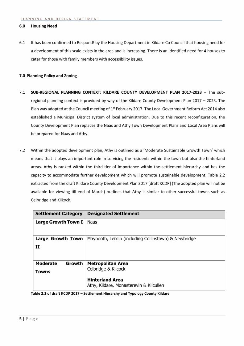
Settlement Category Designated Settlement
Large Growth Town I
Naas
Large Growth Town
II
Maynooth, Leixlip (including Collinstown) & Newbridge
Moderate Growth
Towns
Metropolitan Area Celbridge & Kilcock Hinterland Area Athy, Kildare, Monasterevin & Kilcullen
Table 2.2 of draft KCDP 2017 – Settlement Hierarchy and Typology County Kildare

P L A N N I N G A N D D E S I G N S T A T E M E N T
6 | P a g e
7.3 The draft KCDP 2017 outlines that the preferred development strategy [informed by the Regional Planning
Guidelines] is based on” building strong urban centres while protecting the rural hinterlands. The focus is
on achieving: critical mass in the Metropolitan urban areas (Maynooth, Leixlip, Celbridge, Kilcock) and in
key towns and villages in the Hinterland (Naas, Newbridge, Athy, Kildare, Monasterevin and Kilcullen)”
[draft KCDP 2017:32]; Therefore new residential schemes should be accommodated within these towns in
order to fulfil the preferred strategy as set out in the draft KCDP 2017.
7.4 In terms of population growth, it is a requirement of the RPGs that a minimum of 35% of overall growth is
directed into the Metropolitan area (Maynooth, Celbridge, Leixlip and Kilcock) and the remaining 65% to
the Hinterland area. Of the proportion allocated to the Hinterland, a minimum of 60% of the allocation is
to be directed to the main urban centres (Naas, Newbridge, Kildare, Monasterevin, Athy and Kilcullen) with
the remaining 40% to small towns/villages and the rural countryside. The table outlined below provides
greater detail in relation to the housing requirements for key areas within Kildare between now and 2023.
Athy and 5 other hinterland towns have been allocated 13,120 housing units for this period. If this
allocation is divided evenly then Athy must accommodate 2,187 units over the next 7 years, which amounts
to over 300 units per year.
Settlement Housing Unit Allocation 2016- 2023
% County Total
% Allocation Metro/Hinterland
Metropolitan Allocation
Leixlip Maynooth Celbridge Kilcock
11,200 35% 35%
Hinterland Town Allocation
Naas Newbridge Kildare Monasterevin Athy Kilcullen
13,120 41%
65% Rural Areas Small Towns Villages Rural Settlements Rural Nodes One-off Rural Housing
7,680 24%
Total 32,000 100%
Table 3.1 of draft KCDP 2017 – Housing Allocation 2016-2023

P L A N N I N G A N D D E S I G N S T A T E M E N T
7 | P a g e
7.5 The 2011 Census Small Area Population Statistics [SAPS] give an indicative overview of the population
increase between 2006 and 2011, and enable the prediction of population growth for the next number of
years. The draft plan outlines that Athy will grow by almost 5% between now and 2023 [see table outlined
below]. In other to achieve this growth new residential schemes need to be implemented within the
development boundary.
7.6
Town/Village 2100 Pop
Census
2011 Units
Census
New Unit
Target
2011-2023
Allocated Growth
(%) 2011-2023
(Proposed~)
Athy
9,926
4,301
1,536
4.80%
Table 3.3 of draft KCDP 2017 – Population and Housing Unit Allocation 2016-2023Given
7.7 Given that Athy is outlined on the third tier within the settlement hierarchy and is outlined as a town which
needs to build upon its critical mass, it is imperative that new residential development is incorporated
within the development boundary in order to achieve population targets and the objectives of the
development plan.
7.8 LOCAL PLANNING CONTEXT: ATHY TOWN DEVELOPMENT PLAN 2012-2018 - The Local level Planning
Policy context is provided by way of the Athy Town Development Plan. As previously stated, a new local
area plan will be prepared for the Athy area now that the county development plan has been formally
adopted.
7.9 The vision for Athy, as set out in the plan, is “To plan for and facilitate appropriate levels of sustainable
development in Athy, addressing its weaknesses and building on its strengths based on high quality employment,
residential and recreational areas with a balanced range of facilities to meet the needs of those living, working or
visiting the town, thereby improving the quality of life for all.” [ATDP 2012:11]
7.10 The plan outlines that there has been a steady population increase within Athy between 2006 and 2011,
from 7,943 to 9,588 inhabitants. When the plan was formulated, a population target of 10,819 was to be
met by 2018, which would be a 36% increase on the 2006 population figure. The 2016 census data shows
that the population has increased by 331 persons, standing at a current figure of 9,919. Therefore,
significant new residential projects need to be implemented within the town, in order to reach population
targets set out in the town development plan.

P L A N N I N G A N D D E S I G N S T A T E M E N T
8 | P a g e
7.11 The zoning map within the plan outlines that the subject site is zoned for ‘new residential development’,
with a small portion of the site within the ‘existing residential and infill’ zoning, this is outlined in Fig 1
below. A very small corner of the site at the southern corner is zoned ‘open space’ and is retained as open
space in the proposal Therefore, the proposed residential scheme is in accordance with the zoning
objectives associated with this area of Athy.
Fig 1 Zoning Map extracted from the Athy town Development Plan 2012-2018
7.12 The ATDP 2012 states that it is ‘necessary to make efficient use of green filed lands and residentially zoned
lands in the context of their location and the provision of a variety of housing types’. The plan outlines that
‘densities in a range of 30-50 dwellings per hectare will be appropriate and should include a variety of
housing types’. The proposed scheme represents a density of 20 units per hectare, it comprises of 35 units
on a 1.9534 hectare site. This site is zoned as both an ‘existing residential and infill’ and ‘new residential’
site and therefore this density application is deemed appropriate in order to respect the existing build form
of the surrounding area. There is also an objective in the ATDP 2012 to provide a green linear park alongside
the canalside of the site. The plan also states that ‘the density levels considered appropriate are indicative

P L A N N I N G A N D D E S I G N S T A T E M E N T
9 | P a g e
only’ [ATDP 2012:51].Note regarding the density calculation: It should be noted that the site area of this
proposed development includes an area of existing open space alongside the Canal in front of Flinter’s
Close. The brief includes the provision of a natural play area at this location and the introduction of a 3
meter wide cycleway/pathway and the retention of the existing recycling facility within the overall site.
This area will be suitably landscaped to improve visual amenity. The density on the site is also constrained
by the requirement to respect the existing pattern of suburban type development in the vicinity, and the
provision of a continuation of the linear park along the canal. The fact that the site is only to be accessed
via Flinter’s Close and Flinter’s Place, is a further constraint.
7.13 Policies within the ATDP which relate to this proposed development scheme are as follows:
HP7: To ensure that all new urban development especially in and around the town centre is of a high design
and supports the achievement of successful urban spaces and sustainable communities.
HP8: To require diversity in the density of development and in the form, size and type of dwelling within
residential areas.
HP9: To secure the development of a mix of house types and sizes throughout the town as a whole to meet
the needs of the existing and projected likely future population. A statement of mix may be required for
multi- unit schemes to demonstrate that the needs of the area are provided for within the scheme.
HP12: To ensure developments are carried out generally in accordance with the ‘Recommendations for
Site Development Works for Housing Areas’. (DoEHLG 1998) or as updated or amended.
HP13: To ensure that all open spaces, entrances, pathways and parking areas in new residential
developments are designed with reference to “Buildings for Everyone – Inclusion, Access and Use (National
Disability Authority, 2002) and any subsequent update.[Source: ATDP 2012:52]
7.14 The proposed scheme reflects the objectives set out above as it is of appropriate density [given the
constraints referred to in 7.13 that there is existing development on three boundaries], is of high quality
design and includes a mix of 2, 3 and 4 bed house types and sizes.
7.15 Respond! have prepared and designed a well-considered scheme of 35 no. residential units for the Flinter’s
Field site to the north of Athy Town. The proposed development is in line with the planning policy and

P L A N N I N G A N D D E S I G N S T A T E M E N T
10 | P a g e
zoning objectives set out in both the Kildare County Development Plan 2017(adopted Feb 2017) and the
Athy Town Development Plan 2012-2018.
Fig 2 Broader Context of Athy and Hinterland
Fig 3 Aerial View of Existing site Boundaries showing the pattern of development in the immediate Area

P L A N N I N G A N D D E S I G N S T A T E M E N T
11 | P a g e
Fig 4 Existing Site showing current road layout- Photo 1 (top photo) - location of existing underground services,
Photo 2 (bottom photo) site view in the vicinity of the proposed pedestrian access to Woodstock Street.
THE PROPOSED DEVELOPMENT
8.0 Site description:
8.1 The site, of 1.9534 hectares (4.826 acres) (see Fig 3 and Fig 4) is located in a residential area to the north
of Athy town centre in a location surrounded on 3 sides by established residential developments and on
the 4th side bounded by the Grand Canal. A small portion of the north- east boundary abuts the car parking
area serving the adjoining Health Centre.
8.2 The estate to the north, Cardington Court, is accessed off Woodstock Street (R428) and forms a cul-de- sac
with green amenity open space and the side of house number 10 directly bordering the subject site. There
is a 2.1 meter high concrete block wall boundary between the sites. To the south - east is the rear access
laneway to an older residential estate, St. Domnic’s Park. The houses have long rear gardens and separation
distances to the new development will vary between just under 50 meters to just over 28 meters.Like the
proposed development, St Domnic’s park has a green open space adjoining the Canal walkway and
separated from it via a hedgerow. To the east is an integrated residential development of 46 social and

P L A N N I N G A N D D E S I G N S T A T E M E N T
12 | P a g e
private homes (houses and apartments) and a community facility providing child care services, developed
by Respond! in 2001. The main part of the subject site is generally rectangular in shape measuring approx.
130 meters from north -west to south west and 100 meters from south west to north east. The site was
extended during the pre-planning process to include at the north east corner an area linking in to
Woodstock Street. Later the walkway to Woodstock Street was included in the site boundary together with
provision for widening this route to 6 meters wide. Alongside the canal bank the site extends into the
existing open space to the front of the existing Flinter’s Field estate. A designated enclosed natural play
area is proposed and a 3 meter wide cycleway/walkway and cycle parking is also part of the brief for this
open space area generally in accordance with the NETWORK OF GREEN SPACES PLAN, Fig 14.4 of the Athy
Town Development Plan 2012-2018. This plan is attached in Appendix 2 at the end of this report. The
boundary with the canal side is currently formed by hedgerow interspersed with trees and a 1.5 meter high
chain-link fence marks the site boundary on the site side of the hedge.
8.3 There is currently an informal pedestrian link through the hedge and chainlink fence to the Canal path mid-
way along the site. There is a preliminary road lay out across the northern-western part of the site with a
cul-de-sac road perpendicular to this terminating close to the site boundary with the Canal. In order to
optimize the capacity of site, this indicative road layout will be revised. The site is generally level and a little
lower than the surrounding residential estates. The ground cover is improved grassland with some
hardstanding at the location of previously proposed internal roads. There are trees in the southern corner
of the site adjoining St Domnic’s Park.
8.4 The surveyed level of the water in the canal is at approximately the same level as the ground level on the
site. There is a ditch on the canalside of the existing chainlink fence.
8.5 It has been confirmed that there is existing capacity to connect into local foul and water services and that
there is adequate capacity in the existing access roads and junction with Woodstock St. to serve the
proposed development.
8.6 The site lies outside the flood risk zone associated with the river Barrow as indicated on the OPW flood risk
maps.

P L A N N I N G A N D D E S I G N S T A T E M E N T
13 | P a g e
9.0 Design Brief
9.1 Respond! Housing Association, Parag Joglekar, director of Development, met with Michael Mcloughlin of
the Housing section in Kildare Co Council in 2015. A preliminary layout proposal was drawn up for 33
houses. The houses are designed to comply with or exceed the recommended quality housing standards.
The disabled accessible bungalow is fully accessible , and the ground floor bedroom and bathroom in the 4
other 4 bed houses is to N D A standards (National Disability Authority)
9.2 An indicative diagrammatic layout showing the location of desired frontage was also provided to Respond!
as a briefing guideline by Michael McLoughlin (the layout related to the Urban Design Framework prepared
for the site).
9.3 The original scheme proposed by Respond! to the Council comprised of mainly 3 bed semi – detached
homes in keeping with the pattern of development in the area. It was a request by the Council at this initial
stage to include a designated children’s play area and to retain the existing waste recycling facility in its
current canalside location. The residential amenity of surrounding residents to be given due consideration,
in particular, paying attention to providing adequate passive surveillance of all public areas. All public
open spaces and walkways in the proposed development benefit from passive surveillance. 2 parking
spaces are provided for each house generally within the curtilage except for the terrace of houses adjoining
the pedestrian link to Woodstock Street - four of these houses share a communal parking area in front of
the dwellings. One of the 2 parking spaces in each of the 4 disabled accessible houses is a disabled
accessible parking space. Space for segregated refuse bins for compost, green bin and general waste is
generally provided in rear gardens accessed via side pedestrian gates. All other mid- terraced units are
provided with enclosed 3 bin enclosure with brick sides and timber slatted doors to the front, located as
indicated on the site layout drawing P16/09/P01.
9.4 The housing department initially requested that 4 no. of the houses should be 4-bed and able to cater for
a family with a disabled family member. At the meeting with the Council this figure was increased by 1 to
5 number 4 bedroomed disabled accessible Houses.
9.5 The scheme was revised to take this into account. A 4 bed fully accessible bungalow was included, and 4
no. 4 bedroomed 2 storey, which have a disabled accessible bedroom and bathroom on the ground floor
to National Disability Authority standards.

P L A N N I N G A N D D E S I G N S T A T E M E N T
14 | P a g e
9.6 A further meeting between Liam Fewer, National Production Manager of Respond! and Kildare Co Council
took place in November 2016 and included an enlarged brief to extend the site to include the area adjacent
to the proposed pedestrian route linking the site to Woodstock Street at the northern corner of the site
and to provide for a future vehicular and/or pedestrian link at the southern corner of the site to St Domnic’s
Park extending the canal side linear park. This increase to the site allowed for an increase of 2 additional
units to 35 units. Subsequently the brief was further amended in March 2017 to include the entire link to
Woodstock Street and to omit the potential future vehicular link into St Domnic’s Park. The pedestrian and
cycle link to St Domnic’s’ Park was also omitted. Instead the pathway connects via a lockable opening to
the canalside walkway. At the meeting with the Council on 20.03.17, it was agreed that, subject to
agreement with the relevant section, the recycling facility would not be retained as part of the overall site.
9.7 Kildare Co Council also requested that the scheme be evaluated against Figure 14.3 Urban Design
Framework of the current Athy Development Plan.
9.8 Following the meeting with the Council on 20.03.17 it was decided to remove the existing recycling facility
from the overall site.
9.9 Investigations by consulting engineers appointed to the project in November 2016 revealed existing
services (water and foul) along the northern boundary alongside the side gardens of the existing Flinter’s
Field estate. An existing substation is located along this boundary also and it proposed to maintain this in
situ. The road layout was revised to take these factors into account.
9.10 Design approach
9.11 Evaluation of the Urban Design Framework Plan figures 14.3 and fig 14.10 in relation to this site. (copy
attached in Appendix 1 and Appendix 3)
This envisaged 3 vehicular access points to the site, one from the existing estate to the east via
current public open space, and 2 from the North West – via the existing Flinter’s Place and
Flinter’s Close roads.
A road linking Flinter’s Close to the road along the canal side of the site was proposed to continue
into the adjoining St Dominic’s Estate to the south east.
Pedestrian link from Woodstock Street linking to the estate is indicated as well as a pedestrian
canal side walk as part of the proposed linear park.
A diagram showing perimeter terraced housing is indicated with communal parking located in an
internal courtyard.

P L A N N I N G A N D D E S I G N S T A T E M E N T
15 | P a g e
9.12 Design Development: Following discussions between the Director of Development at Respond! Housing
Association, Parag Joglekar and the Council Architect, it was agreed that this framework plan could be
interpreted liberally but the following essential connection points were to be included:
1) The pedestrian link to Woodstock Street continuing through the site to link with the canal side path.
2) Option for the provision for a future vehicular link with St Dominic’s Park. (later omitted)
3) Road links with Flinter’s Court and Flinter’s Park.
4) Omission of any vehicular/pedestrian link proposed with the estate to the north-east, Cardington Court.
The proposed layout of the site (shown on drawing P16/09/P01) is designed to maximize residential
amenity of future residents while fully respecting the residential amenity of adjoining residents and
property in the vicinity. Two access roads, which are continuations of Flinter’s Place and Flinter’s Close,
both ending in a cul-de-sac, form the basis of the layout. These roads are linked by a shorter section of
road alongside the north- western site boundary. This link road also fulfils the requirement for a
pedestrian link from Woodstock Street to the canal side linear park, natural play area and path along the
canal. Existing constraints on the site include the location of underground services and the location of
the existing ESB substation along the North-Western boundary. The design now presented has been
reviewed by Senior Executive planner Patricia Conlon in December 2016 and her comments have been
incorporated into the design. In addition, Senior Executive Engineer Mr. Willoughby has also seen and
commented on the plans and this feedback has been taken into account in the proposal presented. The
drainage of the site has been designed following consultation with the Council regarding existing service
routes in the locality. In 2017 further refinement to the brief was undertaken, liaising with Sharon
Whelan.
P L A N N I N G A N D D E S I G N S T A T E M E N T
16 | P a g e
9.13 Site layout:
9.14 The site layout is designed to maintain the open landscaped linear park along the canal side. A new natural
children’s play area is also located in this linear open space for the benefit of the future residents and
residents of adjoining estates and the surrounding area.The request by the Council to incorporate a 3 meter
wide cycleway/walkway along the linear openspace adjoining the canal side boundary forms part of the
proposal. A smaller linear strip of open space is also retained to the north-east of the site alongside the
existing boundary wall to the open space associated with Cardington Court. In order to improve passive
survelience, and to enhance the view and aspect of the houses on the site, it is proposed that the existing
boundary hedge will be cut back and maintained at 1.4 meters high.
9.15 Orientation: The majority of the houses have either south, west or east facing rear gardens. The terrace of
5 houses located overlooking the pedestrian link to Woodstock Street have north- east facing gardens over
13 meters long.
Parking: The majority of the car parking will be within the curtilage of each dwelling house. (2 spaces
allocated for each house) A disabled parking space has been provided with each of the 4 houses which have
disabled accessible accommodation. Additional visitor parking is provided alongside the linear park and
adjoining Cardington Court. Existing layout including parking at the recycling centre is retained.
Landscape: Where possible, healthy, hedgerow and trees will be retained, and along the canal boundary
trimmed to 1.4 meters height and a gap will be made to allow lockable access through to the canal path
for cyclists and pedestrians. A full landscape proposal for the entire site accompanies this application.
Road layout: The road layout is designed to provide natural traffic calming. In addition, speed bumps are
located at the entry points to the site.
9.16 Housing Layout: The positioning of the houses on site has been carefully considered to ensure optimal
orientation and compliant separation distances between houses and with adjoining properties and that
each house has a private open space which complies with or exceeds minimum standards. All separation
distances between houses back to back at first floor level comply with or exceed the minimum of 22 meters.
The terrace, No 31 to 35 is located to improve passive surveillance of the pedestrian route to Woodstock
Street. The disabled accessible bungalow No. 15, is located directly in front of this pedestrian route with its
kitchen window facing towards the pedestrian route thus enhancing passive surveillance and pedestrian
safety. Existing house no 1, Flinter’s Place also overlooks this pedestrian route. Separation distances and
private open space sizes to all properties are indicated on the site layout drawing P16/09/P01.

P L A N N I N G A N D D E S I G N S T A T E M E N T
17 | P a g e
9.17 Boundary Treatment: Details of all site boundaries are shown on Drg. P16/09/P03. A new section of
boundary wall adjoining the Health Centre, and to the South-East of the site adjoining the existing rear lane
to the rear of St Dominic’s Park will be constructed. The new boundary treatment adjoining the pedestrian
link to the canal path will be a 1.5 meter high bow top fence,-The existing palisade fence to St Domnic’s
Park will be retained at this location. All other existing boundary walls will remain intact.
9.18 A full topographical survey of the site was undertaken and the proposed site levels are generally retained
as close as possible to existing levels. The greatest increase in level required to achieve adequate drainage
falls is 450 mm increase in level at the eastern corner of the site. Proposed levels are shown on the site
section drawing P16/09/P04.
9.19 Services: The development will link into existing water supply, waste water and electrical services. Existing
overhead electrical wires will be relocated as appropriate.
9.20 Site Construction Access: At the request of the Council it is proposed to form a temporary dedicated site
construction access via the existing pedestrian link to Woodstock Street for the duration of the project.This
has been confirmed as a feasible option by the consulting engineers. On completion of the development,
the pedestrian access will be reinstated, landscaped and reopened. This temporary arrangement will
permit vehicles to access the site in one direction only at any one time as it will be 6 meters wide and so
will require the services of a banks man. It is anticipated that this dedicated route will accommodate
approximately 95% of site traffic directly on to the site. Some larger vehicles will use the existing access
route via Flinter’s Place, and delivery times can be arranged so that they do not coincide with peak traffic
times. It has been confirmed by the consulting engineers that there is adequate road capacity to serve the
estate through the existing road network.

P L A N N I N G A N D D E S I G N S T A T E M E N T
18 | P a g e
9.22 Unit Mix and Typology
9.21 A total of 35 houses are proposed. All are 2 storey except for one fully accessible 4 bed bungalow.
2 are detached, 12 are semi- detached and 21 are terraced. The unit mix is as per the following:
House
type
Unit
Type
Quantity
of Units
House numbers Remarks
2 bed end
terrace
A1 4 06,19,21.31 4 person
2 bed mid
terrace
A2 5 07,20,
32,33,34,
4 person
2 bed end
terrace
A3 1 35, 4 person
2 bed
mid-
terrace
A4 2 03,04, 4 person
3 bed
semi-
D/end tce
B1 12 11,12,13,16,
22,23,24,25,26,27,29,30,
5 person
3 bed mid-
tce
B2 4 08,09,14,15, 5 person
3 bed end-
tce
B3 1 10, 5 person
3 bed
semi-D
B4 1 17 5 person
4 bed end-
tce
C1 2 02,05, 7 person Accessible
bedroom/bathroom, gr floor
4Bed semi
detached
C1 1 18 7 person Accessible bedroom
/bathroom gr floor
4 bed
detached
C2 1 28, 7 person, Accessible
bedroom/bathroom, gr floor
4 bed
detached
bungalow
C3 1 01, 7 person Fully accessible
Total 35

P L A N N I N G A N D D E S I G N S T A T E M E N T
19 | P a g e
9.22 There are 12 no. 2 bed houses (Type A1, A2 and A3). There are 18 no 3 bed houses (Type B1, B2 and B3).
There are 5no. 4 bed houses Types C1, C2, C3 and D1 (One bungalow, which is the fully accessible
bungalow.) The other 4 no four bed houses have an accessible bathroom and bedroom on the ground floor.
All house sizes meet or exceed the minimum area standards.
9.23 Storage - Storage areas, meeting or exceeding minimum standards is provided. All include, at the specific
request of Kildare County Council some storage areas at first floor level which are directly accessible from
common areas. The 2 and 3 bedroomed houses have an open plan kitchen/living/dining room. The 4
bedroomed houses have a separate kitchen.
9.24 Hierarchy of open spaces , Private and public open spaces:
a) Private open space
All houses have rear garden sizes meeting or exceeding minimum size requirements ranging in size from
75 M2 to 330M2 as indicated on layout plan P16/P06/P01/A. All houses are set back from the road with
some semi-private space for planting to the front. Most have on-site parking for 2 vehicles.
b) Public open space
The public open space is primarily the linear strip alongside the canal, which includes a proposed new
natural playground. There is also a smaller landscaped area alongside the north east boundary wall
adjoining Cardington Court. The combined area amounts to over 26% of the site area which exceeds the
development plan standard for open space in residential areas.
9.25 Privacy and Overlooking – adjoining property - All properties fully respect the privacy and residential
amenity of adjoining property and have a minimum 11 meter long rear gardens. The minimum distance
between first floor windows is 22 meters. The design and positioning of the bungalow, house no. 1 has
been positioned to prevent any adverse impact on residential amenity of the existing adjoining property.
10.0 Detail Design - Palette of Materials
10.1 The proposed materials for the facades have been carefully considered to result in attractive varied facades
while also considering long term durability and maintenance. Most front facades are a combination of brick
and painted render. Some front facades are fully in brick. Gables and rear walls are generally painted
render except at prominent locations gables are fully in brick.
All roofs are grey concrete roof tiles. PV panels may be fitted to the roof to reduce hot water costs. All front
doors will be painted timber. Windows will be UPVC timber effect type.
10.2 Boundary treatments - All site boundary treatments are as existing, with the exception of the area
immediately adjoining the Health Centre carpark, the lane to the south backing on to St Dominic’s Park and
the boundary to the canal. A new 2.1 meter high concrete block plastered and capped wall shall be erected
P L A N N I N G A N D D E S I G N S T A T E M E N T
20 | P a g e
at the rear of properties backing on to the lane to the rear of St Domnic’s Park in place of the existing
palisade fence. Boundaries to the front gardens will generally be open, but occasional 1.2 meters high
galvanized bow top fencing will be used. Rear garden boundaries will generally be 1.8 meters high concrete
post and timber panel fencing. Where rear gardens back on to each other the end wall will be in concrete
block capped. Where the rear garden boundary abuts to public domain it shall be finished concrete block,
plastered, painted and capped. A high quality low maintenance paint finish will be selected. A new 1.5
meter high galvanized bow top fence shall be erected alongside the canal boundary on the canalside of the
hedgerow. This will link with the existing palisade fence at St. Domnic’s Park. Please refer to boundary
treatment drawing P16/P09/P03.
10.3 Refuse Storage/ Recycling - An existing recycling centre exists on the site which will be removed and a new
natural play area will be installed at this location. All houses with side entrances have space allocated for
segregating waste to 3 bins, Grey, Green and compost generally accessed and out of public view via side
garden gates. The 11 mid terrace units have an enclosed refuse enclosure (brick ends and slatted timber
doors to the front) all as indicated on the site layout drawing P16/09/P01, and as shown on the context
elevations on site section drawing P16/P09/P04.
10.4 Services - Gas and electric meters will be generally located in the public domain on the gable end of the
houses Mid terrace units shall have meters fixed on the inside of their projecting porch walls.
10.5 Landscaping - See accompanying drawing of landscaping proposal- Drawing number P278 by Landmark
Designs. Attractive well designed public open space is an important part this proposal including a dedicated
natural play area for younger children [See Appendix 4]. Landscaping will include tree planting and shrubs
in accordance with the submitted landscaping scheme including many native species. For all landscaping
details please refer to the landscaping drawing.
10.6 Parking and roads All roads, footpaths and parking areas are designed in accordance with the
Recommendations for Site Development works for Housing Areas including adequate turning areas for
refuse vehicles. Provision is made for 2 off street parking spaces for all the units except the terrace 31 to
34. The parking spaces for these units are grouped in a communal parking space in close proximity to and
in full view of the front entrances of this terrace. Allowance is made for 2 parking spaces per house. In
addition there are 15 visitors’ car parking spaces throughout the site.
P L A N N I N G A N D D E S I G N S T A T E M E N T
21 | P a g e
11.0 Schedule of Floor areas
11.1 All the units comply with or exceed current minimum standard sizes. A detailed Schedule of Floor Areas
document is submitted with this application for reference.
12.0 Concluding Statement
12.1 Respond! propose that this 35 unit residential development in an existing residentially zoned area within
the town of Athy close to all amenities will be in keeping with the surrounding residential developments in
terms of scale, will result in a vibrant mixed community of families, elderly, and persons with special
accessibility requirements. The proposed development complies with or exceeds all current minimum
standards. It will not seriously injure the amenity of the area or of property in the vicinity, will be
acceptable in terms of traffic safety and convenience and will enhance the amenity of adjoining residents
by way of provision of a new natural play area and an upgraded pedestrian/ link to Woodstock Street and
provision of a walkway /cycle way linking to the canalside pathway, and will be in accordance with the
proper planning and sustainable development of the area.
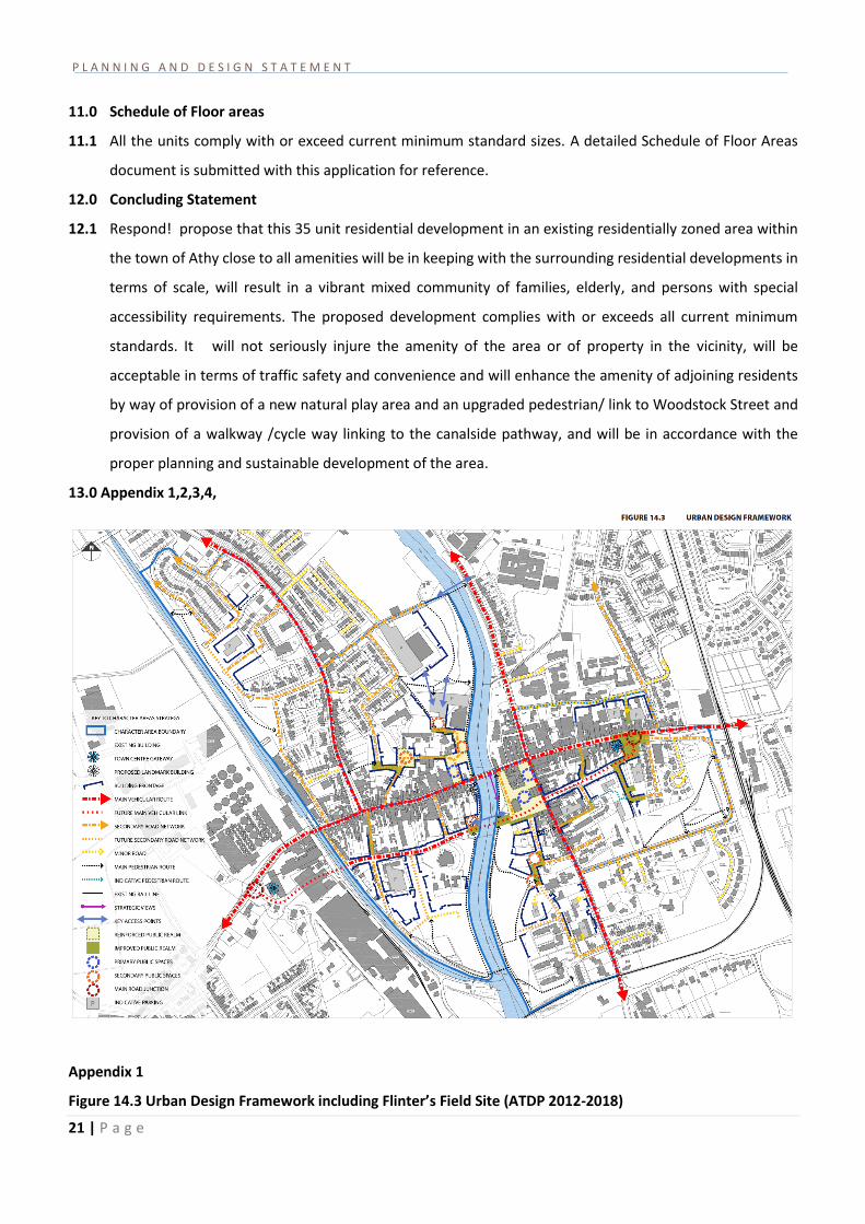
13.0 Appendix 1,2,3,4,
Appendix 1
Figure 14.3 Urban Design Framework including Flinter’s Field Site (ATDP 2012-2018)

P L A N N I N G A N D D E S I G N S T A T E M E N T
22 | P a g e
Appendix 2
Figure 14.4 Network of Green spaces including open space alongside the Grand Canal on the Flinter’s Field Site.
(ATDP 2012-2018)

P L A N N I N G A N D D E S I G N S T A T E M E N T
23 | P a g e
Appendix 3
Fig 14.10 Flinter’s Field Character Area (ATDP 2012- 2018)

P L A N N I N G A N D D E S I G N S T A T E M E N T
24 | P a g e
Natural Play areas are areas that incorporate natural play features such as willow archways, tunnels through
earthen banks, slides, assault course type equipment. This play area can ‘spill’ over into the main green space.
The link may be a willow arch for example. Specific items of play may be required for the multiple users.
Appendix 4
Sample images of proposed natural play area
END