,p s d f wv r i * or e d o : d up lq j r q 0 r x q wd lq h h ulq … · ,p s d f wv r i * or e d o...
TRANSCRIPT

Impacts of Global Warming on Mountaineering: AClassification of Phenomena Affecting the Alpine TrailNetwork
Authors: Ritter, Florian, Fiebig, Markus, and Muhar, Andreas
Source: Mountain Research and Development, 32(1) : 4-15
Published By: International Mountain Society
URL: https://doi.org/10.1659/MRD-JOURNAL-D-11-00036.1
BioOne Complete (complete.BioOne.org) is a full-text database of 200 subscribed and open-access titlesin the biological, ecological, and environmental sciences published by nonprofit societies, associations,museums, institutions, and presses.
Your use of this PDF, the BioOne Complete website, and all posted and associated content indicates youracceptance of BioOne’s Terms of Use, available at www.bioone.org/terms-of-use.
Usage of BioOne Complete content is strictly limited to personal, educational, and non - commercial use.Commercial inquiries or rights and permissions requests should be directed to the individual publisher ascopyright holder.
BioOne sees sustainable scholarly publishing as an inherently collaborative enterprise connecting authors, nonprofitpublishers, academic institutions, research libraries, and research funders in the common goal of maximizing access tocritical research.
Downloaded From: https://bioone.org/journals/Mountain-Research-and-Development on 11 Apr 2020Terms of Use: https://bioone.org/terms-of-use
Impacts of Global Warming on Mountaineering:A Classification of Phenomena Affecting theAlpine Trail NetworkFlorian Ritter1, Markus Fiebig2*, and Andreas Muhar3
*Corresponding author: [email protected] Doctoral School Sustainable Development (dokNE), BOKU – University of Natural Resources and Life Sciences, Peter Jordan-Str. 82, 1190 Vienna,Austria
2 Institute of Applied Geology, BOKU – University of Natural Resources and Life Sciences, Peter Jordan-Str. 70, 1190 Vienna, Austria3 Institute of Landscape Development, Recreation and Conservation Planning, BOKU – University of Natural Resources and Life Sciences,Peter Jordan-Str. 82, 1190 Vienna, Austria
Open access article: please credit the authors and the full source.
The high Alpine landscape
is significantly shaped by
glacial and periglacial
processes. It is sensitive
to effects caused by
global warming, such as
glacier retreat and
permafrost degradation.
Trails and mountain huts
form the infrastructure
basis for hiking and mountaineering in the Alps. This
infrastructure is a decisive factor for summer mountain
tourism. This article presents a classification of phenomena
describing the effects of global warming on high Alpine trails
and routes. The classification was developed based on an in-
depth study in the Austrian Alps. The examples collected show
that in the context of global warming, numerous different
types of phenomena can affect both the occurrence of natural
hazards along high Alpine trails and routes, and the
accessibility of the terrain. Depending on the specific
situation, threats and difficulties can increase or decrease.
Trail holders have to adapt the high Alpine trail network to
these changes. The classification presented here can serve to
support maintenance of the Alpine trail network in the future.
Keywords: Global warming; glacier retreat; Eastern Alps; trail
network; summer mountain tourism; hiking; natural hazards;
infrastructure management; Austria.
Peer-reviewed: October 2011 Accepted: November 2011
Introduction
The high Alpine landscape has been and still issignificantly shaped by glacial and periglacial processesand is therefore highly sensitive to effects caused byglobal warming, such as glacier retreat and permafrostdegradation (eg Haeberli and Beniston 1998; Fischer et al2006). Mountaineering as an important tourist activity inthe European Alps can be indirectly affected by anincrease in the occurrence of natural hazards, such asrockfall, debris flows, or landslides (eg Haeberli 1999;Harris et al 2001; Gruber et al 2004).
Trails and mountain huts form the infrastructure basisfor hiking and mountaineering in the Alps and aretherefore a decisive factor for summer mountain tourism(Muhar et al 2006). Institutions responsible for trailmaintenance and safety have pointed out a steadilyincreasing number of problem situations and growingfinancial expenses for trail maintenance (Kapelari 2008).
In this article we present a classification ofphenomena describing effects of global warming on trailsand routes from a mountaineering perspective. Thesephenomena usually arise from the spatial coincidence ofmorphodynamic processes, specific landforms, and trail
infrastructure. The classification is intended as a basis fordeveloping adaptation strategies.
Study area
Our study focused on the Austrian Alps, where the lowestglacier tongues are situated at an altitude of about 2100 mand periglacial processes occur from approximately2000 m upwards. In this article, therefore, we use the term‘‘high Alpine area’’ to refer to terrain from 2000 mupwards in glaciated mountain ranges in the Eastern Alpsand the term ‘‘high Alpine trail network’’ to refer to trailsand routes in this area.
The term ‘‘trails’’ refers to marked and regularlymaintained hiking trails. They may also include sectionswhere fixed ropes or similar technical devices areinstalled as safeguarding measures. We use the term‘‘routes’’ to refer to other, usually unmarked ascents, inparticular on glaciers. While they cannot be regarded aspart of the trail infrastructure in a narrower sense, theyoften play an important role for mountaineering in highAlpine terrain and are thus also depicted on hiking maps.
The major part of the Alpine trail network in Austriais maintained by mountaineering associations. The most
MountainDevelopmentTransformation knowledge
Mountain Research and Development (MRD)An international, peer-reviewed open access journalpublished by the International Mountain Society (IMS)www.mrd-journal.org
Mountain Research and Development Vol 32 No 1 Feb 2012: 4–15 http://dx.doi.org/10.1659/MRD-JOURNAL-D-11-00036.1 � 2012 by the authors4Downloaded From: https://bioone.org/journals/Mountain-Research-and-Development on 11 Apr 2020Terms of Use: https://bioone.org/terms-of-use
relevant trail maintainers are the Austrian Alpine Club(OeAV) and the German Alpine Club (DAV). Together,they are responsible for about 40,000 km of trails.According to the Austrian Civil Code, the responsibilityof a trail holder usually implies a legal liability foraccidents caused by neglectful maintenance. Althoughmaintenance work is often done by volunteers, theseassociations report annual costs of about J 2 million (US$2.6 million; see Witty 2007).
Data collection
The classification of phenomena presented here is basedon a systematic collection of examples using a wide rangeof sources:
N Scientific literature and mountain sports literature;N Evidence from mountain guide books and mountain
sports websites and web forums;N Qualitative expert interviews with trail maintainers,
glaciologists, and mountain guides (N 5 8);N Field mapping in seven high Alpine mountain ranges,
representative for the spectrum of landscapes withAlpine trail networks in the Austrian Alps (extent ofglaciation, geographical location, geology, relevancefor tourism);
N Ad hoc remarks of local case actors during fieldmapping.
We implemented a theoretical sampling approach(Rosenthal 2008), continuing data collection until atheoretical saturation was reached, that is, until noadditional data could be found which would haveheightened the informative value of the existingcategories. This sampling method was useful foridentifying categories; however, it did not provide anyquantitative information on the frequency of occurrenceor on the spatial distribution of the phenomena.
In line with our research objective we classified thephenomena according to their effects on trails and routesand their consequential relevance for mountaineering.This does not necessarily correspond to the usualapproach in the geosciences, where phenomena andevents are mostly classified according to the underlyinggeomorphological processes, such as mass wasting andglacial or fluvial processes.
Results
This classification distinguishes two main groups ofphenomena with different effects on trails and routes: (1)changes in the occurrence of natural hazards and (2)changes in the accessibility of the terrain. Changes in theoccurrence of natural hazards in the context of globalwarming are addressed in a considerable body of existingscientific literature (eg Haeberli et al 1989; Ballantyne2002; Notzli et al 2004; Fischer et al 2006). Less attention
has been given so far to the accessibility of the terrain andthe technical difficulty of high Alpine trails and routes,despite their relevance to mountaineering. We aim tocontribute to filling this gap by focusing on these aspectsin this article.
In the following paragraphs and tables we describe therelevant phenomena and illustrate some practicalexamples. For a detailed mapping of the phenomena inselected mountain ranges see Braun (2009).
Changes in the occurrence of natural hazards
Introductory considerations: High Alpine environments areareas of strong erosion and mass movements. Combinedwith the presence of humans or the construction ofinfrastructure, these natural processes can causedamaging events and are therefore perceived as potential‘‘natural hazards.’’
In the context of mountaineering, the term ‘‘naturalhazard’’ usually refers to fast mass movements such asrockfall, debris flows, or landslides. Glacier lake outburstfloods might be a major hazard linked to global warmingin intensively glaciated mountain ranges, but since theydo not appear to be a relevant threat in the Austrian Alpsat the moment, we do not discuss them here in furtherdetail. The same applies to ice avalanches (Lieb 2007).However, in the Western Alps the situation may bedifferent (eg Fischer et al 2006). In this article we focus onchanges in the occurrence of natural hazards due toglacier retreat or permafrost degradation; these seem tobe the two most important processes in the context ofglobal warming and mountaineering.
Changes due to glacier retreat: Since the last glacialmaximum in the mid-19th century, a dramatic decrease ofthe glaciated areas has been observed throughout theAlpine arc (WGMS 2008). Large parts of the now-uncovered areas in glacier forefields consist of debris.Depending on the inclination of the slope, this unstablematerial provides new potential starting zones fordifferent kinds of mass movements such as debris flows,landslides, or rockfall. Slopes and lateral moraines thathave been oversteepened by glacial erosion and have nowlost their lateral support due to glacier retreat areparticularly susceptible to such processes (Ballantyne2002; Chiarle et al 2007).
Crucial changes also occur along the upper marginsof glaciers. Continuous mass loss causes glacier surfacesto gradually subside. This often reveals heavily jointedand unstable rocks, leading to a high potential forrockfall or continuously falling stones. In the context ofmountaineering, this phenomenon mainly affectsformerly glaciated passes or ridges leading to summitsabove glaciers. Many of these routes have becomeextremely dangerous. Numerous classical ice climbs inthe Eastern Alps have become heavily affected byrockfall and falling stones as well due to rocks melting
MountainDevelopment
Mountain Research and Development http://dx.doi.org/10.1659/MRD-JOURNAL-D-11-00036.15Downloaded From: https://bioone.org/journals/Mountain-Research-and-Development on 11 Apr 2020Terms of Use: https://bioone.org/terms-of-use

out at the ice margins (Schworer 1999), in particularduring late summer and autumn. This phenomenonoccurs not only on glaciers but also at the margins ofsteep perennial snowfields, which are quite commonalong high Alpine trails. It therefore poses aconsiderable risk to hikers.
A phenomenon specific to steep glacier slopes is thecontinuous falling of stones previously frozen onto theglacier surface that are released by the daily warming.Global warming leads to an increase both in the occurrenceof bare ice and in debris cover, thus additionally increasingthe potential for continuously falling stones.
Changes due to permafrost degradation: Permafrost isdefined as soil or rock in the ground that remains at atemperature of ,0uC for at least 2 consecutive years(Washburn 1973). According to this definition,permafrost may or may not contain ice. In the EasternAlps, discontinuous permafrost can be found at altitudesabove 2500–2900 m, depending on various factors such asaspect and surface material. Since permafrost is notdirectly visible at the surface, its changes are not obviousand are difficult to detect.
Permafrost reacts very slowly to climatic changes. Inmost sites complete thawing will only occur aftercontinuous warming over decades or even centuries.However, even partial warming may affect slope stability.The extent of such an impact depends on the ice contentof the permafrost, as the cohesion in ice-filled jointsdecreases with rising temperature (Davies et al 2001).Partial warming of permafrost may be induced byextreme seasonal conditions, as observed during the heatwave in the summer of 2003, when rockfall activityincreased noticeably. Most rockfalls occurred near therock surface and at the lower limit of permafrostdistribution, which indicates that the warming of theouter permafrost layer played a major role (Gruber et al2004). Another effect of permafrost warming is deeperinfiltration of meltwater into joints and discontinuities.The associated frost weathering then contributes to thedestabilization of rocks (Haeberli and Beniston 1998).
Debris in permafrost areas is often ice-bound. Whenthe active layer of the permafrost melts, the debris losesits cohesion. This process can free large quantities ofunstable material in zones with degrading permafrost.Similar to glacier retreat, this results in new potential
starting zones for mass movements, mainly debris flows(Hirschmugl 2003).
Relevance to mountaineering: We can summarize that bothglacier retreat and permafrost degradation provideadditional rock material for different kinds of massmovement processes. Therefore, the potential for fastmass movement events to occur in the affected areas isgenerally increasing. Yet it always depends on geologicalfactors (eg type of rock, jointing, strike, and dip) andgeomorphological factors (eg slope, landform elements)whether the occurrence of these events in a certain areaactually increases or not.
Furthermore, a distinction has to be made between thehazard, that is, the potential for an event to occur, and thetriggering of the actual event: While the describedprocesses related to global warming might increase thepotential, events are generally triggered by otherprocesses that are less linked to global warming, such asextreme rain events.
It must not be overlooked that both glacier retreat andpermafrost degradation can also reduce morphodynamicslocally, thereby decreasing the occurrence of naturalhazards (Lieb 2007). Hence, it cannot be generally statedthat the mountains are becoming more dangerousthroughout. There is still little known about the frequencyof the mentioned hazard events, and to date there are notime series available to prove that these events havebecome more frequent in the long run (Lieb et al 2007).
From a mountaineer’s point of view, it does not reallymatter which type of mass movement is causing a threat.Far more decisive is the frequency and the scale of thepotential hazard event. Regarding relevance tomountaineering, therefore, we suggest looking first at thefrequency of events before distinguishing the detailedtypes of mass movement process, as in practice manyevents are coincidences of different types of massmovement (see Table 1). Our findings indicate thatmountaineers are threatened primarily by small ‘‘quasi-continuous events’’ (Lieb 2007), mainly stones falling fromrock walls or glacier slopes.
Changes in the accessibility of the terrain
Introductory considerations: We use ‘‘accessibility of theterrain’’ to refer to the sum of technical difficulties andpotential risks associated with moving through the
TABLE 1 Differences between single events and quasi-continuous events in terms of their relevance to mountaineering.
Type of event Frequency Scale of event
Relevance for
mountaineering Examples
Single events Low Small to large Mainly damage anddestruction of trailinfrastructure
Rockfall, landslide,debris flow
Quasi-continuous
events
High toquasi-continuous
Small Mainly threat tomountaineers
Falling stones fromrock slopes,moraines, or glaciers
MountainDevelopment
Mountain Research and Development http://dx.doi.org/10.1659/MRD-JOURNAL-D-11-00036.16Downloaded From: https://bioone.org/journals/Mountain-Research-and-Development on 11 Apr 2020Terms of Use: https://bioone.org/terms-of-use
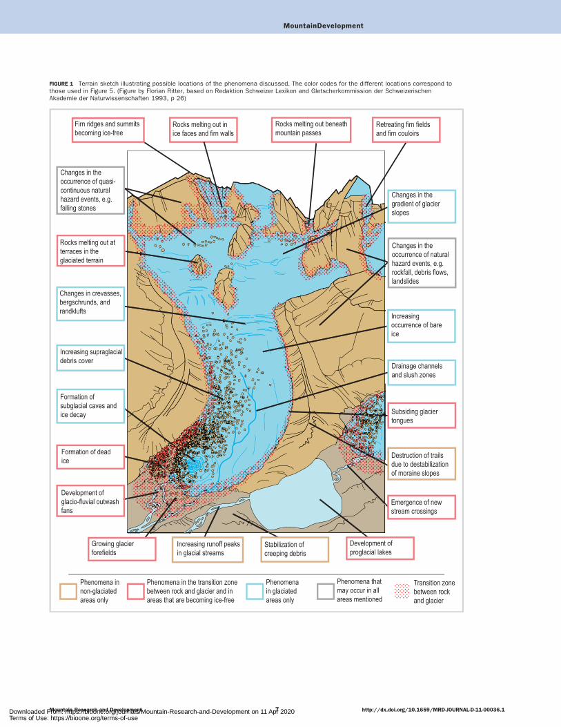
FIGURE 1 Terrain sketch illustrating possible locations of the phenomena discussed. The color codes for the different locations correspond tothose used in Figure 5. (Figure by Florian Ritter, based on Redaktion Schweizer Lexikon and Gletscherkommission der SchweizerischenAkademie der Naturwissenschaften 1993, p 26)
MountainDevelopment
Mountain Research and Development http://dx.doi.org/10.1659/MRD-JOURNAL-D-11-00036.17Downloaded From: https://bioone.org/journals/Mountain-Research-and-Development on 11 Apr 2020Terms of Use: https://bioone.org/terms-of-use
terrain. The effects described in this section may be lessimportant for society as a whole, because they do notthreaten settlement areas the way natural hazards might.However, they can be crucial for summer mountaintourism in many Alpine regions.
In our classification we differentiate between hazardsand accessibility, as not all changes in the technicaldifficulty of accessing terrain can be referred to ashazards. For example, a torrential glacial stream that hasto be crossed may increase the difficulty of a route orconstitute an obstacle, but it is not per se a hazard. Whendealing with the consequences of global warming for highAlpine trails and routes, it is thus insufficient to speakexclusively of hazards. We use the term ‘‘accessibility’’ todescribe changes that affect trails and routes but do notconstitute hazards.
Particular weather conditions and seasonal variationmay affect the accessibility of the terrain to a muchgreater degree than changes related to global warming(Lieb 2007). Most of the phenomena described below arenot new in the high Alps, but their intensity, frequency,and spatial distribution may be undergoing significantchange. Regarding the temporal scale, we distinguish twotypes of phenomena:
N Phenomena that follow a continuous trend and areusually linked to processes progressing steadily due tolong-term warming, such as glacier retreat andpermafrost degradation.
N Phenomena with a high seasonal variation that dependon immediate weather conditions, such as snow coveror meltwater runoff. Both the intensity and thetemporal occurrence of this group of phenomena willchange due to global warming.
In our classification we characterized about 20 suchphenomena that substantially affect the accessibility of
trails and routes. We grouped them according to theiroccurrence along the sections of a mountain tour:
N Changes in already ice-free areas;N Changes in glacier forefields;N Changes at the surface of glaciers;N Changes in summit areas.
The following paragraphs outline the most importantcharacteristics of the phenomena in each section, whileTables 2 to 5 list all phenomena and explain their causesas well as their effects along trails and routes. Figure 1illustrates possible locations of the phenomena discussed.Of course, the occurrence of natural hazards may changeas well in association with the described phenomena.These changes are not mentioned here, as they have beenaddressed in the preceding sections.
Again, the focus is on phenomena directly andindirectly connected to glacier retreat and permafrostdegradation. Other relevant processes could include, forexample, increasing erosion problems along hiking trailsdue to a growing frequency of heavy precipitation events,as claimed by the Alpine Clubs (eg Witty 2007). However,up to now a significant increase of heavy precipitationevents in the Alps in summer could not be verified(Schmidli and Frei 2005).
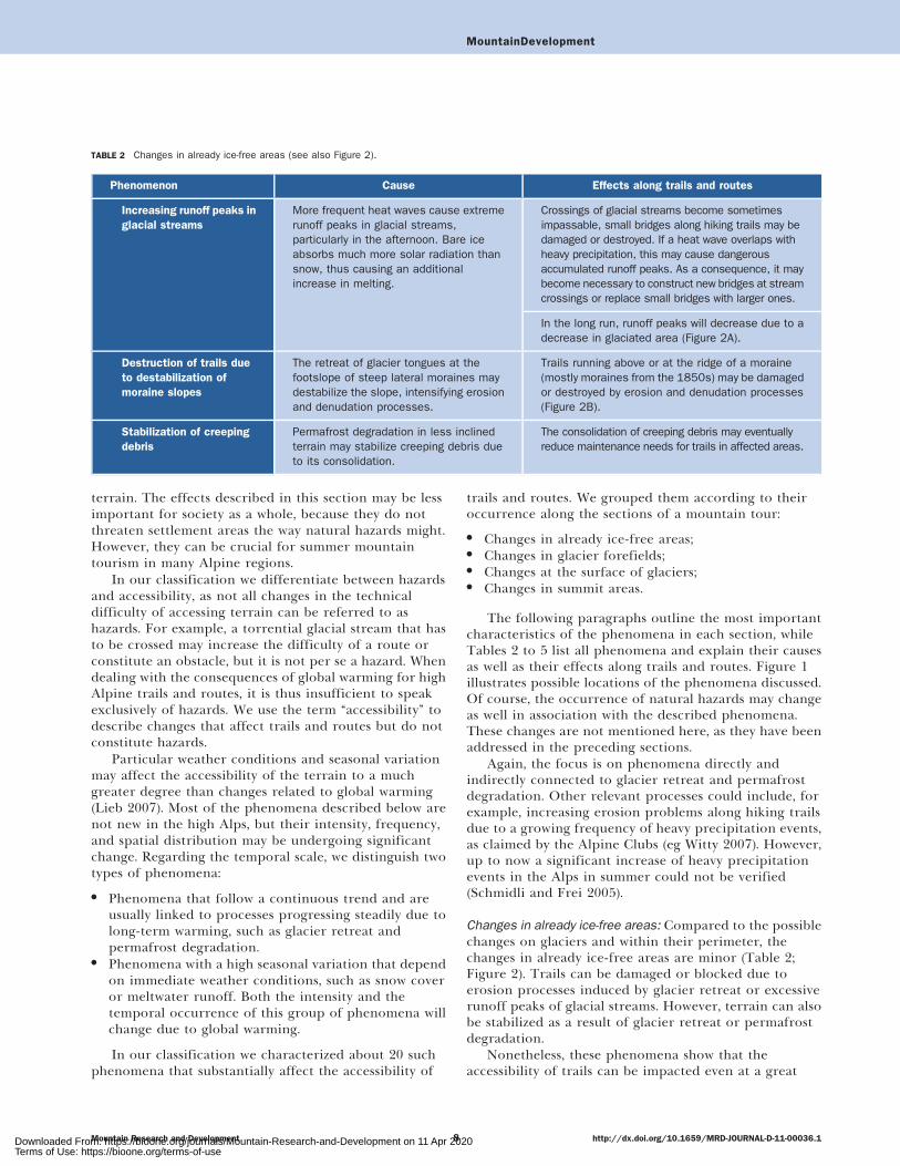
Changes in already ice-free areas: Compared to the possiblechanges on glaciers and within their perimeter, thechanges in already ice-free areas are minor (Table 2;Figure 2). Trails can be damaged or blocked due toerosion processes induced by glacier retreat or excessiverunoff peaks of glacial streams. However, terrain can alsobe stabilized as a result of glacier retreat or permafrostdegradation.
Nonetheless, these phenomena show that theaccessibility of trails can be impacted even at a great
TABLE 2 Changes in already ice-free areas (see also Figure 2).
Phenomenon Cause Effects along trails and routes
Increasing runoff peaks in
glacial streams
More frequent heat waves cause extremerunoff peaks in glacial streams,particularly in the afternoon. Bare iceabsorbs much more solar radiation thansnow, thus causing an additionalincrease in melting.
Crossings of glacial streams become sometimesimpassable, small bridges along hiking trails may bedamaged or destroyed. If a heat wave overlaps withheavy precipitation, this may cause dangerousaccumulated runoff peaks. As a consequence, it maybecome necessary to construct new bridges at streamcrossings or replace small bridges with larger ones.
In the long run, runoff peaks will decrease due to adecrease in glaciated area (Figure 2A).
Destruction of trails due
to destabilization of
moraine slopes
The retreat of glacier tongues at thefootslope of steep lateral moraines maydestabilize the slope, intensifying erosionand denudation processes.
Trails running above or at the ridge of a moraine(mostly moraines from the 1850s) may be damagedor destroyed by erosion and denudation processes(Figure 2B).
Stabilization of creeping
debris
Permafrost degradation in less inclinedterrain may stabilize creeping debris dueto its consolidation.
The consolidation of creeping debris may eventuallyreduce maintenance needs for trails in affected areas.
MountainDevelopment
Mountain Research and Development http://dx.doi.org/10.1659/MRD-JOURNAL-D-11-00036.18Downloaded From: https://bioone.org/journals/Mountain-Research-and-Development on 11 Apr 2020Terms of Use: https://bioone.org/terms-of-use

distance from glaciers. This means that such changesaffect not only mountaineers heading towards glaciatedmountain areas but also hikers using trails that werepreviously perceived as ‘‘safe.’’
Changes in glacier forefields: Glacier forefields and lateralaccess routes to glaciers are changing rapidly due toglacier retreat. Whether or not this leads to difficulties inaccessing the glacier mainly depends on the type ofterrain melting out and on the possibility to build newtrail infrastructure.
Growing glacier forefields are often unsuitable fornew trail infrastructure due to unstable underground (egdead ice, unconsolidated debris). In many cases the bestroute to access the glacier changes from year to year. TheAlpine Clubs do not have always the capacities necessaryto react to frequently changing conditions. Lakesdeveloping in glacier forefields may require specialsolutions concerning the trail network (Table 3;Figure 3).
Changes at the surface of glaciers: The accessibility ofglaciers changes according to daily and seasonal patterns,as well as from year to year. Global warming will lead toan increase in the occurrence of phenomena that aretypical for hot days or summers (eg intense meltwaterrunoff at the surface, occurrence of bare ice). Phenomenathat have not been observed in the Alps for a long time,such as ice decay, may occur.
Since there is usually no trail infrastructure onglaciers, these changes only affect routes without a fixedcourse. Locally, the accessibility of glaciers can eitherimprove or worsen, depending on the characteristics ofthe glacier and the prevailing conditions (Table 4).
Changes in summit areas: In many popular routes thetransition between the upper margin of a glacier and therocks of the summit area has become the crux of thewhole route. There are many prominent cases where it
used to be possible to simply ascend to the summit area byway of a snowy slope or couloir, whereas today these siteshave become both dangerous (see ‘‘Changes due to glacierretreat’’ above) and technically very difficult. In manycases it has been necessary to install fixed ropes or otherdevices such as ladders; however, this is possible only ifthe rocks revealed from underneath the melting ice arestable. Where rocks are unstable, the route may have to beredesigned completely.
Many classical ice climbing tours throughout the Alpshave already either become impassable due to instablerocks melting out or turned into difficult rock climbs(Table 5; Figure 4).
Discussion
Applicability
It was our objective to develop a classification ofphenomena related to global warming that affectmountaineering in high Alpine areas. The practicalapplicability has been successfully tested in three rangesof the Austrian Alps, where a mapping of thesephenomena along the high Alpine trail network wasconducted (Braun 2009).
In order to develop suitable solutions for themanagement of trails, different perspectives as well asdifferent kinds of knowledge need to be integrated.Various groups of stakeholders and scientists have towork together in a transdisciplinary way. As an example,we applied the classification in several workshops withlocal actors and stakeholders to explore the probablefuture development of the trail network in particularAustrian mountain ranges. Using the classification, wediscussed where the various phenomena might occuralong the examined trail network over the next decades.Based on this discussion, the stakeholders then sketcheddifferent adaptation scenarios. We received very positivefeedback regarding the intelligibility and practicability of
FIGURE 2 Examples of changes along trails in already ice-free areas (see also Table 2). (A) Extreme runoff peak in a glacial stream floodinga bridge in the Otztaler Alpen; (B) partial destruction of a trail along the ridge of the 1850 moraine of a glacier in the Venedigergruppe.(Photos by Erich Heucke and Florian Ritter)
MountainDevelopment
Mountain Research and Development http://dx.doi.org/10.1659/MRD-JOURNAL-D-11-00036.19Downloaded From: https://bioone.org/journals/Mountain-Research-and-Development on 11 Apr 2020Terms of Use: https://bioone.org/terms-of-use
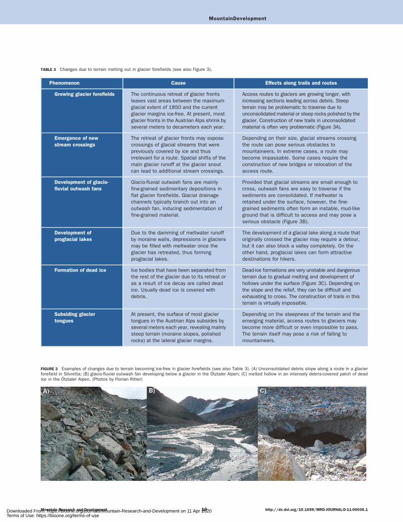
TABLE 3 Changes due to terrain melting out in glacier forefields (see also Figure 3).
Phenomenon Cause Effects along trails and routes
Growing glacier forefields The continuous retreat of glacier frontsleaves vast areas between the maximumglacial extent of 1850 and the currentglacier margins ice-free. At present, mostglacier fronts in the Austrian Alps shrink byseveral meters to decameters each year.
Access routes to glaciers are growing longer, withincreasing sections leading across debris. Steepterrain may be problematic to traverse due tounconsolidated material or steep rocks polished by theglacier. Construction of new trails in unconsolidatedmaterial is often very problematic (Figure 3A).
Emergence of new
stream crossings
The retreat of glacier fronts may exposecrossings of glacial streams that werepreviously covered by ice and thusirrelevant for a route. Spatial shifts of themain glacier runoff at the glacier snoutcan lead to additional stream crossings.
Depending on their size, glacial streams crossingthe route can pose serious obstacles tomountaineers. In extreme cases, a route maybecome impassable. Some cases require theconstruction of new bridges or relocation of theaccess route.
Development of glacio-
fluvial outwash fans
Glacio-fluvial outwash fans are mainlyfine-grained sedimentary depositions inflat glacier forefields. Glacial drainagechannels typically branch out into anoutwash fan, inducing sedimentation offine-grained material.
Provided that glacial streams are small enough tocross, outwash fans are easy to traverse if thesediments are consolidated. If meltwater isretained under the surface, however, the fine-grained sediments often form an instable, mud-likeground that is difficult to access and may pose aserious obstacle (Figure 3B).
Development of
proglacial lakes
Due to the damming of meltwater runoffby moraine walls, depressions in glaciersmay be filled with meltwater once theglacier has retreated, thus formingproglacial lakes.
The development of a glacial lake along a route thatoriginally crossed the glacier may require a detour,but it can also block a valley completely. On theother hand, proglacial lakes can form attractivedestinations for hikers.
Formation of dead ice Ice bodies that have been separated fromthe rest of the glacier due to its retreat oras a result of ice decay are called deadice. Usually dead ice is covered withdebris.
Dead-ice formations are very unstable and dangerousterrain due to gradual melting and development ofhollows under the surface (Figure 3C). Depending onthe slope and the relief, they can be difficult andexhausting to cross. The construction of trails in thisterrain is virtually impossible.
Subsiding glacier
tongues
At present, the surface of most glaciertongues in the Austrian Alps subsides byseveral meters each year, revealing mainlysteep terrain (moraine slopes, polishedrocks) at the lateral glacier margins.
Depending on the steepness of the terrain and theemerging material, access routes to glaciers maybecome more difficult or even impossible to pass.The terrain itself may pose a risk of falling tomountaineers.
FIGURE 3 Examples of changes due to terrain becoming ice-free in glacier forefields (see also Table 3). (A) Unconsolidated debris slope along a route in a glacierforefield in Silvretta; (B) glacio-fluvial outwash fan developing below a glacier in the Otztaler Alpen; (C) melted hollow in an intensely debris-covered patch of deadice in the Otztaler Alpen. (Photos by Florian Ritter)
MountainDevelopment
Mountain Research and Development http://dx.doi.org/10.1659/MRD-JOURNAL-D-11-00036.110Downloaded From: https://bioone.org/journals/Mountain-Research-and-Development on 11 Apr 2020Terms of Use: https://bioone.org/terms-of-use
the classification from all participating groups (Ritter etal 2010).
Limitations
Our classification is based on changes concerning naturalhazards and accessibility. Such changes can, of course,affect the overall character of an Alpine landscape andthe attractiveness of certain tours to mountaineers, withconsiderable effects on mountain huts and the local
economy (Figure 5). However, we did not include theseaspects in our classification, as they refer to a differentspatial scale.
Generalizability
The classification scheme was developed from data mostlyreferring to the Eastern Alps, in particular the AustrianAlps. We believe that it can be applied to other parts ofthe Alps and, with specific adaptations, presumably also
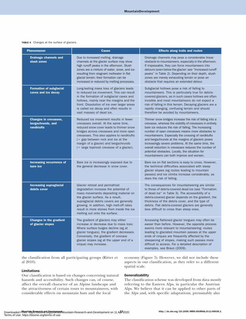
TABLE 4 Changes at the surface of glaciers.
Phenomenon Cause Effects along trails and routes
Drainage channels and
slush zones
Due to increased melting, drainagechannels at the glacier surface may showhigh runoff peaks in the afternoon. Slushzones are a mixture of water, snow, and iceresulting from stagnant meltwater in flatglacial terrain; their formation can beincreased or reduced by melting processes.
Drainage channels may pose a considerable linearobstacle to mountaineers, especially in the afternoon.If impassable, they can force mountaineers intodetours (even below the glacier: see ‘‘Increased runoffpeaks’’ in Table 2). Depending on their depth, slushzones are merely exhausting terrain or pose anobstacle that requires an extended detour.
Formation of subglacial
caves and ice decay
Long-lasting mass loss of glaciers leadsto reduced ice movement. This can resultin the formation of subglacial caves andhollows, mainly near the margins and thefront. Dissolution of ice over larger areasis called ice decay and often results invast masses of dead ice.
Subglacial hollows pose a risk of falling tomountaineers. This is particularly true for debris-covered glaciers, as in such cases hollows are ofteninvisible and most mountaineers do not expect arisk of falling in this terrain. Decaying glaciers are arapidly changing, confusing terrain and shouldtherefore be avoided by mountaineers.
Changes in crevasses,
bergschrunds, and
randklufts
Reduced ice movement results in fewercrevasses overall. At the same time,reduced snow cover leads to thinner snowbridges across crevasses and more opencrevasses. This also applies to randklufts(5 gap between rock and ice at themargin of a glacier) and bergschrunds(5 large topmost crevasse of a glacier).
Thinner snow bridges increase the risk of falling into acrevasse, whereas the visibility of crevasses in entirelybare ice reduces the risk of falling. The increasingnumber of open crevasses means more obstacles tomountaineers. Especially the crossing of randkluftsand bergschrunds at the margins of glaciers posesincreasingly severe problems. At the same time, theoverall reduction in crevasses reduces the number ofpotential obstacles. Locally, the situation formountaineers can both improve and worsen.
Increasing occurrence of
bare ice
Bare ice is increasingly exposed due tothe general decrease in snow cover.
Bare ice on flat sections is easy to cross. However,the technical difficulties associated with steepglacier slopes (eg routes leading to mountainpasses) and ice climbs increase considerably, asdoes the risk of falling.
Increasing supraglacial
debris cover
Glacier retreat and permafrostdegradation increase the potential ofmass movements depositing material onthe glacier surface. As a result,supraglacial debris covers are generallygrowing. In addition, high melt-off ratesresult in more stones from inside the icemelting out onto the surface.
The consequences for mountaineering are similarto those of debris-covered dead ice (see ‘‘Formationof dead ice’’ in Table 3). The accessibility of adebris-covered glacier depends on the gradient, thethickness of the debris cover, and the type ofdebris. Flat debris-covered glaciers are generallyless difficult to cross than steep ones.
Changes in the gradient
of glacier slopes
The gradient of glaciers may eitherincrease or decrease due to mass loss:Where surface bulges decline (eg atglacier tongues), the gradient decreases.Conversely, the gradient of concaveglacier slopes (eg at the upper end of acirque) may increase.
Accessing flattened glacier tongues may often beeasier than before. However, the opposite processseems more relevant to mountaineering: routesleading to glaciated mountain passes at the upperends of cirques are frequently affected by thesteepening of slopes, making such passes moredifficult to access. For a detailed description ofexamples, see Braun (2009).
MountainDevelopment
Mountain Research and Development http://dx.doi.org/10.1659/MRD-JOURNAL-D-11-00036.111Downloaded From: https://bioone.org/journals/Mountain-Research-and-Development on 11 Apr 2020Terms of Use: https://bioone.org/terms-of-use
to most glaciated mountain ranges outside the Alps.Adaptations might be necessary due to differentgeological, morphodynamic, and climatic situations, aswell as different forms and traditions of mountaineering.
Before applying the classification in othermountain regions, it would be necessary to investigatewhether local practitioners, such as mountain guides ortrail workers, are familiar with the phenomena itdescribes. In addition, it would have to be checkedwhether they are confronted with additional problemsthat are not considered in the classification. Expertinterviews would constitute an appropriate approachto retrieving this information and could help toidentify the need for additional field research in therelevant area.
Anticipatory implementation
It is essential with a view to maintaining an attractive trailnetwork in high Alpine areas that problematic
morphodynamic developments be recognized before theaffected trails or routes become impassable. It should bepossible to look for alternatives well ahead of time, forexample, by providing different routes. It is thereforecrucial to identify and anticipate expected future changesin the terrain linked to global warming.
Our findings suggest that the majority of thephenomena can be found in almost all heavily glaciatedmountain areas. Our classification could be used to derivecriteria for recognizing these spots. Using GeographicInformation Systems (GIS) analysis, the terrain alongtrails could be checked against these criteria in order todetect critical spots that might become problematic infuture.
Conclusions
Hiking and mountaineering have always been performedin terrain characterized by increased occurrence of
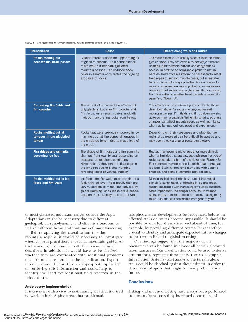
TABLE 5 Changes due to terrain melting out in summit areas (see also Figure 4).
Phenomenon Cause Effects along trails and routes
Rocks melting out
beneath mountain passes
Glacier retreat causes the upper marginsof glaciers subside. As a consequence,rocks melt out beneath glaciatedmountain passes. The reduced snowcover in summer accelerates the ongoingexposure of rocks.
The rocks exposed are usually steeper than the formerglacier slope. They are often also heavily jointed andunstable and therefore difficult and dangerous toaccess, in addition to being more prone to naturalhazards. In many cases it would be necessary to installfixed ropes to support mountaineers, but in instableterrain this is not always possible. Access routes tomountain passes are very important to mountaineers,because most routes leading to summits or crossingfrom one valley to another head towards a mountainpass first (Figure 4A).
Retreating firn fields and
firn couloirs
The retreat of snow and ice affects notonly glaciers, but also firn couloirs andfirn fields. As a result, routes graduallymelt out, uncovering rocks from below.
The effects on mountaineering are similar to thosedescribed above for rocks melting out beneathmountain passes. Firn fields and firn couloirs are alsoquite common along high Alpine hiking trails, so thesechanges can affect mountaineers as well as hikers,who may be less well equipped and experienced.
Rocks melting out at
terraces in the glaciated
terrain
Rocks that were previously covered in icemay melt out at the edges of terraces inthe glaciated terrain due to mass loss ofthe glacier.
Depending on their steepness and stability, therocks thus exposed can be difficult to access andmay even block a glacier route completely.
Firn ridges and summits
becoming ice-free
The shape of firn ridges and firn summitschanges from year to year depending onseasonal atmospheric conditions.Nevertheless, they tend to disappear inthe long run due to global warming,revealing rocks of varying stability.
Routes may become either easier or more difficultwhen a firn ridge disappears, depending on the type ofrocks exposed, the form of the ridge, etc (Figure 4B).Firn summits may decrease in height due to gradualice loss. Stability problems may arise with summitcrosses, and parts of summits may collapse.
Rocks melting out in ice
faces and firn walls
Ice faces and firn walls often consist of afairly thin ice layer. As a result, they arevery vulnerable to mass loss induced byglobal warming. Once rocks are exposed,adjacent rocks rapidly melt out as well.
Many classical ice climbs have turned into mixedclimbs (a combination of climbing in ice and rock),mostly associated with increasing difficulties and risks.More importantly, the danger of rockfall increasessubstantially in most affected ice faces, making manytours less and less accessible from year to year.
MountainDevelopment
Mountain Research and Development http://dx.doi.org/10.1659/MRD-JOURNAL-D-11-00036.112Downloaded From: https://bioone.org/journals/Mountain-Research-and-Development on 11 Apr 2020Terms of Use: https://bioone.org/terms-of-use
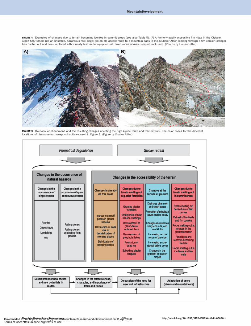
FIGURE 4 Examples of changes due to terrain becoming ice-free in summit areas (see also Table 5). (A) A formerly easily accessible firn ridge in the OtztalerAlpen has turned into an unstable, hazardous rock ridge; (B) an old ascent route to a mountain pass in the Stubaier Alpen leading through a firn couloir (orange)has melted out and been replaced with a newly built route equipped with fixed ropes across compact rock (red). (Photos by Florian Ritter)
FIGURE 5 Overview of phenomena and the resulting changes affecting the high Alpine route and trail network. The color codes for the differentlocations of phenomena correspond to those used in Figure 1. (Figure by Florian Ritter)
MountainDevelopment
Mountain Research and Development http://dx.doi.org/10.1659/MRD-JOURNAL-D-11-00036.113Downloaded From: https://bioone.org/journals/Mountain-Research-and-Development on 11 Apr 2020Terms of Use: https://bioone.org/terms-of-use

natural hazards and low management intensity. It is partof the activity’s identity that mountaineers areresponsible for their own safety in the Alpineenvironment. The risk situation along high Alpine trailsand routes thus cannot be compared to the situation inresidential areas, for example, where natural hazardmanagement has to be much more intensive.
The collected examples show that in the context ofglobal warming numerous different types of phenomenacan affect the accessibility of high Alpine trails androutes, in terms of both the occurrence of natural hazardsand technical difficulty. Threats and difficulties canincrease or decrease depending on the specific situation,but usually a worsening of the situation receives moreattention than an improvement.
Extending the legal liability of trail holders andmaintenance staff is not a sensible solution. Instead, werecommend addressing the problem awareness of users(hikers, mountaineers) and their personal responsibility.However, they should not be scared away, as it oftenhappens when only disasters are reported in the media.The effects of global warming on the high Alpine terrainare not exclusively negative. From the point of view of
infrastructure management it is essential to see newopportunities as well, such as the possibility ofdeveloping new ascents in areas that have become ice-free.
In Figure 5 we present a possible framework forinvestigating effects and developing managementmeasures at the local level. This can be successfullyimplemented only by involving a wide variety ofstakeholders (see Ritter et al 2010). The cumulativeeffects of numerous individual critical developments atthe local level can also induce a need for strategicdecisions at a different level, such as a completeredesign of the trail network or even the abandonmentof trail maintenance in critical sections of a mountainrange.
Planning and management of trail networks have to beadaptive and future oriented. Trail holders have to lookfor alternatives ahead of time. Our findings show thatmany problems are foreseeable. Action should be takenbefore severe accidents happen or trails becomecompletely impassable. We hope that our classificationcan serve to support the development of integrativeadaptation strategies.
ACKNOWLEDGMENTS
This article is based on parts of the PhD thesis by Florian Ritter (formerly Braun),which was completed within the Doctoral School Sustainable Development(dokNE) at BOKU University of Natural Resources and Life Sciences, Vienna,Austria, and was funded by the proVISION research program of the Austrian
Federal Ministry of Science and Research (bmwf); the Federal Ministry ofAgriculture, Forestry, Environment and Water Management (BMLFUW); theFederal State of Lower Austria; the Federal State of Styria; and the City ofVienna.
REFERENCES
Ballantyne CK. 2002. Paraglacial geomorphology. Quaternary Science Reviews21:1935–2017.Braun F. 2009. Sommer-Bergtourismus im Klimawandel: Szenarien undHandlungsbedarf am Beispiel des hochalpinen Wegenetzes [PhDdissertation]. Vienna, Austria: University of Natural Resources and LifeSciences.Chiarle M, Iannotti S, Mortara G, Deline P. 2007. Recent debris flowoccurrences associated with glaciers in the Alps. Global and Planetary Change56(1–2):123–136.Davies MCR, Hamza O, Harris C. 2001. The effect of rise in mean annualtemperature on the stability of rock slopes containing ice-filled discontinuities.Permafrost and Periglacial Processes 12:137–144.Fischer L, Kaab A, Huggel C, Noetzli J. 2006. Geology, glacier retreat andpermafrost degradation as controlling factors of slope instabilities in a high-mountain rock wall: The Monte Rosa east face. Natural Hazards and EarthSystem Sciences 6:761–772.Gruber S, Hoelzle M, Haeberli W. 2004. Permafrost thaw and destabilization ofAlpine rock walls in the hot summer of 2003. Geophysical Research Letters31(13).Haeberli W. 1999. Eisschwund und Naturkatastrophen im Hochgebirge. Zurich,Switzerland: vdf.Haeberli W, Alean J, Muller P, Funk M. 1989. Assessing risks from glacierhazards in high mountain regions: Some experiences in the Swiss Alps. Annalsof Glaciology 13:96–102.Haeberli W, Beniston M. 1998. Climate change and its impacts on glaciers andpermafrost in the Alps. Ambio 27(4):258–265.Harris C, Davies MCR, Etzelmuller B. 2001. The assessment ofpotential geotechnical hazards associated with mountain permafrost in awarming global climate. Permafrost and Periglacial Processes 12(1):145–156.
Hirschmug M. 2003. Debris flows in the mountain permafrost zone: HoheTauern national park (Austria). In: Phillips M, editor. Proceedings of the EighthInternational Conference on Permafrost, 21–25 July 2003, Zurich, Switzerland.Lisse, The Netherlands: Balkema, pp 413–418.
Kapelari P. 2008. Der Weg ist das Ziel. Das Wegenetz des Alpenvereins istkeine Selbstverstandlichkeit. Bergauf 04(2008):6–9.
Lieb GK. 2007. Vom Klimawandel beeinflusste Naturprozesse im Hochgebirgeals potenzielle Gefahren fur Freizeitaktivitaten. In: Wohlschlagl H, editor.Beitrage zur Humangeographie und Entwicklungsforschung. GeographischerJahresbericht aus Osterreich. Vienna, Austria: Institut fur Geographie undRegionalforschung, pp 79–94.
Lieb GK, Kellerer-Pirklbauer A, Avian M. 2007. A preliminary map ofgeomorphological hazards caused by climate change in the GroßglocknerMountains (Austria). In: Kellerer-Pirklbauer A, Keiler M, Embleton-Hamann C,editors. Geomorphology for the Future. Innsbruck, Austria: Innsbruck UniversityPress, pp 137–144.
Muhar A, Schauppenlehner T, Brandenburg C, Arnberger A. 2006. Alpinesummer tourism: the mountaineers’ perspective and consequences fortourism strategies in Austria. Forest, Snow and Landscape Research 81(1/2):7–17.
Notzli J, Gruber S, Hoelzle M. 2004. Permafrost und Felssturze im Hitzesommer2003. GEOforum actuel 20:11–14.
Redaktion Schweizer Lexikon and Gletscherkommission derSchweizerischen Akademie der Naturwissenschaften, editors. 1993.Gletscher, Schnee und Eis: Das Lexikon zu Glaziologie, Schnee- undLawinenforschung der Schweiz. Visp, Switzerland: Verlag Schweizer Lexikon,Mengis und Zier.
Ritter F, Muhar A, Fiebig M. 2010. Transdisziplinarer Dialog: Fachwissen undErfahrungswissen im Austausch uber Sommer-Bergtourismus und Klimawandel.GAIA 19(3):194–203.
Rosenthal G. 2008. Interpretative Sozialforschung: Eine Einfuhrung. Weinheim,Germany: Juventa.
MountainDevelopment
Mountain Research and Development http://dx.doi.org/10.1659/MRD-JOURNAL-D-11-00036.114Downloaded From: https://bioone.org/journals/Mountain-Research-and-Development on 11 Apr 2020Terms of Use: https://bioone.org/terms-of-use

Schmidli J, Frei C. 2005. Trends of heavy precipitation and wet and dry spells in Swit-zerland during the 20th century. International Journal of Climatology 25(6):753–771.Schworer D. 1999. Klima und Alpinismus im Wandel der Zeit. Available at:http://www.alpineresearch.ch/1/; accessed on 10 September 2010.Washburn AL. 1973. Periglacial processes and environments. London, UnitedKingdom: Arnold.
WGMS [World Glacier Monitoring Service]. 2008. Global glacier changes:facts and figures. Zurich, Switzerland: World Glacier Monitoring Service.Witty S. 2007. ‘‘New Tool’’ – Neues Werkzeug – GIS. In: OesterreichischerAlpenverein Fachabteilung Raumplanung-Naturschutz, editor: Die Arbeitsgebieteder Alpenvereine zwischen Ruckzug und neuen Ufern. Innsbruck, Austria: AlpineRaumordnung, pp 61–65.
MountainDevelopment
Mountain Research and Development http://dx.doi.org/10.1659/MRD-JOURNAL-D-11-00036.115Downloaded From: https://bioone.org/journals/Mountain-Research-and-Development on 11 Apr 2020Terms of Use: https://bioone.org/terms-of-use