p1-2-12 3d land seismic with low environmental impact: a … · · 2016-11-033d land seismic with...
TRANSCRIPT
P1-2-12
3D land seismic with low environmental impact: a case study from the Murchison Falls National Park, Uganda
Keith Mills1, Abderrahim Lafram
2, Michael Igoe
3, Sharon Cooper
1, Louise Moorhead
1, Andrew
Stone1
1CGG, London, UK,
2Total S.A., Pau, France,
3Tullow Oil, Dublin, Ireland
Introduction
In this paper we present a case study from the Murchison Falls National Park in Uganda where advanced processing solutions were applied to overcome various challenges arising from low impact acquisition due to the complexity of the environment. The dataset used was acquired in 2013-14 within the EA-1 and EA-1A blocks which lie at the northern end of Lake Albert in the Albertine graben. The purpose of this 3D survey was to obtain detailed information of the sub-surface geology for optimisation of Total’s current fields and development of new prospects (Cardama et al., 2014). Due to the location of the survey almost wholly within the Murchison Falls National Park, an important conservation and major tourist destination in Uganda, it was imperative for the data to be acquired in a sensitive manner to limit disruption to animals and minimise the environmental footprint. Following single-sensor equipment testing and method validation in the neighbouring EA-2 block (Mougenot et al., 2014), the system selected enabled the nodes to be buried with ease, which would be relatively undisturbed by the density and diversity of wildlife. This was coupled with low-impact small-size vibrators and portable dynamite drills for use in infill areas only, which helped to reduce the footprint. The survey was designed on a dense shot (100 m x 25 m) and receiver (100 m x 12.5 m) grid to mitigate the effects of low signal-to-noise ratio per trace and to account for the depth of the reservoirs, which get very shallow in the north of the area (1200 to 200 ms two-way traveltime).
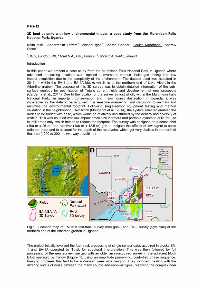
Fig 1. Location map of EA-1/1A fast-track survey area (pink) and EA-2 survey (light blue) at the northern end of the Albertine graben in Uganda.
The project initially involved the fast-track processing of single-sensor data, acquired in blocks EA-1 and EA-1A operated by Total, for structural interpretation. This was then followed by full processing of the new survey, merged with an older array-acquired survey in the adjacent block EA-2 operated by Tullow (Figure 1), using an amplitude preserving, controlled phase sequence. Imaging problems that had to be addressed were wide ranging. They included: dealing with the differing levels of noise between the many source and receiver types, resolving the complex near
surface, careful denoising due to the shallowness of the target, producing a seamless merge between the two surveys, and filling in large gaps due to the River Nile. To overcome these obstacles we used a multi-pass, multi-domain approach to denoising, advanced surface-consistent solutions, used previously on a high-density data set (Poulain et al., 2014), and multi-dimensional interpolation (Poole, 2010), all of which were possible due to the necessary high performance computing (HPC) techniques already in place (Poulain et al., 2014).
Processing challenges and advanced solutions
This case study shows the final imaging quality that can be achieved when using advanced solutions on well sampled data to resolve problems arising from sensitive acquisition in a difficult natural environment. The fast-track required less detailed attention than the full processing due to application of pre-stack scaling. The focus of the full processing was to preserve amplitudes and merge two surveys of different geometries onto the same processing grid.
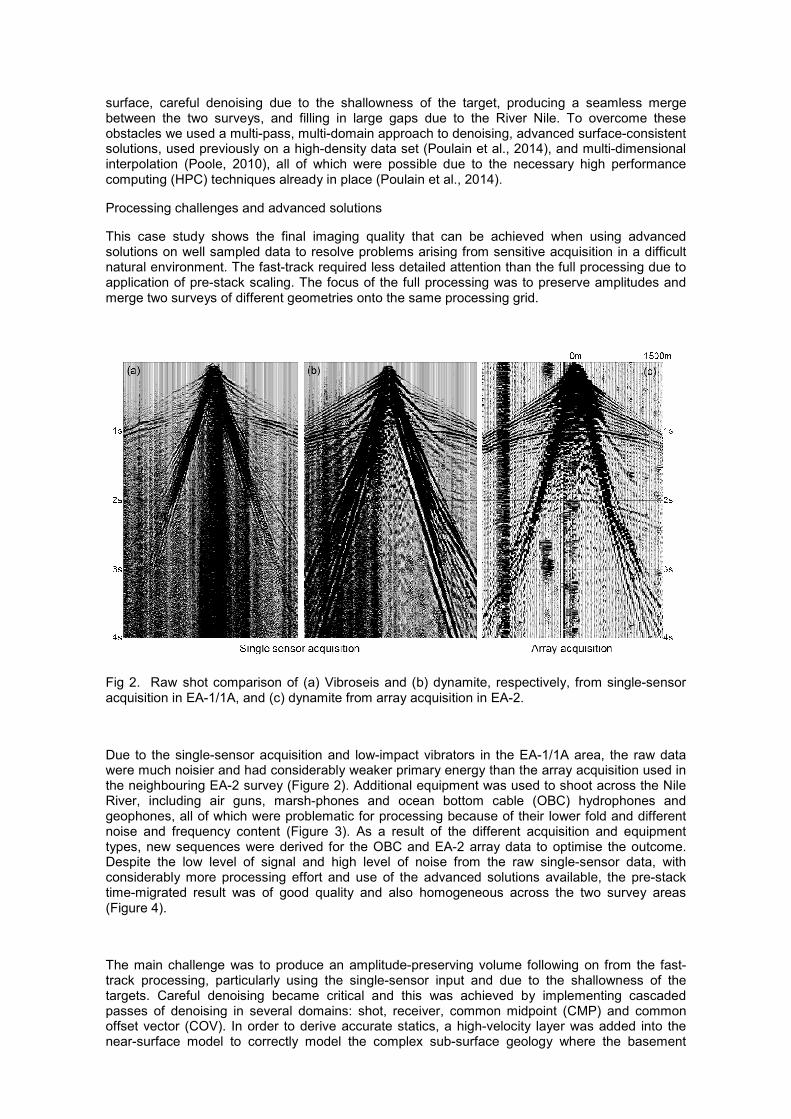
Fig 2. Raw shot comparison of (a) Vibroseis and (b) dynamite, respectively, from single-sensor acquisition in EA-1/1A, and (c) dynamite from array acquisition in EA-2.
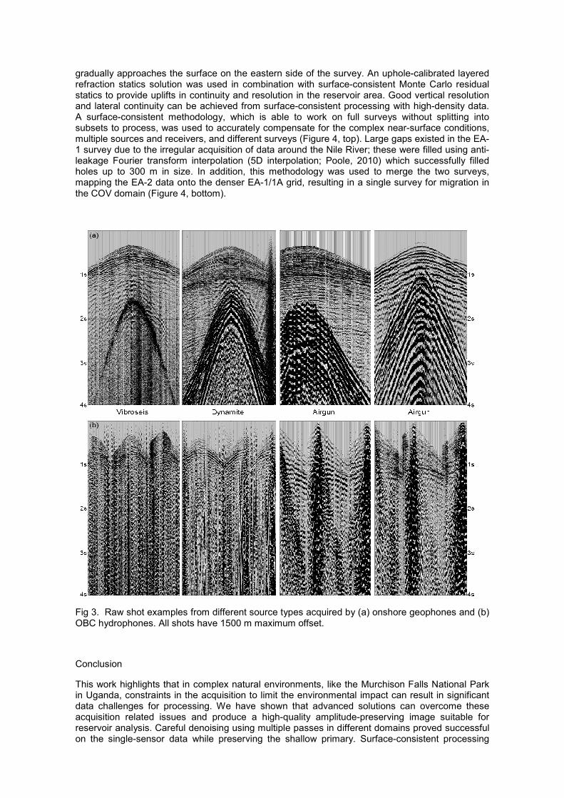
Due to the single-sensor acquisition and low-impact vibrators in the EA-1/1A area, the raw data were much noisier and had considerably weaker primary energy than the array acquisition used in the neighbouring EA-2 survey (Figure 2). Additional equipment was used to shoot across the Nile River, including air guns, marsh-phones and ocean bottom cable (OBC) hydrophones and geophones, all of which were problematic for processing because of their lower fold and different noise and frequency content (Figure 3). As a result of the different acquisition and equipment types, new sequences were derived for the OBC and EA-2 array data to optimise the outcome. Despite the low level of signal and high level of noise from the raw single-sensor data, with considerably more processing effort and use of the advanced solutions available, the pre-stack time-migrated result was of good quality and also homogeneous across the two survey areas (Figure 4).
The main challenge was to produce an amplitude-preserving volume following on from the fast-track processing, particularly using the single-sensor input and due to the shallowness of the targets. Careful denoising became critical and this was achieved by implementing cascaded passes of denoising in several domains: shot, receiver, common midpoint (CMP) and common offset vector (COV). In order to derive accurate statics, a high-velocity layer was added into the near-surface model to correctly model the complex sub-surface geology where the basement
gradually approaches the surface on the eastern side of the survey. An uphole-calibrated layered refraction statics solution was used in combination with surface-consistent Monte Carlo residual statics to provide uplifts in continuity and resolution in the reservoir area. Good vertical resolution and lateral continuity can be achieved from surface-consistent processing with high-density data. A surface-consistent methodology, which is able to work on full surveys without splitting into subsets to process, was used to accurately compensate for the complex near-surface conditions, multiple sources and receivers, and different surveys (Figure 4, top). Large gaps existed in the EA-1 survey due to the irregular acquisition of data around the Nile River; these were filled using anti-leakage Fourier transform interpolation (5D interpolation; Poole, 2010) which successfully filled holes up to 300 m in size. In addition, this methodology was used to merge the two surveys, mapping the EA-2 data onto the denser EA-1/1A grid, resulting in a single survey for migration in the COV domain (Figure 4, bottom).
Fig 3. Raw shot examples from different source types acquired by (a) onshore geophones and (b) OBC hydrophones. All shots have 1500 m maximum offset.
Conclusion
This work highlights that in complex natural environments, like the Murchison Falls National Park in Uganda, constraints in the acquisition to limit the environmental impact can result in significant data challenges for processing. We have shown that advanced solutions can overcome these acquisition related issues and produce a high-quality amplitude-preserving image suitable for reservoir analysis. Careful denoising using multiple passes in different domains proved successful on the single-sensor data while preserving the shallow primary. Surface-consistent processing
resolved any variations in the data benefitting the mixed sources, receivers and terrains encountered in the area, and Monte-Carlo residual statics improved the resolution considerably. Multi-dimensional interpolation used in the merging of the EA-1/1A and EA-2 surveys achieved a seamless final result. The comprehensive processing applied was made possible through established HPC techniques.
References
Cardama, C., Sanchez, R. and Mougenot, J.M., 2014, Cableless Seismic Acquisition to Reduce Environmental Footprint in Murchison Falls National Park Uganda, 76th EAGE Conference and Exhibition, Extended Abstracts, Tu ELI1 02.
Mougenot, J.M., Cardama, C., Faure, P. and Sanchez, R., 2014, Cableless Seismic Acquisition Technology Evaluation and First Full Field Implementation in France and Uganda, 76th EAGE Conference and Exhibition, Extended Abstracts, Tu ELI1 01.
Poole, G., 2010, 5D data reconstruction using the anti-leakage Fourier transform, 72nd EAGE
Conference and Exhibition, Extended Abstracts.
Poulain, G., Garceran, K., Grimshaw, M., Le Meur, D., Murray, E., Kowalczyk-Kedzierska, M., Cooper, S. and Ourabah, A., 2014, Surface-Consistent Processing of a Full-azimuth Dataset – The Challenges and Solutions, 76th EAGE Conference and Exhibition, Extended Abstracts, We ELI1 03.
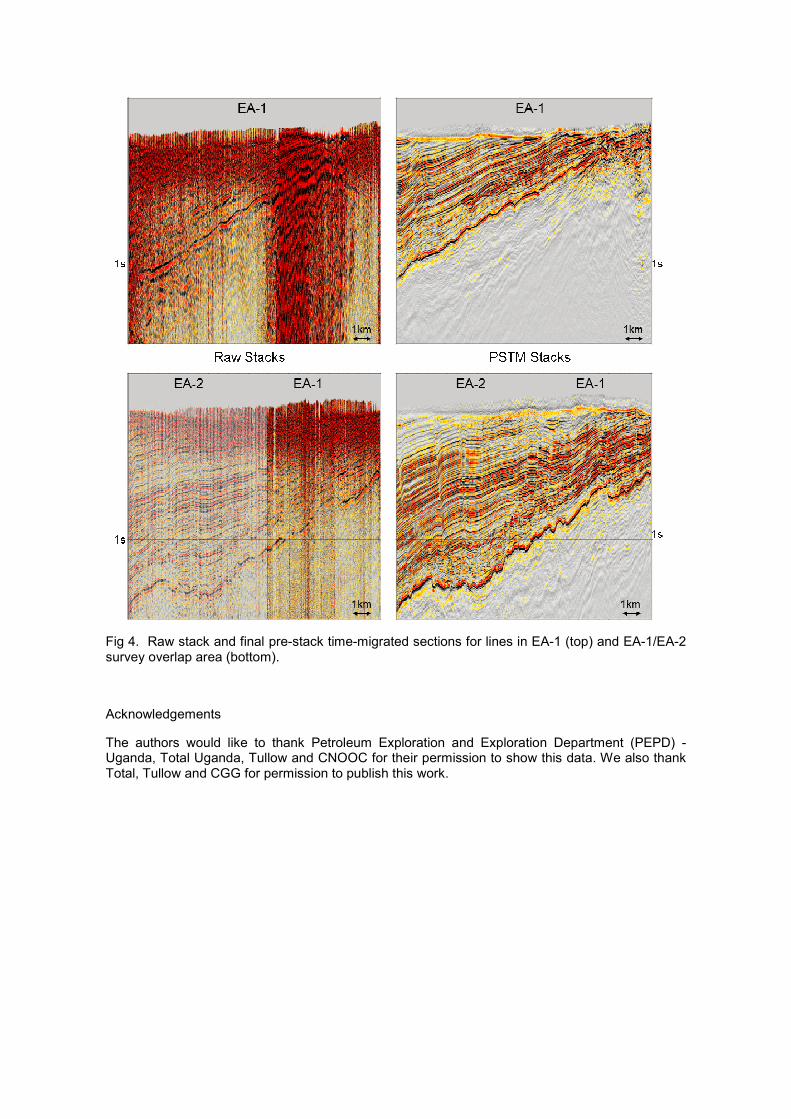
Fig 4. Raw stack and final pre-stack time-migrated sections for lines in EA-1 (top) and EA-1/EA-2 survey overlap area (bottom).
Acknowledgements
The authors would like to thank Petroleum Exploration and Exploration Department (PEPD) - Uganda, Total Uganda, Tullow and CNOOC for their permission to show this data. We also thank Total, Tullow and CGG for permission to publish this work.