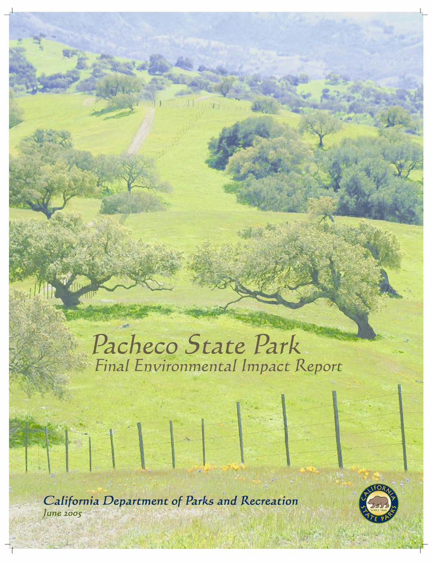
pacheco state park
TRANSCRIPT
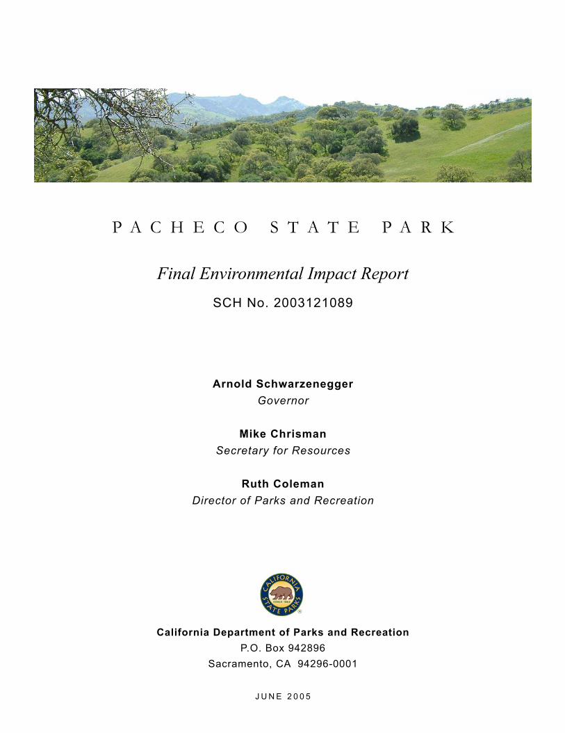
P A C H E C O S T A T E P A R K
California Department of Parks and Recreation
P.O. Box 942896
Sacramento, CA 94296-0001
J U N E 2 0 0 5
Final Environmental Impact ReportSCH No. 2003121089
Arnold Schwarzenegger
Governor
Mike Chrisman
Secretary for Resources
Ruth Coleman
Director of Parks and Recreation

© 2005 California Department of Parks and Recreation
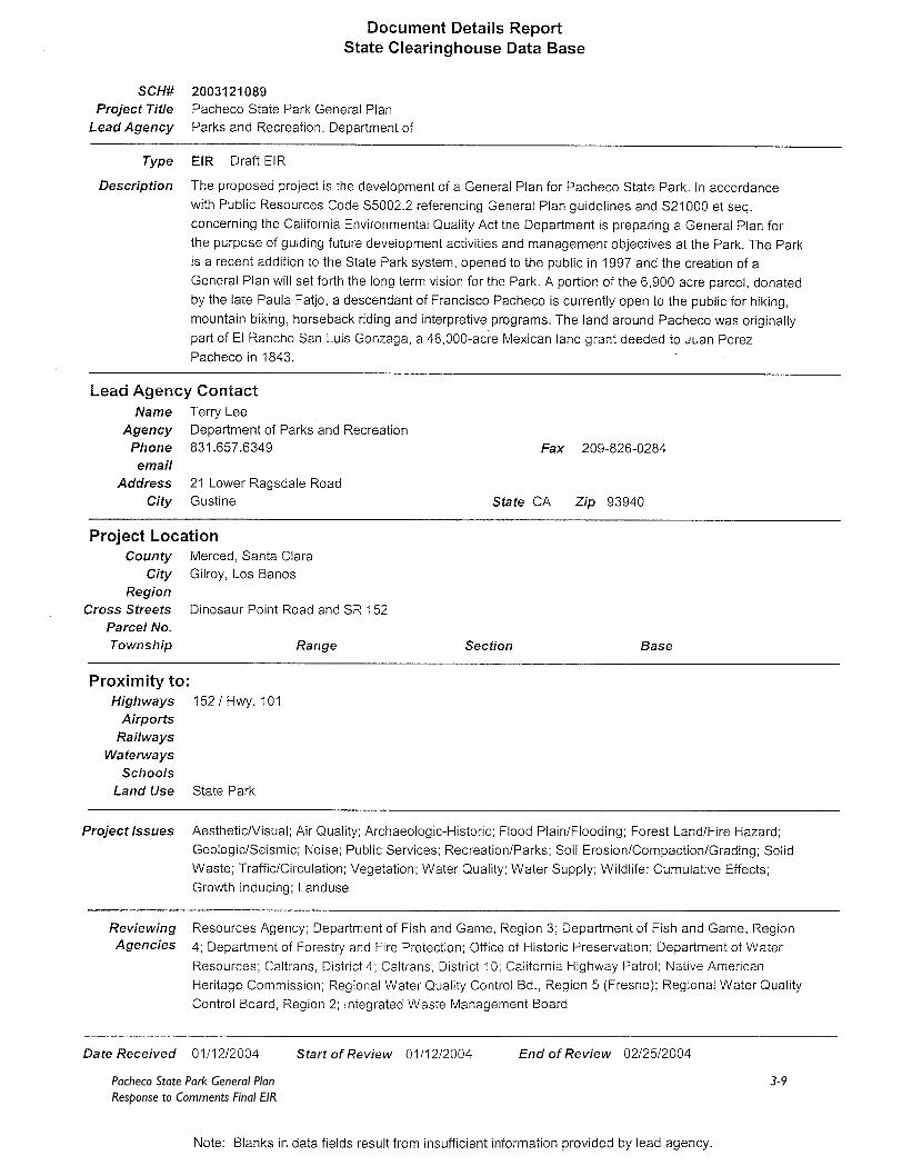
June 8, 2005 All Interested Agencies, Organizations, and Persons NOTICE OF AVAILABILITY PACHECO STATE PARK GENERAL PLAN FINAL ENVIRONMENTAL IMPACT REPORT The Final Environmental Impact Report (FEIR) has been prepared by the California Department of Parks and Recreation (Department) for the Pacheco State Park General Plan (General Plan). The FEIR is an adjunct to the Draft General Plan and EIR and includes comments received during the public review period and the Department’s responses to those comments. The Department is the lead agency, pursuant to the California Environmental Quality Act (CEQA), responsible for preparation of this document. Project Location The entrance to Pacheco State Park is off Dinosaur Point Road, south of State Route 152, between Interstates 101 and 5, approximately 24 miles west of the City of Los Banos and 20 miles east of Gilroy in the counties of Merced and Santa Clara. Project Description The proposed project is the development of a General Plan for Pacheco State Park. In accordance with Public Resources Code §5002.2 referencing General Plan guidelines and §21000 et seq. concerning the California Environmental Quality Act (CEQA) the Department is preparing a General Plan for the purpose of guiding future development activities and management objectives at the Park. The Park is a recent addition to the State Park system, opened to the public in 1997 and has not had a General Plan prepared to date. A portion of the 6,900 acre parcel, donated by the late Paula Fatjo, a descendant of Francisco Pacheco is currently open to the public for hiking, mountain biking, horseback riding and interpretive programs. The land around Pacheco was originally part of El Rancho San Luis Gonzaga, a 48,000-acre Mexican land grant deeded to Juan Perez Pacheco in 1843. The Park contains a rich array of natural and cultural resources, several residences, garages, paddocks, and outbuildings and is characterized by scenic expanses of open land laced with old ranch roads. Portions of the property are leased for the production of energy through wind turbines and cattle grazing.
The General Plan sets forth management zones that are based on existing conditions and resources and provide an overall intention for managing different areas of the Park recognizing the unique qualities and diversity of the site. Additionally, the Plan contains a comprehensive set of park-wide goals and guidelines for the long-term direction of the Park. A number of Park improvements are identified in three alternatives including the development of a recreational vehicle and an equestrian campground, a visitor center, re-use and rehabilitation of the existing buildings and additional interpretive programs. All alternatives provide for long term natural and cultural resource management and sustainable development for the Park.
Summary of Impacts The DEIR prepared for the project is a program-level analysis of the potential environmental impacts associated with the General Plan. Subsequent environmental review will take place pursuant to Plan implementation, as needed. The public review period for the Draft Plan and EIR began on January 12, 2004 and closed on February 26, 2004. The DEIR documented that no significant environmental impacts would occur as a result of the proposed project. Public Review Period The 30-day public review period for this Final EIR will commence on June 8, 2005 and conclude on July 8, 2005. Copies of the Draft General Plan and EIR and now the Final EIR, are available at the addresses noted below and at the Department website at http://www.parks.ca.gov/. Once there, click on “General Plans in Progress” in the right margin. Four Rivers Sector office 31426 Gonzaga Road Gustine, CA, 95322 209-826-1197
Los Banos Library 1312 South 7th Street Los Banos, CA 93635 209-826-5254
California Department of Parks and Recreation Northern Service Center One Capitol Mall, Suite 500 Sacramento, CA 95814
Pacheco State Park General Plan I Response to Comments FEIR
Table of Contents
TABLE OF CONTENTS .................................................................................. I
ACRONYMS .....................................................................................................III
1. INTRODUCTION .....................................................................................1-1
1.1 PURPOSE OF THE DRAFT FINAL ENVIRONMENTAL IMPACT REPORT .....................................................................................................................................................................1-1
1.2 ENVIRONMENTAL REVIEW PROCESS ......................................................................................1-1
2. LIST OF COMMENTERS.......................................................................2-1
3. PUBLIC COMMENT LETTERS AND RESPONSES ...........................3-1
LETTER 1.................................................................................................................................................................................3-2
RESPONSE TO LETTER 1......................................................................................................................................3-5
LETTER 2.................................................................................................................................................................................3-8
RESPONSE TO LETTER 2...................................................................................................................................3-10
LETTER 3..............................................................................................................................................................................3-11
RESPONSE TO LETTER 3...................................................................................................................................3-13
LETTER 4..............................................................................................................................................................................3-15
RESPONSE TO LETTER 4...................................................................................................................................3-22
LETTER 5..............................................................................................................................................................................3-27
RESPONSE TO LETTER 5...................................................................................................................................3-39
LETTER 6..............................................................................................................................................................................3-44
RESPONSE TO LETTER 6...................................................................................................................................3-45
LETTER 7..............................................................................................................................................................................3-47
RESPONSE TO LETTER 7...................................................................................................................................3-50
LETTERS 8 AND 9 .......................................................................................................................................................3-52
RESPONSE TO LETTER 8...................................................................................................................................3-56
RESPONSE TO LETTER 9...................................................................................................................................3-57
LETTER 10 ..........................................................................................................................................................................3-58
RESPONSE TO LETTER 10................................................................................................................................3-59
Pacheco State Park General Plan II Response to Comments FEIR
LETTER 11 ..........................................................................................................................................................................3-60
RESPONSE TO LETTER 11................................................................................................................................3-61
4. STAFF RECOMMENDED CHANGES TO THE GENERAL PLAN........4-1
4.1 DEPARTMENT STAFF-RECOMMENDED CHANGES .........................................................4-1
LIST OF TABLES
Table 1 Log Of Public Comments For CEQA Review....................................................................................2-1
Pacheco State Park General Plan III Response to Comments FEIR
Acronyms
ABAG Association of Bay Area Governments
ADA Americans with Disabilities Act
af acre-feet
AO Administration and Operations Zone
AUM animal unit month
BAAQMD Bay Area Air Quality Management District
Basin Plan Water Quality Control Plan
BC Zone Backcountry Zone
BP Before Present
BRM bedrock mortar
CALFED CALFED Bay-Delta Program
Caltrans California Department of Transportation
CDF California Department of Forestry and Fire Protection
CEQA California Environmental Quality Act
CESA California Endangered Species Act
CHRIS California Historical Resources Information System
CLR cultural landscape report
CNDDB California Natural Diversity Database
CNPS California Native Plant Society
CRHR California Register of Historical Resources
CVP Central Valley Project
dBA A-weighted decibel
DEIR Draft Environmental Impact Report
Department California Department of Parks and Recreation
DFG California Department of Fish and Game
DWR California Department of Water Resources
Pacheco State Park General Plan IV Response to Comments FEIR
EIR Environmental Impact Report
EIS Environmental Impact Statement
ESA Federal Endangered Species Act
FC Frontcountry Zone
FEIR Final Environmental Impact Report
FEMA Federal Emergency Management Agency
Gilroy General Plan Gilroy 2002-2020 General Plan
HCP Habitat Conservation Plan
Hollister General Plan
Hollister General Plan 1995-2010
I- Interstate
IRRS Interregional Road System
ITR International Turbine Research, Inc.
km kilometer
kWh Kilowatt-Hour
LAC Limits of Acceptable Change
LAFCO Local Agency Formation Commission
LOS Level of Service
Los Banos General Plan
The City of Los Banos General Plan
LE Zone Leased Zone
MCAG Merced County Association of Governments
Merced County General Plan
Merced County Year 2000 General Plan
mph miles per hour
MOA Memorandum of Agreement
MOU Memorandum of Understanding
Pacheco State Park General Plan V Response to Comments FEIR
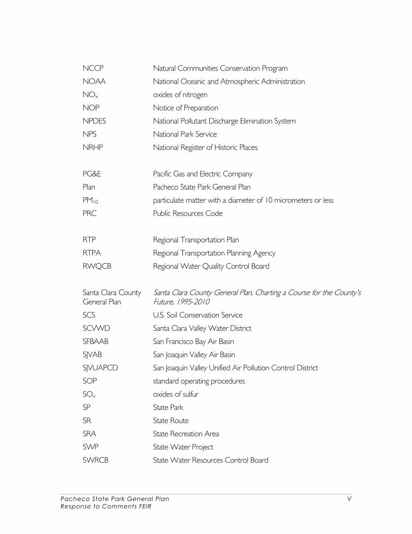
NCCP Natural Communities Conservation Program
NOAA National Oceanic and Atmospheric Administration
NOx oxides of nitrogen
NOP Notice of Preparation
NPDES National Pollutant Discharge Elimination System
NPS National Park Service
NRHP National Register of Historic Places
PG&E Pacific Gas and Electric Company
Plan Pacheco State Park General Plan
PM10 particulate matter with a diameter of 10 micrometers or less
PRC Public Resources Code
RTP Regional Transportation Plan
RTPA Regional Transportation Planning Agency
RWQCB Regional Water Quality Control Board
Santa Clara County General Plan
Santa Clara County General Plan, Charting a Course for the County's Future, 1995-2010
SCS U.S. Soil Conservation Service
SCVWD Santa Clara Valley Water District
SFBAAB San Francisco Bay Air Basin
SJVAB San Joaquin Valley Air Basin
SJVUAPCD San Joaquin Valley Unified Air Pollution Control District
SOP standard operating procedures
SOx oxides of sulfur
SP State Park
SR State Route
SRA State Recreation Area
SWP State Water Project
SWRCB State Water Resources Control Board
Pacheco State Park General Plan VI Response to Comments FEIR
TCR Transportation Concept Report
the Park Pacheco State Park
UC Merced University of California, Merced
USACE U.S. Army Corps of Engineers
USBR U.S. Bureau of Reclamation
US 101 U.S. Highway 101
USEPA U.S. Environmental Protection Agency
USFS U.S. Forest Service
USFWS U.S. Fish and Wildlife Service
USGS U.S. Geological Survey
UTC Ultimate Transportation Corridor
VERP Visitor Experience and Resource Protection
Pacheco State Park General Plan 1-1 Response to Comments FEIR
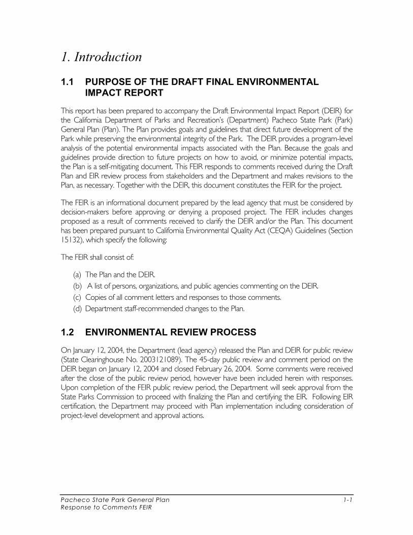
1. Introduction
1.1 PURPOSE OF THE DRAFT FINAL ENVIRONMENTAL IMPACT REPORT
This report has been prepared to accompany the Draft Environmental Impact Report (DEIR) for the California Department of Parks and Recreation’s (Department) Pacheco State Park (Park) General Plan (Plan). The Plan provides goals and guidelines that direct future development of the Park while preserving the environmental integrity of the Park. The DEIR provides a program-level analysis of the potential environmental impacts associated with the Plan. Because the goals and guidelines provide direction to future projects on how to avoid, or minimize potential impacts, the Plan is a self-mitigating document. This FEIR responds to comments received during the Draft Plan and EIR review process from stakeholders and the Department and makes revisions to the Plan, as necessary. Together with the DEIR, this document constitutes the FEIR for the project.
The FEIR is an informational document prepared by the lead agency that must be considered by decision-makers before approving or denying a proposed project. The FEIR includes changes proposed as a result of comments received to clarify the DEIR and/or the Plan. This document has been prepared pursuant to California Environmental Quality Act (CEQA) Guidelines (Section 15132), which specify the following:
The FEIR shall consist of:
(a) The Plan and the DEIR. (b) A list of persons, organizations, and public agencies commenting on the DEIR. (c) Copies of all comment letters and responses to those comments. (d) Department staff-recommended changes to the Plan.
1.2 ENVIRONMENTAL REVIEW PROCESS
On January 12, 2004, the Department (lead agency) released the Plan and DEIR for public review (State Clearinghouse No. 2003121089). The 45-day public review and comment period on the DEIR began on January 12, 2004 and closed February 26, 2004. Some comments were received after the close of the public review period, however have been included herein with responses. Upon completion of the FEIR public review period, the Department will seek approval from the State Parks Commission to proceed with finalizing the Plan and certifying the EIR. Following EIR certification, the Department may proceed with Plan implementation including consideration of project-level development and approval actions.

Pacheco State Park General Plan 2-1 Response to Comments Final EIR
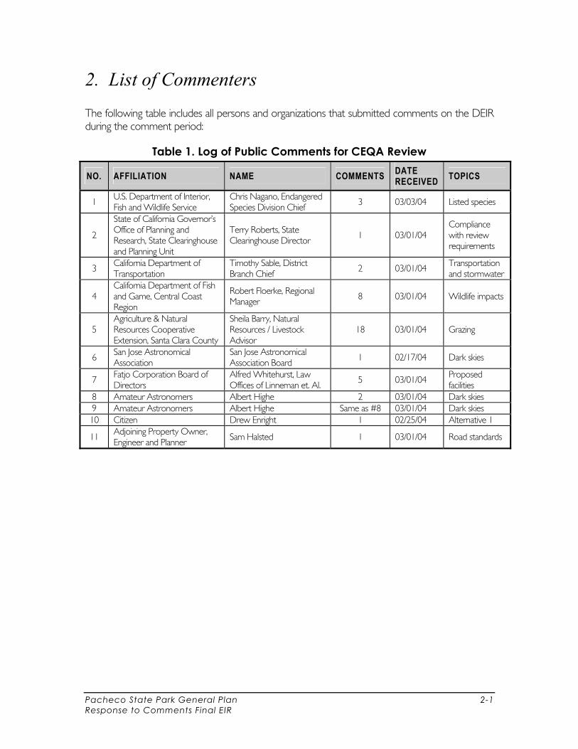
2. List of Commenters
The following table includes all persons and organizations that submitted comments on the DEIR during the comment period:
Table 1. Log of Public Comments for CEQA Review
NO. AFFILIATION NAME COMMENTS DATE RECEIVED TOPICS
1 U.S. Department of Interior, Fish and Wildlife Service
Chris Nagano, Endangered Species Division Chief
3 03/03/04 Listed species
2
State of California Governor’s Office of Planning and Research, State Clearinghouse and Planning Unit
Terry Roberts, State Clearinghouse Director
1 03/01/04 Compliance with review requirements
3 California Department of Transportation
Timothy Sable, District Branch Chief
2 03/01/04 Transportation and stormwater
4 California Department of Fish and Game, Central Coast Region
Robert Floerke, Regional Manager 8 03/01/04 Wildlife impacts
5 Agriculture & Natural Resources Cooperative Extension, Santa Clara County
Sheila Barry, Natural Resources / Livestock Advisor
18 03/01/04 Grazing
6 San Jose Astronomical Association
San Jose Astronomical Association Board
1 02/17/04 Dark skies
7 Fatjo Corporation Board of Directors
Alfred Whitehurst, Law Offices of Linneman et. Al.
5 03/01/04 Proposed facilities
8 Amateur Astronomers Albert Highe 2 03/01/04 Dark skies 9 Amateur Astronomers Albert Highe Same as #8 03/01/04 Dark skies 10 Citizen Drew Enright 1 02/25/04 Alternative 1
11 Adjoining Property Owner, Engineer and Planner
Sam Halsted 1 03/01/04 Road standards

Pacheco State Park General Plan 3-1 Response to Comments Final EIR
3. Public Comment Letters and Responses
This Section contains copies of comment letters received during the comment period and responses to those comments. As stated in CEQA Guidelines, Article 13, Section 15204: CEQA does not require a lead agency to conduct every test or perform all research, study, and experimentation recommended or demanded by commenters. When responding to comments, lead agencies need only respond to significant environmental issues and do not need to provide all information requested by reviewers, as long as a good faith effort at full disclosure is made in the EIR.
The Plan and DEIR serves as a first tier Environmental Impact Report as defined in Section 15166 of the California Environmental Quality Act (CEQA) Guidelines. The analysis of broad potential environmental impacts will provide the basis for future second level environmental review, which will provide more detailed information and analysis for site-specific developments and projects. This Plan is a broad policy document that sets the direction and provides a vision for the Park’s management and development. The Plan provides general direction for the Park while avoiding specific details that could change before a project could be funded and implemented. The purpose of the Plan is to provide a framework for the future facility development, on-going management, and public use. The goals and guidelines presented in the Plan are designed to guide resource stewardship, facility development and interpretation, and future resource management for the Park.
Each comment is numbered in the margin of the comment letter, and the responses to all of the comments in a particular letter follow the letter. The comments are referenced numerically by letter and comment number. Where a response includes a change to the text of the Plan and DEIR, the change is shown underlined as demonstrated here. In addition to underlined text, references to the Draft Plan and EIR page numbers and sections are provided.
Pacheco State Park General Plan 3-5 Response to Comments Final EIR
RESPONSE TO LETTER 1
From: United States Department of Interior, Fish and Wildlife Service, Chris Nagano, Endangered Species Division, Chief
The California Department of Parks and Recreation, Four Rivers Sector appreciates the comments received by the Fish and Wildlife Service (USFWS). The Plan and DEIR is a program-level evaluation. As specific projects are developed based on need and the availability of funds, the Department will value the involvement of the USFWS in site evaluations.
1-1 Determination of Impacts
The Plan serves as a first-tier Environmental Impact Report as defined in Section 15166 of the California Environmental Quality Act (CEQA) Guidelines. The analysis of broad potential environmental impacts discussed in the DEIR will provide the basis for future second-level environmental review, which will provide more detailed information and analysis on special-status species for site-specific developments and projects.
Because future projects would be required to meet the standards and performance measures to reduce potential impacts to a less-than-significant level as prescribed in the guidelines of the Plan and DEIR, it can be determined that the Plan would not result in any unavoidable or irreversible significant effects. The site-specific conditions in a particular location would affect the manner in which projects are carried out, as directed by the applicable Plan guidelines. Additional surveys would be conducted as necessary to ensure that special-status species are not adversely impacted as a result of a specific project. It is not guaranteed that all of the proposals allowed in the Plan will be deemed feasible after the completion of project level environmental review. In some cases the projects allowed by the Plan may be excluded upon site-specific evaluations that find adverse impacts to listed species.
This Plan is a programmatic, or tiered EIR, which is encouraged in the CEQA Guidelines. Please refer to CEQA Guidelines Section 15152(h) which states: “There are various types of EIRs that may be used in a tiering situation. These include, but are not limited to, the following:…(3) Program EIR”. CEQA Guidelines Section 15385 also states that “Tiering is appropriate when the sequence of EIRs is: (a) from a… program EIR to a program, plan or policy EIR of lesser scope or to a site-specific EIR.” CEQA Guidelines Section 15162 refers to the requirements that would trigger a subsequent EIR be prepared for an EIR which has been certified for a project. This guideline does not refer to the tiering process, where subsequent environmental analysis and review is completed as more detailed information and site-specific developments are proposed following a first-tier EIR.
Adoption of the Plan with selection of the preferred alternative is not anticipated to result in incidental take and therefore would not require authorization for such from the USFWS and National Oceanic and Atmospheric Administration (NOAA).

Pacheco State Park General Plan 3-6 Response to Comments Final EIR
Plan implementation of certain projects proposed in the Plan will require further consultation with the USFWS to determine if incidental take will result as part of the proposed project or action at that time.
1-2 Adequacy of Environmental Analysis and Use of a Programmatic EIR
The DEIR is a programmatic EIR for the Plan. According to CEQA provisions, the DEIR provides an adequate level of environmental analysis for a programmatic action. The proposed Plan consists of a variety of interrelated components to guide Department actions for the next 20 years or more. The EIR contains an appropriate level of detail in light of the nature and breadth of the proposed Plan. This document presents numerous goals and guidelines (pages 3-12 – 3-32) to protect and preserve the sensitive resources in the Park, including listed species. Additionally, the Plan does include large scale conservation measures such as minimizing and clustering development in existing disturbed areas and planning for most of the site to remain as backcountry, with minimal visitor uses and facilities. Analysis of the reasonably foreseeable impacts on listed species was reviewed comprehensively in Section 2.3 Opportunities and Constraints, Wildlife Species Inventory and Management (pages 2-54 – 2-55) and Section 4.5 Environmental Impacts, Wildlife (pages 4-22- 4-24) as part of the entire planning process and hence the resultant alternatives to minimize overall development of the Park. As specific projects within the management zones are selected for implementation, a more detailed CEQA analysis will be conducted within the overall planning framework of all the Plan goals and guidelines. The Plan allows for future broad scale, conceptual planning of future visitor use and facilities, but is not intended to pre-determine the final location or design of such facilities. However, the Plan provides that future planning and design must meet goals and guidelines (pages 3-13 – 3-20) for resource protection.
As a program-level document, the DEIR does not analyze site-specific impacts of future activities at specific locations. Rather, the DEIR describes generally the sorts of impacts that may occur, and describes the standards, best-management practices, regulations, or decision-making processes that would be followed to avoid such impacts. The EIR presents as much information as can be reasonably given at this program-level discussion. By law, the Department must comply with applicable responsible agencies’ rules and regulations when implementing the components of the Plan. Compliance with the standards set forth in the Plan and by regulating agencies would address potential environmental impacts.
As site-specific projects are implemented, conservation measures to avoid, minimize, or compensate for effects that could result from the increase in visitor activity or the development of the Park facility will be tailored to fit the particular nature of the proposed project. The Plan currently provides flexible policy guidelines intended to encourage conservation and habitat enhancements over a 20-year planning horizon. In doing so, it is important that policy language associated with conservation measures is not overly specific to preclude site-specific or innovative conservation approaches which meet the intent of the policy. Therefore, the existing conservation measures identified in the Plan (pages 3-13 – 3-20) are deemed adequate for the Park.

Pacheco State Park General Plan 3-7 Response to Comments Final EIR
1-3 Authorization for Incidental Take
Support for the goals RES-W1 and RES-W2 are appreciated. The additional information provided by the commenter on incidental take authorization is informative and will be used to revise the Plan on page 4-23 and 4-24 as follows:
“The USFWS is currently considering issuing a 10(a)(1)(B) permit for incidental take of San Joaquin kit fox for the Santa Nella Community Specific Plan, which covers approximately 150 acres east of O'Neill Forebay.”
1-4 Preference for Alternative 1
Your comment that recommends that we consider a preferred alternative that contains less development and will promote fewer visitors……Alternative (Alternative 2) is noted. The Preferred Alternative (2) reflects the Department’s mission (“to provide for the health, inspiration, and education of the people of California by helping to preserve the State’s extraordinary biological diversity, protecting its most valued natural and cultural resources, and creating opportunities for high quality outdoor recreation”), as well as public interests, agencies’ relevant rules and regulations, the Park’s purpose and vision, and opportunities and constraints in all planning areas. It will provide implementation of the Park-wide goals and guidelines while balancing current and future needs to ensure plan longevity. Development proposed in the Plan may not ultimately be built out if visitor needs and resource protection cannot be balanced. Future development will be further analyzed in project-specific environmental review. For the purpose of this policy-level Plan, however, proposed development is shown to accommodate future facilities and visitors, should they be needed.
Pacheco State Park General Plan 3-10 Response to Comments Final EIR
RESPONSE TO LETTER 2
From: State of California Governor’s Office of Planning and Research, State Clearinghouse and Planning Unit, Terry Roberts, Director.
Receipt of this letter confirms that the Department has complied with the State Clearinghouse review requirements for draft environmental documents pursuant to the California Environmental Quality Act. No other comments were submitted by the office.
Pacheco State Park General Plan 3-13 Response to Comments Final EIR
RESPONSE TO LETTER 3
From: State of California Department of Transportation, Timothy Sable, District Branch Chief
The California Department of Parks and Recreation, Four Rivers Sector appreciates the comments received by the California Department of Transportation (Caltrans), especially as a down-stream property owner. The Department does not anticipate runoff from proposed Park facilities to adversely affect highway facilities. However, as specific projects are developed based on need and the availability of funds, the District will value the involvement of Caltrans in solving transportation and associated drainage issues or where permits are necessary.
3-1 Recommendations for Future Management and Development Plans
Your concern for potential runoff effects to highway facilities downstream from proposed Park development areas is noted. Existing hydrology and water quality conditions are presented in Chapter 2, Existing Conditions (pages 2-4 – 2-5). Increased or contaminated runoff from proposed Park development is not anticipated to adversely affect highway facilities under any of the alternatives, As part of the Plan’s conceptual level planning process, hydrologic and hydraulic evaluations for development proposed in the preferred alternative was not conducted as the future Plan implementation will provide further details about improvements and facilities and their hydrologic characteristics. However, the Plan identifies the following goal and guidelines and mitigation measures to ensure that the effects of stormwater runoff are minimized:
Goal RES-WQ3 (page 3-17) Design, construct, and maintain buildings, roads, trails, campsites, and associated infrastructure to minimize stormwater runoff, promote quality groundwater recharge, and prevent soil erosion.
Guidelines Adhere to water quality protection standards and control measures available in the
Basin Plan for the region. Consult the Clean Water Act for current stormwater management guidelines and
comply with National Pollution Discharge Elimination System (NPDES) requirements where applicable.
Limit impervious surfaces to minimize runoff; consider the use of permeable materials for new or expanded pedestrian and vehicular surfaces.
During implementation, the Department will further evaluate storm water pollution prevention plans and work with your agency to ensure that potential impacts on highway facilities and adjacent lands are properly avoided and or mitigated pursuant to CEQA.
Pacheco State Park General Plan 3-14 Response to Comments Final EIR
3-2 Permit Requirements
The Department acknowledges that any work or traffic control necessary for proposed Park development within the Sate right-of-way will require an encroachment permit from Caltrans. In the event a permit is necessary, review and input from Caltrans on the project is welcomed.


Pacheco State Park General Plan 3-22 Response to Comments Final EIR
RESPONSE TO LETTER 4
From: California Department of Fish and Game, Central Coast Region, Robert Floerke, Regional Manger.
The California Department of Parks and Recreation, Four Rivers Sector appreciates the comments received by the California Department of Fish and Game (DFG). The Plan and DEIR is a program level evaluation. As specific projects are developed based on need and the availability of funds, the District will value the involvement of the DFG in site evaluations to protect listed species.
4-1 Adequacy of Environmental Evaluation
The Plan provides adequate environmental evaluation under CEQA for programmatic EIRs. The DEIR considers potential future facilities, but is not intended to designate detailed facilities with specific size, design, and locations. As required by CEQA, subsequent activities carried out pursuant to the Plan will be reviewed to determine whether additional environmental analysis must be performed (State CEQA Guidelines 15168(c)). If the subsequent activities generate impacts that were not analyzed in the General Plan DEIR, the Department would have to prepare an initial study analyzing those impacts (State CEQA Guidelines 15168(c)(1)),
The Plan documents all information currently known with regards to the locations of sensitive plants, (page 2-18 and Table 1, page 2-10) presence in and the use of the Park by wildlife (page 2-7 through 2-16 and Appendix B, “Biological Data Sheets”) and the current status of grazing at the Park (page 2-19). Additionally, these issues are covered in the Opportunities and Constraints section of the Plan: Vegetation and Wetlands Management, including grazing, water quality and erosion issues (page 2-54 and 2-57), and Wildlife Species and Inventory (pages 2-54 and 2-55). Based on the Chapter 2 discussion of these issues, these items are further discussed by the creation of goals and guidelines to cover these issues on page 3-15 beginning with a discussion of Geology and Soils, Hydrology and Water Quality on pages 3-16 and 3-17 and Vegetation and Wildlife on pages 3-17 through 3-20. Finally, these items are covered in Chapter 4, Environmental Analysis under each topic respectively. This section identifies potential environmental impacts and refers the reader to the mitigation provided in the above noted goals and guidelines. The Plan is designed such that once the Plan is implemented and the goals and guidelines are employed, potential impacts would be less than significant. In addition, as project-level development is pursued, additional analysis would take place to ensure that potential impacts are mitigated at that level.
Mitigation measures are outlined for each resource topic as well as other planning areas in Chapter 2 Goals and Guidelines, starting on pages 3-12 through 3-32. These are designed to allow future management staff at the Park to utilize a host of options, based on current knowledge and technology. It is not possible at this time to anticipate all the specific resource management tools that may be employed in the future.

Pacheco State Park General Plan 3-23 Response to Comments Final EIR
4-2 Proposed Visitor Use
The Plan text will be revised to be consistent with Table 15 and Map 9 to reflect the preferred alternative and Alternative 3. To clarify, the preferred alternative is to allow for a new camping area of 20 sites and a combination group camp/horse camp to accommodate up to 40 people. Hence the assumptions made for new campground visitors of 200 or up to 605 persons are incorrect. To clarify the description of Alternative 3, a total of 80 RV campsites and 60 horse trailer Parking (without camping) are being proposed.
Plan text on page 4-12 under Alternative 2 “Description” will be revised as follows:
Visitor Experience and Education: Alternative 2 proposes a new camping area with a maximum of 60 20 sites in the FC to accommodate tents and self-contained RVs, a group camp in the FC to accommodate up to 50 people, a horse camp in the FC to accommodate up to 50 horses and 75 40 people and campsites in the backcountry for hikers and equestrian access. Alternative 2 proposes similar trail expansion as proposed in Alternative 1.
4-3 Adequacy of Environmental Evaluation and Baseline Information
Please refer back to the response in 4-1 wherein the commenter’s comments related to the “specific data on locations and quality of special status plant species and habitats on the property, presence or absence of California tiger salamanders, potential use patterns of the property by San Joaquin kit fox and impacts of grazing on vegetation succession” are noted with specific sections in the Plan where these issues and topics can be found.
The commenter notes several inconsistencies within the text. These inconsistencies pertain primarily to the status of particular special-status plants and animals. The commenter notes that the special-status plants listed in Table 1 are not the same as those discussed in the text.
Table 1 will be revised to include the following three species discussed under special-status plants on page 2-18:
Big-scale Balsamroot Balsamorhiza macrolepis macrolepis Habitat: chaparral, cismontane woodland, valley and foothill grassland/sometimes serpentinite Potential for occurrence: Known to occur CNPS: 1B DFG: none USFWS: none Santa Clara Liveforever Dudleya setchellii Habitat: rocky, serpentinite, cismontane woodland, valley and foothill grassland Potential for occurrence: May occur; may have been observed by Edminster CNPS: 1B DFG: none
Pacheco State Park General Plan 3-24 Response to Comments Final EIR
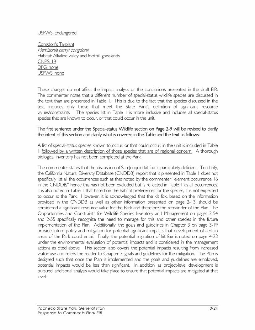
USFWS: Endangered Congdon's Tarplant Hemizonia parryi congdonii Habitat: Alkaline valley and foothill grasslands CNPS: 1B DFG: none USFWS: none
These changes do not affect the impact analysis or the conclusions presented in the draft EIR. The commenter notes that a different number of special-status wildlife species are discussed in the text than are presented in Table 1. This is due to the fact that the species discussed in the text includes only those that meet the State Park's definition of significant resource values/constraints. The species list in Table 1 is more inclusive and includes all special-status species that are known to occur, or that could occur in the unit.
The first sentence under the Special-status Wildlife section on Page 2-9 will be revised to clarify the intent of this section and clarify what is covered in the Table and the text as follows:
A list of special-status species known to occur, or that could occur, in the unit is included in Table 1 followed by a written description of those species that are of regional concern. A thorough biological inventory has not been completed at the Park.
The commenter states that the discussion of San Joaquin kit fox is particularly deficient. To clarify, the California Natural Diversity Database (CNDDB) report that is presented in Table 1 does not specifically list all the occurrences such as that noted by the commenter “element occurrence 16 in the CNDDB,” hence this has not been excluded but is reflected in Table 1 as all occurrences. It is also noted in Table 1 that based on the habitat preferences for the species, it is not expected to occur at the Park. However, it is acknowledged that the kit fox, based on the information provided in the CNDDB as well as other information presented on page 2-13, should be considered a significant resource value for the Park and therefore the remainder of the Plan. The Opportunities and Constraints for Wildlife Species Inventory and Management on pages 2-54 and 2-55 specifically recognize the need to manage for this and other species in the future implementation of the Plan. Additionally, the goals and guidelines in Chapter 3 on page 3-19 provide future policy and mitigation for potential significant impacts that development of certain areas of the Park could entail. Finally, the potential migration of kit fox is noted on page 4-23 under the environmental evaluation of potential impacts and is considered in the management actions as cited above. This section also covers the potential impacts resulting from increased visitor use and refers the reader to Chapter 3, goals and guidelines for the mitigation. The Plan is designed such that once the Plan is implemented and the goals and guidelines are employed, potential impacts would be less than significant. In addition, as project-level development is pursued, additional analysis would take place to ensure that potential impacts are mitigated at that level.
Pacheco State Park General Plan 3-25 Response to Comments Final EIR
4-4 Recommended Management Standards
The commenter is referred to “thresholds” or standards that are provided in Table 3-36 “Recreation Carrying Capacity” as indicators for when management actions may need to be altered or an adaptive management approach should be employed. As future baseline data is collected and augmented, these indicators and their associated recommended actions will change. If future data collection and analysis determine that a particular species does use the Park even on an irregular basis, the management actions can be tailored for that species and their specific needs or requirements. Please also note that the goals and guidelines in Chapter 3 are serving as the policy-level guidance that will direct future Park management and these policies are analyzed in Chapter 4 which serves as the DEIR for the “Plan.”
4-5 Cumulative Impacts
The Department acknowledges the commenter’s opinion on the issue of cumulative impacts. However, to the extent that cumulative impacts can be identified, policies proposed in the Plan are intended to mitigate these types of impacts. This issue is addressed in part in Section 4.6 Unavoidable Significant Effects on the Environment:
“Evaluation… of this first-tier review indicates that the potential effects of projects proposed in this Plan can be reduced to a less-than-significant level with the implementation of resource management programs, and the development of specific mitigation measures noted. Until the uses, location, and scope of facilities or management plans are specific, the actual level of impact, whether individual or cumulative, cannot be determined. However, all projects are required to be in compliance with local, State, and federal permitting and regulatory requirements and subject to subsequent-tier CEQA review and project-specific mitigation.”
The Cumulative Impacts discussion of Section 4.6 also identifies general measures to avoid future cumulative impacts:
“The General Plan proposes a number of mitigation measures (Goals RES-WQ1 through RES-WQ3 (pages 3-16 – 3-17), RES-V1 through RES-V5 (pages 3-17 – 3-19), RES-W1 and RES-W2 (pages 3-19 – 3-20), RES-C1 (page 3-15), and RES-S1 through RES-S5 (pages 3-13 – 3-14) to avoid or minimize impacts on these (biological, cultural, and visual) resources. In addition, the protection of a large expanse of unfragmented open space and protection of wildlife habitat and corridors will further reduce the cumulative effects that the General Plan would contribute to the region.”
As part of the Plan and its implementation, certain impacts, particularly in backcountry areas may actually be reduced as certain existing ranch roads and any associated erosion may be closed and ultimately reclaimed. The Plan provides for more focused and monitored use with use areas clearly defined and limited so while there may be more visitors in certain areas this may result in an overall positive cumulative effect. Until more study can be conducted on grazing, invasive species and visitor use the Plan goals and
Pacheco State Park General Plan 3-26 Response to Comments Final EIR
guidelines serve to outline the desired future conditions to avoid cumulative impacts and future implementation projects will need to plan and design accordingly.
4-6 Recirculation of the DEIR
The Department will comply with Public Resources Code 5002.2 referencing Plan guidelines and 21000 et seq. CEQA regulations associated with the development of programmatic EIRs. The Department is in compliance with the circulation requirements for a programmatic DEIR, which includes the submittal of the Plan and DEIR to agencies for their review and comment within a 45-day comment period. Responses to your comments are provided in this document as part of the FEIR and will be distributed to involved agencies for their review and understanding pursuant to CEQA requirements. CEQA regulations do not require the Department to circulate the programmatic Plan more than once. Therefore, the Department does not plan to recirculate the DEIR to agencies for further comments. This document will provide DFG with an understanding of how your comments have contributed to the betterment of the Plan through the responses provided herein.
It is noted that DFG favors keeping visitor accommodations at a low level, presumably as proposed under Alternative 1. Thank you for your input.
4-7 Specificity of Mitigation Measures
It is the intent of the Plan to provide the goals and guidelines that will prevent significant environmental impacts as they will have to be complied with in order to implement projects of the preferred alternative. DFG’s recommended mitigation language may be too specific and inadvertently dictate the design solution for future project implementation. Based on the need to maintain flexibility in project development over time, the goals and guidelines identified in the Plan provide an appropriate level of mitigation for a first-tier environmental document. As such, the Plan goals and guidelines are deemed sufficient to meet the intent of CEQA mitigation requirements. The DEIR will provide the basis for future second-level environmental review, which will provide more detailed environmental analysis and mitigation for site-specific developments and projects.
4-8 Recommended Guidelines
The Department appreciates the thoughtful review of the Plan and DFG’s recommended policy changes and additions. However, similar to response 4.7, your recommended guidelines are too specific and dictate a resource management tool that may not ultimately be used based on future circumstances. Future staffing and resources as well as new data collection will provide the actual mechanisms for achieving goals, based on the desired future conditions set forth in the Plan.

Pacheco State Park General Plan 3-39 Response to Comments Final EIR
RESPONSE TO LETTER 5
From: University of California Cooperative Extension, Sheila Barry, Natural Resources/Livestock Advisor, Certified Rangeland Manager #63.
The California Department of Parks and Recreation, Four Rivers Sector appreciates the comments received by the University of California Cooperative Extension (Extension Service). The Plan and DEIR is a broad policy document that sets the direction and provides the vision for the Park’s management and development. Ms. Barry’s comments focus on specifics of potential beneficial impacts that cattle grazing could provide. Development of Park facilities will constitute a new project for which a design would need to be developed, and a second-tier environmental review (Project Level) would be conducted to evaluate impacts of that specific project. As specific projects are developed based on need and the availability of funds, the Department will consider any input offered by the Extension Service when addressing site-specific grazing impacts.
5-1 Certified Rangeland Manager Involvement
Whereas the California Code of Regulations Title 14, Section 1602 provides that a “Certified Rangeland Manager (CRM)” shall perform professional forestry services relating to the application of scientific principles to the art and science of managing rangelands and range, there are no provisions in the Plan that are in violation of this code. A CRM license would be needed to prepare specific forest management or conservation plans for rangelands. This level of detail is not provided in the Plan; the Plan is designed to guide resource stewardship, facility development and interpretation, and future land use management for the Park and is acceptable by CEQA standards.
Implementation of Vegetation Goals RES-V1 through RES-V5 (pages 3-17 – 3-19) of the Plan would provide for the preservation and management of vegetation within the Park. Guidelines under these goals state that consultation with experts will be sought when the Department develops vegetation inventories and management plans. The Department will comply with Title 14 as appropriate during the implementation of these goals.
5-2 Grazing Lease Information
Please see pages 2-1 and page 2-19 in the Plan for reference and information related to grazing leases. Also, see Chapter 4 in this document to see how these sections will be amended but will still include grazing lease information.
5-3 Adequacy of Existing Conditions Information
As the Park is a recent addition to the State Park System only limited and generalized baseline data on cultural information associated with the history of grazing within the Park exists. This is due in part to the lack of existing data and in part to the programmatic nature of the programmatic environmental review pursuant to CEQA. A full cultural landscape inventory was not conducted as part of the planning process for the Plan, hence the questions regarding previous cultivation and details about grazing on the property are not documented. However, according to CEQA provisions, the DEIR provides an adequate level of environmental analysis for a programmatic action.

Pacheco State Park General Plan 3-40 Response to Comments Final EIR
Commenter is referred to Responses 1-2 and 4-1 in this document for additional information on the level of evaluation required in a Plan and DEIR document.
5-4 Consistency of Acreage Totals
To improve consistency, the statement on page 1-1 will be changed to address your comment as follows:
“Of the total acreage, about one half 3,000 acres are currently open to the public.”
5-5 Soils
Thank you for your suggestion. It is acknowledged that the Plan and DEIR provides generalized baseline data on soils. This is primarily due to the conceptual level of planning that the Plan provides and the programmatic nature of the environmental review. It is also recognized that the Soil Survey for the Park provides details about rangeland and the characteristic plant community or “range site” based on the soil types as well as information about the species composition and total production. This information will certainly be consulted by the Department when they make future decisions about potential grazing sites and frequencies within the Park.
5-6 Surface Water
Approximately 90% of Pacheco SP lands are located within the Panoche-San Luis Reservoir and 10% of Park lands are located within the Pajaro watershed, both of which are classified as Category I (impaired) priority watersheds. As an impaired, priority watershed, certain future projects at Pacheco SP may need to comply with the State Water Resources Control Board’s (SWRCB) zero toxicity and habitat restoration guidelines, as well as the U.S. Environmental Protection Agency (USEPA) standards for allowable maximum pollutant and nutrient concentrations.
Information from Page 4-17 of the Plan’s environmental evaluation provides information on the potential sources of point and non-point pollution as a result of the Preferred Alternative. The document states:
“The development of proposed facilities and paving of unpaved roads and Parking areas would increase the impermeable surface area within the Park, thereby resulting in an increase in runoff—and potential polluted runoff—in developed areas. Moreover, increases in vehicle traffic within the Park associated with new facilities and the anticipated increase in visitor use would increase vehicle-related pollution in runoff, including rubber, oil, and gasoline, and other vehicle-related chemicals. . . .
“Construction activities associated with development under this Plan, including digging, grading, filling, and paving, also have the potential to adversely affect hydrology and water quality by increasing erosion, sedimentation, and polluted runoff. Construction activities would expose loose soils, potentially increasing erosion and siltation. In addition, a variety of types of construction equipment and related chemicals would be used during
Pacheco State Park General Plan 3-41 Response to Comments Final EIR
construction, potentially resulting in the release of vehicle- and construction-related chemicals into surface water, groundwater, or runoff. . . .”
It is acknowledged that the Plan and DEIR provide generalized baseline data on surface water and water quality. This is due to the programmatic nature of the environmental review. In addition to the Plan provisions to protect water quality, as stated on pages 3-16 through 3-17 of the Plan and DEIR, the Department will also comply with the Water Quality Control Plans, or Basin Plans, adopted by the Central Coast and Region 5 SWRCB pursuant to the California Water Code (Section 13240) and supported by the Federal Clean Water Act Section 303. Proposed development activities, including those with on-site septic or those that would generate a significant level of stormwater runoff, will meet water quality objectives to protect waterways with beneficial uses as identified in the Basin Plans. The Department will consider the need for a Water Quality Management Plan as part of the Plan implementation and as projects are further identified.
5-7 Air Quality
The information presented in Section 4.5 under Air Quality Environmental Evaluation (pages 4-18 – 4-19) assesses the potential impacts that could result with the adoption of the proposed Plan. The Plan does not propose the introduction of stationary sources of air pollution into the Park and potential significant adverse impacts to Park vegetation were not anticipated as a result of the adoption of the Plan. Therefore, air quality mitigation at this level of environmental review was not used to develop Park vegetation management. Page 2-54 identifies the opportunity to assess the current status and future role of prescribed fire in vegetation management. At that time, the Department could evaluate the likelihood of being able to conduct a prescribed fire due to air quality concerns. In the meantime, the Department will continue to comply with all local, State, and federal regulations regarding air quality, as stated on page 4-19, which would include the Department’s use of prescribed fires or any other Department action. Mitigation measures for planning, implementation, and construction include the BAAQMD CEQA Guidelines and the SJVUAPCD’s Guide for Assessing and Mitigating Air Quality Impacts.
5-8 Special-Status Species and Plant Life
Your comments are noted. Please refer to Responses 1-2 and 4-1 of this document, which describe the availability of special-status species information and level of environmental analysis required under CEQA for a Draft EIS. Information on Park vegetation is also provided in Appendix C. However as part of the planning process a detailed vegetation survey was not conducted. It is therefore not possible to ascertain the location of native grassland populations relative to the current grazing lease and other recommendations that the commenter suggests. The information the commenter provided on specific plant species and associated papers and authors is useful and will be recorded for future reference.
Pacheco State Park General Plan 3-42 Response to Comments Final EIR
5-9 Invasive Non-Native Species
Goal RES-V3 (page 3-18) provides general direction to Park staff to make efforts to control invasive and non-native species within the Park. Guidelines under this goal include avoidance of planting invasive or non-native species and encouragement of planting locally native species that are defined as indigenous to the Park or closely surrounding areas. While the Plan does not outline specific control options at this level of management, development of a vegetation management plan as recommended under Goal RES-V3 will provide this information in the future.
5-10 Grazing
The statement “there is uncertainty as to whether grazing is beneficial to the site’s biodiversity and species composition” on page 2-19 under Grazing is accurate. Development of a vegetation management plan, as recommended under Goal RES-V3 (page 3-18), will assess the potential impacts associated with grazing on native flora and fauna with additional certainty within the Park.
The Plan serves as a first-tier Environmental Impact Report as defined in Section 15166 of the California Environmental Quality Act (CEQA) Guidelines. The analysis of broad potential environmental impacts discussed in the DEIR will provide the basis for future second-level environmental review. Second-tier review associated with specific developments will provide more detailed information and analysis on monitoring and oak regeneration as requested by the commenter.
5-11 Cultural
Thank you for your comment. It is duly noted. As the Plan is intended to be a timeless document and the marketing efforts of the current lessee could change, the commenter’s suggested text additions are appreciated but will not be implemented into the text.
5-12 Vegetation and Wetlands Management
The commenter’s statement is acknowledged and will be considered in more detail when a more specific vegetation management and monitoring plan is implemented. Additionally, the Department will utilize every opportunity to work with the grazing lessee for prevention and control of invasive species whenever possible (Goal RES-V3, page 3-18).
5-13 Wildlife Species Inventory and Management
See response noted above in 5-12.
Pacheco State Park General Plan 3-43 Response to Comments Final EIR
5-14 Interpretive
The Plan provides some examples for possible future interpretive programs and does not prevent any new or additional themes from being interpreted as staffing and required resources allow (Interpretive Themes (VIS-I) and Goal VIS-II, pages 3-22 – 3-24).
5-15 Park Plan
Currently the Plan would allow grazing to continue in its current location if it is needed for resource management purposes and based on monitoring to ensure that Plan goals are being met (Goal OPS-L1 and OPS-L2, page 3-29, and Goal RES-V4, page 3-18). Additionally, grazing for resource management purposes could occur in other areas of the Park and is not limited by the management zone boundaries.
5-16 Backcountry Zone
See response 5-15 above. The criteria for determining whether grazing will be permitted and for selecting future grazed and un-grazed areas will depend upon a variety of factors including staff resources, the results of monitoring, physical conditions, and other management factors. Grazing management is not specifically listed under Backcountry Land Use but is included in the “Leases and Special Agreements (OPS-L on page 3-29)” listing. It is also acknowledged that grazing practices can be adjusted to achieve different results and are one option that can be used for a variety of resource management objectives (Goal RES-V4, page 3-18).
5-17 Leased Zone
See response 5-16 above.
5-18 Parkwide Goals and Guidelines
The commenter’s suggestions for additional goals and guidelines as well as revisions to the content of certain existing text are duly noted. At this time, the Department feels that it needs additional data to be able to set forth more specific directives related to grazing as a potential tool that could be considered for resource management purposes. Please also review the response to comment 4-8 of this document for additional information regarding the specificity of goals and guidelines.
Pacheco State Park General Plan 3-45 Response to Comments Final EIR
RESPONSE TO LETTER 6
From: San Jose Astronomical Association, San Jose Astronomical Association Board Members.
The Department appreciates your comments on the Pacheco State Park’s rare “dark sky” resource conditions. Based on your comments and those similar in nature from other commenters, we will add this resource to the Park’s existing resources and include goals and policies to preserve dark sky conditions in areas of the Park.
6-1 Dark Skies
As a result of your comments, the Plan will include information on dark skies and add provisions to preserve public “dark sky” gazing. The following discussions will be added to the Plan and DEIR:
Section 2.1 Unit Summary, Significant Resource Values, Aesthetic Resources (page 2-32)
Dark Sky
Dark night skies at the Park make it an ideal place for observing the wonders of the universe. As a resource, dark skies are increasingly important to campers who want to escape from ambient lighting found in most residential areas and cities at night. In addition, hundreds of amateur astronomers are known to visit the Park annually to take advantage of this increasingly unique resource. The Park and the San Luis Reservoir Recreation Area at Dinosaur Point are known locations where astronomers set up telescopes to observe constellations and other objects and activities within the universe. It has been reported that these two Parks contain the darkest night skies of anywhere within reasonable driving distance of the Bay Area. The Parks draw celestial viewers from as far away as San Francisco, Oakland, Salinas, and Monterey, as well as communities between them. To take advantage of the dark sky conditions, the Park has hosted public star-gazing gatherings where the public is invited to learn more about the universe through amateur astronomers’ telescopes.
Section 2.3 Opportunities and Constraints, Resource Management, Scenic Resources (page 2-56)
The ridges at the Park offer stupendous, uninterrupted views in all directions and contribute to the overall beauty that is experienced there. Additionally, the open, undeveloped nature of the Park and the steep, dramatic topography allow the view to be dominated by the natural vegetation, devoid of extensive human-made features. At night, the Park’s dark night skies add to the pristine nature of the area. The landscape character also includes historical and cultural elements that are not documented.
Opportunities and Constraints
Significant view corridors and ridgetops are undefined and not documented. There are no criteria to determine when views will be affected.
Pacheco State Park General Plan 3-46 Response to Comments Final EIR
An inventory of cultural elements that contribute to the scenic and aesthetic character of the Park is lacking.
Future development and facilities should protect unique resource. Opportunities exist to interpret and educate about the landscape character and the
features that define it. Opportunities exist to design future facilities to preserve the dark sky resources
found within the Park. Section 2.3 Opportunities and Constraints, Resource Management, Visitor Experience and Education, Interpretive Opportunities, Opportunities and Constraints (page 2-57):
Opportunities exist to partner with groups such as the San Jose Astronomical Association in interpreting astronomy as a resource and demonstrating the value of the dark night sky associated with celestial viewing.
Please see Chapter 4 of this document which recommends revisions to Section 3.1 Unit Purpose and Vision, Park Vision (pages 3-2 – 3-3) to add references to star-gazing and night skies.
Section 3.3 Parkwide Goals and Guidelines, Resource Management will be revised as follows:
Scenic/Aesthetic (RES-S) (page 3-13) Scenic and aesthetic resources consist of site views, open landscape character, architectural styles, and details found onsite. The site’s scenic qualities are perpetuated by the undeveloped landscape, consisting of open (grassland) and closed (woodland) vegetation defined by scattered large stately oaks as well as the rolling topography. The layout and configuration of the built structures on the site and their materials also contribute to the overall historic character, affecting scenic quality. Additionally, signage can portray an image or identity for the Park and contribute to the aesthetic experience. The dark nighttime sky is an important resource at Pacheco State Park for celestial viewing and is a contributing factor to the remote and natural setting of the Park.
Goal (RES-S6) (page 3-14) Maintain and protect the dark nighttime sky for celestial viewing.
Guidelines Develop educational and interpretive services about the value of the dark nighttime
sky and the importance of its protection. Work with the County, local entities involved with development around the Park,
and neighboring landowners to minimize adverse effects from light sources outside the boundaries of the Park.
Design lighting systems consistent with Goal RES-S5 and associated guidelines. Future Park facilities should use properly shielded light fixtures and minimize the use
of exterior lighting to preserve dark skies as a resource. Thank you for your contribution to the Plan and DEIR.


Pacheco State Park General Plan 3-50 Response to Comments Final EIR
RESPONSE TO LETTER 7
From: Law Offices of Linneman, Burgess, Telles, Van Atta, Vierra, Rathmann, Whitehurst & Keene, Alfred L. Whitehurst on behalf of the Board of Directors of the Fatjo Corporation
The Department appreciates the support of the Fatjo Corporation for this project and will continue to work with the Board as specific projects develop throughout the Park. Reducing the leased area of the Park is not anticipated to reduce the amount of clean energy produced by windmills or limit the income generated by the sale of this energy to operate the Park.
7-1 Potable Water
Thank you for understanding that the availability of potable water is a top priority to the successful management of the Park. The Department looks forward to collaborating with the Fatjo Corporation on the efficient distribution of potable water for Park operations from the new well.
7.2 Restroom Facilities
The Department appreciates your support for developing and improving restroom facilities, especially in the front portion of the Park. We understand that the Board remains undecided on the desirability of placement of restroom facilities in the back country Park zone.
7-3 Ingress and Egress
Your opinion on improving the Pacheco SP ingress / egress from Highway 152 is noted. The Plan provides for working with Caltrans for appropriate safety and access and ingress improvements (Goal OPS-A1, page 3-28). As part of the planning process, Caltrans was contacted and a meeting was held to preliminarily discuss the transportation-related issues at the Park and to begin to understand the future steps needed to work more closely with Caltrans in developing future plans for improvements.
7-4 Signage
Thank you for suggesting that the Board may explore the possibility of donating signs to the Department for use at Pacheco SP. We look forward to collaborating with you and Caltrans on developing appropriate signage for the Park.
7-5 Windmills
Your objection to limiting Park lands available for energy use is noted. The Department also recognizes that Paula Fatjo’s intent for Pacheco SP was to allow the windmills to remain on the property to produce income, as well as to produce clean and efficient electricity. Pages 3-10 to 3-11 state:
“The intent of the LE Zone shall be to maintain windmills and associated power production and operation infrastructure. The purpose of proposing to reduce the land
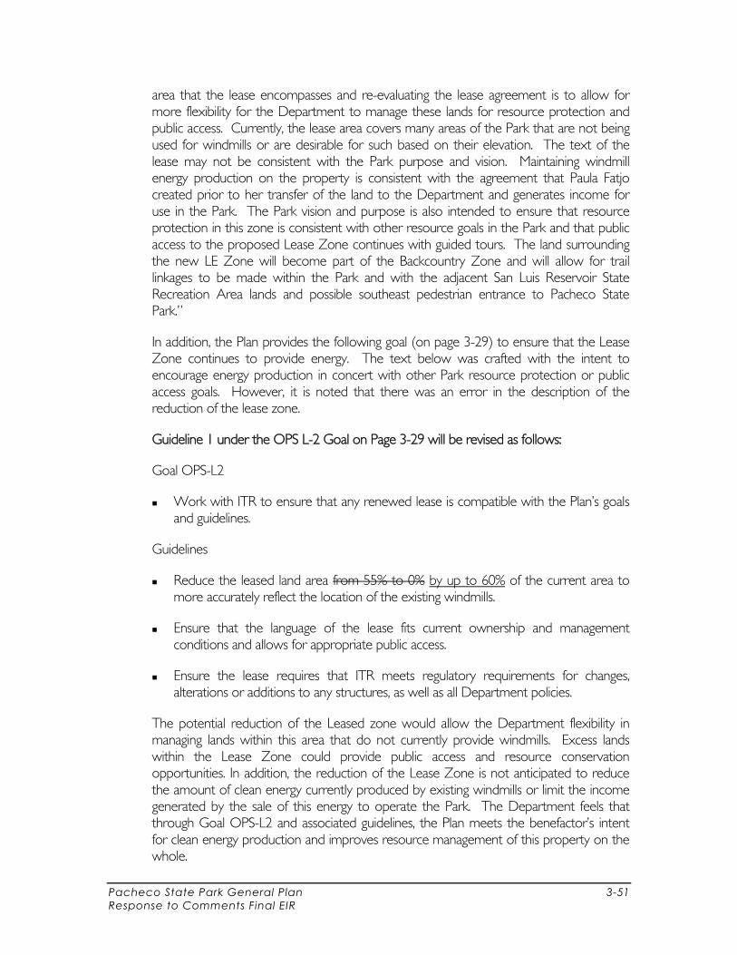
Pacheco State Park General Plan 3-51 Response to Comments Final EIR
area that the lease encompasses and re-evaluating the lease agreement is to allow for more flexibility for the Department to manage these lands for resource protection and public access. Currently, the lease area covers many areas of the Park that are not being used for windmills or are desirable for such based on their elevation. The text of the lease may not be consistent with the Park purpose and vision. Maintaining windmill energy production on the property is consistent with the agreement that Paula Fatjo created prior to her transfer of the land to the Department and generates income for use in the Park. The Park vision and purpose is also intended to ensure that resource protection in this zone is consistent with other resource goals in the Park and that public access to the proposed Lease Zone continues with guided tours. The land surrounding the new LE Zone will become part of the Backcountry Zone and will allow for trail linkages to be made within the Park and with the adjacent San Luis Reservoir State Recreation Area lands and possible southeast pedestrian entrance to Pacheco State Park.”
In addition, the Plan provides the following goal (on page 3-29) to ensure that the Lease Zone continues to provide energy. The text below was crafted with the intent to encourage energy production in concert with other Park resource protection or public access goals. However, it is noted that there was an error in the description of the reduction of the lease zone.
Guideline 1 under the OPS L-2 Goal on Page 3-29 will be revised as follows:
Goal OPS-L2
Work with ITR to ensure that any renewed lease is compatible with the Plan’s goals and guidelines.
Guidelines
Reduce the leased land area from 55% to 0% by up to 60% of the current area to more accurately reflect the location of the existing windmills.
Ensure that the language of the lease fits current ownership and management conditions and allows for appropriate public access.
Ensure the lease requires that ITR meets regulatory requirements for changes, alterations or additions to any structures, as well as all Department policies.
The potential reduction of the Leased zone would allow the Department flexibility in managing lands within this area that do not currently provide windmills. Excess lands within the Lease Zone could provide public access and resource conservation opportunities. In addition, the reduction of the Lease Zone is not anticipated to reduce the amount of clean energy currently produced by existing windmills or limit the income generated by the sale of this energy to operate the Park. The Department feels that through Goal OPS-L2 and associated guidelines, the Plan meets the benefactor’s intent for clean energy production and improves resource management of this property on the whole.

Pacheco State Park General Plan 3-56 Response to Comments Final EIR
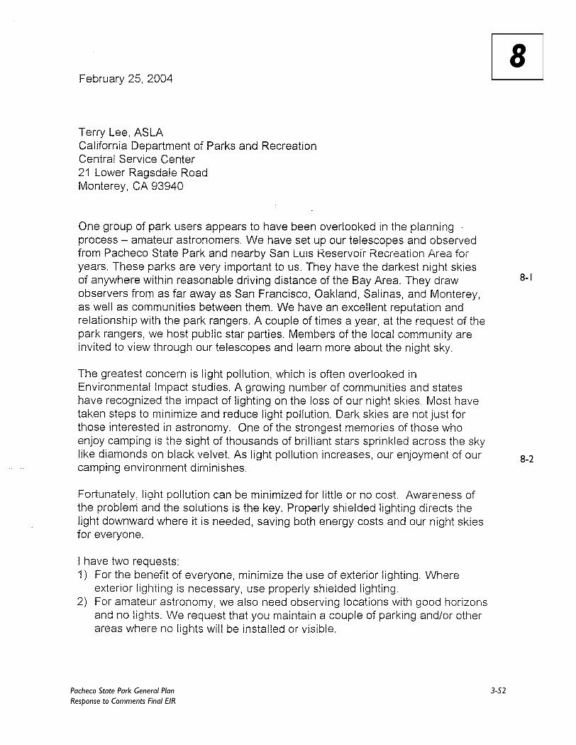
RESPONSE TO LETTER 8
From: Citizen, Albert Highe, Amateur Astronomer.
The Department received two copies of the same letter from Mr. Highe that was addressed to different staff members (Letters 8 and 9). Based on your comments and those received by the San Jose Astronomical Association, the Department will add dark skies to the Park’s existing resources and include goals and policies to preserve dark sky conditions in areas of the Park.
8-1 Dark Skies
As a result of your comments, the Plan will include information on dark skies and add provisions to preserve public “dark sky” gazing. Please refer to Response 6.1 to review changes to the Plan and DEIR.
8-2 Light Pollution Concerns
The Plan and DEIR, Environmental Impacts Section 4.5 under “Aesthetics” identifies light pollution as a concern (pages 4-30 – 4-31). This section discusses the potential of new Park facilities to create new sources of light or glare, which could affect day or nighttime views in the area. The Plan provides the following goals and guidelines as mitigation measures to avoid these impacts:
Goal RES-S5 (page 3-14) Prevent aesthetic and environmental damage from duration and intensity of lighting
and fixtures.
Guidelines Ensure that light fixtures are designed and placed only as needed and are in keeping
with site character. Minimize intensity by considering techniques such as low voltage fixtures and downlighting.
Design lighting systems and facilities that minimize light pollution on site and to neighboring areas.
Furthermore, Goal RES-S6 and associated guidelines were added to the Plan to address the preservation of the dark night sky at the Park as an important resource consistent with your comments (refer to Response 6-1 to review the added policy language). As a result, no significant adverse impacts to the Park dark skies are anticipated. Thank you for your contribution to the Plan and DEIR.

Pacheco State Park General Plan 3-57 Response to Comments Final EIR
RESPONSE TO LETTER 9
From: Citizen, Albert Highe, Amateur Astronomer.
The Department received two copies of the same letter from Mr. Highe that was addressed to different staff members (Letters 8 and 9). Based on your comments and those received by the San Jose Astronomical Association, the Department will add dark skies to the Park’s existing resources and include goals and policies to preserve dark sky conditions in areas of the Park.
9-1 Dark Skies
As a result of your comments, the Plan will include information on dark skies and add provisions to preserve public “dark sky” gazing. Please refer to Response 6-1 to review changes to the Plan and DEIR.
9-2 Light Pollution Concerns
The Plan and DEIR, Environmental Impacts Section 4.5 under “Aesthetics” identifies light pollution as a concern (pages 4-30 – 4-31). This section discusses the potential of new Park facilities to create new sources of light or glare, which could affect day or nighttime views in the area. The Plan provides the following goals and guidelines as mitigation measures to avoid these impacts:
Goal RES-S5 (page 3-14) Prevent aesthetic and environmental damage from duration and intensity of lighting
and fixtures.
Guidelines Ensure that light fixtures are designed and placed only as needed and are in keeping
with site character. Minimize intensity by considering techniques such as low voltage fixtures and downlighting.
Design lighting systems and facilities that minimize light pollution on site and to neighboring areas.
Furthermore, Goal RES-S6 and associated guidelines were added to the Plan to address the preservation of the dark night sky at the Park as an important resource consistent with your comments (refer to Response 6-1 to review the added policy language). As a result, no significant adverse impacts to the Park dark skies are anticipated. Thank you for your contribution to the Plan and DEIR.
Pacheco State Park General Plan 3-59 Response to Comments Final EIR
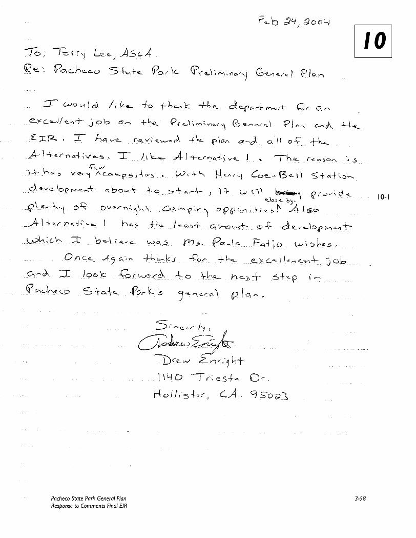
RESPONSE TO LETTER 10
From: Citizen, Andrew Enright
Mr. Enright’s support of the Plan is appreciated.
10.1 Supports Alternative 1
Thank you for your comment. Your preference for Alternative 1 is noted.

Pacheco State Park General Plan 3-61 Response to Comments Final EIR
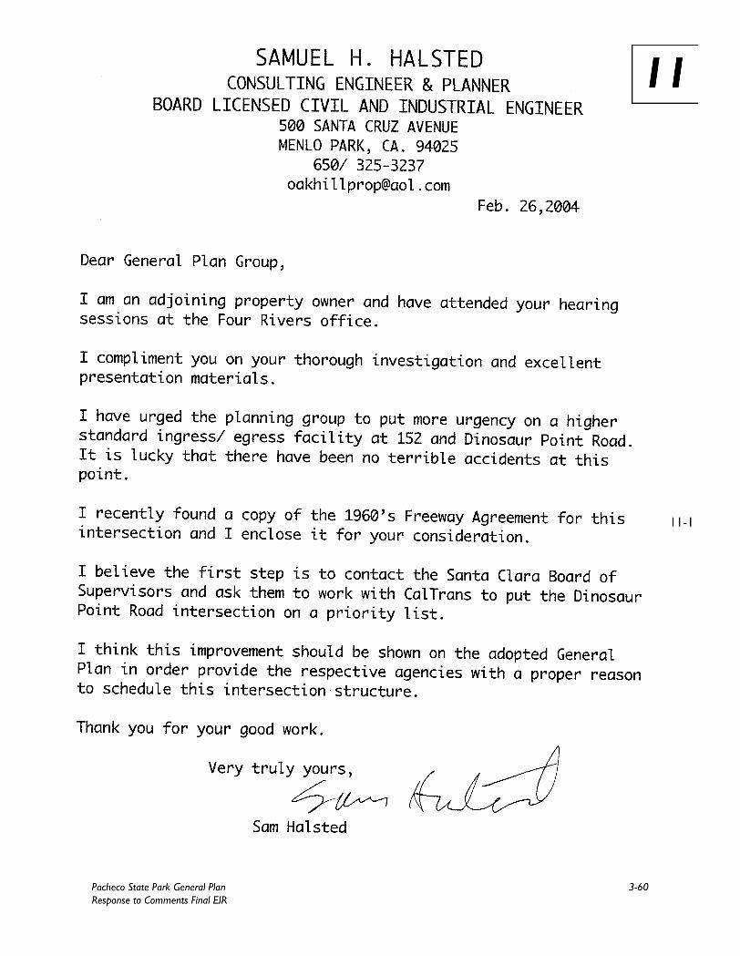
RESPONSE TO LETTER 11
From: Adjacent Property Owner, Samuel Halsted
The Department appreciates your concern for safety at the Highway 152 intersection with Dinosaur Point Road. The Department will continue to manage safety at the Park entrance in collaboration with Caltrans.
11.1 Traffic Safety
Thank you for your comment and for providing a 1960s Freeway Agreement for the Highway 152 and Dinosaur Park Road intersection. The Department shares your concern for safety in this area and acknowledges that this intersection should be improved to reduce congestion and enhance safety conditions. The Draft EIR identifies the following mitigation measures to reduce traffic and improve Park access, overall circulation, and safety at Highway 152 and Dinosaur Point Road (refer to pages 4-27–4-28):
Realign and resurface the Park entrance road; Extend turning and acceleration lanes at the junction of SR 152 and Dinosaur Point
Road or work with Caltrans to establish an overpass or underpass (similar to the 1960s Freeway Agreement); and
Improve signage along SR 152 and at the Park entrance.
Goals OPS-A1 through OPS-A4 (pages 3-28 – 3-29) and associated guidelines of the Plan were developed with the intent to mitigate or avoid potential safety impacts that could result from increased visitation at the Park at this intersection. Implementation of these mitigation measures will continue to ensure the safety of Park patrons and travelers along Highway 152 and Dinosaur Point Road.

Pacheco State Park General Plan 4-1 Response to Comments Final EIR
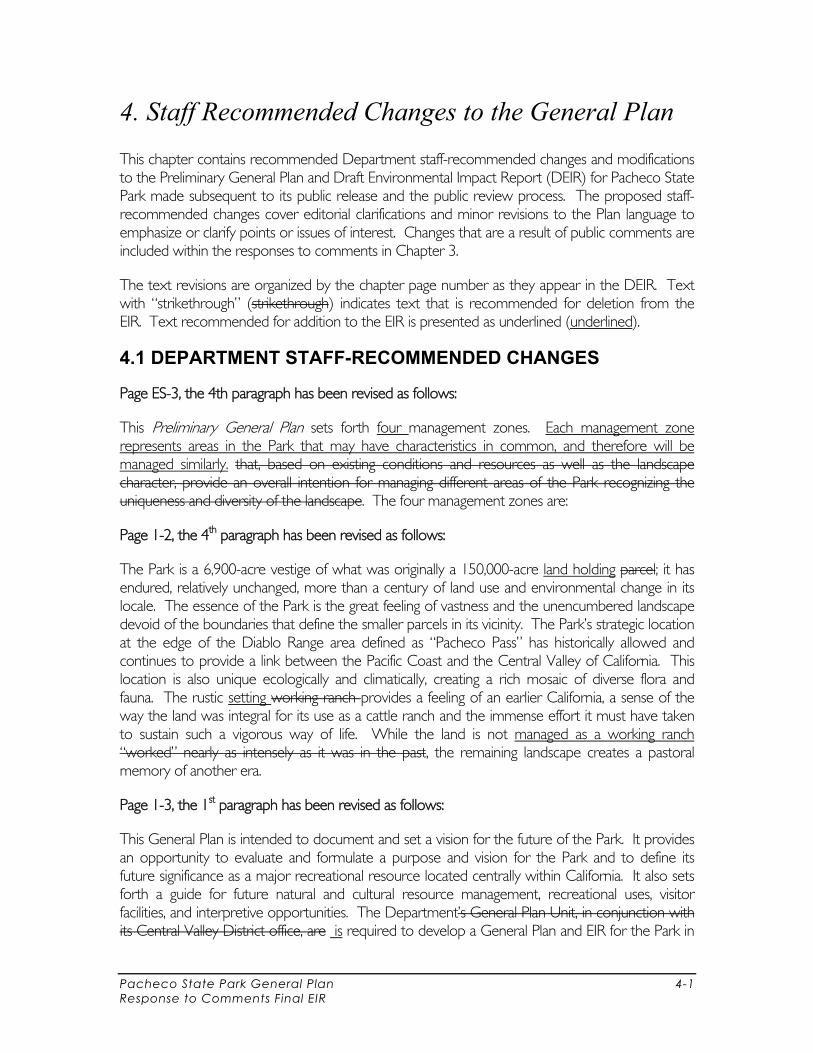
4. Staff Recommended Changes to the General Plan
This chapter contains recommended Department staff-recommended changes and modifications to the Preliminary General Plan and Draft Environmental Impact Report (DEIR) for Pacheco State Park made subsequent to its public release and the public review process. The proposed staff-recommended changes cover editorial clarifications and minor revisions to the Plan language to emphasize or clarify points or issues of interest. Changes that are a result of public comments are included within the responses to comments in Chapter 3.
The text revisions are organized by the chapter page number as they appear in the DEIR. Text with “strikethrough” (strikethrough) indicates text that is recommended for deletion from the EIR. Text recommended for addition to the EIR is presented as underlined (underlined).
4.1 DEPARTMENT STAFF-RECOMMENDED CHANGES
Page ES-3, the 4th paragraph has been revised as follows:
This Preliminary General Plan sets forth four management zones. Each management zone represents areas in the Park that may have characteristics in common, and therefore will be managed similarly. that, based on existing conditions and resources as well as the landscape character, provide an overall intention for managing different areas of the Park recognizing the uniqueness and diversity of the landscape. The four management zones are:
Page 1-2, the 4th paragraph has been revised as follows:
The Park is a 6,900-acre vestige of what was originally a 150,000-acre land holding parcel; it has endured, relatively unchanged, more than a century of land use and environmental change in its locale. The essence of the Park is the great feeling of vastness and the unencumbered landscape devoid of the boundaries that define the smaller parcels in its vicinity. The Park’s strategic location at the edge of the Diablo Range area defined as “Pacheco Pass” has historically allowed and continues to provide a link between the Pacific Coast and the Central Valley of California. This location is also unique ecologically and climatically, creating a rich mosaic of diverse flora and fauna. The rustic setting working ranch provides a feeling of an earlier California, a sense of the way the land was integral for its use as a cattle ranch and the immense effort it must have taken to sustain such a vigorous way of life. While the land is not managed as a working ranch “worked” nearly as intensely as it was in the past, the remaining landscape creates a pastoral memory of another era.
Page 1-3, the 1st paragraph has been revised as follows:
This General Plan is intended to document and set a vision for the future of the Park. It provides an opportunity to evaluate and formulate a purpose and vision for the Park and to define its future significance as a major recreational resource located centrally within California. It also sets forth a guide for future natural and cultural resource management, recreational uses, visitor facilities, and interpretive opportunities. The Department’s General Plan Unit, in conjunction with its Central Valley District office, are is required to develop a General Plan and EIR for the Park in
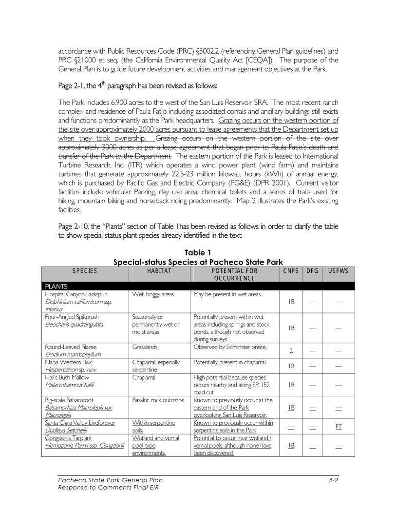
Pacheco State Park General Plan 4-2 Response to Comments Final EIR
accordance with Public Resources Code (PRC) §5002.2 (referencing General Plan guidelines) and PRC §21000 et seq. (the California Environmental Quality Act [CEQA]). The purpose of the General Plan is to guide future development activities and management objectives at the Park.
Page 2-1, the 4th paragraph has been revised as follows:
The Park includes 6,900 acres to the west of the San Luis Reservoir SRA. The most recent ranch complex and residence of Paula Fatjo including associated corrals and ancillary buildings still exists and functions predominantly as the Park headquarters. Grazing occurs on the western portion of the site over approximately 2000 acres pursuant to lease agreements that the Department set up when they took ownership. Grazing occurs on the western portion of the site over approximately 3000 acres as per a lease agreement that began prior to Paula Fatjo’s death and transfer of the Park to the Department. The eastern portion of the Park is leased to International Turbine Research, Inc. (ITR) which operates a wind power plant (wind farm) and maintains turbines that generate approximately 22.5-23 million kilowatt hours (kWh) of annual energy, which is purchased by Pacific Gas and Electric Company (PG&E) (DPR 2001). Current visitor facilities include vehicular Parking, day use area, chemical toilets and a series of trails used for hiking, mountain biking and horseback riding predominantly. Map 2 illustrates the Park’s existing facilities.
Page 2-10, the “Plants” section of Table 1has been revised as follows in order to clarify the table to show special-status plant species already identified in the text:
Table 1 Special-status Species at Pacheco State Park
SPECIES HABITAT POTENTIAL FOR OCCURRENCE
CNPS DFG USFWS
PLANTS Hospital Canyon Larkspur Delphinium californicum ssp. Interius
Wet, boggy areas May be present in wet areas. 1B — —
Four-Angled Spikerush Eleocharis quadrangulata
Seasonally or permanently wet or moist areas
Potentially present within wet areas including springs and stock ponds, although not observed during surveys.
1B — —
Round-Leaved Filaree Erodium macrophyllum
Grasslands Observed by Edminster onsite. 2 — —
Napa Western Flax Hesperolinon sp. nov.
Chaparral, especially serpentine
Potentially present in chaparral. 1B — —
Hall’s Bush Mallow Malacothamnus hallii
Chaparral High potential because species occurs nearby and along SR 152 road cut.
1B — —
Big-scale Balsamroot Balsamorhiza Macrolepis var. Macrolepis
Basaltic rock outcrops Known to previously occur at the eastern end of the Park overlooking San Luis Reservoir.
1B — —
Santa Clara Valley Liveforever Dudleya Setchellii
Within serpentine soils.
Known to previously occur within serpentine soils in the Park — — FT
Congdon’s Tarplant Hemozonia Parryi ssp. Congdonii
Wetland and vernal pool-type environments.
Potential to occur near wetland / vernal pools, although none have been discovered.
1B — —
Pacheco State Park General Plan 4-3 Response to Comments Final EIR
Page 2-18, the 3rd paragraph has been revised as follows:
Special-status plant species are endangered, threatened, or otherwise rare or uncommon in California. These species are on either the State or Federal lists of Endangered or Threatened species, are candidates for such listing, or are on a variety of informal lists. These informal lists include the Special Plants list developed by DFG and lists developed by CNPS (2001, 2002). The CNPS lists include species considered rare and endangered in California and elsewhere (List 1B), species considered extinct (List 1A), and species considered rare and endangered in California but more common elsewhere (List 2). CNPS List 1B species that have potential for occurrence within the Park include Hospital Canyon Larkspur (Delphinium californicum ssp. Interius); Four-Angled Spikerush (Eleocharis quadrangulata); Napa Western Flax (Hesperolinon sp. Nov.); and Hall’s Bush Mallow (Malacothamnus hallii).
Page 2-19, the 3rd paragraph has been revised as follows:
Species at the Park with the potential to convert native habitats to areas of non-native vegetation are broad-leaved peppergrass, also known as the perennial pepperweed, (Lepidium latifolium), Himalaya berry (Rubus discolor), yellow starthistle (Centaurea solstitialis), red brome (Bromus madritensis ssp. rubens), fennel (Foeniculum vulgare), and medusahead (Taeniatherum caput-medusae). These species are all on the Most Invasive Wildland Pest Plant list developed by the California Exotic Pest Plant Council. In addition, hoary cress (Cardaria draba) and milk thistle (Silybum marianum) are also of concern.
Page 2-19, paragraphs 6-8, and Page 2-20, paragraphs 1-2, have been revised as follows:
Grazing
Paula Fatjo had a lease for cattle grazing in the western portion of the Park in a series of ten paddock areas. grazed her entire ranch, partially with her own cattle and partially through leases with neighboring ranchers. Currently, the western 2,000 acres of the Park are leased by the Department for grazing. utilize grazing and are leased. Grazing leases do not exist for does not occur on the eastern portion of the Park, with the easternmost paddock fence ending at a point east of the Park entry. Grazing does not occur in including the area leased for wind turbines. Grazing and currently occupies less than half of the site. This lease has continued under the Department’s ownership and currently, with a limited the limited time frame of the four-year monitoring program, there is uncertainty as to whether grazing is beneficial to the site’s biodiversity and species composition. Based on the existing lease, cows and their calves graze in 10 pastures on a rest/rotation basis from November to May, depending on rainfall. Each pasture is grazed for 3–8 days before the animals are transferred to another pasture. Grazing, therefore, takes place in each pasture only once a month or month and a half (30–50 days)
Animal unit months (AUM) measure a pasture’s grazing intensity. The grazing intensity varies depending on the available forage. The maximum AUM allowed at the Park is 2,800. Each mature cow is considered to be 1.0 AU, each weaned calf 0.6 AU, each yearling 12–17 months old is 0.7 AU, and each yearling 17–22 months old is 0.75 AU. The 2002-03 yearly report reveals that approximately 2,400 AUM occurred at the Park.
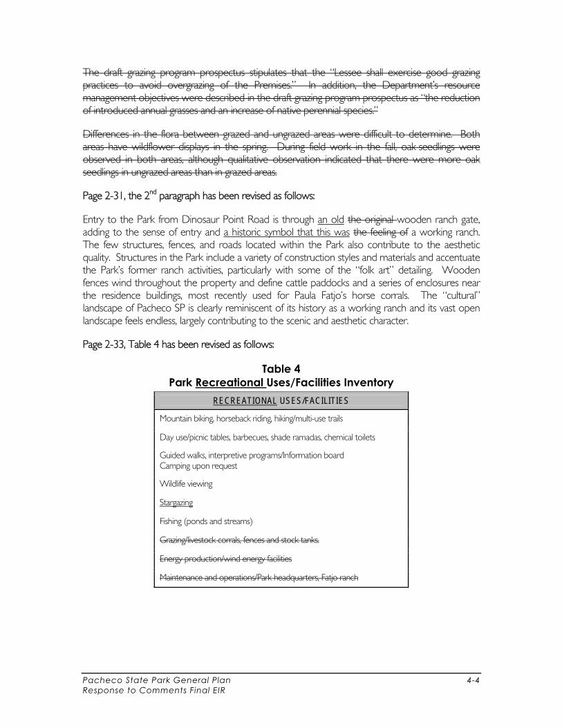
Pacheco State Park General Plan 4-4 Response to Comments Final EIR
The draft grazing program prospectus stipulates that the “Lessee shall exercise good grazing practices to avoid overgrazing of the Premises.” In addition, the Department’s resource management objectives were described in the draft grazing program prospectus as “the reduction of introduced annual grasses and an increase of native perennial species.”
Differences in the flora between grazed and ungrazed areas were difficult to determine. Both areas have wildflower displays in the spring. During field work in the fall, oak seedlings were observed in both areas, although qualitative observation indicated that there were more oak seedlings in ungrazed areas than in grazed areas.
Page 2-31, the 2nd paragraph has been revised as follows:
Entry to the Park from Dinosaur Point Road is through an old the original wooden ranch gate, adding to the sense of entry and a historic symbol that this was the feeling of a working ranch. The few structures, fences, and roads located within the Park also contribute to the aesthetic quality. Structures in the Park include a variety of construction styles and materials and accentuate the Park’s former ranch activities, particularly with some of the “folk art” detailing. Wooden fences wind throughout the property and define cattle paddocks and a series of enclosures near the residence buildings, most recently used for Paula Fatjo’s horse corrals. The “cultural” landscape of Pacheco SP is clearly reminiscent of its history as a working ranch and its vast open landscape feels endless, largely contributing to the scenic and aesthetic character.
Page 2-33, Table 4 has been revised as follows:
Table 4 Park Recreational Uses/Facilities Inventory
RECREATIONAL USES/FACILITIES
Mountain biking, horseback riding, hiking/multi-use trails
Day use/picnic tables, barbecues, shade ramadas, chemical toilets
Guided walks, interpretive programs/Information board Camping upon request
Wildlife viewing
Stargazing
Fishing (ponds and streams)
Grazing/livestock corrals, fences and stock tanks.
Energy production/wind energy facilities
Maintenance and operations/Park headquarters, Fatjo ranch
Pacheco State Park General Plan 4-5 Response to Comments Final EIR
Page 2-35, the following text has been added after the 1st paragraph:
Lease Facilities
Facilities associated with the wind farming and cattle grazing leases in the Park are owned and operated by the leaseholders. These facilities include windmills and other energy production and wind energy facilities, grazing/livestock corrals, fences and stock tanks.
Page 2-36, the last paragraph has been revised as follows:
The Park is laced with approximately 25 miles of trails. Most of them are double-track remains of ranch roads, although some are more rugged single-track trails. Many of these trails are shown on Map 4. Trails are open to mountain bikers, horseback riders, as well as hikers. Options for day-use visitors range from short, 1-mile loops, to a hike about 20 miles in distance. Most of the trails are accessible via four-wheel drive for patrol purposes. , some are accessible with the Park’s off-highway vehicle, and some are not accessible by vehicles.
Page 2-51, the 1st paragraph has been revised as follows:
Department sector staff gather and record visitor attendance data. However, there is little information regarding specific activities and duration of visitor stay and other detailed use data. Visitor attendance data were collected from the Park’s self-registration and fee system from its opening through December 2001. During this period, visitors that registered and paid were recorded from sign-in sheets, while the numbers of others visitors, who did not pay, were estimated based on staff observations. Beginning January 1, 2001 and through March 2003, the self-registration and fee system were discontinued and Park attendance was collected based on staff observations. The self-registration system and $4.00 per day users fee have been reinstated and is now being used to track attendance as was done previously. Attendance data show a steady increase in Park use between July 1999 and June 2003, with annual peak use occurring between March and May. Table 9 shows visitor attendance data for July 1999–June 2003.
Page 2-53, the 2nd full paragraph has been revised as follows:
Cultural and Historic Resources Inventory and Protection
Some of the Park’s historic and cultural resources are mapped; however, this database is not comprehensive and additional resources may need to be included. This information is integral to planning for future uses and activities and to determine the best management strategy for such resources. It is also necessary to comply with CEQA. The Park also has an extensive collection of over 3,000 artifacts and documents associated with Rancho San Luis Gonzaga and Paula Fatjo’s tenure on the land. The entire collection has been processed and entered into the Department's collection management database and is in temporary storage. temporarily stored in a side room of the Park’s headquarters. The temporary storage area is inadequate for the long-term protection of the artifacts and the materials are not accessible by the general public.

Pacheco State Park General Plan 4-6 Response to Comments Final EIR
Page 2-54, the text under “Vegetation and Wetlands Management” has been revised as follows:
Vegetation and Wetlands Management
A vegetation inventory was completed for the Park in 1996 before it was included within the State Park system. This information is in text form only and is not linked graphically or digitally to specific locations on the site. To understand what resources are needed for vegetation management, how visitor uses affect vegetation, and how to protect certain vegetative resources, vegetative communities should be mapped. A complete wetlands inventory has also never been completed. A grazing regime currently exists on a portion of the Park. However without sufficient monitoring the benefits or detriment to native species and wetlands resources remain unknown. Various invasive species exist in the Park and there is no methodical program to manage these communities. Erosion, sedimentation and non-point source pollution from trails and roads may have a negative effect on vegetation and surface waters. Future management actions and tools should be devised to ensure ample protection of native vegetative communities and to comply with CEQA and other applicable laws.
Opportunities and Constraints
The Park’s vegetative communities should be mapped and may need to be digitized to make based on previous and current inventory work available for GIS analysis.
Known problem areas, such as parts of the Park containing invasive species, have not been defined and mapped; strategies are needed for managing these areas.
The adequacy of the existing vegetation and wetlands inventory needs to be determined and data gaps need to be defined.
The role of grazing in vegetation management needs to be addressed. The current status and future role of prescribed fire in vegetation management need to be
assessed. Opportunities exist to devise Best Management Practices for on-site use. There are opportunities to rehabilitate and restore unique plant species occurrences and
communities. Surface waters, pond shores and adjacent areas may be impacted from ground disturbance
from wild pig foraging and cattle resulting in runoff, erosion, surface water contamination and sedimentation.
Currently no comprehensive surface water management program or monitoring is in place. There is no assessment of sediment deposition and non-point source pollution from roads
and no documentation of erosion problem areas.
Page 2-55, the bullet points at the top of the page have been revised as follows:
Opportunities and Constraints
The coordination of data collection, mapping, and analysis need improvement, perhaps through partnering with sister agencies and local institutions.

Pacheco State Park General Plan 4-7 Response to Comments Final EIR
Additional wildlife surveys and monitoring are needed to provide augment base-line information for the Park’s wildlife, including birds, mammals, amphibians, and reptiles.
Wildlife corridors and habitat areas need to be better understood defined to provide better ensure protection of species and minimum disturbance of minimize habitat degradation.
Opportunities for rehabilitating reestablishing native wildlife habitat exist to maintain and enrich wildlife diversity. However, a comprehensive multiple species approach will be needed to make sure that habitat manipulations done to benefit one species are not detrimental to others.
Protocols for future wildlife inventories need to be defined so they can be included in future budget allocations.
Page 2-55, the bullet points under “Wild Pig Management” have been revised as follows:
Opportunities and Constraints
Park staff members currently cannot keep up with the management of wild pigs. Currently there is no formal program for pig management at the Park. except for
depredation performed by rangers. Develop a Park-wide plan for wild pig management and implement a pig control program. Explore opportunities to partner with adjacent landowners and agencies in a management
plan that will to reduce or eradicate wild pigs.
Page 2-55, the bullet points under “Red-legged Frog Protection” have been revised as follows:
Opportunities and Constraints
Regulations and permit processes applicable to the California red-legged frog need to be followed incorporated into management practices and future development proposals so that future actions can comply with State and federal laws.
An assessment is needed of the inventory data collected to date and management strategies to ensure protection of the species.
Explore opportunities opportunity to partner with DFG and other researchers for inventory and monitoring work and to pool staff resources.
Rehabilitate and restore areas of the Park that can support the species. Page 2-56, the first bullet point under “Scenic Resources” has been revised as follows:
Significant view corridors and ridgetops are undefined and not documented designated.
Pacheco State Park General Plan 4-8 Response to Comments Final EIR
Pages 2-56 to 2-57, the text under the “Limited Public Access” and “Trails” subtitles has been revised as follows:
Limited Public Access
Current visitor use of the Park seems to be is limited primarily because of by the lack of potable water and overnight accommodations. However, because the Park has only been open to the public for a few years, it is expected that the opportunities afforded to the public are not yet well known and should increase as public awareness increases. In addition, major and areas of the Park that are not open to the public, such as the land leased for windmills and energy production. Interpretive programs and small classes can function better in a small-group, all weather gathering area. Lack of a well-defined entrance and signage inhibits visitors attending the Park for the first time. Currently there is not a clear outline of permitted uses and existing facilities.
Opportunities and Constraints
An assessment is needed to provide for potable water supply and permanent restroom facilities.
Explore the opportunity for enhancing the identity of the SP separate from the adjacent SRA. The demand for and feasibility of developing overnight camping facilities need to be assessed. Locations for addition, removal, or improvement of signage should be determined. Explore the opportunity to open more areas of the Park to the public. The demand for less active recreation opportunities (as opposed to hiking, horseback riding,
and mountain biking) needs to be assessed. Specifically, the assessment should cover demand for developed picnic, interpretive, wildlife viewing, and nature study facilities and/or programs.
A visitor center may provide an opportunity to educate the public about the resources and recreational experiences they may expect to find in the Park be needed.
Trails There are many trails and old ranch roads at the that. Many of these are marked and are open to the public and are currently all for multi-use. Future usage may require some trails to become single-use. There are additional trails on the property that are not marked and are not sanctioned for public use, specifically in the wind turbine lease area. There are other areas of the property where it may be desirable to add or open trails. Trail usage can result in resource degradation and hence requires continuous maintenance and monitoring. Some old ranch roads and trails, due to their surface condition and location, may contribute to runoff pollution and sedimentation to pond areas.
Opportunities and Constraints
Current demand for trails and the desirability or need for single-use trails should be assessed. The need for additional trails in other areas of the Park should be determined. Explore partnerships with trail user groups for maintenance, trails patrols and stewardship.
Pacheco State Park General Plan 4-9 Response to Comments Final EIR
The possibility of building additional facilities, including a paved multiuse trail for walking and bicycling, should be investigated.
The existing trails map needs to be updated enhanced as new trails and uses are set up. A method needs to be developed for documenting resource damage resulting from trail use. Lack of a comprehensive trails assessment and management plan.
Page 2-57, the 4th bullet under “Interpretive Opportunities” has been revised as follows:
Opportunities for self-guided interpretive walks and the need for additional displays should be evaluated.
Pages 2-58, the text under the “ADA Accessibility”, “Concession Opportunities”, and “Limited Visitor Use and Demand Data” subtitles have been revised as follows:
ADA Accessibility
The Park’s rugged terrain, steep slopes and historic structures make ADA accessibility a challenge. Trails run through the majority of the Park; currently is accessible by trails however with only some areas are accessible by vehicle. Accessibility should be considered in the planning and development of future Park facilities. Evaluation of visitor access needs to should include opportunities for users with varying degrees of ability.
Opportunities and Constraints
Opportunities to improve accessibility in Areas of the Park that can be designed to best accommodate ADA accessibility need to should be identified and planned, and when new facilities are developed, accessibility needs to be a component of the design.
The site topography and natural features limit areas that can be made accessible; however, opportunities exist, particularly near the entrance and around the existing ranch structures to allow all users to experience the unique aspects of the Park.
Concession Opportunities
There are currently no concessions available in the Park. There are opportunities to add concessions that complement the site’s character and enhance overall Park function and interpretive ability, Themes include such as seasonal horseback riding facilities and the reuse of existing buildings for overnight accommodations. Concessions should be considered for improving and enhancing Park operations in partnership with Department staff.
Opportunities and Constraints
The viability of providing concession services that compliment and enhance the Park’s operations needs to be assessed.
Pacheco State Park General Plan 4-10 Response to Comments Final EIR
Opportunities exist to use concessions to embellish the interpretive programs at the Park. through the addition of staff resources.
It is not known whether the level of visitor use warrants a viable concession operation. Information needed, such as the level of visitor use to develop a viable concession operation
concessions at this location is currently lacking. Lack of services in the Park vicinity and the Park’s remote location limit visitation and duration
of stay. Limited Visitor Use and Demand Data
Facilities and uses should be planned using visitor use information. Currently there are only limited data regarding visitor use and demand. These data would help to determine the greatest need for facilities and better understand the existing problems and opportunities. In addition, it would provide a means to track visitor satisfaction.
Opportunities and Constraints
Data currently being collected by the Department’s various Visitor’s Surveys should be Division are not being used to aid in planning for future visitors’ needs.
Explore the opportunity to use regional data sources and collaborateing with county agencies and other entities to plan regional Park facilities and conservation efforts.
The system for tracking visitor use of the Park is limited and there is no database that can be readily accessed by Department staff to gain information about visitor and use trends.
Page 2-59, the last two bullet points have been revised as follows:
Work closely with the Fatjo Board to keep them informed of Department actions and foster consensus support for Park programs.
Enforcement responsibility needs to be reviewed and the Department needs to continue cooperating with local agencies to provide for efficient public safety share resources.
Page 2-60, the bullet points under “Population and Demographics” have been revised as follows:
Opportunities and Constraints
Development in the area should be tracked, and the Department needs to should coordinate with adjacent counties to ensure that understand how Park activities respond to demographic trends.
The Department needs to establish how the Park will respond to regional demands for recreational and nature-based facilities.

Pacheco State Park General Plan 4-11 Response to Comments Final EIR
Page 2-60, the bullet points under “Regional Plans” have been revised as follows:
Opportunities and Constraints
Trail opportunities or other recreational links with adjacent San Luis Reservoir SRA lands need to be determined evaluated.
Coordinate recreation and conservation planning with other state, federal, and Department sector staff and other regional agencies and entities.
The Department should not only coordinate management and enforcement efforts with the San Luis Reservoir SRA and DFG, but also with USFWS and the adjacent counties for comprehensive planning of resources and visitors.
Page 2-61, the 2nd bullet point at the top of the page (under the “Park Access and Circulation” subtitle on the previous page) has been revised as follows:
The Department should work closely with provide recommendations to Caltrans to evaluate alternatives for future safety improvements for ingress to and egress from SR 152.
Page 2-61, the 2nd subtitle has been revised as follows:
Leases, and Special Agreements, and Adjacent Lands
Page 2-61, the 3rd and 4th bullet points under “Leases and Special Agreements” have been revised as follows:
Park staff involvement in County Planning process can help reduce the impacts of County-permitted special uses through the creation of setbacks or buffers or other conditions of approval.
Opportunities exist to work with adjacent landowners through outreach to ensure maximum protection of Park resources by minimizing impacts from and compatible adjacent land uses.
Page 2-61, the first bullet point under “Staffing Needs and Facilities” has been revised as follows:
The Department should determine evaluate the adequacy of staff facilities and recommend methods of meeting future needs.
Pages 3-2 and 3-3, the text in the “Park Vision” has been revised as follows:
Park Vision
The Park vision describes the future essential character and overall appearance of the Park during various phases of General Plan implementation and, ultimately, upon completion of plan development. Pacheco SP will be one of the last remaining a vestiges of a California ranch and its associated landscape features within the a developing region, providing a strategically located respite for coastal and valley visitors and celebrating the resources indicative of this historical
Pacheco State Park General Plan 4-12 Response to Comments Final EIR
location. The 6,900 acres of open space will provide a unique visitor experience. It will include ample facilities for functional and logical use of the rolling, scenic landscape dotted with natural springs and a mosaic of narrow ranch roads, some of which will be managed and maintained for public trail use while others will be rehabilitated to improve wildlife habitat. The land will look much like it did 100 years ago, providing key critical wildlife habitat, vegetative diversity and dark night skies.
Upon entry into the Park, visitors will be oriented to a succinct cluster of facilities, designed to minimize physical and visual intrusion into the undeveloped open landscape. The Park will offer a variety of experiences including horseback riding, hiking, camping, star-gazing and opportunities to learn about the landscape’s past and thriving future and rich cultural resources. Visitors will be able to link up with adjacent open spaces through trail connections and enjoy distant views from the Park’s ridgetop vistas. An intricate variety of trails will lace through the Park’s myriad landscapes, fostering a sense of beauty and remoteness in the region. Portions of the Fatjo ranch complex including old corrals evoke a feeling of a working ranch and through guided walks and interpretive information visitors will understand the history of how the ranch was once part of a much larger land grant.
Visitors will be greeted at an entry area that evokes a feeling of a traditional ranch, complete with scenic views of the undeveloped landscape. They will be oriented to a succinct cluster of facilities, designed to minimize intrusion, that offer a variety of Park experiences. These experiences will include horseback riding, hiking, camping, and opportunities to learn about the landscape’s past and thriving future. They will be able to link up with adjacent open spaces through trail connections and enjoy distant views from ridgetop vistas. An intricate variety of trails will lace through the Park’s myriad landscapes, fostering a sense of beauty and remoteness in the region.
Park managers and various interns and researchers will have an opportunity to partake in resource management using the state-of-the-art tools required for the conservation of native vegetation, wetlands, and wildlife. Natural springs and stock ponds will remain healthy and vital to support wildlife and will add to the diversity of natural systems in the region. Park staff members will have the personnel, infrastructure, and facilities in place to maintain the unit and operate with efficiency. The landscape will be managed utilizing best management practices for native vegetation conservation, habitat and species diversity, and cultural resource protection.
Future issues related to visitor use or other factors will be evaluated using goals and guidelines set forth in the General Plan. Current, state-of-the-art techniques will also be considered as required to accomplish the appropriate balance between visitor use and landscape conservation. The General Plan will help managers to prioritize and budget for a variety of operational, resource-based actions and facilities related to the visitor experience. In this way they will be able to balance and sustain the Park’s resources as defined in the Declaration of Purpose and in honor of the Park’s legacy.
Page 3-4, the last paragraph has been revised as follows:
The resources associated with this zone are the cultural and historic elements, including buildings and landscape features, which define the core of the zone. Future development in this zone should respect and protect these resources through the sensitive siting and architecture of new
Pacheco State Park General Plan 4-13 Response to Comments Final EIR
structures as well as preservation of the configuration of existing site features. The existing configuration of buildings, corrals, and other landscape features contributes to the character of this zone and provides an opportunity to interpret is essential to preserving the “ranch” history associated with the Park. In addition to the cultural and historic elements, the undeveloped landscape contains rolling terrain, with scattered single oaks and small clusters of oaks. Such terrain contributes to the sense of place in this zone.
Page 3-9, the 2nd paragraph has been revised as follows:
Activities in the BC Zone shall include a full array of resource management actions as appropriate, as well as the less intensive recreation uses and limited facilities associated with primitive camping. Less intensive uses include self-guided interpretive walks and other trail usage by mountain bikers, hikers, backpackers, horseback riders, birders, photographers, researchers, students, and Park staff members. Resource management activities will be especially active in this zone. and grazing will continue; if beneficial to species composition and wildlife habitat values. Prescribed fire will be used if deemed ecologically desirable, as per a fire management plan. Riparian restoration, exotic species removal, and eradication of wild pigs are other intended resource management activities. See Table 12 for a summary of BC Zone activities.
Page 3-10, the 2nd paragraph has been revised as follows:
Easements exist with private property owners for use of Windmills Road to access their land located to the south of the Park. The LE Zone also contains some scattered creeks and ponds, as shown on Map 6 (in Chapter 4, Environmental Analysis). Other than the ITR office, windmills and associated infrastructure, the LE Zone is undeveloped.
Page 3-10, the last paragraph has been revised as follows:
The intent of the LE Zone shall be to maintain windmills and associated power production and operation infrastructure for the life of the lease. If the lease is not renewed, the entire LE Zone should be changed to BC Zone and opened for public use. The purpose of proposing to reduce the land area that the lease encompasses and re-evaluating the lease agreement is to allow for more flexibility for the Department to manage these lands for resource protection and public access. Currently, the lease area covers many areas of the Park that are not being used for windmills or are desirable for such based on their elevation. The text of the lease may not be consistent with the Park purpose and vision. Maintaining windmill energy production on the property is consistent with the agreement that Paula Fatjo created prior to her transfer of the land to the Department and generates income for use in the Park. The Park vision and purpose is also intended to ensure that resource protection in this zone is consistent with other resource goals in the Park and that public access to the proposed LE Zone continues with guided tours. The land surrounding the new LE Zone will become part of the Backcountry Zone and will allow for trail linkages to be made within the Park and with the adjacent San Luis Reservoir State Recreation Area lands and possible southeast pedestrian entrance to Pacheco State Park.
Page 3-15, the 1st paragraph has been revised as follows:
Cultural resources consist of significant and potentially significant prehistoric and ethnographic sites, historic and ethnographic resources, and cultural landscapes. Pacheco SP includes an
Pacheco State Park General Plan 4-14 Response to Comments Final EIR
abundance of important cultural resources, including significant prehistoric resources, and former historic ranch buildings and other structures.
Page 3-15, the 4th bullet point has been revised as follows:
Submit and complete Park site records and evaluations of cultural landscapes to the State Historic Preservation Officer to establish and submit resources that may be eligible for inclusion in the National Register of Historic Places and/or the California Register of Historic Resources, or for listing and recognition under the Department’s Cultural Resources Division including under cultural landscapes.
Page 3-16, under “Hydrology/Water Quality” and “Goal RES-WQ1”, the text has been revised as follows:
The quality and quantity of surface water and groundwater and natural hydrological patterns are integral to the Park’s physical health. Much of the native flora and fauna depend on the scattered expressions of surface and subsurface waters in the Park. Hydrologic function is related not only to activities that take place in the Park but also to surrounding land uses, as the Park contributes to the regional watershed. and also receives runoff from adjacent parcels. Many of the Park stock ponds are man-made and have altered natural drainage patterns and the earthen dams may be structurally deficient.
Goal RES-WQ1 Minimize access to Park wetlands, ponds, springs, and other watercourses to Prevent
degradation of the Park’s wetlands, ponds, springs and other water courses related to trampling, surface runoff, and sedimentation.
Guidelines
Minimize access to Park wetlands, ponds, springs, and other watercourses. Provide key, well-marked visitor access points to wetlands and ponds and provide interpretive signage to educate visitors about habitat sensitivity.
Establish minimum buffers and site-specific guidelines for siting future campsites and associated facilities away from wetlands, ponds, and watercourses.
Inventory, map, and evaluate stock ponds and adjacent dams for removal, maintenance, or restoration as part of a comprehensive management plan. Consider a range of options including removal of stock ponds to restore the natural landscape, reestablish natural watercourses and drainages, and reduce erosion and the potential for dam failure. Consider potential effects on special-status plant and wildlife species, and evaluate the best solution in coordination with DFG.
Minimize trail crossings over springs or riparian corridors, and build bridges over such crossings where essential and practicable.
With development of horse-related facilities, implement measures to reduce transport of pollutants from animal waste to natural springs, ponds, and other watercourses.
Pacheco State Park General Plan 4-15 Response to Comments Final EIR
Provide native plantings for erosion control around degraded pond shores.
Page 3-17, the 1st and 2nd bullet points under “Goal RES-WQ3”, “Guidelines”, have been revised as follows:
Consider seasonal requirements of aquatic plant and wildlife species, and plan any work that would result in streambed alteration or riparian disturbance to avoid adverse impacts on these species where feasible. Follow DFG’s and other regulatory requirements for streambed alteration.
Adhere to Review and incorporate water quality protection standards and control measures available in the Water Quality Control Board’s Basin Plans for the region.
Page 3-17, the first paragraph under “Vegetation (RES-V)”, has been revised as follows:
Geography and climate contribute to the unique flora of the Park, “a floristic anomaly in relation to the whole of the Diablo range” (Edminster 1996). Blue oak woodland and savanna and native grasslands constitute the main plant communities found at the Park. A large population of coast live oak is found within the blue oak woodland community, “the only place where coast live oak is found on the east face of the Diablo range” (Edminster 1996). In addition to the more common species found at the Park, there are also sensitive and special-status species that are known to may inhabit the area.
Page 3-18, Goal RES-V4 and Guidelines has been revised as follows:
Goal RES-V4 Preserve the diversity of the Park’s native grasslands through the use of monitored grazing
or other new or current management tools and best management practices.
Guidelines
Continue to monitor grazed and ungrazed plots for species composition and other parameters using appropriate methodologies, as long as grazing continues.
Consult with experts and reports on rangelands and other Department policies for current information on preservation of native grasslands.
Evaluate the use of native grasslands management tools and their beneficial or detrimental effects to native species and wetland resources as part of an overall Park vegetation management plan. Potential grasslands management tools could include, but are not limited to, the use of prescribed fire, grazing, mowing, herbicides, etc.
Page 3-19, the bullet point under “Goal RES-W1” has been revised as follows:
Maintain, protect, and enhance native wildlife habitat for common, sensitive, and special-status wildlife species.

Pacheco State Park General Plan 4-16 Response to Comments Final EIR
Page 3-19, the 2nd bullet point under “Goal RES-WI”, “Guidelines” has been revised as follows:
Evaluate opportunities to enhance habitat for California red-legged frog through the evaluation of wetlands and restoration of vegetation along pond shorelines.
Page 3-21, the 1st and 2nd bullet points under “Goal VIS-F1”, “Guidelines” have been revised as follows:
Explore the opportunity for a visitor center to orient and educate visitors to the Park as well as an increase in other, self-guided interpretive facilities such as weather-proof-displays and signage.
Plan for recreational opportunities within a regional context and in coordination with other plans (e.g., the joint General Plan and Resource Management Plan with the San Luis Reservoir SRA, plans for Henry Coe SP and Merced and Santa Clara County Parks) to ensure that facilities are balanced within the region and are compatible with the location and resources.
Page 3-21, the bullet point under “Subtheme 4” has been revised as follows:
Connecting the Natural and Cultural Landscape with Visitors—an exploration of the unique flora and fauna of the Park and a celebration of seasonal and historical values not found elsewhere in the region.
Page 3-24, the bullet point under “Goal VIS-C1” has been revised as follows:
Provide opportunities for concessions that support the purpose and vision for the Park and enhance the visitor experience without compromising resource protection.
Page 3-25, the first bullet point has been revised as follows:
Ensure that any concessions are adding to the capacity of Park staff and clearly implementing desired visitor programs beyond what the Department is capable of achieving.
Page 3-26, the bullet point under “Goal REG-PI” has been revised as follows:
Provide information to local governments on the impacts to the Park from on regional planning initiatives and surrounding development to assist in making them compatible consistent with the Park’s purpose and vision.
Page 3-29, Goal OPS-L1 and Guidelines have been revised as follows:
Goal OPS-L1 Leases with cattle grazers The cattle grazing lease may be maintained at the Park if they it
achieves effective and desired results such as habitat enhancement, native grass preservation, and maintenance of clear passage on trails and ranch roads.
Pacheco State Park General Plan 4-17 Response to Comments Final EIR
achieves effective and desired results such as native grass preservation, a reduction in fuel loads, and maintenance of clear passage on trails and ranch roads.
Guidelines
Continue existing monitoring of vegetative species composition in some grazed areas and improve program to include monitoring in other locations as well as for other parameters such as wildlife species composition and effects on habitat values.
Through review of monitoring reports, adjust enclosures and intensity and frequency of grazing accordingly and based on goals for species composition and other ecological requirements.
Evaluate the use of grazing as a grassland management tool in a as part of an overall Park vegetation management plan.
Through review of monitoring reports, adjust enclosures and intensity and frequency of grazing accordingly and based on goals for species composition and other ecological requirements.
Ensure cattle are not causing environmental degradation particularly at ponds and springs.
Page 3-30, the last bullet point has been revised as follows:
Develop a plan to either Allow continued use of the existing ranch buildings for staff housing to minimize the need for other structures or provide new housing.
Page 3-32, the 2nd full paragraph has been revised as follows:
This section describes the Department’s guidance for establishing and measuring carrying capacity for State Park holdings. It also presents examples of environmental quality indicators to be used for monitoring the success of the desired future conditions presented in Section 3.3 as goals and guidelines.
Page 3-34, the 2nd full paragraph has been revised as follows:
Adaptive management is a tool to assist in addressing recreation carrying capacity and is included in this General Plan. Adaptive management is an ongoing, iterative process of determining desired conditions, selecting and monitoring indicators and standards that reflect these desired conditions, and taking management action when the desired conditions are not being realized. If the Department determines that the entire Park or a specific area of the Park is not meeting the desired future conditions set forth herein, then management action would begin. Management action Monitoring could determine whether that the violation failure to achieve the desired condition was caused by natural variation (e.g., by a natural storm event) or by human-induced variables (e.g., overcrowding or trampling associated with hiking). Management actions may be needed to improve the visitor experience or to reduce impacts to the resources and could include, but are not limited to, the following:
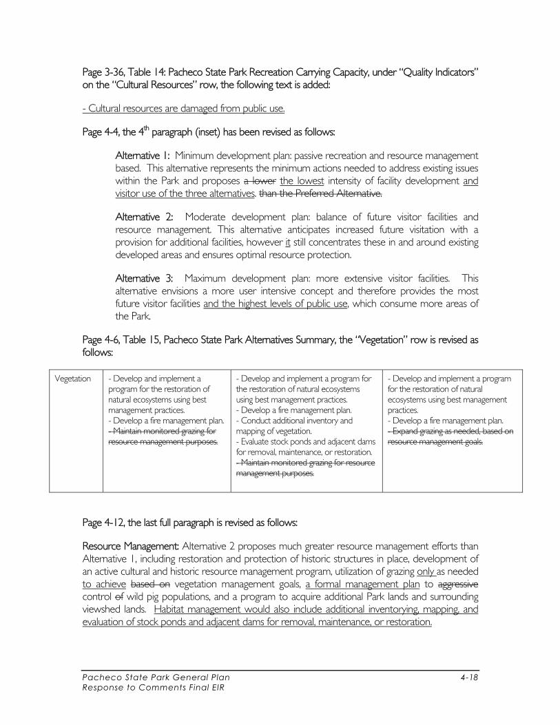
Pacheco State Park General Plan 4-18 Response to Comments Final EIR
Page 3-36, Table 14: Pacheco State Park Recreation Carrying Capacity, under “Quality Indicators” on the “Cultural Resources” row, the following text is added:
- Cultural resources are damaged from public use.
Page 4-4, the 4th paragraph (inset) has been revised as follows:
Alternative 1: Minimum development plan: passive recreation and resource management based. This alternative represents the minimum actions needed to address existing issues within the Park and proposes a lower the lowest intensity of facility development and visitor use of the three alternatives. than the Preferred Alternative.
Alternative 2: Moderate development plan: balance of future visitor facilities and resource management. This alternative anticipates increased future visitation with a provision for additional facilities, however it still concentrates these in and around existing developed areas and ensures optimal resource protection.
Alternative 3: Maximum development plan: more extensive visitor facilities. This alternative envisions a more user intensive concept and therefore provides the most future visitor facilities and the highest levels of public use, which consume more areas of the Park.
Page 4-6, Table 15, Pacheco State Park Alternatives Summary, the “Vegetation” row is revised as follows:
Vegetation - Develop and implement a program for the restoration of natural ecosystems using best management practices. - Develop a fire management plan. - Maintain monitored grazing for resource management purposes.
- Develop and implement a program for the restoration of natural ecosystems using best management practices. - Develop a fire management plan. - Conduct additional inventory and mapping of vegetation. - Evaluate stock ponds and adjacent dams for removal, maintenance, or restoration. - Maintain monitored grazing for resource management purposes.
- Develop and implement a program for the restoration of natural ecosystems using best management practices. - Develop a fire management plan. - Expand grazing as needed, based on resource management goals.
Page 4-12, the last full paragraph is revised as follows:
Resource Management: Alternative 2 proposes much greater resource management efforts than Alternative 1, including restoration and protection of historic structures in place, development of an active cultural and historic resource management program, utilization of grazing only as needed to achieve based on vegetation management goals, a formal management plan to aggressive control of wild pig populations, and a program to acquire additional Park lands and surrounding viewshed lands. Habitat management would also include additional inventorying, mapping, and evaluation of stock ponds and adjacent dams for removal, maintenance, or restoration.
Pacheco State Park General Plan 4-19 Response to Comments Final EIR
Page 4-14, the 1st paragraph has been revised as follows:
The Preferred Alternative includes elements directed at protecting and enhancing wildlife resources in the Park. The General Plan would include development of a coherent wildlife management plan. In an attempt to control wild pigs, an aggressive eradication program management plan would be developed that does not include fencing the entire Park boundary. A wildlife management plan and wild pig eradication control program could both contribute to the long-term protection of wildlife resources at the Park. Without fencing the Park, it may not be feasible to eradicate wild pigs but it would be possible to reduce their numbers to a level where they do not cause a significant impact to the habitat. Restoration of sensitive habitat including stock ponds would also be more feasible if pig numbers were lowered. Restoration and natural recovery of wetland vegetation could substantially improve habitat for California red-legged frog and other native wildlife species. Collectively, these measures could minimize potential impacts on wildlife and enhance existing wildlife habitat.
Pages 4-20 to 4-21, the text under “Thresholds of Significance” have been revised as follows:
Thresholds of Significance
The biological analysis uses criteria from Appendix G of the State CEQA Guidelines as applicable to State lands. Pursuant to these criteria, implementation of the General Plan would have a significant biological impact if the proposed action would:
Have a substantial adverse effect, either directly or indirectly through habitat modifications, on any species identified as a candidate, sensitive, or special-status species in local or regional plans, policies, or regulations, or by DFG or USFWS;
Have a substantial adverse effect on any riparian or other sensitive natural community identified in local or regional plans, policies, or regulations or by DFG or USFWS;
Have a substantial adverse effect on federally protected wetlands as defined by §404 of the Clean Water Act (including, but not limited to, marshes, vernal pools, coastal wetlands, etc.) through direct removal, filling, hydrological interruption, or other means;
Interfere substantially with the movement of any native resident or migratory fish or wildlife species or with established native resident or migratory wildlife corridors, or impede the use of native wildlife nursery sites;
Conflict with any local policies or ordinances protecting biological resources, such as a tree preservation policy or ordinance;
Conflict with the provisions of an adopted HCP, NCCP, or other approved local, regional, or state HCP.
Page 4-21, the 2nd paragraph has been revised as follows: There are a number of vegetation types in the Park, the most common of which are grassland, blue oak woodland, and blue oak savanna. The Park also includes riparian woodland, wetlands, mesic herbaceous vegetation, coast live oak woodland, chaparral, and scrub. All of these vegetation types provide important habitat for native plant and wildlife species. Mesic herbaceous and riparian vegetation are considered sensitive and are regulated under State and federal law.
Pacheco State Park General Plan 4-20 Response to Comments Final EIR
The Park also provides habitat for at least five special-status plant species. Construction and maintenance of Park facilities could result in the loss, permanent alteration, and/or temporary disturbance of vegetation, including special-status plant species. Construction and post-construction impacts on vegetation could also include the introduction of invasive plant species. Impacts on vegetation that would result in a substantial loss of native vegetation types, sensitive habitats, special-status plant species, or the introduction of invasive plant species are considered potentially significant.