pacific islands cooperative ecological studies unit
TRANSCRIPT

PACIFIC ISLANDS COOPERATIVE ECOLOGICAL STUDIES UNIT
Department of Botany
3190 Maile Way Honolulu, Hawaii 96822
Technical Report 1xx
REMOVAL OF ALIEN RED MANGROVE FROM KALOKO-HONOKOHAU NATIONAL HISTORICAL PARK
Rizal Fronda,a Melia Lane-Kamaheleb and Bryan Harryc
a. Maintenance Worker, Kaloko-Honokohau National Historical Park. b. National Park Service, Honolulu c. Volunteer, National Park Service, Hawaii
December 2007
REMOVAL OF ALIEN RED MANGROVE FROMKALOKO-HONOKOHAU NATIONAL HISTORICAL PARK
Rizal Fronda,a Melia Lane-Kamaheleb and Bryan Harryc
a. Maintenance Worker, Kaloko-Honokohau National Historical Park. b. National Park Service, Honolulu c. Volunteer, National Park Service, Hawaii
INTRODUCTION
In the late 1970s red mangrove, Rhizophora mangle, an invasive alien climax tree, invaded the Kaloko-Honokohau National Historical Park saltwater marshes and formed dense closed forest stands. The man-grove impaired nationally significant archeological sites, not only visually but also the physical structures necessitating its removal. The need to protect the physical integrity of the structures complicated any work to control the trees. Beginning in 1988 park maintenance crews carefully began hand-removing the man-grove and systematically controlling reinvading seedling sprouts. By the mid-1990s all mangrove stands on park-owned lands had been removed. Controlling reinvading mangrove sprouts remains a never-ending maintenance endeavor.
1
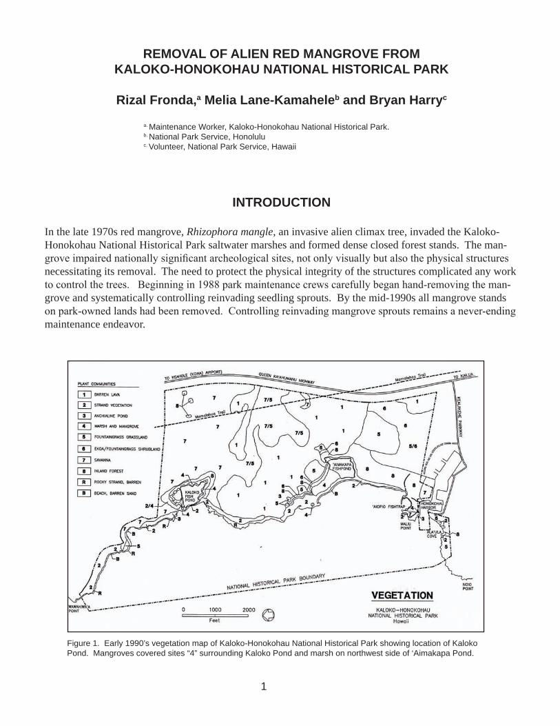
Figure 1. Early 1990’s vegetation map of Kaloko-Honokohau National Historical Park showing location of Kaloko Pond. Mangroves covered sites “4” surrounding Kaloko Pond and marsh on northwest side of ‘Aimakapa Pond.

Figure 2. Aerial view of Kaloko Pond, 13 December 1972. The pond is surrounded by typical strand vegeta-tion. No mangrove is present. Archeological site D13-12 (Figures 4 and 5) is in the bottom right corner of the pond.
THE AREA
Prehistorically, ancient Hawaiians converted Kaloko-Honokohau coastal wet sedgelands into fishponds which were then of great economic value. Until the early 1970s, the strand vegetation bordering these pond areas was largely native (Figure 2) consisting of abundant stands of naupaka-kahakai shrubs (Scaevo-la taccata), scattered 10-18 foot high tree heliotrope (Messerschmidia argenta), and a few naio (Myoporum sandwicense). The strand graded into kiawe (Prosopis pallida) and a few milo (Thespia populinea) and kou (Cordia subcordata) inland. There was a small semi-naturalized coconut grove (Coco nucifera) at the south end of the pond. Two endangered birds, the Hawaiian coot (Fulica alai) and Hawaiian stilt (Himan-topus medicanus), used both the ponds as breeding habitat.
Kaloko Fishpond is the most prominent feature at the northern portion of the park. The Hawaiian word kaloko means “the pond,” and so it is presumed that this particular pond is the prototype example. Kaloko is a loko kuapa type of pond, (a pond of littoral waters whose side facing the sea is barricaded by a stone or coral wall usually with one or more makaha, or sluice gates). The seawall at Kaloko is the most massive known of the ancient fishponds in the Hawaiian Islands (Figure 3). The wall separating the pond from the sea appears as a continuation of the coastline, evidence that the pond was formed by enclosing a bay with a stone seawall.
2

Figure 3. Aerial view of north end of Kaloko Pond, 25 September 1990. Mangrove now had covered the entire shoreline of the pond. Note areas at the main wall in the left foreground, the walls in the pond center, and the upper pond edge where mangrove has been manually removed.
3
Many springs flow into Kaloko Pond along its inland side as well as the ocean along this coast. The re-sulting brackish water is attractive to fish highly prized by ancient Hawaiians. Mullet or ‘ama’ama (Mugil cephalus) and milkfish or awa (Chanos chanos) were the main fish raised at Kaloko.
The area around the pond is considered to be of the highest cultural significance and is designated as a zone where both historical and natural values are to be preserved. Early mythology mentions that Kaloko is the burial place to which Kameeiamoku’s son took Kamehameha’s bones. Kameeiamodu, and with his son, “. . the man who had charge of the secret cave and together they placed the bones there.” Kaloko Pond and its surroundings remain today as one of the most significant Hawaiian cultural sites.
In 1962, the makai areas from Honokohau to Kaloko were designated as the Honokohau Settlement National Landmark (and subject to sections 106 and 110 provisions of the Historic Preservation Act). In 1970, the area including the ponds was established as the Kaloko-Honokohau National Historical Park.
THE PROBLEM
In the late 1970’s, red mangrove became established at Kaloko Pond and in the 1980’s began to invade Honokohau Pond. The location of Kaloko Pond and areas with mangroves are shown in Figure 1, an early 1990’s vegetation map of the park. Red mangrove is alien to Hawaii, and in recent decades it has formed a dominant climax woodland at saltwater swamp sites such as Kaloko and Honokohau ponds. There was no evidence of mangrove at Kaloko in l972 as shown in the aerial photo (Figure 2). By 1990, as shown in a later aerial photo (Figure 3), solid mangrove thickets have become the dominant shoreline vegetation.

Red mangrove is native to Florida, West Indies, and South America. It was introduced to Hawaii in 1902 by the American Sugar Company. It has now spread to saltwater marsh habitats on Molokai, Oahu, Kauai, and Lanai as well as the Big Island. At Kaloko Pond, the mangrove population exploded forming dense thickets up to 10 meters high. Archeological sites became overgrown, the mangrove roots intruding into every available space in the archeological sites and lava flows. Since early Hawaiians used no mortar in their structures mangrove plants grew between the boulders of the pond walls. The historic structures were dismantled and destroyed as plant growth pushed the rocks apart. Left uncontrolled, mangrove would have overgrown much of the pond, destroying and masking the historical site, and creating an anoxic pond of slowly decomposing litter killing fish and aquatic biota (much of it endemic and rare) as well as changing the bird habitat in the feeding and breeding areas in the pond.
MANGROVE CONTROL
Control of red mangrove at the new Kaloko-Honokohau National Historical Park was difficult, physically and mechanically demanding and expensive. This paper summarizes that effort, and is of interest because red mangrove has invaded similar situations elsewhere in Hawaii, with destruction of ancient Hawaiian archeological sites and often disastrous effect upon native water bird feeding and breeding habitat. The ap-proach and application developed at Kaloko-Honokohau formed the basis for the more extensive eradica-tion programs at sites such as Kaneohe Marine Base Areas.
By 1988, when the Kaloko property was acquired, the mangrove trees were about 30 feet tall and formed impenetrable thickets surrounding the entire pond. By 1990, when Honokohau Pond was acquired, man-grove seedlings were widely scattered there also and the invasion of mangrove seemed assured.
Park management regarded mangrove as undesirable, and while uncontrolled it created a vexing problem. The vegetation management goal of the park is a four-fold mosaic:
• Favor and reestablish vegetation typical of pre-historic Polynesian landscapes,
• Where appropriate, favor native vegetation,
• Where applicable, favor vegetation desirable for breeding habitat of endangered stilts and coots, and
• Remove vegetation detrimental to significant archeological sites
Red mangrove is an anathema to all these park objectives.
CONSTRAINTS
The archeological sites and ruins (all on the National Register of Historic Places and are part of a desig-nated National Historical Landmark) severely complicated mangrove removal within the park. Care of the fishpond walls, dams, and related archeological features required careful hand-work removal. Vehicles could not be driven to the work site and all brush had to be carried away by hand or helicopter, rather than dragged or skidded to convenient transfer sites. All work was done under the protective surveillance of an archeologist.
4

Figure 4. Archeological map by Renger of site D13-12 at Kaloko Pond. This is only one of several archeological sites entirely bordering the pond.
5
Much of the mangrove infestation, par-ticularly the denser stands, grew upon intricate and complicated archeology features. Renger’s archeological map of a site at the southeast edge of the pond, Figure 4, is typical of the entire area with mangroves. Note Renger’s further enlarged detail of this site in Figure 5 which highlights the fragile nature of the work site. Mangrove roots penetrated the smallest openings in the ancient ruins and any activity more than careful handwork in removing trees irreparably destroys the old ruins--the principal feature for which this National Historical Park was estab-lished.
Figure 5. Close-up diagram of a portion of site D13-12 illustrates the detail and complexity which complicated mangrove removal.
Spraying the mangrove was not an accept-able alternative. The tree has a thick leathery leaf from which liquids fall off even when the weed killer is mixed with a wetting agent. This leaf is protected by a thick cuticle (skin) which minimizes absorption of liquid that may remain on the leaf. Also, chemicals could not be considered for use because of their unknown impact upon native fish and crusta-ceans.
Use of helicopters and boats require additional safety precautions and operational protocols. Difficult footing made use of chainsaws haz-ardous. Fireworms were always present and people have different, some severe, reactions to their stings.
ACTION TAKEN
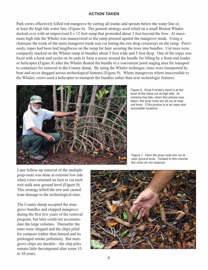
Park crews effectively killed red mangrove by cutting all trunks and sprouts below the water line or, at least the high tide water line, (Figure 6). The general strategy used relied on a small Boston Whaler decked over with an improvised 8 x 12 foot ramp that protruded about 3 feet beyond the bow. At maxi-mum high tide the Whaler was maneuvered so the ramp pressed against the mangrove trunk. Using a chainsaw the trunk of the main mangrove trunk was cut letting the tree drop crossways on the ramp. Previ-ously, ropes had been laid lengthwise on the ramp for later securing the trees into bundles. Cut trees were compactly stacked on the Whaler ramp in bundles about 5 foot wide and 5 foot deep. One of the ropes was fixed with a hook and eyelet on its ends to form a noose around the bundle for lifting by a front-end loader or helicopter (Figure 8) after the Whaler floated the bundle to a convenient pond staging area for transport to containers for removal to the County dump. By using the Whaler technique, trees were transported by boat and never dragged across archeological features (Figure 9). Where mangroves where inaccessible to the Whaler, crews used a helicopter to transport the bundles rather than scar archeologic features.
6
Later follow-up removal of the multiple prop-roots was done at extreme low tide when crews returned on foot to cut each root stalk near ground level (Figure 9). This strategy killed the tree and caused least damage to the archeological sites.
The County dump accepted the man-grove bundles and chipped mangrove during the first few years of the removal program, but later could not accommo-date the large volumes. Thereafter the trees were chipped and the chips piled for compost (rather than burned and its prolonged smoke pollution). But man-grove chips are durable—the chip piles remain little decomposed after some 15 to 18 years.
Figure 6. Rizal Fronda’s hand is at the level of the initial cut at high tide. At extreme low tide, when this picture was taken, the prop roots are all cut at near soil level. (This picture is at an easy and accessible location).
Figure 7. Here the prop roots are cut at near ground level. Treated in this manner the roots do not resprout.

Fiscal Year Square feet Acres Activity1988 70,242 1.62 6 mo cutting, manu-
ally hauling1989 23,182 0.53 Cut, haul, maintain
(manually burn): 3 laborers for 6 mo.
1990 15,124 0.35 Cut, haul, maintain (manually burn): 2 laborers for 4 mo.
1991 16,380 0.38 Cut, helio haul, main-tain (manually burn)
1992* 27,201 0.63 Cut, helio haul, main-tain (manually burn)
1993* 27,202 0.63 Cut, helio haul, main-tain (manually burn)
1994* 27,201 0.63 Cut, helio haul, main-tain (manually burn)
Total mangroves 207,332 4.75
Table 1. Kaloko Pond work accomplished by fiscal year.
* The 1992-1994 years square feet and acreage are extrapolated from the prior years and based upon total acreage.
Figure 8. Maintenance crew bundling mangrove cuttings for transport to dumpster loading area.
Figure 9. Aerial transfer of mangrove bundle to dumpster for hauling. Ka-loko Pond 26 December 1990.
7

Table 2. Dollar Expenditures. (Clearing and Maintenance only available for the 1990 and 1991 Years).
Work accomplished to date
Personnel costs
Equipment costs
Equipment supplies & materials
Torch burning and maintenance
> half of Kaloko mangrove removed 3/4 of Kaloko mangrove removed
Area cleared this year 0.35 acres 0.38 acres
Mangrove area cleared to date 2.50 acres 2.88 acres
Volume removed 4,280 cu meters
Total worker hours 3,620
Worker cost / hour $8.52
Total direct salary cost $31,524 est $31,524
Supervision and training 2,000
Buy 15 HP outboard 2,800
Bobcat hauling 4,300
Truck rental for hauling 4,200 4,200
Helicopter operation (hauling) 19,862
2,000 2,000
6,176 1414
Total annual cost $53,000 $59,000
Item FY 1990 FY 1991

9
Figure 10. The pond’s numerous bristle worms (Eurythroe complanata) greatly aggravated manual workers slogging through wetlands to cut mangrove. Bristle worms are notorious for their painful stings.
Figure 11. Red Mangrove eradication program, Kaloko-Honokohau National Historical Park, 1988 - 1991.
The program was expensive and took sev-en years (Table 1. and Figure 11). At this historical park it was slow so as to protect the significant archeology, and since most aspects of the work were experimental, many different strategies were tried and invalidated. The cost was considered acceptable; a very valuable historical resource was preserved, and the park also developed an appropriate strategy for use at similar fishpond and wetland sites elsewhere—not only archeological sites but endangered species habitat as well.

FUTURE MAINTENANCE
Neglecting “weeding maintenance” of the controlled mangrove for merely a few years would nullify this control effort and revert the ponds back into man-grove thickets. Though by now resprouting of the old stumps is negligible, there is a constant source of new seed pods floating along the coast from other nearby mangrove infestations; sites over which the park has no jurisdiction. Present maintenance involves annual inspection of all potential habitat searched for man-grove seedlings in the park and either “weed whack-ing” or burning them out with a methane flame-throw-er. At maximum low tide, seedlings are effectively controlled by cutting with mechanical weed whackers as long as the stems are cut below the leaf cluster. Stems too stout to be mechanically cut in this man-ner are effectively burned with a flame thrower until scorched. This sustained surveillance involves about two to three weeks work annually by a savvy mainte-nance worker.
Figure 12. Kaloko Pond foreground shows prolific new mangrove seedlings only a year after clearing. Middle distance is recently cleared mangrove, and in the distance are yet uncut thickets of mangrove.
10
Figure 13. Mangrove seedlings of this size, if completely severed below leaves, usually can be destroyed by weed whack-ing, and can certainly be killed by a flame thrower.
Figure 14. The typical propane flame thrower park crews use to kill mangrove seedlings. Burning sufficient to torch all leaves is effective.

Figure 15. These relict piles of mangrove chips in the park’s maintenance yard are only slightly grayer in hue than when stored there there for compost some 18 years ago.
ACKNOWLEDGMENTS
This successful park restoration effort to curtail invasion by an aggressive alien plant could not have suc-ceeded without the partnership of the University of Hawaii Park Cooperative Studies Unit (now Cooper-ative Ecosystem Studies Unit). This project exemplifies the excellent collaboration between the National Park Service and the University to experimentally develop natural resource preservation strategies for statewide implementation. It also served as an opportunity to train students and native Hawaiians in ap-propriate strategies to manage their heritage sites. Dr. Clifford Smith, Professor of Botany emeritus gave considerable impetus to the authors in developing this paper. The project was partially funded by Co-operative Agreements #### and #### between the National Park Service and the University of Hawaii, Manoa.
The weedwacking and burning strategies are far superior to techniques such as hand pulling or herbicide treatment. Scorching young shoots and leaves with a propane torch is much quicker and more effective. It leaves no obvious stains on the rocks and causes minimal disturbance because a wide area (some 10 square feet can be controlled from a single position. The operator can easily control areas missed since treated areas are immediately visible.
Small seedlings and resprouts between stones are not amenable to hand pulling which is difficult and as a continuous activity could damage historic site’s stonework; an unacceptable practice because of the cu-mulative disturbance by repeated control activities. As mentioned above chemical treatment was ineffec-tive, but also it was difficult to see where plants had been adequately sprayed without adding dyes which would be unsightly to the archeological ruins.
11

LITERATURE CITED
Apple, Russ A. and W. K. Kikuchi. 1975. Ancient Hawai’i Shore Zone Fishponds: an
Evaluation of Survivors for Historical Preservation. Office of the State Director, National Park Service, Honolulu. U.S. Gov’t Printing Office 157 pp.
Canfield, Joan E. 1990. Description and Map of the Plant Communities of Kaloko-
Honokohau National Cultural Park. Cooperative National Park Resources Study Unit Technical Report 73, University of Hawaii’ at Manoa, Honolulu, HI. 29 pp and map.
Cordy, Ross, Joseph Tainter, Robert Renger and Robert Hitchcock. 1991. An
Ahupua’a Study: The 1971 Archaeological Work at Kaloko Ahupua’a North Kona, Hawai’i. National Park Service Western Archeological and Conservation Center, Pub’l in Anthropology # 58. 633 pp.
Degener, Otto. 1940. Flora Hawaiiensis, family 269. Rhizopora mangle. Published
privately, 2pp. Reprinted 1946. Honolulu, HI. Kelly, Marion. 1971. Kekaha: ‘Aina Malo’o: Historical Survey and Background of
Kaloko and Kuki’o Ahupua’a, North Kona, Hawaii. Report 71-2. Dept. of Anthropology, Bernice P. Bishop Museum. Honolulu, HI.
Kikuchi, William K. 1976. Prehistoric Hawaiian Fishponds. Science. 193:295-99 National Park Service. 1962. Honokohau Settlement. Nomination as a National
Historical Landmark, June 27, 1962. NPS files, 3 pp. National Park Service. 1994. General Management Plan and Environmental Impact
Statement. Kaloko-Honokohau National Historical Park, Hawaii. 347 pp. National Park Service. 1996. Resource Management Plan Project Statements, Kaloko-
Honokohau National Historical Park. Unpublished report in files at Kaloko-Honokohau National Historical Park, Hawaii. 123 pp.
Pratt, Linda W. 1998. Vegetation Management Strategies for Three National Historical
Parks on Hawai’i Island. Cooperative National Park Resources Studies Unit Technical Report 121. Univ of Hawaii, Manoa.
U.S Fish and Wildlife Service. 1985. Hawaiian Waterbirds Recovery Plan. 99 pp
mimeo. Wagner, Warren L., Derral Herbst, and S. L. Sohmner. 1990. Manual of the Flowering
Plants of Hawaii. 2 vol. Bishop Museum Special Publication 83. Univ. of Hawaii Press/Bishop Museum Press.