page | 1 copyright © commonwealth of australia november …
TRANSCRIPT
Page | 1 Copyright © Commonwealth of Australia November 2020
Fact Sheet: Navigation
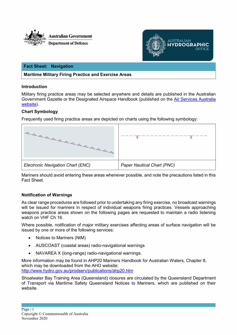
Maritime Military Firing Practice and Exercise Areas Introduction Military firing practice areas may be selected anywhere and details are published in the Australian Government Gazette or the Designated Airspace Handbook (published on the Air Services Australia website). Chart Symbology Frequently used firing practice areas are depicted on charts using the following symbology:
Electronic Navigation Chart (ENC) Paper Nautical Chart (PNC)
Mariners should avoid entering these areas whenever possible, and note the precautions listed in this Fact Sheet. Notification of Warnings As clear range procedures are followed prior to undertaking any firing exercise, no broadcast warnings will be issued for mariners in respect of individual weapons firing practices. Vessels approaching weapons practice areas shown on the following pages are requested to maintain a radio listening watch on VHF Ch 16. Where possible, notification of major military exercises affecting areas of surface navigation will be issued by one or more of the following services:
• Notices to Mariners (NtM)
• AUSCOAST (coastal areas) radio-navigational warnings
• NAVAREA X (long-range) radio-navigational warnings. More information may be found in AHP20 Mariners Handbook for Australian Waters, Chapter 8, which may be downloaded from the AHO website: http://www.hydro.gov.au/prodserv/publications/ahp20.htm Shoalwater Bay Training Area (Queensland) closures are circulated by the Queensland Department of Transport via Maritime Safety Queensland Notices to Mariners, which are published on their website.

Page | 2 Copyright © Commonwealth of Australia November 2020
Maritime Safety Queensland website: www.msq.qld.gov.au/Notices-to-Mariners.aspx
AHO website: www.hydro.gov.au
Shoalwater Bay Training Area Range Control Telephone: +61 7 4935 5000 Facsimile: +61 7 4935 5024 Email: [email protected]
Visual warnings:
• Ships engaged in firing practices fly a red flag by day.
• Ships and aircraft carrying out night exercises may illuminate with bright white flares.
• All safety craft, target towers or control launchers for radio controlled targets will display: o a large red flag at the masthead o a painted canvas strip (1.8 metre x 0.9 metre) with red and white or red and yellow checks
in 0.3 metre squares on the foredeck or cabin roof. The absence of warning signals cannot be accepted as evidence that a practice is not taking place. Precautions to be taken by vessels in or near a firing practice area Vessels should monitor VHF Ch 16 and comply with any requests from either the firing vessel or range safety or the Range Safety Craft. If a vessel finds herself in an area where a practice is in progress she should maintain her course and speed. If she is prevented from doing so due to the navigation situation, she should endeavour to clear the area at the earliest possible moment. Fishermen operating in or near firing practice and exercise areas may occasionally bring unexploded ordinance or portions of them to the surface in their nets or trawls. These objects may be dangerous - they should be treated with extreme caution and jettisoned immediately. No attempt should be made to tamper with them or bring them back for inspection by Navy authorities. Such objects should be reported immediately to JRCC Australia or the Police. Precautions taken by units undertaking firing practice All practice firings are conducted under Clear (Air and Sea) Range Procedure. This includes confirming that any area in which a firing is scheduled to take place is confirmed to be clear both by radar and visually, including wide clearance arcs either side of the intended direction of firing, and any potential ricochet area. Firings are invariably delayed if the area is not clear, or if a vessel has the potential to stray into a previously clear area. Devices are generally incorporated whereby the missiles may be destroyed should their flight be erratic. While the sound of weapons being fired may occasionally be heard by passing vessels, this does not mean they are in any danger – sound may carry considerably further at sea than might be expected due to prevailing winds and the lack of any high land features to dissipate the sound.

Page | 3 Copyright © Commonwealth of Australia November 2020
Types of firing practices The principal types of practices carried out are:
• Aircraft: o Bombing practice, generally at targets on a coastal (or inland) bombardment range. o Air to air firing practice, by aircraft at a large white or red sleeve, a winged target, or flag
towed by another aircraft moving on a steady course. o Air to sea (or ground) firing practice - the former is carried out at towed or stationary
targets, while the latter may be carried out against targets on a coastal bombardment range.
• Surface (sea / land) to air: o Anti-aircraft firing from sea or land to air - this may be from AA guns, machine guns or
missiles at a target towed by an aircraft, a pilotless target aircraft or, at balloons or kites.
• Surface to surface: o At fixed or floating targets on the sea, primarily using small calibre weapons. o At targets on a coastal bombardment range, primarily using large calibre (loud) guns. o At remote controlled craft - these are 6.4 metre surface craft, orange in colour and carry
no distinctive shapes or lights. They are however, fitted with navigation lights appropriate to their size in accordance with the International Regulations for Preventing Collisions at Sea, 1972. Such craft are remotely controlled from helicopters, ships and occasionally from the shore.
• Rocket and guided weapons firing may occasionally be undertaken in conjunction with or in lieu of gun firing practice for air to air, air to surface, or surface to surface firings.
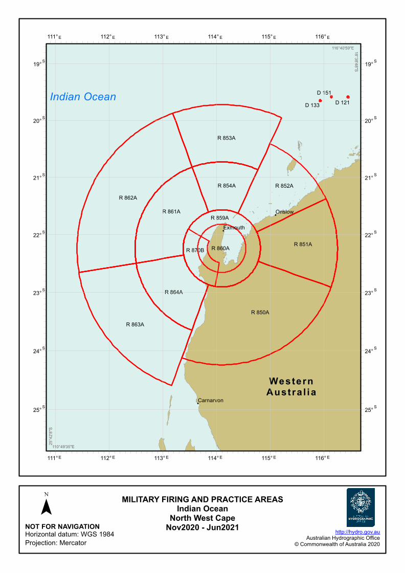
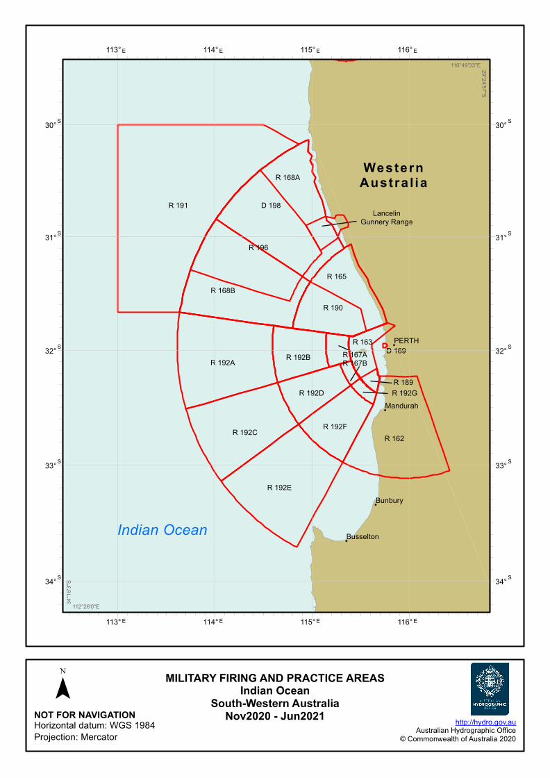
Australian (maritime) military firing practice exercise areas Diagrams of designated maritime military firing practice and exercise areas are shown on the following pages.

!
!
!
!
Off Bass Point
Off Black Point
R 453B
R 452
R 453A
R 453F
R 453D
R 453C
R 453ER 453H
R 453G
R 453J
R 485AR 485B R 485C
R 485D
R 485E
R 421A
R 453L
R 421B
R 453P
R 495CR 495B
R 453K
R 495A
R 453N
R 453M
SYDNEY
Batemans Bay
Wollongong
Nowra
NewSouthWales
Tasman Sea
153° E
153° E
152° E
152° E
151° E
151° E
34°S 34° S
35°S 35° S
36°S 36° S
37°S 37° S
NOT FOR NAVIGATIONHorizontal datum: WGS 1984Projection: Mercator
http://hydro.gov.auAustralian Hydrographic Office
© Commonwealth of Australia 2020
¯
150°3'42"E
37°4
5'0"
S153°43'20"E 33°53'32"S
MILITARY FIRING AND PRACTICE AREASTasman SeaJervis Bay
Nov2020 - Jun2021

!
!
!
!
!
!
!
D 679A
D 679B
D 675
R 638
D 690
SR050
R 578B
R 574
R 489
PortMacquarie
Byron Bay
SYDNEY
Newcastle
Coffs Harbour
Taree
Gold Coast
New SouthWales
Queensland
Tasman Sea
Coral Sea
156° E
156° E
155° E
155° E
154° E
154° E
153° E
153° E
152° E
152° E
151° E
151° E
28°S 28° S
29°S 29° S
30°S 30° S
31°S 31° S
32°S 32° S
33°S 33° S
NOT FOR NAVIGATIONHorizontal datum: WGS 1984Projection: Mercator
http://hydro.gov.auAustralian Hydrographic Office
© Commonwealth of Australia 2020
¯
150°38'38"E33°5
9'37
"S156°8'5"E 27°52'17"S
MILITARY FIRING AND PRACTICE AREASCoral and Tasman Seas
NewcastleNov2020 - Jun2021

!
!
!
!
!
D 666
D 629B
D 629A
D 629C
D 617B
D 617A D 617C
D 679A
D 658A
D 632
D 658B
D 617D
D 675
R 638
R 693
Byron Bay
Bundaberg
Toowoomba
Gold Coast
BRISBANE
New SouthWales
Queensland
Coral Sea
157° E
157° E
156° E
156° E
155° E
155° E
154° E
154° E
153° E
153° E
152° E
152° E
23°S 23° S
24°S 24° S
25°S 25° S
26°S 26° S
27°S 27° S
28°S 28° S
29°S 29° S
NOT FOR NAVIGATIONHorizontal datum: WGS 1984Projection: Mercator
http://hydro.gov.auAustralian Hydrographic Office
© Commonwealth of Australia 2020
¯
151°47'55"E29°3
8'38
"S157°39'19"E 22°48'43"S
MILITARY FIRING AND PRACTICE AREASCoral Sea
Queensland SouthNov2020 - Jun2021

!
Shoalwater BayTraining Area
R 686
R 680
R 689
R 682
R 683
Yeppoon
Queensland
Coral Sea
151° E
151° E
150° E
150° E
22°S 22° S
23°S 23° S
NOT FOR NAVIGATIONHorizontal datum: WGS 1984Projection: Mercator
http://hydro.gov.auAustralian Hydrographic Office
© Commonwealth of Australia 2020
¯
149°44'46"E
23°8
'42"
S151°12'37"E 21°22'51"S
MILITARY FIRING AND PRACTICE AREASCoral Sea
Shoalwater BayNov2020 - Jun2021

!
!
!
!
!
D 779
Halifax Bay
D 764
R 747
R 743
Townsville
ChartersTowers
Ingham
Bowen
AyrQueensland
Coral Sea
148° E
148° E
147° E
147° E
18°S 18° S
19°S 19° S
20°S 20° S
NOT FOR NAVIGATIONHorizontal datum: WGS 1984Projection: Mercator
http://hydro.gov.auAustralian Hydrographic Office
© Commonwealth of Australia 2020
¯
146°6'4"E20°1
0'43
"S148°17'37"E 17°28'35"S
MILITARY FIRING AND PRACTICE AREASCoral SeaTownsville
Nov2020 - Jun2021

!
!
!
R 766
D 769A
D 771C
D 769B
D 771D
R 778
R 767
R 783
Cairns
Port Douglas
Innisfail
Queensland
147° E
147° E
146° E
146° E
145° E
145° E
15°S 15° S
16°S 16° S
17°S 17° S
NOT FOR NAVIGATIONHorizontal datum: WGS 1984Projection: Mercator
http://hydro.gov.auAustralian Hydrographic Office
© Commonwealth of Australia 2020
¯
144°6'56"E17°4
0'30
"S147°2'38"E
14°0'22"S
MILITARY FIRING AND PRACTICE AREASCoral Sea
Queensland NorthNov2020 - Jun2021

!
D 606D 602
R 603Weipa
Queensland
Coral Sea
Arafura Sea
144° E
144° E
143° E
143° E
142° E
142° E
141° E
141° E
140° E
140° E
10°S 10° S
11°S 11° S
12°S 12° S
13°S 13° S
14°S 14° S
15°S 15° S
16°S 16° S
NOT FOR NAVIGATIONHorizontal datum: WGS 1984Projection: Mercator
http://hydro.gov.auAustralian Hydrographic Office
© Commonwealth of Australia 2020
¯
139°46'51"E16°1
0'40
"S144°54'20"E
9°40'28"S
MILITARY FIRING AND PRACTICE AREASArafura and Coral SeasFar North Queensland
Nov2020 - Jun2021

!
D 257
Ordnance No ImpactZone (ONIZ)
R 264K
R 264J
R 230D
R 230A
R 230F
R 230E
R 264BR 264A
R 264DR 264C
R 264E
R 264G
R 230B
R 230C
R 264F
D 288C
DARWIN
NorthernTerr i tory
WesternAustra l ia
Arafura Sea
Timor Sea
133° E
133° E
132° E
132° E
131° E
131° E
130° E
130° E
129° E
129° E
128° E
128° E
9°S 9° S
10°S 10° S
11°S 11° S
12°S 12° S
13°S 13° S
14°S 14° S
15°S 15° S
16°S 16° S
NOT FOR NAVIGATIONHorizontal datum: WGS 1984Projection: Mercator
http://hydro.gov.auAustralian Hydrographic Office
© Commonwealth of Australia 2020
¯
127°40'52"E16°1
5'24
"S133°32'17"E
8°48'50"S
MILITARY FIRING AND PRACTICE AREASTimor and Arafura Seas
DarwinNov2020 - Jun2021

!
D 818
D 817
D 820
D 819
D 812
D 813D 816
D 814
D 815
R 811
Broome
WesternAustra l ia
Indian Ocean
127° E
127° E
126° E
126° E
125° E
125° E
124° E
124° E
123° E
123° E
122° E
122° E
121° E
121° E
13°S 13° S
14°S 14° S
15°S 15° S
16°S 16° S
17°S 17° S
18°S 18° S
19°S 19° S
20°S 20° S
21°S 21° S
NOT FOR NAVIGATIONHorizontal datum: WGS 1984Projection: Mercator
http://hydro.gov.auAustralian Hydrographic Office
© Commonwealth of Australia 2020
¯
120°2'35"E21°3
6'25
"S127°21'50"E
12°30'8"S
MILITARY FIRING AND PRACTICE AREASIndian Ocean
Dampier PeninsulaNov2020 - Jun2021
!
!
!
D 133 D 121
R 859A
R 850A
R 853A
R 854A
R 862A
R 852A
R 863A
R 864A
R 870B
R 861A
R 851AR 860A
D 151
Exmouth
Carnarvon
Onslow
WesternAustra l ia
Indian Ocean
116° E
116° E
115° E
115° E
114° E
114° E
113° E
113° E
112° E
112° E
111°E
111°E
19°S 19° S
20°S 20° S
21°S 21° S
22°S 22° S
23°S 23° S
24°S 24° S
25°S 25° S
NOT FOR NAVIGATIONHorizontal datum: WGS 1984Projection: Mercator
http://hydro.gov.auAustralian Hydrographic Office
© Commonwealth of Australia 2020
¯
110°49'35"E
25°4
2'8"
S116°40'59"E 18°38'48"S
MILITARY FIRING AND PRACTICE AREASIndian Ocean
North West CapeNov2020 - Jun2021
!
!
!
!
D 169
D 198Lancelin
Gunnery Range
R 191
R 190
R 163
R 162
R 196
R 168A
R 168B
R 192F
R 192A
R 192C
R 192B
R 192D
R 192E
R 192G
R 167AR 167B
R 165
R 189
Busselton
PERTH
Bunbury
Mandurah
WesternAustra l ia
Indian Ocean
116° E
116° E
115° E
115° E
114° E
114° E
113° E
113° E
30°S 30° S
31°S 31° S
32°S 32° S
33°S 33° S
34°S 34° S
NOT FOR NAVIGATIONHorizontal datum: WGS 1984Projection: Mercator
http://hydro.gov.auAustralian Hydrographic Office
© Commonwealth of Australia 2020
¯
112°26'0"E
34°1
6'3"
S116°49'33"E 29°24'57"S
MILITARY FIRING AND PRACTICE AREASIndian Ocean
South-Western AustraliaNov2020 - Jun2021

!
!
!
!
!
!
!
!
!
R 231
R 303A
R 302A
R 282
R 279
Acoustic RangingArea (ThistleIsland)
R 292A
R 282A
R 254
D 280
R 292E
R 292FD 220
R 292CR 292D
Port Lincoln
Port Pirie
Whyalla
Victor Harbor
ADELAIDE
Port Augusta
KingstonSouth East
Wallaroo
Cowell
SouthAustra l ia
GreatAustralian
Bight
140° E
140° E
139° E
139° E
138° E
138° E
137° E
137° E
136° E
136° E
135° E
135° E
33°S 33° S
34°S 34° S
35°S 35° S
36°S 36° S
37°S 37° S
NOT FOR NAVIGATIONHorizontal datum: WGS 1984Projection: Mercator
http://hydro.gov.auAustralian Hydrographic Office
© Commonwealth of Australia 2020
¯
134°52'45"E
37°4
4'0"
S140°0'14"E 32°16'44"S
MILITARY FIRING AND PRACTICE AREASGreat Australian Bight
South AustraliaNov2020 - Jun2021

!
!
!
!
!
!
!
!
!
!
!
!
R 359H
D 322B
D 383A
R 359B
R 339
R 359FR 323A
R 359A
Sunbury
Seymour
Sale
Bendigo
TraralgonGeelong
Wonthaggi
MELBOURNE
Shepparton
Melton
Bairnsdale
Wangaratta
Victor ia
Bass Strait
148° E
148° E
147° E
147° E
146° E
146° E
145° E
145° E
37°S 37° S
38°S 38° S
39°S 39° S
40°S 40° S
NOT FOR NAVIGATIONHorizontal datum: WGS 1984Projection: Mercator
http://hydro.gov.auAustralian Hydrographic Office
© Commonwealth of Australia 2020
¯
144°11'41"E40°4
2'42
"S148°32'58"E
36°17'1"S
MILITARY FIRING AND PRACTICE AREASBass Strait
VictoriaNov2020 - Jun2021