paper b - iwight.com committee from... · up to 14549 sqm of marine industrial space and storage...
TRANSCRIPT

B - 1
PAPER B ISLE OF WIGHT COUNCIL PLANNING COMMITTEE - TUESDAY, 13 MARCH 2018 REPORT OF THE HEAD OF PLACE WARNING
1. THE RECOMMENDATIONS CONTAINED IN THIS REPORT OTHER THAN PART 1 SCHEDULE AND DECISIONS ARE DISCLOSED FOR INFORMATION PURPOSES ONLY.
2. THE RECOMMENDATIONS WILL BE CONSIDERED ON THE DATE INDICATED
ABOVE IN THE FIRST INSTANCE. (In some circumstances, consideration of an item may be deferred to a later meeting).
3. THE RECOMMENDATIONS MAY OR MAY NOT BE ACCEPTED BY THE
PLANNING COMMITTEE AND MAY BE SUBJECT TO ALTERATION IN THE LIGHT OF FURTHER INFORMATION RECEIVED BY THE OFFICERS AND PRESENTED TO MEMBERS AT MEETINGS.
4. YOU ARE ADVISED TO CHECK WITH THE PLANNING DEPARTMENT (TEL:
821000) AS TO WHETHER OR NOT A DECISION HAS BEEN TAKEN ON ANY ITEM BEFORE YOU TAKE ANY ACTION ON ANY OF THE RECOMMENDATIONS CONTAINED IN THIS REPORT.
5. THE COUNCIL CANNOT ACCEPT ANY RESPONSIBILITY FOR THE
CONSEQUENCES OF ANY ACTION TAKEN BY ANY PERSON ON ANY OF THE RECOMMENDATIONS.
Background Papers
The various documents, letters and other correspondence referred to in the Report in respect of each planning application or other item of business.
Members are advised that every application on this report has been considered against a background of the implications of the Crime and Disorder Act 1998 and, where necessary, consultations have taken place with the Crime and Disorder Facilitator and Architectural Liaison Officer. Any responses received prior to publication are featured in the report under the heading Representations.
Members are advised that every application on this report has been considered against a background of the implications of the Human Rights Act 1998 and, following advice from the Head of Legal Services and Monitoring Officer, in recognition of a duty to give reasons for a decision, each report will include a section explaining and giving a justification for the recommendation.

B - 2
LIST OF PLANNING APPLICATIONS REPORT TO COMMITTEE – 13 MARCH 2018 01 P/00496/16 TCP/28471/A Cowes Conditional
Permission Page 4 land bounded by River Medina/Cowes Youth
Centre/, Medina Road/Thetis Road/Pelham Road/, Arctic Road, Cowes, Isle Of Wight. Hybrid planning application for mixed-use re-development to provide up to 535 residential units and up to 18630 sqm of non-residential floor space and associated new public realm works, landscaping, re-construction of sea wall and new public slipway. Comprised of the following elements: Full planning permission for demolition of existing buildings and partial demolition of J Samuel White building; re-development of Phase 1 at northern end of site comprising construction of 3 building clusters (total of 9 buildings) to provide: 1. Up to 256 residential units 2. Up to 460 sqm of flexible retail, financial and professional services, food and drink floor space (A1-A4 uses) 3. Up to 493 sqm of flexible restaurant or bar floor space (A3/A4 use) 4. Up to 1238 sqm of office and flexible workspace (B1 use) 5. Up to 689 sqm of flexible retail, financial and professional services, food and drink, office and community use floor space (A1-A4, B1 and D1 uses) 6. Up to 242 basement car parking spaces 7. Up to 287 cycle parking spaces together with access, new public routes, piazza and associated landscaping treatment, re-construction of sea wall and refurbishment of former J Samuel White offices and Hammerhead Crane. Outline planning permission for development at the southern end of site to provide: 1. Up to 279 residential units 2. Up to 631 sqm of flexible retail, financial and professional services, food and drink floor space (A1-A4 uses) 3. Up to 616 sqm community/museum use floor space (D1 use)

B - 3
4. Up to 447 sqm Marine Training accommodation (B1 use) 5. Up to 14549 sqm of marine industrial space and storage (B2/B8 use) 6. Up to 12288 sqm of basement floor space for associated car parking and plant area. together with access, new public routes and associated landscaping treatment, re-construction of sea wall and new public slipway (Revised plans showing changes to Phase 1 Block 2, widening of Admiralty Gate entrance, changes to Phase 2 building parameters plans; update information relating to the level of accommodation, visual montages, heritage assessment and confidential viability information; reduction of residential units from 256 to 253)(readvertised)
02 P/01460/17 TCP/27471/T Ryde Conditional
Permission Page 105 Ryde School, 7 Queens Road, Ryde, Isle Of Wight,
PO333BE Construction of boarding house and netball courts in association with school and associate landscaping works, to include improved access for emergency and refuse vehicles (revised scheme).
03 P/01141/15 TCP/17535/P Newport Conditional
Permission Page 140 land adjacent to Hunter's Way, Buckbury Lane,
Newport, Isle Of Wight, PO30 Proposed construction of 5 detached dwellings with vehicular access and parking (revised plans, flood risk assessment and application form, tree report and dormice report received)(revised plans - unit 6 removed)(revised description)(readvertised)
04 P/01484/17 TCP/12917/W Wootton
Bridge Conditional Permission
Page 165 Wootton Bridge Recreation Ground, Footways, Wootton Bridge, Ryde, Isle Of Wight, PO33 Replacement of 1no existing 15m floodlight with 17.5m floodlight/ telecommunications antenna; 4 no ground cabinets (revised location)(readvertised application)

01 Reference Number: P/00496/16 – TCP/28471/A & P/01076/17 – LBC/28471/B Description of applications: Hybrid planning application for mixed-use re-development to provide up to 535 residential units and up to 18630 sqm of non-residential floor space and associated new public realm works, landscaping, re-construction of sea wall and new public slipway. Comprised of the following elements: Full planning permission for demolition of existing buildings and partial demolition of J Samuel White building; re-development of Phase 1 at northern end of site comprising construction of 3 building clusters (total of 9 buildings) to provide: 1. Up to 253 residential units 2. Up to 460 sqm of flexible retail, financial and professional services, food and drink floor space (A1-A4 uses) 3. Up to 493 sqm of flexible restaurant or bar floor space (A3/A4 use) 4. Up to 1238 sqm of office and flexible workspace (B1 use) 5. Up to 689 sqm of flexible retail, financial and professional services, food and drink, office and community use floor space (A1-A4, B1 and D1 uses) 6. Up to 242 basement car parking spaces 7. Up to 287 cycle parking spaces together with access, new public routes, piazza and associated landscaping treatment, re-construction of sea wall and refurbishment of former J Samuel White offices and Hammerhead Crane. Outline planning permission for development at the southern end of site to provide: 1. Up to 279 residential units 2. Up to 631 sqm of flexible retail, financial and professional services, food and drink floor space (A1-A4 uses) 3. Up to 616 sqm community/museum use floor space (D1 use) 4. Up to 447 sqm Marine Training accommodation (B1 use) 5. Up to 14549 sqm of marine industrial space and storage (B2/B8 use) 6. Up to 12288 sqm of basement floor space for associated car parking and plant area. together with access, new public routes and associated landscaping treatment, re-construction of sea wall and new public slipway (Revised plans showing changes to Phase 1 Block 2, widening of Admiralty Gate entrance, changes to Phase 2 building parameters plans; update information relating to the level of accommodation, visual montages, heritage assessment and confidential viability information; reduction of residential units from 256 to 253)(re-advertised)
B - 4
Application for Listed Building Consent for works to repair and consolidate the Grade II* Listed Hammerhead Crane including the relocation of the existing switch gear and demolition of the associated building. Site Address: land bounded by River Medina/Cowes Youth Centre/, Medina Road/Thetis Road/Pelham Road/, Arctic Road, Cowes, Isle Of Wight, PO31 Applicant: The Harrison Trust. This application is recommended for full conditional planning permission for phase 1 of the development and outline planning permission for phases 2, 3 and 4. Both are subject to the prior execution of a planning obligation (s.106 agreement). The Listed Building application is recommended for conditional permission.
REASON FOR COMMITTEE CONSIDERATION This planning application raises issues of genuine Island-wide significance, therefore, in line with the Council’s Constitution Officers have referred this application for Committee consideration. MAIN CONSIDERATIONS
• Principle • Employment land • Housing matters including affordable housing provision • Impact on the town centre (retail) • Design and layout • Impact on the character of the area (including scale and height) • Impact on heritage assets • Impact on nearby properties and uses • Transport and highway considerations • Impact on ecology • Flood risk • Contamination • Planning contributions • Other matters
1. Location and Site Characteristics
1.1. Medina Yard is located 280m south of Cowes town centre in a
B - 5

developed area that comprises a mix of residential and employment development, located to the west of the River Medina. Residential development surrounds the north and western boundaries of the site and is mainly characterised by long terraces of Victorian era cottages arranged in a dense, rigid pattern that follows the alignment of the roads they front onto. The terraces occupy an area of the town that slopes steeply towards the river and as a result, many properties comprise three storeys, formed of a lower ground floor with two storeys above street level.
1.2 The dwellings close to the site comprise narrow but relatively deep rear gardens and the majority of properties also contain small front gardens that front onto the highway. Further west, within Artic Road are more modern post war properties but these are not readily related to the site.
1.3 The land adjacent to the River Medina mainly comprises employment uses, given the ready access to the waterfront. The buildings to the south of the site are generally medium scale employment buildings, housing a sailing centre and various industrial uses. To the north is a boatyard (close to Medina Road) and a six storey block of 48 flats known as Shepherd’s Wharf and beyond that, various boatyards, marinas and industrial style buildings. The area of East Cowes that is opposite to the site comprises a significant cluster of large employment buildings, that front on the River Medina.
1.4 The application site extends to an area of 5.5ha and is currently in full employment use. The buildings at the site include large industrial sheds, brick office buildings and various ancillary sheds and structures arranged around large yards that open onto the river and various pontoons and slipways. Officer site inspections have shown that many of the buildings are in a poor state, detracting from the surrounding streets and the river frontage. In January 2016 the site was the subject of a significant fire, which resulted in the loss of several large buildings within the northern section of the site. Their removal has opened a large yarded area to the west of the Hammerhead crane, a large listed structure that dominates this section of the site and the river. The crane includes a large box section tower that supports the cantilever crane jib.
1.5 The application site is currently accessed via various vehicle accesses from Bridge Road, Thetis Road, Pelham Road and South Road.
2. Details of Application
The planning application
2.1 The planning application proposes the total demolition of all buildings at this site and their replacement with a mix of housing, retail and employment uses. The application has been made as both a full and
B - 6

outline application. As a result, the northern section of the site (phase 1) is the subject of a detailed application and the remaining phases (2, 3 and 4) are the subject of an outline application with all matters other than access reserved for later consideration, should outline permission be granted.
2.2 Phase 1 would include the construction of three lines of large blocks that would comprise 253 residential units and a mix of retail and office units that would include shops, cafes, restaurants and office units. The blocks would be arranged around a central piazza and public squares on a north south alignment. The blocks would range between 4 and 7 storeys, the highest block measuring 24.4m in height.
2.3 The existing J.S. White building, which is locally listed and that fronts on to Medina Road would be refurbished and continue to be used for office space. A later three storey office block that adjoins the north elevation of the J. S. White building would be demolished and the remaining side made good and finished with feature cladding. The plans show a mix of hard and soft landscaping throughout the various public squares and access routes at the site.
2.4 Phase 1 would be accessed via a new pedestrianised access that would open onto Bridge Road and Medina Road. This would comprise a large square that would also allow limited deliveries into the site at specified times. The plans show that a basement parking area would be provided within phase 1 and this would include 242 parking spaces. A further 287 cycle spaces would be provided in this phase.
2.5 Phase 1 would also include the restoration of the listed hammerhead crane. This would involve a programme of restoring defunct sections of the structure and various components for the crane. A current building that houses switchgear for the crane would be demolished and the equipment re-housed within a proposed museum.
2.6 Phases 2, 3 and 4 are the subject of the outline elements of the application. All matters have been reserved for a later stage other than access and therefore matters relating to scale, appearance, layout and landscaping would be considered via an AORM application, should outline permission be granted. The phases would comprise various blocks that would include between 2.5 to 7 storeys. They would include up to 279 residential units and a mix of retail, financial and professional services, cafes and restaurants and marine training uses. A new marine employment building and related storage space would be provided through phase 4. A new museum would also be provided, to be located south of the hammerhead crane, with floor space of up to 616 sqm.
2.7 In a similar fashion to phase, 1 the buildings within phases 2 and 3 would be arranged around squares and access roads. The phase 4 employment phase shows a single, rectangular building set within a
B - 7

separated plot, surrounded by external storage yards and with access to the River Medina. In addition, a large publicly accessible slipway would be provided within phase 3 directly east of South Road.
2.8 The plans show that phases 2, 3 and 4 would be accessed via remodelled vehicle/ pedestrian accesses from Pelham Road, South Road, Thetis Road and Arctic Road. These would lead to the internal service roads, which would then connect to phase 1 and provide access throughout the site.
2.9 The planning application is supported by draft heads of terms for a Section 106 agreement. The details of these are listed in the report.
The listed building application
2.10 The listed building application relates to two elements; firstly the repair and alterations to the crane (repairs would be predominately like for like and the alterations would affect its colour, the handrails, stairs, turntable brake, lift drum, new lifting equipment and lighting) and secondly the demolition of the switchgear building and relocation of the switchgear.
3. Relevant History
3.1. P/00199/05 - Demolition of buildings/structures including part of seawall;
outline for marine employment (Class B1, B2 & B8), residential development; retail, public house/restaurant, hotel, new quay wall, raising of site levels, formation of vehicular access and access road, cycle and pedestrian routes, a riverside walkway, associated parking and landscaping – Withdrawn 13th October 2006
3.2 P/00200/05 - Demolition of buildings/structures including part of seawall; outline for marine employment (Class B1, B2 & B8), residential development; retail, public house/restaurant, hotel, new quay wall, raising of site levels, formation of vehicular access and access road, cycle and pedestrian routes, a riverside walkway, associated parking and landscaping - Withdrawn 25th August 2009
3.3 P/01712/05 - LBC for repair & consolidation of the hammerhead crane (revised location) (re-advertised application) – Approved 27th October 2005
3.4 P/01352/07 - Proposed concrete base for siting of davit in connection with lifeboat & rescue boat training – Approved 31st July 2007
3.5 P/00978/10 - Retention of five storage containers for fire training purposes in association with Red Ensign Training – Refused 4th October 2010
B - 8

3.6 P/00507/16 - LBC for repair and consolidation works to include fixing of the crane jib to enable structure to remain as a static fixed display piece – Withdrawn 4th October 2017
4. Development Plan Policy
National Planning Policy
4.1. The National Planning Policy Framework (NPPF) constitutes guidance
for local planning authorities and decision-takers both in drawing up plans and as a material consideration on determining applications. At the heart of the NPPF is a presumption in favour of sustainable development.
4.2 The NPPF states that sustainable development is a core issue for the planning system and sets out three roles (economic, social and environmental) that should be performed by the planning system.
The NPPF places a “presumption in favour” at its core, citing that development in accordance with an up-to-date Local Plan should be approved.
The NPPF sets twelve principles and these include encouraging the reuse of existing resources and effective use of previously developed land, and encourages that policies and decisions should seek to address barriers to investment (particularly infrastructure) as part of encouraging economic growth.
Local Planning Policy
4.3 The Island Plan Core Strategy defines the application site as being within the Medina Valley Key Regeneration Area (KRA) and the settlement boundary for Cowes. The site is also within flood zone 3 and adjacent to the Solent and Southampton Waters Special Protection Area (SPA) and Ramsar site. The following policies are relevant to this application:
• SP1 Spatial Strategy • SP2 Housing • SP3 Economy • SP5 Environment • SP7 Travel
• AAP1 Medina Valley
• DM2 Design Quality for New Development • DM3 Balanced Mix of Housing • DM4 Locally Affordable Housing
B - 9

• DM8 Economic Development • DM9 Town Centres • DM11 Historic and Built Environment • DM12 Landscape, Seascape, Biodiversity and Geodiversity • DM14 Flood Risk • DM15 Coastal Management • DM17 Sustainable Travel • DM21 Utility Infrastructure Requirements • DM22 Developer Contributions
Supplementary Planning Documents (SPD)
4.4 • The Solent Special Protection Areas (SPA) Supplementary Planning Document (2014)
• Affordable Housing Contributions (2017) • The Children's Services Financial Contributions Supplementary
Planning Document (CSFCSPD) • Guidelines for Parking (2017
Background policy documents
4.5 • Isle of Wight - Strategic Housing Market Assessment (SHMA) - June 2014
• Employment Land Demand Study (update 2015)
5. Consultee and Third Party Comments
Internal Consultees
5.1 The Council’s Environmental Health Officer has commented on the
contaminated land issues that affect this site, concluding that the development proposal could be subject to contaminated land condition.
5.2 Environmental Health Officers have provided separated comments in relation to noise, air quality and vibration. They have raised no objection to the development in relation to impacts on existing neighbouring properties but advised conditions relating to sound insulation for properties, business and delivery hours and extract systems for proposed commercial units and the basement cars parks and conditions to control impacts from the construction phases of the development.
5.3 The Council’s Housing Projects Officer advised that the provision of on-site affordable housing (including affordable rented, shared ownership and key worker properties) would be unlikely to provide housing at an affordable rate for people registered on the social housing register, due to the likely high cost of units at this site. The Officer advised that a contribution towards off-site affordable housing within the
B - 10

Medina Valley KRA would be advisable.
5.4 The Council’s Ecology Officer has raised no objection to the proposed development, noting that the site itself is of limited ecology value. The Officer has carried out an Appropriate Assessment and this concludes that subject to conditions, the development would not result in significant effects to the designated sites adjacent to the application site. The Ecology Officer’s comments are covered in detail within the report.
5.5 The Council’s Senior Archaeologist commented that there has been some land reclamation on the water front and it has been stated that geo-archaeological sequences including palaeo-channels on site would be ‘at considerable depth’, but these may be impacted by piling or compaction of the sediments. In addition, the Officer noted that the survival of buried structures relating to the post medieval ship building industry, including docks and slipways, is unknown. The Officer reasoned that the environmental statement refers to these heritage assets as being of ‘local interest’ and therefore ‘of a low heritage value’ (volume 2, p.8-15) and confirmed that preservation by record is appropriate mitigation. Conditions have been recommended relating to monitoring during piling and borehole excavation, should permission be granted.
5.6 The Council’s Resilience Coordinator (Emergency Planning) raised no objection to the proposed development and confirmed that the applicant’s Flood Warning and Evacuation Plan (FWEP) sets out a strategic approach to managing flood risk at the site but lacks some detail. The Officer has recommended a planning condition to secure the final FWEP.
5.7 The Council’s Rights of Way Manager commented that the site should make provision for the England Coastal Path to connect via the site and that financial contributions should be sought to improve rights of way in the Cowes area, including foot and cycle access. External Consultees
5.8 The Environment Agency confirmed no objection to the development in relation to flood risk provided that the Council is satisfied that a suitable Sequential Test has been undertaken by the applicants. The Agency confirmed that the site is at risk from tidal flooding and that during a 1 in 100 year flood event water levels would rise to 4.1m AOD across the site. The Agency has also confirmed no objection to the development in relation to the marine ecology of the Medina Estuary. The Agency’s comments will be discussed in detail within the report.
5.9 Natural England has not objected to the proposed development and recommended conditions to secure biodiversity enhancements. Natural England previously raised concerns in relation to use of water and
B - 11

potential impacts on abstraction sites on the Rivers Itchen and Test in Hampshire. However, Natural England have since recommended that a condition should be imposed to secure water efficiency measures.
5.10 The Island Roads Highway Engineer confirmed that the means of access to phases 1, 2, 3 and 4 of the site would meet design standards, subject to final design of access roads for the outline phases of the development. The Highway Engineer confirmed agreement with the conclusions of the applicant’s Transport Assessment in relation to the impact of the development on the capacity of the wider transport network. The Engineer advised that various Traffic Regulation Orders would be required to ensure that access arrangements would be safe and to prevent congestion. The Highway Engineer raised concerns in relation to HGVs accessing phase 4 of the development. The comments are discussed in detail within the highway section of this report.
5.11 Historic England advised that the hammerhead crane the last remaining giant cantilever crane in England and is listed grade 2* because of its national architectural and historic interest, bearing testimony to the ship building tradition of Cowes. Historic England has commented that the form of the proposed mixed use development would harm the setting of the crane by obscuring views of it and removing its maritime industrial context and stated that to satisfy the requirements of the NPPF this harm must be minimised, justified and outweighed by public benefit. Historic England has noted that securing a sustainable future for the crane would be a considerable heritage benefit but their view is that in its current form this application does not specifically deliver that benefit. If the planning committee is minded to approve the application it is important that a legal agreement secures the sustained future of the crane. In the absence of such an agreement Historic England consider the proposal to fail the fundamental sustainability objectives of the NPPF.
5.12 Cowes Harbour Commission objected to the loss of marine employment space at the site and in particular, employment land that is adjacent to deep water access. The CHC also raised concerns that phase 1 may be delivered and then later employment phases fail to be delivered. The CHC commented that the marine industrial phase should be delivered prior to the residential/ mixed use phases of the development.
5.13 Southern Water has not objected to the development but commented that the public system could not currently support the foul drainage needs of the development without additional drainage infrastructure. Therefore, Southern Water recommended a condition to secure a site wide drainage strategy. Southern Water also advised conditions relating to the diversion or protection of existing mains and sewers, provision of a surface water drainage system and the necessary filters and traps for potential pollutants.
B - 12

5.14 Southern Gas Networks raised no objection to the development but
advised that excavations at the site should be undertaken in accordance with HSE guidelines. The maps of the site that SGN provided showed no gas mains running across the site.
5.15 The Hampshire and IW Police Crime Prevention Design Advisor referred to the presence of ground floor apartments onto the highway and the potential for crime issues associated with access to these apartments. The comments also suggest that CCTV should be provided around basement car parks to deter crime and that entrances to apartment blocks should include electronic access systems.
5.16 Sport England confirmed that the site does not comprise playing fields but commented that contributions for new sport facilities could be sought. Parish/Town Council Comments
5.17
Cowes Town Council objected to the development for the following reasons:
• The area of marine employment is not large enough and the retention of an area for the marine related industry is of critical importance for the local economy. It is also critical for deep water frontage to be retained
• Could the development be committed at the outline stage to ensure the construction of the site did not result in the loss of area designated for marine commerce – Officer comment – The applicant has provide a strategy for retaining existing businesses, as set out in the main report
• The phasing of the site would not be compatible for many of the large employers at the site and some may move from the site – See above Officer comment
• The need for affordable housing is recognised but affordable workshops are also important – Officer comment – There is no current policy relating to affordable employment space within the Island Plan
• The proposed retail element of the scheme would have a negative impact on existing businesses in Cowes
• Serious concerns about increased traffic and the access of heavy plant and machinery
• Concerns over the removal of contaminated materials • Impact on Cowes Medical Centre
B - 13

5.18 East Cowes Town Council has confirmed that they support the comments provided by Cowes Harbour Commission and therefore, object to the development. Third Party Representations
5.19
The Planning Authority has received 98 objections and 4 neutral comments in relation to the proposed development. The material planning considerations can be summarised as follows:
• The proposal would result in a loss of marine industry employment
• There would be a replacement of high-skilled jobs with unskilled, seasonal roles.
• Loss of deep-water access which is necessary for the marine industry
• The proposal does not comply with the Island Plan Core Strategy • The proposal does not meet the objectives of the Medina Valley
AAP • The proposed residential units would not meet a housing need,
would not be affordable and would not be for the local people • By virtue of the height of some of the residential units, there
would be a loss of light to existing properties in the surrounding area
• The proposed bars and restaurants would result in noise disturbance
• Overdevelopment of the site • The proposed buildings would have a harmful visual impact • Inadequate infrastructure in terms of hospitals, doctor’s
surgeries, places of work etc. • Lack of on-site parking provision • Detrimental increase in traffic generation • Inadequate highway infrastructure • Lack of sustainable transport measures such as adequate cycle
ways and footpaths • Lack of public transport connections • The site does not provide adequate access for emergence
vehicles • The land is contaminated from previous uses • The site is susceptible to flooding • No increased sewage provision • There are historic artefacts on site that could be lost
B - 14

• The setting and stability of the Grade II listed crane would be harmed by the development.
• Impact on the setting of heritage assets, including adjacent listed buildings
• The fixing of the crane prevents the possibility of creating a heritage attraction
• Pollution as a result of large lorries, supply trucks and traffic generation
• The proposed new Classic Boat Museum would not be of an appropriate size
• The increase in residential properties would have a harmful impact on the ecology of the area, including that of the Medina Estuary
• An Economic Impact Assessment and Environmental Impact Assessment should be carried out. Officer comment – The planning application is the subject of an Environmental Statement and significant information relating to the economic impact of the development
5.20 A further 8 comments of support for the development were received, which can be summarised as follows:
• The creation of a new museum space will benefit the Classic Boat Centre Trust and attract tourists to the area
• The cost of remedial work, crane renovation and flood protection render the existing site financially unattractive for investment
• Regenerated modern development will attract business occupiers • Appropriate design for the area • The retention of the riverbank and waterfront as public space will
be of great importance to tourism • Large amount of cycle parking and ability to cycle through the site
The listed building application (lbc)
5.21 External consultees
5.22 Historic England have commented that the approach to repairs, which are based on a reduced lifting capacity for the crane than its original design, are not justified and that all future repairs should try to achieve as near as possible the original condition of the crane. Historic England has also questioned the fixed position of the crane jib, the removal of a lower section of an access ladder for safety reasons, proposed changes
B - 15

to safety rails, painting materials, bird netting and spikes but has noted that such matters could be conditioned.
5.23 Historic England has also commented that it would be preferable for investigations of the crane’s foundations to be undertaken but accepted that these could be secured by condition or a later lbc application. Historic England has also referred to the historic interest of plant and equipment relating to the crane and has concluded that there is insufficient information to allow the lbc to be determined.
5.24 The Isle of Wight Society has supported the application, referring to the preservation of engineering heritage and efforts to provide jobs and tourism attractions. The Society has also commented on the wider benefits of engineering research and development.
5.25 The Victorian Society has objected to the proposals, not due to the restoration to the crane, which the Society strongly supports, but objection to the loss of the switchgear building. The Society also commented that information relating to the relocation of switchgear to the proposed museum was insufficient. The society also objected to works to the J. S. White offices but these are not part of the listed building application. Parish/Town Council Comment
5.26 Cowes Town Council has confirmed no objection to this application. Third Party Representations
5.27 The Planning Authority has received two objections to the application (numerous comments from the Hammerhead Crane Trust have been considered as one comment), raising concerns that can be summarised as follows:
• The loss of the switchgear housing would be unacceptable • Loss of power feed cables would render the crane inoperable • The crane must be brought back for full operational potential • The hammerhead crane can be used for future tidal energy
generation projects • There is no reason why structures cannot be replaced with better
stronger sections therefore allowing full capacity • Britain must focus on core industrial production • A safety wire should be added to handrails to allow safe access • Existing wires, motors and controllers must be retained in situ
and in working order • The creation of the museum is fundamental to an overall viable
offer in this area of the yard • The crane should not be fixed in position but should be moveable
B - 16

• The jib need not be removed for repair • The lower stairway access to the crane should be hinged and
operated remotely with climbing deterrents fitted • Guards rails should be fitted around the various systems on the
crane
6. Evaluation
Principle
6.1
The application site is located within the settlement boundary for Cowes which is within the Medina Valley Key Regeneration Area as defined by the Island Plan Core Strategy. The Core Strategy states that it is expected that the greatest level of development over the plan period will occur within the Key Regeneration Areas, with the priority being to locate the majority of housing and employment development in locations that minimise the need to travel. Cowes is considered to be a sustainable location for housing and employment development and it should be noted that the site is previously-developed (or brownfield) land, which should be considered as a priority for re-development. As such, the principle of this scheme is considered to comply with policy SP1 of the Island Plan and the NPPF, subject to the more detailed matters set out within the remainder of this report. Employment land
6.2 Policy SP3 (Employment) of the Island Plan states that economic growth of the Island over the plan period will be focussed upon employment, retail and high quality tourism, with a target of creating 7,550 new jobs. As a result, the policy targets the delivery of at least 42 hectares of new economic development land, primarily within the KRAs. Policy SP3 also seeks to resist the loss of large scale employment sites of one hectare or above, where they are important to sustaining the local economy or where mixed use redevelopment will not maintain the scale of employment opportunities on site.
6.3 In 2015 the Council commissioned an update to the Employment Land Demand Study (ELDS) that had been undertaken in 2008. The purpose of the review was to provide an appropriate policy response to the existing employment land stock and give clear guidance on what provision for new employment sites might be made on the Island. The key findings of the 2015 study were as follows:
• There is a need for between 6.3ha up to 31.6ha of employment land for the period 2011 to 2036
• That need is between 5.0ha to 25.3ha between 2012 to 2027 • Newport is the key employment area for the Island
B - 17

• Policies should support investment into existing sites through redevelopment, refurbishment and upgrading of dated floor-space
• Policies should protect existing employment sites unless the sites are redundant or incapable of meeting the needs of modern employment uses
6.4 The 2015 study specifically refers to the Medina Yard site, noting that it
would be likely to deliver a net loss in employment floor-space due to its existing current condition. However, the study advises that existing uses at the site, if redeveloped, could be accommodation elsewhere on the Island. However, this assumption was based on a wholly residential proposal, whereas the current proposals involve a mix of uses.
6.5 Medina Yard is a long established employment site that comprises numerous buildings that house a range of employment uses over an area of approximately 5.5 hectares. To inform this planning application, the applicants have undertaken an employment survey, which was updated in November 2016. This showed that the site benefitted from approximately 26,446 sqm of employment floor space, including:
• 6,594 sqm of marine related floor space • 11,619 sqm of vacant floor space, and • 3,464 sqm of floor space that was lost to fire in 2016
The above floor space is in B1 (Light Industrial), B2 (General Industrial) and B8 (Storage and Distribution) uses. At the time of the survey, the site provided for between 138 to 170 jobs of which 101 to 122 were related to the marine industry. These figures are given as a range given the changeable nature of the employers housed at the site.
6.6 The submitted plans show that all existing buildings at the site would be demolished as part of the proposed redevelopment. The replacement development would then be undertaken in four phases, with phase one comprising mainly housing but also a mix of employment and retail uses that would include the following use types:
• 1,149 sqm of flexible retail, financial and professional services and food and drink floor space as well as office and community use floor space
• 493 sqm of flexible bar/ restaurant space • 1,238 sqm of office and flexible work space
In addition to this, the following phases (2, 3 and the marine employment phase) would see the provision of the following floor space:
• 631 sqm of flexible retail, financial and professional services and food and drink floor space
• 616 sqm of community use/ museum space
B - 18

• 447 sqm of marine training accommodation • 14,549 sqm of marine industrial space and storage
Members will note that the site currently supports a range of businesses
that use the existing buildings. It is noted that there are local concerns about how this development would affect businesses at the site, given that the loss of the buildings would be likely to displace some of the businesses. The site also includes numerous slipways that give access to the River Medina for those businesses that occupy the site.
6.7 The applicant’s supporting ‘Employment Case Report’ investigates these issues, giving consideration to the potential for reinvesting in existing buildings. It notes that the rental levels received for industrial floor space on the Island is low, as does the ELDS 2015. Both documents paint a picture of poor quality existing floor space that commands low rents and that as a result, cannot generate funds for reinvestment. As stated above, the ELDS concludes that the Medina Yard site would in the future, result in a loss of employment space due to the need for redevelopment.
6.8 The applicant’s Case Report includes an assessment of the existing buildings at the site. This advises that buildings and external shared spaces at the site show clear signs of external decline and a lack of repair and maintenance. Some of the buildings include areas of asbestos, are not weatherproof and so suffer from poor energy efficiency and lack of insulation. Furthermore, the Case Report refers to a lack of good vehicle access, ineffective internal circulation spaces, storage areas, office space, welfare facilities or ICT infrastructure. The Case Report concludes that these factors would bring into question the future environmental sustainably of the buildings and their ability to be let in the future.
6.9 The state of the site has apparently resulted in much of the site being under-utilised, with large areas of vacant floor space and a loss of previous businesses to other sites. In March 2013 the site included between 230 and 340 employees within the various businesses but by the end of 2016 this has dropped to between 138 to 170 employees. Moreover, the loss of companies such as Seaflex to new units in Cowes and South Boats, who have largely relocated to East Cowes, has seen a drop in jobs at the site. This has weakened the sites ability to attract new businesses. The Case Report reasons that much of the active employment space at the site is used by companies with few staff and that have no requirement for water access.
6.10 The Officer site visits have shown that much of the site is occupied by historic, large industrial style buildings. Most of these are in a significantly poor state of repair and due to their size and the outdated mode of construction would lack the versatility required for modern
B - 19

businesses. Moreover, their size and degree of decline would result in a requirement for significant investment simply to provide a weatherproof working environment let alone deliver the level of energy efficiency required for such buildings or the standard of working environment expected by employers or their employees. The corollary to these factors is that the buildings could not themselves command sufficiently high rental returns to fund improvements required to increase demand for floor space at the site.
6.11 In addition to this, the large buildings at the site are poorly arranged and so there is poor permeability through the site. This results in an inability for larger vehicles etc. to pass through the site without using the local highway network and the poorly arranged current accesses to the site. While the buildings have some historic value as former industrial buildings within the heart of Cowes, the majority are of no design merit and instead, detract from the character of the area.
6.12 As a result, of the current 22,446 sqm of employment space at the site, over half of it, some 11,619 sqm is vacant. As a result, it is apparent that the Medina Yard site is a poor component of the employment offer for the Medina Valley KRA despite its well-located nature within Cowes and its proximity to other employment sites and transport links.
6.13 The submitted plans show that the site would be redeveloped, with a mix of housing and employment floor space. According to the applicant’s Planning Statement, the proposed development would deliver a maximum of 18,630 sqm of employment floor space, of which 14,549 sqm would be for marine industrial uses. It is predicted that this would deliver 436 to 457 jobs once the site was fully operational and 654 to 685 indirect jobs within the local area.
6.14 It is apparent that once redeveloped, the site would be laid out in a more coherent manner than the current range of buildings and yards. The plans for the employment phases are in outline but these show that the proposed buildings would be arranged around internal access roads that would link well to the off-site highway network and this would allow circulation through the site. Moreover, the fact that the replacement employment space would be located within purpose built, flexible and modern buildings in a well laid out site would significantly increase the quality of the employment sections of the site and increase its ability to attract and retain businesses.
6.15 The proposed development would result in a slight reduction of employment space, from the current 22,446 sqm to 18,630 sqm. However, in this context it is important to note that half of the site is currently vacant and that many of the buildings are in a very poor state. The new development would deliver high quality employment space and have the potential to increase the amount of jobs at the site. Thus, while the development would result in a quantitative reduction in floor space,
B - 20

Officers consider that this would be offset by the improvement to its quality and an increase in jobs.
6.16 As a result, Officers are of the view that the proposed redeveloped employment space would accord with the objectives contained within the Core Strategy which include providing opportunities to diversify and strengthen the local economy and increase the range of higher skilled jobs available locally. In addition, the development would comply with the guidance contained within Policy DM8, which at paragraph 7.143 refers to providing accommodation for a wide range of business uses and that this contributes to sustaining the local economy.
6.17 It is noted that the redevelopment of the site would impact on some of the businesses currently housed within existing buildings. However, the applicants have considered impacts on businesses within their Planning Statement. This sets out a marketing and relocation strategy (appendix 2 of the Statement) that would aim to support, relocate or retain existing occupiers of the site. The Planning Statement reasons that where possible the applicants would aim to retain existing tenants during the construction phases, to assist tenants to relocate permanently or temporarily where this would not be possible and to provide the opportunity for existing tenants to occupy space within the new development. Officers consider that this represents a good strategy and consider that it could be secured through a legal agreement.
6.18 In addition, the proposed development would see the removal of some areas of access for the River Medina and in particular the change of the northern section of the site to residential use rather than marine industrial. With regard to deep water access criterion 7 of AAP1 (Medina Valley) has the objective of identifying employment sites with waterfront access and ensuring that appropriate access is maintained for employment uses which require water access.
6.19 The applicants have submitted an assessment of deep water characteristics for the area of river that is adjacent to the site and this concluded that there is no deep water access available for larger vessels, and that instead available access would better relate to light leisure marine related uses. To provide access for larger craft, dredging would be required but this could have potential harmful impacts on the ecology of the riverbed.
6.20 The submitted plans show that while part of the site would be used for non-employment purposes, the southern section would continue to operate as a marine employment cluster (phase 4), providing significant modern space for such uses. The frontage adjacent to phase 4 would continue to allow access to the river and a slipway would be provided between phases 2 and 3, which would also comprise employment space. Officers considered that the proposals would continue to provide sufficient access to the river for potential marine related companies and
B - 21

therefore not prejudice the future viability of the site. Housing Location of housing
6.21 Policy SP2 (Housing) of the Core Strategy states that over the plan period, 1,350 dwellings will be delivered throughout the Medina Valley. The application site is located within the settlement boundary for Cowes and is previously developed (brownfield) land. The site benefits from good links to a range of transport options (this will be discussed in detail within the Transport and Highway section of this report) and is adjacent to a residential area. Therefore, the site is considered to be a sustainable urban location that is suitable for new housing.
6.22 The proposed development would deliver 253 residential units in phase one and a further 279 dwellings in phases 2 and 3 on previously developed land and therefore, contribute significantly towards delivering the housing requirement for the Island and Medina Valley, while also contributing to the Council’s 5-year land supply. As a result, the proposed development is considered to be in accordance with policy SP2 of the Core Strategy. The housing mix
6.23 In terms of the mix of housing, it should be noted that the range of housing sizes for phases 2 and 3 of the development may change, given that the proposals for those elements of the site are in outline only. However, this is a hybrid planning application and therefore, the application is made in full for phase 1. The submitted information confirms that for phase 1 the following mix of housing would be provided: 53 x 1 bed units (21%) 120 x 2 bed units (48%) 75 x 3 bed units (29%) 5 x 4 bed units (2%) Phases (2 and 3) would include the following indicative mix of housing: 55 x 1 bed units (20%) 131 x 2 bed units (47%) 87 x 3 bed units (31%) 6 x 4 bed units (2%) All of the above units would be flats.
6.24 Members will be aware that policy DM3 (Balanced Mix of Housing) states that proposals will be expected to reflect the most up-to-date
B - 22

Strategic Housing Market Assessment (SHMA), contribute to meeting the identified housing need for the local area and contribute to meeting specialist housing requirements. It also outlines that the final mix will be negotiated with the developer.
6.25 The SHMA confirms that Cowes forms its own housing sub-market on the Island, which also includes the villages of Gurnard and Northwood. For this sub-market the SHMA confirms that the following mix of housing would be required for Cowes: 1 bed units - 5.4% 2 bed units – 43.5% 3 bed units – 43.6% 4+ bed units – 7.5% Clearly, the mix of housing proposed for the Medina Yard site would not wholly reflect the findings of the SHMA, due to the higher level of 1 bed units (20%). However, the findings of the SHMA relate to an objectively assessed overall need based on the whole of the Cowes sub-market and therefore, specific sites would be not be required to directly meet the exact levels shown within this document. Instead, the overall mix should deliver a variety of unit sizes and clearly the location and nature of each application site would dictate different on-site solutions. In this case, the level of 2, 3 and 4 bedroom units would broadly reflect the findings of the SHMA, with a slight deficiency for 3 bedroom units.
6.26 The site is located within close proximity to centre of Cowes and with good links to all forms of transport and the existing facilities within the town centre, it is considered that the site would create a demand for smaller starter units and thus, the higher provision of 1 bed units is considered to be justified and realistic. While this would result in a slightly lower level of 3 bedroom units, it is considered likely that any deficiency would be met by other less central sites, where the demand would be better related to houses rather than flats and there would be greater space for gardens. Therefore, it is considered that the mix of dwelling types would be acceptable in this location and as a result, the development would comply with the requirements of policy DM3 of the Island Plan. Affordable housing provision
6.27 Policy DM4 (Affordable Housing) of the Island Plan Core Strategy states that for developments of 15 dwellings or above within the settlement boundaries, 35 per cent of the development should be affordable. The applicants have confirmed an offer of 15% affordable housing for phase 1 of the development, which would equate to 38 units of the 253 proposed. At this stage, because the later stages of the development are indicative, no proposed affordable housing scheme has been provided for them at this stage.
B - 23

6.28 Clearly, the level of proposed affordable housing for phase 1 would be
well below that required by policy DM4. In such circumstances the policy states that if a developer is unable to provide the required 35% affordable housing, the Council will require an open book assessment of the development viability to demonstrate what level of affordable housing is viable for the site.
6.29 In this case, the applicant has provided a detailed viability report that considers the costs associated with the construction of phase 1, as well as other planning contributions that would be required for this phase, such as costs associated with the renovation of the listed hammerhead crane, off-site highway improvements and education provision. Officers have commissioned a viability consultant to appraise the information that has been submitted, in order to assess whether the conclusions of the applicants own viability report are accurate.
6.30 Members will note that Medina Yard is a previously developed site and as a result there are various costs associated with demolition, clean up works and provision of upgraded and new infrastructure. Most of these costs have been provided in public and are set out within the applicant’s planning statement, although Officers have been provided with some further confidential information that has been assessed by the Council’s consultants and Officers.
6.31 The applicants had previously proposed to provide 15% on-site affordable housing with a mix of shared ownership and affordable rented properties and clearly, this level of provision would be below the requirements of policy DM4. However, the Council’s viability consultants have informed Officers that based on the costs of the development and the provision of a viable development, the current offer is accurate, if a little high. In addition, the Council’s viability consultants have carried out consultation with local providers of affordable housing to establish whether the units offered for this site would be suitable for those people on the social housing register. Their conclusion is that due to the high property prices for Cowes, even with discounted sales prices both the market discounted housing and shared ownership housing would still not be affordable and result in low take-up rates. These comments have been mirrored by those received from the Council’s Housing Projects Officer.
6.32 In light of the concerns for affordability, Officers have negotiated with the applicants to secure a financial contribution of £3,000,000 which would be paid to the Council and then used for provision of affordable housing within the Medina Valley KRA (including Newport, Northwood, East Cowes etc.). Officers consider that this level of contribution could result in the delivery of units that would be equivalent to 35% onsite provision but also allow the Council to fund housing in more affordable locations and therefore, meet specific needs. As a result, it is considered that in
B - 24
this case the provision of an off-site contribution would be more suitable and comply with the requirements of policy DM4 of the Core Strategy. Conclusion on principle
6.33 Medina Yard is a significant employment site located to the south of Cowes town centre and in an area that includes a mix of housing and employment uses. The submitted information confirms that the redevelopment of the site would result in a minor reduction of employment floor space. However, it is apparent that the current buildings at the site are not suitable for modern business due to their dated mode of construction, lack of insulation and poor arrangement. Moreover, the site is poorly arranged, with a lack of permeability through the site, resulting in a lack of flexibility for current or prospective occupiers. The site also suffers from poor infrastructure and is an unattractive environment for the business that it currently houses.
6.34 These deficiencies are evidenced by the current low occupancy rates, whereby half of the employment space is empty and those buildings that are let, suffer from low rental levels, which prevent further investment.
6.35 The site is well located within Cowes, with good links to transport, existing housing and nearby employment uses. The submitted information demonstrates that the redevelopment of the site would result in a significant level of employment space for a variety of use types but including the marine industry and access to the River Medina, therefore providing the ability to generate a range of job types. Moreover, while the development would result in a minor loss of actual employment space, the replacement development would deliver modern, flexible employment buildings within a well arranged site that would be likely to generate a greater level of demand from existing and new businesses and an increased number of jobs within this area.
6.36 The applicants have provided a draft strategy for the existing businesses located at the site. This sets out a means of supporting those businesses that would relocate either permanently or temporarily during the construction process and a method for retaining those on site while works are undertaken during the various phases of the development. As a result, the development is considered to be in accordance with the requirements of policies SP3 and DM8 of the Core Strategy.
6.37 The proposed development would provide up to 529 new dwellings and therefore, provide a significant contribution to the Council’s aims for new housing within the Medina Valley Key Regeneration Area. Medina Yard benefits from good links to transport modes and also the facilities contained within the nearby town centre and therefore, the principle of new housing would be in accordance with the guidance contained within policy SP1 of the Core Strategy. The submitted information shows that the mix of units at the site would be broadly in compliance with the
B - 25

background information contained within the Strategic Housing Market Assessment and therefore, it is considered that the development would comply with policies SP2 and DM3 of the Core Strategy.
6.38 In addition, the proposed development would secure a significant contribution towards off-site affordable housing within the Medina Valley, allowing the provision a significant level of housing for people on the housing register. Therefore, the proposal complies with the requirements of policy DM4 of the Core Strategy. Impact on Cowes town centre
6.39 Policy DM9 outlines that new retail development will be expected to be located within the Town Centre Boundary before edge-of-centre and out-of-centre sites are considered. Any proposals for retail development which falls outside of the identified town centre boundaries will be assessed on a sequential and impact basis as outlined in national policy.
6.40 In respect of national policy paragraph 24 of the NPPF sets the basis for the sequential test:
"Local planning authorities should apply a sequential test to planning applications for main town centre uses that are not in an existing centre and are not in accordance with an up-to-date Local Plan. They should require applications for main town centre uses to be located in town centres, then in edge of centre locations and only if suitable sites are not available should out of centre sites be considered. When considering edge of centre and out of centre proposals, preference should be given to accessible sites that are well connected to the town centre. Applicants and local planning authorities should demonstrate flexibility on issues such as format and scale."
6.41 The approach in the NPPF to determine the sequential status of sites starts with the "primary shopping area". For retail development, "well connected" sites within 300 metres distance of the ''primary shopping area" are "edge of centre" sites and sites further away (or sites that are not well connected) are "out of centre" sites. In this case, the site is considered to be within an “edge of centre” location.
6.42 The submitted information shows that the proposed development would comprise a range of retail space that would include 2,280 sqm of flexible retail, café and restaurant uses within phase 1 of the development and a further 631 sqm of retail, financial and professional services and food and drink floor space. The application site is located outside of the town centre however the proposed uses would support the regeneration of this site, delivering a mix of uses, mainly focussed on bars and restaurants, that would support not only future residents but also attract further visitors and customers to Cowes, enhancing tourism for not only
B - 26

the site but also Cowes town centre. The proposed uses would provide a vibrant and attractive area of public realm that would relate well to the River Medina.
6.43 The Council undertook an Island Wide Retail Assessment in 2014 (the Retail Assessment) and this noted that Cowes comprises 177 retail units, of which 46% were in retail use with the next main use being leisure related (31%). The rate of empty shops was low at 7% and the overall conclusion was that Cowes contained a strong retail base focussed on tourists and sailing visitors. The Retail Assessment advises that a clear strategy should be established for Cowes Town Centre, particularly focussed around leisure and retail uses. Building on this, policy SP3 (Employment) of the Core Strategy states that over the plan period no more than 75,159 sqm of net retail floor space will be located within the town centres, primary retail areas and KRAs. Officers are satisfied that the vacant units that are within the town centre are not necessarily of an appropriate size and therefore additional units would be appropriate and not harm the viability or vitality of the town centre.
6.44 While the application site is located outside of the town centre, at 280m away it is within easy walking distance and therefore, would share good links with the existing shops and uses within the main retail area. The proposed mix of uses for this site would expand upon those already trading well within the town centre and be likely to enhance the choice and offer of Cowes and therefore attract further visitors. While the proposed uses may well compete with existing retail uses within Cowes, given the strong performance of the town centre identified within the Retail Assessment, it is likely that impacts would be low and that the town centre, given its unique character and links to sailing would retain its attraction and that the site would only add a further component to the offer within the town centre. As a result, it is considered that the proposed use would not harm the vitality or viability of the town centre and comply with the requirements of policy DM8 of the Core Strategy. Design and layout
6.45 Medina Yard makes a significant contribution to the character of this area of Cowes, covering a site area of some 5.5 hectares and comprising significant industrial style buildings that cover much of the site. The northern boundary of the site fronts onto Bridge Road and this area includes large industrial buildings that dominate the street scene of this and nearby Thetis Road. The characteristic is repeated throughout the site, whereby large industrial style buildings straddle the site east to west and dominate the surrounding streets, rear gardens of nearby properties and the River Medina. Furthermore, there is little space between many of the buildings, resulting in dense pattern of development.
6.46 The submitted plans show that the existing industrial buildings would be
B - 27

demolished. In phases1, 2 & 3 of the development existing buildings would be replaced with modern blocks of residential apartments and employment uses. Phase 4 would include a large, single building which would be used for marine industrial uses.
6.47 Members will note that policy DM2 of the Island Plan requires development proposals to be of a high quality of design and in particular to optimise the use of sites but to have regard to existing constraints while complimenting the character of the surrounding area. The policy states that proposals should provide an attractive, functional, accessible, safe and adaptable built environment with a sense of place. In this case the planning application includes for both detailed and outline elements and these will be discussed separately below. The full planning application (phase1) Design
6.48 The detailed element of the planning application covers the northern section of the application site and is annotated as phase 1 on the submitted plans. This would include the construction of three lines of large blocks that would comprise mainly residential apartments but also a mix of office and retail/ restaurant uses at ground floor level. These blocks would be arranged around a central area plaza and squares. An existing 3 storey office block located on the corner of Bridge Road and Medina Road would be demolished to form a public entrance to the site.
6.49 The blocks that would front onto the River Medina (annotated as blocks E1, E2, S1 and S2) would include four sections, joined within links and would be staggered in alignment with the curve of the River. The Hammerhead Crane would be located to the south of this block. To the rear (west) of this block would be the remaining two larger blocks. The northern of these two blocks would align with Bridge Road while the southern of the blocks would be located within the confines of the site, not fronting onto any of the highways that surround the wider site.
6.50 In terms of their appearance, it is apparent that the proposed blocks have been designed to reflect the historic industrial use of the site. The blocks would comprise simple, regularly shaped elevations but in order to differentiate between blocks, a mix of materials and design iterations would be used. The detailed information contained within the design and access statement reasons that a range of block types have been used to avoid a single design approach and to respond to the urban context of the site. In particular, the larger blocks of apartments that would front onto the river would be divided through a mix of differing materials and link blocks to give the appearance of terraces. In addition, the roofs include a ‘saw tooth’ design in order to reflect a key characteristic of the more historic warehouse buildings in this area of Cowes. As a result, Officers are of the opinion that the residential blocks for phase 1 would
B - 28

strike a balance between the industrial context of the site, its adjoining neighbouring employments uses and the residential terraces to the west.
6.51 The blocks that would front onto Bridge Road and occupy the western side of the site would include simpler elevations, but these would adhere to the warehouse style of phase 1. To provide visual interest windows would be framed by deep reveals and corner windows would wrap around corner edges. Again, these blocks would include long gabled roofs that would be set in from elevations, forming warehouse style rooflines that would respond to the current roofline of the site.
6.52 Officers consider that the various blocks within phase 1 would appear as a modern response to the historic use of the site and the existing buildings that surrounding it. The fenestration for each of the buildings would be well arranged and include off-set windows, protruding balconies, framed elevations and set-in roof lines used to break up what could otherwise appear as large and repetitive elevations. The various blocks would include brickwork, terracotta cladding, timber louvres, zinc roofing etc. Officers consider that the use of correct materials would be important for a development of this extent however the plans show that the proposed materials would respond well to the surrounding area and therefore support the design approach that has been adopted to allow the development to blend well into the existing townscape. In particular, the use of brickwork would reflect nearby terraced dwellings while the proposed various cladding systems would pay homage to the industrial buildings being replaced and those adjacent to the site.
6.53 The submitted plans show that the site would benefit from a comprehensive landscaping scheme. The squares, piazza and various access areas would offer space and the use of appropriate materials for hard surfaces would enhance the appearance of the development. Moreover, soft landscaping that would include a range of trees, shrubs and grassed areas would be undertaken on the periphery of blocks and throughout the various squares between them. This would soften the appearance of the development and enhance the open spaces throughout it.
6.54 In conclusion, it is considered that the proposed design for the blocks within phase 1 would be high quality and responsive to the surrounding area. The proposed buildings would appear as modern, fresh interpretations of the area and provide a suitable link between the site and the townscape and uses that surrounding it. Layout
6.55 In terms of layout, the proposed blocks would be set around three public squares, linked by a wide central piazza and this would allow the internal areas of the site to establish a sense of place, with vistas of the
B - 29

proposed buildings, the river and the Hammerhead Crane. Each of these areas would allow space between the blocks and as a result, prevent the site from appearing excessively dense. Instead, the mix of squares and the central piazza would provide a spacious urban context. The presence of shops, restaurants/ cafes and offices would combine with the proposed layout to provide an attractive and vibrant area of public space that would link well with the existing public highway to the north of the site.
6.56 The northern most square would form the entrance to the site from Bridge Road and the plans show that this section of the site would provide a wide open space that would allow open vistas through the site towards the Hammerhead Crane. This would provide not only a sense of place but also a legible and inviting entrance from Bridge Road that would allow the site to connect well to the current network of public highways that link to the town centre via Medina Road.
6.57 Moreover, the alignment of the blocks and the central piazza would pay respect to the layout of the residential areas to the west of the site. The blocks would appear as large terraces aligning an access route that would lie parallel to the River Medina, which is part of the urban grain for this area of Cowes. In addition to this, there would be vistas formed by gaps on an east – west alignment, allowing views through the site and towards the river from the various roads to the west of the site. These would reflect the current system of walkways through terraced houses in surrounding streets but also deliver an enhancement to the area, by removing the current visual break between houses and the river that is formed by the current buildings at the site.
6.58 The proposed spaces between blocks would allow residents of the proposed apartments to benefit from the outlook and light that would be provided through separating the blocks as well as areas of recreation space. The plans show that in combination with the public squares would be enclosed areas of green space between the western blocks. These would prevent the layout of the blocks from appearing or feeling oppressive for future residents while also providing a visual break between blocks when viewed from outside of the site. As a result, it is considered that the layout of phase 1 would be acceptable and allow the development to respect the urban context of the surrounding area while also providing an attractive development, with areas of space between otherwise large blocks. The outline phase
6.59 Phases 2, 3 and 4 (the marine employment zone) are the subject of the outline element of the planning application, with all matters reserved for a detailed planning application (should outline consent be granted). As a result, the detailed design and layout for these phases would be provided at that stage. As a result the design of the buildings cannot be
B - 30

assessed at this stage. Nevertheless, the plans show an indicative layout for the proposed buildings as well as height parameters. The buildings within phases 2 and 3 would comprise a mix of housing, a museum, employment space and a range of retail uses and these would be arranged in a further series of squares and connecting access roads.
6.60 It is apparent from the outline plans that the proposed phases would reflect the layout of phase 1. Buildings would be arranged around squares, with wide yards and access routes used to separate blocks and to provide space and adhere to the permeable approach to the layout of the site. The outline plans show that the larger buildings would be located adjacent to the river frontage, with lower 2, 3 and 4 storey buildings located on the western side of the site, close the terraced dwellings within Thetis Road and Pelham Road. This would allow transition of building heights through the site towards the residential areas to the west.
6.61 Officers note that the proposals show larger buildings within the southern section of the site, however these would be located in areas that currently contain large industrial buildings that back onto existing properties, thus creating an established relationship between the site and the neighbouring townscape. In conclusion, Officers consider that the proposed layout for the outline scheme would be acceptable and reflective of that proposed for phase 1. The pattern of blocks arranged around squares and separate by wide yards and access areas would prevent the site from appearing excessively dense and allow views from existing residential areas through the site towards the river. It is therefore considered by officers that the indicative plans demonstrate that the quantum of development proposed could be accommodated on site. Impact on the character of the area
6.62 The streets that surround the site include mainly two and three storey dwellings however it should be noted that the application site comprises existing industrial buildings of significant height (up to 13m in height) and that surrounding industrial buildings that front the River Medina are of a similar height and scale. The submitted plans (both full and outline phases) show that the proposed apartment and employment blocks would be large, with significant elevations and high rooflines. This would clearly change the character of this area of Cowes. The plans show that three of the proposed blocks in phase 1 would include 7 storeys (24.4m in height) and that the remaining blocks throughout the site would include between 2 and 6 storeys (varying between 20.3m to 15.2m in height) with links between blocks.
6.63 To assess the impact of the development on the surrounding area the applicants have undertaken a Landscape and Visual Impact Assessment (LVIA) which investigates the impact of the proposed
B - 31

development on the wider area, taking into account views from key visual receptors. The applicants have used 16 viewpoints to inform the proposals and provided visual montages of the development from the viewpoints.
6.64 The overall height of the blocks would be higher than the existing buildings at the site, which measure approximately 13m in height. The proposals would result in a group of large, high buildings that would front onto Bridge Road, back onto Thetis Road and Pelham Road while also fronting onto the River Medina. From these locations there would be clear views of the development. However, these would be seen in the context of the existing large scale industrial buildings in the wider area and the 6 storey Shepherds Wharf apartment block to the north.
6.65 From Bridge Road, the apartment blocks for phase 1 would be readily visible and present a new frontage, replacing the existing industrial buildings that form the northern boundary of the site. The buildings would be high and wide and it is considered that their presence would clearly change the character of this section of the street scene, resulting in high blocks close to the pavement edge. Officers consider that this level of impact would result in some harm to the street scene within Bridge Road. However, it is considered that the level of impact would be mitigated by the well-designed nature of the blocks and the current poor appearance of this section of the highway, which is degraded by nearby yarded areas and public car parks. The entrance to the site would adjoin Bridge Road and this has been designed to include a spacious square and it is considered that the vistas through the development would provide a new and improved streetscape that would enhance the appearance of this area of Cowes and that would offset the height and impact of the development when seen from Bridge Road.
6.66 From greater distances to the north within Cowes, views of the site would be largely restricted by existing development. However, from some locations, such as Birmingham Road, there would be views of the wide upper elevations of the blocks, particularly those that would front onto Bridge Road and the River Medina. From such locations, the development would appear as a significant addition to the skyline of Cowes and result in a change that would be perceptible and significant. However, such impacts would relate to a limited number of vistas and it is considered that they would be outweighed by the wider regeneration benefits of the development.
6.67 The proposed buildings would be visible from the streets located to the west of the site, such as Thetis Road, Pelham Road, Arctic Road and South Road. However, the residential blocks within Phase 1 would be separated from the Victorian terraced houses in Thetis Road by intervening warehouses at the northern end of this road that would be retained. It is considered that the separation that these warehouses would offer would in part mitigate the height of the development.
B - 32

Moreover, the blocks further south (phases 2, 3 and 4) would include 2, 3 and 4 storeys and occupy the area of existing large industrial buildings. From more distant streets to the west of the site there would be views of the upper sections of the development and again, the various apartment blocks and employment buildings would appear as significant additions to the area. However, the submitted plans show that the various squares and access routes through the site would separate buildings and therefore, allow vistas towards the River Medina, reducing the impact of the development. Moreover, the greatly improved design of buildings when compared to those currently at the site would further mitigate the level of impact, which would result in less than substantial harm when seen from nearby streets that would be outweighed by the regeneration benefits of the scheme.
6.68 When seen from the River Medina and East Cowes, the full width of the development would be visible, particularly from the East Cowes terminal of the chain ferry, areas of the GKN site, from boats using the river and the various public access areas that align the river banks. The submitted photo-montages show that the new blocks within phase 1 and the development proposed through phases 2, 3 and 4 (outline) would present a significant level of visual prominence and change from these locations.
6.69 The blocks within phase 1 would include between 4 and 7 storeys and these would align the curvature of the river, resulting in a line of blocks that would appear high and wide and from most locations, imposing. The remainder of the site would include mixed residential/ employment buildings as well as a large marine industrial building that when combined with phase 1, would result in a wider area of this section of Cowes that would comprise high buildings set within a backdrop of residential development. Clearly, this level of development at such a scale would result in a significant level of change, particularly because the open riverside frontage of the site would allow such open and clear views.
6.70 While the development would result in a significant level of change as a result of the landscape and visual impact on Cowes when viewed from the River Medina and areas of East Cowes, this level of impact must be balanced with the wider regeneration objectives for the site. The current views of the site are of large scale, poorly maintained industrial buildings that detract from the character of the area. Currently, the site is poorly laid out and the various buildings are conjoined, with little architectural merit. The proposals would result in the redevelopment of the whole site and this would allow the overall layout and design of the development to be designed comprehensively and to allow a coherent linked development that would deliver well designed buildings that would respect the character of the area.
6.71 Officers consider that the proposed design approach that has been
B - 33

adopted for phase 1 would assist in breaking up the scale of the proposed buildings and it is apparent from the draft layout plans for further stages, that this pattern would be repeated. As stated above, each block would include a range of design treatments such as the arrangement of fenestration, the use of off-set balconies, materials and inset roof lines to prevent the blocks from appearing bland or slab-like. Moreover, the proposed linked sections of the buildings would provide visual gaps and when combined with the form of the buildings, provide a high degree of articulation that would enhance the visual interest of the site.
6.72 Moreover, the design approach would respect the warehouse style of many buildings in the area and the degree of separation between blocks, particularly within the southern section of the site would assist in mitigating the impact of the development as a result of the scale and height of buildings.
6.73 In conclusion, while the proposed development would result in a high level of change from some locations as a result of the height and scale of some blocks, it is considered that the high quality design approach for the buildings, the layout of the development and wider regeneration benefits of the scheme would outweigh the level of harm that has been identified. As a result, it is considered that on balance the development would comply with the requirements of policies DM2 and DM11 of the Core Strategy. Heritage assets
6.74 The application site is located approximately 160m south of the Cowes Conservation area and given the extent of the proposed development, could impact on the setting of this heritage asset. Moreover, the site includes and is adjacent to listed buildings. The impact of the scheme on heritage assets is considered below: The Hammerhead Crane
6.75 The Hammerhead Crane is a grade II* listed building. The list description and associated advisors report refers to the ‘giant’ cantilever crane and the advisors comments in the report dated 31st October 2007 states the ‘crane dominates the skyline of west and east Cowes and is a reminder of the shipbuilding heritage of the area’. The visual dominance of the crane is considered to be far-reaching and because of this it’s setting contributes positively to its significance. The fact that the crane is rare and largely intact are critical components of its interest and significance but the established views of the crane in its existing industrial surroundings adjacent the water are influential within this area. To see and appreciate its scale and dominance in the skyline helps reinforce the understanding of its role in ship building on the Isle of Wight and the part played by the Island in both World Wars.
B - 34

6.76 Officers consider that the proposed development would harm the setting
of the crane because of the large scale of the proposed buildings and their close proximity to it and these concerns are reflected by Historic England. This would result in undermining its landmark quality and context and the loss of some important views from the surrounding area would harm its existing visual relationship with the town. The revised plans submitted in September 2017 have responded to previous concerns raised in respect of a proposed building under the arc of the jib and it is considered positive that this has now been omitted. However, Officers are officers are conscious of the impact from the scale of the proposed buildings in relation to the crane. Nevertheless, it is apparent that the quantum of development required to make the scheme viable means that the only option to reduce harm would be to relocate units/floor space. During the course of the application, suggestions were proposed to demonstrate how this would work but the result was considered to be more harmful due to the increased height of blocks. Consequently the concerns regarding the potential loss of views of the crane and the harm to its landmark quality and context remain.
6.77 The loss of the industrial buildings within the immediate setting of the crane would harm its significance by affecting the ability to appreciate its function and relationship with the site. However, it is accepted that the original use of this site and indeed crane has long ceased and that the crane’s original use is no longer viable. Even if the site was to remain in commercial use, it is unlikely to require the full operational use of this crane which was highly innovative at the time of its construction, but less practical or flexible than new cranes available today. Furthermore, the size of the industrial buildings on this site fails to reflect the general demand for small and medium employers required today. With this in mind, there is a level of acceptance that the use and appearance of the site has to change and with this there is an inevitability that the views of the crane will change and acknowledgement that not every view can be preserved. However, there are key views that are worthy of protection as well as the area immediately surrounding the crane such as the area within the arc of the jib and a development proposal with appropriately scaled and sited buildings need not harm the landmark quality or context of the crane.
6.78 Attempts have been made to break up the bulk of the new development through materials and the design, but this does not negate the fact that the presence of very large buildings near to the crane will affect the viewers ability to appreciate its ‘giant’ scale and will compromise views of the crane from a number of vantage points, thereby harming its dominance in the skyline. The appearance of the proposed buildings are based upon warehouses which is considered to be the correct design response but this is compromised by the extent of glazing and balconies and the likely presence of other paraphernalia associated with residential use which would compromise this appearance and therefore
B - 35

contribute harm to the setting of the crane. In light of the above it is considered that the proposal would harm the setting and thus significance of the crane and the applicant’s heritage statement acknowledges this. The harm would not be considered substantial but nevertheless paragraph 134 of the NPPF is clear in that less than substantial harm to the significance of a designated heritage asset should still be weighed against the public benefits of the proposal, including securing its optimum viable use.
6.79 Whilst the Heritage Statement refers to the harm to the significance of
the crane from the loss of key views, it also recognises that other new views would be created and that these will have a positive effect. Officers acknowledge this as well as the creation of the public space around the immediate vicinity of the crane. Furthermore, the proposal incorporates a financial contribution of £1.7 million for repairs of the crane and its illumination (within phase 1) and the creation of a heritage centre (within phase 2). Historic England has attributed little weight to the new heritage centre, commenting that questions remain as to whether it is needed, viable or deliverable. However, Officers consider that the proposed centre has been shown in a prominent location that would overlook the public open space surrounding the crane and this would increase its public interest and potential to attract visitors. The final design solution could be agreed during a later AORM application through negotiations with Officers. Therefore, Officers contribute additional weight to the proposed museum.
6.80 The works proposed to the crane involve its full repair (through the associated lbc application, P/1076/17), but stop short of returning it to its fully working order. However it would not prevent the crane from operating should the owner wish this to happen and funding is allocated within this contribution for operation through alternative methods of lifting and limited turning.
6.81 Officers and Historic England have sought for the restoration of the crane to include its full operation as this would be the most appropriate scenario; however the applicant is unable to agree to this at this stage but is willing to consider this through a legal agreement. Historic England have advised a feasibility study should be completed to establish with some certainty whether it would be possible to operate the crane for demonstration purposes and this would cover issues around finding an appropriate user with the necessary skills, qualifications, insurance and financial means to operate the crane in a safe manner. Officers consider the feasibility study necessary and reasonable and recognise that whilst the proposal would not secure the cranes optimum viable use, it would in combination with the heritage centre support its long term conservation and support its ongoing maintenance and viability as well as assist with the presentation and interpretation of its significance to a wider audience.
B - 36

6.82 The applicant refers to other public benefits that would arise from the proposal in respect of employment and housing which are typical public benefits that arise from this type of development. These benefits, in combination with the financial contribution towards the crane (which would enable its restoration, the creation of new public spaces and views, the feasibility study regarding its operation and securing ongoing maintenance contributions from the development), are considered to outweigh the likely harm to the setting of the crane. Members will note that Historic England has reached a different conclusion for balancing issues, but they have advised that their assessment only relates to balancing issues of the heritage matters, and that it is for the Planning Authority to weigh other public benefits. To secure these public benefits conditions and a legal agreement would be required and this should include securing the full £1.7million for the crane works. In the event that works to the crane cost less, the resultant savings should be used for other heritage purposes which can be agreed through the legal agreement. Furthermore, the timing of the works are critical to ensure that the repair of the crane and the construction of the heritage centre (which will amongst other things house the relocated switchgear for the crane), are delivered. Officers consider that these matters could be secured through a legal agreement.
6.83 The proposal involves hard and soft landscaping throughout the site and in particular at the base of and immediately surrounding the crane. These works would provide a spacious and attractive area of public realm around the crane. It should be noted that an element of soft landscaping would be acceptable on site but this should not be within close vicinity of the crane. The landscaping and lighting in this area could be secured by condition to ensure that it reflected the utilitarian appearance of the crane and respect the industrial history of the site. Impact on the setting of other listed buildings
6.84 With regard to the grade II listed former Sailmakers Loft and 1-3 Bell Cottages, the presence of the development would have an impact upon the setting of these buildings. However it is noted that with specific regard to views, there is unlikely to be an impact upon the street scene. The impact will be greater in longer views from the water and from East Cowes but these buildings already form part of the townscape and do not benefit from landmark qualities and so their setting is less susceptible to harm from such changes. With regard to the grade II listed Clare Lallows Grid Iron Yard, East Cowes, the presence of the development would result in an impact upon the setting of this building which would lose its relationship with the industrial maritime heritage opposite the river. However this setting and relationship with the crane and industrial site, whilst being of interest, is not a significant contributor to the significance of this building which lies in its unusual architectural form and its historical association with the production of seaplanes.
B - 37

Impact upon Cowes Conservation Area
6.85 Views of the crane from within the Town Centre character area of the Cowes Conservation Area contribute positively to the setting of the conservation area because it is a prominent visual reminder of the shipbuilding heritage of the town. The proposal would result in the partial loss of this view and this would be harmful to the designated conservation area. However, the harm would be less than substantial and when considered against the public benefits that would arise from the scheme (referred to above) and is considered to be acceptable. Impact on non-designated assets
6.86 The retention of the locally listed former offices of JS White is welcomed. The removal of the mid twentieth century addition would improve its appearance. Works to replace render, reinstate windows and remove an oriel window would require further details to be secured by condition.
6.87 There is a historical and visual relationship between the terraced former workers houses surrounding the site and Medina Yard and this would be affected by the proposal. Some views would be lost and others would be changed (such as those from Thetis Road) with industrial buildings replaced by domestic buildings. The harm that would arise is considered to be less than substantial and on balance the impact to the setting of these non-designated assets is outweighed by the benefits that would be delivered by the proposal.
6.88 The loss of the industrial buildings on the site would result in the loss of historically interesting buildings that have contributed to the maritime history of Cowes. However it is accepted that the original use of this site and these buildings has ceased and that these buildings are no longer fit for purpose and thus no longer viable. Mitigation could be sought through a recording condition to ensure their role, form and function is properly recorded for use in the proposed heritage centre. The site includes a building that houses the switchgear for the crane (referred to as 117b) and the OS plans indicate it is post World War II and therefore not contemporary with the installation of the crane. Therefore while being of interest in respect of housing the switchgear for a period of time, it does not appear to have been built specifically for this function. Therefore its historic interest is limited and it is not considered to have any architectural interest and so its association and thus value with the crane is limited.
6.89 In conclusion, Officers consider this development would deliver some positive aspects such as the restoration of the crane, creation of a heritage centre, the enhancement of the locally listed former offices of JS White and the creation of a new public space around the crane. However, the impact of the proposed development is still considered
B - 38

harmful to the setting of the grade II* listed Hammerhead Crane and setting of Cowes Conservation Area. Taking into account the statutory duty under s 66 of the Planning (Listed Buildings & Conservation Areas) Act 1990 (as amended) for the Planning Authority to have special regard to the desirability of preserving a listed building, its setting and any features of special interest and paragraphs 132, 134 & 135 of the NPPF, it is considered that the public benefits that would arise as a result of this development (as set out above) are considered to outweigh the less than substantial harm in this instance. The listed building application
6.90 The works covered by the listed building application relate to two elements; firstly the repair and alterations to the crane and secondly the demolition of the switchgear building and relocation of the switchgear. It is worth highlighting that works have been undertaken to the crane by the Council through the service of two urgent works notices (served in 2014 and 2016). The works were required to secure the stability of the crane and to halt its continued deterioration which was harming its significance.
6.91 The works proposed for the repairs to the crane are contained in the Such-Salinger-Peters Consulting Engineers ‘Cowes Hammerhead Crane Structural Assessment and Repair Report to support Listed Building Consent Application’ dated November 2017 (SSP report). The methodology of the repairs is considered to be acceptable having been based upon those used by the Council during the Urgent Works. They comprise of a hierarchy of works starting with clean off and rebuild loss of section, then, if decay is too extensive for this cut out isolated decay and replace with welded plate, and where decay is too extensive for this, removal of sections and replacement of entire members.
6.92 The repairs/works proposed in this application would allow any possible future lifts (either through existing or new equipment) to be no greater than 2 tons and at a radius of no greater than 28ft. The applicants advise that these figures were chosen to minimise the necessary exclusion area under the crane during lifting operations whilst allowing operational lifts to be undertaken from vessels moored alongside the pontoons. Whilst the potential operation of the crane is welcomed, the decision to limit to these parameters has a direct affect upon the extent of the works undertaken. It is acknowledged there is unlikely to be a requirement for the crane to lift its maximum load and seeking this would result in more repairs and replacement and therefore result in the loss of more historic fabric. However a compromise is required that balances the operational capacity with an acceptable level and lifespan of repair. A Finite Element Analysis (FEA) would help identify this and could be conditioned which will assist with the detailed specification of works to be submitted for agreement.
B - 39

6.93 The crane is electrically powered and this was originally derived from equipment contained in nearby buildings. Officers have inspected all buildings on the site and the only equipment remaining is the main switchgear. Unfortunately this is only partial with many sections having been lost. Nevertheless, it is a critical part of the cranes history and its preservation is important. The associated planning application (P/00496/16) suggests it would be relocated to a new heritage centre near to the crane. This would only be acceptable should the planning application be approved and works commence and only after details had been agreed in writing securing the new location and a suitable interim location agreed for safekeeping of the equipment.
6.94 As outline previously within this report the building housing the switchgear (referred to as 117b) appears from the OS plans to be post World War II and therefore not contemporary with the installation of the crane. Therefore while being of interest in respect of housing the switchgear for a period of time, it does not appear to have been built specifically for this function. Therefore its historic interest is limited and it is not considered to have any architectural interest and so its association with the crane and thus value is limited.
6.95 In conclusion, the repairs to the crane are welcomed and the use of conditions would allow works to be managed in respect of timing and quality. Therefore, no objection is raised for the lbc and it is considered that the proposals are in compliance with the requirements of policies DM2 and DM11 of the Core Strategy. Impact on properties and uses
6.96 The application site is located in an area that is surrounded by both residential and employment uses. The area to the west of the site is generally residential in character and the terraced properties within Thetis Road and Pelham Road would back onto the proposed development. There are also residential properties to the north and east of the site within Bridge Road and Medina Road that would be adjacent to the proposed development. It should be noted that the Council’s Environmental Health Officer has not objected to the development, recommending condition in respect of hours of use, extract systems and delivery times for the various proposed uses and a construction management plan. Operational impacts
6.97 Phase 1 of the development would include eight units proposed for a mix of commercial uses that would include shops, financial/ professional offices, bars, restaurants or cafes and a further five office units. The majority of these units would be located within the confines of the site, facing onto the central piazza and away from existing residential properties or other uses. Their presence would be screened by the
B - 40

various proposed blocks and therefore, impacts on existing nearby properties would be limited and could be mitigated through conditions to control hours of use and delivery times as well as extract systems for cafes and restaurants.
6.98 Two of the proposed commercial units would be located in close proximity to existing dwellings. The first unit would be located on the north east corner of block W2 and be opposite to the side elevations of terraced properties located to the north within Brunswick Road and an office block on the corner of Bridge Road and Medina Road. However, the unit would be located 21m from the residential terrace and its primary display windows would face east and therefore away from these properties, which have no side elevation windows. Given this level of separation, the intervening highway, the potential to control opening hours and means of extraction and the impacts of the current industrial use of the site, it is considered that this unit would have a limited impact on the terraced properties. The office block would be located 16m north of the unit and again it is considered that the potential minor impacts of the proposed uses could be mitigated through conditions.
6.99 The second commercial unit that could impact on properties would be located within the ground floor of block E2, located on the eastern edge of the site, close to the chain ferry and the residential properties at the southern end of Medina Road. This unit would be used as a bar or restaurant with an external terrace. While in close proximity to these properties, it should be noted that they currently back onto the industrial areas of the site, with little separation distance to mitigate noise and visual impacts. The proposed external seating area would be located 6m from these properties, with the bar/ restaurant located 13m from their rear elevations. It is considered that suitable boundary treatments could be used to screen these properties and protect privacy while conditions could be imposed to control the hours of use for the proposed unit, in order to prevent excessive noise impacts.
6.100 The proposed development for phases 2, 3 and 4 would comprise a range of commercial uses that would include shops, bars/ restaurants, offices, a museum and a marine industrial unit. Other than the proposed marine industrial unit, the detail layout of unit has not been confirmed, given that these phases of the development are in outline only. However, the plans do confirm that the non-residential elements of the scheme would be located on the river-side section of the site and therefore, well away from the residential properties within nearby Pelham Road and Thetis Road. Therefore, impacts from these uses on existing properties would be minimal and could be controlled through conditions imposed through a reserved matters planning application.
6.101 The proposed marine industrial unit would be a large and high building, located at the southern end of the site and within 20 to 40m from properties within Pelham Road. Clearly, the proposed uses could result
B - 41
in impacts on existing properties through the general noise associated with the operations of a boatyard. However, it should be noted that the proposed building and its use would be located within an area of the site that is currently used for the same purposes. Given the established use of this site, the Planning Authority cannot control the working hours or practices associated with the site currently and it is considered that the proposals would allow matters such as extraction systems, outside storage and working and working hours to be controlled via planning conditions, representing a significant benefit for the occupants of nearby properties.
6.102 Nevertheless, the plans show that the proposed marine industrial unit would be a large unit, with space to provide flexible internal working and therefore, be likely to reduce outside working and the current level of impact associated with the current use of the site. Therefore, it is considered that given existing impacts, the relationship shared between the proposed industrial unit and its external areas would provide betterment to the existing situation.
6.103 It should be noted that external lighting for this development could, without mitigation cause harm to nearby properties and uses and also harm the character of the area. However, Officers are of the opinion that external lighting could be controlled by conditions, with suitable means of preventing glare or light pollution being agreed as part of lighting strategy. As a result, it is considered that the proposed uses for the site would not harm nearby properties and uses and that the development would comply with the requirements of policy DM2 of the Core Strategy. General amenity (daylight, outlook and privacy)
6.104 The submitted plans show that the proposed development would result in the construction of large blocks of apartments close to the existing properties within streets that surround the site. The site currently includes numerous large scale industrial sheds that align the rear boundaries of properties within Pelham Road and Medina Road and that face the front elevations of properties within Thetis Road and Bridge Road. To assist the assessment of the planning application, the applicants have submitted a daylight and sunlight report, which assesses the potential for overshadowing by the proposed blocks. Officers have also visited the site and surrounding streets in order to view the current arrangement of residential properties.
6.105 The phase 1 apartment blocks range between 4, 5, 6 and 7 storeys. Two of the blocks proposed for the riverfront (blocks E1 & E2) would be situated to the rear of the residential and commercial properties that front onto Medina Road and these would rise to 4 and 6 storeys. The proposed blocks would result in overshadowing to the existing properties, however the current buildings at the site align the full length of these properties and are in places joined to them and where not,
B - 42

within 4m of rear windows allowing little light or outlook. However, block E1 (which would align the full length of the rear elevations of the properties would share an angled alignment to them so that at its southern end, there would be a separation distance of 30m, with block E2 15m from the properties. While the proposed blocks would rise to heights of between 23.4 and 26m, the increased separation distances would allow a great level of light for the rear elevations of the properties within Medina Road.
6.106 The eastern elevations of blocks E1 and E2 would include a range of windows and external balconies that would face onto properties within Medina Road, resulting in overlooking and a loss of privacy for the occupants of these properties. However, given their current relationship with the site, whereby buildings are located in close proximity to rear windows and open yards allow clear views towards them, it is considered that the development would not harm the amenity of residents and users of these buildings.
6.107 The blocks that would occupy the western and northern sections of phase 1 would include 5, 6 and 7 storeys. However, they would be separated from properties within Thetis Road by distances of between 30 to 60m and this level of separation combined with the retained industrial units that would align Thetis Road would mitigate overlooking from windows and overshadowing form the blocks. The blocks would be located east of the properties within Pelham Road and therefore, not interrupt sunlight for the majority of the day.
6.108 The Officer site visit showed that much of Bridge Road adjacent to the northern section of the site is occupied by parking areas and a playground. Blocks W1 and W2 would overlook Bridge Road and include 4 and 5 storeys, with windows facing north. However, these would have no impact on the existing parking and play areas within Bridge Road. The blocks would also be located within 21m of properties within nearby Brunswick Road, but the main elevations of these properties face east and west and as a result, the proposed blocks would not result in adverse levels of overlooking, loss of outlook or light to these properties.
6.109 The buildings proposed for phases 2, 3 and 4 would be located within close proximity to the rear elevations of properties within Thetis Road and Pelham Road, with separation distances ranging between 18 to 25m. All of these properties face onto the current industrial buildings that sit tightly against site boundaries, comprising high elevations and roofs. The proposed replacement buildings would be set at great distances to existing properties and the outline plans show that most would include 2 or 4 storeys. Due to the separation distances between these buildings and existing properties, it is considered that harmful impacts as a result of overlooking, loss of outlook or light would not occur. As a result, it is considered that the relationship between the proposed buildings and
B - 43

nearby properties and uses would be acceptable and that the development would comply with the requirements of policy DM2 of the Core Strategy. Construction impacts
6.110 The construction phase of the development would have the potential to cause disruption to local residents as a result of demolition works, piling, construction works and the various transport movements associated with deliveries of materials.
6.111 The site is located within a largely residential area, with access gained via narrow streets. However, it is considered that potential impacts could be managed through a detailed construction management plan, secured by condition, as advised by the Council’s Environmental Health Officer (EHO). The condition would include controls for the following matters:
• The means of access/egress for construction traffic • The loading and unloading of plant and materials • The storage and handling of plant, materials and waste • Measures to control the emission of dust and dirt during construction • Demolition/ construction working hours • Measures to protect occupants of the site during the demolition and construction phases. • Measures to control noise and vibration
This would allow the Planning Authority to control hours of working for all stages of the construction project in order to protect residential amenity, particularly during evenings and weekends and to secure suitable working practices for the site that would protect the amenity of nearby properties and uses. As a result, the development is considered to be in compliance with policy DM2 of the Island Plan. Transport and highway considerations
6.112 The proposed development would result in a significant increase in housing within this area of Cowes and also require the formation of new or altered means of access. Therefore, the impact of the development on the capacity of the wider transport network must be considered, as should the highway safety implications of new access arrangements. In addition, this area of Cowes is densely developed and therefore, the provision of parking and alternative transport options is an important matter. These matters will be discussed in detail below. Impacts on the highway network
6.113 Policy SP7 (Travel) of the Island Plan states that the Council will support proposals that increase travel choice and provide alternative means of
B - 44
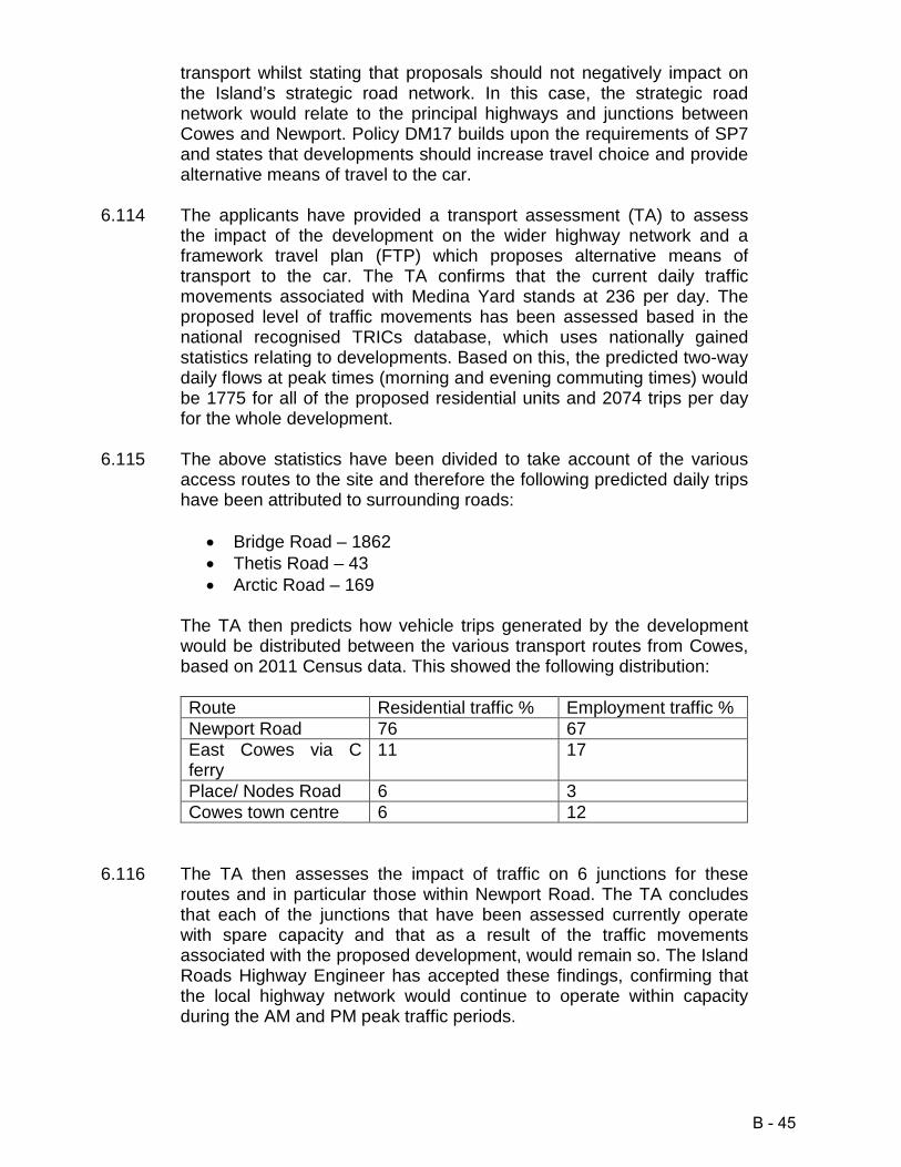
transport whilst stating that proposals should not negatively impact on the Island’s strategic road network. In this case, the strategic road network would relate to the principal highways and junctions between Cowes and Newport. Policy DM17 builds upon the requirements of SP7 and states that developments should increase travel choice and provide alternative means of travel to the car.
6.114 The applicants have provided a transport assessment (TA) to assess the impact of the development on the wider highway network and a framework travel plan (FTP) which proposes alternative means of transport to the car. The TA confirms that the current daily traffic movements associated with Medina Yard stands at 236 per day. The proposed level of traffic movements has been assessed based in the national recognised TRICs database, which uses nationally gained statistics relating to developments. Based on this, the predicted two-way daily flows at peak times (morning and evening commuting times) would be 1775 for all of the proposed residential units and 2074 trips per day for the whole development.
6.115 The above statistics have been divided to take account of the various access routes to the site and therefore the following predicted daily trips have been attributed to surrounding roads:
• Bridge Road – 1862 • Thetis Road – 43 • Arctic Road – 169
The TA then predicts how vehicle trips generated by the development would be distributed between the various transport routes from Cowes, based on 2011 Census data. This showed the following distribution: Route Residential traffic % Employment traffic % Newport Road 76 67 East Cowes via C ferry
11 17
Place/ Nodes Road 6 3 Cowes town centre 6 12
6.116 The TA then assesses the impact of traffic on 6 junctions for these routes and in particular those within Newport Road. The TA concludes that each of the junctions that have been assessed currently operate with spare capacity and that as a result of the traffic movements associated with the proposed development, would remain so. The Island Roads Highway Engineer has accepted these findings, confirming that the local highway network would continue to operate within capacity during the AM and PM peak traffic periods.
B - 45

6.117 The FTP refers to the multiple travel modes that would be available to occupants and users of the site. The development would result in connections between Bridge Road, Pelham Road and Thetis Road, through new access routes that would allow pedestrians, cyclists and vehicles to travel through the site, thus increasing the permeability of area. In addition, the FTP refers to the proximity of the site to the centre of Cowes (280m), the Red jet terminal (590m), the nearest bus stop within Newport Road (330m). All of these are within a 4 to 8 minute walk. Moreover, the FTP recognises that a cycle route passes the site, that the floating bridge is adjacent to the site and that pedestrian links to these facilities are direct and via adopted highways within the town.
6.118 The FTP also includes proposals for a new bus stop within Bridge Road and adjacent to phase 1 of the development. However, the local bus provider, Southern Vectis, has written to Officers during the course of the planning application and confirmed that they would not intend to extend their current bus route to the site. Therefore, occupants of the site would instead need to walk to the bus stop within Newport Road. However, this would be within easy walking distance and it should be noted that the route between Cowes and Newport operates on a quarter-hourly service, with buses every 7 minutes during peak times.
6.119 Officers consider that the site is located within a sustainable area of Cowes, with good links to the town centre and a range of transport options. The site is within reasonable walking distance of the town centre, ferry terminals, bus stops and the cycle route between Cowes and Newport. The various transport routes would allow access to the employment areas of Cowes, Newport and East Cowes, with access to the mainland via the Red Jet terminal or the East Cowes vehicle ferry (via the floating bridge). Moreover, good access would be available to the general services and facilities within Cowes, East Cowes and Newport.
6.120 In addition, the FTP outlines a draft travel plan, aimed at reducing the need to travel, discourage the use of unsustainable modes of transport and enable residents, employees and visitors to make travel choices and to raise awareness of alternative modes of transport. The travel plan sets out a range of measure to achieve these aims:
• New public realm, including walks and public squares throughout the site
• Replacement bus shelters in Newport Road and a coach set-down area in Bridge Road
• Internal cycle links and cycle parking spaces • Reconfiguration of the Bridge Road/ Medina Road junction to
provide safe pedestrian access • Contribution towards cycle route improvements • Residents travel pack
B - 46

• Monitoring regime
6.121 The travel plan would aid the choices available to residents and also existing residents surrounding the site by providing and promoting alternative means of transport to the car. It is considered that a detailed travel plan could be secured by condition. In summary, it is considered that the transport options related to this site would allow residents to exercise significant choices for accessing the jobs, services and facilities they would require and thus, offer alternative transport options in compliance with policies SP7 and DM17 of the Island Plan. Added to this, the information provided has demonstrated that the development would not result in significant impacts to the capacity of the highway network.
6.122 It is apparent that the development would be likely to increase the use of the nearby Cowes to Newport cycle track. The track forms part of the national cycle route 23, which passes the site. Clearly, given the approach set out within the applicant’s FTP, the development would result in greater use of the track, off-setting the amount of vehicle traffic that would use the highway. However, Officer site inspections have shown a lack of connectivity between the site and the Newport to Cowes cycle track due to a lack of any segregated cycles lanes for route 23 along the highway. The Council has recently undertaken two feasibility studies that focus on means of improving safe access to the cycle track via the existing local transport network and also repairing areas of the existing off-road section of the track.
6.123 The first study relates to the off-road cycle track which runs for approximately 4.8km between Newport and Cowes. The cycle track (including the use of highways in Cowes) is used by both cyclists and walkers and surveys have shown that on average, 263 cycle trips occur per day, with up to 639 trips occurring on the busiest days. The feasibility study has shown that around 10% of the cycle track requires repair in order to remain safe at a cost of approximately £275,000.
6.124 The second study relates to the section of on-road track between Arctic Road and Bridge Road. The study concludes that a lack of segregated cycle lanes, crossing points and the poor standard of pavements and road surfaces can be discouraging for some cyclists and clearly, if this should be the case, cyclists from the development may well choose to use vehicles instead, increasing impacts on the highway network and environmental impacts.
6.125 The study proposes the following four options, which include:
A. Do nothing B. Classify Artic Road as a ‘Quiet Street.’ This would involve use of
the street for access only, resurfacing of the carriageway (as part of the existing PFI contract) and painted cyclist signs on the road
B - 47

to raise awareness of cyclists C. Classify the road as a ‘Cycle Street.’ This would be comparable
to option B, but with a coloured surface provided for cyclists with priority given to cyclists rather than vehicles
D. To provide a segregated cycle lane for cyclists. This more comprehensive would see the provision of a specific cycle lane for cyclists, through widening the eastern highway pavement to a minimum of 3m for much of the length of Arctic Road. Due to a lack of a pavement at the southern end of the highway, a section of the cycleway would re-routed along existing footpaths to the rear of properties within Arctic Road, terminating directly opposite to the off-road cycle track and linked via purpose built crossing point. For this option, Arctic Road would be made a one-way street but still allow access for all types of vehicles.
The relevant plans for the above options have been attached to the end of this report as an appendix.
6.126 Officers consider that improving the cycle network would be key to this development, given the likely increased use of route 23 by residents, employees and visitors to the site. Options B and C would improve the safety of the route and when combined with maintenance of the off-road cycle track, assist in the implementation of the applicant’s travel plan as set out within FTP. The applicants have agreed to provide the necessary contributions to fund option D and the improvements to the off-road cycle track, via staged payments. This would involve funding for option D being provided in relation to phase 1 of the development and funding for the repairs to the cycle track being provided in relation to phases 2 and 3 of the development. Highway safety
6.127 Policy DM2 of the Island Plan requires developments be accessible and safe. The submitted plans show that phase 1 of the development would be served by two new accesses at the eastern end of Bridge Road. The first would provide shared access to the main site and include the re-organisation of the Bridge Road/ Medina Road junction and the second would provide access to the basement parking area comprising 242 parking spaces, accessed between blocks W1 and W2. Bridge Road is a residential street and therefore subject to a 30mph speed limit. As a result, visibility splays measuring 43m at a set-back of 2.4m would be required for each access and in addition to this splays measuring 2m by 2m would be required for pedestrians.
6.128 The basement parking area would be served by a bell-mouth junction and include tactile crossing points that would link to pavements. The Island Roads Highway Engineer has confirmed that the access would comprise the required vehicle visibility splays (see Islands Road comments dated 17.2.17) and that revisions to the plans would result in
B - 48

adequate pedestrian visibility splays (see Island Roads comments dated 31.1.18). In addition, the Highway Engineer has confirmed that the basement parking area would be acceptable, subject to the final location of support piers.
6.129 The main access to phase 1 would be semi-pedestrianised and include a raised plateau that would cross the full width of the access with 4m wide pavements provided to the front of block W2, curving round to Medina Road. Bollards would be placed alongside the edge of the pavement to prevent vehicles from obstructing pedestrian access. Service vehicles would be permitted to access the site via the Bridge Road entrance to the site.
6.130 The Island Roads Highway Engineer has confirmed that the proposed main entrance for phase 1 and the internal access roads would allow safe access for service vehicles and therefore it is apparent that this access would comply with design standards. In addition, a loading bay is proposed to the south of the main access, allowing parking for two large vans. The Highway Engineer has confirmed that revised plans demonstrate that these bays would not compromise highway safety or obstruct the proposed pavements.
6.131 The outline elements of the planning application would include three access points. Phases 2 and 3 would be accessed via an existing vehicle access from South Road, which currently serves part of Medina Yard. A further new access would be created through the demolition of buildings at the southern end of Thetis Road and this would link with the access onto South Road to provide circulation throughout phases 2 and 3. These new access routes would benefit the development and the wider highway network through increasing a choice of routes but also, overcoming existing turning issues within Thetis Road, which is effectively a cul-de-sac. Phase 4 would be served by a new access that would adjoin the eastern side of Arctic Road and via the southern end of Pelham Road, where there is an existing access.
6.132 The Island Roads Highway Engineer has confirmed that the layout and width of internal roads within phases 2 and 3 of the development could be secured by condition. The access via South Road already exists and currently serves the central areas of the site and the Highway Engineer has raised no highway safety concerns in relation to this access. The proposed extension to Thetis Road would not result in the formation of a new junction and therefore, raise no issues relating to visibility. The Highway Engineer has queried the potential for traffic restrictions for the new sections of road in order to ensure suitable areas for vehicles to wait for oncoming traffic however it is considered that these issues would be addressed via the detailed stage of the outline planning application, given that access is not to be considered at this stage. What is apparent is that phases 2 and 3 could be accessed and that on site arrangements could be designed to meet highway standards at a later
B - 49

stage.
6.133 Phase 4 would include a new access which is referred to as a heavy good vehicle (HGV) access. The Island Roads Highway Engineer has commented that the latest drawings for this access show that HGVs could access phase 4 safely, subject to the applicants securing a Traffic Regulation Order (TRO) for the removal of 4 car parking spaces at the point of the proposed access. This would allow suitable visibility splays and space for vehicles to enter and leave the site. It is considered that this matter could be secured by condition, to ensure that a suitable means of access could be provided. While the TRO process is separate to the planning process, it is considered that the works would result in the loss of a minor number of parking spaces, which could be mitigated and would allow significant employment benefits for Cowes, through the regeneration of this site. Therefore, it is considered suitable to condition this matter.
6.134 The Highway Engineer has raised concerns in respect of HGVs accessing the site via Arctic Road and Smithards Lane, due to width restrictions. These comments are noted however, the application site is an established employment site that generates 236 vehicle movements per day, based on current levels of occupancy. The applicant’s TA predicts that the proposed marine employment uses at the site would generate 169 movements per day and that the proposed business uses 70 trips per day. Thus, the amount of trips associated with employment uses would be comparable to the existing situation and these would use the same highway network for access. As a result, it is considered that the situation related to HGVs from the proposed use would be no worse than the existing situation and that it would be unreasonable to raise objection to the development in this basis.
6.135 The access for phase 4 from Pelham Road would utilise an access point that currently serves the existing marine industrial buildings within this section of the site. The Highway Engineer has not objected to the use of the access, given that it is an existing situation, but has stated that detailed layout plans should be provided to demonstrate that two way vehicle traffic and pedestrian connectivity could be provided. However, it is considered that such detailed could be secured during the reserved matters stage for phase 4.
6.136 In conclusion, it is considered that the applicants TA has demonstrated that the proposed development would not prejudice the capacity of the highway network, particularly when taking into account the sustainable location of the site and links to a range of transport choices that would allow residents, employees and visitors to travel to and from the site by alternative means of transport to the car. Furthermore, the proposed draft travel plan would promote such choices and off-site improvements to cycle route 23 would significantly improve cycle links between the site and Newport/ Cowes. It is considered that the proposed means of
B - 50

access and internal access arrangements for phase 1 would meet highway design standards and that the outline elements of the development could be suitably accessed, subject to detailed arrangements being secured by condition. As a result, it is considered that the development would comply with the requirements of policies SP7, DM2 and DM17 of the Island Plan. Parking
6.137 The level of parking required for new developments is set out within the Council’s Parking Provision SPD. This sets out the parking levels that would be for sites within and outside of town centre boundaries. This site is outside of the town centre boundary for Cowes. Based on the standards set out within the SPD, the site should provide 1,191 parking spaces (699 for residential units and 492 parking spaces for non-residential uses) and a total of 793 cycle space spaces (699 for residential units and 94 for non-residential uses).
6.138 The submitted information confirms that the site would comprise 608 parking spaces in total, with 482 parking spaces for residential units and visitors and 127 for employment uses, representing a shortfall of 583 spaces. The site would comprise a total of 680 cycle spaces, with 535 for residents and 145 for non-residential uses and visitors, representing a shortfall of 185 spaces.
6.139 Officers note that the site would result in a shortfall of both cycle and vehicle parking spaces and that nearby residential streets lack capacity for on-street parking, as referred to by objectors. However, it should be noted that the NPPF states that in setting local parking standards for residential and non-residential developments, local planning authorities should take account of the accessibility of the development, the availability of and opportunities for public transport and the overall need to reduce the use of high emission vehicles. The Island Plan reflects this, in referring to the use of a range of transport choices.
6.140 The site is sustainably located and benefits from good links to alternative transport choices as well as being located within easy walking distance of Cowes Town centre. The nearby bus routes run on a regular basis (see above) and the floating bridge is located adjacent to the site. Moreover, as stated above, the cycle network passes the site and therefore, on balance, it is considered that the lack of parking provision for this site is not contrary to the requirements of policies SP7 or DM17 of the Island Plan. Impact on ecology
6.141 The application site adjoins the western bank of the River Medina, which falls within the Solent Maritime Special Area of Conservation (SAC) and the Solent and Southampton Waters Special Protection Area (SPA) and
B - 51

Ramsar site. The SPA/ Ramsar site is also designated as a Site of Special Scientific Interest (SSSI). Parts of the site are also within the boundary of the Solent and Dorset proposed SPA (pSPA). It should be noted that for the purposes of the Habitat Regulations the proposed development is not necessary for the management of the above designated sites for conservation purposes. Therefore, and due to the designated nature of the surrounding area and the potential direct and indirect impacts of the wider project, the applicants have provided a full Environmental Statement (ES) that assesses the potential for significant effects on the environment.
6.142 Due to the requirements of the Habitat Regulations, and as a Competent Authority, the Council has undertaken an Appropriate Assessment (AA). The AA investigates the likely significant effects of the project and then the implications of those effects for the conservation objectives of designated sites. The detailed information within the AA is used to draw the conclusions within this report.
6.143 The applicant’s ecology information within the ES confirms that desk top surveys and on site surveys have been undertaken to establish the designations relating to the site and the species that it supports. The landside areas of the site are developed and include a range of industrial buildings and offices surrounded by concrete yards. In terms of habitat, the site includes small areas of overgrown scrub and grass, tidal mudflats and the existing buildings. The buildings at the site have the potential to support roosting bats and as a result, emergence/ re-entry surveys were undertaken at dawn and dusk to determine whether bats are present. In addition, surveys for wintering birds have been undertaken. The ES scopes out a requirement for surveys for dormice, red squirrels, badgers, brown hare, reptiles and amphibians, marine mammals and terrestrial invertebrates due to a lack of suitable habitat for such species.
6.144 The surveys undertaken in relation to the planning application showed that the mudflats adjacent to the sites boundary have low importance for wintering waders and wildfowl, as does the application site. The internal areas of grassland are also considered to be of negligible importance due to their limited area. The buildings are considered to be of very low importance. However, the site does provide habitat for two wintering black redstart and that during summer months, the site supports breeding species such as herring gulls, sparrows, jackdaw and pigeon. The survey also showed a pair of raven attempting to nest on the Hammerhead Crane. The bat surveys showed a peak count of 8 pipistrelle bats at the site, with the ES concluding that the site is of negligible importance for bats.
6.145 The river itself is important for migratory species of fish, breeding birds, wintering birds and the inter-tidal mud flats and sand flats. Based on the findings of the AA, the Council considers that the key impacts to be
B - 52
considered are:
1. Recreational pressure associated with new housing resulting in disturbance to SPA birds.
2. Potential impacts to water quality due to increases in wastewater production.
3. Coastal squeeze. 4. Loss of habitats supporting species outside of European sites.
Disturbance to SPA birds
6.146 The Medina Estuary Creek SSSI component of the site is important for wintering and migratory wildfowl and waders, and contributes towards the importance of the SPA for waterfowl. The proposed development also lies within the Solent & Dorset Coast pSPA for foraging terns. The conservation objectives for the SPA, Ramsar/ SSSI designation includes maintaining the habitats of the populations of the regularly occurring internationally important populations of migratory species that are noted for the designated sites.
6.147 However, the information provided within the ES has demonstrated that the mudflats and sandflats that are adjacent to the site were of low importance for wintering waders and wildfowl and this is noted within the Council’s AA. Nevertheless, it is considered that through mitigation, impacts on the SPA (habitat and species) can be minimised. Members will note that evidence shows recreational activity from residents using designated areas (and supporting habitats) can cause disturbance to wildfowl and therefore have an adverse impact on bird populations.
6.148 As a result, to mitigate for such impacts, Natural England and a range of other bodies including the Council have devised a means of mitigation known as the Solent Recreation Mitigation Project (SRMP). The project would provide the following elements:
• a project officer to oversee and co-ordinate across the Special Protection Areas and to oversee the rangers
• a team of rangers who will work on the ground at European sites to reduce disturbance levels and initiate specific measures at the sites to reduce disturbance levels
• a Coastal Dog Project; and • a monitoring scheme
6.149 The Council’s Supplementary Planning Document relating to the SRMP
states that Developments of one or more dwellings will be required to provide financial contributions of £172 per dwelling towards the project in order to prevent additional disturbance to the SPA/ Ramsar site. The applicants have provided draft Heads of Terms for a legal agreement that would secure the required level of funding and therefore, the
B - 53

development is considered to comply with the requirements of the Council’s Supplementary Planning Document. Water quality
6.150 The proposed development has the potential to cause pollution as a result of waste water from the operational phase of the development and also the demolition/ construction phase. The site is previously developed and given the former and current uses of the site, there are likely to be contaminants within the ground that if released to the river, could harm designated habitats and species. The submitted plans also show that the current seawall that abuts the River Medina would be wholly reconstructed and re-aligned and the AA notes that this could alter patterns of tidal flow as well as sediment release and accretion.
6.151 In relation to foul water, the submitted information confirms that this would be routed to the public sewer system, thus not impacting on the water quality of the river. The means of foul drainage would be subject to a planning condition. Surface water would be drained to the river, as per the existing situation for the southern section of the site. However, the surface water scheme for the operational phase would be the subject of a planning condition and this would secure the provision of the necessary drainage infrastructure and filters to prevent pollutants from entering the river, improving the current situation.
6.152 The applicant’s ES confirms that during the construction phase of the development, measures would be undertaken to prevent pollution to the river. These measures would be included within a Construction Environmental Management Plan that would contain:
• Plans for waste management • Maintenance of all plant • Use of bio-degradable oil • Secure storage areas for fuel • Re-fuelling of vehicles to be undertaken in designated areas • Education of workers in relation to environmental awareness and
pollution prevention • Provision of spill kits to prevent run-off of any substances or
materials to the river
6.153 The Environment Agency has not objected to the proposed development in relation to pollution and instead, recommended that pollution protection methods to protect water quality should be secured a Construction Environmental Management Condition, that would include the following requirements:
• The timing of the works • Construction methods
B - 54

• Any proposed piling(including size of piles, piling method) • Any necessary pollution protection methods to protect water
quality. In particular, the management of any silt dispersal • Any foreshore/intertidal restoration that may be required which
has been subject to temporary land take during construction • The works shall be carried out in accordance with the approved
method statement. The AA accepts the requirements of the condition recommended by the Agency and it is considered through the implementation of the requirements of the condition the development would not result in pollution during the demolition, construction or operational phases. Coastal Squeeze
6.154 Coastal squeeze is a process whereby intertidal habitats are reduced in net size due to sea level rises and hard sea defences preventing landward retreat. The net result is that the quantity of saltmarsh, sand dunes and mudflat adjacent to built-up areas will progressively decrease as sea levels rise. In this case, the plans show that the existing sea wall at the site would be replaced and re-aligned and these works have the potential to cause an adverse impact on the SAC designation either temporarily or permanently if development advances the river wall. While in limited places the sea wall would extend slightly further into the river (particularly to the front of the Hammerhead Crane), other areas would retreat.
6.155 The Council’s Ecology Officer has advised that while the proposed
seawall realignment would result in a very small loss to the overall SAC habitat (11,325ha), the overall potential for intertidal habitat area would increase through the provision of additional habitat in planted terraces adjacent to the river. Natural England has confirmed that the provision of these terraces and a mosaic of textures and surfaces within the new seawall would result in net gain in bio-diversity. As a result, the Council’s Ecology Officer has advised that coastal squeeze above what is existing is not expected since the subtidal zone of the river would not be constricted. Both Natural England and the Environment Agency have been consulted and are satisfied that realignment of the seawall could be a beneficial gain of connecting and supporting habitat to the SAC. It is considered that the enhancements could be secured by conditions. Loss of habitats supporting species outside of European sites
6.156 As stated above, the application site itself is of little ecological value, given its developed nature and the active uses that take place within it. The Ecology Officer has noted that the land proposed for development is not used by SPA birds and it is apparent that its ability to support other protected species, such as bats, is limited. The site does support
B - 55
black redstart and the applicants have proposed to carry out summer surveys to inform the prior commencement condition information. The Council’s Ecology Officer has accepted this approach.
6.157 In conclusion, it is considered that the subject to the conditions contained within the AA are imposed, as agreed by Natural England and the Environment Agency, that the development would not alone result in adverse effects upon the integrity of the Solent and Southampton Water SAC, SPA, Ramsar site. In addition, given the findings of the AA, it is considered that the development and other plans or projects in the Medina Valley would not cause in-combination effects to the designated sites. Therefore, it is considered that the proposed development would comply with policies SP5 and DM12 of the Core Strategy. Flood risk
6.158 The application site is located within flood zone 3 and therefore at a high risk of flooding in the event of a flood event. Both the NPPF and policy DM14 of the Island Plan seek to direct development, in the first instance, to areas at the lowest risk of flooding. Paragraph 100 of the NPPF states that inappropriate development in areas at risk of flooding should be avoided by directing development from areas at highest risk, but where development is necessary, making it safe without increasing flood risk elsewhere. Developers are therefore required to comply with the Sequential Test that is outlined within paragraphs 101 & 102 of the NPPF and the supporting technical guidance and if found to be required, Local Planning Authorities should apply the Exception Test outlined within paragraph 103 of the NPPF.
6.159 Paragraph 34 (Flood Risk and Coastal Change) of the PPG states that ‘It is for local planning authorities, taking advice from the Environment Agency as appropriate, to consider the extent to which Sequential Test considerations have been satisfied, taking into account the particular circumstances in any given case. The developer should justify with evidence to the local planning authority what area of search has been used when making the application. Ultimately the local planning authority needs to be satisfied in all cases that the proposed development would be safe and not lead to increased flood risk elsewhere.’
6.160 The applicants have provided a comprehensive Sequential Test that assesses sites throughout the Medina Valley Key Regeneration Area. The Sequential Test discounts 51 sites contained within the Strategic Housing Land Availability Assessment (SHLAA) due to their inability to accommodate the proposed development. Members will appreciate that the sites included within the SHLAA have been assessed as a result of a high level exercise and that their inclusion does not mean that they would be policy compliant should a planning application be made for
B - 56

development. Officers agree with the sites that have been identified and having carried out further investigations, have not identified other alternatives. Officers agree with the applicant’s conclusions relating to the 51 sites that have been immediately discounted, given their limited ability to support the development that is proposed.
6.161 A further 16 sites have then been assessed taking into account the size of the development, their location, whether existing buildings would prevent development, whether they are themselves at risk of flooding or available. The assessment discounts sites that are not brownfield, given the previously developed nature of the application site. Officers consider that the study area for alternative sites is appropriate. Whether any sites with a lower flood risk within that study area are suitable and available needs careful consideration, given that the development has different elements and that in essence, the residential part would be used to enable the regeneration of a large brownfield site that is sustainably located.
6.162 Officers consider that of the 16 sites that have been assessed, the following can be reasonably discounted due to being within a flood zone and therefore not sequentially preferable, a lack of available land, existing permissions (leading to a lack of availability) or constrained by existing surrounding uses:
• Medina Wharf, Cowes • Victory Yard, Cowes • Land south of Three Gates Road, Cowes • Venture Quays, East Cowes • Kingston Marine Park, East Cowes • Carisbrooke Business Park • Land east of Pan Lane, Newport • Newport Harbour (Council owned site) • Newport Industrial Estate • Quarr Business Centre, Whitcombe Road, Carisbrooke • Stag Lane, Newport (Officers are aware of contamination issues
for this site) • Vittlefields Industrial Estate, Forest Road, Newport • Land at Osborne Road, Whippingham • Land at former SARO works (Folly Works)
6.163 Officers do not agree that sites should be discounted on the simple
basis of being undeveloped land. It should be noted that undeveloped sites can remain sequentially preferable given potential links to existing settlements and their location within flood zone 1(areas with the least risk of flooding). However, Officers have assessed the sites listed above and agree that due to various reasons, including location of some sites within flood zone 3, lack of availability, existing uses, size etc., these sites would not be sequentially preferable to the application site.
B - 57
6.164 Two remaining sites at Horsebridge Hill, Newport were discounted by
the applicant’s Sequential Test on the basis of being undeveloped and allocated for employment use within the Island Plan. However, neither are at risk of flooding, both are located close to Newport and it should be noted that while being allocated within policy SP3 of the Core Strategy for employment use, there may be material reason why mixed use development could take place.
6.165 However, Officers note that their allocation may prevent their availability but more importantly, increase their likely land value. Officers recognise that the delivery of the regeneration of the Medina Yard site is reliant upon the viability of the whole development and in essence, the ability of the residential development to fund the proposed works to deliver modern employment uses on a brownfield site that is within the settlement boundary for Cowes and that benefits from good links to a range of transport choices and access to the River Medina for employers. Therefore, rigidly applying a requirement for the whole development or the housing to be delivered on land currently outside of the ownership of the applicant and at a lower risk of flooding would, taking into account the applicant’s viability assessment, lead to the development being unviable and undeliverable due to the likely costs associated with purchasing sites outside of the applicant’s control.
6.166 Officers consider that this is a valid consideration, given the pragmatic approach for Sequential Tests that is advocated by the Government’s policy guidance. The applicant has included land values within the submitted viability assessment for the sites proposed for development, based on asset values. Officers have undertaken searches of land values for potential housing plots and these have shown that purchasing sites outside of the applicant’s control would be a significant cost that would render the proposed development unviable and prevent the regeneration of an important and sustainable site within the Medina Valley KRA.
6.167 Therefore, given the significant regeneration benefits of redeveloping this site and the viability issues relating to the application, it is considered that there would be no reasonably available alternative sites at a lower risk of flooding to deliver the proposed development. Therefore on an exceptional basis on balance Officers consider that the proposal satisfies the Sequential Test. Exception Test and flood risk assessment
6.168 Paragraph 102 of the NPPF states that if, following the application of the Sequential Test it is not possible, consistent with wider sustainability objectives for the development to be located in zones with a lower probability of flooding the Exception Test can be applied. In this case it is considered appropriate to do so. For the Exception Test to be passed,
B - 58

it must be demonstrated that the development provides wider sustainability benefits to the community that outweigh the flood risk and subject to a site specific flood risk assessment (FRA) that demonstrates that the development would be safe for its lifetime taking into account the vulnerability of its users, without increasing flood risk elsewhere.
6.169 In this case, it is considered that wider sustainability benefits have been identified, as explained above and in the principle section of this report. It should be noted that a site specific FRA has been prepared by the applicants and that takes account of the predicted flood levels for the site, as informed by the Isle of Wight Strategic Flood Risk Assessment (SFRA). The Council’s SFRA states that the finished floor levels (FFL) for development should be set above the 1 in 200 year predicted flood levels for the year 2115, that buildings should be designed so that safe access and egress can be facilitated in the event of a 1 in 200 year tidal event and that buildings should be flood resilient.
6.170 The Environment Agency has confirmed that over the 100 year lifetime of the development, a flood event would lead to waters rising to 4.1m AOD. Because the majority of the site is below this level (2.2m AOD is the level at Bridge Road), the Agency has confirmed that without mitigation the development would flood. However, the submitted plans show that the residential development, at the highest risk of flooding, would include finished floor levels at 4.4m AOD therefore allowing residents to remain safe during a flood event. The commercial uses and basement parking areas at the site would be located at ground floor level and the Agency has commented that these could be flooded to a depth of 1.9m during a flood event.
6.171 However, the Agency has not objected to the development and instead advised Officers that the Council should consider whether or not the principle of relying on flood response planning would be acceptable and whether or not the proposed refuge for the site would enable people to remain safe taking into the resilience and recoverability of essential services during and after a flood and the ability of buildings to remain structurally stable during a flood.
6.172 The applicant’s Flood Risk Assessment (FRA) sets out the following measures to mitigate the impact of flooding across the site:
• Whole site sea wall to be rebuilt at a height of 2.3m AOD • All residential accommodation to be at heights of 4.4m AOD and
above • Car parking areas to include flood protection and doorways to be
sealed • Buildings to be constructed to be flood resilient (including barriers
to ground floor doors, flood proofed windows, sealed air bricks etc)
B - 59

It is considered that these measures, which reflect those outlined by the Environment Agency, could be secured by condition to ensure that buildings would be resilient during a flood event.
6.173 In addition, the applicants have provided a draft Flood Warning and Evacuation Plan (FWEP). This identifies how people at the site would be warned of an impending flood event and how they would be able to safely leave. Phase 1 of the development would be accessed via Bridge Road, however because the ground levels for this area of the site are 2.3m AOD, safe means of escape could not be provided in this location. Instead, the plans show a temporary emergency escape route that would lead from the main open space within this phase, to Thetis Road, where land levels are 4.8m AOD and so above the predicted flood level. For the subsequent phases, dry routes of escape would be provided via permanent pedestrian and vehicle access routes that would lead onto Thetis Road, at a land level of 4.6m AOD, thus above the predicted flood level.
6.174 To allow early warning, the FWEP advises that all development at the site would register with the Environment Agency’s flood warning service. The Environment Agency have in their comments to the Planning Authority, supported such an approach. It should be noted that the flood risk to this site is tidal and therefore, adequate ‘lead in times’ would exist to allow prior warning of a flood event. This, when combined with the developments link to the Agency’s flood warning direct system would allow time for residents, employees and visitors leave the site prior to its inundation with water.
6.175 The Council’s Resilience Coordinator (Emergency Planning) has confirmed that the current approach set out within the FWEP is strategic, but lacks detail in relation to lead in times, who a plan would be triggered by, whether there would be a flood warden and what their responsibilities would be. As a result, the Officer has recommended a condition that would require the submission of a detailed FWEP prior to the commencement of the development, with the following information to be agreed:
• Raise awareness of the flood hazard at the location specified in the plan
• Define the flood warnings and estimated lead-in times available • Detail how, when and by who the plan is triggered • Define the responsibilities of those participating in the plan i.e. the
site user/occupants/site manager/flood warden • Outline the place of safe refuge, evacuation procedure and the
safe evacuation route away from the development; and • Establish the procedure for implementing, monitoring and
maintaining the plan.
B - 60

6.176 Officers note that the current FWEP is draft and that more detailed
information would be required. However, importantly, the strategy contains draft measures for early warning of a flood event (the sites would be linked to the Environment Agency’s Flood Warning Service) and as a fail-safe, the site management would pass on warnings to all properties and uses within the site. Once a flood event had been confirmed all people could be evacuated to the higher ground around this site. Furthermore, the Strategy and the FRA confirm that dwellings and other buildings would be flood resilient. In the event that residents of dwellings chose to remain in the buildings at the site, or were not aware of the flood event, it is apparent that first floor habitable accommodation within dwellings would provide safe areas of refuge until such time that the tide receded. It should be noted that the site would be affected by tidal flooding and therefore, high water levels would be short in duration given tidal processes.
6.177 As a result, given the comments provided by specialist consultees, Officers are satisfied that a site specific Flood Risk Assessment has demonstrated that the development will be safe for the lifetime, when taking into account the vulnerability of the occupants of the proposed dwellings and the users of the various uses at the site. As a result, it is considered that the Exception Test has been passed and that the development is in accordance with the requirements of the relevant guidance within the NPPF and the requirements of policy DM14 of the Island Plan and the Council’s SFRA. Contaminated land
6.178 The Council’s Environmental Health Officer has confirmed that the site proposed for development should be assessed for potential contamination caused by former uses. The Officer has advised that a condition could be imposed that would require updated documents to be submitted including a phase 1 desk top study of current and previous uses at the site, an appropriate summary of prior invasive investigation with a gap analysis concerning update requirements for prior work, further site investigation and reporting covering the gap analysis, a resulting updated remediation strategy and a validation exercise with a close out report concerning remediation undertaken that has been accepted as appropriate by the Authority. As a result, the Officer has confirmed that standard conditions could be used to secure investigations and potential mitigation. It is considered that this would be a suitable approach. Drainage
6.179 The application site is historic and given its developed nature, the precise nature of the existing drainage system in use is not fully know. However, the applicant’s drainage information, which is based on
B - 61

Southern Water records, advises that the much of the site is currently connected to the combined sewer network so that most foul and surface water is directed to the public system. However, surface water from the southern section of the site is likely to drain direct into the river.
6.180 The applicants propose to provide a new drainage system for the site which would involve surface water being collected via a system of pipes, gullies and drainage channels and then drain direct in the river, removing surface water flows from the combined system. However, during a flood event, water would be stored on site in storage tanks and then released after tidal waters had receded. The applicants have calculated that storage capacity of 3570 cubic metres would be required, based on the extent of the site and taking into account climate change. This approach is considered to be acceptable, subject to the final scheme being agreed by condition in order to ensure that the necessary filters and carbon interceptors being included in order to prevent pollutants from entering the river.
6.181 Foul water would be directed to the pubic sewer system via new infrastructure within the site and new on-site foul pumping station that would pump flows into the existing system within surrounding roads. The applicant’s information also states that some existing sewers that run through the site may need to be relocated.
6.182 Southern Water has confirmed that it might be possible to relocate existing public water mains, public sewers and foul drains, subject to this not resulting in a loss of hydraulic capacity. As a result, Southern Water has confirmed that such works could be undertaken with their agreement via the relevant statutory regulations. As a result, it is apparent that works to existing mains, sewers etc. could be undertaken, but with agreement of the statutory undertaker. Southern Water has advised a planning condition relating to the protection of existing public water mains and public sewers.
6.183 In respect of foul water, Southern Water has advised that the public system would not have capacity to accommodate the needs of the development without the development providing additional local infrastructure. It is apparent from the submitted information that the applicant’s propose to provide additional infrastructure, and that they accept the need to do so in order to prevent unacceptable impacts on the public system. Southern Water has therefore recommended a condition that would require the submission of a detailed drainage strategy for disposal of foul water from the whole site and it is considered that this is both reasonable and necessary. Therefore, it is considered that a suitable strategy could be secured by condition and that the capacity of the public system to accept foul water from this site should not be a constraint to the development. Planning obligation
B - 62

6.184 The planning application raises matters that could not be secured by
conditions and therefore, would be the subject of a planning obligation. The applicants have provided draft heads of terms for an agreement, which would be finalised and executed in the event that planning permission and listed building consent was granted. The agreement would comprise clauses relating to the phasing of the development and works to the Hammerhead Crane.
6.185 The agreement would also secure the following financial contributions:
• A contribution of £3,000,000 towards off-site affordable housing provision within the Medina Valley KRA
• A contribution of £43,516 towards SPA mitigation, based on £172 x 253 units
• £842,800 for education provision (£4,214 x 200 units) • £545,000 for off-site cycle links (to be paid in staged amounts)
It is considered that these contributions and requirements are necessary to mitigate for the impacts of the development. Other matters Crime and design
6.186 The Crime Prevention Design Advisor has raised concerns that residential entrances direct onto highways would increase vulnerability for crime and has advised that all apartments at ground floor have external private space to prevent access to windows and doors. However, it is apparent from the submitted plans that any such areas would impinge onto the public highway. This is a situation reflected in the existing residential properties in the area and it is considered unreasonable to object to the development on this basis. However, it is considered reasonable to require ground floor bedroom windows to be fitted with restrictors in order to prevent opportunities for crime during night-time hours.
6.187 The Advisor also recommends that basement car parks should be covered by CCTV systems, be fitted with roller shutter doors to prevent unauthorised access and that communal entrances should be fitted with electronic door systems. These matters are all considered reasonable and could be controlled by conditions. Phased delivery
6.188 Objectors to the development have raised concerns that the employment uses that have been proposed may not be delivered once phase 1 had been completed. In particular, Cowes Harbour
B - 63

Commission, have commented that the marine employment phase should be delivered prior to the residential and mixed use phases of the development.
6.189 The planning obligation that would support any planning permission would secure a suitable phased approach to the development and in particular the delivery of the marine industrial phase. However, its delivery is predicated on the costs and viability of the scheme and it is apparent that the residential elements of the scheme would provide the funding to deliver the remaining mixed uses. Therefore, it is agreed that the phasing must be secured but that the current phasing proposed by the applicants is reasonable, taking into account the delivery of the whole development in a viable manner.
The phasing of the site would ensure that existing buildings within phases 2, 3 and 4 would not be demolished until it was necessary, which would ensure that they can continue to be used during the construction process of phase 1.
6.190 Members should be aware that the Council’s Regeneration Directorate is currently in negotiations with the applicants for the lease of the marine industrial phase. This would see the Council delivering this phase of the development, potentially well in advance of the current proposed phased approach. However, the negotiations are ongoing at the time of this report being written and therefore, the proposed planning obligation would reflect this option. Healthcare facilities
6.191 Several objections and those from Cowes Town Council have referred to the impact of the development on medical centres. Officers note these concerns, however funding for new or expanded surgeries relies on existing patient numbers and therefore, surgeries cannot be enlarged until increased population numbers have occurred. Should the development result in an excess number of patients per GP in Cowes (the targeted average in England is 1,800 per patient) then local GPs could apply for funding for additional facilities.
7. Conclusion
The planning application
7.1 Medina Yard is a previously developed site that is located within a sustainable location within the settlement boundary for Cowes and the Medina Valley Key Regeneration Area. The proposed development would result in the regeneration of this area of Cowes through the removal of dated industrial buildings that lack the facilities required for modern business use and therefore suffer from low rents which prevent
B - 64

the maintenance or upgrade of the site and as a result, attract a low number of users.
7.2 The proposed development would secure modern employment buildings that would benefit from improved access, services and facilities set within a well-designed and purposely laid out site. While the redevelopment of this site would result in a small loss of overall employment space, that provided would be of high quality and when considering that over half of existing space is vacant, deliver a higher number of jobs. The development would continue to provide marine industrial space with access to the River Medina.
7.3 The proposed residential development would assist in delivering the regeneration of this site but also provide a significant amount of housing within a central and sustainable location with good links to existing services and facilities via a range of transport choices. Officers consider that the proposed retail uses would not harm the vitality or viability of Cowes town centre. Therefore, the development is considered to comply with the requirements of policies SP1, SP2, SP3 and DM8 of the Core Strategy.
7.4 The design and layout of the detailed phase of this development (phase 1) is considered to be acceptable, providing a reference to the historic industrial use of the site. Moreover, the design and layout principles of the outline phases of the development are also considered to be appropriate. These would combine with phase 1 to result in a well linked development, with a mix of public squares, piazzas and waterfront walks surrounded by well designed building. Given the current appearance of the site, these factors are considered be of significant benefit to this area of Cowes. While the height of some of the proposed buildings would be substantial and result in landscape and visual harm from some viewpoints, it is considered that the wider significant economic and social regeneration benefits of the development, through the delivery of jobs and housing, would outweigh the level of harm that has been identified.
7.5 The proposed development would impact on heritage assets and in particular, the setting of the listed hammerhead crane. However, as detailed within the Heritage Assets section of this report, it is considered that the development would result in less than substantial harm to these assets and that this would be outweighed through works to restore the crane and the wider social, economic and environmental benefits that the development would deliver.
7.6 It is considered that impacts on nearby properties and uses would be acceptable and that impacts from future commercial uses at the site could be controlled by conditions. Officers note that the proposed residential blocks within phase 1 would result in some overlooking towards cottages that front onto Medina Road, however given the
B - 65

current use of the site, the lack of space between existing buildings, their open relationship with these properties and the wider benefits of the scheme, it is considered that these impacts would not justify the refusal of this application.
7.7 It is considered that the traffic associated with the development would not compromise the capacity of the wider highway networks and that the range of transport choices available to residents, employees and visitors would offer alternative means of travel to and from the site than the car. Moreover, it is considered that the vehicle accesses and service roads related to phase 1 would comply with design requirements and that those related to the outline phases of the development could be delivered in compliance with guidance, subject to detailed designs being secured via conditions.
7.8 The site would comprise a level of parking below the standards set out within the Council’s Parking SPD, however the site is considered to be located within a sustainable area of Cowes, with access to alternative means of transport to car travel that would justify the level of provision that is proposed.
7.9 In relation to ecology, taking into account the conclusions of the Council’s Appropriate Assessment and comments received from Natural England and the Environment Agency, Officers are satisfied that the development would not compromise the integrity of the SAC, SPA, Ramsar or SSSI that relate to the site. This is subject to advised conditions being imposed and then their requirements being fully implemented.
7.10 The application site is located within an area that is at high risk of flooding. However, Officers are satisfied that a suitable Sequential Assessment has been undertaken and that the proposals pass the required Exceptions Test due to the measures set out within the applicant’s Flood Risk Assessment and the draft measures set out within their Flood Warning and Evacuation Plan. Officers are also satisfied that a suitable scheme of drainage and decontamination could be secured by condition.
7.11 Having regard to the above and having taken into account all relevant material considerations, Officers conclude that the proposed development is in full conformity with the provisions of the development plan. The listed building application
7.12 The repairs to the crane are welcomed and the use of conditions would allow works to be managed in respect of timing and quality.
7.13 Having given due weight and consideration to all comments received in
B - 66

relation to this application and for the reasons set out above, the proposal is considered to accord with Policy DM11 (Historic and Built Environment) of the Isle of Wight Council Core Strategy Island Plan, takes into account the guidance within paragraphs 131, 132 & 134 of the National Planning Policy Framework and does reflect the requirements of section 16 of the Planning (Listed Buildings and Conservation Areas) Act 1990. Therefore it is recommended that the approved subject to conditions.
8. Recommendation
8.1
For full and outline planning permission to be granted, subject to conditions and the prior execution of a planning obligation under S.106 of the Planning Act.
8.2 For listed building consent to be granted for the works to the Hammerhead Crane, subject to conditions and the prior execution of a planning obligation under S.106 of the Planning Act.
9. Statement of Proactive Working
9.1
In accordance with paragraphs 186 and 187 of the NPPF, the Isle of Wight Council takes a positive approach to development proposals focused on solutions to secure sustainable developments that improve the economic, social and environmental conditions of the area. Where development proposals are considered to be sustainable, the Council aims to work proactively with applicants in the following way:
1. The IWC offers a pre-application advice service 2. Updates applicants/agents of any issues that may arise in the
processing of their application and, where there is not a principle objection to the proposed development, suggest solutions where possible
In this instance The Planning Authority updated the applicants on a regular basis in relation to the processing of the planning application. Due to matters raised by consultees the Planning Authority required the submitted of additional information relating to a range of matters, including transport and highway issues, flood risk, listed buildings, planning contributions and ecology. The information is considered to have overcome concerns and therefore, the proposal is considered to represent an acceptable form of sustainable development.
B - 67

Conditions/Reasons The full planning permission (phase 1) 1 The development hereby permitted shall be begun before the expiration of
3 years from date of this permission. Reason: To comply with Section 91 of the Town and Country Planning Act 1990.
2 The development hereby permitted shall be carried out in complete
accordance with the details shown on the submitted plans, numbered below, except where varied by any other conditions of this permission. 00648_S01 00648_PP04 Rev A 00648_PP05 Rev A 00648_PP06 Rev A 00648_PP07 Rev A 00648_PP09 Rev A 00648_PP10 Rev A 00648_PP11 Rev A Access SK12 SK16 SK17 DD102 Elevations & Sections 00648A_JTP_E_ST00 Rev B 00648A_JTP_E_ST01 Rev B 00648A_JTP_E_ST02 Rev B 00648A_JTP_E_ST03 Rev B 00648A_JTP_E_ST04 Rev B 00648A_JTP_E_ST05 Rev B 00648_JTP_X_01
B - 68

00648_JTP_X_02 00648_JTP_X_03 00648_JTP_X_04 00648A_JTP_E_WE 00648A_JTP_E_W1 00648A_JTP_E_W2 00648A_JTP_E_W3 00648A_JTP_E_W4 00648A_JTP_E_W5 00648A_JTP_E_JSW 00648A_JTP_E_S1 00648A_JTP_E_S2 Rev B 00648A_JTP_E_E2 Floorplans 00648A_JTP_P1_00 Rev B 00648A_JTP_P1_01 Rev B 00648A_JTP_P1_02 Rev B 00648A_JTP_P1_03 Rev B 00648A_JTP_P1_04 Rev B 00648A_JTP_P1_05 Rev B 00648A_JTP_P1_06 Rev B 00648A_JTP_P1_07 Rev B 00648A_JTP_P1_0 Rev B Reason: For the avoidance of doubt and to ensure the satisfactory implementation of the development in accordance with policy DM2 (Design Quality for New Development) of the Island Plan Core Strategy.
3 No building hereby approved shall be constructed above foundation level
until samples of the materials and finishes including mortar colour, brick detailing, roof materials, balustrading and cladding to be used in the construction of the external surfaces of the development hereby permitted have been submitted to and approved in writing by the Local Planning Authority. Development shall be carried out in accordance with the approved details.
Reason: In the interests of the amenities of the area, to allow the Local Planning Authority to agree materials prior to commencement and to comply with policy DM2 (Design Quality for New Development) of the Island Plan Core Strategy.
B - 69

4 No doors, windows or glazing units shall be installed until details of the
proposed windows, doors (including those for the basement car parking area) and glazing units have been submitted to and approved in writing by the Local Planning Authority. Details shall outline security entry systems for communal entrances. Development shall be carried out in accordance with the approved details and shall be retained thereafter.
Reason: In the interests of the amenities of the area, to allow the Local Planning Authority to agree materials prior to commencement, to prevent crime and disorder and to comply with policy DM2 (Design Quality for New Development) of the Island Plan Core Strategy.
5 No building hereby approved shall be occupied until details have been
submitted to and approved in writing by the Local Planning Authority of the positions, design, materials and type of boundary treatment and bin stores to be erected. The boundary treatments and bin stores shall be completed before the development hereby permitted is first brought into use. Development shall be carried out and retained in accordance with the approved details and retained thereafter.
Reason: In the interests of maintaining the amenity value of the area and to comply with policy DM2 (Design Quality for New Development) of the Island Plan Core Strategy.
6 No external lighting shall be installed in phase 1 until details of means of
external lighting for the development have been submitted to and agreed in writing by the Local Planning Authority. Details shall include measures to minimise light pollution and to prevent glare. Development shall be carried and maintained out in accordance with the agreed details and be retained thereafter.
Reason: To protect the amenities of nearby residential properties, to prevent light pollution from harming the character of the surrounding area and designated sites and to comply with the requirements of policies DM2 (Design Quality for New Development) and DM12 (Landscape, Seascape, Biodiversity and Geodiversity) of the Island Plan Core Strategy.
7 No hard or soft landscaping shall take place until there has been submitted
to and approved in writing by the Local Planning Authority a scheme of hard and soft landscaping (not including the silt lagoon mitigation works). Hard landscaping shall include details of materials for paving, footpaths, parking spaces and other areas of hard standing. Soft landscape works shall include planting plans; written specifications (including cultivation and other operations associated with plant and grass establishment); schedules
B - 70

of plants, noting species, plant sizes and proposed numbers/densities. All plants shall be native species. All planting in the approved details of landscaping shall be carried out in the first planting and seeding seasons following the commencement of the approved development and any trees or plants which within a period of 5 years from the commencement of the development die, are removed or become seriously damaged or diseased shall be replaced in the next planting season with others of similar size and species, unless the Local Planning Authority gives written consent to any variation. The agreed hard landscaping shall be completed prior to the occupation of the buildings hereby permitted and be retained thereafter.
Reason: To ensure the appearance of the development is satisfactory and to comply with the requirements of policies SP5 (Environment), DM2 (Design Quality for New Development) and DM12 (Landscape, Seascape, Biodiversity and Geodiversity) of the Island Plan Core Strategy.
8 No use hereby permitted shall be occupied until details of a CCTV system
for the development have been submitted to and approved in writing by the Local Planning Authority. Details shall outline the specifications of proposed cameras, their number and location as well as an operational strategy. Development shall be carried out in accordance with the approved details and shall be retained thereafter.
Reason: To prevent crime and disorder and to comply with policy DM2 (Design Quality for New Development) of the Island Plan Core Strategy.
9 Prior to the commencement of development, a flood warning and
evacuation plan (FWEP) shall be submitted to and agreed in writing by the Local Planning Authority. The FWEP should address the following: • Raise awareness of the flood hazard at the location specified in the plan; • Define the flood warnings and estimated lead-in times available; • Detail how, when and by who the plan is triggered; • Define the responsibilities of those participating in the plan i.e. the site user/occupants/site manager/flood warden; • Outline the place of safe refuge, evacuation procedure and the safe evacuation route away from the development; and • Establish the procedure for implementing, monitoring and maintaining the plan.
Reason: To reduce the risk and impact of flooding for future occupants and to comply with the requirements of paragraph 103 of the NPPF and policy DM14 (Flood Risk) of the Island Plan Core Strategy. This is pre-commencement condition, due to the stage at which some measures would
B - 71

need to be carried out. 10 No development shall take place until flood warning and evacuation plans,
construction resilience measures for the approved buildings and vehicle flood barriers for the basement and surface parking areas within the site have been submitted to and approved in writing by the Local Planning Authority. The submitted plans should detail the means of flood warning and evacuation separately for the residential and non-residential uses. The development shall be carried out and maintained in accordance with the approved details and the finished floor level of habitable accommodation within the residential units hereby permitted shall be set no lower than 4.4m AOD.
Reason: To reduce the risk and impact of flooding for future occupants and to comply with the requirements of paragraph 103 of the NPPF and policy DM14 (Flood Risk) of the Island Plan Core Strategy. This is pre-commencement condition, due to the stage at which some measures would need to be carried out.
11 No development shall take place until a Construction Environmental
Management Plan (CEMP) has been submitted to and approved in writing by the local planning authority. Works associated with the development hereby shall be carried out in accordance with the approved CEMP.
The CEMP shall include consideration of but not limited to the following issues:
· The means of access/egress for construction traffic;
· The loading and unloading of plant and materials;
· The storage and handling of plant, materials and wastes;
· Measures to control the emission of dust and dirt during construction;
· Demolition/ construction working hours;
· Measures to protect occupants of the development which become used during the demolition construction phases.
· The adoption and compliance with best practices and recommendations as described in BS 5228-1:2009 Code of practice for noise and vibration control on construction and open sites.
Reason: In order to ensure that the works are undertaken in an
B - 72

appropriate manner to minimise impact on the amenities of neighbouring uses and to ensure safe access into the site during the construction period and to comply with policy DM2 (Design Quality for New Development) of the Island Plan Core Strategy.
12 No development including below ground site clearance works shall take
place until the applicant or their agents has secured the implementation of a programme of archaeological works in accordance with a Written Scheme of Investigation which has been agreed in writing by the Local Planning Authority. The works shall be carried out in accordance with the approved details. Reason: To mitigate the effect of the works associated with the development upon any heritage assets and to ensure that information regarding these heritage assets is preserved by record in accordance with Policy DM11 of the Isle of Wight Council Island Plan Core Strategy.
13 With the exception of investigation to the foundations, no works shall
commence to the crane until a detailed schedule of works (to include those sections missing from the proposed ‘listing of remedial works’ and the works proposed to the foundations as a result of the investigations hereby referenced) have been submitted to and agreed in writing by the Local Planning Authority. The details submitted shall be based upon a Finite Element Analysis to establish the loading and thus lifting capacity of the crane. The works shall be carried out in accordance with the approved details.
Reason: To protect the fabric of the listed building and to ensure the works are in keeping with the special historic and architectural interest of the listed building in accordance with the requirements of section 66 of the Planning (Listed Buildings and Conservation Areas) Act 1990 (as amended) and to comply with the aims of policy DM11 (Historic and Built Environment) of the Island Plan Core Strategy and section 12 of the National Planning Policy Framework.
14 Notwithstanding the approved plans and ‘listing of remedial works’
document, the materials used for the repairs to the crane shall match those of the existing structure and this shall include the diamond pattern metal footplates.
Reason: To protect the fabric of the listed building and to ensure the works are in keeping with the special historic and architectural interest of the listed building in accordance with the requirements of section 66 of the Planning (Listed Buildings and Conservation Areas) Act 1990 (as amended) and to comply with the aims of policy DM11 (Historic and Built Environment) of the Island Plan Core Strategy and section 12 of the
B - 73

National Planning Policy Framework. 15 The works to the crane involving repairs by building up sections with weld
and the insertion of new metal plates shall be finished flush/smooth to prevent moisture traps and shall be painted using a paint system and colour to be agreed in writing by the Local Planning Authority. The works shall be carried out in accordance with the agreed details.
Reason: To protect the fabric of the listed building and to ensure the works are in keeping with the special historic and architectural interest of the listed building in accordance with the requirements of section 66 of the Planning (Listed Buildings and Conservation Areas) Act 1990 (as amended) and to comply with the aims of policy DM11 (Historic and Built Environment) of the Island Plan Core Strategy and section 12 of the National Planning Policy Framework.
16 No decoration shall take place to the crane until a paint analysis has been
undertaken and the results submitted with the proposed paint (colour and system) for agreement in writing by the Local Planning Authority. The works shall be carried out in accordance with the agreed details.
Reason: To protect the fabric of the listed building and to ensure the works are in keeping with the special historic and architectural interest of the listed building in accordance with the requirements of section 66 of the Planning (Listed Buildings and Conservation Areas) Act 1990 (as amended) and to comply with the aims of policy DM11 (Historic and Built Environment) of the Island Plan Core Strategy and section 12 of the National Planning Policy Framework.
17 Prior to the removal of any equipment or material from the crane, a detailed
schedule shall be produced to identify which elements are historic and to be retained and those which are non-historic and proposed for removal. The schedule shall be submitted to and agreed in writing by the Local Planning Authority. The works shall be carried out in accordance with the agreed details.
Reason: To protect the fabric of the listed building and to ensure the works are in keeping with the special historic and architectural interest of the listed building in accordance with the requirements of section 66 of the Planning (Listed Buildings and Conservation Areas) Act 1990 (as amended) and to comply with the aims of policy DM11 (Historic and Built Environment) of the Island Plan Core Strategy and section 12 of the National Planning Policy Framework.
B - 74

18 Works to provide security measures to the base of the crane and
alterations including the stairs, handrails and the fixing of the turntable and the lifting drum shall not commence until details have been submitted to and agreed in writing by the Local Planning Authority and only after works to repair the rest of the crane have been completed in accordance with the listing of remedial works. Details should include an engineer’s report regarding the proposed alteration/fixing of the turntable. The works shall be carried out in accordance with the agreed details.
Reason: To protect the fabric of the listed building and to ensure the works are in keeping with the special historic and architectural interest of the listed building in accordance with the requirements of section 66 of the Planning (Listed Buildings and Conservation Areas) Act 1990 (as amended) and to comply with the aims of policy DM11 (Historic and Built Environment) of the Island Plan Core Strategy and section 12 of the National Planning Policy Framework.
19 The relocation of the switchgear and demolition of the switchgear building
(known as building 117b) shall not take place until level 2 building recording has been completed and submitted to the Local Planning Authority and a copy of a signed binding contract for the development of phase 1 of the planning application P/00496/16 is submitted to the Local Planning Authority. These works shall not take place until a suitable interim and permanent location together with a proposed timescale for the relocation of the switchgear has been agreed in writing by the Local Planning Authority. Development shall be carried out in accordance with the agreed details.
Reason: To ensure the retention and protection of equipment related to the listed crane and to ensure the works are in keeping with the special historic and architectural interest of the listed building in accordance with the requirements of section 66 of the Planning (Listed Buildings and Conservation Areas) Act 1990 (as amended) and to comply with the aims of policy DM11 (Historic and Built Environment) of the Island Plan Core Strategy and section 12 of the National Planning Policy Framework.
20 The new lifting equipment for the crane shall not be installed until the
results of a Finite Element Analysis are obtained to establish the loading and lifting capacity of the crane and only after details have been submitted to and agreed in writing by the Local Planning Authority. The works shall be carried out in accordance with the agreed details.
B - 75

Reason: To protect the fabric of the listed building and to ensure the works are in keeping with the special historic and architectural interest of the listed building in accordance with the requirements of section 66 of the Planning (Listed Buildings and Conservation Areas) Act 1990 (as amended) and to comply with the aims of policy DM11 (Historic and Built Environment) of the Island Plan Core Strategy and section 12 of the National Planning Policy Framework.
21 The anti-bird measures and lighting to illuminate the crane shall not be
installed until details for each have been submitted to and agreed in writing by the Local Planning Authority. The works shall be carried out in accordance with the agreed details.
Reason: To protect the historic interest of the listed building and to ensure the works are in keeping with the special historic and architectural interest of the listed building in accordance with the requirements of section 66 of the Planning (Listed Buildings and Conservation Areas) Act 1990 (as amended) and to comply with the aims of policy DM11 (Historic and Built Environment) of the Island Plan Core Strategy and section 12 of the National Planning Policy Framework.
22 Notwithstanding the approved plans and with the exception of the removal
of the later extensions, works to the front, side and rear elevations of the former JS White offices shall not commence until details of the proposed materials, finishes and fenestration have been submitted to and agreed in writing by the local planning authority. Development shall be carried out in accordance with the agreed details.
Reason: To protect the fabric of the locally listed building and to ensure the works are in keeping with the special historic and architectural interest of the listed building in accordance with the requirements of section 66 of the Planning (Listed Buildings and Conservation Areas) Act 1990 (as amended) and to comply with the aims of policy DM11 (Historic and Built Environment) of the Island Plan Core Strategy and section 12 of the National Planning Policy Framework.
23 Notwithstanding the approved plans, works to the river/sea wall and
foundations of the proposed development shall not commence until a safeguarding strategy for the crane has been submitted to and agreed in writing by the Local Planning Authority. Development shall be carried out in accordance with the agreed details.
Reason: To protect the fabric of the listed building and to ensure the works are in keeping with the special historic and architectural interest of the listed building in accordance with the requirements of section 66 of the Planning (Listed Buildings and Conservation Areas) Act 1990 (as
B - 76

amended) and to comply with the aims of policy DM11 (Historic and Built Environment) of the Island Plan Core Strategy and section 12 of the National Planning Policy Framework.
24 No development shall commence until details of proposed ecological
enhancements to the new sea wall have been submitted and approved by the Local Planning Authority. The enhancements should provide:
• A complex range of habitats benefitting a range of marine species at different tidal zones
• A mosaic of surfaces and textures into the new seawall design • A nursery and resting area for fish species • Sufficient roughness for the passage of migratory eel
Development shall be carried out in strict accordance with the agreed details and the enhancements shall be undertaken prior to the occupation of the buildings hereby approved.
Reason: To avoid harm to protected species and to comply with the requirements of policy DM12 (Landscape, Seascape, Biodiversity and Geodiversity) of the Island Plan Core Strategy. This is a pre-commencement condition due to the timing at which the works to the seawall may take place.
25 No development shall commence until details of the new intertidal
foreshore habitat have been submitted to and approved by the Local Planning Authority. The information should provide details of any proposed intertidal foreshore and what remediation work will be required to provide the best habitat for biodiversity. Any planting undertaken as part of the works shall only include native species. Development shall be carried out in accordance with the approved details and the agreed works shall be undertaken prior to the occupation of the buildings hereby approved.
Reason: In order to avoid impacts to features of ecological interest and to comply with the requirements of policy DM12 (Landscape, Seascape, Biodiversity and Geodiversity) of the Island Plan Core Strategy. This is a pre-commencement condition due to the timing at which the works to the seawall may take place.
26 No development, including site clearance works, shall take place until a
Construction Environmental Management Plan (CEMP) that is in accordance with the principles outlined in the Environmental Statement,
B - 77

has been submitted to and approved in writing by the Local Planning Authority. This shall deal with the treatment of any environmentally sensitive areas and species, detailing how the works will be carried out and how the environment will be protected during the works. Such a scheme shall include details of the following:
• The timing of the works • Construction methods and lighting controls • Plans for waste management, maintenance of plant • Any proposed piling(including size of piles, piling method) • Any necessary pollution protection methods to protect water quality
and the management of any silt dispersal • A location for the refuelling and maintenance of vehicles • A map or plan showing habitat areas to be specifically protected
during the works and the means of protection • Any foreshore/intertidal restoration that may be required which has
been subject to temporary land take during construction Development and site clearance works shall be carried out in accordance with the approved CEMP.
Reason: In order to avoid impacts to features of ecological interest and to comply with the requirements of policy DM12 (Landscape, Seascape, Biodiversity and Geodiversity) of the Island Plan Core Strategy. This is a pre-commencement condition due to the timing at which the agreed CEMP would need to be employed.
27 All paints, coatings and materials used during construction should be
suitable for use in the marine environment and in accordance with best environmental practice. Reason: In order to avoid impacts to features of ecological interest and to comply with the requirements of policy DM12 (Landscape, Seascape, Biodiversity and Geodiversity) of the Island Plan Core Strategy.
28 All equipment and debris associated with the works should be removed
from the area upon completion of the works and the area returned to its previous condition. Reason: In order to avoid impacts to features of ecological interest and to comply with the requirements of policy DM12 (Landscape, Seascape, Biodiversity and Geodiversity) of the Island Plan Core Strategy.
B - 78

29 No building shall be occupied until a site wide ecological enhancement plan has been provided, outlining measures for the enhancement of habitats at the site, including swift bricks, bat bricks and landscaping. Development shall be carried out in accordance with the approved details and the approved enhancements shall be carried out prior to the occupation of any building hereby approved. Reason: To secure a programme of ecological enhancements and to comply with the requirements of policy DM12 (Landscape, Seascape, Biodiversity and Geodiversity) of the Island Plan Core Strategy.
30 The applicant shall undertake a site investigation and risk assessment of any area of land to be returned to the foreshore in relation to the approved development in order to ensure that no contaminated materials are to be returned to the foreshore. Details shall set out the scheme of investigation and proposed mitigation/ remediation measures. Development shall be carried out in accordance with the approved details.
Reason: To avoid harm to protected species, in particular shellfish, and to comply with the requirements of policy DM12 (Landscape, Seascape, Biodiversity and Geodiversity) of the Island Plan Core Strategy and the requirements of the Water Framework Directive. This is a pre-commencement condition due to the timing at which the works would take place.
31 No development, including site clearance, shall take place until the results
of surveys for the presence of Black Redstart have been submitted to and agreed in writing by the Local Planning Authority. The surveys shall be supported by a suitable level of mitigation for impacts on Black Redstart, commensurate to the findings of the survey. Development shall be carried out in accordance with the approved details. Reason: To avoid harm to protected species, in particular shellfish, and to comply with the requirements of policy DM12 (Landscape, Seascape, Biodiversity and Geodiversity) of the Island Plan Core Strategy. This is a pre-commencement condition due to the timing at which works that may affect this species would take place.
32 No development shall take place until a detailed method statement for the removing or the long-term management / control of Japanese Knotweed on site has been submitted to and approved in writing by the Local Planning Authority. Development shall be carried out in accordance with the approved details. Reason: To prevent the spread of Japanese Knotweed which is an invasive species and to comply with the requirements of policy DM12 (Landscape, Seascape, Biodiversity and Geodiversity) of the Island Plan
B - 79

Core Strategy.
33 Notwithstanding the submitted information, no development shall take place until a scheme for the drainage and disposal of surface and foul water from the development hereby permitted has been submitted to and approved in writing by the local planning authority. The approved scheme shall be completed before the occupation of the buildings hereby permitted as each section of the approved phasing plan is completed.
Reason: To ensure that the site is suitably drained, to protect ground water and protected sites from pollution and to comply with policies SP5 (Environment), DM2 (Design Quality for New Development), DM12 (Landscape, Seascape, Biodiversity and Geodiversity) and DM14 (Flood Risk) of the Island Plan Core Strategy. This is a pre-commencement condition due to the stage at which drainage infrastructure would need to be installed.
34 The development hereby permitted shall not be commenced until a scheme
to treat and remove suspended solids from surface water run-off during construction works has been submitted to and approved in writing by the Local Planning Authority.
Reason: To protect ground water and protected sites from pollution and to comply with policies SP5 (Environment), DM2 (Design Quality for New Development), DM12 (Landscape, Seascape, Biodiversity and Geodiversity) and DM14 (Flood Risk) of the Island Plan Core Strategy. This is a pre-commencement condition due to the stage at which drainage infrastructure would need to be installed.
35 No development shall take place until a scheme of efficiency measures to
reduce water consumption has been submitted to and agreed in writing by the Local Planning Authority. The information shall set out a rationale for reducing water consumption from all uses hereby permitted. Development shall be carried out in accordance with the approved details. Reason: To prevent excess extraction of water from the Rivers Itchen and Test, in the interests of sustainable development and to comply with the requirements of paragraph 109 of the NPPF.
36 No development shall take place until a scheme of measures to be undertaken to divert/protect the public water mains and sewers has been submitted to and approved in writing by the Local Planning Authority. Development shall be carried out in accordance with the approved details. Reason: To protect utilities and to comply with the requirements of policy
B - 80

DM21 (Utility Infrastructure Requirements) of the Island Plan.
37 No part of the development hereby permitted shall commence until there has been submitted to and approved in writing by the Local Planning Authority parts a) and b) below. Parts c) and d) shall be submitted thereafter;
a) a desk-top study documenting all previous and existing land uses of the site and adjacent land in accordance with national guidance as set out in Contaminated Land Research report no 11and BS10175:2011+A1:2013; and, unless otherwise agreed in writing by the Local Planning Authority,
b) a site investigation report documenting the ground conditions of the site and incorporating chemical and gas analysis identified as appropriate by the desk-top study in accordance with BS10175: 2011+A1:2013 – “Investigation of Potentially Contaminated Sites – Code of Practice”; and, unless otherwise agreed in writing by the Local Planning Authority,
c) a remediation scheme to deal with any contaminant including an implementation timetable, monitoring proposals and a remediation verification methodology. The verification methodology shall include a sampling and analysis programme to confirm the adequacy of decontamination and an appropriately qualified person shall oversee the implementation of all remediation.
d) The investigator shall provide a report, which shall include confirmation that all remediation measures have been carried out fully in accordance with the scheme. The report shall also include results of the verification programme of post-remediation sampling and monitoring in order to demonstrate that the required remediation has been carried out. The construction of buildings, including any associated groundwork, shall not commence until such time as is approved by the Local Planning Authority.
Reason: to protect the environment and prevent harm to human health by ensuring that where necessary, the land is remediated to an appropriate standard in order to comply with Part IIA of the Environmental Protection Act 1990.
38 The construction of the buildings hereby approved shall be carried out in
accordance with a phasing plan that has been submitted to and agreed in writing by the Local Planning Authority prior to commencement. Development shall be carried out in accordance with the agreed details.
Reason: In the interests of the amenities of the area, to avoid impacts to protected species and habitats and to comply with policies DM2 (Design
B - 81

Quality for New Development) and DM12 (Landscape, Seascape, Biodiversity and Geodiversity) of the Island Plan Core Strategy.
39 Phase 1 of the development hereby approved shall not be occupied until
sight lines have been provided in accordance with the visibility splays shown on the approved plan (reference number SK16 Rev A dated 17.07.17). Nothing that may cause an obstruction to visibility when taken at a height of 1.0m above the adjacent carriageway / public highway shall at any time be placed or be permitted to remain within that visibility splay. Reason: In the interests of highway safety and to comply with policy DM2 (Design Quality for New Development) of the Island Plan Core Strategy.
40 No dwelling shall be occupied / building brought into operational until the
junction providing access to the Phase 1 Basement car park as detailed on drawing no. SK17 Rev A dated 17.07.17 has been constructed surfaced and drained in accordance with details which have been submitted to and approved by the Local Planning Authority. Development shall be carried out in accordance with the approved details. Reason: In the interests of highway safety and to comply with policy DM2 (Design Quality for New Development) of the Island Plan Core Strategy.
41 None of the buildings hereby permitted shall be occupied / brought into use
until space has been laid out within the site in accordance with drawing number 00648A_JTP_P1_01 for 242 cars and 228 bicycles to be parked and for vehicles to turn so that they may enter and leave the site in forward gear. The space shall not thereafter be used for any purpose other than that approved in accordance with this condition. Reason: In the interests of highway safety and to comply with policy DM17 (Sustainable Transport) and policy DM2 (Design Quality for New Development) of the Island Plan Core Strategy.
42 No development shall commence in relation to the basement car park until
details of the location and number of support structures/ piles have been submitted to and agreed in writing by the Local Planning Authority. Development shall be carried out in accordance with the approved detail. Reason: To ensure that the required level of parking for the development can be achieved and to comply with policy DM17 (Sustainable Transport) and policy DM2 (Design Quality for New Development) of the Island Plan Core Strategy.
43 No building hereby permitted shall be occupied/ brought into use until the
parts of the service roads / pedestrian routes which provide access to it and associated service vehicle turning areas have been constructed
B - 82

surfaced and drained in accordance with details which have been submitted to and approved by the Local Planning Authority based on the principles of drawing no. 00648A_JTP_P1_00 Rev B dated 31.08.17 and DD-102 dated 01.06.16. Development shall be carried out in accordance with the approved details. Reason: In the interests of highway safety and to comply with policy DM2 (Design Quality for New Development) of the Island Plan Core Strategy.
44 No dwelling shall be occupied / building brought into operation until the dry
pedestrian escape route linking the site to Thetis Road has been constructed surfaced and drained in accordance with details which have been submitted to and approved by the Local Planning Authority based on the principles of drawing no. 00648_PP05 Rev A dated 23.08.17. Development shall be carried out in accordance with the approved details. Reason: In the interests of highway safety, to reduce the risk to life of the occupants of the development, to comply with the National Planning Policy Framework and policies SP5 (Environment) DM2 (Design Quality for New Development) and DM14 (Flood Risk) of the Island Plan.
45 No later than one month after the day on which the buildings / dwellings hereby permitted are first occupied/ brought into operation or the access hereby permitted is first used (whichever is the earlier) the existing vehicular access to the site from Thetis Road shall be permanently closed in accordance with details which have been submitted to and approved in writing by the Local Planning Authority. Development shall be carried out in accordance with the approved details. Reason: In the interests of highway safety and to comply with policy DM2 (Design Quality for New Development) of the Island Plan Core Strategy.
46 No building / dwelling hereby permitted shall be occupied until the junction
of Bridge Road with Medina Road has been remodelled in accordance with details that have been submitted to and approved in writing by the Local Planning Authority based on the principals of drawing no. SK27 dated 17.0-7.17 to include for the remodelling of the existing footways on the southern side of Bridge Road and Medina Road across the full extent of the roadside frontages of the site and to exclude the provision of bus stop facilities within Bridge Road and the proposed ‘No Right Turn’ ban within Medina Road. Development shall be carried out in accordance with the approved details. Reason: In the interests of highway safety and to comply with policy DM2 (Design Quality for New Development) of the Island Plan Core Strategy.
47 No building / dwelling hereby permitted shall be brought into use until the
B - 83

existing bus stops on Newport Road have been upgraded in accordance with details to be submitted to and approved in writing by the Local Planning Authority based on the principals of drawing no. SK24 dated 17.07.17. Development shall be carried out in accordance with the approved details. Reason: In the interests of highway safety and to comply with policy DM2 (Design Quality for New Development) of the Island Plan Core Strategy.
48 No development shall take place until details have been submitted to and
approved in writing by the Local Planning Authority in respect of steps to prevent material being deposited on the highway as a result of any operations on the site in connection with the approved development. Such steps shall include the installation and use of wheel cleaning facilities for vehicles connected to the construction of the development. The agreed facilities shall be installed prior to the commencement of development and shall be retained in accordance with the approved details during the construction phase of the development. Any deposit of material from the site on the highway shall be removed as soon as practicable by the site operator. Reason: In the interests of highway safety, to prevent mud and dust from getting on the highway and to comply with policy DM2 (Design Quality for New Development) of the Island Plan Core Strategy.
49 The pedestrianised/ service vehicle access from Bridge Road shall not be
brought into use until details of the hours of access for service vehicles have been submitted to and agreed in writing by the Local Planning Authority. The access shall only be used by service vehicles during the hours set out within the approved details. Reason: In the interests of highway safety and to comply with policy DM2 (Design Quality for New Development) of the Island Plan Core Strategy.
50 No development including site clearance works shall commence until a
construction / traffic management plan has been submitted to and agreed in writing by the Local Planning Authority. The details should identify proposed routes and accesses to be used by construction vehicles along with identified onsite parking, turning, loading and unloading areas for construction vehicles and associated operative parking throughout the build process to minimise the impact on the local and wider highway network. Reason: In the interests of highway safety and to comply with policy DM2 (Design Quality for New Development) of the Island Plan Core Strategy.
B - 84

51 The buildings hereby permitted shall not be brought into use until a travel
plan aimed at reducing the use of motor vehicles and promoting sustainable choices of transport has been submitted to and agreed in writing by the Local Planning Authority. The travel plan shall be in accordance with the principles of the applicant’s Framework Travel Plan. Development shall be carried out in accordance with the approved travel plan. Reason: In the interests of highway safety, to promote sustainable transport options and to comply with policy DM2 (Design Quality for New Development) of the Island Plan Core Strategy.
52 Prior to the use of any retail or business unit hereby authorised commencing, the Local Planning Authority shall be notified of the intended business hours of each unit. The units shall be operated in accordance with the agreed business hours at all times.
Reason: To prevent annoyance and disturbance to nearby residential properties and to comply with the requirements of policy DM2 (Design Quality for New Development) of the Island Plan Core Strategy.
53 Prior to the use of any retail or business unit hereby authorised
commencing, the Local Planning Authority shall be notified of the intended hours for goods deliveries and dispatches from each unit. The units shall be operated in accordance with the agreed hours at all times.
Reason: To prevent annoyance and disturbance to nearby residential properties and to comply with the requirements of policy DM2 (Design Quality for New Development) of the Island Plan Core Strategy.
54 No café/ restaurant/ bar or basement car park hereby approved shall be
brought into use until details of the means of extraction from the premises has been submitted to and agreed in writing by the Local Planning Authority. The information shall include details of grease/ carbon filters, the location and size of exhaust chimneys and associated extract machinery. The agreed systems shall be installed in accordance with the agreed details and shall be retained thereafter in good working order.
Reason: To prevent annoyance and disturbance from emissions from the premises and to comply with the requirements of policy DM2 (Design Quality for New Development) of the Island Plan Core Strategy.
B - 85

55 Noise emitted from all externally mounted plant associated with this development, shall not exceed LAeq 15 minute of 35 dB (and shall have no significant tonal component within any 1/3 Octave Band Level. Where any 1/3 octave band level is 5 dB or above the adjacent band levels the tone is deemed to be significant) between 23:00 and 07:00 hours daily, and shall not exceed LAeq 60 minute of 40 dB at any time (and shall have no significant tonal component within any 1/3 Octave Band Level. Where any 1/3 octave band level is 5dB or above the adjacent band levels the tone is deemed to be significant) between 07:00 and 23:00 hours daily. The noise levels shall be determined at 1 metre from any existing residential property by measurement or calculation. The measurements and or calculation shall be made in accordance with BS4142: 2014.
Reason: To prevent annoyance and disturbance, in particular sleep disturbance from noise emissions from the premises and to comply with the requirements of policy DM2 (Design Quality for New Development) of the Island Plan Core Strategy.
56 There shall be no burning of material during the demolition and
construction phases of this development.
Reason: To prevent annoyance and disturbance from smoke emissions and to comply with the requirements of policy DM2 (Design Quality for New Development) of the Island Plan Core Strategy.
57 The development hereby permitted shall be carried out in accordance with
the Marketing and relocation strategy set out within appendix 2 of the Environmental Statement. Reason: To prevent excessive loss of employment and to comply with the requirements of policies SP3 (Economy) and DM8 (Economic Development) of the Island Plan Core Strategy.
58 The replacement seawall shall be completed prior to the occupation of any residential unit hereby permitted. Reason: In the interests of the visual amenity of the area, to provide a means of flood protection and to comply with the requirements of policies DM2 (Design Quality for New Development) and DM14 (Flood Risk) of the Island Plan Core Strategy.
59 The non-residential floor space hereby permitted shall be operated in accordance with the uses annotated on the approved plans and for no other purpose.
B - 86

Reason: To allow the Local Planning Authority assess the impact of alternative uses on nearby properties and potential flood risks and to comply with the requirements of policies DM2 (Design Quality for New Development) and DM14 (Flood Risk) of the Island Plan Core Strategy.
Conditions/Reasons The outline planning permission (phases 2, 3 and 4) 1 Application for approval of the reserved matters shall be made to the Local
Planning Authority before the expiration of 3 years from the date of this planning permission. The development hereby permitted shall be begun before the expiration of 2 years from the date of approval of the final approval of the reserved matters or, in the case of approval on different dates, the final approval of the last such matter to be approved.
Reason: To comply with Section 92 of the Town and Country Planning Act 1990 (as amended).
2 Before any works or development hereby approved for phases 2, 3 and 4 is
commenced on site, details relating to the detailed appearance, scale and landscaping for the development shall be submitted to, and approved by the Local Planning Authority. These details shall comprise the ‘reserved matters’ and shall be submitted within the time constraints referred to in condition 1 above before any development is commenced.
Reason: To enable the Local Planning Authority to control the development in detail and to comply with Section 92 of the Town and Country Planning Act 1990 (as amended).
3 The development hereby permitted shall be carried out in complete
accordance with the details shown on the submitted plans, numbered below, except where varied by any other conditions of this permission. 00648_S01 00648_PP04 Rev A 00648_PP05 Rev A 00648_PP06 Rev A 00648_PP07 Rev A 00648_PP09 Rev A 00648_PP10 Rev A
B - 87

00648_PP11 Rev A Access SK21 SK22 SK23 DD102 Reason: For the avoidance of doubt and to ensure the satisfactory implementation of the development in accordance with policy DM2 (Design Quality for New Development) of the Island Plan Core Strategy.
4 The development of Phases 2, 3 and 4 hereby permitted shall not
commence until a parking layout and associated vehicle turning strategy providing for a minimum of 366 motorised vehicle spaces (car / service vehicles) and 392 cycle spaces has been submitted to and agreed in writing by the Local Planning Authority. No (building/dwelling) hereby permitted shall be occupied / brought into operation until the associated parking spaces have been laid out within the site and drained and surfaced in accordance with the agreed details. Reason: In the interests of highway safety and to comply with policy DM17 (Sustainable Transport) and policy DM2 (Design Quality for New Development) of the Island Plan Core Strategy.
5 Development of Phases 2 and 3 shall not begin until details of the design,
surfacing and construction of any new roads, footways, cycle links, accesses, vehicle turning areas and car parking areas, together with details of the means of disposal of surface water drainage there from based on the principals of drawing no. SK22 Rev A dated 17.07.17 and 00648_PP07 Rev A dated 23.08.17 and providing for a link road and associated footways running from the southern end of Thetis Road through to Pelham Road / South Road have been submitted to and approved in writing by the Local Planning Authority. Development shall be carried out in accordance with the approved details. Reason: In the interests of highway safety and to comply with policy DM2 (Design Quality for New Development) of the Island Plan Core Strategy.
6 Development of Phase 4 shall not begin until details of the design,
surfacing and construction of any new roads, footways, cycle links, accesses, vehicle turning areas and car parking areas, together with details of the means of disposal of surface water drainage have been submitted to and approved in writing by the Local Planning Authority. Development shall
B - 88

be carried out in accordance with the approved details. Reason: In the interests of highway safety and to comply with policy DM2 (Design Quality for New Development) of the Island Plan Core Strategy.
7 Development of Phase 4 shall not begin until details of the junction
between the proposed service road and Arctic Road including for associated pedestrian links and associated onsite service vehicle turning areas have been submitted to and agreed in writing by the Local Planning Authority based on the principles of drawing no.SK23 Rev A dated 17.07.17. The details shall include provision for the submission and securing under the Road Traffic Regulation Act 1984 a revision to the existing Traffic Regulation Order relating to double yellow lines within Artic Road about the proposed junction in order to secure the required visibility splays and access arrangements. The development shall provide for unimpeded public use of replacement on-site parking spaces equivalent to existing on-street parking lost as a result of obtaining the necessary Traffic Regulation Order (anticipated to be 4 bays). The approved marine employment building shall not be occupied until the junction has been constructed in accordance with the approved details and the on-site public parking spaces have been provided. Reason: In the interests of highway safety and to comply with policy DM2 (Design Quality for New Development) of the Island Plan Core Strategy. This is pre-commencement condition given the required TRO process.
8 Development of Phase 4 shall not begin until details of the junction
between the proposed service road and the Pelham Road have been submitted to and agreed in writing by the Local Planning Authority. The building shall not be occupied until that junction has been constructed in accordance with the approved details. Reason: In the interests of highway safety and to comply with policy DM2 (Design Quality for New Development) of the Island Plan Core Strategy.
9 No development shall take place until details have been submitted to and
approved in writing by the Local Planning Authority in respect of steps to prevent material being deposited on the highway as a result of any operations on the site in connection with the approved development. Such steps shall include the installation and use of wheel cleaning facilities for vehicles connected to the construction of the development. The agreed facilities shall be installed prior to the commencement of development and shall be retained in accordance with the approved details during the
B - 89

construction phase of the development. Any deposit of material from the site on the highway shall be removed as soon as practicable by the site operator. Reason: In the interests of highway safety and to prevent mud and dust from getting on the highway and to comply with policy DM2 Design Quality for New Development of the Island Plan Core Strategy.
10 No development including site clearance works shall commence until a construction / traffic management plan has been submitted to and agreed in writing by the Local Planning Authority. The details should identify proposed routes and accesses to be used by construction vehicles along with identified onsite parking, turning, loading and unloading areas for construction vehicles and associated operative parking throughout the build process to minimise the impact on the local and wider highway network. Reason: In the interests of highway safety and to comply with policy DM2 Design Quality for New Development of the Island Plan Core Strategy.
11 The buildings hereby permitted shall not be brought into use until a travel
plan aimed at reducing the use of motor vehicles and promoting sustainable choices of transport has been submitted to and agreed in writing by the Local Planning Authority. The travel plan shall be in accordance with the principles of the applicant’s Framework Travel Plan. Development shall be carried out in accordance with the approved travel plan. Reason: In the interests of highway safety, to promote sustainable transport options and to comply with policy DM2 (Design Quality for New Development) of the Island Plan Core Strategy.
12 Prior to the commencement of development, a flood warning and
evacuation plan (FWEP) shall be submitted to and agreed in writing by the Local Planning Authority. The FWEP should address the following: • Raise awareness of the flood hazard at the location specified in the plan; • Define the flood warnings and estimated lead-in times available; • Detail how, when and by who the plan is triggered; • Define the responsibilities of those participating in the plan i.e. the site user/occupants/site manager/flood warden; • Outline the place of safe refuge, evacuation procedure and the safe evacuation route away from the development; and • Establish the procedure for implementing, monitoring and maintaining the
B - 90

plan.
Reason: To reduce the risk and impact of flooding for future occupants and to comply with the requirements of paragraph 103 of the NPPF and policy DM14 (Flood Risk) of the Island Plan Core Strategy.
13 No development shall take place until flood warning and evacuation plans,
construction resilience measures for the approved buildings and vehicle flood barriers for the basement and surface parking areas within the site have been submitted to and approved in writing by the Local Planning Authority. The submitted plans should detail the means of flood warning and evacuation separately for the residential and non-residential uses. The development shall be carried out and maintained in accordance with the approved details and the finished floor level of habitable accommodation within the residential units hereby permitted shall be set no lower than 4.4m AOD.
Reason: To reduce the risk and impact of flooding for future occupants and to comply with the requirements of paragraph 103 of the NPPF and policy DM14 (Flood Risk) of the Island Plan Core Strategy. This is pre-commencement condition, due to the stage at which some measures would need to be carried out.
14 No development shall take place until a Construction Environmental
Management Plan (CEMP) has been submitted to and approved in writing by the local planning authority. Works associated with the development hereby shall be carried out in accordance with the approved CEMP.
The CEMP shall include consideration of but not limited to the following issues:
· The means of access/egress for construction traffic;
· The loading and unloading of plant and materials;
· The storage and handling of plant, materials and wastes;
· Measures to control the emission of dust and dirt during construction;
· Demolition/ construction working hours;
· Measures to protect occupants of the development which become used during the demolition construction phases.
· The adoption and compliance with best practices and recommendations
B - 91

as described in BS 5228-1:2009 Code of practice for noise and vibration control on construction and open sites.
Reason: In order to ensure that the works are undertaken in an appropriate manner to minimise impact on the amenities of neighbouring uses and to ensure safe access into the site during the construction period and to comply with policy DM2 (Design Quality for New Development) of the Island Plan Core Strategy.
15 No development including below ground site clearance works shall take
place until the applicant or their agents has secured the implementation of a programme of archaeological works in accordance with a Written Scheme of Investigation which has been agreed in writing by the Local Planning Authority. The works shall be carried out in accordance with the approved details. Reason: To mitigate the effect of the works associated with the development upon any heritage assets and to ensure that information regarding these heritage assets is preserved by record in accordance with Policy DM11 of the Isle of Wight Council Island Plan Core Strategy.
16 No development shall commence until details of proposed ecological enhancements to the new sea wall have been submitted and approved by the Local Planning Authority. The enhancements should provide:
• A complex range of habitats benefitting a range of marine species at different tidal zones
• A mosaic of surfaces and textures into the new seawall design • A nursery and resting area for fish species • Sufficient roughness for the passage of migratory eel
Development shall be carried out in strict accordance with the agreed details and the enhancements shall be undertaken prior to the occupation of the buildings hereby approved.
Reason: To avoid harm to protected species and to comply with the requirements of policy DM12 (Landscape, Seascape, Biodiversity and Geodiversity) of the Island Plan Core Strategy. This is a pre-commencement condition due to the timing at which the works to the seawall may take place.
17 No development shall commence until details of the new intertidal
foreshore habitat have been submitted to and approved by the Local
B - 92

Planning Authority. The information should provide details of any proposed intertidal foreshore and what remediation work will be required to provide the best habitat for biodiversity. Any planting undertaken as part of the works shall only include native species. Development shall be carried out in accordance with the approved details and the agreed works shall be undertaken prior to the occupation of the buildings hereby approved.
Reason: In order to avoid impacts to features of ecological interest and to comply with the requirements of policy DM12 (Landscape, Seascape, Biodiversity and Geodiversity) of the Island Plan Core Strategy. This is a pre-commencement condition due to the timing at which the works to the seawall may take place.
18 No development, including site clearance works, shall take place until a
Construction Environmental Management Plan (CEMP) that is in accordance with the principles outlined in the Environmental Statement, has been submitted to and approved in writing by the Local Planning Authority. This shall deal with the treatment of any environmentally sensitive areas and species, detailing how the works will be carried out and how the environment will be protected during the works. Such a scheme shall include details of the following:
• The timing of the works • Construction methods and lighting controls • Plans for waste management, maintenance of plant • Any proposed piling(including size of piles, piling method) • Any necessary pollution protection methods to protect water quality
and the management of any silt dispersal • A location for the refuelling and maintenance of vehicles • A map or plan showing habitat areas to be specifically protected
during the works and the means of protection • Any foreshore/intertidal restoration that may be required which has
been subject to temporary land take during construction Development and site clearance works shall be carried out in accordance with the approved CEMP.
Reason: In order to avoid impacts to features of ecological interest and to comply with the requirements of policy DM12 (Landscape, Seascape, Biodiversity and Geodiversity) of the Island Plan Core Strategy. This is a pre-commencement condition due to the timing at which the agreed CEMP would need to be employed.
19 All paints, coatings and materials used during construction should be
B - 93

suitable for use in the marine environment and in accordance with best environmental practice. Reason: In order to avoid impacts to features of ecological interest and to comply with the requirements of policy DM12 (Landscape, Seascape, Biodiversity and Geodiversity) of the Island Plan Core Strategy.
20 All equipment and debris associated with the works should be removed from the area upon completion of the works and the area returned to its previous condition. Reason: In order to avoid impacts to features of ecological interest and to comply with the requirements of policy DM12 (Landscape, Seascape, Biodiversity and Geodiversity) of the Island Plan Core Strategy.
21 No building shall be occupied until a site wide ecological enhancement plan has been provided, outlining measures for the enhancement of habitats at the site, including swift bricks, bat bricks and landscaping. Development shall be carried out in accordance with the approved details and the approved enhancements shall be carried out prior to the occupation of any building hereby approved. Reason: To secure a programme of ecological enhancements and to comply with the requirements of policy DM12 (Landscape, Seascape, Biodiversity and Geodiversity) of the Island Plan Core Strategy.
22 The applicant shall undertake a site investigation and risk assessment of any area of land to be returned to the foreshore in relation to the approved development in order to ensure that no contaminated materials are to be returned to the foreshore. Details shall set out the scheme of investigation and proposed mitigation/ remediation measures. Development shall be carried out in accordance with the approved details.
Reason: To avoid harm to protected species, in particular shellfish, and to comply with the requirements of policy DM12 (Landscape, Seascape, Biodiversity and Geodiversity) of the Island Plan Core Strategy and the requirements of the Water Framework Directive. This is a pre-commencement condition due to the timing at which the works would take place.
23 No development, including site clearance, shall take place until the results
of surveys for the presence of Black Redstart have been submitted to and agreed in writing by the Local Planning Authority. The surveys shall be supported by a suitable level of mitigation for impacts on Black Redstart, commensurate to the findings of the survey. Development shall be carried out in accordance with the approved details.
B - 94

Reason: To avoid harm to protected species, in particular shellfish, and to comply with the requirements of policy DM12 (Landscape, Seascape, Biodiversity and Geodiversity) of the Island Plan Core Strategy. This is a pre-commencement condition due to the timing at which works that may affect this species would take place.
24 No development shall take place until a detailed method statement for the removing or the long-term management / control of Japanese Knotweed on site has been submitted to and approved in writing by the Local Planning Authority. Development shall be carried out in accordance with the approved details. Reason: To prevent the spread of Japanese Knotweed which is an invasive species and to comply with the requirements of policy DM12 (Landscape, Seascape, Biodiversity and Geodiversity) of the Island Plan Core Strategy.
25 Notwithstanding the submitted information, no development shall take place until a scheme for the drainage and disposal of surface and foul water from the development hereby permitted has been submitted to and approved in writing by the local planning authority. The approved scheme shall be completed before the occupation of the buildings hereby permitted as each section of the approved phasing plan is completed.
Reason: To ensure that the site is suitably drained, to protect ground water and protected sites from pollution and to comply with policies SP5 (Environment), DM2 (Design Quality for New Development), DM12 (Landscape, Seascape, Biodiversity and Geodiversity) and DM14 (Flood Risk) of the Island Plan Core Strategy. This is a pre-commencement condition due to the stage at which drainage infrastructure would need to be installed.
26 The development hereby permitted shall not be commenced until a scheme
to treat and remove suspended solids from surface water run-off during construction works has been submitted to and approved in writing by the Local Planning Authority.
Reason: To protect ground water and protected sites from pollution and to comply with policies SP5 (Environment), DM2 (Design Quality for New Development), DM12 (Landscape, Seascape, Biodiversity and Geodiversity) and DM14 (Flood Risk) of the Island Plan Core Strategy. This is a pre-commencement condition due to the stage at which drainage infrastructure would need to be installed.
B - 95

27 No development shall take place until a scheme of efficiency measures to reduce water consumption has been submitted to and agreed in writing by the Local Planning Authority. The information shall set out a rationale for reducing water consumption from all uses hereby permitted. Development shall be carried out in accordance with the approved details. Reason: To prevent excess extraction of water from the Rivers Itchen and Test, in the interests of sustainable development and to comply with the requirements of paragraph 109 of the NPPF.
28 No development shall take place until a scheme of measures to be undertaken to divert/protect the public water mains and sewers has been submitted to and approved in writing by the Local Planning Authority. Development shall be carried out in accordance with the approved details. Reason: To protect utilities and to comply with the requirements of policy DM21 (Utility Infrastructure Requirements) of the Island Plan.
29 No part of the development hereby permitted shall commence until there has been submitted to and approved in writing by the Local Planning Authority parts a) and b) below. Parts c) and d) shall be submitted thereafter;
a) a desk-top study documenting all previous and existing land uses of the site and adjacent land in accordance with national guidance as set out in Contaminated Land Research report no 11and BS10175:2011+A1:2013; and, unless otherwise agreed in writing by the Local Planning Authority,
b) a site investigation report documenting the ground conditions of the site and incorporating chemical and gas analysis identified as appropriate by the desk-top study in accordance with BS10175: 2011+A1:2013 – “Investigation of Potentially Contaminated Sites – Code of Practice”; and, unless otherwise agreed in writing by the Local Planning Authority,
c) a remediation scheme to deal with any contaminant including an implementation timetable, monitoring proposals and a remediation verification methodology. The verification methodology shall include a sampling and analysis programme to confirm the adequacy of decontamination and an appropriately qualified person shall oversee the implementation of all remediation.
d) The investigator shall provide a report, which shall include confirmation that all remediation measures have been carried out fully in accordance with the scheme. The report shall also include results of the verification programme of post-remediation sampling and monitoring in order to demonstrate that the required remediation has been carried out. The
B - 96

construction of buildings, including any associated groundwork, shall not commence until such time as is approved by the Local Planning Authority.
Reason: to protect the environment and prevent harm to human health by ensuring that where necessary, the land is remediated to an appropriate standard in order to comply with Part IIA of the Environmental Protection Act 1990.
30 The construction of the buildings hereby approved shall be carried out in
accordance with a phasing plan that has been submitted to and agreed in writing by the Local Planning Authority prior to commencement. Each phase of development shall be completed with associated materials, drainage and highway infrastructure, landscaping and other matters as approved by the other conditions for this planning permission prior to commencement of the next phase, unless agreed otherwise in writing by the Local Planning Authority.
Reason: In the interests of the amenities of the area, to avoid impacts to protected species and habitats and to comply with policies DM2 (Design Quality for New Development) and DM12 (Landscape, Seascape, Biodiversity and Geodiversity) of the Island Plan Core Strategy.
31 There shall be no burning of material during the demolition and
construction phases of this development.
Reason: To prevent annoyance and disturbance from smoke emissions and to comply with the requirements of policy DM2 (Design Quality for New Development) of the Island Plan Core Strategy.
32 The development hereby permitted shall be carried out in accordance with
the Marketing and relocation strategy set out within appendix 2 of the Environmental Statement. Reason: To prevent excessive loss of employment and to comply with the requirements of policies SP3 (Economy) and DM8 (Economic Development) of the Island Plan Core Strategy.
33 The replacement seawall shall be completed prior to the occupation of any residential unit hereby permitted. Reason: In the interests of the visual amenity of the area, to provide a means of flood protection and to comply with the requirements of policies DM2 (Design Quality for New Development) and DM14 (Flood Risk) of the Island Plan Core Strategy.
B - 97

The listed building consent 1 The works hereby authorised shall be begun not later than 3 years from the
date of this consent. Reason: As required by s18 Planning (Listed Buildings and Conservation Areas) Act 1990 (as amended).
2 The development hereby permitted shall be carried out in complete
accordance with the details shown on the submitted plans, numbered below, except where varied by any other conditions of this permission. 00648_S02 Reason: For the avoidance of doubt and to ensure the satisfactory implementation of the development in accordance with policy DM2 (Design Quality for New Development) of the Island Plan Core Strategy.
3 With the exception of investigation to the foundations, no works shall commence to the crane until a detailed schedule of works (to include those sections missing from the proposed ‘listing of remedial works’ and the works proposed to the foundations as a result of the investigations hereby referenced) have been submitted to and agreed in writing by the Local Planning Authority. The details submitted shall be based upon a Finite Element Analysis to establish the loading and thus lifting capacity of the crane. The works shall be carried out in accordance with the approved details.
Reason: To protect the fabric of the listed building and to ensure the works are in keeping with the special historic and architectural interest of the listed building in accordance with the requirements of section 66 of the Planning (Listed Buildings and Conservation Areas) Act 1990 (as amended) and to comply with the aims of policy DM11 (Historic and Built Environment) of the Island Plan Core Strategy and section 12 of the National Planning Policy Framework.
4 Notwithstanding the approved plans and ‘listing of remedial works’
document, the materials used for the repairs to the crane shall match those of the existing structure and this shall include the diamond pattern metal footplates.
Reason: To protect the fabric of the listed building and to ensure the works are in keeping with the special historic and architectural interest of the listed building in accordance with the requirements of section 66 of the
B - 98

Planning (Listed Buildings and Conservation Areas) Act 1990 (as amended) and to comply with the aims of policy DM11 (Historic and Built Environment) of the Island Plan Core Strategy and section 12 of the National Planning Policy Framework.
5 The works to the crane involving repairs by building up sections with weld
and the insertion of new metal plates shall be finished flush/smooth to prevent moisture traps and shall be painted using a paint system and colour to be agreed in writing by the Local Planning Authority. The works shall be carried out in accordance with the agreed details.
Reason: To protect the fabric of the listed building and to ensure the works are in keeping with the special historic and architectural interest of the listed building in accordance with the requirements of section 66 of the Planning (Listed Buildings and Conservation Areas) Act 1990 (as amended) and to comply with the aims of policy DM11 (Historic and Built Environment) of the Island Plan Core Strategy and section 12 of the National Planning Policy Framework.
6 No decoration shall take place to the crane until a paint analysis has been
undertaken and the results submitted with the proposed paint (colour and system) for agreement in writing by the Local Planning Authority. The works shall be carried out in accordance with the agreed details.
Reason: To protect the fabric of the listed building and to ensure the works are in keeping with the special historic and architectural interest of the listed building in accordance with the requirements of section 66 of the Planning (Listed Buildings and Conservation Areas) Act 1990 (as amended) and to comply with the aims of policy DM11 (Historic and Built Environment) of the Island Plan Core Strategy and section 12 of the National Planning Policy Framework.
7 Prior to the removal of any equipment or material from the crane, a detailed
schedule shall be produced to identify which elements are historic and to be retained and those which are non-historic and proposed for removal. The schedule shall be submitted to and agreed in writing by the Local Planning Authority. The works shall be carried out in accordance with the agreed details.
Reason: To protect the fabric of the listed building and to ensure the works are in keeping with the special historic and architectural interest of the listed building in accordance with the requirements of section 66 of the Planning (Listed Buildings and Conservation Areas) Act 1990 (as amended) and to comply with the aims of policy DM11 (Historic and Built
B - 99

Environment) of the Island Plan Core Strategy and section 12 of the National Planning Policy Framework.
8 Works to alter the stairs, handrails and the fixing of the turntable and the
lifting drum shall not commence until details have been submitted to and agreed in writing by the Local Planning Authority and only after works to repair the rest of the crane have been completed in accordance with the listing of remedial works. Details shall include an engineer’s report regarding the proposed alteration/fixing of the turntable. The works shall be carried out in accordance with the agreed details.
Reason: To protect the fabric of the listed building and to ensure the works are in keeping with the special historic and architectural interest of the listed building in accordance with the requirements of section 66 of the Planning (Listed Buildings and Conservation Areas) Act 1990 (as amended) and to comply with the aims of policy DM11 (Historic and Built Environment) of the Island Plan Core Strategy and section 12 of the National Planning Policy Framework.
9 The relocation of the switchgear and demolition of the switchgear building
(known as building 117b) shall not take place until level 2 building recording has been completed and submitted to the Local Planning Authority and a copy of a signed binding contract for the development of phase 1 of the planning application P/00496/16 is submitted to the Local Planning Authority. These works shall not take place until a suitable interim and permanent location together with a proposed timescale for the relocation of the switchgear has been agreed in writing by the Local Planning Authority. Development shall be carried out in accordance with the agreed details.
Reason: To ensure the retention and protection of equipment related to the listed crane and to ensure the works are in keeping with the special historic and architectural interest of the listed building in accordance with the requirements of section 66 of the Planning (Listed Buildings and Conservation Areas) Act 1990 (as amended) and to comply with the aims of policy DM11 (Historic and Built Environment) of the Island Plan Core Strategy and section 12 of the National Planning Policy Framework.
10 The new lifting equipment for the crane shall not be installed until the
results of a Finite Element Analysis are obtained to establish the loading and lifting capacity of the crane and only after details have been submitted to and agreed in writing by the Local Planning Authority. The works shall be carried out in accordance with the agreed details.
Reason: To protect the fabric of the listed building and to ensure the works
B - 100

are in keeping with the special historic and architectural interest of the listed building in accordance with the requirements of section 66 of the Planning (Listed Buildings and Conservation Areas) Act 1990 (as amended) and to comply with the aims of policy DM11 (Historic and Built Environment) of the Island Plan Core Strategy and section 12 of the National Planning Policy Framework.
11 The anti-bird measures shall not be installed until details for each have
been submitted to and agreed in writing by the Local Planning Authority. The works shall be carried out in accordance with the agreed details.
Reason: To protect the historic interest of the listed building and to ensure the works are in keeping with the special historic and architectural interest of the listed building in accordance with the requirements of section 66 of the Planning (Listed Buildings and Conservation Areas) Act 1990 (as amended) and to comply with the aims of policy DM11 (Historic and Built Environment) of the Island Plan Core Strategy and section 12 of the National Planning Policy Framework.
B - 101

B - 102

B - 103

44
92
50
E
44
92
50
E
44
95
00
E
44
95
00
E
44
97
50
E
44
97
50
E
45
00
00
E
45
00
00
E
45
02
50
E
45
02
50
E
45
05
00
E
45
05
00
E
95000N95000N
95250N95250N
95500N95500N
95750N95750N
Sca
le 1
:50
00
P/0
04
96
/16
- la
nd
bo
un
de
d b
y R
ive
r M
ed
ina
/Co
we
s Y
ou
th C
en
tre
/, M
ed
ina
R
oa
d/T
he
tis R
oa
d/P
elh
am
Ro
ad
/, A
rctic R
oa
d,
Co
we
s,
Isle
Of
Wig
ht,
PO
31
B - 104

02 Reference Number: P/01460/17 Description of application: Construction of boarding house and netball courts in association with school and associated landscaping works, to include improved access for emergency and refuse vehicles (revised scheme). Site Address: Ryde School, 7 Queens Road, Ryde, PO33 3BE Applicant: Ryde School Construction Ltd This application is recommended for conditional permission
REASON FOR COMMITTEE CONSIDERATION A previous application for this development proposal was determined by the Committee in August 2017, ref: P/00319/17. This is a revised application seeking to address the reasons for refusal of this previous proposal which related to its design and impact on the Ryde Conservation Area. MAIN CONSIDERATIONS
• Principle of development • Impact on the school playing fields • Impact on the settings of listed buildings • Impact on the character and appearance of the Ryde Conservation Area • Impact on trees • Impact on ecology • Impact on neighbouring properties • Highways considerations
1. Details of Application
1.1. The application seeks permission for a boarding house, replacement netball courts and remodelling of an existing pedestrian and vehicle access from Spencer Road to the school site as well as associated landscaping works, including new paths and tree/shrub planting.
1.2 The submitted plans show the proposed boarding house would have walls that would extend to a height of 11m at its northern end and 10m at its southern end. The building design would include an expansive flat roof hidden behind a projecting cornice and parapet detail. The building would have a width of about 44m and a maximum depth of 28.6m. The submitted plans indicate that the
B - 105

walls of the building would be finished externally with dark grey brick plinth and render at ground level and buff brick to the upper floors. The building design would incorporate green walls, stone window surrounds and powder-coated (grey) aluminium windows with recessed feature band and white render cornice above the second floor windows. Rainwater goods are proposed to be aluminium.
1.3 Two of the proposed netball courts would be sited 7m to the north of the proposed boarding house, 4m from the northern boundary of the school site with the gardens of residential properties in Spencer Road. The eastern proposed court would be sited about 6m from the shared boundary of the school site with 23 Spencer Road. The northern courts would have a footprint of 19m x 70m and the eastern court would have a footprint of 19m x 35m. These courts would be hard surfaced and enclosed by 2.4m high chain link fencing.
1.4 The proposed landscaping works also include the relocation of the high jump facilities between the proposed boarding house and northern netball courts and the submitted plans indicate areas proposed for new soft landscaping, to include new tree and shrub planting.
1.5 The proposed remodelled access from Spencer Road is shown to have a tarmac surface. The existing pedestrian/vehicular gated access points would be handed and the access width for vehicles increased to 4.8m. Beyond the access point the access road would be extended to 8m in width for its first 10m and then would reduce to 3.7m in width. The alterations to the Spencer Road access would be facilitated by altering the existing culvert in this location and would provide improved access to the school site for emergency vehicles.
2. Location and Site Characteristics
2.1 The application relates to an existing school site located between Queens Road to the south, West Street to the east, Westwood Road and Coniston Drive to the west and Spencer Road to the north. The main entrance to the school site is from Queens Road, but the site can also be accessed from West Street and Spencer Road.
2.2 The site contains various single and two-storey school buildings, including Westmont House, which is grade II listed, car parking areas, playing fields and existing tennis/netball courts, cricket nets and long and high jump facilities. The site boundaries are generally defined by trees and boundary fencing.
2.3 The topography of the site falls from south to north, with properties in Spencer Road being at a lower level in relation to the school site and those in Coniston Drive and Westwood Road being at an elevated level.
B - 106

2.4 The surrounding area is characterised by residential streets, with the landscaped gardens of adjacent residential properties backing onto the school site. Whilst the school grounds are screened by trees, a number of residential properties do look out over them.
2.5 The school site is in the designated Ryde Conservation Area, within its character area 4 (Pelhamfield, Ryde School and All Saints Church). The Council’s appraisal of this area summarises its special interest as a pleasant, quiet area, with some fine examples of 19th century detached villas, set within spacious gardens facing the sea. The style of architecture is mixed and it has a semi-rural feel, assisted by the presence of stone boundary walls and hedges.
2.6 As well as the listed Westmont House within the grounds, the site is surrounded by a number of listed buildings, including Coniston House and 29 Queens Road to the west. There are two groups of protected trees on the western boundary of the school site with these specifically mentioned adjacent listed buildings.
3. Relevant History
3.1. There is an extensive history for this school site, but relevant recent history includes:
• P/00319/17: Construction of boarding house and netball courts in association with school and associated landscaping works, to include improved access for emergency and refuse vehicles: refused 14/08/17; appeal lodged.
• P/01152/16: Alterations to vehicular access to include barrier system and parking: granted 19/10/16.
• P/01893/10: Retention of re-sited greenhouse: granted 08/02/11.
• P/01894/10: LBC for retention of re-sited greenhouse: granted 08/02/11.
• P/00049/09: Demolition of no's 11 & 15 Queens Road; proposed
construction of 2 storey building to provide additional school facilities; internal alterations to Westmont; alterations & rear extension to Art & CDT building; new access road off Queens Road, car park & additional parking bays; landscaping (revised scheme): refused 21/04/09; appeal allowed 28/10/09.
• P/00816/08: Conservation Area Consent for demolition of pavilion in
connection with replacement pavilion to include boiler & plant room & changing facilities: granted 28/07/08.
B - 107

• P/00683/08: Demolition of pavilion; replacement pavilion to include boiler & plant room & changing facilities (revised plans): granted 28/07/08.
• P/00072/04: Continued use of car parking area off Spencer Road:
refused 15/12/04.
4. Development Plan Policy
National Planning Policy
4.1 The National Planning Policy Framework, NPPF explains that the purpose of the planning system is to contribute to the achievement of sustainable development and that at the heart of national planning policy is the presumption in favour of sustainable development. Paragraph 14 sets out that this means for decision-taking, approving development proposals that accord with the development plan without delay; and where the development plan is absent, silent or relevant policies are out-of-date, granting permission unless:
• Any adverse impacts of doing so would significantly and demonstrably outweigh the benefits, when assessed against policies in this Framework taken as a whole; or
• Specific policies in this Framework indicate development should be restricted.
Paragraph 49 states that housing applications should be considered in the context of the presumption in favour of sustainable development. The Framework explains that sustainable development has 3 dimensions: economic, social and environmental and that these economic, social and environmental roles for planning should not be undertaken in isolation, because they are mutually dependent.
4.2 Paragraph 17 of the Framework sets out 12 core planning principles, which include:
• be plan-led; • not simply about scrutiny, but a creative exercise to find ways to enhance and
improve the places in which people live their lives; • proactively drive and support sustainable economic development; • seek to secure high quality design and a good standard of amenity for all
existing and future occupants of land and buildings; • take account of the different roles and character of different areas, promoting
the vitality of our main urban areas and recognising the intrinsic character and beauty of the countryside;
• support the transition to a low carbon future and take full account of flood risk and encourage the reuse of existing resources;
• contribute to conserving and enhancing the natural environment; • conserve the historic environment; and • promote mixed use developments.
B - 108

Local Planning Policy
4.3 The Island Plan Core Strategy identifies the application site as being within the
settlement boundary of the Ryde Key Regeneration Area. The following policies are relevant to this application:
• SP1 (Spatial Strategy) • SP2 (Housing) • SP5 (Environment) • SP7 (Travel) • DM2 (Design Quality for New Development) • DM7 (Social and Community Infrastructure) • DM11 (Historic and Built Environment) • DM12 (Landscape, Seascape, Biodiversity and Geodiversity) • DM14 (Flood risk) • DM17 (Sustainable Travel)
4.4 The following supplementary planning documents are relevant:
• Solent Special Protection Areas • Guidelines for Recycling and Refuse Storage in New Developments • Guidelines for Parking Provision as Part of New Developments
5. Consultee and Third Party Comments
Internal Consultees
5.1 The Conservation Officer has raised no objections in relation to impacts on the setting of surrounding listed buildings (including Westmont and Coniston House, All Saints Church or those within Queens Road, West Street and Spencer Road) or on the character and appearance of the Ryde Conservation Area. He has commented that the duties under sections 66(1) and 72(1) of the Planning (Listed Buildings and Conservation Areas) Act 1990, to pay special attention to the desirability of the preservation and enhancement of these listed buildings, their settings, and the character and appearance of the conservation area, must be afforded great weight in the planning balance. His comments are discussed in further detail in section 6 of this report – see paragraphs 6.12, 6.18, 6.19 and 6.31.
5.2 Island Roads, commenting on behalf of the Local Highway Authority, has commented that provision should be made to provide a pedestrian/buggy link between the southern car park and the proposed boarding house to ensure accessibility to and from the proposed pickup/drop off facility. No highway safety concerns have been raised, but advice has been provided that the submitted plans have demonstrated, subject to detailed design, that service/emergency vehicles could access the site. It has been recommended
B - 109

that the LPA liaise with the Chief Fire Officer regarding fire appliance access and, if deemed reasonable, that provision is made for non-evasive passing facilities along the proposed emergency vehicle access route where space allows. These comments are further discussed in the highways section of this report.
5.3 Environmental Health has no objections, but has recommended conditions are imposed to protect neighbouring amenity. The Environmental Health Officer has commented that in the event the Spencer Road access is to be used for more than emergency use, a management plan of the use of this access would be reasonable and proportionate to ensure unreasonable disturbance to neighbouring residents would be avoided. These comments will be discussed in more detail in section 6 – impact on neighbouring properties.
5.4
The Tree Officer has raised no objections, but has recommended conditions should be imposed to ensure adequate tree protection and replacement tree planting to compensate for tree removals required to facilitate the development.
5.5 The Ecology Officer has advised that no detrimental impacts to habitats or protected species are expected through this development and is satisfied that this has been justified within the applicant's ecology report, which is considered to provide an adequate ecological assessment. It has been requested that the recommendations and enhancement measures set out in this report are secured by planning conditions. In terms of the potential impacts to the Solent SPA site, the Ecology Officer has commented that on-site mitigation could be provided in the form of educational/promotional materials within the building to raise awareness of the issues affecting this European site and how human disturbance to the interests of this site can be avoided.
External Consultees
5.6 Sport England (SE) had originally advised that it had no objection to this application on the basis that no path/track was to be provided along the edge of the southern rugby pitch. SE objects to the provision of such a path/track along the edge of this pitch as it is concerned it would prejudice this area of playing field for sport as a sufficient run-off area could not be provided in line with national governing body requirements, which would present a health and safety risk. In addition, SE has commented that it is not aware of any specific path type or design which could offer a potential solution and this would require the applicant to investigate further in consultation with the Rugby Football Union (RFU). It has raised concerns that at this time the use of a Grampian condition to secure the provision of this path/track would not meet the tests for imposing planning conditions set out in the NPPF as there is no degree of certainty that this could be achieved. SE has not raised any other concerns regarding the loss of playing fields or sporting provision within the site.
5.7 Historic England has advised that it does not wish to make comments on the
B - 110

application, but has suggested that the Council’s specialist conservation and archaeological advice is utilised as relevant.
5.8 Police & Crime Commissioner (PCC) Crime Prevention Design Advisor has recommended a number of security measures be incorporated into the design of the development and has commented that a buffer (i.e. private garden) should be provided between the ground floor staff accommodation at the southern side of the building and the school field defined by a robust boundary treatment.
Parish/Town Council Comments
5.9
Ryde Town Council has objected, raising the following concerns:
• scale and dominance of proposed building; • significant harm to the special interest of the Ryde Conservation Area
(RCA); • no justification or assessment of visual impact on the RCA; • proposed materials out of character; • impact on neighbouring properties in terms of overlooking and lack of
screening; • inadequate details of play areas, in particular in relation to lighting and
any required mitigation; • no noise assessment; • inadequate information in relation to surface water drainage; • insufficient attention to access arrangements for students at evenings
and weekends; • loss of open space; • whether access improvements can be delivered; • parking provision assessment should be undertaken; • impact on Solent Special Protection Area (SPA) site, Habitats
Regulations Assessment should be carried out or the required mitigation should be provided on a per student basis.
Third Party Representations
5.10 57 representations have been received from local/Island residents, and an
additional 24 have been received from another resident, who object, raising the following issues/concerns:
• no need for development; • future use of the proposed building beyond its proposed use as a
school boarding house should be taken into consideration now; • internal layout designed to/would not meet minimum requirements; • accommodation and facilities to be provided for boarders; • size, scale and siting of the building; • building design out of character with surrounding buildings;
B - 111

• impact on heritage assets (listed buildings and conservation area) and their settings;
• impact on coastal path; • impact on Ryde’s landscape and seascape; • loss of amenity for neighbouring residents, due to proximity of building,
loss of privacy/overlooking, outlook, noise, disturbance, and light pollution;
• lack of consultation with local residents/the public; • inadequate/inaccurate plans; • inadequate access, including for less abled staff/students, and
compliance with Equalities Act 2010; • access for construction traffic; • inadequate parking provision and increased demand for parking locally; • increased level of deliveries and traffic; • intensification of Spencer Road access; • fire risk, in terms of proposed materials and access for fire & rescue
service; • Island Roads’ comments based on outdated and incorrect information; • no. of boarders to be accommodated; • impact on playing fields, sporting provision, and loss of open space; • planning permission previously refused for parking in this part of school
site; • drainage and flood risk; • damage to ground stability/neighbouring property from ground works; • impact to trees; • impact to wildlife, including protected species, and inadequate
ecological assessment; • Requirements of Solent SPA SPD not met; • Habitats Regulations Assessment (HRA) required; • EIA Regulations Screening Opinion required; • Natural England not consulted; • set a precedent for future development with conservation areas and on
greenfield land; • regard should be had to a recent appeal decision; • no community benefits; and • conditions should be used to ensure Spencer Road access for
pedestrians only, boarding house used only during term time and planting undertaken within site to protect privacy of neighbouring residents;
• extent of site area and land in the ownership of the applicant/school; • missing/misleading information in relation to supporting documents; • no. of employees at school queried.
Concerns were raised that incorrect certification was supplied with the planning application. This has been corrected by the applicant.
5.11 Representations have been received from 2 local residents who support the
B - 112

application for the following reasons:
• very good design; • new building will nestle into surrounding environment; • takes into account the local vernacular; and • proposed brick used on other buildings locally.
6. Evaluation
Principle of development
6.1
Policy SP1 of the CS explains that the Council will support proposals within or immediately adjacent to the defined settlements of the Island’s Key Regeneration Areas and will prioritise the reuse of previously developed land.
6.2 Policy DM7 of the CS states that the Council will support development proposals that improve cultural, educational, leisure and community facilities. This policy sets out criteria which proposals are expected to meet and this includes:
• Encourage appropriate intensification of existing facilities; • Ensure that they are accessible by cycling, walking and public
transport; • Be located within defined settlement boundaries.
6.3 Paragraph 72 of the NPPF explains that the Government attaches great
importance to ensuring that a sufficient choice of school places is available to meet the needs of existing and new communities and that local planning authorities should take a proactive, positive and collaborative approach to meeting this requirement and to development that will widen choice in education. It states that great weight should be given to the need to create, expand or alter schools.
6.4 The application seeks to provide boarding accommodation within the school site, which would improve its offer, attractiveness and longer term sustainability and would reduce the need for boarding students to travel to the school site. The site is located in a sustainable and accessible residential area of Ryde, within the settlement boundary of the Ryde Key Regeneration Area. Given this and having regard to the above, it is considered that the proposal can be supported, in principle, in accordance with the aims of policies SP1 and DM7 of the CS and paragraph 72 of the NPPF.
Impact on the school playing fields
6.5 Paragraph 74 of the NPPF states that existing open space, sports and recreational buildings and land, including playing fields, should not be built on unless:
B - 113
• an assessment has been undertaken which clearly shows the space,
buildings or land to be surplus to requirements; • the loss resulting from the proposed development would be replaced
by equivalent or better provision in terms of quantity and quality in a suitable location; or
• the development is for alternative sports and recreational provision, the needs for which clearly outweigh the loss.
Policy DM7 of the CS states the Council will support improvements to educational, leisure, and community facilities, appropriate intensification of facilities, and that proposals will be expected to consider the needs and requirements of all people in the community. It adds that the Council will only permit the loss of existing social and community facilities when it can be demonstrated that:
a. the facility is no longer needed or viable for community use; or b. an alternative facility will be provided in a location with at least an equal
level of accessibility for the community it is intended to serve.
6.6 The proposed boarding house, access road and paths would result in the loss of part of the existing school playing fields, tennis courts and cricket nets at this school site. However, the proposal would provide replacement netball/tennis courts, 2 courts directly to the north of the proposed boarding house and 1 court further away to the east. The existing long jump and high jump facilities would be retained, the latter being relocated between the northern courts and the boarding accommodation, and the school has confirmed that there would be space within the existing playing fields to re-provide the existing cricket nets. Sport England has also advised that there is no community use of the existing tennis/netball courts and that the proposal would not lead to the loss of these facilities.
6.7 During the previous application P/00319/17, Sport England had originally raised concerns that the proposed gravel path along the western edge of the southern rugby pitch would prejudice the run-off areas of this pitch to the detriment of its safe use. Because of this, the section of this proposed path/track running along the edge of this pitch was omitted from the previous application and also this current application. On this basis Sport England did not object to the previous application and continues not to object to the current application. However, concerns have been raised that without this section of path/track, staff and students would have to negotiate the (potentially muddy and in some parts uneven) field to move between the southern car park and the new boarding accommodation. Furthermore, Island Roads has commented that provision of a pedestrian/buggy link between this car park and the boarding house should be provided to ensure accessibility to and from this pickup/drop off facility (the existing southern car park).
6.8 Whilst it is acknowledged that Sport England has objected to the provision of a
B - 114

path/track along the edge of the rugby pitch, it is considered by Officers that, subject to a suitable design solution being found, there is the possibility to provide a formalised pedestrian/buggy track along the eastern and northern edge of the rugby pitch to connect the car park to the boarding house whilst maintaining run-off space around this pitch. It was noted during the site visit that at present a grass reinforcement system is in place along the northern edge of the pitch to provide an improved access route around this area and down toward the existing tennis courts. Given that at present other users of the school site must walk around the edge of this rugby pitch to access the lower school fields, it is not considered that the provision of a suitably designed and surfaced path/track around this pitch would conflict with its continued use. Given the concerns and reservations expressed by Sport England, it is considered that a Grampian-style planning condition could be used in this case to ensure that no development would begin until details of this access path/track has been agreed with the LPA.
6.9 Whilst the proposal would result in the loss of part of the existing school playing fields to accommodate the proposed boarding house and access improvements, it is considered that this loss would not prejudice existing or future sports provision at the site, provided a Grampian-style planning condition is imposed as recommended to ensure that any access path/track to be provided between the southern car park and boarding accommodation would be designed so as to not conflict with the safe use of the existing rugby pitch. Subject to this condition, it is considered that sporting provision, including access to these facilities, would be maintained and improved by the proposal in accordance with the aims of policy DM7 of the CS and paragraph 74 of the NPPF.
Impact on the settings of listed buildings
6.10 Section 66(1) of the Planning (Listed Buildings and Conservation Areas) Act 1990 places a duty on the Council when considering whether to grant planning permission for development which would affect a listed building (which is a designated heritage asset) or its setting, to have special regard to the desirability of preserving the building or its setting or any features of special architectural or historic interest which it possesses. When considering the impact of a proposed development on the significance of a designated heritage asset, the NPPF requires great weight to be given to the asset’s conservation and states the more important the asset, the greater the weight should be. It explains that significance can be harmed or lost through alteration or destruction of the heritage asset or development within its setting and that as heritage assets are irreplaceable, any harm or loss should require clear and convincing justification.
6.11 Policies DM2 and DM11 of the CS require proposals to be of a high quality design and explain that the Council will support proposals that positively conserve and enhance the special character of the Island’s historic and built environment, including its heritage assets and public realm. It adds that proposals should consider and balance the relationship between the quality of
B - 115

place, economic, social and environmental characteristics and be informed by sufficient evidence to reveal impacts upon the significance of heritage assets and their settings. Policy DM11 states that demolition or substantial harm to designated heritage assets and their settings will only be permitted in exceptional or wholly exceptional circumstances.
6.12 The school site is located within the Ryde Conservation Area (also a designated heritage asset) and there are a number of listed buildings within and surrounding the school site along Spencer Road to the north, Queens Road to the south and west, West Street to the east and including Westmont within the school grounds and Coniston House to the west. The Council’s Conservation Officer has advised that due to the proximity to the site these buildings are those most likely to be affected and, although there are other listed buildings within the wider area, these are less affected as discussed in the following paragraphs below.
6.13 The listed school building (Westmont) is located 224m to the SE of the proposed boarding house. Land levels from this listed building fall northwards across the site, with this existing building occupying an elevated position in relation to the proposed site for the boarding house. The submitted plans indicate that whilst 3 storeys, the proposed building would not be higher than existing 2 storey buildings to the south. Like many traditional buildings in this area, Westmont is primarily orientated towards the sea. Because of the NNE orientation of this building, the size and scale of the proposed building and its discreet siting within the NW corner of the lower area of the school site, as well as intervening vegetation and the existing pavilion building, it is considered that the outlook and views from Westmont across the existing school playing fields and towards the sea would be largely unaffected by the proposed building and the main views of this building from Queens Road and the school grounds would not be obstructed. In addition, given the distance and lower topography, the proposed courts and access road/paths would not have any harmful effect on the setting of this building.
6.14 Coniston House to the west of the site, although now divided into flats, is the closest listed building to the proposed boarding house and has its principal rooms facing north toward the sea. The setting of this building has been compromised in the past by surrounding residential development. The eastern boundary of the curtilage of this building with the school site is largely defined and screened by existing trees, which are protected by tree preservation orders. Because of this, whilst the building does currently benefit from some views out over the school grounds, it does have an enclosed setting, especially in relation to the school site. The plans show that due to the scale of the proposed building and its lower ground level, the boarding house would not be higher than existing housing within Coniston Drive. Therefore whilst at present there are some limited views of this building from the school grounds, taking into account the above, the distance of the proposed boarding house from this listed building (43m), the presence of intervening trees and vegetation on the shared boundary, the elevated position of this listed building and the presence of later 20th century development within is immediate surroundings, it is
B - 116
considered that the effect of the proposed boarding house on the setting of this listed building would be minimal and not harmful. Given that the proposed netball courts would replace the existing hard surfaced tennis courts in this part of the school site and the lower level of the school site in relation to Coniston House, it is considered that these courts and the proposed access road and path would not have a harmful effect on the setting of this listed building.
6.15 With the exception of longer distance views from the pier and sea, the proposed building, courts and access road/paths in relation to listed buildings in Queens Road to the south and West Street to the east is discreet due to the distance from these listed buildings and the intervening presence of other buildings and vegetation. The proposed building, courts and road/path would be a considerable distance from the listed buildings in Queens Road and West Street and given the topography of the site, which falls to the north, the landscaped settings of these listed buildings and the school grounds, and taking into account the scale of the proposed building and the separation distances between this proposed building and these listed buildings (i.e. 209m from 29 Queens Road and 221m from 94 West Street), it is considered that the proposal would not have a harmful impact on the more immediate settings of these buildings.
6.16 The listed buildings on the northern side of Spencer Road are visually separated from the school site by modern residential development on the southern side of this road. Given this, only glimpses of the proposed building and courts would be visible between buildings from Spencer Road. There are views of these buildings from the south across the school site, but these views are interrupted by existing trees and vegetation and later residential buildings on the southern side of Spencer Road. Whilst the proposed boarding house may impact on views of these buildings across the school site from certain vantage points, this would not be harmful to the setting of these buildings, which are primarily viewed from Spencer Road and the sea. In addition, given tennis courts already exist in this part of the site, the proposed netball courts and access road and paths would not result in harm to the setting of these buildings.
6.17 In terms of the longer distance views and setting of all the above mentioned listed buildings when viewed from Ryde Pier and the sea, this part of Ryde is seen from the coast as a variety of buildings interspersed with tree cover, rising up Ryde’s hills and dominated by All Saints Church and its spire. The Council’s Conservation Officer has commented that the views of villas rising up from the water’s edge to the top of the tree lined ridge are impressive and the trees within this area and along the ridge line are notable and contribute positively to the conservation area and setting of the listed buildings. He has advised that with the exception of the tower and spire of All Saints Church, the other listed buildings are not of landmark quality when viewed from these longer distances, but do offer a collective quality. When viewed from the pier/sea, the school site is obscured by the existing tree cover around it and within Spencer Road as well as by buildings to the south.
B - 117

6.18 The Conservation Officer has advised that longer distance views of the listed
buildings in this area are more likely to be affected by the proposed development. He has commented that the 3 storey height of the proposed building is similar to other properties in the area, but has acknowledged that the building would be wider than these buildings. However, he considers the design of the building has sought to mitigate the impact of this width, incorporating a projecting wing and bays, which in respect of the north elevation would help alleviate the width of the building by creating depth and relief. Although the flat roof is not common locally, there are examples within Spencer Road and Westfield Park and some traditional buildings do incorporate parapet details hiding shallow pitched roofs, which often gives these buildings the appearance of having a flat roof from the immediate street scene. In this case, the flat roof design would reduce the visual impact of the building, especially from longer distance views from the north, where the absence of a pitched roof is considered beneficial to minimise the presence of the building and ensure it would not protrude above the sky/treeline so that it would be seen more comfortably in the context of the wider townscape/seascape.
6.19 The Conservation Officer has also advised that the proposed external materials (i.e. buff brick and render) to be used in the construction of this building are common for this area and would help the building integrate more comfortably with other surrounding properties, without drawing undue attention and enabling it to assimilate into the established character of this area. This combined with the fact that the villas in this area have already been interspersed with later 20th century developments, means that the proposed development is unlikely to result in harm to the conservation area or the setting of the listed buildings.
6.20 Taking into consideration the Council’s statutory duty under section 66(1) of the 1990 Act, having regard to the aims of policies DM2 and DM11 of the CS and the aims of section 12 of the NPPF, it is considered that the proposal would not have a harmful effect on any of the listed buildings within or surrounding the school site or their settings, including the setting of these buildings when viewed from the pier/sea to the north, which would be preserved in line with the aims of these policies of the CS, the NPPF and the requirements of section 66(1) of the Planning (Listed Buildings and Conservation Areas) Act 1990 (as amended).
Impact on the character and appearance of the Ryde Conservation Area
6.21 As explained above, policies DM2 and DM11 of the CS require proposals to protect, conserve, and enhance the Island’s historic and built environment, to ensure development would compliment the character of the surrounding area and that the significance of the Island’s heritage assets and their settings, including its conservation areas, would be preserved and enhanced. As heritage assets, the NPPF requires great weight to be afforded to the conservation of conservation areas, in decision making. This reflects the
B - 118

Council’s statutory duty under section 72(1) of the Planning (Listed Buildings and Conservation Areas) Act 1990 to pay special attention to the desirability of preserving and enhancing the character or appearance of the Ryde Conservation Area.
6.22 The Council’s appraisal of the Ryde Conservation Area explains that this part of the conservation area is characterised by a variety of 19th century villas, set within spacious landscaped grounds and facing the sea. These villas are interspersed with more modern 20th century residential infill development. This later development also often has a spacious landscaped setting and this gives this area of Ryde a spacious and verdant suburban character and appearance.
6.23 The Committee refused the previous proposal P/00319/17 on the basis of the design of the proposed boarding house and the impact of this building on the character and appearance of the Ryde Conservation Area. As discussed above, the siting, footprint and scale of the proposed boarding house remains similar to that proposed in the previous application, but in order to address the concerns of the Committee the design and appearance of the boarding house building has been revised, with the main changes being the flat roof design, incorporation of a decorative cornice and banding at upper floor level, the use of grey render and brickwork at ground level with buff brick to be used for the upper walls and a reduction of projecting white rendered elements, which would now be at ground floor level on the north side of the building only.
6.24 The proposed building would have a sizeable footprint, but like many of the other more sizable villas found in this area it would be set within extensive landscaped grounds, would have a spacious setting and would be orientated N-S, toward the sea.
6.25 In terms of its size and scale, the proposed building would be 3 storeys, but the submitted plans show how the topography of the school site would be used so that in relation to neighbouring buildings, the proposed building would not be higher than existing buildings in Coniston Drive to the west and would sit lower in relation to those in Westwood Road to the south. The plans promoted by the Applicant demonstrate that the building in terms of its scale and height would provide a transition from existing buildings to the north and those to the south of the site. Furthermore, the size and scale of the building would be mitigated by its spacious setting, which would be landscaped as part of the overall development, and distances from neighbouring buildings (46m from properties in Spencer Road and 33m from those in Coniston Drive).
6.26 The proposed building would have a simple balanced appearance and its walls and mass would be broken up by a combination of projecting walls, parapet, decorative banding, recessed fenestration, flat roofs and variety of exterior materials to be used for the upper and lower walls and projecting/decorative elements. The materials to be used, including buff brick and render, are commonly found in the surrounding area. The provision of a parapet/decorative cornice around the flat roof would ensure that this roof would be a discreet feature of the building and would not be visually
B - 119

prominent. The building would have a more institutional, functional and modern appearance, but this would reflect the nature of the school use of the site and its intended use.
6.27 The existing school playing fields do relieve the otherwise built up surrounding residential environment of this part of Ryde and the landscaped setting of these grounds compliment the landscaped gardens of neighbouring properties and make a positive contribution to the conservation area. Whilst the proposed development would result in some loss of this open space, this largely relates to a discreet and underutilised area of the school site, with extensive areas of open space remaining around the proposed building and other school buildings. Furthermore, the school grounds would benefit from additional landscaping as part of this development, which would compliment and enhance the landscaped setting of the site and would be likely to have a positive effect on the character and appearance of the conservation area.
6.28 As discussed above, the school site is relatively discreet from the public realm, with limited views between buildings fronting surrounding streets and views of the site from the coast screened by existing tree cover and surrounding buildings. Whilst there may be some limited glimpses of the building from between buildings in Spencer Road, the impact of this building visually from the public realm would not be harmful and would more than likely be disrupted, soften and reduced by new planting proposed to be undertaken within the site as part of the development.
6.29 The proposed building would be visible from surrounding residential properties that adjoin the school site. A number of these properties do look out toward and over the school playing fields and in some cases, towards the sea. Given the discreet siting of the building within the lower NW part of the school site, its scale and appearance, separation distances between the proposed building and neighbouring buildings, including those buildings in Spencer Road to the north, Coniston Drive to the west, including Coniston House, and Queens Road to the south, and taking into consideration intervening trees and vegetation along parts of the northern, southern and western boundaries of the school site, as well as the remaining space around the building and proposed landscape enhancements, including additional planting, it is considered that although the building would be visible from surrounding residential properties, it would not be harmful to residents’ experience of the conservation area, given the existing school use of the site and that a spacious and verdant setting for the building, site and neighbouring properties would be maintained and/or enhanced by the development.
6.30 It has been discussed that the development is more likely to impact on longer distant views of the conservation area from the pier and sea to the north. But, having regard to the siting, scale and appearance of the building, including the proposed external materials, it is considered that whilst this building is likely to be visible in such views, it would assimilate sympathetically into the existing townscape/seascape, would not harm views of the setting of Ryde’s listed buildings, including the tower and spire of All Saints Church or the prominence
B - 120

of Coniston House to the west and that its visual impact on this area would be broken up and relieved not only by its decorative and projecting elements, but also by the proposed planting within the school site, which would add to and compliment the verdant setting of the townscape, the school site and this part of the conservation area.
6.31
It is acknowledged that the significance of the conservation area comprises more than just views and that the Council’s appraisal of this part of the Ryde Conservation Area makes reference to the tranquillity of the area. The Council’s Conservation Officer has advised that this feature of the area is also likely to apply to the setting of the various listed buildings in the area. However, he has commented that the proposed use of the building would be residential and when this is considered in the context of this school site, the existing use of which will affect the tranquillity of the surrounding environment, the proposal is unlikely to affect this quality of the area to any significant degree.
6.32 Having regard to the above, the Council’s duty under section 72(1) of the 1990 Act, and the aims of policies DM2 and DM11 of the CS and the NPPF, it is considered that the proposed development would, on balance, preserve and/or enhance the character and appearance of the Ryde Conservation Area in accordance with the aims of these policies of the CS, the NPPF and the requirements of section 72(1) of the Planning (Listed Buildings and Conservation Areas) Act 1990 (as amended).
Impact on trees
6.33 The development proposed would require the removal of several trees within the northern part of the school site, these being: T1 (Ash); T15-T17 (a group of silver birch); T20 (Silver Birch); T22 (Alder); T23, T24 and T30 (Willow) around the area of the existing tennis courts and cricket nets; T63-T65 (Willow, Norway Maple and Ash) on the eastern boundary of the site near the area proposed for the eastern netball court. None of the trees along the western boundary of the site protected by tree preservation orders would be removed. The proposal seeks to maintain and retain the treed boundaries of the site and to enhance these boundaries through new tree planting and it is considered that the proposed tree losses could be mitigated and compensated for through this new planting. Details of this replacement tree planting and landscaping of the site can be agreed through a planning condition.
6.34 To facilitate the development, in particular the proposed access road, tree pruning works would also be required to trees T1-T12 (a group of Ash, Hawthorn, Oak and Lime trees). These works can be controlled and agreed through a planning condition to ensure that these works would not harm the health, form or appearance of these trees.
6.35 The tree report submitted by the applicant sets out a number of recommendations to protect trees during the development. This includes the use of protective tree fencing, that conventional trenching (i.e. for drainage or services) must not be routed across any of the root protection areas of
B - 121

retained trees without approval from a competent arboriculturalist, and that an arboricultural method statement (AMS) covering the following should be prepared before any works commence and be adhered to throughout the development of the site:
• Prevention of soil contamination near T29; • Prevention of soil compaction and root damage during construction of
the north access road; • Prevention of soil compaction and root damage during gravel path
improvement; • Treework; facilitation pruning and tree removal.
The Council’s Tree Officer has advised that the impact of the current proposed development would be no greater than the development proposed in the previous application and as such his comments on that application remain relevant to this current proposal. Previously he had raised concerns with the potential of the access road construction to impact on existing trees along this existing access, but considers construction details of this road can be agreed through an AMS, to ensure that any impact would be avoided or minimised to an acceptable level.
6.36 Having regard to the submitted tree report and arboricultural impact assessment and the comments of the Council’s Tree Officer, it is considered that the proposal would result in the loss of a number of trees within the site, but subject to the recommended conditions, the proposal would have regard to the constraints of existing trees to be retained and would provide new planting within the site, which would mitigate and compensate for tree removals required to facilitate the development, whilst also ensuring that opportunities are taken by the development to enhance the arboreal appearance and setting of the school grounds in accordance with the aims of policies DM2 and DM12 of the CS and the NPPF.
Impact on ecology
6.37 The application is supported by an ecological assessment and survey of the site. This report explains that the site comprises tennis courts and amenity grassland with some planted trees and shrubs. On its northern and western boundaries the site is bordered by the residential areas and gardens of Spencer Road and Westwood Road and it concludes that the proposed development should have no significant impacts on protected habitats or species, with the proposal replacing an area used for sport with the proposed boarding accommodation and rearranging sports facilities within the school grounds. It adds that the proposal should not result in the loss of any semi-natural habitat and no reduction in mature tree canopy or natural screening and that the opportunities for ecological enhancement through new planting and the installation of nest and roost boxes would be taken. These measures are set out in the assessment.
B - 122

6.38 In terms of reptiles, amphibians, birds, squirrels, hedgehogs and bats, the report states that because of the existing recreational and sporting use of this site, its heavily modified and maintained nature, there are few areas of refuge within the site for these species, except within its landscaped boundaries, which would be maintained and enhanced by the proposed development. It adds that habitat suitable for such species is unlikely to be affected and recommends new planting, creation of debris and the installation of bat and roost boxes to enhance the site for these species. Furthermore, it advocates a precautionary approach during any demolition and site clearance works, advising that if species are discovered they should be removed to refuge areas at the edge of the site and also that any vegetation suitable for nesting birds should not be disturbed or removed during the bird breeding season (March-August).
6.39 As discussed above, the landscaping proposals for this site would replace trees to be lost with new planting, which would mitigate and compensate for the loss of these trees. The assessment confirms that the development would not disturb or remove any suitable habitat for bat species, that existing tree cover would remain and be enhanced and that a lighting strategy for the development would minimise light spillage towards planted corridors.
6.40 With regard to badgers, the assessment explains that there is evidence of badger movement (well-worn tracks) along the western perimeter of the site, but that the permeability of the development layout, retention of wooded perimeters and forage landscaping would ensure that the site would continue to support badger activity. It also advises that because of the distance of the proposed development from the existing sett within the site, it would be unlikely for it to be impacted by construction works. The report sets out recommendations to protect the welfare of badgers during construction works and landscape enhancement to the benefit of this species.
6.41 The Council’s Ecology Officer has considered the contents of the submitted ecological assessment, considers this assessment to be adequate and is satisfied that no detrimental impacts to habitats or protected species are expected as a result of the proposed development provided the recommendations and measures set out in the submitted are followed.
6.42 A number of comments have been received that the development would not provide adequate mitigation for potential recreational impacts on the Solent SPA to the north that may be associated with this development. The Council has adopted the Solent SPA SPD, which recognises the cumulative impact that new development within 5.6km of this SPA site would have on the conservation interests of this designated site and this sets out the required mitigation from residential development within this buffer zone to ensure that residential development would not be likely to result in a significant effect on this European site. The applicant has agreed to provide a contribution of £172 toward the mitigation set out in the SPD. This would follow the approach set out in the SPD which sets out this required contribution on a per residential unit basis. In this case the boarding house would form one residential/planning
B - 123

unit and therefore it is considered that a contribution equivalent to one unit of C3 housing would be appropriate to mitigate for the potential impacts of this development, particularly given that this approach is also applied to larger scale HMOs
6.43 In addition, the Council’s Ecology Officer has advised that a key aspect of the mitigation is raising awareness and providing educational resources about the issues. It would be appropriate in this case to seek on site mitigation in the form of literature and promotional material that raises awareness, particular of those occupants of the proposed boarding house, of the conservation interests of the SPA site and how any impacts cause by human disturbance can be reduced/avoided. This measure can be secured by a planning condition. Therefore, on this basis and in accordance with para. 4.1 of the SPD, provided the required financial contribution is secured before permission is granted and the measure recommended by the Ecology Officer is secured by condition, it can be concluded that this development, in combination with other projects, would not be likely to result in a significant effect on the Solent SPA and therefore a Habitats Regulations Assessment (HRA) is not required in this case.
6.44 A number of concerns have been raised that Natural England should have been consulted and that a screening opinion should have been provided by the LPA in respect of the EIA Regulations. Having regard to the above, provided the mitigation required by the Solent SPA SPD is provided, the development would not be likely to have a significant effect on the Solent SPA site. The SPD was agreed in consultation with Natural England. Furthermore, although the development would be of a type that would fall within category 10(b) of Schedule 2 of the EIA Regulations, it would not exceed the prescribed thresholds or be located within a sensitive area to require the LPA to provide a screening opinion in this case. The development is not considered to be EIA development and given the development is not located within a sensitive area as defined by the EIA Regulations and would not be likely to have a significant effect on the Sole SPA site, it is considered that there is no requirement for Natural England to be consulted in this case.
6.45 Having regard to the above, it is considered that provided the recommendations set out within sections 8 and 9 of the submitted ecological assessment are secured by planning conditions, that the financial contribution toward SPA mitigation is secured before permission is granted, and that on-site mitigation and enhancements are secured by planning conditions as recommended, the proposal would not be likely to have any significant and/or harmful effects on protected species or their habitats or the Solent SPA site and would take the opportunities available for enhancing the ecological and biodiversity interests of the site in accordance with the aims of policies DM2 and DM12 of the CS and the NPPF.
Impact on neighbouring properties
6.46 The proposal has raised a number of concerns from residents, which relate to
B - 124
the effect of the proposed development on neighbouring properties in terms of:
• Visual dominance; • Loss of outlook/view; • Loss of light/overshadowing; • Loss of privacy; • Noise and disturbance; • Light pollution.
6.47 There would be significant separation distances between the proposed
boarding house and surrounding residential properties. This building would be 46m from properties in Spencer Road, 33m from those in Coniston Drive and 42m from those in Westwood Road. Whilst the proposed building would result in a change to the outlook for neighbouring residents, given these distances and having regard to the surrounding residential environment and spacious and verdant setting that would be provided for this building, the scale of the building in relation to neighbouring buildings and the topography of the site, it is considered that the building would not be visually intrusive or dominant when viewed from surrounding properties. Furthermore, neighbouring residents would still benefit from uninterrupted views out of their dwellings and gardens toward the common boundaries with the school grounds. Whilst there may be some loss of views towards the sea for neighbouring residents, this is not a material planning consideration.
6.48 Having regard to the separation distances between the proposed building and neighbouring properties and the scale of the building, it is considered that it would not result in any significant or harmful loss of daylight or sunlight to neighbouring dwellings or gardens. In terms of the proposed tree planting on the boundaries of the site, this could be controlled through a condition to ensure that trees to be planted on boundaries with neighbouring residential properties would be of a size and species suitable to visually soften and screen the development but without conflicting with, or imposing on, the use of neighbouring gardens.
6.49 Given the separation distances with neighbouring residential properties, it is considered that the proposed building would not result in a level of overlooking or intervisibility with surrounding properties that would be detrimental to the privacy and living conditions of residents of those properties. In addition, it is considered that the development provides the opportunity to enhance the landscaped setting and boundaries of the site and such landscaping would help to reduce not only the visual impact of the development but also the perception of being overlooked. As such, it is considered that the privacy and living conditions of neighbouring residents, as well as the enjoyment of their rear gardens, would be maintained.
6.50 Concerns have been raised that the proposed boarding use of the site and use of the courts could adversely impact on the peaceful enjoyment of neighbouring residential properties, particularly after school hours and during
B - 125

the night or early morning. The Council’s Environmental Health Officer (EHO) has advised that whilst there would be some impact on residential amenity insofar as there would be a building in a location where there is not one at present and that the use of this would extend beyond the times that courts and playing fields would be in use, there may be some loss of amenity for local residents, but this would not be significant. Furthermore, he has commented that residential properties are often in close proximity to similar uses (i.e. hostels and hotels) and so it would not be reasonable to object to the principle of this use on noise impact grounds. He has recommended that conditions are used to minimise the effect of the development on neighbouring amenity, including the times when the courts could be used and to restrict the use of the Spencer Road access. The EHO has commented that a management plan for the use of the Spencer Road access would seem a reasonable and proportionate measure to ensure that potential impacts to neighbouring amenity are avoided and/or minimised. Such a management plan could also be extended to use of the courts within the lower part of the school site, which are nearer to neighbouring residences.
6.51 The proposed use of the boarding house could potentially require the installation of additional plant (i.e. air conditioning units). Whilst no details of such facilities have been provided with this application, a planning condition could be used to ensure that no additional external plant, which could potentially cause noise disturbance to neighbours, is installed without the approval of the LPA.
6.52 In terms of the appeal referenced by some residents, this related to a site in West Lancashire where an Inspector dismissed an appeal relating to a proposed change of use from a single dwellinghouse (C3) to a small shared house (HMO – C4) to provide student accommodation for a nearby university. This appeal is not directly relevant to the application currently before the Council and cannot be directly compared to the circumstances of this case. The circumstances of that site and area will be different to this site and the surrounding area, for example, in the appeal case permitted development rights had been removed for the proposed change of use, which in many places, including on the Island, such a change of use could often occur without planning permission being required from the Council. In addition, in that case, the Inspector found clear evidence that students were having an adverse effect on the amenities of the area and neighbouring residents.
6.53 In the case of Ryde School, evidence provided during the previous application from local residents would seem to suggest that the school promotes itself as a good neighbour and takes action to address issues which may be affecting the living conditions/environment of neighbouring residents. No clear evidence has been provided by residents that the existing school use of this site has a harmful effect on neighbouring residential amenity or that the management of the school site is ineffective with dealing with any such issues which may arise from time to time. Therefore, it is considered that the appeal case referred to should be treated with caution and cannot be given any weight in the determination of this application, which must be determined on its own merits
B - 126

and on the basis of the specific circumstances of the site and surrounding area.
6.54 The proposed access road from Spencer Road would primarily be used for emergency access/egress. However, it would not be unreasonable to expect this route to also be used for some pedestrian access to Spencer Road from the school grounds as it is at present (i.e. for cross country runs) or for the purposes of maintenance or even disabled access to the proposed boarding accommodation. A planning condition could be used to agree a management plan for the use of this access point to the school grounds to ensure that this access would be managed and controlled by the school to allow for its use where required to facilitate the effective operation of the school and the boarding accommodation, but to ensure that its use during the early morning and later evening/night is avoided where practicable and that its use, in particular by vehicular traffic, is minimised. As discussed above, this approach is endorsed by the Council’s Environmental Health Officer and would ensure that the use of this access and road would not have a negative impact on neighbouring residential amenity.
6.55 Taking into consideration the comments made by Environmental Health, that the proposed use would be a residential use in connection with the existing school use of this site, and that no evidence has been presented that the existing school use of the site, or management of that use, seems to cause harm to the living conditions of neighbouring residents at present, it is concluded that the proposal, subject to the recommended conditions, would be unlikely to result in harm to neighbouring amenity in terms of noise and disturbance and as a result of use of the Spencer Road access.
6.56 The proposed development would inevitably require some external lighting along the access path/road and around the proposed building for safety and security purposes. However, such lighting could be designed to minimise light spillage, direct light to building entrances and exits and away from boundaries with neighbouring residential properties. An external lighting scheme for the site can be agreed through a planning condition. No floodlighting for the proposed courts has been proposed as part of the current application and a condition could be imposed ensure that any floodlights that may be required at a later date to service these courts is first approved by the LPA, to ensure neighbouring amenity would be protected.
6.57 In terms of internal light, this is a residential area where light emanating from neighbouring properties would not be an uncommon sight. Whilst it is appreciated that concerns have been raised regarding the scale and dominance of the building and the number of windows that would be within it, given the separation distances between the proposed building and neighbouring residential properties, existing tree screening and additional tree planting that could be secured as part of this development, it is considered that internal lighting from the proposed building would be unlikely to harm the reasonable use and enjoyment of neighbouring residential properties. The Council’s Environmental Health Officer has advised that in terms of internal lighting, whilst this would be visible from surrounding residential properties, it is
B - 127

unlikely to cause a problem/nuisance as it would not be at a level which would illuminate neighbouring property.
6.58 Whilst the proposed development would impact on neighbouring amenity, subject to the recommended conditions, it is considered that such impacts could be limited to an acceptable level. In addition, there is no evidence to suggest that the proposed use could not coexist with surrounding residential properties, given the existing school use of the site. Therefore, it is concluded that the proposal would not harm neighbouring amenity, which would be maintained in accordance with the aims of policy DM2 of the CS and the NPPF.
Highways considerations
6.59 The proposed boarding accommodation would be accessed via the existing western access to the site off Queens Road and it is envisaged that boarders would typically be transported to and from the site at the beginning and end of each term using the existing car park as a pick-up and drop-off area. Island Roads has advised that the existing Queens Road access meets current design standards.
6.60 The Highway Engineer has advised that the access arrangement from Spencer Road is acceptable and would allow for emergency and service vehicles to turn within the site so that they may enter and leave in a forward gear. It is however recommended that further construction details of this road, including its gradient and method of drainage, and its junction with Spencer Road be agreed. These details can be secured by planning conditions.
6.61 Concerns have been raised that the Spencer Road access route as proposed would not provide suitable access for a fire appliance and that because of the limited width of this route a fire appliance may be delayed by oncoming traffic using this route to exit the site. However, given the intended use of this route primarily for emergency vehicle access, the lightly trafficked nature of this route, partly due to the school site having other more convenient accesses from West Street and Queens Road, it is considered that such instances are unlikely to occur. However, there is potential to accommodate an additional passing place along this proposed access route so that should vehicles conflict they could manoeuvre within the school site to allow for those coming into the school site to pass. Such a provision can be secured by a planning condition. The Highway Engineer has recommended that the Chief Fire Officer should be consulted in respect of the proposal. Previously the Fire & Rescue Service has advised that the issue of access for fire appliances and fire safety would be considered in accordance with the Building Regulations. On the basis that the development will need to comply with Building Regulations in terms of access for fire appliances, that the Highway Engineer is satisfied that adequate access can be provided for a fire appliance/service vehicle to access the site of the proposed boarding house and subject to a condition to ensure the provision of an additional passing bay along the proposed northern access road, it is considered that adequate access for the fire service and other emergency
B - 128

services would be provided.
6.62 In relation to the concerns regarding the lack of a suitable access route from the southern car park to the proposed boarding house, it is considered that there is potential to provide a path/track along the eastern and northern edges of the rugby pitch to link the car park to the proposed accommodation. This could be designed to provide a suitable pedestrian link for many staff, students and visitors and would enable access for less abled persons using a golf buggy/ATV-type vehicle as suggested by the school. The detailed route and design of this access could be secured by a Grampian-style planning condition, which would prevent commencement of the development until it can be demonstrated to the LPA that this access path/track can be provided without prejudicing the use of the existing rugby pitch.
6.63 In terms of access for the less abled, including wheelchair users, who may not be able to negotiate the topography of the playing fields/application site to access the lower fields from the southern end of the site, it is considered that the school could put in place arrangements to address these issues. This could include transportation via any provided buggy track or alternatively providing direct disabled access via the Spencer Road access. Such arrangements would more than likely be infrequent and unlikely to have a negative impact on neighbouring residential amenity. As discussed earlier in the report, it is considered that a Grampian-style planning condition could be used to ensure that an adequate means of access from the southern car park to the boarding house and an adequate means of disabled access to this accommodation would be provided. Such provision would also improve access to the lower parts of the school site, including the sporting facilities to be re-provided there. Internally, the building would incorporate a lift, which would ensure level access to all floors of the building.
6.64 Whilst Sport England has expressed reservations about the suitability of a
planning condition and the impact of any path/track on the rugby pitch, Officers have discussed this issue with the RFU, who has advised that it is supportive of development proposals provided they would not result in the loss of the existing rugby pitch or its required run-off areas. The RFU has advised that it would be supportive of the use of a Grampian-style condition in this case to ensure that any required access would not impinge on the play of rugby at this site.
6.65 It is acknowledged that during AM/PM peaks the highway network within the vicinity of the site experiences capacity issues. However, it is not anticipated that the proposal would result in increased daily vehicle movements to and from the site. This is mainly due to the nature of the accommodation which seeks to enable students to live on the site at their place of study. Given that the pupil limit for this school site as set by the Department of Education is 856 and that currently only 743 are enrolled at the school, it is considered that an additional 43 students could be enrolled at the site, which could see an increase in traffic movements irrespective of the proposed development. Taking this into account, and given that the proposed accommodation would
B - 129

be likely to see a reduction in daily traffic to and from the site (as those boarding at the site would not have to be transported to and from the site to off-site accommodation), it is considered that the proposal would not be likely to have a negative impact on the capacity of the surrounding highway network.
6.66 The proposal would not provide any additional parking within the school site to specifically service the proposed boarding accommodation as essentially this accommodation seeks to provide on-site residential accommodation for students, which would minimise the need for those students to travel to and from the school site. Island Roads has confirmed that this approach is acceptable. However, it is recommended that provision is made for on-site cycle parking/storage to promote sustainable means of travel outside of the school day. This can be secured by a planning condition. In terms of provision being made for the storage of wheelchairs and mobility scooters, it is considered that there would be adequate space either within the accommodation for wheelchairs to be stored or that, if required, such facilities for the storage of wheelchairs/mobility scooters could be accommodated within the school site near to the proposed boarding house if required at a later date. Subject to conditions to secure the provision of on-site cycle storage, it is considered that the proposal would reduce the need for these students to travel by car on a daily basis and would promote sustainable travel in line with the aims of policy DM17 of the CS and the NPPF.
6.67 Given the above, it is concluded that, subject to the recommended conditions, the proposal would provide safe and adequate access and would not have a negative impact on the highway network in accordance with the aims of policies SP7, DM2 and DM17 of the CS and the NPPF.
Other issues raised
6.68 The concerns of residents in relation to drainage and localised flooding issues are acknowledged. The submitted drainage strategy, explains that surface water would be discharged to the existing ditch that runs along the western side of the existing Spencer Road access and that foul flows would be directed to the existing combined drain in Spencer Road. This strategy states that the use of permeable surfaces for the netball courts would help reduce flows to this ditch, but if infiltration is not possible, on-site attenuation and flow controls would need to be put in place to ensure that surface water flow rates to this ditch would not exceed the current limit. Whilst it is appreciated that the precise details of the proposed drainage scheme for this development is somewhat vague at this stage, it is considered that planning conditions can be used to ensure more specific details are submitted by the applicant to demonstrate that the proposed scheme would be adequate to service the development and to ensure that surface water flow rates from the development would not exceed those rates prior to the development in accordance with the aims of policy DM14 of the CS.
B - 130

7. Conclusion
7.1 The proposal would enable the school to provide boarding accommodation for its pupils within the existing school site where the need to travel to and from the school site would be reduced. It would also enable the school to expand its offer, which would increase its future attractiveness and viability. These benefits would be line with the aims of current planning policy which support the growth and expansion of existing schools and promote development in locations where the need to travel is minimised. Subject to the recommended conditions, it would also be compliant with the aims of CS in terms of the improvement of existing educational and leisure facilities on the Island. In line with the NPPF, great weight can be afforded to this when deciding this application.
7.2 For the above reasons, it is considered that the proposed development would impact upon the setting of nearby and surrounding listed buildings and wider views of these buildings from the pier and sea as well as the character and appearance of the Ryde Conservation Area. However, having regard to the duties placed on the Council by sections 66(1) and 72(1) of the 1990 Act and the requirements of the NPPF that great weight should be afforded to the conservation of these heritage assets and their settings, it is concluded that the development proposed would not result in harm to the significance of these assets or their settings and that these listed buildings, their settings and the character and appearance of the Ryde Conservation Area would be preserved and enhanced in accordance with the provisions of the development plan, the NPPF and the requirements of sections 66(1) and 72(1) of the 1990 Act.
7.3 Impacts to neighbouring residential amenity, trees and ecology are considered to be acceptable and could be controlled to an acceptable level through the use of planning conditions. Potential impacts to the Solent SPA site would be mitigated in accordance with the Council’s Solent SPA SPD.
7.4 Whilst Sport England have raised objections to the provision of a path/track along the edge of the existing rugby pitch, it is considered that planning conditions can be used to ensure that adequate and safe access, including disabled access, would be provided to service the development, without compromising existing sporting facilities at the site, including the existing rugby pitch. The RFU is supportive of the use of a Grampian-style condition to ensure this would be achieved.
7.5 Taking all of the above into consideration, it is concluded that the proposal would comply with the provisions of the development plan, the NPPF and the requirements of sections 66(1) and 72(1) of the Planning (Listed Buildings and Conservation Areas Act 1990 (as amended).
8. Recommendation
8.1 Conditional Permission.
B - 131

8.2 If the Committee resolve to approve this application in line with the
recommendation Members should note that there is a requirement that no decision is issued until the LPA has consulted with Secretary of State for the requisite period. This is due to the objection from Sport England in relation to the provision of an access path/track across the edge of the existing rugby pitch.
9. Statement of Pro-active working
9.1 In accordance with paragraphs 186 and 187 of the NPPF, the Isle of Wight Council takes a positive approach to development proposals focused on solutions to secure sustainable developments that improve the economic, social and environmental conditions of the area. Where development proposals are considered to be sustainable, the Council aims to work proactively with applicants in the following way:
1. The IWC offers a pre-application advice service; 2. Updates applicants/agents of any issues that may arise in the
processing of their application and, where there is not a principle objection to the proposed development, suggest solutions where possible.
In this instance the applicant was:
• provided with pre-application advice; • given the opportunity to amend information during the course of the
application; Following receipt of the amended information, the application was considerable to be acceptable.
Conditions/Reasons 1 The development hereby permitted shall be begun before the expiration of 3
years from date of this permission. Reason: To comply with Section 91 of the Town and Country Planning Act 1990.
2 Except for the details approved in accordance with conditions 3 and 5 to 12 (inclusive), the development hereby permitted shall only be carried out in complete accordance with the submitted Ecological Impact Assessment, dated March 2017, and the details shown on the submitted plans, numbered: PL101 Rev A Location Plan PL104 Rev B Proposed Site Plan (North) PL105 Rev A Proposed Site Plan (South)
B - 132

PL110 Rev A Ground Floor Plan PL111 Rev A First Floor Plan PL112 Rev A Second Floor Plan PL113 Rev A Roof Plan PL120 Rev A Elevations Sheet 1 PL121 Rev A Elevations Sheet 2 PL130 Rev A Site & Floor Levels PL131 Rev A Site Section (N-S) PL150 Rev A Elevational Details 20548/4 Rev A Fire Appliance/Refuse Vehicle Access Reason: For the avoidance of doubt, to ensure the satisfactory implementation of the development and to ensure any impacts to protected species would be avoided in accordance with the aims of policies DM2 (Design Quality for New Development) and DM12 (Landscape, Seascape, Biodiversity and Geodiversity) of the Island Plan Core Strategy.
3 Notwithstanding the details shown on the submitted plans, the development hereby permitted shall not commence until the means of access from the southern car park to the proposed boarding house, and the means of disabled access to the boarding house, have been submitted to and approved in writing by the Local Planning Authority. The submitted details shall include the position, size and route of the proposed access(es), levels and gradients, and details of the construction and surfacing of the proposed accesses. The submitted details shall include an assessment of the impact of the proposed means of access on existing sports provision within the site, in particular the existing rugby pitch, and shall explain how the positioning, design and construction of these routes would avoid conflict with the safe use of these facilities, including any required run-off areas. The approved means of access to the boarding house shall be completed in accordance with the approved details before this building is brought into use. Reason: To ensure adequate access to the boarding house would be provided in accordance with the aims of policy DM2 (Design Quality for New Development) of the Island Plan Core Strategy and the National Planning Policy Framework.
4 Development shall not begin until a Construction Management Plan, which details how construction traffic and operations would be managed for the duration of the development to minimise any impacts to the condition and use of the public highway network and noise and disturbance from construction activity on neighbouring residents has been submitted to and approved in writing by the Local Planning Authority. The plan shall provide for:
i. deliveries, loading and unloading of plant and materials; ii. storage of plant and materials used in construction of
the development; iii. wheel washing/road cleaning facilities; iv. parking of vehicles associated with construction of the development.
The agreed plan shall be adhered to throughout the development.
B - 133

Reason: This is a pre-commencement condition to ensure that measures would be taken throughout the development to protect the condition and use of the public highway network and to ensure that noise and disturbance to neighbouring residents as a result of construction activity would be minimised in accordance with the aims of policies SP7 (Travel), DM2 (Design Quality for New Development) and DM17 (Sustainable Travel) of the Island Plan Core Strategy.
5 Notwithstanding the submitted details, development shall not begin until an Arboreal Method Statement, which details (1) how trees would be protected for the duration of the development; (2) how works would be carried out to minimise impact to existing trees, shown to be retained; (3) construction of the new access road(s) in the vicinity of trees, in particular T1-T12; (4) any trees works necessary to facilitate the development; and (5) incorporates the recommendations set out in section 5 of the submitted Tree Report and Arboricultural Impact Assessment, dated 27 November 2017, numbered: WIT-16-19-028-aia, has been submitted to and approved in writing by the Local Planning Authority. Development shall be carried out in accordance with the approved details. Reason: To ensure appropriate regard would be had to the constraints of existing trees and to protect the arboreal character and setting of the site and the Ryde Conservation Area in accordance with the aims of policies DM2 (Design Quality for New Development), DM11 (Historic and Built Environment) and DM12 (Landscape, Seascape, Biodiversity and Geodiversity) of the Island Plan Core Strategy and the National Planning Policy Framework and the requirements of section 72(1) of the Planning (Listed Buildings and Conservation Areas) Act 1990 (as amended).
6 Construction of the access road, paths, building and courts hereby permitted shall not begin until details of the means of disposal of surface water and foul drainage from the development hereby permitted have been submitted to and approved in writing by the Local Planning Authority. The submitted details shall include an assessment of the potential for surface water to be disposed of by means of sustainable drainage systems (SuDS), evidence that any SuDS would have the capacity to accommodate the surface water flows from the development, and details of how any SuDS would be managed and maintained in the future. If it is proposed to connect to the existing public sewer, details of proposed connection points to the existing public sewer together with evidence and calculations, as well as details of any proposed attenuation and/or flow controls, should be submitted to demonstrate that the public sewer would have capacity to accommodate flows from the development. Evidence shall also be provided to demonstrate that the surface water flow rates from the site after the development would not be greater than the surface water flow rates from the site before the development took place. The approved drainage works shall be carried out and completed before the access, boarding house and courts are brought into use. Reason: To ensure that the development would make adequate provision for the disposal of surface water and foul water and would not increase the rate of surface water flows across the site in accordance with the aims of policies DM2
B - 134

(Design Quality for New Development) and DM14 (Flood Risk) of the Island Plan Core Strategy.
7 Construction of the boarding house shall not begin until details of the materials and finishes to be used in the construction of the external surfaces of this building and details of any security measures to be incorporated into the design of the building have been submitted to and approved in writing by the Local Planning Authority. The submitted details shall have regard to the comments of the Police & Crime Commissioner (PCC) Crime Prevention & Design Advisor. Development shall be carried out in accordance with the approved details. Reason: To ensure the character and appearance of the Ryde Conservation Area would be preserved and enhanced and that a safe and secure environment would be provided for future residents in the interests of their amenities and the amenities of neighbouring residents in accordance with the aims of policies DM2 (Design Quality for New Development), DM11 (Historic and Built Environment) and DM12 (Landscape, Seascape, Biodiversity and Geodiversity) of the Island Plan Core Strategy and the National Planning Policy Framework and the requirements of section 72(1) of the Planning (Listed Buildings and Conservation Areas) Act 1990 (as amended).
8 Notwithstanding the details shown on the submitted plans, alterations to the site access from Spencer Road and construction of the associated access road and turning area hereby permitted shall not begin until details showing the provision of an additional passing bay along this access road and construction details for this access, road and turning area, including its junction with the public highway and facilities for the drainage and disposal of surface water from this access road and turning area have been submitted to and approved in writing by the Local Planning Authority. This access, access road (including the additional passing bay) and turning area shall be provided in accordance with the approved details before the building hereby permitted is occupied. Reason: To ensure adequate access to the development, to protect existing trees, to ensure that the character and appearance of the Ryde Conservation Area would be preserved and/or enhanced and that surface water run-off would be minimised in accordance with the aims of policy DM2 (Design Quality for New Development), DM11 (Historic and Built Environment) and DM14 (Flood Risk) of the Island Plan Core Strategy, the National Planning Policy Framework and the requirements of section 72(1) of the Planning (Listed Buildings and Conservation Areas) Act 1990 (as amended).
9 Notwithstanding the submitted details, the boarding house, access and courts hereby permitted shall not be brought into use until details of hard and soft landscaping works and the ecological enhancements set out within the submitted Ecological Impact Assessment, including a timetable for the carrying out and completion of such works, have been submitted to and approved in writing by the Local Planning Authority. These details shall include proposed finished levels or contours; means of enclosure; boundary treatments; pedestrian and vehicular access; hard surfacing materials; refuse and cycle storage (minimum capacity for
B - 135

10 cycles to be stored); existing trees and planting to be retained and new planting (including the location, number, species, size and density of plants and method of planting). The landscaping of the development and ecological enhancements shall be carried out and completed in accordance with the approved details and at the agreed times. Any trees or plants which within a period of 5 years from the completion of the development die, are removed, or become seriously damaged or diseased, shall be replaced in the next planting season with others of similar size and species, unless otherwise approved in writing by the Local Planning Authority. The facilities approved and provided in accordance with this condition for recycling, refuse and cycle storage shall be maintained and retained thereafter in accordance with the approved details and shall not be used for any other purpose other than for the approved storage/parking purposes as indicated on the approved details. Reason: To ensure an attractive appearance for the development and that tree loss would be mitigated and compensated for, to ensure the character and appearance of the Ryde Conservation Area would be preserved and enhanced, to ensure that opportunities to enhance the ecological and biodiversity interests of the site and the surrounding area would be taken, to protect the amenities of neighbouring residents, and to ensure facilities for the provision of recycling and refuse storage and cycle parking would be provided to service the development in accordance with the aims of policies DM2 (Design Quality for New Development), DM11 (Historic and Built Environment), DM12 (Landscape, Seascape, Biodiversity and Geodiversity) and DM17 (Sustainable Travel) of the Island Plan Core Strategy, the National Planning Policy Framework, and the Council's Supplementary Planning Documents Guidelines for Parking Provision as Part of New Developments and Guidelines for Recycling and Refuse Storage in New Developments.
10 Prior to the installation of any exterior lighting to illuminate the building, courts, or the access road/paths hereby permitted, details of this lighting shall be submitted to and approved in writing by the Local Planning Authority. The submitted details shall include details of the position, orientation, size, height, type and appearance of the proposed lighting units, lighting level, and details of how the lighting would be installed to minimise or avoid upward or outward light spillage, so far as is practicable. Development shall be carried out in accordance with the approved details. Reason: To protect the amenities of neighbouring residents in accordance with the aims of policy DM2 (Design Quality for New Development) of the Island Plan Core Strategy and the National Planning Policy Framework.
11 Prior to the installation of any kitchen extraction equipment to service the building hereby permitted, details of the extraction equipment to be installed, including details of any filtration/odour control which may be required and the noise level of that equipment, shall be submitted to and approved in writing by the Local Planning Authority. Development shall be carried out in accordance with the approved details.
B - 136
Reason: To protect the amenities of neighbouring residents in accordance with the aims of policy DM2 (Design Quality for New Development) of the Island Plan Core Strategy and the National Planning Policy Framework.
12 The gates to be erected within the site access from Spencer Road hereby permitted, as shown on drawing 20548/4, shall be installed in accordance with the details approved in accordance with condition 9 before the boarding house hereby permitted is brought into use. Thereafter, these gates shall be maintained and retained in accordance with the approved details. Reason: In the interests of highway safety and to comply with the aims of policy DM2 (Design Quality for New Development) of the Island Plan Core Strategy and the National Planning Policy Framework.
13 The boarding house, courts and Spencer Road access hereby permitted shall not be brought into use until a Management Plan for use of the Spencer Road access and use of the courts hereby permitted has been submitted to and approved in writing by the Local Planning Authority. The submitted plan shall set out how and when this access and these facilities will be used by the school and its visitors and shall provide for measures to limit use of this access and facilities so as to minimise any disturbance to neighbouring residents. Thereafter, this access and these courts shall only be used in accordance with the agreed management plan. Reason: To protect the amenities of neighbouring residents in accordance with the aims of policy DM2 (Design Quality for New Development) of the Island Plan Core Strategy and the National Planning Policy Framework.
14 Prior to occupation of the boarding house hereby permitted, details of measures to inform and educate occupiers of the boarding house and their visitors of the conservation interests of the Solent Special Protection Area and how to avoid causing disturbance to these interests shall be submitted to and approved in writing by the Local Planning Authority. These measures shall be implemented and adhered to for the lifetime of the development. Reason: To ensure that potential impacts to the Solent SPA site would be avoided and/or mitigated for in accordance with the aims of policy DM12 (Landscape, Seascape, Biodiversity and Geodiversity) of the Island Plan Core Strategy, the National Planning Policy Framework and the requirements of the Council’s Solent Special Protection Areas Supplementary Planning Document.
15 The building hereby permitted shall only be used to provide boarding accommodation for students or employees of the school, any dependents of such employees, or visitors to the school and shall not be used for any other purpose, unless that other purpose is ancillary to the principal C1 use of the building hereby permitted. The number of residents of the building shall not at any time exceed 75. Reason: To ensure a good level of amenity for residents of the building and neighbouring residents in accordance with the aims of policy DM2 (Design Quality
B - 137

for New Development) of the Island Plan Core Strategy and the National Planning Policy Framework.
16 The courts hereby permitted shall not at any time be used outside the hours of 0900 to 2200 hours. Reason: To protect the amenities of neighbouring residents in accordance with the aims of policy DM2 (Design Quality for New Development) of the Island Plan Core Strategy and the National Planning Policy Framework.
17 Notwithstanding the provisions of the Town and Country Planning (General Permitted Development) (England) Order 2015 (or any Order revoking and re-enacting that Order with or without modification), no air conditioning units shall be installed on the exterior of the building hereby permitted and no flood lighting shall be installed within the site (except that authorised by this permission). Reason: To protect the amenities of neighbouring residents in accordance with the aims of policy DM2 (Design Quality for New Development) of the Island Plan Core Strategy and the National Planning Policy Framework.
B - 138

45
82
50
E
45
82
50
E
45
85
00
E
45
85
00
E
45
87
50
E
45
87
50
E
45
90
00
E
45
90
00
E
45
92
50
E
45
92
50
E
45
95
00
E
45
95
00
E
92250N92250N
92500N92500N
92750N92750N
Sca
le 1
:50
00
P/0
14
60
/17
- R
yd
e S
ch
oo
l, 7
Qu
ee
ns R
oa
d,
Ryd
e,
Isle
Of
Wig
ht,
PO
33
3B
E
B - 139

03 Reference Number: P/01141/15 – TCP/17535/P Description of application: Proposed construction of 5 detached dwellings with vehicular access and parking (revised plans, flood risk assessment and application form; tree and dormice reports received) (unit 6 removed) Site Address: land adjacent to Hunter’s Way, Buckbury Lane, Newport, PO30 Applicant: Betterment Properties (Weymouth) Ltd This application is recommended for conditional permission
REASON FOR COMMITTEE CONSIDERATION The Local Member has requested the application is determined by the Committee, citing the following reasons/concerns:
• Contrary to policy SP1 as it would be to the detriment of the character and context of the local area
• Contrary to policy SP5 as it would have a demonstrable adverse impact on the natural environment
• Contrary to policy DM2 as it would fail to optimise the site, to compliment the character of the surrounding area and would be to the detriment of neighbouring residents’ amenities
• Traffic generation, access and highway safety issues • Capacity of local drainage infrastructure • Nature conservation impact, in particular on dormice and badgers • Recent appeal decision relating to application P/00448/16 sets a precedent
MAIN CONSIDERATIONS
• Principle of development • Flood risk • Impact on the character and appearance of the area • Impact on trees and ecology • Impact on neighbouring properties • Highways considerations • Other matters
1. Location and Site Characteristics
1.1. The application site comprises an open field enclosed by scrub, trees and hedgerows at the end of existing residential development along the
B - 140

SW side of Buckbury Lane. To the north and east of the site is existing residential development fronting the NE side of Buckbury Lane and an existing tree belt, protected by tree preservation order, generally follows the alignment of an existing watercourse that runs to the east and south of the site. Public footpath N35 runs alongside the western site boundary. To the west, south and southeast is open countryside, of which the site currently forms part of.
1.2 The site is situated at the eastern edge of Newport, close to existing residential development and adjacent countryside. Because of this, the site is within the Medina Valley Key Regeneration Area, outside of, but immediately adjacent to, the defined settlement boundary for Newport.
1.3 The northern side of Buckbury Lane has a developed suburban residential character, whilst the land on the southern side is less developed, with land to the SE of the neighbouring residential property Hunter’s Way, which includes the application site, being seen as part of the undeveloped countryside. That said, there are views across the site of the Pan Meadows residential development to the west.
1.4 The majority of the site is within Flood Zone 1, but Flood Zones 2 and 3 do extend from the watercourse across part of SE area of the site.
1.5 Currently the site can be accessed from the public highway (Long Lane) via its junctions with Buckbury Lane, which is an unadopted private road. At the northern end of the site there is an existing field access within the current hedgerow that defines the NE boundary with Buckbury Lane.
2. Details of Application
2.1 The application proposes to develop the site for 5 detached, two storey, 4-bed dwellinghouses in a ribbon form of development that would span the width of the site. Each dwelling would benefit from a generous landscaped curtilage, with the submitted plans showing the houses to be set back from Buckbury Lane within deep plots that would be defined by new hedgerow planting. The dwellings would be set back from the road at distances varying from 12m to 18.5m.
2.2 The proposed dwellings would be of two types. Units 1, 3 and 5 would be 8m in height to roof ridge, 5.7m in height to eaves and would have a footprint of 10.4m in width and 16.7m in depth. Units 2 and 4 would be 6.5m to roof ridge, 5.5m to eaves and would have a footprint of 11.2m in width and 8.3m in depth.
2.3 Each plot would benefit from its own access onto Buckbury Lane, with 5 new vehicular accesses being formed within the existing roadside boundary hedgerow. These accesses would lead to a sizeable parking
B - 141

area for each dwelling where there would be space for at least two cars to park within each frontage and for vehicles to turn so that they may enter and leave the site in forward gear.
2.4 The area beyond the application site, but adjacent to it, (outlined in blue on the submitted plans) is to be retained, enhanced and maintained as a landscaped zone, which would ensure that this area would continue to provide an ecological buffer between the proposed residential development and the adjacent countryside/country park to the west, south and east.
3. Relevant History
3.1. None relevant to the application site. The recent appeal noted by the Local Member, which relates to land to the east of the application site is referenced below: P/00448/16: Proposed detached dwelling with vehicular access and parking (revised scheme): refused 26/07/16; appeal dismissed 17/08/17 A previous application was also submitted for this land in 2015: P/00396/15: Proposed detached dwelling with vehicular access and parking: refused 23/06/2015
4. Development Plan Policy
National Planning Policy
4.1. The National Planning Policy Framework (NPPF) explains that the purpose of the planning system is to contribute to the achievement of sustainable development and that at the heart of national planning policy is the presumption in favour of sustainable development. Paragraph 14 sets out that this means for decision-taking, approving development proposals that accord with the development plan without delay; and where the development plan is absent, silent or relevant policies are out-of-date, granting permission unless:
• Any adverse impacts of doing so would significantly and demonstrably outweigh the benefits, when assessed against policies in this Framework taken as a whole; or
• Specific policies in this Framework indicate development should be restricted.
Paragraph 49 states that housing applications should be considered in the context of the presumption in favour of sustainable development.
B - 142

The Framework explains that sustainable development has 3 dimensions: economic, social and environmental and that these economic, social and environmental roles for planning should not be undertaken in isolation, because they are mutually dependent.
4.2 Paragraph 17 of the Framework sets out 12 core planning principles, which include:
• be plan-led; • not simply about scrutiny, but a creative exercise to find ways to
enhance and improve the places in which people live their lives; • seek to secure high quality design and a good standard of
amenity for all existing and future occupants of land and buildings;
• take account of the different roles and character of different areas, promoting the vitality of our main urban areas and recognising the intrinsic character and beauty of the countryside;
• support the transition to a low carbon future and take full account of flood risk and encourage the reuse of existing resources;
• contribute to conserving and enhancing the natural environment.
Local Planning Policy
4.3 The Island Plan Core Strategy (CS) defines the application site as being within the Medina Valley Key Regeneration Area, immediately adjacent to the defined settlement boundary for Newport. The following policies are relevant to this application:
• SP1 Spatial Strategy • SP2 Housing • SP5 Environment • SP7 Travel
• DM2 Design Quality for New Development • DM3 Balanced Mix of Housing • DM4 Locally Affordable Housing • DM12 Landscape, Seascape, Biodiversity and Geodiversity • DM14 Flood Risk • DM17 Sustainable Travel
4.4 The following supplementary planning documents (SPDs) are relevant:
• Solent Special Protection Areas (SPA) • Affordable Housing Contributions • Guidelines for Parking Provision as Part of New Developments • Guidelines for Recycling and Refuse Storage in New
Developments
B - 143

5. Consultee and Third Party Comments
Internal Consultees
5.1 The Island Roads Highway Engineer has raised no objections, but has
recommended conditions to secure the required visibility splays of the proposed vehicular accesses as well as the required on-site car parking and turning space. It has also been suggested that, if deemed reasonable by the LPA, conditions are used to secure:
• a Construction Management Plan, which would set out how vehicles and materials would be accommodated within the site during construction and how space would be provided for the turning, loading and unloading of vehicles;
• a remediation scheme for Buckbury Lane following completion of the development; and
• that site traffic would access and egress Buckbury Lane via its northern junction with Long Lane.
Island Roads’ comments are discussed in further detail within the highways section of this report (see paragraphs 6.29-6.36).
5.2 The Council's Drainage Engineer, commenting on behalf of the Lead Local Flood Authority, has no objections but has advised that a detailed drainage scheme, supported by calculations and percolation tests, should be secured by a planning condition prior to commencement of the development. His comments are discussed in further detail at paragraph 6.7.
5.3 The Council's Tree Officer has no objections, but has recommended a planning condition to ensure adequate tree protection during construction (see paragraph 6.15 for further discussion of his comments).
5.4 The Council's Ecology Officer has no objections, but has commented that the land to the south (edged in blue) should be retained and managed cohesively as a 'wild' area for the benefit of wildlife (these comments are discussed at paragraphs 6.19 and 6.21 of the report).
5.5 The Council's Rights of Way Service is supportive of the proposed financial contribution from this development towards maintenance/improvements of the local rights of way network. It has commented that this contribution should be secured for use in relation to works to public footpath N35, public bridleways N204 and N36 and Buckbury Lane itself.
External Consultees
B - 144

5.6 The Environment Agency has no objection, in principle, to the proposed
development.
Parish Council Comments
5.7
Newport Parish Council objects and has raised the following concerns:
• impact on character and appearance of the area and would set a precedent for future undesirable development;
• impact of existing residential properties; • inadequate access; • failure to provide benefits for local residents in terms of
improvements to Buckbury Lane, which the Parish Council considers should be brought up to a reasonable maintainable standard across the site frontage to its junction with Long Lane;
• inadequate infrastructure. The Parish Council has suggested that any planning permission should be subject to a Grampian-style condition, which would prevent development until improvements to Buckbury Lane and a maintenance agreement for this highway have been secured.
Third Party Representations
5.8
Isle of Wight Badger Trust objects as it considers that the proposal would have an adverse impact on badgers and their habitat, would result in the loss of existing greenfield land that supports a variety of wildlife, and would set an undesirable precedent for future development. It has raised concerns that the ‘buffer zone’ around the housing development would be left unmanaged, that this land would pass into the ownership of the homeowners and would be used for their own purposes. It considers provisions should be put in place to prevent this land becoming part of the gardens of the proposed houses and has suggested that this land be managed as part of the Pan Meadows Country Park, which would offer better protection for wildlife. The Trust has also commented that the ecology report should be updated as it is now almost 4 years old.
5.9 49 comments have been received from local/Island residents who object, raising the following concerns:
• site outside settlement boundary; • no need for the proposed housing; • no affordable housing provision; • proposal would result in loss of greenfield land; • proposed development would harm rural/semi-rural character and
appearance of the area;
B - 145

• proposed houses would be visually dominant and out of scale and keeping with existing residential properties in the area;
• loss of existing trees, hedgerows and protected hazelgrove; • impact to wildlife and protected species; • would impinge on Pan Meadows Country Park buffer zone; • impact to residential amenity, including loss of outlook, view and
privacy and noise and disturbance from construction traffic/works; • flood risk and drainage (including repair of off-site drainage); • provision of services; • no planning statement submitted with the application; • inadequate access; • impact on condition and (safe) use of Buckbury Lane, in particular
in terms of traffic generation and construction traffic; • need for street lighting; • Lack of information/detail within the submitted application, in
particular in relation to proposed access works and drainage; • Lack of parking for visitors; • ground stability; • reasons for refusal of 2015 planning application would apply to
this proposal.
6. Evaluation
Principle of development
6.1 The application site is located within the Medina Valley Key Regeneration Area, outside of, but immediately adjacent to the settlement boundary for Newport. Policy SP1 states that the Council will support, in principle, development proposals on appropriate (deliverable) land within or immediately adjacent to the defined settlement boundary of the Medina Valley KRA. Policy SP2 of the CS explains that the focus for housing delivery will be the KRAs, setting a target of 520 dwellings per annum across the Island over the 16 year plan period (2011 to 2027), with 1,350 dwellings (excluding existing permissions) to be delivered within the Medina Valley.
6.2 It is clear from the Council's own evidence (monitoring reports) that in recent years there has been a shortfall in new housing supply on the Island, with the annual target of 520 dwellings not being met between 2009/10-2015/2016. The only year this target was met was 2011/12, when 535 housing completions were recorded. Therefore, over the first 5 years of the life of the CS, the housing target of 520 per annum has not been achieved to date.
6.3 Having regard to the location of the site and the nature of the development proposed, it is considered that the proposal can be supported, in principle, in line with the strategic spatial and housing
B - 146

delivery aims of policies SP1 and SP2 of the CS.
Flood risk
6.4
Policy DM14 of the CS expects development proposals to reduce the overall and local risk of flooding on the Island and to meet the aims and objectives of the Council’s Strategic Flood Risk Assessment (SFRA). To ensure safe development, the SFRA explains that the sequential approach to landuse planning should, where possible, be applied on site. This approach would see more and highly vulnerable landuse types being placed in the lower risk flood zones. It also advocates that:
• buildings should be designed so that safe access and egress can be facilitated;
• development should not increase flooding elsewhere; and • surface water generated by development should be managed
using sustainable techniques and that discharge rates and volumes should not increase post development.
Policy DM14 also states that for greenfield sites, SuDS will be required to achieve no increase in run-off rate to that prior to the development.
6.5 Figure 80 of Appendix P (Newport) of the SFRA shows that part of the wider land (mainly that edged in blue) is at high probability of flooding as Flood Zones 2 and 3 extend from the existing watercourse into the southern and eastern areas of this land. The proposed development layout responds to this by locating the proposed dwellinghouses (more vulnerable uses) outside of the extents of these higher risk zones. Whilst parts of the garden of unit 5 would extend into the edge of these zones, given the location of the dwellings within Flood Zone 1, which is shown to be at low probability of flooding in Figure 80, and that the proposed accesses to these dwellings from Buckbury Lane would also be located within this lower risk zone, it is considered that the layout of the proposed development has followed the sequential approach and that safe access and egress would be provided in the event of flooding affecting this land.
6.6 The application is supported by a Flood Risk Assessment (FRA) which explains that the land sits on an area of Hamstead Marls, which is not known for high levels of infiltration. It goes on to state that given the size of the land in the ownership of the applicant, there is sufficient space to create a drainage design so that surface water flows do not exceed the existing greenfield run off rates and that this could be secured by planning conditions.
6.7 The Council’s Drainage Engineer has commented that the existing watercourse is controlled by the Environment Agency (EA) and consent would be required from the EA to discharge into this watercourse. He
B - 147

has advised that this watercourse eventually leads to the culvert under Pan Lane, which commonly floods in storm conditions, and there have also been flood events in Garden Way, mainly caused by storm associated blockages (debris build up). The Engineer has commented that the development would increase the speed of run-off from the area and would also concentrate it, rather than allow the natural ‘spread’ rainfall. All of this would need to be taken into consideration as part of the final drainage design, which would need to be based on calculations of flow volumes and rates, any attenuation required to reduce the flow rate to that of the current field run-off, appropriate percolation testing of the ground, and a design for the headwall where the surface water from the site would meet the watercourse. The Environment Agency has been consulted and has no objections in principle to the development.
6.8 In order for flood risk to be fully taken into consideration, it will be necessary to develop a detailed drainage scheme for this site, taking into account the requirements and issues discussed in the preceding paragraph. A planning condition has been recommended to ensure that a detailed drainage scheme for both surface water and foul drainage is prepared and submitted to the LPA for approval prior to the commencement of this development (see condition 3) at the end of this report). Subject to imposing this condition, it is considered that appropriate regard would be had to flood risk and that it could be ensured that the aims of policy DM14 of the CS would be met.
Impact on the character and appearance of the area
6.9 The site is located at the eastern edge of Newport and currently forms part of the wider countryside at the edge of the town and to the SW of existing residential development located opposite, along the NE side of Buckbury Lane. The lane has a built-up character at its NW end and also along its NE side. From the application site onwards the land to the SW side of the lane has an undeveloped character, but across the site there are views of the Pan Meadows residential extension.
6.10 The proposed development would change the undeveloped character of this land and would extend residential development along the SW side of Buckbury Lane. However, it would do so in a manner that would be in keeping with the ribbon style of residential development that characterises this lane. Like development to the north, the proposed dwellings would benefit from spacious curtilages, with large rear gardens and generous frontages.
6.11 The scale and appearance of the proposed dwellings would be reflective of dwellings within the surrounding area and the applicant has demonstrated through photomontages that in terms of longer distance views of the site from the SW, the proposed housing would be seen in the context of existing residential development at Staplers, Buckbury Lane and Pan Meadows, would appear in keeping with that existing
B - 148

development and would be encapsulated and softened by existing trees and hedgerows that characterise the surrounding countryside. Given this, it is considered that the proposed development would integrate with and compliment the character and appearance of the wider area, without harming the character and appearance of the wider countryside and landscape.
6.12 It is noted that views of the site are possible from public footpath N35 to the west due to the current level of screening along the part of this right of way that adjoins the land to the south of the application site. This land (edged in blue) is to be retained and managed as a ‘wild’ area. This would provide a buffer between the housing development, this public right of way and the Pan Meadows county park and the scheme would include additional hedgerow planting along the south and west boundaries of the domestic gardens, which would soften the development and ensure an appropriate boundary with this ‘wild’ area. Furthermore, it is considered that additional tree planting could be undertaken within this new hedgerow, which would further reduce the visual impact of the proposed development from this public right of way and views toward the site from the south and west.
6.13 Having regard to the above, and subject to conditions to control the landscaping of the development, the future maintenance and management of the land outlined in blue, and the external materials to be used in the development, it is considered that the proposal would integrate with and compliment the character and appearance of surrounding residential development and would not harm the character and appearance of the countryside surrounding this site or the wider landscape in accordance with the aims of policies SP1, DM2 and DM12 of the CS and the NPPF.
Impact on trees and ecology
6.14 The application is supported by a tree survey and assessment, which explains that sections of the existing roadside hedgerow (H1) would need to be removed to facilitate the development. This loss would be compensated for by new planting within the site. The submitted assessment explains that the only high amenity tree that would be impacted by this development is the protected Oak tree (T1) located on the boundary of the site with Hunter’s Way to the west. This impact would occur as a result of minor incursion of the rear patio of Unit 1 into the root protection area (RPA)) and underneath the crown of this tree. This minor encroachment is considered to have insignificant impact on the wellbeing of this tree due to the vertical design of the retaining wall to this patio, which would not require additional grading or infill of soil toward the tree or over its RPA, and that minor pruning to the crown (limited to secondary branches and branch tips) could carried out to raise it to enable construction. Although there would be some shade cast by T1, this would only affect part of the rear patio of Unit 1 for part
B - 149

of the day and the tree assessment deems this to be insignificant.
6.15 The Council’s Tree Officer has considered the submitted tree assessment and agrees that the development only has the potential to impact on the protected oak tree (T1). He has advised that impact to this tree should be minimal and acceptable provided the rear patios of the dwellings are constructed with retaining walls as indicated and that adequate tree protection is employed during construction. This can be secured by planning condition. Subject to a tree protection condition, it is therefore considered that impact to existing trees would be minimised to an acceptable level and that no trees of high amenity would be lost or adversely impacted by the proposed development in accordance with the aims of policies DM2 and DM12 of the CS.
6.16 The application is supported by an ecological report, dated May 2015. This report is not yet 3 years old. This report, in conjunction with the additional dormouse survey, dated April to October 2016, is considered to provide a robust assessment of the ecological value of the site and the potential impact on biodiversity and protected species, including dormice and badgers.
6.17 The submitted ecological assessment explains that there is a badger sett near to the site, not within it, and that there is evidence of badgers using and crossing the site. It also found a small population of slow worms on the site, near the western boundary with Hunter’s Way and states that the retained woodland and scrub perimeter to the site and the existing roadside hedge is likely to support a typical assemblage of breeding birds.
6.18 The ecological assessment recommends that site clearance is undertaken with care, that an undeveloped greenspace buffer is retained to protect the watercourse from disturbance and pollution and that as much of the existing roadside hedge is retained as possible and enhanced through the removal of invasive species and additional planting. It adds that the retained greenspace zone would also provide a buffer between the badger sett and the development site, safe refuge for any animals disturbed during site clearance, connecting with the adjacent Pan Country Park for further dispersal, and that opportunities are taken to provide new hedge planting, enhancement of the scrub perimeter and provision of bird and bat boxes within the proposed dwellings and dormice nest boxes within the adjacent wooded perimeter.
6.19 The dormouse survey identified that the south-eastern and south-western areas of the site contained dormice and dormice nests. Therefore these areas are to be retained and enhanced. The Council’s Ecology Officer has commented that the proposed new hedgerow planting would supplement existing habitat and provide mitigation for loss of hedgerow to the north, required to enable the accesses to be
B - 150

provided. The proposals would result in the loss of a single recorded dormouse nest, as such works would need to be carried out under licence from Natural England, but the Ecology Officer considers that the loss of a single nest would not have a significant impact to the overall population of this species. The additional habitat that would be created would mitigate and compensate for this loss.
6.20 In terms of badgers, the badger sett is located outside of the proposed housing development area. There would be no direct access from the proposed housing plots to this area and as such the Council’s Ecology Officer has commented that any impacts from the development would be no greater than from use of the existing public right of way N35. Furthermore, the Ecology Officer has advised that through landscaping of the site and retention of habitat, the badger setts will be protected and foraging grounds enhanced.
6.21 The Council’s Ecology Officer had raised concerns with the original proposal to divide up the land edged blue in a manner reflect the division of the housing plots, but the applicant has since revised the plan for this area to show that it would be maintained and managed cohesively for the benefit of wildlife. The landscaping enhancement and management of this area can be agreed and secured by an appropriate planning condition.
6.22 Having regard to the above and the comments of the Council’s Tree and Ecology Officers, it is considered that, subject to the recommended conditions to control the detailed landscaping of the development, the provision of ecological enhancements/mitigation, including the enhancement of the perimeter buffer zone and its future maintenance and management, and to ensure site clearance would be carried out with care to avoid impacts to protected species, in particular slow worms and breeding birds, the proposal would not result in harm to wildlife, including protected species, their habitats or biodiversity and that opportunities to enhance ecology and biodiversity would be taken in accordance with the aims of policies DM2 and DM12 of the CS and the NPPF.
Impact on neighbours
6.23 The neighbouring residential property to the west of the site, Hunter’s Way, is a two storey detached dwelling primarily orientated NE-SW away from the site, fronting Buckbury Lane. This property does have a number of ground and upper floor windows within its SE (side) and SW (rear) walls and a raised patio extends to the rear, although the base of this is hidden from the application site behind the current common boundary treatment.
6.24 The nearest dwelling (Unit 1) would be 4m away from Hunter’s Way and 3m away from the shared boundary with this neighbouring residential
B - 151

property. The submitted plans show that Unit 1 would be of a similar scale to this neighbouring building, but it would be constructed at a lower ground level. Submitted sections show that the proposed dwellings would have a subordinate appearance in relation to this neighbouring property. The two storey flank walls of Unit 1 would extend beyond the rear of Hunter’s Way by about 8.5m and these walls would be 3m and 5m away from the shared boundary. Beyond these side walls, a single storey conservatory and raised patio would project further to the rear.
6.25 Taking into consideration the set back of the proposed dwellings in relation to Hunter’s Way, it is considered that the SE side windows of this neighbouring building would face out toward and over the front parking area of Unit 1. The proposed development would result in an increased sense of enclosure for residents of this neighbouring property, but given its primary orientation and the size and extent of its rear garden and taking into account the distance of Unit 1 from the shared boundary, it is considered that the proposal would not harm the use and enjoyment of this neighbouring property in terms of loss of light or outlook. Furthermore, given the lower level of the rear conservatory and patio areas in relation to this neighbouring property and that only one side facing upper floor window is proposed within Unit 1 (which would serve a bathroom and be obscure-gazed and top-opening only), it is considered that the privacy of residents of this neighbouring dwelling would be maintained and not harmed.
6.26 The proposed dwellings would be located 27-35m away from existing residential properties on the northern side of Buckbury Lane. Given this distance and having regard to the proposed scale, appearance and lower ground level the proposed dwellings, it is considered that the proposal would not harm the privacy or outlook of these neighbouring dwellings or result in any loss of light. Whilst the development would impact of views from these dwellings, this is not a material planning consideration and cannot prejudice the determination of the application. Therefore, whilst the proposed development would impact upon the outlook and views from properties to the north, this would not be harmful to the amenities and living conditions of residents of those neighbouring properties.
6.27 Planning conditions can be used to ensure that the upper floor side windows of the proposed dwellings would be obscure-glazed and non-opening, that the NE edge of the rear upper floor balconies of Units 2 and 4 would be screened, and to secure appropriate landscaping of the site, including boundary treatments, to ensure that the privacy and amenities of existing and future occupiers of neighbouring properties and the proposed dwellings would be maintained.
6.28 Having regard to the above, it is concluded that neighbouring amenity would be maintained in accordance with the aims of policy DM2 of the
B - 152

CS and the NPPF.
Highways considerations
6.29 The proposal would see 5 vehicular accesses proposed through the existing roadside boundary hedgerow to enable access from Buckbury Lane to the dwellings. This would not be out of place, with properties in Buckbury Lane in the majority of cases benefiting from their own access onto this highway. Island Roads has advised that the accesses and on-site layout proposed would comply with design standards and would be acceptable in terms of highway safety and has confirmed that the required 2m x 11m visibility splays for these accesses could be provided, subject to the reshaping of the roadside hedge at each access. The on-site layout as proposed would allow space for the turning of vehicles and for on-site parking provision in line with the Council’s parking guidance SPD.
6.30 Although Buckbury Lane varies in width, it is considered that there are opportunities along its route where vehicles may pass. This lane services a significant amount of residential properties at present and it is not considered that the traffic generated by an additional 5 dwellings would result in serious impacts to the condition of this lane or significantly greater demand for service or emergency vehicles to access this part of the road. Given there are existing residences further along the lane, it is considered that access to the proposed houses would be no worse than to existing residential properties.
6.31 Given the nature and condition of Buckbury Lane, lack of pavements and that the surface is shared by all highway users, this promotes slower vehicle speeds (advisory speed limit is 10mph along this private road) and given the linear alignment and available forward visibility drivers, pedestrians and other highway users would be aware of each other on approach. It was observed during the site visit that currently approaching vehicles and/or pedestrians can wait and manoeuvre to pass one another and given the lightly trafficked nature of this road, such standing traffic or manoeuvring does not compromise the safety of highway users. It is not considered that this small scale housing development would have any greater impact on the safe use of this route than existing residential development. It is also not considered than an additional 5 houses, given the amount of housing already served by this lane, would justify the requirement for street lighting as suggested by some residents.
6.32 Island Roads has recommended that conditions could be used to secure the preparation of, and adherence to, a Construction Management Plan during development and that site traffic would use the eastern junction of Buckbury Lane with Long Lane and not bridleway N204 to access and exit the site. It is envisaged that a Construction Management Plan could be used to ensure that space would be provided within the site for
B - 153

vehicles, plant, equipment and materials associated with the development and also measures to direct site traffic to use the northern junction. This condition is included within the recommended conditions at the end of this report.
6.33 In terms of the condition of Buckbury Lane, this route already services a significant number of residential properties and so access across this lane to the proposed dwellings would be no worse than to other existing residential properties. Furthermore, given the level of traffic already likely to be using this lane to access existing housing, it is unlikely that vehicles (be it residents vehicles, service and emergency vehicles, construction vehicles or those visiting the proposed dwellings) accessing the site and proposed dwellings would have a serious impact on the condition and safe use of this lane. Whilst comments have been made that the developer should be made to repair/resurface this road on completion of the development, the road is not within the applicant’s ownership/control and furthermore such a condition would not meet the 6 tests for imposing planning conditions set out in the National Planning Practice Guidance.
6.34 Such a condition would not be reasonable or enforceable as it would be difficult for the LPA to attribute specific damage to traffic associated with this small scale development and other daily traffic using the road. Notwithstanding this, it has been agreed with the applicant and the Public Rights of Way Service that a contribution of £8400 would be secured from this development towards the maintenance and improvement of public rights of way N35, N36 and N204 and/or Buckbury Lane. This can be secured by a S.106 agreement. Subject to this, it is considered that the development would contribute to the maintenance and improvements of the highway, including rights of way, network locally.
6.35 Whilst it is noted that Buckbury Lane is a private road, legal right of access is not a material planning consideration. Therefore, right of access would be a civil matter and should not prejudice the determination of the application.
6.36 Given the above, it is considered that the proposal would provide safe and adequate access, would provide on-site parking in accordance with the Council’s parking guidelines and would not have a negative impact on the highway network in accordance with the aims and requirements of policies SP7, DM2 and DM17 of the CS, the NPPF and the Council’s parking guidelines SPD.
Other matters
6.37 Given the site is adjacent to existing housing, other services (i.e. water, gas, electric etc.) are likely to be deliverable to service this small scale housing development. If such provision would require consent from
B - 154

other landowners or bodies, the developer will need to obtain such consents irrespective of planning permission being granted.
6.38 Due to the small scale of the development it would fall below the thresholds set out in Policy DM4 of the CS for the provision of on-site affordable housing. In terms of making a financial contribution towards such provision off-site, the current Affordable Housing Contributions SPD applies to applications received on or after 1 July 2017. This application was submitted before this date and so it would not be reasonable or justifiable to request such a contribution in this case.
6.39 Despite concerns raised in respect of the lack of a Planning Statement, there is no requirement for such a document in this case as this only applies to major planning applications.
6.40 Whilst there have been recent planning decisions relating to development proposals for land within the vicinity of the site and concerns have been raised that this development may make it difficult for the LPA to resist development of other land along this side of Buckbury Lane, this application must be determined on its own merits and in respect of its own site characteristics, constraints and surroundings. Any land immediately adjacent the settlement boundary would be compliant, in principle, with the aims of policies SP1 and SP2 in terms of the location of new housing. Therefore, it is considered that this application would not prejudice the ability of the LPA to determine future applications on their merits and in accordance with the development plan. Therefore, it is considered that other recent decisions locally should not prejudice the determination of this application and that favourable determination of this application would not prejudice the ability of the LPA to resist future inappropriate development locally, which would also be determined on its own merits.
6.41 S.106 Agreement The applicant has agreed to enter into an agreement under S.106 of the Town and Country Planning Act 1990 (as amended) to secure the following:
• Financial contribution of £172 per dwelling to mitigate for the potential impacts of the development on the Solent SPA site;
• Financial contribution of £8400 to be used to repair, maintain and upgrade public rights of way N35, N36 and N204 and Buckbury Lane.
The contribution towards the Solent SPA mitigation is in line with the requirements of the Council’s Solent SPA SPD.
B - 155

The S.106 agreement would need to be completed before planning permission is granted to secure these contributions.
7. Conclusion
7.1 For the above reasons, it is considered that, subject to the recommended conditions and S.106 agreement, the proposal would:
• meet the aims of SP1 and SP2 of the CS in terms of the location of new housing;
• have appropriate regard to flood risks; • integrate with and compliment the character of the surrounding
area; • have regard to, and mitigate for, impacts to trees and ecology,
including protected species; • maintain the amenities and living conditions of neighbouring
residents; • not have a negative impact on the highway/public rights of way
network, but would provide safe access and on-site parking provision in accordance with Council’s parking guidelines.
Therefore, it is concluded that the proposal would comply with the provisions of the development plan and the aims of the NPPF.
8. Recommendation
8.1
Conditional Permission, subject to a S.106 agreement to secure the required contributions as set out in paragraph 6.40.
9. Statement of Proactive Working
9.1
In accordance with paragraphs 186 and 187 of the NPPF, the Isle of Wight Council takes a positive approach to development proposals focused on solutions to secure sustainable developments that improve the economic, social and environmental conditions of the area. Where development proposals are considered to be sustainable, the Council aims to work proactively with applicants in the following way:
• The IWC offers a pre-application advice service; • Updates applicants/agents of any issues that may arise in the
processing of their application and, where there is not a principle objection to the proposed development, suggest solutions where possible.
B - 156

In this instance:
• The applicant was provided with pre-application advice; • The applicant was updated during the application process and
given the opportunity to submit revised plans and additional information to address issues raised;
• Following receipt of revised plans and additional information, the application was considered to be acceptable as submitted and therefore no further discussions were required.
Conditions
1 The development hereby permitted shall be begun before the expiration of 3 years from date of this permission. Reason: To comply with Section 91 of the Town and Country Planning Act 1990.
2 Except for the details approved in accordance with conditions 3, 5, 8,
10,11-13 and the requirements of condition 14, the development hereby permitted shall only be carried out in complete accordance with the details shown on the submitted plans, numbered: LMA-BUB-001 Rev A Site Plan and Block Plan LMA-BUB-002 Rev A Sections and Elevations LMA-BUB-003 Rev A Unit 1, 3, 5 Floor Plans and Elevations LMA-BUB-004 Rev A Unit 2 and 4 Floor Plans and Elevations LMA-BUB-007 Rev A Location Plan Reason: For the avoidance of doubt and to ensure the satisfactory implementation of the development in accordance with the aims of policy DM2 (Design Quality for New Development) of the Island Plan Core Strategy.
3 Development shall not commence until details of the means of the disposal
of surface and foul water from the development have been submitted to and approved in writing by the Local Planning Authority. The submitted details shall include an assessment of the suitability of the site to dispose of surface water using SuDS, to include the results of percolation tests to demonstrate the porosity of soils, shall include calculations of pre-development run-off volumes/rates and predicted flow volumes/rates post-development, as well as any required attenuation, to demonstrate that run-off from the land post-development would not exceed the run-off rates from this land prior to the development taking place. The drainage scheme submitted shall also show connection points, position of any soakaways, and include the design of any headwall for an outfall into the existing watercourse (if required).
B - 157

Reason: This is a pre-commencement condition to ensure that adequate provision would be made for the disposal of surface and foul water from the development in accordance with the aims of policies DM2 (Design Quality for New Development) and DM14 (Flood Risk) of the Island Plan Core Strategy.
4 No development, including site clearance, shall commence on the site until
all trees shown to be retained on drawing LMA-BUB-001 Rev A have been protected by fencing or other agreed barrier. Any fencing shall conform to the following specification: Barrier shall consist of a scaffold framework as shown in figure 2 of BS 5837 (2005). Comprising of vertical and horizontal framework braced to resist impact, with vertical tubes spaced at a maximum of 3 m intervals. Onto this weldmesh panels are to be securely fixed. Such fencing or barrier shall be maintained throughout the course of the works on the site, during which period the following restrictions shall apply: (a)No placement or storage of material; (b)No placement or storage of fuels or chemicals. (c)No placement or storage of excavated soil. (d)No lighting of bonfires. (e)No physical damage to bark or branches. (f)No changes to natural ground drainage in the area. (g)No changes in ground levels. (h)No digging of trenches for services, drains or sewers. (i)Any trenches required in close proximity shall be hand dug ensuring all major roots are left undamaged. Reason: To ensure that high amenity trees and hedges to be retained are adequately protected from damage to health and stability throughout the construction period in the interests of the amenity of the area and to comply with the aims of policies DM2 (Design Quality for New Development) and DM12 (Landscape, Seascape, Biodiversity and Geodiversity) of the Island Plan Core Strategy.
5 No development, including site clearance, shall begin until an Arboreal
Method Statement, which details measures to protect and minimise impacts to trees during construction and provides details of any tree works to facilitate the development, has been submitted to and approved in writing by the Local Planning Authority. The submitted details shall include a plan showing the positions of protective fencing as required by condition 4. Development shall be carried out in accordance with the approved details and the approved method statement shall be adhered to for the duration of the development. Reason: To protect high amenity trees in the interests of the amenities of the area and to comply with the aims of policies DM2 (Design Quality for
B - 158

New Development) and DM12 (Landscape, Seascape, Biodiversity and Geodiversity) of the Island Plan Core Strategy.
6 Site clearance works shall be undertaken outside of the bird breeding
season (01 March to 31 August) and shall be overseen by a suitably qualified and licensed ecologist. Reason: To avoid potential impacts to wildlife, in particular nesting birds, dormice and reptiles (slow worms), in accordance with the aims of policies DM2 (Design Quality for New Development) and DM12 (Landscape, Seascape, Biodiversity and Geodiversity) of the Island Plan Core Strategy and the National Planning Policy Framework.
7 No development shall begin until a Construction Management Plan has
been submitted to and approved in writing by the Local Planning Authority. The submitted plan shall provide for:
• How site/construction traffic would be directed/informed to only use the northern junction of Buckbury Lane with Long Lane to access and exit the site to the public highway;
• Deliveries, loading and unloading of plant and materials; • Storage of plant and materials used in construction of the
development; • the measures that will be implemented to avoid and minimise
impacts to the areas safeguarded for wildlife including pollution prevention measures and avoidance of encroachment of machinery and materials;
• Wheel washing/road cleaning facilities; and shall detail; • Hours of working and deliveries.
Development shall be carried out in accordance with the approved management plan, which shall be adhered to throughout the construction period. Reason: This is a pre-commencement condition to ensure that measures would be taken throughout the development to minimise disruption and impact to the highway network, protected species and the amenities of neighbouring residents in accordance with the aims of policies SP7 (Travel), DM2 (Design Quality for New Development), DM12 (Landscape, Seascape, Biodiversity and Geodiversity) and DM17 (Sustainable Travel) of the Island Plan Core Strategy.
8 No development shall take place until details of hard and soft landscaping
and ecological mitigation/enhancement works to be undertaken within the site and the land edged blue on drawing LMA-BUB-001 Rev A, as well as a timetable for the carrying out and completion of these works, have been submitted to and approved in writing by the Local Planning Authority. The submitted details shall include proposed finished levels or contours; means
B - 159

of enclosure and boundary treatments (including any fencing to prevent dogs leaving the garden areas of the dwellings); car parking layouts; other vehicle and pedestrian access and circulation areas; hard surfacing materials; external lighting; recycling and refuse storage facilities; existing trees and planting to be retained; new planting (including location, species, number, size and density of plants and a planting methodology and implementation plan); and details of bird and bat boxes to be installed within the dwellings and/or within the land edged blue on drawing LMA-BUB-001 Rev A. The approved landscaping and ecological mitigation/enhancement works shall be carried out and completed in accordance with the agreed details and times. Thereafter, any trees or plants which within a period of 5 years from the completion of the development die, are removed, or become seriously damaged or diseased, shall be replaced in the next planting season with others of similar size and species and any agreed bat or bird boxes shall be maintained and retained in accordance with the approved details. Reason: To ensure an attractive appearance for the development in the interests of the visual amenity of the area, to protect the amenities of neighbouring property occupiers and to ensure a good level of amenity would be provided for future occupiers of the development in accordance with the aims of policy DM2 (Design Quality for New Development) of the Island Plan Core Strategy.
9 No dwelling hereby permitted shall be occupied until a Landscape
Management Plan for the land outlined in blue on drawing LMA-BUB-001 Rev A has been submitted to and approved in writing by the Local Planning Authority. The submitted plan shall detail how this land would be cohesively maintained and managed following occupation of any or all of the dwellings and/or completion of the development (whichever is the earlier) for the benefit of wildlife, biodiversity and ecology and management responsibilities. Following completion of the development or occupation of any of the dwellings (whichever is earlier) this land shall thereafter be maintained and managed in accordance with the agreed Landscape Management Plan. Reason: In the interests of ecology and biodiversity, to ensure that impacts to these interests and protected species would be avoided and/or minimised and to protect the amenities of future occupiers of the dwellings hereby permitted in accordance with the aims of policies DM2 (Design Quality for New Development) and DM12 (Landscape, Seascape, Biodiversity and Geodiversity) of the Island Plan Core Strategy and the National Planning Policy Framework.
10 The vehicular accesses to service the dwellings hereby permitted shall not
be brought into use and no dwelling shall be occupied until sight lines for the access to serve that dwelling has been provided in accordance with details that have been submitted to and approved in writing by the Local Planning Authority. The submitted details shall provide for visibility splays
B - 160

at each access of X = 2.0m by Y = 11.0m. Thereafter, nothing that may cause an obstruction to visibility shall at any time be placed or be permitted to remain within the visibility splays shown in the approved sight lines. Reason: To ensure safe access in the interests of highway safety and to comply with the aims of policies DM2 (Design Quality for New Development) and DM17 (Sustainable Travel) of the Island Plan Core Strategy and the National Planning Policy Framework.
11 The dwellings hereby permitted shall not be occupied until space has been
laid out within the site in accordance with the submitted drawing, numbered LMA-BUB-001 Rev A, and details approved in accordance with conditions 3 and 8, for a minimum of 2 cars to be parked per dwelling and for vehicles to turn so that they may enter and leave the site in forward gear. Thereafter, this space shall only be used for the parking and manoeuvring of vehicles belonging to occupiers of the existing dwelling, the dwellings hereby permitted and their visitors. Reason: In the interests of highway safety and to ensure adequate provision would be made for on-site parking to service the development in accordance with the aims of policies DM2 (Design Quality for New Development) and DM17 (Sustainable Travel) of the Island Plan Core Strategy.
12 No above ground works associated with the construction of the dwellings
hereby permitted shall begin until details of the materials and finishes to be used in the construction of the external surfaces of these buildings have been submitted to and approved in writing by the Local Planning Authority. Development shall be carried out in accordance with the approved details. Reason: In the interests of the amenities of the area and to comply with the aims of policy DM2 (Design Quality for New Development) of the Island Plan Core Strategy.
13 Notwithstanding the submitted details, units 2 and 4 hereby permitted shall not be brought into use until the rear balconies of these dwellings have been screened along the northwestern edges, and in the case of unit 2 the southeastern edge also, of these platforms in accordance with details that have been submitted to and approved in writing by the Local Planning Authority. The submitted details shall provide for obscure screens of a height of at least 1.8 metres above the level of these platforms. Thereafter, these screens shall be maintained and retained in accordance with the agreed details. Reason: To protect the privacy and amenities of neighbouring property occupiers and those of future residents of the development in accordance with the aims of policy DM2 (Design Quality for New Development) and the
B - 161

National Planning Policy Framework.
14 The upper floor windows to be installed within the side walls of the dwellings to serve the bathroom of units 1, 3 and 5 and the kitchens and lounge of units 2 and 4 shall be (1) obscure-glazed and (2) non-opening, unless the parts of the windows that can be opened are more than 1.7 metres above the floor level of the room in which that window is installed. These windows shall be installed and thereafter maintained and retained in accordance with these requirements. Reason: To protect the privacy and amenities of neighbouring property occupiers and those of future residents of the development in accordance with the aims of policy DM2 (Design Quality for New Development) and the National Planning Policy Framework.
15 Notwithstanding the provisions of the Town and Country Planning (General
Permitted Development) (England) Order 2015 (or any Order revoking and re-enacting that Order with or without modification), no upper floor windows shall be installed within the side walls or roof slopes of the dwellings, unless the window to be installed is: (1) obscure-glazed; and (2) non-opening, unless the parts of the windows that can be opened are more than 1.7 metres above the floor level of the room in which that window is installed. Reason: To protect the privacy and amenities of neighbouring property occupiers and those of future residents of the development in accordance with the aims of policy DM2 (Design Quality for New Development) and the National Planning Policy Framework.
16 Notwithstanding the provisions of the Town and Country Planning (General Permitted Development) (England) Order 2015 (or any Order revoking and re-enacting that Order with or without modification), no building, fence, wall or other means of enclosure shall be erected between the front walls of the dwellings and the highway (other than that expressly authorised by this permission) or within the land edged blue on drawing LMA-BUB-001 Rev A. Reason: To protect the character and amenities of the area and to ensure that the land edged blue would not be maintained cohesively and not segregated to the detriment of its value to wildlife in accordance with the aims of policy DM2 (Design Quality for New Development) and DM12 (Landscape, Seascape, Biodiversity and Geodiversity) of the Island Plan Core Strategy.
17 Notwithstanding the provisions of the Town and Country Planning (General
B - 162

Permitted Development) (England) Order 2015 (or any Order revoking and re-enacting that Order with or without modification), the dwelling hereby permitted, referred to as ‘Unit 5’ on the submitted plans, shall not, except for alterations to the original roof, be enlarged. Reason: To ensure flood risk would not be increased in accordance with the aims of policies DM2 (Design Quality for New Development) and DM14 (Flood Risk) of the Island Plan Core Strategy and the National planning Policy Framework.
B - 163

45
11
00
E
45
11
00
E
45
12
00
E
45
12
00
E
45
13
00
E
45
13
00
E
45
14
00
E
45
14
00
E
45
15
00
E
45
15
00
E
45
16
00
E
45
16
00
E
45
17
00
E
45
17
00
E
88900N88900N
89000N89000N
89100N89100N
89200N89200N
89300N89300N
Sca
le 1
:25
00
P/0
11
41
/15
- la
nd
ad
jace
nt
to H
un
ters
Wa
y,
Bu
ckb
ury
La
ne
,
Ne
wp
ort
, Is
le O
f W
igh
t, P
O3
0
B - 164

04 Reference Number: P/01484/17 Description of application: Replacement of 1no existing 15m floodlight with 17.5m floodlight/ telecommunications antenna; 4 no ground cabinets (readvertised) Site Address: Wootton Bridge Recreation Ground, Footways, Wootton Bridge, Ryde, Isle Of Wight, PO33 Applicant: Shared Access This application is recommended for Conditional Permission
REASON FOR COMMITTEE CONSIDERATION In accordance with the Council’s Constitution, this application has been referred to the Planning Committee for consideration as it relates to land owned by the Isle of Wight Council. MAIN CONSIDERATIONS In accordance with the Council’s Constitution, this application has been referred to the Planning Committee for consideration as it is an Isle of Wight Council application.
1. Location and Site Characteristics
1.1 Wootton Recreation Ground measures approximately 5.2 hectares and is located to the north of Lushington Hill and to the west of the main village centre. The ground is bounded on all sides by development, including housing (along Palmers Road, Footways, Church Road and Lushington Hill) with a primary school backing on to the south-eastern corner. The site is designated as “Open-Space” within the Core Strategy.
1.2. Within the overall site there are two marked-out rugby pitches. There is also a single storey clubhouse and storage facilities located towards the western boundary. There is a football pitch close to the car park to the north-east.
2. Details of Application
B - 165

2.1 The application seeks full planning permission - the existing 15m high
floodlight pole would be replaced with a 17.5m high pole and antenna with three further smaller antennas and two dishes below, and below those, the existing floodlighting units would be re-installed. Between the pole and the nearby trees/vegetation would be two cabinets set on a concrete base, painted green. Floodlighting electrical switch gear would be relocated behind the pole and also painted green.
3. Relevant History
3.1. P/00139/14 - Proposed installation of 6x15metre high floodlighting
columns – Approved - 30/04/2014.
3.2 Other than the above application, there is no directly relevant planning history, however, there have been a number of historic approvals relating to the improvement of facilities within the recreation ground including P/00375/08 which sought permission to relocate the rugby club pavilion to within a larger community building at the eastern side of the site.
4. Development Plan Policy
National Planning Policy
4.1. National Planning Policy Framework • Section 5; Supporting high quality telecommunications
infrastructure. • Section 11; Conserving and enhancing the natural environment
Local Planning Policy
4.2 The following policies are relevant to this application:
• SP1 Spatial Strategy • SP5 Environment • DM2 Design Criteria for New Development • DM12 Landscape, Seascape, Biodiversity and Geodiversity • DM13 Green Infrastructure • DM13 Green Infrastructure • DM21 Utility Infrastructure Requirements
5. Consultee and Third Party Comments
Internal Consultees
B - 166

5.1 The Council’s Environmental Health Officer has not raised any
objections, noting that it is the pole not the luminaires which would be replaced, that the same luminaires would be refitted, and that the operations restrictions placed on P/00139/14 would still apply. External Consultees
5.2 Sport England has not raised any objections following the submission of further information.
Parish/Town Council Comments
5.3
Wootton Bridge Parish Council considers the application is misleading with regards the address (and it is not technically to do with the rugby club) and so should be readvertised. They also question how long the mast would be in situ [Case Officer Note: the application was subsequently readvertised with a different address].
Third Party Representations
5.4 5 letters of objection have been received (2 from one person) the content of which can be summarised as follows:
• Queries the location and if this is allowed then other suppliers will look to move their masts and whether this is a community benefit;
• Suggests a better location would be on the perimeter of the land rather than this more central area;
• Too close to the school and their playing field; • Not positioned to maximise coverage from the higher ground of
the rec.; • The open/greenspace should not be eroded by
commercial/industrial apparatus; • Young people will attempt to climb the pole and concerns of
safety; • Cabinets would be used for BBQs or in connection with bike
stunts; • Concerns of the additional height with regards winds and blowing
down
5.5 1 letter in support of the application has been received, the content of which can be summarised as follows:
• The new structure would not be significantly higher than the existing floodlights and within the middle of the field to minimise impacts on local residents;
• Mobile phone coverage in Wootton is not great and good communication networks are vital in regenerating the island and its economy.
B - 167

6. Evaluation
Principle
6.1
The proposal is to provide a new mast with telecommunication equipment to enhance network coverage. This new mast would utilise an existing floodlight pole although it would replace this pole with a new and larger/higher pole. The applicant has set out the justification for this mast – as discussed below, and officers consider that the proposal would be acceptable subject to an assessment against other relevant policies of the Core Strategy (as below). Need for Telecommunications Facilities
6.2 Government guidance contained within the NPPF supports the expansion of electronic communications networks. The application is supported by information from the applicant, including additional information submitted during the course of the application, stating that the mast is required to enhance coverage and would be a significant modernisation of the communications infrastructure serving the area and also how it would fit into the wider network thus improve coverage for Island users. It would provide facilities for two operators. It is also noted that the existing masts approximately 1km from the site would not be suitable.
6.3 From the applicant’s supporting justification it is considered that there is a specific local need for the proposed equipment. As such the proposal is considered to meet the aims of Policy DM21 of the Core Strategy and paragraphs 43 and 45 of the NPPF in this regard. Visual Impact within the Landscape
6.4 This site is within a recreation ground which includes the rugby pitch which the existing floodlights serve. The proposal would utilise the floodlight poles, albeit replacing one of the poles with one slightly larger – weight is given to the utilisation of existing floodlight poles and whilst the telecommunications antenna/equipment would make this pole taller and slightly more bulky than the existing one, it is noted that the additional height is required for both ensuring the best coverage and also to allow the rugby pitch to be sufficiently lighted. Officers therefore consider that this increase in size/bulk compared to the existing floodlight would not be significant and would not result in an adverse impact on the landscape and not impact on the open space designation.
6.5 The telecommunication mast subject of this proposal is to provide mobile phone service in an area currently not serviced by this particular network. Ordinarily mobile phone providers should look to share masts,
B - 168

use existing buildings or look outside the designated boundary. It is considered that the applicants have sufficiently demonstrated that they cannot share existing masts which are situated at the edge of the required coverage area. They have also assessed and discounted other sites and illustrated that coverage would not be achievable at those that are within the location required to provide the coverage.
6.6 Therefore, whilst the mast would result in some visual impact within the landscape it is considered that significant weight is given to the need for the mast and equipment and that the siting is in the most appropriate location and also mitigated by utilising on of the existing floodlight poles. With regards the cabinets, these would be relatively low key and situated close to existing shrubs/vegetation and therefore would not result in an adverse impact on the landscape. Thus it is considered that the proposal would have an acceptable visual impact with the landscape and would be in accordance with Government advice contained within the NPPF, Policies SP5, DM2, DM13 and DM21 of the Core Strategy. Impact on sports fields
6.7 Further information was submitted and Sport England consulted the Rugby Football Union (RFU) on the proposed lighting plan for the replacement floodlight/telecoms antennae. The RFU stresses the need for the proposed development not to compromise the floodlighting lux levels for the pitch and that minimum average 100lux level should be achieved. Following the submission of further information, Sport England is content that the lighting plan demonstrates that there would be no adverse effect on the floodlighting levels for the rugby pitch. Sport England is therefore satisfied that the proposed development meets the following Sport England Policy exception:
E2 - The proposed development is ancillary to the principal use of the site as a playing field or playing fields, and does not affect the quantity or quality of pitches or adversely affect their use.
Neighbouring Properties
6.8 The new pole would be in the same place as the existing floodlight and
whilst there are residential properties and a school along the boundaries of the overall playing fields, the floodlighting would be set in from these boundaries – and is considered to be best placed of the existing poles from each of these boundaries so as not to impact on neighbouring properties/users, including the school. The Council’s Environmental Health (EH) Officer has not raised an objection and whilst the operational restrictions contained within permission P/00139/14 will still apply, it is considered appropriate to re-impose these as the floodlight would effectively be a new structure. The EH Officer has gone through their records and confirms that no complaints have been received regarding the lighting at the recreation ground since the lights were
B - 169

installed. With regards to noise, EH do not anticipate that any noise from the proposed cabinets would be audible at any nearby premises so have no concerns in that respect either. It is therefore considered that with this degree of separation the proposal would have no adverse impact on neighbouring occupiers. Health
6.9 Advice in paragraphs 45 and 46 the NPPF requires the submission of a statement that when operational, the equipment will meet International Commission guidelines for public exposure. The applicant has submitted a certificate confirming that the equipment conforms with ICNIRP Public Exposure Guidelines. Therefore the proposal is considered to be acceptable in this regard. Highways and public right of way
6.10 The application site is served via an existing access to a car park with vehicle gates into the field. It is not considered that the proposal would affect access or parking arrangements at this site.
7. Conclusion
7.1 The Council is satisfied that a need for the proposed development has
been established in line with current planning policy guidance and whilst it is acknowledged the mast would result in a slight visual impact, given the weight accorded to telecommunications development by both local and national policy and guidance and that the siting is in the most appropriate location utilising existing structures, it is considered that the proposal would have an acceptable visual impact with the landscape and designated open space and would be in accordance with Government advice contained within the NPPF, Policies SP5, DM2, DM13 and DM21 of the Core Strategy. There would be no adverse impact upon neighbouring property occupiers due to the degree of separation from the application site and the proposal meets the ICNIRP guidelines for public exposure. For the reasons set out in the above report the application has been recommended for the conditional approval of planning permission, also noting that two conditions that were imposed on the 2014 application for the floodlights have been repeated.
8. Recommendation
8.1
Conditional permission.
B - 170

9. Statement of Proactive Working
9.1
In accordance with paragraphs 186 and 187 of the NPPF, the Isle of Wight Council takes a positive approach to development proposals focused on solutions to secure sustainable developments that improve the economic, social and environmental conditions of the area. Where development proposals are considered to be sustainable, the Council aims to work proactively with applicants in the following way:
• The IWC offers a pre-application advice service • Updates applicants/agents of any issues that may arise in the
processing of their application and, where there is not a principle objection to the proposed development, suggest solutions where possible
In this instance the application was considered to be acceptable following the submission of further information relating to the floodlighting.
Conditions/Reasons 1 The development hereby permitted shall be begun before the expiration of
3 years from date of this permission. Reason: To comply with Section 91 of the Town and Country Planning Act 1990.
2 The development hereby permitted shall only be carried out in complete accordance with the details shown on the submitted plans, numbered/labelled:
• 100 - Site Location Maps; • 201 – Proposed Site Plan; • 301 – Proposed Side Elevation; • HLS03561
Reason: For the avoidance of doubt and to ensure the satisfactory implementation of the development in accordance with the aims of Policy DM2 (Design Criteria for New Development) of the Island Plan Core Strategy.
3 During installation of the floodlights hereby permitted, a time-clock to control the terminal hour of use shall be installed in accordance with the email and technical specification dated 12th March 2014 submitted with approved planning application P/00139/14. The time-clock shall be maintained in good working order, and the lights shall only be operated following the installation of the time-clock.
B - 171

Reason: To comply with the terms of the application and in the interests of the amenities of the area and to protect the amenities of adjoining residential properties and to comply with policy DM2 (Design Quality) of the Island Plan.
4 The floodlight hereby permitted shall be illuminated on no more than 4 days per week (between Monday to Saturday) and shall only be in operation between the hours of 16:00-21:30 on any day, unless otherwise agreed in writing by the Local Planning Authority. The applicant shall maintain a record of the days and hours during which the floodlights are in use and the associated user group. This record shall be made available for inspection by the Local Planning Authority at reasonable notice. Reason: To comply with the terms of the application and in the interests of protecting the amenity of adjoining residential properties and to comply with policy DM2 (Design Quality) of the Island Plan.
5 Any apparatus or structure provided in accordance with this permission shall be removed from the land on which it is sited as soon as reasonably practicable after it is no longer required for telecommunications purposes and the site restored to its former condition. Reason: In the interests of the amenities and character of the locality and to comply with Policy DM2 (Design Quality for New Development) of the Island Plan Core Strategy and Government advice contained within the National Planning Policy Framework.
B - 172
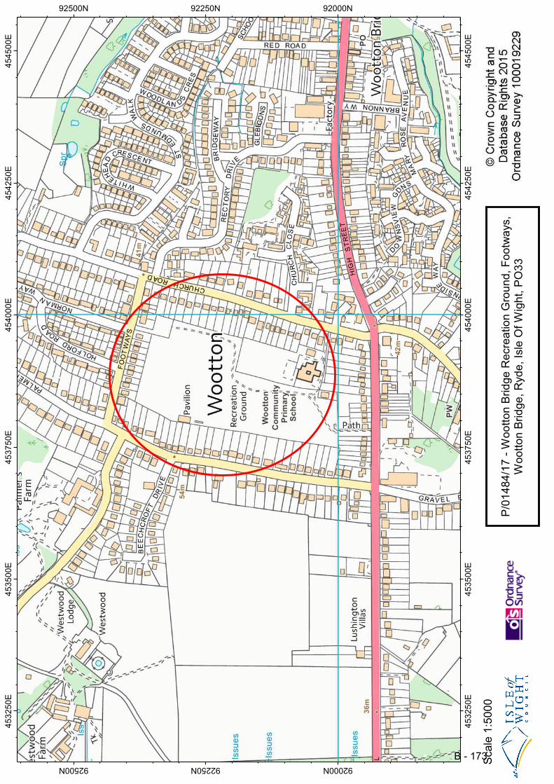
45
32
50
E
45
32
50
E
45
35
00
E
45
35
00
E
45
37
50
E
45
37
50
E
45
40
00
E
45
40
00
E
45
42
50
E
45
42
50
E
45
45
00
E
45
45
00
E
92000N92000N
92250N92250N
92500N92500N
Sca
le 1
:50
00
P/0
14
84
/17
- W
oo
tto
n B
rid
ge
Re
cre
atio
n G
rou
nd
, F
oo
twa
ys,
W
oo
tto
n B
rid
ge
, R
yd
e,
Isle
Of
Wig
ht,
PO
33
B - 173