parallel landscapes: a spatial and critical study of...
TRANSCRIPT

Paral lel Landscapes:
A spatial and crit ical study of mil i tar ised sites in the
United Kingdom
Matthew Fl intham
A thesis submitted in partial fulfilment of the requirements of the Royal College of Art for the Degree
of Doctor of Philosophy
June 2010
Department of Communication Art and Design The Royal College of Art

Copyright Statement
This thesis represents the submission for the degree of Doctor of Philosophy at the Royal College of Art. This copy has been supplied for the purpose of research or private study, on the understanding that it is copyright material, and that no quotation from the thesis may be published without proper acknowledgement.

Abstract
There are currently 548 declared military facilities in the United Kingdom, located on
372,000 hectares of military-owned or used land. Collectively known as the defence estate,
this land is used for defence and training, and constitutes approximately 1.5% of the UK
surface area. The research presented here interprets this landscape and its accompanying
airspaces, infrastructures and processes as a spatial phenomenon, one which is in an
almost constant state of flux. This thesis is, therefore, a study of militarised space in the UK
as defined by recent developments in technology, mobility and communication. It analyses
the processes by which land and space become militarised within different environments
and the residual effects of this on the wider fabric of civil society.
This thesis addresses issues of land appropriation, weapons testing, airspace design and
notions of temporary, flexible, invisible boundaries. A multidisciplinary approach is adopted
to analyse the histories, geographies and technologies evident at three case study sites.
These are MoD Shoeburyness (Essex), Salisbury Plain Training Area (Wiltshire) and the city
of Portsmouth (Hampshire).
The first outcome of this research is a spatial interpretation of the defence estate, its
transformation over the 20th century and its fluctuating control of the British landscape and
skies. The second outcome is an analysis of the current military environment and its use of
complex assemblages of land, sea, infrastructure and airspace to contain military activities.
These localised, three-dimensional forms are not only becoming more refined to
accommodate new weapons and technologies but they are also increasingly connected to
each other. The third outcome is a speculative interpretation of the defence estate as a
complex, connected totality, a parallel landscape of military spaces, activities and
processes.
Together, these outcomes demonstrate that the Armed Services of the UK preside over an
increasingly complex and interconnected environment. They continue to engage with UK
territory and space in unique and diverse ways but are increasingly influenced by external
forces such as the commercial and civil sectors, public interest pressure groups and the
conflicted governance of the state.

Table of contents
List of figures and tables
Preface
Acknowledgement
Author’s declaration
Abbreviations and acronyms
Chapter 1. Introduct ion …………………………………………………………. 1
1.1 Research question ….………………………………………………………… 2
1.2 Objectives 2
1.3 Introduction …………………………………………………………………….. 3
1.4 Theoretical approach 10
1.4.1 Introduction ………………………………………………………….. 10
1.4.2 The production of space 11
1.4.3 Military space ………………………………………………………… 13
1.4.4 Complexes and networks 14
1.4.5 Power ………………………………………………………………… 15
1.4.6 Research limitations 16
1.4.7 Timeliness ……………………………………………………………. 17
1.5 Practical methodology 18
1.5.1 Database survey ……………………………………………………. 18
1.5.2 Mapping, Google Earth and GIS 18
1.5.3 Field studies 21
1.5.4 Interviews and oral histories ……………………………………….. 25
1.5.5 Photographic documentation 26
1.5.6 Searches and archive ………………………………………………. 27
Chapter 2. The Br it ish mil i tary capabi l i t y
and the de fence estate .. ………………………………………. 30
21 Introduction ……………………………………………………………………... 31
2.2 The British defence capability 31

2.3 UK military expenditure ………………………………………………………… 35
2.4 The defence estate 38
2.5 Defence land and the Anglo-American relationship ………………................ 44
2.6 Bridging the geographies of training and conflict ……………………............ 48
2.7 Defence of the sovereign territory 50
2.8 The British nuclear capability ………………………………………………….. 52
2.9 Strategies, reviews and papers 53
2.10 Conclusions …………………………………………………………………….. 54
Chapter 3. Land, space and transformat ion
in the Brit ish defence estate ………………………………….. 56
3.1 Introductions ……………………………………………………………………. 57
3.2 The camp and the barrack 58
3.3 Land for training ………………………………………………………………… 66
3.4 Air defence and airspace 74
3.5 Conclusions …………………………………………………………………….. 80
Chapter 4. The legal const itut ion of
mil i tary land in the unt ied kingdom …………………............. 83
4.1 Introduction ……………………………………………………………………... 84
4.2 Military laws 84
4.3 Byelaws and spatial segregation ……………………………………………….86
Chapter 5. Case Study 1.
The Shoeburyness Complex and
the problem of the civi l ian body ……………………………… 90
5.1 Introduction …………………………………………………………………….. 91
5.2 Military science, death and decommissioning 93
5.3 Proving, static trials, random noise …………………………………………… 96
5.4 Why are we still here? 101
5.5 Conclusions ……………………………………………………………………. 105
Chapter 6. Case Study 2.
The Sa l isbury P lain Training Estate …………………………..106

6.1 Introduction ……………………………………………………………………… 107
6.2 Geographies 109
6.3 Histories of reconnaissance and archaeology ………………………………. 114
6.4 Histories of appropriation. 117
6.5 Spaces of archaeology ………………………………………………………… 123
6.6 Spaces of management and rationalisation 128
6.7 Airspaces ……………………………………………………………………….. 129
6.8 Conclusions 132
Chapter 7. Case Study 3.
Portsmouth ………………………………………………................ 135
7.1 Introduction 136
7.2 The development of regional defence clusters ……………………………….. 137
7.3 Current regional defence clusters 146
7.4 Fluid dynamics ………………………………………………………………….. 151
7.5 Conclusions 154
Chapter 8. Networked landscapes ………………………………………….. 158
8.1 Introduction 159
8.2 Land, networks and infrastructures …………………………………………… 160
8.2.1 Government Pipeline and Storage Systems (GPSS) 161
8.2.2 Project Aquatrine ……………………………………………………… 164
8.2.3 Road and transport networks 166
8.2.4 Integrated Range Information System (IRIS) ……………………….. 166
8.2.5 The Defence Fixed Telecommunications Service (DFTS) 167
8.3 The military network paradigm ………………………………………………… 168
8.4 Conclusions 177
Chapter 9. The mil i ta ry spat ia l complex …………………………………… 180
9.1 Introduction 181
9.2 Poly-spatial forms ………………………………………………………………. 182
9.3 Militarised airspaces 188
9.4 The evolving military-industrial complex ………………………………………. 195
9.5 The military spatial complex 200
9.6 Conclusions ……………………………………………………………………... 202

Chapter 10. Para l le l landscapes ………………………………………………. 205
10.1 Introduction 206
10.2 The social detachment of military space ……………………………………… 208
10.3 The ‘real’ Revolution in Military Affairs 212
10.4 The vessel of military space ……………………………………………………. 217
10.5 An ‘original continuum’? 219
10.6 Conclusions ………………………………………………………………………221
Chapter 11. Conclusions ………………………………………………………… 224
11.1 Questions and answers 225
11.2 Original contribution to research ……………………………………………… 228
11.3 Other findings 228
11.4 Future research ………………………………………………………………… 229
Bibl iography …………………………………………………………………………… 231
Appendices
2.1 Private Finance Initiatives (PFI) commissioned by the MoD ………………… 245
2.2 AWACS (Airborne Warning and Control System) orbit area map 249
8.1 Royal Observer Corps bunkers (1956 -1991)………………………………… 250
9.1 Military Aerodrome Traffic Zones (MATZ) map 251
9.2 Military Low-Flying Area map incorporating coastal waters…………. 252

F igures and tables
Figure 1.1. Radome, RAF Trimingham, Norfolk. Photograph: M. Flintham……………………………………………. 1 Figure 2.1. Salisbury Plain tank crossing.
Photograph: M. Flintham…………………………………………….. 30
Figure 2.2 Deployments of the Armed Forces 1 April 2008 – 31 March 2009. Source MoD. Crown Copyright, 2008……………………………… 34
Table 2.1. Military expenditure: SIPRI Yearbook 2008:
Armaments,Disarmament and International Security, Oxford: Oxford University Press 2008…………………… 36
Figure 2.3. Defence Training Estate: Training Area and Ranges.
Crown Copyright, Ministry of Defence 2009………………………. 41 Figure 2.4. RAF Feltwell, Norfolk, UK.
Photograph: M, Flintham……..…………………………………….. 47 Figure 3.1. World War Two air traffic control tower.
RAF West Raynham, Norfolk. Photograph: M. Flintham…………. 56
Figure 3.2. Jonathan Olley. Romeo One One watchtower, Courtney Mountain, Lislea, South Armagh, Northern Ireland, UK. Copyright Jonathan Olley…………………………………………… 65
Table 3.1. Military land use in thousands of hectares.
Source: MoD Defence Statistics incorporating additional data from John Childs, The Military Use of Land, Bern: Lang, 1998………………………. 73
Figure 4.1. Hazards and byelaws, the Wash, Lincolnshire.
Photograph: M.Flintham……………………………………………. 83 Figure 5.1. Controlled explosion at the MOD Shoeburyness
proving ground. Crown Copyright/MoD 2009……………………. 90 Figure 5.2. MoD Shoeburyness. Area owned or controlled by the MoD.
Source: Ordnance Survey. Crown Copyright, modified by M. Flintham……………………….. 100
Figure 5.3. The island of Foulness and surrounding Danger Areas.
Google Earth images with additional graphic modeling by by M.Flintham………………………………………… 101
Figure 6.1. A FIBUA village near Imber, Salisbury Plain.
Photograph, M. Flintham…………………………………………… 106

Figure 6.2. Map: Military Garrisons and camps, Salisbury Plain. Googlemaps with overlays by M.Flintham………………………… 111 Figure 6.3. Map: Defined local economic area around the Salisbury
Plain garrisons. Source: Wiltshire County Council………………… 113 Figure 6.4. Map: Salisbury Plain, internal military subdivisions.
Source: Google Maps with additional data by M. Flintham based on current military maps of the region………… 125
Figure 6.5. A formation of armoured vehicles moves across Salisbury Plain.
Image from Google Earth……………………………………………. 126 Figure 6.6. Map: Proposed segregated airspace for Unmanned Aerial
Vehicles (UAV). Source: Ministry of Defence and Ordnance Survey. Crown Copyright………………………………… 131
Figure 7.1. The Maritime Integration and Support Centre (MISC),
Portsdown Technology Park. Photograph: M. Flintham…………… 135 Figure 7.2. Bernard de Gomme’s garrison fortification of 1690………………... 141 Figure 7.3. Map: The distribution of ‘Palmerston’ fortifications.
Source: The Palmerston Fort Society……………………………….. 145 Figure 7.4. Map: Major Aerospace & Defence Companies in the South East.
Source: SEEDA………………………………………………………. 148 Figure 7.5. The current distribution of defence sites across
the Portsmouth region. Source: University of Portsmouth with additional information by M. Flintham…………………………. 150
Figure 7.6. Current distribution of major defence-related companies
across the Portsmouth region. Source: University of Portsmouth with additional information by M. Flintham…………… 151
Figure 7.7. Map. Limits of the Queen’s Harbour Master authority.
Source: Queen’s Harbour Master Portsmouth…………………….. 153 Figure 7.8. Designated Danger Areas in relation to the Isle of Wight.
Source: Google Earth satellite image with additional modelling by Lloyd Bailey……………………………………………. 154
Figure 8.1. Ground-to-air microwave antenna, RAF Neatishead.
Photograph: M. Flintham…………………………………………….. 158 Figure 8.1. Government Pipeline and Storage Systems (GPSS)
distribution map.Source: <http://www.linewatch.co.uk/network.htm>, (accessed 11 June 2010)……………………………………………. 162
Figure 8.2. Representation of the Joint Operations Picture (JOP).
Source: Ministry of Defence………………………………………….. 170
Figure 9.1. Model of a Watchkeeper UAV taken at the Salisbury Plain Airspace Change public consultation session, Amesbury. Photograph: M. Flintham………………………………… 180

Figure 9.2. SPTA Danger Area volumes. Satellite image from
Google Earth with additional graphic modelling by Lloyd Bailey and M. Flintham…………………………………….. 183
Figure 9.3. Salisbury Plain Danger Area volumes with Military Aerodrome
Traffic Zones (MATZ). Satellite image from Google Earth with additional graphic modelling by Lloyd Bailey and M. Flintham……. 184
Figure 9.4. Salisbury Plain Danger Areas with proposed segregated
airspace for UAVs. Satellite image from Google Earth with additional graphic modelling by Lloyd Bailey and M. Flintham……. 184
Figure 9.5. The Aberporth Range Complex over Cardigan Bay and
the Irish Sea. Satellite image from Google Earth with additional graphic modelling by Lloyd Bailey and M. Flintham……. 186
Figure 9.6. The Aberporth Range Complex and the Sennybridge
ArmyField Training Centre (SENTA) plus segregated airspace Volumes for UAVs. Satellite image from Google Earth with additional graphic modelling by Lloyd Bailey and M. Flintham……………….. 190
Figure 9.7. The military UK Day Low Flying System (UK DLFS).
Source: National Air Traffic Service (NATS)…………………………. 193 Figure 9.8. Chart of United Kingdom Airspace Restrictions and
Hazardous Areas. Source: National Air Traffic Service (NATS)……. 194 Figure 10.1. Military warning flag at Gedney Drove End, Lincolnshire.
Photograph: M. Flintham……………………………………………. 205 Figure 10.2. ‘Hot row’, hardened nuclear weapons storage facility,
RAF Bentwater. Photograph: M. Flintham ………………………………………….. 211

Preface
This research began in the spring of 2007 as part the Future of Landscape and the
Moving Image, a three year research project funded by the Arts and Humanities
Research Council and based at the Royal College of Art. The project’s Principle
Investigator, Patrick Keiller and co-researchers Doreen Massey of the Open University
and Patrick Wright of Nottingham Trent University, set out to ‘explore received ideas
about mobility, belonging and displacement in terms of landscape and images of
landscape, in a context of economic and environmental change’. It was in this context
that I was selected to undertake an AHRC-funded PhD studentship on the subject of
my initial proposal, a study of how military spaces are defined or ‘produced’ in the
British landscape.
The origin of this research goes back over a decade and a half. After graduating from
Central Saint Martins with a degree in fine art, I became increasingly interested in
‘utilitarian’ forms of architecture in the landscape, from industrial and agricultural
facilities to miscellaneous transport and utility infrastructures. From the perspective of
visual culture these typologies seemed to run counter to certain expectations of the
British landscape, which is often called upon to provide images of beauty, respite or
bucolic repose. The extensive military landscape of the United Kingdom appeared to be
the extreme antithesis of this vision but it also suggested evidence of a greater national
anxiety, one which I thought needed further investigation.
I decided to pursue this subject for a Masters dissertation in Humanities and Cultural
Studies at the London Consortium where I focused on the island of Orfordness on the
Suffolk coast. As the site of intense military research and development for most of the
20th century, it is a place invested with the horrors of experimental weapons technology
and nuclear warfare. Here it struck me that the numerous strange buildings and piles of
military detritus around the island were actually the by-products, the residue of extreme
military processes and practices, built to contain the possibilities of danger and death. I
was also aware that this place was dead, at least to the military, and that in many other
parts of the country the Armed Services and related private sector organisations were

constantly preparing for war, segregating vast areas of land, sea and air for their own
purposes. It was becoming clear to me that the military were, even in this seemingly
‘domestic’ landscape, designing and producing the most unusual and elaborate
assemblages of space for the purpose of simulating the wars in Iraq, Afghanistan and
elsewhere. The problem, it seemed, was to try and understand how all these
dangerous activities and spaces interacted with everything else in the UK, and why
Britain developed such a densely militarised landscape in the first place. I was never in
any doubt that these spaces were, and still are, defined by government policy and, as
such, are political in the most literal way. They are the contested sites of patriotism and
protest, duty and activism. However one feels about them, it seemed necessary for me
to try and generate new possibilities for understanding these spaces, to try and keep up
with government policy, military strategy and the increasing influence of the commercial
sector in the defence environment.
Being part of the Future of Landscape project at the RCA provided an environment that
was both sympathetic to a sustained investigation into military geographies and offered
a critical, supportive framework in which to proceed, develop and collaborate. It was
also here that I began to understand how different visual and cultural practices could
offer alternative perspectives on the subject of militarised landscapes and the invisible
architecture of airspace. I hope that this thesis will play a part in widening the field of
debate to include new forms of representation, visualisation and to reinterpret the ever-
changing movement of military power in the landscape.

Acknowledgement
Being part of the Future of Landscape and the Moving Image research project at the
Royal College of Art has been a genuine privilege. Nowhere else would I have found
such a combination of inspired debate, good humour and guiding support. I would,
therefore, like to thank my second supervisor Patrick Wright for lending his breadth of
knowledge and constructive support, Doreen Massey for her kind encouragement and
infectious enthusiasm, and Patrick Keiller for his unfailing, invaluable supervision and for
gently pushing me beyond what I thought possible.
I am grateful for the calm and professional support of the Research Department at the
RCA and to AL Rees for guiding me through the research process with such ease and
kindness. I also owe a dept to those friends and colleagues who read and commented
on parts of this thesis, particularly to Iris Argyropoulou who attacked a very late draft
with uncommon determination.
For companionship on the road, I am grateful to Calvin Winner and Richard Mosse who
entered military areas with me and came out mostly unscathed. Inside those areas, I
would like to thank the military personnel and civilians who granted me access and
consented to be interviewed, particularly Richard Osgood at Westdown Camp,
Salisbury Plain. The community on Foulness must also be thanked for their hospitality
and for showing me their extraordinary and beautiful island.
At the Arts and Humanities Research Council, I would like to thank Stephen Daniels and
Charlotte Lloyd for producing the Landscape and Environment programme, without
which this research would not have been possible. In this context, Chris Pearson, Peter
Coates and Time Cole should also be thanked for organising the Militarized Landscapes
conference at the University of Bristol in 2008, which was an inspired and unique event.
None of this, however, would have been possible without the love and encouragement
of my parents, Dorothy and John, or the unfaltering support of Katrine and Maina.

Cert i f icate of Authorship and Original ity
I certify that the work in this thesis has not previously been submitted for a degree nor has it been submitted as part of requirements for a degree. I certify that I have not been registered with any other academic institution during the period of registered study. I also certify that the thesis has been written by me. Any help that I have received in my research work and the preparation of the thesis itself has been acknowledged. In addition, I certify that all sources and literature used are indicated in the thesis. Signature of Student Matthew Flintham

Abbreviat ions
AARA Air-to-Air Refuelling Areas
AIAA Areas of Intense Air Activity
ASACS Air Surveillance And Control
System
ATA Aerial Tactics Area
ATA Army Training Area.
ATC Air Traffic Control
ATZ Aerodrome Traffic Zone
AWE Atomic Weapons Establishment
AWPC Aldermaston Women’s Peace
Camp
AWRE Atomic Weapons Research
Establishment
BTA Battle Training Area
CND Campaign for Nuclear Disarmament
DFTS Defence Fixed Telecommunications
Service
DoD Department of Defence (USA)
DSTL Defence Science and Technology
Laboratory
DSTS Deep Space Tracking System
EDA European Defence Agency
EU European Union
FUA (European) Flexible Use of Airspace
GCHG Government Communication
Headquarters
GIS Geographic Information System
GPSS Government Pipeline and Storage
Systems
IED Improvised Explosive Device
IRIS Integrated Range Information System
JHC Joint Helicopter Command
JRRF Joint Rapid Reaction Force
JFH Joint Force Harrier
LASS Low Altitude Space Surveillance
MATZ Military Aerodrome Traffic Zone
MISC The Maritime Integration & Support
Centre
MoD Ministry of Defence (UK)
MTA Military Training Areas
NATO North Atlantic Treaty Organisation
NATS National Air Traffic Service
NCW Network Centric Warfare
NEC Network Enabled Capability (UK)
NGO Non-Governmental Organisation
PFI Private Finance Initiatives
PJHQ Permanent Joint Headquarters
PPP Public Private Partnership
QHM Queen's Harbour Master
R&D Research and Development
RAF Royal Air Force
RDD Radiological Dispersal Device
RMA Revolution in Military Affairs
RN Royal Navy
SIGINT Signals Intelligence
SIPRI Stockholm International Peace
Research Institute
SPTA Salisbury Plain Training Area
SRR Special Reconnaissance Regiment
SSSI Sites of Special Scientific Interest.
SUA Special Use Airspace
TESEX Tactical Engagement Simulation
Exercise
TRA Temporary Reserved Areas
UAV Unmanned Aerial Vehicles

Chapter 1. Introduction 1
Chapter 1 Introduction
Figure 1.1. Radome, RAF Trimingham, Norfolk. Photograph: M. Flintham.

Chapter 1. Introduction 2
1.1 . Research quest ion Do the operational military spaces of the United Kingdom, in their various
interconnected arrangements, constitute a pervasive ‘complex’ which coexists with
civilian space, creating a militarised parallel landscape?
1.2. Research aims and objectives:
• To survey and visually represent the production of military space in the United
Kingdom.
• To understand how military space operates in relation to civil space, and to
define the differences and similarities in methods of production.
• To propose that the spaces created by the military are not simply the closed,
fixed sites we imagine, but highly complex forms that are often connected to
each other in invisible and intangible ways.
• To study the increasing influence of the private sector on the UK defence estate,
particularly its effect on the constitution of domestic military space.

Chapter 1. Introduction 3
1.3 . Introduction
The purpose of this research is to understand the extent and nature of military
space in the United Kingdom (UK). It begins with the understanding that there are,
according to the Ministry of Defence (MoD), 548 known military sites across the
UK,1 which suggests, when compared to other European states, an unusually
pronounced military presence in the British landscape. For those not employed by
or in the service of the armed forces, military sites are generally the places we half
glimpse on a journey to somewhere else; anonymous barbed-wire fences
protecting distant grey aerodromes, or signalled by red flags on the edges of fields.
This partially hidden landscape, known as the defence estate, actually constitutes
between 1-2% of the surface area of the UK, and for reasons explored here and
elsewhere, remains under-researched within current academic discourse.
This research set out to gain legitimate access to military sites across the UK in an
attempt to understand what, if anything, distinguishes these places from other sites
of social interaction or productive processes. During the process, the research
discovered that military sites can, in fact, be highly dynamic and flexible assemblages
of spaces, some visible and solid, others invisible and immaterial. In addition, the
activities and processes that occur within them can also define spaces, some
instantaneous and dangerous, others written and rewritten on the landscape over
decades. Most importantly, many of these sites and spaces are constituted on a
parallel set of legal and judicial principles which necessarily separates them from
‘civil’ space and limits unauthorised access.
What follows is a line of enquiry that traces the transformation of the defence estate
from the mass acquisition of land during 19th and 20th century to today’s leaner,
private sector-assisted form via the anxious, ‘hardened’ estate of the Cold War. The
increasingly systematised use of land, sea and airspace leads this thesis to an
interpretation of military sites as ‘spatial complexes’; assemblages of military-owned
land, architecture, infrastructures, volumes of airspace and designated danger areas.
In identifying and visualising many of these assemblages this research concludes
that they have become, over the last 30 years, more intensely used, systematised
1 ‘Defence Estates Development Plan (DEDP) 2009 (Annex A)’, Ministry of Defence, <http://www.mod.uk/NR/rdonlyres/A8806EE6-7A77-4998-BC89 B9466190A85D/0/DEDP09_annex_a.pdf>, (accessed 29 January 2010).

Chapter 1. Introduction 4
and connected to one another in new and unusual ways. A broad picture emerges of
the defence estate in its current configuration, as an entity that has mobilised the
private sector to reorganise itself in the face of economic challenges, land
constraints, and the changing nature of warfare. While much of this private sector
involvement has proved misguided and rarely cost-effective, the rationale of
corporate management and the appetite for rationalisation has nevertheless altered
the military’s conception of space in both the domestic landscape and the battlefield.
This thesis describes a domestic military landscape that is less distinct (and therefore
less quantifiable and visible to scrutiny) and a military capability whose infrastructures
and support services are exposed to the turbulence of a fragile global economy and
unscrupulous business practices.
This chapter will identify the questions and objectives of this research, and will
describe a mixed methodology of field work, graphic visualisation, interviews, and a
critical and theoretical framework for the current line of enquiry.
Chapter 2 will provide a broad national and global context for the current research,
an overview of the British military capability and its relationship to the defence estate.
It will also describe links with other cross-national organisations such as NATO and
the emerging European Defence Agency, and their impact on recent conflicts and
humanitarian missions around the world. Special attention will be paid to the direct
connection between the military geographies of the UK and specific conflict zones
such as Iraq and Afghanistan, and crisis management operations around the world.
Chapter 2 will also describe the relevance of the ‘special relationship’ with the USA
and the physical impression it leaves on the British landscape.
Chapter 3 will describe a selective history of defensive sites in the UK leading to the
British defence estate in its current form. While the primary focus will be on the
incremental growth of military land-ownership during the twentieth century, this will
be conducted with reference to older forms of military fortification and barracking.
The political and social motivations for the purchase of land will be studied as will the
impact of specific conflicts such as the Napoleonic Wars, World Wars One and Two,
and the Cold War. This chapter will depict a military landscape that is as much a
product of institutional conservatism as it is of conflict (and the threat of conflict).
However, it will also illustrate how the limits of military geographies are defined by the

Chapter 1. Introduction 5
possibilities of destructive technologies and the requirement to exclude civilians from
their lethal effects. The increasing importance of militarised airspace will be assessed
in its relations with military land use, training and national defence. In addition, this
chapter will propose that the increasing systematisation of airspace throughout the
20th century marks an important shift in the military’s ability to define space in three
dimensions both in the field of conflict and in the domestic context. In this respect,
Chapter 3 will assess the vertical and volumetric use of space as the military defence
estate extends beyond land use and beyond the fluid parameters of naval navigation.
The Cold War will be studied as a period of intense consolidation and technological
innovation leading to an unprecedented nation-wide framework of connected sites,
airspaces and communication/surveillance networks.
Since the aim of this thesis is to understand what, if any, are the basic principles of
military space in the UK, Chapter 4 will analyse the legal constitution of military
controlled areas. Defence lands, enclosures and sometimes airspaces are protected
by site-specific bylaws that prohibit unauthorised access and limit activities around
them. Perimeter fences, guarded entrances and surveillance cameras are often the
most obvious expressions of this spatial segregation. But while many bylaws are
written to define the boundary of a site they are also used to regulate the behaviour
of civilians outside certain sites to prohibit protests and activities such as
photography and filming. However, the legal legitimacy of certain bylaws can be
successfully challenged by the activities of civilians which can lead to a site being, in
some sense, legally ‘reconstituted’. Certain examples in the thesis will show how
military bylaws are adaptable, sometimes ambiguous and can lack legal legitimacy.
In addition, Chapter 4 will describe how British military personnel are bound by a
separate judicial system, the Military Criminal Justice System, which is marked by the
principles of extreme discipline and the requirement to regulate the behaviour of
soldiers at home, abroad and in hostile environments. The military institution, in this
respect, is a self-regulating body, a ‘warrior class’ who define land and space in their
own terms but who requires the state to legitimise their activities and to legally
constitute the spaces they inhabit.
Chapter 5 describes the first of three case studies undertaken as field work during
2008-09. MoD Shoeburyness is a collection of military sites used primarily for military
research and development (R&D) but is almost entirely managed by QinetiQ, a

Chapter 1. Introduction 6
private sector organisation which emerged from the British government’s Defence
Evaluation and Research Agency (DERA) in 2001. Many of the facilities are found on
Foulness, an island at the mouth of the river Thames used for weapons testing,
development and disposal. This restricted and uniquely hazardous island also
happens to be home to a civilian community gathered in the isolated village of
Churchend. While it resembles a ‘traditional’ English village in many respects,
Churchend is at the centre of a complex system of land use and airspace
architecture which is designed to both protect and exclude the vulnerable civilian
inhabitants. Chapter 5 identifies a number of issues relating to the transformation of
military land use and spatial design over the last 30 years. Firstly, it looks at what it
is like as a civilian to live inside a quasi-military zone, where weapons testing is
implied if not experienced on a daily basis and where agricultural routines are
organised around live firing schedules. Secondly it will look at the impact of
Geographic Information Systems (GIS) on the organisation of farming cycles and
ballistics hazards. Thirdly, Chapter 5 will ask where the human body resides within
the equation of military and agricultural land use, restricted airspace, weapons
testing and the very real threat of danger.
The second case study within this research is Salisbury Plain Training Area (SPTA),
the British Army’s largest training facility in the UK. Chapter 6 will describe a
selective history of military land acquisition across the county of Wiltshire throughout
the twentieth century, a process which would largely spare Salisbury Plain the
homogenising effects of modern agriculture but subject it, instead, to the effects of
intense military activity. The emergence of new technologies such as the tank and
the aeroplane will be assessed in relation to land and airspace use as will the residual
effects of aerial reconnaissance photography on the disciplines of archaeology and
geography. Chapter 6 reveals that many of these historical sites are now
incorporated into military training exercises as strategic obstacles such as dummy
‘mine fields’. This research also shows that, despites its relatively uncultivated,
naturalist appearance, the military landscape of SPTA has been systematically
subdivided into multiple parts, each with its own specific training function. This
rationalisation of space is managed by a private company, Landmarc to increase
efficiency of use by the armed services. Similarly, the Danger Area volumes and
airspaces above the Plain are heavily used by a variety of aircraft for training. Chapter

Chapter 1. Introduction 7
6 builds a picture of SPTA as highly structured assemblage of spaces, a combination
of land and air but managed as a single military resource.
The final case study is the city of Portsmouth, Hampshire, which is the largest naval
port in the UK. Chapter 7 describes the history and growth of the city as a defended
site of considerable naval and military-industrial activity. The urban development of
Portsmouth is shown to have been significantly influenced by the expansion of
military sites and spaces in the region but also by the changing posture of the city
from a defensible entity to a virtually indefensible place of significant military-industrial
production. Indeed, the relationship between the military and industry provides the
focus for this chapter in its analysis of regional private sector involvement in military
activities. Chapter 7 identifies clusters of current military activity and military-industrial
manufacturing in the region and traces the increasing influence of the private sector
within them. This analysis of military/urban forms reveals the large extent to which
military sites are now occupied and managed by commercial organisations. While
military-industrial manufacturing has always been present in Portsmouth, the
relinquishment of key military services, the training of personnel, catering, security
and site management is a phenomenon that has its origins the economic strategies
of the 1980s but which continues to this day. The congruence of naval activity and
the high density of military-industrial manufacturing and service provision is
responsible for a diffused assemblage of related sites across the region.
The case studies offered here provide three very different perspectives on how
military activity defines sites and spaces. Indeed, they show in very direct ways how
military activities are processes that can, for instance, explode instantaneously or
shape urban forms over centuries. They can exist in the construction of barbed-wire
perimeter fences around a site or in the coordinates of an invisible volume of
airspace – a very real space if you happen to fly into one during a heavy artillery trial.
These case studies provide alternative examples of the military habitat: an island
used for R&D, an army training area one tenth the size of Wiltshire and an entire city
whose urban form continues to be defined by the principles of warfare and defence.
Each was chosen because it offered a broad range of spatial forms and activities for
analysis, and all three were accessed on multiple occasions with permission from the
relevant authorities. Ideally, this research would have also included an active RAF
base as a case study. This was not possible for a number of reasons including lack
Chapter 1. Introduction 8
of accessibility and the constraints of the project time frame. However, a number of
recently decommissioned RAF bases were visited during the course of this research
including Greenham Common, Sculthorpe and West Raynham.2 Two active RAF
radar bases, Trimingham and Neatishead were accessed with permission from the
base commanders but were not selected to become full case studies because they
were unrepresentative of active ‘flying’ stations. All of these sites, however, informed
the historical background for this research or the interpretive exposition of the later
chapters.
Chapter 8, Networked Landscapes describes and interprets two types of military
networking. The first relates to the physical infrastructural networks that provide
military sites with fuel, water, communication and information technology systems.
These networks, which often run for hundreds of miles underground and sometimes
connect military sites together, constitute a parallel and hidden aspect of the British
military landscape. Many of these systems and networks, while essential to the
military capability and defence estate, are now managed as Public Private
Partnership (PPP) schemes or Private Finance Initiatives (PFI) meaning that the MoD
has attempted to transfer responsibility and risk to the commercial sector. An
analysis of these infrastructures, however, is essential to an interpretation of the
current defence estate: despite their defused spatial formations and their hidden
aspect they underpin and connect so many of the sites described in this thesis. They
are the veins and arteries of the British military landscape.
The second line of enquiry in Chapter 8 relates to the MoD’s doctrine of a Network
Enabled Capability (NEC). This is conceived as a practical exploitation of digital
information technology to enable a greater connectivity in the battlefield but also
means of rationalising existing bureaucratic systems, bypassing hierarchies in
defence command structures and capitalising on the apparent expertise of the
private sector. NEC is reshaping the way warfare is conducted abroad which, in turn,
has unusual residual effects on military activities across the British defence estate.
The introduction of Unmanned Aerial Vehicles into domestic training exercises is just
one example of a broader reshaping of defence training strategies.
2 A full list of active and decommissioned sites visited during the course of this research can be found in the methodologies section.

Chapter 1. Introduction 9
Chapter 9 brings together the salient themes of the previous chapters and builds a
picture of military sites as poly-spatial forms: assemblages or complexes with solid
geographical, infrastructural and architectural foundations but incorporating invisible
and vertical dimensions. These complexes are becoming increasingly systematised
and restructured by new technologies and the influence of the private sector.
Furthermore, Chapter 9 interprets the domestic military habitat as a spatial totality,
as a pervasive, nationally connected complex of sites, regions, airspaces and
processes. This chapter also addresses the validity of the word ‘complex’ in relation
to the more diffused aspects of an evolving military-industrial dynamic in the UK and
USA – a complex as a socioeconomic condition
The final chapter, Parallel Landscapes, offers a speculative interpretation of domestic
military space as distinct from civil space. The nature of this distinction is explored as
a process of ‘detachment’, first from the obligation of domestic civil enforcement and
later as a form of ‘self-segregation’ brought about by the proximity of lethal weapons
and the proliferation of nuclear warheads across the UK. However, the influence of
the private sector in most (if not all) forms of military activity is breaking down the
distinction between military and civil activities (and their respective ‘spaces’) in both
the domestic context and the war zone. This research can reveal that the ‘parallel
landscape’ of military training and defence, once so distinct during the Cold War, is
visibly diminishing in a confusion of private sector outsourcing, public accessibility,
ecological rhetoric, and a questionable mass-mobilisation of digital communication
technology. The end of the Cold War will be shown to be a critical moment in the
evolution of (western) state coercive force, when military power itself is opened as a
space for commercial enterprise.
The use of ‘parallel’ in the title of this thesis was not, therefore, an arbitrary choice
but actually frames several themes that relate to the changing character, proximity
and influence of military power across the British landscape. As the research
progressed other key words presented themselves as possible alternatives - such as
‘complex’, ‘poly-spatial’, ‘rhizomatic’ and ‘detached’, amongst others. However, all
of these seemed to relate only to a specific aspect of the research (at the exclusion
of others) and none seems to offer the inclusive, open and slightly ambiguous
analogy that best described the research as a whole. If, perhaps, the word ‘parallel’
doesn’t quite do justice to the sheer connectedness and mutability of the British

Chapter 1. Introduction 10
military landscape, it does function as a useful point of departure for many of the
themes that will be described in this thesis.
1.4 . Theoretica l approach
This section aims to provide a theoretical framework that informs and compliments
the practical methodology described below. The literature review undertaken for this
research began before the programme of field trips but ran concurrently to many of
the other practical methods employed here. However, the two methodologies can
be seen as mutually constitutive and in many ways, indivisible.
1.4 .1. In troduction
This research has employed a range of different methods to address the research
questions and its related objectives. Prior to undertaking field work and applying the
other practical methods described in the next section, a review of relevant literature
was conducted with a view to building a critical understanding of the military
presence in the UK and the historical trajectory of martial power across the domestic
landscape. This presence is most obviously seen in military bases, facility and
training areas, but also in a range of processes and events that unfold across the
landscape in a variety of ways. It quickly became apparent during this research that
no one discipline or subject area could adequately describe the manner in which the
armed services express themselves on, above and beneath the landscape: the
multiplicity of places, events and processes under analysis required navigating and
cross-referencing a series of familiar and less familiar academic approaches. Land
use, for instance, might be studied in direct relation to the historical development of
ballistics, or the design of airspace might demand an analysis drawn from critical
geography. However, this somewhat eclectic approach was ordered and
constrained by a bias towards visual culture, which generally begins by considering
the design, functionality, beauty or symbolic value of objects or phenomena in their
broader social milieu.
It became increasingly apparent during this research that the military imagination
conceives space differently from other social groups. Here, space is principally
strategic and cartographic, defensible or destructive: space is the framework within
which death and danger are measured. The military organisation and production of
space emerged, therefore, as key theme for this thesis. More specifically, the

Chapter 1. Introduction 11
domestic military landscape is framed here as the place in which war is planned and
prepared for, where the military imagination conceptualises the spaces of battle and
configures the landscape on those terms. War, however, is the place where those
plans, so carefully laid, unravel.
Underpinning and articulating the methods employed here is a critical and theoretical
interpretation of military activity and the ways in which the British Armed Services
(and their associated private sector partners) coordinate their activities across the
country. Despite the proliferation of literature relating to military strategies, to wars
ancient and modern, and the mountain of material fetishising weapons technology,
there are relatively few critical or analytical studies of training or defence activities in
the UK, and still fewer that relate to military geographies or the organisation of
domestic military space. However, the following significant texts stand out as relating
either directly or indirectly to the subject in question, but all in some way contribute
to an essential interpretive framework for progress. Many of these texts will be
employed to shed a critical light on the surfeit of government reports, MoD
documents and corporate promotional material available online today. Others assist
in developing the key arguments present in this thesis. The synopsis of texts below
will be organised thematically to introduce some of the persistent ideas that will
shape this thesis.
1.4 .2. The production of space.
This thesis recognises that there are different conceptions of space. The focus here,
however, is on those spaces conceived and defined by military activity. These
include the delineation of land, architecture and buildings, the construction of
physical borders and perimeters, infrastructure and other methods of limiting or
extending martial activity. Military spaces are also defined by processes: some are
instantaneous events such as detonations or impacts, others are mobile or transitory
and delineate a space by their movement or trajectory. All of these spaces should, as
in the civil realm, be regarded as ‘always under construction’ and a ‘product of
relations-between, relations which are necessarily embedded material practices’.3
There are, however, other orders of space that exist as representations, between the
imaginary and the real, which, within the martial context, include forms of
cartography and computer-assisted mapping but which can correlate with physical 3 Doreen Massey, For Space, London: Sage , 2005, p.9.

Chapter 1. Introduction 12
space in very direct ways. There also invisible and immaterial conceptions of space
such a those determined by coordinates; facetted volumes of airspace, danger areas
or as controlled zones. This thesis will proceed on the basis that these static, mobile
or representational spaces are produced as extensions of state and military power.
Having called for a unitary theory or science of space, Henri Lefebvre’s The
Production of Space4 remains a primary text for discourses in spatial culture and
practice. Lefebvre’s persuasive call to bring together a range of interpretive methods
to interrogate the spatial arrangements of capitalist production has been applied with
varying success across a range of disciplines. The central proposition that a spatial
subject can only usefully be interpreted by bringing together a number of different
disciplinary perspectives is one with which this research wholly concurs. The act of
applying a multidisciplinary approach to a spatial subject forms the basis for much of
the methodology of this research, and The Production of Space will be referred to
throughout as a primary model for this approach.
Lefebvre addresses military space only indirectly, as a expression of state power
and, perhaps more significantly, as a form of instrumental and abstract space that is
not so far removed from the systematised processes of industrial mass production.5
This perspective is useful in exploring a complex and mutually constitutive
relationship that has formed between military power and capitalism in the UK.
Similarly, David Harvey in Spaces of Capital, identifies military power as a form of
state coercion which is often mobilised in the service of economic ambition, but
which conceptualises space on its own terms. In this text, Harvey calls for ‘careful
studies of how geography as a mode of understanding is formulated, used and
applied in different institutional settings (for example, the military, Greenpeace, the
state apparatus, multinational corporations, and so on)’.6 This thesis can be
understood, in this respect, as an attempt to ‘read’ the geographies and spatialities
of the military institution.
4 Henri Lefebvre, The Production of Space, trans. Donald Nicholson-Smith, Oxford: Basil Blackwell, 1991. 5 Ibid., p.49 6 David Harvey, Spaces of capital: towards a critical geography, Edinburgh: Edinburgh University Press, 2001, p.209.

Chapter 1. Introduction 13
This research follows Lefebvre and Harvey in identifying state/military power as a
spatial phenomenon, one which is essentially a process of production which nurtures
a dynamic, if somewhat opaque relationship with the commercial sector. In the first
decade of the 21st century, the relationship between military power, space and
capital is more complex that ever, supporting vast military capabilities with
international infrastructures and sustained by an equally vast armament industry – all
of which are unravelling with alarming unpredictability in conflicts around the world.
1.4 .3. Mi l i tary space
The spatial bias that informs this thesis is also one derived from a unease with
temporally-fixated accounts of technology, globalisation and the apparent ‘death of
distance’ or even the ‘end of geography’. In these accounts military technology is
implicated in an acceleration of speed and a psychosocial erosion of distance. It may
be a truism to say as Sun Tzu did, that ‘speed is the essence of war’, but to say, as
Paul Virilio did, that the ‘reduction of distance has become a strategic reality bearing
incalculable economic and political consequences, since it corresponds to the
negation of space’,7 may be over-stating the issue. Pragmatically speaking, it is not
distance that has been reduced but duration. Whether one travels a kilometre in five
hours or five seconds, the distance remains the same. This research recognises that
the motives of military power remains essentially territorial and spatial, mobilised to
defend national or regional borders, maintain flows of capital and commodities
around the world, and to preserve other nuanced political interests.
However, it was Virilio’s Bunker Archeology, a photographic and architectural study
of the decaying Nazi Atlantic Wall defences, (and its accompanying essay Military
Space), that identified a certain ‘rupture effectuated between human territory and the
continuum of violence’.8 While ultimately critical of Virilio’s proposition, much of this
thesis’ penultimate chapter is devoted to addressing an apparent shift in the British
military’s conception of land and geography.
Rachel Woodward’s Military Geographies is one of the few recent texts with original
research and field work to recognise the significance and scale of military activity in
7 Paul Virilio, Speed and politics: an essay on dromology, New York: Semiotext(e), 1986, p.133. 8 Paul Virilio, Bunker Archeology, trans. George Collins, New York: Princeton Architectural Press, 2009, p.17.

Chapter 1. Introduction 14
the UK, but also to convincingly challenge much of the geographical and
environmental data provided by the MoD.9 Crucial for this research, Woodward’s
study identifies the value of thinking ‘coherently and critically about the moral
authority on which military geographies are based’.10 Another key text for this
research, The Military Use of Land: A History of the Defence Estate, by John Childs,
maps the development of the military landscape from Iron Age settlements and
fortifications to the training grounds and airfield of the present era.11 Childs’
quantitative, acre by acre analysis of the growth of the defence estate forms the
basis for much of the land use details in Chapter 3.
1.4 .4. Complexes and networks
The research question for this thesis rests on an interpretation of the word complex
which is developed here as a structural model for interpreting spatial relations. Here
is a definition of the word complex from the Compact Oxford English Dictionary:
adjective 1 consisting of many different and connected parts. 2 not easy to
understand; complicated.
noun 1 a group of similar buildings or facilities on the same site. 2 an
interlinked system; a network. 3 a related group of repressed feelings or
ideas which lead to abnormal mental states or behaviour. 4 informal an
obsession or preoccupation.
This thesis assesses and develops the complex model of military spatial relations
from the local level to the regional, and finally to the national level. In each case these
assemblages of land, buildings, infrastructures and airspace architecture are shown
to share a collective function and can be regarded as poly-spatial complex forms.
However, this thesis also recognized the political and socio-economic forces that
shape these forms. Britain’s changing military-industrial dynamic is assessed at
various points in relation to the defence estate. In this respect, David Edgerton’s
Warfare State: Britain 1920-1970, offers a thorough, ‘post-declinist’ reading of the
development of the British military capability and its relations with industry and
9 Rachel Woodward, Military Geographies, Oxford: Blackwell, 2004. 10 Ibid., p.9. 11 John Childs, The Military Use of Land: A History of the Defence Estate, New York: Peter Lang, 1998.

Chapter 1. Introduction 15
manufacturing.12 Warfare State and England and the Aeroplane describes a ‘liberal
militarism’ which provided long term policies for armaments production and the
development of military technologies.13 Following the changing military-industrial
dynamic into the 1980s and 1990s, War on Terror, Inc by Solomon Hughes,
proposes that Britain’s privatisation of military assets was more conceptually
developed than the USA’s, with the Reagan/Thatcher axis providing a cross-Atlantic
dialogue for accelerated commercial enterprise in the defence sector.14 Among
others, these accounts of defence manufacturing and privatisation are woven into a
history of the defence estate as it’s sites and infrastructures are increasingly
managed by the commercial sector. This fact is shown to have significant
implications for the organisation and management of the defence estate as a whole.
The proximity of technological development, military activity and private sector
investment is also explored in Antoine Bousquet’s The Scientific Way of Warfare
which tracks the emergence of Network-centric Warfare (NCW) as a flawed but
influential doctrine of digital communication and decentralized command
structures.15 The principles of NCW have been embraced by the MoD as Network
Enabled Capability (NEC), a doctrine which is incrementally reordering the theatre of
war and, as a consequence, the training environments in the UK.
1.4 .5. Power
Understanding the role power plays in generating and preserving military and
institutional spaces is the subject of Paul Hirst’s Space and power.16 This
Foucaultian reading of political and institutional spatial practice informs this thesis’s
analysis of the evolving defence estate. Foucault’s critical approach to static
constructs such as ‘state’, ‘sovereignty’ or ‘law’, is useful for this thesis in
introducing dynamic, unexpected forces into the play of power that defines
militarised space. The appearance of these spaces in a landscape is shown to be
not simply the work of the ‘state’ or the ‘military’ but a matrix of institutions, people,
12 David Edgerton, Warfare state: Britain, 1920-1970, Cambridge: Cambridge University Press, 2006. 13 David Edgerton, England and the Aeroplane: An Essay on a Militant and Technological Nation, Macmillan Academic and Professional LTD, 1991. 14 Solomon Hughes, War on Terror, Inc.: corporate profiteering from the politics of fear, London: Verso, 2007. 15 Antoine Bousquet, The scientific way of warfare: order and chaos on the battlefields of modernity, London: Hurst, 2009. 16 Paul Hirst, Space and power: politics, war and architecture, Cambridge: Polity, 2005.

Chapter 1. Introduction 16
technologies and architectures, making the process of interpretation that much
harder.
Patrick Wright’s The Village that Died for England, is a detailed account of the ebbs
and flows of power that shaped the Isle of Purbeck in Dorset and finally extinguished
the village of Tyneham as a living community. At first glance this appears to be a
document of the ‘final triumph of the metallic state over the old organic nation of
romantic protest’, but quickly reveals the mesh of imbrications between people,
institutions, land, weapons and the conflicted character of the ‘state’.17 This study of
British militarism will be referred to throughout this thesis and serves as a model for
detail and depth of research.
This is by no means a complete review of the literature referred to in this thesis but it
does indicate a number of trajectories that coalesce into an analysis of the defence
estate in its current form. In this respect, this thesis does not provide a
comprehensive or fixed methodology for interpreting spatial relations but instead
proposes a multidisciplinary model which approaches the subject of domestic
military space from a number of different perspectives. The principal focus for this
thesis are the poly-spatial assemblages described above; the complexes of land, air
and architecture, within which the destructive possibilities of war are seemingly
contained but which, in fact, leak the residues of British militarism into the spaces
and places beyond.
1.4 .6. Research l imitat ion
There are areas of military activity which could not be assessed by this research due
to the constraints of time, access to information or the requirements of national
security.
This thesis is principally about the relationships between military land use and
airspace. An assessment of Royal Navy activities is limited to research on the city of
Portsmouth and other naval bases in the UK. Additional studies on military activity in
UK coastal water were not possible due to time limitations. However, it should be
17 Patrick Wright, The village that died for England : the strange story of Tyneham, London: Faber, 2002, p.422.

Chapter 1. Introduction 17
recognised that this is an important area of military activity that needs further
investigation.
This research also intended to address the military use of the electromagnetic
spectrum as an invisible form of spatial delineation. However, the details of military
radar use for air defence remains secret and it would be inappropriate to
approximate the radial distribution of signals, their vertical dimensions or identifying
signal ‘blind spots’. The use of satellite-based hyperspectral imaging for visualising
radar signal distribution was out of the question because it could effectively expose
gaps in British air defence. However, this remains an important and developing area
of military activity that demands further attention.
There are other omissions such as the MoD’s blocking of off-shore wind farm
planning applications because of potential radar interference from rotating turbines.
This issue became an interesting counterpoint to the apparent ‘greening’ of the MoD
and their engagement with environmental issues. However, this matter, which has
been ongoing for a number of years, appears to have been resolved by the purchase
of a booster radar to be based on the Norfolk coast.
The are undoubtedly other important issues which have been missed or left out for
structural reasons, or which were otherwise beyond the scope of this research. This
thesis was not intended to be a comprehensive or all-inclusive study but, amongst
other things, a springboard for more detailed analyses.
1.4 .7. T imel iness
Over a three year period this research project has identified numerous accomplished
and relevant texts, many of which are cited above. However, this thesis
acknowledges a need to build on the work already undertaken in the fields of spatial
culture and practice by assembling a multidisciplinary methodology for interpreting
recent developments in defence and the military-industrial sector. The conceptual
tools and visual technologies are available to push for a greater transparency and
accountability of military activities, to question the need for the high level of military
land and air use, and to track the increasingly interconnected military presence
across the UK, around its coasts, and in its skies.

Chapter 1. Introduction 18
This research also hopes to address the lack of critical discussion on airspace as a
projection of power or as an extension of land-based activities. The stratification and
subdivision of the skies is something which appears to have largely evaded
academic consideration and public discussions are, understandably, almost entirely
focused on the socially intrusive flight paths around major airports. This thesis aims
to highlight the use of airspace as an functional component of the defence estate
and as an evolving element of warfare and national defence.
1.5 . Practical methodology
Having established the Research Question and Objectives after the initial literature
review in 2007-08, a set of practical methods were used to facilitate the next stage
of research. These methods were used to identify and/or visualise military sites and
spaces in the UK, and gain information relating to planned site visits. During 2008-
09, field work was also undertaken in parallel to these desk-based activities. The list
below represents a selection of techniques and processes used throughout the
research programme and seeks to position them in a wider cultural framework.
1.5 .1. Database survey.
In the absence of a comprehensive list of military sites in the UK, this research began
compiling a database as a reference tool. However, during the course of 2009 the
MoD published its own comprehensive database of national and international sites.
This new comprehensive database has proved to be an invaluable reference tool and
is referred to throughout this thesis. Where possible, information from this database
is cross-checked with other sources.
1.5 .2. Mapp ing, Goog le Ear th and Geographic Information Systems
(GIS) .
This research recognises that mapping is never objective (whatever the makers’ true
intentions) but is created by individuals or groups for specific, often political reasons.
The histories of cartography, while often conveying different cultural and spatial
imaginations, is one steeped in territorial expansion, military ambition and grandiose
symbolic value. In this context, this thesis acknowledges a debt to texts such as The
New Nature of Maps: Essays in the History of Cartography edited by Paul Laxton,18
18 J. B. Harley and Paul Laxton, The New Nature of Maps: essays in the history of cartography, London: Johns Hopkins University Press, 2001

Chapter 1. Introduction 19
and Maps and Politics by Jeremy Black for revealing so clearly those links between
politics, power and representations of geography.19 More closer to home this thesis
also recognises the very literal relationship between military intelligence, geography
and the British landscape, so precisely described in Map of a Nation: a biography of
the Ordnance Survey by Rachel Hewitt,20 and in Kitty Hauser’s biography of O.G.S
Crawford, Bloody Old Britain.21
Despite the fact that Ordnance Survey (OS) provides arguably the most
comprehensive and accurate resource of British geographic information, the
organisation is effectively part of the state apparatus. As such it was, until recently,
required to omit sensitive military sites from its maps – leaving large blank areas
where significant installations clearly reside. Thankfully, this deception is not as
widespread as it once was and today OS maps convey the large majority of military
sites in some detail. Whatever the good intentions and obvious commitment to
creating the highest quality maps of Britain, confidence in OS is questioned by its
deference to state requirements on national security.
The evolution of OS mapping into an online phenomenon is only a small aspect of an
explosion of internet-base cartography. However, OS is being left behind in the
public’s quest for free and flexible geo-information (currently provided by companies
such as Google and Microsoft). The now common use of geo-tagging, which
combines satellite-based GPS (Global Positioning System) and online maps, is
transforming the way individuals and groups organise themselves in relation to their
environments. Moreover, digitised geographic data can more readily be employed to
critically interrogate those dominant forces at work in the landscape. Critical
cartography may not be new but has certainly been invigorated in recent years by
digital and online technologies.
This research was encouraged and motivated by such attempts to self-manage geo-
information and augment traditional or state-endorsed cartographies with additional
information.
19 Jeremy Black, Maps and Politics, London: Reaktion, 2000 20 Rachel Hewitt, Map of a nation: a biography of the Ordnance Survey, London: Granta, 2010. 21 Kitty Hauser, Bloody old Britain: O.G.S. Crawford and the archaeology of modern life, London: Granta, 2008.
Chapter 1. Introduction 20
Maps (and OS maps, specifically) were not only an essential investigative tool for this
research but a way of conveying to the reader the exact location and boundary limits
of a military holding or area of land. It has been necessary to cross-reference maps
from a number of sources including OS, MoD public-access information websites,
and other online resources such as Google Maps, in order to determine the changes
to military boundaries which may occur over time. A number of maps were
specifically produced for this research by the author and are included in this thesis.
Much of the land use assessment of Salisbury Plain Training Estate is based on an
active military map of the area acquired during the field work process.
Online satellite image resources such as Google Earth have been an invaluable for
studying military sites. It is possible to view much of the UK at high resolution, and
hence the vast majority of military establishments are not only visible but can be
legally scrutinised, logged and reproduced for publication. The research recognised,
however, that satellite and aerial images are sometimes many years old and must
therefore be considered historical documents. The relationship between aerial
reconnaissance and academic and artistic practice is analysed by Kitty Hauser, once
again, in Shadow Sites which details how conceptions of the British landscape have
been informed and reformulated by military surveillance images.22
Furthermore, it is with a sense of irony that this thesis draws so heavily on Satellite
photography and GIS considering the military origins of such technologies, a fact
which is explored in great detail by T. J. Barnes in the essay Geography’s
Underworld.23 The rapid development of analytic cartography and geographic
information science is shown here to be due, in no small part, to their fundamental
role in US Cold War early warning defensive systems such as SAGE (Semi-
Automated Ground Environment). The mathematical modelling of geographic and
spatial data was essential to SAGE’s function in national perimeter air defence for the
United States. Parallel developments in Military Geographic Information (MGI), terrain
analysis, digital terrain modelling and cruise missile guidance systems such as
ATRAN (Automatic Terrain Recognition and Navigation) are described in sobering
22 Kitty Hauser, Shadow Sites: photography, archaeology, and the British landscape, 1927-1955, Oxford: Oxford University Press, 2007. 23 T. J. Barnes, 'Geography’s underworld: The military–industrial complex, mathematical modelling and the quantitative revolution', Geoforum, Vol. 39, no. 1, 2008, pp. 3-16.

Chapter 1. Introduction 21
terms in American Cartographic Transformations during the Cold War by John
Cloud.24 Harun Ferocki’s three cinematic installations Eye/Machine I, II and III also
served to illustrate to devastating effect the way images of terrain are captured and
processed by cruise missiles as they navigate autonomously to their fatal destination.
The evolution of geographic data manipulation and modelling is recognised in this
thesis as a process driven to a significant degree by military imperatives. It seems
fitting then that such technologies should be used here to interrogate the spaces and
landscapes of military control.
Google Earth was also used to identify sites and add graphic layers to highlight areas
and perimeters. In addition, by entering coordinates from the Civil Aviation Authority
and using a 3D graphic function of Google Earth, it was possible to visualise volumes
of active restricted airspace around particular military sites or elsewhere. This
information, while already in the public domain, can now be viewed in a new graphic
form in this thesis. This research used similar graphic models created by other users
in the Google Earth community, most notably by Lloyd Bailey. Other users in the
community have been credited for model design where appropriate and the
accuracy of their work has been checked for inclusion here. It must also be
recognised that the dimensions of airspace volumes change quite frequently and
those recorded and visualised in this thesis may well change in the future.
1.5 .3. F ie ld studies.
This study would have been impossible without first-hand experience of militarised
environments, and in this sense it broadly follows a social science model of acquiring
empirical data though pre-arranged field trips and site visits. By their very nature,
military sites are hard to get into and resist the curiosity of casual visitors, and for
these reasons the process of gaining permission to enter them was sometimes
lengthy. A request to enter RAF Trimingham, for example , seemed to be
accompanied by a lengthy vetting process in which my university credentials were
checked and the legitimacy of my research questioned. Once this process was
completed, however, the RAF site personnel were very accommodating, even to the
extent of escorting me around the Norfolk countryside pointing out unmarked military
24 John Cloud, ‘American Cartographic Transformations During the Cold War’ Cartography and Geographic Information Science, Vol 29, Number 3, July 2002 , pp. 261-282

Chapter 1. Introduction 22
radio and signal sites. Repeated visits to Salisbury Plain were similarly greeted with
guarded but friendly curiosity by personnel very keen to help where possible. On
other occasions, more imaginative methods of entry were used. Gaining access to
USAF bases in the UK can be very difficult, where visits are often limited to a guided
bus tour with an pre-written commentary. I resolved to enter RAF Feltwell (a near-
space listening station and Signals Intelligence site in north Norfolk) on the 4th of July,
a day when, for a few hours, thousands of US service personnel from across the
country (and members of the local civilian community) are invited to a celebration of
all things American – a day that was considerably more revealing that a guided bus
tour. Similarly at Foulness island on the Thames estuary, the site is closed to all non-
residents except for a handful of days in the year when the tiny local heritage centre
is open to the public. I used one of these days to enter the site and meet the local
population who subsequently invited me back for a tour of the island and a series of
interviews.
The methods used to enter active sites have been varied and often unusual but
always legal. However, the study also placed considerable emphasis on
unstructured visits and encounters, a strategy which allowed a degree of serendipity
and unpredictability into the research. The experience of visiting a site without a
formal invitation or simply observing a militarised area from beyond its perimeter can
elicit a range of responses from military and private security guards. I could not have
imagined being followed for quite some time by a private security guard from the
QinetiQ research site on Portsdown Hill, Portsmouth as I legally photographed the
facility from a nearby roadside. Nor could I have predicted being given a highly
informative ‘off-piste’ guided tour of RAF Woodford in Suffolk after ‘straying’ from an
agreed route around the decommissioned base.
Whatever form the visits have taken, the sensory experiences gathered during field
trips have been invaluable in conveying the nuanced differences between places; the
smell of a fuel spill on a hot runway or the unlikely sight of Fairy Shrimps thriving in
fresh tanks tracks, and innumerable other subtle but significant experiences have all
implicitly informed this writing. Like Rebecca Solnit in her study of activism and the
landscapes of America, Storming the Gates of Paradise, I wanted ‘more scope,
more nuance, more inclusion of the crucial details and associations that are

Chapter 1. Introduction 23
conventionally excluded’.25 This experience of sensed ‘phenomena’ is in line with the
general proposition of this thesis - that military space encompasses much more than
land, architecture and technology, much more than material objects even. In this
respect, the earth’s natural environment and the complex, fluid medium of weather
can be read in this thesis as a counterpoint to the cartographic or systematised
parameters of human (and in this case military) activities. The division of the earth
from the sky in the landscape is, as Tim Ingold has suggested, an ‘illusion’, filled as it
is with the complex atmospheric weather systems that blow, buffet and sustain us.26
It is also the same atmosphere that hosts the invisible airspace structures that figure
so much in the following pages.
Evidence gathering and analysis for this research has been supported by field trips to
active military sites in the UK during 2008-09. Additional trips were conducted during
2009-10. Recently ‘drawn-down’ or decommissioned sites were also visited to
assess the impact of recent military disposal, but also to allow a degree of scrutiny
which may not be permitted in active military sites. Active sites visited include:
• RAF Sculthorpe, Norfolk. Much of this site has been sold to developers or used
for business applications. However, the landing strip continues to be used by the
British Army for training exercises.
• RAF Neatishead, Norfolk. A Remote Radar Head (RHH) station used to provide
radar and communications for the national Air Surveillance And Control System
(ASACS).
• RAF Trimingham, Norfolk. A small site with a Type 93 radar (most notable for its
‘golf ball’ radome covering) which is used to provide coverage for ASACS (see
Figure 1.1).
• Salisbury Plain Training Area (SPTA), Wiltshire. The largest British Army training
site in the defence estate.
25 Rebecca Solnit, Storming the Gates of Paradise: landscapes for politics, Berkeley, Calif: University of California Press, 2008, p.2. 26 Tim Ingold, 'Earth, sky, wind, and weather', Journal of the Royal Anthropological Institute, Vol. 13, 2007, pp. 19-38.

Chapter 1. Introduction 24
• RAF Holbeach, Lincolnshire. A target bombing range on the edge of the Wash
used for training RAF, USAF and NATO pilots in air-to-surface attack.
• MoD Shoeburyness, Essex. A research and development site with multiple
facilities, predominantly used for weapons testing and disposal.
• RAF Feltwell, Norfolk. A USAF non-flying station used, until recently, for tracking
orbital and low orbital objects. Also allegedly used for intelligence surveillance
and eavesdropping.
Non-active sites visited include:
• RAF West Raynham, Norfolk. Closed – 1994. A derelict site latterly used as a jet
fighter station and a launch site for Bloodhound SAM missiles.
• RAF Bentwater, Suffolk. Closed – 1993. Used by the USAF for fighter aircraft.
During the Cold War Bentwater had the capacity to store and deliver tactical
nuclear weapons.
• RAF Greenham Common, Berkshire. Closed – 1993. Notably used to house
cruise missiles and the site of a sustained protest by the Greenham Common
Women’s Peace Camp.
• RAF Stenigot, Lincolnshire. Closed in the late 1980’s. Used for the Chain Home
radar network and Ace High tropospheric communication system.
• Kelverdon Hatch. Regional Government Headquarters bunker, Essex. Closed –
1992.
These study trips and others, have shown how necessary first-hand experience is in
gathering original data (much of which is evident in this thesis), and that it is possible,
with the assistance of the armed services and other agencies, to gain access to
places which are normally restricted to the general public. Field trips are an essential
way of obtaining original information that would otherwise not reach the public
domain. Three case study sites were chosen for analysis in this thesis: MoD
Chapter 1. Introduction 25
Shoeburyness, Salisbury Plain Training Area, and the city of Portsmouth. In each
case it was necessary to make repeated visits. The rationale for choosing these sites
is as follows:
MoD Shoeburyness was chosen because of its unique identity as a MoD-owned,
private sector-managed, R&D facility with a civilian community living permanently
within the military enclosure – the only such case in the UK. Based predominantly on
the island of Foulness, the civilian and military/research communities coexist by
creating an elaborate system of barrier controls that restrict access to areas for
specific periods.
Salisbury Plain Training Area (SPTA) was chosen because of its status as the largest
army training area in the UK. SPTA is significant for this thesis because of the
complex spatial structures evident in and around the area – land holding, airspaces
and military hazards all combine to create a highly complicated assemblage of
connected spaces.
As the principal port of the Royal Navy, the city of Portsmouth was used as a case
study for this thesis to examine the way military activities effect the development of
urban growth. For over six centuries Portsmouth has grown around naval activities
and continues to support a large military-industrial manufacturing base. The role of
the private sector was examined as a determining factor in the constitution of
military sites and space in the region.
1.5 .4. In terv iews and ora l histories.
Living and working within militarised environments is a common experience for
thousands of British service personnel. There are, however, few experiences
common to all, but most would be conscious of the hazards of military activity. The
few that were interviewed for this research (either formally or informally) all worked or
lived within potentially dangerous militarised environments, and as such were
questioned about their relationship to their place of work or, in the case of Foulness
Island, their home.
A mixture of techniques were used but the form of the interviews was always
determined by the interviewee: military staff (specifically, Flight Lieutenant Dan

Chapter 1. Introduction 26
Gibson at RAF Trimingham, personnel at RAF Neatishead and Richard Osgood
Salisbury Plain) generally preferred a formal procedure – at least initially – to clearly
define what was actually taking place and why. Civilians, particularly those of the
farming community on Foulness, were eager to talk as a group over tea and biscuits
but some later spoke individually to disclose more detailed information. All the
individuals interviewed on Foulness consented to be named in any subsequent
publications but disclosure was not deemed necessary in this thesis.
Sometimes actions speak louder than words: a silent walk with a farmer as he looks
in the furrows for artillery casings and sabots before they mangle his harvester can
be a sobering and revealing experience. Equally telling can be the steely gaze and
authoritative language of the Serco or QinetiQ gatekeeper as he runs through the
safety guidelines for entering a site or persuades you to sign away institutional
liability. In Portsmouth, a series of informal conversations took place with residents
and employees of military contractors, all of which added valuable colour and texture
to the case study rather than yielding solid data on military activities.
Some interviewees are referred to by name in the text and have signed the
necessary release consent forms. Others preferred to remain anonymous, and in
such cases the data was also used in the text but was supported, where possible,
by additional material. With each meeting, interview or conversation, I was prepared
with background information but always tried where possible to let the interviewees
lead the discussions. In all cases, University ethics guidelines were observed and I
made every effort to avoid leading or inappropriate questions.
1.5 .5. Photographic documentation
Site visits and field trips were documented with still photographs, some of which are
shown in this thesis as supporting evidence. Permission was obtained before
photographs where taken inside restricted or controlled areas.
Despite having a background in fine art and photography, I was conscious that this
research should not become an investigation into image-making or over-burden the
study by introducing aesthetic or artistic enquiry. However, despite myself, this has
occurred a number of time in the thesis and I accept that the outcome is better for it.
With hindsight, I only wish that I had the courage to introduce more of it, more
Chapter 1. Introduction 27
speculative interpretations of the landscape as image - or maybe just more images.
My initial reticence grew after seeing images and text so brilliantly fused in W.G
Sebald’s The Rings of Saturn and Austerlitz.27 Equally important for this thesis, but
not less responsible for dissuading me from embarking on an image or practice-led
enquiry is Virilio’s Bunker Archeology, the text of which was written after a
photographic tour of the Normandy beaches and the crumbling Nazi fortifications
that pitch and sink in its sands.28 To my knowledge, Virilio (who is clearly a highly
accomplished photographer), never undertook a similar study, where images have
such a persuasive influence on the reading of the text. Exceptional though these
works are, they reveal a complex philosophical dialogue between text and image,
something which this research did not set out to achieve.
While there was an element of self-denial about the value of images (or image
interpretation) in this research, the motivation from the start was simply to produce a
body of text that could stand on its own, and perhaps more importantly, to stretch
my own limited abilities as a writer in an academic environment.
1.5 .6. Searches and archives
Military archives, museums and libraries were visited to obtain records and
information, and in this context the National Archives was also a valuable resource of
declassified information. The internet was an essential resource for obtaining current
military documents, many of which are not published anywhere else. Online searches
of corporate documents and promotional material provided an invaluable insight in to
the scale and character of the defence industry. The internet also gave essential
access to research centres and agencies such as the Stockholm International Peace
Institute (SIPRI), the International Security Information Service (ISIS), the Rand
Corporation, the International Institute for Strategic Studies (IISS), and the
International Relations and Security Network (ISN), the Centre for Defence
and International Security Studies (CDISS), and the Defence Analytical Service
Agency (DASA), all of which provide relevant statistical data and information relating
to military land use, weapons proliferation and national defence capabilities. The
wealth of online material compiled by military enthusiasts and researchers was also
27 W. G. Sebald, The Rings of Saturn, trans. Michael Hulse. London; Harvill, 1999, and Austerlitz, trans. Anthea Bell, London; Penguin, 2002. 28 Virilio, Bunker Archeology.

Chapter 1. Introduction 28
useful in assessing building typologies and sites maps, as were the informal military
personnel and pilot web forums. Websites such as Subterranea Britannica29 and
Secret Bases30 are both run by determined and dedicated researchers who are
committed to legally disseminating accurate information about government and
military facilities. These websites and many others like them reveal a hunger to know
more about the landscapes and sites that play such an ambiguous and secretive role
in defining the state’s coercive force.
29 Subterranea Britannica, <http://www.subbrit.org.uk/>, (accessed 15 Feb 2011). 30 Secret bases, <http://www.secret-bases.co.uk/>, (accessed 15 Feb 2011).

Chapter 1. Introduction 29
This page is intentional ly b lank
This page is intentional ly b lank

Chapter 2. The British military capability and the defence estate 30
Chapter 2
The Brit ish mi l i tary capabi l i ty
and the defence estate.
Figure 2.1 Salisbury Plain tank crossing. Photograph: M. Flintham
Chapter 2. The British military capability and the defence estate 31
2.1 . Introduction
The aim of this chapter is to provide a broad overview of the current British military
capability and to orientate the defence estate in a local and global context. It will
described the scale of the defence estate, the size of the British military in relation to
other global powers, its deployment overseas and its affiliation to other trans-
national treaties and organisations. Military budgets and expenditures will be
assessed and compared to the other European countries. France will be highlighted
as a country which shares a similar military capability and defence budget to the UK
but which is undergoing a radical restructuring of its defence estate. The USA will
also be studied as a nation which has become the world’s dominant superpower
and which shares an ongoing ‘special relationship’ with the UK. This relationship is
inscribed in the British landscape, in the use of RAF stations for US air operations
and signals intelligence (SIGINT) eavesdropping sites. The British nuclear capability
will also be described in its proximity to US interests and its part-privatisation by US
corporations. Also outlined in this chapter are some of the ‘bridges’ between the
defence estate of the UK and war zones and relief efforts around the world. Air
bridges, are also used to ‘repatriate’ soldiers killed in action which has led to very
localised scenes of mourning and the apparent phenomenon of ‘grief tourism’. The
defence of British sovereign territory is the one of the principle function of the armed
services and a ‘rapid deployment’ of fast jets is shown to be part of this ‘defence’; a
show of power intended to reinforce national land, sea and airspace boundaries,
and to deter speculative incursions by foreign powers. Major training exercises can
also be viewed, in this respect, as tacit forms of defence.
2.2 . The Brit ish defence capab il i ty
The Ministry of Defence (MoD) is the department within the British government
responsible for defence. It is funded by parliament with the Secretary of State for
Defence as the professional head of the armed services as a whole. The stated
purpose of the British military is ‘to deliver security for the people of the UK and the
Overseas Territories by defending them, including against terrorism; and to act as a
force for good by strengthening international peace and stability’.1 Each with its own
1 'Defence Framework: how defence works', Ministry of Defence, June 2009, p.2, <http://www.mod.uk/NR/rdonlyres/001123AD-34F2-4CE5-AF07-C622A99A4F6C/0/defence_framework_20090630.pdf>, (accessed 8 June 2010).

Chapter 2. The British military capability and the defence estate 32
Service Chief of Staff, the British Armed Forces are divided into three distinct
services: the Royal Navy (RN), the British Army and the Royal Air Force (RAF). They
have a combined total of 187,210 regular force personnel, 3,600 Ghurkhas,
approximately 2,040 full-time regular reserve personnel and 40,780 volunteer
reserve personnel.2 In addition, the MoD employs 86,970 civilians working in all
areas of the organisation. The MoD and the Armed Services therefore form an
organisation of considerable size and complexity which also extends into education3
and a number of research and development agencies including, most prominently,
the Defence Science and Technology Laboratory (DSTL). The military also provides
a 24 hour search and rescue service (including mountain rescue) across the UK and
coastal waters, a service which operates from six location using RAF Sea King
helicopters and a Nimrod Maritime patrol aircraft.4 The military delivers humanitarian
and emergency relief to crisis zones around the world, often in coordination with the
United Nations (UN) and various Non-Governmental Organisations (NGO).5 In
addition to the three main armed services there are a number of formalised joint
service bodies including the Special Reconnaissance Regiment (SRR), Joint Force
Harrier (JFH), Joint Helicopter Command (JHC), the Joint Chemical, Biological,
Radiation and Nuclear Regiment (Jt CBRN Regt), Joint Service Signals Organisation
(JSSO) and an undisclosed number of Special Forces units. The increasing number
of joint service units and integrated operations abroad reflects a shift in doctrine
away from a nationally-orientated defensive posture to one of a rapidly deployable,
expeditionary nature. The formations of the UK Joint Rapid Reaction Force (JRRF)
and the establishment of the Permanent Joint Headquarters (PJHQ), Northwood,
Middlesex, are examples of this change in posture, an attempt to provide greater
2 Charles Heyman, The Armed Forces of the United Kingdom 2010-2011, Pen and Sword, 2009, p.8. 3 The MoD runs a number of educational bodies including Britannia Royal Naval College (Royal Naval officer training college.), the Joint Service and Command Staff College (command and staff training), RAF Cranwell (Royal Air Force officer training college), the Royal College of Defence Studies (part of the UK National Defence Academy), the Royal Military Academy Sandhurst (army officer training academy), and the Research and Assessment Branch (also part of the UK National Defence Academy) 4 No.22 Squadron fly from the Royal Marine Base Chivenor (Devon), Wattisham Airfield (Suffolk), and RAF Valley (Anglesey). No.202 Squadron fly from RAF Boulmer (Northumberland), RAF Lossiemouth (Moray) and Leconfield (Yorkshire). 5 Most recently this has included the deployment (at the request of the United Nations) of Military Police and a Royal Fleet Auxiliary ship for the transportation of aid to Haiti after the earthquake in January 2010. Other efforts include operations by the Commando Engineers to assists in the building of shelters, infrastructural support and the distribution of food after the earthquake in Pakistan in October 2005, and considerable military assistance was supplied in the wake of the 2004 Asian tsunami.

Chapter 2. The British military capability and the defence estate 33
institutional agility in response to so-called ‘hybrid’ forms of conflict.6 These are
wars that are increasingly fought between state and non-state actors characterised
by traditional manoeuvres and attrition but also by asymmetrical attacks,
insurgencies and the apparent threat of chemical, biological or radiological
weapons.
The UK is permanent member of the UN Security Council, the body which usually
provides a legal mandate for multinational military or humanitarian operations. The
UK is also one of the 28 members of NATO (North Atlantic Treaty Organization) and
consequently contributes over £150m to its civil and military budgets.7 The majority
of the UK’s military operations are conducted in concord with NATO forces and as
such are currently deployed in Afghanistan, Iraq, Kosovo and Bosnia, Cyprus,
Georgia, the Democratic Republic of Congo, Sudan, Sierra Leone, Liberia, Nepal
and other sites around the world (see figure 2.2). Moreover, the UK commands
NATO's Counter Piracy operation in Gulf of Aden and off the Horn of Africa from the
Allied Maritime Command HQ, Northwood, London. The British government’s
position is that NATO is central to UK defence policy but retains the right to act
unilaterally if need be. NATO members frequently use each other’s defence estate
facilities and airspace to vary training patterns and encourage force integration.
During 2009, for instance, Salisbury Plain Training Area (SPTA) in Wiltshire played
host to exercise ‘Urgent Quest’ which involved troops and equipment from eight
allied NATO nations and Sweden.8 Similarly, NATO air crews train in electronic
surveillance and counter-measures against ‘enemy’ radar jamming and targeting
systems at RAF Spadeadam in Cumbria, the only facility in Europe where such an
Electronic Warfare resource exists.9 Conversely, British troops regularly train in a
number of allied countries including Norway: early 2010 saw the multi-national
6 ‘Strategic Trends Programme: Future Character of Conflict’, Ministry of Defence, <http://www.mod.uk/NR/rdonlyres/00CD3C81-8295-4B79-A306-E76C370CC314/0/20100201Future_Character_of_ConflictUDCDC_Strat_Trends_4.pdf>, 2010, (accessed 9 June 2010), p.13. 7 See NATO website, <http://uknato.fco.gov.uk/en/uk-in-nato/uk-contribution-to-nato>, (accessed 8 March 2010). 8 Ministry of Defence: Progress in Combat Identification, National Audit Office, 2006, p.9. 9 See RAF website, <http://www.raf.mod.uk/rafspadeadam/aboutus/electronicwarfare.cfm>,(accessed 09 March 2010).

Chapter 2. The British military capability and the defence estate 34
NATO exercise ‘Cold Response’ integrate 20,000 soldiers from 14 different
countries into a comprehensive ‘invasion’ and defence force.
Figure 2.2. Deployments of the Armed Forces 1 April 2008 – 31 March 2009. Source MoD. Crown Copyright, 2008.10
As a member of the European Union (EU), the UK also forms alliances that can,
apparently, be both separate and complimentary to those instigated by NATO. In
2004, for instance, the European Defence Agency (EDA) was established "to
support the Member States and the [EU] Council in their effort to improve European
defence capabilities in the field of crisis management and to sustain the European
Security and Defence Policy as it stands now and develops in the future”.11 In
addition, the EDA has a core aim of strengthening the European defence,
technological and industrial base, and developing key military concepts such as
Network Enabled Capability (see Chapter 10 for a fuller assessment of NEC).
Explicit in EDA’s strategy is the belief that the apparent deficit in military spending
10 Annual Report and Accounts Volume One 2008-2009, Ministry of Defence, HM Stationary Office, 2009. 11 See European Defence Agency website, <http://www.eda.europa.eu/genericitem.aspx?area=Background&id=122>, (accessed 8 March 2010).

Chapter 2. The British military capability and the defence estate 35
across the EU can be addressed by encouraging greater cross-national
cooperation and increasing the connections between military and industry –
effectively a new EU military-industrial strategy.
In terms of a single EU military capability, member states have adopted the Helsinki
Headline Goal 2010, a strategy to provide personnel and resources for,
humanitarian and rescue tasks, peace-keeping tasks, tasks of combat
forces in crisis management, including peacemaking. As indicated by the
European Security Strategy this might also include joint disarmament
operations, the support for third [world] countries in combating terrorism
and security sector reform.12
For this purpose the UK offers three mechanised, armoured or air assault brigades
and the provision to ‘provide a Battlegroup force package ready and trained to
respond to emerging contingencies’.13 In addition, the UK is a member of other EU
multilateral military initiatives such as the European Air Group (with Belgium, France,
Germany, Italy and Spain), the Sealift Coordination Centre (with the Netherlands)
and the European Amphibious Initiative (with France, Italy, Netherlands and Spain).
2.3 . UK mil i tary expenditure.
Supplied by the Stockholm International Peace Research Institute (SIPRI), Table 2.1
shows the 15 countries with the highest military expenditure in 2008. Spending
figures are in US Dollars, at current prices and market exchange rates. First and
foremost it reveals the disproportionate size of the US defence budget in relation to
the other major powers which, under George W. Bush, was at its highest level in
real terms since World War II. The UK is shown to be the world’s fourth highest
military spender, narrowly overtaken by France who, after the election of Nicolas
Sarkozy in 2007, embarked on a ‘renovation of transatlantic relations’ and an
assurance that defence spending will increase 1% above inflation per year.14
12 Headline Goal 2010, General Affairs and External Relations Council, European Council, 17 May 2004. 13 Heyman, The Armed Forces of the United Kingdom 2010-2011, p.28. 14 The French White Paper on defence and national security, Ministère De La Défense, 2008. This proposition by the French government seems increasingly unlikely during the current global financial crisis.
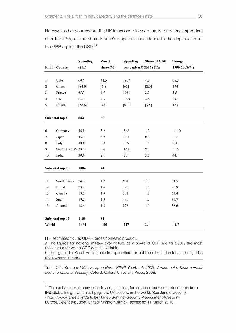
Chapter 2. The British military capability and the defence estate 36
However, other sources put the UK in second place on the list of defence spenders
after the USA, and attribute France’s apparent ascendance to the depreciation of
the GBP against the USD.15
Spending World Spending Share of GDP Change,
Rank Country ($ b.) share (%) per capita($) 2007 (%)a 1999-2008(%)
1 USA 607 41.5 1967 4.0 66.5
2 China [84.9] [5.8] [63] [2.0] 194
3 France 65.7 4.5 1061 2.3 3.5
4 UK 65.3 4.5 1070 2.4 20.7
5 Russia [58.6] [4.0] [413] [3.5] 173
Sub-total top 5 882 60
6 Germany 46.8 3.2 568 1.3 –11.0
7 Japan 46.3 3.2 361 0.9 –1.7
8 Italy 40.6 2.8 689 1.8 0.4
9 Saudi Arabiab 38.2 2.6 1511 9.3 81.5
10 India 30.0 2.1 25 2.5 44.1
Sub-total top 10 1084 74
11 South Korea 24.2 1.7 501 2.7 51.5
12 Brazil 23.3 1.6 120 1.5 29.9
13 Canada 19.3 1.3 581 1.2 37.4
14 Spain 19.2 1.3 430 1.2 37.7
15 Australia 18.4 1.3 876 1.9 38.6
Sub-total top 15 1188 81
World 1464 100 217 2.4 44.7
[ ] = estimated figure; GDP = gross domestic product. a The figures for national military expenditure as a share of GDP are for 2007, the most recent year for which GDP data is available. b The figures for Saudi Arabia include expenditure for public order and safety and might be slight overestimates. Table 2.1. Source: Military expenditure: SIPRI Yearbook 2008: Armaments, Disarmament and International Security, Oxford: Oxford University Press, 2008.
15 The exchange rate conversion in Jane’s report, for instance, uses annualised rates from IHS Global Insight which still pegs the UK second in the world. See Jane’s website, <http://www.janes.com/articles/Janes-Sentinel-Security-Assessment-Western-Europe/Defence-budget-United-Kingdom.html>, (accessed 11 March 2010).

Chapter 2. The British military capability and the defence estate 37
Over the last decade UK defence spending has steadily increased from £21,792bn
in 2000 to £35,320bn in 2008. By the MoD’s own standards the proposed budget
for 2010-11 will be 11% higher in real terms (after inflation) than in 1997 which
‘represents the longest period of sustained growth since the 1980s’.16 In fact, if
Armed Forces Pensions, War Pensions and Allowances are included then the
projected figure for 2010-11 reaches over £44bn.17 As a percentage of GDP,
however, defence spending has remained relatively constant at around 2.4%.
Despite the economic crisis of 2008 and its long-term implications for national debt,
it seems likely that the British government will go ahead with major procurement
projects. These include the two Future (aircraft) Carriers (already delayed and likely
to cost in the region of £5.2bn), up to 150 Joint Strike Fighters (£62m each), and
the planned replacement for Trident, the British nuclear deterrent (the complete
delivery system - missiles, warheads and submarines – is estimated to cost
between £15 - £20bn). It was undoubtedly the financial burden of commissioning
long-term projects such as these and fighting two major conflicts that led the MoD
to take steps to ‘manage a funding gap of £21 billion’.18 The recent Green Paper on
defence, produced in the absence of a long-overdue Strategic Defence Review,
largely avoids addressing these seemingly huge financial obstacles.19 With these
vast figures in mind it could be argued that the British government’s ambitions for
national defence and procurement have not yet adjusted to the economic realities
of life after the 2008 crash.20 In addition, MoD procurement strategies have long
been criticised for their apparent mismanagement and failure to anticipate the
changing nature of warfare since the end of the Cold War – or as one commentator
recently stated, ‘Britain always buys the wrong equipment at the wrong price for the
16 ‘Defence Spending’, Ministry of Defence, <http://www.mod.uk/DefenceInternet/AboutDefence/Organisation/KeyFactsAboutDefence/DefenceSpending.htm>, (accessed 11 March 2010). 17 Defence Plan, Including the Government’s Expenditure Plans 2008 - 2012, Ministry of Defence, The Stationary Office, June 2008. 18 Defence Equipment 2010: Sixth Report of Session 2009–10, House of Commons Defence Committee, The Stationery Office, February 2010, p.6 19 Adaptability and Partnership: Issues for the Strategic Defence Review, Ministry of Defence, The Stationary Office, February 2010. 20 For a more radical assessment of the future of the armed services see, Simon Jenkins, 'My once-in-a-generation cut? The armed forces. All of them.' Guardian 2010, p. 27.

Chapter 2. The British military capability and the defence estate 38
wrong wars’.21 These arguments are likely to continue at least until a new Strategic
Defence Review clearly states the aims of national defence in an era of economic
uncertainty.
2.4 . The defence estate
In addition to undertaking military operations at home and abroad, the MoD
manages a considerable amount of land and property across the UK, collectively
known as the defence estate. In fact, it is often claimed that military operation would
not be possible without the provision of a substantial training environment in the UK
and abroad. In this sense the domestic defence estate is an expression or a by-
product of national defence and warfare elsewhere. The MoD manages the defence
estate ‘in trust and on trust for the nation’, meaning that they have an obligation to
maintain it in line with an overarching plan for sustainable development and
ecological conservation.22 The apparent paradox of caring for an environment which
is systematically bombed, polluted or churned up by armoured vehicles has been
discussed in detail by Woodward,23 Doxford and Hill,24 Wright25 and most recently
by Dudley.26 The defence estate itself is a combination of freehold and leasehold
land; 239,000 ha (590,982 acres) or approximately 1% of land area of the United
Kingdom, a figure which has remained relatively static since the extensive
reorganisation after the Cold War.27 The MoD also has limited rights to use a further
133,000 ha (328,650 acres) of land around the UK bringing the combined area of
potentially militarised land to 372,000 ha (919,232 acres). Childs notes a marginal
decrease in military land ownership after 1991 but remarks on the increasing trend
to acquire rights and licenses to use land:
21 Julian Glover, 'Our defence policy is caught between pride and guilt', Guardian, Monday 22 March 2009, p.30. 22 The Defence Estate Strategy 2006: In Trust and On Trust, Ministry of Defence, 2006. 23 Rachel Woodward, 'Discourses on Military Environmentalism', Centre for Rural Economy Working Paper 48, University of Newcastle Upon Tyne, 2000. 24 David Doxford, and Tony Hill, 'Land use for military training in the UK: the current situation, likely developments and possible alternatives', Journal of environmental planning and management, 41 (3), 1998, pp.279-97. 25 Wright, The village that died for England. 26 Marianna Dudley, ‘A Fairy (Shrimp) Tale of Military Environmentalism: The ‘Greening’ of Salisbury Plain’, in Militarized Landscapes: From Gettysburg to Salisbury Plain, eds. Tim Cole, Chris Pearson, Peter Coates, London: Continuum, 2010. 27 See Defence Analytical Service Agency statistics at: <http://www.dasa.mod.uk/modintranet/UKDS/UKDS2009/c6/table602.html>, (accessed 9 June 2010).

Chapter 2. The British military capability and the defence estate 39
Rights and licenses are usually taken out for a period of 10 years: the MoD
may not possess the freehold but it has the full rights to the use of that land.
In effect, the purchase of rights rather that freeholds or leaseholds enables the
MoD to acquire land cheaply and often without the aggravation of a public
enquiry. It also enables the military estate to be managed with a degree of
flexibility in order to react to changes in defence requirements.28
The increase from 103,400 ha in 1990 to 133,000 ha in 2009 marks a subtle but
significant change in land acquisition strategies. It also calls into question the logic
of permanent freehold ownership, particularly in a time when the nature of military
operations remains uncertain.
Despite being subjected to intense military activity such as bombing and heavy
armoured vehicle training, much of the ‘rural’ training estate is relatively
undeveloped and has been spared the effects of modern agriculture. Subsequently,
82,970 ha (205,023 acres) have been designated as Sites of Special Scientific
Interest (SSSIs) which if combined, would be an area twice the size of the Isle of
Wight.
The defence estate can be better understood in terms of service-specific sites:
there are currently 63 RAF stations (19 of which are flying stations), three major
naval bases (HMNB Portsmouth, HMNB Devonport, Plymouth and HMNB Clyde),
14 major Army Training Areas (ATA) (Kirkcudbright, Garelochhead, Otterburn,
Warcop, Catterick, Castlemartin, Sennybridge, Dartmoor, Salisbury Plain, Lydd,
Hythe, Stanford, Longmoor and Aldershot), 37 minor training areas (many of which
are considerable in size) and numerous ranges, camps, accommodation and
administration facilities. Figure 2.3 below shows the general distribution of training
sites across the UK and the division of the country into seven administrative
districts. The map does not include the numerous airfields used for training or sites
leased to the MoD for temporary use.
The ‘built’ environment of the defence estate is harder to quantify because the
notion of a military ‘site’ is an ambiguous term. The MoD, For instance, lists 548
sites in its 2009 rationalization audit but the number of individual Service Family 28 Childs, The military use of land, p.212.

Chapter 2. The British military capability and the defence estate 40
Accommodation (SFA) units across the UK is in the region of 50,000.29 To
complicate matters further, many of the properties in England were sold to
Annington Homes Limited (AHL) in 1996 and leased back to the MoD as part of a
Private Finance Initiative (PFI).30 There are also numerous administration, storage
and infrastructural buildings, and many other sites which are under so-called ‘care
and maintenance’ orders (still owned but not actively used by the MoD or the armed
services).
29 For a comprehensive list of MoD-owned sites see Annex A of ‘The Defence Estate Development Plan’ Ministry of Defence , 2009, <http://www.mod.uk/NR/rdonlyres/A8806EE6-7A77-4998-BC89-B9466190A85D/0/DEDP09_annex_a.pdf>, (accessed 5 March 2010). 30 Defence Estate Development Plan 2009, Ministry of Defence, 2009, p.16.

Chapter 2. The British military capability and the defence estate 41
Figure 2.3. Defence Training Estate: Training Area and Ranges. Crown Copyright, Ministry of Defence 2009. 31 31 Map source: <http://www.mod.uk/NR/rdonlyres/6553E496-F00E-4317-A58A-3B6CCB7E3379/0/dte_map_uk.pdf>, (accessed 9 June 2010)

Chapter 2. The British military capability and the defence estate 42
There are significant modernisation and development projects underway across the
defence estate: Projects Allenby for Salisbury Plain and Connaught for Aldershot are
major infrastructural initiatives designed to address seriously depleted standards in
accommodation and services at these garrisons. At Tidworth garrison on Salisbury
Plain, for instance, accommodation was in 1984 ranked ‘with the poorest to be
found within the NATO Alliance’ and at Aldershot ‘a large proportion of the
infrastructure is in inadequate condition due to the poor quality of the original
structures and a lack of investment’.32 Both Allenby and Connaught are being
undertaken by Aspire Defence Limited as a PFI worth £8bn over a 35 year period.
These projects amongst others will define a new category of military base in the UK:
the ‘super garrison’ - existing sites which are greatly expanded and modernised to
accommodated additional troops returning from bases in Germany. At St Athan in
the Vale of Glamorgan, the MoD plans to build a joint service Defence Technical
College and Aerospace Business Park which will provide training for up to 4,500
students in a range of engineering, communication and aeronautical subjects. This
single facility will replace a number of military institutions around the UK as part of
an ongoing rationalization of the defence training estate. Here the PFI is undertaken
by Metrix (a consortium of defence and educational organisations including QinetiQ,
Sodexo, Raytheon, Nord Anglia Education, EDS, City & Guilds and the Open
University) and is valued at approximately £12bn. This project, latterly known as
‘Package 1’ of the Defence Training Review (described below) has seen
considerable delays due in no small part to the fact that ‘debt is more expensive
[after the global financial crisis] and Metrix's ability to offset rising costs with land
sales has diminished’.33 For a full list of current PFIs see Appendix 2.1.
The gradual demilitarisation, rationalisation and subsequent development of defence
sites since the end of Cold War has had surprisingly little effect on the aggregated
total area of land used by the military which remains static at 1% of the UK land
area. In France, however, where the total land area is over twice that of the UK, the
32 For more information see ‘Project Histrory: A brief history of Project Allenby/Connaught’, Ministry of Defence, 2010, <http://www.mod.uk/DefenceInternet/AboutDefence/WhatWeDo/DefenceEstateandEnvironment/AllenbyConnaught/ProjectHistory.htm>, (accessed 16 March 2010) 33 Karl West, 'Credit Crunch hits £11bn Forces deal after development land value plummets', The Daily Mail, 12th September 2008.

Chapter 2. The British military capability and the defence estate 43
defence estate is in the region of 110,932, almost exactly half the size of Britain’s
domestic estate.34 With its comparable military capability and almost identical
defence budget, France seems able to conduct military training and national
defence on a much smaller area of domestic land. In addition, France is
accelerating a process of base closure, shutting down 50 smaller garrisons and
facilities scattered around the country, reducing land forces to 88,000, and creating
11 larger, joint-service ‘experimental’ bases.35 France’s radical defence reforms are
determined by economic necessity and a practical realisation that a scattered
distribution of sites across the country no longer makes strategic or economic
sense. This concept mirrors the MoD’s (as yet unrealised) desire to have fewer,
larger bases and create a more streamlined and rapidly deployable force. Despite
these aims there will be, according to the MoD ‘little scope to reduce the existing
UK training estate in the near term, as it will continue to be required to support the
delivery of military capability, despite the increasing use of synthetic
environments’.36
Not included in official data for the size of the defence estate are the low flying
zones, Air Tactics Areas (ATA) and volumetric Danger Areas which are regularly
used by the armed services for training and national defence. Some of these blocks
of space are vast in size and account for a considerable amount of UK sovereign
airspace. Much of this thesis will be devoted to analysing these spaces as products
of military activity and processes.
In addition to what amounts to nearly a million acres of land in the UK, the defence
estate has significant holding in Germany (1,129 ha), Kenya (137,959 ha), Cyprus
(5,347 ha), the Falkland Islands (33,996 ha), Canada (25,900 ha), and Gibraltar (131
ha) with the use or control of other major training facilities in Belize, Nepal, Poland,
Norway, Singapore, Ascension Island, Brunei, Diego Garcia, Oman, Iraq and
34 Woodward, Military Geographies, p.13. 35 Projet de loi relatif à la programmation militaire pour les années 2009 à 2014, French Senate, <http://www.assemblee-nationale.fr/13/dossiers/programmation_militaire_2009-2014.asp>, (accessed 9 June 2010). See also, The French White Paper on defence and national security, Ministère De La Défense, <http://www.ambafrance-ca.org/IMG/pdf/Livre_blanc_Press_kit_english_version.pdf>, (accessed 9 June 2010), p.9. 36 Defence Estate Development Plan 2009, Ministry of Defence, p.3.
Chapter 2. The British military capability and the defence estate 44
Afghanistan.37
Despite this extensive use of land across the UK and abroad there continues to be
an ongoing reluctance to relinquish or reduce the defence estate, with the army
being the most vocal in its defence of land for training. The difficulty of balancing
training requirements against the use of land is further complicated by changing
operational directives determined by government. Therefore the ‘right’ amount of
land for training is only ever nominally measured against a military capability of the
‘right’ size. These, in turn, are measured against foreign policies with optimistic
projections but wildly unpredictable outcomes. The debate about size versus need,
as Woodward points out, is political and any study of military geography will
ultimately call into question the function and value of the armed services in the
national and global environments.38
2.5 . Defence land and the Anglo-American relat ionsh ip.
A legacy of the Second World War and Cold War is the continued presence of the
American military on UK soil. Seven RAF stations are permanently used by the
United States Air Force (USAF) including RAF Alconbury (Cambridgeshire), RAF
Croughton (Oxfordshire), RAF Feltwell (Norfolk), RAF Lakenheath (Suffolk), RAF
Fairford (Gloucestershire), RAF Mildenhall (Suffolk) and RAF Menwith Hill (North
Yorkshire). RAF Welford (Berkshire) is apparently one of the largest munitions stores
in Europe and is still used to store USAF bombs for US aircraft at forward bases
such as RAF Fairford.
Since the first deployment of Nuclear weapons on UK soil in September 1954,
many US bases around the UK have been the focus of sustained protest by anti-
nuclear campaign groups including, most prominently, the Woman’s Peace Camp
at Greenham Common (1981-2000). These campaigns were successful at drawing
attention to the fact that the Anglo-American ‘special relationship’ effectively turned
the UK into one of the principal targets for the Soviet nuclear arsenal.39 In this
37 ‘The Defence Estate Development Plan’ Ministry of Defence , 2009, <http://www.mod.uk/NR/rdonlyres/A8806EE6-7A77-4998-BC89-B9466190A85D/0/DEDP09_annex_a.pdf>, (accessed 5 March 2010). 38 Woodward , Military Geographies, p.20. 39 There is a growing distinction between diplomatic and military aspects of the ‘special relationship’ between the UK and the USA. While both countries remain closely connected by interdependent intelligence networks, compatible battlefield technologies and a raft of

Chapter 2. The British military capability and the defence estate 45
respect the geographies of US military land use across the UK were (and perhaps
still are) also those of profound anxiety, suspicion and potential annihilation.
However, sometime in the early twenty-first century all US nuclear warheads were
apparently removed from USAF bases in the UK (although no official announcement
has been made on the matter). This did not end the US military presence nor the
use of Britain as a strategic ‘bridge’ between the US and continental Europe, the
Middle East and Asia.40
The US Pentagon lists 25 sites across the UK in which there are 9,304 serving US
military personnel and 604 US civilians.41 Many of these are currently engaged in the
monitoring of Signal Intelligence (SIGINT) from sites such as RAF Menwith Hill in
Yorkshire and the Government Communication Headquarters (GCHG) in
Gloucestershire. Shrouded in secrecy and misinformation, SIGINT is the gathering
of digital and electromagnetic information using various forms of surveillance
technology to monitor and filter communication between individuals or groups.
Unlike the pronounced USAF presence in the UK, the geographies of the UK-USA
Security Agreement (actually a SIGINT data sharing agreement between the USA,
UK, Australia, Canada, and New Zealand) are largely hidden in the landscape or
tangled within communication infrastructures. Tracing and connecting their routes
across the landscape is an ongoing act of detective work undertaken by
surveillance researchers who diligently identify exotic transmission masts or note the
particular direction of microwave dishes. Some, like Steve Wright, uncover
transnational systems of secret and possibly illegal eavesdropping apparatus,42
while others like David Murakami Woods map the connections between military, civil
and commercial elements of the ‘surveillance society’, all of which have some form
mutually binding defence agreements, the UK periodically shows unease at being perceived as subservient to the US administration. The Obama administration currently seems to take a less sentimental view of the relationship, and the UK for their part are keen to play down any hint of automatic acquiescence. 40 Hans Kristensen, ‘U.S. Nuclear Weapons Withdrawn From the United Kingdom’, Federation of American Scientists, 2008, <http://www.fas.org/blog/ssp/2008/06/us-nuclear-weapons-withdrawn-from-the-united-kingdom.php>, (accessed 18 March 2010). 41Department of Defence, Base Structure Report – Fiscal year 2009 Baseline, US Department of Defence, <http://www.acq.osd.mil/ie/download/bsr/BSR2009Baseline.pdf>, (accessed 3 March 2010). 42Steve Wright, 'The ECHELON Trail: An Illegal Vision.' Surveillance and Society, 3/2/3, <http://www.surveillance-and-society.org/journal.htm>, 2005, (accessed 22 March 2010).

Chapter 2. The British military capability and the defence estate 46
of geographical or spatial presence.43
SIGINT does have a small number of notable, ‘iconic’ sites in the British landscape;
RAF Menwith Hill, for instance, with its conspicuous scattering of white radomes, is
run by the US National Security Agency (NSA) as part of the UK-USA Security
Agreement.44 This peculiarly organic-looking facility seems to sprout new fungoid
growths with each passing year, and at the last count there were over 25 white
geodesic radomes hiding a variety of radars and antennas. RAF Feltwell in Norfolk
has also been linked to various SIGINT activities but is principally known for its
previous function as an outpost of the USAF's 5th Space Surveillance Squadron
(5SSS) which tracked the physical location of satellites orbiting the Earth. Figure 2.4
shows the US military soldiers at Feltwell on the 4th of July, a day which annually
transforms 137 hectares of East Anglia into a place of American celebration and
independence. Behind the servicemen on the fire truck three radomes can be seen,
each housing a Deep Space Tracking System (DSTS) or a Low Altitude Space
Surveillance (LASS) system, technologies whose exact function is still very much
open to speculation.
43 David Murakami Wood (ed), 'A Report on the Surveillance Society: for the Information Commissioner by the Surveillance Studies Network', Surveillance Studies Network, <http://www.libertysecurity.org/IMG/pdf_Surveillance_society_full_report_final.pdf>, 2006 (accessed 22 March 2010). 44 RAF Menwith Hill and the UK/USA Security Agreement is often variously connected to the global eavesdropping system known as Echelon. According to the Scientific and Technological Options Assessment programme (STOA) of the European Parliament, ‘within Europe, all e-mail, telephone and fax communications are routinely intercepted by the United State National Security Agency, transferring all target information from the European mainland via the strategic hub of London, and then by satellite to Fort Meade in Maryland via the crucial hub at Menwith Hill in the North Yorkshire moors in the UK’. See Steve Wright, ‘An Appraisal for Technologies of Political Control, European Parliament Directorate General for Research (Dir. B) STOA Programme, Luxembourg, 1998’, in; Paul Todd and Jonathan Bloch, Global intelligence: the world's secret services today, London: Zed, 2003, p.45.

Chapter 2. The British military capability and the defence estate 47
Figure 2.4. RAF Feltwell, Norfolk, UK. American Soldiers stand in front of three space surveillance radar domes. Photograph: Matthew Flintham.
The continued use of British land for US training and operations is a reflection of the
close strategic relationship between UK and US governments. The long history of
SIGINT, which reached fruition during the Second World War and continues to this
day, is one which sometimes runs contrary to Britain’s alliances with Europe and
the EU. Martin Rudner argues that SIGINT is at the heart of US/UK intelligence-
sharing, and as such pulls the UK away from a closer association with the EU,
leading to competing and adversarial intelligence communities.45 In this sense, the
UK continues to be torn between its alliance with the US and that of ‘Old Europe’,
as US Secretary of Defense Donald Rumsfeld pejoratively described those
members of the EU (principally France and Germany) that did not wish to follow it
into Iraq.
The Anglo-American ‘special relationship’ is currently based on the assumption that
‘in all but minor affairs, little can be accomplished [by the UK] without help from the
45 Martin Rudner, 'Britain Betwixt and Between: UK SIGINT Alliance Strategy's Transatlantic and European Connections', Intelligence and National Security, Vol.19, issue 4, 2004.

Chapter 2. The British military capability and the defence estate 48
Americans, who will participate only if they lead’.46 This admission by Defence
Secretary Geoff Hoon in 2003 reflected the Blair government’s desire to maintain an
active and interventionist foreign policy despite limited economic means. Today,
there seem to be signs of a change in attitude, a realisation of sorts, that the UK’s
military ambition ought to be balanced against its immense national debt and a
future of economic austerity.
2.6 . Bridg ing the geographies o f train ing and confl ict
The direct links between the domestic British landscape and military missions
around the world has changed considerably since the end of the Cold War. Britain’s
national defensive posture is no longer focused exclusively on the Soviet Bloc
states. Russia remains an erratic and volatile influence, but the balance of
international power has pitched sharply in favour of the USA, and states such as
China, India and Brazil are economically and militarily ascendant. The residual
effects of September 11th 2001 and the rise in Islamic militancy has led many world
powers to recalibrate their national security strategies and their geopolitical
affiliations.
For Britain, the most significant deployments in recent years have been in
Afghanistan as part of the UN authorised, NATO led International Security
Assistance Force (ISAF), and in Iraq as part of the Coalition Force authorised under
UN Security Council Resolution 1546. Afghanistan continues to place considerable
strain on the military establishment and successive British governments. British
service fatalities for the ongoing operation in Afghanistan reached 261 in early 2010
and the number of personnel wounded in action stands at 1,126. According to the
lowest credible estimates, the number of civilians killed during the conflict stands at
8,309 (as of February 2010).47 The British military mission in Iraq officially ended in
April 2009 with a total of 179 UK service personnel killed in action, and for the
period between January 2003 and July 2009 the total wounded reached 315.48 At
the time of writing (April 2010), documented civilian deaths from violence in Iraq are
46 Michael Hancock, ‘Transatlantic security challenges’, European Security and Defence Assembly, December 2007, <http://www.assembly-weu.org/en/documents/sessions_ordinaires/cr/2007/cr07.php>, (accessed 9 June 2010). 47 ‘Casualties in Afghanistan and Iraq’, Unknown News, <http://www.unknownnews.net/casualties.html>, (accessed 2 March 2010). 48 Defence Analytical Services and Advice (DASA), Ministry of Defence, 2010.

Chapter 2. The British military capability and the defence estate 49
between 95,822–104,529 (minimum and maximum estimates by Iraq Body
Count).49 According to the Human Security Report Project, the financial cost for the
UK of both conflicts for 2009-10 alone, is in the region of £4.37bn.50 Other sources
put the total cost of both wars (for the period 2001-09) at £14bn.51
However tragic and highly contentious these wars may be, they sometimes seem
far removed from everyday live in the UK. Cultural difference and geographical
distance can easily become obstacles to understanding the very real connections
between the British landscape and military operations abroad. Zones of conflict and
natural disaster such Afghanistan, Iraq and Haiti are points of convergence for
military personnel and equipment from countries around the World. A continuous
supply chain feeds these wars and relief efforts, connecting the domestic
landscapes of training and defence to these places of danger, violence and faltering
security. According to a National Audit Office report, Operation Telic in Iraq required
‘the deployment of significant military capabilities from all three armed services
including some 46,000 personnel, 19 warships, 14 Royal Fleet Auxiliary vessels,
15,000 vehicles, 115 fixed-wing aircraft and nearly 100 helicopters’.52 This initial
mass-mobilisation would be supported by an almost constant exchange of troops
and equipment via ‘air bridges’ between RAF Lyneham and Brize Norton in the UK
and Baghdad International Airport. The same stations also served the concurrent
and rapidly escalating conflict in Afghanistan with huge C-17 and C-130 transporter
planes making several journeys to Kandahar Airport every week. Sometimes fast
jets heading to the war zones from bases in the UK would be accompanied by
Tristar air-to-air refueling tankers from Brize Norton. USAF B-52 bombers flew from
RAF Fairford in Gloucestershire leading the ‘shock and awe’ barrage of Baghdad in
2003. America’s desire to spread democracy in the Middle East also saw RAF
Fairford becoming a forward base for B-2 stealth bombers - but not before a multi-
million dollar refit of the entire aerodrome including new sunken fuel bowsers, an air-
49 ‘Documented civilian deaths from violence’, Iraq Body Count (IBC), <http://www.iraqbodycount.org/database/>, (accessed 2 March 2010). 50 ‘Britain's War Costs In Iraq And Afghanistan Triple’, Afghanistan Conflict Monitor, <http://www.afghanconflictmonitor.org/2009/07/british-troops-expand-major-afghan-operation-.html>, (accessed 2 March 2010). 51 Richard Norton-Taylor, 'UK military costs in Afghanistan and Iraq soar to £4.5bn', Guardian, Thursday 12 February 2009. 52 'Operation TELIC - United Kingdom Military Operations in Iraq', National Audit Office, The Stationary Office, December 2003, p.1.

Chapter 2. The British military capability and the defence estate 50
conditioned hangar and a Stealth Coating Dock.53 The B-2’s have since left Fairford,
perhaps because the once imminent plans to remove Iran’s nuclear capabilities
have receded, if only slightly.
The transporter planes that carry troops and cargo to war zones are also charged
with the grim task of bringing back the bodies of British soldiers killed in action. RAF
Lyneham has become the point of repatriation for these soldiers and the beginning
of a journey across a new landscape of mourning. From Lyneham, a funeral cortege
proceeds down the A3102 and through the market town of Wootton Bassett and
on to the John Radcliffe Hospital in Oxford for inspection by the defence coroner.
Only then are the bodies released to the families of the deceased. For nearly three
years the people of Wootton Bassett have lined the streets to pay their respects to
the fallen soldiers but more recently the town has become a place of apparent ‘grief
tourism’ and the focus of a much broader debate about the respect due or owed to
the armed services.54 Media trucks and camera crews now fill the streets on ‘repat’
days along with people from all over country mirroring what some have called the
‘Diana’ effect; a disproportionate outpouring of grief that has its roots in the
complexities of the British national character. It is almost as if the British media’s
appetite for stories of grief and stoic patriotism engendered by the conflicts in Iraq
and Afghanistan have been distilled into one manageable location. The events have
also been perceived both as a counterpoint to the apparent rise of British Islamic
extremism and a public apathy towards the plight of soldiers fighting abroad.
Curiously, the Wootton Bassett phenomenon would never have occurred had it not
been for the diversion of repatriation flights to RAF Lyneham after the runway at
Brize Norton was closed briefly in 2007 for resurfacing.
2.7 . Defence and the sovere ign terr ito ry
Despite the gradual switch from a defence posture to a more expeditionary,
interventionist policy, the armed services are still actively required to protect against
national invasion. The very act of training is perceived as a form of defence: the
53 Alan Turnbull’s recent analysis of RAF Fairford includes accessing planning application documents from Cotswold District Council and close aerial photography of the site. See, ‘RAF Welford and RAF Fairford – its new B-2 Stealth Bomber role’, Secret Bases, <http://www.secret-bases.co.uk/secret4.htm>, (accessed 24 March 2010). 54 Will Pavia, ‘Wootton Bassett fears being in front line of ‘grief tourism’’, The Times, 29th July 2009.

Chapter 2. The British military capability and the defence estate 51
obvious displays of simulated warfare and military might are considered as tacit
forms of deterrence. Major training exercises are regularly carried out at specified
zones in UK waters, particularly in the North Sea (East Coast SXA), the Hebrides
(West Coast SXA) and Cape Wrath. RAF fast jets fly hundreds of sorties a year
across the low fly zones of the UK and the Air Tactics Areas around the coasts.
These conspicuous displays of power are complemented by ASACS, which
monitors airspace for incursion and provides an early warning system for the UK
territory. ASACS also controls the Quick Reaction Alert (QRA) force; a squadron of
Typhoons from RAF Coningsby in Lincolnshire and Tornados from RAF Leuchars in
Fife – all of which are on-call 24 hours a day and can be deployed in minutes. The
QRA force was scrambled 20 times during 2009 to intercept Russian aircraft in or
near UK airspace.55 ‘Incursions’ by Tupolev TU-160 bombers are increasing in
number and generally coincide with Russian training exercises and missile tests in
the North Sea and Arctic Ocean. These incidents are also seen as an expression of
escalating diplomatic tensions between Russia and the UK following the poisoning
of ex-Russian spy Alexander Litvinenko in London in November 2006. These
apparent incursions highlight the ambiguous nature of training exercises and their
function as potential gestures of intimidation. They also prove that the remote,
invisible boundaries of state territory can often be the focus of sustained tension
and antagonism between nations. Appendix 2.2 shows how Airborne Warning and
Control System (AWACS) aircraft are predominantly deployed around northern
sovereign airspace.
2.8 . The Brit ish nuclear capabi l i ty
The UK is one of nine nations known or thought to possess nuclear weapons along
with Russia, USA, China, France, North Korea, Pakistan, India and Israel. Whilst the
exact number of warheads in the British arsenal has not been disclosed, SIPRI puts
the figure in the region of 185 (160 operationally available at any one time).56 Having
dispensed with its ground and air-launched systems during the last two decades
the UK now has a single delivery system: four Vanguard class, nuclear powered
submarines equipped to carry nuclear weapons, all based at HMNB Clyde, 40km
(25 miles) west of Glasgow, Scotland. At least one submarine is deployed at all
55 Richard Norton-Taylor, 'Cold War Echo - RAF Scrambles to Intercept Russians', Guardian, Thursday 25 March 2009. 56 Stockholm International Peace Research Institute, SIPRI Yearbook 2009: Armaments, Disarmament and International Security, OUP, 2009, p.359.

Chapter 2. The British military capability and the defence estate 52
times as part of a posture known as Continuous At Sea Deterrence. The weapons
themselves are Trident II (D-5) Submarine Launched Ballistic Missiles (SLBM), 58 of
which are leased from the US under a system of ‘mingled asset ownership’ which
are;
[…] randomly selected from the stockpile at the US Navy’s Trident facility in
Kings Bay, Georgia, and loaded onto British submarines. The Submarines
then go to the Royal Naval Armaments Depot at Coulport, Scotland, where
the missiles are fitted with warheads designed and manufactured at the
Atomic Weapons Establishment (AWE), Aldermaston, England.57
A secretive institution, the AWE is located at two sites in Berkshire: AWE Burghfield
(91 ha) where the nuclear warheads are assembled and maintained, and the
headquarters at AWE Aldermaston (303 ha), a sophisticated research and
development facility which has been the focus for a sustained campaign against
nuclear weapons. AWE employs around 4,500 staff and 2,000 contractors and is
managed by AWE Management Limited (AWE ML), a consortium of three equal
shareholders: Serco, Jacobs Engineering Group and Lockheed Martin.
For political and economic reasons the British government is currently under
sustained pressure to rethink its nuclear strategy. In its 2009 yearbook, SIPRI refers
to a letter in The Times newspaper in which three senior military figures not only
challenge the need for a nuclear deterrent but question its current validity as a
supposedly ‘independent’ capability which, in fact, relies on the USA ‘for the
provision and regular servicing of the D5 missiles’.58 Further criticism surrounds
AWE ML and the fact that two American corporations, Jacobs and Lockheed
Martin, ‘now own two-thirds of the UK’s sole nuclear weapons laboratory which has
implications for the independence of the UK’s nuclear deterrent’.59 In this respect,
the Anglo-American relationship reaches to the very heart of the UK’s military
capability and has been accused of undermining the very foundations of the
57 Stockholm International Peace Research Institute, SIPRI Yearbook 2008: Armaments, Disarmament and International Security, Oxford: Oxford University Press, p.359. 58 Lord Bramall (Field Marshal), Lord Ramsbotham (Gen.) and Beach, H. (Gen.), 'UK does not need a nuclear deterrent', Letter, The Times, 16 Jan. 2009. 59 Stephen Jones, Recent developments at the Atomic Weapons Establishment, House of Commons Note, 24 March 2009), p.13

Chapter 2. The British military capability and the defence estate 53
Nuclear Non-Proliferation Treaty in which technology sharing between nations is not
permitted.60 The privatisation of nuclear weapons production in the UK to American
corporations (a process which bypassed parliamentary debate) continues a tradition
of secrecy and ‘cloak and dagger’ politics. The process by which the UK struggles
to justify and pay for its flagging nuclear capability now resembles nothing less that
a fictional narrative, a satire in which the control of a country’s deadliest weapons
are handed to a foreign consortium in the name of efficiency and rationalisation. The
MoD claims to hold a ‘special share’ which will maintain and protect the UK’s
strategic interests and adds that ‘It is the UK government, not AWE, that sets the
UK's nuclear policy. UK sovereign interests remain protected at all times, as does
the independence of the UK deterrent. The safe operation of AWE will remain
unaffected by the sale’.61 The nature of this ‘special share’ remains a mystery and
the British government may find its strategic interests being eroded or defined by
US corporate interests.
2.9 . Strateg ies, reviews and papers
This chapter has outlined some of the key aspects of the British military capability
as it stands at the beginning of 2010. All these factors (and many others) impact on
the geographies of the defence estate, the domestic habitat of the British armed
services. The next Strategic Defence Review (SDR), scheduled for 2010, will no
doubt include recommendations for changes in the size or arrangement of the
defence estate.62 These are likely to include a continuation of the ‘larger, fewer sites’
ethos described above, but this is unlikely to mean that less land will be used for
training given the recent dependence on infantry-based strategies in Iraq and
Afghanistan. If the SDR of 1998 set out the major procurement projects for the
future (super-carriers, Typhoon Eurofighter jets, etc.) and the shift towards an
expeditionary posture for the 21st century, the Defence White Paper of 2003 was a
shocked response to the instabilities caused by global terrorism and the events of
11 September 2001 in particular. The latter also outlined major strategies for
60 Ben Russell, 'Secret nuclear sell-off storm', The Independent, Saturday, 20 December 2008. 61 Stephen Jones, Recent developments at the Atomic Weapons Establishment, p.14. 62 The last Strategic Defence Review, written in 1998, mentioned a number of major building sales since 1990 totalling £700m and identified a number of likely sales worth a further £700m. However, the review could not see any scope for reduction in training estate land. See, Strategic Defence Review: Modern forces for a modern world, Ministry of Defence, July 1998.

Chapter 2. The British military capability and the defence estate 54
streamlining the defence estate including the Core Site Rationalisation Initiative.63
But it was the Defence Training Review (DTR) of 2001 that began the most
comprehensive rationalisation and integration of the defence estate since the end of
the Cold War. This was in response to the surprising admission that the ‘training
estate, despite earlier rationalisations, is still too large’,64 and that ‘Site running costs
typically represent about 40-50% of the total costs of a training establishment’.65
We can assume from this that the built environment of the defence estate is more
costly to run than MoD-owned land and training ranges. In this respect there is
actually very little impetus to reduce defence land, particularly when it can be a
source of rent revenue from agriculture or industry. Hindsight has shown us that the
defence estate may well have been too big but the military has since shown little
inclination to reduce the total area of MoD-owned land.
The rationalisation programme outlined in the DTR of 2001 barely hints at the scale
of privatisation planned for the defence training sector – although it does suggest
that training will become a ‘customer driven process’. Later the programme will be
split into two packages under a system of Public Private Partnerships (PPP) and
Private Finance Initiatives (PFI) worth £11bn. Package 1 (training for
communications, engineering and information systems) will gather a number of
existing military educational institutions in one site, a new Defence Technical College
at St Athan in Wales. Package 2 (training for Personnel Administration, Logistics,
Police and Guarding, Security, Languages, Intelligence and Photography) has, at
the time of writing, been unable to find private sector bidders for the contract and
has therefore stalled. The effectiveness of PPPs, PFIs and privatisation on the
defence estate will be addressed in Chapters 8, 9 and 10.
2.10. Conclusions
If there is currently a sense in which the military are pulled in so many directions by
different global commitments and competing alliances, there is also a feeling that
the defence estate is the home, the geographical bedrock of the military institution.
Over the last two decades the MoD has adjusted to change by following the logic of
63 Defence White Paper: Delivering Security in a Changing World, Ministry of Defence, The Stationary Office, December 2003, p.16. 64 Modernising Defence Training: Report of the Defence Training Review, Ministry of Defence 2001, p.4. 65 Ibid., p.34.

Chapter 2. The British military capability and the defence estate 55
laissez-faire economics strategies and by embracing the private sector, a process
which has subtly changed the militarised landscape and nature of military space
itself. What follows is an examination of that transformation: the conservative military
institution that was believed to be so integral to the British cultural landscape has
become a ‘capability’, one that now reveres digital and social networks, remote
technologies and a strives for ‘total situational awareness’. Above all, however, it
has become something that covets the apparent dynamism of the corporate sector.
To assess the effectiveness and the side-effects of this transformation it is
necessary to choose a beginning. The following chapter will therefore assess the
development of the defence estate throughout the 19th and 20th centuries as military
regiments embed themselves in the landscape, deriving their identities from places
and regions, and enclosing wider and wider parts of the landscape for their own
purposes.

Chapter 3. Land, space and transformation in the British defence estate 56
Chapter 3
Land, space and transformation
in the Brit ish defence estate.
Figure 3.1. World War Two air traffic control tower. RAF West Raynham, Norfolk. Photograph: M. Flintham

Chapter 3. Land, space and transformation in the British defence estate 57
3.1 . Introduction
A walk in the British countryside can reveal a high concentration of military detritus,
so much, in fact, that the landscape sometimes appears to have been materially
forged in conflict. The processes by which we choose to erase or spare these
vestiges of war and defence often seems arbitrary, when so many seem to be of
obvious historical importance but do not fit into the narrow parameters of ‘heritage’.
There are many more ruins from the First, Second and Cold wars than can possibly
be spared. There is, however, a strong argument for documenting as much as
possible as quickly as possible. The cataloguing of over 20,000 military sites across
the UK by the Defence of Britain Project, for instance, records a period in which ‘11
million acres (20% of the total land surface of Great Britain) was under some form of
military control’ and that there was ‘a ‘totality of defence’ over the entire
landscape’1 Already, most of these temporary and hastily constructed defences
have disappeared, quite understandably removed, torn down or ploughed back into
the land. Recording their remnants, however, or the memories of those who used
them is essential to understanding a landscape whose character during the 20th
century was fluid, temporary, and unquestionably more militarised than it is today.
There is also a case for understanding the incremental preparation for war in peace
time, since the transformation of the British landscape during the 20th century has
much more to do with military training and passive defence than is readily accepted.
Defence, in this sense, is still a productive process which alters and shapes the
environment in ways not dissimilar to industrialisation, urbanisation and intensive
agricultural cultivation. However, it is a form of production determined, in part, by
functional necessity and a ‘violence sometimes latent, or preparing to explode’.2
The residual effect of warfare has also created a permanently militarised training
environment, a fragmented but sizable collection of land, buildings and holdings
scattered across the UK, known today as the defence estate. The purpose of this
chapter then is to trace the development of the defence estate, both in war and in
peace. Rather than embark on a comprehensive, acre-by-acre history of the British
defence estate (an endeavour completed so thoroughly by John Child and whose
1 For a comprehensive archaeological survey of militarised sites from the 20th century see, Defence of Britain Project, Council for British Archaeology, <http://www.britarch.ac.uk/cba/projects/dob/>, (accessed 20 May 2010). 2 Lefebvre, The Production of Space, p. 227.

Chapter 3. Land, space and transformation in the British defence estate 58
work will be referred to throughout), this chapter will study three key themes or
spatial types: the barracking system as a way of strategically placing and
segregating troops; the extensive use of land for training; and the use of airspace
both as a vertical projection of sovereign territory and as a way of segregating
military activity in peace time. These themes are related and inseparably connected
but it is useful to identify how each influences the other and why. This chapter will
therefore build a picture of an estate that is shaped by warfare but also by an
almost constant preparation for war.
3.2 . Camps and barracks
AD 43 was the year the British Isles were first inscribed by the rectilinear enclosure,
the year when the circular fort was first challenged by the square camp. The four
hundred year occupation of the British Isles by the Roman Empire was driven by the
logic of territorial expansion, the acquisition of private property and the exploitation
of local resources by a force that was transparently militaristic in its appearance,
methods and bureaucratic structure. Its arrival also signalled the beginning of a new
type of warfare, one that was brutally effective and reliant on highly organised
standing armies and a strategy of establishing fortified linear frontiers. The Romans
also brought exotic technologies which, in the short term, were highly effective
against an adversary that was used to nothing more sophisticated than a sword,
arrow or slingshot. The incorporation of artillery weapons such as the ballista
(crossbow) and onager (catapult) with tried-and-tested strategies into siege warfare
had devastating consequences for the oval Iron Age palisade enclosure. By
contrast the Roman military enclosures (castrum) that began appearing across the
iron-age landscape were rectilinear in shape with timber walls and could be thrown
up in a matter of hours if need be.3
Several discernable types of Roman military enclosure have been identified.
Whether the enclosure has been classified as a fortlet, housing just a small number
of men, a temporary marching camp, a five to ten acre auxiliary garrison fortress or
a fifty acre legionary fortress, all conformed in most respects to a tried and tested
3 The term castra (hence castle, castillo, chateaux, etcetera), has its origin in primitive Latin, from kastrum meaning both to ‘cut’ and ‘separate’ (hence, castrate), and ‘entrench’ or ‘fortify’. This etymological lineage is the source of place names ending in –caster or -chester found in the English language. The sheer proliferation of such places in the United Kingdom is a testament to the impact of the Roman militarised landscape on the English language.
Chapter 3. Land, space and transformation in the British defence estate 59
template: all would be defined by a stone or timber-stake palisade and surrounded
by one or more V-shaped ditches. Larger forts had a gated entrance at each side
while smaller ones tended to only have only one or two. The logic of maintaining a
defensive presence seems at first to be undermined by the incorporation of multiple
entrances into the fort perimeter wall, but as Williams suggests, the Roman army
was essentially an offensive, not defensive force and would therefore have placed
more importance on the need to deploy troops quickly than to establishing a
restrictive siege-proof enclosure.4
Again, in contrast to the familial arrangement of buildings within the indigenous hill-
forts and camps (which would have developed over the course of numerous
generations), the internal plan of Roman forts and camps followed a formulaic
pattern: in the middle third of the site was the principia which housed the officers
and functioned as a headquarters. In this area, depending on the size of the fort,
there might also be a workshop, hospital, granary, bathhouse and storerooms. The
front and rear parts of the fort, known as the praetentura and retentura, housed
rows of vertically aligned barracks for troops. By contrast, the round or oval forts of
the indigenous Britons were designed to protect communities of loosely connected
families. The Roman fort was defined for one purpose: offensive warfare.
Although the systematised methods of Roman warfare were largely abandoned by
the Britons, Anglo-Saxons and Vikings, they re-emerged during the Enlightenment
as a paradigm, ‘as the ideal schema for discipline’.5 The appearance of the barrack
as part of the martial apparatus in the seventeenth and eighteenth century was one
example of a recourse to the ordered spaces and structures of classical antiquity,
the embodiment of power and control in the built environment. Prior to this,
however, the fashioning of the nation state under the Tudors saw a
conceptualisation of the military as an essentially national capability but one which
required subdividing into distinct functional types. Under Henry VIII, the combined
effects of a prolonged invasion crisis and the evolution of the Navy as a military
4 Geoffrey Williams, Stronghold Britain, Stroud: Sutton, 1999, p.59. This fits in with archaeological speculation that many Roman forts were either drawn-down, to use a modern phrase, or abandoned once a region had been stabilised and\or the local population had become sufficiently sympathetic to the Roman campaign. Troop units could then be redeployed to other regions or back overseas again. 5 Michel Foucault, Discipline and Punish, London: Penguin, 1991, p.146.

Chapter 3. Land, space and transformation in the British defence estate 60
institution led to purpose-built forts and blockhouses for gunners and porters being
positioned at strategic anchor points along the south coast.6 Existing castles were
also subdivided and adapted for residential functions. However, ‘the extent of
accommodation available did not allow anything resembling the common
perception of a barrack’.7 Although there are references later to semi-permanent
accommodation for soldiers during the Civil Wars,8 the barrack as a recognisable
architectural form appeared with the disbandment of the New Model Army and the
establishment of a core standing army under Charles II. An initial wave of barrack
building following a programme of fortification at the major naval ports of Tilbury,
Sheerness, Portsmouth and Plymouth was overseen by the Ordnance Office under
Dutch Chief Engineer, Sir Bernard de Gomme. Considered by many to be the
greatest military engineer of the seventeenth century, de Gomme standardised
ordnance building types, basing barrack designs on the military unit – a company of
six or more men. There was still a constitutional and public antipathy towards the
formation of a large standing army and their accommodation in purpose-built
barracks. As a consequence barrack building was still not widespread in England
despite a uniform growth in standing armies across Europe and sporadic hostilities
with France. The reasons for this were twofold. Firstly, the cost to the Whigs of
creating permanent accommodation for the army was seen as too great and
billeting still offered a convenient way of indirectly passing the costs ‘on to publicans
and the innkeepers (and hence the drinking public)’.9 The second reason was the
wars in Ireland: Cromwell’s conquest had created a volatile, highly contested and
heavily militarised environment, one which the English were not keen to replicate on
the mainland having tasted the efficiency of the New Model army some years
before. The ‘liberal view of the barracks, as the physical manifestation of a
potentially autonomous, anti-constitutional armed force’ or as a ‘nest for the
standing army’,10 also drew comparisons with Roman institutional militarism:
To prevent the executive power from being able to suppress […] armies
should come from the people […] as was the case with Rome till Marcus
6 Keith Feiling, A History of England, Trowbridge: Redwood Burn, 1975, p.368. 7 James Douet, British Barracks: 1600-1914, London: The Stationary Office, 1998, p.5. 8 David Papillon, A Practical Abstract of the Arts of Fortification and Assailing, London, 1645, ch.10. 9 Douet, British Barracks: 1600-1914, p. 42. 10 Ibid., p. 41.

Chapter 3. Land, space and transformation in the British defence estate 61
new-modelled the legions by enlisting the rabble of Italy […]. The military
power […] should be composed of natural subjects […] they should live
intermixed with the people; no separate camps, no barracks, no inland
fortresses should be allowed.11
The Hanoverian military of the eighteenth century was effectively a police force
indemnified against prosecution by the Riot Act of 1714 and was frequently called
on to suppress industrial disputes, popular rebellions and acts of civil disobedience.
The first Jacobite rebellion in the same year, saw Berwick-upon-Tweed granted a
defensible barrack designed by Nicholas Hawksmoor and big enough to house over
900 men as part of a counter-insurgency measure which also included barracks in
Bernera (Spey); Inversnaid (Sterlingshire); Kiliwhimen (in the Great Glen), and
Ruthven (Badenock). Fort Augustus, built by General Wade on the banks of Loch
Ness served as the headquarters for the British Army in the Highlands. The initial
failure of these forts and barracks to contain Prince Charles Edwards Stuart’s army
led to the construction of Fort George in the centre of the Highlands, a massive
bastioned traced complex built on a spit projecting into the Moray Firth near
Inverness. Capable of housing two battalions of 1,600 men, it was, at the time of
construction in 1753, the largest fortified works under British control. Fort George is
still used by the British Army and is home to the Black Watch (the 3rd Battalion the
Royal Regiment of Scotland). It is also a popular tourist destination and as such is
one of the few operational military bases open to the public.
Without doubt, the priority for the army and navy in the 18th century was the foreign
wars in France, the Low Countries, Germany and the colonies, and troops were
regularly embarking and returning to the main ports of Bristol, Plymouth,
Portsmouth, the Medway towns, Liverpool and Newcastle-upon-Tyne. The surging,
unruly mass of troops around these towns led to the establishment, between 1765-
1781, of major naval barracks, particularly for the newly created Royal Marines. The
defensive function and strategic importance of these heavily fortified military-
industrial centres was not doubted by the political community but the establishment
of inland fortresses and barracks was still a contentious issue for many. In London,
the Ordnance Board began construction of a vast permanent barracks on
11 W. Blackstone, Commentaries on the Laws of England, 4th edn (Dublin 1771), cited in Douet, British Barracks: 1600-1914, p.41.

Chapter 3. Land, space and transformation in the British defence estate 62
Woolwich common very close to the dockyard and the arsenal. At over 1,000 feet
in length it was ‘probably the longest residential building in Georgian Britain where
‘all the ancillary buildings were at the rear arranged in a grid pattern reminiscent of a
Roman fort’.12 When the barracks were finally occupied in 1808 there was enough
room and support for 3,500 men and 1,700 horses. Already by 1796, the newly
established Barrack Department had constructed forty-two permanent barracks
around the United Kingdom with a capacity for 16,311 soldiers, and at Colchester,
Glasgow, Sunderland, Portchester and Chelmsford a series of vast encampments
were designed to accommodate swelling troops numbers preparing for the
Napoleonic Wars.
The constant movement of troops around the British Isles was mirrored over the
Channel in Regency France where ‘the army, the vagabond mass’ was far greater
in number and presented itself as an urgent social problem that somehow had to be
contained.13 By 1745 there were barracks in 350 French towns and ‘it was
estimated that the total capacity of the barracks in 1775 was about 200,000
men’.14 Political opinion in Britain, however, was still resisting a comprehensive
national barrack programme until the reign of George III when billeting was
becoming increasingly unpopular with an impossible burden placed on inns and
lodging houses across the country. This was compounded in the last decade of the
century by the revolutionary turmoil in France which was inspiring political
transformation across Britain and galvanising radical groups towards civil unrest.
The monarchy and Pitt’s government were concerned that billeted troops would be
exposed to seditious influence and the contagion of unrest would spread beyond
the Corresponding Societies of the artisan classes and the manufacturing industries
to the army itself. Birmingham, Nottingham, and Sheffield all received cavalry
barracks for three troops each. The largest, however, was saved for Manchester,
the forge of the industrial revolution. Coventry and Norwich also received policing
barracks as did Knighsbridge and Hounslow in London, and in 1812, ‘12,000 men
were stationed between Leicester and York in order to suppress the machine-
breaking Luddites’.15 There is no question that civil unrest was endemic across
much of the country and that given a slightly different set of social circumstances,
12 Trevor May, Military Barracks, Princes Risborough: Shire Books, 2002, p.9. 13 Foucault, Discipline and Punish, p.142. 14 Ibid., p.142. 15 May, Military Barracks, p.11

Chapter 3. Land, space and transformation in the British defence estate 63
Britain may have followed France into revolution. Removing the army from seditious
influences undoubtedly played a role in stabilising the Hanoverian dynasty and its
governments, but to what degree remains a matter off speculation.16 What is clear
is that this act not only led to the barrack becoming an accepted part of the urban
fabric and a physical presence in almost every town and city in the UK, but that it
also cemented the hitherto precarious relationship between the military and the
state. It follows then that the possibility of social unrest and the policing of actual
disturbances during this period is partially responsible for the geographically
diffused distribution of the armed forces across the British Isles. The barrack
effectively reinforced the notion of a separate ‘warrior class’, detaching the soldier
and the military itself from civil society.17 This cultural and spatial differentiation will
be explored further in Chapter 10.
The imposing architectural style of military barracks is generally overlooked within
discourses on civil control. Often neoclassical or retrogressive in form they exude an
oppressive sense of institutional authority or, as is often the case, they are
completely out of sight behind the high enclosure or beyond the barrier at the
gatehouse. Like the town hall, museum or hospital, the military barrack quietly
resides in the register of familiarly imposing municipal buildings. Each of these
institutions articulates a unique form of state control, and the barrack is no
exception: within it a harsh educational and reorientation programme is taking place
every day, one that requires consenting adults to subjugate their minds and bodies
to the will of the military regime. It prepares the human being for almost
unimaginable acts of obedience and ultimately for death. Here the architecture of
military discipline extends from the ‘body-machine complex’ of the soldier to the
barrack, to the camp, to the garrison town, and somewhat inevitably to the so-
called ‘super garrisons’ of today. 18
16 Although, given the brutality of the disciple inside some northern barracks, it is surprising that any form of cohesive military identity was formed. For a fuller account see, J. R. Dinwiddy, Radicalism and reform in Britain, 1780-1850, London: Hambledon, 1992. 17 Even as late as 1824, the exact function and value of the barrack and the Barrack Department itself was a matter of repeated parliamentary debate. One member reminded the house that ‘The barrack system had long ago been decided against, as a novel and unconstitutional mode of lodging a standing army. That system was calculated, perhaps, to turn out a finer soldier for the parade – a living machine, more likely to pay prompt and implicit obedience to his officer […].’ The member also questioned the value of creating ‘a mere automaton of a soldier, or perpetuation a system which separates the character of the soldier and the citizen’. See, Hansard, HC, vol 10, cc861-5, (09 March 1824). 18 Foucault, Discipline and Punish, p.153.

Chapter 3. Land, space and transformation in the British defence estate 64
Of the 158,630 service personnel stationed in the UK today many are housed in
single person living accommodation or barracks within military enclosures. Barracks
are a part of the established military training infrastructure which expanded greatly
during the 20th century, and as such can be found in almost all major towns and
cities. Many, however, are close to, or within the boundaries of land used for military
training. Catterick, a newly-designated Super Garrison,19 for example, is ‘home to
18,500 people, housing ten major units and numerous minor formations’,20 and
provision is being made for a further five major units. Catterick’s nineteen barracks
form part of a vast regional training complex that encompasses 34 square miles of
the North Yorkshire Dales and is the HQ for the Army Training Estate North. Project
SLAM (Single Living Accommodation Modernisation) is a nationwide initiative
undertaken by Debut Services on behalf of the MoD to create new barracks,
renovate existing ones and address some of the ‘appalling’ conditions found at
many of those built in the 1960s and 70s.21 It is part of the current trend towards
the coalescing of home-based service personnel into expanded camps and super
garrisons. This reflects the current rationalisation of MoD-owned property and
military land-use, and is a move away from the 17th and 18th century model of a
national network of barracks as a measure against civil uprising, border control and
coastal invasion. While there is little doubt that the barrack evolved stylistically from
both the Roman fort and Tudor castle, it could also be argued that the strategically
placed barrack performed a similar symbolic function until well into the nineteenth
century, as a place emblematic of subjugation or of state power. But is it true to say
that today, the barrack is a benign presence across the British Landscape? Those
living in Northern Ireland may have very different perspectives. There the barrack is
just one element in a complex military infrastructure which, until very recently,
formed part of an embattled, sectarian environment – or some would say, a war
19 For information on Catterick’s status as a Super Garrison see, ‘Richmondshire Local Development Framework’, Richmondshire District Council, February 2008, <http://www.richmondshire.gov.uk/PDF/Richmond%20and%20Catterick%20Garrison%20AAP%20Issues%20and%20Options%20consultation.pdf>, (accessed 21 May 2010). 20 ‘Defence - Fifteenth Report, Single Living Accommodation’, House of Commons Select Committee, July 2007, <http://www.publications.parliament.uk/pa/cm200607/cmselect/cmdfence/535/53502.htm>, (accessed 21 May 2010). 21 So far SLAM has produced 6,000 new and 3,800 ‘up-graded’ bed spaces. The widespread criticism surrounding military accommodation continues despite the improvement of SLAM and a parallel project, CHALLENGER in Northern Ireland.

Chapter 3. Land, space and transformation in the British defence estate 65
zone. Jonathan Olley’s remarkable series of photographs, Castles of Ulster, show
police stations and British Army barracks refortified with corrugated steel against
sporadic attacks by ‘barrack-buster’ mortars and bristling with improvised
defences, their elevated watchtowers scrutinising communities below with obvious
menace.22 Olley also captures images of the British Army hilltop surveillance
fortress on Courtney Mountain and Sugerloaf Hill in South Armagh (see Figure 3.2).
They show a recourse to the basic principle of using elevated land to establish a
privileged position from which to survey the landscape for approaching enemies,
but also to project a symbolic or dominant presence over the surrounding
communities.23 Northern Ireland may be experiencing its first tentative peace for
many decades but its history of bitter sectarianism and bloody street fighting was
akin to urban warfare. This fact alone serves to emphasise that the functions and
symbolic values ascribed to military barracks are not the same across the British
Isles but vary dramatically from place to place. The public perception of the British
armed services and their nationwide network of barracks is not fixed. It is
determined by local specificities and by the constantly changing political and social
climate. What for some is a reassuring image of tradition, heritage and social
stability, for others is a bitter reminder of social oppression and violent subjugation.
Figure 3.2. Romeo One One watchtower, Courtney Mountain, Lislea, South Armagh, Northern Ireland, UK. Copyright Jonathan Olley, 2007.
22 Jonathan Olley and David Brett, Castles of Ulster, Belfast: Factotum, 2007. 23 Eyal Weizman shows clearly that this principle is still very much in use as he charts the recent surge of Israeli hill-top settlements in the West Bank. See, Eyal Weizman, Hollow Land, London: Verso, 2007.

Chapter 3. Land, space and transformation in the British defence estate 66
3.3 . Land for t raining
The idea of setting land aside for military training is not an invention of the modern
era. The Romans, once again, established large areas of land for equestrian training
and built complex fortifications to simulate siege warfare. It was the modern era,
however, that saw the combined use of the rifled cannon and the exploding
projectile by armies inflated to enormous sizes by mass-conscription – all of which
had to be accommodated somewhere. By the end of the Napoleonic Wars in 1815
there were 204,000 men serving in the army but the ‘distaste of the British public
for their army was so great that arguments about crops were sufficient to prevent
the army purchasing or renting land for training’.24 However, drill training was
generally conducted on parade grounds and fields around barracks were used for
musket practice. These improvisations and piecemeal acquisitions of land were
done in apparent ignorance of the ‘profound military changes in Europe’, where the
German, Austrian and Russian armies were all acquiring permanent land for artillery
training and troop manoeuvres.25 Nevertheless, it was during the Victorian era that
the link between the building of military barracks and a dedicated training estate
became established in the UK: the realisation by British commanders that the army
needed to train for warfare in brigades and divisions rather than collections of
battalions was paired with the need to freely communicate troops from barracks to
training areas. In 1854, 10,000 acres (4000 hectares) of land were acquired at a
strategic point between London and the Channel ports, and over the next two
decades the village of Aldershot became an army garrison town with brick huts for
20,000 men and sandy heathland on which to train.26 It also ‘stood conveniently on
the flank of any advance upon the capital from all points east of the Isle of Wight’.27
The Aldershot complex was also conveniently close to the Royal Military Academy
at Sandhurst, the Staff College at Camberley and a number of outlying rifle ranges.
Land was also purchased around Colchester and new wooden barracks for 5,000
men were built on Ordnance Field, while Middlewick Farm to the south was used for
rifle practice. Both Aldershot (today known as the ‘Home of the British Army’) and
Colchester remain primary garrison towns for the Army. The Crimean War also saw
a permanent training camp established at Curragh, County Kildare for 5,000 men.
But as Childs points, while France, Russia, Germany and Austria-Hungary had vast
24 Childs, The Military Use of Land, p.115. 25 Ibid., p.115. 26 May, Military Barracks, p.14. 27 Childs, The Military Use of Land, p.117.

Chapter 3. Land, space and transformation in the British defence estate 67
tracts of land for military manoeuvres, in Britain, ‘available space was confined to
the small amount of land owned by the government, lent as a favour or rented from
private owners’.28
Despite fierce resistance from landowners and farmers, training rights to 207,199
ha of Salisbury plain were purchased by the War Office between 1871-72 and in
1897 they bought 16,187 ha to the east and west of the river Avon. This initial act
and the incremental purchase of land in and around the County of Wiltshire will be
studied in greater detail in the Chapter 6 on Salisbury Plain. However, it remains to
be said that this process was greatly facilitated by the Military Land Act of 1892
which enabled not only the purchase of land but the creation of bylaws to restrict
access to designated areas under pain of prosecution.29 Permanent camps were
built at Bulford and Tidworth in 1902, an artillery range at Durrington expanded to
become Larkhill Camp in 1920 and became the home of the School of Artillery.
In 1902, the war office owned, or held on long-leases, 115,000 acres
[46,538 ha]. By 1911, the estate had increased to 155,400 acres [62,888
ha]. On the eve of the First World War, the defence estate was thus relatively
small consisting principally of the holdings at Aldershot (22,000 acres)
[8,903 ha], Salisbury Plain (40,000 acres) [16,187 ha], Shoeburyness
(20,000 acres of foreshore) [8,093 ha], Stobs in the Borders, Trawsfynydd
and Rhayadr in Wales, Hythe, Redesdale [which became known as the
Otterburn Training Area] (20,000 acres purchased in 1910) [8,093ha],
Dartmoor (26,000 acres) [10,521 ha], barracks and depots sufficient to
accommodate 160,000 men, and 160 rifle ranges.30
Whether Childs’ detailed research points to a ‘relatively small’ estate during this
period for training or not, the fact remains that the Military Lands Act of 1892
empowered the War Office to massively extend their geographical reach over a
twenty year period. The subsequent Military Manoeuvres Act of 1897 and the
Defence of the Realm Acts of 1914 and 1916 consolidated the War Office’s ability
28 Childs, The Military Use of Land, p.118. 29 The Military Lands Act, 1892. 30 Childs, The Military Use of Land, p.192
Chapter 3. Land, space and transformation in the British defence estate 68
to requisition land for up to two years after any hostilities.31 This was apparently for
the purpose of rectifying damage done to land during military use. However, it also
meant that land could be compulsorily purchased up to three years after the initial
requisition. These Acts provided the basis for the creation of a new kind of space,
one that could be taken by compulsory purchase and defended, if necessary, from
intruders.
The First World War saw the defence estate rapidly expand to accommodate a
million volunteers and conscripted soldiers, though most were trained overseas
near the channel ports of France or behind the frontline itself. By 1920, however,
the War office had returned most buildings and land requisitioned for training, but
eighteen years later during the lead-up to the Second World War they once again
began purchasing vast tracts of land. By 1938 they owned or had training rights to
0.45% (101,980 ha) of the land area of the UK. This was the moment before the
tipping point of mass land requisition by the War Office, when 20% of the land area
would eventually be used for training or defence, when the country itself became a
fortress under siege by the Nazis. The urgent process by which land and coastal
water where appropriated was enabled by the Emergency Powers (Defence) Act of
1939.32 The extent of military land acquisition is well documented but, suffice to say,
the ‘principal requirement for land was in the creation of battle areas and battle
schools, usually about 8.5 kilometres square, camps for accommodation, and firing
ranges’.33 The other unprecedented acquisition of land was airfields for the RAF and
the USAAF which will be considered later in this chapter
Stanford Battle Training Area (11,331 ha) was established in 1942 on the Breckland
fringes of Thetford Forest primarily for Army Infantry combat and rifle practice, but
the same area had been used for military training as early as 1911 when 30,000
troops were engaged in manoeuvres and housed in temporary bell tents. The
annexation of the villages of Stanford, Tottington, West Tofts and parts of the
surrounding parishes began with an unequivocal promise from the Commander of
Home Forces that the tenants would be allowed to return ‘whenever the war was
31 Defence of the Realm (Acquisition of Land) Act 1916. 32 The Emergency Powers Act 1964, (includes both the initial Acts of 1920 and 1939). 33 Childs, The Military Use of Land, p.194.

Chapter 3. Land, space and transformation in the British defence estate 69
won’.34 Compulsory purchase of land began immediately after the war and
landowners were offered just 25 pounds an acre, a rate fixed at 1938, pre-inflation
prices. Today Stanford Battle Area remains East Anglia’s principle army training
area.
In 1940, a boggy plateau in Powys, Wales, became another Army training site of
considerable size. The Sennybridge Army Field Training Centre (now known as
SENTA), occupies 19,424 ha of Mynydd Epynt plateau and the mountain of
Mynydd Bwlch-y-groes. Here too villagers and farming communities were displaced
by compulsory purchase igniting a great deal of resentment against the British Army
and sparking a number of bitter articles in the Welsh language newspapers.35 Also
in Wales, the Royal Armoured Corps established Merrion Camp and the
Castlemartin firing ranges in 1939 on the Pembrokeshire coast.
Perhaps the most poignant and controversial example of military requisition must be
the village of Tyneham in the Isle of Purbeck, Dorset. In The Village that Died for
England, Patrick Wright chronicles the lives and protests of the villagers who were
‘tipped so precipitously out of their valley’ in the winter of 1943 in order that existing
firing ranges could be extended for D-Day troops training.36 Again we read of
villagers willing to temporarily relinquish their homes for the war effort only to have
the early promise of return reneged upon. Childs notes that ‘the subsequent
requisition and purchase of much of the Isle of Purbeck by the Royal Tank
Regiment has been described by one author as ‘military occupation at its most
blatant and arrogant’.37 However, the case of Tyneham also revealed a community
factionalised by the military requisition of land, one torn between a sense of national
duty and the vision of landscape corrupted by an alien militarism.
80 miles west in the county of Devon, Dartmoor had been used for army training
since 1875, and the ranges principle camp, Okehampton was established in 1894
34 Leigh Driver and Stephen Whitehorne, The lost villages of England, London: New Holland, 2006, p.89. 35 For a comprehensive and moving account of the expropriation of Mynydd Epynt see, Herbert Hughes, An uprooted community: a history of Epynt, Llandysul: Gwasg Gomer, 1998. 36 Wright, The village that died for England, p.248. 37 J. H. Bettey, Dorset, Newton Abbot: David and Charles,1974, cited in Childs, The Military Use of Land, p.121.

Chapter 3. Land, space and transformation in the British defence estate 70
followed quickly by a lease of 4,046 ha from the Duchy of Cornwall. In the early
1900s, 1,395 ha of Willsworthy Manor on the west of the moor was purchased by
the War Office and later developed to accommodate grenade and field firing ranges
in addition to permanent buildings and tents. Curiously there is no known evidence
of army training on the moor during the First World War as there had been on
Salisbury Plain. Artillery training continued, however, throughout the 1920s and
‘30s, and as the likelihood of another war increased more buildings appeared
across the moor including three gas decontamination chambers and troop
accommodation at Okehampton and Willsworthy Camps. By the end of the Second
World War ‘the War Office, as the Ministry of Defence […], owned, leased, licensed
or had requisitioned some 31,617 hectares of the Moor’ for training.38 In 1973 this
figure was substantially reduced to 13,179 ha in light of Lord Nugent’s review of the
defence estate, the details of which will be addressed later in this chapter.
In Northumbria, the substantial Redesdale army firing ranges were extended to
20,234 ha in 1940, making it the largest artillery range in the UK at the time.
Otterburn Training Area (OTA), as it became known, was now large enough to
accommodate complex artillery manoeuvres firing into sizable impact zones in the
centre of the range. Recently the infrastructure of OTA was adapted to
accommodate the Artillery System 90 (AS90) and the Multi Launch Rocket System
(MLRS), both of which have a range of over 20 miles. Currently, the military
occupies approximately a quarter of the Northumberland National Park and has the
right to use an additional 57,465 ha of Forestry Commission land.
The progressive acquisition of land throughout the twentieth century mirrored the
increased requirements for training during times of conflict and threat. While this
may seem obvious, it should be noted that before to the First World War most
training was conducted abroad prior to battle. Even during the war, much training
was taking place in the infamous ‘Bull Rings’, the battle training centres at
Boulogne, Calais, Rouen, Étaples-sur-Mer and Dieppe.39 However, the retention of
38 For further information see ‘The Armed Forces on Dartmoor - a Brief History’, Dartmoor Training Area, <http://www.dartmoor-ranges.co.uk/military_use_3_brief_history.html>, (accessed 27 September 2009). 39 For a fictionalised account of the notorious Bull Ring Mutiny at Étaples-sur-Mer, see Henry Williamson, Love and the loveless: a soldier's tale, Stroud: Sutton,1997.

Chapter 3. Land, space and transformation in the British defence estate 71
land for training across Britain, while relatively small before the First World War,
increased significantly during the conflict and then again before and after the
Second World War. Most interesting, however, were the issues and protocols
surrounding the retention of land after these times of a national crisis. The military’s
ability to retain large areas of land long after the two world wars (and the Cold War)
was advanced, firstly, by a doctrine built on conjecture: that it is a false economy to
sell land in case it should be needed at some later date.40 While this was certainly
not the absolute rule, it undoubtedly contributed to the incremental increase in the
acquisition of land over the course of the 20th century. Secondly, the return of
military land to its original owners was impeded by the Requisitioned Land and War
Works Act of 1945,41 which allowed the state to compulsorily purchase or retain
land that had been damaged during military training or defence. Much land was
returned to its original owners and compensation paid for damage caused by
training – but a great deal was not. By 1950, the landscape of defence, with its
principal army Battle Training Areas (BTA) and RAF airfields in place, had been
shaped into the basic form that we recognise today, but not without causing a
good deal of consternation among land owners and public interest groups. This fact
was typified by a number of events including the Crichel Down Affair42 and the
eviction of tenants from the Stanford Battle Training Area, Mynydd Epynt and
Tyneham, and the numerous individual claims for compensation or the return of
land and property. If there ever was a ‘grass roots’ antipathy to the military retention
40 This doctrine, first propagated by the Conservative Under-Secretary for War, 1903-05 hinged on the economic threat that if defence lands were sold to save money they would only have to be repurchased at higher prices at some point in the future. See Childs, The Military Use of Land, pp. 191-92. 41 Requisitioned Land and War Works Act of 1945, c.43. 42 Winston Churchill gave a promise in Parliament that 725 acres of land belonging to the Critchel House estate would be sold back to its original owners after it was no longer needed as a practice bombing range. This promise was not kept - the land was instead handed over to the Ministry of Agriculture at a price inflated beyond the reach of the original owners and then lease out to tenant farmers. Subsequent ‘accusations of civil service cover-up, ministerial corruption and departmental maladministration’ let to a campaign and public enquiry known as the ‘Crichel Down Affair’ which resulted in the resignation of the Minister of Agriculture, Sir Thomas Dugdale, and the establishment of the ‘Crichel Down Rules’ of land requisition and sale. The ‘rules’ remain vague and challengeable but are in place to recognise the ‘moral obligation, consequent on the compulsory nature of the original acquisition, to give former owners the pre-emptive right to re-acquire what was taken from them. The precise mechanics under which this principle operates, and the determination of the price at which the sale occurs are details which require a consistency of application and regulatory guidance in order to function fairly and predictably’, Robert Gibbard, 'Whose land was it anyway? The Crichel Down Rules and the sale of public land', Working Papers in Real Estate & Planning 01/02, Reading University.
Chapter 3. Land, space and transformation in the British defence estate 72
of land after the Second World War it was probably fired by the fact that the rules
were clearly written in favour of the state rather than the individual, and the Crichel
Down Affair served, if only partly, to redress the balance.
Military sites would become more politicised, more visible and yet more hermetic in
the coming decades as the British public increasingly took to the roads and hills in
pursuit of something called leisure. Improved mobility and a degree of surplus
income fed a desire to reengage with the British landscape, a process which may
well have been obstructed by the numerous military enclosures, checkpoints,
warning flags and post-war detritus liberally scattered across the country. These
reminders of warfare, rationing and martial power would have probably been
unwelcome for a generation nervously looking to the future, and only a few of these
sites showed any sign of being returned to the public realm.43
It was not until 1971 that a comprehensive review of the defence estate was
undertaken with a view to returning substantial areas of the defence estate to the
National Parks or back to private ownership. Lord Nugent of Guilford was charged
with chairing the Defence Lands Committee, a body convened by Edward Heath’s
Conservative government to address the concerns that ‘the Ministry [of Defence]
had ridden roughshod over the concerns of local communities and interest
groups’.44 The result of Nugent’s audit was the release in 1974 of 13,233 ha across
the UK, but his recommendation for the transfer of the RAC School of Gunnery at
Lulworth to Castlemartin in Pembrokeshire was rejected by the MoD. This final point
had become such an emotive issue for the people of Dorset and so central to the
debate surrounding the military’s relationship to the environment that Nugent’s aims
could only really be regarded as half-fulfilled. However, the Committee’s report was
effective as a way of checking the military’s constant call for more land and
revealing significant inefficiencies in the use of existing land for training. It was also
the moment when environmental issues were introduced into the debates
43 Childs, The military use of land : a history of the defence estate, p.205. ‘In 1947, the Ministry of War had decided to retain 1,027,000 acres, approximately 2% of the land [area of the UK] available. Although the number of troops in Britain fell substantially since 1960, between 1947 and 1971 the MoD released only 279,200 acres [112,988 ha], principally because of the continuing demands imposed by the increasing range of weaponry (i.e. guided missiles, artillery rockets) and the loss of training grounds overseas as Britain “withdrew from Empire”’. 44 Ibid., p.205.

Chapter 3. Land, space and transformation in the British defence estate 73
surrounding the military use of land.45 Whether they liked it or not, the military were
now responsible for the land which had inadvertently been spared the rigours of
modern agriculture. In fact, green issues would become the main weapon in the
military’s arsenal to keep large tracts of land for training. These issues will be
studied in greater detail in Chapter 6.
The report of the Defence Lands Committee, began a trend of land disposal which,
by the peak of the Cold War in 1985, had seen a reduction in the total defence
estate by 29,900 ha. However, Table 3.1 below reveals an alternative trend
beginning at the same time: the MoD were increasingly acquiring rights and licenses
to use land for specific periods of time – usually for periods of 5 or 10 years. So by
1995, the freehold and leasehold land owned by the MoD remained at 1985 levels
(approximately 240,000 ha) but the Ministry had acquired additional rights to use
another 122,200 ha of land for training. By 2009, this figure had risen to 133,000
ha. Since the Nugent report, the defence estate has seen significant reductions in
RAF stations and airfields, barracks, storage depots, R&D sites and administration
buildings. Surprisingly, between 1985 and 1996, the army training estate had
actually increased in size by 96,497 ha or 35%.46 Despite a period of rationalisation
during the 2000s, the overall size of the defence estate has remained relatively
static at 1996 levels but the ability to acquire special rights and licences has allowed
the armed services, particularly the army, to treat land flexibly and bypass the usual
protocols for acquiring freehold and leaseholds.
Table 3.1. Figure in thousands of hectares. Source: MoD Defence Statistics incorporating additional data from John Childs, The Military Use of Land.
45 Report of the Defence Lands Committee, 1971-1973. 46 Childs, The military use of land, p.211.

Chapter 3. Land, space and transformation in the British defence estate 74
Most significantly, the total area of freehold and leaseholds has remained broadly
the same for 25 years while rights and licenses have increased by 97,100 ha to
133,000 ha. The Cold War may be long over and service personnel numbers
reduced from 314,800 in 1990 to 194,700 in 2009, but, paradoxically, the land
supposedly required for defence and training continues to increase.47 The increase
in military land use over this period was, however, masked by factors such as
improved public access and an apparent willingness by the MoD to engage with
environmental issues. This new permeability may be in stark contrast to the ‘closed’
military estate of the 1970s and 80s but it nevertheless hides a firm grip on the
British landscape, one that shows no signs of weakening.
3.4 . Air defence and a irspace.
The history of warfare has never simply been about land, sea or the projection of
power across a horizontal plain. It has always incorporated elements of airspace:
the passage of a projectile across the sky denotes a vertical dimension to warfare
that is as old the spear, catapult or slingshot. The arc drawn by an artillery shell as it
passes through space has to be guessed or actively calculated as a parabolic
trajectory over a horizontal plain. The history of ballistics is, therefore, an increasing
awareness of the dynamics of space and the play of gravity upon an object.
Equally, military surveillance has always required elevated positions from which to
assess territory: establishing promontory watchtowers and forts has been a key
feature of strategic military behaviour, but it was observation balloons and powered
flight that finally extended human vision into the skies. Though the sky has always
held latent possibilities for military activity, it was during the 20th century that warfare
fully engaged with the sky above.
The landscape of the UK and the design of its cities would be irrevocably altered by
aerial warfare, and ultimately the sky itself would become as delineated and
subdivided as the land below. The years between 1908 and 1914 have become
defined as a period of intense research and development in which the first tentative
powered flights quickly turned into the mass production of functional, stable aircraft.
47 ‘Land Holdings and Buildings’, Defence Analytical Services and Advice (DASA), <http://www.dasa.mod.uk/modintranet/UKDS/UKDS2009/c6/table601.html>, (accessed 9 June 2010).

Chapter 3. Land, space and transformation in the British defence estate 75
Huge companies such as, Armstrong-Whitworth, Vickers, Beardmore and Coventry
Ordnance Works ‘were among the largest employers of manufacturing labour in the
Edwardian years’,48 and what began in 1908 as HM Balloon Factory in Farnborough
(Hampshire), quickly transformed into the Royal Aircraft Factory, attracting
designers, engineers and aviators from around the world. The S.E (Scout
Experimental) series of biplanes emerged during this period, as did the Sopwith Pup
and its legendary successor, the Camel. As aircraft production increased during the
build up to 1914, so did the growth in the number of aerodromes which peaked at
215 by the end of the war.49 However, Mike Osborne records 400 locations involved
in military aviation by November 1918.50 Many of these would relate to the
manufacture and storage of airships such as those at Cardington (Bedfordshire),
Mullion (Cornwall), Wormwood Scrubs (London), Luce Bay (Galloway), Capel (Kent),
Barrow-in-Furness (Lancashire), Inchinnan (Glasgow), Longside (Aberdeen),
Llangefni (Anglesey), Pulham (Norfolk), Polegate (Eastborne) and many other smaller
support sites. German raids by Zeppelin airships and Gotha bombers required the
rapid expansion of the Home Defence Scheme and the formation of defence fighter
squadrons based at new aerodromes along the east coast of Britain, and
improvised anti-aircraft guns also liberally studded the eastern side of the UK.51 By
1918, Britain maintained a large aviation industry which now had the technological
capacity to bomb Berlin ‘with new four-engined Handley Page bombers, and had
already dropped more than twice the tonnage of bombs that the Germans had
dropped on Britain in the whole war’. David Edgerton continues,
Here was the shape of the things to come. An air force separate from the two
traditional services, with an increasing emphasis on the bombing of civilians, a
continuing association of aviation with right-wing politics and the right-wing
popular press, and a deep concern on the part of the state with the
economics of warfare.52
48 David Edgerton, England and the Aeroplane, Macmillan, 1991, p.9. 49 Childs, The military use of land, p.147. 50 Mike Osborne, Defending Britain: twentieth-century military structures in the landscape, Stroud: Tempus, 2006, p.118. 51 Apart from a small selection of hangers and aerodromes retained after the war, the large majority of these sites were closed or returned to their original owners. A few reverted to civil control planting the seeds of an established civil aviation industry which had hitherto been unquestionable dominated by military production and activity. 52 Edgerton, England and the Aeroplane, p.17.

Chapter 3. Land, space and transformation in the British defence estate 76
The interwar aviation sector detailed in Edgerton’s England and the Aeroplane, is
one driven by a ‘liberal militarism’ with a technocratic vision of an ‘ideal’ type of
warfare detached from the apparent barbarism of previous eras. This vision,
however, would struggle against financial practicalities. A post-war fall in defence
spending from £766m in 1919–20, to £189m in 1921–22,53 would temper the
military’s association with the aviation industry - if only briefly.54 During the early
1920s, the newly formed Royal Air Force (RAF) presided over just 27 active military
airfields but continued to renovate existing sites and experiment with hanger
designs. Examples of these can be still be found at Upper Heyford (Oxfordshire),
Bicester (Oxfordshire), Catfoss (East Yorkshire), Pembroke Dock (South Wales) and
Abingdon (Oxfordshire). As Child shows, the growth of military and civil aviation
increased in the interwar years, and clearly accelerated during the rearmament
years in the 1930s:
In Britain, in 1928, there were no licenced municipal aerodromes: by 1932
there were 13 with a further 14 planned, plus 68 licensed civilian airfields.
Three years later, the UK had 60 military and 90 civil airfields. Rearmament
intended the number of RAF stations to rise to 31 over the succeeding few
years; in the event, it climbed by nearly 100 and, as the RAF expanded for
war, it took over a number of civilian airfields. By the end of the first year of
the Second World War, there were 280 military airfields in the UK, including
110 civilian airfields which had been requisitioned by the Air Ministry.
Expansion reached a peak in 1945 when 720 airfields were in existence in
addition to 145 landing fields and flying boat stations mostly located in the
southern and eastern counties.55
The total area used as military airfields was, according to R.N.E Blake, in the region
of 360,000 acres (145,686 ha), almost exactly the total land holdings (including
rights and licenses issued) of today’s defence estate.56 The astonishing fact that the
53 Paul Kennedy, The realities behind diplomacy : background influences on British external policy, 1865-1980, London: Fontana, 1981, p.231. 54 ‘RAF procurement expenditure increased between 1924 and 1932, from £6.9 to £8.7 million, while in the same period naval and army procurement had decreased’, Edgerton, Warfare state: Britain, 1920-1970, p. 43, 55 Childs, The military use of land : a history of the defence estate, p.148. 56 R.N.E Blake, 'The Impact of Airfields on the British Landscape', Geographical Journal, Vol. 135, no. 4, December 1969, pp. 508-28.

Chapter 3. Land, space and transformation in the British defence estate 77
British landscape could accommodate 720 airfields is matched only by the numbers
of British, American and allied personnel occupying them. East Anglia alone
absorbed ‘several hundred thousand of the American service personnel of the
United States Eighth Air Force, the majority of whom were stationed at over 60
newly constructed airfields’.57 At the height of what became known as the
Expansion Period of the RAF estate, a new airfield was opening roughly every three
days. Each new bomber airfield required approximately;
20 miles (32km) of drains, six miles (9.6km) of water main, four miles (6.4km)
of sewers, ten miles (16km) of conduit, and another ten miles (16km) of
road. 4.5 million bricks were used, and 400,000 tonnes of earth had to be
excavated.58
Rubble was be carried by train from the bombed cities to build runways, and the
construction of giant aircraft hangers became a familiar site in the landscape. The
history of this militarised landscape and Expansion Period Britain is one which is
familiar to a whole generation, and its impact on the development of the British
landscape is still visible for all to see. Less familiar perhaps is the parallel
development of airspace as a component of the manufactured landscape, as a
technology for regulating civil and military aviation.
It is striking that while aviation has had such a profound effect on international
travel, urban and rural planning, and has changed the fundamental character of
warfare, airspace itself remains relatively under-researched by the academic
community, remaining instead, within the province of territorial governance and law.
The invisible parameters of international aviation have shaped the flows of civilian
travel and military activity since the first powered manned flight at the turn of the
20th century. Before this, however, it was Queen Elizabeth who declared in 1580,
‘the use of sea and air is common to all’. Even she, however, could not envisage
the explosion of international aviation 350 years later, and the spectre of mass
destruction that would accompany it. Ironically, it was the British authorities who
first objected to ‘freedom of the air’ advocated by certain early aviators, by
57 Sam Edwards, ‘Ruins, Relics and Restoration: The Afterlife of World War Two American Airfields in England, 1945–2005’, in Militarized Landscapes: From Gettysburg to Salisbury Plain, eds. Chris Pearson, Peter Coates, Tim Cole, London: Continuum, 2010, p.211. 58 Mike Osborne, Defending Britain, p.128.

Chapter 3. Land, space and transformation in the British defence estate 78
suggesting that ‘the presence of any vehicle overhead was always a source of
danger to the land and waters beneath’.59 In the absence of an international
agreement, ‘Britain enacted regulations in 1913 prohibiting foreign aircraft from
flying over the country without advance permission’.60 The idea of the ‘enclosure’ of
airspace is perhaps not so far removed from the delineation of land in a country
which has a contentious history of subtracting land from ‘common’ use.
Events overtook policy, however, when the First World War exposed the defensive
vulnerability posed by aviation. Aerial bombing of British cities by Gothas and
Zeppelins proved more alarming than destructive (certainly when compared to the
level of devastation wrought by the carpet bombings and fire storms of the Second
World War). A year after the war, in 1919, the International Air Navigation
Conference adopted the provision that individual states assert the sovereignty of
airspace above their respective territories. Later, in 1944, the Convention of
International Aviation (also known as the Chicago Convention or occasionally as the
‘Magna Carta’ of international air law), required the 52 contracting states to
‘collaborate in securing the highest practicable degree of uniformity’ in standards,
procedures and regulations.61 In addition, the convention empowered the
International Aviation Authority (IAA) to adopt international practices, recommend
procedures in relation to air traffic control and the identification and registration of
aircraft. From this point, individual states would exercise sovereignty over the air
above their territory and territorial seas. The airspace over the high seas, however,
would be an aerial highway open to all traffic. The two World Wars proved beyond
doubt that the struggle to control the air was as critical as the battle for land, and
that the destructive possibilities of aerial warfare would mean mass civilian
casualties on an unprecedented scale. The world wars also proved that shifting the
parameters of sovereign territory to include airspace does not prevent conflict - it
simply projects the national border into an invisible continuum. It describes an
invisible wall through which the uninvited must not pass.
59 John A. Eubank, 'The Doctrine of the Airspace Zone of Effective Possession ', 12 Boston University Library Review, 1932, p. 414. 60 Stuart Banner, Who owns the sky?: the struggle to control airspace from the Wright brothers on, Cambridge, Mass: Harvard University Press, 2008, p.62. 61 Kay Hailbronner, 'Freedom of the Air and the Convention on the Law of the Sea', American Journal of International Law, Vol. 77, no. 490, 1983.

Chapter 3. Land, space and transformation in the British defence estate 79
The increase in air traffic in the post war period compelled governments to strictly
regulate Air Traffic Control (ATC) and establish an internationally recognised
airspace classification system. For example, classes A-E would be designated as
controlled airspace while F and G are generally uncontrolled by ATC. Curiously, the
UK introduced two additional classifications: Aerodrome Traffic Zones (ATZ) and
Military Aerodrome Traffic Zones (MATZ). These are radial volumes extending up to
3000ft above the airfield to regulate the critical moments of takeoff and landing. One
could speculate that the historical basis for these additional classifications relates to
the high number of military and civil airfields functioning in the British landscape after
the Second World War.
The development of nuclear weapons by the British Government after the Second
World War created other unusual anomalies in airspace policy and specification. In
the early 1960s, a Low Flying System was designed for the UK to accommodate
under-the-radar training for long-range strategic V-Bombers built to deliver nuclear
weapons to Soviet bloc countries. This system linked airspace zones across the UK
over areas with low population densities and varied topography, particularly over
national parks and mountainous terrain. In the mid-1970s and early ‘80s, the
intensity of activity increased with the introduction of a new generation of fast jets
(Jaguars, Tornados and Buccaneers), and the Low Flying System was reordered in
favour of ‘sharing any potential impact of this training activity as fairly as possible
across all the population’.62 Excepting major conurbations, the whole of the UK
became, and remains to this day, a military low flying area.
Within the British and international classification system a subcategory of Special
Use Airspace (SUA) was developed, defining areas as Prohibited, Restricted or as
Danger Areas depending on the nature of activity within them. Again, within these
there are further subcategories such as Military Training Areas (MTA), Aerial Tactics
Areas (ATA), Areas of Intense Air Activity (AIAA), Air-to-Air Refueling Areas (AARA)
and Temporary Reserved Areas (TRA). Many of these were implemented during the
1970s and ‘80s in response to changing operational requirements during the Cold
War and the need to separate hazardous military activities from the increasingly
62 ‘UK Military Low Flying – An Essential Skill’, Ministry of Defence, <http://www.mod.uk/NR/rdonlyres/22A9CEDC-4069-4E68-AE77-15317255935B/0/UK_Military_Low_Flying.pdf>, (accessed 14 May 2010).

Chapter 3. Land, space and transformation in the British defence estate 80
dominant commercial sector. Technically, the above categories are not classified as
‘military airspace’, since they are not ‘owned’ by the MoD, but managed and
regulated by civil authorities under the aegis of the Department for Transport.
However, these volumes become ‘militarised’ in the course of being used for
military activity. In addition, because the National Air Traffic Service (NATS) has
adhered to the European Flexible Use of Airspace (FUA) concept since 1996, these
segregated volumes open and close at specific times to allow for a more efficient
use of airspace. By 2001, the UK was more advanced than any other European
country in a coordinating military and civilian aviation and airspace design.63 The
Directorate of Airspace Policy (DAP), an integrated civil-military body was
established to manage the regulation and the design of the airspace in the UK. This
is an example of the armed services maintaining a strong influential presence in the
face of an overwhelmingly commercial sector. So whilst the total numbers of military
aircraft may have dramatically reduced over the last 50 years, ‘the performance and
training requirements of modern aircraft and weapons systems demand greater
volumes of airspace’.64 The form and function of militarised airspace in the UK will
be addressed throughout this thesis as an under-researched but highly significant
extension of military activity and spatial territorialisation.
3.5 . Conclusions
This chapter described how the expansion of the defence estate began in a time of
civil unrest and national crisis. The barracking system was an attempt to
simultaneously encourage a cohesive identity in the military and an attempt to
remove it from revolutionary fervor during the early years of industrialization.65 It is
curious that once the army had been detached from the obligation of civil control in
the 19th century there began a trend towards buying land for training, and
expanding (if somewhat haphazardly) across the landscape: as power over the civil
population diminished, the amount of land owned and used by the military
increased. This trend could be read as an inverse expression of the domestication
63 'Status of Civil-Military Co-ordination in air traffic management', Eurocontrol, October 2001, <http://www.eurocontrol.int/mil/public/subsite_homepage/homepage.html>, (accessed 9 June 2010). 64 ‘Airspace for Tomorrow: Developing the United Kingdom’s airspace arrangements in a safe, sustainable and efficient way.' Civil Aviation Authority, October, 2009, <http://www.caa.co.uk/docs/7/Airspace%20for%20Tomorrow.pdf>, (accessed 9 June 2010).

Chapter 3. Land, space and transformation in the British defence estate 81
of the armed services, or equally as a consolidation of power in the face of
diminished social responsibility. Either way, it is easy to imagine the acquisition of
land as a reflexive instinct for an institution hardwired for territorial control. However,
during the 20th century, the role of global politics and international conflict
undoubtedly spurred the most significant increase in military land use in the UK. The
retention of land after these conflicts remains problematic. The review of military
land by Lord Nugent in 1973, highlighted an excessive and inefficient use of land,
and only partially succeeded in persuading the armed services to relinquish what
they clearly did not need. The number of serving military personnel may have
significantly declined since the end of the Cold War but this change was not
reflected in the size of the defence estate. In fact, despite significant reductions in
RAF stations around the UK and the sale of other redundant MoD sites, the army
training estate increased by over a third between 1985 and 1996 (if one includes
the purchase of rights and licenses to use land for training). From then until 2010,
the size of the freehold and leasehold estate has remained relatively static at around
240,000 ha. However, the purchase of rights and licenses to use land has also
increased steadily, a fact which is only partly mitigated by increased public access
to previously closed areas of the defence estate and a growing (if contentious)
commitment to environmental management.
The increasing use of land by the military must also be measured against a
somewhat more complex use of airspace. Aviation added a new dimension to
warfare in the 20th century, and redefined the notion of sovereign territory in
volumetric and spatial terms. However, military aviation was quickly overtaken by
the commercial sector in an increasingly overcrowded sky. As post-Second World
War airspace began to be subdivided and stratified along the principles of sovereign
territory, large parts of the sky were segregated for military training and defence.
Military low flying would become commonplace in some remote parts of rural
Britain, a feature of training and defence that would eventually extend over much of
the country by 1979. Today, commercial flights far outnumber military training
sorties or operational flights, but the former has an arguably disproportionate impact
on the regulation and use of Special Use Airspace (SUA) in the skies of the UK.
Chapter 9 will detail the complexity of British airspace and the scale of SUAs for
military activities.

Chapter 3. Land, space and transformation in the British defence estate 82
The transformation of the British landscape over the last half millennia is a history of
changing agricultural methods, the enclosure of land by the state and the
monarchy, mass deforestation, industrialization and urbanization. Into this less than
bucolic picture of hardship, labour and migration, the military has inserted itself with
increasing assurance; first as a rabble drawn from the people and residing amongst
the people, next as an instrument of oppression segregated in barracks, then as
owners of land, and latterly as pioneers of the air. In this respect, the defence of the
British nation and its aspirations as an Empire has an alternative history of control in
the British landscape, one which is still evident in the strategic distribution of
barracks around the country, the acres of land (sometimes taken under duress), the
areas of national parks that remain inaccessible to civilians because of hazardous
military activities, and the large volumes of British airspace reserved for training
sorties.
If this brief history has principally focused on the increasing use and acquisition of
land by the armed services, it has also tried to introduce airspace into a broader
picture of defence and control of the British landscape. In the coming chapters,
airspaces, danger areas and low-flying zones will define the military presence in the
UK as a spatial phenomenon which transcends the obvious distinctions between
military and civil realms.

Chapter 4. The legal constitution of military space in the Untied Kingdom. 83
Chapter 4
The legal consti tut ion of mi l i tary
space in the Uni ted Kingdom
Figure 4.1. Hazards and byelaws, the Wash, Lincolnshire. Photograph: M.Flintham.

Chapter 4. The legal constitution of military space in the Untied Kingdom. 84
4.1 . Introduction
Central to this thesis is the proposition that military space is somehow different from
that which surrounds it. The following chapters will describe the many ways in
which a site or space can become militarised; from permanent possession and use
by the Armed Services to more temporary and ambiguous methods of occupancy.
Arguably, presence is sometimes enough to define a place as militarised: the
presence of an armoured convey on a motorway, for instance, implicitly suggests a
whole world of activities from which civilians would or ought to be excluded. Even a
simple, static sign such as in Figure 4.1, can denote military presence in the most
rigid terms. It is possible to find ones journey interrupted for no obvious reason by a
sign invoking, if necessary, the powers of the Secretary of State for Defence and
threatening prosecution for transgressors. At this point most people go no further
fearing not only the law but some form of hidden or immanent danger, usually of
military origin. The sign signifies a zone of difference which is constituted on a set of
legal principles laid down by the government on behalf of the Crown. The purpose
of this chapter then, is to explore those laws which set the military institution apart,
which invest certain spaces with the power to exclude.
4.2 . Mi l i tary Law.
Today, the foundation of British military-owned land is the military institution itself,
which is, in turn, regulated by Military Law. Military service personnel in the UK are
subject to the same laws and rules of evidence described in English Law as any
civilian.1 The former are, however, are subject to a parallel judicial process, the
Military Criminal Justice System, which, according to the Adjutant General, is
‘necessarily separate and universally deployable’.2 The justification for this rests on
the following historical and social factors:
1/ The requirement that a system based on English Law can be applied to
individuals serving abroad beyond the jurisdiction of the UK courts.
1 While the Military Criminal Justice System is based on English Law, the laws of the United Kingdom are defined by English Law (which also covers Wales), Scottish Law and Northern Irish Law. 2 Lt Gen F. R. Viggers, ‘The Military Criminal Justice System: Supporting Operational Effectiveness in the Military Environment’, The British Army, <http://www.army.mod.uk/documents/general/military_criminal_justice_system.pdf>, (accessed 14 August 2009).

Chapter 4. The legal constitution of military space in the Untied Kingdom. 85
2/ Service personnel operate within a strict hierarchical system and are subject to
unique regulations such as disobeying a lawful command or being absent-without-
leave (AWOL). These rules are ultimately in place to mitigate danger to others and
as such any breach is penalised in a manner that would not be appropriate in a
civilian environment. Other punishable regulations amongst many include
‘Malingering’, ‘Failure to suppress a mutiny’, ‘Desertion’, ‘Failure to escape [when
presented with the opportunity] etc’, ‘Misconduct towards a superior officer’ and
curiously, ‘Annoyance by flying’.3
Another major difference in the military judicial system is that the decision to
proceed with a disciplinary or criminal process rests with the Commanding Office
(CO) of the accused. The CO then decides whether the case against the individual
should go before a Summary Hearing (generally used for less serious offences),
whether the Service Police should be engaged to investigate the offence, or
whether a Summary Court Martial (for more serious cases) should be convened. As
with the civilian judicial process the accused has the right to a defending solicitor
and the Court Martial court is open to the public. A small number of serious criminal
offences, such as murder, rape and manslaughter, if committed in the UK, are
beyond military jurisdiction and are dealt with in the civil courts. Certain civilians
such as contractors and the families of serving personnel can be subject to military
jurisdiction if they are serving or based abroad.
A parallel legal system based on the principles of discipline and the diminution of
danger in hostile environments is one that promulgates an order of ‘difference’ and
‘exception’, a partially self-regulating warrior class that is legally separate from other
social groups. It is, however, a difference that many societies have encouraged to
such a degree that the civil and military orders have developed a co-dependence in
relation to their countries constitutional structure. Most countries deem it necessary
to maintain parallel judicial systems. Historically, the British military have never
attempted to overtly depose an elected government but they remain a powerful and
influential part of the state apparatus. They are also most notably invested with the
hierarchical structures associated with the aristocracy and the Crown. The current
legal parameters of the British military judicial system rests on the Army Act of 1955 3 Armed Forces Act 2006, c.52,

Chapter 4. The legal constitution of military space in the Untied Kingdom. 86
but were recently modified in the Armed Services Act of 2006 to take into account
the legal discrepancies between the three services and the growing emphasis on
joint service activities in the UK and abroad.
4.3 . Byelaws and spatial segregation.
Discipline and the possibility of danger or violence are enshrined in this alternative
legal code, one that follows the military order of ‘exception’ wherever they may go.4
To varying degrees, the places and spaces that the military inhabit are also invested
with this code. Buildings and fields are set apart from civil society, fences are
erected, boundaries are drawn, holes are dug and walls are built. A process of
segregation disconnects and conceals certain activities from the civil realm,
activities that can often appear violent or dangerous. Other activities are violent and
dangerous, and the spaces defined by them become hazardous by association.
The spaces defined by industrial and manufacturing processes, by contrast, can be
equally dangerous but here danger is a by-product and is not actively sought for its
own sake. Exposure to danger and violence is an intrinsic part of military training, a
process of preparation before entering ‘harm’s way’, an inevitable condition of
combat. Within UK training areas, however, danger is sporadic and instantaneous
but the provision to restrict the general public on the grounds of safety is, more
often than not, a permanent condition.
The annexation of land for military purposes has been enshrined in law for little over
a hundred years. Currently ‘under the provisions of the Military Lands Act 1892
(s14), the Secretary of State for Defence is empowered to make byelaws to regulate
the use of land being used for military purposes’.5 Accessing land protected by a
byelaw is a criminal offence and can result in a substantial fine or imprisonment.
Byelaws do not only define areas. Many incorporate an altitude restriction above the
prohibited area thereby creating a volume of restricted space. The byelaw for
Stanford Training Area in Norfolk, for instance, states that it is an offence for any
4 The notion of ‘exception’ was most recently mentioned in the Countryside and Rights of Way Act 2000, in which military areas protect by byelaws were designated as ‘Excepted Land’ along with twelve other types of land use. Countryside and Rights of Way Act 2000, s17. 5 Military Lands Act 1892, s14.

Chapter 4. The legal constitution of military space in the Untied Kingdom. 87
civilian aircraft to fly under an altitude of 7,500 feet over the area.6 Interestingly,
some byelaws dating from the first half of the twentieth century simply state that
‘firing will cease’ when an aircraft passes over the range in the normal course of
navigation. Even as late as 1941 when the byelaws for Manorbier Anti-Aircraft
Artillery Range where drawn up, aircraft were only alerted to the danger beneath
them by signals from the ground and gunners were directed to continue firing 20
degrees either side of it.7 The integration of airspace into military byelaws seems to
coincide with the regulation of international airspace during the 1950s and ‘60s and
continues to this day with prioritised review of byelaws relating to key military
installations in the UK. They will, presumably, incorporate very specific restrictions
relating to nuclear installations including measures to impede protests around sites
and updated restrictions on airspace to take into account perceived threats from
the air after the 11 September terrorist attack. There is, however, considerable
confusion surrounding those sites where byelaws are no longer extant or where
they are not specific enough to cover the variety of current military activities or the
complexities surrounding the protection of ‘visiting forces’. For this reason, amongst
others, the military-owned ‘nuclear licensed’ sites8 together with certain RAF bases
used by American forces9 and other key military installations10 are now covered by
the Serious Organised Crime and Police Act 2005 (SOCPA).11 These sites are now
defined by Statuary Instrument to specify areas where SOCPA is enforceable,
where police and armed security can exercise unprecedented powers of arrest and
detention. SOCPA is a highly contentious piece of legislation that was later
amended to include the Terrorism Act 2006 to extend and augment the criminal
offence of trespass on protected sites.12
The methods by which byelaws were created and land subtracted from civil or
common territory bears a comparison to the processes of enclosure which have
shaped and torn the British Isles over the course of the last 800 years. The state-
6 Stanford Training Area Byelaws 1970, SI no.909. 7 Manorbier Anti-Aircraft Artillery Range in the County of Pembrokeshire Byelaws 1941, SI 1941/158. 8 Military Nuclear-licensed sites include MoD Aldermaston, MoD Burghfield, HMNB Devonport, HMNB Clyde and HMNB Coulport. 9 These include RAF Menwith Hill, RAF Croughton, RAF Lakenheath, RAF Mildenhall, RAF Feltwell, RAF Fylingdales, RAF Fairford and RAF Welford 10 These include RAF Brize Norton, SMC Marchwood and JSU Northwood. 11 Serious Organised Crime and Police Act 2005. 12 Terrorism Act 2006.

Chapter 4. The legal constitution of military space in the Untied Kingdom. 88
sanctioned militarisation of the British landscape, with its genesis at the end of the
nineteenth century, is perhaps the swiftest and least expected chapter in the history
of enclosure. As we enter the 21st century, the many evictions and public protests
that accompany the annexation of land for military purposes are being forgotten.
The generation of tenants and landowners that were evicted during the century of
compulsory purchase are, by and large, no longer with us but groups such as the
Campaign for Nuclear Disarmament (CND), Trident Ploughshares and The
Campaign for the Accountability of American Bases (CAAB) amongst others,
continue to challenge the physical boundaries of military sites and the legitimacy of
their legal constitution. The case of Tabernacle v Secretary of State for Defence
(2009), for example, tested the details of the revised Atomic Weapons
Establishment (AWE) Aldermaston Byelaws 2007.13 These were rewritten to include
a series of specific prohibitions including ‘camping’, ‘causing a nuisance’ and
attaching things to ‘surfaces’ amongst many others. The original 1986 byelaw
distinguishes between ‘Protected Areas’ (inside the site perimeter) and Controlled
Areas (adjacent to the AWE site). The Aldermaston Women’s Peace Camp (AWPC)
had effectively been camping and protesting on controlled MoD land but outside
the AWE site perimeter for 23 years without major incident.14 The new byelaw was
clearly an attempt to shift protestors away from the MoD land and this was
confirmed when Kay Tabernacle and other members of the AWPC were arrested
for violation of the revised byelaws. Despite the charges being dropped by the MoD,
Tabernacle successfully pushed the case to the Court of Appeal were the bylaws
were deemed to violate the human rights of the AWPC protestors.15 The right to
freedom of expression as a basic human right was preserved at the controlled area
in question, and that ‘there is absolutely no evidence that the presence of the
AWPC over many years has been incompatible ‘with the operational requirements
of the establishment’’16. In making this remark, Lord Justice Wall added that the
case for the Secretary of State ‘comes nowhere near demonstrating a ‘pressing
13 Atomic Weapons Establishment (AWE) Aldermaston Byelaws 2007, SI 2007/1066. 14 For an analysis of the case in relation to the wider debate on the function and value of ‘gendered’ protest see; Ralph Sandland, 'Poetic Justice', Feminist Legal Studies, 17/2, 2009, pp. 219–28. In it, Sandland states that the ‘byelaws prohibit or regulate activity, but really or also, they are an attempt to delimit the contours of discourse and therefore identity, to remove the conditions of possibility for some subject positions, namely those of the AWPC members […] The ‘interference’, with the human rights and the psychic space of the AWPC members, cannot be classified, as the MoD sought to do, as ‘weak’’, p.226. 15 Tabernacle v Secretary of State for Defence [2009] EWCA Civ 23; [2009] WLR (D) 35 16 Ibid., Para 48.

Chapter 4. The legal constitution of military space in the Untied Kingdom. 89
social need’’.17
The so-called ‘carry on camping’ case clearly demonstrates that the legal
constitution of military space is one that can be challenged on the grounds of
freedom of expression and that these spaces can be defined and redefined through
protest.
17 Tabernacle v Secretary of State for Defence [2009] EWCA Civ 23; [2009] WLR (D) 35, para 49.

Chapter 5. The Shoeburyness Complex
90
Chapter 5
Case Study 1.
The Shoeburyness Complex:
Mi l i tary space and the problem
of the civi l ian body.
Figure 5.1. Controlled explosion at the MOD Shoeburyness proving ground. Picture: Crown Copyright/MOD 2009.

Chapter 5. The Shoeburyness Complex
91
5.1 . Introduction
The extraordinary death of Ministry of Defence (MOD) scientist Terrance Jupp on 20
August 2002 pushed the little-known island of Foulness reluctantly into the national
spotlight.1 As details of disastrous experiments with simulated ‘dirty bombs’ made
with off-the-shelf chemicals leaked out onto the broadsheets, and with the curiously
low-key manslaughter trial that followed, the island itself continued to resist
interrogation. This is ultimately because Foulness Island is part of MOD
Shoeburyness, which is owned entirely by the MOD for the development and
evaluation of weapons and the decommissioning of unstable and out-of-date
incendiaries. As a military–scientific complex, MOD Shoeburyness is unique in the
British Isles: at the centre of this permanently restricted zone a small community of
civilians continues to live and work alongside the military, having done so already for
over a century. The small village of Churchend not only sits at the very heart of the
island but also remains central to the organization of regional military activity.
If we wish to understand the full extent of military influence on Foulness, it is
necessary to recognize the MOD (and associated private-sector organizations) as
producers of space, and space in this context is defined and delineated in an
almost unlimited number of ways. The multidisciplinary framework used here
accepts the heterogeneous nature of military activity, and recognizes that their
spaces can be defined in ways that are physical (fences, roads, buildings, barriers,
infrastructural services), invisible or immaterial (sound, airspaces, danger areas,
pollution, electromagnetic transmissions, surveillance), instantaneous (projectiles,
static explosions, vehicle movement) and social (economic dependence, military–
civilian relations). Many of these can occur simultaneously within a given set of
parameters. For instance, a projectile can be fired within a fixed danger area, or a
sound can emanate from the source of a static explosion over a measurable
geographical region. It is not the purpose of this chapter to track or measure every
military/scientific activity at MOD Shoeburyness or on Foulness, but to offer some
specific examples and to suggest the possibility that military space is continually
evolving in ways that are far from obvious.
1 Ian Cobain, ‘Curious case of the dead scientist and the bomb experiment’, Guardian, 24 March 2008, pp.1–3.

Chapter 5. The Shoeburyness Complex
92
This chapter draws on fieldwork and interviews undertaken on the island of
Foulness. While Foulness should not be considered emblematic of military–civilian
interaction across the United Kingdom, the chapter aims to show, among other
things, examples of how domestic militarised space is conceived and produced in
three dimensions and how it exists in parallel with civilian space. In addition it will
ask: where does the vulnerable civilian body reside in an environment which is
regulated in this unique manner and where danger is constantly implied? By way of
response it will propose that the civilian body (both human and social in this context)
is a central agency in defining the limits of domestic military space and how, in turn,
the body can be defined by it.
MOD Shoeburyness encompasses a small area of the mainland and an archipelago
of islands on the northern edge of the opening to the River Thames. There are
approximately 25 military testing and disposal facilities at various points within the
enclosure, connected by spur lanes to a spinal road running through the middle of
Foulness , Havengore Island and down into mainland Shoeburyness. Both islands
together measure roughly five miles from the north-east tip to south-west toe and
about three miles across at the widest point. The low, even landscape is almost
without topographical features and the only defence against permanent flooding is a
sea wall around each island. The nearest mainland village is Great Wakering and the
nearest large town is Southend-on-Sea, eight miles away.
Shoeburyness has been associated with military activity since 1847, when
developments in longer-range ballistics led the War Ministry to establish an
experimental firing range there for the Royal Artillery and School of Gunnery.2 The
ministry subsequently began buying more and more land on Foulness with a view to
establishing a larger weapons-proving ground. This move was resisted only by the
majority landowner, George Finch, who had previously provided the 640 residents
with housing and a standard of living hitherto unknown on the island.3 By the end of
the First World War, the entire island had been bought, with the exception of the
church, the mission hall and the school. However, much of the civilian population
was allowed to remain as tenants of the War Ministry, and between the wars the
2 Childs, The Military Use of Land, p.116. 3 J. R. Smith, Foulness: A History of an Essex Island Parish, Chelmsford: Essex Record Office Publications, 1970, pp.39–40.

Chapter 5. The Shoeburyness Complex
93
vast majority of land on the island was still used for agricultural production. Most of
the military facilities in use today appeared immediately after the Second World War
and required the requisitioning of approximately 202 hectares of tenant farmland.
At the last census, in 2001, Foulness had a diminishing population of 212 people,
and it currently has five resident tenant farmers. Yet the last informal headcount
revealed that the population had shrunk to around 160 people. It is doubtful
whether the steady decline in population over the last century-and-a-half can be
attributed solely to the military presence, but the fact remains that only the most
resilient would choose to live in such an isolated and potentially hostile environment.
Today, roughly half the island is used for arable farming, and the fallow land around
the old Atomic Weapons Research Establishment (AWRE), in the south-west, is
regularly used for grazing sheep. For non-residents, access to the island is strictly
controlled: visitors must be invited either by a resident or by the MOD/QinetiQ. The
gatehouse must have the names and addresses of visitors in advance and car
registrations details are taken before entry. In 2002 and 2003, the management of
the island was passed to QinetiQ Group PLC, the controversial public–private
partnership company created by the MOD from its Defence Science and
Technology Laboratory (DSTL) to handle certain elements of its Research and
Development (R&D) and land management.4 The extent of the MOD-owned
enclosure is approximately 3,035 hectares, with an additional 14,164 hectares of
tidal sands.
5.2 . Mi l i tary science, death and decommissioning.
Traveling up the single military road on Foulness, over twisting tributaries and past
reclaimed marshland and arable fields, one sees signs to such places as Avocet,
New England, Fleet, Roman, Small Gains, East Wick Battery, Rugwood Battery,
Church End Battery, Jerrywood and, more ominously, X3 and Z2. These are
military–scientific facilities, each with a distinct purpose, none more remarkable than
an alleged Anglo-American research programme which took place at Newlands
4 On QinetiQ, see, Twenty–fourth Report of Session 2007–08: The Privatisation of QinetiQ, House of Commons Committee of Public Accounts, London: The Stationary Office, 2008. The degree to which a private sector organization can produce a ‘militarised’ environment is open to debate. As Foulness is still owned entirely by the MoD and is still subject to the bylaws that define military enclosures and danger zones, I classify it as a militarized zone in the broadest sense. There is little doubt that the private sector will exert more and more influence on MoD land and as such will redefine the very notion of military space.

Chapter 5. The Shoeburyness Complex
94
Battery, at the far north-east tip of the island.
The near fever pitch of public and institutional anxiety after 11 September 2001 led
Western governments to urgently reassign their research and development budgets
in anticipation of asymmetrical attacks by terrorists. One fear was the creation of an
explosive devise using chemicals and materials that anyone could buy in the high-
street, and that such a device could be used to scatter radiological material over a
wide area – a so-called Radiological Dispersal Device (RDD). According to the
Guardian, the DSTL had conducted a series of secret experiments with the US
National Laboratory in New Mexico.5 Back on Foulness, it is understood that
Terrance Jupp was involved in parallel RDD trials and, on this occasion, had mixed
a number of 10-kilogram charges containing three types of commercially available
ingredients. One spontaneously ignited, creating a lethal fireball that engulfed him.
Sixty to ninety per cent of his body was burned and he died six days later from the
injuries.6
Jupp’s family had no knowledge of his involvement with the MOD’s Forensic
Explosive Laboratory, a division of the DSTL, but hoped that an investigation by the
Health and Safety Executive and the MOD Police would shed some light on the
matter. Eventually, the investigation led to criminal charges being brought against
two employees of the DSTL. However, a lengthy court case was dropped suddenly
in early 2008 after new information was brought to the attention of the Crown
Prosecution Service. The exact nature of this information remains restricted, and it
is understood that the American and British military authorities continue to be
nervous about releasing such sensitive information into the public realm even if it be
in the public interest to do so.
It is not known whether radiological material was ever used in the so-called dirty-
bomb trials on Foulness. What is known, though, is that between 1998 and 2003,
the UK decommissioned many of its Chevaline nuclear warheads and WE177 free-
fall bombs.7 This process generated two types of radioactively contaminated
5 Cobain, ‘Curious case of the dead scientist.’ 6 Antony Barnett, ‘Case dropped over defence scientist’s death’, Observer, 18 March 2007, p.24. 7 The Environment Agency, Decision Document and Authorization Notice: Application by AWE plc under the Radioactive Substances Act 1993 for a variation to its authorization to

Chapter 5. The Shoeburyness Complex
95
warhead waste: the security-sensitive weapon components and the tritium-
contaminated high explosives.8 The former were transferred from Atomic Weapons
Establishment (AWE) sites at Aldermaston and Burghfield to the MOD sites at
Aldermaston and Burghfield, together with any uranium-contaminated waste, while
the latter were transferred to Foulness for open-hearth incineration, or cage-
burning. MOD Shoeburyness is one of the few sites in Britain with enough space to
engage in this method of weapons decommissioning, also known as ‘Demil’ in the
industry. The Environment Agency sought to reassure the public by stating that
levels of tritium radiation dispersed into the atmosphere during the process were
many times lower than everyday background radiation, and that the resident
islanders, also known as ‘THE CRITICAL GROUP’, would not receive ‘anywhere
near the pessimistic dose’, which, furthermore, would be ‘much too small to
measure and of no radiological significance’.9
While the immediate danger to life during the decommissioning process comes
perhaps from the vulnerable high explosives rather than the tritium itself, it is ironic
that the millions of pounds invested in Britain’s nuclear deterrent should end as a
bonfire on the Essex marshes. Between 1998 and 2001, ten to twenty
consignments of tritium-contaminated high explosives were delivered from the AWE
sites at Aldermaston and Burghfield, and between 2001 and 2003, two more. Each
of these AWE-managed consignments would have been bound by the strict
regulations that govern the passage of radiological and explosive materials across
the UK, meaning that the routes between sites could be considered temporary
corridors of militarised space.
While there is no suggestion that the two programmes outlined above were in any
way linked, the aim here is to show how Foulness continues to be the focus of
highly contentious, politically charged activities, the effects of which can be felt
around the world. The network of social, political and geographical spatialities may
converge on a concrete platform in a damp field on Foulness, but when the ‘events’
dispose of radioactive waste, <http://nuclear- awarenessgroup.org.uk/files/AWE%20DD%20Issue%2001V1.pdf>, (accessed 29 September 2008). 8 Tritium is a weakly energetic beta-emitting radionuclide and is used in nuclear weapons to enable the fission process that precedes detonation. 9 Environment Agency, Decision Document 139. ‘THE CRITICAL GROUP’ is capitalized in the original document.

Chapter 5. The Shoeburyness Complex
96
take place, the effects can radiate out once again in new, perhaps more lethal,
configurations.
5.3 . Prov ing, static t r ials, random noise
Is it really quietest in the eye of the storm? Foulness can be an unnervingly silent
place for a visitor, removed as it is from major traffic networks, low-flying aircraft and
the sheer density of human activity typical of many parts of Britain. The silence is
almost supernaturally enhanced by unusual bird calls, the abundant drone of heavy
insects and the particular sound wind makes as it sweeps across a flat landscape.
This range of sounds, and the physical environment itself, seems to have shaped
the community that lives here in unquantifiable ways. While many villagers seem to
relish the quiet isolation that island life provides, the sudden jarring crack of a static
detonation or the gloomy, war-tainted thud of shells exploding in the distance would
seem to undermine the supposition. The perception of military-generated noise on
Foulness is one of stoic acceptance. It even makes an unusual addition to the roster
of village conversation topics, in the same register as the weather or the price of
wheat. However, although residents play ‘guess what made the noise’ when they
meet at the shop or pass in the street, many are generally unmoved by the sounds,
having entered into an alliance – albeit an uneasy and often faltering one – with
QinetiQ.
Residents are clearly willing to accept a degree of military noise in exchange for
unparalleled security and privacy. This attitude is in stark contrast to the barrage of
complaints received by QinetiQ and the MOD from residents and businesses in the
nearby coastal towns and villages on both sides of the Thames estuary. Noise from
MOD Shoeburyness has regularly been a Parliamentary issue.10 Many residents in
the region have commented on earthquake-like blasts that have cracked windows
and fractured walls.11 These people, in contrast to the islanders, have nothing to
lose; they have no tenancy agreement with the MOD to worry about or landlord to
placate. What is clear, though, is that noise is an issue for residents and non-
residents alike. It is being produced every day, radiating out from the facilities on
Foulness and at Shoeburyness, and defining a geographical region with each
10 For instance, see Hansard, HC, cols 462-122, (11 July 2007). 11 The pressure group Citizens Against Shoeburyness Explosions is very active in galvanizing support for its cause.
Chapter 5. The Shoeburyness Complex
97
detonation – another invisible signifier of military activity extending beyond the
boundary of the physical enclosure. This military acoustic presence is not, however,
uniform in its radial emanations; it can be affected by any number of determinants
such as topographical irregularities, physical obstacles, wind direction and other
meteorological variables. Decibels and levels of pervasiveness can be measured
but, as we have seen, reception can also be defined by subjective interpretation.
One person’s irritation is another’s earthquake. It literally seems to depend on which
side of the fence the individual is on.
The source of these emanations is weapons at various points in their life cycle. A
weapon may have three possible opportunities to ‘visit’ MOD Shoeburyness: during
development, batch-testing and destruction. In its development stage, a weapon
may arrive from the manufacturer for testing and evaluation. A typical example is the
ongoing subtle adjustments to large-calibre artillery projectiles involving
performance trials (firing and recovery, ageing, environmental and fragmentation
testing) and hazard assessments (fuel fires, bullet attack, etc.).12 Firing regularly
takes place over Maplin Sands, where a shell can be retrieved by a recovery team
for examination and disposal. MOD Shoeburyness Environmental Test Centre (ETC)
is used for all stages of environmental assessment. The ongoing development of
Explosive Reactive Armour, new materials and vehicles also takes place on
Foulness, a process which often involves static trials with the kind of explosives
likely to be encountered in current and anticipated conflict zones (See Figure 5.1).13
Trials of the Armtrac 100, an armoured tractor developed for clearing mines, took
place during 2002 at Shoeburyness. Several different types of landmine, including
anti-personnel, fragmentation and anti-tank, were employed to test the resilience of
the vehicle under operational conditions.14
After the weapon has entered mass production, a certain percentage from each
12 V. Fung, et al, ‘High Performance IM Compliant Artillery Projectile With Enhanced Throughlife Survivability’, BAE conference poster, 2006, <http://www.imemg.org/res/imemts2006_Fung_Poster.pdf>, (accessed 29 September 2008). 13 Information on weapons testing and evaluation at MoD Shoeburyness is available at the following QinetiQ website, <http://www.qinetiq.com/ix/defence/test_and_eval_and_training_support/singlesitefacilities/shoeburyness_facilities.html>, (accessed 29 December 2008). 14 C. A. Leach, ‘Armtrac 100 Trial Report’, April 2002, <http://www.itep.ws/pdf/Armtrac_Report.pdf>, (accessed 29 September 2008).

Chapter 5. The Shoeburyness Complex
98
batch produced are expended and analysed to maintain quality control. A wide
variety of tank and artillery shells are fired over the various ranges at MOD
Shoeburyness and out to sea over Maplin Sands and Pig’s Bay. Farmers regularly
have to inspect their fields for shells and anti-tank artillery sabots (a sabot is an alloy
sleeve that falls to the ground once the projectile has been fired from the muzzle of
the weapon). Shells and sabots come in a range of sizes and can do serious
damage to a harvester or plough.
Finally, when a weapon has exceeded its use-by date, it is destroyed.
Demilitarization is probably one of the most profitable forms of revenue for QinetiQ
since there is so much to be disposed of in the UK alone.15 The ongoing
decommissioning process of Second World War and Cold War RAF bases in Britain
continually turns up quantities of decaying and vulnerable ordnance. A recent
commission to dispose of 150,000 Cold War bar mines over an estimated 20
months must have been highly lucrative for the organisation.16 In this instance, so as
not to risk a further deluge of complaints about noise, QinetiQ opted for open
incineration rather than destructive explosions. This process, though, is not without
its hazards or inconveniences; the smoke generated is considerable, and during a
previous mine-burning exercise QinetiQ personnel failed to heed the warning of a
tenant farmer about burning in unfavourable wind conditions. Consequently, the
farmer’s adjacent field was scorched and a crop partially ruined.17 High explosives
and the deployment of ballistics define space in a manner unique to the armed
services. Manuel De Landa separates the projectile-firing engine into three stages:
(1) the propulsion stage, comprising of the processes by which impulse and
direction are imparted to a projectile; (2) the ballistic stage, relating to the
events that effect a missiles trajectory during flight; and (3) the impact stage,
15 Since the UK has recently signed a treaty banning the use of cluster bombs, it is now left with a stockpile of 28,000,000 explosive bomblets. A. Crawford, ‘“30 m” to destroy cluster devices’, BBC, <http://news.bbc. co.uk/1/hi/uk/7602933.stm>, (accessed 29 September 2008). 16 For more information on the burning of bar mines, see, ‘Potential relief from noise and vibration in St Osyth’, St Osyth Parish Council, 12 December 2007, <http://www.stosyth.gov.uk/default.asp?calltype=burningmines>, (accessed 29 November 2008). 17 Interview with tenant farmers, Foulness, 14 April 2008. Farmers are continually incensed that QinetiQ doesn’t employ their knowledge of local geographies, as the MoD did when it managed Shoeburyness.

Chapter 5. The Shoeburyness Complex
99
regarding the effect of the projectile on the target.18
But while De Landa attributes most theoretical importance to the propulsion stage,
the production and definition of space relates most directly to the ballistics stage,
the passage of the projectile. The interruption of this at the impact stage, however,
also produces a multitude of simultaneous spaces of varying configurations, such
as an impact explosion or fragmentation, an impact sound heard over a
geographical distance, and the injury or death of a person. While many other
production processes in agriculture, industry and transport systems have obvious
dangers associated with them, the testing of weapons and training for warfare have
their own designated danger areas. These larger spaces act as safety buffers
around the near instantaneous and potentially lethal spaces produced during the
three firing stages described above, as well as those formed during static
detonations and by the movement of military personnel and vehicles across the
landscape and through the skies. Contamination hazards, unsound structures and
unexploded ordnance can also define space in instantaneous and unpredictable
ways.
The larger danger areas, however, may vary in size according to the social and
geographical specificities of the region, the nature of the activities undertaken within
them and pressure from special-interest groups. They rarely correspond to the limits
of the military enclosures themselves or to land owned by the MOD (see Figure 5.2).
It is true that large, permanent danger areas within the UK are designated on
Ordnance Survey maps, either within clearly marked boundaries or simply by radial
markings over a vaguely defined area. But many other danger areas regularly
extend over public-access land, either at prearranged times or at very short notice
depending on the nature of the military operations concerned. The limits of these
temporary zones are usually manifest in the sudden appearance of red flags,
lanterns or closed stop-gates blocking access to tracks or roads - the
disappearance of these signals can be just as sudden. For civil pilots they are
identified as altitudes and coordinates on a map. Such is the fluidity of military
activity that theorizing about it, or indeed tracking it over a fixed period of time, is a
18 Manuel De Landa, War in the Age of Intelligent Machines, Zone Books, 1991, p.25.

Chapter 5. The Shoeburyness Complex
100
challenge rarely undertaken by geographers or those working in related fields.19
Figure 5.2. Area owned or controlled by the MoD (in pink). Source: Ordnance Survey. Crown Copyright, modified by M. Flintham.
The four designated air Danger Areas around MOD Shoeburyness are known as
D136, D138, D138a and D138b (see Figure 5.3). These four connected volumes of
space extend 3,658 metres up (and potentially as far as 18,288) and encompass
MOD Shoeburyness in its entirety, stretching nearly 28 miles (45 km) over the island
and tidal sands. They define the limits of the regional ballistics hazard, and are
closed to civilian aircraft and shipping from Monday to Friday, 6 a.m. until 6 p.m.
Any aircraft entering the Thames gateway during these times must fly round or over
them.
These volumes suggest how space defined within the militarised landscape extends
19 Geographic Information System (GIS) technologies allow the visualization of military activity and its relationship to civil space. Among others, Eyal Weizman employs GIS to convey the fluid power structures that currently shape the West Bank and the Palestinian Territories; see Hollow Land: Israel’s Architecture of Occupation. Many Google Earth users are actively building models of military airspace and no-fly zones around the world using airspace authority coordinates.

Chapter 5. The Shoeburyness Complex
101
way beyond the physical boundaries we recognize and into the invisible realm of
airspace, ballistics hazards and the electromagnetic spectrum. Just as it is almost
impossible to conceive of the British landscape without its capricious weather and
dramatic skies, so is it meaningless to theorize about the current military landscapes
in Britain without considering the immaterial and technologically enabled parameters
just described. The sky above Britain is no longer an unregulated continuum. It has
become a space of elaborately crafted vectors and invisible, restricted architectures
in an increasingly overcrowded sky.
Figure 5.3. The island of Foulness and surrounding Danger Areas. Google Earth images with additional graphic modeling by by M.Flintham.
5.4 . Why are we sti l l here?
The collision of military science and pastoral village life is a fictional experience for
many, limited as it is to the rich clichés of literature, film and television; a genre
driven by anxiety-borne narratives that derive, at least in part, from the race for
technological superiority immediately after World War Two.20 These fictions may
20 It is almost possible to assemble a loose genre of post-war British literature based on anxieties about a military–scientific ‘other’. See, for example, Rex Warner, The Aerodrome,

Chapter 5. The Shoeburyness Complex
102
have mutated in recent years to incorporate fears of nuclear-industrial
mismanagement, terror threats or surveillance fears, but essentially the model still
has cultural currency. It may well be based on a polarized, romantic view of a
benign, distinctly ‘British’ landscape which is somehow corrupted by military
ideology or infected by scientific meddling, but it would be a mistake to interpret
Foulness, the so-called Secret Island,21 using the framework of these fictions or to
allow them to colour the seriousness of weapons development or the tragedy
described above. It may also be tempting to regard the presence of a quasi-military
research organization on the island in similar terms but truth, as they say, is often
stranger than fiction. The encounters that occur every day across Britain between
civilians and military personnel are shaped by local specificities on the one hand and
military ideology on the other, which are indeed the basis for many of the fictional
narratives in the genre just outlined. The military–civilian encounter is played out
hour by hour on Foulness, producing a complexity of spatial and social relations
that may challenge conventional views of what it means to permanently live with a
military presence.
The village of Churchend is situated at the centre of the island and less than a
kilometre from many of the test facilities and firing ranges. While the core of the
village dates back to medieval times, a more recent expansion represents an
attempt by the War Ministry to pull the scattered civilian population into one
settlement. The housing developments of 1922 and the demolition of outlying
homesteads accelerated the coalescence of islanders towards the centre of
Foulness and in doing so fashioned a more manageable civilian community.22 Much
of the housing from the 1922 development is sympathetic to the Essex vernacular
style: red stock brick or black and white weatherboard properties are set back from
the road with ample front and rear gardens. These few houses form part of a short
linear development that follows the military spinal road south but stops abruptly a
few yards from Churchend Battery, where a firing range fans out due east for 3.2
km as far as the sea wall.
London: John Lane, 1941; John Wyndham, The Midwich Cuckoos, London: Michael Joseph, 1957; George Mackay Brown, Greenvoe, Harmondsworth: Penguin, 1972. 21 ‘Is the secret island slowly dying’, Southend Echo, 3 April, 2008, p.1. 22 Foulness Churchend Conservation Area Appraisal and Management Plan, Rochford District Council, October 2007.

Chapter 5. The Shoeburyness Complex
103
Luckily for the tenants of Churchend, the village was designated a conservation
area in March 1992, being defined as an Area of Special Architectural or Historic
Interest.23 There is also rich archaeological evidence of continuous settlement on
Foulness, with artifacts from the Romano-British era, the medieval period and more
recent times on display at the Heritage Centre in Churchend. This institution,
established in 2003 with a donation from QinetiQ, is a testament to the
resourcefulness and enthusiasm of local historians, archaeologists and
conservationists. None of these facts, however, prevents the village from being
slowly drained of basic amenities; the recent closure of the village pub, the village
hall and the primary school are just three examples. Nor can they be expected to
stop the population diminishing further or the village becoming a latter-day
Tyneham, Imber or Mynydd Epynt.24 All three of these settlements were
permanently expropriated by the War Office for military training before or during the
World War Two, many hundreds of people being displaced or forcefully evicted in
the process. In some cases, promises to return property and land after the war
were rescinded or postponed indefinitely. Remarkably, Churchend escaped this
acquisition process, and for the moment this island within an island seems
protected from total military encroachment. But life would be a lot simpler for the
MOD and QinetiQ if there were no civilian tenants on Foulness. The mystified tenant
farmers are fully aware of their precarious position and continually ask themselves,
‘Why are we still here? Why are we still tolerated?’25 The answer seems to lie in a
combination of factors, the most obvious of which is that tenants are a continued
and stable source of revenue for the MOD. This is perhaps more significant in an
age when the MOD is increasingly asked to justify the land it owns and to increase
independent revenue. The MOD is also encouraged to strengthen its links with local
communities and forge stronger ties with tenant farmers.26 Another obvious
answers could be that in the absence of tenant civilians, the MoD or QinetiQ would
have to manage the land themselves.
23 Foulness Churchend Conservation Area Appraisal and Management Plan, p.2. 24 A further six villages in the Stanford Battle Area, near Thetford, Norfolk, were requisitioned during World War Two. 25 Interview with tenant farmers, Foulness, 14 April 2008. 26 The Defence Estate Strategy 2006: In Trust and On Trust, Ministry of Defence, 2006, pp. 22-25. Its tacit message is clear: if the MoD wishes to maintain its current levels of land use, it has to be perceived as a benevolent custodian of the British landscape and it has to address recruitment and retention issues by reaching out to the surrounding communities.

Chapter 5. The Shoeburyness Complex
104
So how does the present community of 160 people manage to negotiate the day-
to-day hazards of living and working in the middle of this vast danger area? How do
tenant farmers plough and harvest fields that double as firing ranges and ballistics
hazards? QinetiQ’s answer is computer-assisted planning. The whole island
operates as an arrangement of connected spatial units that open and close so as to
control the flow of activity within them, much like the flow of electricity across
different parts of a circuit board. Every month tenant farmers are forwarded dozens
of amended Ordnance Survey map printouts of temporary danger areas around
which they have to organize their agricultural schedules, and changes can be faxed
or emailed at any time. A unit may be a field, a group of fields, a firing range, a road
or a test facility. Access to, and flow in and out of, each unit is controlled by a
system of stop-gates that are manually opened and closed accordingly but
organized using Geographic Information System (GIS) mapping technologies at a
central facility. To a large degree farmers have to work around the planning
schedule imposed on them by QinetiQ, which can entail working in the evening and
at night to harvest fields closed to them during the day. However, the transposition
of a military geographical planning system (determined by ballistics hazards and
static explosions) onto an agricultural landscape seems less fraught with
incompatibilities than one might imagine. Both parties are dealing with geographical
units that are clearly either in use or not in use. There are also incentives to conform
to these uniquely restrictive, systematized structures. The benefit for the islanders
and tenant farmers is the continued security and favourable isolation that they feel
military occupation provides. For the MOD and QinetiQ the value of not accidentally
killing a civilian is self-evident. These disjointed constraints are there to prevent injury
or death to civilians but effectively the tenants’ working lives are inseparably
entwined with military geographic planning. There are problems, though: QinetiQ’s
sophisticated planning techniques do not seem to extend to the civilian
infrastructure of the island. According to the tenants, the landlords are no longer
looking after the crumbling sea walls.
GIS-assisted planning is one of the key technologies that conspire to create a
regional spatial system in which the civilian body is a relatively benign but influential
agency. Danger to the human body, and the civilian body in particular, is a decisive
factor in arranging the fluid parameters of this complex. These parameters are
specifically designed to exclude the civilian body whenever and wherever possible,

Chapter 5. The Shoeburyness Complex
105
not only to remove it from danger but also to control its movements and limit its
somewhat troublesome behaviour. Civilians habitually fraternize with each other
without informing the proper authorities; they spontaneously gather in small groups.
Young people are particularly resistant to authority and subject to unpredictable
acts of free will. In short, these unstructured acts of transgression are tolerated and
contained within pockets and corridors of quasi-civil space. The island is
simultaneously an embattled rural community, an agricultural resource and a military
proving ground. Somewhere in between, however, the civilian body is an integrated
component of the planning mechanism, and risk, danger and death are forces of
friction to be understood and incorporated early in the planning process.
5.5 . Conclusions
Foulness Island, like any place in the world, is a point of convergence for many
physical and invisible spatialities. This essay has concentrated on only a few such
aspects of Foulness: its role as a home to some, as a working environment to
others, and as a forge for the armed services and the defence industry. The last of
these exercises the most dominant kind of control, projecting its many lethal forms
across the landscape and into the skies and fashioning the most convoluted
structures to protect and deliberately restrict the movements of a civilian
community. On Foulness, there are no pockets of civilian-owned land or public
highways cutting into the military landscape, as we find in other militarised areas of
the UK. This environment is a highly concentrated, atypical expression of civilian–
military relations. It is also one that is partly organized around the vulnerabilities of
the human civilian body. The death of Terrance Jupp in 2002 reminds us, however,
that death is often random and chaotic in nature and will always reveal the inherent
weaknesses in military structures. It also exposes for a moment their true and
ultimate expression.
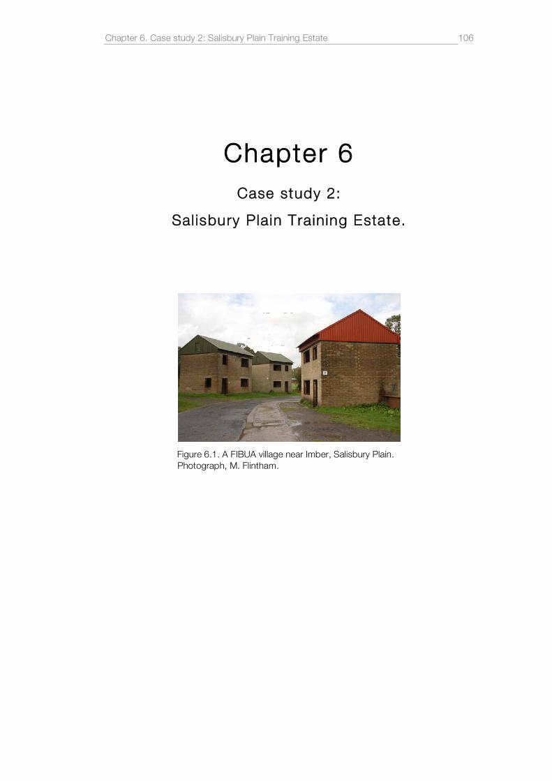
Chapter 6. Case study 2: Salisbury Plain Training Estate
106
Chapter 6 Case study 2:
Sal isbury Plain Training Estate.
Figure 6.1. A FIBUA village near Imber, Salisbury Plain. Photograph, M. Flintham.

Chapter 6. Case study 2: Salisbury Plain Training Estate
107
6.1 . Introduction.
For many Salisbury Plain epitomises a certain kind of British wilderness, somehow
infused with romanticism and touched only lightly by human intervention. J.M.W
Turner’s Stonehenge (1828), is scorched by heavenly fire, repelling cowering beasts
from the inferno at its centre where a single needle of lightning strikes the fallen
Sarsen stones. John Constable’s slightly later take on the subject, by contrast, is
struck by two vast roving arcs of light, one lands somewhere to the left while the
other falls in the centre of the ancient henge, illuminating it from within. But while
Constable’s scene may appear cataclysmic or even revelatory in some sense, the
drama is a sign not from God or the supernatural but simply a product of the
inclement weather. In the absence of historical certainty or hard facts about their
subject both painters employ a supercharged sky to interrogate those objects
which curiously still persist in a British landscape being redrawn by industrial
modernity. And while Stonehenge remains the focus of these paintings it is the sky
that activates them and is revealed to be an essential component of the landscape
itself. On a recent trip to the region a walker suggested that ‘half of Salisbury Plain is
the sky’. This chapter will demonstrate that the same is true of the military presence
on the Plain which not only projects itself across the landscape but also draws the
sky into a vast three dimensional spatial complex.
For twelve days in the summer months of 2008, Salisbury Plain Training Area
(SPTA) was the stage for one of the UK’s largest military exercises, or more
precisely, a Mission Rehearsal Exercise (MRX) that would prepare 5,800 troops
from across all three services for an imminent tour of duty in Afghanistan. Local
papers were alerted to the possibility of increased noise levels, air activity and
armoured vehicles crossing public roads.1 A spokesperson from Exercise Control
asked local people for “[…] their co-operation and understanding to ensure that the
Armed Forces maintain their genuine operational effectiveness”, and Lieutenant
Colonel Mike Beard, Commandant of SPTA remarked that “[…] horse owners
should take extra care when there is low flying”. For the residents of Andover,
Tidworth, Upavon, Burbage, Pewsey, Devizes, Everleigh, Lavington, Tilshead,
Durrington, Bulford, Amesbury and the dozens of other smaller villages that
surround the Plain the military presence is an everyday fact of life. It permeates the 1 'Major military exercise to be held on Salisbury Plain', Andover Advertiser, 15th July, 2008.

Chapter 6. Case study 2: Salisbury Plain Training Estate
108
most unlikely aspects of daily existence. A low-flying Apache helicopter drowns a
conversation in a local library, a single gun shot sets a nervous dog howling for a
couple of minutes or a wake of diesel smoke is drawn after a convoy of
camouflaged vehicles. For most, however, these unexpected and often residual
intrusions have become part of the texture of life in this area. For some the effects
of the military presence have become normalised, for others they are simply normal.
For newcomers and visitors, however, they can be annoying and sometimes
frightening acts of personal intrusion. But the absence of a popular movement
against the military presence speaks of an institution that is utterly embedded in the
social fabric of the region. The era of mass land appropriation and local community
action seems to be over. In fact, for many, particularly those within the military, the
armed services are custodians of the historic landscape, preserving it against
intensive agriculture and the encroachment of modern developments. The degree
to which Salisbury Plain has been spared the exhaustive spread of industrial,
agricultural and infrastructural forms will be assessed in the following chapter in
relation to the supposed ‘greening of the MoD’ and its brand of ‘Khaki
conservation’.2 Is the MoD simply paying lip service to the green lobby and the
heritage industry by promoting ‘token’ or perhaps even inadvertent successes like
the thriving Fairy Shrimp or the recent reintroduction of Great Bustards on to
Salisbury Plain? Are the numerous vestiges of historic settlements that litter the
plain being cared for in a systematic way or have they simply become obstacles to
tank training? The following chapter will demonstrate that these emotive issues are
once again, inextricably linked to the rigorous subdivision of space and the
technologically-enabled management of this vast region of the British countryside.
Salisbury Plain is managed as a complex. Its planning is controlled by a single
agency for the purpose of simulating warfare. Each element within the complex,
including the land itself, the movement of soldiers and armoured vehicles across it,
the management of the airspace architecture, helicopter and fast jet activity, live
firing and long range artillery training, parachute drops, barrack accommodation,
administration and the myriad of infrastructural services are all controlled for the sole
purpose of training a continuous influx of soldiers for battle. The Great Bustard
reintroduction project, the thriving population of Fairy Shrimps and the 2,300
2 Rachel Woodward, 'Khaki conservation: an examination of military environmentalist discourses in the British Army', Journal of Rural Studies, Vol. 17, no. 2, 2001, pp. 201-17.

Chapter 6. Case study 2: Salisbury Plain Training Estate
109
archaeological sites are not external to this systematic subdivision of space. They
too are incorporated as elements within an ever adaptive complex. The following
chapter will examine how this is achieved and to what aims. It will also analyse the
interconnection of some of the key elements within the overall complex, united as
they all are by the articulation of militarised space. What follows is a spatial
interpretation of Salisbury Plain, one which will address the extreme and diverse
military presence in the region, how it is distinct from the area that surrounding it but
also how it intersects with civilian space. The chapter will also show that while the
notion of ‘Salisbury Plain’ may mean different things to different people, the MoD’s
conception of the region is very much as a collection of connected spaces and
processes that form a single, cohesive military complex. This conception of
Salisbury Plain may be one of many but it happens to have primacy as the
dominant and most controlling ideology in the region.
6.2 . Geographies
Salisbury Plain is the United Kingdom’s principal area for training personnel from all
three military services. It also acts as a training ground for NATO troops and those
allied to British or NATO interests. As a designated Site of Special Scientific Interest
(SSSI) Salisbury Plain ‘supports the largest known expanse of unimproved chalk
downland in north west Europe’.3 The total area of the plain is 19,689 ha (48,655
acres) which the MoD acquired in its entirety plus large sections of the surrounding
farmland. The total area of land owned by the MoD for military use is 38,000 ha
(93,900 acres), or approximately 40km by 16km (25 miles by 10 miles) and
occupies one ninth the area of Wiltshire. The training area is roughly divided into
three sections with the A345 public road following the river Avon between the east
and central sections, and the A360 bisecting the central and western sections. With
the Pewsey Vale to the north and the river Wylye Valley to the south, the plain rises
to an plateaux of undulating grassland hills and rich dry river valleys. A wide variety
of grasses and other flora support many rare species of butterflies, moths, bees,
and many of the temporary pools formed by tank tracks are home to endangered
crustaceans such as the Fairy Shrimp. The plain is also a breeding ground for birds
such as the Hobby, Quail, Nightingale, Stonechat, Whinchat, Buzzard, Corn
3 ‘County: Wiltshire/Hampshire: Site Name: Salisbury Plain’ English Nature document, <http://www.english-nature.org.uk/citation/citation_photo/1006531.pdf>, (accessed 08 June 2009).

Chapter 6. Case study 2: Salisbury Plain Training Estate
110
Bunting, Stone Curlews and on occasion, Montagu’s Harrier. After being extinct in
the UK since the 19th century, a recent project saw the successful reintroduction of
the Great Bustard to Salisbury Plain using birds from Saratov, Russia.4 Salisbury
Plain may well be a significant focus point for troops around the world but these
patterns of globalised behaviour also extend to the world of flora and fauna. While
migrant birds and insects habitually move around the planet according to the needs
of their species, and seeds drift on the prevailing winds, the first generation of
Russian Bustards were undoubtedly selected because this high corner of Britain
shares the same latitude as the Saratov Steppe. The irony of allowing these Russian
émigré the free run of a British military training complex is not entirely lost on the
army community.
Aside from the many villages that surround the plain, the other major population
centres are Andover to the east, Amesbury and Salisbury so the south, Devizes to
the north across the Pewsey Vale, and Westbury and Warminster on the edge of
the plain to the west. Salisbury Plain Training Area is also served by three major
garrison towns: Larkhill in the central section, Bulford in the south of the east
section and Tidworth, also in the east. Netheravon and Lugershall (both in the
eastern section) also have a high percentage of military residents. Warminster, on
the western edge of the plain is home to the Land Warfare Centre which
coordinates training for every army range in the UK. Westdown Camp in the central
section is the administrative heart of SPTA where major exercises and training
activities are planned and coordinated. In many ways, this camp, though small and
lacking sense of permanence, is largely responsible for the direction and forms of
military activity in the region (see Figure 6.2).
4 The Great Bustard Group, is a registered charity and a consortium of universities, conservation groups and government agencies. See their website for more information, <http://www.greatbustard.com/>, (accessed 08 June 2009)

Chapter 6. Case study 2: Salisbury Plain Training Estate
111
Figure 6.2. Military Garrisons and camps, Salisbury Plain.
The historic growth of these military towns will be described in greater detail below,
but suffice to say that population density and urban developments in the region are
broadly defined by the changing British military capability and its role in global
conflicts. However, despite the fluctuating military presence over the last century
(including the growth and subsequent removal of large camps on Salisbury Plain
around the two world wars), the growth of the three main garrison towns has
remained constant. Nowhere is this more evident than in the eastern section of the
plain where the area will gain ‘Super Garrison’ status over the next five years. This
fact is consistent with the main themes of this research which is to track the
geographical shift and spatial consolidation of military sites in the UK. Upavon,
Tidworth, Lugershall and Bulford will all experience increased development to
accommodate an influx of repatriated troops from British garrisons in Germany.
Currently, however, the main garrison towns of,
Tidworth, Bulford, Netheravon, Perham Down, Larkhill and Warminster
Garrisons […] are home to around 10,000 military personnel, in mainly
infantry and artillery units, and approximately 9,000 of their dependants.5
These figures are expected to increase by 5,400 before 2012. The economic
impact of the military presence in the area is evident both in sustained employment
5 Sally Hunter, ‘Military Presence and Economic Significance in the South West Region’, Wiltshire Council, March 2009, p.27.

Chapter 6. Case study 2: Salisbury Plain Training Estate
112
in the defence sector and a degree of localised social deprivation: figure 6.3 shows
a ‘local economic area’ defined by Wiltshire County Council where,
military personnel constitute around 2% of the total population, with direct
military and civilian defence employment accounting for around 4% of total
employment […]. As indicated above, these percentages increase
significantly in the areas immediately surrounding the bases, particularly
Tidworth, Bulford and Larkhill. The employment profile within the local
economic area is dominated by base, business services and local
commercial services sectors, largely reflecting the trends within the main
urban centres. In the immediate vicinity of the bases, employment in
commercial services is strongly influenced by the defence presence, with a
large proportion of employment in this sector providing services to the
military bases.6
Tidworth also benefits from military investment in infrastructure and extensive leisure
facilities for civilian use. But, as Woodward suggest, nationally ‘there is a basic lack
of easily accessible data on the economic and financial contribution of military
establishments to their localities’,7 and broader social effects of a military presence
may well be detrimental to the civilian community or the dependents of military
personnel. At Tidworth, for instance:
Skills levels are below average, with 12% of Tidworth CA population
educated to degree level or above, compared with 21% for the county as a
whole. The profile identifies low skills levels, poor self-esteem and a lack of
suitable local employment as a particular problem amongst military
dependants. Despite lower than average class sizes, education
achievements at Key Stage 3 and GCSE level are significantly lower than the
average for Wiltshire.8
6 Hunter, ‘Military Presence and Economic Significance in the South West Region’, p.29. 7 Woodward, Military Geographies, p.44 8 Mark Temple, Julia Hawley, Andy Frost, ‘Impact of the Military on the Agricultural Sector in Wiltshire’, Wiltshire Council, May 2008, p.9.

Chapter 6. Case study 2: Salisbury Plain Training Estate
113
Figure 6.3. Defined local economic area around the Salisbury Plain garrisons. The Salisbury Plain Training Area is highlighted and the Super Garrison bases shown in red. Source: Wiltshire County Council.
While these facts are difficult to attribute to military presence alone and economic
research in this area remains very limited, the negative anecdotal evidence of crime
and deprivation in garrison towns across the UK still prevails. Education levels,
employment statistics, and the limited indices of social deprivation point to the
military presence in the region as a highly significant social influence. Every town
may be unique and may depend on their particular dominant local employers, but
garrison towns are unique because of their direct association with nearby military
sites but also because they represent a place of civilian and military interaction. For
better or worse, garrison towns are places infused with the markers of military life
and the mundane, fearful expectancy of war.

Chapter 6. Case study 2: Salisbury Plain Training Estate
114
6.3. Histor ies of reconnaissance and archaeology
The territorial control of Salisbury Plain may have increased with fits and starts over
the course of the 20th Century, but during this process of expansion the landscape
was continuously mapped and remapped – every inch of military land understood in
terms of its value as a resource. It is well known that mapping has always been
central to territorial expansion and the control of space, but the former is dependant
on many different forms of reconnaissance. While adapted Ordnance Survey maps
may have been sufficient for military planners to manage training activities on
Salisbury Plain, the aerial reconnaissance techniques developed in the First World
War were continued over the landscape of southern England: great swathes of the
countryside were photographed between the wars by the British Army and the RAF
as part of navigation and reconnaissance training. The military conception of the
British landscape is one that has, somewhat reluctantly, come to incorporate
elements of historical and archaeological heritage but it was principally the work of
O.G.S Crawford and his associates that drew the two seemingly incompatibly
worlds together.
A veteran of the Givenchy trenches and committed archaeologist, O.G.S Crawford
seized an opportunity to exploit the hundreds of aerial photographic negatives
languishing in drawers at the Old Sarum Airfield near Salisbury Plain, and set about
studying them for geographical irregularities.9 He was struck by the unusual
shadows cast in the early and evening light of features that would ordinarily be
invisible to the earth-bound archaeologist. These photographs of barely perceptible
patterns in the landscape suggested human settlements of various kinds: hill forts,
old pathways, burial mounds and field systems. Using this method Crawford
established the exact location of the Eastern branch of the Stonehenge Avenue,
evidence of which was, quite literally, thin on the ground. This victory was by no
means an accident: Crawford, an Oxford graduate in Geography, already saw the
potential of aerial photography having undertaken a number of reconnaissance
fights over the Western Front. He also astutely realised that if ‘aerial archaeology’
was to have a credible future it had to establish itself quite conclusively from the
outset, and Stonehenge itself was the perfect popular catalyst. In the spring and
summer of 1924 Crawford undertook a aerial survey of Berkshire, Dorset,
9 For more on O.G.S Crawford see Kitty Hauser, Bloody Old Britain: O.G.S. Crawford and the archaeology of modern life, London: Granta, 2008.

Chapter 6. Case study 2: Salisbury Plain Training Estate
115
Hampshire, Somerset and Wiltshire, looking out for possible archaeological
remains. The photographs and accompanying commentaries were published as
Wessex from the Air in 1928, a book that would reinvigorate the disciplines of
archaeology and geography. Despite Crawford’s assertion that Salisbury Plain had
been so damaged by military activity that archaeological research should be
concentrated on Marlborough Downs, his discoveries on Salisbury Plain let to many
subsequent land surveys and archaeological investigations culminating with Simon
Crutchley’s comprehensive report for English Heritage in 2000.10 As an employee of
Ordnance Survey, Crawford also expressed a critical view of the State’s destruction
of its own archaeological heritage, and describes how,
[…] in the name of something (misleadingly in his opinion) called defence,
aerodromes, barracks, and other buildings pepper the countryside including
areas of great archaeological interest like Salisbury Plain […], Lulworth Cove
in Dorset, and Pembrokeshire Coast.11
Crawford’s observation, however, was supplanted by the irony of future
developments: Marlborough Downs would be given over to intense agriculture
which would destroy evidence of historical sites and the British military would come
to remodel themselves as responsible custodians of Salisbury Plain’s ancient
heritage, defenders against urban encroachment.
Crutchley’s survey acknowledges Crawford’s contribution to aerial photography
and goes on describe a landscape saturated with historical evidence. A total of
4261 sites were subsequently recorded with many more areas of the Plain yet to be
examined. Of the 50 Neolithic sites catalogued five were identified as henges but
the majority were barrows and mortuary enclosures. Stonehenge, of course, dates
from this period as does the adjacent Greater Cursus which, at 9,090 ft in length is
one of the largest ancient sites on Salisbury Plain. The vast majority of the 1186
catalogued Bronze Age sites were identified as funereal barrows are ritualistic sites
of some kind. A small number, however, seem to be defensible enclosures while
others are quite clearly linear ditches or so-called ‘ranch boundaries’. The Iron Age,
10 Simon Crutchley, ‘Salisbury Plain Training Area: A report for the National Mapping Programme’, English Heritage; 2008, Series Aer/3/2000. 11 Hauser, Bloody Old Britain, pp.201-202.

Chapter 6. Case study 2: Salisbury Plain Training Estate
116
by contrast, only yields 60 identifiable sites. While this may seem surprisingly few,
the report states that many more probable site are categorised simply as ‘Unknown
Prehistoric’ when it is not possible to attribute a identifying period with any certainty.
Of the Iron Age sites eight are well known hill forts of considerable size. Battlebury,
Scratchbury, Bratton Camp, Casterley Camp, Sidbury, Yarnbury (Main) and
Yarnbury (Early), Knook and Chisenbury Trendle all occupy elevated positions with
commanding views across much of the Plain. Six of them are the ‘largest features
dated to the Iron Age, all over 100,000m2’.12 These enormous defensible sites are
some of the finest remaining examples in the United Kingdom which, arguably,
would not be here today if it were not for the military presence. Access to some of
these hill forts remains restricted, however. There are a small number of field
systems attributed to this period and many small Iron Age enclosures (defensible or
otherwise) distributed around the plain, most of which are roughly a hectare in size
or larger. The presence of defensible sites such as these is testament to a long
history of battles and military activity in the UK and it is curious to reflect that they
are situated within (and to a degree, defended by) the much larger military zone of
Salisbury Plain itself. Chisenbury Warren accounts for 44 of the 91 sites attributed
to the Roman period, the majority of which are settlements that would have
consisted of a number of individual houses. All that remains are rectilinear
undulations in the landscape, foundation platforms for villas perhaps. While the
village of Imber is often regarded as the most notable deserted community on
Salisbury Plain, Crutchley’s report records a total of 13 villages and tofts, deserted
during the Medieval period, with associated boundaries, field systems, fish ponds
and trackways. Dozens of other field systems are evident: 85 lynchets, 74 blocks of
ridge and furrow and 26 examples of stock enclosure also date from this period.
Its is interesting that Cructhley and English Heritage have chosen to catalogue sites
from the modern era which almost entirely consist of vestiges of military activities,
architecture, camps, vehicles and weapons. While these sites (approximately 10%
of the of the total number of sites catalogued) undoubtedly constitute an important
part of the historical fabric of Salisbury Plain Training Area, it is remarkable that this
impact should have happened in the relatively short time frame of one century.
12 Crutchley, ‘Salisbury Plain Training Area: A report for the National Mapping Programme’, p.31

Chapter 6. Case study 2: Salisbury Plain Training Estate
117
What O.G.S Crawford glimpsed and what subsequent analyses have revealed is a
palimpsest of human activity, history inscribed on a bare landscape that has
remained exposed to the sky for centuries. Almost everything around it, however,
has been erased by intensive farming, industrial production, urban development and
an inexorably subdividing transport network.
In a great leap of imagination, the invisible ‘shadow sites’ of Salisbury Plain were
revealed by O.S.G Crawford and his application of a burgeoning military
reconnaissance technology: aerial photography.13 Aerial and satellite photography is
taken for granted today but intelligence gathering during the First World War was
extended into a new realm by the elevation of human vision, a major shift in the
‘logistics of perception’, as Virilio puts it.14 This was a technology that captured
images of the land below for the purpose of strategic dissection and territorial
control. Into this calculating and systematised perception of the landscape
Crawford introduced the boundless depths of historical interpretation. By subverting
the strategic spatial delineations of aerial photography in this manner, he
transformed the technique into something more than a tool for future
archaeologists, geographers and environmentalists, something more than an
objectifying tool for scientific enquiry. He introduced the possibility that it could
become art. The pristine objectivity of the aerial photograph was a quality that
transferred easily to Crawford’s earth-bound shots of buildings and weathered
advertising hoardings; scenes of social cohesion and capitalist intrusions. Scenes of
archaeological sites are equally immaculate. It is not clear if Crawford ever
considered his photographs to be works of art. What we find, however, is that
across his whole corpus there is both a simple, formal brilliance and an almost
faultless simplicity to his compositions. Above all, it is one that simultaneously
recognised the beauty of the landscape, its historical and social constitution, and its
ongoing transformation. This is a perspective at once severed from the logic of
power and control from which it came.
6.4 . Histor ies of appropriat ion.
13 Kitty Hauser, Shadow sites: photography, archaeology, and the British landscape, 1927-1955, Oxford: Oxford University Press, 2007. 14 Paul Virilio, War and cinema: the logistics of perception, London: Verso, 1989.

Chapter 6. Case study 2: Salisbury Plain Training Estate
118
There is a sense in which Salisbury Plain has always been under military control.
Like Stonehenge itself, the military cast a permanent and commanding presence
across the chalk downs. The red flags, lanterns, stop-gates and warning signs that
surround the danger areas seem to reside in that curious register of British
anachronisms along with red telephone boxes, Brighton rock and Little Chefs. To
subtly infuse the landscape with military warning markers may or may not be a
deliberate appeal to a sense of historical lineage, but the effect is one of subliminal
authority and almost patriotic acquiescence. To defy the signs would not only be
foolhardy, it would be a rejection of the inalienable permanence of the military
institution.
In fact, the Army arrived somewhat in desperation, at the end of the 19th century.
Large scale manoeuvres had been held at various sites around the country,
including Salisbury Plain, but the logistics of supplying accommodation, transport,
food and water to temporary training areas on private land was an ongoing burden.
The decision to acquire land was facilitated by the Military Manoeuvres Act of 1897,
described in Chapter 3, and in the same year 303.5 ha (750 acres) were purchased
at Bulford for the price of £7,500.15 By 1902 a total of 16,996 ha (42,000 acres) had
been purchased by the War Office Salisbury Plain committee. While the owners of
the land may have changed, the resident agricultural community were offered new
rents and new terms depending on where they were situated in relation to the
intensity of military activity. These areas become known as Schedule I, II, or III.
Under Schedule I, full agricultural tenancies were granted on land principally
around the training estate’s periphery, where livestock could safely graze.
The areas were clearly marked, to prevent troops from disturbing them.
However, the war office reserved the rights for troops to use these areas
whenever failure to do so would create an artificial tactical situation. In this
event, compensation would be paid to the farmer for any damage caused.
The war office required that Schedule II land should be kept as permanent
grassland […] Schedule III land covered the remaining estate, where troops
could manoeuvre at any time.16
15 Henry Buckton, Salisbury Plain: home of Britain's military training, Stroud: Phillimore, 2008, p.1. 16 Buckton, Salisbury Plain, p.5.

Chapter 6. Case study 2: Salisbury Plain Training Estate
119
Despite having grown considerably, this regime of land management is still largely in
effect today with the different types of land classifications clearly marked on recent
military maps of the region. Schedule I land still acts a kind of buffer between the
hazardous military landscape (Schedule II and III) at the core of SPTA and the
surrounding British countryside.
Tidworth camp was quickly establish over two abandoned villages but it wasn’t until
1904-5 that permanent barracks blocks were built with associated accommodation
for officers, roads to link them, a sewage works and an isolation hospital. The
template for a permanent British Army garrison town had already been established
at Aldershot but photographs of Tidworth from this period convey the sense of a
town at the frontier of human civilisation surrounded by a benign wilderness, or
perhaps a town isolated from the rest of humanity for some unspecified reason. The
leap from the almost timeless model of a military community under canvas, transient
and temporary in the landscape, to an almost pioneerist model of land annexation
and permanence was quickly taking shape. Bulford camp followed next, growing
quickly to the east of Bulford village and spreading over to Durrington on the
western side of the river Avon. Eight lines of wooden barracks were initially built,
each for a separate unit with ‘guardroom, regimental offices, messes for both
officers and sergeants, and married quarter for officers and all other ranks’.17
The War Office’s initial intention was to purchase land only east of the Avon.
However, developments in artillery and new rifles such as the Lee-Enfield extended
the hazardous range of army ballistics. In 1898, all 7,813 acres of the Nethervon
Estate had been bought and the Cavalry School was established at Netheravon
House, with additional with additional barracks around the estate. Rifle ranges
began to appear all around the Plain and Larkhill was chosen as the principle long-
range artillery training area. The range was again extended to the Salisbury-Devizes
road, and later in 1911 a new tract of land was purchased at West Down near
Tilshead. A number of small camps were established before the First World War
such as Pond Farm Camp on West Down, Durrington Camp, Fargo Down Camp,
Rollestone Camp, Hamilton Camp and Bustard Camp, but it was Larkhill that would
17 Buckton, Salisbury Plain, p.15.

Chapter 6. Case study 2: Salisbury Plain Training Estate
120
emerge as the third garrison town on the Plain after the School of Gunnery moved
there from Shoeburyness in 1914.
In just 15 years the eastern section of Salisbury Plain had been bought or annexed
for military activities, but the Army’s expansions were not only anchored to the
surface of the plain. Their relationship with the sky began with the balloon trials
which it used as a form of aerial surveillance. Balloons had already been deployed
for reconnaissance at the end of the 19th century in operation across the African
colonies, and the Balloon Company of the Royal Engineers held several trials and
training courses at Larkhill and across Salisbury Plain. Larkhill, however, had
suddenly become the focus for production and trials of the aeroplane. The
increasing realisation that airpower would redefine future warfare led to the creation
of the Royal Flying Corps in 1912 (split into military and naval wings) and the
construction of a dedicated airfield at Upavon Down.18 Two more airfield at Upper
and Lower Netheravon followed quickly after, bringing Salisbury Plain to the
forefront of experimental aviation. Edgerton’s England and the Aeroplane brilliantly
dismantles the myth that Britain was in some way backward in identifying the
military application of manned flight: the fever pitch efforts at Salisbury demonstrate
that Britain was at least as able at developing the technology necessary to establish
an aerial capability as any other major global power.19 During the First World War
further airfields were built at Stonehenge (used by the School of Navigation and
Bomb Dropping), Lake Down and Red House Farm, later known as Boscombe
Down - an airfield which continues to be integral to the development of British and
US military technologies. The Key airfields of Larkhill, Upavon and Netheravon
experienced continued growth during this period, and finally at the end of the war
the Royal Flying Corp and the Royal Naval Air Service combined to become the
Royal Air Force.
During the First World War, Salisbury Plain saw a massive influx of troops, not only
from Britain but Canada, Australia and New Zealand, all requiring training in one
form or another. Their arrival necessitated a massive expansion of the existing
camps, some of whose streets now bear names such as a Wellington Lines,
18 Buckton, Salisbury Plain, p.26, ‘When the airfield was created on Upavon Down archaeologists were invited to watch the levelling of a Bronze-Age barrow which was obviously regarded as a hazard to aviators landing and taking off’. 19 David Edgerton, England and the Aeroplane, Macmillan, 1991.

Chapter 6. Case study 2: Salisbury Plain Training Estate
121
Canterbury Lines, Auckland and Otago Lines. Thousands of bell tents were raised
to accommodate those troops not lucky enough to be billeted or barracked.
Conditions were harsh without the basic amenities of the built camps. Diseases like
tuberculosis and meningitis spread easily, and this was before the troops even
made it to battle. More camps were hastily built: Bustard Camp, Sling Camp, West
Down South and West Down North camps, and Pond Farm Camp were thrown up
quickly by visiting troops. Large military hospitals were built at Sutton Veny, Fargo
Plantation, Punch Bowl Bottom, Codford and Bulford, and the main camps saw
improved leisure facilities – all as a drive to hastily improve the general conditions for
the flood of international soldiers. However, by December 1914 there were still
11,000 troops under canvas on Salisbury Plain so the decision was taken to billet
them in the surrounding towns and villages until permanent provision could be
made for them. Between 1914 and 1929 the infrastructure of the main garrisons
continued with the expansion of the Larkhill Military Railway which conveyed troops,
artillery and goods between camps, firing ranges, hospitals and airfields.
In addition to more traditional field exercises such as rifle practice and hand to hand
combat training, practice trenches were dug at many locations, a fact which
emphasised the changing face of modern warfare and the ongoing need to
replicate different types of built environments. This methodology continues to this
day with simulated urban environments or FIBUA villages (Fighting in Built Up Areas)
such as the ersatz Cold War era Bavarian village and ‘middle eastern’ streets on
Copehill Down and Imber (see Figure 6.1).
After the end of hostilities and the remaining overseas troops had left, the dozens of
temporary camps were dismantled and the villages of Codford and Sutton Veny
could return to normal life again. A consolidation of the three garrison towns began
with new accommodation, better leisure facilities, football and polo pitches, and the
first Navy, Army and Air Force Institutes (NAAFI) bars and canteens were
established. The army had by now grown used to training on so much of the
surrounding Plain, particularly in the west where a number of temporary camps had
to be relinquished after the war. Between 1929 and 1932 the War Office
controversially purchased the whole of the village of Imber and the surrounding
estates for approximately £400,000 excluding the church, the school, the Baptist
chapel and the village inn. A total of 27,158 acres were bought from the various

Chapter 6. Case study 2: Salisbury Plain Training Estate
122
estate owners and the land was effectively leased back to them for farming under
Schedule I or III terms. However, the 130 tenants of Imber were evicted in 1943 on
the understanding that they would be allowed to return in six months.20 Despite a
public enquiry in 1962 and repeated public protestation, Imber remains a ghost
village, overgrown and damaged beyond repair. For a few days a year the MoD
allows limited access to Imber for memorial services and for graves to be tended,
but effectively the village has simply become one of the many thousands of
historical sites across the Plain, managed and mostly avoided by the armed
services.
The incremental annexation and transformation of Salisbury Plain continued
throughout the Second World War with the establishment of permanent tanks
ranges. These armoured mobile weapons had been a sporadic presence across the
plain, particularly at Perham Down, since 1922.21 ‘A very effective tank lobby which
made Britain the leading tank power of the 1920s’ ensured that land was
purchased around Warminster for the exclusive use of the tank.22 Village roads
around Salisbury Plain were strengthened with concrete to take the extraordinary
weight of these vehicles, hangers and barracks were built at Warminster, Tidworth
and Perham Down to accommodate the influx of units from the Royal Tanks Corps.
Above all, armoured warfare had irrevocably altered the character of training on the
plain: tanks units were now fully integrated into training programmes and exercises,
huge clouds of chalk dust and smoke would be visible from miles around and the
monstrous churning of advancing squadrons would be felt across the downs.
However, the disastrous ‘Battle of Hungerford’ training manoeuvre of 1934 exposed
doubts that tanks could effectively dominate future warfare. During this apparent
fiasco the tanks were over-reliant on infantry and extensive logistical support, they
slid backwards down hills spraying burning petrol in the air or they ungainly flipped
over before bemused onlookers. In Royal Tank Corp circles ‘the Battle of
Hungerford, was long remembered as the event that discredited mechanisation and
set back the modernisation of the British Army for years’.23 Major General J.F.C
20 WO 32/17163, Imber Training Area, Salisbury Plain: acquisition of village and proposed maintenance programme, 1947-1973. 21 Buckton, Salisbury Plain, p.72. 22 Edgerton, Warfare state: Britain, 1920-1970, p.45. 23 Patrick Wright, Tank: the progress of a monstrous war machine, London: Faber, 2001, p.186.
Chapter 6. Case study 2: Salisbury Plain Training Estate
123
Fuller’s ‘occult’ vision of a fully mechanised army leading to an ‘epoch-making
“Reformation of War”’24 was undone by the pragmatic need for flexible battlegroups
and strategies, something which the tank could only ever be a part of. The tank
lobby was in retreat and as the Second World War approached, Chamberlain
redirected the defence budget towards anti-aircraft and home defence.
Nevertheless, experimentation and training with armoured vehicles continued
throughout and after the Second World War on Salisbury Plain. Today, the tanks
and armoured vehicles are extensively used across the plain by many regiments
including the 2nd Royal Tanks Regiment based at Tidworth. The movement of tanks
is one of the most obviously visible and destructive form of military activity on the
plain. During the period between 1945 and 1990, tanks and other armoured vehicle
have contributed to a sustained reduction in the chalk grassland across SPTA with
an ‘average annual increase in bare ground since WWII […] in the region of
25.5 ha’.25 Despite the implementation of the Integrated Land Management Plan by
Defence Estates, more recent studies have concluded that vehicles such as the 64
ton Challenger II tank can still create significant long-term damage to vegetation and
soil communities across the plain.26 Satellite images from 2002 convey an almost
alien landscape, criss-crossed with hundreds of chalk-white lines intersecting
across the rolling plains. These lines, in turn, connect to the main hardened transit
routes around the circumference of each major section and to the hangers in the
garrisons. Repeated training patterns leave distinct traces (which can take years to
disappear) and form new layers within the historical palimpsest of Salisbury Plain.
Amid shifting mud banks and sodden thickets of vegetation the tank crushes and a
blasts its way across the downs. In this precarious and unlikely landscape its
occupants prepare for battle in the desert regions of Iraq and Afghanistan.
6.5 Spaces o f archaeo logy
As we have seen, the current military geographies of Salisbury Plain Training Area
have a history that stretches back over a century, a history that is defined almost
24 See Wright, Tank, for a comprehensive account of Fuller’s dubious role as a military intellectual. Aside from his standing as a fascist sympathiser and as an acolyte of the mystic Aleister Crowley, the validity of Fuller’s criticisms of the British Army and its apparent resistance to the mechanisation during the inter-war years has been largely downplayed. 25R.A Hirst, R.F Pywell, P.D Putwain, 'Assessing habitat disturbance using an historical perspective: The case of Salisbury Plain military training area', Journal of Environmental Management, Vol. 60, no. 2, October 2002, pp. 181-93. 26 R.A Hirst, R.F Pywell, R.H Marrs, P.D Putwain, 'The resistance of a chalk grassland to disturbance', Journal of Applied Ecology , Vol. 40, no 2, April 2003, pp. 368-379.

Chapter 6. Case study 2: Salisbury Plain Training Estate
124
entirely by changing military strategies and technologies. While the surrounding
landscape was being shaped by industrial modernity, increases in population,
changes in modes of transport and intensive agriculture, Salisbury Plain was left
exposed only to the intensities of modern warfare. The systematic delineations of
twentieth century agriculture may be visually apparent in modern field systems, but
the effects of military activity are much harder to quantity because of their transitory
and often instantaneous manifestations. In addition, military zones by their very
nature resist access and interpretation. This section of the chapter aims to show the
spatial diversity, complexity and intensity of military activity at SPTA and the
surrounding areas by referring to recent exercises, conservation strategies, and the
use of airspace as defining factors within a highly structured spatial complex.
A cursory glance at recent satellite images of SPTA would seem to confirm military
conviction that its three primary areas have largely been spared the transformations
of the modern era. The plain appears to be an almost unadulterated oasis in an
increasingly manufactured British Landscape, a beleaguered wilderness in an age of
monoculture and nebulous conurbations. Closer inspection, however, reveals a
landscape criss-crossed with vehicle tracks, pock-marked with impact craters and
studded with unknown buildings and facilities. Cross-referencing these images with
current military maps shows a terrain divided into twenty five major areas with many
other smaller subdivisions.27 Figure 6.4 shows the overall configuration of these
boundaries which are determined both by the topography of the landscape and a
designated training function. For example, the central region is divided into two
artillery impact areas (areas 15 and 16) for tank training and live firing. Within each
area there are scatterings of firing points, datum points for coordinated targeting
and observation posts positioned around the periphery. This area is littered with
over a quarter of a million unexploded pieces of ordnance, from small mortars to
1000 lb air-dropped bombs.28 It is also regularly swept by an ordnance disposal
team who remove live ammunition where possible. At high resolution (Figure 6.5) a
satellite photograph from 2002 reveals a large formation of tanks progressing in a
northerly direction from the bottom of the impact area. An everyday occurrence on
27 ‘United Kingdom Training Areas map 1:25,000, Salisbury Plain (West) and Salisbury Plain (Centre and East)’, Ordnance Survey (produced under the direction of Defence Geographic Centre and effective from January 2008). 28 From an interview with Richard Osgood, head of the Historic Environment Team at Defence Estates (MoD), 9th October 2008.

Chapter 6. Case study 2: Salisbury Plain Training Estate
125
SPTA, they seems to be heading for a circular subdivision within the impact area
known as a Range Danger Area. However, transposed over this area of Charlton
Down is another designated subdivision: an Environmental Site roughly two
kilometres across. This is one of the best preserved Roman villages in the UK and
as such is one of the 306 protected scheduled monuments on SPTA. Dozens of
connected cropmark traces can be seen on aerial and satellite photographs, and
over 200 house platforms are thought to be embedded in that part of the chalk
down.29 Curiously, the site is also liberally pock-marked with small craters and a
scattering of armoured vehicles can also be seen on the satellite image. This
designated historic site (and the dozens of Iron Age tumuli in the immediate vicinity),
highlights the paradox at the heart of Salisbury Plain: how is such an intensive and
seemingly destructive form of military training conducive to the protection of this
historic environment?
Figure 6.4. Salisbury Plain, internal military subdivisions. Source: Google Maps with additional data by M. Flintham based on current military maps of the region.
29 Crutchley, Salisbury Plain Training Area, p.36.

Chapter 6. Case study 2: Salisbury Plain Training Estate
126
Figure 6.5. A formation of armoured vehicles moves across Salisbury Plain. Image from Google Earth.
This chapter previously looked at the physical effects of tanks trials on the
landscape. The early 1990’s saw the greatest destructive impressions left by military
activities - exacerbated, in part, by some of the wettest winters in decades.
Conservationists were ‘appalled by the scale of destruction across the plain's 1,800
barrows, field systems and ancient settlements’.30 Jocelyn Stevens, the chairman of
English Heritage partly blamed ‘a breakdown in discipline - the failure of
commanders to educate troops’. In many ways these scathing criticisms exposed
an attitude oblivious to the historic environment and misjudged the supposed
priorities afforded to military training. Today, while tanks trials still persist on SPTA
the Historic Environment Team based at Westdown camp on SPTA maintain that
military transgression into archaeological or environmental sites is extremely rare.31
In addition, the team apparently work very closely with the MoD to preserve
Scheduled Monuments in a variety of ways including the implementation of
accepted environmental policies. Practically this means building timber palisade
enclosures around many designated sites and restricting access to whole areas if
necessary.32 However, because the raison d'etre of the Defence Estate Historic
30 Peter Dunn, 'Tanks carve up heritage sites on Salisbury Plain’, Independent, Friday 29 April 1994. 31 According to Richard Osgood, the vast majority of damage done to archaeological sites is by rabbits and badgers. Water erosion is also a considerable problem for historic and environmental sites. 32 Driving timber palisades into or around an archaeological site is a destructive process which could damage historic evidence. It also the one of the few methods available to ensure that infantry and armoured vehicles avoid the boundary of the site.
Chapter 6. Case study 2: Salisbury Plain Training Estate
127
Environment Team is ultimately not to protect the historic sites but to ‘facilitate
military training’, there is a will to actually integrate the archaeological and
environmental elements into the military exercise planning process.33 So rather than
impede military operations, these sites actually augment training at SPTA. For
example, the Roman linear ribbon development on Chapperton Down in the
western section of the plain is out of bounds to military training because of its
importance as an archaeological site. Rather than let this encumber army exercises
the site has been incorporated as a ‘minefield’ into TESEX and armoured vehicle
training exercises.34 In addition, a causeway has been built to allow non-destructive
movement over the site during training. Other archaeological sites become
‘obstacles’ to be encountered and avoided on manoeuvres. British and
international troops are apparently briefed on the locations of archaeological and
environmental sites before the exercise begins and any anticipated military digging
(foxholes, trenches, etc) must first be cleared with the Historic Environment Team.
SPTA has a wide variety of soil types and densities, and experiences the full range
of British weather. In order to gauge the moisture saturation level of a particular area
and its suitability for heavy vehicles, the British Army has planted solar powered
moisture probes across SPTA that can be remotely interrogated from a central
control point. In this way the military landscape can be read as data which can be
assessed against the weighting factor of particular vehicles. Once again SPTA is
interpreted as a mutable, shifting environment whose changes must be carefully
monitored and incorporated into military activities.
The integration of archaeological and environmental sites into the overall training
complex at SPTA is in line with shifting military conceptions of space. Where once
space for training had to be simply acquired (and often brutalised in the process),
now it must first be understood and interpreted; chaotic and entropic elements
must be incorporated into an adaptive, evolving system. Archaeological and
33 From an interview with Richard Osgood, head of the Historic Environment Team at Defence Estates (MoD), 9th October 2008. 34 TESEX stands for Tactical Engagement Simulation Exercise – a form of training that utilises laser-tag technology and blank rounds. When an individual or vehicle is shot or enters into a restricted area, their weapons are immobilised and warning lights flash to signal their status. Amongst other examples of archaeological sites that have been incorporated into military training, the Cursus near Stonehenge which cuts through the Royal School of Artillery boundary, is designated as a ‘minefield’ during TESEX and armoured vehicle training exercises.

Chapter 6. Case study 2: Salisbury Plain Training Estate
128
environmental sites now constitute an additional layer in the expanding strata of
geographical information to be assimilated during training and combat. Vestiges of
historical events and places of cultural significance become integrated into this
emergent power structure. The increasing focus on cultural heritage sites in warfare
and training was highlighted in the recent Bosnian, Afghan and Iraqi conflicts where
many sites were accidentally destroyed while others were deliberately attacked or
targeted with the sole purpose of erasing cultural identity. While the USA and the
UK claim never to have deliberately targeted such sites, they have yet to formally
ratify the 1954 Hague Conventions and its associated protocols on the protection of
cultural assets. However, in 2005, the UK declared its intention to ratify the
Convention, citing that to not do so would damage the international standing of the
United Kingdom.35 The UK’s hesitancy seems in some way linked to the
particularities of limiting their impact on sites ‘situated near important military
objectives’ which should be ‘placed under special protection’.36 This provision
applies as much to the hundreds of heritage sites owned and occupied by the
armed services in the UK as it does to those within international combat zones.
6.6 . Spaces o f management and rationa l isation
Archaeological and environmental concerns undoubtedly shape the arrangement of
functional training spaces on SPTA. The current subdivisions shown in Figure 6.4
are defined by these and many other social and geographical factors, but each is an
intensively used unit within a broader spatial arrangement. Indeed, each area is
over-subscribed to the point where new technological management systems have
been introduced to accommodate the increased training requirements. In 2002
Landmarc Support Services (LSS) were awarded the contract to provide a range of
services for the entire Army Training Estate (ATE), including facility management and
range maintenance, accommodation, catering, radar surveillance, targetry and the
implementation of a new nation-wide training range booking system named IRIS
35 ‘Consultation Paper on: The 1954 Hague Convention on the Protection of Cultural Property in the Event of Armed Conflict and its two Protocols of 1954 and 1999’, The Department of Culture, Media and Sport, 6 September 2005. <http://www.culture.gov.uk/> (accessed 20 June 2010). 36 Convention for the Protection of Cultural Property in the Event of Armed Conflict with Regulations for the Execution of the Convention 1954, Chapter 2, article 8.

Chapter 6. Case study 2: Salisbury Plain Training Estate
129
(Integrated Range Information System).37 The same system is implemented by
DynCorp International for use by the US Department of Defence.
The original [UK] system only operated on a regional basis and so did not
provide a national overview. Furthermore, the accuracy and availability of the
information was patchy, making it difficult to arrive at informed decisions.38
While a new intranet booking system may seem mundane and not exactly worthy of
serious critical attention, it may yet have far reaching implications for military land
management. The use of IRIS for the rationalisation of land-use across the entire
11 Army Training regions is further evidence of the continued interconnection of the
UK defence estate. Furthermore, the out-sourcing of land management across the
defence estate centralises the administration of army training sites as a profit-driven,
private sector concern.39 This aspect of military land-use rationalisation will be
address in greater depth in Chapter 8, 9 and 10 but it is interesting to note that the
relinquishment of range management by the British Army at SPTA to Landmarc is
evident in increased land usage, from 600,000 person-days per annum to
750,000.40
6.7 . Airspaces
The ‘militarised’ airspace of the UK is a highly regulated continuum of invisible but
complex architectures. Many exist for only a few minutes at a time, others exist for
fixed durations but many more are permanently off-limits to passing civilian aircraft.
The intersection of permanent aerodrome volumes, bombing ranges, temporary
NOTAM (Notice to Airmen) zones, Air Tactical Areas (ATA) around the coasts and
37 ‘Annual Report 2002/3: Facilitating Training and Protecting the Environment’, Army Training Estate, 2002/3, pp.11-12, <http://www.mod.uk/NR/rdonlyres/57B9124C-5B67-4069-A58E-46A2C1D4F290/0/dte_ann_report_0203.pdf>, (accessed 12 June 2010). 38 'Landmarc Update: Progressing with ATE', Focus, no. 12, August 2005, p.8, <http://www.interserveplc.co.uk/Images/focusissue12august20091.pdf>, (accessed 10 June 2009). 39 ‘Public-Private Partnerships in United Kingdom Defence: Opportunities and Risks’, Royal United Service Institute, 2006, <http://www.rusi.org/downloads/assets/Public_Private_Partnership_in_UK_Defence.pdf>, (accessed 10 June 2009). 40 Mark Temple Julia Hawley, Andy Frost, 'Impact of the Military on the Agricultural Sector in Wiltshire', Wiltshire County Council, May 2008, p.3, <http://www.wiltshire.gov.uk/communityandliving/militarycivilianintegrationprogramme.htm>, (accessed 12 June 2010).

Chapter 6. Case study 2: Salisbury Plain Training Estate
130
low-fly zones combine to form a uniquely managed environment, one that
coordinates a high volume of mixed air traffic.
Being the largest military training area in the UK, SPTA has a uniquely complex
arrangement of airspace volumes, each of which differ in size and altitude.41 Their
unusual facetted shapes are determined by the activities that predominate within
them. For instance, the Everleigh and Bulford Danger Areas rise to an altitude of
14,00 feet because the eastern section of SPTA is principally used for helicopter
exercises, ‘dry training’42 and small calibre ballistics only. With advanced notification
the Danger Area altitude can rise to 50,000 feet to accommodate fast jets and
Hercules aircraft. By contrast, the vast Imber and Larkhill Danger Areas are set at a
standard altitude of 50,000 ft because of the proliferation of large caliber ballistics,
pilotless target aircraft, fast jet activity and freefall bombing. The Lavington Danger
Area is a limitless column that rises between the Imber and Larkhill areas and has a
radius of one and a half nautical miles.43 According the National Air Traffic Service
(NATS) the column is used for ‘vertical firing’ and is quite possibly used by the
Cranfield University Ordnance Test and Evaluation Centre (COTEC) which lies at the
centre of the Danger Area, for testing various missiles and pyrotechnics including
‘white phosphorous’.44 These five Danger Area volumes partially overlap two
additional Military Air Traffic Zones (MATZ) above AAC Middle Wallop and MoD
Boscombe Down allowing free transit of helicopters and other aircraft into SPTA. 32
km (20 miles) to the north is RAF Lyneham which supplies Hercules transporter
aircraft for parachute training. Fast jets from bases across UK and Europe also take
part in coordinated land and air exercises at SPTA. Airspace volumes at SPTA will
also be studies in detail in Chapter 9.
41 The Civil Aviation Authority designation for each SPTA danger area is as follows: Imber: EG D123, Larkhill: EG D125, Everleigh: EG D128, Bulford: EG D126, Lavington: EG D124, Porton: EG D127. Although not strictly within the boundary of SPTA, Porton remains integral to military training operation in the area. See, ‘ENR 2 – Air Traffic Services Airspace’, Civil Aviation Authority, <http://www.ead.eurocontrol.int/eadbasic/pamslight-B88E6002A6E7055DF02EFBA98BB946F2/7FE5QZZF3FXUS/EN/AIP/ENR/EG_ENR_2_1_en_2010-06-03.pdf>, (accessed 10 June 2010). 42 ‘Dry training’ denotes training without live fire arms and ballistics. 43 While the Danger Area structures are permanently in place they can be accessed by certain anticipated civil or military aircraft depending on the nature of the present hazard. 44 Cranfield University Ordnance Test and Evaluation Centre (COTEC) website, <http://www.cotec.org.uk/what_we_do.htm>, (accessed 01 April 2010).

Chapter 6. Case study 2: Salisbury Plain Training Estate
131
This architecture may be unusually complex and necessarily accommodating to a
range of ballistics hazards and airborne activities but it is also one that currently
resists Unmanned Aerial Vehicles (UAV). The CAA has strict guidelines regarding the
use of UAVs for military or civilian use. It stipulates that UAVs over 7kg can only
operate in UK airspace which is segregated (temporarily or otherwise) from that of
manned aircraft.45 While this may, in part, be the impetus for developing smaller
UAVs for domestic applications in urban environments, it also places considerable
constraints on the MoD’s burgeoning UAV Watchkeeper program. Judging from a
recent application to extend its military airspace to the region south of Salisbury
Plain (Figure 6.6), the MoD must be having considerable difficulties in integrating
these drones into training and Mission Rehearsal Exercises (MRX). The
Watchkeeper’s medium range capabilities are constrained by the existing airspace
architecture at SPTA which itself is heavily regulated and highly dangerous in equal
measure.
Figure 6.6. Proposed segregated airspace for Unmanned Aerial Vehicles (UAV). Source: Ministry of Defence and Ordnance Survey. Crown Copyright.
45 ‘Unmanned Aircraft System Operations in UK Airspace – Guidance’, Civil Aviation Authority, <http://www.caa.co.uk/docs/33/cap722.pdf>, (accessed 8 June 2009).

Chapter 6. Case study 2: Salisbury Plain Training Estate
132
132
The design of this new segregated military airspace and the ensuing consultation
process are being managed by QinetiQ on behalf of the MoD, and the opinions of
local and national stakeholders organisations are also being solicited as a
requirement of CAA procedure. But whether the new space will become a semi-
permanent Danger Area such as the ones currently in place over SPTA and many
other sites around the country remains to be seen. If this were the case, however,
another block of the sky would be appropriated by the MoD for training activity and
another section of the civilian landscape will presided over by military/surveillance
technology. The final go-ahead from the CAA may be some months away and as
QinetiQ point out, the airspace design may be subject to changes.46 But however
complicated and drawn-out this stakeholder procedure may seem, it is something
that should be valued for its potential to expose the utility of the technology in
question and any further incursions of military activity into the civilian realm. The
projection of power into the skies continues with a similar proposal to segregate an
area of airspace for drone activity over Aberporth, Wales (see Chapter 9). However
benign the packaging (in this case job opportunities for the defence sector and the
creation of a ‘centre of excellence’ for Wales) this migration of military surveillance
technology from the combat zones to domestic airspace constitutes an alarming
development in the continuing transformation of the defence estate.47
6.8 . Conclusions
It is possible that no other part of rural Britain is quite as intensively mapped and
surveyed as Salisbury Plain. The intensity of geographical scrutiny, as we have
seen, dates back to the arrival of the military before the First World War and
continued with aerial surveillance photography throughout the Twentieth Century.
O.G.S Crawford’s application of this technology for archaeological research
invigorated interest in the region as a treasure trove of historical sites and academic
speculation. The War Ministry’s gradual acquisition of the entire plain inadvertently
spared it the homogeneous effects of intensive agriculture and saved the hundreds
of ancient archaeological sites from destruction by the plough. This scenario later
46 ‘MOD Airspace Change Proposal for Unmanned Aircraft’, QinetiQ, <http://www.qinetiq.com/home_salisbury_uav.html>, (accessed 10 June 2010). 47 ‘Consultation on An Airspace Change to Establish Segregated Airspace for The Wales Unmanned Aircraft Systems (UAS) Environment’, Welsh Assembly Government, 2009, <http://wales.gov.uk/docs/det/consultation/090507aberporthconsen.pdf>, (accessed 08 June 09).

Chapter 6. Case study 2: Salisbury Plain Training Estate
133
133
produced a somewhat unwelcome ‘catch 22’ situation in which the MoD now find
itself the custodians of a ‘historic’ landscape, many elements of which will soon be
protected under International law. The methods by which the MoD currently shields
these sites from the destructive effect of military activity are incorporated directly
into exercise planning procedures. The geographic particularities of the historic
landscape are somehow fused with the destructive possibilities of modern warfare.
Whether this elaborate but incongruous construction bares any relation to the
chaotic realities of Helmand Province, for instance, is something only a returning
soldier could answer. One element missing from this highly regulated structure is
war itself; the chaotic unpredictability of battle and the imminence of death.
Historically, the gradual acquisition of land for military use has mirrored the
extending range of large caliber weapons and the requirement to accommodate
mixed infantry, armoured and airborne units during large training exercises. Ballistics
have always traveled through the air but the use of airspace for powered flight
began almost as early as the first appropriation of land on Salisbury Plain. The
establishment of Britain’s first aerodrome at Larkhill in 1909 began an experimental
relationship with airspace that continues to the present day with the current
Watchkeeper UAV programme. The recent delineation and appropriation of
airspace for military use is perhaps just as significant as the mass acquisition of land
for training during the twentieth century. At SPTA we find a rigorously controlled use
of space which extends into three dimensions. The limits of its selectively permeable
enclosures are not only signaled by quaint red flags and stop-gates but also by
warning markers on aircharts. In addition, entry into SPTA airspace or associated
MATZ would also be extremely unwelcome without prior arrangement and a very
good reason. SPTA is very much a three dimensional military complex, much of
which is camouflaged by increasing public access and media friendly exercises like
the Great Bustard reintroduction programme.
The Watchkeeper programme will go ahead - the future of the MoD’s Network
Enabled Capability (NEC) doctrine depends on it.48 The integration of unmanned
airborne surveillance technology into networked military operations is a common
48 ‘Network Enabled Capability’, Ministry of Defence, 2005, <http://www.mod.uk/NR/rdonlyres/E1403E7F-96FA-4550-AE14-4C7FF610FE3E/0/nec_jsp777.pdf>, (accessed 10 June 2010).

Chapter 6. Case study 2: Salisbury Plain Training Estate
134
134
occurrence in contemporary warfare but the development of new systems occurs at
domestic sites such as SPTA. The inevitable by-product of this situation is the
segregation of more airspace for military purposes. In this way NEC is redefining not
only the spaces of combat around the world but the spaces of training too.
Ultimately, and rather worryingly, the CAA envisage a time when UAVs are fully
integrated into all classes of airspace.49
Salisbury Plain is unique not only because it is partly constituted on military training
objectives. After all, the military have only been present on the plain for little over a
hundred years, and as the numerous archaeological sites suggest, other human
communities have been here for over five thousand years. The current annexation of
land for military use may only be evident for future archaeologists as another curious
layer in the archeological palimpsest. Perhaps it will reside in the category of
‘defensible spaces’ along with Battlebury, Sidbury Hill, Scratchbury and Yarnbury
Castle, or simply within a subcategory of anomalous enclosures. It may even seem
remarkable that the area was largely spared the rigours of 20th and 21st century
agriculture or that the remains of certain ‘villages’ on the plain were totally devoid of
human domestic artifacts. Future archaeologists may speculate, after unearthing
hundreds of thousands of primitive ballistic projectiles, that the area was subject to
the most intense machanised battles. The technologically-contrived complex as it
stands today, the invisible castle in the sky, will collapse (or perhaps reconfigure),
leaving only vestiges of a place that was once believed to be so critical to British
military might.
49 Plans are afoot to eliminate segregated airspace for drones and establish an integrated air traffic policy where manned and unmanned vehicles fly side by side. Industrial and military stakeholders on both sides of the Atlantic seem to crave a future where UAV’s fill their domestic skies. In the USA, the Office of the Secretary of Defence stated in 2004, rather worryingly, that this must happen for the sake of national defence and homeland security. There is no reason to suspect that this strategy will change in the near future. Similar objectives are sought for the skies of the UK by a consortium of defence and aerospace giants called Astraea. Under license from the National Aerospace Technology Strategy, Astraea seeks to ‘reinterpret’ the current regulatory framework provided by the CAA. See Astraea website, <http://www.projectastraea.co.uk/?OBH=354>, (accessed 9 June 2009).

Chapter 7. Case study 3: Portsmouth
135
Chapter 7
Case study 3:
Portsmouth
Figure 7.1. The Maritime Integration & Support Centre (MISC), Portsdown Technology Park.
Photograph: M. Flintham.

Chapter 7. Case study 3: Portsmouth
136
7.1 . Introduction.
One of the basic aims of this research is to establish the ways in which space is
defined by military activities, principles and governance. The focus here is on (but
not limited to) the British military capability in the present era and to sites within the
UK. There are many examples and case studies within this research of sites of
various sizes, from clearly defined bases to whole islands, from flexible airspaces to
infrastructural networks. This chapter, however, will concentrate on an entire city,
one which has grown over the centuries around a diverse set of naval activities.
Portsmouth has also become, by association, a significant centre of military-
industrial manufacturing. It is also necessary for this research to examine ways in
which military activity extends into manufacturing processes which are today
overwhelmingly provided by the private sector. In addition, this chapter means to
consider another dimension in the seemingly limitless realm of military activity and
production, the ways in which the coastal waters of the UK can be defined in
military terms - as militarised spaces.
Following the salient theme of this research, the city of Portsmouth and the military-
industrial presence within (and around) it will be studied in spatial terms. Portsmouth
will be considered as a centre of naval power, a defended city, a military-industrial
manufacturing base, but also as a city whose constitutive military parts have
developed as a complex. Once again the spatial imperative in this research is driven
by necessity since the military presence is not simply limited to the development of
urban forms. It is apparent in everyday processes and events, in the
electromagnetic spectrum, in the fluid dynamics of coastal navigation and in the
projection of power through legislation and bylaws.
Section 7.2 will broadly consider the variety of historical and current military spaces
around the Portsmouth region. It will also consider how geographically defensive
postures can change over time in relation to developments in weapons technology.
It will demonstrate how the form and function of a military complex can change;
how it can be a walled, consolidated unit or a collection of sites over a larger area.
Like any strategically important place, Portsmouth’s defences are defined by any
number of unique social, political and geographical factors. It will show how
Portsmouth’s defences were prioritised around its dockyards which were

Chapter 7. Case study 3: Portsmouth
137
instrumental in maintaining British naval strength for the last 500 years. Section 7.3
will study the geographical distribution of military-industrial sites in Portsmouth in
relation to the development of the urban environment. It will do this in two ways:
firstly, it will follow Raymond Riley’s study of the Naval presence in Portsmouth as
the dominant urban organisational influence.1 Secondly it will draw upon recent
work by the University of Portsmouth on the socio-economic impact of the regional
military-industrial presence. Here the relevance of the dockyard will be considered
as a continuing but less influential focus for the arrangement of military sites across
the region. However, evidence of a broader manufacturing base and service
provision industry will be assessed in its relation to the existing military sites, as will
their relationship within a regionally diffused military-industrial dynamic. Section 7.4
will assess the relationship between military port authority and the spatial dynamics
of military training at sea.
7.2 . The deve lopment o f reg ional defence c lusters.
The giant metallic edifice that presides over the city of Portsmouth does not appear
to be of this world. Somehow it is neither a building, a weapon nor a vehicle, though
it could conceivably be a fusion of all three (see Figure 7.1). The main hulk is roughly
five or six stories high and clad in blue/grey riveted panels redolent of a late-20th
century warship thrown together at short notice. At one end, however, extends a
forbidding Dalek-like tower, perhaps 60 or 70 ft high, and crowned with a rotating
ball spiked with antennas. In the land immediately around its base, an unusual array
of masts, discs, balls and umbrella-like apparatus sprout like rhizomes. The whole
threatening assemblage seems to have landed inside a heavily protected
compound, or perhaps the razor-wired fences and gate houses were thrown up
after the thing had landed to protect us from it.
Maybe we had lingered too long (or maybe it was the sight of my companion
squatting under the hood of his large-format camera), because security guards
were rapidly on the scene and wasting no time in asking us to ‘voluntarily’ submit
our names and addresses. The exchange was friendly but the request was absurd.
It transpired that BAE Systems, the makers of this strange structure simply wished
1 Raymond Riley, ‘Military and Naval Land Use as a Determinant of Urban Development – The Case of Portsmouth’, in M. Bateman and R. C. Riley, The Geography of defence London: Croom Helm, 1987.

Chapter 7. Case study 3: Portsmouth
138
to control the proliferation of images - of an object that was visible to just about
anyone on either side of the chalk downs. In a surreptitious (but unsuccessful)
attempt to take down my car details the guard caught up with us again at a mobile
tea hut further down the road. This part of the BAE security/detective apparatus
was friendly enough but warned us against further… looking.
The Maritime Integration & Support Centre (MISC) on Portsdown Hill plays host to
this weirdly retrogressive machine-building – actually a state-of-the-art radar
commissioned by the MoD and destined for their new Type 45 Daring class
destroyer ships.2 The Active Electronically Scanned Array (AECA) radar system,
known as Sampson, is part of the Royal Navy’s new Sea Viper naval air defence
system which is said to be able to track and destroy an object the size of a tennis
ball travelling at Mach 3.3 Technologically, it more closely resembles the Phased
Array system RAF Fylingdales in Yorkshire than it does a conventional pulse
emitting radar.4 HMS Daring, the first of the Type 45s to be built, began Atlantic sea
trials across the Benbecula rocket range in the Outer Hebrides during July 2006.5
Beset by a whole range of financial problems (£1.5bn over its original budget for the
fleet of six ships) and a host of departmental failings, HMS Daring entered service
two years late on the 23rd July 2009 but will not reach full operational capability until
2011 – or as Edward Leigh, Chairman of the Committee of Public Accounts put it,
‘Here we have an Anti-Aircraft Destroyer which when it enters service will not
actually be able to have any anti-aircraft capability yet’.6
Presumably the trials of the Sampson radar prototype, stranded as it still is on
Portsdown Hill, made full use of its strategic position. The views from this point
stretch down to Portsmouth harbour, Gosport, the busy Spithead sea channel and
across the Isle of Wight, nine miles to the south. The electromagnetic reach of
2 ‘SAMPSON Multi-Function Radar’, Navy Matters, <http://navy-matters.beedall.com/sampson.htm>, (accessed 1 October 2009). 3 ‘Britain Gets World’s Deadliest Destroyer’, Arab Times, Friday 30 January 2009. 4 RAF Fylingdales is located on Snod Hill in the North York Moors and is part of the joint US and UK Ballistic Missile Early Warning System (BMEWS). AECA radars can broadcast signals or ‘beams’ on a number of frequencies simultaneously which can ‘hide’ within the normal register of background ‘noise’. This makes the signal relatively hard to detect and allows it to remains ‘stealthy’. 5‘Type 45 Destroyer’ BAE Systems, <http://www.baesystems.com/type45/>, (accessed 5 October 2009). 6 Ministry of Defence, Type 45 Destroyer: Thirteenth Report of Session 2009-10, House of Commons Committee of Public Accounts, The Stationery Office, 23 June 2009, p.21.

Chapter 7. Case study 3: Portsmouth
139
Sampson defines space hemispherically, detecting aircraft flying high above but
also the approach of surface skimming objects and missiles. Scientists and
operators inside BAE’s MISC installation undoubtedly spent countless hours and
days fine-tuning their electromagnetic gaze over the region, refining the vision of this
future weapon system over the bays, coves and tributaries of this South Hampshire
coast. Its range is greater even than this: during recent trials Sampson was able to
‘track and plot a firing solution for every aircraft arriving or leaving from Heathrow,
Charles de Gaulle, Schipol and Frankfurt airports’.7 This ‘passive’ targeting mirrors
the somewhat more aggressive tactics used by low-flying RAF jets who habitually
select cars and houses as practice ‘targets’ across the Highland of Scotland.8
The development of radar as an electromagnetic, dematerialized barrier, has its
origins in the Second World War. The defence of Portsmouth as a significant naval
port was, in part, provided by RAF Ventnor and RAF St. Lawrence on the Isle of
Wight, both vital links in the Chain Home radar system that extended Britain’s vision
across the English Channel. While radar gave Britain a significant new tool to defend
itself, it did not prevent Portsmouth from suffering heavy bombing on several
occasions during the war.
The naval significance of Portsmouth relates, of course, to its geographical shape
as one of the few sizable natural harbours on the south coast of the UK along with
Poole, Southampton, Plymouth and those within the Thames estuary. Portsmouth
Harbour, together with neighbouring Langstone and Chichester Harbours are three
large concave ria; drowned river-valley landforms notable for their inter-tidal
mudflats and tributaries. Portmouth harbour, however, is the most developed with a
dense urban population concentrated on Portsea Island and extended conurbations
and transport networks around the region. For nearly two thousand years the
harbour has provided shelter and calm waters for both military and commercial
enterprise. The Romans felt the area was significant enough to protect it against
Saxon raiders and built a substantial stone fort at Portchester, part of their extensive
‘Saxon Shore’ command structure. Portsmouth quickly became a centre for
commercial trade and private shipbuilding, and later in 1495, Henry VII established
7 David Robertson, 'BAE begins trials of next-generation destroyer', The Times, July 16, 2007. 8 Rob Edwards, 'MoD admits fighters use cars and homes as 'targets'', The Herald, 21 Jun 2008.
Chapter 7. Case study 3: Portsmouth
140
a military garrison and the first Royal Dockyard as a permanent facility for the Navy.
Henry’s instinct that Portsmouth would become of vital strategic importance was
borne out by successive efforts to fortify and protect the area. The subsequent
creation of this and other Royal Dockyards across Britain is undoubtedly central to
the development of the British Navy but the historical impact of the private sector
should not be underestimated. Royal Dockyards often ‘served as outfitting facilities
for military ship hulls built in private yards’.9 As a commercial port, Portsmouth has
for centuries played a significant role in international trade. Wheat was regularly
exported to France and Spain during the 13 and 14th centuries. The trade in wool
was considerable as were imports of wine, wax, woad and iron from France.
Leather came from Spain and a variety of goods were traded with Holland, while
later in the 17th century, the merchants of Portsmouth opened trading routes with
New England and attempted to monopolize the import of tobacco into Britain. While
wine remained the chief import, other goods significantly boosted customs duty for
the region.10 After a number of devastating attacks by the French during the
Hundred Year War trading began to deteriorate and duties were levied to wall the
town, to defend it against further attacks. The sacking and seizing of Portsmouth,
Southampton, Plymouth, Hastings, Harwich, Gravesend and others, undoubtedly
accelerated the fortification of many coastal ports and the establishment of the
worlds first dry docks on Portsea Island during the reign of Henry VII in 1495. Later,
however, the most strategic value was placed on the large military garrison adjacent
to the dock, a fact proved by its almost total enclosure with a trace italienne (a
polygonal structure with complex arrow-shaped bastions) fortification in 1690.
Designed by Bernard de Gomme, its scale and complexity was unmatched
anywhere in the Britain at the time. 80 years later even larger fortifications were
begun which eventually delimited the entire Naval docks on Portsea to the north
and the urban areas that had developed around it (see figure 7.2).
9 J. L. Birkler, Differences between military and commercial shipbuilding: applications for the United Kingdom's Ministry of Defence, Santa Monica: Rand, 2005, p.86. In addition, ‘The subcontracted products and services were widely used elsewhere in the economy of the times; this external demand helped temper the swings in order quantity that have always typified commercial shipbuilding’. 10 ‘A History of the County of Hampshire: Vol. 3’, British History Online, <http://www.british-history.ac.uk/report.aspx?compid=41952>, (accessed 13 October 2009).

Chapter 7. Case study 3: Portsmouth
141
Figure 7.2. Bernard de Gomme’s garrison fortification of 1690.
Mirroring de Gomme’s design for Portsmouth garrison the new extension had
‘angled bastions project[ing] from the ramparts to ensure that the entire face of the
outer walls could be raked with defensive fire from some other point’.11 Enormous
V-shaped ravelins also projected out facing potential attack from Landport and
Southsea in east. Irregular earthen glacis slopped down into the surrounding
government-owned land. The many barracks, officers quarters and semi-urban
areas increased in density throughout the 19th century. Henry VIII’s South Sea
Castle already protected the entrance to Portsmouth harbour and in 1748 work
was completed on Fort Cumberland, a pentagonal star-shaped structure which
could hinder a landing in Langstone Harbour. Hilsea lines, a mile-long earthen
rampart was also raised along the northern reach of the Portsea Island to protect
against incursions from the mainland.
11 Riley, Military and Naval Land Use as a Determinant of Urban Development, p.57.

Chapter 7. Case study 3: Portsmouth
142
The growth of the naval port and the military community was most pronounced in
the 18th century. However, Riley’s extensive research suggests that the subsequent
growth of the town around it in the 19th century, (and the infrastructures and
transports networks associated with it) were all indisputably moulded around these
substantial fortifications. ‘Fringing the glacis was a ring of roads whose spatial form
was entirely determined by the shape of the glacis itself, a pattern which in
Portsmouth has persisted unchanged’.12 Riley also remarks on the unique manner
in which the presence of the glacis produce middle class residential enclaves
encouraged by the presence of officers housing in the land to the east of the
garrison fortification.
This period would mark the apogee of Portsmouth as a fortified city. In fact, no
sooner had this state been reached than the complex of walls, glacis, ramparts and
ravelins that so dramatically defined the town where rendered redundant by
developments in artillery technology. It had been known since the 15th century that
by incorporating a helix-shaped channel into the barrel of a gun, a technique known
as rifling, the fired conical projectile would twist through the air, greatly increasing its
accuracy, range and stability. However, the technique only reached large-scale
production in the mid-19th century when it also became combined, to devastating
effect, with a breech loading mechanism (where the projectile could be placed in
the rear of the barrel as opposed to the muzzle).13 The case of Portsmouth
demonstrates that these and other developments in weapons design played a
significant role in altering the arrangement of urban growth: quite suddenly the
decision was taken to demolish the entire fortification except those protecting the
harbour entrance. Between 1860 and 1870, the entire fortification was razed to the
ground. Not only did this provide space for new road networks through Portsmouth
12 Riley, Military and Naval Land Use as a Determinant of Urban Development – The Case of Portsmouth, p.60. ‘ […] it is arguable that without the demands from the officers class for his and his imitators houses, central Southsea would never have become that largest middle class enclave in present day Portsmouth’. 13 William Armstrong’s Rifle Breech Load (RBL) system was adopted in a number a sizable weapons, and in the case of the 40 pounder, doubled its range to 8,000 yards. In addition, the incorporation of explosive shells into the French Paixhans guns changed entirely the conditions of siege and naval conflict. Wooden ships could be smashed to pieces with a single hit and maritime fortifications could be seriously undermined by attack from the sea. In response, the Anglo–French arms race shifted up a gear with the introduction of iron cladding to battleships (La Gloire, launched 1859) followed very quickly by hulls made entirely of iron (HMS Warrior, launched 1860). The latter remains a centrepiece in Portsmouth’s repertoire of historic ships and museums.
Chapter 7. Case study 3: Portsmouth
143
and Portsea but it allowed existing barracks to expand. Rubble and bricks from the
demolition were almost certainly used to created the new docks and basins in the
harbour to accommodate the construction of new iron-hulled vessels. By 1876 the
Admiralty had effectively trebled the area of the dockyard and by 1895 two new
islands had been created on the tidal mud flats: Whale Island (now known as HMS
Excellent) became a gunnery school and Horsea Island in the north of the harbour
was used to test self-propelled torpedoes. Riley extensively maps this dramatic
reconfiguration of land use but also remarks that the demolition of fortifications
could have led to ‘much of the land being sold on the open market, yet in practice
almost three quarters of the land remained in control of the Crown’.14
The Royal Commission on the Defence of the United Kingdom, fearing that French
invasion was imminent, proposed that the capital and the ports be protected with a
major system of new fortifications. By 1852 the refortification of the entire English
coast was underway and by 1869 a Commission report lists 85 new and refitted
batteries, forts and citadels with countless smaller redoubts and gun
emplacements.15 Portsmouth and the Isle of Wight eventually received an expansive
complex of fortifications including the four sea forts protecting the Spithead
approach to harbours, five forts to defend the western approach on the Gosport
side of the harbour, a line of five forts and batteries on the south Portsmouth coast,
and five major forts along Portsdown Hill (see figure 7.3).
For Viscount Palmerston (head of the Royal Commission, twice British Prime
Minister and principal architect of British colonial expansion), the city’s greatest
threat might also conceivably come from inland. Portsdown Hill, the seven mile
chalk ridge that encloses the city and harbour could, he imagined, offer an invading
force the perfect platform from which to launch a lethal artillery barrage on the naval
dock. Palmerston commissioned a line of five large polygonal forts to be built along
the length of Portsdown Hill to protect against an attack by the forces of Napoleon
III who might logically land further up or down the coast and move upon the city
14 Riley, Military and Naval Land Use as a Determinant of Urban Development – The Case of Portsmouth, p.67. 15 Report of the Committee Appointed to Enquire into the Construction, Condition and Cost of Fortifications Erected in 30, 31 Victoria and Previous Statutes, Together with minutes of Evidence, 1869, cited in The Palmerston Fort Society, <http://www.palmerstonforts.org.uk/royalcommission.htm>, (accessed 20 June 2010).

Chapter 7. Case study 3: Portsmouth
144
from inland.16 Forts Wallington, Nelson, Southwick, Widley and Purbrook are all
significant feats of military engineering: made from brick, earth and chalk, each is
unique in design but follows either a six or seven sided polygonal trace. Their high
walls are concealed from the northern and eastern approach by earthen banks and
deep ditches which achieves a deceptively low profile in the landscape. This meant
that they would also have been devoid of the symbolic value associated with the
castles and forts of previous eras. While not as architecturally elegant as certain
trace italienne ‘star forts’ in the UK or Europe, many of the Palmerston forts were
conceived by the demands of function and largely devoid of aesthetic
considerations. As such they adhered to the accelerated rationalisation of militarised
space within and beyond the structure. Changes in weapon technologies once
again changed the technology of military architecture and shifted the tacit networks
of power from the local to the expanded regional level. The Palmerston forts of
Portsmouth were not only considered as individual units but also as components in
a much larger defensive network. This defensive system represents an overlooked
but highly significant moment in the evolution of defensive space in the UK. It marks
the transition from larger citadel-like defensive structures (variations of the trace
italienne) to more geographically dispersed clusters of sites which effectively cast a
wider net of militarised space utilising ever more powerful artillery. Paul Hirst argues,
however, that as cities became larger and weapons became more devastating so
their defensive measures became less coherent.17 Hirst offers the case of Belgium
in the First World War when the substantial fortifications around Antwerp simply
became ‘obstacles’ to be smashed by heavy artillery as the Germans marched to
outflank the French. Childs draws similar conclusions in his study of large
casemated gun-towers in the Crimean which ‘made excellent targets for naval
artillery’.18 With this in mind, it is doubtful whether the Palmeston Forts could have
resisted a Napoleonic attack of Portsmouth or indeed a mass invasion of Britain,
and would have been even less effective in subsequent wars. Nevertheless, many
such forts across the UK were refitted during the First and Second World Wars and
16 This strategic principle accounts for the direction in which the forts are facing and also counters the persistent erroneous belief that they were built the wrong way round - hence ‘Palmerston’s Follies’. 17 Hirst, Space and power, p.196. ‘Most of this vast effort and expense [fortress building] had been in vain, a last attempt to ensure the traditional defence of places. In effect, the new forts were large concrete targets, regular in shape, plotted on maps, and easy aiming points for controlled artillery fire’. 18 Childs, The military use of land, p.65.

Chapter 7. Case study 3: Portsmouth
145
served as effective costal defences. It is also true that, whilst they were never put to
full use, these forts may have provided a degree of deterrence and hence
discouraged the possibility of invasion by Napoleon’s forces. Palmerston’s ‘Follies’
as they became known, are the expression of an uncertain period between the end
of the era of traditional ‘siege craft’ and the beginning of industrialised warfare.
Figure 7.3. The distribution of ‘Palmerston’ fortifications built during the latter half of the 19th century. Source: The Palmerston Fort Society.
This sudden geographical expansion and diffusion in the arrangement of military
spaces was determined not only by advances in weaponry but also by the highly
volatile, dynamic realignment of power across the European continent and beyond.
The specificities of local geography also played an important role in determining the
relative position and strategic importance of each component within the complex
and at its heart was the Royal Dockyard. Unlike its 21st century variant, the 19th and
20th century naval-industrial complex was as much about the defence of naval
assets as it was about manufacturing processes. Portsmouth dockyard was, after
all, one of the principal forges of the industrial revolution and as such its defence
was paramount to preserving British naval supremacy. Like the newly developed
processes for manufacturing artillery shells, naval ship building was at the forefront

Chapter 7. Case study 3: Portsmouth
146
of industrial mass-production: the mills at Portsmouth turned 130,000 rigging
blocks a year in the first decade of the 19th century using mechanized processes
that significantly reduced the need for skilled labour.19 Before long, the collusion of
scientific research and accelerated production methods was responsible for the
most advanced iron-hulled steam-driven ships on the seas.20 The corolla of
fortifications and gun emplacements that appeared across the region throughout
the 19th century were protecting a military-industrial powerhouse, an almost
experimental project that put industry at the heart of military ambition.
The possibilities of aerial warfare in the 20th century would render any traditionally
defended place vulnerable to attack. During the Second World War bombing raids
would devastate cities across Europe and Portsmouth was not spared the full force
of The Blitz. However, the city’s military-industrial dynamic would again reconstitute
itself. The following section will explore the current configuration of spaces and their
growing dependence on private sector manufacturing and service provision.
7.3 . Current regional defence clusters
The latter half of 2009 sees the UK in the midst of, arguably, the most severe
economic downturn since the Great Depression of the 1930’s. The defence sector
does not seem to be immune from the strictures of an accelerated and somewhat
unexpected wave of government rationalisation. At the time of writing the British
government has yet to decide which area of military spending will be cut but it
seems likely, (despite doubts about the value of expeditionary warfare in this era of
asymmetrical attacks and counter-insurgencies), that at least one (if not both) of the
two 65,000 ton ‘super carriers’ commissioned for production in the near future will
be spared the axe. Portsmouth will be home to the carriers, HMS Queen Elizabeth
and HMS Prince of Wales, and their production will be managed by BVT Surface
Fleet Limited, a combined division of BAE Systems and VT Group. Further growth is
expected after the Maritime Change Programme (an extensive review of the British
naval capability) recommended that the three operating bases be ‘optimised’ for the
19 Kenneth Lunn and Ann Day, History of work and labour relations in the Royal Dockyards London: Mansell , 1999, p.ix. 20 HMS Warrior, launched in October 1861, represented the convergence of a number of leading technologies including an armour plated iron hull, rifled breach loading guns, steam driven engines and a propeller drive. For a few short years it was the front runner in the Anglo-French naval arms race.

Chapter 7. Case study 3: Portsmouth
147
21st century. In effect, this means that after a long period of uncertainty HMNB
Portsmouth will not only continue to be the principal base for the British navy but it
will expand to accommodate more of the Navy’s capability. A significant number of
services and ships (including the 11 Royal Navy frigate war ships) will relocate to
Portsmouth from HMNB Devonport, and HMNB Clyde will become the dedicated
site for the UK’s fleet of nuclear-powered submarines. All this, however, could lead
to a possible loss of 10,000 jobs in the Plymouth area.21 The ‘devastating’ impact of
this rationalisation will be, of course Clyde and Portsmouth’s gain but the case
serves to emphasise the high economic dependence that characterises the
military/industrial relationship in these areas.
During the build up to the Maritime Change Programme the University of
Portsmouth produced a report investigating the broader economic impact of naval
activity in the Portsmouth area and the possible effects of three rationalisation
scenarios: no change to current activity; minimisation of the base (if services
transfer to HMNB Devonport); and expansion (due to the minimisation of
Devonport). The report concluded by revealing that the Portsmouth Naval Base and
associated activities currently supports:
• A total of just under 35,000 jobs within South Hampshire – consisting of:
• 13,300 Service jobs and
• 21,600 Civilian jobs
• These jobs account for 8% of all jobs located in the sub-region and for the
employment of 6.2% of people living within the area.
• 15% of people living in Gosport, 10% of those in Portsmouth and 8% of
those in Fareham are in ‘defence dependent’ jobs
• This employment and the spending of defence firms generates an income
of £680m for the local economy.22
21 ‘Naval move would ‘devastate’ city’, BBC website, <http://news.bbc.co.uk/1/hi/england/devon/8000058.stm>, (accessed 2 December 2009). 22 Socio-Economic Impact Assessment of Portsmouth Naval Base, The Centre for Local and Regional Economic Analysis and University of Portsmouth Business School, University of Portsmouth, 2007, p.5.

Chapter 7. Case study 3: Portsmouth
148
The report was presumably commissioned by Portsmouth City Council as a
defence of the city and its military-industrial base in the face of an uncertain future.23
It bluntly and uncritically demonstrates the extent to which the city is dependant on
the defence sector for revenue and, importantly for this study, it reveals the unique
geographical dispersal of military-related sites across the South Hampshire and
Portsmouth sub-region.24 Research by the South East England Development
Agency (SEEDA) (Figure 7.4) also shows the distribution of aerospace and defence-
related companies across the south east of England (excepting London) and clearly
shows a high concentration of companies clustered within and around the South
Hampshire/Portsmouth sub-region.
Figure 7.4. Major Aerospace & Defence Companies in the South East. Source: SEEDA
Figure 7.5. shows the distribution of military-owned land and defence-related sites
across the Portsmouth area. Whale island, to the north of the dockyard is home to
HMS Excellent, a shore training establishment and HQ for the entire Royal Navy.
23 ‘Long term future of Portsmouth naval base secure’, Portsmouth City Council, <http://www.portsmouth.gov.uk/business/9345.html>, (accessed 3 November 2009). 24 Socio-Economic Impact Assessment of Portsmouth Naval Base, p.6. The report estimates that the financial impact of base closure and subsequent job losses would be in the region of £350m to the local economy.
Chapter 7. Case study 3: Portsmouth
149
HMS Sultan and HMS Collingwood are both sizable sites in the Gosport area which
have both expanded as other training sites around the country have closed down or
been rationalized. DARA Fleetlands25 and the DSDA Gosport26 are also sites of
considerable size. However, the dockyard with its 15 working dry docks, continues
to be at the centre of military-industrial production but since its privatization in 1998
it builds and refits both military and commercial ships in direct competition with
other dockyards. Within the military-owned site which is roughly 300 acres in size,
BVT Surface Fleet manage the production of new vessels and the repair of older
ones. Inside the larger naval base perimeter there are other companies such as:
Serco, Thales, Tighe, and Ably Access as well as many others. Many of
these firms act as sub-contractors to one of the ‘big three’ [Vosper
Thornycroft (VT), Fleet Support Limited (FSL) and BAE Systems but now
known collectively for the purposes of shipbuilding as BVT Surface Fleet]
and provide essential services such as painting, building maintenance and
harbour tug services.27
However, while other smaller companies are based within the military enclosure
many are effectively second or third tier military contractors and are dependent
exclusively on defence contracts for their survival. BVT Surface Fleet, by contrast, is
known as a DIRECT first round recipient of defence contracts and was formed
specifically in response to government ‘pressure’.28 Confusingly, both VT and BAE
Systems are also separate recipients of defence contracts for other products and
services in and around HMNB Portsmouth. Beyond the base and the dockyards
private sector contractors are clustered in and around other military sites across the
sub-region (see figure 7.6): Portsdown Hill Technology Park is run by Qinetiq but the 25 DARA (Defence Aviation Repair Agency) Fleetlands provides helicopter maintenance for all three military services. However, Vector Aerospace Corporation recently agreed to acquire DARA and to provide similar service provision for the MoD. This sale is very much in line with the recent defence strategy to divest itself of those businesses not directly related to providing a defence capability. 26 DSDA (Defence Storage And Distribution Agency) Gosport is a 500 acre site used for storing munitions. While many MoD sites are managed by Landmarc, DSDA Gosport is maintained by One Complete Solution (OCS), property support services. 27 Socio-Economic Impact Assessment of Portsmouth Naval Base, p.17. 28 BVT Surface Fleet was formed after publication of the government’s Defence Industrial Strategy White Paper of 2005 in which it recommends that the major ship builders should provide a consolidated service with better value for money or it would take its contracts abroad. See, Defence Industrial Strategy: Defence White Paper, Ministry of Defence, London: The Stationary Office, 2005, p.70.

Chapter 7. Case study 3: Portsmouth
150
MISC radar facility perched on the hill (described in Section 7.2) is developed by the
BAE Systems subsidiary - Integrated System Technologies (Insyte); Qinetiq also
operate a site at Haslar in Gosport, dedicated to marine propulsion; VT Flagship is
contracted to provide naval training at HMS Collingwood, HMS Excellent and HMS
Sultan; BMT Group LTD, operating from Gosport, are responsible for designing the
new sea channels architectures for Portsmouth harbour (to accommodate new
generations of warships and ‘super carriers’; in Hilsea, Wellman Defence provides
atmosphere management systems for ships and submarines; at Portchester
Shipyard, VT Halmatic produce smaller high-speed ships for the RN.
Figure 7.5. The current distribution of defence sites across the Portsmouth region. Source: University of Portsmouth with additional information and graphics by the M. Flintham.

Chapter 7. Case study 3: Portsmouth
151
Figure 7.6. Current distribution of major defence-related companies across the Portsmouth region. Source: University of Portsmouth with additional information and graphics by M. Flintham.
This list is by no means exhaustive. In fact, it represents the tip of the defence-
manufacturing iceberg in the South Hampshire and Portsmouth sub-region. There
are, of course, innumerable tiers of sub-contractors radiating out across the region
from the principal manufacturers who themselves are subdividing, forming alliances
and changing identity at an alarming rate. For this reason mapping the current
defence supply and service network is like chasing a chimera. Nevertheless, there is
value in attempting to geographically track their shifting movements because they
represent a new spatial dynamic in the field of military-industrial relations. Never
before have services (and hence, responsibility and accountability) been outsourced
to such a degree. Never before has technological innovation relied on so many
complex component sets, all requiring networks of specialised manufacturing
companies. Never before have so many organisations embraced the production of
military technology.
7.4 . Flu id Dynamics.
So far this chapter has concentrated on the geographical distribution of RN and
defence-related sites across the Portsmouth region. However, the influence of the
RN extends, most obviously, across the seas, and it is this spatial transition, from
land to water, that the following section will concentrate on. The numerous docks,

Chapter 7. Case study 3: Portsmouth
152
marinas, quays and jetties around Portsmouth harbour provide mooring points for a
whole range of leisure, commercial and military ships. In fact, the harbour sees
117,000 shipping movements every year, and for this reason the waters are a highly
regulated but potentially dangerous environment. Perhaps unsurprisingly, the
regulatory authority for these waters is military: the Queen's Harbour Master (QHM),
Portsmouth’s ‘primary purpose is to protect the Port, the Royal Navy and its vessels
and other government assets’.29 What does seem remarkable, however, is that the
QHM’s authority covers not only movements within the harbour but also a total of
50 square miles out across the Solent (see figure 7.7).30
The management of these restricted waters and the control of movements therein
bears more than a passing resemblance to air traffic control procedures. The
Dockyard Port of Portsmouth Order 2005, states in no uncertain terms who
controls the waters: the directions, movements, speed and moorings are all clearly
defined by the regulations - as are very specific exclusion zones around military
vessels under pain of prosecution. The QHM also has a duty to protect private and
commercial vessels whilst in designated waters. The Order is enforced by the
Ministry Of Defence Police Marine Unit who, interestingly, are a civil police unit
protecting Crown assets.31 Curiously, nowhere in The Dockyard Ports Regulation
Act 1865 does it state that those working for the QHM should be serving naval
officers.32 Tradition dictates, however, that they always are. This is another instance
of an age old legal ambiguity favouring the Crown and the military.
29 ‘About the Queen's Harbour Master’, Queen's Harbour Master (QHM), Portsmouth, <http://www.qhmportsmouth.com./about/>, (accessed 10 November 2009) 30 The Dockyard Port of Portsmouth Order 2005. 31 MoD Police have a protective role at many Defence Estate sites in the UK but do not normally police the general public. At HMNB Clyde, the Fleet Protection Group Royal Marines offer an additional level of security, a ‘Final Denial’ of access to nuclear weapons. 32 The Dockyard Ports Regulation Act 1865.

Chapter 7. Case study 3: Portsmouth
153
Figure 7.7. Limits of the Queen’s Harbour Master authority. Source: Queen’s Harbour Master Portsmouth.
Of the 50 or more naval vessels based at HMNB Portsmouth (approximately two
thirds of the British Naval capability),33 many would undertake exercises in the
sovereign waters of the UK using some of the vast off-shore restricted Danger
Areas described elsewhere in this thesis. Just 13 miles from Portsmouth and 3
miles from the Isle of Wight lies one such area, or volume to be more precise, since
the restriction extends up to 55,000 feet in some sections (see figure 7.8). Naval
exercises in these waters can include live firing of artillery targeting stationary rafts or
buoys and unmanned aircraft. The movement of a Type 23 frigate or a Type 42
destroyer through the water, displacing 5,000 tons of water as it goes, represents
an unparalleled spatial process: with their massive turbines and enormous hulls they
not only alter the chaotic flux of the sea but simultaneously dislocate everything
around or under them. Their state-sanctioned presence has priority wherever they
33 These include three aircraft carriers, six Type 42 destroyers, six Type 23 frigates, eight Hunt-class minehunters, three Offshore patrol vessels of the Fishery Protection Squadron, Antarctic Patrol Ship, HMS Endurance and Falklands Patrol Vessel, HMS Clyde.

Chapter 7. Case study 3: Portsmouth
154
go, bristling as they are with missiles, heavy artillery and armour plating. Their
disciplined and subtle manoeuvres within the naval port are managed to precision,
as is the explosive violence they exercise within the nearby designated Danger
Areas. These degrees of control, power projection and violence, while uniquely
defined in this case by the specificities of the naval environment, typify the diversity
of forces at work in the creation of military space in the UK.
Figure 7.8. Designated Danger Areas in relation to the Isle of Wight. Source: Google Earth satellite image with additional modelling by Lloyd Bailey.
7.5 . Conclusions
It would be incorrect to describe Portsmouth as a military city. There are, after all,
innumerable factors that have shaped the development of the city and the people
within it, the majority of whom have no connection to the Royal Navy or the defence
industry. Nevertheless, there is no denying the pronounced military presence in the
region, from the many subtle markers in the high streets to the grey imposing ships
in the harbour. The historical growth of Portsmouth, as this chapter shows, began
as a fortified military settlement which subsequently defined the structure and
growth of urban settlements across the region. By the 16th century Portsmouth was

Chapter 7. Case study 3: Portsmouth
155
both a centre of international trade and a royal naval base supported by a prolific
dockyard. It was the 19th century, however, which saw the greatest concentration of
military-industrial activity in the island of Portsea and beyond, with De Gomme’s
fortifications acting as a containment device. The inexorable advancements in
weapons design quickly rendered these defences useless, leading to their rapid
clearance. A series of defensive forts and redoubts were establishes around the
peripheries of the town and along Portsdown Hill but the demise of de Gomme’s
fortification led inevitably to an encroachment of civilian urban areas into the military-
industrial zones and vice versa. Many new forts and garrisons were built in response
to an ever-imminent invasion by the French but without the consolidating influence
of the city walls and ramparts the fragmentation of the military-industrial base had
begun. However, the introduction of armour cladding and metal-hulled ships
spurred a reinvigoration of the dockyards. Tidal mudflats in the harbour were
reclaimed to create new docks and wharfs, and an era of unparalleled industrial
production began. Areas of urban growth had to ‘mesh into a predetermined spatial
pattern, very much in the fashion of an urban population coming to terms with
pockets of uninhabitable terrain’.34 The early 20th century saw a period of intense
urbanisation in Portsea but Hilsea to the north of the island had effectively become
a militarised zone and the coastal areas to the south remained firmly under military
control. The 20th century also saw significant reductions of military land use across
the island of Portsea leading to further urban growth and improved transport
networks. However, there was effectively a migration of military activities into the
Gosport area where large training areas were retained and new sites expanded.
Ironically, the current distribution of military sites across the region reflects the force
of urban growth and renewal after the devastation of WWII – growth inspired, in
part, by the persistent military-industrial presence.35 Essentially, the 20th century
saw Portsmouth readjust its defensive posture from a fortified city to a mixed urban
environment with a pronounced military-industrial presence.
The privatisation of the Royal Dockyards by the Conservative government during
the 1980’s almost led to the total closure of Portsmouth dockyard. It was given a
34 Riley, Military and Naval Land Use as a Determinant of Urban Development – The Case of Portsmouth, p.78 35 The presence of high density urban areas spared Portsmouth the possibility of fitting and fuelling nuclear submarines which went to HMNB Devonport and Clyde.

Chapter 7. Case study 3: Portsmouth
156
reprieve, however, after working solidly throughout and after the Falklands War.36 In
fact, when Devonport and Rosyth were privatised in 1987, Portsmouth was spared
partly because the government wanted ‘to preserve a banker on which it could rely
if things went awry elsewhere’.37 Despite the trend towards a reduction of the
British naval capability, Portsmouth dockyards was finally offered up for tender in
1998. Under VT Ltd and BAE, the dockyard is again building warships but at a
significantly reduced rate. However, both companies have secured contracts to
build parts of the two new ‘super carriers’. Seeing the writing on the wall the RN
opened a significant portion of the base and dockyard to the heritage industry
which continues to attract around 500,000 visitors a year.
This new streamlined, semi-privatised naval base retains its functional components:
its dockyard is still building ships, its munitions depot in Fareham over the harbour
is well stocked, its sailors and officers are trained at various sites around the region,
it preserves its authority over the harbour waters and the nearby seas, and its
management is consolidated at HMS Excellent on Whale Island. Furthermore, as
the Royal Navy’s principal base, its activities are due to increase in the coming
years with the introduction of a new generation of destroyers and aircraft carriers.
But Portsmouth has become something else in recent years; a product of the
Strategic Defence Review of 1998 and the Defence Industrial Strategy of 2002.
Both these directives emphasis the privatisation of non-core services, the creation
of Public Private Partnerships (PPP’s) and Private Finance Initiatives (PFI). Leaving
aside the wisdom of this strategy, it is evident that the private sector has grabbed
the opportunity and now supports naval activity in almost every conceivable area
from training and R&D to manufacturing and facilities management. Furthermore,
the spatial distribution of private sector operations and existing military sites shows
an obvious spatial correlation but it also reveals the degree to which the service
industries have become inseparably integrated into the regional military-industrial
dynamic. This chapter has become a study of military privatisation - an alternative
study might geographically pinpoint those elusive second and third tier recipients of
military contracts within the South Hampshire and Portsmouth region. Portsdown
36 Kenneth Lunn, ‘The way Forward? The Royal Dockyards since 1945’ in Kenneth Lunn and Ann Day, History of work and labour relations in the Royal Dockyards, (Mansell; London, 1999). 37 Portsmouth Royal Dockyard Historical Trust, <http://www.portsmouthdockyard.org.uk>, (accessed 12-11-2009).

Chapter 7. Case study 3: Portsmouth
157
Technology Park, which overlooks the city from the chalk-white escarpment is just
one of many examples of defence space retained and re-occupied by private sector
organisations. On the brow of the hill the prototype Sampson radar regards the
surrounding landscape and skies with its hemispherical gaze, identifying and
targeting dummy threats as they emerge, but this is just one component in a much
broader arrangements of spaces, technologies and processes within an ever-
changing military-industrial city.

Chapter 8. Networked Landscapes
158
Chapter 8
Networked Landscapes
Figure 8.1. Ground-to-air microwave antenna, RAF Neatishead. Photograph: M. Flintham.

Chapter 8. Networked Landscapes
159
8.1 . Introduction
The assessment of military land holdings in Chapter 2 established that there has been
no significant disposal of defence land since the end of the Cold War (effectively after
1990). It would, however, be a mistake to assume that the defence estate has
remained unchanged for the last twenty years. This research has already outlined some
of the significant ways in which the defence estate of the UK has been consolidated
and rationalised since the end of the Cold War, but it is interesting to note, without
irony, that this was effectively achieved without diminishing the total amount of land
owned by the MoD. This chapter will detail some of the less conspicuous ways in which
the MoD has connected and networked military sites as a way of effecting efficiency
and consolidation. The seemingly mundane infrastructures of the defence estate will be
discussed next to the emerging battlefield and training doctrine of Network Enabled
Capability (NEC). One is embedded in the buildings and land of the defence estate and
is incorporated into the planning of military sites from the outset, the other is reliant on
mobile communication systems and networks of ‘sensors’ to shape and organise the
theatre of war or the training environment. These two disparate and ostensibly separate
aspects of the British military capability will be shown to be share certain
characteristics: both are increasingly ordered and altered by the private sector and
each is exercising an increasing influence on the form and structure of military space
across the UK. They also represent different spatial formations within the defence
estate: one physically connects sites across geographical distance, the other is
reorganising the use of space within domestic training and battlefield environments. In
one way or another the static forms of infrastructure and the mobile elements of NEC all
connect sites, weapons, vehicles and individuals across the defence estate,
consolidating geographically disparate elements in the UK and abroad.
Section 8.2 will consider infrastructure; the hidden connections between military sites,
the resources and utilities that connect defence and training spaces in the UK and
provide basic services such as electricity, water, the removal of sewage and the steady
supply of fuel. Many of these systems and services have been in place since the
Second World War and run parallel to civil systems, others have evolved more recently
as land management systems, logistical supply networks, radio and data transmitters,
and secure telecommunication (land-line) networks. This chapter will show how many
of these networks and systems are now managed by the private sector or
Chapter 8. Networked Landscapes
160
public/private partnerships in an attempt to draw on the apparent efficiency of market-
let initiatives but also as a way of diverting potential litigation after the withdrawal of
Crown Immunity from the armed services. More recent service and communication
infrastructures will be shown to mesh with new MoD communication strategies and
doctrines such as NEC.
Section 8.3 will address the key tenets of Network Enabled Capability (NEC) as a
variant of the US military doctrine Network Centric Warfare (NCW) which places
advanced digital communication systems at the heart of military arsenals and battlefield
strategy. The British version will be studied as a doctrine that not only defines combat
operations abroad and training exercises across the UK but extends across the whole
bureaucratic structure of the MoD and the armed services. Section 8.3 will also trace
the evolution of NCW and its formation within the Revolution in Military Affairs (RMA) as
a reaction against Cold War probability-determining ‘war games’. The relationship
between NCW, NEC and corporate management systems will be examined as an
attempt by military institutions to harness the apparent successes of the newly
liberalised commercial sector. Section 8.2 will also critically assess the current value
and limitations of network-centric operations in the war zones of Iraq and Afghanistan.
An examination of a recent military exercise on Salisbury Plain, Agile Thunder, will serve
to illustrate how NEC is shaping the fluid, three dimensional aspects of current military
training at sites across the UK.
8.2 . Land, networks and in frastructures.
Chapter 3 described a number of Second World War and Cold War defensive systems
across the UK, from nation-wide early warning and communication systems to the
hundreds of sub-surface bunkers built to monitor radiation levels after a nuclear attack.1
These parallel networks and systems emerged as the military sought greater self-
sufficiency and separation from civil society. As the British landscape was mobilised for
warfare during WWII, military sites became tremendous consumers of food, water, fuel,
munitions, electricity and other resources. In order to sustain this flow of goods and
1 The Royal Observer Corp, for instance, transformed from a enemy aircraft spotting service (1925-1955) into a nuclear fallout analysis service (1955-1995). This latter role saw them periodically occupy 1563 underground bunkers built across the UK during the Cold War. Communication between clusters of bunkers and HQ bunkers was by diverted conventional telephone lines. Many such sites have since been purchased by telecommunication companies because of their strategic locations on higher ground. See Appendix 8.1.

Chapter 8. Networked Landscapes
161
services a complex series of parallel logistical supply chains would be established;
infrastructural networks would be build and integrated into new and existing sites, and
communication lines would be rapidly established between sites. The secrecy and
paranoia of 20th century warfare and politics would later create a Cold War military
institution that was increasingly hermetic and less willing to rely on civil structures to
provide basic services. The relationship between service infrastructures and strategic
defensive systems become blurred: the Cold War saw ever more expansive radar, line-
of-site and ground-to-air communication systems stretching across the UK and into
Europe.2 While many of these systems formed network-like structures across the
landscape the idea of ‘network’ as an organisational paradigm would only emerge
during the late 1980s - it would take the emergence of digital technologies and an
invigorated commercial sector to spark the military’s interest in decentralised
management and communication structures. Before addressing NEC, however, the
following sections will detail a number of currently active infrastructures; some date
from the Second World War while others are more recently installed systems for
managing communication and activities across the defence estate.
8.2 .1. Government Pipel ine and Storage Systems (GPSS)
Among the countless defence networks developed across the UK during the Second
World War, perhaps the most overlooked are those associated with fuel distribution.
The allied invasion of Europe would have be logistically impossible without Operation
Pluto (Pipe-Lines Under The Ocean) to connect ports, fuel refineries and reserves
across the UK to the French mainland. While pipe lines were secretly laid across the
channel floor, other supporting networks were already established in the early part of
the war providing aviation fuel to all major the RAF and USAAF airbases across the UK.
The rapid growth and efficiency of this ‘strategic defence asset’, or the Government
Pipeline and Storage System (GPSS) as it became known, was such that it later served
the Atomic Weapons Establishment (AWE) sites at Burghfield and Aldermaston, served
civil airports around the country and later became connected to private fuel pipe-line
networks provided by companies such as Total, Shell and Esso (see Figure 8.1).3
2 For a comprehensive survey of Cold War early warning systems, tropospheric communication networks and line-of-site microwave networks in the UK see, Wayne Cocroft, Roger J. C. Thomas, and P. S. Barnwell, Cold War: Building for Nuclear Confrontation 1946-1989, Swindon: English Heritage, 2003. 3 ‘Fuelling the front line’, Ministry of Defence (National Archives), <http://www.mod.uk/DefenceInternet/DefenceNews/EquipmentAndLogistics/FuellingTheFrontLine.htm>, (accessed 29 July 2009).

Chapter 8. Networked Landscapes
162
Figure 8.1. Government Pipeline and Storage Systems (GPSS) distribution map. Source: <http://www.linewatch.co.uk/network.htm>, (accessed 11 June 2010).
Today GPSS is managed by the Oil and Pipelines Agency (OPA) on behalf of the
Secretary of State for Defence. Facilities are constructed and maintained under powers
derived from the Requisitioned Land and War Works Act 1945 and 1948, and the Land
Powers (Defence) Act 1958.4 The following is a general description of the network from
the OPA accounts document 2005-2006:
GPSS consists of some 2,500 kilometres of underground cross-country
pipelines of differing diameters, together with storage depots, salt cavities,
associated pumping stations, receipt and delivery facilities and other ancillary
equipment […]. Most of the storage depots are connected to the pipeline
ringmain, which in turn is supplied by the majority of the major refining centres
and port areas in England. Other self-standing pipelines and depots are situated
elsewhere in England and Scotland. The GPSS receives, stores, transports and
delivers light oil petroleum products for military and civil users.5
However, according to Alan Turnbull,
4 ‘The Government Pipeline & Storage System Standard Requirements for Crossing or Working Near to GPSS Pipelines’, Linewatch website, <https://linesearch.org/uploaded/documents/Standard%20Requirements%20for%20Working%20near%20to%20GPSS%20rev%20Jan%202009.pdf>, (accessed 29 July 2009). 5 The Oil and Pipelines Agency Accounts 2005-2006, The Oil and Pipelines Agency, London: The Stationery Office, 2006.

Chapter 8. Networked Landscapes
163
the whole of the MoD's GPSS network is controlled from the Defence Fuels
Group at West Moors near Wimborne, Dorset. It is a tri-service fuel storage,
distribution and training centre, designated the Defence School of Petroleum
and also known as the Defence Petroleum Centre.6
As an integral part of the infrastructure of national defence, GPSS has few visible or
geographical manifestations. In this respect, it remains very much a part of the hidden
military geography of the UK. Many large storage depots only began ‘appearing’ on
Ordnance Survey maps within the last decade in response to a softening in the British
government’s attitude to potentially sensitive geographic information. Recent aerial and
satellite photographs reveal field-sized enclosures, sets of uniformly circular mounds
and undulations suggesting buried tanks and sub-surface facilities. Some are quite
pronounced such as the one at Killingholme, Humberside, within the Lindsey Oil
Refinery complex, while others are small and barely discernable even from the air.
Similarly, Padworth Common (which is adjacent to AWE Aldermaston), is studded with
subtle undulations, tiny out-buildings and slip-roads that seemingly lead to nowhere.
Like many military establishments they are accessed by prior invitation only. Rusty
fences and padlocked gates usually prevent any unsolicited attention and some sites
seem thoroughly neglected despite occasional visit from private security contractors.
The existence of GPSS storage depots is not a secret but it is one of the most visually
unobtrusive and least known aspects of military planning or infrastructure. The closure
of a number of RAF and USAF airbases during the 1990’s means that some GPSS
terminals, pumps stations and storage depots are actually not in use. These sleeping
sites, while still owned by the MoD and maintained in some capacity by nebulous public
and private sector organisations, hint at fluctuating levels of obsolescence in the British
Defence Estate.
Much of the information about GPSS in the public domain relates to Health and Safety
since the environmental cost of accidentally hitting a high-pressure aviation fuel pipe-
line with a mechanical digger, for instance, would be enormous. For this reason the
path of the pipe-lines are marked at various intervals by six-foot white posts crowned
6 For a critically comprehensive study of the GPSS pipe-line infrastructure and a typological assessment of defence fuel storage depots see, Alan Turnbull, ‘Government Pipeline and Storage Systems (GPSS)’, Secret Bases, <http://www.secret-bases.co.uk/secret3.htm#GPSS>, (accessed 27 July 2009).
Chapter 8. Networked Landscapes
164
with slightly improbable yellow and black striped roofs. Another smaller post close-by
gives general information about the pipeline and a contact number in case of
emergency. These discreet markers pepper the edges of roads and byways like
government issue bird houses or Beatlesque periscopes spying on passing surface
dwellers. They barely hint at the complex infrastructural network beneath, stretching
across the country and supplying major military bases with the fuel required to train
aircrews and fly to war zones around the world. GPSS is the ‘hidden’ arterial system for
the British defence capability, a buried network pumping fuel to sites around the
country.
8.2 .2. Project Aquatr ine.
Another such hidden resource is the system that provides water to many military site in
the country and removes sewage in accordance with government standards. According
to a recent assessment,
The MoD’s net annual consumption of water in Great Britain is estimated to be
24.2 million m3.This water is used for many different purposes - domestic,
office, industrial, aircraft washing, vehicle washing, swimming pools, testing
tanks, and fire fighting including the testing of fire hydrants. Infrastructure on the
defence estate includes a large number of water and waste water assets and a
water distribution system equal in size to that of a small water company.7
However, in recent years the MoD has admitted that its ‘historical management of its
water and wastewater estate had not been efficient and that the use of the private
sector would provide better value for money and improved management of
environmental issues’.8 After the Strategic Defence Review of 1998, the MoD divested
itself of many ‘non core’ services, those not directly related to providing the UK’s
defence capability.9 In terms of water supply and waste management, the combined
effects of the imminent ‘loss of crown immunity coupled with the ever tightening UK and
7 ‘Sustainable Development in Government (SDiG). The Framework for Sustainable Development on the Government Estate. Strategic Statement: Water Consumption’, Ministry of Defence, <http://www.mod.uk/NR/rdonlyres/87A1C520-A4A2-42ED-9C97-A7B203DC000A/0/water_strat.doc.>, (accessed 10-08-2009). 8 ‘Project Aquatrine – Southern & Western UK’ Earthtech, <http://www.earthtech.co.uk/generic/documents/projectaquatrine2_000.pdf>, (accessed 11-08-2009). 9 Strategic Defence Review, Ministry of Defence, London: The Stationary Office, 1998.

Chapter 8. Networked Landscapes
165
EU legislation left the MoD exposed to unprecedented risk [of legal action]’.10 In
addition, ‘a lack of business focus, plus uneconomic management’ suggests that this
area of Defence Estate service management was in a poor state. Rather than seeking a
significant injection of capital from the government, the MoD followed recent
government policy and deferred instead to the private sector. Project Aquatrine was
established as a way of outsourcing all of the MoD’s water and sewage services to
Public Private Partnership (PPP) consortiums and Private Finance Initiatives (PFI). The
defence estate was divided into three ‘packages’ which were separately negotiated:
Package A, covering the Midlands, Wales and South West England was awarded to
Brey Utilities, a 25 year contract which commenced on December 2003.11 Package B
covers Scotland and was awarded to Thames Water Nevis and commenced on March
2005.12 Package C covers the North and East of England and was awarded to Coast to
Coast Water (C2C) and came into effect in March 2005.13 An example of the scale of
the network inherited by these organisations is evident in the list of ‘assets’ described
by Brey Utilities in their Package A contract:
Boreholes 104
Impounding Reservoirs 6
Service Reservoirs 134
Water Pumping Stations 70
Water Treatment Works 47
Water Distribution Mains 922km
Oil and Water Interceptors 797
Wastewater Treatment Works 72
Sewage Pumping Stations 300
Sewers 1,045km
Storm Drains 1,248km14
10 ‘Project Aquatrine’, Defence Estate, <http://www.defence-estates.mod.uk/major_projects/proj_aquatrine.php>, (accessed 11 August 2009). 11 Brey Utilities is a consortium of Earth Tech Engineering, Yorkshire Water and Kellogg Brown and Root. 12 Thames Water Nevis was acquired in November 2007 by Veolia Water UK and is now known as Veolia Water Nevis. 13 C2C is a consortium of Severn Trent and Costain. 14 ‘Project Aquatrine – Southern & Western UK’ Earthtech.

Chapter 8. Networked Landscapes
166
While the contract covering Scotland is likely to have fewer assets than those above,
we can assume that there are comparable figures for Package C in Project Aquatrine.
Once again the hidden military geography of the UK can be found in the mundane,
peripheral networks buried underground or in the seemingly benign architecture of the
water treatment industry. These are the reticular infrastructures that support the British
military capability, the barely discernible, spatially diffused systems that feed and
connect the defence estate. Like many defence utilities, information on the parallel
water and sewage processing systems really only reached the public domain after they
were offered to the private sector. Today what little information there is on the subject
emanates from a host of peculiarly amateurish or opaque corporate websites that
suggests a grudging obligation rather than a will to provide hard facts. A few low-
resolution pictures of men in hard hats or a parade of cold grey water tanks barely hint
at the enormity of the operation, the vast, fragmented resource that stretches the length
and breadth of the country.
8.2 .3. Road and transport networks.
It is curious that one of the most significant networks that connects military sites across
the UK is perhaps the least researched or measured. All mainland military bases are
connected by public roads and this is the principal mode of transport for the British
armed services. The dearth of quantifiable data on troop movement by public roads
across the UK is not for want of evidence: if we consider, for instance, that there are, on
average, 2,000 troops training on Salisbury Plain every day and comparable figures for
Otterburn in Northumberland and Sennybridge in Wale, there must be a huge number
of troops moving between barracks and training areas around the country every single
day. There are ten major army training areas in the UK, 66 RAF bases, three Naval
ports and numerous smaller firing ranges and training facilities. All are dependent on
this fundamental civilian infrastructure. Transport by road is one of most frequent and
least considered forms of military activity. Although it would be extremely difficult to
measure military road use, it could potentially be the subject of an important and unique
research project. In addition, the development and planning of the British transport
network itself must have been influenced to a greater or lesser degree by issues of
national defence - a subject which could also benefit from further research.
8.2 .4. In tegrated Range In format ion System ( IRIS)

Chapter 8. Networked Landscapes
167
The introduction of the IRIS software system to manage training over the entire defence
estate by Landmarc Support Services (LSS) has already been examined in the chapter
on the Salisbury Plain Training Estate but it is worth recontextualising it here as a
national network (and an infrastructure of sorts) for rationalizing military land use across
a set of geographical locations. Although not strictly considered a part of the range of
digital technologies and hardware that combine to form the MoD’s Network Enabled
Capability, IRIS is already beginning to have an impact on the management of defence
training across the UK. Introduced in 2003, IRIS allows authorised users (predominately
military commanders) to book sites and ranges for training, accommodation and
catering for military units of any size. Double-booking and inefficiencies have apparently
been significantly reduced: where the Army Training Estate once lacked a centralized
management information system, Landmarc now provides a ‘clarity and consolidation
of all training ranges and range assets’ across the ten administrative regions.15 All
training facilities across the UK (including 170 small arms ranges, 124 field firing ranges,
44 artillery/mortar/impact areas, 16 missile/helicopter/fighter ground attack ranges,
multiple targetry systems, 477 dry training areas and 19 indoor/simulator)16 are
bookable and accessible in a way that treats the military estate as a totality. The military
obsession with mapping and geographic information is now twinned with corporate
facilities management software to create an increasingly systematised vision of the
defence estate.
8.2 .5. The Defence F ixed Telecommunications Service (DFTS)
During the course of the 20th century the MoD and the armed services have used
numerous communications systems to convey speech and information across great
distances. Some networks were extremely secure and technologically complex, some
less so, but all had a physical presence on (or under) the landscape. Today the British
armed services have become just as dependent on instantaneous voice, data and
video transmission as the rest of society. The issue of security, however, requires that
the military fixed-communication systems are separate from civilian networks. Nortel
and BT Group PLC provides this parallel network for the MoD and in 2005 undertook a
commitment to build a combined digital communication infrastructure for all three
15Jane Fenwick, ‘Landmarc on Target’, Premises and Facilities Management, <http://www.pfmonthenet.net/featuresarchive/article.aspx?ArticleID=13114>, (accessed 13 September 2009), 16 Ibid.,
Chapter 8. Networked Landscapes
168
services.17 The Defence Fixed Telecommunications Service (DFTS) is a £3bn deal to
provide Voice over Internet Protocol (VoIP) to 2,000 national and international sites, and
ethernet connectivity to over 150,000 terminals.18 A dedicate test facility in Harlow,
Essex, The Network Development Lab (NDL) is a replica of the actual MoD
communications network. It tests the integration of current and experimental
technologies to ensure a smooth transition and upgrade within the real network. It is
hoped by BT that the facility will be both a centre for research into military data security
and a forge for spin-off technologies that could benefit the private sector. The
geographical, spatial reality of communication is often forgotten, as are the practical
and infrastructural difficulties of implementing or upgrading such networks. The miles
and miles of service conduits that have to be laid, the months of aggregated technician-
hours that are needed to link people behind desks are all part of the vast, deceptively
mundane web of infrastructure that links the landlocked islands of the defence estate.
8.3 . The mi l i tary network paradigm
The following section will outline the US military doctrine of Network-Centric Warfare
(NCW) and the British variation, Network Enabled Capability (NEC) as they begin to
influence both combat and training. The emphasis here, however, will be on NEC’s
impact on domestic military geographies and the British defence estate. The British
military is currently in line with most of the world’s powerful states in developing a so-
called networked capability, one which incorporates advanced digital communication,
surveillance and imaging technologies into combat and training operations. It is
commonly believed amongst military strategists that ‘networked warfare’ is the latest in
a long line of paradigmatic shifts in the way wars are fought, where military might shifts
‘from the industrial age to the information age’.19 The sheer impact of digital technology
on the battlefield has been likened to the introduction of airpower at the beginning of
the 20th century, the widespread use of gunpowder in the 15th century, or as
17Nortel provide a similar service the US Department of Defence, essentially a private network under complete military control. See ‘U.S. Department of Defense Secures Voice Network Using Nortel Solution’, Nortel, <http://www.nortel.com/corporate/news/newsreleases/2005a/03_29_05_us_dept_of_defense.html>, (accessed 21 September 2009). 18 Andrew Donoghue ‘Military VoIP plans to benefit private sector’, ZDNet, <http://news.zdnet.co.uk/communications/0,1000000085,39201547,00.htm>, (accessed 25-08-2009). 19 Jeff Cares, Distributed Networked Operations: The Foundations of Network Centric Operations, Lincoln: iUniverse, 2005, p.1.

Chapter 8. Networked Landscapes
169
‘significant as the change from sail to steam in the 19th century’.20 Few military
commanders would argue that defence is now totally dependent on a whole range of
digital technologies and many of the world’s major powers are taking steps to organise
their military capabilities around such technology. The Americans call it NCW, the
Canadians have Network Enabled Operations (NEOps), and the Indian military, amongst
many others, are following suit in acquiring technologies that enhance digital
communication, satellite and aerial surveillance, and battlefield communication. The
importance that the British military attaches to networked warfare is evident in the MoD
handbook, Network Enabled Capability,21 which details its own version of NCW and
outlines a plan of procurement and reorganisation for the next decade. It highlights
examples where NEC is already orientating military operations in conflict zones around
the world and how this will reorder the command infrastructure at strategic, operational
and tactical levels. Leaving aside some notable criticisms for a moment, it is clear that
NEC (and the very idea of ‘networks’ themselves) have become thoroughly embedded
in the military consciousness and the effects of its practical application can be seen
most prominently in Iraq and Afghanistan today (some of which will be assessed later in
the chapter).
Fundamental to NCW and NEC is an almost continuous upgrade of technology: the
MoD are engaged in an ongoing procurement programme to introduce a number of
new communication, imaging and weapons platforms into the British national arsenal.
These include several interconnected mobile digital communication systems that will be
incrementally introduced over the next five years.22 As well as being linked to each other
they will be able to access a number of emerging aerial surveillance technologies
including the Airborne Stand Off Radar (ASTOR) system mounted on the Sentinel R1
aircraft and linked to mobile ground-based units, various UAV systems including the
Reaper and Watchkeeper drones, and any number of orbital defence surveillance
20 ‘Network Enabled Capability. JSP-777.’, Ministry of Defence, 2009, p.12, <http://www.mod.uk/NR/rdonlyres/E1403E7F-96FA-4550-AE14-4C7FF610FE3E/0/nec_jsp777.pdf>, (accessed 12 June 2010). 21 Ibid., 22 These include the Bowman digital radio system which is already in use throughout the British Army, the Reacher mobile satellite communication terminals which links directly to the Skynet 5 constellation of satellites, the Falcon trunk communication system, described as a ‘battlefield internet’, which will replace the aging Ptarmigan field telephone system and the Future Infantry Soldier Technology (FIST) system for dismounted infantry, a tablet device that ‘will provide individual soldiers on the front line with a direct link to the network’, ‘NEC: Understanding Network Enabled Capability’, Ministry of Defence, Newsdesk Communication, 2009, p.60.

Chapter 8. Networked Landscapes
170
satellites. International communication is underpinned by the UK’s sovereign
communication satellite constellations, Skynet 4 and 5. In addition, the many diverse
information technology systems previously employed by the MoD are currently being
replaced by a single ‘system of systems’ for all three services, the Defence Information
Infrastructure (DII). In military operations a new system known as JOPWeb (Joint
Operational Picture) collates incoming operational reports and builds battlespace
‘pictures’ (Figure 8.2 is a pictorial representation of JOP).
Figure 8.2. Representation of the Joint Operations Picture (JOP). Source: Ministry of Defence.
This stratified representation is an idealised vision of battle in which information is
gathered and reinterpreted in spatial terms. Cartographic data is just one layer in a
three dimensional, extended theatre of war in which successive layers are gathered
from disparate mobile and airborne sources. Information from many different events,
places, technologies and people are reassembled to form a single contiguous picture of
battle. Here, signal officers now tend banks of humming servers and the old plotting
room with toy tanks and push sticks has been replaced by a darkened room full of
laptops.
Skynet 5 is a constellation of three military satellites launched in 2007-8 to transmit and
relay secure voice and digital broadband communications to British armed forces

Chapter 8. Networked Landscapes
171
anywhere in the world. Unlike previous Skynet programmes, Skynet 5 was
commissioned, and is currently run, as a £3.6b Private Finance Initiative (PFI). Built and
launched by EADS Astrium, a subsidiary - Paradigm Services provides the
communication service (Milsatcom). Paradigm also manages the ground stations at
RAF Oakhanger in Hampshire and Colerne Airfield in Wiltshire, and provides ‘secure
communication services to non-UK armed forces, governments, organisations and
businesses’.23 Despite Skynet 5 being commissioned by the government of the UK, the
MoD is in the peculiar situation of having to buy expensive digital bandwidth from the
provider, Paradigm. Perhaps one day the MoD will be in the unenviable position of
having to compete with allies or even adversaries for bandwidth in war zones. The
electromagnetic delineation of space is defined, in this case by a ‘shapeable’ X-band
beam transmitted from the satellite. Paradigm promotional material states that they can
use the beam
to generate up to seven hot spots within a single spot beam. That allows us to
shape beams around a country or region. We can even shape the beam to the
same size and shape as the coast of Africa. We can put a hot spot over Iraq and
a hot spot over Afghanistan in the same beam but include no intervening
countries […]. Because of the way we designed Skynet 5 for the military
operational requirement, we can switch the same channel to a different shape
that does include intervening countries in a matter of minutes […].24
Skynet 5 is an integral part of NEC and enables an international communication
network which extends around the world and into space. As a method of wireless
communication it is unprecedented: the ability to open digital communication ‘hotspots’
anywhere in the world using geographically selective beams is particularly striking. More
so, perhaps, is Skynet 5’s ability to provide the controlling links between RAF and USAF
operators based in Nevada with Reaper drones over Afghanistan, Iraq and Pakistan.
This new level of military omniscience and power projection is in line with the
development of ‘Full Spectrum Dominance’ envisaged by proponents of the US and
23 ‘Secure Communications Services’, Paradigm Services, <http://www.paradigmservices.com/our_services/secure_communications_services>, (accessed 25 September 2009). 24 Adam Baddeley, 'X-Band Advantage', Paradigm Services, <http://www.paradigmservices.com/files.paradigm/1810-x-band-advantage.pdf>, (accessed 25 September 2009).

Chapter 8. Networked Landscapes
172
Soviet Revolution in Military Affairs (RMA). It is also proof that ‘the will to endow
machines with predatory capabilities has been institutionalised in the military’.25
The theoretical framework for NCW, NEC and their wilful dependence on digital
technology has its origin in an ever-imminent military ethos, the Revolution in Military
Affairs (RMA). RMA emerged as a Soviet and US military doctrine during the 1980’s as
a response to the inadequacies of Cold War methodologies, (namely attrition, war
games and probability-determining technologies), in tackling popular insurgencies. After
the Second World War, American defence policy was firmly focused on a possible war
of attrition with the Soviet Union and the acquisition of a nuclear arsenal vast enough to
match its opponents. Nuclear attack scenarios were played again and again by ever
more sophisticated computer systems. These, however, created what Paul Edwards
has termed a ‘closed world’ discourse in which the parameters of warfare planning are
defined in ‘inescapably self-referential space[s]’.26 US Secretary of Defence, Robert
McNamara’s disastrous application of business systems-analysis to the Vietnam war
was very much a part of this closed world discourse. It quickly became clear that
popular insurgencies do not share the same dynamic characteristics as wars of attrition
or nuclear-inspired strategies. Despite the continued use of advanced computerized
systems-analysis during the 1980s, it also became apparent to military strategists that
new models would need to be developed which allowed the possibility of incorporating
unpredictable, chaotic elements into military scenarios. In summarising the transition
from ‘closed’ Cold War models of military strategy to more realistic, inclusive models
that mirror the complexities of insurgencies and modern warfare, Antoine Bousquet
conceptualises both paradigms as being respectively dependent on negative and
positive feedback systems. The former unrealistically ‘necessitates a complete
modelling of war in which all factors and parameters have been accounted for’ and
where ‘all eventualities have been foreseen’.27 As an example of a positive feedback
system Bousquet identifies John Boyd’s theory of the Observe-Orient-Decide-Act
(OODA) ‘loop’.28 Originally conceived as a breakdown of the decision-making process
25 Manuel De Landa, War in the age of intelligent machines, Zone Books; New York, 1991, p.128. 26 Paul N. Edwards, The closed world: computers and the politics of discourse in Cold War America, MIT Press; Cambridge, Mass, 1996, p.12, cited in Antoine Bousquet, The scientific way of warfare, p.123. 27 Antoine Bousquet, The scientific way of warfare, p.189. 28 John R. Boyd, The Essence of Winning and Losing, military briefing / slide presentation, Jan 1996. The OODA positive feedback ‘loop’ is a cognitive model that could apply to any level of

Chapter 8. Networked Landscapes
173
of the fighter pilot, the OODA loop reopened strategic planning to the unpredictable
reality of battle, and the ‘dynamics of survival and growth of competing complex
adaptive systems’.29 US tactical and strategic superiority during the Persian Gulf War of
1990 could be said to be due, in no small part, to the influence of Boyd’s ideas. Boyd’s
subsequent influence on the development of NCW is apparent in the following three
concepts:
(1) The idea of maneuver conflict; (2) the image of a swarm-like organization of
netted but relatively autonomously operating units, […] and (3) the idea that
information superiority will offer a decisive advantage because it allows a more
rapid and accurate completion of the OODA loop, or decision cycle.30
The broad influence of this model in organising competitive behaviour in complex and
unpredictable environments led to its wide use in the commercial sector as a business
strategy tool. Arthur K. Cebrowski (one of NCW’s principal advocates) points to Wal-
Mart and Deutsche Morgan Grenfell for examples of a more sustained exchange
between the NCW doctrine and advanced commercial management models.31 The
current digital backbone for such ‘network-centric’ business strategies is the Internet
which famously has its origin as a US Department of Defence communication network,
the Advanced Research Projects Agency Network (ARPANET).
In both the commercial and military sectors the network has emerged as a way of
managing and capitalising on increasingly chaotic events and environments. The basic
principle of the military battlefield network, however, is a collection of adaptable links
the conflict environment from combatant and unit behaviour on the battle field to strategic planning and procurement. For a full account of the influence of the OODA loop see Robert Coram, Boyd: the fighter pilot who changed the art of war Little, Boston: Brown and company, London, 2002. 29 Mark Safranski (ed), The John Boyd Roundtable: Debating Science, Strategy, and War, Ann Arbor MI: Nimble Books, 2008, p.38. 30 Safranski, The John Boyd Roundtable, p.39. 31 Arthur K. Cebrowski, ‘Network-Centric Warfare: Its Origin and Future’, Proceedings, US Naval Institute, January, 1998, p.4. ‘Characteristic of big winners, they [Wal-Mart and Deutsche Morgan Grenfell] employ network-centric operational architectures that consist of a high-powered information backplane (or information grid), a sensor grid, and a transaction grid. These architectures provide the ability to generate and sustain very high levels of competitive space awareness, which is translated into competitive advantage’. With the advantage of hindsight it is now possible to observe that all major corporation (companies of any size, in fact) employ a range of digital ‘information grids’ to seek a competitive edge – a presence on the internet being the most visible.

Chapter 8. Networked Landscapes
174
and nodes, where a lost component or section can be replaced relatively quickly
without a great loss to the structural integrity of the whole, or more complex systems
such as those ‘modelled on flocking algorithms simulating the behaviour of birds in
flight. Autonomous units are programmed to avoid crowding their flock mates, always
steering towards the average heading of the entire flock’.32 A node can be any one of
the weapon or sensor platforms in the theatre of war, a vehicle, a drone or a single
soldier. In addition, within the taxonomy of NCW and NEC, targets can also be nodes in
an enemy network, a concept which emphasises the apparent interconnection and
competition of adversarial networks in the battle space.
The gradual evolution of military networked operations and decentralised power
structures was given a sudden, traumatic jolt after the attacks of 11th September 2001.
All the advanced weaponry inspired by the RMA, the nominally devolved battlefield
hierarchy or the barrage of state-of-the-art sensors could not anticipate or defend the
United States against asymmetrical attacks. The flow of militant resentment from
antagonised or failed states had coalesced into a global networks of loosely connected
cells which at once resembled the most modern geographically dispersed ‘social
network’ and a hierarchical social structure that is ‘conventionally viewed as pre-
modern’.33 Despite the massive investment in the RMA and later in NCW, it almost
seems as if the achingly modern and future-obsessed western military imagination still
could not conceive of an enemy that did not fit their standard template. Conventional
weapons, networked or not, would prove to be worse than useless: antagonistic and
blunt in equal measure. During the US-led retaliatory wars in Afghanistan and Iraq,
Jihadist and Islamic militant organisations were able to ‘turn the table on networkcentric
warfare, moving the battle field into the cities’, and used the internet as an ‘effective
control and command mechanism to coordinate and plan future attacks’.34 Curiously,
these wars are often cited as examples of NCW35 and NEC36 working successfully but
32 M. Christine Boyer, ‘Urban Operations and Network Centric Warfare’, in Michael Sorkin (ed.), Indefensible space: the architecture of the national insecurity state, London: Routledge, 2008, p.64. 33 John Gray, Al Qaeda and what it means to be modern, London: Faber, 2004, p.80. Gray goes on to say that ‘Al Qaeda is organised on the model of an extended family. Using the trust that bind families together, it can make considerable use of informal banking systems (hawala) that are global in their reach and are effectively untraceable […] The deep commitment fostered by Al Qaeda’s familial structure enables it to mount long term missions such as the attacks on the American embassies in Africa, which were preceded by years of patient preparation’. 34 M. Christine Boyer, ‘Urban Operations and Network Centric Warfare’, p.70 35 Dennis Murphy, Network Enabled Operations in Operation Iraqi Freedom: initial impressions, Center for Strategic Leadership, US Army War College, 2005.

Chapter 8. Networked Landscapes
175
the true value of these disastrous interventions must be measured in the civilian (non-
combatant) body count, which in Iraq alone exceeded 60,000 deaths between 2003-
08.37 The frictionless, casualty-free wars envisaged by the advocates of RMA were
absurd hallucinations, summoned in the heat of 1980s prosperity and global ambition,
and before the technology produced in the market outshone the products of military
R&D. Today, soldiers move around Baghdad and Kabul with iphones because they
offer advanced GPS and the Vcommunicator translations package.38 It is an obvious
paradox that the same economic market that encourages the Western military to seize
the possibilities of the network also connects and arms a global insurgency of Islamic
militants against them.
War in the cities and amongst urban populations requires a completely different set of
skills to those associated with combat in open terrain but also, and most fundamentally,
it ‘challenges the West’s faith in the transformational potential of sophisticated
technology’.39 There is a sense of desperation about urban operations, where NCW and
NEC have limited value and specialised, urban combat training is being undertaken as a
matter of urgency. The ersatz Bavarian villages built on army training grounds across
Britain during the Cold War are again being intensively used to train troops for urban
warfare abroad. The Fighting in Built Up Areas (FIBUA) villages of Copehill Down on
Salisbury plain, Gorse-Fach Farm at Sennybridge, Stone Camp near Faslane submarine
base, Eastmere at Stanford Training Area near Thetford, Whinny Hill at Catterick
Garrison, Lydd Ranges and Hythe Ranges near Dungeness, Longmoor Camp near
Bordon in Hampshire, Sherfield Farm in the Brambley Training Area near Basingstoke,
are all currently used for Operational Training and Advisory Group (OPTAG) courses
before deployment to war zones. Some of these sites have seen significant investments
to remodel them as ‘middle eastern’ villages including a new £14m complex at Stanford
Training area which opened in May 2009. ‘With the help of Afghan nationals and others
who take on the role of insurgents in these training areas OPTAG will be able to
36 See the following for the use of NEC within Operations Telic in Iraq and Herrick in Afghanistan, 'NEC: Understanding Network Enabled Capability', Ministry of Defence, 2009. 37 Madelyn Hsiao-Rei Hicks, Dardagan, Hamit, Serdan, Gabriela Guerrero, Bagnall, Peter M., Sloboda, John A., Spagat, Michael, 'The Weapons That Kill Civilians -- Deaths of Children and Noncombatants in Iraq, 2003-2008', New England Medical Journal, Vol. 360, no. 16, 2009, pp. 1585-8. 38 Benjamin Sutherland, 'Apple’s New Weapon', in Newsweek Magazine, April 27th 2009. 39 Alice Hills, ‘Continuity and Discontinuity: The Grammar of Urban Military Operations’ in Stephen Graham (ed), Cities, war, and terrorism: towards an urban geopolitics, Oxford: Blackwell, 2004, p.231.

Chapter 8. Networked Landscapes
176
replicate the sights, sounds and smells of the Middle East’.40 NATO and British troops
can also experience the ‘sights sounds and smells’ of a roadside bomb scenario at the
new NATO Improvised Explosive Device Disposal (IEDD) centre at DM (Defence
Munitions) Kineton, Warwickshire - another brand new mock village designed to
replicate counter-insurgency operations.41
The incongruity of fake villages and the reappearance of urban army exercises across
the landscape of the UK are just a few of the unusual by-products of networked warfare
(and its failings) elsewhere. Despite its apparent limitations, the broader application of
NEC into military training exercises is an ongoing process, one in which technology is
introduced incrementally. The Agile Thunder exercise of October 2007 on Salisbury
Plain saw the testing and introduction of Northrop Grumman’s Advanced Information
Architecture (AIA), a communication network which allowed near real-time gathering
and transmission of data between airborne and ground-based units which ‘makes
everyone’s information discoverable in the network’.42 The unfolding, three dimensional
spaces created during a large exercise occur within the larger semi-permanent Military
Air Trafic Zones (MATZ), low fly zones and restricted airspace architecture around and
above the British training sites (in this case Salisbury Plain). The interconnection of these
spaces and fixed volumes will be explored in greater detail in the following chapter. It
remains to be said, however, that while all military exercises are unique in their planning
and execution, Agile Thunder’s reliance on emerging NEC technology is an example of
a spatial structure defined to a greater degree by a fluid distribution nodes and hubs. Its
is not known whether there were any UAVs integrated into Agile Thunder but their
increasing presence in network-enabled exercises is defining new forms of segregated
airspace over the domestic civilian landscape. Agile Thunder (and other recent NEC-
based exercises), reconceptualise the battlespace as an ‘architecture’, an unfolding, 40 ‘New training area recreates Middle East in Norfolk’ Ministry of Defence (National Archives), <http://www.mod.uk/DefenceInternet/DefenceNews/TrainingAndAdventure/NewTrainingAreaRecreatesMiddleEastInNorfolk.htm>, (accessed 17 September 2009). 41 These villages and spaces are remarkable not simply because they look uncanny or fake but because they throw into relief the peculiarly bland style and poor quality of so many recent housing developments in the UK. Many FIBUA villages look remarkably similar to certain modern Barratt or Taylor-Wimpey-style homes but are, perhaps not surprisingly, built to be more durable. 42 Exercise Agile Thunder employed a variety of platforms including a Nimrod MR2 aircraft, a Hercules C-130J, two Tornadoes, forward and rear operations centres and a number of ground-based Army and RAF troops. See Rich Mercadente, ‘Agile Thunder: Providing Near-Term NEC with Existing Systems’, Royal Air Force, <http://www.raf.mod.uk/rafcms/mediafiles/E887F5A7_1143_EC82_2EBDEFB0B53D7EF9.pdf>, (accessed 17 September 2007).

Chapter 8. Networked Landscapes
177
potentially limitless theatre of war in which information is passed between static and
mobile nodes.
Recent counter-insurgency operations in Afghanistan and Iraq have failed to paint the
emerging ‘networked capability’ as a paradigmatic shift in modern warfare. Despite the
reliance on joint operation strategies and an ‘increased situational awareness’, NATO
forces struggle to contain insurgencies which employ asymmetrical tactics. Back in the
UK, however, the ‘network paradigm’ has found a more benign and passive
environment to remodel.
Another looming problem is NEC’s dependant on a fickle commercial environment for
technology: Elizabeth Quintana remarks that ‘[…] a few [study participants] observed
NEC may soon be dead as far as their organization was concerned, citing insufficient
money and stability in decision-making timelines to keep them in the market long-
term’.43 The reliance on the commercial sector for advanced information technology and
complex component sets could fatally undermine current military ideology, particularly
when so many IT companies are struggling or collapsing in the current global financial
crisis.
8.4 . Conclusions
The development of the defence estate throughout the twentieth century saw the
introduction of substantial infrastructural networks and systems to connect airfields,
training sites and storage facilities. In times of war the value of rapid fuel distribution,
communications and radar surveillance became integral to the defence of the UK and
the continuous deployment of troops and vehicles. The current defence estate may be
significantly smaller than it was in 1945 but many of the infrastructures remain and
many more have been introduced, particularly in the area of communications. The
gradual transformation of the defence estate has, nevertheless, moved away from a
rigid dependence on land to a more flexible use of space and a greater dependence on
digital communication networks. In fact, the military mantras in recent years of
‘digitization’ and ‘networks’ can almost be viewed as a reaction to the weakening of
territorial control at home and abroad – an emasculation of sorts. Desperate for a new
43 Elizabeth Quintana, ‘Is NEC Dead? An Analysis of Industry’s Perspective on the UK’s NEC Programme’, Royal United Services Institute, 2007, <http://www.rusi.org/downloads/assets/NEC2007.pdf>, (accessed 12 June 2010).
Chapter 8. Networked Landscapes
178
direction after the bankruptcy of Cold War posturing but conscious of institutional
conservatism,
the proponents of military change [began] to behave like “capitalist marketeers”
picking out “a symbol, a vision, a logo, a saying”, and promoting it ceaselessly
in writing and presentations. Mechanization had been such a concept in its
time, and the slogans of digitization were the same […]’.44
As it neglected then abandoned many of its physical infrastructures to private sector
management, the MoD increasingly invested in new digital technologies across the
defence estate to reflect the changes in society at large and the shifting nature of
warfare. NEC is part of a much broader engagement with the commercial sector in
which the divestiture of defence infrastructure to the private sector is seen as a
necessary act of rationalization.
There is also a sense in which ‘network’ is a metaphor for a burgeoning military doctrine
that is moving away from pyramidal battlefield command structures towards a
decentralised distribution of power. The aim of this is simply to emulate the apparent
efficiency of commercial enterprise in the global market.45 Indeed, the emergence in the
last two decades of NEC as Britain’s over-arching military doctrine seems as much
about commercial enterprise as it is about military strategy. Such is the power of the
commercial sector that the procurement of military technology is no longer following
military strategy but dictating it.46
44 Patrick Wright, Tank, p.427. 45 Alfred Kaufman, 'Caught in the Network: How the Doctrine of Network-Centric Warfare Allows Technology to Dictate Military Strategy', Armed Forces Journal, Vol. 142, no. 7, February 2005, pp.20-2. 46 Alfred Kaufman, 'Caught in the Network’, p.1. Kaufmann states that one of the ‘consequences of our [American] victory in the Cold War […] is the virtual collapse of the intellectual structure that was erected to control the development of Western military technology. That structure, which ensured that the acquisition of military technology was guided by the specific operational requirements that flowed from a well-articulated national security strategy, rested on the simple proposition that military technology should follow, rather than precede, the national security needs of the nation’. Kaufman goes on to say that ‘military technology emulates commercial technology in the hope that adapting the latest commercial innovation to war may bring to national security that same benefits that undoubtedly accrued to commercial enterprises […]. Technology is thus beginning to dictate military strategy’. While this may be a USA-orientated supposition, the same could be said for the British military who follow US military procurement strategies very closely.

Chapter 8. Networked Landscapes
179
Without wishing to conflate the static infrastructures of the defence estate with the
nebulous doctrine of NEC, both have recently been defined in their separate ways by
the private sector. Both represent different forms of military space and connectivity.
One is conceived, perhaps unwisely, as the future of warfare (which redraws the theatre
of war as a three dimensional network), the other physically links sites ‘horizontally’
across the domestic defence estate. NEC may be conceived as a battlefield concept
but it is also redefining training environments in the UK by introducing new training
patterns and technologies, and, as the following chapter will show, by subtly changing
airspace design to accommodate UAVs.
The current vogue for everything ‘networked’ must be considered in a wider historical
context. The British military have been forming networks and infrastructure across the
landscape of the UK with increasing intensity for the last hundred years. This chapter
has offered a comparison between military utility networks in the landscape which have
evolved over the course of the 20th century and the more recent changes in military
doctrine which have focused on employing digital networks to reorganised the battle
space. NEC, and its reliance on the commercial sector, is only the most recent chapter
in a much broader reconceptualization of space that has occurred over the course of
the 20th century. However, it continues the military imperative to dominate territory in
horizontal, vertical and in volumetric terms. With this in mind the next chapter will build
on the concept of a military ‘networked landscape’ by explicitly addressing the design
and function of airspace architecture in relation to a broader structural model for
interpreting military spatial relations.

Chapter 9. The military spatial complex
180
Chapter 9
The mi l i tary spatial complex
Figure 9.1. Model of a Watchkeeper UAV taken at the Salisbury Plain Airspace Change public consultation session, Amesbury. Photograph: M. Flintham.

Chapter 9. The military spatial complex
181
9.1 . Introduction
The purpose of this chapter is to draw together a number of persistent (but not
always obvious) themes introduced by the case study material gathered within this
thesis. These themes, however, should not yet be considered evidence of an
archaeology of military or state power. Rather, they should be regarded at this
stage simply as building blocks in the construction of an assemblage, a structural
model for interpreting spatial relations. The themes in question relate, of course, to
the way military spaces are ‘produced’, how those spaces then become
connected over time and how they appear in their current manifestation. The
purpose of sections 9.2 and 9.3 will be to establish and summarise the
commonalities between certain exemplary sites, their shared spatial features and
the principles that organise and animate them. Furthermore, it will describe the
logic of how these spaces are gathered and mobilised as geographically-defined
assemblages, how each one under analysis is unique but may share certain
material, invisible and institutional characteristics with others across the UK. Also
evident will be how each ‘poly-spatial’ form is defined by the historical, social and
geographical specificities described in previous chapters, and how the military
imperative is limited by these factors and by the nature of its own historically
evolving posture. For the purposes of sections 9.2 and 9.3, the term ‘assemblage’
will be used as a temporary, if somewhat arbitrary descriptive term.
Sections 9.2 and 9.3 will also contextualise these assemblages as local, regional
and national phenomena. The specific spatial examples described in these
sections will be shown to be components in a much larger assemblage
encompassing large areas of the sovereign British airspace and a considerable
network of inter-site connections. In this respect military space can be seen as an
observable and measurable manifestation of an evolving military presence across
the UK, a vast resource defined by the armed services and the private sector to
contain their specialised activities.
In the search for a descriptive vocabulary, the term ‘complex’ will be tested in
sections 9.4 and 9.5 for its descriptive value and productive analysis. Just as
military institutions around the world are currently using the term ‘network’ as an
organising paradigm (which can equally be described as a technology of military

Chapter 9. The military spatial complex
182
power or as a constituent of a broader apparatus), so ‘complex’ has been
employed in a variety of ways to describe a sometimes pervasive militarisation of
civil society. Section 9.4 will ask if, given its leaden connotations, it is appropriate
or useful to classify these spatial formations as military complexes. Section 9.4 will
also asses the increasing influence of the private sector and the current status of
the British military-industrial complex (if it can be regarded as such) in the formal
constitution of military space. It will describe the disposal of certain state-owned
assets and sites as they become elements in the new geography of military
privatisation. In section 9.5, the term ‘spatial complex’ emerges as a public/private
entity, a military/industrial hybrid defined by corporate ‘rationalisation’, localised
military processes and a set of incumbent spatial parameters.
9.2 . Poly-spatial forms
Throughout this thesis many methods have been employed to visualise historical
and emerging forms of militarised space. Mapping techniques have been used to
describe bylaw boundaries, site perimeters and military settlements but also to
visualise invisible forms of spatial production such as airspace volumes and danger
areas. These methods of visualisation have allowed this research, in a sense, to
‘see the unseen’. Just as the Cold War predilection for subterranean spaces is at
last being documented by scholars and dedicated amateurs, current military
spatial assemblages must also be revealed and recorded before they change form.
However, there is a sense in which they have already changed, or rather
‘dematerialised’ to an extent. The disposal and privatisation of some military sites,
and increased public accessibility to others has contributed to this
dematerialisation, as has the increased use of simulation technology for training.
But, as this study has highlighted, the defence capability itself is not shrinking so
where is it going? Research at Salisbury Plain (chapter 6) has demonstrated that
there is an increased rationalisation of land used by the armed services for training
(although in this case, not a reduction in the actual amount of military-owned land)
which is facilitated by private sector management (Landmarc). This private sector
methodology now extends across the entire training estate which will ultimately
lead to more troops being trained on fewer but larger sites.1 Much of Salisbury
1 The new strategy of creating ‘super garrisons’ at Salisbury Plain, Aldershot and Catterick amongst others, and a major new tri-service training establishment at St Athan, Wales,

Chapter 9. The military spatial complex
183
Plain Training Area (SPTA) is now accessible to the walking public which not only
blurs the distinction between boundaries but also the conceptual distinction
between militarised and non-militarised space. While this increased accessibility
may be welcome in many respects, there is also an ambiguity here that falsely
implies a reduction in military activity. In actual fact, SPTA has never been busier.
Current spatial formations at SPTA are evident in Chapter 6 and here in Figures
9.2 and 9.3, including how invisible Danger Area volumes mirror the footprint of
military land ownership, but also how they connect with Military Aerodrome Traffic
Zones (MATZ) in the region (see Appendix 9.1 for a map of all active MATZ across
the UK). These spaces are designed in relation to each other and their constitution
is negotiated with the Civil Aviation Authority and other stake holders. These
invisible volumes are carefully fashioned with military training in mind and
subtracted from the civil realm for specific periods of time. As described in Chapter
6, Figure 9.4 shows a proposed volume of airspace which has been designed to
accommodate new Watchkeeper UAVs for their eventual integration into military
training exercises.
Figure 9.2. SPTA Danger Area volumes. Satellite image from Google Earth with additional graphic modelling by Lloyd Bailey and M. Flintham. bears out the message of rationalisation and consolidation proposed in the Defence Training Review of 1999. Also sown here were the seeds of privatisation and the creation of Private Finance Initiatives (PFI) and Public Private Partnership (PPP) deals.

Chapter 9. The military spatial complex
184
Figure 9.3. Salisbury Plain Danger Area volumes with Military Aerodrome Traffic Zones (MATZ). Satellite image from Google Earth with additional graphic modelling by Lloyd Bailey and M. Flintham.
Figure 9.4. Salisbury Plain Danger Areas with proposed segregated airspace for UAVs (in blue). Satellite image from Google Earth with additional graphic modelling by Lloyd Bailey and M. Flintham.
Chapter 9. The military spatial complex
185
At Sennybridge Army Field Training Centre (SENTA) on the wild Mynydd Epynt
plateau in Powys, things are simpler. At 12,000 ha (37,000 acres),2 SENTA is just
over a third the size of SPTA and principally used to train infantry but has no
facilities for heavy armoured vehicles. A single Danger Area volume extends up to
23,000 feet and encapsulates SENTA, the Mynydd Epynt in its entirety and much
of the surrounding region. 40 miles to the west of Sennybridge is Cardigan Bay
and the village of Aberporth, a fishing community which has led a double life for
nearly 70 years. Since the Second World War it has also been a centre of sub-
orbital solid rocket testing and aeronautical science. Today, the village is host to a
Welsh Assembly-supported ‘centre of excellence’ for the development of UAVs at
former RAF Aberporth. It is also home to QinetiQ’s surface-to-air weapons centre.
A radial Danger Area over the airfield connects to the vast MoD Aberporth Range
Complex,3 a series of restricted airspace volumes of unlimited height over the Irish
Sea, the total area of which is over 3,500 square miles (see Figure 9.5).4 This area,
used predominantly for surface-to-air missile tests using sub-sonic aerial targets
will also see Watchkeeper UAVs operating within it. Developed by Thales and
adapted at Aberporth, these drones will also operate over the skies of Powys and
Wiltshire as they become integrated into training exercises at SENTA and SPTA.
2 Of which 31,000 acres is MOD freehold land and 2,500 ha (6,000 acres) is leased from Forest Enterprise. 3 ‘QinetiQ readies Aberporth UAV centre for Watchkeeper’ QinetiQ, <http://www.qinetiq.com/home/newsroom/news_releases_homepage/2009/2nd_quarter/aberporth_may09.html>, (accessed 08 December 2009). 4 Based on approximate measurements using Civil Aviation Authority coordinates of the MoD Aberporth Range Complex.

Chapter 9. The military spatial complex
186
Figure 9.5. The Aberporth Range Complex over Cardigan Bay and the Irish Sea. The Sennybridge Army Field Training Centre (SENTA) airspace volume can be seen bottom centre. Satellite image from Google Earth with additional graphic modelling by Lloyd Bailey and M. Flintham.
Similarly at MoD Shoeburyness, the Danger Area perimeter covers the whole of
Foulness island and out to sea (nearly 45 km in total) and rises up to 35,000ft
(10668m). As Chapter 5 reveals, MoD Shoeburyness also plays hosts to a range of
weapons testing facilities which are evenly dispersed across Foulness island but
which are almost exclusively managed by QinetiQ on behalf of the MoD. Each site
within this geographical dispersed arrangement has a unique function but all are
gathered under the canopy of the designated Danger Areas to accommodate live
firing, weapons disposal, static explosions and engine testing. Once again, the
landscape, the airspace volumes, the facilities and the processes that occur within
and around them are all components within an interconnected assemblage of
quasi-military space. Even the civilian community at the heart of the island is
encapsulated within this invisible architecture, even agriculture and animal
husbandry are defined by the immaterial structures of weapons development.
SPTA, SENTA and MoD Shoeburyness have complex relationships with their
civilian tenants and their use of military-owned land. In fact, this propinquity is
repeated across the Defence Training Estate where land is leased to the farming
community but incorporated into military training exercises when the need arises.

Chapter 9. The military spatial complex
187
So in this sense, both ‘military’ and agricultural land act as a foundation for much
more complicated spatial assemblages. MoD Shoeburyness shows in the starkest
terms how such an assemblage is constructed from the ground up, how the island
of Foulness acts almost as a tabula rasa for military activity: a skeletal network of
roads, infrastructures and facilities spreads across the island and incorporates the
existing civilian community. Military bylaws are imposed, infrastructural networks
quickly follow and the island becomes both a training ground and a military-
scientific community. Its relative isolation make it perfect for clandestine activities
such as atomic weapons development and experimental research. Artillery firing
out to sea make it necessary to impose shipping restrictions around the north and
east of the island. Lateral and vertical dimensions for restricted Danger Areas are
imposed as national airspace becomes rationalised after the Second World War.
Today, all these elements are in place for the duration of the working week and
can be imposed whenever the need arises. Enter these areas at your peril.
While each spatial assemblage described above is unique in its arrangement and
in its relation to the geography it inhabits, this pattern of a gradual, incremental
construction of space is repeated at all the substantial militarised sites across the
UK. They are built to contain specific activities but are no longer protected by
crown immunity, nor are they impervious to the concerns of civil pressure groups
or the requirements of public accountability. More than ever, the British armed
services find themselves constrained by the very landscape they inhabit. For these
reasons the military spaces they create are becoming adaptive systems which are
able to accommodate all manner of external influences; areas of national parks can
be regularly opened to walkers and to the farming community, restricted airspaces
can be shared with civil user groups, military-controlled waters can be open to
commercial shipping (see Chapter 7) and conservation is managed in a way that is
more transparent to external bodies. The level of organisation involved in
designing, assembling and maintaining these semi-permeable structures requires
the collaboration of a number of military and non-military agencies. For example,
the SPTA complex falls under the overall jurisdiction of the Defence Training Estate
(DTE) but is managed from HQ SPTA at Westdown Camp, Tilshead. Exercise
planning also takes place at Westdown but exercise-specific maps, airspace
charts and geographic data sets of the region are produced at the Defence
Geographic Centre in Feltham, Middlesex. Security and range maintenance is

Chapter 9. The military spatial complex
188
managed by Landmarc. Conservation and archaeological site management is
coordinated by the Defence Estates’ Environmental Support Team (EST) also
based at Westdown camp. MoD Boscombe Down (adjacent to SPTA) coordinates
aircraft entry into the MATZ and Danger Areas. These and other agencies all
contribute to the construction and managements of the SPTA spatial assemblage.
Militarised structures and procedures such as these can be found at numerous
other places across the British Isles. Many combine land, sea and airspace in
unique configurations, poly-spatial edifices built to contain perilous and secret
events. Once detected and visualised, they can be measured, interpreted and
brought into the broader register of analysis and critical discourse. They can now
be understood as the tacit, perhaps even clandestine borders of military control. It
is not simply a question of a new ‘air grab’ (following the extensive military land
grabs of the 19th and 20th centuries), but an articulation of land, sea, air as a
combined entity.
There also seems little point in describing spaces in isolation, divorced from their
social, political and economic determinants or consequences. For instance, after
having studied SPTA, MoD Shoeburyness and HMNB Portsmouth it was
necessary to raise the following question: is a space ‘militarised’ if it is managed by
a private sector organisation (in the first two cases, Landmarc and QinetiQ)? The
answer was yes, simply because in all three cases the land in question was owned
by the MoD and protected by military bylaws. Similarly, the question of whether a
volume of airspace above and around a military site is ‘militarised’ must be asked
in the knowledge that it was constituted and regulated by a civil authority (the CAA)
in consultation with a broad group of (non-military) stake holders. The answer in
this case was slightly more complicated since many of the airspace in question are
constituted in slightly different ways; some are Danger Areas which are legally
accessible to civil aircraft when active, others are an extension of military land
bylaws (and hence illegal to enter without authorisation), and some are simply
‘restricted’ airspaces within the rule of civil law. In all cases, however, their
parameters are defined by military activity – and hence, they become ‘militarised’.
9.3 . Mi l i tar ised ai rspaces

Chapter 9. The military spatial complex
189
Chapter 8 described some of the other, less pronounced ways in which military
sites are connected by infrastructure such as fuel pipeline networks, water and
waste processing networks and other utility services. These webs and networks
are permanent, material features of the defence estate, binding military sites
together to form an interdependent, increasingly interconnected totality. As we
have seen, many of these utilities are now managed as PPPs, PFIs or sold in their
entirety to the private sector. This fact does not detract from their function as
assets of the defence estate or components in the machinery of the British military
capability.
One notable and emerging form of inter-site connectivity is temporary airspace - in
particular, those spaces that are currently being designed and proposed as
segregated volumes for UAVs. This research has encountered two examples
where these airborne surveillance (and potentially weaponised) systems will require
their own airspace, extending existing volumes over civil space and connecting
existing Danger Areas together. The case of Aberporth Range Complex described
above, is a prime example of this emerging form of inter-site connection. Figure
9.5 shows the massive Aberporth rocket testing complex which currently
incorporates the nearby ParcAberporth UAV test facility within the same airspace.
However, the area highlighted in blue represents a proposal (which is very similar
to the one currently under review for SPTA and visualised here as Figure 9.4) for an
extension of existing airspace which links the Aberporth complex at Cardigan Bay
to the SENTA complex in mid-Wales (shown in red). This illustration shows one of
three possible designs, all of which are subtly different but which share the
objective of linking the two sites.5 This airspace bridge will facilitate the passage of
UAVs from Aberporth to military training exercises in and around SENTA.
5 This Google Earth visualisation is based on coordinates and maps found in the following public document: 'Consultation on an Airspace Change to Establish Segregated Airspace for The Wales Unmanned Aircraft Systems (UAS) Environment', Welsh Assembly Government, May, 2009, <http://wales.gov.uk/docs/det/consultation/090507aberporthconsen.pdf>, (accessed 8 June 2010).

Chapter 9. The military spatial complex
190
Figure 9.6. The Aberporth Range Complex and the Sennybridge Army Field Training Centre (SENTA) airspace volume are seen here connected by a proposed volume of segregated airspace to facilitate the transit of UAVs between the two complexes. Satellite image from Google Earth with additional graphic modelling by Lloyd Bailey and M. Flintham.
With UAVs increasing being viewed as a panacea for the failures in British and
NATO counterinsurgency strategies in Afghanistan, it seems highly likely that these
two segregated airspace proposals (SPTA and Aberporth) will be adopted and,
furthermore, there will be many more like them in the coming years.6 These
volumes, however, are mere fine adjustments to a national airspace system in
which British sovereign skies are segregated and stratified into a system of
monumental complexity. Chapter 3 described a system in which the military have,
since the Second World War, negotiated a considerable amount of space for
training. This is unsurprising since the National Air Traffic Service (NATS) was
managed until 1996 as a joint civil/military organisation. There followed a
transitionary period culminating in its reconstitution as a PPP under New Labour in
2000 with the government retaining a balancing share. While no longer part of the
organisation’s management structure, the MoD has enshrined its influence in the
Civil Aviation Authority’s (CAA) Directorate of Airspace Policy which is ‘charged
6 Or to put it another way, ‘You heard it here first. The skies will be full of these things [UAVs] in a few years’, remarked an RAF base commander during a conversation with the author at the Salisbury Plain Airspace Change public consultation session at the Bowman Centre, Amesbury on Thursday 11 June, 2009.

Chapter 9. The military spatial complex
191
with reconciling civil and military operational needs, without affording preferential
treatment to either’.7 How the CAA reconciles this statement with their decision to
classify almost the entire area of the UK (from the surface to 2,000 feet) as a
Military Low Flying System (UKLFS) is somewhat mystifying. Even more mystifying
is that it apparently permits a wide distribution of low flying ‘in order to reduce the
impact on the environment’.8 Figure 9.6 show how this largely unrestricted
continuum is divided into 18 traffic management regions with large areas of
Scotland, Wales and the border regions designated as Tactical Training Areas with
flying down to 100 feet. Fast jets, transporters and helicopters, while seemingly
enjoying carte blanch of the British lower airspace, are nevertheless advised to
avoid large conurbations, controlled airspace and Aerodrome Traffic Zones (ATZ).
7 ‘CAP 724: Airspace Charter’ Civil Aviation Authority, 2009, <http://www.caa.co.uk/docs/33/CAP724.PDF>, (accessed 12 June 2010). 8 ‘Aeronautical Information Circular: Military Low Flying Training in the United Kingdom’, Civil Aviation Authority, 2006, <http://www.nats-uk.ead-it.com/aip/current/aic/EG_Circ_2010_Y_027_en.pdf>, (accessed 12 June 2010).

Chapter 9. The military spatial complex
192
Figure 9.7. The military UK Day Low Flying System (UK DLFS). Source: National Air Traffic Service (NATS).
The Military Low Flying System may not be constituted in volumetric terms like the
Danger Areas described above but it is, nevertheless, a highly complex system of

Chapter 9. The military spatial complex
193
airspace design, a cartographic framework for military training on a national scale.
Within it, however, certain parts may be designated as Danger Areas and Tactical
Training Areas which are reserved for high energy and sometimes very low altitude
manoeuvres. The Highlands Restricted Area (otherwise known as Area 14T) for
example, becomes crystallised as a volume with vertical and area coordinates that
cover a great deal of northern Scotland including the Cape Wrath Range on the
northern coast. The incorporation of extreme terrain into low flying sorties is
another way in which the British landscapes becomes a spatial resource for the
military: the extreme pre-cambian topography, which doubled for Soviet territory
throughout the Cold War, now presents nothing more than a navigable challenge
for the fast jet pilot, a way of understanding complex irregularities within a larger
spatial system. See Appendix 9.2 for a military low-flying map which incorporates
UK coastal waters.
Just as cartography developed as a technology of orientation and navigation so
airspace itself has become a technology (rather than simply a territorial possession)
of military control. The NATS airspace chart below (figure 9.7) resembles nothing
less than a mechanism, a military technology of national proportions. Invisible
mechanistic structures sit side by side against organic land forms, nominally built
around coastal contours and which are, at times, fully integrated into civil airspace
structures. Restricted and hazardous area such as these open and collapse at
predetermined intervals suggesting a realm of precisely defined voids. Just as the
MoD Shoeburyness case study revealed a system of spatial structures that both
protect and control civilian movement across the island, so we find here a similar
system but one of Byzantine complexity that structures and limits travel around
sovereign British airspace. The scale and proliferation of militarised airspace across
the British Isles is a startling feature of a nation that is apparently reducing physical
control of its military estate. This study could not possibly describe all the features
and formations present in Figure 9.7, but it does offer a glimpse into a vast invisible
realm of military spatial delineation.
The grey channels on the chart represent civilian air traffic routes which connect
major UK towns and cities to each other and to airspaces outside sovereign
territory. Many of the assemblages examined in this research appear on this chart
as danger areas within and around the landmass of the UK; MoD Shoeburyness

Chapter 9. The military spatial complex
194
on the Thames estuary, SPTA in Wiltshire, SENTA in central Wales, the
Portsmouth Danger Areas over the English Channel and the Aberporth Range
Complex over the Irish Sea. All of these, vast in themselves, pale in size next to the
enormous off shore complexes such as the Hebrides Range at Benbecula, the
Manorbier and Castlemartin Ranges in South Wales or those over the North Sea.
Together with the military Low Flying System described above they provide the
armed services with a vast connected system of spaces, a training resource of
national proportions.
Figure 9.8. Chart of United Kingdom Airspace Restrictions and Hazardous Areas. Source: National Air Traffic Service (NATS).
Chapter 9. The military spatial complex
195
9.4 . The evolv ing mil i tary-industr ial complex
The alliance of warfare and commerce is not an issue this research set out to
address in detail but after encountering so many sites where the private sector has
assumed control of services, management and logistics, the subject suddenly
seems hard to avoid. This enquiry began by my assuming, perhaps naively, that
military land and space was defined solely by the military. If this notion was ever
true, it is certainly no longer the case.
Having determined that the British military (and their numerous private sector
partners) produce complex volumetric structures and permeable geographical
areas using an almost limitless number of processes, it is now possible to critically
interpret these unusual poly-spatial forms. It seems difficult to do this, however,
without mentioning the ‘military-industrial complex’, a term which this thesis has so
far been reluctant to deploy: its almost ubiquitous use during the 1960 and 1970s
led to the term becoming something of a cliché in academic discourse. Its over-
use has possibly contributed to a lack of serious discussion around military-
industrial relations at the end of the Cold War – precisely the time when military
budgets were being cut and the private sector was mobilised for an even greater
influence in the defence sector.
But what of the relationship between the spatial assemblages described above
and the nebulous, almost mythical military-industrial complex? US President
Eisenhower’s Farewell Address of 1961 brought the term into common usage,
warning of the ‘conjunction of an immense military establishment and a large arms
industry’.9 For Eisenhower, the question was not whether the military-industrial
complex existed (of which he had little doubt), but whether it sought or exerted
‘unwarranted influence’ over the decisions of state. Much of David Edgerton’s
exemplary Warfare State is dedicated to the examination of Britain’s fundamental
role in the creation of ‘big science’ during the ‘White Heat’ period of intense
9 President Dwight D. Eisenhower, Farewell Address, January 17, 1961. ‘In the councils of government, we must guard against the acquisition of unwarranted influence, whether sought or unsought, by the military-industrial complex. The potential for the disastrous rise of misplaced power exists and will persist […] Only an alert and knowledgeable citizenry

Chapter 9. The military spatial complex
196
military-scientific production between 1955 and 1970. For this reason it is one of
the few texts to detail the growth of a distinctly British military-industrial dynamic. It
is also fervently anti-declinist in its dissection of Britain’s interwar period, shredding
the notion of the UK as a sleepy, technologically backward nation, obsessed with
disarmament and ‘caught out’ by the rise of Hitler and the rearmament of
Germany:
Britain was not a military-technological superpower in the interwar years for
there was then so such thing; but it could claim to be the most powerful of
the great powers’. In fact, it managed to maintained a ‘globally based
capacity, to intervene in Europe to make the world safe for multinational
capitalism.10
It could also be argued that military-industrial complexes existed before the 20th
century. The great naval powers of the 18th and 19th centuries were driven by
increasingly sophisticated production processes developed during the industrial
revolution, but tracing the complex historical patterns of conjunction between the
military and industry is never easy (and perhaps beyond the remit of this study) but
there are notable examples: the British Royal Dockyards were at the forefront of
industrial manufacturing and were, according the Jeremy Black, ‘amongst the
largest permanent employers of labour in Europe, and in their own right centres of
strategic and profitable international trade in naval stores’.11 In addition, the
development dockyards, arsenals and ordnance factories as part of a broader
industrialization of military activity had a fundamental role in the creation of
systematizes labour processes.12 The previous chapter on the emergence of a
can compel the proper meshing of the huge industrial and military machinery of defense with our peaceful methods and goals, so that security and liberty may prosper together’. 10 Edgerton, Warfare State, p.58. 11 Jeremy Black, European warfare in a global context, 1660-1815, London: Routledge, 2007, p.33. 12 Edgerton, Warfare State, p.327. ‘Merrit Roe-Smith turned the conventional view of the ‘American system of manufacturers’ of the nineteenth century on its head finding its origin not in civilian Yankee ingenuity applied to arms, but in ‘armory practice’, a creation of military institutions which demanded interchangeability of parts for military reasons’. De Landa also follows a similar line of enquiry, attributing the institutionalization of these manufacturing processes to the French military engineer Jean Baptiste Gribeauval: ‘It was in the French and American armories that standardization and routinization of manufacturing practices was first introduced. Indeed, the nineteenth-century military drive to create weapons with perfectly interchangeable parts marked the beginning of the age of

Chapter 9. The military spatial complex
197
military ‘network’ paradigm explored some later examples of exchanges between
military and industry. The ‘network’ has not only been adopted by the military as a
means of emulating the technologies and the efficiency of the global market, but
the finance industries have adopted military cognitive combat models (the ‘OODA
Loop’, for instance, and its variants) as management tools.
Today, the military-industrial complex has a new permutation, one which has been
accelerated by the wars in Iraq and Afghanistan, and the persistent lobbying of the
US senate by military contractors. With an estimated 15,000-20,000 private
security contractors working in Iraq during March 2003, the conflict has been
referred to as ‘the first privatized war’,13 which fundamentally ‘challenges
conventional assumptions about the roles of the nation state as the main
protagonist in military affairs’.14
The private sector rush to the combat zone, however, is only one side of the coin:
back home the management of bases, training facilities and the myriad services
required to keep the military apparatus moving have all been subject to private
sector interest. The US, with its massive military capability and its liberalised
economic policies is often assumed to be the world leader in military privatisation,15
but there is compelling evidence to suggest that Britain was more advanced than
the US in forming a new, revitalized military-industrial dynamic. At a conference
convened by RAND at Ditchley Park, Oxfordshire in April 2000, a group of
businessmen, consultants and high-ranking military officials laid the groundwork
for an unprecedented defence privatisation strategy. The co-chair of the ‘Joint US-
UK Conference on Privatizing Military Installations, Assets, Operations and
the rationalization of labor processes. The command structures developed in armories during this period were later exported to the civilian sector in the form of “scientific management” techniques.’ See, De Landa, War in the Age of Intelligent Machines, p.31. 13 ‘Military-Industrial Complexities’, The Economist, 29 March 2003, p.56, cited in Caroline Holmqvist, 'Private Security Companies: The case for regulation', SIPRI Policy Paper No.9, Stockholm: SIPRI, 2005, p.1. 14 Caroline Holmqvist, 'Private Security Companies: The case for regulation', SIPRI Policy Paper No.9, Stockholm: SIPRI, 2005, p.1. 15 If there was any doubt about the continued and accelerating US military-industrial relationship, Nick Turse notes that ten years after Eisenhower’s farewell speech, ‘[…] there were twenty-two thousand prime contractors doing business with the US Department of Defence in 1970. Today, the number of prime contractors tops forty-seven thousand with subcontractors reaching well over the one hundred thousand mark […]’. See Nick Turse, The complex: how the military invades our everyday lives, London: Faber, 2008, p.3.

Chapter 9. The military spatial complex
198
Services’, was future Vice President of the United States, Dick Cheney, then Chief
Executive and Chairman of Halliburton.16 Soloman Hughes remarks that:
While the US has some notable privatizations close to what the conference
called ‘the bullet line’, they were generally jealous of Britain’s overall lead in
military sell-offs. Dick Cheney told the Oxford gathering, ‘My general
impression is that our British colleagues are far ahead of us in the US in the
extent to which they have adopted changes in culture, attitude and style of
operations that are required for successful privatization efforts’.17
One such sell-off was the disastrous sale of 57,000 military housing units to
Annington Homes Ltd in 1996, the penultimate year of John Major’s Conservative
government.18 This was just the latest in a series of bold moves by the
Conservatives to dispose of state-owned defence assets. Other sales during
Margaret Thatcher’s tenure as Prime Minister included British Aerospace (sold
1985), Rolls Royce (sold 1987) and Royal Ordnance (sold 1987). Tony Blair’s New
Labour government seamlessly continued the project establishing numerous
Public Private Partnership (PPP) and Private Finance Initiative (PFI) deals for
‘leveraging private sector capital and expertise in the provision of defence activities
and support services’.19 Each deal had its own particular set of multinational
investors and stakeholders, and its own audacious profiteers and outraged
detractors. A number of things were certain about these deals, however: they
16 Solomon Hughes, War on Terror, Inc.: corporate profiteering from the politics of fear London: Verso, 2007, p. 58. Hughes continues, ‘Nine months later [after the conference], Cheney’s old firm [Halliburton] won a contract to provide ‘sponsored reserves’ – British soldiers who were employees of a US multinational’. Halliburton later went on to secure the contract for the construction of the Guantánamo Bay prison complex and established managerial control of the Iraq’s oil infrastructure during the second Gulf War and subsequent occupation. 17 Ibid., p.61. 18 ‘Ministry Of Defence: Sale of the Married Quarters Estate’, National Audit Office, London: The Stationary Office,1999. The NAO concluded after an investigation that the £1.7 billion paid for the homes by Annington Homes (via the Japanese investment bank Nomura) was somewhere between £77 million and £139 below their actual worth. Furthermore, the ‘burden of managing the estate still rests mainly with the Department’, and ‘The Department are now in the business of maintaining and upgrading an estate which, as the quarters were sold on a 999-year lease, is in effect owned by somebody else’. Consequently, the MoD struggled throughout 2007-8 to justify the scandalously dilapidated dwellings in which many service personnel and their families continue to live. 19 Rachel Hart & Ellen Pint, ‘Joint US-UK Conference on Privatizing Military Installations, Assets, Operations and Services’, Santa Monica, CA: RAND, 2000.

Chapter 9. The military spatial complex
199
exposed large parts of Britain’s defence capability to market forces and to the
turbulent effects of seemingly random takeovers and mergers. The military-
industrial complex as it stands today is an evolved being: before the end of the
Cold War, industry simply made ‘things’ for the military but today no area of
military activity is left untouched by the private sector. Housing and building
contracts, security, research and development, logistics support, water and waste
management, information technology, land management, the training of soldiers,
the feeding of soldiers, even some of the soldiers themselves can be subject to
private sector contracts.
The transformation of the military-industrial dynamic from what is essentially is a
socio-economic condition to a geographical reality is plainly illustrated in the case
of Portsmouth – not just in the naval base or the dockyard (or in their combined
presence) but in the city as a whole. The distribution of naval and military-related
sites across the region is the historical aggregation of prolonged martial activity. It
is also the expression of a recent private sector colonization of military sites and
services in the region, where organizations such as BAE Systems, QinetiQ and VT
have taken over roles traditionally undertaken by the military such as training, R&D
and site management. Naval shipping building, which was previously the preserve
of a military/civil labour structure is now wholly private sector. This fact adds an
additional layer of complexity to a landscape and seascape of intense military-
related activity, once again blurring the distinctions between defence, production,
and profit margins.
It is worth mentioning that while Margaret Thatcher’s government hesitated over
the privatisation of Portsmouth Royal Dockyard, it had no such reservations in
transferring the administration of Devonport Royal Dockyard, Plymouth to
Devonport Management Limited (DML) in 1987. DML was the creation of Brown
and Root (the UK subsidiary of Halliburton), the Weir Group, BICC (subsidiary of
UK construction firm Balfour Beatty), and the international bank, Barclays. The
Dockyard remained the actual property of the MoD until 1997 when Brown and
Root took the majority share of DML and purchased the Dockyard for £40.3m.20
20 ‘Anglo-American consortium buys Devonport Royal Naval Dockyard for pounds 40m’. The Independent, Wednesday, 12 February 1997, p.17.

Chapter 9. The military spatial complex
200
Hughes remarks that Halliburton, BICC and the Weir Group ‘were all Tory donors,
with Tory lords serving on their boards. The Conservative commitment to
privatisation was by itself a enough to ensure the sell-off, but the cash and
connections probably helped’.21 The deal included the refuelling and refitting of
Britain’s ‘Vanguard’ class of nuclear submarines, the UK’s only nuclear weapon
delivery system. When DML’s costs began to escalate from the target of £576m to
an estimated £933m, the MoD believed it could win a legal case against them but
chose not to because delays ‘would have adversely impacted on the effectiveness
of the UK’s strategic nuclear deterrent’.22 Putting Britain’s nuclear deterrent at the
centre of a high profile court case would have not only made a mockery of the
privatisation process but seriously undermined the wisdom of entrusting it to a
consortium of banks and foreign corporations. DML was eventually bought out by
Babcock International Group PLC who also manage the Rosyth naval dockyard in
Fife, Scotland and numerous other assets around the world. Today, Devonport
and Portsmouth dockyards are just two constituents of the new hybrid military-
industrial landscape - part state-owned, part private sector. The geographies of
defence and training are evermore closely aligned to the geographies of capitalist
production- a relationship which will be examined in greater detail in the following
chapter.
9.5 . The mi l i tary spatia l complex
Despite its uncertain scale and diffused characteristics, the evolving military-
industrial complex is a useful theme to draw into this research on assemblages of
space. It not only reveals the fallacy of a rigid military/civil (or indeed,
military/commercial) dichotomy but throws into relief the increasing ambiguity of
their respective identities. Much the same can be said of the hybrid spaces they
produce – flexible, permeable and much harder to identify or visualise. It also
highlights the multiple ‘personalities’ evident at many of the sites examined here –
indeed, the term ‘complex’ hints at an indistinct anxiety or neurosis. If it is possible
to talk about a conflict of interests occurring within a space – which has been
described time and time again within this research – it seems equally possible to
21 Solomon Hughes, War on Terror, Inc., p.46. 22 House of Commons Committee of Public Accounts, Ministry of Defence: The construction of nuclear submarine facilities at Devonport, 2002-2003, cited in Solomon Hughes, War on Terror, Inc., p.46.

Chapter 9. The military spatial complex
201
consider space as a product of institutional or social anxiety. As military sites pass
from state to private ownership they can exude, for instance, social tension in
labour relations, or if a site of intense military training activities also happens to be
one of the richest archaeological sites in the UK (SPTA) it can lead to truly
paradoxical exercise planning strategies. Likewise, if an isolated island used for
weapons testing also happens to be home to a village community (MoD
Shoeburyness), it can require extremely convoluted strictures to both limit and
protect the movements of civilians. There must also be an inherent anxiety in
knowing that because one’s home is close to a nuclear submarine base, it is also
a prime target in a foreign power’s attack strategy. In fact, perhaps domestic
military spaces are inherently anxious: many are created to contain different forms
of controlled violence or dangerous activities, from hand-to-hand combat to target
bombing, from small fire arms practice to armour-piercing artillery trials. Simulating
the terrors of war and the extreme discipline of military training can only imbue a
space with a tension that is at odds with the surrounding environment. Where the
military-industrial complex might be described as a diffused socio-economic
condition, here the term complex might describe a psychosocial condition which
emanates from specific locations. In essence, however, this research is
sympathetic to the term precisely because it implies an aggregation of elements,
their synthesis or their interconnections.
Rather than use the ambiguous, all-inclusive idiom ‘military-industrial complex’, this
research will use the term ‘spatial complex’ to usefully describe the material and
invisible aspects of the defence estate. It would be grounded in something quite
specific, an entity in the landscape, a conglomerations of air, land, sea,
architecture and processes. These complexes of space are also specifically
created (often with precise dimensions) to contain the effects of the military
directive or order as it unfolds across the domestic landscape, as it passes like a
ghost between humans, vehicles and weapons systems. The military order is the
only constant in these spatial transmutations. This thesis will proceed, therefore,
with the term spatial complex to describe a multiplicity of connected spatialities -
all related, of course, to the relentless preparation for war and the defence of
sovereign territory.

Chapter 9. The military spatial complex
202
The majority of this research has been devoted to the building blocks of the military
spatial complex, as we will now call it. These form an invisible topography of
cylinders, cubes and irregular volumes across the British Isles which, in many
cases, are connected by infrastructural networks like stolons between organisms.
Above the ground, spaces are connected by temporary air corridors, low fly zones,
and Special Use Airspaces (SUA). The 14 major Defence Training Estate sites act
as points of convergence, attracting military units from all over the UK and the
world for training. These sites experience traffic flows much like any urban centres,
except that they correspond to hazardous military exercises and irregular training
schedules. The process of moving between sites is therefore an everyday
occurrence. Increasing with the steady rise in military training, these transitory
connections link barracks and bases to training sites across the UK. Similarly,
military air traffic is constantly moving between local and regional complexes
following specific routes.
9.6 . Conclusions
The question of whether these complexes, in their interconnected totality, form a
kind of militarised ‘parallel landscape’ will be reserved for a more speculative
enquiry in the final chapter. Before this however, it is worth restating that the
growth of the defence estate should not simply be measured in acreage but also in
the additional infrastructural connections, bureaucratic systems, transport routes
and airspace design. Many of these elements have been completely ignored within
critical academic discourse in what Woodward has broadly termed ‘the invisibility
of military geographies’.23 There are a number of factors contributing to its
peripherality as a subject, not least the access to restricted geographic information
in the latter half of the 20th century but also its marginalisation as a ‘radical’
discourse during the 1970s and 1980s. Today, another factor contributes to its
invisibility: the transfer of military services and assets to the private sector has
proved to be a world of shifting conglomerates, consortiums and wilfully obscure
identities. It is precisely these organisations that are so radically altering the British
military landscape and rationalising the defence estate as a whole. They at once
fragment the identity of military space and attempt to optimise its use as a
commodity.

Chapter 9. The military spatial complex
203
The poly-spatial forms addressed in section 9.2 (and encountered throughout this
research) are complex structures which connect land, air, sea, architecture,
technological processes (both hazardous and mundane), with human activity.
These complexes are in turn connected to others around the UK to form a flexible,
dynamic totality. This totality can be characterised as a national military spatial
complex which incorporates the British sovereign territory but also extends its
connections as ‘air bridges’ to war zones and relief efforts around the world. In this
sense, the research represents a snapshot of an evolving, shifting military
presence which is becoming more embedded in civil structures (CAA, NATS) and
is increasingly defined by commercial enterprise (QinetiQ, BAA, VT, Landmarc,
SERCO, et al). Evidence of market competition is visible across the entire military
estate and is characterised by forms of spatial efficiency, increased connectivity
and often an ambiguous distinction between military and non-military space. There
is also strong evidence (described throughout this thesis) of poor performance,
financial mismanagement, and where the MoD has adopted a private sector
methodology for ‘Smart Procurement’, a series of massively inflated project
costs.24 Indeed, some have accused Smart Procurement of leading directly to
fatalities in military operations in Afghanistan.25
Proximity to the market has emboldened the MoD (and other major global military
institutions) to adopt commercial management models, including the network-
based methodologies, to restructure procurement, training methods and combat
systems. Chapter 8 showed how this attitude is also apparent in new spatial forms
across the UK (segregated airspace for UAVs and new parallel infrastructural
networks). The strengthening of links between the military and the private sector
(particularly in the areas of training, logistics support and site management – many
of which fall under the ambiguous ‘service provision’ category) has redefined the
British military-industrial complex for the twenty-first century. This is not simply a
socio-economic condition or a hidden field of production but a spatial reality - and
23 Woodward, Military Geographies, p.4. 24 Richard Norton-Taylor, ‘Audit office slams air force’s PFI nightmare’ the Guardian, Tuesday 30 March 2010, p.22. 25 Richard Norton-Taylor, ‘RAF Nimrod crash report describes 'lamentable' failings of MoD and BAE’, Guardian, Wednesday 28 October 2009, p.1

Chapter 9. The military spatial complex
204
the national military spatial complex presented here is but one aspect of a much
larger, diffused set of global relations. If this research were undertaken 20 years
ago, it would probably have encountered a much clearer distinction between the
military, civil and commercial spaces. Today these distinctions are breaking down
making it more critical than ever to define, track and visualise their relations.

Chapter 10. Parallel Landscapes? 205
Chapter 10 Paral lel Landscapes?
Figure 10.1. Military warning flag
at Gedney Drove End, Lincolnshire. Photograph: M. Flintham.

Chapter 10. Parallel Landscapes? 206
10.1. Introduct ion
On the edge of the Lincolnshire Wash, past low marshes and fenlands, the sea
defences at Gedney Drove provide an abrupt end to an intensely cultivated, ‘reclaimed’
landscape. Beyond this are the almost corporeal, brain-like tributaries and mudflats that
lead inevitably into the wash itself. From here it is easy to picture Stanislav Lem’s
sentient world, Solaris with its oceans of mutable matter churning into half-recognised
forms and structures. The salt marshes and mud flats stretch all the way from Boston
to King’s Lynn across the square jaw of the Wash; a transitionary medium between
solid and fluid, cultivation and chaos, wet and dry. The living communities, both human
and non-human, that survive and thrive on its periphery are innumerable. One such
community is represented, at first, by tall red flags that echo the swaying poppies that
inhabit the field and hedgerows. There are also unusual observation towers and
warning signs along the sea wall, and out across the marches an assemblage of
scuttled barges, stranded scaffold structures and painted targets all seem part of a
related group of objects. The thing that binds them together with a connected purpose
suddenly appears in the sky as if from nowhere (which is the point, I suppose). The
Harrier ground attack jet makes a low pass, (maybe 150 feet), and drops something
over the targets. A delayed engine-roar quickly follows and a thin white plume is
suddenly visible in the distance. The jet makes several more passes, each slightly
different from the last but tracing a basic racetrack pattern above the salt marshes; an
invisible form that connects the land to the air with the passage of a missile. The jet
disappears just as suddenly leaving only a thunderous doppler-distorted wake; not so
much a sound as an amorphous force folding through space. If this sortie were a real
air strike it would be both terrifying and life threatening but here it is simply incongruous.
This bombing range is one of several around the coasts of the UK that are used for
target practice by the RAF, USAF and jets from other NATO countries. Such patterns of
simulated warfare, repeated day in day out at RAF stations, army training sites and
naval ports, exemplify what could be considered as a parallel form of spatial activity – a
disruptive form of production which is, by necessity, segregated from civil space.
The previous chapter described a national framework of military sites, airspaces,
processes and connections, a vast arrangement of militarised spaces which are both
integrated with and separated from civil space. Military frameworks such as this have
existed throughout the 20th century and before, reconfiguring with each change in threat

Chapter 10. Parallel Landscapes? 207
and defensive posture, extending or contracting with each new technological
development. The sovereign territory is its defining and constraining feature, the body
over which the armature is placed. Could this spatial framework be considered parallel
to civil space? If so, what is the real value in discussing this parallel landscape of military
activity? This chapter will attempt to answer these and other questions relating to the
spatial constitution of military power in the British landscape.
Much of this thesis has concentrated on the increasing permeability of military spaces
and their connections with civil society. There remains, however, a sense in which they
retain a degree of ‘detachment’, which ultimately relates to the function of military
power in British society. One aim of this chapter then is to assess the status and
constitution of military power as a component of the British state apparatus. It has
already become apparent during this research that military power is defined in the
broadest sense by its relationships to geography, territory and space. While this fact
may seem obvious, it is worth stating clearly since the control of space has historically
been so closely aligned to the accumulation of wealth and property which, in turn, is
linked to the formation of the nation state and the emergence of capitalism. If British
military power has served the territorial ambitions of the state it has done so in varying
proximity to British capitalism itself.
Section 10.2 of this chapter will briefly reiterate the social origin of the military’s
‘detachment’ from civil society as a function of state coercive force. In this respect the
original function of the barrack system as a form of segregation will be assessed, as will
the military’s subsequent release from the obligation of civil control. The mass-purchase
and appropriation of land by the military during the 19th and 20th centuries will be
considered as the basis for an acute spatial differentiation of martial activity which
would ultimately manifest in the hermetic, anxious landscapes of the Cold War.
Section 10.3 will study military power and its relationship to national economic ambition
and its role as a form of ‘extra-economic’ coercion. Military coercion will be assessed
as a distinct and separate form of state control, but one which has been, (and
continues to be) employed to open up spaces for capital accumulation. For this reason
military coercive power is dependent on cartographic knowledge as a technology for
territorial control. The end of the Cold War will be shown to be a pivotal moment in the
evolution of (western) state coercive force, when military power itself is opened as a

Chapter 10. Parallel Landscapes? 208
space for commercial enterprise. In this respect, the influence of the private sector on
the British military landscape will be developed in this section.
Section 10.4 will discuss military space as vessel of British state power. However, the
definition of ‘state’ control will also be called into question in light of the increasing
influence of exterior, non-state agencies such as private sector companies, NGOs,
public interest groups and cross-national alliances. All these parties contribute to a
blurring or a ‘dematerialization’ of domestic military landscape which was once so
distinct during the Cold War. As military space is increasingly woven into the fabric of
civil society, this chapter reiterates the need to monitor and track its changing status.
The persistent theme that military space is distinct, parallel or somehow uncoupled
from other social activities will be further explored in section 10.5. Paul Virilio’s analysis
of military space as an ‘original continuum’ will be addressed in relation to the dynamic
arrangements of spaces defined within this thesis. This final speculative interpretation
will consider the consequences of military technology and speed on the perception of
geographical distance, and the possibility that the martial imagination has outgrown
human territory.
10.2. The social detachment of mil i tary space.
In order to maintain its status as a world power the British government allows the
armed services to maintain a large permanent presence across the landscape of the
UK. It is a presence which has become largely detached from the burden of civil
‘coercion’ or civilian control. What follows is a summary of the significant moments in
history when domestic military space and power became detached from these social
requirements.
As discussed in Chapter 3, a permanent British Army was established after the English
Civil Wars. It was simultaneously subject to the sovereignty of parliament and the crown
but was largely billeted amongst the people – integrated into the civil population.
However, the organised barracking system that emerged in the UK during the 18th and
19th centuries was a reflection of growing imperialist ambitions, threats from abroad,
internally contested borders, and the sporadic threat of civil unrest. This move was also,
in part, a desire by the state to remove the military from the revolutionary or seditious
influence of disaffected industrial or agricultural labourers. The geographic distribution of

Chapter 10. Parallel Landscapes? 209
barracks often mirrored the patterns of sustained labour disputes and actions around
major towns and cities – a way of providing a localised but socially segregated force to
subdue unrest. In addition, new railway networks were assisting the distribution of
troops to hot spots around the country, particularly the midland and the north,
suppressing unrest among disaffected industrial workers and craftsmen. The strategic
presence of the army represented a direct form of state control. However, while this
control could be attributed to the ongoing formation of the state (and its attempts to
consolidate a unified sovereign territory), the emerging form of industrial capitalism was
confidently defining state policy.1
During the 19th century, a burgeoning regional police force released the army and
volunteer forces from the obligation of civil enforcement. This it seems, was another
decisive moment in the creation of a military that is at once present but separate –
parallel, in fact, to civil society. This moment marks another degree of localised
‘detachment’ from the coercive requirements of capitalist production. From this point
the military ceased to exercise violent control over the British population but, curiously,
began, instead, to acquire vast tract of land on which to train. Control of the population
ended but control of the landscape began in earnest with the mass acquisition and
appropriation of land at the end of the 19th century and continued throughout the next.
Military land from this point attains value as a training resource but is removed from the
agricultural production cycle (until such a time when it is either leased back to the
farming community or sold outright). Research here on Salisbury Plain suggests that
most of the land was bought at near-market value but was generally acquired through
forms of compulsory purchase. This seems to be indicative of the military purchase
trend during the first half of the 20th century where land was effectively subtracted from
the stock of agricultural land or from large private estates. The purchase of land on this
scale greatly accentuated the difference between military and civilian activities where
the former were given licence by the state to strictly limit access to their land under
threat of prosecution. This spatial differential was therefore a social phenomenon too,
defined by uneven power relations.
1 Ellen Meiksins Wood, Empire of capital, London: Verso, 2005, p.19. ‘The Poor Law Reform of 1834 represented a moment, in the early days of industrial development, when capital needed to uproot labour, to separate it from local attachment. But, while the state continued to perform that role, making labour freely available by movements within and across borders whenever required, such movements have always been rigorously controlled. It has been one of the state’s essential functions to keep a firm grip on the mobility of labour, so that the movements of labour enhance, rather than endanger, capitalist profit’.

Chapter 10. Parallel Landscapes? 210
The ‘totality of defence’ that occurred later during the Second World War was, in fact,
based on a 20% requisition of the British landscape for training and defence. Britain
effectively became a war zone during this period and as such the distinction between
civil and military aspects of society was less pronounced. Another study might
speculate on the degree to which mass conscription militarised civil society or whether
the process, in fact, ‘civilised’ the military. Certainly, the hazards of military activities
were a part of everyday life in a way that galvanised a common purpose in the face of
adversity. After the war much of the requisitioned land was returned to its original
owners leaving the landscape littered with the relics of military production and
destruction, many of which are still visible today. However, a much higher proportion of
land was retained by the military after the Second World War than after the First.
During the Cold War, military sites in the UK were defined by their acute difference and
their detachment from civil space; they were highly secure, wilfully secretive, and in
many cases controlled by a foreign power (USA). The presence of nuclear weapons
invested many of these spaces with an apocalyptic charge: the triple-fenced
perimeters, the ‘sterile’ zones around the hardened bunkers all spoke of difference,
exclusion and ultimately, the absence of life on earth. Freud’s Todestrieb was there; the
‘death drive’ in its most sophisticated form, presided over by an impenetrable shell of
political (il)logic. Military space was a place of retreat or exile for the soldier
contaminated by his association with the ultimate weapon. Smelling death perhaps, the
commercial sector (that would figure so significantly at military sites in later years) was
nowhere to be seen. These hermetic spaces with their incumbent national framework of
early warning systems, their partial invisibility and cult-like detachment, could
undoubtedly be considered parallel to civil society and, in fact, parallel to life itself.
These are spaces which, to borrow from Sebald, ‘cast the shadow of their own
destruction before them’.2 Any serious study of the Cold War military landscape
(including those immense underground bunkers that prefigured the spectacle of mass
premature burial) would be one not of war but an exercise in eschatology.
2 W.G Sebald, Austerlitz, trans. Anthea Bell, London: Penguin, 2002, p.24.

Chapter 10. Parallel Landscapes? 211
Figure 10.2. ‘Hot row’, hardened nuclear weapons storage facility, RAF Bentwater. Photograph: M. Flintham.
In many ways the military landscape of the Cold War embodies the key theme of this
research; it is the parallel landscape in extremis. The complex arrangement of spaces,
networks and processes present during this period exemplify the notion of an
alternative, hidden landscape of military control, one defined by the probability of
nuclear attack. In this instance, the national military assemblage is orientated towards
three related military imperatives: the defence of the sovereign territory (in relation to the
bi-lateral US-UK Mutual Defence Agreement of 1958)3 which included a pronounced
nuclear deterrence and the electromagnetic surveillance of home and foreign territories;
the training and maintenance of the military capability itself across the defence estate;
and finally the establishment of a sub-surface regional command network. Special Use
Airspaces, segregated for military activity, emerged during this period, as did the notion
of Low Flying Systems for strategic V-Bombers and fast jets. In many ways these
comprehensive systems formed the most radical defensive complex of the 20th century;
a carapace hardened against the threat from the Soviet Union, organised around the
devastating possibilities of the ultimate weapon and braced for the total breakdown of
civil society.
3 US-UK Mutual Defence Agreement 1958.

Chapter 10. Parallel Landscapes? 212
This section outlined some of the ways in which military power and space became
‘detached’ from civil society culminating in a segregated, parallel landscape of Cold
War military activity. The following section will describe how this landscape has
changed in the last two decades under the influence of the private sector and the
principles of the liberalised US and British economies.
10.3. The ‘rea l’ Revolution in Mil i tary Affairs.
There is a sense in which every space seems parallel to the next; houses are parallel to
one another, streets run side by side, fields systems subdivide a great deal of the British
landscape, even the sky seems parallel to the land below. The British military
landscape, however, deserves to be categorised separately, as a unique type of space
that is deliberately created or produced in parallel to civil society as an act of self-
imposed segregation. As a manifestation of state power, domestic military space is
essentially constituted on the use and containment of controlled violence and on a strict
martial judicial system. In addition, military spaces and communication networks serve
to control the flow of certain kinds of privileged information or knowledge. The following
section will argue, however, that the degree to which military space is detached,
segregated or indeed parallel to civil society is also influenced by its fluctuating
relationship with capitalism and the global market.
In order to understand the relationship that military space currently shares with capital
and capitalism it is necessary to study the constitution of military power itself in the
broadest terms. To begin with, it is easy to assume that such power is largely indivisible
from the will of the state. However, as David Harvey points out,
While obviously part of the state apparatus, military power deserves to be
categorized separately because it is in this area that the connection between
privileged geographical knowledge and the pursuit of power becomes most
obvious […]. The conventions and the norms which attach to military
requirements affect the nature of the geographical knowledge produced.
Engineering perspectives, like the evaluation of terrain conditions affecting

Chapter 10. Parallel Landscapes? 213
vehicular movement, tend to take precedence over evaluating cultural
conditions in the population, for example.4
Harvey is correct in placing the single-minded acquisition and production of
geographical knowledge at the heart of military power and hence spatial production.
There is a strong historical precedence for the use of cartography as a technology of
military power and the aspirations of state. It was, for instance, during the imperialist era
that the military cartographic identity became productively aligned with capitalist
accumulation, when ‘the cartographic basis was laid for the imposition of capitalist
forms of territorial rights in areas of the world (Africa, the Americas, Australasia, and
much of Asia) that had previously lacked them’.5 In this equation, capitalist forms of
production and accumulation follow the military production of space (in this case,
territorialization): military power opens up the ‘possibility for the “rational” organisation of
space for capital accumulation’.6 Today, cartographic analysis remains central to
military power but it is as much about the interpretation and delineation of three
dimensional space as it is about plotting topographical features and surface densities.
The influence of capital and capitalism on the function of military power is, however,
somewhat more opaque. Military conquests of the type described above have been
described (in their proximity to capitalist accumulation) as ‘extra-economic coercion’ - a
way of differentiating between the coercive powers of state-sanctioned violence and
commerce. However, Henri Lefebvre draws a much closer bond between military/state
violence and capitalism, implying that that the two are somehow indivisible and mutually
constitutive:
[…] before the advent of capitalism, the part played by violence was extra-
economic; under the dominion of capitalism and the world market it assumed
an economic role in the accumulation process; and in consequence, the
economic sphere became dominant. This is not to say that economic relations
were now identical to relations of power, but merely that the two could no
longer be separated […]. What followed was the establishment of the world
4 David Harvey, Spaces of capital: towards a critical geography, Edinburgh: Edinburgh University Press, 2001, pp. 213-214. It is interesting to note that even at Salisbury Plain Training Area (SPTA) where conservation is very much an emerging factor in changing military behavior, operational objectives ultimately take priority over ecological or environmental concerns. 5 Ibid., p.220. 6 Ibid., p.220.

Chapter 10. Parallel Landscapes? 214
market, and the conquest and the plunder of the oceans and continents by
Europeans […].7
And, more fundamentally, military ‘violence enthroned a specific rationality, that of
accumulation, that of bureaucracy and the army – a unitary, logistical, operational and
quantifying rationality which would make economic growth possible […]’.8 Ellen
Meiksins Wood takes a less absolute position arguing, in fact, that;
[…] capitalism is unique in its capacity to detach economic from extra-
economic power, and that this, amongst other things, implies that the economic
power of capital can reach far beyond the grasp of any existing, or conceivable,
political and military power. At the same time, capital’s economic power cannot
exist without the support of extra-economic force; and extra-economic force is
today, as before, supplied by the state.9
If Harvey follows Lefebvre in stressing the fundamental union of ‘state’ violence and
capitalist growth, Wood seems to suggests that the modern capitalist state retains the
ability to ‘detach’ military force/coercion from economic ambition, although the two
remain very close bedfellows. Indeed, the development of highly militarised Western
economies after the Second World War emphasises, for Wood, the continuing (and in
this case open-ended) role that ‘extra-economic’ force plays in defending and ‘policing’
the flow of (particularly US) capital around the world.10 Huge defence budgets typified
this period but it was, as it is now, hard to gauge the ‘production function for national
security, [and] it was difficult to correlate military expenditure levels to distinct
improvements in national security’.11 So even in recent history, with fact and figures
readily available, it is hard to asses the actual functional value of defence spending in
relation to projected outcomes. If, however, the function of western Cold War defence
spending was ultimately to preserve the free flow of global capital then the strategy
7 Lefebvre, The production of space, p.276. 8 Ibid., p.280. 9 Meiksins Wood, Empire of capital, p.5. Curiously, in Empire of Capital, Wood ignores the coercive properties (extra-economic or otherwise) of Soviet military/state power or indeed, the role of ideology in forming a coercive Socialist economic identity. 10 Ibid., p.129. 11 Robert Higgs, ‘The Cold War Economy: Opportunity Costs, Ideology, and the Politics of Crisis’, The Independent Institute, 1994, <http://www.independent.org/publications/article.asp?id=1297>, (accessed 27 January 2010).

Chapter 10. Parallel Landscapes? 215
succeeded. The globalised markets of the late 20th and 21st century can be regarded as
the most obvious outcome of a Western ‘victory’ in the Cold War.
It was the economic burden of the Cold War that ignited the Revolution in Military Affairs
(RMA) in the Soviet Union and the USA during the 1980s, the doctrine of harnessing
emerging information technologies to ‘lift the fog of war’. Or as Bousquet puts it:
In the post-Cold War environment in which military budgets were cut as part of
the “peace dividend”, the promises of the RMA were particularly appealing as
they became a way of doing more with less and substituting technology for
manpower.12
It was also a time in which the ‘futurological avant-garde took over the mainstream’ and
the shift to information-centric warfare, hypersonic weapons and even artificial
intelligence (AI) was expected to substantially reduce the old spatio-physical limitation of
international conflict.13 Chapter 8 demonstrated that while information technology has
found a significant place in the battlefield and in military infrastructures, many of the
fundamental aspects of warfare remain unchanged. Paul Hirst alludes to the birth of the
RMA in an era of US economic prosperity and hyperbole, in which an information-
based ‘knowledge economy’ expected to suspend ‘the old laws of economics, abolish
scarcity’, remove limits to growth and transform the functioning of capital markets.14
How does all this influence the British military landscape in the current era? It was in this
climate that both US and UK governments began privatising defence assets and
outsourcing services in an effort to reduce their defence budgets, leveraging private
sector capital and disposing of certain risks associated with defence infrastructure.15
The real revolution in military affairs is actually the sale and transfer of large elements of
12 Bousquet, The scientific way of warfare, p.218. 13 Hirst, Space and power, p136. 14 Ibid., p136. 15 We have already explored the fundamental shift in the British military’s current relationship to the market; not only as it emulates ‘free’ market principles in its adoption of a ‘network’ paradigm but in its divestiture of so-called ‘non-core’ services and provisions across the defence estate. When the private sector steps in to manage large sections of British military land, training, accommodation, catering and maintenance, its influence on the constitution of military space is considerable - so considerable, in fact, that the spaces themselves sometimes become commodities with an exchange value. In the recent case of MoD housing sold to Annington Homes Ltd and then leased back to service personnel and their families, that exchange value was £1.662bn.

Chapter 10. Parallel Landscapes? 216
the US and UK military capabilities to the private sector and the re-orientation of
capitalism’s relationship to the state’s ‘extra-economic’ force. Once again we witness
the changing proximity of the military to the market and the fluctuating constitution of
military space. The parallel landscapes of military and civil activity, once so distinct
during the Cold War, are brought closer together in the post-war liberalised economic
environment. Both at war and at home the military landscape is certainly changing.
Naomi Klein’s theory of Disaster Capitalism may have convincingly described the role
that neo-conservative and neo-liberal economic strategies played in recent years in
exploiting wars and manufacturing national crises for corporate profit,16 but the US and
British armed services themselves have also been actively transformed by these
strategies.
Today’s parallel landscape of military activity may be less distinct, less hard-edged and
less brutally nihilistic than that of 30 years ago but it is now being rationalised as a site
of production by the private sector, a streamlined resource for hire. Since the Cold War,
low-key changes to airspace design, land management, military housing and
infrastructural networks have created what this research has termed a new ‘military
spatial complex’ which is adaptable, fluid in its parameters and permeable to external
influence. Technological and market-driven systems attempt a greater concentration of
use within increasingly systematised structures, across a military landscape that is
effectively managed for profit by a group of Russian-doll-like consortiums and
multinationals. David Craig reveals that the MoD is the single biggest Whitehall investor
in Private Finance Initiatives (PFI), boasting ‘52 signed schemes worth £4.25bn on its
books’ with further deals that, in terms of payments, ‘will dwarf those already signed
up’.17
In summary, any analysis of the apparent ‘detachment’ or otherwise of military coercion
from economic imperatives has to take into account the fundamental differences
16 Naomi Klein, The shock doctrine : the rise of disaster capitalism, New York: Metropolitan, 2007. 17 David Craig and Richard Brooks, Plundering the public sector: how New Labour are letting consultants run off with £70 billion of our money, London: Constable, 2006, pp.152-153. ‘The Defence Training Review deal pencilled in for the combined Armed Forces is estimated to be worth £19bn, while the Future Strategic Air Tanker PFI (providing planes to refuel fighter jets in-air) is expected to generate £13bn for the PFI companies’. Notable examples that relate to the defence estate include the new Defence Equipment and Support (DE&S) site at Corsham in Wiltshire worth £690 million over a 25-year deal, and the proposed £12bn Defence Technical Academy at St Athan in the Vale of Glamorgan.

Chapter 10. Parallel Landscapes? 217
between domestic military spaces and the spaces of conflict. Recent conflicts in Iraq
and Afghanistan may or may not have been economically motivated but those domestic
military sites ‘back home’ are rapidly becoming the new arena for private sector profit
and competition. For the British MoD, the management of its defence estate and
related services became something of an economic burden in the late 1980s: to borrow
from Harvey again, they resolved to open up the ‘possibility for the “rational”
organisation of space for capital accumulation’. This time the territory was domestic
military landscape itself and the possibilities for profit that reside within it. The military
spatial complex offered in this thesis is a manifestation of that ‘rational organisation of
space’. The coercive force of the state is currently allowing itself to be reordered and
remodelled by the market.
10.4. The vessel o f mil i tary space.
It now seems clear that military sites and space are not always entirely observable or
easily defined. There is a sense, however, in which they could almost be described as a
vessels designed to contain and legitimise violence for which ever actor or apparatus
possesses it. Whether in the service of a despotic dictator, a nation state, a commercial
enterprise or a combination of all three, military space enshrines and defines a set of
power relations in which violent coercion is either rehearsed, implied or actively
deployed. In this sense, military power is not exclusively nor ‘obviously part of the state
apparatus’, as Harvey stated earlier, but more specifically, a force which is mobilised by
a dominant (though not exclusively governmental) apparatus. A definition of this
apparatus may be closer to Foucault’s ‘complex composed of men and things’.18 For
Foucault, this is a way of exploding ‘the mental constructs he calls “the universals”,
such as the State, Sovereignty, Law, and Power’,19 but it is useful here as a way of
showing that these entities are not static or self-contained but dynamic systems in
which power shifts between parties, dissipates and re-emerges elsewhere. Foucault’s
model also allows for the influence of exterior (non-state) agencies and forces. Today,
18 Michel Foucault cited in Jeremy W. Crampton and Stuart Elden, Space, knowledge and power: Foucault and geography, Aldershot: Ashgate, 2007, p.7. ‘I think it is not a matter of opposing things to men, but rather showing that what government has to do with is not territory but, rather, a sort of complex composed of men and things. The things, in this sense, with which government is to be concerned are in fact men, but men in their relations, their links, their imbrications with those things that are wealth, resources, means of subsistence, the territory with its specific qualities, climate, irrigation, fertility, and so on … what counts is essentially this complex of men and things; property and territory are merely one of its variables’. 19 Giorgio Agamben, “What is an apparatus”? and other essays, Stanford: Stanford University Press, 2009, p.7.

Chapter 10. Parallel Landscapes? 218
market forces, flows of capital and capitalism itself are all exerting considerable
influence on the way in which wars are conducted and military might is configured - war
zones remain violent and unpredictable (despite or perhaps because of the increasing
influence of ‘corporate warriors’ and private security organisations)20 but domestic
military spaces of the kind under discussion here are increasingly mediated and
systematised, quietly being reordered under the influence of the private sector.
So military spaces, like many others produced by social activity, are continually being
defined and redefined according to the changing dynamics of the ‘state’ apparatus
(actually a matrix of different agencies and actors). Foucault may problematise the
concept of ‘state power’ but here his critique can help articulate the various forces at
play within a domestic militarised environment. If military spaces were problematised
during the Cold War because of their association with nuclear weapons and a climate of
acute anxiety, today this critique should also include their relations with the private
sector service industry and various public interest groups. It is likely that this current
alliance has contributed to an increased permeability or a visible ‘softening’ of domestic
military space.21
As it becomes integrated into commercial and civil structures there is a sense in which
militarised space is becoming much harder to see, define or measure: many spaces
now have the ability to ‘switch’ on and off in accordance with public and private sector
needs; there are regular flows of personnel and vehicles between sites across the UK,
and even the British atomic weapons industry is now managed predominantly by US
companies. In short, military activity is slowly dissolving into the domestic landscape,
into the fabric of civilian and commercial life. It may be overstating the matter to suggest
that this is, to borrow from Virilio, ‘the sign of a rupture effectuated between human
territory and the continuum of violence’.22 Rather, this process of dematerialization
appears to be evidence of the ongoing preparation for war which has changed during
the modern era ‘from being a strategic, military principle – the fare of martial experts –
20 P.W. Singer, Corporate Warriors: The Rise of the Privatized Military Industry, New York: Cornell University Press, 2003. 21 For example, elements of the military landscape, hitherto used for clandestine research and development, now have the appearance of being part of the corporate sector, with few visible markers to link them to their martial landlords or clients. QinetiQ, for instance, occupy 38 locations around the UK, many of which are still owned by the MoD and undertake major contracts for them but which, to all intents and purposes, look like commercial cleaning providers or pharmaceutical companies. 22 Paul Virilio, Bunker Archeology, New York: Princeton Architectural Press, 2006, p.20.

Chapter 10. Parallel Landscapes? 219
to becoming part of the inmost fabric of civil society’, where it is now ‘wired into the
filigree of peace’’.23 What began in the UK at the end of the 19th century as a large scale
acquisition of land, an internal colonisation, is today transforming into a commercial and
bureaucratic procedure: military space as a negotiated entity, woven into the fabric of
the landscape and blooming invisibly in the skies above.
The parallel landscape of military activity, so distinct during the Cold War, can no longer
be relied on to make explicit the distinctions between war and peace, death and life.
For this reason alone, the discourses surrounding military geographies must engage
with its dematerialization, its invisible, vertical dimensions and its growing economic
exigency.
10.5. An ‘or iginal cont inuum’?
The previous chapter described a connected complex of military spaces and sites,
many of which are now time-sensitive, switching between active and inactive, or can
shift their shape according to a negotiated set of coordinates. These spaces are more
elusive than ever before; not only are they difficult to track and visualise (many spaces
have changed during the course of this research) but they are even harder to
conceptualise in the broader field of spatial culture. Even more perplexing is their ability
to connect and intersect like a mechanism of moving parts. This behaviour increases
the flow of activity between and within certain areas just as electricity passes across an
analogue circuit, pooling into different components according to a particular command
or calculation.
The nature of this flow is another unusual point of interest: flows and rhythms of activity
within regulated environments are common in all societies, but within the constraints of
a developed military environment such as the United Kingdom’s, these flows can are
characterised by eruptions of controlled violence, high energy manoeuvres and the
passage of supersonic projectiles. Virilio takes the matter further and suggests,
23 Beatrice Hanssen, Critique of violence: between poststructuralism and critical theory, London: Routledge, 2000, p.102. One could interpret Hanssen’s ‘filigree of peace’ in this context as the domestic territory, but Britain is, of course, currently at war. The ‘War on Terror’ may have slipped from the lexicon of international politics but the conflict in Afghanistan shows no sign ending, and the threat of international terrorism sustains a highly pervasive international security surveillance assemblage. It is in this climate that the commercial sector is thriving, penetrating previously closed markets and sectors.

Chapter 10. Parallel Landscapes? 220
somewhat obliquely, that the military are now inhabiting an ‘original continuum’.24 He
describes an apparent omniscience and omnipresence experienced within a ‘locus of
violence’, a realm in which speed has revolutionised warfare and social space in its
wake:
The superior speed of various means of communication and destruction is, in
the hands of the military, the privileged means for a secret and permanent social
transformation, a projectile for the destruction of the social continuum, a
weapon, an implosive […]. The scientific conquest of energies and of speed is
thus but the conquest of the reduction and contraction of the world.25
Reading sometimes like lost Futurist texts by F.T. Marinetti, the apocalyptic, polemical
style of Virilio’s work is actually informed by solid historical research. While the Futurists
are often considered as proto-Fascists, Virilio, writing from the left, regards speed as
being fundamentally fascistic in nature, organising the world to function in a constant
state of anxiety and crisis.26 In this schema, the exploitation of the world is controlled by
those who have speed at the expense of those who do not. In this respect, Virilio
suggests that speed itself has become the new military habitat supplanting the need to
acquire territory, controlling it instead from the point of high resolution surveillance and
instantaneous deployment. While this proposition now seems wildly exaggerated in the
wake of the protracted insurgencies in Iraq and Afghanistan (in which ground-based
infantry forces arguably play the most significant role), it is, however, worth considering
in relation to the domestic military landscape.
In the UK, something unusual is happening to military space: it does indeed appear to
be detaching itself (at least partially) from the responsibilities of territory, from the
managerial burden of a large training estate and migrating instead to more rationalised,
flexible forms of space. Unlike Virilio’s proposition, however, the domestic military
landscape retains a strong link to ‘geographical reality’, albeit one that is increasingly
mediated by the private sector. In fact, space (rather than speed) remains very much
the locus of military control, echoing Massey’s assertion that, ‘(Contrary to popular
24 Virilio, Bunker archeology, p.18. ‘The “conquest of space” by military and scientific personnel is no longer, as it once was, the conquest of the human habitat but the discovery of an original continuum that has only a distant link to geographical reality’. 25 Ibid., pp.19-20. 26 Paul Virilio, Speed and politics: an essay on dromology, New York: Semiotext(e), 1989).

Chapter 10. Parallel Landscapes? 221
opinion) space cannot be annihilated by time’.27 In fact, the increase in aeroplane speed
brought about by the jet engine serves to reduce the time of travel rather than reduce
geographical distance.28 In addition, infantry and armoured vehicle training continues to
require vast tracts of land to accommodate increasingly intensive schedules despite
advances in simulation technology. The word ‘vast’ here is used in relation to the scale
of the human body - not to the speed of military vehicles or the range of current
weapons systems, both of which appear to straining against the limited scale of the
British training estate.
Despite the questionable notion that military technology has somehow been
responsible for a psychosocial ‘contraction’ of geographical distance, there is,
nevertheless, a sense in which sovereign territories are struggling to contain their
military technologies, as if its range, speed and lethality has somehow exceeded the
scale of human relations, like a child outgrowing its playpen. Certainly the capacity to
destroy the world several times over with atomic weapons is a clear sign that the martial
imperative (as a functional mechanism of ‘state’ power) can imagine a realm of
destruction beyond human territory.
10.6. Conclusions.
This chapter has concentrated on the means by which militarised spaces becomes
parallel to civil space. The barracking system consolidated state power in local and
national terms, but it also it also gave military power a recognisable, standardised
typology in building design. The subsequent ‘detachment’ of the armed services from
the obligation of civil control during the 19th century can be seen as a significant era in
the distribution and consolidation of state power in the landscape. After relinquishing
these forms of social control the military began expanding, haphazardly acquiring land
27 Doreen Massey, For space, London: Sage, 2005, p.90. Massey’s critique of temporally-fixated accounts of globalisation is one that seems to need repeating with each new era. George Orwell was voicing similar concerns in 1944: ‘Reading recently a batch of rather shallowly optimistic ‘progressive’ books, I was struck by the automatic way people go on repeating certain phrases which were fashionable before 1914. Two great favourites were ‘the abolition of distance’ and the ‘disappearance of frontiers’. I do not know how often I have met with the statements that ‘the aeroplane and the radio have abolished distance’ and ‘all parts of the world are now interdependent’. Cited in David Edgerton, The shock of the old : technology and global history since 1900 (Profile, 2006), p115. 28 Military jets are generally restricted to a speeds under 450kt (7.5 miles per minute), although speeds of up to 550 kt can be authorised for short periods during simulated attacks and practice interceptions. The RAF’s new Typhoon fighter jets can travel over 1,000mph faster than a Second World War Spitfire, but they are still dependent on a substantial ground-based infrastructure.

Chapter 10. Parallel Landscapes? 222
close to barracks or spaces large enough to accommodated increasing troops
numbers and weapons with ever-longer ranges. The concept of ‘military land’ became
enshrined in subsequent Acts of Parliaments. The two World Wars of the 20th century
greatly accelerated the acquisition of land consolidating a permanent and substantial
military presence in the British Landscape. However, the spatial differentiation between
military and civil land was, perhaps, never more pronounced than during the Cold War.
Fences became thicker and higher, buildings were hardened against nuclear attack and
sovereign airspace became charged with possibility of imminent attack by soviet aircraft
or missiles.
In studying the current differences between military and civil environments this chapter
recognised the influence of the private sector in the post-Cold War defence
environment and, more generally, the climate of economic deregulation advanced
during the Reagan/Thatcher axis and which continues to this day. What this chapter
called the ‘real revolution in military affairs’ can be read as a period when defence sites,
spaces and activities where opened to commercial competition, when the US
Department of Defence and the British MoD began transferring the management of
sites, training services, catering, accommodation and elements of logistics to private
sector control. Britain may have a much smaller military capability than the US but, as
the previous two chapters showed, the MoD was in no way backward in embracing the
private sector. This process epitomises the changing role capitalism plays in the
constitution of the state’s coercive force. The character of British military power has,
therefore, become more ambiguous in its increasing proximity to private sector
investment. Equally, the spaces of military power in the UK are becoming less uniquely
segregated from civil space, less parallel.
What is the real value in discussing a parallel landscape of military activity? This
question was posed at the beginning of this chapter, and the answer lies in the
essential need to critically distinguish between what is military and what is not. The
question is fundamentally about the apprehension and accountability of military (and
ultimately state) power. To explain, Chapter 3 described a defence estate that has
visibly diminished over the last 25 years while simultaneously managing to increase its
combined ownership and use of land. This feat was achieved by the MoD using a
number of methods, many of which have been described throughout this thesis, but the
fact remains that military activity and land use is increasing yet it is less visible in the

Chapter 10. Parallel Landscapes? 223
landscape.29 The point here is than when part of the defence apparatus gets bigger but
becomes less visible something new and unusual is taking place, something which
requires a new set of critical tools to study it. For instance, the influence of the private
sector is fundamentally altering the character of defence sites, a fact which requires an
intimate understanding of PFIs and PPPs, and a broad knowledge of economics.
Interpreting and theorising airspace use is equally as challenging, demanding a set of
skills which are rarely used outside the air traffic control tower or the aircraft cockpit.
Our ability to apprehend the defence estate in all its changing forms is diminishing. It is
essential, therefore, to preserve the critical distinction between what is military and what
is not, and to acquire the tools to interpret the new spaces of military power.
29 These methods can be summarised as follows: a consolidation of the defence estate into fewer, bigger sites; increased purchase of short term rights and licenses to use land; the purchase of pockets of additional land already used for military training; a more efficient use of existing land which treats the whole training estate as a single resource; and an increased permeability of training estate land.

Chapter 11. Conclusions 224
Chapter 11
Conclusions and future research

Chapter 11. Conclusions 225
11.1. Quest ions and answers
To summarise the findings and conclusions of this research it is necessary to
return to the original research question:
• Do the operational military spaces of the United Kingdom, in their various
interconnected arrangements, constitute a pervasive ‘complex’ which
coexists with civilian space, creating a militarised parallel landscape?
The question can be broken into parts and answered accordingly. Firstly, this
research began with the assumption that military sites and spaces in the UK are in
some way interconnected, and a substantial amount of this thesis (particularly
Chapters 8 and 9) is devoted to detailing certain key methods of inter-site
connectivity. These included substantial physical infrastructures such as the
Government Pipeline and Storage Systems (GPSS), dedicated water supply and
drainage systems, but also less obvious methods such as dedicated digital
information systems and telecommunication infrastructures. Logistical movement
between sites is by civilian roads, railways and by air, and power is supplied, in
many cases, by the national grid. However, one of the most significant findings for
this research was the methods by which Special Use Airspaces (SUA) and Danger
Areas connect military sites across the UK and over sovereign waters. These
volumes sometimes connect and combine to form complex arrangements of
spaces that extend thousands of feet into the air and resist civilian aircraft for
lengthy periods. These local and regional assemblages are, in turn, connected with
others around the UK via transit corridors that open and close for military activity.
This research has framed these assemblages of land, architecture, air and
infrastructure as poly-spatial complexes, and proposed that, when connected to
others around the country, could be considered as a spatial complex of national
proportions. This complex, which has developed over the course of the 20th
century, is the domestic spatial expression of the British military capability.
Secondly, whether these complex assemblages could be deemed pervasive is
linked to their coexistence with civilian space. With over 61 million people, Britain is
one of the most densely populated countries in the world, and as Chapters 2 and
3 showed, it has also developed one of the world’s most powerful military

Chapter 11. Conclusions 226
capabilities with a large domestic defence estate. This estate is distributed over
approximately 550 sites including 12 large army training areas, over 60 RAF
stations and three large naval ports. The uneven distribution of sites across the
country has led to a pronounced and visible military presence which currently
includes a low flying system for fast jets that spans nearly all of the lower airspace
of the UK. In the absence of large areas of remote wilderness on which to train or
uncrowded skies in which to fly, the British military have, over the course of the
20th century, inserted themselves into the domestic landscape, buying, leasing and
appropriating land between towns and villages, heathlands and national parks.
The nature of this distribution and proximity is pervasive in any sense of the word,
and degrees of coexistence are, in this respect, inevitable.
Coexistence is also linked to the final part of the research question which relates to
the idea of a parallel landscape of military activity. This part of the question is
deliberately ambiguous to allow a degree of theoretical and critical speculation
beyond, but supported by, other forms of analysis and data in this research. The
incremental process of ‘detachment’ from civil life and the means by which military
spaces became separate, adjacent or parallel to civil space was explored in
Chapters 3, 8 and 10.
In summary, the parallel-ness of the current British military presence can be
described in the following ways:
• Military sites and airspaces are parallel to civil space in the most literal and
obvious sense, existing side-by-side but separated by physical divisions or
as adjacent volumes of space defined by coordinates. Physical and
immaterial boundaries can be also reinforced by Crown/government
byelaws and/or civil authority regulations and guidelines.
• It also appears that over the last 25 years military power in the UK is slowly
detaching itself from the responsibility of land and territory, extending
instead into flexible and temporary modes of occupancy or outsourcing the
management of land and services to the private sector. This fact is evident
in the increased use of rights and licenses instead of leasehold/freehold
land purchases, increased public access to training estate land, and the

Chapter 11. Conclusions 227
use of time-sensitive segregated airspaces. These methods can lead to
situations in which military and civil activities are able to share or occupy
the same space, to be physically coexistent and yet exist in parallel social
frameworks with wildly divergent agendas.
These two differing, perhaps contradictory interpretations of military space are in
fact symptoms of a defence estate that is, as Chapter 3 shows, in a permanent
state of transformation – much like the British landscape itself. However, the
defence estate and its accompanying airspaces and infrastructural networks have,
during the last 25 years, been subject to changes driven by a broadly neoliberal
economic and social ideology that is less inclined to maintain responsibility for
state-owned assets, deferring instead to the private sector. Another factor is the
increasing power of public interest pressure groups which, for instance, appeal for
more access to military land or more ecological accountability.
With these answers in mind, the answer to the research question has to be yes,
but qualified by the following findings:
• The defence estate is getting bigger. Despite the large reduction in service
personnel numbers, from 314,800 in 1990 to 194,700 in 2009, and the
disposal of a large number of airfields since the end of the Cold War
(1990), the use of land for training shows a steady upward trend. Freehold
land (owned by the MoD) has remained relatively static at around 220,000
ha, while short term rights and licenses (normally for 10 years or less) and
leasehold purchases have shown a steady, if sporadic, increase since the
end of the Cold War. Other increases include the abandonment of the Cold
War era low flying areas in favour of using almost the entire lower airspace
over rural Britain for fast jet training. Today, Special Use Airspace (SUA)
and Danger Areas are constantly being designed and redesigned around
military activity, and while the CAA is a constraining authority in this
respect, it continues to reserve truly huge sections of the sovereign sky for
military activity.
• The increasing influence of the private sector on the defence estate is
substantial and ultimately beyond the scope of this research. However,

Chapter 11. Conclusions 228
examples of where the MoD is leveraging private sector capital and
‘expertise’ through the use of PFIs, PPPs, outsourcing services or selling
assets (only to rehire them later) are evident throughout this thesis. In many
such cases this has led to a ‘spatial ambiguity’, where the military/non-
military differentiation becomes unclear. This has been referred at times in
this thesis as a form of dematerialisation or permeability, where it becomes
increasingly difficult to identify military activity or military space, and hence
determine accountability.
Both of these factors suggest that the parallel military landscape described above
is increasing but becoming more diffused, ambiguous and harder to detect.
11.2. Or igina l contr ibution to research
The principal aim of this research was to introduce airspace, infrastructure and
networks into current discourses on military land use, military geographies and
other related subjects. This was necessary to widen the field of analysis to include
those flexible, temporary, immaterial and invisible components of the defence
estate, to gain a more inclusive understanding of domestic military activity. Any
comprehensive analysis of military activities in the UK must take these additional
components into account because these are precisely the areas in which the
defence estate is growing and changing. The defence estate has invisible and
vertical dimensions that need to be studied and incorporated into the discourses
on militarism, military geographies or defence studies in general. This research is a
contribution to that process.
With hindsight, undertaking this research from within an arts institution allowed for
a unique interpretation of military sites in which the exploration of different forms of
visualisation and representation were encouraged as a legitimate methodology.
This led to an implicit visual analysis of the research question and the subject as a
whole.
11.3. Other f indings
The choice of space as an organising principle for this thesis was based on the
presumption that a study of land use alone could not fully address the three
dimensional, dynamic aspects of military activity in the landscape. The research
Chapter 11. Conclusions 229
also began with the belief that that space was somehow fundamental to military
activity and ambition. Territoriality and the possession of land became key themes
in this thesis, demonstrating that the projection of power and control of space is
still fundamental to military activity in the UK. However, it also emerged during this
research that space can be mobilised as a technology of military control, rather
than something which is simply occupied, built or acquired. While this may have
always been the case, it is now possible to design invisible and/or temporary
spaces for defence, training or combat activities, to be used as a tools then
instantly disposed of when necessary. The use of computer technology now
enables the easy manipulation of complex three dimensional forms with
geographical coordinates, altitudes and multiple variable. The same principles are
also applied to the use of land, where complex flows of activity can be planned
across training areas and weapons testing ranges using Geographic Information
System (GIS) technology.
The MoD doctrine and technology of Network Enabled Capability (NEC) is being
incrementally introduced into military combat operations. The impact of this
doctrine on training environments in the UK is evident in the design of at least two
new segregated airspaces for Unmanned Aerial Vehicles (UAV) over civilian land to
facilitate the inclusion of Watchkeeper drones into training exercises.
11.4 Future research
Looking to the future, military aviation will continue to exert an increasing influence
in an already overcrowded sky. Military activities such as air policing (escorting
suspect aircraft), search and rescue, air transport, Unmanned Aerial Vehicle (UAV)
activities, mission training, and refueling will, in all probability, be integrated into a
single airspace management system. Eurocontrol, the organization that regulates
European airspace, is leading a project called Single European Sky Air Traffic
Management Research (SESAR) in which airspace management evolves into
‘trajectory management’. In this scenario, flexible airspace will be timed precisely
to open and close for the duration of particular activities, and volumes of
segregated airspace will surround and accompany military aircraft along a
specified trajectory. These flexible, adaptive systems will mean that militarised
activities in segregated airspaces will be closely harmonized with commercial
aviation. Indeed, the military unit of Eurocontrol envisage a time in the near future

Chapter 11. Conclusions 230
when military and commercial trajectories will share the same continuum, when
territorial air borders will no longer be necessary. This will inevitably affect the
nature of military and civil airspace and redefine the distinction between what is
military and what is not – a process which will undoubtedly require critical
interpretation.
Autonomous UAVs are likely to be integrated much more into domestic training
activities above military areas and in mixed airspace over civil land. In addition,
UAVs will be introduced into other sectors such as law enforcement, agriculture,
traffic control and observation, crowd control and meteorological data gathering.
The only impediment to this burgeoning technology is the development of
acceptable avoidance capability. In order to be fully integrated into mixed-use
airspace, UAVs must be at least as able to avoid other aircraft and obstacles as a
human pilot. Astraea, a consortium of aerospace and defence organizations has
been assembled to address this deficit with a view to opening non-segregated
airspace to UAVs in the near future. There is, however, almost no discussion on
the wisdom of introducing a whole new class of aircraft into an already
overcrowded sky or, indeed, the ethics of creating a whole new sector of the
surveillance industry. A comprehensive study should be undertaken on the ethics
of UAV technology before industrial advances outpace critical discussion.
The price the British public pays for maintaining a large and powerful military
capability is evident in the amount of land reserves for training and national
defence. However, the distribution of military sites remains muddled and uneven, a
fact which the MoD is beginning to address by consolidating its activities into
fewer, larger sites. How this strategy will effect the overall size of the defence
estate remains unclear. It is unlikely that the creation of ‘super garrisons’ and large
training complexes will force a reduction in the size of the army’s training estate,
which continues to press for additional land. In light of the impending Defence
Review, a formal discussion should be opened to address the overall size of the
military training estate with an aim to reducing the total area of land and the
volumes of militarised airspaces. The requirement for land and space must be
balanced against actual defence needs, the changing/diminishing status of the UK
as a world power and a systematic revaluation of the British military capability.

Bibliography 231
Bibliography Afghanistan Conflict Monitor, Britain's War Costs In Iraq And Afghanistan Triple,
<http://www.afghanconflictmonitor.org/2009/07/british-troops-expand-major-afghan-operation-.html>, (accessed 2 March 2010).
Agamben, G. “What is an apparatus”? and other essays, Stanford: Stanford University
Press, 2009. Andover Advertiser, Major military exercise to be held on Salisbury Plain, 15th July, 2008. Armed Forces Act 2006. Army Training Estate, Annual Report 2002/3: Facilitating Training and Protecting the
Environment, 2002/3, <http://www.mod.uk/NR/rdonlyres/57B9124C-5B67-4069-A58E-46A2C1D4F290/0/dte_ann_report_0203.pdf>, (accessed 14 June 2010).
Astraea, <http://www.projectastraea.co.uk/?OBH=354>, (accessed 9 June 2009). Atomic Weapons Establishment (AWE) Aldermaston Byelaws 2007, SI 2007/1066, 2007. Baddeley, A. 'X-Band Advantage', Paradigm Services,
<http://www.paradigmservices.com/files.paradigm/1810-x-band- advantage.pdf>, (accessed 25 September 2009).
Balakrishnan, G. ‘Algorithms of War’, New Left Review, Sept./Oct, 2003,
pp.18-20. Banner, S. Who owns the sky?: the struggle to control airspace from the Wright brothers on,
Cambridge, Mass: Harvard University Press, 2008. Barnes, T.J. ‘Geography's underworld: the military-industrial complex, mathematical
modelling , and the quantitative revolution.’ Geoforum 39, no 1, 2008, pp. 3-16. Barnett, A. ‘Case dropped over defence scientist’s death’, Observer, 18 March
2007. Bettey, J. H. Dorset, Newton Abbot: David and Charles,1974 Betz, D. 'Redesigning land forces for wars amongst the people', Contemporary security
policy, Vol. 28, no. 2, 2007, pp. 221-43. Birkler, J. L. Differences between military and commercial shipbuilding: applications for the
United Kingdom's Ministry of Defence, Santa Monica: Rand, 2005. Black, J. European warfare in a global context, 1660-1815, London: Routledge, 2007. Black, J. Maps and Politics, London: Reaktion, 2000. British Broadcasting Corporation (BBC), Naval move would ‘devastate’ city,
Bibliography 232
<http://news.bbc.co.uk/1/hi/england/devon/8000058.stm>, (accessed 2 December 2009).
Blackmore, T. War X: human extensions in battlespace, Toronto: University of Toronto
Press, 2005 Blake, R.N.E. 'The Impact of Airfields on the British Landscape', Geographical Journal, no.
85, 1969. Boal, I. A. Afflicted powers: capital and spectacle in a new age of war, London: Verso, 2005. Bousquet, A. The scientific way of warfare: order and chaos on the battlefields of modernity,
London: Hurst, 2009. Boyd, J. R, The Essence of Winning and Losing, military briefing / slide presentation, Jan
1996, <http://www.danford.net/boyd/essence1.htm>, (Accessed 14 June 2010).
Boyer, M.C. ‘Aviation and the Aerial View: Le Corbusier's Spatial Transformations in the
1930s and 1940s.’ Diacritics 33, no.3-4, 2003, pp. 93-116. Boyer, M. C. ‘Urban Operations and Network Centric Warfare’, in Michael Sorkin (ed.),
Indefensible space: the architecture of the national insecurity state, Routledge; London, 2008.
Bramall, L. (Field Marshal), Ramsbotham, L (Gen.) and Beach, H. (Gen.), 'UK does not need
a nuclear deterrent', Letter, The Times, 16 Jan. 2009. British History Online, A History of the County of Hampshire: Volume 3, <http://www.british-
history.ac.uk/report.aspx?compid=41952>, (accessed 13 October 2009). Brown, G.M. Greenvoe, Harmondsworth: Penguin, 1972. Buckton, H. Salisbury Plain: home of Britain's military training, Stroud: Phillimore, 2008. Cares, J. Distributed Networked Operations: The Foundations of Network Centric
Operations, Lincoln: iUniverse, 2005. Castells, M. The rise of the network society, Oxford: Blackwell, 2000. Centre for Local and Regional Economic Analysis, Socio-Economic Impact Assessment of
Portsmouth Naval Base, University of Portsmouth, 2007. Childs, J. The Military Use of Land: A History of the Defence Estate, Bern: Peter Lang, 1998. Civil Aviation Authority, Airspace for Tomorrow: Developing the United Kingdom’s airspace
arrangements in a safe, sustainable and efficient way, October, 2009, <http://www.caa.co.uk/docs/7/Airspace%20for%20Tomorrow.pdf>, (accessed 9 June 2010).
Civil Aviation Authority, CAP 724: Airspace Charter, 2009,
<http://www.caa.co.uk/docs/33/CAP724.PDF>, (accessed 12 June 2010). Civil Aviation Authority, ENR 2 – Air Traffic Services Airspace,
<http://www.ead.eurocontrol.int/eadbasic/pamslight-B88E6002A6E7055DF02EFBA98BB946F2/7FE5QZZF3FXUS/EN/AIP/ENR/EG_ENR_2_1_en_2010-06-03.pdf>, (accessed 10 June 2010).

Bibliography 233
Cloud, J. ‘American Cartographic Transformations During the Cold War’, Cartography and
Geographic Information Science, Vol 29, Number 3, July 2002 , pp. 261-282. Cobain, I. ‘Curious case of the dead scientist and the bomb experiment’, Guardian, 24
March 2008. Cocroft, W., Thomas, R.J. C. and Barnwell, P. S. Cold War: Building for Nuclear
Confrontation 1946-1989, Swindon: English Heritage, 2003. Cole, T., Pearson, C. and Coates, P. (eds). Militarized Landscapes: From Gettysburg to
Salisbury Plain, London: Continuum, 2010. Coram, R, Boyd: the fighter pilot who changed the art of war, Boston: Little, Brown and
company, 2002. Coulson, M. 'The geography of defence: developing themes of study’, GeoJournal, Vol. 36,
no. 4, 1995, pp. 371-82. Council for British Archaeology, Defence of Britain Project, <http://www.britarch.ac.uk/cba/projects/dob/>, (accessed 20 May 2010). Craig, D. and Brooks, R. Plundering the public sector: how New Labour are letting
consultants run off with £70 billion of our money, London: Constable, 2006 Cranfield University Ordnance Test and Evaluation Centre (COTEC), What we do,
<http://www.cotec.org.uk/what_we_do.htm>, (accessed 01 April 2010). Crampton, J. W. and Elden, S. Space, knowledge and power: Foucault and geography,
Aldershot: Ashgate, 2007. Crawford, A, ‘“30 m” to destroy cluster devices’, BBC news,
<http://news.bbc. co.uk/1/hi/uk/7602933.stm>, (accessed 29 September 2008).
Crutchley, S. ‘Salisbury Plain Training Area: A report for the National Mapping Programme’,
English Heritage, Series Aer/3/2000, 2008, Cunningham, K. and Tomes, R. R, 'Space-time orientations and contemporary political-
military thought', Armed forces and society, Vol. 31, no. 1, 2004, pp. 119-40. Defence Analytical Service Agency (DASA),
<http://www.dasa.mod.uk/modintranet/UKDS/UKDS2009/c6/table602.html>, (accessed 9 June 2010).
Defence Estates, Project Aquatrine,
<http://www.defence-estates.mod.uk/major_projects/proj_aquatrine.php>, (accessed 11 August 2009).
Defence of the Realm (Acquisition of Land) Act 1916. Department of Culture, Media and Sport, Consultation Paper on: The 1954 Hague
Convention on the Protection of Cultural Property in the Event of Armed Conflict and its two Protocols of 1954 and 1999, 6 September 2005.
Department of Defence, Department of Defence, Base Structure Report – Fiscal year 2009
Baseline, 2009,

Bibliography 234
<http://www.acq.osd.mil/ie/download/bsr/BSR2009Baseline.pdf>, (accessed 3 March 2010).
De Landa, M. War in the Age of Intelligent Machines, New York: Zone Books, 1991. Deleuze, G. Guattari, F. A thousand plateaus: capitalism and schizophrenia, London:
Continuum, 2004. Der Derian, J. Virtuous war: mapping the military-industrial-media-entertainment network,
Boulder: Westview Press, 2001. Dillon, M. 'Network society, network-centric warfare and the state of emergency', Theory
Culture & Society, Vol. 4, no. 19, August 2002. Dinwiddy, J. R. Radicalism and reform in Britain, 1780-1850, London: Hambledon, 1992. Dockyard Port of Portsmouth Order 2005. Dockyard Ports Regulation Act 1865. Douet, J. British Barracks: 1600-1914, London: Stationery Office, 1998. Donoghue, A. ‘Military VoIP plans to benefit private sector’, ZDNet,
<http://news.zdnet.co.uk/communications/0,1000000085,39201547,00.htm>, (accessed 25-08-2009).
Dowdall, P. 'Chains, networks and shifting paradigms: the UK defence industry supply
system', Defence and Peace Economics, Vol. 15, no. 6, 2004, pp. 535-50. Doxford, D. and Hill, T. ‘Land use for military training in the UK: the current situation, likely
developments and possible alternatives', Journal of environmental planning and management, Vol. 41, no.3, 1998, pp. 279-97.
Driver, L. and Whitehorne, S. The lost villages of England, London: New Holland, 2006, Dudley, M. ‘A Fairy (Shrimp) Tale of Military Environmentalism: The ‘Greening’ of Salisbury
Plain’, in Militarized Landscapes: From Gettysburg to Salisbury Plain, (eds.) Tim Cole, Chris Pearson, Peter Coates, London: Continuum, 2010.
Dunn, P. 'Tanks carve up heritage sites on Salisbury Plain: Peter Dunn reports on growing
concern at damage being done to a priceless landscape', Independent, Friday 29 April 1994.
Edgerton, D. England and the Aeroplane: An Essay on a Militant and Technological Nation,
Basingstoke: Macmillan, 1991. Edgerton, D. The shock of the old: technology and global history since 1900, London:
Profile, 2006. Edgerton, D. Warfare state: Britain, 1920-1970, Cambridge: Cambridge University Press,
2006. Edmunds, T. and Forster, A. ‘Tradition and hierarchy prevent our armed forces from
responding to new challenges’, Demos, Leicester: Iprint, 2007.

Bibliography 235
Edwards, P.N. The closed world: computers and the politics of discourse in Cold War America, Cambridge, Mass: MIT Press, 1996.
Edwards, R. 'MoD admits fighters use cars and homes as 'targets'', The Herald, 21 Jun
2008. Edwards, S. ‘Ruins, Relics and Restoration: The Afterlife of World War Two American
Airfields in England, 1945–2005’, in Militarized Landscapes: From Gettysburg to Salisbury Plain, (eds.) Chris Pearson, Peter Coates, Tim Cole, London: Continuum, 2010.
Elden, S. Understanding Henri Lefebvre: theory and the possible, London, Continuum,
2004. Emergency Powers Act 1964. Environment Agency, Decision Document and Authorization Notice: Application by AWE plc
under the Radioactive Substances Act 1993 for a variation to its authorization to dispose of radioactive waste, <http://nuclearawarenessgroup.org.uk/files/AWE%20DD%20Issue%2001V1.pdf>, (accessed 29 September 2008).
Earthtech, Project Aquatrine – Southern & Western UK, 2004,
<http://www.earthtech.co.uk/generic/documents/projectaquatrine2_000.pdf>, (accessed 11 August 2009).
Eubank, J.A. 'The Doctrine of the Airspace Zone of Effective Possession', 12 Boston
University Library Review, no.414, 1932. Eurocontrol, Status of Civil-Military Co-ordination in air traffic management, October 2001,
<http://www.eurocontrol.int/mil/public/subsite_homepage/homepage.html>, (accessed 9 June 2010).
European Council, ‘Headline Goal 2010’, General Affairs and External Relations Council, 17
May 2004. Feiling, K. A History of England, Trowbridge: Redwood Burn, 1975. Foucault, M. Discipline and Punish, Harmondsworth: Penguin, 1979. Foucault, M, et al. Society must be defended: lectures at the College de France, 1975-76
New York: Picador, 2002. French Senate, Projet de loi relatif à la programmation militaire pour les années 2009 à
2014, <http://www.assembleenationale.fr/13/dossiers/programmation_militaire_2009-2014.asp>, (accessed 9 June 2010).
Fung, V, et al. ‘High Performance IM Compliant Artillery Projectile With Enhanced Throughlife
Survivability’, BAE conference poster, 2006, <http://www.imemg.org/res/imemts2006_Fung_Poster.pdf>, (accessed 29 September 2008).
Kaufman, A. 'Caught in the Network: How the Doctrine of Network-Centric Warfare Allows
Technology to Dictate Military Strategy', Armed Forces Journal, Vol. 142, no. 7, February 2005, pp.20-2.

Bibliography 236
Galison, P. ‘War Against the Centre’, Grey Room, no.4, 2001, pp. 5-33. Gibbard, R. 'Whose land was it anyway? The Crichel Down Rules and the sale of public
land', Working Papers in Real Estate & Planning 01/02, Reading University. Glover, J. 'Our defence policy is caught between pride and guilt', Guardian, Monday 22
March 2009. Geoghegan, J. ‘Is the secret island slowly dying’, Southend Echo, 3 April, 2008, Graham, S. 'The end of geography or the explosion of place? Conceptualizing space, place
and information technology', Progress in Human Geography, Vol. 22, no.2, pp.165-85.
Graham, S. Cities, war, and terrorism: towards an urban geopolitics, Oxford: Blackwell,
2004. Graham, S. ‘Vertical Geopolitics: Baghdad and After’, Antipode, Vol. 36, no. 1, pp.
12‐23. Gray, J. Al Qaeda and what it means to be modern, London: Faber, 2004, Gregory, D. and Pred, A. R. Violent geographies: fear, terror, and political violence: London:
Routledge, 2007. Hailbronner, K. 'Freedom of the Air and the Convention on the Law of the Sea', American
Journal of International Law, Vol. 77, no. 490, 1983. Hancock, M. ‘Transatlantic security challenges’, European Security and Defence Assembly,
December 2007. Hansard, HC, vol 10, cols 861-5, (09 March 1824). Hansard, HC, Written Answers, cols 462-122 (11 July 2007). Hanssen, B. Critique of violence: between poststructuralism and critical theory, London:
Routledge, 2000. Harley, J. B. and Laxton, P. The New Nature of Maps: essays in the history of cartography,
London: Johns Hopkins University Press, 2001. Hart, R. and Pint, E. ‘Joint US-UK Conference on Privatizing Military Installations, Assets,
Operations and Services’, Santa Monica, CA: RAND, 2000. Hartung, W. 'Profits of War: The Fruits of the Permanent Military-Industrial Complex',
Multinational Monitor, Vol. 26, no. 1/2, 2005, pp. 24-27. Harvey, D. Spaces of capital: towards a critical geography, Edinburgh: Edinburgh University
Press, 2001. Havlick, D. G. ‘Logics of Change for Military-to-Wildlife Conversions in the United States’,
GeoJournal Vol. 69, no. 3 2007, pp.151-164. Hauser, K. Bloody Old Britain: O.G.S. Crawford and the archaeology of modern life, London:
Granta 2008.

Bibliography 237
Hauser, K, Shadow sites: photography, archaeology, and the British landscape, 1927-1955, Oxford: Oxford University Press, 2007.
Hawley, J., Temple, M. and Frost, A. ‘Impact of the Military on the Agricultural Sector in
Wiltshire' Wiltshire County Council, May 2008. Hewitt, R. Map of a nation: A biography of the Ordnance Survey, London: Granta, 2010. Heyman, C. The Armed Forces of the United Kingdom 2010-2011, Barnsley: Pen and
Sword, 2009, Higgs, R. ‘The Cold War Economy: Opportunity Costs, Ideology, and the Politics of Crisis’,
The Independent Institute, 1994, <http://www.independent.org/publications/article.asp?id=1297>, (accessed 27 January 2010).
Hills, A. ‘Continuity and Discontinuity: The Grammar of Urban Military Operations’ in
Graham, S. (ed), Cities, war, and terrorism: towards an urban geopolitics, Oxford: Blackwell, 2004.
Hirst, P. ‘The Defence of Places: Fortification as Architecture’, AA Files, No. 34, pp. 6-17. Hirst, P. Space and power: politics, war and architecture, Cambridge: Polity, 2005. Hirst, P. War and power in the 21st century: The state, military conflict and the international
system, Oxford: Polity, 2001. Hirst, R.A., Pywell, R.F., Marrs, R.H. and Putwain, P.D. 'The resistance of a chalk grassland
to disturbance', Journal of Applied Ecology , Vol. 40, 2003. Hirst, R.A., Pywell, R.F. and Putwain, P.D. 'Assessing habitat disturbance using an historical
perspective: The case of Salisbury Plain military training area', Journal of Environmental Management, Vol. 60, no. 2, October 2002,
Holder, P. The Roman army in Britain, London: Batsford, 1982. Holmqvist, C. 'Private Security Companies: The case for regulation', SIPRI Policy Paper
No.9, Stockholm: SIPRI, 2005. House of Commons Committee of Public Accounts, Progress in Combat Identification:
Twenty–first Report of Session 2006–07, London: The Stationary Office, 2007. House of Commons Committee of Public Accounts, Ministry of Defence, Type 45 Destroyer:
Thirteenth Report of Session 2009–10, London: The Stationary Office, 2010. House of Commons Committee of Public Accounts, The Privatisation of QinetiQ: Twenty–
fourth Report of Session 2007–08, London: The Stationary Office, 2008 House of Commons Select Committee, Defence: Fifteenth Report, Single Living
Accommodation, London: The Stationary Office, 2007 House of Commons Defence Committee, Defence Equipment 2010: Sixth Report of Session
2009–10, London: The Stationery Office, February 2010. Hicks, H.R., Dardagan, H., Serdan, GG., Bagnall, P.M., Sloboda, J.A. and Spagat, M. 'The
Weapons That Kill Civilians -- Deaths of Children and Noncombatants in Iraq, 2003-2008', New England Medical Journal, Vol. 360, no. 16, 2009.
Bibliography 238
Hughes, H. An uprooted community: a history of Epynt, Llandysul: Gwasg Gomer, 1998. Hughes, S. and Syal, R. 'Ex-home secretary Reid has private security job', The Observer.
Sunday 11 January 2009. Hughes, S. War on Terror, Inc.: corporate profiteering from the politics of fear, London:
Verso, 2007. Hunter, S. ‘Military Presence and Economic Significance in the South West Region’,
Wiltshire Council, March 2009, Independent, Anglo-American consortium buys Devonport Royal Naval Dockyard for
pounds 40m, Wednesday 12 February 1997. Ingold, T. 'Earth, sky, wind, and weather', Journal of the Royal Anthropological Institute, Vol.
13, 2007, pp. 19-38. Interserve PLC, ‘Landmarc Update: Progressing with ATE’, Focus, No. 12, August 2005,
<http://www.interserveplc.co.uk/Images/focusissue12august20091.pdf>, (accessed 10 June 2009).
Iraq Body Count, Documented civilian deaths from violence,
<http://www.iraqbodycount.org/database/>, (accessed 2 March 2010). Jenkins, S. 'My once-in-a-generation cut? The armed forces. All of them.' Guardian 2010. Jones, S. ‘Recent developments at the Atomic Weapons Establishment’, House of
Commons Note, 24 March 2009. Kaufman, A. 'Caught in the Network : How the Doctrine of Network-Centric Warfare Allows
Technology to Dictate Military Strategy', Armed Forces Journal, Vol. 142, no. 7, February 2005,
Kennedy, P. The realities behind diplomacy: background influences on British external
policy, 1865-1980, London: Fontana, 1981. Klein, N. The shock doctrine: the rise of disaster capitalism, New York: Metropolitan, 2007. Leach, C. A. Armtrac 100 Trial Report, April 2002,
<http://www.itep.ws/pdf/Armtrac_Report.pdf>, (accessed 29 September 2008). Lefebvre, H. The Production of Space, trans. Donald Nicholson-Smith, Oxford: Blackwell,
1991. Linewatch, The Government Pipeline & Storage System Standard Requirements for
Crossing or Working Near to GPSS Pipelines, January 2009, <https://linesearch.org/uploaded/documents/Standard%20Requirements%20for%20Working%20near%20to%20GPSS%20rev%20Jan%202009.pdf>, (accessed 29 July 2009).
Lunn, K. and Day, A. History of work and labour relations in the Royal Dockyards, London:
Mansell, 1999. Mallory, K. and Ottar, A. Architecture of aggression: a history of military architecture in north
west Europe, 1900-1945, London: Architectural Press, 1973.

Bibliography 239
Manorbier Anti-Aircraft Artillery Range in the County of Pembrokeshire Byelaws, 1941, SI 141/158.
Massey, D. For space, London: Sage, 2005. May, T. Military Barracks, Princes Risborough: Shire Books, 2002. Meiksins Wood, E. Empire of capital, London: Verso, 2005. Mercadente, R. ‘Agile Thunder: Providing Near-Term NEC with Existing Systems’, Royal Air
Force, <http://www.raf.mod.uk/rafcms/mediafiles/E887F5A7_1143_EC82_2EBDEFB0B53D7EF9.pdf>, (accessed 17 September 2007).
Military Lands Act 1892. Ministry of Defence, Adaptability and Partnership: Issues for the Strategic Defence Review,
London: The Stationary Office, February 2010. Ministry of Defence, Annual Report and Accounts Volume One 2008-2009, London: HM
Stationary Office, 2009. Ministry of Defence, Defence Estate Development Plan 2009, 2009, <http://www.mod.uk/NR/rdonlyres/B128153D-FB42-47E8-87F4-
0DD29DD0B9CA/0/DEDP09.pdf>, (accessed 21 June 2010). Ministry of Defence, The Defence Estate Strategy 2006: In Trust and On Trust , 2006. Ministry of Defence, Defence Framework: how defence works, June 2009,
<http://www.mod.uk/NR/rdonlyres/001123AD-34F2-4CE5-AF07-C622A99A4F6C/0/defence_framework_20090630.pdf>, (accessed 8 June 2010).
Ministry of Defence, Defence Industrial Strategy: Defence White Paper, London: The Stationary Office, 2005.
Ministry of Defence, Defence Plan, Including the Government’s Expenditure Plans 2008 -
2012, The Stationary Office, June 2008. Ministry of Defence, Defence Training Estate: Training Area and Ranges,
<http://www.mod.uk/NR/rdonlyres/6553E496-F00E-4317-A58A-3B6CCB7E3379/0/dte_map_uk.pdf>, (accessed 9 June 2010)
Ministère De La Défense, The French White Paper on defence and national security, <
http://www.ambafrance-ca.org/IMG/pdf/Livre_blanc_Press_%20kit_english_version.pdf>, (accessed 9 June 2010).
Ministry of Defence, Defence White Paper: Delivering Security in a Changing World, London:
The Stationary Office, 2003. Ministry of Defence, Sustainable Development in Government (SDiG). The Framework for
Sustainable Development on the Government Estate. Strategic Statement: Water Consumption, <http://www.mod.uk/NR/rdonlyres/87A1C520-A4A2-42ED-9C97-A7B203DC000A/0/water_strat.doc.>, (accessed 10-08-2009).

Bibliography 240
Ministry of Defence, Modernising Defence Training: Report of the Defence Training Review, 2001.
Ministry of Defence, Fuelling the front line, 11 April 2009,
<http://www.mod.uk/DefenceInternet/DefenceNews/EquipmentAndLogistics/FuellingTheFrontLine.htm>, (accessed 29 July 2009).
Ministry of Defence, New training area recreates Middle East in Norfolk, 5 May 2009,
<http://www.mod.uk/DefenceInternet/DefenceNews/TrainingAndAdventure/NewTrainingAreaRecreatesMiddleEastInNorfolk.htm>, (accessed 17 September 2009).
Ministry of Defence, Strategic Defence Review, London: The Stationary Office, 1998. Ministry of Defence, Strategic Trends Programme: Future Character of Conflict, 2010,
<http://www.mod.uk/NR/rdonlyres/00CD3C81-8295-4B79-A306-E76C370CC314/0/20100201Future_Character_of_ConflictUDCDC_Strat_Trends_4.pdf>, 2010, (accessed 9 June 2010),
Ministry of Defence, UK Military Low Flying – An Essential Skill,
<http://www.mod.uk/NR/rdonlyres/22A9CEDC-4069-4E68-AE77-15317255935B/0/UK_Military_Low_Flying.pdf>, (accessed 14 May 2010).
Ministry of Defence, Network Enabled Capability. JSP-777, 2005,
<http://www.mod.uk/NR/rdonlyres/E1403E7F-96FA-4550-AE14-4C7FF610FE3E/0/nec_jsp777.pdf>, (accessed 12 June 2010).
Ministry of Defence, ‘NEC: Understanding Network Enabled Capability’, Newsdesk
Communications, 2009. Murphy, D. ‘Network Enabled Operations in Operation Iraqi Freedom: initial impressions’,
Center for Strategic Leadership, US Army War College, 2005. National Air Traffic Service, Aeronautical Information Circular: Military Low Flying Training in
the United Kingdom, 20 May 2010, <http://www.nats-uk.ead-it.com/aip/current/aic/EG_Circ_ 2010_Y_027_en.pdf>, (accessed 12 June 2010).
National Audit Office, Ministry Of Defence: Sale of the Married Quarters Estate, London: The
Stationary Office,1999. National Audit Office, 'Operation TELIC - United Kingdom Military Operations in Iraq',
London: The Stationary Office, December 2003. Netchvatal, J. ‘La beaute tragique: Mapping the Militarization of Spatial Consciousness’,
Leonardo, Vol. 34, No. 1, 2001, pp. 27-29. Nortel, U.S. Department of Defense Secures Voice Network Using Nortel Solution, 29
March, 2005, <http://www.nortel.com/corporate/news/newsreleases/2005a/03_29_05_us_dept_of_defense.html>, (accessed 21 September 2009).
Norton-Taylor, R. ‘Audit office slams air force’s PFI nightmare’ Guardian, Tuesday 30 March
2010. Norton-Taylor, R. 'Cold War Echo - RAF Scrambles to Intercept Russians', Guardian,
Thursday 25 March 2009.
Bibliography 241
Norton-Taylor, R, ‘RAF Nimrod crash report describes 'lamentable' failings of MoD and BAE’, Guardian, Wednesday 28 October 2009.
Nugent (the right Hon. Lord), Report of the Defence Lands Committee, 1971-1973, HM
Stationary Office, 1973. Oil and Pipelines Agency, The Oil and Pipelines Agency Accounts 2005-2006, London: The
Stationery Office, 2006. Olley, J. and Brett, D. Castles of Ulster, Belfast: Factotum, 2007. Osborne, M. Defending Britain: twentieth-century military structures in the landscape,
Stroud: Tempus, 2006. Papillon, D. A Practical Abstract of the Arts of Fortification and Assailing, London, 1645. Paradigm Services, Secure Communications Services,
<http://www.paradigmservices.com/our_services/secure_communications_services>, (accessed 25 September 2009).
Pavia, W. ‘Wootton Bassett fears being in front line of ‘grief tourism’’, The Times, 29th July
2009. Portsmouth City Council, Long term future of Portsmouth naval base secure, 7 October
2009, <http://www.portsmouth.gov.uk/business/9345.html>, (accessed 3 November 2009).
QinetiQ, MOD Airspace Change Proposal for Unmanned Aircraft,
<http://www.qinetiq.com/home_salisbury_uav.html>, (accessed 10 June 2010). QinetiQ, QinetiQ readies Aberporth UAV centre for Watchkeeper, May 2009,
<http://www.qinetiq.com/home/newsroom/news_releases_homepage/2009/2nd_quarter/aberporth_may09.html>, (accessed 08 December 2009).
QinetiQ, Shoeburyness Facilities,
<http://www.qinetiq.com/ix/defence/test_and_eval_and_training_support/singlesitefacilities/shoeburyness_facilities.html>, (accessed 29 December 2008).
Quintana, E, ‘Is NEC Dead? An Analysis of Industry’s Perspective on the UK’s NEC
Programme’, Royal United Services Institute, 2007, <http://www.rusi.org/downloads/assets/NEC2007.pdf>, (accessed 12 June 2010). Requisitioned Land and War Works Act 1945. Richmondshire District Council, Richmondshire Local Development Framework, February
2008, <http://www.richmondshire.gov.uk/PDF/Richmond%20and%20Catterick%20Garrison%20AAP%20Issues%20and%20Options%20consultation.pdf>, (accessed 21 May 2010).
Robertson, D. 'BAE begins trials of next-generation destroyer', The Times, July 16, 2007. Rochford District Council, Foulness Churchend Conservation Area Appraisal and
Management Plan, 2007, <http://www.rochford.gov.uk/PDF/planning_conservation_foulness.pdf>, (accessed
14 June 2010).

Bibliography 242
Riley, R. Military and Naval Land Use as a Determinant of Urban Development – The Case of
Portsmouth, in Bateman, M. and Riley, R. C. The Geography of defence, London: Croom Helm, 1987.
Rudner, M. 'Britain Betwixt and Between: UK SIGINT Alliance Strategy's Transatlantic and
European Connections', Intelligence and National Security, Vol.19, issue 4, 2004. Russell, Ben, 'Secret nuclear sell-off storm', The Independent, Saturday, 20 December
2008. Safranski, M. The John Boyd Roundtable: Debating Science, Strategy, and War, Ann Arbor
Mi: Nimble Books, 2008, Salway, P. A History of Roman Britain, Oxford: Oxford University Press, 2001. Sandland, R. 'Poetic Justice', Feminist Legal Studies, 17/2, 2009. Schama, S. Landscape and memory, London: HarperCollins, 1995. Schofield, S. 'The UK Defence Industrial Strategy and Alternative Approaches', Basic
Papers, no. 50, March 2006. Sebald, W.G. Austerlitz, trans. Anthea Bell, London: Penguin, 2002. Sebald, W.G. The rings of Saturn, trans. Michael Hulse, London: Harvill, 1999. Secret Bases, RAF Welford and RAF Fairford – its new B-2 Stealth Bomber role,
<http://www.secret-bases.co.uk/secret4.htm>, (accessed 24 March 2010). Secretary of State for Defence, Defence Industrial Strategy: Defence White Paper, London:
The Stationary Office, December 2005. Serious Organised Crime and Police Act, 2005. Solnit, Rebecca, Storming the gates of paradise: landscapes for politics, London: University
of California Press, 2007. Singer, P.W. Corporate Warriors: The Rise of the Privatized Military Industry, New York:
Cornell University Press, 2003. Smith, J. R. Foulness: A History of an Essex Island Parish. Chelmsford: Essex Record Office
Publications, 1970. Soja, E.W. Postmodern geographies: the reassertion of space in critical social theory,
London: Verso, 1989. Stanford Training Area Byelaws 1970, SI 1970 no.909. Stockholm International Peace Research Institute, SIPRI Yearbook 2009: Armaments,
Disarmament and International Security, Oxford: Oxford University Press, 2009. Stockholm International Peace Research Institute, SIPRI Yearbook 2008: Armaments,
Disarmament and International Security, Oxford: Oxford University Press, 2008. St Osyth Parish Council, Potential relief from noise and vibration in St Osyth, 12 December
2007,

Bibliography 243
<http://www.stosyth.gov.uk/default.asp?calltype=burningmines>, (accessed 29 November 2008)
Subterranea Britannica,
<http://www.subbrit.org.uk/>, (accessed 15 Feb 2011). Sutherland, B. 'Apple’s New Weapon', Newsweek Magazine, April 27th 2009. Tabernacle v Secretary of State for Defence [2009] EWCA Civ 23; [2009] WLR (D) 35. Temple, M., Hawley, J. and Frost, A, 'Impact of the Military on the Agricultural Sector in
Wiltshire', Wiltshire County Council, May 2008. Terrorism Act 2006. Todd, P. and Bloch, J. Global intelligence: the world's secret services today, London: Zed,
2003. Turse, N. The complex: how the military invades our everyday lives, London: Faber, 2008. Unknown News, Casualties in Afghanistan and Iraq,
<http://www.unknownnews.net/casualties.html>, (accessed 2 March 2010).
US-UK Mutual Defence Agreement 1958. Viggers, Lt Gen. F. R. ‘The Military Criminal Justice System: Supporting Operational
Effectiveness in the Military Environment’, The British Army, <http://www.army.mod.uk/documents/general/military_criminal_justice_system.pdf>, (accessed 14 August 2009).
Virilio, P. Bunker Archeology, New York: Princeton Architectural Press, 2006. Virilio, P. Speed and politics: an essay on dromology, New York: Semiotext(e), 1986. Virilio, P. War and cinema: the logistics of perception London: Verso, 1989. Warner, R, The Aerodrome, Oxford: Oxford University Press, 1941. Weizman, E. Hollow Land: Israel’s architecture of occupation, London: Verso, 2007. Welsh Assembly Government, Consultation on An Airspace Change to Establish Segregated
Airspace for The Wales Unmanned Aircraft Systems (UAS) Environment, 2009, <http://wales.gov.uk/docs/det/consultation/090507aberporthconsen.pdf>, (accessed 08 June 09).
Williams, G. Stronghold Britain, Stroud: Sutton, 1999. Williamson, H. Love and the loveless: a soldier's tale, Stroud: Sutton,1997. Wright, S. 'The ECHELON Trail: An Illegal Vision.' Surveillance and Society, 3/2/3,
<http://www.surveillance-and-society.org/journal.htm>, 2005, (accessed 22 March 2010).
WO 32/17163, Imber Training Area, Salisbury Plain: acquisition of village and proposed
maintenance programme, 1947-1973. Woodward, R. 'Khaki conservation: an examination of military environmentalist discourses in

Bibliography 244
the British Army', Journal of Rural Studies, Vol. 17, no. 2, 2001. Woodward, R. Military Geographies, Oxford: Blackwell, 2004. Woodward, R. 'Discourses on Military Environmentalism', Centre for Rural Economy
Working Paper 48, University of Newcastle Upon Tyne, 2000. Wright, S. ‘An Appraisal for Technologies of Political Control, European Parliament
Directorate General for Research (Dir. B) STOA Programme, Luxembourg, 1998’, in Todd, P. and Bloch, J. Global intelligence: the world's secret services today, London: Zed, 2003.
Wright, P. Tank: the progress of a monstrous war machine, London: Faber, 2001. Wright, P. The village that died for England: the strange story of Tyneham, London: Faber,
2002. Wyndham, J. The Midwich Cuckoos, London: Michael Joseph, 1957.
Appendix 2.1
245
245
Appendix 2.1
Private Finance Initiatives (PFI) commissioned by the MoD. Source: MoD Annual
Reports and Accounts Volume 2 for 2008-2009.1
Off Balance Sheet ! Training, Administration and Financial Management Information System: Provision of training administration and financial management information systems to the Army Recruiting and Training Division.! £36m – Aug 1996 Nov 2009 Hazardous Stores Information System: Provision of an information management service for hazardous stores safety datasheets with 2,000 users.! £1m – Oct 1997 Oct 2008 Defence Fixed Telecommunications System: Integration of 50 fixed telecommunications networks used by the Armed Forces and MOD, including the delivery of voice, data, LAN interconnect and other WAN services. £200m – Jul 1997 Jul 2012 Medium Support Helicopter Aircrew Training Facility: Provision of 6 flight simulator training facilities, covering three different types of helicopter, at RAF Benson.! £114m Oct 1997 Oct 2037 Hawk Synthetic Training Facility: Provision of replacement simulator training facilities at RAF Valley !£19m Dec 1997 Dec 2015 Joint Services Command and Staff College (JSCSC): Design and delivery of a new tri-Service Command and Staff Training College infrastructure and supporting services, including single residential accommodation and married quarters.! £29m – Jun 1998 Aug 2028 Attack Helicopter Training Service: Provision of full mission simulator, 3 field deployable simulators, ground crew, maintenance and armament training. !£165m – Jul 1998 Sep 2017 Family Quarters Yeovilton: Provision of married quarters accommodation for 88 Service families at RNAS Yeovilton. !£8.2m – Jul 1998 Jul 2028 RAF Lyneham Sewage Treatment: Refurbishment of existing sewage treatment facilities, serving a population of 7,000, to meet regulatory standards at RAF Lyneham!. £3.8m – Aug 1998 Aug 2023 VIOLA PFI (formerly Thames Water and Tidworth Water and Sewage): Pathfinder project providing water, sewerage and surface water drainage, serving a population of 12,000 military and dependants at Tidworth!. £5m – Feb 1998 Aug 2018 RAF Mail: Provision of informal messaging services for the RAF!£12m – Nov 1998 Nov 2011
1 ‘Annual Report and Accounts, Volume Two 2008-2009’, Ministry of Defence, 2009, <http://www.mod.uk/NR/rdonlyres/77428463-6C55-46F2-AEE4-522FB73D1B98/0/mod_arac0809_vol2.pdf>, (accessed 29 May 2010).

Appendix 2.1
246
246
Fire Fighting Training Units: Provision of fire fighting training for the Royal Navy. !£22.5 – Apr 1999 Jan 2021 Light Aircraft Flying Training: Provision of flying training and support services for Air Experience Flying and University Air Squadron Flying Training!. £20m – Apr 1999 Mar 2009 Tornado GR4 Synthetic Training Service: Provision of aircraft training service at RAF Marham and RAF Lossiemouth. !£61.7m Jun 1999 Jun 2031 Army Foundation College: Provision of teaching and training facilities for the further vocational education and military training of high-quality school leavers !. £73.4m – Feb 2000 Dec 2029 RAF Cosford/RAF Shawbury Family Quarters: Provision of married quarters accommodation for 145 Service families at RAF Cosford and RAF Shawbury. !£15m – Mar 1999 Jun 2025 Central Scotland Family Quarters: Provision of married quarters accommodation for 164 Service families in Central Scotland!. £24.7m Aug 1999 Jan 2021 Tri-Service Material Handling Equipment: Provision of Tri-Service materials handling capability!. £35m – Jun 2000 Jun 2010 E3D Sentry Aircrew Training Service: E3D Sentry simulators instructors and maintainers at RAF Waddington!. £6.9m Jul 2000 Dec 2030 Lynx MK 7 and 9 Aircrew Training Service: Provision for simulator training facility for Lynx MK 7 and 9 helicopter aircrew. !£15.5m Jul 2000 Jul 2025 Tri-Service White Fleet: Provision, management and maintenance of support vehicles in the UK. !£40m – Jan 2001 Jan 2011 Family quarters at Wattisham: Provision of married quarters accommodation for 250 Service families. !£34.2m – May 2001 Mar 2028 Family quarters at Bristol/Bath/Portsmouth: Provision of accommodation for 317 Service families. !£78m Nov 2001 Sep 2028 Defence Housing Information Systems: Provision of a management information system for Defence Housing. !£11.6m – Oct 2001 Sep 2010 Marine Support to Range and Aircrew Training: Provision of management, manning, operation and maintenance of Air Support and Range Safety Craft!. £11.9m – Dec 2001 Mar 2012 Astute Class Training: Provision of a training environment for crewmen and maintainers to support Astute Class submarines for 30 years. !£79.6m – Sep 2001 Jan 2037 Strategic Sealift (RoRo): Provision of strategic sealift services based on six RoRo ferries in support of Joint Rapid Reaction Force deployments !. £167.9m – Jun 2002 Dec 2024 Material Handling Equipment: Provision of Tri-Service material handling equipment for Army, Navy and RAF storage depots. !£5.9m – Aug 2002 Jul 2010 Aquatrine Project A: Provision of water and waste water services !. £154m Apr 2003 Nov 2028 Aquatrine Project B: Provision of water and waste water services!. £48.5m Sep 2004 Mar

Appendix 2.1
247
247
2030 Aquatrine Project C: Provision of water and waste water services. !£174m Oct 2004 Mar 2030 Hayes Records and Storage: Pan-Government Records Management and Archive Services!. £11m – Sep 2003 Sep 2028 Defence Sixth Form College: Development of a sixth form college to help meet the future recruitment requirements in the Armed Forces and MOD Civil Service. !£20m – Jun 2003 Aug 2033 Colchester Garrison: Redevelopment, rebuilding and refurbishment to provide accommodation and associated services (messing, education, storage, workshops). !£539m Feb 2004 Feb 2039 Skynet 5: Range of satellite services, including management of existing Skynet 4 satellites. !£1,360m – Oct 2003 Feb 2020 C Vehicles: Provision of Earthmoving and Specialist plant, Engineer Construction Plant and Material Handling Equipment and support services !. £703m 4 Jun 2005 Jun 2021 Portsmouth 2 Housing: Provision of 148 Family quarters in Portsmouth!£27,1m Oct 2005 Oct 2030 Future Strategic Tanker Aircraft (FSTA): FSTA is an innovative PFI programme that will provide modern air-to-air refuelling and passenger air transport capabilities !. £2,688m – Mar 2008 Mar 2035! ! On Balance Sheet Defence Helicopter Flying School: Provision of helicopter flying training services. !£93m Apr 1997 Mar 2012 RAF Lossiemouth Family Quarters: Redevelopment and re-provision of 279 Service family quarters !. £24.8m Jun 1998 Aug 2020 Joint Services Command and Staff College: Command and Staff College for military and civilian personnel (also see JSCSC – Off Balance Sheet). !£58.2m Jun 1998 Aug 2028 RAF Fylingdales: Provision of guaranteed power supply. !£7.5m Dec 1998 Dec 2023 Main Building Refurbishment: Redevelopment and management services for MOD Main Building!. £347.9m May 2000 May 2030 Defence Electronic Commerce Service: Strategic partnership to deliver e-business environment to share information between MOD and trading partners!£6.5m Jul 2000 Jul 2010 Defence Animal Centre: Redevelopment of new office and residential accommodation, animal husbandry and training support!. £10m Aug 2000 Nov 2026 Heavy Equipment Transporters: Provision of vehicles to replace existing fleet and meet future requirements. !£58m Dec 2001 Jul 2024 Field Electrical Power Supplies: Provision of generator sets to support operational electrical

Appendix 2.1
248
248
requirements in the field. !£73m Jun 2002 Jun 2022 Naval Communications: Submarine fleet communications service!. £58.5m Jun 2003 Dec 2030 Devonport Armada Single Living Accommodation: Provision of Support Services and Fleet Accommodation Centre services at Devonport Naval Base. !£44.5m Jul 2004 Mar 2029 Project Allenby/Connaught: Rebuild, refurbishment, management and operation of facilities for Service accommodation at Aldershot, Tidworth, Bulford, Warminster, Larkhill and Perham Down. !£1,300m Mar 2006 Apr 2041 Northwood: Rebuild, refurbishment, management and operation of facilities for the Permanent Joint Headquarters !. £161m Jul 2006 Oct 2031 Provision of Marine Services: Provision of marine services at UK Dockyard Ports at Portsmouth, Devonport and Clyde and support to military exercises, training and deep water trials, worldwide. !£90.5m Dec 2007 Dec 2022 Corsham Development Project: rebuild, refurbishment, management and operation of facilities of the Basil Hill site. !£111m – Aug 2008 Jul 2033 UK Military Flying Training System: Advanced Jet Trainer, Ground Based Training Equipment Element. !£59m – May 2008 May 2033

Appendix 2.2 249
Appendix 2.2 AWACS (Airborne Warning and Control System) orbit area map. Source: Fighter Control/Aerosource website.1
1 ‘AWACS Orbit Area Map’, Fightercontrol, <http://www.aeroresource.co.uk/#>, (accessed 21 June 2010).

Appendix 8.1 250
Appendix 8.1 Royal Observer Corps bunkers (1956 -1991). Networks and cluster across the British Isles. Source: Wayne Cocroft, Roger J. C. Thomas and P. S. Barnwell, Cold war : building for nuclear confrontation 1946-1989, Swindon: English Heritage, 2003.

Appendix 9.1 251
Appendix 9.1 Military Aerodrome Traffic Zones (MATZ) map. Source: National Air Traffic Service (NATS) and Civil Aviation Authority (CAA).1
1 ‘Military Aerodrome Traffic Zones (MATZ) map’, NATS, < http://www.ead.eurocontrol.int/eadbasic/pamslight-B9D77735D21F82BE3C289DB5524C8278/7FE5QZZF3FXUS/EN/Charts/ENR/NON_AIRAC/EG_ENR_6_2_2_3_1_en_2010-01-14.pdf>, (accessed 21 June 2010).

Appendix 9.2 252
Appendix 9.2 Military Low-Flying Area map incorporating coastal waters. Source:
Fightercontrol/Aeroresource.1
1 ‘Military low-flying area incorporating coastal waters’, Fightercontrol/Aeroresource, <http://www.aeroresource.co.uk/aviationmaps/>, (accessed 21 June 2010).