park news the midden
TRANSCRIPT

Winter 2010/2011
The Resource Management Newsletter of Great Basin National Park
In This IssueRattlesnake Telemetry Study......1Sagebrush Voles Found...................2Bioblitz Update................................3 Strawberry Creek Restoration.....4Tilford Cabin & Bonita Camp.....5Tin Cans Speak..................................6Bonneville Cutthroat Trout...........8Recent Research Projects.............9SNOTEL Site Installed...................10Upcoming Events...........................10
Rattlesnake Telemetry Shows New Movement Trends
Park News
Volume 10 Issue 2
Great Basin rattlesnake (Crotalus lutosus)
Phot
o by
Bra
ndi R
ober
ts,
NPS
Great Basin National ParkNational Park ServiceU.S. Department of the Interior
The Midden
By Jeremy Russell, Biological Science Technician, and Bryan Hamilton, Wildlife Biologist
Great Basin rattlesnakes (Crotalus lutosus) occur across eastern Nevada, including Great Basin National Park. To survive the long, harsh Great Basin winters, rattlesnakes hibernate in steep, south-facing rocky hillsides, which provide protection from predators and freezing temperatures. During the spring, rattlesnakes emerge from their den sites to warm themselves and then disperse into the surrounding landscape to forage and reproduce. During the active season, interactions between rattlesnakes and humans increase. Although rattlesnakes are not aggressive, they are venomous animals. Interactions between humans and rattlesnakes often have negative consequences for the rattlesnakes.
Killing rattlesnakes is illegal in national parks, which are mandated to protect all native wildlife unimpaired. However, safety concerns for both people and rattlesnakes has resulted in a rattlesnake relocation policy designed to balance human and rattlesnake safety. Several studies have shown that rattlesnakes relocated long distances (>1000 m
(>3280 ft)) have substantially lower survival rates than those relocated short distances (<100 m (<328 ft)). Short distance translocations generally do not result in an increase in rattlesnake mortality but relocated snakes sometimes “re-offend” by returning to their capture sites.
In 2009 a study was initiated to learn more about rattlesnake-human interactions and the effects of rattlesnake relocations in Great Basin National Park. The primary objectives of the study were to (1) provide for both rattlesnake and visitor safety, (2) document snake survival and recidivism (returning to capture site) rates following short distance translocations, and (3) learn more about the natural history of Great Basin rattlesnakes.
In 2010 nine rattlesnakes (2 females and 7 males) were monitored using radio telemetry. Between June and October, these snakes were relocated 91 times. On average, snakes moved 200 m (656 ft)
per week and up to 2 km (1.3 mi) from their hibernation sites. The average total movement per individual was 3.6 km (2.3 mi) and the maximum total distance moved was 5.1 km (3.2 mi). By the first week in August, rattlesnakes were at the greatest distance from their hibernacula. No snakes were found at their initial capture sites, although some individuals came within 50 m (164 ft).
By late October, snakes had returned to their hibernacula and five new sites were documented.
Continued on Page 2

2 The Midden
Rattlesnake Telemetry (continued)
Sagebrush vole (Lemmiscus curtatus)
Phot
o by
Mar
c A
. C
happ
elle
, N
PS
These sites, often referred to as dens, typically are south facing and higher in elevation than their breeding and foraging range. The dens are deep under the surface where the snakes can better thermoregulate and survive lethal winter temperatures. Large numbers of rattlesnakes utilize these sites, and they are crucial to the survival of the species in a cold desert.
These data allow park managers to delineate and protect rattlesnake habitat and migration corridors in areas of high visitor use and to understand the mechanisms (substrate and ambient temperatures, cloud cover, time of year, etc.) that drive snake movement. This study has confirmed that short distance translocations do not negatively affect rattlesnake survival and that rattlesnakes apparently avoid their
initial capture sites where they encountered humans.
Next year we plan to continue this study by replacing and implanting more transmitters in snakes to document more movement and locate additional hibernacula. Knowing more about the Great Basin rattlesnake’s natural history will enable us to protect both rattlesnakes and park visitors.
New Populations of Sagebrush Voles FoundBy Meg Horner, Biological Science Technician, and Bryan Hamilton, Wildlife Biologist
Great Basin National Park was created to preserve a representative segment of the Great Basin ecoregion. Although the Great Basin desert is defined biologically by the distribution of contiguous sagebrush communities, this vegetation type is not well represented within the park due to its high elevation. The park supports approximately 6475 ha (16,000 acres) of sagebrush habitat. These plant communities have been negatively affected by past land management practices, such as fire exclusion, livestock grazing, and the introduction of annual grasses.
Currently, 1885 ha (4,658 acres, 29%) of sagebrush habitat in the park are departed from their natural range of variability due primarily to encroachment of piñon-juniper woodlands and proliferation of cheatgrass. Because of the limited extent of healthy and contiguous sagebrush habitat within the park, protecting this vegetation type and wildlife that depend on it is of great importance to park managers.
One representative vertebrate species of the sagebrush steppe is the sagebrush vole. Because of the limited and deteriorating condition of sagebrush habitat, the sagebrush vole (Lemmiscus curtatus) has been designated a species of management concern in the park. This designation ensures that the park manages sagebrush voles and their habitat and gives this species special consideration during planning and management actions.
Sagebrush voles occur in xeric, sagebrush steppe habitats throughout western North America and are documented from a wide elevation range, 305 m to 3780 m (1,000-12,400 ft). Sagebrush voles are strictly herbivorous and do not store food.
They are generally crepuscular and remain active under the snow in burrows throughout the winter. Continued on Page 3
The Midden 3
Sagebrush Voles (continued)Rattlesnake Telemetry (continued)Although sagebrush voles appear secure across their range, severaloutside influences pose local threats to sagebrush voles including roads, loss of sagebrush habitat via piñon-juniper expansion, and climate change.
Park biologists have surveyed small mammals since 2004 to document the abundance and distribution of species of management concern. As of last year, Strawberry Creek was the only watershed where sagebrush voles were known to occur. During 2010, seven additional sagebrush vole populations (23 individuals) were discovered which expanded the known distribution of sagebrush voles into three other watersheds, Snake, Baker, and Lehman. Sagebrush voles were found for
the first time at two of the park’s long term monitoring sites. These sites had been sampled for seven years and were mechanically treated in 2005 to restore sagebrush and herbaceous vegetation. Sagebrush voles occurred across an elevation gradient of 2075 m to 3140 m (6,807-10,301 ft).
Higher elevation habitat types which supported sagebrush voles included goldenbush and native grasses; mid-elevation sites were dominated by black sagebrush, mountain mahogany and piñon pine or mountain big sagebrush communities; and the two lower elevation sites (between 2075 m and 2285 m (6,807-7,497 ft)) were both located within restored sagebrush steppe habitat composed of mountain
big sagebrush, rabbitbrush, and native forbs and grasses albeit with a robust component of non-native, annual grass.
Trapping sagebrush voles was a success in 2010 for several reasons. Field staff focused on sampling suitable habitat at higher elevations. In addition, a good pine nut crop and above average precipitation in 2009 provided ample food sources for small mammals through the fall and winter, boosting their population numbers. Finally, the restoration of encroached sagebrush steppe habitat by removing trees and reseeding native shrubs and grasses opened up potential habitat for sagebrush voles and allowed for migration into previously degraded sagebrush habitat.
2010 Bioblitz Update and Announcement of 2011 BioblitzBy Gretchen Baker, Ecologist
Bioblitzes are short-term, intensive events to document species in an area. They include experts as well as citizen scientists to learn more about park resources. Many Bioblitzes focus on invertebrates, as they are widespread but understudied. In June 2010, Great Basin National Park held its second annual Bioblitz, focusing on Orthopteroids (crickets, grasshoppers, and related insects).
To date, 15 species of Orthopteroids have been added to the park’s all-taxa database as a result of the 2010 Orthopteroid Bioblitz. To put this in perspective, this number of species newly recorded in the park equals the number of reptiles (lizards and snakes) that call the park home. Dr. Andrew Barnum from Dixie
State College graciously donated his time to identify the specimens collected during the event. The park is very appreciative of his efforts. Throughout the summer and fall, additional Orthopteroid specimens have been collected by park staff in other locations and elevations not accessible during the June event.
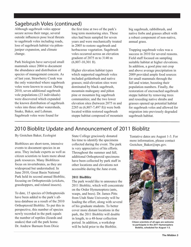
2011 BioBlitzThe park would like to announce the 2011 Bioblitz, which will concentrate on the Order Hymenoptera (ants, wasps, and bees). Dr. James Pitts from Utah State University will be leading the effort, along with several of his graduate students. To better cover more distant locations in the park, the 2011 Bioblitz will double in length, to a 48-hour collection period. In addition, a workshop will be held prior to the Bioblitz.
Citizen scientists of all ages are welcome to participate in the 2011 Hymenoptera
Bioblitz, scheduled for August 1-3.
Phot
o by
Gre
tche
n Ba
ker,
NPS
Tentative dates are August 1-3. For more information, please contact [email protected].

Strawberry Creek RestorationBy Patrick Mingus, Biological Science Technician
During the 2010 summer, park staff worked to make significant improvements in the Strawberry Creek area of Great Basin National Park. These improvements were done to enhance both the park visitor experience and vital sage steppe wildlife habitat. These improvements included closing part of a road that was causing hydrologic problems, creating a loop trail and a new trailhead parking area, developing nine campsites in a piñon-juniper area, and restoring dispersed campsites.
A total of 0.9 km (0.6 mi) of road located at the end of Strawberry Creek Road was closed and restored. This area will be converted to a hiking trail. The adjacent meadow is often used by elk during the fall rut period. The road removal and site rehabilitation was accomplished by the Resource Management Division. Both mechanized equipment and hand tools were used to recontour the site to match pre-road conditions. By matching the natural landscape, surface drainage patterns were restored. Trees and brush were placed on the soil surface as a mulch to protect against erosion from raindrop impact and sheet flow. Stone found in the fill material was randomly placed to conform to site conditions. A seed mix of sage, snowberry, flax, and other native plants was applied to the reclaimed road section to restore this area to a sage steppe dominant ecosystem. This type of habitat is critical for species such as sage thrasher and sagebrush voles.
Park staff also created a new trailhead parking area complete with restroom facilities and a loop trail. This new hiking trail connects to the Osceola Ditch Trail. Below the trailhead, nine campsites were created along Strawberry Creek Road. Silt fencing and weed-free straw bale check dams were erected in sensitive areas near the campground construction to protect Strawberry Creek and Bonneville cutthroat trout. The nine new campsites were sited in piñon-juniper forest along Strawberry Creek Road. Previous dispersed camping sites and access roads,
Phot
o by
Pat
rick
Min
gus,
NPS
4 The Midden
Resource Management staff rehabilitate a road at the upper end of Strawberry Creek. A hiking trail will be created in this area.
Phot
o by
Pat
rick
Min
gus,
NPS
One of the new campsites in Strawberry Creek. Nine new campsites were created, including one handicapped accessible.
some in sensitive riparian areas, were removed and restored.
New campsites were graded and mulched to reduce erosion and soil compaction. A new fire ring and picnic table were installed at each site. These modern picnic tables were constructed partially of recycled materials. One site is handicapped accessible to help serve a wider range of park visitors. Each site has improved parking. Future plans call for the installation of a horse corral for equestrian visitor use.

Strawberry Creek Restoration
The Midden 5
Historic Areas Recorded: Tilford Cabin and the Bonita Mining Campby Karla Jageman, Archeologist
Mining has long been a way of life in the West. The prospect of unfathomable riches brought many settlers from the East in the mid 19th century. Western expansion continued following the 1849 California Gold Rush, as people sought riches well into the 20th century.
John D. Tilford was among those early 20th century settlers looking for a new way of life. He came to the area, in what is now Great Basin National Park, in the early 1900s with his wife and children. They soon established a home and sawmill along Snake Creek. He operated the sawmill until 1912, when he discovered tungsten east of the sawmill, also along Snake Creek. Soon after the discovery he established the Bonita Mine.
In the early years the mining operation was small. However, during World War I demand for tungsten was high. It was during this time that much of the mine and its associated mining camp were developed. Tilford moved his family from the sawmill to the mine sometime around 1914. At its height the mine boasted 40 miners who lived at the Bonita Mining Camp, along with Tilford’s family. Due to the decreased need for tungsten after the end of World War I, the mine fell into disuse sometime between 1918 and 1920. It was during this time that the Tilford family moved to Ely, Nevada.
In an effort to learn more about this important mining site located within Great Basin National Park, a three step process was initiated during
the 2010 field season. First, the park contacted a Historic Preservation Specialist, David Yubeta, from the Tumacácori National Historical Park Vanishing Treasures Team. He was tasked with assessing the cabin and creating a plan for future stabilization efforts. Second, the Tilford family was contacted and invited to the park for a site visit to coincide with David Yubeta’s trip. Third was to record and map the Tilford Cabin and Bonita Mining Camp.
While at the park David Yubeta measured, recorded, documented, and photographed the Tilford Cabin. The information he gathered on this trip assisted him in creating a plan for stabilizing the cabin. Currently the cabin is in a state of ruin. The front corner has been damaged by natural deterioration and vandalism (Figure 1). Over the next few field seasons the park will use these plans to accurately and safely stabilize the cabin to its former glory.
The Tilford family was extremely excited to learn about the park’s plans for the site, which is a very important part of the family’s history. Family members who attended the visit included John D. Tilford’s daughter, grandchildren, great grandchildren,
and great nephew (Figure 2). During the visit, park cultural staff were eager to learn from family members about the daily life of the camp during its heyday. This information will be helpful in interpreting the site for park visitors in the future.
Another important aspect to better understand life at the mining camp was to record and document the archeological evidence left at the site. This was the final task for the 2010 field season. Twenty-three features and thousands of historic artifacts were located during the survey and recording of the Tilford Cabin and Bonita Mining Camp site. The twenty-three features included 12 tent platforms, four depressions, a corral, steps nailed to a tree, a dugout which was Toy Fong’s (the camp’s cook) house, a foundation for the Tilford family home, the Tilford Cabin (which was used for storage), a stone lined circular hole that may have been associated with the school house, and a ditch. The artifacts included glass, tin cans, ceramics, nails, wire, leather shoe parts, doll parts, and numerous others. Analysis of the artifacts is ongoing, but the majority of artifacts found are associated with the early 20th century, which is when the site was occupied by the Tilford family and the Bonita miners.
Figure 1. Tilford Cabin, note that the right corner has almost completely collapsed due to
natural deterioration and vandalism.
Figure 2. Dave Tilford (great nephew), Eleanor Tilford (daughter), and
Superintendant Andy Ferguson discuss the Tilford Cabin and Bonita Mining Camp.
Phot
o by
Nic
ole
Lohm
an,
NPS
Phot
o by
Kar
la J
agem
an,
NPS

6 The Midden
The Tin Can Speaks: Telling Time and Truths from Trashby Karla Jageman, Archeologist
Many people look at a rusty can and think it is just unimportant trash. Archeologists, however, look at that same rusty can and think of the information that it can reveal about the lives of the people who once lived in the area. This article is the second in a series about telling time and truths from the trash. (See The Midden Summer 2010 issue for the first in this series)
Past and Present: The Evolution of a Tin Can
Tinplating, the process of plating tin onto sheets of iron, began in Europe sometime during the 14th – 16th centuries. By 1810 the first tin can patent was filed in England. The technology did not make it to the United States for commercial production until sometime around 1819.
At Great Basin National Park, five types of tin cans are commonly found. Of these types, three once contained food: the hole-in-cap, vent hole, and sanitary cans. The other two tin can types did not contain food: the beverage/beer can and tobacco tin.
The hole-in-cap can has a circular hole in the top, through which food was pushed and a cap with a small vent hole was soldered to seal the can (Figure 1). Once enough steam had escaped, the vent hole was soldered. Hole-in-cap cans were produced from around 1820 to 1930. From 1820 to 1850 the can making process was done entirely by hand. From 1850 to 1886 part of the process was mechanized, and from 1886 to 1930
their manufacture was completely mechanized.
The vent hole can was manufactured starting around 1900. This can is identified by the single vent hole in one end. The hole was covered with a drop of solder at the end of the canning process. By 1920 this can type was most commonly used for canning evaporated milk. As of 1988 the vent hole can was almost entirely replaced by the modern sanitary can.
Sanitary cans were first developed in Europe in the late 1800s. By 1897 the Ams Machine Company had completely mechanized a new can production process that used a double side seam. Solder was still applied to the exterior of these cans until 1904 when the can became truly sanitary. During this time the interiors of the cans were coated with a lacquer to prevent a chemical reaction between the can’s contents and the metal. Some early sanitary cans had the mark ‘SANITARY’ on them (Figure 2). These probably are
associated with the Sanitary Can Company which was in operation from 1904 – 1908. The Sanitary can is still in use today.
The beverage/beer can was first produced in the early 1930s, but the process was not perfected until 1935 when it began to be made commercially. These cans had a flat top, contained beer, and were commonly opened with a church key opener, which was invented in 1935. Due to the carbonation of the beverage, soft drinks were not successfully canned until 1953. In 1959 the first completely aluminum can was invented. The pull tab beer can began being used in 1962; this method of opening the can eliminated the need for the church key. Daniel F. Cudzik invented the modern stay tab in 1975, which is still in use today.
Tobacco tins were first produced in the United States in 1892; these were the smaller so called pocket
Continued on Page 7
Figure 1. Example of the top of a hole-in-cap can. Notice the solder around the cap and over the
vent hole.
Phot
o by
Kar
la J
agem
an,
NPS

The Midden 7
The Tin Can Speaks (continued)
tins. In 1896 the upright pocket tin (Figure 3) was introduced by the Tuxedo Tobacco Company. One of the most common brands for the upright pocket tin was the Prince Albert. These were manufactured beginning around 1908. Originally they had a hinged friction lid. However, in 1946 the lid was changed to be more airtight with a lip on the can so that it fit more securely. Tobacco tins are still being produced today.
Types of Cans in Great Basin National Park and What They Tell Us
These five can types, along with many others, tell park archeologists information about the people who lived, worked, and played within what is now Great Basin National Park. Hole-in-cap cans are present in the park, but are not the most abundant type of can. This suggests that occupation of the area in the
1800s was likely, but did not last for an extended period of time. Therefore, this indicates that European-Americans did not settle in the area until the late 1800s. The most common type of can found in the park is the vent hole can. Its use suggests an early 1900s European-American occupation of the area.
Figure 2. This is a sanitary can with the ‘SANITARY’ label and was probably produced sometime between 1904 and 1908.
Figure 3. Back of an upright pocket tobacco tin. The writing was protected from the natural
elements because this side of the tin was facing down.
The Sanitary can is still used today, but there are many indicators that date it to the early 1900s, such as the smooth sides of the can.
Hole-in-cap cans, vent hole cans, sanitary cans, and tobacco tins are most commonly associated with the occupation sites, such as mines and ranches located within the park. Many of these sites date to the late 1800s and early 1900s. The period of occupation for these sites is based on a number of factors including artifact identification, such as tin cans, glass, ceramics, and the historic record. Beverage/beer cans are most commonly associated with road edges and camping areas. This suggests that these cans were used by recreationists in the area in the mid 1900s.
Tin cans are important for many reasons. They help archeologists date historic archeological sites and learn about what types of food and non-food items were used by the people who once lived there. Both are important factors for archeologists to learn about and interpret the past. Without these artifacts the history of a site would be lost forever.
For further information on tin cans and other historic artifacts, see Mark Q. Sutton and Brooke S. Arkush’s 2002 book Archeological Laboratory Methods: An Introduction.
Phot
o by
Kar
la J
agem
an,
NPS
Phot
o by
Kar
la J
agem
an,
NPS
The Tin Can Speaks: Telling Time and Truths from Trash

Bonneville Cutthroat Trout Population Update
8 The Midden
The fish crew conducts an electrofishing survey along South Fork Big Wash.
By Mark Pepper, Biological Science Technician
Ten years ago, Great Basin National Park began the reintroduction of native Bonneville cutthroat trout (BCT) to park streams. BCT were moved to South Fork Big Wash in 2000, to Strawberry Creek in 2003, and to South Fork Baker Creek and Snake Creek in 2005. A small number of fish were used during the initial reintroduction phase due to the small populations in Mill Creek and another donor stream. South Fork Big Wash initially had 56 BCT, Strawberry Creek had 64, Upper Snake Creek had 104, and South Fork Baker had 45.
Over the past two field seasons, the fisheries crew has surveyed all five of the BCT streams in the park. Surveys included population estimates and habitat and riparian condition assessments. The information gathered will help the park to better understand the current distribution of BCT, calculate population estimates, and provide important information fon fisheries habitat conditions.
Mill Creek is of special importance because of its remnant native population of BCT. Four permanent long term monitoring sites have been set up. Two of the sites are located at the park boundary and two east of the Osceola Ditch, spanning the entire length of Mill Creek. Electrofishing surveys have determined that the creek has an estimated fish density of 221 BCT/km (354 BCT/mile), with its upper distribution at 2530 m (8,300 ft).
South Fork Big Wash is the most remote of the BCT streams in the park. It starts at 2316 m (7,600 ft) at a large perennial spring head, which is the upper distribution of the BCT. The stream continues intermittently for over 5 km (3 mi) to the park boundary. Due to the remoteness of the stream only a small portion has been surveyed, with two sites set up as long term permanent monitoring sites. During the 2011 field season additional sites will be added to better assess the stream’s excellent habitat. This stream has an estimated fish density of 453 BCT/km (725 BCT/mile) and boasts some of the largest BCT found in the park to date.
Strawberry Creek has the longest distribution of BCT, 7.2 km (4.5 mi). In 2009 the creek was surveyed and it was found to have an estimated fish density of 403 BCT/km (644 BCT/mile). This is amazing when you consider that only 64 BCT were reintroduced into the stream in 2003 and an additional 30 in 2005 from Mill Creek. The upper distribution elevation is relatively low at 2414 m (7,920 ft). In the future the park hopes to expand BCT habitat into the creek’s higher elevations. From the park boundary to the creek’s
headwaters, a total of 10 long term permanent monitoring sites have been established.
Upper Snake Creek has over 5 km (3 mi) of good trout habitat, with BCT occupying 3 km (2 mi). In 2010, 11 long term permanent monitoring sites were set up along the creek in the main stem and the north, middle, and south tributaries. Surveys in 2010 revealed that brook trout have invaded the BCT habitat. The creek has a density of 342 fish/km (547 fish/mile), although BCT make up only about 20% of that total. The upper distribution is 2530 m (8,300 ft).
South Fork Baker Creek has one of the highest upper distributions of BCT in the park, at 2820 m (9,250 ft). The fish density in this creek was surveyed in 2009 and estimated to be 201 BCT/km (322 BCT/mile). The natural fish barrier that separates it from the main channel of Baker Creek has kept non-native trout from entering the restored portion of the creek. This creek has four permanent long term monitoring sites.
The future of the park’s fisheries program continues to look bright. Plans include introducing additional BCT into the streams, removing non-native trout from Snake Creek, and translocating BCT within streams to additional habitat. These plans will expand the distribution and increase BCT populations. The park thanks all who have helped in these efforts, especially Trout Unlimited.
Phot
o by
Ste
pfan
ie O
lind,
NPS

The Midden 9
Recent Research Projects
Desert Research Institute researchers collecting algae near a light in Lehman Cave.
Phot
o by
Gre
tche
n Ba
ker,
NPS
By Gretchen Baker, Ecologist
Every year, researchers come to Great Basin National Park to learn more about park resources. These studies are encouraged by the National Park Service Management Policies (2006) because “they support the NPS mission by providing the Service, the scientific community, and the public with an understanding of park resources, processes, values, and uses.” In 2010 the park had about 30 active research permits.
Water is frequently studied in Great Basin National Park. The Nevada State Engineer’s office, USGS, and Southern Nevada Water Authority have taken streamflow measurements. The Utah USGS under the direction of Philip Gardner also collected water samples for isotope analysis. Ohio State University (OSU) researchers David Porinchu and Scott Reinemann took a core sample of Dead Lake sediments to determine its past climate. The OSU researchers Bryan Mark, Jason Box, and Nathan Patrick also maintain a collection of dataloggers in selected waterbodies to detect changes in temperature over the course of the year. The Mojave Desert Inventory and Monitoring network, in cooperation with the park, has dataloggers installed in all the lakes and also conducted some continuous water quality measurements in streams.
Several researchers looked at vegetation. Dr. David Charlet and Glenn Clifton helped conduct additional botanical surveys in the park, looking for rare and unusual plant species. Dr. Barbara Ertter
examined Potentilla, the buttercups, in preparation for the upcoming Intermountain Flora.
Invertebrates were the subject of several studies. The Nevada Department of Agriculture has an ongoing project to detect gypsy moth invasion. Under the direction of entomologist Jeff Knight, they are also studying Jerusalem crickets and thrips. Retired Professor Mark Ports extended his study of landsnails in the Great Basin to the park. Cave biologist Steve Taylor returned to the park, but concentrated on above-ground habitats to help determine which invertebrates are using cave-like habitats.
A variety of other studies occurred in the park. Researchers from the Desert Research Institute led by Christian Fritsen brought students to the park to learn about algae in the caves and on snow near and on the rock glacier. Air studies directed by Genine Wright included testing for
mercury deposition. A social science study by Stephanie Kyriazis explored the emotional dimensions of geology interpretation. Cultural research by former park employee David Harwood focused on documenting pre-1900 historic graffiti in Lehman Cave.
Anyone interested in doing research in Great Basin National Park can apply for a research permit on the National Park Service online system, which is found at http://science.nature.nps.gov/research.
Researchers are required to submit Investigator Annual Reports (IARs) for each year they have a valid permit. These IARs are available to the public, and can be found on the same NPS research website. If you’d like to learn more about what researchers have written about the park, a list of selected researchers’ publications are found on the park website: http://www.nps.gov/grba/parknews/selected-publications.htm.

The Midden is the Resource Management newsletter for Great Basin National Park.
A spring/summer and fall/winter issue are printed each year. The Midden is also available on the Park’s website at www.nps.gov/grba.
We welcome submissions of articles or drawings relating to natural and cultural resource management and research in the park. They can be sent to:Resource Management,Great Basin National Park,Baker, NV 89311Or call us at: (775) 234-7331
SuperintendentAndy Ferguson
Chief of Resource ManagementTod Williams
Editor & LayoutGretchen Baker
10 The Midden
National Park ServiceU.S. Department of the Interior
What’s a midden? A midden is a fancy name for a pile of trash, often left by pack rats. Pack rats leave middens near their nests, which may be continuously occupied for hundreds, or even thousands, of years. Each layer of trash contains twigs, seeds, animal bones and other material, which is cemented together by urine. Over time, the midden becomes a treasure trove of information for plant ecologists, climate change scientists and others who want to learn about past climatic conditions and vegetation patterns dating back as far as 25,000 years. Great Basin National Park contains numerous middens.
SNOTEL Site Installed in Park
Nevada SNOTEL sites
Upcoming Events:
March 5: Messier Marathon Star Party. See how many celestial objects you can check off. Great Basin park rangers will assist at the Lehman Cave Visitor Center. Visit http://www.richardbell.net/marathon.html for more background.
May 28-29: Great Basin Star Party. Special program & night sky viewing with telescopes. See http://www.nps.gov/grba for more details.
Jul y 28-30: 2nd Annual Astronomy Festival. Join hundreds of star gazaers for a fun filled weekend. Excellent sky-viewing opportunities and a variety of programs and talks offered. See http://www.nps.gov/grba for more details.
August 1-3: Hymenoptera Bioblitz. Help collect ants, bees, and wasps to add to the baseline data on invertebrates in the park. Email [email protected] for more details.
September 3-5: Great Basin Star Party. Special program & night sky viewing with telescopes. See http://www.nps.gov/grba for more details.
Lehman Cave Tours daily at 9 AM, 11 AM, 1 PM, and 3 PM. Visitor Center open 8 AM to 4:30 PM daily except Thanksgiving, 12/25 & 1/1.
During the 2010 summer, the Natural Resources Conservation Service (NRCS) installed a SNOTEL site near the Wheeler Peak campground at 3093 m (10,147 ft) elevation. SNOTEL stands for SNOpack TELemetry and is an automated system to measure and relay climate data, including temperature, depth of snow, year-to-date precipitation, and snow water equivalent. The measurements are communicated in near-real-time using VHF radio signals that are reflected off ionized meteorites that exist in a band 80 to 120 km (50 to 75 miles) above the earth.
The SNOTEL site joins 33 others in the state of Nevada. SNOTEL sites are present in 11 western states at over 730 locations. Most of the sites are high elevation, remote, and difficult to access during the winter months. The SNOTEL sites are designed to operate unattended and without maintenance for a year. They use a solar panel to recharge batteries.
The data collected by the SNOTEL sites is used to predict water supply, including streamflow forecasts, for the coming year. The data for the Wheeler Peak site is available on the Internet athttp://www.wcc.nrcs.usda.gov/nwcc/site?sitenum=1147&state=nv or Google ‘Wheeler Peak SNOTEL site.’