park row access - nyc.gov
TRANSCRIPT

PARK ROW ACCESS Bike and Pedestrian Connections
Presented to Manhattan Community Board 1, October 5, 2017
1
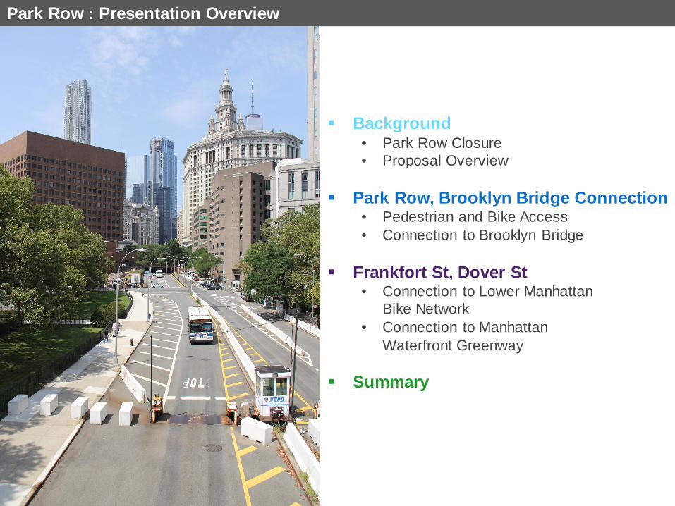
Park Row : Presentation Overview
Background • Park Row Closure • Proposal Overview
Park Row, Brooklyn Bridge Connection • Pedestrian and Bike Access • Connection to Brooklyn Bridge
Frankfort St, Dover St • Connection to Lower Manhattan Bike Network • Connection to Manhattan Waterfront Greenway
Summary

1 Background
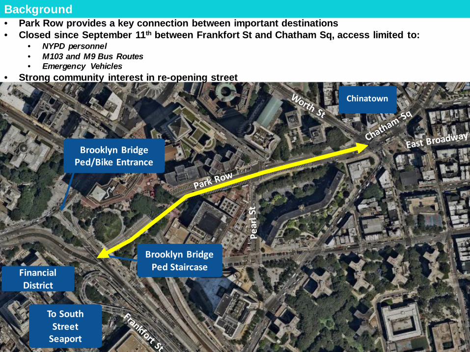
Background
Chinatown
Brooklyn Bridge Ped/Bike Entrance
Brooklyn Bridge Ped Staircase
To South
Street Seaport
Financial District
• Park Row provides a key connection between important destinations • Closed since September 11th between Frankfort St and Chatham Sq, access limited to:
• NYPD personnel • M103 and M9 Bus Routes • Emergency Vehicles
• Strong community interest in re-opening street

Background • DOT has recently implemented pedestrian and bike safety and mobility enhancements in the
area, improved access to entrances to Manhattan and Brooklyn bridges
Chrystie St
2-way Protected Bike Lane Canal St
Manhattan Bridge Mobility and Safety Improvements
Centre St / Park Row 2-way Protected Bike Lane
Park Row Pedestrian Safety
Improvements
Lower Manhattan Bike Network

Background
One Police Plaza
Metropolitan Correctional
Center
Daniel Patrick Moynihan US Courthouse
US Court of Appeals
New York County Supreme Court
US Attorney’s Office
• NYPD and DOT are working together to increase access while maintaining necessary security
around One Police Plaza and other critical civil institutions • NYPD has agreed to allow pedestrian and bike access • At this time NYPD will continue to restrict access for unauthorized motor vehicles

Timeline: Background Project Timeline
• June – August 2017:
• Series of site visits and meetings to examine feasibility of opening Park Row to pedestrians and cyclists (DOT, NYPD, City Hall, DEP)
• Development of proposed project
• August 2017: Elected official and Community Board notifications; DOT/City Hall press conference
• September – October 2017: Community Board presentations
• Fall 2017: Preliminary implementation, including NYPD removal of conflicting infrastructure, DOT resurfacing and wayfinding installation
• Spring 2018: Complete implementation of bike and pedestrian improvements
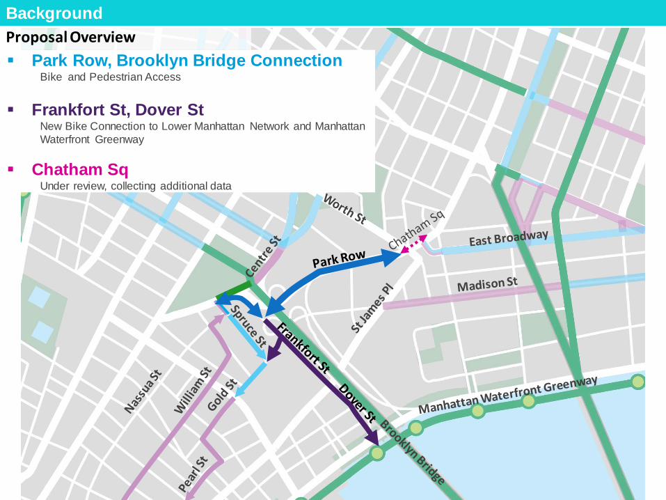
Park Row, Brooklyn Bridge Connection Bike and Pedestrian Access
Frankfort St, Dover St New Bike Connection to Lower Manhattan Network and Manhattan Waterfront Greenway
Chatham Sq
Under review, collecting additional data
Proposal Overview Background

Grand St Corridor Upgrades Park Row Brooklyn Bridge Connection 2
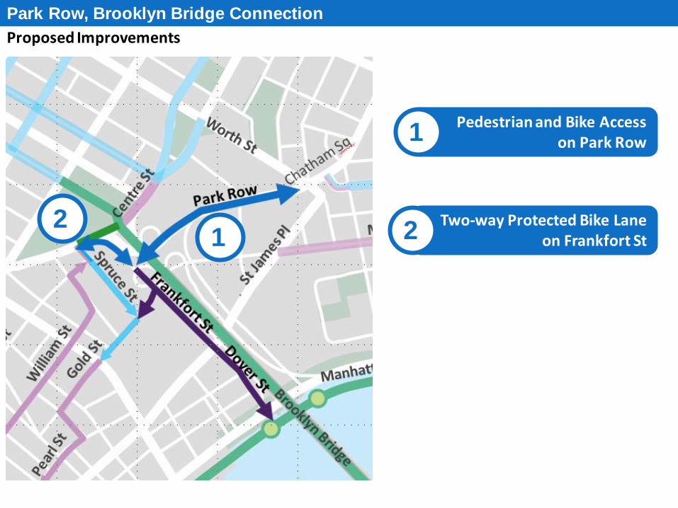
Proposed Improvements Park Row, Brooklyn Bridge Connection
Pedestrian and Bike Access on Park Row 1
Two-way Protected Bike Lane on Frankfort St 2 1
2

No Sidewalk between Brooklyn Bridge and Pearl St No Bike Facility Excess roadway space and fewer conflicts along south side of street
Existing Conditions
Park Row, Brooklyn Bridge Connection
Pedestrian and Bike Access on Park Row 1
Roadway Obstructions Shipping Containers
Planters “Delta Barrier” - Guard Booth
Jersey/Block Barriers PD parking
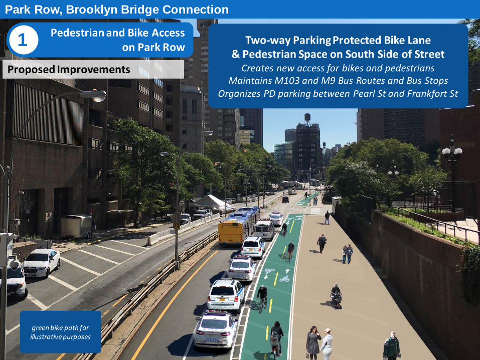
Proposed Improvements
Two-way Parking Protected Bike Lane & Pedestrian Space on South Side of Street
Creates new access for bikes and pedestrians Maintains M103 and M9 Bus Routes and Bus Stops
Organizes PD parking between Pearl St and Frankfort St
Park Row, Brooklyn Bridge Connection
Pedestrian and Bike Access on Park Row 1
green bike path for illustrative purposes

Existing Conditions
Park Row, Brooklyn Bridge Connection
Pedestrian and Bike Access on Park Row 1
No Sidewalk between Brooklyn Bridge and Pearl St No Bike Facility Excess roadway space and fewer conflicts along south side of street
Pear
l St
Roadway Obstructions Shipping Containers
Planters “Delta Barrier” - Guard Booth
Jersey/Block Barriers PD Parking

Existing Conditions
Park Row, Brooklyn Bridge Connection
Pedestrian and Bike Access on Park Row 1
Excess Space with Lack of Formal Markings Disorganized PD Parking
No Dedicated Space for Pedestrians and Bikes Unpredictable Movements Long Pedestrian Crossing
Pear
l St
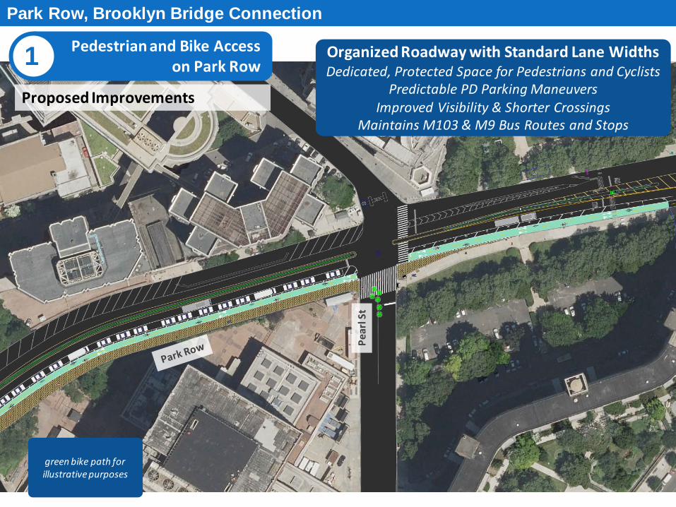
Proposed Improvements
Park Row, Brooklyn Bridge Connection
Pedestrian and Bike Access on Park Row 1
green bike path for illustrative purposes
Organized Roadway with Standard Lane Widths Dedicated, Protected Space for Pedestrians and Cyclists
Predictable PD Parking Maneuvers Improved Visibility & Shorter Crossings
Maintains M103 & M9 Bus Routes and Stops
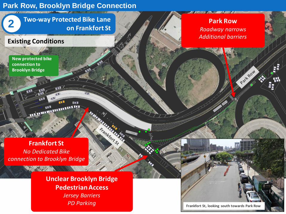
Frankfort St No Dedicated Bike
connection to Brooklyn Bridge
Park Row
Roadway narrows Additional barriers
Existing Conditions
Park Row, Brooklyn Bridge Connection
Unclear Brooklyn Bridge Pedestrian Access
Jersey Barriers PD Parking
Frankfort St, looking south towards Park Row
New protected bike connection to Brooklyn Bridge
Two-way Protected Bike Lane on Frankfort St 2
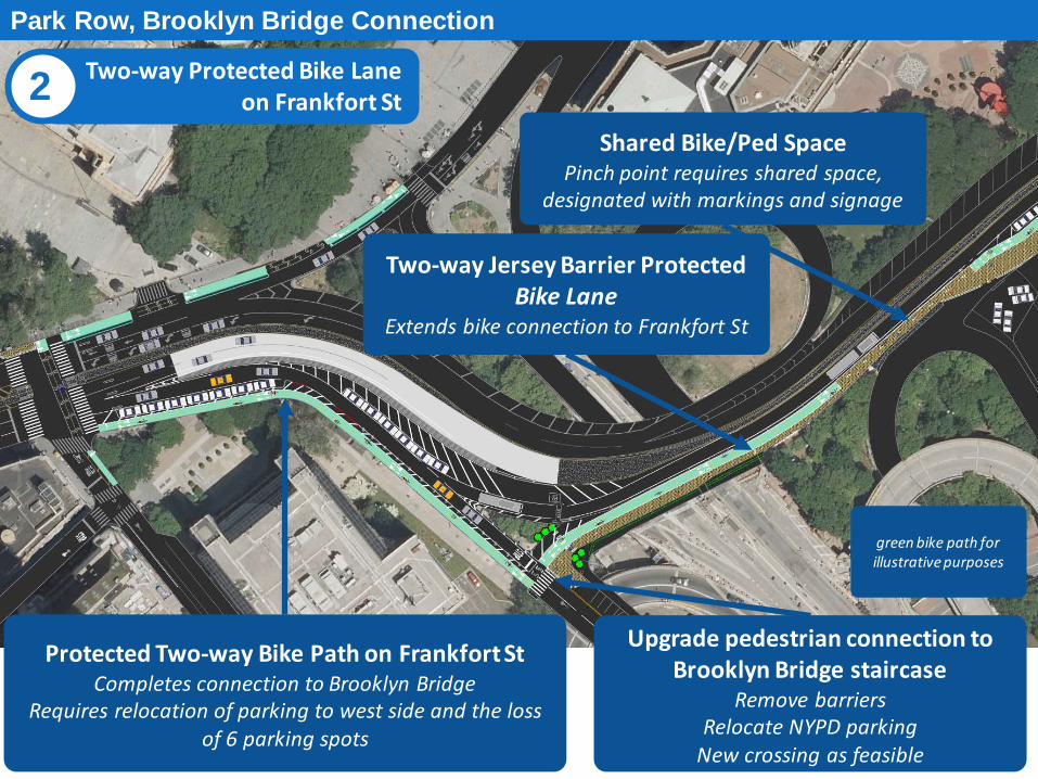
Protected Two-way Bike Path on Frankfort St Completes connection to Brooklyn Bridge
Requires relocation of parking to west side and the loss of 6 parking spots
Upgrade pedestrian connection to Brooklyn Bridge staircase
Remove barriers Relocate NYPD parking
New crossing as feasible
Park Row, Brooklyn Bridge Connection
Shared Bike/Ped Space Pinch point requires shared space,
designated with markings and signage
Two-way Jersey Barrier Protected Bike Lane
Extends bike connection to Frankfort St
green bike path for illustrative purposes
Two-way Protected Bike Lane on Frankfort St 2
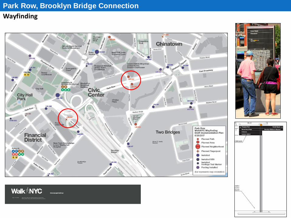
Wayfinding Park Row, Brooklyn Bridge Connection
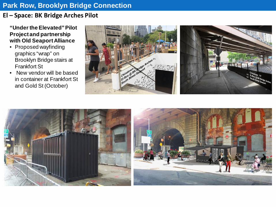
El – Space: BK Bridge Arches Pilot Park Row, Brooklyn Bridge Connection
“Under the Elevated” Pilot Project and partnership with Old Seaport Alliance • Proposed wayfinding
graphics “wrap” on Brooklyn Bridge stairs at Frankfort St
• New vendor will be based in container at Frankfort St and Gold St (October)
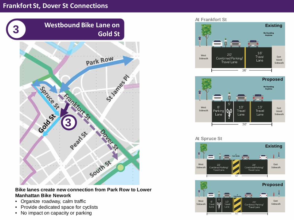
3 Frankfort St, Dover St

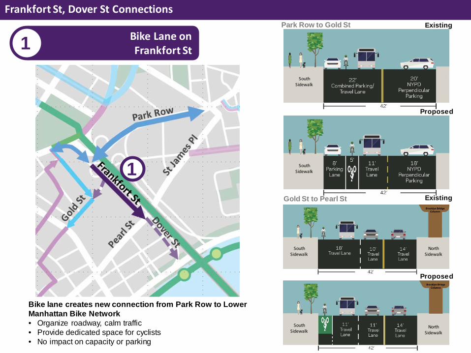
Proposed Improvements Frankfort St, Dover St Connections
Bike Lane on Frankfort St 1
Bike Lane on Gold St 3
Shared Lane on Dover St 2
1
2
3
South Sidewalk
South Sidewalk
North Sidewalk
North Sidewalk
South Sidewalk
South Sidewalk
Gold St to Pearl St
Park Row to Gold St Bike Lane on Frankfort St 1
Frankfort St, Dover St Connections
Proposed
Existing
Bike lane creates new connection from Park Row to Lower Manhattan Bike Network • Organize roadway, calm traffic • Provide dedicated space for cyclists • No impact on capacity or parking
1
Proposed
Existing

South Sidewalk
South Sidewalk
South Sidewalk
South Sidewalk
Southbound Shared Lane on Dover St 2
Frankfort St, Dover St Connections
Pearl St to Water St Water St to South St
Shared lanes from Pearl St to Manhattan Waterfront Greenway • Provides wayfinding • No impact on capacity or parking
2 Proposed
Existing
Proposed
Existing
West Sidewalk
West Sidewalk
East Sidewalk
East Sidewalk
East Island
Sidewalk
East Island
Sidewalk
West Sidewalk
West Sidewalk
Westbound Bike Lane on Gold St 3
Frankfort St, Dover St Connections
At Frankfort St
At Spruce St
Bike lanes create new connection from Park Row to Lower Manhattan Bike Nework • Organize roadway, calm traffic • Provide dedicated space for cyclists • No impact on capacity or parking
3
Proposed
Existing
Proposed
Existing
4 Summary
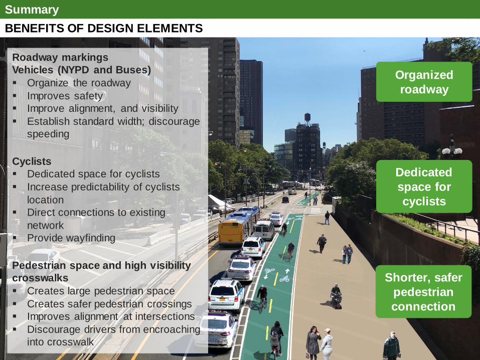
BENEFITS OF DESIGN ELEMENTS Summary
Roadway markings Vehicles (NYPD and Buses) Organize the roadway Improves safety Improve alignment, and visibility Establish standard width; discourage
speeding Cyclists Dedicated space for cyclists Increase predictability of cyclists
location Direct connections to existing
network Provide wayfinding Pedestrian space and high visibility crosswalks Creates large pedestrian space Creates safer pedestrian crossings Improves alignment at intersections Discourage drivers from encroaching
into crosswalk
Organized roadway
Dedicated space for cyclists
Shorter, safer pedestrian connection

Questions?
THANK YOU!
27
NYC DOT NYC DOT nyc_dot NYC DOT