part 4 residential - home - rotorua lakes council · 2016-07-08 · june 2016 | 4.4 rdc–572451...
TRANSCRIPT

JUNE 2016 | 4 .1
RDC–572451 ROTORUA DISTRICT PLAN
PART 4 – RES IDENTIAL
PART 4
RESIDENTIAL
4.1 INTRODUCTION
The purpose of the residential zone is to provide a high level of amenity for residents and
an attractive residential environment where people want to live.
Across the district there are residential areas that have different amenity values and
character. Residents of these areas have different expectations of the environment and
experience different issues. This is reflected by defining five residential zones with
objectives, policies and rules that address the issues affecting each zone.
The character of each zone is briefly described in the following table:
Zone Code Description
Residential 1
Low Density living
RD1 Low density residential areas, such as Ngōngōtahā, Kāwaha Point, Western Heights, Hillcrest, Springfield
and Lynmore. There is a mix of single storey and two-
storey houses of various styles and materials. There is
a balance between the built and natural elements of the environment in this zone. There is a sense of
space around buildings, which is enhanced by the
landscaping on site and trees within the road reserve.
Other characteristics include generally low levels of
noise and low traffic levels.
Residential 2
Medium Density living
RD2 Medium density residential areas located close to the
city centre. There is a mix of single storey and two-
storey apartment style living, with limited outdoor space. The built environment is dominant and much
of the space around buildings is taken up by hard
surfacing for car parking and turning. There are few
trees and shrubs that make an impact on the wider
area and the zone is more reliant on the street trees to soften the built environment.
Residential 3
Ōhinemutu,
Whakarewarewa,
Ngāpuna
RD3 The cultural and historic villages of Ōhinemutu,
Whakarewarewa and Ngāpuna. Dwellings within these areas are typically single storey wooden buildings
interspersed with geothermal activity and geothermal
features. Ōhinemutu and Whakarewarewa villages are
accessed through narrow roads and have the sense of
being close-knit communities. Marae and associated communal buildings are dominant focal points. Each
village contributes to the cultural historic heritage and
identity of Rotorua.

JUNE 2016 | 4 .2
RDC–572451 ROTORUA DISTRICT PLAN
PART 4 – RES IDENTIAL
Zone Code Description
Residential 4
Lakeside
Settlements
RD4 Residential lakeside settlements including, for
example Hamurana, Rotoiti, Ōkere Falls, Rotoehu and
Rotomā. These areas consist of sites with low density
development and high levels of outdoor open living space. Dwellings are often oriented to capitalise on
lake views. A mix of freehold and leasehold land is
present that supports a variety of building design and
a range of residential activity such as baches, holiday
homes and permanent living. The settlements themselves vary in size and character.
Residential 5
Residential
Lifestyle
(Wharenui
Road area)
RD5 Rural-residential lifestyle specifically located within the
area of the Wharenui Road Area Development Plan in Appendix 5. The intended character of the zone is one
of relatively large lot sizes and space around and
between buildings to be established by the imposition
of performance standards for overall density.
4.2 KEY ENVIRONMENTAL ISSUES
There are two key issues influencing the policy framework in the residential zones:
4.2.1 Activities in a Residentia l Zone
A high level of amenity is anticipated in residential areas where an environment is
provided that is primarily residential in character, peaceful and safe. Traffic generated is
generally low and of light vehicles. Non-residential uses have the potential to have an
adverse effect on that amenity by introducing noise, traffic, fumes and odours, or light
glare, for example.
The cumulative effect of new building, whether infill housing, or accessory garages and
sleep-outs can also alter the character of residential areas by increasing density and
reducing the proportion of open space available for landscaping. Building within yards
reduces space around buildings and can have an adverse effect on outlook and privacy.
Building within, and enclosure of, the front yard has an effect on the street scene and is a
significant influence on the character of the area. Examples of such effects can be seen
in the existing residential areas. In some cases the cumulative effect of several changes
from residential to office use has altered the character of the area, or a cluster of garages
in the front yards has reduced the sense of openness within a streetscape.
The Plan sets out a framework to enable residential activity without imposing excessive
controls.
Residential 1
The character of the Residential 1 zone can be adversely affected by the gradual erosion
of the open space around and between buildings as a result of extensions and accessory
buildings within the boundary yards. In particular building within, or enclosure of, the
front yards has an impact on the street scene in that the sense of space is reduced,
obscuring passive surveillance of the neighbourhood reduces security and individual sites
do not relate visually to the street. These effects can be made worse by the loss of
JUNE 2016 | 4 .3
RDC–572451 ROTORUA DISTRICT PLAN
PART 4 – RES IDENTIAL
established garden areas, particularly taller trees and shrubs that have an impact on the
amenity of the surrounding area beyond the boundary of an individual site.
Residential 2
The Residential 2 zone helps to provide diversity in residential living; however the higher
density, site coverage, and area of hard surfacing that is used for on-site parking all
contribute to an environment that is dominated by buildings and man-made features.
The consequent lower levels of planting on site accentuate the harder environment of the
Residential 2 zone. The potential adverse effects of such an environment can be
reduced by higher quality of urban design in both the buildings and open space around
them. High quality urban design, providing passive surveillance over the streetscape and
public reserves, ensuring suitable private, outdoor living space is provided on the site and
that onsite parking does not dominate the streetscape are examples of measures that
enhance residential amenity in such an environment. Whilst there may be an expectation
that the scale and form of new development will be in keeping with the surroundings,
some variety in design is desirable to add interest and vibrancy to the streetscape.
Residential 3
The villages of Ōhinemutu and Whakarewarewa are exceptional and unique places within
the district. New development or activities within the villages that are out of keeping with
the existing environment, has the potential to have an adverse effect on their special
character. Similarly activities on the land adjacent to the villages may cause disturbance
through noise, smoke, dust, vibration or traffic, or may be visually intrusive such that they
have an adverse impact on the cultural and historic heritage of the villages and
consequently of the district.
The residential amenity, character and cultural significance of Ngāpuna village are
adversely affected by the non-residential activities that are carried out in the surrounding
area. Further development and expansion of such activities within the vicinity of this
village has the potential to make the situation worse. In most places the boundary
between the residential and non-residential activities is not softened by landscaping or
screened by fencing. Consequently the potential for there to be an adverse effect on
amenity from noise, smoke, dust, vibration or traffic, or visual intrusion is significant.
Residential 4
Lakeside settlements are a key attribute of the Rotorua district. Some lakeside
settlements are connected to public water and waste water reticulation thereby making
further development feasible. It is planned to connect further lakeside settlements in the
future where possible, which will help to enhance lake water quality. Residential activity
affects the character of lakeside margins. Buildings that nestle into the landscape at a
density that is in keeping with the surrounding environment maintain an element of the
natural character and reduce the impact on the wider landscape of the lake edge.
Residential 5
The residential lifestyle (Wharenui Road Area) is a major greenfield site that will
significantly increase the amount of low density residential land. Its location anticipates
that there will be connections to existing residential areas, schools, the strategic road
network, and to reserves and public spaces. The area will be expected to conform to
performance standards and design criteria to ensure that development of the land
provides a high standard of amenity.
JUNE 2016 | 4 .4
RDC–572451 ROTORUA DISTRICT PLAN
PART 4 – RES IDENTIAL
4.2.2 The Design, Layout and Appearance of Residentia l Sites
The appearance of buildings on residential land, the space around them and the
treatment of the space and boundaries can have a positive or negative effect on an area.
Layouts that reduce the space around the buildings and high front boundary fences that
are unrelieved by planting, or intrusive car parking reduce amenity value, whilst sensitive
landscaping and boundary treatments can enhance it.
Environmental quality and amenity values are influenced by lot sizes and shapes and can
be enhanced by ensuring that buildings can be located on each site in accordance with
performance standards. However the degree of control that Council seeks to achieve
through these standards is a sensitive issue.
The promotion of well-designed and safe pedestrian and cycling linkages between
neighbourhoods to and from schools and local amenities is also very important to ensure
connectivity within local communities. It will also allow for easy access and promotion of
non-vehicular modes of transport. This is even more important where these activities are
separated by strategic roading corridors.
The environmental qualities that the community wish to provide should guide the
framework of objectives, policies and rules. The residential areas have developed with
rules and performance standards that have controlled matters such as building height,
yard distances, site coverage, on-site parking and turning, fence height and signage.
These controls can be adjusted, or extended depending on the desired outcome. For
example reducing yards may allow for a more efficient use of a site, but at the same time
there may be an adverse impact on the amenity and privacy of an adjoining site.
The importance that government and the community place on the sustainability of new
development is reflected in changes to the Building Act, promotion of improvements to
insulation and interest in domestic scale renewable energy, for example. Whilst the
inclusion of rules imposing control over the detailed design and construction of new
buildings is beyond the scope of this plan, provision can be made to encourage that
building be carried out using sustainability principles such as orienting toward the sun to
obtain maximum solar gain, including good insulation, use of domestic scale energy
generation, recycling grey water and use of renewable or recycled materials. Assessment
criteria are included to encourage this to be considered.
High quality urban design is a desirable outcome to promote amenity and security and
address the potential adverse cumulative effects of infill housing. The plan seeks to be
permissive and enable new development, providing useable, private outdoor living space
that is separate from access and parking provision, and enable the maximisation of
daylight and solar access.
Infill housing is provided for in the plan as a way to facilitate a compact, sustainable
urban form. Infill housing reduces the demand to develop greenfield sites in rural zones
and makes best use of the existing urban infrastructure. There is potential for such
development to have an adverse impact on the surroundings. The construction of
additional houses intensifies activity on land that may historically have been used as a
relatively quiet rear yard and garden area. This is likely to have an impact both on the
neighbouring properties and the character of the wider area. Potential disturbance from
vehicles entering and leaving the site, noise from the normal occupation of houses,
effects on privacy and outlook for example, can all adversely affect the environment and
cumulatively alter the amenity of the residential zones.

JUNE 2016 | 4 .5
RDC–572451 ROTORUA DISTRICT PLAN
PART 4 – RES IDENTIAL
There are particular challenges in different areas of the district. In areas of high density
such as the Residential 2 zone, site layout and design are important where open space is
limited. The design of development in the lakeside settlements in the Residential 4 zone
needs to have regard to the natural character of the lakes and lake margins in order to
maintain and enhance the existing amenity values.
4.3 OBJECTIVES AND POLICIES
The specific Objectives and Policies for the residential zones are stated below. The
objectives and policies below shall be read in conjunction with the provisions for Parts 1-
3 and the technical requirements in Parts 13-17.
Activities in a Residential Zone
Objective 4.3.1
A level of amenity that provides residents with:
A northerly outlook
Side and rear yards that provide aural and visual amenity
Residential levels of noise
Safe parking and turning areas where required
Street surveillance
Orientation to maximise energy efficiency
Policy 4.3.1.1 Require yards and protection of daylight planes to provide for privacy
and outlook to reduce the adverse effects of noise between
household units and the character of the streetscape.
Policy 4.3.1.2 Manage the siting of household units on adjoining land to protect the
privacy, outlook and amenity of residents.
Policy 4.3.1.3 Require on-site outdoor space for each household unit.
Policy 4.3.1.4 Ensure the design and location of access, on-site parking and turning areas do not detract from the safe and efficient functioning of the
transport network or dominate the streetscape.
Policy 4.3.1.5 When considering a resource consent application, require the landscaping to mitigate the adverse effects of activities and to
enhance the character and amenity of the zone.
Policy 4.3.1.6 Require noise mitigation measures for household units that adjoin strategic roads to avoid reverse sensitivity effects.
Policy 4.3.1.7 Encourage implementation of principles of sustainable building practice through provision of advice and information.

JUNE 2016 | 4 .6
RDC–572451 ROTORUA DISTRICT PLAN
PART 4 – RES IDENTIAL
Objective 4.3.2
The character and amenity values of the residential zones are maintained and
enhanced.
Policy 4.3.2.1 Maintain the following qualities and characteristics of the Residential 1 zone:
Low density residential areas
A mix of single and two storey buildings
A variety of building design and materials
Balance between the built and natural elements of the
environment
A sense of space around buildings
Space enhanced by on-site landscaping and trees within the
road reserve
Low levels of noise and
Low traffic levels
Policy 4.3.2.2 Maintain the following qualities and characteristics of the Residential
2 zone:
Medium density residential areas
A mix of single storey and two-storey buildings
Smaller household units and apartment style living
Limited outdoor space
Built elements dominate the environment
Much of the space around buildings is taken up by hard
surfacing for car parking and turning
Reliance on street trees to soften the built environment
Policy 4.3.2.3 Maintain the following qualities and characteristics of the Residential
3 zone:
Medium to high density residential areas
Close development and narrow roads
Historic and geothermal features integrated into the
environment of the villages
A mix of single and two storey buildings
A variety of building design and materials
Low levels of noise and
Low traffic levels
Policy 4.3.2.4 Maintain the following qualities and characteristics of the Residential
4 zone:
Low density residential areas
A mix of single storey and two-storey buildings
A high proportion of outdoor open living space
A variety of building design and materials
Building that does not dominate the natural character of the
lake and its margin
A sense of space around buildings
Low levels of noise
Low traffic levels
JUNE 2016 | 4 .7
RDC–572451 ROTORUA DISTRICT PLAN
PART 4 – RES IDENTIAL
Policy 4.3.2.5 Achieve the following qualities and characteristics of the Residential
5 zone:
Low density residential areas on larger lots
A mix of single and two storey buildings
A variety of building design and materials
Balance between the built and natural elements of the environment such that building does not over-dominate
A sense of space around buildings
Space enhanced by on-site landscaping and trees within the
road reserve
Low levels of noise
Low traffic levels
Objective 4.3.3
Non-residential activities in residential zones that are domestic in scale and character
and do not have an adverse impact on the amenity values and character of the
residential zones, or the vitality and viability of the City Centre or Commercial zones.
Policy 4.3.3.1 Manage the location and design of buildings for non-residential activities to ensure that the activity is in keeping with the appearance
and character of the residential zone sought in Objective 4.3.2 and
Policies 4.3.2.1 to 5.
Policy 4.3.3.2 Prevent the establishment of non-residential activities where they
would be more appropriately located in a commercial, industrial or
city centre zone and would have an adverse effect on the vitality and
viability of those zones.
Policy 4.3.3.3 Avoid adverse effects of noise, vibration, light, smoke, fumes, odours,
or other sources of disturbance that are detrimental to the amenity of
the residential zones.
Policy 4.3.3.4 Ensure the location of community activities avoids, remedies, or
mitigates adverse effects on the quality of residential amenity in the
residential zones.
Policy 4.3.3.5 Avoid, remedy or mitigate the potential adverse effects of non-
residential activities, including community activities, through the
provision of;
Sufficient on-site parking, loading and turning
Landscaping to maintain and enhance the quality of residential
amenity, primarily the streetscape
Noise mitigation measures
Objective 4.3.4
Maintain the following qualities and characteristics that contribute to the cultural
significance of the Te Arawa villages of Ōhinemutu and Whakarewarewa.
Single storey housing grouped in clusters
Narrow lanes and limited space around buildings
Pedestrian focussed
Geothermal features
Home based businesses
Community established around Marae

JUNE 2016 | 4 .8
RDC–572451 ROTORUA DISTRICT PLAN
PART 4 – RES IDENTIAL
Policy 4.3.4.1 Enable the continued co-existence of residential activities with the
geothermal features throughout each village, whilst ensuring future
development is undertaken with an acknowledgement of risks.
Policy 4.3.4.2 Activities within Ōhinemutu and Whakarewarewa are in keeping with
the unique character of the villages and include:
Sufficient on-site parking and safe access that does not
adversely affect the transport network
Buildings and structures located in a manner that respects the tikanga of the Marae
Traditional, home-based cultural activities
Objective 4.3.5
Avoid adverse effects of non-residential activities within the Residential 3 zone on the amenity of Ngāpuna
Policy 4.3.5.1 Manage the effects of non-residential activities so that adverse
effects on the residential amenity of Ngāpuna village are not increased.
Policy 4.3.5.2 Manage the location of activities that generate unacceptable levels of
noise and have the potential to adversely impact Ngāpuna residents.
The Design, Layout and Appearance of Residential Sites
Objective 4.3.6
Residential site design and development in a sustainable manner that promotes and maintains the character of the zone, residential amenity and community safety.
Policy 4.3.6.1 Encourage and promote buildings on residential sites that:
Have sufficient space to provide private, useable outdoor open
areas for garden and amenity space.
Do not intrude into side, rear, or front yards.
Maximise access to sunlight and daylight to north facing living
rooms.
Provide car parking and turning areas that are separate from outdoor garden and amenity space and do not dominate in the
streetscape.
Policy 4.3.6.2 Encourage site and building design that provides:
Passive surveillance of public space
Front yards that are free of buildings and not screened by high fencing
Policy 4.3.6.3 Control signage to ensure that it does not adversely affect traffic
safety, residential amenity, or matters of significant cultural, historical, or landscape value as listed in Appendices 1 and 2,
Cultural Historic Heritage Inventory and Natural Heritage Inventory
respectively.
JUNE 2016 | 4 .9
RDC–572451 ROTORUA DISTRICT PLAN
PART 4 – RES IDENTIAL
Policy 4.3.6.4 Provide for residential development to occur in a manner that:
Does not detract from the surrounding residential amenity
Provides for a range of residential opportunities
Provides for access by a range of modes of transport
Provides recreation and amenity areas
Policy 4.3.6.5 Ensure the development of the Residential 1 zoned portion of land
within Lot 1 DPS 70760 (Owhatirua South) provides for a continuous,
safe and efficient pedestrian and cycle accessway between Vaughan
Road and Te Ngae Road which is designed to meet the principles of CPTED.
Objective 4.3.7
Residential property design and development that ensures reverse sensitivity effects
on network utilities and other infrastructure do not occur.
Policy 4.3.7.1 Ensure that the operation, maintenance and upgrading of network utility operations and other infrastructure is not constrained by
reverse sensitivity effects resulting from residential development.
Policy 4.3.7.2 Enable the safe, secure and efficient operation of the existing electricity transmission network while providing for residential
development and other sensitive development in a way that avoids high hazard areas within the national grid corridor.
Objective 4.3.8
Infill housing that maintains the environmental quality, character and amenity values
of the zone for existing and future residents.
Policy 4.3.8.1 Infill housing development is designed to maintain the privacy,
outlook and amenity values for residents.
4.4 ENVIRONMENTAL OUTCOMES
The efficiency and effectiveness of the policy framework of this part will be the focus of
on-going monitoring and review. Effectiveness or achievement of the objectives will be
assessed through performance indicators. The performance indicators will be developed
to measure the following outcomes that the policy framework was put in place to achieve:
1. An Increase in passive street surveillance and therefore safety.
2. An improved perception of Rotorua as a safe and attractive place to live.
3. Increase in new activity that provides private space on site.
4. Retained character of each of the five residential zones according to their
attributes.
5. An increase in or at least no loss of vegetation in low density residential areas for
amenity purposes.
6. An increased sense of privacy in residential zones.

JUNE 2016 | 4 .10
RDC–572451 ROTORUA DISTRICT PLAN
PART 4 – RES IDENTIAL
7. A reduction of the adverse effects on noise sensitive activities located in proximity
to strategic roads.
8. Increase in new activities or development that results in the implementation of a
landscaping scheme.
9. A low number of applications for activities that seek changes to the performance
standards.
4.5 RULES
Table 4.5 identifies the status of activities which are provided for in this part of the plan.
The following abbreviations for the zones are used in activity Table 4.5:
RD1 = Residential 1 Low Density Living
RD2 = Residential 2 Medium Density Living
RD3 = Residential 3 Ōhinemutu, Whakarewarewa, Ngāpuna
RD4 = Residential 4 Lakeside Settlements
RD5 = Residential 5 Residential Lifestyle (Wharenui Road
Area)
The following abbreviations are used for classes of activities in activity Table 4.5:
P = Permitted C = Controlled RD = Restricted Discretionary
D = Discretionary NC = Non-complying Pro = Prohibited
The ‘NA’ abbreviation in the activity table refers to where an activity is not applicable to
the zone.
The activity classes in Table 4.5 are explained in the User Guide at the front of the District
Plan.
Meanings for the terms in Table 4.5 can be found in Part 17 - Definitions.
Permitted and Controlled Activities shall comply with the relevant performance standards
in Part 4.6.
The activity status may be altered if the site contains or is adjacent to an item identified
in Appendix 1 or 2 of the Plan, Cultural Historic Heritage Inventory and Natural Heritage
Inventory respectively.
JUNE 2016 | 4 .11
RDC–572451 ROTORUA DISTRICT PLAN
PART 4 – RES IDENTIAL
Table 4.5 : Activities in the Residential 1 - 5 Zones
Rules Zones
RD1 RD2 RD3 RD4 RD5
General
1. An activity accessory to a permitted activity
P P P P P
2. Any activity stated as a permitted or controlled activity that does
not meet the performance
standards stated in 4.6
RD RD RD RD RD
3. Where an activity is not expressly stated in 4.5
NC NC NC NC NC
Household Units
4. Household unit, one per site P P P P P
5. Development in accordance with
the Twin Oaks Development Plan
contained within Appendix 5, Development Plans
RD NA NA NA NA
6. Buildings and alterations
accessory to a household unit
P P P P P
7. The demolition or removal of a
household unit from a site
P P P P P
8. Micro scale wind turbines C C C C C
9. Additional household units C C C C NC
10. Approval of a comprehensive
residential development for three
or more household units on one site
D RD D D NA
11. Conversion of tourist
accommodation to household units
C C C C NA
12. The preparation, assembly or
finishing and thereafter sale or display of traditional Māori food,
traditional and contemporary
Māori crafts, and souvenirs
accessory to a household unit
NC NC P NC NC
13. Kaumātua housing Refer to Part 3, Iwi Cultural and Historic
Heritage and Economic Resources, and
performance standards in 4.6

JUNE 2016 | 4 .12
RDC–572451 ROTORUA DISTRICT PLAN
PART 4 – RES IDENTIAL
Rules Zones
RD1 RD2 RD3 RD4 RD5
14. Papakāinga Refer to Part 3 Iwi Cultural and Historic
Heritage and Economic Resources, and performance standards in 4.6
Wharenui Road Area
15. Household units within the
Wharenui Road Area not part of a
comprehensive residential development in accordance with
Appendix 5 Development Plans
NC NA NA NA NC
16. Comprehensive residential developments in the Wharenui
Road area, in accordance with
Appendix 5 Development Plans
C NA NA NA NC
17. Medium density housing within the Wharenui Road area, where
the parent site must be equal to
or greater than 3,000m², in accordance with Appendix 5
Development Plans
C NA NA NA NC
18. Medium density housing within the Wharenui Road area for
areas smaller than 3,000m² in
accordance with Appendix 5
Development Plans
D NA NA NA NC
19. Stormwater management
reserves, facilities and overland
flow paths not associated with an
approved subdivision or land use activity within the Wharenui Road
area in accordance with the
provisions of Appendix 5
Development Plans
RD NA NA NA RD
Community Activities
20. Additions to and upgrades of existing Marae
See also Part 3, Iwi Cultural and Historic Heritage and Economic Resources
21. Hospitals and medical centres D D D D D
22. Alterations and extensions of
existing hospitals and medical
centres
D P D D D
23. Rest homes D D D D D
24. Daycare centres D D D D D

JUNE 2016 | 4 .13
RDC–572451 ROTORUA DISTRICT PLAN
PART 4 – RES IDENTIAL
Rules Zones
RD1 RD2 RD3 RD4 RD5
25. Educational facilities D D D D D
26. Community facilities D D D D D
27. Funeral homes D D D D D
28. Community housing P P P P P
Tourism and Recreation
29. Holiday parks D D D D NC
30. Additions to and upgrades of
existing holiday parks
P P P P NA
31. Bed and Breakfast P P P P P
32. Tourist accommodation (other than bed and breakfast)
D D D D D
Retail and Commercial
33. Home based business P P P P P
34. Show homes C C C C C
35. Retail shop NC NC NC NC NC
36. Office activities, other than home
based business
NC NC NC NC NC
37. Alterations and extensions of
existing office activities
NC P NC NC NC
38. Industrial or trade process, vehicle transport or storage
facility
NC NC NC NC NC
39. Offensive Trades Pro Pro Pro Pro Pro
Temporary Activities/Events
40. Temporary events P P P P P
41. Temporary military training P P P P P
42. Concert involving amplified music
NC NC NC NC NC
Signs
ADVICE NOTE: Signs within the road reserve are covered by the Signs on Roads Bylaw
2015, not the rules in this sub-section.

JUNE 2016 | 4 .14
RDC–572451 ROTORUA DISTRICT PLAN
PART 4 – RES IDENTIAL
Rules Zones
RD1 RD2 RD3 RD4 RD5
43. Signs that comply with the sign
performance standards for the zone as specified in Appendix 8,
Signs
P P P P P
44. Temporary signs that comply with the performance standards in
Appendix 8, Signs
P P P P P
45. Non site related signs D D D D D
46. Signs located on a historic site or
attached to a Historic Structure
that are listed in Appendix 1, Cultural Historic Heritage
Inventory
RD RD RD RD RD
Special Land Features
Airport Noise Contour Controls
47. Any addition to an existing
activity sensitive to aircraft noise within the inner noise control
area as shown on the Planning
Maps
RD NA NA NA NA
48. Any new activity sensitive to aircraft noise within the inner
noise control area as shown on
the Planning Maps
D NA NA NA NA
49. Any new or extension to an
Activity Sensitive to Aircraft Noise
within the Air Noise Area as
shown on the Planning Maps
Pro NA NA NA NA
Activity Within the National Grid Subdivision Corridor
50. Any building, structure or activity
(other than subdivision), within
the National Grid Subdivision
Corridor, unless listed as a non-complying activity within the
National Grid yard
P P P P P
Within any part of the National Grid Yard the following:
51. Within any existing developed site, any uninhabitable accessory
buildings
P P P P P
JUNE 2016 | 4 .15
RDC–572451 ROTORUA DISTRICT PLAN
PART 4 – RES IDENTIAL
Rules Zones
RD1 RD2 RD3 RD4 RD5
52. Within any existing developed site, any new building or addition
to an existing building that
involves an increase in the
building envelope or height, not associated with a sensitive
activity
P P P P P
53. The following buildings and structures more than 12m from
the outer visible edge of a
National Grid support structure
foundation or stay wire:
a. Fences less than 2.5m high.
b. An accessory building for a
sensitive activity that is under
2.5m high and 10m2 in area;
c. Alterations and additions to
existing buildings that do not involve an increase in the
building envelope or height.
d. Network Utilities within a
transport corridor or any part
of electricity infrastructure
that connects to the National
Grid.
e. Any official or safety sign
required by law or provided by any statutory body in
accordance with its powers
under any law.
P P P P P
54. The following buildings and structures within 12m from the
outer visible edge of a National
Grid support structure foundation
or stay wire:
a. Network Utilities within a
transport corridor or any part of electricity infrastructure
that connects to the National
Grid.
b. Fences less than 2.5m in
height and more than 5m
from the nearest support
structure.
P P P P P
JUNE 2016 | 4 .16
RDC–572451 ROTORUA DISTRICT PLAN
PART 4 – RES IDENTIAL
Rules Zones
RD1 RD2 RD3 RD4 RD5
55. Within any part of the National
Grid Yard:
a. Any new building or addition
to an existing building that
involves an increase in the
building envelope or height, for a sensitive activity.
b. A change of use to a
sensitive activity or the
establishment of a new sensitive activity.
c. Any buildings and structures
within the National Grid Yard that do not meet the
performance standards in
section 4.6.12 and Appendix
10, Earthworks.
d. Any building or structure within the National Grid Yard
that is not provided for under
Rules 4.5.51 to 54.
NC NC NC NC NC
Built Historic Heritage and Archaeological Sites
56. Maintenance and repair of
historic heritage structures and
sites listed in Appendix 1 Cultural
Historic Heritage Inventory, in accordance with the standards in
Appendix 9, Section 6 Matters
P P P P NA
57. Internal alterations to historic structures where only the
exterior of the structure is
deemed to be historic.
P P P P P
58. Alterations and additions to historic heritage structures listed
in Appendix 1 Cultural Historic
Heritage Inventory
RD RD RD RD NA
59. Disturbance, modification and
alteration of cultural historic
heritage listed in Appendix 1 Cultural Historic Heritage
Inventory, unless provided for
under A9.2.1.3
D D D D NA
60. Destruction of cultural historic heritage listed in Appendix 1
Cultural Historic Heritage
Inventory
NC NC NC NC NC
JUNE 2016 | 4 .17
RDC–572451 ROTORUA DISTRICT PLAN
PART 4 – RES IDENTIAL
Rules Zones
RD1 RD2 RD3 RD4 RD5
61. Re-siting, or demolition of a
historic heritage structure listed in Appendix 1 Cultural Historic
Heritage Inventory
NC NC NC NC NA
Notable Trees
62. Maintenance of a notable tree or removal of dead notable tree
listed in Appendix 1, Cultural
Historic Heritage Inventory, in
accordance with the standards in Appendix 9, Section 6 Matters
P NA NA P NA
63. Removal of a notable tree
identified in Appendix 1 not provided for under Rule 4.5.62
NC NA NA NC NA
64. Buildings constructed within the
dripline of a notable tree identified in Appendix 1, Cultural
Historic Heritage Inventory
D NA NA D NA
Significant Geothermal Features
65. Restoration, re-vegetation or enhancement of indigenous
vegetation associated with
Significant Geothermal Features
in accordance with the standards in Appendix 9 Section 6 Matters
P P P P P
66. Development and earthworks
adjacent to Significant Geothermal Features in
accordance with the standards
in Appendix 9, Section 6
Matters
P P P P P
67. Development and earthworks
that will affect a Significant
Geothermal Feature where a
consent has been granted under a Regional rule which has
required an assessment of the
effects on the Significant
Geothermal Features, or is
permitted by a Regional rule relating to the Significant
Geothermal Features
P P P P P
JUNE 2016 | 4 .18
RDC–572451 ROTORUA DISTRICT PLAN
PART 4 – RES IDENTIAL
Rules Zones
RD1 RD2 RD3 RD4 RD5
68. Maintenance of existing tracks
within a Significant Geothermal Feature in accordance with the
standards in Appendix 9, Section
6 Matters, including realignment
and reinstatement due to
geothermal damage
P P P P P
69. Development and earthworks not
provided for in Rules 4.5.65, 66,
67 and 68
D D D D D
Significant Natural Areas
70. Disturbance, restoration, re-
vegetation or enhancement of indigenous vegetation within
Significant Natural Areas in
accordance with the standards
in Appendix 9, Section 6 Matters
P P P P P
71. Upgrade, alterations,
maintenance or the replacement
of any lawfully established
building or structure within a significant natural area that
does not exceed the building
envelope or footprint of the
existing building or structure in
accordance with Appendix 9, Section 6 Matters
P P P P P

JUNE 2016 | 4 .19
RDC–572451 ROTORUA DISTRICT PLAN
PART 4 – RES IDENTIAL
Rules Zones
RD1 RD2 RD3 RD4 RD5
72. Trimming or pruning of
vegetation within a Significant Natural Area where the
vegetation:
affects the operations of existing high voltage
transmission lines or
network utility structures or;
affects the structural integrity of an existing fence
or;
will not result in the death
or irreparable damage of the vegetation or;
is directly adjoining existing
pedestrian and cycle tracks for the purpose of
maintaining the use of
those tracks or;
will not result in a reduction in the identified values
associated with the
significant natural area
affects the structural integrity of an existing
building.
P P P P P
73. The maintenance of existing farm, forestry, skid sites and
walking tracks within a
Significant Natural Area in
accordance with Appendix 9, Section 6 Matters
P P P P P
74. Construction of new walking
tracks within a Significant Natural Area
RD RD RD RD RD
75. New buildings and structures
located within a Significant Natural Area unless otherwise
specified
NC NC NC NC NC
76. New lake structures within an identified Significant Natural
Area
D D D D D
JUNE 2016 | 4 .20
RDC–572451 ROTORUA DISTRICT PLAN
PART 4 – RES IDENTIAL
Rules Zones
RD1 RD2 RD3 RD4 RD5
77. Disturbance of indigenous
vegetation within a Significant Natural Area other than that
provided for under Rule 4.5.70
NC NC NC NC NC
Outstanding Natural Features and Landscapes
78. Maintenance of existing infrastructure including high
voltage transmission lines and
infrastructure within an
Outstanding Natural Feature or Landscape that does not exceed
the building envelope or
footprint of the existing building
or structure
P P P P P
79. The maintenance of existing
farm, forestry skid sites, and
walking tracks within
Outstanding Natural Features and Landscapes in accordance
with Appendix 9 Section 6
Matters
P P P P P
80. Earthworks within Outstanding Natural Features or Landscapes
in accordance with standards in
Appendix 10, Reserves,
Community Assets and Water
P P P P P
81. Earthworks within an
Outstanding Natural Feature or
Landscape not provided for under Appendix 10, Reserves,
Community Assets and Water
D NA D D NA
82. Construction of new farm, forestry or walking tracks within
an Outstanding Natural Features
or Landscapes
RD RD RD RD RD
83. Replacement, maintenance and upgrades of existing lawfully
established buildings and
accessory buildings located
within private freehold lots within Mount Ngōngōtahā and
Whakarewarewa Outstanding
Natural Features and
Landscapes in accordance with
Appendix 9, Section 6 Matters
P NA NA NA NA
JUNE 2016 | 4 .21
RDC–572451 ROTORUA DISTRICT PLAN
PART 4 – RES IDENTIAL
Rules Zones
RD1 RD2 RD3 RD4 RD5
84. Maintenance and replacement
of existing lawfully established buildings, or lake structures
within an identified Outstanding
Natural Feature or Landscape
not in accordance with Appendix
9, Section 6 Matters
D D D D D
85. Removal of indigenous
vegetation within residential
zoned lots in the Mount Ngōngōtahā Outstanding Natural
Feature and Landscape and the
removal of up to 200m² of
indigenous vegetation within
other outstanding natural landscapes or features unless
otherwise specified
P P P P P
86. Removal of more than 200m2 indigenous vegetation within the
boundaries of an identified
Outstanding Natural Feature or
Landscape unless otherwise
provided for
NC NC NC NC NC
87. Maintenance and replacement
of existing lawfully established
buildings, or lake structures within an identified Outstanding
Natural Feature or Landscape or
in accordance with Appendix 9,
Section 6 Matters
P P P P P
88. New Buildings, structures and
lake structures located within an
Outstanding Natural Feature or
Landscape, unless otherwise specified
D NA D D NA
Esplanade Reserves or Strips
89. Maintenance and replacement of existing lawfully established
buildings, infrastructure, or
structures within 25 metres from
the bank of a lake or from a river
or stream identified on Planning Map 203.
P P P P P
JUNE 2016 | 4 .22
RDC–572451 ROTORUA DISTRICT PLAN
PART 4 – RES IDENTIAL
Rules Zones
RD1 RD2 RD3 RD4 RD5
90. New buildings and lake
structures located within 25 metres from the edge of a lake,
or from a river or stream
identified on Planning Map 203
as being an area identified for
esplanade reserve acquisition except as provided for by Rule
4.5.87
RD RD RD RD RD
91. Construction of public walking tracks within esplanade reserves
or strips
P P P P P
Activities Affected by Fault Lines
92. Additions to existing buildings or replacement buildings located
within the fault avoidance area
on Planning Map 210.
P NA NA P NA
93. Buildings of low importance
located within the fault
avoidance area on Planning Map
210 e.g. farm buildings, fences, structures with a floor area of
less than 30 square metres,
masts or towers in rural
situations and temporary
structures.
P NA NA P NA
94. New buildings located within the
fault avoidance area on Planning
Map 210
RD NA NA RD NA
Other Activities
95. Any activity that involves the use, storage, transportation or
disposal of hazardous
substances and/or
contaminants; or any activity on contaminated or potentially
contaminated land
See Part 16, Hazardous Substances and Contaminated land
96. Earthworks P P P P P
97. Felling of exotic vegetation not
within an area identified in
Appendix 1 or Appendix 2, Cultural Historic Heritage
Inventory and Natural Heritage
Inventory respectively
P P P P P
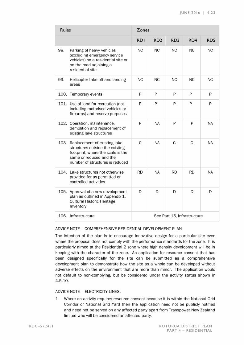
JUNE 2016 | 4 .23
RDC–572451 ROTORUA DISTRICT PLAN
PART 4 – RES IDENTIAL
Rules Zones
RD1 RD2 RD3 RD4 RD5
98. Parking of heavy vehicles
(excluding emergency service vehicles) on a residential site or
on the road adjoining a
residential site
NC NC NC NC NC
99. Helicopter take-off and landing areas
NC NC NC NC NC
100. Temporary events P P P P P
101. Use of land for recreation (not
including motorised vehicles or
firearms) and reserve purposes
P P P P P
102. Operation, maintenance,
demolition and replacement of
existing lake structures
P NA P P NA
103. Replacement of existing lake
structures outside the existing footprint, where the scale is the
same or reduced and the
number of structures is reduced
C NA C C NA
104. Lake structures not otherwise provided for as permitted or
controlled activities
RD NA RD RD NA
105. Approval of a new development plan as outlined in Appendix 1,
Cultural Historic Heritage
Inventory
D D D D D
106. Infrastructure See Part 15, Infrastructure
ADVICE NOTE – COMPREHENSIVE RESIDENTIAL DEVELOPMENT PLAN:
The intention of the plan is to encourage innovative design for a particular site even
where the proposal does not comply with the performance standards for the zone. It is
particularly aimed at the Residential 2 zone where high density development will be in
keeping with the character of the zone. An application for resource consent that has
been designed specifically for the site can be submitted as a comprehensive
development plan to demonstrate how the site as a whole can be developed without
adverse effects on the environment that are more than minor. The application would
not default to non-complying, but be considered under the activity status shown in
4.5.10.
ADVICE NOTE – ELECTRICITY LINES:
1. Where an activity requires resource consent because it is within the National Grid
Corridor or National Grid Yard then the application need not be publicly notified
and need not be served on any affected party apart from Transpower New Zealand
limited who will be considered an affected party.

JUNE 2016 | 4 .24
RDC–572451 ROTORUA DISTRICT PLAN
PART 4 – RES IDENTIAL
2. Vegetation to be planted within the National Grid Corridor or in close proximity to
any sub-transmission or distribution electricity line should be selected and/or
managed to ensure that it will not result in that vegetation breaching the Electricity
(Hazards from Trees) Regulations 2003.
3. The New Zealand Electrical Code of Practice for Electrical Safe Distances (NZECP
34: 2001) contains restrictions on the location of structures and activities around
electricity lines. Compliance with this code is mandatory. Compliance with this plan
does not ensure compliance with NZECP34:2001. The electricity line operator can
be contacted for advice for any activities around the electricity network.
4.6 PERFORMANCE STANDARDS
Permitted and Controlled Activities undertaken Within the Residential Zones shall comply
with all of the following Performance Standards. Activities relating to Section 6 matters
listed in Appendices 1 and 2 Cultural Historic Heritage Inventory and Natural Heritage
Inventory respectively, shall comply with the performance standards within Appendix 9,
Section 6 Matters.
1. Maximum Height and Daylight Envelope
The maximum height of a building or structure shall not exceed 7.5 metres above
natural ground except that in the Residential 4 zone the height shall not exceed
8.0 metres subject to complying with the following;
a. No building or structure shall penetrate the Obstacle Limitation Surface as
defined by Rotorua Regional Airport Limited designation A6.12 in Appendix
6, Designations and shown on Special Map 207.
b. No part of a building or structure shall extend outside the daylight envelope.
For the purpose of assessing buildings within the Wharenui Road
Development Plan area, the daylight envelope will only apply to the external
boundaries (other than the road boundary) of the “parent lot” prior to
subdivision.
The daylight envelope is taken from any point on the boundary at a height of
3.0 metres above natural ground level and rises at a 45 degree angle (i.e.
rising 1.0 metre for every 1.0 metre from that boundary) until it crosses the
maximum permitted height for the zone.
JUNE 2016 | 4 .25
RDC–572451 ROTORUA DISTRICT PLAN
PART 4 – RES IDENTIAL
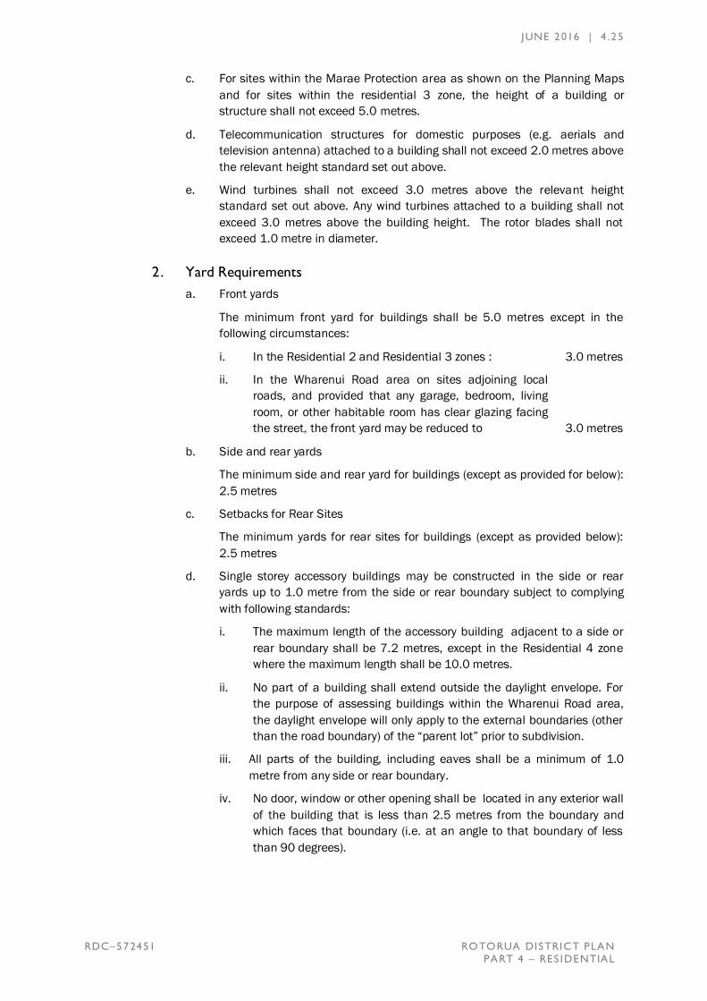
c. For sites within the Marae Protection area as shown on the Planning Maps
and for sites within the residential 3 zone, the height of a building or
structure shall not exceed 5.0 metres.
d. Telecommunication structures for domestic purposes (e.g. aerials and
television antenna) attached to a building shall not exceed 2.0 metres above
the relevant height standard set out above.
e. Wind turbines shall not exceed 3.0 metres above the relevant height
standard set out above. Any wind turbines attached to a building shall not
exceed 3.0 metres above the building height. The rotor blades shall not
exceed 1.0 metre in diameter.
2. Yard Requirements
a. Front yards
The minimum front yard for buildings shall be 5.0 metres except in the
following circumstances:
i. In the Residential 2 and Residential 3 zones : 3.0 metres
ii. In the Wharenui Road area on sites adjoining local
roads, and provided that any garage, bedroom, living
room, or other habitable room has clear glazing facing
the street, the front yard may be reduced to 3.0 metres
b. Side and rear yards
The minimum side and rear yard for buildings (except as provided for below):
2.5 metres
c. Setbacks for Rear Sites
The minimum yards for rear sites for buildings (except as provided below):
2.5 metres
d. Single storey accessory buildings may be constructed in the side or rear
yards up to 1.0 metre from the side or rear boundary subject to complying
with following standards:
i. The maximum length of the accessory building adjacent to a side or
rear boundary shall be 7.2 metres, except in the Residential 4 zone
where the maximum length shall be 10.0 metres.
ii. No part of a building shall extend outside the daylight envelope. For
the purpose of assessing buildings within the Wharenui Road area,
the daylight envelope will only apply to the external boundaries (other
than the road boundary) of the “parent lot” prior to subdivision.
iii. All parts of the building, including eaves shall be a minimum of 1.0
metre from any side or rear boundary.
iv. No door, window or other opening shall be located in any exterior wall
of the building that is less than 2.5 metres from the boundary and
which faces that boundary (i.e. at an angle to that boundary of less
than 90 degrees).

JUNE 2016 | 4 .26
RDC–572451 ROTORUA DISTRICT PLAN
PART 4 – RES IDENTIAL
e. Setbacks from water bodies
No building shall be erected within 25 metres of the edge of any river or
stream identified on Planning Map 203, or any lake with a surface area in
excess of 8 hectares or within 5 metres of any esplanade reserve or strip.
f. Wharenui Road Area
The specified yard requirements shall only apply to the external boundaries,
other than the road boundary, of the “parent lot” and be included as a
matter of control, or assessment criteria when considering the design and
layout of buildings within the lot.
g. Where road widening is identified as being required, any required yard shall
be measured from the boundary of the road widening designation, rather
than the lot boundary.
3. Site Coverage
a. For buildings and/or hard surfacing within a geothermal system, where the
total building and hard surface coverage is 90% or more of a site, the works
shall be designed to achieve a low level of risk from geothermal gas, hot
ground and acid ground. This shall be demonstrated by a suitably qualified
and experienced person as part of any required building consent application.
b. The maximum site coverage for buildings shall be:
Residential 1 and 4: 40% of the area of the site.
Residential 2: There is no maximum site
coverage for this zone.
Residential 3: 50% of the area of the site.
Residential 5: 25% of the area of the site.
c. The maximum site coverage for impermeable surfaces shall be:
Residential 2 : 100% of the site area
Residential 1, Residential 3 and
Residential 4: 80% of the site area
Residential 5: 40% of the area of the site.
d. For all zones
A minimum of 10% of the net site area shall be provided as outdoor
recreation and amenity space divided between each dwelling (including
decks), but shall not include the required yard areas or any area used for
parking and turning of vehicles.
4. Household Unit Density
a. Residential 1
i. The minimum permitted net site area for any one household unit shall
be 350m2, provided that the average net site area for all household
units on a site is at least 450m2.
ii. For sites that exceed a net site area of 600m2, there may be one
additional household unit with a net floor area not exceeding 72m2
(excluding garaging). This is to enable provision of a small household
unit on a site, for the accommodation of family members for example.

JUNE 2016 | 4 .27
RDC–572451 ROTORUA DISTRICT PLAN
PART 4 – RES IDENTIAL
Subdivision of lots of this size is not allowed for by the plan, so the
additional house will remain accessory to the principal household unit.
iii. Within the area covered by the Wharenui Road Development plan only
one household unit may be constructed for each 450m² net site area.
iv Within the area covered by the Twin Oaks Development Plan only one
household unit may be constructed for each 700m² net site area. See
Appendix 5.8
b. Residential 2
i. The minimum permitted net site area for any one household shall be
350m² without an approved comprehensive residential development
plan.
c. Residential 3
i. The minimum net site area for any one household shall be 250m².
d. Residential 4
i. One household unit may be constructed on site per 2,000m² of net
site area provided that the site is able to meet the relevant regional
council requirements for on-site effluent or sewage disposal, including
any associated disposal field.
ii. One household unit may be constructed per 1,000m² of net site area
in an area where a public sanitary sewer reticulation system is
operational.
e. Residential 5
i. One household unit per 1,500m² net site area provided that the
average net site area for all households onsite is 2,000m².
5. Parking, Access and Turning
a. Parking, turning and access shall be provided in accordance with the
provisions of Appendix 4, Parking and Turning Standards.
b. Parking and on-site turning areas shall be separate to those areas provided
on-site for outdoor recreation and amenity space.
c. Any garage shall be located such that there is a practicable parking space in
front of the garage door to enable vehicles to stop and open the garage door
clear of the road.
d. Shared access driveways shall comply with the following table:
Number of Household Units Served by the Access
Width
Overall Formed
1-2 household units
3-4 household units
5-8 household units
3m
4m
6.5m
2.7m
3m
5m
Shared access driveways shall not serve more than eight household units
and are not allowed.

JUNE 2016 | 4 .28
RDC–572451 ROTORUA DISTRICT PLAN
PART 4 – RES IDENTIAL
e. All vehicle crossings onto local roads shall be provided and constructed to
the standards of Rotorua District Council. Where new vehicle crossings are
proposed onto a State Highway, written consent from the New Zealand
Transport Agency shall be provided.
6. Noise
The noise limits shall be as follows:
a. Noise from any activity within any residential zone shall not exceed the
following limits when measured at the boundary of the receiving residential
site:
Daytime 7am to 10pm, any day except public holidays
50dB LAeq
Night-time At all other times 40dB LAeq and
70dB LAmax
Note: Construction noise is exempt from these restrictions.
The following activities are exempt from these restrictions:
i. Construction noise, (NZS6803:1999 will be used for the assessment
of construction noise)
ii. Temporary military training activities; and
iii. Emergency services activities.
b. Noise sensitive activities that are within 40 metres of a state highway with a
speed limit of less than 70KM/Hr, or within 80 metres of a State Highway
with a speed limit of 70km/hr or more shall comply with the noise mitigation
requirements contained in Appendix 11, State Highway Noise Mitigation
Requirements.
7. Glare and Light
Activities shall be managed so that direct or indirect illumination measures not
more than 10 lux on any site boundary.
8. Earthworks
All earthworks shall comply with the performance standards contained in Appendix
10, Earthworks.
9. Temporary Activities and Events
a. Any temporary military training activity shall be considered as a permitted
activity.
Notwithstanding any other performance standard listed in 4.6, temporary
activities and events shall be permitted subject only to compliance with the
following:

JUNE 2016 | 4 .29
RDC–572451 ROTORUA DISTRICT PLAN
PART 4 – RES IDENTIAL
b. Any amplification system shall not be used earlier than 8:00am and shall
finish no later than 10:30pm (Sunday to Thursday) or 11:00pm (Fridays and
Saturdays). Testing shall not last more than six hours between 9.00am and
7.00pm.
c. All temporary events shall comply with the glare and light standards of the
zone.
10. Signs
Refer to Appendix 8 for performance standards relating to signs.
11. Reflectivity in the Residential 4 Zone
For buildings visible from a lake the finished exterior surfaces, including the roof,
shall have reflectivity values of between 0%-37%. In this case visible shall be
taken to mean as assessed from any point on a lake using no more than sight
correcting lenses and shall be considered irrespective of vegetative cover.
12. Activities, buildings and structures within the National Grid Yard
Activities, buildings and structures within the National Grid Yard, identified on the
planning maps, shall comply with at least one of the following performance
standards:
a. A minimum vertical clearance of 10 metres below the lowest point of the
conductor associated with National Grid lines; or
b. Demonstrate that safe electrical clearance distances are maintained in
accordance with Sections 2 and 3 of The New Zealand Electrical Code of
Practice for Electrical Safe Distances (NZECP 34: 2001).
13. Natural Hazards
a. Setbacks from geothermal surface features.
i. No building shall be erected within 5 metres of the edge of any
geothermal surface feature or bore, provided that this performance
standard does not apply to any building associated with geothermal
electricity generation.
b. Replacement buildings within the fault avoidance area shall be within the
existing building footprint.
c. Buildings within the flood zone as identified on map 208 and 300 series
maps shall comply with the following standards:
i. Building platform must be above the stated maximum lake level.
ii. For sites where the building platform has to be raised to be above the
stated maximum lake level, the roof structure may exceed the
maximum height limit by up to 1.0 metre, providing the building does
not extend outside the daylight envelope.
d. Development of Land or Buildings Susceptible to Inundation From Surface
Water
i. Any habitable additions to existing buildings shall be constructed on a
building platform filled to above the 2% AEP flood level.
JUNE 2016 | 4 .30
RDC–572451 ROTORUA DISTRICT PLAN
PART 4 – RES IDENTIAL
ii. Any replacement building shall be provided with a building platform
filled to above the 2% AEP flood level and be located entirely within
the existing building footprint.
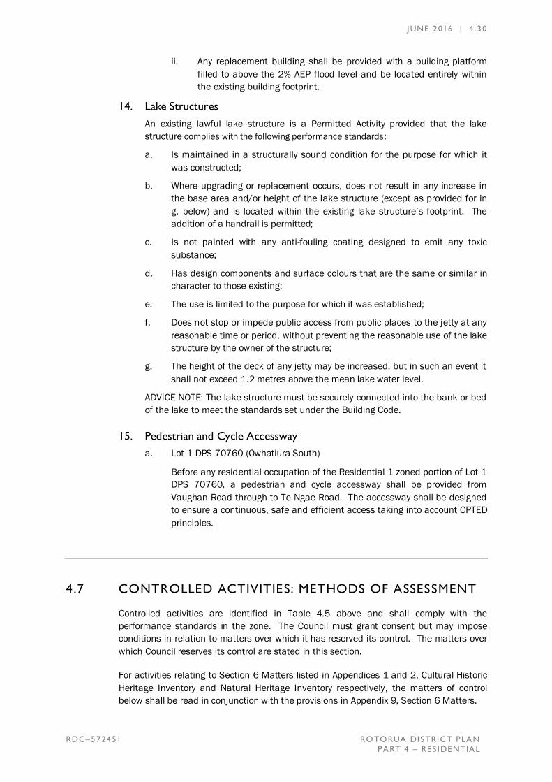
14. Lake Structures
An existing lawful lake structure is a Permitted Activity provided that the lake
structure complies with the following performance standards:
a. Is maintained in a structurally sound condition for the purpose for which it
was constructed;
b. Where upgrading or replacement occurs, does not result in any increase in
the base area and/or height of the lake structure (except as provided for in
g. below) and is located within the existing lake structure’s footprint. The
addition of a handrail is permitted;
c. Is not painted with any anti-fouling coating designed to emit any toxic
substance;
d. Has design components and surface colours that are the same or similar in
character to those existing;
e. The use is limited to the purpose for which it was established;
f. Does not stop or impede public access from public places to the jetty at any
reasonable time or period, without preventing the reasonable use of the lake
structure by the owner of the structure;
g. The height of the deck of any jetty may be increased, but in such an event it
shall not exceed 1.2 metres above the mean lake water level.
ADVICE NOTE: The lake structure must be securely connected into the bank or bed
of the lake to meet the standards set under the Building Code.
15. Pedestrian and Cycle Accessway
a. Lot 1 DPS 70760 (Owhatiura South)
Before any residential occupation of the Residential 1 zoned portion of Lot 1
DPS 70760, a pedestrian and cycle accessway shall be provided from
Vaughan Road through to Te Ngae Road. The accessway shall be designed
to ensure a continuous, safe and efficient access taking into account CPTED
principles.
4.7 CONTROLLED ACTIVITIES: METHODS OF ASSESSMENT
Controlled activities are identified in Table 4.5 above and shall comply with the
performance standards in the zone. The Council must grant consent but may impose
conditions in relation to matters over which it has reserved its control. The matters over
which Council reserves its control are stated in this section.
For activities relating to Section 6 Matters listed in Appendices 1 and 2, Cultural Historic
Heritage Inventory and Natural Heritage Inventory respectively, the matters of control
below shall be read in conjunction with the provisions in Appendix 9, Section 6 Matters.

JUNE 2016 | 4 .31
RDC–572451 ROTORUA DISTRICT PLAN
PART 4 – RES IDENTIAL
4.7.1 General Matters of Control
1. Building Design, Site Layout and Amenity
The extent to which -
a. The privacy and outlook for adjacent sites is maintained.
b. The principles of CPTED are implemented, including provision for the passive
surveillance of any adjoining road or reserve.
c. The principles of sustainable building design are implemented to make use
of solar gain.
d. Building design and site layout does not compromise future subdivision on
the site by demonstrating that subdivision can be undertaken in a complying
manner.
2. Character of the Zone
The extent to which the character and environmental quality of the adjoining
properties, the street scene and the properties within the zone is maintained and
enhanced.
3. Amenity Values of the Zone
The extent to which the amenity of the adjoining properties and of the properties
within the zone is maintained and enhanced.
4. Parking, Access and Turning
The extent to which -
a. On-site design, location and surfacing of access, parking and turning areas
to provide for practical use of the site and maintain the amenity of adjacent
sites.
b. Adequate sight distances are provided to prevent adverse effects on traffic
flow and safety.
c. The requirements of an integrated transport assessment carried out in
accordance with Appendix 4 can be implemented.
d. The activities to avoid, remedy or mitigate any adverse effects on the
function and safe and efficient operation of the transport network.
5. Financial Contribution
Whether the proposal requires a financial contribution under the provisions of Part
14, Financial Contributions.
6. Natural Hazards
a. Adverse effects from natural hazards or the worsening of any hazard
identified on the Special Interest Series Maps 208 to 213 are managed.
b. A flood risk assessment by a suitably qualified person, that includes an
evaluation of the likelihood and consequences of an appropriate range of
events to establish the maximum risk, may be required for activities subject
to flooding. This applies primarily for significant developments.
JUNE 2016 | 4 .32
RDC–572451 ROTORUA DISTRICT PLAN
PART 4 – RES IDENTIAL
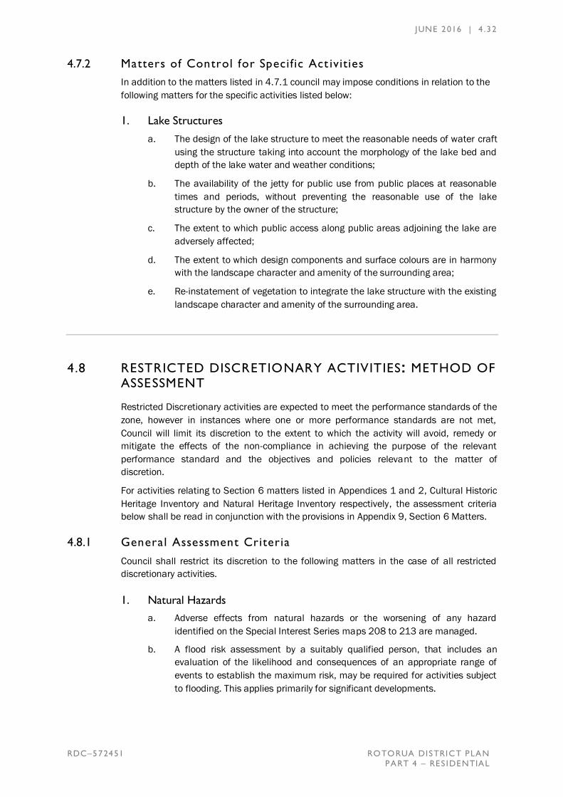
4.7.2 Matters of Control for Specif ic Act ivities
In addition to the matters listed in 4.7.1 council may impose conditions in relation to the
following matters for the specific activities listed below:
1. Lake Structures
a. The design of the lake structure to meet the reasonable needs of water craft
using the structure taking into account the morphology of the lake bed and
depth of the lake water and weather conditions;
b. The availability of the jetty for public use from public places at reasonable
times and periods, without preventing the reasonable use of the lake
structure by the owner of the structure;
c. The extent to which public access along public areas adjoining the lake are
adversely affected;
d. The extent to which design components and surface colours are in harmony
with the landscape character and amenity of the surrounding area;
e. Re-instatement of vegetation to integrate the lake structure with the existing
landscape character and amenity of the surrounding area.
4.8 RESTRICTED DISCRETIONARY ACTIVITIES: METHOD OF ASSESSMENT
Restricted Discretionary activities are expected to meet the performance standards of the
zone, however in instances where one or more performance standards are not met,
Council will limit its discretion to the extent to which the activity will avoid, remedy or
mitigate the effects of the non-compliance in achieving the purpose of the relevant
performance standard and the objectives and policies relevant to the matter of
discretion.
For activities relating to Section 6 matters listed in Appendices 1 and 2, Cultural Historic
Heritage Inventory and Natural Heritage Inventory respectively, the assessment criteria
below shall be read in conjunction with the provisions in Appendix 9, Section 6 Matters.
4.8.1 General Assessment Criteria
Council shall restrict its discretion to the following matters in the case of all restricted
discretionary activities.
1. Natural Hazards
a. Adverse effects from natural hazards or the worsening of any hazard
identified on the Special Interest Series maps 208 to 213 are managed.
b. A flood risk assessment by a suitably qualified person, that includes an
evaluation of the likelihood and consequences of an appropriate range of
events to establish the maximum risk, may be required for activities subject
to flooding. This applies primarily for significant developments.

JUNE 2016 | 4 .33
RDC–572451 ROTORUA DISTRICT PLAN
PART 4 – RES IDENTIAL
c. New Buildings Located Within the Fault Avoidance Area
In order to assess the risk arising from locating a habitable building within a
fault avoidance area, a natural hazard assessment report from a suitably
qualified geotechnical engineer shall be provided for new buildings located
within the fault avoidance area with this identifying the potential location of
the fault line, its recurrence interval and any subsequent building design and
location requirements or restrictions on use.
2. Character and amenity values for the zone
The extent to which the activity adversely affects the character and amenity values
of the zone.
3. Financial Contribution
Whether the proposal requires a financial contribution under the provisions of Part
14, Financial Contributions.
4.8.2 Assessment Criteria for Specif ic Activities
Council will consider the relevant assessment criteria below for activities listed as
restricted discretionary activities:
1. Permitted and Controlled Activities that do not meet the Performance
Standards
Where one or more performance standards are not met, Council will restrict its
discretion to the reason for the non-compliance and the extent to which the activity
will avoid, remedy or mitigate the effects of the non-compliance on achieving the
purpose of the relevant performance standard and objectives and policies.
2. Any Addition to Existing Activities Sensitive to Aircraft Noise within the
Inner Noise Control Area
Council shall restrict its discretion to the following matters:
a. The nature, size and scale of the proposed additions.
b. The application of the applicable acoustic performance standards listed
under Appendix 7 Airport Noise and Development Controls, to existing parts
of the structure housing the activity sensitive to aircraft noise.
c. Whether a covenant should be registered on the title to secure any
conditions of consent in accordance with Appendix 7, Airport Noise and
Development Controls; and the means of securing any conditions of consent.
d. Whether, having regard to all the circumstances the nature, size and scale of
the addition is likely to lead to potential conflict with and adverse effects
upon airport activities.
e. Any assessment criteria applicable to the activity within the residential
zones.
f. Any particular issues of safety relating to occupants of the site, or aircraft, in
relation to any proposed activities or buildings on the site.
g. The potential to detract from the qualities and characteristics specified of a
landscape or feature identified in Appendix 2 Natural Heritage Inventory or
the natural character of the environment.

JUNE 2016 | 4 .34
RDC–572451 ROTORUA DISTRICT PLAN
PART 4 – RES IDENTIAL
h. How the proposal affects the appearance of the outstanding natural feature
or landscape.
3. Stormwater Management Reserves
Council shall restrict its discretion to the assessment of the proposal in accordance
with that listed within Appendix 5 – Wharenui Road Development Plan.
4. Lake Structures
a. The existing provision, availability and suitability of existing lake structures in
the vicinity of the site that would otherwise enable reasonable lake access.
b. The extent to which the new structure would contribute to the cumulative
adverse effects on the carrying capacity of the bay and the recreational
opportunity.
c. The effects of the lake structure on the public access and use of the lake
and adjoining public areas.
d. The extent to which the structure contributes to the recreational and social
benefits and environmental wellbeing.
e. The design of the lake structure to meet the reasonable needs of water craft
using the structure taking into account the morphology of the lake bed and
depth of the lake water and weather condition.
f. The availability of the jetty for public use from public places at reasonable
times and periods without preventing use of the lake structure by the owner
of the structure.
g. The extent to which the main design components and surface colours of the
lake structure are in harmony with the landscape character and amenity of
the surrounding area, whilst allowing reasonable provision for the safety and
protection of vessels using the structure.
h. The extent to which re-instatement of vegetation will integrate the lake
structure with the existing landscape character and amenity of the
surrounding area.
i. The management of adverse effects on resources, sites or areas of spiritual,
cultural and historical significance to tangata whenua where those
resources, sites or areas have been identified by tangata whenua.
ADVICE NOTE: In the case of Lake Structures the Plan’s general criteria for
restricted discretionary activities shall not apply.
5. Comprehensive Residential Development Plans
a. The design and layout and any innovative components.
b. Potential adverse effects on the environment.
6. Development in accordance with the Twin Oaks Development Plan
See Appendix 5.8.

JUNE 2016 | 4 .35
RDC–572451 ROTORUA DISTRICT PLAN
PART 4 – RES IDENTIAL
4.9 DISCRETIONARY ACTIVITIES: METHOD OF ASSESSMENT
Council may grant or decline an application for a discretionary activity and may impose
conditions.
In assessing the proposal, Council can consider all relevant objectives and policies within
the district plan, all potential environmental effects, and any matters outlined in the Act
without limitation as part of the decision making. Conditions may be imposed in relation
to any of these matters.
Whilst not limiting the exercise of its discretion, Council may also consider the particular
matters below for the activities listed as Discretionary in the activity table.
For activities relating to Section 6 matters listed in Appendices 1 and 2, the assessment
criteria below shall be read in conjunction with the provisions in Appendix 9.
4.9.1 General Assessment Criteria
1. The degree to which the proposal complies with the performance standards of the
zone.
2. The extent to which the proposal will avoid, remedy, or mitigate effects on the
character and amenity of the zone.
3. The extent to which the proposal will avoid, remedy, or mitigate effects on the
amenity of neighbouring residents, including protection of privacy and outlook and
protection from adverse effects from any source of disturbance.
4. The extent to which the proposal will avoid, remedy, or mitigate the effects on the
streetscape and on-site landscaping, in particular where buildings intrude into the
front yards.
5. The degree to which the proposal implements sustainable building design and
promotes energy efficiency.
6. The degree to which the proposal promotes the principles of CPTED.
7. The extent to which the proposal will avoid, remedy, or mitigate effects on water
quality.
8. The ability for the activity to be connected to existing transport networks and utility
services.
9. The extent to which the proposal will avoid, remedy, or mitigate effects on the
function and safe and efficient operation of the transport network.
10. The extent to which the activity will avoid, remedy, or mitigate reverse sensitivity
effects on lawfully established activities or existing infrastructure.
11. The degree to which the proposal has access to or increases the demand on public
open space and reserves.
12. The extent to which the proposal will avoid, remedy, or mitigate effects on the
qualities and characteristics of a landscape or feature identified in Appendix 2,
Natural Heritage inventory or the natural character of the environment.
13. The extent to which the proposal will avoid, remedy, or mitigate effects on the
natural, physical, spiritual or cultural qualities and characteristics of a site
identified in Appendix 1 or 2 Cultural Historic Heritage Inventory and Natural
Heritage inventory respectively.

JUNE 2016 | 4 .36
RDC–572451 ROTORUA DISTRICT PLAN
PART 4 – RES IDENTIAL
14. Whether the proposal requires a financial contribution under the provisions of Part
14, Financial Contributions.
15. The extent to which the requirements of an integrated transport assessment
carried out in accordance with Appendix 4, Parking and Turning Standards can be
implemented.
16. Natural Hazards
a . Adverse effects from natural hazards or the worsening of any hazard
identified on the Special Interest Series Maps 208 to 213. The likelihood
and consequences of a natural hazard event will be assessed to determine
the level of risk associated with natural hazards.
b. A flood risk assessment by a suitably qualified person, that includes an
evaluation of the likelihood and consequences of an appropriate range of
events to establish the maximum risk, may be required for activities subject
to flooding. This applies primarily for significant developments. The report
shall identify the potential risk from flooding, any recommendations for floor
levels, earthworks, or engineering works.
17. The assessment criteria for development and activities that affect a Significant
Geothermal Feature, as set out in Appendix 9.5.2.
4.9.2 Assessment Criteria for Specif ic Activities
1. Any New Activities Sensitive to Aircraft Noise, Within the Inner Noise
Control Area
a. The nature, size and scale of the proposed additions.
b. The application of the applicable acoustic performance standards listed
under Appendix 7, Airport Noise and Development Controls, to existing parts
of the structure housing the activity sensitive to aircraft noise.
c. Whether a covenant should be registered on the title to secure any
conditions of consent in accordance with Appendix 7, Airport Noise and
Development Controls; and the means of securing any conditions of consent.
d. Whether, having regard to all the circumstances the nature, size and scale of
the addition is likely to lead to potential conflict with and adverse effects
upon airport activities.
e. Any assessment criteria applicable to the activity within the residential
zones.
f. Any particular issues of safety relating to occupants of the site, or aircraft, in
relation to any proposed activities or buildings on the site.
2. Buildings and Earthworks Located Within 25 metres from the Margin of
a Lake, or from a River or Stream Identified on the Planning Maps as Being an Area Identified for Esplanade Reserve Acquisition
The extent to which the proposal affects the purposes of esplanade reserves and
strips in relation to being able to -
contribute to the protection of conservation values,
enable public access, or
enable public recreational use.

JUNE 2016 | 4 .37
RDC–572451 ROTORUA DISTRICT PLAN
PART 4 – RES IDENTIAL
3. Comprehensive Residential Development Plans
a. Encouraging innovative design for a particular site where the proposal does
not comply with the performance standards for the zone.
b. Potential adverse effects on the environment.
4.10 NON-COMPLYING ACTIVITIES: METHOD OF ASSESSMENT
Applications for resource consent must be assessed on their merits against the
requirements of the Act. Consent for a non-complying activity may be granted only if
Council is satisfied that either:
a. the adverse effects of the activity on the environment (other than any effect on a
person who has given written approval to the application) will be minor; or
b. the application is for an activity that will not be contrary to the objectives and
policies of the District Plan.
If the proposal meets either of the two tests, Council can then consider all other relevant
matters and may grant or decline consent. If neither test is met, Council must decline the
resource consent application.