part 6: implementation...
TRANSCRIPT

152
PART 6: IMPLEMENTATION 2008
� Lighting should be provided along all walkways and cycle ways for safety and security as well as night-time operational reasons.
Building Frontages:
Geometry (Accessed from the Sidewalk):
� Ramps should be provided for disabled users at 1:12 (8.3%) gradient.
� Ramp rises should be stepped at ≤400mm intervals.
� Stairs to be implemented according to National Building Regulations (SABS 1900)
� Public stairs ≥1.5m width, minimum of 3 steps, non-slip materials with -2% gradients for drainage.
Bicycle Ramps and Storage
� Bicycle ramps to be provided adjacent to all stairs ≤1:2 (50%) gradient.
� Locate bicycle storage and parking adjacent to major destinations i.e. BRT stations, GRRL station, employment, retail and entertainment centres.
Note:
Although Oxford Road is classified as a Class 2 road with the emphasis on mobility, it should be recognised that a blanket design approach might not be appropriate between the Oxford and Glenhove Road intersections and the Oxford Road and Jellicoe Avenue intersection.

153
PART 6: IMPLEMENTATION 2008
Table 19: Class 3 Descriptions and Guidelines
Description Rosebank application
Characteristics Design elements
Class 3/ Mobility Road
� Minor arterial road / collector road serving as internal vehicular circulation road within the precinct.
� These roads have a greater balance between mobility and access.
� The roads serve the internal circulation of the precinct as well as the relatively few trips wishing to travel through the precinct, as opposed to traveling around the precinct on the Class 2 Arterial Routes.
� Glenhove Road
� Baker Street
� Bompas Road
� Jellicoe Avenue
Speed: 60 km/h
Vehicle volumes: 1750 – 5000 veh/hr
Geometry: Primarily single carriageway
roads but dual carriageway class 3 roads
are not uncommon
Turning Radii: > 4.2m < 10m
Level of Access :LOA 3 – LOA 6 (Balance
Between mobility and access – interrupted
flow)
Parking: On-street acceptable
PEDESTRIANS
Mid-block Pedestrian Crossings
Signal Layout:
� Provide signalised mid-block crossings along Class 3 routes with S11 signal heads and pedestrian demand push-buttons.
� Audible signals to be implemented for sight-impaired road users.
� RTM 4 pedestrian crossing lines to be implemented (minimum width 2.3m / desirable width 5m)
� Signal heads to be placed 3m from RTM1 stop line.
� W306 signs to be provided leading up to mid-block crossings.
Road Lighting:
� Street lighting to be provided as per NDoT Pedestrian Guideline Standard.
Kerb Transitions:
� Kerb ramps must be implemented at all crossing points to accommodate wheelchair users and sight-impaired pedestrians.
Intersection Crossings:
Pedestrian Signal Applications:
-Three types of pedestrian signal applications are recommended for precinct intersections:
� Standard Pedestrian Phase
� Scramble Pedestrian Phase
� Early Start Pedestrian Phase

154
PART 6: IMPLEMENTATION 2008
Intersection and Signal Layout:
� Provide signalised pedestrian crossings at all Class 3 route intersections with S11 signal heads and pedestrian demand push-buttons.
� Audible signals to be implemented for sight-impaired road users.
� RTM 3 pedestrian crossing lines to be implemented (minimum width 1.5m / desirable width 3m)
� Interlocking pavers or coloured asphalt is recommended at Class 2 junctions serving as gateways to the precinct (indicates higher pedestrian volumes and entrances to the precincts).
� Staged crossings should be considered. Minimum median width for staged crossings 2m.
Road Lighting:
� Street lighting to be provided as per NDoT Pedestrian Guideline Standard.
Application Areas:
� Road intersection between Class 3 roads and any other road class (Generally Class 3 or 4)
� NB: Provide pedestrian crossings on left-slip lanes where high vehicle speeds conflict with pedestrian crossings.
Pedestrian and Cycle Ways:
Layout and Geometry:
� Walkways and cycle to be provided adjacent to all Class 3 Roads (These facilities should always be separated from the roadway itself by means of a buffer strip minimum 1.0m / desirable 3m).
� Walkway and cycle way also separated because of speed differential of modes (Barrier Kerb 0.3m).
� All existing lateral obstructions should be removed from the

155
PART 6: IMPLEMENTATION 2008
walkway / cycle way area.
Design Dimensions
Walkway (Refer to B) Cycle way (Refer to B)
� Gradient ≤5% � Gradient ≤5%
� Minimum width 1.2m
� Minimum width 1.5m
� Desirable width 1.8m
� Desirable width 1.8m
� Lateral clearance ≥0.1m
� Lateral clearance ≥0.5m
� Height clearance ≥2.1m
� Height clearance ≥2.1m
� Buffer strip 0.6m � Buffer strip 0.6m
Parking:
Geometry and Layout
� Parking standards are to be applied in accordance with the National Department of Transport Parking Standards (2nd Edition), 1985.

156
PART 6: IMPLEMENTATION 2008
Table 20: Class 4 & 5 Descriptions and Guidelines
Description Rosebank application
Characteristics Design elements
Class 4 and 5 / Residential streets
� Residential collector / access roads serving properties within the precinct.
� These roads are mainly utilised as access routes with little mobility.
� Eastwood
� Rosebank
� Sturdee
� Jellicoe Avenue
� Cecil
� Tottenham
Speed: 60 km/h
Vehicle volumes: 500 – 1500 veh/hr
Geometry: Primarily single carriageway roads
but dual carriageway class 3 roads are not
uncommon
Turning Radii:> 4.2m < 10m
Level of Access: LOA 7 – LOA 8
Parking: On-street acceptable
Surfacing: Road surfacing materials may vary
from standard asphalt surfaces. Alternative
surfacing should be standard at intersections
and at mid-block pedestrian crossings.
PEDESTRIANS
Priority Mid-Block Pedestrian Crossings
Yield Layout :
� Provide yield mid-block crossings along Class 4/5 routes.
� RTM 4 pedestrian crossing lines to be implemented (minimum width 2.4m/ desirable 5m width)
� No overtaking line RM1 fro 9m minimum / 16m preferred.
� RTM2 road signage with yield sign WM5
� RTM2 to be placed 3m minimum – 6m from block pedestrian crossing (RTM4).
� Option to provide raised block pedestrian crossing to serve as further speed reduction tool.
Road Lighting
� Street lighting to be provided as per NDoT Pedestrian Guideline Standard.
Kerb Transitions:
� Kerb ramps must be implemented at all crossing points to accommodate wheelchair users and sight-impaired pedestrians
Intersection Crossings:
Roundabout Intersection Pedestrian Crossing:
� RTM 4 pedestrian crossings to be implemented (minimum width 1.5m / desirable width 3m).
� RTM 2 with WM5 yield road signage on both sides of the pedestrian crossing. Therefore vehicle will yield for pedestrians before entering the circle, then vehicles upon entering the circle, again yielding before

157
PART 6: IMPLEMENTATION 2008
exiting the desired road.
� Shared pedestrian and cycle lanes provided adjacent to road with signage R113.
� W201 Roundabout sign.
� Provide barrier kerbing.
� Option to provide raised roundabout intersection to further reduce vehicular speed.
Staged Intersection Crossing:
� RTM 3 pedestrian crossing lines to be implemented (minimum width 1.5m / desirable width 3m)
� Interlocking pavers or colored asphalt is recommended at Class 4/5 junctions serving as gateways to a residential road.
� Staged crossings should be considered. Minimum median width for staged crossings 2m.
� Raised pedestrian crossing can be considered.
Pedestrian and Cycle Ways:
Layout and Geometry :
� Walkways to be provided adjacent to all Class 4/5 Roads with cycle ways provided within roadway separated by paint marking.
� Walkway and cycle way also separated because of speed differential of modes (Barrier Kerb 0.3m).
� All existing lateral obstructions should be removed from the walkway / cycle way area.
Design Dimensions
Walkway (Refer to B) Cycle way (Refer to B)
� Gradient ≤5% � Gradient ≤5%
� Minimum Width 1.2m
� Minimum Width 1.5m
� Desirable width 1.8m
� Desirable width 1.8m
� Lateral clearance ≥0.1m
� Lateral clearance ≥0.5m
� Height clearance ≥2.1m
� Height clearance ≥2.1m
� Buffer strip 0.6m � Buffer strip 0.6m

158
PART 6: IMPLEMENTATION 2008
2. Interventions
The proposed interventions (Refer to Figure 60 below) for the Rosebank UDF area are put forth in Table 19 below
Figure 60: Proposed Interventions

159
PART 6: IMPLEMENTATION 2008
Table 21: Interventions
Intervention S
(1-2)
M
(3-5)
L
(6-10)
Responsibility
(Although only City departments and units are mentioned below to facilitate implementation, effort should be made to include all relevant stakeholders in implementation efforts e.g. the RMD)
Transportation Interventions:
New pedestrian linkages: To encourage filtering from Oxford into the back of the blocks and reduce the block sizes even more, making the blocks more walkable and exposing more edges to the street network in order to maximise the potential for multiple trip journeys. These new linkages should occur along Oxford, Fricker, and Tyrwhitt Roads.
Development Planning and Facilitation, Transportation Planning and Johannesburg Roads Agency
New Relief Roads should be investigated: The proposed relief road runs along Rudd, Bute, Venus, and Melrose Road until it meets Oxford Road.
Transportation Planning and Johannesburg Roads Agency
Investigate the extension of North Street: The extension of North Street to link up with Athol Oaklands Road will contribute to better regional accessibility to and from the node.
Transportation Planning and Johannesburg Roads Agency
Intersections must be upgraded: New traffic control measures like ITS and SCOOT should be introduced at conflict intersections to combat traffic congestion and enhance traffic flow. These intersections include Jan Smuts and Seventh Avenue, Oxford and Glenhove Roads and Oxford Road and Baker Street as a minimum.
Transportation Planning and Johannesburg Roads Agency
A Roads Master plan: A roads master plan and transport model has to be formulated for the area.
Transportation Planning and Johannesburg Roads Agency
Oxford Road: A detailed plan for the design of the whole of Oxford Road should be
done to address upgrading and design issues as well as the design of pedestrian -friendly intersections. The conceptual diagram below provides a minimum set of guidelines and principles should that influence the desigt planning process
Development Planning and Facilitation

160
PART 6: IMPLEMENTATION 2008
Glenhove
Bolton
Oxford
Tyrwhitt
Interface with the intersection and
provision for pedestrian movement
and access is important for gateway
buildings.
The Tyrwhitt pedestrian link should
be planned carefully taking into
account:
• Pedestrian movement across
Oxford
• Integration of the BRT station
• Legibility from west to east
• Signage
• Interface between buildings
and pedestrian ways
• Type of uses at ground level
should promote a fine grained
pedestrian -orientated
environment
Developments abutting the school
should use setbacks, window
placements and screening to prevent
overlooking and negative effects on
privacy
Sidewalks and landscaping ought to
create a positive walking experience,
not only along, but also across roads
and streets
Promote surveillance on streets and
public spaces from well placed
windows and entrances. Building
entrances should enhance pedestrian
usage and accessibility, be well lit
and clearly marked.
Provide visual relief from blank
exterior walls, building mass and bulk
through variation and setbacks.
Interface with the intersection and
provision for pedestrian movement
and access is important for gateway
buildings.
There should be a
clear distinction
through signs and
markings between
different modes of
transport including
pedestrian ways

161
PART 6: IMPLEMENTATION 2008
Note:
Although Oxford Road is classified as a Class 2 road with the emphasis on mobility, it should be recognised that a blanket design approach might not be appropriate between the Oxford and Glenhove Road intersections and the Oxford Road and Jellicoe Avenue intersection.
High priority elements, additional to the above, that should influence the detailed design and planning of Oxford Road ought to include:
• Number and width of travel lanes should be investigated in the light of the notion to support and create a mixed use and pedestrian environment
• Vehicular capacity and access management
• Giving priority to public transport operations
• Promoting wide sidewalks with amenities
• Designing multimodal intersection
• Making provision for urban design elements including streetscape, signage, markings and landscaping that is functional.
Tyrwhitt Ave: A detailed design and development plan must be completed to upgrade the existing street into a vibrant pedestrian promenade. The conceptual sketches below indicate some of the principles that should be taken into account for development of Tyrwhitt Road west and east of Oxford Road.
Development Planning and Facilitation, Transportation Planning and Johannesburg Roads Agency

162
PART 6: IMPLEMENTATION 2008
Oxford
Bath
Tyrwhitt
Fourth
Intersections need to be pedestrian
friendly in terms of signage, signals
and markings. The needs of disabled
people ought to be addressed.
Sidewalks are to be upgraded, included as a
minimum:
• Appropriate streetscaping and
landscaping
• Appropriate lighting
• Signage and marking
• Create safe routes through:
� Natural surveillance
� Generating activity levels that
make people feel safe
� Avoiding monotonous boundary
treatments
� Improved and appropriate lighting
� High walls and fences should not
dominate streets
• Well-lit public transport facilities with
relevant branding
Visual relief from blank exterior
walls, building mass and bulk
should be provided through
variation and boundary
treatment. Building ought to
relate to the pedestrian
environments through the
placement and design of
entrances and pedestrian
orientated activities at lower
levels (in the event of
redevelopment)
The planning and design of the intersection with
Oxford is crucial. This intersection comprises not
only a station exit and entrance point, but also a
BRT station and the pedestrian walkway between
Fourth and Oxford. It should also be ensured that
Tyrwhitt as an important pedestrian route,
continues to the east across Oxford.. Pedestrian -
orientated activities are needed to promote a pedestrian experience and movement.
The Fourth Street link through to the
existing open parking area is important
for creating a sustainable pedestrian
network. The link should be well lit and
appropriate streets aping provided.

163
PART 6: IMPLEMENTATION 2008
Sensitive development
abutting the school should
address issues of privacy
and overlooking through
placement of windows,
setbacks and variety in
heights.
Create safe routes through:
• Natural surveillance
• Generating activity levels that
make people feel safe
• Avoiding monotonous boundary
treatments
• Improved and appropriate
lighting
• High walls and fences should
not dominate streets.
Minimize the impact of parking by
locating them to the rear of a site.
Limit the size of parking areas by
promoting small and separate
parking clusters.
Tyrwhitt should be a continuous
east-west pedestrian route and the
area at the intersection with
Oxford and the location of the BRT
station should be carefully designed
to ensure continuity. The landmark
building and BRT station as points
of activity ought to enhance
legibility.
At least two blocks away
from the station, pedestrian
orientated activities at ground
level are needed to promote a
pedestrian experience and
movement along a possible
pedestrian boulevard along
Tyrwhitt.
Sidewalks are to be upgraded,
included as a minimum:
• Appropriate streetscaping and
landscaping
• Appropriate lighting
• Signage and markings to
promote legibility
• At least two blocks from the
station, wider walkways should
be provided to make provision
for a higher level of activity.
Softer landscaping can be used
further away.
• Road treatment or markings
should indicate that one has
entered an area that features
higher pedestrian activity
Common streetscape, signage
and design elements ought to
be used along both Oxford and
Tyrwhitt to promote a sense
of nodal identity and branding.
Specific secondary design
elements can be used to
identify specific precincts.
Tyrwhit
Cecil
Oxford
164
PART 6: IMPLEMENTATION 2008
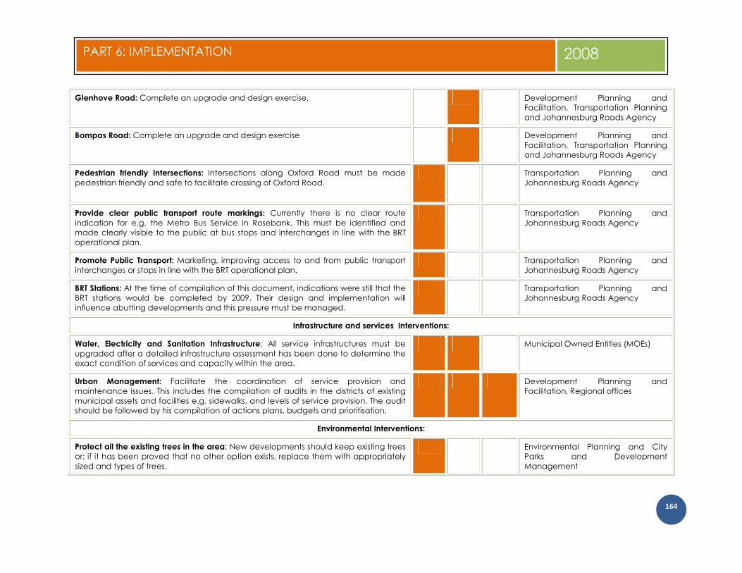
Glenhove Road: Complete an upgrade and design exercise. Development Planning and Facilitation, Transportation Planning and Johannesburg Roads Agency
Bompas Road: Complete an upgrade and design exercise Development Planning and Facilitation, Transportation Planning and Johannesburg Roads Agency
Pedestrian friendly Intersections: Intersections along Oxford Road must be made
pedestrian friendly and safe to facilitate crossing of Oxford Road.
Transportation Planning and Johannesburg Roads Agency
Provide clear public transport route markings: Currently there is no clear route
indication for e.g. the Metro Bus Service in Rosebank. This must be identified and made clearly visible to the public at bus stops and interchanges in line with the BRT operational plan.
Transportation Planning and Johannesburg Roads Agency
Promote Public Transport: Marketing, improving access to and from public transport interchanges or stops in line with the BRT operational plan.
Transportation Planning and Johannesburg Roads Agency
BRT Stations: At the time of compilation of this document, indications were still that the BRT stations would be completed by 2009. Their design and implementation will influence abutting developments and this pressure must be managed.
Transportation Planning and Johannesburg Roads Agency
Infrastructure and services Interventions:
Water, Electricity and Sanitation Infrastructure: All service infrastructures must be
upgraded after a detailed infrastructure assessment has been done to determine the exact condition of services and capacity within the area.
Municipal Owned Entities (MOEs)
Urban Management: Facilitate the coordination of service provision and maintenance issues. This includes the compilation of audits in the districts of existing municipal assets and facilities e.g. sidewalks, and levels of service provision. The audit should be followed by his compilation of actions plans, budgets and prioritisation.
Development Planning and Facilitation, Regional offices
Environmental Interventions:
Protect all the existing trees in the area: New developments should keep existing trees or; if it has been proved that no other option exists, replace them with appropriately sized and types of trees.
Environmental Planning and City Parks and Development Management

165
PART 6: IMPLEMENTATION 2008
Open Space Network:
Due to the limited availability of public open space, other means of public space needs to be considered. It has already been mentioned that sidewalks and squares are important elements in the proposed open space network (see figure 54). The upgrading of intersections and construction of BRT stations are another opportunity that ought to be utilised optimally.
The conceptual sketches below indicate that with careful design of appropriate landscaping, streetscape and signage, intersections and BRT station areas can become valuable open space assets in the Rosebank node.
Community Interventions:
Upgrading of community facilities. This includes the library, post office, police station
and fire station. Community Development
Parks: Must be cleaned up and new landscape designs should be done in order to
upgrade the existing facilities, enhance the environment and make it easier to maintain by planting certain types of trees and vegetation which requires less
Environmental Planning and City Parks

166
PART 6: IMPLEMENTATION 2008
maintenance.
Institutional
Assessment and evaluation committee: Introduce an assessment committee to evaluate proposals in line with design guidelines.
Development Planning and Facilitation
Traffic Plan: Investigate the viability of the introduction of a traffic plan as a requirement for certain developments.
Transportation Planning
Review of the RSDF: The current Region B and E RSDFs ought to be reviewed in terms of
the UDF proposals. Development Planning and
Facilitation
Facilitate coordination: The development, growth and urban management issues
should be discussed by all stakeholders. Development Planning and
Facilitation
Develop a monitoring system: The “health” of the node should be measured on a continuous basis to record, analyse and evaluate agreed-upon indicators e.g. crime levels, vacancy levels, satisfaction levels etc.
Development Planning and Facilitation
Communication: A communication and branding exercise is needed to inform and
involve relevant stakeholders. Development Planning and
Facilitation
The last intervention, a Nodal Program, is probably the most important to initiate overall implementation and also concludes the implementation part of
the Rosebank UDF. It comprises of three basic elements:
� Understanding the context, content and requirements of every intervention through the compilation of an implementation and workflow “map” � Implementation is driven by various institutions and institutional arrangements who need to manage and monitor progress and outcomes � Getting people to work together effectively
Detailed Implementation and Workflow Map
The purpose is to understand what needs to be achieved and to have detailed knowledge of what every intervention entails. The understanding and knowledge should then be translated into a project management approach. Project Management is widely regarded as the most efficient way of
managing implementation successfully. Essentially, project management achieves this by:
� Defining what has to be accomplished, generally in terms of time, cost, and various technical and quality performance parameters; � Developing a plan to achieve these and then working according tothis plan, ensuring that progress is maintained in line with these objectives; � Using appropriate project management techniques and tools to plan, monitor and maintain progress;

167
PART 6: IMPLEMENTATION 2008
� Providing a “single point of integrative responsibility” needed to ensure that everything on the project is managed effectively to ensure a successful project deliverable.
The above will also include a prioritisation and sequencing exercise. Together with the decision on what needs to be done first should also be an understanding of the order in which the implementation should take place. Figure 62 indicates a summary of an implementation schedule.
Institutional processes and systems
Implementation actions need to be informed by a clear understanding of regulatory and institutional processes. This will ensure that misunderstandings
and administration come-backs are limited.
From the Process and Work Flow Map, a detailed administration audit should be done to identify all administration process and resources involved. This
includes CoJ and external processes and resources.
Collaboration with stakeholders
The outcome of the Implementation Plan will, to a large degree, depend on how effectively people work together. Those who are involved with managing the process, those who prepare and implement various regulatory processes, those who decide on applications and those who submissions and who give support. The collaboration between these parties rarely happens by chance and the process by which people collaborate to build on common interest will have to be managed.
Conclusion

168
PART 6: IMPLEMENTATION 2008
Figure 62: Implementation schedule

169
PART 6: IMPLEMENTATION 2008

170
PART 6: IMPLEMENTATION 2008