part b - southwest florida water management district · southwest florida water management...
TRANSCRIPT

Southwest Florida Water Management District
PART B
Environmental Resource Permit Applications within the
Southwest Florida Water Management District MANAGEMENT AND STORAGE OF SURFACE WATERS December 8, 2010
PART B
Basis of Review
i
TABLE OF CONTENTS PART B - BASIS OF REVIEW
PAGE CHAPTER ONE - INTRODUCTION .................................................................................................................... B1-1
1.1 Objectives ................................................................................................................................... B1-1 1.2 Application Review Process ....................................................................................................... B1-1 1.2.1 Application Forms....................................................................................................................... B1-1 1.3 Criteria Flexibility ....................................................................................................................... B1-1 1.4 Simultaneous Reviews ................................................................................................................ B1-1 1.5 Compliance with Laws ................................................................................................................ B1-1 1.6 Construction/Operation Criteria Applicability ............................................................................ B1-1 1.7 Explanation of Terms .................................................................................................................. B1-2 1.7.1 Closed Drainage Basin ................................................................................................................ B1-2 1.7.2 Control Device ............................................................................................................................ B1-2 1.7.3 Control Elevation ........................................................................................................................ B1-2 1.7.4 Creation ....................................................................................................................................... B1-2 1.7.5 Detention ..................................................................................................................................... B1-2 1.7.6 Detention Volume ....................................................................................................................... B1-2 1.7.7 Directly Connected Impervious Areas ........................................................................................ B1-2 1.7.8 Discharge Structure ..................................................................................................................... B1-2 1.7.9 Drainage Basin ............................................................................................................................ B1-2 1.7.10 Dredging ..................................................................................................................................... B1-2 1.7.11 Ecological Value ......................................................................................................................... B1-2 1.7.12 Enhancement ............................................................................................................................... B1-2 1.7.13 Estuary ........................................................................................................................................ B1-2 1.7.14 Elevation ..................................................................................................................................... B1-3 1.7.15 Existing Nesting or Denning ....................................................................................................... B1-3 1.7.16 Filling .......................................................................................................................................... B1-3 1.7.17 Historic Basin Storage ................................................................................................................ B1-3 1.7.18 Historic Discharge....................................................................................................................... B1-3 1.7.19 Hydroperiod ................................................................................................................................ B1-3 1.7.20 Impervious .................................................................................................................................. B1-3 1.7.21 Isolated Wetland ......................................................................................................................... B1-3 1.7.22 Lagoon ........................................................................................................................................ B1-3 1.7.23 Listed Species ............................................................................................................................. B1-3 1.7.24 Mitigation .................................................................................................................................... B1-3 1.7.25 Mitigation Bank .......................................................................................................................... B1-3 1.7.26 Normal Water Level.................................................................................................................... B1-3 1.7.27 Off-line Treatment System .......................................................................................................... B1-4 1.7.28 On-line Treatment System .......................................................................................................... B1-4 1.7.29 Open Drainage Basin .................................................................................................................. B1-4 1.7.30 Overflow Elevation ..................................................................................................................... B1-4 1.7.31 Preservation................................................................................................................................. B1-4 1.7.32 Regulated Activity ...................................................................................................................... B1-4 1.7.33 Restoration .................................................................................................................................. B1-4 1.7.34 Retention ..................................................................................................................................... B1-4 1.7.35 Seasonal High Water Level ......................................................................................................... B1-4 1.7.36 Seawall ........................................................................................................................................ B1-4 1.7.37 Stormwater Management System ............................................................................................... B1-4 1.7.38 Surface Water Management System or System .......................................................................... B1-4 1.7.39 Water Management Areas ........................................................................................................... B1-5

ii
1.7.40 Watershed ................................................................................................................................... B1-5 1.7.41 Wet Detention System ................................................................................................................ B1-5
CHAPTER TWO - ADMINISTRATIVE CRITERIA ............................................................................................ B2-1
2.0 Ownership and Control ............................................................................................................... B2-1 2.1 Phased Projects ........................................................................................................................... B2-1 2.2 Land Use Considerations ............................................................................................................ B2-1 2.3 Water and Wastewater Service ................................................................................................... B2-1 2.4 Water Management Areas ........................................................................................................... B2-1 2.6 Legal Operation/Maintenance Entity Requirements ................................................................... B2-2 2.6.1 Acceptable Entities ..................................................................................................................... B2-2 2.6.2 Operation and Maintenance Entity Documentation Requirements ............................................. B2-3 2.6.2.1 Requirements for Governments and Utilities .............................................................................. B2-3 2.6.2.2 Requirements for Association ..................................................................................................... B2-3 2.6.2.2.1 .................................................................................................................................................... B2-3 2.6.2.2.2 .................................................................................................................................................... B2-3 2.6.2.2.3 .................................................................................................................................................... B2-4 2.6.2.2.4 .................................................................................................................................................... B2-4 2.6.2.2.5 .................................................................................................................................................... B2-4 2.6.2.2.6 .................................................................................................................................................... B2-5 2.6.2.2.7 .................................................................................................................................................... B2-5 2.6.2.3 .................................................................................................................................................... B2-5 2.6.3 Future Operation and Maintenance ............................................................................................. B2-6 2.7 Statement of Completion ............................................................................................................ B2-6 2.8 Construction Surface Water Management .................................................................................. B2-6 2.8.1 .................................................................................................................................................... B2-6 2.8.2 .................................................................................................................................................... B2-7 2.8.3 .................................................................................................................................................... B2-7 2.8.4 .................................................................................................................................................... B2-8
CHAPTER THREE - ENVIRONMENTAL ........................................................................................................... B3-1 3.1.0 Wetlands and Other Surface Waters ........................................................................................... B3-1 3.1.1 Environmental Conditions for Issuance ...................................................................................... B3-1 3.2 Environmental Criteria ................................................................................................................ B3-1 3.2.1 Elimination or Reduction of Impacts .......................................................................................... B3-2 3.2.1.1 .................................................................................................................................................... B3-2 3.2.1.2 .................................................................................................................................................... B3-2 3.2.1.3 .................................................................................................................................................... B3-2 3.2.2 Fish, Wildlife, Listed Species and Their Habitats ....................................................................... B3-2 3.2.2.1 .................................................................................................................................................... B3-3 3.2.2.2 .................................................................................................................................................... B3-3 3.2.2.3 .................................................................................................................................................... B3-3 3.2.2.4 Water Quantity Impacts to Wetlands and Other Surface Waters ................................................ B3-3 3.2.3 Public Interest Test...................................................................................................................... B3-4 3.2.3.1 Public Health, Safety, or Welfare or the Property of Others ....................................................... B3-4 3.2.3.2 Fish and Wildlife and Their Habitats .......................................................................................... B3-5 3.2.3.3 Navigation, Water Flow, Erosion and Shoaling .......................................................................... B3-5 3.2.3.4 Fisheries, Recreation, Marine Productivity ................................................................................. B3-5 3.2.3.5 Temporary or Permanent Nature ................................................................................................. B3-6 3.2.3.6 Historical and Archaeological Resources ................................................................................... B3-6 3.2.3.7 Current Condition and Relative Value of Functions ................................................................... B3-6 3.2.4 Water Quality .............................................................................................................................. B3-6 3.2.4.1 Short Term Water Quality Considerations .................................................................................. B3-6

iii
3.2.4.2 Long Term Water Quality Considerations .................................................................................. B3-7 3.2.4.3 Additional Water Quality Considerations for Docking Facilities ............................................... B3-7 3.2.4.4 Mixing Zones .............................................................................................................................. B3-8 3.2.4.5 Where Ambient Water Quality Does Not Meet Standards ......................................................... B3-8 3.2.5 Class II Waters: Waters Approved for Shellfish Harvesting ....................................................... B3-8 3.2.6 Vertical Seawalls......................................................................................................................... B3-9 3.2.7 Secondary Impacts ...................................................................................................................... B3-9 3.2.8 Cumulative Impacts .................................................................................................................. B3-10 3.2.8.1 .................................................................................................................................................. B3-11 3.2.8.2 .................................................................................................................................................. B3-11 3.3 Mitigation .................................................................................................................................. B3-11 3.3.1 Types of Mitigation ................................................................................................................... B3-11 3.3.1.1 .................................................................................................................................................. B3-11 3.3.1.2 .................................................................................................................................................. B3-11 3.3.1.3 .................................................................................................................................................. B3-12 3.3.1.4 .................................................................................................................................................. B3-12 3.3.1.5 .................................................................................................................................................. B3-12 3.3.1.6 .................................................................................................................................................. B3-12 3.3.1.7 .................................................................................................................................................. B3-12 3.3.1.8 .................................................................................................................................................. B3-12 3.3.2 Mitigation Ratio Guidelines ...................................................................................................... B3-12 3.3.2.1 Creation, Restoration and Enhancement ................................................................................... B3-13 3.3.2.1.1 .................................................................................................................................................. B3-13 3.3.2.1.2 .................................................................................................................................................. B3-13 3.3.2.2 Preservation............................................................................................................................... B3-13 3.3.2.3 .................................................................................................................................................. B3-14 3.3.3 Mitigation Proposals ................................................................................................................. B3-14 3.3.3.1 .................................................................................................................................................. B3-14 3.3.3.2 .................................................................................................................................................. B3-14 3.3.4 Monitoring Requirements for Mitigation Areas ........................................................................ B3-15 3.3.5 Protection of Mitigation Areas .................................................................................................. B3-15 3.3.6 Mitigation Success .................................................................................................................... B3-15 3.3.7 Financial Responsibility for Mitigations ................................................................................... B3-15 3.3.7.1 Applications Not Subject to Financial Responsibility Requirements ....................................... B3-15 3.3.7.2 Amount of Financial Responsibility ......................................................................................... B3-16 3.3.7.3 Documentation .......................................................................................................................... B3-16 3.3.7.4 General Terms for Financial Responsibility Mechanisms ........................................................ B3-16 3.3.7.5 .................................................................................................................................................. B3-16 3.3.7.6 Financial Responsibility Mechanisms ....................................................................................... B3-16 3.3.7.7 Cost Estimates ........................................................................................................................... B3-17 3.3.7.7.1 Partial Releases ......................................................................................................................... B3-17 3.3.7.7.2 Final Release ............................................................................................................................. B3-17 3.3.7.8 Financial Responsibility Conditions ......................................................................................... B3-17 3.3.7.9 Financial Responsibility Mechanisms for Multiple Projects ..................................................... B3-17 3.3.8 Real Property Conveyance ........................................................................................................ B3-18 3.4 Formal Determination of the Landward Extent of Wetlands and Other Surface Waters .......... B3-18 3.4.1 Procedure .................................................................................................................................. B3-18 3.4.2 Types of Formal Determinations .............................................................................................. B3-18 3.4.3 Locating the Surface Waters and Wetlands Boundary Line ..................................................... B3-19 3.4.4 Duration .................................................................................................................................... B3-19 3.4.5 Formal Determination for Properties with an Existing Formal Determination ......................... B3-19 3.4.6 Nonbinding Determination........................................................................................................ B3-19

iv
CHAPTER FOUR - WATER QUANTITY ............................................................................................................ B4-1 4.1 General ........................................................................................................................................ B4-1 4.2 Discharge .................................................................................................................................... B4-1 4.3 Flood Protection .......................................................................................................................... B4-1 4.4 Flood Plain Encroachment .......................................................................................................... B4-2 4.4.1 100-Year Flood Level Determination…………………………………………………………..B4-2 4.5 Minimum Drainage ..................................................................................................................... B4-3 4.6 Overdrainage and Water Conservation ....................................................................................... B4-3 4.6.1 .................................................................................................................................................... B4-3 4.6.2 .................................................................................................................................................... B4-3 4.7 Historic Basin Storage ................................................................................................................ B4-3 4.8 Offsite Lands ............................................................................................................................... B4-3 4.9 Isolated Wetlands ........................................................................................................................ B4-3
CHAPTER FIVE - WATER QUALITY ................................................................................................................. B5-1
5.1 .................................................................................................................................................... B5-1 5.2 Retention, Detention Criteria ...................................................................................................... B5-1 5.3 Surface Water Treatment Systems .............................................................................................. B5-2 5.4 Sewage Treatment Percolation Ponds ......................................................................................... B5-2 5.5 Solid Waste Facilities .................................................................................................................. B5-3 5.6 Reserved ...................................................................................................................................... B5-3 5.7 Underground Exfiltration Systems .............................................................................................. B5-3 5.8 Alterations to Existing Public Roadway Projects ........................................................................ B5-3 5.9 Water Quality Monitoring ........................................................................................................... B5-3 5.10 General Conditions Related to Water Quality Monitoring by Permittees .................................. B5-3 5.11 .................................................................................................................................................... B5-4 5.12 Reserved ...................................................................................................................................... B5-4 5.13 .................................................................................................................................................... B5-4
CHAPTER SIX - CONSTRUCTION...................................................................................................................... B6-1
6.1 Discharge Structures ................................................................................................................... B6-1 6.2 Control Devices/Bleed-Down Mechanisms for Detention Systems............................................ B6-1 6.3 .................................................................................................................................................... B6-1 6.4 Retention and Detention Areas ................................................................................................... B6-1 6.4.1 Dimensional Criteria (as measured at or from the control elevation) ......................................... B6-1 6.4.2 Support Facility Design Criteria ................................................................................................. B6-2 6.5 Exfiltration Systems .................................................................................................................... B6-2 6.6 Impervious Areas ........................................................................................................................ B6-2 6.7 Stagnant Water Conditions ......................................................................................................... B6-2 6.8 Sediment Sumps Shall: ............................................................................................................... B6-2
CHAPTER SEVEN - DESIGN INFORMATION .................................................................................................. B7-1
7.1 Antecedent Conditions ................................................................................................................ B7-1 7.2 Rainfall Volume .......................................................................................................................... B7-1 7.3 Rainfall Distribution ................................................................................................................... B7-1 7.4 Storage ........................................................................................................................................ B7-1 7.4.1 Open Surface ............................................................................................................................... B7-1 7.5 Infiltration and Percolation ......................................................................................................... B7-1 7.5.1 Ground Surface ........................................................................................................................... B7-1 7.5.2 Subsurface ................................................................................................................................... B7-1 7.6 Runoff ......................................................................................................................................... B7-1 7.7 Receiving Water Stage ................................................................................................................ B7-2 7.7.1 Regulated Systems ...................................................................................................................... B7-2 7.7.2 Non-regulated Systems ............................................................................................................... B7-2
v
7.7.3 All Systems ................................................................................................................................. B7-2 7.8 Discharge .................................................................................................................................... B7-2 7.8.1 Allowable Discharges ................................................................................................................. B7-2
APPENDICES
APP. 1 Statement of Inspection for Proper Operation and Maintenance……………………………..B/A1-1 Statement of Inspection for Proper Operation and Maintenance Form……………………... B/A1-2 APP. 2 Land, Basins and Water Courses Having Specific Design Criteria…………………………. B/A2-1 Delaney Creek Watershed (aerial)…………………………………………………………... B/A2-2 Tampa Bypass Canal Watershed (aerial)……………………………………………………. B/A2-3 Channels A, G & H Watersheds (aerial)……………………………………………………...B/A2-4 APP. 3 [RESERVED]………………………………………………………………………………….. B/A3 APP. 4 Basis of Review for the Establishment and Use of Mitigation Banks………………………. B/A4-1 1. Intent………………………………………………………………………………...B/A4-2 2. Definitions…………………………………………………………………………..B/A4-2 3. Use of a Mitigation bank……………………………………………………………B/A4-3 4. Criteria for Establishing a Mitigation Bank………………………………………... B/A4-3 5. Mitigation Bank Permit and Mitigation Bank Conceptual Permit Applications….. B/A4-3 6. Establishment of Mitigation Credits……………………………………………….. B/A4-4 7. Mitigation Service Area……………………………………………………………. B/A4-6 8. Land Use Restrictions on Mitigation Banks……………………………………….. B/A4-6 9. Financial Responsibility…………………………………………………………….B/A4-7 10. Mitigation Bank Permit and Mitigation Bank Conceptual Permit………………...B/A4-11 11. Surrender, Transfer, or Modification Bank Permits……………………………… B/A4-12 12. Department of Environmental Protection Mitigation Bank………………………. B/A4-12 Exhibit 1 Watersheds in the S.W.F.W.M.D………………………………………………... B/A4-13 APP. 5 Listed Wildlife Species That Are Aquatic or Wetland Dependent and That Use Upland Habitats for Nesting or Denning……………………………………………………………. B/A5-1 APP. 6 Drainage Basins in the S.W.F.W.M.D……………………………………………………… B/A6-1 APP. 7 Site Conditions Assessment Permitting………………………………………………………B/A7-1 7.1 Introduction………………………………………………………………...……… B/A7-1 7.1.1 Procedure…………………………………………………………………………... B/A7-1 7.1.2 Types of Site Conditions Boundary Documentation..................................................B/A7-1 7.1.3 Locating the Boundary Lines..................................................................................... B/A7-2 7.1.4 Duration..................................................................................................................... B/A7-3
September 5, 2010 B1-1
CHAPTER ONE - INTRODUCTION 1.1 Objectives. Under Part IV of Chapter 373, Florida Statutes (F.S.) and Chapters 40D-4, 40, and 400, Florida Administrative Code (F.A.C.), the District is responsible for permitting construction and operation of surface water management systems within its jurisdictional boundaries. The objective of this document is to identify the usual procedures and information used by the District staff in permit application review. The objective of the review is to ensure that the permit will authorize activities or situations which are not harmful to the water resources of the District or inconsistent with the public interest. 1.2 Application Review Process. The District issues three types of environmental resource permits as authorized by Part IV of Chapter 373, Florida Statutes: individual including conceptual, general, and noticed general permits. Amended 11-2-09 1.2.1 Application Forms. Applicants for Environmental Resource Permits shall fill out the form entitled, "Joint Application for Environmental Resource Permit and Authorization to Use State Owned Submerged Lands" and Federal Dredge and Fill Permit. Engineered systems are required to have plans and calculations signed and sealed by a Florida Professional Engineer in accordance with Chapter 471, Florida Statutes. 1.3 Criteria Flexibility. The primary goal of the review criteria is to meet District water resource objectives. However, the criteria are designed to be flexible. Performance criteria are used where possible. Other methods of meeting overall objectives will be considered depending on the magnitude of specific or cumulative impacts. 1.4 Simultaneous Reviews. Aside from purely technical aspects, legal and institutional factors must be considered. Because of legal time constraints for processing permits, it is advisable for the applicant to contact other interested agencies, organizations, and affected citizens prior to submitting a formal application to the District. Summaries of meetings and copies of responses from appropriate parties should be included in the application. It may be in the applicant's best interest to seek simultaneous reviews from all agencies with jurisdiction. This provision is not intended to preclude the submission of an application to this District prior to receiving other necessary approvals, but the application should contain at least a status report on other approvals being sought, with an indication that the surface water management portion of the project will be approved by other pertinent jurisdictions. Issuance of an Environmental Resource Permit by the District does not relieve the applicant of the responsibility to obtain all necessary federal, state, local or special district permits or authorizations. 1.5 Compliance with Laws. Activities discussed herein must be conducted in accordance with all other applicable laws. Of specific note are those activities covered by laws as follows, including but not limited to: a. Section 404, Federal Water Pollution Control Act, - U.S. Army Corps of Engineers - fill b. Chapter 471, F.S. - Florida professional engineer seal and signature on all engineering plans and documents (subject to the exemptions of the Chapter). 1.6 Construction/Operation Criteria Applicability. The District issues permits to construct and operate proposed surface water management activities and to operate, alter or abandon existing systems. The criteria herein are specifically intended to apply to those activities.

September 5, 2010 B1-2
1.7 Explanation of Terms. 1.7.1 "Closed Drainage Basin" A watershed in which the runoff does not have a surface outfall up to and including the 100-year flood level. 1.7.2 "Control Device" The element of a discharge structure which allows the gradual release of water under controlled conditions. This is sometimes referred to as the bleed-down mechanism or "bleeder". Examples include orifices, notches, weirs, and effluent filtration systems. 1.7.3 "Control Elevation" The lowest elevation at which water can be released through the control device. This is sometimes referred to as the invert elevation. 1.7.4 “Creation” The establishment of new wetlands or surface waters by conversion of other land forms. 1.7.5 "Detention" The delay of storm runoff prior to discharge into receiving waters. 1.7.6 "Detention Volume" The volume of open surface storage behind the discharge structure measure between the overflow elevation and control elevation. 1.7.7 "Directly Connected Impervious Areas" Unless otherwise specifically stated in the Basis of Review, directly connected impervious areas as considered in the calculation of volumes for treatment systems are those impervious and semi-impervious areas hydraulically connected to the treatment system directly or by pipes or ditches. 1.7.8 "Discharge Structure" A structural device, usually of concrete, metal, etc., through which water is discharged from a project to the receiving water. 1.7.9 "Drainage Basin" A subdivision of a watershed. 1.7.10 "Dredging" Excavation, by any means, in surface waters or wetlands, Excavation also means the excavation, or creation, of a water body which is, or is to be, connected to surface waters or wetlands, directly or via an excavated water body or series of water bodies. 1.7.11 "Ecological Value" the value of functions performed by wetlands and other environmentally sensitive areas. These functions include: providing habitat for wildlife, corridors for wildlife movement, food chain support, groundwater recharge, water storage and flow attenuation, and water quality enhancement. 1.7.12 "Enhancement" Improving the ecological value of wetlands, other surface waters, or uplands that have been degraded in comparison to their historic condition. 1.7.13 "Estuary" Means a semienclosed, naturally existing coastal body of water which has a free connection with the open sea and within which seawater is measurably diluted with fresh water derived from riverine systems.
September 5, 2010 B1-3
1.7.14 “Elevation" The height in feet above mean sea level according to National Geodetic Vertical Datum (NGVD). 1.7.15 "Existing Nesting or Denning" As used in Section 3.2.7 means an upland site is currently Being used for nesting or denning or is expected, based on reasonable scientific judgment, to be used for such Purposes based on past nesting or denning at the site. 1.7.16 "Filling" The deposition, by any means, of materials in surface waters or wetlands. 1.7.17 "Historic Basin Storage" The depression storage available on the site in the pre-development condition. The volume of storage is that which exists up to the required design storm. 1.7.18 "Historic Discharge" The peak rate and/or amount of runoff which leaves a parcel of land by gravity from an undisturbed/existing site, or the legally allowable discharge at the time of permit application. 1.7.19 "Hydroperiod" The duration of inundation in a wetland. 1.7.20 "Impervious" Land surfaces which do not allow, or minimally allow, the penetration of water; examples are buildings, non-porous concrete and asphalt pavements. 1.7.21 "Isolated Wetland" Any wetland without a direct hydrologic connection by standing or flowing surface water at seasonal high water level to a lake, stream, estuary, or marine waters. 1.7.22 "Lagoon" A naturally existing coastal zone depression which is below mean high water and which has permanent or ephemeral communications with the sea, but which is protected from the sea by some type of naturally existing barrier. 1.7.23 "Listed Species"
Those animal species which are endangered, threatened or of special concern and are listed in Rules 68A-27.003 (as amended December 16, 2003), 68A-27.004 (as amended May 15, 2008), and 68A-27.005 (as amended November 8, 2007), F.A.C., and those plant species listed in 50 Code of Federal Regulation 17.12 (as amended April 8, 2004), when such plants are found to be located in a wetland or other surface water. Amended 11-03-09. 1.7.24 "Mitigation" An action or series of actions to offset the adverse impacts that would otherwise cause a regulated activity to fail to meet the criteria set forth in 3.1.1 through 3.3.6. Mitigation usually consists of restoration, enhancement, creation, preservation, or a combination thereof. 1.7.25 "Mitigation Bank" Means a project undertaken to provide for the withdrawal of mitigation credits to offset adverse impacts. 1.7.26 "Normal Water Level" The design starting water elevation used when determining stage/storage design computations in a retention or detention area. A retention or detention system may have two (2) designated "normal water levels" associated with it if the system is designed for both water quality and water quantity.
September 5, 2010 B1-4
1.7.27 "Off-line Treatment System" A system only for water quality treatment that collects project runoff and has no direct discharge capability other than percolation and evaporation. A system utilizing detention with effluent filtration is not an off-line treatment system. 1.7.28 "On-line Treatment System" A dual purpose system that collects project runoff for both water quality and water quantity requirements. Water quality volumes are recovered through percolation and evaporation while water quantity volumes are recovered through a combination of percolation, evaporation, and surface discharge. 1.7.29 "Open Drainage Basin" Open drainage basins are all watersheds not meeting the definition of 1.7.1 (Closed Drainage Basin). 1.7.30 "Overflow Elevation" The design elevation of a discharge structure at or below which water is contained behind the structure, except for that which leaks or bleeds out, through a control device down to the control elevation. 1.7.31 "Preservation" The protection of wetlands, other surface waters or uplands from adverse impacts by placing a conservation easement or other comparable land use restriction over the property or by donation of fee simple interest in the property to an appropriate entity. 1.7.32 "Regulated Activity" The construction, alteration, operation, maintenance, abandonment or removal of a system regulated pursuant to Part IV, Chapter 373, F.S. 1.7.33 "Restoration" Converting back to a historic condition those wetlands, surface waters, or uplands which currently exist as a land form which differs from the historic condition. 1.7.34 "Retention" The prevention of direct discharge of storm runoff into receiving waters; included as examples are systems which discharge through percolation, exfiltration, and evaporation processes and which generally have residence times less than 3 days. 1.7.35 "Seasonal High Water Level" The elevation to which the ground or surface water can be expected to rise due to a normal wet season. 1.7.36 "Seawall" A manmade wall or encroachment, except riprap, which is made to break the force of waves and to protect the shore from erosion. 1.7.37 "Stormwater Management System" A system which is designed and constructed or implemented to control discharges which are necessitated by rainfall events, incorporating methods to collect, convey, store, absorb, inhibit, treat, use, or reuse water to prevent or reduce flooding, overdrainage, environmental degradation, and water pollution or otherwise affect the quantity and quality of discharges from the system. 1.7.38 "Surface Water Management System or System" A stormwater management system, dam, impoundment, reservoir, appurtenant work, or works, or any combination thereof. The terms "surface water management system" or "system" include dredged or filled areas.

September 5, 2010 B1-5
1.7.39 "Water Management Areas" Areas to be utilized for the conveyance or storage of surface water, mitigation, or perpetual operation and maintenance purposes. 1.7.40 "Watershed" The land area which contributes to the flow of water into a receiving body of water. 1.7.41 "Wet Detention System" A water quality treatment system that utilizes a design water pool in association with water-tolerant vegetation to remove pollutants through settling, adsorption by soils and nutrient uptake by the vegetation. The bottom elevation of the pond must be at least one foot below the control elevation.

September 5, 2010 B2-1
CHAPTER TWO – ADMINISTRATIVE CRITERIA 2.0 Ownership and Control.
In accordance with the requirement of Rule 40D-4.301(1)(j), F.A.C., an applicant must demonstrate reasonable assurance that permitted activities will be conducted by an entity with financial, legal and administrative capability of ensuring that the activity will be undertaken in accordance with the terms and conditions of the permit, if issued. Compliance with this requirement may be demonstrated through a deed, a long-term lease demonstrating control of the project area adequate to comply with all permit conditions, a purchase and sale agreement, or similar document. Compliance with this requirement may also be demonstrated by an entity with the power of eminent domain. Where control is demonstrated by a long-term lease, the permit will be conditioned to address transfer of control or proper abandonment of the permitted system at the end of the lease. Where control is demonstrated by a purchase and sale agreement, the permit will be conditioned to terminate if the transfer of ownership does not occur, and to prohibit construction until ownership is transferred to the permittee. Where control is demonstrated by an entity with the power of eminent domain, the permit will be conditioned to prohibit construction until ownership or legal control is transferred to the permittee. Amended 05-12-09. 2.1 Phased Projects.
Projects that are to be developed in phases will normally require the submission of a master plan of the applicant's contiguous land holdings. The primary concerns of the District are to ensure continuity between phases, satisfactory completion of individual phases should the project not be completed as planned, and protection of adjacent property owners' rights. This includes adjacent property owners created by the sale of incomplete phases.
An application for a conceptual permit encompassing the total master plan should be submitted first. An application for a construction permit for the first phase may also be included as part of the initial application.
Applications for phases of a project for which no conceptual permit has been obtained may be considered only when the phases are totally independent of, or make sufficient provisions for, adjacent lands. 2.2 Land Use Considerations.
The proposed land use to be served by a surface water management system for which an Environmental Resource Permit is requested is not required to be consistent with the affected local government's comprehensive plan and/or existing zoning for the site. However, it is strongly recommended that an applicant obtain the necessary land use approvals from the affected local government prior to permit application since these approvals often contain conditions which impact the overall project design and, hence, the type of surface water management system design which is proposed. By obtaining these local government approvals first, the applicant can reduce or eliminate the need for subsequent permit modifications which may be necessary as a result of conditions imposed by the local government.
Should these local land use approvals be obtained subsequent to the issuance of the Environmental Resource Permit, the applicant should be aware that a permit modification may be necessary prior to initiation of construction. Due to the amount of time which may be involved in processing such a modification, the applicant is encouraged to initiate an application for modification as soon as possible in order to prevent construction delays. 2.3 Water and Wastewater Service.
Potable water and wastewater facilities must be identified. The applicant for an Environmental Resource Permit must provide information on how these services are to be provided including the status of any existing or proposed water use permit, if applicable. If wastewater disposal is accomplished on-site, additional information will normally be requested regarding separation of wastewater and stormwater systems. 2.4 Water Management Areas.
Such areas shall be shown on construction plans and, when appropriate, legally reserved for that purpose by dedication on the plat, deed restrictions, easements, etc., so that subsequent owners or others may not remove such areas from their intended use. Management areas, including maintenance easements, shall be connected to a public road or other location from which operation and maintenance access is legally and physically available. Areas designed for purposes such as roads, parking lots, sidewalks, or public access shall not be used as water management
September 5, 2010 B2-2
areas if the level or duration of standing or flowing water on these areas is a potential risk to vehicular traffic or pedestrian use.
2.6 Legal Operation and Maintenance Entity Requirements. 2.6.1 Acceptable Entities.
The following entities or persons are acceptable to satisfy the requirements of Rules 40D-4.301(1)(i) and (j), and 40D-4.381(1)(o), F.A.C.:
a. Local governmental units, including counties or municipalities. b. Active Chapter 298, F.S., drainage districts; drainage districts created by special act of the Legislature; or Chapter 190, F.S., Community Development Districts. c. Non-profit corporations, including homeowners' associations, property owners' associations, condominium owners' associations or master associations. Protective covenants, deed restrictions or a declaration of condominium must be recorded for this option in accordance with section 2.6.2.2.5 below. d. Legally constituted communication, water, sewer, electrical or other public utilities. e. State or federal agencies. f. The permittee, provided that: (1) The property is wholly owned by the permittee and ownership is intended to be retained or (2) The project is a residential subdivision, condominium, commercial subdivision or industrial park and responsibility for the operation and maintenance of the surface water management system facilities will be transferred to a homeowners' association, property owners' association, condominium owners' association or master association. The transfer of responsibility shall occur upon completion of the first reinspection of the surface water management system conducted pursuant to the permit following transfer to the operation phase, unless at the time of the first reinspection, the permittee requests, in writing, that the transfer of responsibility to the association occur at some specified later date. The District shall approve such request if the permittee demonstrates that it can perform all necessary operation and maintenance responsibilities during the extended time period. In any event, within thirty (30) days after the sale of the last lot, parcel or unit in the project, the permittee shall request the transfer of responsibility for the operation and maintenance of the surface water management system facilities to the association. The permittee must submit to the District, a Notification and Request for Transfer of Environmental Resource Permit, Form No. LEG-R.043.00 (4/09), incorporated by reference in subsection 40D-4.351(1), F.A.C. This form is available from the District’s website at www.watermatters.org or upon request at any District service office. The District must approve the transfer in writing before the transfer of responsibility to the association is effective. Protective covenants, deed restrictions or a declaration of condominium must be recorded for this option in accordance with section 2.6.2.2.6 below; or (3) The project is a residential subdivision consisting of ten (10) lots or less and responsibility for the operation and maintenance of the surface water management system facilities will be transferred to the lot owners, jointly and severally. The transfer of responsibility shall occur following the first successful reinspection of the surface water management system pursuant to the permit. "First successful reinspection" means the first periodic reinspection of the surface water management system conducted pursuant to the permit following transfer to the operation phase, at which the District determines that the system is functioning properly and requires no corrective action. The transfer must be approved by the District in writing before the transfer of responsibility to the lot owners is effective. This option is available for residential subdivisions which have surface water management systems that are passively operated and maintained, and are designed to be dry except during and immediately following a rainfall event. This option is not available for residential subdivisions with surface water management systems containing any of the following features: exfiltration or effluent filtration stormwater treatment facilities or facilities that require specialized or commercially conducted operation and maintenance, such as wet ponds with an orifice bleed down, pumps, on-site wetland mitigation areas, or operable discharge structures. Protective covenants or deed restrictions must be recorded for this option in accordance with section 2.6.2.3 below. Amended 8-30-09.

September 5, 2010 B2-3
2.6.2 Operation and Maintenance Entity Documentation Requirements. 2.6.2.1 Requirements for Governments and Utilities. If the applicant is not a governmental unit or a utility but proposes to transfer responsibility for the operation and maintenance of the surface water management system facilities to a governmental unit or a utility, the applicant shall submit with the permit application appropriate documentation, such as a resolution or an ordinance, from the governing body of the governmental unit or the utility outlining the terms and conditions under which it will accept responsibility to operate and maintain the surface water management system facilities. For those entities identified in subsections 2.6.1.b and d, the applicant shall also submit documentation regarding the establishment of the entity, such as a copy of the county or city ordinance, special act of the Legislature, Florida Land and Water Adjudicatory Commission rule or articles of incorporation. For entities identified in subsections 2.6.1.b and d that are not yet in existence, the applicant shall provide documentation, such as a letter, that the entity will be formed and will be responsible for operation and maintenance of the applicant's surface water management system facilities. An employee who has been authorized, in writing, by the governing body to act on behalf of the governmental unit or utility may accept the responsibility to operate and maintain the surface water management system facilities on behalf of the entity. For all of the entities addressed in this section, final documentation of acceptance of responsibility shall be submitted within 180 days after beginning construction or with the Statement of Completion and as-built construction plans if construction is completed prior to 180 days. Failure to submit the appropriate final documents will result in the permittee remaining responsible for the operation and maintenance of the permitted system and all other permit conditions. 2.6.2.2 Requirements for Associations. 2.6.2.2.1 If a homeowners' association, property owners' association or master association is proposed, the applicant shall submit, with the permit application, Section K, Supplemental Information for Homeowner or Property Owner Associations Documents, incorporated by reference in Rule 40D-4.101, F.A.C., draft copies of the articles of incorporation for the association, the declaration of protective covenants or deed restrictions, and a reference map or plat if referred to in the documents. Copies of these documents in their final form shall be submitted either: (1) within 180 days after beginning construction or with the Statement of Completion and as-built construction plans if construction is completed prior to 180 days, or (2) prior to lot or parcel sales, whichever occurs first. Where there will be a delayed transfer to the association, a copy of the association's articles of incorporation in final form shall be submitted to the District prior to transfer of operation and maintenance responsibility to the association. "Final form" as applied to the articles of incorporation for the association means the document as filed with the Florida Department of State, Division of Corporations, including the certificate of incorporation. "Final form" as applied to the declaration of protective covenants or deed restrictions means the document as recorded in the official records for the county where the project is located, including the clerk of court's official record book and page numbers. The final documents shall be the same as the draft documents approved by the District during the permit application review process with respect to the provisions required pursuant to sections. 2.6.2.2.4, 2.6.2.2.5, and 2.6.2.2.6. The District's approval of any proposed changes to the final documents regarding these provisions must be obtained in writing prior to their inclusion in the final documents. Amended 8-30-09. 2.6.2.2.2 If a condominium association is proposed, the applicant shall submit, with the permit application, Section K, Supplemental Information for Homeowner or Property Owner Associations Documents, incorporated by reference in Rule 40D-4.101, F.A.C., draft copies of the articles of incorporation for the association and the declaration of condominium. The applicant shall also submit a copy of the acceptance letter from the Department of Business and Professional Regulation, Division of Florida Land Sales, Condominiums and Mobile Homes, stating the documents are proper for filing. Copies of these documents in their final form shall be submitted either: (1) within 180 days after beginning construction or with the Statement of Completion and as-built construction plans if construction is completed prior to 180 days, or (2) prior to unit sales, whichever occurs first. Where there will be a delayed transfer to the association, a copy of the association's articles of incorporation in final form shall be submitted prior to transfer of operation and maintenance responsibility to the association. "Final form" as applied to the declaration of condominium means the document as recorded in the official records for the county where the

September 5, 2010 B2-4
project is located, including the clerk of court's official record book and page numbers. The final documents shall be the same as the draft documents approved by the District during the permit application review process with respect to the provisions required pursuant to sections 2.6.2.2.4, 2.6.2.2.5, and 2.6.2.2.6. The District's approval of any proposed changes to the final documents regarding these provisions must be obtained in writing prior to their inclusion in the final documents. Amended 8-30-09. 2.6.2.2.3 The association must comply with Florida law, including but not limited to Chapters 617, 718 and 719, F.S., as applicable. 2.6.2.2.4 The articles of incorporation for the association shall provide that the association has the power to do the following: a. Own and convey property. b. Operate and maintain the surface water management system facilities, including all inlets, ditches, swales, culverts, water control structures, retention and detention areas, ponds, lakes, floodplain compensation areas, wetlands and any associated buffer areas, and wetland mitigation areas. c. Establish rules and regulations. d. Assess members and enforce assessments. e. Sue and be sued. f. Contract for services to provide for operation and maintenance of the surface water management system facilities if the association contemplates employing a maintenance company. g. Require all the lot owners, parcel owners, or unit owners to be members. h. Exist in perpetuity; however, the articles of incorporation shall provide that if the association is dissolved, the control or right of access to the property containing the surface water management system facilities shall be conveyed or dedicated to an appropriate governmental unit or public unit and that if not accepted, then the surface water management system facilities shall be conveyed to a non-profit corporation similar to the association. i. Take any other action necessary for the purposes for which the association is organized. The articles of incorporation of a master association in existence as of July 28, 1999 shall not be amended to include the provisions required by section 2.6.2.2.4 if the master association is proposed as the operation and maintenance entity for a new phase of a multi-phase project. However, a copy of the association's articles of incorporation shall be submitted with the permit application for construction of the new phase.
2.6.2.2.5 The declaration of protective covenants, deed restrictions or declaration of condominium shall provide all of the following: a. A definition for the term "surface water management system facilities" substantially as follows: The surface water management system facilities shall include, but are not limited to: all inlets, ditches, swales, culverts, water control structures, retention and detention areas, ponds, lakes, floodplain compensation areas, wetlands and any associated buffer areas, and wetland mitigation areas. b. The surface water management system facilities are located on land that is designated common property on the plat, are located on land that is owned by the association, or are located on land that is subject to an easement in favor of the association and its successors. c. No construction activities may be conducted relative to any portion of the surface water management system facilities. Prohibited activities include, but are not limited to: digging or excavation; depositing fill, debris or any other material or item; constructing or altering any water control structure; or any other construction to modify the surface water management system facilities. If the project includes a wetland mitigation area, as defined in section 1.7.24, or a wet detention pond, no vegetation in these areas shall be removed, cut, trimmed or sprayed with herbicide without specific written approval from the District. Construction and maintenance activities which are consistent with the design and permit conditions approved by the District in the Environmental Resource Permit may be conducted without specific written approval from the District. d. The association is responsible for operation and maintenance of the surface water management system facilities. Operation and maintenance and reinspection reporting shall be performed in accordance with the terms and conditions of the Environmental Resource Permit.

September 5, 2010 B2-5
e. All the lot owners, parcel owners or unit owners must be members of the association. f. A method of assessing funds and collecting the assessed funds by the association for operation, maintenance and replacement of the surface water management system facilities. g. The District has the right to take enforcement measures, including a civil action for injunction and/or penalties, against the association to compel it to correct any outstanding problems with the surface water management system facilities. h. Any amendment of the declaration of protective covenants, deed restrictions or declaration of condominium affecting the surface water management system facilities or the operation and maintenance of the surface water management system facilities shall have the prior written approval of the District. i. The restrictions shall be in effect for at least 25 years with automatic renewal period thereafter. j. If the association ceases to exist, all of the lot owners, parcel owners or unit owners shall be jointly and severally responsible for operation and maintenance of the surface water management system facilities in accordance with the requirements of the Environmental Resource Permit, unless and until an alternate entity assumes responsibility as explained in subsection 2.6.2.2.4.h. k. For projects which have on-site wetland mitigation as defined in section 1.7.24 which requires ongoing monitoring and maintenance, the declaration of protective covenants, deed restrictions or declaration of condominium shall include a provision requiring the association to allocate sufficient funds in its budget for monitoring and maintenance of the wetland mitigation area(s) each year until the District determines that the area(s) is successful in accordance with the Environmental Resource Permit. 2.6.2.2.6 For delayed transfers to associations, the articles of incorporation shall comply with section 2.6.2.2.4, and the declaration of protective covenants, deed restrictions or declaration of condominium shall comply with section 2.6.2.2.5, except that the provisions set forth in subsection “d” thereof shall not apply and, instead, the following provisions shall be substituted: a. The permittee shall be responsible for operation and maintenance of the surface water management system facilities until responsibility is transferred to the association. The permittee shall submit to the District Form O&M/ASGN (7/99), which must be approved by the District, before the transfer of responsibility to the association is effective. b. The association shall be responsible for operation and maintenance of the surface water management system facilities upon transfer of responsibility from the permittee. c. Operation and maintenance and reinspection reporting shall be performed in accordance with the terms and conditions of the Environmental Resource Permit. 2.6.2.2.7 For projects which have on-site wetland mitigation as defined in section 1.7.24, which requires ongoing monitoring and maintenance, and a homeowners’ association, property owners’ association, condominium owners’ association or master association is proposed as the operation and maintenance entity that will also assume responsibility for the wetland mitigation, the applicant shall submit, with the permit application, a proposed budget for the association. The budget shall specifically allocate sufficient funds for monitoring and maintenance of the wetland mitigation area(s) for the first year. A copy of the final budget shall be submitted to the District with the copy of the association’s final articles of incorporation. The final budget shall include, at a minimum, the sum of money allocated for monitoring and maintenance of the wetland mitigation area(s) approved by the District during the permit application review process. Sufficient funds shall be allocated in subsequent budgets for monitoring and maintenance until the District determines that the wetland mitigation is successful in accordance with the Environmental Resource Permit (see section 2.6.2.2.5.k). If the funds allocated any year are less than the funds allocated in the association’s budget for its first year, the association shall so advise the District in writing within fifteen (15) days of adoption of the budget. 2.6.2.3 Requirements For Small Subdivisions With The Lot Owners As The Operation And Maintenance Entity. The declaration of protective covenants or deed restrictions for residential subdivisions consisting of ten (10) lots or less and for which the lot owners are proposed as the operation and maintenance entity shall contain the provisions in subsections 2.6.2.2.5.a, c, h, and i, and the following additional provisions:

September 5, 2010 B2-6
a. The surface water management system facilities are located on land that is designated common property on the plat or are located on land that is subject to an easement in favor of all of the lot owners within the subdivision. b. The permittee shall be responsible for operation and maintenance of the surface water management system facilities until the first successful reinspection conducted pursuant to the Environmental Resource Permit. The transfer of responsibility to the lot owners will not be effective until the District approves the transfer in writing. c. The lot owners shall be jointly and severally responsible for operation and maintenance of the surface water management system facilities after the first successful reinspection. d. Operation and maintenance and reinspection reporting shall be performed in accordance with terms and conditions of the Environmental Resource Permit. e. The District has the right to take enforcement measures, including a civil action for injunction and/or penalties, against any lot owner(s) to compel such lot owner(s) to correct any outstanding maintenance problems with the surface water management system facilities. The applicant shall submit, with the permit application, Section K, Supplemental Information for Homeowner or Property Owner Associations Documents, incorporated by reference in Rule 40D-4.101, F.A.C., a draft copy of the declaration of protective covenants or deed restrictions, and a reference map or plat if referred to in the document. A copy of the declaration of protective covenants or deed restrictions in its final form shall be submitted, either: (1) within 180 days, or (2) prior to lot sales, whichever occurs first. “Final form” as applied to the declaration of protective covenants or deed restrictions means the document as recorded in the official records for the county where the project is located, including the clerk of court’s official record book and page numbers. The final documents shall be the same as the draft documents approved by the District during the permit application review process with respect to the provisions required pursuant to this section. The District’s approval of any proposed changes to the final documents regarding these provisions must be obtained in writing prior to their inclusion in the final documents. Amended 8-30-09. 2.6.3 Future Operation and Maintenance. The operation and maintenance entity is required to provide for the inspection of the surface water management system by a Florida registered Professional Engineer to assure that the system is properly operated and maintained. Inspection schedules will be specifically stated in the permit. For those systems utilizing effluent filtration or exfiltration, the inspections shall be performed 18 months after operation is authorized and every 18 months thereafter. A written report of the finds of the inspection shall be submitted on the Statement of Inspection for Proper Operation and Maintenance, Form No. LEG-R.044.00 (4/09), incorporated by reference in subsection 40D-4.351(3), F.A.C., and filed with the District within thirty (30) days of the date of the inspection. The permit shall be subject to additional reasonable conditions as are necessary, including performance bonds, to ensure future operation and maintenance of the surface water management system. Amended 8-30-09. 2.7 Statement of Completion. When a system permitted by the District is constructed, a Florida registered Professional Engineer or person under their responsible supervision, direction or control must be on the construction site as needed to certify that the system was constructed as permitted. The owner, authorized agent or engineer must certify that the system was constructed as permitted and, if applicable, in compliance with Rule 40D-40.301, F.A.C., prior to issuance of the operation authorization or any transfer of operation and maintenance responsibility utilizing the Statement of Completion and Request for Transfer to Operation Entity form identified and adopted by reference in Rule 40D-4.351, F.A.C. Amended 8-30-09. 2.8 Construction Surface Water Management. 2.8.1 a. A construction surface water management plan for the proposed system and related activities shall be designed to provide reasonable assurance that the project construction activities will not result in erosion and sediment deposition in wetlands or off-site, adverse impacts to wetlands, off-site flooding, or violations of state water quality standards.

September 5, 2010 B2-7
b. Discharge control and erosion protection measures shall be employed and operated at all times during construction to avoid adverse impacts to receiving waters or adjacent property. Detention/retention storage structures, sediment barriers, flow conveyances, revetment, discharge control structures, and other stormwater management structures should be built and continuously maintained during project construction in a manner such that, to the extent possible, the structures are incorporated into and become part of the permanent surface water management system. c. The owner/permittee shall ensure that the surface water and stormwater management measures proposed in the plan are effectively implemented until completion of the project or until the permanent surface water management system is operational. 2.8.2 a. For non-agricultural systems, the construction surface water management plan shall be designed and implemented to include site specific measures adapted from conceptual practices and guidelines described in the following publications. In addition, the applicant may propose equivalent protection measures that meet the requirements of Rules 40D-4.301 and 40D-4.302, F.A.C. 1. The guidelines set forth in Chapter 6, “The Florida Development Manual: A Guide to Sound Land and Water management,” (FDER 1988). 2. The guidelines set forth in “The Florida Stormwater, Erosion, and Sediment Control Inspector’s Manual,” (FDEP and FDOT 1999). b. For non-agricultural systems with a project area of one (1) acre or more, or construction activities that result in the disturbance of less than five (5) acres, but are part of a larger common plan of development or sale within a total land area, the construction surface water management plan shall, in addition to the requirements of Section 2.8.2.a. above, be designed and implemented to function in accordance with the technical standards, conceptual practices and guidelines for a stormwater pollution prevention plan described in Part V of the Florida Department of Environmental Protection (FDEP) document, “Generic Permit for Stormwater Discharge from Construction Activities that Disturb Five or More Acres of Land.” FDEP document number 62-621.300(4)(a), effective October 22, 2000. c. For agricultural systems, a conservation plan shall be designed and implemented for the proposed activities that is the functional equivalent of a construction surface water management plan. As used herein, “conservation plan” means a formal document describing the stormwater and surface water management practices for a specific parcel of property. Such practices must comply with USDA-NRCS standards for the control of soil erosion and sediment transport, avoidance of off-site flooding protection of wetlands and prevention of state water quality standard violations during construction and operation. These standards are contained in Section IV of the NRCS Florida Electronic Field Office Technical Guide as it exists on August 8, 2003 (effective date of Rule). d. For silvicultural systems, a surface water management plan shall be designed and implemented in accordance with the best management practices set forth in “Silviculture Best Management Practices Manual” (1993). 2.8.3 For projects located wholly or partially within 100 feet of an Outstanding Florida Water (OFW), or within 100 feet of any wetland abutting an OFW, applicants must provide reasonable assurance that the proposed construction or alteration of a system will not cause sedimentation in the OFW or adjacent wetlands and that filtration of all runoff will occur prior to discharge into the OFW or adjacent wetlands. Reasonable assurance is presumed if in addition to implementation of the requirements in section 2.8.2., any one or more of the following measures are implemented: a. Maintenance of a vegetative buffer, consisting of an area of undisturbed vegetation that is a minimum of 100 feet in width, landward of the OFW or adjacent wetlands. During construction or alteration of the system, all runoff, including turbid discharges from dewatering activities, must be allowed to sheet flow across the buffer area. Concentrated or channelized runoff from upstream areas must be dispersed before flowing across the vegetative buffer. Construction activities of limited scope that are necessary for the placement of outfall structures may occur within the buffer area. b. The installation or construction of the structures described below at all outfalls to the OFW or adjacent wetlands must be completed prior to beginning any construction or alteration of the remainder of the system. These structures must be operated and maintained throughout construction or alteration of the permanent system.

September 5, 2010 B2-8
Although these structures may be located within the 100 foot buffer described in subparagraph a. above, a buffer area of undisturbed vegetation that is a minimum of 25 feet in width must be maintained between the OFW or adjacent wetlands and any structure. 1. Stormwater discharge facilities constructed in accordance with the conditions of the permit for the permanent surface water management system; 2. Interim sedimentation traps or basins located immediately upstream of the stormwater discharge facilities described above; and 3. Spreader swale(s) that reduce the velocity and disperse the amount of discharges from the stormwater facilities to allow non-erosive rates and sheet flow depth before discharging to wetlands adjacent to the OFW. c. No direct discharges to the OFW or adjacent wetlands may occur during the 10-year 24-hour storm event or as the result of dewatering activities. Any on-site storage constructed to prevent such discharges must recover within 14 days of the rainfall event. A vegetative buffer, consisting of an area of undisturbed vegetation that is a minimum of 25 feet in width must be maintained landward of the OFW or adjacent wetlands. Construction activities of limited scope and necessary for the placement of outfall structures may occur within the buffer area. 2.8.4 a. A complete construction surface water management plan for the project must be submitted with the permit application or prior to beginning construction. 1. If a complete plan is not submitted as a part of the permit application, a preliminary plan for the project area must be submitted with sufficient content and detail to demonstrate compliance with the requirements and technical standards set forth in this Section 2.8, and a specific limiting condition will be placed on the permit prohibiting construction prior to completion of the plan and its approval by the District. 2. Five (5) copies of the completed plan shall be submitted to the District for review. Submittal of the completed plan shall occur no later than the submittal of a Notice of Intent (NOI) for an FDEP/NPDES Generic Permit for Stormwater Discharge from Construction Activities that Disturb Five or More Acres of Landa
b. The completed plan shall be signed by the applicant/owner or authorized agent and signed and sealed by the design engineer. The plan shall be part of the final construction plans for the permitted surface water management systems.
, or the federal equivalent thereof should the DEP no longer issue such generic permits.
c. The permittee shall amend the construction surface water management plan whenever the project is altered or modified in a manner that will result in: (1) the potential discharge of pollutants, (2) a change in the amount of discharge, (3) a change in the number or location of storm water discharge points, or (4) adverse impacts to wetlands, and such change(s) have not otherwise been previously addressed in the approved plan. The permittee shall also amend the plan if its implementation does not eliminate or minimize erosion and sediment deposition, off-site flooding, adverse impacts to wetlands, or violations of state water quality standards. Amendments to the plan shall be prepared and kept as separate documents along with the original plan. All alterations to the system must be shown on the amended plan along with the documentation of required approval(s). d. The permittee shall keep copies of the construction surface water management plan and any amendments thereto together with permitted construction drawings at the construction site for use by construction personnel, and shall make the plan and construction drawings available upon request to the District staff who visit the project during inspections. e. The District will notify the permittee if it determines that the construction surface water management plan, as implemented, does not comply with one or more of the minimum requirements of the permit. The permittee shall implement corrective measures as soon as possible, but in no case later than seven (7) days following receipt of such notification.
a To be authorized by a FDEP/NPDES generic permit to discharge stormwater from construction activities that disturb five or more acres of land [Rule 62-621.300(4), F.A.C.] the operator/permittee (land owner or authorized agent must have:
a. received an ERP permit from the WMD or FDEP prior to beginning construction; b. completed a stormwater pollution prevention plan (SWPPP); c. proceeded with implementation of the SWPPP; and d. submitted the Notice of Intent and SWPPP to FDEP at least 48 hours prior to the initial disturbance of soils associated with clearing,
grading, or excavation activities or other construction activities.

December 8, 2010 B3-1
CHAPTER THREE - ENVIRONMENTAL
3.1.0 Wetlands and Other Surface Waters. Wetlands are important components of the water resource because they often serve as spawning, nursery and
feeding habitats for many species of fish and wildlife, and because they often provide important flood storage, nutrient cycling, detrital production, recreational and water quality functions. Other surface waters such as lakes, ponds, reservoirs, other impoundments, streams, rivers and estuaries also often provide such functions, and in addition may provide flood conveyance, navigation and water supply functions to the public. Not all wetlands or other surface waters provide all of these functions, nor do they provide them to the same extent. A wide array of biological, physical and chemical factors affect the functioning of any wetland or other surface water community. Maintenance of water quality standards in applicable wetlands and other surface waters is critical to their ability to provide many of these functions.
It is the intent of the Governing Board that the criteria in subsections 3.2 through 3.3.8 be implemented in a manner which achieves a programmatic goal and a project permitting goal of no net loss of wetlands or other surface water functions. This goal shall not include projects that are exempt by statute or rule or which are authorized by a noticed general permit. Unless exempted by statute or rule, permits are required for the construction, alteration, operation, maintenance, abandonment and removal of systems so that the District can conserve the beneficial functions of these communities. The term "systems" includes areas of dredging or filling, as those terms are defined in s. 373.403(13) and (14), F.S.
3.1.1 Environmental Conditions for Issuance. The District addresses the conservation of these beneficial functions in the permitting process by requiring
applicants to provide reasonable assurance that the following conditions for issuance of permits, set forth in Sections 40D-4.301 (Conditions for Issuance) and 40D-4.302 (Additional Conditions for Issuance), F.A.C., are met. Applicants must provide reasonable assurance that: a. a regulated activity will not adversely impact the value of functions provided to fish, wildlife and listed species, including aquatic and wetland dependent species, by wetlands and other surface waters and other water related resources of the District. (paragraph 40D-4.301(1)(d), F.A.C.)(see subsection 3.2.2);
b. a regulated activity located in, on, or over wetlands or other surface waters, will not be contrary to the public interest, or if such an activity significantly degrades or is located within an Outstanding Florida Water, that the regulated activity will be clearly in the public interest (see subsection 3.2.3); c. a regulated activity will not adversely affect the quality of receiving waters such that the water quality standards set forth in Chapters 62-4, 62-302, 62-520, 62-522 and 62-550, F.A.C., including any antidegradation provisions of Sections 62-4.242(1)(a) and (b), 62-4.242(2) and (3), and 62-302.300 and any special standards for Outstanding Florida Waters and Outstanding National Resource Waters set forth in sections 62-4.242(2) and (3), F.A.C., will be violated (paragraph 40D-4.301(1)(e), F.A.C.); d. a regulated activity located in, adjacent to or in close proximity to Class II waters or located in waters classified by the Department as approved, restricted, or conditionally restricted for shellfish harvesting pursuant to chapter 16R-7, F.A.C., will comply with the additional criteria in subsection 3.2.5 (paragraph 40D-4.302(1)(c), F.A.C.); e. the construction of vertical seawalls in estuaries and lagoons will comply with the additional criteria in subsection 3.2.6; (paragraph 40D-4.302(1)(d), F.A.C.); f. a regulated activity will not cause adverse secondary impacts to the water resources (paragraph 40D-4.301(1)(f), F.A.C.) (see subsection 3.2.7); g. a regulated activity will not cause adverse cumulative impacts upon wetlands and other surface waters, as delineated pursuant to the methodology authorized by subsection 373.421(1), F.S. (paragraph 40D-4.302(1)(b), F.A.C.) (see subsection 3.2.8).
3.2 Environmental Criteria. Compliance with the conditions for issuance in subsection 3.1.1 will be determined through compliance with
the criteria explained in subsections 3.2 through 3.3.8 of this BOR. Amended 12-8-2010.
December 8, 2010 B3-2
3.2.1 Elimination or Reduction of Impacts. The degree of impact to wetland and other surface water functions caused by a proposed system, whether the
impact to these functions can be mitigated and the practicability of design modifications for the site, as well as alignment alternatives for a proposed linear system, which could eliminate or reduce impacts to these functions, are all factors in determining whether an application will be approved by the District. Design modifications to reduce or eliminate adverse impacts must be explored as described in 3.2.1.1. Any adverse impacts remaining after practicable design modifications have been implemented may be offset by mitigation as described in subsections 3.3 through 3.3.8. An applicant may propose mitigation, or the District may suggest mitigation, to offset the adverse impacts which would cause the system to fail to meet the conditions for issuance. To receive District approval, a system cannot cause a net adverse impact on wetland functions and other surface water functions which is not offset by mitigation. 3.2.1.1 Except as provided in 3.2.1.2, if the proposed system will result in adverse impacts to wetland functions and other surface water functions such that it does not meet the requirements of sections 3.2.2 through 3.2.3.7, then the District in determining whether to grant or deny a permit shall consider whether the applicant has implemented practicable design modifications to reduce or eliminate such adverse impacts.
The term "modification" shall not be construed as including the alternative of not implementing the system in some form, nor shall it be construed as requiring a project that is significantly different in type or function. A proposed modification which is not technically capable of being done, is not economically viable, or which adversely affects public safety through the endangerment of lives or property is not considered "practicable." A proposed modification need not remove all economic value of the property in order to be considered not "practicable." Conversely, a modification need not provide the highest and best use of the property to be "practicable." In determining whether a proposed modification is practicable, consideration shall be given to the cost of the modification compared to the environmental benefit it achieves.
3.2.1.2 The District will not require the applicant to implement practicable design modifications to reduce or
eliminate impacts when: a. the ecological value of the functions provided by the area of wetland or other surface water to be adversely
affected is low, based on a site specific analysis using the factors in subsection 3.2.2.3, and the proposed mitigation will provide greater long term ecological value than the area of wetland or other surface water to be adversely affected, or
b. the applicant proposes mitigation that implements all or part of a plan that provides regional ecological value and that provides greater long term ecological value than the area of wetland or other surface water to be adversely affected.
3.2.1.3 Should such mutual consideration of modification and mitigation not result in a permittable system, the District must deny the application. Nothing herein shall imply that the District may not deny an application for a permit as submitted or modified, if it fails to meet the conditions for issuance, or that mitigation must be accepted by the District.
3.2.2 Fish, Wildlife, Listed Species and Their Habitats. To meet the condition for issuance in paragraph 3.1.1(a), an applicant must provide reasonable assurance that a
regulated activity will not impact the values of wetlands, other surface waters and other water related resources of the District, so as to cause adverse impacts to:
a. the abundance and diversity of fish, wildlife and listed species; and b. the habitat of fish, wildlife and listed species. In evaluating whether an applicant has provided such reasonable assurance under this subsection 3.2.2, the
magnitude of the effect of the regulated activity shall be considered, and de minimis effects shall not be considered adverse.
As part of the assessment of the impacts of regulated activities upon fish and wildlife and their habitat, the District will provide a copy of all notices of application for standard general and individual permits, including conceptual permits, which propose regulated activities in, on or over wetlands or other surface waters and which propose activities that have a potential to impact listed marine species to the Florida Fish and Wildlife Conservation

December 8, 2010 B3-3
Commission for review and comment. In addition, the District staff may solicit comments from the Florida Fish and Wildlife Conservation Commission regarding other applications to assist in the assessment of potential impacts to wildlife and their habitats, particularly with regard to listed wildlife species.
The need for a wildlife survey will depend upon the likelihood that the site is used by listed species, considering site characteristics and the range and habitat needs of such species, and whether the proposed system will impact that use such that the criteria in subsection 3.2.2 through 3.2.2.3 and subsection 3.2.7 will not be met. Survey methodologies employed to inventory the site must provide reasonable assurance regarding the presence or absence of the subject listed species. Amended 12-8-2010.
3.2.2.1 Compliance with subsections 3.2.2 through 3.2.3.7 and 3.2.5 through 3.3.8 will not be required for regulated activities in isolated wetlands less than one half acre in size, unless:
a. the wetland is used by threatened or endangered species, or b. the wetland is located in an area of critical state concern designated pursuant to Chapter 380, F.S., or c. the wetland is connected by standing or flowing surface water at seasonal high water level to one or more
wetlands, and the combined wetland acreage so connected is greater than one half acre, or d. the District establishes that the wetland to be impacted is, or several such wetlands to be impacted are
cumulatively, of more than minimal value to fish and wildlife based on the factors in subsection 3.2.2.3.
3.2.2.2 Alterations to wholly owned ponds that were constructed entirely in uplands and which are less than one acre in area and alterations to drainage ditches that were constructed in uplands will not be required to comply with the provisions of subsections 3.2.2 through 3.2.2.3, 3.2.3 through 3.2.3.7 and 3.2.5 through 3.3.8, unless those ponds or ditches provide significant habitat for threatened or endangered species. This means that, except in cases where those ponds or ditches provide significant habitat for threatened or endangered species, the only environmental criteria that will apply to those ponds or ditches are those included in subsections 3.2.2.4, and 3.2.4 through 3.2.4.5. This provision does not apply to ditches constructed to divert natural stream flow or to ponds and ditches constructed in violation of rules authorized under Chapter 373, Part IV, F.S. Amended 12-8-2010.
3.2.2.3 The assessment of impacts expected as a result of proposed activities on the values of functions will be based on a review of pertinent scientific literature, ecologic and hydrologic information, and field inspection. When assessing the value of functions that any wetland or other surface water provides to fish, wildlife, and listed species, the factors which the District will consider include:
a. condition - this factor addresses whether the wetland or other surface water is in a high quality state or has been the subject of past alterations in hydrology, water quality, or vegetative composition. However, areas impacted by activities in violation of a District or Department rule, order or permit adopted or issued pursuant to Chapter 373, or Part VIII, Chapter 403 F.S. (1984, as amended), will be evaluated as if the activity had not occurred.
b. hydrologic connection - this factor addresses the nature and degree of connection which may provide benefits to water resources through detrital export, base flow maintenance, water quality enhancement or the provision of nursery habitat.
c. uniqueness - this factor addresses the relative rarity of the wetland or other surface water and its floral and faunal components in relation to the surrounding regional landscape.
d. location - this factor addresses the location of the wetland or other surface water in relation to its surroundings.
e. fish and wildlife utilization - this factor addresses use of the wetland or other surface water for resting, feeding, breeding, nesting or denning by fish and wildlife, particularly those which are listed species. 3.2.2.4 Water Quantity Impacts to Wetlands and Other Surface Waters.
Pursuant to paragraph 3.1.1(a), an applicant must provide reasonable assurance that the regulated activity will not change the hydroperiod of a wetland or other surface water, so as to adversely affect wetland functions or other surface water functions as follows:
a. Whenever portions of a system, such as constructed basins, structures, stormwater ponds, canals, and ditches, could have the effect of reducing the depth, duration or frequency of inundation or saturation in a wetland or other surface water, the applicant must perform an analysis of the drawdown in water levels or diversion of water
December 8, 2010 B3-4
flows resulting from such activities and provide reasonable assurance that these drawdowns or diversions will not adversely impact the functions that wetlands and other surface waters provide to fish and wildlife and listed species.
b. Increasing the depth, duration, or frequency of inundation through changing the rate or method of discharge of water to wetlands or other surface waters or by impounding water in wetlands or other surface waters must also be addressed to prevent adverse effects to functions that wetlands and other surface waters provide to fish and wildlife and listed species. Different types of wetlands respond differently to increased depth, duration, or frequency of inundation. Therefore, the applicant must provide reasonable assurance that activities that have the potential to increase discharge or water levels will not adversely affect the functioning of the specific wetland or other surface water subject to the increased discharge or water level.
c. Whenever portions of a system could have the effect of altering water levels in wetlands or other surface waters, applicants shall be required to monitor the wetland or other surface waters to demonstrate that such alteration has not resulted in adverse impacts, or to calibrate the system to prevent adverse impacts. Monitoring parameters, methods, schedules, and reporting requirements shall be specified in permit conditions. d. The activity shall not reduce or suppress the flow of a watercourse or the level of water in a wetland or other surface water below a minimum flow or level that has been established pursuant to Section 373.042, F.S. e. The effects of water withdrawals shall not be considered as the ambient condition in the design of surface water management systems permitted under Chapters 40D-4, 40D-40, or 40D-400, F.A.C., except to the extent that the long term success of mitigation would be affected adversely.
3.2.3 Public Interest Test. In determining whether a regulated activity located in, on, or over surface waters or wetlands, is not contrary to
the public interest or, if such an activity significantly degrades or is within an Outstanding Florida Water, that the regulated activity is clearly in the public interest, the District shall consider and balance, and an applicant must address, the following criteria: a. Whether the regulated activity will adversely affect the public health, safety, or welfare or the property of others;
b. Whether the regulated activity will adversely affect the conservation of fish and wildlife, including endangered or threatened species, or their habitats;
c. Whether the regulated activity will adversely affect navigation or the flow of water or cause harmful erosion or shoaling;
d. Whether the regulated activity will adversely affect the fishing or recreational values or marine productivity in the vicinity of the activity;
e. Whether the regulated activity will be of a temporary or permanent nature; f. Whether the regulated activity will adversely affect or will enhance significant historical and archaeological
resources under the provisions of section 267.061, F.S.; and g. The current condition and relative value of functions being performed by areas affected by the proposed
regulated activity. 3.2.3.1 Public Health, Safety, or Welfare or the Property of Others.
In reviewing and balancing the criterion regarding public health, safety, welfare and the property of others in paragraph 3.2.3(a), the District will evaluate whether the regulated activity located in, on, or over wetlands or other surface waters will cause:
a. An environmental hazard to public health or safety or improvement to public health or safety with respect to environmental issues. Each applicant must identify potential environmental public health or safety issues resulting from their project. Examples of these type of issues include: mosquito control; proper disposal of solid, hazardous, domestic or industrial waste; aids to navigation; hurricane preparedness or cleanup; environmental remediation, enhancement or restoration; and similar environmentally related issues. For example, the installation of navigational aids may improve public safety and may reduce impacts to public resources.
b. Impacts to areas classified by the Department as approved, conditionally approved, restricted or conditionally restricted for shellfish harvesting. Activities which would cause closure or a more restrictive classification or management plan for a shellfish harvesting area would result in a negative factor in the public interest balance with respect to this criterion.

December 8, 2010 B3-5
c. Flooding or alleviate existing flooding on the property of others. There is at least a neutral factor in the public interest balance with respect to the potential for causing or alleviating flooding problems if the applicant meets the water quantity criteria in Chapter Four.
d. Environmental impacts to the property of others. For example, construction of a ditch that results in drawdown impacts to a wetland on an adjacent property would be an environmental impact to the property of others. The District will not consider impacts to property values.
3.2.3.2 Fish and Wildlife and Their Habitats. The District's public interest review of that portion of a proposed system in, on, or over wetlands and other
surface waters for impacts to "the conservation of fish and wildlife, including endangered or threatened species, or their habitats" is encompassed within the required review of the entire system under subsection 3.2.2. An applicant must always provide the reasonable assurances required under subsection 3.2.2.
3.2.3.3 Navigation, Water Flow, Erosion and Shoaling. In reviewing and balancing the criterion on navigation, erosion and shoaling in paragraph 3.2.3(c), the District
will evaluate whether the regulated activity located in, on or over wetlands or other surface waters will: a. Significantly impede navigability or enhance navigability. The District will consider the current
navigational uses of the surface waters and will not speculate on uses which may occur in the future. Applicants proposing to construct bridges or other traversing works must address adequate horizontal and vertical clearance for the type of watercraft currently navigating the surface waters. Applicants proposing to construct docks, piers and other works which extend into surface waters must address the continued navigability of these waters. An encroachment into a marked or customarily used navigation channel is an example of a significant impediment to navigability. Applicants proposing temporary activities in navigable surface waters, such as the mooring of construction barges, must address measures for clearly marking the work as a hazard to navigation, including nighttime lighting. The addition of navigational aids may be beneficial to navigation. If the applicant has been issued a U.S. Coast Guard permit issued pursuant to 14 U.S.C. Section 81 (1993), 33 C.F.R. Section 62 (1993) for a regulated activity in, on or over wetlands or other surface waters, submittal of this permit with the application may assist in addressing this criterion.
b. Cause or alleviate harmful erosion or shoaling. Applicants proposing activities such as channel relocation, artificial reefs, construction of jetties, breakwaters, groins, bulkheads or beach renourishment must address existing and expected erosion or shoaling in the proposed design. Compliance with erosion control best management practices will be an important consideration in addressing this criterion. Each permit will have a general condition which requires applicants to utilize appropriate erosion control practices and to correct any adverse erosion or shoaling resulting from the regulated activities.
c. Significantly impact or enhance water flow. Applicants must address obstructions to sheet flow by assessing the need for structures which minimize the obstruction such as culverts or spreader swales in fill areas. Compliance with the water quantity criteria found in subsection 3.2.2.4 shall be an important consideration in addressing this criterion.
3.2.3.4 Fisheries, Recreation, Marine Productivity. In reviewing and balancing the criterion regarding fishing or recreational values and marine productivity in
paragraph 3.2.3(d), the District will evaluate whether the regulated activity in, on, or over wetlands or other surface waters will cause:
a. Adverse effects to sport or commercial fisheries or marine productivity. Examples of activities which may adversely affect fisheries or marine productivity are the elimination or degradation of fish nursery habitat, change in ambient water temperature, change in normal salinity regime, reduction in detrital export, change in nutrient levels or other adverse affects on populations of native aquatic organisms.
b. Adverse effects or improvements to existing recreational uses of a wetland or other surface water. Wetlands and other surface waters may provide recreational uses such as boating, fishing, swimming, skiing, hunting and birdwatching. An example of potential adverse effects to recreational uses is the construction of a traversing work, such as a road crossing a waterway, which could impact the current use of the waterway for waterskiing and boating.

December 8, 2010 B3-6
3.2.3.5 Temporary or Permanent Nature. When evaluating the other criteria in subsection 3.2.3, the District will consider the frequency and duration of
the impacts caused by the proposed activity. Temporary impacts will be considered less harmful than permanent impacts of the same nature and extent. 3.2.3.6 Historical and Archaeological Resources.
In reviewing and balancing the criterion regarding historical and archaeological resources in paragraph 3.2.3(f), the District will evaluate whether the regulated activity located in, on, or over wetlands or other surface waters will impact significant historical or archaeological resources. The applicant must map the location of and list the significance of any known historical or archaeological resources that may be affected by the regulated activity located in, on or over wetlands or other surface waters. The District will provide copies of all conceptual, individual and standard general permit applications to the Division of Historical Resources of the Department of State and solicit their comments regarding whether the regulated activity may adversely affect significant historical or archaeological resources. The applicant will be required to submit an archaeological survey performed by a qualified professional such as one listed by the Florida Archeology Council or the Division of Historical Resources and to develop and implement a plan as necessary to demarcate and to protect the significant historical and archaeological resources if such resources are reasonably expected to be impacted by the regulated activity. 3.2.3.7 Current Condition and Relative Value of Functions.
When evaluating other criteria in subsection 3.2.3, the District will consider the current condition and relative value of the functions performed by wetlands and other surface waters affected by the proposed regulated activity. Wetlands and other surface waters which have had their hydrology, water quality or vegetative composition permanently impacted due to past legal alterations or occurrences, such as infestation with exotic species usually provide lower habitat value to fish and wildlife. However, if the wetland or other surface water is currently degraded, but is still providing some beneficial functions, consideration will be given to whether the regulated activity will further reduce or eliminate those functions. The District will also evaluate the predicted ability of the wetlands or other surface waters to maintain their current functions as part of the proposed system once it is developed. Where previous impacts to a wetland or other surface water are temporary in nature, consideration will be given to the inherent functions of these areas, relative to seasonal hydrologic changes, and expected vegetative regeneration and projected habitat functions if the use of the subject property were to remain unchanged. When evaluating impacts to mitigation sites which have not reached success pursuant to 3.3.6, the District shall consider the functions that the mitigation site was intended to offset, and any additional delay or reduction in offsetting those functions that may be caused by impacting the mitigation site. Previous construction or alteration undertaken in violation of Chapter 373, F.S., or District rule, order or permit will not be considered as having diminished the condition and relative value of a wetland or other surface water. 3.2.4 Water Quality.
Pursuant to paragraph 3.1.1(c), an applicant must provide reasonable assurance that the regulated activity will not violate water quality standards in areas where water quality standards apply.
Reasonable assurance regarding water quality must be provided both for the short term and the long term, addressing the proposed construction, alteration, operation, maintenance, removal and abandonment of the system. The following requirements are in addition to the water quality requirements found in Chapter 5.
3.2.4.1 Short Term Water Quality Considerations. The applicant must address the short term water quality impacts of a proposed system, including: a. providing turbidity barriers or similar devices for the duration of dewatering and other construction
activities in or adjacent to wetlands or other surface waters. b. stabilizing newly created slopes or surfaces in or adjacent to wetlands and other surface waters to prevent
erosion and turbidity. c. providing proper construction access for barges, boats and equipment to ensure that propeller dredging and
rutting from vehicular traffic does not occur. d. maintaining construction equipment to ensure that oils, greases, gasoline, or other pollutants are not
released into wetlands or other surface waters.

December 8, 2010 B3-7
e. controlling the discharge from spoil disposal sites. f. preventing any other discharge or release of pollutants during construction or alteration that will cause
water quality standards to be violated.
3.2.4.2 Long Term Water Quality Considerations. The applicant must address the long term water quality impacts of a proposed system, including: a. the potential of a constructed or altered water body to violate water quality standards due to its depth or
configuration. For example, the depth of water bodies must be designed to insure proper mixing so that the water quality standard for dissolved oxygen will not be violated in the lower levels of the water body, but the depth should not be so shallow that the bottom sediments are frequently resuspended by boat activity. Water bodies must be configured to prevent the creation of debris traps or stagnant areas which could result in violations of water quality standards.
b. long term erosion, siltation or propeller dredging that will cause turbidity violations. c. prevention of any discharge or release of pollutants from the system that will cause water quality standards
to be violated.
3.2.4.3 Additional Water Quality Considerations for Docking Facilities. Docking facilities, due to their nature, provide potential sources of pollutants to wetlands and other surface
waters. To provide the required reasonable assurance that water quality standards will not be violated, the following factors must be addressed by an applicant proposing the construction of a new docking facility, or the expansion of or other alteration of an existing docking facility that has the potential to adversely affect water quality:
a. hydrographic information or studies shall be required for docking facilities of greater than ten boat slips. Hydrographic information or studies also may be required for docking facilities of less than ten slips, dependent upon the site specific features described in (b) below. In all cases, the need for a hydrographic study, and the complexity of the study, will be dependent upon the specific project design and the specific features of the project site.
b. the purpose of the hydrographic information or studies is to document the flushing time (the time required to reduce the concentration of a conservative pollutant to ten percent of its original concentration) of the water at the docking facility. This information is used to determine the likelihood that the facility will accumulate pollutants to the extent that water quality violations will occur. Generally, a flushing time of less than or equal to four days is the maximum that is desirable for docking facilities. However, the evaluation of the maximum desirable flushing time also takes into consideration the size (number of slips) and configuration of the proposed docking facility; the amplitude and periodicity of the tide; the geometry of the subject waterbody; the circulation and flushing of the waterbody; the quality of the waters at the project site; the type and nature of the docking facility; the services provided at the docking facility; and the number and type of other sources of water pollution in the area.
c. the level and type of hydrographic information or studies will be determined based upon an analysis on site-specific characteristics. As compared to sites that flush in less than four days, sites where the flushing time is greater than four days generally will require additional, more complex levels of hydrographic studies or information to determine whether water quality standards can be expected to be violated by the facility. Generally, the degree and complexity of the hydrographic study will be dependent upon the types of considerations listed in 3.2.4.3(b), including the potential for the facility, based on its design and location, to add pollutants to the receiving waters. Types of information required include the following: site-specific measurements; waterway geometry; tidal amplitude; the periodicity of forces that drive water movement at the site; and water tracer studies that document specific circulation patterns.
d. the applicant shall document, through hydrographic information or studies, that pollutants leaving the site of the docking facility will be adequately dispersed in the receiving water body so as to not cause violations of water quality standards based on circulation patterns and flushing characteristics of the receiving water body.
e. in all cases, the hydrographic studies shall be designed to document the hydrographic characteristics of the project site and surrounding waters. All hydrographic studies must be based on the factors described in (a)-(d) above. An applicant should consult with the District prior to conducting such a study.
f. fueling facilities shall be located and operated so that the potential for spills or discharges to surface waters and wetlands is minimized. Containment equipment and emergency response plans must be provided to ensure that the effects of spills are minimized.

December 8, 2010 B3-8
g. the disposal of domestic wastes from boat heads, particularly from liveaboard vessels, must be addressed to prevent improper disposal into wetlands or other surface waters. A liveaboard vessel shall be defined as a vessel docked at the facility that is inhabited by a person or persons for any five consecutive days or a total of ten days within a 30 day period.
h. the disposal of solid waste, such as garbage and fish cleaning debris, must be addressed to prevent disposal into wetlands or other surface waters.
i. pollutant leaching characteristics of materials such as pilings and anti-fouling paints used on the hulls of vessels must be addressed to ensure that any pollutants that leach from the structures and vessels will not cause violations of water quality standards given the flushing at the site and the type, number and concentration of the likely sources of pollutants. 3.2.4.4 Mixing Zones.
Temporary mixing zones for water quality during construction or alteration may be requested by the applicant. The District shall review such request pursuant to sections 62-4.242 and 62-4.244(5), F.A.C., in accordance with the Operating Agreement Concerning Regulation Under Part IV, Chapter 373, F.S. adopted by reference in 40D-4.091(1), F.A.C. 3.2.4.5 Where Ambient Water Quality Does Not Meet Standards.
If the site of the proposed activity currently does not meet water quality standards, the applicant must demonstrate compliance with the water quality standards by meeting the provisions in 3.2.4.1, 3.2.4.2, and 3.2.4.3, as applicable, and for the parameters which do not meet water quality standards, the applicant must demonstrate that the proposed activity will not contribute to the existing violation. If the proposed activity will contribute to the existing violation, mitigation may be proposed as described in subsection 3.3.1.4. 3.2.5 Class II Waters; Waters Approved for Shellfish Harvesting.
The special value and importance of shellfish harvesting waters to Florida's economy as existing or potential sites of commercial and recreational shellfish harvesting and as a nursery area for fish and shellfish is recognized by the District. In accordance with section 3.1.1(d), the District shall:
a. deny a permit for a regulated activity in Class II waters which are not approved for shellfish harvesting unless the applicant submits a plan or proposes a procedure to protect those waters and waters in the vicinity. The plan or procedure shall detail the measures to be taken to prevent significant damage to the immediate project area and the adjacent area and shall provide reasonable assurance that the standards for Class II waters will not be violated;
b. deny a permit for a regulated activity in any class of waters where the location of the system is adjacent or in close proximity to Class II waters, unless the applicant submits a plan or proposes a procedure which demonstrates that the regulated activity will not have a negative effect on the Class II waters and will not result in violations of water quality standards in the Class II waters;
c. deny a permit for a regulated activity that is located directly in Class II or Class III waters which are classified as approved, restricted, conditionally approved or conditionally restricted for shellfish harvesting. This provision shall not apply to maintenance dredging of navigational channels, the construction of shoreline protection structures, the installation of transmission and distribution lines for carrying potable water, electricity or communication cables in rights-of-way previously used for such lines, for clam and oyster culture, and for private, single family boat docks that meet the following criteria for installation in such waters: 1. there shall be no more than two boats moored at the dock;
2. no overboard discharges of trash, human or animal waste, or fuel shall occur at the dock; 3. any non-water dependent structures, such as gazebos or fish cleaning stations, shall be located on the uplands; 4. prior to the mooring of any boat at the dock, there shall be existing structures with toilet facilities located on the uplands; 5. any proposed shelter shall not have enclosed sides; 6. the mooring area shall be located in waters sufficiently deep to prevent bottom scour by boat propellers; and

December 8, 2010 B3-9
7. any structures located over grassbeds shall be designed so as to allow for the maximum light penetration practicable.
3.2.6 Vertical Seawalls. a. The construction of vertical seawalls in estuaries or lagoons is prohibited unless one of the following
conditions exists: 1. the proposed construction is located within a port as defined in Section 315.02, F.S., or Section 403.021, F.S.; 2. the proposed construction is necessary for the creation of a marina, the vertical seawalls are necessary to provide access to watercraft, or the proposed construction is necessary for public facilities. For the purpose of this paragraph 3.2.6(a)2., necessary means essential to the activity or the activity would not occur at the site; 3. the proposed construction is to be located within an existing manmade canal and the shoreline of such canal is currently occupied in whole or in part by vertical seawalls; or 4. the proposed construction is to be conducted by a public utility when such utility is acting in the performance of its obligation to provide service to the public. b. When considering an application for a permit to repair or replace an existing vertical seawall, the District shall generally require such seawall to be faced with riprap material, or to be replaced entirely with riprap material unless a condition specified in 1.-4. above exists. Nothing in this subsection shall be construed to hinder any activity previously exempt or permitted or those activities permitted pursuant to Chapter 161, F.S.
3.2.7 Secondary Impacts. Pursuant to paragraph 3.1.1(f), an applicant must provide reasonable assurance that a regulated activity will not
cause adverse secondary impacts to the water resource as described in paragraphs (a) through (d) below. A proposed system shall be reviewed under this criterion by evaluating the impacts to: wetland and surface
water functions identified in subsection 3.2.2; water quality; upland habitat for Bald Eagles (Haliaeetus leucocephalus) and (aquatic and wetland dependent listed species; and historical and archaeological resources. De minimis or remotely related secondary impacts will not be considered. Applicants may propose measures such as preservation to prevent secondary impacts. Such preservation shall comply with the land preservation provisions of subsection 3.3.8. If such secondary impacts can not be prevented, the applicant may propose mitigation measures as provided for in section 3.3 through 3.3.8.
This secondary impact criterion consists of the following four parts: a. An applicant shall provide reasonable assurance that the secondary impacts from construction, alteration,
and intended or reasonably expected uses of a proposed system will not cause violations of water quality standards or adverse impacts to the functions of wetlands or other surface waters as described in section 3.2.2.
Impacts such as boat traffic generated by a proposed dock, boat ramp or dry dock facility, which causes an increased threat of collision with manatees; impacts to wildlife from vehicles using proposed roads in wetlands or surface waters; impacts to water quality associated with the use of septic tanks or propeller dredging by boats and wakes from boats; and impacts associated with docking facilities as described in paragraphs 3.2.4.3(f) and (h), will be considered relative to the specific activities proposed and the potential for such impacts. Impacts of ground water withdrawals to wetlands and other surface waters that result from the use of wells permitted pursuant to Chapter 40D-2, F.A.C., shall not be considered as secondary impacts under rules adopted pursuant to Part IV of Chapter 373, F.S., since these impacts shall be considered in the water use permit application process.
Secondary impacts to habitat functions of wetlands associated with adjacent upland activities will not be considered adverse if buffers, with a minimum width of 15' and an average width of 25' are provided abutting those wetlands that will remain under the permitted design, unless additional measures are needed for protection of wetlands used by Bald Eagles (Haliaeetus leucocephalus) for nesting or listed species for nesting, denning, or critically important feeding habitat. The mere fact that a species is listed does not imply that all of its feeding habitat is critically important. Buffers shall remain in an undisturbed condition, except for drainage features such as spreader swales and discharge structures, provided the construction or use of these features does not adversely impact wetlands. Where an applicant elects not to utilize buffers of the above described dimensions, buffers of different dimensions, measures other than buffers or information may be proposed to provide the required reasonable assurance.
December 8, 2010 B3-10
b. An applicant shall provide reasonable assurance that the construction, alteration, and intended or reasonably expected uses of a proposed system will not adversely impact the ecological value of uplands to Bald Eagles (Haliaeetus leucocephalus) and aquatic or wetland dependant listed animal species for enabling existing nesting or denning by these species, but not including:
1. areas needed for foraging; or 2. wildlife corridors, except for those limited areas of uplands
necessary for ingress and egress to the nest or den site from the wetland or other surface water. Appendix 5 identifies those aquatic and wetland dependent listed animal species that use upland habitats
for nesting or denning. For those aquatic and wetland dependent listed animal species for which habitat management guidelines have been developed by the U.S. Fish and Wildlife Service (USFWS) or the Florida Fish and Wildlife Conservation Commission (FFWCC), compliance with these guidelines will provide reasonable assurance that the proposed system will not adversely impact upland habitat functions described in paragraph (b). For those aquatic or wetland dependent listed animal species for which habitat management guidelines have not been developed or in cases where an applicant does not propose to use USFWS or FFWCC habitat management guidelines, the applicant may propose measures to mitigate adverse impacts to upland habitat functions described in paragraph (b) provided to aquatic or wetland dependent listed animal species. Secondary impacts to the functions of wetlands or uplands for nesting of Bald Eagles (Haliaeetus leucocephalus) will not be considered adverse if the applicant holds a valid permit pursuant to paragraph 68A-16.002(1)(a), F.A.C., (May 15, 2008) or a valid authorization as described in subsection 68A-16.002(1), F.A.C (May 15, 2008) for the same activities proposed by the applicant under Part IV of Chapter 373, F.S., or if the applicant demonstrates compliance with the FFWCC Eagle Management Guidelines incorporated by reference in Rule 68A-16.002, F.A.C. (May 15, 2008). c. In addition to evaluating the impacts in the area of any dredging and filling in, on, or over wetlands or other surface waters, and as part of the balancing review under subsection 3.2.3, the District will consider any other relevant activities that are very closely linked and causally related to any proposed dredging or filling which will cause impacts to significant historical and archaeological resources. d. An applicant shall provide reasonable assurance that the following future activities: 1. additional phases or expansion of the proposed system for which plans have been submitted to the District or other governmental agencies; and 2. on-site and off-site activities regulated under Part IV, Chapter 373, F.S., or activities described in section 403.813(2), F.S., that are very closely linked and causally related to the proposed system, will not result in water quality violations or adverse impacts to the functions of wetlands and other surface waters as described in section 3.2.2. As part of this review, the District will also consider the impacts of the intended or reasonably expected uses of the future activities on water quality and wetland and other surface water functions. In conducting the analysis under paragraph (d)2., above, the District will consider those future projects or activities which would not occur but for the proposed system, including where the proposed system would be considered a waste of resources should the future project or activities not be permitted. Where practicable, proposed systems shall be designed in a fashion which does not necessitate future impacts to wetland and other surface water functions. If future phases or project expansion have the potential to cause adverse secondary impacts, applicants must provide sufficient conceptual design information to provide reasonable assurance that these impacts can be successfully eliminated or offset. One way for applicants to establish that future phases or system expansions do not have adverse secondary impacts is for the applicant to obtain a conceptual permit for the entire project. Amended 11-03-09.
3.2.8 Cumulative Impacts. Pursuant to paragraph 3.1.1(g), an applicant must provide reasonable assurance that a regulated activity will not
cause unacceptable cumulative impacts upon wetlands and other surface waters within the same drainage basin as the regulated activity for which a permit is sought. The impact on wetlands and other surface waters shall be reviewed by evaluating the impacts to water quality as set forth in subsection 3.1.1(c) and by evaluating the impacts to functions identified in subsection 3.2.2. If an applicant proposes to mitigate any adverse impacts within the same drainage basin as the impacts, and if the mitigation fully offsets these impacts, then the District will consider the regulated activity to have no unacceptable cumulative impacts upon wetlands and other surface waters, and the
December 8, 2010 B3-11
condition for issuance in paragraph 3.1.1(g) will be satisfied. The drainage basins within the District are identified on Appendix 6.
When adverse impacts to water quality or adverse impacts to the functions of wetlands and other surface waters, as referenced in the paragraph above, are not fully offset within the same drainage basin as the impacts, then an applicant must provide reasonable assurance that the proposed system, when considered with the following activities, will not result in unacceptable cumulative impacts to water quality or the functions of wetlands and other surface waters, within the same drainage basin:
a. projects which are existing or activities regulated under part IV, chapter 373, which are under construction or projects for which permits or determinations pursuant to sections 373.421 or 403.914 have been sought.
b. activities which are under review, approved, or vested pursuant to section 380.06, or other activities regulated under part IV, chapter 373, which may reasonably be expected to be located within wetlands or other surface waters, in the same drainage basin, based upon the comprehensive plans, adopted pursuant to chapter 163, of the local governments having jurisdiction over the activities, or applicable land use restrictions and regulations.
Only those activities listed in paragraphs (a) and (b) which have similar types of impacts (adverse effects) to those which will be caused by the proposed system will be considered. (All citations in paragraphs (a) and (b) refer to provisions of Florida Statutes.)
The cumulative impact evaluation is conducted using an assumption that reasonably expected future applications with like impacts will be sought, thus necessitating equitable distribution of acceptable impacts among future applications.
3.2.8.1 Cumulative impacts are considered unacceptable when the proposed system, considered in conjunction with the past, present, and future activities as described in 3.2.8 would then result in a violation of state water quality standards as set forth in subsection 3.1.1(c) or significant adverse impacts to functions of wetlands or other surface waters identified in subsection 3.2.2 within the same drainage basin when considering the basin as a whole. 3.2.8.2 Applicants may propose measures such as preservation to prevent cumulative impacts. Such preservation shall comply with the land preservation provisions in subsection 3.3.8. If unacceptable cumulative impacts are expected to occur, the applicant may propose mitigation measures as provided for in sections 3.3 through 3.3.8.
3.3 Mitigation. Protection of wetlands and other surface waters is preferred to destruction and mitigation due to the temporal
loss of ecological value and uncertainty regarding the ability to recreate certain functions associated with these features. Mitigation will be approved only after the applicant has complied with the requirements of subsection 3.2.1 regarding practicable modifications to reduce or eliminate adverse impacts. However, any mitigation proposal submitted for review by an applicant shall be reviewed concurrently with the analysis of any modifications pursuant to subsection 3.2.1. This section establishes criteria to be followed in evaluating mitigation proposals.
Mitigation as described in sections 3.3 through 3.3.8 is required only to offset the adverse impacts to the functions identified in sections 3.2 through 3.2.8.2 caused by regulated activities. In certain cases, mitigation cannot offset impacts sufficiently to yield a permittable project. Such causes often include activities which significantly degrade Outstanding Florida Waters, adversely impact habitat for listed species, or adversely impact those wetlands or other surface waters not likely to be successfully recreated.
Applicants are encouraged to consult with District staff in pre-application conferences or during the application process to identify appropriate mitigation options.
3.3.1 Types of Mitigation. Mitigation usually consists of restoration, enhancement, creation, or preservation of wetlands, other surface
waters or uplands. In some cases, a combination of mitigation types is the best approach to offset adverse impacts resulting from the regulated activity.
3.3.1.1 In general, mitigation is best accomplished through creation, restoration, enhancement, or preservation of ecological communities similar to those being impacted. However, when the area proposed to be impacted is
December 8, 2010 B3-12
degraded, compared to its historic condition, mitigation is best accomplished through creation, restoration, enhancement or preservation of the ecological community which was historically present. Mitigation involving other ecological communities is acceptable if impacts are offset and the applicant demonstrates that greater improvement in ecological value will result.
3.3.1.2 Mitigation can be conducted on-site or off-site, or accomplished through the purchase of credits from a mitigation bank, or through a combination of approaches, as long as it sufficiently offsets anticipated adverse impacts to wetlands and other surface waters and meets all other criteria for permit issuance. Off-site mitigation is preferred when:
a. on-site mitigation opportunities are not expected to have comparable long-term viability due to such factors as unsuitable hydrologic conditions or ecologically incompatible existing adjacent land uses or future land uses identified in a local comprehensive plan adopted according to Chapter 163, F.S.; or
b. off-site mitigation will provide greater improvement in ecological value than on-site mitigation. One example of a project expected to benefit from off-site mitigation is a linear project which cannot effectively
implement on-site mitigation due to right-of-way constraints. Amended 12-8-2010.
3.3.1.2.1 Off-site Mitigation – An applicant proposing an off-site location at which to mitigate adverse impacts to wetlands and other surface waters must provide reasonable assurance that the permitted mitigation activities will be conducted by an entity with the financial, legal and administrative capability of ensuring that the activities will be undertaken in accordance with the terms and conditions of the permit, if issued, pursuant to Rule 40D-4.301(1)(j), F.A.C. Compliance with this requirement can be demonstrated by providing the District with a copy of one of the following: a deed conveying fee simple ownership of the mitigation area to the applicant; an easement in favor of the applicant that grants access to and use of the mitigation area for the activities required by the permit; or a purchase and sale agreement for an interest in the mitigation area sufficient to allow the applicant to comply with all permit conditions. If the applicant demonstrates compliance with this requirement by providing the District with a purchase and sale agreement, the permit, if issued, shall be conditioned to prohibit all construction until ownership is transferred to the permittee. If the transfer of ownership does not occur by the date specified in the permit or any extension approved by the District, the permit shall terminate. This provision does not apply if the applicant proposes to offset adverse impacts to wetlands or other surface waters through the purchase of credits from a mitigation bank, or participation in regional off-site mitigation pursuant to Section 373.4135, F.S., and does not apply to the Florida Department of Transportation when mitigation is accomplished pursuant to Section 373.4137, F.S. New 12-8-2010.
3.3.1.3 Mitigation through participation in a mitigation bank shall be in accordance with Appendix 4, Establishment and Use of Mitigation Banks.
3.3.1.4 In instances where an applicant is unable to meet water quality standards because existing ambient water quality does not meet standards and the system will contribute to this existing condition, mitigation for water quality impacts can consist of water quality enhancement. In these cases, the applicant must implement mitigation measures that will cause net improvement of the water quality in the receiving waters for those parameters which do not meet standards. (See 373.414(1)(b), F.S.). Amended 12-8-2010.
3.3.1.5 To offset adverse secondary impacts from regulated activities to habitat functions that uplands provide to Bald Eagles (Haliaeetus leucocephalus) for nesting and to listed species evaluated as provided in paragraph 3.2.7.1(b), mitigation can include the implementation of management plans, participation in a wildlife mitigation park established by the Florida Fish and Wildlife Conservation Commission, or other measures. Measures to offset adverse secondary impacts on wetlands and other surface waters resulting from use of a system can include the incorporation of culverts or bridged crossings designed to facilitate wildlife movement, fencing to limit access, reduced speed zones, or other measures designed to offset the secondary impact. Amended 11-03-09.
3.3.1.6 Mitigation for certain mining activities shall be in accordance with subsection 373.414(6), F.S.
December 8, 2010 B3-13
3.3.1.7 Except as provided in subsection 373.414(6), F.S., mitigation or reclamation required or approved by
other agencies for a specific project will be acceptable to the District to the extent that such mitigation or reclamation fulfills the requirements of subsections 3.3 through 3.3.8.6 and offsets adverse impacts of the same project in accordance with the criteria in subsections 3.2 through 3.2.8.2.
3.3.1.8 Innovative mitigation proposals which deviate from the standard practices described in subsections 3.3 through 3.3.6 may be proposed by an applicant; however to receive District approval they must offset the adverse impacts to the functions identified in subsections 3.2 through 3.2.8.2. The donation of money is not considered to be an acceptable method of mitigation, unless cash payments are specified for use in a District or Department of Environmental Protection endorsed environmental, preservation enhancement or restoration project, and the payments initiate a project or supplement an ongoing project. The project or portion of the project funded by the donation of money must offset the impacts of the proposed system.
3.3.2 Mitigation Ratio Guidelines. a. The Uniform Mitigation Assessment Method (UMAM) set forth in Chapter 62-345, F.A.C., establishes a
standardized procedure for assessing the functions provided by wetlands and other surface waters, the amount that those functions are reduced by a proposed impact, and the amount of mitigation necessary to offset that loss, for those activities subject to review under Section 373.414, F.S., and not excluded pursuant to Section 62-345.100(3), F.A.C. This method does not assess whether other criteria for permit issuance are met. Where applicable, the UMAM supersedes the ratios established in subsections 3.3.2 through 3.3.2.3 used for determining the amount of mitigation required to offset an adverse impact.
b. The District will verify the information required to be provided and considered under the UMAM and will
determine the amount of mitigation required to offset adverse impacts to wetlands and other surface waters. c. Chapter 62-345, F.A.C., also establishes the criteria to award and deduct mitigation bank or regional offsite
mitigation area credits. For permit applications for mitigation banks or regional offsite mitigation areas that are issued by the District, the District will be responsible for verifying the information and applying the UMAM to determine the potential amount of mitigation to be provided by the bank or regional offsite mitigation area and the number of credits to be required as mitigation for specific projects permitted by the District that will use the mitigation bank or regional offsite mitigation area to offset adverse impacts to wetlands or other surface waters.
d. Subsections 3.3.2 through 3.3.2.2 establish ratios for the acreage of mitigation required compared to the
acreage which is adversely impacted by regulated activities and are applicable as provided in Rule 62-345, F.A.C. Ranges of ratios are provided below for certain specific types of mitigation, including creation, restoration, enhancement and preservation. These ranges will be used to assess impacts and mitigation requirements in those instances where UMAM is not applicable. The difference between the ranges of ratios provided for mitigation types is based on the degree of improvement in ecological value expected from each type. Creation and restoration are assigned the lowest range of ratios as these activities, when successfully conducted, add new wetlands or other surface waters which provide the same or similar functions as the areas adversely impacted. The range of ratios established for enhancement is higher than that for creation and restoration, as the area being enhanced currently provides a degree of the desired functions, and this type of mitigation serves to increase, rather than create, those functions.
e. Preservation differs from the other types of mitigation in that it does not serve to improve the existing
ecological value of an area in the short term. However, preservation does provide benefits as it can ensure that the values of the preserved area are protected and maintained in the long term, particularly when these values are not fully protected under existing regulatory programs. Therefore, the range of ratios established for preservation is higher than those for other types of mitigation.

December 8, 2010 B3-14
f. These ratios are provided as guidelines for preliminary planning purposes only. The actual ratio needed to offset adverse impacts may be higher or lower based on a consideration of the factors listed in subsections 3.3.2.1 and 3.3.2.2. For example, in instances where the proposed system results in only a small loss of ecological value in the impacted area, such as cases involving impacts to areas of low ecological value or cases where the proposed system results in a small reduction of ecological value of the impacted area, then the actual mitigation ratio would normally be in the lower end of or below the range. For other types of mitigation, ratios will be determined based upon the reduction in quality and relative value of the functions of the areas adversely impacted as compared to the expected improvement in quality and value of the functions of the mitigation area. Amended 12-8-2010.
3.3.2.1 Creation, Restoration and Enhancement. When considering creation, restoration and enhancement as mitigation, the following factors will be considered
to determine whether the mitigation will offset the proposed impacts and to determine the appropriate mitigation ratio:
a. The reduction in quality and relative value of the function of the areas adversely impacted, including the factors listed in subsection 3.2.2.3, as compared to the proposed improvement in quality and value of the functions of the area to be created, restored or enhanced.
b. Any special designation or classification of the affected area. c. The presence and abundance of nuisance and exotic plants within the area to be adversely impacted. d. The hydrologic condition of the area to be adversely impacted and the degree to which it has been altered
relative to the historic condition. e. The length of time expected to elapse before the functions of the area adversely impacted will be offset. f. The likelihood of mitigation success. g. Wetlands reclamation activities for phosphate and heavy minerals mining undertaken pursuant to Chapter
378, F.S., shall be considered appropriate mitigation for this part if they maintain or improve the water quality and the function of the biological systems present at the site prior to the commencement of mining activities.
3.3.2.1.1 Creation and restoration have the potential to result in similar benefits, if they can be successfully accomplished. Therefore, the ratio ranges given below for these two types of mitigation are the same. Restoration is usually preferred over creation as it often has a greater chance of success due to soil characteristic, hydrologic regime, landscape position or other factors that favor re-establishment of wetland or other surface water communities. Restoration ratios will generally be at the lower end of the ratio ranges within the guidelines below. The following ratio guidelines will be used to estimate the acreage of wetland restoration or creation required:
a. Mangrove swamps, cypress swamps, and hardwood swamps - 2:1 to 5:1 (acres created or restored: acres impacted).
b. Saltwater marshes and freshwater marshes - 1.5:1 to 4:1 (acres created or restored: acres impacted). 3.3.2.1.2 The ratio guidelines for use in the estimation of the acreage of wetland enhancement will range from 4:1 to 20:1 (acres enhanced: acres impacted).
3.3.2.2 Preservation a. Preservation of important ecosystems can provide an improved level of protection over current regulatory
programs. Wetlands, other surface waters, or uplands that comprise important ecosystems shall be preserved by donation of the fee title to the property or a conservation easement interest in the property. Conservation easements must be consistent with the requirements of subsection 3.3.8. In many cases it is not expected that preservation alone will be sufficient to offset adverse impacts. Preservation will most frequently be approved in combination with other mitigation measures.
b. When considering preservation as mitigation, the following factors will be considered to determine whether the preservation parcel would offset the proposed impacts and to determine the appropriate mitigation ratio.
1. The reduction in quality and relative value of the functions of the areas adversely impacted, including those factors listed in subsection 3.2.2.3, as compared to the quality and value of the functions of the area to be preserved and the additional protection provided to these functions by the proposed preservation. Factors used in determining this additional level of protection include the extent and likelihood that the land to be

December 8, 2010 B3-15
preserved would be adversely impacted if it were not preserved, considering the protection provided by existing regulations and land use restrictions.
2. Any special designation or classification of the affected area. 3. The presence and abundance of nuisance and exotic plants within the area to be adversely impacted. 4. The ecological and hydrological relationship between wetlands, other surface waters, and uplands to be preserved. 5. The extent to which proposed management activities on the area to be preserved promote natural ecological conditions, such as natural fire patterns. 6. The proximity of the area to be preserved to areas of national, state, or regional ecological significance, such as national or state parks, Outstanding Florida Waters, and other regionally significant ecological resources or habitats, such as lands acquired or to be acquired through governmental or non-profit land acquisition programs for environmental conservation, and whether the areas to be preserved include corridors between these habitats. 7. The extent to which the preserved area provides habitat for fish and wildlife, especially listed species. 8. Any special designation or classification of the area to be preserved. 9. The extent of invasion of nuisance and exotic species within the area to be preserved.
c. Since wetlands and other surface waters are, to a large extent, protected by existing regulations, the ratio guideline for preservation of wetlands and other surface waters is substantially higher than for restoration and creation. The ratio guideline for wetland and other surface water preservation will be 10:1 to 60:1 (acreage wetlands and other surface waters preserved to acreage impacted).
d. Uplands function as hydrologic contributing areas to wetlands and are necessary to maintain the ecological value of those wetlands. Many wildlife species that are aquatic or wetland dependent spend critical portions of their life cycles in uplands. Because of these values, the preservation of certain uplands may be appropriate for full or partial mitigation of wetland impacts, and impacts to uplands that are used by listed aquatic and wetland dependent species as described in subsection 3.2.7.1. The ratio guideline for upland preservation will be 3:1 to 20:1 (acreage of uplands preserved to acreage impacted). Amended 12-8-2010.
3.3.2.3 To the extent that the area to be preserved offsets adverse impacts and otherwise meets the requirements of this section, wetland, other surface water, or upland habitat which is proposed to be preserved in order to prevent secondary or cumulative impacts can be considered as part of the mitigation plan to offset other adverse impacts of the system. 3.3.3 Mitigation Proposals.
3.3.3.1 Applicants shall provide reasonable assurance that proposed mitigation will: a. offset adverse impacts due to regulated activities; and b. achieve mitigation success by providing viable and sustainable ecological and hydrological functions.
3.3.3.2 Applicants shall submit detailed plans describing proposed construction, establishment, and
management of mitigation areas. These plans shall include the following information, as appropriate for the type of mitigation proposed:
a. A soils map of the mitigation area and other soils information pertinent to the specific mitigation actions proposed.
b. A topographic map of the mitigation area and adjacent hydrologic contributing and receiving areas. c. A hydrologic features map of the mitigation area and adjacent hydrologic contributing and receiving areas. d. A description of current hydrologic conditions affecting the mitigation area. e. A map of vegetation communities in and around the mitigation area. f. Construction drawings detailing proposed topographic alterations and all structural components associated
with proposed activities. g. Proposed construction activities, including a detailed schedule for implementation. h. A vegetation planting scheme if planting is proposed, and schedule for implementation. i. Sources of plants and soils used in wetland creation. j. Measures to be implemented during and after construction to avoid adverse impacts related to proposed
activities.

December 8, 2010 B3-16
k. A management plan comprising all aspects of operation and maintenance, including water management practices, vegetation establishment, exotic and nuisance species control, fire management, and control of access.
l. A proposed monitoring plan to demonstrate mitigation success. m. A description of the activities proposed to control exotic and nuisance species should these become
established in the mitigation area. The mitigation proposal must include reasonable measures to assure that these species do not invade the mitigation area in such numbers as to affect the likelihood of success of the project.
n. A description of anticipated site conditions in and around the mitigation area after the mitigation plan is successfully implemented.
o. A comparison of current fish and wildlife habitat to expected habitat after the mitigation plan is successfully implemented.
p. For mitigation plans with projected implementation costs in excess of $25,000.00, an itemized estimate of the cost of implementing mitigation as set forth in subsection 3.3.7.7.
3.3.4 Monitoring Requirements for Mitigation Areas. Applicants shall monitor the progress of mitigation areas until success can be demonstrated as provided in
section 3.3.6. Monitoring parameters, methods, schedules, and reporting requirements will be specified in permit conditions. 3.3.5 Protection of Mitigation Areas.
Applicants shall propose and be responsible for implementing methods which assure that mitigation areas will not be adversely impacted by incidental encroachment or secondary activities which might compromise mitigation success.
3.3.6 Mitigation Success. Mitigation success will be measured in terms of whether the objectives of the mitigation can be realized. The
success criteria to be included in permit conditions will specify the minimum requirements necessary to attain a determination of success. The mitigation shall be deemed successful by the District when all applicable water quality standards are met, the mitigation area has achieved viable and sustainable ecological and hydrological functions and the specific success criteria contained in the permit are met. If success is not achieved within the time frame specified within the permit, remedial measures shall be required. Monitoring and maintenance requirements shall remain in effect until success is achieved.
3.3.7 Financial Responsibility for Mitigation. As part of compliance with paragraph 40D-4.301(1)(j), F.A.C., where an applicant proposes mitigation, the
applicant shall provide proof of financial responsibility to: a. conduct the mitigation activities; b. conduct any necessary management of the mitigation site; c. conduct monitoring of the mitigation; and d. conduct any necessary corrective action indicated by the monitoring.
3.3.7.1 Applicants Not Subject to Financial Responsibility Requirements.
The following applicants shall not be subject to the financial responsibility requirements in subsections 3.3.7 through 3.3.7.9:
a. Applicants whose mitigation is deemed successful pursuant to section 3.3.6 of this Handbook prior to undertaking the construction activities authorized under the permit issued pursuant to Rule 40D-4, F.A.C.
b. Applicants whose mitigation is estimated to cost less than $25,000.00. c. Federal, state, county and municipal governments, state political subdivisions and investor-owned utilities
regulated by the Public Service Commission, and rural electric cooperatives. d. Mitigation banks which comply with the financial responsibility provisions of Appendix 4.

December 8, 2010 B3-17
3.3.7.2 Amount of Financial Responsibility. The amount of financial responsibility provided by the applicant shall be in an amount equal to 110 percent of
the cost estimate determined pursuant to subsection 3.3.7.8 below, for each phase of the mitigation plan submitted under the requirements of subsections 3.3 through 3.3.8.
3.3.7.3 Documentation.
The permit applicant shall provide draft documentation of the required financial responsibility mechanism described below with the permit application, and shall submit to the District the executed or finalized documentation within the time frames specified in the permit. 3.3.7.4 General Terms for Financial Responsibility Mechanisms.
In addition to the specific provisions regarding financial responsibility mechanisms set forth in subsection 3.3.7.6 below, the following, as they relate to the specific mechanism proposed, shall be complied with:
a. The form and content of all financial responsibility mechanisms shall be approved by the District if they satisfy the requirements specified in subsections 3.3.7 through 3.3.7.9.
b. The financial mechanisms shall name the District as sole beneficiary or shall be payable to the District. The original financial responsibility mechanism shall be retained by the District.
c. The financial responsibility mechanisms shall be established with a state or national bank, savings and loan association, or other financial institution, licensed in this state. In the case of letters of credit, the letter of credit must be issued by an entity which has authority to issue letters of credit and whose letter of credit operations are regulated and examined by a federal or state agency. In the case of a surety bond, the surety bond must be issued by a surety company registered with the state of Florida.
d. Prior written consent from the District shall be obtained before withdrawing or transferring any portion of the funds therein pursuant to subsections 3.3.7.7.1 and 3.3.7.7.2.
e. The financial responsibility mechanisms shall be effective on or prior to the date that the activity authorized by the permit commences and shall continue to be effective through the date of notification of final release by the District in accordance with subsection 3.3.7.7.2 below of this Handbook.
f. The financial responsibility mechanisms shall provide that they cannot be revoked, terminated or canceled without first providing an alternative financial responsibility mechanism which meets the requirements of subsections 3.3.7 through 3.3.7.9. Within 90 days of receipt by the permittee of actual or constructive notice of revocation, termination or cancellation of a financial responsibility mechanism or other actual or constructive notice of cancellation, the permittee shall provide an alternate financial responsibility mechanism which meets the requirements of subsections 3.3.7 through 3.3.7.9.
3.3.7.5 If the permittee fails to comply with the terms and conditions of the permit, subsection 3.3.7 or fails to complete the mitigation and monitoring within the timeframes specified by the permit conditions or any extension thereof, such failure shall be deemed a violation of Chapter 40D-4, F.A.C., and the permit issued thereunder. In addition to any other remedies for such violation as the District may have, the District, upon notice as provided in the mechanism or if none, upon reasonable notice, may draw upon the financial mechanism.
3.3.7.6 Financial Responsibility Mechanisms. Financial responsibility for the mitigation, monitoring and corrective action for each phase of the project may
be established by any of the following methods, at the discretion of the applicant. a. performance bond; b. irrevocable letter of credit; c. trust fund agreement; d. deposit of cash or cash equivalent into an escrow account; e. a demonstration that the applicant meets the financial test and corporate guarantee requirements set forth in
40 C.F.R. Section 264.143(f) incorporated herein by reference. Where the referenced test is used to provide evidence of financial resources necessary to conduct mitigation activities the term "closure and post-closure cost estimates" as set forth therein, shall be construed to mean "mitigation cost estimates."
f. guarantee bond; g. insurance certificate;
December 8, 2010 B3-18
h. a demonstration that the applicant meets the self-bonding provisions set forth at 30 C.F.R. Section 800.23 incorporated herein by reference. Where the referenced provisions are used to provide evidence of financial responsibility to conduct mitigation activities, the term "surface coal mining and reclamation operations," as set forth therein, shall generally be construed as meaning "mitigation activities."
3.3.7.7 Cost Estimates. For the purposes of determining the amount of financial responsibility that is required by this subsection, the
applicant shall submit a detailed written estimate, in current dollars, of the total cost of conducting the mitigation, including any maintenance activities and monitoring activities, and the applicant shall comply with the following:
a. The cost estimate for conducting the mitigation and monitoring shall include all associated costs for each phase thereof, including earthmoving, planting, structure installation, maintaining and operating any structures, controlling nuisance or exotic species, fire management, consultant fees, monitoring activities and reports.
b. The applicant shall submit the estimates, together with verifiable documentation, to the District for approval along with the draft of the financial responsibility mechanism.
c. The costs shall be estimated based on a third party performing the work and supplying materials at the fair market value of the services and materials. The source of any cost estimates shall be indicated. 3.3.7.7.1 Partial Releases. The permittee may request the District to release portions of the financial responsibility mechanism as phases of the mitigation plan, such as earth moving or other construction or activities for which cost estimates were submitted in accordance with subsection 3.3.7.7, are successfully completed.
The request shall be in writing and include documentation that the phase or phases have been completed and have been paid for or will be paid for upon release of the applicable portion of the financial responsibility mechanism.
The District shall authorize the release of the portion requested upon verification that the construction or activities have been completed in accordance with the mitigation plans.
3.3.7.7.2 Final Release. Within thirty (30) days of the District determining that the mitigation is successful in accordance with
subsection 3.3.6, the District shall so notify the permittee and shall authorize the return and release of all funds held or give written authorization to the appropriate third party for the cancellation or termination of the financial responsibility mechanism. 3.3.7.8 Financial Responsibility Conditions.
For applicants subject to the financial responsibility of subsections 3.3.7 through 3.3.7.9, the District will include the following conditions on the permit.
a. A permittee must notify the District by certified mail of the commencement of a voluntary or involuntary proceeding under Title XI (Bankruptcy), U.S. Code naming the permittee as debtor within 10 business days after the commencement of the proceeding.
b. A permittee who fulfills the requirements of subsections 3.3.7 through 3.3.7.9 by obtaining a letter of credit or performance bond will be deemed to be without the required financial assurance in the event of bankruptcy, insolvency or suspension or revocation of the license or charter of the issuing institution. The permittee must reestablish in accordance with subsections 3.3.7 through 3.3.7.9 a financial responsibility mechanism within 60 days after such event.
c. When transferring a permit in accordance with section 40D-4.351, F.A.C., the new owner or person with legal control shall submit documentation to satisfy the financial responsibility requirements of subsections 3.3.7 through 3.3.7.9. The prior owner or person with legal control of the project shall continue the financial responsibility mechanism until the District has approved the permit transfer and substitute financial responsibility mechanism. 3.3.7.9 Financial Responsibility Mechanisms For Multiple Projects.
An applicant may use a mechanism specified in subsection 3.3.7.6 above to meet the financial responsibility requirement for multiple projects. The financial responsibility mechanism must include a list of projects and the

December 8, 2010 B3-19
amount of funds assured for each project. The mechanism must be no less than the sum of the funds that would be necessary in accordance with subsection 3.3.7.2 above, as if separate mechanisms had been established for each project. As additional permits are issued which require mitigation, the amount of the financial responsibility mechanism may be increased in accordance with subsection 3.3.7.2, above and the project added to the list.
3.3.8 Real Property Conveyances. a. All conservation easements shall be granted in perpetuity without encumbrances, unless such
encumbrances do not adversely affect the ecological viability of the mitigation. All liens against the conservation easement site shall release, be subordinated to, or joined with the conservation easement. All conservation easements shall, be consistent with Section 704.06, F.S., and shall contain restrictions that ensure the ecological viability of the site.
b. All real property conveyances shall be in fee simple and by statutory warranty deed, special warranty deed, or other deed, without encumbrances that adversely affect the integrity of the preservation. The District may also accept a quit claim deed for the purpose of clearing minor title defects or otherwise resolving boundary questions.
3.4 Formal Determination of the Landward Extent of Wetlands and Other Surface Waters. Pursuant to subsection 373.421(2), F.S., the Governing Board has established a procedure by which a real
property owner, an entity that has the power of eminent domain, or any person who has a legal or equitable interest in real property may petition the District for a formal determination for that property. A formal wetland determination means the District will determine the locations on the property of the landward extent (boundaries) of the wetlands and other surface waters delineated according to Chapter 62-340, F.A.C., as ratified in section 373.4211, F.S.
3.4.1 Procedure. To petition for a formal determination, the petitioner must submit to the District the following: a. five copies of the Petition for Formal Determination of the Landward Extent of Wetlands and Surface
Waters, Form 547.27/FJDS (4/09) as incorporated in paragraph 40D-4.042(2)(a), F.A.C., including copies of all items required by the form, and
b. the appropriate non-refundable formal determination fee pursuant to Rule 40D-1.607, F.A.C. Within 30 days of receipt of a petition for a formal determination, the District shall notify the petitioner of any missing or insufficient information in the petition documentation submitted which may be necessary to complete review of the petition.
The petitioner may publish the notice of agency action on the petition in a newspaper of general circulation in the county or counties where the property is located in accordance with Rule 40D-1.1010, F.A.C.
Sections 120.569 and 120.57, F.S., apply to formal determinations made pursuant to this section. Any person whose substantial interests will be affected by the District's proposed action on the petition may request an administrative hearing on the proposed action pursuant to Chapter 28-106, F.A.C.
The District will only issue a formal determination if the petitioner has satisfied all the requirements of section 3.4. A person requesting a formal determination may withdraw the petition without prejudice at any point before final agency action. Amended 8-30-09.
3.4.2 Types of Formal Determinations. A petitioner can request a formal determination consisting of a certified survey, an approximate delineation, or
combinations thereof, as described below. a. The survey of the extent of wetlands and other surface waters shall be certified pursuant to chapter 472,
F.S., to meet the minimum technical standards in chapter 61G17-6, F.A.C. A petitioner seeking a certified surveyed delineation shall have a land surveyor registered in the State of Florida survey the verified boundaries of wetlands and other surface waters, and shall have the surveyor or surveyor's representative accompany the District representative on the delineation verification described in subsection 3.4.3. The certified survey shall also contain a legal description of, and acreage contained within, the boundaries of the property for which the determination is sought. The boundaries of wetlands and other surface waters shall be witnessed to the property boundaries, and shall be capable of being mathematically reproduced from the survey. The petitioner shall submit five copies of the survey, along with five copies of the survey depicted on aerial photographs, to the District to complete the petition.

December 8, 2010 B3-20
b. An approximate delineation shall consist of a boundary produced by using global positioning system (GPS), a boundary drawn on rectified aerial photographs, a geo-reference image produced from a boundary drawn on a non-rectified aerial photograph, or any combination thereof. 1. A range of variability shall be determined for all approximate delineations by comparing a number of specific boundary points indicated on the aerial photograph, or located by GPS, to field located boundary points. The District shall determine the number and location of comparison sites using the total linear feet of delineated boundary such that the total number of sites reflects at least one site for every 1000 feet of delineated boundary. No fewer than three boundary point comparisons shall be performed for each approximate delineation. For GPS approximate delineations, the petitioner shall conduct a specific purpose survey, as defined in Chapter 61G17-6, F.A.C., to show the relationship of field located boundary points to the GPS located boundary points. The range of variability shall be the greatest deviation measured at the comparison boundary points. An approximate delineation method cannot be used if the range of variability is equal to or greater than plus or minus 25 feet. 2. An aerial photograph shall serve as the basis for an approximate delineation only when the aerial photograph accurately depicts the boundaries of the wetlands and other surface waters by a clear expression of vegetative or physical signatures as verified by groundtruthing. If a submitted aerial photograph does not provide an accurate depiction, then the landward extent of wetlands and other surface waters shall be delineated by flagging the boundary, and the formal determination shall be produced using GPS or a certified survey. 3. Following any verification and adjustment as required in subsection 3.4.3, the petitioner shall submit five copies of the following to complete the petition: a hand drawn delineation on a rectified aerial photograph; the geo-referenced image of the delineation and aerial photograph with the delineation; or the GPS depiction of the delineation on an aerial photograph. 4. When a subsequent permit application includes regulated activities within 200 feet of the landward extent of the range of variability of an approximate delineation at a given location, the applicant shall establish in the field the exact boundary of the wetlands and other surface waters at that location. 3.4.3 Locating the Surface Waters and Wetlands Boundary Line.
If the property is 10 acres or greater in size, the petitioner or his agent shall initially delineate the boundaries of wetlands and other surface waters by either flagging the boundary for a certified survey or GPS, or estimating the extent of wetlands and other surface waters on aerial photographs, prior to the District's inspection of the site. A District representative will then verify the location of the boundary line and indicate to the petitioner any necessary adjustments in the initial delineation needed to reflect an accurate boundary. For properties less than 10 acres in size, the petitioner is not required to approximate the delineation.
3.4.4 Duration. The formal determination shall be binding for five years provided physical conditions on the property do not
change so as to alter the boundaries of wetlands and other surface waters during that period. 3.4.5 Formal Determinations for Properties with an Existing Formal Determination.
A petition for a new formal determination for a property for which a formal determination already exists shall be eligible for a reduced fee set forth in Section 40D-1.607, F.A.C., provided:
a. physical conditions on the property have not changed so as to alter the boundaries of the wetlands and other surface waters during that period; and
b. the petition is submitted within 60 days prior to the existing determination's expiration.
3.4.6 Nonbinding Determinations. The District may issue informal nonbinding pre-application determinations or otherwise initiate nonbinding determinations on its own initiative.

December 9, 2009
B4-1
CHAPTER FOUR - WATER QUANTITY
4.1 General. Pursuant to the Conditions for Issuance in Rule 40D-4.301, an applicant must provide reasonable assurance that the proposed construction, alteration, operation, maintenance, removal or abandonment of a surface water management system: a. Will not cause adverse water quantity impacts to receiving waters and adjacent lands; b. Will not cause adverse flooding to on-site or off-site property; c. Will not cause adverse impacts to existing surface water storage and conveyance capabilities; and d. Will not adversely impact the maintenance of surface or ground water levels or surface water flows established pursuant to Chapter 373.042, F.S. Utilization of the design criteria in Sections 4.2 through 4.9 shall provide reasonable assurance of compliance with these conditions for issuance unless credible historical evidence of past flooding or the physical capacity of the downstream conveyance or receiving waters indicates that the conditions for issuance will not be met without consideration of storm events of different frequency or duration. In those instances, applicants shall be required to provide additional analyses using storm events of different duration or frequency than those referenced below, or to adjust the volume, rate or timing of discharges, to provide reasonable assurance of compliance with the conditions for issuance. Pre-application meetings are encouraged for projects in flood-prone areas to determine whether additional analysis is necessary to demonstrate reasonable assurance of compliance with the conditions for issuance. Amended 12-9-09
4.2 Discharge. Off-site discharge is limited to amounts which will not cause adverse off-site impacts. a. For a project or portion of a project located within an open drainage basin, the allowable discharge is: 1. historic discharge, which is the peak rate at which runoff leaves a parcel of land by gravity under
existing site conditions, or the legally allowable discharge at the time of permit application; or 2. amounts determined in previous District permit actions.
b. Except as described in Section 4.1, off-site discharges for the existing and developed conditions shall be computed using the Southwest Florida Water Management District's 24-hour, 25-year rainfall maps and the Natural Resources Conservation Service type II Florida Modified 24-hour rainfall distribution with an antecedent moisture condition II.
c. For a project or portion of a project located within a closed drainage basin, the required retention volume shall be the post-development runoff volume less the pre-development runoff volume computed using the Southwest Florida Water Management District's 24-hour/100-year rainfall map and the Natural Resources Conservation Service type II Florida Modified 24-hour rainfall distribution with an antecedent moisture condition II. The total post development volume leaving the site shall be no more than the total pre-development volume leaving the site for the design 100-year storm. The rate of runoff leaving the site shall not cause adverse off-site impacts. Maintenance of pre-development off-site low flow may be required in hydrologically sensitive areas.
d. When not in conflict with the objectives of recharge, dewatering, or maintaining ground water levels, projects serviced by a permitted or approved regional surface water management system may discharge storm water runoff at the rate and volume established by the agency operating the regional storm water system. The permittee must provide written verification from the operating agency stating the acceptable rate and volume of storm water runoff from the project.
e. In no case shall the proposed surface water management system be required to account for storm events less frequent than the 25 year event in an open basin or the 100-year event in a closed basin. Amended 12-9-09
4.3 Flood Protection. For structures should be provided as follows: a. Residential buildings should have the lowest floor elevated above the 100-year flood elevation for that site. b. Industrial, commercial or other non-residential buildings susceptible to flood damage should have the
lowest floor elevated above the 100-year flood elevation or be designed and constructed so that below the 100-year

December 9, 2009
B4-2
flood elevation the structure and attendant utility facilities are watertight and capable of resisting the effects of the regulatory flood. The design should take into account flood velocities, duration, rate of rise, hydrostatic and hydrodynamic forces, the effect of buoyancy and impacts from debris. Flood proofing measures should be operable without human intervention and without an outside source of electricity.
c. Accessory buildings may be constructed below the 100-year flood elevation provided there is minimal potential for significant damage by flooding. Amended 12-9-09
4.4 Flood Plain Encroachment. No net encroachment into the flood plain, up to that encompassed by the 100-year event, which will adversely
affect either conveyance, storage, water quality or adjacent lands will be allowed. Any required compensating storage shall be equivalently provided between the seasonal high water level and the 100-year flood level to allow storage function during all lesser flood events. Amended 12-9-09
4.4.1 100-Year Flood Level Determination. a. Flood elevations shall be determined using the most accurate information available, which can include: 1. Actual data, including water level, stream flow and rainfall records, or 2. Hydrologic/hydraulic modeling, or 3. Federal Flood Insurance Rate Maps and supporting flood study data. 4. Floodplain analysis studies approved by the District Governing Board. b. Flood elevations shall be evaluated for accuracy considering the extent to which flood elevations are validated by site specific data. c. The 24 hour, 100-year storm shall be used to determine the 100-year flood elevation except in those circumstances where credible historical evidence exists that higher flood stages have occurred, and can be expected to re-occur, following more frequent storm events. In those cases, the 100-year flood elevation shall be determined using a 100-year storm of sufficient duration to exceed the flood stages observed following more frequent events. Amended 12-9-09
4.5 Minimum Drainage. Commercial and industrial projects to be subdivided for sale are required to install a minimum drainage system
as described in (a) and (b) below. Projects permitted in such a manner shall require deed restrictions which notify lot or tract purchasers of the amount of additional on-site storm water management system necessary to provide flood attenuation and any additional retention/detention required for water quality purposes.
a. The required water quality system must have treatment capacity for one inch of runoff if wet detention is used, or one-half inch of runoff if retention, effluent filtration or exfiltration is used, from the total developed site and contributing offsite area.
b. A storm water collection and conveyance system must be provided to interconnect the retention/detention system with the project outfall, including access points to the system available to each individual lot or tract. The system shall be sized to limit discharge under full build-out design conditions to the allowable discharge.
4.6 Overdrainage and Water Conservation - Where practicable, systems shall be designed to: a. maintain water tables at the highest practicable level; the depth to which the water table can be lowered will
be determined based on the potential adverse impact on recharge, the effect on water resources (quality and quantity), and the necessity for fill and its impact on existing natural upland vegetation; and
b. preserve site environmental values; and c. not waste freshwater through overdrainage; and d. not lower water tables which would adversely affect existing legal uses; and e. preserve site groundwater recharge characteristics; and f. retain water on-site for use and re-use for irrigation and other reasonable beneficial uses.

December 9, 2009
B4-3
4.6.1 In addition to the design considerations in 4.6 above, the system shall not reduce or suppress the flow of a watercourse or the level of water in a wetland or other surface water or the level of ground water below a minimum flow or level that has been established pursuant to Section 373.042, F.S.
4.6.2 The effects of water withdrawals shall not be considered as the ambient condition in the design of surface water management systems permitted under Chapters 40D-4, 40D-40, or 40D-400, F.A.C., except to the extent that the long term success of mitigation would be affected adversely.
4.7 Historic Basin Storage. Provision must be made to replace or otherwise mitigate the loss of historic basin
storage provided by the project site.
4.8 Offsite Lands. The application shall include provisions to allow drainage from off-site upgradient areas to downgradient areas
without adversely altering the time, stage, volume, point or manner of discharge or dispersion and without degrading water quality.
4.9 Isolated Wetlands. Owned or controlled by the applicant may be used for flood attenuation purposes when not in conflict with
environmental or public use considerations.
September 5, 2010
B5-1
CHAPTER FIVE - WATER QUALITY
5.1 Projects shall be designed so that discharges will meet applicable state water quality standards. Projects designed using the criteria found in this section shall be presumed to provide reasonable assurance of compliance with the state water quality standards referenced above. The applicant may also provide reasonable assurance of compliance with state water quality standards by the use of alternative methods that will provide treatment equivalent to systems designed using the criteria specified in this section. If the applicant chooses to use alternative methods the District will determine whether the applicant has provided reasonable assurance based on information specific to the proposed design and submitted by the applicant.
5.2 Retention, Detention Criteria. The volume of runoff to be treated from a site shall be determined by the type of treatment system, i.e., wet detention, detention with effluent filtration, on-line treatment system, or off-line treatment system. If off-site run-off is not prevented from combining with on-site runoff prior to treatment, then treatment must be provided for the combined off-site/project runoff.
a. Wet detention systems. 1. A wet detention treatment system shall treat one inch of runoff from the contributing area. 2. A manmade wet detention system shall include a minimum of 35 percent littoral zone, concentrated at
the outfall, for biological assimilation of pollutants. The percentage of littoral zone is based on the ratio of vegetated littoral zone to the surface area of the pond at the control elevation. The littoral zone shall be no deeper than 3.5 feet below the design overflow elevation. The treatment volume should not cause the pond level to rise more that 18 inches above the control elevation. Mulching and/or planting is desirable but not required, unless the soils in the proposed littoral zone are not capable of supporting wetland vegetation. In this case mulching will be required. Native vegetation that becomes established in the littoral zone must be maintained as part of the operation permit.
3. Isolated natural wetlands can be used as a wet detention system when not in conflict with environmental or public use considerations.
(a) If the required treatment volume cannot be detained within the limits of the isolated wetland boundaries and range of natural water levels, expansion of the wetland will be allowed when it can be shown that the excavation will not adversely impact the wetland.
(b) The treatment volume cannot adversely impact the wetland so that it fluctuates beyond the range of natural water levels. The available volume is determined based on site-specific conditions and an analysis of the isolated wetland to be used.
(c) Provisions must be made to remove sediment, oils and greases from runoff entering the wetland. This can be accomplished through incorporation of sediment sumps, baffles and dry grassed swales or a combination thereof. Normally, a dry grassed swale system designed for detention of the first one-fourth inch of runoff with an overall depth of no more than 4 inches will satisfy the requirement for prior removal of sediment, oils and greases. 4. The wet detention system's treatment volume shall be discharged in no less than 120 hours (5 days) with no more than one-half the total volume being discharged within the first 60 hours (2.5 days).
5. Due to the detention time required for wet detention systems, only that volume which drains below the overflow elevation within 36 hours may be counted as part of the volume required for water quantity storage under Chapter 4. b. Detention with Effluent Filtration System (Manmade Underdrains). 1. A detention with effluent filtration system shall treat the runoff from the first one inch of rainfall; or as an option for projects or project subunits with drainage areas less than 100 acres, the first one-half inch of runoff. In determining the runoff from one inch of rainfall, the applicant must provide calculations determining runoff from the directly connected impervious and semi-impervious areas separately from any other contributing area. 2. Filtration systems shall have a minimum of 0.5 feet of vertical head between the center line of the perforated pipe and the normal water elevation or the pond bottom of the system. The seasonal high water level must be at least one foot below the center line of the perforated pipe (measured from the lowest point of the perforated pipe), or separated by structural means from the hydraulic contribution of the surrounding water table. The storm water must pass through a minimum of two feet of the filter material before entering the perforated pipe.

September 5, 2010
B5-2
3. Filtration systems shall have pore spaces large enough to provide sufficient flow capacity so that the permeability of the filter is equal to or greater than the surrounding soil. The design shall ensure that the filter medium particles do not move. The filter material shall be of a quality sufficient to satisfy the requirements listed below, but these requirements are not intended to preclude the use of multilayered filters nor the use of materials to increase ion exchange, precipitation or pollutant absorption capacity of the filter. The requirements are: (a) Washed material meeting FDOT road and bridge specifications for silica sand and quart gravels, or mixtures thereof (less than 1 percent silt, clay and organic matter), unless filter cloth is used which is suitable to retain the silt, clay and organic matter within the filter; calcium carbonate aggregate is not an acceptable substitute; (b) Uniformity coefficient 1.5 or greater; and
(c) Effective grain size of 0.20 to 0.55 millimeters in diameter. 4. The total detention volume shall again be available within 36 hours. 5. The treatment volume can be counted as part of the storage required for water quantity storage in Chapter 4. 6. Maintenance of filter includes proper disposal of spent filter material. 7. The design of the system must be such that the water velocities and associated flow path through the storage pond do not cause the accumulated pollutants to be flushed out of the treatment pond up to the 25-year, 24-hour design storm. c. On-line treatment system 1. An on-line treatment system shall treat the runoff from the first one-inch of rainfall; or as an option for projects or project sub-units with drainage areas less than 100 acres, the first one-half inch of run-off. In determining the runoff from one-inch of rainfall, the applicant must provide calculations determining runoff from the directly connected impervious and semi-impervious areas separately from any other contributing area. 2. Total treatment volume shall again be available within 72 hours, however, only that volume which can again be available within 36 hours may be counted as part of the volume required for water quantity storage under Chapter 4. 3. The design of the system must be such that the water velocities and associated flow path through the storage pond do not cause the accumulated pollutants to be flushed out of the treatment pond up to the 25-year-24-hour design storm. d. Off-line treatment system 1. Off-line treatment system shall treat the runoff from the first one-inch of rainfall; or as an option for projects or project sub-units with drainage areas less than 100 acres, the first one-half inch of runoff. In determining the runoff from one-inch of rainfall, the applicant must provide calculations determining run-off from the directly connected impervious and semi-impervious areas separately from any other contributing area. 2. Total treatment volume shall again be available within 72 hours, however, only that volume which can again be available within 36 hours may be counted as part of the volume required for water quantity storage under Chapter 4. e. Projects discharging directly into Outstanding Florida Waters (OFW) shall be required to provide treatment for a volume 50 percent more than required for the selected treatment system (wet detention, detention with effluent filtration, on-line retention or off-line retention). f. Off-site treatment volumes shall be the total runoff from one-inch of rainfall over the contributing off-site area. The runoff from the directly connected impervious and semi-impervious contributing areas shall be determined separately from the runoff from the other contributing areas.
5.3 Surface water treatment systems shall not be located closer than 100 feet from public water supply wells. 5.4 Sewage Treatment Percolation Ponds. Above ground pond dikes shall not be located within 200 feet of water bodies or 100 feet of dry retention areas. The applicant may propose specific alternative measures that are equivalent to these criteria in their effectiveness to protect the water resources and adjacent property. The applicant shall provide the District with reasonable assurance based on the plans, calculations and other information specific to the design proposed.

September 5, 2010
B5-3
5.5 Solid Waste Facilities. a. Surface water management systems for Class I and II solid waste facilities, as defined in Chapter 62-7, F.A.C., shall be designed and constructed to maintain the integrity of the landfill at all times including construction, operation, closure and post closure. Applicants should consult with District staff prior to submittal of an application to determine the specific requirements which will apply for a particular project.
5.6 Reserved. 5.7 Underground Exfiltration Systems.
a. Systems shall be designed for the volumes specified in Section 5.2(d) for off-line treatment systems. b. Systems must have the capacity to retain the required retention volume without considering
discharges. c. The seasonal high water level must be at least one foot below the bottom of the exfiltration pipe. d. Systems should not be proposed for projects to be operated by entities other than single owners or entities with full time maintenance staffs. e. A safety factor of 2.0 or more shall be applied to the exfiltration design to allow for geological uncertainties by dividing the exfiltration rate by the safety factor. f. Total system required volume shall again be available within 72 hours. g. Due to the maintenance requirements and life expectancy of exfiltrations systems, the treatment volume required in Section 5.2(d) cannot be counted as part of the storage volumes required under Water Quantity Section 3.2.1. 5.8 Alterations to Existing Public Roadway Projects. Alterations to existing public roadway projects will be required to treat a volume equal to those specified in Section 5.2 and the contributing area according to the following options. a. The contributing area(s) to be used in calculating the required treatment volume will be: 1. For off-line treatment systems and on-line treatment systems, including wet-detention, which provide storage of the treatment volume off-line from the primary conveyance path of flood discharges, use the area of new pavement. 2. For all other on-line treatment systems, including wet-detention, use the entire directly connected impervious areas contributing to the system, both on and off-site; directly connected impervious areas are those new and existing pavement areas connected to the treatment systems by pavement or pipe that contribute untreated runoff. b. When alterations involve extreme hardship, in order to provide direct treatment of new project area, the District will consider proposals to satisfy the overall public interest that shall include equivalent treatment of alternate existing pavement areas to achieve the required pollution abatement. For example, existing untreated contributing areas not otherwise required to be included for treatment may be included for treatment by the system in lieu of direct treatment of new project area when the pollution abatement is equivalent and benefits the same receiving waters. c. Existing treatment capacity being displaced by any roadway project will require additional compensating treatment volume. Additional volume is also required for projects that discharge directly to OFW's. (see section 5.2.e.) 5.9 Water Quality Monitoring. All non-exempt surface water management systems will be evaluated based on the ability of the system to prevent degradation of receiving waters and its ability to conform to state water quality standards. 5.10 General Conditions Related To Water Quality Monitoring By Permittees. a. If the applicant utilizes design criteria found in this chapter, monitoring will not be required. b. Monitoring shall be required when the applicant proposes design criteria not found in this chapter, and does not have specific test data or other data to support that state water quality standards will be met.

September 5, 2010
B5-4
c. Monitoring may be required in cases where there may be a real and immediate concern regarding degradation of quality in the receiving waters, regardless of the pollutant removal efficiency of the drainage system. 5.11 The reason for the monitoring requirement will be stated in the staff report for each permit, along with the monitoring schedule and the parameters of interest. Samples will be collected at discharge locations unless other locations are identified in the monitoring schedule. Monitoring schedules will require the periodic collection of samples. Permittees will also be required to collect samples during storm events, provide the rate of discharge and total discharge quantities at the time of sample collection, if necessary to ensure that state water quality standards will be met. 5.12 (Reserved) 5.13 Staff reports and permits for projects not requiring monitoring at the time of permit issuance will include a statement that water quality monitoring will be required in the future if necessary to ensure that state water quality standards are being met. This should not be construed as an indication that the District is contemplating the implementation of a program of intensive water quality monitoring by all permittees.

September 5, 2010
B6-1
CHAPTER SIX - CONSTRUCTION
6.1 Discharge Structures. a. The construction design for all surface water systems shall be adequate to meet all design criteria and performance standards referred to in this rule. Provision shall be made for the controlled release of water volumes in excess of that caused by the design storm event to ensure adequate performance of the system and its continued safe operation. Construction designs shall include adequate provisions to allow operation and maintenance activities and to prevent unauthorized operation of operable structures. b. All design discharges shall be made through structural discharge facilities. Discharge structures shall be fixed so that discharge cannot be made below the control elevation, except that emergency operation devices may be designed and installed with secure locking mechanisms. c. Non-operable discharge structures shall not be constructed so that they are operable. d. Discharge structures shall include gratings for safety and maintenance purposes. The use of trash collection screens is desirable. e. Discharge structures for water quality systems shall include a "baffle" system to encourage discharge from the center of the water column rather than the top or bottom. Discharge structures from areas with greater than 50 percent impervious and semi-impervious area or from systems with inlets in paved areas shall include a baffle, skimmer, or other mechanism suitable for preventing oil and grease from discharging from detention and on-line treatment systems. f. Direct discharges, such as through culverts, stormdrains, weir structures, etc., will be allowed to receiving waters which by virtue of their large capacity, configuration, etc. are easily able to absorb concentrated discharges. Examples of such receiving waters include existing storm sewer systems and man-made ditches, canals and lakes. g. Indirect discharges, such as overflow and spreader swales, are required where the receiving water or its adjacent supporting ecosystem might be degraded by a direct discharge. The discharge structure must discharge into the overflow, spreader swale, etc. which in turn releases the water to the actual receiving water. Affected receiving waters include natural streams, lakes, marshes, isolated wetlands and land naturally receiving overland sheet flow. h. Pumped systems will only be allowed for single owner or governmental agency operation entities, unless perpetual operation ability can be guaranteed. 6.2 Control devices/Bleed-Down Mechanisms for Detention Systems. a. When not in conflict with meeting the District's pre-/post-peak discharge requirement or a more restrictive local government discharge requirement, gravity control devices normally shall be designed to discharge one-half of the detention volume required by Chapter 4, within 24 hours. Devices incorporating dimensions smaller than six square inches of cross sectional area or two inches minimum dimension or less than 20 degrees for "V" notches shall include a device to eliminate clogging. Such devices include baffles, grates, pipe elbows, etc. b. Gravity control devices for wet detention water treatment systems as specified in Chapter 5, are required to be designed to meet the bleed-down times specified therein. Devices incorporating dimensions smaller than those indicated in a. above, must include a device to eliminate clogging. Such devices include baffles, grates, pipe elbows, etc. c. Wet detention systems designed for both water treatment (quality) and attenuation of the design storm (quantity) must incorporate the requirements of a. and b. above. 6.3 The design of retention areas shall incorporate consideration of sediment removal, regular maintenance and vegetation harvesting procedures. 6.4 Retention and Detention Areas. 6.4.1 Dimensional Criteria (as measured at or from the control elevation). a. Width - Wet detention water quality treatment systems shall be designed with a 100 foot minimum width for linear areas in excess of 200 feet in length. Area and width requirements will be waived for projects to be operated by single owner entities, or entities with full time maintenance staffs with a particular interest in maintaining the area, e.g., golf courses. Treatment areas not meeting the above width to length ratio will be

September 5, 2010
B6-2
approved if the permittee can demonstrate that the design of the system will maximize circulation by location of inflow and outflow points. b. Depth - The detention or retention area shall not be excavated to a depth that breaches an aquitard such that it would allow for lesser quality water to pass, either way, between the two systems. In those geographical areas of the District where there is not an aquitard present, the depth of the pond shall not be excavated to within two (2) feet of the underlying limestone which is part of a drinking water aquifer. c. Side slopes – for purposes of public safety, water quality treatment and maintenance, all retention or detention areas should have stabilized side slopes no steeper than 4:1 (horizontal:vertical) out to a depth of two feet below the control elevation. Except as provided for in paragraph 6.4.1(d), constructed side slopes steeper than 3.5:1 (horizontal:vertical) shall be considered a substantial deviation from the permitted design. d. For purposes of public safety, side slopes designed or permitted steeper than 4:1 will require a six foot chain link fence or other protection sufficient to prevent accidental incursion into the retention or detention area. In determining the sufficiency of other protection measures, consideration shall be given to the depth and morphometry of the detention or retention area, surrounding land uses, degree of public access, and likelihood of accidental incursion. 6.4.2 Support Facility Design Criteria. a. Perimeter maintenance and operation easements, with a minimum width of 20 feet and slopes no steeper than 4:1 (horizontal: vertical), should be provided landward of the control elevation water line. Widths less than 20 feet are allowed when it can be demonstrated that equipment can enter and perform the necessary maintenance for the system. 6.5 Exfiltration Systems. a. Pipe diameter - 12 inch minimum b. Trench width - 3 foot minimum c. Rock in trench must be enclosed in filter material. d. Maintenance sumps in inlets 6.6 Impervious Areas. Runoff shall be discharged from impervious and semi-impervious surfaces into retention areas, or through detention devices, filtering and cleansing devices, or subjected to some type of Best Management Practice (BMP) prior to discharge from the project site. For projects, which include substantial paved areas, such as shopping centers, large highway intersections with frequent stopped traffic, and high density developments, provisions shall be made for the removal of oil, grease and sediment from storm water discharges. 6.7 Stagnant Water Conditions. Configurations, which create stagnant water conditions such as dead end canals are prohibited, regardless of the type of development. 6.8 Sediment Sumps Shall: a. Remove a particle of .1 mm in diameter (approximately a No. 100 sieve size) unless it can be shown another grain size is more appropriate for the site. b. Be designed for an inflow rate equal to the design peak flow rate of the project's internal storm water system. c. Include a maintenance schedule for sediment and vegetation removal.
December 9, 2009
B7-1
CHAPTER SEVEN - DESIGN INFORMATION 7.1 “Antecedent Conditions” Normal average wet season (AMC II). 7.2 “Rainfall Volume” The rainfall isohyetal maps in Part D will be used to determine rainfall amounts. Amended 12-9-09 7.3 “Rainfall Distribution” The Natural Resource Conservation Service Type II Florida Modified rainfall distribution will be used unless the applicant demonstrates that a different distribution better characterizes the actual rainfall distribution based on rainfall record. Amended 12-9-09 7.4 “Storage” 7.4.1 “Open Surface” If open surface storage is to be considered in the review, the applicant must submit stage-storage computations. If open surface storage plus discharge is to be considered, the stage discharge computations will also be submitted. Actual rather than allowable discharges shall be used in routing. Discharges will be based on the tail water resulting from the normal seasonal high water elevation of the receiving waters. For extreme events, such as the 100-year frequency, discharge will be based on the tail water resulting from a 100-year flood on the receiving waters. 7.5 “Infiltration and Percolation” 7.5.1 “Ground Surface” Ground surface infiltration will be reviewed on the basis of commonly accepted procedures such as those of Soil Conservation Service (see U.S. Department of Agriculture, Soil Conservation Service Technical Paper No. 149, "A Method for Estimating Volume and rate of Runoff in Small Watersheds" (1973), and U.S. Department of Agriculture, Soil Conservation Service Technical Release No. 55, "Urban Hydrology for Small Watersheds" (1975); or Rational Method (see State of Florida Department of Transportation, "Drainage Manual" (1987); or standard civil engineering textbooks), unless test data are submitted to justify other procedures. 7.5.2 “Subsurface” Subsurface exfiltration will be reviewed only on the basis of representative or actual test data submitted by the applicant. Tests shall be consistent as to elevation, location, soils, etc. with the system design to which the test data will be applied. 7.6 “Runoff” The usual methods of computation are as follows: a. Rainfall minus losses and storage. b. Soil Conservation Service (see U.S. Department of Agriculture, Soil Conservation Service, "National Engineering Handbook, Section 4, Hydrology" -1972). c. Rational method, for systems serving projects of less than 10 acres total contributing area (see State of Florida Department of Transportation, "Drainage Manual" Volume 2A 1987; or standard civil engineering texts). d. Other alternative methods and criteria proposed by the applicant that are functionally equivalent to the criteria in District rules. The applicant shall provide the District with reasonable assurance of such equivalency based on the submitted plans, calculations and other information.

December 9, 2009
B7-2
7.7 “Receiving Water Stage” 7.7.1 “ Regulated Systems” Design and maintained stage elevations should be available either from the local jurisdiction or the District. Stages for frequencies other than the design will be estimated by the District upon request from the applicant. 7.7.2 “ Non-regulated Systems” The applicant should compute receiving water stages for such systems from the best available data and submit the results to the District for review and concurrence before utilizing such results in further computations. 7.7.3 “All Systems” Variable tailwater stages should be considered if they have a significant influence on the design. 7.8 “Discharge” 7.8.1 “Allowable Discharges” Peak discharge, for purposes of meeting maximum allowable discharges, is computed as the maximum average discharge over a time period equal to the time of concentration of the contributory area.
APPENDIX COVER
APPENDICES 1. Statement of Inspection for Proper Operation and Maintenance. Form No. LEG-R.044.00 (4/09) Rule 40D-
4.351(3), F.A.C. 2. Lands, Basins and Water Courses Having Specific Design Criteria. 3. [RESERVED] 4. Establishment and Use of Mitigation Banks (6-12-01). 5. Listed Wildlife Species that are Aquatic or Wetland Dependent and that use Upland Habitats for Nesting or
Denning (11-3-09). 6. Drainage Basins in the Southwest Florida Water Management District (5/2/06). 7. Site Conditions Assessment Permitting (7-02-98).

B/A1-1
APPENDIX 1
STATEMENT OF INSPECTION FOR PROPER OPERATION AND MAINTENANCE

B/A1-2

B/A2-1
APPENDIX 2
LAND, BASINS AND WATER COURSES HAVING SPECIFIC DESIGN CRITERIA The following lands, basins, and water courses have specific design criteria different than that found in Part B of the Basis of Review. It is suggested that you contact the District for a preapplication meeting to discuss appropriate criteria. COUNTY: Hillsborough: See maps on following pages for approximate location. 1. *Delaney Creek Basin: Water quantity only. (Same quantity requirements as Hillsborough County). 2. Tampa By-Pass Canal: Specific quantity limitations. Existing connections to canal, operation levels within
canal. 3. *Northwest Hillsborough Channels: A, G, and H: Water quantity only.

B/A2-2

B/A2-3

B/A2-4

B/A3
APPENDIX 3
[RESERVED]
B/A4-1
APPENDIX 4
ESTABLISHMENT AND USE OF MITIGATION BANKS
To Part B, Basis of Review
Environmental Resource Permit Information Manual
Southwest Florida Water Management District
B/A4-2
1. Intent. The District recognizes that, in certain instances, adverse impacts of activities regulated under Part IV of
Chapter 373, F.S., can be offset through the utilization of mitigation credits from a permitted mitigation bank. This rule provides criteria for this mitigation alternative to complement existing mitigation criteria and requirements. This rule does not supersede any other criteria and requirements in rules promulgated under Part IV of Chapter 373, F.S. The District intends that mitigation banks be used to minimize mitigation uncertainty associated with traditional mitigation practices and provide greater assurance of mitigation success. It is anticipated that the consolidation of multiple mitigation projects into larger contiguous areas will provide greater assurance that the mitigation will yield long-term, sustainable, regional ecological benefits. Mitigation banks should emphasize restoration and enhancement of degraded ecosystems and the preservation of uplands and wetlands as intact ecosystems rather than alteration of landscapes to create wetlands. This is best accomplished through restoration of ecological communities that were historically present. The establishment and use of mitigation banks in or adjacent to areas of national, state or ecological significance is encouraged, provided the area in which the mitigation bank is proposed to be located is determined appropriate for a mitigation bank and the mitigation bank meets all applicable permitting criteria.
A mitigation bank permit authorizes the establishment, implementation and operation of a mitigation bank, and constitutes authorization pursuant to 40D-4, 40D-40 or 40D-400, F.A.C., as applicable, to construct, alter, operate, maintain, abandon or remove any surface water management system proposed as a part of the mitigation bank. A mitigation bank conceptual permit estimates the legal and financial requirements necessary for evaluation of a mitigation bank permit application, and potential mitigation credits to be awarded pursuant to a mitigation bank permit. A mitigation bank conceptual permit does not authorize the use or withdrawal of mitigation credits, or the construction, alteration, operation, maintenance, abandonment or removal of any surface water management system within a mitigation bank.
Nothing in this rule shall affect the mitigation requirements set forth in any mitigation bank agreement or any permit issued under Chapter 84-79, Laws of Florida, or Part IV of Chapter 373, F.S., prior to January 22, 1994. If a permittee wishes to substantially modify a mitigation bank previously established by agreement or permit issued prior to January 22, 1994, the permittee must comply with this rule. Additionally, nothing in this rule shall affect the requirements for mitigation banks to which subsections 373.4136(9) and (10), F.S., apply. This rule does not prohibit an applicant from proposing project-specific, pre-construction on-site or off-site mitigation, without establishing a mitigation bank.
2. Definitions. As used in this rule: a. Ecological value - The value of functions performed by uplands, wetlands and other surface waters to the
abundance, diversity, and habitats of fish, wildlife, and listed species. These functions include, but are not limited to, providing cover and refuge; breeding, nesting, denning, and nursery areas; corridors for wildlife movement; food chain support; and natural water storage, natural flow attenuation, and water quality improvement, which enhances fish, wildlife and listed species utilization. (Subsection 373.403(18), F.S.)
b. Mitigation bank - A project permitted under section 373.4136, F.S., undertaken to provide for the withdrawal of mitigation credits to offset adverse impacts authorized by a permit under Part IV of Chapter 373, F.S. (Subsection 373.403(19), F.S.)
c. Mitigation banker or banker - An entity that creates, operates, manages, or maintains a mitigation bank pursuant to a mitigation bank permit.
d. Mitigation bank permit - A permit issued to a banker to construct, operate, manage and maintain a mitigation bank.
e. Mitigation credit - A standard unit of measure which represents the increase in ecological value resulting from restoration enhancement, preservation, or creation activities. (Subsection 373.403(20), F.S.)
f. Mitigation service area - The geographic area within which mitigation credits from a mitigation bank may be used to offset adverse impacts of activities regulated under Part IV of Chapter 373, F.S. (Subsection 373.403(21), F.S.)
g. Regional watershed - A watershed as delineated in Exhibit 1.

B/A4-3
3. Use of a Mitigation Bank. Use of a mitigation bank is an appropriate and permittable mitigation option when the mitigation bank will
offset the adverse impacts of the project and meet all other criteria for permit issuance. Some examples of when the use of a mitigation bank may be preferred include:
a. on-site mitigation opportunities are not expected to have comparable long-term viability due to such factors as unsuitable hydrologic conditions or ecologically incompatible existing adjacent land uses or future land uses identified in a local comprehensive plan adopted according to Chapter 163, F.S.; and
b. use of the mitigation bank would provide greater improvement in ecological value than on-site mitigation. In some cases, a combination of on-site mitigation and participation in a mitigation bank will be appropriate to
offset adverse impacts of a project. Amended 12-8-2010.
4. Criteria for Establishing a Mitigation Bank. The following criteria shall be met to establish a mitigation bank: a. The banker shall provide reasonable assurance that the proposed mitigation bank will:
1. improve ecological conditions of the regional watershed; 2. provide viable and sustainable ecological and hydrological functions for the proposed mitigation service area; 3. be effectively managed in perpetuity; 4. not destroy areas with high ecological value; 5. achieve mitigation success; and 6. be adjacent to lands which will not adversely affect the perpetual viability of the mitigation bank due to unsuitable land uses or conditions.
b. The banker shall also provide reasonable assurance that any surface water management system to be constructed, altered, operated, maintained, abandoned or removed within the mitigation bank area will meet the conditions of issuance of Chapters 40D-4, 40D-40, F.A.C., or the terms, conditions, requirements, limitations and restrictions of Chapter 40D-400, F.A.C., as applicable.
c. A mitigation bank may be implemented in phases if each phase independently meets the requirements of subsection (4)(a) above.
d. The banker shall: 1. Have sufficient legal or equitable interest in the property to ensure perpetual protection and management of the land within the mitigation bank and meet the requirements of Section (8) of this rule; and 2. Meet the financial responsibility requirements of Section (9) of this rule.
5. Mitigation Bank Permit and Mitigation Bank Conceptual Permit Applications. Any person or entity proposing to establish a mitigation bank must apply for a mitigation bank permit. An application for a mitigation bank permit shall also constitute an application for any permit required under Chapters 40D-4, 40D-40, or 40D-400, F.A.C., to construct, alter, operate, maintain, abandon or remove any surface water management system proposed as part of the bank. Mitigation bank permit applications shall be processed according to Chapter 120, F.S. To provide the District with reasonable assurance that the proposed mitigation bank will meet the criteria in Section 373.4136, F.S., and Appendix 4, and that any proposed system within the mitigation bank will meet the applicable criteria of Chapters 40D-4, 40D-40, or 40D-400, F.A.C., each mitigation bank permit application submitted to the District shall include the information required under those Chapters, as applicable, and the information specified below as appropriate for the proposed bank:
a. A description of the location of the proposed mitigation bank which shall include: 1. a map at regional scale showing the proposed mitigation bank site in relation to the regional watershed and proposed mitigation service area; 2. a vicinity map showing the proposed mitigation bank site in relation to adjacent lands and offsite areas of ecologic or hydrologic significance which could affect the perpetual viability or ecological value of the bank;
3. an aerial photograph identifying the boundaries of the proposed mitigation bank; 4. a highway map showing points of access to the proposed mitigation bank for site inspection; and 5. a legal description of the proposed mitigation bank.
b. A description of the ecological significance of the proposed mitigation bank to the regional watershed in which it is located.

B/A4-4
c. A description and assessment of current conditions at the proposed mitigation bank site which shall include: 1. a soils map of the proposed mitigation bank site; 2. a topographic map of the proposed mitigation bank site and adjacent hydrologic contributing and receiving areas; 3. a hydrologic features map of the proposed mitigation bank site and adjacent hydrologic contributing and receiving areas; 4. current hydrologic conditions in the proposed mitigation bank site; 5. a vegetation map of the proposed mitigation bank site; 6. ecological benefits currently provided to the regional watershed by the proposed mitigation bank site; and 7. adjacent lands, including existing land uses and conditions, projected land uses according to comprehensive plans adopted pursuant to Chapter 163, F.S., by local governments having jurisdiction, and any special designations or classifications associated with adjacent lands or waters.
d. A mitigation plan describing the actions proposed to establish, construct, operate, manage and maintain the mitigation bank which shall include: 1. construction-level drawings detailing proposed topographic alterations and all structural components associated with proposed activities; 2. proposed construction activities, including a detailed schedule for implementation; 3. the proposed vegetation planting scheme and detailed schedule for implementation; 4. measures to be implemented during and after construction to avoid adverse impacts related to proposed activities; 5. a detailed perpetual management plan comprising all aspects of operation and maintenance, including water management practices, vegetation establishment, exotic and nuisance species control, fire management, and control of access; and 6. a proposed monitoring plan to demonstrate mitigation success.
e. An assessment of improvement or changes in ecological value anticipated as a result of proposed mitigation actions which shall include: 1. a description of anticipated site conditions in the mitigation bank after the mitigation plan is successfully implemented; 2. a comparison of current fish and wildlife habitat to expected habitat after the mitigation plan is successfully implemented; and 3. a description of the expected ecological benefits to the regional watershed.
f. Except for applications for banks to be located on sovereign submerged lands, evidence of sufficient legal or equitable interest in the property which is to become the mitigation bank to meet the requirements of section 8 of this rule.
g. Draft documentation of financial responsibility meeting the requirements of section 9 of this rule. h. Any additional information which may be necessary to evaluate whether the proposed Mitigation Bank
meets the criteria of Section 373.4136, F.S., and Appendix 4. A person or entity who wishes to obtain an estimation of the legal and financial requirements necessary for a mitigation bank, information necessary for evaluation of a mitigation bank permit application, and potential mitigation credits to be awarded pursuant to a mitigation bank permit, may apply for a mitigation bank conceptual permit. An application for a mitigation bank conceptual permit shall contain the information listed in paragraphs a. through h. above. 6. Establishment of Mitigation Credits.
a. Based upon the information submitted by the applicant, and an assessment of the proposed mitigation bank pursuant to the criteria of Section 373.4136, F.S., the District will assign a number of mitigation credits to the proposed mitigation bank, or phases thereof.
b. The number of mitigation credits awarded shall be based on the degree of improvement in ecological value expected to result from the establishment and operation of the mitigation bank as determined using a functional assessment methodology. For purposes of establishing a standard unit of measure, one mitigation credit is equivalent to the ecological value gained by the successful creation of one acre of wetland. Mitigation credits
B/A4-5
assigned for enhancement, restoration or preservation of wetlands or uplands will be based on the extent of improvement in ecological value resulting from these activities relative to that obtained by successfully creating one acre of wetland. In determining the degree of improvement in ecological value, the following factors will be considered:
1. The extent to which target hydrologic regimes can be achieved and maintained. 2. The extent to which management activities promote natural ecological conditions, such as natural fire patterns. 3. The proximity of the mitigation bank to areas with regionally significant ecological resources or habitats, such as national or state parks, Outstanding National Resource Waters and associated watersheds, and Outstanding Florida Waters and associated watersheds, and lands acquired or to be acquired through governmental or non-profit land acquisition programs for environmental conservation; and the extent to which the mitigation bank establishes of corridors for fish, wildlife or listed species to those regionally significant ecological resources or habitats. 4. The quality and quantity of wetland or upland restoration, enhancement, preservation, or creation. 5. The ecological and hydrological relationship between wetlands and uplands in the mitigation bank. 6. The extent to which the mitigation bank provides habitat for fish and wildlife, especially habitat for species listed as threatened, endangered or of special concern, or provides habitats which are unique for that mitigation service area.
7. The extent to which the lands that are to be preserved are already protected by existing state, local or federal regulations or land use restrictions.
8. The extent that lands to be preserved would be adversely affected if they were not preserved. 9. Any special designation or classification of the affected waters and lands.
c. Some mitigation credits may be released for use prior to meeting all of the performance criteria specified in the mitigation bank permit. The release of all mitigation credits awarded will only occur after the bank meets all of the success criteria specified in the permit. The number of credits and schedule for release shall be determined based upon the performance criteria for the mitigation bank, the success criteria for each mitigation activity, and a consideration of the factors listed in subsection 373.4136(5), F.S. However, no mitigation credits shall be released prior to meeting the criteria of Sections 8. and 9. of this rule. Additionally, no credits awarded for freshwater wetland creation shall be released until the success criteria included in the mitigation bank permit are met.
d. If at any time the banker is not in material compliance with the terms of the mitigation bank permit, no mitigation credits may be withdrawn. Mitigation credits shall again be available for withdrawal when the banker comes back into compliance.
e. The mitigation bank permit shall contain a ledger listing the number and type of mitigation credits in the mitigation bank. The ledger shall provide the maximum number and type of mitigation credits which will be available for withdrawal when the mitigation bank meets all of the performance criteria in the permit.
f. Mitigation credits may be sold or resold until they are used to offset adverse impacts. Mitigation credits may be used in whole or part. However, mitigation credits in increments of less than a hundredth of one credit shall not be used.
g. The District shall maintain a ledger of the mitigation credits available in each mitigation bank. Mitigation credits shall be withdrawn as a minor modification of the mitigation bank permit.
1. To use mitigation credits for activities undergoing permit review at the District, the permit applicant must submit to the District documentation from the banker demonstrating that mitigation credits have been reserved, sold or transferred to the permit applicant, and that the banker has requested that the mitigation credits be withdrawn from the mitigation bank. If the District determines, pursuant to Part IV of Chapter 40D-4, F.A.C., that use of the mitigation credits proposed by the applicant is appropriate to offset the impacts, and a sufficient number of mitigation credits are available, the District shall withdraw the mitigation credits as a minor modification of the mitigation bank permit, and notify the banker by letter of the withdrawal of the mitigation credits and the remaining balance of mitigation credits. 2. To use mitigation credits for activities undergoing permit review at another agency, the permit applicant must submit to the permitting agency documentation from the banker demonstrating that mitigation credits have been reserved, sold or transferred to the permit applicant, and that the banker has requested that the mitigation credits be withdrawn from the mitigation bank. If the permitting agency determines that use of the mitigation credits proposed by the applicant is appropriate to offset the adverse impacts, it shall notify the District. Upon receipt of

B/A4-6
this notice, the District shall determine if a sufficient number of mitigation credits are available, withdraw the mitigation credits as a minor modification of the mitigation bank permit, and notify the permitting agency and the banker by letter of the withdrawal of the mitigation credits and the remaining balance of mitigation credits. 3. The District will consider, during its evaluation of the permit application pursuant to Section 373.4136, F.S., a request by the banker to require additional signatures on the documentation provided to the District by the banker asking that mitigation credits be withdrawn from the mitigation bank.
h. When the Department is the banker, the Department shall maintain its own ledger. The Department shall annually submit a report of the mitigation credits sold, transferred, or used from its mitigation bank to the District.
7. Mitigation Service Area. a. A mitigation service area will be established for each mitigation bank in the mitigation bank permit
pursuant to the criteria of subsection 373.4136(6), F.S. Except as provided herein, mitigation credits may only be withdrawn to offset adverse impacts in the mitigation service area. The mitigation service area will typically be co-extensive with the regional watershed in which the mitigation bank is located, however, the boundaries of the mitigation service area shall depend upon the geographic area in which the mitigation bank could reasonably be expected to offset adverse impacts.
b. A mitigation service area may be larger than the regional watershed if the mitigation bank provides exceptional ecological value such that the mitigation bank could reasonably be expected to adequately offset adverse impacts to wetlands outside the regional watershed. A mitigation service area may be smaller than a regional watershed, if the mitigation bank cannot reasonably be expected to offset adverse impacts throughout the regional watershed because of local ecological or hydrological conditions.
c. Mitigation service areas may overlap and multiple mitigation service areas for two or more mitigation banks may be approved for a regional watershed.
d. If the requirements in Section 3 of this rule are met, the following projects or activities shall be eligible to use a mitigation bank, notwithstanding the fact that they are not completely located within the mitigation service area: 1. Projects with adverse impacts partially located within the mitigation service area. 2. Linear projects, such as roadways, transmission lines, distribution lines, pipelines, or railways. 3. Projects with total adverse impacts of less than one acre in size.
e. When mitigation credits are applied to offset adverse impacts within the same regional watershed as the mitigation bank, the mitigation credit requirement shall be the same as that specified for mitigation on the project site.
f. When mitigation credits are applied to offset adverse impacts outside the regional watershed, the mitigation credit requirement shall be higher than that specified for mitigation on the project site, if necessary to adequately offset the adverse impacts of the project.
8. Land Use Restrictions on Mitigation Banks. a. Before mitigation credits may be used from a mitigation bank or any phase of a mitigation bank, the banker
shall either (1) cause a fee simple interest to be conveyed to the District, or (2) cause a conservation easement to be conveyed to the District. The grantor of a conservation easement may convey a conservation easement to additional grantees, but such conveyance shall be subordinate to the conservation easement granted to the District. Mitigation banks on Federal, state or District-owned land shall be encumbered in perpetuity by conservation easements or other mechanisms shall be employed to ensure preservation according to the mitigation bank permit.
b. All conservation easements shall be granted in perpetuity without encumbrances, unless such encumbrances do not adversely affect the ecological viability of the mitigation bank. All conservation easements shall be of a form and content sufficient to ensure preservation of the mitigation bank according to the permit, and shall, at a minimum, meet the requirements and restrictions of Section 704.06, F.S., except as provided in the mitigation bank permit. The conservation easement shall also provide that the banker shall have access to the property and the authority to perform all acts necessary to ensure compliance with the mitigation banking permit (unless the banker is the fee owner of the property), and that the District shall have access and the authority to perform these acts if the banker fails to do so.
c. All real property conveyances of the fee interest shall be in fee simple and by statutory warranty deed, without encumbrances that adversely affect the District's title in the mitigation bank property or preservation of the

B/A4-7
mitigation bank according to the permit. The District shall accept a quit claim deed if necessary to aid in clearing minor title defects or otherwise resolve a boundary question in the mitigation bank.
d. As part of providing reasonable assurance that the mitigation bank site will be preserved in perpetuity, the grantor of the property or conservation easement shall provide the following unless the District determines during the permit review process that such items are not necessary to ensure preservation of the mitigation bank according to the permit:
1. A boundary survey of the real property interest being conveyed. The survey must be certified, by a land surveyor and Mapper, registered in the State of Florida, to meet the requirements of the District, and the minimum technical standards set forth by the Florida Board of Professional Land Surveyors and Mappers in Chapter 21HH-6, F.A.C., pursuant to Section 472.027, F.S. 2. A certified appraisal or other documentation demonstrating the market value of the property or interest to be conveyed to determine the appropriate amount of title insurance. 3. A marketable title commitment issued to the District as beneficiary in an amount at least equal to the fair market value, as established in subsection (2), of the interest being conveyed. An owner's title insurance policy (ALTA Form B) naming the District as beneficiary shall be issued to the District within the time frames specified by the permit. The coverage, form and exceptions of the title insurance policy shall ensure that the mitigation bank will be preserved according to the mitigation bank permit. 4. A Phase I environmental audit identifying any environmental problems which may affect the liability of the District and any additional audits as necessary to ensure that the District is not subject to liability under federal or state laws relating to the treatment or disposal of hazardous substances or ownership of land upon which hazardous substances are located, or to ensure that there are not hazardous substances present on the property which would adversely affect construction, implementation and perpetual management of the mitigation bank.
e. The banker shall pay the documentary revenue stamp tax and all other taxes or costs associated with the conveyance, including the cost of recording the deed or conservation easement and any other recordable instruments required by the District, unless prohibited or exempt by law, as a condition of the receipt of the conveyance.
f. All real estate taxes and assessments which are or which may become a lien against the property shall be satisfied of record by the banker before recording the deed or conservation easement. If necessary, the banker shall, in accordance with Section 196.295, F.S., place funds in escrow with the county tax collector. The banker shall also provide the District with annual documentation demonstrating that such taxes and assessments have been paid.
g. The banker shall remove all abandoned personal property, solid waste, or hazardous substances from the property that reduces the proposed ecological value of the property, will adversely affect the construction, implementation or management of the bank, will adversely affect the construction, alteration, operation, maintenance, abandonment or removal of any surface water management system to be constructed in the bank or poses a risk of liability to the District, as a condition of receipt of the conveyance.
h. The banker shall record the deed or conservation easement as required in the mitigation bank permit. The banker shall submit to the District the original recorded deed or conservation easement as soon as such document is returned from the public records office.
9. Financial Responsibility. a. To provide reasonable assurance that the proposed mitigation bank will meet the requirements of Section
373.4136, F.S., this rule and the associated permit conditions, non-governmental bankers shall provide proof of financial responsibility for: (1) the construction and implementation phase of the bank, and (2) the perpetual management of the bank, as required in this Section. Governmental entities shall provide proof of financial responsibility pursuant to subsection (9)(l). The amount of financial responsibility provided in the mechanisms required in this rule shall be based on the cost estimates determined pursuant to subsection (9)(j).
b. Submitting Financial Responsibility Documentation - The applicant shall provide draft documentation of the required financial responsibility mechanisms described below with the permit application, and shall submit to the District the executed or finalized documentation within the timeframes specified in the permit. The provisions of this section shall also apply for any modifications to the mitigation bank permit.
c. General Terms for Financial Responsibility Mechanisms - In addition to the specific provisions regarding financial responsibility mechanisms for construction and implementation in subsection (9)(d) and perpetual management in subsection (9)(i), the following terms shall be complied with:

B/A4-8
1. The financial responsibility mechanisms shall be payable at the direction of the District to its designee or to a standby trust agreement. If the financial responsibility mechanism is of a type which is retained by the beneficiary according to industry standards, it shall be retained by the District. 2. Demonstration of financial responsibility shall be continuous until complete satisfaction of the applicable permit conditions and approved release of financial responsibility by the District. 3. All financial responsibility mechanisms must guarantee that the banker will perform all of its obligations under the permit. All financial responsibility mechanisms must guarantee that the banker will provide alternative financial assurance of a type allowed by this section, and obtain the District’s written approval of the alternative assurance provided, within 90 days after receipt by both the banker and the District of a notice of cancellation of a bond or intent not to extend the expiration date of a letter of credit. 4. A banker may satisfy the requirements of this section by establishing more than one acceptable financial responsibility mechanism per mitigation bank. 5. A banker may use a financial responsibility mechanism allowed under this section for more than one mitigation bank. The amount of funds available through the mechanism must be no less than the sum of funds that would be available through separate mechanisms acceptable for each mitigation bank. 6. A banker must notify the District by certified mail within 10 days after the commencement of a voluntary or involuntary proceeding i) to dissolve the banker, ii) to place the banker in receivership, iii) for entry of an order for relief against the banker pursuant to the bankruptcy provisions of the United States Code. A banker must also notify the District by certified mail within 10 days of a general assignment of its assets for the benefit of its creditors under Chapter 727, F.S. A banker will be without the required financial responsibility in the event of a bankruptcy of the trustee of any trust provided under this rule, or the suspension or revocation of the authority of any trustee to act as trustee, or in the event of a bankruptcy the issuing institution of any bond or letter of credit, or the revocation of the authority of such institution to issue such instruments. A banker will also be without the required financial responsibility in the event of a general assignment of its assets for the benefit of its creditors under Chapter 727, F.S. The banker must notify the District within 10 days, and establish other financial assurance within 60 days after such an event.
d. Financial Responsibility for Construction and Implementation. 1. No financial responsibility shall be required for construction and implementation where the construction and implementation of the mitigation bank, or a phase thereof, is completed and successful prior to the withdrawal of any credits. 2. Financial responsibility for the construction and implementation of a mitigation bank may be established by surety bonds, performance bonds, irrevocable letters of credit, or trust funds. If a bonds or an irrevocable letter of credit is used as the financial responsibility mechanism, a standby trust fund shall be established, into which all payments under the bonds or letter of credit shall be directly deposited. 3. The amount of financial responsibility established shall equal 110% of the cost of construction and implementation of each phase of the mitigation bank or each phase of the mitigation bank, which is being constructed and implemented. When the mitigation bank or phase has been constructed, implemented and is trending toward success according to the terms of the permit, the respective amount of financial responsibility for that phase shall be released. 4. The financial responsibility mechanism shall become effective prior to the release of any mitigation credits.
e. Surety or Performance Bond. 1. A banker may satisfy the requirements of subsection (9)(d) by obtaining a surety or performance bond that conforms to the requirements of this subsection. The company issuing the bond must be authorized to do business in Florida with a certificate of good standing, and be among those listed as acceptable sureties on federal bonds in the latest Circular 570 of the U.S. Department of the Treasury or have at least an “A” rating in the latest printing of the A.M. Best’s Key Rating Guide to write environmental bonds of up to 10 percent of the policyholder’s surplus. The banker shall provide proof that the bond company meets these requirements. 2. The surety or performance bond shall be worded in substantial conformance with FORM MB/PB (4/09), adopted by reference in Rule 40D-4.091(6)(a), F.A.C. Deviations from the form shall be identified and submitted to the District for review and approval.
B/A4-9
3. Under the terms of the bond, the surety shall become liable on the bond obligation when the mitigation banker fails to perform under the terms of the mitigation bank permit. In all cases, the surety’s liability shall be limited to the sum stated in the bond. 4. The mitigation banker who uses a surety or performance bond to satisfy the requirements of subsection 9.(d) must establish a standby trust fund when the surety or performance bond is acquired. Under the terms of the bond, all amounts paid by the surety under the bond will be deposited directly into the standby trust fund for distribution by the trustee in accordance with the District’s instructions. The standby trust fund agreement must meet the requirements specified in subsection 9.(g). 5. The bonding company shall provide notice of cancellation of a bond by certified mail to the banker and to the District. Cancellation may not occur, however, during the 120 days beginning on the date of receipt of the notice of cancellation by both the banker and the District, as evidenced by the return receipt. 6. A bond may be cancelled by the banker if the District has given prior written consent. The District shall provide such consent when either the banker substitutes alternative financial assurance allowed under this rule and such alternate financial assurance is approved by the District and in effect; or the District releases the banker from the financial responsibility requirements pursuant to subsection (9)(d)3.
f. Irrevocable Letter of Credit. 1. A mitigation banker may satisfy the requirements of subsection (9)(d) by obtaining an irrevocable letter of credit. The irrevocable letter of credit shall be provided by a federally insured depository that is “well capitalized” or “adequately capitalized” as defined in Section 38 of the Federal Deposit Insurance Act (12 U.S.C. 1831(0)). The banker shall submit proof of such capitalization to the District. 2. The irrevocable letter of credit shall be worded in substantial conformance with FORM MB/ILC (4/09), adopted by reference in Rule 40D-4.091(6)(b), F.A.C. Deviations from the form shall be identified and submitted to the District for review and approval. 3. A mitigation banker who uses an irrevocable letter of credit to satisfy the requirements of subsection (9)(d) must also establish a standby trust fund when the irrevocable letter of credit is acquired. Under the terms of the irrevocable letter of credit, all amounts paid pursuant to a sight draft by the District will be deposited by the issuing institution directly into the standby trust fund to be distributed by the trustee in accordance with instructions from the District. This standby trust fund must meet the requirements specified in subsection 9(g). 4. Letters of credit must be irrevocable and issued for a period of at least one year, and the expiration date must be automatically extended for a period of at least one year unless, at least 120 days prior to each expiration date, the issuing institution notifies both the banker and the District by certified mail of a decision not to extend the expiration date. The terms of the irrevocable letter of credit must provide that the 120 days begins on the date when both the banker and the District have received the notice, as evidenced by the return receipts.
g. Standby Trust Fund. 1. A mitigation banker using a surety or performance bond or irrevocable letter of credit as the financial responsibility mechanism shall contemporaneously establish a standby trust fund. The trustee of the standby trust fund shall be an entity that has the authority to act as a trustee and whose trust operations are regulated and examined by a federal agency or an agency of the state in which the fund is established. The banker shall provide proof of such regulation and examination to the District. 2. The standby trust agreement shall be worded in substantial conformance with FORM MB/S-B/CIFA (2/99), adopted by reference in Rule 40D-1.659, F.A.C. Deviations from the form shall be identified and submitted to the District for review and approval.
h. Trust Fund. 1. A mitigation banker may satisfy the requirements of subsection (9)(d) by establishing a trust fund that conforms to the requirements of this section. The trustee of the trust fund shall be an entity that has the authority to act as a trustee and whose trust operations are regulated and examined by a federal agency or an agency of the state in which the fund is established. The banker shall provide proof of such regulation and examination to the District. 2. The trust agreement must be worded in substantial conformance to a FORM MB/CIFA (4/09), adopted by reference in Rule 40D-4.091(6)(c), F.A.C. Deviations from the form shall be identified and submitted to the District for review and approval.
i. Financial Responsibility for Perpetual Management. 1. A banker shall establish either a trust fund or an irrevocable letter of credit or surety or performance bond with a corresponding standby trust fund to provide financial responsibility for perpetual management of the

B/A4-10
mitigation bank, or phase thereof. When a standby trust fund is used, the requirements of subsection (9)(g) must be met. When an irrevocable letter of credit or surety or performance bond is used with a standby trust fund, the requirements of subsections (9)(f) and (9)(e) respectively, must be met. Trust fund agreements for perpetual management shall be worded in substantial conformance with FORM MB/PMFA (4/09), adopted by reference in Rule 40D-4.091(6)(d), F.A.C. Standby trust fund agreements for perpetual management shall be worded in substantial conformance with FORM MB/S-B/PMFA (2/99), adopted by reference in Rule 40D-1.659, F.A.C. Deviations from the form shall be identified and submitted to the District for review and approval. 2. The amount of financial responsibility provided shall be sufficient to be reasonably expected to generate annual revenue equal to the annual cost of perpetual management, established pursuant to subsection (9)(j) at an assumed average rate of return of six percent per annum, for the bank, or for banks constructed in phases for phases for which credits have been released. 3. The financial responsibility mechanism must be in effect prior to the withdrawal of credits from the mitigation bank, or applicable phase thereof.
j. Cost estimates. 1. For the purposes of determining the amount of financial responsibility that is required by this rule, the
banker shall submit a detailed written estimate, in current dollars, of the total cost of construction, implementation and of the cost of perpetual management of the mitigation bank. The written cost estimate shall be certified by a licensed professional whose license authority in the State of Florida includes the ability to provide such certified written estimates. 2. The cost estimate for construction and implementation shall include all costs associated with completing construction and implementation of the mitigation bank, or phase thereof, including, as applicable, earthmoving, planting, exotic/nuisance vegetation removal, land surveying, structure installation, consultant fees, monitoring activities and reports. 3. The cost estimate for the perpetual management of the mitigation bank shall be based on the costs of maintaining and operating any structures, controlling nuisance or exotic species, fire management, consultant fees, monitoring activities and reports, and any other costs associated with perpetual management. The amount of financial responsibility shall equal the cost of perpetual management for the bank, or for banks constructed in phases, for all phases for which credits have been released. 4. The banker shall submit written cost estimates to the District together with the financial responsibility mechanism. 5. The costs shall be estimated based on a third party performing the work at the fair market value of services. The source of any cost estimates shall be indicated.
k. Cost adjustments. 1. Every two years, the banker shall undertake an estimate of the costs remaining for construction,
implementation and perpetual management. The banker shall submit the estimate to the District in writing certified by a licensed professional whose license authority in the State of Florida includes the ability to provide such certified written estimates and accompanied by supporting documentation. Construction implementation and perpetual management costs shall be listed separately. The District shall review the cost adjustment statement and supporting documentation to determine if it reflects a reasonable estimate of all remaining construction, implementation, and perpetual management costs. If the cost adjustment statement and supporting documentation accurately reflects a reasonable estimate of all remaining construction, implementation and perpetual management costs, the District shall approve the cost adjustment statement. 2. At each cost adjustment, the banker shall revise the construction, implementation and perpetual management cost estimate for inflation and changes in the costs to complete or undertake perpetual management of the mitigation bank or appropriate phase thereof. 3. Revised cost estimates shall be used as the basis for modifying the financial mechanism. If the value of the financial mechanism is less than the total amount of the current construction, implementation and perpetual management cost estimates, the banker shall, upon District approval of the cost adjustment statement, increase the value of the financial mechanism to reflect the new estimate within 60 days. If the value of the funding mechanism is greater than the total amount of the current cost estimate, the banker may reduce the value of the funding mechanism to reflect the new estimate upon receiving District approval of the cost adjustment statement. 4. The District shall require adjustment of the amount of financial responsibility provided for construction, implementation or perpetual management at times other than the cost adjustment period when

B/A4-11
estimated costs associated with compliance with the permit conditions exceed the current amount of financial responsibility and such financial assurances are deemed necessary to ensure compliance with the permit conditions. 5. The banker may provide revised cost estimates more frequently than every two years. If at any time the banker learns that actual costs exceed estimated costs by more than 25 percent, the banker shall provide a revised cost estimate and adjust the corresponding amount of financial responsibility pursuant to this section.
l. Financial Responsibility for Governmental, Non-Department, Mitigation Banks. 1. Governmental entities other than the Department shall demonstrate that they can meet the construction and implementation requirements of the mitigation bank permit by any of the mechanisms in subsection (9)(d) above, or by other financial mechanisms which meet the requirements of subsections (9)(c)3. - 6., (d)3. and 4. and subsections (9)(j) and (k). 2. Governmental entities other than the Department shall establish a trust fund for the perpetual management of the mitigation bank which meets the requirements of subsections (9)(i)2. and 3. above. The trust fund for perpetual management may be funded as mitigation credits are withdrawn, provided that the trust fund is fully funded when all mitigation credits are withdrawn. Governmental entities shall comply with the cost adjustment provisions in Section (8)(j).
10. Mitigation Bank Permit and Mitigation Bank Conceptual Permit. If the mitigation bank proposal meets the criteria of Section 373.4136, F.S., this rule, and the applicable criteria
of Chapters 40D-4, 40D-40, or 40D-400, F.A.C., the District shall issue either a mitigation bank permit or a mitigation bank conceptual permit to the banker.
a. The mitigation bank permit authorizes the establishment, implementation and operation of the mitigation bank authorizes the construction, alteration, operation, maintenance, abandonment, or removal of any surface water management system proposed within the mitigation bank and sets forth the rights and responsibilities of the banker for the implementation, management, maintenance and operation of the mitigation bank. The mitigation bank permit shall include the following: 1. A description of the mitigation service area. 2. The maximum number of mitigation credits available for use when the mitigation bank, or phase thereof, is deemed successful, the type of mitigation credits awarded, and the number and schedule of mitigation credits available for use prior to success. 3. The success criteria by which the mitigation bank will be evaluated. 4. The financial responsibility mechanism(s) which must be employed by the banker and provisions for adjustment of the financial responsibility mechanism. 5. Requirements for the execution and recording of the conservation easement or conveyance of the fee interest as provided in Section (8) of this rule. 6. A ledger listing mitigation credits available in the mitigation bank. 7. A schedule for implementation of the mitigation bank, and any phases therein. 8. The perpetual management requirements for the mitigation bank. 9. The conditions required pursuant to Chapters 40D-4, 40D-40, and 40D-400, F.A.C., as applicable, for construction, alteration, operation, maintenance, abandonment or removal of any surface water management system proposed within the mitigation bank.
b. A mitigation bank permit shall automatically expire five years from the date of issuance if the banker has not recorded a conservation easement or conveyed fee simple interest, as appropriate, over the real property within the mitigation bank, or phase thereof, in accordance with the mitigation bank permit, and has not completely constructed any proposed surface water management system within the mitigation bank or applicable phase thereof. Except as provided above, a mitigation bank permit shall be perpetual unless revoked or modified.
c. A mitigation bank conceptual permit estimates the legal and financial requirements necessary for the mitigation bank, information necessary for evaluation of the mitigation bank permit application, and potential mitigation credits to be awarded pursuant to the mitigation bank permit. A mitigation bank conceptual permit does not authorize the use or withdrawal of mitigation credits or the construction alteration, operation, maintenance, abandonment or removal of any surface water management system within the mitigation bank. The level of detail provided in the mitigation bank conceptual permit will depend on the level of detail submitted with the application. A mitigation bank conceptual permit shall be valid for a term of five years from the date of issuance.

B/A4-12
11. Surrender, Transfer, or Modification of Mitigation Bank Permits. a. If no credits have been sold or used, a banker may apply to surrender a mitigation bank permit, or permitted phase thereof, by submitting a written request to the District. The written request must identify the mitigation bank or phase thereof which will be surrendered, indicate the extent of mitigation work performed in that bank or phase, and describe the conservation property interest encumbering that bank or phase. The District shall authorize release from a mitigation bank permit when no credits have been sold or used and, for a request to release a phase of a bank, relinquishment of that phase would not compromise the ecological value of the remaining portions of the mitigation bank. A surrender and release of a geographic phase of a mitigation bank shall be made by modification of the mitigation bank permit.
b. If a property interest has been conveyed as provided in Section (8) for a mitigation bank permit which is surrendered as provided above, the District shall convey the property interest back to the grantor.
c. If a surface water management system has been constructed, altered, operated, or maintained within the mitigation bank, the banker shall obtain any permits required under Chapters 40D-4, 40D-40, or 40D-400, F.A.C., to complete the construction, alteration, operation, or maintenance, or to abandon, or remove the surface water management system.
d. To transfer a mitigation bank permit, the banker shall meet the requirements of Rules 40D-4.351 or 40D-40.351, F.A.C., as applicable, and the entity to which the permit will be transferred must provide reasonable assurance that it can meet the requirements of the permit. If the transfer to the District is proposed, the current banker shall provide an updated cost estimate and adjust the financial responsibility mechanism, as appropriate, prior to transfer of the permit.
e. A mitigation bank permit can be issued as a modification of a mitigation bank conceptual permit.
12. Department of Environmental Protection Mitigation Bank. The Department may construct, operate, manage, and maintain a mitigation bank pursuant to this rule after
obtaining a mitigation bank permit from the District. a. The Department may apply to establish a mitigation bank by submitting a mitigation bank plan, and
meeting the applicable permitting criteria of this rule, in one of the following formats: 1. A mitigation bank plan identifying one or more parcels of lands to be acquired for mitigation site(s). 2. A mitigation bank plan identifying one or more parcels of land in which the District has a legal or equitable interest.
b. Land Use Restrictions on Department Mitigation Banks - The Department shall maintain the land within the mitigation bank pursuant to the terms of the mitigation bank permit. Any change in the land use shall require a modification of the mitigation bank permit.
c. Department Financial Responsibility - A portion of the funds contributed to a Department mitigation bank from the sale of credits shall be dedicated for the construction and implementation of the mitigation bank, and a portion of the funds shall be dedicated for the perpetual management of the bank as set forth in the mitigation bank permit. Funds derived from the sale of mitigation credits which are not necessary for the construction, implementation, and perpetual management of a Department mitigation bank shall be dedicated for the initiation of other Department mitigation banks or expansion of other Department land acquisition or restoration projects which improve regional ecological conditions.
d. Procedures for Establishment of Mitigation Banks - Mitigation banks established by the Department shall be permitted pursuant to the procedures of that certain Operating Agreement Concerning Regulation Under Part IV, Chapter 373, F.S. Between Southwest Florida Water Management District and Department of Environmental Protection, dated December 2, 1998.

B/A4-13

November 3, 2009 B/A5-1
APPENDIX 5
LISTED WILDLIFE SPECIES THAT ARE AQUATIC OR WETLAND DEPENDENT AND THAT USE UPLAND HABITATS FOR NESTING OR DENNING Fishes Species of Special Concern Rivulus marmoratus (mangrove rivulus; rivulus) Reptiles Endangered Chelonia mydas mydas (Atlantic green turtle) Crocodylus acutus (American crocodile) Dermochelys coriacea (leatherback turtle; leathery turtle) Eretmochelys imbricata imbricata (Atlantic hawksbill turtle) Lepidochelys kempi (Atlantic ridley turtle) Threatened Caretta caretta caretta (Atlantic loggerhead turtle) Species of Special Concern Alligator mississippiensis (American alligator) Graptemys barbouri (Barbour's map turtle; Barbour's sawback turtle) Macroclemys temmincki (alligator snapping turtle) Pseudemys concinna suwannienis (Suwannee cooter) Birds Endangered Ammodramus maritimus mirabilis (Cape sable seaside sparrow) Mycteria americana (wood stork) Rostrhamus sociabilis (Snail kite) Threatened Charadrius alexandrinus tenuirostris (southeastern snowy plover) Charadrius melodus (piping plover) Columba leucocephalus (white-crowned pigeon) Grus canadensis pratensis (Floria sandhill crane) Picoides borealis (red-cockaded woodpecker) ONLY IN LEE, COLLIER AND CHARLOTTE COUNTIES. Sterna antillarum (least tern) Sterna dougallii (roseate tern) Polyborus plancus audubonii (Audubon's crested caracara) Species of Special Concern
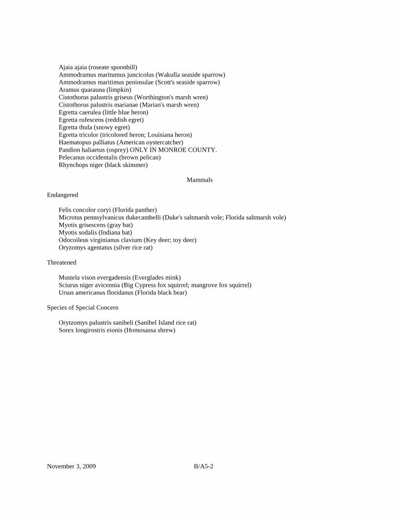
November 3, 2009 B/A5-2
Ajaia ajaia (roseate spoonbill) Ammodramus maritumus juncicolus (Wakulla seaside sparrow) Ammodramus maritimus peninsulae (Scott's seaside sparrow) Aramus quarauna (limpkin) Cistothorus palustris griseus (Worthington's marsh wren) Cistothorus palustris marianae (Marian's marsh wren) Egretta caerulea (little blue heron) Egretta rufescens (reddish egret) Egretta thula (snowy egret) Egretta tricolor (tricolored heron; Louisiana heron) Haematopus palliatus (American oystercatcher) Pandion haliaetus (osprey) ONLY IN MONROE COUNTY. Pelecanus occidentalis (brown pelican) Rhynchops niger (black skimmer) Mammals Endangered Felis concolor coryi (Florida panther) Microtus pennsylvanicus dukecambelli (Duke's saltmarsh vole; Florida saltmarsh vole) Myotis grisescens (gray bat) Myotis sodalis (Indiana bat) Odocoileus virginianus clavium (Key deer; toy deer) Oryzomys agentatus (silver rice rat) Threatened Mustela vison evergadensis (Everglades mink) Sciurus niger avicennia (Big Cypress fox squirrel; mangrove fox squirrel) Ursus americanus floridanus (Florida black bear) Species of Special Concern Orytzomys palustris sanibeli (Sanibel Island rice rat) Sorex longirostris eionis (Homosassa shrew)


B/A7-1
APPENDIX 7
SITE CONDITIONS ASSESSMENT PERMITTING
7.1 Introduction. The applicant shall furnish site conditions assessment information sufficient for the District to verify and determine the locations on the property of certain existing site conditions boundaries in accordance with permitting procedures as stated herein. The site conditions boundaries will delineate existing topographic and environmental site conditions within the applicant's project area that are measurably associated with waters, such as: the landward extent of wetlands and other surface waters delineated according to Chapter 62-340, F.A.C., as ratified in section 373.4211, F.S.; the level and landward extent of floodplains and seasonal or periodic water; watershed delineations; and other limits that are defined by water levels, surface contours or other physical characteristics that affect the management and storage of surface waters. All site conditions assessment permits must evaluate, and identify if present, the landward extent of wetlands and other surface waters; the level and landward extent of the 100-year floodplain; seasonal high water levels; and existing watershed delineations. Additional site conditions boundaries may be requested by the applicant and evaluated for permitting by the District. Nothing herein precludes the use of a site conditions assessment permit as the basis for a construction permit for offsite mitigation. 7.1.1 Procedure. To apply for a site conditions assessment permit, the applicant shall submit to the District the following: a. Five copies of the Permit Application for Site Conditions Assessment as identified in Rule 40D-1.659, F.A.C., including copies of all items and information required for assessment and evaluation by the District of the existing site conditions, and b. The appropriate site conditions assessment permit application processing fee pursuant to Rule 40D-1.607, F.A.C. Within 30 days after receipt of an application for site conditions assessment, the District will notify the applicant of any missing or insufficient information relative to the application, which may be necessary for a review of the site conditions. The applicant shall provide complete and sufficient information described in Section 7.1.2 below, as needed, for assessment and verification of the boundaries of wetlands and other surface waters or other site conditions referenced in the application, and for which permitting is being requested. Sections 120.569 and 120.57, F.S., apply to site conditions assessment permit applications evaluated pursuant to this section. Any person whose substantial interests will be affected by the District's action on the application may request an administrative hearing on the action pursuant to Chapter 28-106, F.A.C. If no request for an administrative hearing is filed, the District will then take final action on the site conditions assessment permit application. The District will issue a site conditions assessment permit if the applicant has satisfied all the applicable requirements of this Basis of Review and Chapters 40D-4 and 40D-40, F.A.C. A person requesting a site conditions assessment permit may withdraw the application without prejudice at any point before final agency action. 7.1.2 Types of Site Conditions Boundary Documentation. An applicant can request a site conditions assessment permit based upon boundary documentation consisting of either a certified survey, an approximate delineation, or combinations thereof, as described below. All surveying and mapping shall be conducted under the responsible supervision of professional surveyor and mapper registered in the State of Florida. a. The survey of the extent of wetlands and other surface waters or other site condition boundaries shall be certified as meeting the minimum technical standards contained in Chapter 61G17-6, F.A.C., by a surveyor licensed pursuant to Chapter 472, F.S. An applicant proposing a certified survey delineation shall have a survey performed of the verified boundaries of wetlands and other surface waters and other required or requested site conditions, and shall have the surveyor or surveyor's representative accompany the District representative during the delineation verification described in subsection 7.1.3. The certified survey shall also contain a legal description of, and acreage
B/A7-2
contained within, the boundaries of the property (contiguous wetlands and project area) for which the permit is being requested. The boundaries of wetlands and other surface waters or other site conditions shall be witnesses to the property boundaries, and shall be capable of being mathematically reproduced from the survey. The applicant shall submit five line drawing copies of the certified survey, along with five copies of the survey depicted on aerial photographs, to the District to complete the application. All vertical boundaries of site conditions shall be referenced to elevations that are witnessed to and on a site bench mark established as part of the survey and shown thereon, and referenced to National Geodetic Vertical Datum (NGVD). The horizontal or topographic extent of vertical boundaries shall be shown on the certified survey in the manner defined in Chapter 61G17-6, F.A.C. b. An approximate delineation proposed by the applicant shall consist of either: (1) a horizontal or topographic boundary map produced by using global positioning system (GPS) or conventional surveying technology, (2) a boundary map drawn on rectified aerial photographs using photo interpretation, (3) a geo-reference image map produced from a boundary drawn on a non-rectified aerial photograph using infrared or similar technology, or (4) any combination thereof. The approximate topographic mapping extent of site conditions boundaries that are defined by elevations (such as flood plains) shall be verified in the manner described in subsection 7.1.3 and surveyed in the manner defined in Chapter 61G17-6, F.A.C., with relative locations shown on the boundary map and referenced to NVGD. 1. A range of horizontal variability shall be determined for all approximate delineations by comparing a number of specific boundary points indicated on the aerial photograph, or located by GPS, to field located boundary points. The District shall determine the number and location of comparison sites using the total linear feet of delineated boundary such that the total number of sites reflects at least one site for every 1000 feet of delineated boundary. No fewer than three boundary point comparisons shall be performed for each approximate delineation. For GPS approximate delineations, the petitioner shall conduct a specific purpose survey, as defined in Chapter 61G17-6, F.A.C., to show the relationship of field located boundary points to the GPS located boundary points. For approximate delineations using rectified aerial photo interpretation and geo-reference imagery, the District will compare a specific number of boundary points indicated on the rectified aerial photo map or geo-reference image map to field located boundary points to estimate the relationship of field to map located boundary points. The range of variability shall be the greatest deviation measured at the comparison boundary points. An approximate delineation method cannot be used if the range of horizontal variability is equal to or greater than plus or minus 25 feet. 2. An aerial photograph (aerial photogrammetric map) shall serve as the basis for an approximate delineation only when the rectified aerial photograph accurately depicts the boundaries of the wetlands and other surface waters or other site conditions by a clear expression of topographic, vegetative or physical signatures as verified by ground truthing. If the District determines that a submitted aerial photograph does not provide an accurate depiction, then the landward extent of wetlands and other surface waters or other site conditions shall be delineated by flagging the boundary, and the formal determination shall be produced using GPS or a certified survey. 3. When a subsequent construction permit application includes regulated activities within 200 feet of the landward extent of the range of variability of an approximate delineation at a given location, the applicant shall establish in the field and use certified survey methods to locate the exact boundary of the wetlands and other surface waters or other site conditions at that location. 4. Following any verification and adjustment as required in subsection 7.1.3, the applicant shall submit five copies of the following items, as applicable, to complete the site conditions boundaries documentation: the certified survey; a hand drawn boundary delineation map on a rectified aerial photograph; the geo-referenced image map of the delineations and aerial photograph with the delineations thereon; or the GPS depiction of the delineations either on an aerial photograph or as a line drawing to constitute a boundary map. 7.1.3 Locating the Boundary Lines. At the time of application an applicant shall furnish a certified survey or an approximate delineation which produces a boundary map that accurately depicts the extent of wetlands and other surface waters or other site conditions for documentation of the site conditions boundaries within the project area. If the property is 10 acres or greater in size, the applicant or his agent shall initially delineate the estimated boundaries of wetlands and other surface waters or other site conditions by either flagging the boundary for a certified survey or GPS, or estimating the extent of wetlands and other surface waters on aerial photographs, prior to the District's inspection of the site. A

B/A7-3
District representative will then verify the locations of the boundary lines and indicate to the applicant's representative any adjustments in the initial delineation needed to reflect an accurate boundary map. For properties less than 10 acres in size, the applicant will not be required to estimate the delineations in the field prior to verification by the District. 7.1.4 Duration. The site conditions assessment boundaries shall be binding for five years provided physical conditions on the property do not change so as to alter the boundaries of wetlands and other surface waters or other site conditions during that period. A site conditions assessment permit shall become invalid for other permitting purposes following the discovery that inaccurate information has been submitted by the applicant. The District shall revoke a site conditions assessment permit upon a finding that the applicant has submitted inaccurate information to the District. Amended 11-2-09.