part d2 residential zones - timaru · by jellicoe street, old north road, mahoneys hill road and...
TRANSCRIPT
Decision District Plan Change 21
Timaru District Council | 16 September 2017 51
APPENDIX 2 – DECISION VERSION OF THE PLAN CHANGE
Note: Notified version of plan change is shown with additions marked as underline and deletions marked as strikethrough. Changes made through the decision process is shown with additions marked as underline and deletions marked with strikethrough.
Part D2 – Residential Zones
Amend Part D2, Policy 2.1.2.2
…..
Residential 1 Zone (Temuka North West)
Explanation and Principal Reason
The Temuka North West Residential Expansion - Outline Development Plan area is outlined in
Appendix B of Part D 2 Residential Zones and comprises approximately 31 hectares of land situated
west of King Street (State Highway 1) between Oxford Crossing Road in the north, the Temuka River
Stopbank in the west, Cass Street in the south and Grant Street and Wallingford Road in the east and
also includes the existing Residential 1 Zoned land north of Donald Street.
The Outline Development Plan includes the configuration of land use zoning, roads, walkways,
reserve and linkages throughout the site. The Rules and Performance Standards of the Residential 1
Zone shall apply to this zone.
The northern areas of this zone are labelled as „deferred‟ zones, i.e. Stages 1A and 2. The Residential
1 Zone rules shall not apply to those deferred zones until a sewer outfall is available to these stages.
These stages are intended to be developed sequentially, as the sewer will first service Stage 1 and 1A
and then progress northwards to Stage 2. This is to enable Council to budget for the funds it may
choose to contribute to the development of services, such as the extension of the sewer.
Staged development will also ensure:
strategic and efficient use of land;
provision of sewer on an ‘as required’ and coordinated basis;
consolidation of urban form;
progressive change in the character of the area;
limitation of the potential effects on existing uses;
provision of enough zoned land within the urban area to counter the demand for rural lifestyle
developments.
Residential 1 Zone (Broughs Gully)

Decision District Plan Change 21
Timaru District Council | 16 September 2017 52
Explanation and Principle Reason
The Broughs Gully Outline Development Plan (ODP) area is shown in Appendix C of Part D2
Residential Zones and comprises 27ha of land situated in the Washdyke area and generally bordered
by Jellicoe Street, Old North Road, Mahoneys Hill Road and existing suburban development. It is
predominantly zoned Residential 1, but also includes an area of Residential 4 zone to the north.
The Outline Development Plan includes the configuration of land use zoning, roads, services,
walkways, stormwater basins and linkages throughout the site. The Rules and Performance
Standards of the Residential 1 Zone (and Residential 4 zone for the northern portion of the
ODPOutline Development Plan area) shall apply to this zone.
Development of this area in general accordance with the ODPOutline Development Plan will ensure:
efficient development of urban zoned land to provide housing choice;
provision of sewer and stormwater infrastructure on a coordinated basis;
provision of a connected, safe, and efficient roading network;
the avoidance of new roading and access connections to major roads;
the avoidance of adverse effects (including reverse sensitivity effects) on the National Grid;
the avoidance of adverse effects on the water quality and hydraulic functioning of Waitarakao
/ Washdyke Lagoon.
….
Residential 4 Zone (Low Density Residential; Timaru only)
Explanation and Principal Reason
This is a low density zone provided for at several locations in Washdyke. Amenity values are intended
to be of as high a standard as is compatible with its location near an industrial area. An integrated
building location and planting regime is to be provided to detail means of achieving maximum visual
amenity. A portion of the Residential 4 Zone is included within the Broughs Gully Outline
Development Plan area shown in Appendix C of Part D2, with which seeks to achieve the outcomes
described above in the Residential 1 Zone (Broughs Gully).
Add new Part D2, Policy 2.4.2.4
Ensure that development in the Residential 1 and 4 zones at within the Broughs Gully Outline
Development Plan area (as set out in Appendix C of Part D2):
(a) is efficient, coordinated and supported by adequate services;
(b) and is in general accordance with the roading and servicing layout shown in Appendix C of
Part D2; and
(c) avoids adverse effects (including reverse sensitivity effects) on the safe, effective and efficient
operation, maintenance, upgrading and development of the National Grid transmission lines.
Comment [KG1]: Decision 3.2
Comment [KG2]: Decision 1.3
Comment [KG3]: Decision 3.2
Comment [KG4]: Decision 3.3
Comment [KG5]: Decision 5.2
Comment [KG6]: Decision 5.2
Comment [KG7]: Decision 3.3
Comment [KG8]: Decision 5.2

Decision District Plan Change 21
Timaru District Council | 16 September 2017 53
Add new Part D2, Policy 2.4.2.5
Ensure that stormwater resulting from development in the Residential 1 and 4 Zones at Broughs
Gully (as set out in Appendix C of Part D 2) does not contribute to further degradation of water
quality, aquatic ecosystems and mahinga kai, and the hydraulic functioning of the Waitarakao /
Washdyke lagoon.
Amend Part D2, Residential 1 Zone, Rule 3A
3A Restricted Discretionary Activities
The following is a Restricted Discretionary Activity provided it is not listed as a Prohibited,
Non-Complying or Discretionary Activity and it complies with all the relevant Zone
Performance Standards:
3A.1 Residential activities not in compliance with the Temuka North West Residential Expansion -
Outline Development Plan (as set out in Appendix B of Part D 2). Discretion shall be limited to
the matter(s) not complied with.
3A.2 Any proposed activity that does not comply with the location(s) of infrastructure shown on the
Broughs Gully Outline Development Plan (as set out in Appendix C of Part D2). Discretion shall
be limited to the matter(s) not complied with.
Amend Part D2, Residential 1 Zone, Rule 4
4 Non-Complying Activities
4.1 All other activities in this zone are non-complying unless they are provided for by a General
Rule.
4.2 In the Residential 1 Zone at Broughs Gully (as set out in Appendix C of Part D2), any building,
fence, earthworks or activity that does not meet Performance Standards 5.B.4, 5.B.5 or
5.B.6the New Zealand Electrical Code of Practice for Electrical Safe Distances (NZECP34:2001)
is non-complying.
Add new Part D2, Residential 1 Zone, Rule 5B, Performance Standards
5B Supplementary Performance Standards for All Activities within the Broughs Gully Outline
Development Plan area shown in Appendix C of Part D2
5B.1 No more than 60% of the area of an allotment shall comprise of impervious or hardstand
surfacing.
Comment [KG9]: Decision 1.4
Comment [KG10]: Decision 3.4
Comment [KG11]: Decision 5.4

Decision District Plan Change 21
Timaru District Council | 16 September 2017 54
5B.2 The runoff from the first 15mm of rainfall in any storm event (regardless of duration) from any
impervious or hardstand surfaces shall be treated before discharging to a reticulated network.
The treatment shall be by infiltration systems, which may include but is not limited to:
Infiltration basins
Rain Gardens
Permeable Pavement
Constructed Wetlands
Catchpit Filter Inserts
5B.3 Materials used in the construction of roofs of all new dwellings shall be a material that
minimises the release of heavy metal contaminants to stormwater. Uncoated galvanised and
copper shall not be used.
5B.4 No building or activity sensitive to the National Grid shall be located within:
12 metres of the foundation of a National Grid transmission line support structure.
All buildings, fences, earthworks, vegetation and structures shall comply with the New
Zealand Electrical Code of Practice for Electrical Safe Distances (NZECP34:2001).
5B.5 Fences shall be located greater than 6 metres from a National Grid transmission line support
structure.
5B.6 Earthworks:
(a) shall not destabilise a National Grid transmission line support structures;
(b) shall not result in a reduction in the ground to conductor clearance distances below
what is required by table 4 of NZECP34:2001; and
(c) shall be no deeper than:
300mm within 2.2m of a National Grid transmission line support structure or stay
wire; and
750mm within 2.2m to 5m of a National Grid transmission line support structure;
except where the earthworks are vertical holes not exceeding 500mm in diameter
beyond 1.5m of a National Grid transmission line support structure or undertaken by a
network utility operator.
Advice Note
(a) Vegetation to be planted around the National Grid should be selected and managed to
ensure that it will not breach the Electricity (Hazards for Trees) Regulations 2003.
(b) Buildings and structures in the vicinity of the National Grid must also comply with the
New Zealand Electrical Code of Practice for Electrical Safe Distances (NZECP34:2001).
10 metres of the centre line of a National Grid transmission line on single poles;
12 metres of the centre line of a National Grid transmission line on pi poles; and
Comment [KG12]: Decision 5.3

Decision District Plan Change 21
Timaru District Council | 16 September 2017 55
Amend Part D2, Residential 4 Zone, Rule 2
2 Controlled Activities
The following are controlled activities subject to complying with all the Performance
Standards for this zone and the General Rules with the exercise of Council's discretion
restricted to the matter(s) specified.
Old North Road
2.1 Except within the Broughs Gully Outline Development Plan area (as set out in Appendix C, Part
D2), oOne household unit per allotment provided for as part of a comprehensive development
plan in that part of the zone west of Old North Road, or one household unit per proposed
allotment south or east of Old North Road (unless otherwise restricted by the Outline
Development Plan shown in Appendix C, Part D2), Blair Street, or Mahoneys Hill Road. Council
shall restrict its discretion to the environmental effects associated with the matters in Policy
2.1.2.2.
…
Add new Part D2, Residential 4 Zone, Rule 3A
3A Restricted Discretionary Activities – Broughs Gully Outline Development Plan area
The following is a Restricted Discretionary Activity provided it is not listed as a Prohibited,
Non-Complying or Discretionary Activity and it complies with all the relevant Zone
Performance Standards:
3A.1 Any activity that does not comply with the location(s) of infrastructure shown on the Broughs
Gully Outline Development Plan (as set out in Appendix C of Part D2). Discretion shall be
limited to the matter(s) not complied with.
Add new Part D2, Residential 4 Zone, Rule 5A, Performance Standards
5A Supplementary Performance Standards for All Activities within the Broughs Gully Outline
Development Plan area shown in Appendix C of Part D2
5A.1 No more than 60% of the area of an allotment canshall comprise of impervious surfacing
5A.2 The runoff from the first 15mm of rainfall in any storm event (regardless of duration) from any
impervious or hardstand surfaces shall be treated before discharging to a reticulated network.
The treatment shall be by infiltration systems, which may include but is not limited to:
Infiltration basins
Comment [KG13]: Decision 3.6
Comment [KG14]: Decision 3.7
Decision District Plan Change 21
Timaru District Council | 16 September 2017 56
Rain Gardens
Permeable Pavement
Constructed Wetlands
Catchpit Filter Inserts
5A.3 Materials used in the construction of roofs of all new dwellings shall be a material that
minimises the release of heavy metal contaminants to stormwater. Uncoated galvanised and
copper shall not be used.
Comment [KG15]: Decision 1.5

Decision District Plan Change 21
Timaru District Council | 16 September 2017 57
Amend Part D2, Appendix C: Broughs Gully Outline Development Plan Note: Appendix C is replaced with updated appendix.

Decision District Plan Change 21
Timaru District Council | 16 September 2017 58

Decision District Plan Change 21
Timaru District Council | 16 September 2017 59
Part D6.3 – Subdivision
Amend Part D6.3, Subdivision, Rule 6.3.5A
6.3.5A Restricted Discretionary Activities
The following shall be Restricted Discretionary Activities provided that they are not listed as a
Prohibited, Non-Complying or Discretionary Activity, and they comply with all the relevant
Zone standards:
….
(v) Any subdivision not in compliance with the Broughs Gully Outline Development Plan (as
set out in Appendix C of Part D 2). Discretion shall be limited to the matter(s) not
complied with.
Amend Part D6.3, Subdivision, Rule 6.3.6
6.3.6 Non-complying activities in all zones
The following are non-complying activities in all zones unless they are provided for by a
General Rule:
…
(iv) Any subdivision in the Broughs Gully Outline Development Plan area (as set out in
Appendix C of Part D2) that does not meet the Performance Standard in Rule 6.3.8(21).
…
Amend Part D6.3, Subdivision, Rule 6.3.8
6.3.8 Performance Standards for subdivision in Residential Zones
….
(5) In the Residential 4 Zone all subdivisions shall comply with a comprehensive
development plan for the contiguous land in the same zone, unless the sites have:
(a) have access to Doncaster or Martin Streets, or
(b) are on the south or east side of Old North Road, Blair Street or Mahoneys Hill
Road, or
(c) and are not within the Broughs Gully Outline Development Plan shown(as set out
in Appendix C, Part D2).,
Comment [KG16]: Decision 5.7

Decision District Plan Change 21
Timaru District Council | 16 September 2017 60
in which case where Where (a), (b) or (c) above does not apply, the development plan
need relate only to the existing allotment being subdivided. For the area subject to
Appendix C, Part D2, all subdivisions are to be in accordance with the Broughs Gully
Outline Development Plan.
…
(9) Where fill is to occur in the Residential 1 Zone at Temuka North West (as set out in
Appendix B of Part D 2) or within the Broughs Gully Outline Development Plan area (as
set out in Appendix C, Part D2), a certificate in accordance with NZS 4431:1989 Code of
Practice for Earth Fill for Residential Development shall be provided in relation to the
location, depth and nature of any fill. In addition, a report from a suitably qualified
person is required confirming that the placement of fill will not create a flood hazard.
…
(19) At the time of subdivision, new roads and water, sewer, and stormwater infrastructure
shall be constructed and vested in general accordance with the layout shown on the
Broughs Gully Outline Development Plan (as set out in Appendix C of Part D 2). It is the
developer’s responsibility to:
a. Construct the portion of road contained within their land to be subdivided prior
to Council’s granting certification under section 224 of the Resource
Management Act 1991.
b. Design and construct the roads and services in general accordance with the
Outline Development Plan (as set out in Appendix C of Part D 2) and in
accordance with Council’s standards for urban subdivision. Road reserves are to
be the minimum dimensions specified in Appendix C to enable inclusion of a
stormwater swale system within the road reserve.
c. Ensure no methods are used to hinder or restrict the ability for adjoining land to
link to the new road.
(20) In the Broughs Gully Outline Development Plan area (as set out in Appendix C of Part D
2), all applications for subdivision consent shall be required to provide a financial
contribution in accordance with Sections 6.5 and 6.6 of the District Plan for the
following purposes:
a. Sewer: to provide for an efficient sewage disposal system in accordance with Part
D 6.5 Rule 6.5.4.2.
b. Stormwater: to provide for the maintenance and extension of stormwater
systems in accordance with Part D 6.5 Rule 6.5.3.2 and Rule 6.5.3.3.
c. Water: to provide for the maintenance and development of the water supply in
accordance with Part D 6.5 Rule 6.5.1.2.
d. Roading: to provide for safe and efficient road network in accordance with Part D
6.6 Rule 6.6.5(1).
Comment [KG17]: Decision 3.10

Decision District Plan Change 21
Timaru District Council | 16 September 2017 61
(21) In the Broughs Gully Outline Development Plan area (as set out in Appendix C of Part
D2) any lots created must maintain access to the National Grid and must show a
building platform that is greater than:
a. 10 metres from the centre line of a National Grid transmission line on single
poles;
b. 12 metres from the centre line of a National Grid transmission line on pi poles;
and
c. 12 metres from the foundation of a National Grid transmission line support
structure.
NOTE: Consultation with Transpower New Zealand Limited is necessary when considering
subdivision within 20 metres of a high voltage electricity transmission line. The New Zealand
Electrical Code of Practice (NZECP: 34 2001) contains restrictions on the location of structures
and activities in relation to the lines.
Part D6.5 – Water, Sewer, Stormwater and Open Space and
Recreation Contributions
Amend Part D6.5, Stormwater, Rule 6.5.3.2
6.5.3.2 Rules on Financial Contributions
…
(6) At Gleniti and Broughs Gully, where open drainage channels are to be established and
managed as stormwater swales (with or without associated detention dams) as part of a
comprehensive stormwater management system, financial contribution shall be calculated
in accordance with all of the above provisions.
…
Amend Part D6.5, Stormwater, Rule 6.5.3.3
6.5.3.3 Performance Standards for Stormwater
Where a financial contribution is taken in the form of works or services the following criteria
shall be complied with:
…
Comment [KG18]: Decision 5.6

Decision District Plan Change 21
Timaru District Council | 16 September 2017 62
(l) For that area included in the Residential 6 Zone, Residential 6(a) Zone (Deferred), and
6(b) Zone (Deferred) at Gleniti in Timaru, and within the Broughs Gully Outline
Development Plan, the system shall be within the existing natural open drainage
channels, stormwater swales and/or such other waterways as may be the subject of
resource consent and shall:
be located as identified in the Indicative Development Plan for Gleniti or Broughs
Gully (or such other as may be the subject of resource consent)
be visually similar in appearance to a natural gully
include earth detention dams
be designed to manage a 2% annual excedence probability rainfall event (i.e. 50
year/30 minute); and
be approved by a suitably qualified chartered professional engineer.
…
(m) Detention dams within stormwater swales in the Residential 6 Zone, Residential 6(a)
Zone (Deferred), and 6(b) Zone (Deferred) at Gleniti in Timaru and within the Broughs
Gully Outline Development Plan area, are to be constructed on, or about, the locations
as indicated in the Indicative Development Plan for Gleniti and Broughs Gully, or in such
other locations as are approved by resource consent.
(i) Detention dams are to be constructed to the following specifications:
Be made from local available material up to a height of 2 metres.
Suitable construction and the final integrity of each detention dam will
need to be verified by a chartered engineer.
Each dam will have a single 300 millimetre diameter concrete culvert pipe
installed at gully level, and a scour resistant overflow installed on top of the
dam structure.
Once completed regular maintenance of each structure will be required to
ensure there are no blockages or scouring.
Walkways, cycleways and plantings may be established as part of the
stormwater swale.
(ii) Additional detention dams may also be constructed, as and when required.
(iii) No buildings and/or structures that conflict with the primary objective of
stormwater management may be established within a stormwater swale.
(n) Every person within the Residential 6 Zone, Residential 6(a) Zone (Deferred), and 6(b)
Zone (Deferred) at Gleniti in Timaru, and within the Broughs Gully Outline Development
Plan area, has a duty to avoid the discharge of sediment from any site subject to land
modification, development or subdivision. One or more sediment retention and/or
filtering mechanisms may be necessary to ensure that this standard can be met. All
measures to mitigate against the discharge of sediment from a site shall be:
Implemented prior to, or shortly after, the commencement of any land
modification activity;
Comment [KG19]: Decision 3.3 consequential amendment
Comment [KG20]: Decision 3.3 consequential amendment

Decision District Plan Change 21
Timaru District Council | 16 September 2017 63
Retained until the land-disturbing activity has been completed, and/or the
potential for sediment discharge has ceased.
(o) Within the Residential 6 Zone, Residential 6(a) Zone (Deferred), and 6(b) Zone
(Deferred) at Gleniti in Timaru, and within the Broughs Gully Outline Development Plan
area, all bare earthwork surfaces shall be re-vegetated as soon as practicable.
Hydroseeding, grassing or other means of re-vegetation shall be carried out on a
progressive basis as soon as the earthworks have been completed on a particular part
of the site, so as to prevent the future generation and discharge of any sediment from
that site.
(p) Earthworks, roading, tracking and trenching activities within the Residential 6 Zone,
Residential 6(a) Zone (Deferred), and 6(b) Zone (Deferred) at Gleniti in Timaru, and
within the Broughs Gully Outline Development Plan area, shall be isolated from the
path of any run-off from surrounding land to prevent it from washing across the site
and eroding sediment from any exposed earth.
(q) Within the Residential 6 Zone, Residential 6(a) Zone (Deferred), and 6(b) Zone
(Deferred) at Gleniti in Timaru, and within the Broughs Gully Outline Development Plan
area, any stormwater run-off that is discharged from a piped outfall, or an overland
flowpath, shall not cause any form of erosion.
…
Part D6.6 – Roading Hierarchy
Amend Part D6.6, Roading Hierarchy, Rule 6.6.5
6.6.5 Rules for Financial Contributions
…
(2) In the Broughs Gully Outline Development Plan area (as set out in Appendix C of Part
D2), a financial contribution for roading shall be payable in accordance with the
following cost share agreement:
a. The cost of all future and indicative roads within the Outline Development Plan
will be determined and summed to give the total cost of future and indicative
roads.
b. The direct benefit that each property receives from the roading on its land is
determined and subtracted from the actual cost of the roading on its land. This
could be a positive or negative value. The direct benefit shall be determined by
assessing the potential new allotment yield for each existing allotment and
multiplying this by the typical amount of road per allotment in recent
developments. This is then multiplied by a square metre rate for new road to give
a benefit value.
Comment [KG21]: Decision 3.3 consequential amendment
Comment [KG22]: Decision 3.3 consequential amendment
Comment [KG23]: Decision 3.3 consequential amendment

Decision District Plan Change 21
Timaru District Council | 16 September 2017 64
c. The sum of the all the benefit costs determined in 6.6.5(1)(b) is subtracted from
the total cost of all future and indicative roads determined in 6.6.5(1)(a). This
residual cost represents the catchment wide benefit that each property receives
from adjoining and surrounding properties developing.
d. The residual cost determined in 6.6.5(1)(c) is apportioned to all properties in the
catchment in accordance with their developable area.
e. For each property, the cost of the direct benefit (determined in 6.6.5(1)(b)) plus
the properties share of the apportioned residual cost (determine in 6.6.5(1)(c))
equals the total cost of that properties financial contribution. If the actual cost of
roading on that property is greater than the financial contribution, then the
property receives from Council a financial contribution credit (in the form of
cash). If the actual cost of roading on that property is less than the financial
contribution, then the property pays Council a financial contribution (in the form
of cash).
NOTE: The Council's proposals for the basis of cost sharing will be made available to the
subdividers in broad terms, i.e. rate of levy on defined areas, basis of adjustment and
details of services proposed.
Part D7 – Definitions
Add new definition into Part D7
Activity Sensitive to the National Grid - Means Boarding or Lodging House or Hostel, Camping
Grounds/Caravan Parks, Community Care Facility, Community Facilities, Day Care Centres,
Educational Establishments, Home Stay, Hospital, Household Unit, Kohanga Reo, Marae, Papakainga,
and Place of Assembly as defined in this District Plan.
Comment [KG24]: Decision 3.11
Comment [KG25]: Decision 5.5

Decision District Plan Change 21
Timaru District Council | 16 September 2017 65
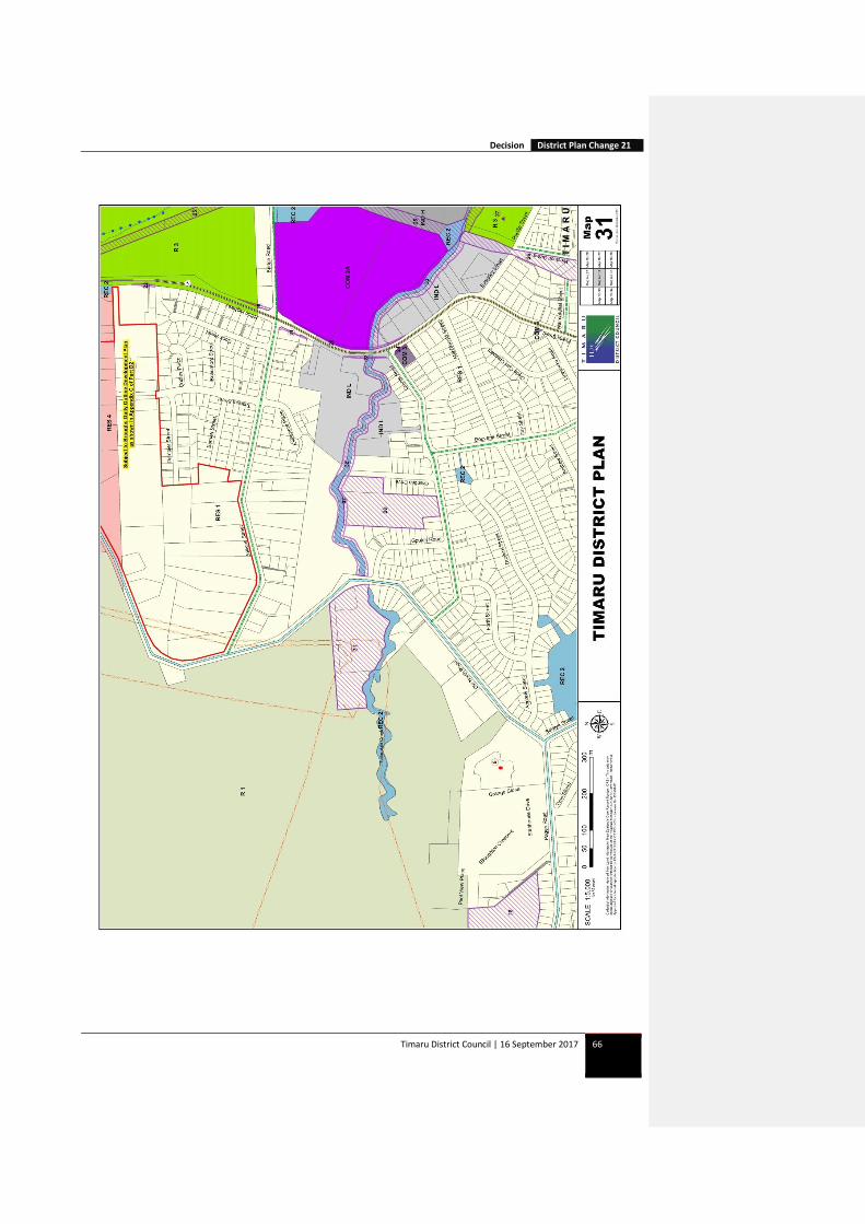
Part C – Planning Maps
Amend Part C, Planning Maps 27 and 31
Decision District Plan Change 21
Timaru District Council | 16 September 2017 66