paths - papio nrd nebraskapaths of discovery! metro area trails map walk paths • bike paths •...
TRANSCRIPT
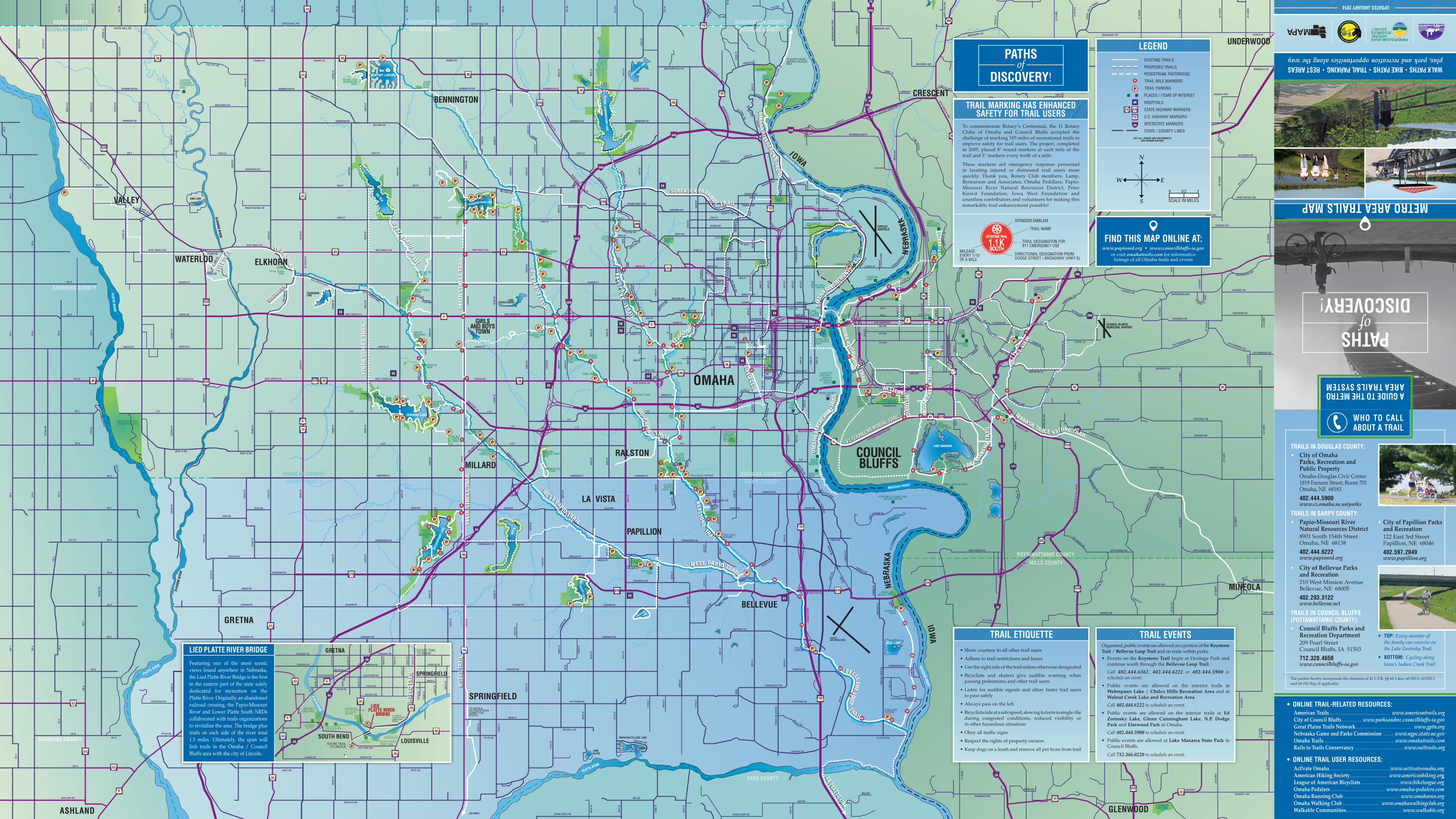
A GUIDE TO THE METRO AREA TRAILS SYSTEM
PATHS of
DISCOVERY!
METRO AREA TRAILS MAP
WALK PATHS • BIKE PATHS • TRAIL PARKING • REST AREASplus, park and recreation opportunities along the way
UPDATED JANUARY 2014
TRAILS IN DOUGLAS COUNTY:• City of Omaha Parks, Recreation and Public Property Omaha-Douglas Civic Center 1819 Farnam Street, Room 701 Omaha, NE 68183
402.444.5900 www.ci.omaha.ne.us/parks
TRAILS IN SARPY COUNTY:• Papio-Missouri River Natural Resources District 8901 South 154th Street Omaha, NE 68138
402.444.6222 www.papionrd.org
• City of Bellevue Parks and Recreation 210 West Mission Avenue Bellevue, NE 68005
402.293.3122 www.bellevue.net
TRAILS IN COUNCIL BLUFFS (POTTAWATTAMIE COUNTY):• Council Bluffs Parks and Recreation Department 209 Pearl Street Council Bluffs, IA 51503
712.328.4650 www.councilbluffs-ia.gov
• City of Papillion Parks and Recreation 122 East 3rd Street Papillion, NE 68046
402.597.2049 www.papillion.org
• TOP: Every member of the family can exercise on the Lake Zorinsky Trail.
• BOTTOM: Cycling along Iowa’s Indian Creek Trail.
WHO TO CALL ABOUT A TRAIL
American Trails . . . . . . . . . . . . . . . . . . . . . . . . . . . . . . . . . . . . www.americantrails.orgCity of Council Bluffs . . . . . . . . . . . www.parksandrec.councilbluffs-ia.govGreat Plains Trails Network . . . . . . . . . . . . . . . . . . . . . . . . . . . . . . . . . www.gptn.orgNebraska Game and Parks Commission . . . . . . www.ngpc.state.ne.gov Omaha Trails . . . . . . . . . . . . . . . . . . . . . . . . . . . . . . . . . . . . . . . . . www.omahatrails.comRails to Trails Conservancy . . . . . . . . . . . . . . . . . . . . . . . . . . . . . www.railtrails.org
Act!vate Omaha . . . . . . . . . . . . . . . . . . . . . . . . . . . . . . . . . . . . www.activateomaha.orgAmerican Hiking Society. . . . . . . . . . . . . . . . . . . . . . www.americanhiking.orgLeague of American Bicyclists . . . . . . . . . . . . . . . . . . . . . . .www.bikeleague.orgOmaha Pedalers . . . . . . . . . . . . . . . . . . . . . . . . . . . . . . . . www.omaha-pedalers.comOmaha Running Club . . . . . . . . . . . . . . . . . . . . . . . . . . . . . . . . www.omaharun.orgOmaha Walking Club . . . . . . . . . . . . . . . . . . . . . . www.omahawalkingclub.orgWalkable Communities . . . . . . . . . . . . . . . . . . . . . . . . . . . . . . . . . www.walkable.org
• ONLINE TRAIL-RELATED RESOURCES:
• ONLINE TRAIL USER RESOURCES:
YOUNGMANLAKE
WEST Q RD
(SEE INSET)
4
PLATTE RIVER
HASTINGSBANNER PARK
AMERICANHEROES PARK
Organized, public events are allowed on a portion of the Keystone Trail / Bellevue Loop Trail and on trails within parks.• Events on the Keystone Trail begin at Heritage Park and
continue south through the Bellevue Loop Trail.
Call 402.444.6362, 402.444.6222 or 402.444.5900 to schedule an event.
• Public events are allowed on the interior trails at Wehrspann Lake / Chalco Hills Recreation Area and at Walnut Creek Lake and Recreation Area.
Call 402.444.6222 to schedule an event.
• Public events are allowed on the interior trails at Ed Zorinsky Lake, Glenn Cunningham Lake, N.P. Dodge Park and Elmwood Park in Omaha.
Call 402.444.5900 to schedule an event.
• Public events are allowed at Lake Manawa State Park in Council Bluffs.
Call 712.366.0220 to schedule an event.
TRAIL EVENTSTRAIL ETIQUETTE• Show courtesy to all other trail users
• Adhere to trail restrictions and hours
• Use the right side of the trail unless otherwise designated
• Bicyclists and skaters give audible warning when passing pedestrians and other trail users
• Listen for audible signals and allow faster trail users to pass safely
• Always pass on the left
• Bicyclists ride at a safe speed, slowing to form in single-file during congested conditions, reduced visibility or in other hazardous situations
• Obey all traffic signs
• Respect the rights of property owners
• Keep dogs on a leash and remove all pet feces from trail
LIED PLATTE RIVER BRIDGE
Featuring one of the most scenic views found anywhere in Nebraska, the Lied Platte River Bridge is the first in the eastern part of the state solely dedicated for recreation on the Platte River. Originally an abandoned railroad crossing, the Papio-Missouri River and Lower Platte South NRDs collaborated with trails organizations to revitalize the area. The bridge plus trails on each side of the river total 1.5 miles. Ultimately, the span will link trails in the Omaha / Council Bluffs area with the city of Lincoln.
PATHS of
DISCOVERY!
LEGEND
0 11/2
SCALE IN MILES
N
S
W E
FIND THIS MAP ONLINE AT:www.papionrd.org • www.councilbluffs-ia.gov
or visit omahatrails.com for informative listings of all Omaha trails and events
TRAIL MARKING HAS ENHANCED SAFETY FOR TRAIL USERS
TRAIL DESIGNATION FOR 911 EMERGENCY USE
SPONSOR EMBLEM
MILEAGE EVERY 1/10 OF A MILE
DIRECTIONAL DESIGNATION FROM DODGE STREET / BROADWAY (HWY 6)
TRAIL NAME
To commemorate Rotary’s Centennial, the 11 Rotary Clubs of Omaha and Council Bluffs accepted the challenge of marking 105 miles of recreational trails to improve safety for trail users. The project, completed in 2005, placed 8" round markers at each mile of the trail and 5" markers every tenth of a mile.
These markers aid emergency response personnel in locating injured or distressed trail users more quickly. Thank you, Rotary Club members, Lamp, Rynearson and Associates, Omaha Peddlars, Papio-Missouri River Natural Resources District, Peter Kiewit Foundation, Iowa West Foundation and countless contributors and volunteers for making this remarkable trail enhancement possible!
The parties hereby incorporate the elements of 41 C.F.R. §§ 60-1.4(a), 60-300.5, 60-250.5 and 60-741.5(a), if applicable.