paul zillig, general manager amy zoller, ms, nednr integrated
TRANSCRIPT

David Potter, Assistant General Manager
Amy Zoller, MS, NeDNR
Integrated Water Management Coordinator
2016 ANNUAL INTEGRATED
MANAGEMENT PLAN REPORT
LPSNRD Board Meeting, August 16, 2017

Voluntary IMP
LPSNRD and NeDNR jointly adopted a voluntary
IMP which became effective May 15, 2014
Plan consists of Goals, Objectives and Actions
The IMP shall be reviewed annually by the
District’s Board of Directors and the Department
to ensure that the plan continues to meet the
needs of the District and Department and to
identify Action steps for the next two years.

IMP VISION
“Water uses and water supplies are in a managed
balance, supporting economic viability,
environmental sustainability and safe living
conditions.”
The plan will be instrumental in identifying
available water supplies and managing water
quantity to meet the future water needs in the
District.


IMP Annual Report/Review
Annual Report covers progress made towards IMP
action items for both the LPSNRD and NeDNR in
2016
LPSNRD and NeDNR jointly decided that no
modifications to the IMP are needed at the time of
the 2016 annual review

NeDNR’s IMP Activities
Surface Water Monitoring • Appropriations
• Stream gaging
• Pump site visits
Surface Water Regulations
Studies and Planning
Education and Outreach
Collaboration

Surface Water Appropriations Monitoring Approved 1
permit
• 16 new SW
irrigated
acres
Cancelled 9
permits
• -461 SW
acres
Dismissed 5
permits
No Transfers

2016 Surface Water Regulations 198 acres
limit in
surface water
control area
No new acres
added to SW
control area in
2016
16 new acres
outside
control area
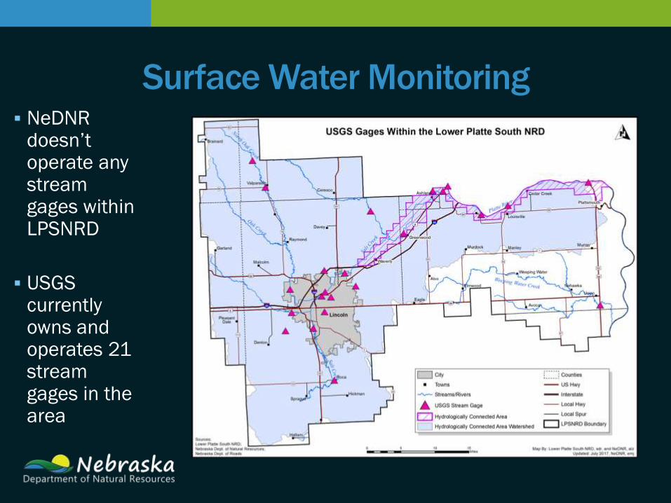
Surface Water Monitoring NeDNR
doesn’t operate any stream gages within LPSNRD
USGS currently owns and operates 21 stream gages in the area

Surface Water Monitoring

Surface Water Data Collection 2016 Pump
Site
Inspections
172
inspections
16 sites
were set up
to irrigate
(3 running)
Surface Water Data Collection
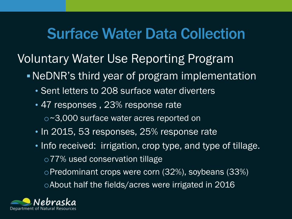
Voluntary Water Use Reporting Program
NeDNR’s third year of program implementation
• Sent letters to 208 surface water diverters
• 47 responses , 23% response rate
o~3,000 surface water acres reported on
• In 2015, 53 responses, 25% response rate
• Info received: irrigation, crop type, and type of tillage.
o77% used conservation tillage
oPredominant crops were corn (32%), soybeans (33%)
oAbout half the fields/acres were irrigated in 2016

Lower Platte/Missouri Tributaries Modeling
Development Progress
Northern model • Undergoing calibration
• Expected to be completed
by the end of 2017
Nemaha model • Development began in
spring 2016
• Expected completion in
2018

Ground Water monitoring
and data collection
• 7 well permits/2 completed
• Water level monitoring in 141 wells,
spring & fall, with average static
water increases of 2.01 feet
• Meters and water use reporting
from 392 wells
• 3.7 billion gallons pumped from 385
wells
2016 ACTIONS & PROGRESS
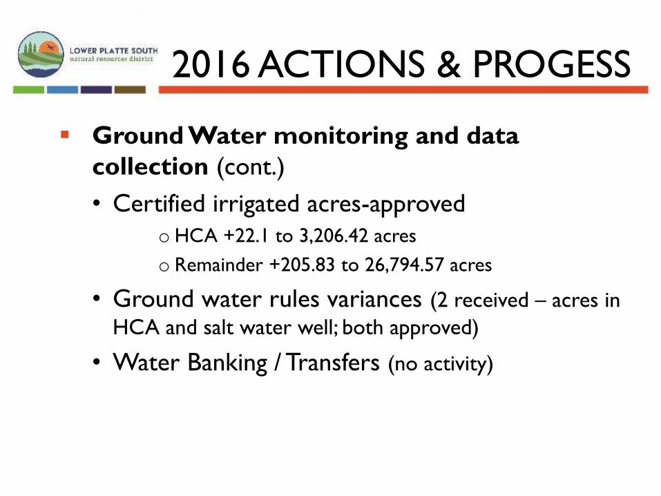
Ground Water monitoring and data
collection (cont.)
• Certified irrigated acres-approved
o HCA +22.1 to 3,206.42 acres
o Remainder +205.83 to 26,794.57 acres
• Ground water rules variances (2 received – acres in
HCA and salt water well; both approved)
• Water Banking / Transfers (no activity)
2016 ACTIONS & PROGESS
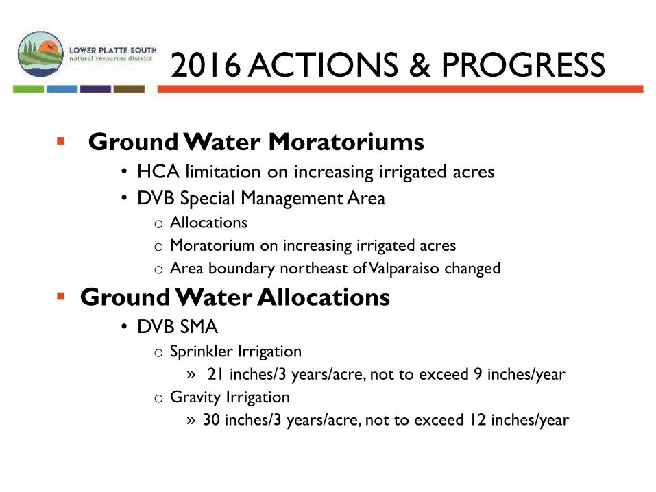
Ground Water Moratoriums • HCA limitation on increasing irrigated acres
• DVB Special Management Area
o Allocations
o Moratorium on increasing irrigated acres
o Area boundary northeast of Valparaiso changed
Ground Water Allocations • DVB SMA
o Sprinkler Irrigation
» 21 inches/3 years/acre, not to exceed 9 inches/year
o Gravity Irrigation
» 30 inches/3 years/acre, not to exceed 12 inches/year
2016 ACTIONS & PROGRESS

2016 Actions/Progress: Collaboration
Both LPSNRD and NeDNR participated in regional
planning activities:
Eastern Nebraska Water Resources Assessment
• Aquifer mapping via electromagnetic imaging
Lower Platte River Corridor Alliance
• Local protection and management of River’s Resources
Lower Platte River Consortium
• Water supply resiliency, drought planning
Lower Platte River Basin Coalition
• Basin-wide planning and accounting

2016 Activities Ground Water Mgt Plan
AEM data posted online
3 Test Your Well nights
School activities
Irrigation certification
BMP promotion
Media, Social Media, Web
Publications
LPSNRD Education/Outreach

NeDNR Education & Outreach
2016 Activities
• Earth Day
• NE State Fair
• INSIGHT web portal
• Husker Harvest Days
• Keep Cass County Beautiful
• The Governor’s Ag Conference
• Nebraska Women in Agriculture Conference booth

2017 & 2018 ACTIONS
Jointly Identified Actions for Succeeding Two Years
NeDNR Actions Improvements to/expansion of INSIGHT web portal
Monitoring of surface water permits & water use
Evaluate need for more stream gages
Continue voluntary surface water use reporting
Continued development of Lower Platte River/Missouri Tributaries models • Will prepare a presentation for LPSNRD Board when
complete

Jointly Identified Actions for Succeeding Two Years
LPSNRD Actions Monitoring of ground water levels
Meter wells & require water use reports
Continue to track changes in water use, land use, population and climate
Complete HDR project for IMP components • Drought Emergency Response Plan
• Water Conservation
• Analyze unmeasured water uses
• implement revisions to GIS database
Recommendations for Areas with limited aquifer areas
Discuss coordination of regional water systems and water shortage action plans
2017 & 2018 ACTIONS

Jointly Identified Actions for Succeeding Two Years
Joint LPSNRD/NeDNR Actions
Complete Drought Contingency Study
Continued participation in regional planning groups (such as
ENWRA, LPR Coalition, and Lower Platte River Consortium)
Jointly participate in one public outreach event—2017 Earth
Wellness Festival
Review, with the Advisory Committee, the need to update
IMP Goals and Objectives
Continue working to move LPSNRD data to central
repository.
2017 & 2018 ACTIONS
QUESTIONS OR COMMENTS?
Amy Zoller, MS, Integrated Water Management Coordinator
Nebraska Department of Natural Resources
David Potter, Assistant General Manager
Lower Platte South Natural Resources District