pdf jakarta e - chikyu.ac.jp · aquifer under dki jakarta, ... chapter 10, pp.113 -130. subsurface...
TRANSCRIPT

The City of JakartaAfter eras of administration by the Netherlands and Japan, Jakarta achieved independence in 1949 and currently is developing as a world city which hosts the headquarters of ASEAN (the Association of South-East Asian Nations). Its population was a mere 120,000 people in 1900 but after independence it rapidly increased and by 2005 it was home to 8,860,000 people. Economic activity is accelerating primarily in the urban region including the cities in the vicinity of Jakarta (Jabodetabek). Jakarta is the region with the highest economic level in Indonesia, but there is a large gap between rich and poor, and rapid development of the slum towns in which the poor live is under way.

Discrepancy between official report and estimation of groundwater abstraction: Jakarta
Land subsidence caused by the excessive pumping of groundwater is a growing concern in Jakarta. There are limits to how much groundwater can be safely extracted. However, many developing cities, like Jakarta, are unclear on the appropriate levels of pumping. It is strongly suspected that Jakarta is pumping greater amounts of groundwater than officially reported, as the rate of land subsidence is increasing alarmingly.The total water demand of a developing city can be estimated by looking at the demand of other cities, using an industrial share or unit for water demand per person. First, we estimate the total water demand, and then calculate the estimated groundwater abstraction rates by finding the difference between water demand and tap water supply.Our results indicate that Jakarta pumps greater amounts of groundwater than stated in the official report.
Defined stages of urbanization and land subsidence for Asian megacities
0
2
4
6
8
10
12
14
16
18
20
0
100
200
300
400
500
600
700
1900
1905
1910
1915
1920
1925
1930
1935
1940
1945
1950
1955
1960
1965
1970
1975
1980
1985
1990
1995
2000
2005
/ ( )
Tomoyo Toyota JICA-RI Kaneko Shinji Hiroshima University

Groundwater in JakartaIn recent years, a draw-down of the groundwater level and land subsidence have became more serious in this region. More than 60% of the city area is located in a lowland swampy area below sea level, so flooding frequently occurs in the rainy season. Due to land subsidence, the damage from the flooding is getting more and more serious. In particular in the coastal areas the situation is so serious that seawater flowing into the area at high tide. The government has launched measures to reduce groundwater use, but the effects of these policies are not apparent yet. The city has not found effective alternative surface water sources, so the city is still undergoing a groundwater disaster.

Fig. 1 Historical change of spatial groundwater potential(Kagabu et al., 2010)
We adopted multiple hydrogeochemicaltechniques to demonstrate the groundwater flow system in the Jakarta area. Our results showed that the water quality and residence time demonstrated a clear difference between shallow and deep aquifers, even though nearly all groundwater is recharged at similar elevations. We also found that seawater intrusions are mixing with shallow and deep groundwater because of a rapid decrease in urban area groundwater potential; confirmed by major ions, Br/Clratios, and CFC-12 analysis.
Estimation for recharge area and flow system of groundwater
M. Kagabu Kumamoto University J. Shimada Kumamoto UniversityR. Delinom LIPI F. Lubis LIPI
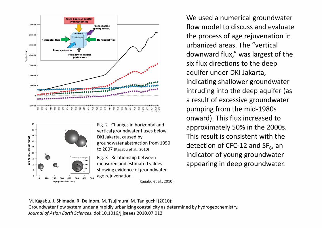
Fig. 3 Relationship between measured and estimated values showing evidence of groundwater age rejuvenation.
(Kagabu et al., 2010)
Fig. 2 Changes in horizontal and vertical groundwater fluxes below DKI Jakarta, caused bygroundwater abstraction from 1950 to 2007 (Kagabu et al., 2010)
We used a numerical groundwater flow model to discuss and evaluate the process of age rejuvenation in urbanized areas. The “vertical downward flux,” was largest of the six flux directions to the deep aquifer under DKI Jakarta, indicating shallower groundwater intruding into the deep aquifer (as a result of excessive groundwater pumping from the mid-1980s onward). This flux increased to approximately 50% in the 2000s.This result is consistent with the detection of CFC-12 and SF6, an indicator of young groundwater appearing in deep groundwater.
M. Kagabu, J. Shimada, R. Delinom, M. Tsujimura, M. Taniguchi (2010):Groundwater flow system under a rapidly urbanizing coastal city as determined by hydrogeochemistry.Journal of Asian Earth Sciences. doi:10.1016/j.jseaes.2010.07.012

Land Subsidence and Groundwater
Land subsidence in Jakarta was recognized as early as 1926. It has resulted in flooding in coastal areas, damage to constructions, and other disasters. One of the causes of recent subsidence is excess pumping of the groundwater, in particular in areas of development.
To investigate the cause of subsidence, we conducted gravity and GPS measurements. We employed a field-type absolute gravimeter, the Micro-G LaCosteA10-#017. This was the first application of an absolute gravimeter to this kind of problem.
Yoichi Fukuda (Kyoto University) Jun Nishijima (Kyushu University )Takashi Hasegawa (Kyoto University)
Flood due to the subsidence Land subsidence
Absolute Gravimeter
Relative Gravimeter
GPS

Using the A10-#017, the first absolute gravity measurements in Jakarta were conducted in August, 2008. It was difficult to make the absolute gravity measurements in high-temperature, humid, and noisy urban conditions. We faced several problems but obtained good absolute gravity data in 2009.
Because of the lack of absolute gravity data for 2008, we have not yet obtained absolute gravity changes. Nevertheless, the figure shows the gravity changes (in �gals) obtained by a relative gravimeter, and the height changes observed by the GPS. These show that the gravity is greater in coastal areas where large subsidence was observed by the GPS.
Gravity changes (2008-2009) observed by a relative gravimeter. The contours show the height changes determined from GPS measurements.
+21 +28
+21
0
Fukuda Y., J. Nishijima, M. Taniguchi (2010):Applications of Absolute Gravity Measurements for Environmental Issues, Proc. 5th Kentingan Physics Forum, Sahid Jaya Solo Hotel, July 14, 2010, 85-88.Abidin, H.Z., et al(2010): Land Subsidence Characteristics of the Jakarta Basin (Indonesia) and its Relation with Groundwater Extraxtion and Sea Level Rise, IAH Selected Papers on Hydrogeology No. 16, Chapter 10, pp.113 -130.

Subsurface Thermal Environment in JakartaAlong with the rapid growth of the city, the temperature in Jakarta City has continuously risen. The impact of this rise has penetrated underground causing a rise in the underground temperature. There is also a possibility that changes in groundwater flow caused by human activities are having an impact on the underground temperature distribution.
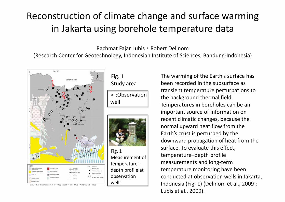
Reconstruction of climate change and surface warming in Jakarta using borehole temperature data
The warming of the Earth’s surface has been recorded in the subsurface as transient temperature perturbations to the background thermal field. Temperatures in boreholes can be an important source of information on recent climatic changes, because the normal upward heat flow from the Earth’s crust is perturbed by the downward propagation of heat from the surface. To evaluate this effect, temperature–depth profile measurements and long-term temperature monitoring have been conducted at observation wells in Jakarta, Indonesia (Fig. 1) (Delinom et al., 2009 ; Lubis et al., 2009).
Fig. 1 Measurement of temperature–depth profile at observation wells
Rachmat Fajar Lubis Robert Delinom(Research Center for Geotechnology, Indonesian Institute of Sciences, Bandung-Indonesia)
13
2
Fig. 1 Study area
:Observation well
:Observation well
Fig. 1 Measurement of temperature–depth profile at observation wells

The reconstruction of GST history in Jakarta showed that the estimated surface temperature increased by 1.4to 2.4 K, which corresponds with air temperature records from the last 100 years. The combined effects of heat island and climate change go below the surface of the Earth, with the heat island effect increasing subsurface temperatures at a faster rate than global warming. The effects of global warming are at levels of 0.5–0.7 K, and the effects of urbanization are estimated to represent 36–50% of the total warming of 1.4 K. These results show that subsurface thermal warming is occurring in this city because of both urbanization and climate change.
Fig. 2 Results of GST history reconstruction at Sites 1, 2, and 3 (Fig. 1)
Delinom et al.(2009) The contribution of human activities to subsurface environment degradation in Greater Jakarta Area, Indonesia . Science of the Total Environment, 407, 3129-3141. Lubis et al. (2009) Reconstructions of climate change and surface warming at Jakarta using borehole temperature data. From Headwaters to the Ocean (Taniguchi et al. (eds.)), Taylor & Francis group, London, 541-546.
Year
Tem
pera
ture
cha
nge
(K)

Groundwater Pollution in JakartaDue to the load of household waste water and industry waste, the high concentration of “nitrate-nitrogen” is detected in some area. On the other hand, the nitrate concentration tends to be low in the central Jakarta and this is because a public sanitation system including public sewage system was developed at an early stage in the center of the city.

Salinization and heavy-metal contamination in groundwater
Figure 1. Distribution of the hydraulic potential in metropolitan and suburban areas of Jakarta
The metropolitan area of Jakarta is a coastal area. Generally, there is upward groundwater discharge in a coastal area. However, the distribution of the hydraulic potential indicates that groundwater flows downward in the metropolitan area of Jakarta. This suggests that the groundwater level has fallen because of excessive pumping that has changed groundwater flow.
Onodera S. (Hiroshima University) Saito M. (Ehime University)

Figure 2. Distribution of a) the Cl- concentration and b) the Mn concentration in groundwater
Both the chloride (Cl-) and manganese (Mn) concentrations (Fig. 2) are obviously high in the area with low hydraulic potential (Fig. 1). This suggests that the falling of the groundwater level results in the intrusion of seawater and contaminated shallower groundwater into deeper groundwater, and thus, an increase in salinization and heavy-metal contamination. However, in the case of the Mn concentration, we need to also consider the effect of dissolution from subsurface material under an anaerobic condition.
a)
b)
Onodera et al. (2009) “Effects of intensive urbanization on the intrusion of shallow groundwater into deep groundwater: Examples from Bangkok and Jakarta." Science of the Total Environment, 407: 3209-3217.

Nitrate contamination in groundwater
Figure 1. Distribution of DIN compositions in shallow groundwater drawn on land-use maps
Ammonium was the dominant form of DIN in urban and rice field areas, while nitrate was the dominant form in suburban dry-field areas. This is probably explained by denitrification under reducing conditions and nitrification under oxic conditions, as shown in other areas. Nitrate concentrations were ������ ���� �������������������������which is lower than the WHO and EU standard for � �������� ����������!����$'
Umezawa Y. Nagasaki University Hosono T. Kumamoto UniversityOnodera S. Hiroshima University
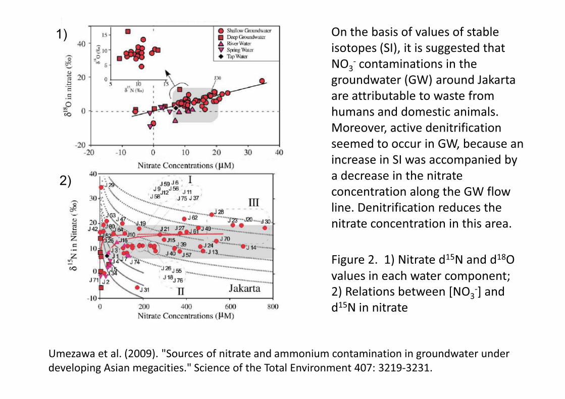
*��� ��+'���$�<�� ����15N and d18O values in each water component;+$�=�����>�?������@<Q3
-] and d15N in nitrate
On the basis of values of stable �>���V�>��X[$������>�>����>�����\��NO3
- contaminations in the � ������ ��^_$� ����`� ��are attributable to waste from humans and domestic animals. �� ���� ��{��������� ���{����seemed to occur in GW, because an increase in SI was accompanied by a decrease in the nitrate concentration along the GW flow line. Denitrification reduces the nitrate concentration in this area.
Umezawa ����'��+!!|$'�}X�� {�>������ ������������{����������� ������ ���� �������V���~>�����{����>'}�X{��{������\��Total Environment 407: 3219-3231.
1)
2)

Effect of urbanization on SGD
222Rn activity was low in areas of reclaimed land (i.e., 0.8–3.0 dpm/L) around the center of the city, while it was as high as 6.0 dpm/L along the coastline with natural mangrove vegetation in western suburban areas. 222Rn and conductivity signatures suggest that an increase in the Rnconcentration around suburban areas can result from river water (likely groundwater fed) rather than the direct discharge of groundwater. The estimated minor contribution of groundwater to the terrestrial water flux passing into the ocean corresponds to the observed decline in the hydraulic potential due to the urbanization of urban Jakarta.
Fig. 1 Distribution of the Rn concentration along the coastline of Jakarta.
Umezawa Y. Nagasaki University Onodera S. Hiroshima UniversityHosono T. Kumamoto University Delinom R. LIPI

Specific flow rates observed at the beach near the center of the city by automated seepage meters ranged widely from 1.0 to 200 cm/day (e.g., see Fig. 2). Higher SGD fluxes were observed during low tide at all locations throughout the monitoring period. However, the conductivity trend did not follow the higher SGD fluxes at low tide, suggesting that most SGD was “recirculated seawater” rather than “fresh groundwater”. Constantly low Rn values independent of salinity are consistent with there being little fresh groundwater discharge at this beach near the city.Fig. 2 Time series of the monitored SGD, water
level, and conductivity around 50 m from the coast line near the center of the city.
Umezawa et al. (2009). "Sources of nitrate and ammonium contamination in groundwater under developing Asian megacities." Science of the Total Environment 407: 3219-3231.