california department of fish and wildlife water branch ... incidental take permit no....
TRANSCRIPT

1
California Department of Fish and Wildlife
Water Branch, Ecosystem Conservation Division 830 S STREET
SACRAMENTO, CA 95811
California Endangered Species Act Incidental Take Permit No. 2081-2016-055-03
Construction and Operation of Dual Conveyance Facilities of the
State Water Project (California WaterFix)
Authority: This California Endangered Species Act (CESA) incidental take permit (ITP) is issued by the California Department of Fish and Wildlife (CDFW) pursuant to Fish and Game Code section 2081, subdivisions (b) and (c), and California Code of Regulations, Title 14, section 783.0 et seq. CESA prohibits the take1 of any species of wildlife designated by the California Fish and Game Commission as an endangered, threatened, or candidate species.2 CDFW may authorize the take of any such species by permit if the conditions set forth in Fish and Game Code section 2081, subdivisions (b) and (c) are met. (See Cal. Code Regs., tit. 14, § 783.4).
Permittee: California Department of Water Resources
Principal Officer: Cindy Messer, Deputy Director Contact Person: Marcus Yee, (916) 651-9567
Mailing Address: P.O. Box 942836
Sacramento, CA 94236
Effective Date and Expiration Date of this ITP: This ITP shall be executed in duplicate original form and shall become effective once a duplicate original is acknowledged by signature of the Permittee on the last page of this ITP and returned to CDFW’s Habitat Conservation Planning Branch at the address listed in the Notices section of this ITP. Unless renewed by CDFW, this ITP’s authorization to take the Covered Species shall expire on December 31st, 2042.
Notwithstanding the expiration date on the take authorization provided by this ITP, Permittee’s obligations pursuant to this ITP do not end until CDFW accepts as complete the Permittee’s Full Project Operations Report required by Condition of Approval 8.9.3 of this ITP.
1 Pursuant to Fish and Game Code section 86, “‘take’ means hunt, pursue, catch, capture, or kill, or attempt to hunt, pursue, catch, capture, or kill.” (See also Environmental Protection Information Center v. California Department of Forestry and Fire Protection (2008) 44 Cal.4th 459, 507 [for purposes of incidental take permitting under Fish and Game Code section 2081, subdivision (b), “’take’ … means to catch, capture or kill”].)
2 The definition of an endangered, threatened, and candidate species for purposes of CESA are found in Fish and Game Code sections 2062, 2067, and 2068, respectively.

2
Incidental Take Permit No. 2081-2016-055-03
CALIFORNIA DEPARTMENT OF WATER RESOURCES
Construction and Operation of Dual Conveyance Facilities of the
State Water Project (California WaterFix)
Project Location:
Construction and operation of California Water Fix (Project) will be located within the legal Sacramento-San Joaquin Delta (Delta) and Suisun Marsh in the specific locations described below (Project Area)3. The California Water Fix tunneled conveyance facilities and alignment, transmission line corridors, and geotechnical exploration corridor will be located within the Delta in Sacramento, San Joaquin, Contra Costa, and Alameda Counties. Project operations facilities will be located within Suisun Marsh and the Delta in Sacramento, San Joaquin, Contra Costa, Napa, and Solano Counties (see Attachment 1, Figures 1, 2, 3 and 4).
Transmission Lines. The northern alignment will begin just east of the Sacramento River and west of Stone Lakes National Wildlife Refuge (SLNWR), in Sacramento County, at approximately -121.509 longitude, 38.405 latitude. It will continue southeast approximately 0.15 mile then will transition southward along the west side of the Sacramento Southern Railroad. The alignment will fork at approximately -121.514 longitude, 38.379 latitude. The northwest spur will connect to North Delta Diversion (NDD) Intake 3 (see Group B below) and the southwest spur will turn south and extend to the census designated place of Hood. It will change directions to follow the northern, eastern, and southern boundaries of Hood then will continue south to approximately -121.517 longitude, 38.483 latitude. At this point, the alignment will fork again. The northwest spur will connect to NDD Intake 5 (see Group C below) and the south spur will continue to Lambert Road at approximately -121.514 longitude, 38.32 latitude. At this point, the alignment will fork again. The east spur will follow Lambert Road to approximately 0.9 mile east of Carroll Lane and then transition northeast along the Cosumnes River to approximately 1.1 miles southwest of Highway 99 at approximately -121.355 longitude, 38.344 latitude; and the south spur will continue to approximately -121.495 longitude, 38.283 latitude about 0.4 miles north of Twin Cities Road. The southern alignment will begin on Bouldin Island, in San Joaquin County, and will continue south through Bouldin, Venice, Mandeville, Mandeville Tip, Bacon, Woodward, and Victoria islands. It will fork on southern Victoria Island at approximately -121.56 longitude, 37.867 latitude. The south spur will continue to the northeast corner of Clifton Court Forebay (CCF) between CCF and the West Canal in Contra Costa County. The west spur will extend to the San Joaquin/Contra Costa county line, then southwest and then west to approximately -121.596 longitude, 37.86 latitude in Contra Costa County. At this point, the alignment will fork to the west and the south. The west spur will continue to 0.6 mile south of Camino Diablo Road in the census designated place of
3 Each specific location will hereafter be referred to as a “construction site.”
3
Incidental Take Permit No. 2081-2016-055-03
CALIFORNIA DEPARTMENT OF WATER RESOURCES
Construction and Operation of Dual Conveyance Facilities of the
State Water Project (California WaterFix)
Byron, then will transition northwest through Byron to Payne Avenue and north to the southeast corner of the City of Brentwood. The south spur will extend towards the Byron Highway to just west of the California Aqueduct at Clifton Court Road and the Union Pacific Railroad, then will transition southeast along the north side of the Union Pacific Railroad to the Delta Mendota canal. It will then transition south along the east side of the Delta Mendota Canal, in Alameda County, to approximately 0.3 mile north of Kelso Road at approximately -121.582 longitude, 37.799 latitude (see Attachment 1, Figures 4c and 4d).
NDD Intake 2 (Group A). To the north, Intake 2 will start on the east side of the Sacramento River, across from the census designated place of Clarksburg, on Highway 160, in Sacramento County, at approximately -121.521 longitude, 38.417 latitude. The intake, its work area, and spoils disposal site will be within an area extending approximately 1.5 river miles south and extending east to the Sacramento Southern Railroad immediately west of Morrison Creek (see Attachment 1, Figure 5 and Project Description, Table 1.2).
NDD Intake 3 (Group B). To the north, Group B will start about 1.4 river miles north of the census-designated place of Hood in Sacramento County on Highway 160. The intake and its work area will be within an area extending south to the northern boundary of Hood, along the east side of the Sacramento River, and will extend east to approximately 0.2 mile west of the Sacramento Southern Railroad (see Attachment 1, Figure 5 and Project Description, Table 1.2).
Intake Work Area (Group C). To the north, Group C will start on the southern boundary of Hood, in Sacramento County, and will extend approximately 0.4 mile south, along the east side of Highway 160, and will extend to the east to approximately 0.13 mile west of SLNWR (see Attachment 1, Figure 5).
NDD Intake 5 (Group D). To the north, Group D will start approximately 1.5 miles north of Lambert Road, Sacramento County, on Highway 160. The intake and its work area will be within an area extending approximately 1.2 miles south along the east side of the Sacramento River and then Highway 160, and will extend to the east to approximately 1 mile west of SLNWR (see Attachment 1, Figure 6 and Project Description, Table 1.2).
Tunnel Work Area/Substation (Group E). Group E will be along the north side of Lambert Road, Sacramento County, within an area extending east from approximately 0.2 mile east of Snodgrass Slough to approximately 0.3 mile west of SLNWR, and extending north to approximately 0.22 mile north of Lambert Road (see Attachment 1, Figure 6).

4
Incidental Take Permit No. 2081-2016-055-03
CALIFORNIA DEPARTMENT OF WATER RESOURCES
Construction and Operation of Dual Conveyance Facilities of the
State Water Project (California WaterFix)
Reusable Tunnel Material Storage Sites (Group F). Group F will be within the SLNWR, Sacramento County. The Reusable Tunnel Material (RTM) sites will be on two parcels of land owned by the California Department of Water Resources (DWR). To the north, Group F starts approximately 0.13 miles south of Lambert Road and extends south to Dierssen Road. From the west, Group F starts approximately 0.9 mile east of Snodgrass Slough and extends east to approximately 1.3 miles west of Interstate 5 (see Attachment 1, Figure 6).
Intermediate Forebay and RTM Sites (Group G). Within southern SLNWR, Sacramento County, in an area bound to the north by a point approximately 1.7 channel miles north of Meadow Slough on Zacharias Island, to the west by the north-south channel of Snodgrass Slough, to the east by a point approximately 0.4 mile west of Interstate 5 on Glannvale Tract, and to the south by the east-west channel of Snodgrass Slough on Glannvale Tract. The Intermediate Forebay (IF) on Glannvale Tract extends approximately 0.5 mile east along Twin Cities Road from just east of Snodgrass Slough and approximately 0.7 mile north along Dierssen Road from Twin Cities Road. An access road connects the IF to a barge landing in Snodgrass Slough extending approximately 0.04 mile north along the shoreline from the southern tip of Zacharias Island and extending approximately 0.03 mile west into the slough (see Attachment 1, Figure 7).
Staten Island Retrieval Shaft and Work Area (Group H). Group H will be on Staten Island, San Joaquin County, just east of Staten Island Road. From the north, it will start approximately 5 miles south of W. Walnut Grove Road and extend approximately 0.2 mile south, and from the west it will extend approximately 0.2 mile east. An access road will extend from Staten Island Road to the work area (see Attachment 1, Figure 7).
Bouldin Island Interchange, Launch Shaft, and RTM Site (Group I). From the north, on Bouldin Island, San Joaquin County, Group I will start with a proposed interchange approximately 0.25 mile north of Highway 12 at approximately -121.535 longitude, 38.117 latitude. The interchange will extend approximately 0.5 mile south and approximately 0.6 mile west-east along Highway 12. The interchange will connect to a proposed facility and RTM site approximately 0.6 mile to the southwest. This area will start approximately 0.8 mile east of the Mokelumne River and approximately 0.6 mile south of Highway 12. It will extend south to Potato Slough and east to Little Potato Slough. The RTM site will fill southeastern Bouldin Island from approximately 1.3 channel miles east of the San Joaquin River on Potato Slough to approximately 1.1 channel miles south of Highway 12 on Little Potato Slough. Group I will include a barge landing on the north side of Potato Slough at the southwestern tip of the RTM site. The barge landing will be within an area that extends approximately 0.2 mile southeast along
5
Incidental Take Permit No. 2081-2016-055-03
CALIFORNIA DEPARTMENT OF WATER RESOURCES
Construction and Operation of Dual Conveyance Facilities of the
State Water Project (California WaterFix)
the shoreline and approximately 0.04 mile southwest into the slough. Group I will also include a barge landing on the north side of the San Joaquin River on southern Venice Island, San Joaquin County. It will be within an area that will start approximately 0.5 river miles southwest of the shore across from the tip of Mandeville Point and will extend approximately 0.2 river mile southwest along the shoreline and approximately 0.07 mile southeast into the river. An access road will extend from the northeastern tip of the barge landing area approximately 0.14 mile to the north and then west, terminating at approximately -121.542 longitude, 38.069 latitude (see Attachment 1, Figure 8).
Mandeville Island Barge Landing and Access Road (Group J). Group J will include a barge landing on the west side of the San Joaquin River, within an area that will start immediately north of the confluence with the Middle River on the eastern shore of Mandeville Island, San Joaquin County. The barge landing area will extend approximately 0.04 river mile northwest along the shoreline and approximately 0.02 mile northeast into the river. An access road will extend from the northwest corner of the barge landing area approximately 0.5 mile southwest and then approximately one mile northwest into Mandeville Island. The road will terminate at approximately -121.542 longitude, 38.069 latitude (see Attachment 1, Figure 8).
Bacon Island Retrieval Shaft Work Area and Barge Landing (Group K). Group K will include a barge landing on northern Bacon Island, San Joaquin County, along southern Connection Slough. The barge landing will be within an area that will start approximately 1.0 channel mile west of the confluence with the Middle River and will extend approximately 0.15 channel mile west along the southern bank of Connection Slough, approximately 0.09 mile south onto Bacon Island, and approximately 0.03 mile north into the slough. The barge landing area will connect with the northern Bacon Island levee road. Group K will also include a shaft work area that will start approximately 2.0 miles north of the southern border of Bacon Island at approximately -121.546 longitude, 37.972 latitude. The work area will extend approximately 0.3 mile to the east and approximately 0.2 mile to the south. An access road will connect the northeast corner of the work area with Bacon Island Road (see Attachment 1, Figure 9).
Victoria Island Barge Landing and Access Road (Group L). Group L will include a barge landing on the east side of the Old River on northwest Victoria Island, San Joaquin County. The barge landing will be within an area that will start immediately south of the confluence with the Woodward Canal and will extend approximately 0.2 river mile to the south, approximately 0.05 mile west into the river, and approximately 0.3 mile east onto the island. An access road will extend from the southeast corner of the barge landing area approximately 0.65 mile to the east, then approximately 1.3 miles to the south,

6
Incidental Take Permit No. 2081-2016-055-03
CALIFORNIA DEPARTMENT OF WATER RESOURCES
Construction and Operation of Dual Conveyance Facilities of the
State Water Project (California WaterFix)
then approximately 0.5 mile to the east, terminating at approximately -212.541 longitude, 37.89 latitude, immediately north of Highway 4. An interchange with Highway 4 will be constructed at this location, extending approximately 0.06 mile farther east, and 0.04 mile to the south (see Attachment 1, Figure 9).
CCF Modifications (Group M). Group M will contain all of CCF, in Contra Costa County, and will include expansion to the south and southwest and RTM storage to the west. Group M will be within an area bound to the north by Italian Slough, Widdows Island, and Eucalyptus Island; to the east by the Old River and the West Canal; to the west by the Byron Highway, to the southwest by the California Aqueduct; and to the south by the Old River, Delta Mendota Canal, and the Union Pacific Railroad just northeast of the Byron Highway. A canal and siphon work area will extend southwest of the Byron Highway. It will start at the intersection of the California Aqueduct and the Byron Highway and will extend approximately 0.54 mile east along the south side of the Byron Highway, then approximately 0.85 mile southwest to the California Aqueduct, then approximately 0.68 mile northeast to the starting point (see Attachment 1, Figure 9).
Head of Old River (HOR) Gate/Staging and Spoils Area (Group N). Group N will be on the Old River, in San Joaquin County, starting immediately west of the confluence with the San Joaquin River. The work area will extend approximately 0.13 river mile west and approximately 0.08 mile south from the northern bank of the Old River to Cohen Road, south of the river. Group N will include a 10-acre staging area that will extend approximately 0.09 mile south of the Old River and approximately 0.22 mile west of the San Joaquin River, encompassing about 0.22 mile of Cohen Road (see Attachment 1, Figure 10).
Geotechnical Exploration and Safe Haven Corridors. North of CCF, the geotechnical exploration corridor will be 400 feet wide and encompassed within the 550-foot-wide safe haven corridor. The safe haven corridor will begin with 2 forks on the east side of the Sacramento River, in Sacramento County. The east fork will begin at Intake 2 and will extend south to approximately 0.4 mile north of Lambert Road, where it will meet with the west fork. The west fork will extend approximately 1.7 miles southeast of Intake 5, where it will meet with the east fork. The combined corridors will continue southeast through SLNWR, Glannvale Tract, Rand Tract, and McCormack-Williamson Tract east of Snodgrass Slough. On McCormack-Williamson tract, it will turn southwest to Dead Horse Island. In San Joaquin County, the corridor will continue southwest through Staten Island, New Hope Tract, and Bouldin Island. It will turn south on Bouldin Island and continue through Potato Slough, Venice Island, Mandeville Tip, Mandeville Island, Connection Slough islands, Bacon Island, Woodward Island, and Victoria Island. It will terminate immediately northeast of CCF in Contra Costa County. The geotechnical

7
Incidental Take Permit No. 2081-2016-055-03
CALIFORNIA DEPARTMENT OF WATER RESOURCES
Construction and Operation of Dual Conveyance Facilities of the
State Water Project (California WaterFix)
exploration corridor will continue along the north, east, and west banks of CCF, excluding the northeast corner, terminating on the west side at the John E. Skinner Delta Fish Protective Facility (Skinner Fish Facility); and on the east side, along the inlet at the southern end of the West Canal. Overwater geotechnical exploration will occur in Sacramento County over the Sacramento River and Snodgrass Slough; in San Joaquin County over South Fork Mokelumne River, San Joaquin River, Potato Slough, Middle River, Connection Slough, and Old River; and in Contra Costa County over the Old River and West Canal (see Attachment 1, Figure 4).
Project Operations. Project operations will be in all fish-bearing waterways within the legal Delta and Suisun Marsh, including rivers, sloughs, and other channels. Project facilities will be located from the Barker Slough pumping plant, Solano County, to the Napa River watershed, Napa County; in Suisun Marsh, Solano County, at Morrow Island, Goodyear Slough, Montezuma Slough, Roaring River, and immediately north of east Honker Bay; and at the Delta Cross Channel (DCC) on the Sacramento River, extending south along the Sacramento River and Georgiana Slough to the North Mokelumne River, in Sacramento County (see Attachment 1, Figure 1).
Project Description
Permittee will build new water conveyance facilities to divert water from the Sacramento River in the north Delta to south Delta pumping plants. Water will be conveyed by gravity through two underground tunnels to pumping plants at the northeast corner of CCF. The Project includes the construction of new facilities and, once those facilities become operational, operations of the State Water Project (SWP) in the Delta using those new facilities and existing facilities4.
In implementing the Project, the Permittee will implement the monitoring plan described in Chapter 6 of the permit application. A primary component of this is the Adaptive Management Program for the California Water Fix (CWF) and 2008/2009 Biological Opinions on the combined operations of the Central Valley Project (CVP) and State Water Project (SWP) (here and after the Adaptive Management Program, Attachment 5).
4 The environmental impact report for the Project includes new water conveyance facility construction, new conveyance facility operation in coordination with operation of existing Central Valley Project/SWP Delta facilities, maintenance of the existing facilities and newly constructed facilities, implementation and maintenance of conservation actions, and required monitoring and adaptive management activities. The activities for which take authorization is provided through this permit are limited only to those activities specifically described in this permit.
8
Incidental Take Permit No. 2081-2016-055-03
CALIFORNIA DEPARTMENT OF WATER RESOURCES
Construction and Operation of Dual Conveyance Facilities of the
State Water Project (California WaterFix)
Monitoring will be performed to measure a Covered Species’ population state and structure, to characterize the condition of a Covered Species’ habitat and to detect and track presence or occupancy by Covered Species. On Habitat Mitigation lands (HM lands), monitoring will focus on describing the baseline condition of protected and managed habitats, detecting presence and distribution of Covered Species, and guiding management actions to assure the species conservation needs for which the HM lands were protect are being achieved. Monitoring will be required at restoration sites measuring variables associated restoration objectives and performance criteria and to determine if the restored habitat is achieving the restoration objectives for Covered Species. Monitoring will also be undertaken to verify implementation and performance of construction minimization measures. A key component of the program will focus on performance of fish screens and operating criteria for the conveyance facilities in minimizing effects on Covered Species.
Five general types of monitoring will occur:
Continuation of existing monitoring required by the current biological opinions from the U.S. Fish and Wildlife Service (USFWS 2008); the National Marine Fisheries Service (NMFS 2009), and incidental take permit (CDFG 2009), and consistency determinations related to continuing operations of existing facilities and their effects on listed species.
Monitoring required by this and other permits and authorizations for construction of the Project, including the Mitigation Monitoring and Reporting Program (MMRP) approved by Permittee as lead agency, and any additional monitoring needed to assess effectiveness of Conditions of Approval and inform any necessary revision.
Monitoring and studies related to operation of the Project that must occur prior to operation of the new facilities, including those necessary to inform design and assess effects of the proposed NDD intakes, head of Old River (HOR) Gate and modified CCF.
Monitoring and studies related to operation of the Project that must occur after operation of the new facilities has commenced, including those necessary to monitor the condition of both the Covered Species and the habitat conditions that may be influenced by the new facilities (e.g., upstream temperatures, potential for redd dewatering, Delta rearing conditions, water quality, etc.).
Monitoring and studies related to evaluation of the effectiveness of proposed facilities (e.g., non-physical barrier at Georgiana Slough), habitat restoration and other mitigation measures after operation of the new facilities has commenced.

9
Incidental Take Permit No. 2081-2016-055-03
CALIFORNIA DEPARTMENT OF WATER RESOURCES
Construction and Operation of Dual Conveyance Facilities of the
State Water Project (California WaterFix)
In addition to the monitoring commitments specified in Chapter 6 of the permit application, monitoring under the Project will be initiated through the Adaptive Management Program. The Adaptive Management Program describes the process for addressing uncertainty associated with current scientific understanding of Covered Species’ needs and effects of CVP/SWP operations under current authorizations and the Project. It will be used to incorporate new information and improved modeling tools to ongoing implementation and management of the CVP and SWP under the existing biological opinions and CESA authorizations and those for the Project. Through the process described in the Adaptive Management Program changes to operating criteria and mitigation requirements can be developed and evaluated based on new scientific information.
Permittee will undertake the following activities within the Project Area during Project construction: geotechnical exploration; NDD intake construction, tunneled conveyance (including safe haven access); the IF; CCF expansion and modifications; canal construction for connection to the C.W. “Bill” Jones (Jones) Pumping Plant and Harvey O. Banks (Banks) Pumping Plant; HOR Gate construction; barge landing construction and operations, temporary work areas construction, temporary access roads construction, RTM storage, and power supply and grid connections. The Project also includes long term maintenance of Project transmission lines and maintenance of terrestrial portions of embankments adjacent to CCF. These Project components and related construction activities are described in the Conveyance Facility Construction Activities subsection of the Project Description.
The Project does not seek incidental take authorization for facilities maintenance, with the exception of transmission line corridor maintenance. Permittee will prepare a separate 2081(b) application addressing non-covered facilities maintenance, if and when such an application is necessary. Project operations will include facilities such as, diversions, pumping plants, outfall gates,, control gates, barriers, and distribution systems which are described in the Project Operations subsection of the Project Description. The Project includes operations of both new and existing water conveyance facilities in the SWP, including coordinated operations with the U.S. Bureau of Reclamation (Reclamation) through the joint CVP/SWP facilities in the Delta. The Project will enable joint management of new north and existing south Delta water diversions, collectively called dual conveyance. The dual conveyance facilities will be operated to minimize impacts to threatened and endangered and other native fish and to maintain and stabilize the water supply.
Project construction will begin after compliance with the Delta Reform Act is achieved, and all other necessary authorizations are obtained consistent with state and federal
10
Incidental Take Permit No. 2081-2016-055-03
CALIFORNIA DEPARTMENT OF WATER RESOURCES
Construction and Operation of Dual Conveyance Facilities of the
State Water Project (California WaterFix)
law. Project operations, as authorized in this ITP, will commence after Project construction is complete and the Test Period is initiated.
Project Description - Conveyance Facility Construction Activities
New water conveyance facilities will divert water from the Sacramento River through three intakes on the east bank of the Sacramento River between Clarksburg and Courtland. The three intakes will be spaced about 1.0 mile apart to minimize their impacts on migratory native fish (see Attachment 1, Figures 5 and 6). Permittee will screen each intake with a state-of-the-art fish screen to minimize impacts to Covered Fish Species as they pass. Water will travel from the three intakes, each with a 3,000 cubic feet per second (cfs) capacity, to a sedimentation basin before reaching the tunnels. From the intakes, water will flow into one of two initial single-bore tunnels (one is 9 miles long with a diameter of 28 feet for the first two miles and a diameter of 40 feet for the remaining 7 miles; the other is 5 miles long with a diameter of 28 feet), which will lead to the IF on Glannvale Tract (see Table 1.5 and Attachment 1, Figure 4e). From the southern end of this forebay, water will pass through an outlet structure into a 30-mile, 40-foot-diameter dual-bore tunnel where it will flow by gravity to the south Delta. Water will then reach two new pumping plants northeast of the CCF, where it will be pumped from the tunnels into the north cell of the expanded CCF. Permittee will dredge and redesign the forebay to provide an area isolating diverted water flowing from the new NDD intakes from south Delta channels.
The Project also includes construction of a new operable barrier at the confluence of the San Joaquin River and Old River, the HOR Gate). The purpose of the HOR Gate is to keep outmigrating San Joaquin River salmonids from moving into the south Delta via Old River, and to improve water quality in the San Joaquin River (particularly the Stockton Deep Water Ship Channel) in the fall.
Geotechnical Exploration
Geotechnical exploration will obtain data to support the development of an appropriate geologic model, characterize ground conditions, and reduce the geologic risks associated with the construction of conveyance facilities. Permittee will conduct geotechnical investigations along the tunnel alignment, at locations for new conveyance facilities, at the new CCF embankment, and at material borrow areas (see Attachment 1, Figures 4a and 4b). Permittee will design geotechnical exploration as a 2-phase
11
Incidental Take Permit No. 2081-2016-055-03
CALIFORNIA DEPARTMENT OF WATER RESOURCES
Construction and Operation of Dual Conveyance Facilities of the
State Water Project (California WaterFix)
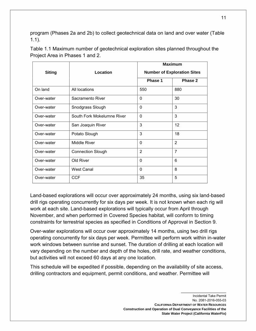
program (Phases 2a and 2b) to collect geotechnical data on land and over water (Table 1.1).
Table 1.1 Maximum number of geotechnical exploration sites planned throughout the Project Area in Phases 1 and 2.
Siting Location
Maximum
Number of Exploration Sites
Phase 1 Phase 2
On land All locations 550 880
Over-water Sacramento River 0 30
Over-water Snodgrass Slough 0 3
Over-water South Fork Mokelumne River 0 3
Over-water San Joaquin River 3 12
Over-water Potato Slough 3 18
Over-water Middle River 0 2
Over-water Connection Slough 2 7
Over-water Old River 0 6
Over-water West Canal 0 8
Over-water CCF 35 5
Land-based explorations will occur over approximately 24 months, using six land-based drill rigs operating concurrently for six days per week. It is not known when each rig will work at each site. Land-based explorations will typically occur from April through November, and when performed in Covered Species habitat, will conform to timing constraints for terrestrial species as specified in Conditions of Approval in Section 9.
Over-water explorations will occur over approximately 14 months, using two drill rigs operating concurrently for six days per week. Permittee will perform work within in-water work windows between sunrise and sunset. The duration of drilling at each location will vary depending on the number and depth of the holes, drill rate, and weather conditions, but activities will not exceed 60 days at any one location.
This schedule will be expedited if possible, depending on the availability of site access, drilling contractors and equipment, permit conditions, and weather. Permittee will

12
Incidental Take Permit No. 2081-2016-055-03
CALIFORNIA DEPARTMENT OF WATER RESOURCES
Construction and Operation of Dual Conveyance Facilities of the
State Water Project (California WaterFix)
perform most of the geotechnical explorations during the first three years of Project implementation.
Phase 1
On Land: Phase 1 exploration will collect data to support preliminary engineering through soil borings and cone penetrometer testing (CPT) at approximately 550 locations. Permittee will conduct explorations for the intake perimeter berms, State Route 160 realignment, sedimentation basins, pumping plants, forebay embankments (IF and CCF), tunnel construction shafts, and other related facilities (subsequent subsections in this Project Description describe these facilities in detail). Exploration for tunnel construction will entail drilling approximately every 1,000 feet along the tunnel alignment. In addition, six soil borings and four CPTs will occur at each tunnel shaft or Clifton Court Forebay Pumping Plant (CCFPP) shaft site.
Over-Water: Over-water explorations will collect data for intake structures and the major water crossings along the tunnel alignment at 43 locations approximately every 1,000 feet. Drilling will occur in Potato Slough (three sites), San Joaquin River (three sites), Connection Slough (two sites), and CCF (35 sites).
Phase 2
Phase 2 explorations will support final design, permitting requirements, and planning for procurement and construction-related activities.
On Land explorations will include soil borings, CPTs, and test pits at 880 locations. Exploration for tunnel construction will entail drilling for soil borings near the Phase 1 CPT locations such that a borehole (soil boring or CPT) will occur at approximately 500-foot intervals along the entire tunnel alignment. Boring will also occur at the construction and safe haven intervention sites.
Over-Water explorations will include over-water boreholes and CPTs at 94 locations in the Sacramento River, Snodgrass Slough, South Fork Mokelumne River, San Joaquin River, Potato Slough, Middle River, Connection Slough, Old River, North Victoria Canal, and CCF.
Geotechnical Exploration Activities (Phases 1 and 2)
On Land: Sampling will occur at locations along the tunnel alignment (see Attachment 1, Figures 4a and 4b) and at conveyance facility sites. The field tests will consist of auger and mud-rotary drilling with soil sampling using a standard penetration test barrel (split spoon sampler) and Shelby tubes; CPT; geophysical testing; pressure meter testing; installation of piezometers and groundwater extraction wells; dissolved gas sampling;

13
Incidental Take Permit No. 2081-2016-055-03
CALIFORNIA DEPARTMENT OF WATER RESOURCES
Construction and Operation of Dual Conveyance Facilities of the
State Water Project (California WaterFix)
aquifer testing; and excavation of test pits. All of these techniques, except test pit excavation and CPT, entail drilling. The field exploration program will evaluate soil characteristics and collect samples for laboratory testing.
The land-based portion of the exploration will occur at approximately 1,430 geotechnical exploration locations (Table 1.1). The exploration locations and accessibility for truck or track-mounted drill rigs will be within the geotechnical exploration zone (Attachment 1, Figures 4a and 4b). At each location, Permittee will drill and grout an eight inch diameter hole. The geotechnical exploration sites will result in approximately 0.84 acre of disturbance per site, which includes a 0.23 acre area of temporary disturbance for drilling and staging, (Figure 1.1) plus an additional 0.61 acre of temporary disturbance associated with accessing the sites. Site access will consist of overland travel in agricultural areas and grasslands, and use existing roads where practicable. Geotechnical exploration sites will include space for a truck-mounted drill rig, a support truck, passenger vehicles, and area for field crews to maneuver. The field tests conducted at each site will depend on the type of data required and the specific location. Temporary pumping wells and piezometers will be installed at intake, forebay, pump shaft, and tunnel shaft exploration locations to investigate soil permeability and to allow sampling of dissolved gases in the groundwater. At approximately 60 of the exploration locations, test pits will be excavated, with test pit dimensions 4 feet wide, 12 feet long, and 12 feet deep. Test pits will be used to evaluate bearing capacity, physical properties of the sediments, location of the groundwater table, and other typical geologic and geotechnical parameters. Aquifer pump tests will also be performed at some sites. Each land-based geotechnical exploration location will be active for a period ranging from a few hours to 12 work days, depending on exploration type and target depth.
- Exploration locations that involve only CPT testing (approximately 430 sites) and/or soil test pits will typically be active for less than one day (a crew may evaluate two such locations per day).
- At locations where piezometers are installed technicians may periodically revisit the sites to collect data. Aquifer pump test activities are not expected to exceed 10 days.
- At approximately 1,000 sites, geotechnical exploration will involve soil borings and will be active for multiple days, with the duration of activity dependent upon the depth of the borings. The deepest borings (300 feet) will be located at shaft locations, and will require up to 12 work days at approximately 50 locations.
- The remaining 950 borings will be to depths of up to 200 feet and will be located along the majority of the tunnel alignment and at other facility construction sites

14
Incidental Take Permit No. 2081-2016-055-03
CALIFORNIA DEPARTMENT OF WATER RESOURCES
Construction and Operation of Dual Conveyance Facilities of the
State Water Project (California WaterFix)
(the intakes, IF, and facilities near CCF); work at these sites will require approximately five work days each.
After each site is explored, Permittee will backfill bored excavations with cement-bentonite grout in accordance with California regulations and industry standards (Water Well Standards, DWR 74-81 and 74-90). Permittee will backfill test pits with the excavated material on the same day as they are excavated, with the stockpiled topsoil placed at the surface and the area restored as closely as possible to its original condition.
Figure 1.1. Example of a land-based geotechnical exploration site.
Over-Water: The over-water portion of geotechnical exploration will occur at 137 locations (Table 1.1). Permittee will select the exploration locations based on practicability considerations such as avoidance of navigation markers and underwater cables. Permittee will use the locations shown in Table 1.1 to obtain geotechnical data for the intake structures and assess the major water under crossings along the tunnel

15
Incidental Take Permit No. 2081-2016-055-03
CALIFORNIA DEPARTMENT OF WATER RESOURCES
Construction and Operation of Dual Conveyance Facilities of the
State Water Project (California WaterFix)
alignment, the barge unloading facilities, and the CCF modifications. The borings and CPTs will explore depths between 100 and 200 feet below the mud line (i.e., river bottom). Over-water borings for the intake structures and river crossings for the tunnel alignment will be carried out by a drill ship and barge-mounted drill rigs.
North Delta Diversions
The Project includes construction of three NDD intakes (Intake 2, Intake 3, and Intake 5, collectively) on the east bank of the Sacramento River between Clarksburg and Courtland, in Sacramento County (see Attachment 1, Figures 6 and 7). Each intake can divert a maximum of 3,000 cfs of river water. The intakes will include fish screens designed to minimize the risk that fish will be entrained into the intakes or injured by impingement on the fish screens.
Each intake will consist of an intake structure fitted with on-bank fish screens; gravity collector box conduits extending through the levee to convey flow to the sedimentation system; a sedimentation system consisting of sedimentation basins to capture sand-sized sediment and drying lagoons for sediment drying and consolidation; a sedimentation afterbay transitioning from the sedimentation basins to a shaft to discharge into a tunnel leading to the IF; and an access road, parking area, electrical service, and fencing (Table 1.2).
Table 1.2 Approximate locations and extent of each NDD intake structure.
Intake Location
(river mile)
Overall Length of
Structure along
Sacramento River
Bank (feet)
Area of Intake
Construction Site
(acres)
Intake 2 41.1 1,969 190
Intake 3 39.4 1,497 152
Intake 5 36.8 1,901 144
Total -- 5,367 486
Each screened intake will consist of a reinforced concrete structure subdivided into six individual bays that can be isolated and managed separately. Water will be diverted from the Sacramento River by gravity into the screened intake bays and routed from each bay through multiple parallel conveyance box conduits to the sedimentation basins. Flow meters and flow control sluice gates will be located on each box conduit to
16
Incidental Take Permit No. 2081-2016-055-03
CALIFORNIA DEPARTMENT OF WATER RESOURCES
Construction and Operation of Dual Conveyance Facilities of the
State Water Project (California WaterFix)
assure limitations on approach velocities and that flow balancing between the three intake facilities is achieved. All of the intakes will be sized at the design water surface elevation (WSE) to provide approach velocities at the fish screen of less than or equal to 0.20 foot per second (ft/s) at an intake flow rate of 3,000 cfs. The design WSE for each intake was established as the 99% exceedance (Sacramento River stage) elevation, and the maximum design WSE was established as the 200-year flood elevation plus an 18-inch allowance for sea level rise.
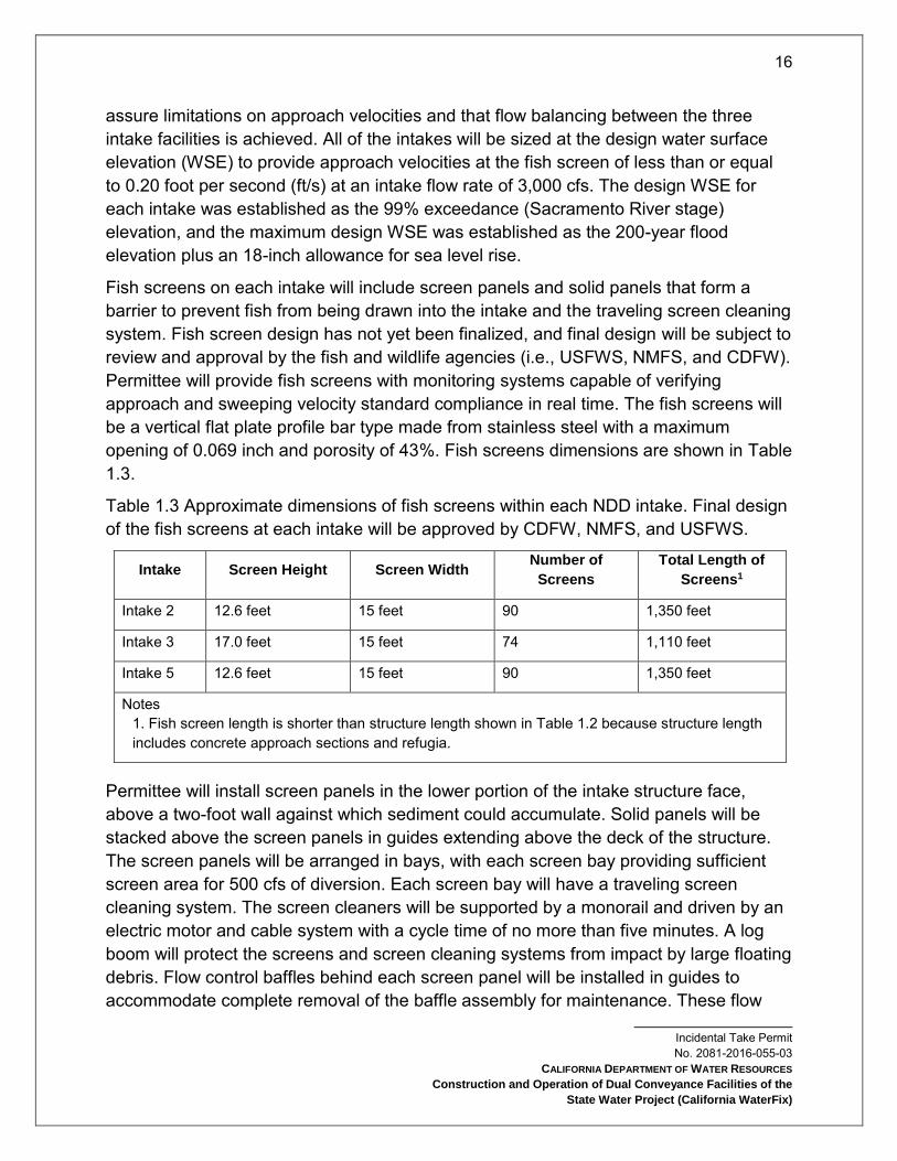
Fish screens on each intake will include screen panels and solid panels that form a barrier to prevent fish from being drawn into the intake and the traveling screen cleaning system. Fish screen design has not yet been finalized, and final design will be subject to review and approval by the fish and wildlife agencies (i.e., USFWS, NMFS, and CDFW). Permittee will provide fish screens with monitoring systems capable of verifying approach and sweeping velocity standard compliance in real time. The fish screens will be a vertical flat plate profile bar type made from stainless steel with a maximum opening of 0.069 inch and porosity of 43%. Fish screens dimensions are shown in Table 1.3.
Table 1.3 Approximate dimensions of fish screens within each NDD intake. Final design of the fish screens at each intake will be approved by CDFW, NMFS, and USFWS.
Intake Screen Height Screen Width Number of
Screens
Total Length of
Screens1
Intake 2 12.6 feet 15 feet 90 1,350 feet
Intake 3 17.0 feet 15 feet 74 1,110 feet
Intake 5 12.6 feet 15 feet 90 1,350 feet
Notes 1. Fish screen length is shorter than structure length shown in Table 1.2 because structure length includes concrete approach sections and refugia.
Permittee will install screen panels in the lower portion of the intake structure face, above a two-foot wall against which sediment could accumulate. Solid panels will be stacked above the screen panels in guides extending above the deck of the structure. The screen panels will be arranged in bays, with each screen bay providing sufficient screen area for 500 cfs of diversion. Each screen bay will have a traveling screen cleaning system. The screen cleaners will be supported by a monorail and driven by an electric motor and cable system with a cycle time of no more than five minutes. A log boom will protect the screens and screen cleaning systems from impact by large floating debris. Flow control baffles behind each screen panel will be installed in guides to accommodate complete removal of the baffle assembly for maintenance. These flow

17
Incidental Take Permit No. 2081-2016-055-03
CALIFORNIA DEPARTMENT OF WATER RESOURCES
Construction and Operation of Dual Conveyance Facilities of the
State Water Project (California WaterFix)
control baffles will be designed to evenly distribute the approach velocity to each screen such that it meets the approach velocity design criteria. The flow control baffle guides will also serve as guides for installing bulkhead gates (after removal of the flow control baffles) for maintenance of each screen bay. The bulkhead gates will be designed to permit dewatering of a screen bay under normal river conditions.
All fish screen bays groups will be separated by piers with guides to allow for installation and removal of screen and solid panels as well as the flow control baffle system and bulkheads; these features will be removable by gantry crane. Piers will support the operating deck set with a freeboard of 18 inches above the 200-year flood level with sea level rise (44.4 feet at Intake 2 from the sill invert, 48.4 feet at Intake 3, and 43.2 feet at Intake 5). Permittee will raise the levee in the immediate area, and within the Project Area as shown in Attachment 1, Figures 6 and 7, to provide a freeboard of three feet above the 200-year flood level with sea level rise. At the upstream and downstream ends of the intake structure, training walls made of sheet piles will transition from the concrete structure into the river-side of the levee. Sheet pile training walls will have a radius of 200 feet and will be upstream and downstream of the intake structures to provide improved river hydraulics and vehicular access to the operating deck. These walls will enclose the areas between fish screens and the levee upstream and downstream of the screens.
North Delta Diversion Intake Construction Activities
Initial Site Work: Construction of Intakes 2, 3, and 5 will take approximately four to five years each. Before site work commences, the Permittee will implement erosion and sediment controls in accordance with the Storm Water Pollution Prevention Plan (SWPPP). Early phase tasks to facilitate construction will include mobilization, site work, and establishing concrete batch plants, pug mills, and cement storage areas. During mobilization, the Permittee will bring materials and equipment to construction sites; set up work areas; locate offices, staging and laydown areas; and secure temporary electrical power. Site work will consist of clearing and grubbing, constructing site work pads, establishment of stockpiles and staging and storage areas, site fencing, onsite electric (such as a substation), erection of temporary construction buildings (primarily offices and storage), and defining and building construction access roads. During site work, Project personnel will use large vehicles and vehicle-mounted equipment such as cranes. Permittee will construct new roads and bridges within each intake site (Attachment 1, Figures 6 and 7). Permittee will place substantial amounts of engineered fill (borrow fill) landward of the levee, amounting to approximately 2 million cubic yards (cy) at each intake site. This fill material will be used primarily in levee work, pad construction for the fills (see fill pad section below), and other placements that will be
18
Incidental Take Permit No. 2081-2016-055-03
CALIFORNIA DEPARTMENT OF WATER RESOURCES
Construction and Operation of Dual Conveyance Facilities of the
State Water Project (California WaterFix)
constructed to ensure that the permanent facilities are at an elevation above the design flood (a 200-year flood with additional allowance for sea level rise).
Levee Widening: Permittee will widen levees near the intakes on the land-side to increase the crest width, facilitate intake construction, provide a pad for sediment handling, and accommodate the Highway 160 realignment. Permittee will place low permeability levee fill material on the land-side of the levee. The material will be compacted in lifts and keyed into the existing levee and ground. Permittee will widen the levee by about 250 feet at each intake site. During the levee widening, at each intake site, Permittee will permanently relocate Highway 160 from its current alignment along the top of the river levee to a new alignment established on top of the widened levee, approximately 220 feet farther inland from the river and within the Project Area as shown in Attachment 1, Figures 4-10.
On-Bank Structure Construction, Cofferdams and Cutoff Walls: Permittee will construct the intake structures and a portion of the box conduits inside a dual sheet pile cofferdam installed within the levee prism on the river-side. The intake structure foundation will use a combination of ground improvement and steel-cased driven piles or drilled piers. The cofferdams will project 10 to 35 feet into the river, relative to the final location of the intake screens 5, located on the bank of the existing levees, dewatering up to 5 acres of channel at each intake site.
The back wall of the cofferdam along the levee crest will be a deep slurry diaphragm cutoff wall designed for dual duty as a structural component of the cofferdam and to minimize seepage through and under the levee at the intake site; thus the cofferdam sheet piles will become permanent structural components of the intake facility. The diaphragm wall will extend along the levee crest upstream and downstream of the cofferdam and the fill pad for the sedimentation on the land-side. The other three sides of the cofferdam, including a center divider wall, will be sheet pile walls. The cofferdam will include a permanent, five-foot-thick tremie concrete seal in the bottom to aid dewatering and construction within the enclosed construction site. Once each cofferdam is completed and the tremie seal has been poured and has cured, Permittee will dewater the enclosed area. Following dewatering, Permittee will excavate areas within the cofferdam to the level of design subgrade using a clam shell or long-reach backhoe
5 Fish screens would be located on the bank of existing levees. See drawing sheets 11, 12, and 13 of 96, in Appendix 3.C to the permit application.

19
Incidental Take Permit No. 2081-2016-055-03
CALIFORNIA DEPARTMENT OF WATER RESOURCES
Construction and Operation of Dual Conveyance Facilities of the
State Water Project (California WaterFix)
before ground improvements (jet grouting and deep soil mixing) and installation of foundation piles (pile driving).
Permittee will construct a slurry cutoff wall (soil, bentonite, and cement slurry) around the perimeter of each intake construction site for the land-side facilities (facilities described above in the paragraphs on Initial Site Work and Levee Widening). This slurry wall will be tied into the diaphragm wall at the levee by short sections of diaphragm wall perpendicular to the levee. The slurry cutoff wall will overlap for approximately 150 feet along the diaphragm wall at the points of tie-in. By using the slurry wall in conjunction with the diaphragm wall, the open cut excavation portion of the work on the landside will be completely surrounded by cutoff walls.
At the upstream and downstream ends of the intake structures, a sheet pile training wall will transition from the concrete intake structure into the river-side of the levee. Permittee will place riprap on the levee-side slope upstream and downstream of the structure to prevent erosion from anomalies in the river created by the training wall. Permittee will also place riprap along the face of the training wall at the river bottom to resist scour. The cofferdam structure and a perimeter berm surrounding the entire intake construction site landward of the levee will provide temporary flood protection for areas surrounding the site during construction. After intake construction is complete, the cofferdammed area will be flooded and underwater divers using torches or plasma cutters will trim the sheet piles at the finished grade/top of structural slab. A portion of the cofferdam will remain in place after intake construction is complete to facilitate dewatering as necessary for maintenance and repairs.
Box Conduits: Large gravity collector box conduits (12 conduits at each intake) will lead from the intake structure through the levee prism to the landside facilities. Flow meters and flow control sluice gates will be located on each box conduit to assure limitations on approach velocities and that flow balancing between the three intake facilities is achieved. The box conduits will be constructed by open-cut methods after the intake portion of the cofferdam is backfilled. Backfill above the box conduits and reconstruction of the disturbed portion of the levee prism will be accomplished using low-permeability levee material in accordance with U. S. Army Corps of Engineers (USACE) specifications.
Sedimentation System: Box conduits will extend through the levee to convey flow to the sedimentation system. The sedimentation system consists of sedimentation basins to capture sand-sized sediment and drying lagoons for sediment drying and consolidation

20
Incidental Take Permit No. 2081-2016-055-03
CALIFORNIA DEPARTMENT OF WATER RESOURCES
Construction and Operation of Dual Conveyance Facilities of the
State Water Project (California WaterFix)
and an afterbay providing the transition from the sedimentation basins to a shaft that will discharge into a tunnel leading to the IF.
Pile Installation for Intake Construction: Sediment at the construction sites will consist of a surficial layer of soft to medium stiff, fine-grained soils to a depth of approximately 20 to 30 feet below ground surface, underlain by stratified stiff clay, clayey silt, and dense silty sand to the depth of the soil borings. Permittee will install sheet piles in two phases, starting with a vibratory hammer and then switching to impact hammer if refusal is encountered before target depths. Sheet pile placement for cofferdam installation will be performed by a barge-mounted crane equipped with vibratory and impact pile-driving rigs. Foundation pile placement within the cofferdammed area may be done before or after the cofferdammed area is dewatered. If it is done after the cofferdammed area is dewatered and the site is dry, a crane equipped with pile driving rig will be used within the cofferdam. If done before the cofferdam is dewatered, pile driving will be performed by a barge-mounted crane positioned outside of the cofferdam or a crane mounted on a deck on top of the cofferdam.
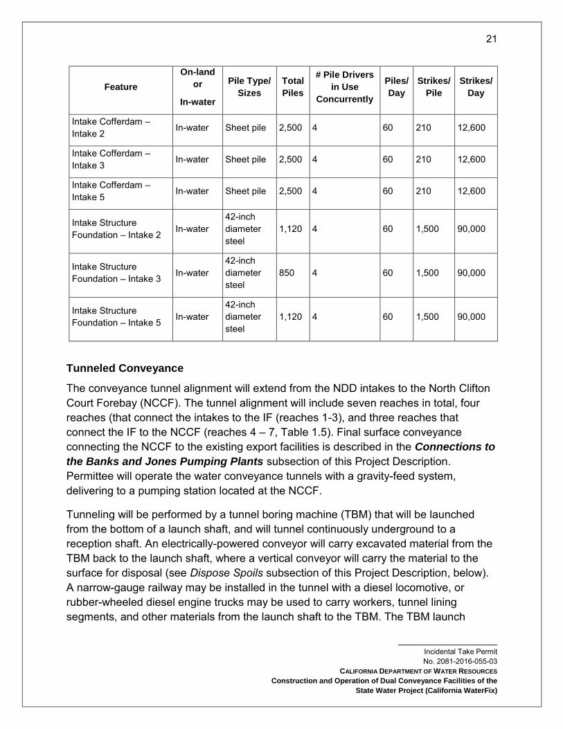
Table 1.4 summarizes pile driving at the intake sites, including the type, size, and number of piles required, as well as the number of piles driven per day, the number of impact strikes per pile, and whether piles will be driven in-water or on land. Table 1.4 specifies 42-inch steel piles for the intake foundations; however, depending on the findings of the geotechnical exploration, it may be feasible to replace some or all of those steel piles with cast-in-drilled-hole (CIDH) foundation piles. Permittee will install the CIDH piles by drilling a shaft, installing rebar, and filling the shaft with concrete; no pile driving will be conducted with CIDH methods. Use of concrete filled steel piles will involve vibratory or impact-driving hollow steel piles, and then filling them with concrete. Table 1.4 assumes that all piles will be driven using impact pile driving, but the design intent is to use impact pile driving only for placement of the intake structure foundation piles. All other piles will be started using vibratory pile driving and driving will be completed using impact pile driving. At the conclusion of construction, the intake facilities will be landscaped, fenced, and provided with security lighting (described below in the Landscaping section).
Table 1.4 Pile driving associated with construction of NDD intakes.
21
Incidental Take Permit No. 2081-2016-055-03
CALIFORNIA DEPARTMENT OF WATER RESOURCES
Construction and Operation of Dual Conveyance Facilities of the
State Water Project (California WaterFix)
Feature
On-land
or
In-water
Pile Type/
Sizes
Total
Piles
# Pile Drivers
in Use
Concurrently
Piles/
Day
Strikes/
Pile
Strikes/
Day
Intake Cofferdam – Intake 2 In-water Sheet pile 2,500 4 60 210 12,600
Intake Cofferdam – Intake 3 In-water Sheet pile 2,500 4 60 210 12,600
Intake Cofferdam – Intake 5 In-water Sheet pile 2,500 4 60 210 12,600
Intake Structure Foundation – Intake 2 In-water
42-inch diameter steel
1,120 4 60 1,500 90,000
Intake Structure Foundation – Intake 3 In-water
42-inch diameter steel
850 4 60 1,500 90,000
Intake Structure Foundation – Intake 5 In-water
42-inch diameter steel
1,120 4 60 1,500 90,000
Tunneled Conveyance
The conveyance tunnel alignment will extend from the NDD intakes to the North Clifton Court Forebay (NCCF). The tunnel alignment will include seven reaches in total, four reaches (that connect the intakes to the IF (reaches 1-3), and three reaches that connect the IF to the NCCF (reaches 4 – 7, Table 1.5). Final surface conveyance connecting the NCCF to the existing export facilities is described in the Connections to
the Banks and Jones Pumping Plants subsection of this Project Description. Permittee will operate the water conveyance tunnels with a gravity-feed system, delivering to a pumping station located at the NCCF.
Tunneling will be performed by a tunnel boring machine (TBM) that will be launched from the bottom of a launch shaft, and will tunnel continuously underground to a reception shaft. An electrically-powered conveyor will carry excavated material from the TBM back to the launch shaft, where a vertical conveyor will carry the material to the surface for disposal (see Dispose Spoils subsection of this Project Description, below). A narrow-gauge railway may be installed in the tunnel with a diesel locomotive, or rubber-wheeled diesel engine trucks may be used to carry workers, tunnel lining segments, and other materials from the launch shaft to the TBM. The TBM launch

22
Incidental Take Permit No. 2081-2016-055-03
CALIFORNIA DEPARTMENT OF WATER RESOURCES
Construction and Operation of Dual Conveyance Facilities of the
State Water Project (California WaterFix)
facilities will hold stockpiles of materials used by the TBM, provide access to the TBM for its operation and maintenance, and receive all materials excavated by the TBM. TBM reception facilities will be used to recover the TBM at the end of its drive, and have a smaller footprint.
Table 1.5 Summary of all the tunnel alignment reaches, identifying launch and reception shafts, tunnel lengths, and tunnel diameters. Launch shaft sites will be located on Bouldin Island, at the IF, at the NCCF, and at Intake 2. Reception shafts will be located at Staten Island, Bacon Island, Intake 5, and Intake 3.
Reach Launch
Shaft Reception Shaft
Inside
Diameter (ft)
Surface Acres Length (miles)
1 Intake 2 Intake 3 junction structure
28 0.010 1.99
2 IF inlet Intake 3 junction structure
40 0.029 6.74
3 IF inlet Intake 5 28 0.010 4.77
4 (west tunnel) IF Staten Island 40 0.029 9.17
4 (east tunnel) IF Staten Island 40 0.029 9.17
5 (west tunnel) Bouldin Island
Staten Island 40 0.029 3.83
5 (east tunnel) Bouldin Island
Staten Island 40 0.029 3.83
6 (west tunnel) Bouldin Island
Bacon Island 40 0.029 8.86
6 (east tunnel) Bouldin Island
Bacon Island 40 0.029 8.86
7 (west tunnel) NCCF Bacon Island 40 0.029 8.29
7 (east tunnel) NCCF Bacon Island 40 0.029 8.29
Tunneled Conveyance Construction Activities
Shaft Site Facilities: Facilities at launch shaft sites will include a concrete batch plant and construction sites including offices, parking, shop, short-term segment storage, fan line storage, crane, dry houses, settling ponds, daily spoils piles, temporary RTM storage, electrical power supplies, air and water treatment, and other requirements. There will also be space for slurry ponds at sites where slurry wall construction is

23
Incidental Take Permit No. 2081-2016-055-03
CALIFORNIA DEPARTMENT OF WATER RESOURCES
Construction and Operation of Dual Conveyance Facilities of the
State Water Project (California WaterFix)
required. Construction sites for RTM handling and permanent disposal will also be necessary, as discussed in the Dispose Spoils section below. Facilities at reception shafts will be similar but will not include a concrete batch plant or RTM storage. Most shaft site work areas will be within larger construction sites for the intakes, IF, Bouldin Island RTM site, and CCFPP. Reception shaft construction sites on Staten and Bacon islands will be approximately 33 acres.
Shaft Site Preparation: During shaft site preparation, Permittee will establish vehicular access and provide electrical service via a temporary transmission line as described in the Power Supply and Grid Connections section below. The shafts will be located on pads elevated to above the 200-year flood elevation; fill will be placed to construct these pads and to preload the ground to facilitate settling (see Fill Pads section below). All surface disturbance associated with construction at each shaft site will occur very early during the period of activity at each site; the entire shaft site will be disturbed and will remain so for the duration of construction activity.
Access Routes: Highway 160 will provide access to the intakes and their associated shafts, but not other shafts (including atmospheric safe haven access shafts). Permittee will construct access roads where existing roads cannot be used. Those roads will be permanent features except at atmospheric safe haven access shafts, where they will be in place for more than one year. Safe haven access roads will typically be short, about 0.25 mile long and 20 feet wide, located at or adjoining existing roads. Permittee will construct access roads within an area of 0.6 acre for each safe haven location.
Shaft Construction: Shafts will be circular with a 100-foot diameter for 28-foot tunnels and a 113-foot diameter for 40-foot tunnels.
To create a watertight shaft sufficiently strong to resist hydrostatic pressure within the Delta sediments, Permittee will construct a concrete cylinder prior to removing sediment. Potential construction methods include overlapping concrete caisson walls, panel walls, jet-grout column walls, secant piles walls, slurry walls, and precast sunken caissons. Where the TBM enters or exits a shaft, Permittee will construct a special break-in section where the TBM enters or break-out section where the TBM exits as an integral part of the shaft, with reinforcement such as fiberglass at the entry and exit points.
Permittee will conduct dewatering during shaft construction and operation (see Dewatering subsection below). Dewatering of sediments surrounding the shaft may be conducted during construction.
Tunnel Excavation: Tunnel excavation will occur entirely underground and thus will entail no surface impacts, apart from those associated with the TBM launch and

24
Incidental Take Permit No. 2081-2016-055-03
CALIFORNIA DEPARTMENT OF WATER RESOURCES
Construction and Operation of Dual Conveyance Facilities of the
State Water Project (California WaterFix)
reception shafts and the safe haven shafts (discussed below). Tunnel dewatering will be minor. Disposition of material excavated during tunnel construction is described in the Dispose Spoils subsection below.
Intermediate Tunnel Access Via Safe Havens: In the event that maintenance, inspection, or repair of the TBM cutterhead is needed, Project personnel will access the equipment either from inside the TBM or from the surface using construction access shafts (Table 1.6). Such surface access points are termed safe havens.
Pressurized Safe Havens: Access to the cutterhead from inside the TBM will occur at a pressurized safe haven intervention sites where compressed air will be used to create a safe work environment and exclude sediment and water from the excavation. Permittee will construct pressurized safe haven interventions by injecting grout from the surface to a point in front of the TBM, or by using other ground improvement techniques, such as ground freezing, to minimize the risk that the excavation will collapse and allow workers to work in a less highly pressurized environment. Surface equipment required to construct the safe haven intervention site will include a small drill rig and grout mixing and injection equipment, and facilities to control runoff from dewatering (described in Dewatering subsection below). Disturbance at the site will be limited to an area of no more than 1.0 acre. The surface drilling and treatment operation will typically take about eight weeks to complete. Once complete, Permittee will remove all equipment and reestablish surface features. If access to the surface location for the pressurized safe haven is not readily available, temporary access roads will be established, as described above.
Atmospheric Safe Havens: Access to the cutterhead from the surface will occur at atmospheric safe haven interventions. Permittee will excavate and construct a shaft roughly equal to the diameter of the TBM cutterhead to tunnel depth. Permittee will construct pads to elevate the top of atmospheric safe haven shafts no higher than the 200-year flood level. Shaft sites will be up to 3.0 acres at each of these locations to set up equipment, construct flood protection facilities, excavate/construct the shaft, and set up and maintain the equipment necessary for the TBM maintenance work. Permittee will conduct dewatering where needed. All work associated with developing and maintaining these shafts may occur over 12 months or longer. At the completion of the TBM maintenance at these sites, the TBM will mine forward, and the shaft will be backfilled. Permittee will confine drilling muds or other materials required for drilling and grouting to the work site and dispose such materials offsite at a permitted facility. Permittee will

25
Incidental Take Permit No. 2081-2016-055-03
CALIFORNIA DEPARTMENT OF WATER RESOURCES
Construction and Operation of Dual Conveyance Facilities of the
State Water Project (California WaterFix)
return disturbed areas to preconstruction conditions by grading and with appropriate revegetation.
Final determination of the number and siting of safe haven shaft locations will depend upon determinations by the tunnel construction contractor(s). Final siting of both pressurized and atmospheric safe haven intervention sites will not occur until after geotechnical explorations are complete, as information from those explorations will determine the appropriate spacing for safe haven intervention sites (TBM cutterhead wear rates depend partly upon the types of material being tunneled).
Table 1.6. The number of safe haven interventions expected to be associated with each tunnel, based upon current understanding of site conditions.
Reach Length
(miles)
Number of Safe Haven
Interventions
Pressurized Atmospheric
1 1.99 4 0
2 6.74 13 1
3 4.77 9 1
4 (twin tunnel) 9.17 34 6
5 (twin tunnel) 3.83 12 2
6 (twin tunnel) 8.86 30 6
7 (twin tunnel) 8.29 32 6
Permittee will locate both pressurized and atmospheric safe haven intervention sites to minimize impacts on sensitive terrestrial and aquatic habitats. The construction phase at all shaft sites will conclude with landscaping and the installation of safety lighting and security fencing (see Landscaping subsection below).
Intermediate Forebay
The IF will receive water from the three NDD intakes and discharge it to the twin tunnel alignment for conveyance to CCF. The IF will be located on Glannvale Tract and will have a water surface area of 54 acres at maximum water elevation. The IF will provide an atmospheric break in the deep tunnel system and buffer volume for the NDD intakes
26
Incidental Take Permit No. 2081-2016-055-03
CALIFORNIA DEPARTMENT OF WATER RESOURCES
Construction and Operation of Dual Conveyance Facilities of the
State Water Project (California WaterFix)
and the downstream CCFPP. Each tunnel into and out of IF will be hydraulically isolated for maintenance while maintaining partial system capacity.
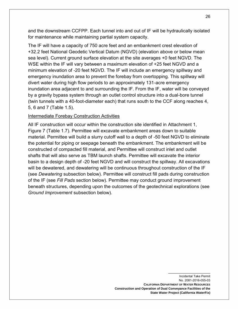
The IF will have a capacity of 750 acre feet and an embankment crest elevation of +32.2 feet National Geodetic Vertical Datum (NGVD) (elevation above or below mean sea level). Current ground surface elevation at the site averages +0 feet NGVD. The WSE within the IF will vary between a maximum elevation of +25 feet NGVD and a minimum elevation of -20 feet NGVD. The IF will include an emergency spillway and emergency inundation area to prevent the forebay from overtopping. This spillway will divert water during high flow periods to an approximately 131-acre emergency inundation area adjacent to and surrounding the IF. From the IF, water will be conveyed by a gravity bypass system through an outlet control structure into a dual-bore tunnel (twin tunnels with a 40-foot-diameter each) that runs south to the CCF along reaches 4, 5, 6 and 7 (Table 1.5).
Intermediate Forebay Construction Activities
All IF construction will occur within the construction site identified in Attachment 1, Figure 7 (Table 1.7). Permittee will excavate embankment areas down to suitable material. Permittee will build a slurry cutoff wall to a depth of -50 feet NGVD to eliminate the potential for piping or seepage beneath the embankment. The embankment will be constructed of compacted fill material, and Permittee will construct inlet and outlet shafts that will also serve as TBM launch shafts. Permittee will excavate the interior basin to a design depth of -20 feet NGVD and will construct the spillway. All excavations will be dewatered, and dewatering will be continuous throughout construction of the IF (see Dewatering subsection below). Permittee will construct fill pads during construction of the IF (see Fill Pads section below). Permittee may conduct ground improvement beneath structures, depending upon the outcomes of the geotechnical explorations (see Ground Improvement subsection below).

27
Incidental Take Permit No. 2081-2016-055-03
CALIFORNIA DEPARTMENT OF WATER RESOURCES
Construction and Operation of Dual Conveyance Facilities of the
State Water Project (California WaterFix)
Table 1.7 Summary of duration of construction activities at the IF.
IF Construction Activity Description Duration
Contract management, supervision, administration, temporary facility operations, and delivery of construction supplies
61 months
Earthworks 42 months
Inlet & outlet ground improvements 23 months
Inlet & outlet site work 8 months
Operate concrete batch plant; inlet & outlet concrete work 13 months
Inlet & outlet gates, mechanical & electrical work 7 months
The IF will have a surface footprint of 243 acres. Permittee will use approximately one million cubic yards (cy) of excavation and 2.3 million cy of fill material to complete the IF embankments. Much of the excavated material will be high in organics and unsuitable for use in embankment construction and will be disposed of (see Dispose Spoils subsection below).
Engineered fill for the IF embankments and tunnel shaft pads will preferably be sourced onsite from locations within the construction footprint as shown in Attachment 1, Figure 7. The construction phase at the IF will conclude with landscaping and the installation of safety lighting and security fencing (see Landscaping subsection below).
Clifton Court Forebay
Permittee will divide the CCF into two separate contiguous forebays: NCCF and South Clifton Court Forebay (SCCF). The NCCF will receive the flow from the NDDs and the NCCF will be sized to meet the hydraulic needs of balancing water entry from the NDDs with discharge via the CVP/SWP export pumps. The SCCF will continue to take in south Delta water; as such, it will function as a replacement for the current CCF. Permittee will enlarge CCF to the south in order to maintain its current size. SCCF will consist of the southern portion of the existing CCF, with expansion to the south into Byron Tract 2.
Permittee will expand the CCF by approximately 590 acres to the southeast of the existing forebay. Permittee will dredge the existing CCF and excavate the expansion area to design depths of -8 feet NGVD for the NCCF and -10 feet NGVD for the SCCF. Permittee will construct a new embankment around the perimeter of the forebay, as well

28
Incidental Take Permit No. 2081-2016-055-03
CALIFORNIA DEPARTMENT OF WATER RESOURCES
Construction and Operation of Dual Conveyance Facilities of the
State Water Project (California WaterFix)
as an embankment dividing the forebay into the NCCF and the SCCF. The tunnels from the NDD intakes will enter the CCFPP at the northeastern end of the NCCF, immediately south of Victoria Island. Flows will be pumped into the NCCF, except when gravity flow is feasible when the Sacramento River is at exceptionally high stages.
In-water Covered Activities at CCF will be limited to a work window from July 1 - November 30. Impact pile driving at CCF will be limited to a work window from July 1 - October 31. Due to the duration and complexity of the work at CCF, the work schedule will be sequenced according to the summary below:
Construct embankment needed for forebay expansion on the south side in dry.
Construct sheet pile channel in existing Clifton Court south embankment.
Remove existing embankment on the south side.
Install sheet piles required for removal of existing embankment on south side of CCF during in-water work window as follows:
Phase 1 - Install all sheet piles except for 100 foot gaps near east and west ends of proposed dividing embankment. These sheet piles can be installed in the same season as “Construct sheet pile channel in existing Clifton Court south embankment” above.
Phase 2 - Close the 100 foot gaps once the new Byron tract expansion of Clifton Court has been flooded.
Dewater and complete fish salvage operation in the CCF north cell. Prior to the start of construction, a fish salvage plan will be prepared in consultation with CDFW, NMFS, and USFWS.
Construct divider embankment between CCF north cell and south cell.
Continue construction activities in the CCF north cell in dry.
Dredge the central part of CCF south cell between the divider wall and the existing south embankment as shown. Dredging activities in the CCF south cell will be limited to the in-water work window and are expected to continue for up to five years.
Construct remainder of CCF south cell embankments on the east and west sides of CCF.
Clifton Court Forebay Construction Activities
Facilities associated with CCF construction activities will include a permanent electrical substation; two electrical buildings; and an office/storage building; as well as temporary
29
Incidental Take Permit No. 2081-2016-055-03
CALIFORNIA DEPARTMENT OF WATER RESOURCES
Construction and Operation of Dual Conveyance Facilities of the
State Water Project (California WaterFix)
facilities for storage, staging, construction electrical, and water treatment (for stormwater). Permittee will site all of these facilities on the CCF embankment, at the design flood elevation (i.e., a 200-year flood with provision for sea level rise) of 25 feet.
Clifton Court Forebay Technical Team (CCFTT): Ongoing collaborative efforts will be used to ensure that the final design and construction procedures for CCF minimize effects on Covered Species. Accordingly, representatives from DWR, Reclamation, CDFW, NMFS and USFWS will participate in the CCFTT. The CCFTT will convene before construction begins at the CCF and will meet periodically until DWR completes final design for the CCF modifications (a time period expected to be at least two years). The CCFTT will review and make recommendations regarding phasing of CCF construction for the benefit of listed and unlisted fish or for water quality based on construction information presented by DWR. In considering any options for phasing, the CCFTT will consider preliminary costs and constructability. The CCFTT will be charged with the following duties:
Based on construction information presented by DWR, review and make recommendations regarding appropriate techniques for dewatering, fish rescue, and fish exclusion during in-water work. Dewatering and fish rescue will be needed for all cofferdam work at CCF, and fish exclusion will be needed for dredging. In considering these techniques, the CCFTT will consider preliminary costs and constructability.
Develop performance criteria and study programs to evaluate critical issues in CCF operations. One such issue is changes to predation patterns in the SCCF, which may have significantly deeper water depths, different residence times, and more exposure of mineral substrates, compared to the current CCF. Other operational issues may also be identified by the CCFTT.
Identify and describe near-term research/monitoring needs, if any, to reduce key uncertainties prior to construction.
Prepare draft and final reports summarizing CCFTT recommendations. The final report must be provided no less than 8 months prior to DWR’s completion of final design, so that recommendations can be incorporated into those construction contract documents.
DWR will abide by monitoring provisions and other measures to implement CCFTT recommendations.
Site Access: Vehicular access to construction sites during construction will be from existing roads. Access will be from Byron Highway via Clifton Court Road and the Italian
30
Incidental Take Permit No. 2081-2016-055-03
CALIFORNIA DEPARTMENT OF WATER RESOURCES
Construction and Operation of Dual Conveyance Facilities of the
State Water Project (California WaterFix)
Slough levee crest road or the CCF embankment crest road and West Canal levee crest road. Permittee will also provide barge access for transport of heavy TBM sections and other very large equipment and materials, and possibly for transport of bulk materials (fill material or excavated material). Barge access will be from the West Canal using a new barge unloading facility (see Barge Landings and Barge Operations subsection below).
Cofferdam and Fill Work: A sheet pile cofferdam will enclose the portion of the CCFPP fill pad next to water (see also Fill Pad section below). Permittee will place sheet piles for the cofferdam using a barge-mounted crane and/or a crane mounted on the existing levee, equipped with vibratory and impact pile-driving rigs. Permittee will drive sheet piles starting with a vibratory hammer, switching to an impact hammer if refusal is encountered before target depths. In-water pile driving will be subject to noise abatement, hydroacoustic monitoring, and compliance with timing limitations as described in an underwater sound control and abatement plan.
Permittee will dewater the area within cofferdams (see Dewatering subsection below). Fill pad construction will then proceed within the dewatered area, including fill placement, compaction, and ground improvement. Due to the soft ground conditions expected at the construction sites, Permittee will conduct ground improvement at existing sites to support heavy construction equipment, switchyards, transformers, concrete and grout plants, cranes and hoists, TBMs, and water treatment plants. Permittee will use substantial amounts of borrow fill for construction of the pad fills (see Fill Pad section below), which will be sourced from borrow sites (see Borrow Fill section below).
Embankments: Permittee will remove the existing south Clifton Court embankment according to the following sequence:
1. Install sheet pile channel. This channel installation includes side walls, end return walls and removable end wall. End return wall shall be located approximately 50 feet from toe of existing embankment.
2. Once sheet pile channel is completed remove existing embankment between sheet pile walls. Remaining ground surface shall be graded to uniformly slope from high to low point between existing Clifton Court and newly constructed Byron tract existing ground surface.
3. Remove 60 foot channel sheet pile end wall and allow existing Clifton Court water to flow into the new Byron tract forebay.
4. Flow should be allowed to continue until water level on both sides of existing Clifton Court south embankment are equal.
31
Incidental Take Permit No. 2081-2016-055-03
CALIFORNIA DEPARTMENT OF WATER RESOURCES
Construction and Operation of Dual Conveyance Facilities of the
State Water Project (California WaterFix)
5. Install sediment curtains east and west of sheet pile channel and on both sides of existing Clifton Court south embankment.
6. Conduct fish rescue as required between silt curtain and existing embankment.
7. Remove existing Clifton Court south embankment down to grade on east and west of sheet pile channel.
8. Remove sheet pile channel and silt curtains.
CCF Spillway: Permittee will construct an emergency spillway in the NCCF east side embankment, south of the CCFPP fill pad. The spillway will be sized to carry emergency overflow (9,000 cfs, the maximum inflow from the NDDs) to the Old River. Ground improvement will be conducted to elevation -50.0 feet NGVD within the footprint of the spillway and beyond the structure by approximately 25 feet (see Ground Improvement section below). Spillway work will occur within sheet piles installed for embankment filling.
Connections to Banks and Jones Pumping Plants
The Project will enable both the Banks Pumping Plant and the Jones Pumping Plant to draw water from existing sources and from the NCCF without changing the Tracy or Skinner fish facilities.
Under existing conditions, the Jones Pumping Plant draws water from the Old River and West Canal via an approach canal that originates at the Tracy Fish Collection Facility (TFCF), near the southeast corner of the CCF. Permittee will install a new control structure downstream of the TFCF. Permittee will construct a new canal on the south side of SCCF that connects the NCCF with the existing Jones Pumping Plant approach canal, enabling the Jones Pumping Plant to draw from the NCCF. Permittee will install a new control structure just upstream of the connection.
The Banks Pumping Plant draws water from the CCF via an approach canal that originates at the southwest corner of the CCF, at the Skinner Fish Facility. The Banks Pumping Plant will continue to draw water from the CCF (which will become part of the SCCF) via the Skinner Fish Facility, but Permittee will install a new control structure between the SCCF and the fish facility. The Banks Pumping Plant will also be able to draw water from the NCCF via the same, new canal used by the Jones Pumping Plant. That canal will fork near the southwest corner of SCCF; the east branch will go toward the Jones Pumping Plant, and the south branch will enter a control structure and then connect with the existing Banks Pumping Plant approach canal.

32
Incidental Take Permit No. 2081-2016-055-03
CALIFORNIA DEPARTMENT OF WATER RESOURCES
Construction and Operation of Dual Conveyance Facilities of the
State Water Project (California WaterFix)
In addition to the canals and control structures mentioned above, Permittee will construct two new siphons. One siphon (Siphon 1) will convey NCCF water beneath the existing SCCF outlet canal. The second siphon (Siphon 2) will convey NCCF water to the Banks Pumping Plant underneath the Byron Highway and the adjacent Southern Pacific Railroad line. Each siphon will have a control structure fitted with radial gates at the inlet, to regulate upstream WSE and flow through the siphons. In order to isolate a siphon for repairs and inspections, Permittee will install stop logs at the downstream end of the siphon barrel.
Permittee will locate control structures, fitted with radial gates, at the end of the new approach channels to control the amount of flow delivered to Jones Pumping Plant and Banks Pumping Plant.
Connections to Banks and Jones Pumping Plants Construction Activities
NCCF Canal: The new canal delivering water from the NCCF to the Banks Pumping Plant and Jones Pumping Plant will originate at NCCF Siphon 1, which will convey water from the NCCF under the existing CCF outlet. The canal will run due south for 2,700 feet, where it will fork; the south fork will pass through Siphon 2 and then join the existing Banks Pumping Plant approach canal at a location downstream of the existing Skinner Fish Facility. The east fork will parallel the Byron Highway on its north side for 4,900 feet, where it will join the existing Jones Pumping Plant approach canal at a location downstream of the existing TFCF.
The embankment crest elevation for the NCCF canal will be +24.5 feet NGVD, which includes considerations for flood levels and sea-level rise. The canal invert will be -5 feet NGVD at Siphon 1, dropping gradually to meet the existing invert depths at the points where it will connect to the existing Banks and Jones approach canals. The ground beneath the canal will be subject to ground improvement to a depth of -50 feet NGVD (see Ground Improvement subsection below). Permittee will excavate the canal and construct its embankments using the same procedure as embankment construction for the CCF expansion. Permittee will install a cofferdam to provide a dry work area along the 800-foot-long portion of the California Aqueduct which adjoins the proposed canal upstream of the Skinner Fish Facility. The same portion of the California Aqueduct will be affected by construction of the control structure upstream of the fish facility, and Permittee will place cofferdam piles in fish-bearing waters. Permittee will isolate one side of the channel by a cofferdam, construct the portion of the control structure on that side of the channel, remove the cofferdam, isolate the other side of the channel with a cofferdam, construct the remainder of the control structure, and then remove the cofferdam. This procedure will allow continued use of the channel during the construction process.
33
Incidental Take Permit No. 2081-2016-055-03
CALIFORNIA DEPARTMENT OF WATER RESOURCES
Construction and Operation of Dual Conveyance Facilities of the
State Water Project (California WaterFix)
NCCF Siphon 1: Siphon 1 will convey water from the NCCF beneath the existing CCF outlet (which will become the SCCF outlet) and into the NCCF canal, leading to the Banks Pumping Plant and Jones Pumping Plant approach canals. The siphon will be 1,500 feet long and will consist of 3 concrete box culverts, each 23 feet wide and 23 feet tall, with a total conveyance capacity of 15,000 cfs, matching the combined diversion capacity of the Banks Pumping Plant plus the Jones Pumping Plant and providing maximum operational flexibility for drawdown of the NCCF. Siphon 1 will have radial gates at the inlet, and it will have provision for stop logs at the outlet, enabling dewatering of each culvert if necessary for maintenance. The area of impact will be up to 250 feet wide. Permittee will construct a 15-acre work area for construction staging.
The siphon will be supported on a pile foundation, and Permittee will construct the siphon within a cofferdam erected in the CCF outlet channel (fish-bearing water) and will dewater the cofferdam. Concrete structures will be cast-in-place. Foundation pile driving, if required, will occur within a dewatered cofferdam. Permittee will construct the siphon in two phases, each phase lasting approximately one year. In the first phase, Permittee will construct a temporary cofferdam approximately halfway along the length of the siphon and then the area will be dewatered and excavated to the desired lines and grade. Half of the total length of the culvert siphon will be constructed inside the cofferdam, temporarily plugged, and backfilled to the desired waterway bottom configuration. During the second phase, Permittee will reinstall the cofferdam across the other half of the siphon, dewater the area, and construct and backfill the remainder of the siphon.
NCCF Siphon 2: Siphon 2 will pass beneath Byron Highway and the adjacent Southern Pacific Railroad (SPRR) line following the same basic design as NCCF Siphon 1, but will be smaller. Siphon 2 will consist of two 23-foot-square box culverts with a total flow capacity of 10,300 cfs; the siphon will be 1,000 feet long.
Construction of NCCF Siphon 2 will be as described above for NCCF Siphon 1, except that no cofferdam will be constructed, no fish-bearing waters will be affected, and construction will occur within one year. During construction, Permittee will reroute traffic on Byron Highway and the SPRR. The excavation will consist of dewatering (see Dewatering section below).
Canal Control Structures: Permittee will construct four canal control structures to enable operational decisions about how much water to divert to each pumping plant from each water source (i.e., north or south Delta waters). Permittee will construct two of these in the existing Banks Pumping Plant and Jones Pumping Plant approach canals, and the others in the forks of the new NCCF canal that lead to the Banks Pumping Plant and Jones Pumping Plant approach canals. Permittee will site all control structures

34
Incidental Take Permit No. 2081-2016-055-03
CALIFORNIA DEPARTMENT OF WATER RESOURCES
Construction and Operation of Dual Conveyance Facilities of the
State Water Project (California WaterFix)
downstream of fish screens and fish salvage facilities, except for the control structure where water conveyed from the NCCF is delivered into the California Aqueduct north of the Skinner Fish Facility. Structures will be cast-in-place concrete structures with ground improvement used for foundation work. Footprints for construction will range from 476 by 200 feet (Old River/Jones Pumping Plant canal structure) to 656 by 422 feet (NCCF/Banks Pumping Plant canal structure); in each case, the footprint will lie within the area otherwise occupied by the canal itself.
Power Supply and Grid Connections
Permittee will provide electric power for intakes, pumping plants, operable barriers, boat locks, and gate control structures throughout the Project facilities. Permittee will also provide temporary power during construction of the Project. During construction, the Project will rely primarily upon electrical power sourced from the grid via temporary transmission lines to serve the TBMs and other Project components. Once operational, the largest power consumption will be for the CCFPP, where a grid connection will be available nearby. The NDD intakes and IF’s operational power demands will be met via lower-voltage connections to nearby grid sources.
Permittee will build new temporary electrical transmission lines to power construction activities. These lines will extend existing power infrastructure (lines and substations) to construction areas, generally providing electrical capacity of 12 kV at work sites. Except on Staten Island, which will tap an existing electrical transmission line, Permittee will construct electrical transmission lines at launch and reception shafts for the construction of deep tunnel segments. Shafts at Intake 2, Intake 3, and the IF will use 69 kV lines; and shafts at Intake 5, Bouldin Island, Bacon Island, and the Clifton Court Pumping Plant will use 230 kV lines. The Bouldin Island and Bacon Island lines will be temporary, serving only to support facility construction. The other lines will be permanent, serving facilities described in the following paragraph.
Permittee will build new permanent transmission lines to power operation of the NDD intakes, IF, and CCFPP. Transmission lines to construct and operate the water conveyance facilities will connect to the existing grid in two different locations. The northern point of interconnection will be located north of Lambert Road and west of Highway 99 (Attachment 1, Figure 4c). From here, a new permanent 230 kV transmission line will run west, along Lambert Road, where one segment will run south to the IF on Glannvale Tract, and one segment will run north to connect to a substation where 69 kV lines will connect to the intakes. At the CCFPP, the point of interconnection will be either southeast of Brentwood near Brentwood Boulevard or adjacent to the Jones Pumping Plant. While only one of these points of interconnection will be used,

35
Incidental Take Permit No. 2081-2016-055-03
CALIFORNIA DEPARTMENT OF WATER RESOURCES
Construction and Operation of Dual Conveyance Facilities of the
State Water Project (California WaterFix)
because Permittee has not determined which to use, both are depicted in Attachment 1, Figure 4, and considered part of the Project. A temporary 230 kV line will extend from one of these locations to the tunnel launch shaft northwest of CCF, and will then continue north, following tunnel shaft locations, to Bouldin Island. Permittee will use lower voltage lines to power safe haven and reception shaft sites between the launch shafts. Permittee will remove all of the new electrical transmission lines between the IF and the CCF following construction.
Permittee will relocate an existing 500 kV line that crosses the area for expansion of the CCF to the southern end of the expanded forebay. There will be no interconnection to this existing line.
Permittee will construct temporary substations at each intake, at the IF, and at each of the launch shaft locations. To serve operations, Permittee will construct a permanent substation adjacent to the CCFPP, where electrical power will be transformed from 230 kV to appropriate voltages for the pumps and other facilities at the pumping plant site. For operation of the three intake facilities and IF, Permittee will use existing distribution lines to power gate operations, lighting, and auxiliary equipment at these facilities.
Power grid interconnections will be completed in time to support most construction activities; but for some activities that occur early in the construction sequence (e.g., constructing raised pads at shaft locations and excavating the shafts), Permittee may use onsite generators on an interim basis. As soon as the connection to associated utility grid power is completed, electricity from the interim onsite generators will no longer be used.
Power Supply and Grid Connection Construction Activities
Permittee will construct the power supply and grid connections within the Project Area as shown in Attachment 1, Figures 4c and 4d. Permittee will construct temporary lines from existing facilities to each worksite where power will be necessary for construction, following the alignments shown in Attachment 1, Figures 4c and 4d. Permittee will construct new transmission lines in three phases: site preparation, tower or pole construction, and line stringing. For 12 kV and 69 kV lines, Project personnel will use cranes during the line-stringing phase. For stringing transmission lines between 230 kV towers, Project personnel will use cranes and helicopters which will fly as low as the top of the transmission towers, or 60 feet. They will take-off and land in the right of ways obtained for transmission line construction, within the corridor identified on the construction footprint, or on other property obtained for the project, and within Project construction sites (Attachment 1, Figures 4-10), or designated existing helicopter pads (airstrips). They will not land in Covered Species habitat.

36
Incidental Take Permit No. 2081-2016-055-03
CALIFORNIA DEPARTMENT OF WATER RESOURCES
Construction and Operation of Dual Conveyance Facilities of the
State Water Project (California WaterFix)
Permittee will construct 230 kV and 69 kV transmission lines within a corridor width of 50 feet; and at each tower or pole, within a 100- by 50-foot area for construction laydown, trailers, and trucks. Permittee will locate towers or poles at average intervals of 450 feet for 69 kV lines and 750 feet for 230 kV lines, although some variability will be feasible to minimize impacts to sensitive resources. Construction sites will also include areas about 50 feet by 350 feet along the corridor (measured from the base of the tower or pole) at conductor pulling locations, including any turns greater than 15° and/or every two miles of line. Construction sites will also include vehicular access to each tower or pole location. Vehicular access routes have not yet been determined, but Project personnel will use existing routes to the greatest extent practicable, and access routes will be subject to the siting constraints and avoidance commitments for all transmission line construction and maintenance.
Permittee will construct 12 kV lines (when not sharing a 69 kV line) within a corridor width of 50 feet. Construction sites will also include 200 feet along the corridor (measured from the base of the pole) and a 50-foot-wide area at conductor pulling locations, including any turns greater than 15° and/or every two miles of line. For a pole-mounted 12 kV/480 volt transformer, the construction site will be the size that is normally used by a utility to service the pole (typically about 20 by 30 feet adjacent to pole). For pad-mounted transformers, the construction site will be approximately 20 by 30 feet adjacent to the pad (for construction vehicle access). Construction sites for 12 kV lines will also include vehicular access to each tower or pole location. Vehicular access routes have not yet been determined, but Project personnel will use existing routes to the greatest extent practicable, and access routes will be subject to the siting constraints and avoidance commitments for all transmission line construction and maintenance.
Head of Old River Gate
Permittee will construct an operable gate at the HOR Gate, replacing the current practice of seasonally installing and removing a rock barrier at this location to 1) keep migrating salmonids in the mainstem of the San Joaquin River and to prevent them from moving into the south Delta via Old River; and 2) improve water quality in the San Joaquin River (particularly the Stockton Deep Water Ship Channel) in the fall by keeping more water in the mainstem San Joaquin River. Permittee will locate the barrier at the divergence of the head of Old River and the San Joaquin River (Attachment 1, Figure 10). The HOR gate will be 210 feet long and 30 feet wide overall, with top elevation of +15 NGVD feet.
37
Incidental Take Permit No. 2081-2016-055-03
CALIFORNIA DEPARTMENT OF WATER RESOURCES
Construction and Operation of Dual Conveyance Facilities of the
State Water Project (California WaterFix)
The HOR Gate will include seven bottom-hinged gates, totaling approximately 125 feet in length, a fish passage structure, a boat lock, a control building, a boat lock operator’s building, and a communications antenna. Additional components will include floating and pile-supported warning signs, water level recorders, and navigation lights. The HOR Gate will also have a permanent storage area (180 by 60 feet) for equipment and operator parking. Fencing and gates will control access to the structure. A propane tank will supply emergency power backup.
The boat lock will be 20 feet wide and 70 feet long. Permittee will design the associated fish passage structure according to guidelines approved by CDFW, NMFS, and USFWS; to be 40 feet long and 10 feet wide; and constructed with reinforced concrete. Permittee will use stop logs to close the fish passage structure when not in use to protect it from damage. When the gate is partially closed, flow will pass through the fish passage structure traversing a series of baffles. The fish passage structure will be designed to maintain a 1-foot-maximum head differential across each set of baffles. The historical maximum head differential across the gate is four feet; therefore, Permittee will design the fish passage structure with four sets of baffles. The vertical slot fish passage structure will be entirely self-regulating and will operate without mechanical adjustments to maintain an equal head drop through each set of baffles regardless of varying upstream and downstream water surface elevations.
Head of Old River Gate Construction Activities
HOR Gate Technical Team: Ongoing collaborative efforts will be used to ensure that the final design and construction procedures for the HOR Gate minimize effects on listed species. Accordingly, representatives from CDFW will participate with representatives of NMFS, USFWS, DWR and Reclamation in the HOR Gate Technical Team (HGTT). The HGTT will convene prior to initiation of construction and will meet periodically until DWR completes final design for the HOR Gate (a time period expected to be at least two years). The HGTT will be charged with the following duties: reviewing and making recommendations regarding provisions for fish passage at the HOR Gate; reviewing and making recommendations regarding appropriate techniques for dewatering, fish rescue, and fish exclusion during in-water work at the HOR Gate; identifying near-term research/monitoring needs, if any, to reduce key uncertainties prior to construction; and preparing draft and final reports summarizing HGTT that will be provided to DWR prior to completion of final design so that recommendations can be incorporated into construction contract documents. DWR will abide by monitoring provisions and other measures sufficient to demonstrate implementation of these recommendations.
Retaining Wall: Permittee will site the HOR Gate within the confines of the existing channel, and the HOR Gate will be tied in to the adjoining levees; however, the levee
38
Incidental Take Permit No. 2081-2016-055-03
CALIFORNIA DEPARTMENT OF WATER RESOURCES
Construction and Operation of Dual Conveyance Facilities of the
State Water Project (California WaterFix)
will not be relocated. To ensure the stability of the levee, Permittee will install a sheet pile retaining wall in the levee where the HOR Gate connects to it.
Dredging: Dredging to prepare the channel for gate construction will occur along 500 feet of channel, from 150 feet upstream to 350 feet downstream from the barrier. Permittee will dredge a total of up to 1,500 cy of material. Dredging will last approximately 15 days and will be performed during the in-water work window (August 1 - October 31). Permittee may use either a hydraulic or a sealed clamshell dredge operated from a barge in the channel.
To store disposed dredge material, Permittee will use the site currently used for dredged material disposal in association with the head of Old River temporary rock barrier placement and removal (Attachment 1, Figure 10).
Gate Construction: Permittee will design gate construction so that the Head of Old River temporary barrier at this site can continue to be installed and removed as they are currently until the permanent gates are fully operable; however, the installation and removal of the temporary barriers is not part of the Project.
Permittee will construct the HOR Gate in two phases, using cofferdams that will create a dewatered construction area. The first phase will include construction of half of the operable barrier, masonry control building, operator’s building, and boat lock. In the first construction phase, Permittee will install a cofferdam in half of the channel and dewater the area (see Dewatering subsection below). The cofferdam will remain in the water until the completion of half of the gate. The cofferdam will then be flooded, and removed or cut off at the required invert depth, and Permittee will install another cofferdam in the other half of the channel.
The second phase will include construction of the second half of the operable barrier, the equipment storage area, and the remaining fixtures, including the communications antenna and fish passage structure. In the second phase, Permittee will construct the gate using the same methods as in Phase 1, with the cofferdam either removed or cut off. In both phases, cofferdam construction will begin in August (of different years) and last approximately 18 days.
All in-water work, including the construction of cofferdams, sheetpile walls, and pile foundations, and placing rock bedding and stone slope protection, will occur during the in-water work window (August 1 to October 31) to minimize effects on fish. All other construction will take place from a barge or from the levee crown throughout the year.
Permittee will use in-water pile driving for the construction of the cofferdam and the foundation for the HOR Gate (see Pile Driving section below). Permittee will install the two cofferdams using approximately 550 sheet piles (275 per season). Permittee will set
39
Incidental Take Permit No. 2081-2016-055-03
CALIFORNIA DEPARTMENT OF WATER RESOURCES
Construction and Operation of Dual Conveyance Facilities of the
State Water Project (California WaterFix)
approximately 15 piles, a maximum of 50 feet long and to a depth of 13.5 to 15 feet, per day with an estimated 210 strikes per pile over a period of approximately 18 days per season. Permittee will install sheet piles starting with a vibratory hammer, then switching to impact hammer if refusal is encountered before target depths. Permittee will install the foundation for the operable barrier using 100 14-inch steel pipe or H-piles (50 per season) to be set with one pile driver on site. Permittee will set approximately 15 piles, a maximum of 50 feet long and to a depth of 13.5 to 15 feet, per day with an estimated 1,050 strikes per pile over a period of approximately 3 days per season. Foundation pile driving may be done in the dry or in the wet. Permittee may use cast-in-drilled-hole concrete foundation piles, in which case pile driving of foundation piles would not be used, depending on results of geotechnical analysis and further design work.
Temporary Work Area: The total construction period is estimated to be up to 32 months, with a maximum construction crew of 80 people. Permittee will site a temporary work area of up to 10 acres in the vicinity of the HOR Gate for such uses as storage of materials, fabrication of concrete forms or gate panels, placing of stockpiles, office trailers, shops, and construction equipment maintenance (Attachment 1, Figure 10). All work will occur within the temporary work area, which is currently seasonally disturbed for temporary rock barrier construction; and site access roads and staging areas used in the past for rock barrier installation and removal will be used for construction staging and other construction support facilities for the barrier.
Barge Landing Construction and Barge Operations
Permittee will use barges to deliver TBM components, and other heavy or bulky equipment or materials to TBM launch sites, or to remove such materials from those sites. This will include barge landing construction, barge operations in the river, tug operations, and barge landing removal.
Permittee will construct seven barge landings, as follows, described from north to south (see Attachment 1, Figures 4-10):
1. Zacharias Island, on Snodgrass Slough: A barge landing and access road to deploy the TBM launched from the IF, as well as to convey construction equipment and materials for work at the IF site.
2. Bouldin Island, on Little Potato Slough: A barge landing and access road to deploy the TBMs launched from Bouldin Island, as well as to convey construction equipment and materials for work at the Bouldin Island shaft site.

40
Incidental Take Permit No. 2081-2016-055-03
CALIFORNIA DEPARTMENT OF WATER RESOURCES
Construction and Operation of Dual Conveyance Facilities of the
State Water Project (California WaterFix)
3. Venice Island, on the San Joaquin River: A barge landing and access road to convey construction equipment and materials for work at a safe haven shaft site on Venice Island.
4. Mandeville Island, near conjunction of San Joaquin River and Middle River: A barge landing and access road to convey construction equipment and materials for work at a Mandeville Island atmospheric safe haven shaft site.
5. Bacon Island, on Connection Slough: A barge landing and access road to recover the TBMs that terminate their drives at Bacon Island, as well as to convey construction equipment and materials for work at the Bacon Island shaft site.
6. Victoria Island, on Old River: A barge landing and access roads to convey construction equipment and materials for work at a Victoria Island atmospheric safe haven shaft site.
7. CCF, at junction of West Canal and Old River: A barge landing to deploy the TBMs launched from the CCF site, as well as to convey construction equipment and materials for work at the CCF site.
Barge landing construction and barge operations will include the following:
Barges may dock at the NDD intake construction sites after the sheet pile has been placed at those sites without constructed barge landing facilities. Permittee will also use barges as construction platforms for drilling rigs, cranes, etc., and the barges will be present throughout the construction period at each NDD intake facility.
Barges may be used for pile-driving rigs and barge-mounted cranes; suction dredging equipment; transporting RTM; crushed rock and aggregate; precast tunnel segment liner sections; post-construction underwater debris removal; and other activities.
Barges will use existing barge landings and maintain a minimum waterway width greater than 100 feet (assuming maximum barge width of 50 feet).
The cumulative physical extent of all barge landing sites will be approximately 33 acres, of which 22.4 acres will be within shallow water and 9.6 acres in adjacent uplands.
Each barge landing site will have an approximately 300-foot by 50-foot, pile-supported dock to provide construction access and construction equipment to portal sites.

41
Incidental Take Permit No. 2081-2016-055-03
CALIFORNIA DEPARTMENT OF WATER RESOURCES
Construction and Operation of Dual Conveyance Facilities of the
State Water Project (California WaterFix)
There will be no dredging for construction or maintenance of barge landings.
Each dock will be supported by 24-inch steel piles placed approximately every 20 feet under the dock, for a total of up to 51 piles. An additional 56 piles will be used to construct the connecting bridge (see Pile Driving section below).
Each dock will be in use during the entire construction period at each location, five to six years. Permittee will remove all docks at the end of construction. All piling will either be removed or cut at the mudline.
Approximately 5,900 barge trips will carry tunnel segment liners from ports (locations not yet determined, but likely in the Sacramento-San Joaquin Delta and San Francisco Bay area) to barge landings via the Sacramento River, averaging approximately four round trips per day for up to 5.5 years. Because barges may also be used for other purposes, such as transportation of bulk materials, a total of 9,400 barge trips may be used. Barges used will be commercial vessels propelled by tugboats. Barge sizes have not been determined.
All barge operations will comply with the provisions of a barge operations plan. The barge operations plan will be subject to review and approval by CDFW, and will address the following:
o Bottom scour from propeller wash.
o Bank erosion or loss of submerged or emergent vegetation from propeller wash and/or excessive wake.
o Sediment and benthic community disturbance from accidental or intentional barge grounding or deployment of barge spuds (extendable shafts for temporarily maintaining barge position) or anchors.
o Accidental material spillage.
o Hazardous materials spills (e.g., fuel, oil, hydraulic fluids).
o Potential for suspension of contaminated sediments.
From June 1 through October 31, barge traffic may travel from all three locations (Stockton, San Francisco and Antioch). From November 1 through February 28, barge traffic is limited to travel from Port of Stockton to Bouldin Island. From March 1 through May 31, barge traffic will be restricted to move critical heavy construction equipment in the San Joaquin River due to emigrating CHNSR from the San Joaquin River basin. Barge operations will only be conducted from Monday through Friday each week. To further minimize potential effects to Covered Fish Species, plans will be developed for
42
Incidental Take Permit No. 2081-2016-055-03
CALIFORNIA DEPARTMENT OF WATER RESOURCES
Construction and Operation of Dual Conveyance Facilities of the
State Water Project (California WaterFix)
materials that can be transported by truck or rail to launch and retrieval points along the proposed tunnel alignment. This includes investigating the potential of using rail to deliver materials and components to Stockton and the CCF location.
Common Construction Activities
Temporary Access and Work Areas: Construction site work areas for the Project will include areas for construction equipment and worker parking, field offices, a warehouse, maintenance shops, equipment and materials laydown and storage, and stockpiled topsoil strippings saved for reuse in landscaping. Permittee will locate all of these facilities within the Project Area as identified in Attachment 1, Figures 4-10.
Project personnel will use surface vehicular access for construction of all Project facilities. Project personnel will access geotechnical exploration sites on water or on agricultural lands by suitable vehicles, but will access all other construction sites from roads. Permittee will construct all-weather roads (asphalt paved) for year-round construction activities, and dry-weather roads (minimum 12-inch thick gravel or asphalt paved) for construction activities restricted to the dry season (May 1 to October 31). Permittee will construct comparable lengths of temporary and permanent access roads. Project personnel will use existing roads where practicable. Permittee will construct 12.26 cumulative miles of temporary access roads and 13.9 cumulative miles of permanent access roads within the Project Area. Project personnel will use heavy construction equipment, such as diesel-powered dozers, excavators, rollers, dump trucks, fuel trucks, and water trucks, during excavation, grading, and construction of access/haul roads. Permittee will construct detour roads for all intakes and for traffic circulation around the construction sites, which will be sited within the Project Area as shown in Attachment 1, Figures 4-10.
Temporary Concrete Batch Plants: Permittee will locate concrete batch plants at TBM launch shafts at Intake 2, Bouldin Island, and the CCFPP and at TBM retrieval shafts at Intakes 3 and 5, within the Project Area depicted in Attachment 1, Figures 4-10 (listed in Table 1.5). Permittee will co-locate concrete batch plants with fuel stations, pug mills, soil mixing facilities, cement storage, and fine and coarse aggregate storage. Permittee will provide fuel stations for construction equipment fueling, pug mills for generating processed soil materials used at the various sites, and soil mixing facilities for some of the RTM disposal and for ground improvement activities. Permittee will store cement and required admixtures at each concrete batch plant at each launch and retrieval shaft to support concrete, slurry walls, ground improvement, soil mixing, and other similar needs. TBM launch sites may also contain facilities for production of precast tunnel segments. If constructed, Permittee will locate these facilities adjacent to concrete batch

43
Incidental Take Permit No. 2081-2016-055-03
CALIFORNIA DEPARTMENT OF WATER RESOURCES
Construction and Operation of Dual Conveyance Facilities of the
State Water Project (California WaterFix)
plants, and also within the Project Area as shown in Attachment 1, Figures 4-7. Each precast segment plant site would be approximately 10 acres for offices, the concrete plant, materials storage, and casting facilities.
Fill Pads: Permittee will construct fill pads with a top surface elevation of approximately 25 feet to 35 feet above sea level, depending upon location, at permanent conveyance facilities (intakes, launch and reception shaft sites, IF, and CCF facilities). These sites are currently near or below sea level, so substantial fill volumes will be used, the placement of which will cause consolidation settlement of underlying Delta soils. Permittee will use fill sourced from borrow sites (see Borrow Fill section below). The shafts at the IF are an exception; Permittee will initially construct them at near existing site grades, and establish final site grades in conjunction with final IF inlet and outlet facilities. The permanent elevated pad perimeters will extend to 75 feet from the outside of the shafts to facilitate heavy equipment access for maintenance and inspection. Due to the soft ground conditions expected at the construction sites, Permittee will improve existing sites to support shaft site facilities. Pad construction will significantly precede other work at the shaft site; at the IF, for instance, earthwork will begin 2.5 years prior to ground improvement, and will then be followed by a 9-month period of ground improvement, before the site will be ready for mobilization.
Clearing: Essentially all lands in the permanent impact footprint will be cleared; the only exceptions are lands that are underlain by a structure (TBM-excavated tunnels), or that are beneath a structure (electrical transmission line wires, between the towers), or that are underwater (in association with the Delta intakes, the CCF, the Banks and Jones connections, and the HOR Gate). Areas Permittee will clear temporarily and restore after use are bore holes (eight inches in diameter) and test pits (four feet wide, 12 feet long, and 12 feet deep) within the geotechnical exploration corridor. Grading will be performed where required by the project design. Clearing and grading will be performed using standard equipment such as bulldozers. Topsoil from cleared areas will be stockpiled and reused at the close of construction (see Landscaping section).
Ground Improvement: Ground improvement will occur within previously cleared areas. Ground improvement will serve to improve existing substrates at a site so that they can bear heavy loads and otherwise support the construction. Activities performed in ground improvement will include drilling and injection of materials. Ground improvement commonly will occur in association with grading and dewatering. Equipment used in ground improvement will include large vehicle-mounted drilling and injection equipment with potential to create noise and light comparable to other construction equipment. Ground improvement will entail the risk of spills associated with vehicles and with materials transport.
44
Incidental Take Permit No. 2081-2016-055-03
CALIFORNIA DEPARTMENT OF WATER RESOURCES
Construction and Operation of Dual Conveyance Facilities of the
State Water Project (California WaterFix)
Borrow Fill: The total amount of borrow material for engineered fill used in all aspects of the Project will be approximately 21 million cy. This total amount will include approximately 3 million cy for tunnel shaft pads, 6.5 million cy for the CCF embankments, 2 million cy for the IF embankments, 6.7 million cy at the three intake sites (approximately 2 million cy each), and 2.6 million cy at the CCFPP site. Source locations for this borrow material will be within the Project Area. Apart from engineering specifications, the criteria for selection of borrow sites will include the following:
Borrow material will not require post-excavation processing (other than moisture conditioning).
Borrow material will be exposed at surface and require no, or very limited, overburden removal.
Borrow areas will be selected to minimize the impact or encroachment on existing surface and subsurface development and environmentally sensitive areas as much as possible.
Dispose Spoils: Spoils will include materials removed from the construction area and placed for nonstructural purposes. The principal sources of spoils will be materials removed during excavation of tunnels (RTM) and dredging of the CCF. Secondary sources will include structural excavations during facilities construction. Topsoil will be stockpiled and reused for landscaping and restoration.
RTM will be the by-product of tunnel excavation using a TBM. The RTM will be a plasticized mix consisting of soil cuttings, air, water, and may also include soil conditioning agents. Permittee may use non-toxic and biodegradable soil conditioning agents such as foams, polymers, and bentonite to make soils more suitable for excavation by a TBM. During tunnel construction, the daily volume of RTM withdrawn at any one shaft location will vary, with an average volume of approximately 6,000 cy per day. The transport of the RTM out of the tunnels and to the RTM storage areas will be nearly continuous during mining or advancement of the TBM. The RTM will be carried on a conveyor belt from the TBM to the base of the launch shaft. The RTM will be withdrawn from the tunnel shaft with a vertical conveyor and moved directly into the RTM work area using another conveyor belt system. From the RTM work area, the RTM will be roughly segregated for transport to RTM storage and water treatment (if required) areas as appropriate.
Permittee will dewater RTM to stabilize it for long-term placement in a storage area. Permittee will use atmospheric drying by tilling and rotating the material, combined with subsurface collection of excess liquids, to render the material dry and suitable for long-term storage or reuse; or if not sufficient, other methods may be used within the

45
Incidental Take Permit No. 2081-2016-055-03
CALIFORNIA DEPARTMENT OF WATER RESOURCES
Construction and Operation of Dual Conveyance Facilities of the
State Water Project (California WaterFix)
construction site. Leachate will drain from ponds to a leachate collection system, then will be pumped to leachate ponds for possible additional treatment. Disposal of the RTM decant liquids will be compliant with permitting in accordance with NPDES and Regional Water Quality Control Board regulations. Permittee will build a retaining dike and underdrain liquid collection system (composed of a berm of compacted soil, gravel and collection piping, as described below) at each RTM storage area to contain any liquid runoff from the drying material.
Permittee will construct designated RTM and spoils storage areas within the Project Area, as shown in Attachment 1, Figures 4-10 and summarized in Table 1.8. RTM will be the largest source of this material. Dredged material from the CCF will be the second largest source of spoils. Permittee will store spoils and RTM according to the following requirements:
Select final locations for storage of spoils, RTM, and dredged material based on the guidelines presented in a Disposal and Reuse of Spoils, Reusable Tunnel Material, and Dredged Material Plan.
Use conventional earthmoving equipment, such as bulldozers and graders, to place the spoil. Some spoil, with the exception of RTM, may be placed on the landside toes of canal embankments and/or setback levees.
Temporarily place spoils, as needed, in borrow pits or temporary spoil laydown areas pending completion of embankment or levee construction. Borrow pits created for the Project will be the preferred spoil location.
Stockpile RTM that may have potential for re-use in the Project (such as levee reinforcement, embankment or fill construction). The process for testing and reuse of this material will be described further in a Disposal and Reuse of Spoils, Reusable Tunnel Material, and Dredged Material Plan.
Build a berm of compacted imported soil around the perimeter of the RTM storage area to ensure containment. The berm will conform to USACE guidelines for levee design and construction.
Stack RTM to an average depth of 10 feet; precise stacking depth will vary across disposal sites.
Maximum capacity of RTM storage ponds will be 50 acre feet.
Subdivide RTM areas by a grid of interior earthen berms in RTM ponds for dewatering, as needed.

46
Incidental Take Permit No. 2081-2016-055-03
CALIFORNIA DEPARTMENT OF WATER RESOURCES
Construction and Operation of Dual Conveyance Facilities of the
State Water Project (California WaterFix)
Dewatering will involve evaporation and a drainage blanket of two-foot-thick pea gravel or similar material placed over an impervious liner.
Drain leachate from ponds to a leachate collection system, and then pump to leachate ponds for possible additional treatment.
At the contractor’s discretion, transfer RTM solids to disposal areas by conveyor; wheeled haul vehicles such as trucks, tractor-trailers, or heavy equipment; or barges. Where feasible, the invert of RTM ponds will be a minimum of five feet above seasonal high groundwater table.
Place an impervious liner on the invert and along interior slopes of berms, to prevent groundwater contamination.
RTM will not be compacted.
Place spoil in disposal areas in 12-inch lifts, with nominal compaction.
The maximum height for placement of spoil at most sites will be six feet above preconstruction grade. Maximum height will be 10 feet above preconstruction grade for sites adjacent to CCF. Spoil placement will have side slopes of 5H:1V or flatter.
After final grading of spoil is complete, Permittee will restore the area based on site-specific conditions following Project restoration guidelines.
Table 1.8 Volumes of spoils for each Project component and acreages of spoils disposition sites.
Disposal Site Volume (cy) Disposal Area (acres)
RTM and dredged material disposal site near Intake 2 1,020,000 45.6
RTM disposal sites near IF 9,060,000 404.7
RTM disposal site on Bouldin Island 8,340,000 1,208.8
RTM and dredged material disposal sites near CCF
5,370,000 (RTM)
7,000,000 (dredged) 899.6
TOTAL 30,790,000 2,558.7
Sediment Recovery: Permittee will reuse Sacramento River sediment removed from the water column by the NDDs as described in the Dispose Soils subsection. However, to the maximum extent practicable, the first and preferred disposition of this material will be to reintroduce it to the water column in order to maintain Delta water quality

47
Incidental Take Permit No. 2081-2016-055-03
CALIFORNIA DEPARTMENT OF WATER RESOURCES
Construction and Operation of Dual Conveyance Facilities of the
State Water Project (California WaterFix)
(specifically, turbidity, as a component of Delta Smelt habitat). The sources and disposition of this material have not yet been determined. Some of the material may be sourced from the settling basins at the NDDs; material may also settle out farther downstream; e.g., at NCCF. Practicability of recovering sediment from locations downstream of the NDDs has not yet been determined. Permittee will collaborate with USFWS and CDFW to develop and implement a sediment reintroduction plan that provides the desired beneficial habitat effects of maintained turbidity while addressing related permitting concerns. The proposed sediment reintroduction will require permits from the Central Valley Regional Water Quality Control Board (CVRWQCB) and USACE . CDFW, USFWS, and NMFS will have approval authority for this plan and for monitoring measures, to be specified in the plan, to assess its effectiveness. The plan may incorporate placement of sediment during low flow periods at a seasonally inundated location along the mainstem river, such as a bench constructed for the purpose. The sediment would then be remobilized and carried downstream following inundation during seasonal high flows (generally, the winter and spring months). The sediment reintroduction will be designed for consistency with objectives for turbidity in the CVRWQB’s Water Quality Control Plan for the Sacramento River and San Joaquin River Basins.
Dewatering: Due to the generally high groundwater table in the Delta, the location of much of the construction alignment at below-sea-level elevations, and the extensive construction of below-grade structures, Permittee will conduct dewatering for nearly all components of Project construction. Dewatering refers to the removal of water from a construction site or from excavated materials, and discharge of the removed water to surface waters in accordance with the terms and conditions of a valid NPDES permit and any other applicable CVRWQCB requirements.
Permittee will accomplish dewatering by using electrically powered pumps, which will either dewater via groundwater wells (thereby drawing down the water table to minimize the amount of water entering a construction site) or by direct removal of water from an excavation or other work area within a construction site (such as a cofferdam or the bottom of a completed tunnel access shaft). Permittee will dewater excavated materials in a similar manner, by stockpiling the material and allowing the water to infiltrate to an impervious layer such as a liner or the bottom of a storage tank, and then pumping or draining it prior to treatment or discharge. At most Project facilities, dewatering will be an ongoing activity throughout most of the period of construction activity.
Water from dewatering may be contaminated due to a preexisting condition, such as elevated salinity; or contaminants may be introduced by construction activity. The most frequent contaminants are expected to be alkalinity caused by water contact with curing

48
Incidental Take Permit No. 2081-2016-055-03
CALIFORNIA DEPARTMENT OF WATER RESOURCES
Construction and Operation of Dual Conveyance Facilities of the
State Water Project (California WaterFix)
concrete or ground improvement materials, or viscous binders used in drilling mud or to treat sediments being excavated by a TBM. There is also the potential for accidental contamination due to spillage of construction materials such as diesel fuel. Dewatering waters will be stored in sedimentation tanks, tested for contaminants and treated in accordance with permit requirements, and discharged to surface waters. Treatment of the removed groundwater has not yet been determined and could include conditioning, flocculation, settlement/sedimentation, and/or processing at a package treatment plant. Permittee will use velocity dissipation structures, such as rock or grouted riprap, to prevent scour where dewatering discharges enter the river. Location of dewatering discharge points will be determined in a NPDES general permit or before start-up of discharge as appropriate. Additional information will be developed during design and the contractor will be required to comply with permit requirements.
Landscaping: The construction phase at most conveyance facilities will conclude with landscaping. Permittee will determine revegetation of disturbed areas in accordance with guidance given by DWR’s WREM No. 30a, Architectural Motif, State Water Project, and through coordination with local agencies through an architectural review process. Landscaping in cleared areas will reuse topsoil stockpiled at the time of site clearing. Permittee will develop site revegetation plans for restoration of areas disturbed by Project activities.
Other activities occurring at the conclusion of construction will include site cleanup, installation of operational lighting, and installation of security fencing. Site cleanup will consist of removal of all construction equipment, materials, and debris from the site. Permittee will dispose construction debris at a regional facility authorized to receive such materials.
Permittee will install operational lighting at the intakes, the IF, the CCFPP, the HOR Gate, and the control structures associated with the Banks and Jones connections, and continue use of operational lighting at the existing SWP facilities. Permittee will design lighting for the facilities in accordance with guidance given by DWR’s WREM No. 30a, Architectural Motif, State Water Project, and through coordination with local agencies through an architectural review process.
The intakes, the IF, the consolidated pumping plant at CCF, and the HOR Gate will have security fencing to prevent unauthorized public access. At each site, the fence line will be coincident with, or within, the area of permanent impact shown in Attachment 1, Figures 4-10.
Pile Driving: Permittee will use sheet pile and tubular steel pile driving for intake construction, barge dock construction, embankment work at CCF, the Banks and Jones connections, and construction of the HOR Gate (Table 1.9). Permittee may operate
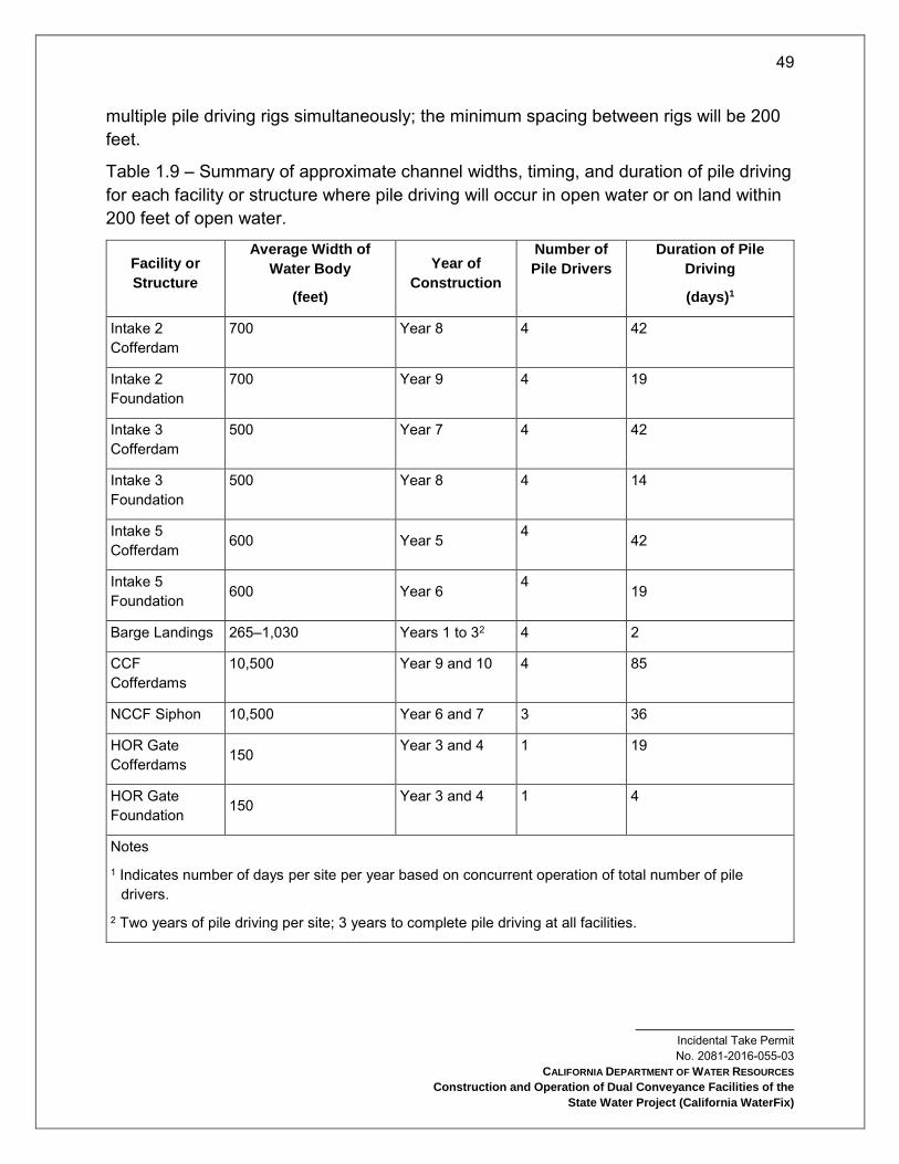
49
Incidental Take Permit No. 2081-2016-055-03
CALIFORNIA DEPARTMENT OF WATER RESOURCES
Construction and Operation of Dual Conveyance Facilities of the
State Water Project (California WaterFix)
multiple pile driving rigs simultaneously; the minimum spacing between rigs will be 200 feet.
Table 1.9 – Summary of approximate channel widths, timing, and duration of pile driving for each facility or structure where pile driving will occur in open water or on land within 200 feet of open water.
Facility or
Structure
Average Width of
Water Body
(feet)
Year of
Construction
Number of
Pile Drivers
Duration of Pile
Driving
(days)1
Intake 2 Cofferdam
700 Year 8 4 42
Intake 2 Foundation
700 Year 9 4 19
Intake 3 Cofferdam
500 Year 7 4 42
Intake 3 Foundation
500 Year 8 4 14
Intake 5 Cofferdam 600 Year 5 4 42
Intake 5 Foundation 600 Year 6
4 19
Barge Landings 265–1,030 Years 1 to 32 4 2
CCF Cofferdams
10,500 Year 9 and 10 4 85
NCCF Siphon 10,500 Year 6 and 7 3 36
HOR Gate Cofferdams 150 Year 3 and 4 1 19
HOR Gate Foundation 150 Year 3 and 4 1 4
Notes
1 Indicates number of days per site per year based on concurrent operation of total number of pile drivers.
2 Two years of pile driving per site; 3 years to complete pile driving at all facilities.

50
Incidental Take Permit No. 2081-2016-055-03
CALIFORNIA DEPARTMENT OF WATER RESOURCES
Construction and Operation of Dual Conveyance Facilities of the
State Water Project (California WaterFix)
In-water pile driving will be subject to abatement, hydroacoustic monitoring, and compliance with timing limitations. For all sheetpile cofferdams at the NDD intakes, CCF, and HOR Gate, Permittee will place approximately 70% of the length of each pile using vibratory pile driving as feasible, with impact driving used to finalize pile placement (Table 1.10). The degree to which vibratory driving can be performed effectively is unknown at this time due to as-yet undetermined geologic conditions at the construction sites. Once constructed, if the foundation design for either the NDD intakes or HOR Gate requires pile driving, Permittee will conduct the work from within the cofferdam; it is still undetermined if the foundation will use piles or concrete-in-drilled-hole methods, which do not require pile driving. If driven foundation piles are included in the design, Permittee will require contractors to isolate pile driving activities within dewatered cofferdams as a means of minimizing noise levels and potential adverse effects on fish.
Barge landing construction will entail pile driving 24-inch tubular steel piles in the water. Permittee will work with contractors to minimize pile driving, particularly impact pile driving, by using floating docks instead of pile-supported docks, wherever feasible, considering the load requirements of the landings and the site conditions; floating docks would need fewer piles. If dock piles for barge landings cannot be installed using vibratory methods, the contractor will use a bubble curtain or other attenuation device approved by CDFW to minimize underwater noise.
Table 1.10 – Summary of planned pile driving activities at each site.
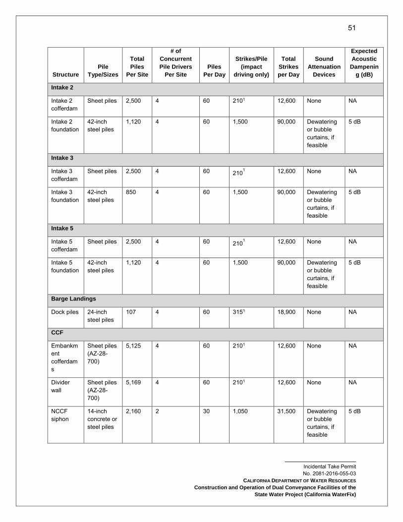
51
Incidental Take Permit No. 2081-2016-055-03
CALIFORNIA DEPARTMENT OF WATER RESOURCES
Construction and Operation of Dual Conveyance Facilities of the
State Water Project (California WaterFix)
Structure
Pile
Type/Sizes
Total
Piles
Per Site
# of
Concurrent
Pile Drivers
Per Site
Piles
Per Day
Strikes/Pile
(impact
driving only)
Total
Strikes
per Day
Sound
Attenuation
Devices
Expected
Acoustic
Dampenin
g (dB)
Intake 2
Intake 2 cofferdam
Sheet piles 2,500 4 60 2101 12,600 None NA
Intake 2 foundation
42-inch steel piles
1,120 4 60 1,500 90,000 Dewatering or bubble curtains, if feasible
5 dB
Intake 3
Intake 3 cofferdam
Sheet piles 2,500 4 60 2101 12,600 None NA
Intake 3 foundation
42-inch steel piles
850 4 60 1,500 90,000 Dewatering or bubble curtains, if feasible
5 dB
Intake 5
Intake 5 cofferdam
Sheet piles 2,500 4 60 2101 12,600 None NA
Intake 5 foundation
42-inch steel piles
1,120 4 60 1,500 90,000 Dewatering or bubble curtains, if feasible
5 dB
Barge Landings
Dock piles 24-inch steel piles
107 4 60 3151 18,900 None NA
CCF
Embankment cofferdams
Sheet piles (AZ-28-700)
5,125 4 60 2101 12,600 None NA
Divider wall
Sheet piles (AZ-28-700)
5,169 4 60 2101 12,600 None NA
NCCF siphon
14-inch concrete or steel piles
2,160 2 30 1,050 31,500 Dewatering or bubble curtains, if feasible
5 dB
52
Incidental Take Permit No. 2081-2016-055-03
CALIFORNIA DEPARTMENT OF WATER RESOURCES
Construction and Operation of Dual Conveyance Facilities of the
State Water Project (California WaterFix)
Structure
Pile
Type/Sizes
Total
Piles
Per Site
# of
Concurrent
Pile Drivers
Per Site
Piles
Per Day
Strikes/Pile
(impact
driving only)
Total
Strikes
per Day
Sound
Attenuation
Devices
Expected
Acoustic
Dampenin
g (dB)
HOR Gate
HOR Gate cofferdams
Sheet piles (AZ-28-700)
550 1 15 2101 3,150 None NA
HOR Gate foundation
14-inch steel pipe or H-piles
100 1 15 1,050 15,750 None NA
Notes 1 Assumes 70% of pile can be driven using vibratory driving followed by impact driving to drive the remainder of the pile.
Project Description - Conveyance Facilities Operation
When the Test Period is initiated and the new north Delta facilities are operational, dual conveyance operations will replace the current operations implemented in compliance with the requirements of the biological opinions issued by USFWS in 2008 (USFWS 2008) and NMFS in 2009 (NMFS 2009)6, and Incidental Take Permit (No. 2081-2009-001-03) issued to DWR by CDFW in 2009 for take of longfin smelt (CDFG 2009)7, or any successors to NMFS (2009), USFWS (2008) and CDFG (2009). The NDD and the HOR Gate are new facilities for the SWP and will be operated consistent with operating criteria that minimize adverse effects on native fish. The existing south Delta facilities will be operated to new criteria that are protective of Covered Fish Species. The Project also includes new operational criteria for outflow in the spring to minimize Project impacts on longfin smelt. Besides these specific changes, the operating criteria of the new dual conveyance system incorporates other criteria included in CDFG (2009), USFWS (2008),) and NMFS (2009), CDFW consistency determinations 2080-2011-022-00 and 2080-2012-005-00 (CDFW 2011, 2012)8, and applicable State Water Resources Control Board water rights decision and underlying permits of the SWP (D-1641). The existing criteria that would continue under dual operations include minimum standards for fall outflow (Fall X2) and the ratio of water exports to inflow (E:I ratio), among others.
6 Note: Any reference to NMFS (2009) in this permit includes the amendments to that BO, as issued by NMFS on April 7, 2011. 7 Note: References to CDFG (2009) in this permit refer to Incidental Take Permit No. 2081-2009-001-03 issued in 2009. 8 Note: Any reference to USFWS (2008) and NMFS (2009) in this permit includes the associated CDFW 2011 and 2012 Consistency Determinations.

53
Incidental Take Permit No. 2081-2016-055-03
CALIFORNIA DEPARTMENT OF WATER RESOURCES
Construction and Operation of Dual Conveyance Facilities of the
State Water Project (California WaterFix)
Many operational criteria vary depending on the type of water condition in a particular year. For example, diversions from the north Delta would be greatest in the wettest water conditions but would be minimal in in critical water seasons that typically occur 15% of the time. In summary, the Project incorporates modified or new operations of four components as compared to current operations of the SWP/CVP in the Delta:
New operations of the north Delta facilities to ensure sufficient flows in the Sacramento River to support migration by Covered Fish Species and to ensure no change in the frequency or intensity of reverse flows (called North Delta bypass flows).
New operations of the HOR Gate.
Modified spring Delta outflow to minimize impacts of the taking on longfin smelt.
South Delta export operations modified to account for dual conveyance and to minimize and mitigate impacts of the taking to Covered Fish Species.
Delta SWP Operations Regulatory Setting
Relationship to Existing Incidental Take Permit and Biological Opinions
There are existing operating criteria, including real time operating criteria, in place that apply to the operations of the SWP and CVP and which are required by USFWS (2008), NMFS (2009), and CDFG (2009). Table 1.11 identifies the existing requirements that apply to CVP/SWP facilities in the Delta region and notes which requirements are incorporated in the Project.
The Project includes ongoing implementation of the real-time operational processes currently required by USFWS (2008), NMFS (2009), and CDFG (2009). However, as described in the Real-Time Operations section of this Project Description and Conditions of Approval of this permit, the Project will implement additional real-time operations processes.
Coordinated Operations Agreement
The Coordinated Operations Agreement (COA) between the United States of America, acting through Reclamation and DWR to operate the CVP/SWP, was signed in November, 1986. Congress, through Public Law 99-546, authorized and directed the Secretary of the Interior to execute and implement the COA. The COA defines the rights and responsibilities of the CVP/SWP with respect to in-basin water needs and Project exports and provides a mechanism to account for those rights and responsibilities
54
Incidental Take Permit No. 2081-2016-055-03
CALIFORNIA DEPARTMENT OF WATER RESOURCES
Construction and Operation of Dual Conveyance Facilities of the
State Water Project (California WaterFix)
(Reclamation 2008). The Project operational criteria described below will be implemented consistent with the COA.
1995 Water Quality Control Plan
The State Water Resources Control Board (SWRCB) adopted the 1995 Bay-Delta Water Quality Control Plan (WQCP) on May 22, 1995, and it became the basis of SWRCB Decision-1641 (D-1641).
The SWRCB has issued orders and decisions regarding water quality and water right requirements for the Bay-Delta Estuary that impose multiple operations responsibilities on CVP/SWP in the Delta to meet the flow objectives in the 1995 WQCP. With D-1641, issued December 29, 1999, and its subsequent revision dated March 15, 2000 (collectively, D-1641), the SWRCB implements the objectives set forth in the 1995 WQCP, resulting in flow and water quality requirements for CVP/SWP operations to assure protection of beneficial uses in the Delta. The SWRCB adopted a revised WQCP on December 13, 2006. There were no changes to the Beneficial Uses from the 1995 WQCP to the 2006 WQCP, nor were any new water quality objectives adopted in the 2006 WQCP.
The SWRCB is in the process of developing and implementing updates to 2006 WQCP that protect beneficial uses in the Bay-Delta watershed. This update is broken into four phases, some of which are proceeding concurrently. Phase 1 of this work, currently in progress, involves updating San Joaquin River flow and southern Delta water quality requirements for inclusion in the WQCP. Phase 2 will involve comprehensive changes to the WQCP to protect beneficial uses not addressed in Phase 1. Phase 3 will involve implementation of Phases 1 and 2 through changes to water rights and other measures. Phase 4 will involve developing and implementing flow objectives for priority Delta tributaries upstream of the Delta.
Annual and Seasonal Water Management Upstream of the Delta
Sacramento River: Reclamation is required to control water temperature in the Sacramento River pursuant to State Water Board Order WRO 90-5. Per Reasonable and Prudent Alternative (RPA) (Action Suite I.2) in NMFS 2009, Reclamation is required to develop and implement an annual Temperature Management Plan by May 15 each year to manage the cold water supply within Shasta Reservoir and make cold water releases from Shasta Reservoir, and Trinity Reservoir through the Spring Creek Tunnel, to provide suitable temperatures for listed species, and, when feasible, fall-run Chinook salmon. The Project assumes Reclamation’s implementation of these temperature management actions.

55
Incidental Take Permit No. 2081-2016-055-03
CALIFORNIA DEPARTMENT OF WATER RESOURCES
Construction and Operation of Dual Conveyance Facilities of the
State Water Project (California WaterFix)
Feather River: As part of the SWP, Permittee operates the Oroville Facilities on the Feather River under a license from the Federal Energy Regulatory Commission (FERC). The original FERC license to operate the Oroville Facilities expired in January, 2007. Since then, an annual license that renews automatically each year has been issued, authorizing Permittee to continue operating to the terms of the original FERC license until the new license is issued. In December, 2016, NMFS released a final Biological Opinion for FERC relicensing of the Oroville Facilities.
The FERC license and its associated agreements and permits will be the primary regulatory drivers for operations at the Oroville Facilities. The Project does not include operations of the Oroville Facilities, but assumes the requirements of its regulatory authorizations will be met, along with any other requirements imposed on the SWP through this permit including spring outflow criteria for longfin smelt.
Water Transfers
Transfers requiring export from the Delta are done at times when pumping and conveyance capacity at the CVP or SWP export facilities is available to move the water. Additionally, operations to accomplish these transfers must be carried out in coordination with CVP/SWP operations, such that the capabilities of the projects to exercise their own water rights or to meet their legal and regulatory requirements are not diminished or limited in any way. In particular, parties to the transfer are responsible for providing for any incremental changes in flows required to protect Delta water quality standards. Purchasers of water for transfers may include Reclamation, CVP contractors, DWR, SWP entitlement holders, other state and federal agencies, and other parties.
Contra Costa Canal Rock Slough Intake
This discussion is provided for informational purposes only as operations of the Rock Slough Intake are not a part of the Project. The Contra Costa Water District (CCWD) diverts water from the Delta for irrigation and municipal and industrial uses under its CVP contract and under its own water right permits and license, issued by SWRCB for users. CCWD’s water system includes the Mallard Slough, Rock Slough, Old River, and Middle River (on Victoria Canal) intakes; the Contra Costa Canal and shortcut pipeline; and the Los Vaqueros Reservoir. The Rock Slough Intake facilities, the Contra Costa Canal, and the shortcut pipeline are owned by Reclamation, and operated and maintained by CCWD under contract with Reclamation. Reclamation completed construction of the fish screen at the Rock Slough intake in 2011, and testing and the transfer of operation and maintenance to CCWD is ongoing. Mallard Slough Intake, Old

56
Incidental Take Permit No. 2081-2016-055-03
CALIFORNIA DEPARTMENT OF WATER RESOURCES
Construction and Operation of Dual Conveyance Facilities of the
State Water Project (California WaterFix)
River Intake, Middle River Intake, and Los Vaqueros Reservoir are owned and operated by CCWD.
The Rock Slough Intake is located about four miles southeast of Oakley, where water flows through a positive barrier fish screen into the earth-lined portion of the Contra Costa Canal. The Canal connects the fish screen at Rock Slough to Pumping Plant 1, approximately four miles to the west. Pumping Plant 1 has capacity to pump up to 350 cfs into the concrete-lined portion of the Canal. Diversions at Rock Slough Intake are typically taken under CVP contract. CCWD can divert approximately 30% to 50% of its total annual supply (approximately 127 TAF) through the Rock Slough Intake depending upon water quality there.

57
Incidental Take Permit No. 2081-2016-055-03
CALIFORNIA DEPARTMENT OF WATER RESOURCES
Construction and Operation of Dual Conveyance Facilities of the
State Water Project (California WaterFix)
Table 1.11 CVP/SWP Facilities and Actions Included and Not Included in the Project
58
Incidental Take Permit No. 2081-2016-055-03
CALIFORNIA DEPARTMENT OF WATER RESOURCES
Construction and Operation of Dual Conveyance Facilities of the
State Water Project (California WaterFix)
Topic Action Description Source Comments
Facilities and Activities Included in the Project
New Facilities Conveyance facilities construction
Construction, operations, and maintenance of the proposed NDD intakes and associated conveyance facilities.
This document
New Facilities HOR Gate construction
Construction, operations, and maintenance of the proposed HOR Gate.
This document
Real-time Operations
Real-time Decision-making
Apply real-time decision-making to assist fishery management.
Reclamation (2008)9 USFWS (2008) DWR (2009)10, NMFS (2009)
Modified to incorporate operations of new facilities and corresponding changes in management structure.
Real-time Operations
NMFS (2009) IV.3
Reduce likelihood of entrainment or salvage at the export facilities
NMFS (2009) Project operational criteria supplement this RPA.
Real-time Operations
USFWS (2008) RPA General
Smelt Working Group (SWG) and Water and Operations Management Team (WOMT)
USFWS (2008) RTO teams coordinate with and provide recommendations to WOMT for the Delta operations.
9 Reclamation (2008) Biological Assessment for Continued Long-term Operations of the Central Valley Project and the State Water Project. US Bureau of Reclamation, Mid-Pacific Region (Reclamation). Sacramento, CA 10 DWR (2009) California Incidental Take Permit Application for the California State Water Project Delta Facilities and Operations. Submitted to California Department of Fish and Game in February 2009. California Department of Water Resources (DWR). Sacramento, CA.

59
Incidental Take Permit No. 2081-2016-055-03
CALIFORNIA DEPARTMENT OF WATER RESOURCES
Construction and Operation of Dual Conveyance Facilities of the
State Water Project (California WaterFix)
Topic Action Description Source Comments
Real-time Operations
NMFS (2009) 11.2.1.1
Technical Team NMFS (2009) Existing real-time decision making process is incorporated into the Project as described in the Real-Time Operations - Ongoing Processes to support Real-Time Decision Making In addition to this process a separate Operational Opportunities subcommittee of the IICG will be convened in, as described in the Real Time Operations - New and Modified Processes to Support Real-Time Decision Making section of this Project Description.
Real-time Operations
NMFS (2009) IV.5
Formation of Delta Operations for Salmon and Sturgeon Technical Working Group
NMFS (2009) RTO teams coordinate with and provide recommendations to WOMT for the Delta operations.
Flow CDFG (2009) Condition 5
Flow criteria, also including real-time operational considerations.
CDFG (2009) Modified to incorporate operations of new facilities and corresponding changes in management structure.
Flow Jones Pumping Plant
Permitted diversion capacity of 4,600 cfs
Reclamation (2008) USFWS (2008) NMFS (2009)
CVP facility to be operated per flow criteria. Permitted diversion capacity does not allow for more water to be exported in conjunction with the operation of NDD than is permitted by the SWRCB.
Flow Banks Pumping Plant
Diversion rates at Clifton Court intake are normally restricted to 6,680 cfs, with exceptions
Reclamation (2008) USFWS (2008) DWR (2009) NMFS (2009)
To be operated per flow criteria.

60
Incidental Take Permit No. 2081-2016-055-03
CALIFORNIA DEPARTMENT OF WATER RESOURCES
Construction and Operation of Dual Conveyance Facilities of the
State Water Project (California WaterFix)
Topic Action Description Source Comments
Flow NMFS IV.2.3 OMR flow management
NMFS (2009) Project operational criteria incorporate and replace this RPA action. See Table 9.9.4-1.
Flow USFWS 1 Adult migration and entrainment; first flush: limit exports so average daily OMR flow is no more negative than -2,000 cfs for 14 days, with a 5-day running average no more negative than -2,500 cfs
USFWS (2008) Project operational criteria incorporate all aspects of this action including salvage based triggers, and replace this RPA action. See the Operational Criteria section of this Project Description.
Flow USFWS 2 Adult migration and entrainment
USFWS (2008) Project operational criteria incorporate and replace this RPA action.
Flow USFWS 3 Entrainment protection of larval smelt
USFWS (2008) Project operational criteria incorporate and replace this RPA action.
Flow USFWS 4 Estuarine habitat during fall (provide Delta outflow to maintain average X2 for September, October, and November)
USFWS (2008) Project operational criteria incorporate and replace this RPA action.
North Bay Aqueduct
North Bay Aqueduct Monitoring
Conduct monitoring at NBA
Reclamation (2008) Project includes this monitoring.
North Bay Aqueduct
North Bay Aqueduct Operations
Operate NBA USFWS (2008) CDFG (2009)
Project includes these operational constraints.
Interior Delta Entry
Engineering solutions to reduce interior Delta entry
Reduce interior Delta entry
Reclamation (2008) NMFS (2009)
Project incorporates and addresses with Georgiana Slough non-physical barrier and HOR Gate.
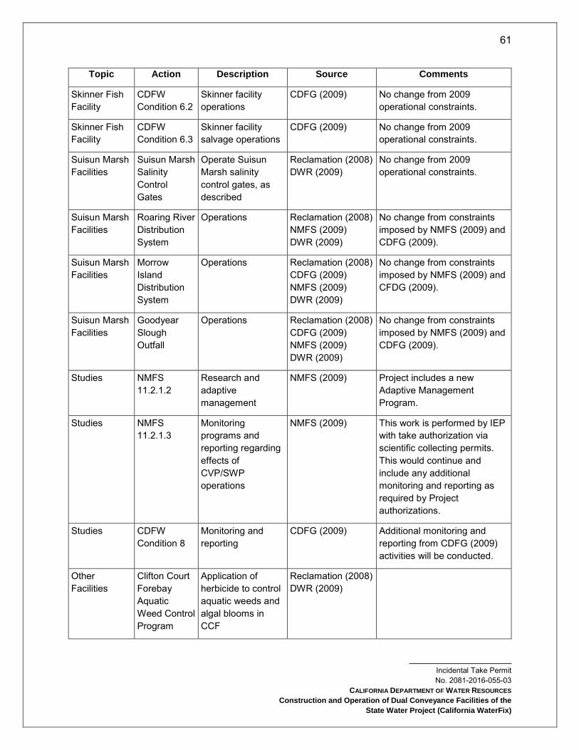
61
Incidental Take Permit No. 2081-2016-055-03
CALIFORNIA DEPARTMENT OF WATER RESOURCES
Construction and Operation of Dual Conveyance Facilities of the
State Water Project (California WaterFix)
Topic Action Description Source Comments
Skinner Fish Facility
CDFW Condition 6.2
Skinner facility operations
CDFG (2009) No change from 2009 operational constraints.
Skinner Fish Facility
CDFW Condition 6.3
Skinner facility salvage operations
CDFG (2009) No change from 2009 operational constraints.
Suisun Marsh Facilities
Suisun Marsh Salinity Control Gates
Operate Suisun Marsh salinity control gates, as described
Reclamation (2008) DWR (2009)
No change from 2009 operational constraints.
Suisun Marsh Facilities
Roaring River Distribution System
Operations Reclamation (2008) NMFS (2009) DWR (2009)
No change from constraints imposed by NMFS (2009) and CDFG (2009).
Suisun Marsh Facilities
Morrow Island Distribution System
Operations Reclamation (2008) CDFG (2009) NMFS (2009) DWR (2009)
No change from constraints imposed by NMFS (2009) and CFDG (2009).
Suisun Marsh Facilities
Goodyear Slough Outfall
Operations Reclamation (2008) CDFG (2009) NMFS (2009) DWR (2009)
No change from constraints imposed by NMFS (2009) and CDFG (2009).
Studies NMFS 11.2.1.2
Research and adaptive management
NMFS (2009) Project includes a new Adaptive Management Program.
Studies NMFS 11.2.1.3
Monitoring programs and reporting regarding effects of CVP/SWP operations
NMFS (2009) This work is performed by IEP with take authorization via scientific collecting permits. This would continue and include any additional monitoring and reporting as required by Project authorizations.
Studies CDFW Condition 8
Monitoring and reporting
CDFG (2009) Additional monitoring and reporting from CDFG (2009) activities will be conducted.
Other Facilities
Clifton Court Forebay Aquatic Weed Control Program
Application of herbicide to control aquatic weeds and algal blooms in CCF
Reclamation (2008) DWR (2009)
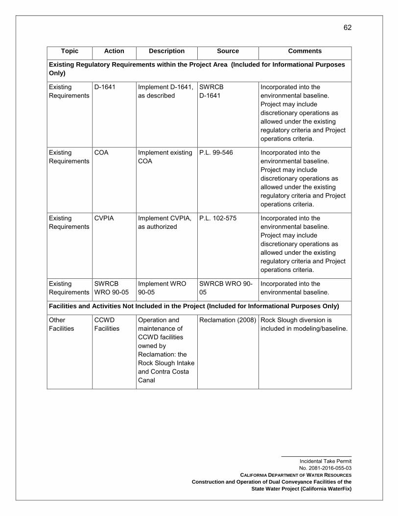
62
Incidental Take Permit No. 2081-2016-055-03
CALIFORNIA DEPARTMENT OF WATER RESOURCES
Construction and Operation of Dual Conveyance Facilities of the
State Water Project (California WaterFix)
Topic Action Description Source Comments
Existing Regulatory Requirements within the Project Area (Included for Informational Purposes
Only)
Existing Requirements
D-1641 Implement D-1641, as described
SWRCB D-1641
Incorporated into the environmental baseline. Project may include discretionary operations as allowed under the existing regulatory criteria and Project operations criteria.
Existing Requirements
COA Implement existing COA
P.L. 99-546 Incorporated into the environmental baseline. Project may include discretionary operations as allowed under the existing regulatory criteria and Project operations criteria.
Existing Requirements
CVPIA Implement CVPIA, as authorized
P.L. 102-575 Incorporated into the environmental baseline. Project may include discretionary operations as allowed under the existing regulatory criteria and Project operations criteria.
Existing Requirements
SWRCB WRO 90-05
Implement WRO 90-05
SWRCB WRO 90-05
Incorporated into the environmental baseline.
Facilities and Activities Not Included in the Project (Included for Informational Purposes Only)
Other Facilities
CCWD Facilities
Operation and maintenance of CCWD facilities owned by Reclamation: the Rock Slough Intake and Contra Costa Canal
Reclamation (2008) Rock Slough diversion is included in modeling/baseline.
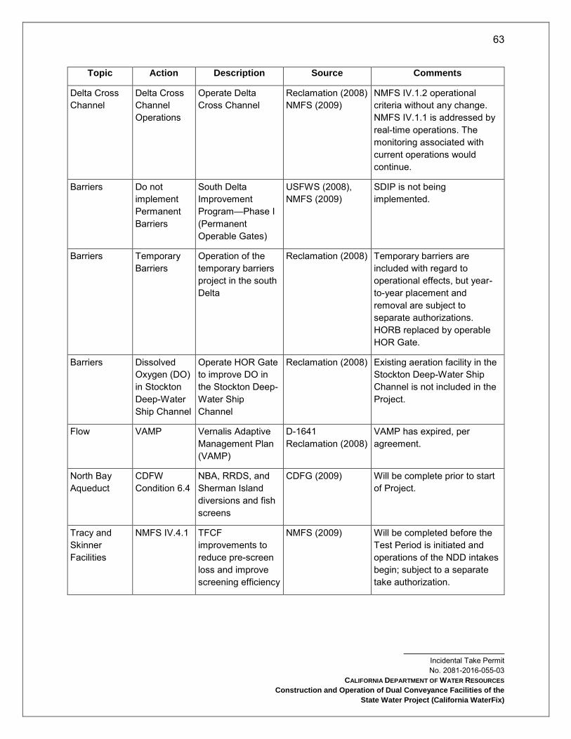
63
Incidental Take Permit No. 2081-2016-055-03
CALIFORNIA DEPARTMENT OF WATER RESOURCES
Construction and Operation of Dual Conveyance Facilities of the
State Water Project (California WaterFix)
Topic Action Description Source Comments
Delta Cross Channel
Delta Cross Channel Operations
Operate Delta Cross Channel
Reclamation (2008) NMFS (2009)
NMFS IV.1.2 operational criteria without any change. NMFS IV.1.1 is addressed by real-time operations. The monitoring associated with current operations would continue.
Barriers Do not implement Permanent Barriers
South Delta Improvement Program—Phase I (Permanent Operable Gates)
USFWS (2008), NMFS (2009)
SDIP is not being implemented.
Barriers Temporary Barriers
Operation of the temporary barriers project in the south Delta
Reclamation (2008) Temporary barriers are included with regard to operational effects, but year-to-year placement and removal are subject to separate authorizations. HORB replaced by operable HOR Gate.
Barriers Dissolved Oxygen (DO) in Stockton Deep-Water Ship Channel
Operate HOR Gate to improve DO in the Stockton Deep-Water Ship Channel
Reclamation (2008) Existing aeration facility in the Stockton Deep-Water Ship Channel is not included in the Project.
Flow VAMP Vernalis Adaptive Management Plan (VAMP)
D-1641 Reclamation (2008)
VAMP has expired, per agreement.
North Bay Aqueduct
CDFW Condition 6.4
NBA, RRDS, and Sherman Island diversions and fish screens
CDFG (2009) Will be complete prior to start of Project.
Tracy and Skinner Facilities
NMFS IV.4.1 TFCF improvements to reduce pre-screen loss and improve screening efficiency
NMFS (2009) Will be completed before the Test Period is initiated and operations of the NDD intakes begin; subject to a separate take authorization.
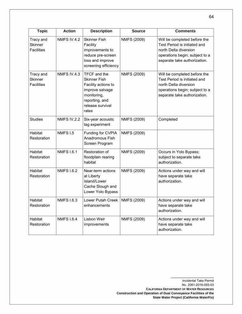
64
Incidental Take Permit No. 2081-2016-055-03
CALIFORNIA DEPARTMENT OF WATER RESOURCES
Construction and Operation of Dual Conveyance Facilities of the
State Water Project (California WaterFix)
Topic Action Description Source Comments
Tracy and Skinner Facilities
NMFS IV.4.2 Skinner Fish Facility improvements to reduce pre-screen loss and improve screening efficiency
NMFS (2009) Will be completed before the Test Period is initiated and north Delta diversion operations begin; subject to a separate take authorization.
Tracy and Skinner Facilities
NMFS IV.4.3 TFCF and the Skinner Fish Facility actions to improve salvage monitoring, reporting, and release survival rates
NMFS (2009) Will be completed before the Test Period is initiated and north Delta diversion operations begin; subject to a separate take authorization.
Studies NMFS IV.2.2 Six-year acoustic tag experiment
NMFS (2009) Completed
Habitat Restoration
NMFS I.5 Funding for CVPIA Anadromous Fish Screen Program
NMFS (2009)
Habitat Restoration
NMFS I.6.1 Restoration of floodplain rearing habitat
NMFS (2009) Occurs in Yolo Bypass; subject to separate take authorization.
Habitat Restoration
NMFS I.6.2 Near-term actions at Liberty Island/Lower Cache Slough and Lower Yolo Bypass
NMFS (2009) Actions under way and will have separate take authorization.
Habitat Restoration
NMFS I.6.3 Lower Putah Creek enhancements
NMFS (2009) Actions under way and will have separate take authorization.
Habitat Restoration
NMFS I.6.4 Lisbon Weir improvements
NMFS (2009) Actions under way and will have separate take authorization.
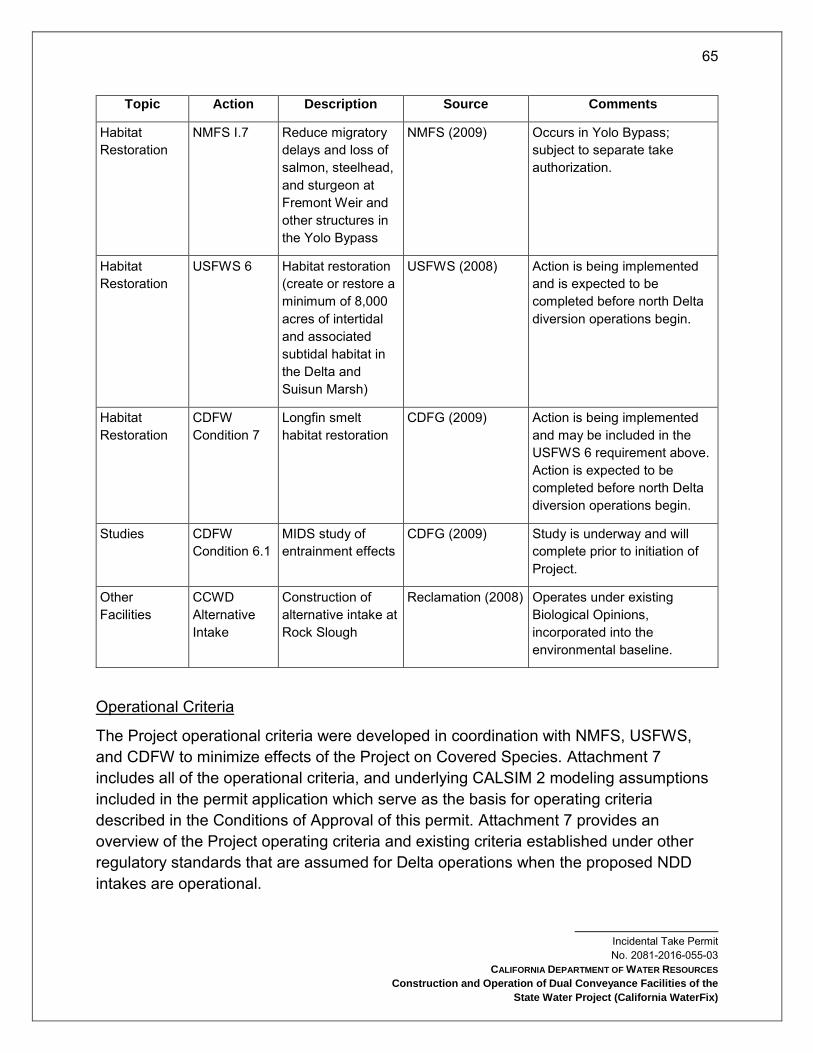
65
Incidental Take Permit No. 2081-2016-055-03
CALIFORNIA DEPARTMENT OF WATER RESOURCES
Construction and Operation of Dual Conveyance Facilities of the
State Water Project (California WaterFix)
Topic Action Description Source Comments
Habitat Restoration
NMFS I.7 Reduce migratory delays and loss of salmon, steelhead, and sturgeon at Fremont Weir and other structures in the Yolo Bypass
NMFS (2009) Occurs in Yolo Bypass; subject to separate take authorization.
Habitat Restoration
USFWS 6 Habitat restoration (create or restore a minimum of 8,000 acres of intertidal and associated subtidal habitat in the Delta and Suisun Marsh)
USFWS (2008) Action is being implemented and is expected to be completed before north Delta diversion operations begin.
Habitat Restoration
CDFW Condition 7
Longfin smelt habitat restoration
CDFG (2009) Action is being implemented and may be included in the USFWS 6 requirement above. Action is expected to be completed before north Delta diversion operations begin.
Studies CDFW Condition 6.1
MIDS study of entrainment effects
CDFG (2009) Study is underway and will complete prior to initiation of Project.
Other Facilities
CCWD Alternative Intake
Construction of alternative intake at Rock Slough
Reclamation (2008) Operates under existing Biological Opinions, incorporated into the environmental baseline.
Operational Criteria
The Project operational criteria were developed in coordination with NMFS, USFWS, and CDFW to minimize effects of the Project on Covered Species. Attachment 7 includes all of the operational criteria, and underlying CALSIM 2 modeling assumptions included in the permit application which serve as the basis for operating criteria described in the Conditions of Approval of this permit. Attachment 7 provides an overview of the Project operating criteria and existing criteria established under other regulatory standards that are assumed for Delta operations when the proposed NDD intakes are operational.

66
Incidental Take Permit No. 2081-2016-055-03
CALIFORNIA DEPARTMENT OF WATER RESOURCES
Construction and Operation of Dual Conveyance Facilities of the
State Water Project (California WaterFix)
One new criteria included in the Conditions of Approval, the spring outflow criteria, is not associated with any specific facility. The purpose of the spring outflow criteria is to maintain spring outflows consistent with existing conditions throughout the permit term and avoid a reduction in overall abundance of longfin smelt. As described in the permit application, the spring outflow criteria are intended to be provided through the acquisition of water from willing sellers and through operations of the SWP.
Actual operations will also rely on real-time operations as described in the Real-Time Operations section below. A Test Period Operations Plan will be developed by the Permittee and Reclamation in coordination with CDFW, NMFS and USFWS prior to initiation of the Test Period and operation of the NDD intakes, which will detail implementation of operational criteria presented in this permit. Additionally, a Full Project Operations Plan will be developed by the Permittee and Reclamation in coordination with CDFW, NMFS, and USFWS before the Test Period ends and Full Project Operations commence, which will detail implementation of operational criteria presented in this permit.
To summarize, the Project includes modified or new operational criteria for the following facilities (see Attachment 1, Figures 4-10):
NDD Intakes
South Delta export facilities
HOR Gate operations
Additionally, the operation of the following facilities is included in the Project (see Attachment 1, Figure 3):
Suisun Marsh facilities (Morrow Island Distribution System, Goodyear Slough Outfall, Roaring River Distribution System, Suisun Marsh Salinity Control Gate)
Georgiana Slough Non-Physical Barrier
North Bay Aqueduct Intake - Barker Slough Pumping Plant
Relationship Between Operating Criteria and Adaptive Management
Operations under the Project may result in substantial change in Delta flows compared to the expected flows under the existing Delta configuration, and real-time operations will be applied for water supply, water quality, flood control, and/or fish protection purposes. As a result of 1) uncertainty associated with current scientific understanding of Covered Species’ needs and effects of CVP/SWP operations under current authorizations and the Project, 2) imprecision of modeling tools and 3) other management processes affecting the Delta operational criteria including two key drivers

67
Incidental Take Permit No. 2081-2016-055-03
CALIFORNIA DEPARTMENT OF WATER RESOURCES
Construction and Operation of Dual Conveyance Facilities of the
State Water Project (California WaterFix)
of operations, Fall X2 and spring outflow, the individual operational components described below may be subject to change based on new scientific information developed through the adaptive management process. The Adaptive Management Program will be used to evaluate and consider changes in the operational criteria based on information gained before and after the new facilities become operational. The Adaptive Management Program (Attachment 5) describes this program in more detail. It will be used to consider and address scientific uncertainty regarding the Delta ecosystem and to inform implementation of the SWP and CVP operational criteria in the near term for USFWS (2008), NMFS (2009), and CDFG (2009), as well as any future federal Endangered Species Act (ESA) and CESA authorizations for the Project including this permit.
Relationship Between Project Operations and Existing CVP/SWP Operational Requirements
Implementation of the Project will include operations of both new and existing water conveyance facilities once construction is complete and operation of the NDD intakes begins with the initiation of the Test Period. During construction, the SWP operations will continue to be governed by USFWS (2008), NMFS (2009), and CDFG (2009), including any modifications to those authorizations resulting from reinitiation of consultation, or replacement, amendment, modification, or renewal of the existing CESA authorizations. This permit will replace the then-existing CESA authorization(s) for SWP operations when the Test Period is initiated and Permittee begins operating the new conveyance in coordination with existing SWP facilities.
Components of USFWS (2008) and NMFS (2009) that address CVP/SWP activities not included in the Project, such as some upstream reservoir operations, will continue to provide the basis for ESA authorization for those activities, including after the initiation of the Test Period, and after Permittee begins operating the new NDD intakes. USFWS (2008) and NMFS (2009) may be modified through the reinitiation of those Biological Opinions, begun in 2016, or other ESA processes.
For Shasta operations, Reclamation has requested adjustment to the NMFS (2009) RPA (Action Suite 1.2) for seasonal temperature management. The outcome of the adjustment will control Shasta operations, and if there are any unforeseen conflicts in Shasta operations between the Project operating criteria and the adjusted RPA for CVP operations, Project operating criteria will be met through SWP operations.
Operational Criteria for the NDD Intakes
The NDD Intake design and operational criteria were developed based on the scientific information available at the time of Permittee’s application and are intended to minimize

68
Incidental Take Permit No. 2081-2016-055-03
CALIFORNIA DEPARTMENT OF WATER RESOURCES
Construction and Operation of Dual Conveyance Facilities of the
State Water Project (California WaterFix)
effects on Covered Species while providing water supply. These criteria will allow the NDD Intakes to export water subject to real-time operations. Through implementation of the Adaptive Management Program (see Attachment 5) NDD intake operating criteria and real-time operations may be modified in response to new scientific information and further evaluation of Project effects such as those related to Old and Middle Rivers, DCC operations, or north Delta bypass flows. Additionally, the Project operations include a preference for south Delta facility pumping in July through September to limit any potential water quality degradation in the south Delta.
NDD intakes design and operation constraints:
The NDD intakes will consist of three separate intake units with a total, combined intake capacity not exceeding 9,000 cfs (maximum of 3,000 cfs per unit).
Project conveyance from the NDD intakes will be provided by a tunnel capacity sized to provide for gravity-assisted flow from an IF to the south Delta pumping facilities when supported by sufficient flow conditions.
The NDD intakes will, during the Test Period and as needed during Full Project Operations, demonstrate compliance with the then-current NMFS, USFWS, and CDFW fish screening design and operating criteria, which govern such things as approach and sweeping velocities and rates of impingement. In addition, the screens will be operated to maintain winter-run and spring-run Chinook salmon juvenile salmonid survival rates of 95% or more of the existing survival rate through the reach containing new north Delta diversion intakes (beginning 0.25 miles upstream of Intake 2 through 0.25 miles downstream of Intake 5). The reduction in survival of up to 5% below the existing survival rate will be cumulative across all screens and will be averaged on a monthly basis.
The Adaptive Management Program will, among other things, develop and use information focused on minimizing uncertainties related to the design and operation of the fish screens (see Attachment 5).
Full operations of the NDD intakes will be preceded by close collaboration with NMFS, USFWS and CDFW to develop detailed plans for appropriate tests and use those tests to evaluate NDD intake performance across a range of diversion rates and flow conditions during the Test Period (Test Period Operations Plan) and during Full Project Operations (Full Project Operations Plan). The Test Period Operations Plan and the Full Project Operations Plan will include biological studies and monitoring efforts to enable the measurement of survival rates (both within the screening reach and downstream to Chipps Island), and
69
Incidental Take Permit No. 2081-2016-055-03
CALIFORNIA DEPARTMENT OF WATER RESOURCES
Construction and Operation of Dual Conveyance Facilities of the
State Water Project (California WaterFix)
other relevant biological parameters which may be affected by the operation of the new intakes.
Operations will be managed at all times to avoid increasing the magnitude, frequency, or duration of flow reversals in the Sacramento River at the Georgiana Slough junction above pre-NDD intake operations levels.
The NDD Technical Team (NDDTT) and Technical Oversight Team (TOT) retain responsibility for determination of the operational criteria and constraints (i.e., which intakes are operated and at what diversion rate) during the Test Period. USFWS, NMFS, and CDFW will also determine whether the diversion structures are achieving performance standards for Covered Species over the course of operations. USFWS, NMFS, and CDFW will determine when the Test Period may end and Full Project Operations, consistent with the Full Project Operations Plan, can commence. In making this determination, USFWS, NMFS, and CDFW expect and will consider that it may be difficult to test for a full range of conditions prior to commencing Full Project Operations. Therefore, tests of the NDD intakes to ensure biological performance standards are met are expected to continue intermittently after Full Project Operations begin, to enable testing to be completed for different diversion levels during infrequently occurring hydrologic conditions.
Once Full Project Operations begin, the Full Project Operations Plan will be used to establish operational criteria for the NDD intakes consistent with the terms of this permit, and ensure that adjustments in diversions based on real time operating criteria are made when needed for fish protection or as appropriate for water supply, water quality, flood control, and/or fish protection purposes for each real-time operational component, as described in the Real-Time Operations section below.
The Adaptive Management Program (see Attachment 5) will review the efficacy of the North Delta bypass criteria in light of Pre-construction and Post-construction studies described in Conditions of Approval 9.6.10 and 9.6.11, to identify what adjustments, if any, are needed to further minimize adverse effects on Covered Species.
NDD intake bypass flow criteria: NDD intake bypass flow criteria will be used to minimize impacts on Covered Species primarily from December through June, which brackets the main juvenile salmon migration period. The objectives of the NDD intake bypass flow criteria include regulation of flows to (1) maintain fish screen sweeping velocities, (2) minimize potential increase in upstream transport of productivity in the
70
Incidental Take Permit No. 2081-2016-055-03
CALIFORNIA DEPARTMENT OF WATER RESOURCES
Construction and Operation of Dual Conveyance Facilities of the
State Water Project (California WaterFix)
channels downstream of the intakes, (3) support salmonid and pelagic fish movements to regions of suitable habitat, (4) reduce losses to predation downstream of the diversions, and (5) maintain or improve rearing habitat conditions in the north Delta. To ensure that these objectives are met, diversions must be restricted at certain times of the year that bracket the main juvenile salmon migration period.
Operational Criteria for South Delta CVP/SWP Export Facilities
The objective of new south Delta flow criteria is to minimize take of Covered Fish Species at south Delta pumps by reducing the hydrodynamic effects of south Delta operations that may affect fish movement and migration routing during critical periods. The south Delta channel flow criteria are based on the parameters for Old and Middle River (OMR) flows and the San Joaquin River inflow, and HOR Gate operations (see Operational Criteria for the Head of Old River Gate section below). Additionally, Project operations include a preference for south Delta pumping in July through September to provide limited flushing flows to manage water quality in the south Delta.
OMR flow criteria: The OMR flow criteria chiefly serve to constrain the magnitude of reverse flows in the Old and Middle Rivers to limit fish entrainment into the south Delta and increase the likelihood that Delta smelt can successfully reproduce in the San Joaquin River. The rational for using OMR flow criteria is based on the USFWS (2008) and NMFS (2009) RPA Actions. OMR criteria and associated HOR Gate operations described in this permit are designed primarily to secure operations that are expected to provide beneficial changes in south Delta flows under the Project, (i.e., they would lessen reverse flows in Old and Middle Rivers). As with other operational criteria described in this permit, OMR flow criteria will govern SWP operations when the Test Period is initiated.
In April, May, and June, minimum allowable OMR flow values are based upon the San Joaquin River inflow. In October and November, OMR and south Delta export restrictions are based upon the D-1641 pulse trigger. Additionally, new criteria based on the water year type in December through June will be implemented as described in this permit to preserve the reduced reverse flow conditions under the Project. As with other operational criteria described in this permit, these OMR flow criteria will govern SWP operations beginning when the Test Period is initiated.
Operational Criteria for the Head of Old River Gate
As described in the Conveyance Facility Construction section, a new permanent, operable gate at the head of Old River at the divergence from the San Joaquin River (HOR Gate) will be constructed and operated to protect emmigrating San Joaquin River salmonids in the spring and to provide water quality improvements in the San Joaquin

71
Incidental Take Permit No. 2081-2016-055-03
CALIFORNIA DEPARTMENT OF WATER RESOURCES
Construction and Operation of Dual Conveyance Facilities of the
State Water Project (California WaterFix)
River in the fall. The new HOR Gate will replace the temporary rock barrier that is typically installed at the same location. Temporary agricultural barriers on Middle River and Old River near Tracy and Grant Line Canal will continue to be installed consistent with current operations, but their installation and removal is subject to separate CESA authorizations. Operation of the HOR Gate will vary from completely open (lying flat on the channel bed) to completely closed (erect in the channel, prohibiting any flow of San Joaquin River water into Old River), with the potential for operations in between that will allow partial flow. Operations of the gate will be determined by the operational criteria and real-time operations as described in this permit (also see Real-Time Operations section below), based on actual flows and/or fish presence.
Operational Criteria for the Delta Cross Channel Gates
This discussion is provided for informational purposes as the Permittee does not seek incidental take coverage for these facilities. The DCC is a gated diversion channel in the Sacramento River near Walnut Grove and Snodgrass Slough (Attachment 1, Figure 3) that is owned and operated by Reclamation. No changes to DCC operational criteria from the operations described in D-1641 and the USFWS 2008 and NMFS 2009 Biological Opinions are proposed.
Flows into the DCC from the Sacramento River are controlled by two 60-foot by 30-foot radial gates. When the gates are open, water flows from the Sacramento River through the cross channel to channels of the lower Mokelumne and San Joaquin Rivers toward the interior Delta. The DCC operation improves water quality in the interior Delta by improving circulation patterns of higher-quality water from the Sacramento River toward Delta diversion facilities.
Reclamation operates the DCC in the open position to (1) improve water quality in the interior Delta, and (2) reduce saltwater intrusion rates in the western Delta. During the late fall, winter, and spring, the gates are often periodically closed to protect out-migrating salmonids from entering the interior Delta. In addition, whenever flows in the Sacramento River at Sacramento reach 20,000 to 25,000 cfs (on a sustained basis), the gates are closed to reduce potential scouring and flooding that might occur in the channels on the downstream side of the gates.
Flow rates through the gates are determined by Sacramento River stage and are not affected by export rates in the south Delta. During Project operations, DCC closure for downstream flood control will be based on Sacramento River flow at Freeport upstream
72
Incidental Take Permit No. 2081-2016-055-03
CALIFORNIA DEPARTMENT OF WATER RESOURCES
Construction and Operation of Dual Conveyance Facilities of the
State Water Project (California WaterFix)
of the NDD facilities. The DCC also serves as a link between the Mokelumne River and the Sacramento River for small craft.
The DCC will continue to be operated as it is operated now, under the terms of NMFS (2009). The gates will be closed if fish are present in October and November, with closure decisions at that time reached through the existing real-time operations process described in the Real-Time Operations section below.
Operational Criteria for the Suisun Marsh Facilities
The Suisun Marsh facilities are jointly operated by CVP/SWP and include the Suisun Marsh Salinity Control Gates (SMSCG), Roaring River Distribution System (RRDS, Morrow Island Distribution System (MIDS), and Goodyear Slough Outfall. Operations of the Suisun Marsh facilities are described in this permit and consistent with those described in USFWS (2008) and NMFS (2009).
Suisun Marsh Salinity Control Gates (SMSCG): The SMSCG are located on Montezuma Slough about two miles downstream from the confluence of the Sacramento and San Joaquin Rivers, near Collinsville (Attachment 1, Figure 3). Operation of the SMSCG began in October 1988 as Phase II of the Plan of Protection for the Suisun Marsh. The objective of SMSCG operation is to decrease the salinity of the water in Montezuma Slough. The facility, spanning the 465-foot width of Montezuma Slough, consists of a boat lock, a series of three radial gates, and removable flashboards. The gates control salinity by restricting the flow of higher salinity water from Grizzly Bay into Montezuma Slough during incoming tides and retaining lower salinity Sacramento River water from the previous ebb tide. Operation of the gates in this fashion lowers salinity in Suisun Marsh channels and results in a net movement of water from east to west.
When Delta outflow is low to moderate and the gates are not operating, tidal flow past the gate is approximately 5,000 to 6,000 cfs while the net flow is near zero. When operated, flood tide flows are arrested while ebb tide flows remain in the range of 5,000 to 6,000 cfs. The net flow in Montezuma Slough becomes approximately 2,500 to 2,800 cfs. The USACE permit for operating the SMSCG requires that it be operated between October and May only when needed to meet Suisun Marsh salinity standards. Details of annual gate operations can be found in “Summary of Salinity Conditions in Suisun Marsh During WYs 1984–1992”, or the “Suisun Marsh Monitoring Program Data Summary” produced annually by DWR, Division of Environmental Services.
The approximately 2,800 cfs net flow induced by SMSCG operation is effective at moving the salinity downstream in Montezuma Slough. Salinity is reduced by roughly one-hundred percent at Beldons Landing, and lesser amounts further west along

73
Incidental Take Permit No. 2081-2016-055-03
CALIFORNIA DEPARTMENT OF WATER RESOURCES
Construction and Operation of Dual Conveyance Facilities of the
State Water Project (California WaterFix)
Montezuma Slough. At the same time, the salinity field in Suisun Bay moves upstream as net Delta outflow (measured nominally at Chipps Island) is reduced by gate operation. Net outflow through Carquinez Strait is not affected.
The boat lock portion of the gate is held open at all times during SMSCG operation to allow for continuous salmon passage opportunity. Assuming no significant, long-term changes in the drivers mentioned above, SMSCG can generally be expected to be operational 10 to 20 days per year to continue to meet standards in the future except perhaps during the most critical hydrologic conditions and/or other conditions that affect Delta outflow.
Roaring River Distribution System: The RRDS (Attachment 1, Figure 3) was constructed during 1979 and 1980 as part of the Initial Facilities in the Plan of Protection for the Suisun Marsh. The system was constructed to provide lower salinity water to 5,000 acres of private and 3,000 acres of CDFW-managed wetlands on Simmons, Hammond, Van Sickle, Wheeler, and Grizzly islands.
The RRDS includes a 40-acre intake pond that supplies water to Roaring River Slough. Motorized slide gates in Montezuma Slough and flap gates in the pond control flows through the culverts into the pond. A manually operated flap gate and flashboard riser are located at the confluence of Roaring River and Montezuma Slough to allow drainage back into Montezuma Slough for controlling water levels in the distribution system and for flood protection. Permittee owns and operates this drain gate to ensure the Roaring River levees are not compromised during extremely high tides.
Water is diverted through a bank of eight 60-inch-diameter culverts equipped with fish screens into the Roaring River intake pond on high tides to raise the water surface elevation in RRDS above the adjacent managed wetlands. Managed wetlands north and south of the RRDS receive water, as needed, through publicly and privately owned turnouts on the system.
The intake to the RRDS is screened to prevent entrainment of fish larger than approximately 25 mm. Permittee designed and installed the screens based on CDFW criteria. The screen is a stationary vertical screen constructed of continuous-slot stainless steel wedge wire. All screens have 3/32-inch slot openings. To minimize the risk of Delta smelt entrainment, RRDS diversion rates are controlled to maintain an average approach velocity below 0.2 ft/s at the intake fish screen. Since 1996, the motorized slide gates have been operated remotely to allow hourly adjustment of gate openings to maximize diversion throughout the tide.
Morrow Island Distribution System: The MIDS (Attachment 1, Figure 3) was constructed in 1979 and 1980 in the south-western Suisun Marsh as part of the Initial Facilities in

74
Incidental Take Permit No. 2081-2016-055-03
CALIFORNIA DEPARTMENT OF WATER RESOURCES
Construction and Operation of Dual Conveyance Facilities of the
State Water Project (California WaterFix)
the Plan of Protection for the Suisun Marsh. Reclamation and Permittee are required by contract to provide water to landowners so that lands may be managed according to approved local management plans. The system was constructed primarily to channel drainage water from the adjacent managed wetlands for discharge into Suisun Slough and Grizzly Bay, increase circulation, and reduce salinity in Goodyear Slough.
The MIDS is used year-round, but most intensively from September through June. When managed wetlands are filling and circulating, water is tidally diverted from Goodyear Slough just south of Pierce Harbor through three 48-inch culverts. Drainage water from Morrow Island is discharged into Grizzly Bay by way of the C-Line Outfall (two 36-inch culverts) and into the mouth of Suisun Slough by way of the M-Line Outfall (three 48- inch culverts), rather than back into Goodyear Slough. This helps prevent increases in salinity due to drainage water discharges into Goodyear Slough. The M-Line ditch is approximately 1.6 miles in length and the C-Line ditch is approximately 0.8 miles in length.
Goodyear Slough Outfall: The Goodyear Slough Outfall (Attachment 1, Figure 3) was constructed in 1979 and 1980 as part of the Initial Facilities in the Plan of Protection for the Suisun Marsh. A channel approximately 69 feet wide was dredged from the south end of Goodyear Slough to Suisun Bay (about 2,800 feet). The control structure consists of four 48-inch culverts with flap gates on the bay side. On ebb tides, Goodyear Slough receives watershed runoff from Green Valley Creek and, to a lesser extent, Suisun Creek.
The system was designed to draw creek flow south into Goodyear Slough, and thereby reduce salinity, by draining water one-way from the lower end of Goodyear Slough into Suisun Bay on the ebb tide. The one-way flap gates at the Outfall close on flood tide keeping saltier bay water from mixing into the slough. The system creates a small net flow in the southerly direction overlaid on a larger, bidirectional tidal flow. The system provides lower salinity water to the wetland managers who flood their ponds with Goodyear Slough water. MIDS also diverts from Goodyear Slough and receives lower salinity water. Since the gates are passively operated (in response to water surface elevation differentials) there are no operations schedules or records. The system is open for free fish movement except very near the Outfall when flap gates close during flood tides.
Operational Criteria for the North Bay Aqueduct Intake
The Barker Slough Pumping Plant diverts water from Barker Slough into the North Bay Aqueduct (NBA) for delivery in Napa and Solano Counties. Maximum pipeline capacity is 175 cubic feet per second (cfs). During the past few years, daily pumping rates have ranged between 0 and 140 cfs. The current maximum pumping rate is 140 cfs due to
75
Incidental Take Permit No. 2081-2016-055-03
CALIFORNIA DEPARTMENT OF WATER RESOURCES
Construction and Operation of Dual Conveyance Facilities of the
State Water Project (California WaterFix)
the physical limitations of the existing pumps. Growth of biofilm in a portion of the pipeline also limits NBA pumping capacity.
The NBA intake is located approximately 10 miles from the mainstem Sacramento River at the end of Barker Slough (Attachment 1, Figure 3). Per salmon screening criteria, each of the ten NBA pump bays is individually screened with a positive barrier fish screen consisting of a series of flat, stainless steel, wedge-wire panels with a slot width of 3/32 inch. This configuration is designed to exclude fish approximately one inch or larger from being entrained. The bays tied to the two smaller units have an approach velocity of about 0.2 feet per second (ft/s). The larger units were designed for a 0.5 ft/s approach velocity, but actual approach velocity is about 0.44 ft/s. The screens are routinely cleaned to prevent excessive head loss, thereby minimizing increased localized approach velocities.
The NBA fish screens are also designed to comply with USFWS criteria for Delta smelt protection (Reclamation 2008), which are also protective of longfin smelt. The fish screens are assessed annually for effectiveness, per the terms of USFWS (2008) and the CDFG (2009). The Smelt Larval Survey occurs each winter/early spring (January–March) in Suisun Bay, Suisun Marsh, and the Delta, including sloughs near NBA. This monitoring program is used to trigger NBA export reductions in drier years when longfin smelt larvae are detected nearby (specifically at station 716 in Cache Slough), per the terms of CDFG (2009).
As part of the Interagency Ecological Program, Permittee has contracted with CDFW to conduct the required monitoring each year since USFWS (2008) was issued. The expanded survey covers all existing 20-mm stations, in addition to a new suite of stations near the NBA. The expanded survey also has an earlier seasonal start and stop date to focus on the presence of Delta smelt and longfin smelt larvae in the Delta.
Real-Time Operations
Real-time changes to CVP/SWP operations that help avoid and minimize adverse effects to Covered Species must also consider public health, safety, and water supply reliability. Operating criteria are influenced by a number of real-time factors. To facilitate real-time operational decisions and fish and wildlife agency determinations, the Permittee, Reclamation, USFWS, NMFS, and CDFW have developed and refined (Reclamation 2008; NMFS 2009; USFWS 2008) a set of processes to collect data, disseminate information, develop recommendations, make decisions, and provide transparency. This process consists of three types of groups that meet on a recurring basis. All of these teams review the most up-to-date data and information on fish status

76
Incidental Take Permit No. 2081-2016-055-03
CALIFORNIA DEPARTMENT OF WATER RESOURCES
Construction and Operation of Dual Conveyance Facilities of the
State Water Project (California WaterFix)
and Delta conditions, and develop recommendations that can be used to modify operations or criteria to improve the protection of Covered Species.
Ongoing Processes to Support Real-Time Decision Making
The process to identify actions to protect Covered Species varies to some degree among species and geographic area, but abides by the following general outline. A fisheries or operations technical team compiles and assesses current information that may include operational or hydrologic conditions, or species-specific factors such as stages of reproductive development, geographic distribution, relative abundance, and physical habitat conditions. That team then provides a recommendation to the fish and wildlife agency with statutory obligation to enforce protection of the species in question, within guidelines established within the respective biological opinion or incidental take authorization. The fish and wildlife agency’s staff and management review the recommendation and use it as a basis for developing, in cooperation with Reclamation and the Permittee, an operational response that minimizes adverse effects on listed species. In addition, certain actions may require input from the SWRCB to assess consistency with D-1641 requirements or other water rights permit terms. The outcomes of protective actions that are implemented are monitored and documented, and this information informs future actions by the real-time decision-making teams. The management team is comprised of management staff from Reclamation, DWR, CDFW, NMFS, and USFWS. The SWRCB also participates in management team meetings. Information teams are teams that disseminate and coordinate information among agencies and stakeholders. Fisheries and operations technical teams are comprised of technical staff from state and Federal agencies.
All of these teams review the most up-to-date data and information on fish status and Delta conditions, and develop recommendations that can be used to modify operations or criteria to improve the protection of Covered Species.
Table 1.12 Summary of Real Time Operations Decision-Making Teams
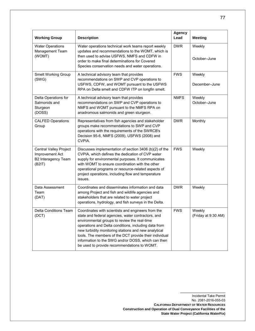
77
Incidental Take Permit No. 2081-2016-055-03
CALIFORNIA DEPARTMENT OF WATER RESOURCES
Construction and Operation of Dual Conveyance Facilities of the
State Water Project (California WaterFix)
Working Group Description
Agency
Lead Meeting
Water Operations Management Team (WOMT)
Water operations technical work teams report weekly updates and recommendations to the WOMT, which is then used to advise USFWS, NMFS and CDFW in order to make final determinations for Covered Species conservation needs and water operations.
DWR Weekly
October–June
Smelt Working Group (SWG)
A technical advisory team that provides recommendations on SWP and CVP operations to USFWS, CDFW, and WOMT pursuant to the USFWS RPA on Delta smelt and CDFW ITP on longfin smelt.
FWS Weekly December–June
Delta Operations for Salmonids and Sturgeon (DOSS)
A technical advisory team that provides recommendations on SWP and CVP operations to NMFS and WOMT pursuant to the NMFS RPA on anadromous salmonids and green sturgeon.
NMFS Weekly October–June
CALFED Operations Group
Representatives from fish agencies and stakeholder groups make recommendations to SWP and CVP operations with the requirements of the SWRCB's Decision 95-6, NMFS (2009), USFWS (2008) and CVPIA.
DWR Monthly
Central Valley Project Improvement Act B2 Interagency Team (B2IT)
Discusses implementation of section 3406 (b)(2) of the CVPIA, which defines the dedication of CVP water supply for environmental purposes. It communicates with WOMT to ensure coordination with the other operational programs or resource-related aspects of project operations, including flow and temperature issues.
FWS Weekly
Data Assessment Team (DAT)
Coordinates and disseminates information and data among Project and fish and wildlife agencies and stakeholders that are related to water project operations, hydrology, and fish surveys in the Delta.
DWR Weekly
Delta Conditions Team (DCT)
Coordinates with scientists and engineers from the state and federal agencies, water contractors, and environmental groups to review the real-time operations and Delta conditions, including data from new turbidity monitoring stations and new analytical tools. The members of the DCT provide their individual information to the SWG and/or DOSS, which can then be used to provide recommendations to WOMT.
FWS Weekly (Friday at 9:30 AM)
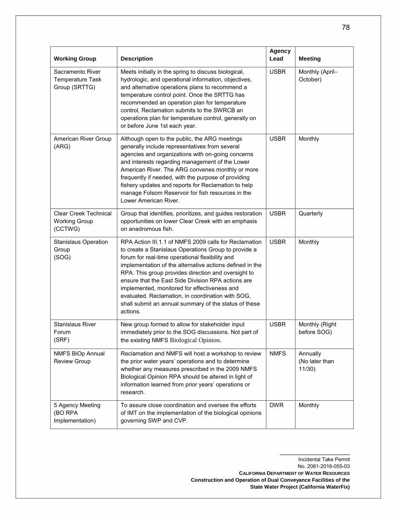
78
Incidental Take Permit No. 2081-2016-055-03
CALIFORNIA DEPARTMENT OF WATER RESOURCES
Construction and Operation of Dual Conveyance Facilities of the
State Water Project (California WaterFix)
Working Group Description
Agency
Lead Meeting
Sacramento River Temperature Task Group (SRTTG)
Meets initially in the spring to discuss biological, hydrologic, and operational information, objectives, and alternative operations plans to recommend a temperature control point. Once the SRTTG has recommended an operation plan for temperature control, Reclamation submits to the SWRCB an operations plan for temperature control, generally on or before June 1st each year.
USBR Monthly (April–October)
American River Group (ARG)
Although open to the public, the ARG meetings generally include representatives from several agencies and organizations with on-going concerns and interests regarding management of the Lower American River. The ARG convenes monthly or more frequently if needed, with the purpose of providing fishery updates and reports for Reclamation to help manage Folsom Reservoir for fish resources in the Lower American River.
USBR Monthly
Clear Creek Technical Working Group (CCTWG)
Group that identifies, prioritizes, and guides restoration opportunities on lower Clear Creek with an emphasis on anadromous fish.
USBR Quarterly
Stanislaus Operation Group (SOG)
RPA Action III.1.1 of NMFS 2009 calls for Reclamation to create a Stanislaus Operations Group to provide a forum for real-time operational flexibility and implementation of the alternative actions defined in the RPA. This group provides direction and oversight to ensure that the East Side Division RPA actions are implemented, monitored for effectiveness and evaluated. Reclamation, in coordination with SOG, shall submit an annual summary of the status of these actions.
USBR Monthly
Stanislaus River Forum (SRF)
New group formed to allow for stakeholder input immediately prior to the SOG discussions. Not part of the existing NMFS Biological Opinion.
USBR Monthly (Right before SOG)
NMFS BiOp Annual Review Group
Reclamation and NMFS will host a workshop to review the prior water years’ operations and to determine whether any measures prescribed in the 2009 NMFS Biological Opinion RPA should be altered in light of information learned from prior years’ operations or research.
NMFS Annually (No later than 11/30)
5 Agency Meeting (BO RPA Implementation)
To assure close coordination and oversee the efforts of IMT on the implementation of the biological opinions governing SWP and CVP.
DWR Monthly
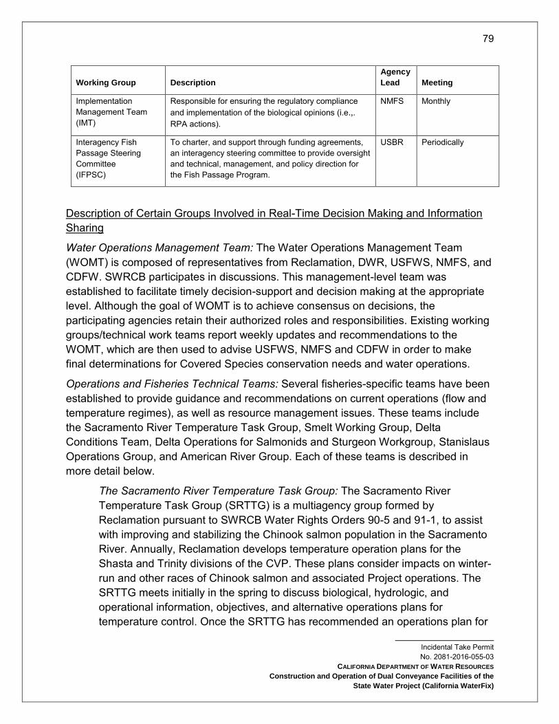
79
Incidental Take Permit No. 2081-2016-055-03
CALIFORNIA DEPARTMENT OF WATER RESOURCES
Construction and Operation of Dual Conveyance Facilities of the
State Water Project (California WaterFix)
Working Group Description
Agency
Lead Meeting
Implementation Management Team (IMT)
Responsible for ensuring the regulatory compliance and implementation of the biological opinions (i.e.,. RPA actions).
NMFS Monthly
Interagency Fish Passage Steering Committee (IFPSC)
To charter, and support through funding agreements, an interagency steering committee to provide oversight and technical, management, and policy direction for the Fish Passage Program.
USBR Periodically
Description of Certain Groups Involved in Real-Time Decision Making and Information Sharing
Water Operations Management Team: The Water Operations Management Team (WOMT) is composed of representatives from Reclamation, DWR, USFWS, NMFS, and CDFW. SWRCB participates in discussions. This management-level team was established to facilitate timely decision-support and decision making at the appropriate level. Although the goal of WOMT is to achieve consensus on decisions, the participating agencies retain their authorized roles and responsibilities. Existing working groups/technical work teams report weekly updates and recommendations to the WOMT, which are then used to advise USFWS, NMFS and CDFW in order to make final determinations for Covered Species conservation needs and water operations.
Operations and Fisheries Technical Teams: Several fisheries-specific teams have been established to provide guidance and recommendations on current operations (flow and temperature regimes), as well as resource management issues. These teams include the Sacramento River Temperature Task Group, Smelt Working Group, Delta Conditions Team, Delta Operations for Salmonids and Sturgeon Workgroup, Stanislaus Operations Group, and American River Group. Each of these teams is described in more detail below.
The Sacramento River Temperature Task Group: The Sacramento River Temperature Task Group (SRTTG) is a multiagency group formed by Reclamation pursuant to SWRCB Water Rights Orders 90-5 and 91-1, to assist with improving and stabilizing the Chinook salmon population in the Sacramento River. Annually, Reclamation develops temperature operation plans for the Shasta and Trinity divisions of the CVP. These plans consider impacts on winter-run and other races of Chinook salmon and associated Project operations. The SRTTG meets initially in the spring to discuss biological, hydrologic, and operational information, objectives, and alternative operations plans for temperature control. Once the SRTTG has recommended an operations plan for

80
Incidental Take Permit No. 2081-2016-055-03
CALIFORNIA DEPARTMENT OF WATER RESOURCES
Construction and Operation of Dual Conveyance Facilities of the
State Water Project (California WaterFix)
temperature control, Reclamation then submits a temperature management plan to SWRCB and NMFS, generally on or before June 1 each year.
After implementation of the operations plan, the SRTTG may report out on the results of studies and monitoring, or temperature model runs. The group holds meetings as needed, typically monthly through the summer and into fall, to recommend plan revisions based on updated biological data, reservoir temperature profiles, and operations data. Updated plans may be needed for summer operations to protect winter-run, or in fall for the fall-run spawning season. If there are any changes in the plan, Reclamation submits a supplemental report to SWRCB.
Smelt Working Group: The Smelt Working Group (SWG) consists of representatives from USFWS, CDFW, DWR, U.S. Environmental Protection Agency (USEPA), Reclamation, and NMFS. USFWS chairs the group, and a member is assigned by each agency. The SWG evaluates biological and technical issues regarding Delta smelt and develops recommendations for consideration by USFWS. After longfin smelt became a state candidate species in 2008, SWG has also developed recommendations for CDFW to minimize adverse effects on longfin smelt.
The SWG compiles and interprets the latest real-time information regarding Delta smelt and longfin smelt, such as stages of development, distribution, and salvage. After evaluating available information, if the SWG members agree that a protective action is warranted, the SWG submits its recommendations in writing to WOMT, USFWS and CDFW.
The SWG may meet at any time at the request of USFWS, but generally meets weekly during the months of January through June, when smelt salvage at the CVP and SWP export facilities has historically occurred.
Stanislaus Operations Group: Reclamation created a Stanislaus Operations Group (SOG) to provide a forum for real-time operational flexibility and implementation of the alternative actions defined in the RPA. This group provides direction and oversight to ensure that the East Side Division actions are implemented, monitored for effectiveness and evaluated. Reclamation, in coordination with SOG, submits an annual summary of the status of these actions. Stakeholders interested in providing information to Reclamation and
81
Incidental Take Permit No. 2081-2016-055-03
CALIFORNIA DEPARTMENT OF WATER RESOURCES
Construction and Operation of Dual Conveyance Facilities of the
State Water Project (California WaterFix)
NMFS regarding Stanislaus River operations are invited to do so via the Stanislaus River Forum (SRF).
Delta Condition Team: The existing SWG and WOMT advise USFWS on smelt conservation needs and water operations. In addition, a Delta Condition Team (DCT), consisting of scientists and engineers from the state and federal agencies, water contractors, and environmental groups, meet weekly to review the real time operations and Delta conditions, including data from new turbidity monitoring stations and new analytical tools such as the Delta smelt behavior model. The members of the DCT provide their individual information to the SWG and the DOSS workgroup. Individual members of the DCT may provide, in accordance with a process provided by the WOMT, their information to the SWG or DOSS for their consideration in developing recommendations to the Project Agencies for actions to protect Covered Species.
Delta Operations Salmonid and Sturgeon Workgroup: The DOSS workgroup is a technical team with relevant expertise from Reclamation, DWR, CDFW, USFWS, SWRCB, U.S. Geological Survey (USGS), USEPA, and NMFS that provides advice to WOMT and to NMFS on issues related to fisheries and water resources in the Delta and recommendations on measures to reduce adverse effects of Delta operations of the CVP and SWP to salmonids and green sturgeon. The purpose of DOSS is to provide recommendations for real-time management of operations to WOMT and NMFS; annually review CVP and SWP operations in the Delta and the collected data from the different ongoing monitoring programs; and coordinate with the SWG to maximize benefits to all listed species.
American River Group (ARG): In 1996, Reclamation established a working group for the Lower American River, known as the American River Group (ARG). Although open to the public, the ARG meetings generally include representatives from several agencies and organizations with ongoing concerns and interests regarding management of the Lower American River. The formal members of the group are Reclamation, USFWS, NMFS, CDFW, and the Water Forum. The ARG convenes monthly or more frequently if needed, with the purpose of providing fishery updates and recommendations for Reclamation to help manage operations at Folsom Dam and Reservoir for the protection of fishery resources in the Lower American River, and with consideration of its other intended purposes (e.g., water and power supply).
South Delta Facilities Real Time Operations
This section describes how the existing South Delta facilities, including the CVP’s Jones Pumping Plant and TFCF and the SWP’s Banks Pumping Plant and Skinner Fish
82
Incidental Take Permit No. 2081-2016-055-03
CALIFORNIA DEPARTMENT OF WATER RESOURCES
Construction and Operation of Dual Conveyance Facilities of the
State Water Project (California WaterFix)
Facility, are currently operated to minimize the risks of predation and entrainment of listed species of fish, and how the CCF is managed for control of invasive aquatic vegetation under USFWS (2008) and NMFS (2009).
C.W. “Bill” Jones Pumping Plant and Tracy Fish Collection Facility: This discussion is provided for informational purposes only as Permittee does not seek incidental take coverage for these facilities. The CVP’s Jones Pumping Plant, about five miles north of Tracy, consists of six available export pumps. The Jones Pumping Plant is located at the end of an earth-lined intake channel about 2.5 miles in length. At the entrance to the intake channel, louver screens (that are part of the TFCF) intercept fish, which are then collected, held, and transported by tanker truck to release sites more than 15 miles away from the pumping plants, in the west Delta near the Sacramento/San Joaquin confluence. The CVP release sites are at the bifurcation between Horseshoe Bend and the Sacramento River (CVP Emmaton) and on the lower San Joaquin River at the Antioch Bridge (CVP Delta Base). Fish salvaged at the CVP are also released at the SWP release sites.
Jones Pumping Plant has a permitted diversion capacity of 4,600 cfs with maximum pumping rates capable of achieving that capacity. The Tracy Fish Collection Facility (TFCF) is located in the south-west portion of the Sacramento-San Joaquin Delta and uses behavioral barriers consisting of primary louvers and secondary screens to guide entrained fish into holding tanks before transport by truck to release sites within the Delta.
Harvey O. Banks Pumping Plant and John E. Skinner Delta Fish Protective Facility: SWP facilities in the southern Delta include CCF, Skinner Fish Facility, and the Banks Pumping Plant. CCF will be extensively modified and repurposed under the Project, as described in the Construction Project Description section, however, the modifications will not impact or change operations of the existing Banks and Skinner facilities.
The Skinner Fish Facility is located west of the CCF, two miles upstream of the Banks Pumping Plant. The Skinner Fish Facility screens fish away from the pumps that lift water into the California Aqueduct. Large fish and debris are directed away from the facility by a 388-foot long trash boom. Smaller fish are diverted from the intake channel into bypasses by a series of metal louvers, while the main flow of water continues through the louvers and toward the pumps. The diverted fish pass through a secondary system of screens and pipes into seven holding tanks, where a sub-sample is counted and recorded. The salvaged fish are then returned to the Delta in oxygenated tank trucks at any one of the four. The active release sites for the SWP are on Sherman Island, one at Horseshoe Bend (SWP Horseshoe Bend) and one on the lower San Joaquin River (SWP
83
Incidental Take Permit No. 2081-2016-055-03
CALIFORNIA DEPARTMENT OF WATER RESOURCES
Construction and Operation of Dual Conveyance Facilities of the
State Water Project (California WaterFix)
Curtis Landing). Fish salvaged at the SWP are also released at the CVP release sites. at Curtis Landing and Horseshoe Bend
The Banks Pumping Plant is in the South Delta, about eight miles northwest of Tracy, and marks the beginning of the California Aqueduct. By means of 11 pumps, including two rated at 375 cfs capacity, five at 1,130 cfs capacity, and four at 1,067 cfs capacity, the plant provides the initial lift of water 244 feet into the California Aqueduct. The nominal capacity of the Banks Pumping Plant is 10,300 cfs, although Corps permits restrict 3- and 7-day averages to 6,680 cfs.
CDFW and USFWS evaluated pre-screen loss and facility/louver efficiency for juvenile and adult Delta smelt at the Skinner Fish Facility. Permittee has also conducted pre-screen loss and facility efficiency studies for steelhead.
Clifton Court Forebay Aquatic Weed Control Program: Permittee will apply herbicides or use mechanical harvesters on an as-needed basis to control aquatic weeds and algal blooms in CCF. Herbicides may include Komeen®, a chelated copper herbicide (copper-ethylenediamine complex and copper sulfate pentahydrate) and Nautique®, a copper carbonate compound. These products are used to control algal blooms that can degrade drinking water quality through tastes and odors and production of algal toxins. Dense growth of submerged aquatic weeds, predominantly Egeria densa, can cause severe head loss and pump cavitation at Banks Pumping Plant when the stems of the rooted plant break free and drift into the trashracks. The resulting blockage necessitates a reduction in the pumping rate of water to prevent potential equipment damage through cavitation at the pumps. Cavitation creates excessive wear and deterioration of the pump impeller blades. Excessive floating weed mats also reduce the efficiency of fish salvage at the Skinner Fish Facility. Ultimately, this all results in a reduction in the volume of water diverted by the SWP. Herbicide treatments will occur only in July and August on an as needed basis in the CCF, dependent upon the level of vegetation biomass in the enclosure.
New and Modified Processes to Support Real-Time Decision Making
RTO will be implemented to minimize take of Covered Species, through the existing decision-making process and related technical work teams identified in the Description
84
Incidental Take Permit No. 2081-2016-055-03
CALIFORNIA DEPARTMENT OF WATER RESOURCES
Construction and Operation of Dual Conveyance Facilities of the
State Water Project (California WaterFix)
of Certain Groups Involved in Real-Time Decision Making and Information Sharing11 section above.
The operational adjustments made through the RTO processes apply only to the facilities and activities identified in the Project. RTOs are expected to be needed during at least some part of the year at the NDD intakes, south Delta diversions, and the HOR Gate. The Project establishes criteria, ranges, and considerations for real time operational adjustments in the North Delta Diversion, South Delta Diversion; and Head of Old River Gate subsections below. The Project includes operations within the criteria.
The operational adjustments made through the RTO processes apply only to the facilities and activities identified in the Project. RTOs are expected to be needed during at least some part of the year at the north and south Delta diversions and the HOR Gate. This Project Description and the Conditions of Approval establish criteria, ranges, and considerations for real time operational adjustments. The Project will operate within the ranges defined in the operating criteria.
The CVP/SWP operators conduct seasonal planning of the CVP/SWP operations, taking into account many factors such as the existing regulatory requirements, forecasted hydrology, contractual demands, etc. The operators also consider any recommendations resulting from the RTO decision making to minimize adverse effects for Covered Species while meeting permit requirements and contractual obligations for water deliveries.
Operational Opportunities Subcommittee: To complement the RTO process, a separate Operational Opportunities subcommittee, as a part of the Interagency Implementation and Coordination Group (IICG) (Attachment 5), will be convened to consider and make recommendations on a case-by-case basis regarding specific short term (within one year) ecological or water supply opportunities that may be available without reducing the ability of the SWP or CVP to deliver water, imposing additional funding obligations on the CVP/SWP Contractors, or adversely impacting Covered Species.
NDD Intakes Real Time Operations: RTOs will govern operations of the NDD intakes for the majority of the December through June salmonid migration period. RTOs will be a key component of NDD intake operations and are intended to minimize take of Covered Fish Species and to support the successful migration of salmonids past the NDD intakes and through the Delta, in combination with other operational components of the Project. Operations necessary to support Delta rearing of juvenile salmonids will be
11 The decision-making process and technical work teams identified here may be changed in response to recommendations made through the Adaptive Management Program described in Attachment 5 and through an amendment to this permit.

85
Incidental Take Permit No. 2081-2016-055-03
CALIFORNIA DEPARTMENT OF WATER RESOURCES
Construction and Operation of Dual Conveyance Facilities of the
State Water Project (California WaterFix)
addressed through the Adaptive Management Program (Attachment 5), due to limited information on rearing flow needs at this time. Post-pulse bypass flow operations may remain at Level 1 diversions depending on fish presence, abundance, and movement in the north Delta; however, the exact levels will be determined through initial operating studies evaluating the level of protection provided at various levels of diversions.
The criteria for transitioning between and among pulse-protection, Level 1, Level 2, and/or Level 3 operations described in this permit will be based on real-time fish monitoring and hydrologic/ behavioral cues upstream of and in the Delta that will be studied as part of the Project’s Adaptive Management Program (Attachment 5) and conditions of this permit. Based on the outcome of the studies pursued under that program, additional information about appropriate triggers, off-ramps, and other RTO management of NDD intake operations may be integrated into the Test Period Operations Plan and the Full Project Operations Plan.
South Delta Diversions Real Time Operations: Beginning with the initiation of the Test Period the south Delta diversions will be managed under RTO requirements of this permit. Additionally, RTO will also be managed to distribute diversions among the three north Delta and two south Delta intake facilities to maximize both survival of Covered Species in the Delta and water supply.
Head of Old River Gate Real Time Operations: Operations for the HOR Gate will be managed under RTOs as described in this permit.
Climate Change
Climate change is anticipated to affect the entire CVP and SWP. The primary foreseeable effects include changes in the hydrograph, sea level rise, and water temperature increases. The Project includes ongoing compliance with D-1641 (the current Bay-Delta Water Quality Control Plan), ongoing compliance with the Fall X2 RPA (USFWS 2008), and a new spring outflow criterion that ensures the same spring outflow exceedance frequencies that would have occurred absent the Project. Reclamation has reinitiated consultation with USFWS and NMFS on the Coordinated Long-Term Operation of the CVP and SWP (LTO). This broadly-scoped consultation is expected to review and possibly update system-wide operating criteria for the LTO consistent with the requirements of ESA Section 7 and is also expected to be coordinated with the SWRCB’s update of the Bay Delta Water Quality Control Plan. Reclamation is required to control water temperature in the Sacramento River pursuant to State Water Board Order WR 90-5. Per the Reasonable and Prudent Alternative (RPA) (Action Suite I.2) in NMFS (2009), Reclamation is required to develop and implement an annual Temperature Management Plan by May 15 each year to manage the cold water supply within Shasta Reservoir and make cold water releases from

86
Incidental Take Permit No. 2081-2016-055-03
CALIFORNIA DEPARTMENT OF WATER RESOURCES
Construction and Operation of Dual Conveyance Facilities of the
State Water Project (California WaterFix)
Shasta Reservoir, and Trinity Reservoir through the Spring Creek Tunnel, to provide suitable temperatures for winter- and spring-run Chinook, and, when feasible, fall-run Chinook salmon. Notwithstanding any changing conditions due to climate change, Reclamation is required to manage operations to achieve certain daily average water temperatures in the Sacramento River between Keswick Dam and Bend Bridge. In addition, Reclamation is required to provide the draft February forecast and initial allocations, as well as a projection of temperature management operations for the summer months to NMFS for review and evaluation under RPA Action I.2.3 in NMFS (2009).
In consideration of recent concerns with the level of protection provided by NMFS (2009) based on the very low egg-to-fry survival to Red Bluff, and new information regarding temperature tolerance during early life stages over the past few years, NMFS will work with Reclamation and other state and Federal agencies to adjust the RPA Action Suite 1.2. The adjustment will be made pursuant to the NMFS (2009) Section 11.2.1.2. Research and Adaptive Management, which states “After completion of the annual review, NMFS may initiate a process to amend specific measures in this RPA to reflect new information, provided that the amendment is consistent with the Opinion’s underlying analysis and conclusions and does not limit the effectiveness of the RPA in avoiding jeopardy to listed species or adverse modification of critical habitat.” This process may include refinements and additions to the existing annual/seasonal temperature management processes, including spring storage targets, revised temperature compliance criteria and a range in summertime Keswick release rates.
As described above, the Project includes spring outflow criteria to ensure that, compared to existing conditions, it does not cause any reduction in spring outflow.
Drought Procedures Drought is a gradual phenomenon and can best be thought of as a condition of water shortage for a particular user in a particular location. Although persistent drought may be characterized as an emergency, it differs from typical emergency events. Most natural disasters, such as floods or forest fires, occur relatively rapidly and afford little time for preparing for disaster response. Droughts occur slowly, over a period of time. Drought impacts increase with the length of a drought, as carry-over supplies in reservoirs are depleted and water levels in groundwater basins decline.
Proposed Future Drought Procedures: In order to address the challenges related to the 2013–2016 drought, federal and state agencies (Reclamation, DWR, USFWS, NMFS, CDFW, and SWRCB) relied heavily on on-going communication and coordination through the Real Time Drought Operations Management Team and frequent meetings of the executive leadership of these agencies. In order to better prepare for future

87
Incidental Take Permit No. 2081-2016-055-03
CALIFORNIA DEPARTMENT OF WATER RESOURCES
Construction and Operation of Dual Conveyance Facilities of the
State Water Project (California WaterFix)
droughts, this type of coordination and communication will need to begin as early as possible. Therefore, on October 1st, if the prior water year was dry or critical12, Reclamation and DWR will convene a multi-agency drought management team to include representatives from Reclamation, DWR, USFWS, NMFS, SWRCB, and CDFW and be charged with evaluating current hydrologic conditions and the potential for continued dry conditions that may necessitate the need for development of a drought contingency plan for the water year. The drought management team will commit to convening at least every month to assess hydrologic conditions and forecast predictions and identify the potential need for development of a drought contingency plan until it is clear that drought conditions for that year will not persist. Information and recommendations from the drought management team will be reported back to the executive leadership of the agencies. These assessments would also inform what actions should be included in a drought contingency plan, depending on the updated hydrology assessment and the magnitude and duration of the preceding dry conditions. While a drought contingency plan may recommend adhering to the operations as identified in existing regulatory authorizations, in longer periods of dry conditions, the plan could also propose other drought response actions. Such a contingency plan should, at a minimum, include information pertaining to: an evaluation of current and forecasted hydrologic conditions and water supplies; recommended actions or changes needed to respond to drought (including changes to project operations, contract deliveries, and regulatory requirements) and any associated water supply or fish and wildlife impacts; identified timeframes; potential benefits; monitoring needs and measures to avoid and minimize fish and wildlife impacts; and proposed mitigation (if necessary).
12 For either Sacramento Valley or San Joaquin Water Year classifications

88
Incidental Take Permit No. 2081-2016-055-03
CALIFORNIA DEPARTMENT OF WATER RESOURCES
Construction and Operation of Dual Conveyance Facilities of the
State Water Project (California WaterFix)
Covered Species Subject to Take Authorization Provided by this ITP:
This ITP covers the following species:
Name CESA Status
Giant garter snake (Thamnophis gigas) Threatened13
California tiger salamander (Ambystoma californiense) Threatened14
Tricolored blackbird (Agelaius tricolor) Candidate15
Swainson’s hawk (Buteo swainsoni) Threatened16
Delta smelt (Hypomesus transpacificus) Endangered17
Longfin smelt (Spirinchus thaleichthys) Threatened18
Spring-run Chinook salmon (Oncorhynchus tshawytscha) Threatened19
Winter-run Chinook salmon (Oncorhynchus tshawytscha) Endangered20
These species and only these species are the “Covered Species” for the purposes of this ITP.
Impacts of the Taking on Covered Species
Project activities and their resulting impacts are expected to result in the incidental take of individuals of the Covered Species. Project activities described above expected to result in incidental take of individuals of the Covered Species include the following: geotechnical exploration, construction of safe haven work areas (which includes site clearing and grading), NDD intake construction and barge landing construction and operation (including site clearing and grading, cofferdam installation, levee clearing and
13 See Cal. Code Regs. tit. 14 § 670.5, subd. (b)(3)(E) 14 See Cal. Code Regs. tit. 14 § 670.5, subd. (b)(3)(G) 15 Take of this species is prohibited, unless otherwise authorized by the Department, during the period that the Fish and Game Commission considers a petition seeking its listing as an endangered species, and determines whether the petitioned action is warranted (See Cal. Reg. Notice Register 2016, No. 2-Z, p. 57.). If the species is added to the list of threatened or endangered species, the species will remain a Covered Species. 16 See Cal. Code Regs. tit. 14 § 670.5, subd. (b)(5)(A) 17 See Cal. Code Regs. tit. 14 § 670.5, subd. (a)(2)(O) 18 See Cal. Code Regs. tit. 14 § 670.5, subd. (b)(2)(E) 19 See Cal. Code Regs. tit. 14 § 670.5, subd. (b)(2)(C) 20 See Cal. Code Regs. tit. 14 § 670.5, subd. (a)(2)(M)
89
Incidental Take Permit No. 2081-2016-055-03
CALIFORNIA DEPARTMENT OF WATER RESOURCES
Construction and Operation of Dual Conveyance Facilities of the
State Water Project (California WaterFix)
grading, riprap installation, dredging, and pile driving), operation of barges, construction of tunneled conveyance facilities (including site clearing and grading), CCF modifications (including relocating transmission towers, expansion and dredging of SCCF, construction of divider wall and east/west embankments, dewatering and excavation of NCCF, construction of NCCF outlet canals and siphons, construction of a SCCF intake structure and a NCCF emergency spillway), construction and maintenance of power supply and grid connections, construction and operation of the HOR Gate, RTM placement and storage, construction or improvement of access roads, maintenance of transmission lines, construction of a new connection canal between the CCF and the Banks pumping plant, and other activities within the Project Area described in the Project Description section of this ITP (Covered Activities). The Project includes modified or new operational criteria for the NDD intakes, south Delta export facilities, and HOR Gate operations. Additionally, the operation of the Suisun Marsh facilities and the NBA are included in the Project once the NDD intakes are operational, but no changes to their operations are proposed. Incidental take of individuals of the Covered Species in the form of mortality (“kill”) may occur as a result of Covered Activities.
Impacts of the authorized taking also include adverse impacts to Covered Species related to temporal losses, increased habitat fragmentation and edge effects, and the Project’s incremental contribution to cumulative impacts (indirect impacts).
The areas where authorized take of the Covered Species is expected to occur include transmission line corridors, geotechnical exploration and safe haven corridors (see Attachment 1, Figures 4a-d), NDD Intake 2 (Attachment 1, Figure 5 Group A), NDD Intake 3 (see Attachment 1, Figure 5 Group B), intake work area (see Attachment 1, Figure 5 Group C), NDD Intake 5 (see Attachment 1, Figure 6 Group D), tunnel work area/substation (see Attachment 1, Figure 6 Group E), RTM storage sites (see Attachment 1, Figure 6 Group F), IF and RTM sites (see Attachment 1, Figure 7 Group G), Staten Island retrieval shaft construction site (see Attachment 1, Figure 7 Group H), Bouldin Island interchange, launch shaft, and RTM site (see Attachment 1, Figure 8 Group I), Bouldin Island barge landing and access road (see Attachment 1, Figure 8 Group I), Mandeville Island barge landing and access road (see Attachment 1, Figure 8 Group J), Bacon Island retrieval shaft construction site and barge landing (see Attachment 1, Figure 9 Group K), Victoria Island barge landing and access road (see Attachment 1, Figure 9 Group L), CCF modifications (see Attachment 1, Figure 9 Group M), HOR Gate and staging and spoils area (see Attachment 1, Figure 10 Group N), and all fish-bearing waterways within the legal Delta and Suisun Marsh, including rivers, sloughs, and other channels (see Attachment 1 and Figure 1).
90
Incidental Take Permit No. 2081-2016-055-03
CALIFORNIA DEPARTMENT OF WATER RESOURCES
Construction and Operation of Dual Conveyance Facilities of the
State Water Project (California WaterFix)
Giant garter snake (Thamnophis gigas)
Project activities and their resulting impacts are expected to result in the incidental take of giant garter snake (GGS) individuals. The Covered Activities expected to result in incidental take of GGS individuals include geotechnical exploration, construction of safe haven sites, NDD intake construction, construction of tunneled conveyance facilities, CCF modifications (including relocating transmission towers), construction and maintenance of power supply and grid connections, construction of the HOR Gate, RTM placement and storage, and construction or improvement of access roads.
Incidental take of GGS individuals in the form of mortality (“kill”) may occur as a result of equipment or vehicles or deposition of stockpiled materials or spoils crushing GGS individuals or crushing burrows, causing entombment inside occupied burrows, during grading and vegetation clearance; facilities maintenance; road construction or improvements; removing equipment or vehicles from storage; stringing of transmission lines; construction of transmission poles, pads, or towers; and geotechnical exploration. Incidental take could also occur in construction sites as a result of trapping GGS individuals in excavated steep-wall holes or trenches; construction materials such as pipes, culverts, or similar structures; construction equipment; erosion material; or construction debris. In aquatic habitat, incidental take of GGS individuals could result from direct strikes with barges, tugboats, or propellers; being crushed by falling or moved rock (riprap); and entrainment by dredging equipment or dewatering pumps. Incidental take of GGS individuals may occur from the Covered Activities in the form of pursue, catch, capture, or attempt to do so from biologists relocating individuals out of project exclusion fencing or construction sites or removing trapped individuals. The areas where authorized take of GGS is expected to occur are described above in Project Area groups A – D, F – G, and I – N, in the geotechnical zone, and in the transmission line and safe haven corridors (Attachment 1, Figures 4-10).
The Project is expected to cause the permanent loss of 570 acres of upland GGS habitat and 205 acres of aquatic GGS habitat and the temporary loss of 165 acres of upland GGS habitat. Vegetation and natural community cover types, crop cover types, wetland delineation and other hydrology data, and occurrence data were included in a GIS habitat model used as a habitat-based proxy to estimate the extent of incidental take in the form of mortality and indirect impacts that will occur as a result of the Project.
Impacts of the authorized taking also include adverse impacts to GGS related to temporal losses, increased habitat fragmentation and edge effects, and the Project’s incremental contribution to cumulative impacts (indirect impacts). These impacts include: direct or secondary poisoning from contaminants; displacement from loss of aquatic or upland habitat vegetation; displacement from noise, vibration, or other

91
Incidental Take Permit No. 2081-2016-055-03
CALIFORNIA DEPARTMENT OF WATER RESOURCES
Construction and Operation of Dual Conveyance Facilities of the
State Water Project (California WaterFix)
disturbances; disturbance or displacement resulting in risks of exposure to predation, vehicle strikes, stress, thermal effects or recreation; and reduction of suitable habitat elements such as pesticides or contaminants causing reduction in prey and rodenticides causing a reduction in burrows.
California tiger salamander (Ambystoma californiense)
Project activities and their resulting impacts are expected to result in the incidental take of California tiger salamander (CTS) individuals. The Covered Activities described above expected to result in incidental take of CTS individuals include geotechnical exploration, the construction of a new connection canal between the CCF and the Banks pumping plant, and the construction and maintenance of power supply and grid connections (e.g., poles and lines).
Incidental take of CTS individuals in the form of mortality (“kill”) may occur as a result of vehicles, heavy equipment, foot traffic, or deposition of stockpiled materials or spoils crushing CTS individuals or crushing burrows, causing entombment inside occupied burrows, during vegetation clearing, excavation, pile driving, cofferdam and embankment construction, and operation of geotechnical exploration and construction equipment; entrapment or burial within trenches or open pipelines; entanglement in erosion control materials, fences, or construction staging materials; and increased light, noise, and vibration that could cause CTS individuals to exit burrows and become active at inappropriate times, potentially increasing exposure to predation and adverse environmental conditions. Incidental take of CTS individuals may also occur from the Covered Activities in the form of catch, capture, or attempt to do so from biologists that relocate individuals out of the construction site or remove trapped individuals. Authorized take of CTS is expected to occur within Project Area Group L and transmission line corridor locations, but only south of the Byron Highway (Attachment 1, Figures 4 and 9).
The Project is expected to cause the permanent loss of 50 acres of terrestrial CTS habitat and the temporary loss of 6 acres of terrestrial CTS habitat. There will be no permanent or temporary loss of aquatic habitat. Impacts of the authorized taking also include adverse impacts to CTS related to temporal losses, increased habitat fragmentation and edge effects, and the Project’s incremental contribution to cumulative impacts (indirect impacts). These impacts include: long-tern health effects due to fugitive dust and other release of contaminants; pesticide or herbicide application affecting CTS directly, reducing vegetation cover, or reducing prey abundance; altered behavior from light disturbance such as failing to migrate to a safer burrow; and loss of small mammal burrows form the use of rodenticides.
92
Incidental Take Permit No. 2081-2016-055-03
CALIFORNIA DEPARTMENT OF WATER RESOURCES
Construction and Operation of Dual Conveyance Facilities of the
State Water Project (California WaterFix)
Tricolored blackbird (Agelaius tricolor)
Project activities and their resulting impacts are expected to result in the incidental take of tricolored blackbird (TRBL) individuals. The Covered Activities expected to result in incidental take of TRBL individuals include geotechnical exploration, construction of safe haven shaft sites, NDD intake construction, construction of tunneled conveyance facilities, CCF modifications (including relocating transmission towers), construction and maintenance of power supply and grid connections, construction of the HOR Gate, RTM placement and storage, and construction or improvement of access roads.
Incidental take of TRBL individuals in the form of mortality (“kill”) may occur during the breeding season (March 1 – August 15) as a result of vehicles or construction equipment crushing occupied nesting colonies; drilling or construction disturbance (eg., pile driving, dredging, excavating, grading, barge traffic, helicopters) causing nest abandonment that exposes eggs or chicks to predation or the elements; removing vegetative cover and exposing eggs or chicks to predation or the elements; and workers or construction activities approaching colonies too closely and causing disturbance. Vehicle or equipment strikes and collisions with transmission lines could cause direct mortality of TRBL individuals in flight. The areas where authorized take of TRBL is expected to occur are described above in Project Area groups A – D, F – I, K – N and in the utility line and geotechnical corridors (Attachment 1, Figures 4-10).
The Project is expected to cause the permanent loss of 3,837 acres of TRBL foraging habitat, 16 acres of TRBL nesting habitat, and 20 acres of TRBL roosting habitat and temporary loss of 676 acres of TRBL foraging habitat. Vegetation and natural community cover types, crop cover and other agricultural types, and occurrence data were included in a GIS habitat model used as a habitat-based proxy to estimate the extent of incidental take in the form of mortality and indirect impacts that will occur as a result of the Project. Impacts of the authorized taking also include adverse impacts to TRBL related to temporal losses, increased habitat fragmentation and edge effects, and the Project’s incremental contribution to cumulative impacts (indirect impacts). These impacts include: construction disturbance causing potential displacement form preferred habitat to less protective habitat; herbicides or vegetation removal causing a decrease in suitable nesting substrate or displaced nesting to less protective habitat; removal or disturbance of roosting habitat impacting protective roosting opportunities; loss of foraging habitat that affects survival or TRBL young due to reduced foraging opportunities; insecticides or other pest control causing a decrease in prey abundance; and fugitive dust or release of other contaminants affecting the health and long term survival of TRBL.
93
Incidental Take Permit No. 2081-2016-055-03
CALIFORNIA DEPARTMENT OF WATER RESOURCES
Construction and Operation of Dual Conveyance Facilities of the
State Water Project (California WaterFix)
Swainson’s hawk (Buteo swainsoni)
Project activities and their resulting impacts are expected to result in the incidental take of Swainson’s hawk (SWHA) individuals . The Covered Activities expected to result in incidental take of SWHA individuals include geotechnical exploration, construction of safe haven shaft sites, NDD intake construction and maintenance, construction and maintenance of tunneled conveyance facilities, CCF modifications (including relocating transmission towers) and maintenance, construction and maintenance of power supply and grid connections, construction and maintenance of the HOR Gate, RTM placement and storage, and construction or improvement of access roads.
Incidental take of SWHA individuals in the form of mortality (“kill”) may occur during the breeding season (March 1 – September 15), in SWHA nesting habitat within 0.5 miles of construction activities, as a result of drilling or construction noise or vibration (e.g., pile driving, excavating, dredging, grading, helicopter operations, barge operations) and light disturbances that cause abandonment of nests and the loss of nestlings or eggs from exposure of the nest to predators and environmental conditions; vehicles, equipment, and workers, or construction activities approaching nest trees too closely or touching or disturbing a nest tree, causing nest abandonment and exposure of eggs or nestlings; trimming or removal of nest trees that take down and destroy an occupied nest and result in mortality of eggs or nestlings; and increased collisions with vehicles, equipment, or transmission lines that could cause direct mortality of SWHA. The areas where authorized take of SWHA is expected to occur are described above in Project Area impact locations groups A – D, F – I, and K – N, and in the utility line corridor (Attachment 1, Figures 4-10).
The Project is expected to cause the permanent loss of 3,770 acres of SWHA foraging habitat and 22 acres of SWHA nesting habitat, including seven nest sites with suitable nest trees, and temporary loss of 1,114 acres of SWHA foraging habitat. Vegetation and natural community cover types, crop cover types, and occurrence data were included in a CDFW-approved habitat model used as a habitat-based proxy to estimate the extent of incidental take in the form of mortality and indirect impacts that will occur as a result of the Project. Impacts of the authorized taking also include adverse impacts to SWHA related to temporal losses, increased habitat fragmentation and edge effects, and the Project’s incremental contribution to cumulative impacts (indirect impacts). These impacts include: the removal of nest trees during the nonbreeding season (September 15 – March 1) resulting in increased competition for suitable, protective nest sites; removal of foraging habitat or foraging habitat disturbances causing reduced foraging opportunities and farther foraging distances, resulting in higher energetic expense to adults and less provisioning of young; fugitive dust and other release of contaminants
94
Incidental Take Permit No. 2081-2016-055-03
CALIFORNIA DEPARTMENT OF WATER RESOURCES
Construction and Operation of Dual Conveyance Facilities of the
State Water Project (California WaterFix)
affecting the health and long-term survival of SWHA; and rodent control causing a decrease in available prey abundance.
Delta smelt (Hypomesus transpacificus) and Longfin smelt (Spirinchus thaleichthys)
Project Construction
Project construction activities and their resulting impacts are expected to result in the incidental take of individuals of Delta smelt (DS) and longfin smelt (LFS). The Covered Activities described above that are expected to result in incidental take of individuals of DS and LFS include: geotechnical exploration; construction activities at the NDD intakes, barge landings, and HOR Gate that include cofferdam installation, levee clearing and grading, riprap installation, dredging, pile driving; modifications to CCF that include expansion and dredging of SCCF, construction of divider wall and east/west embankments, dewatering and excavation of NCCF, construction of NCCF outlet canals and siphons, and construction of a SCCF intake structure and NCCF emergency spillway; and barge operations.
Incidental take of DS and LFS individuals in the form of mortality (“kill”) may occur as a result of Covered Activities. Exposure to underwater noise associated with impact pile driving may lead to direct mortality. Exposure to other underwater noise generated by geotechnical exploration, cofferdam installation, riprap placement, dredging, and barge operations may impair survival through behavioral responses, physiological stress, temporary and permanent hearing loss, and tissue damage (auditory and non-auditory). Increased turbidity and suspended sediment associated with geotechnical exploration, cofferdam installation, levee clearing and grading, dredging, pile driving, and barge operations may result in burial of DS and LFS eggs and embryos. Resuspension of sediment associated with geotechnical exploration, cofferdam installation, levee clearing and grading, dredging, pile driving, and barge operations may lead to lethal exposure of DS and LFS individuals to contaminants. Contaminant spills associated with geotechnical exploration, cofferdam installation, levee clearing and grading, and barge operations may damage gill tissue leading to asphyxiation and may inhibit growth and survival as a result of increased stress or reduced feeding. Direct mortality of DS and LFS may occur as a result of stranding during installation of cofferdams; direct contact with equipment or materials including falling rock (riprap), sheetpiles, dredges, or barge propellers in open waters; exposure to violent “prop wash” conditions associated with barge operations; and stranding due to vessel wake action. Incidental take of individuals of DS and LFS may also occur from the Covered Activities in the form of pursue, catch, capture, or attempt to do so as the result of Minimization Measures involving fish collection, handling, transportation and release.

95
Incidental Take Permit No. 2081-2016-055-03
CALIFORNIA DEPARTMENT OF WATER RESOURCES
Construction and Operation of Dual Conveyance Facilities of the
State Water Project (California WaterFix)
The areas where authorized take of DS and LFS is expected to occur due to Covered Activities are:
Over-water geotechnical exploration at Snodgrass Slough (3 sites), South Fork Mokelumne River (3 sites), San Joaquin River (15 sites), Potato Slough (21 sites), Middle River (2 sites), Connection Slough (9 sites), Old River (6 sites), West Canal (8 sites), and CCF (40 sites)
NDD intakes (the east bank of the Sacramento River between Clarksburg and Courtland at river miles 41.1, 39.4, and 36.8)
Barge landings at Zacharias Island on Snodgrass Slough, Bouldin Island on Little Potato Slough, Venice Island on the San Joaquin River, Mandeville Island near confluence of the San Joaquin River and Middle River, Bacon Island on Middle River, Victoria Island on Middle river, and CCF at the junction of West Canal and Old River. Barges may dock at the NDD intake sites during construction.
Barge operation routes originating from San Francisco, Antioch or the Port of Stockton and transiting through the middle and north San Francisco Bay regions, San Pablo Bay, the Carquinez Strait, Suisun Bay and then through the Sacramento and Stockton deepwater ship channels, the Sacramento River channel above Rio Vista, the San Joaquin River, the Mokelumne River system, Snodgrass Slough, Potato Slough, Middle River, and Old River to reach terminal barge locations.
HOR Gate in Old River approximately 400 feet downstream of the junction of Old River with the San Joaquin River
South Delta Export/ CCF facilities
The Project is expected to cause permanent loss of 500.6 acres of shallow water habitat 25.3 acres of tidal perennial aquatic habitat, and Covered Activities associated with construction in CCF will permanently alter 1,932 acres of tidal perennial habitat and result in the permanent loss of 258 acres of tidal perennial habitat.
Impacts of the authorized taking also include adverse impacts to DS and LFS related to temporal losses, increased habitat fragmentation, and the Project’s incremental contribution to cumulative impacts (indirect impacts). These impacts include: non-lethal stress due to underwater noise and vibrations from pile driving, barge operations, dredging, increased turbidity and sedimentation, long-term effects due to increased contamination, and displacement from habitat. The creation of new predator habitat from the Covered Activities at the NDD intakes, HOR Gate, and barge landings has the potential to lead to an increased vulnerability of DS and LFS to predation mortality.

96
Incidental Take Permit No. 2081-2016-055-03
CALIFORNIA DEPARTMENT OF WATER RESOURCES
Construction and Operation of Dual Conveyance Facilities of the
State Water Project (California WaterFix)
Indirect impacts may also result from the modification and loss of habitat. NDD intake construction has the potential to impede spawning migrations through the affected reach of the Sacramento River due to behavioral responses to construction activity and loss of low velocity shoreline habitat.
Project Operations
Project operation activities and their impacts are expected to result in the incidental take of DS and LFS. The Covered Activities that are expected to result in incidental take of DS and LFS include operations of the: NDD intakes, South Delta Export Facilities, Skinner Fish Facility, CCF Aquatic Weed Control Program, HOR Gate, NBA, Georgiana NPB, and Suisun Marsh Facilities that include the SMSCG, the RRDS, and the MIDS.
North Delta Diversions - Incidental take of adult and larval DS and LFS in the form of mortality (“kill”) may occur as a result of operations of the NDD through entrainment, impingement, and screen contact.
Impacts of the authorized taking also include adverse impacts to DS and LFS individuals related to temporal losses, increased habitat fragmentation and edge effects, and the Project’s incremental contribution to cumulative impacts (indirect effects). These impacts include: increased vulnerability to predation, limited access to spawning habitat upstream of the NDD intakes, reduced Sacramento River flows below the NDD intakes (which has the potential to indirectly take DS and LFS through alteration of larval transport to key rearing areas), reduced Delta outflow, reduced turbidity, exacerbation of harmful algal blooms in rearing habitat downstream of Rio Vista, and entrainment of food web resources. Project-related changes in the position of X2 have the potential to indirectly take rearing DS and LFS by limiting the size of the low salinity zone and shifting the low salinity zone east where food production is lower, water temperatures are higher, and turbidity is reduced. The areas where authorized take of DS and LFS are expected to occur include: the east bank of the Sacramento River between Clarksburg and Courtland at RMs 41.1, 39.4, and 36.8 and the Delta downstream of the NDD intakes.
South Delta Export Facilities - Incidental take of DS and LFS in the form of mortality (“kill”) may occur as a result of operations of the South Delta Export Facilities and the CCF Aquatic Weed Control Program. Operations of the South Delta Export Facilities will result in take of all life stages of DS and LFS beyond the egg stage, but particularly adults, larvae, and early stage juveniles. After being entrained into the export facilities take may occur as a result of fish bypassing salvage operations through the louvered (behavioral) fish screens to the export pumps, and losses during the fish salvage process. South Delta export-related reverse flows in Old and Middle rivers can draw turbidity, that DS are associated with, and pre-spawn adult DS and LFS into the interior

97
Incidental Take Permit No. 2081-2016-055-03
CALIFORNIA DEPARTMENT OF WATER RESOURCES
Construction and Operation of Dual Conveyance Facilities of the
State Water Project (California WaterFix)
Delta where they are subjected to higher exposure to entrainment risk at the South Delta Export Facilities. Incidental take of larval and juvenile DS and LFS is similar to adults, except that these smaller life stages are much less likely to be effectively screened by the louvered (behavioral) screens employed at the Skinner Fish Facility, and thus tend to be transported to the export pumps. Larval and juvenile DS and LFS produced by adults that spawn in the South Delta are particularly susceptible to take at the South Delta export facilities, even at low levels of operation. Incidental take of individuals of the DS and LFS may also occur from the Covered Activities in the form of pursue, catch, capture, or attempt to do so during the fish salvage process. The areas where authorized take of DS and LFS is expected to occur include: the South Delta Export Facilities and CCF located about eight miles northwest of Tracy.
Impacts of the authorized taking also include adverse impacts to DS and LFS individuals related to the Project’s incremental contribution to cumulative impacts (indirect effects). These impacts include: increased vulnerability to predation within the modified CCF, entrainment of larval and juvenile DS and LFS into unfavorable southern Delta habitats through reverse flows in the Old and Middle rivers as a result of South Delta export operations, impaired feeding opportunities, entrainment of food web resources, and elevated selenium concentrations in fish tissues as a result of increased San Joaquin River flows. Project operations of the south Delta export facilities will cause hydrodynamic effects that will result in impacts to DS and LFS larvae, juveniles and adults occurring in the South Delta. Operations of south Delta facilities will also increase larval transport into the central Delta.
Head of Old River Gate - Incidental take of DS and LFS in the form of mortality (“kill”) may occur as a result of operations of the HOR Gate. HOR Gate operations will alter Old and Middle River hydraulics, resulting in short term increases Old and Middle river reverse flows. Increases in Old and Middle River reverse flows in turn may increase the entrainment of DS and LFS (larvae, early juvenile life stages, and migrating and spawning adults) into the South Delta Export Facilities. The area where authorized take of DS and LFS is expected to occur is at the divergence of the head of Old River and the San Joaquin River.
Impacts of the authorized taking also include adverse impacts to DS and LFS individuals related to the Project’s incremental contribution to cumulative impacts (indirect effects). These impacts include increased vulnerability to predation through creation of enhanced predatory fish habitat adjacent to the HOR Gate.
North Bay Aqueduct - Incidental take of DS and LFS in the form of mortality (“kill”) may occur as a result of operations of the NBA by means of entrainment, impingement and screen contact. The area where authorized take of DS and LFS is expected to occur is

98
Incidental Take Permit No. 2081-2016-055-03
CALIFORNIA DEPARTMENT OF WATER RESOURCES
Construction and Operation of Dual Conveyance Facilities of the
State Water Project (California WaterFix)
approximately 10 miles from the mainstem Sacramento River at the end of Barker Slough.
Impacts of the authorized taking also include adverse impacts to DS and LFS related to the Project’s incremental contribution to cumulative impacts (indirect impacts). These impacts include non-lethal impingement/screen contact and increased vulnerability to predation.
Georgiana Slough Non-Physical Barrier - Incidental take of DS and LFS in the form of mortality (“kill”) may occur as a result of operations of the Georgiana NPB by means of direct contact of larvae and young juveniles with structures associated with the NPB. The area where authorized take of DS and LFS is expected to occur is the confluence of the Sacramento River and Georgiana Slough.
Impacts of the authorized taking also include adverse impacts to DS and LFS related to temporal losses, increased habitat fragmentation and edge effects and the Project’s incremental contribution to cumulative impacts (indirect impacts). These impacts include the Georgiana NPB structure impeding migration of adult DS and LFS upstream to preferred spawning habitat and increased vulnerability to predation associated with the operation of in-water structures that predatory fish may use as ambush habitat.
Suisun Marsh Facilities - Incidental take of DS and LFS in the form of mortality (“kill”) may occur as a result of operations of RRDS, MIDS, and SMSCG by means of entrainment, impingement, and screen contact. The areas where authorized take of DS and LFS is expected to occur include: Montezuma Slough about two miles downstream from the confluence of the Sacramento and San Joaquin Rivers, the confluence of Roaring River and Montezuma Slough, and at Goodyear Slough south of Pierce Harbor.
Impacts of the authorized taking also include adverse impacts to DS and LFS related to the Project’s incremental contribution to cumulative impacts (indirect impacts). These impacts include non-lethal impingement/screen contact and increased vulnerability to predation.
Winter-run Chinook salmon and Spring-run Chinook salmon (Oncorhynchus tshawytscha)
Project Construction
Project construction activities and their resulting impacts are expected to result in the incidental take of individuals of winter-run Chinook salmon (CHNWR) and spring-run Chinook salmon (CHNSR). The Covered Activities described above expected to result in incidental take of CHNWR and CHNSR include: geotechnical exploration;
99
Incidental Take Permit No. 2081-2016-055-03
CALIFORNIA DEPARTMENT OF WATER RESOURCES
Construction and Operation of Dual Conveyance Facilities of the
State Water Project (California WaterFix)
construction activities at the NDD intakes, barge landings, and HOR Gate that include cofferdam installation, levee clearing and grading, riprap installation dredging, pile driving; modifications to CCF that include expansion and dredging of SCCF, construction of divider wall and east/west embankments, dewatering and excavation of NCCF, construction of NCCF outlet canals and siphons, and construction of a SCCF intake structure and NCCF emergency spillway; and barge operations.
Incidental take of CHNWR and CHNSR individuals in the form of mortality (“kill”) may occur as a result of Covered Activities. Exposure to underwater noise associated with impact pile driving may lead to direct mortality. Exposure to other underwater noise generated by geotechnical exploration, cofferdam installation, riprap placement, dredging, and barge operations may impair survival through behavioral responses, physiological stress, temporary and permanent hearing loss, and tissue damage (auditory and non-auditory). Resuspension of contaminated sediment associated with geotechnical exploration, riprap placement, cofferdam installation, levee clearing and grading, dredging, pile driving, and barge operations may lead to lethal exposure of CHNWR and CHNSR individuals. Contaminant spills associated with geotechnical exploration, cofferdam installation, levee clearing and grading, and barge operations may damage gill tissue leading to asphyxiation and may inhibit growth and survival as a result of increased stress or reduced feeding. Direct mortality of CHNWR and CHNSR may occur as a result of stranding during installation of cofferdams; direct contact with equipment or materials including falling rock (riprap), sheetpiles, dredges, or barge propellers in open waters; exposure to violent “prop wash” conditions associated with barge operations; and stranding due to vessel wake action. Incidental take of individuals of CHNWR and CHNSR may also occur from the Covered Activities in the form of pursue, catch, capture, or attempt to do so as the result of Minimization Measures involving fish collection, handling, transportation and release.
The areas where authorized take is expected to occur due to Covered Activities are:
Over-water geotechnical exploration at Snodgrass Slough (3 sites), South Fork Mokelumne River (3 sites), San Joaquin River (15 sites), Potato Slough (21 sites), Middle River (2 sites), Connection Slough (9 sites), Old River (6 sites), West Canal (8 sites), and CCF (40 sites).
NDD intakes (the east bank of the Sacramento River between Clarksburg and Courtland at river miles 41.1, 39.4, and 36.8).
Barge landings at: Zacharias Island on Snodgrass Slough, Bouldin Island on Little Potato Slough, Venice Island on the San Joaquin River, Mandeville Island near confluence of the San Joaquin River and Middle River, Bacon Island on Middle River, Victoria Island on Middle river, and CCF at the junction of West
100
Incidental Take Permit No. 2081-2016-055-03
CALIFORNIA DEPARTMENT OF WATER RESOURCES
Construction and Operation of Dual Conveyance Facilities of the
State Water Project (California WaterFix)
Canal and Old River. Barge operation routes originating from San Francisco, Antioch or the Port of Stockton and transiting through the middle and north San Francisco Bay regions, San Pablo Bay, the Carquinez Strait, Suisun Bay and then through the Sacramento and Stockton deepwater ship channels, the Sacramento River channel above Rio Vista, the San Joaquin River, the Mokelumne River system, Snodgrass Slough, Potato Slough, Middle River, and Old River to reach terminal barge locations.
HOR Gate (in Old River approximately 400 feet downstream of the junction of Old River with the San Joaquin River), and
South Delta Export/ CCF facilities.
Construction of the Project is expected to cause the permanent loss of 1.02 linear miles of channel margin habitat and 31.9 acres of tidal perennial aquatic habitat. Project construction is expected to permanently alter 2,190 acres of non-tidal perennial aquatic habitat in CCF suitable for CHNWR and CHNSR. Project construction is also is expected to temporarily affect 20.1 acres of tidal perennial aquatic habitat.
Impacts of the authorized taking also include adverse impacts to CHNWR and CHNSR related to temporal losses and increased habitat fragmentation, through the Project’s incremental contribution to cumulative impacts (indirect impacts). These impacts include: stress resulting from underwater noise and vibrations from pile driving, barge operations, dredging, increased turbidity and sedimentation, capture and relocation, long-term effects due to increased contamination, and displacement from habitat. The creation of new predator habitat at the facilities (NDD intakes, HOR Gate, and barge landings) may increase juvenile CHNWR and CHNSR vulnerability to predation.
Project Operations
Project operation activities and their resulting impacts are expected to result in the incidental take of CHNWR and CHNSR. The Covered Activities which are expected to result in incidental take of individuals of CHNWR and CHNSR include operations of the: NDD intakes, South Delta Export Facilities, Skinner Fish Facility, HOR Gate, and CCF Aquatic Weed Control Program.
North Delta Diversions - Incidental take of CHNWR and CHNSR in the form of mortality (“kill”) may occur as a result of operations of the NDD intakes by means of entrainment, impingement, and screen contact. Operations of the NDD intakes may also result in reduced through-Delta survival via reduced flow volume and velocity below the NDD intakes that impacts suitable rearing and migration habitat.
101
Incidental Take Permit No. 2081-2016-055-03
CALIFORNIA DEPARTMENT OF WATER RESOURCES
Construction and Operation of Dual Conveyance Facilities of the
State Water Project (California WaterFix)
The areas where authorized take of the CHNWR and CHNSR is expected to occur include: the location of the NDD intakes at the east bank of the Sacramento River between Clarksburg and Courtland at RMs 41.1, 39.4, and 36.8 and the Delta downstream of the NDD intakes.
The operation of the NDDs is expected to cause the permanent loss of 0.42 linear miles of restored channel margin habitat for CHNWR and CHNSR. Impacts to natural riparian bench habitat and other habitat types utilized for juvenile rearing and as temporary refugia for migrating salmonids are expected as a result of reduction in flow downstream of the NDD intakes.
Impacts of the authorized taking associated with Project operations also include indirect impacts to CHNWR and CHNSR related to temporal losses, increased habitat fragmentation and the Project’s incremental contribution to cumulative impacts (indirect impacts). These impacts include: increased migration time of emigrating fry, parr and smolts leading to increased vulnerability to predation, other sources of mortality and injury, and greater risk of entry into migration routes with higher mortality such as Georgiana Slough. Risk of entry into the interior Delta, where mortality rates of juvenile salmonids are relatively higher, is expected to increase with operations of the Project because reduced net flow downstream of the NDD intakes would result in greater tidal influence and, therefore, more reverse flow at the Sacramento River junction with the DCC and Georgiana Slough. Vulnerability to predation is expected to increase in the vicinity of the NDD intakes.
South Delta Export Facilities - Incidental take of CHNWR and CHNSR in the form of mortality (“kill”) may occur as a result of operations of the South Delta Export Facilities by means of entrainment, mechanical removal of aquatic vegetation, exposure to herbicides used to control aquatic vegetation, fish bypassing salvage operations through the louvered (behavioral) fish screens to the export pumps, and losses during the salvage process. Mechanical removal of aquatic weeds has the potential to result in take through direct physical injury. The CCF Aquatic Weed Control Program uses copper-based herbicides in CCF, which would result in injury and mortality of CHNWR and CHNSR. Incidental take of individuals of CHNWR and CHNSR may also occur from the Covered Activities in the form of pursue, catch, capture, or attempt to do so of individuals during salvage at the Skinner Fish Facility. The areas where authorized take of CHNWR and CHNSR is expected to occur include: the South Delta export facilities and CCF located about eight miles northwest of Tracy.
Impacts of the authorized taking associated with Project operations also include adverse impacts to CHNWR and CHNSR related to the Project’s incremental contribution to cumulative impacts (indirect impacts). Project operations of the south

102
Incidental Take Permit No. 2081-2016-055-03
CALIFORNIA DEPARTMENT OF WATER RESOURCES
Construction and Operation of Dual Conveyance Facilities of the
State Water Project (California WaterFix)
Delta export facilities will cause hydrodynamic effects that will result in impacts to juvenile CHNWR and CHNSR emigrating from the Sacramento River basin and entering the interior Delta. These impacts include: increased migration time of emigrating fry, parr and smolts leading to increased vulnerability to predation, other sources of mortality and injury, and greater risk of entry into migration routes with higher mortality such as Georgiana Slough and increased exposure to entrainment at the South Delta export facilities. These impacts also include increased vulnerability to predation within CCF.
Head of Old River Gate - Impacts of the authorized taking associated with Project operations include adverse impacts to CHNWR and CHNSR related to the Project’s incremental contribution to cumulative impacts (indirect impacts). These impacts include increased vulnerability to predation in the vicinity of the HOR Gate. The area where authorized take of CHNWR and CHNSR is expected to occur is located at the divergence of the head of Old River and the San Joaquin River.
North Bay Aqueduct - Incidental take of juvenile CHNWR and CHNSR in the form of mortality (“kill”) may occur as a result of operations of the NBA by means of entrainment, impingement and screen contact. The area where authorized take of CHNWR and CHNSR is expected to occur is approximately 10 miles from the mainstem Sacramento River at the end of Barker Slough.
Impacts of the authorized taking also include adverse impacts to CHNWR and CHNSR related to the Project’s incremental contribution to cumulative impacts (indirect impacts). These impacts include non-lethal impingement/screen contact and increased vulnerability to predation.
Suisun Marsh Facilities - Incidental take of juvenile CHNWR and CHNSR in the form of mortality (“kill”) may occur as a result of operations of RRDS and MIDS by means of entrainment, impingement, and screen contact. The areas where authorized take of CHNWR and CHNSR is expected to occur include: Montezuma Slough about two miles downstream from the confluence of the Sacramento and San Joaquin Rivers, the confluence of Roaring River and Montezuma Slough, and at Goodyear Slough south of Pierce Harbor.
Impacts of the authorized taking also include adverse impacts to CHNWR and CHNSR related to the Project’s incremental contribution to cumulative impacts (indirect impacts). These impacts include non-lethal impingement/screen contact, increased vulnerability to predation, and potential migration delays for adult CHNWR and CHNSR at the SMSCG.
Georgiana Slough Non-Physical Barrier - Impacts of the authorized taking include adverse impacts to CHNWR and CHNSR related to temporal losses, increased habitat

103
Incidental Take Permit No. 2081-2016-055-03
CALIFORNIA DEPARTMENT OF WATER RESOURCES
Construction and Operation of Dual Conveyance Facilities of the
State Water Project (California WaterFix)
fragmentation and edge effects and the Project’s incremental contribution to cumulative impacts (indirect impacts). These impacts include the creation of new predator habitat at the facilities which may increase juvenile CHNWR and CHNSR vulnerability to predation and increased migration timing for adult CHNWR and CHNSR.
Incidental Take Authorization of Covered Species
This ITP authorizes incidental take of the Covered Species and only the Covered Species. With respect to incidental take of the Covered Species, CDFW authorizes the Permittee, its employees, contractors, and agents to take Covered Species incidentally in carrying out the Covered Activities, subject to the limitations described in this section and the Conditions of Approval identified below. This ITP does not authorize take of Covered Species from activities outside the scope of the Covered Activities, take of Covered Species outside of the Project Area, take of Covered Species resulting from violation of this ITP, or intentional take of Covered Species except for capture and relocation of Covered Species as authorized by this ITP. Take or possession occurring in the conduct of Covered Activities that is otherwise prohibited under the Fish and Game Code is not authorized by this ITP, and is subject to enforcement pursuant to the Fish and Game Code, or any other provision of law.
Conditions of Approval:
Unless specified otherwise, the following measures apply to all Covered Activities within the Project Area, including areas used for vehicular ingress and egress, staging and parking, and noise and vibration generating activities that may/will cause take. CDFW’s issuance of this ITP and Permittee’s authorization to take the Covered Species are subject to Permittee’s compliance with and implementation of the following Conditions of Approval:
1. Legal Compliance: Permittee shall comply with all applicable federal, state, and local laws in existence on the effective date of this ITP or adopted thereafter.
2. CEQA Compliance: Permittee shall implement and adhere to the mitigation measures related to the Covered Species in the Biological Resources section of the Bay Delta Conservation Plan/California WaterFix Final Environmental Impact Report/Environmental Impact Statement (EIR/EIS) (State Clearinghouse No. 2008032062) certified by DWR on July 21, 2017 as lead agency for the Project pursuant to the California Environmental Quality Act (CEQA) (Pub. Resources Code, § 21000 et seq.).

104
Incidental Take Permit No. 2081-2016-055-03
CALIFORNIA DEPARTMENT OF WATER RESOURCES
Construction and Operation of Dual Conveyance Facilities of the
State Water Project (California WaterFix)
3. LSA Agreement Compliance: Permittee shall implement and adhere to the mitigation measures and conditions related to the Covered Species in any Lake and Streambed Alteration Agreement (LSAA) for the Project executed by CDFW pursuant to Fish and Game Code section 1600 et seq.
4. ESA Compliance: Permittee shall implement and adhere to the terms and conditions related to the Covered Species in the USFWS Biological Opinion for the California WaterFix (Service File No. 08FBDT00-2016-F-0247) and the NMFS California WaterFix Biological Opinion (NMFS Consultation No: WCR-2016-5506) for the Project pursuant to the Federal Endangered Species Act (ESA). For purposes of this ITP, where the terms and conditions for the Covered Species in the federal authorization are less protective of the Covered Species or otherwise conflict with this ITP, the conditions of approval set forth in this ITP shall control.
5. ITP Time Frame Compliance: Permittee shall fully implement and adhere to the conditions of this ITP within the time frames set forth below and as set forth in the Mitigation Monitoring and Reporting Program (MMRP), which is included as Attachment 2 to this ITP.
6. Consultation Regarding Amendment: This permit may require an amendment if any one of the following conditions occur:
Modification, amendment or replacement of the FWS 2008 Biological Opinion for Delta smelt (USFWS 2008) or the NMFS 2009 Biological Opinion and Conference Opinion on the Long-term Operations of the Central Valley Project and the State Water Project (NMFS 2009), the 2017 NMFS or FWS biological opinion identified in Condition 4 of this permit, or any subsequent biological opinion addressing the coordinated operations of the CVP and SWP.
Modification, replacement or renewal of Incidental Take Permit No. 2081-2009-001-03, or replacement of Consistency Determination Nos. 2080-2011-022-00 or 2080-2012-005-00.
Modification to the Water Quality Control Plan for the San Francisco Bay/Sacramento-San Joaquin Delta Estuary or water rights decisions by the SWRCB affecting operations of the Project.
Modifications to the project description, monitoring, studies, or Project operational criteria identified in this permit as these measures are incorporated into the Test Period Operations Plan or the Full Project Operations Plan.
105
Incidental Take Permit No. 2081-2016-055-03
CALIFORNIA DEPARTMENT OF WATER RESOURCES
Construction and Operation of Dual Conveyance Facilities of the
State Water Project (California WaterFix)
Modifications to the project description, monitoring, studies, or Project operational criteria evaluated and requested through the Adaptive Management Program for the California Water Fix and Current Biological Opinions on the Coordinated Operations of the Central Valley and State Water Projects (Attachment 5).
An unanticipated emergency condition arises that imposes a serious threat to public health or safety.
Permittee shall notify CDFW if any of the conditions listed above occur. Permittee shall consult with CDFW if any of the conditions listed above occur to determine whether an amendment is necessary for reasons including but not limited to an increase in the anticipated extent of the taking of Covered Species or the impacts on the Covered Species that result from the Covered Activities, or modifications to the necessary and appropriate measures to minimize and fully mitigate the impacts of the taking. Permittee shall submit an application and supporting information to CDFW if it requests an amendment, in compliance with the California Code of Regulations, section 783.6, subdivision (c)(1). CDFW will follow the amendment process outlined in the California Code of Regulations, section 783.6, subdivision (c) to determine whether any proposed amendment is major or minor and whether additional or modified measures are necessary. This condition does not modify CDFW’s authorities or obligations pursuant to CESA, including the obligation to amend this permit as required by law.
7. General Provisions
7.1 Designated Representative. Before starting Covered Activities, Permittee shall designate a representative (Designated Representative) responsible for communications with CDFW and overseeing compliance with this ITP. Permittee shall notify CDFW in writing before starting Covered Activities of the Designated Representative’s name, business address, and contact information, and shall notify CDFW in writing if a substitute Designated Representative is selected or identified at any time during the term of this ITP.
7.2 Designated Biologist. Permittee shall submit to CDFW in writing the name, qualifications, business address, and contact information of one or more biological monitor(s) (Designated Biologist(s)) at least 30 days before starting Covered Activities. Permittee shall ensure that each Designated Biologist is knowledgeable and experienced in the biology, natural history, collecting and handling of the Covered Species. The Designated Biologist(s) shall be responsible for monitoring Covered Activities to help minimize and fully mitigate or avoid the incidental take of individual
106
Incidental Take Permit No. 2081-2016-055-03
CALIFORNIA DEPARTMENT OF WATER RESOURCES
Construction and Operation of Dual Conveyance Facilities of the
State Water Project (California WaterFix)
Covered Species and to minimize disturbance of Covered Species’ habitat. Permittee shall obtain CDFW approval of a Designated Biologist in writing before starting Covered Activities, and shall also obtain approval in advance in writing if a Designated Biologist must be changed.
7.3 Designated Fisheries Biologist. Permittee shall submit to CDFW in writing the name, qualifications, business address, and contact information of one or more fisheries biologist (s) (Designated Fisheries Biologist(s)) at least 30 days before starting Covered Activities. Permittee shall ensure that each Designated Fisheries Biologist has 1) a four-year college degree in fisheries or biology, or a related degree, 2) at least two years of professional experience in fisheries field surveys and fish capture and handling procedures, and 3) completed an electrofishing training course such as Principles and Techniques of Electrofishing (USFWS, National Conservation Training Center), or similar course. The Designated Fisheries Biologist(s) shall be responsible for monitoring in-water Covered Activities and fish salvage to help minimize or avoid the incidental take of individual Covered Fish Species and to minimize disturbance of Covered Fish Species’ habitat. Permittee shall obtain CDFW approval of the Designated Fisheries Biologist in writing before starting Covered Activities, and shall also obtain approval in advance in writing if a Designated Fisheries Biologist must be changed.
7.4 Designated Biologist and Designated Fisheries Biologist Authority. To ensure compliance with the Conditions of Approval of this ITP, the Designated Biologist and Designated Fisheries Biologist shall have authority to immediately stop any activity that does not comply with this ITP, and/or to order any reasonable measure to avoid the unauthorized take of an individual of the Covered Species.
7.5 Education Program. Permittee shall conduct an education program for all persons employed or otherwise working in the Project Area before performing any work. The program shall consist of a presentation from the Designated Biologist or Designated Fisheries Biologist that includes:
Important timing windows for Covered Species, including information about the distribution and habitat needs of the Covered Species
Sensitivity of the Covered Species to human activities
Take minimization measures that will be implemented during Covered Activities
Protocols for identifying relevant take minimization measures based on the nature, timing, and location of Covered Activities
107
Incidental Take Permit No. 2081-2016-055-03
CALIFORNIA DEPARTMENT OF WATER RESOURCES
Construction and Operation of Dual Conveyance Facilities of the
State Water Project (California WaterFix)
Species of Special Concern and federally listed species that may be present on the construction site but are not Covered Species
Boundaries of the construction site and demarcation of disturbance-free zones
Covered Species habitat avoidance commitments
Exclusion and construction fencing installation and monitoring
Roles and responsibilities of workers, managers, Designated Representative, Designated Biologist(s), and Designated Fisheries Biologist(s)
Measures to take when encountering Covered Species and what to do when Covered Species are found dead, injured, stressed, or entrapped
Covered Species status pursuant to CESA (including legal protection) and penalties for violations and Project-specific protective measures described in this ITP
Permittee shall provide interpretation for non-English speaking workers, and the same instruction shall be provided to any new workers before they are authorized to perform work in the Project Area. Permittee shall prepare and distribute wallet-sized cards or a fact sheet handout containing this information for workers to carry in the Project Area. Upon completion of the program, employees shall sign a form stating they attended the program and understand all protection measures. This training shall be repeated at least once annually for long-term and/or permanent employees that will be conducting work in the Project Area.
7.6 Construction Monitoring Notebook. The Designated Biologist shall maintain a construction-monitoring notebook on-site throughout the construction period, which shall include a copy of this ITP with attachments and a list of signatures of all personnel who have successfully completed the education program. Permittee shall ensure a copy of the construction-monitoring notebook is available for review at the Project site upon request by CDFW.
7.7 Trash Abatement. Permittee shall initiate a trash abatement program before starting Covered Activities and shall continue the program for the duration of the Project. Permittee shall ensure that trash and food items are contained in animal-proof containers and removed at least once a week to avoid attracting opportunistic predators such as ravens, coyotes, and feral dogs.
7.8 Dust Control. Permittee shall implement dust control measures during Covered Activities to facilitate visibility for monitoring of the Covered Species by the Designated
108
Incidental Take Permit No. 2081-2016-055-03
CALIFORNIA DEPARTMENT OF WATER RESOURCES
Construction and Operation of Dual Conveyance Facilities of the
State Water Project (California WaterFix)
Biologist. Permittee shall keep the amount of water used to the minimum amount needed, and shall not allow water to form puddles.
7.9 Delineation of Property Boundaries. Before starting Covered Activities Permittee shall clearly delineate the boundaries of the construction site with fencing, stakes, or flags. Permittee shall restrict all Covered Activities to within the fenced, staked, or flagged areas. Permittee shall maintain all fencing, stakes, and flags until the completion of Covered Activities in that area.
7.10 Delineation of Habitat. Permittee shall clearly delineate habitat of the Covered Species within the Project Area with posted signs, posting stakes, flags, and/or rope or cord, and place fencing as necessary to minimize the disturbance of Covered Species’ habitat.
7.11 Project Related Vehicle Use. Permittee shall restrict all project-related vehicle or heavy equipment traffic to established roadways or designated ingress/egress routes within the Project Area. Project-related personnel shall observe a speed limit of 20 miles per hour in construction sites, except on county roads, state and federal highways, and other roads where 20 miles per hour would unsafely impede the normal flow of traffic. Permittee shall post a vehicle speed limit of 20 miles per hour on all nonpublic construction and access roads.
7.12 Vehicle Parking and Staging Areas. Permittee shall confine project-related vehicles, storage areas, equipment storage, and laydown sites to the Project Area using previously disturbed locations to the extent possible. Permittee shall restrict all vehicle parking to established construction sites, existing roads, or cleared areas.
7.13 Visual Inspections. Project personnel shall visually check for Covered Species under vehicles and equipment prior to moving them.
7.14 Hazardous Waste. Permittee shall immediately stop and, pursuant to pertinent state and federal statutes and regulations, arrange for repair and clean up by qualified individuals of any fuel or hazardous waste leaks or spills at the time of occurrence, or as soon as it is safe to do so. Permittee shall exclude the storage and handling of hazardous materials from the Project Area and shall properly contain and dispose of any unused or leftover hazardous products off-site.
7.15 CDFW Access. Permittee shall provide CDFW staff with reasonable access to the Project, and shall otherwise fully cooperate with CDFW efforts to verify compliance with or effectiveness of mitigation measures set forth in this ITP.
7.16 Refuse Removal. Upon completion of Covered Activities, Permittee shall remove from the Project Area and properly dispose of all temporary fill and construction refuse,
109
Incidental Take Permit No. 2081-2016-055-03
CALIFORNIA DEPARTMENT OF WATER RESOURCES
Construction and Operation of Dual Conveyance Facilities of the
State Water Project (California WaterFix)
including, but not limited to, broken equipment parts, wrapping material, cords, cables, wire, rope, strapping, twine, buckets, metal or plastic containers, flags, and boxes.
8. Monitoring, Notification, and Reporting Provisions
8.1 Notification Before Commencement. The Designated Representative shall notify CDFW 14 calendar days before starting Covered Activities and shall document compliance with all pre-Project Conditions of Approval before starting Covered Activities.
8.2 Notification of Non-compliance. The Designated Representative shall immediately notify CDFW in writing if it determines that the Permittee is not in compliance with any Condition of Approval of this ITP, including but not limited to any actual or anticipated failure to implement measures within the time periods indicated in this ITP and/or the MMRP. The Designated Representative shall report any non-compliance with this ITP to CDFW within 24 hours.
8.3 Compliance Monitoring. The Designated Biologist(s) shall be on-site daily at each construction site within the Project Area when Covered Activities occur. The Designated Biologist(s) shall conduct compliance inspections to: (1) minimize incidental take of the Covered Species; (2) prevent unlawful take of species; (3) check for compliance with all measures of this ITP; (4) check all exclusion zones; (5) ensure that signs, stakes, and fencing are intact; and (6) ensure that Covered Activities are only occurring in the Project Area. During initial vegetation and soil disturbance, the Designated Biologist(s) shall monitor compliance continuously where Covered Activities are occurring. After initial vegetation and soil disturbance, the Designated Biologist(s) shall conduct compliance inspections a minimum of once per day where Covered Activities are occurring. The Designated Representative or Designated Biologist(s) shall prepare daily written observation and inspection records summarizing: oversight activities and compliance inspections, observations of Covered Species and their sign, survey results, and monitoring activities required by this ITP. Permittee shall compile and report observation and inspection records as described in Condition of Approval 8.6. The Designated Biologist(s) shall conduct compliance inspections a minimum of monthly during periods of inactivity and after clearing, grubbing, and grading are completed.
8.4 Tracking Suitable Habitat Feature Disturbances, Map Updating, and Reporting. Permittee shall maintain Geographic Information System (GIS) shapefile layers and associated maps depicting: 1) mapped areas of all land disturbances within the Project Area; and 2) mapped areas of disturbed identified habitat features suitable for Covered Species (see Condition of Approval 8.4.1 for habitat features) within the Project Area
110
Incidental Take Permit No. 2081-2016-055-03
CALIFORNIA DEPARTMENT OF WATER RESOURCES
Construction and Operation of Dual Conveyance Facilities of the
State Water Project (California WaterFix)
(as depicted in Attachment 1, Figures 1-10). Permittee shall maintain the GIS layers and metadata for those maps and shall update the GIS layers and maps if there are any new detections of Covered Species or their habitat features. Within each construction site, Permittee shall track, in real time, acreages of identified habitat features suitable for Covered Species disturbed by Covered Activities. Permittee shall maintain this tracking using a GIS format and include photo documentation of the habitat feature, conducted no more than 14 days prior to initiation of Covered Activities. The photo documentation of each habitat feature shall include a minimum of four photos: one taken each from the North, South, East, and West and facing the habitat feature. Permittee shall include separate photo documentation of each habitat feature suitable for Covered Species. Accordingly, if there are multiple habitat features in a construction site, Permittee shall include multiple sets of photo documentation for that site. The Permittee shall document the total disturbed acreage of habitat features for each Covered Species compiled from the real-time tracking, and compare the documented disturbance in each construction site to the Baseline Maps shown in Attachment 6. Permittee shall provide GIS layers and the associated metadata to CDFW with the Monthly Compliance Report (see Condition of Approval 8.6). Permittee shall also maintain maps for each Covered Species separately, and shall include updates to any of the maps in the next Annual Status Report (see Condition of Approval 8.7). Permittee shall also provide up-to-date GIS layers of the identified habitat features suitable for Covered Species with the Monthly Compliance Report and a summation of disturbance of identified habitat features annually at the time of Annual Status Report submission.
8.4.1. Permittee shall track suitable habitat for the Covered Species in each construction site within the Project Area and surrounding species-specific buffers. Suitable habitat shall be defined based on the following habitat features and the professional judgement of the Designated Biologist(s) conducting on-the-ground habitat evaluation surveys:
8.4.1.1. CTS Upland
Contains any of the following habitat features:
o Grassland: native, ruderal, or annual grasses, weeds, and forbs
o Pasture
o Undisked barren
o Undisked fallow field
o Degraded vernal pool complex
o Alkali seasonal wetland complex

111
Incidental Take Permit No. 2081-2016-055-03
CALIFORNIA DEPARTMENT OF WATER RESOURCES
Construction and Operation of Dual Conveyance Facilities of the
State Water Project (California WaterFix)
Within 1.3 miles of suitable aquatic breeding habitat
No impermeable barriers to CTS movement between the potential upland refugia and suitable aquatic habitat
Contains burrows, cracks, or crevices (or presence of ground squirrels or gophers)
8.4.1.2 CTS Aquatic Breeding habitat shall include necessary components from the most current USFWS recovery plan in any of the following habitat features:
Vernal pools
Natural and artificial swales
Seasonal ponds
Seasonal wetland/vernal pool complex
Perennial ponds such as stock ponds
8.4.1.3 SWHA Breeding habitat:
Suitable nest trees: 20-ft (6-m) minimum height in any of the following habitat features:
o Riparian including valley oak, Fremont cottonwood, willow, sycamore
o Isolated trees, small groves, or tree rows including oak, walnut, locust, conifers, or Eucalyptus
8.4.1.4 SWHA Foraging habitat in any of the following habitat features:
Grassland: native, ruderal, or annual grasses, weeds, and forbs
Pasture or open rangeland
Barren fields
Fallowed fields
Irrigated field crops; including alfalfa and other hay, grains, sunflower, corn, safflower
Managed row crops; including tomatoes, beets, peppers, beans, lettuce, broccoli, asparagus, carrots, melons, squash, cucumbers, onions, garlic, berries
Shrub/sage
Managed or seasonal wetlands

112
Incidental Take Permit No. 2081-2016-055-03
CALIFORNIA DEPARTMENT OF WATER RESOURCES
Construction and Operation of Dual Conveyance Facilities of the
State Water Project (California WaterFix)
8.4.1.5 GGS Aquatic (active season) habitat shall include necessary components from the most current USFWS recovery plan in any of the following habitat features:
Freshwater perennial aquatic—all types
Freshwater emergent wetland
Rice
Managed wetland
Agricultural ditches and irrigation canals
8.4.1.6 GGS Upland (active and inactive season) habitat within 200 feet of suitable aquatic habitat and contains burrows, cracks or crevices within any of the following habitat types:
Non-irrigated pasture
Annual or native grasslands and forbs
Seasonal wetland
Vernal pool complex
Levee rock riprap
Vegetated banks and levees
Dune scrub
Managed wetland
Low-canopy riparian
8.4.1.7 TRBL Nesting habitat in any of the following habitat features that are within five miles of an observed or historic breeding colony, within three miles of suitable foraging habitat, and within 0.3 miles of a water source:
In any healthy freshwater emergent wetland
In any flooded riparian TRBL nesting habitat feature, including small willows and cottonwoods, giant reed, desert olive, mulefat scrub, coyote bush, tamarisk, elderberry, buttonwillow, poison oak, or other riparian species
The Designated Biologist shall also conduct preconstruction surveys for breeding colonies (Condition of Approval 9.3.1) in the following alternative nesting substrates:

113
Incidental Take Permit No. 2081-2016-055-03
CALIFORNIA DEPARTMENT OF WATER RESOURCES
Construction and Operation of Dual Conveyance Facilities of the
State Water Project (California WaterFix)
o Agricultural fields, such as triticale, fava beans, wheat, barley, rice, or safflower
o Large weedy fields at least 30 feet wide, such as mustard, foxtail, and mallow
o In any of the following armored plant habitat: thistle; blackberry or raspberry, particularly Himalayan blackberry; nettle; prickly lettuce; wild rose; poison hemlock; or other thorny plants
If a breeding colony is observed in above TRBL nesting habitat or alternative nesting substrates in areas not already shown in Attachment 6, all avoidance and minimization measures described in Condition of Approval 9.3 shall apply and Permittee shall consult with CDFW regarding the need to amend the ITP with additional compensatory mitigation requirements from what is described in Condition of Approval 10.
8.4.1.8 TRBL Foraging habitat in any of the following habitat types:
Grasslands – all types
Pasture
Weedy fields
Seasonal wetlands
Vernal pool complex
Dry and irrigated pasture
Sage/scrub
Hay crops including alfalfa
Grain crops; including wheat, oats, and millet
Field crops; including sunflower, corn, and rice
Idle or fallowed croplands
Stored grain and livestock feed lots
Dairies
Farmsteads
8.4.1.9 TRBL Roosting habitat:
Managed wetland
Tidal freshwater and brackish emergent wetland
114
Incidental Take Permit No. 2081-2016-055-03
CALIFORNIA DEPARTMENT OF WATER RESOURCES
Construction and Operation of Dual Conveyance Facilities of the
State Water Project (California WaterFix)
Nontidal freshwater emergent wetland
Riparian; including blackberry, elderberry, and willows
8.4.1.10 Covered Fish Species Migration, Rearing, Foraging, and Spawning habitat:
Accessible tidal freshwater and brackish emergent wetland
Tidal perennial aquatic habitat
Sandy shoals
Deep channels, rivers and streams
Emergent and riparian vegetation
Riparian bench migration and rearing habitat
8.5 Reporting Approved Maps. Permittee shall document the cumulatively disturbed acreages of identified habitat suitable for each Covered Species within the Project Area, as well as acreages of identified habitat features anticipated to be disturbed over the succeeding 30 days, using the data maintained according to Condition of Approval 8.4. Permittee shall provide the above information to CDFW with the Monthly Compliance Report.
8.6 Compliance Report. For the duration of the Covered Activities, the Designated Representative or Designated Biologist(s) shall compile the observation and inspection records identified in Conditions of Approval 8.3 and 8.4 into a Monthly Compliance Report and submit it to CDFW along with a copy of the MMRP table with notes showing the current implementation status of each Condition of Approval. Monthly Compliance Reports shall also include: 1) an accounting of the number of acres that have been disturbed within the Project area, both for the prior month and a total since ITP issuance; 2) the cumulatively disturbed acreages of identified habitat features for each of the Covered Species within the Project Area, both for preceding 30 days and a total since ITP issuance; and 3) the acreages of identified habitat features anticipated to be disturbed over the succeeding 30 days; and 4) the up-to-date GIS layers, associated metadata, and photo documentation used to track acreages disturbed during Covered Activities and as identified in Conditions of Approval 8.4 and 8.5. Permittee shall submit Monthly Compliance Reports to CDFW no later than the 15th day of the month. The Monthly Compliance Report is due at the office listed in the Notices section of this ITP and via e-mail to CDFW’s Representative and Headquarters CESA Program. At the time of this ITP’s approval, the CDFW Representative is Carl Wilcox [email protected]) and Headquarters CESA Program email is [email protected]. CDFW may at any time increase the timing and number of

115
Incidental Take Permit No. 2081-2016-055-03
CALIFORNIA DEPARTMENT OF WATER RESOURCES
Construction and Operation of Dual Conveyance Facilities of the
State Water Project (California WaterFix)
compliance inspections and reports required under this provision depending upon the results of previous compliance inspections. If CDFW determines the reporting schedule must be changed, CDFW will notify Permittee in writing of the new reporting schedule.
8.7 Annual Status Report. Permittee shall provide CDFW with an Annual Status Report (ASR) no later than January 31 of every year beginning with issuance of this ITP and continuing until CDFW accepts the Full Project Operations Report identified below. Each ASR shall include, at a minimum: (1) a summary of all Monthly Compliance Reports for that year identified in Condition of Approval 8.6; (2) a general description of the status of the Project Area and Covered Activities, including actual or projected completion dates, if known; (3) a copy of the table in the MMRP with notes showing the current implementation status of each mitigation measure; (4) an assessment of the effectiveness of each completed or partially completed mitigation measure in avoiding, minimizing and mitigating Project impacts; (5) all available information about Project-related incidental take of the Covered Species; (6) information about other Project impacts on the Covered Species; (7) updates to the mapped areas of all land disturbances and mapped areas of identified habitat features suitable for Covered Species within the Project Area in accordance with Condition of Approval 8.4 above; 8) a summary of findings from pre-construction surveys (e.g., number of times a Covered Species or a burrow or nest was encountered, location, if avoidance was achieved, if not, what other measures were implemented); 9) beginning and ending dates of maintenance, emergency related, and other Covered Activities undertaken during the reporting year; 10) a summary of the cumulative status of the disturbed acreages of all land disturbances and identified habitat features for each of the Covered Species within construction sites in the Project Area, both for the preceding twelve months and a total since ITP issuance, and the acreages of all land and identified habitat features anticipated to be disturbed over the succeeding twelve months in accordance with Conditions of Approval 8.4 and 8.5 above; and 11) documentation demonstrating that cumulative HM lands permanently protected (and restored where required) for each Covered Species is at least 10 percent greater than the cumulative acreages of land disturbance for each Covered Species’ habitat in accordance with Condition of Approval 10, below.
8.8 CNDDB Observations. The Designated Biologist shall submit all observations of Covered Species to CDFW’s California Natural Diversity Database (CNDDB) within 60 calendar days of the observation and the Designated Biologist shall include copies of the submitted forms with the next Monthly Compliance Report or ASR, whichever is submitted first relative to the observation.
8.9 Project Reports. Permittee shall prepare and submit to CDFW three summary

116
Incidental Take Permit No. 2081-2016-055-03
CALIFORNIA DEPARTMENT OF WATER RESOURCES
Construction and Operation of Dual Conveyance Facilities of the
State Water Project (California WaterFix)
reports describing progress on the Project during the permit term. These reports will supplement annual syntheses and evaluations of studies and monitoring data conducted on an ongoing basis as a part of the Adaptive Management Program.
8.9.1 Project Construction Report. No later than 180 days after completion of Project construction, Permittee shall provide CDFW with a Project Construction Report. The Designated Biologist and Designated Representative shall prepare the Project Construction Report which shall include, at a minimum: (1) a summary of all Monthly Compliance Reports and all ASRs; (2) a copy of the table in the MMRP with notes showing when each of the mitigation measures was implemented; (3) all available information about Project-related incidental take of the Covered Species; (4) information about other Project impacts on the Covered Species; (5) beginning and ending dates of Covered Activities; (6) an assessment of the effectiveness of this ITP’s Conditions of Approval in minimizing and fully mitigating Project impacts of the taking on Covered Species; (7) recommendations on how mitigation measures might be changed to more effectively minimize take and mitigate the impacts of future projects on the Covered Species; and (8) any other pertinent information.
8.9.2 Test Period Report. At least 180 days prior to completion of the Test Period Permittee shall provide CDFW with a Test Period Report documenting results of all pre-construction studies and monitoring conducted during the Test Period of Project operations, and monitoring of HM lands established as compensatory mitigation for Project impacts.
8.9.3 Full Project Operations Report. Before June 30th 2042 Permittee shall provide CDFW with a Full Project Operations Report documenting the results of all post-construction studies and monitoring conducted during Full Project Operations, and monitoring of HM lands established as compensatory mitigation for Project impacts.
8.10 Notification of Take or Injury. Permittee shall immediately notify the Designated Biologist if a Covered Species is taken or injured by a Covered Activity, or if a Covered Species is otherwise found dead or injured within the vicinity of the Project. The Designated Biologist or Designated Representative shall provide initial notification to CDFW by calling the Water Branch at (916) 445-8576. The initial notification to CDFW shall include information regarding the location, species, and number of animals taken or injured and the ITP Number. Following initial notification, Permittee shall send CDFW a written report within two calendar days. The report shall include the date and time of the finding or incident, location of the animal or carcass, and if possible provide a photograph, explanation as to cause of take or injury, and any other pertinent

117
Incidental Take Permit No. 2081-2016-055-03
CALIFORNIA DEPARTMENT OF WATER RESOURCES
Construction and Operation of Dual Conveyance Facilities of the
State Water Project (California WaterFix)
information.
9. Minimization Measures
The following requirements are intended to ensure the minimization of incidental take of Covered Species in the Project Area and associated impacts of the taking during Covered Activities. Permittee shall implement and adhere to the following conditions to minimize take of Covered Species:
9.1 Project Construction Multi-species Measures.
9.1.1 Herbicide and Pesticide Use. Permittee shall ensure that all herbicide and pesticide use (mixing, application, and clean-up) is done by a licensed applicator in accordance with all applicable state, federal, and local regulations. Permittee shall only apply herbicide sprays via ground application when wind speed measures less than three miles per hour. Permittee shall ensure all herbicide sprays utilized within and adjacent to identified habitat features suitable for Covered Species contain a dye (registered for aquatic use by the California Department of Pesticide Regulation, if warranted) to prevent overspray.
9.1.2 Rodenticide Use. Permittee shall prohibit the use of rodenticides in construction sites.
9.1.3 Artificial Lighting. Permittee shall use artificial outdoor lighting only as needed for safety and security. Permittee shall ensure all lighting minimally impacts the surrounding environment, and Permittee or contractors shall shield lighting to direct the light only toward objects requiring illumination in construction and permanent facility sites within the Project Area. Lights shall be downcast, cut-off type fixtures with non-glare finishes set at a height that casts low-angle illumination to minimize incidental spillover of light onto adjacent properties or open spaces and backscatter into the nighttime sky. Lights shall provide good color rendering with natural light qualities with the minimum intensity feasible for security, safety, and personnel access. All lighting shall be directed away from waterways near Project facilities with shielding to further minimize potential light spillover into Covered Fish Species habitat.
9.1.4 Covered Species Observations. Project personnel shall inform the Designated Biologist(s) if they encounter Covered Species within or near the construction site during all phases of Covered Activities. Permittee shall cease Covered Activities in the vicinity of Covered Species that could cause injury or mortality until the Covered Species is moved by the Designated Biologist(s) or it moves from the construction site of its own accord (see species-specific Relocation Conditions).

118
Incidental Take Permit No. 2081-2016-055-03
CALIFORNIA DEPARTMENT OF WATER RESOURCES
Construction and Operation of Dual Conveyance Facilities of the
State Water Project (California WaterFix)
9.1.5 Hazards to Covered Species. Permittee shall not permit pets, campfires, or firearms in construction sites, except firearms carried by authorized security personnel or local, state, or federal law enforcement officials. To avoid attracting predators, Permittee shall ensure Project personnel dispose of all food-related trash items such as wrappers, cans, bottles, and food scraps in enclosed containers. Permittee shall ensure trash is removed from the construction site and taken to an appropriate facility at least once a week for disposal (see Condition of Approval 7.7).
9.1.6 Restoration for Geotechnical Exploration Impacts. Upon completion of work, Permittee shall backfill geotechnical test pits with the excavated material on the same day as they are excavated, and shall place the stockpiled topsoil at the surface and restore the site where geotechnical exploration activities were conducted. Permittee shall backfill bored holes on the same day as they were drilled, after exploration is completed at that site.
9.1.7 Daily Entrapment Inspections. To prevent inadvertent entrapment of Covered Species during construction, Permittee shall cover all excavated, steep-walled holes or trenches more than six inches deep at the close of each working day with plywood or similar material and shall ensure the cover is sealed with rock bags or other methods to prevent animals from reentering. While pits or holes are open, Permittee shall provide one or more escape ramps constructed of earth fill or wooden planks, as approved by the Designated Biologist. When such holes or trenches are being covered or filled, the Designated Biologist(s) shall be present to ensure there are no trapped Covered Species and the hole or trench cover is secure. If a Covered Species or other wild animal is encountered in holes or trenches during construction work, Permittee shall divert Covered Activities away from the Covered Species until Project personnel contact the Designated Biologist. The Designated Biologist(s) shall attempt to relocate the trapped Covered Species if safe or feasible to do so or shall determine further action.
9.1.8 Materials Inspection. The Designated Biologist(s) or Project personnel shall inspect all construction pipes, culverts, or similar structures with a diameter of 0.25 inch or greater that are stored for one or more overnight periods in construction sites that may be occupied by Covered Species, at the beginning of each day during which such materials will be used for construction, moved, buried, or capped. If Project personnel detect Covered Species within a pipe, culvert, or similar structure, they shall notify the Designated Biologist(s) and allow the animal to safely escape, or be relocated by the Designated Biologist(s) outside of the construction site, prior to moving, capping, burying, or utilizing the structure. If necessary, and under the direct supervision of the Designated Biologist(s), Project personnel may move the structure up to one time to isolate it from construction activities until the Covered Species moves from the structure

119
Incidental Take Permit No. 2081-2016-055-03
CALIFORNIA DEPARTMENT OF WATER RESOURCES
Construction and Operation of Dual Conveyance Facilities of the
State Water Project (California WaterFix)
of its own volition or the Designated Biologist(s) relocates the individual outside of the construction site. Immediately after inspection or after the animal has vacated the structure, Project personnel shall securely cap the pipes, culverts, or similar structures to prevent Covered Species from entering the structures.
9.1.9 Disposal of Spoils, Reusable Tunnel Material, and Dredged Material. Prior to finalizing Project engineering design, Permittee shall coordinate with the TOT to develop a spoils disposal plan for the storage of spoils, RTM, and dredged material. The spoils disposal plan shall address size, locations, and required characteristics of designated storage sites; storage site preparation and dewatering; excavation of contaminated material; and chemical characterization, drainage, and treatment.
The spoils disposal plan shall include protocols for sampling and analysis of dredge materials, spoils, and RTM that shall address: handling and disposal of hazardous material; the presence and concentrations of contaminants (including mercury, arsenic, barium, cadmium, chromium, copper, lead, nickel, selenium, silver, zinc, tributyltin, polycyclic aromatic hydrocarbons, and organochlorine pesticides); potential discharge of contaminants that would affect surface water or groundwater (e.g., instream discharges during dredging, effluent discharge from the disposal site; leachate from the disposal site); sediment analyses; chemical analyses; a protocol to reduce or eliminate the release of contaminated sediment; and best management practicess to be implemented during handling and disposal of any potentially hazardous dredged or excavated material (see Condition of Approval 9.1.21).
Permittee shall size the designated storage sites to accommodate all RTM, dredge material, or spoils expected to be generated by Covered Activities and shall size and locate the sites to minimize the impact or encroachment on environmentally sensitive areas within the Project Area.
Permittee shall set aside a portion of each designated storage site for topsoil storage. Permittee shall immediately haul vegetative material off site for disposal, or place the material in piles 200 feet from Covered Species habitat to be left undisturbed. Permittee shall not chip, stockpile, and spread vegetative material over the topsoil unless such material does not contain seeds of invasive nonnative species and it is processed immediately. Permittee shall use rocks and other inorganic material grubbed from storage sites to backfill borrow pits or shall remove these materials from the site. Permittee shall not place grubbed material in environmentally sensitive areas.
Permittee shall conduct discharges from RTM draining operations in such a way as to not cause erosion at the discharge point. If RTM liquid requires chemical treatment, Permittee shall ensure chemical treatment of RTM liquid is nontoxic to aquatic organisms.

120
Incidental Take Permit No. 2081-2016-055-03
CALIFORNIA DEPARTMENT OF WATER RESOURCES
Construction and Operation of Dual Conveyance Facilities of the
State Water Project (California WaterFix)
9.1.10 Transmission Line Strikes. To minimize the potential for bird strikes with transmission lines, Permittee shall install bird strike diverters on all new permanent and temporary lines. For optimum results, Permittee shall space the diverters along the lines in accordance with the Avian Powerline Interaction Committee’s guidance (Avian Power Line Interaction Committee 2012). Permittee shall use the most effective and appropriate diverter for minimizing strikes, according to best available science. Permittee shall install bird strike diverters in a configuration that research indicates would reduce bird strike risk by 60% or more. Permittee shall also install bird strike diverters on the same length of existing lines within the Project Area as the length of new transmission lines constructed, unless the new lines replace existing lines. Permittee shall periodically inspect and replace bird strike diverters placed on new and existing lines as needed until or unless the lines are removed (also see Condition of Approval 10.4.4).
9.1.11 In-Water Work Windows. Permittee shall restrict the times of year when in-water Covered Activities are conducted to minimize impacts on Covered Species. The following Covered Activities are permitted only during the in-water work windows (in-water Covered Activities): over water geotechnical exploration, dredging, cofferdam installation and removal, pile driving, levee clearing and grading, riprap placement, construction of sheetpile walls, and placement of rock bedding and stone slopes. In-water Covered Activities associated with mobilization and demobilization are not subject to the work window restrictions.
The in-water work windows do not apply to in-water Covered Activities conducted behind a dewatered cofferdam, except impact pile driving. Permittee may conduct in-water impact pile driving outside of the in-water work windows within a dewatered cofferdam and with in-channel acoustic monitoring to verify that sound generated by pile driving does not exceed the 150 dB disturbance criterion, as described in the CDFW-approved Underwater Sound Abatement Plan (see Condition of Approval 9.1.13).
Permittee shall restrict in-water Covered Activities associated with construction of the NDD intakes, CCF, HOR Gate and barge landings to the following in-water work windows:
Permittee shall only conduct in-water work at the NDD intakes from June 1 through October 31:
o Permittee shall only conduct in-water impact pile driving at the NDD intakes from June 15 - September 15. Mobilization and demobilization are not included within this work window.
121
Incidental Take Permit No. 2081-2016-055-03
CALIFORNIA DEPARTMENT OF WATER RESOURCES
Construction and Operation of Dual Conveyance Facilities of the
State Water Project (California WaterFix)
o Permittee may conduct in-water impact pile driving at the NDD intakes from June 1 – June 15 and September 16 - October 31 if bubble curtains and other measures demonstrate that an equivalent level of protection can be achieved during the primary work window, and as approved in writing by CDFW.
o Permittee may conduct impact pile driving between June 1 – June 15 and September 16 – October 31 behind cofferdams at the NDD Intakes construction sites outside of the above shortened work window with in-channel acoustic monitoring (see Condition of Approval 9.1.13) required to verify that generated sound thresholds do not exceed the disturbance threshold of 150 dB.
o Permittee shall conduct acoustic monitoring (see Condition of Approval 9.1.13) to verify that any sound transmitted to the water column is below the disturbance threshold of 150 dB for all other in-water Covered Activities at the NDD intakes, including drilled shaft (also known as cast-in-drilled hole piles) construction, riprap placement, and dredging in NDD intake dewatered cofferdams outside the above referenced work windows.
Permittee shall only conduct in-water Covered Activities associated with the construction of the HOR Gate from August 1 - October 31.
o Permittee shall implement use of bubble/sound barrier with acoustic monitoring to verify reduction in the sound field when impact hammers are used.
Permittee shall only conduct in-water Covered Activities associated with the construction of barge landings from July 1 - August 31.
Permittee shall only conduct barge operations within the following windows and associated locations:
o Except as explicitly allowed by this Condition of Approval, Permittee shall only conduct barge operations from the Port of Stockton, San Francisco, and Antioch to all barge landings from June 1 – October 31
o Permittee shall only conduct barge operations from the Port of Stockton to Bouldin Island from November 1 - February 28.
o Permittee shall only conduct barge operations from the Port of Stockton from March 1 - May 31 to move critical heavy construction equipment and materials that cannot be moved by land. Barge traffic shall be restricted to minimize impacts to emigrating CHNSR from the San Joaquin River basin.

122
Incidental Take Permit No. 2081-2016-055-03
CALIFORNIA DEPARTMENT OF WATER RESOURCES
Construction and Operation of Dual Conveyance Facilities of the
State Water Project (California WaterFix)
o During the period from November 1 to May 31 no trips will originate from the ports in San Francisco or Antioch.
Permittee shall only conduct over-water geotechnical exploration from August 1 - October 31.
Permittee shall only conduct in-water Covered Activities associated with construction of the CCF facilities from July 1 - November 30
o Permittee shall only conduct in-water impact pile driving from July 1 - October 31. Mobilization and demobilization could continue to occur outside this window.
o Permittee shall only conduct dredging operations from July 1 – October 31 at South CCF.
o Permittee shall only conduct dredging of the North CCF after fish have been rescued/salvaged.
o Permittee may conduct other low impact in-water work from November 1 – November 30.
Permittee shall coordinate with the NDDTT, HGTT, CCFTT, and the TOT prior to finalizing Project engineering design to further limit the times when Permittee shall conduct in-water work, as feasible. Further limits to the timing of in-water work windows may be incorporated into the final Project engineering design in coordination with the TOT, and if approved in writing by CDFW.
9.1.12 Daily In-Water Work Restriction. Permittee shall terminate all in-water Covered Activities 30 minutes before sunset and shall not resume until 30 minutes after sunrise. Permittee shall use sunrise and sunset times established by the U.S. Naval Observatory Astronomical Applications Department for the geographic area.
9.1.13 Underwater Sound Abatement Plan. Prior to finalizing Project engineering design Permittee shall coordinate with the TOT to develop an underwater sound abatement plan outlining specific measures to avoid and minimize the effects of underwater construction noise on Covered Fish Species.
The underwater sound abatement plan shall evaluate methods to minimize the potential effects of underwater noise on Covered Fish Species in the context of established underwater noise thresholds for disturbance and injury of fish. The underwater sound abatement plan shall include a requirement for continual acoustic monitoring of pile driving conducted outside in-water work windows in dewatered areas by the Designated Fisheries Biologist, and procedures for measuring pile driving sound consistent with ICF Jones and Stokes 2009 Technical Guidance for Assessment and Mitigation of the
123
Incidental Take Permit No. 2081-2016-055-03
CALIFORNIA DEPARTMENT OF WATER RESOURCES
Construction and Operation of Dual Conveyance Facilities of the
State Water Project (California WaterFix)
Hydroacoustic Effects of Pile Driving on Fish, Appendix II. Permittee shall consider incorporating California Department of Transportation (2009) thresholds into the underwater sound abatement plan:
Fish of all sizes single event injury threshold: Injury at a peak sound pressure level of 206 decibels (dB) relative to 1 micropascal. Disturbance at 150 dB root mean square relative to 1 micropascal.
Fish less than 2 grams cumulative exposure injury threshold: Injury at 183 dB relative to 1 micropascal cumulative sound exposure.
Fish greater than or equal to 2 grams cumulative exposure injury threshold: Injury at 187 dB relative to 1 micropascal cumulative sound exposure.
Permittee shall implement the underwater sound abatement plan to verify that any sound transmitted to the water column by Covered Activities conducted outside the in-water work window, but within de-watered areas, is below the disturbance threshold of 150 dB. The Designated Fisheries Biologist shall retain the authority to stop work in the event that sound pressure level (SPL) measured during acoustic monitoring exceeds the disturbance threshold.
Permittee shall submit the underwater sound abatement plan to the TOT for review at least 90 days prior to finalization of the Project engineering design. Permittee shall not initiate in-water Covered Activities until the final underwater sound abatement plan is approved in writing by CDFW.
9.1.14 Pile Driving Plan. Prior to finalizing Project engineering design Permittee shall coordinate with the TOT to develop a pile driving plan to minimize the impacts of pile driving on Covered Species. The pile driving plan shall include an explanation of how the Project engineering design minimizes the total number of pilings, the number of pilings that will be driven per day with an impact pile driver, the number of pile driving strikes per day, the duration of pile driving within the in-water work windows, and the duration of pile driving within the daily in-water work construction window.
To minimize impacts of pile driving on Covered Species the pile driving plan shall incorporate, but not be limited to, the following pile driving minimization measures and performance reporting requirements:
Restrict impact pile driving activities to specific times of the day and for a specific duration to be determined in coordination with the TOT.
Minimize impact pile driving used in the construction of barge landings by using floating docks instead of pile-supported docks, where feasible.
124
Incidental Take Permit No. 2081-2016-055-03
CALIFORNIA DEPARTMENT OF WATER RESOURCES
Construction and Operation of Dual Conveyance Facilities of the
State Water Project (California WaterFix)
Implement vibratory pile driving methods to minimize the noise generated from construction activities to the greatest extent feasible.
Initiate impact pile driving with a soft-start, such that pile strikes are initiated at reduced impact and increase to full impact over several strikes to provide Covered Species an opportunity to move out of the area.
Ensure pile driving activities are initiated in a way that provides an escape route and avoids trapping Covered Fish Species between pile drivers in waters exposed to underwater noise levels that could potentially cause injury when more than one pile driving rig is employed.
Abate underwater noise generated by impact pile driving using the best available and practicable technologies.
Establish hydroacoustic objectives to minimize potential impacts of impact pile driving on Covered Fish Species and implement hydroacoustic monitoring where impact pile driving is required to determine compliance with established objectives.
Immediately report exceedances of hydroacoustic objectives to CDFW and implement corrective actions.
Monitor the in-water work area for Covered Fish Species that may be showing signs of distress or injury as a result of pile driving activities and stop work when distressed or injured Covered Fish Species are observed. Immediately report to CDFW observations of distressed or injured Covered Fish Species resulting from pile driving activities.
Provide an annual pile driving monitoring report to the TOT, summarizing pile driving monitoring observations over the course of each construction year, including an evaluation of the plan performance measures. The annual monitoring report shall also include a description of exceedances of hydroacoustic objectives and measures implemented to remediate impacts to Covered Fish Species.
Permittee shall ensure the pile driving plan is reviewed and finalized by the TOT and submitted to CDFW for written approval at least 90 days before Permittee initiates pile driving. Permittee shall implement all measures in the approved plan.
9.1.15 Barge Operations Plan. Permittee shall coordinate with the TOT prior to finalizing Project engineering design, to develop a barge operations plan to minimize the number of barge trips necessary to conduct Covered Activities, identify the barge routes that
125
Incidental Take Permit No. 2081-2016-055-03
CALIFORNIA DEPARTMENT OF WATER RESOURCES
Construction and Operation of Dual Conveyance Facilities of the
State Water Project (California WaterFix)
minimize impacts on Covered Fish Species, and minimize general barge operation related effects on Covered Fish Species. Permittee shall submit a draft barge operations plan to the TOT at least 90 days prior to finalization of the Project engineering design. Permittee shall not initiate Covered Activities that require barge operations until the final barge operations plan is approved in writing by CDFW.
The barge operations plan shall describe measures to avoid and minimize impacts to Covered Fish Species caused by direct mortality due to propeller strikes or propeller wash, bottom scour from propeller wash, bank erosion or loss of submerged or emergent vegetation from propeller wash and/or excessive wakes, fish stranding due to wakes, accidental spillage of hazardous material, sediment that could cause turbidity or changes to bathymetry if disturbed, and disturbance to the bottom dwelling (benthic) invertebrates that provide a prey base for Covered Fish Species.
Permittee shall also investigate the potential of using rail to deliver materials and components to Stockton and the CCF location and the potential for transporting materials by truck or rail to launch and retrieval points along the tunnel alignment.
Permittee shall incorporate, but not be limited to, the following requirements into the barge operations plan:
Limit vessel speeds to maintain wake heights of less than two feet at shore to minimize the potential for vessel wakes to strand Covered Fish Species and the effects of wakes on unarmored or vegetated banks.
Ensure that tug boat and barge operators are trained to minimize impacts on Covered Species’ habitats such as reducing the effects of wake on vegetated banks. Permittee shall require vessel operators to obey all federal and state navigation regulations that apply to the Delta.
Limit the direction and/or velocity of propeller wash to prevent bottom scour and loss of aquatic vegetation.
All vessels shall approach and depart from the NDD intake and barge landing sites at dead slow to reduce vessel wakes and propeller wash.
Tie up barges whenever possible to avoid the necessity of maintaining stationary position by tugboat or by the use of barge spuds. Use anchors and barge spuds to secure vessels only when it is not possible to tie up.
Identify the location of barge anchoring planned at each barge landing and NDD intake site. Vessel operators shall not anchor barges where they will ground during low tides.

126
Incidental Take Permit No. 2081-2016-055-03
CALIFORNIA DEPARTMENT OF WATER RESOURCES
Construction and Operation of Dual Conveyance Facilities of the
State Water Project (California WaterFix)
Lower anchors into place so they are not allowed to drag across the channel bed.
Avoid pushing stationary vessels up against cofferdams, docks, or other structures for extended periods, which could result in excessive directed propeller wash impinging on a single location.
All vessel operators shall obey U.S. Coast Guard regulations related to the prevention, notification, and cleanup of hazardous materials spills.
When transporting loose materials (e.g., sand, aggregate), vessel operators shall use deck walls or other features to prevent loose materials from blowing or washing off of the deck.
The Designated Representative shall report to CDFW within 24 hours any vessel grounding and deviations from the barge operations plan, and barge operations that could have resulted in the disturbance of bottom sediments, damage to river banks, loss of submerged, emergent, or riparian vegetation or impacts to Covered Fish Species.
All vessel operators shall keep an oil spill containment kit and spill prevention and response plan onboard. In the event of a fuel spill, vessel operators shall contact the CDFW Office of Spill Prevention and Response immediately at 800-852-7550 or 800-OILS-911 (800-645-7911) to report the spill.
Permittee shall visit each NDD intake and barge landing site to determine the extent of emergent and riparian vegetation, bank conditions, and general site conditions during the growing season prior to initiation of construction (see 7.4 Tracking Suitable Habitat Feature Disturbances, Map Updating, and Reporting) and then annually during and after construction until barge landings are disassembled. Permittee shall monitor the condition of both river banks at each landing site.
Permittee shall provide an annual monitoring report to CDFW, summarizing monitoring observations over the course of each construction year, including an evaluation of the plan performance measures. The annual monitoring report shall also include a description of and representative photographs and/or videos of conditions of river banks and vegetation, deviations from the barge operations plan, accidental contaminant and materials spills, and other impacts to Covered Fish Species and their habitats.
Permittee shall develop plans to transport materials by truck or rail, instead of barges, to launch and retrieval points along the tunnel alignment and shall

127
Incidental Take Permit No. 2081-2016-055-03
CALIFORNIA DEPARTMENT OF WATER RESOURCES
Construction and Operation of Dual Conveyance Facilities of the
State Water Project (California WaterFix)
investigate the potential of using rail to deliver materials and components to Stockton and the CCF location.
Permittee shall ensure the barge operations plan is reviewed and finalized by the TOT and submitted to CDFW for written approval. Permittee shall implement all measures in the approved plan. Permittee shall not initiate barge operations that have the potential to impact Covered Fish Species until the barge operations plan is approved in writing by CDFW.
9.1.16 Fish Salvage Plan. Permittee shall coordinate with the TOT to develop a fish salvage plan that describes procedures for fish rescue and salvage to minimize the number of Covered Fish Species stranded during Project construction. Permittee shall submit a draft fish salvage plan to the TOT at least 90 days prior to finalization of Project engineering design. Permittee shall not initiate Covered Activities that have the potential to strand fish until the final fish salvage plan is approved in writing by CDFW.
Permittee shall incorporate, but not be limited to, the following requirements into the fish salvage plan:
Conduct fish salvage operations in accordance with all required state and federal permits.
Fish salvage operations shall occur at all in-water construction sites where dewatering and resulting isolation of fish may occur.
The Designated Representative or Designated Fisheries Biologist shall notify CDFW at least seven days prior to an anticipated activity that could result in isolating fish, such as installation of a cofferdam.
The Designated Representative or Designated Fisheries Biologist shall notify CDFW at least seven days prior to dewatering activities that are expected to require fish salvage.
The Designated Fisheries Biologist(s) shall, in consultation with CDFW, determine appropriate site-specific procedures for excluding fish from construction zones, removing fish from construction zones should they become trapped, and preventing fish from reentering construction zones prior to dewatering based on site-specific conditions and construction methods.
Each fish salvage team conducting fish salvage efforts shall contain at least one Designated Fisheries Biologist.
To avoid and minimize the risk of injury to fish, attempts to seine and/or net fish shall always precede the use of electrofishing equipment. Conduct

128
Incidental Take Permit No. 2081-2016-055-03
CALIFORNIA DEPARTMENT OF WATER RESOURCES
Construction and Operation of Dual Conveyance Facilities of the
State Water Project (California WaterFix)
electrofishing in accordance with NMFS electrofishing guidelines (NMFS 2000) and other appropriate fish and wildlife agency guidelines. One or two 3- to 4-person teams shall conduct electrofishing, with each team having an electrofishing unit operator and two or three netters.
Permittee shall provide an annual report to the TOT summarizing the results of the fish salvage operations (including date, time, location, comments, method of capture, fish species, number of fish, approximate age, condition, release location, and release time) within 90 days from the end of each in water work window.
The Designated Fisheries Biologist shall place dead Covered Fish Species in sealed plastic bags with labels indicating species, location, date, and time of collection, store them on ice then freeze as soon as possible, and provide the frozen specimens to CDFW.
Fish capture, release, and relocation measures shall be consistent with the following general guidelines:
o Use dip nets made of soft (nonabrasive) nylon material and small mesh size (0.125 inch) to collect small fish.
o After conducting herding and netting operations use electrofishing, as needed, to remove as many fish as possible from the enclosure.
o Make at least three passes through the enclosed cofferdam areas to remove as many fish as possible.
o Initially place salvaged fish in containers filled with water obtained from the immediate area.
o Transfer salvaged fish into 5-gallon buckets filled with clean river water at ambient temperature.
o Hold fish in 5-gallon buckets equipped with a lid and an aerator, and add fresh river water or small amounts of ice to the fish buckets if the water temperature in the buckets becomes more than 2°F warmer than ambient river waters.
o Maintain low densities of salvaged fish in holding containers to avoid effects of overcrowding.
o Use water-to-water transfers whenever possible.
o Release salvaged fish at predetermined locations approved by CDFW in appropriate habitat upstream or downstream of the construction site with

129
Incidental Take Permit No. 2081-2016-055-03
CALIFORNIA DEPARTMENT OF WATER RESOURCES
Construction and Operation of Dual Conveyance Facilities of the
State Water Project (California WaterFix)
similar temperature to the area from which fish were rescued and a low likelihood of fish reentering the construction site or being impinged on exclusion nets/screens.
o Segregate larger fish from smaller fish to minimize the risk of predation and physical damage to smaller fish from larger fish.
o Limit holding time to about 10 minutes, to the extent possible.
o Avoid handling fish during processing unless absolutely necessary. Use wet hands or dip nets if handling is necessary.
o Handle fish with hands that are free of potentially harmful products, including but not limited to sunscreen, lotion, and insect repellent.
o Avoid anesthetizing or measuring fish.
o Note the date, time, and location of fish collection; species; number of fish; approximate age (e.g., young-of-the-year, yearling, adult); fish condition (dead, visibly injured, healthy); and water temperature.
o If positive identification of fish cannot be made without handling the fish, note this and release fish without handling.
o In notes, indicate the level of accuracy of visual estimates to allow appropriate reporting to CDFW (e.g., “Approx. 10–20 young-of-the-year steelhead”).
o Note the fish release date, time, and location.
o Provide CDFW with unrestricted access to construction sites for the duration of implementation of the fish salvage plan and fish salvage activities.
o Begin fish salvage operations as soon as fish stranding is discovered and when conditions are safe enough to do so, and complete within 48 hours after isolation of a construction site to minimize potential predation and adverse water quality impacts (high water temperature, low dissolved oxygen) associated with confinement.
o Install cofferdams to block off the construction area before fish removal activities occur. Use block nets or other temporary exclusion methods (e.g., silt curtains) for other in-water construction activities exclude fish or isolate the construction area prior to the fish removal process.
130
Incidental Take Permit No. 2081-2016-055-03
CALIFORNIA DEPARTMENT OF WATER RESOURCES
Construction and Operation of Dual Conveyance Facilities of the
State Water Project (California WaterFix)
Permittee shall ensure the fish salvage plan is reviewed and finalized by the TOT and submitted to CDFW for written approval prior to initiating Covered Activities. Permittee shall implement all measures in the approved plan.
9.1.17 Dewatering. Permittee shall screen dewatering pump intakes to prevent entrainment of fish in accordance with screening criteria for salmonid fry National Marine Fisheries Service 1997 Fish Screening Criteria for Anadromous Salmonids. During dewatering a Designated Fisheries Biologist shall remain onsite to observe the process and remove Covered Species that were not successfully salvaged prior to dewatering (see Condition of Approval 9.1.16).
If Covered Species salvage operations cannot be conducted effectively or safely by the Designated Fisheries Biologist, it may be necessary to begin the dewatering process prior to salvage. During the dewatering process, a Designated Fisheries Biologist shall be onsite to implement Covered Species salvage during dewatering with the aim of minimizing the number of Covered Species that become trapped in isolated areas or impinged on pump screen(s) or isolation nets. If the Designated Fisheries Biologist determines the proposed methods are found to be insufficient to avoid undue losses of Covered Species, they shall implement alternative salvage methods to minimize impacts to Covered Species.
Permittee shall temporarily stop dewatering if the Designated Fisheries Biologist or CDFW personnel determine that water levels may drop too quickly to allow successful fish salvage.
Upon dewatering to water depths at which neither electrofishing nor seining can effectively occur (e.g., less than 3 inches [0.1 meter]), the Designated Fisheries Biologist shall inspect the dewatered areas to locate any remaining fish and collect them by dip net. The Designated Fisheries Biologist shall notify the Permittee and CDFW when the fish salvage has been completed and construction can recommence.
9.1.18 Stormwater Pollution Prevention Plan. Permittee shall ensure compliance with all construction stormwater permitting requirements and shall ensure the preparation and implementation of a Stormwater Pollution Prevention Plan (SWPPP) to control short-term and long-term effects associated with construction-generated stormwater runoff. The SWPPP shall include all applicable SWRCB and Central Valley Regional Quality Control Board requirements regarding construction-generated stormwater collection, detention, treatment, and discharge that will be in place throughout the duration of construction activities. The SWPPP shall include measures that address erosion and sediment control (see Condition of Approval 9.1.19), management of construction materials, waste management, site dewatering and pipeline testing, accidental spill
131
Incidental Take Permit No. 2081-2016-055-03
CALIFORNIA DEPARTMENT OF WATER RESOURCES
Construction and Operation of Dual Conveyance Facilities of the
State Water Project (California WaterFix)
prevention and response, site inspection and monitoring, and measures to prevent non-stormwater discharges from reaching surface water. Non-stormwater discharge examples include washing vehicles, cleaning streets, or applying erodible landscape material during rain. The SWPPP shall be submitted to CDFW for written approval prior to initiating construction activities.
9.1.19 Erosion and Sediment Control Plan. Permittee shall develop one or more erosion and sediment control plan(s) to be incorporated in the SWPPP prior to disturbance and throughout all phases of Construction Activities. The erosion and sediment control plan(s) shall include best management practices such as: physical erosion control stabilization (see Condition of Approval 9.1.20); maintaining emergency erosion control supplies at all times during construction and replacing used materials within 48 hours; minimal disturbance of the terrain and natural land features; diverting runoff away from steep, denuded slopes; retaining trees and vegetation where practicable to stabilize hillsides, retain moisture, and reduce erosion; limiting disturbance to areas of proven stability; implementing site inspections before and after storm events; installing drainage control features; and installing wind erosion control features. Sediment control measures shall include retaining sediment transported by run-off; collecting and directing surface runoff at non-erosive velocities to common drainage courses; using sediment and turbidity areas where ground disturbance is adjacent to surface water or wetlands; preventing mud tracking; and depositing or storing excavated materials away from drainage courses and keeping them covered when stored over five days or within 48 hours of a forecasted rain event. The erosion and sediment control plan(s) shall be submitted to CDFW for written approval prior to initiating construction activities.
9.1.20 Erosion Control Stabilization Measures. Permittee shall not use plastic monofilament netting or similar material such as nylon for erosion control, to avoid entanglement or trapping of Covered Species. Permittee shall not use products that use photodegradable or biodegradable synthetic netting. Acceptable materials include natural fibers such as jute matting, coconut, twine, or other similar fibers or tackified hydroseeding compounds. Permittee shall communicate this measure to Project contractor(s) through specifications or special provisions included in the construction bid solicitation package. Permittee shall bury the edge of erosion control materials in the ground to prevent reptiles and amphibians from crawling underneath them. Permittee shall submit the erosion control stabilization measures to CDFW for written approval prior to initiating construction activities. SWRCB requirements shall prevail where they are more restrictive than CDFW requirements.
Permittee shall consult 72-hour weather forecasts from the National Weather Service prior to startup of Covered Activities within a construction site that may result in

132
Incidental Take Permit No. 2081-2016-055-03
CALIFORNIA DEPARTMENT OF WATER RESOURCES
Construction and Operation of Dual Conveyance Facilities of the
State Water Project (California WaterFix)
sediment runoff to any source of water. Permittee may not start Covered Activities within a construction site that may cause the introduction of sediments into a waterway if the erosion control measures applicable to that construction site cannot be completed prior to the onset of a storm (rainfall exceeding 0.5 inch during a 24-hour period). The Designated Biologist(s) shall monitor erosion control measures before, during, and after each storm event, and Permittee shall repair and/or replace ineffective measures immediately.
9.1.21 Spill Prevention, Containment, and Countermeasure Plan. In accordance with local, state, or federal regulations, Permittee or its contractors shall develop a spill prevention, containment, and countermeasure plan (SPCC) at each site where ground-disturbing activity will occur. Each SPCC shall address actions used to prevent spills and actions that will be taken should any spills occur, including emergency notification procedures. The SPCC plans shall include measures and processes that address the following: procedures for routine handling of products; discharge or drainage controls such as secondary containment and procedures for discharge control; countermeasures for discharge discovery, response, and cleanup; methods of disposal of recovered materials; personnel training in emergency response, spill containment techniques, and pollution control laws, rules, and regulations; storage of petroleum products in non-leaking containers at impervious storage sites from which an accidental spill cannot escape; storing and maintaining spill containment materials --such as absorbent pads, pillows, socks, or booms-- in non-leaking sealed containers until transported and disposed of; using spill containment materials under transfer areas when transferring oil or other hazardous materials from trucks to storage containers; storage of concrete, wash water, and other contaminants in watertight containment structures; daily inspection of equipment for oil, grease, and other petroleum products if equipment is in contact with surface water; cleaning of external petroleum products off of equipment prior to its contact to water; and use of oil-absorbent booms for equipment used in or adjacent to water.
In the event of a spill, personnel shall identify and secure the source of discharge and contain the discharge with spill kit materials, such as sorbents or sandbags, and shall contact CDFW and other appropriate regulatory authorities within 24 hours. Permittee shall submit the SPCC plans to CDFW for written approval prior to initiating construction activities.
9.1.22 Hazardous Materials Management Plan. Permittee or its contractors shall develop and implement one or more hazardous materials management plan(s) (HMMP) prior to initiating construction activities. The HMMP shall provide detailed information on the types of hazardous materials used; phone numbers of emergency response
133
Incidental Take Permit No. 2081-2016-055-03
CALIFORNIA DEPARTMENT OF WATER RESOURCES
Construction and Operation of Dual Conveyance Facilities of the
State Water Project (California WaterFix)
agencies; appropriate practices to reduce the likelihood of a spill of toxic chemicals or other hazardous waste (see Condition of Approval 9.1.21); and a specific protocol for the proper handling and disposal of hazardous materials. The HMMP shall address the following measures or practices; clear labeling, handling and safety instructions, and emergency contact information on hazardous material containers; use or transfer of hazardous materials near wet or dry streams; Material Safety Data Sheets, accumulation and temporary storage of hazardous wastes (e.g., not to exceed 90 days); and disposal of contaminated soils. Permittee shall submit the HMMP to CDFW for written approval prior to initiating construction activities.
9.1.23 Fugitive Dust Control. Permittee shall implement fugitive dust control measures and enhanced dust control measures at all construction and staging areas to reduce construction-related fugitive dust. Measures shall be consistent with Air Quality Management District (AQMD) guidelines and requirements for each region. Fugitive dust control measures shall address: applying water to all exposed surfaces—such as soil piles, graded areas, unpaved parking areas, staging areas, and access roads--to prevent visible dust from leaving construction sites; covering and maintaining at least two feet of freeboard space on trucks transporting soil, sand, and other loose material; using wet power vacuum street sweepers to remove visible track-out of mud or dirt; limiting vehicle speeds on unpaved roads to 15 miles per hour; and completing paving projects and laying construction pads as soon as possible after grading. Enhanced dust control measures shall address: watering exposed soil with adequate frequency; suspending excavation, grading, or demolition activity when wind speeds exceed 20 miles per hour or conducting fugitive dust control measures more frequently during dry summers and wind conditions higher than 20 miles per hour; installing wind breaks such as trees or solid fencing on the windward side(s) of construction sites; and planting vegetative ground cover, such as fast-germinating native grass seed, as soon as possible after construction is completed and ensuring vegetation becomes established. Permittee shall develop measures for entrained road dust—such as washing wheels and equipment or treating access to sites with material such as wood chips or gravel that would reduce carry-out. Permittee shall develop measures for concrete batching, such as achieving a 70% reduction in dust from concrete batching and 80% reduction in dust from aggregate and sand pile erosion. Permittee shall submit fugitive dust control and enhanced dust control measures to CDFW for written approval prior to initiating construction activities.
9.2 Specific Measures for Swainson’s Hawk
9.2.1 Preconstruction Surveys. The Designated Biologist(s) shall conduct preconstruction surveys to identify the presence of suitable SWHA nest trees and
134
Incidental Take Permit No. 2081-2016-055-03
CALIFORNIA DEPARTMENT OF WATER RESOURCES
Construction and Operation of Dual Conveyance Facilities of the
State Water Project (California WaterFix)
known nest trees (occupied within one or more of the past five years) within 0.5 mile of the construction site. Suitable nest trees shall be defined by Condition of Approval 8.4.1 and the Designated Biologist(s)’ professional judgment. The Designated Biologist(s) shall also conduct preconstruction surveys prior to maintenance activities that could disturb SWHA nests, such as dredging. Permittee shall ensure surveys for nesting SWHA are conducted in all suitable and known nest trees identified by the Designated Biologist(s), and are consistent with the Recommended Timing and Methodology for Swainson’s Hawk Nesting Surveys in California’s Central Valley (SWHA Technical Advisory Committee 2000), or methodology modified with written approval from CDFW. Permittee shall provide survey results to CDFW by phone or e-mail no less than five days prior to commencement of Covered Activities and in a written report within 30 days after commencement of Covered Activities. The Designated Biologist(s) shall include the location of all known and occupied nest trees present within 0.5 mile of the construction site. A nest tree shall be considered occupied from the time the SWHA pair starts constructing the nest until the young leave the nest, or until the Designated Biologist(s) determine(s) the nesting attempt failed and the nest is abandoned.
9.2.2 Timing Restrictions. Where the construction site occurs within 0.5 mile of known or occupied nest trees identified by the Designated Biologist(s), Permittee shall limit Covered Activities to outside the SWHA breeding season (March 1 – August 15), to the extent practicable. Where Covered Activities cannot be restricted to more than 0.5 mile of an occupied nest tree during the breeding season, Permittee shall restrict the Covered Activities to not occur during the period of egg laying to post-hatching, as determined by the Designated Biologist(s), to the extent practicable. If not practicable, Permittee shall initiate Covered Activities prior to egg laying to allow time for SWHA to acclimate to disturbance before eggs are laid. Where restricting work to outside the breeding season or during the period of egg laying to post-hatching is not practicable, Permittee shall submit plans to initiate Covered Activities to CDFW for written approval.
9.2.3 No-disturbance Buffer. Where Covered Activities must occur within 0.5 mile of an occupied SWHA nest tree, Permittee shall establish a 650-foot-radius, no-activity buffer (buffer) around each occupied nest tree, and the buffer shall remain in place until the end of the breeding season or until the last chick has left the nest. Permittee shall clearly delineate the buffer with fencing or other conspicuous marking. The Designated Biologist(s) shall monitor occupied nest trees to track progress of nesting activities (see Condition of Approval 9.2.4). Permittee shall not conduct any Covered Activity within the buffer unless a smaller buffer is approved in writing by CDFW. If a Covered Activity must occur within 0.5 mile of an occupied nest tree, Permittee shall follow the conditions in Condition of Approval 9.2.4. Permittee shall not conduct any Covered Activity within 150 feet of an occupied nest tree.
135
Incidental Take Permit No. 2081-2016-055-03
CALIFORNIA DEPARTMENT OF WATER RESOURCES
Construction and Operation of Dual Conveyance Facilities of the
State Water Project (California WaterFix)
9.2.4 SWHA Nest Monitoring. Where Covered Activities must occur within 0.5 mile of an occupied SWHA nest tree, Permittee shall implement the following monitoring plan. If a nesting bird monitoring and management plan is prepared by the Designated Biologist(s) and approved in writing by CDFW, that plan shall prevail where it differs from these measures.
Five days and three days prior to the initiation of Covered Activities at any site where an occupied nest tree is within 0.5 mile of the Covered Activity, the Designated Biologist(s) shall observe the occupied nest(s) for at least one hour or until nest status can be determined. The Designated Biologist(s) shall document nesting status and behaviors to compare to nesting status and behaviors after Covered Activities begin. Permittee shall report the results of preconstruction monitoring to CDFW within 24 hours of each survey.
Where an occupied nest tree occurs between 150 and 325 feet from Covered Activities, the Designated Biologist(s) shall observe the nest for at least four hours per day during Covered Activities to ensure the SWHA are engaged in normal nesting behavior. Permittee shall limit Covered Activities to between 30 minutes after sunrise and 30 minutes before sunset.
Where an occupied nest tree occurs between 325 and 650 feet of Covered Activities, the Designated Biologist(s) shall observe the nest for at least two hours per day during Covered Activities to ensure the SWHA are engaged in normal nesting behavior.
Where an occupied nest tree occurs between 650 and 1,300 feet of Covered Activities, the Designated Biologist(s) shall observe the nest for at least one hour on at least three days per week during Covered Activities to ensure the SWHA are engaged in normal nesting behavior and to check the status of the nest.
Where an occupied nest tree occurs between 1,300 and 2,640 feet of Covered Activities, the Designated Biologist(s) shall observe the nest for at least one hour on at least one day per week during Covered Activities to ensure the SWHA are engaged in normal nesting behavior and to check the status of the nest.
9.2.5 Disturbance of Occupied Nest Tree. Permittee shall prohibit physical contact with an occupied nest tree throughout the breeding season (see Condition of Approval 9.2.2). All workers within 650 feet shall be out of the line of sight of the occupied nest tree during breaks, or shall take breaks more than 650 feet from the occupied nest tree.

136
Incidental Take Permit No. 2081-2016-055-03
CALIFORNIA DEPARTMENT OF WATER RESOURCES
Construction and Operation of Dual Conveyance Facilities of the
State Water Project (California WaterFix)
9.2.6 Authority of Designated Biologist(s). If, during Covered Activities, the Designated Biologist(s) determine(s) that nesting SWHA within 0.5 mile of the construction site are disturbed by Covered Activities, to the point where nest abandonment is likely, the Designated Biologist(s) shall have the authority to stop Covered Activities and shall immediately notify Permittee. The Designated Representative shall contact CDFW within 24 hours to determine additional protective measures to be implemented. The Designated Biologist(s) shall:
Stop Covered Activities until additional protective measures are implemented, unless SWHA behavior normalizes on its own. Potential nest abandonment and nest failure shall be indicated if, in the Designated Biologist(s)’ professional judgment, SWHA exhibit distress and/or abnormal nesting behavior, such as swooping/stooping at equipment or personnel, excessive distress-call vocalization or agitated behavior directed at personnel, failure to remain on nest, or failure to deliver prey items.
Continue monitoring and ensure additional protective measures remain in place until the Designated Biologist(s) determine(s) SWHA behavior has normalized.
Determine if additional protective measures are ineffectiveand stop Covered Activities until the additional protective measures are modified.
Continue monitoring until determining that SWHA behavior has normalized.
The Designated Representative or Biologist shall notify CDFW within 24 hours if nests or nestlings are abandoned and if the nestlings are still alive. The Designated Biologist(s) shall work with CDFW to determine appropriate actions.
9.2.7 Nest Tree Avoidance. Permittee shall avoid removal of known SWHA nest trees and suitable nest trees to the maximum extent practicable. If a known nest tree must be removed for Covered Activities, Permittee shall notify and obtain written approval from CDFW. The notification shall include the location of the known nest tree, conditions to offset the loss of the nest tree, and the timing of removal, which shall generally be October 1 – February 1. Permittee shall not remove any occupied nest tree until the last young have left the nest, as verified by the Designated Biologist.
9.2.8 Safe Haven Site Construction. Permittee shall restrict safe haven site construction activities to outside of the SWHA breeding season, to the extent practicable. The Designated Biologist(s) shall delineate with flagging or other visible markers suitable breeding habitat in the construction site. Permittee shall restrict safe haven site construction to areas outside of the delineated breeding habitat. If safe haven site construction must occur during the breeding season, the Designated
137
Incidental Take Permit No. 2081-2016-055-03
CALIFORNIA DEPARTMENT OF WATER RESOURCES
Construction and Operation of Dual Conveyance Facilities of the
State Water Project (California WaterFix)
Biologist(s) shall survey breeding habitat within 0.5 mile for nesting SWHA. Permittee shall locate the construction site at least 0.5 mile from any occupied nest tree, or Permittee shall notify and obtain written approval from CDFW prior to conducting safe haven site construction within 0.5 mile of the occupied nest tree(s). Permittee shall implement Conditions of Approval 9.2.1 through 9.2.6 for any safe haven site construction work within 0.5 mile of the occupied nest tree.
9.2.9 Geotechnical Exploration. Permittee shall conduct geotechnical exploration outside of the breeding season, to the extent practicable. The Designated Biologist(s) shall delineate with flagging or other visible markers suitable breeding habitat within the geotechnical exploration site. Permittee shall restrict geotechnical exploration to areas outside of the delineated breeding habitat. If geotechnical exploration must occur during the breeding season, the Designated Biologist(s) shall survey the breeding habitat within 0.5 mile for nesting SWHA. Permittee shall limit geotechnical exploration activities to least 0.5 mile away from any occupied nest tree.
9.2.10 Measures Specific to Transmission Line Construction and Maintenance. Permittee shall not use helicopters to string transmission lines within 0.5 mile of an occupied nest tree. Permittee shall not remove or trim occupied nest trees for transmission line construction until after the breeding season has ended or the last young have left the nest. Permittee shall not remove or trim occupied nest trees during transmission line maintenance. If removal or trimming of an occupied nest tree needs to occur for human or wildlife safety, Permittee shall conduct removal or trimming from October 1 – February 1 (outside of the breeding season), or with written approval and guidance from CDFW. Permittee shall avoid removal or trimming of known or suitable nest trees, to the extent practicable, during transmission line stringing and reconductoring activities or during power and pole placement. Where practicable, Permittee shall place poles and lines outside of breeding habitat, as delineated by the Designated Biologist(s). Permittee shall follow Condition of Approval 9.2.7 when removal or trimming of known or suitable nest trees cannot be avoided.
9.3 Specific Measures for Tricolored Blackbird
9.3.1 Preconstruction Surveys. Prior to initiation of Covered Activities in the Project Area and within 1,300 feet of the Project Area, the Designated Biologist(s) shall conduct preconstruction surveys to evaluate the presence of TRBL breeding colonies and suitable nesting habitat. Surveys shall be conducted during the breeding season (March 15 - July 31) one year prior to, and then again the year of, the Covered Activities within the Project Area. During each year, surveys shall be conducted monthly in March, April, May, June, and July. If Covered Activities are initiated during the breeding season, the Designated Biologist(s) shall conduct three surveys within 15 days of the Covered
138
Incidental Take Permit No. 2081-2016-055-03
CALIFORNIA DEPARTMENT OF WATER RESOURCES
Construction and Operation of Dual Conveyance Facilities of the
State Water Project (California WaterFix)
Activities, with one of the surveys within five days of the start of the Covered Activities. Permittee shall use a breeding season survey protocol approved in writing by CDFW. The Designated Biologist(s) shall delineate suitable nesting habitat and breeding colonies with flagging or other visible marking.
Prior to initiation of Covered Activities in the Project Area and within 300 feet of a construction site, the Designated Biologist(s) shall conduct preconstruction surveys to establish the existence and use of roosting habitat by TRBL. Surveys shall be conducted during the nonbreeding season (August 1 - March 14) one year prior to, and then again the year of, the Covered Activities. If construction is initiated at a site during the nonbreeding season, the Designated Biologist(s) shall conduct three surveys within 15 days prior to the Covered Activity, with one of the surveys within five days prior to the start of the Covered Activity. Permittee shall use a roosting survey protocol approved in writing by CDFW. Permittee shall consider roosting habitat occupied by large mixed blackbird flocks to be occupied by TRBL if the Designated Biologist(s) cannot clearly identify TRBL presence within the flock. The Designated Biologist(s) shall check suitable roost sites within 300 feet of Covered Activities that are not occupied at the time of preconstruction surveys daily throughout the nonbreeding season, in accordance with the roosting survey protocol approved by CDFW, to determine whether TRBL later occupies the roost site.
9.3.2 No-Activity Buffer for Breeding. Permittee shall ensure Covered Activities avoid suitable nesting habitat within 1,300 feet, to the extent practicable. If nesting habitat cannot be avoided and a TRBL breeding colony is detected, Permittee shall ensure Covered Activities do not occur within a 1,300-foot diameter no-activity buffer surrounding the colony and associated habitat during the breeding season (March 15–July 31) (no-activity buffer). The no-activity buffer may be reduced to a minimum of 300 feet, with written approval from CDFW, in areas with dense forest, buildings, or other features between the Covered Activities and the breeding colony; where there is sufficient topographic relief to protect the colony from excessive noise or visual disturbance; or where sound curtains have been installed. If TRBL colonizes habitat adjacent to Covered Activities after they have been initiated, Permittee shall reduce disturbance through establishment of no-activity buffers or sound curtains, as determined in consultation with CDFW.
9.3.3 Night Work. Permittee shall restrict Covered Activities to 30 minutes after sunrise to 30 minutes before sunset if occurring within 1,300 feet of a breeding colony or a roost site occupied by TRBL.
9.3.4 Daily Monitoring. The Designated Biologist(s) shall monitor breeding colonies that are within 1,300 feet of Covered Activities for at least six hours per day, to verify the

139
Incidental Take Permit No. 2081-2016-055-03
CALIFORNIA DEPARTMENT OF WATER RESOURCES
Construction and Operation of Dual Conveyance Facilities of the
State Water Project (California WaterFix)
Covered Activity is not disrupting the colony. If the Designated Biologist(s) determines that the Covered Activity is causing a disruption to the colony, the Designated Biologist(s) shall have the authority to stop Covered Activities and shall notify Permittee immediately. The Designated Representative shall notify CDFW within 24 hours to determine additional protective measures that can be implemented.
The Designated Biologist(s) shall have the authority to:
Stop Covered Activities until additional protective measures are implemented, unless TRBL breeding behavior normalizes on its own.
Continue monitoring and ensure additional protective measures shall remain in place for the duration of the Covered Activities.
Determine if additional protective measures are ineffective, and stop Covered Activities as needed until the additional protective measures are modified.
Continue monitoring until determining TRBL behavior has normalized.
Additional protective measures may include, but are not limited to, increasing the size of the buffer, delaying Covered Activities until the colony is finished breeding and chicks have left the nest site, temporarily relocating staging areas, or temporarily rerouting access to the construction site. The Designated Biologist(s) shall notify CDFW within 24 hours if nests or nestlings are abandoned. If the nestlings are still alive, the Designated Biologist(s) shall work with CDFW to determine appropriate actions. Notification to CDFW shall be via telephone or email, followed by a written incident report. Notification shall include the date, time, location, and circumstances of the incident.
9.3.5 No-Activity Buffer for Roosting. Permittee shall not conduct Covered Activities within 300 feet of suitable roosting habitat, to the extent practicable. If occupied roosting habitat cannot be avoided, Permittee shall not conduct Covered Activities within a 300-foot no-activity buffer surrounding the roost site (no-activity buffer). The no-activity buffer may be modified in areas with dense forest, buildings, or other features between the Covered Activities and the occupied roost site; where there is sufficient topographic relief to protect the roost site from excessive noise or visual disturbance; or where sound curtains are installed, as approved in writing by CDFW. Occupied roost sites that are within 300 feet of Covered Activities shall be monitored daily by the Designated Biologist, for at least four hours or until the roost site is no longer occupied, to verify that the activity is not disrupting the roosting birds. If the Designated Biologist determines Covered Activities are disrupting roosting activity, Permittee shall put additional protective measures in place until the TRBL behavior normalizes. Additional protective measures may include, but are not limited to, increasing the size of the no-activity buffer, delaying Covered Activities until the flock has left the roost site or the end of the

140
Incidental Take Permit No. 2081-2016-055-03
CALIFORNIA DEPARTMENT OF WATER RESOURCES
Construction and Operation of Dual Conveyance Facilities of the
State Water Project (California WaterFix)
nonbreeding season, temporarily relocating staging areas, temporarily rerouting access to the construction site, or installation of sound curtains. Permittee shall contact CDFW if protective measures are not effectively reducing disruption to the roost site.
9.3.6 Disturbance of Breeding Colonies and Roost Sites. Permittee shall prohibit physical contact with a breeding colony during the breeding season from the time of nest site selection until after the chicks have fledged. Permittee shall prohibit physical contact with an occupied roost site during the nonbreeding season. Project personnel shall not exit vehicles when inside the established no-activity buffer for breeding or roosting when TRBL is present (see Conditions of Approval 9.3.3 and 9.3.5).
9.3.7 Nesting and Roosting Habitat Avoidance. The Designated Biologist(s) shall delineate suitable nesting and roosting habitat and buffers with flagging or other visible marking at construction sites for geotechnical exploration, transmission line construction, transmission line maintenance, and safe haven construction, including work and staging areas and access roads. Permittee shall restrict these Covered Activities to construction sites outside of the delineated habitat. Permittee shall not conduct these Covered Activities within no-activity buffers established for breeding colonies or occupied roost sites (see Conditions of Approval 9.3.3 and 9.3.5).
9.3.8 Helicopters. Permittee shall not use helicopters to string transmission lines within 200 horizontal feet or 150 vertical feet of breeding colonies or occupied roost sites unless the helicopter is small enough to only cause a down draft of 15 to 18 miles per hour at up to 150 feet. Permittee shall only operate helicopters at these distances from the breeding colony or occupied roost site for up to three minutes in duration, once or twice per day, with a minimum of four hours between helicopter activities. For larger helicopters or longer work periods, Permittee shall consult with CDFW to establish the appropriate buffer. Permittee shall ensure helicopters do not land or take off within 500 feet of any breeding colony or occupied roost site. This buffer may be modified in areas with dense forest, buildings, or other features between the helicopter landing/take-off site and the occupied roost site; where there is sufficient topographic relief to protect the roost site from excessive noise or disturbance; and as approved in writing by CDFW.
9.4 Specific Measures for California Tiger Salamander
9.4.1 Habitat Evaluation. The Designated Biologist(s) shall conduct a field evaluation of the Project Area southwest of Byron Highway and shall identify suitable aquatic breeding and upland habitat within the Project Area that may have been excluded from the modeled habitat. Suitable habitat shall be defined by Condition of Approval 8.4.1 and the Designated Biologist(s)’ professional judgment.
141
Incidental Take Permit No. 2081-2016-055-03
CALIFORNIA DEPARTMENT OF WATER RESOURCES
Construction and Operation of Dual Conveyance Facilities of the
State Water Project (California WaterFix)
9.4.2 Breeding Habitat Avoidance. If breeding habitat is identified by the Designated Biologist(s) within the Project Area southwest of Byron Highway, Permittee shall restrict Covered Activities to beyond 300 feet of the breeding habitat. Permittee shall consult with CDFW to develop further habitat protection measures to maintain connectivity between breeding habitat and suitable upland habitat and ensure impacts to breeding habitat are fully avoided. Permittee shall site transmission line poles or towers at least 300 feet from suitable breeding habitat. Permittee shall clearly demarcate the habitat to be avoided with signs or another type of marking that is visible to Project personnel.
9.4.3 CTS Relocation. Permittee shall prepare a CTS Mortality Reduction and Relocation Plan (Relocation Plan). The Relocation Plan shall include, but not be limited to, the name(s) of the Designated Biologist(s) who will relocate CTS; pre-construction survey methodology; method for the hand excavation of burrows that cannot be avoided during Covered Activities; capture, handling, and relocation methods; a map and description of the relocation area(s) for captured CTS, including relative location, quality of habitat, non-native species or the potential for CTS-barred tiger salamander hybrids to be present, other CTS present, identified upland burrows determined to be suitable for CTS placement, distance to aquatic habitat, and potential barriers for movement; written permission from the landowner to use their land as a relocation site; and identification of a wildlife rehabilitation center or veterinary facility that routinely evaluates or treats amphibians. Permittee shall submit the Relocation Plan to CDFW for written approval at least 15 days prior to the beginning of any Covered Activities, including preconstruction surveys. Permittee shall not conduct Covered Activities within the Project Area south of Byron Highway until the Relocation Plan is approved in writing by CDFW.
If CTS is found within a construction site or 75 feet beyond the construction site (75-foot boundary), Project personnel shall notify the Designated Biologist(s) immediately. If CTS is encountered within a construction site, it is directly threatened by Covered Activities, and it is unable to move to a safe area on its own, the Designated Biologist(s) shall relocate CTS to a safe area in accordance with the Relocation Plan.
CTS may only be captured and handled by the Designated Biologist(s). The Designated Biologist(s) shall determine whether the CTS should be captured and handled and shall relocate CTS in accordance with the Relocation Plan. Relocated CTS shall be released as soon as possible. The Designated Representative shall notify CDFW within 24 hours of each time CTS is relocated. Notification to CDFW shall be via telephone or email, followed by a written incident report. Notification shall include the date, time, location, and circumstances of the incident.

142
Incidental Take Permit No. 2081-2016-055-03
CALIFORNIA DEPARTMENT OF WATER RESOURCES
Construction and Operation of Dual Conveyance Facilities of the
State Water Project (California WaterFix)
If CTS is captured and handled for relocation, the Designated Biologist(s) shall take tissue samples and mark or photograph the CTS for potential follow-up studies if they have authorization to do so on their capture and handling permits.
9.4.4 Mowing. Within suitable upland habitat, Permittee shall mow grasses within 24 hours of initiation of preconstruction surveys (see Condition of Approval 9.4.5) in each construction site where ground disturbance will occur and within the 75-foot boundary. Permittee shall use light mowing equipment that would not crush burrows or impact the ground to mow vegetation until it reaches a height that allows the Designated Biologist to see and survey for CTS and burrows. The Designated Biologist shall walk in front of the mower and monitor for CTS escaping out of burrows. If CTS is found, mowing shall cease until the CTS is relocated by the Designated Biologist in accordance with Condition of Approval 9.4.3. Mowing shall occur in rows in a pattern that would not concentrate animals in the center of the construction site. Mowing shall only occur during the day in dry conditions (no rain within the past 24 hours), when the Designated Biologist determines CTS is unlikely to be above ground.
9.4.5 Preconstruction Surveys. The Designated Biologist(s) shall complete nocturnal walking or cover-board surveys in each of the construction sites located within suitable upland habitat (see Condition of Approval 9.4.1). This survey shall provide 100% visual coverage of the construction site and 75-foot boundary, including access roads. Permittee may only modify the 75-foot boundary with written approval by CDFW and may exclude obvious barriers to CTS movement, such as the California Aqueduct. The Designated Biologist(s) shall pay particular attention to suitable CTS habitat features and search beneath woody debris. If CTS is found within the construction site, access roads, or the 75-foot boundary, the Designated Biologist(s) shall delay installation of the exclusion barrier (see Condition of Approval 9.4.8 ) until the Designated Biologist(s) relocate(s) the CTS out of the Project Area and 75-foot boundary in accordance with 9.4.3. The Designated Biologist(s) shall visually inspect all small mammal burrows within suitable upland habitat in the construction site, access roads, and 75-foot boundary. The Designated Biologist(s) shall immediately collapse small unoccupied burrows (e.g., less than three feet long and checked for dead ends). The Designated Biologist(s) shall inspect larger burrows for occupancy and shall collapse or block the burrow if determined they are not occupied. Permittee shall submit the preconstruction survey protocols to CDFW for written approval prior to initiating preconstruction surveys. The Designated Biologist(s) shall submit a report documenting the results of the pre-construction surveys to CDFW within five days after performing the surveys.
9.4.6 Flag Burrows. Permittee shall establish a 50-foot-radius no activity buffer (no activity buffer) around small mammal burrows that can be avoided within the

143
Incidental Take Permit No. 2081-2016-055-03
CALIFORNIA DEPARTMENT OF WATER RESOURCES
Construction and Operation of Dual Conveyance Facilities of the
State Water Project (California WaterFix)
construction site, access roads, and the 75-foot boundary and shall designate the no-activity buffers with flagging. If small mammal burrows cannot be avoided by a no-activity buffer and are within suitable upland habitat, Permittee shall excavate occupied burrows as described in Condition of Approval 9.4.7.
9.4.7 Burrow Excavation. The Designated Biologist(s) shall fully excavate by hand small mammal burrows that cannot be avoided by the no-activity buffer and were found to be occupied by CTS during preconstruction surveys. The excavation method shall ensure CTS emerges or is removed from the burrow without causing harm to the individual. The excavation requirement shall apply to burrows located within the construction site, access roads, or the 75-foot boundary. The Designated Biologist(s) shall relocate CTS from the burrow to a suitable burrow outside of the Project Area and 75-foot boundary in accordance with Condition of Approval 9.4.3. Once the Designated Biologist(s) determine(s) a burrow is no longer occupied, they shall collapse or block the burrow.
9.4.8 Exclusion Barrier. Permittee shall install an exclusion barrier around the perimeter of all construction sites within CTS suitable upland habitat, including access roads, that are adjacent to CTS suitable habitat (see Condition of Approval 8.4.1) to prevent CTS from migrating into the construction sites or using the access roads. Permittee shall install the exclusion barrier prior to the start of ground disturbing Covered Activities and within 24 hours after preconstruction surveys and burrow excavation are completed (see Conditions of Approval 9.4.5 and 9.4.6). Exclusion barriers shall not be required for geotechnical exploration sites, transmission line construction, or maintenance sites for transmission lines or facilities.
The exclusion barrier shall consist of taut silt fencing extending at least 24 inches above ground; shall be buried a minimum of six inches below ground surface; and shall be constructed with a lip so that CTS cannot scale and go over the barrier. Permittee shall ensure no gaps or holes are allowed in the exclusion barrier except for access gates required for vehicular and pedestrian traffic and as required for one-way exit points (e.g., ramps or doors) to allow CTS to move out of the construction site. Permittee shall construct the exit points no more than 200 feet apart and flush to the ground to prevent CTS or other wildlife from accessing the construction site. Permittee shall design the exclusion barrier to include redirection points at access gates and at no greater than 100-foot intervals (for example, at least five feet of fencing perpendicular to the exclusion barrier) to redirect CTS on the outside of the barrier back to intact habitat.
Permittee shall ensure the exclusion barrier is supported sufficiently to maintain its integrity under all conditions, such as wind and heavy rain, for the duration of the Covered Activities in the Project Area. Permittee shall provide refuge opportunities
144
Incidental Take Permit No. 2081-2016-055-03
CALIFORNIA DEPARTMENT OF WATER RESOURCES
Construction and Operation of Dual Conveyance Facilities of the
State Water Project (California WaterFix)
(such as cover boards or straw wattles) on both sides of the exclusion barrier. The Designated Biologist(s) shall inspect refuge areas each morning during and after rain events (rainfall predicted to exceed 0.25 inches during a 24-hour period at the nearest weather station).
Permittee shall submit the exclusion barrier material and design to CDFW for written approval no less than 30 days prior to the proposed start of Covered Activities. Permittee shall obtain written approval from CDFW before exclusion barrier installation. Permittee shall not use plastic monofilament netting for the exclusion barrier (see Condition of Approval 9.1.19).
9.4.9 Exclusion Barrier Installation and Maintenance. Permittee shall maintain vegetation within three feet of the edge of the exclusion barrier away from the construction site at a height that allows visibility of CTS (four to six inches, depending on the terrain and at the discretion of the Designated Biologist[s]) near the barrier. Permittee shall use hand tools (e.g., trimmer, chainsaw, etc.) to trim or remove vegetation.
The Designated Biologist(s) shall be onsite during all exclusion barrier installation activities that could result in take, including trenching, vehicular access, erecting fencing material, installing posts, and any other activity that requires vehicle or foot traffic in suitable upland habitat. The Designated Biologist(s) shall watch for burrows on either side of the exclusion barrier during trenching. If CTS or new burrows are discovered during exclusion barrier construction, the Designated Biologist(s) shall have the authority to stop construction until new burrows are checked for occupancy, CTS is relocated in accordance with Condition of Approval 9.4.3, and unoccupied burrows are blocked or collapsed.
The Designated Biologist(s) shall check the exclusion barrier at least once daily, and during and after storm events (rainfall predicted to exceed 0.25 inches during a 24-hour period at the nearest weather station) to ensure that it is functional and without defects, that fencing material is taut, and that the bottom edge of the fencing material remains buried.
If the fence is compromised, Permittee shall repair the barrier within 24 hours to ensure that it is functional and without defects. After the barrier is repaired, the Designated Biologist(s) shall conduct a survey, using CDFW-approved protocol, within 24 hours prior to initiation of Covered Activities that may result in take of CTS within the construction site or access roads. The Designated Biologist(s) shall carefully search potential hiding spots, such as along exclusion fences and in pipes, culverts, or other similar structures, trenches (see Conditions of Approval 9.1.7 and 9.1.8), large downed woody debris, and beneath vehicles or equipment before they are moved. The survey

145
Incidental Take Permit No. 2081-2016-055-03
CALIFORNIA DEPARTMENT OF WATER RESOURCES
Construction and Operation of Dual Conveyance Facilities of the
State Water Project (California WaterFix)
shall also include checking new burrows for occupancy and collapsing the burrows when they are not occupied (see Conditions of Approval 9.4.5 and 9.4.6). The Designated Biologist(s) shall relocate CTS found within burrows in accordance with 9.4.3.
Permittee shall instruct Project personnel to make sure access gates are securely closed when not in use. If access gates are left open and unattended, the Designated Biologist shall stop Covered Activities until preconstruction surveys are repeated, CTS found are relocated from the construction site, and additional burrows are checked and collapsed.
Permittee shall ensure the CTS exclusion barrier remains in place for the duration of Covered Activities other than ongoing maintenance. Permittee shall remove the barrier and all barrier materials upon completion of construction-related Covered Activities.
9.4.10 Initial Site Clearing and Monitoring. Permittee shall confine ground disturbance activities that could result in take of CTS (clearance work) to the minimal area necessary to conduct Covered Activities. Permittee shall avoid, to the extent practicable, clearance work during rainfall events between sunset and sunrise. If clearance work is conducted at night the Designated Biologist(s) shall conduct daily surveys not more than two hours after sunrise for CTS in suitable habitat within each construction site and access road, using a CDFW-approved protocol, prior to site clearing activities until the construction site has been completely cleared. The Designated Biologist(s) shall be onsite during clearance work and shall check potential hiding places (see Condition of Approval 9.4.7). If CTS is discovered inside the exclusion fencing, the Designated Biologist(s) shall have the authority to stop Covered Activities until the CTS is relocated in accordance with Condition of Approval 9.4.3 and appropriate corrective measures are implemented to ensure CTS cannot enter the construction site.
9.4.11 CTS Avoidance. Where possible, Permittee shall conduct Covered Activities within paved roads, farm roads, road shoulders, and similarly disturbed and compacted areas. Where it is not possible to conduct Covered Activities in already disturbed areas, Permittee shall confine ground disturbance and habitat removal to the minimal area necessary. Project-related vehicles shall observe a speed limit of 10 miles per hour within suitable CTS habitat prior to ground clearance, within 300 feet of suitable aquatic habitat, or 50 feet from a flagged burrow, except on the Byron Highway and other roads where 10 miles per hour would unsafely impede the normal flow of traffic. A vehicle speed limit of 10 miles per hour shall be posted on all nonpublic construction and access roads where the speed limit is required.
146
Incidental Take Permit No. 2081-2016-055-03
CALIFORNIA DEPARTMENT OF WATER RESOURCES
Construction and Operation of Dual Conveyance Facilities of the
State Water Project (California WaterFix)
If Project personnel observe CTS, or a salamander resembling CTS, retreating into an underground burrow, crack or crevice, or under woody debris (hereafter refuge) within a construction site, Permittee shall not allow Covered Activities within a 50-foot radius of the refuge until a Designated Biologist is contacted and is on-site. If the Covered Activities cannot avoid the refuge, the Designated Biologist shall excavate, expose, and relocate the CTS in accordance with Condition of Approval 9.4.3. All Project personnel shall inform the Designated Biologist if they encounter CTS, or a salamander similar to CTS, within the construction site, the 75-foot boundary, or on access roads during all phases of Covered Activities.
9.4.12 Rain Forecast. For geotechnical exploration, transmission line construction, transmission line maintenance, and facility maintenance within suitable CTS upland habitat, Permittee and Designated Biologist(s) shall monitor the National Weather Service (NWS) 72-hour forecast for the location nearest to the Project Area. If a 40% or greater chance of rainfall is predicted within 72 hours, Permittee shall cease Covered Activities 24 hours prior to the 40% or greater forecast event within CTS suitable upland habitat and on access roads to construction sites. Work may continue 24 hours after the rain ceases if there is 0% chance of precipitation in the 72-hour forecast. The Designated Biologist(s) shall survey each construction site before these Covered Activities resume, using the CDFW-approved preconstruction survey protocol. If CTS is found, the Designated Biologist(s) shall halt the Covered Activities until the CTS is relocated in accordance with Condition of Approval 9.4.3 and workers are further instructed by the Designated Biologist to cease work during rain events when CTS are expected to be above ground.
9.4.13 Night Work. Permittee shall cease Covered Activities no less than 30 minutes before sunset on sites and access roads for geotechnical exploration, transmission line construction and maintenance, and facility maintenance within suitable CTS upland habitat or within 300 feet of suitable CTS aquatic habitat. Permittee shall not begin Covered Activities again until no less than 30 minutes after sunrise.
If night work is required within construction sites with an exclusion barrier, Permittee shall not use artificial lighting unless it is needed for worker safety. Where artificial lighting is required for worker safety, Permittee shall follow night lighting provisions in Condition of Approval 9.1.13. If light spillover into suitable CTS habitat occurs during night work, the Designated Biologist(s) shall be present to survey burrows for emerging CTS in portions of the 75-foot buffer illuminated by construction lighting. If CTS is found above-ground, the Designated Biologist(s) shall have the authority to stop Covered Activities until the light is directed away from the burrows, CTS moves out of the illuminated area, or CTS is removed from the illuminated area. The Designated

147
Incidental Take Permit No. 2081-2016-055-03
CALIFORNIA DEPARTMENT OF WATER RESOURCES
Construction and Operation of Dual Conveyance Facilities of the
State Water Project (California WaterFix)
Biologist(s) shall relocate removed CTS in accordance with Condition of Approval 9.4.3).
9.4.14 Geotechnical Exploration, Transmission Line Maintenance, and Canal Maintenance Activities. Permittee shall implement the following measures during geotechnical exploration activities and maintenance of transmission lines or the canal connecting the CCF siphon under the Byron Highway to the California aqueduct:
Permittee shall restore temporarily disturbed CTS upland habitat with appropriate native vegetation in accordance with a Vegetation Restoration Plan (see Condition of Approval 10.8).
The Designated Biologist(s) shall be present during selection of the geotechnical or maintenance sites, ingress and egress to these sites, and during set-up activities to guide workers to avoid visible burrows, cracks, or crevices until avoidance routes are clearly established.
The Designated Biologist(s) shall flag potentially occupied burrows to be avoided by a 50-foot radius no-activity buffer or shall designate and flag areas within the site and ingress/egress routes that avoid potentially occupied burrows.
Permittee shall confine movement of heavy equipment to existing access roads or to locations at least 50 feet from flagged burrows. Vehicles shall follow the shortest possible routes from existing roads to the site.
Project personnel shall limit vehicle speed to 10 miles per hour within the site and on non-public access routes (such as transmission line spur roads).
The Designated Biologist(s) shall conduct pre-construction surveys (see Condition of Approval 9.1.4) prior to these Covered Activities. If CTS is found, the Designated Biologist(s) shall have the authority to delay these Covered Activities until CTS is removed from the site. The Designated Biologist(s) shall relocate removed CTS in accordance with Condition of Approval 9.4.3.
9.5 Specific Measures for Giant Garter Snake
9.5.1 Establishment of Habitat Disturbance-Free Zones. Prior to ground disturbing Covered Activities, the Designated Biologist(s) shall evaluate and clearly delineate suitable GGS habitat, within each construction site, that will be avoided to minimize habitat disturbance as a result of Covered Activities (disturbance-free zone). Suitable GGS habitat shall be defined by Condition of Approval 8.4.1 Tracking Suitable Habitat Feature Disturbances, Map Updating, and Reporting and the Designated Biologist(s)’ professional judgment. Permittee shall erect high visibility poly wire around suitable

148
Incidental Take Permit No. 2081-2016-055-03
CALIFORNIA DEPARTMENT OF WATER RESOURCES
Construction and Operation of Dual Conveyance Facilities of the
State Water Project (California WaterFix)
GGS habitat, as directed by the Designated Biologist(s), on stakes placed every six feet along the boundary. The high visibility poly wire shall be raised at least four feet above grade and marked with high visibility flagging or markers. Permittee shall also post and maintain signs identifying the disturbance-free zone every 50 feet along the edge of the suitable GGS habitat, and ensure signs are clearly visible and recognizable to Project personnel. Where agricultural ditches and other suitable aquatic habitat can be avoided and delineated, Permittee shall clearly mark the aquatic habitat by surrounding it with poly wire.
All Project personnel shall avoid suitable GGS habitat in the disturbance-free zone during all phases of Covered Activities. Permittee shall inspect the stakes and high visibility poly wire before the start of each work day during ground disturbance activities, and Permittee shall maintain the stakes and poly wire until completion of Covered Activities within a construction site. Permittee shall remove all stakes and high visibility poly wire upon completion of Covered Activities. The Designated Biologist shall flag construction sites in suitable GGS habitat outside of the disturbance-free zone to guide installation of an exclusion barrier (see Condition of Approval 9.5.8 GGS Exclusion Barrier).
9.5.2 GGS Habitat Avoidance. Project personnel shall avoid suitable GGS habitat in the disturbance-free zone during all phases of Covered Activities. Permittee shall avoid all suitable aquatic GGS habitat located at the southern tip of Zacharias Island on the inside of levees and demarcate it as a disturbance-free zone (see Attachment 6, Figure 4.6.14).
9.5.3 GGS Relocation Conditions. Permittee shall develop a Mortality Reduction and Relocation Plan (Relocation Plan) for GGS and submit it to CDFW for written approval no less than 30 days prior to initiating Covered Activities. Permittee shall include in the Relocation Plan, at a minimum, the proposed GGS capture and handling technique; a quantification of the amount, relative location, and quality of suitable habitat (aquatic and upland)--including invasive and non-native species present, available upland burrows for aestivation and high-water refugia, suitable prey items, and potential barriers for movement--within proposed relocation site(s); written permission from the landowner to use their land as a relocation site; and identification of a wildlife rehabilitation center or veterinary facility that routinely evaluates or treats reptiles.
If GGS, or a snake resembling GGS, is found within a construction site, or three feet beyond the construction site (three-foot boundary), Project personnel shall notify the Designated Biologist(s) immediately. The Designated Biologist(s) shall relocate GGS if the individual is directly threatened by Covered Activities and is unable to move to a safe area on its own.

149
Incidental Take Permit No. 2081-2016-055-03
CALIFORNIA DEPARTMENT OF WATER RESOURCES
Construction and Operation of Dual Conveyance Facilities of the
State Water Project (California WaterFix)
GGS shall only be captured and handled by Designated Biologist(s). The Designated Biologist(s) shall determine whether or not GGS should be captured and handled and shall only relocate GGS to areas identified in the Relocation Plan. Relocated GGS shall be released as soon as possible. The Designated Representative shall notify CDFW of each relocation incident within 24 hours. Notification to CDFW shall be via telephone or email, followed by a written incident report. Notification shall include the date, time, location, and circumstances of the incident.
9.5.4 Dewatered GGS Aquatic Habitat. In suitable GGS aquatic habitat that cannot be avoided by Covered Activities, Permittee shall dewater the habitat within the construction site–or, in the case of rice fields, shall not irrigate the portion of rice field within the construction site–prior to starting the Covered Activity. The Designated Biologist shall be on site when dewatering begins and when the level of water reaches the level of the intake to salvage and relocate any GGS that cannot swim away from the suction pumps and escape on its own. If Project personnel see GGS at the screen during dewatering, they shall shut down the pump and contact the Designated Biologist to remove the snake. Permittee shall ensure the habitat remains dry for at least 15 consecutive days after May 1 and prior to excavating or filling aquatic habitat. Permittee shall limit dewatering to May 1 – October 1 and shall limit dewatering to the immediate construction site. Following de-watering of aquatic habitat, the Designated Biologist(s) shall survey for GGS in all suitable GGS aquatic or upland habitat within the construction site that is not within the disturbance-free zone. If GGS is observed, Permittee and the Designated Biologist(s) shall follow Condition of Approval 9.5.3 GGS Relocation Conditions. Permittee shall obtain written approval from CDFW for any deviation from this measure and shall coordinate alternative actions with CDFW.
9.5.5 Mowing. Within 24 hours of preconstruction surveys (see Condition of Approval 9.5.6) in construction sites with high grass cover or vegetation, Permittee shall mow the flagged construction site and three-foot boundary. Permittee shall use light mowing equipment that would not crush burrows or impact the ground, until vegetation reaches a maximum height of four inches or, at the Designated Biologist’s discretion, a height that allows the Designated Biologist to see and survey for snakes and burrows. The Designated Biologist shall walk in front of the mower and monitor for GGS escaping the vegetation or burrows. If GGS is found, Permittee shall cease mowing until GGS moves out of the way or is relocated by the Designated Biologist(s). Permittee shall mow in rows and not in a circular pattern that would concentrate animals in the center of a construction site. Permittee shall start mowing farthest from aquatic habitat to push GGS toward the water.
150
Incidental Take Permit No. 2081-2016-055-03
CALIFORNIA DEPARTMENT OF WATER RESOURCES
Construction and Operation of Dual Conveyance Facilities of the
State Water Project (California WaterFix)
9.5.6 Preconstruction Surveys. The Designated Biologist(s) shall conduct two days of walking pre-construction surveys within each construction site and the three-foot boundary, beginning no more than seven days prior to initiating ground disturbing Covered Activities during the active season (May 1 – October 1). The final preconstruction survey shall occur within 24 hours preceding exclusion barrier installation (see Condition of Approval 9.5.8). If GGS is discovered, the Designated Biologist(s) shall have the authority to delay installation of the exclusion barrier until the GGS leaves the construction site or three foot boundary of its own volition or is removed from the construction site. The Designated Biologist(s) shall relocate removed GGS in accordance with Condition of Approval 9.5.2. Within the construction site and three-foot boundary, the Designated Biologist(s) shall investigate all small mammal burrows within suitable upland habitat outside of disturbance-free zones, using a CDFW-approved methodology at the biologist’s discretion, to determine whether or not the burrows are occupied by GGS. The Designated Biologist(s) shall immediately collapse small unoccupied burrows (e.g., less than three feet long and with dead ends). Permittee shall submit the preconstruction survey protocols to CDFW for written approval prior to initiating preconstruction surveys.
9.5.7 Burrow Excavation. If GGS is found present within a burrow, the Designated Biologist(s) shall fully excavate the occupied burrow by hand. If GGS does not leave the burrow, construction site, and three-foot boundary of its own volition, the Designated Biologist(s) shall relocate the snake in accordance with Condition of Approval 9.5.2. The Designated Biologist(s) shall conduct excavation upon discovery of GGS during preconstruction surveys. Once determined the burrow is not occupied, the Designated Biologist(s) shall collapse or block the burrow to prevent GGS from re-entering.
9.5.8 GGS Exclusion Barrier. To exclude GGS from entering any construction site where ground disturbing Covered Activities will occur, Permittee shall erect an exclusion barrier that encircles all suitable GGS habitat prior to habitat disturbance and within 24 hours after the pre-construction surveys have been completed. Where GGS aquatic habitat is not being disturbed, Permittee shall install the exclusion barrier at least 10 feet from the edge of the aquatic habitat.
The Designated Biologist(s) shall be onsite during all barrier installation activities that could result in take, including trenching, vehicular access, erecting fencing material, installing posts, and any other activity that requires vehicle or foot traffic in suitable GGS upland habitat. The Designated Biologist(s) shall watch for burrows on either side of the barrier during trenching. If GGS are discovered during barrier construction, the Designated Biologist(s) shall have the authority to stop barrier construction until the

151
Incidental Take Permit No. 2081-2016-055-03
CALIFORNIA DEPARTMENT OF WATER RESOURCES
Construction and Operation of Dual Conveyance Facilities of the
State Water Project (California WaterFix)
GGS leaves the construction site of its own volition or is relocated in accordance with Condition of Approval 9.5.2.
The exclusion barrier shall consist of taut silt fencing supported by wooden stakes on the Project side only. The barrier shall be buried a minimum of six inches below ground, and soil shall be compacted against both sides of the barrier for its entire length to prevent animals from passing under. The exclusion barrier shall extend at least 24 inches above the ground and shall be designed with a lip to prevent GGS from climbing over the barrier. Permittee shall ensure there are no gaps or holes in the barrier except for access areas required for vehicular and pedestrian traffic and for one-way exit funnels to allow GGS to move out of the construction site but not reenter. Access points shall be flush to the ground to prevent GGS or other wildlife from entering the barrier. At all access gates, a directional barrier shall be designed to divert GGS away from each access gate (for example, fencing that extends at least one perpendicular foot from the gate and connects to approximately ten feet of fencing parallel to the barrier leading GGS away from the gate and back into intact habitat). The exclusion and directional barrier design shall be submitted to CDFW for written approval before exclusion barrier installation and no less than 30 days prior to the start of Covered Activities. Permittee shall not use plastic monofilament netting for the exclusion barrier (see Condition of Approval 9.1.19).
Permittee shall maintain vegetation within three feet of the edge of the barrier outside construction sites at a maximum height of four inches to discourage GGS from using vegetation along the barrier fencing and to increase visibility of GGS near the barrier. Permittee shall use hand tools (e.g., trimmer, chainsaw, etc.) to trim or remove vegetation. The Designated Biologist(s) shall monitor all vegetation removal to minimize impacts to GGS.
The Designated Biologist(s) shall inspect the exclusion barrier daily and during and after rain events to ensure it is intact and upright. If the exclusion barrier is found to be compromised, Permittee shall repair the barrier within 24 hours to ensure that it is functional and without defects, that fencing material is taut, and that the bottom edge of the fencing material remains buried. After fencing is repaired, the Designated Biologist(s) shall conduct a survey within 24 hours preceding Covered Activities within the construction site. The Designated Biologist(s) shall search within and along exclusion fencing and in pipes, culverts, or other potential places of hiding or entrapment (see Conditions of Approval 9.1.7 and 9.1.8) and beneath vehicles or equipment immediately before they are moved. The Designated Biologist(s) shall capture and relocate any GGS found that does not safely leave the construction site of its own volition in accordance with Condition of Approval 9.5.2. Permittee shall instruct
152
Incidental Take Permit No. 2081-2016-055-03
CALIFORNIA DEPARTMENT OF WATER RESOURCES
Construction and Operation of Dual Conveyance Facilities of the
State Water Project (California WaterFix)
Project personnel to make sure access gates are securely closed when not in use. If access gates are left open and unattended, the Designated Biologist(s) shall have the authority to stop all ground disturbing Covered Activities until preconstruction surveys are repeated (see Condition of Approval 9.5.6) and GGS found have left or are removed from the construction site. The Designated Biologist(s) shall relocate removed GGS in accordance with Condition of Approval 9.5.3. Permittee shall ensure the GGS exclusion barrier remains in place and shall maintain the barrier for the duration of ground disturbing Covered Activities. Permittee shall remove the barrier and all barrier materials upon completion of construction-related Covered Activities.
9.5.9 Seasonal Work Restriction. Permittee shall confine all fill, vegetation removal, and other ground disturbing Covered Activities in construction sites located within suitable GGS habitat to the active period between May 1 and October 1.
9.5.10 Seasonal Work Restriction Exception. Permittee may conduct Covered Activities within suitable GGS habitat after October 1, during the GGS inactive season, if Permittee notifies CDFW in writing, initiates Covered Activities prior to September 15, and the construction site already has an exclusion barrier in place.
9.5.11 Initial Site Clearing and Monitoring. Permittee shall confine ground disturbance to the minimal area necessary to facilitate Covered Activities. The Designated Biologist(s) shall be onsite during initial ground disturbing activities to assess the construction site each morning before construction work for that day begins. The Designated Biologist(s) shall monitor burrows that have not been collapsed for emerging GGS. The Designated Biologist(s) shall also check any potential hiding places in the construction site, such as cracks, crevices, or cavities; stockpiles that have been left for more than 24 hours where cracks or crevices may have formed; and under or around vehicles and equipment before they are moved. If GGS is discovered, the Designated Biologist(s) shall have the authority to delay construction activities until the GGS leaves the construction site of its own volition or is removed from the construction site and Permittee implements appropriate corrective measures to ensure GGS will not enter the construction site through the exclusion barrier. The Designated Biologist(s) shall relocate removed GGS in accordance with Condition of Approval 9.5.3. If ground disturbance is delayed for more than seven days after the exclusion fencing is installed, the Designated Biologist(s) shall repeat preconstruction surveys and collapsing of burrows (see Conditions of Approval 9.5.6 and 9.5.7) before ground disturbance begins.
9.5.12 Disposal of Debris. Permittee shall use one, but not both, of the following methods to handle natural debris (debris composed of on-site vegetation, usually removed from waterways, not including spoils from dredging):

153
Incidental Take Permit No. 2081-2016-055-03
CALIFORNIA DEPARTMENT OF WATER RESOURCES
Construction and Operation of Dual Conveyance Facilities of the
State Water Project (California WaterFix)
1. Permittee shall place debris in piles 200 feet from suitable aquatic habitat and within the exclusion barrier. Permittee shall not disturb or remove debris piles once placed; or
2. Permittee shall haul debris outside of the Project Area for disposal within 24 hours of placement.
9.5.13 GGS Avoidance. Where possible, Permittee shall conduct Covered Activities within paved roads, farm roads, road shoulders, and similarly disturbed and compacted areas. Where Covered Activities cannot occur in already disturbed areas, Project-related vehicles shall observe a speed limit of 10 miles per hour in construction sites and access roads within suitable GGS upland habitat, except on county roads, highways, and other roads where 10 miles per hour would unsafely impede the normal flow of traffic. Permittee shall post a vehicle speed limit of 10 miles per hour on all nonpublic construction site and access roads within suitable GGS upland habitat.
If GGS, or any snake resembling GGS, is found on or traversing a roadway, Project personnel shall allow the snake to safely move off the road on its own, maneuver to avoid striking it, or shall notify the Designated Biologist(s) to move the snake off the road.
If Project personnel observe GGS, or any snake resembling GGS, retreating into an underground burrow, crack, or crevice, including rock riprap (hereafter refuge) within a construction site, Permittee shall not allow the Covered Activity within a 50-foot radius of the refuge until Project personnel contact the Designated Biologist(s) and the Designated Biologist(s) is/are on site. If the refuge cannot be avoided by the Covered Activities, the Designated Biologist(s) shall attempt to excavate or expose and identify the snake. If GGS is found, the Designated Biologist(s) shall allow it to escape the construction site of its own volition or relocate it in accordance with Condition of Approval 9.5.3. Project personnel shall inform the Designated Biologist(s) if they encounter GGS, or any snake resembling GGS, within or near the construction site during all phases of Covered Activities.
Permittee shall store equipment, supplies, and vehicles and conduct vehicle or equipment service or refueling in designated laydown and staging areas within the Project Area at least 200 feet from suitable GGS aquatic habitat.
9.5.14 Restoration of Temporary Impacts. Upon completion of work, Permittee shall restore GGS habitat on-site by removing temporary fill and construction debris, re-contouring, if appropriate, and re-vegetating areas with CDFW approved and available native plant species (see Condition of Approval 10.8). The restoration effort shall comply with the U.S. Fish and Wildlife Service Guidelines for the Restoration and/or
154
Incidental Take Permit No. 2081-2016-055-03
CALIFORNIA DEPARTMENT OF WATER RESOURCES
Construction and Operation of Dual Conveyance Facilities of the
State Water Project (California WaterFix)
Replacement of GGS Habitat (U.S. Fish and Wildlife Service 2007), and Permittee shall monitor the restoration site for one year.
9.5.15 Safe Haven Sites. The Designated Biologist(s) shall delineate with flagging or other visible markers suitable GGS habitat within construction sites for atmospheric or pressurized safe havens. Permittee shall ensure no Covered Activities associated with the construction of, access to, or operation of safe havens occur within delineated GGS habitat.
9.5.16 Geotechnical Exploration. The Designated Biologist(s) shall delineate suitable GGS aquatic habitat within geotechnical exploration sites with poly wire or other visible flagging approved by CDFW to demarcate it as a disturbance-free zone (see Condition of Approval 9.5.1). Permittee shall not conduct geotechnical exploration Covered Activities in suitable GGS aquatic habitat.
The Designated Biologist(s) shall delineate with flagging or other visible markers suitable GGS upland habitat within geotechnical exploration sites. Permittee shall not conduct geotechnical exploration Covered Activities in suitable GGS upland habitat during the inactive season from October 2 – April 30. For Covered Activities conducted during the active season of May 1 – October 1 in suitable GGS upland habitat, Permittee shall implement the following measures:
Permittee shall confine movement of heavy equipment to existing access roads or to locations outside of suitable GGS upland habitat to the extent practicable.
Project personnel shall limit vehicle speed to 10 miles per hour within exploration sites and on non-public access roads.
The Designated Biologist(s) shall be on-site during selection of the exploration site, ingress and egress to the exploration site, and during set-up activities to guide Project personnel to avoid visible burrows until access routes are clearly established.
The Designated Biologist(s) shall conduct daily surveys prior to the start of Covered Activities each day to check for burrows within the exploration site. The Designated Biologist(s) shall either flag burrows to be avoided by a 50-foot radius no-activity buffer or designate and flag work sites, staging areas, and ingress/egress routes that avoid potentially occupied burrows.
If GGS, or any snake resembling GGS, is detected retreating into or exiting a burrow, the Designated Biologist(s) shall flag the burrow to be avoided by the no-activity buffer.
155
Incidental Take Permit No. 2081-2016-055-03
CALIFORNIA DEPARTMENT OF WATER RESOURCES
Construction and Operation of Dual Conveyance Facilities of the
State Water Project (California WaterFix)
If Project personnel find GGS, or any snake resembling GGS, within the exploration site, they shall allow GGS to leave the site, or notify the Designated Biologist(s) to relocate the GGS outside of the exploration site, before continuing Covered Activities.
9.5.17 Permanent Facilities and Transmission Line Maintenance. For transmission line maintenance activity, Permittee shall follow the same measures as geotechnical exploration (see Conditions of Approval 9.5.16). Permittee shall follow Condition of Approval 9.5.13 for all transmission line maintenance-related Covered Activities.
Permittee shall only use mowing or burning for vegetation control within suitable GGS upland habitat. Permittee shall use light mowing equipment that would not crush burrows or impact the ground. Permittee shall not use flail or other high-suction mowers in suitable GGS upland habitat during the active season unless the Designated Biologist(s) is/are on site in front of the mower to help GGS escape the blades. Permittee shall start mowing farthest from aquatic habitat in order to force GGS toward the water. Permittee shall limit mowing on channel banks to one side of the channel per year to maintain cover for GGS. Permittee shall avoid mowing emergent vegetation such as tules, cattail, sedge, or rush to the extent practicable and shall keep grassy vegetation at a minimum height of 4 inches. Permittee shall ensure maintenance activities do not include ground disturbance activity that would crush burrows or entomb GGS within a burrow.
9.5.18 Suction Dredging. When practicable, in channels with suitable GGS aquatic habitat during the active season Permittee shall suction dredge from only one side of the water channel during a given year and shall confine suction dredging to the channel bed below the high-water mark to avoid suction dredging near shallow water edges and channel-side banks. Where channel margin disturbance cannot be avoided, the Designated Biologist(s) shall be on-site to look for GGS basking or hiding in riprap, on channel bank edges, or swimming in the shallow water along the channel margin before suction dredging begins. The Designated Biologist(s) shall have the authority to delay suction dredging until GGS is safely out of the water or removed from the construction site. The Designated Biologist(s) shall relocate removed GGS in accordance with Condition of Approval 9.5.2.
9.6 Required Technical Teams, Studies, and Project Operations Plans
9.6.1 Technical Oversight Team. Permittee shall, in consultation with CDFW, identify participants in a Technical Oversight Team (TOT) within 30 days of issuance of a SWRCB approval of a change in point of diversion for the Project. The purpose of the TOT is to ensure that the final design, construction, and operations of the Project minimize effects on Covered Fish Species. The TOT shall include only representatives

156
Incidental Take Permit No. 2081-2016-055-03
CALIFORNIA DEPARTMENT OF WATER RESOURCES
Construction and Operation of Dual Conveyance Facilities of the
State Water Project (California WaterFix)
from CDFW, USFWS, NMFS, DWR, and Reclamation. If at least three of the participating TOT agencies approve, other experts in fish biology, hydrology, or engineering may also participate in the TOT to assist in the development, review and finalization of specific TOT work products.
Permittee shall:
Convene the first meeting of the TOT within 60 days of issuance of a SWRCB change in point of diversion, and regularly thereafter throughout the development of the final project design, project construction, the Test Period, and Full Project Operations.
Create additional technical teams including HGTT, CCFTT, and the NDDTT to develop final work products as described below in this condition to support the TOT. As appropriate, the technical teams may include experts in fish biology, hydrology, and engineering, for example experts from Interagency Ecological Program (IEP) or water operations technical work teams. Permittee shall ensure that TOT and technical team work products comply with all requirements of this condition.
Develop and distribute regular meeting schedules for the TOT and technical teams at the beginning of each calendar year, based on anticipated needs.
Reschedule or call for a special meeting of the TOT or technical teams outside the regular schedule, upon request from CDFW or any two or more TOT or technical team members. Such meetings shall be scheduled within 3 working days of receiving a request, and shall be held in a timeframe responsive to the issue(s) warranting the meeting.
Ensure that all draft documents for discussion in the regularly scheduled TOT and technical team meetings are distributed to team members at least five working days prior to each meeting.
Distribute a meeting agenda to team members at least two working days prior to each TOT and technical team meeting.
Record and distribute meeting notes to team members no more than five working days after each TOT and technical team meeting.
Provide a NDD intake fish screen final as-built construction report to the TOT within six months of completion of construction of the NDD intake fish screens.
The TOT shall:
157
Incidental Take Permit No. 2081-2016-055-03
CALIFORNIA DEPARTMENT OF WATER RESOURCES
Construction and Operation of Dual Conveyance Facilities of the
State Water Project (California WaterFix)
Review and finalize plans required to minimize impacts of Project construction on Covered Species associated with underwater sound, fish salvage, pile driving, and barge operations (see Conditions of Approval 9.1.13, 9.1.14, 9.1.15, and 9.1.16).
Ensure the final construction plan incorporates final fish screen design recommendations developed by the NDDTT, final HOR Gate construction and design recommendations developed by the HGTT, and final CCF construction and design recommendations developed by the CCFTT.
Synthesize results from pre-construction studies and incorporate into the draft Test Period Operations Plan prepared by Permittee (see Condition of Approval 9.6.7).
Synthesize results from all pre-construction and test period studies and incorporate into the draft Full Project Operations Plan prepared by Permittee (see Condition of Approval 9.6.8).
Annually synthesize results from all post-construction studies, and operations modeling and measurement, to evaluate Project performance relative to required biological criteria (see Condition of Approval 9.7) and to evaluate compliance with operating criteria described in the Condition of Approval 9.9, the Test Period Operations Plan, and the Full Project Operations Plan.
All final work products (including but not limited to construction designs, study plans, reports, and recommendations) produced by the technical teams supporting the TOT shall be submitted to the TOT for the TOT’s approval, CDFW approval where required, and incorporation into final project design, construction contract documents, and studies and monitoring programs.
The Test Period Operations Plan, and the Full Project Operations Plan shall be finalized by the TOT, then provided to the IICG for review and integration into the Adaptive Management Program decision-making process. As a part of the Adaptive Management Program decision-making process final plans approved by the TOT, as appropriate, shall be independently peer reviewed prior to implementation by Permittee, as determined in consultation with CDFW.
9.6.2 CSAMP CWF Project Work Team. The TOT shall collaborate with Collaborative Science and Adaptive Management Program (CSAMP) and IEP to establish CWF project work team(s) (Project Work Team) responsible for developing initial study plans for Pre-construction Studies 10-16 and Post-construction Studies 10-12. The Project Work Team(s) shall be overseen by the Collaborative Adaptive Management Team (CAMT). The Project Work Team(s) will present draft study plans for review to CAMT

158
Incidental Take Permit No. 2081-2016-055-03
CALIFORNIA DEPARTMENT OF WATER RESOURCES
Construction and Operation of Dual Conveyance Facilities of the
State Water Project (California WaterFix)
and TOT and subsequent independent peer review. After review comments have been addressed, and the TOT approves, the study plans will be sent to the IICG for review. Permittee shall submit the final plan(s) to CDFW for written approval.
9.6.3 NDD Intakes Technical Team. Permittee shall convene the NDD Intake Technical Team (NDDTT) within 60 days of TOT establishment and regularly thereafter throughout the development of the final design of NDD intakes, the Test Period, and Full Project Operations. The NDDTT shall only include representatives from CDFW, NMFS, USFWS, DWR, and Reclamation. With the approval of three or more of the original five agencies participating in the NDDTT, other individual experts in fish biology, hydrology, and engineering from other agencies, or non-agency experts may also participate in the NDDTT to assist in the review and finalization of specific NDDTT work products.
The TOT shall collaborate with the NDDTT to:
Develop final fish screen design. Final fish screen design shall be consistent with criteria described in NMFS 1997 Fish Screening Criteria for Anadromous Salmonids and CDFG 2000 Fish Screening Criteria, including any updates to the NMFS or CDFW fish screening criteria. Final fish screen design must receive written CDFW approval before NDD intake construction can begin.
Develop study plans for all Pre-construction Studies 1-9, and Post-construction studies 1-9 and 13 (see Conditions of Approval 9.6.10 and 9.6.11).
Review and finalize annual reports for all required pre-construction and post-construction studies (see Conditions of Approval 9.6.10 and 9.6.11).
Review and comment on the NDD intake subcomponent of the draft Test Period Operations Plan (see Condition of Approval 9.6.7).
Review and comment on the NDD intake subcomponent of the draft Full Project Operations Plan (see Condition of Approval 9.6.8).
Annually synthesize results from Project operations modeling and measurement (see Condition of Approval 9.8) to evaluate compliance with operating criteria described in the Test Period Operations Plan and the Full Project Operations Plan.
All final work products produced by the NDDTT (including but not limited to construction designs, study plans, reports, and recommendations) shall be submitted to the TOT for approval, and CDFW approval where required, and incorporation into final project design, construction contract documents, future studies, and monitoring programs.

159
Incidental Take Permit No. 2081-2016-055-03
CALIFORNIA DEPARTMENT OF WATER RESOURCES
Construction and Operation of Dual Conveyance Facilities of the
State Water Project (California WaterFix)
9.6.4 HOR Gate Technical Team. Permittee shall convene an HOR Gate Technical Team (HGTT) at the initiation of the HOR Gate design that will meet periodically (at least quarterly) to provide technical input to the Permittee on the design process of the HOR Gate until Permittee completes final design (a time period expected to be at least two years). The HGTT shall include only representatives from CDFW, NMFS, USFWS, DWR, and Reclamation. With the approval of three or more of the initial agencies participating in the HGTT, experts in fish biology, hydrology, and engineering from other agencies, or non-agency experts may also be participate in the HGTT to assist in the development, review and finalization of specific HGTT work products.
The TOT shall collaborate with the HGTT to:
Review construction plans and make recommendations regarding appropriate techniques for dewatering, fish rescue, and fish exclusion during in-water work at the HOR Gate.
Identify near-term research/monitoring needs, if any, to reduce Covered Species impact uncertainties (e.g. HOR Gate area habitat use) prior to construction.
Prior to completion of final HOR Gate design, prepare draft and final reports summarizing HGTT work products that have been provided to the TOT for final approval prior to completion of final HOR Gate design.
All final work products produced by the HGTT (including but not limited to construction designs, study plans, reports, and recommendations) shall be submitted to the TOT for approval and incorporation into final project design, construction contract documents, and studies and monitoring programs.
9.6.5 Clifton Court Forebay Technical Team. Permittee shall convene a Clifton Court Forebay Technical Team (CCFTT) regularly (at least quarterly) throughout the development of the final design of CCF modifications, the Test Period, and Full Project Operations. The CCFTT shall include only representatives from CDFW, NMFS, USFWS, DWR, and Reclamation. With approval of three or more of the original agencies participating in the CCFTT, other individual experts in fish biology, hydrology, and engineering from other agencies, or non-agency experts, may also participate in the CCFTT to assist in the development, review and finalization of specific TOT work products.
The TOT shall collaborate with the CCFTT to:
Review construction plans and make recommendations regarding phasing of CCF construction to further minimize impacts to Covered Species.

160
Incidental Take Permit No. 2081-2016-055-03
CALIFORNIA DEPARTMENT OF WATER RESOURCES
Construction and Operation of Dual Conveyance Facilities of the
State Water Project (California WaterFix)
Review Permittee’s construction plans and make recommendations regarding appropriate techniques for dewatering, fish rescue, and fish exclusion during in-water work. Dewatering and fish rescue shall be conducted for all cofferdam work at CCF, and fish exclusion shall be conducted for dredging.
Implement requirements and recommendations described in Condition of Approval 9.8.13 - Clifton Court Forebay Aquatic Weed Control Program.
Develop studies and monitoring programs to assess impacts on Covered Fish Species resulting from CCFPP and CCF operations and as part of requirements described in Condition of Approval 9.8.4 – DS and LFS Larval South Delta Abundance and Entrainment Monitoring and Condition of Approval 9.6.6 – Clifton Court Forebay Loss Multiplier.
Annually, synthesize results from south Delta and CCF operations modeling and monitoring (described in Condition of Approval 9.8) to evaluate compliance with operating criteria described in the Test Period Operations Plan and the Full Project Operations Plan.
Review and comment on the CCF subcomponent of the draft Test Period Operations Plan (see Condition of Approval 9.6.7).
Review and comment on the CCF subcomponent of the draft Full Project Operations Plan (see Condition of Approval 9.6.8).
All final work products produced by the CCFTT (including but not limited to construction designs, study plans, reports, and recommendations) shall be submitted to the TOT for approval, and CDFW approval where required, and incorporation into final project design, construction contract documents, and studies and monitoring programs.
9.6.6 Clifton Court Forebay Loss Multiplier. The purpose of this condition is to estimate the extent to which the reconfigured CCF, and associated changes to the south Delta export facilities, changes the prescreen loss of juvenile salmonids (i.e., from the CCF radial gates to the primary louvers at the Skinner Fish Facility) relative to the assumptions currently made for estimating loss and take in NMFS (2009).
Upon completion of construction and initiation of the Test Period Permittee shall implement studies to estimate prescreen loss of juvenile salmonids in coordination with the CCFTT as described in the CCF subsection of the Project Description. These studies shall consist of releases of tagged or marked juvenile salmonids, followed by recapture or detection to estimate survival during passage through CCF. The results of these studies shall be used by CDFW to determine whether the pre-screen loss multipliers used to estimate loss and take need to be revised. If CDFW determines that

161
Incidental Take Permit No. 2081-2016-055-03
CALIFORNIA DEPARTMENT OF WATER RESOURCES
Construction and Operation of Dual Conveyance Facilities of the
State Water Project (California WaterFix)
these studies indicate biologically significant differences between the loss multipliers calculated prior to issuance of this permit and the multipliers following completion of Project construction, the new Project multipliers shall from then on be employed in subsequent loss estimates to quantify the level of incidental take of CHNWR and CHNSR for the Project in each water year.
9.6.7 Test Period. Full Project Operations shall be preceded by a period of testing (Test Period) during which Permittee, in collaboration with the TOT, shall evaluate and demonstrate compliance with operating criteria for all Project facilities and biological criteria set forth in this permit (see Condition of Approval 9.9, and the Operational Criteria for the NDD Intakes subsection of the Project Description).
Prior to initiation of the Test Period Permittee shall develop a draft Test Period Operations Plan and submit it to the NDDTT, CCFTT, and the TOT for review and finalization. The Test Period Operations Plan shall be used to conduct coordinated operations of all Project facilities and evaluate compliance with NDD intake operating criteria and biological criteria over the full range of diversion rates and flow conditions anticipated throughout the permit term. The Test Period Operations Plan shall include the synthesis of results from all pre-construction studies approved by the TOT and shall describe how Permittee shall implement all post-construction studies during the Test Period.
Operation of the NDD intakes shall be restricted to isolated and brief tests of individual intakes to verify functionality of primary structural components prior to initiation of the Test Period in consultation with CDFW, NMFS, and USFWS. The Test Period shall not commence until after construction of all Project components is complete and the final Test Period Operations Plan is approved in writing by CDFW.
Upon initiation of the Test Period the terms of this permit shall prevail over existing incidental take permit(s) or other approvals pursuant to CESA authorizing take of Covered Species for the operations of the SWP.
During the Test Period, Permittee shall implement post-construction studies described in the Test Period Operations Plan and provide draft annual reports to the NDDTT and the TOT for review. The TOT shall approve final reports prior to submission to the IICG and incorporation into the Adaptive Management Program decision-making process.
CDFW, NMFS, and USFWS shall determine when the Test Period ends, and when Full Project Operations can commence, consistent with operating criteria evaluated during the Test Period and as described in Condition of Approval 9.9 and the Full Project Operations Plan.

162
Incidental Take Permit No. 2081-2016-055-03
CALIFORNIA DEPARTMENT OF WATER RESOURCES
Construction and Operation of Dual Conveyance Facilities of the
State Water Project (California WaterFix)
Following completion of the Test Period subsequent tests of the NDD intakes shall continue during infrequently occurring hydrologic conditions to determine compliance with NDD intake operating criteria and biological requirements. The Full Project Operations Plan shall include a description of subsequent tests to evaluate operations of the NDD intakes in hydrologic conditions that were not evaluated during the Test Period.
9.6.8 Full Project Operations. In collaboration with the NDDTT, CCFTT, and TOT, Permittee shall develop and obtain approval of a Full Project Operations Plan prior to completion of the Test Period and initiation of coordinated long-term operations of all Project facilities described in Condition of Approval 9.9 (Full Project Operations). Permittee shall submit a draft Full Project Operations Plan to the NDDTT, CCFTT and the TOT for review and finalization.
The Full Project Operations Plan shall be used to conduct coordinated operations of all Project facilities and evaluate compliance with operating criteria and biological criteria over the full range of diversion rates and flow conditions anticipated throughout the permit term. The Full Project Operations Plan shall include the synthesis of all pre-construction and test period studies prepared by the TOT and use such information to provide a detailed description of how Permittee shall meet all required operating criteria and ensure compliance with biological criteria during Full Project Operations. The Full Project Operations Plan shall describe how Permittee will implement all required post-construction studies and monitoring during Full Project Operations. Full Project Operations shall not commence until after the final Full Project Operations Plan is approved in writing by CDFW.
The Full Project Operations Plan shall include:
Detailed descriptions of how the biological criteria established in Condition of Approval 9.7 will be met following completion of the Test Period.
All operational criteria included in Condition of Approval 9.9 of this permit (also see Condition 6).
Results of pre-construction studies and post-construction studies conducted during the Test Period (see Conditions of Approval 9.6.10 and 9.6.11).
Upon completion of the Test Period, and initiation of Full Project Operations, Permittee shall adhere to the Full Project Operations Plan.
9.6.9 Sediment Reintroduction Plan. Permittee shall develop and implement a sediment reintroduction plan that enhances Covered Fish Species habitat through recurring sediment reintroduction and placement, over the course of Project operations

163
Incidental Take Permit No. 2081-2016-055-03
CALIFORNIA DEPARTMENT OF WATER RESOURCES
Construction and Operation of Dual Conveyance Facilities of the
State Water Project (California WaterFix)
governed by this ITP, to maintain turbidity and create and maintain spawning habitat conditions for DS and LFS and rearing habitat conditions for CHNWR and CHNSR. The sediment reintroduction plan shall include monitoring programs to assess the effectiveness of sediment reintroduction in maintaining turbidity, DS and LFS spawning habitat, and rearing habitat for CHNWR and CHNSR in the Delta. The sediment reintroduction plan shall also identify separate CEQA and other permitting requirements and a plan for compliance with those requirements. Permittee shall develop the sediment reintroduction plan in coordination with CDFW and submit a draft to the TOT for review and finalization. The Test Period shall not commence until the sediment reintroduction plan is finalized by the TOT and approved in writing by CDFW.
9.6.10 NDD Intakes Pre-construction Studies. Permittee shall coordinate with the NDDTT to develop study plans for Pre-construction studies 1-9 and with the CSAMP CWF Project Work Team to develop study plans for Pre-construction studies 10-15, as identified in the Fish Facilities Technical Memorandum 201121, further described in the Fish Facilities Work Plan 201322, and as described below. Study plans shall include requirements for the timing of study initiation, study duration, timing of report review and finalization, and final approval prior to study termination.
Permittee shall implement additional studies, as recommended through the Adaptive Management Program decision-making process, to evaluate relevant physical and biological parameters.
Permittee shall initiate and fully fund each study within 60 days of study plan finalization and submit annual and final reports describing study progress and outcomes to the NDDTT and the CSAMP CWF Project Work Team for review. Final reports describing outcomes of pre-construction studies 1-9 must be provided to the TOT and approved no less than nine (9) months prior to Permittee’s completion of final design and of the relevant Project elements. Final written reports must be approved in writing by the TOT before they are incorporated into the final project design and construction contract documents.
Pre-construction Study 1 - Site Locations Lab Study: The purpose of this study shall be to develop physical hydraulic models to optimize hydraulics and sediment transport at
21 Fish Facilities Technical Team. 2011. BDCP Fish Facilities Technical Team Technical Memorandum. 22 Fish Facilities Working Team. 2013. Work Plan—Intake Design Criteria and Performance Monitoring Development. June 28. California Department of Water Resources, California Department of Fish and Wildlife, U. S. Bureau of Reclamation, U. S. Fish and Wildlife Service, and the National Marine Fisheries Service.
164
Incidental Take Permit No. 2081-2016-055-03
CALIFORNIA DEPARTMENT OF WATER RESOURCES
Construction and Operation of Dual Conveyance Facilities of the
State Water Project (California WaterFix)
each NDD intake site to ensure NDD intake designs minimize Covered Fish Species impingement and entrainment risk.
Pre-construction Study 2 - Site Locations Mathematical Modeling Study: The purpose of this study shall be to develop site specific mathematical models to assess the performance of each NDD intake under the full range of tidal and river hydraulic conditions and associated operating conditions.
Pre-construction Study 3 - Refugia Lab Study: The purpose of this study shall be to use laboratory studies to test and optimize fish refugia designs to be incorporated in the final design of the NDD intakes.
Pre-construction Study 4 - Refugia Field Study: The purpose of this study shall be to conduct field experiments to evaluate the effectiveness of incorporating refugia into the NDD intakes to provide areas for juvenile fish passing the screen to hold and recover from swimming fatigue and avoid exposure to predatory fish.
Pre-construction Study 5 - Predator Habitat Locations: The purpose of this study shall be to perform a field evaluation of predator habitat at facilities similar to the NDD intakes (e.g., Freeport, RD 108, Sutter Mutual, Patterson Irrigation District, and Glenn Colusa Irrigation District) to inform final design of the NDD intakes.
Pre-construction Study 6 -Predator Reduction Methods: The purpose of this study shall be to evaluate predator reduction techniques implemented at facilities similar to the NDD intakes (e.g., Freeport, RD 108, Sutter Mutual, Patterson Irrigation District, and Glenn Colusa Irrigation District), to determine whether similar techniques could minimize potential predation impacts on Covered Fish Species and be feasible to implement at the NDD intakes.
Pre-construction Study 7 - Flow Profiling Field Study: The purpose of this study shall be to use field data collection to characterize the water velocity distribution at river transects within the NDD intake reach for a range of flow conditions. Water velocity distributions within the NDD intake reach will identify how hydraulics change with flow rate and tidal cycle. This information shall be used to inform fish screen final design and model-based testing of fish screen performance (see Pre-construction Study 8 below).
Pre-construction Study 8 - Deep Water Screens Study: The purpose of this study shall be to develop a computational fluid dynamics model to evaluate the need for hydraulic tuning baffles which can be adjusted in both the vertical and horizontal directions to achieve NDD intake design requirements to minimize Covered Fish Species impingement and entrainment.
Pre-construction Study 9 - Predator Density and Distribution: The purpose of this study is to determine the baseline densities, species composition, and seasonal and

165
Incidental Take Permit No. 2081-2016-055-03
CALIFORNIA DEPARTMENT OF WATER RESOURCES
Construction and Operation of Dual Conveyance Facilities of the
State Water Project (California WaterFix)
geographic distribution of predatory fish (and birds and mammals if appropriate) within the Sacramento River in the NDD intake reach and in adjacent control reaches. Baseline data collected on predator occurrence in the vicinity of each NDD intake and adjacent control reaches shall be used in the future, during the Test Period and Full Project Operations, to determine changes in predator density and distribution associated with construction and operation of the NDD intakes (see Post-construction Study 9 in Condition of Approval 9.6.11).
Pre-construction Study 10 – NDD Intake Reach Baseline Juvenile23 CHNWR and CHNSR Survival Rates: The purpose of this study shall be to quantify baseline survival rates for juvenile CHNWR and CHNSR before initiation of construction activities at the NDD intakes based on empirical field data collection. This study shall be conducted within the NDD intake reach over the full range of flow conditions anticipated to occur over the permit term prior to initiation of construction and during Project construction to monitor impacts of construction on CHNWR and CHNSR. For the purposes of this study and Post-construction Study 10 only, the NDD intake reach shall begin 0.25 miles upstream of Intake 2 and end 0.25 miles downstream of Intake 5.
During the Test Period and Full Project Operations, this study shall continue as Post-construction Study 10 (in Condition of Approval 9.6.11), using the same or compatible methodology. Together, these studies will quantify the change in survival rates of juvenile CHNWR and CHNSR due to construction and operation of the NDD intakes (see Biological Criterion 1 in Condition of Approval 9.7).
Pre-construction Study 11 - Baseline DS and LFS Survey: The purpose of this study shall be to determine baseline abundance, distribution, and timing of all life stages of DS and LFS inhabiting, or migrating through, all portions of the Sacramento River upstream of Intake 5. This study shall quantify:
Seasonal and geographic variation in DS and LFS abundance within the study reach
The percentage of the total population of adult DS and LFS that spawn in the NDD intake reach and in the Sacramento River upstream of the NDD intakes
The percentage of the total population of juvenile and larval DS and LFS that migrate through the NDD intake reach.
23 Juvenile CHNWR and CHNSR survival rates shall be determined for the fry, parr, smolt, and yearling life stages and the rearing and emigrating life history strategies.
166
Incidental Take Permit No. 2081-2016-055-03
CALIFORNIA DEPARTMENT OF WATER RESOURCES
Construction and Operation of Dual Conveyance Facilities of the
State Water Project (California WaterFix)
The relative use of right-bank, left-bank and low velocity bottom habitats for adult upstream migration and for downstream larval and juvenile migration.
During the Test Period and Full Project Operations, this study shall continue as Post-construction Study 11 (in Condition of Approval 9.6.11), using the same, or compatible, methodology. Together, these studies will be used as inputs to the DS and LFS life cycle models (Pre-construction Studies 14 and 15) to quantify the effect of NDD intake operations on DS and LFS population dynamics (see Biological Criterion 3 in Condition of Approval 9.7).
Pre-construction Study 12 – Through Delta Baseline Juvenile CHNWR and CHNSR Survival Rates: The purpose of this study shall be to develop a flow-based index of baseline survival rates for juvenile CHNWR and CHNSR to Chipps Island through the full range of inflows and South Delta exports. The flow-based index shall be based on Sacramento River inflow at Freeport. Best available science shall be used to develop a method utilizing mark/recapture, acoustic telemetry, or other methods to implement this study.
During the Test Period and Full Project Operations, this study shall continue as Post-construction Study 12, using the same or compatible methodology. Together, the results of these studies shall be used to quantify changes in juvenile CHNWR and CHNSR survivorship to Chipps Island as a result of the Project and ensure compliance with Biological Criterion 2 (see Condition of Approval 9.7).
Pre-construction Study 13 – Monitoring Sacramento River Reverse Flows: The purpose of this study is to monitor the magnitude, frequency, and duration of Sacramento River reverse flows at the Georgiana Slough junction prior to initiation of the Test Period. This study shall be used to establish a pre-Project baseline and inform development of the Test Period Operations Plan and the Full Project Operations Plan. This study shall continue during the Test Period and Full Project Operations as Post-construction Study 13 (see Condition of Approval 9.6.11) using the same methodology. Together, the results of these studies shall be used to ensure compliance with Condition of Approval 9.9.4.1.
Pre-construction Study 14 – DS Life Cycle Model: The purpose of this study is to develop or enhance mathematical life cycle models for use as quantitative tools to characterize the effects of abiotic (including climate change effects) and biotic factors on the DS population. Model enhancements shall employ best available science and modeling methods, and be verified through empirical data collection. The DS life cycle model shall be used to quantify the effects of the Project throughout construction, the
167
Incidental Take Permit No. 2081-2016-055-03
CALIFORNIA DEPARTMENT OF WATER RESOURCES
Construction and Operation of Dual Conveyance Facilities of the
State Water Project (California WaterFix)
Test Period, and Full Project Operations to ensure compliance with DS biological criteria (see Condition of Approval 9.7).
Pre-construction Study 15 – LFS Life Cycle Model: The purpose of this study is to use best available science to develop a mathematical life cycle model for LFS, verified with field data collection, as a quantitative tool to characterize the effects of abiotic (including climate change effects) and biotic factors on LFS populations. The LFS life cycle model shall be used to quantify the effects of the Project throughout construction, the Test Period, and Full Project Operations to ensure compliance with LFS biological criteria (see Condition of Approval 9.7).
Pre-construction Study 16 – CHNWR and CHNSR Life Cycle Models: The purpose of this study is to use best available science to continue to support and refine the existing NMFS mathematical life cycle models for CHNWR, and verify it with field data collection, as a quantitative tool to characterize the effects of abiotic (including climate change effects) and biotic factors on CHNWR populations. This CHNWR life cycle model shall be expanded and adapted to CHNSR. The CHNWR and CHNSR life cycle models shall be used to quantify the effects of the Project throughout construction, the Test Period, and Full Project Operations to ensure compliance with CHNWR and CHNSR biological criteria (see Conditions of Approval 9.6.11 and 9.7).
9.6.11 NDD Intakes Post-construction Studies. Prior to initiation of the Test Period Permittee shall coordinate with the NDDTT to develop study plans for Post-construction studies 1-9 and 13, and with the CSAMP CWF Project Work Team to develop study plans for Post-construction Studies 10-12, as identified in the Fish Facilities Technical Memorandum 201124, further described in the Fish Facilities Work Plan 201325, and as described below. Post-construction studies shall be implemented throughout the Test Period to inform the development of the Full Project Operations Plan, and throughout Full Project Operations. Study plans shall include requirements for the timing of study initiation, study duration, timing of report review and finalization, and written approval from CDFW prior to study termination.
Permittee shall implement additional studies, as recommended through the Adaptive Management Program decision-making process, to evaluate relevant physical and biological parameters.
24 Fish Facilities Technical Team. 2011. BDCP Fish Facilities Technical Team Technical Memorandum. 25 Fish Facilities Working Team. 2013. Work Plan—Intake Design Criteria and Performance Monitoring Development. June 28. California Department of Water Resources, California Department of Fish and Wildlife, U. S. Bureau of Reclamation, U. S. Fish and Wildlife Service, and the National Marine Fisheries Service.
168
Incidental Take Permit No. 2081-2016-055-03
CALIFORNIA DEPARTMENT OF WATER RESOURCES
Construction and Operation of Dual Conveyance Facilities of the
State Water Project (California WaterFix)
Permittee shall initiate each study within 60 days of study plan finalization and written approval from CDFW. Following final approval by the TOT, Permittee shall fully fund and implement post-construction studies, and submit annual reports to the NDDTT for review and finalization. Annual and final written reports must be approved in writing by the TOT.
Post-construction Study 1 – Hydraulic Screen Evaluations to Set Baffles: The purpose of this study shall be to conduct initial hydraulic field evaluations of the NDD intakes to measure velocities over a designated grid in front of each screen panel. This study shall be conducted at diversion rates close to the maximum diversion rate. Results of this study shall be used to set initial baffle positions.
Post-construction Study 2 - Long-term Hydraulic Screen Evaluations: The purpose of this long term monitoring program shall be to measure approach velocities, sweeping velocities, and other hydrodynamic characteristics across the entire fish screen face at each intake. Results of this monitoring program shall be used to “tune” baffles and other components of the screen system to consistently achieve compliance with final fish screen design criteria (see Condition of Approval 9.6.3).
Post-construction Study 3 - Periodic Visual Inspections: The purpose of this monitoring program shall be to perform visual inspections of NDD intake screens to evaluate screen integrity and the effectiveness of the cleaning mechanism in protecting the structural integrity of the screen and maintaining uniform flow distribution through the screen. Results of this monitoring program shall be used to adjust cleaning intervals as needed to achieve compliance with final fish screen design criteria (see Condition of Approval 9.6.3).
Post-construction Study 4 - Velocity Measurement Evaluations: The purpose of this monitoring program shall be to determine sweeping velocities along the length of each fish screen and in front of, and within, refugia areas over a range of flow conditions. The results of this monitoring program shall be used to determine if sweeping velocities and refugia areas are within the final fish screen design criteria (see Condition of Approval 9.6.3). Sweeping velocities in front of and within refugia areas shall be implemented if refugia are incorporated into the design of the NDD intakes.
Post-construction Study 5: - Refugia Effectiveness: This study shall be implemented if refugia are incorporated into the design of the NDD intakes. The purpose of this study shall be to monitor NDD intake fish screen refugia to evaluate effectiveness in minimizing screen impingement and near-screen predation. This includes evaluating refugia effectiveness at a range of flow conditions. Results of this monitoring program shall be used to evaluate compliance with final fish screen design criteria (see Condition of Approval 9.6.3).

169
Incidental Take Permit No. 2081-2016-055-03
CALIFORNIA DEPARTMENT OF WATER RESOURCES
Construction and Operation of Dual Conveyance Facilities of the
State Water Project (California WaterFix)
Post-construction Study 6 - Sediment Management: The purpose of this study is to quantify sediment deposition in front of the NDD intake screen base, and behind screens, to evaluate the effectiveness of sediment management devices and ensure compliance with final fish screen design criteria (see Condition of Approval 9.6.3).
Post-construction Study 7- Evaluation of Screen Impingement: The purpose of this monitoring program is to observe fish activity at the screen face and quantify Covered Fish Species impingement and injury rates. Results of this monitoring program shall be used to assess NDD intake performance relative to final fish screen design criteria (see Condition of Approval 9.6.3).
Post-construction Study 8 - Screen Entrainment: The purpose of this study is to monitor densities of all Covered Fish Species life stages behind fish screens to quantify entrainment rates into the NDD intakes. Permittee shall identify the species and size of all entrained fish. Results of this study shall be used to assess performance of NDD intakes relative to biological criteria in Condition of Approval 9.7 and final fish screen design criteria (see Condition of Approval 9.6.3).
Post-construction Study 9 – Predator Density and Distribution: The purpose of this study, which is associated with Pre-construction Study 9 in Condition of Approval 9.6.10, is to determine the densities, species composition, and seasonal and geographic distribution of predatory fish (and birds and mammals if appropriate) within the Sacramento River in the NDD intake reach and adjacent control reaches during the Test Period and Full Project Operations. Data collected on predator occurrence in the vicinity of each NDD intake and control reaches shall be used to determine whether predator control, facility modification, or operational changes at the NDD intakes are warranted to reduce predation of Covered Fish Species.
Post-construction Study 10 – Post-construction NDD Intake Reach Juvenile26 Salmon Survival Rates: The purpose of this study is to quantify survival rates for juvenile CHNWR and CHNSR at the NDD intakes based on empirical field data collection. This study shall be conducted within the NDD intake reach throughout the Test Period and Full Project Operations. For the purposes of this study and Pre-construction Study 10 only, the NDD intake reach shall begin 0.25 miles upstream of Intake 2 and end 0.25 miles downstream of Intake 5.
This study shall use the same methods or compatible methods as Pre-construction Study 10 to enable direct comparison of juvenile CHNWR and CHNSR survival rates quantified before construction, during construction, throughout the Test Period, and
26 Juvenile CHNWR and CHNSR survival rates shall be determined for the fry, parr, smolt, and yearling life stages and the rearing and emigrating life history strategies.
170
Incidental Take Permit No. 2081-2016-055-03
CALIFORNIA DEPARTMENT OF WATER RESOURCES
Construction and Operation of Dual Conveyance Facilities of the
State Water Project (California WaterFix)
throughout Full Project Operations. Together, these studies will quantify the change in survival rates of juvenile CHNWR and CHNSR due to construction and operation of the NDD intakes (see Biological Criterion 1 in Condition of Approval 9.7).
Post-construction Study 11 – Post-construction DS and LFS Surveys: The purpose of this study is to determine the distribution, abundance, and timing of all life stages of DS and LFS inhabiting, or migrating through, all portions of the Sacramento River upstream of Intake 5 throughout the Test Period and Full Project Operations. This study shall quantify:
Seasonal and geographic variation in DS and LFS abundance within the study reach.
The percentage of the total population of DS and LFS that spawn in the NDD intake reach and in the Sacramento River upstream of the NDD intakes.
The percentage of the total population of juvenile and larval DS and LFS that migrate through the NDD intake reach.
The relative use of right-bank, left-bank and low velocity bottom habitats for adult upstream migration and for downstream larval and juvenile migration.
This study shall use the same, or compatible, methods as Pre-construction Study 11 to enable direct comparison of DS and LFS distribution and abundance quantified before construction, during construction, throughout the Test Period, and throughout Full Project Operations. Together, these studies will be used as inputs to the DS and LFS life cycle models (Pre-construction Studies 14 and 15) to quantify the effect of NDD intake construction and operations on DS and LFS population dynamics (see Biological Criterion 3 in Condition of Approval 9.7).
Post-construction Study 12 –Through Delta Post-construction Juvenile27 CHNWR and CHNSR Survival Rates: The purpose of this study is to quantify flow-based survival rates of juvenile CHNWR and CHNSR to Chipps Island throughout the Test Period and Full Project Operations. This study shall use the same, or compatible, methods as Pre-construction Study 12 to enable direct comparison of pre-construction and post-construction juvenile CHNWR and CHNSR flow-based survival rates quantified before construction, during construction, the Test Period and Full Project Operations. Together, the results of these studies shall be used to verify that flow-based juvenile CHNWR and CHNSR survival rates established by Pre-construction Study 12 are not impacted by
27 Juvenile CHNWR and CHNSR survival rates shall be determined for the fry, parr, smolt, and yearling life stages and the rearing and emigrating life history strategies.

171
Incidental Take Permit No. 2081-2016-055-03
CALIFORNIA DEPARTMENT OF WATER RESOURCES
Construction and Operation of Dual Conveyance Facilities of the
State Water Project (California WaterFix)
Test Period and Full Project Operations and ensure compliance with Biological Criterion 2 (see Condition of Approval 9.7).
Post-construction Study 13 – Monitoring Sacramento River Reverse Flows: The purpose of this study is to monitor the magnitude, frequency, and duration of Sacramento River reverse flows at the Georgiana Slough junction throughout the Test Period and Full Project Operations. This study shall use the same methodology as Pre-construction Study 13 in Condition of Approval 9.6.10. Together, the results of these studies shall be used to determine compliance with Condition of Approval 9.9.4.1.
Post-construction Study 14 – DS Life Cycle Model: The purpose of this study is to continue to support, refine, and enhance mathematical life cycle models for use as quantitative tools to characterize the effects of abiotic (including climate change effects) and biotic factors on the DS population. Model enhancements shall employ best available science and modeling methods, and be verified through empirical data collection. The DS life cycle model shall be used to quantify the effects of the Project throughout construction, the Test Period, and Full Project Operations to ensure compliance with DS biological criteria (see Condition of Approval 9.7).
Post-construction Study 15 – LFS Life Cycle Model: The purpose of this study is to continue to support, refine, and enhance mathematical life cycle models developed as a part of Pre-construction Study 15, for use as quantitative tools to characterize the effects of abiotic (including climate change effects) and biotic factors on the LFS population. Model enhancements shall employ best available science and modeling methods, and be verified through empirical data collection. The LFS life cycle model shall be used to quantify the effects of the Project throughout construction, the Test Period, and Full Project Operations to ensure compliance with LFS biological criteria (see Condition of Approval 9.7).
Post-construction Study 16 – CHNWR and CHNSR Life Cycle Models: The purpose of this study is to use best available science to continue to support and refine the life cycle models for CHNWR and CHNSR, and verify them with field data collection, as a quantitative tool to characterize the effects of abiotic (including climate change effects) and biotic factors on CHNWR and CHNSR populations. The CHNWR and CHNSR life cycle models shall be used to quantify the effects of the Project throughout construction, the Test Period, and Full Project Operations to ensure compliance with CHNWR biological criteria (see Condition of Approval 9.7).
9.6.12 Personnel Conducting Studies and Monitoring. Permittee shall ensure that all pre-construction studies, post-construction studies and monitoring programs which result in the direct take of CHNWR, CHNSR, DS, and LFS are conducted by a person or
172
Incidental Take Permit No. 2081-2016-055-03
CALIFORNIA DEPARTMENT OF WATER RESOURCES
Construction and Operation of Dual Conveyance Facilities of the
State Water Project (California WaterFix)
entity with necessary state and federal scientific collecting permits and take authorizations.
9.7 Covered Fish Species Biological Criteria. Permittee shall utilize operating criteria described in Condition of Approval 9.9 to meet or exceed the following biological criteria for CHNWR, CHNSR, DS and LFS (Covered Fish Species):
Biological Criterion 1: Permittee shall operate the NDD intakes to achieve juvenile28 CHNWR and CHNSR survival rates through NDD intake reach of 95 percent or more of the pre-project survival rate (established by Pre-construction Study 10 and Post-construction Study 10 in Conditions of Approval 9.6.10 and 9.6.11). For the purposes of Biological Criterion 1 only, the NDD intake reach shall be defined as beginning 0.25 miles upstream of Intake 2 and ending 0.25 miles downstream of Intake 5. Permittee shall provide survival estimates on an annual basis to CDFW, the TOT and the NDDTT.
Biological Criterion 2: Permittee shall operate the Project to achieve pre-project juvenile CHNWR and CHNSR survival rates to Chipps Island (as established by Pre-construction Study 12 in Condition of Approval 9.6.10). Test Period and Full Project Operations survival rates shall be determined by Post-Construction Study 12 (see Condition of Approval 9.6.11). Permittee shall provide survival estimates on an annual basis to CDFW, the TOT and the NDDTT29.
Biological Criterion 3: Permittee shall ensure that the Project, including effects from construction and operation of NDD intakes, does not result in an overall decrease in the population size of DS and LFS from pre-project conditions. On an annual basis, Permittee shall provide estimates of overall adult DS and LFS population size, and an analysis of how the Project affected population size as determined through life cycle modeling, to CDFW, the TOT and the NDDTT (see Pre-construction Studies 14 and 15 in Condition of Approval 9.6.10 and Post-construction Studies 14 and 15 in Condition of Approval 9.6.11). These analyses shall incorporate the results of Pre-construction Study 11 and Post-construction Study 11 in Conditions of Approval 9.6.10 and 9.6.11.
9.8 Project Operations Monitoring and Funding
9.8.1 Operations-Independent Measurement. Permittee shall document NDD intake operations compliance using data obtained from existing environmental monitoring programs including (1) Interagency Ecological Program Environmental Monitoring Program: Continuous Multi-parameter Monitoring, Discrete Physical/ Chemical Water
28 Juvenile CHNWR and CHNSR survival rates shall be determined for the fry, parr, smolt, and yearling life stages and the rearing and emigrating life history strategies. 29 Juvenile CHNWR and CHNSR survival rates shall be determined for the fry, parr, smolt, and yearling life stages and the rearing and emigrating life history strategies.
173
Incidental Take Permit No. 2081-2016-055-03
CALIFORNIA DEPARTMENT OF WATER RESOURCES
Construction and Operation of Dual Conveyance Facilities of the
State Water Project (California WaterFix)
Quality Sampling; (2) DWR and Reclamation: Continuous Recorder Sites; (3) Central Valley RWQCB: NPDES Self- Monitoring Program; and (4) USGS Delta Flows Network and National Water Quality Assessment Program. Permittee shall provide copies of monitoring reports prepared for these environmental monitoring programs to the TOT with other monitoring reporting required by this permit. Permittee shall fully fund and implement these existing environmental monitoring programs prior to initiation of Covered Activities and continue funding and implementation for the duration of the permit term.
9.8.2 Red Bluff Diversion Dam Rotary Screw Traps. Permittee shall coordinate with Reclamation to continue Red Bluff Diversion Dam rotary screw trapping operations to determine juvenile CHNWR and CHNSR passage and abundance year-round through the duration of this permit.
9.8.3 Operations Measurement and Modeling. Permittee shall fund and implement hydrologic monitoring and modeling to document Project operations and ensure that the Project is operated consistent with required operational criteria (see Condition of Approval 9.9). This Condition of Approval shall commence upon initiation of the Test Period and continue for the duration of the permit term. Permittee shall submit annual reports describing hydrologic monitoring and modeling conducted throughout the previous year with other monitoring reporting required by Condition of Approval 9.8 to the TOT for review and approval.
9.8.4 DS and LFS South Delta Larval Abundance and Entrainment Monitoring. Permittee shall collaborate with the CCFTT to develop a South Delta Larval DS and LFS Monitoring and Reporting Program to quantify DS and LFS larval entrainment at south Delta salvage facilities and support implementation of Biological Criteria 3 (see Condition of Approval 9.7) throughout the Test Period and Full Project Operations. Permittee shall submit the draft plan to the TOT at least 90 days prior to the initiation of the Test Period. Permittee shall fully fund and implement the final Larval South Delta DS and LFS Monitoring and Reporting Program approved by the TOT, and submit annual reports describing results of this entrainment monitoring to the TOT for review and approval.
9.8.5 Initiation of Pre-construction Studies and Continuation of Post-construction Studies. Permittee shall fund and implement Pre-construction Studies 10 - 15 upon completion of approval of the change in point of diversion for the Project by the SWRCB until the initiation of the Test Period (see Condition of Approval 9.6.10). Upon initiation of the Test Period (see Condition of Approval 9.6.7), Permittee shall fund and implement Post-construction Studies 10 - 13 (see Condition of Approval 9.6.11) throughout the duration of the permit term.

174
Incidental Take Permit No. 2081-2016-055-03
CALIFORNIA DEPARTMENT OF WATER RESOURCES
Construction and Operation of Dual Conveyance Facilities of the
State Water Project (California WaterFix)
9.8.6 Hatchery Origin Chinook Salmon Required for Studies and Monitoring. Permittee shall fund all costs associated with the annual production of hatchery origin Chinook salmon necessary to implement studies and monitoring including, but not limited to, pre-construction studies, post-construction studies, and long-term compliance and effectiveness research and monitoring (see Conditions of Approval 9.6.10, 9.6.11, and 9.8). These hatchery-origin Chinook salmon shall be provided to support implementation of the Project, in addition to Permittee’s existing mitigation requirements, through the duration of the permit term.
9.8.7 Genetic Testing and CWT Analysis Required for Studies and Monitoring. Permittee shall provide funding for all costs associated with genetic testing and coded wire tag (CWT) tagging and processing and analysis necessary to implement studies and monitoring required by this permit including pre-construction studies, post-construction studies, and long term compliance and effectiveness research and monitoring (see Conditions of Approval 9.6.10, 9.6.11, and 9.8). Permittee shall provide this funding throughout the duration of the permit term.
9.8.8 Georgiana Slough Nonphysical Fish Barrier. Permittee shall construct and operate a nonphysical fish barrier at Georgiana Slough (Georgiana Slough NPB) prior to initiation of the Test Period. Design and operation of the NPB shall be developed and finalized in coordination with CDFW, USFWS and NMFS. Operation of the Georgiana Slough NPB shall not commence until operational criteria are approved in writing by CDFW.
Permittee shall include a description of Georgiana Slough NPB operational criteria in the Test Period Operations Plan and Full Project Operations Plan. As part of that coordination Permittee shall continue pilot investigations to refine the understanding of barrier efficiency and impacts on Covered Fish Species. This permit does not provide take authorization for construction of the Georgiana Slough NPB. Permittee shall submit a separate 2081(b) application for incidental take authorization associated with construction of the barrier. The Georgiana Slough NPB is expected to provide a higher probability of survival for emigrating juvenile salmon that pass the NDD intakes and encounter the Sacramento River-Georgiana Slough junction since the reduced Sacramento River flows that result from the operation of the NDD intakes could increase the potential for entrainment into Georgiana Slough.
9.8.9 Existing Monitoring and IEP Funding30,31. Permittee shall fund its share of the IEP and other existing monitoring efforts in the lower Sacramento River, the lower Feather
30 This measure was initially implemented as Condition 8.1 of CDFG (2009). 31 This measure was initially implemented under Section 11.2.1.3 of NMFS (2009).

175
Incidental Take Permit No. 2081-2016-055-03
CALIFORNIA DEPARTMENT OF WATER RESOURCES
Construction and Operation of Dual Conveyance Facilities of the
State Water Project (California WaterFix)
River, the lower San Joaquin River, and the Delta to establish presence and timing of migration of Covered Fish Species and inform implementation of RTO (described in Condition of Approval 9.9.5) including Fall Midwater Trawl (FMWT), Spring Kodiak Trawl, 20mm Survey, Smelt Larval Survey, Summer Townet, Bay Study sampling, Tisdale RST, Knights Landing RST, Beach Seine, Sacramento Trawl, Mossdale Trawl, and Chipps Island Trawl. This condition includes Permittee funding its share of any modifications or additions that may be made to IEP or other existing monitoring efforts through the Adaptive Management Program, consistent with Condition of Approval 9.8.11.
9.8.10 Long Term Funding, Monitoring, and Reporting Requirements. Permittee shall fund and conduct required monitoring, and the staff and equipment that are needed for such monitoring, throughout the Test Period and Full Project Operations to document Project compliance with required operating criteria (see Condition of Approval 9.9).
9.8.11 Funding for Additional Studies and Monitoring Identified Through the Adaptive Management Program. Permittee shall fund additional studies and monitoring, and the staff and equipment that are needed for such studies and monitoring, to document compliance with the terms of this permit, the Test Period Operations Plan, and the Full Project Operations Plan as deemed necessary under the Adaptive Management Program.
Permittee shall implement the monitoring and scientific research detailed in the AMP, as coordinated through the IICG. This is required to assure monitoring to evaluate the efficacy of minimization and mitigation measures is occurring. Continuation of core monitoring specified in the current biological opinions and CESA authorizations, or the then-governing biological opinions and CESA authorization(s), is required as part of the Adaptive Management Program and included as a requirement of this permit.
Permittee shall prepare and submit to CDFW within one year of permit issuance an initial Adaptive Management Program funding strategy for review and approval (see Condition of Approval 11.2.2). The interagency adaptive management effort that developed the Adaptive Management Program and Agreement For Implementation Of An Adaptive Management Program For Project Operations has identified existing and new monitoring and study efforts to be implemented as part of the Adaptive Management Program in the near term (i.e., 2019-2024) and longer term (i.e., 2025 and later) (see Implementation Schedule to Adaptive Management Program in Attachment 5).
Permittee shall develop a funding strategy that clearly identifies responsible parties and levels of annual and total program funding consistent with the above identified funding needs for implementation of the Adaptive Management Program starting in 2019. The

176
Incidental Take Permit No. 2081-2016-055-03
CALIFORNIA DEPARTMENT OF WATER RESOURCES
Construction and Operation of Dual Conveyance Facilities of the
State Water Project (California WaterFix)
strategy shall include detailed funding and commitments for the first five years (2019-2024), and lesser detail for the studies required after 2024.
Consistent with the role of the IICG as detailed in the Adaptive Management Program, Permittee in cooperation with Reclamation, shall submit annual updates to the strategy to CDFW for review and approval. These updates shall include extension of the detailed funding strategy for five years post submission date. To the degree that annual appropriations are relied upon, the funding strategy shall demonstrate that those funds have been appropriated, similar levels of annual appropriations have been consistently available in past years, and/or that those funds are planned for subsequent appropriations processes. CDFW anticipates that this condition is fully consistent with the Adaptive Management Program, including the role of the IICG.
As identified in the Agreement for Implementation of an Adaptive Management Program for Project Operations (Attachment 5), the IICG Manager shall manage preparation of the Annual Monitoring and Research Plan. Reclamation and DWR in coordination with the IICG, shall refer management related actions or proposals, as appropriate, to the Delta Science Program for review by an independent science panel consistent with that agreement.
9.8.12 Real Time Operations Fish Monitoring. Permittee shall fund long-term fish monitoring and any subsequent fish and water quality monitoring stations required to implement RTO of the Project throughout the Test Period and Full Project Operations, as described in Condition of Approval 9.9.5, and as may be further described in the Real Time Operations sections of the Test Period Operations Plan and the Full Project Operations Plan.
9.8.13 Clifton Court Forebay Aquatic Weed Control Program. Permittee shall implement the CCF Aquatic Weed Control Program as follows:
Permittee shall apply herbicides or use mechanical harvesters on an as-needed basis to control aquatic weeds and algal blooms in CCF. Herbicides may include Komeen®, a chelated copper herbicide (copper-ethylenediamine complex and copper sulfate pentahydrate) and Nautique®, a copper carbonate compound. Herbicide treatments shall occur only in July and August on an as needed basis in the CCF, dependent upon the level of vegetation biomass in the enclosure.
9.9 Specific Measures for Covered Fish Species
9.9.1 Coordinated Operating Agreement. The operational criteria specified in Conditions of Approval 9.9.4 and 9.9.5 shall be implemented consistent with the Coordinated Operating Agreement (COA), as follows:

177
Incidental Take Permit No. 2081-2016-055-03
CALIFORNIA DEPARTMENT OF WATER RESOURCES
Construction and Operation of Dual Conveyance Facilities of the
State Water Project (California WaterFix)
Under the COA, Reclamation and DWR agree to operate the CVP/SWP under balanced conditions in a manner that meets Sacramento Valley and Delta needs while maintaining their respective annual water supplies as identified in the COA. Balanced conditions are defined as periods when the two projects agree that releases from upstream reservoirs, plus unregulated flow, approximately equal water supply needed to meet Sacramento Valley in-basin uses and CVP and SWP exports. Coordination between the CVP and the SWP is facilitated by implementing an accounting procedure based on the sharing principles outlined in the COA. During balanced conditions in the Delta when water must be withdrawn from storage to meet Sacramento Valley and Delta requirements, 75 percent of the responsibility to withdraw from storage is borne by the CVP and 25 percent by the SWP. The Project operational criteria specified under the Project Description and throughout Condition of Approval 9.9 shall be implemented consistent with the COA.
9.9.2 Project Operations. Upon initiation of the Test Period, Permittee shall adhere to the requirements outlined in the Test Period Operations Plan. Upon initiation of Full Project Operations Permittee shall adhere to the operating criteria described in the Full Project Operations Plan. The Test Period Operations Plan and the Full Project Operations Plan shall include all operational criteria and real-time operations requirements described in this Condition, or as modified through amendments to this permit (see Condition of Approval 6).
Throughout Condition 9.9 the water year type used to determine Project operations shall be based on the Sacramento 40-30-30 index to be based on the 50% exceedance forecast in the Water Quality Control Plan for the San Francisco Bay/Sacramento-San Joaquin Delta Estuary, per current approaches; the first update of the water year type to occur in February. The Permittee shall use the previous water year type for October through January, and the current water year type from February onwards.
Throughout Condition 9.9 OMR flows used to determine Project operations shall be based on the Old and Middle River Index developed through the Old and Middle River Index Demonstration Project initiated in 2014 by Reclamation, and be in compliance with the USGS tidally filtered Old and Middle River Stream Gages.
9.9.3 Controlling Operational Criteria. When this permit, D-1641, the biological opinion(s), or other SWP authorizations establish operational criteria, the most restrictive applicable criteria shall control Project operations.
9.9.4 General Operating Criteria. South Delta operations criteria presented in Table 9.9.4-1 represent restrictions on Project operations to be implemented to protect Covered Fish Species, which shall be met unless superseded by real-time operations described in Condition of Approval 9.9.5.
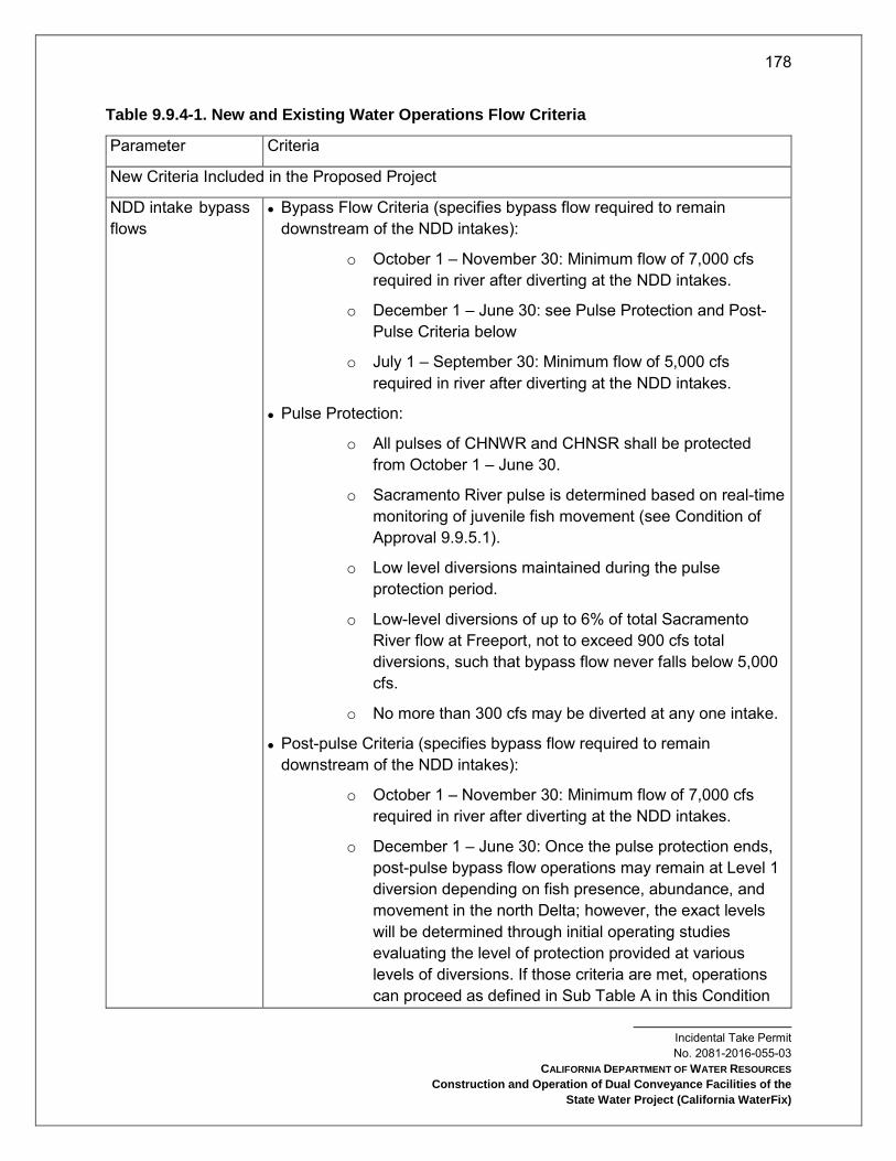
178
Incidental Take Permit No. 2081-2016-055-03
CALIFORNIA DEPARTMENT OF WATER RESOURCES
Construction and Operation of Dual Conveyance Facilities of the
State Water Project (California WaterFix)
Table 9.9.4-1. New and Existing Water Operations Flow Criteria
Parameter Criteria
New Criteria Included in the Proposed Project
NDD intake bypass flows
Bypass Flow Criteria (specifies bypass flow required to remain downstream of the NDD intakes):
o October 1 – November 30: Minimum flow of 7,000 cfs required in river after diverting at the NDD intakes.
o December 1 – June 30: see Pulse Protection and Post-Pulse Criteria below
o July 1 – September 30: Minimum flow of 5,000 cfs required in river after diverting at the NDD intakes.
Pulse Protection:
o All pulses of CHNWR and CHNSR shall be protected from October 1 – June 30.
o Sacramento River pulse is determined based on real-time monitoring of juvenile fish movement (see Condition of Approval 9.9.5.1).
o Low level diversions maintained during the pulse protection period.
o Low-level diversions of up to 6% of total Sacramento River flow at Freeport, not to exceed 900 cfs total diversions, such that bypass flow never falls below 5,000 cfs.
o No more than 300 cfs may be diverted at any one intake.
Post-pulse Criteria (specifies bypass flow required to remain downstream of the NDD intakes):
o October 1 – November 30: Minimum flow of 7,000 cfs required in river after diverting at the NDD intakes.
o December 1 – June 30: Once the pulse protection ends, post-pulse bypass flow operations may remain at Level 1 diversion depending on fish presence, abundance, and movement in the north Delta; however, the exact levels will be determined through initial operating studies evaluating the level of protection provided at various levels of diversions. If those criteria are met, operations can proceed as defined in Sub Table A in this Condition

179
Incidental Take Permit No. 2081-2016-055-03
CALIFORNIA DEPARTMENT OF WATER RESOURCES
Construction and Operation of Dual Conveyance Facilities of the
State Water Project (California WaterFix)
Parameter Criteria
of Approval. The specific criteria for transitioning between and among pulse protection, Level 1, Level 2, and/or Level 3 operations, shall be based on real-time fish monitoring and hydrologic/behavioral cues upstream of and in the Delta (see Condition of Approval 9.9.5.1).
South Delta
operations 32, 33
October 1 – November 30: To be determined based on RTO and protection of the D-1641 San Joaquin River 2-week pulse.
December 1 – December 31: OMR flows will not be more negative than an average of −5,000 cfs when the Sacramento River pulse protection triggers and no more negative than an average of −2,000 cfs when the South Delta RTO Measure 1 triggers. No OMR flow restriction prior to the Sacramento River pulse protection or South Delta RTO Measure 1 triggers.
January 1 – February 28: OMR flows will not be more negative than a 3-day average of 0 cfs during wet years, −3,500 cfs during above-normal years, or −4,000 cfs during below-normal to critical years, except −5,000 in January of dry and critical years.
March 1 – March 31: OMR flows will not be more negative than a 3-day average of 0 cfs during wet or above- normal years or −3,500 cfs during below-normal and dry year and -3,000 cfs during critical years.
April 1 – May 3134: Allowable OMR flows depend on gaged flow measured at Vernalis, and will be determined by a linear relationship. If Vernalis flow is below 5,000 cfs, OMR flows will not be more negative than -2000 cfs. If Vernalis is 6,000 cfs, OMR flows will not be less than +1000 cfs. If Vernalis is 10,000 cfs, OMR flows will not be less than +2,000 cfs. If Vernalis is 15,000 cfs, OMR flows will not be
32 The criteria do not fully reflect the complexities of CVP/SWP operations, dynamic hydrology, or spatial and temporal variation in the distribution of aquatic species. As a result, the criteria will be achieved by operating within an initial range of real time operational criteria from January through March and in June. This initial range, including operational triggers, will be determined through future discussion, including a starting point of -1250 to -5000 cfs based on a 14-day running average, and will be informed by the Adaptive Management Program, including real time monitoring. Further, the 3-day averaging period may be modified through future discussion. Modifications to the 3-day average period and the range of operating criteria may be needed, in part, because: 1) the water year type is forecasted in February but not finalized until May and 2) 0 cfs, or positive, OMR in wet and above normal years may be attained coincident with unimpaired flows. 33 OMR measured through the currently proposed index-method (Hutton 2008) with a 14-day averaging period consistent with the current operations (USBR 2014). 34 When OMR target is based on Vernalis flow it shall be a function of 5-day average measured flow.
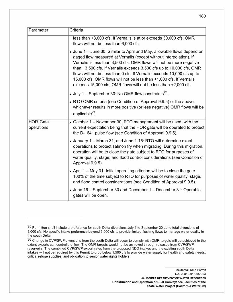
180
Incidental Take Permit No. 2081-2016-055-03
CALIFORNIA DEPARTMENT OF WATER RESOURCES
Construction and Operation of Dual Conveyance Facilities of the
State Water Project (California WaterFix)
Parameter Criteria
less than +3,000 cfs. If Vernalis is at or exceeds 30,000 cfs, OMR flows will not be less than 6,000 cfs.
June 1 – June 30: Similar to April and May, allowable flows depend on gaged flow measured at Vernalis (except without interpolation). If Vernalis is less than 3,500 cfs, OMR flows will not be more negative than −3,500 cfs. If Vernalis exceeds 3,500 cfs up to 10,000 cfs, OMR flows will not be less than 0 cfs. If Vernalis exceeds 10,000 cfs up to 15,000 cfs, OMR flows will not be less than +1,000 cfs. If Vernalis exceeds 15,000 cfs, OMR flows will not be less than +2,000 cfs.
July 1 – September 30: No OMR flow constraints35.
RTO OMR criteria (see Condition of Approval 9.9.5) or the above, whichever results in more positive (or less negative) OMR flows will be applicable36.
HOR Gate operations
October 1 – November 30: RTO management will be used, with the current expectation being that the HOR gate will be operated to protect the D-1641 pulse flow (see Condition of Approval 9.9.5).
January 1 – March 31, and June 1-15: RTO will determine exact operations to protect salmon fry when migrating. During this migration, operation will be to close the gate subject to RTO for purposes of water quality, stage, and flood control considerations (see Condition of Approval 9.9.5).
April 1 – May 31: Initial operating criterion will be to close the gate 100% of the time subject to RTO for purposes of water quality, stage, and flood control considerations (see Condition of Approval 9.9.5).
June 16 – September 30 and December 1 – December 31: Operable gates will be open.
35 Permittee shall include a preference for south Delta diversions July 1 to September 30 up to total diversions of 3,000 cfs; No specific intake preference beyond 3,000 cfs to provide limited flushing flows to manage water quality in the south Delta. 36 Change in CVP/SWP diversions from the south Delta will occur to comply with OMR targets will be achieved to the extent exports can control the flow. The OMR targets would not be achieved through releases from CVP/SWP reservoirs. The combined CVP/SWP export rates from the proposed NDD intakes and the existing south Delta intakes will not be required by this Permit to drop below 1,500 cfs to provide water supply for health and safety needs, critical refuge supplies, and obligation to senior water rights holders.

181
Incidental Take Permit No. 2081-2016-055-03
CALIFORNIA DEPARTMENT OF WATER RESOURCES
Construction and Operation of Dual Conveyance Facilities of the
State Water Project (California WaterFix)
Parameter Criteria
Spring Outflow37 March 1 –– May 31: Sub Table B. Total exports shall not be required by this permit to fall below Human Health and Safety (currently 1500 cfs).
Rio Vista minimum flow standard38
September 1 – December 31: flows per D-1641
o September 1- September 30: All water year types: 3,000 cfs
o October 1 – October 31: wet, above normal, below normal, dry: 4,000 cfs, critically dry: 3,000 cfs
o November 1 – December 31: wet, above normal, below normal, dry: 4,500 cfs, critically dry: 3,500 cfs
Fall Outflow September 1 – November 30: Implement Fall X2 requirements in wet and above normal year types (see Condition of Approval 9.9.4.4)
Winter and Summer Outflow
D-1641 Delta outflow and February – June X2 criteria shall be followed if not superseded by criteria listed above (see Condition of Approval 9.9.4.5).
Export to inflow ratio Operational criteria are the same as defined under D-1641, and applied as a maximum 3-day running average (see Condition of Approval 9.9.4.6).
Sacramento River inflow is defined as flows downstream of the NDD intakes and only south Delta exports are included for the export component of the criteria.
Combined export rate is defined as the diversion rate of the Banks Pumping Plant and Jones Pumping Plant from the south Delta channels.
Delta inflow is defined as the sum of the Sacramento River flow downstream of the proposed NDD intakes, Yolo Bypass flow, Mokelumne River flow, Cosumnes River flow, Calaveras River flow, San Joaquin River flow at Vernalis, and other miscellaneous in-Delta flows.
37 To minimize impacts of the Project on LFS Permittee shall operate to achieve spring outflow criteria (see Condition of Approval 9.9.4.3). 38 Rio Vista minimum monthly average flow in cfs (7-day average flow not be less than 1,000 below monthly minimum), consistent with the SWRCB D-1641.

182
Incidental Take Permit No. 2081-2016-055-03
CALIFORNIA DEPARTMENT OF WATER RESOURCES
Construction and Operation of Dual Conveyance Facilities of the
State Water Project (California WaterFix)
Sub Table A. Post-Pulse Operations for NDD Intake Bypass Flows
Permittee shall implement following bypass flow requirements to (1) maintain fish screen sweeping velocities, (2) minimize potential increase in upstream transport of productivity in the channels downstream of the intakes, (3) support salmonid and pelagic fish movements to regions of suitable habitat, (4) reduce losses to predation downstream of the diversions, and (5) maintain or improve rearing habitat conditions in the north Delta.
Level 1 Post-Pulse Operations
Level 2 Post-Pulse Operations
Level 3 Post Pulse Operations
If Sacramento River flow is over...
But not over...
The bypass is...
If Sacramento River flow is over...
But not over...
The bypass is...
If Sacramento River flow is over...
But not over...
The bypass is...
December 1 to April 30
0 cfs 5,000 cfs
100% of the amount over 0 cfs
0 cfs 5,000 cfs
100% of the amount over 0 cfs
0 cfs 5,000 cfs
100% of the amount over 0 cfs
5,000 cfs 15,000 cfs
Flows remaining after constant low level diversion
5,000 cfs 11,000 cfs
Flows remaining after constant low level diversion
5,000 cfs 9,000 cfs
Flows remaining after constant low level diversion
15,000 cfs
17,000 cfs
15,000 cfs plus 80% of the amount over 15,000 cfs
11,000 cfs 15,000 cfs
11,000 cfs plus 60% of the amount over 11,000 cfs
9,000 cfs 15,000 cfs
9,000 cfs plus 50% of the amount over 9,000 cfs
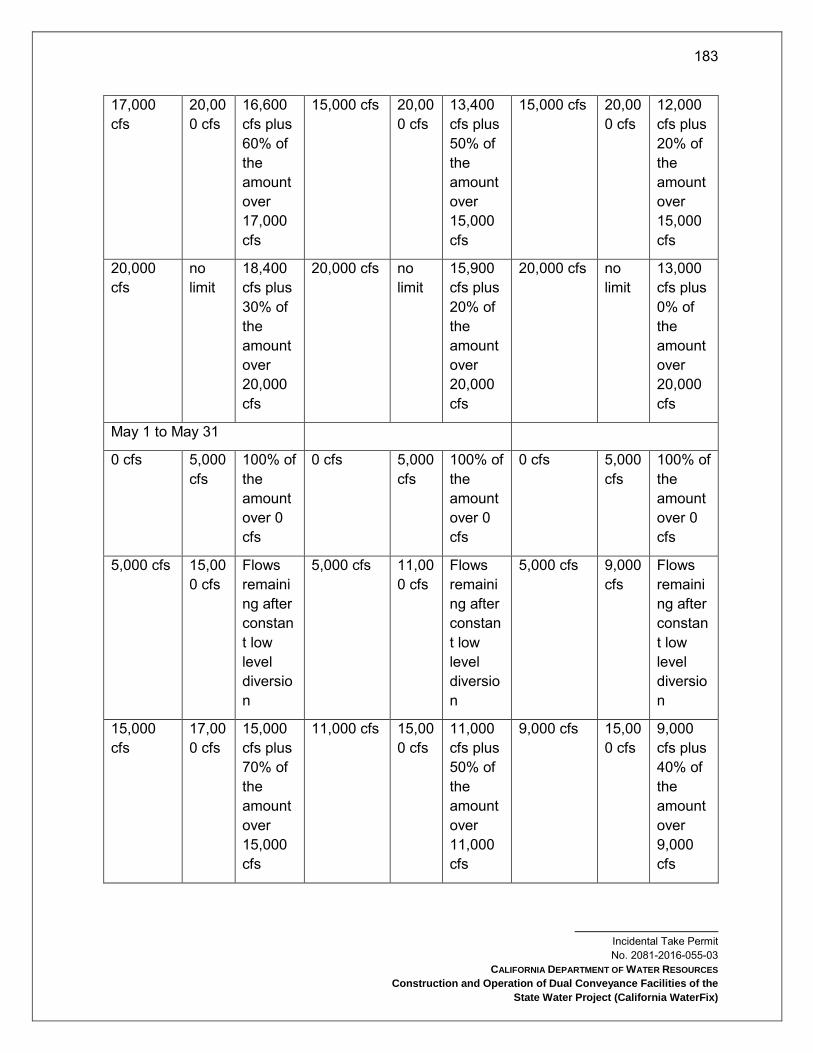
183
Incidental Take Permit No. 2081-2016-055-03
CALIFORNIA DEPARTMENT OF WATER RESOURCES
Construction and Operation of Dual Conveyance Facilities of the
State Water Project (California WaterFix)
17,000 cfs
20,000 cfs
16,600 cfs plus 60% of the amount over 17,000 cfs
15,000 cfs 20,000 cfs
13,400 cfs plus 50% of the amount over 15,000 cfs
15,000 cfs 20,000 cfs
12,000 cfs plus 20% of the amount over 15,000 cfs
20,000 cfs
no limit
18,400 cfs plus 30% of the amount over 20,000 cfs
20,000 cfs no limit
15,900 cfs plus 20% of the amount over 20,000 cfs
20,000 cfs no limit
13,000 cfs plus 0% of the amount over 20,000 cfs
May 1 to May 31
0 cfs 5,000 cfs
100% of the amount over 0 cfs
0 cfs 5,000 cfs
100% of the amount over 0 cfs
0 cfs 5,000 cfs
100% of the amount over 0 cfs
5,000 cfs 15,000 cfs
Flows remaining after constant low level diversion
5,000 cfs 11,000 cfs
Flows remaining after constant low level diversion
5,000 cfs 9,000 cfs
Flows remaining after constant low level diversion
15,000 cfs
17,000 cfs
15,000 cfs plus 70% of the amount over 15,000 cfs
11,000 cfs 15,000 cfs
11,000 cfs plus 50% of the amount over 11,000 cfs
9,000 cfs 15,000 cfs
9,000 cfs plus 40% of the amount over 9,000 cfs

184
Incidental Take Permit No. 2081-2016-055-03
CALIFORNIA DEPARTMENT OF WATER RESOURCES
Construction and Operation of Dual Conveyance Facilities of the
State Water Project (California WaterFix)
17,000 cfs
20,000 cfs
16,400 cfs plus 50% of the amount over 17,000 cfs
15,000 cfs 20,000 cfs
13,000 cfs plus 35% of the amount over 15,000 cfs
15,000 cfs 20,000 cfs
11,400 cfs plus 20% of the amount over 15,000 cfs
20,000 cfs
no limit
17,900 cfs plus 20% of the amount over 20,000 cfs
20,000 cfs no limit
14,750 cfs plus 20% of the amount over 20,000 cfs
20,000 cfs no limit
12,400 cfs plus 0% of the amount over 20,000 cfs
June 1 to June 30
0 cfs 5,000 cfs
100% of the amount over 0 cfs
0 cfs 5,000 cfs
100% of the amount over 0 cfs
0 cfs 5,000 cfs
100% of the amount over 0 cfs
5,000 cfs 15,000 cfs
Flows remaining after constant low level diversion
5,000 cfs 11,000 cfs
Flows remaining after constant low level diversion
5,000 cfs 9,000 cfs
Flows remaining after constant low level diversion
15,000 cfs
17,000 cfs
15,000 cfs plus 60% of the amount over 15,000 cfs
11,000 cfs 15,000 cfs
11,000 cfs plus 40% of the amount over 11,000 cfs
9,000 cfs 15,000 cfs
9,000 cfs plus 30% of the amount over 9,000 cfs
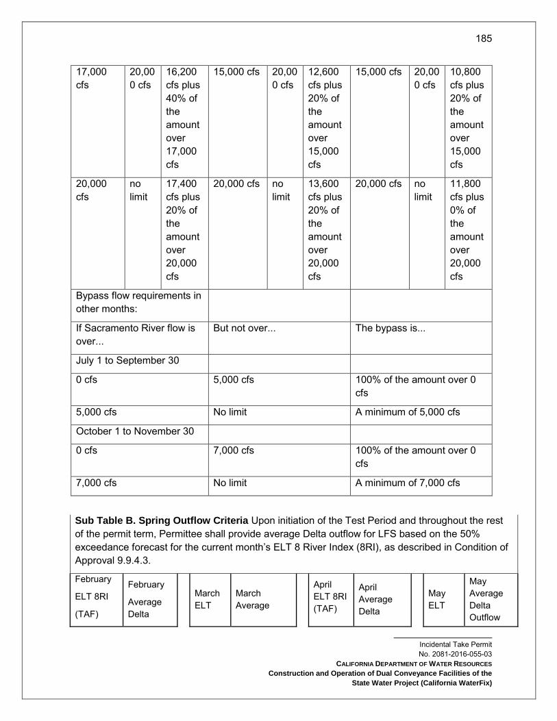
185
Incidental Take Permit No. 2081-2016-055-03
CALIFORNIA DEPARTMENT OF WATER RESOURCES
Construction and Operation of Dual Conveyance Facilities of the
State Water Project (California WaterFix)
17,000 cfs
20,000 cfs
16,200 cfs plus 40% of the amount over 17,000 cfs
15,000 cfs 20,000 cfs
12,600 cfs plus 20% of the amount over 15,000 cfs
15,000 cfs 20,000 cfs
10,800 cfs plus 20% of the amount over 15,000 cfs
20,000 cfs
no limit
17,400 cfs plus 20% of the amount over 20,000 cfs
20,000 cfs no limit
13,600 cfs plus 20% of the amount over 20,000 cfs
20,000 cfs no limit
11,800 cfs plus 0% of the amount over 20,000 cfs
Bypass flow requirements in other months:
If Sacramento River flow is over...
But not over... The bypass is...
July 1 to September 30
0 cfs 5,000 cfs 100% of the amount over 0 cfs
5,000 cfs No limit A minimum of 5,000 cfs
October 1 to November 30
0 cfs 7,000 cfs 100% of the amount over 0 cfs
7,000 cfs No limit A minimum of 7,000 cfs
Sub Table B. Spring Outflow Criteria Upon initiation of the Test Period and throughout the rest of the permit term, Permittee shall provide average Delta outflow for LFS based on the 50% exceedance forecast for the current month’s ELT 8 River Index (8RI), as described in Condition of Approval 9.9.4.3.
February
ELT 8RI
(TAF)
February
Average Delta
March ELT
March Average
April ELT 8RI (TAF)
April Average Delta
May ELT
May Average Delta Outflow
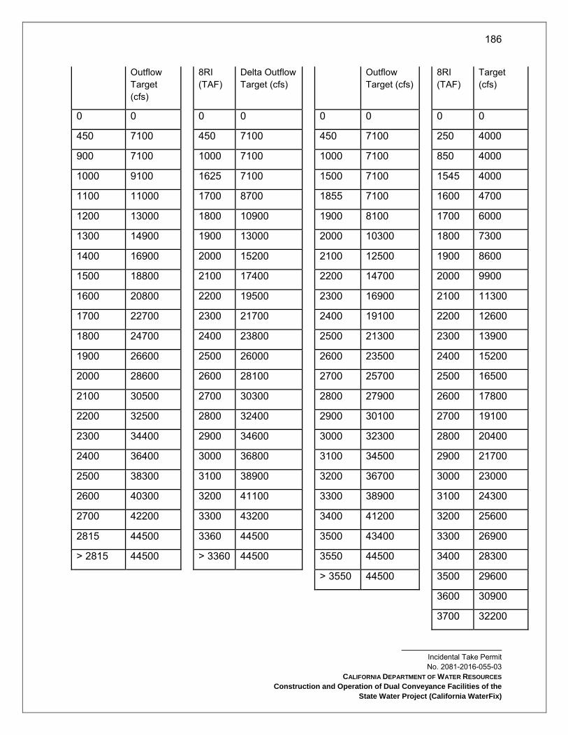
186
Incidental Take Permit No. 2081-2016-055-03
CALIFORNIA DEPARTMENT OF WATER RESOURCES
Construction and Operation of Dual Conveyance Facilities of the
State Water Project (California WaterFix)
Outflow Target (cfs)
8RI (TAF)
Delta Outflow Target (cfs)
Outflow Target (cfs)
8RI (TAF)
Target (cfs)
0 0 0 0 0 0 0 0
450 7100 450 7100 450 7100 250 4000
900 7100 1000 7100 1000 7100 850 4000
1000 9100 1625 7100 1500 7100 1545 4000
1100 11000 1700 8700 1855 7100 1600 4700
1200 13000 1800 10900 1900 8100 1700 6000
1300 14900 1900 13000 2000 10300 1800 7300
1400 16900 2000 15200 2100 12500 1900 8600
1500 18800 2100 17400 2200 14700 2000 9900
1600 20800 2200 19500 2300 16900 2100 11300
1700 22700 2300 21700 2400 19100 2200 12600
1800 24700 2400 23800 2500 21300 2300 13900
1900 26600 2500 26000 2600 23500 2400 15200
2000 28600 2600 28100 2700 25700 2500 16500
2100 30500 2700 30300 2800 27900 2600 17800
2200 32500 2800 32400 2900 30100 2700 19100
2300 34400 2900 34600 3000 32300 2800 20400
2400 36400 3000 36800 3100 34500 2900 21700
2500 38300 3100 38900 3200 36700 3000 23000
2600 40300 3200 41100 3300 38900 3100 24300
2700 42200 3300 43200 3400 41200 3200 25600
2815 44500 3360 44500 3500 43400 3300 26900
> 2815 44500 > 3360 44500 3550 44500 3400 28300
> 3550 44500 3500 29600
3600 30900
3700 32200
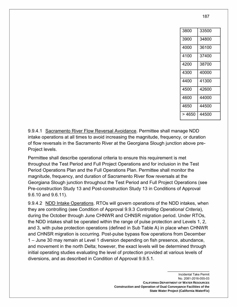
187
Incidental Take Permit No. 2081-2016-055-03
CALIFORNIA DEPARTMENT OF WATER RESOURCES
Construction and Operation of Dual Conveyance Facilities of the
State Water Project (California WaterFix)
3800 33500
3900 34800
4000 36100
4100 37400
4200 38700
4300 40000
4400 41300
4500 42600
4600 44000
4650 44500
> 4650 44500
9.9.4.1 Sacramento River Flow Reversal Avoidance. Permittee shall manage NDD intake operations at all times to avoid increasing the magnitude, frequency, or duration of flow reversals in the Sacramento River at the Georgiana Slough junction above pre-Project levels.
Permittee shall describe operational criteria to ensure this requirement is met throughout the Test Period and Full Project Operations and for inclusion in the Test Period Operations Plan and the Full Operations Plan. Permittee shall monitor the magnitude, frequency, and duration of Sacramento River flow reversals at the Georgiana Slough junction throughout the Test Period and Full Project Operations (see Pre-construction Study 13 and Post-construction Study 13 in Conditions of Approval 9.6.10 and 9.6.11).
9.9.4.2 NDD Intake Operations. RTOs will govern operations of the NDD intakes, when they are controlling (see Condition of Approval 9.9.3 Controlling Operational Criteria), during the October through June CHNWR and CHNSR migration period. Under RTOs, the NDD intakes shall be operated within the range of pulse protection and Levels 1, 2, and 3, with pulse protection operations (defined in Sub Table A) in place when CHNWR and CHNSR migration is occurring. Post-pulse bypass flow operations from December 1 – June 30 may remain at Level 1 diversion depending on fish presence, abundance, and movement in the north Delta; however, the exact levels will be determined through initial operating studies evaluating the level of protection provided at various levels of diversions, and as described in Condition of Approval 9.9.5.1.

188
Incidental Take Permit No. 2081-2016-055-03
CALIFORNIA DEPARTMENT OF WATER RESOURCES
Construction and Operation of Dual Conveyance Facilities of the
State Water Project (California WaterFix)
9.9.4.3 Spring Outflow: Abiotic Habitat for Longfin Smelt. To minimize take of LFS associated with impacts of Project operations on abiotic habitat, Permittee shall maintain Delta outflows that are protective of LFS every year from March 1 – May 31. These outflows will: 1) maintain estuarine processes and flow positively associated with LFS abundance; 2) maintain downstream transport of LFS larvae to rearing habitat; and 3) dedicate water to maintain LFS habitat quality and quantity at levels consistent with recent conditions. Protective outflows from March 1 – May 31 every year shall be determined by the use of a lookup table derived from a linear relationship between the 50% exceedance forecast for the current month’s 8RI and recent historic Delta outflow (1980 – 2016), as shown in Sub Table B.
Upon initiation of the Test Period and throughout the permit term, Permittee shall provide average Delta outflow for LFS based on the 50% exceedance forecast for the current month’s 8RI, as specified in Sub Table B in Condition of Approval 9.9.4 and below:
February 8RI 50% exceedance forecast shall be used to establish the target average Delta outflow beginning on March 1, until the March 8RI 50% exceedance forecast is made available.
March 8RI 50% exceedance forecast shall be used to establish the target average Delta outflow beginning when the March 8RI 50% exceedance forecast is made available through March 31.
April 8RI 50% exceedance forecast shall be used to establish the target average Delta outflow beginning when the April 8RI 50% exceedance forecast is made available through April 30. If April 8RI 50% exceedance forecast is not available on April 1, March 8RI 50% exceedance forecast shall be used to establish target Delta outflow until April 50% exceedance forecast is available.
May 8RI 50% exceedance forecast shall be used to establish the target average Delta outflow from beginning when the May 8RI 50% exceedance forecast is available through May 31. If May 8RI 50% exceedance forecast is not available beginning May 1, April 8RI 50% exceedance forecast shall be used to establish target Delta outflow until May 50% exceedance forecast is available.
Permittee may use preliminary 8RI 50% exceedance forecast estimates to establish outflow targets in the first ten days of each month, if approved by CDFW in writing.
Reduction in combined exports below minimum health and safety requirements (1,500 cfs) is not required by this Condition of Approval.

189
Incidental Take Permit No. 2081-2016-055-03
CALIFORNIA DEPARTMENT OF WATER RESOURCES
Construction and Operation of Dual Conveyance Facilities of the
State Water Project (California WaterFix)
These targets are intended to be provided through the acquisition of water from willing sellers and through operations of the CVP/SWP. Permittee shall achieve Delta outflow targets through shared export allocations between the NDD and South Delta, consistent with required Operating Criteria described in Condition of Approval 9.9. If the target average Delta outflow is greater than 44,500 cfs Permittee shall consult with CDFW to determine how to allocate exports between the NDD intakes and the South Delta.
Permittee shall utilize Net Delta Outflow Index (NDOI) data to confirm that the average Delta outflow target was met from March 1 – March 31, April 1 – April 30, and May 1 – May 31. Permittee shall provide daily NDOI data quantifying daily Delta outflow in each 30 day period to CDFW on or before April 5, May 5, and June 5 every year.
Permittee shall submit a written report to CDFW on or before June 30 every year explaining how operations of the Project complied with the requirements of this term. This annual report shall include, but is not limited to:
1) 50% exceedance 8RI forecasts in February, March, April, and May
2) Daily NDOI from March 1 – May 31
3) Daily diversion rates from each NDD intake
4) Daily total exports from the South Delta CVP/SWP facilities
5) Description of water obtained from willing sellers to contribute to achieving the outflow targets from March 1 –March 31, April 1 – April 30, and May 1 – May 31.
This report will be used to determine whether Permittee complied with the operational requirements in this Condition of Approval on an annual basis.
9.9.4.4 Fall Outflow – Estuarine Habitat for Delta Smelt. Permittee shall coordinate with Reclamation to provide sufficient Delta outflow to maintain average X2 from September 1 – October 31 no greater (more eastward) than 74 km in the fall following wet years, and 81 km from September 1 through November 30 following above normal years. The monthly average X2 shall be maintained at or seaward of these values for each individual month and not averaged over the two month period. In November, the inflow to CVP/SWP reservoirs in the Sacramento Basin shall be added to CVP/SWP reservoir releases to provide an added increment of Delta inflow and augment Delta outflow to achieve the target X2 location. Permittee shall utilize wet and above normal water year type classifications as defined in the Water Quality Control Plan for the San Francisco Bay/Sacramento-San Joaquin Delta Estuary.
9.9.4.5 Winter and Summer Outflow. Upon initiation of the Test Period and Full Project Operations Permittee shall adhere to Net Delta Outflow Index as defined in D-1641 from January 1 – August 31 when it is controlling (see Condition of Approval 9.9.3).
190
Incidental Take Permit No. 2081-2016-055-03
CALIFORNIA DEPARTMENT OF WATER RESOURCES
Construction and Operation of Dual Conveyance Facilities of the
State Water Project (California WaterFix)
9.9.4.6 Export to Inflow Ratio. Upon initiation of the Test Period and Full Project Operations Permittee shall adhere to the export to inflow ratios as defined in D-1641 to conduct coordinated operations of all Project facilities.
9.9.5 Real-Time Operations. The real-time operational decision-making process (real-time operations (RTO) shall allow short-term (i.e., daily and weekly) adjustments to be made to water operations, within the range of criteria described in Condition of Approval 9.9.4. RTO provides flexibility in operations based on monitoring for Covered Fish Species presence (see Condition of Approval 9.8), hydrologic conditions, and operational criteria throughout the Delta and as described in Condition of Approval 9.9.4 to contribute to meeting the biological criteria established in Condition of Approval 9.7.
The RTO criteria and decision making process for all Project facilities during the Test Period and Full Project Operations shall be described in a Real Time Operations Plan developed by the TOT, NDDTT, HGTT, and CCFTT, and included in the Test Period Operations Plan and the Full Project Operations Plan. The Real Time Operations Plan shall include all criteria and decision making processes described in this Condition. Permittee shall not initiate the Test Period until the Real Time Operations Plan is approved in writing by CDFW.
RTO shall be implemented through the existing decision-making process and related technical work teams described in the Groups Involved in Real-Time Decision Making and Information Sharing section of the Project Description. Permittee shall manage RTO to balance the distribution of exports among the three NDD intakes and the CVP/SWP south Delta export facilities.
9.9.5.1 Real Time Operations of the NDD Intakes. RTOs will govern operations, when they are controlling (see Condition of Approval 9.9.3 Controlling Operational Criteria), during the October through June CHNWR and CHNSR migration period. Under RTOs, the NDD intakes shall be operated within the range of pulse protection and Levels 1, 2, and 3, with pulse protection operations in place when CHNWR and CHNSR migration is occurring. Post-pulse bypass flow operations from December 1 through June 30 may remain at Level 1 diversion depending on fish presence, abundance, and movement in the north Delta; however, the exact levels will be determined through initial operating studies evaluating the level of protection provided at various levels of diversions.
The NDDTT shall develop criteria for transitioning between and among pulse protection, Levels 1, 2 and 3 based on best available science. The NDDTT shall recommend transitional criteria to the TOT and IICG for consideration through the Adaptive Management Program, to ensure that the Project will achieve the objectives of Biological Criteria 1 and 2. New transitional criteria are subject to CDFW approval.

191
Incidental Take Permit No. 2081-2016-055-03
CALIFORNIA DEPARTMENT OF WATER RESOURCES
Construction and Operation of Dual Conveyance Facilities of the
State Water Project (California WaterFix)
The NDDTT shall evaluate fish triggers for initiating pulse protection and pulse duration based on new data (including but not limited to data obtained from Pre-construction Studies 7, 10 and 12), new monitoring stations and techniques, the method used to identify CHNWR and CHNSR, and the time of year when fish pulses are observed. The NDDTT may recommend new fish triggers for initiating pulse protection and pulse durations to the TOT and IICG for consideration through the Adaptive Management Program, to ensure that the Project will achieve the objectives of Biological Criteria 1 and 2. New fish triggers and pulse durations are subject to CDFW approval.
October 1 – June 30: Permittee shall protect all CHNWR and CHNSR pulses by adhering to the following pulse protection criteria:
A fish pulse is defined as a Knights Landing Catch Index (KLCI) ≥ 5 where KLCI = (# of CHNWR + # of CHNSR)/(Total Hours Fished/24)39.
Pulse protection operations shall be implemented within 24 hours of detection of a fish pulse.
Diversions from the NDD intakes shall be reduced to low-level diversions of up to 6% of inflow measured at Freeport, but shall not exceed 900 cfs total and shall not exceed 300 cfs per intake.
During the period of pulse protection, additional diversions above low-level diversions may occur provided that a minimum of 35,000 cfs bypass flow at the NDD intakes is maintained.
Pulse protection ends after five consecutive days of daily KLCI < 5.
October 1 - November 30: Post-pulse minimum bypass flows of 7,000 cfs shall be maintained in river after diverting at the NDD intakes.
9.9.5.2 Real Time Operations of South Delta Export Facilities. Real time operations shall be implemented to make short-term decisions regarding operation of south Delta export facilities in coordination with real time operations of all other Project facilities. The south Delta facilities shall be operated within the range of criteria listed in Condition of Approval 9.9.4, and be subject to RTO decision making based on anticipated impacts to DS, LFS, CHNWR, and CHNSR. South Delta RTO criteria, as described in the Test Period Operations Plan and the Full Project Operations Plan, shall include the following Measures:
39 KLCI is based on length at date criteria to identify CHNWR and CHNSR.
192
Incidental Take Permit No. 2081-2016-055-03
CALIFORNIA DEPARTMENT OF WATER RESOURCES
Construction and Operation of Dual Conveyance Facilities of the
State Water Project (California WaterFix)
South Delta RTO Measure 140 - Adult DS Migration and Entrainment First Flush Protection (Action 1): Permittee shall coordinate with Reclamation to limit exports so that the average daily OMR flow41 shall be no more negative than -2,000 cfs for a total duration of 14 days, and no more negative than -2,500 cfs (within 25 percent) on a 5-day running average.
Part A: From December 1 – December 20: Based upon an examination of turbidity data from Prisoner’s Point, Holland Cut, and Victoria Canal (supplemented by turbidity transects conducted by Permittee on a daily basis) and salvage data from CVP/SWP (see Triggers below), and other parameters important to the protection of DS including, but not limited to, preceding conditions of X2, QWEST, FMWT, and river flows the SWG or CDFW SWG personnel may recommend a start date to WOMT and WOMT may accept, reject, or revise the recommendation. If WOMT accepts the recommendation, Permittee shall implement the recommended start date. If WOMT rejects or revises the recommendation, the Director of CDFW (Director) may require a start date and Permittee shall implement the start date required by the Director.
Part B: After December 20 Permittee shall implement this measure if at least one of the two Measure 1 triggers is met. The SWG can recommend a delayed start or interruption in implementation based on other conditions such as Delta inflow that may affect DS vulnerability to entrainment. If either off ramp condition is met, South Delta RTO Measure 1 shall not be implemented. If either Measure 1 off ramp condition is met, and South Delta RTO Measure 1 has not been implemented, then South Delta RTO Measure 3 shall be implemented and South Delta RTO Measure 2 is not required, unless CDFW concludes, on the basis of the totality of available information, that South Delta RTO Measure 2 shall be implemented instead.
Measure 1 (Part B) triggers:
(1) Turbidity: 3-day average of 12 NTU or greater at all three CDEC turbidity stations (Prisoner’s Point, Holland Cut, Victoria Canal)
(2) Salvage: Three days or DS salvage after December 20 at either facility or cumulative daily salvage count that is above a risk threshold based upon the “daily salvage index” approach reflected in a daily salvage index value ≥0.5 (daily delta smelt salvage > one-half prior year FMWT index value).
Measure 1 (Part B) off ramps:
40 This measure was initially implemented as RPA Component 1 (Actions 1) under USFWS (2008). 41 OMR Flows for this and all relevant actions shall be measured at the Old River at Bacon Island and Middle River at Middle River stations.

193
Incidental Take Permit No. 2081-2016-055-03
CALIFORNIA DEPARTMENT OF WATER RESOURCES
Construction and Operation of Dual Conveyance Facilities of the
State Water Project (California WaterFix)
(1) Temperature: Water temperature reaches 12°C based on a three station daily mean at Mossdale, Antioch, and Rio Vista
(2) Biological: Onset of spawning (presence of spent females in SKT or at TFCF or Skinner Fish Facility salvage samples).
South Delta RTO Measure 242 - Adult DS Migration and Entrainment Protection (Action 2): This measure shall be implemented using an adaptive process to tailor protection to changing environmental conditions after South Delta RTO Measure 1 ceases. As in South Delta RTO Measure 1, the purpose of this measure is to protect pre-spawning DS adults from entrainment and, to the extent possible, from adverse hydrodynamic conditions.
Permittee shall coordinate with Reclamation to operate to a range of net daily OMR flows that will be no more negative than -1,250 to - 5,000 cfs. Specific OMR flows within this range shall be recommended by the SWG throughout implementation of this measure based on extant conditions and the general guidelines below.
The SWG or CDFW SWG personnel shall provide WOMT and the Director weekly recommendations for required OMR flows based upon review of real-time salvage data at the SWP, and utilizing most up-to-date technological expertise and knowledge relating DS population status and predicted distribution to monitored physical variables of flow and turbidity. WOMT may accept, reject, or revise the recommendations. If WOMT accepts the recommendations, Permittee shall coordinate with Reclamation to implement the required OMR flow. If WOMT rejects or revises the recommendation, the Director may require an OMR flow and Permittee shall coordinate with Reclamation to implement the OMR flow required by the Director.
Timing: Before Measure 2 is implemented, and in time for Permittee to implement the flow requirement, the SWG or CDFW SWG personnel shall recommend to WOMT and to Director specific OMR flow requirements based on salvage and on physical and biological data on an ongoing basis (see Condition of Approval 9.8). This Measure shall be implemented immediately after South Delta RTO Measure 1 off-ramps occur. If South Delta RTO Measure 1 is not implemented, the SWG or CDFW SWG personnel may recommend a start date for the implementation of South Delta RTO Measure 2 to protect adult DS.
Suspension of Measure 2: OMR flow requirements in this measure do not apply whenever a three day flow average is greater than or equal to 90,000 cfs in Sacramento
42 This measure was initially implemented as RPA Component 1 (Actions 2) under USFWS (2008).

194
Incidental Take Permit No. 2081-2016-055-03
CALIFORNIA DEPARTMENT OF WATER RESOURCES
Construction and Operation of Dual Conveyance Facilities of the
State Water Project (California WaterFix)
River at Rio Vista and 10,000 cfs in San Joaquin River at Vernalis. Once such flows have abated, the OMR flow requirements of this Measure are again in place.
Measure 2 off -ramps: South Delta RTO Measure 2 shall cease and South Delta RTO Measure 3 shall commence if one of the following two conditions is met:
(1) Temperature: When water temperature reaches 12°C based on a three station daily average (Rio Vista, Antioch, and Mossdale) or
(2) Biological: Onset of spawning (presence of spent females in Spring Kodiak Trawl or at either salvage facility) occurs
Adaptive Process Required Parameters:
Two scenarios span the range of circumstances likely to exist during implementation of South Delta RTO Measure 2. First, the low-entrainment risk scenario. There may be a low risk of adult DS entrainment because (a) there has been no discernable migration of DS adults into the South and Central Delta (b) the upstream migration has already occurred but turbidity is low and there is no evidence of ongoing adult entrainment. In this scenario, more negative net daily OMR flow rates as negative as -5,000 cfs may be allowed as long as entrainment risk factors and salvage permit.
The second scenario, the high-entrainment risk scenario, is one in which either (a) there is evidence that upstream adult migration is currently occurring, or (b) upstream migration has already occurred and there are adult fish in the South and Central Delta and turbidity is high, increasing the risk of entrainment, or (c) there is evidence of ongoing entrainment, regardless of other risk factors. In this case, OMR flow will be set to reduce entrainment and/or the risk of entrainment as the totality of circumstances warrant.
If the available distributional information suggests that most DS are in the North or North/Central Delta, then OMR flow can be chosen to minimize Central Delta DS entrainment. However, if the distributional information suggests there are DS in the Central or South Delta, then OMR flow will have to be set less negative to reduce entrainment of DS.
The following two paragraphs describe how these action guidelines would be implemented at the start of South Delta RTO Measure 2 and at other times during implementation of South Delta RTO Measure 2.
1. OMR flow setting at initiation of South Delta RTO Measure 2
a) If salvage is zero during the final seven (7) days of South Delta RTO Measure 1, and three station mean turbidity is below 15 NTU, OMR flow shall be no more negative than

195
Incidental Take Permit No. 2081-2016-055-03
CALIFORNIA DEPARTMENT OF WATER RESOURCES
Construction and Operation of Dual Conveyance Facilities of the
State Water Project (California WaterFix)
-5,000 cfs on a 14-day running average with a simultaneous 5-day running average within 25 percent of the applicable required OMR flow43; UNLESS
b) If salvage is less in the most recent three days than in the preceding three days of South Delta RTO Measure 1, and the maximum DS Daily Salvage Index is ≤1 during the prior 7 days, then limit exports to achieve OMR flows no more negative than -3,500 cfs on a 14-day running average for 7 days (or until 4 consecutive days of zero salvage or any 5 of 7 days with zero salvage), with a 5-day running average within 25 percent of the applicable required OMR flow; OR
c) If salvage is greater or equal in the last three days than in the preceding three days of South Delta RTO Measure 1, and maximum Daily Salvage Index ≥1 during any of those days, then continue OMR flow at no more negative than -2,000 cfs on a 14-day running average for an additional 7 days (or until 4 succeeding days of zero salvage or any 5 of 7 days zero salvage), with a simultaneous 5-day running average within 25 percent of the applicable requirement OMR; OR
d) If circumstances existing at the initiation of South Delta RTO Measure 2 are, in the judgment of CDFW, less protective from those anticipated in (a) through (c) above, then the OMR flow requirement in (c) will be applied and the SWG will review available data and recommend an initial flow rate to CDFW.
2. OMR flow setting after initiation of South Delta RTO Measure 2
a) The SWG will review all available information and request updated entrainment simulations (including particle tracking models) and/or other information, as needed, on a weekly basis to decide whether the current OMR flow requirement is appropriate or should be changed based on adult DS entrainment risk through consideration of (1) salvage or other actual entrainment indicators, (2) turbidity, (3) available monitoring results, hydrologic variables other than export pumping rates that affect OMR flow, (4) apparent population size from the preceding FMWT survey, and (5) particle tracking or other model-based entrainment risk information.
c) As described above, the risk of entrainment is generally higher when there is evidence of ongoing entrainment or turbidity is high, and these two variables are the primary triggers of decisions to raise or lower OMR flow requirements.
d) Based on historical experience, OMR flow requirements between the limits of -2,000 cfs and -5,000 cfs are likely to be adequate in most years. The exception is years in which there is a substantial fraction of the adult spawning migrant population in the
43 The daily OMR flows used to compute both the 14-day and the 5-day averages shall be based on the definition in Condition of Approval 9.9.2.
196
Incidental Take Permit No. 2081-2016-055-03
CALIFORNIA DEPARTMENT OF WATER RESOURCES
Construction and Operation of Dual Conveyance Facilities of the
State Water Project (California WaterFix)
Central and/or South Delta. When this occurs, more stringent OMR limitations (possibly to no more negative than - 1,250 cfs) may be required.
South Delta RTO Measure 3 - Larval DS Entrainment Protection (Action 3)44: Permittee shall implement this measure to minimize the number of larval DS entrained at the south Delta facilities by managing the hydrodynamics in the Central Delta, flow levels, and pumping rates. Because protective OMR flow requirements vary over time (within and among years), implementation of this measure is flexible within constraints.
Permittee shall coordinate with Reclamation on the operation of south Delta facilities to achieve a net daily OMR flow no more negative than -1,250 to -5,000 cfs based on a 14-day running average with a simultaneous 5-day running average within 25 percent of the applicable requirement for OMR45. Depending on extant conditions (and the general guidelines below) specific OMR flows within this range shall be recommended by the SWG or CDFW SWG personnel to WOMT and the Director from initiation through termination of this measure46. The SWG shall provide these recommendations based upon weekly review of sampling data, real-time salvage data at the CVP/SWP, and knowledge relating DS population status and predicted distribution to flow and turbidity. WOMT may accept, reject, or revise the recommendations. If WOMT accepts the recommendations, Permittee shall implement the required OMR flow. If WOMT rejects or revises the recommendation, the Director may require an OMR flow and Permittee shall implement the OMR flow required by the Director.
Timing: Permittee shall implement this measure if at least one of the two Measure 3 triggers is met. Measure 3 triggers are indicative of DS spawning activity and the presence of larval DS in the South and Central Delta. Based upon daily salvage data, the SWG or CDFW SWG personnel may recommend an earlier start to South Delta RTO Measure 3. WOMT may accept, reject, or revise the recommended start date. If WOMT accepts the recommendation, Permittee shall implement the measure. If WOMT rejects or revises the recommendation, the Director may require an OMR flow and Permittee shall implement the OMR flow required by the Director. South Delta RTO Measure 3 shall terminate if one of the two Measure 3 off ramps is met.
44 This measure was initially implemented as RPA Component 2 (Action 3) under USFWS (2008). 45 The daily OMR flows used to compute both the 14-day and the 5-day averages shall be based on the definition in Condition of Approval 9.9.2. 46 During most conditions, it is expected that maximum negative OMR flows will range between -2000 and -3500. During certain years of higher or lower predicted entrainment risk, requirements as low as -1,250 or -5,000 will be recommended to CDFW by the SWG.

197
Incidental Take Permit No. 2081-2016-055-03
CALIFORNIA DEPARTMENT OF WATER RESOURCES
Construction and Operation of Dual Conveyance Facilities of the
State Water Project (California WaterFix)
Measure 3 triggers:
1) Temperature – When temperature reaches 12°C based on a three station average at Mossdale, Antioch, and Rio Vista, or
2) Biological: Onset of spawning (presence of spent females in SKT or at either fish salvage facility).
Measure 3 off ramps:
1) Temporal – June 30, or
2) Temperature: Water temperature reaches a daily average of 25°C for three consecutive days at CCF.
South Delta RTO Measure 4 – Adult LFS Migration and Entrainment Protection (LFS 2009 Condition 5.1)47: The purpose of this measure is to protect adult LFS migration and spawning from December 1 through February 28. Permittee shall ensure the OMR flow requirement recommended by WOMT, or required by the Director, is met by coordinating operations with Reclamation to ensure the OMR flow 14-day running average is no more negative than -5,000 cfs and the initial 5-day running average is no more negative than -6,250 cfs48.
The SWG or CDFW SWG personnel shall provide OMR flow advice based on the Measure 4 triggers to the WOMT and to the Director weekly. WOMT shall provide weekly advice which may include information on other ecosystem and water supply considerations to the Director.
Based on OMR flow advice from SWG or CDFW SWG personnel, CDFW shall make an OMR flow recommendation to WOMT and WOMT may accept, reject, or revise the recommendation. If WOMT accepts the recommendation, Permittee shall implement the required OMR flow. If WOMT rejects, revises, or declines to accept the recommendation, the Director may require an OMR flow and Permittee shall implement the OMR flow required by the Director.
Measure 4 triggers:
1) The cumulative salvage index (defined as the total estimated LFS salvage at the CVP and SWP in the December through February
47 This measure was initially implemented as Condition 5.1 of CDFG (2009). 48 The daily OMR flows used to compute both the 14-day and the 5-day averages shall be based on the definition in Condition of Approval 9.9.2.

198
Incidental Take Permit No. 2081-2016-055-03
CALIFORNIA DEPARTMENT OF WATER RESOURCES
Construction and Operation of Dual Conveyance Facilities of the
State Water Project (California WaterFix)
period divided by the immediately previous Fall Mid-Water Trawl (FMWT) LFS annual abundance index49) exceeds five (5); or
2) When a review of all abundance and distribution survey data and other pertinent biological factors that influence the entrainment risk of adult LFS indicate OMR flow advice is warranted.
Measure 4 off ramps:
1) During any time OMR flow restrictions for DS are being implemented (South Delta RTO Measures 1, 2, and 3), this measure shall not result in additional OMR flow requirements for protection of adult LFS, or
2) When LFS spawning has been detected in the system, South Delta RTO Measure 4 shall terminate and South Delta RTO Measure 5 shall be implemented, or
3) South Delta RTO Measure 4, including the OMR requirement, is not required or would cease if previously required when river flows are: a) greater than 55,000 cfs in the Sacramento River at Rio Vista; or b) greater than 8,000 cfs in the San Joaquin River at Vernalis, or
If flows go below 40,000 cfs in the Sacramento River at Rio Vista or 5,000 cfs in the San Joaquin River at Vernalis, the OMR flow in South Delta RTO Measure 4 shall resume if triggered previously and not precluded by another Measure 4 off ramp. In implementation of this resumption, in addition to river flows, the SWG or CDFW SWG personnel review of survey data and other pertinent biological factors that influence the entrainment risk of adult LFS may result in advice to WOMT and the Director and may result in a recommendation by CDFW to WOMT and the Director to relax or cease this OMR flow requirement.
South Delta RTO Measure 5 – Larval LFS Entrainment Protection50: The SWG or CDFW SWG personnel shall provide OMR flow advice to the WOMT and to the Director weekly to protect larval and juvenile LFS during from January 1 – June 30. The OMR flow advice shall be an OMR flow between -1,250 and -5,000 cfs and be based on review of survey data (see Measure 5 triggers below), including all current LFS distributional and abundance data, and other pertinent biological factors that influence the entrainment risk of larval and juvenile LFS. The OMR flow requirement is likely to
49 The Fall Midwater Trawl (FMWT) Survey annual abundance index for longfin smelt is calculated as the sum of September through December monthly abundance indices, and is typically reported at about the same date as adult salvage begins in December. Early December salvage can be compared to September through November abundance as an approximation of the salvage index. 50 This measure was initially implemented as Condition 5.2 of CDFG (2009).
199
Incidental Take Permit No. 2081-2016-055-03
CALIFORNIA DEPARTMENT OF WATER RESOURCES
Construction and Operation of Dual Conveyance Facilities of the
State Water Project (California WaterFix)
vary from January 1 – June 30 based upon LFS survey results, data analysis, and environmental factors. Based on prior analysis, CDFW has identified three likely scenarios that illustrate the typical LFS entrainment risk level and associated protective OMR flow measures for larval LFS over the period:
High Entrainment Risk Period – January 1 – March 31: OMR range from -1,250 cfs to -5,000 cfs
Medium Entrainment Risk Period – April 1 – May 31: OMR range from -2,000 cfs to -5,000 cfs
Low Entrainment Risk Period - June 1 through June 30: OMR -5,000 cfs
Based on SWG or CDFW SWG personnel OMR flow advice, CDFW shall make an OMR flow recommendation to WOMT and WOMT may accept, reject, or revise the recommendation. If WOMT accepts the recommendation, Permittee shall implement the OMR flow as recommended by the SWG. If WOMT rejects or revises the recommendation, the Director may require an OMR flow and Permittee shall implement the OMR flow required by the Director. Permittee shall coordinate with Reclamation to ensure the OMR flow requirement is met by maintaining the OMR flow 14-day running average no more negative than the required OMR flow and the 5-day running average is within 25 percent of the required OMR flow51.
Measure 5 triggers: All current LFS distributional and abundance data, including the Smelt Larval Survey, and other pertinent biological factors that influence the entrainment risk of larval and juvenile LFS shall be used to determine OMR flow advice. When a single Smelt Larva Survey (SLS) or 20 mm Survey (20 mm) sampling period results in one of the following triggers Permittee shall implement South Delta RTO Measure 5 and OMR flow advice shall be warranted:
1) LFS larvae or juveniles found in 8 or more of the 12 SLS or 20 mm stations in the central and south Delta (Stations 809, 812, 815, 901, 902, 906, 910, 912, 914, 915, 918, 919) or,
2) LFS catch per tow exceeds 15 LFS larvae or juveniles in 4 or more of the 12 central and south Delta (Stations 809, 812, 815, 901, 902, 906, 910, 912, 914, 915, 918, 919).
Measure 5 off ramps: When river flows meet one of the following requirements South Delta RTO Measure 5 would not trigger, or would be relaxed if triggered previously.
51 The daily OMR flows used to compute both the 14-day and the 5-day averages shall be based on the definition in Condition of Approval 9.9.2.
200
Incidental Take Permit No. 2081-2016-055-03
CALIFORNIA DEPARTMENT OF WATER RESOURCES
Construction and Operation of Dual Conveyance Facilities of the
State Water Project (California WaterFix)
1) Greater than 55,000 cfs in the Sacramento River at Rio Vista; or
2) Greater than 8,000 cfs in the San Joaquin River at Vernalis
Should the flows drop below 40,000 cfs in the Sacramento River at Rio Vista or 5,000 cfs in the San Joaquin River at Vernalis, Measure 5 shall resume if triggered previously.
In implementing this resumption, in addition to river flows, the SWG or CDFW SWG personnel review of all abundance and distribution survey data and other pertinent biological factors that influence the entrainment risk of adult LFS may result in advice to WOMT and the Director, and may result in a recommendation by CDFW to WOMT to relax or cease an OMR flow requirement per this Measure.
South Delta RTO Measure 6 - OMR RTO Criteria for Juvenile CHNWR and CHNSR Entrainment Protection (Action IV.2.3 NMFS Biological Opinion): The purpose of this measure is to reduce the vulnerability of emigrating CHNWR and CHNSR within the lower Sacramento and San Joaquin rivers to entrainment into the channels of the South Delta and at the SWP South Delta export facilities.
Permittee shall implement the following CHNWR and CHNSR Measure 6 criteria upon initiation of Full Project Operations if at least one of the Measure 6 triggers is met:52
Measure 6 criteria 1: To protect juvenile CHNWR and CHNSR from south Delta entrainment from January 1 – June 15, DOSS or CDFW DOSS personnel shall provide OMR flow advice to the WOMT and to the Director weekly. WOMT shall provide weekly advice which may include information on other ecosystem and water supply considerations to the Director.
Measure 6 criteria 2: From January 1 – June 15 Permittee shall coordinate with Reclamation to reduce exports, as necessary, to limit negative flows to -2,500 to -5,000 cfs in Old and Middle Rivers, depending on the presence of CHNWR and CHNSR. The specific OMR objective within this range shall be determined based on whether Measure 6 Criteria 2 stage 1 or stage 2 triggers are met.
Measure 6 criteria 3: Permittee shall coordinate with Reclamation to provide for an OMR flow of no more negative than -5,000 cfs, during the period between January 1 – June 15. The 5-day running average shall be no more than 25 percent more negative than the targeted flow requirement.53 Further reductions in exports shall occur in a tiered
52 These measures were initially implemented under the as Action IV.2.3 of NMFS (2009). 53 The daily OMR flows used to compute both the 14-day and the 5-day averages shall be based on the definition in Condition of Approval 9.9.2.

201
Incidental Take Permit No. 2081-2016-055-03
CALIFORNIA DEPARTMENT OF WATER RESOURCES
Construction and Operation of Dual Conveyance Facilities of the
State Water Project (California WaterFix)
fashion depending on the magnitude covered salmonid salvage at the CVP and SWP fish salvage facilities.
Measure 6 criteria 4: The combined CVP and SWP South Delta export facilities CHNWR incidental take limit is established in NMFS (2009) to govern operations of these facilities under this Measure. The juvenile CHNWR incidental take limit is 2 percent (based on Fisher length by date criteria54) or 1 percent (based on real time genetic testing) of the annual Juvenile Production Estimate (JPE). The JPE is an estimate of the number of juvenile CHNWR entering the Delta and shall be developed annually by the IEP Winter-run Project Work Team utilizing CHNWR adult in-river escapement data, the Juvenile Production Index at Red Bluff Diversion Dam (RBDD), juvenile in-river survival data and other information.
Measure 6 criteria 2 triggers55 (first stage):
(1) Daily CVP/SWP CHNWR and CHNSR56 loss density (fish per TAF) as determined by rapid genetic testing is greater than incidental take limit divided by 2,000 (1% WRJPE ÷ 2,000), with a minimum value of 2.5 fish per TAF, or
(2) Daily CVP/SWP CHNWR and CHNSR salmon loss is greater than 8 fish per TAF multiplied by volume exported (in TAF), or
(3) Coleman National Fish Hatchery coded wire tagged CHNSR surrogate late fall-run Chinook salmon or Livingston Stone National Fish Hatchery coded wire tagged CHNWR cumulative CVP/SWP export facility entrainment loss is greater than 0.5% for each surrogate release group57.
Measure 6 criteria 2 triggers58 (second stage):
(1) Daily CVP/SWP CHNWR salmon loss density (fish per TAF) is greater than incidental take limit divided by 1,000 (1% of WRJPE ÷ 1,000), with a minimum value of 5 fish per TAF, or
54 Fisher, F. W. 1992. Chinook salmon, Oncorhynchus tshawytscha, growth and occurrence in the Sacramento-San Joaquin River system. California Department Fish and Game. 55 Reductions are required when any one criterion is met. 56 Permittee shall implement rapid genetic testing protocol to determine CHNWR and CHNSR genetic origin. 57 Three consecutive days in which the combined loss numbers are below the action triggers are required before the OMR flow reductions can be relaxed to no more negative than -5,000 cfs. A minimum of 5 consecutive days of export reduction are required for the protection of listed salmonids under the action. Starting on day 3 of the export curtailment, the level of fish loss must be below the action triggers for the remainder of the 5-day export reduction to relax the OMR requirements on day 6. Any exceedance of a more conservative trigger restarts the 5-day OMR action response with the 3 consecutive days of loss monitoring criteria. 58 Reductions are required when any one criterion is met.

202
Incidental Take Permit No. 2081-2016-055-03
CALIFORNIA DEPARTMENT OF WATER RESOURCES
Construction and Operation of Dual Conveyance Facilities of the
State Water Project (California WaterFix)
(2) Daily CVP/SWP CHNWR and CHNSR loss is greater than 12 fish per TAF multiplied by volume exported (in TAF).
Measure 6 criteria 2 response (first stage):
Permittee shall implement the first stage reduction to decrease exports to achieve, in coordination with Reclamation, a net average OMR flow of no more negative than -3,500 cfs over a minimum of 5 consecutive days. The 5-day running average OMR flows will be no more than 25 percent more negative than the targeted flow level at any time during the 5-day running average period (e.g., -4,375 cfs average over 5 days).
Measure 6 criteria 2 response (second stage):
Permittee, in coordination with Reclamation, shall implement the second stage reduction, based on higher salvage numbers, to further reduce exports to achieve a net average OMR flow of -2,500 cfs over a minimum of 5 days.
Measure 6 criteria 2 off ramps:
Off Ramp from First Stage Trigger: Resumption of no more negative than -5,000 cfs OMR flow is allowed when average daily fish density is less than trigger density for the last 3 days of export reduction.
Off ramp from second stage trigger: Resumption of no more negative than -5,000 OMR cfs flows is allowed when average daily fish density is less than trigger density for the last 3 days of export reduction.
End of Measure 6: June 15 or until average daily water temperature at Mossdale is greater than 72°F (22°C) for 7 consecutive days, whichever is earlier.
South Delta RTO Measure 7 - Export RTO Criteria for CHNWR and CHNSR (Action 4.3 from NMFS 2009 Biological Opinion): The purpose of this measure is to reduce losses of CHNWR and CHNSR migrating into the upper Delta region by reducing exports to minimize risk of entrainment into the central and south Delta, and then to the south Delta SWP facilities in the following weeks.
From November 1 – December 31, when salvage numbers reach a first stage trigger, Permittee in coordination with Reclamation shall reduce south Delta exports to a combined 6,000 cfs. When salvage numbers reach a second stage trigger, Permittee in coordination with Reclamation shall reduce south Delta exports to a combined 4,000 cfs. This measure shall be implemented in concert with South Delta RTO Measure 6.
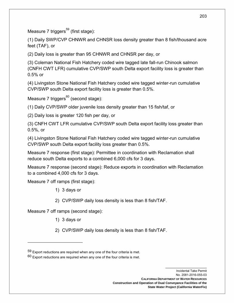
203
Incidental Take Permit No. 2081-2016-055-03
CALIFORNIA DEPARTMENT OF WATER RESOURCES
Construction and Operation of Dual Conveyance Facilities of the
State Water Project (California WaterFix)
Measure 7 triggers59 (first stage):
(1) Daily SWP/CVP CHNWR and CHNSR loss density greater than 8 fish/thousand acre feet (TAF), or
(2) Daily loss is greater than 95 CHNWR and CHNSR per day, or
(3) Coleman National Fish Hatchery coded wire tagged late fall-run Chinook salmon (CNFH CWT LFR) cumulative CVP/SWP south Delta export facility loss is greater than 0.5% or
(4) Livingston Stone National Fish Hatchery coded wire tagged winter-run cumulative CVP/SWP south Delta export facility loss is greater than 0.5%.
Measure 7 triggers60 (second stage):
(1) Daily CVP/SWP older juvenile loss density greater than 15 fish/taf, or
(2) Daily loss is greater 120 fish per day, or
(3) CNFH CWT LFR cumulative CVP/SWP south Delta export facility loss greater than 0.5%, or
(4) Livingston Stone National Fish Hatchery coded wire tagged winter-run cumulative CVP/SWP south Delta export facility loss greater than 0.5%.
Measure 7 response (first stage): Permittee in coordination with Reclamation shall reduce south Delta exports to a combined 6,000 cfs for 3 days.
Measure 7 response (second stage): Reduce exports in coordination with Reclamation to a combined 4,000 cfs for 3 days.
Measure 7 off ramps (first stage):
1) 3 days or
2) CVP/SWP daily loss density is less than 8 fish/TAF.
Measure 7 off ramps (second stage):
1) 3 days or
2) CVP/SWP daily loss density is less than 8 fish/TAF.
59 Export reductions are required when any one of the four criteria is met. 60 Export reductions are required when any one of the four criteria is met.

204
Incidental Take Permit No. 2081-2016-055-03
CALIFORNIA DEPARTMENT OF WATER RESOURCES
Construction and Operation of Dual Conveyance Facilities of the
State Water Project (California WaterFix)
South Delta RTO Measure 8 - Skinner Fish Facility Operations61: The purpose of this measure is to ensure that the maintenance, inspection and reporting schedule at the Skinner Fish Facility is effective in minimizing take of Covered Fish Species.
At least one year prior to initiation of the Test Period Permittee shall consult with CDFW on projects and actions that will improve the survival rates of salvaged DS and LFS at the Skinner Fish Facility. This consultation shall inform development of the draft and final Test Period Operations Plan and Full Project Operations Plan, which shall include a list of feasible actions and projects, and plans to implement them, throughout the Test Period and Full Project Operations to improve the survival rates of salvaged DS and LFS at the Skinner Fish Facility.
The Test Period Operations Plan and the Full Project Operations Plan shall include, but not be limited to, the following Skinner Fish Facility operations requirements from November 1 – June 30:
1) Permittee shall salvage Covered Species according to CDFW and DWR protocol (see Skinner Fish Facility Operations Manual (v 2.0 October 19, 2005)) when exporting water via the Banks Pumping Plant
2) Permittee shall promptly report unplanned salvage outages to CDFW
3) Permittee shall consult with CDFW to plan salvage outages
4) For unplanned salvage outages greater than one hour, Permittee shall notify the CDFW Salvage Biologist by phone immediately. If discussion by phone isn’t possible, Permittee shall leave a message detailing the source and estimated duration of the outage.
Salvage Biologist: (209) 234-3672; (209) 639-2750
Salvage Supervisor: (209) 234-3485; (209) 639-2686
Salvage Manager: (831) 372-2581
5) For all planned salvage outages to be conducted for normal maintenance and repair work (e.g., predator clean-outs, normal maintenance procedures, repairs to valves and controls), Permittee shall contact the CDFW Salvage Biologist at least one business day in advance of outages. Export rates shall not increase during any outage period.
61 This measure was initially implemented as Conditions 6.2 and 6.3 of CDFG (2009).

205
Incidental Take Permit No. 2081-2016-055-03
CALIFORNIA DEPARTMENT OF WATER RESOURCES
Construction and Operation of Dual Conveyance Facilities of the
State Water Project (California WaterFix)
6) Permittee shall submit annual reports that document and describe the regular inspection and maintenance at the Skinner Fish Facility performed on fish protective equipment that may affect screening and salvage efficiencies to the TOT.
7) The Permittee shall ensure the Skinner Fish Facility salvage monitoring and reporting program samples no less than 30 minutes for every 2 hours from December 1 – June 30. If the presence of large number of fish or debris in the salvage will result in the significant loss of Covered Species in the salvage monitoring process, Permittee shall operate to the existing protocols for such circumstances (see Skinner Fish Facility Operations Manual (v 2.0 October 19, 2005)).
8) Permittee shall implement an effectiveness monitoring program for the Skinner Fish Facility that covers the November through June monitoring period to ensure the minimization measures are successfully reducing incidental take of the Covered Species. The Permittee shall continue to work and coordinate with CDFW salvage staff to information is shared as promptly as possible.
9.9.5.3 Real Time Operations of the HOR Gate.
October 1 – November 30: HOR gate shall be operated during the SJR pulse period, as determined by the SOG. During this pulse period operation shall be to close the gate subject to RTO for purposes of water quality, stage and flood control considerations.
January 1 – March 31, and June 1 – June 15: Operation of the HOR gate will be based on presence of migrating juvenile salmonids. During their migration, operation will be to close the gate for purposes of water quality, stage, and flood control.
April 1 – May 31: Permittee shall close the gate 100% of the time for purposes for water quality, stage, and flood control. Reclamation, DWR, NMFS, USFWS and CDFW will explore the implementation of reliable juvenile salmonid tracking technology that may enable shifting to a more flexible real time operating criterion based on the presence/absence of Covered Fish Species.
June 16 – September 30, and December 1 – December 31: Operable gates will be open
At any time during the year Permittee may open the HOR gate to reduce downstream flood risks based on current conditions if San Joaquin River flow at Vernalis is greater than 10,000 cfs. This threshold may be revised to align with any future flood protection actions and with written approval from CDFW.
9.9.5.4 Suisun Marsh Facilities Real Time Operations. RTO shall be implemented to make short-term decisions regarding operation of Suisun Marsh facilities (SMSCG, RRDS, MIDS, and Goodyear Slough Outfall) in coordination with real time operations of all other Project facilities. The Suisun Marsh facilities shall be operated within the range

206
Incidental Take Permit No. 2081-2016-055-03
CALIFORNIA DEPARTMENT OF WATER RESOURCES
Construction and Operation of Dual Conveyance Facilities of the
State Water Project (California WaterFix)
of criteria listed in Condition of Approval 9.9.4, and be subject to RTO decision making based on anticipated impacts to DS, LFS, CHNWR, and CHNSR. Suisun Marsh facility RTO criteria, as described in the Real Time Operations Plan, shall include all Suisun Marsh RTO Measures included in this term.
Permittee may modify requirements in Suisun Marsh RTO Measure 2 using a minor amendment to this permit if such modifications are recommended as a result of reinitiation of USFWS (2009) or under the Adaptive Management Program.
Suisun Marsh RTO Measure 1 - Suisun Marsh Salinity Control Gates Operating Criteria: Permittee shall adhere to operating criteria as required by D-1641 and the following seasonal operation requirements from October 1 – February 28:
1) The radial gates shall be operational if Martinez EC is greater than 20,000, and for remaining months they remain open.
2) Permittee shall close gates when downstream channel flow velocity is < 0.1 (onset of flood tide); gates open when upstream to downstream stage difference is greater than 0.3 ft (onset of ebb tide).
Suisun Marsh RTO Measure 2 - MIDS Operating Criteria (LFS ITP Condition 6.1): To minimize take of LFS at the MIDS diversion, in addition to any existing operating rules, Permittee shall adhere to CDFW average intake velocity specifications.
CDFW will specify the required average intake velocities by August 15 each year in order to adequately protect LFS and, if appropriate, to allow Permittee to meet contractual water delivery requirements. Permittee shall maintain this velocity from September 1 to December 31 each year to protect staging and spawning LFS from entrainment until alternative operational criteria are developed from completion of the study below.
9.9.5.5 Real Time Operations of the North Bay Aqueduct62. The purpose of this measure is to operate the NBA to protect larval DS and LFS.
Throughout the Test Period and Full Project Operations Permittee shall implement this measure from January 15 – March 31 of dry and critically dry years, as defined in D-1641 for the Sacramento River. If the Water Year type changes after January 1 to below normal, above normal, or wet, this measure shall be suspended. If the Water Year type changes after January to dry or critical, this measure shall apply.
62 This measure was initially implemented as Condition 5.3 of CDFG (2009).

207
Incidental Take Permit No. 2081-2016-055-03
CALIFORNIA DEPARTMENT OF WATER RESOURCES
Construction and Operation of Dual Conveyance Facilities of the
State Water Project (California WaterFix)
The SWG or CDFW SWG personnel shall provide Barker Slough Pumping Plant operations advice to the WOMT and to the Director weekly based on a review of the abundance and distribution survey data and other pertinent biological factors that influence the entrainment risk including detection of larval DS or LFS at Station 716. The advice for the Barker Slough Pumping Plant’s maximum seven day average shall not exceed 50 cfs. WOMT shall provide weekly advice which may include information on other ecosystem and water supply considerations to the Director and may accept, reject, or revise the recommendation of the SWG. If WOMT rejects or revises the recommendation, the Director may require a Barker Slough diversion rate and Permittee shall implement the rate required by the Director. Once notice is provided by the Director that a diversion rate is required, or the WOMT accepts the SWG or CDFW SWG advice,, the rate of diversion at Barker Slough shall not increase. Beginning on the day on which notice is provided or the WOMT accepts the advice, the maximum diversion rate shall not exceed 50 cfs. This restriction shall be suspended when larval DS or LFS are no longer detected at Station 716 or after March 31, whichever occurs sooner.
9.10 Impacts Associated with Atmospheric and Pressurized Safe Havens. Permittee shall not construct more than 22 atmospheric safe haven shafts during the course of Covered Activities without written approval from CDFW and an amendment to this permit. Individual atmospheric safe havens shall not impact more than three acres, including access roads. Permittee shall not construct more than 132 pressurized safe haven intervention shafts during the course of Covered Activities without written approval from CDFW and an amendment to this permit. Individual pressurized safe havens shall not exceed one acre, including access roads. Permittee shall construct atmospheric and pressurized safe haven intervention shafts as described in the Conveyance Facility Construction Activities section of the Project Description. Permittee shall restrict all Covered Activities associated with atmospheric and pressurized safe haven intervention shafts, including associated access roads, to construction sites within the safe haven corridor shown in Attachment 1, Figure 4. Permittee shall consult with CDFW after it constructs 18 atmospheric safe haven shafts or 110 pressurized safe haven intervention shafts to determine whether additional safe havens will be required during Project construction and an amendment to this permit is necessary.
10. Habitat Management Land Acquisition and Restoration
CDFW has determined that permanent protection and perpetual management of compensatory habitat is necessary and required pursuant to CESA to fully mitigate Project-related impacts of the taking on the Covered Species that will result with implementation of the Covered Activities. This determination is based on factors

208
Incidental Take Permit No. 2081-2016-055-03
CALIFORNIA DEPARTMENT OF WATER RESOURCES
Construction and Operation of Dual Conveyance Facilities of the
State Water Project (California WaterFix)
including an assessment of the importance of the habitat in the Project Area, the extent to which the Covered Activities will impact the habitat, and CDFW’s estimate of the acreage required to provide for adequate compensation.
To meet this requirement, Permittee shall either purchase Covered Species credits from a CDFW-approved mitigation or conservation bank to achieve the acreage requirements described in Table 10-1 (Condition of Approval 10.6), or shall provide for the permanent protection, restoration and initial and long-term management and monitoring of Habitat Management (HM) lands described in Table 10-1 and consistent with Covered Species habitat criteria described in Attachments 4 and 8. HM land protection, restoration, monitoring, and management shall be pursuant to Condition of Approval 10.6 below and the calculation of the management funds pursuant to Condition of Approval 10.5 below.
Permanent HM land protection, restoration and funding for perpetual monitoring and management of compensatory habitat must be complete before incurring impacts to Covered Species habitat. Permittee shall include in its Annual Status Report, pursuant to Condition of Approval 8.7, documentation demonstrating that cumulative HM lands permanently protected (and restored where required) for each Covered Species is at least 10 percent greater than the cumulative impacts to each Covered Species habitat, based on the requirements shown in Table 10-1 below (10 percent stay-ahead requirement). Permittee shall ensure that the ratio of cumulative HM lands protection and restoration for each Covered Species remains at least 10 percent greater than the cumulative impacts to each Covered Species habitat until the compensatory mitigation acreages in Table 10-1 have been achieved. The Annual Status Report shall also demonstrate that land and identified habitat features, anticipated to be disturbed over the succeeding twelve months in accordance with Conditions of Approval 8.4 and 8.5 above, will be preceded by HM lands permanent protection, and restoration if required. In the event that anticipated impacts in a given year to each Covered Species habitat are such that the 10 percent stay-ahead requirement would not be met, Permittee shall notify CDFW and provide a plan for permanently protecting, and restoring if required, the necessary HM lands before proceeding with the Covered Activity causing the impact.
Permanent protection, restoration and funding for perpetual monitoring and management of compensatory habitat must be complete before starting Covered Activities, or, if Security is provided pursuant to Condition of Approval 11 below for all uncompleted obligations, after initiation of Covered Activities but before impacts to Covered Species habitat occur.
The Permittee shall also restore on-site 766.1 acres of temporarily impacted Covered Species habitat pursuant to Condition of Approval 10.8 below.

209
Incidental Take Permit No. 2081-2016-055-03
CALIFORNIA DEPARTMENT OF WATER RESOURCES
Construction and Operation of Dual Conveyance Facilities of the
State Water Project (California WaterFix)
All compensatory acreage requirements are in addition to any acres already required or under development for compliance with existing CESA authorizations including Incidental Take Permit No. 2081-2009-001-03, and Consistency Determination Nos. 2080-2011-022-00 and 2080-2012-005-00. Permittee’s implementation of the protection, restoration or perpetual management of HM lands may require separate CEQA evaluation. Because no take authorization is provided through this permit for the HM lands activities Permittee shall obtain CESA authorization as necessary to implement HM land requirements. All individual protection and restoration projects proposed to achieve the compensatory mitigation required in this Condition of Approval shall be subject to CDFW approval in writing.
Table 10-1 Permanent and Temporary Impacts and Associated Compensatory
Mitigation Acres for Covered Species
Impact Type Acres
California Tiger Salamander
Permanent indirect upland habitat 3
Permanent direct upland habitat 47
Total permanent impacts 50
Required compensatory mitigation 150 upland
Temporary upland habitat 6
Total temporary impacts to upland habitat 6
Swainson’s Hawk
Permanent foraging habitat 3,770
Permanent nesting habitat 22
Total permanent impacts 3,792
Required compensatory mitigation
(also see Conditions of Approval 10.4, 10.5, 10.6, and 10.7)
3,770 foraging
22 nesting protected
22 nesting restored
Total temporary impacts to foraging habitat 1,114
Tricolored Blackbird
Permanent foraging habitat - breeding 2,063
Permanent foraging habitat - nonbreeding 1,774
Permanent nesting habitat 16
Permanent roosting habitat 20

210
Incidental Take Permit No. 2081-2016-055-03
CALIFORNIA DEPARTMENT OF WATER RESOURCES
Construction and Operation of Dual Conveyance Facilities of the
State Water Project (California WaterFix)
Impact Type Acres
Total permanent impacts 3,873
Required compensatory mitigation
2,063 foraging - breeding
1,774 foraging -
nonbreeding
48 nesting
40 roosting
Temporary foraging habitat - breeding 299
Temporary foraging habitat - nonbreeding 377
Total temporary impacts to foraging habitat 676
Giant Garter Snake
Permanent upland habitat 570
Permanent aquatic habitat 205
Total permanent impacts 775
Required compensatory mitigation See Condition of Approval
10.3
Temporary upland habitat 165
Total temporary impacts to upland habitat 165
Delta Smelt and Longfin Smelt
Permanent shallow water habitat 500.6
Permanent tidal perennial habitat 25.3
Permanent tidal perennial habitat in CCF 2,190
Total permanent impacts 2,715.9
Required compensatory mitigation
(also see Condition of Approval 10.1) 1,827.7
Total temporary impacts 0
Winter-run Chinook Salmon and Spring-run Chinook Salmon
Permanent channel margin habitat 1.44 linear miles
Permanent tidal perennial habitat 31.9
Permanent tidal perennial habitat in CCF 2,190
Total permanent impacts 2,221.9 acres

211
Incidental Take Permit No. 2081-2016-055-03
CALIFORNIA DEPARTMENT OF WATER RESOURCES
Construction and Operation of Dual Conveyance Facilities of the
State Water Project (California WaterFix)
Impact Type Acres
1.44 linear miles channel
margin
Required compensatory mitigation
(also see Condition of Approval 10.2)
154.8 acres
4.3 linear miles channel
margin
Temporary tidal perennial habitat 20.1
Total temporary impacts to tidal perennial habitat 20.1
10.1 Compensatory Mitigation for DS and LFS. Permittee shall site and design required DS and LFS tidal habitat compensatory mitigation totaling 1,827.7 acres (see Table 10-1) to expand the diversity, quantity, and quality of rearing and refuge habitat in the tidal portions of the Delta and Suisun Marsh. Permittee shall implement required DS and LFS compensatory mitigation prior to initiating the Covered Activities that impact DS and LFS habitat. Permittee shall coordinate with USFWS and CDFW during the process of site selection and restoration design for HM lands intended to serve as compensatory mitigation for impacts to DS and LFS habitat. HM lands and restoration designs shall be informed by the specifications and habitat crediting process described in the 2012 Fish Restoration Program Agreement Implementation Strategy, the Draft 2008 FWS BiOp Delta Smelt Crediting Decision Model Guidelines, and the Draft 2008 FWS BiOp Delta Smelt Crediting Decision Model (Guidance for Smelt HM Lands Suitable for Compensatory Mitigation, Attachment 8).
10.2 Compensatory Mitigation for CHNWR and CHNSR.
10.2.1 Mitigation for Impacts Associated With Project Construction. To offset impacts to habitat associated with construction of the NDD intakes Permittee will restore 154.8 acres of tidal perennial habitat and 3.04 linear miles of channel margin habitat on the Sacramento River or associated sloughs downstream of Freeport (Table 10-1 above). Restoration shall be completed prior to initiating Covered Activities.
10.2.2 Mitigation for Impacts Associated With Project Operations. To offset impacts to habitat associated with operations of the NDD intakes Permittee will restore 1.26 linear miles of channel margin habitat on the Sacramento River or associated sloughs downstream of Freeport (Table 10-1 above). Restoration shall be completed prior to initiation of the Test Period.
In addition to the compensatory mitigation requirements shown in Table 10-1, and upon approval of the change in point of diversion for the Project by the State
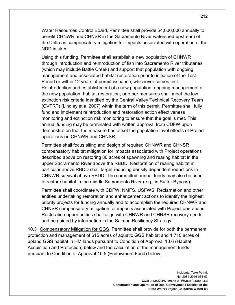
212
Incidental Take Permit No. 2081-2016-055-03
CALIFORNIA DEPARTMENT OF WATER RESOURCES
Construction and Operation of Dual Conveyance Facilities of the
State Water Project (California WaterFix)
Water Resources Control Board, Permittee shall provide $4,000,000 annually to benefit CHNWR and CHNSR in the Sacramento River watershed upstream of the Delta as compensatory mitigation for impacts associated with operation of the NDD intakes.
Using this funding, Permittee shall establish a new population of CHNWR through introduction and reintroduction of fish into Sacramento River tributaries (which may include Battle Creek) and support that population with ongoing management and associated habitat restoration prior to initiation of the Test Period or within 12 years of permit issuance, whichever comes first. Reintroduction and establishment of a new population, ongoing management of the new population, habitat restoration, or other measures shall meet the low extinction risk criteria identified by the Central Valley Technical Recovery Team (CVTRT) (Lindley et al.2007) within the term of this permit. Permittee shall fully fund and implement reintroduction and restoration action effectiveness monitoring and extinction risk monitoring to ensure that the goal is met. This annual funding may be terminated with written approval from CDFW upon demonstration that the measure has offset the population level effects of Project operations on CHNWR and CHNSR.
Permittee shall focus siting and design of required CHNWR and CHNSR compensatory habitat mitigation for impacts associated with Project operations described above on restoring 80 acres of spawning and rearing habitat in the upper Sacramento River above the RBDD. Restoration of rearing habitat in particular above RBDD shall target reducing density dependent reductions in CHNWR survival above RBDD. The committed annual funds may also be used to restore habitat in the middle Sacramento River (e.g., in Sutter Bypass).
Permittee shall coordinate with CDFW, NMFS, USFWS, Reclamation and other entities undertaking restoration and enhancement actions to identify the highest priority projects for funding annually and to accomplish the required CHNWR and CHNSR compensatory mitigation for impacts associated with Project operations. Restoration opportunities shall align with CHNWR and CHNSR recovery needs and be guided by information in the Salmon Resiliency Strategy.
10.3 Compensatory Mitigation for GGS. Permittee shall provide for both the permanent protection and management of 615 acres of aquatic GGS habitat and 1,710 acres of upland GGS habitat in HM lands pursuant to Condition of Approval 10.6 (Habitat Acquisition and Protection) below and the calculation of the management funds pursuant to Condition of Approval 10.5 (Endowment Fund) below.
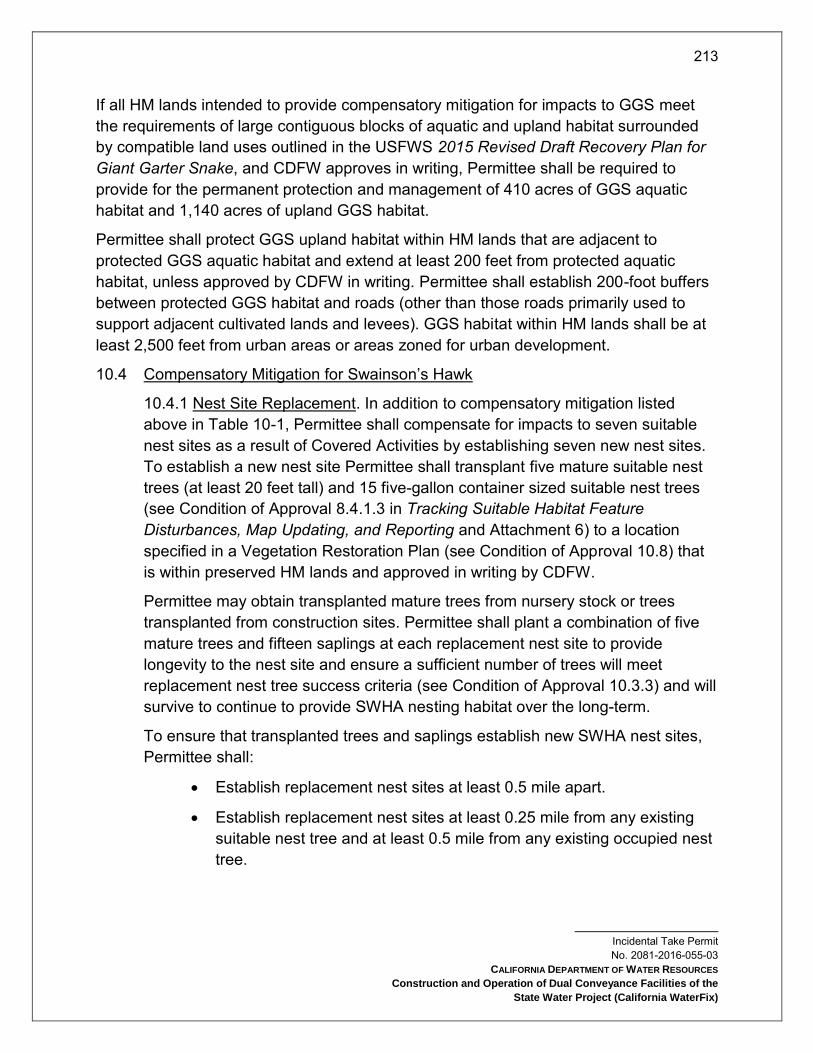
213
Incidental Take Permit No. 2081-2016-055-03
CALIFORNIA DEPARTMENT OF WATER RESOURCES
Construction and Operation of Dual Conveyance Facilities of the
State Water Project (California WaterFix)
If all HM lands intended to provide compensatory mitigation for impacts to GGS meet the requirements of large contiguous blocks of aquatic and upland habitat surrounded by compatible land uses outlined in the USFWS 2015 Revised Draft Recovery Plan for Giant Garter Snake, and CDFW approves in writing, Permittee shall be required to provide for the permanent protection and management of 410 acres of GGS aquatic habitat and 1,140 acres of upland GGS habitat.
Permittee shall protect GGS upland habitat within HM lands that are adjacent to protected GGS aquatic habitat and extend at least 200 feet from protected aquatic habitat, unless approved by CDFW in writing. Permittee shall establish 200-foot buffers between protected GGS habitat and roads (other than those roads primarily used to support adjacent cultivated lands and levees). GGS habitat within HM lands shall be at least 2,500 feet from urban areas or areas zoned for urban development.
10.4 Compensatory Mitigation for Swainson’s Hawk
10.4.1 Nest Site Replacement. In addition to compensatory mitigation listed above in Table 10-1, Permittee shall compensate for impacts to seven suitable nest sites as a result of Covered Activities by establishing seven new nest sites. To establish a new nest site Permittee shall transplant five mature suitable nest trees (at least 20 feet tall) and 15 five-gallon container sized suitable nest trees (see Condition of Approval 8.4.1.3 in Tracking Suitable Habitat Feature Disturbances, Map Updating, and Reporting and Attachment 6) to a location specified in a Vegetation Restoration Plan (see Condition of Approval 10.8) that is within preserved HM lands and approved in writing by CDFW.
Permittee may obtain transplanted mature trees from nursery stock or trees transplanted from construction sites. Permittee shall plant a combination of five mature trees and fifteen saplings at each replacement nest site to provide longevity to the nest site and ensure a sufficient number of trees will meet replacement nest tree success criteria (see Condition of Approval 10.3.3) and will survive to continue to provide SWHA nesting habitat over the long-term.
To ensure that transplanted trees and saplings establish new SWHA nest sites, Permittee shall:
Establish replacement nest sites at least 0.5 mile apart.
Establish replacement nest sites at least 0.25 mile from any existing suitable nest tree and at least 0.5 mile from any existing occupied nest tree.

214
Incidental Take Permit No. 2081-2016-055-03
CALIFORNIA DEPARTMENT OF WATER RESOURCES
Construction and Operation of Dual Conveyance Facilities of the
State Water Project (California WaterFix)
Establish replacement nest sites as close as possible to the impacted nest site, unless such location would have low long-term conservation value due to threats such as ongoing disturbance, seasonal flooding, or sea level rise.
Plant the five mature trees and 15 saplings in sites within or adjacent to conserved suitable foraging habitat (see Condition of Approval 8.4.1.4 in Tracking Suitable Habitat Feature Disturbances, Map Updating, and Reporting)
Plant mature nest trees and saplings before impacts to suitable nest sites to reduce temporal impacts resulting from the loss of mature nest trees.
10.4.2 Compensation for Lost Suitable Nest Trees. For each suitable nest tree removed as a result of Covered Activities, Permittee shall plant five native trees (five gallon container size) suitable for SWHA nesting to replace lost suitable nest trees (see 8.4.1.3 in Tracking Suitable Habitat Feature Disturbances, Map Updating, and Reporting and Attachment 6) at sites within or adjacent to conserved foraging habitat.
10.4.3 SWHA Replacement Nest Tree Monitoring and Success Criteria. Permittee shall monitor and maintain all replacement nest trees (mature trees and saplings) for a period of ten years to ensure survival and appropriate growth and development. Success shall be measured as an 80% survival rate of mature trees and 80% survival rate of saplings at five and ten years after planting. After the first ten years, Permittee shall monitor replacement nest trees every five years to verify their continued survival and growth. For every tree lost during the ten-year time period, Permittee shall immediately plant a replacement tree upon the detection of failure. Permittee shall provide all necessary maintenance (e.g., fertilizing, irrigation) to ensure successful tree establishment. Permittee shall irrigate trees for a minimum of five years after planting, and then gradually wean the trees off the irrigation during a period of approximately two years. If larger stock is planted, Permittee may reduce the number of years of irrigation accordingly. If the 80% establishment success criteria cannot be met, Permittee shall coordinate with CDFW to determine additional measures.
10.4.4 Install and Maintain Bird Strike Diverters on Transmission Lines in the Project Area. Permittee shall install bird strike diverters on existing transmission lines within the Project Area and all new transmission lines constructed as a part of Covered Activities and shown in Attachment 1, Figures 4 c and d (see also Condition of Approval 9.1.10). Permittee shall install bird strike diverters on

215
Incidental Take Permit No. 2081-2016-055-03
CALIFORNIA DEPARTMENT OF WATER RESOURCES
Construction and Operation of Dual Conveyance Facilities of the
State Water Project (California WaterFix)
existing transmission lines in the Project Area equal in length to the length of new permanent and temporary transmission lines constructed as a part of Covered Activities and shown in Attachment 1, Figures 4 c and d, except where new transmission lines replace existing transmission lines. Permittee shall space bird strike diverters along transmission lines in accordance with the Avian Powerline Interaction Committee’s guidance (Avian Power Line Interaction Committee 2012) and shall select bird strike diverters according to the best available science. Permittee shall inspect bird strike diverters annually and replace malfunctioning or lost diverters, unless or until the transmission line is removed. Permittee shall submit a plan describing the location and type of bird strike diverters installed as compensatory mitigation for impacts to SWHA and TRBL to CDFW for review. Upon written approval of the plan by CDFW Permittee shall install and maintain all bird strike diverters.
10.5 Cost Estimates. CDFW has estimated the cost of acquisition, protection, and perpetual management of the HM lands as shown in Table 10-2. The methods used to determine these costs are described in Section 7.1.1 of the permit application and are based largely on the detailed cost estimates of relevant conservation measures and other program elements from the 2013 Bay Delta Conservation Plan (BDCP) Public Draft and from Exhibit E Budget and Schedule of the January 2016 Design and Construction Enterprise (DCE) Agreement, with costs expressed in 2014 dollars. The costs of restoration of temporarily disturbed habitat are shown in Table 10-3.
10.5.1 Land acquisition costs for HM lands identified in Condition of Approval 10, are shown in Table 10-2 and are estimated using local fair market current value for lands with habitat values meeting mitigation requirements plus a ten percent contingency;
10.5.2 Start-up costs for HM lands, including initial site protection and enhancement costs as described in Conditions of Approval 10.6.1 and 10.6.5 below, as shown in Table 10-2 by habitat type. This includes costs of restoration and enhancement;
10.5.3 Interim management period funding as described in Condition of Approval 10.6.6 below, is estimated as shown in Table 10-2 by habitat type. This cost includes post-restoration or enhancement monitoring and management actions;
10.5.4 Long-term management funding as described in Condition of Approval 10.6.7 below, was estimated at between $13 and $693/acre for habitat types shown in Table 10-2. Long-term management funding is estimated initially for determining what the SWP Contractors will be required to fund on an annual basis to ensure implementation of HM lands management.

216
Incidental Take Permit No. 2081-2016-055-03
CALIFORNIA DEPARTMENT OF WATER RESOURCES
Construction and Operation of Dual Conveyance Facilities of the
State Water Project (California WaterFix)
10.5.5 Related transaction fees including but not limited to account set-up fees, administrative fees, title and documentation review and related title transactions, expenses incurred from other state agency reviews, and overhead related to transfer of HM lands to CDFW as described in Condition of Approval 10.6, estimated to be between $510 and $1,318/acre.
10.5.6 Restoration of on-site temporary effects to Covered Species habitat as described in Condition of Approval 10.8, and estimated costs are presented in Table 10-3. Temporary impacts to Covered Species habitats on croplands will be restored through resumption of existing cropland uses and were assumed to have no additional incremental costs.
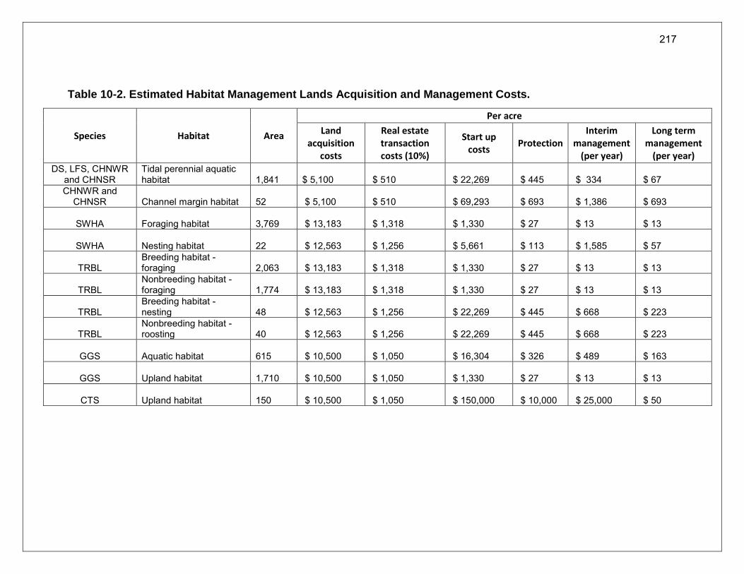
217
Table 10-2. Estimated Habitat Management Lands Acquisition and Management Costs.
Species Habitat Area
Per acre
Land acquisition
costs
Real estate transaction costs (10%)
Start up costs
Protection Interim
management (per year)
Long term management
(per year) DS, LFS, CHNWR
and CHNSR Tidal perennial aquatic habitat
1,841 $ 5,100 $ 510 $ 22,269 $ 445 $ 334 $ 67
CHNWR and CHNSR Channel margin habitat
52 $ 5,100 $ 510 $ 69,293 $ 693 $ 1,386 $ 693
SWHA Foraging habitat 3,769 $ 13,183 $ 1,318 $ 1,330 $ 27 $ 13 $ 13
SWHA Nesting habitat 22 $ 12,563 $ 1,256 $ 5,661 $ 113 $ 1,585 $ 57
TRBL Breeding habitat - foraging
2,063 $ 13,183 $ 1,318 $ 1,330 $ 27 $ 13 $ 13
TRBL Nonbreeding habitat - foraging
1,774 $ 13,183 $ 1,318 $ 1,330 $ 27 $ 13 $ 13
TRBL Breeding habitat - nesting
48 $ 12,563 $ 1,256 $ 22,269 $ 445 $ 668 $ 223
TRBL Nonbreeding habitat - roosting
40 $ 12,563 $ 1,256 $ 22,269 $ 445 $ 668 $ 223
GGS Aquatic habitat 615 $ 10,500 $ 1,050 $ 16,304 $ 326 $ 489 $ 163
GGS Upland habitat 1,710 $ 10,500 $ 1,050 $ 1,330 $ 27 $ 13 $ 13
CTS Upland habitat 150 $ 10,500 $ 1,050 $ 150,000 $ 10,000 $ 25,000 $ 50
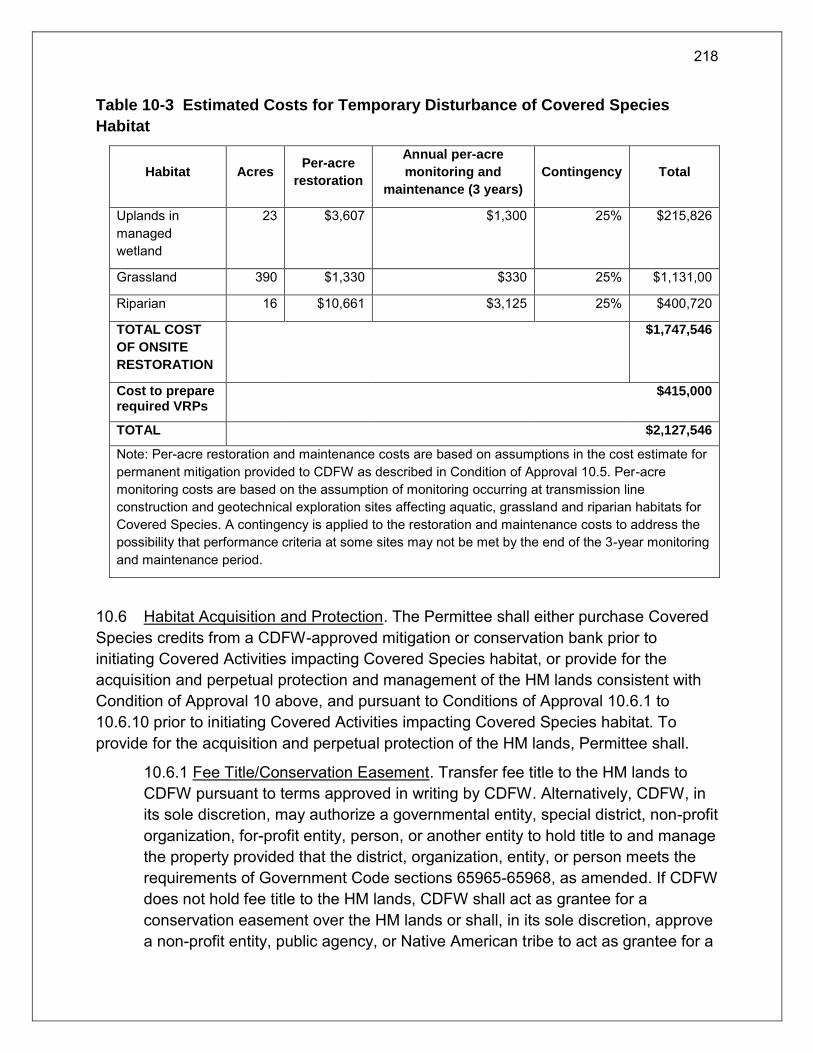
218
Table 10-3 Estimated Costs for Temporary Disturbance of Covered Species
Habitat
Habitat Acres Per-acre
restoration
Annual per-acre
monitoring and
maintenance (3 years)
Contingency Total
Uplands in managed wetland
23 $3,607 $1,300 25% $215,826
Grassland 390 $1,330 $330 25% $1,131,00
Riparian 16 $10,661 $3,125 25% $400,720
TOTAL COST
OF ONSITE
RESTORATION
$1,747,546
Cost to prepare required VRPs
$415,000
TOTAL $2,127,546
Note: Per-acre restoration and maintenance costs are based on assumptions in the cost estimate for permanent mitigation provided to CDFW as described in Condition of Approval 10.5. Per-acre monitoring costs are based on the assumption of monitoring occurring at transmission line construction and geotechnical exploration sites affecting aquatic, grassland and riparian habitats for Covered Species. A contingency is applied to the restoration and maintenance costs to address the possibility that performance criteria at some sites may not be met by the end of the 3-year monitoring and maintenance period.
10.6 Habitat Acquisition and Protection. The Permittee shall either purchase Covered Species credits from a CDFW-approved mitigation or conservation bank prior to initiating Covered Activities impacting Covered Species habitat, or provide for the acquisition and perpetual protection and management of the HM lands consistent with Condition of Approval 10 above, and pursuant to Conditions of Approval 10.6.1 to 10.6.10 prior to initiating Covered Activities impacting Covered Species habitat. To provide for the acquisition and perpetual protection of the HM lands, Permittee shall.
10.6.1 Fee Title/Conservation Easement. Transfer fee title to the HM lands to CDFW pursuant to terms approved in writing by CDFW. Alternatively, CDFW, in its sole discretion, may authorize a governmental entity, special district, non-profit organization, for-profit entity, person, or another entity to hold title to and manage the property provided that the district, organization, entity, or person meets the requirements of Government Code sections 65965-65968, as amended. If CDFW does not hold fee title to the HM lands, CDFW shall act as grantee for a conservation easement over the HM lands or shall, in its sole discretion, approve a non-profit entity, public agency, or Native American tribe to act as grantee for a

219
Incidental Take Permit No. 2081-2016-055-03
CALIFORNIA DEPARTMENT OF WATER RESOURCES
Construction and Operation of Dual Conveyance Facilities of the
State Water Project (California WaterFix)
conservation easement over the HM lands provided that the entity, agency, or tribe meets the requirements of Civil Code section 815.3. If CDFW does not hold the conservation easement, CDFW shall be expressly named in the conservation easement as a third-party beneficiary. The Permittee shall obtain CDFW written approval of any conservation easement before its execution or recordation. No conservation easement shall be approved by CDFW unless it complies with Government Code sections 65965-65968, as amended and includes provisions expressly addressing Government Code sections 65966(j) and 65967(e).
10.6.2 HM Lands Approval. Obtain CDFW written approval of the HM lands before acquisition and/or transfer of the land by submitting, at least three months before acquisition and/or transfer of the HM lands, a formal Proposed Lands for Acquisition Form (see Attachment 3B) identifying the land to be purchased or property interest conveyed to an approved entity as mitigation for the Project’s impacts on Covered Species. HM lands may be proposed and approved in segments or subsets;
10.6.3 HM Lands Documentation. Provide a recent preliminary title report, initial hazardous materials survey report, and other necessary documents (see Attachment 3A). All documents conveying the HM lands and all conditions of title are subject to the approval of CDFW, and if applicable, the Wildlife Conservation Board and the Department of General Services;
10.6.4 Land Manager. Designate both an interim and long-term land manager approved by CDFW. The interim and long-term land managers may, but need not, be the same. The interim and/or long-term land managers may be the landowner or another party. Documents related to land management shall identify both the interim and long-term land managers. Permittee shall notify CDFW of any subsequent changes in the land manager within 30 days of the change. If CDFW will hold fee title to the mitigation land, CDFW will also act as both the interim and long-term land manager unless otherwise specified;
10.6.5 Start-up Activities. Provide for the implementation of start-up activities, including the initial site protection and enhancement of HM lands, once the HM lands have been approved by CDFW. Start-up activities include, at a minimum: (1) Preparation of restoration or enhancement plan as necessary; (2) preparing necessary CEQA documents and obtaining necessary permits, including take authorization under CESA (3) preparing a final management plan for CDFW approval; (4) implementing habitat restoration or enhancement, if applicable; (5) conducting a baseline biological assessment and land survey report within four months of recording or transfer; (6) developing and transferring Geographic

220
Incidental Take Permit No. 2081-2016-055-03
CALIFORNIA DEPARTMENT OF WATER RESOURCES
Construction and Operation of Dual Conveyance Facilities of the
State Water Project (California WaterFix)
Information Systems (GIS) data if applicable; (7) initial site management including installing fencing and site improvements as necessary; (8) site maintenance; and (9), installing signage. Permittee shall provide for these start-up activities until the final management plan is approved and all restoration or enhancement actions are completed;
10.6.6 Interim Management (Initial and Capital). Provide for the interim management of the HM lands. The Permittee shall ensure that the interim land manager implements the interim management of the HM lands as described in the final management plan and conservation easement approved by CDFW. The interim management period shall be a minimum of three years from the date of HM land acquisition and protection and includes expected management following start-up activities. Interim management period activities described in the final management plan shall include site maintenance, site monitoring, and vegetation and invasive species management. Permittee shall provide funding for interim management of the HM lands by using revenues derived from the SWP charges to the SWP Contractors under long-term water supply contracts, and any subsequent agreements;
10.6.7 In-Perpetuity Management Funding. The Permittee shall ensure that the HM lands are perpetually managed, maintained, and monitored by the long-term land manager as described in this ITP, the conservation easement, and the final management plan approved by CDFW. After obtaining CDFW approval of the HM lands, Permittee shall provide long-term management funding for the perpetual management of the HM lands. As shall be specified in written terms acceptable to CDFW for individual HM lands projects, Permittee shall provide long-term funding for the perpetual management of the HM lands by using revenues derived from the SWP charges to the SWP Contractors under long-term water supply contracts, and any subsequent agreements, to fund long-term management activities in perpetuity annually in the amount identified initially in a CDFW approved Property Analysis Record (PAR) or PAR-equivalent analysis (hereinafter “PAR”) addressing the specific long-term management costs for individual HM lands sites. Actual annual funding shall be adjusted for inflation and may be adjusted to address actual costs of management over time, as approved by CDFW. Prior to commencement of Covered Activities, Permittee shall furnish CDFW with a copy of: 1) the contract entered into or arrangement made to satisfy California Water Code, section 85089, subdivision (a); and 2) documentation acceptable to CDFW demonstrating that subsequent financial agreements entered into to cover the costs of the Project explicitly identify the

221
Incidental Take Permit No. 2081-2016-055-03
CALIFORNIA DEPARTMENT OF WATER RESOURCES
Construction and Operation of Dual Conveyance Facilities of the
State Water Project (California WaterFix)
costs of long-term management of HM lands as a cost covered by the Agreement.
If funding is no longer available from SWP charges to the SWP Contractors, Permittee shall annually fund in-perpetuity management activities through another funding source until Permittee has established and fully funded an endowment. If another funding source is required, it shall be established within six months of identifying that the previous funding source will no longer be available. If SWP charges to the State Water Contractors funding is no longer available, Permittee shall establish a long-term management fund (Endowment). The Endowment is a sum of money, held in a CDFW-approved fund, that provides funds for the perpetual management, maintenance, monitoring, and other activities on the HM lands consistent with the management plan(s) required by Condition of Approval 10.6.5, and based on funding requirements established through the PAR(s) prepared for the HM lands pursuant to Condition of Approval 10.6.7. If the HM lands have been managed pursuant to a final management plan approved by CDFW for at least five years, the PAR and Endowment shall be based on the actual costs of managing the HM lands. Permittee shall fund the Endowment by contributing a minimum of ten percent of the amount required by the PAR (adjusted for present value) annually, commencing the fiscal year that SWP charges to the SWP Contractors are no longer an available funding source, to a mutually agreed upon account, until the Endowment is fully funded, after which time the activities under the management plan(s) will be funded from interest generated from the Endowment principal. Endowment as referred to in this ITP shall refer to the endowment deposit and all interest, dividends, other earnings, additions and appreciation thereon. The Endowment shall be governed by this ITP, Government Code sections 65965-65968, as amended, and Probate Code sections 18501-18510, as amended.
After the interim management period, Permittee shall ensure that the designated long-term land manager implements the management and monitoring of the HM lands according to the final management plan. The long-term land manager shall be obligated to manage and monitor the HM lands in perpetuity to preserve their conservation values in accordance with this ITP, the conservation easement, and the final management plan. Such activities shall be funded as described above or in the event a conservation or mitigation bank is used to meet HM land requirements the long-term manager will be responsible for funding in perpetuity management through the endowment for the bank.

222
Incidental Take Permit No. 2081-2016-055-03
CALIFORNIA DEPARTMENT OF WATER RESOURCES
Construction and Operation of Dual Conveyance Facilities of the
State Water Project (California WaterFix)
10.6.8 Identify an Endowment Manager. In the event an Endowment is required (Condition of Approval 10.6.7), the Endowment shall be held by the Endowment Manager, which shall be either CDFW or another entity qualified pursuant to Government Code sections 65965-65968, as amended. Permittee shall submit to CDFW a written proposal that includes: (i) the name of the proposed Endowment Manager; (ii) whether the proposed Endowment Manager is a governmental entity, special district, nonprofit organization, community foundation, or congressionally chartered foundation; (iii) whether the proposed Endowment Manager holds the property or an interest in the property for conservation purposes as required by Government Code section 65968(b)(1) or, in the alternative, the basis for finding that the Project qualifies for an exception pursuant to Government Code section 65968(b)(2); and (iv) a copy of the proposed Endowment Manager’s certification pursuant to Government Code section 65968(e). Within thirty days of CDFW’s receipt of Permittee’s written proposal, CDFW shall inform Permittee in writing if it determines the proposal does not satisfy the requirements of Fish and Game Code section 2081(b)(4) and, if so, shall provide Permittee with a written explanation of the reasons for its determination. If CDFW does not provide Permittee with a written determination within the thirty-day period, the proposal shall be deemed consistent with Section 2081(b)(4).
10.6.9 Calculate the Endowment Funds Deposit. In the event that an Endowment is required (Condition of Approval 10.6.7), after obtaining CDFW written approval of the HM lands, or a subset of them, and long-term management plan, Permittee shall prepare a PAR to calculate the amount of funding necessary to ensure the long-term management of the HM lands or identified subset (Endowment Deposit Amount). If at the time an Endowment becomes necessary, the HM lands have been managed pursuant to an approved final management plan for at least five years, Permittee shall use the actual costs of managing the HM lands to prepare the PAR. The Permittee shall submit to CDFW for review and approval the results of the PAR(s) before transferring funds to the Endowment Manager.
10.6.9.1 Capitalization Rate and Fees. Permittee shall obtain the capitalization rate from the selected Endowment Manager for use in calculating the PAR and adjust for any additional administrative, periodic, or annual fees.
10.6.9.2 Endowment Buffers/Assumptions. Permittee shall include in PAR assumptions the following buffers for endowment establishment and use

223
Incidental Take Permit No. 2081-2016-055-03
CALIFORNIA DEPARTMENT OF WATER RESOURCES
Construction and Operation of Dual Conveyance Facilities of the
State Water Project (California WaterFix)
that will substantially ensure long-term viability and security of the Endowment:
10.6.9.2.1 10 Percent Contingency. A 10 percent contingency shall be added to each endowment calculation to hedge against underestimation of the fund, unanticipated expenditures, inflation, or catastrophic events.
10.6.9.2.2 Three Years Delayed Spending. The endowment shall be established assuming spending will not occur for the first three years after full funding.
10.6.9.2.3 Non-annualized Expenses. For all large capital expenses to occur periodically but not annually such as fence replacement or well replacement, payments shall be withheld from the annual disbursement until the year of anticipated need or upon request to Endowment Manager and CDFW.
10.6.10 Transfer Long-term Endowment Funds. In the event that an Endowment is required (Condition of Approval 10.6.5), Permittee shall fund the Endowment Deposit Amount over a 10 year period, in annual amounts of 10 percent of the total Endowment Deposit Amount, adjusted for inflation, as approved by CDFW in writing. The approved Endowment Manager may pool the Endowment with other endowments for the operation, management, and protection of HM lands for local populations of the Covered Species, but shall maintain separate accounting for each Endowment. The Endowment Manager shall, at all times, hold and manage the Endowment in compliance with this ITP, Government Code sections 65965-65968, as amended, and Probate Code sections 18501-18510, as amended.
10.7 Reimburse CDFW. Permittee shall reimburse CDFW for all reasonable expenses incurred by CDFW such as transaction fees, account set-up fees, administrative fees, title and documentation review and related title transactions, expenses incurred from other state agency reviews, and overhead related to transfer of HM lands to CDFW.
10.8 On-site Habitat Restoration for Temporary Impacts. Permittee shall restore on-site the Covered Species habitat that will be temporarily disturbed during Covered Activities to pre-project or better conditions, as described in this Condition of Approval. At least six months prior to initiation of Covered Activities affecting Covered Species habitat, Permittee shall prepare a Vegetation Restoration Plan (VRP) to facilitate revegetation of temporary disturbance on-site for each of the Covered Species habitats, and shall ensure that the VRP is successfully implemented. Restoration of temporarily disturbed agricultural lands will be accomplished by returning the lands to the same

224
Incidental Take Permit No. 2081-2016-055-03
CALIFORNIA DEPARTMENT OF WATER RESOURCES
Construction and Operation of Dual Conveyance Facilities of the
State Water Project (California WaterFix)
crop production following disturbance. The Permittee has identified the need to prepare twelve VRP based on current assessments. Given the long time period over which construction activities will occur and uncertainty over the location of habitat to be affected, VRP’s will be prepared as construction plans are finalized and the specific Covered Species habitats are identified.
The VRP for each Covered Species shall include, at a minimum, the following information: (1) a description of the existing physical and biological conditions of the site prior to commencement of restoration activities; (2) methodologies for the initial removal of nonnative plant species, trash, and debris; (3) identification of native plant seed mixes and/or plantings to be used (agricultural plants may be used instead of native plants where cultivated lands have been temporarily impacted); (4) source(s) of plant seeds and/or plantings; (5) seeding rate and/or number of plantings per species; (6) identification or mulching methodologies and product(s) to be used; (7) proposed spacing of plantings; (8) habitat restoration design plans/mapping for the restoration area(s); (9) and irrigation/watering plan, if warranted; (10) proposed weed management methods; (11) monitoring methodologies and maintenance measures including a timeline for implementation; (12) fencing and signage to restrict pedestrian and/or vehicle access into the restoration area(s); and (13) success standards and proposed remedial actions if those standards are not met.
Restoration measures and success criteria included in the VRP shall be consistent with the definitions of suitable habitat in Condition of Approval 8.4.1 Tracking Suitable Habitat Feature Disturbances, Map Updating, and Reporting; Attachment 4 Covered Species-Specific Criteria for HM Lands Suitable for Compensatory Mitigation. Permittee shall include in the VRP for GGS upland habitat restoration measures and success criteria described in the 2007 USFWS Programmatic Consultation with the U.S. Army Corps of Engineers 404 Permitted Projects with Relatively Small Effects on the Giant Garter Snake within Butte, Colusa, Glenn, Fresno, Merced, Sacramento, San Joaquin, Solano, Stanislaus, Sutter and Yolo Counties, California, Appendix A – Guidelines for Restoration and/or Replacement of Giant Garter Snake Habitat.
Permittee shall submit the VRP for each Covered Species to CDFW for written approval. Permittee shall not initiate Covered Activities that will result in temporary impacts to Covered Species habitat, including geotechnical exploration and pressurized safe haven activities, until the VRP is approved in writing by CDFW. Permittee shall conduct monitoring and maintenance of the habitat restoration area(s) no less than annually for a minimum of three years after initial restoration activities are complete, and until CDFW determines in writing that the restoration effort is successful.

225
Incidental Take Permit No. 2081-2016-055-03
CALIFORNIA DEPARTMENT OF WATER RESOURCES
Construction and Operation of Dual Conveyance Facilities of the
State Water Project (California WaterFix)
11 Performance Security
The Permittee may proceed with Covered Activities based on the Security as described below. Permittee is a party to a long-term water supply contract with each of its 29 water supply customers, who are generally referred to as “Contractors.” In accordance with the Delta Reform Act (Water Code section 85089), Covered Activities shall not commence until the persons or entities that contract to receive water from the SWP and CVP or a joint powers authority representing those entities have entered into an agreement or made arrangements to pay for the construction and mitigation costs associated with the Project (including the CESA mitigation requiring land purchase and restoration and enhancement of HM lands and the long term management, and monitoring of the HM lands). Permittee and/or one or more of the SWP contractors or other entities participating in the Project will likely issue revenue bonds to fund the portion of the construction and mitigation costs accruing to SWP contractors. Capital costs associated with mitigation required by this permit would also be funded in this manner. Subsequent funding agreements will provide for the payment of debt service and ongoing operation and maintenance costs, including all mitigation and monitoring costs incurred during construction, operation, maintenance and monitoring associated with the Project, including CESA mitigation. Permittee shall assure performance as follows:
11.1 Security Amount. Estimated costs to implement acquisition, protection, restoration ad perpetual management of the HM lands as shown in Table 10-2 and restoration of temporarily disturbed habitat identified in Table 10-3 of this permit and Condition of Approval 10.5.
Estimated costs to implement studies and monitoring required as in Conditions 9.6.10, 9.6.11, and 9.8 and to support the Adaptive Management Program required by this permit to begin within the near term are identified in the interagency funding assessment. (Implementation Schedule for AMP, Attachment 5.) The existing annual budget for monitoring, studies, and model development for assessing all aspects for management associated with the CVP and SWP and meeting requirements of the existing biological opinions, CESA authorizations and D-1641 is approximately $66 million. Additional estimated costs for studies and monitoring associated with this permit could total and additional $50 million per year through the first 10 years following permit issuance. The Permittee in coordination with Reclamation has committed to securing
226
Incidental Take Permit No. 2081-2016-055-03
CALIFORNIA DEPARTMENT OF WATER RESOURCES
Construction and Operation of Dual Conveyance Facilities of the
State Water Project (California WaterFix)
funding for implementation of the necessary studies required by this permit and to support the Adaptive Management Program as described in Attachment 5.
11.2 Security Form.
11.2.1 Construction monitoring, mitigation implementation and monitoring. Payment of the costs of constructing and operating the Project, including associated mitigation projects, is assured by Permittee’s long term water supply contracts and applicable state law. All construction costs of the Project, including the costs of mitigation and monitoring activities required by this Permit will be paid by Permittee and charged to SWP Contractors and, as appropriate, CVP Contractors.
Permittee shall prepare and submit to CDFW within one year of issuance of a SWRCB approval of a change in point of diversion for the Project an initial CESA mitigation funding strategy for review and approval. The strategy shall include detailed cost estimates regarding, as applicable: 1) purchase of mitigation or conservation bank credits; 2) HM lands acquisition and start-up costs and interim management period costs; 3) restoration costs including design, environmental review, permitting, construction and interim management period costs 4) and long-term management costs for all HM lands. The strategy shall include detailed funding and commitments for the first five years (2019-2024).
Permittee shall submit annual updates to the strategy to CDFW for review and approval. These updates shall include extension of the detailed funding strategy for five years post submission date, and shall include a description of expenditures to date for compliance with Conditions of Approval 10.5 to 10.8. To the degree that annual charges to Contractors are relied upon, the funding strategy shall demonstrate that those funds have been or will be charged to Contractors and received by Permittee consistent with Contractor billing practices.
11.2.2 Adaptive Management Program. Permittee shall prepare and submit to CDFW within one year of issuance of a SWRCB approval of a change in point of diversion for the Project an initial Adaptive Management Program funding strategy for review and approval. Permittee shall develop a funding strategy that clearly identifies responsible parties and levels of annual and total program funding consistent with the funding needs identified in Condition of Approval 9.8.11 for implementation of the Adaptive Management Program starting in 2019. The strategy shall include detailed funding and commitments for the first five years (2019-2024), and lesser detail for the studies required after 2024.
227
Incidental Take Permit No. 2081-2016-055-03
CALIFORNIA DEPARTMENT OF WATER RESOURCES
Construction and Operation of Dual Conveyance Facilities of the
State Water Project (California WaterFix)
Consistent with the role of the IICG as detailed in the Adaptive Management Program, Permittee shall submit annual updates to the strategy to CDFW for review and approval. These updates shall include extension of the detailed funding strategy for five years post submission date. To the degree that annual charges to Contractors are relied upon, the funding strategy shall demonstrate that those funds have been or will be charged to Contractors and received by Permittee consistent with Contractor billing practices.
11.3 Demonstration of Performance. Before incurring impacts to Covered Species, Permittee shall demonstrate to CDFW that Covered Species’ requirements have been satisfied, as evidenced by:
Receipt by CDFW of a copy of the contract(s) entered into or arrangement made to satisfy California Water Code, section 85089, subdivision (a), prior to commencement of Covered Activities;
Receipt by CDFW of documentation, acceptable to CDFW, demonstrating that subsequent financial agreements, entered into to cover repayment of the CWF bonds, explicitly identify funding for pre-construction studies, monitoring and all other Conditions of Approval of this permit as part of the construction costs of the Project;
Within one year of permit issuance, submission of an initial CESA mitigation funding strategy for concurrence by CDFW; and
Within one year of permit issuance submission of an initial Adaptive Management Program funding strategy for concurrence by CDFW.
During the permit term, Permittee shall demonstrate to CDFW that Covered Species’ requirements have been satisfied on an ongoing basis and consistent with the 10 percent stay-ahead requirement of Condition of Approval 10, as evidenced by:
Written documentation of the acquisition of HM lands as required in Condition 10;
Copies of all executed and recorded conservation easements for HM lands acquired;
Final CDFW approved management plans for all HM lands;
Documentation of completion of habitat restoration or enhancement to mitigate adverse effects to Covered Species from Covered Activities;
Written confirmation from the approved Endowment Manager of its receipt of the full Endowment if required; and
228
Incidental Take Permit No. 2081-2016-055-03
CALIFORNIA DEPARTMENT OF WATER RESOURCES
Construction and Operation of Dual Conveyance Facilities of the
State Water Project (California WaterFix)
Timely submission of all required reports.
Permanent protection, restoration and funding for perpetual monitoring and management of compensatory habitat must be complete before commencement of Covered Activities as specified in Condition of Approval 10. CDFW may require the Permittee to provide additional HM lands and/or additional funding to ensure the impacts of the taking are minimized and fully mitigated, as required by law, if the Permittee does not complete these requirements within the specified timeframe.
Delegation of Responsibilities
Any act required by the Conditions of Approval of this ITP to be undertaken by Permittee shall only be undertaken by Permittee and its employees, unless CDFW provides written approval for Permittee’s contractors or agents to undertake an act, which approval will not be unreasonably withheld. In all cases, including where such delegation is approved by CDFW, Permittee remains ultimately responsible for compliance with this ITP.
Amendment:
This ITP may be amended as provided by California Code of Regulations, Title 14, section 783.6, subdivision (c), and other applicable law. This ITP may be amended without the concurrence of the Permittee as required by law, including if CDFW determines that continued implementation of the Project as authorized under this ITP would jeopardize the continued existence of the Covered Species or where Project changes or changed biological conditions necessitate an ITP amendment to ensure that all Project-related impacts of the taking to the Covered Species are minimized and fully mitigated.
Stop-Work Order:
CDFW may issue Permittee a written stop-work order requiring Permittee to suspend any Covered Activity for an initial period of up to 25 days to prevent or remedy a violation of this ITP, including but not limited to the failure to comply with reporting or monitoring obligations, or to prevent the unauthorized take of any CESA endangered, threatened, or candidate species. Permittee shall stop work immediately as directed by CDFW upon receipt of any such stop-work order. Upon written notice to Permittee, CDFW may extend any stop-work order issued to Permittee for a period not to exceed

229
Incidental Take Permit No. 2081-2016-055-03
CALIFORNIA DEPARTMENT OF WATER RESOURCES
Construction and Operation of Dual Conveyance Facilities of the
State Water Project (California WaterFix)
25 additional days. Suspension and revocation of this ITP shall be governed by California Code of Regulations, Title 14, section 783.7, and any other applicable law. Neither the Designated Biologist nor CDFW shall be liable for any costs incurred in complying with stop-work orders.
Compliance with Other Laws:
This ITP sets forth CDFW’s requirements for the Permittee to implement the Project pursuant to CESA. This ITP does not necessarily create an entitlement to proceed with the Project. Permittee is responsible for complying with all other applicable federal, state, and local law.
Notices:
The Permittee shall deliver a fully executed duplicate original ITP by registered first class mail or overnight delivery to the following address:
Habitat Conservation Planning Branch
California Department of Fish and Wildlife
Attention: CESA Permitting Program
1416 Ninth Street, 12th Floor
Sacramento, CA 95814
Written notices, reports and other communications relating to this ITP shall be delivered to CDFW by registered first class mail at the following address, or at addresses CDFW may subsequently provide the Permittee. Notices, reports, and other communications shall reference the Project name, Permittee, and ITP Number (2081-2016-055-03) in a cover letter and on any other associated documents.
Original cover with attachment(s) to:
Cal Wilcox, Policy Advisor to the Director
California Department of Fish and Wildlife
830 S Street
Sacramento, CA 95811
Telephone (916) 445-8576
Fax (916) 445-1768
and a copy to:
230
Incidental Take Permit No. 2081-2016-055-03
CALIFORNIA DEPARTMENT OF WATER RESOURCES
Construction and Operation of Dual Conveyance Facilities of the
State Water Project (California WaterFix)
Habitat Conservation Planning Branch
California Department of Fish and Wildlife
Attention: CESA Permitting Program
1416 Ninth Street, 12th Floor
Sacramento, CA 95814
Unless Permittee is notified otherwise, CDFW’s Representative for purposes of addressing issues that arise during implementation of this ITP is:
Carl Wilcox
830 S Street
Sacramento, CA 95811
Telephone (916) 445-8576
Fax (916) 445-1768
Compliance with CEQA:
In general, the issuance of an ITP under CESA constitutes the approval of a project by CDFW subject to CEQA. CDFW’s issuance of this ITP is subject to CEQA. CDFW is a responsible agency pursuant to CEQA with respect to this ITP because of prior environmental review of the Project by the lead agency, DWR. (See generally Pub. Resources Code, §§ 21000 et seq., 21067, 21069.) The lead agency’s prior environmental review of the Project is set forth in the Bay Delta Conservation Plan/California WaterFix Final Environmental Impact Report/Environmental Impact Statement (EIR/EIS) (State Clearinghouse No. 2008032062), dated July 2017 that DWR certified for the Project on July 21, 2017. At the time the lead agency certified the EIR and approved the Project it also adopted various mitigation measures for the Covered Species as conditions of Project approval.
This ITP, along with CDFW’s related CEQA findings, which are available as a separate document, provide evidence of CDFW’s consideration of the lead agency’s EIR for the Project and the environmental effects related to issuance of this ITP (CEQA Guidelines, § 15096, subd. (f )). CDFW finds that issuance of this ITP will not result in any previously undisclosed potentially significant effects on the environment or a substantial increase in the severity of any potentially significant environmental effects previously

231
Incidental Take Permit No. 2081-2016-055-03
CALIFORNIA DEPARTMENT OF WATER RESOURCES
Construction and Operation of Dual Conveyance Facilities of the
State Water Project (California WaterFix)
disclosed by the lead agency. Furthermore, to the extent the potential for such effects exists, CDFW finds adherence to and implementation of the Conditions of Project Approval adopted by the lead agency, and that adherence to and implementation of the Conditions of Approval imposed by CDFW through the issuance of this ITP, will avoid or reduce to below a level of significance any such potential effects. CDFW consequently finds that issuance of this ITP will not result in any significant, adverse impacts on the environment.
Findings Pursuant to CESA:
CESA and CDFW’s related implementing regulations require CDFW to prepare and adopt specific findings under CESA prior to and in connection with the issuance of this ITP. (See, e.g. Fish & G. Code § 2081, subs. (b)-(c); Cal. Code Regs., tit. 14, §§ 783.4, subds, (a)-(b), 783.5, subd. (c)(2).) CDFW’s CESA findings for this ITP are available in a separate document as adopted by CDFW.
Attachments:
ATTACHMENT 1 Map of Project
ATTACHMENT 2 Mitigation Monitoring and Reporting Program (MMRP)
ATTACHMENT 3A, 3B Habitat Management Lands Checklist; Proposed Lands for Acquisition Form
ATTACHMENT 4 Covered Species-Specific Criteria for HM Lands Suitable for Compensatory Mitigation
ATTACHMENT 5 Adaptive Management Program for the California Water Fix and Current Biological Opinions on the Coordinated Operations of the Central Valley and State Water Projects
ATTACHMENT 6 Application Covered Species Impact Estimates Based on Species Habitat Models
ATTACHMENT 7 Modeling Assumptions Used to Support California Water Fix Application for Incidental Take
ATTACHMENT 8 Guidance for Smelt HM Lands Suitable for Compensatory Mitigation
ATTACHMENT 9 List of Acronyms and Terms