soil survey of de kalb county, illinois - usda - nrcs survey of de kalb county, illinois in...
TRANSCRIPT

United StatesDepartment ofAgriculture
NaturalResourcesConservationService
Soil Survey ofDe Kalb County,Illinois
In cooperation withIllinois AgriculturalExperiment Station

The Natural Resources Conservation Service (NRCS) is committed to making itsinformation accessible to all of its customers and employees. If you are experiencingaccessibility issues and need assistance, please contact our Helpdesk by phone at1-800-457-3642 or by e-mail at [email protected]. For assistancewith publications that include maps, graphs, or similar forms of information, you mayalso wish to contact our State or local office. You can locate the correct office andphone number at http://offices.sc.egov.usda.gov/locator/app.
NRCS Accessibility Statement

The detailed soil maps can be useful in planning the use and management of small areas.
To find information about your area of interest, locate that area on the Index to Map Sheets. Note the number ofthe map sheet and turn to that sheet.
Locate your area of interest on the map sheet. Note the map unit symbols that are in that area. Turn to theContents, which lists the map units by symbol and name and shows the page where each map unit is described.
The Contents shows which table has data on a specific land use for each detailed soil map unit. Also see theContents for sections of this publication that may address your specific needs.
3
How To Use This Soil Survey

4
Additional information about the Nation’s natural resources is available on theNatural Resources Conservation Service homepage on the World Wide Web. Theaddress is http://www.nrcs.usda.gov.
This soil survey is a publication of the National Cooperative Soil Survey, a joint effortof the United States Department of Agriculture and other Federal agencies, Stateagencies including the Agricultural Experiment Stations, and local agencies. TheNatural Resources Conservation Service (formerly the Soil Conservation Service) hasleadership for the Federal part of the National Cooperative Soil Survey.
Major fieldwork for this soil survey was completed in 1997. Soil names anddescriptions were approved in 1998. Unless otherwise indicated, statements in thispublication refer to conditions in the survey area in 1997. This survey was madecooperatively by the Natural Resources Conservation Service and the IllinoisAgricultural Experiment Station. It is part of the technical assistance furnished to theDe Kalb County Soil and Water Conservation District. Partial funding was provided bythe De Kalb County Board and the Illinois Department of Agriculture.
Soil maps in this survey may be copied without permission. Enlargement of thesemaps, however, could cause misunderstanding of the detail of mapping. If enlarged,maps do not show the small areas of contrasting soils that could have been shown at alarger scale.
The United States Department of Agriculture (USDA) prohibits discrimination in all ofits programs on the basis of race, color, national origin, gender, religion, age, disability,political beliefs, sexual orientation, and marital or family status. (Not all prohibited basesapply to all programs.) Persons with disabilities who require alternative means forcommunication of program information (Braille, large print, audiotape, etc.) shouldcontact the USDA’s TARGET Center at 202-720-2600 (voice or TDD).
To file a complaint of discrimination, write USDA, Director, Office of Civil Rights,Room 326W, Whitten Building, 14th and Independence Avenue SW, Washington, DC20250-9410, or call 202-720-5964 (voice or TDD). USDA is an equal opportunityprovider and employer.
Cover: A typical landscape in an area of Danabrook, Lisbon, and Parr soils. Approximately 90percent of De Kalb County is prime farmland.
5
Contents
How To Use This Soil Survey ................................. 3Foreword ................................................................. 9General Nature of the Survey Area ......................... 11
History ................................................................ 11Physiography, Relief, and Drainage .................... 12Natural Resources ............................................. 13Agriculture .......................................................... 13Transportation Facilities ...................................... 13Industry .............................................................. 13Climate ............................................................... 13
How This Survey Was Made ................................... 14Detailed Soil Map Units ........................................ 17
59A—Lisbon silt loam, 0 to 2 percent slopes ...... 1860C2—La Rose loam, 5 to 10 percent slopes,
eroded ......................................................... 1860D2—La Rose loam, 10 to 18 percent
slopes, eroded ............................................. 1962A—Herbert silt loam, 0 to 2 percent slopes .... 1967A—Harpster silty clay loam, 0 to 2 percent
slopes .......................................................... 2068A—Sable silty clay loam, 0 to 2 percent
slopes .......................................................... 20103A—Houghton muck, 0 to 2 percent
slopes .......................................................... 21104A—Virgil silt loam, 0 to 2 percent slopes ...... 21148A—Proctor silt loam, 0 to 2 percent
slopes .......................................................... 21148B—Proctor silt loam, 2 to 5 percent
slopes .......................................................... 22152A—Drummer silty clay loam, 0 to 2
percent slopes ............................................. 22154A—Flanagan silt loam, 0 to 2 percent
slopes .......................................................... 23171A—Catlin silt loam, 0 to 2 percent slopes ..... 23171B—Catlin silt loam, 2 to 5 percent slopes ..... 24193A—Mayville silt loam, 0 to 2 percent
slopes .......................................................... 24193B—Mayville silt loam, 2 to 5 percent
slopes .......................................................... 25193C2—Mayville silt loam, 5 to 10 percent
slopes, eroded ............................................. 25198A—Elburn silt loam, 0 to 2 percent
slopes .......................................................... 26206A—Thorp silt loam, 0 to 2 percent
slopes .......................................................... 26
219A—Millbrook silt loam, 0 to 2 percentslopes .......................................................... 27
221B2—Parr silt loam, 2 to 5 percent slopes,eroded ......................................................... 27
221C2—Parr silt loam, 5 to 10 percent slopes,eroded ......................................................... 28
233A—Birkbeck silt loam, 0 to 2 percentslopes .......................................................... 28
233B—Birkbeck silt loam, 2 to 5 percentslopes .......................................................... 29
236A—Sabina silt loam, 0 to 2 percentslopes .......................................................... 29
318D2—Lorenzo loam, 6 to 12 percentslopes, eroded ............................................. 30
325A—Dresden silt loam, 0 to 2 percentslopes .......................................................... 30
325B—Dresden silt loam, 2 to 4 percentslopes .......................................................... 31
325C2—Dresden silt loam, 4 to 6 percentslopes, eroded ............................................. 32
327B—Fox silt loam, 2 to 4 percent slopes ........ 32330A—Peotone silty clay loam, 0 to 2
percent slopes ............................................. 33344B—Harvard silt loam, 2 to 5 percent
slopes .......................................................... 33348A—Wingate silt loam, 0 to 2 percent
slopes .......................................................... 34348B—Wingate silt loam, 2 to 5 percent
slopes .......................................................... 34348C2—Wingate silt loam, 5 to 10 percent
slopes, eroded ............................................. 35356A—Elpaso silty clay loam, 0 to 2 percent
slopes .......................................................... 35488A—Hooppole loam, 0 to 2 percent
slopes .......................................................... 36512A—Danabrook silt loam, 0 to 2 percent
slopes .......................................................... 36512B—Danabrook silt loam, 2 to 5 percent
slopes .......................................................... 37512C2—Danabrook silt loam, 5 to 10 percent
slopes, eroded ............................................. 37527B—Kidami silt loam, 2 to 4 percent
slopes .......................................................... 38527C2—Kidami loam, 4 to 6 percent slopes,
eroded ......................................................... 38

6
527D2—Kidami loam, 6 to 12 percent slopes,eroded ......................................................... 39
656B—Octagon silt loam, 2 to 4 percentslopes .......................................................... 39
656C2—Octagon silt loam, 4 to 6 percentslopes, eroded ............................................. 40
662A—Barony silt loam, 0 to 2 percentslopes .......................................................... 40
662B—Barony silt loam, 2 to 5 percentslopes .......................................................... 41
662C2—Barony silt loam, 5 to 10 percentslopes, eroded ............................................. 41
663A—Clare silt loam, 0 to 2 percent slopes ...... 42663B—Clare silt loam, 2 to 5 percent slopes ...... 42667A—Kaneville silt loam, 0 to 2 percent
slopes .......................................................... 43667B—Kaneville silt loam, 2 to 5 percent
slopes .......................................................... 43667C2—Kaneville silt loam, 5 to 10 percent
slopes, eroded ............................................. 44668A—Somonauk silt loam, 0 to 2 percent
slopes .......................................................... 44668B—Somonauk silt loam, 2 to 5 percent
slopes .......................................................... 45679A—Blackberry silt loam, 0 to 2 percent
slopes .......................................................... 45679B—Blackberry silt loam, 2 to 5 percent
slopes .......................................................... 46712A—Spaulding silty clay loam, 0 to 2
percent slopes ............................................. 46715A—Arrowsmith silt loam, 0 to 2 percent
slopes .......................................................... 47791A—Rush silt loam, 0 to 2 percent slopes ...... 47791B—Rush silt loam, 2 to 4 percent slopes ...... 48792A—Bowes silt loam, 0 to 2 percent
slopes .......................................................... 48792B—Bowes silt loam, 2 to 4 percent
slopes .......................................................... 49802B—Orthents, loamy, undulating .................... 49830—Landfills .................................................... 50865—Pits, gravel ................................................ 503076A—Otter silt loam, 0 to 2 percent
slopes, frequently flooded ............................ 503776A—Comfrey loam, 0 to 2 percent
slopes, frequently flooded ............................ 50
Use and Management of the Soils ...................... 53Crops and Pasture ............................................. 53
Cropland Management Considerations .......... 55Pastureland Management Considerations ...... 56Yields per Acre ............................................... 57Land Capability Classification ........................ 57Prime Farmland ............................................. 58
Forestland .......................................................... 59Windbreaks and Environmental Plantings .......... 59Recreation .......................................................... 60Wildlife Habitat ................................................... 61Hydric Soils ........................................................ 63Engineering ........................................................ 65
Building Site Development ............................. 65Sanitary Facilities ........................................... 66Construction Materials ................................... 67Water Management ........................................ 68
Soil Properties ...................................................... 71Engineering Index Properties ............................. 71Physical Properties ............................................ 72Chemical Properties ........................................... 74Water Features ................................................... 74Soil Features ...................................................... 75
Classification of the Soils .................................... 77Soil Series and Their Morphology ....................... 77
Arrowsmith Series .......................................... 77Barony Series ................................................ 78Birkbeck Series .............................................. 80Blackberry Series ........................................... 81Bowes Series ................................................. 83Catlin Series .................................................. 84Clare Series ................................................... 85Comfrey Series .............................................. 86Danabrook Series .......................................... 87Dresden Series .............................................. 88Drummer Series ............................................. 88Elburn Series ................................................. 89Elpaso Series ................................................. 91Flanagan Series ............................................. 92Fox Series ...................................................... 93Harpster Series .............................................. 93Harvard Series ............................................... 94Herbert Series ............................................... 95Hooppole Series ............................................ 97Houghton Series ............................................ 98

7
Kaneville Series ............................................. 98Kidami Series ................................................. 99La Rose Series ............................................ 100Lisbon Series ............................................... 101Lorenzo Series ............................................. 102Mayville Series ............................................. 103Millbrook Series ........................................... 104Octagon Series ............................................ 105Otter Series .................................................. 106Parr Series ................................................... 107Peotone Series ............................................ 108Proctor Series .............................................. 108Rush Series ................................................. 109Sabina Series .............................................. 110Sable Series ................................................. 111Somonauk Series......................................... 112Spaulding Series .......................................... 114Thorp Series ................................................ 115Virgil Series .................................................. 116Wingate Series............................................. 117
Formation of the Soils ........................................ 119Parent Material ................................................. 119Climate ............................................................. 120Living Organisms ............................................. 120Topography....................................................... 120Time ................................................................. 120
References .......................................................... 123
Glossary .............................................................. 125Tables .................................................................. 137
Table 1.—Temperature and Precipitation .......... 138Table 2.—Freeze Dates in Spring and Fall ........ 139Table 3.—Growing Season ............................... 139Table 4.—Acreage and Proportionate Extent
of the Soils ................................................. 140Table 5.—Main Limitations and Hazards
Affecting Cropland and Pastureland ........... 142Table 6.—Land Capability and Yields per
Acre of Crops and Pasture ......................... 147Table 7.—Prime Farmland ................................ 151Table 8.—Forestland Productivity ..................... 152Table 9.—Windbreaks and Environmental
Plantings .................................................... 159Table 10.—Recreational Development .............. 176Table 11.—Wildlife Habitat ................................ 181Table 12.—Building Site Development .............. 185Table 13.—Sanitary Facilities ........................... 191Table 14.—Construction Materials .................... 197Table 15.—Water Management ........................ 203Table 16.—Engineering Index Properties ......... 210Table 17.—Physical Properties of the Soils ...... 228Table 18.—Chemical Properties of the Soils ..... 238Table 19.—Water Features ............................... 245Table 20.—Soil Features .................................. 250Table 21.—Classification of the Soils ................ 254
Issued 2003

9
This soil survey contains information that can be used in land-planning programs inDe Kalb County. It contains predictions of soil behavior for selected land uses. Thesurvey also highlights limitations and hazards inherent in the soil, improvementsneeded to overcome the limitations, and the impact of selected land uses on theenvironment.
This soil survey is designed for many different users. Farmers, foresters, andagronomists can use it to evaluate the potential of the soil and the management neededfor maximum food and fiber production. Planners, community officials, engineers,developers, builders, and home buyers can use the survey to plan land use, select sitesfor construction, and identify special practices needed to ensure proper performance.Conservationists, teachers, students, and specialists in recreation, wildlifemanagement, waste disposal, and pollution control can use the survey to help themunderstand, protect, and enhance the environment.
Various land use regulations of Federal, State, and local governments may imposespecial restrictions on land use or land treatment. The information in this report isintended to identify soil properties that are used in making various land use or landtreatment decisions. Statements made in this report are intended to help the land usersidentify and reduce the effects of soil limitations on various land uses. The landowner oruser is responsible for identifying and complying with existing laws and regulations.
Great differences in soil properties can occur within short distances. Some soils areseasonally wet or subject to flooding. Some are shallow to bedrock. Some are toounstable to be used as a foundation for buildings or roads. Clayey or wet soils arepoorly suited to use as septic tank absorption fields. A high water table makes a soilpoorly suited to basements or underground installations.
These and many other soil properties that affect land use are described in this soilsurvey. The location of each soil is shown on the detailed soil maps. Each soil in thesurvey area is described, and information on specific uses is given. Help in using thispublication and additional information are available at the local office of the NaturalResources Conservation Service.
William J. GradleState ConservationistNatural Resources Conservation Service
Foreword

11
DE KALB COUNTY is in north-central Illinois (fig. 1). Ithas an area of 405,920 acres, or 634 square miles. In2000, the population of the county was 88,969 (U.S.Department of Commerce, 2000). Sycamore is thecounty seat. De Kalb and Sycamore are the largestcities. The county is bordered by McHenry and BooneCounties on the north; Kane and Kendall Counties onthe east; La Salle County on the south; and Lee andOgle Counties on the west. The survey area is asubset of Major Land Resource Area (MLRA) 95B, theSouthern Wisconsin and Northern Illinois Drift Plain,and MLRA 108, the Illinois and Iowa Deep Loess andDrift (USDA, 1981).
This survey updates the survey of De Kalb Countypublished in 1978 (Hinckley, 1978). It providesadditional information and has larger maps, whichshow the soils in greater detail.
General Nature of the Survey AreaThis section provides general information about De
Kalb County. It describes history; physiography, relief,
and drainage; natural resources; agriculture;transportation facilities; industry; and climate.
History
Mike Richolson, district conservationist, Natural ResourcesConservation Service, helped prepare this section.
De Kalb County takes its name from Baron JohannDe Kalb, a German soldier of fortune who fought in theFrench Army during the American Revolutionary Warand died in the Battle of Camden in 1780.
The last Native Americans in the county were theOttawa and Potawatomi Nations. After the BlackhawkWar in 1832, tribes were moved west to reservations.The last chief in the area was Chief Shabbona, whowarned settlers of an impending attack. He washonored with the naming of the town of Shabbona andShabbona Lake State Park.
Settlers first arrived in 1834. The Illinois StateLegislature established De Kalb County on March 4,1837.
Soil Survey of
De Kalb County, IllinoisBy Jeffrey A. Deniger, Natural Resources Conservation Service
Original fieldwork by R.J. Herman, K.C. Hinckley, G.T. Keller, B.G. Stewart, andL.C. Young, Soil Conservation Service
Updated fieldwork by Jeffrey A. Deniger and Karla D. Hanson, Natural ResourcesConservation Service
Map compilation by Jennifer T. Berman, Jeffrey A. Deniger, Karla D. Hanson,Mary E. Qvyjt, Gregory T. Snell, and Catherine A. Swain, Natural ResourcesConservation Service
Manuscript by Dale E. Calsyn, Jeffrey A. Deniger, and Karla D. Hanson, NaturalResources Conservation Service
United States Department of Agriculture, Natural Resources Conservation Service,in cooperation withthe Illinois Agricultural Experiment Station

12 Soil Survey of
De Kalb County gained early prominence withachievements in both agriculture and education. In1873, Joseph Glidden, Jacob Haish, and IsaacEllwood invented and manufactured barbed wire. Thisinvention was crucial in the opening up of the West,and De Kalb was recognized as Barb City.
In 1895, with the help of local business, the StateLegislature founded the Northern Illinois State NormalSchool. The mission of the school was to train andeducate teachers. Today, Northern Illinois Universityhas broadened its curriculum and is now the secondlargest state university in Illinois.
In 1912, Henry H. Parke and other area farmersformed the De Kalb County Soil ImprovementAssociation. This group went on to hire the Nation’sfirst county extension advisor, or county agent. The
group was also the forerunner of the farm bureaumovement.
In 1917, the Soil Improvement Association workedwith area farmers to purchase limestone, fertilizers,and better seed. The need for heartier seed wasrecognized, and the De Kalb County AgriculturalAssociation was formed. This group grew into De KalbGenetics Corporation, an international organizationwith numerous affiliates.
Physiography, Relief, and Drainage
The survey area consists of moraines, till plains,outwash plains, stream terraces, flood plains, andbogs. The county lies in the Great Lake Section of theCentral Lowland Province (Leighton and others, 1948).Two subdivisions of this section make up the majorityof the county. The Rock River Hill Country occurs inthe northern one-fifth of De Kalb County, and theBloomington Ridged Plain makes up the southernfour-fifths.
De Kalb County has relatively low relief. Elevationranges from 650 feet above sea level one-half milesouthwest of Sandwich to 990 feet above sea level 3miles north of Lee. The elevation generally rangesfrom 700 to 950 feet above sea level throughout mostof the county.
Several moraines run through the county. TheBloomington Morainic System occurs in the westernand northern parts. The Shabbona, Arlington, andMendota Moraines run in towards the northeast fromthe southwest corner of the county to the east-centralpart. The Elburn Complex and Farm Ridge Morainesrun through southeastern De Kalb County (Hansel andJohnson, 1996).
The northern two-thirds of the county is drained bythe South Branch of the Kishwaukee River and itstributaries. This drainage system generally flows fromsouth to north and includes three drainage districtssouth of the city of De Kalb. The South Branch joinswith the North Branch, and eventually the water flowsinto the Rock River. The southern one-third of thecounty is drained by a number of creeks. SomonaukCreek, Indian Creek, and Little Rock Creek generallyflow in a southerly direction. Their waters eventuallyempty into the Fox River.
Many small ponds are scattered throughout thecounty. The largest constructed reservoir in thecounty is Shabbona Lake. The lake has a surfacearea of 320 acres. It is located in Shabbona LakeState Park, which is in the southwestern part of thecounty.
Figure 1.—Location of De Kalb County in Illinois.

De Kalb County, Illinois 13
Natural Resources
Soil is the most abundant natural resource inDe Kalb County. This fact is reflected in the county’slarge agriculture industry.
Other natural resources in the county include sand,gravel, and limestone products. They are removedcommercially in Cortland, Franklin, and SycamoreTownships near the Kishwaukee River.
Agriculture
Farming has been a major enterprise since thecounty was first settled. In 1997, 91 percent of thecounty was farmland and there were 828 farms (U.S.Department of Commerce, 1997). The average farmsize was 445 acres.
Agriculture in De Kalb County consists ofcommodity crop production, livestock, and specialtycrops, such as vegetables, turf, and landscapematerials. Corn and soybeans are the main crops.Corn is grown on 58 percent of the cropland acreage,and soybeans are grown on 38 percent.
In 1997, the number of swine was 154,403 andthere were 27,072 head of cattle (U.S. Department ofCommerce, 1997).
Transportation Facilities
De Kalb County’s transportation system providespassenger and freight access to the Chicago,Rockford, and Quad Cities metropolitan areas. Theroad network includes the East-West Tollway (I-88);U.S. Highways 30 and 34; and State Highways 23, 38,64, and 72. De Kalb County has a well developedcounty highway system that provides connectionsbetween incorporated and unincorporated areas.
Freight is also shipped by rail. Several lines runthrough the county.
De Kalb County is served by three general aviationairports. These are the De Kalb Taylor Municipal,Hinckley, and Sandwich Airports.
Industry
An agricultural focus shaped early industrialdevelopment. The Marsh Harvester, the sulky plow,the corn husker, and barbed wire were invented inDe Kalb County. Hybrid seed corn has been producedin the county since 1934.
Although Northern Illinois University is by far thecounty’s largest employer, several manufacturing and
distribution facilities contribute to the county’seconomy and employment opportunities.Telecommunication equipment, electrical equipment,wire harnesses, tractors, plastic packaging, and othergoods are produced in the county.
Climate
Table 1 gives data on temperature and precipitationfor the survey area as recorded at De Kalb in theperiod 1971 to 2000. Table 2 shows probable dates ofthe first freeze in fall and the last freeze in spring.Table 3 provides data on length of the growing season.
In winter, the average temperature is 23.4 degreesF and the average daily minimum temperature is 15.6degrees. The lowest temperature on record, whichoccurred at De Kalb on January 20, 1985, is -27degrees. In summer, the average temperature is 71.5degrees and the average daily maximum temperatureis 82.4 degrees. The highest recorded temperature,which occurred at De Kalb on August 17, 1988, is 103degrees.
Growing degree days are shown in table 1. Theyare equivalent to “heat units.” During the month,growing degree days accumulate by the amount thatthe average temperature each day exceeds a basetemperature (50 degrees F). The normal monthlyaccumulation is used to schedule single or successiveplantings of a crop between the last freeze in springand the first freeze in fall.
The total annual precipitation is 37.59 inches. Ofthis total, about 21 inches, or 56 percent, usually fallsin May through September. The growing season formost crops falls within this period. The heaviest 1-dayrainfall during the period of record was 8.1 inches onJuly 18, 1996. Thunderstorms occur on about 43 dayseach year, and most occur between April andSeptember.
The average seasonal snowfall is 34.8 inches. Thegreatest snow depth at any one time during the periodof record was 29 inches recorded on January 24,1979. On the average, 55 days of the year have atleast 1 inch of snow on the ground. The number ofsuch days varies greatly from year to year. Theheaviest 1-day snowfall during the period of recordwas 15.6 inches on January 13, 1979.
The average relative humidity in midafternoon isabout 60 percent. Humidity is higher at night, and theaverage at dawn is about 84 percent. The sun shines67 percent of the time possible in summer and 47percent in winter. The prevailing wind is from the westin most months, but it is from the south from June
14 Soil Survey of
through October. Average windspeed is highest, about12 miles per hour, in March and April.
Tornadoes and severe thunderstorms strikeoccasionally. They are of local extent and of shortduration and cause only sparse damage in narrowareas. Hailstorms sometimes occur during the warmerperiods.
How This Survey Was MadeSoil surveys are updated as part of maintenance
projects that are conducted for a major land resourcearea or other region. Maintaining and coordinating soilsurvey information within a broad area result inuniformly delineated and joined soil maps and incoordinated interpretations and map unit descriptionsfor areas that have similar physiography, climate, andland use.
Updated soil survey information is coordinatedwithin the major land resource area or other regionand meets the standards established and defined inthe memorandum of understanding. Soil surveys thatare consistent and uniform within a broad area enablethe coordination of soil managementrecommendations and a uniform program applicationof soil information.
This survey was made to provide updatedinformation about the soils and miscellaneous areas inthe survey area, which is a subset of MLRA 95B andMLRA 108. The information includes a description ofthe soils and miscellaneous areas and their locationand a discussion of their suitability, limitations, andmanagement for specified uses.
Soil scientists from both the prior soil survey andthe update survey observed the steepness, length,and shape of slopes; the degree of erosion; thegeneral pattern of drainage; and the kinds of cropsand native plants. They made borings and dug holes tostudy the soil profile, which is the sequence of naturallayers, or horizons, in a soil. The profile extends fromthe surface down into the unconsolidated material inwhich the soil formed. The unconsolidated material isdevoid of roots and other living organisms and has notbeen changed by other biological activity.
The soils and miscellaneous areas in the surveyarea are in an orderly pattern that is related to thegeology, landforms, relief, climate, and naturalvegetation of the area. Each kind of soil andmiscellaneous area is associated with a particular kindof landform or with a segment of the landform. Byobserving the soils and miscellaneous areas in thesurvey area and relating their position to specificsegments of the landform, a soil scientist develops aconcept, or model, of how they were formed. Thus,
during mapping, this model enables the soil scientistto predict with a considerable degree of accuracy thekind of soil or miscellaneous area at a specific locationon the landscape.
Commonly, individual soils on the landform mergeinto one another as their characteristics graduallychange. To construct an accurate map, however, soilscientists must determine the boundaries between thesoils. They can observe only a limited number of soilprofiles. Nevertheless, these observations,supplemented by an understanding of the soil-vegetation-landscape relationship, are sufficient toverify predictions of the kinds of soil in an area and todetermine the boundaries. After soil scientists locatedand identified the significant natural bodies of soil inthe survey area, they then drew the boundaries ofthese bodies on aerial photographs and identifiedeach as a specific map unit.
Fieldwork in the De Kalb County soil survey updateconsisted primarily of soil transects conducted by soilscientists. Soil transects are a systematic way ofsampling a specific soil type. Soil borings are taken atregular intervals. Soil scientists then record thecharacteristics of the soil profiles that they study. Theynote soil color, texture, size and shape of soilaggregates, kind and amount of rock fragments,distribution of plant roots, reaction, and other featuresthat enable them to identify soils. This information canthen be used to run statistical analyses for specific soilproperties. The results of these analyses, along withother observations, enable the soil scientists to assignthe soils to taxonomic classes (units). Taxonomicclasses are concepts. Each taxonomic class has a setof soil characteristics with precisely defined limits. Theclasses are used as a basis for comparison to classifysoils systematically. Soil taxonomy, the system oftaxonomic classification used in the United States, isbased mainly on the kind and character of soilproperties and the arrangement of horizons within theprofile. After the soil scientists classified and namedthe soils in the survey area, they compared theindividual soils with similar soils in the sametaxonomic class in other areas so that they couldconfirm data and assemble additional data based onexperience and research.
While a soil survey is in progress, samples of someof the soils in the area generally are collected forlaboratory analyses and for engineering tests. Soilscientists interpret the data from these analyses andtests as well as the field-observed characteristics andthe soil properties to determine the expected behaviorof the soils under different uses. Interpretations for allof the soils are field tested through observation of thesoils in different uses and under different levels of

De Kalb County, Illinois 15
management. Some interpretations are modified to fitlocal conditions, and some new interpretations aredeveloped to meet local needs. Data are assembledfrom other sources, such as research information,production records, and field experience of specialists.For example, data on crop yields under defined levelsof management are assembled from farm records andfrom field or plot experiments on the same kinds ofsoil.
Predictions about soil behavior are based not onlyon soil properties but also on such variables asclimate and biological activity. Soil conditions arepredictable over long periods of time, but they are notpredictable from year to year. For example, soilscientists can predict with a fairly high degree of
accuracy that a given soil will have a high water tablewithin certain depths in most years, but they cannotpredict that a high water table will always be at aspecific level in the soil on a specific date.
Aerial photographs used in this update survey weretaken in 1994. Soil scientists also studied U.S.Geological Survey topographic maps andorthophotographs to relate land and image features.Adjustments of soil boundary lines on the soil mapspublished in 1978 were made to coincide with the U.S.Geological Survey topographic map contour lines andtonal patterns on aerial photographs. Aerialphotographs also show trees, buildings, fields, roads,and rivers, all of which help in locating boundariesaccurately.


17
The map units delineated on the detailed soil mapsin this survey represent the soils or miscellaneousareas in the survey area. The map unit descriptions inthis section, along with the maps, can be used todetermine the suitability and potential of a unit forspecific uses. They also can be used to plan themanagement needed for those uses.
A map unit delineation on a soil map represents anarea dominated by one or more major kinds of soil ormiscellaneous areas. A map unit is identified andnamed according to the taxonomic classification of thedominant soils. Within a taxonomic class there areprecisely defined limits for the properties of the soils.On the landscape, however, the soils are naturalphenomena, and they have the characteristicvariability of all natural phenomena. Thus, the range ofsome observed properties may extend beyond thelimits defined for a taxonomic class. Areas of soils of asingle taxonomic class rarely, if ever, can be mappedwithout including areas of other taxonomic classes.Consequently, every map unit is made up of the soilsor miscellaneous areas for which it is named andsome minor components that belong to taxonomicclasses other than those of the major soils.
Most minor soils have properties similar to those ofthe dominant soil or soils in the map unit, and thusthey do not affect use and management. These arecalled noncontrasting, or similar, components. Theymay or may not be mentioned in a particular map unitdescription. Other minor components, however, haveproperties and behavioral characteristics divergentenough to affect use or to require differentmanagement. These are called contrasting, ordissimilar, components. They generally are in smallareas and could not be mapped separately because ofthe scale used. Some small areas of stronglycontrasting soils or miscellaneous areas are identifiedby a special symbol on the maps. The contrastingcomponents are mentioned in the map unitdescriptions. A few areas of minor components maynot have been observed, and consequently they arenot mentioned in the descriptions, especially where
the pattern was so complex that it was impractical tomake enough observations to identify all the soils andmiscellaneous areas on the landscape.
The presence of minor components in a map unit inno way diminishes the usefulness or accuracy of thedata. The objective of mapping is not to delineate puretaxonomic classes but rather to separate thelandscape into landforms or landform segments thathave similar use and management requirements. Thedelineation of such segments on the map providessufficient information for the development of resourceplans. If intensive use of small areas is planned,however, onsite investigation is needed to define andlocate the soils and miscellaneous areas.
An identifying symbol precedes the map unit namein the map unit descriptions. Each description includesgeneral facts about the unit and gives the principalhazards and limitations to be considered in planningfor specific uses.
Soils that have profiles that are almost alike makeup a soil series. Except for differences in texture of thesurface layer, all the soils of a series have majorhorizons that are similar in composition, thickness,and arrangement.
Soils of one series can differ in texture of thesurface layer, slope, stoniness, salinity, degree oferosion, and other characteristics that affect their use.On the basis of such differences, a soil series isdivided into soil phases. Most of the areas shown onthe detailed soil maps are phases of soil series. Thename of a soil phase commonly indicates a featurethat affects use or management. For example, Parr siltloam, 5 to 10 percent slopes, eroded, is a phase of theParr series.
This survey includes miscellaneous areas. Suchareas have little or no soil material and support little orno vegetation. Pits, gravel, is an example.
Table 4 gives the acreage and proportionate extentof each map unit. Other tables give properties of thesoils and the limitations, capabilities, and potentials formany uses. The Glossary defines many of the termsused in describing the soils or miscellaneous areas.
Detailed Soil Map Units
18 Soil Survey of
59A—Lisbon silt loam, 0 to 2 percentslopes
Setting
Landform: Ground moraines and end morainesPosition on the landform: Summits and footslopes
Soil Properties and Qualities
Parent material: Loess or other silty material and theunderlying till
Drainage class: Somewhat poorly drainedSeasonal high water table: Perched at a depth of 1 to
2 feetPonding: NoneDepth to restrictive feature: Very deep (more than 60
inches)Permeability: Moderate in the upper part; moderately
slow in the lower part
Map Unit Composition
Lisbon and similar soils: 92 percentDissimilar soils: 8 percent
Minor Components
Similar soils:• Soils that do not have a subsurface layer• Soils that have till beginning at a depth of more than40 inches• Soils that contain carbonates beginning at a depthof less than 20 inches or more than 40 inches• Soils that contain a zone of glaciofluvial depositsabove the till• Soils that have a seasonal high water tablebeginning at a depth of more than 2 feet
Dissimilar soils:• The poorly drained Elpaso soils on toeslopes
Management
For general and detailed information aboutmanaging this map unit, see the following sections ofthis publication:
• “Crops and Pasture”• “Wildlife Habitat”• “Engineering”• “Soil Properties”
Interpretive Groups
Land capability classification: 1Prime farmland status: Prime farmlandHydric properties: Not hydric
60C2—La Rose loam, 5 to 10 percentslopes, eroded
Setting
Landform: Ground moraines and end morainesPosition on the landform: Shoulders and backslopes
Soil Properties and Qualities
Parent material: TillDrainage class: Well drainedDepth to seasonal high water table: More than 6 feetPonding: NoneDepth to restrictive feature: Very deep (more than 60
inches)Permeability: Moderate in the upper part; moderately
slow in the lower part
Map Unit Composition
La Rose and similar soils: 92 percentDissimilar soils: 8 percent
Minor Components
Similar soils:• Soils that have till beginning at a depth of more than10 inches• Soils that contain carbonates beginning at a depthof less than 10 inches or more than 24 inches• Soils that have slopes of less than 5 percent• Soils that have a seasonal high water table within adepth of 6 feet• Soils that contain less sand and more silt in the till
Dissimilar soils:• The somewhat poorly drained Lisbon soils onfootslopes and summits• The poorly drained Elpaso soils on toeslopes
Management
For general and detailed information aboutmanaging this map unit, see the following sections ofthis publication:
• “Crops and Pasture”• “Wildlife Habitat”• “Engineering”• “Soil Properties”
Interpretive Groups
Land capability classification: 3ePrime farmland status: Prime farmlandHydric properties: Not hydric
De Kalb County, Illinois 19
60D2—La Rose loam, 10 to 18 percentslopes, eroded
Setting
Landform: Ground moraines and end morainesPosition on the landform: Shoulders and backslopes
Soil Properties and Qualities
Parent material: TillDrainage class: Well drainedDepth to seasonal high water table: More than 6 feetPonding: NoneDepth to restrictive feature: Very deep (more than 60
inches)Permeability: Moderate in the upper part; moderately
slow in the lower part
Map Unit Composition
La Rose and similar soils: 92 percentDissimilar soils: 8 percent
Minor Components
Similar soils:• Soils that contain till beginning at a depth of morethan 10 inches• Soils that contain carbonates beginning at a depthof less than 10 inches or more than 24 inches• Soils that have slopes of less than 10 percent• Soils that have a seasonal high water table within adepth of 6 feet• Soils that contain less sand and more silt in thetill
Dissimilar soils:• The somewhat poorly drained Lisbon soils onfootslopes and summits• The poorly drained Elpaso soils on toeslopes
Management
For general and detailed information aboutmanaging this map unit, see the following sections ofthis publication:
• “Crops and Pasture”• “Wildlife Habitat”• “Engineering”• “Soil Properties”
Interpretive Groups
Land capability classification: 4ePrime farmland status: Not prime farmlandHydric properties: Not hydric
62A—Herbert silt loam, 0 to 2 percentslopes
Setting
Landform: Ground moraines and end morainesPosition on the landform: Summits and footslopes
Soil Properties and Qualities
Parent material: Loess or silty material and theunderlying till
Drainage class: Somewhat poorly drainedSeasonal high water table: Perched at a depth of 0.5
foot to 2.0 feetPonding: NoneDepth to restrictive feature: Very deep (more than 60
inches)Permeability: Moderate in the upper part; moderately
slow in the lower part
Map Unit Composition
Herbert and similar soils: 92 percentDissimilar soils: 8 percent
Minor Components
Similar soils:• Soils that contain till beginning at a depth of morethan 40 inches• Soils that contain carbonates beginning at a depthof more than 40 inches• Soils that contain a zone of glaciofluvial depositsabove the till• Soils that have a seasonal high water table at adepth of more than 2 feet• Soils that have a darker subsurface layer
Dissimilar soils:• The poorly drained Elpaso soils on toeslopes
Management
For general and detailed information aboutmanaging this map unit, see the following sections ofthis publication:
• “Crops and Pasture”• “Forestland”• “Wildlife Habitat”• “Engineering”• “Soil Properties”
Interpretive Groups
Land capability classification: 2wPrime farmland status: Prime farmland where drainedHydric properties: Not hydric

20 Soil Survey of
67A—Harpster silty clay loam, 0 to 2percent slopes
Setting
Landform: Outwash plains and ground morainesPosition on the landform: Toeslopes
Soil Properties and Qualities
Parent material: Calcareous loess or other siltymaterial over drift
Drainage class: Poorly drainedSeasonal high water table: 0.5 foot above to 1.0 foot
below the surface (apparent)Ponding frequency: FrequentDepth to restrictive feature: Very deep (more than 60
inches)Permeability: Moderate
Map Unit Composition
Harpster and similar soils: 90 percentDissimilar soils: 10 percent
Minor Components
Similar soils:• Soils that contain loamy drift at a depth of less than36 inches• Soils in which the upper part of the subsoil is darker• Soils that do not contain carbonates at or near thesurface
Dissimilar soils:• The noncalcareous, poorly drained Drummer soilson toeslopes• The somewhat poorly drained Flanagan soils onfootslopes and summits• The organic, very poorly drained Houghton soils onthe slightly lower toeslopes
Management
For general and detailed information aboutmanaging this map unit, see the following sections ofthis publication:
• “Crops and Pasture”• “Wildlife Habitat”• “Engineering”• “Soil Properties”
Interpretive Groups
Land capability classification: 2wPrime farmland status: Prime farmland where drainedHydric properties: Hydric soil
68A—Sable silty clay loam, 0 to 2 percentslopes
Setting
Landform: Ground morainesPosition on the landform: Toeslopes
Soil Properties and Qualities
Parent material: LoessDrainage class: Poorly drainedSeasonal high water table: 0.5 foot above to 1.0 foot
below the surface (apparent)Ponding frequency: FrequentDepth to restrictive feature: Very deep (more than 60
inches)Permeability: Moderate
Map Unit Composition
Sable and similar soils: 90 percentDissimilar soils: 10 percent
Minor Components
Similar soils:• Soils that contain outwash or till in the lower part ofthe profile• Soils that are darker in the upper part of thesubsoil• Soils that are overlain by recent, light-coloreddeposition• Soils that contain carbonates at a depth of less than40 inches
Dissimilar soils:• The somewhat poorly drained Arrowsmith soils onsummits and footslopes• The calcareous, poorly drained Spaulding soils ontoeslopes
Management
For general and detailed information aboutmanaging this map unit, see the following sections ofthis publication:
• “Crops and Pasture”• “Wildlife Habitat”• “Engineering”• “Soil Properties”
Interpretive Groups
Land capability classification: 2wPrime farmland status: Prime farmland where drainedHydric properties: Hydric soil

De Kalb County, Illinois 21
103A—Houghton muck, 0 to 2 percentslopes
Setting
Landform: Ground moraines and outwash plainsPosition on the landform: Toeslopes
Soil Properties and Qualities
Parent material: Herbaceous organic materialDrainage class: Very poorly drainedSeasonal high water table: 1 foot above to 1 foot below
the surface (apparent)Ponding frequency: FrequentDepth to restrictive feature: Very deep (more than 60
inches)Permeability: Moderate
Map Unit Composition
Houghton and similar soils: 90 percentDissimilar soils: 10 percent
Minor Components
Similar soils:• Soils that have a lower content of organic matter inthe surface layer• Soils that have organic deposits less than 51 inchesthick
Dissimilar soils:• The poorly drained Drummer soils on the slightlyhigher toeslopes• Very poorly drained, calcareous soils on toeslopes
Management
For general and detailed information aboutmanaging this map unit, see the following sections ofthis publication:
• “Crops and Pasture”• “Forestland”• “Wildlife Habitat”• “Engineering”• “Soil Properties”
Interpretive Groups
Land capability classification: 3wPrime farmland status: Not prime farmlandHydric properties: Hydric soil
104A—Virgil silt loam, 0 to 2 percentslopes
Setting
Landform: Outwash plains and ground morainesPosition on the landform: Summits and footslopes
Soil Properties and Qualities
Parent material: Loess and the underlying outwashDrainage class: Somewhat poorly drainedDepth to seasonal high water table: 0.5 foot to 2.0 feet
(apparent)Ponding: NoneDepth to restrictive feature: Very deep (more than 60
inches)Permeability: Moderate
Map Unit Composition
Virgil and similar soils: 90 percentDissimilar soils: 10 percent
Minor Components
Similar soils:• Soils that contain till in the lower part of the profile• Soils that have a darker subsurface layer• Soils that contain outwash beginning at a depth ofless than 40 inches or more than 60 inches• Soils that contain carbonates at a depth of less than45 inches• Soils that have a seasonal high water table below adepth of 2 feet
Dissimilar soils:• The poorly drained Drummer soils on toeslopes• The well drained Harvard soils on summits andbackslopes
Management
For general and detailed information about managingthis map unit, see the following sections of this survey:
• “Crops and Pasture”• “Forestland”• “Wildlife Habitat”• “Engineering”• “Soil Properties”
Interpretive Groups
Land capability classification: 1Prime farmland status: Prime farmland where drainedHydric properties: Not hydric
148A—Proctor silt loam, 0 to 2 percentslopes
Setting
Landform: Outwash plains and stream terracesPosition on the landform: Summits
Soil Properties and Qualities
Parent material: Loess or other silty material and theunderlying outwash

22 Soil Survey of
Drainage class: Well drainedDepth to seasonal high water table: More than 6 feetPonding: NoneDepth to restrictive feature: Very deep (more than 60
inches)Permeability: Moderate
Map Unit Composition
Proctor and similar soils: 90 percentDissimilar soils: 10 percent
Minor Components
Similar soils:• Soils that have a thinner surface layer• Soils that contain outwash beginning at a depth ofmore than 40 inches• Soils that have a seasonal high water table within adepth of 6 feet• Soils that contain carbonates at a depth of less than40 inches• Soils that contain till in the lower part of the profile
Dissimilar soils:• The somewhat poorly drained Millbrook soils onsummits and footslopes• The poorly drained Drummer soils on toeslopes
Management
For general and detailed information aboutmanaging this map unit, see the following sections ofthis publication:
• “Crops and Pasture”• “Wildlife Habitat”• “Engineering”• “Soil Properties”
Interpretive Groups
Land capability classification: 1Prime farmland status: Prime farmlandHydric properties: Not hydric
148B—Proctor silt loam, 2 to 5 percentslopes
Setting
Landform: Outwash plains and stream terracesPosition on the landform: Summits and backslopes
Soil Properties and Qualities
Drainage class: Well drainedParent material: Loess or other silty material and the
underlying outwashDepth to seasonal high water table: More than 6 feetPonding: None
Depth to restrictive feature: Very deep (more than 60inches)
Permeability: Moderate
Map Unit Composition
Proctor and similar soils: 90 percentDissimilar soils: 10 percent
Minor Components
Similar soils:• Soils that have a thinner surface layer• Soils that contain outwash beginning at a depth ofmore than 40 inches• Soils that have a seasonal high water table within adepth of 6 feet• Soils that contain carbonates at a depth of less than40 inches• Soils that contain till in the lower part of the profile
Dissimilar soils:• The somewhat poorly drained Millbrook soils onsummits and footslopes• The poorly drained Drummer soils on toeslopes
Management
For general and detailed information aboutmanaging this map unit, see the following sections ofthis publication:
• “Crops and Pasture”• “Wildlife Habitat”• “Engineering”• “Soil Properties”
Interpretive Groups
Land capability classification: 2ePrime farmland status: Prime farmlandHydric properties: Not hydric
152A—Drummer silty clay loam, 0 to 2percent slopes
Setting
Landform: Outwash plains and ground morainesPosition on the landform: Toeslopes
Soil Properties and Qualities
Parent material: Loess or silty material and theunderlying outwash
Drainage class: Poorly drainedSeasonal high water table: 0.5 foot above to 1.0 foot
below the surface (apparent)Ponding frequency: Frequent
De Kalb County, Illinois 23
Depth to restrictive feature: Very deep (more than 60inches)
Permeability: Moderate
Map Unit Composition
Drummer and similar soils: 90 percentDissimilar soils: 10 percent
Minor Components
Similar soils:• Soils that have a thicker surface layer andsubsurface layer• Soils that contain outwash beginning at a depth ofless than 40 inches or more than 60 inches• Soils that contain carbonates at a depth of less than40 inches• Soils that contain till in the lower part of the profile• Soils that are overlain by recent, light-coloreddeposition
Dissimilar soils:• The very poorly drained Houghton soils on theslightly lower toeslopes• The somewhat poorly drained Elburn soils onsummits and footslopes• The calcareous, poorly drained Harpster soils ontoeslopes
Management
For general and detailed information aboutmanaging this map unit, see the following sections ofthis publication:
• “Crops and Pasture”• “Wildlife Habitat”• “Engineering”• “Soil Properties”
Interpretive Groups
Land capability classification: 2wPrime farmland status: Prime farmland where drainedHydric properties: Hydric soil
154A—Flanagan silt loam, 0 to 2 percentslopes
Setting
Landform: Ground moraines and end morainesPosition on the landform: Summits and footslopes
Soil Properties and Qualities
Parent material: Loess and the underlying tillDrainage class: Somewhat poorly drainedSeasonal high water table: Perched at a depth of 1 to
2 feet
Ponding: NoneDepth to restrictive feature: Very deep (more than 60
inches)Permeability: Moderate in the upper part; moderately
slow in the lower part
Map Unit Composition
Flanagan and similar soils: 94 percentDissimilar soils: 6 percent
Minor Components
Similar soils:• Soils that contain less clay and more silt in thesubsoil• Soils that do not have a subsurface layer• Soils that contain carbonates at a depth of less than45 inches• Soils that contain till beginning at a depth of lessthan 40 inches or more than 60 inches• Soils that contain a zone of glaciofluvial depositsabove the till• Soils that have a seasonal high water tablebeginning at a depth of more than 2 feet
Dissimilar soils:• The poorly drained Elpaso soils on toeslopes
Management
For general and detailed information aboutmanaging this map unit, see the following sections ofthis publication:
• “Crops and Pasture”• “Wildlife Habitat”• “Engineering”• “Soil Properties”
Interpretive Groups
Land capability classification: 1Prime farmland status: Prime farmlandHydric properties: Not hydric
171A—Catlin silt loam, 0 to 2 percentslopes
Setting
Landform: Ground moraines and end morainesPosition on the landform: Summits
Soil Properties and Qualities
Parent material: Loess and the underlying tillDrainage class: Moderately well drainedSeasonal high water table: Perched at a depth of 2.0
to 3.5 feetPonding: None

24 Soil Survey of
Depth to restrictive feature: Very deep (more than 60inches)
Permeability: Moderate in the upper part; moderatelyslow in the lower part
Map Unit Composition
Catlin and similar soils: 90 percentDissimilar soils: 10 percent
Minor Components
Similar soils:• Soils that have a thinner surface layer• Soils that contain till beginning at a depth of lessthan 40 inches or more than 60 inches• Soils that contain carbonates at a depth of less than40 inches• Soils that contain a zone of glaciofluvial depositsabove the till• Soils that have a seasonal high water tablebeginning at a depth of less than 2 feet or more than3.5 feet
Dissimilar soils:• The poorly drained Elpaso soils on toeslopes
Management
For general and detailed information aboutmanaging this map unit, see the following sections ofthis publication:
• “Crops and Pasture”• “Wildlife Habitat”• “Engineering”• “Soil Properties”
Interpretive Groups
Land capability classification: 1Prime farmland status: Prime farmlandHydric properties: Not hydric
171B—Catlin silt loam, 2 to 5 percentslopes
Setting
Landform: Ground moraines and end morainesPosition on the landform: Summits and backslopes
Soil Properties and Qualities
Parent material: Loess and the underlying tillDrainage class: Moderately well drainedSeasonal high water table: Perched at a depth of 2.0
to 3.5 feetPonding: NoneDepth to restrictive feature: Very deep (more than 60
inches)
Permeability: Moderate in the upper part; moderatelyslow in the lower part
Map Unit Composition
Catlin and similar soils: 94 percentDissimilar soils: 6 percent
Minor Components
Similar soils:• Soils that have a thinner surface layer• Soils that contain till beginning at a depth of lessthan 40 inches or more than 60 inches• Soils that contain carbonates at a depth of less than40 inches• Soils that contain a zone of glaciofluvial depositsabove the till• Soils that have a seasonal high water tablebeginning at a depth of less than 2.0 feet or more than3.5 feet
Dissimilar soils:• The poorly drained Elpaso soils on toeslopes
Management
For general and detailed information aboutmanaging this map unit, see the following sections ofthis publication:
• “Crops and Pasture”• “Wildlife Habitat”• “Engineering”• “Soil Properties”
Interpretive Groups
Land capability classification: 2ePrime farmland status: Prime farmlandHydric properties: Not hydric
193A—Mayville silt loam, 0 to 2 percentslopes
Setting
Landform: Ground moraines and end morainesPosition on the landform: Summits
Soil Properties and Qualities
Parent material: Loess or other silty material and theunderlying till
Drainage class: Moderately well drainedSeasonal high water table: Perched at a depth of 2.0
to 3.5 feetPonding: NoneDepth to restrictive feature: Very deep (more than 60
inches)

De Kalb County, Illinois 25
Permeability: Moderate in the upper part; moderatelyslow in the lower part
Map Unit Composition
Mayville and similar soils: 90 percentDissimilar soils: 10 percent
Minor Components
Similar soils:• Soils that contain till beginning at a depth of lessthan 20 inches or more than 40 inches• Soils that have a thicker and darker surface layer• Soils that contain a zone of glaciofluvial depositsabove the till• Soils that have a seasonal high water tablebeginning at a depth of less than 2.0 feet or more than3.5 feet
Dissimilar soils:• The poorly drained Elpaso soils on toeslopes
Management
For general and detailed information aboutmanaging this map unit, see the following sections ofthis publication:
• “Crops and Pasture”• “Forestland”• “Wildlife Habitat”• “Engineering”• “Soil Properties”
Interpretive Groups
Land capability classification: 1Prime farmland status: Prime farmlandHydric properties: Not hydric
193B—Mayville silt loam, 2 to 5 percentslopes
Setting
Landform: Ground moraines and end morainesPosition on the landform: Summits and backslopes
Soil Properties and Qualities
Parent material: Loess or other silty material and theunderlying till
Drainage class: Moderately well drainedSeasonal high water table: Perched at a depth of 2.0
to 3.5 feetPonding: NoneDepth to restrictive feature: Very deep (more than 60
inches)Permeability: Moderate in the upper part; moderately
slow in the lower part
Map Unit Composition
Mayville and similar soils: 92 percentDissimilar soils: 8 percent
Minor Components
Similar soils:• Soils that contain till beginning at a depth of lessthan 20 inches or more than 40 inches• Soils that have a thicker and darker surfacelayer• Soils that contain a zone of glaciofluvial depositsabove the till• Soils that have a seasonal high water tablebeginning at a depth of less than 2.0 feet or more than3.5 feet
Dissimilar soils:• The poorly drained Elpaso soils on toeslopes
Management
For general and detailed information aboutmanaging this map unit, see the following sections ofthis publication:
• “Crops and Pasture”• “Forestland”• “Wildlife Habitat”• “Engineering”• “Soil Properties”
Interpretive Groups
Land capability classification: 2ePrime farmland status: Prime farmlandHydric properties: Not hydric
193C2—Mayville silt loam, 5 to 10 percentslopes, eroded
Setting
Landform: End moraines and ground morainesPosition on the landform: Shoulders and backslopes
Soil Properties and Qualities
Parent material: Loess or other silty material and theunderlying till
Drainage class: Moderately well drainedSeasonal high water table: Perched at a depth of 2.0
to 3.5 feetPonding: NoneDepth to restrictive feature: Very deep (more than 60
inches)Permeability: Moderate in the upper part; moderately
slow in the lower part

26 Soil Survey of
Map Unit Composition
Mayville and similar soils: 92 percentDissimilar soils: 8 percent
Minor Components
Similar soils:• Soils that contain till beginning at a depth of lessthan 20 inches or more than 40 inches• Soils that have a thicker and darker surfacelayer• Soils that contain a zone of glaciofluvial depositsabove the till• Soils that have a seasonal high water tablebeginning at a depth of more than 3.5 feet• Soils that have slopes of less than 5 percent
Dissimilar soils:• The poorly drained Elpaso soils on toeslopes• The somewhat poorly drained Herbert soils onfootslopes and summits
Management
For general and detailed information aboutmanaging this map unit, see the following sections ofthis publication:
• “Crops and Pasture”• “Forestland”• “Wildlife Habitat”• “Engineering”• “Soil Properties”
Interpretive Groups
Land capability classification: 3ePrime farmland status: Not prime farmlandHydric properties: Not hydric
198A—Elburn silt loam, 0 to 2 percentslopes
Setting
Landform: Outwash plains and stream terracesPosition on the landform: Summits and footslopes
Soil Properties and Qualities
Parent material: Loess and the underlying outwashDrainage class: Somewhat poorly drainedDepth to seasonal high water table: 1 to 2 feet
(apparent)Ponding: NoneDepth to restrictive feature: Very deep (more than 60
inches)Permeability: Moderate
Map Unit Composition
Elburn and similar soils: 93 percentDissimilar soils: 7 percent
Minor Components
Similar soils:• Soils that do not have a subsurface layer• Soils that contain outwash beginning at a depth ofless than 40 inches or more than 60 inches• Soils that have a seasonal high water tablebeginning at a depth of more than 2 feet• Soils that contain carbonates at a depth of less than40 inches• Soils that contain till in the lower part of the profile
Dissimilar soils:• The poorly drained Drummer and Thorp soils ontoeslopes
Management
For general and detailed information aboutmanaging this map unit, see the following sections ofthis publication:
• “Crops and Pasture”• “Wildlife Habitat”• “Engineering”• “Soil Properties”
Interpretive Groups
Land capability classification: 1Prime farmland status: Prime farmlandHydric properties: Not hydric
206A—Thorp silt loam, 0 to 2 percentslopes
Setting
Landform: Outwash plains and ground morainesPosition on the landform: Toeslopes
Soil Properties and Qualities
Parent material: Loess and the underlying outwashDrainage class: Poorly drainedSeasonal high water table: 0.5 foot above to 1.0 foot
below the surface (apparent)Ponding frequency: FrequentDepth to restrictive feature: Very deep (more than 60
inches)Permeability: Slow
Map Unit Composition
Thorp and similar soils: 95 percentDissimilar soils: 5 percent

De Kalb County, Illinois 27
Minor Components
Similar soils:• Soils that have a thinner surface layer• Soils that have a darker subsurface layer• Soils that contain till in the lower part of the profile• Soils that contain carbonates at a depth of less than40 inches
Dissimilar soils:• The moderately well drained Blackberry soils onsummits• The somewhat poorly drained Elburn soils onsummits and footslopes
Management
For general and detailed information aboutmanaging this map unit, see the following sections ofthis publication:
• “Crops and Pasture”• “Wildlife Habitat”• “Engineering”• “Soil Properties”
Interpretive Groups
Land capability classification: 2wPrime farmland status: Prime farmland where drainedHydric properties: Hydric soil
219A—Millbrook silt loam, 0 to 2 percentslopes
Setting
Landform: Outwash plains and stream terracesPosition on the landform: Summits and footslopes
Soil Properties and Qualities
Parent material: Loess or other silty material and theunderlying outwash
Drainage class: Somewhat poorly drainedDepth to seasonal high water table: 0.5 foot to 2.0 feet
(apparent)Ponding: NoneDepth to restrictive feature: Very deep (more than 60
inches)Permeability: Moderate
Map Unit Composition
Millbrook and similar soils: 90 percentDissimilar soils: 10 percent
Minor Components
Similar soils:• Soils that have a seasonal high water tablebeginning at a depth of more than 2 feet• Soils that have a darker subsurface layer• Soils that contain more gravel in the lower part ofthe profile• Soils that contain outwash beginning at a depth ofmore than 40 inches• Soils that contain carbonates at a depth of less than40 inches
Dissimilar soils:• The poorly drained Drummer soils on toeslopes• The well drained Harvard soils on summits andbackslopes
Management
For general and detailed information aboutmanaging this map unit, see the following sections ofthis publication:
• “Crops and Pasture”• “Forestland”• “Wildlife Habitat”• “Engineering”• “Soil Properties”
Interpretive Groups
Land capability classification: 1Prime farmland status: Prime farmland where drainedHydric properties: Not hydric
221B2—Parr silt loam, 2 to 5 percentslopes, eroded
Setting
Landform: Ground moraines and end morainesPosition on the landform: Summits and backslopes
Soil Properties and Qualities
Parent material: Thin mantle of loess or other siltymaterial and the underlying till
Drainage class: Moderately well drainedSeasonal high water table: Perched at a depth of 2.0
to 3.5 feetPonding: NoneDepth to restrictive feature: Very deep (more than 60
inches)Permeability: Moderate in the upper part; moderately
slow in the lower part

28 Soil Survey of
Map Unit Composition
Parr and similar soils: 92 percentDissimilar soils: 8 percent
Minor Components
Similar soils:• Soils that are only slightly eroded• Soils that have a seasonal high water tablebeginning at a depth of less than 2.0 feet or more than3.5 feet• Soils that contain carbonates beginning at a depthof less than 20 inches or more than 40 inches• Soils that contain till beginning at a depth of morethan 18 inches• Soils that contain less sand and more silt in the till
Dissimilar soils:• The poorly drained Elpaso soils on toeslopes
Management
For general and detailed information aboutmanaging this map unit, see the following sections ofthis publication:
• “Crops and Pasture”• “Wildlife Habitat”• “Engineering”• “Soil Properties”
Interpretive Groups
Land capability classification: 2ePrime farmland status: Prime farmlandHydric properties: Not hydric
221C2—Parr silt loam, 5 to 10 percentslopes, eroded
Setting
Landform: Ground moraines and end morainesPosition on the landform: Shoulders and backslopes
Soil Properties and Qualities
Parent material: Thin mantle of loess or other siltymaterial and the underlying till
Drainage class: Moderately well drainedSeasonal high water table: Perched at a depth of 2.0
to 3.5 feetPonding: NoneDepth to restrictive feature: Very deep (more than 60
inches)Permeability: Moderate in the upper part; moderately
slow in the lower part
Map Unit Composition
Parr and similar soils: 90 percentDissimilar soils: 10 percent
Minor Components
Similar soils:• Soils that have slopes of less than 5 percent• Soils that have a seasonal high water tablebeginning at a depth of more than 3.5 feet• Soils that contain carbonates beginning at a depthof less than 20 inches or more than 40 inches• Soils that contain till beginning at a depth of morethan 18 inches• Soils that contain less sand and more silt in the till
Dissimilar soils:• The somewhat poorly drained Lisbon soils onsummits and footslopes• The poorly drained Elpaso soils on toeslopes
Management
For general and detailed information aboutmanaging this map unit, see the following sections ofthis publication:
• “Crops and Pasture”• “Wildlife Habitat”• “Engineering”• “Soil Properties”
Interpretive Groups
Land capability classification: 3ePrime farmland status: Prime farmlandHydric properties: Not hydric
233A—Birkbeck silt loam, 0 to 2 percentslopes
Setting
Landform: Ground moraines and end morainesPosition on the landform: Summits
Soil Properties and Qualities
Parent material: Loess and the underlying tillDrainage class: Moderately well drainedSeasonal high water table: Perched at a depth of 2.0
to 3.5 feetPonding: NoneDepth to restrictive feature: Very deep (more than 60
inches)Permeability: Moderate in the upper part; moderately
slow in the lower part

De Kalb County, Illinois 29
Map Unit Composition
Birkbeck and similar soils: 90 percentDissimilar soils: 10 percent
Minor Components
Similar soils:• Soils that have a darker subsurface layer• Soils that have a seasonal high water table at adepth of less than 2 feet• Soils that contain till beginning at a depth of lessthan 40 inches or more than 60 inches• Soils that contain carbonates at a depth of less than40 inches• Soils that contain a zone of glaciofluvial depositsabove the till
Dissimilar soils:• The poorly drained Elpaso soils on toeslopes
Management
For general and detailed information aboutmanaging this map unit, see the following sections ofthis publication:
• “Crops and Pasture”• “Forestland”• “Wildlife Habitat”• “Engineering”• “Soil Properties”
Interpretive Groups
Land capability classification: 1Prime farmland status: Prime farmlandHydric properties: Not hydric
233B—Birkbeck silt loam, 2 to 5 percentslopes
Setting
Landform: Ground moraines and end morainesPosition on the landform: Summits and backslopes
Soil Properties and Qualities
Parent material: Loess and the underlying tillDrainage class: Moderately well drainedSeasonal high water table: Perched at a depth of 2.0
to 3.5 feetPonding: NoneDepth to restrictive feature: Very deep (more than 60
inches)Permeability: Moderate in the upper part; moderately
slow in the lower part
Map Unit Composition
Birkbeck and similar soils: 92 percentDissimilar soils: 8 percent
Minor Components
Similar soils:• Soils that have a darker subsurface layer• Soils that have a seasonal high water table at adepth of less than 2 feet• Soils that contain till beginning at a depth of lessthan 40 inches or more than 60 inches• Soils that contain carbonates at a depth of less than40 inches• Soils that contain a zone of glaciofluvial depositsabove the till
Dissimilar soils:• The poorly drained Elpaso soils on toeslopes
Management
For general and detailed information aboutmanaging this map unit, see the following sections ofthis publication:
• “Crops and Pasture”• “Forestland”• “Wildlife Habitat”• “Engineering”• “Soil Properties”
Interpretive Groups
Land capability classification: 2ePrime farmland status: Prime farmlandHydric properties: Not hydric
236A—Sabina silt loam, 0 to 2 percentslopes
Setting
Landform: Ground moraines and end morainesPosition on the landform: Summits and footslopes
Soil Properties and Qualities
Parent material: Loess and the underlying tillDrainage class: Somewhat poorly drainedSeasonal high water table: Perched at a depth of 0.5
foot to 2.0 feetPonding: NoneDepth to restrictive feature: Very deep (more than 60
inches)Permeability: Moderately slow
30 Soil Survey of
Map Unit Composition
Sabina and similar soils: 92 percentDissimilar soils: 8 percent
Minor Components
Similar soils:• Soils that have a thicker and darker surface layer• Soils that contain less clay and more silt in thesubsoil• Soils that contain till beginning at a depth of lessthan 40 inches or more than 60 inches• Soils that contain a zone of glaciofluvial depositsabove the till• Soils that contain carbonates at a depth of less than40 inches
Dissimilar soils:• The poorly drained Elpaso soils on toeslopes
Management
For general and detailed information aboutmanaging this map unit, see the following sections ofthis publication:
• “Crops and Pasture”• “Forestland”• “Wildlife Habitat”• “Engineering”• “Soil Properties”
Interpretive Groups
Land capability classification: 2wPrime farmland status: Prime farmland where drainedHydric properties: Not hydric
318D2—Lorenzo loam, 6 to 12 percentslopes, eroded
Setting
Landform: Outwash plains, end moraines, and kamesPosition on the landform: Shoulders and backslopes
Soil Properties and Qualities
Parent material: Loamy glaciofluvial deposits oversandy and gravelly glaciofluvial deposits
Drainage class: Well drainedDepth to seasonal high water table: More than 6 feetPonding: NoneDepth to restrictive feature: Very deep (more than 60
inches)Permeability: Moderate in the upper part; very rapid in
the lower part
Map Unit Composition
Lorenzo and similar soils: 90 percentDissimilar soils: 10 percent
Minor Components
Similar soils:• Soils that contain carbonates beginning at a depthof less than 12 inches or more than 24 inches• Soils that have a lighter colored surface layer• Soils that contain sandy and gravelly depositsbeginning at a depth of more than 24 inches• Soils that have slopes of less than 6 percent ormore than 12 percent• Soils that contain till in the lower part of the profile
Dissimilar soils:• Excessively drained soils on shoulders andbackslopes• Somewhat poorly drained soils on footslopes andsummits• Poorly drained soils on toeslopes
Management
For general and detailed information aboutmanaging this map unit, see the following sections ofthis publication:
• “Crops and Pasture”• “Wildlife Habitat”• “Engineering”• “Soil Properties”
Interpretive Groups
Land capability classification: 3ePrime farmland status: Not prime farmlandHydric properties: Not hydric
325A—Dresden silt loam, 0 to 2 percentslopes
Setting
Landform: Outwash plains and stream terracesPosition on the landform: Summits
Soil Properties and Qualities
Parent material: Thin mantle of loess or other siltymaterial and the underlying loamy glaciofluvialdeposits over sandy and gravelly glaciofluvialdeposits
Drainage class: Well drainedDepth to seasonal high water table: More than 6 feetPonding: None

De Kalb County, Illinois 31
Depth to restrictive feature: Very deep (more than 60inches)
Permeability: Moderate in the upper part; very rapid inthe lower part
Map Unit Composition
Dresden and similar soils: 90 percentDissimilar soils: 10 percent
Minor ComponentsSimilar soils:• Soils that have a lighter colored surface layer• Soils that have a thicker surface layer• Soils that contain less sand and more silt in theupper one-half of the profile• Soils that contain sandy and gravelly depositsbeginning at a depth of less than 24 inches or morethan 40 inches• Soils that contain till in the lower part of the profile• Soils that have a seasonal high water table within adepth of 6 feet
Dissimilar soils:• Somewhat poorly drained soils on summits andfootslopes• Poorly drained soils on toeslopes
Management
For general and detailed information aboutmanaging this map unit, see the following sections ofthis publication:
• “Crops and Pasture”• “Forestland”• “Wildlife Habitat”• “Engineering”• “Soil Properties”
Interpretive Groups
Land capability classification: 2sPrime farmland status: Prime farmlandHydric properties: Not hydric
325B—Dresden silt loam, 2 to 4 percentslopes
Setting
Landform: Outwash plains, stream terraces, andkames
Position on the landform: Summits and backslopes
Soil Properties and Qualities
Parent material: Thin mantle of loess or other silty
material and the underlying loamy glaciofluvialdeposits over sandy and gravelly glaciofluvialdeposits
Drainage class: Well drainedDepth to seasonal high water table: More than 6 feetPonding: NoneDepth to restrictive feature: Very deep (more than 60
inches)Permeability: Moderate in the upper part; very rapid in
the lower part
Map Unit Composition
Dresden and similar soils: 90 percentDissimilar soils: 10 percent
Minor Components
Similar soils:• Soils that have a lighter colored surface layer• Soils that have a thicker surface layer• Soils that contain less sand and more silt in themiddle part of the subsoil• Soils that contain sandy and gravelly depositsbeginning at a depth of less than 24 inches or morethan 40 inches• Soils that contain till in the lower part of theprofile• Soils that have a seasonal high water table within adepth of 6 feet
Dissimilar soils:• Somewhat poorly drained soils on summits andfootslopes• Excessively drained soils on shoulders andbackslopes• Poorly drained soils on toeslopes
Management
For general and detailed information aboutmanaging this map unit, see the following sections ofthis publication:
• “Crops and Pasture”• “Forestland”• “Wildlife Habitat”• “Engineering”• “Soil Properties”
Interpretive Groups
Land capability classification: 2ePrime farmland status: Prime farmlandHydric properties: Not hydric

32 Soil Survey of
325C2—Dresden silt loam, 4 to 6 percentslopes, eroded
Setting
Landform: Outwash plains, stream terraces, andkames
Position on the landform: Shoulders and backslopes
Soil Properties and Qualities
Parent material: Thin mantle of loess or other siltymaterial and the underlying loamy glaciofluvialdeposits over sandy and gravelly glaciofluvialdeposits
Drainage class: Well drainedDepth to seasonal high water table: More than 6 feetPonding: NoneDepth to restrictive feature: Very deep (more than 60
inches)Permeability: Moderate in the upper part; very rapid in
the lower part
Map Unit Composition
Dresden and similar soils: 90 percentDissimilar soils: 10 percent
Minor Components
Similar soils:• Soils that have a lighter colored surface layer• Soils that have slopes of less than 4 percent• Soils that contain less sand and more silt in themiddle part of the subsoil• Soils that contain sandy and gravelly depositsbeginning at a depth of less than 24 inches or morethan 40 inches• Soils that contain till in the lower part of the profile• Soils that have a seasonal high water table within adepth of 6 feet
Dissimilar soils:• Somewhat poorly drained soils on summits andfootslopes• Excessively drained soils on shoulders andbackslopes• Poorly drained soils on toeslopes
Management
For general and detailed information aboutmanaging this map unit, see the following sections ofthis publication:
• “Crops and Pasture”• “Forestland”• “Wildlife Habitat”• “Engineering”• “Soil Properties”
Interpretive Groups
Land capability classification: 2ePrime farmland status: Prime farmlandHydric properties: Not hydric
327B—Fox silt loam, 2 to 4 percent slopes
Setting
Landform: Outwash plains, end moraines, and kamesPosition on the landform: Summits and backslopes
Soil Properties and Qualities
Parent material: Thin mantle of loess or other siltymaterial and the underlying loamy glaciofluvialdeposits over sandy and gravelly glaciofluvialdeposits
Drainage class: Well drainedDepth to seasonal high water table: More than 6 feetPonding: NoneDepth to restrictive feature: Very deep (more than 60
inches)Permeability: Moderate in the upper part; very rapid in
the lower part
Map Unit Composition
Fox and similar soils: 90 percentDissimilar soils: 10 percent
Minor Components
Similar soils:• Soils that have a darker surface layer• Soils that contain sandy and gravelly depositsbeginning at a depth of less than 20 inches or morethan 40 inches• Soils that contain less sand and more silt in themiddle part of the subsoil• Soils that contain till in the lower part of the profile• Soils that have a seasonal high water table within adepth of 6 feet
Dissimilar soils:• Somewhat poorly drained soils on footslopes andsummits• Excessively drained soils on shoulders andbackslopes• Poorly drained soils on toeslopes
Management
For general and detailed information aboutmanaging this map unit, see the following sections ofthis publication:
• “Crops and Pasture”• “Forestland”

De Kalb County, Illinois 33
• “Wildlife Habitat”• “Engineering”• “Soil Properties”
Interpretive Groups
Land capability classification: 2ePrime farmland status: Prime farmlandHydric properties: Not hydric
330A—Peotone silty clay loam, 0 to 2percent slopes
Setting
Landform: Ground morainesPosition on the landform: Toeslopes
Soil Properties and Qualities
Parent material: ColluviumDrainage class: Very poorly drainedSeasonal high water table: 0.5 foot above to 1.0 foot
below the surface (apparent)Ponding frequency: FrequentDepth to restrictive feature: Very deep (more than 60
inches)Permeability: Moderately slow
Map Unit Composition
Peotone and similar soils: 90 percentDissimilar soils: 10 percent
Minor Components
Similar soils:• Soils that are lighter colored in the upper one-half ofthe subsoil• Soils that contain less clay in the subsurface layerand the subsoil• Soils that are overlain by recent, light-coloreddeposition
Dissimilar soils:• The somewhat poorly drained Flanagan soils onsummits and footslopes• The organic, very poorly drained Houghton soils ontoeslopes
Management
For general and detailed information aboutmanaging this map unit, see the following sections ofthis publication:
• “Crops and Pasture”• “Wildlife Habitat”
• “Engineering”• “Soil Properties”
Interpretive Groups
Land capability classification: 2wPrime farmland status: Prime farmland where drainedHydric properties: Hydric soil
344B—Harvard silt loam, 2 to 5 percentslopes
Setting
Landform: Outwash plains and stream terracesPosition on the landform: Summits and backslopes
Soil Properties and Qualities
Parent material: Loess or silty material and theunderlying outwash
Drainage class: Well drainedDepth to seasonal high water table: More than 6 feetPonding: NoneDepth to restrictive feature: Very deep (more than 60
inches)Permeability: Moderate
Map Unit Composition
Harvard and similar soils: 90 percentDissimilar soils: 10 percent
Minor ComponentsSimilar soils:• Soils that have a thicker surface layer• Soils that contain outwash beginning at a depth ofmore than 40 inches• Soils that contain carbonates at a depth of less than40 inches• Soils that have a seasonal high water table within adepth of 6 feet• Soils that have slopes of less than 2 percent
Dissimilar soils:• The somewhat poorly drained Millbrook soils onfootslopes and summits• The poorly drained Drummer soils on toeslopes
Management
For general and detailed information aboutmanaging this map unit, see the following sections ofthis publication:
• “Crops and Pasture”• “Forestland”• “Wildlife Habitat”

34 Soil Survey of
• “Engineering”• “Soil Properties”
Interpretive Groups
Land capability classification: 2ePrime farmland status: Prime farmlandHydric properties: Not hydric
348A—Wingate silt loam, 0 to 2 percentslopes
Setting
Landform: Ground moraines and end morainesPosition on the landform: Summits
Soil Properties and Qualities
Parent material: Loess or other silty material and theunderlying till
Drainage class: Moderately well drainedSeasonal high water table: Perched at a depth of 2.0
to 3.5 feetPonding: NoneDepth to restrictive feature: Very deep (more than 60
inches)Permeability: Moderate in the upper part; moderately
slow in the lower part
Map Unit Composition
Wingate and similar soils: 90 percentDissimilar soils: 10 percent
Minor Components
Similar soils:• Soils that have a thicker surface layer• Soils that contain till beginning at a depth of morethan 40 inches• Soils that contain a zone of glaciofluvial depositsabove the till• Soils that have a seasonal high water tablebeginning at a depth of less than 2.0 feet or more than3.5 feet• Soils that have slopes of more than 2 percent
Dissimilar soils:• The poorly drained Elpaso soils on toeslopes
Management
For general and detailed information aboutmanaging this map unit, see the following sections ofthis publication:
• “Crops and Pasture”• “Forestland”• “Wildlife Habitat”
• “Engineering”• “Soil Properties”
Interpretive Groups
Land capability classification: 1Prime farmland status: Prime farmlandHydric properties: Not hydric
348B—Wingate silt loam, 2 to 5 percentslopes
Setting
Landform: Ground moraines and end morainesPosition on the landform: Summits and backslopes
Soil Properties and Qualities
Parent material: Loess or other silty material and theunderlying till
Drainage class: Moderately well drainedSeasonal high water table: Perched at a depth of 2.0
to 3.5 feetPonding: NoneDepth to restrictive feature: Very deep (more than 60
inches)Permeability: Moderate in the upper part; moderately
slow in the lower part
Map Unit Composition
Wingate and similar soils: 90 percentDissimilar soils: 10 percent
Minor Components
Similar soils:• Soils that have a thicker surface layer• Soils that contain till beginning at a depth of morethan 40 inches• Soils that contain a zone of glaciofluvial depositsabove the till• Soils that have a seasonal high water tablebeginning at a depth of less than 2.0 feet or more than3.5 feet
Dissimilar soils:• The poorly drained Elpaso soils on toeslopes
Management
For general and detailed information aboutmanaging this map unit, see the following sections ofthis publication:
• “Crops and Pasture”• “Forestland”• “Wildlife Habitat”

De Kalb County, Illinois 35
• “Engineering”• “Soil Properties”
Interpretive Groups
Land capability classification: 2ePrime farmland status: Prime farmlandHydric properties: Not hydric
348C2—Wingate silt loam, 5 to 10 percentslopes, eroded
Setting
Landform: Ground moraines and end morainesPosition on the landform: Shoulders and backslopes
Soil Properties and Qualities
Parent material: Loess or other silty material and theunderlying till
Drainage class: Moderately well drainedSeasonal high water table: Perched at a depth of 2.0
to 3.5 feetPonding: NoneDepth to restrictive feature: Very deep (more than 60
inches)Permeability: Moderate in the upper part; moderately
slow in the lower part
Map Unit Composition
Wingate and similar soils: 92 percentDissimilar soils: 8 percent
Minor Components
Similar soils:• Soils that contain till beginning at a depth of morethan 40 inches• Soils that contain a zone of glaciofluvial depositsabove the till• Soils that have a seasonal high water tablebeginning at a depth of more than 3.5 feet• Soils that have slopes of less than 5 percent
Dissimilar soils:• The poorly drained Elpaso soils on toeslopes• The somewhat poorly drained Herbert soils onsummits and footslopes
Management
For general and detailed information aboutmanaging this map unit, see the following sections ofthis publication:
• “Crops and Pasture”• “Forestland”• “Wildlife Habitat”
• “Engineering”• “Soil Properties”
Interpretive Groups
Land capability classification: 3ePrime farmland status: Not prime farmlandHydric properties: Not hydric
356A—Elpaso silty clay loam, 0 to 2percent slopes
Setting
Landform: Ground moraines and end morainesPosition on the landform: Toeslopes
Soil Properties and Qualities
Parent material: Loess or silty material and theunderlying till
Drainage class: Poorly drainedSeasonal high water table: 0.5 foot above to 1.0 foot
below the surface (apparent)Ponding frequency: FrequentDepth to restrictive feature: Very deep (more than 60
inches)Permeability: Moderate in the upper part; moderately
slow in the lower part
Map Unit Composition
Elpaso and similar soils: 90 percentDissimilar soils: 10 percent
Minor Components
Similar soils:• Soils that contain till beginning at a depth of lessthan 40 inches or more than 60 inches• Soils that contain carbonates at a depth of less than35 inches• Soils that contain a zone of glaciofluvial depositsabove the till• Soils that are overlain by recent, light-coloreddeposition
Dissimilar soils:• The somewhat poorly drained Flanagan soils onsummits and footslopes• The moderately well drained Danabrook soils onsummits• The calcareous, poorly drained Harpster soils ontoeslopes
Management
For general and detailed information aboutmanaging this map unit, see the following sections ofthis publication:

36 Soil Survey of
• “Crops and Pasture”• “Wildlife Habitat”• “Engineering”• “Soil Properties”
Interpretive Groups
Land capability classification: 2wPrime farmland status: Prime farmland where drainedHydric properties: Hydric soil
488A—Hooppole loam, 0 to 2 percentslopes
Setting
Landform: Outwash plains and stream terracesPosition on the landform: Toeslopes
Soil Properties and Qualities
Parent material: Calcareous outwashDrainage class: Poorly drainedSeasonal high water table: 0.5 foot above to 1.0 foot
below the surface (apparent)Ponding frequency: FrequentDepth to restrictive feature: Very deep (more than 60
inches)Permeability: Moderate in the upper part; rapid in the
lower part
Map Unit Composition
Hooppole and similar soils: 90 percentDissimilar soils: 10 percent
Minor Components
Similar soils:• Soils that contain less sand and more silt in theupper one-half of the profile• Soils that contain more gravel in the lower part ofthe profile• Soils that do not contain carbonates at or near thesurface• Soils that do not have a subsurface layer
Dissimilar soils:• Noncalcareous, poorly drained soils on toeslopes• Noncalcareous, somewhat poorly drained soils onfootslopes and summits• Very poorly drained, organic soils on the slightlylower toeslopes
Management
For general and detailed information aboutmanaging this map unit, see the following sections ofthis publication:
• “Crops and Pasture”
• “Wildlife Habitat”• “Engineering”• “Soil Properties”
Interpretive Groups
Land capability classification: 2wPrime farmland status: Prime farmland where drainedHydric properties: Hydric soil
512A—Danabrook silt loam, 0 to 2 percentslopes
Setting
Landform: Ground moraines and end morainesPosition on the landform: Summits
Soil Properties and Qualities
Parent material: Loess or other silty material and theunderlying till
Drainage class: Moderately well drainedSeasonal high water table: Perched at a depth of 2.0
to 3.5 feetPonding: NoneDepth to restrictive feature: Very deep (more than 60
inches)Permeability: Moderate in the upper part; moderately
slow in the lower part
Map Unit Composition
Danabrook and similar soils: 90 percentDissimilar soils: 10 percent
Minor Components
Similar soils:• Soils that have slopes of more than 2 percent• Soils that do not have a subsurface layer• Soils that have a seasonal high water tablebeginning at a depth of less than 2.0 feet or more than3.5 feet• Soils that contain till beginning at a depth of morethan 40 inches• Soils that contain a zone of glaciofluvial depositsabove the till
Dissimilar soils:• The poorly drained Elpaso soils on toeslopes
Management
For general and detailed information aboutmanaging this map unit, see the following sections ofthis publication:
• “Crops and Pasture”• “Wildlife Habitat”

De Kalb County, Illinois 37
• “Engineering”• “Soil Properties”
Interpretive Groups
Land capability classification: 1Prime farmland status: Prime farmlandHydric properties: Not hydric
512B—Danabrook silt loam, 2 to 5 percentslopes
Setting
Landform: Ground moraines and end morainesPosition on the landform: Summits and backslopes
Soil Properties and Qualities
Parent material: Loess or other silty material and theunderlying till
Drainage class: Moderately well drainedSeasonal high water table: Perched at a depth of 2.0
to 3.5 feetPonding: NoneDepth to restrictive feature: Very deep (more than 60
inches)Permeability: Moderate in the upper part; moderately
slow in the lower part
Map Unit Composition
Danabrook and similar soils: 90 percentDissimilar soils: 10 percent
Minor Components
Similar soils:• Soils that have slopes of less than 2 percent• Soils that do not have a subsurface layer• Soils that have a seasonal high water tablebeginning at a depth of less than 2.0 feet or more than3.5 feet• Soils that contain till beginning at a depth of lessthan 22 inches or more than 40 inches• Soils that contain a zone of glaciofluvial depositsabove the till
Dissimilar soils:• The poorly drained Elpaso soils on toeslopes
Management
For general and detailed information aboutmanaging this map unit, see the following sections ofthis publication:
• “Crops and Pasture”• “Wildlife Habitat”• “Engineering”• “Soil Properties”
Interpretive Groups
Land capability classification: 2ePrime farmland status: Prime farmlandHydric properties: Not hydric
512C2—Danabrook silt loam, 5 to 10percent slopes, eroded
Setting
Landform: Ground moraines and end morainesPosition on the landform: Shoulders and backslopes
Soil Properties and Qualities
Parent material: Loess or other silty material and theunderlying till
Drainage class: Moderately well drainedSeasonal high water table: Perched at a depth of 2.0
to 3.5 feetPonding: NoneDepth to restrictive feature: Very deep (more than 60
inches)Permeability: Moderate in the upper part; moderately
slow in the lower part
Map Unit Composition
Danabrook and similar soils: 92 percentDissimilar soils: 8 percent
Minor Components
Similar soils:• Soils that have slopes of less than 5 percent• Soils that have a seasonal high water tablebeginning at a depth of more than 3.5 feet• Soils that contain till beginning at a depth of lessthan 22 inches or more than 40 inches• Soils that contain a zone of glaciofluvial depositsabove the till• Soils that have a seasonal high water tablebeginning at a depth of more than 3.5 feet
Dissimilar soils:• The somewhat poorly drained Lisbon soils onsummits and footslopes• The poorly drained Elpaso soils on toeslopes
Management
For general and detailed information aboutmanaging this map unit, see the following sections ofthis publication:
• “Crops and Pasture”• “Wildlife Habitat”• “Engineering”• “Soil Properties”

38 Soil Survey of
Interpretive Groups
Land capability classification: 3ePrime farmland status: Not prime farmlandHydric properties: Not hydric
527B—Kidami silt loam, 2 to 4 percentslopes
Setting
Landform: Ground moraines and end morainesPosition on the landform: Summits and backslopes
Soil Properties and Qualities
Parent material: Thin mantle of loess or other siltymaterial and the underlying till
Drainage class: Moderately well drainedSeasonal high water table: Perched at a depth of 2.0
to 3.5 feetPonding: NoneDepth to restrictive feature: Very deep (more than 60
inches)Permeability: Moderate in the upper part; moderately
slow in the lower part
Map Unit Composition
Kidami and similar soils: 90 percentDissimilar soils: 10 percent
Minor Components
Similar soils:• Soils that have a darker and thicker surface layer• Soils that contain till beginning at a depth of morethan 18 inches• Soils that have a seasonal high water tablebeginning at a depth of less than 2.0 feet or more than3.5 feet• Soils that contain carbonates at a depth of less than20 inches• Soils that have slopes of less than 2 percent• Soils that contain less sand and more silt in the till
Dissimilar soils:• The poorly drained Elpaso soils on toeslopes• The well drained Fox soils, which are moderatelydeep to sandy and gravelly outwash; on summits andbackslopes
Management
For general and detailed information aboutmanaging this map unit, see the following sections ofthis publication:
• “Crops and Pasture”• “Forestland”
• “Wildlife Habitat”• “Engineering”• “Soil Properties”
Interpretive Groups
Land capability classification: 2ePrime farmland status: Prime farmlandHydric properties: Not hydric
527C2—Kidami loam, 4 to 6 percentslopes, eroded
Setting
Landform: End moraines and ground morainesPosition on the landform: Shoulders and backslopes
Soil Properties and Qualities
Parent material: TillDrainage class: Moderately well drainedSeasonal high water table: Perched at a depth of 2.0
to 3.5 feetPonding: NoneDepth to restrictive feature: Very deep (more than 60
inches)Permeability: Moderate in the upper part; moderately
slow in the lower part
Map Unit Composition
Kidami and similar soils: 90 percentDissimilar soils: 10 percent
Minor Components
Similar soils:• Soils that contain till beginning at a depth of morethan 18 inches• Soils that have a seasonal high water tablebeginning at a depth of more than 3.5 feet• Soils that contain carbonates at a depth of less than20 inches• Soils that have slopes of less than 4 percent• Soils that contain less sand and more silt in the till
Dissimilar soils:• The somewhat poorly drained Herbert soils onfootslopes and summits• The poorly drained Elpaso soils on toeslopes• The well drained Fox soils, which are moderatelydeep to sandy and gravelly outwash; on shoulders andbackslopes
Management
For general and detailed information aboutmanaging this map unit, see the following sections ofthis publication:
De Kalb County, Illinois 39
• “Crops and Pasture”• “Forestland”• “Wildlife Habitat”• “Engineering”• “Soil Properties”
Interpretive Groups
Land capability classification: 2ePrime farmland status: Prime farmlandHydric properties: Not hydric
527D2—Kidami loam, 6 to 12 percentslopes, eroded
Setting
Landform: End moraines and ground morainesPosition on the landform: Shoulders and backslopes
Soil Properties and Qualities
Parent material: TillDrainage class: Moderately well drainedSeasonal high water table: Perched at a depth of 2.0
to 3.5 feetPonding: NoneDepth to restrictive feature: Very deep (more than 60
inches)Permeability: Moderate in the upper part; moderately
slow in the lower part
Map Unit Composition
Kidami and similar soils: 90 percentDissimilar soils: 10 percent
Minor Components
Similar soils:• Soils that contain till beginning at a depth of morethan 18 inches• Soils that are severely eroded• Soils that contain carbonates at a depth of less than20 inches• Soils that have slopes of less than 6 percent• Soils that have a seasonal high water tablebeginning at a depth of more than 3.5 feet• Soils that contain less sand and more silt in the till
Dissimilar soils:• The somewhat poorly drained Herbert soils onsummits and footslopes• The well drained Fox soils, which are moderatelydeep to sandy and gravelly outwash; on shoulders andbackslopes• The poorly drained Elpaso soils on toeslopes
Management
For general and detailed information aboutmanaging this map unit, see the following sections ofthis publication:
• “Crops and Pasture”• “Forestland”• “Wildlife Habitat”• “Engineering”• “Soil Properties”
Interpretive Groups
Land capability classification: 3ePrime farmland status: Not prime farmlandHydric properties: Not hydric
656B—Octagon silt loam, 2 to 4 percentslopes
Setting
Landform: Ground moraines and end morainesPosition on the landform: Summits and backslopes
Soil Properties and Qualities
Parent material: Thin mantle of loess or other siltymaterial and the underlying till
Drainage class: Moderately well drainedSeasonal high water table: Perched at a depth of 2.0
to 3.5 feetPonding: NoneDepth to restrictive feature: Very deep (more than 60
inches)Permeability: Moderate in the upper part; moderately
slow in the lower part
Map Unit Composition
Octagon and similar soils: 92 percentDissimilar soils: 8 percent
Minor Components
Similar soils:• Soils that have a thicker surface layer• Soils that contain till beginning at a depth of morethan 18 inches• Soils that contain carbonates beginning at a depthof less than 24 inches or more than 40 inches• Soils that have a seasonal high water tablebeginning at a depth of less than 2.0 feet or more than3.5 feet• Soils that have a lighter colored surface layer• Soils that contain less sand and more silt in the till

40 Soil Survey of
Dissimilar soils:• The poorly drained Elpaso soils on toeslopes
Management
For general and detailed information aboutmanaging this map unit, see the following sections ofthis publication:
• “Crops and Pasture”• “Forestland”• “Wildlife Habitat”• “Engineering”• “Soil Properties”
Interpretive Groups
Land capability classification: 2ePrime farmland status: Prime farmlandHydric properties: Not hydric
656C2—Octagon silt loam, 4 to 6 percentslopes, eroded
Setting
Landform: Ground moraines and end morainesPosition on the landform: Shoulders and backslopes
Soil Properties and Qualities
Parent material: Thin mantle of loess or other siltymaterial and the underlying till
Drainage class: Moderately well drainedSeasonal high water table: Perched at a depth of 2.0
to 3.5 feetPonding: NoneDepth to restrictive feature: Very deep (more than 60
inches)Permeability: Moderate in the upper part; moderately
slow in the lower part
Map Unit Composition
Octagon and similar soils: 92 percentDissimilar soils: 8 percent
Minor Components
Similar soils:• Soils that contain till beginning at a depth of morethan 18 inches• Soils that contain carbonates beginning at a depthof less than 24 inches or more than 40 inches• Soils that have a seasonal high water tablebeginning at a depth of more than 3.5 feet• Soils that have slopes of less than 4 percent• Soils that have a lighter colored surface layer• Soils that contain less sand and more silt in the till
Dissimilar soils:• The poorly drained Elpaso soils on toeslopes• The somewhat poorly drained Herbert soils onsummits and footslopes
Management
For general and detailed information aboutmanaging this map unit, see the following sections ofthis publication:
• “Crops and Pasture”• “Forestland”• “Wildlife Habitat”• “Engineering”• “Soil Properties”
Interpretive Groups
Land capability classification: 2ePrime farmland status: Prime farmlandHydric properties: Not hydric
662A—Barony silt loam, 0 to 2 percentslopes
Setting
Landform: Outwash plains and stream terracesPosition on the landform: Summits
Soil Properties and Qualities
Parent material: Loess or other silty material and theunderlying outwash
Drainage class: Moderately well drainedDepth to seasonal high water table: 2.0 to 3.5 feet
(apparent)Ponding: NoneDepth to restrictive feature: Very deep (more than 60
inches)Permeability: Moderate
Map Unit Composition
Barony and similar soils: 92 percentDissimilar soils: 8 percent
Minor Components
Similar soils:• Soils that have a thicker surface layer• Soils that contain outwash beginning at a depth ofmore than 40 inches• Soils that contain carbonates at a depth of less than40 inches• Soils that contain till in the lower part of the profile• Soils that have a seasonal high water tablebeginning at a depth of less than 2.0 feet or more than3.5 feet

De Kalb County, Illinois 41
Dissimilar soils:• The poorly drained Drummer soils on toeslopes
Management
For general and detailed information aboutmanaging this map unit, see the following sections ofthis publication:
• “Crops and Pasture”• “Forestland”• “Wildlife Habitat”• “Engineering”• “Soil Properties”
Interpretive Groups
Land capability classification: 1Prime farmland status: Prime farmlandHydric properties: Not hydric
662B—Barony silt loam, 2 to 5 percentslopes
Setting
Landform: Outwash plains and stream terracesPosition on the landform: Summits and backslopes
Soil Properties and Qualities
Parent material: Loess or other silty material and theunderlying outwash
Drainage class: Moderately well drainedDepth to seasonal high water table: 2.0 to 3.5 feet
(apparent)Ponding: NoneDepth to restrictive feature: Very deep (more than 60
inches)Permeability: Moderate
Map Unit Composition
Barony and similar soils: 92 percentDissimilar soils: 8 percent
Minor Components
Similar soils:• Soils that have a thicker surface layer• Soils that contain outwash beginning at a depth ofmore than 40 inches• Soils that contain carbonates at a depth of less than40 inches• Soils that contain till in the lower part of the profile• Soils that have slopes of more than 5 percent• Soils that have a seasonal high water tablebeginning at a depth of less than 2.0 feet or more than3.5 feet
Dissimilar soils:• The poorly drained Drummer soils on toeslopes
Management
For general and detailed information aboutmanaging this map unit, see the following sections ofthis publication:
• “Crops and Pasture”• “Forestland”• “Wildlife Habitat”• “Engineering”• “Soil Properties”
Interpretive Groups
Land capability classification: 2ePrime farmland status: Prime farmlandHydric properties: Not hydric
662C2—Barony silt loam, 5 to 10 percentslopes, eroded
Setting
Landform: Outwash plains and stream terracesPosition on the landform: Shoulders and backslopes
Soil Properties and Qualities
Parent material: Loess or other silty material and theunderlying outwash
Drainage class: Moderately well drainedDepth to seasonal high water table: 2.0 to 3.5 feet
(apparent)Ponding: NoneDepth to restrictive feature: Very deep (more than 60
inches)Permeability: Moderate
Map Unit Composition
Barony and similar soils: 92 percentDissimilar soils: 8 percent
Minor Components
Similar soils:• Soils that contain outwash beginning at a depth ofmore than 40 inches• Soils that contain carbonates at a depth of less than40 inches• Soils that contain till in the lower part of the profile• Soils that contain more gravel in the lower part ofthe profile• Soils that have slopes of less than 5 percent• Soils that have a seasonal high water tablebeginning at a depth of more than 3.5 feet

42 Soil Survey of
Dissimilar soils:• The somewhat poorly drained Millbrook soils onsummits and footslopes• The poorly drained Drummer soils on toeslopes
Management
For general and detailed information aboutmanaging this map unit, see the following sections ofthis publication:
• “Crops and Pasture”• “Forestland”• “Wildlife Habitat”• “Engineering”• “Soil Properties”
Interpretive Groups
Land capability classification: 3ePrime farmland status: Not prime farmlandHydric properties: Not hydric
663A—Clare silt loam, 0 to 2 percentslopes
Setting
Landform: Outwash plains and stream terracesPosition on the landform: Summits
Soil Properties and Qualities
Parent material: Loess or other silty material and theunderlying outwash
Drainage class: Moderately well drainedDepth to seasonal high water table: 2.0 to 3.5 feet
(apparent)Ponding: NoneDepth to restrictive feature: Very deep (more than 60
inches)Permeability: Moderate
Map Unit Composition
Clare and similar soils: 92 percentDissimilar soils: 8 percent
Minor Components
Similar soils:• Soils that have a thinner subsurface layer• Soils that contain outwash beginning at a depth ofmore than 40 inches• Soils that contain carbonates at a depth of less than40 inches• Soils that contain till in the lower part the profile• Soils that have a seasonal high water tablebeginning at a depth of less than 2.0 feet or more than3.5 feet
Dissimilar soils:• The poorly drained Drummer soils on toeslopes
Management
For general and detailed information aboutmanaging this map unit, see the following sections ofthis publication:
• “Crops and Pasture”• “Wildlife Habitat”• “Engineering”• “Soil Properties”
Interpretive Groups
Land capability classification: 1Prime farmland status: Prime farmlandHydric properties: Not hydric
663B—Clare silt loam, 2 to 5 percentslopes
Setting
Landform: Outwash plains and stream terracesPosition on the landform: Summits and backslopes
Soil Properties and Qualities
Parent material: Loess or other silty material and theunderlying outwash
Drainage class: Moderately well drainedDepth to seasonal high water table: 2.0 to 3.5 feet
(apparent)Ponding: NoneDepth to restrictive feature: Very deep (more than 60
inches)Permeability: Moderate
Map Unit Composition
Clare and similar soils: 92 percentDissimilar soils: 8 percent
Minor Components
Similar soils:• Soils that have a thinner subsurface layer• Soils that contain outwash beginning at a depth ofmore than 40 inches• Soils that contain carbonates at a depth of less than40 inches• Soils that contain till in the lower part of the profile• Soils that have slopes of less than 2 percent ormore than 5 percent• Soils that have a seasonal high water tablebeginning at a depth of less than 2.0 feet or more than3.5 feet

De Kalb County, Illinois 43
Dissimilar soils:• The poorly drained Drummer soils on toeslopes
Management
For general and detailed information aboutmanaging this map unit, see the following sections ofthis publication:
• “Crops and Pasture”• “Wildlife Habitat”• “Engineering”• “Soil Properties”
Interpretive Groups
Land capability classification: 2ePrime farmland status: Prime farmlandHydric properties: Not hydric
667A—Kaneville silt loam, 0 to 2 percentslopes
Setting
Landform: Outwash plains and stream terracesPosition on the landform: Summits
Soil Properties and Qualities
Parent material: Loess and the underlying outwashDrainage class: Moderately well drainedDepth to seasonal high water table: 2.0 to 3.5 feet
(apparent)Ponding: NoneDepth to restrictive feature: Very deep (more than 60
inches)Permeability: Moderate
Map Unit Composition
Kaneville and similar soils: 92 percentDissimilar soils: 8 percent
Minor Components
Similar soils:• Soils that have a thicker surface layer• Soils that contain outwash beginning at a depth ofless than 40 inches or more than 60 inches• Soils that contain carbonates at a depth of less than40 inches• Soils that contain till in the lower part of the profile• Soils that have a seasonal high water tablebeginning at a depth of less than 2.0 feet or more than3.5 feet
Dissimilar soils:• The poorly drained Drummer soils on toeslopes
Management
For general and detailed information aboutmanaging this map unit, see the following sections ofthis publication:
• “Crops and Pasture”• “Forestland”• “Wildlife Habitat”• “Engineering”• “Soil Properties”
Interpretive Groups
Land capability classification: 1Prime farmland status: Prime farmlandHydric properties: Not hydric
667B—Kaneville silt loam, 2 to 5 percentslopes
Setting
Landform: Outwash plains and stream terracesPosition on the landform: Summits and backslopes
Soil Properties and Qualities
Parent material: Loess or silty material and theunderlying outwash
Drainage class: Moderately well drainedDepth to seasonal high water table: 2.0 to 3.5 feet
(apparent)Ponding: NoneDepth to restrictive feature: Very deep (more than 60
inches)Permeability: Moderate
Map Unit Composition
Kaneville and similar soils: 92 percentDissimilar soils: 8 percent
Minor ComponentsSimilar soils:• Soils that have a thicker surface layer• Soils that contain outwash beginning at a depth ofless than 40 inches or more than 60 inches• Soils that contain carbonates at a depth of less than40 inches• Soils that contain till in the lower part of the profile• Soils that have a seasonal high water tablebeginning at a depth of less than 2.0 feet or more than3.5 feet
Dissimilar soils:• The poorly drained Drummer soils on toeslopes
Management
For general and detailed information about

44 Soil Survey of
managing this map unit, see the following sections ofthis publication:
• “Crops and Pasture”• “Forestland”• “Wildlife Habitat”• “Engineering”• “Soil Properties”
Interpretive Groups
Land capability classification: 2ePrime farmland status: Prime farmlandHydric properties: Not hydric
667C2—Kaneville silt loam, 5 to 10percent slopes, eroded
Setting
Landform: Outwash plains and stream terracesPosition on the landform: Shoulders and backslopes
Soil Properties and Qualities
Parent material: Loess or silty material and theunderlying outwash
Drainage class: Moderately well drainedDepth to seasonal high water table: 2.0 to 3.5 feet
(apparent)Ponding: NoneDepth to restrictive feature: Very deep (more than 60
inches)Permeability: Moderate
Map Unit Composition
Kaneville and similar soils: 92 percentDissimilar soils: 8 percent
Minor Components
Similar soils:• Soils that contain outwash beginning at a depth ofless than 40 inches or more than 60 inches• Soils that contain carbonates at a depth of less than40 inches• Soils that contain till in the lower part of the profile• Soils that have slopes of less than 5 percent• Soils that have a seasonal high water tablebeginning at a depth of more than 3.5 feet
Dissimilar soils:• The somewhat poorly drained Virgil soils onfootslopes and summits• The poorly drained Drummer soils on toeslopes
Management
For general and detailed information about
managing this map unit, see the following sections ofthis publication:
• “Crops and Pasture”• “Forestland”• “Wildlife Habitat”• “Engineering”• “Soil Properties”
Interpretive Groups
Land capability classification: 3ePrime farmland status: Not prime farmlandHydric properties: Not hydric
668A—Somonauk silt loam, 0 to 2 percentslopes
Setting
Landform: Outwash plains and stream terracesPosition on the landform: Summits
Soil Properties and Qualities
Parent material: Loess or other silty material and theunderlying outwash
Drainage class: Moderately well drainedDepth to seasonal high water table: 2.0 to 3.5 feet
(apparent)Ponding: NoneDepth to restrictive feature: Very deep (more than 60
inches)Permeability: Moderate
Map Unit Composition
Somonauk and similar soils: 92 percentDissimilar soils: 8 percent
Minor Components
Similar soils:• Soils that have a thicker and darker surface layer• Soils that contain outwash beginning at a depth ofmore than 40 inches• Soils that contain carbonates at a depth of less than40 inches• Soils that contain till in the lower part of the profile• Soils that have a seasonal high water tablebeginning at a depth of less than 2.0 feet or more than3.5 feet
Dissimilar soils:• The poorly drained Drummer soils on toeslopes
Management
For general and detailed information aboutmanaging this map unit, see the following sections ofthis publication:

De Kalb County, Illinois 45
• “Crops and Pasture”• “Forestland”• “Wildlife Habitat”• “Engineering”• “Soil Properties”
Interpretive Groups
Land capability classification: 1Prime farmland status: Prime farmlandHydric properties: Not hydric
668B—Somonauk silt loam, 2 to 5 percentslopes
Setting
Landform: Outwash plains and stream terracesPosition on the landform: Summits and backslopes
Soil Properties and Qualities
Parent material: Loess or other silty material and theunderlying outwash
Drainage class: Moderately well drainedDepth to seasonal high water table: 2.0 to 3.5 feet
(apparent)Ponding: NoneDepth to restrictive feature: Very deep (more than 60
inches)Permeability: Moderate
Map Unit Composition
Somonauk and similar soils: 92 percentDissimilar soils: 8 percent
Minor Components
Similar soils:• Soils that have a thicker and darker surface layer• Soils that contain outwash beginning at a depth ofmore than 40 inches• Soils that contain carbonates at a depth of less than40 inches• Soils that contain till in the lower part of the profile• Soils that have a seasonal high water tablebeginning at a depth of less than 2.0 feet or more than3.5 feet• Soils that have slopes of less than 2 percent
Dissimilar soils:• The poorly drained Drummer soils on toeslopes
Management
For general and detailed information aboutmanaging this map unit, see the following sections ofthis publication:
• “Crops and Pasture”
• “Forestland”• “Wildlife Habitat”• “Engineering”• “Soil Properties”
Interpretive Groups
Land capability classification: 2ePrime farmland status: Prime farmlandHydric properties: Not hydric
679A—Blackberry silt loam, 0 to 2 percentslopes
Setting
Landform: Outwash plains and stream terracesPosition on the landform: Summits
Soil Properties and Qualities
Parent material: Loess and the underlying outwashDrainage class: Moderately well drainedDepth to seasonal high water table: 2.0 to 3.5 feet
(apparent)Ponding: NoneDepth to restrictive feature: Very deep (more than 60
inches)Permeability: Moderate
Map Unit Composition
Blackberry and similar soils: 92 percentDissimilar soils: 8 percent
Minor Components
Similar soils:• Soils that contain outwash beginning at a depth ofless than 40 inches or more than 60 inches• Soils that contain carbonates at a depth of less than40 inches• Soils that contain till in the lower part of the profile• Soils that have a seasonal high water tablebeginning at a depth of less than 2.0 feet or more than3.5 feet• Soils that have a thinner subsurface layer
Dissimilar soils:• The poorly drained Drummer soils on toeslopes
Management
For general and detailed information aboutmanaging this map unit, see the following sections ofthis publication:
• “Crops and Pasture”• “Wildlife Habitat”• “Engineering”• “Soil Properties”
46 Soil Survey of
Interpretive Groups
Land capability classification: 1Prime farmland status: Prime farmlandHydric properties: Not hydric
679B—Blackberry silt loam, 2 to 5 percentslopes
Setting
Landform: Outwash plains and stream terracesPosition on the landform: Summits and backslopes
Soil Properties and Qualities
Parent material: Loess and the underlying outwashDrainage class: Moderately well drainedDepth to seasonal high water table: 2.0 to 3.5 feet
(apparent)Ponding: NoneDepth to restrictive feature: Very deep (more than 60
inches)Permeability: Moderate
Map Unit Composition
Blackberry and similar soils: 93 percentDissimilar soils: 7 percent
Minor Components
Similar soils:• Soils that contain outwash beginning at a depth ofless than 40 inches or more than 60 inches• Soils that contain carbonates at a depth of less than40 inches• Soils that contain till in the lower part of the profile• Soils that have a seasonal high water tablebeginning at a depth of less than 2.0 feet or more than3.5 feet• Soils that have a thinner subsurface layer
Dissimilar soils:• The poorly drained Drummer soils on toeslopes
Management
For general and detailed information aboutmanaging this map unit, see the following sections ofthis publication:
• “Crops and Pasture”• “Wildlife Habitat”• “Engineering”• “Soil Properties”
Interpretive Groups
Land capability classification: 2e
Prime farmland status: Prime farmlandHydric properties: Not hydric
712A—Spaulding silty clay loam, 0 to 2percent slopes
Setting
Landform: Ground morainesPosition on the landform: Toeslopes
Soil Properties and Qualities
Parent material: Calcareous loessDrainage class: Poorly drainedSeasonal high water table: 0.5 foot above to 1.0 foot
below the surface (apparent)Ponding frequency: FrequentDepth to restrictive feature: Very deep (more than 60
inches)Permeability: Moderate
Map Unit Composition
Spaulding and similar soils: 90 percentDissimilar soils: 10 percent
Minor Components
Similar soils:• Soils that contain outwash or till in the lower part ofthe profile• Soils that are darker in the upper part of thesubsoil
Dissimilar soils:• The somewhat poorly drained Arrowsmith soils onsummits and footslopes• The noncalcareous, poorly drained Sable soils ontoeslopes
Management
For general and detailed information aboutmanaging this map unit, see the following sections ofthis publication:
• “Crops and Pasture”• “Wildlife Habitat”• “Engineering”• “Soil Properties”
Interpretive Groups
Land capability classification: 2wPrime farmland status: Prime farmland where drainedHydric properties: Hydric soil

De Kalb County, Illinois 47
715A—Arrowsmith silt loam, 0 to 2percent slopes
Setting
Landform: Ground morainesPosition on the landform: Summits and footslopes
Soil Properties and Qualities
Parent material: LoessDrainage class: Somewhat poorly drainedDepth to seasonal high water table: 1 to 2 feet
(apparent)Ponding: NoneDepth to restrictive feature: Very deep (more than 60
inches)Permeability: Moderate
Map Unit Composition
Arrowsmith and similar soils: 92 percentDissimilar soils: 8 percent
Minor Components
Similar soils:• Soils that do not have a subsurface layer• Soils that contain carbonates beginning at a depthof more than 40 inches• Soils that have a seasonal high water tablebeginning at a depth of more than 2 feet• Soils that contain loamy drift in the lower part of theprofile
Dissimilar soils:• The poorly drained Sable soils on toeslopes• The calcareous, poorly drained Spaulding soils ontoeslopes
Management
For general and detailed information aboutmanaging this map unit, see the following sections ofthis publication:
• “Crops and Pasture”• “Wildlife Habitat”• “Engineering”• “Soil Properties”
Interpretive Groups
Land capability classification: 1Prime farmland status: Prime farmlandHydric properties: Not hydric
791A—Rush silt loam, 0 to 2 percentslopes
Setting
Landform: Outwash plains and stream terracesPosition on the landform: Summits
Soil Properties and Qualities
Parent material: Loess or other silty material and theunderlying loamy and gravelly outwash
Drainage class: Well drainedDepth to seasonal high water table: More than 6 feetPonding: NoneDepth to restrictive feature: Very deep (more than 60
inches)Permeability: Moderate in the upper part; very rapid in
the lower part
Map Unit Composition
Rush and similar soils: 90 percentDissimilar soils: 10 percent
Minor Components
Similar soils:• Soils that have a thicker dark surface layer• Soils that contain sandy and gravelly depositsbeginning at a depth of less than 40 inches or morethan 60 inches• Soils that have a seasonal high water table within adepth of 6 feet• Soils that contain more sand in the upper andmiddle parts of the subsoil
Dissimilar soils:• Somewhat poorly drained soils on summits andfootslopes• Somewhat excessively drained soils that areshallow to sandy and gravelly outwash; on summitsand backslopes• Poorly drained soils on toeslopes
Management
For general and detailed information aboutmanaging this map unit, see the following sections ofthis publication:
• “Crops and Pasture”• “Forestland”• “Wildlife Habitat”• “Engineering”• “Soil Properties”

48 Soil Survey of
Interpretive Groups
Land capability classification: 1Prime farmland status: Prime farmlandHydric properties: Not hydric
791B—Rush silt loam, 2 to 4 percentslopes
Setting
Landform: Outwash plains and stream terracesPosition on the landform: Summits and backslopes
Soil Properties and Qualities
Parent material: Loess or other silty material and theunderlying loamy and gravelly outwash
Drainage class: Well drainedDepth to seasonal high water table: More than 6 feetPonding: NoneDepth to restrictive feature: Very deep (more than 60
inches)Permeability: Moderate in the upper part; very rapid in
the lower part
Map Unit Composition
Rush and similar soils: 90 percentDissimilar soils: 10 percent
Minor Components
Similar soils:• Soils that have a thicker dark surface layer• Soils that contain sandy and gravelly depositsbeginning at a depth of less than 40 inches or morethan 60 inches• Soils that have a seasonal high water table within adepth of 6 feet• Soils that have slopes of less than 2 percent• Soils that contain more sand in the upper andmiddle parts of the subsoil
Dissimilar soils:• Somewhat poorly drained soils on summits andfootslopes• Somewhat excessively drained soils that areshallow to sandy and gravelly outwash; on summitsand backslopes• Poorly drained soils on toeslopes
Management
For general and detailed information aboutmanaging this map unit, see the following sections ofthis publication:
• “Crops and Pasture”• “Forestland”
• “Wildlife Habitat”• “Engineering”• “Soil Properties”
Interpretive Groups
Land capability classification: 2ePrime farmland status: Prime farmlandHydric properties: Not hydric
792A—Bowes silt loam, 0 to 2 percentslopes
Setting
Landform: Outwash plains and stream terracesPosition on the landform: Summits
Soil Properties and Qualities
Parent material: Loess or other silty material and theunderlying loamy and gravelly outwash
Drainage class: Well drainedDepth to seasonal high water table: More than 6 feetPonding: NoneDepth to restrictive feature: Very deep (more than 60
inches)Permeability: Moderate in the upper part; very rapid in
the lower part
Map Unit Composition
Bowes and similar soils: 90 percentDissimilar soils: 10 percent
Minor Components
Similar soils:• Soils that have a darker subsurface layer• Soils that contain sandy and gravelly depositsbeginning at a depth of less than 40 inches or morethan 60 inches• Soils that have a seasonal high water table within adepth of 6 feet• Soils that contain more sand in the upper andmiddle parts of the subsoil
Dissimilar soils:• Somewhat poorly drained soils on summits andfootslopes• Poorly drained soils on toeslopes• The well drained Lorenzo soils, which are shallow tosandy and gravelly outwash; on summits
Management
For general and detailed information aboutmanaging this map unit, see the following sections ofthis publication:
• “Crops and Pasture”

De Kalb County, Illinois 49
• “Forestland”• “Wildlife Habitat”• “Engineering”• “Soil Properties”
Interpretive Groups
Land capability classification: 1Prime farmland status: Prime farmlandHydric properties: Not hydric
792B—Bowes silt loam, 2 to 4 percentslopes
Setting
Landform: Outwash plains and stream terracesPosition on the landform: Summits and backslopes
Soil Properties and Qualities
Parent material: Loess or other silty material and theunderlying loamy and gravelly outwash
Drainage class: Well drainedDepth to seasonal high water table: More than 6 feetPonding: NoneDepth to restrictive feature: Very deep (more than 60
inches)Permeability: Moderate in the upper part; very rapid in
the lower part
Map Unit Composition
Bowes and similar soils: 90 percentDissimilar soils: 10 percent
Minor Components
Similar soils:• Soils that have a darker subsurface layer• Soils that contain sandy and gravelly depositsbeginning at a depth of less than 40 inches or morethan 60 inches• Soils that have a seasonal high water table within adepth of 6 feet• Soils that have slopes of less than 2 percent• Soils that contain more sand in the upper andmiddle parts of the subsoil
Dissimilar soils:• Somewhat poorly drained soils on summits andfootslopes• Poorly drained soils on toeslopes• The well drained Lorenzo soils, which are shallow tosandy and gravelly outwash; on summits andbackslopes
Management
For general and detailed information about
managing this map unit, see the following sections ofthis publication:
• “Crops and Pasture”• “Forestland”• “Wildlife Habitat”• “Engineering”• “Soil Properties”
Interpretive Groups
Land capability classification: 2ePrime farmland status: Prime farmlandHydric properties: Not hydric
802B—Orthents, loamy, undulating
Setting
General description: This map unit consists of areas ofdisturbed soil material.
Landform: Ground moraines, outwash plains, andareas of leveled land
Position on the landform: Summits and backslopesSlope range: 1 to 6 percent
Soil Properties and Qualities
Parent material: Earthy fillDrainage class: Well drainedSeasonal high water table: Perched at a depth of 3.5
to 5.0 feetPonding: NoneDepth to restrictive feature: Very deep (more than 60
inches)Permeability: Moderately slow
Map Unit Composition
Orthents and similar soils: 92 percentDissimilar soils: 8 percent
Minor Components
Similar soils:• Soils that contain more silt and less sand in theprofile• Soils that contain more than 15 percent gravel in thelower one-half of the profile• Soils that have a seasonal high water table at adepth of less than 3.5 feet• Soils that contain carbonates at or near the surface
Dissimilar soils:• The poorly drained Drummer soils on toeslopes• The very poorly drained Houghton soils ontoeslopes
50 Soil Survey of
Management
For general and detailed information aboutmanaging this map unit, see the following sections ofthis publication:
• “Crops and Pasture”• “Wildlife Habitat”• “Engineering”• “Soil Properties”
Interpretive Groups
Land capability classification: 2ePrime farmland status: Not prime farmlandHydric properties: Not hydric
830—Landfills
• This map unit consists of garbage and other refuseand rubble from the demolition of buildings andpavement. The material is typically covered by a layerof compacted earth. Slopes are highly variable. Someof the landfills are active, but some have beenabandoned. Some inactive landfills are beingdeveloped as recreational areas.
865—Pits, gravel
• This map unit consists of nearly level to gentlysloping areas from which gravel has been extracted.The pits have nearly vertical sidewalls. Some pits areactive, but others have been abandoned. Somecontain water. Some of the larger abandoned pits areused as recreational areas.
3076A—Otter silt loam, 0 to 2 percentslopes, frequently flooded
Setting
Landform: Flood plains
Soil Properties and Qualities
Parent material: AlluviumDrainage class: Poorly drainedSeasonal high water table: 0.5 foot above to 1.0 foot
below the surface (apparent)Ponding frequency: FrequentDepth to restrictive feature: Very deep (more than 60
inches)Permeability: Moderate
Map Unit Composition
Otter and similar soils: 90 percentDissimilar soils: 10 percent
Minor Components
Similar soils:• Soils that have a thinner subsurface layer and arelighter colored in the upper part of the subsoil• Soils that contain less silt and more clay in theupper one-half of the profile• Soils that contain less silt and more sand in theupper one-half of the profile• Soils that contain more gravel in the lower part ofthe profile
Dissimilar soils:• Calcareous, poorly drained soils in landformpositions similar to those of the Otter soil• The very poorly drained Houghton soils on adjacentlandforms
Management
For general and detailed information aboutmanaging this map unit, see the following sections ofthis publication:
• “Crops and Pasture”• “Forestland”• “Wildlife Habitat”• “Engineering”• “Soil Properties”
Interpretive Groups
Land capability classification: 3wPrime farmland status: Prime farmland where drained
and either protected from flooding or notfrequently flooded during the growing season
Hydric properties: Hydric soil
3776A—Comfrey loam, 0 to 2 percentslopes, frequently flooded
Setting
Landform: Flood plains
Soil Properties and Qualities
Parent material: AlluviumDrainage class: Poorly drainedSeasonal high water table: 0.5 foot above to 1.0 foot
below the surface (apparent)Ponding frequency: Frequent

De Kalb County, Illinois 51
Depth to restrictive feature: Very deep (more than 60inches)
Permeability: Moderate
Map Unit Composition
Comfrey and similar soils: 90 percentDissimilar soils: 10 percent
Minor Components
Similar soils:• Soils that have a thinner subsurface layer• Soils that contain less sand and more silt in theupper one-half of the profile• Soils that contain more gravel in the lower part ofthe profile
Dissimilar soils:• Calcareous, poorly drained soils in landformpositions similar to those of the Comfrey soil
• The very poorly drained Houghton soils on adjacentlandforms
Management
For general and detailed information aboutmanaging this map unit, see the following sections ofthis publication:
• “Crops and Pasture”• “Wildlife Habitat”• “Engineering”• “Soil Properties”
Interpretive Groups
Land capability classification: 2wPrime farmland status: Prime farmland where drained
and either protected from flooding or notfrequently flooded during the growing season
Hydric properties: Hydric soil


53
This soil survey is an inventory and evaluation ofthe soils in the survey area. It can be used to adjustland uses to the limitations and potentials of naturalresources and the environment. Also, it can help toprevent soil-related failures in land uses.
In preparing a soil survey, soil scientists,conservationists, engineers, and others collectextensive field data about the nature and behavioralcharacteristics of the soils. They collect data onerosion, droughtiness, flooding, and other factors thataffect various soil uses and management. Fieldexperience and collected data on soil properties andperformance are used as a basis in predicting soilbehavior.
Information in this section can be used to plan theuse and management of soils for crops and pasture;as woodland; as sites for buildings, sanitary facilities,highways and other transportation systems, and parksand other recreational facilities; and for wildlife habitat.It can be used to identify the potentials and limitationsof each soil for specific land uses and to help preventconstruction failures caused by unfavorable soilproperties.
Planners and others using soil survey informationcan evaluate the effect of specific land uses onproductivity and on the environment in all or part of thesurvey area. The survey can help planners to maintainor create a land use pattern in harmony with thenatural soil.
Contractors can use this survey to locate sourcesof sand and gravel, roadfill, and topsoil. They can useit to identify areas where bedrock, wetness, or veryfirm soil layers can cause difficulty in excavation.
Health officials, highway officials, engineers, andothers may also find this survey useful. The surveycan help them plan the safe disposal of wastes andlocate sites for pavements, sidewalks, campgrounds,playgrounds, lawns, and trees and shrubs.
Crops and PastureGeneral management needed for crops and pasture
is suggested in this section. The estimated yields ofthe main crops and pasture plants are listed, thesystem of land capability classification used by the
Natural Resources Conservation Service is explained,and prime farmland is described.
Planners of management systems for individualfields or farms should consider obtaining specificinformation from the local office of the NaturalResources Conservation Service or the CooperativeExtension Service.
In 1997, De Kalb County had about 355,207 acresof cropland (U.S. Department of Commerce, 1997).The major row crops are corn and soybeans. Wheat isthe major small grain crop grown in the county. Somevegetables, sod, and nursery crops also are grown.Alfalfa is the major forage crop.
The soils in De Kalb County have good potential forcontinued crop production, especially if the latest cropproduction technology is applied. This soil survey canbe used as a guide for applying the latest cropproduction technologies.
The major management concerns affectingcropland in the county are water erosion, wetness,ponding, surface crusting, poor tilth, and excessivepermeability.
Soil erosion is a potential problem on approximately41 percent of the cropland in the county. Erosion canbe a problem on soils that have slopes of more than 2percent, such as Catlin, Danabrook, and Octagonsoils.
Loss of the surface layer is damaging for severalreasons. Soil productivity is reduced as the surfacesoil is removed and part of the subsoil is incorporatedinto the plow layer. Compared to the surface layer, thesubsoil is generally lower in plant nutrients, has alower content of organic matter, and has a higher claycontent. As the content of organic matter decreasesand the clay content increases in the plow layer, soiltilth decreases. The deterioration of tilth can result insurface crusting and a reduced rate of waterinfiltration. Erosion also results in the sedimentation ofstreams, rivers, road ditches, and lakes. This pollutionreduces the quality of water for agricultural, municipal,and recreational uses and for fish and wildlife.Removing the sediment generally is expensive.Controlling erosion helps to minimize this pollution andimproves water quality.
Erosion-control measures include both cultural and
Use and Management of the Soils
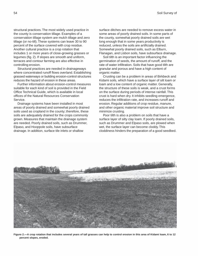
54 Soil Survey of
structural practices. The most widely used practice inthe county is conservation tillage. Examples of aconservation tillage system are mulch tillage and zerotillage (or no-till). These systems can leave 30 to 90percent of the surface covered with crop residue.Another cultural practice is a crop rotation thatincludes 1 or more years of close-growing grasses orlegumes (fig. 2). If slopes are smooth and uniform,terraces and contour farming are also effective incontrolling erosion.
Structural practices are needed in drainagewayswhere concentrated runoff flows overland. Establishinggrassed waterways or building erosion-control structuresreduces the hazard of erosion in these areas.
Further information about erosion-control measuressuitable for each kind of soil is provided in the FieldOffice Technical Guide, which is available in localoffices of the Natural Resources ConservationService.
Drainage systems have been installed in mostareas of poorly drained and somewhat poorly drainedsoils used as cropland in the county; therefore, thesesoils are adequately drained for the crops commonlygrown. Measures that maintain the drainage systemare needed. Poorly drained soils, such as Drummer,Elpaso, and Hooppole soils, have subsurfacedrainage. In addition, surface tile inlets or shallow
surface ditches are needed to remove excess water insome areas of poorly drained soils. In some parts ofthe county, somewhat poorly drained soils are wetlong enough that in some years productivity isreduced, unless the soils are artificially drained.Somewhat poorly drained soils, such as Elburn,Flanagan, and Lisbon soils, have subsurface drainage.
Soil tilth is an important factor influencing thegermination of seeds, the amount of runoff, and therate of water infiltration. Soils that have good tilth aregranular and porous and have a high content oforganic matter.
Crusting can be a problem in areas of Birkbeck andKidami soils, which have a surface layer of silt loam orloam and a low content of organic matter. Generally,the structure of these soils is weak, and a crust formson the surface during periods of intense rainfall. Thiscrust is hard when dry. It inhibits seedling emergence,reduces the infiltration rate, and increases runoff anderosion. Regular additions of crop residue, manure,and other organic material improve soil structure andminimize crusting.
Poor tilth is also a problem on soils that have asurface layer of silty clay loam. If poorly drained soils,such as Drummer and Elpaso soils, are plowed whenwet, the surface layer can become cloddy. Thiscloddiness hinders the preparation of a good seedbed.
Figure 2.—A crop rotation that includes several years of tall grasses can help to control erosion in this area of Kidami loam, 6 to 12percent slopes, eroded.

De Kalb County, Illinois 55
Tilling in the fall and leaving the soil surface rough andcovered with a moderate amount of crop residuegenerally result in good tilth in the spring. A system ofstrip or ridge tillage may also work well on these soils.
Soils with excessive permeability, such as Bowesand Dresden soils, have the potential for ground-watercontamination. These soils contain sandy and gravellydeposits within a depth of 60 inches and are veryrapidly permeable in the lower part of the profile.
Several measures can be used to limit the amountof deep leaching of nutrients and pesticides.Applications of fertilizer should be based on the resultsof soil tests. The local office of the CooperativeExtension Service can help in determining the kindsand proper amounts of nutrients needed. Chemicalsshould be selected based on their solubility in water,their ability to bind with the soil, and the rate of theirbreakdown in the soil. Splitting applications ofchemicals, particularly nitrogen, is beneficial. Thispractice reduces the chance for excessive leachingfrom a one-time application. Including legumes in acrop rotation or as a cover crop adds nitrogen to thesoil and thus reduces the amount of nitrogen neededin chemical applications. Using crop rotations is alsoeffective in limiting the buildup of weed and insectpopulations, thereby reducing the amount ofherbicides and insecticides needed per application.Finally, the use of small grain cover crops followingfertilized corn crops can be effective in taking up someresidual nitrogen from the soil.
Proper management is needed on hayland toprolong the life of desirable forage species, maintain orimprove the quality and quantity of forage, and controlerosion and runoff. Hay may last as a vigorous crop for4 or 5 years, depending on management and on thevarieties seeded. Suitable hay plants include severallegumes and cool-season grasses. Alfalfa is thelegume most commonly grown for hay. It is often usedin mixtures with smooth bromegrass andorchardgrass. Alfalfa is best suited to moderately welldrained soils, such as Mayville and Kidami soils. Redclover also is grown for hay. Measures that maintainfertility are needed. The amount of lime and fertilizer tobe added should be based on the results of soil tests,the needs of the plants, and the expected level ofyields. Seed varieties should be selected inaccordance with the soil properties and the drainageconditions of the tract of land.
Cropland Management Considerations
The management concerns affecting the use of thesoils in the survey area for crops and pasture areshown in table 5.
The main concerns in managing cropland arecontrolling water erosion, soil wetness, and ponding;minimizing crusting; improving poor tilth; and limitingthe effects of excessive permeability.
Generally, a combination of several practices isneeded to control water erosion. Conservation tillage,stripcropping, contour farming, conservation croppingsystems, crop residue management, diversions, andgrassed waterways help to prevent excessive soil loss.
Wetness is a limitation in some areas of cropland,and ponding is a hazard. Drainage systems consist ofsubsurface tile drains, surface inlet tile, open drainageditches, or a combination of these. Measures thatmaintain the drainage system are needed.
Practices that minimize crusting and improve poortilth include incorporating green manure crops,manure, or crop residue into the soil and using asystem of conservation tillage. Avoiding tillage whenthe soil is too wet can control surface cloddiness.
Excessive permeability can cause deep leaching ofnutrients and pesticides. Selecting appropriatechemicals and using split application methods reducethe hazard of ground-water contamination.
Additional limitations and hazards are as follows:Excess lime.—This limitation can be overcome by
incorporating green manure crops, manure, or cropresidue into the soil; applying a system ofconservation tillage; and using conservation croppingsystems. In addition, crops may respond well toadditions of phosphate fertilizer to soils that have ahigh content of lime.
Flooding.—This hazard cannot be easily overcome.Winter small grain crops can be damaged by flooding.Tilling and planting should be delayed in the springuntil flooding is no longer a hazard. Dikes anddiversions can reduce the extent of the crop damagecaused by floodwater
Low available water capacity.—This limitation canbe minimized by reducing the evaporation and runoffrates and increasing the rate of water infiltration.Applying conservation tillage and conservationcropping systems, farming on the contour,stripcropping, establishing field windbreaks, andleaving crop residue on the surface conservemoisture.
Restricted permeability.—This limitation can reducethe effectiveness of drainage systems. Narrower tilespacing can lower the seasonal high water table.
Subsidence.—Subsidence occurs as a result ofshrinkage from drying, consolidation because of theloss of ground water, compaction from tillage, winderosion, burning, and biochemical oxidation. Limitingthe amount of drainage, avoiding excessive tillage,avoiding tilling when the soil is wet, and using a

56 Soil Survey of
system of conservation tillage that leaves crop residueon the surface after planting help to controlsubsidence.
Wind erosion.—Using a system of conservationtillage that leaves crop residue on the surface afterplanting and keeping the surface rough help to controlwind erosion.
Explanation of Criteria
Crusting.—The organic matter content is 2.5percent or less, and the clay content is greater than 20percent in the surface layer.
Excess lime.—A calcium carbonate equivalent of 15percent or more is within 16 inches of the surface.
Excessive permeability.—Permeability is 6 inchesor more per hour within the soil profile.
Flooding.—The soil is subject to occasional orfrequent flooding.
Low available water capacity.—The weightedaverage of the available water capacity between thesurface and a depth of 40 inches is 0.1 inch or less.
Ponding.—A seasonal high water table is above thesurface.
Poor tilth.—The clay content is 27 percent or morein the surface layer.
Restricted permeability.—Permeability is less than0.2 inch per hour between the surface and a depth of40 inches.
Subsidence.—The decrease in surface elevation ismore than 0 inches.
Water erosion.—The Kw factor of the surface layermultiplied by the slope is more than 0.8, and the slopeis 3 percent or more.
Wetness.—The seasonal high water table is withina depth of 1.5 feet.
Wind erosion.—The wind erodibility group is 1 or 2.
Pastureland Management Considerations
Under good management, proper grazing isessential for the production of high-quality forage,stand survival, and erosion control. Proper grazinghelps plants to maintain sufficient and generallyvigorous top growth during the growing season. Brushcontrol is essential in many areas, and weed controlgenerally is needed. Rotation grazing and renovationalso are important management practices.
Yield estimates are often provided in animal unitmonths (AUM), or the amount of forage or feedrequired to feed one animal unit (one cow, one horse,one mule, five sheep, or five goats) for 30 days.
The local office of the Natural ResourcesConservation Service or of the Cooperative Extension
Service can provide information about forage yieldsother than those shown in the yields table.
Growing legumes and cool-season grasses that aresuited to the soils and climate in the survey area helpsto maintain a productive stand of pasture. The mainconcerns affecting the management of pastureland inthe county are listed in table 5. They include frost heave,low pH, water erosion, wetness, ponding, equipmentlimitation, flooding, wind erosion, and low available watercapacity.
Frost heave is a limitation in areas of soils that havea moderate or high potential for frost action. It occurswhen ice lenses or bands develop in the soil and drivean ice wedge between two layers of soil near thesurface layer. The ice wedges heave the overlying soillayer upward, snapping the roots. Soils that have a lowcontent of sand have small pores that hold water andenable ice lenses to form. Selecting adapted forageand hay varieties reduces the effects of frost heave.Timely deferment of grazing, which maintains surfacecover that insulates the soil, also reduces the effectsof frost heave.
Soils that have low pH have a pH value of 5.5 orless within 40 inches of the surface. Low pH inhibitsthe uptake of certain nutrients by the plants oraccelerates the absorption of certain other elements tothe level of toxic concentrations. Either of theseconditions affects the health and vigor of plants.Applications of lime should be based on the results ofsoil tests. The goal is to achieve the optimum pH levelfor the uptake of the major nutrients by the specificgrass, legume, or combination of grasses and legumes.
Pastureland soils that are susceptible to watererosion meet the following criteria: the value of the Kwfactor multiplied by the percent slope is more than 0.8,and the slope is 3 percent or more. Water erosionreduces the productivity of pastureland. It also resultsin onsite and offsite sedimentation, causes waterpollution by sedimentation, and increases the runoff oflivestock manure and other added nutrients. Measuresthat are effective in controlling water erosion includeestablishing or renovating stands of legumes andgrasses. Controlling erosion during seedbedpreparation is a major concern. If the soil is tilled forthe reseeding of pasture or hay crops, planting wintercover crops, establishing grassed waterways, farmingon the contour, and using a system of conservationtillage that leaves crop residue on the surface can helpto minimize erosion. Overgrazing or grazing when thesoil is wet reduces the extent of plant cover andresults in surface compaction and poor tilth, and thus itincreases the susceptibility to erosion. Proper stockingrates, rotation grazing, and timely deferment of
De Kalb County, Illinois 57
grazing, especially during wet periods, help to keepthe pasture and soil in good condition. The properlocation of livestock watering facilities helps to preventsurface compaction or the formation of ruts by makingit unnecessary for cattle to travel long distances upand down the steeper slopes.
Wetness is limitation in some areas, and ponding isa hazard. Wetness occurs in areas where theseasonal high water table is within a depth of 1.5 feet.Ponding occurs when the seasonal high water table isabove the surface. A drainage system that consists ofsubsurface tile drains, surface inlet tile, open drainageditches, or a combination of these can lower the watertable and remove excess water. Measures thatmaintain the drainage system are needed. Selectingspecies of grasses and legumes adapted to wetconditions can improve forage production. Restricteduse during wet periods helps to keep the pasture ingood condition.
Equipment limitation is a concern in areas whereslopes are more than 10 percent. It can cause rapidwear of equipment. It can also present problems withfertilization, harvest, pasture renovation, and seedbedpreparation. This limitation cannot be easily overcome.
Frequent or occasional flooding can damage foragestands and delay harvesting in some years. Dikes anddiversions help to control the extent of damage causedby floodwater. Selecting species of grasses andlegumes adapted to wet conditions can improve forageproduction. Restricted use during wet periods helps tokeep the pasture in good condition.
Organic soils, which are in wind erodibility group 1or 2, are susceptible to wind erosion. If the soil is tilledfor the reseeding of pasture or hay crops, plantingwinter cover crops, using a system of conservationtillage that leaves crop residue on the surface, andkeeping the surface rough help to control wind erosion.Overgrazing or grazing when the soil is wet reducesthe extent of plant cover, and thus it increases thesusceptibility to wind erosion. Proper stocking rates,rotation grazing, and timely deferment of grazing,especially during wet periods, help to keep the pasturein good condition.
Low available water capacity means that theweighted average of the available water capacitybetween the surface and a depth of 40 inches is 0.1inch or less. Available water capacity refers to thecapacity of soils to hold water available for use bymost plants. The quality and quantity of the pasturemay be reduced if the pasture cannot support thedesired number of livestock because the availablewater is inadequate for the maintenance of a healthycommunity of desired pasture species. A poor qualitypasture may increase the hazard of water erosion and
increase the runoff of pollutants. Planting drought-resistant species of grasses and legumes helps toestablish a cover of vegetation. The plants should notbe clipped or grazed until they are sufficientlyestablished.
Yields per Acre
The average yields per acre that can be expectedof the principal crops under a high level ofmanagement are shown in table 6. In any given year,yields may be higher or lower than those indicated inthe table because of variations in rainfall and otherclimatic factors. The land capability classification of themap units in the survey area also is shown in thetable.
The yields are based mainly on the experience andrecords of farmers, conservationists, and extensionagents (Fehrenbacher and others, 1978). Availableyield data from nearby counties and results of fieldtrials and demonstrations also are considered.
The management needed to obtain the indicatedyields of the various crops depends on the kind of soiland the crop. Management can include drainage,erosion control, and protection from flooding; theproper planting and seeding rates; suitable high-yielding crop varieties; appropriate and timely tillage;control of weeds, plant diseases, and harmful insects;favorable soil reaction and optimum levels of nitrogen,phosphorus, potassium, and trace elements for eachcrop; effective use of crop residue, barnyard manure,and green manure crops; and harvesting that ensuresthe smallest possible loss.
The estimated yields reflect the productive capacityof each soil for each of the principal crops. Yields arelikely to increase as new production technology isdeveloped. The productivity of a given soil comparedwith that of other soils, however, is not likely tochange.
Crops other than those shown in the table aregrown in the survey area, but estimated yields are notlisted because the acreage of such crops is small. Thelocal office of the Natural Resources ConservationService or of the Cooperative Extension Service canprovide information about the management andproductivity of the soils for those crops.
Land Capability Classification
Land capability classification shows, in a generalway, the suitability of soils for most kinds of field crops.Crops that require special management are excluded.The soils are grouped according to their limitations forfield crops, the risk of damage if they are used for

58 Soil Survey of
crops, and the way they respond to management. Thecriteria used in grouping the soils do not take intoaccount major and generally expensive landformingthat would change slope, depth, or othercharacteristics of the soils, nor do they includepossible but unlikely major reclamation projects.Capability classification is not a substitute forinterpretations designed to show suitability andlimitations of groups of soils for woodland or forengineering purposes.
In the capability system, soils generally are groupedat three levels—capability class, subclass, and unit(USDA, 1961). These categories indicate the degreeand kinds of limitations affecting mechanized farmingsystems that produce the more commonly grown fieldcrops, such as corn, small grain, cotton, hay, and field-grown vegetables. Only class and subclass are usedin this survey.
Capability classes, the broadest groups, aredesignated by the numbers 1 through 8. The numbersindicate progressively greater limitations and narrowerchoices for practical use. The classes are defined asfollows:
Class 1 soils have few limitations that restrict theiruse.
Class 2 soils have moderate limitations that reducethe choice of plants or that require moderateconservation practices.
Class 3 soils have severe limitations that reduce thechoice of plants or that require special conservationpractices, or both.
Class 4 soils have very severe limitations thatreduce the choice of plants or that require very carefulmanagement, or both.
Class 5 soils are not likely to erode but have otherlimitations, impractical to remove, that limit their use.
Class 6 soils have severe limitations that makethem generally unsuitable for cultivation.
Class 7 soils have very severe limitations that makethem unsuitable for cultivation.
Class 8 soils and miscellaneous areas havelimitations that nearly preclude their use forcommercial crop production.
Capability subclasses are soil groups within oneclass. They are designated by adding a small letter, e,w, s, or c, to the class number, for example, 2e. Theletter e shows that the main hazard is the risk oferosion unless a close-growing plant cover ismaintained; w shows that water in or on the soilinterferes with plant growth or cultivation (in some soilsthe wetness can be partly corrected by artificialdrainage); s shows that the soil is limited mainly
because it is shallow, droughty, or stony; and c, usedin only some parts of the United States, shows that thechief limitation is climate that is very cold or very dry.
In class 1 there are no subclasses because thesoils of this class have few limitations. Class 5contains only the subclasses indicated by w, s, or cbecause the soils in class 5 are subject to little or noerosion. They have other limitations that restrict theiruse mainly to pasture, rangeland, woodland, wildlifehabitat, or recreation.
The capability classification of map units in thissurvey area is given in table 6.
Prime Farmland
Prime farmland is one of several kinds of importantfarmland defined by the U.S. Department ofAgriculture. It is of major importance in meeting theNation’s short- and long-range needs for food andfiber. Because the supply of high-quality farmland islimited, the U.S. Department of Agriculture recognizesthat responsible levels of government, as well asindividuals, should encourage and facilitate the wiseuse of our Nation’s prime farmland.
Prime farmland, as defined by the U.S. Departmentof Agriculture, is land that has the best combination ofphysical and chemical characteristics for producingfood, feed, forage, fiber, and oilseed crops and isavailable for these uses. It could be cultivated land,pastureland, forestland, or other land, but it is noturban or built-up land or water areas. The soil qualities,growing season, and moisture supply are thoseneeded for the soil to economically produce sustainedhigh yields of crops when proper management,including water management, and acceptable farmingmethods are applied. In general, prime farmland hasan adequate and dependable supply of moisture fromprecipitation or irrigation, a favorable temperature andgrowing season, acceptable acidity or alkalinity, anacceptable salt and sodium content, and few or norocks. It is permeable to water and air. It is notexcessively erodible or saturated with water for longperiods, and it either is not frequently flooded duringthe growing season or is protected from flooding.Slope ranges mainly from 0 to 6 percent. Moredetailed information about the criteria for primefarmland is available at the local office of the NaturalResources Conservation Service.
Over the past 20 years, a trend in land use in someparts of the survey area has been the loss of someprime farmland to industrial and urban uses. The lossof prime farmland to other uses puts pressure on

De Kalb County, Illinois 59
marginal lands, which generally are more erodible,droughty, and less productive and cannot be easilycultivated.
About 366,350 acres, or nearly 90 percent of thesurvey area, meets the criteria for prime farmland.Areas of this land are throughout the county.
The map units in the survey area that areconsidered prime farmland are listed in table 7. Thislist does not constitute a recommendation for aparticular land use. On some soils included in the list,measures that overcome a hazard or limitation, suchas flooding, wetness, and droughtiness, are needed.Onsite evaluation is needed to determine whether ornot the hazard or limitation has been overcome bycorrective measures. The extent of each listed mapunit is shown in table 4. The location is shown on thedetailed soil maps. The soil qualities that affect useand management are described in the section“Detailed Soil Map Units.”
ForestlandGeorge Poe, district forester, Illinois Department of
Conservation, helped prepare this section.
The early land survey maps of the 1820s show thatabout 29,600 acres in De Kalb County, or 7 percent ofthe total land area, was forested. During the following100 years, the forest was cleared and converted toother land uses; by the 1920s, a residual forest of onlyabout 5,600 acres remained. The latest survey,conducted in 1985, shows that about 5,300 acres, or 1percent of the total land area, supports forestvegetation. In recent times a very slight increase inforest coverage has occurred. This increase is a resultof the reduction in livestock numbers as the forestslowly occupies abandoned pasturelands.
The majority of forests in De Kalb County cangenerally be classified as the elm-ash-soft maple typeon bottom land or the oak-hickory type on uplands.The common tree species associated with the bottom-land forest include swamp white oak, bur oak, greenash, cottonwood, black willow, silver maple,honeylocust, American elm, bitternut hickory,hackberry, and boxelder. The oak-hickory forest typeincludes white oak, bur oak, shagbark hickory, redoak, black oak, and black cherry. Other tree speciesthat are common in the county but that are mostly intransitional areas between the two forest types arewhite ash, basswood, sugar maple, Hill’s oak, blackwalnut, hophornbeam, slippery elm, and Kentuckycoffeetree. There are 59 different tree species in thecounty and at least that many associated shrubspecies.
Assistance in establishing, improving, or managingforestland is available from foresters or naturalresource specialists.
Table 8 provides information regarding theproductivity of the soils in the county for forestland.The potential productivity for merchantable or commontrees on a soil is expressed as a site index and as avolume number. Only those soils suitable for woodcrops are listed.
The site index is the average height, in feet, thatdominant and codominant trees of a given speciesattain in a specified number of years. The site indexapplies to fully stocked, even-aged, unmanagedstands.
The first species listed under common trees for asoil is the indicator species for that soil. It generally isthe most common species on the soil. Commonlygrown trees are those that forest managers generallyfavor in intermediate or improvement cuttings. Theyare selected based on growth rate, quality, value, andmarketability. More detailed information is available inthe “National Forestry Manual,” which is available inlocal offices of the Natural Resources ConservationService.
The volume of wood fiber, a number, is the yieldlikely to be produced by the most important trees. Thisnumber, expressed as cubic feet per acre per yearand calculated at the age of culmination of the meanannual increment (CMAI), indicates the amount offiber produced in a fully stocked, even-aged,unmanaged stand.
Trees to manage are those that are preferred forplanting, seeding, or natural regeneration and thosethat remain in the stand after thinning or partialharvest.
Windbreaks and EnvironmentalPlantings
Windbreaks protect livestock, buildings, and yardsfrom wind and snow. They also protect fruit trees andgardens, and they furnish habitat for wildlife. Severalrows of low- and high-growing broadleaf andconiferous trees and shrubs provide the mostprotection.
Field windbreaks are narrow plantings made at rightangles to the prevailing wind and at specific intervalsacross the field. The interval depends on the erodibilityof the soil. Field windbreaks protect cropland andcrops from wind, help to keep snow on the fields, andprovide food and cover for wildlife.
Environmental plantings help to beautify and screenhouses and other buildings and to abate noise. The

60 Soil Survey of
plants, mostly evergreen shrubs and trees, are closelyspaced. To ensure plant survival, a healthy plantingstock of suitable species should be planted properlyon a well prepared site and maintained in goodcondition.
Table 9 shows the height that locally grown treesand shrubs are expected to reach in 20 years onvarious soils. The estimates in table 9 are based onmeasurements and observation of establishedplantings that have been given adequate care. Theycan be used as a guide in planning windbreaks andscreens. Additional information on planningwindbreaks and screens and planting and caring fortrees and shrubs can be obtained from the local officeof the Natural Resources Conservation Service or ofthe Cooperative Extension Service or from acommercial nursery.
RecreationDe Kalb County offers a wide variety of recreational
facilities, including the 1,500-acre Shabbona LakeState Park (fig. 3) and county-owned forest preserves.An assortment of outdoor activities are available to thepublic, including boating, fishing, hiking, biking,horseback riding, camping, and picnicking. Also, mostmunicipalities offer a variety of recreational facilitiesand activities, such as playgrounds, swimming pools,and golf courses.
The county has several bicycle trails. The KiwanisBicycle Path and Peace Road Bicycle Trail are two ofthe more extensive trails.
The soils of the survey area are rated in table 10according to limitations that affect their suitability forrecreation. The ratings are based on restrictive soilfeatures, such as wetness, slope, and texture of thesurface layer. Susceptibility to flooding is considered.Not considered in the ratings, but important inevaluating a site, are the location and accessibility ofthe area, the size and shape of the area and its scenicquality, vegetation, access to water, potential waterimpoundment sites, and access to public sewer lines.The capacity of the soil to absorb septic tank effluentand the ability of the soil to support vegetation also areimportant. Soils that are subject to flooding are limitedfor recreational uses by the duration and intensity offlooding and the season when flooding occurs. Inplanning recreational facilities, onsite assessment ofthe height, duration, intensity, and frequency offlooding is essential.
In table 10, the degree of soil limitation is expressedas slight, moderate, or severe. Slight means that soil
properties are generally favorable and that limitationsare minor and easily overcome. Moderate means thatlimitations can be overcome or alleviated by planning,design, or special maintenance. Severe means thatsoil properties are unfavorable and that limitations canbe offset only by costly soil reclamation, specialdesign, intensive maintenance, limited use, or acombination of these.
The information in table 10 can be supplemented byother information in this survey, for example,interpretations for septic tank absorption fields in table13 and interpretations for dwellings without basementsand for local roads and streets in table 12.
Camp areas require site preparation, such asshaping and leveling the tent and parking areas,stabilizing roads and intensively used areas, andinstalling sanitary facilities and utility lines. Campareas are subject to heavy foot traffic and somevehicular traffic. The best soils have mild slopes andare not wet or subject to flooding during the period ofuse. The surface has few or no stones or boulders,absorbs rainfall readily but remains firm, and is notdusty when dry. Strong slopes and stones or boulderscan greatly increase the cost of constructingcampsites.
Picnic areas are subject to heavy foot traffic. Mostvehicular traffic is confined to access roads andparking areas. The best soils for picnic areas are firmwhen wet, are not dusty when dry, are not subject toflooding during the period of use, and do not haveslopes or stones or boulders that increase the cost ofshaping sites or of building access roads and parkingareas.
Playgrounds require soils that can withstandintensive foot traffic. The best soils are almost leveland are not wet or subject to flooding during theseason of use. The surface is free of stones andboulders, is firm after rains, and is not dusty when dry.If grading is needed, the depth of the soil over bedrockor a hardpan should be considered.
Paths and trails for hiking and horseback ridingshould require little or no cutting and filling. The bestsoils are not wet, are firm after rains, are not dustywhen dry, and are not subject to flooding more thanonce a year during the period of use. They havemoderate slopes and few or no stones or boulders onthe surface.
Golf fairways are subject to heavy foot traffic andsome light vehicular traffic. Cutting or filling may berequired. The best soils for use as golf fairways arefirm when wet, are not dusty when dry, and are notsubject to prolonged flooding during the period of use.

De Kalb County, Illinois 61
They have moderate slopes and no stones or boulderson the surface. The suitability of the soil for tees orgreens is not considered in rating the soils.
Wildlife HabitatDe Kalb County has diverse topography. This
diversity is primarily the result of glacial action. Itprovides a variety of upland and aquatic habitats thatsupport an abundance of wildlife species.
The upland areas, which range from gently slopingto strongly sloping hillsides and ridges to nearly leveloutwash plains, were once covered by a sea of nativeprairie grasses and small open oak forestlands knownas savannas. These natural communities were oncehome to such species as buffalo, elk, prairie chickens,and wolves.
Characteristic aquatic habitats include streams andwetlands. Typical wetlands include lakeside marshes,glacial potholes, hillside seeps, and flood-plainwetlands along streams and rivers. These wetland
areas provide important stormwater storage and waterquality benefits to the county as well as providinghomes to such species as ducks, geese, great blueherons, sandhill cranes, muskrat, mink, beaver, andnumerous frogs, toads, and turtles.
As the county was settled, conversion of land foragriculture and urbanization altered the naturalcommunities and the wildlife populations associatedwith them. De Kalb County’s landscape is now amosaic of cropland, urban areas, pasture, smallwoodlots, and wetlands and other waterways. Thevarious land uses support wildlife species that haveadapted to the human-altered landscape. Thesespecies include whitetail deer, mallards, pheasants,squirrels, crows, cardinals, house sparrows, raccoon,fox, and coyotes.
In general, most areas in the county are notmanaged primarily for wildlife. Good land managementpractices, however, can commonly improve the valueof an area as wildlife habitat. For example, farmpractices that leave crop residue on the fields during
Figure 3.—Shabbona Lake State Park offers a variety of recreational activities.

62 Soil Survey of
the fall and winter months not only help to control soilerosion but also provide winter cover and food forsome wildlife species. Allowing grassed waterways,road ditches, fencelines, set-aside fields, and vacantproperties to remain unmowed until early Augustprovides much-needed habitat for ground-nestingwildlife, such as rabbits, pheasants, and many speciesof songbirds.
Many temporarily and seasonally flooded wetlandshave been impacted by land use practices.Development and cultivation in these wetlands shouldbe avoided. Buffer strips surrounding wetland areascan provide food and nesting cover for many wildlifespecies and prevent these areas from filling in witheroded sediment. Wetlands, streambanks, andwoodlots should be fenced so that livestock areexcluded. Fencing protects and maintains the nativeplant communities that support wildlife species, helpsto control erosion, and improves water quality in ourstreams and rivers.
When attempts are made to restore or manage anarea for wildlife, it is important to understand the kindsof soils on the site. For example, soils that have aseasonal high water table will most likely supportvegetation that is tolerant of wet conditions and thusattract wetland wildlife species. If the soil series ischaracterized by wetness or hydric properties but thearea does not appear to be susceptible to wetness,there may be an existing drainage ditch or a system ofsubsurface tile drains. Areas that have been drainedcan provide opportunities for the restoration of wetlandhabitat as long as negative impacts are avoided onneighboring properties.
Nonhydric soils in the uplands support communitiesonce dominated by prairie grass and oak savannahabitats. These habitats can also be restored throughmanagement that promotes or reestablishes the nativeplant species while controlling or eliminatingcompeting exotic vegetation.
Assistance with wildlife habitat projects can beobtained from various local, State, and Federalagencies, including the Illinois Department ofConservation, the U.S. Fish and Wildlife Service, theNatural Resources Conservation Service, and thelocal Soil and Water Conservation District.
Soils affect the kind and amount of vegetation thatis available to wildlife as food and cover. They alsoaffect the construction of water impoundments. Thekind and abundance of wildlife depend largely on theamount and distribution of food, cover, and water.Wildlife habitat can be created or improved by plantingappropriate vegetation, by maintaining the existingplant cover, or by promoting the natural establishmentof desirable plants.
In table 11, the soils in the survey area are ratedaccording to their potential for providing habitat forvarious kinds of wildlife. This information can be usedin planning parks, wildlife refuges, nature study areas,and other developments for wildlife; in selecting soilsthat are suitable for establishing, improving, ormaintaining specific elements of wildlife habitat; and indetermining the intensity of management needed foreach element of the habitat.
The potential of the soil is rated good, fair, poor, orvery poor. A rating of good indicates that the elementor kind of habitat is easily established, improved, ormaintained. Few or no limitations affect management,and satisfactory results can be expected. A rating offair indicates that the element or kind of habitat can beestablished, improved, or maintained in most places.Moderately intensive management is required forsatisfactory results. A rating of poor indicates thatlimitations are severe for the designated element orkind of habitat. Habitat can be created, improved, ormaintained in most places, but management is difficultand must be intensive. A rating of very poor indicatesthat restrictions for the element or kind of habitat arevery severe and that unsatisfactory results can beexpected. Creating, improving, or maintaining habitatis impractical or impossible.
The elements of wildlife habitat are described in thefollowing paragraphs.
Grain and seed crops are domestic grains andseed-producing herbaceous plants. Soil propertiesand features that affect the growth of grain and seedcrops are depth of the root zone, texture of the surfacelayer, available water capacity, wetness, slope, surfacestoniness, and flooding. Soil temperature and soilmoisture also are considerations. Examples of grainand seed crops are corn, wheat, oats, and barley.
Grasses and legumes are domestic perennialgrasses and herbaceous legumes. Soil properties andfeatures that affect the growth of grasses and legumesare depth of the root zone, texture of the surface layer,available water capacity, wetness, surface stoniness,flooding, and slope. Soil temperature and soil moisturealso are considerations. Examples of grasses andlegumes are fescue, bromegrass, timothy,orchardgrass, clover, alfalfa, trefoil, reed canarygrass,and crownvetch.
Wild herbaceous plants are native or naturallyestablished grasses and forbs, including weeds. Soilproperties and features that affect the growth of theseplants are depth of the root zone, texture of thesurface layer, available water capacity, wetness,surface stoniness, and flooding. Soil temperature andsoil moisture also are considerations. Examples of wildherbaceous plants are bluestem, indiangrass,

De Kalb County, Illinois 63
goldenrod, lambsquarter, dandelions, blackberry,ragweed, wheatgrass, fescue, and nightshade.
Hardwood trees and woody understory producenuts or other fruit, buds, catkins, twigs, bark, andfoliage. Soil properties and features that affect thegrowth of hardwood trees and shrubs are depth of theroot zone, available water capacity, and wetness.Examples of these plants are oak, poplar, boxelder,birch, maple, green ash, willow, and American elm.Examples of fruit-producing shrubs that are suitablefor planting on soils rated good are hawthorn,honeysuckle, American plum, redosier dogwood,chokecherry, serviceberry, silver buffaloberry, andcrabapple.
Coniferous plants furnish browse and seeds. Soilproperties and features that affect the growth ofconiferous trees, shrubs, and ground cover are depthof the root zone, available water capacity, andwetness. Examples of coniferous plants are pine,spruce, hemlock, fir, yew, cedar, larch, and juniper.
Wetland plants are annual and perennial wildherbaceous plants that grow on moist or wet sites.Submerged or floating aquatic plants are excluded.Soil properties and features affecting wetland plantsare texture of the surface layer, wetness, reaction,salinity, slope, and surface stoniness. Examples ofwetland plants are smartweed, wild millet, rushes,sedges, bulrushes, wild rice, arrowhead,waterplantain, pickerelweed, and cattails.
Shallow water areas have an average depth of lessthan 5 feet. Some are naturally wet areas. Others arecreated by dams, levees, or other water-controlstructures. Soil properties and features affectingshallow water areas are depth to bedrock, wetness,surface stoniness, slope, and permeability. Examplesof shallow water areas are muskrat marshes,waterfowl feeding areas, wildlife wateringdevelopments, beaver ponds, and other ponds.
The habitat for various kinds of wildlife is describedin the following paragraphs.
Habitat for openland wildlife consists of cropland,pasture, meadows, and areas that are overgrown withgrasses, herbs, shrubs, and vines. These areasproduce grain and seed crops, grasses and legumes,and wild herbaceous plants. Wildlife attracted to theseareas include bobwhite quail, Hungarian partridge,pheasant, meadowlark, field sparrow, killdeer,cottontail rabbit, and red fox.
Habitat for woodland wildlife consists of areas ofdeciduous and/or coniferous plants and associatedgrasses, legumes, and wild herbaceous plants. Wildlifeattracted to these areas include wild turkey, thrushes,woodpeckers, owls, squirrels, raccoon, and deer.
Habitat for wetland wildlife consists of open, marshy
or swampy shallow water areas (fig. 4). Some of thewildlife attracted to such areas are ducks, geese,herons, bitterns, rails, kingfishers, muskrat, otter, mink,and beaver.
Hydric SoilsIn this section, hydric soils are defined and
described and the hydric soils in the survey area arelisted.
The three essential characteristics of wetlands arehydrophytic vegetation, hydric soils, and wetlandhydrology (Cowardin and others, 1979; U.S. ArmyCorps of Engineers, 1987; National Research Council,1995; Tiner, 1985). Criteria for each of thecharacteristics must be met for areas to be identifiedas wetlands. Undrained hydric soils that have naturalvegetation should support a dominant population ofecological wetland plant species. Hydric soils thathave been converted to other uses should be capableof being restored to wetlands.
Hydric soils are defined by the National TechnicalCommittee for Hydric Soils (NTCHS) as soils thatformed under conditions of saturation, flooding, orponding long enough during the growing season todevelop anaerobic conditions in the upper part(Federal Register, 1994). These soils are eithersaturated or inundated long enough during thegrowing season to support the growth andreproduction of hydrophytic vegetation.
The NTCHS definition identifies general soilproperties that are associated with wetness. In orderto determine whether a specific soil is a hydric soil ornonhydric soil, however, more specific information,such as information about the depth and duration ofthe water table, is needed. Thus, criteria that identifythose estimated soil properties unique to hydric soilshave been established (Federal Register, 1995). Thesecriteria are used to identify a phase of a soil seriesthat normally is associated with wetlands. The criteriaused are selected estimated soil properties that aredescribed in “Soil Taxonomy” (Soil Survey Staff, 1999)and “Keys to Soil Taxonomy” (Soil Survey Staff, 1998)and in the “Soil Survey Manual” (Soil Survey DivisionStaff, 1993).
If soils are wet enough for a long enough period tobe considered hydric, they should exhibit certainproperties that can be easily observed in the field.These visible properties are indicators of hydric soils.The indicators used to make onsite determinations ofhydric soils in this survey area are specified in “FieldIndicators of Hydric Soils in the United States” (Hurtand others, 1998).
Hydric soils are identified by examining and

64 Soil Survey of
describing the soil to a depth of about 20 inches. Thisdepth may be greater if determination of anappropriate indicator so requires. It is alwaysrecommended that soils be excavated and describedto the depth necessary for an understanding of theredoximorphic processes. Then, using the completedsoil descriptions, soil scientists can compare the soilfeatures required by each indicator and specify whichindicators have been matched with the conditionsobserved in the soil. The soil can be identified as ahydric soil if at least one of the approved indicators ispresent.
The following map units meet the definition ofhydric soils and, in addition, have at least one of thehydric soil indicators. This list can help in planningland uses; however, onsite investigation isrecommended to determine the hydric soils on aspecific site (National Research Council, 1995; Hurtand others, 1998).
67A Harpster silty clay loam, 0 to 2 percent slopes68A Sable silty clay loam, 0 to 2 percent slopes103A Houghton muck, 0 to 2 percent slopes152A Drummer silty clay loam, 0 to 2 percent slopes206A Thorp silt loam, 0 to 2 percent slopes330A Peotone silty clay loam, 0 to 2 percent slopes356A Elpaso silty clay loam, 0 to 2 percent slopes488A Hooppole loam, 0 to 2 percent slopes712A Spaulding silty clay loam, 0 to 2 percent slopes3076A Otter silt loam, 0 to 2 percent slopes,
frequently flooded3776A Comfrey loam, 0 to 2 percent slopes,
frequently flooded
Map units that are made up of hydric soils mayhave small areas, or inclusions, of nonhydric soils inthe higher positions on the landform, and map unitsmade up of nonhydric soils may have inclusions ofhydric soils in the lower positions on the landform.
Figure 4.—Shabbona Lake provides good habitat for waterfowl.

De Kalb County, Illinois 65
EngineeringThis section provides information for planning land
uses related to urban development and to watermanagement. Soils are rated for various uses, and themost limiting features are identified. Ratings are givenfor building site development, sanitary facilities,construction materials, and water management. Theratings are based on observed performance of thesoils and on the data provided in the tables under theheading “Soil Properties.”
Information in this section is intended for land useplanning, for evaluating land use alternatives, and forplanning site investigations prior to design andconstruction. The information, however, has limitations.For example, estimates and other data generally applyonly to that part of the soil within a depth of 5 or 6 feet.Because of the map scale, small areas of differentsoils may be included within the mapped areas of aspecific soil.
The information is not site specific and does noteliminate the need for onsite investigation of the soilsor for testing and analysis by personnel experienced inthe design and construction of engineering works.
Government ordinances and regulations thatrestrict certain land uses or impose specific designcriteria were not considered in preparing theinformation in this section. Local ordinances andregulations should be considered in planning, in siteselection, and in design.
Soil properties, site features, and observedperformance were considered in determining theratings in this section. During the fieldwork for this soilsurvey, determinations were made about grain-sizedistribution, liquid limit, plasticity index, soil reaction,depth to bedrock, hardness of bedrock within 5 or 6feet of the surface, soil wetness, depth to a seasonalhigh water table, slope, likelihood of flooding, naturalsoil structure aggregation, and soil density. Data werecollected about kinds of clay minerals, mineralogy ofthe sand and silt fractions, and the kinds of adsorbedcations. Estimates were made for erodibility,permeability, corrosivity, shrink-swell potential,available water capacity, and other behavioralcharacteristics affecting engineering uses.
This information can be used to evaluate thepotential of areas for residential, commercial,industrial, and recreational uses; make preliminaryestimates of construction conditions; evaluatealternative routes for roads, streets, highways,pipelines, and underground cables; evaluatealternative sites for sanitary landfills, septic tankabsorption fields, and sewage lagoons; plan detailed
onsite investigations of soils and geology; locatepotential sources of gravel, sand, earthfill, and topsoil;plan drainage systems, irrigation systems, ponds,terraces, and other structures for soil and waterconservation; and predict performance of proposedsmall structures and pavements by comparing theperformance of existing similar structures on the sameor similar soils.
The information in the tables, along with the soilmaps, the soil descriptions, and other data provided inthis survey, can be used to make additionalinterpretations.
Some of the terms used in this soil survey have aspecial meaning in soil science and are defined in theGlossary.
Building Site Development
Table 12 shows the degree and kind of soillimitations that affect shallow excavations, dwellingswith and without basements, small commercialbuildings, local roads and streets, and lawns andlandscaping. The limitations are considered slight ifsoil properties and site features are generallyfavorable for the indicated use and limitations areminor and easily overcome; moderate if soil propertiesor site features are not favorable for the indicated useand special planning, design, or maintenance isneeded to overcome or minimize the limitations; andsevere if soil properties or site features are sounfavorable or so difficult to overcome that specialdesign, significant increases in construction costs, andpossibly increased maintenance are required. Specialfeasibility studies may be required where the soillimitations are severe.
Shallow excavations are trenches or holes dug to amaximum depth of 5 or 6 feet for basements, graves,utility lines, open ditches, or other purposes. Theratings are based on soil properties, site features, andobserved performance of the soils. The ease ofdigging, filling, and compacting is affected by the depthto bedrock, a cemented pan, or a very firm denselayer; stone content; soil texture; and slope. The timeof the year that excavations can be made is affectedby the depth to a seasonal high water table and thesusceptibility of the soil to flooding. The resistance ofthe excavation walls or banks to sloughing or caving isaffected by soil texture and depth to the water table.
Dwellings and small commercial buildings arestructures built on shallow foundations on undisturbedsoil. The load limit is the same as that for single-familydwellings no higher than three stories. Ratings aremade for small commercial buildings without

66 Soil Survey of
basements, for dwellings with basements, and fordwellings without basements. The ratings are basedon soil properties, site features, and observedperformance of the soils. A high water table, flooding,shrinking and swelling, and organic layers can causethe movement of footings. A high water table, depth tobedrock or to a cemented pan, large stones, slope,and flooding affect the ease of excavation andconstruction. Landscaping and grading that requirecuts and fills of more than 5 or 6 feet are notconsidered.
Local roads and streets have an all-weather surfaceand carry automobile and light truck traffic all year.They have a subgrade of cut or fill soil material; a baseof gravel, crushed rock, or stabilized soil material; anda flexible or rigid surface. Cuts and fills are generallylimited to less than 6 feet. The ratings are based onsoil properties, site features, and observedperformance of the soils. Depth to bedrock or to acemented pan, a high water table, flooding, largestones, and slope affect the ease of excavating andgrading. Soil strength (as inferred from the engineeringclassification of the soil), shrink-swell potential, frostaction potential, and depth to a high water table affectthe traffic-supporting capacity.
Lawns and landscaping require soils on which turfand ornamental trees and shrubs can be establishedand maintained. The ratings are based on soilproperties, site features, and observed performance ofthe soils. Soil reaction, a high water table, depth tobedrock or to a cemented pan, the available watercapacity in the upper 40 inches, and the content ofsalts, sodium, and sulfidic materials affect plantgrowth. Flooding, wetness, slope, stoniness, and theamount of sand, clay, or organic matter in the surfacelayer affect trafficability after vegetation is established.
Sanitary Facilities
Table 13 shows the degree and kind of soillimitations that affect septic tank absorption fields,sewage lagoons, and sanitary landfills. The limitationsare considered slight if soil properties and site featuresare generally favorable for the indicated use andlimitations are minor and easily overcome; moderate ifsoil properties or site features are not favorable for theindicated use and special planning, design, ormaintenance is needed to overcome or minimize thelimitations; and severe if soil properties or site featuresare so unfavorable or so difficult to overcome thatspecial design, significant increases in constructioncosts, and possibly increased maintenance arerequired.
The table also shows the suitability of the soils foruse as daily cover for landfill. A rating of goodindicates that soil properties and site features arefavorable for the use and good performance and lowmaintenance can be expected; fair indicates that soilproperties and site features are moderately favorablefor the use and one or more soil properties or sitefeatures make the soil less desirable than the soilsrated good; and poor indicates that one or more soilproperties or site features are unfavorable for the useand overcoming the unfavorable properties requiresspecial design, extra maintenance, or costly alteration.
Septic tank absorption fields are areas in whicheffluent from a septic tank is distributed into the soilthrough subsurface tiles or perforated pipe. Only thatpart of the soil between depths of 24 and 72 inches isevaluated. The ratings are based on soil properties,site features, and observed performance of the soils.Permeability, a high water table, depth to bedrock or toa cemented pan, and flooding affect absorption of theeffluent. Large stones and bedrock or a cemented paninterfere with installation.
Unsatisfactory performance of septic tankabsorption fields, including excessively slowabsorption of effluent, surfacing of effluent, and hillsideseepage, can affect public health. Ground water canbe polluted if highly permeable sand and gravel orfractured bedrock is less than 4 feet below the base ofthe absorption field, if slope is excessive, or if thewater table is near the surface. There must beunsaturated soil material beneath the absorption fieldto filter the effluent effectively. Many local ordinancesrequire that this material be of a certain thickness.
Sewage lagoons are shallow ponds constructed tohold sewage while aerobic bacteria decompose thesolid and liquid wastes. Lagoons should have a nearlylevel floor surrounded by cut slopes or embankmentsof compacted soil. Lagoons generally are designed tohold the sewage within a depth of 2 to 5 feet. Nearlyimpervious soil material for the lagoon floor and sidesis required to minimize seepage and contamination ofground water.
The table gives ratings for the natural soil thatmakes up the lagoon floor. The surface layer and,generally, 1 or 2 feet of soil material below the surfacelayer are excavated to provide material for theembankments. The ratings are based on soilproperties, site features, and observed performance ofthe soils. Considered in the ratings are slope,permeability, a high water table, depth to bedrock or toa cemented pan, flooding, large stones, and content oforganic matter.
Excessive seepage resulting from rapid
De Kalb County, Illinois 67
permeability in the soil or a water table that is highenough to raise the level of sewage in the lagooncauses a lagoon to function unsatisfactorily. Pollutionresults if seepage is excessive or if floodwaterovertops the lagoon. A high content of organic matteris detrimental to proper functioning of the lagoonbecause it inhibits aerobic activity. Slope, bedrock, andcemented pans can cause construction problems, andlarge stones can hinder compaction of the lagoonfloor.
Sanitary landfills are areas where solid waste isdisposed of by burying it in soil. There are two types oflandfill—trench and area. In a trench landfill, the wasteis placed in a trench. It is spread, compacted, andcovered daily with a thin layer of soil excavated at thesite. In an area landfill, the waste is placed insuccessive layers on the surface of the soil. The wasteis spread, compacted, and covered daily with a thinlayer of soil from a source away from the site.
Both types of landfill must be able to bear heavyvehicular traffic. Both types involve a risk of ground-water pollution. Ease of excavation and revegetationshould be considered.
The ratings in the table are based on soilproperties, site features, and observed performance ofthe soils. Permeability, depth to bedrock or to acemented pan, a high water table, slope, and floodingaffect both types of landfill. Texture, stones andboulders, highly organic layers, soil reaction, andcontent of salts and sodium affect trench landfills.Unless otherwise stated, the ratings apply only to thatpart of the soil within a depth of about 6 feet. Fordeeper trenches, a limitation rated slight or moderatemay not be valid. Onsite investigation is needed.
Daily cover for landfill is the soil material that isused to cover compacted solid waste in an areasanitary landfill. The soil material is obtained offsite,transported to the landfill, and spread over the waste.
Soil texture, wetness, rock fragments, and slopeaffect the ease of removing and spreading the materialduring wet and dry periods. Loamy or silty soils thatare free of large stones or excess gravel are the bestcover for a landfill. Clayey soils are sticky or cloddyand are difficult to spread; sandy soils are subject towind erosion.
After soil material has been removed, the soilmaterial remaining in the borrow area must be thickenough over bedrock, a cemented pan, or the watertable to permit revegetation. The soil material used asthe final cover for a landfill should be suitable forplants. The surface layer generally has the bestworkability, more organic matter, and the best potentialfor plants. Material from the surface layer should bestockpiled for use as the final cover.
Construction Materials
Table 14 gives information about the soils as asource of roadfill, sand, gravel, and topsoil. The soilsare rated good, fair, or poor as a source of roadfill andtopsoil. They are rated as a probable or improbablesource of sand and gravel. The ratings are based onsoil properties and site features that affect the removalof the soil and its use as construction material. Normalcompaction, minor processing, and other standardconstruction practices are assumed. Each soil isevaluated to a depth of 5 or 6 feet.
Roadfill is soil material that is excavated in oneplace and used in road embankments in anotherplace. In this table, the soils are rated as a source ofroadfill for low embankments, generally less than 6feet high and less exacting in design than higherembankments.
The ratings are for the soil material below thesurface layer to a depth of 5 or 6 feet. It is assumedthat soil layers will be mixed during excavating andspreading. Many soils have layers of contrastingsuitability within their profile. The table showingengineering index properties provides detailedinformation about each soil layer. This information canhelp to determine the suitability of each layer for useas roadfill. The performance of soil after it is stabilizedwith lime or cement is not considered in the ratings.
The ratings are based on soil properties, sitefeatures, and observed performance of the soils. Thethickness of suitable material is a major consideration.The ease of excavation is affected by large stones, ahigh water table, and slope. How well the soil performsin place after it has been compacted and drained isdetermined by its strength (as inferred from theengineering classification of the soil) and shrink-swellpotential.
Soils rated good contain significant amounts ofsand or gravel or both. They have at least 5 feet ofsuitable material, a low shrink-swell potential, fewcobbles and stones, and slopes of 15 percent or less.Depth to the water table is more than 3 feet. Soilsrated fair are more than 35 percent silt- and clay-sizedparticles and have a plasticity index of less than 10.They have a moderate shrink-swell potential, slopes of15 to 25 percent, or many stones. Depth to the watertable is 1 to 3 feet. Soils rated poor have a plasticityindex of more than 10, a high shrink-swell potential,many stones, or slopes of more than 25 percent. Theyare wet and have a water table at a depth of less than1 foot. They may have layers of suitable material, butthe material is less than 3 feet thick.
Sand and gravel are natural aggregates suitable forcommercial use with a minimum of processing. They

68 Soil Survey of
are used in many kinds of construction. Specificationsfor each use vary widely. In table 14, only theprobability of finding material in suitable quantity isevaluated. The suitability of the material for specificpurposes is not evaluated, nor are factors that affectexcavation of the material.
The properties used to evaluate the soil as a sourceof sand or gravel are gradation of grain sizes (asindicated by the engineering classification of the soil),the thickness of suitable material, and the content ofrock fragments. Kinds of rock, acidity, and stratificationare given in the soil series descriptions. Gradation ofgrain sizes is given in the table on engineering indexproperties.
A soil rated as a probable source has a layer ofclean sand or gravel or a layer of sand or gravel that isup to 12 percent silty fines. This material must be atleast 3 feet thick and less than 50 percent, by weight,large stones. All other soils are rated as an improbablesource. Coarse fragments of soft bedrock, such asshale and siltstone, are not considered to be sand andgravel.
Topsoil is used to cover an area so that vegetationcan be established and maintained. The upper 40inches of a soil is evaluated for use as topsoil. Alsoevaluated is the reclamation potential of the borrowarea.
Plant growth is affected by toxic material and bysuch properties as soil reaction, available watercapacity, and fertility. The ease of excavating, loading,and spreading is affected by rock fragments, slope, awater table, soil texture, and thickness of suitablematerial. Reclamation of the borrow area is affected byslope, a water table, rock fragments, bedrock, andtoxic material.
Soils rated good have friable, loamy material to adepth of at least 40 inches. They are free of stonesand cobbles, have little or no gravel, and have slopesof less than 8 percent. They are low in content ofsoluble salts, are naturally fertile or respond well tofertilizer, and are not so wet that excavation is difficult.
Soils rated fair are sandy soils, loamy soils thathave a relatively high content of clay, soils that haveonly 20 to 40 inches of suitable material, soils thathave an appreciable amount of gravel, stones, orsoluble salts, or soils that have slopes of 8 to 15percent. The soils are not so wet that excavation isdifficult.
Soils rated poor are very sandy or clayey, have lessthan 20 inches of suitable material, have a largeamount of gravel, stones, or soluble salts, have slopesof more than 15 percent, or have a seasonal highwater table at or near the surface.
The surface layer of most soils is generallypreferred for topsoil because of its organic mattercontent. Organic matter greatly increases theabsorption and retention of moisture and nutrients forplant growth.
Water Management
Table 15 gives information on the soil propertiesand site features that affect water management. Thedegree and kind of soil limitations are given for pondreservoir areas; embankments, dikes, and levees; andaquifer-fed excavated ponds. The limitations areconsidered slight if soil properties and site features aregenerally favorable for the indicated use andlimitations are minor and are easily overcome;moderate if soil properties or site features are notfavorable for the indicated use and special planning,design, or maintenance is needed to overcome orminimize the limitations; and severe if soil properties orsite features are so unfavorable or so difficult toovercome that special design, significant increase inconstruction costs, and possibly increasedmaintenance are required.
This table also gives for each soil the restrictivefeatures that affect drainage, irrigation, terraces anddiversions, and grassed waterways.
Pond reservoir areas hold water behind a dam orembankment. Soils best suited to this use have lowseepage potential in the upper 60 inches. Theseepage potential is determined by the permeability ofthe soil and the depth to fractured bedrock or otherpermeable material. Excessive slope can affect thestorage capacity of the reservoir area.
Embankments, dikes, and levees are raisedstructures of soil material, generally less than 20 feethigh, constructed to impound water or to protect landagainst overflow. In this table, the soils are rated as asource of material for embankment fill. The ratingsapply to the soil material below the surface layer to adepth of about 5 feet. It is assumed that soil layers willbe uniformly mixed and compacted duringconstruction.
The ratings do not indicate the ability of the naturalsoil to support an embankment. Soil properties to adepth even greater than the height of the embankmentcan affect performance and safety of the embankment.Generally, deeper onsite investigation is needed todetermine these properties.
Soil material in embankments must be resistant toseepage, piping, and erosion and have favorablecompaction characteristics. Unfavorable featuresinclude less than 5 feet of suitable material and a high

De Kalb County, Illinois 69
content of stones or boulders, organic matter, or saltsor sodium. A high water table affects the amount ofusable material. It also affects trafficability.
Aquifer-fed excavated ponds are pits or dugoutsthat extend to a ground-water aquifer or to a depthbelow a permanent water table. Excluded are pondsthat are fed only by surface runoff and embankmentponds that impound water 3 feet or more above theoriginal surface. Excavated ponds are affected bydepth to a permanent water table, permeability of theaquifer, and quality of the water as inferred from thesalinity of the soil. Depth to bedrock and the content oflarge stones affect the ease of excavation.
Drainage is the removal of excess surface andsubsurface water from the soil. How easily andeffectively the soil is drained depends on the depth tobedrock, to a cemented pan, or to other layers thataffect the rate of water movement; permeability; depthto a high water table or depth of standing water if thesoil is subject to ponding; slope; susceptibility toflooding; subsidence of organic layers; and thepotential for frost action. Excavating and grading andthe stability of ditchbanks are affected by depth tobedrock or to a cemented pan, large stones, slope,and the hazard of cutbanks caving. The productivity ofthe soil after drainage is adversely affected by extremeacidity or by toxic substances in the root zone, such assalts, sodium, and sulfur. Availability of drainageoutlets is not considered in the ratings.
Irrigation is the controlled application of water to
supplement rainfall and support plant growth. Thedesign and management of an irrigation system areaffected by depth to the water table, the need fordrainage, flooding, available water capacity, intakerate, permeability, erosion hazard, and slope. Theconstruction of a system is affected by large stonesand depth to bedrock or to a cemented pan. Theperformance of a system is affected by the depth ofthe root zone, the amount of salts or sodium, and soilreaction.
Terraces and diversions are embankments or acombination of channels and ridges constructedacross a slope to control erosion and conservemoisture by intercepting runoff. Slope, wetness, largestones, and depth to bedrock or to a cemented panaffect the construction of terraces and diversions. Arestricted rooting depth, a severe hazard of winderosion or water erosion, an excessively coarsetexture, and restricted permeability adversely affectmaintenance.
Grassed waterways are natural or constructedchannels, generally broad and shallow, that conductsurface water to outlets at a nonerosive velocity. Largestones, wetness, slope, and depth to bedrock or to acemented pan affect the construction of grassedwaterways. A hazard of wind erosion, low availablewater capacity, restricted rooting depth, toxicsubstances such as salts and sodium, and restrictedpermeability adversely affect the growth andmaintenance of the grass after construction.


71
Data relating to soil properties are collected duringthe course of the soil survey.
Soil properties are ascertained by field examinationof the soils and by laboratory index testing of somebenchmark soils. Established standard procedures arefollowed. During the survey, many shallow borings aremade and examined to identify and classify the soilsand to delineate them on the soil maps. Samples aretaken from some typical profiles and tested in thelaboratory to determine particle-size distribution,plasticity, and compaction characteristics.
Estimates of soil properties are based on fieldexaminations, on laboratory tests of samples from thesurvey area, and on laboratory tests of samples ofsimilar soils in nearby areas. Tests verify fieldobservations, verify properties that cannot beestimated accurately by field observation, and help tocharacterize key soils.
The estimates of soil properties are shown intables. They include engineering index properties,physical and chemical properties, and pertinent soiland water features.
Engineering Index PropertiesTable 16 gives the engineering classifications and
the range of index properties for the layers of each soilin the survey area.
Depth to the upper and lower boundaries of eachlayer is indicated.
Texture is given in the standard terms used by theU.S. Department of Agriculture. These terms aredefined according to percentages of sand, silt, andclay in the fraction of the soil that is less than 2millimeters in diameter (fig. 5). “Loam,” for example, issoil that is 7 to 27 percent clay, 28 to 50 percent silt,and less than 52 percent sand. If the content ofparticles coarser than sand is 15 percent or more, anappropriate modifier is added, for example, “gravelly.”Textural terms are defined in the Glossary.
Classification of the soils is determined according tothe Unified soil classification system (ASTM, 2001)and the system adopted by the American Association
of State Highway and Transportation Officials(AASHTO, 2000).
The Unified system classifies soils according toproperties that affect their use as constructionmaterial. Soils are classified according to particle-sizedistribution of the fraction less than 3 inches indiameter and according to plasticity index, liquid limit,and organic matter content. Sandy and gravelly soilsare identified as GW, GP, GM, GC, SW, SP, SM, andSC; silty and clayey soils as ML, CL, OL, MH, CH, andOH; and highly organic soils as PT. Soils exhibitingengineering properties of two groups can have a dualclassification, for example, CL-ML.
The AASHTO system classifies soils according tothose properties that affect roadway construction andmaintenance. In this system, the fraction of a mineralsoil that is less than 3 inches in diameter is classifiedin one of seven groups from A-1 through A-7 on thebasis of particle-size distribution, liquid limit, andplasticity index. Soils in group A-1 are coarse grained
Soil Properties
Figure 5.—Percentages of clay, silt, and sand in the basicUSDA soil textural classes.
72 Soil Survey of
and low in content of fines (silt and clay). At the otherextreme, soils in group A-7 are fine grained. Highlyorganic soils are classified in group A-8 on the basis ofvisual inspection.
If laboratory data are available, the A-1, A-2, andA-7 groups are further classified as A-1-a, A-1-b,A-2-4, A-2-5, A-2-6, A-2-7, A-7-5, or A-7-6. As anadditional refinement, the suitability of a soil assubgrade material can be indicated by a group indexnumber. Group index numbers range from 0 for thebest subgrade material to 20 or higher for the poorest.
Rock fragments larger than 10 inches in diameterand 3 to 10 inches in diameter are indicated as apercentage of the total soil on a dry-weight basis. Thepercentages are estimates determined mainly byconverting volume percentage in the field to weightpercentage.
Percentage (of soil particles) passing designatedsieves is the percentage of the soil fraction less than 3inches in diameter based on an ovendry weight. Thesieves, numbers 4, 10, 40, and 200 (USA StandardSeries), have openings of 4.76, 2.00, 0.420, and 0.074millimeters, respectively. Estimates are based onlaboratory tests of soils sampled in the survey areaand in nearby areas and on estimates made in thefield.
Liquid limit and plasticity index (Atterberg limits)indicate the plasticity characteristics of a soil. Theestimates are based on test data from the survey areaor from nearby areas and on field examination.
The estimates of particle-size distribution, liquidlimit, and plasticity index are generally rounded to thenearest 5 percent. Thus, if the ranges of gradation andAtterberg limits extend a marginal amount (1 or 2percentage points) across classification boundaries,the classification in the marginal zone is generallyomitted in the table.
Physical PropertiesTable 17 shows estimates of some physical
characteristics and features that affect soil behavior.These estimates are given for the layers of each soil inthe survey area. The estimates are based on fieldobservations and on test data for these and similarsoils.
Depth to the upper and lower boundaries of eachlayer is indicated.
Particle size is the effective diameter of a soilparticle as measured by sedimentation, sieving, ormicrometric methods. Particle sizes are expressed asclasses with specific effective diameter class limits.The broad classes are sand, silt, and clay, rangingfrom the larger to the smaller.
Sand as a soil separate consists of mineral soilparticles that are 0.05 millimeter to 2 millimeters indiameter. In table 17, the estimated sand content ofeach soil layer is given as a percentage, by weight, ofthe soil material that is less than 2 millimeters indiameter.
Silt as a soil separate consists of mineral soilparticles that are 0.002 to 0.05 millimeter in diameter.In table 17, the estimated silt content of each soil layeris given as a percentage, by weight, of the soilmaterial that is less than 2 millimeters in diameter.
Clay as a soil separate consists of mineral soilparticles that are less than 0.002 millimeter indiameter. In table 17, the estimated clay content ofeach soil layer is given as a percentage, by weight, ofthe soil material that is less than 2 millimeters indiameter.
The content of sand, silt, and clay affects thephysical behavior of a soil. Particle size is important forengineering and agronomic interpretations, fordetermination of soil hydrologic qualities, and for soilclassification.
The amount and kind of clay affect the fertility andphysical condition of the soil and the ability of the soilto adsorb cations and to retain moisture. Theyinfluence shrink-swell potential, permeability, plasticity,the ease of soil dispersion, and other soil properties.The amount and kind of clay in a soil also affect tillageand earthmoving operations.
Moist bulk density is the weight of soil (ovendry) perunit volume. Volume is measured when the soil is atfield moisture capacity, that is, the moisture content at1/3- or 1/10-bar (33kPa or 10kPa) moisture tension.Weight is determined after the soil is dried at 105degrees C. In the table, the estimated moist bulkdensity of each soil horizon is expressed in grams percubic centimeter of soil material that is less than 2millimeters in diameter. Bulk density data are used tocompute shrink-swell potential, available watercapacity, total pore space, and other soil properties.The moist bulk density of a soil indicates the porespace available for water and roots. Depending on soiltexture, a bulk density of more than 1.4 can restrictwater storage and root penetration. Moist bulk densityis influenced by texture, kind of clay, content of organicmatter, and soil structure.
Permeability (Ksat ) refers to the ability of a soil totransmit water or air. The term “permeability,” as usedin soil surveys, indicates saturated hydraulicconductivity (K
sat ). The estimates in the table indicate
the rate of water movement, in inches per hour, whenthe soil is saturated. They are based on soilcharacteristics observed in the field, particularlystructure, porosity, and texture. Permeability is

De Kalb County, Illinois 73
considered in the design of soil drainage systems andseptic tank absorption fields.
Available water capacity refers to the quantity ofwater that the soil is capable of storing for use byplants. The capacity for water storage is given ininches of water per inch of soil for each soil layer. Thecapacity varies, depending on soil properties thataffect retention of water. The most importantproperties are the content of organic matter, soiltexture, bulk density, and soil structure. Available watercapacity is an important factor in the choice of plantsor crops to be grown and in the design andmanagement of irrigation systems. Available watercapacity is not an estimate of the quantity of wateractually available to plants at any given time.
Linear extensibility refers to the change in length ofan unconfined clod as moisture content is decreasedfrom a moist to a dry state. It is an expression of thevolume change between the water content of the clodat 1/3- or 1/10-bar tension (33kPa or 10kPa tension) andoven dryness. The volume change is reported in thetable as percent change for the whole soil. Volumechange is influenced by the amount and type of clayminerals in the soil.
Linear extensibility is used to determine the shrink-swell potential of soils. The shrink-swell potential is lowif the soil has a linear extensibility of less than 3percent; moderate if 3 to 6 percent; high if 6 to 9percent; and very high if more than 9 percent. If thelinear extensibility is more than 3, shrinking andswelling can cause damage to buildings, roads, andother structures and to plant roots. Special designcommonly is needed.
Organic matter is the plant and animal residue inthe soil at various stages of decomposition. In table17, the estimated content of organic matter isexpressed as a percentage, by weight, of the soilmaterial that is less than 2 millimeters in diameter.
The content of organic matter in a soil can bemaintained by returning crop residue to the soil.Organic matter has a positive effect on available watercapacity, water infiltration, soil organism activity, andtilth. It is a source of nitrogen and other nutrients forcrops and soil organisms.
Erosion factors are shown in table 17 as the Kfactor (Kw and Kf) and the T factor. Erosion factor Kindicates the susceptibility of a soil to sheet and rillerosion by water. Factor K is one of six factors used inthe Universal Soil Loss Equation (USLE) and theRevised Universal Soil Loss Equation (RUSLE) topredict the average annual rate of soil loss by sheetand rill erosion in tons per acre per year. Theestimates are based primarily on percentage of silt,
sand, and organic matter and on soil structure andpermeability. Values of K range from 0.02 to 0.69.Other factors being equal, the higher the value, themore susceptible the soil is to sheet and rill erosion bywater.
Erosion factor Kw indicates the erodibility of thewhole soil. The estimates are modified by thepresence of rock fragments.
Erosion factor Kf indicates the erodibility of the fine-earth fraction, or the material less than 2 millimeters insize.
Erosion factor T is an estimate of the maximumaverage annual rate of soil erosion by wind or waterthat can occur without affecting crop productivity overa sustained period. The rate is in tons per acre peryear.
Wind erodibility groups are made up of soils thathave similar properties affecting their susceptibility towind erosion in cultivated areas. The soils assigned togroup 1 are the most susceptible to wind erosion, andthose assigned to group 8 are the least susceptible.The groups are as follows:
1. Coarse sands, sands, fine sands, and very finesands.
2. Loamy coarse sands, loamy sands, loamy finesands, loamy very fine sands, ash material, and sapricsoil material.
3. Coarse sandy loams, sandy loams, fine sandyloams, and very fine sandy loams.
4L. Calcareous loams, silt loams, clay loams, andsilty clay loams.
4. Clays, silty clays, noncalcareous clay loams, andsilty clay loams that are more than 35 percent clay.
5. Noncalcareous loams and silt loams that areless than 20 percent clay and sandy clay loams, sandyclays, and hemic soil material.
6. Noncalcareous loams and silt loams that aremore than 20 percent clay and noncalcareous clayloams that are less than 35 percent clay.
7. Silts, noncalcareous silty clay loams that areless than 35 percent clay, and fibric soil material.
8. Soils that are not subject to wind erosionbecause of rock fragments on the surface or becauseof surface wetness.
Wind erodibility index is a numerical value indicatingthe susceptibility of soil to wind erosion, or the tonsper acre per year that can be expected to be lost towind erosion. There is a close correlation betweenwind erosion and the texture of the surface layer, thesize and durability of surface clods, rock fragments,organic matter, and a calcareous reaction. Soilmoisture and frozen soil layers also influence winderosion.

74 Soil Survey of
Chemical PropertiesTable 18 shows estimates of some chemical
characteristics and features that affect soil behavior.These estimates are given for the layers of each soil inthe survey area. The estimates are based on fieldobservations and on test data for these and similarsoils.
Depth to the upper and lower boundaries of eachlayer is indicated.
Cation-exchange capacity is the total amount ofextractable bases that can be held by the soil,expressed in terms of milliequivalents per 100 gramsof soil at neutrality (pH 7.0) or at some other stated pHvalue. Soils having a low cation-exchange capacityhold fewer cations and may require more frequentapplications of fertilizer than soils having a high cation-exchange capacity. The ability to retain cationsreduces the hazard of ground-water pollution.
Soil reaction is a measure of acidity or alkalinity.The pH of each soil horizon is based on many fieldtests. For many soils, values have been verified bylaboratory analyses. Soil reaction is important inselecting crops and other plants, in evaluating soilamendments for fertility and stabilization, and indetermining the risk of corrosion.
Calcium carbonate equivalent is the percent ofcarbonates, by weight, in the fraction of the soil lessthan 2 millimeters in size. The availability of plantnutrients is influenced by the amount of carbonates inthe soil. Incorporating nitrogen fertilizer into calcareoussoils helps to prevent nitrite accumulation andammonium-N volatilization.
Water FeaturesTable 19 gives estimates of various water features.
The estimates are used in land use planning thatinvolves engineering considerations.
Hydrologic soil groups are based on estimates ofrunoff potential. Soils are assigned to one of fourgroups according to the rate of water infiltration whenthe soils are not protected by vegetation, arethoroughly wet, and receive precipitation from long-duration storms.
The four hydrologic soil groups are:Group A. Soils having a high infiltration rate (low
runoff potential) when thoroughly wet. These consistmainly of deep, well drained to excessively drainedsands or gravelly sands. These soils have a high rateof water transmission.
Group B. Soils having a moderate infiltration ratewhen thoroughly wet. These consist chiefly ofmoderately deep or deep, moderately well drained or
well drained soils that have moderately fine texture tomoderately coarse texture. These soils have amoderate rate of water transmission.
Group C. Soils having a slow infiltration rate whenthoroughly wet. These consist chiefly of soils having alayer that impedes the downward movement of wateror soils of moderately fine texture or fine texture.These soils have a slow rate of water transmission.
Group D. Soils having a very slow infiltration rate(high runoff potential) when thoroughly wet. Theseconsist chiefly of clays that have a high shrink-swellpotential, soils that have a high water table, soils thathave a claypan or clay layer at or near the surface,and soils that are shallow over nearly imperviousmaterial. These soils have a very slow rate of watertransmission.
The months in the table indicate the portion of theyear in which the feature is most likely to be aconcern.
Water table refers to a saturated zone in the soil.Table 19 indicates, by month, depth to the top (upperlimit) and base (lower limit) of the saturated zone inmost years. Estimates of the upper and lower limitsare based mainly on observations of the water table atselected sites and on evidence of a saturated zone,namely grayish colors or mottles (redoximorphicfeatures) in the soil. A saturated zone that lasts forless than a month is not considered a water table.
The table also shows the kind of water table. Anapparent water table is a thick zone of free water in thesoil. It is indicated by the level at which water stands inan uncased borehole after adequate time is allowedfor adjustment in the surrounding soil. A perched watertable is water standing above an unsaturated zone. Inplaces an upper, or perched, water table is separatedfrom a lower one by a dry zone.
Ponding is standing water in a closed depression.Unless a drainage system is installed, the water isremoved only by percolation, transpiration, orevaporation. Table 19 indicates surface water depthand the duration and frequency of ponding. Duration isexpressed as very brief if less than 2 days, brief if 2 to7 days, long if 7 to 30 days, and very long if more than30 days. Frequency is expressed as none, rare,occasional, and frequent. None means that ponding isnot probable; rare that it is unlikely but possible underunusual weather conditions (the chance of ponding isnearly 0 percent to 5 percent in any year); occasionalthat it occurs, on the average, once or less in 2 years(the chance of ponding is 5 to 50 percent in any year);and frequent that it occurs, on the average, more thanonce in 2 years (the chance of ponding is more than50 percent in any year).
Flooding is the temporary inundation of an area
De Kalb County, Illinois 75
caused by overflowing streams, by runoff fromadjacent slopes, or by tides. Water standing for shortperiods after rainfall or snowmelt is not consideredflooding, and water standing in swamps and marshesis considered ponding rather than flooding.
Duration and frequency are estimated. Duration isexpressed as extremely brief if 0.1 hour to 4 hours,very brief if 4 hours to 2 days, brief if 2 to 7 days, longif 7 to 30 days, and very long if more than 30 days.Frequency is expressed as none, very rare, rare,occasional, frequent, and very frequent. None meansthat flooding is not probable; very rare that it is veryunlikely but possible under extremely unusual weatherconditions (the chance of flooding is less than 1percent in any year); rare that it is unlikely but possibleunder unusual weather conditions (the chance offlooding is 1 to 5 percent in any year); occasional thatit occurs infrequently under normal weather conditions(the chance of flooding is 5 to 50 percent in any year);frequent that it is likely to occur often under normalweather conditions (the chance of flooding is morethan 50 percent in any year but is less than 50 percentin all months in any year); and very frequent that it islikely to occur very often under normal weatherconditions (the chance of flooding is more than 50percent in all months of any year).
The information is based on evidence in the soilprofile, namely thin strata of gravel, sand, silt, or claydeposited by floodwater; irregular decrease in organicmatter content with increasing depth; and little or nohorizon development.
Also considered are local information about theextent and levels of flooding and the relation of eachsoil on the landscape to historic floods. Information onthe extent of flooding based on soil data is lessspecific than that provided by detailed engineeringsurveys that delineate flood-prone areas at specificflood frequency levels.
Soil FeaturesTable 20 gives estimates of various soil features.
The estimates are used in land use planning thatinvolves engineering considerations.
Subsidence is the settlement of organic soils or ofsaturated mineral soils of very low density. Subsidencegenerally results from either desiccation and
shrinkage or oxidation of organic material, or both,following drainage. Subsidence takes place gradually,usually over a period of several years. The table showsthe expected initial subsidence, which usually is aresult of drainage, and total subsidence, which resultsfrom a combination of factors.
Potential for frost action is the likelihood of upwardor lateral expansion of the soil caused by the formationof segregated ice lenses (frost heave) and thesubsequent collapse of the soil and loss of strength onthawing. Frost action occurs when moisture movesinto the freezing zone of the soil. Temperature, texture,density, permeability, content of organic matter, anddepth to the water table are the most important factorsconsidered in evaluating the potential for frost action. Itis assumed that the soil is not insulated by vegetationor snow and is not artificially drained. Silty and highlystructured, clayey soils that have a high water table inwinter are the most susceptible to frost action. Welldrained, very gravelly, or very sandy soils are the leastsusceptible. Frost heave and low soil strength duringthawing cause damage to pavements and other rigidstructures.
Risk of corrosion pertains to potential soil-inducedelectrochemical or chemical action that corrodes orweakens uncoated steel or concrete. The rate ofcorrosion of uncoated steel is related to such factorsas soil moisture, particle-size distribution, acidity, andelectrical conductivity of the soil. The rate of corrosionof concrete is based mainly on the sulfate and sodiumcontent, texture, moisture content, and acidity of thesoil. Special site examination and design may beneeded if the combination of factors results in a severehazard of corrosion. The steel or concrete ininstallations that intersect soil boundaries or soil layersis more susceptible to corrosion than the steel orconcrete in installations that are entirely within onekind of soil or within one soil layer.
For uncoated steel, the risk of corrosion, expressedas low, moderate, or high, is based on soil drainageclass, total acidity, electrical resistivity near fieldcapacity, and electrical conductivity of the saturationextract.
For concrete, the risk of corrosion also is expressedas low, moderate, or high. It is based on soil texture,acidity, and amount of sulfates in the saturationextract.


77
The system of soil classification used by theNational Cooperative Soil Survey has six categories(Soil Survey Staff, 1998 and 1999). Beginning with thebroadest, these categories are the order, suborder,great group, subgroup, family, and series.Classification is based on soil properties observed inthe field or inferred from those observations or fromlaboratory measurements. Table 21 shows theclassification of the soils in the survey area. Thecategories are defined in the following paragraphs.
ORDER. Twelve soil orders are recognized. Thedifferences among orders reflect the dominant soil-forming processes and the degree of soil formation.Each order is identified by a word ending in sol. Anexample is Mollisol.
SUBORDER. Each order is divided into subordersprimarily on the basis of properties that influence soilgenesis and are important to plant growth orproperties that reflect the most important variableswithin the orders. The last syllable in the name of asuborder indicates the order. An example is Aquoll(Aqu, meaning water, plus oll, from Mollisol).
GREAT GROUP. Each suborder is divided intogreat groups on the basis of close similarities in kind,arrangement, and degree of development ofpedogenic horizons; soil moisture and temperatureregimes; type of saturation; and base status. Eachgreat group is identified by the name of a suborderand by a prefix that indicates a property of the soil. Anexample is Endoaquolls (Endo, meaning within, plusaquoll, the suborder of the Mollisols that has an aquicmoisture regime).
SUBGROUP. Each great group has a typicsubgroup. Other subgroups are intergrades orextragrades. The typic subgroup is the central conceptof the great group; it is not necessarily the mostextensive. Intergrades are transitions to other orders,suborders, or great groups. Extragrades have someproperties that are not representative of the greatgroup but do not indicate transitions to any othertaxonomic class. Each subgroup is identified by one ormore adjectives preceding the name of the greatgroup. The adjective Typic identifies the subgroup thattypifies the great group. An example is TypicEndoaquolls.
FAMILY. Families are established within asubgroup on the basis of physical and chemicalproperties and other characteristics that affectmanagement. Generally, the properties are those ofhorizons below plow depth where there is muchbiological activity. Among the properties andcharacteristics considered are particle-size class,mineralogy class, cation-exchange activity class, soiltemperature regime, soil depth, and reaction class. Afamily name consists of the name of a subgrouppreceded by terms that indicate soil properties. Anexample is fine-silty, mixed, superactive, mesic TypicEndoaquolls.
SERIES. The series consists of soils within afamily that have horizons similar in color, texture,structure, reaction, consistence, mineral and chemicalcomposition, and arrangement in the profile.
Soil Series and Their MorphologyIn this section, each soil series recognized in the
survey area is described. Characteristics of the soiland the material in which it formed are identified foreach series. A pedon, a small three-dimensional areaof soil, that is typical of the series in the survey area isdescribed. The detailed description of each soilhorizon follows standards in the “Soil Survey Manual”(Soil Survey Division Staff, 1993). Many of thetechnical terms used in the descriptions are defined in“Soil Taxonomy” (Soil Survey Staff, 1999) and in “Keysto Soil Taxonomy” (Soil Survey Staff, 1998). Unlessotherwise indicated, colors in the descriptions are formoist soil. Following the pedon description is the rangeof important characteristics of the soils in the series.
Arrowsmith Series
Drainage class: Somewhat poorly drainedPermeability: ModerateLandform: Ground morainesParent material: LoessSlope range: 0 to 2 percent
Taxonomic classification: Fine-silty, mixed,superactive, mesic Aquic Argiudolls
Classification of the Soils

78 Soil Survey of
Typical Pedon for MLRA 108
Arrowsmith silt loam, 0 to 2 percent slopes, in De KalbCounty, Illinois; at an elevation of 770 feet; 650 feetsouth and 1,890 feet east of the northwest corner ofsec. 18, T. 22 N., R. 5 E.; USGS Farmer City Northtopographic quadrangle; lat. 40 degrees 22 minutes 04seconds N. and long. 88 degrees 40 minutes 53seconds W., NAD 27:
Ap—0 to 8 inches; black (10YR 2/1) silt loam, darkgray (10YR 4/1) dry; weak medium subangularblocky structure; very friable; neutral; abruptsmooth boundary.
A—8 to 12 inches; black (10YR 2/1) silt loam, darkgray (10YR 4/1) dry; weak medium subangularblocky structure; friable; neutral; abrupt smoothboundary.
Bt1—12 to 17 inches; brown (10YR 5/3) silty clayloam; moderate fine subangular blocky structure;friable; common distinct very dark grayish brown(10YR 3/2) organo-clay films on faces of peds; fewfine faint grayish brown (10YR 5/2) iron depletionsin the matrix; common fine distinct yellowish brown(10YR 5/6) masses of iron accumulation in thematrix; few fine rounded black (7.5YR 2.5/1) veryweakly cemented iron and manganese oxideconcretions throughout; neutral; clear smoothboundary.
Bt2—17 to 23 inches; olive brown (2.5Y 4/4) silty clayloam; weak fine prismatic structure parting tomoderate fine subangular blocky; friable; commonfaint dark grayish brown (10YR 4/2) clay films onfaces of peds; common fine distinct grayish brown(2.5Y 5/2) iron depletions in the matrix; commonfine prominent yellowish brown (10YR 5/8)masses of iron accumulation in the matrix; few finerounded black (7.5YR 2.5/1) very weaklycemented iron and manganese oxide concretionsthroughout; neutral; clear smooth boundary.
Bt3—23 to 30 inches; light olive brown (2.5Y 5/4) siltyclay loam; weak medium prismatic structureparting to moderate medium subangular blocky;friable; few faint dark grayish brown (10YR 4/2)clay films on faces of peds; common fine distinctgrayish brown (2.5Y 5/2) iron depletions in thematrix; many fine prominent yellowish brown(10YR 5/8) masses of iron accumulation in thematrix; few fine rounded black (7.5YR 2.5/1) veryweakly cemented iron and manganese oxideconcretions throughout; slightly alkaline; abruptsmooth boundary.
BC—30 to 39 inches; light olive brown (2.5Y 5/4) siltloam; weak coarse subangular blocky structure;friable; very few faint dark grayish brown (2.5Y
4/2) clay films lining pores; many fine distinct lightbrownish gray (2.5Y 6/2) iron depletions in thematrix; many fine and medium prominent yellowishbrown (10YR 5/8) masses of iron accumulation inthe matrix; few fine rounded black (7.5YR 2.5/1)very weakly cemented iron and manganese oxideconcretions in the matrix; few medium roundedwhite (10YR 8/1) weakly cemented calciumcarbonate concretions throughout; stronglyeffervescent; moderately alkaline; gradual smoothboundary.
C—39 to 60 inches; light olive brown (2.5Y 5/4) siltloam; massive; friable; many fine distinct lightbrownish gray (2.5Y 6/2) iron depletions in thematrix; many medium prominent yellowish brown(10YR 5/8) masses of iron accumulation in thematrix; few fine rounded black (7.5YR 2.5/1) veryweakly cemented iron and manganeseconcretions in the matrix; few medium roundedwhite (10YR 8/1) weakly cemented calciumcarbonate concretions throughout; stronglyeffervescent; moderately alkaline.
Range in Characteristics
Thickness of the mollic epipedon: 10 to 20 inchesThickness of the loess: More than 60 inchesDepth to carbonates: 25 to 40 inchesThickness of the solum: 25 to 40 inches
Ap or A horizon:Hue—10YRValue—2 or 3Chroma—1 or 2Texture—silt loam
Bt horizon:Hue—10YR or 2.5YValue—4 to 6Chroma—2 to 4Texture—silty clay loam or silt loam
C horizon:Hue—2.5Y or 10YRValue—4 to 6Chroma—2 to 4Texture—silt loam
Barony Series
Drainage class: Moderately well drainedPermeability: ModerateLandform: Outwash plains and stream terracesParent material: Loess or other silty material and the
underlying outwashSlope range: 0 to 10 percent
De Kalb County, Illinois 79
Taxonomic classification: Fine-silty, mixed,superactive, mesic Oxyaquic Hapludalfs
Typical Pedon for MLRA 95B
Barony silt loam, 2 to 5 percent slopes, in KaneCounty, Illinois; at an elevation of 875 feet; 708 feetnorth and 1,458 feet east of the southwest corner ofsec. 33, T. 41 N., R. 6 E.; USGS Maple Parktopographic quadrangle; lat. 41 degrees 59 minutes 01second N. and long. 88 degrees 33 minutes 41seconds W., NAD 27:
Ap—0 to 8 inches; very dark grayish brown (10YR 3/2)silt loam, grayish brown (10YR 5/2) dry; weak fineand medium subangular blocky structure partingto weak fine granular; friable; common very fineroots; neutral; abrupt smooth boundary.
Bt1—8 to 12 inches; dark yellowish brown (10YR 4/4)silty clay loam; moderate fine and mediumsubangular blocky structure; friable; common veryfine roots; few distinct very dark grayish brown(10YR 3/2) organic coatings on faces of peds; fewdistinct brown (10YR 4/3) clay films on faces ofpeds and in pores; neutral; clear smoothboundary.
Bt2—12 to 16 inches; dark yellowish brown (10YR 4/4)silty clay loam; weak medium prismatic structureparting to moderate fine and medium subangularblocky; friable; common very fine roots; few distinctvery dark grayish brown (10YR 3/2) organiccoatings on faces of peds; common distinct brown(10YR 4/3) clay films on faces of peds and inpores; slightly acid; clear wavy boundary.
Bt3—16 to 21 inches; yellowish brown (10YR 5/4) siltyclay loam; moderate medium prismatic structureparting to moderate medium subangular blocky;friable; common very fine roots; common distinctbrown (10YR 4/3) clay films on faces of peds andin pores; few fine rounded black (7.5YR 2.5/1)manganese concretions throughout; moderatelyacid; clear wavy boundary.
Bt4—21 to 26 inches; yellowish brown (10YR 5/4) siltyclay loam; moderate medium prismatic structureparting to moderate fine and medium subangularblocky; friable; common very fine roots; commondistinct brown (10YR 4/3) clay films on faces ofpeds; common fine rounded black (7.5YR 2.5/1)manganese concretions throughout; common fineprominent strong brown (7.5YR 5/6) masses ofiron accumulation in the matrix; common mediumdistinct light brownish gray (10YR 6/2) irondepletions in the matrix; slightly acid; gradual wavyboundary.
Bt5—26 to 34 inches; yellowish brown (10YR 5/4) silty
clay loam; moderate medium and coarse prismaticstructure parting to moderate medium subangularblocky; friable; common very fine roots; few distinctbrown (10YR 4/3) clay films on faces of peds andin pores; common fine strong brown (7.5YR 5/8)iron oxide concretions throughout; common finerounded black (7.5YR 2.5/1) manganeseconcretions throughout; common fine prominentstrong brown (7.5YR 5/6) masses of ironaccumulation in the matrix; common mediumdistinct light brownish gray (10YR 6/2) irondepletions in the matrix; slightly acid; clear wavyboundary.
2Bt6—34 to 41 inches; brown (7.5YR 4/4) sandy clayloam; moderate medium and coarse subangularblocky structure; friable; few distinct dark brown(7.5YR 3/2) organo-clay films on faces of peds;few distinct brown (7.5YR 4/3) clay films on facesof peds and in pores; common fine strong brown(7.5YR 5/8) iron oxide concretions throughout;common fine distinct strong brown (7.5YR 5/6)masses of iron accumulation in the matrix; manymedium prominent light brownish gray (10YR 6/2)iron depletions in the matrix; 5 percent gravel;neutral; clear smooth boundary.
2Bt7—41 to 45 inches; yellowish brown (10YR 5/4)and brown (7.5YR 4/4) silt loam and loam; weakmedium and coarse subangular blocky structure;friable; few distinct dark brown (7.5YR 3/2)organo-clay films on faces of peds; few distinctbrown (7.5YR 4/3) clay films on faces of peds andin pores; common fine strong brown (7.5YR 5/8)iron oxide concretions throughout; common finedistinct brownish yellow (10YR 6/8) masses of ironaccumulation in the matrix; many fine distinct lightbrownish gray (10YR 6/2) iron depletions in thematrix; 2 percent gravel; neutral; clear wavyboundary.
2Bt8—45 to 54 inches; brown (7.5YR 4/4) sandy clayloam; weak medium and coarse subangular blockystructure; friable; few distinct dark brown (7.5YR3/2) organo-clay films on faces of peds; fewdistinct brown (7.5YR 4/3) clay films on faces ofpeds; common fine very pale brown (10YR 8/2)calcium carbonate concretions throughout;common fine prominent yellowish brown (10YR5/8) masses of iron accumulation in the matrix;common fine prominent light brownish gray (10YR6/2) iron depletions in the matrix; 14 percentgravel; slightly effervescent; slightly alkaline; clearsmooth boundary.
2C1—54 to 65 inches; yellowish brown (10YR 5/4) andstrong brown (7.5YR 4/6), stratified sand and loamysand; single grain; loose; common fine faint strong
80 Soil Survey of
brown (7.5YR 5/6) masses of iron accumulation inthe matrix; 5 percent gravel; strongly effervescent;slightly alkaline; clear wavy boundary.
2C2—65 to 78 inches; brown (7.5YR 4/4 and 5/4) andyellowish brown (10YR 5/4), stratified very finesandy loam, loamy sand, and sandy loam; massive;very friable; common medium faint strong brown(7.5YR 4/6) masses of iron accumulation in thematrix; 8 percent gravel; strongly effervescent;slightly alkaline; clear wavy boundary.
2C3—78 to 85 inches; yellowish brown (10YR 5/6 and5/8) and brown (7.5YR 5/4), stratified loamy sand,sandy loam, and very fine sandy loam; massive;very friable; common fine distinct strong brown(7.5YR 5/6) masses of iron accumulation in thematrix; 5 percent gravel; strongly effervescent;moderately alkaline.
Range in Characteristics
Thickness of loess or silty material: 20 to 40 inchesDepth to carbonates: More than 40 inchesThickness of the solum: 30 to more than 60 inches
Ap horizon:Hue—10YRValue—2 or 3Chroma—1 to 3Texture—silt loam
Bt horizon:Hue—10YRValue—4 or 5Chroma—3 or 4Texture—silty clay loam or silt loam
2Bt horizon:Hue—7.5YR or 10YRValue—4 or 5Chroma—2 to 6Texture—silt loam, loam, silty clay loam, clay
loam, sandy clay loam, or sandy loamContent of gravel—less than 15 percent
2C horizon:Hue—7.5YR, 10YR, or 2.5YValue—3 to 6Chroma—3 to 6Texture—stratified silt loam, loam, or sandy loam
with strata of loamy sand or sandContent of gravel—less than 15 percent
Birkbeck Series
Drainage class: Moderately well drainedPermeability: Moderate in the upper part; moderately
slow in the lower part
Landform: Ground moraines and end morainesParent material: Loess and the underlying tillSlope range: 0 to 5 percent
Taxonomic classification: Fine-silty, mixed,superactive, mesic Oxyaquic Hapludalfs
Typical Pedon for MLRA 108
Birkbeck silt loam, 2 to 5 percent slopes, in MaconCounty, Illinois; at an elevation of 680 feet; 750 feetsouth and 1,600 feet east of the northwest corner ofsec. 25, T. 17 N., R. 3 E.; USGS Argenta topographicquadrangle; lat. 39 degrees 54 minutes 24 seconds N.and long. 88 degrees 48 minutes 59 seconds W., NAD27:
A—0 to 4 inches; very dark grayish brown (10YR 3/2)silt loam, grayish brown (10YR 5/2) dry; weak thinplaty structure parting to moderate very finegranular; friable; slightly acid; abrupt smoothboundary.
E—4 to 9 inches; brown (10YR 4/3) silt loam;moderate very thin platy structure; friable; fewdistinct dark brown (10YR 3/3) organic coatingsand gray (10YR 6/1) (dry) clay depletions on facesof peds; moderately acid; clear smooth boundary.
Bt1—9 to 13 inches; dark yellowish brown (10YR 4/4)silty clay loam; weak fine subangular blockystructure parting to moderate very fine granular;friable; common distinct dark brown (10YR 3/3)organo-clay films and light gray (10YR 7/1) (dry)clay depletions on faces of peds; few fine irregularblack (7.5YR 2.5/1) weakly cemented iron andmanganese oxide nodules throughout; moderatelyacid; clear smooth boundary.
Bt2—13 to 24 inches; dark yellowish brown (10YR 4/4)silty clay loam; moderate fine and very finesubangular blocky structure; friable; many distinctbrown (7.5YR 4/4) clay films on faces of peds;common fine irregular black (7.5YR 2.5/1) weaklycemented iron and manganese oxide nodulesthroughout; moderately acid; clear smoothboundary.
Bt3—24 to 29 inches; dark yellowish brown (10YR 4/4)silty clay loam; moderate fine subangular blockystructure; friable; many distinct brown (7.5YR 4/4)clay films on faces of peds; common fine irregularblack (7.5YR 2.5/1) weakly cemented iron andmanganese oxide nodules throughout; moderatelyacid; clear smooth boundary.
Bt4—29 to 42 inches; dark yellowish brown (10YR 4/4)silty clay loam; moderate medium subangularblocky structure; friable; many distinct brown(7.5YR 4/4) clay films on faces of peds; commonmedium irregular black (7.5YR 2.5/1) weakly

De Kalb County, Illinois 81
cemented iron and manganese oxide nodulesthroughout; few fine prominent light brownish gray(2.5Y 6/2) iron depletions in the matrix; commonfine distinct light yellowish brown (2.5Y 6/4)masses of iron accumulations in the matrix;slightly acid; gradual smooth boundary.
Bt5—42 to 54 inches; dark yellowish brown (10YR 4/4)silty clay loam; moderate medium and coarsesubangular blocky structure; friable; many distinctbrown (7.5YR 4/4) clay films on faces of peds;common medium irregular black (7.5YR 2.5/1)weakly cemented iron and manganese oxidenodules throughout; few fine prominent lightbrownish gray (2.5Y 6/2) iron depletions in thematrix; common fine distinct light yellowishbrown (2.5Y 6/4) and few medium prominentstrong brown (7.5YR 5/6) masses of ironaccumulation in the matrix; neutral; clear smoothboundary.
2Bt6—54 to 60 inches; dark yellowish brown (10YR4/4) loam; weak coarse subangular blockystructure; friable; few distinct brown (7.5YR 4/4)clay films on faces of peds; few distinct very darkgrayish brown (10YR 3/2) organo-clay films inpores; few fine irregular black (7.5YR 2.5/1)weakly cemented iron and manganese oxidenodules throughout; common fine prominent lightbrownish gray (2.5Y 6/2) iron depletions in thematrix; common medium distinct light yellowishbrown (2.5Y 6/4) and fine prominent strong brown(7.5YR 5/6) masses of iron accumulation in thematrix; neutral; gradual smooth boundary.
2C—60 to 68 inches; light olive brown (2.5Y 5/4) loam;massive; firm; few distinct very dark grayish brown(10YR 3/2) organo-clay films in pores; few fineirregular black (7.5YR 2.5/1) weakly cementediron and manganese oxide nodules throughout;common fine distinct light brownish gray (2.5Y 6/2)iron depletions in the matrix; common fine faintlight yellowish brown (2.5Y 6/4) and prominentyellowish brown (10YR 5/6) masses of ironaccumulation in the matrix; strongly effervescent;slightly alkaline.
Range in Characteristics
Thickness of the loess: 40 to 60 inchesDepth to carbonates: 40 to more than 60 inchesThickness of the solum: 44 to 70 inches
Ap or A horizon:Hue—10YRValue—3 or 4Chroma—1 to 3Texture—silt loam
E horizon (if it occurs):Hue—10YRValue—4 or 5Chroma—2 to 4Texture—silt loam
Bt horizon:Hue—10YRValue—4 or 5Chroma—3 to 6Texture—silty clay loam or silt loam
2Bt horizon:Hue—7.5YR, 10YR, or 2.5YValue—4 to 6Chroma—2 to 6Texture—loam, clay loam, silt loam, or silty clay
loamContent of gravel—less than 15 percent
2C horizon:Hue—7.5YR, 10YR, or 2.5YValue—4 to 6Chroma—2 to 4Texture—loam, clay loam, or silt loamContent of gravel—less than 15 percent
Blackberry Series
Drainage class: Moderately well drainedPermeability: ModerateLandform: Outwash plains and stream terracesParent material: Loess and the underlying outwashSlope range: 0 to 5 percent
Taxonomic classification: Fine-silty, mixed,superactive, mesic Oxyaquic Argiudolls
Typical Pedon for MLRA 108
Blackberry silt loam, 0 to 2 percent slopes, in KaneCounty, Illinois; at an elevation of 728 feet; 475 feetsouth and 770 feet west of the northeast corner of sec.27, T. 39 N., R. 7 E.; USGS Sugar Grove topographicquadrangle; lat. 41 degrees 50 minutes 15 seconds N.and long. 88 degrees 25 minutes 05 seconds W., NAD27:
Ap—0 to 4 inches; black (10YR 2/1) silt loam, darkgrayish brown (10YR 4/2) dry; weak fine granularstructure; friable; common very fine and fine roots;neutral; clear smooth boundary.
A—4 to 11 inches; very dark gray (10YR 3/1) silt loam,grayish brown (10YR 5/2) dry; weak mediumangular blocky structure parting to weak finegranular; friable; common very fine and fine roots;neutral; abrupt smooth boundary.

82 Soil Survey of
Bt1—11 to 15 inches; dark yellowish brown (10YR 4/4)silty clay loam; weak fine and medium angularblocky structure; friable; common very fine roots;common distinct black (10YR 2/1) organiccoatings throughout; few distinct very dark grayishbrown (10YR 3/2) organo-clay films on faces ofpeds and in pores; few distinct brown (10YR 4/3)clay films on faces of peds and in pores; neutral;gradual wavy boundary.
Bt2—15 to 24 inches; dark yellowish brown (10YR 4/4)silty clay loam; moderate fine and mediumsubangular blocky structure; friable; common fineroots; few distinct very dark grayish brown (10YR3/2) organo-clay films in root channels and pores;common distinct brown (10YR 4/3) clay films onfaces of peds and in pores; neutral; gradual wavyboundary.
Bt3—24 to 35 inches; dark yellowish brown (10YR 4/4)silty clay loam; moderate fine and medium prismaticstructure parting to moderate medium subangularblocky; friable; common very fine to medium roots;common distinct brown (10YR 4/3) clay films onfaces of peds and in pores; common fine distinctdark yellowish brown (10YR 4/6) masses of ironaccumulation in the matrix; common fine distinctgrayish brown (10YR 5/2) iron depletions in thematrix; neutral; gradual wavy boundary.
Bt4—35 to 44 inches; dark yellowish brown (10YR 4/4)silty clay loam; moderate medium prismaticstructure parting to moderate medium subangularblocky; friable; common very fine to medium roots;common distinct brown (10YR 4/3) clay films onfaces of peds and in pores; common fine distinctdark yellowish brown (10YR 4/6) masses of ironaccumulation in the matrix; common mediumdistinct grayish brown (10YR 5/2) iron depletionsin the matrix; neutral; gradual wavy boundary.
Bt5—44 to 52 inches; dark yellowish brown (10YR 4/4)silty clay loam; moderate medium prismaticstructure parting to moderate medium subangularblocky; friable; common fine roots; few distinctbrown (10YR 4/3) clay films on faces of peds andin pores; common fine irregular very dark gray(10YR 3/1) very weakly cemented manganeseconcretions throughout; common fine prominentstrong brown (7.5YR 4/6) masses of ironaccumulation in the matrix; many medium distinctgrayish brown (10YR 5/2) iron depletions in thematrix; neutral; gradual wavy boundary.
2Bt6—52 to 58 inches; yellowish brown (10YR 5/4)loam; weak medium prismatic structure parting toweak medium and coarse subangular blocky;friable; few distinct brown (10YR 4/3) clay films onvertical faces of peds; common fine faint yellowish
brown (10YR 5/6) masses of iron accumulation inthe matrix; common medium distinct grayishbrown (10YR 5/2) iron depletions in the matrix; 3percent gravel; slightly effervescent; slightlyalkaline; clear wavy boundary.
2Bt7—58 to 68 inches; brown (10YR 4/3) gravelly clayloam; weak medium and coarse subangular blockystructure; friable; common distinct dark grayishbrown (10YR 4/2) clay films on vertical faces ofpeds; common medium distinct yellowish brown(10YR 5/6) and prominent strong brown (7.5YR4/6) masses of iron accumulation in the matrix; 18percent gravel; strongly effervescent; moderatelyalkaline; gradual wavy boundary.
2C—68 to 80 inches; brown (10YR 4/3) gravelly clayloam; massive; very friable; common mediumprominent strong brown (7.5YR 4/6) and distinctyellowish brown (10YR 5/6) masses of ironaccumulation in the matrix; 23 percent gravel;strongly effervescent; moderately alkaline.
Range in Characteristics
Thickness of the mollic epipedon: 10 to 20 inchesThickness of the loess: 40 to 60 inchesDepth to carbonates: More than 40 inchesThickness of the solum: 45 to 70 inches
Ap or A horizon:Hue—10YRValue—2 or 3Chroma—1 to 3Texture—silt loam
Bt horizon:Hue—10YRValue—4 or 5Chroma—3 or 4Texture—silty clay loam or silt loam
2Bt horizon:Hue—10YR or 7.5YRValue—4 to 6Chroma—2 to 6Texture—loam, clay loam, silt loam, silty clay
loam, sandy loam, fine sandy loam, sandy clayloam, or the gravelly analogs of these textures
Content of gravel—less than 20 percent
2C horizon:Hue—7.5YR, 10YR, or 2.5YValue—4 to 6Chroma—2 to 6Texture—loam, clay loam, silt loam, sandy loam,
loamy sand, sandy clay loam, or the gravellyanalogs of these textures
Content of gravel—less than 25 percent

De Kalb County, Illinois 83
Bowes Series
Drainage class: Well drainedPermeability: Moderate in the upper part; very rapid in
the lower partLandform: Outwash plains and stream terracesParent material: Loess or other silty material and the
underlying loamy and gravelly outwashSlope range: 0 to 4 percent
Taxonomic classification: Fine-silty, mixed,superactive, mesic Mollic Hapludalfs
Typical Pedon for MLRA 95B
Bowes silt loam, 0 to 2 percent slopes, in KaneCounty, Illinois; at an elevation of 920 feet; 330 feetnorth and 330 feet west of the center of sec. 19, T. 42N., R. 8 E.; USGS Elgin topographic quadrangle; lat.42 degrees 06 minutes 13 seconds N. and long. 88degrees 20 minutes 43 seconds W., NAD 27:
Ap—0 to 9 inches; very dark grayish brown (10YR 3/2)silt loam, grayish brown (10YR 5/2) dry; weak veryfine and fine granular structure; friable; moderatelyacid; abrupt smooth boundary.
E—9 to 13 inches; yellowish brown (10YR 5/4) siltloam, very pale brown (10YR 7/4) dry; weak thickplaty structure parting to weak fine granular;friable; slightly acid; clear smooth boundary.
Bt1—13 to 19 inches; brown (10YR 4/3) silty clayloam; moderate very fine and fine subangularblocky structure; firm; common distinct dark brown(10YR 3/3) clay films on faces of peds; slightlyacid; clear smooth boundary.
Bt2—19 to 28 inches; yellowish brown (10YR 5/4) siltyclay loam; weak coarse prismatic structure partingto moderate fine subangular blocky; firm; commondistinct brown (10YR 4/3) clay films on faces ofpeds; slightly acid; gradual smooth boundary.
Bt3—28 to 36 inches; dark yellowish brown (10YR 4/4)silty clay loam; weak medium prismatic structureparting to moderate fine and medium subangularblocky; firm; common distinct brown (10YR 4/3)clay films on faces of peds; moderately acid;gradual smooth boundary.
Bt4—36 to 43 inches; yellowish brown (10YR 5/4) siltyclay loam; weak medium prismatic structureparting to moderate fine and medium subangularblocky; firm; common distinct brown (10YR 4/3)clay films on faces of peds; 2 percent gravel;moderately acid; clear smooth boundary.
2Bt5—43 to 46 inches; brown (10YR 4/3) gravelly clayloam; moderate medium prismatic structureparting to moderate fine and medium subangularblocky; firm; few distinct dark yellowish brown
(10YR 3/4) clay films on faces of peds; 22 percentgravel; 5 percent dolomitic cobbles; slightlyalkaline; clear smooth boundary.
2Bt6—46 to 51 inches; dark brown (7.5YR 3/2) verygravelly sandy loam; weak medium subangularblocky structure; friable; common distinct verydark brown (7.5YR 2/2) organo-clay films onpebbles and occurring as bridges between sandgrains; 40 percent gravel; 10 percent dolomiticcobbles; slightly alkaline; clear smooth boundary.
2C—51 to 61 inches; brown (7.5YR 4/4) very gravellysand; single grain; loose; 45 percent gravel; 10percent dolomitic cobbles; strongly effervescent;moderately alkaline.
Range in Characteristics
Thickness of loess or silty material: 28 to 60 inchesDepth to sandy and gravelly deposits: 40 to 60 inchesDepth to carbonates: 40 to 60 inchesThickness of the solum: 40 to 65 inches
Ap or A horizon:Hue—7.5YR or 10YRValue—2 to 3Chroma—1 to 3Texture—silt loam
E horizon:Hue—7.5YR or 10YRValue—4 to 6Chroma—3 or 4Texture—silt loam
Bt horizon:Hue—7.5YR or 10YRValue—4 or 5Chroma—3 to 6Texture—silty clay loam or silt loam
2Bt horizon:Hue—7.5YR or 10YRValue—3 to 5Chroma—2 to 6Texture—the gravelly or very gravelly analogs of
loam, sandy loam, sandy clay loam, clay loam,or loamy sand
Content of gravel—15 to 60 percent
2C horizon:Hue—7.5YR or 10YRValue—4 to 7Chroma—3 to 6Texture—the gravelly, very gravelly, or extremely
gravelly analogs of sand, loamy sand, coarsesand, or loamy coarse sand
Content of gravel—15 to 75 percent
84 Soil Survey of
Catlin Series
Drainage class: Moderately well drainedPermeability: Moderate in the upper part; moderately
slow in the lower partLandform: Ground moraines and end morainesParent material: Loess and the underlying tillSlope range: 0 to 5 percent
Taxonomic classification: Fine-silty, mixed,superactive, mesic Oxyaquic Argiudolls
Typical Pedon for MLRA 108
Catlin silt loam, 0 to 2 percent slopes, in Ogle County,Illinois; at an elevation of 830 feet; 650 feet south and571 feet east of the northwest corner of sec. 36, T. 42N., R. 2 E.; USGS Fairdale topographic quadrangle;lat. 42 degrees 04 minutes 38 seconds N. and long. 88degrees 57 minutes 17 seconds W., NAD 27:
Ap—0 to 11 inches; very dark brown (10YR 2/2) siltloam, grayish brown (10YR 5/2) dry; moderate finegranular structure; friable; neutral; abrupt smoothboundary.
BA—11 to 18 inches; brown (10YR 4/3) silt loam;weak medium prismatic structure parting tomoderate fine and medium subangular blocky;friable; few faint dark brown (10YR 3/3) organiccoatings on faces of peds; common distinct lightgray (10YR 7/1) (dry) clay depletions on faces ofpeds; moderately acid; clear smooth boundary.
Bt1—18 to 23 inches; brown (10YR 5/3) silty clayloam; weak medium prismatic structure parting tostrong fine and medium subangular blocky; friable;many faint brown (10YR 4/3) clay films on faces ofpeds; few distinct light gray (10YR 7/1) (dry) claydepletions on faces of peds; strongly acid; clearsmooth boundary.
Bt2—23 to 31 inches; yellowish brown (10YR 5/4) siltyclay loam; moderate medium prismatic structureparting to strong medium angular and subangularblocky; firm; few distinct very dark brown (10YR2/2) organo-clay films in root channels; many faintbrown (10YR 4/3) clay films on faces of peds; fewdistinct light gray (10YR 7/1) (dry) clay depletionson faces of peds; few black (N 2.5/) weaklycemented iron and manganese oxide concretionsthroughout; few fine distinct brown (7.5YR 4/4) andcommon fine distinct yellowish brown (10YR 5/6)masses of iron accumulation in the matrix;moderately acid; clear smooth boundary.
Bt3—31 to 36 inches; yellowish brown (10YR 5/4) siltyclay loam; strong medium prismatic structureparting to strong medium angular and subangularblocky; firm; common prominent grayish brown
(2.5Y 5/2) clay films on faces of peds; few distinctlight gray (10YR 7/1) (dry) clay depletions onfaces of peds; few black (N 2.5/) weakly cementediron and manganese oxide concretionsthroughout; few fine distinct brown (7.5YR 4/4) andyellowish brown (10YR 5/6) masses of ironaccumulation in the matrix; slightly acid; clearsmooth boundary.
Bt4—36 to 44 inches; yellowish brown (10YR 5/4),brown (7.5YR 4/4), and light brownish gray (2.5Y6/2) silty clay loam; weak coarse prismaticstructure parting to moderate coarse subangularblocky; firm; many faint grayish brown (2.5Y 5/2)clay films on faces of peds; common distinct lightgray (10YR 7/1) (dry) clay depletions on faces ofpeds; few distinct very dark brown (10YR 2/2)organo-clay films in root channels; slightly acid;abrupt smooth boundary.
2Bt5—44 to 49 inches; dark yellowish brown (10YR4/4) clay loam; weak coarse subangular blockystructure; firm; few faint brown (10YR 5/3) clayfilms mainly on vertical faces of peds; few distinctvery dark brown (10YR 2/2) organo-clay films inroot channels; slightly alkaline; clear smoothboundary.
2C—49 to 60 inches; yellowish brown (10YR 5/4)loam; massive; common fine distinct yellowishbrown (10YR 5/6) masses of iron accumulation inthe matrix; about 5 percent gravel; stronglyeffervescent; moderately alkaline.
Range in Characteristics
Thickness of the mollic epipedon: 10 to 20 inchesThickness of the loess: 40 to 60 inchesDepth to carbonates: 40 to 60 inchesThickness of the solum: 45 to 65 inches
Ap or A horizon:Hue—10YRValue—2 or 3Chroma—1 to 3Texture—silt loam
Bt or BA horizon:Hue—10YR or 2.5YValue—3 to 5Chroma—3 or 4Texture—silty clay loam or silt loam
2Bt horizon:Hue—7.5YR, 10YR, or 2.5YValue—4 or 5Chroma—2 to 6Texture—loam, clay loam, silt loam, or silty clay
loamContent of gravel—less than 10 percent

De Kalb County, Illinois 85
2C horizon:Hue—7.5YR, 10YR, or 2.5YValue—4 or 5Chroma—2 to 8Texture—loam, clay loam, or silt loamContent of gravel—less than 10 percent
Clare Series
Drainage class: Moderately well drainedPermeability: ModerateLandform: Outwash plains and stream terracesParent material: Loess or other silty material and the
underlying outwashSlope range: 0 to 5 percent
Taxonomic classification: Fine-silty, mixed,superactive, mesic Oxyaquic Argiudolls
Typical Pedon for MLRA 95B
Clare silt loam, 0 to 2 percent slopes, in De KalbCounty, Illinois; at an elevation of 750 feet; 840 feetnorth and 2,300 feet east of the southwest corner ofsec. 7, T. 42 N., R. 3 E.; USGS Cherry Valleytopographic quadrangle; lat. 42 degrees 07 minutes 36seconds N. and long. 88 degrees 55 minutes 53seconds W., NAD 27:
Ap—0 to 5 inches; very dark grayish brown (10YR 3/2)silt loam, grayish brown (10YR 5/2) dry; weak finegranular structure; friable; common very fine roots;neutral; clear smooth boundary.
A—5 to 11 inches; very dark grayish brown (10YR 3/2)silt loam, grayish brown (10YR 5/2) dry; moderatefine and medium subangular blocky structure;friable; common very fine roots; neutral; clearsmooth boundary.
BA—11 to 14 inches; 60 percent dark yellowish brown(10YR 4/4) and 40 percent very dark grayishbrown (10YR 3/2) silty clay loam; moderatemedium subangular blocky structure; friable;common very fine roots; neutral; gradual wavyboundary.
Bt1—14 to 21 inches; dark yellowish brown (10YR 4/4)silty clay loam; weak medium prismatic structureparting to weak fine and medium subangularblocky; friable; common fine roots; commondistinct very dark grayish brown (10YR 3/2)organo-clay films on faces of peds: commondistinct brown (10YR 4/3) clay films on faces ofpeds and in pores; neutral; gradual wavyboundary.
Bt2—21 to 28 inches; dark yellowish brown (10YR 4/4)silty clay loam; moderate medium prismaticstructure parting to moderate fine and medium
subangular blocky; firm; common fine roots;common distinct brown (10YR 4/3) clay films onfaces of peds and in pores; slightly acid; gradualwavy boundary.
Bt3—28 to 32 inches; dark yellowish brown (10YR 4/4)silt loam; moderate medium and coarsesubangular blocky structure; friable; few very fineroots; common distinct brown (10YR 4/3) clayfilms on faces of peds and in pores; common finedistinct yellowish brown (10YR 5/6) masses of ironaccumulation in the matrix; common mediumprominent grayish brown (2.5Y 5/2) iron depletionsin the matrix; slightly acid; gradual wavy boundary.
2Bt4—32 to 37 inches; dark yellowish brown (10YR4/4) loam; moderate medium and coarsesubangular blocky structure; friable; few very fineroots; few distinct brown (10YR 4/3) clay films onfaces of peds and in pores; common mediumprominent strong brown (7.5YR 5/6) masses ofiron accumulation in the matrix; common mediumprominent grayish brown (2.5Y 5/2) iron depletionsin the matrix; neutral; clear wavy boundary.
2Bt5—37 to 45 inches; brown (7.5YR 4/4) sandy loam;weak medium and coarse angular blockystructure; friable; few very fine roots; few distinctbrown (10YR 4/3) clay films on faces of peds;common medium distinct strong brown (7.5YR5/6) masses of iron accumulation in the matrix;common medium prominent dark grayish brown(10YR 4/2) iron depletions in the matrix; 2 percentgravel; neutral; gradual wavy boundary.
2Bt6—45 to 61 inches; brown (7.5YR 4/4) clay loam;weak medium and coarse angular blockystructure; friable; few distinct dark brown (7.5YR3/2) organo-clay films on faces of peds; fewdistinct brown (10YR 4/3) clay films on faces ofpeds; common medium rounded black (10YR 2/1)very weakly cemented manganese concretionsthroughout; common medium rounded yellowishbrown (10YR 5/6) very weakly cemented ironoxide concretions throughout; 5 percent gravel;neutral; clear smooth boundary.
2C—61 to 80 inches; brown (7.5YR 5/4), stratifiedgravelly sandy loam and loam; massive; friable; 17percent gravel; strongly effervescent; moderatelyalkaline.
Range in Characteristics
Thickness of the mollic epipedon: 10 to 20 inchesThickness of loess or silty material: 20 to 40 inchesDepth to carbonates: More than 40 inchesThickness of the solum: 40 to 70 inches
Ap or A horizon:Hue—10YR

86 Soil Survey of
Value—2 or 3Chroma—1 to 3Texture—silt loam
Bt or BA horizon:Hue—7.5YR or 10YRValue—3 to 6Chroma—3 to 6Texture—silty clay loam or silt loam
2Bt horizon:Hue—7.5YR, 10YR, or 2.5YValue—4 to 6Chroma—3 to 6Texture—loam, sandy loam, clay loam, silt loam,
sandy clay loam, or silty clay loamContent of gravel—less than 15 percent
2C horizon:Hue—7.5YR, 10YR, or 2.5YValue—4 to 6Chroma—3 to 6Texture—loam, sandy loam, loam, silt loam, or the
gravelly analogs of these textures with strata ofloamy sand or sand
Content of gravel—2 to 20 percent
Comfrey Series
Drainage class: Poorly drainedPermeability: ModerateLandform: Flood plainsParent material: AlluviumSlope range: 0 to 2 percent
Taxonomic classification: Fine-loamy, mixed,superactive, mesic Cumulic Endoaquolls
Typical Pedon for MLRA 95B
Comfrey loam, 0 to 2 percent slopes, frequentlyflooded, in Winnebago County, Illinois; at an elevationof 725 feet; 570 feet north and 1,400 feet west of thecenter of sec. 25, T. 43 N., R. 2 E.; USGS CherryValley topographic quadrangle; lat. 42 degrees 10minutes 32 seconds N. and long. 88 degrees 57minutes 17 seconds W., NAD 27:
Ap—0 to 7 inches; black (10YR 2/1) loam, dark gray(10YR 4/1) dry; weak fine and medium granularstructure; friable; many very fine roots; neutral;clear smooth boundary.
A1—7 to 15 inches; black (10YR 2/1) loam, dark gray(10YR 4/1) dry; weak fine and medium granularstructure; friable; common very fine roots; manydistinct black (N 2.5/) organic coatings on faces ofpeds; common fine brown (7.5YR 4/4) very weakly
cemented iron oxide concretions throughout;neutral; clear smooth boundary.
A2—15 to 26 inches; very dark gray (10YR 3/1) loam,gray (10YR 5/1) dry; weak fine and mediumgranular structure; friable; common very fine roots;many distinct black (N 2.5/) organic coatings onfaces of peds; common fine brown (7.5YR 4/4)very weakly cemented iron oxide concretionsthroughout; neutral; clear smooth boundary.
Bg—26 to 37 inches; gray (2.5Y 5/1) silty clay loam;weak medium prismatic structure parting to weakmedium subangular blocky; friable; common veryfine roots; few distinct very dark gray (2.5Y 3/1)organic coatings on faces of peds and in pores;many fine and medium yellowish brown (10YR5/6) very weakly cemented iron oxide concretionsthroughout; common fine distinct gray (10YR 6/1)iron depletions in the matrix; neutral; gradualsmooth boundary.
Cg1—37 to 57 inches; gray (5Y 5/1), stratified clayloam and loam; massive; friable; few very fineroots; many fine and medium yellowish brown(10YR 5/6) very weakly cemented iron oxideconcretions throughout; common fine prominentgray (10YR 6/1) iron depletions in the matrix;neutral; gradual smooth boundary.
Cg2—57 to 63 inches; 40 percent gray (5Y 5/1), 30percent yellowish brown (10YR 5/6), and 30 percentdark gray (2.5Y 4/1), stratified loam and sandy loam;massive; friable; 12 percent gravel; neutral.
Range in Characteristics
Thickness of the mollic epipedon: 24 to 36 inchesDepth to carbonates: More than 18 inchesThickness of the solum: 24 to 50 inches
Ap or A horizon:Hue—10YR, 2.5Y, or NValue—2 to 3Chroma—0 or 1Texture—loam, silt loam, clay loam, or silty clay
loam
Bg horizon:Hue—10YR, 2.5Y, 5Y, or NValue—3 to 5Chroma—0 to 2Texture—loam, clay loam, silt loam, or silty clay
loam
Cg horizon:Hue—2.5Y or 5YValue—4 or 5Chroma—1 or 2Texture—loam, clay loam, silt loam, or sandy loamContent of gravel—less than 15 percent

De Kalb County, Illinois 87
Danabrook Series
Drainage class: Moderately well drainedPermeability: Moderate in the upper part; moderately
slow in the lower partLandform: Ground moraines and end morainesParent material: Loess or other silty material and the
underlying tillSlope range: 0 to 10 percent
Taxonomic classification: Fine-silty, mixed,superactive, mesic Oxyaquic Argiudolls
Taxadjunct features: Danabrook silt loam, 5 to 10percent slopes, eroded, has a mollic epipedonless than 10 inches thick. This soil is classified asa fine-silty, mixed, superactive, mesic OxyaquicHapludalf.
Typical Pedon for MLRA 95B
Danabrook silt loam, 2 to 5 percent slopes, in De KalbCounty, Illinois; at an elevation of 872 feet; 176 feetsouth and 2,334 feet west of the northeast corner ofsec. 5, T. 42 N., R. 5 E.; USGS Riley topographicquadrangle; lat. 42 degrees 09 minutes 09 seconds N.and long. 88 degrees 40 minutes 28 seconds W., NAD27:
Ap—0 to 8 inches; very dark gray (10YR 3/1) silt loam,gray (10YR 5/1) dry; weak very fine and finegranular structure; friable; common very fine roots;neutral; clear smooth boundary.
A—8 to 13 inches; very dark gray (10YR 3/1) silt loam,gray (10YR 5/1) dry; moderate fine granularstructure; friable; common very fine roots; neutral;clear smooth boundary.
Bt1—13 to 21 inches; brown (10YR 4/3) silty clayloam; moderate very fine and fine subangularblocky structure; friable; common very fine roots;few distinct dark brown (10YR 3/3) clay films andvery dark grayish brown (10YR 3/2) organiccoatings on faces of peds and in pores; neutral;clear smooth boundary.
Bt2—21 to 26 inches; dark yellowish brown (10YR 4/4)silty clay loam; moderate fine and mediumsubangular blocky structure; friable; few very fineroots; common distinct brown (10YR 4/3) clayfilms on faces of peds and in pores; common finedark brown (7.5YR 3/3) very weakly cementediron and manganese oxide concretionsthroughout; common fine distinct yellowish brown(10YR 5/6) masses of iron accumulation in thematrix; neutral; clear wavy boundary.
Bt3—26 to 33 inches; brown (10YR 5/3) silty clayloam; weak medium prismatic structure parting tomoderate medium subangular blocky; friable; few
very fine roots; many distinct brown (10YR 4/3)clay films on faces of peds and in pores; commonfine dark brown (7.5YR 3/3) very weaklycemented iron and manganese oxide concretionsthroughout; many fine distinct yellowish brown(10YR 5/6) masses of iron accumulation in thematrix; common fine faint grayish brown (10YR5/2) iron depletions in the matrix; neutral; clearwavy boundary.
2Bt4—33 to 42 inches; brown (7.5YR 5/4) clay loam;weak medium prismatic structure parting tomoderate medium subangular blocky; friable; fewvery fine roots; common distinct brown (10YR 4/3)clay films on faces of peds and in pores; commonfine dark brown (7.5YR 3/3) very weaklycemented iron and manganese oxide concretionsthroughout; common fine prominent yellowishbrown (10YR 5/6) masses of iron accumulation inthe matrix; few fine prominent light brownish gray(10YR 6/2) iron depletions in the matrix; 6 percentgravel; slightly alkaline; clear wavy boundary.
2BC—42 to 50 inches; brown (7.5YR 5/4) loam; weakmedium prismatic structure parting to weakmedium subangular blocky; friable; common fineprominent yellowish brown (10YR 5/6) masses ofiron accumulation in the matrix; common fineprominent light brownish gray (10YR 6/2) irondepletions in the matrix; 8 percent gravel; slightlyeffervescent; slightly alkaline; gradual wavyboundary.
2C—50 to 60 inches; brown (7.5YR 5/4) loam;massive; firm; many fine prominent yellowishbrown (10YR 5/6) masses of iron accumulation inthe matrix; common fine prominent light brownishgray (10YR 6/2) iron depletions in the matrix; 10percent gravel; strongly effervescent; slightlyalkaline.
Range in Characteristics
Thickness of the mollic epipedon: 10 to 20 inchesThickness of loess or silty material: 22 to 40 inchesDepth to carbonates: 30 to 50 inchesThickness of the solum: 30 to 55 inches
Ap or A horizon:Hue—10YRValue—2 or 3Chroma—1 to 3Texture—silt loam
Bt horizon:Hue—10YRValue—4 to 6Chroma—3 or 4Texture—silty clay loam or silt loam

88 Soil Survey of
2Bt or 2BC horizon:Hue—7.5YRValue—4 to 6Chroma—3 to 6Texture—loam, clay loam, or sandy clay loamContent of gravel—2 to 15 percent
2C horizon:Hue—7.5YRValue—4 to 6Chroma—3 to 6Texture—loam or sandy loamContent of gravel—2 to 15 percent
Dresden Series
Drainage class: Well drainedPermeability: Moderate in the upper part; very rapid in
the lower partLandform: Outwash plains, stream terraces, and
kamesParent material: Thin mantle of loess or other silty
material and the underlying loamy glaciofluvialdeposits over sandy and gravelly glaciofluvialdeposits
Slope range: 0 to 6 percent
Taxonomic classification: Fine-loamy over sandy orsandy-skeletal, mixed, active, mesic MollicHapludalfs
Typical Pedon for MLRA 95B
Dresden silt loam, 2 to 4 percent slopes, in KaneCounty, Illinois; at an elevation of 805 feet; 720 feetsouth and 1,340 feet west of the center of sec. 21, T.41 N., R. 8 E.; USGS Elgin topographic quadrangle;lat. 42 degrees 01 minute 10 seconds N. and long. 88degrees 20 minutes 10 seconds W., NAD 27:
Ap—0 to 7 inches; very dark grayish brown (10YR 3/2)silt loam, grayish brown (10YR 5/2) dry; weak veryfine granular structure; friable; common very fineroots; slightly acid; abrupt smooth boundary.
BE—7 to 11 inches; brown (10YR 4/3) silt loam; weakvery fine subangular blocky structure; friable;common very fine roots; few distinct very darkgrayish brown (10YR 3/2) organic coatings onfaces of peds; neutral; clear smooth boundary.
Bt1—11 to 19 inches; brown (10YR 4/3) silty clayloam; moderate fine subangular blocky structure;friable; few very fine roots; common distinct darkbrown (10YR 3/3) clay films on faces of peds;slightly acid; clear smooth boundary.
2Bt2—19 to 27 inches; dark yellowish brown (10YR4/4) clay loam; moderate fine and medium
subangular blocky structure; friable; few very fineroots; common distinct brown (10YR 4/3) clayfilms on faces of peds; 5 percent gravel; slightlyacid; clear smooth boundary.
2Bt3—27 to 32 inches; dark yellowish brown (10YR4/4) sandy clay loam; weak coarse subangularblocky structure; friable; few very fine roots;common distinct brown (7.5YR 4/3) and darkbrown (7.5YR 3/3) clay films on faces of peds; 13percent gravel; neutral; abrupt smooth boundary.
3C—32 to 60 inches; yellowish brown (10YR 5/4)gravelly sand; single grain; loose; 34 percentgravel; strongly effervescent; moderately alkaline.
Range in Characteristics
Thickness of loess or silty material: Less than 20inches
Depth to sandy and gravelly deposits: 24 to 40 inchesDepth to carbonates: 24 to 40 inchesThickness of the solum: 24 to 40 inches
Ap or A horizon:Hue—10YRValue—2 or 3Chroma—2 or 3Texture—silt loam or loam
Bt or 2Bt horizon:Hue—7.5YR or 10YRValue—4 or 5Chroma—3 or 4Texture—silty clay loam, clay loam, loam, sandy
clay loam, or the gravelly analogs of thesetextures
Content of gravel—less than 35 percent
3C horizon:Hue—7.5YR or 10YRValue—4 to 7Chroma—2 to 6Texture—the gravelly, very gravelly, or extremely
gravelly analogs of sand, loamy sand, coarsesand, or loamy coarse sand
Content of gravel—20 to 75 percent
Drummer Series
Drainage class: Poorly drainedPermeability: ModerateLandform: Outwash plains and ground morainesParent material: Loess or other silty material and the
underlying outwashSlope range: 0 to 2 percent
Taxonomic classification: Fine-silty, mixed,superactive, mesic Typic Endoaquolls

De Kalb County, Illinois 89
Typical Pedon for MLRA 108
Drummer silty clay loam, 0 to 2 percent slopes, inChampaign County, Illinois; at an elevation of 715 feet;300 feet north and 1,600 feet east of the southwestcorner of sec. 19, T. 19 N., R. 9 E.; USGS Urbanatopographic quadrangle; lat. 40 degrees 05 minutes 04seconds N. and long. 88 degrees 13 minutes 58seconds W., NAD 27:
Ap—0 to 7 inches; black (10YR 2/1) silty clay loam,dark gray (10YR 4/1) dry; weak fine granularstructure; firm; many fine roots; moderately acid;clear smooth boundary.
A—7 to 14 inches; black (10YR 2/1) silty clay loam,dark gray (10YR 4/1) dry; moderate finesubangular blocky structure parting to weak finegranular; firm; many fine and medium roots;slightly acid; clear smooth boundary.
BA—14 to 19 inches; very dark gray (10YR 3/1) siltyclay loam, gray (10YR 5/1) dry; moderate fine andmedium subangular blocky structure; firm; manyfine and medium roots; few fine faint very darkgrayish brown (2.5Y 3/2) masses of manganeseaccumulation in the matrix; slightly acid; gradualsmooth boundary.
Bg—19 to 25 inches; dark gray (10YR 4/1) silty clayloam; moderate fine prismatic structure parting tomoderate fine angular blocky; firm; many fineroots; common fine distinct and prominentyellowish brown (10YR 5/4 and 5/6) masses ofiron accumulation in the matrix; many wormholes;neutral; gradual smooth boundary.
Btg1—25 to 32 inches; grayish brown (2.5Y 5/2) siltyclay loam; weak fine and medium prismaticstructure parting to moderate fine angular blocky;firm; many fine roots; common distinct dark gray(N 4/) clay films on faces of peds; many mediumprominent yellowish brown (10YR 5/4) masses ofiron accumulation in the matrix; neutral; gradualwavy boundary.
Btg2—32 to 41 inches; gray (N 5/) silty clay loam;weak medium prismatic structure parting to weakmedium angular blocky; firm; few fine roots; fewdistinct dark gray (N 4/) clay films on faces ofpeds; many medium prominent yellowish brown(10YR 5/4) masses of iron accumulation in thematrix; neutral; clear wavy boundary.
2Btg3—41 to 47 inches; gray (N 5/) loam; weak coarsesubangular blocky structure; friable; few fine roots;few distinct dark gray (10YR 4/1) clay films onfaces of peds; common medium prominentyellowish brown (10YR 5/6) masses of ironaccumulation in the matrix; 4 percent gravel;neutral; abrupt wavy boundary.
2Cg—47 to 60 inches; dark gray (10YR 4/1), stratifiedloam and sandy loam; massive; friable; manymedium prominent olive brown (2.5Y 4/4) massesof iron accumulation in the matrix; many mediumdistinct gray (N 5/) iron depletions in the matrix;slightly alkaline.
Range in Characteristics
Thickness of the mollic epipedon: 10 to 24 inchesThickness of loess or silty material: 40 to 60 inchesDepth to carbonates: 40 to 65 inchesThickness of the solum: 42 to 65 inches
Ap or A horizon:Hue—10YR, 2.5Y, 5Y, or NValue—2 to 3Chroma—0 to 2Texture—silty clay loam
Btg, Bg, or BA horizon:Hue—10YR, 2.5Y, 5Y, or NValue—3 to 6Chroma—0 to 2Texture—silty clay loam or silt loam
2Btg horizon:Hue—10YR, 2.5Y, 5Y, or NValue—4 to 6Chroma—0 to 2Texture—loam, clay loam, silt loam, silty clay
loam, or sandy loamContent of gravel—less than 7 percent
2Cg horizon:Hue—10YR, 2.5Y, 5Y, or NValue—4 to 7Chroma—0 to 8Texture—stratified loam, silt loam, clay loam, or
sandy loam with strata of loamy sandContent of gravel—less than 15 percent
Elburn Series
Drainage class: Somewhat poorly drainedPermeability: ModerateLandform: Outwash plains and stream terracesParent material: Loess and the underlying outwashSlope range: 0 to 2 percent
Taxonomic classification: Fine-silty, mixed,superactive, mesic Aquic Argiudolls
Typical Pedon for MLRA 108
Elburn silt loam, 0 to 2 percent slopes, in LoganCounty, Illinois; at an elevation of 600 feet; 1,320 feetnorth and 50 feet west of the southeast corner of sec.

90 Soil Survey of
2, T. 20 N., R. 2 W.; USGS Lincoln East topographicquadrangle; lat. 40 degrees 12 minutes 30 seconds N.and long. 89 degrees 16 minutes 27 seconds W., NAD27:
Ap—0 to 7 inches; black (10YR 2/1) silt loam, grayishbrown (10YR 5/2) dry; moderate fine granularstructure; friable; slightly alkaline; abrupt smoothboundary.
A—7 to 13 inches; black (10YR 2/1) silt loam, grayishbrown (10YR 5/2) dry; moderate fine granularstructure; friable; slightly alkaline; clear smoothboundary.
Bt1—13 to 17 inches; brown (10YR 4/3) silty clayloam; moderate fine subangular blocky structure;friable; common distinct black (10YR 2/1) organo-clay films on faces of peds; slightly acid; clearsmooth boundary.
Bt2—17 to 25 inches; brown (10YR 4/3) silty clayloam; moderate medium subangular blockystructure; firm; common distinct dark grayishbrown (10YR 4/2) clay films on faces of peds; fewfine black (5YR 2.5/1) weakly cemented iron andmanganese oxide concretions throughout; few finedistinct yellowish brown (10YR 5/6) masses of ironaccumulation in the matrix; few fine faint grayishbrown (10YR 5/2) iron depletions in the matrix;moderately acid; clear smooth boundary.
Bt3—25 to 35 inches; dark yellowish brown (10YR 4/4)silty clay loam; weak medium prismatic structureparting to moderate medium and coarsesubangular blocky; firm; very few distinct very darkgray (10YR 3/1) and black (10YR 2/1) organo-clayfilms in wormholes and root channels and onfaces of peds; many distinct dark grayish brown(10YR 4/2) clay films on faces of peds; few fineblack (5YR 2.5/1) weakly cemented iron andmanganese oxide concretions throughout;common fine distinct yellowish brown (10YR 5/6)masses of iron accumulation in the matrix;common fine distinct grayish brown (10YR 5/2)iron depletions in the matrix; slightly acid; clearsmooth boundary.
Bt4—35 to 44 inches; yellowish brown (10YR 5/8) andlight olive brown (2.5Y 5/4) silty clay loam; weakcoarse prismatic structure parting to moderatecoarse subangular blocky; friable; very few distinctvery dark gray (10YR 3/1) organo-clay films anddark grayish brown (10YR 4/2) clay films on facesof peds; neutral; abrupt smooth boundary.
2Btg—44 to 50 inches; light brownish gray (10YR 6/2)and strong brown (7.5YR 5/8) sandy loam; weakcoarse subangular blocky structure; friable; very
few distinct dark grayish brown (10YR 4/2) clayfilms on faces of peds; neutral; clear smoothboundary.
2BCg—50 to 65 inches; dark grayish brown (10YR4/2), strong brown (7.5YR 5/8), and yellowishbrown (10YR 5/6) sandy loam with 1- to 2-inchstrata of loam; weak coarse subangular blockystructure; friable; about 5 percent gravel; slightlyalkaline; clear smooth boundary.
2C1—65 to 77 inches; brown (10YR 5/3), stratifiedsandy loam and sand; massive; friable; commonmedium prominent strong brown (7.5YR 5/8) anddistinct yellowish brown (10YR 5/6) masses of ironaccumulation in the matrix; common medium faintlight brownish gray (10YR 6/2) iron depletions inthe matrix; about 5 percent gravel; slightly alkaline;clear smooth boundary.
2C2—77 to 80 inches; dark grayish brown (10YR 4/2)and brown (10YR 4/3), stratified coarse sandyloam and sand; massive; friable; about 5 percentgravel; slightly alkaline.
Range in Characteristics
Thickness of the mollic epipedon: 10 to 20 inchesThickness of the loess: 40 to 60 inchesDepth to carbonates: 40 to 70 inchesThickness of the solum: 45 to 70 inches
Ap or A horizon:Hue—10YRValue—2 or 3Chroma—1 or 2Texture—silt loam
Bt horizon:Hue—10YR or 2.5YValue—4 or 5Chroma—2 to 4Texture—silty clay loam or silt loam
2Btg or 2BCg horizon:Hue—7.5YR, 10YR, or 2.5YValue—4 to 6Chroma—2 to 8Texture—loam, silt loam, sandy loam, clay loam,
or silty clay loamContent of gravel—less than 15 percent
2C horizon:Hue—7.5YR, 10YR, or 2.5YValue—4 to 6Chroma—2 to 8Texture—loam, sandy loam, or silt loam with strata
of loamy sand or sandContent of gravel—less than 15 percent

De Kalb County, Illinois 91
Elpaso Series
Drainage class: Poorly drainedPermeability: Moderate in the upper part; moderately
slow in the lower partLandform: Ground moraines and end morainesParent material: Loess or other silty material and the
underlying tillSlope range: 0 to 2 percent
Taxonomic classification: Fine-silty, mixed,superactive, mesic Typic Endoaquolls
Typical Pedon for MLRA 108
Elpaso silty clay loam, 0 to 2 percent slopes, inWoodford County, Illinois; at an elevation of 715 feet;210 feet north and 320 feet west of the southeastcorner of sec. 30, T. 27 N., R. 2 E.; USGS Bensontopographic quadrangle; lat. 40 degrees 46 minutes 03seconds N. and long. 89 degrees 01 minute 34seconds W., NAD 27:
Ap—0 to 7 inches; very dark gray (10YR 3/1) silty clayloam, gray (10YR 5/1) dry; weak very fine granularstructure; firm; many very fine and fine roots;moderately acid; abrupt smooth boundary.
A—7 to 21 inches; black (10YR 2/1) silty clay loam,dark gray (10YR 4/1) dry; moderate fine andmedium subangular blocky structure; firm; manyvery fine and fine roots; moderately acid; gradualwavy boundary.
Bg—21 to 35 inches; dark grayish brown (2.5Y 4/2)silty clay loam; moderate fine prismatic structureparting to moderate medium subangular blocky;friable; many fine roots; many distinct very darkgrayish brown (10YR 3/2) organic coatings onfaces of peds; few fine black (10YR 2/1) veryweakly cemented iron and manganese oxideconcretions throughout; few fine distinct light olivebrown (2.5Y 5/4) masses of iron accumulation inthe matrix; neutral; gradual wavy boundary.
Btg1—35 to 44 inches; dark grayish brown (2.5Y 4/2)silty clay loam; moderate fine prismatic structureparting to moderate medium subangular blocky;friable; common fine roots; common distinct darkgray (10YR 4/1) clay films on faces of peds;common fine black (10YR 2/1) very weaklycemented iron and manganese oxide concretionsthroughout; common fine prominent yellowishbrown (10YR 5/6) and few fine distinct light olivebrown (2.5Y 5/4) masses of iron accumulation inthe matrix; neutral; gradual wavy boundary.
2Btg2—44 to 53 inches; dark grayish brown (2.5Y 4/2)silt loam; weak medium and coarse subangularblocky structure; friable; few fine roots; common
distinct dark gray (10YR 4/1) clay films on faces ofpeds; common fine black (10YR 2/1) very weaklycemented iron and manganese oxide concretionsthroughout; common medium prominent yellowishbrown (10YR 5/6) and fine distinct light olivebrown (2.5Y 5/4) masses of iron accumulation inthe matrix; 5 percent pebbles; slightly alkaline;clear wavy boundary.
2Btg3—53 to 69 inches; dark grayish brown (2.5Y 4/2)and olive brown (2.5Y 4/4) silty clay loam; weakmedium and coarse prismatic structure; firm; fewdistinct dark gray (10YR 4/1) clay films on faces ofpeds; few fine black (10YR 2/1) very weaklycemented iron and manganese oxide concretionsthroughout; many medium prominent yellowishbrown (10YR 5/6) masses of iron accumulation inthe matrix; common fine distinct olive gray (5Y 5/2)iron depletions throughout; 4 percent pebbles;slightly effervescent starting at a depth of 63inches; slightly alkaline; diffuse wavy boundary.
2C—69 to 80 inches; olive brown (2.5Y 4/4) silty clayloam; massive; firm; few fine black (10YR 2/1) veryweakly cemented iron and manganeseconcretions throughout; many medium prominentyellowish brown (10YR 5/6) masses of ironaccumulation in the matrix; common fineprominent olive gray (5Y 5/2) iron depletionsthroughout; 4 percent pebbles; stronglyeffervescent; moderately alkaline.
Range in Characteristics
Thickness of the mollic epipedon: 10 to 24 inchesThickness of loess or silty material: 40 to 60 inchesDepth to carbonates: 35 to 65 inchesThickness of the solum: 45 to 75 inches
Ap or A horizon:Hue—10YR, 2.5Y, or NValue—2 to 3Chroma—0 to 2Texture—silty clay loam
Bg or Btg horizon:Hue—10YR, 2.5Y, 5Y, or NValue—4 to 6Chroma—0 to 2Texture—silty clay loam or silt loam
2Btg horizon:Hue—10YR, 2.5Y, 5Y, or NValue—4 to 6Chroma—0 to 4Texture—loam, clay loam, silt loam, or silty clay
loamContent of gravel—1 to 10 percent

92 Soil Survey of
2C horizon:Hue—10YR, 2.5Y, or 5YValue—4 to 6Chroma—1 to 8Texture—loam, clay loam, silt loam, or silty clay
loamContent of gravel—1 to 10 percent
Flanagan Series
Drainage class: Somewhat poorly drainedPermeability: Moderate in the upper part; moderately
slow in the lower partLandform: Ground moraines and end morainesParent material: Loess and the underlying tillSlope range: 0 to 2 percent
Taxonomic classification: Fine, smectitic, mesicAquic Argiudolls
Typical Pedon for MLRA 108
Flanagan silt loam, 0 to 2 percent slopes, inChampaign County, Illinois; at an elevation of 730 feet;1,405 feet north and 1,607 feet east of the southwestcorner of sec. 19, T. 19 N., R. 9 E.; USGS Urbanatopographic quadrangle; lat. 40 degrees 05 minutes 14seconds N. and long. 88 degrees 13 minutes 57seconds W., NAD 27:
A1—0 to 8 inches; very dark gray (10YR 3/1) silt loam,gray (10YR 5/1) dry; moderate medium granularstructure; friable; slightly acid; gradual smoothboundary.
A2—8 to 15 inches; very dark brown (10YR 2/2) siltloam, dark grayish brown (10YR 4/2) dry;moderate medium granular structure; friable;slightly acid; clear smooth boundary.
A3—15 to 18 inches; very dark grayish brown (10YR3/2) silt loam, grayish brown (10YR 5/2) dry;moderate medium granular structure; friable;slightly acid; clear smooth boundary.
Bt1—18 to 23 inches; dark grayish brown (10YR 4/2)silty clay loam; moderate fine subangular blockystructure; firm; many distinct very dark grayishbrown (10YR 3/2) organo-clay films on faces ofpeds; few fine faint brown (10YR 4/3) masses ofiron accumulation in the matrix; moderately acid;clear smooth boundary.
Bt2—23 to 32 inches; dark grayish brown (10YR 4/2)silty clay loam; moderate medium subangularblocky structure; firm; many distinct very darkgrayish brown (10YR 3/2) organo-clay films onfaces of peds; common fine faint brown (10YR 5/3and 4/3) masses of iron accumulation in thematrix; moderately acid; clear smooth boundary.
Bt3—32 to 38 inches; yellowish brown (10YR 5/4) siltyclay loam; moderate medium subangular blockystructure; firm; many distinct very dark grayishbrown (10YR 3/2) organo-clay films on faces ofpeds; common fine faint light yellowish brown(10YR 6/4) and distinct yellowish brown (10YR5/6) masses of iron accumulation in the matrix;slightly acid; clear smooth boundary.
Bt4—38 to 45 inches; 40 percent yellowish brown(10YR 5/6), 30 percent light brownish gray (10YR6/2), and 30 percent brown (10YR 5/3) silt loam;weak medium subangular blocky structure; friable;common distinct very dark grayish brown (10YR3/2) organo-clay films on faces of peds; slightlyacid; gradual smooth boundary.
2Bt5—45 to 49 inches; 35 percent yellowish brown(10YR 5/4), 35 percent light olive brown (2.5Y5/4), and 30 percent light brownish gray (10YR6/2) silt loam; weak coarse subangular blockystructure; firm; few distinct dark grayish brown(10YR 4/2) clay films on faces of peds; 5percent fine gravel; neutral; abrupt smoothboundary.
2C—49 to 60 inches; yellowish brown (10YR 5/4)loam; massive; firm; common medium roundedwhite (10YR 8/1) weakly cemented calciumcarbonate nodules throughout; common fine andmedium distinct light brownish gray (10YR 6/2)iron depletions in the matrix; 5 percent fine gravel;slightly effervescent; slightly alkaline.
Range in Characteristics
Thickness of the mollic epipedon: 10 to 24 inchesThickness of the loess: 40 to 60 inchesDepth to carbonates: 45 to 65 inchesThickness of the solum: 45 to 70 inches
Ap or A horizon:Hue—10YRValue—2 or 3Chroma—1 or 2Texture—silt loam or silty clay loam
Bt horizon:Hue—10YR or 2.5YValue—4 or 5Chroma—2 to 6Texture—silty clay loam or silty clay
2Bt horizon:Hue—7.5YR, 10YR, or 2.5YValue—4 to 6Chroma—1 to 6Texture—loam, clay loam, silt loam, or silty clay
loamContent of gravel—1 to 15 percent

De Kalb County, Illinois 93
2C horizon:Hue—7.5YR, 10YR, or 2.5YValue—4 to 6Chroma—2 to 6Texture—loam or silt loamContent of gravel—1 to 15 percent
Fox Series
Drainage class: Well drainedPermeability: Moderate in the upper part; very rapid in
the lower partLandform: Outwash plains, end moraines, and kamesParent material: Thin mantle of loess or other silty
material and the underlying loamy glaciofluvialdeposits over sandy and gravelly glaciofluvialdeposits
Slope range: 2 to 4 percent
Taxonomic classification: Fine-loamy over sandy orsandy-skeletal, mixed, superactive, mesic TypicHapludalfs
Typical Pedon for MLRA 95B
Fox silt loam, 2 to 4 percent slopes, in JeffersonCounty, Wisconsin; at an elevation of 930 feet; 1,150feet north and 2,400 feet west of the southeast cornerof sec. 1, T. 45 N., R. 5 E.; USGS Harvard topographicquadrangle; lat. 42 degrees 24 minutes 12 seconds N.and long. 88 degrees 35 minutes 52 seconds W., NAD27:
Ap1—0 to 3 inches; dark brown (10YR 3/3) silt loam,pale brown (10YR 6/3) dry; moderate fine granularstructure; friable; common very fine roots; slightlyacid; abrupt smooth boundary.
Ap2—3 to 7 inches; 97 percent brown (10YR 4/3) and3 percent dark yellowish brown (10YR 4/4) siltloam, pale brown (10YR 6/3) dry; weak mediumplaty structure; friable; common very fine roots;common distinct dark brown (10YR 3/3) organiccoatings on faces of peds; slightly acid; abruptsmooth boundary.
Bt1—7 to 11 inches; dark yellowish brown (10YR 4/4)silty clay loam; weak fine and medium subangularblocky structure; friable; common very fine roots;few distinct dark brown (10YR 3/3) organo-clayfilms and brown (10YR 4/3) clay films on faces ofpeds; moderately acid; clear smooth boundary.
2Bt2—11 to 21 inches; dark yellowish brown (10YR4/4) clay loam; moderate fine and mediumsubangular blocky structure; friable; common veryfine roots; common distinct brown (10YR 4/3) clayfilms on faces of peds; 1 percent gravel;moderately acid; gradual smooth boundary.
2Bt3—21 to 27 inches; dark yellowish brown (10YR4/4) clay loam; moderate medium subangularblocky structure; friable; common very fine roots;common distinct brown (10YR 4/3) clay films onfaces of peds; 1 percent gravel; moderately acid;clear smooth boundary.
2Bt4—27 to 32 inches; brown (7.5YR 4/4) clay loam;weak medium subangular blocky structure; firm;common very fine roots; many distinct dark brown(10YR 3/3) organo-clay films on faces of peds; 10percent gravel; moderately acid; abrupt smoothboundary.
3C—32 to 60 inches; yellowish brown (10YR 5/4)gravelly coarse sand and gravelly sand; singlegrain; loose; 25 percent gravel; violentlyeffervescent; moderately alkaline.
Range in Characteristics
Thickness of loess or silty material: Less than 24inches
Depth to sandy and gravelly deposits: 20 to 40 inchesDepth to carbonates: 20 to 40 inchesThickness of the solum: 20 to 40 inches
Ap or A horizon:Hue—7.5YR or 10YRValue—3 or 4Chroma—2 or 3Texture—silt loam
Bt horizon:Hue—7.5YR or 10YRValue—4Chroma—3 or 4Texture—silty clay loam or silt loam
2Bt horizon:Hue—7.5YR or 10YRValue—3 or 4Chroma—3 or 4Texture—clay loam, loam, sandy clay loam, sandy
loam, or the gravelly analogs of these texturesContent of gravel—less than 35 percent
3C horizon:Hue—7.5YR or 10YRValue—4 to 7Chroma—3 or 4Texture—the gravelly, very gravelly, or extremely
gravelly analogs of sand or coarse sandContent of gravel—15 to 70 percent
Harpster Series
Drainage class: Poorly drainedPermeability: Moderate

94 Soil Survey of
Landform: Outwash plains and ground morainesParent material: Calcareous loess or other silty
material over driftSlope range: 0 to 2 percent
Taxonomic classification: Fine-silty, mixed,superactive, mesic Typic Calciaquolls
Typical Pedon for MLRA 108
Harpster silty clay loam, 0 to 2 percent slopes, in FordCounty, Illinois; at an elevation of 722 feet; 855 feetsouth and 70 feet west of the northeast corner of sec.20, T. 23 N., R. 7 E.; USGS Gibson City Westtopographic quadrangle; lat. 40 degrees 26 minutes 24seconds N. and long. 88 degrees 25 minutes 23seconds W., NAD 27:
Apk—0 to 9 inches; black (10YR 2/1) silty clay loam,dark gray (10YR 4/1) dry; weak fine granularstructure; friable; common very fine roots; manysnail shells; strongly effervescent (20 percentcalcium carbonate); moderately alkaline; abruptsmooth boundary.
Ak—9 to 18 inches; very dark gray (10YR 3/1) siltyclay loam, gray (10YR 5/1) dry; weak fine andmedium granular structure; firm; common very fineroots; many snail shells; strongly effervescent (18percent calcium carbonate); moderately alkaline;clear smooth boundary.
Bg1—18 to 25 inches; dark grayish brown (2.5Y 4/2)silty clay loam; weak fine and medium angularblocky structure; firm; common very fine roots;many distinct very dark gray (10YR 3/1) organiccoatings on faces of peds; few snail shells;common fine distinct light olive brown (2.5Y 5/4)masses of iron accumulation in the matrix; slightlyeffervescent (7 percent calcium carbonate);moderately alkaline; gradual smooth boundary.
Bg2—25 to 31 inches; dark gray (5Y 4/1) silty clayloam; moderate medium prismatic structureparting to moderate fine and medium angularblocky; firm; few very fine roots; many distinct verydark gray (10YR 3/1) organic coatings on faces ofpeds; few snail shells; few fine prominent darkyellowish brown (10YR 4/4) and few fine distinctolive (5Y 4/4) masses of iron accumulation in thematrix; slightly effervescent (5 percent calciumcarbonate); slightly alkaline; gradual smoothboundary.
Bg3—31 to 36 inches; dark gray (5Y 4/1) silty clayloam; weak coarse prismatic structure parting toweak medium angular blocky; firm; few very fineroots; common distinct very dark gray (10YR 3/1)organic coatings on faces of peds; commonmedium distinct olive (5Y 4/4) and few fine
prominent yellowish brown (10YR 5/6) masses ofiron accumulation in the matrix; 2 percent gravel;slightly effervescent (2 percent calciumcarbonate); slightly alkaline; gradual smoothboundary.
Bg4—36 to 41 inches; 40 percent olive brown (2.5Y4/4), 35 percent olive yellow (2.5Y 6/6), and 25percent gray (5Y 5/1) silty clay loam; weak coarseangular blocky structure; firm; few very fine roots;2 percent gravel; slightly effervescent (2 percentcalcium carbonate); slightly alkaline; gradualsmooth boundary.
Cg1—41 to 56 inches; 55 percent gray (5Y 5/1), 40percent light olive brown (2.5Y 5/6), and 5 percentdark yellowish brown (10YR 4/4) silt loam;massive; firm; 1 percent gravel; stronglyeffervescent (16 percent calcium carbonate);moderately alkaline; clear smooth boundary.
Cg2—56 to 60 inches; gray (10YR 5/1) loam; massive;friable; 5 percent gravel; strongly effervescent;moderately alkaline.
Range in Characteristics
Thickness of the mollic epipedon: 10 to 24 inchesDepth to horizons containing more than 15 percent
sand: 36 to 60 inchesDepth to carbonates: Less than 16 inchesThickness of the solum: 22 to 46 inches
Apk or Ak horizon:Hue—10YR, 2.5Y, 5Y, or NValue—2 to 3Chroma—0 or 1Texture—silty clay loam or silt loam
Bg horizon:Hue—10YR, 2.5Y, 5Y, or NValue—3 to 6Chroma—0 to 2Texture—silty clay loam, silt loam, loam, or clay
loam
Cg horizon:Hue—7.5YR, 10YR, 2.5Y, or 5YValue—4 to 6Chroma—1 to 8Texture—silt loam, loam, sandy loam, or clay
loamContent of gravel—less than 7 percent
Harvard Series
Drainage class: Well drainedPermeability: ModerateLandform: Outwash plains and stream terraces
De Kalb County, Illinois 95
Parent material: Loess or other silty material and theunderlying outwash
Slope range: 2 to 5 percent
Taxonomic classification: Fine-silty, mixed,superactive, mesic Mollic Hapludalfs
Typical Pedon for MLRA 95B
Harvard silt loam, 2 to 5 percent slopes, in De KalbCounty, Illinois; at an elevation of 827 feet; 1,458 feetnorth and 756 feet east of the southwest corner of sec.12, T. 42 N., R. 5 E.; USGS Marengo Southtopographic quadrangle; lat. 42 degrees 07 minutes 43seconds N. and long. 88 degrees 35 minutes 38seconds W., NAD 27:
Ap—0 to 9 inches; very dark grayish brown (10YR 3/2)silt loam, grayish brown (10YR 5/2) dry; weak fineand medium subangular blocky structure partingto moderate medium granular; friable; commonvery fine roots; neutral; abrupt smooth boundary.
Bt1—9 to 16 inches; dark yellowish brown (10YR 4/4)silty clay loam; moderate medium subangularblocky structure; friable; common very fine roots;few distinct brown (10YR 4/3) clay films and verydark grayish brown (10YR 3/2) organic coatingson faces of peds and in pores; neutral; clear wavyboundary.
Bt2—16 to 23 inches; dark yellowish brown (10YR 4/4)silty clay loam; moderate medium prismaticstructure parting to moderate fine and mediumsubangular blocky; friable; common very fineroots; common distinct brown (10YR 4/3) clayfilms on faces of peds and in pores; very few verydark grayish brown (10YR 3/2) organic coatings inroot channels and in pores; moderately acid; clearwavy boundary.
Bt3—23 to 30 inches; dark yellowish brown (10YR 4/4)silty clay loam; moderate medium prismaticstructure parting to moderate fine and mediumsubangular blocky; friable; common very fineroots; few distinct brown (10YR 4/3) clay films onfaces of peds and in pores; slightly acid; clearwavy boundary.
2Bt4—30 to 43 inches; dark yellowish brown (10YR4/4) sandy clay loam; moderate fine and mediumsubangular blocky structure; friable; common veryfine roots; few distinct brown (10YR 4/3) clay filmson faces of peds and in pores; moderately acid;clear wavy boundary.
2Bt5—43 to 56 inches; dark yellowish brown (10YR4/4) loam; weak fine and medium subangularblocky structure; friable; few very fine roots; fewdistinct brown (10YR 4/3) clay films on faces of
peds and in pores; moderately acid; clear smoothboundary.
2C—56 to 69 inches; yellowish brown (10YR 5/4),stratified silt loam and loam; massive; friable; fewvery fine roots; common fine distinct grayish brown(10YR 5/2) and light olive brown (2.5Y 5/3) irondepletions in the matrix; slightly acid.
Range in Characteristics
Thickness of loess or silty material: 20 to 40 inchesDepth to carbonates: More than 40 inchesThickness of the solum: 36 to 60 inches
Ap or A horizon:Hue—10YRValue—2 or 3Chroma—1 to 3Texture—silt loam
Bt horizon:Hue—10YRValue—4 or 5Chroma—3 or 4Texture—silty clay loam or silt loam
2Bt horizon:Hue—7.5YR or 10YRValue—4 or 5Chroma—3 to 6Texture—loam, silt loam, sandy clay loam, sandy
loam, or clay loamContent of gravel—less than 10 percent
2C horizon:Hue—10YRValue—4 to 6Chroma—3 to 6Texture—stratified loam, silt loam, sandy loam, or
clay loam with strata of loamy sand or sandContent of gravel—less than 15 percent
Herbert Series
Drainage class: Somewhat poorly drainedPermeability: Moderate in the upper part; moderately
slow in the lower partLandform: Ground moraines and end morainesParent material: Loess or other silty material and the
underlying tillSlope range: 0 to 2 percent
Taxonomic classification: Fine-silty, mixed,superactive, mesic Udollic Epiaqualfs
Typical Pedon for MLRA 95B
Herbert silt loam, 0 to 2 percent slopes, in De Kalb

96 Soil Survey of
County, Illinois; at an elevation of 842 feet; 405 feetsouth and 306 feet east of the northwest corner of sec.14, T. 42 N., R. 4 E.; USGS Genoa topographicquadrangle; lat. 42 degrees 07 minutes 24 seconds N.and long. 88 degrees 44 minutes 36 seconds W., NAD27:
Ap—0 to 8 inches; very dark brown (10YR 2/2) siltloam, dark grayish brown (10YR 4/2) dry;moderate very fine granular structure; friable;many very fine and fine roots; slightly acid; abruptsmooth boundary.
E—8 to 12 inches; dark grayish brown (10YR 4/2) siltloam, light brownish gray (10YR 6/2) dry; weakmedium and thick platy structure parting tomoderate fine granular; friable; many very fineroots; few fine faint brown (10YR 5/3) masses ofiron accumulation in the matrix; slightly acid; clearsmooth boundary.
Bt1—12 to 16 inches; brown (10YR 4/3) silty clayloam; moderate very fine subangular blockystructure; firm; many very fine roots; commondistinct discontinuous dark grayish brown (10YR4/2) clay films on faces of peds; few fine faintbrown (10YR 5/3) masses of iron accumulation inthe matrix; few fine distinct grayish brown (2.5Y5/2) iron depletions in the matrix; slightly acid;clear smooth boundary.
Bt2—16 to 20 inches; brown (10YR 4/3) silty clayloam; moderate fine subangular blocky structure;firm; many very fine roots; many distinctcontinuous grayish brown (10YR 5/2) clay films onfaces of peds; few fine dark brown (10YR 3/3) ironand manganese oxide concretions throughout; fewfine distinct yellowish brown (10YR 5/6) masses ofiron accumulation in the matrix; common finedistinct grayish brown (2.5Y 5/2) iron depletions inthe matrix; moderately acid; clear smoothboundary.
Bt3—20 to 26 inches; grayish brown (10YR 5/2) siltyclay loam; moderate medium subangular blockystructure; firm; common very fine roots; commondistinct continuous dark grayish brown (2.5Y 4/2)clay films on faces of peds; common distinct verydark brown (10YR 2/2) organic coatings in rootchannels; few fine dark brown (10YR 3/3) iron andmanganese oxide concretions throughout;common medium prominent strong brown (7.5YR5/6) and common medium distinct yellowish brown(10YR 5/6) masses of iron accumulation in thematrix; moderately acid; clear smooth boundary.
2Bt4—26 to 33 inches; brown (7.5YR 5/4) clay loam;moderate medium angular and subangular blockystructure; firm; common very fine roots; commondistinct discontinuous dark grayish brown (2.5Y
4/2) clay films on faces of peds; common distinctvery dark brown (10YR 2/2) organic coatings inroot channels; few fine dark brown (10YR 3/3) ironand manganese oxide concretions throughout;common medium prominent yellowish brown(10YR 5/6) and distinct strong brown (7.5YR 5/6)masses of iron accumulation in the matrix; 2percent gravel; moderately acid; clear smoothboundary.
2Bt5—33 to 36 inches; brown (7.5YR 5/3) clay loam;weak coarse angular blocky structure; firm;common very fine roots; common distinctdiscontinuous dark grayish brown (2.5Y 4/2) clayfilms on faces of peds; common distinct very darkbrown (10YR 2/2) organic coatings in rootchannels; few fine dark brown (10YR 3/3) iron andmanganese oxide concretions throughout;common medium distinct strong brown (7.5YR5/6) masses of iron accumulation in the matrix;common medium distinct light brownish gray(10YR 6/2) iron depletions in the matrix; 2 percentgravel; neutral; clear smooth boundary.
2C—36 to 60 inches; brown (7.5YR 5/4) loam;massive; firm; few very fine roots; few fine lightgray (10YR 7/1) very weakly cemented calciumcarbonate concretions throughout; few fineprominent gray (5Y 6/1) and few fine distinct verypale brown (10YR 7/3) iron depletions in thematrix; 3 percent gravel; strongly effervescent;moderately alkaline.
Range in Characteristics
Thickness of loess or silty material: 20 to 40 inchesDepth to carbonates: 22 to 40 inchesThickness of the solum: 22 to 40 inches
Ap or A horizon:Hue—10YRValue—2 or 3Chroma—1 to 3Texture—silt loam
E horizon:Hue—10YR or 2.5YValue—4 to 6Chroma—1 or 2Texture—silt loam
Bt horizon:Hue—7.5YR or 10YRValue—4 to 6Chroma—2 to 6Texture—silty clay loam or silt loam
2Bt horizon:Hue—7.5YR, 10YR, or 2.5Y

De Kalb County, Illinois 97
Value—4 to 6Chroma—2 to 6Texture—clay loam or loamContent of gravel—less than 10 percent
2C horizon:Hue—7.5YR, 10YR, or 2.5YValue—4 to 6Chroma—2 to 6Texture—loam or sandy loamContent of gravel—2 to 15 percent
Hooppole Series
Drainage class: Poorly drainedPermeability: Moderate in the upper part; rapid in the
lower partLandform: Outwash plains and stream terracesParent material: Calcareous outwashSlope range: 0 to 2 percent
Taxonomic classification: Fine-loamy, mixed,superactive, calcareous, mesic Typic Endoaquolls
Typical Pedon for MLRA 108
Hooppole loam, 0 to 2 percent slopes, in BureauCounty, Illinois; at an elevation of 620 feet; 470 feetsouth and 1,940 feet west of the northeast corner ofsec. 18, T. 17 N., R. 6 W.; USGS Mineral topographicquadrangle; lat. 41 degrees 27 minutes 55 seconds N.and long. 89 degrees 50 minutes 46 seconds W., NAD27:
Apk—0 to 7 inches; black (N 2.5/) loam, very dark gray(10YR 3/1) dry; moderate medium granularstructure; friable; common fine roots; violentlyeffervescent; slightly alkaline; abrupt smoothboundary.
Ak—7 to 12 inches; black (N 2.5/) loam, black (10YR2/1) dry; moderate medium granular structure;friable; few fine roots; violently effervescent;slightly alkaline; clear smooth boundary.
A—12 to 17 inches; black (10YR 2/1) loam, very darkgrayish brown (10YR 3/2) dry; moderate finesubangular blocky structure parting to moderatemedium granular; friable; few fine roots; few finefaint dark grayish brown (10YR 4/2) irondepletions in the matrix; slightly effervescent;slightly alkaline; clear smooth boundary.
BA—17 to 22 inches; very dark grayish brown (2.5Y3/2) loam, dark grayish brown (2.5Y 4/2) dry;moderate fine subangular blocky structure; friable;few fine roots; common prominent black (10YR2/1) organic coatings on faces of peds; black(10YR 2/1) loamy krotovinas and light brownish
gray (10YR 6/2) sandy krotovinas; few fineprominent yellowish brown (10YR 5/6) masses ofiron accumulation in the matrix; few fine faintgrayish brown (2.5Y 5/2) iron depletions in thematrix; slightly effervescent; slightly alkaline; clearsmooth boundary.
Bg1—22 to 30 inches; dark grayish brown (2.5Y 4/2)loam; moderate medium subangular blockystructure; friable; few fine roots; common distinctvery dark gray (10YR 3/1) organic coatings onfaces of peds; very dark grayish brown (2.5Y 3/2)loamy krotovinas and light brownish gray (10YR6/2) sandy krotovinas; common fine prominentstrong brown (7.5YR 5/6) masses of ironaccumulation in the matrix; few fine faint grayishbrown (2.5Y 5/2) iron depletions in the matrix;slightly effervescent; slightly alkaline; clear smoothboundary.
Bg2—30 to 38 inches; olive gray (5Y 5/2) loam;moderate medium subangular blocky structure;friable; few fine roots; common distinct very darkgray (5Y 3/1) organic coatings on faces of peds;very dark grayish brown (2.5Y 3/2) loamykrotovinas; common fine prominent strong brown(7.5YR 5/6) masses of iron accumulation in thematrix; few fine faint gray (5Y 6/1) iron depletionsin the matrix; 4 percent gravel; stronglyeffervescent; slightly alkaline; clear smoothboundary.
BCg—38 to 44 inches; dark grayish brown (2.5Y 4/2)sandy loam; weak medium subangular blockystructure; friable; few fine roots; common distinctvery dark gray (5Y 3/1) organic coatings on facesof peds; black (10YR 2/1) loamy krotovinas; fewfine prominent strong brown (7.5YR 5/6) massesof iron accumulation in the matrix; few fine distinctgray (5Y 5/1) iron depletions in the matrix; slightlyeffervescent; slightly alkaline; clear smoothboundary.
2Cg—44 to 60 inches; very dark gray (5Y 3/1) andgrayish brown (2.5Y 5/2) sand; single grain; loose;few fine prominent yellowish brown (10YR 5/6)masses of iron accumulation in the matrix; slightlyeffervescent; slightly alkaline.
Range in Characteristics
Thickness of the mollic epipedon: 10 to 24 inchesDepth to sandy outwash: 40 to 60 inchesDepth to carbonates: Less than 10 inchesThickness of the solum: 40 to 60 inches
Apk, Ak, or A horizon:Hue—10YR, 2.5Y, or NValue—2 to 3

98 Soil Survey of
Chroma—0 or 1Texture—loam, silt loam, clay loam, or silty clay
loam
Bg horizon:Hue—10YR, 2.5Y, or 5YValue—4 to 6Chroma—1 or 2Texture—loam, silt loam, clay loam, sandy loam,
silty clay loam, or sandy clay loamContent of gravel—less than 10 percent
2Cg horizon:Hue—10YR, 2.5Y, or 5YValue—3 to 6Chroma—1 to 4Texture—sand or loamy sandContent of gravel—less than 15 percent
Houghton Series
Drainage class: Very poorly drainedPermeability: ModerateLandform: Ground moraines and outwash plainsParent material: Herbaceous organic materialSlope range: 0 to 2 percent
Taxonomic classification: Euic, mesic TypicHaplosaprists
Typical Pedon for MLRA 108
Houghton muck, 0 to 2 percent slopes, in McHenryCounty, Illinois; at an elevation of 960 feet; 465 feetsouth and 1,248 feet west of the northeast corner ofsec. 5, T. 45 N., R. 6 E.; USGS Harvard topographicquadrangle; lat. 42 degrees 24 minutes 48 seconds N.and long. 88 degrees 33 minutes 18 seconds W., NAD27:
Oap—0 to 11 inches; sapric material, black (N 2.5/)broken face and rubbed, dark gray (5Y 2.5/1) dry;about 10 percent fiber, 1 percent rubbed;moderate fine subangular structure; very friable;common very fine roots; neutral; abrupt smoothboundary.
Oa1—11 to 26 inches; sapric material, 95 percentblack (N 2.5/) and 5 percent dark reddish brown(5YR 3/3) broken face and rubbed; about 10percent fiber, 1 percent rubbed; moderate fine andmedium subangular blocky structure; very friable;common very fine roots; neutral; clear wavyboundary.
Oa2—26 to 44 inches; sapric material, black (N 2.5/)broken face and rubbed; about 10 percent fiber, 1percent rubbed; weak fine subangular blocky
structure; very friable; common very fine roots;slightly acid; clear wavy boundary.
Oa3—44 to 60 inches; 95 percent black (N 2.5/)(broken face and rubbed) sapric material and 5percent light brownish gray (2.5Y 6/2) very finesandy loam; about 10 percent fiber, 1 percentrubbed; massive; very friable; common very fineroots; slightly acid.
Range in Characteristics
Thickness of the organic deposits: More than 51inches
Surface tier:Hue—10YR or NValue—2 to 3Chroma—0 or 1
Subsurface tier:Hue—7.5YR, 10YR, or NValue—2 to 3Chroma—0 to 2
Kaneville Series
Drainage class: Moderately well drainedPermeability: ModerateLandform: Outwash plains and stream terracesParent material: Loess and the underlying outwashSlope range: 0 to 10 percent
Taxonomic classification: Fine-silty, mixed,superactive, mesic Oxyaquic Hapludalfs
Typical Pedon for MLRA 108
Kaneville silt loam, 0 to 2 percent slopes, in KaneCounty, Illinois; at an elevation of 765 feet; 1,400 feetnorth and 80 feet west of the southeast corner of sec.34, T. 39 N., R. 6 E.; USGS Big Rock topographicquadrangle; lat. 41 degrees 48 minutes 41 seconds N.and long. 88 degrees 31 minutes 30 seconds W., NAD27:
Ap—0 to 8 inches; very dark grayish brown (10YR 3/2)silt loam, grayish brown (10YR 5/2) dry; weak finesubangular blocky structure parting to weak finegranular; friable; common very fine roots; neutral;abrupt smooth boundary.
Bt1—8 to 12 inches; dark yellowish brown (10YR 4/4)silty clay loam; weak medium subangular blockystructure; friable; common very fine roots;common faint brown (10YR 4/3) clay films onfaces of peds and in pores; few distinct very darkgray (10YR 3/1) organic coatings on faces ofpeds; slightly acid; clear wavy boundary.

De Kalb County, Illinois 99
Bt2—12 to 19 inches; dark yellowish brown (10YR 4/4)silty clay loam; moderate medium prismaticstructure parting to moderate medium subangularblocky; friable; common very fine roots; commonfaint brown (10YR 4/3) clay films on faces of pedsand in pores; few distinct very dark gray (10YR3/1) organic coatings on faces of peds; slightlyacid; clear wavy boundary.
Bt3—19 to 26 inches; brown (10YR 4/3) silty clayloam; moderate medium prismatic structureparting to moderate fine and medium subangularblocky; friable; common very fine roots; commonfaint brown (10YR 4/3) clay films on faces of pedsand in pores; few distinct very dark gray (10YR3/1) organic coatings in root channels and inpores; common fine rounded black (7.5YR 2.5/1)manganese concretions throughout; common finedistinct light brownish gray (10YR 6/2) and faintbrown (10YR 5/3) iron depletions in the matrix;slightly acid; clear wavy boundary.
Bt4—26 to 34 inches; yellowish brown (10YR 5/4) siltyclay loam; moderate medium prismatic structureparting to moderate medium subangular blocky;friable; common very fine roots; common faint darkgrayish brown (10YR 4/2) clay films on faces ofpeds; common fine rounded black (7.5YR 2.5/1)manganese concretions throughout; common finedistinct yellowish brown (10YR 5/6) masses of ironaccumulation in the matrix; common mediumprominent light brownish gray (2.5Y 6/2) and faintbrown (10YR 5/3) iron depletions in the matrix;neutral; gradual wavy boundary.
Bt5—34 to 42 inches; yellowish brown (10YR 5/4) siltloam; weak medium and coarse subangular blockystructure; friable; common very fine roots; few faintbrown (10YR 4/3) clay films on faces of peds;common fine rounded black (7.5YR 2.5/1)manganese concretions throughout; common finedistinct yellowish brown (10YR 5/6) masses of ironaccumulation in the matrix; many coarse distinctlight brownish gray (10YR 6/2) and commoncoarse faint brown (10YR 5/3) iron depletions inthe matrix; neutral; clear wavy boundary.
2Bt6—42 to 56 inches; yellowish brown (10YR 5/4)loam; weak medium subangular blocky structure;friable; common very fine roots; few faint brown(10YR 5/3) clay films on faces of peds; commoncoarse distinct light brownish gray (10YR 6/2) irondepletions in the matrix; 5 percent gravel; stronglyeffervescent; slightly alkaline; gradual wavyboundary.
2C—56 to 80 inches; light olive brown (2.5Y 5/4)sandy loam; massive; very friable; 5 percentgravel; strongly effervescent; moderately alkaline.
Range in Characteristics
Thickness of the loess: 40 to 60 inchesDepth to carbonates: More than 40 inchesThickness of the solum: 40 to 70 inches
Ap or A horizon:Hue—10YRValue—2 or 3Chroma—1 to 3Texture—silt loam
Bt horizon:Hue—10YRValue—4 or 5Chroma—3 or 4Texture—silty clay loam or silt loam
2Bt horizon:Hue—10YRValue—4 or 5Chroma—3 or 4Texture—loam, clay loam, silt loam, or sandy loamContent of gravel—less than 10 percent
2C horizon:Hue—10YR or 2.5YValue—4 to 6Chroma—3 to 6Texture—loam, silt loam, sandy loam, or clay loam
with strata of loamy sandContent of gravel—less than 15 percent
Kidami Series
Drainage class: Moderately well drainedPermeability: Moderate in the upper part; moderately
slow in the lower partLandform: Ground moraines and end morainesParent material: Thin mantle of loess or other silty
material and the underlying tillSlope range: 2 to 12 percent
Taxonomic classification: Fine-loamy, mixed, active,mesic Oxyaquic Hapludalfs
Typical Pedon for MLRA 95B
Kidami silt loam, 2 to 4 percent slopes, in McHenryCounty, Illinois; at an elevation of 952 feet; 1,500 feetnorth and 1,980 feet east of the southwest corner ofsec. 13, T. 44 N., R. 5 E.; USGS Marengo Northtopographic quadrangle; lat. 42 degrees 17 minutes 18seconds N. and long. 88 degrees 36 minutes 00seconds W., NAD 27:
A—0 to 3 inches; dark grayish brown (10YR 4/2) siltloam, light brownish gray (10YR 6/2) dry; weak

100 Soil Survey of
fine subangular blocky structure parting to weakfine granular; friable; common fine and mediumroots; 2 percent gravel; neutral; abrupt smoothboundary.
E—3 to 7 inches; brown (10YR 5/3) silt loam, lightbrownish gray (10YR 6/2) dry; weak thin platystructure parting to weak fine subangular blocky;very friable; common fine roots; few distinct verydark grayish brown (10YR 3/2) organic coatingson faces of peds and in pores; common distinctlight gray (10YR 7/2) (dry) clay depletions onfaces of peds and in pores; 1 percent gravel;slightly acid; abrupt smooth boundary.
BE—7 to 10 inches; 50 percent brown (10YR 5/3) and50 percent brown (7.5YR 5/4) silt loam; moderatefine subangular blocky structure; friable; commonfine roots; few distinct very dark grayish brown(10YR 3/2) organic coatings on faces of peds andin pores; common distinct light gray (10YR 7/2)(dry) clay depletions on faces of peds and inpores; 2 percent gravel; moderately acid; clearsmooth boundary.
2Bt1—10 to 16 inches; brown (7.5YR 5/4) loam;moderate fine subangular blocky structure; firm;common very fine and fine roots; few distinctbrown (7.5YR 4/4) clay films and light gray (10YR7/2) (dry) clay depletions on faces of peds and inpores; 3 percent gravel; strongly acid; clear wavyboundary.
2Bt2—16 to 24 inches; brown (7.5YR 4/4) clay loam;moderate fine prismatic structure parting tomoderate fine subangular blocky; firm; commonvery fine and fine roots; few distinct brown (7.5YR4/3) clay films and light gray (10YR 7/2) (dry) claydepletions on faces of peds and in pores; 3percent gravel; strongly acid; clear smoothboundary.
2Bt3—24 to 30 inches; strong brown (7.5YR 4/6) clayloam; moderate medium prismatic structureparting to moderate fine and medium subangularblocky; firm; few very fine roots; few distinct brown(7.5YR 4/3 and 4/4) clay films on faces of pedsand in pores; 5 percent gravel; moderately acid;clear wavy boundary.
2Bt4—30 to 37 inches; brown (7.5YR 4/4) clay loam;moderate medium subangular blocky structure;firm; few very fine and fine roots; few distinctbrown (7.5YR 4/3) clay films on faces of peds andin pores; 6 percent gravel; slightly effervescent;slightly alkaline; gradual wavy boundary.
2Bt5—37 to 45 inches; brown (7.5YR 5/4) loam; weakmedium and coarse subangular blocky structure;firm; few very fine roots; few distinct brown (7.5YR4/3) clay films on faces of peds and in pores; 7
percent gravel; slightly effervescent; slightlyalkaline; gradual wavy boundary.
2C—45 to 60 inches; brown (7.5YR 5/4) loam;massive; firm; few very fine roots; few distinctbrown (7.5YR 4/3) clay films in root channels andin pores; 8 percent gravel; strongly effervescent;moderately alkaline.
Range in Characteristics
Thickness of loess or silty material: Less than 18inches
Depth to carbonates: 20 to 48 inchesThickness of the solum: 24 to 55 inches
Ap or A horizon:Hue—7.5YR or 10YRValue—3 or 4Chroma—1 to 3Texture—silt loam or loamContent of gravel—less than 10 percent
E horizon (if it occurs):Hue—7.5YR or 10YRValue—4 or 5Chroma—2 to 4Texture—silt loam, loam, or sandy loamContent of gravel—less than 10 percent
2Bt horizon:Hue—7.5YR or 10YRValue—4 to 6Chroma—3 to 6Texture—clay loam or loamContent of gravel—2 to 15 percent
2C horizon:Hue—5YR or 7.5YRValue—4 to 6Chroma—3 to 6Texture—loam or sandy loamContent of gravel—5 to 15 percent
La Rose Series
Drainage class: Well drainedPermeability: Moderate in the upper part; moderately
slow in the lower partLandform: Ground moraines and end morainesParent material: TillSlope range: 5 to 18 percent
Taxonomic classification: Fine-loamy, mixed, active,mesic Typic Argiudolls
Typical Pedon for MLRA 95B
La Rose loam, 5 to 10 percent slopes, eroded, in

De Kalb County, Illinois 101
Bureau County, Illinois; at an elevation of 852 feet;2,440 feet north and 2,200 feet west of the southeastcorner of sec. 23, T. 44 N., R. 6 E.; USGS Woodstocktopographic quadrangle; lat. 42 degrees 16 minutes 34seconds N. and long. 88 degrees 29 minutes 58seconds W., NAD 27:
Ap—0 to 7 inches; 97 percent very dark grayish brown(10YR 3/2) and 3 percent dark brown (7.5YR 3/4)loam, brown (10YR 5/3) dry; weak mediumsubangular blocky structure parting to weak fineand medium granular; friable; common very fineroots; 2 percent gravel; neutral; abrupt smoothboundary.
BA—7 to 11 inches; 75 percent dark brown (7.5YR3/4) and 25 percent very dark grayish brown(10YR 3/2) clay loam; weak medium subangularblocky structure; firm; common very fine roots; 2percent gravel; neutral; abrupt smooth boundary.
Bt1—11 to 15 inches; brown (7.5YR 4/4) clay loam;moderate medium subangular blocky structure;friable; common very fine roots; common distinctdark brown (7.5YR 3/4) clay films on faces ofpeds; very few distinct dark brown (7.5YR 3/2)organic coatings in root channels and in pores; 2percent gravel; slightly effervescent; slightlyalkaline; clear smooth boundary.
Bt2—15 to 21 inches; brown (7.5YR 4/4) clay loam;weak medium subangular blocky structure; friable;common very fine roots; few distinct dark brown(7.5YR 3/4) clay films on faces of peds; very fewdistinct dark brown (7.5YR 3/2) organic coatings inroot channels and in pores; 3 percent gravel;strongly effervescent; slightly alkaline; gradualsmooth boundary.
C—21 to 60 inches; brown (7.5YR 5/4) loam; massive;friable; common very fine roots; 4 percent gravel;violently effervescent; moderately alkaline.
Range in Characteristics
Thickness of the mollic epipedon: 7 to 10 inchesDepth to carbonates: 10 to 24 inchesThickness of the solum: 12 to 24 inches
Ap or A horizon:Hue—10YRValue—2 or 3Chroma—1 to 3Texture—loam or silt loam
Bt horizon:Hue—10YR or 7.5YRValue—4 or 5Chroma—3 or 4Texture—clay loamContent of gravel—less than 7 percent
C horizon:Hue—10YR or 7.5YRValue—4 to 6Chroma—3 or 4Texture—loam or silt loamContent of gravel—2 to 10 percent
Lisbon Series
Drainage class: Somewhat poorly drainedPermeability: Moderate in the upper part; moderately
slow in the lower partLandform: Ground moraines and end morainesParent material: Loess or other silty material and the
underlying tillSlope range: 0 to 2 percent
Taxonomic classification: Fine-silty, mixed,superactive, mesic Aquic Argiudolls
Typical Pedon for MLRA 95B
Lisbon silt loam, 0 to 2 percent slopes, in BooneCounty, Illinois; at an elevation of 858 feet; 1,190 feetnorth and 310 feet east of the southwest corner of sec.36, T. 43 N., R. 4 E.; USGS Riley topographicquadrangle; lat. 42 degrees 09 minutes 23 seconds N.and long. 88 degrees 43 minutes 27 seconds W., NAD27:
Ap—0 to 7 inches; very dark brown (10YR 2/2) siltloam, dark grayish brown (10YR 4/2) dry;moderate fine granular structure; friable; slightlyacid; abrupt smooth boundary.
A—7 to 11 inches; very dark brown (10YR 2/2) siltloam, dark grayish brown (10YR 4/2) dry;moderate medium granular structure; friable;neutral; clear smooth boundary.
BA—11 to 17 inches; brown (10YR 4/3) silty clay loam;moderate medium subangular blocky structure;friable; common fine faint dark grayish brown(10YR 4/2) and few fine faint grayish brown (10YR5/2) iron depletions in the matrix; moderately acid;clear smooth boundary.
Bt1—17 to 23 inches; yellowish brown (10YR 5/4) siltyclay loam; moderate medium subangular blockystructure parting to strong fine subangular blocky;friable; common distinct dark grayish brown (10YR4/2) clay films on faces of peds; few fine distinctyellowish brown (10YR 5/6) masses of ironaccumulation in the matrix; few fine distinct grayishbrown (10YR 5/2) iron depletions in the matrix;moderately acid; clear smooth boundary.
Bt2—23 to 28 inches; light olive brown (2.5Y 5/6) siltyclay loam; strong fine angular blocky structure;firm; common distinct grayish brown (10YR 5/2)
102 Soil Survey of
clay films on faces of peds; common fine distinctyellowish brown (10YR 5/6) masses of ironaccumulation in the matrix; few fine prominentgrayish brown (2.5Y 5/2) iron depletions in thematrix; neutral; clear smooth boundary.
Bt3—28 to 36 inches; olive brown (2.5Y 4/4) silty clayloam; weak medium prismatic structure parting tostrong medium angular and subangular blocky;firm; common distinct grayish brown (10YR 5/2)and few distinct dark grayish brown (10YR 4/2)clay films on faces of peds; many mediumprominent grayish brown (10YR 5/2) irondepletions in the matrix; slightly alkaline; clearsmooth boundary.
2Bt4—36 to 39 inches; yellowish brown (10YR 5/6)clay loam; weak coarse prismatic structure; firm;common distinct dark grayish brown (10YR 4/2)clay films on vertical faces of peds; few fine black(10YR 2/1) very weakly cemented iron andmanganese oxide concretions throughout; fewmedium distinct light yellowish brown (10YR 6/4)masses of iron accumulation in the matrix;common medium prominent light brownish gray(10YR 6/2) iron depletions in the matrix; 1 percentgravel; slightly effervescent; slightly alkaline; clearsmooth boundary.
2C—39 to 70 inches; light yellowish brown (10YR 6/4)loam; massive; firm; few faint pale brown (10YR6/3) coatings on vertical faces of joints; few fineblack (10YR 2/1) very weakly cemented iron andmanganese oxide concretions throughout; few finedistinct brownish yellow (10YR 6/6) masses of ironaccumulation in the matrix; common fineprominent greenish gray (5GY 6/1) iron depletionsin the matrix; 3 percent gravel; stronglyeffervescent; moderately alkaline.
Range in Characteristics
Thickness of the mollic epipedon: 10 to 20 inchesThickness of loess or silty material: 20 to 40 inchesDepth to carbonates: 20 to 40 inchesThickness of the solum: 24 to 42 inches
Ap or A horizon:Hue—10YRValue—2 or 3Chroma—1 to 3Texture—silt loam
Bt or BA horizon:Hue—10YR or 2.5YValue—4 to 6Chroma—2 to 6Texture—silty clay loam or silt loam
2Bt horizon:Hue—7.5YR, 10YR, or 2.5YValue—4 to 6Chroma—2 to 6Texture—loam or clay loamContent of gravel—less than 10 percent
2C horizon:Hue—7.5YR, 10YR, or 2.5YValue—4 to 6Chroma—2 to 6Texture—loam or sandy loamContent of gravel—2 to 15 percent
Lorenzo Series
Drainage class: Well drainedPermeability: Moderate in the upper part; very rapid in
the lower partLandform: Outwash plains, end moraines, and kamesParent material: Loamy glaciofluvial deposits over
sandy and gravelly glaciofluvial depositsSlope range: 6 to 12 percent
Taxonomic classification: Fine-loamy over sandy orsandy-skeletal, mixed, active, mesic TypicArgiudolls
Typical Pedon for MLRA 95B
Lorenzo loam, 6 to 12 percent slopes, eroded, inMcHenry County, Illinois; at an elevation of 850 feet;2,500 feet south and 660 feet east of the northwestcorner of sec. 24, T. 40 N., R. 5 E.; USGS Maple Parktopographic quadrangle; lat. 41 degrees 55 minutes 51seconds N. and long. 88 degrees 37 minutes 07seconds W., NAD 27:
Ap—0 to 8 inches; 90 percent very dark grayish brown(10YR 3/2) and 10 percent dark yellowish brown(10YR 4/4) loam, grayish brown (10YR 5/2) dry;weak fine subangular blocky structure parting toweak medium granular; friable; common very fineroots; 4 percent gravel; neutral; abrupt smoothboundary.
Bt1—8 to 14 inches; dark yellowish brown (10YR 4/4)clay loam; moderate fine subangular blockystructure; friable; common very fine roots; fewdistinct very dark grayish brown (10YR 3/2)organic coatings on faces of peds and in pores;common distinct brown (10YR 4/3) clay films onfaces of peds and in pores; 4 percent gravel;neutral; clear wavy boundary.
Bt2—14 to 18 inches; dark yellowish brown (10YR 4/6)sandy clay loam; moderate medium subangular

De Kalb County, Illinois 103
blocky structure; firm; few very fine roots; fewdistinct brown (10YR 4/3) clay films on faces ofpeds; 8 percent gravel; neutral; clear wavyboundary.
BC—18 to 22 inches; 60 percent dark yellowish brown(10YR 4/4) and 40 percent brown (10YR 4/3)sandy loam; weak medium subangular blockystructure; very friable; few very fine roots; 8percent gravel; neutral; clear wavy boundary.
2C1—22 to 31 inches; dark yellowish brown (10YR4/4) gravelly sand and gravelly coarse sand; singlegrain; loose; few very fine roots; 15 percent gravel;strongly effervescent; slightly alkaline; clear wavyboundary.
2C2—31 to 60 inches; 50 percent yellowish brown(10YR 5/4) and 50 percent dark yellowish brown(10YR 4/4) gravelly coarse sand; single grain;loose; few very fine roots; 25 percent gravel;violently effervescent; moderately alkaline.
Range in Characteristics
Thickness of the mollic epipedon: 7 to 10 inchesDepth to sandy and gravelly deposits: 12 to 24 inchesDepth to carbonates: 12 to 24 inchesThickness of the solum: 12 to 24 inches
Ap or A horizon:Hue—7.5YR or 10YRValue—2 to 3Chroma—1 or 2Texture—loam
Bt horizon:Hue—7.5YR or 10YRValue—4 or 5Chroma—3 to 6Texture—clay loam, loam, sandy clay loam, or the
gravelly analogs of these texturesContent of gravel—2 to 35 percent
2C horizon:Hue—7.5YR or 10YRValue—4 to 6Chroma—3 to 6Texture—the gravelly, very gravelly, or extremely
gravelly analogs of sand, loamy sand, coarsesand, or loamy coarse sand
Content of gravel—20 to 75 percent
Mayville Series
Drainage class: Moderately well drainedPermeability: Moderate in the upper part; moderately
slow in the lower part
Landform: Ground moraines and end morainesParent material: Loess or other silty material and the
underlying tillSlope range: 0 to 10 percent
Taxonomic classification: Fine-silty, mixed,superactive, mesic Oxyaquic Hapludalfs
Typical Pedon for MLRA 95B
Mayville silt loam, 2 to 5 percent slopes, in WashingtonCounty, Wisconsin; at an elevation of 1,040 feet; 1,450feet south and 210 feet east of the northwest corner ofsec. 8, T. 10 N., R. 18 E.; USGS Hartford Westtopographic quadrangle; lat. 43 degrees 21 minutes 00seconds N. and long. 88 degrees 23 minutes 51seconds W., NAD 27:
Ap—0 to 6 inches; very dark gray (10YR 3/1) silt loam,light brownish gray (10YR 6/2) dry; moderatemedium granular structure; friable; neutral; abruptwavy boundary.
E—6 to 8 inches; dark grayish brown (10YR 4/2) siltloam, light brownish gray (10YR 6/2) dry;moderate medium platy structure; very friable;neutral; abrupt smooth boundary.
BE—8 to 12 inches; brown (10YR 4/3) silt loam; weakfine subangular blocky structure; friable; neutral;clear smooth boundary.
Bt1—12 to 24 inches; brown (10YR 4/3) silty clayloam; moderate medium subangular blockystructure; firm; common faint dark brown (10YR3/3) clay films on faces of peds; few fine distinctyellowish brown (10YR 5/4 and 5/6) masses ofiron accumulation in the matrix in the lower part ofthe horizon; neutral; clear smooth boundary.
Bt2—24 to 28 inches; brown (10YR 4/3) silty clayloam; moderate medium subangular blockystructure; firm; common faint very dark grayishbrown (10YR 3/2) organo-clay films on faces ofpeds; few medium faint dark yellowish brown(10YR 4/4) masses of iron accumulation in thematrix; neutral; clear smooth boundary.
2Bt3—28 to 32 inches; brown (10YR 4/3) clay loamgrading to yellowish brown (10YR 5/4) loam in thelower part; moderate coarse subangular blockystructure; firm; few faint very dark grayish brown(10YR 3/2) organo-clay films on faces of peds; fewmedium faint dark yellowish brown (10YR 4/4)masses of iron accumulation in the matrix; about 3percent gravel; slightly effervescent in the lowerpart; neutral; clear smooth boundary.
2C—32 to 60 inches; light yellowish brown (10YR 6/4)gravelly sandy loam; massive; friable; few mediumprominent brownish yellow (10YR 6/8) masses of

104 Soil Survey of
iron accumulation in the matrix; few mediumdistinct grayish brown (10YR 5/2) iron depletionsin the matrix; about 17 percent gravel and 1percent cobbles; violently effervescent; moderatelyalkaline.
Range in Characteristics
Thickness of loess or silty material: 20 to 40 inchesDepth to carbonates: 20 to 40 inchesThickness of the solum: 24 to 48 inches
Ap or A horizon:Hue—10YRValue—3 or 4Chroma—1 to 3Texture—silt loam
E horizon (if it occurs):Hue—10YRValue—4 or 5Chroma—2 or 3Texture—silt loam
Bt or BE horizon:Hue—10YRValue—4 or 5Chroma—3 or 4Texture—silty clay loam or silt loam
2Bt horizon:Hue—7.5YR or 10YRValue—4 or 5Chroma—3 to 6Texture—loam, clay loam, or sandy clay loamContent of gravel—3 to 12 percent
2C horizon:Hue—7.5YR or 10YRValue—5 or 6Chroma—3 or 4Texture—loam, sandy loam, gravelly loam, or
gravelly sandy loamContent of gravel—5 to 20 percent
Millbrook Series
Drainage class: Somewhat poorly drainedPermeability: ModerateLandform: Outwash plains and stream terracesParent material: Loess or other silty material and the
underlying outwashSlope range: 0 to 2 percent
Taxonomic classification: Fine-silty, mixed,superactive, mesic Udollic Endoaqualfs
Typical Pedon for MLRA 95B
Millbrook silt loam, 0 to 2 percent slopes, in De KalbCounty, Illinois; at an elevation of 830 feet; 150 feetsouth and 1,390 feet east of the northwest corner ofsec. 12, T. 42 N., R. 5 E.; USGS Marengo Southtopographic quadrangle; lat. 42 degrees 08 minutes 17seconds N. and long. 88 degrees 36 minutes 09seconds W., NAD 27:
Ap—0 to 8 inches; black (10YR 2/1) silt loam, darkgray (10YR 4/1) dry; moderate fine granularstructure; friable; common very fine roots;moderately acid; abrupt smooth boundary.
E—8 to 12 inches; 70 percent dark grayish brown(10YR 4/2) and 30 percent brown (10YR 4/3) siltloam, grayish brown (10YR 5/2) dry; weak thinplaty structure parting to moderate fine granular;friable; common very fine roots; moderately acid;clear smooth boundary.
Bt1—12 to 18 inches; brown (10YR 4/3) silty clayloam; moderate fine subangular blocky structure;friable; common very fine roots; many distinct darkgrayish brown (10YR 4/2) clay films on faces ofpeds; common fine distinct yellowish brown (10YR5/6) masses of iron accumulation in the matrix;strongly acid; clear smooth boundary.
Bt2—18 to 26 inches; grayish brown (10YR 5/2) siltyclay loam; weak fine and medium prismaticstructure parting to moderate fine and mediumsubangular blocky; firm; few very fine roots;common distinct grayish brown (2.5Y 5/2) clayfilms on faces of peds; few distinct very darkbrown (10YR 2/2) organic coatings in rootchannels and in pores; few fine very dark grayishbrown (10YR 3/2) iron and manganese oxideconcretions throughout; many fine and mediumfaint brown (10YR 5/3) and common fine distinctyellowish brown (10YR 5/6) masses of ironaccumulation in the matrix; strongly acid; clearsmooth boundary.
2Bt3—26 to 34 inches; grayish brown (10YR 5/2)loam; weak medium prismatic structure parting tomoderate medium subangular blocky; friable; fewvery fine roots; few distinct grayish brown (2.5Y5/2) clay films on faces of peds; common fine verydark brown (10YR 2/2) iron and manganese oxideconcretions throughout; many fine and mediumprominent yellowish brown (10YR 5/6) andcommon fine prominent yellowish brown (10YR5/8) masses of iron accumulation in the matrix;moderately acid; clear smooth boundary.
2Bt4—34 to 41 inches; dark grayish brown (10YR 4/2)sandy loam; weak coarse subangular blocky

De Kalb County, Illinois 105
structure; very friable; few very fine roots; fewdistinct grayish brown (10YR 5/2) clay films onfaces of peds; common fine very dark brown(10YR 2/2) iron and manganese oxide concretionsthroughout; common fine prominent yellowishbrown (10YR 5/6) masses of iron accumulation inthe matrix; moderately acid; clear smoothboundary.
2C1—41 to 57 inches; stratified light brownish gray(2.5Y 6/2) and yellowish brown (10YR 5/6 and 5/8)loam and sandy loam and gray (5Y 6/1) silt loam;massive; very friable; common fine very darkbrown (10YR 2/2) iron and manganese oxideconcretions throughout; 3 percent gravel; neutral;clear wavy boundary.
2C2—57 to 65 inches; stratified light brownish gray(2.5Y 6/2) and yellowish brown (10YR 5/6 and 5/8)loam and sandy loam and gray (5Y 6/1) silt loam;massive; very friable; few fine very dark brown(10YR 2/2) iron and manganese oxide concretionsthroughout; 4 percent gravel; strongly effervescent;moderately alkaline.
Range in Characteristics
Thickness of loess or silty material: 24 to 40 inchesDepth to carbonates: More than 40 inchesThickness of the solum: 40 to 65 inches
Ap horizon:Hue—10YRValue—2 or 3Chroma—1 to 3Texture—silt loam
E horizon:Hue—10YRValue—4 to 6Chroma—2 or 3Texture—silt loam
Bt horizon:Hue—10YR or 2.5YValue—4 to 6Chroma—1 to 6Texture—silty clay loam or silt loam
2Bt horizon:Hue—10YR or 2.5YValue—4 to 6Chroma—1 to 6Texture—sandy loam, loam, silt loam, clay loam,
or sandy clay loamContent of gravel—less than 10 percent
2C horizon:Hue—7.5YR, 10YR, 2.5Y, or 5YValue—4 to 6
Chroma—1 to 8Texture—stratified sandy loam, loam, silt loam,
clay loam, or loamy sandContent of gravel—less than 15 percent
Octagon Series
Drainage class: Moderately well drainedPermeability: Moderate in the upper part; moderately
slow in the lower partLandform: Ground moraines and end morainesParent material: Thin mantle of loess or other silty
material and the underlying tillSlope range: 2 to 6 percent
Taxonomic classification: Fine-loamy, mixed, active,mesic Oxyaquic Hapludalfs
Typical Pedon for MLRA 95B
Octagon silt loam, 2 to 4 percent slopes, in KaneCounty, Illinois; at an elevation of 1,052 feet; 70 feetnorth and 1,900 feet east of the southwest corner ofsec. 18, T. 41 N., R. 7 E.; USGS Pingree Grovetopographic quadrangle; lat. 42 degrees 01 minute 35seconds N. and long. 88 degrees 28 minutes 56seconds W., NAD 27:
Ap—0 to 7 inches; very dark brown (10YR 2/2) siltloam, dark grayish brown (10YR 4/2) dry; weakvery fine granular structure; friable; common veryfine roots; neutral; abrupt smooth boundary.
Bt1—7 to 13 inches; brown (10YR 4/3) silty clay loam;weak very fine subangular blocky structure; friable;common very fine roots; common distinct darkbrown (10YR 3/3) clay films on faces of peds;slightly acid; clear smooth boundary.
2Bt2—13 to 25 inches; brown (7.5YR 4/4) clay loam;moderate fine subangular blocky structure; friable;common very fine roots; common distinct brown(7.5YR 4/3) clay films on faces of peds; 2 percentgravel; neutral; clear smooth boundary.
2Bt3—25 to 30 inches; brown (7.5YR 5/4) clay loam;weak fine subangular blocky structure; friable; fewvery fine roots; few distinct brown (7.5YR 4/3) anddark brown (7.5YR 3/3) clay films on faces ofpeds; 3 percent gravel; slightly effervescent;slightly alkaline; clear smooth boundary.
2C—30 to 60 inches; brown (7.5YR 5/4) loam;massive; firm; few very fine roots; 5 percent gravel;strongly effervescent; moderately alkaline.
Range in Characteristics
Thickness of loess or silty material: Less than 18 inchesDepth to carbonates: 24 to 40 inchesThickness of the solum: 24 to 40 inches
106 Soil Survey of
Ap or A horizon:Hue—10YRValue—2 or 3Chroma—1 to 3Texture—silt loam
Bt horizon:Hue—10YRValue—4 or 5Chroma—3 or 4Texture—silty clay loam
2Bt horizon:Hue—7.5YR or 10YRValue—4 or 5Chroma—3 to 6Texture—clay loam or loamContent of gravel—less than 10 percent
2C horizon:Hue—7.5YR or 10YRValue—5 or 6Chroma—3 or 4Texture—loamContent of gravel—2 to 15 percent
Otter Series
Drainage class: Poorly drainedPermeability: ModerateLandform: Flood plainsParent material: AlluviumSlope range: 0 to 2 percent
Taxonomic classification: Fine-silty, mixed,superactive, mesic Cumulic Endoaquolls
Typical Pedon for MLRA 108
Otter silt loam, 0 to 2 percent slopes, frequentlyflooded, in De Kalb County, Illinois; at an elevation of795 feet; 1,275 feet south and 800 feet east of thenorthwest corner of sec. 25, T. 42 N., R. 4 E.; USGSGenoa topographic quadrangle; lat. 42 degrees 05minutes 31 seconds N. and long. 88 degrees 43minutes 22 seconds W., NAD 27:
A1—0 to 11 inches; black (N 2.5/) silt loam, dark gray(N 4/) dry; moderate fine granular structure; friable;common very fine to medium roots; neutral; clearsmooth boundary.
A2—11 to 16 inches; black (N 2.5/) silt loam, dark gray(N 4/) dry; moderate fine and medium subangularblocky structure; friable; common very fine tomedium roots; neutral; clear smooth boundary.
A3—16 to 21 inches; black (2.5Y 2.5/1) silt loam, dark
gray (2.5Y 4/1) dry; moderate medium subangularblocky structure; friable; common very fine andfine roots; neutral; clear wavy boundary.
A4—21 to 27 inches; black (2.5Y 2.5/1) silt loam, darkgrayish brown (2.5Y 4/2) dry; moderate mediumsubangular blocky structure; friable; common veryfine and fine roots; common fine prominentyellowish brown (10YR 5/4) irregular masses ofiron accumulation throughout; neutral; clear wavyboundary.
Bg—27 to 34 inches; black (5Y 2.5/1) silty clay loam,dark gray (5Y 4/1) dry; moderate medium angularblocky structure; friable; common very fine tomedium roots; few faint very dark gray (N 3/)organic coatings on faces of peds; common fineprominent yellowish brown (10YR 5/4) irregularmasses of iron accumulation throughout; neutral;clear smooth boundary.
BCg—34 to 41 inches; grayish brown (2.5Y 5/2) siltloam; weak medium angular blocky structure;friable; common very fine and fine roots; few faintvery dark gray (N 3/) organic coatings in rootchannels and in pores; many medium prominentyellowish brown (10YR 5/8 and 5/6) irregularmasses of iron accumulation throughout; slightlyeffervescent; slightly alkaline; gradual wavyboundary.
Cg—41 to 65 inches; gray (2.5Y 5/1), stratified loamand silt loam; massive; friable; many mediumprominent brownish yellow (10YR 6/8) andyellowish brown (10YR 5/8) irregular masses ofiron accumulation throughout; 1 percent gravel;strongly effervescent; moderately alkaline.
Range in Characteristics
Thickness of the mollic epipedon: 24 to 50 inchesDepth to carbonates: More than 24 inchesThickness of the solum: 24 to 50 inches
A horizon:Hue—10YR, 2.5Y, or NValue—2 to 3Chroma—0 to 2Texture—silt loam, loam, or silty clay loam
Bg or BCg horizon:Hue—10YR, 2.5Y, 5Y, or NValue—2 to 6Chroma—0 to 3Texture—silt loam, silty clay loam, or loam
Cg horizon:Hue—10YR, 2.5Y, 5Y, or NValue—3 to 6Chroma—0 to 4

De Kalb County, Illinois 107
Texture—silt loam, loam, sandy loam, or silty clayloam
Content of gravel—less than 15 percent
Parr Series
Drainage class: Moderately well drainedPermeability: Moderate in the upper part; moderately
slow in the lower partLandform: Ground moraines and end morainesParent material: Thin mantle of loess or other silty
material and the underlying tillSlope range: 2 to 10 percent
Taxonomic classification: Fine-loamy, mixed, active,mesic Oxyaquic Argiudolls
Taxadjunct features: The Parr soils in this surveyarea have a mollic epipedon that is less than 10inches thick. These soils are classified as fine-loamy, mixed, active, mesic Oxyaquic Hapludalfs.
Typical Pedon for MLRA 95B
Parr silt loam, 2 to 5 percent slopes, in McHenryCounty, Illinois; at an elevation of 849 feet; 2,186 feetnorth and 2,604 feet west of the southeast corner ofsec. 23, T. 44 N., R. 6 E.; USGS Marengo Northtopographic quadrangle; lat. 42 degrees 16 minutes 32seconds N. and long. 88 degrees 30 minutes 03seconds W., NAD 27:
Ap1—0 to 4 inches; very dark brown (10YR 2/2) siltloam, grayish brown (10YR 5/2) dry; weak finesubangular blocky structure parting to moderatefine granular; friable; common very fine roots;common distinct black (10YR 2/1) organiccoatings on faces of peds; slightly acid; abruptsmooth boundary.
Ap2—4 to 11 inches; very dark brown (10YR 2/2) siltloam, grayish brown (10YR 5/2) dry; moderatemedium subangular blocky structure parting toweak medium granular; friable; common very fineroots; common distinct black (10YR 2/1) organiccoatings on faces of peds; 1 percent gravel;neutral; abrupt smooth boundary.
Bt1—11 to 17 inches; brown (10YR 4/3) silty clayloam; weak medium prismatic structure parting tomoderate fine and medium subangular blocky;friable; common very fine roots; few distinct darkbrown (10YR 3/3) clay films on faces of peds;common distinct very dark grayish brown (10YR3/2) organic coatings on faces of peds and inpores; 1 percent gravel; slightly acid; clear smoothboundary.
2Bt2—17 to 21 inches; dark yellowish brown (10YR
4/4) clay loam; weak medium prismatic structureparting to moderate fine and medium subangularblocky; friable; common very fine roots; few distinctbrown (10YR 4/3) and dark brown (10YR 3/3) clayfilms on faces of peds; few distinct very darkgrayish brown (10YR 3/2) organic coatings onfaces of peds and in pores; 3 percent gravel;slightly acid; clear smooth boundary.
2Bt3—21 to 32 inches; brown (7.5YR 4/4) clay loam;moderate medium prismatic structure parting tomoderate medium subangular blocky; friable;common very fine roots; few distinct brown (7.5YR4/3) and dark brown (7.5YR 3/3) clay films onfaces of peds; very few distinct dark brown (7.5YR3/2) organic coatings in root channels and inpores; common fine black (7.5YR 2.5/1) veryweakly cemented iron and manganese oxideconcretions throughout; 3 percent gravel; neutral;clear smooth boundary.
2BCt—32 to 36 inches; brown (7.5YR 5/4) loam; weakmedium prismatic structure parting to weakmedium subangular blocky; friable; common veryfine roots; very few distinct dark brown (7.5YR 3/3)clay films in root channels and in pores; very fewdistinct brown (7.5YR 4/4) clay films on faces ofpeds; common fine black (7.5YR 2.5/1) veryweakly cemented iron and manganese oxideconcretions throughout; common fine distinctstrong brown (7.5YR 5/6) masses of ironaccumulation in the matrix; 3 percent gravel;slightly effervescent; slightly alkaline; clear smoothboundary.
2C—36 to 60 inches; brown (7.5YR 5/4) loam;massive; firm; common very fine roots; very fewdistinct dark brown (7.5YR 3/3) linings in rootchannels and in pores; common medium white(7.5YR 8/1) soft masses of carbonate throughout;common medium and coarse distinct strong brown(7.5YR 5/6) masses of iron accumulation in thematrix; common fine and medium faint brown(7.5YR 5/3) iron depletions in the matrix; 4 percentgravel; strongly effervescent; slightly alkaline.
Range in Characteristics
Thickness of loess or silty material: Less than 18inches
Depth to carbonates: 20 to 40 inchesThickness of the solum: 24 to 40 inches
Ap or A horizon:Hue—10YRValue—2 or 3Chroma—1 to 3Texture—silt loam

108 Soil Survey of
Bt or 2Bt horizon:Hue—7.5YR or 10YRValue—4 or 5Chroma—3 or 4Texture—clay loam, loam, or silty clay loamContent of gravel—less than 10 percent
2C horizon:Hue—7.5YR or 10YRValue—4 to 6Chroma—3 or 4Texture—loamContent of gravel—less than 15 percent
Peotone Series
Drainage class: Very poorly drainedPermeability: Moderately slowLandform: Ground morainesParent material: ColluviumSlope range: 0 to 2 percent
Taxonomic classification: Fine, smectitic, mesicCumulic Vertic Endoaquolls
Typical Pedon
Peotone silty clay loam, 0 to 2 percent slopes, in DeKalb County, Illinois; at an elevation of 707 feet; 315feet south and 2,233 feet east of the northwest cornerof sec. 21, T. 29 N., R. 9 E.; USGS Cabery topographicquadrangle; lat. 40 degrees 48 minutes 58 seconds N.and long. 88 degrees 12 minutes 02 seconds W., NAD27:
Ap—0 to 7 inches; black (N 2.5/) silty clay loam, darkgray (10YR 4/1) dry; weak fine granular structure;friable; common very fine roots; neutral; clearsmooth boundary.
A—7 to 13 inches; black (N 2.5/) silty clay loam, darkgray (10YR 4/1) dry; weak fine granular structure;friable; common very fine roots; neutral; clearsmooth boundary.
Bg1—13 to 27 inches; black (N 2.5/) silty clay loam,dark gray (10YR 4/1) dry; moderate mediumangular blocky structure; friable; common very fineroots; neutral; clear smooth boundary.
Bg2—27 to 41 inches; dark gray (10YR 4/1) silty clay;moderate fine prismatic structure; firm; commonvery fine roots; common fine faint dark grayishbrown (10YR 4/2) iron depletions in the matrix; fewfine prominent yellowish brown (10YR 5/6)masses of iron accumulation in the matrix; slightlyalkaline; clear smooth boundary.
Bg3—41 to 50 inches; dark gray (10YR 4/1) silty clay;moderate medium prismatic structure; firm; few
very fine roots; common medium faint dark grayishbrown (10YR 4/2) iron depletions in the matrix;common fine prominent yellowish brown (10YR5/6) masses of iron accumulation in the matrix;slightly alkaline; clear smooth boundary.
Cg—50 to 60 inches; dark gray (10YR 4/1) silty clayloam; massive; firm; few fine faint dark grayishbrown (10YR 4/2) iron depletions in the matrix; fewfine prominent yellowish brown (10YR 5/6)masses of iron accumulation in the matrix; slightlyeffervescent; slightly alkaline.
Range in Characteristics
Thickness of the mollic epipedon: 24 to 36 inchesDepth to carbonates: More than 24 inchesThickness of the solum: 38 to 60 inches
Ap or A horizon:Hue—10YR, 2.5Y, 5Y, or NValue—2 to 3Chroma—0 or 1Texture—silty clay loam
Btg horizon:Hue—10YR, 2.5Y, 5Y, or NValue—2 to 6Chroma—0 to 2Texture—silty clay loam or silty clay
Cg horizon:Hue—10YR, 2.5Y, 5Y, or NValue—4 to 6Chroma—0 to 2Texture—silty clay loam or silt loam
Proctor Series
Drainage class: Well drainedPermeability: ModerateLandform: Outwash plains and stream terracesParent material: Loess or other silty material and the
underlying outwashSlope range: 0 to 5 percent
Taxonomic classification: Fine-silty, mixed,superactive, mesic Typic Argiudolls
Typical Pedon for MLRA 95B
Proctor silt loam, 0 to 2 percent slopes, in De KalbCounty, Illinois; at an elevation of 830 feet; 396 feetnorth and 1,485 feet east of the southwest corner ofsec. 12, T. 42 N., R. 5 E.; USGS Marengo Southtopographic quadrangle; lat. 42 degrees 07 minutes 33seconds N. and long. 88 degrees 36 minutes 08seconds W., NAD 27:

De Kalb County, Illinois 109
Ap—0 to 11 inches; very dark grayish brown (10YR3/2) silt loam, grayish brown (10YR 5/2) dry; weakvery fine granular structure; very friable; commonvery fine roots; neutral; abrupt smooth boundary.
Bt1—11 to 16 inches; dark yellowish brown (10YR 4/4)silty clay loam; weak very fine and fine subangularblocky structure; friable; common very fine roots;many distinct brown (10YR 4/3) clay films on facesof peds and in pores; few distinct dark brown(10YR 3/3) organic coatings in root channels andin pores; neutral; clear smooth boundary.
Bt2—16 to 27 inches; dark yellowish brown (10YR 4/4)silty clay loam; weak fine prismatic structureparting to moderate fine and medium subangularblocky; friable; common very fine roots; manydistinct brown (10YR 4/3) clay films on faces ofpeds and in pores; moderately acid; gradualsmooth boundary.
2Bt3—27 to 32 inches; yellowish brown (10YR 5/4)clay loam; moderate fine and medium subangularblocky structure; friable; common very fine roots;many distinct brown (10YR 4/3) clay films on facesof peds; moderately acid; clear smooth boundary.
2Bt4—32 to 38 inches; yellowish brown (10YR 5/4)loam; weak medium subangular blocky structure;friable; common very fine roots; common distinctbrown (10YR 4/3) clay films on faces of peds;common fine prominent strong brown (7.5YR 4/6)masses of iron accumulation in the matrix;moderately acid; clear smooth boundary.
2Bt5—38 to 44 inches; yellowish brown (10YR 5/6)sandy loam; weak medium subangular blockystructure; very friable; common very fine roots; fewdistinct brown (10YR 4/3) clay films on faces ofpeds; common fine distinct strong brown (7.5YR5/6) masses of iron accumulation in the matrix;moderately acid; gradual wavy boundary.
2C—44 to 73 inches; 50 percent yellowish brown(10YR 5/6) and 50 percent dark yellowish brown(10YR 4/4), stratified sandy loam, loam, andloamy sand; massive; very friable; few fine distinctgrayish brown (10YR 5/2) iron depletions in thematrix; slightly acid.
Range in Characteristics
Thickness of the mollic epipedon: 10 to 20 inchesThickness of loess or silty material: 20 to 40 inchesDepth to carbonates: More than 40 inchesThickness of the solum: 40 to 65 inches
Ap or A horizon:Hue—10YRValue—2 or 3Chroma—1 to 3Texture—silt loam
Bt horizon:Hue—10YRValue—4 or 5Chroma—3 or 4Texture—silty clay loam or silt loam
2Bt horizon:Hue—7.5YR or 10YRValue—4 to 6Chroma—3 to 6Texture—loam, silt loam, sandy loam, clay loam,
or sandy clay loamContent of gravel—less than 10 percent
2C horizon:Hue—7.5YR or 10YRValue—4 to 6Chroma—3 to 6Texture—loam, silt loam, or sandy loam with strata
of loamy sandContent of gravel—less than 15 percent
Rush Series
Drainage class: Well drainedPermeability: Moderate in the upper part; very rapid in
the lower partLandform: Outwash plains and stream terracesParent material: Loess or other silty material and the
underlying loamy and gravelly outwashSlope range: 0 to 4 percent
Taxonomic classification: Fine-silty, mixed,superactive, mesic Typic Hapludalfs
Typical Pedon for MLRA 95B
Rush silt loam, 0 to 2 percent slopes, in Kane County,Illinois; at an elevation of 712 feet; 175 feet south and470 feet west of the northeast corner of sec. 15, T. 39N., R. 8 E.; USGS Aurora North topographicquadrangle; lat. 41 degrees 52 minutes 09 seconds N.and long. 88 degrees 18 minutes 08 seconds W., NAD27:
A—0 to 4 inches; very dark gray (10YR 3/1) silt loam,brown (10YR 5/3) dry; weak very fine granularstructure; friable; common very fine roots; slightlyacid; abrupt smooth boundary.
E—4 to 11 inches; 60 percent dark grayish brown(10YR 4/2) and 40 percent brown (10YR 4/3) siltloam, light brownish gray (10YR 6/2) dry; weakthick platy structure; friable; common very fineroots; strongly acid; abrupt smooth boundary.
Bt1—11 to 18 inches; 55 percent brown (10YR 4/3)and 45 percent dark yellowish brown (10YR 4/4)silty clay loam; moderate very fine subangular

110 Soil Survey of
blocky structure; friable; common very fine roots;strongly acid; clear smooth boundary.
Bt2—18 to 24 inches; dark yellowish brown (10YR 4/4)silty clay loam; moderate fine subangular blockystructure; firm; common very fine roots; commondistinct brown (10YR 4/3) clay films on faces ofpeds; moderately acid; clear smooth boundary.
Bt3—24 to 32 inches; dark yellowish brown (10YR 4/4)silty clay loam; moderate medium subangularblocky structure; firm; few very fine roots; commondistinct brown (10YR 4/3) clay films on faces ofpeds; slightly acid; clear smooth boundary.
Bt4—32 to 38 inches; dark yellowish brown (10YR 4/4)silty clay loam; moderate coarse subangularblocky structure; firm; few very fine roots; fewdistinct brown (10YR 4/3) and dark brown (10YR3/3) clay films on faces of peds; slightly acid;abrupt smooth boundary.
2Bt5—38 to 45 inches; dark yellowish brown (10YR4/4) clay loam; weak coarse subangular blockystructure; firm; few very fine roots; commondistinct dark brown (10YR 3/3) clay films on facesof peds; 12 percent gravel; slightly acid; abruptsmooth boundary.
3C—45 to 60 inches; yellowish brown (10YR 5/4)gravelly sand; single grain; loose; 25 percentgravel; strongly effervescent; moderately alkaline.
Range in Characteristics
Thickness of loess or silty material: 24 to 40 inchesDepth to sandy and gravelly deposits: 40 to 60 inchesDepth to carbonates: 40 to 60 inchesThickness of the solum: 40 to 70 inches
Ap or A horizon:Hue—10YRValue—3 or 4Chroma—1 to 3Texture—silt loam
E horizon (if it occurs):Hue—10YRValue—4 or 5Chroma—2 to 4Texture—silt loam
Bt horizon:Hue—7.5YR or 10YRValue—4 or 5Chroma—3 to 6Texture—silty clay loam or silt loam
2Bt horizon:Hue—7.5YR or 10YRValue—4 or 5Chroma—3 to 6
Texture—clay loam, loam, sandy clay loam, sandyloam, or the gravelly analogs of these textures
Content of gravel—less than 35 percent
3C horizon:Hue—10YRValue—5 or 6Chroma—2 to 4Texture—the gravelly, very gravelly, or extremely
gravelly analogs of sand, loamy sand, coarsesand, or loamy coarse sand
Content of gravel—15 to 70 percent
Sabina Series
Drainage class: Somewhat poorly drainedPermeability: Moderately slowLandform: Ground moraines and end morainesParent material: Loess and the underlying tillSlope range: 0 to 2 percent
Taxonomic classification: Fine, smectitic, mesicAeric Epiaqualfs
Typical Pedon for MLRA 108
Sabina silt loam, 0 to 2 percent slopes, in DouglasCounty, Illinois; at an elevation of 665 feet; 1,785 feetnorth and 36 feet east of the southwest corner of sec.13, T. 16 N., R. 7 E.; USGS Tuscola topographicquadrangle; lat. 39 degrees 50 minutes 25 seconds N.and long. 88 degrees 22 minutes 05 seconds W., NAD27:
Ap—0 to 6 inches; grayish brown (10YR 5/2) silt loam,pale brown (10YR 6/3) dry; weak very finegranular structure; friable; few fine and mediumrounded black (7.5YR 2.5/1) weakly cementediron and manganese oxide concretionsthroughout; moderately acid; abrupt smoothboundary.
E—6 to 8 inches; brown (10YR 5/3) silt loam; weakthin platy structure; friable; few fine and mediumrounded black (7.5YR 2.5/1) weakly cementediron and manganese oxide concretionsthroughout; moderately acid; clear smoothboundary.
Btg1—8 to 12 inches; light brownish gray (2.5Y 6/2)silty clay loam; moderate fine prismatic structureparting to moderate very fine angular blocky; firm;few prominent light gray (10YR 7/2) (dry) claydepletions on faces of peds; common distinctgrayish brown (10YR 5/2) clay films on faces ofpeds; few fine rounded black (7.5YR 2.5/1) weaklycemented iron and manganese oxide concretionsthroughout; common fine prominent yellowish

De Kalb County, Illinois 111
brown (10YR 5/6) masses of iron accumulation inthe matrix; strongly acid; clear wavy boundary.
Btg2—12 to 19 inches; grayish brown (2.5Y 5/2) siltyclay; moderate medium prismatic structure partingto moderate fine angular blocky; very firm;common distinct dark grayish brown (10YR 4/2)clay films on faces of peds; few fine rounded black(7.5YR 2.5/1) weakly cemented iron andmanganese oxide concretions throughout;common medium prominent yellowish brown(10YR 5/6) masses of iron accumulation in thematrix; very strongly acid; clear wavy boundary.
Btg3—19 to 33 inches; grayish brown (2.5Y 5/2) siltyclay loam; moderate medium prismatic structureparting to moderate medium angular blocky; veryfirm; few prominent very dark gray (10YR 3/1)organo-clay films in pores; common distinct darkgrayish brown (10YR 4/2) clay films on faces ofpeds; common medium rounded black (7.5YR2.5/1) weakly cemented iron and manganeseoxide concretions throughout; many mediumprominent yellowish brown (10YR 5/6) masses ofiron accumulation in the matrix; slightly acid; clearwavy boundary.
Btg4—33 to 40 inches; grayish brown (2.5Y 5/2) siltyclay loam; moderate medium prismatic structureparting to weak medium angular blocky; firm; fewprominent very dark gray (10YR 3/1) organo-clayfilms in pores; common distinct dark gray (10YR4/1) clay films on faces of peds; common mediumrounded black (7.5YR 2.5/1) weakly cementediron and manganese oxide concretionsthroughout; many medium prominent yellowishbrown (10YR 5/6) masses of iron accumulation inthe matrix; neutral; clear wavy boundary.
2Btg5—40 to 47 inches; grayish brown (2.5Y 5/2) clayloam; moderate coarse prismatic structure partingto weak coarse angular blocky; very firm; commondistinct dark gray (10YR 4/1) clay films on faces ofpeds; common medium rounded black (7.5YR2.5/1) weakly cemented iron and manganeseoxide concretions throughout; common mediumprominent yellowish brown (10YR 5/6) masses ofiron accumulation in the matrix; common mediumdistinct gray (10YR 6/1) iron depletions in thematrix; 5 percent gravel; slightly effervescent;slightly alkaline; abrupt wavy boundary.
2C—47 to 80 inches; light olive brown (2.5Y 5/3) clayloam; massive; very firm; common mediumirregular white (10YR 8/1) very weakly cementedcalcium carbonate nodules throughout; commonmedium rounded black (7.5YR 2.5/1) moderatelycemented iron and manganese oxide concretionsthroughout; common medium prominent yellowish
brown (10YR 5/6) masses of iron accumulation inthe matrix; common medium prominent gray(10YR 6/1) iron depletions in the matrix; 7 percentgravel; strongly effervescent; moderately alkaline.
Range in Characteristics
Thickness of the loess: 40 to 60 inchesDepth to carbonates: More than 40 inchesThickness of the solum: 44 to 70 inches
Ap or A horizon:Hue—10YRValue—3 to 5Chroma—2Texture—silt loam
E horizon:Hue—10YRValue—4 or 5Chroma—1 to 3Texture—silt loam
Bt or Btg horizon:Hue—10YR or 2.5YValue—4 or 5Chroma—2 to 4Texture—silty clay loam
2Bt horizon:Hue—10YR or 2.5YValue—4 or 5Chroma—2 to 4Texture—loam or clay loamContent of gravel—less than 5 percent
2C horizon:Hue—10YR, 2.5Y, or 5YValue—4 or 5Chroma—2 to 4Texture—loamContent of gravel—less than 10 percent
Sable Series
Drainage class: Poorly drainedPermeability: ModerateLandform: Ground morainesParent material: LoessSlope range: 0 to 2 percent
Taxonomic classification: Fine-silty, mixed,superactive, mesic Typic Endoaquolls
Typical Pedon for MLRA 108
Sable silty clay loam, 0 to 2 percent slopes, in WarrenCounty, Illinois; at an elevation of 732 feet; 1,281 feet

112 Soil Survey of
south and 97 feet west of the northeast corner of sec.14, T. 9 N., R. 3 W.; USGS Kirkwood East topographicquadrangle; lat. 40 degrees 46 minutes 30 seconds N.and long. 90 degrees 41 minutes 32 seconds W., NAD27:
Ap—0 to 8 inches; black (10YR 2/1) silty clay loam,dark gray (10YR 4/1) dry; moderate fine andmedium granular structure; firm; moderately acid;abrupt smooth boundary.
A—8 to 19 inches; black (10YR 2/1) silty clay loam,dark gray (10YR 4/1) dry; moderate very fineangular blocky structure; firm; few fine roundeddark reddish brown (5YR 3/2) very weaklycemented iron and manganese oxide concretionsthroughout; slightly acid; clear smooth boundary.
AB—19 to 23 inches; very dark gray (10YR 3/1) siltyclay loam, grayish brown (10YR 5/2) dry;moderate fine angular blocky structure; firm; fewfaint very dark grayish brown (10YR 3/2) organiccoatings on faces of peds; few fine rounded darkreddish brown (5YR 3/2) very weakly cementediron and manganese oxide concretionsthroughout; slightly acid; clear smooth boundary.
Bg—23 to 29 inches; dark gray (10YR 4/1) silty clayloam; moderate fine and medium subangularblocky structure; firm; common faint very dark gray(10YR 3/1) organic coatings on faces of peds;common fine and medium rounded dark reddishbrown (5YR 3/2) very weakly cemented iron andmanganese oxide concretions throughout;common medium distinct brown (10YR 5/3)masses of iron accumulation in the matrix; fewmedium faint dark grayish brown (10YR 4/2) irondepletions in the matrix; neutral; clear smoothboundary.
Btg1—29 to 38 inches; grayish brown (2.5Y 5/2) siltyclay loam; moderate medium and coarsesubangular blocky structure; firm; few distinct darkgray (10YR 4/1) clay films on faces of peds; manyfine and medium rounded dark reddish brown(5YR 3/2) very weakly cemented iron andmanganese oxide concretions throughout; manymedium prominent yellowish brown (10YR 5/6)masses of iron accumulation in the matrix; neutral;clear wavy boundary.
Btg2—38 to 47 inches; gray (N 5/) silt loam; weakmedium prismatic structure parting to weakmedium and coarse angular blocky; firm; fewdistinct grayish brown (10YR 5/2) clay films onfaces of peds; common fine rounded dark reddishbrown (5YR 3/2) very weakly cemented iron andmanganese oxide concretions throughout; manymedium prominent yellowish brown (10YR 5/6)
masses of iron accumulation in the matrix; slightlyalkaline; gradual smooth boundary.
Cg—47 to 60 inches; gray (N 6/) silt loam; massive;friable; many medium prominent yellowish brown(10YR 5/6) masses of iron accumulation in thematrix; slightly effervescent; slightly alkaline.
Range in Characteristics
Thickness of the mollic epipedon: 12 to 24 inchesThickness of the loess: More than 60 inchesDepth to carbonates: More than 40 inchesThickness of the solum: 40 to 60 inches
Ap, A, or AB horizon:Hue—10YR, 2.5Y, or NValue—2 to 3Chroma—0 or 1Texture—silty clay loam
Bg or Btg horizon:Hue—10YR, 2.5Y, 5Y, or NValue—3 to 6Chroma—0 to 2Texture—silty clay loam or silt loam
Cg horizon:Hue—10YR, 2.5Y, 5Y, or NValue—4 to 6Chroma—0 to 2Texture—silt loam or silty clay loam
Somonauk Series
Drainage class: Moderately well drainedPermeability: ModerateLandform: Outwash plains and stream terracesParent material: Loess or other silty material and the
underlying outwashSlope range: 0 to 5 percent
Taxonomic classification: Fine-silty, mixed,superactive, mesic Oxyaquic Hapludalfs
Typical Pedon for MLRA 95B
Somonauk silt loam, 0 to 2 percent slopes, in De KalbCounty, Illinois; at an elevation of 822 feet; 700 feetsouth and 2,400 feet west of the northeast corner ofsec. 25, T. 41 N., R. 4 E.; USGS Genoa topographicquadrangle; lat. 42 degrees 00 minutes 25 seconds N.and long. 88 degrees 43 minutes 24 seconds W., NAD27:
Ap—0 to 4 inches; 85 percent dark grayish brown(10YR 4/2) and 15 percent dark brown (10YR 3/3)silt loam, grayish brown (10YR 5/2) dry; weak fine

De Kalb County, Illinois 113
and medium granular structure; friable; commonvery fine and fine roots; neutral; gradual wavyboundary.
E—4 to 9 inches; 80 percent dark grayish brown(10YR 4/2) and 20 percent brown (10YR 4/3) siltloam, light brownish gray (10YR 6/2) dry; weakmedium and thick platy structure; friable; commonvery fine and fine roots; neutral; clear smoothboundary.
Bt1—9 to 14 inches; brown (10YR 4/3) silty clay loam;moderate fine and medium subangular blockystructure; friable; common fine roots; many distinctdark brown (10YR 3/3) clay films on faces of pedsand in pores; few distinct light brownish gray(10YR 6/2) (dry) clay depletions on faces of peds;common fine rounded black (10YR 2/1)manganese nodules throughout; moderately acid;gradual wavy boundary.
Bt2—14 to 21 inches; dark yellowish brown (10YR 4/4)silty clay loam; moderate medium prismaticstructure parting to moderate medium subangularblocky; friable; common very fine and fine roots;common distinct brown (10YR 4/3) clay films onfaces of peds and in pores; few distinct light gray(10YR 7/2) (dry) clay depletions on faces of peds;common medium rounded black (10YR 2/1)manganese nodules throughout; moderately acid;gradual wavy boundary.
Bt3—21 to 29 inches; dark yellowish brown (10YR 4/4)silty clay loam; moderate medium and coarseprismatic structure; friable; common fine roots;common distinct brown (10YR 4/3) clay films onfaces of peds and in pores; few distinct light gray(10YR 7/2) (dry) clay depletions on faces of peds;common medium rounded black (10YR 2/1)manganese nodules throughout; few fine distinctgrayish brown (10YR 5/2) iron depletions in thematrix; moderately acid; gradual wavy boundary.
Bt4—29 to 34 inches; yellowish brown (10YR 5/4) siltyclay loam; moderate fine and medium subangularblocky structure; friable; common very fine andfine roots; common distinct brown (10YR 4/3) clayfilms on faces of peds and in pores; few distinctlight gray (10YR 7/2) (dry) clay depletions onfaces of peds; common fine rounded black (10YR2/1) manganese nodules throughout; few finedistinct grayish brown (10YR 5/2) iron depletionsin the matrix; moderately acid; gradual wavyboundary.
2Bt5—34 to 39 inches; yellowish brown (10YR 5/4)silty clay loam that contains 13 percent sand;moderate medium angular blocky structure; friable;few distinct dark yellowish brown (10YR 4/4) clayfilms on faces of peds and in pores; few distinct
light gray (10YR 7/2) (dry) clay depletions onfaces of peds; common fine rounded black (10YR2/1) manganese nodules throughout; few finedistinct grayish brown (10YR 5/2) iron depletionsin the matrix; 1 percent gravel; moderately acid;gradual wavy boundary.
2Bt6—39 to 49 inches; yellowish brown (10YR 5/4)loam; moderate medium and coarse angularblocky structure; friable; few distinct dark yellowishbrown (10YR 4/4) clay films on faces of peds andin pores; few fine rounded black (10YR 2/1)manganese nodules throughout; common finedistinct yellowish brown (10YR 5/8) masses of ironaccumulation in the matrix; 6 percent gravel;moderately acid; gradual wavy boundary.
2Bt7—49 to 55 inches; brown (7.5YR 4/3) loam; weakmedium and coarse angular blocky structure;friable; common distinct dark yellowish brown(10YR 4/4) clay films on faces of peds and inpores; few fine rounded black (10YR 2/1)manganese nodules throughout; common fineprominent yellowish brown (10YR 5/8) masses ofiron accumulation in the matrix; 8 percent gravel;slightly acid; clear smooth boundary.
2Bt8—55 to 61 inches; brown (7.5YR 4/3) sandy loam;weak medium angular blocky structure; friable;common distinct dark brown (10YR 3/3) clay filmson faces of peds and in pores; 10 percent gravel;slightly acid; clear smooth boundary.
2Bt9—61 to 70 inches; 60 percent dark yellowishbrown (10YR 4/4) and 40 percent brown (7.5YR4/3) sandy loam; weak medium subangular blockystructure; friable; few distinct dark brown (10YR3/3) clay films on faces of peds and in pores; 8percent gravel; neutral; gradual wavy boundary.
2C—70 to 80 inches; 70 percent dark yellowish brown(10YR 4/4) and 30 percent yellowish brown (10YR5/4), stratified gravelly sandy loam and gravellysand; massive; very friable; 15 percent gravel;strongly effervescent; moderately alkaline.
Range in Characteristics
Thickness of loess or silty material: 20 to 40 inchesDepth to carbonates: More than 40 inchesThickness of the solum: 42 to 75 inches
Ap or A horizon:Hue—10YRValue—3 or 4Chroma—2 or 3Texture—silt loam
E horizon (if it occurs):Hue—10YRValue—4 to 6

114 Soil Survey of
Chroma—2 or 3Texture—silt loam
Bt horizon:Hue—10YR or 7.5YRValue—4 to 6Chroma—3 to 6Texture—silty clay loam or silt loam
2Bt horizon:Hue—10YR or 7.5YRValue—4 to 6Chroma—3 to 6Texture—loam, clay loam, silt loam, sandy loam,
or silty clay loamContent of gravel—less than 10 percent
2C horizon:Hue—10YR or 7.5YRValue—4 to 6Chroma—3 to 6Texture—loam, sandy loam, silt loam, clay loam,
loamy sand, or the gravelly analogs of thesetextures with strata of loamy sand or sand
Content of gravel—less than 20 percent
Spaulding Series
Drainage class: Poorly drainedPermeability: ModerateLandform: Ground morainesParent material: Calcareous loessSlope range: 0 to 2 percent
Taxonomic classification: Fine-silty, mixed,superactive, mesic Typic Calciaquolls
Typical Pedon for MLRA 108
Spaulding silty clay loam, 0 to 2 percent slopes, inSangamon County, Illinois; at an elevation of 612 feet;2,410 feet east and 1,300 feet south of the northwestcorner of sec. 22, T. 17 N., R. 3 W.; USGS Cornlandtopographic quadrangle; lat. 39 degrees 54 minutes 52seconds N. and long. 89 degrees 24 minutes 54seconds W., NAD 27:
Apk—0 to 9 inches; black (10YR 2/1) silty clay loam,very dark gray (10YR 3/1) dry; weak andmoderate fine granular structure; friable; many fineroots throughout; few snail shells; violentlyeffervescent; 15 percent calcium carbonateequivalent; moderately alkaline; abrupt smoothboundary.
Ak1—9 to 18 inches; black (10YR 2/1) silty clay loam,dark gray (10YR 4/1) dry; moderate very fine andfine subangular blocky structure; friable; many fine
roots throughout; few snail shells; violentlyeffervescent; 22 percent calcium carbonateequivalent; moderately alkaline; clear smoothboundary.
Ak2—18 to 22 inches; very dark gray (10YR 3/1) siltyclay loam, gray (10YR 5/1) dry; moderate very fineand fine subangular blocky structure; firm;common fine roots throughout; few fine prominentlight olive brown (2.5Y 5/6) masses of ironaccumulation along micropores; few snail shells;violently effervescent; 22 percent calciumcarbonate equivalent; moderately alkaline; clearsmooth boundary.
Btgk1—22 to 26 inches; dark gray (2.5Y 4/1) silty clayloam; moderate very fine and fine subangularblocky structure; firm; common fine rootsthroughout; common distinct very dark gray (10YR3/1) organo-clay films on faces of peds; commondistinct black (10YR 2/1) organic coatings in rootchannels and/or pores; few fine prominent lightolive brown (2.5Y 5/6) masses of ironaccumulation along micropores; few finecarbonate nodules; strongly effervescent; 12percent calcium carbonate equivalent; moderatelyalkaline; clear smooth boundary.
Btgk2—26 to 32 inches; olive gray (5Y 5/2) silty clayloam; moderate fine and medium subangularblocky structure; firm; common fine rootsthroughout; few distinct gray (5Y 5/1) clay films onfaces of peds; common fine rounded prominentblack (10YR 2/1) masses of manganeseaccumulation in the matrix; common mediumprominent light olive brown (2.5Y 5/6) andyellowish brown (10YR 5/6) masses of ironaccumulations in the matrix; common medium andcoarse carbonate nodules; strongly effervescent;12 percent calcium carbonate equivalent;moderately alkaline; clear smooth boundary.
Btgk3—32 to 38 inches; gray (5Y 6/1) silty clay loam;moderate fine and medium subangular blockystructure; firm; few distinct gray (5Y 5/1) clay filmson faces of peds; very few distinct very dark gray(10YR 3/1) organic coatings in root channelsand/or pores; many fine prominent light olivebrown (2.5Y 5/6) and few fine prominent yellowishbrown (10YR 5/6) masses of iron accumulation inthe matrix; few fine carbonate nodules; stronglyeffervescent; 16 percent calcium carbonateequivalent; moderately alkaline; clear smoothboundary.
BCgk—38 to 44 inches; gray (5Y 6/1) silty clay loam;weak medium subangular blocky structure; firm;few distinct gray (5Y 5/1) clay films in rootchannels and/or pores; few distinct very dark gray

De Kalb County, Illinois 115
(10YR 3/1) organic coatings in root channelsand/or pores; many fine prominent light olivebrown (2.5Y 5/6) and few fine prominent yellowishbrown (10YR 5/6) masses of iron accumulation inthe matrix; few fine carbonate nodules; stronglyeffervescent; 16 percent calcium carbonateequivalent; moderately alkaline; clear smoothboundary.
Cg—44 to 80 inches; gray (5Y 6/1) silt loam; massive;friable; many medium prominent strong brown(7.5YR 5/8) masses of iron accumulation in thematrix; strongly effervescent; 19 percent calciumcarbonate equivalent; moderately alkaline.
Range in Characteristics
Thickness of the mollic epipedon: 10 to 24 inchesThickness of the loess: More than 60 inchesDepth to carbonates: Less than 16 inchesThickness of the solum: 22 to 60 inches
Apk or Ak horizon:Hue—10YR, 2.5Y, 5Y, or NValue—2 to 3Chroma—0 or 1Texture—silty clay loam
Bgk or Btgk horizon:Hue—10YR, 2.5Y, 5Y, or NValue—3 to 6Chroma—0 to 2Texture—silty clay loam or silt loam
Cg horizon:Hue—10YR, 2.5Y, or 5YValue—4 to 6Chroma—1 to 8Texture—silt loam
Thorp Series
Drainage class: Poorly drainedPermeability: SlowLandform: Outwash plains and ground morainesParent material: Loess and the underlying outwashSlope range: 0 to 2 percent
Taxonomic classification: Fine-silty, mixed,superactive, mesic Argiaquic Argialbolls
Typical Pedon for MLRA 108
Thorp silt loam, 0 to 2 percent slopes, in La SalleCounty, Illinois; at an elevation of 640 feet; 990 feetnorth and 2,240 feet west of the southeast corner ofsec. 27, T. 36 N., R. 5 E.; USGS Sheridan topographic
quadrangle; lat. 41 degrees 33 minutes 20 seconds N.and long. 88 degrees 38 minutes 10 seconds W., NAD27:
Ap—0 to 7 inches; black (10YR 2/1) silt loam, darkgray (10YR 4/1) dry; moderate very fine granularstructure; friable; neutral; abrupt smooth boundary.
A—7 to 14 inches; very dark gray (10YR 3/1) silt loam,gray (10YR 5/1) dry; moderate fine granularstructure; friable; slightly acid; abrupt smoothboundary.
Eg—14 to 19 inches; dark gray (10YR 4/1) silt loam,gray (10YR 6/1) dry; weak fine granular structure;friable; few fine prominent yellowish brown (10YR5/6) masses of iron accumulation in the matrix;moderately acid; clear smooth boundary.
Btg1—19 to 21 inches; dark gray (10YR 4/1) and darkgrayish brown (2.5Y 4/2) silty clay loam; weak fineprismatic structure parting to moderate finesubangular blocky; firm; many distinct very darkgray (10YR 3/1) organo-clay films on faces ofpeds; few fine prominent yellowish brown (10YR5/6) masses of iron accumulation in the matrix;moderately acid; clear smooth boundary.
Btg2—21 to 33 inches; gray (5Y 5/1) and olive gray(5Y 4/2) silty clay loam; moderate mediumprismatic structure parting to moderate fine andmedium subangular blocky; firm; many prominentvery dark gray (10YR 3/1) organo-clay films onfaces of peds; many fine prominent yellowishbrown (10YR 5/6) masses of iron accumulation inthe matrix; moderately acid; clear smoothboundary.
Btg3—33 to 43 inches; grayish brown (2.5Y 5/2) siltyclay loam; weak fine prismatic structure parting tomoderate fine angular and subangular blocky; firm;many distinct very dark gray (10YR 3/1) organo-clay films and dark gray (N 4/) clay films on facesof peds; common fine prominent yellowish brown(10YR 5/6) and distinct light yellowish brown (2.5Y6/4) masses of iron accumulation in the matrix;slightly acid; clear smooth boundary.
2Btg4—43 to 50 inches; grayish brown (10YR 5/2) andyellowish brown (10YR 5/6) sandy clay loam;weak coarse subangular blocky structure; friable;few distinct dark grayish brown (2.5Y 4/2) clayfilms on faces of peds; neutral; clear smoothboundary.
2Cg—50 to 65 inches; grayish brown (10YR 5/2) andyellowish brown (10YR 5/8) sandy loam with thinstrata of sand; massive; friable in the sandy loamand loose in the sand; strongly effervescent;moderately alkaline.

116 Soil Survey of
Range in Characteristics
Thickness of the mollic epipedon: 10 to 14 inchesThickness of the loess: 30 to 54 inchesDepth to carbonates: More than 40 inchesThickness of the solum: 40 to 70 inches
Ap or A horizon:Hue—10YRValue—2 or 3Chroma—1 to 3Texture—silt loam
Eg horizon:Hue—10YR or 2.5YValue—4 to 6Chroma—1 or 2Texture—silt loam
Btg horizon:Hue—10YR, 2.5Y, or 5YValue—4 to 6Chroma—1 or 2Texture—silty clay loam or silt loam
2Btg horizon:Hue—10YR, 2.5Y, 5Y, or NValue—4 to 6Chroma—0 to 6Texture—clay loam, loam, silt loam, sandy loam,
or sandy clay loamContent of gravel—less than 10 percent
2Cg horizon:Hue—10YR, 2.5Y, 5Y, or NValue—4 to 6Chroma—0 to 8Texture—loam, silt loam, sandy loam, or clay loam
with strata of loamy sandContent of gravel—less than 15 percent
Virgil Series
Drainage class: Somewhat poorly drainedPermeability: ModerateLandform: Outwash plains and ground morainesParent material: Loess and the underlying outwashSlope range: 0 to 2 percent
Taxonomic classification: Fine-silty, mixed,superactive, mesic Udollic Endoaqualfs
Typical Pedon for MLRA 95B
Virgil silt loam, 0 to 2 percent slopes, in StephensonCounty, Illinois; at an elevation of 765 feet; 300 feetsouth and 1,346 feet east of the northwest corner ofsec. 8, T. 26 N., R. 8 E.; USGS Freeport East
topographic quadrangle; lat. 42 degrees 16 minutes 30seconds N. and long. 89 degrees 36 minutes 38seconds W., NAD 27:
Ap—0 to 7 inches; black (10YR 2/1) silt loam, grayishbrown (10YR 5/2) dry; weak medium granularstructure; friable; common fine roots; neutral;abrupt smooth boundary.
Eg—7 to 13 inches; dark grayish brown (10YR 4/2)and grayish brown (10YR 5/2) silt loam, lightbrownish gray (10YR 6/2) dry; weak thin platystructure parting to moderate fine granular; friable;many fine roots; few faint black (10YR 2/1) organiccoatings on faces of peds and fillings in rootchannels; few fine prominent brown (7.5YR 4/4)masses of iron accumulation in the matrix;strongly acid; clear smooth boundary.
Bt1—13 to 17 inches; grayish brown (10YR 5/2) andbrown (10YR 5/3) silty clay loam; moderate finesubangular blocky structure; firm; common fineroots; few faint dark grayish brown (10YR 4/2) clayfilms on faces of peds; common distinct light gray(10YR 7/2) (dry) clay depletions on faces of peds;few fine black (10YR 2/1) iron and manganeseoxide concretions throughout; few fine prominentbrown (7.5YR 4/4) and strong brown (7.5YR 5/6)masses of iron accumulation in the matrix;strongly acid; clear smooth boundary.
Bt2—17 to 25 inches; grayish brown (10YR 5/2) andbrown (10YR 5/3) silty clay loam; moderate finesubangular blocky structure; firm; common fineroots; common faint dark grayish brown (10YR4/2) and grayish brown (10YR 5/2) clay films onfaces of peds; common faint light gray (10YR 7/2)(dry) clay depletions on faces of peds; few fineblack (10YR 2/1) iron and manganese oxideconcretions throughout; few fine prominent brown(7.5YR 4/4) and strong brown (7.5YR 5/6) massesof iron accumulation in the matrix; strongly acid;gradual smooth boundary.
Btg1—25 to 35 inches; light brownish gray (2.5Y 6/2)silty clay loam; moderate fine and mediumsubangular blocky structure; firm; few fine roots;many faint grayish brown (2.5Y 5/2) clay films onfaces of peds; few distinct light gray (10YR 7/2)(dry) clay depletions on faces of peds; many fineblack (10YR 2/1) iron and manganese oxideconcretions throughout; common fine prominentstrong brown (7.5YR 5/6 and 5/8) masses of ironaccumulation in the matrix; strongly acid; clearsmooth boundary.
Btg2—35 to 44 inches; light brownish gray (2.5Y 6/2)silty clay loam; moderate medium and coarsesubangular and angular blocky structure; firm; fewfine roots; common faint grayish brown (2.5Y 5/2)

De Kalb County, Illinois 117
clay films on faces of peds; few distinct light gray(10YR 7/2) (dry) clay depletions on faces of peds;many fine black (10YR 2/1) iron and manganeseoxide nodules and concretions throughout; manymedium prominent brown (7.5YR 4/4) and strongbrown (7.5YR 5/6) masses of iron accumulation inthe matrix; moderately acid; clear smoothboundary.
Btg3—44 to 49 inches; grayish brown (2.5Y 5/2) siltyclay loam; weak medium and coarse angularblocky structure; firm; few fine roots; few prominentgray (N 5/) clay films on faces of peds; many fineblack (10YR 2/1) iron and manganese oxidenodules and concretions throughout; manymedium prominent brown (7.5YR 4/4) and strongbrown (7.5YR 5/6) masses of iron accumulation inthe matrix; moderately acid; clear smoothboundary.
2Btg4—49 to 58 inches; grayish brown (2.5Y 5/2) andlight brownish gray (2.5Y 6/2) loam; weak coarseangular blocky structure; firm; few prominent darkgray (N 4/) clay films on faces of peds; few fineblack (10YR 2/1) iron and manganese oxideconcretions throughout; many medium prominentbrown (7.5YR 4/4) and strong brown (7.5YR 5/6)masses of iron accumulation in the matrix; neutral;gradual smooth boundary.
2C—58 to 60 inches; brown (10YR 4/3) and darkyellowish brown (10YR 4/4) sandy loam; massive;friable; common fine distinct dark gray (10YR 4/1)and gray (10YR 5/1) iron depletions in the matrix;slightly alkaline.
Range in Characteristics
Thickness of the loess: 40 to 60 inchesDepth to carbonates: 45 to 70 inchesThickness of the solum: 42 to 70 inches
Ap or A horizon:Hue—10YRValue—2 or 3Chroma—1 or 2Texture—silt loam
Eg horizon:Hue—10YRValue—4 to 6Chroma—1 or 2Texture—silt loam
Bt or Btg horizon:Hue—10YR or 2.5YValue—4 to 6Chroma—2 to 4Texture—silty clay loam
2Bt or 2Btg horizon:Hue—10YR or 2.5YValue—4 to 6Chroma—2 to 6Texture—loam, clay loam, sandy loam, or silt
loamContent of gravel—less than 10 percent
2C or 2Cg horizon:Hue—10YR or 2.5YValue—4 to 6Chroma—2 to 8Texture—loam, sandy loam, silt loam, clay loam,
or loamy sandContent of gravel—less than 15 percent
Wingate Series
Drainage class: Moderately well drainedPermeability: Moderate in the upper part; moderately
slow in the lower partLandform: Ground moraines and end morainesParent material: Loess or other silty material and the
underlying tillSlope range: 0 to 10 percent
Taxonomic classification: Fine-silty, mixed,superactive, mesic Oxyaquic Hapludalfs
Typical Pedon for MLRA 108
Wingate silt loam, 2 to 5 percent slopes, in EdgarCounty, Illinois; at an elevation of 650 feet; 985 feetnorth and 1,455 feet east of the southwest corner ofsec. 25, T. 15 N., R. 12 W.; USGS Paris Northtopographic quadrangle; lat. 39 degrees 43 minutes 23seconds N. and long. 87 degrees 42 minutes 07seconds W., NAD 27:
Ap—0 to 9 inches; very dark grayish brown (10YR 3/2)silt loam, brown (10YR 5/3) dry; moderate mediumsubangular blocky structure parting to moderatefine granular; friable; many very fine roots; neutral;abrupt smooth boundary.
E—9 to 12 inches; brown (10YR 4/3) silt loam, palebrown (10YR 6/3) dry; moderate medium platystructure; friable; common very fine roots; neutral;abrupt smooth boundary.
Bt1—12 to 22 inches; yellowish brown (10YR 5/6) siltyclay loam; moderate fine and medium subangularblocky structure; firm; few very fine roots; manydistinct brown (10YR 4/3) clay films on faces ofpeds; moderately acid; clear smooth boundary.
Bt2—22 to 27 inches; yellowish brown (10YR 5/6) siltyclay loam; moderate medium angular blocky

118
structure; firm; few very fine roots; commondistinct brown (10YR 4/3) clay films on facesof peds; moderately acid; clear smooth boundary.
2Bt3—27 to 36 inches; yellowish brown (10YR 5/6)clay loam; moderate coarse subangular blockystructure; firm; few very fine roots; commondistinct brown (10YR 4/3) clay films on faces ofpeds; few distinct black (10YR 2/1) iron andmanganese oxide coatings on faces of peds;common fine and medium irregular black (10YR2/1) weakly cemented iron and manganese oxidenodules throughout; few fine prominent lightbrownish gray (10YR 6/2) iron depletions in thematrix; about 2 percent fine gravel; moderatelyacid; clear smooth boundary.
2Bt4—36 to 52 inches; yellowish brown (10YR 5/4)clay loam; weak coarse subangular blockystructure; firm; few distinct dark grayish brown(10YR 4/2) clay films on faces of peds; few finerounded black (10YR 2/1) weakly cemented ironand manganese oxide nodules throughout; about5 percent fine gravel; neutral; gradual smoothboundary.
2C—52 to 60 inches; yellowish brown (10YR 5/4)loam; massive; firm; few fine rounded black (10YR2/1) weakly cemented iron and manganese oxidenodules throughout; about 5 percent fine gravel;slightly effervescent; slightly alkaline.
Range in Characteristics
Thickness of loess or silty material: 20 to 40 inches
Depth to carbonates: 29 to 65 inchesThickness of the solum: 30 to 65 inches
Ap or A horizon:Hue—10YRValue—2 or 3Chroma—1 to 3Texture—silt loam
E horizon (if it occurs):Hue—10YRValue—4 or 5Chroma—3Texture—silt loam
Bt horizon:Hue—10YRValue—4 or 5Chroma—3 to 6Texture—silty clay loam or silt loam
2Bt horizon:Hue—10YR or 7.5YRValue—4 to 6Chroma—2 to 6Texture—clay loam or loamContent of gravel—1 to 7 percent
2C horizon:Hue—10YR or 7.5YRValue—4 to 6Chroma—2 to 6Texture—loamContent of gravel—1 to 10 percent

119
Soil forms through processes that act on depositedgeologic material. The factors of soil formation are thephysical and mineralogical composition of the parentmaterial; the climate in which the soil formed; the plantand animal life on and in the soil; the relief; and thelength of time the processes of soil formation haveacted on the parent material (Jenny, 1941).
Climate and plant and animal life are the dominantactive factors of soil formation. They act directly on theparent material, either in place or after it has beenmoved by water, wind, or glaciers, and slowly changeit into a natural body that has genetically relatedhorizons. Relief modifies soil formation and can inhibitsoil formation on the steeper, eroded slopes and inwet depressional or nearly level areas by controllingthe moisture status of soils. Finally, time is needed forchanging the parent material into a soil that hasdifferentiated horizons.
The factors of soil formation are so closelyinterrelated and conditioned by each other that fewgeneralizations can be made regarding the effects ofany one factor unless the effects of the other factorsare understood.
Parent Material
Parent material is the unconsolidated geologicformations from which soils form. The soils of De KalbCounty were derived from parent materials that weredirectly or indirectly impacted by glaciation of theIllinoian and Wisconsinan age. The parent materials inDe Kalb County include till; loess, or silty material;outwash; organic deposits; and alluvium.
Till is nonstratified drift transported and depositeddirectly by glacial ice. It is a compact mixture of gravel,sand, silt, and clay. The glaciers deposited anextensive morainic system in the survey area. Themajor moraines, from west to east, include theBloomington Morainic System; the Shabbona,Arlington, and Mendota Moraines; the Farm RidgeMoraine; and the Elburn Complex. Three formationscover the county. These are the Glasford in the north,the Tiskilwa in the central part, and the Lemont in the
south (Hansel and Johnson, 1996). Soils that formedin these formations include the moderately welldrained Catlin and Danabrook soils and the somewhatpoorly drained Flanagan and Lisbon soils.
Sometime after the glaciers retreated, conditionsbecame drier and the winds increased. A layer of siltymaterial, or loess, was deposited over the area directlyby the winds. The primary sources of the loess werethe flood plains along major rivers. Some of the siltymaterial in the county may be of local origin since itcontains more sand than is typical for loess. Thethickness of the loess or silty material generallyranges from 2 to 5 feet throughout the county, but it ismore than 5 feet in some areas in the southern part ofthe county. Arrowsmith and Sable soils formed entirelyin loess.
Outwash was deposited by running meltwater fromglaciers. The particle size of the material that wasdeposited depended on the speed of the stream orriver. As the water velocity slowed, larger particleswere initially deposited. Over a further distance, therewas a continued reduction in water velocity andsmaller particles were deposited. Outwash deposits inDe Kalb County range from loamy sediments to amixture of coarse sand and gravel. Dresden soilsformed in loamy outwash over sandy and gravellydeposits. Kaneville soils formed in loess and in theunderlying outwash.
Organic deposits consist of decomposed plantremnants. After the glaciers receded, water was leftstanding in depressional areas. As a result, theseareas were very wet during the period of soilformation, and the decaying plant materialaccumulated more quickly than it decomposed. Mostof these plant remains are decomposed to a point thatthey are unrecognizable. These organic deposits arecalled sapric material. Houghton soils formed in thismaterial.
Alluvium consists of material and sedimentsrecently deposited by streams and rivers on floodplains. The texture of alluvium varies, depending onthe velocity of the water source. Otter soils formed insilty alluvium.
Formation of the Soils

120 Soil Survey of
Climate
De Kalb County has a temperate, humid continentalclimate. The general climate has had an importantoverall influence on the characteristics of the soils. It isessentially uniform throughout the county, however,and has not caused any major differences among thesoils.
Climate has very important effects on weathering,vegetation, and erosion. The weathering of minerals inthe soil increases as temperature and rainfall increase.As water moves downward, clay is moved from thesurface soil to the subsoil, where it accumulates. Thewater also dissolves soluble salts and leaches themdownward. Climate also influences the kind and extentof plant and animal life. The climate in De Kalb Countyhas generally favored prairie grasses and hardwoodforests. Heavy rains can harm exposed areas of soilthat are farmed or in the process of being developed.Spring rains and wind can cause extensive erosionwhen crop residue, trees, or other vegetative cover isremoved from the surface. More soil will be lostthrough erosion each year than is formed by naturalprocesses.
Living Organisms
Soils are affected by the vegetation under whichthey formed. The main contribution of the vegetationand biological processes is the addition of organicmatter and nitrogen to the soil. The amount of organicmaterial in the soil depends on the kind of nativeplants that grew on the soil. Grasses have many finefibrous roots that add large amounts of organic matterto the soil when they die and decay. Soils that formedunder prairie vegetation, therefore, have a thick, blackor dark brown surface layer (fig. 6). Catlin andFlanagan soils formed under prairie vegetation. Incontrast, the soils that supported native vegetation ofdeciduous trees have a thin, light-colored surface layerbecause less organic matter is added to the soil.Mayville and Somonauk soils formed under forestvegetation.
Bacteria, fungi, and other micro-organisms help tobreak down the organic matter and thus providenutrients for plants and other soil organisms. Thestability of soil aggregates, structure units made up ofsand, silt, and clay, is affected by microbial activity,because cellular excretions from these organisms helpto bind soil particles together. Stable aggregates helpto maintain soil porosity and promote favorablerelationships among soil, water, and air. Moreover,
earthworms, crayfish, insects, and burrowing animalstend to incorporate organic material into the soil and tokeep soils open and porous.
Human activities are also important factors inDe Kalb County. Urban and industrial expansionover the past several decades has resulted in landbeing drained, cleared, and excavated and filled.These practices have had a pronounced effect on pastsoil formation and on present and future soildevelopment.
Topography
Relief, which includes elevation, topography, andwater table levels, largely determines the naturaldrainage of soils. In De Kalb County, the slopes rangefrom 0 to 18 percent. Natural soil drainage ranges fromwell drained on the backslopes and summits to verypoorly drained in depressions.
Relief affects the depth to the seasonal high watertable or natural drainage of the soil by influencinginfiltration and runoff rates. The poorly drainedDrummer and Elpaso soils are in low, nearly levelareas and have a water table close to the surface formost of the year. The soil pores contain water, whichrestricts the circulation of air in the soil. Under theseconditions, iron and manganese compounds arechemically reduced. As a result, the subsoil is dull grayand mottled. In the more sloping, well drained Dresdenand Harvard soils, the water table is lower and someof the rainfall runs off the surface. The soil porescontain less water and more air than those in the lowerlying soils. The iron and manganese compounds arewell oxidized. As a result, the subsoil has browncolors.
Local relief also influences the severity of erosion.Even though some erosion occurs on almost allsloping soils, the hazard of erosion generallybecomes more severe as the slope increases. Therunoff and the removal of soil material on these slopesresult in the formation of soils that have a relativelythin solum.
Time
The length of time needed for the formation of a soildepends on the other factors of soil formation. Soilsform more rapidly and are more acid if the parentmaterial has a low content of lime. Thus, more rapidlypermeable soils form more readily than soils that aremore slowly permeable because lime and othersoluble minerals are leached more quickly. Forest soils
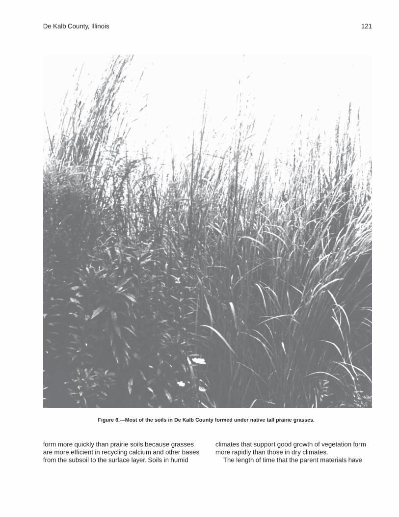
De Kalb County, Illinois 121
form more quickly than prairie soils because grassesare more efficient in recycling calcium and other basesfrom the subsoil to the surface layer. Soils in humid
climates that support good growth of vegetation formmore rapidly than those in dry climates.
The length of time that the parent materials have
Figure 6.—Most of the soils in De Kalb County formed under native tall prairie grasses.

122
been in place determines, to a great extent, thedegree of profile development. Most of the soils inDe Kalb County began formation with the retreat ofthe last glacier about 12,500 years ago. On the flood
plains, however, material is deposited during eachflood. This continual deposition slows development.Comfrey soils are examples of soils on floodplains.
123
American Association of State Highway and Transportation Officials (AASHTO). 2000.Standard specifications for transportation materials and methods of sampling andtesting. 20th edition, 2 volumes.
American Society for Testing and Materials (ASTM). 2001. Standard classification ofsoils for engineering purposes. ASTM Standard D 2487-00.
Cowardin, L.M., V. Carter, F.C. Golet, and E.T. LaRoe. 1979. Classification of wetlandsand deep-water habitats of the United States. U.S. Fish and Wildlife Service FWS/OBS-79/31.
Federal Register. July 13, 1994. Changes in hydric soils of the United States.
Federal Register. February 24, 1995. Hydric soils of the United States.
Fehrenbacher, J.B., R.A. Pope, I.J. Jansen, J.D. Alexander, and B.W. Ray. 1978. Soilproductivity in Illinois. University of Illinois, College of Agriculture, CooperativeExtension Service Circular 1156.
Hansel, A.K., and W.H. Johnson. 1996. Wedron and Mason groups: Lithostratigraphicreclassification of deposits of the Wisconsin episode, Lake Michigan lobe area. IllinoisState Geological Survey Bulletin 104.
Hinckley, K.C. 1978. Soil survey of De Kalb County, Illinois. University of IllinoisAgricultural Experiment Station Soil Report 96.
Hurt, G.W., P.M. Whited, and R.F. Pringle, editors. Version 4.0, 1998. Field indicators ofhydric soils in the United States.
Jenny, Hans. 1941. Factors of soil formation.
Leighton, M.M., G.E. Ekblaw, and L. Horberg. 1948. Physiographic divisions of Illinois.Illinois State Geological Survey, Report of Investigations 129.
National Research Council. 1995. Wetlands: Characteristics and boundaries.
Soil Survey Division Staff. 1993. Soil survey manual. Soil Conservation Service. U.S.Department of Agriculture Handbook 18.
Soil Survey Staff. 1998. Keys to soil taxonomy. 8th edition. U.S. Department ofAgriculture, Natural Resources Conservation Service.
Soil Survey Staff. 1999. Soil taxonomy: A basic system of soil classification for makingand interpreting soil surveys. 2nd edition. Natural Resources Conservation Service.U.S. Department of Agriculture Handbook 436.
References

124
Tiner, R.W., Jr. 1985. Wetlands of Delaware. U.S. Fish and Wildlife Service andDelaware Department of Natural Resources and Environmental Control, WetlandsSection.
United States Army Corps of Engineers, Environmental Laboratory. 1987. Corps ofEngineers wetlands delineation manual. Waterways Experiment Station TechnicalReport Y-87-1.
United States Department of Agriculture. 1961. Land capability classification. SoilConservation Service. U.S. Department of Agriculture Handbook 210.
United States Department of Agriculture. 1981. Land resource regions and major landresource areas of the United States. Soil Conservation Service. U.S. Department ofAgriculture Handbook 296.
United States Department of Commerce, Bureau of the Census. 1997. 1997 census ofagriculture.
United States Department of Commerce, Bureau of the Census. 2000. 2000 census ofpopulation and housing.

125
Aeration, soil. The exchange of air in soil with air fromthe atmosphere. The air in a well aerated soil issimilar to that in the atmosphere; the air in apoorly aerated soil is considerably higher incarbon dioxide and lower in oxygen.
Aggregate, soil. Many fine particles held in a singlemass or cluster. Natural soil aggregates, such asgranules, blocks, or prisms, are called peds. Clodsare aggregates produced by tillage or logging.
Alluvium. Material, such as sand, silt, or clay,deposited on land by streams.
Alpha,alpha-dipyridyl. A dye that when dissolved in1N ammonium acetate is used to detect thepresence of reduced iron (Fe II) in the soil. Apositive reaction indicates a type of redoximorphicfeature.
Animal unit month (AUM). The amount of foragerequired by one mature cow of approximately 1,000pounds weight, with or without a calf, for 1 month.
Aquic conditions. Current soil wetness characterizedby saturation, reduction, and redoximorphicfeatures.
Area reclaim (in tables). An area difficult to reclaimafter the removal of soil for construction and otheruses. Revegetation and erosion control areextremely difficult.
Argillic horizon. A subsoil horizon characterized byan accumulation of illuvial clay.
Aspect. The direction in which a slope faces.Available water capacity (available moisture
capacity). The capacity of soils to hold wateravailable for use by most plants. It is commonlydefined as the difference between the amount ofsoil water at field moisture capacity and theamount at wilting point. It is commonly expressedas inches of water per inch of soil. The capacity, ininches, in a 60-inch profile or to a limiting layer isexpressed as:
Very low ............................................................ 0 to 3
Low ................................................................... 3 to 6
Moderate .......................................................... 6 to 9
High ................................................................ 9 to 12
Very high .............................................. more than 12
Backslope. The position that forms the steepest and
generally linear, middle portion of a hillslope. Inprofile, backslopes are commonly bounded by aconvex shoulder above and a concave footslopebelow.
Basal till. Compact till deposited beneath the ice.Base saturation. The degree to which material having
cation-exchange properties is saturated withexchangeable bases (sum of Ca, Mg, Na, and K),expressed as a percentage of the total cation-exchange capacity.
Bedding planes. Fine strata, less than 5 millimetersthick, in unconsolidated alluvial, eolian, lacustrine,or marine sediment.
Bedrock. The solid rock that underlies the soil andother unconsolidated material or that is exposed atthe surface.
Bench terrace. A raised, level or nearly level strip ofearth constructed on or nearly on a contour,supported by a barrier of rocks or similar material,and designed to make the soil suitable for tillageand to prevent accelerated erosion.
Bottom land. The normal flood plain of a stream,subject to flooding.
Boulders. Rock fragments larger than 2 feet (60centimeters) in diameter.
Calcareous soil. A soil containing enough calciumcarbonate (commonly combined with magnesiumcarbonate) to effervesce visibly when treated withcold, dilute hydrochloric acid.
Capillary water. Water held as a film around soilparticles and in tiny spaces between particles.Surface tension is the adhesive force that holdscapillary water in the soil.
Catena. A sequence, or “chain,” of soils on alandscape that formed in similar kinds of parentmaterial but have different characteristics as aresult of differences in relief and drainage.
Cation. An ion carrying a positive charge of electricity.The common soil cations are calcium, potassium,magnesium, sodium, and hydrogen.
Cation-exchange capacity. The total amount ofexchangeable cations that can be held by the soil,expressed in terms of milliequivalents per 100grams of soil at neutrality (pH 7.0) or at someother stated pH value. The term, as applied to
Glossary

126 Soil Survey of
soils, is synonymous with base-exchange capacitybut is more precise in meaning.
Chemical treatment. Control of unwanted vegetationthrough the use of chemicals.
Chiseling. Tillage with an implement having one ormore soil-penetrating points that shatter or loosenhard, compacted layers to a depth below normalplow depth.
Clay. As a soil separate, the mineral soil particles lessthan 0.002 millimeter in diameter. As a soil texturalclass, soil material that is 40 percent or more clay,less than 45 percent sand, and less than 40percent silt.
Clay depletions. Low-chroma zones having a lowcontent of iron, manganese, and clay because ofthe chemical reduction of iron and manganeseand the removal of iron, manganese, and clay. Atype of redoximorphic depletion.
Clay film. A thin coating of oriented clay on thesurface of a soil aggregate or lining pores or rootchannels. Synonyms: clay coating, clay skin.
Closed depression. A low area completelysurrounded by higher ground and having nonatural outlet.
Coarse textured soil. Sand or loamy sand.Cobble (or cobblestone). A rounded or partly
rounded fragment of rock 3 to 10 inches (7.6 to 25centimeters) in diameter.
Colluvium. Soil material or rock fragments, or both,moved by creep, slide, or local wash anddeposited at the base of steep slopes.
Complex slope. Irregular or variable slope. Planningor establishing terraces, diversions, and otherwater-control structures on a complex slope isdifficult.
Concretions. Cemented bodies with crude internalsymmetry organized around a point, a line, or aplane. They typically take the form of concentriclayers visible to the naked eye. Calcium carbonate,iron oxide, and manganese oxide are commoncompounds making up concretions. If formed inplace, concretions of iron oxide or manganeseoxide are generally considered a type ofredoximorphic concentration.
Conservation cropping system. Growing crops incombination with needed cultural andmanagement practices. In a good conservationcropping system, the soil-improving crops andpractices more than offset the effects of the soil-depleting crops and practices. Cropping systemsare needed on all tilled soils. Soil-improvingpractices in a conservation cropping systeminclude the use of rotations that contain grassesand legumes and the return of crop residue to the
soil. Other practices include the use of greenmanure crops of grasses and legumes, propertillage, adequate fertilization, and weed and pestcontrol.
Conservation tillage. A tillage system that does notinvert the soil and that leaves a protective amountof crop residue on the surface throughout the year.
Consistence, soil. Refers to the degree of cohesionand adhesion of soil material and its resistance todeformation when ruptured. Consistence includesresistance of soil material to rupture and topenetration; plasticity, toughness, and stickiness ofpuddled soil material; and the manner in which thesoil material behaves when subject tocompression. Terms describing consistence aredefined in the “Soil Survey Manual.”
Contour stripcropping. Growing crops in strips thatfollow the contour. Strips of grass or close-growingcrops are alternated with strips of clean-tilledcrops or summer fallow.
Control section. The part of the soil on whichclassification is based. The thickness variesamong different kinds of soil, but for many it is thatpart of the soil profile between depths of 10 inchesand 40 or 80 inches.
Corrosion. Soil-induced electrochemical or chemicalaction that dissolves or weakens concrete oruncoated steel.
Cover crop. A close-growing crop grown primarily toimprove and protect the soil between periods ofregular crop production, or a crop grown betweentrees and vines in orchards and vineyards.
Crop residue management. Returning crop residueto the soil, which helps to maintain soil structure,organic matter content, and fertility and helps tocontrol erosion.
Cropping system. Growing crops according to aplanned system of rotation and managementpractices.
Culmination of the mean annual increment (CMAI).The average annual increase per acre in thevolume of a stand. Computed by dividing the totalvolume of the stand by its age. As the standincreases in age, the mean annual incrementcontinues to increase until mortality begins toreduce the rate of increase. The point where thestand reaches its maximum annual rate of growthis called the culmination of the mean annualincrement.
Cutbanks cave (in tables). The walls of excavationstend to cave in or slough.
Deferred grazing. Postponing grazing or restinggrazing land for a prescribed period.
Dense layer (in tables). A very firm, massive layer that

De Kalb County, Illinois 127
has a bulk density of more than 1.8 grams percubic centimeter. Such a layer affects the ease ofdigging and can affect filling and compacting.
Depth, soil. Generally, the thickness of the soil overbedrock. Very deep soils are more than 60 inchesdeep over bedrock; deep soils, 40 to 60 inches;moderately deep, 20 to 40 inches; shallow, 10 to20 inches; and very shallow, less than 10 inches.
Diversion (or diversion terrace). A ridge of earth,generally a terrace, built to protect downslopeareas by diverting runoff from its natural course.
Drainage class (natural). Refers to the frequency andduration of wet periods under conditions similar tothose under which the soil formed. Alterations ofthe water regime by human activities, eitherthrough drainage or irrigation, are not aconsideration unless they have significantlychanged the morphology of the soil. Sevenclasses of natural soil drainage are recognized—excessively drained, somewhat excessivelydrained, well drained, moderately well drained,somewhat poorly drained, poorly drained, andvery poorly drained. These classes are defined inthe “Soil Survey Manual.”
Drainage, surface. Runoff, or surface flow of water,from an area.
Drift. Pulverized and other rock material transportedby glacial ice and then deposited. Also, the sortedand unsorted material deposited by streamsflowing from glaciers.
Eluviation. The movement of material in true solutionor colloidal suspension from one place to anotherwithin the soil. Soil horizons that have lost materialthrough eluviation are eluvial; those that havereceived material are illuvial.
End moraine. A ridgelike accumulation that is beingor was produced at the outer margin of an activelyflowing glacier at any given time.
Endosaturation. A type of saturation of the soil inwhich all horizons between the upper boundary ofsaturation and a depth of 2 meters are saturated.
Eolian soil material. Earthy parent materialaccumulated through wind action; commonlyrefers to sandy material in dunes or to loess inblankets on the surface.
Ephemeral stream. A stream, or reach of a stream,that flows only in direct response to precipitation. Itreceives no long-continued supply from meltingsnow or other source, and its channel is above thewater table at all times.
Episaturation. A type of saturation indicating aperched water table in a soil in which saturatedlayers are underlain by one or more unsaturatedlayers within 2 meters of the surface.
Erosion. The wearing away of the land surface bywater, wind, ice, or other geologic agents and bysuch processes as gravitational creep.Erosion (geologic). Erosion caused by geologicprocesses acting over long geologic periods andresulting in the wearing away of mountains andthe building up of such landscape features asflood plains and coastal plains. Synonym: naturalerosion.Erosion (accelerated). Erosion much more rapidthan geologic erosion, mainly as a result of humanor animal activities or of a catastrophe in nature,such as a fire, that exposes the surface.
Escarpment. A relatively continuous and steep slopeor cliff breaking the general continuity of moregently sloping land surfaces and resulting fromerosion or faulting. Synonym: scarp.
Excess fines (in tables). Excess silt and clay in thesoil. The soil does not provide a source of gravelor sand for construction purposes.
Fertility, soil. The quality that enables a soil to provideplant nutrients, in adequate amounts and in properbalance, for the growth of specified plants whenlight, moisture, temperature, tilth, and other growthfactors are favorable.
Fibric soil material (peat). The least decomposed ofall organic soil material. Peat contains a largeamount of well preserved fiber that is readilyidentifiable according to botanical origin. Peat hasthe lowest bulk density and the highest watercontent at saturation of all organic soil material.
Field moisture capacity. The moisture content of asoil, expressed as a percentage of the ovendryweight, after the gravitational, or free, water hasdrained away; the field moisture content 2 or 3days after a soaking rain; also called normal fieldcapacity, normal moisture capacity, or capillarycapacity.
Fine textured soil. Sandy clay, silty clay, or clay.First bottom. The normal flood plain of a stream,
subject to frequent or occasional flooding.Flood plain. A nearly level alluvial plain that borders a
stream and is subject to flooding unless protectedartificially.
Footslope. The position that forms the inner, gentlyinclined surface at the base of a hillslope. Inprofile, footslopes are commonly concave. Afootslope is a transition zone between upslopesites of erosion and transport (shoulders andbackslopes) and downslope sites of deposition(toeslopes).
Forb. Any herbaceous plant not a grass or a sedge.Forest cover. All trees and other woody plants
(underbrush) covering the ground in a forest.

128 Soil Survey of
Forest type. A stand of trees similar in compositionand development because of given physical andbiological factors by which it may be differentiatedfrom other stands.
Frost action (in tables). Freezing and thawing of soilmoisture. Frost action can damage roads,buildings and other structures, and plant roots.
Genesis, soil. The mode of origin of the soil. Refersespecially to the processes or soil-forming factorsresponsible for the formation of the solum, or truesoil, from the unconsolidated parent material.
Geomorphology. The science that treats the generalconfiguration of the earth’s surface; specifically,the study of the classification, description, nature,origin, and development of landforms and theirrelationships to underlying structures, and thehistory of geologic changes as recorded by thesesurface features. The term is especially applied tothe genetic interpretation of landforms.
Glaciofluvial deposits. Material moved by glaciersand subsequently sorted and deposited bystreams flowing from the melting ice. The depositsare stratified and occur as kames, eskers, deltas,and outwash plains.
Glaciolacustrine deposits. Material ranging from fineclay to sand derived from glaciers and depositedin glacial lakes mainly by glacial meltwater. Manydeposits are interbedded or laminated.
Gleyed soil. Soil that formed under poor drainage,resulting in the reduction of iron and otherelements in the profile and in gray colors.
Grassed waterway. A natural or constructedwaterway, typically broad and shallow, seeded tograss as protection against erosion. Conductssurface water away from cropland.
Gravel. Rounded or angular fragments of rock asmuch as 3 inches (2 millimeters to 7.6centimeters) in diameter. An individual piece is apebble.
Gravelly soil material. Material that has 15 to 35percent, by volume, rounded or angular rockfragments, not prominently flattened, as much as3 inches (7.6 centimeters) in diameter.
Green manure crop (agronomy). A soil-improvingcrop grown to be plowed under in an early stageof maturity or soon after maturity.
Ground moraine. An extensive, fairly even layer of tillhaving an uneven or undulating surface; a depositof rock and mineral debris dragged along, in, on,or beneath a glacier and emplaced by processesincluding basal lodgment and release from thedownwasting stagnant ice by ablation.
Ground water. Water filling all the unblocked pores ofthe material below the water table.
Gully. A miniature valley with steep sides cut byrunning water and through which water ordinarilyruns only after rainfall. The distinction between agully and a rill is one of depth. A gully generally isan obstacle to farm machinery and is too deep tobe obliterated by ordinary tillage; a rill is of lesserdepth and can be smoothed over by ordinarytillage.
Head slope. A geomorphic component of hillsconsisting of a laterally concave area of a hillside,especially at the head of a drainageway. Theoverland waterflow is converging.
Hemic soil material (mucky peat). Organic soilmaterial intermediate in degree of decompositionbetween the less decomposed fibric material andthe more decomposed sapric material.
High-chroma zones. Zones having chroma of 3 ormore. Typical colors in areas of ironconcentrations.
High-residue crops. Such crops as small grain andcorn used for grain. If properly managed, residuefrom these crops can be used to control erosionuntil the next crop in the rotation is established.These crops return large amounts of organicmatter to the soil.
Horizon, soil. A layer of soil, approximately parallel tothe surface, having distinct characteristicsproduced by soil-forming processes. In theidentification of soil horizons, an uppercase letterrepresents the major horizons. Numbers orlowercase letters that follow representsubdivisions of the major horizons. An explanationof the subdivisions is given in the “Soil SurveyManual.” The major horizons of mineral soil are asfollows:O horizon.—An organic layer of fresh anddecaying plant residue.A horizon.—The mineral horizon at or near thesurface in which an accumulation of humifiedorganic matter is mixed with the mineral material.Also, a plowed surface horizon, most of which wasoriginally part of a B horizon.E horizon.—The mineral horizon in which the mainfeature is loss of silicate clay, iron, aluminum, orsome combination of these.B horizon.—The mineral horizon below an Ahorizon. The B horizon is in part a layer oftransition from the overlying A to the underlying Chorizon. The B horizon also has distinctivecharacteristics, such as (1) accumulation of clay,sesquioxides, humus, or a combination of these;(2) prismatic or blocky structure; (3) redder orbrowner colors than those in the A horizon; or (4)a combination of these.

De Kalb County, Illinois 129
C horizon.—The mineral horizon or layer,excluding indurated bedrock, that is little affectedby soil-forming processes and does not have theproperties typical of the overlying soil material.The material of a C horizon may be either like orunlike that in which the solum formed. If thematerial is known to differ from that in the solum,an Arabic numeral, commonly a 2, precedes theletter C.Cr horizon.—Soft, consolidated bedrock beneaththe soil.R layer.—Consolidated bedrock beneath the soil.The bedrock commonly underlies a C horizon, butit can be directly below an A or a B horizon.
Humus. The well decomposed, more or less stablepart of the organic matter in mineral soils.
Hydrologic soil groups. Refers to soils groupedaccording to their runoff potential. The soilproperties that influence this potential are thosethat affect the minimum rate of water infiltration ona bare soil during periods after prolonged wettingwhen the soil is not frozen. These properties aredepth to a seasonal high water table, theinfiltration rate and permeability after prolongedwetting, and depth to a very slowly permeablelayer. The slope and the kind of plant cover are notconsidered but are separate factors in predictingrunoff.
Illuviation. The movement of soil material from onehorizon to another in the soil profile. Generally,material is removed from an upper horizon anddeposited in a lower horizon.
Impervious soil. A soil through which water, air, orroots penetrate slowly or not at all. No soil isabsolutely impervious to air and water all the time.
Infiltration. The downward entry of water into theimmediate surface of soil or other material, ascontrasted with percolation, which is movement ofwater through soil layers or material.
Infiltration capacity. The maximum rate at whichwater can infiltrate into a soil under a given set ofconditions.
Infiltration rate. The rate at which water penetratesthe surface of the soil at any given instant, usuallyexpressed in inches per hour. The rate can belimited by the infiltration capacity of the soil or therate at which water is applied at the surface.
Intake rate. The average rate of water entering thesoil under irrigation. Most soils have a fast initialrate; the rate decreases with application time.Therefore, intake rate for design purposes is not aconstant but is a variable depending on the net
irrigation application. The rate of water intake, ininches per hour, is expressed as follows:
Less than 0.2 ............................................... very low
0.2 to 0.4 .............................................................. low
0.4 to 0.75 ......................................... moderately low
0.75 to 1.25 ................................................ moderate
1.25 to 1.75 ..................................... moderately high
1.75 to 2.5 .......................................................... high
More than 2.5 ............................................. very high
Interfluve. An elevated area between twodrainageways that sheds water to thosedrainageways.
Intermittent stream. A stream, or reach of a stream,that flows for prolonged periods only when itreceives ground-water discharge or long,continued contributions from melting snow or othersurface and shallow subsurface sources.
Iron accumulations. High-chroma zones having ahigh content of iron and manganese oxidebecause of chemical oxidation and accumulationbut having a clay content similar to that of theadjacent matrix. A type of redoximorphicfeature.
Iron depletions. Low-chroma zones having a lowcontent of iron and manganese oxide because ofchemical reduction and removal, but having a claycontent similar to that of the adjacent matrix. Atype of redoximorphic depletion.
Irrigation. Application of water to soils to assist inproduction of crops. Methods of irrigation are:Basin.—Water is applied rapidly to nearly levelplains surrounded by levees or dikes.Border.—Water is applied at the upper end of astrip in which the lateral flow of water is controlledby small earth ridges called border dikes, orborders.Controlled flooding.—Water is released atintervals from closely spaced field ditches anddistributed uniformly over the field.Corrugation.—Water is applied to small, closelyspaced furrows or ditches in fields of close-growing crops or in orchards so that it flows in onlyone direction.Drip (or trickle).—Water is applied slowly andunder low pressure to the surface of the soil orinto the soil through such applicators as emitters,porous tubing, or perforated pipe.Furrow.—Water is applied in small ditches madeby cultivation implements. Furrows are used fortree and row crops.Sprinkler.—Water is sprayed over the soil surface

130 Soil Survey of
through pipes or nozzles from a pressure system.Subirrigation.—Water is applied in open ditches ortile lines until the water table is raised enough towet the soil.Wild flooding.—Water, released at high points, isallowed to flow onto an area without controlleddistribution.
Leached soil. A soil from which most of the solubleconstituents have been removed from the entireprofile or have been removed from one part of theprofile and have accumulated in another part.
Leaching. The removal of soluble material from soil orother material by percolating water.
Liquid limit. The moisture content at which the soilpasses from a plastic to a liquid state.
Loam. Soil material that is 7 to 27 percent clayparticles, 28 to 50 percent silt particles, and lessthan 52 percent sand particles.
Loess. Fine grained material, dominantly of silt-sizedparticles, deposited by wind.
Low-chroma zones. Zones having chroma of 2 orless. Typical colors in areas of iron depletions.
Low-residue crops. Such crops as corn used forsilage, peas, beans, and potatoes. Residue fromthese crops is not adequate to control erosion untilthe next crop in the rotation is established. Thesecrops return little organic matter to the soil.
Low strength. The soil is not strong enough tosupport loads.
Masses. Concentrations of substances in the soilmatrix that do not have a clearly defined boundarywith the surrounding soil material and cannot beremoved as a discrete unit. Common compoundsmaking up masses are calcium carbonate,gypsum or other soluble salts, iron oxide, andmanganese oxide. Masses consisting of iron oxideor manganese oxide generally are considered atype of redoximorphic concentration.
Mechanical treatment. Use of mechanical equipmentfor seeding, brush management, and othermanagement practices.
Medium textured soil. Very fine sandy loam, loam,silt loam, or silt.
Metamorphic rock. Rock of any origin altered inmineralogical composition, chemical composition,or structure by heat, pressure, and movement.Nearly all such rocks are crystalline.
Mineral soil. Soil that is mainly mineral material andlow in organic material. Its bulk density is morethan that of organic soil.
Minimum tillage. Only the tillage essential to cropproduction and prevention of soil damage.
Miscellaneous area. An area that has little or nonatural soil and supports little or no vegetation.
MLRA (Major Land Resource Area). A geographicarea characterized by a particular pattern of landuses, elevation and topography, soils, climate,water resources, and potential natural vegetation.
Moderately coarse textured soil. Coarse sandyloam, sandy loam, or fine sandy loam.
Moderately fine textured soil. Clay loam, sandy clayloam, or silty clay loam.
Mollic epipedon. A thick, dark, humus-rich surfacehorizon (or horizons) that has high base saturationand pedogenic soil structure. It may include theupper part of the subsoil.
Moraine. An accumulation of earth, stones, and otherdebris deposited by a glacier. Some types areterminal, lateral, medial, and ground.
Morphology, soil. The physical makeup of the soil,including the texture, structure, porosity,consistence, color, and other physical, mineral,and biological properties of the various horizons,and the thickness and arrangement of thosehorizons in the soil profile.
Mottling, soil. Irregular spots of different colors thatvary in number and size. Descriptive terms are asfollows: abundance—few, common, and many;size—fine, medium, and coarse; and contrast—faint, distinct, and prominent. The sizemeasurements are of the diameter along thegreatest dimension. Fine indicates less than 5millimeters (about 0.2 inch); medium, from 5 to 15millimeters (about 0.2 to 0.6 inch); and coarse,more than 15 millimeters (about 0.6 inch).
Muck. Dark, finely divided, well decomposed organicsoil material. (See Sapric soil material.)
Munsell notation. A designation of color by degreesof three simple variables—hue, value, andchroma. For example, a notation of 10YR 6/4 isa color with hue of 10YR, value of 6, and chromaof 4.
Neutral soil. A soil having a pH value of 6.6 to 7.3.(See Reaction, soil.)
Nodules. Cemented bodies lacking visible internalstructure. Calcium carbonate, iron oxide, andmanganese oxide are common compoundsmaking up nodules. If formed in place, nodules ofiron oxide or manganese oxide are consideredtypes of redoximorphic concentrations.
Nose slope. A geomorphic component of hillsconsisting of the projecting end (laterally convexarea) of a hillside. The overland waterflow ispredominantly divergent.

De Kalb County, Illinois 131
Nutrient, plant. Any element taken in by a plantessential to its growth. Plant nutrients are mainlynitrogen, phosphorus, potassium, calcium,magnesium, sulfur, iron, manganese, copper,boron, and zinc obtained from the soil and carbon,hydrogen, and oxygen obtained from the air andwater.
Organic matter. Plant and animal residue in the soil invarious stages of decomposition. The content oforganic matter in the surface layer is described asfollows:
Very low ................................... less than 0.5 percent
Low ................................................ 0.5 to 1.0 percent
Moderately low .............................. 1.0 to 2.0 percent
Moderate ....................................... 2.0 to 4.0 percent
High ............................................... 4.0 to 8.0 percent
Very high ............................... more than 8.0 percent
Outwash. Gravel, sand, and silt, commonly stratified,deposited by glacial meltwater.
Outwash plain. A landform of mainly sandy or coarsetextured material of glaciofluvial origin. Anoutwash plain is commonly smooth; where pitted,it generally is low in relief.
Parent material. The unconsolidated organic andmineral material in which soil forms.
Peat. Unconsolidated material, largely undecomposedorganic matter, that has accumulated underexcess moisture. (See Fibric soil material.)
Ped. An individual natural soil aggregate, such as agranule, a prism, or a block.
Pedon. The smallest volume that can be called “a soil.”A pedon is three dimensional and large enough topermit study of all horizons. Its area ranges fromabout 10 to 100 square feet (1 square meter to 10square meters), depending on the variability of thesoil.
Percolation. The movement of water through the soil.Percs slowly (in tables). The slow movement of water
through the soil adversely affects the specifieduse.
Permeability. The quality of the soil that enables wateror air to move downward through the profile. Therate at which a saturated soil transmits water isaccepted as a measure of this quality. In soilphysics, the rate is referred to as “saturatedhydraulic conductivity,” which is defined in the “SoilSurvey Manual.” In line with conventional usage inthe engineering profession and with traditionalusage in published soil surveys, this rate of flowcontinues to be expressed as “permeability.” Terms
describing permeability, measured in inches perhour, are as follows:
Extremely slow ................................. 0.0 to 0.01 inch
Very slow ........................................ 0.01 to 0.06 inch
Slow .................................................. 0.06 to 0.2 inch
Moderately slow ................................. 0.2 to 0.6 inch
Moderate ................................ 0.6 inch to 2.0 inches
Moderately rapid ............................ 2.0 to 6.0 inches
Rapid ............................................... 6.0 to 20 inches
Very rapid ................................. more than 20 inches
Phase, soil. A subdivision of a soil series based onfeatures that affect its use and management, suchas slope, stoniness, and flooding.
pH value. A numerical designation of acidity andalkalinity in soil. (See Reaction, soil.)
Piping (in tables). Formation of subsurface tunnels orpipelike cavities by water moving through the soil.
Plastic limit. The moisture content at which a soilchanges from semisolid to plastic.
Plasticity index. The numerical difference betweenthe liquid limit and the plastic limit; the range ofmoisture content within which the soil remainsplastic.
Plowpan. A compacted layer formed in the soildirectly below the plowed layer.
Ponding. Standing water on soils in closeddepressions. Unless the soils are artificiallydrained, the water can be removed only bypercolation or evapotranspiration.
Poor filter (in tables). Because of rapid or very rapidpermeability, the soil may not adequately filtereffluent from a waste disposal system.
Poorly graded. Refers to a coarse grained soil or soilmaterial consisting mainly of particles of nearlythe same size. Because there is little difference insize of the particles, density can be increased onlyslightly by compaction.
Prescribed burning. Deliberately burning an area forspecific management purposes, under theappropriate conditions of weather and soilmoisture and at the proper time of day.
Productivity, soil. The capability of a soil forproducing a specified plant or sequence of plantsunder specific management.
Profile, soil. A vertical section of the soil extendingthrough all its horizons and into the parentmaterial.
Reaction, soil. A measure of acidity or alkalinity of asoil, expressed in pH values. A soil that tests to pH7.0 is described as precisely neutral in reaction
132 Soil Survey of
because it is neither acid nor alkaline. Thedegrees of acidity or alkalinity, expressed as pHvalues, are:
Ultra acid .............................................. less than 3.5
Extremely acid ........................................... 3.5 to 4.4
Very strongly acid ...................................... 4.5 to 5.0
Strongly acid .............................................. 5.1 to 5.5
Moderately acid .......................................... 5.6 to 6.0
Slightly acid ................................................ 6.1 to 6.5
Neutral ........................................................ 6.6 to 7.3
Slightly alkaline .......................................... 7.4 to 7.8
Moderately alkaline .................................... 7.9 to 8.4
Strongly alkaline ........................................ 8.5 to 9.0
Very strongly alkaline ......................... 9.1 and higher
Redoximorphic concentrations. Nodules,concretions, soft masses, pore linings, and otherfeatures resulting from the accumulation of iron ormanganese oxide. An indication of chemicalreduction and oxidation resulting from saturation.
Redoximorphic depletions. Low-chroma zones fromwhich iron and manganese oxide or a combinationof iron and manganese oxide and clay has beenremoved. These zones are indications of thechemical reduction of iron resulting fromsaturation.
Redoximorphic features. Redoximorphicconcentrations, redoximorphic depletions, reducedmatrices, a positive reaction to alpha,alpha-dipyridyl, and other features indicating thechemical reduction and oxidation of iron andmanganese compounds resulting from saturation.
Reduced matrix. A soil matrix that has low chroma insitu because of chemically reduced iron (Fe II).The chemical reduction results from nearlycontinuous wetness. The matrix undergoes achange in hue or chroma within 30 minutes afterexposure to air as the iron is oxidized (Fe III). Atype of redoximorphic feature.
Regolith. The unconsolidated mantle of weatheredrock and soil material on the earth’s surface; theloose earth material above the solid rock.
Relief. The elevations or inequalities of a land surface,considered collectively.
Residuum (residual soil material). Unconsolidated,weathered or partly weathered mineral materialthat accumulated as consolidated rockdisintegrated in place.
Rill. A steep-sided channel resulting from acceleratederosion. A rill generally is a few inches deep andnot wide enough to be an obstacle to farmmachinery.
Rock fragments. Rock or mineral fragments having a
diameter of 2 millimeters or more; for example,pebbles, cobbles, stones, and boulders.
Root zone. The part of the soil that can be penetratedby plant roots.
Rooting depth (in tables). Shallow root zone. The soilis shallow over a layer that greatly restricts roots.
Runoff. The precipitation discharged into streamchannels from an area. The water that flows off thesurface of the land without sinking into the soil iscalled surface runoff. Water that enters the soilbefore reaching surface streams is called ground-water runoff or seepage flow from ground water.
Sand. As a soil separate, individual rock or mineralfragments from 0.05 millimeter to 2.0 millimeters indiameter. Most sand grains consist of quartz. As asoil textural class, a soil that is 85 percent or moresand and not more than 10 percent clay.
Sapric soil material (muck). The most highlydecomposed of all organic soil material. Muck hasthe least amount of plant fiber, the highest bulkdensity, and the lowest water content at saturationof all organic soil material.
Saturation. Wetness characterized by zero or positivepressure of the soil water. Under conditions ofsaturation, the water will flow from the soil matrixinto an unlined auger hole.
Seasonal high water table. A zone of saturation atthe highest average depth during the wettestseason. It is at least 6 inches thick and persists inthe soil for more than a few weeks.
Second bottom. The first terrace above the normalflood plain (or first bottom) of a river.
Sedimentary rock. Rock made up of particlesdeposited from suspension in water. The chiefkinds of sedimentary rock are conglomerate,formed from gravel; sandstone, formed from sand;shale, formed from clay; and limestone, formedfrom soft masses of calcium carbonate. There aremany intermediate types. Some wind-depositedsand is consolidated into sandstone.
Seepage (in tables). The movement of water throughthe soil. Seepage adversely affects the specifieduse.
Sequum. A sequence consisting of an illuvial horizonand the overlying eluvial horizon. (See Eluviation.)
Series, soil. A group of soils that have profiles that arealmost alike, except for differences in texture ofthe surface layer. All the soils of a series havehorizons that are similar in composition, thickness,and arrangement.
Sheet erosion. The removal of a fairly uniform layer ofsoil material from the land surface by the action ofrainfall and surface runoff.

De Kalb County, Illinois 133
Shoulder. The position that forms the uppermostinclined surface near the top of a hillslope. It is atransition from backslope to summit. The surfaceis dominantly convex in profile and erosional inorigin.
Shrink-swell (in tables). The shrinking of soil whendry and the swelling when wet. Shrinking andswelling can damage roads, dams, buildingfoundations, and other structures. It can alsodamage plant roots.
Side slope. A geomorphic component of hillsconsisting of a laterally planar area of a hillside.The overland waterflow is predominantly parallel.
Silica. A combination of silicon and oxygen. Themineral form is called quartz.
Silt. As a soil separate, individual mineral particlesthat range in diameter from the upper limit of clay(0.002 millimeter) to the lower limit of very finesand (0.05 millimeter). As a soil textural class, soilthat is 80 percent or more silt and less than 12percent clay.
Siltstone. Sedimentary rock made up of dominantlysilt-sized particles.
Similar soils. Soils that share limits of diagnosticcriteria, behave and perform in a similar manner,and have similar conservation needs ormanagement requirements for the major land usesin the survey area.
Site index. A designation of the quality of a forest sitebased on the height of the dominant stand at anarbitrarily chosen age. For example, if the averageheight attained by dominant and codominant treesin a fully stocked stand at the age of 50 years is75 feet, the site index is 75.
Slope. The inclination of the land surface from thehorizontal. Percentage of slope is the verticaldistance divided by horizontal distance, thenmultiplied by 100. Thus, a slope of 20 percent is adrop of 20 feet in 100 feet of horizontal distance.
Slope (in tables). Slope is great enough that specialpractices are required to ensure satisfactoryperformance of the soil for a specific use.
Slow refill (in tables). The slow filling of ponds,resulting from restricted permeability in the soil.
Small stones (in tables). Rock fragments less than 3inches (7.6 centimeters) in diameter. Small stonesadversely affect the specified use of the soil.
Soil. A natural, three-dimensional body at the earth’ssurface. It is capable of supporting plants and hasproperties resulting from the integrated effect ofclimate and living matter acting on earthy parentmaterial, as conditioned by relief and by thepassage of time.
Soil quality. The fitness of a specific kind of soil tofunction within its surroundings, support plant andanimal productivity, maintain or enhance waterand air quality, and support human health andhabitation.
Soil separates. Mineral particles less than 2millimeters in equivalent diameter and rangingbetween specified size limits. The names andsizes, in millimeters, of separates recognized inthe United States are as follows:
Very coarse sand ....................................... 2.0 to 1.0
Coarse sand ............................................... 1.0 to 0.5
Medium sand ........................................... 0.5 to 0.25
Fine sand ............................................... 0.25 to 0.10
Very fine sand ........................................ 0.10 to 0.05
Silt ........................................................ 0.05 to 0.002
Clay .................................................. less than 0.002
Solum. The upper part of a soil profile, above the Chorizon, in which the processes of soil formationare active. The solum in soil consists of the A, E,and B horizons. Generally, the characteristics ofthe material in these horizons are unlike those ofthe material below the solum. The living roots andplant and animal activities are largely confined tothe solum.
Stones. Rock fragments 10 to 24 inches (25 to 60centimeters) in diameter if rounded or 15 to 24inches (38 to 60 centimeters) in length if flat.
Stony. Refers to a soil containing stones in numbersthat interfere with or prevent tillage.
Stream channel. The hollow bed where a naturalstream of surface water flows or may flow; thedeepest or central part of the bed, formed by themain current and covered more or lesscontinuously by water.
Stream terrace. One of a series of platforms in astream valley, flanking and more or less parallel tothe stream channel. It originally formed near thelevel of the stream and is the dissected remnantsof an abandoned flood plain, streambed, or valleyfloor that were produced during a former stage oferosion or deposition.
Stripcropping. Growing crops in a systematicarrangement of strips or bands that providevegetative barriers to wind erosion and watererosion.
Structure, soil. The arrangement of primary soilparticles into compound particles or aggregates.The principal forms of soil structure are—platy(laminated), prismatic (vertical axis of aggregateslonger than horizontal), columnar (prisms withrounded tops), blocky (angular or subangular),

134 Soil Survey of
and granular. Structureless soils are either singlegrain (each grain by itself, as in dune sand) ormassive (the particles adhering without anyregular cleavage, as in many hardpans).
Stubble mulch. Stubble or other crop residue left onthe soil or partly worked into the soil. It protectsthe soil from wind erosion and water erosion afterharvest, during preparation of a seedbed for thenext crop, and during the early growing period ofthe new crop.
Subsoil. Technically, the B horizon; roughly, the part ofthe solum below plow depth.
Subsoiling. Tilling a soil below normal plow depth,ordinarily to shatter a hardpan or claypan.
Substratum. The part of the soil below the solum.Subsurface layer. Any surface soil horizon (A, E, AB,
or EB) below the surface layer.Summit. The topographically highest position of a
hillslope. It has a nearly level (planar or onlyslightly convex) surface.
Surface layer. The soil ordinarily moved in tillage, orits equivalent in uncultivated soil, ranging in depthfrom 4 to 10 inches (10 to 25 centimeters).Frequently designated as the “plow layer,” or the“Ap horizon.”
Surface soil. The A, E, AB, and EB horizons,considered collectively. It includes all subdivisionsof these horizons.
Taxadjuncts. Soils that cannot be classified in aseries recognized in the classification system.Such soils are named for a series they stronglyresemble and are designated as taxadjuncts tothat series because they differ in ways too small tobe of consequence in interpreting their use andbehavior. Soils are recognized as taxadjuncts onlywhen one or more of their characteristics areslightly outside the range defined for the family ofthe series for which the soils are named.
Terminal moraine. A belt of thick drift that generallymarks the termination of important glacialadvances. It commonly is a massive, arcuate ridgeor complex of ridges underlain by till and othertypes of drift.
Terrace. An embankment, or ridge, constructedacross sloping soils on the contour or at a slightangle to the contour. The terrace interceptssurface runoff so that water soaks into the soil orflows slowly to a prepared outlet. A terrace in afield generally is built so that the field can befarmed. A terrace intended mainly for drainagehas a deep channel that is maintained inpermanent sod.
Terrace (geologic). An old alluvial plain, ordinarilyflat or undulating, bordering a river, a lake, or thesea.
Texture, soil. The relative proportions of sand, silt,and clay particles in a mass of soil. The basictextural classes, in order of increasing proportionof fine particles, are sand, loamy sand, sandyloam, loam, silt loam, silt, sandy clay loam, clayloam, silty clay loam, sandy clay, silty clay, andclay. The sand, loamy sand, and sandy loamclasses may be further divided by specifying“coarse,” “fine,” or “very fine.”
Thin layer (in tables). Otherwise suitable soil materialthat is too thin for the specified use.
Till. Unsorted, nonstratified drift consisting of clay, silt,sand, and boulders transported and deposited byglacial ice.
Till plain. An extensive area of nearly level toundulating soils underlain by till.
Tilth, soil. The physical condition of the soil as relatedto tillage, seedbed preparation, seedlingemergence, and root penetration.
Toeslope. The position that forms the gently inclinedsurface at the base of a hillslope. Toeslopes inprofile are commonly gentle and linear and areconstructional surfaces forming the lower part of ahillslope continuum that grades to valley or closed-depression floors.
Topsoil. The upper part of the soil, which is the mostfavorable material for plant growth. It is ordinarilyrich in organic matter and is used to topdressroadbanks, lawns, and land affected by mining.
Trace elements. Chemical elements, for example,zinc, cobalt, manganese, copper, and iron, in soilsin extremely small amounts. They are essential toplant growth.
Understory. Any plants in a forest community thatgrow to a height of less than 5 feet.
Upland. Land at a higher elevation, in general, thanthe alluvial plain or stream terrace; land above thelowlands along streams.
Valley fill. In glaciated regions, material deposited instream valleys by glacial meltwater. Innonglaciated regions, alluvium deposited byheavily loaded streams.
Variegation. Refers to patterns of contrastingcolors assumed to be inherited from the parentmaterial rather than to be the result of poordrainage.
Weathering. All physical and chemical changesproduced in rocks or other deposits at or near theearth’s surface by atmospheric agents. These

De Kalb County, Illinois 135
changes result in disintegration anddecomposition of the material.
Well graded. Refers to soil material consisting ofcoarse grained particles that are well distributedover a wide range in size or diameter. Such soilnormally can be easily increased in density andbearing properties by compaction. Contrasts withpoorly graded soil.
Wilting point (or permanent wilting point). Themoisture content of soil, on an ovendry basis, atwhich a plant (specifically a sunflower) wilts somuch that it does not recover when placed in ahumid, dark chamber.
Windthrow. The uprooting and tipping over of trees bythe wind.


137
Tables

138 Soil Survey of
Table 1.--Temperature and Precipitation
(Recorded in the period 1971-2000 at De Kalb, Illinois)
_______________________________________________________________________________________________________________ | | | Temperature | Precipitation | | __________________________________________________________________________________________________ | | | | 2 years in | | |2 years in 10| | | | | | 10 will have-- | | | will have-- | | _______________________ _____________ Month |Average|Average|Average| | | Average |Average| | | Average |Average | daily | daily | | Maximum | Minimum |number of| | Less | More |number of|snowfall |maximum|minimum| |temperature|temperature| growing | |than--|than--|days with| | | | | higher | lower | degree | | | |0.10 inch| | | | | than-- | than-- | days* | | | | or more |_______________________________________________________________________________________________________________ | oF | oF | oF | oF | oF | Units | In | In | In | | In | | | | | | | | | | | January----| 27.1 | 11.2 | 19.1 | 52 | -19 | 0 | 1.57 | 0.71| 2.30| 4 | 9.9 | | | | | | | | | | | February---| 33.5 | 17.3 | 25.4 | 60 | -13 | 0 | 1.40 | .62| 2.07| 3 | 7.3 | | | | | | | | | | | March------| 45.4 | 27.4 | 36.4 | 76 | 3 | 21 | 2.44 | 1.31| 3.43| 5 | 4.8 | | | | | | | | | | | April------| 59.2 | 37.5 | 48.3 | 85 | 17 | 97 | 3.52 | 2.18| 4.72| 7 | 1.1 | | | | | | | | | | | May--------| 71.6 | 48.4 | 60.0 | 91 | 29 | 321 | 4.16 | 2.41| 5.72| 7 | .0 | | | | | | | | | | | June-------| 81.1 | 58.5 | 69.8 | 95 | 41 | 598 | 4.53 | 2.14| 6.60| 7 | .0 | | | | | | | | | | | July-------| 84.2 | 62.8 | 73.5 | 97 | 48 | 731 | 4.26 | 2.09| 6.14| 5 | .0 | | | | | | | | | | | August-----| 81.9 | 60.7 | 71.3 | 95 | 45 | 660 | 4.60 | 2.35| 6.56| 6 | .0 | | | | | | | | | | | September--| 75.6 | 52.5 | 64.1 | 92 | 33 | 428 | 3.47 | 1.35| 5.25| 5 | .0 | | | | | | | | | | | October----| 63.1 | 40.8 | 51.9 | 85 | 21 | 146 | 2.65 | 1.38| 3.76| 5 | .0 | | | | | | | | | | | November---| 46.3 | 29.7 | 38.0 | 71 | 6 | 20 | 2.82 | 1.38| 4.07| 5 | 2.1 | | | | | | | | | | | December---| 33.0 | 18.3 | 25.7 | 58 | -10 | 2 | 2.18 | 1.15| 3.09| 5 | 9.5 | | | | | | | | | | | Yearly: | | | | | | | | | | | | | | | | | | | | | | Average---| 58.5 | 38.8 | 48.6 | --- | --- | --- | --- | ---| ---| --- | --- | | | | | | | | | | | Extreme---| 103 | -27 | --- | 98 | -20 | --- | --- | ---| ---| --- | --- | | | | | | | | | | | Total-----| --- | --- | --- | --- | --- | 3,024 | 37.59 | 30.93| 41.80| 64 | 34.8 | | | | | | | | | | |_______________________________________________________________________________________________________________
* A growing degree day is a unit of heat available for plant growth. It can be calculated by adding themaximum and minimum daily temperatures, dividing the sum by 2, and subtracting the temperature below whichgrowth is minimal for the principal crops in the area (50 degrees F).

De Kalb County, Illinois 139
Table 2.--Freeze Dates in Spring and Fall
(Recorded in the period 1971-2000 at De Kalb, Illinois)
_____________________________________________________________ | | Temperature |__________________________________________ Probability | | | | 24 oF | 28 oF | 32 oF | or lower | or lower | or lower_____________________________________________________________ | | | | | |Last freezing | | | temperature | | | in spring: | | | | | | 1 year in 10 | | | later than-- | Apr. 21 | May 1 | May 15 | | | 2 years in 10 | | | later than-- | Apr. 16 | Apr. 26 | May 9 | | | 5 years in 10 | | | later than-- | Apr. 6 | Apr. 16 | Apr. 28 | | |First freezing | | | temperature | | | in fall: | | | | | | 1 year in 10 | | | earlier than-- | Oct. 17 | Oct. 5 | Sept. 26 | | | 2 years in 10 | | | earlier than-- | Oct. 22 | Oct. 11 | Sept. 30 | | | 5 years in 10 | | | earlier than-- | Nov. 2 | Oct. 23 | Oct. 9 | | |_____________________________________________________________
Table 3.--Growing Season
(Recorded in the period 1971-2000 at De Kalb, Illinois)
__________________________________________________ | | Daily minimum temperature | during growing season |___________________________________ Probability | | | | Higher | Higher | Higher | than | than | than | 24 oF | 28 oF | 32 oF__________________________________________________ | Days | Days | Days | | |9 years in 10 | 188 | 166 | 137 | | |8 years in 10 | 196 | 174 | 146 | | |5 years in 10 | 210 | 190 | 163 | | |2 years in 10 | 224 | 206 | 180 | | |1 year in 10 | 232 | 214 | 189 | | |__________________________________________________

140 Soil Survey of
Table 4.--Acreage and Proportionate Extent of the Soils_______________________________________________________________________________________________________ | | | Map | Soil name | Acres |Percentsymbol | | |_______________________________________________________________________________________________________ | | |59A |Lisbon silt loam, 0 to 2 percent slopes----------------------------------| 4,918 | 1.260C2 |La Rose loam, 5 to 10 percent slopes, eroded-----------------------------| 2,469 | 0.660D2 |La Rose loam, 10 to 18 percent slopes, eroded----------------------------| 1,354 | 0.362A |Herbert silt loam, 0 to 2 percent slopes---------------------------------| 4,564 | 1.167A |Harpster silty clay loam, 0 to 2 percent slopes--------------------------| 5,985 | 1.568A |Sable silty clay loam, 0 to 2 percent slopes-----------------------------| 623 | 0.2103A |Houghton muck, 0 to 2 percent slopes-------------------------------------| 1,467 | 0.4104A |Virgil silt loam, 0 to 2 percent slopes----------------------------------| 2,970 | 0.7148A |Proctor silt loam, 0 to 2 percent slopes---------------------------------| 322 | *148B |Proctor silt loam, 2 to 5 percent slopes---------------------------------| 54 | *152A |Drummer silty clay loam, 0 to 2 percent slopes---------------------------| 42,583 | 10.5154A |Flanagan silt loam, 0 to 2 percent slopes--------------------------------| 57,007 | 14.0171A |Catlin silt loam, 0 to 2 percent slopes----------------------------------| 7,858 | 1.9171B |Catlin silt loam, 2 to 5 percent slopes----------------------------------| 35,898 | 8.8193A |Mayville silt loam, 0 to 2 percent slopes--------------------------------| 416 | 0.1193B |Mayville silt loam, 2 to 5 percent slopes--------------------------------| 8,932 | 2.2193C2 |Mayville silt loam, 5 to 10 percent slopes, eroded-----------------------| 543 | 0.1198A |Elburn silt loam, 0 to 2 percent slopes----------------------------------| 9,386 | 2.3206A |Thorp silt loam, 0 to 2 percent slopes-----------------------------------| 383 | *219A |Millbrook silt loam, 0 to 2 percent slopes-------------------------------| 2,042 | 0.5221B2 |Parr silt loam, 2 to 5 percent slopes, eroded----------------------------| 7,259 | 1.8221C2 |Parr silt loam, 5 to 10 percent slopes, eroded---------------------------| 8,076 | 2.0233A |Birkbeck silt loam, 0 to 2 percent slopes--------------------------------| 885 | 0.2233B |Birkbeck silt loam, 2 to 5 percent slopes--------------------------------| 377 | *236A |Sabina silt loam, 0 to 2 percent slopes----------------------------------| 1,325 | 0.3318D2 |Lorenzo loam, 6 to 12 percent slopes, eroded-----------------------------| 73 | *325A |Dresden silt loam, 0 to 2 percent slopes---------------------------------| 6 | *325B |Dresden silt loam, 2 to 4 percent slopes---------------------------------| 275 | *325C2 |Dresden silt loam, 4 to 6 percent slopes, eroded-------------------------| 412 | 0.1327B |Fox silt loam, 2 to 4 percent slopes-------------------------------------| 117 | *330A |Peotone silty clay loam, 0 to 2 percent slopes---------------------------| 2,845 | 0.7344B |Harvard silt loam, 2 to 5 percent slopes---------------------------------| 176 | *348A |Wingate silt loam, 0 to 2 percent slopes---------------------------------| 855 | 0.2348B |Wingate silt loam, 2 to 5 percent slopes---------------------------------| 12,197 | 3.0348C2 |Wingate silt loam, 5 to 10 percent slopes, eroded------------------------| 910 | 0.2356A |Elpaso silty clay loam, 0 to 2 percent slopes----------------------------| 65,011 | 16.0488A |Hooppole loam, 0 to 2 percent slopes-------------------------------------| 565 | 0.1512A |Danabrook silt loam, 0 to 2 percent slopes-------------------------------| 1,433 | 0.4512B |Danabrook silt loam, 2 to 5 percent slopes-------------------------------| 56,035 | 13.8512C2 |Danabrook silt loam, 5 to 10 percent slopes, eroded----------------------| 5,809 | 1.4527B |Kidami silt loam, 2 to 4 percent slopes----------------------------------| 2,505 | 0.6527C2 |Kidami loam, 4 to 6 percent slopes, eroded-------------------------------| 3,572 | 0.9527D2 |Kidami loam, 6 to 12 percent slopes, eroded------------------------------| 649 | 0.2656B |Octagon silt loam, 2 to 4 percent slopes---------------------------------| 2,594 | 0.6656C2 |Octagon silt loam, 4 to 6 percent slopes, eroded-------------------------| 3,740 | 0.9662A |Barony silt loam, 0 to 2 percent slopes----------------------------------| 1,252 | 0.3662B |Barony silt loam, 2 to 5 percent slopes----------------------------------| 2,365 | 0.6662C2 |Barony silt loam, 5 to 10 percent slopes, eroded-------------------------| 855 | 0.2663A |Clare silt loam, 0 to 2 percent slopes-----------------------------------| 553 | 0.1663B |Clare silt loam, 2 to 5 percent slopes-----------------------------------| 885 | 0.2667A |Kaneville silt loam, 0 to 2 percent slopes-------------------------------| 3,147 | 0.8667B |Kaneville silt loam, 2 to 5 percent slopes-------------------------------| 4,241 | 1.0667C2 |Kaneville silt loam, 5 to 10 percent slopes, eroded----------------------| 432 | 0.1668A |Somonauk silt loam, 0 to 2 percent slopes--------------------------------| 1,949 | 0.5668B |Somonauk silt loam, 2 to 5 percent slopes--------------------------------| 1,859 | 0.5679A |Blackberry silt loam, 0 to 2 percent slopes------------------------------| 774 | 0.2679B |Blackberry silt loam, 2 to 5 percent slopes------------------------------| 2,405 | 0.6712A |Spaulding silty clay loam, 0 to 2 percent slopes-------------------------| 78 | *715A |Arrowsmith silt loam, 0 to 2 percent slopes------------------------------| 1,276 | 0.3791A |Rush silt loam, 0 to 2 percent slopes------------------------------------| 262 | *791B |Rush silt loam, 2 to 4 percent slopes------------------------------------| 316 | *792A |Bowes silt loam, 0 to 2 percent slopes-----------------------------------| 582 | 0.1792B |Bowes silt loam, 2 to 4 percent slopes-----------------------------------| 467 | 0.1 | | |
See footnote at end of table.

De Kalb County, Illinois 141
Table 4.--Acreage and Proportionate Extent of the Soils--Continued_______________________________________________________________________________________________________ | | | Map | Soil name | Acres |Percentsymbol | | |_______________________________________________________________________________________________________ | | |802B |Orthents, loamy, undulating----------------------------------------------| 884 | 0.2830 |Landfills----------------------------------------------------------------| 122 | *865 |Pits, gravel-------------------------------------------------------------| 387 | *3076A |Otter silt loam, 0 to 2 percent slopes, frequently flooded---------------| 11,831 | 2.93776A |Comfrey loam, 0 to 2 percent slopes, frequently flooded------------------| 320 | *W |Water--------------------------------------------------------------------| 1,203 | 0.3 | |____________|________ | Total---------------------------------------------------------------| 405,920 | 100.0 | | |_______________________________________________________________________________________________________
* Less than 0.1 percent.

142 Soil Survey of
Table 5.--Main Limitations and Hazards Affecting Cropland and Pastureland
(See text for a description of the limitations and hazards listed in this table.)
________________________________________________________________________________________ | | Map symbol | Limitations and hazards | Limitations and hazards and | affecting cropland | affecting pastureland soil name | |________________________________________________________________________________________ | |59A: | | Lisbon-------------------|Wetness |Frost heave, | | wetness | |60C2: | | La Rose------------------|Crusting, |Frost heave, | water erosion | water erosion | |60D2: | | La Rose------------------|Crusting, |Equipment limitation, | water erosion | frost heave, | | water erosion | |62A: | | Herbert------------------|Wetness |Frost heave, | | wetness | |67A: | | Harpster-----------------|Excess lime, |Frost heave, | ponding, | ponding | poor tilth | | |68A: | | Sable--------------------|Ponding, |Frost heave, | poor tilth | ponding | |103A: | | Houghton-----------------|Ponding, |Frost heave, | subsidence, | low pH, | wind erosion | ponding, | | wind erosion | |104A: | | Virgil-------------------|Wetness |Frost heave, | | low pH, | | wetness | |148A: | | Proctor------------------|None |Frost heave, | | low pH | |148B: | | Proctor------------------|Water erosion |Frost heave, | | low pH, | | water erosion | |152A: | | Drummer------------------|Ponding, |Frost heave, | poor tilth | ponding | |154A: | | Flanagan-----------------|Wetness |Frost heave, | | low pH, | | wetness | |171A: | | Catlin-------------------|None |Frost heave, | | low pH | |

De Kalb County, Illinois 143
Table 5.--Main Limitations and Hazards Affecting Cropland and Pastureland--Continued________________________________________________________________________________________ | | Map symbol | Limitations and hazards | Limitations and hazards and | affecting cropland | affecting pastureland soil name | |________________________________________________________________________________________ | |171B: | | Catlin-------------------|Water erosion |Frost heave, | | low pH, | | water erosion | |193A: | | Mayville-----------------|Crusting |Frost heave, | | low pH | |193B: | | Mayville-----------------|Crusting, |Frost heave, | water erosion | low pH, | | water erosion | |193C2: | | Mayville-----------------|Crusting, |Frost heave, | water erosion | low pH, | | water erosion | |198A: | | Elburn-------------------|Wetness |Frost heave, | | wetness | |206A: | | Thorp--------------------|Ponding, |Frost heave, | restricted permeability | low pH, | | ponding | |219A: | | Millbrook----------------|Wetness |Frost heave, | | low pH, | | wetness | |221B2: | | Parr---------------------|Crusting, |Frost heave, | water erosion | water erosion | |221C2: | | Parr---------------------|Crusting, |Frost heave, | water erosion | water erosion | |233A: | | Birkbeck-----------------|Crusting |Frost heave, | | low pH | |233B: | | Birkbeck-----------------|Crusting, |Frost heave, | water erosion | low pH, | | water erosion | |236A: | | Sabina-------------------|Crusting, |Frost heave, | wetness | low pH, | | wetness | |318D2: | | Lorenzo------------------|Crusting, |Equipment limitation, | excessive permeability, | frost heave, | low available water capacity,| low available water capacity, | water erosion | water erosion | |325A: | | Dresden------------------|Excessive permeability |Frost heave | |
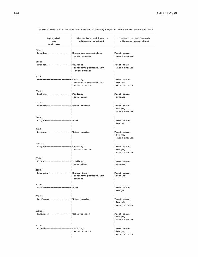
144 Soil Survey of
Table 5.--Main Limitations and Hazards Affecting Cropland and Pastureland--Continued________________________________________________________________________________________ | | Map symbol | Limitations and hazards | Limitations and hazards and | affecting cropland | affecting pastureland soil name | |________________________________________________________________________________________ | |325B: | | Dresden------------------|Excessive permeability, |Frost heave, | water erosion | water erosion | |325C2: | | Dresden------------------|Crusting, |Frost heave, | excessive permeability, | water erosion | water erosion | | |327B: | | Fox----------------------|Crusting, |Frost heave, | excessive permeability, | low pH, | water erosion | water erosion | |330A: | | Peotone------------------|Ponding, |Frost heave, | poor tilth | ponding | |344B: | | Harvard------------------|Water erosion |Frost heave, | | low pH, | | water erosion | |348A: | | Wingate------------------|None |Frost heave, | | low pH | |348B: | | Wingate------------------|Water erosion |Frost heave, | | low pH, | | water erosion | |348C2: | | Wingate------------------|Crusting, |Frost heave, | water erosion | low pH, | | water erosion | |356A: | | Elpaso-------------------|Ponding, |Frost heave, | poor tilth | ponding | |488A: | | Hooppole-----------------|Excess lime, |Frost heave, | excessive permeability, | ponding | ponding | | |512A: | | Danabrook----------------|None |Frost heave, | | low pH | |512B: | | Danabrook----------------|Water erosion |Frost heave, | | low pH, | | water erosion | |512C2: | | Danabrook----------------|Water erosion |Frost heave, | | low pH, | | water erosion | |527B: | | Kidami-------------------|Crusting, |Frost heave, | water erosion | low pH, | | water erosion | |
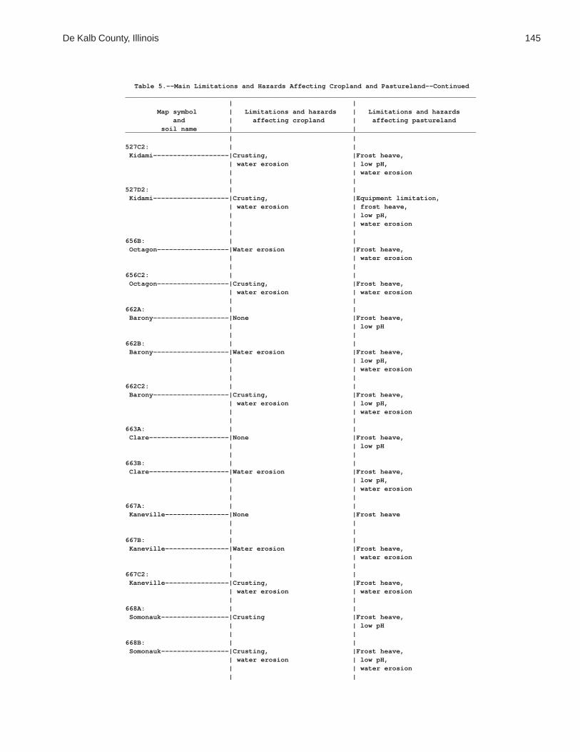
De Kalb County, Illinois 145
Table 5.--Main Limitations and Hazards Affecting Cropland and Pastureland--Continued________________________________________________________________________________________ | | Map symbol | Limitations and hazards | Limitations and hazards and | affecting cropland | affecting pastureland soil name | |________________________________________________________________________________________ | |527C2: | | Kidami-------------------|Crusting, |Frost heave, | water erosion | low pH, | | water erosion | |527D2: | | Kidami-------------------|Crusting, |Equipment limitation, | water erosion | frost heave, | | low pH, | | water erosion | |656B: | | Octagon------------------|Water erosion |Frost heave, | | water erosion | |656C2: | | Octagon------------------|Crusting, |Frost heave, | water erosion | water erosion | |662A: | | Barony-------------------|None |Frost heave, | | low pH | |662B: | | Barony-------------------|Water erosion |Frost heave, | | low pH, | | water erosion | |662C2: | | Barony-------------------|Crusting, |Frost heave, | water erosion | low pH, | | water erosion | |663A: | | Clare--------------------|None |Frost heave, | | low pH | |663B: | | Clare--------------------|Water erosion |Frost heave, | | low pH, | | water erosion | |667A: | | Kaneville----------------|None |Frost heave | | | |667B: | | Kaneville----------------|Water erosion |Frost heave, | | water erosion | |667C2: | | Kaneville----------------|Crusting, |Frost heave, | water erosion | water erosion | |668A: | | Somonauk-----------------|Crusting |Frost heave, | | low pH | |668B: | | Somonauk-----------------|Crusting, |Frost heave, | water erosion | low pH, | | water erosion | |

146 Soil Survey of
Table 5.--Main Limitations and Hazards Affecting Cropland and Pastureland--Continued________________________________________________________________________________________ | | Map symbol | Limitations and hazards | Limitations and hazards and | affecting cropland | affecting pastureland soil name | |________________________________________________________________________________________ | |679A: | | Blackberry---------------|None |Frost heave, | | low pH | |679B: | | Blackberry---------------|Water erosion |Frost heave, | | low pH, | | water erosion | |712A: | | Spaulding----------------|Excess lime, |Frost heave, | ponding, | ponding | poor tilth | | |715A: | | Arrowsmith---------------|Wetness |Frost heave, | | wetness | |791A: | | Rush---------------------|Crusting, |Frost heave, | excessive permeability | low pH | |791B: | | Rush---------------------|Crusting, |Frost heave, | excessive permeability, | low pH, | water erosion | water erosion | |792A: | | Bowes--------------------|Excessive permeability |Frost heave, | | low pH | |792B: | | Bowes--------------------|Excessive permeability, |Frost heave, | water erosion | low pH, | | water erosion | |802B: | | Orthents, loamy----------|Crusting, |Frost heave, | water erosion | water erosion | |830: | | Landfills. | | | |865: | | Pits, gravel. | | | | | |3076A: | | Otter--------------------|Flooding, |Flooding, | ponding | frost heave, | | ponding | |3776A: | | Comfrey------------------|Flooding, |Flooding, | ponding | frost heave, | | ponding | |________________________________________________________________________________________

De Kalb County, Illinois 147
Table 6.--Land Capability and Yields per Acre of Crops and Pasture
(Yields are those that can be expected under a high level of management. They are for nonirrigated areas. Absence of a yield indicates that the soil is not suited to the crop or the crop generally is not grown on the soil.)
______________________________________________________________________________________________________________ | | | | | | | Map symbol | Land | Corn | Soybeans |Winter wheat| Oats |Grass-legume|Grass-legume and soil name |capability| | | | | hay | pasture______________________________________________________________________________________________________________ | | Bu | Bu | Bu | Bu | Tons | AUM* | | | | | | |59A: | | | | | | | Lisbon--------------| 1 | 155 | 51 | 63 | 92 | 5.9 | 9.8 | | | | | | |60C2: | | | | | | | La Rose-------------| 3e | 116 | 39 | 49 | 70 | 4.5 | 7.5 | | | | | | |60D2: | | | | | | | La Rose-------------| 4e | 109 | 36 | 46 | 66 | 4.3 | 7.1 | | | | | | |62A: | | | | | | | Herbert-------------| 2w | 140 | 44 | 56 | 81 | 5.4 | 9.0 | | | | | | |67A: | | | | | | | Harpster------------| 2w | 136 | 44 | 52 | 74 | 5.0 | 8.3 | | | | | | |68A: | | | | | | | Sable---------------| 2w | 156 | 51 | 61 | 85 | 5.6 | 9.3 | | | | | | |103A: | | | | | | | Houghton------------| 3w | 129 | 44 | --- | --- | --- | 7.3 | | | | | | |104A: | | | | | | | Virgil--------------| 1 | 148 | 45 | 60 | 84 | 5.6 | 9.3 | | | | | | |148A: | | | | | | | Proctor-------------| 1 | 144 | 44 | 59 | 88 | 5.5 | 9.2 | | | | | | |148B: | | | | | | | Proctor-------------| 2e | 143 | 44 | 58 | 87 | 5.4 | 9.1 | | | | | | |152A: | | | | | | | Drummer-------------| 2w | 154 | 51 | 61 | 83 | 5.5 | 9.2 | | | | | | |154A: | | | | | | | Flanagan------------| 1 | 162 | 52 | 67 | 92 | 6.1 | 10.2 | | | | | | |171A: | | | | | | | Catlin--------------| 1 | 150 | 46 | 61 | 87 | 5.8 | 9.7 | | | | | | |171B: | | | | | | | Catlin--------------| 2e | 149 | 46 | 60 | 86 | 5.7 | 9.6 | | | | | | |193A: | | | | | | | Mayville------------| 1 | 130 | 43 | 56 | 80 | 5.2 | 8.7 | | | | | | |193B: | | | | | | | Mayville------------| 2e | 129 | 43 | 55 | 79 | 5.1 | 8.6 | | | | | | |193C2: | | | | | | | Mayville------------| 3e | 122 | 40 | 53 | 75 | 4.9 | 8.2 | | | | | | |198A: | | | | | | | Elburn--------------| 1 | 161 | 50 | 63 | 94 | 6.1 | 10.2 | | | | | | |206A: | | | | | | | Thorp---------------| 2w | 126 | 42 | 51 | 69 | 4.6 | 7.7 | | | | | | |
See footnote at end of table.

148 Soil Survey of
Table 6.--Land Capability and Yields per Acre of Crops and Pasture--Continued______________________________________________________________________________________________________________ | | | | | | | Map symbol | Land | Corn | Soybeans |Winter wheat| Oats |Grass-legume|Grass-legume and soil name |capability| | | | | hay | pasture______________________________________________________________________________________________________________ | | Bu | Bu | Bu | Bu | Tons | AUM* | | | | | | |219A: | | | | | | | Millbrook-----------| 1 | 144 | 43 | 59 | 81 | 5.4 | 9.0 | | | | | | |221B2: | | | | | | | Parr----------------| 2e | 124 | 42 | 55 | 75 | 5.1 | 8.5 | | | | | | |221C2: | | | | | | | Parr----------------| 3e | 121 | 41 | 54 | 73 | 5.0 | 8.3 | | | | | | |233A: | | | | | | | Birkbeck------------| 1 | 123 | 41 | 55 | 70 | 5.0 | 8.3 | | | | | | |233B: | | | | | | | Birkbeck------------| 2e | 122 | 41 | 54 | 69 | 5.0 | 8.2 | | | | | | |236A: | | | | | | | Sabina--------------| 2w | 133 | 42 | 56 | 75 | 5.2 | 8.7 | | | | | | |318D2: | | | | | | | Lorenzo-------------| 3e | 83 | 27 | 40 | 55 | 3.2 | 5.4 | | | | | | |325A: | | | | | | | Dresden-------------| 2s | 110 | 36 | 49 | 69 | 4.5 | 7.5 | | | | | | |325B: | | | | | | | Dresden-------------| 2e | 109 | 36 | 49 | 68 | 4.5 | 7.4 | | | | | | |325C2: | | | | | | | Dresden-------------| 2e | 104 | 34 | 47 | 66 | 4.3 | 7.1 | | | | | | |327B: | | | | | | | Fox-----------------| 2e | 105 | 33 | 46 | 63 | 4.3 | 7.1 | | | | | | |330A: | | | | | | | Peotone-------------| 2w | 123 | 42 | 43 | 58 | 4.2 | 7.0 | | | | | | |344B: | | | | | | | Harvard-------------| 2e | 131 | 41 | 53 | 77 | 5.1 | 8.6 | | | | | | |348A: | | | | | | | Wingate-------------| 1 | 133 | 42 | 56 | 79 | 5.1 | 8.5 | | | | | | |348B: | | | | | | | Wingate-------------| 2e | 132 | 42 | 55 | 78 | 5.0 | 8.4 | | | | | | |348C2: | | | | | | | Wingate-------------| 3e | 125 | 39 | 53 | 74 | 4.8 | 8.0 | | | | | | |356A: | | | | | | | Elpaso--------------| 2w | 146 | 49 | 58 | 82 | 5.5 | 9.2 | | | | | | |488A: | | | | | | | Hooppole------------| 2w | 132 | 44 | 53 | 77 | 5.3 | 8.8 | | | | | | |512A: | | | | | | | Danabrook-----------| 1 | 141 | 46 | 60 | 85 | 5.6 | 9.3 | | | | | | |512B: | | | | | | | Danabrook-----------| 2e | 140 | 46 | 59 | 84 | 5.5 | 9.2 | | | | | | |
See footnote at end of table.
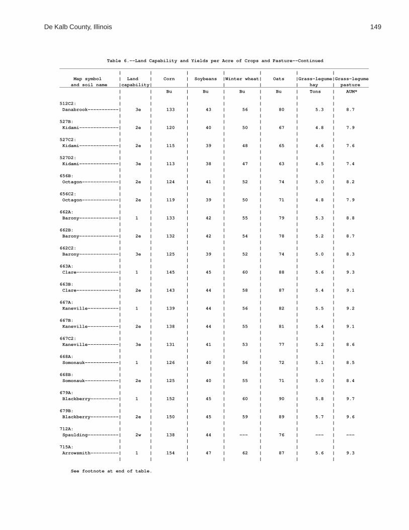
De Kalb County, Illinois 149
Table 6.--Land Capability and Yields per Acre of Crops and Pasture--Continued______________________________________________________________________________________________________________ | | | | | | | Map symbol | Land | Corn | Soybeans |Winter wheat| Oats |Grass-legume|Grass-legume and soil name |capability| | | | | hay | pasture______________________________________________________________________________________________________________ | | Bu | Bu | Bu | Bu | Tons | AUM* | | | | | | |512C2: | | | | | | | Danabrook-----------| 3e | 133 | 43 | 56 | 80 | 5.3 | 8.7 | | | | | | |527B: | | | | | | | Kidami--------------| 2e | 120 | 40 | 50 | 67 | 4.8 | 7.9 | | | | | | |527C2: | | | | | | | Kidami--------------| 2e | 115 | 39 | 48 | 65 | 4.6 | 7.6 | | | | | | |527D2: | | | | | | | Kidami--------------| 3e | 113 | 38 | 47 | 63 | 4.5 | 7.4 | | | | | | |656B: | | | | | | | Octagon-------------| 2e | 124 | 41 | 52 | 74 | 5.0 | 8.2 | | | | | | |656C2: | | | | | | | Octagon-------------| 2e | 119 | 39 | 50 | 71 | 4.8 | 7.9 | | | | | | |662A: | | | | | | | Barony--------------| 1 | 133 | 42 | 55 | 79 | 5.3 | 8.8 | | | | | | |662B: | | | | | | | Barony--------------| 2e | 132 | 42 | 54 | 78 | 5.2 | 8.7 | | | | | | |662C2: | | | | | | | Barony--------------| 3e | 125 | 39 | 52 | 74 | 5.0 | 8.3 | | | | | | |663A: | | | | | | | Clare---------------| 1 | 145 | 45 | 60 | 88 | 5.6 | 9.3 | | | | | | |663B: | | | | | | | Clare---------------| 2e | 143 | 44 | 58 | 87 | 5.4 | 9.1 | | | | | | |667A: | | | | | | | Kaneville-----------| 1 | 139 | 44 | 56 | 82 | 5.5 | 9.2 | | | | | | |667B: | | | | | | | Kaneville-----------| 2e | 138 | 44 | 55 | 81 | 5.4 | 9.1 | | | | | | |667C2: | | | | | | | Kaneville-----------| 3e | 131 | 41 | 53 | 77 | 5.2 | 8.6 | | | | | | |668A: | | | | | | | Somonauk------------| 1 | 126 | 40 | 56 | 72 | 5.1 | 8.5 | | | | | | |668B: | | | | | | | Somonauk------------| 2e | 125 | 40 | 55 | 71 | 5.0 | 8.4 | | | | | | |679A: | | | | | | | Blackberry----------| 1 | 152 | 45 | 60 | 90 | 5.8 | 9.7 | | | | | | |679B: | | | | | | | Blackberry----------| 2e | 150 | 45 | 59 | 89 | 5.7 | 9.6 | | | | | | |712A: | | | | | | | Spaulding-----------| 2w | 138 | 44 | --- | 76 | --- | --- | | | | | | |715A: | | | | | | | Arrowsmith----------| 1 | 154 | 47 | 62 | 87 | 5.6 | 9.3 | | | | | | |
See footnote at end of table.

150 Soil Survey of
Table 6.--Land Capability and Yields per Acre of Crops and Pasture--Continued______________________________________________________________________________________________________________ | | | | | | | Map symbol | Land | Corn | Soybeans |Winter wheat| Oats |Grass-legume|Grass-legume and soil name |capability| | | | | hay | pasture______________________________________________________________________________________________________________ | | Bu | Bu | Bu | Bu | Tons | AUM* | | | | | | |791A: | | | | | | | Rush----------------| 1 | 132 | 42 | 57 | 77 | 5.1 | 9.0 | | | | | | |791B: | | | | | | | Rush----------------| 2e | 131 | 42 | 56 | 76 | 5.0 | 8.9 | | | | | | |792A: | | | | | | | Bowes---------------| 1 | 141 | 46 | 60 | 79 | 5.3 | 9.3 | | | | | | |792B: | | | | | | | Bowes---------------| 2e | 140 | 46 | 59 | 78 | 5.2 | 9.2 | | | | | | |802B: | | | | | | | Orthents, loamy-----| 2e | 85 | 27 | 30 | 50 | 3.7 | 6.2 | | | | | | |830: | | | | | | | Landfills. | | | | | | | | | | | | | |865: | | | | | | | Pits, gravel. | | | | | | | | | | | | | |3076A: | | | | | | | Otter---------------| 3w | 129 | 41 | 44 | 62 | 4.2 | 7.0 | | | | | | |3776A: | | | | | | | Comfrey-------------| 2w | 126 | 41 | 46 | 59 | 4.5 | 7.5 | | | | | | |______________________________________________________________________________________________________________
* Animal unit month: The amount of forage or feed required to feed one animal unit (one cow, one horse,one mule, five sheep, or five goats) for 30 days.

De Kalb County, Illinois 151
Table 7.--Prime Farmland
(Only the soils considered prime farmland are listed. Urban or built-up areas of the soils listed are not considered prime farmland. If a soil is prime farmland only under certain conditions, the conditions are specified in parentheses after the soil name.)
_______________________________________________________________________________________________________ | Map | Soil namesymbol | |_______________________________________________________________________________________________________ |59A |Lisbon silt loam, 0 to 2 percent slopes60C2 |La Rose loam, 5 to 10 percent slopes, eroded62A |Herbert silt loam, 0 to 2 percent slopes (where drained)67A |Harpster silty clay loam, 0 to 2 percent slopes (where drained)68A |Sable silty clay loam, 0 to 2 percent slopes (where drained)104A |Virgil silt loam, 0 to 2 percent slopes (where drained)148A |Proctor silt loam, 0 to 2 percent slopes148B |Proctor silt loam, 2 to 5 percent slopes152A |Drummer silty clay loam, 0 to 2 percent slopes (where drained)154A |Flanagan silt loam, 0 to 2 percent slopes171A |Catlin silt loam, 0 to 2 percent slopes171B |Catlin silt loam, 2 to 5 percent slopes193A |Mayville silt loam, 0 to 2 percent slopes193B |Mayville silt loam, 2 to 5 percent slopes198A |Elburn silt loam, 0 to 2 percent slopes206A |Thorp silt loam, 0 to 2 percent slopes (where drained)219A |Millbrook silt loam, 0 to 2 percent slopes (where drained)221B2 |Parr silt loam, 2 to 5 percent slopes, eroded221C2 |Parr silt loam, 5 to 10 percent slopes, eroded233A |Birkbeck silt loam, 0 to 2 percent slopes233B |Birkbeck silt loam, 2 to 5 percent slopes236A |Sabina silt loam, 0 to 2 percent slopes (where drained)325A |Dresden silt loam, 0 to 2 percent slopes325B |Dresden silt loam, 2 to 4 percent slopes325C2 |Dresden silt loam, 4 to 6 percent slopes, eroded327B |Fox silt loam, 2 to 4 percent slopes330A |Peotone silty clay loam, 0 to 2 percent slopes (where drained)344B |Harvard silt loam, 2 to 5 percent slopes348A |Wingate silt loam, 0 to 2 percent slopes348B |Wingate silt loam, 2 to 5 percent slopes356A |Elpaso silty clay loam, 0 to 2 percent slopes (where drained)488A |Hooppole loam, 0 to 2 percent slopes (where drained)512A |Danabrook silt loam, 0 to 2 percent slopes512B |Danabrook silt loam, 2 to 5 percent slopes527B |Kidami silt loam, 2 to 4 percent slopes527C2 |Kidami loam, 4 to 6 percent slopes, eroded656B |Octagon silt loam, 2 to 4 percent slopes656C2 |Octagon silt loam, 4 to 6 percent slopes, eroded662A |Barony silt loam, 0 to 2 percent slopes662B |Barony silt loam, 2 to 5 percent slopes663A |Clare silt loam, 0 to 2 percent slopes663B |Clare silt loam, 2 to 5 percent slopes667A |Kaneville silt loam, 0 to 2 percent slopes667B |Kaneville silt loam, 2 to 5 percent slopes668A |Somonauk silt loam, 0 to 2 percent slopes668B |Somonauk silt loam, 2 to 5 percent slopes679A |Blackberry silt loam, 0 to 2 percent slopes679B |Blackberry silt loam, 2 to 5 percent slopes712A |Spaulding silty clay loam, 0 to 2 percent slopes (where drained)715A |Arrowsmith silt loam, 0 to 2 percent slopes791A |Rush silt loam, 0 to 2 percent slopes791B |Rush silt loam, 2 to 4 percent slopes792A |Bowes silt loam, 0 to 2 percent slopes792B |Bowes silt loam, 2 to 4 percent slopes3076A |Otter silt loam, 0 to 2 percent slopes, frequently flooded (where drained and either protected | from flooding or not frequently flooded during the growing season)3776A |Comfrey loam, 0 to 2 percent slopes, frequently flooded (where drained and either protected | from flooding or not frequently flooded during the growing season) |_______________________________________________________________________________________________________

152 Soil Survey of
Table 8.--Forestland Productivity
(Only the soils suitable for commercial production of trees are listed.)
_________________________________________________________________________________ | Potential productivity | ___________________________________ Map symbol and | | | | soil name | Common trees |Site | Volume | Trees to manage | |index|of wood | | | | fiber |_________________________________________________________________________________ | | |Cu ft/ac| | | | |62A: | | | | Herbert-----------------|White oak-----------| 80 | 57 |Common hackberry, |Black walnut--------| --- | --- | common persimmon, |Northern red oak----| --- | --- | eastern |Shagbark hickory----| --- | --- | cottonwood, green | | | | ash, pecan, pin | | | | oak, swamp white | | | | oak | | | |103A: | | | | Houghton----------------|Silver maple--------| 82 | 29 |Common persimmon, |Arborvitae----------| 37 | 57 | eastern |Green ash-----------| --- | --- | cottonwood, green |Quaking aspen-------| 60 | 57 | ash, pin oak, |Red maple-----------| 56 | 29 | swamp white oak, |White ash-----------| 56 | 43 | sweetgum | | | |104A: | | | | Virgil------------------|Silver maple--------| 70 | 29 |Common hackberry, |American elm--------| --- | --- | common persimmon, |Shagbark hickory----| --- | --- | eastern | | | | cottonwood, green | | | | ash, pecan, pin | | | | oak, swamp white | | | | oak | | | |193A: | | | | Mayville----------------|Northern red oak----| 78 | 57 |Black walnut, |Shagbark hickory----| --- | --- | cherrybark oak, |Sugar maple---------| --- | --- | eastern |White ash-----------| --- | --- | cottonwood, |White oak-----------| 78 | 57 | eastern white | | | | pine, green ash, | | | | northern red oak, | | | | pecan, pin oak, | | | | tuliptree, white | | | | oak | | | |193B: | | | | Mayville----------------|Northern red oak----| 78 | 57 |Black walnut, |Shagbark hickory----| --- | --- | eastern |Sugar maple---------| --- | --- | cottonwood, |White ash-----------| --- | --- | eastern white |White oak-----------| 78 | 57 | pine, green ash, | | | | northern red oak, | | | | pecan, pin oak, | | | | tuliptree, white | | | | oak | | | |193C2: | | | | Mayville----------------|Northern red oak----| 78 | 57 |Black walnut, |Shagbark hickory----| --- | --- | eastern |Sugar maple---------| --- | --- | cottonwood, |White ash-----------| --- | --- | eastern white |White oak-----------| 78 | 57 | pine, green ash, | | | | northern red oak, | | | | pecan, pin oak, | | | | tuliptree, white | | | | oak | | | |

De Kalb County, Illinois 153
Table 8.--Forestland Productivity--Continued_________________________________________________________________________________ | Potential productivity | ___________________________________ Map symbol and | | | | soil name | Common trees |Site | Volume | Trees to manage | |index|of wood | | | | fiber |_________________________________________________________________________________ | | |Cu ft/ac| | | | |219A: | | | | Millbrook---------------|Northern red oak----| 80 | 57 |Common hackberry, |Black walnut--------| --- | --- | common persimmon, |Shagbark hickory----| --- | --- | eastern |White oak-----------| 80 | 57 | cottonwood, green | | | | ash, pecan, pin | | | | oak, swamp white | | | | oak | | | |233A: | | | | Birkbeck----------------|White oak-----------| 86 | 72 |Black walnut, |Green ash-----------| --- | --- | eastern |Northern red oak----| --- | --- | cottonwood, | | | | eastern white | | | | pine, green ash, | | | | northern red oak, | | | | pecan, pin oak, | | | | tuliptree, white | | | | oak | | | |233B: | | | | Birkbeck----------------|White oak-----------| 86 | 72 |Black walnut, |Green ash-----------| --- | --- | eastern |Northern red oak----| --- | --- | cottonwood, | | | | eastern white | | | | pine, green ash, | | | | northern red oak, | | | | pecan, pin oak, | | | | tuliptree, white | | | | oak | | | |236A: | | | | Sabina------------------|White oak-----------| 80 | 57 |Common hackberry, |Black walnut--------| --- | --- | common persimmon, |Northern red oak----| 80 | 57 | eastern | | | | cottonwood, green | | | | ash, pecan, pin | | | | oak, swamp white | | | | oak | | | |325A: | | | | Dresden-----------------|Northern red oak----| 70 | 57 |Black oak, common |American basswood---| --- | --- | hackberry, eastern |Black cherry--------| --- | --- | white pine, green |Black oak-----------| --- | --- | ash |Shagbark hickory----| --- | --- | |Sugar maple---------| --- | --- | |White ash-----------| --- | --- | |White oak-----------| --- | --- | | | | |325B: | | | | Dresden-----------------|Northern red oak----| 70 | 57 |Black oak, common |American basswood---| --- | --- | hackberry, eastern |Black cherry--------| --- | --- | white pine, green |Black oak-----------| --- | --- | ash |Shagbark hickory----| --- | --- | |Sugar maple---------| --- | --- | |White ash-----------| --- | --- | |White oak-----------| --- | --- | | | | |

154 Soil Survey of
Table 8.--Forestland Productivity--Continued_________________________________________________________________________________ | Potential productivity | ___________________________________ Map symbol and | | | | soil name | Common trees |Site | Volume | Trees to manage | |index|of wood | | | | fiber |_________________________________________________________________________________ | | |Cu ft/ac| | | | |325C2: | | | | Dresden-----------------|Northern red oak----| 70 | 57 |Black oak, common |American basswood---| --- | --- | hackberry, eastern |Black cherry--------| --- | --- | white pine, green |Black oak-----------| --- | --- | ash |Shagbark hickory----| --- | --- | |Sugar maple---------| --- | --- | |White ash-----------| --- | --- | |White oak-----------| --- | --- | | | | |327B: | | | | Fox---------------------|Northern red oak----| 65 | 57 |Black oak, common |Black cherry--------| --- | --- | hackberry, eastern |Shagbark hickory----| --- | --- | white pine, green |Sugar maple---------| --- | --- | ash |White ash-----------| --- | --- | |White oak-----------| --- | --- | | | | |344B: | | | | Harvard-----------------|Northern red oak----| 85 | 72 |Black walnut, |Shagbark hickory----| 85 | 72 | eastern |White ash-----------| --- | --- | cottonwood, |White oak-----------| --- | --- | eastern white | | | | pine, green ash, | | | | northern red oak, | | | | pecan, pin oak, | | | | tuliptree, white | | | | oak | | | |348A: | | | | Wingate-----------------|Northern red oak----| 80 | 57 |Black walnut, |Shagbark hickory----| --- | --- | eastern |Sugar maple---------| --- | --- | cottonwood, |White ash-----------| --- | --- | eastern white |White oak-----------| 80 | 57 | pine, green ash, | | | | northern red oak, | | | | pecan, pin oak, | | | | tuliptree, white | | | | oak | | | |348B: | | | | Wingate-----------------|Northern red oak----| 80 | 57 |Black walnut, |Shagbark hickory----| --- | --- | eastern |Sugar maple---------| --- | --- | cottonwood, |White ash-----------| --- | --- | eastern white |White oak-----------| 80 | 57 | pine, green ash, | | | | northern red oak, | | | | pecan, pin oak, | | | | tuliptree, white | | | | oak | | | |348C2: | | | | Wingate-----------------|Northern red oak----| 80 | 57 |Black walnut, |Shagbark hickory----| --- | --- | eastern |Sugar maple---------| --- | --- | cottonwood, |White ash-----------| --- | --- | eastern white |White oak-----------| 80 | 57 | pine, green ash, | | | | northern red oak, | | | | pecan, pin oak, | | | | tuliptree, white | | | | oak | | | |
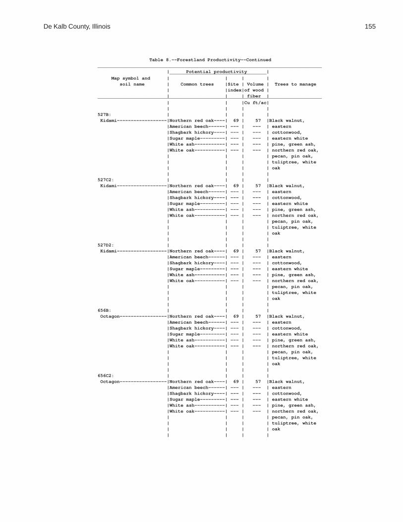
De Kalb County, Illinois 155
Table 8.--Forestland Productivity--Continued_________________________________________________________________________________ | Potential productivity | ___________________________________ Map symbol and | | | | soil name | Common trees |Site | Volume | Trees to manage | |index|of wood | | | | fiber |_________________________________________________________________________________ | | |Cu ft/ac| | | | |527B: | | | | Kidami------------------|Northern red oak----| 69 | 57 |Black walnut, |American beech------| --- | --- | eastern |Shagbark hickory----| --- | --- | cottonwood, |Sugar maple---------| --- | --- | eastern white |White ash-----------| --- | --- | pine, green ash, |White oak-----------| --- | --- | northern red oak, | | | | pecan, pin oak, | | | | tuliptree, white | | | | oak | | | |527C2: | | | | Kidami------------------|Northern red oak----| 69 | 57 |Black walnut, |American beech------| --- | --- | eastern |Shagbark hickory----| --- | --- | cottonwood, |Sugar maple---------| --- | --- | eastern white |White ash-----------| --- | --- | pine, green ash, |White oak-----------| --- | --- | northern red oak, | | | | pecan, pin oak, | | | | tuliptree, white | | | | oak | | | |527D2: | | | | Kidami------------------|Northern red oak----| 69 | 57 |Black walnut, |American beech------| --- | --- | eastern |Shagbark hickory----| --- | --- | cottonwood, |Sugar maple---------| --- | --- | eastern white |White ash-----------| --- | --- | pine, green ash, |White oak-----------| --- | --- | northern red oak, | | | | pecan, pin oak, | | | | tuliptree, white | | | | oak | | | |656B: | | | | Octagon-----------------|Northern red oak----| 69 | 57 |Black walnut, |American beech------| --- | --- | eastern |Shagbark hickory----| --- | --- | cottonwood, |Sugar maple---------| --- | --- | eastern white |White ash-----------| --- | --- | pine, green ash, |White oak-----------| --- | --- | northern red oak, | | | | pecan, pin oak, | | | | tuliptree, white | | | | oak | | | |656C2: | | | | Octagon-----------------|Northern red oak----| 69 | 57 |Black walnut, |American beech------| --- | --- | eastern |Shagbark hickory----| --- | --- | cottonwood, |Sugar maple---------| --- | --- | eastern white |White ash-----------| --- | --- | pine, green ash, |White oak-----------| --- | --- | northern red oak, | | | | pecan, pin oak, | | | | tuliptree, white | | | | oak | | | |

156 Soil Survey of
Table 8.--Forestland Productivity--Continued_________________________________________________________________________________ | Potential productivity | ___________________________________ Map symbol and | | | | soil name | Common trees |Site | Volume | Trees to manage | |index|of wood | | | | fiber |_________________________________________________________________________________ | | |Cu ft/ac| | | | |662A: | | | | Barony------------------|Northern red oak----| 85 | 72 |Black walnut, |Shagbark hickory----| --- | --- | eastern |White ash-----------| --- | --- | cottonwood, |White oak-----------| 85 | 72 | eastern white | | | | pine, green ash, | | | | northern red oak, | | | | pecan, pin oak, | | | | tuliptree, white | | | | oak | | | |662B: | | | | Barony------------------|Northern red oak----| 85 | 72 |Black walnut, |Shagbark hickory----| --- | --- | eastern |White ash-----------| --- | --- | cottonwood, |White oak-----------| 85 | 72 | eastern white | | | | pine, green ash, | | | | northern red oak, | | | | pecan, pin oak, | | | | tuliptree, white | | | | oak | | | |662C2: | | | | Barony------------------|Northern red oak----| 85 | 72 |Black walnut, |Shagbark hickory----| --- | --- | eastern |White ash-----------| --- | --- | cottonwood, |White oak-----------| 85 | 72 | eastern white | | | | pine, green ash, | | | | northern red oak, | | | | pecan, pin oak, | | | | tuliptree, white | | | | oak | | | |667A: | | | | Kaneville---------------|Northern red oak----| 85 | 72 |Black walnut, |Shagbark hickory----| --- | --- | eastern |White ash-----------| --- | --- | cottonwood, |White oak-----------| 85 | 72 | eastern white | | | | pine, green ash, | | | | northern red oak, | | | | pecan, pin oak, | | | | tuliptree, white | | | | oak | | | |667B: | | | | Kaneville---------------|Northern red oak----| 85 | 72 |Black walnut, |Shagbark hickory----| --- | --- | eastern |White ash-----------| --- | --- | cottonwood, |White oak-----------| 85 | 72 | eastern white | | | | pine, green ash, | | | | northern red oak, | | | | pecan, pin oak, | | | | tuliptree, white | | | | oak | | | |

De Kalb County, Illinois 157
Table 8.--Forestland Productivity--Continued_________________________________________________________________________________ | Potential productivity | ___________________________________ Map symbol and | | | | soil name | Common trees |Site | Volume | Trees to manage | |index|of wood | | | | fiber |_________________________________________________________________________________ | | |Cu ft/ac| | | | |667C2: | | | | Kaneville---------------|Northern red oak----| 85 | 72 |Black walnut, |Shagbark hickory----| --- | --- | eastern |White ash-----------| --- | --- | cottonwood, |White oak-----------| 85 | 72 | eastern white | | | | pine, green ash, | | | | northern red oak, | | | | pecan, pin oak, | | | | tuliptree, white | | | | oak | | | |668A: | | | | Somonauk----------------|Northern red oak----| 85 | 72 |Black walnut, |Shagbark hickory----| --- | --- | eastern |Sugar maple---------| --- | --- | cottonwood, |White oak-----------| 85 | 72 | eastern white | | | | pine, green ash, | | | | northern red oak, | | | | pecan, pin oak, | | | | tuliptree, white | | | | oak | | | |668B: | | | | Somonauk----------------|Northern red oak----| 85 | 72 |Black walnut, |Shagbark hickory----| --- | --- | eastern |Sugar maple---------| --- | --- | cottonwood, |White oak-----------| 85 | 72 | eastern white | | | | pine, green ash, | | | | northern red oak, | | | | pecan, pin oak, | | | | tuliptree, white | | | | oak | | | |791A: | | | | Rush--------------------|Northern red oak----| 90 | 72 |Black walnut, |Shagbark hickory----| --- | --- | eastern |Sugar maple---------| --- | --- | cottonwood, |White oak-----------| 90 | 72 | eastern white | | | | pine, green ash, | | | | northern red oak, | | | | pecan, pin oak, | | | | tuliptree, white | | | | oak | | | |791B: | | | | Rush--------------------|Northern red oak----| 90 | 72 |Black walnut, |Shagbark hickory----| --- | --- | eastern |Sugar maple---------| --- | --- | cottonwood, |White oak-----------| 90 | 72 | eastern white | | | | pine, green ash, | | | | northern red oak, | | | | pecan, pin oak, | | | | tuliptree, white | | | | oak | | | |

158 Soil Survey of
Table 8.--Forestland Productivity--Continued_________________________________________________________________________________ | Potential productivity | ___________________________________ Map symbol and | | | | soil name | Common trees |Site | Volume | Trees to manage | |index|of wood | | | | fiber |_________________________________________________________________________________ | | |Cu ft/ac| | | | |792A: | | | | Bowes-------------------|Northern red oak----| 90 | 72 |Black walnut, |Shagbark hickory----| --- | --- | eastern |White ash-----------| --- | --- | cottonwood, |White oak-----------| 90 | 72 | eastern white | | | | pine, green ash, | | | | northern red oak, | | | | pecan, pin oak, | | | | tuliptree, white | | | | oak | | | |792B: | | | | Bowes-------------------|Northern red oak----| 90 | 72 |Black walnut, |Shagbark hickory----| --- | --- | eastern |White ash-----------| --- | --- | cottonwood, |White oak-----------| 90 | 72 | eastern white | | | | pine, green ash, | | | | northern red oak, | | | | pecan, pin oak, | | | | tuliptree, white | | | | oak | | | |3076A: | | | | Otter-------------------|Silver maple--------| 94 | 43 |Common hackberry, |White ash-----------| --- | --- | eastern | | | | cottonwood, green | | | | ash, pin oak, | | | | river birch, swamp | | | | white oak, | | | | sweetgum | | | |3776A: | | | | Comfrey-----------------|Silver maple--------| 94 | 43 |Common hackberry, |White ash-----------| --- | --- | eastern | | | | cottonwood, green | | | | ash, pin oak, | | | | river birch, swamp | | | | white oak, | | | | sweetgum | | | |_________________________________________________________________________________

De K
alb County, Illinois
159
Table 9.--Windbreaks and Environmental Plantings
(Absence of an entry indicates that trees generally do not grow to the given height.)
__________________________________________________________________________________________________________________________________ | Trees having predicted 20-year average height, in feet, of-- Map symbol |________________________________________________________________________________________________________ and soil name | <8 | 8-15 | 16-25 | 26-35 | >35__________________________________________________________________________________________________________________________________ | | | | |59A: | | | | | Lisbon------------------|American |Blackhaw, cockspur |Austrian pine, |Norway spruce, |Carolina poplar, | cranberrybush, | hawthorn, common | Douglas-fir, | blackgum, common | eastern cottonwood, | Canada yew, black | pawpaw, common | arborvitae, blue | hackberry, green | pin oak | chokeberry, common | serviceberry, | spruce, common | ash, red maple, | | elderberry, common | prairie crabapple, | persimmon, eastern | swamp white oak, | | juniper, common | roughleaf dogwood, | redcedar, green | sweetgum | | ninebark, common | rusty blackhaw, | hawthorn, | | | winterberry, | southern arrowwood,| nannyberry, pecan, | | | northern spicebush,| witchhazel | shingle oak | | | redosier dogwood, | | | | | silky dogwood | | | | | | | | |60C2: | | | | | La Rose-----------------|American hazelnut, |American plum, |Washington hawthorn,|Douglas-fir, Norway |Carolina poplar, | black chokeberry, | American | arborvitae, blue | spruce, black | eastern cottonwood, | common elderberry, | witchhazel, | spruce, common | walnut, blackgum, | eastern white pine | common juniper, | blackhaw, common | persimmon, eastern | common hackberry, | | common ninebark, | chokecherry, common| redcedar, | green ash, northern| | common winterberry,| serviceberry, | nannyberry, pecan, | red oak, pin oak, | | coralberry, | prairie crabapple, | white oak | tuliptree | | mapleleaf viburnum,| roughleaf dogwood, | | | | redosier dogwood, | smooth sumac, | | | | silky dogwood | southern arrowwood | | | | | | | |60D2: | | | | | La Rose-----------------|American hazelnut, |American plum, |Washington hawthorn,|Douglas-fir, Norway |Carolina poplar, | black chokeberry, | American | arborvitae, blue | spruce, black | eastern cottonwood, | common elderberry, | witchhazel, | spruce, common | walnut, blackgum, | eastern white pine | common juniper, | blackhaw, common | persimmon, eastern | common hackberry, | | common ninebark, | chokecherry, common| redcedar, | green ash, northern| | common winterberry,| serviceberry, | nannyberry, pecan, | red oak, pin oak, | | coralberry, | prairie crabapple, | white oak | tuliptree | | mapleleaf viburnum,| roughleaf dogwood, | | | | redosier dogwood, | smooth sumac, | | | | silky dogwood | southern arrowwood | | | | | | | |
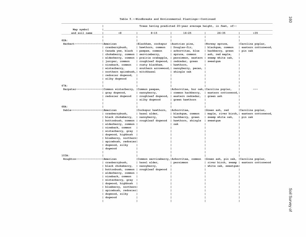
160S
oil Survey of
Table 9.--Windbreaks and Environmental Plantings--Continued__________________________________________________________________________________________________________________________________ | Trees having predicted 20-year average height, in feet, of-- Map symbol |________________________________________________________________________________________________________ and soil name | <8 | 8-15 | 16-25 | 26-35 | >35__________________________________________________________________________________________________________________________________ | | | | |62A: | | | | | Herbert-----------------|American |Blackhaw, cockspur |Austrian pine, |Norway spruce, |Carolina poplar, | cranberrybush, | hawthorn, common | Douglas-fir, | blackgum, common | eastern cottonwood, | Canada yew, black | pawpaw, common | arborvitae, blue | hackberry, green | pin oak | chokeberry, common | serviceberry, | spruce, common | ash, red maple, | | elderberry, common | prairie crabapple, | persimmon, eastern | swamp white oak, | | juniper, common | roughleaf dogwood, | redcedar, green | sweetgum | | ninebark, common | rusty blackhaw, | hawthorn, | | | winterberry, | southern arrowwood,| nannyberry, pecan, | | | northern spicebush,| witchhazel | shingle oak | | | redosier dogwood, | | | | | silky dogwood | | | | | | | | |67A: | | | | | Harpster----------------|Common winterberry, |Common pawpaw, |Arborvitae, bur oak,|Carolina poplar, | --- | gray dogwood, | nannyberry, | common hackberry, | eastern cottonwood,| | redosier dogwood | roughleaf dogwood, | eastern redcedar, | green ash | | | silky dogwood | green hawthorn | | | | | | |68A: | | | | | Sable-------------------|American |Cockspur hawthorn, |Arborvitae, |Green ash, red |Carolina poplar, | cranberrybush, | hazel alder, | blackgum, common | maple, river birch,| eastern cottonwood, | black chokeberry, | nannyberry, | hackberry, green | swamp white oak, | pin oak | buttonbush, common | roughleaf dogwood | hawthorn, shingle | sweetgum | | elderberry, common | | oak | | | ninebark, common | | | | | winterberry, gray | | | | | dogwood, highbush | | | | | blueberry, northern| | | | | spicebush, redosier| | | | | dogwood, silky | | | | | dogwood | | | | | | | | |103A: | | | | | Houghton----------------|American |Common serviceberry,|Arborvitae, common |Green ash, pin oak, |Carolina poplar, | cranberrybush, | hazel alder, | persimmon | river birch, swamp | eastern cottonwood | black chokeberry, | nannyberry, | | white oak, sweetgum| | buttonbush, common | roughleaf dogwood | | | | elderberry, common | | | | | ninebark, common | | | | | winterberry, gray | | | | | dogwood, highbush | | | | | blueberry, northern| | | | | spicebush, redosier| | | | | dogwood, silky | | | | | dogwood | | | | | | | | |

De K
alb County, Illinois
161
Table 9.--Windbreaks and Environmental Plantings--Continued__________________________________________________________________________________________________________________________________ | Trees having predicted 20-year average height, in feet, of-- Map symbol |________________________________________________________________________________________________________ and soil name | <8 | 8-15 | 16-25 | 26-35 | >35__________________________________________________________________________________________________________________________________ | | | | |104A: | | | | | Virgil------------------|American |Blackhaw, cockspur |Austrian pine, |Norway spruce, |Carolina poplar, | cranberrybush, | hawthorn, common | Douglas-fir, | blackgum, common | eastern cottonwood, | Canada yew, black | pawpaw, common | arborvitae, blue | hackberry, green | pin oak | chokeberry, common | serviceberry, | spruce, common | ash, red maple, | | elderberry, common | prairie crabapple, | persimmon, eastern | swamp white oak, | | juniper, common | roughleaf dogwood, | redcedar, green | sweetgum | | ninebark, common | rusty blackhaw, | hawthorn, | | | winterberry, | southern arrowwood,| nannyberry, pecan, | | | northern spicebush,| witchhazel | shingle oak | | | redosier dogwood, | | | | | silky dogwood | | | | | | | | |148A: | | | | | Proctor-----------------|American hazelnut, |American plum, |Washington hawthorn,|Douglas-fir, Norway |Carolina poplar, | black chokeberry, | American | arborvitae, blue | spruce, black | eastern cottonwood, | common elderberry, | witchhazel, | spruce, common | walnut, blackgum, | eastern white pine | common juniper, | blackhaw, common | persimmon, eastern | common hackberry, | | common ninebark, | chokecherry, common| redcedar, | green ash, northern| | common winterberry,| serviceberry, | nannyberry, pecan, | red oak, pin oak, | | coralberry, | prairie crabapple, | white oak | tuliptree | | mapleleaf viburnum,| roughleaf dogwood, | | | | redosier dogwood, | smooth sumac, | | | | silky dogwood | southern arrowwood | | | | | | | |148B: | | | | | Proctor-----------------|American hazelnut, |American plum, |Washington hawthorn,|Douglas-fir, Norway |Carolina poplar, | black chokeberry, | American | arborvitae, blue | spruce, black | eastern cottonwood, | common elderberry, | witchhazel, | spruce, common | walnut, blackgum, | eastern white pine | common juniper, | blackhaw, common | persimmon, eastern | common hackberry, | | common ninebark, | chokecherry, common| redcedar, | green ash, northern| | common winterberry,| serviceberry, | nannyberry, pecan, | red oak, pin oak, | | coralberry, | prairie crabapple, | white oak | tuliptree | | mapleleaf viburnum,| roughleaf dogwood, | | | | redosier dogwood, | smooth sumac, | | | | silky dogwood | southern arrowwood | | | | | | | |152A: | | | | | Drummer-----------------|American |Cockspur hawthorn, |Arborvitae, |Green ash, red |Carolina poplar, | cranberrybush, | hazel alder, | blackgum, common | maple, river birch,| eastern cottonwood, | black chokeberry, | nannyberry, | hackberry, green | swamp white oak, | pin oak | buttonbush, common | roughleaf dogwood | hawthorn, shingle | sweetgum | | elderberry, common | | oak | | | ninebark, common | | | | | winterberry, gray | | | | | dogwood, highbush | | | | | blueberry, northern| | | | | spicebush, redosier| | | | | dogwood, silky | | | | | dogwood | | | | | | | | |
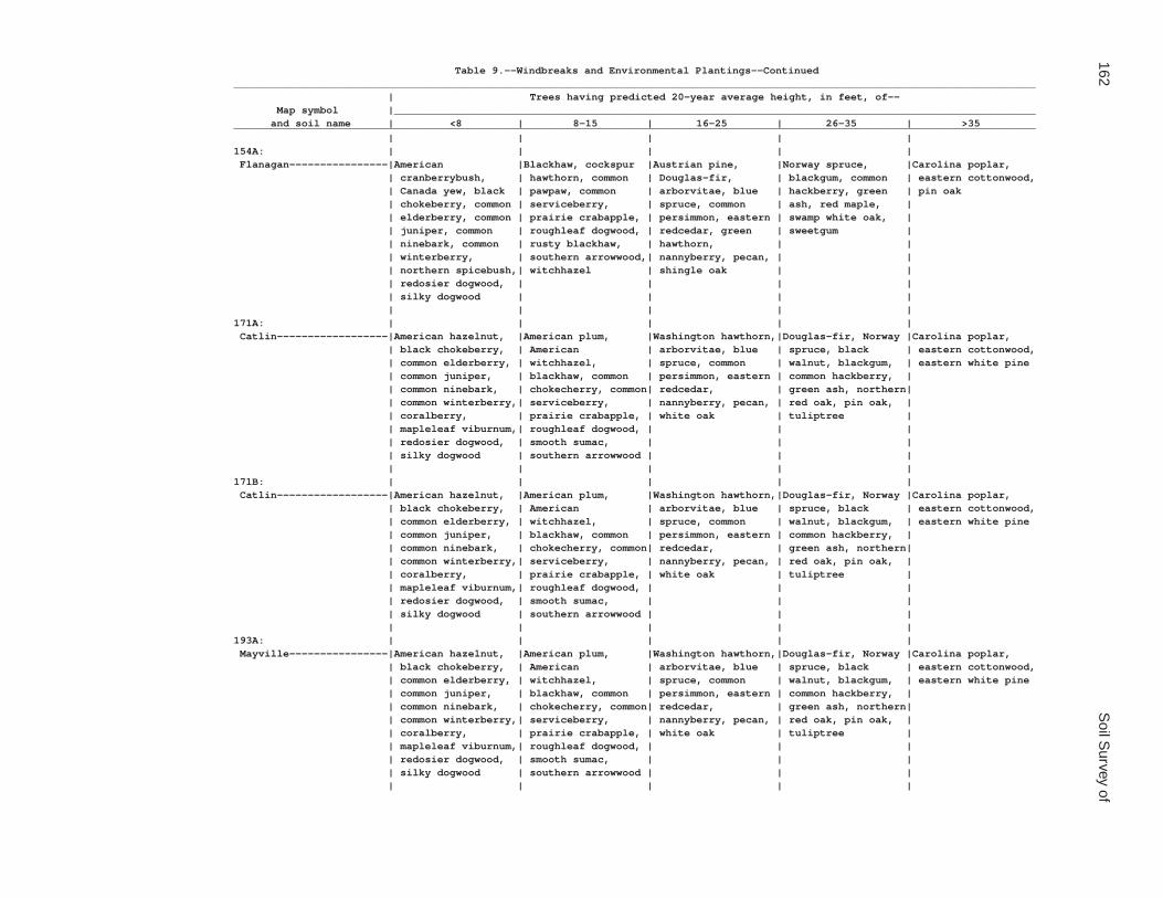
162S
oil Survey of
Table 9.--Windbreaks and Environmental Plantings--Continued__________________________________________________________________________________________________________________________________ | Trees having predicted 20-year average height, in feet, of-- Map symbol |________________________________________________________________________________________________________ and soil name | <8 | 8-15 | 16-25 | 26-35 | >35__________________________________________________________________________________________________________________________________ | | | | |154A: | | | | | Flanagan----------------|American |Blackhaw, cockspur |Austrian pine, |Norway spruce, |Carolina poplar, | cranberrybush, | hawthorn, common | Douglas-fir, | blackgum, common | eastern cottonwood, | Canada yew, black | pawpaw, common | arborvitae, blue | hackberry, green | pin oak | chokeberry, common | serviceberry, | spruce, common | ash, red maple, | | elderberry, common | prairie crabapple, | persimmon, eastern | swamp white oak, | | juniper, common | roughleaf dogwood, | redcedar, green | sweetgum | | ninebark, common | rusty blackhaw, | hawthorn, | | | winterberry, | southern arrowwood,| nannyberry, pecan, | | | northern spicebush,| witchhazel | shingle oak | | | redosier dogwood, | | | | | silky dogwood | | | | | | | | |171A: | | | | | Catlin------------------|American hazelnut, |American plum, |Washington hawthorn,|Douglas-fir, Norway |Carolina poplar, | black chokeberry, | American | arborvitae, blue | spruce, black | eastern cottonwood, | common elderberry, | witchhazel, | spruce, common | walnut, blackgum, | eastern white pine | common juniper, | blackhaw, common | persimmon, eastern | common hackberry, | | common ninebark, | chokecherry, common| redcedar, | green ash, northern| | common winterberry,| serviceberry, | nannyberry, pecan, | red oak, pin oak, | | coralberry, | prairie crabapple, | white oak | tuliptree | | mapleleaf viburnum,| roughleaf dogwood, | | | | redosier dogwood, | smooth sumac, | | | | silky dogwood | southern arrowwood | | | | | | | |171B: | | | | | Catlin------------------|American hazelnut, |American plum, |Washington hawthorn,|Douglas-fir, Norway |Carolina poplar, | black chokeberry, | American | arborvitae, blue | spruce, black | eastern cottonwood, | common elderberry, | witchhazel, | spruce, common | walnut, blackgum, | eastern white pine | common juniper, | blackhaw, common | persimmon, eastern | common hackberry, | | common ninebark, | chokecherry, common| redcedar, | green ash, northern| | common winterberry,| serviceberry, | nannyberry, pecan, | red oak, pin oak, | | coralberry, | prairie crabapple, | white oak | tuliptree | | mapleleaf viburnum,| roughleaf dogwood, | | | | redosier dogwood, | smooth sumac, | | | | silky dogwood | southern arrowwood | | | | | | | |193A: | | | | | Mayville----------------|American hazelnut, |American plum, |Washington hawthorn,|Douglas-fir, Norway |Carolina poplar, | black chokeberry, | American | arborvitae, blue | spruce, black | eastern cottonwood, | common elderberry, | witchhazel, | spruce, common | walnut, blackgum, | eastern white pine | common juniper, | blackhaw, common | persimmon, eastern | common hackberry, | | common ninebark, | chokecherry, common| redcedar, | green ash, northern| | common winterberry,| serviceberry, | nannyberry, pecan, | red oak, pin oak, | | coralberry, | prairie crabapple, | white oak | tuliptree | | mapleleaf viburnum,| roughleaf dogwood, | | | | redosier dogwood, | smooth sumac, | | | | silky dogwood | southern arrowwood | | | | | | | |

De K
alb County, Illinois
163
Table 9.--Windbreaks and Environmental Plantings--Continued__________________________________________________________________________________________________________________________________ | Trees having predicted 20-year average height, in feet, of-- Map symbol |________________________________________________________________________________________________________ and soil name | <8 | 8-15 | 16-25 | 26-35 | >35__________________________________________________________________________________________________________________________________ | | | | |193B: | | | | | Mayville----------------|American hazelnut, |American plum, |Washington hawthorn,|Douglas-fir, Norway |Carolina poplar, | black chokeberry, | American | arborvitae, blue | spruce, black | eastern cottonwood, | common elderberry, | witchhazel, | spruce, common | walnut, blackgum, | eastern white pine | common juniper, | blackhaw, common | persimmon, eastern | common hackberry, | | common ninebark, | chokecherry, common| redcedar, | green ash, northern| | common winterberry,| serviceberry, | nannyberry, pecan, | red oak, pin oak, | | coralberry, | prairie crabapple, | white oak | tuliptree | | mapleleaf viburnum,| roughleaf dogwood, | | | | redosier dogwood, | smooth sumac, | | | | silky dogwood | southern arrowwood | | | | | | | |193C2: | | | | | Mayville----------------|American hazelnut, |American plum, |Washington hawthorn,|Douglas-fir, Norway |Carolina poplar, | black chokeberry, | American | arborvitae, blue | spruce, black | eastern cottonwood, | common elderberry, | witchhazel, | spruce, common | walnut, blackgum, | eastern white pine | common juniper, | blackhaw, common | persimmon, eastern | common hackberry, | | common ninebark, | chokecherry, common| redcedar, | green ash, northern| | common winterberry,| serviceberry, | nannyberry, pecan, | red oak, pin oak, | | coralberry, | prairie crabapple, | white oak | tuliptree | | mapleleaf viburnum,| roughleaf dogwood, | | | | redosier dogwood, | smooth sumac, | | | | silky dogwood | southern arrowwood | | | | | | | |198A: | | | | | Elburn------------------|American |Blackhaw, cockspur |Austrian pine, |Norway spruce, |Carolina poplar, | cranberrybush, | hawthorn, common | Douglas-fir, | blackgum, common | eastern cottonwood, | Canada yew, black | pawpaw, common | arborvitae, blue | hackberry, green | pin oak | chokeberry, common | serviceberry, | spruce, common | ash, red maple, | | elderberry, common | prairie crabapple, | persimmon, eastern | swamp white oak, | | juniper, common | roughleaf dogwood, | redcedar, green | sweetgum | | ninebark, common | rusty blackhaw, | hawthorn, | | | winterberry, | southern arrowwood,| nannyberry, pecan, | | | northern spicebush,| witchhazel | shingle oak | | | redosier dogwood, | | | | | silky dogwood | | | | | | | | |206A: | | | | | Thorp-------------------|American |Cockspur hawthorn, |Arborvitae, |Green ash, red |Carolina poplar, | cranberrybush, | hazel alder, | blackgum, common | maple, river birch,| eastern cottonwood, | black chokeberry, | nannyberry, | hackberry, green | swamp white oak, | pin oak | buttonbush, common | roughleaf dogwood | hawthorn, shingle | sweetgum | | elderberry, common | | oak | | | ninebark, common | | | | | winterberry, gray | | | | | dogwood, highbush | | | | | blueberry, northern| | | | | spicebush, redosier| | | | | dogwood, silky | | | | | dogwood | | | | | | | | |

164S
oil Survey of
Table 9.--Windbreaks and Environmental Plantings--Continued__________________________________________________________________________________________________________________________________ | Trees having predicted 20-year average height, in feet, of-- Map symbol |________________________________________________________________________________________________________ and soil name | <8 | 8-15 | 16-25 | 26-35 | >35__________________________________________________________________________________________________________________________________ | | | | |219A: | | | | | Millbrook---------------|American |Blackhaw, cockspur |Austrian pine, |Norway spruce, |Carolina poplar, | cranberrybush, | hawthorn, common | Douglas-fir, | blackgum, common | eastern cottonwood, | Canada yew, black | pawpaw, common | arborvitae, blue | hackberry, green | pin oak | chokeberry, common | serviceberry, | spruce, common | ash, red maple, | | elderberry, common | prairie crabapple, | persimmon, eastern | swamp white oak, | | juniper, common | roughleaf dogwood, | redcedar, green | sweetgum | | ninebark, common | rusty blackhaw, | hawthorn, | | | winterberry, | southern arrowwood,| nannyberry, pecan, | | | northern spicebush,| witchhazel | shingle oak | | | redosier dogwood, | | | | | silky dogwood | | | | | | | | |221B2: | | | | | Parr--------------------|American hazelnut, |American plum, |Washington hawthorn,|Douglas-fir, Norway |Carolina poplar, | black chokeberry, | American | arborvitae, blue | spruce, black | eastern cottonwood, | common elderberry, | witchhazel, | spruce, common | walnut, blackgum, | eastern white pine | common juniper, | blackhaw, common | persimmon, eastern | common hackberry, | | common ninebark, | chokecherry, common| redcedar, | green ash, northern| | common winterberry,| serviceberry, | nannyberry, pecan, | red oak, pin oak, | | coralberry, | prairie crabapple, | white oak | tuliptree | | mapleleaf viburnum,| roughleaf dogwood, | | | | redosier dogwood, | smooth sumac, | | | | silky dogwood | southern arrowwood | | | | | | | |221C2: | | | | | Parr--------------------|American hazelnut, |American plum, |Washington hawthorn,|Douglas-fir, Norway |Carolina poplar, | black chokeberry, | American | arborvitae, blue | spruce, black | eastern cottonwood, | common elderberry, | witchhazel, | spruce, common | walnut, blackgum, | eastern white pine | common juniper, | blackhaw, common | persimmon, eastern | common hackberry, | | common ninebark, | chokecherry, common| redcedar, | green ash, northern| | common winterberry,| serviceberry, | nannyberry, pecan, | red oak, pin oak, | | coralberry, | prairie crabapple, | white oak | tuliptree | | mapleleaf viburnum,| roughleaf dogwood, | | | | redosier dogwood, | smooth sumac, | | | | silky dogwood | southern arrowwood | | | | | | | |233A: | | | | | Birkbeck----------------|American hazelnut, |American plum, |Washington hawthorn,|Douglas-fir, Norway |Carolina poplar, | black chokeberry, | American | arborvitae, blue | spruce, black | eastern cottonwood, | common elderberry, | witchhazel, | spruce, common | walnut, blackgum, | eastern white pine | common juniper, | blackhaw, common | persimmon, eastern | common hackberry, | | common ninebark, | chokecherry, common| redcedar, | green ash, northern| | common winterberry,| serviceberry, | nannyberry, pecan, | red oak, pin oak, | | coralberry, | prairie crabapple, | white oak | tuliptree | | mapleleaf viburnum,| roughleaf dogwood, | | | | redosier dogwood, | smooth sumac, | | | | silky dogwood | southern arrowwood | | | | | | | |
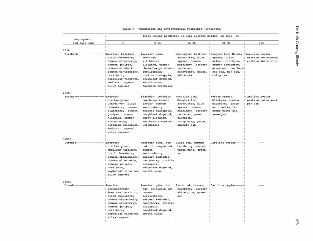
De K
alb County, Illinois
165
Table 9.--Windbreaks and Environmental Plantings--Continued__________________________________________________________________________________________________________________________________ | Trees having predicted 20-year average height, in feet, of-- Map symbol |________________________________________________________________________________________________________ and soil name | <8 | 8-15 | 16-25 | 26-35 | >35__________________________________________________________________________________________________________________________________ | | | | |233B: | | | | | Birkbeck----------------|American hazelnut, |American plum, |Washington hawthorn,|Douglas-fir, Norway |Carolina poplar, | black chokeberry, | American | arborvitae, blue | spruce, black | eastern cottonwood, | common elderberry, | witchhazel, | spruce, common | walnut, blackgum, | eastern white pine | common juniper, | blackhaw, common | persimmon, eastern | common hackberry, | | common ninebark, | chokecherry, common| redcedar, | green ash, northern| | common winterberry,| serviceberry, | nannyberry, pecan, | red oak, pin oak, | | coralberry, | prairie crabapple, | white oak | tuliptree | | mapleleaf viburnum,| roughleaf dogwood, | | | | redosier dogwood, | smooth sumac, | | | | silky dogwood | southern arrowwood | | | | | | | |236A: | | | | | Sabina------------------|American |Blackhaw, cockspur |Austrian pine, |Norway spruce, |Carolina poplar, | cranberrybush, | hawthorn, common | Douglas-fir, | blackgum, common | eastern cottonwood, | Canada yew, black | pawpaw, common | arborvitae, blue | hackberry, green | pin oak | chokeberry, common | serviceberry, | spruce, common | ash, red maple, | | elderberry, common | prairie crabapple, | persimmon, eastern | swamp white oak, | | juniper, common | roughleaf dogwood, | redcedar, green | sweetgum | | ninebark, common | rusty blackhaw, | hawthorn, | | | winterberry, | southern arrowwood,| nannyberry, pecan, | | | northern spicebush,| witchhazel | shingle oak | | | redosier dogwood, | | | | | silky dogwood | | | | | | | | |318D2: | | | | | Lorenzo-----------------|American |American plum, bur |Black oak, common |Carolina poplar-----| --- | cranberrybush, | oak, chinkapin oak,| hackberry, eastern | | | American hazelnut, | common | white pine, green | | | black chokeberry, | serviceberry, | ash | | | common chokecherry,| eastern redcedar, | | | | common elderberry, | nannyberry, prairie| | | | common juniper, | crabapple, | | | | coralberry, | roughleaf dogwood, | | | | mapleleaf viburnum,| smooth sumac | | | | silky dogwood | | | | | | | | |325A: | | | | | Dresden-----------------|American |American plum, bur |Black oak, common |Carolina poplar-----| --- | cranberrybush, | oak, chinkapin oak,| hackberry, eastern | | | American hazelnut, | common | white pine, green | | | black chokeberry, | serviceberry, | ash | | | common chokecherry,| eastern redcedar, | | | | common elderberry, | nannyberry, prairie| | | | common juniper, | crabapple, | | | | coralberry, | roughleaf dogwood, | | | | mapleleaf viburnum,| smooth sumac | | | | silky dogwood | | | | | | | | |

166S
oil Survey of
Table 9.--Windbreaks and Environmental Plantings--Continued__________________________________________________________________________________________________________________________________ | Trees having predicted 20-year average height, in feet, of-- Map symbol |________________________________________________________________________________________________________ and soil name | <8 | 8-15 | 16-25 | 26-35 | >35__________________________________________________________________________________________________________________________________ | | | | |325B: | | | | | Dresden-----------------|American |American plum, bur |Black oak, common |Carolina poplar-----| --- | cranberrybush, | oak, chinkapin oak,| hackberry, eastern | | | American hazelnut, | common | white pine, green | | | black chokeberry, | serviceberry, | ash | | | common chokecherry,| eastern redcedar, | | | | common elderberry, | nannyberry, prairie| | | | common juniper, | crabapple, | | | | coralberry, | roughleaf dogwood, | | | | mapleleaf viburnum,| smooth sumac | | | | silky dogwood | | | | | | | | |325C2: | | | | | Dresden-----------------|American |American plum, bur |Black oak, common |Carolina poplar-----| --- | cranberrybush, | oak, chinkapin oak,| hackberry, eastern | | | American hazelnut, | common | white pine, green | | | black chokeberry, | serviceberry, | ash | | | common chokecherry,| eastern redcedar, | | | | common elderberry, | nannyberry, prairie| | | | common juniper, | crabapple, | | | | coralberry, | roughleaf dogwood, | | | | mapleleaf viburnum,| smooth sumac | | | | silky dogwood | | | | | | | | |327B: | | | | | Fox---------------------|American |American plum, bur |Black oak, common |Carolina poplar-----| --- | cranberrybush, | oak, chinkapin oak,| hackberry, eastern | | | American hazelnut, | common | white pine, green | | | black chokeberry, | serviceberry, | ash | | | common chokecherry,| eastern redcedar, | | | | common elderberry, | nannyberry, prairie| | | | common juniper, | crabapple, | | | | coralberry, | roughleaf dogwood, | | | | mapleleaf viburnum,| smooth sumac | | | | silky dogwood | | | | | | | | |330A: | | | | | Peotone-----------------|American |Cockspur hawthorn, |Arborvitae, |Green ash, red |Carolina poplar, | cranberrybush, | hazel alder, | blackgum, common | maple, river birch,| eastern cottonwood, | black chokeberry, | nannyberry, | hackberry, green | swamp white oak, | pin oak | buttonbush, common | roughleaf dogwood | hawthorn, shingle | sweetgum | | elderberry, common | | oak | | | ninebark, common | | | | | winterberry, gray | | | | | dogwood, highbush | | | | | blueberry, northern| | | | | spicebush, redosier| | | | | dogwood, silky | | | | | dogwood | | | | | | | | |

De K
alb County, Illinois
167
Table 9.--Windbreaks and Environmental Plantings--Continued__________________________________________________________________________________________________________________________________ | Trees having predicted 20-year average height, in feet, of-- Map symbol |________________________________________________________________________________________________________ and soil name | <8 | 8-15 | 16-25 | 26-35 | >35__________________________________________________________________________________________________________________________________ | | | | |344B: | | | | | Harvard-----------------|American hazelnut, |American plum, |Washington hawthorn,|Douglas-fir, Norway |Carolina poplar, | black chokeberry, | American | arborvitae, blue | spruce, black | eastern cottonwood, | common elderberry, | witchhazel, | spruce, common | walnut, blackgum, | eastern white pine | common juniper, | blackhaw, common | persimmon, eastern | common hackberry, | | common ninebark, | chokecherry, common| redcedar, | green ash, northern| | common winterberry,| serviceberry, | nannyberry, pecan, | red oak, pin oak, | | coralberry, | prairie crabapple, | white oak | tuliptree | | mapleleaf viburnum,| roughleaf dogwood, | | | | redosier dogwood, | smooth sumac, | | | | silky dogwood | southern arrowwood | | | | | | | |348A: | | | | | Wingate-----------------|American hazelnut, |American plum, |Washington hawthorn,|Douglas-fir, Norway |Carolina poplar, | black chokeberry, | American | arborvitae, blue | spruce, black | eastern cottonwood, | common elderberry, | witchhazel, | spruce, common | walnut, blackgum, | eastern white pine | common juniper, | blackhaw, common | persimmon, eastern | common hackberry, | | common ninebark, | chokecherry, common| redcedar, | green ash, northern| | common winterberry,| serviceberry, | nannyberry, pecan, | red oak, pin oak, | | coralberry, | prairie crabapple, | white oak | tuliptree | | mapleleaf viburnum,| roughleaf dogwood, | | | | redosier dogwood, | smooth sumac, | | | | silky dogwood | southern arrowwood | | | | | | | |348B: | | | | | Wingate-----------------|American hazelnut, |American plum, |Washington hawthorn,|Douglas-fir, Norway |Carolina poplar, | black chokeberry, | American | arborvitae, blue | spruce, black | eastern cottonwood, | common elderberry, | witchhazel, | spruce, common | walnut, blackgum, | eastern white pine | common juniper, | blackhaw, common | persimmon, eastern | common hackberry, | | common ninebark, | chokecherry, common| redcedar, | green ash, northern| | common winterberry,| serviceberry, | nannyberry, pecan, | red oak, pin oak, | | coralberry, | prairie crabapple, | white oak | tuliptree | | mapleleaf viburnum,| roughleaf dogwood, | | | | redosier dogwood, | smooth sumac, | | | | silky dogwood | southern arrowwood | | | | | | | |348C2: | | | | | Wingate-----------------|American hazelnut, |American plum, |Washington hawthorn,|Douglas-fir, Norway |Carolina poplar, | black chokeberry, | American | arborvitae, blue | spruce, black | eastern cottonwood, | common elderberry, | witchhazel, | spruce, common | walnut, blackgum, | eastern white pine | common juniper, | blackhaw, common | persimmon, eastern | common hackberry, | | common ninebark, | chokecherry, common| redcedar, | green ash, northern| | common winterberry,| serviceberry, | nannyberry, pecan, | red oak, pin oak, | | coralberry, | prairie crabapple, | white oak | tuliptree | | mapleleaf viburnum,| roughleaf dogwood, | | | | redosier dogwood, | smooth sumac, | | | | silky dogwood | southern arrowwood | | | | | | | |

168S
oil Survey of
Table 9.--Windbreaks and Environmental Plantings--Continued__________________________________________________________________________________________________________________________________ | Trees having predicted 20-year average height, in feet, of-- Map symbol |________________________________________________________________________________________________________ and soil name | <8 | 8-15 | 16-25 | 26-35 | >35__________________________________________________________________________________________________________________________________ | | | | |356A: | | | | | Elpaso------------------|American |Cockspur hawthorn, |Arborvitae, |Green ash, red |Carolina poplar, | cranberrybush, | hazel alder, | blackgum, common | maple, river birch,| eastern cottonwood, | black chokeberry, | nannyberry, | hackberry, green | swamp white oak, | pin oak | buttonbush, common | roughleaf dogwood | hawthorn, shingle | sweetgum | | elderberry, common | | oak | | | ninebark, common | | | | | winterberry, gray | | | | | dogwood, highbush | | | | | blueberry, northern| | | | | spicebush, redosier| | | | | dogwood, silky | | | | | dogwood | | | | | | | | |488A: | | | | | Hooppole----------------|Common winterberry, |Common pawpaw, |Arborvitae, bur oak,|Carolina poplar, | --- | gray dogwood, | nannyberry, | common hackberry, | eastern cottonwood,| | redosier dogwood | roughleaf dogwood, | eastern redcedar, | green ash | | | silky dogwood | green hawthorn | | | | | | |512A: | | | | | Danabrook---------------|American hazelnut, |American plum, |Washington hawthorn,|Douglas-fir, Norway |Carolina poplar, | black chokeberry, | American | arborvitae, blue | spruce, black | eastern cottonwood, | common elderberry, | witchhazel, | spruce, common | walnut, blackgum, | eastern white pine | common juniper, | blackhaw, common | persimmon, eastern | common hackberry, | | common ninebark, | chokecherry, common| redcedar, | green ash, northern| | common winterberry,| serviceberry, | nannyberry, pecan, | red oak, pin oak, | | coralberry, | prairie crabapple, | white oak | tuliptree | | mapleleaf viburnum,| roughleaf dogwood, | | | | redosier dogwood, | smooth sumac, | | | | silky dogwood | southern arrowwood | | | | | | | |512B: | | | | | Danabrook---------------|American hazelnut, |American plum, |Washington hawthorn,|Douglas-fir, Norway |Carolina poplar, | black chokeberry, | American | arborvitae, blue | spruce, black | eastern cottonwood, | common elderberry, | witchhazel, | spruce, common | walnut, blackgum, | eastern white pine | common juniper, | blackhaw, common | persimmon, eastern | common hackberry, | | common ninebark, | chokecherry, common| redcedar, | green ash, northern| | common winterberry,| serviceberry, | nannyberry, pecan, | red oak, pin oak, | | coralberry, | prairie crabapple, | white oak | tuliptree | | mapleleaf viburnum,| roughleaf dogwood, | | | | redosier dogwood, | smooth sumac, | | | | silky dogwood | southern arrowwood | | | | | | | |

De K
alb County, Illinois
169
Table 9.--Windbreaks and Environmental Plantings--Continued__________________________________________________________________________________________________________________________________ | Trees having predicted 20-year average height, in feet, of-- Map symbol |________________________________________________________________________________________________________ and soil name | <8 | 8-15 | 16-25 | 26-35 | >35__________________________________________________________________________________________________________________________________ | | | | |512C2: | | | | | Danabrook---------------|American hazelnut, |American plum, |Washington hawthorn,|Douglas-fir, Norway |Carolina poplar, | black chokeberry, | American | arborvitae, blue | spruce, black | eastern cottonwood, | common elderberry, | witchhazel, | spruce, common | walnut, blackgum, | eastern white pine | common juniper, | blackhaw, common | persimmon, eastern | common hackberry, | | common ninebark, | chokecherry, common| redcedar, | green ash, northern| | common winterberry,| serviceberry, | nannyberry, pecan, | red oak, pin oak, | | coralberry, | prairie crabapple, | white oak | tuliptree | | mapleleaf viburnum,| roughleaf dogwood, | | | | redosier dogwood, | smooth sumac, | | | | silky dogwood | southern arrowwood | | | | | | | |527B: | | | | | Kidami------------------|American hazelnut, |American plum, |Washington hawthorn,|Douglas-fir, Norway |Carolina poplar, | black chokeberry, | American | arborvitae, blue | spruce, black | eastern cottonwood, | common elderberry, | witchhazel, | spruce, common | walnut, blackgum, | eastern white pine | common juniper, | blackhaw, common | persimmon, eastern | common hackberry, | | common ninebark, | chokecherry, common| redcedar, | green ash, northern| | common winterberry,| serviceberry, | nannyberry, pecan, | red oak, pin oak, | | coralberry, | prairie crabapple, | white oak | tuliptree | | mapleleaf viburnum,| roughleaf dogwood, | | | | redosier dogwood, | smooth sumac, | | | | silky dogwood | southern arrowwood | | | | | | | |527C2: | | | | | Kidami------------------|American hazelnut, |American plum, |Washington hawthorn,|Douglas-fir, Norway |Carolina poplar, | black chokeberry, | American | arborvitae, blue | spruce, black | eastern cottonwood, | common elderberry, | witchhazel, | spruce, common | walnut, blackgum, | eastern white pine | common juniper, | blackhaw, common | persimmon, eastern | common hackberry, | | common ninebark, | chokecherry, common| redcedar, | green ash, northern| | common winterberry,| serviceberry, | nannyberry, pecan, | red oak, pin oak, | | coralberry, | prairie crabapple, | white oak | tuliptree | | mapleleaf viburnum,| roughleaf dogwood, | | | | redosier dogwood, | smooth sumac, | | | | silky dogwood | southern arrowwood | | | | | | | |527D2: | | | | | Kidami------------------|American hazelnut, |American plum, |Washington hawthorn,|Douglas-fir, Norway |Carolina poplar, | black chokeberry, | American | arborvitae, blue | spruce, black | eastern cottonwood, | common elderberry, | witchhazel, | spruce, common | walnut, blackgum, | eastern white pine | common juniper, | blackhaw, common | persimmon, eastern | common hackberry, | | common ninebark, | chokecherry, common| redcedar, | green ash, northern| | common winterberry,| serviceberry, | nannyberry, pecan, | red oak, pin oak, | | coralberry, | prairie crabapple, | white oak | tuliptree | | mapleleaf viburnum,| roughleaf dogwood, | | | | redosier dogwood, | smooth sumac, | | | | silky dogwood | southern arrowwood | | | | | | | |

170S
oil Survey of
Table 9.--Windbreaks and Environmental Plantings--Continued__________________________________________________________________________________________________________________________________ | Trees having predicted 20-year average height, in feet, of-- Map symbol |________________________________________________________________________________________________________ and soil name | <8 | 8-15 | 16-25 | 26-35 | >35__________________________________________________________________________________________________________________________________ | | | | |656B: | | | | | Octagon-----------------|American hazelnut, |American plum, |Washington hawthorn,|Douglas-fir, Norway |Carolina poplar, | black chokeberry, | American | arborvitae, blue | spruce, black | eastern cottonwood, | common elderberry, | witchhazel, | spruce, common | walnut, blackgum, | eastern white pine | common juniper, | blackhaw, common | persimmon, eastern | common hackberry, | | common ninebark, | chokecherry, common| redcedar, | green ash, northern| | common winterberry,| serviceberry, | nannyberry, pecan, | red oak, pin oak, | | coralberry, | prairie crabapple, | white oak | tuliptree | | mapleleaf viburnum,| roughleaf dogwood, | | | | redosier dogwood, | smooth sumac, | | | | silky dogwood | southern arrowwood | | | | | | | |656C2: | | | | | Octagon-----------------|American hazelnut, |American plum, |Washington hawthorn,|Douglas-fir, Norway |Carolina poplar, | black chokeberry, | American | arborvitae, blue | spruce, black | eastern cottonwood, | common elderberry, | witchhazel, | spruce, common | walnut, blackgum, | eastern white pine | common juniper, | blackhaw, common | persimmon, eastern | common hackberry, | | common ninebark, | chokecherry, common| redcedar, | green ash, northern| | common winterberry,| serviceberry, | nannyberry, pecan, | red oak, pin oak, | | coralberry, | prairie crabapple, | white oak | tuliptree | | mapleleaf viburnum,| roughleaf dogwood, | | | | redosier dogwood, | smooth sumac, | | | | silky dogwood | southern arrowwood | | | | | | | |662A: | | | | | Barony------------------|American hazelnut, |American plum, |Washington hawthorn,|Douglas-fir, Norway |Carolina poplar, | black chokeberry, | American | arborvitae, blue | spruce, black | eastern cottonwood, | common elderberry, | witchhazel, | spruce, common | walnut, blackgum, | eastern white pine | common juniper, | blackhaw, common | persimmon, eastern | common hackberry, | | common ninebark, | chokecherry, common| redcedar, | green ash, northern| | common winterberry,| serviceberry, | nannyberry, pecan, | red oak, pin oak, | | coralberry, | prairie crabapple, | white oak | tuliptree | | mapleleaf viburnum,| roughleaf dogwood, | | | | redosier dogwood, | smooth sumac, | | | | silky dogwood | southern arrowwood | | | | | | | |662B: | | | | | Barony------------------|American hazelnut, |American plum, |Washington hawthorn,|Douglas-fir, Norway |Carolina poplar, | black chokeberry, | American | arborvitae, blue | spruce, black | eastern cottonwood, | common elderberry, | witchhazel, | spruce, common | walnut, blackgum, | eastern white pine | common juniper, | blackhaw, common | persimmon, eastern | common hackberry, | | common ninebark, | chokecherry, common| redcedar, | green ash, northern| | common winterberry,| serviceberry, | nannyberry, pecan, | red oak, pin oak, | | coralberry, | prairie crabapple, | white oak | tuliptree | | mapleleaf viburnum,| roughleaf dogwood, | | | | redosier dogwood, | smooth sumac, | | | | silky dogwood | southern arrowwood | | | | | | | |

De K
alb County, Illinois
171
Table 9.--Windbreaks and Environmental Plantings--Continued__________________________________________________________________________________________________________________________________ | Trees having predicted 20-year average height, in feet, of-- Map symbol |________________________________________________________________________________________________________ and soil name | <8 | 8-15 | 16-25 | 26-35 | >35__________________________________________________________________________________________________________________________________ | | | | |662C2: | | | | | Barony------------------|American hazelnut, |American plum, |Washington hawthorn,|Douglas-fir, Norway |Carolina poplar, | black chokeberry, | American | arborvitae, blue | spruce, black | eastern cottonwood, | common elderberry, | witchhazel, | spruce, common | walnut, blackgum, | eastern white pine | common juniper, | blackhaw, common | persimmon, eastern | common hackberry, | | common ninebark, | chokecherry, common| redcedar, | green ash, northern| | common winterberry,| serviceberry, | nannyberry, pecan, | red oak, pin oak, | | coralberry, | prairie crabapple, | white oak | tuliptree | | mapleleaf viburnum,| roughleaf dogwood, | | | | redosier dogwood, | smooth sumac, | | | | silky dogwood | southern arrowwood | | | | | | | |663A: | | | | | Clare-------------------|American hazelnut, |American plum, |Washington hawthorn,|Douglas-fir, Norway |Carolina poplar, | black chokeberry, | American | arborvitae, blue | spruce, black | eastern cottonwood, | common elderberry, | witchhazel, | spruce, common | walnut, blackgum, | eastern white pine | common juniper, | blackhaw, common | persimmon, eastern | common hackberry, | | common ninebark, | chokecherry, common| redcedar, | green ash, northern| | common winterberry,| serviceberry, | nannyberry, pecan, | red oak, pin oak, | | coralberry, | prairie crabapple, | white oak | tuliptree | | mapleleaf viburnum,| roughleaf dogwood, | | | | redosier dogwood, | smooth sumac, | | | | silky dogwood | southern arrowwood | | | | | | | |663B: | | | | | Clare-------------------|American hazelnut, |American plum, |Washington hawthorn,|Douglas-fir, Norway |Carolina poplar, | black chokeberry, | American | arborvitae, blue | spruce, black | eastern cottonwood, | common elderberry, | witchhazel, | spruce, common | walnut, blackgum, | eastern white pine | common juniper, | blackhaw, common | persimmon, eastern | common hackberry, | | common ninebark, | chokecherry, common| redcedar, | green ash, northern| | common winterberry,| serviceberry, | nannyberry, pecan, | red oak, pin oak, | | coralberry, | prairie crabapple, | white oak | tuliptree | | mapleleaf viburnum,| roughleaf dogwood, | | | | redosier dogwood, | smooth sumac, | | | | silky dogwood | southern arrowwood | | | | | | | |667A: | | | | | Kaneville---------------|American hazelnut, |American plum, |Washington hawthorn,|Douglas-fir, Norway |Carolina poplar, | black chokeberry, | American | arborvitae, blue | spruce, black | eastern cottonwood, | common elderberry, | witchhazel, | spruce, common | walnut, blackgum, | eastern white pine | common juniper, | blackhaw, common | persimmon, eastern | common hackberry, | | common ninebark, | chokecherry, common| redcedar, | green ash, northern| | common winterberry,| serviceberry, | nannyberry, pecan, | red oak, pin oak, | | coralberry, | prairie crabapple, | white oak | tuliptree | | mapleleaf viburnum,| roughleaf dogwood, | | | | redosier dogwood, | smooth sumac, | | | | silky dogwood | southern arrowwood | | | | | | | |

172S
oil Survey of
Table 9.--Windbreaks and Environmental Plantings--Continued__________________________________________________________________________________________________________________________________ | Trees having predicted 20-year average height, in feet, of-- Map symbol |________________________________________________________________________________________________________ and soil name | <8 | 8-15 | 16-25 | 26-35 | >35__________________________________________________________________________________________________________________________________ | | | | |667B: | | | | | Kaneville---------------|American hazelnut, |American plum, |Washington hawthorn,|Douglas-fir, Norway |Carolina poplar, | black chokeberry, | American | arborvitae, blue | spruce, black | eastern cottonwood, | common elderberry, | witchhazel, | spruce, common | walnut, blackgum, | eastern white pine | common juniper, | blackhaw, common | persimmon, eastern | common hackberry, | | common ninebark, | chokecherry, common| redcedar, | green ash, northern| | common winterberry,| serviceberry, | nannyberry, pecan, | red oak, pin oak, | | coralberry, | prairie crabapple, | white oak | tuliptree | | mapleleaf viburnum,| roughleaf dogwood, | | | | redosier dogwood, | smooth sumac, | | | | silky dogwood | southern arrowwood | | | | | | | |667C2: | | | | | Kaneville---------------|American hazelnut, |American plum, |Washington hawthorn,|Douglas-fir, Norway |Carolina poplar, | black chokeberry, | American | arborvitae, blue | spruce, black | eastern cottonwood, | common elderberry, | witchhazel, | spruce, common | walnut, blackgum, | eastern white pine | common juniper, | blackhaw, common | persimmon, eastern | common hackberry, | | common ninebark, | chokecherry, common| redcedar, | green ash, northern| | common winterberry,| serviceberry, | nannyberry, pecan, | red oak, pin oak, | | coralberry, | prairie crabapple, | white oak | tuliptree | | mapleleaf viburnum,| roughleaf dogwood, | | | | redosier dogwood, | smooth sumac, | | | | silky dogwood | southern arrowwood | | | | | | | |668A: | | | | | Somonauk----------------|American hazelnut, |American plum, |Washington hawthorn,|Douglas-fir, Norway |Carolina poplar, | black chokeberry, | American | arborvitae, blue | spruce, black | eastern cottonwood, | common elderberry, | witchhazel, | spruce, common | walnut, blackgum, | eastern white pine | common juniper, | blackhaw, common | persimmon, eastern | common hackberry, | | common ninebark, | chokecherry, common| redcedar, | green ash, northern| | common winterberry,| serviceberry, | nannyberry, pecan, | red oak, pin oak, | | coralberry, | prairie crabapple, | white oak | tuliptree | | mapleleaf viburnum,| roughleaf dogwood, | | | | redosier dogwood, | smooth sumac, | | | | silky dogwood | southern arrowwood | | | | | | | |668B: | | | | | Somonauk----------------|American hazelnut, |American plum, |Washington hawthorn,|Douglas-fir, Norway |Carolina poplar, | black chokeberry, | American | arborvitae, blue | spruce, black | eastern cottonwood, | common elderberry, | witchhazel, | spruce, common | walnut, blackgum, | eastern white pine | common juniper, | blackhaw, common | persimmon, eastern | common hackberry, | | common ninebark, | chokecherry, common| redcedar, | green ash, northern| | common winterberry,| serviceberry, | nannyberry, pecan, | red oak, pin oak, | | coralberry, | prairie crabapple, | white oak | tuliptree | | mapleleaf viburnum,| roughleaf dogwood, | | | | redosier dogwood, | smooth sumac, | | | | silky dogwood | southern arrowwood | | | | | | | |

De K
alb County, Illinois
173
Table 9.--Windbreaks and Environmental Plantings--Continued__________________________________________________________________________________________________________________________________ | Trees having predicted 20-year average height, in feet, of-- Map symbol |________________________________________________________________________________________________________ and soil name | <8 | 8-15 | 16-25 | 26-35 | >35__________________________________________________________________________________________________________________________________ | | | | |679A: | | | | | Blackberry--------------|American hazelnut, |American plum, |Washington hawthorn,|Douglas-fir, Norway |Carolina poplar, | black chokeberry, | American | arborvitae, blue | spruce, black | eastern cottonwood, | common elderberry, | witchhazel, | spruce, common | walnut, blackgum, | eastern white pine | common juniper, | blackhaw, common | persimmon, eastern | common hackberry, | | common ninebark, | chokecherry, common| redcedar, | green ash, northern| | common winterberry,| serviceberry, | nannyberry, pecan, | red oak, pin oak, | | coralberry, | prairie crabapple, | white oak | tuliptree | | mapleleaf viburnum,| roughleaf dogwood, | | | | redosier dogwood, | smooth sumac, | | | | silky dogwood | southern arrowwood | | | | | | | |679B: | | | | | Blackberry--------------|American hazelnut, |American plum, |Washington hawthorn,|Douglas-fir, Norway |Carolina poplar, | black chokeberry, | American | arborvitae, blue | spruce, black | eastern cottonwood, | common elderberry, | witchhazel, | spruce, common | walnut, blackgum, | eastern white pine | common juniper, | blackhaw, common | persimmon, eastern | common hackberry, | | common ninebark, | chokecherry, common| redcedar, | green ash, northern| | common winterberry,| serviceberry, | nannyberry, pecan, | red oak, pin oak, | | coralberry, | prairie crabapple, | white oak | tuliptree | | mapleleaf viburnum,| roughleaf dogwood, | | | | redosier dogwood, | smooth sumac, | | | | silky dogwood | southern arrowwood | | | | | | | |712A: | | | | | Spaulding---------------|Common winterberry, |Common pawpaw, |Arborvitae, bur oak,|Carolina poplar, | --- | gray dogwood, | nannyberry, | common hackberry, | eastern cottonwood,| | redosier dogwood | roughleaf dogwood, | eastern redcedar, | green ash | | | silky dogwood | green hawthorn | | | | | | |715A: | | | | | Arrowsmith--------------|American |Blackhaw, cockspur |Austrian pine, |Norway spruce, |Carolina poplar, | cranberrybush, | hawthorn, common | Douglas-fir, | blackgum, common | eastern cottonwood, | Canada yew, black | pawpaw, common | arborvitae, blue | hackberry, green | pin oak | chokeberry, common | serviceberry, | spruce, common | ash, red maple, | | elderberry, common | prairie crabapple, | persimmon, eastern | swamp white oak, | | juniper, common | roughleaf dogwood, | redcedar, green | sweetgum | | ninebark, common | rusty blackhaw, | hawthorn, | | | winterberry, | southern arrowwood,| nannyberry, pecan, | | | northern spicebush,| witchhazel | shingle oak | | | redosier dogwood, | | | | | silky dogwood | | | | | | | | |
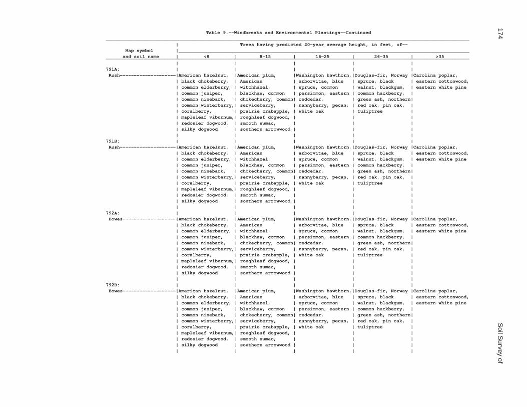
174S
oil Survey of
Table 9.--Windbreaks and Environmental Plantings--Continued__________________________________________________________________________________________________________________________________ | Trees having predicted 20-year average height, in feet, of-- Map symbol |________________________________________________________________________________________________________ and soil name | <8 | 8-15 | 16-25 | 26-35 | >35__________________________________________________________________________________________________________________________________ | | | | |791A: | | | | | Rush--------------------|American hazelnut, |American plum, |Washington hawthorn,|Douglas-fir, Norway |Carolina poplar, | black chokeberry, | American | arborvitae, blue | spruce, black | eastern cottonwood, | common elderberry, | witchhazel, | spruce, common | walnut, blackgum, | eastern white pine | common juniper, | blackhaw, common | persimmon, eastern | common hackberry, | | common ninebark, | chokecherry, common| redcedar, | green ash, northern| | common winterberry,| serviceberry, | nannyberry, pecan, | red oak, pin oak, | | coralberry, | prairie crabapple, | white oak | tuliptree | | mapleleaf viburnum,| roughleaf dogwood, | | | | redosier dogwood, | smooth sumac, | | | | silky dogwood | southern arrowwood | | | | | | | |791B: | | | | | Rush--------------------|American hazelnut, |American plum, |Washington hawthorn,|Douglas-fir, Norway |Carolina poplar, | black chokeberry, | American | arborvitae, blue | spruce, black | eastern cottonwood, | common elderberry, | witchhazel, | spruce, common | walnut, blackgum, | eastern white pine | common juniper, | blackhaw, common | persimmon, eastern | common hackberry, | | common ninebark, | chokecherry, common| redcedar, | green ash, northern| | common winterberry,| serviceberry, | nannyberry, pecan, | red oak, pin oak, | | coralberry, | prairie crabapple, | white oak | tuliptree | | mapleleaf viburnum,| roughleaf dogwood, | | | | redosier dogwood, | smooth sumac, | | | | silky dogwood | southern arrowwood | | | | | | | |792A: | | | | | Bowes-------------------|American hazelnut, |American plum, |Washington hawthorn,|Douglas-fir, Norway |Carolina poplar, | black chokeberry, | American | arborvitae, blue | spruce, black | eastern cottonwood, | common elderberry, | witchhazel, | spruce, common | walnut, blackgum, | eastern white pine | common juniper, | blackhaw, common | persimmon, eastern | common hackberry, | | common ninebark, | chokecherry, common| redcedar, | green ash, northern| | common winterberry,| serviceberry, | nannyberry, pecan, | red oak, pin oak, | | coralberry, | prairie crabapple, | white oak | tuliptree | | mapleleaf viburnum,| roughleaf dogwood, | | | | redosier dogwood, | smooth sumac, | | | | silky dogwood | southern arrowwood | | | | | | | |792B: | | | | | Bowes-------------------|American hazelnut, |American plum, |Washington hawthorn,|Douglas-fir, Norway |Carolina poplar, | black chokeberry, | American | arborvitae, blue | spruce, black | eastern cottonwood, | common elderberry, | witchhazel, | spruce, common | walnut, blackgum, | eastern white pine | common juniper, | blackhaw, common | persimmon, eastern | common hackberry, | | common ninebark, | chokecherry, common| redcedar, | green ash, northern| | common winterberry,| serviceberry, | nannyberry, pecan, | red oak, pin oak, | | coralberry, | prairie crabapple, | white oak | tuliptree | | mapleleaf viburnum,| roughleaf dogwood, | | | | redosier dogwood, | smooth sumac, | | | | silky dogwood | southern arrowwood | | | | | | | |

De K
alb County, Illinois
175
Table 9.--Windbreaks and Environmental Plantings--Continued__________________________________________________________________________________________________________________________________ | Trees having predicted 20-year average height, in feet, of-- Map symbol |________________________________________________________________________________________________________ and soil name | <8 | 8-15 | 16-25 | 26-35 | >35__________________________________________________________________________________________________________________________________ | | | | |802B: | | | | | Orthents, loamy---------|American hazelnut, |American plum, |Washington hawthorn,|Douglas-fir, Norway |Carolina poplar, | black chokeberry, | American | arborvitae, blue | spruce, black | eastern cottonwood, | common elderberry, | witchhazel, | spruce, common | walnut, blackgum, | eastern white pine | common juniper, | blackhaw, common | persimmon, eastern | common hackberry, | | common ninebark, | chokecherry, common| redcedar, | green ash, northern| | common winterberry,| serviceberry, | nannyberry, pecan, | red oak, pin oak, | | coralberry, | prairie crabapple, | white oak | tuliptree | | mapleleaf viburnum,| roughleaf dogwood, | | | | redosier dogwood, | smooth sumac, | | | | silky dogwood | southern arrowwood | | | | | | | |830: | | | | | Landfills. | | | | | | | | | |865: | | | | | Pits, gravel. | | | | | | | | | |3076A: | | | | | Otter-------------------|American |Cockspur hawthorn, |Arborvitae, |Green ash, red |Carolina poplar, | cranberrybush, | hazel alder, | blackgum, common | maple, river birch,| eastern cottonwood, | black chokeberry, | nannyberry, | hackberry, green | swamp white oak, | pin oak | buttonbush, common | roughleaf dogwood | hawthorn, shingle | sweetgum | | elderberry, common | | oak | | | ninebark, common | | | | | winterberry, gray | | | | | dogwood, highbush | | | | | blueberry, northern| | | | | spicebush, redosier| | | | | dogwood, silky | | | | | dogwood | | | | | | | | |3776A: | | | | | Comfrey-----------------|American |Cockspur hawthorn, |Arborvitae, |Green ash, red |Carolina poplar, | cranberrybush, | hazel alder, | blackgum, common | maple, river birch,| eastern cottonwood, | black chokeberry, | nannyberry, | hackberry, green | swamp white oak, | pin oak | buttonbush, common | roughleaf dogwood | hawthorn, shingle | sweetgum | | elderberry, common | | oak | | | ninebark, common | | | | | winterberry, gray | | | | | dogwood, highbush | | | | | blueberry, northern| | | | | spicebush, redosier| | | | | dogwood, silky | | | | | dogwood | | | | | | | | |__________________________________________________________________________________________________________________________________
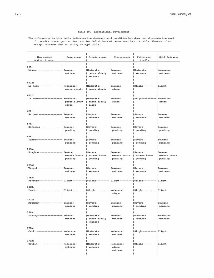
176 Soil Survey of
Table 10.--Recreational Development
(The information in this table indicates the dominant soil condition but does not eliminate the need for onsite investigation. See text for definitions of terms used in this table. Absence of an entry indicates that no rating is applicable.)
________________________________________________________________________________________________________ | | | | | Map symbol | Camp areas | Picnic areas | Playgrounds | Paths and | Golf fairways and soil name | | | | trails |________________________________________________________________________________________________________ | | | | |59A: | | | | | Lisbon-----------------|Severe: |Moderate: |Severe: |Moderate: |Moderate: | wetness | percs slowly | wetness | wetness | wetness | | wetness | | | | | | | |60C2: | | | | | La Rose----------------|Moderate: |Moderate: |Severe: |Slight---------|Slight | percs slowly | percs slowly | slope | | | | | | |60D2: | | | | | La Rose----------------|Moderate: |Moderate: |Severe: |Slight---------|Moderate: | percs slowly | percs slowly | slope | | slope | slope | slope | | | | | | | |62A: | | | | | Herbert----------------|Severe: |Severe: |Severe: |Severe: |Severe: | wetness | wetness | wetness | wetness | wetness | | | | |67A: | | | | | Harpster---------------|Severe: |Severe: |Severe: |Severe: |Severe: | ponding | ponding | ponding | ponding | ponding | | | | |68A: | | | | | Sable------------------|Severe: |Severe: |Severe: |Severe: |Severe: | ponding | ponding | ponding | ponding | ponding | | | | |103A: | | | | | Houghton---------------|Severe: |Severe: |Severe: |Severe: |Severe: | excess humus | excess humus | excess humus | excess humus | excess humus | ponding | ponding | ponding | ponding | ponding | | | | |104A: | | | | | Virgil-----------------|Severe: |Severe: |Severe: |Severe: |Severe: | wetness | wetness | wetness | wetness | wetness | | | | |148A: | | | | | Proctor----------------|Slight---------|Slight---------|Slight---------|Slight---------|Slight | | | | |148B: | | | | | Proctor----------------|Slight---------|Slight---------|Moderate: |Slight---------|Slight | | | slope | | | | | | |152A: | | | | | Drummer----------------|Severe: |Severe: |Severe: |Severe: |Severe: | ponding | ponding | ponding | ponding | ponding | | | | |154A: | | | | | Flanagan---------------|Severe: |Moderate: |Severe: |Moderate: |Moderate: | wetness | percs slowly | wetness | wetness | wetness | | wetness | | | | | | | |171A: | | | | | Catlin-----------------|Moderate: |Moderate: |Moderate: |Slight---------|Slight | wetness | wetness | wetness | | | | | | |171B: | | | | | Catlin-----------------|Moderate: |Moderate: |Moderate: |Slight---------|Slight | wetness | wetness | slope | | | | | wetness | | | | | | |

De Kalb County, Illinois 177
Table 10.--Recreational Development--Continued________________________________________________________________________________________________________ | | | | | Map symbol | Camp areas | Picnic areas | Playgrounds | Paths and | Golf fairways and soil name | | | | trails |________________________________________________________________________________________________________ | | | | |193A: | | | | | Mayville---------------|Moderate: |Moderate: |Moderate: |Slight---------|Slight | percs slowly | percs slowly | percs slowly | | | wetness | wetness | wetness | | | | | | |193B: | | | | | Mayville---------------|Moderate: |Moderate: |Moderate: |Slight---------|Slight | percs slowly | percs slowly | percs slowly | | | wetness | wetness | slope | | | | | wetness | | | | | | |193C2: | | | | | Mayville---------------|Moderate: |Moderate: |Severe: |Slight---------|Slight | percs slowly | percs slowly | slope | | | wetness | wetness | | | | | | | |198A: | | | | | Elburn-----------------|Severe: |Moderate: |Severe: |Moderate: |Moderate: | wetness | wetness | wetness | wetness | wetness | | | | |206A: | | | | | Thorp------------------|Severe: |Severe: |Severe: |Severe: |Severe: | ponding | ponding | ponding | ponding | ponding | | | | |219A: | | | | | Millbrook--------------|Severe: |Severe: |Severe: |Severe: |Severe: | wetness | wetness | wetness | wetness | wetness | | | | |221B2: | | | | | Parr-------------------|Moderate: |Moderate: |Moderate: |Slight---------|Slight | percs slowly | percs slowly | percs slowly | | | wetness | wetness | slope | | | | | wetness | | | | | | |221C2: | | | | | Parr-------------------|Moderate: |Moderate: |Severe: |Slight---------|Slight | percs slowly | percs slowly | slope | | | wetness | wetness | | | | | | | |233A: | | | | | Birkbeck---------------|Moderate: |Moderate: |Moderate: |Slight---------|Slight | wetness | wetness | wetness | | | | | | |233B: | | | | | Birkbeck---------------|Moderate: |Moderate: |Moderate: |Slight---------|Slight | wetness | wetness | slope | | | | | wetness | | | | | | |236A: | | | | | Sabina-----------------|Severe: |Severe: |Severe: |Severe: |Severe: | wetness | wetness | wetness | wetness | wetness | | | | |318D2: | | | | | Lorenzo----------------|Moderate: |Moderate: |Severe: |Slight---------|Moderate: | slope | slope | slope | | slope | | | | | droughty | | | | |325A: | | | | | Dresden----------------|Slight---------|Slight---------|Slight---------|Slight---------|Slight | | | | |325B: | | | | | Dresden----------------|Slight---------|Slight---------|Moderate: |Slight---------|Slight | | | slope | | | | | | |
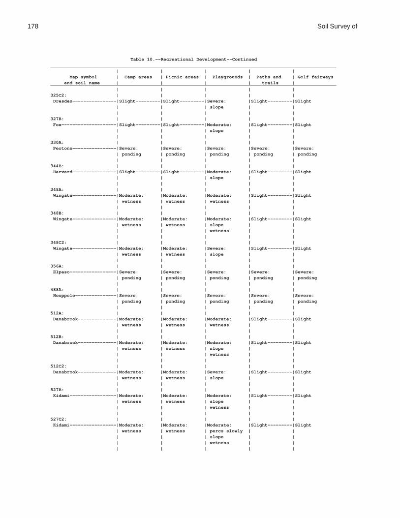
178 Soil Survey of
Table 10.--Recreational Development--Continued________________________________________________________________________________________________________ | | | | | Map symbol | Camp areas | Picnic areas | Playgrounds | Paths and | Golf fairways and soil name | | | | trails |________________________________________________________________________________________________________ | | | | |325C2: | | | | | Dresden----------------|Slight---------|Slight---------|Severe: |Slight---------|Slight | | | slope | | | | | | |327B: | | | | | Fox--------------------|Slight---------|Slight---------|Moderate: |Slight---------|Slight | | | slope | | | | | | |330A: | | | | | Peotone----------------|Severe: |Severe: |Severe: |Severe: |Severe: | ponding | ponding | ponding | ponding | ponding | | | | |344B: | | | | | Harvard----------------|Slight---------|Slight---------|Moderate: |Slight---------|Slight | | | slope | | | | | | |348A: | | | | | Wingate----------------|Moderate: |Moderate: |Moderate: |Slight---------|Slight | wetness | wetness | wetness | | | | | | |348B: | | | | | Wingate----------------|Moderate: |Moderate: |Moderate: |Slight---------|Slight | wetness | wetness | slope | | | | | wetness | | | | | | |348C2: | | | | | Wingate----------------|Moderate: |Moderate: |Severe: |Slight---------|Slight | wetness | wetness | slope | | | | | | |356A: | | | | | Elpaso-----------------|Severe: |Severe: |Severe: |Severe: |Severe: | ponding | ponding | ponding | ponding | ponding | | | | |488A: | | | | | Hooppole---------------|Severe: |Severe: |Severe: |Severe: |Severe: | ponding | ponding | ponding | ponding | ponding | | | | |512A: | | | | | Danabrook--------------|Moderate: |Moderate: |Moderate: |Slight---------|Slight | wetness | wetness | wetness | | | | | | |512B: | | | | | Danabrook--------------|Moderate: |Moderate: |Moderate: |Slight---------|Slight | wetness | wetness | slope | | | | | wetness | | | | | | |512C2: | | | | | Danabrook--------------|Moderate: |Moderate: |Severe: |Slight---------|Slight | wetness | wetness | slope | | | | | | |527B: | | | | | Kidami-----------------|Moderate: |Moderate: |Moderate: |Slight---------|Slight | wetness | wetness | slope | | | | | wetness | | | | | | |527C2: | | | | | Kidami-----------------|Moderate: |Moderate: |Moderate: |Slight---------|Slight | wetness | wetness | percs slowly | | | | | slope | | | | | wetness | | | | | | |

De Kalb County, Illinois 179
Table 10.--Recreational Development--Continued________________________________________________________________________________________________________ | | | | | Map symbol | Camp areas | Picnic areas | Playgrounds | Paths and | Golf fairways and soil name | | | | trails |________________________________________________________________________________________________________ | | | | |527D2: | | | | | Kidami-----------------|Moderate: |Moderate: |Severe: |Slight---------|Moderate: | percs slowly | percs slowly | slope | | slope | slope | slope | | | | wetness | wetness | | | | | | | |656B: | | | | | Octagon----------------|Moderate: |Moderate: |Moderate: |Slight---------|Slight | percs slowly | percs slowly | percs slowly | | | wetness | wetness | slope | | | | | wetness | | | | | | |656C2: | | | | | Octagon----------------|Moderate: |Moderate: |Moderate: |Slight---------|Slight | percs slowly | percs slowly | percs slowly | | | wetness | wetness | slope | | | | | wetness | | | | | | |662A: | | | | | Barony-----------------|Moderate: |Moderate: |Moderate: |Slight---------|Slight | wetness | wetness | wetness | | | | | | |662B: | | | | | Barony-----------------|Moderate: |Moderate: |Moderate: |Slight---------|Slight | wetness | wetness | slope | | | | | wetness | | | | | | |662C2: | | | | | Barony-----------------|Moderate: |Moderate: |Severe: |Slight---------|Slight | wetness | wetness | slope | | | | | | |663A: | | | | | Clare------------------|Moderate: |Moderate: |Moderate: |Slight---------|Slight | wetness | wetness | wetness | | | | | | |663B: | | | | | Clare------------------|Moderate: |Moderate: |Moderate: |Slight---------|Slight | wetness | wetness | slope | | | | | wetness | | | | | | |667A: | | | | | Kaneville--------------|Moderate: |Moderate: |Moderate: |Slight---------|Slight | wetness | wetness | wetness | | | | | | |667B: | | | | | Kaneville--------------|Moderate: |Moderate: |Moderate: |Slight---------|Slight | wetness | wetness | slope | | | | | wetness | | | | | | |667C2: | | | | | Kaneville--------------|Moderate: |Moderate: |Severe: |Slight---------|Slight | wetness | wetness | slope | | | | | | |668A: | | | | | Somonauk---------------|Moderate: |Moderate: |Moderate: |Slight---------|Slight | wetness | wetness | wetness | | | | | | |668B: | | | | | Somonauk---------------|Moderate: |Moderate: |Moderate: |Slight---------|Slight | wetness | wetness | slope | | | | | wetness | | | | | | |

180 Soil Survey of
Table 10.--Recreational Development--Continued________________________________________________________________________________________________________ | | | | | Map symbol | Camp areas | Picnic areas | Playgrounds | Paths and | Golf fairways and soil name | | | | trails |________________________________________________________________________________________________________ | | | | |679A: | | | | | Blackberry-------------|Moderate: |Moderate: |Moderate: |Slight---------|Slight | wetness | wetness | wetness | | | | | | |679B: | | | | | Blackberry-------------|Moderate: |Moderate: |Moderate: |Slight---------|Slight | wetness | wetness | slope | | | | | wetness | | | | | | |712A: | | | | | Spaulding--------------|Severe: |Severe: |Severe: |Severe: |Severe: | ponding | ponding | ponding | ponding | ponding | | | | |715A: | | | | | Arrowsmith-------------|Severe: |Moderate: |Severe: |Moderate: |Moderate: | wetness | wetness | wetness | wetness | wetness | | | | |791A: | | | | | Rush-------------------|Slight---------|Slight---------|Slight---------|Slight---------|Slight | | | | |791B: | | | | | Rush-------------------|Slight---------|Slight---------|Moderate: |Slight---------|Slight | | | slope | | | | | | |792A: | | | | | Bowes------------------|Slight---------|Slight---------|Slight---------|Slight---------|Slight | | | | |792B: | | | | | Bowes------------------|Slight---------|Slight---------|Moderate: |Slight---------|Slight | | | slope | | | | | | |802B: | | | | | Orthents, loamy--------|Moderate: |Moderate: |Moderate: |Slight---------|Slight | percs slowly | percs slowly | percs slowly | | | | | slope | | | | | | |830: | | | | | Landfills. | | | | | | | | | |865: | | | | | Pits, gravel. | | | | | | | | | |3076A: | | | | | Otter------------------|Severe: |Severe: |Severe: |Severe: |Severe: | flooding | ponding | flooding | ponding | flooding | ponding | | ponding | | ponding | | | | |3776A: | | | | | Comfrey----------------|Severe: |Severe: |Severe: |Severe: |Severe: | flooding | ponding | flooding | ponding | flooding | ponding | | ponding | | ponding | | | | |________________________________________________________________________________________________________

De Kalb County, Illinois 181
Table 11.--Wildlife Habitat
(See text for definitions of terms used in this table. Absence of an entry indicates that no rating is applicable.)
____________________________________________________________________________________________________________ | Potential for habitat elements |Potential as habitat for-- __________________________________________________________________________________ Map symbol | Grain | | Wild | | | | | Open- | Wood- | Wetland and soil name | and |Grasses|herba- | Hard- |Conif- |Wetland|Shallow| land | land | wild- | seed | and | ceous | wood | erous |plants | water | wild- | wild- | life | crops |legumes|plants | trees |plants | | areas | life | life |____________________________________________________________________________________________________________ | | | | | | | | | |59A: | | | | | | | | | | Lisbon------------------|Fair |Good |Good |Good |Good |Fair |Fair |Good |Good |Fair | | | | | | | | | |60C2: | | | | | | | | | | La Rose-----------------|Fair |Good |Good |Good |Good |Poor |Very |Good |Good |Very | | | | | | | poor | | | poor | | | | | | | | | |60D2: | | | | | | | | | | La Rose-----------------|Fair |Good |Good |Good |Good |Very |Very |Good |Good |Very | | | | | | poor | poor | | | poor | | | | | | | | | |62A: | | | | | | | | | | Herbert-----------------|Fair |Good |Good |Good |Good |Fair |Fair |Good |Good |Fair | | | | | | | | | |67A: | | | | | | | | | | Harpster----------------|Fair |Fair |Fair |Fair |Fair |Good |Good |Fair |Fair |Good | | | | | | | | | |68A: | | | | | | | | | | Sable-------------------|Fair |Fair |Fair |Fair |Fair |Good |Good |Fair |Fair |Good | | | | | | | | | |103A: | | | | | | | | | | Houghton----------------|Poor |Poor |Poor |Poor |Poor |Good |Good |Poor |Poor |Good | | | | | | | | | |104A: | | | | | | | | | | Virgil------------------|Fair |Good |Fair |Good |Good |Fair |Fair |Fair |Good |Fair | | | | | | | | | |148A: | | | | | | | | | | Proctor-----------------|Good |Good |Good |Good |Good |Poor |Very |Good |Good |Very | | | | | | | poor | | | poor | | | | | | | | | |148B: | | | | | | | | | | Proctor-----------------|Good |Good |Good |Good |Good |Poor |Very |Good |Good |Very | | | | | | | poor | | | poor | | | | | | | | | |152A: | | | | | | | | | | Drummer-----------------|Fair |Fair |Fair |Fair |Fair |Good |Good |Fair |Fair |Good | | | | | | | | | |154A: | | | | | | | | | | Flanagan----------------|Fair |Good |Good |Good |Good |Fair |Fair |Good |Good |Fair | | | | | | | | | |171A: | | | | | | | | | | Catlin------------------|Good |Good |Good |Good |Good |Poor |Poor |Good |Good |Poor | | | | | | | | | |171B: | | | | | | | | | | Catlin------------------|Good |Good |Good |Good |Good |Poor |Very |Good |Good |Very | | | | | | | poor | | | poor | | | | | | | | | |193A: | | | | | | | | | | Mayville----------------|Good |Good |Good |Good |Good |Poor |Poor |Good |Good |Poor | | | | | | | | | |193B: | | | | | | | | | | Mayville----------------|Good |Good |Good |Good |Good |Poor |Very |Good |Good |Very | | | | | | | poor | | | poor | | | | | | | | | |193C2: | | | | | | | | | | Mayville----------------|Fair |Good |Good |Good |Good |Poor |Very |Good |Good |Very | | | | | | | poor | | | poor | | | | | | | | | |

182 Soil Survey of
Table 11.--Wildlife Habitat--Continued____________________________________________________________________________________________________________ | Potential for habitat elements |Potential as habitat for-- __________________________________________________________________________________ Map symbol | Grain | | Wild | | | | | Open- | Wood- | Wetland and soil name | and |Grasses|herba- | Hard- |Conif- |Wetland|Shallow| land | land | wild- | seed | and | ceous | wood | erous |plants | water | wild- | wild- | life | crops |legumes|plants | trees |plants | | areas | life | life |____________________________________________________________________________________________________________ | | | | | | | | | |198A: | | | | | | | | | | Elburn------------------|Fair |Good |Good |Good |Good |Fair |Fair |Good |Good |Fair | | | | | | | | | |206A: | | | | | | | | | | Thorp-------------------|Fair |Fair |Fair |Fair |Fair |Good |Good |Fair |Fair |Good | | | | | | | | | |219A: | | | | | | | | | | Millbrook---------------|Fair |Good |Fair |Good |Good |Fair |Fair |Fair |Good |Fair | | | | | | | | | |221B2: | | | | | | | | | | Parr--------------------|Good |Good |Good |Good |Good |Poor |Very |Good |Good |Very | | | | | | | poor | | | poor | | | | | | | | | |221C2: | | | | | | | | | | Parr--------------------|Fair |Good |Good |Good |Good |Poor |Very |Good |Good |Very | | | | | | | poor | | | poor | | | | | | | | | |233A: | | | | | | | | | | Birkbeck----------------|Good |Good |Good |Good |Good |Poor |Poor |Good |Good |Poor | | | | | | | | | |233B: | | | | | | | | | | Birkbeck----------------|Good |Good |Good |Good |Good |Poor |Very |Good |Good |Very | | | | | | | poor | | | poor | | | | | | | | | |236A: | | | | | | | | | | Sabina------------------|Fair |Good |Good |Good |Good |Fair |Fair |Good |Good |Fair | | | | | | | | | |318D2: | | | | | | | | | | Lorenzo-----------------|Fair |Fair |Good |Fair |Fair |Very |Very |Fair |Fair |Very | | | | | | poor | poor | | | poor | | | | | | | | | |325A: | | | | | | | | | | Dresden-----------------|Good |Good |Good |Good |Good |Poor |Very |Good |Good |Very | | | | | | | poor | | | poor325B: | | | | | | | | | | Dresden-----------------|Good |Good |Good |Good |Good |Poor |Very |Good |Good |Very | | | | | | | poor | | | poor | | | | | | | | | |325C2: | | | | | | | | | | Dresden-----------------|Fair |Good |Good |Good |Good |Poor |Very |Good |Good |Very | | | | | | | poor | | | poor | | | | | | | | | |327B: | | | | | | | | | | Fox---------------------|Good |Good |Good |Good |Good |Poor |Very |Good |Good |Very | | | | | | | poor | | | poor | | | | | | | | | |330A: | | | | | | | | | | Peotone-----------------|Poor |Poor |Poor |Poor |Poor |Good |Good |Poor |Poor |Good | | | | | | | | | |344B: | | | | | | | | | | Harvard-----------------|Good |Good |Good |Good |Good |Poor |Very |Good |Good |Very | | | | | | | poor | | | poor | | | | | | | | | |348A: | | | | | | | | | | Wingate-----------------|Good |Good |Good |Good |Good |Poor |Poor |Good |Good |Poor | | | | | | | | | |348B: | | | | | | | | | | Wingate-----------------|Good |Good |Good |Good |Good |Poor |Very |Good |Good |Very | | | | | | | poor | | | poor | | | | | | | | | |348C2: | | | | | | | | | | Wingate-----------------|Fair |Good |Good |Good |Good |Poor |Very |Good |Good |Very | | | | | | | poor | | | poor | | | | | | | | | |

De Kalb County, Illinois 183
Table 11.--Wildlife Habitat--Continued____________________________________________________________________________________________________________ | Potential for habitat elements |Potential as habitat for-- __________________________________________________________________________________ Map symbol | Grain | | Wild | | | | | Open- | Wood- | Wetland and soil name | and |Grasses|herba- | Hard- |Conif- |Wetland|Shallow| land | land | wild- | seed | and | ceous | wood | erous |plants | water | wild- | wild- | life | crops |legumes|plants | trees |plants | | areas | life | life |____________________________________________________________________________________________________________ | | | | | | | | | |356A: | | | | | | | | | | Elpaso------------------|Fair |Fair |Fair |Fair |Fair |Good |Good |Fair |Fair |Good | | | | | | | | | |488A: | | | | | | | | | | Hooppole----------------|Fair |Fair |Fair |Fair |Fair |Good |Good |Fair |Fair |Good | | | | | | | | | |512A: | | | | | | | | | | Danabrook---------------|Good |Good |Good |Good |Good |Poor |Poor |Good |Good |Poor | | | | | | | | | |512B: | | | | | | | | | | Danabrook---------------|Good |Good |Good |Good |Good |Poor |Very |Good |Good |Very | | | | | | | poor | | | poor | | | | | | | | | |512C2: | | | | | | | | | | Danabrook---------------|Fair |Good |Good |Good |Good |Poor |Very |Good |Good |Very | | | | | | | poor | | | poor | | | | | | | | | |527B: | | | | | | | | | | Kidami------------------|Good |Good |Good |Good |Good |Poor |Poor |Good |Good |Poor | | | | | | | | | |527C2: | | | | | | | | | | Kidami------------------|Good |Good |Good |Good |Good |Poor |Very |Good |Good |Very | | | | | | | poor | | | poor | | | | | | | | | |527D2: | | | | | | | | | | Kidami------------------|Fair |Good |Good |Good |Good |Very |Very |Good |Good |Very | | | | | | poor | poor | | | poor | | | | | | | | | |656B: | | | | | | | | | | Octagon-----------------|Good |Good |Good |Good |Good |Poor |Poor |Good |Good |Poor | | | | | | | | | |656C2: | | | | | | | | | | Octagon-----------------|Good |Good |Good |Good |Good |Poor |Very |Good |Good |Very | | | | | | | poor | | | poor | | | | | | | | | |662A: | | | | | | | | | | Barony------------------|Good |Good |Good |Good |Good |Poor |Poor |Good |Good |Poor | | | | | | | | | |662B: | | | | | | | | | | Barony------------------|Good |Good |Good |Good |Good |Poor |Very |Good |Good |Very | | | | | | | poor | | | poor | | | | | | | | | |662C2: | | | | | | | | | | Barony------------------|Fair |Good |Good |Good |Good |Poor |Very |Good |Good |Very | | | | | | | poor | | | poor | | | | | | | | | |663A: | | | | | | | | | | Clare-------------------|Good |Good |Good |Good |Good |Poor |Poor |Good |Good |Poor | | | | | | | | | |663B: | | | | | | | | | | Clare-------------------|Good |Good |Good |Good |Good |Poor |Very |Good |Good |Very | | | | | | | poor | | | poor | | | | | | | | | |667A: | | | | | | | | | | Kaneville---------------|Good |Good |Good |Good |Good |Poor |Poor |Good |Good |Poor | | | | | | | | | |667B: | | | | | | | | | | Kaneville---------------|Good |Good |Good |Good |Good |Poor |Very |Good |Good |Very | | | | | | | poor | | | poor | | | | | | | | | |667C2: | | | | | | | | | | Kaneville---------------|Fair |Good |Good |Good |Good |Poor |Very |Good |Good |Very | | | | | | | poor | | | poor | | | | | | | | | |

184 Soil Survey of
Table 11.--Wildlife Habitat--Continued____________________________________________________________________________________________________________ | Potential for habitat elements |Potential as habitat for-- __________________________________________________________________________________ Map symbol | Grain | | Wild | | | | | Open- | Wood- | Wetland and soil name | and |Grasses|herba- | Hard- |Conif- |Wetland|Shallow| land | land | wild- | seed | and | ceous | wood | erous |plants | water | wild- | wild- | life | crops |legumes|plants | trees |plants | | areas | life | life |____________________________________________________________________________________________________________ | | | | | | | | | |668A: | | | | | | | | | | Somonauk----------------|Good |Good |Good |Good |Good |Poor |Poor |Good |Good |Poor | | | | | | | | | |668B: | | | | | | | | | | Somonauk----------------|Good |Good |Good |Good |Good |Poor |Very |Good |Good |Very | | | | | | | poor | | | poor | | | | | | | | | |679A: | | | | | | | | | | Blackberry--------------|Good |Good |Good |Good |Good |Poor |Poor |Good |Good |Poor | | | | | | | | | |679B: | | | | | | | | | | Blackberry--------------|Good |Good |Good |Good |Good |Poor |Very |Good |Good |Very | | | | | | | poor | | | poor | | | | | | | | | |712A: | | | | | | | | | | Spaulding---------------|Fair |Fair |Fair |Fair |Fair |Good |Good |Fair |Fair |Good | | | | | | | | | |715A: | | | | | | | | | | Arrowsmith--------------|Fair |Good |Good |Good |Good |Fair |Fair |Good |Good |Fair | | | | | | | | | |791A: | | | | | | | | | | Rush--------------------|Good |Good |Good |Good |Good |Poor |Very |Good |Good |Very | | | | | | | poor | | | poor | | | | | | | | | |791B: | | | | | | | | | | Rush--------------------|Good |Good |Good |Good |Good |Poor |Very |Good |Good |Very | | | | | | | poor | | | poor | | | | | | | | | |792A: | | | | | | | | | | Bowes-------------------|Good |Good |Good |Good |Good |Poor |Very |Good |Good |Very | | | | | | | poor | | | poor | | | | | | | | | |792B: | | | | | | | | | | Bowes-------------------|Good |Good |Good |Good |Good |Poor |Very |Good |Good |Very | | | | | | | poor | | | poor | | | | | | | | | |802B: | | | | | | | | | | Orthents, loamy---------|Good |Good |Good |Good |Good |Poor |Very |Good |Good |Very | | | | | | | poor | | | poor | | | | | | | | | |830: | | | | | | | | | | Landfills. | | | | | | | | | | | | | | | | | | | |865: | | | | | | | | | | Pits, gravel. | | | | | | | | | | | | | | | | | | | |3076A: | | | | | | | | | | Otter-------------------|Poor |Fair |Fair |Fair |Fair |Good |Good |Fair |Fair |Good | | | | | | | | | |3776A: | | | | | | | | | | Comfrey-----------------|Poor |Fair |Fair |Fair |Fair |Good |Good |Fair |Fair |Good | | | | | | | | | |____________________________________________________________________________________________________________

De Kalb County, Illinois 185
Table 12.--Building Site Development
(The information in this table indicates the dominant soil condition but does not eliminate the need for onsite investigation. See text for definitions of terms used in this table. Absence of an entry indicates that no rating is applicable.)
_________________________________________________________________________________________________________________________ | | | | | | Map symbol | Shallow | Dwellings | Dwellings | Small | Local roads | Lawns and and soil name | excavations | without | with | commercial | and streets | landscaping | | basements | basements | buildings | |_________________________________________________________________________________________________________________________ | | | | | |59A: | | | | | | Lisbon------------------|Severe: |Severe: |Severe: |Severe: |Severe: |Moderate: | wetness | wetness | wetness | wetness | frost action | wetness | | | | | low strength | | | | | | |60C2: | | | | | | La Rose-----------------|Moderate: |Slight---------|Slight---------|Moderate: |Moderate: |Slight | dense layer | | | slope | frost action | | | | | | low strength | | | | | | |60D2: | | | | | | La Rose-----------------|Moderate: |Moderate: |Moderate: |Severe: |Moderate: |Moderate: | slope | slope | slope | slope | frost action | slope | dense layer | | | | low strength | | | | | | slope | | | | | | |62A: | | | | | | Herbert-----------------|Severe: |Severe: |Severe: |Severe: |Severe: |Severe: | wetness | wetness | wetness | wetness | frost action | wetness | | | | | low strength | | | | | | wetness | | | | | | |67A: | | | | | | Harpster----------------|Severe: |Severe: |Severe: |Severe: |Severe: |Severe: | ponding | ponding | ponding | ponding | frost action | ponding | | | | | low strength | | | | | | ponding | | | | | | |68A: | | | | | | Sable-------------------|Severe: |Severe: |Severe: |Severe: |Severe: |Severe: | ponding | ponding | ponding | ponding | frost action | ponding | | | | | low strength | | | | | | ponding | | | | | | |103A: | | | | | | Houghton----------------|Severe: |Severe: |Severe: |Severe: |Severe: |Severe: | excess humus | subsides | subsides | subsides | frost action | excess humus | ponding | ponding | ponding | ponding | subsides | ponding | | low strength | low strength | low strength | ponding | | | | | | |104A: | | | | | | Virgil------------------|Severe: |Severe: |Severe: |Severe: |Severe: |Severe: | wetness | wetness | wetness | wetness | frost action | wetness | cutbanks cave | | | | low strength | | | | | | wetness | | | | | | |148A: | | | | | | Proctor-----------------|Severe: |Moderate: |Moderate: |Moderate: |Severe: |Slight | cutbanks cave | shrink-swell | shrink-swell | shrink-swell | frost action | | | | | | low strength | | | | | | |148B: | | | | | | Proctor-----------------|Severe: |Moderate: |Moderate: |Moderate: |Severe: |Slight | cutbanks cave | shrink-swell | shrink-swell | shrink-swell | frost action | | | | | | low strength | | | | | | |

186 Soil Survey of
Table 12.--Building Site Development--Continued_________________________________________________________________________________________________________________________ | | | | | | Map symbol | Shallow | Dwellings | Dwellings | Small | Local roads | Lawns and and soil name | excavations | without | with | commercial | and streets | landscaping | | basements | basements | buildings | |_________________________________________________________________________________________________________________________ | | | | | |152A: | | | | | | Drummer-----------------|Severe: |Severe: |Severe: |Severe: |Severe: |Severe: | ponding | ponding | ponding | ponding | frost action | ponding | cutbanks cave | | | | low strength | | | | | | ponding | | | | | | |154A: | | | | | | Flanagan----------------|Severe: |Severe: |Severe: |Severe: |Severe: |Moderate: | wetness | shrink-swell | shrink-swell | shrink-swell | low strength | wetness | | wetness | wetness | wetness | shrink-swell | | | | | | |171A: | | | | | | Catlin------------------|Severe: |Moderate: |Severe: |Moderate: |Severe: |Slight | wetness | shrink-swell | wetness | shrink-swell | frost action | | | wetness | | wetness | low strength | | | | | | |171B: | | | | | | Catlin------------------|Severe: |Moderate: |Severe: |Moderate: |Severe: |Slight | wetness | shrink-swell | wetness | shrink-swell | frost action | | | wetness | | wetness | low strength | | | | | | |193A: | | | | | | Mayville----------------|Severe: |Moderate: |Severe: |Moderate: |Severe: |Slight | wetness | shrink-swell | wetness | shrink-swell | frost action | | | wetness | | wetness | low strength | | | | | | |193B: | | | | | | Mayville----------------|Severe: |Moderate: |Severe: |Moderate: |Severe: |Slight | wetness | shrink-swell | wetness | shrink-swell | frost action | | | wetness | | wetness | low strength | | | | | | |193C2: | | | | | | Mayville----------------|Severe: |Moderate: |Severe: |Moderate: |Severe: |Slight | wetness | shrink-swell | wetness | shrink-swell | frost action | | | wetness | | slope | low strength | | | | | wetness | | | | | | | |198A: | | | | | | Elburn------------------|Severe: |Severe: |Severe: |Severe: |Severe: |Moderate: | wetness | wetness | wetness | wetness | frost action | wetness | cutbanks cave | | | | low strength | | | | | | |206A: | | | | | | Thorp-------------------|Severe: |Severe: |Severe: |Severe: |Severe: |Severe: | ponding | ponding | ponding | ponding | frost action | ponding | cutbanks cave | | | | low strength | | | | | | ponding | | | | | | |219A: | | | | | | Millbrook---------------|Severe: |Severe: |Severe: |Severe: |Severe: |Severe: | wetness | wetness | wetness | wetness | frost action | wetness | cutbanks cave | | | | low strength | | | | | | wetness | | | | | | |221B2: | | | | | | Parr--------------------|Severe: |Moderate: |Severe: |Moderate: |Severe: |Slight | wetness | shrink-swell | wetness | shrink-swell | low strength | | | wetness | | wetness | | | | | | | |221C2: | | | | | | Parr--------------------|Severe: |Moderate: |Severe: |Moderate: |Severe: |Slight | wetness | wetness | wetness | shrink-swell | low strength | | | shrink-swell | | slope | | | | | | wetness | | | | | | | |

De Kalb County, Illinois 187
Table 12.--Building Site Development--Continued_________________________________________________________________________________________________________________________ | | | | | | Map symbol | Shallow | Dwellings | Dwellings | Small | Local roads | Lawns and and soil name | excavations | without | with | commercial | and streets | landscaping | | basements | basements | buildings | |_________________________________________________________________________________________________________________________ | | | | | |233A: | | | | | | Birkbeck----------------|Severe: |Moderate: |Severe: |Moderate: |Severe: |Slight | wetness | shrink-swell | wetness | shrink-swell | frost action | | | wetness | | wetness | low strength | | | | | | |233B: | | | | | | Birkbeck----------------|Severe: |Moderate: |Severe: |Moderate: |Severe: |Slight | wetness | shrink-swell | wetness | shrink-swell | frost action | | | wetness | | wetness | low strength | | | | | | |236A: | | | | | | Sabina------------------|Severe: |Severe: |Severe: |Severe: |Severe: |Severe: | wetness | shrink-swell | shrink-swell | shrink-swell | low strength | wetness | | wetness | wetness | wetness | shrink-swell | | | | | | wetness | | | | | | |318D2: | | | | | | Lorenzo-----------------|Severe: |Moderate: |Moderate: |Severe: |Moderate: |Moderate: | cutbanks cave | slope | slope | slope | frost action | slope | | | | | slope | droughty | | | | | |325A: | | | | | | Dresden-----------------|Severe: |Moderate: |Slight---------|Moderate: |Severe: |Slight | cutbanks cave | shrink-swell | | shrink-swell | low strength | | | | | | |325B: | | | | | | Dresden-----------------|Severe: |Moderate: |Slight---------|Moderate: |Severe: |Slight | cutbanks cave | shrink-swell | | shrink-swell | low strength | | | | | | |325C2: | | | | | | Dresden-----------------|Severe: |Moderate: |Slight---------|Moderate: |Severe: |Slight | cutbanks cave | shrink-swell | | shrink-swell | low strength | | | | | slope | | | | | | | |327B: | | | | | | Fox---------------------|Severe: |Moderate: |Slight---------|Moderate: |Moderate: |Slight | cutbanks cave | shrink-swell | | shrink-swell | frost action | | | | | | shrink-swell | | | | | | low strength | | | | | | |330A: | | | | | | Peotone-----------------|Severe: |Severe: |Severe: |Severe: |Severe: |Severe: | ponding | shrink-swell | shrink-swell | shrink-swell | low strength | ponding | | ponding | ponding | ponding | shrink-swell | | | | | | ponding | | | | | | |344B: | | | | | | Harvard-----------------|Severe: |Moderate: |Moderate: |Moderate: |Severe: |Slight | cutbanks cave | shrink-swell | shrink-swell | shrink-swell | frost action | | | | | | low strength | | | | | | |348A: | | | | | | Wingate-----------------|Severe: |Moderate: |Severe: |Moderate: |Severe: |Slight | wetness | shrink-swell | wetness | shrink-swell | frost action | | | wetness | | wetness | low strength | | | | | | |348B: | | | | | | Wingate-----------------|Severe: |Moderate: |Severe: |Moderate: |Severe: |Slight | wetness | shrink-swell | wetness | shrink-swell | frost action | | | wetness | | wetness | low strength | | | | | | |

188 Soil Survey of
Table 12.--Building Site Development--Continued_________________________________________________________________________________________________________________________ | | | | | | Map symbol | Shallow | Dwellings | Dwellings | Small | Local roads | Lawns and and soil name | excavations | without | with | commercial | and streets | landscaping | | basements | basements | buildings | |_________________________________________________________________________________________________________________________ | | | | | |348C2: | | | | | | Wingate-----------------|Severe: |Moderate: |Severe: |Moderate: |Severe: |Slight | wetness | shrink-swell | wetness | shrink-swell | frost action | | | wetness | | slope | low strength | | | | | wetness | | | | | | | |356A: | | | | | | Elpaso------------------|Severe: |Severe: |Severe: |Severe: |Severe: |Severe: | ponding | ponding | ponding | ponding | frost action | ponding | | | | | low strength | | | | | | ponding | | | | | | |488A: | | | | | | Hooppole----------------|Severe: |Severe: |Severe: |Severe: |Severe: |Severe: | ponding | ponding | ponding | ponding | frost action | ponding | cutbanks cave | | | | low strength | | | | | | ponding | | | | | | |512A: | | | | | | Danabrook---------------|Severe: |Moderate: |Severe: |Moderate: |Severe: |Slight | wetness | shrink-swell | wetness | shrink-swell | frost action | | | wetness | | wetness | low strength | | | | | | |512B: | | | | | | Danabrook---------------|Severe: |Moderate: |Severe: |Moderate: |Severe: |Slight | wetness | shrink-swell | wetness | shrink-swell | frost action | | | wetness | | wetness | low strength | | | | | | |512C2: | | | | | | Danabrook---------------|Severe: |Moderate: |Severe: |Moderate: |Severe: |Slight | wetness | shrink-swell | wetness | shrink-swell | frost action | | | wetness | | slope | low strength | | | | | wetness | | | | | | | |527B: | | | | | | Kidami------------------|Severe: |Moderate: |Severe: |Moderate: |Severe: |Slight | wetness | shrink-swell | wetness | shrink-swell | low strength | | | wetness | | wetness | | | | | | | |527C2: | | | | | | Kidami------------------|Severe: |Moderate: |Severe: |Moderate: |Severe: |Slight | wetness | shrink-swell | wetness | shrink-swell | low strength | | | wetness | | slope | | | | | | wetness | | | | | | | |527D2: | | | | | | Kidami------------------|Severe: |Moderate: |Severe: |Severe: |Severe: |Moderate: | wetness | shrink-swell | wetness | slope | low strength | slope | | slope | | | | | | wetness | | | | | | | | | |656B: | | | | | | Octagon-----------------|Severe: |Moderate: |Severe: |Moderate: |Severe: |Slight | wetness | shrink-swell | wetness | shrink-swell | low strength | | | wetness | | wetness | | | | | | | |656C2: | | | | | | Octagon-----------------|Severe: |Moderate: |Severe: |Moderate: |Severe: |Slight | wetness | shrink-swell | wetness | shrink-swell | low strength | | | wetness | | slope | | | | | | wetness | | | | | | | |

De Kalb County, Illinois 189
Table 12.--Building Site Development--Continued_________________________________________________________________________________________________________________________ | | | | | | Map symbol | Shallow | Dwellings | Dwellings | Small | Local roads | Lawns and and soil name | excavations | without | with | commercial | and streets | landscaping | | basements | basements | buildings | |_________________________________________________________________________________________________________________________ | | | | | |662A: | | | | | | Barony------------------|Severe: |Moderate: |Severe: |Moderate: |Severe: |Slight | wetness | shrink-swell | wetness | shrink-swell | frost action | | cutbanks cave | wetness | | wetness | low strength | | | | | | |662B: | | | | | | Barony------------------|Severe: |Moderate: |Severe: |Moderate: |Severe: |Slight | wetness | shrink-swell | wetness | shrink-swell | frost action | | cutbanks cave | wetness | | wetness | low strength | | | | | | |662C2: | | | | | | Barony------------------|Severe: |Moderate: |Severe: |Moderate: |Severe: |Slight | wetness | shrink-swell | wetness | shrink-swell | frost action | | cutbanks cave | wetness | | slope | low strength | | | | | wetness | | | | | | | |663A: | | | | | | Clare-------------------|Severe: |Moderate: |Severe: |Moderate: |Severe: |Slight | wetness | shrink-swell | wetness | shrink-swell | frost action | | cutbanks cave | wetness | | wetness | low strength | | | | | | |663B: | | | | | | Clare-------------------|Severe: |Moderate: |Severe: |Moderate: |Severe: |Slight | wetness | shrink-swell | wetness | shrink-swell | frost action | | cutbanks cave | wetness | | wetness | low strength | | | | | | |667A: | | | | | | Kaneville---------------|Severe: |Moderate: |Severe: |Moderate: |Severe: |Slight | wetness | shrink-swell | wetness | shrink-swell | frost action | | cutbanks cave | wetness | | wetness | low strength | | | | | | |667B: | | | | | | Kaneville---------------|Severe: |Moderate: |Severe: |Moderate: |Severe: |Slight | wetness | shrink-swell | wetness | shrink-swell | frost action | | cutbanks cave | wetness | | wetness | low strength | | | | | | |667C2: | | | | | | Kaneville---------------|Severe: |Moderate: |Severe: |Moderate: |Severe: |Slight | wetness | shrink-swell | wetness | shrink-swell | frost action | | cutbanks cave | wetness | | slope | low strength | | | | | wetness | | | | | | | |668A: | | | | | | Somonauk----------------|Severe: |Moderate: |Severe: |Moderate: |Severe: |Slight | wetness | shrink-swell | wetness | shrink-swell | frost action | | cutbanks cave | wetness | | wetness | low strength | | | | | | |668B: | | | | | | Somonauk----------------|Severe: |Moderate: |Severe: |Moderate: |Severe: |Slight | wetness | shrink-swell | wetness | shrink-swell | frost action | | cutbanks cave | wetness | | wetness | low strength | | | | | | |679A: | | | | | | Blackberry--------------|Severe: |Moderate: |Severe: |Moderate: |Severe: |Slight | wetness | shrink-swell | wetness | shrink-swell | frost action | | cutbanks cave | wetness | | wetness | low strength | | | | | | |679B: | | | | | | Blackberry--------------|Severe: |Moderate: |Severe: |Moderate: |Severe: |Slight | wetness | shrink-swell | wetness | shrink-swell | frost action | | cutbanks cave | wetness | | wetness | low strength | | | | | | |

190 Soil Survey of
Table 12.--Building Site Development--Continued_________________________________________________________________________________________________________________________ | | | | | | Map symbol | Shallow | Dwellings | Dwellings | Small | Local roads | Lawns and and soil name | excavations | without | with | commercial | and streets | landscaping | | basements | basements | buildings | |_________________________________________________________________________________________________________________________ | | | | | |712A: | | | | | | Spaulding---------------|Severe: |Severe: |Severe: |Severe: |Severe: |Severe: | ponding | ponding | ponding | ponding | frost action | ponding | | | | | low strength | | | | | | ponding | | | | | | |715A: | | | | | | Arrowsmith--------------|Severe: |Severe: |Severe: |Severe: |Severe: |Moderate: | wetness | wetness | wetness | wetness | frost action | wetness | | | | | low strength | | | | | | |791A: | | | | | | Rush--------------------|Severe: |Moderate: |Moderate: |Moderate: |Severe: |Slight | cutbanks cave | shrink-swell | shrink-swell | shrink-swell | frost action | | | | | | low strength | | | | | | |791B: | | | | | | Rush--------------------|Severe: |Moderate: |Moderate: |Moderate: |Severe: |Slight | cutbanks cave | shrink-swell | shrink-swell | shrink-swell | frost action | | | | | | low strength | | | | | | |792A: | | | | | | Bowes-------------------|Severe: |Moderate: |Moderate: |Moderate: |Severe: |Slight | cutbanks cave | shrink-swell | shrink-swell | shrink-swell | frost action | | | | | | low strength | | | | | | |792B: | | | | | | Bowes-------------------|Severe: |Moderate: |Moderate: |Moderate: |Severe: |Slight | cutbanks cave | shrink-swell | shrink-swell | shrink-swell | frost action | | | | | | low strength | | | | | | |802B: | | | | | | Orthents, loamy---------|Moderate: |Moderate: |Moderate: |Moderate: |Severe: |Slight | wetness | shrink-swell | shrink-swell | shrink-swell | low strength | | | | wetness | | | | | | | | |830: | | | | | | Landfills. | | | | | | | | | | | |865: | | | | | | Pits, gravel. | | | | | | | | | | | |3076A: | | | | | | Otter-------------------|Severe: |Severe: |Severe: |Severe: |Severe: |Severe: | ponding | flooding | flooding | flooding | flooding | flooding | | ponding | ponding | ponding | low strength | ponding | | | | | ponding | | | | | | |3776A: | | | | | | Comfrey-----------------|Severe: |Severe: |Severe: |Severe: |Severe: |Severe: | ponding | flooding | flooding | flooding | flooding | flooding | | ponding | ponding | ponding | low strength | ponding | | | | | ponding | | | | | | |_________________________________________________________________________________________________________________________

De Kalb County, Illinois 191
Table 13.--Sanitary Facilities
(The information in this table indicates the dominant soil condition but does not eliminate the need for onsite investigation. See text for definitions of terms used in this table. Absence of an entry indicates that no rating is applicable.)
________________________________________________________________________________________________________ | | | | | Map symbol | Septic tank | Sewage lagoon |Trench sanitary| Area sanitary | Daily cover and soil name | absorption | areas | landfill | landfill | for landfill | fields | | | |________________________________________________________________________________________________________ | | | | |59A: | | | | | Lisbon-----------------|Severe: |Severe: |Severe: |Severe: |Poor: | percs slowly | wetness | wetness | wetness | wetness | wetness | | | | | | | | |60C2: | | | | | La Rose----------------|Severe: |Severe: |Slight---------|Slight---------|Good | percs slowly | slope | | | | | | | |60D2: | | | | | La Rose----------------|Severe: |Severe: |Moderate: |Moderate: |Fair: | percs slowly | slope | slope | slope | slope | | | | |62A: | | | | | Herbert----------------|Severe: |Severe: |Severe: |Severe: |Poor: | percs slowly | wetness | wetness | wetness | wetness | wetness | | | | | | | | |67A: | | | | | Harpster---------------|Severe: |Severe: |Severe: |Severe: |Poor: | ponding | seepage | seepage | ponding | hard to pack | | ponding | ponding | | ponding | | | | |68A: | | | | | Sable------------------|Severe: |Severe: |Severe: |Severe: |Poor: | ponding | ponding | ponding | ponding | hard to pack | | | | | ponding | | | | |103A: | | | | | Houghton---------------|Severe: |Severe: |Severe: |Severe: |Poor: | percs slowly | excess humus | excess humus | seepage | excess humus | subsides | seepage | seepage | ponding | ponding | ponding | ponding | ponding | | | | | | |104A: | | | | | Virgil-----------------|Severe: |Severe: |Severe: |Severe: |Poor: | wetness | seepage | seepage | wetness | wetness | | wetness | wetness | | | | | | |148A: | | | | | Proctor----------------|Moderate: |Severe: |Severe: |Slight---------|Fair: | percs slowly | seepage | seepage | | too clayey | | | | |148B: | | | | | Proctor----------------|Moderate: |Severe: |Severe: |Slight---------|Fair: | percs slowly | seepage | seepage | | too clayey | | | | |152A: | | | | | Drummer----------------|Severe: |Severe: |Severe: |Severe: |Poor: | ponding | seepage | seepage | ponding | ponding | | ponding | ponding | | | | | | |154A: | | | | | Flanagan---------------|Severe: |Severe: |Severe: |Severe: |Poor: | percs slowly | wetness | wetness | wetness | hard to pack | wetness | | | | wetness | | | | |
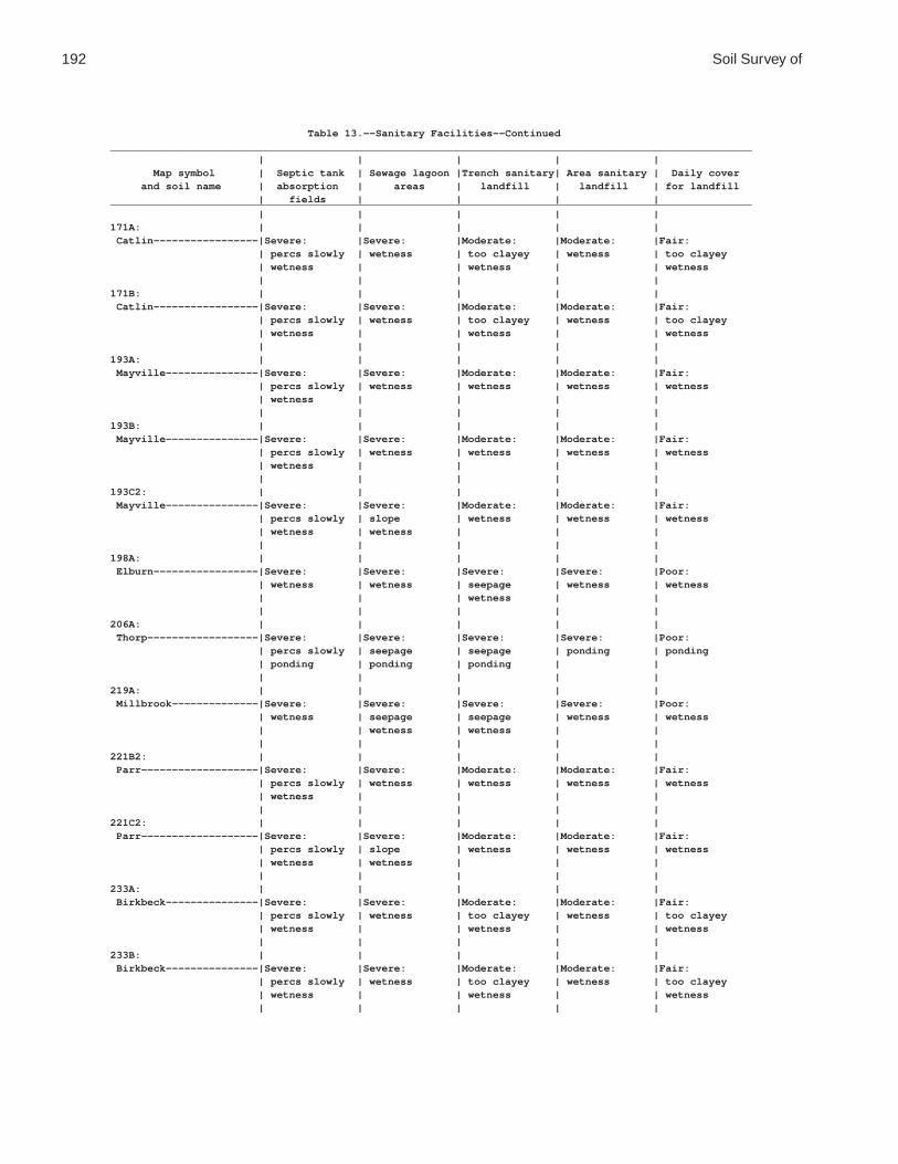
192 Soil Survey of
Table 13.--Sanitary Facilities--Continued________________________________________________________________________________________________________ | | | | | Map symbol | Septic tank | Sewage lagoon |Trench sanitary| Area sanitary | Daily cover and soil name | absorption | areas | landfill | landfill | for landfill | fields | | | |________________________________________________________________________________________________________ | | | | |171A: | | | | | Catlin-----------------|Severe: |Severe: |Moderate: |Moderate: |Fair: | percs slowly | wetness | too clayey | wetness | too clayey | wetness | | wetness | | wetness | | | | |171B: | | | | | Catlin-----------------|Severe: |Severe: |Moderate: |Moderate: |Fair: | percs slowly | wetness | too clayey | wetness | too clayey | wetness | | wetness | | wetness | | | | |193A: | | | | | Mayville---------------|Severe: |Severe: |Moderate: |Moderate: |Fair: | percs slowly | wetness | wetness | wetness | wetness | wetness | | | | | | | | |193B: | | | | | Mayville---------------|Severe: |Severe: |Moderate: |Moderate: |Fair: | percs slowly | wetness | wetness | wetness | wetness | wetness | | | | | | | | |193C2: | | | | | Mayville---------------|Severe: |Severe: |Moderate: |Moderate: |Fair: | percs slowly | slope | wetness | wetness | wetness | wetness | wetness | | | | | | | |198A: | | | | | Elburn-----------------|Severe: |Severe: |Severe: |Severe: |Poor: | wetness | wetness | seepage | wetness | wetness | | | wetness | | | | | | |206A: | | | | | Thorp------------------|Severe: |Severe: |Severe: |Severe: |Poor: | percs slowly | seepage | seepage | ponding | ponding | ponding | ponding | ponding | | | | | | |219A: | | | | | Millbrook--------------|Severe: |Severe: |Severe: |Severe: |Poor: | wetness | seepage | seepage | wetness | wetness | | wetness | wetness | | | | | | |221B2: | | | | | Parr-------------------|Severe: |Severe: |Moderate: |Moderate: |Fair: | percs slowly | wetness | wetness | wetness | wetness | wetness | | | | | | | | |221C2: | | | | | Parr-------------------|Severe: |Severe: |Moderate: |Moderate: |Fair: | percs slowly | slope | wetness | wetness | wetness | wetness | wetness | | | | | | | |233A: | | | | | Birkbeck---------------|Severe: |Severe: |Moderate: |Moderate: |Fair: | percs slowly | wetness | too clayey | wetness | too clayey | wetness | | wetness | | wetness | | | | |233B: | | | | | Birkbeck---------------|Severe: |Severe: |Moderate: |Moderate: |Fair: | percs slowly | wetness | too clayey | wetness | too clayey | wetness | | wetness | | wetness | | | | |

De Kalb County, Illinois 193
Table 13.--Sanitary Facilities--Continued________________________________________________________________________________________________________ | | | | | Map symbol | Septic tank | Sewage lagoon |Trench sanitary| Area sanitary | Daily cover and soil name | absorption | areas | landfill | landfill | for landfill | fields | | | |________________________________________________________________________________________________________ | | | | |236A: | | | | | Sabina-----------------|Severe: |Severe: |Severe: |Severe: |Poor: | percs slowly | wetness | wetness | wetness | hard to pack | wetness | | | | wetness | | | | |318D2: | | | | | Lorenzo----------------|Severe: |Severe: |Severe: |Severe: |Poor: | poor filter | seepage | seepage | seepage | seepage | | slope | too sandy | | small stones | | | | | too sandy | | | | |325A: | | | | | Dresden----------------|Severe: |Severe: |Severe: |Severe: |Poor: | poor filter | seepage | seepage | seepage | seepage | | | too sandy | | too sandy | | | | | thin layer | | | | |325B: | | | | | Dresden----------------|Severe: |Severe: |Severe: |Severe: |Poor: | poor filter | seepage | seepage | seepage | seepage | | | too sandy | | small stones | | | | | too sandy | | | | |325C2: | | | | | Dresden----------------|Severe: |Severe: |Severe: |Severe: |Poor: | poor filter | seepage | seepage | seepage | seepage | | | too sandy | | small stones | | | | | too sandy | | | | |327B: | | | | | Fox--------------------|Severe: |Severe: |Severe: |Severe: |Poor: | poor filter | seepage | seepage | seepage | seepage | | | too sandy | | small stones | | | | | too sandy | | | | |330A: | | | | | Peotone----------------|Severe: |Severe: |Severe: |Severe: |Poor: | percs slowly | ponding | too clayey | ponding | hard to pack | ponding | | ponding | | too clayey | | | | | ponding | | | | |344B: | | | | | Harvard----------------|Moderate: |Severe: |Severe: |Slight---------|Fair: | percs slowly | seepage | seepage | | too clayey | | | | |348A: | | | | | Wingate----------------|Severe: |Severe: |Moderate: |Moderate: |Fair: | percs slowly | wetness | too clayey | wetness | too clayey | wetness | | wetness | | wetness | | | | |348B: | | | | | Wingate----------------|Severe: |Severe: |Moderate: |Moderate: |Fair: | percs slowly | wetness | too clayey | wetness | too clayey | wetness | | wetness | | wetness | | | | |348C2: | | | | | Wingate----------------|Severe: |Severe: |Moderate: |Moderate: |Fair: | percs slowly | slope | too clayey | wetness | too clayey | wetness | wetness | wetness | | wetness | | | | |

194 Soil Survey of
Table 13.--Sanitary Facilities--Continued________________________________________________________________________________________________________ | | | | | Map symbol | Septic tank | Sewage lagoon |Trench sanitary| Area sanitary | Daily cover and soil name | absorption | areas | landfill | landfill | for landfill | fields | | | |________________________________________________________________________________________________________ | | | | |356A: | | | | | Elpaso-----------------|Severe: |Severe: |Severe: |Severe: |Poor: | ponding | ponding | ponding | ponding | ponding | | | | |488A: | | | | | Hooppole---------------|Severe: |Severe: |Severe: |Severe: |Poor: | ponding | seepage | seepage | ponding | ponding | poor filter | ponding | ponding | | | | | | |512A: | | | | | Danabrook--------------|Severe: |Severe: |Moderate: |Moderate: |Fair: | percs slowly | wetness | too clayey | wetness | too clayey | wetness | | wetness | | wetness | | | | |512B: | | | | | Danabrook--------------|Severe: |Severe: |Moderate: |Moderate: |Fair: | percs slowly | wetness | too clayey | wetness | too clayey | wetness | | wetness | | wetness | | | | |512C2: | | | | | Danabrook--------------|Severe: |Severe: |Moderate: |Moderate: |Fair: | percs slowly | slope | wetness | wetness | too clayey | wetness | wetness | | | wetness | | | | |527B: | | | | | Kidami-----------------|Severe: |Severe: |Moderate: |Moderate: |Fair: | percs slowly | wetness | wetness | wetness | too clayey | wetness | | | | wetness | | | | |527C2: | | | | | Kidami-----------------|Severe: |Severe: |Moderate: |Moderate: |Fair: | percs slowly | wetness | wetness | wetness | wetness | wetness | | | | | | | | |527D2: | | | | | Kidami-----------------|Severe: |Severe: |Moderate: |Moderate: |Fair: | percs slowly | slope | slope | slope | slope | wetness | wetness | wetness | wetness | wetness | | | | |656B: | | | | | Octagon----------------|Severe: |Severe: |Moderate: |Moderate: |Fair: | percs slowly | wetness | wetness | wetness | wetness | wetness | | | | | | | | |656C2: | | | | | Octagon----------------|Severe: |Severe: |Moderate: |Moderate: |Fair: | percs slowly | wetness | wetness | wetness | wetness | wetness | | | | | | | | |662A: | | | | | Barony-----------------|Severe: |Severe: |Severe: |Severe: |Fair: | wetness | seepage | seepage | wetness | too clayey | | wetness | wetness | | wetness | | | | |662B: | | | | | Barony-----------------|Severe: |Severe: |Severe: |Severe: |Fair: | wetness | seepage | seepage | wetness | too clayey | | wetness | wetness | | wetness | | | | |662C2: | | | | | Barony-----------------|Severe: |Severe: |Severe: |Severe: |Fair: | wetness | seepage | seepage | wetness | too clayey | | wetness | wetness | | wetness | | | | |

De Kalb County, Illinois 195
Table 13.--Sanitary Facilities--Continued________________________________________________________________________________________________________ | | | | | Map symbol | Septic tank | Sewage lagoon |Trench sanitary| Area sanitary | Daily cover and soil name | absorption | areas | landfill | landfill | for landfill | fields | | | |________________________________________________________________________________________________________ | | | | |663A: | | | | | Clare------------------|Severe: |Severe: |Severe: |Severe: |Fair: | wetness | wetness | seepage | wetness | too clayey | | | wetness | | wetness | | | | |663B: | | | | | Clare------------------|Severe: |Severe: |Severe: |Severe: |Fair: | wetness | seepage | seepage | wetness | too clayey | | wetness | wetness | | wetness | | | | |667A: | | | | | Kaneville--------------|Severe: |Severe: |Severe: |Severe: |Fair: | wetness | seepage | seepage | wetness | too clayey | | wetness | wetness | | wetness | | | | |667B: | | | | | Kaneville--------------|Severe: |Severe: |Severe: |Severe: |Fair: | wetness | seepage | seepage | wetness | too clayey | | wetness | wetness | | wetness | | | | |667C2: | | | | | Kaneville--------------|Severe: |Severe: |Severe: |Severe: |Fair: | wetness | seepage | seepage | wetness | too clayey | | wetness | wetness | | wetness | | | | |668A: | | | | | Somonauk---------------|Severe: |Severe: |Severe: |Severe: |Fair: | wetness | wetness | seepage | wetness | too clayey | | | wetness | | wetness | | | | |668B: | | | | | Somonauk---------------|Severe: |Severe: |Severe: |Severe: |Fair: | wetness | seepage | seepage | wetness | too clayey | | wetness | wetness | | wetness | | | | |679A: | | | | | Blackberry-------------|Severe: |Severe: |Severe: |Severe: |Fair: | wetness | wetness | seepage | wetness | too clayey | | | wetness | | wetness | | | | |679B: | | | | | Blackberry-------------|Severe: |Severe: |Severe: |Severe: |Fair: | wetness | wetness | seepage | wetness | too clayey | | | wetness | | wetness | | | | |712A: | | | | | Spaulding--------------|Severe: |Severe: |Severe: |Severe: |Poor: | ponding | ponding | ponding | ponding | hard to pack | | | | | ponding | | | | |715A: | | | | | Arrowsmith-------------|Severe: |Severe: |Severe: |Severe: |Poor: | wetness | wetness | wetness | wetness | wetness | | | | |791A: | | | | | Rush-------------------|Severe: |Severe: |Severe: |Slight---------|Fair: | poor filter | seepage | seepage | | thin layer | | | | | too clayey | | | | |791B: | | | | | Rush-------------------|Severe: |Severe: |Severe: |Slight---------|Fair: | poor filter | seepage | seepage | | thin layer | | | | | too clayey | | | | |

196 Soil Survey of
Table 13.--Sanitary Facilities--Continued________________________________________________________________________________________________________ | | | | | Map symbol | Septic tank | Sewage lagoon |Trench sanitary| Area sanitary | Daily cover and soil name | absorption | areas | landfill | landfill | for landfill | fields | | | |________________________________________________________________________________________________________ | | | | |792A: | | | | | Bowes------------------|Severe: |Severe: |Severe: |Slight---------|Fair: | poor filter | seepage | seepage | | thin layer | | | | | too clayey | | | | |792B: | | | | | Bowes------------------|Severe: |Severe: |Severe: |Slight---------|Fair: | poor filter | seepage | seepage | | thin layer | | | | | too clayey | | | | |802B: | | | | | Orthents, loamy--------|Severe: |Moderate: |Moderate: |Slight---------|Fair: | percs slowly | slope | too clayey | | too clayey | wetness | wetness | wetness | | | | | | |830: | | | | | Landfills. | | | | | | | | | |865: | | | | | Pits, gravel. | | | | | | | | | |3076A: | | | | | Otter------------------|Severe: |Severe: |Severe: |Severe: |Poor: | flooding | flooding | flooding | flooding | ponding | ponding | ponding | ponding | ponding | | | | | |3776A: | | | | | Comfrey----------------|Severe: |Severe: |Severe: |Severe: |Poor: | flooding | flooding | flooding | flooding | ponding | ponding | ponding | ponding | ponding | | | | | |________________________________________________________________________________________________________

De Kalb County, Illinois 197
Table 14.--Construction Materials
(The information in this table indicates the dominant soil condition but does not eliminate the need for onsite investigation. See text for definitions of terms used in this table. Absence of an entry indicates that no rating is applicable.)
_____________________________________________________________________________________________________ | | | | Map symbol | Roadfill | Sand | Gravel | Topsoil and soil name | | | |_____________________________________________________________________________________________________ | | | |59A: | | | | Lisbon------------------|Poor: |Improbable: |Improbable: |Fair: | low strength | excess fines | excess fines | area reclaim | | | | small stones | | | | too clayey | | | |60C2: | | | | La Rose-----------------|Fair: |Improbable: |Improbable: |Fair: | low strength | excess fines | excess fines | area reclaim | | | | small stones | | | |60D2: | | | | La Rose-----------------|Fair: |Improbable: |Improbable: |Fair: | low strength | excess fines | excess fines | area reclaim | | | | slope | | | | small stones | | | |62A: | | | | Herbert-----------------|Poor: |Improbable: |Improbable: |Poor: | wetness | excess fines | excess fines | wetness | | | |67A: | | | | Harpster----------------|Poor: |Improbable: |Improbable: |Poor: | low strength | excess fines | excess fines | wetness | wetness | | | | | | |68A: | | | | Sable-------------------|Poor: |Improbable: |Improbable: |Poor: | low strength | excess fines | excess fines | wetness | wetness | | | | | | |103A: | | | | Houghton----------------|Poor: |Improbable: |Improbable: |Poor: | low strength | excess humus | excess humus | excess humus | wetness | | | wetness | | | |104A: | | | | Virgil------------------|Poor: |Improbable: |Improbable: |Poor: | low strength | excess fines | excess fines | wetness | wetness | | | | | | |148A: | | | | Proctor-----------------|Fair: |Improbable: |Improbable: |Fair: | low strength | excess fines | excess fines | small stones | shrink-swell | | | too clayey | | | |148B: | | | | Proctor-----------------|Fair: |Improbable: |Improbable: |Fair: | low strength | excess fines | excess fines | small stones | shrink-swell | | | too clayey | | | |152A: | | | | Drummer-----------------|Poor: |Improbable: |Improbable: |Poor: | low strength | excess fines | excess fines | wetness | wetness | | | | | | |154A: | | | | Flanagan----------------|Poor: |Improbable: |Improbable: |Fair: | low strength | excess fines | excess fines | too clayey | shrink-swell | | | | | | |

198 Soil Survey of
Table 14.--Construction Materials--Continued_____________________________________________________________________________________________________ | | | | Map symbol | Roadfill | Sand | Gravel | Topsoil and soil name | | | |_____________________________________________________________________________________________________ | | | |171A: | | | | Catlin------------------|Poor: |Improbable: |Improbable: |Fair: | low strength | excess fines | excess fines | too clayey | | | |171B: | | | | Catlin------------------|Poor: |Improbable: |Improbable: |Fair: | low strength | excess fines | excess fines | too clayey | | | |193A: | | | | Mayville----------------|Fair: |Improbable: |Improbable: |Fair: | wetness | excess fines | excess fines | area reclaim | | | | small stones | | | | too clayey | | | |193B: | | | | Mayville----------------|Fair: |Improbable: |Improbable: |Fair: | wetness | excess fines | excess fines | area reclaim | | | | small stones | | | | too clayey | | | |193C2: | | | | Mayville----------------|Fair: |Improbable: |Improbable: |Fair: | wetness | excess fines | excess fines | area reclaim | | | | small stones | | | | too clayey | | | |198A: | | | | Elburn------------------|Poor: |Probable----------|Improbable: |Fair: | low strength | | too sandy | too clayey | | | |206A: | | | | Thorp-------------------|Poor: |Improbable: |Improbable: |Poor: | low strength | excess fines | excess fines | wetness | wetness | | | | | | |219A: | | | | Millbrook---------------|Poor: |Improbable: |Improbable: |Poor: | wetness | excess fines | excess fines | wetness | | | |221B2: | | | | Parr--------------------|Fair: |Improbable: |Improbable: |Fair: | wetness | excess fines | excess fines | area reclaim | | | | small stones | | | | too clayey | | | |221C2: | | | | Parr--------------------|Fair: |Improbable: |Improbable: |Fair: | wetness | excess fines | excess fines | area reclaim | | | | small stones | | | | too clayey | | | |233A: | | | | Birkbeck----------------|Poor: |Improbable: |Improbable: |Fair: | low strength | excess fines | excess fines | too clayey | | | |233B: | | | | Birkbeck----------------|Poor: |Improbable: |Improbable: |Fair: | low strength | excess fines | excess fines | too clayey | | | |236A: | | | | Sabina------------------|Poor: |Improbable: |Improbable: |Poor: | low strength | excess fines | excess fines | wetness | shrink-swell | | | | wetness | | | | | | |

De Kalb County, Illinois 199
Table 14.--Construction Materials--Continued_____________________________________________________________________________________________________ | | | | Map symbol | Roadfill | Sand | Gravel | Topsoil and soil name | | | |_____________________________________________________________________________________________________ | | | |318D2: | | | | Lorenzo-----------------|Good--------------|Probable----------|Probable----------|Poor: | | | | area reclaim | | | | small stones | | | |325A: | | | | Dresden-----------------|Good--------------|Probable----------|Probable----------|Poor: | | | | area reclaim | | | | small stones | | | |325B: | | | | Dresden-----------------|Good--------------|Probable----------|Probable----------|Poor: | | | | area reclaim | | | | small stones | | | |325C2: | | | | Dresden-----------------|Good--------------|Probable----------|Probable----------|Poor: | | | | area reclaim | | | | small stones | | | |327B: | | | | Fox---------------------|Good--------------|Probable----------|Probable----------|Poor: | | | | area reclaim | | | | small stones | | | |330A: | | | | Peotone-----------------|Poor: |Improbable: |Improbable: |Poor: | low strength | excess fines | excess fines | too clayey | shrink-swell | | | wetness | wetness | | | | | | |344B: | | | | Harvard-----------------|Fair: |Improbable: |Improbable: |Fair: | low strength | excess fines | excess fines | small stones | shrink-swell | | | too clayey | | | |348A: | | | | Wingate-----------------|Fair: |Improbable: |Improbable: |Fair: | low strength | excess fines | excess fines | small stones | | | | too clayey | | | |348B: | | | | Wingate-----------------|Fair: |Improbable: |Improbable: |Fair: | low strength | excess fines | excess fines | small stones | wetness | | | too clayey | | | |348C2: | | | | Wingate-----------------|Fair: |Improbable: |Improbable: |Fair: | low strength | excess fines | excess fines | small stones | wetness | | | too clayey | | | |356A: | | | | Elpaso------------------|Poor: |Improbable: |Improbable: |Poor: | low strength | excess fines | excess fines | wetness | wetness | | | | | | |488A: | | | | Hooppole----------------|Poor: |Probable----------|Improbable: |Poor: | low strength | | too sandy | wetness | wetness | | | | | | |
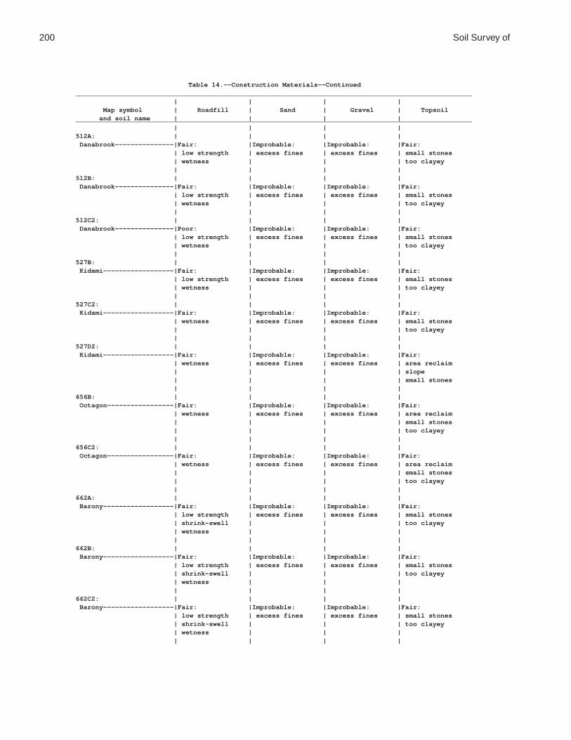
200 Soil Survey of
Table 14.--Construction Materials--Continued_____________________________________________________________________________________________________ | | | | Map symbol | Roadfill | Sand | Gravel | Topsoil and soil name | | | |_____________________________________________________________________________________________________ | | | |512A: | | | | Danabrook---------------|Fair: |Improbable: |Improbable: |Fair: | low strength | excess fines | excess fines | small stones | wetness | | | too clayey | | | |512B: | | | | Danabrook---------------|Fair: |Improbable: |Improbable: |Fair: | low strength | excess fines | excess fines | small stones | wetness | | | too clayey | | | |512C2: | | | | Danabrook---------------|Poor: |Improbable: |Improbable: |Fair: | low strength | excess fines | excess fines | small stones | wetness | | | too clayey | | | |527B: | | | | Kidami------------------|Fair: |Improbable: |Improbable: |Fair: | low strength | excess fines | excess fines | small stones | wetness | | | too clayey | | | |527C2: | | | | Kidami------------------|Fair: |Improbable: |Improbable: |Fair: | wetness | excess fines | excess fines | small stones | | | | too clayey | | | |527D2: | | | | Kidami------------------|Fair: |Improbable: |Improbable: |Fair: | wetness | excess fines | excess fines | area reclaim | | | | slope | | | | small stones | | | |656B: | | | | Octagon-----------------|Fair: |Improbable: |Improbable: |Fair: | wetness | excess fines | excess fines | area reclaim | | | | small stones | | | | too clayey | | | |656C2: | | | | Octagon-----------------|Fair: |Improbable: |Improbable: |Fair: | wetness | excess fines | excess fines | area reclaim | | | | small stones | | | | too clayey | | | |662A: | | | | Barony------------------|Fair: |Improbable: |Improbable: |Fair: | low strength | excess fines | excess fines | small stones | shrink-swell | | | too clayey | wetness | | | | | | |662B: | | | | Barony------------------|Fair: |Improbable: |Improbable: |Fair: | low strength | excess fines | excess fines | small stones | shrink-swell | | | too clayey | wetness | | | | | | |662C2: | | | | Barony------------------|Fair: |Improbable: |Improbable: |Fair: | low strength | excess fines | excess fines | small stones | shrink-swell | | | too clayey | wetness | | | | | | |

De Kalb County, Illinois 201
Table 14.--Construction Materials--Continued_____________________________________________________________________________________________________ | | | | Map symbol | Roadfill | Sand | Gravel | Topsoil and soil name | | | |_____________________________________________________________________________________________________ | | | |663A: | | | | Clare-------------------|Fair: |Improbable: |Improbable: |Fair: | low strength | excess fines | excess fines | small stones | shrink-swell | | | too clayey | wetness | | | | | | |663B: | | | | Clare-------------------|Poor: |Improbable: |Improbable: |Fair: | low strength | excess fines | excess fines | too clayey | | | |667A: | | | | Kaneville---------------|Poor: |Improbable: |Improbable: |Fair: | low strength | excess fines | excess fines | too clayey | | | |667B: | | | | Kaneville---------------|Poor: |Improbable: |Improbable: |Fair: | low strength | excess fines | excess fines | too clayey | | | |667C2: | | | | Kaneville---------------|Poor: |Improbable: |Improbable: |Fair: | low strength | excess fines | excess fines | too clayey | | | |668A: | | | | Somonauk----------------|Fair: |Improbable: |Improbable: |Fair: | shrink-swell | excess fines | excess fines | small stones | wetness | | | too clayey | | | |668B: | | | | Somonauk----------------|Fair: |Improbable: |Improbable: |Fair: | shrink-swell | excess fines | excess fines | small stones | wetness | | | too clayey | | | |679A: | | | | Blackberry--------------|Poor: |Improbable: |Improbable: |Fair: | low strength | excess fines | excess fines | too clayey | | | |679B: | | | | Blackberry--------------|Poor: |Improbable: |Improbable: |Fair: | low strength | excess fines | excess fines | too clayey | | | |712A: | | | | Spaulding---------------|Poor: |Improbable: |Improbable: |Poor: | low strength | excess fines | excess fines | wetness | wetness | | | | | | |715A: | | | | Arrowsmith--------------|Poor: |Improbable: |Improbable: |Fair: | low strength | excess fines | excess fines | too clayey | | | |791A: | | | | Rush--------------------|Poor: |Probable----------|Probable----------|Poor: | low strength | | | area reclaim | | | | small stones | | | |791B: | | | | Rush--------------------|Poor: |Probable----------|Probable----------|Poor: | low strength | | | area reclaim | | | | small stones | | | |792A: | | | | Bowes-------------------|Poor: |Probable----------|Probable----------|Poor: | low strength | | | area reclaim | | | |

202 Soil Survey of
Table 14.--Construction Materials--Continued_____________________________________________________________________________________________________ | | | | Map symbol | Roadfill | Sand | Gravel | Topsoil and soil name | | | |_____________________________________________________________________________________________________ | | | |792B: | | | | Bowes-------------------|Poor: |Probable----------|Probable----------|Poor: | low strength | | | area reclaim | | | | small stones | | | |802B: | | | | Orthents, loamy---------|Poor: |Improbable: |Improbable: |Fair: | low strength | excess fines | excess fines | small stones | | | | too clayey | | | |830: | | | | Landfills. | | | | | | | |865: | | | | Pits, gravel. | | | | | | | |3076A: | | | | Otter-------------------|Poor: |Improbable: |Improbable: |Poor: | low strength | excess fines | excess fines | wetness | wetness | | | | | | |3776A: | | | | Comfrey-----------------|Poor: |Improbable: |Improbable: |Poor: | low strength | excess fines | excess fines | wetness | wetness | | | | | | |_____________________________________________________________________________________________________

De K
alb County, Illinois
203
Table 15.--Water Management
(The information in this table indicates the dominant soil condition but does not eliminate the need for onsite investigation. See text for definitions of terms used in this table. Absence of an entry indicates that no rating is applicable.)
_________________________________________________________________________________________________________________________________ | Limitations for-- | Features affecting-- ________________________________________________________________________________________________________ Map symbol |Pond reservoir| Embankments, | Aquifer-fed | | | Terraces and | Grassed and soil name | areas | dikes, and | excavated | Drainage | Irrigation | diversions | waterways | | levees | ponds | | | |_________________________________________________________________________________________________________________________________ | | | | | | |59A: | | | | | | | Lisbon-----------------|Moderate: |Moderate: |Severe: |Frost action |Wetness-------|Erodes easily |Erodes easily | seepage | piping | no water | | | wetness | rooting depth | | wetness | | | | | wetness | | | | | | |60C2: | | | | | | | La Rose----------------|Moderate: |Moderate: |Severe: |Deep to water |Slope---------|Erodes easily |Erodes easily | seepage | piping | no water | | | | rooting depth | slope | | | | | | | | | | | | |60D2: | | | | | | | La Rose----------------|Severe: |Moderate: |Severe: |Deep to water |Slope---------|Erodes easily |Erodes easily | slope | piping | no water | | | slope | rooting depth | | | | | | | slope | | | | | | |62A: | | | | | | | Herbert----------------|Moderate: |Severe: |Severe: |Frost action |Erodes easily |Erodes easily |Erodes easily | seepage | wetness | no water | | wetness | wetness | rooting depth | | | | | | | wetness | | | | | | |67A: | | | | | | | Harpster---------------|Severe: |Severe: |Moderate: |Frost action |Ponding-------|Erodes easily |Erodes easily | seepage | ponding | slow refill | ponding | | ponding | wetness | | | | | | |68A: | | | | | | | Sable------------------|Moderate: |Severe: |Moderate: |Frost action |Ponding-------|Erodes easily |Erodes easily | seepage | ponding | slow refill | ponding | | ponding | wetness | | | | | | |103A: | | | | | | | Houghton---------------|Severe: |Severe: |Severe: |Frost action |Soil blowing |Soil blowing |Wetness | seepage | excess humus | slow refill | subsides | ponding | ponding | | | ponding | | ponding | | | | | | | | | |104A: | | | | | | | Virgil-----------------|Severe: |Severe: |Severe: |Frost action |Erodes easily |Erodes easily |Erodes easily | seepage | wetness | cutbanks cave| | wetness | wetness | wetness | | | | | | |148A: | | | | | | | Proctor----------------|Severe: |Severe: |Severe: |Deep to water |Favorable-----|Erodes easily |Erodes easily | seepage | piping | no water | | | | | | | | | | |
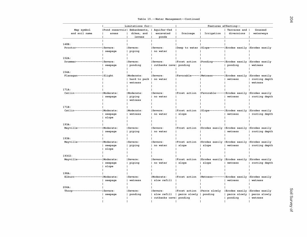
204S
oil Survey of
Table 15.--Water Management--Continued_________________________________________________________________________________________________________________________________ | Limitations for-- | Features affecting-- ________________________________________________________________________________________________________ Map symbol |Pond reservoir| Embankments, | Aquifer-fed | | | Terraces and | Grassed and soil name | areas | dikes, and | excavated | Drainage | Irrigation | diversions | waterways | | levees | ponds | | | |_________________________________________________________________________________________________________________________________ | | | | | | |148B: | | | | | | | Proctor----------------|Severe: |Severe: |Severe: |Deep to water |Slope---------|Erodes easily |Erodes easily | seepage | piping | no water | | | | | | | | | | |152A: | | | | | | | Drummer----------------|Severe: |Severe: |Severe: |Frost action |Ponding-------|Erodes easily |Erodes easily | seepage | ponding | cutbanks cave| ponding | | ponding | wetness | | | | | | |154A: | | | | | | | Flanagan---------------|Slight |Moderate: |Severe: |Favorable-----|Wetness-------|Erodes easily |Erodes easily | | hard to pack | no water | | | wetness | rooting depth | | wetness | | | | | wetness | | | | | | |171A: | | | | | | | Catlin-----------------|Moderate: |Moderate: |Severe: |Frost action |Favorable-----|Erodes easily |Erodes easily | seepage | piping | no water | | | wetness | rooting depth | | wetness | | | | | | | | | | | |171B: | | | | | | | Catlin-----------------|Moderate: |Moderate: |Severe: |Frost action |Slope---------|Erodes easily |Erodes easily | seepage | wetness | no water | slope | | wetness | rooting depth | slope | | | | | | | | | | | | |193A: | | | | | | | Mayville---------------|Moderate: |Severe: |Severe: |Frost action |Erodes easily |Erodes easily |Erodes easily | seepage | piping | no water | | | wetness | rooting depth | | | | | | |193B: | | | | | | | Mayville---------------|Moderate: |Severe: |Severe: |Frost action |Erodes easily |Erodes easily |Erodes easily | seepage | piping | no water | slope | slope | wetness | rooting depth | slope | | | | | | | | | | | | |193C2: | | | | | | | Mayville---------------|Moderate: |Severe: |Severe: |Frost action |Erodes easily |Erodes easily |Erodes easily | seepage | piping | no water | slope | slope | wetness | rooting depth | slope | | | | | | | | | | | | |198A: | | | | | | | Elburn-----------------|Moderate: |Severe: |Moderate: |Frost action |Wetness-------|Erodes easily |Erodes easily | seepage | wetness | slow refill | | | wetness | wetness | | | | | | |206A: | | | | | | | Thorp------------------|Severe: |Severe: |Severe: |Frost action |Percs slowly |Erodes easily |Erodes easily | seepage | ponding | slow refill | percs slowly | ponding | percs slowly | percs slowly | | | cutbanks cave| ponding | | ponding | wetness | | | | | | |

De K
alb County, Illinois
205
Table 15.--Water Management--Continued_________________________________________________________________________________________________________________________________ | Limitations for-- | Features affecting-- ________________________________________________________________________________________________________ Map symbol |Pond reservoir| Embankments, | Aquifer-fed | | | Terraces and | Grassed and soil name | areas | dikes, and | excavated | Drainage | Irrigation | diversions | waterways | | levees | ponds | | | |_________________________________________________________________________________________________________________________________ | | | | | | |219A: | | | | | | | Millbrook--------------|Severe: |Severe: |Severe: |Frost action |Erodes easily |Erodes easily |Erodes easily | seepage | wetness | cutbanks cave| | wetness | wetness | wetness | | | | | | |221B2: | | | | | | | Parr-------------------|Moderate: |Moderate: |Severe: |Favorable-----|Favorable-----|Erodes easily |Erodes easily | seepage | piping | no water | | | wetness | rooting depth | slope | wetness | | | | | | | | | | | |221C2: | | | | | | | Parr-------------------|Moderate: |Moderate: |Severe: |Slope---------|Slope---------|Erodes easily |Erodes easily | seepage | piping | no water | | | wetness | rooting depth | slope | wetness | | | | | | | | | | | |233A: | | | | | | | Birkbeck---------------|Moderate: |Moderate: |Severe: |Frost action |Erodes easily |Erodes easily |Erodes easily | seepage | piping | no water | | | wetness | rooting depth | | wetness | | | | | | | | | | | |233B: | | | | | | | Birkbeck---------------|Moderate: |Moderate: |Severe: |Frost action |Erodes easily |Erodes easily |Erodes easily | seepage | piping | no water | slope | slope | wetness | rooting depth | slope | wetness | | | | | | | | | | | |236A: | | | | | | | Sabina-----------------|Slight |Severe: |Severe: |Frost action |Erodes easily |Erodes easily |Erodes easily | | wetness | no water | | wetness | wetness | rooting depth | | | | | | | wetness | | | | | | |318D2: | | | | | | | Lorenzo----------------|Severe: |Severe: |Severe: |Deep to water |Slope |Slope |Rooting depth | seepage | seepage | no water | | droughty | too sandy | droughty | slope | piping | | | | | slope | | | | | | |325A: | | | | | | | Dresden----------------|Severe: |Severe: |Severe: |Deep to water |Favorable-----|Too sandy-----|Favorable | seepage | seepage | no water | | | | | | piping | | | | | | | | | | | |325B: | | | | | | | Dresden----------------|Severe: |Severe: |Severe: |Deep to water |Favorable-----|Too sandy-----|Favorable | seepage | seepage | no water | | | | | | piping | | | | | | | | | | | |

206S
oil Survey of
Table 15.--Water Management--Continued_________________________________________________________________________________________________________________________________ | Limitations for-- | Features affecting-- ________________________________________________________________________________________________________ Map symbol |Pond reservoir| Embankments, | Aquifer-fed | | | Terraces and | Grassed and soil name | areas | dikes, and | excavated | Drainage | Irrigation | diversions | waterways | | levees | ponds | | | |_________________________________________________________________________________________________________________________________ | | | | | | |325C2: | | | | | | | Dresden----------------|Severe: |Severe: |Severe: |Deep to water |Slope---------|Too sandy-----|Favorable | seepage | seepage | no water | | | | | | piping | | | | | | | | | | | |327B: | | | | | | | Fox--------------------|Severe: |Severe: |Severe: |Deep to water |Favorable-----|Too sandy-----|Favorable | seepage | seepage | no water | | | | | | piping | | | | | | | | | | | |330A: | | | | | | | Peotone----------------|Slight |Severe: |Severe: |Frost action |Ponding-------|Erodes easily |Erodes easily | | ponding | slow refill | ponding | | ponding | wetness | | | | | | |344B: | | | | | | | Harvard----------------|Severe: |Severe: |Severe: |Deep to water |Erodes easily |Erodes easily |Erodes easily | seepage | piping | no water | | slope | | | | | | | | |348A: | | | | | | | Wingate----------------|Moderate: |Moderate: |Severe: |Frost action |Erodes easily |Erodes easily |Erodes easily | seepage | piping | no water | | wetness | wetness | rooting depth | | wetness | | | | | | | | | | | |348B: | | | | | | | Wingate----------------|Moderate: |Moderate: |Severe: |Frost action |Erodes easily |Erodes easily |Erodes easily | seepage | piping | no water | slope | slope | wetness | rooting depth | slope | wetness | | | | | | | | | | | |348C2: | | | | | | | Wingate----------------|Moderate: |Moderate: |Severe: |Frost action |Erodes easily |Erodes easily |Erodes easily | seepage | piping | no water | slope | slope | wetness | rooting depth | slope | wetness | | | | | | | | | | | |356A: | | | | | | | Elpaso-----------------|Moderate: |Severe: |Severe: |Frost action |Ponding-------|Erodes easily |Erodes easily | seepage | ponding | slow refill | ponding | | ponding | wetness | | | | | | |488A: | | | | | | | Hooppole---------------|Severe: |Severe: |Severe: |Frost action |Ponding-------|Ponding-------|Wetness | seepage | ponding | cutbanks cave| ponding | | | | | | | | | |512A: | | | | | | | Danabrook--------------|Moderate: |Moderate: |Severe: |Frost action |Favorable-----|Erodes easily |Erodes easily | seepage | piping | no water | | | wetness | rooting depth | | wetness | | | | | | | | | | | |

De K
alb County, Illinois
207
Table 15.--Water Management--Continued_________________________________________________________________________________________________________________________________ | Limitations for-- | Features affecting-- ________________________________________________________________________________________________________ Map symbol |Pond reservoir| Embankments, | Aquifer-fed | | | Terraces and | Grassed and soil name | areas | dikes, and | excavated | Drainage | Irrigation | diversions | waterways | | levees | ponds | | | |_________________________________________________________________________________________________________________________________ | | | | | | |512B: | | | | | | | Danabrook--------------|Moderate: |Moderate: |Severe: |Frost action |Slope---------|Erodes easily |Erodes easily | seepage | piping | no water | slope | | wetness | rooting depth | slope | wetness | | | | | | | | | | | |512C2: | | | | | | | Danabrook--------------|Moderate: |Moderate: |Severe: |Frost action |Slope---------|Erodes easily |Erodes easily | seepage | piping | no water | slope | | wetness | rooting depth | slope | wetness | | | | | | | | | | | |527B: | | | | | | | Kidami-----------------|Moderate: |Moderate: |Severe: |Favorable-----|Favorable-----|Erodes easily |Erodes easily | seepage | piping | no water | | | wetness | rooting depth | slope | wetness | | | | | | | | | | | |527C2: | | | | | | | Kidami-----------------|Moderate: |Moderate: |Severe: |Slope---------|Slope---------|Erodes easily |Erodes easily | seepage | piping | no water | | | wetness | rooting depth | slope | wetness | | | | | | | | | | | |527D2: | | | | | | | Kidami-----------------|Severe: |Severe: |Severe: |Slope---------|Slope---------|Erodes easily |Erodes easily | slope | piping | no water | | | slope | rooting depth | | | | | | wetness | slope | | | | | | |656B: | | | | | | | Octagon----------------|Moderate: |Severe: |Severe: |Favorable-----|Favorable-----|Erodes easily |Erodes easily | seepage | piping | no water | | | wetness | rooting depth | slope | | | | | | | | | | | | |656C2: | | | | | | | Octagon----------------|Moderate: |Severe: |Severe: |Slope---------|Slope---------|Erodes easily |Erodes easily | seepage | piping | no water | | | wetness | rooting depth | slope | | | | | | | | | | | | |662A: | | | | | | | Barony-----------------|Severe: |Severe: |Severe: |Frost action |Erodes easily |Erodes easily |Erodes easily | seepage | piping | cutbanks cave| | | wetness | | | | | | | |662B: | | | | | | | Barony-----------------|Severe: |Severe: |Severe: |Frost action |Erodes easily |Erodes easily |Erodes easily | seepage | piping | cutbanks cave| slope | slope | wetness | | | | | | | |662C2: | | | | | | | Barony-----------------|Severe: |Severe: |Severe: |Frost action |Erodes easily |Erodes easily |Erodes easily | seepage | piping | cutbanks cave| slope | slope | wetness | | | | | | | |

208S
oil Survey of
Table 15.--Water Management--Continued_________________________________________________________________________________________________________________________________ | Limitations for-- | Features affecting-- ________________________________________________________________________________________________________ Map symbol |Pond reservoir| Embankments, | Aquifer-fed | | | Terraces and | Grassed and soil name | areas | dikes, and | excavated | Drainage | Irrigation | diversions | waterways | | levees | ponds | | | |_________________________________________________________________________________________________________________________________ | | | | | | |663A: | | | | | | | Clare------------------|Moderate: |Severe: |Severe: |Frost action |Favorable-----|Erodes easily |Erodes easily | seepage | piping | cutbanks cave| | | wetness | | | | | | | |663B: | | | | | | | Clare------------------|Severe: |Moderate: |Severe: |Frost action |Slope---------|Erodes easily |Erodes easily | seepage | piping | cutbanks cave| slope | | wetness | | | wetness | | | | | | | | | | | |667A: | | | | | | | Kaneville--------------|Severe: |Moderate: |Severe: |Frost action |Erodes easily |Erodes easily |Erodes easily | seepage | piping | cutbanks cave| | | wetness | | | wetness | | | | | | | | | | | |667B: | | | | | | | Kaneville--------------|Severe: |Moderate: |Severe: |Frost action |Erodes easily |Erodes easily |Erodes easily | seepage | piping | cutbanks cave| slope | slope | wetness | | | wetness | | | | | | | | | | | |667C2: | | | | | | | Kaneville--------------|Severe: |Moderate: |Severe: |Frost action |Erodes easily |Erodes easily |Erodes easily | seepage | piping | cutbanks cave| slope | slope | wetness | | | wetness | | | | | | | | | | | |668A: | | | | | | | Somonauk---------------|Moderate: |Moderate: |Moderate: |Frost action |Erodes easily |Erodes easily |Erodes easily | seepage | piping | slow refill | | | wetness | | | wetness | deep to water| | | | | | | | | | |668B: | | | | | | | Somonauk---------------|Severe: |Moderate: |Moderate: |Frost action |Erodes easily |Erodes easily |Erodes easily | seepage | piping | slow refill | slope | slope | wetness | | | wetness | deep to water| | | | | | | | | | |679A: | | | | | | | Blackberry-------------|Moderate: |Moderate: |Moderate: |Frost action |Favorable-----|Erodes easily |Erodes easily | seepage | piping | slow refill | | | wetness | | | wetness | deep to water| | | | | | | | | | |679B: | | | | | | | Blackberry-------------|Moderate: |Moderate: |Moderate: |Frost action |Slope---------|Erodes easily |Erodes easily | seepage | piping | slow refill | slope | | wetness | | slope | wetness | deep to water| | | | | | | | | | |

De K
alb County, Illinois
209
Table 15.--Water Management--Continued_________________________________________________________________________________________________________________________________ | Limitations for-- | Features affecting-- ________________________________________________________________________________________________________ Map symbol |Pond reservoir| Embankments, | Aquifer-fed | | | Terraces and | Grassed and soil name | areas | dikes, and | excavated | Drainage | Irrigation | diversions | waterways | | levees | ponds | | | |_________________________________________________________________________________________________________________________________ | | | | | | |712A: | | | | | | | Spaulding--------------|Moderate: |Severe: |Moderate: |Frost action |Ponding-------|Erodes easily |Erodes easily | seepage | ponding | slow refill | ponding | | ponding | wetness | | hard to pack | | | | | | | | | | | |715A: | | | | | | | Arrowsmith-------------|Moderate: |Severe: |Moderate: |Frost action |Wetness-------|Erodes easily |Erodes easily | seepage | wetness | slow refill | | | wetness | wetness | | | | | | |791A: | | | | | | | Rush-------------------|Severe: |Moderate: |Severe: |Deep to water |Erodes easily |Erodes easily |Erodes easily | seepage | piping | no water | | | | rooting depth | | | | | | |791B: | | | | | | | Rush-------------------|Severe: |Moderate: |Severe: |Deep to water |Erodes easily |Erodes easily |Erodes easily | seepage | piping | no water | | | | rooting depth | | | | | | |792A: | | | | | | | Bowes------------------|Severe: |Moderate: |Severe: |Deep to water |Erodes easily |Erodes easily |Erodes easily | seepage | piping | no water | | | | rooting depth | | | | | | |792B: | | | | | | | Bowes------------------|Severe: |Moderate: |Severe: |Deep to water |Erodes easily |Erodes easily |Erodes easily | seepage | piping | no water | | | | rooting depth | | | | | | |802B: | | | | | | | Orthents, loamy--------|Moderate: |Moderate: |Severe: |Deep to water |Erodes easily |Erodes easily |Erodes easily | slope | piping | no water | | slope | | rooting depth | | | | | | |830: | | | | | | | Landfills. | | | | | | | | | | | | | |865: | | | | | | | Pits, gravel. | | | | | | | | | | | | | |3076A: | | | | | | | Otter------------------|Moderate: |Severe: |Moderate: |Flooding |Flooding |Erodes easily |Erodes easily | seepage | ponding | slow refill | frost action | ponding | ponding | wetness | | | | ponding | | | | | | | | | |3776A: | | | | | | | Comfrey----------------|Moderate: |Severe: |Moderate: |Flooding |Flooding |Ponding-------|Wetness | seepage | ponding | slow refill | frost action | ponding | | | | | | ponding | | | | | | | | | |_________________________________________________________________________________________________________________________________

210S
oil Survey of
Table 16.--Engineering Index Properties
(Absence of an entry indicates that the data were not estimated.)
_____________________________________________________________________________________________________________________________ | | | Classification | Fragments | Percentage passing | | Map symbol | Depth | USDA texture |___________________________|_____________| sieve number-- |Liquid| Plas- and soil name | | | | | >10 | 3-10 |___________________________|limit |ticity | | | Unified | AASHTO |inches|inches| 4 | 10 | 40 | 200 | |index_____________________________________________________________________________________________________________________________ | In | | | | Pct | Pct | | | | | Pct | | | | | | | | | | | | |59A: | | | | | | | | | | | | Lisbon----------| 0-11 |Silt loam |CL, CL-ML |A-4, A-6 | 0 | 0 | 100 | 100 |95-100|85-100|25-40 | 5-20 | 11-36 |Silty clay |CL |A-6, A-7 | 0 | 0 | 100 |95-100|95-100|85-100|30-50 |15-35 | | loam, silt | | | | | | | | | | | | loam | | | | | | | | | | | 36-39 |Loam, clay loam|CL |A-4, A-6, A-7| 0 | 0-2 |95-100|85-100|75-90 |60-80 |20-45 | 8-25 | 39-70 |Loam, sandy |CL |A-4, A-6 | 0 | 0-3 |90-100|80-98 |65-85 |45-75 |20-40 | 8-20 | | loam | | | | | | | | | | | | | | | | | | | | | |60C2: | | | | | | | | | | | | La Rose---------| 0-7 |Loam |CL |A-4, A-6 | 0 | 0 | 100 |95-100|85-100|60-85 |30-40 | 8-15 | 7-21 |Clay loam |CL |A-6, A-7 | 0 | 0 |95-100|90-100|85-100|60-85 |30-45 |15-25 | 21-60 |Loam, silt loam|CL |A-6 | 0 | 0-5 |95-100|85-100|75-95 |50-80 |25-40 |10-20 | | | | | | | | | | | |60D2: | | | | | | | | | | | | La Rose---------| 0-7 |Loam |CL |A-4, A-6 | 0 | 0 | 100 |95-100|85-100|60-85 |30-40 | 8-15 | 7-20 |Clay loam |CL |A-6, A-7 | 0 | 0 |95-100|90-100|85-100|60-85 |30-45 |15-25 | 20-60 |Loam, silt loam|CL |A-6 | 0 | 0-5 |95-100|85-100|75-95 |50-80 |25-40 |10-20 | | | | | | | | | | | |62A: | | | | | | | | | | | | Herbert---------| 0-8 |Silt loam |CL |A-6 | 0 | 0 | 100 | 100 |95-100|85-100|30-40 |10-20 | 8-12 |Silt loam |CL |A-6 | 0 | 0 | 100 | 100 |95-100|85-100|25-35 |10-20 | 12-26 |Silty clay |CL |A-6, A-7 | 0 | 0 | 100 | 100 |95-100|85-100|25-45 |12-25 | | loam, silt | | | | | | | | | | | | loam | | | | | | | | | | | 26-36 |Clay loam, loam|CL |A-6 | 0 | 0 |95-100|85-100|75-90 |60-80 |25-40 |10-20 | 36-60 |Loam, sandy |CL |A-4, A-6 | 0 | 0 |95-100|80-98 |65-85 |45-75 |25-40 | 8-20 | | loam | | | | | | | | | | | | | | | | | | | | | |67A: | | | | | | | | | | | | Harpster--------| 0-18 |Silty clay loam|CH, CL |A-7-6 | 0 | 0 | 100 |95-100|95-100|85-100|45-60 |20-35 | 18-36 |Silty clay loam|CH, CL |A-7-6 | 0 | 0 | 100 |95-100|95-100|85-100|40-60 |20-35 | 36-41 |Silty clay |CH, CL |A-6, A-7-6 | 0 | 0 | 100 |95-100|95-100|65-100|35-55 |20-35 | | loam, silt | | | | | | | | | | | | loam, loam | | | | | | | | | | | 41-60 |Stratified |CL, CL-ML, |A-4, A-6, A-7| 0 | 0 | 100 |95-100|90-100|45-95 |20-50 | 5-25 | | sandy loam to | SC, SC-SM | | | | | | | | | | | silt loam to | | | | | | | | | | | | clay loam | | | | | | | | | | | | | | | | | | | | | |

De K
alb County, Illinois
211
Table 16.--Engineering Index Properties--Continued_____________________________________________________________________________________________________________________________ | | | Classification | Fragments | Percentage passing | | Map symbol | Depth | USDA texture |___________________________|_____________| sieve number-- |Liquid| Plas- and soil name | | | | | >10 | 3-10 |___________________________|limit |ticity | | | Unified | AASHTO |inches|inches| 4 | 10 | 40 | 200 | |index_____________________________________________________________________________________________________________________________ | In | | | | Pct | Pct | | | | | Pct | | | | | | | | | | | | |68A: | | | | | | | | | | | | Sable-----------| 0-19 |Silty clay loam|CL, CH |A-7-6 | 0 | 0 | 100 | 100 |98-100|95-100|40-65 |15-35 | 19-23 |Silty clay loam|CL, CH |A-7-6 | 0 | 0 | 100 | 100 |98-100|95-100|40-65 |15-35 | 23-47 |Silty clay |CH, CL |A-7-6 | 0 | 0 | 100 | 100 |98-100|95-100|40-55 |20-35 | | loam, silt | | | | | | | | | | | | loam | | | | | | | | | | | 47-60 |Silt loam, |CL |A-6 | 0 | 0 | 100 | 100 |98-100|95-100|30-40 |10-20 | | silty clay | | | | | | | | | | | | loam | | | | | | | | | | | | | | | | | | | | | |103A: | | | | | | | | | | | | Houghton--------| 0-7 |Muck |PT |A-8 | 0 | 0 | --- | --- | --- | --- | 0-0 | NP | 7-60 |Muck |PT |A-8 | 0 | 0 | --- | --- | --- | --- | 0-0 | NP | | | | | | | | | | | |104A: | | | | | | | | | | | | Virgil----------| 0-7 |Silt loam |CL |A-4, A-6 | 0 | 0 | 100 | 100 |98-100|90-100|20-35 | 8-20 | 7-13 |Silt loam |CL, CL-ML |A-4, A-6 | 0 | 0 | 100 | 100 |98-100|90-100|20-35 | 5-20 | 13-49 |Silty clay loam|CL |A-6, A-7 | 0 | 0 | 100 | 100 |98-100|90-100|30-50 |15-30 | 49-58 |Sandy loam, |CL, CL-ML, |A-4, A-6, A-7| 0 | 0-3 |95-100|90-100|75-100|40-85 |25-45 | 5-25 | | loam, silty | SC-SM | | | | | | | | | | | clay loam | | | | | | | | | | | 58-60 |Stratified |CL, CL-ML, |A-2, A-4, A-6| 0 | 0-5 |90-100|85-100|70-95 |20-80 |20-35 | 5-15 | | loamy sand to | SC, SC-SM | | | | | | | | | | | clay loam | | | | | | | | | | | | | | | | | | | | | |148A: | | | | | | | | | | | | Proctor---------| 0-11 |Silt loam |CL |A-6 | 0 | 0 | 100 | 100 |95-100|85-100|25-40 |10-20 | 11-27 |Silty clay |CL |A-6, A-7 | 0 | 0 | 100 |98-100|95-100|85-100|25-50 |10-25 | | loam, silt | | | | | | | | | | | | loam | | | | | | | | | | | 27-44 |Clay loam, |CL-ML, CL, |A-4, A-6, A-7| 0 | 0 |95-100|85-100|75-95 |30-85 |20-45 | 5-25 | | sandy loam, | SC-SM, SC | | | | | | | | | | | silt loam | | | | | | | | | | | 44-73 |Stratified |SC-SM, SC, |A-2, A-4, A-6| 0 | 0 |90-100|80-98 |65-95 |15-85 |20-35 | 5-20 | | loamy sand to | CL-ML, CL | | | | | | | | | | | loam | | | | | | | | | | | | | | | | | | | | | |
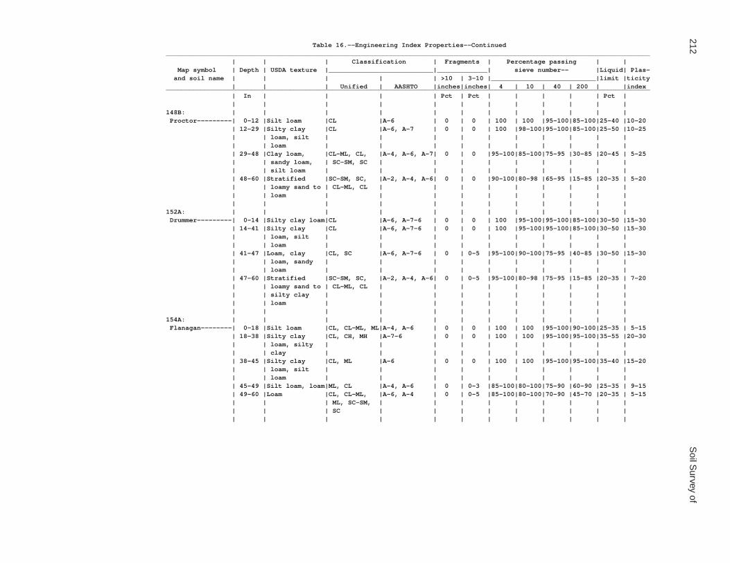
212S
oil Survey of
Table 16.--Engineering Index Properties--Continued_____________________________________________________________________________________________________________________________ | | | Classification | Fragments | Percentage passing | | Map symbol | Depth | USDA texture |___________________________|_____________| sieve number-- |Liquid| Plas- and soil name | | | | | >10 | 3-10 |___________________________|limit |ticity | | | Unified | AASHTO |inches|inches| 4 | 10 | 40 | 200 | |index_____________________________________________________________________________________________________________________________ | In | | | | Pct | Pct | | | | | Pct | | | | | | | | | | | | |148B: | | | | | | | | | | | | Proctor---------| 0-12 |Silt loam |CL |A-6 | 0 | 0 | 100 | 100 |95-100|85-100|25-40 |10-20 | 12-29 |Silty clay |CL |A-6, A-7 | 0 | 0 | 100 |98-100|95-100|85-100|25-50 |10-25 | | loam, silt | | | | | | | | | | | | loam | | | | | | | | | | | 29-48 |Clay loam, |CL-ML, CL, |A-4, A-6, A-7| 0 | 0 |95-100|85-100|75-95 |30-85 |20-45 | 5-25 | | sandy loam, | SC-SM, SC | | | | | | | | | | | silt loam | | | | | | | | | | | 48-60 |Stratified |SC-SM, SC, |A-2, A-4, A-6| 0 | 0 |90-100|80-98 |65-95 |15-85 |20-35 | 5-20 | | loamy sand to | CL-ML, CL | | | | | | | | | | | loam | | | | | | | | | | | | | | | | | | | | | |152A: | | | | | | | | | | | | Drummer---------| 0-14 |Silty clay loam|CL |A-6, A-7-6 | 0 | 0 | 100 |95-100|95-100|85-100|30-50 |15-30 | 14-41 |Silty clay |CL |A-6, A-7-6 | 0 | 0 | 100 |95-100|95-100|85-100|30-50 |15-30 | | loam, silt | | | | | | | | | | | | loam | | | | | | | | | | | 41-47 |Loam, clay |CL, SC |A-6, A-7-6 | 0 | 0-5 |95-100|90-100|75-95 |40-85 |30-50 |15-30 | | loam, sandy | | | | | | | | | | | | loam | | | | | | | | | | | 47-60 |Stratified |SC-SM, SC, |A-2, A-4, A-6| 0 | 0-5 |95-100|80-98 |75-95 |15-85 |20-35 | 7-20 | | loamy sand to | CL-ML, CL | | | | | | | | | | | silty clay | | | | | | | | | | | | loam | | | | | | | | | | | | | | | | | | | | | |154A: | | | | | | | | | | | | Flanagan--------| 0-18 |Silt loam |CL, CL-ML, ML|A-4, A-6 | 0 | 0 | 100 | 100 |95-100|90-100|25-35 | 5-15 | 18-38 |Silty clay |CL, CH, MH |A-7-6 | 0 | 0 | 100 | 100 |95-100|95-100|35-55 |20-30 | | loam, silty | | | | | | | | | | | | clay | | | | | | | | | | | 38-45 |Silty clay |CL, ML |A-6 | 0 | 0 | 100 | 100 |95-100|95-100|35-40 |15-20 | | loam, silt | | | | | | | | | | | | loam | | | | | | | | | | | 45-49 |Silt loam, loam|ML, CL |A-4, A-6 | 0 | 0-3 |85-100|80-100|75-90 |60-90 |25-35 | 9-15 | 49-60 |Loam |CL, CL-ML, |A-6, A-4 | 0 | 0-5 |85-100|80-100|70-90 |45-70 |20-35 | 5-15 | | | ML, SC-SM, | | | | | | | | | | | | SC | | | | | | | | | | | | | | | | | | | | |

De K
alb County, Illinois
213
Table 16.--Engineering Index Properties--Continued_____________________________________________________________________________________________________________________________ | | | Classification | Fragments | Percentage passing | | Map symbol | Depth | USDA texture |___________________________|_____________| sieve number-- |Liquid| Plas- and soil name | | | | | >10 | 3-10 |___________________________|limit |ticity | | | Unified | AASHTO |inches|inches| 4 | 10 | 40 | 200 | |index_____________________________________________________________________________________________________________________________ | In | | | | Pct | Pct | | | | | Pct | | | | | | | | | | | | |171A: | | | | | | | | | | | | Catlin----------| 0-11 |Silt loam |CL-ML, CL |A-4, A-6, A-7| 0 | 0 | 100 | 100 |95-100|90-100|25-45 | 5-20 | 11-44 |Silty clay |CL |A-6, A-7 | 0 | 0 | 100 |95-100|90-100|90-100|30-50 |15-30 | | loam, silt | | | | | | | | | | | | loam | | | | | | | | | | | 44-49 |Clay loam, |CL |A-6 | 0 | 0-3 |90-100|85-100|70-95 |50-80 |25-40 |10-20 | | silty clay | | | | | | | | | | | | loam, loam | | | | | | | | | | | 49-60 |Loam, clay |CL-ML, CL |A-4, A-6 | 0 | 0-3 |90-100|85-100|70-90 |45-70 |20-35 | 5-15 | | loam, silty | | | | | | | | | | | | clay loam | | | | | | | | | | | | | | | | | | | | | |171B: | | | | | | | | | | | | Catlin----------| 0-11 |Silt loam |CL-ML, CL |A-4, A-6, A-7| 0 | 0 | 100 | 100 |95-100|90-100|25-45 | 5-20 | 11-45 |Silty clay |CL |A-6, A-7 | 0 | 0 | 100 |95-100|90-100|90-100|30-50 |15-30 | | loam, silt | | | | | | | | | | | | loam | | | | | | | | | | | 45-57 |Clay loam, |CL |A-6 | 0 | 0-3 |90-100|85-100|70-95 |50-80 |25-40 |10-20 | | silty clay | | | | | | | | | | | | loam, loam | | | | | | | | | | | 57-70 |Loam, clay |CL-ML, CL |A-4, A-6 | 0 | 0-3 |90-100|85-100|70-90 |45-70 |20-35 | 5-15 | | loam, silty | | | | | | | | | | | | clay loam | | | | | | | | | | | | | | | | | | | | | |193A: | | | | | | | | | | | | Mayville--------| 0-8 |Silt loam |CL, CL-ML |A-4, A-6 | 0 | 0 | 100 | 100 |90-100|85-98 |20-30 | 4-15 | 8-12 |Silt loam |CL |A-4, A-6 | 0 | 0 | 100 | 100 |90-100|85-98 |25-35 | 5-15 | 12-24 |Silty clay |CL |A-6, A-7-6 | 0 | 0 | 100 | 100 |90-100|85-98 |35-55 |15-35 | | loam, silt | | | | | | | | | | | | loam | | | | | | | | | | | 24-31 |Clay loam, |CL, SC |A-6, A-7-6 | 0-1 | 0-2 |85-100|80-96 |70-95 |35-75 |35-50 |15-30 | | sandy clay | | | | | | | | | | | | loam, loam | | | | | | | | | | | 31-60 |Gravelly sandy |CL, CL-ML, |A-2, A-4, A-6| 0-1 | 0-5 |80-98 |70-95 |60-95 |30-70 |15-35 | 4-15 | | loam, loam, | SC, SC-SM | | | | | | | | | | | gravelly loam | | | | | | | | | | | | | | | | | | | | | |

214S
oil Survey of
Table 16.--Engineering Index Properties--Continued_____________________________________________________________________________________________________________________________ | | | Classification | Fragments | Percentage passing | | Map symbol | Depth | USDA texture |___________________________|_____________| sieve number-- |Liquid| Plas- and soil name | | | | | >10 | 3-10 |___________________________|limit |ticity | | | Unified | AASHTO |inches|inches| 4 | 10 | 40 | 200 | |index_____________________________________________________________________________________________________________________________ | In | | | | Pct | Pct | | | | | Pct | | | | | | | | | | | | |193B: | | | | | | | | | | | | Mayville--------| 0-6 |Silt loam |CL, CL-ML |A-4, A-6 | 0 | 0 | 100 | 100 |90-100|85-98 |20-30 | 4-15 | 6-8 |Silt loam |CL |A-4, A-6 | 0 | 0 | 100 | 100 |90-100|85-98 |25-35 | 5-15 | 8-28 |Silty clay |CL |A-6, A-7-6 | 0 | 0 | 100 | 100 |90-100|85-98 |35-55 |15-35 | | loam, silt | | | | | | | | | | | | loam | | | | | | | | | | | 28-32 |Clay loam, |CL, SC |A-6, A-7-6 | 0-1 | 0-2 |85-100|80-96 |70-95 |35-75 |35-50 |15-30 | | sandy clay | | | | | | | | | | | | loam, loam | | | | | | | | | | | 32-60 |Gravelly sandy |CL, CL-ML, |A-2, A-4, A-6| 0-1 | 0-5 |80-98 |70-95 |60-95 |30-70 |15-35 | 4-15 | | loam, loam, | SC, SC-SM | | | | | | | | | | | gravelly loam | | | | | | | | | | | | | | | | | | | | | |193C2: | | | | | | | | | | | | Mayville--------| 0-6 |Silt loam |CL, CL-ML |A-4, A-6 | 0 | 0 | 100 | 100 |90-100|85-98 |20-30 | 4-15 | 6-24 |Silty clay |CL |A-6, A-7-6 | 0 | 0 | 100 | 100 |90-100|85-98 |35-55 |15-35 | | loam, silt | | | | | | | | | | | | loam | | | | | | | | | | | 24-34 |Clay loam, |CL, SC |A-6, A-7-6 | 0-1 | 0-2 |85-100|80-96 |70-95 |35-75 |35-50 |15-30 | | sandy clay | | | | | | | | | | | | loam, loam | | | | | | | | | | | 34-60 |Gravelly sandy |CL, CL-ML, |A-2, A-4, A-6| 0-1 | 0-5 |80-98 |70-95 |60-95 |30-70 |15-35 | 4-15 | | loam, loam, | SC, SC-SM | | | | | | | | | | | gravelly loam | | | | | | | | | | | | | | | | | | | | | |198A: | | | | | | | | | | | | Elburn----------| 0-13 |Silt loam |CL |A-6 | 0 | 0 | 100 | 100 |95-100|90-100|25-40 |10-25 | 13-44 |Silty clay |CL |A-6, A-7 | 0 | 0 | 100 | 100 | 100 |90-100|30-50 |15-35 | | loam, silt | | | | | | | | | | | | loam | | | | | | | | | | | 44-65 |Loam, sandy |CL-ML, CL, |A-2, A-4, A-6| 0 | 0 |90-100|80-100|60-90 |30-85 |20-40 | 5-20 | | loam, silty | SC-SM, SC | | | | | | | | | | | clay loam | | | | | | | | | | | 65-80 |Stratified |SC-SM, SC, |A-2, A-4, A-6| 0 | 0 |90-100|80-100|60-90 |20-85 |20-40 | 5-20 | | loamy sand to | CL-ML, CL | | | | | | | | | | | silt loam | | | | | | | | | | | | | | | | | | | | | |

De K
alb County, Illinois
215
Table 16.--Engineering Index Properties--Continued_____________________________________________________________________________________________________________________________ | | | Classification | Fragments | Percentage passing | | Map symbol | Depth | USDA texture |___________________________|_____________| sieve number-- |Liquid| Plas- and soil name | | | | | >10 | 3-10 |___________________________|limit |ticity | | | Unified | AASHTO |inches|inches| 4 | 10 | 40 | 200 | |index_____________________________________________________________________________________________________________________________ | In | | | | Pct | Pct | | | | | Pct | | | | | | | | | | | | |206A: | | | | | | | | | | | | Thorp-----------| 0-14 |Silt loam |CL |A-4, A-6 | 0 | 0 | 100 |95-100|90-100|85-100|20-40 | 8-20 | 14-19 |Silt loam |CL, CL-ML |A-4, A-6 | 0 | 0 | 100 |95-100|90-100|85-100|15-35 | 7-15 | 19-43 |Silty clay |CL |A-6, A-7-6 | 0 | 0 | 100 |95-100|90-100|85-100|35-50 |15-30 | | loam, silt | | | | | | | | | | | | loam | | | | | | | | | | | 43-50 |Loam, clay |CL, SC |A-4, A-6 | 0 | 0 |90-100|85-100|75-95 |45-90 |20-45 | 8-25 | | loam, sandy | | | | | | | | | | | | clay loam | | | | | | | | | | | 50-65 |Stratified |SC, SC-SM, SM|A-2, A-4, A-6| 0 | 0 |85-100|80-95 |65-85 |20-85 |15-25 |NP-15 | | loamy sand to | | | | | | | | | | | | clay loam | | | | | | | | | | | | | | | | | | | | | |219A: | | | | | | | | | | | | Millbrook-------| 0-8 |Silt loam |CL, CL-ML |A-4, A-6 | 0 | 0 | 100 | 100 |95-100|85-100|20-35 | 5-15 | 8-12 |Silt loam |CL, CL-ML |A-4, A-6 | 0 | 0 | 100 | 100 |95-100|85-100|20-35 | 5-15 | 12-26 |Silty clay |CL |A-6, A-7-6 | 0 | 0 | 100 | 100 |95-100|85-100|30-45 |10-25 | | loam, silt | | | | | | | | | | | | loam | | | | | | | | | | | 26-41 |Clay loam, silt|CL, SC |A-6, A-7 | 0 | 0-3 |95-100|85-100|70-95 |40-85 |25-50 |10-25 | | loam, sandy | | | | | | | | | | | | loam | | | | | | | | | | | 41-65 |Stratified |CL, CL-ML, |A-2, A-4, A-6| 0-1 | 0-5 |90-100|80-100|65-90 |15-80 | 5-30 |NP-15 | | loamy sand to | SC, SM | | | | | | | | | | | clay loam | | | | | | | | | | | | | | | | | | | | | |221B2: | | | | | | | | | | | | Parr------------| 0-9 |Silt loam |CL, CL-ML |A-4, A-6 | 0 | 0 |98-100|95-100|80-100|65-95 |20-30 | 4-15 | 9-28 |Clay loam, |CL |A-6 | 0 | 0 |95-100|90-100|75-100|50-90 |25-45 |10-25 | | loam, silty | | | | | | | | | | | | clay loam | | | | | | | | | | | 28-36 |Loam |CL |A-4, A-6 | 0 | 0 |95-100|85-100|75-85 |50-70 |25-35 | 8-15 | 36-60 |Loam |CL, CL-ML, ML|A-4 | 0 | 0-3 |85-100|80-98 |70-85 |50-65 |10-25 | 3-15 | | | | | | | | | | | |221C2: | | | | | | | | | | | | Parr------------| 0-9 |Silt loam |CL, CL-ML |A-4, A-6 | 0 | 0 |98-100|95-100|80-100|65-95 |20-30 | 4-15 | 9-29 |Clay loam, |CL |A-6 | 0 | 0 |95-100|90-100|75-100|50-90 |25-45 |10-25 | | loam, silty | | | | | | | | | | | | clay loam | | | | | | | | | | | 29-33 |Loam |CL |A-4, A-6 | 0 | 0 |95-100|85-100|75-85 |50-70 |25-35 | 8-15 | 33-60 |Loam |CL, CL-ML, ML|A-4 | 0 | 0-3 |85-100|80-98 |70-85 |50-65 |10-25 | 3-15 | | | | | | | | | | | |

216S
oil Survey of
Table 16.--Engineering Index Properties--Continued_____________________________________________________________________________________________________________________________ | | | Classification | Fragments | Percentage passing | | Map symbol | Depth | USDA texture |___________________________|_____________| sieve number-- |Liquid| Plas- and soil name | | | | | >10 | 3-10 |___________________________|limit |ticity | | | Unified | AASHTO |inches|inches| 4 | 10 | 40 | 200 | |index_____________________________________________________________________________________________________________________________ | In | | | | Pct | Pct | | | | | Pct | | | | | | | | | | | | |233A: | | | | | | | | | | | | Birkbeck--------| 0-8 |Silt loam |CL, CL-ML, ML|A-4, A-6 | 0 | 0 | 100 | 100 | 100 |95-100|25-35 | 5-15 | 8-11 |Silt loam |CL, ML |A-4, A-6 | 0 | 0 | 100 | 100 | 100 |95-100|25-35 | 7-20 | 11-46 |Silty clay |CL, ML |A-6, A-7-6 | 0 | 0 | 100 | 100 | 100 |95-100|35-45 |15-25 | | loam, silt | | | | | | | | | | | | loam | | | | | | | | | | | 46-56 |Loam, silty |CL, SC-SM, |A-4, A-6 | 0-1 | 0-5 |85-100|80-100|70-90 |45-70 |25-35 | 8-15 | | clay loam, | SC, ML | | | | | | | | | | | clay loam | | | | | | | | | | | 56-60 |Loam, silt |CL, SC-SM, |A-4, A-6 | 0-1 | 0-5 |85-100|80-100|70-90 |45-70 |25-35 | 5-15 | | loam, clay | SC, ML | | | | | | | | | | | loam | | | | | | | | | | | | | | | | | | | | | |233B: | | | | | | | | | | | | Birkbeck--------| 0-4 |Silt loam |CL, CL-ML, ML|A-4, A-6 | 0 | 0 | 100 | 100 | 100 |95-100|25-35 | 5-15 | 4-9 |Silt loam |CL, ML |A-4, A-6 | 0 | 0 | 100 | 100 | 100 |95-100|25-35 | 7-20 | 9-54 |Silty clay |CL, ML |A-6, A-7-6 | 0 | 0 | 100 | 100 | 100 |95-100|35-45 |15-25 | | loam, silt | | | | | | | | | | | | loam | | | | | | | | | | | 54-60 |Loam, silty |CL, SC-SM, |A-4, A-6 | 0-1 | 0-5 |85-100|80-100|70-90 |45-70 |25-35 | 8-15 | | clay loam, | SC, ML | | | | | | | | | | | clay loam | | | | | | | | | | | 60-68 |Loam, silt |CL, SC-SM, |A-4, A-6 | 0-1 | 0-5 |85-100|80-100|70-90 |45-70 |25-35 | 5-15 | | loam, clay | SC, ML | | | | | | | | | | | loam | | | | | | | | | | | | | | | | | | | | | |236A: | | | | | | | | | | | | Sabina----------| 0-6 |Silt loam |CL |A-4, A-6 | 0 | 0 | 100 | 100 |95-100|95-100|25-35 | 8-15 | 6-8 |Silt loam |CL |A-4, A-6 | 0 | 0 | 100 | 100 |95-100|95-100|25-35 | 8-20 | 8-40 |Silty clay |CH, CL |A-7 | 0 | 0 | 100 | 100 |95-100|95-100|45-60 |25-35 | | loam, silty | | | | | | | | | | | | clay | | | | | | | | | | | 40-47 |Clay loam, |CL |A-6 | 0-1 | 0-3 |95-100|90-100|70-95 |50-80 |30-40 |10-20 | | loam, silt | | | | | | | | | | | | loam, silty | | | | | | | | | | | | clay loam | | | | | | | | | | | 47-80 |Clay loam, |CL |A-6 | 0-1 | 0-5 |90-100|85-95 |70-95 |50-80 |25-35 |10-15 | | loam, silt | | | | | | | | | | | | loam | | | | | | | | | | | | | | | | | | | | | |

De K
alb County, Illinois
217
Table 16.--Engineering Index Properties--Continued_____________________________________________________________________________________________________________________________ | | | Classification | Fragments | Percentage passing | | Map symbol | Depth | USDA texture |___________________________|_____________| sieve number-- |Liquid| Plas- and soil name | | | | | >10 | 3-10 |___________________________|limit |ticity | | | Unified | AASHTO |inches|inches| 4 | 10 | 40 | 200 | |index_____________________________________________________________________________________________________________________________ | In | | | | Pct | Pct | | | | | Pct | | | | | | | | | | | | |318D2: | | | | | | | | | | | | Lorenzo---------| 0-8 |Loam |CL |A-6 | 0 | 0-5 |95-100|90-100|80-95 |60-85 |25-40 |10-20 | 8-18 |Loam, clay |CL, SC |A-2-6, A-6, | 0 | 5-10 |85-100|50-95 |35-85 |20-70 |30-50 |10-25 | | loam, gravelly| | A-7 | | | | | | | | | | sandy clay | | | | | | | | | | | | loam | | | | | | | | | | | 18-60 |Stratified |GP, GP-GM, |A-1-a | 0 | 5-20 |25-80 |10-70 | 5-40 | 1-15 | 0-15 |NP-5 | | gravelly loamy| SP-SM, SP | | | | | | | | | | | sand to | | | | | | | | | | | | extremely | | | | | | | | | | | | gravelly | | | | | | | | | | | | coarse sand | | | | | | | | | | | | | | | | | | | | | |325A: | | | | | | | | | | | | Dresden---------| 0-9 |Silt loam |CL, CL-ML |A-4, A-6 | 0 | 0 | 100 |95-100|90-100|70-98 |20-40 | 5-15 | 9-29 |Silty clay |CL |A-6, A-7 | 0 | 0 | 100 |80-100|70-100|50-95 |30-45 |10-25 | | loam, clay | | | | | | | | | | | | loam, loam | | | | | | | | | | | 29-33 |Gravelly clay |CL, GC, SC |A-2, A-6, A-7| 0-1 | 0-5 |60-100|40-100|35-90 |30-70 |25-45 |10-25 | | loam, sandy | | | | | | | | | | | | clay loam, | | | | | | | | | | | | very gravelly | | | | | | | | | | | | loam | | | | | | | | | | | 33-60 |Stratified |GP, GP-GM, |A-1 | 0-5 | 5-35 |45-90 |15-70 |10-50 | 1-20 | 0-14 | NP | | gravelly loamy| SP, SP-SM | | | | | | | | | | | sand to | | | | | | | | | | | | extremely | | | | | | | | | | | | gravelly | | | | | | | | | | | | coarse sand | | | | | | | | | | | | | | | | | | | | | |325B: | | | | | | | | | | | | Dresden---------| 0-7 |Silt loam |CL, CL-ML |A-4, A-6 | 0 | 0 | 100 |95-100|90-100|70-98 |20-40 | 5-15 | 7-27 |Silty clay |CL |A-6, A-7 | 0 | 0 | 100 |80-100|70-100|50-95 |30-45 |10-25 | | loam, clay | | | | | | | | | | | | loam, loam | | | | | | | | | | | 27-32 |Gravelly clay |CL, GC, SC |A-2, A-6, A-7| 0-1 | 0-5 |60-100|40-100|35-90 |30-70 |25-45 |10-25 | | loam, sandy | | | | | | | | | | | | clay loam, | | | | | | | | | | | | very gravelly | | | | | | | | | | | | loam | | | | | | | | | | | 32-60 |Stratified |GP, GP-GM, |A-1 | 0-5 | 5-35 |45-90 |15-70 |10-50 | 1-20 | 0-14 | NP | | gravelly loamy| SP, SP-SM | | | | | | | | | | | sand to | | | | | | | | | | | | extremely | | | | | | | | | | | | gravelly | | | | | | | | | | | | coarse sand | | | | | | | | | | | | | | | | | | | | | |

218S
oil Survey of
Table 16.--Engineering Index Properties--Continued_____________________________________________________________________________________________________________________________ | | | Classification | Fragments | Percentage passing | | Map symbol | Depth | USDA texture |___________________________|_____________| sieve number-- |Liquid| Plas- and soil name | | | | | >10 | 3-10 |___________________________|limit |ticity | | | Unified | AASHTO |inches|inches| 4 | 10 | 40 | 200 | |index_____________________________________________________________________________________________________________________________ | In | | | | Pct | Pct | | | | | Pct | | | | | | | | | | | | |325C2: | | | | | | | | | | | | Dresden---------| 0-7 |Silt loam |CL, CL-ML |A-4, A-6 | 0 | 0 | 100 |95-100|90-100|70-98 |20-40 | 5-15 | 7-26 |Silty clay |CL |A-6, A-7 | 0 | 0 | 100 |80-100|70-100|50-95 |30-45 |10-25 | | loam, clay | | | | | | | | | | | | loam, loam | | | | | | | | | | | 26-30 |Gravelly clay |CL, GC, SC |A-2, A-6, A-7| 0-1 | 0-5 |60-100|40-100|35-90 |30-70 |25-45 |10-25 | | loam, sandy | | | | | | | | | | | | clay loam, | | | | | | | | | | | | very gravelly | | | | | | | | | | | | loam | | | | | | | | | | | 30-60 |Stratified |GP, GP-GM, |A-1 | 0-5 | 5-35 |45-90 |15-70 |10-50 | 1-20 | 0-14 | NP | | gravelly loamy| SP, SP-SM | | | | | | | | | | | sand to | | | | | | | | | | | | extremely | | | | | | | | | | | | gravelly | | | | | | | | | | | | coarse sand | | | | | | | | | | | | | | | | | | | | | |327B: | | | | | | | | | | | | Fox-------------| 0-7 |Silt loam |CL, CL-ML, ML|A-4 | 0 | 0 |95-100|95-100|85-98 |70-95 |15-30 | 3-15 | 7-11 |Silty clay |CL |A-6, A-7 | 0 | 0-1 |95-100|85-100|75-100|70-95 |25-50 |10-25 | | loam, silt | | | | | | | | | | | | loam | | | | | | | | | | | 11-32 |Clay loam, |CL, GC, SC |A-2, A-6, A-7| 0-1 | 0-5 |65-100|50-100|35-95 |30-80 |25-45 |10-25 | | sandy clay | | | | | | | | | | | | loam, gravelly| | | | | | | | | | | | loam | | | | | | | | | | | 32-60 |Stratified |GP, GP-GM, |A-1, A-2, A-3| 0-3 | 0-10 |30-100|15-85 |10-70 | 2-10 | 0-14 | NP | | gravelly sand | SP, SP-SM | | | | | | | | | | | to extremely | | | | | | | | | | | | gravelly | | | | | | | | | | | | coarse sand | | | | | | | | | | | | | | | | | | | | | |330A: | | | | | | | | | | | | Peotone---------| 0-13 |Silty clay loam|CH, CL |A-7-6 | 0 | 0 | 100 |95-100|95-100|90-100|40-65 |15-35 | 13-50 |Silty clay |CH, CL |A-7-6 | 0 | 0-3 |98-100|95-100|90-100|85-100|40-70 |15-40 | | loam, silty | | | | | | | | | | | | clay | | | | | | | | | | | 50-60 |Silty clay |CH, CL |A-6, A-7-6 | 0 | 0-5 |95-100|95-100|90-100|75-100|30-60 |15-30 | | loam, silt | | | | | | | | | | | | loam, silty | | | | | | | | | | | | clay | | | | | | | | | | | | | | | | | | | | | |

De K
alb County, Illinois
219
Table 16.--Engineering Index Properties--Continued_____________________________________________________________________________________________________________________________ | | | Classification | Fragments | Percentage passing | | Map symbol | Depth | USDA texture |___________________________|_____________| sieve number-- |Liquid| Plas- and soil name | | | | | >10 | 3-10 |___________________________|limit |ticity | | | Unified | AASHTO |inches|inches| 4 | 10 | 40 | 200 | |index_____________________________________________________________________________________________________________________________ | In | | | | Pct | Pct | | | | | Pct | | | | | | | | | | | | |344B: | | | | | | | | | | | | Harvard---------| 0-9 |Silt loam |CL |A-4, A-6 | 0 | 0 | 100 |95-100|90-100|85-100|20-35 | 8-15 | 9-30 |Silty clay |CL |A-6, A-7 | 0 | 0 | 100 |95-100|90-100|85-100|30-45 |10-25 | | loam, silt | | | | | | | | | | | | loam | | | | | | | | | | | 30-56 |Clay loam, silt|CL |A-4, A-6, A-7| 0 | 0-3 |95-100|85-100|75-90 |40-85 |25-45 | 5-25 | | loam, sandy | | | | | | | | | | | | loam | | | | | | | | | | | 56-69 |Stratified sand|CL, CL-ML, |A-2, A-4, A-6| 0 | 0-5 |90-100|80-98 |40-90 |15-70 |20-35 | 5-15 | | to clay loam | SC-SM, SC | | | | | | | | | | | | | | | | | | | | |348A: | | | | | | | | | | | | Wingate---------| 0-9 |Silt loam |CL-ML, CL |A-4, A-6 | 0 | 0 | 100 | 100 |95-100|85-100|25-35 | 7-15 | 9-12 |Silt loam |CL-ML, CL |A-4, A-6 | 0 | 0 | 100 | 100 |95-100|85-100|25-35 | 7-15 | 12-30 |Silty clay |CL |A-6, A-7 | 0 | 0 | 100 | 100 |95-100|85-100|35-45 |15-25 | | loam, silt | | | | | | | | | | | | loam | | | | | | | | | | | 30-47 |Clay loam, loam|CL |A-6 | 0 | 0-3 |90-98 |90-98 |70-95 |45-80 |30-40 |10-20 | 47-60 |Loam |CL-ML, CL |A-4, A-6 | 0 | 0-3 |85-98 |85-98 |70-95 |45-75 |25-35 | 7-15 | | | | | | | | | | | |348B: | | | | | | | | | | | | Wingate---------| 0-9 |Silt loam |CL-ML, CL |A-4, A-6 | 0 | 0 | 100 | 100 |95-100|85-100|25-35 | 7-15 | 9-12 |Silt loam |CL-ML, CL |A-4, A-6 | 0 | 0 | 100 | 100 |95-100|85-100|25-35 | 7-15 | 12-27 |Silty clay |CL |A-6, A-7 | 0 | 0 | 100 | 100 |95-100|85-100|35-45 |15-25 | | loam, silt | | | | | | | | | | | | loam | | | | | | | | | | | 27-52 |Clay loam, loam|CL |A-6 | 0 | 0-3 |90-98 |90-98 |70-95 |45-80 |30-40 |10-20 | 52-60 |Loam |CL-ML, CL |A-4, A-6 | 0 | 0-3 |85-98 |85-98 |70-95 |45-75 |25-35 | 7-15 | | | | | | | | | | | |348C2: | | | | | | | | | | | | Wingate---------| 0-7 |Silt loam |CL-ML, CL |A-4, A-6 | 0 | 0 | 100 | 100 |95-100|85-100|25-35 | 7-15 | 7-25 |Silty clay |CL |A-6, A-7 | 0 | 0 | 100 | 100 |95-100|85-100|35-45 |15-25 | | loam, silt | | | | | | | | | | | | loam | | | | | | | | | | | 25-46 |Clay loam, loam|CL |A-6 | 0 | 0-3 |90-98 |90-98 |70-95 |45-80 |30-40 |10-20 | 46-60 |Loam |CL-ML, CL |A-4, A-6 | 0 | 0-3 |85-98 |85-98 |70-95 |45-75 |25-35 | 7-15 | | | | | | | | | | | |356A: | | | | | | | | | | | | Elpaso----------| 0-21 |Silty clay loam|CL, CH |A-7-6 | 0 | 0 | 100 | 100 |95-100|90-100|40-65 |15-35 | 21-44 |Silty clay |CL |A-6, A-7 | 0 | 0 | 100 | 100 |95-100|90-100|30-45 |10-25 | | loam, silt | | | | | | | | | | | | loam | | | | | | | | | | | 44-69 |Clay loam, silt|CL |A-6 | 0 | 0 | 100 |85-100|80-100|70-100|25-40 |10-20 | | loam, loam | | | | | | | | | | | 69-80 |Clay loam, silt|CL |A-6 | 0 | 0-5 |95-100|85-100|75-100|70-98 |25-40 |10-20 | | loam, loam | | | | | | | | | | | | | | | | | | | | | |

220S
oil Survey of
Table 16.--Engineering Index Properties--Continued_____________________________________________________________________________________________________________________________ | | | Classification | Fragments | Percentage passing | | Map symbol | Depth | USDA texture |___________________________|_____________| sieve number-- |Liquid| Plas- and soil name | | | | | >10 | 3-10 |___________________________|limit |ticity | | | Unified | AASHTO |inches|inches| 4 | 10 | 40 | 200 | |index_____________________________________________________________________________________________________________________________ | In | | | | Pct | Pct | | | | | Pct | | | | | | | | | | | | |488A: | | | | | | | | | | | | Hooppole--------| 0-17 |Loam |CL |A-4, A-6 | 0 | 0 | 100 |95-100|80-100|55-85 |25-35 | 7-17 | 17-44 |Clay loam, |CL |A-6, A-7 | 0 | 0 |95-100|90-100|85-95 |60-80 |30-45 |10-20 | | loam, silt | | | | | | | | | | | | loam | | | | | | | | | | | 44-60 |Loamy sand, |SM, SP-SM |A-2-4, A-3 | 0 | 0 |95-100|80-100|30-75 | 5-25 | 0-10 | NP | | sand | | | | | | | | | | | | | | | | | | | | | |512A: | | | | | | | | | | | | Danabrook-------| 0-19 |Silt loam |CL |A-4, A-6 | 0 | 0 | 100 | 100 |90-100|85-100|25-40 | 5-20 | 19-34 |Silty clay |CL |A-6, A-7 | 0 | 0 | 100 |98-100|90-100|85-100|30-45 |10-25 | | loam, silt | | | | | | | | | | | | loam | | | | | | | | | | | 34-53 |Clay loam, |CL |A-6, A-7 | 0 | 0-2 |95-100|80-98 |75-95 |50-80 |25-45 |10-20 | | loam, sandy | | | | | | | | | | | | clay loam | | | | | | | | | | | 53-60 |Loam, sandy |CL, SC |A-4, A-6 | 0 | 0-3 |90-100|80-98 |65-90 |40-70 |20-40 | 5-15 | | loam | | | | | | | | | | | | | | | | | | | | | |512B: | | | | | | | | | | | | Danabrook-------| 0-13 |Silt loam |CL |A-4, A-6 | 0 | 0 | 100 | 100 |90-100|85-100|25-40 | 5-20 | 13-33 |Silty clay |CL |A-6, A-7 | 0 | 0 | 100 |98-100|90-100|85-100|30-45 |10-25 | | loam, silt | | | | | | | | | | | | loam | | | | | | | | | | | 33-50 |Clay loam, |CL |A-6, A-7 | 0 | 0-2 |95-100|80-98 |75-95 |50-80 |25-45 |10-20 | | loam, sandy | | | | | | | | | | | | clay loam | | | | | | | | | | | 50-60 |Loam, sandy |CL, SC |A-4, A-6 | 0 | 0-3 |90-100|80-98 |65-90 |40-70 |20-40 | 5-15 | | loam | | | | | | | | | | | | | | | | | | | | | |512C2: | | | | | | | | | | | | Danabrook-------| 0-8 |Silt loam |CL |A-4, A-6 | 0 | 0 | 100 | 100 |90-100|85-100|25-40 | 5-20 | 8-27 |Silty clay |CL |A-6, A-7 | 0 | 0 | 100 |98-100|90-100|85-100|30-45 |10-25 | | loam, silt | | | | | | | | | | | | loam | | | | | | | | | | | 27-40 |Clay loam, |CL |A-6, A-7 | 0 | 0-2 |95-100|80-98 |75-95 |50-80 |25-45 |10-20 | | loam, sandy | | | | | | | | | | | | clay loam | | | | | | | | | | | 40-65 |Loam, sandy |CL, SC |A-4, A-6 | 0 | 0-3 |90-100|80-98 |65-90 |40-70 |20-40 | 5-15 | | loam | | | | | | | | | | | | | | | | | | | | | |

De K
alb County, Illinois
221
Table 16.--Engineering Index Properties--Continued_____________________________________________________________________________________________________________________________ | | | Classification | Fragments | Percentage passing | | Map symbol | Depth | USDA texture |___________________________|_____________| sieve number-- |Liquid| Plas- and soil name | | | | | >10 | 3-10 |___________________________|limit |ticity | | | Unified | AASHTO |inches|inches| 4 | 10 | 40 | 200 | |index_____________________________________________________________________________________________________________________________ | In | | | | Pct | Pct | | | | | Pct | | | | | | | | | | | | |527B: | | | | | | | | | | | | Kidami----------| 0-3 |Silt loam |CL, CL-ML |A-4, A-6 | 0 | 0 |95-100|90-100|80-95 |70-90 |20-35 | 5-15 | 3-10 |Silt loam, loam|CL, CL-ML |A-4, A-6 | 0 | 0-1 |95-100|90-100|80-95 |55-90 |20-35 | 5-15 | 10-37 |Loam, clay |CL |A-6, A-7-6 | 0 | 0-2 |95-100|85-98 |75-95 |55-85 |25-45 |10-25 | | loam, silty | | | | | | | | | | | | clay loam | | | | | | | | | | | 37-45 |Loam |CL |A-4, A-6 | 0 | 0-2 |90-100|80-98 |70-90 |55-70 |25-35 | 8-15 | 45-60 |Loam, sandy |CL, CL-ML, |A-4, A-6 | 0 | 0-3 |90-100|80-95 |65-90 |40-65 |15-30 | 3-15 | | loam | ML, SC | | | | | | | | | | | | | | | | | | | | |527C2: | | | | | | | | | | | | Kidami----------| 0-9 |Loam |CL, CL-ML |A-4, A-6 | 0 | 0 |95-100|90-100|80-95 |60-85 |20-35 | 5-15 | 9-30 |Loam, clay loam|CL |A-6, A-7-6 | 0 | 0-2 |95-100|85-98 |75-95 |55-75 |25-45 |10-25 | 30-40 |Loam |CL |A-4, A-6 | 0 | 0-2 |90-100|80-98 |70-90 |55-70 |25-35 | 8-15 | 40-60 |Loam, sandy |CL, CL-ML, |A-4, A-6 | 0 | 0-3 |90-100|80-95 |65-90 |40-65 |15-30 | 3-15 | | loam | ML, SC | | | | | | | | | | | | | | | | | | | | |527D2: | | | | | | | | | | | | Kidami----------| 0-10 |Loam |CL, CL-ML |A-4, A-6 | 0 | 0 |95-100|90-100|80-95 |60-85 |20-35 | 5-15 | 10-27 |Loam, clay loam|CL |A-6, A-7-6 | 0 | 0-2 |95-100|85-98 |75-95 |55-75 |25-45 |10-25 | 27-35 |Loam |CL |A-4, A-6 | 0 | 0-2 |90-100|80-98 |70-90 |55-70 |25-35 | 8-15 | 35-60 |Loam, sandy |CL, CL-ML, |A-4, A-6 | 0 | 0-3 |90-100|80-95 |65-90 |40-65 |15-30 | 3-15 | | loam | ML, SC | | | | | | | | | | | | | | | | | | | | |656B: | | | | | | | | | | | | Octagon---------| 0-7 |Silt loam |CL, CL-ML |A-4 | 0 | 0 |98-100|95-100|80-100|65-90 |20-30 | 5-15 | 7-30 |Clay loam, |CL |A-6 | 0 | 0 |95-100|85-100|70-100|55-90 |30-40 |10-20 | | loam, silty | | | | | | | | | | | | clay loam | | | | | | | | | | | 30-60 |Loam |CL, CL-ML |A-4 | 0 | 0-3 |90-100|80-98 |65-95 |50-65 |10-25 | 3-15 | | | | | | | | | | | |656C2: | | | | | | | | | | | | Octagon---------| 0-7 |Silt loam |CL, CL-ML |A-4 | 0 | 0 |98-100|95-100|80-100|65-90 |20-30 | 5-15 | 7-29 |Clay loam, |CL |A-6 | 0 | 0 |95-100|85-100|70-100|55-90 |30-40 |10-20 | | loam, silty | | | | | | | | | | | | clay loam | | | | | | | | | | | 29-60 |Loam |CL, CL-ML |A-4 | 0 | 0-3 |90-100|80-98 |65-95 |50-65 |10-25 | 3-15 | | | | | | | | | | | |

222S
oil Survey of
Table 16.--Engineering Index Properties--Continued_____________________________________________________________________________________________________________________________ | | | Classification | Fragments | Percentage passing | | Map symbol | Depth | USDA texture |___________________________|_____________| sieve number-- |Liquid| Plas- and soil name | | | | | >10 | 3-10 |___________________________|limit |ticity | | | Unified | AASHTO |inches|inches| 4 | 10 | 40 | 200 | |index_____________________________________________________________________________________________________________________________ | In | | | | Pct | Pct | | | | | Pct | | | | | | | | | | | | |662A: | | | | | | | | | | | | Barony----------| 0-9 |Silt loam |CL |A-4, A-6 | 0 | 0 | 100 |98-100|95-100|85-100|25-35 | 7-16 | 9-13 |Silt loam |CL |A-4, A-6 | 0 | 0 | 100 |98-100|95-100|85-100|25-35 | 5-15 | 13-26 |Silty clay |CL |A-6, A-7 | 0 | 0 | 100 |95-100|95-100|85-100|25-45 |11-25 | | loam, silt | | | | | | | | | | | | loam | | | | | | | | | | | 26-57 |Clay loam, silt|CL, CL-ML |A-4, A-6, A-7| 0 | 0-3 |95-100|80-98 |75-90 |45-85 |20-45 | 5-25 | | loam, sandy | | | | | | | | | | | | loam | | | | | | | | | | | 57-80 |Stratified sand|CL, ML, SC, |A-2, A-4, A-6| 0 | 0-5 |90-100|80-95 |40-90 |10-80 |15-35 |NP-20 | | to clay loam | SM | | | | | | | | | | | | | | | | | | | | |662B: | | | | | | | | | | | | Barony----------| 0-8 |Silt loam |CL |A-4, A-6 | 0 | 0 | 100 |98-100|95-100|85-100|25-35 | 7-16 | 8-34 |Silty clay |CL |A-6, A-7 | 0 | 0 | 100 |95-100|95-100|85-100|25-45 |11-25 | | loam, silt | | | | | | | | | | | | loam | | | | | | | | | | | 34-54 |Clay loam, silt|CL, CL-ML |A-4, A-6, A-7| 0 | 0-3 |95-100|80-98 |75-90 |45-85 |20-45 | 5-25 | | loam, sandy | | | | | | | | | | | | loam | | | | | | | | | | | 54-85 |Stratified sand|CL, ML, SC, |A-2, A-4, A-6| 0 | 0-5 |90-100|80-95 |40-90 |10-80 |15-35 |NP-20 | | to clay loam | SM | | | | | | | | | | | | | | | | | | | | |662C2: | | | | | | | | | | | | Barony----------| 0-7 |Silt loam |CL |A-4, A-6 | 0 | 0 | 100 |98-100|95-100|85-100|25-35 | 7-16 | 7-32 |Silty clay |CL |A-6, A-7 | 0 | 0 | 100 |95-100|95-100|85-100|25-45 |11-25 | | loam, silt | | | | | | | | | | | | loam | | | | | | | | | | | 32-47 |Clay loam, silt|CL, CL-ML |A-4, A-6, A-7| 0 | 0-3 |95-100|80-98 |75-90 |45-85 |20-45 | 5-25 | | loam, sandy | | | | | | | | | | | | loam | | | | | | | | | | | 47-60 |Stratified sand|CL, ML, SC, |A-2, A-4, A-6| 0 | 0-5 |90-100|80-95 |40-90 |10-80 |15-35 |NP-20 | | to clay loam | SM | | | | | | | | | | | | | | | | | | | | |663A: | | | | | | | | | | | | Clare-----------| 0-11 |Silt loam |CL |A-6 | 0 | 0 | 100 | 100 |95-100|90-100|25-40 |10-20 | 11-32 |Silty clay |CL |A-6, A-7 | 0 | 0 | 100 | 100 |90-100|90-100|25-50 |10-25 | | loam, silt | | | | | | | | | | | | loam | | | | | | | | | | | 32-61 |Clay loam, |CL-ML, CL, |A-4, A-6, A-7| 0 | 0 |90-100|80-100|75-100|45-85 |20-45 | 5-25 | | sandy loam, | SC-SM, SC | | | | | | | | | | | loam | | | | | | | | | | | 61-80 |Stratified |SC-SM, SC, |A-2, A-4, A-6| 0 | 0 |85-100|70-98 |50-95 |15-85 |20-40 | 5-20 | | loamy sand to | CL-ML, CL | | | | | | | | | | | gravelly loam | | | | | | | | | | | | | | | | | | | | | |

De K
alb County, Illinois
223
Table 16.--Engineering Index Properties--Continued_____________________________________________________________________________________________________________________________ | | | Classification | Fragments | Percentage passing | | Map symbol | Depth | USDA texture |___________________________|_____________| sieve number-- |Liquid| Plas- and soil name | | | | | >10 | 3-10 |___________________________|limit |ticity | | | Unified | AASHTO |inches|inches| 4 | 10 | 40 | 200 | |index_____________________________________________________________________________________________________________________________ | In | | | | Pct | Pct | | | | | Pct | | | | | | | | | | | | |663B: | | | | | | | | | | | | Clare-----------| 0-14 |Silt loam |CL |A-6 | 0 | 0 | 100 | 100 |95-100|90-100|25-40 |10-20 | 14-36 |Silty clay |CL |A-6, A-7 | 0 | 0 | 100 | 100 |90-100|90-100|25-50 |10-25 | | loam, silt | | | | | | | | | | | | loam | | | | | | | | | | | 36-44 |Clay loam, |CL-ML, CL, |A-4, A-6, A-7| 0 | 0 |90-100|80-100|75-100|45-85 |20-45 | 5-25 | | sandy loam, | SC-SM, SC | | | | | | | | | | | loam | | | | | | | | | | | 44-66 |Stratified |SC-SM, SC, |A-2, A-4, A-6| 0 | 0 |85-100|70-98 |50-95 |15-85 |20-40 | 5-20 | | loamy sand to | CL-ML, CL | | | | | | | | | | | gravelly loam | | | | | | | | | | | | | | | | | | | | | |667A: | | | | | | | | | | | | Kaneville-------| 0-8 |Silt loam |CL, CL-ML |A-4, A-6 | 0 | 0 | 100 | 100 |95-100|90-100|25-35 | 5-15 | 8-42 |Silty clay |CL |A-6, A-7 | 0 | 0 | 100 | 100 |95-100|90-100|25-45 |10-30 | | loam, silt | | | | | | | | | | | | loam | | | | | | | | | | | 42-56 |Clay loam, silt|CL-ML, CL, |A-2, A-4, A-6| 0 | 0-3 |90-100|85-100|60-90 |30-85 |20-35 | 5-20 | | loam, sandy | SC-SM, SC | | | | | | | | | | | loam | | | | | | | | | | | 56-80 |Stratified clay|SC-SM, SC, |A-2, A-4, A-6| 0 | 0-5 |90-100|80-98 |55-90 |20-80 |10-25 | 4-15 | | loam to loamy | CL-ML, CL | | | | | | | | | | | sand | | | | | | | | | | | | | | | | | | | | | |667B: | | | | | | | | | | | | Kaneville-------| 0-9 |Silt loam |CL, CL-ML |A-4, A-6 | 0 | 0 | 100 | 100 |95-100|90-100|25-35 | 5-15 | 9-44 |Silty clay |CL |A-6, A-7 | 0 | 0 | 100 | 100 |95-100|90-100|25-45 |10-30 | | loam, silt | | | | | | | | | | | | loam | | | | | | | | | | | 44-52 |Clay loam, silt|CL-ML, CL, |A-2, A-4, A-6| 0 | 0-3 |90-100|85-100|60-90 |30-85 |20-35 | 5-20 | | loam, sandy | SC-SM, SC | | | | | | | | | | | loam | | | | | | | | | | | 52-80 |Stratified clay|SC-SM, SC, |A-2, A-4, A-6| 0 | 0-5 |90-100|80-98 |55-90 |20-80 |10-25 | 4-15 | | loam to loamy | CL-ML, CL | | | | | | | | | | | sand | | | | | | | | | | | | | | | | | | | | | |667C2: | | | | | | | | | | | | Kaneville-------| 0-8 |Silt loam |CL, CL-ML |A-4, A-6 | 0 | 0 | 100 | 100 |95-100|90-100|25-35 | 5-15 | 8-41 |Silty clay |CL |A-6, A-7 | 0 | 0 | 100 | 100 |95-100|90-100|25-45 |10-30 | | loam, silt | | | | | | | | | | | | loam | | | | | | | | | | | 41-50 |Clay loam, silt|CL-ML, CL, |A-2, A-4, A-6| 0 | 0-3 |90-100|85-100|60-90 |30-85 |20-35 | 5-20 | | loam, sandy | SC-SM, SC | | | | | | | | | | | loam | | | | | | | | | | | 50-60 |Stratified clay|SC-SM, SC, |A-2, A-4, A-6| 0 | 0-5 |90-100|80-98 |55-90 |20-80 |10-25 | 4-15 | | loam to loamy | CL-ML, CL | | | | | | | | | | | sand | | | | | | | | | | | | | | | | | | | | | |

224S
oil Survey of
Table 16.--Engineering Index Properties--Continued_____________________________________________________________________________________________________________________________ | | | Classification | Fragments | Percentage passing | | Map symbol | Depth | USDA texture |___________________________|_____________| sieve number-- |Liquid| Plas- and soil name | | | | | >10 | 3-10 |___________________________|limit |ticity | | | Unified | AASHTO |inches|inches| 4 | 10 | 40 | 200 | |index_____________________________________________________________________________________________________________________________ | In | | | | Pct | Pct | | | | | Pct | | | | | | | | | | | | |668A: | | | | | | | | | | | | Somonauk--------| 0-4 |Silt loam |CL, CL-ML |A-4, A-6 | 0 | 0 | 100 | 100 |95-100|90-100|20-35 | 5-15 | 4-9 |Silt loam |CL, CL-ML |A-4, A-6 | 0 | 0 | 100 | 100 |95-100|90-100|20-35 | 5-15 | 9-34 |Silty clay |CL |A-6 | 0 | 0 | 100 | 100 |95-100|90-100|25-40 |15-25 | | loam, silt | | | | | | | | | | | | loam | | | | | | | | | | | 34-70 |Clay loam, |CL, SC |A-2, A-4, A-6| 0 | 0-3 |90-100|85-100|60-95 |30-85 |20-40 | 5-15 | | loam, sandy | | | | | | | | | | | | loam | | | | | | | | | | | 70-80 |Stratified silt|CL, SC, GM, |A-2, A-4 | 0 | 0-5 |85-100|70-98 |50-90 |15-80 | 0-25 |NP-10 | | loam to | GC | | | | | | | | | | | gravelly sand | | | | | | | | | | | | | | | | | | | | | |668B: | | | | | | | | | | | | Somonauk--------| 0-9 |Silt loam |CL, CL-ML |A-4, A-6 | 0 | 0 | 100 | 100 |95-100|90-100|20-35 | 5-15 | 9-26 |Silty clay |CL |A-6 | 0 | 0 | 100 | 100 |95-100|90-100|25-40 |15-25 | | loam, silt | | | | | | | | | | | | loam | | | | | | | | | | | 26-55 |Clay loam, |CL, SC |A-2, A-4, A-6| 0 | 0-3 |90-100|85-100|60-95 |30-85 |20-40 | 5-15 | | loam, sandy | | | | | | | | | | | | loam | | | | | | | | | | | 55-60 |Stratified silt|CL, SC, GM, |A-2, A-4 | 0 | 0-5 |85-100|70-98 |50-90 |15-80 | 0-25 |NP-10 | | loam to | GC | | | | | | | | | | | gravelly sand | | | | | | | | | | | | | | | | | | | | | |679A: | | | | | | | | | | | | Blackberry------| 0-11 |Silt loam |CL, CL-ML |A-4, A-6 | 0 | 0 | 100 | 100 |95-100|90-100|20-30 | 5-15 | 11-52 |Silty clay |CL |A-6, A-7 | 0 | 0 | 100 | 100 |95-100|90-100|25-45 |10-25 | | loam, silt | | | | | | | | | | | | loam | | | | | | | | | | | 52-68 |Silt loam, |CL-ML, CL, |A-4, A-6 | 0 | 0-5 |90-100|70-100|60-90 |30-85 |20-40 | 5-20 | | gravelly clay | SC-SM, SC | | | | | | | | | | | loam, sandy | | | | | | | | | | | | loam | | | | | | | | | | | 68-80 |Stratified |SC-SM, SC, |A-2, A-4 | 0 | 0-5 |90-100|65-100|60-90 |15-85 |15-25 | 5-10 | | loamy sand to | CL-ML, CL | | | | | | | | | | | gravelly clay | | | | | | | | | | | | loam | | | | | | | | | | | | | | | | | | | | | |
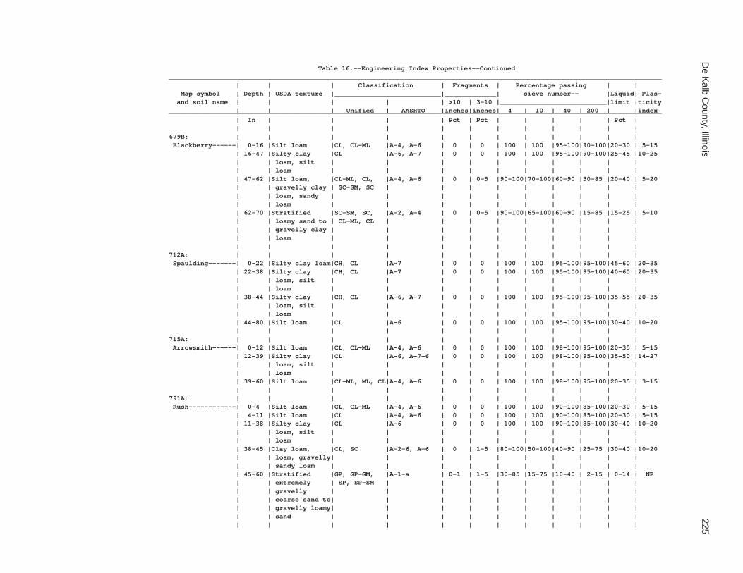
De K
alb County, Illinois
225
Table 16.--Engineering Index Properties--Continued_____________________________________________________________________________________________________________________________ | | | Classification | Fragments | Percentage passing | | Map symbol | Depth | USDA texture |___________________________|_____________| sieve number-- |Liquid| Plas- and soil name | | | | | >10 | 3-10 |___________________________|limit |ticity | | | Unified | AASHTO |inches|inches| 4 | 10 | 40 | 200 | |index_____________________________________________________________________________________________________________________________ | In | | | | Pct | Pct | | | | | Pct | | | | | | | | | | | | |679B: | | | | | | | | | | | | Blackberry------| 0-16 |Silt loam |CL, CL-ML |A-4, A-6 | 0 | 0 | 100 | 100 |95-100|90-100|20-30 | 5-15 | 16-47 |Silty clay |CL |A-6, A-7 | 0 | 0 | 100 | 100 |95-100|90-100|25-45 |10-25 | | loam, silt | | | | | | | | | | | | loam | | | | | | | | | | | 47-62 |Silt loam, |CL-ML, CL, |A-4, A-6 | 0 | 0-5 |90-100|70-100|60-90 |30-85 |20-40 | 5-20 | | gravelly clay | SC-SM, SC | | | | | | | | | | | loam, sandy | | | | | | | | | | | | loam | | | | | | | | | | | 62-70 |Stratified |SC-SM, SC, |A-2, A-4 | 0 | 0-5 |90-100|65-100|60-90 |15-85 |15-25 | 5-10 | | loamy sand to | CL-ML, CL | | | | | | | | | | | gravelly clay | | | | | | | | | | | | loam | | | | | | | | | | | | | | | | | | | | | |712A: | | | | | | | | | | | | Spaulding-------| 0-22 |Silty clay loam|CH, CL |A-7 | 0 | 0 | 100 | 100 |95-100|95-100|45-60 |20-35 | 22-38 |Silty clay |CH, CL |A-7 | 0 | 0 | 100 | 100 |95-100|95-100|40-60 |20-35 | | loam, silt | | | | | | | | | | | | loam | | | | | | | | | | | 38-44 |Silty clay |CH, CL |A-6, A-7 | 0 | 0 | 100 | 100 |95-100|95-100|35-55 |20-35 | | loam, silt | | | | | | | | | | | | loam | | | | | | | | | | | 44-80 |Silt loam |CL |A-6 | 0 | 0 | 100 | 100 |95-100|95-100|30-40 |10-20 | | | | | | | | | | | |715A: | | | | | | | | | | | | Arrowsmith------| 0-12 |Silt loam |CL, CL-ML |A-4, A-6 | 0 | 0 | 100 | 100 |98-100|95-100|20-35 | 5-15 | 12-39 |Silty clay |CL |A-6, A-7-6 | 0 | 0 | 100 | 100 |98-100|95-100|35-50 |14-27 | | loam, silt | | | | | | | | | | | | loam | | | | | | | | | | | 39-60 |Silt loam |CL-ML, ML, CL|A-4, A-6 | 0 | 0 | 100 | 100 |98-100|95-100|20-35 | 3-15 | | | | | | | | | | | |791A: | | | | | | | | | | | | Rush------------| 0-4 |Silt loam |CL, CL-ML |A-4, A-6 | 0 | 0 | 100 | 100 |90-100|85-100|20-30 | 5-15 | 4-11 |Silt loam |CL |A-4, A-6 | 0 | 0 | 100 | 100 |90-100|85-100|20-30 | 5-15 | 11-38 |Silty clay |CL |A-6 | 0 | 0 | 100 | 100 |90-100|85-100|30-40 |10-20 | | loam, silt | | | | | | | | | | | | loam | | | | | | | | | | | 38-45 |Clay loam, |CL, SC |A-2-6, A-6 | 0 | 1-5 |80-100|50-100|40-90 |25-75 |30-40 |10-20 | | loam, gravelly| | | | | | | | | | | | sandy loam | | | | | | | | | | | 45-60 |Stratified |GP, GP-GM, |A-1-a | 0-1 | 1-5 |30-85 |15-75 |10-40 | 2-15 | 0-14 | NP | | extremely | SP, SP-SM | | | | | | | | | | | gravelly | | | | | | | | | | | | coarse sand to| | | | | | | | | | | | gravelly loamy| | | | | | | | | | | | sand | | | | | | | | | | | | | | | | | | | | | |

226S
oil Survey of
Table 16.--Engineering Index Properties--Continued_____________________________________________________________________________________________________________________________ | | | Classification | Fragments | Percentage passing | | Map symbol | Depth | USDA texture |___________________________|_____________| sieve number-- |Liquid| Plas- and soil name | | | | | >10 | 3-10 |___________________________|limit |ticity | | | Unified | AASHTO |inches|inches| 4 | 10 | 40 | 200 | |index_____________________________________________________________________________________________________________________________ | In | | | | Pct | Pct | | | | | Pct | | | | | | | | | | | | |791B: | | | | | | | | | | | | Rush------------| 0-7 |Silt loam |CL, CL-ML |A-4, A-6 | 0 | 0 | 100 | 100 |90-100|85-100|20-30 | 5-15 | 7-35 |Silty clay |CL |A-6 | 0 | 0 | 100 | 100 |90-100|85-100|30-40 |10-20 | | loam, silt | | | | | | | | | | | | loam | | | | | | | | | | | 35-46 |Clay loam, |CL, SC |A-2-6, A-6 | 0 | 1-5 |80-100|50-100|40-90 |25-75 |30-40 |10-20 | | loam, gravelly| | | | | | | | | | | | sandy loam | | | | | | | | | | | 46-60 |Stratified |GP, GP-GM, |A-1-a | 0-1 | 1-5 |30-85 |15-75 |10-40 | 2-15 | 0-14 | NP | | extremely | SP, SP-SM | | | | | | | | | | | gravelly | | | | | | | | | | | | coarse sand to| | | | | | | | | | | | gravelly loamy| | | | | | | | | | | | sand | | | | | | | | | | | | | | | | | | | | | |792A: | | | | | | | | | | | | Bowes-----------| 0-9 |Silt loam |CL, CL-ML |A-4, A-6 | 0 | 0 | 100 | 100 |95-100|90-100|25-35 | 5-20 | 9-13 |Silt loam |CL |A-4, A-6 | 0 | 0 | 100 | 100 |95-100|90-100|20-30 | 5-15 | 13-43 |Silty clay loam|CL |A-6, A-7 | 0 | 0 |95-100|95-100|90-100|90-100|35-45 |15-25 | 43-51 |Gravelly clay |CL, SM, ML, |A-2, A-4, A-6| 0-2 | 0-20 |45-90 |30-80 |25-75 |15-70 | 0-30 |NP-15 | | loam, gravelly| SC | | | | | | | | | | | sandy loam, | | | | | | | | | | | | very gravelly | | | | | | | | | | | | loamy sand | | | | | | | | | | | 51-61 |Stratified |GP, GP-GM, |A-1 | 0-2 | 5-35 |30-85 |15-80 |10-50 | 2-20 | 0-20 |NP-3 | | extremely | SP, SP-SM | | | | | | | | | | | gravelly | | | | | | | | | | | | coarse sand to| | | | | | | | | | | | gravelly loamy| | | | | | | | | | | | sand | | | | | | | | | | | | | | | | | | | | | |792B: | | | | | | | | | | | | Bowes-----------| 0-7 |Silt loam |CL, CL-ML |A-4, A-6 | 0 | 0 | 100 | 100 |95-100|90-100|25-35 | 5-20 | 7-37 |Silty clay loam|CL |A-6, A-7 | 0 | 0 |95-100|95-100|90-100|90-100|35-45 |15-25 | 37-43 |Gravelly clay |CL, SM, ML, |A-2, A-4, A-6| 0-2 | 0-20 |45-90 |30-80 |25-75 |15-70 | 0-30 |NP-15 | | loam, gravelly| SC | | | | | | | | | | | sandy loam, | | | | | | | | | | | | very gravelly | | | | | | | | | | | | loamy sand | | | | | | | | | | | 43-60 |Stratified |GP, GP-GM, |A-1 | 0-2 | 5-35 |30-85 |15-80 |10-50 | 2-20 | 0-20 |NP-3 | | extremely | SP, SP-SM | | | | | | | | | | | gravelly | | | | | | | | | | | | coarse sand to| | | | | | | | | | | | gravelly loamy| | | | | | | | | | | | sand | | | | | | | | | | | | | | | | | | | | | |

De K
alb County, Illinois
227
Table 16.--Engineering Index Properties--Continued_____________________________________________________________________________________________________________________________ | | | Classification | Fragments | Percentage passing | | Map symbol | Depth | USDA texture |___________________________|_____________| sieve number-- |Liquid| Plas- and soil name | | | | | >10 | 3-10 |___________________________|limit |ticity | | | Unified | AASHTO |inches|inches| 4 | 10 | 40 | 200 | |index_____________________________________________________________________________________________________________________________ | In | | | | Pct | Pct | | | | | Pct | | | | | | | | | | | | |802B: | | | | | | | | | | | | Orthents, loamy-| 0-8 |Loam |CL |A-6 | 0-1 | 0-5 |95-100|85-100|80-95 |50-80 |20-40 |10-20 | 8-60 |Loam, silt |CL |A-6 | 0-1 | 0-5 |95-100|80-100|75-95 |50-80 |20-40 |10-20 | | loam, clay | | | | | | | | | | | | loam | | | | | | | | | | | | | | | | | | | | | |830: | | | | | | | | | | | | Landfills. | | | | | | | | | | | | | | | | | | | | | | | |865: | | | | | | | | | | | | Pits, gravel. | | | | | | | | | | | | | | | | | | | | | | | |3076A: | | | | | | | | | | | | Otter-----------| 0-27 |Silt loam |CL |A-4, A-6, A-7| 0 | 0 | 100 |95-100|90-100|85-100|25-45 | 7-20 | 27-41 |Silt loam, |CL |A-6, A-7 | 0 | 0 | 100 |95-100|90-100|75-100|30-45 |10-20 | | loam, silty | | | | | | | | | | | | clay loam | | | | | | | | | | | 41-65 |Silt loam, |CL, CL-ML, |A-4, A-6, A-7| 0 | 0 |90-100|80-100|55-95 |45-85 |25-45 | 5-20 | | sandy loam, | SC, SC-SM | | | | | | | | | | | silty clay | | | | | | | | | | | | loam | | | | | | | | | | | | | | | | | | | | | |3776A: | | | | | | | | | | | | Comfrey---------| 0-7 |Loam |CL, CL-ML |A-4, A-6 | 0 | 0 | 100 | 100 |85-100|55-90 |25-35 | 5-15 | 7-26 |Clay loam, loam|CL, ML |A-6, A-7-6 | 0 | 0 | 100 | 100 |85-100|55-85 |35-50 |10-30 | 26-63 |Clay loam, |CL |A-6, A-7-6 | 0 | 0 |90-100|80-100|70-95 |45-85 |30-45 |10-25 | | loam, sandy | | | | | | | | | | | | loam | | | | | | | | | | | | | | | | | | | | | |_____________________________________________________________________________________________________________________________

228S
oil Survey of
Table 17.--Physical Properties of the Soils
(Entries under "Erosion factors--T" apply to the entire profile. Entries under "Wind erodibility group" and "Wind erodibility index" apply only to the surface layer. Absence of an entry indicates that data were not estimated.)
______________________________________________________________________________________________________________________________________ | | | | | | | | | |Erosion factors|Wind |Wind Map symbol | Depth | Sand | Silt | Clay | Moist | Permea- |Available| Linear | Organic |_______________|erodi-|erodi- and soil name | | | | | bulk | bility | water |extensi- | matter | | | |bility|bility | | | | | density | (Ksat) |capacity | bility | | Kw | Kf | T |group |index______________________________________________________________________________________________________________________________________ | In | Pct | Pct | Pct | g/cc | In/hr | In/in | Pct | Pct | | | | | | | | | | | | | | | | | | |59A: | | | | | | | | | | | | | | Lisbon--------------| 0-11 | 0-15| 58-80| 20-27|1.10-1.30| 0.6-2.0 |0.22-0.24| 0.0-2.9 | 3.0-5.0 | .28 | .28 | 5 | 6 | 48 | 11-36 | 0-15| 50-75| 25-35|1.15-1.35| 0.6-2.0 |0.18-0.22| 3.0-5.9 | 0.5-2.0 | .37 | .37 | | | | 36-39 | 20-45| 21-53| 20-34|1.45-1.55| 0.6-2.0 |0.15-0.20| 3.0-5.9 | 0.2-0.5 | .32 | .32 | | | | 39-70 | 25-55| 25-50| 15-25|1.70-1.90| 0.2-0.6 |0.05-0.10| 0.0-2.9 | 0.2-0.5 | .37 | .37 | | | | | | | | | | | | | | | | |60C2: | | | | | | | | | | | | | | La Rose-------------| 0-7 | 20-40| 33-60| 18-27|1.10-1.35| 0.6-2.0 |0.20-0.24| 0.0-2.9 | 2.0-3.0 | .24 | .24 | 5 | 6 | 48 | 7-21 | 20-45| 20-50| 27-35|1.35-1.55| 0.6-2.0 |0.15-0.20| 3.0-5.9 | 0.0-1.0 | .32 | .32 | | | | 21-60 | 20-50| 28-65| 15-25|1.70-1.90| 0.2-0.6 |0.05-0.10| 0.0-2.9 | 0.0-0.5 | .37 | .37 | | | | | | | | | | | | | | | | |60D2: | | | | | | | | | | | | | | La Rose-------------| 0-7 | 20-40| 33-60| 18-27|1.10-1.35| 0.6-2.0 |0.20-0.24| 0.0-2.9 | 2.0-3.0 | .24 | .24 | 5 | 6 | 48 | 7-20 | 20-45| 20-50| 27-35|1.35-1.55| 0.6-2.0 |0.15-0.20| 3.0-5.9 | 0.0-1.0 | .32 | .32 | | | | 20-60 | 20-50| 28-65| 15-25|1.70-1.90| 0.2-0.6 |0.05-0.10| 0.0-2.9 | 0.0-0.5 | .37 | .37 | | | | | | | | | | | | | | | | |62A: | | | | | | | | | | | | | | Herbert-------------| 0-8 | 0-15| 58-80| 18-27|1.10-1.30| 0.6-2.0 |0.22-0.24| 0.0-2.9 | 2.0-4.0 | .37 | .37 | 5 | 6 | 48 | 8-12 | 0-15| 58-85| 15-27|1.20-1.40| 0.6-2.0 |0.21-0.23| 0.0-2.9 | 0.5-1.0 | .43 | .43 | | | | 12-26 | 0-15| 50-75| 25-35|1.20-1.40| 0.6-2.0 |0.18-0.20| 3.0-5.9 | 0.2-1.0 | .37 | .37 | | | | 26-36 | 20-45| 20-50| 22-35|1.35-1.55| 0.6-2.0 |0.15-0.20| 3.0-5.9 | 0.0-0.5 | .32 | .32 | | | | 36-60 | 25-55| 25-50| 15-25|1.70-1.90| 0.2-0.6 |0.05-0.10| 0.0-2.9 | 0.0-0.2 | .37 | .37 | | | | | | | | | | | | | | | | |67A: | | | | | | | | | | | | | | Harpster------------| 0-18 | 0-15| 50-73| 27-35|1.05-1.25| 0.6-2.0 |0.21-0.24| 3.0-5.9 | 4.0-6.0 | .24 | .24 | 5 | 4L | 86 | 18-36 | 0-15| 50-73| 27-35|1.20-1.50| 0.6-2.0 |0.18-0.22| 3.0-5.9 | 0.5-2.0 | .37 | .37 | | | | 36-41 | 0-30| 35-78| 22-35|1.25-1.55| 0.6-2.0 |0.17-0.22| 3.0-5.9 | 0.5-1.0 | .37 | .37 | | | | 41-60 | 5-55| 15-80| 15-30|1.40-1.60| 0.6-6.0 |0.11-0.22| 0.0-2.9 | 0.0-0.5 | .32 | .32 | | | | | | | | | | | | | | | | |68A: | | | | | | | | | | | | | | Sable---------------| 0-19 | 0-7 | 58-73| 27-35|1.15-1.35| 0.6-2.0 |0.21-0.23| 3.0-5.9 | 5.0-6.0 | .24 | .24 | 5 | 7 | 38 | 19-23 | 0-7 | 58-73| 27-35|1.20-1.40| 0.6-2.0 |0.18-0.20| 3.0-5.9 | 2.0-4.0 | .28 | .28 | | | | 23-47 | 0-7 | 58-76| 24-35|1.30-1.50| 0.6-2.0 |0.18-0.20| 3.0-5.9 | 0.2-1.0 | .37 | .37 | | | | 47-60 | 0-7 | 65-80| 20-28|1.30-1.50| 0.6-2.0 |0.20-0.22| 0.0-2.9 | 0.2-0.5 | .49 | .49 | | | | | | | | | | | | | | | | |103A: | | | | | | | | | | | | | | Houghton------------| 0-7 | --- | --- | --- |0.20-0.35| 0.2-6.0 |0.35-0.45| --- | 70-99 | --- | --- | 3 | 2 | 134 | 7-60 | --- | --- | --- |0.15-0.25| 0.2-6.0 |0.35-0.45| --- | 70-99 | --- | --- | | | | | | | | | | | | | | | | |

De K
alb County, Illinois
229
Table 17.--Physical Properties of the Soils--Continued______________________________________________________________________________________________________________________________________ | | | | | | | | | |Erosion factors|Wind |Wind Map symbol | Depth | Sand | Silt | Clay | Moist | Permea- |Available| Linear | Organic |_______________|erodi-|erodi- and soil name | | | | | bulk | bility | water |extensi- | matter | | | |bility|bility | | | | | density | (Ksat) |capacity | bility | | Kw | Kf | T |group |index______________________________________________________________________________________________________________________________________ | In | Pct | Pct | Pct | g/cc | In/hr | In/in | Pct | Pct | | | | | | | | | | | | | | | | | | |104A: | | | | | | | | | | | | | | Virgil--------------| 0-7 | 0-10| 63-85| 15-27|1.15-1.35| 0.6-2.0 |0.22-0.24| 0.0-2.9 | 2.0-4.0 | .37 | .37 | 5 | 6 | 48 | 7-13 | 0-10| 63-85| 15-27|1.15-1.35| 0.6-2.0 |0.22-0.24| 0.0-2.9 | 0.2-0.5 | .43 | .43 | | | | 13-49 | 0-10| 55-73| 27-35|1.35-1.55| 0.6-2.0 |0.18-0.20| 3.0-5.9 | 0.2-1.0 | .37 | .37 | | | | 49-58 | 15-60| 10-70| 15-30|1.40-1.70| 0.6-2.0 |0.11-0.19| 3.0-5.9 | 0.2-0.5 | .32 | .32 | | | | 58-60 | 20-80| 0-75| 5-30|1.45-1.75| 0.6-6.0 |0.05-0.11| 0.0-2.9 | 0.0-0.5 | .28 | .28 | | | | | | | | | | | | | | | | |148A: | | | | | | | | | | | | | | Proctor-------------| 0-11 | 0-15| 58-82| 18-27|1.10-1.30| 0.6-2.0 |0.22-0.24| 0.0-2.9 | 3.0-4.0 | .28 | .28 | 5 | 6 | 48 | 11-27 | 0-15| 50-75| 25-35|1.20-1.45| 0.6-2.0 |0.18-0.20| 3.0-5.9 | 0.5-2.0 | .37 | .37 | | | | 27-44 | 15-70| 5-67| 18-35|1.30-1.55| 0.6-2.0 |0.13-0.19| 3.0-5.9 | 0.2-1.0 | .32 | .32 | | | | 44-73 | 15-85| 0-80| 5-25|1.40-1.70| 0.6-6.0 |0.07-0.17| 0.0-2.9 | 0.0-0.5 | .28 | .28 | | | | | | | | | | | | | | | | |148B: | | | | | | | | | | | | | | Proctor-------------| 0-12 | 0-15| 58-82| 18-27|1.10-1.30| 0.6-2.0 |0.22-0.24| 0.0-2.9 | 3.0-4.0 | .28 | .28 | 5 | 6 | 48 | 12-29 | 0-15| 50-75| 25-35|1.20-1.45| 0.6-2.0 |0.18-0.20| 3.0-5.9 | 0.5-2.0 | .37 | .37 | | | | 29-48 | 15-70| 5-67| 18-35|1.30-1.55| 0.6-2.0 |0.13-0.19| 3.0-5.9 | 0.2-1.0 | .32 | .32 | | | | 48-60 | 15-85| 0-80| 5-25|1.40-1.70| 0.6-6.0 |0.07-0.17| 0.0-2.9 | 0.0-0.5 | .28 | .28 | | | | | | | | | | | | | | | | |152A: | | | | | | | | | | | | | | Drummer-------------| 0-14 | 0-15| 50-73| 27-35|1.10-1.30| 0.6-2.0 |0.21-0.23| 3.0-5.9 | 4.0-7.0 | .24 | .24 | 5 | 7 | 38 | 14-41 | 0-15| 50-80| 20-35|1.20-1.45| 0.6-2.0 |0.21-0.24| 3.0-5.9 | 0.5-2.0 | .37 | .37 | | | | 41-47 | 15-55| 12-70| 15-33|1.30-1.55| 0.6-2.0 |0.17-0.20| 3.0-5.9 | 0.2-0.5 | .32 | .32 | | | | 47-60 | 15-80| 0-75| 10-32|1.40-1.70| 0.6-6.0 |0.11-0.19| 0.0-2.9 | 0.0-0.2 | .28 | .28 | | | | | | | | | | | | | | | | |154A: | | | | | | | | | | | | | | Flanagan------------| 0-18 | 0-10| 66-85| 15-27|1.25-1.45| 0.6-2.0 |0.21-0.24| 0.0-2.9 | 3.5-5.0 | .28 | .28 | 5 | 6 | 48 | 18-38 | 0-7 | 53-65| 35-42|1.30-1.45| 0.2-0.6 |0.17-0.21| 6.0-8.9 | 0.5-1.5 | .37 | .37 | | | | 38-45 | 0-7 | 58-75| 25-35|1.30-1.45| 0.6-2.0 |0.17-0.21| 3.0-5.9 | 0.5-1.5 | .43 | .43 | | | | 45-49 | 15-35| 45-70| 20-27|1.55-1.75| 0.6-2.0 |0.10-0.17| 0.0-2.9 | 0.1-0.5 | .37 | .37 | | | | 49-60 | 30-50| 28-50| 18-27|1.65-1.90| 0.2-0.6 |0.08-0.14| 0.0-2.9 | 0.0-0.5 | .37 | .37 | | | | | | | | | | | | | | | | |171A: | | | | | | | | | | | | | | Catlin--------------| 0-11 | 0-8 | 65-82| 18-27|1.25-1.45| 0.6-2.0 |0.23-0.26| 0.0-2.9 | 2.5-4.0 | .28 | .28 | 5 | 6 | 48 | 11-44 | 0-8 | 57-76| 24-35|1.25-1.55| 0.6-2.0 |0.18-0.20| 3.0-5.9 | 0.0-1.5 | .37 | .37 | | | | 44-49 | 20-45| 20-53| 20-35|1.40-1.70| 0.6-2.0 |0.15-0.19| 3.0-5.9 | 0.0-0.5 | .32 | .32 | | | | 49-60 | 20-50| 28-50| 10-27|1.60-1.85| 0.2-0.6 |0.05-0.10| 0.0-2.9 | 0.0-0.5 | .37 | .37 | | | | | | | | | | | | | | | | |171B: | | | | | | | | | | | | | | Catlin--------------| 0-11 | 0-8 | 65-82| 18-27|1.25-1.45| 0.6-2.0 |0.23-0.26| 0.0-2.9 | 2.5-4.0 | .28 | .28 | 5 | 6 | 48 | 11-45 | 0-8 | 57-76| 24-35|1.25-1.55| 0.6-2.0 |0.18-0.20| 3.0-5.9 | 0.0-1.5 | .37 | .37 | | | | 45-57 | 20-45| 20-53| 20-35|1.40-1.70| 0.6-2.0 |0.15-0.19| 3.0-5.9 | 0.0-0.5 | .32 | .32 | | | | 57-70 | 20-50| 28-50| 10-27|1.60-1.85| 0.2-0.6 |0.05-0.10| 0.0-2.9 | 0.0-0.5 | .37 | .37 | | | | | | | | | | | | | | | | |

230S
oil Survey of
Table 17.--Physical Properties of the Soils--Continued______________________________________________________________________________________________________________________________________ | | | | | | | | | |Erosion factors|Wind |Wind Map symbol | Depth | Sand | Silt | Clay | Moist | Permea- |Available| Linear | Organic |_______________|erodi-|erodi- and soil name | | | | | bulk | bility | water |extensi- | matter | | | |bility|bility | | | | | density | (Ksat) |capacity | bility | | Kw | Kf | T |group |index______________________________________________________________________________________________________________________________________ | In | Pct | Pct | Pct | g/cc | In/hr | In/in | Pct | Pct | | | | | | | | | | | | | | | | | | |193A: | | | | | | | | | | | | | | Mayville------------| 0-8 | 2-15| 60-88| 10-25|1.35-1.55| 0.6-2.0 |0.22-0.24| 0.0-2.9 | 1.0-3.0 | .43 | .43 | 5 | 5 | 56 | 8-12 | 2-15| 60-88| 10-25|1.45-1.60| 0.6-2.0 |0.19-0.23| 0.0-2.9 | 0.5-1.0 | .49 | .49 | | | | 12-24 | 2-15| 50-73| 25-35|1.55-1.65| 0.6-2.0 |0.18-0.22| 3.0-5.9 | 0.2-0.5 | .37 | .37 | | | | 24-31 | 25-65| 5-52| 20-32|1.55-1.65| 0.6-2.0 |0.15-0.19| 3.0-5.9 | 0.0-0.5 | .32 | .32 | | | | 31-60 | 30-70| 5-50| 10-25|1.70-1.90| 0.2-0.6 |0.05-0.10| 0.0-2.9 | 0.0-0.5 | .37 | .37 | | | | | | | | | | | | | | | | |193B: | | | | | | | | | | | | | | Mayville------------| 0-6 | 2-15| 60-88| 10-25|1.35-1.55| 0.6-2.0 |0.22-0.24| 0.0-2.9 | 1.0-3.0 | .43 | .43 | 5 | 5 | 56 | 6-8 | 2-15| 60-88| 10-25|1.45-1.60| 0.6-2.0 |0.19-0.23| 0.0-2.9 | 0.5-1.0 | .49 | .49 | | | | 8-28 | 2-15| 50-73| 25-35|1.55-1.65| 0.6-2.0 |0.18-0.22| 3.0-5.9 | 0.2-0.5 | .37 | .37 | | | | 28-32 | 25-65| 5-52| 20-32|1.55-1.65| 0.6-2.0 |0.15-0.19| 3.0-5.9 | 0.0-0.5 | .32 | .32 | | | | 32-60 | 30-70| 5-50| 10-25|1.70-1.90| 0.2-0.6 |0.05-0.10| 0.0-2.9 | 0.0-0.5 | .37 | .37 | | | | | | | | | | | | | | | | |193C2: | | | | | | | | | | | | | | Mayville------------| 0-6 | 2-15| 60-88| 10-25|1.35-1.55| 0.6-2.0 |0.22-0.24| 0.0-2.9 | 1.0-2.0 | .43 | .43 | 5 | 5 | 56 | 6-24 | 2-15| 50-73| 25-35|1.55-1.65| 0.6-2.0 |0.18-0.22| 3.0-5.9 | 0.2-0.5 | .37 | .37 | | | | 24-34 | 25-65| 5-52| 20-32|1.55-1.65| 0.6-2.0 |0.15-0.19| 3.0-5.9 | 0.0-0.5 | .32 | .32 | | | | 34-60 | 30-70| 5-50| 10-25|1.70-1.90| 0.2-0.6 |0.05-0.10| 0.0-2.9 | 0.0-0.5 | .37 | .37 | | | | | | | | | | | | | | | | |198A: | | | | | | | | | | | | | | Elburn--------------| 0-13 | 0-10| 63-78| 22-27|1.10-1.30| 0.6-2.0 |0.22-0.24| 0.0-2.9 | 4.0-5.0 | .28 | .28 | 5 | 6 | 48 | 13-44 | 0-10| 55-75| 25-35|1.20-1.40| 0.6-2.0 |0.18-0.20| 3.0-5.9 | 0.5-2.0 | .37 | .37 | | | | 44-65 | 15-70| 0-70| 15-30|1.50-1.70| 0.6-2.0 |0.12-0.18| 3.0-5.9 | 0.0-0.2 | .32 | .32 | | | | 65-80 | 15-80| 5-83| 2-15|1.50-1.75| 0.6-6.0 |0.06-0.10| 0.0-2.9 | 0.0-0.2 | .28 | .28 | | | | | | | | | | | | | | | | |206A: | | | | | | | | | | | | | | Thorp---------------| 0-14 | 0-10| 63-80| 20-27|1.15-1.35| 0.6-2.0 |0.22-0.24| 0.0-2.9 | 4.0-6.0 | .28 | .28 | 5 | 6 | 48 | 14-19 | 0-10| 65-82| 18-25|1.30-1.50| 0.2-0.6 |0.20-0.22| 0.0-2.9 | 0.2-1.0 | .43 | .43 | | | | 19-43 | 0-10| 55-78| 22-35|1.35-1.55| 0.06-0.2 |0.18-0.20| 3.0-5.9 | 0.2-1.0 | .37 | .37 | | | | 43-50 | 10-55| 15-72| 18-30|1.40-1.60| 0.6-2.0 |0.10-0.20| 3.0-5.9 | 0.2-0.5 | .32 | .32 | | | | 50-65 | 15-80| 0-80| 5-30|1.50-1.70| 0.6-6.0 |0.05-0.13| 0.0-2.9 | 0.0-0.1 | .28 | .28 | | | | | | | | | | | | | | | | |219A: | | | | | | | | | | | | | | Millbrook-----------| 0-8 | 0-15| 58-82| 18-27|1.40-1.60| 0.6-2.0 |0.22-0.24| 0.0-2.9 | 2.0-4.0 | .37 | .37 | 5 | 6 | 48 | 8-12 | 0-15| 58-85| 15-27|1.40-1.60| 0.6-2.0 |0.22-0.24| 0.0-2.9 | 0.5-1.0 | .43 | .43 | | | | 12-26 | 0-15| 50-75| 25-35|1.45-1.65| 0.6-2.0 |0.18-0.20| 3.0-5.9 | 0.0-1.0 | .37 | .37 | | | | 26-41 | 15-60| 8-67| 18-32|1.45-1.70| 0.6-2.0 |0.12-0.19| 3.0-5.9 | 0.0-0.5 | .32 | .32 | | | | 41-65 | 20-85| 0-70| 10-30|1.50-1.75| 0.6-6.0 |0.11-0.19| 0.0-2.9 | 0.0-0.5 | .28 | .28 | | | | | | | | | | | | | | | | |221B2: | | | | | | | | | | | | | | Parr----------------| 0-9 | 5-35| 50-80| 12-25|1.30-1.45| 0.6-2.0 |0.20-0.24| 0.0-2.9 | 2.0-3.0 | .24 | .24 | 5 | 5 | 56 | 9-28 | 10-50| 20-65| 22-35|1.40-1.55| 0.6-2.0 |0.15-0.19| 3.0-5.9 | 0.2-0.5 | .32 | .32 | | | | 28-36 | 30-50| 25-50| 20-25|1.55-1.65| 0.6-2.0 |0.15-0.19| 0.0-2.9 | 0.0-0.5 | .32 | .32 | | | | 36-60 | 35-50| 30-50| 10-20|1.70-1.90| 0.2-0.6 |0.05-0.10| 0.0-2.9 | 0.0-0.2 | .37 | .37 | | | | | | | | | | | | | | | | |

De K
alb County, Illinois
231
Table 17.--Physical Properties of the Soils--Continued______________________________________________________________________________________________________________________________________ | | | | | | | | | |Erosion factors|Wind |Wind Map symbol | Depth | Sand | Silt | Clay | Moist | Permea- |Available| Linear | Organic |_______________|erodi-|erodi- and soil name | | | | | bulk | bility | water |extensi- | matter | | | |bility|bility | | | | | density | (Ksat) |capacity | bility | | Kw | Kf | T |group |index______________________________________________________________________________________________________________________________________ | In | Pct | Pct | Pct | g/cc | In/hr | In/in | Pct | Pct | | | | | | | | | | | | | | | | | | |221C2: | | | | | | | | | | | | | | Parr----------------| 0-9 | 5-35| 50-80| 12-25|1.30-1.45| 0.6-2.0 |0.20-0.24| 0.0-2.9 | 2.0-3.0 | .24 | .24 | 5 | 5 | 56 | 9-29 | 10-50| 20-65| 22-35|1.40-1.55| 0.6-2.0 |0.15-0.19| 3.0-5.9 | 0.2-0.5 | .32 | .32 | | | | 29-33 | 30-50| 25-50| 20-25|1.55-1.65| 0.6-2.0 |0.15-0.19| 0.0-2.9 | 0.0-0.5 | .32 | .32 | | | | 33-60 | 35-50| 30-50| 10-20|1.70-1.90| 0.2-0.6 |0.05-0.10| 0.0-2.9 | 0.0-0.2 | .37 | .37 | | | | | | | | | | | | | | | | |233A: | | | | | | | | | | | | | | Birkbeck------------| 0-8 | 0-10| 63-85| 15-27|1.20-1.40| 0.6-2.0 |0.21-0.29| 0.0-2.9 | 1.5-4.5 | .43 | .43 | 5 | 6 | 48 | 8-11 | 0-10| 63-85| 15-27|1.35-1.55| 0.6-2.0 |0.17-0.22| 0.0-2.9 | 0.1-1.5 | .49 | .49 | | | | 11-46 | 0-10| 55-74| 26-35|1.35-1.45| 0.6-2.0 |0.16-0.20| 3.0-5.9 | 0.1-1.0 | .37 | .37 | | | | 46-56 | 20-40| 33-60| 20-27|1.45-1.55| 0.6-2.0 |0.11-0.16| 0.0-2.9 | 0.1-0.5 | .32 | .32 | | | | 56-60 | 30-40| 33-53| 17-27|1.60-1.85| 0.2-0.6 |0.10-0.15| 0.0-2.9 | 0.0-0.5 | .37 | .37 | | | | | | | | | | | | | | | | |233B: | | | | | | | | | | | | | | Birkbeck------------| 0-4 | 0-10| 63-85| 15-27|1.20-1.40| 0.6-2.0 |0.21-0.29| 0.0-2.9 | 1.5-4.5 | .43 | .43 | 5 | 6 | 48 | 4-9 | 0-10| 63-85| 15-27|1.35-1.55| 0.6-2.0 |0.17-0.22| 0.0-2.9 | 0.1-1.5 | .49 | .49 | | | | 9-54 | 0-10| 55-74| 26-35|1.35-1.45| 0.6-2.0 |0.16-0.20| 3.0-5.9 | 0.1-1.0 | .37 | .37 | | | | 54-60 | 20-40| 33-60| 20-27|1.45-1.55| 0.6-2.0 |0.11-0.16| 0.0-2.9 | 0.1-0.5 | .32 | .32 | | | | 60-68 | 30-40| 33-53| 17-27|1.60-1.85| 0.2-0.6 |0.10-0.15| 0.0-2.9 | 0.0-0.5 | .37 | .37 | | | | | | | | | | | | | | | | |236A: | | | | | | | | | | | | | | Sabina--------------| 0-6 | 0-10| 63-80| 20-27|1.25-1.55| 0.6-2.0 |0.22-0.24| 0.0-2.9 | 1.0-3.0 | .43 | .43 | 5 | 6 | 48 | 6-8 | 0-10| 65-82| 18-25|1.35-1.55| 0.6-2.0 |0.20-0.22| 0.0-2.9 | 0.1-1.0 | .49 | .49 | | | | 8-40 | 0-10| 48-65| 35-42|1.35-1.55| 0.2-0.6 |0.15-0.19| 6.0-8.9 | 0.0-1.0 | .37 | .37 | | | | 40-47 | 15-35| 30-65| 20-35|1.50-1.75| 0.6-2.0 |0.14-0.17| 3.0-5.9 | 0.0-0.5 | .32 | .32 | | | | 47-80 | 20-40| 28-70| 15-32|1.60-1.85| 0.2-0.6 |0.05-0.10| 3.0-5.9 | 0.0-0.5 | .37 | .37 | | | | | | | | | | | | | | | | |318D2: | | | | | | | | | | | | | | Lorenzo-------------| 0-8 | 20-40| 33-55| 18-27|1.25-1.40| 0.6-2.0 |0.20-0.22| 0.0-2.9 | 2.0-3.0 | .24 | .24 | 3 | 6 | 48 | 8-18 | 30-80| 5-50| 20-35|1.60-1.70| 2.0-6.0 |0.10-0.19| 3.0-5.9 | 0.0-1.0 | .28 | .32 | | | | 18-60 | 85-99| 0-14| 1-5 |1.60-1.80| 20-100 |0.02-0.04| 0.0-2.9 | 0.0-0.5 | .02 | .05 | | | | | | | | | | | | | | | | |325A: | | | | | | | | | | | | | | Dresden-------------| 0-9 | 2-30| 50-80| 18-27|1.25-1.40| 0.6-2.0 |0.20-0.24| 0.0-2.9 | 2.0-4.0 | .28 | .28 | 4 | 6 | 48 | 9-29 | 5-50| 20-70| 25-35|1.35-1.55| 0.6-2.0 |0.15-0.20| 3.0-5.9 | 0.2-1.0 | .32 | .32 | | | | 29-33 | 30-70| 5-50| 20-30|1.45-1.70| 0.6-2.0 |0.08-0.18| 3.0-5.9 | 0.0-0.5 | .28 | .32 | | | | 33-60 | 80-99| 0-19| 1-5 |1.60-1.70| 20-100 |0.02-0.04| 0.0-2.9 | 0.0-0.5 | .02 | .05 | | | | | | | | | | | | | | | | |325B: | | | | | | | | | | | | | | Dresden-------------| 0-7 | 2-30| 50-80| 18-27|1.25-1.40| 0.6-2.0 |0.20-0.24| 0.0-2.9 | 2.0-4.0 | .28 | .28 | 4 | 6 | 48 | 7-27 | 5-50| 20-70| 25-35|1.35-1.55| 0.6-2.0 |0.15-0.20| 3.0-5.9 | 0.2-1.0 | .32 | .32 | | | | 27-32 | 30-70| 5-50| 20-30|1.45-1.70| 0.6-2.0 |0.08-0.18| 3.0-5.9 | 0.0-0.5 | .28 | .32 | | | | 32-60 | 80-99| 0-19| 1-5 |1.60-1.70| 20-100 |0.02-0.04| 0.0-2.9 | 0.0-0.5 | .02 | .05 | | | | | | | | | | | | | | | | |

232S
oil Survey of
Table 17.--Physical Properties of the Soils--Continued______________________________________________________________________________________________________________________________________ | | | | | | | | | |Erosion factors|Wind |Wind Map symbol | Depth | Sand | Silt | Clay | Moist | Permea- |Available| Linear | Organic |_______________|erodi-|erodi- and soil name | | | | | bulk | bility | water |extensi- | matter | | | |bility|bility | | | | | density | (Ksat) |capacity | bility | | Kw | Kf | T |group |index______________________________________________________________________________________________________________________________________ | In | Pct | Pct | Pct | g/cc | In/hr | In/in | Pct | Pct | | | | | | | | | | | | | | | | | | |325C2: | | | | | | | | | | | | | | Dresden-------------| 0-7 | 2-30| 50-80| 18-27|1.25-1.40| 0.6-2.0 |0.20-0.24| 0.0-2.9 | 2.0-3.0 | .28 | .28 | 4 | 6 | 48 | 7-26 | 5-50| 20-70| 25-35|1.35-1.55| 0.6-2.0 |0.15-0.20| 3.0-5.9 | 0.2-1.0 | .32 | .32 | | | | 26-30 | 30-70| 5-50| 20-30|1.45-1.70| 0.6-2.0 |0.08-0.18| 3.0-5.9 | 0.0-0.5 | .28 | .32 | | | | 30-60 | 80-99| 0-19| 1-5 |1.60-1.70| 20-100 |0.02-0.04| 0.0-2.9 | 0.0-0.5 | .02 | .05 | | | | | | | | | | | | | | | | |327B: | | | | | | | | | | | | | | Fox-----------------| 0-7 | 5-30| 50-85| 10-22|1.35-1.55| 0.6-2.0 |0.17-0.24| 0.0-2.9 | 1.0-3.0 | .32 | .32 | 4 | 5 | 56 | 7-11 | 5-30| 50-77| 18-35|1.55-1.65| 0.6-2.0 |0.10-0.22| 3.0-5.9 | 0.2-0.5 | .32 | .32 | | | | 11-32 | 20-75| 5-50| 18-35|1.55-1.65| 0.6-2.0 |0.10-0.19| 3.0-5.9 | 0.0-0.5 | .28 | .32 | | | | 32-60 | 90-98| 0-10| 0-2 |1.30-1.70| 20-100 |0.02-0.07| 0.0-2.9 | 0.0-0.5 | .02 | .05 | | | | | | | | | | | | | | | | |330A: | | | | | | | | | | | | | | Peotone-------------| 0-13 | 0-10| 50-67| 33-40|1.20-1.40| 0.2-0.6 |0.21-0.23| 6.0-8.9 | 5.0-7.0 | .24 | .24 | 5 | 4 | 86 | 13-50 | 0-10| 45-65| 35-45|1.30-1.60| 0.2-0.6 |0.11-0.20| 6.0-8.9 | 0.5-3.0 | .37 | .37 | | | | 50-60 | 0-20| 38-75| 25-42|1.40-1.65| 0.2-0.6 |0.18-0.20| 6.0-8.9 | 0.2-0.5 | .43 | .43 | | | | | | | | | | | | | | | | |344B: | | | | | | | | | | | | | | Harvard-------------| 0-9 | 0-15| 58-80| 20-27|1.15-1.35| 0.6-2.0 |0.22-0.24| 0.0-2.9 | 2.0-4.0 | .37 | .37 | 5 | 6 | 48 | 9-30 | 0-15| 50-75| 25-35|1.25-1.55| 0.6-2.0 |0.15-0.20| 3.0-5.9 | 0.2-1.0 | .37 | .37 | | | | 30-56 | 15-60| 10-70| 15-35|1.30-1.60| 0.6-2.0 |0.12-0.19| 3.0-5.9 | 0.0-0.5 | .32 | .32 | | | | 56-69 | 30-87| 0-65| 5-30|1.40-1.70| 0.6-6.0 |0.05-0.15| 0.0-2.9 | 0.0-0.5 | .28 | .28 | | | | | | | | | | | | | | | | |348A: | | | | | | | | | | | | | | Wingate-------------| 0-9 | 0-15| 58-85| 15-27|1.30-1.40| 0.6-2.0 |0.22-0.24| 0.0-2.9 | 2.0-4.0 | .37 | .37 | 5 | 6 | 48 | 9-12 | 0-15| 58-85| 15-27|1.20-1.45| 0.6-2.0 |0.21-0.23| 0.0-2.9 | 0.5-2.0 | .43 | .43 | | | | 12-30 | 0-15| 50-76| 24-35|1.40-1.55| 0.6-2.0 |0.18-0.22| 3.0-5.9 | 0.5-2.0 | .37 | .37 | | | | 30-47 | 20-50| 20-60| 20-30|1.40-1.60| 0.6-2.0 |0.12-0.19| 3.0-5.9 | 0.2-0.5 | .32 | .32 | | | | 47-60 | 25-50| 23-60| 15-27|1.60-1.85| 0.2-0.6 |0.05-0.10| 0.0-2.9 | 0.0-0.5 | .37 | .37 | | | | | | | | | | | | | | | | |348B: | | | | | | | | | | | | | | Wingate-------------| 0-9 | 0-15| 58-85| 15-27|1.30-1.40| 0.6-2.0 |0.22-0.24| 0.0-2.9 | 2.0-4.0 | .37 | .37 | 5 | 6 | 48 | 9-12 | 0-15| 58-85| 15-27|1.20-1.45| 0.6-2.0 |0.21-0.23| 0.0-2.9 | 0.5-2.0 | .43 | .43 | | | | 12-27 | 0-15| 50-76| 24-35|1.40-1.55| 0.6-2.0 |0.18-0.22| 3.0-5.9 | 0.5-2.0 | .37 | .37 | | | | 27-52 | 20-50| 20-60| 20-30|1.40-1.60| 0.6-2.0 |0.12-0.19| 3.0-5.9 | 0.2-0.5 | .32 | .32 | | | | 52-60 | 25-50| 23-60| 15-27|1.60-1.85| 0.2-0.6 |0.05-0.10| 0.0-2.9 | 0.0-0.5 | .37 | .37 | | | | | | | | | | | | | | | | |348C2: | | | | | | | | | | | | | | Wingate-------------| 0-7 | 0-15| 58-85| 15-27|1.30-1.40| 0.6-2.0 |0.22-0.24| 0.0-2.9 | 2.0-3.0 | .37 | .37 | 5 | 6 | 48 | 7-25 | 0-15| 50-76| 24-35|1.40-1.55| 0.6-2.0 |0.18-0.22| 3.0-5.9 | 0.5-2.0 | .37 | .37 | | | | 25-46 | 20-50| 20-60| 20-30|1.40-1.60| 0.6-2.0 |0.12-0.19| 3.0-5.9 | 0.2-0.5 | .32 | .32 | | | | 46-60 | 25-50| 23-60| 15-27|1.60-1.85| 0.2-0.6 |0.05-0.10| 0.0-2.9 | 0.0-0.5 | .37 | .37 | | | | | | | | | | | | | | | | |

De K
alb County, Illinois
233
Table 17.--Physical Properties of the Soils--Continued______________________________________________________________________________________________________________________________________ | | | | | | | | | |Erosion factors|Wind |Wind Map symbol | Depth | Sand | Silt | Clay | Moist | Permea- |Available| Linear | Organic |_______________|erodi-|erodi- and soil name | | | | | bulk | bility | water |extensi- | matter | | | |bility|bility | | | | | density | (Ksat) |capacity | bility | | Kw | Kf | T |group |index______________________________________________________________________________________________________________________________________ | In | Pct | Pct | Pct | g/cc | In/hr | In/in | Pct | Pct | | | | | | | | | | | | | | | | | | |356A: | | | | | | | | | | | | | | Elpaso--------------| 0-21 | 1-10| 55-72| 27-35|1.15-1.35| 0.6-2.0 |0.21-0.23| 3.0-5.9 | 5.0-7.0 | .24 | .24 | 5 | 7 | 38 | 21-44 | 1-10| 50-75| 24-40|1.20-1.40| 0.6-2.0 |0.22-0.24| 3.0-5.9 | 0.2-2.0 | .37 | .37 | | | | 44-69 | 2-30| 30-83| 15-40|1.35-1.60| 0.6-2.0 |0.18-0.22| 3.0-5.9 | 0.2-0.5 | .32 | .32 | | | | 69-80 | 2-30| 40-83| 15-30|1.60-1.85| 0.2-0.6 |0.05-0.15| 3.0-5.9 | 0.2-0.5 | .37 | .37 | | | | | | | | | | | | | | | | |488A: | | | | | | | | | | | | | | Hooppole------------| 0-17 | 20-45| 28-50| 20-27|1.40-1.60| 0.6-2.0 |0.20-0.24| 0.0-2.9 | 4.0-7.0 | .24 | .24 | 4 | 4L | 86 | 17-44 | 20-40| 25-55| 25-35|1.35-1.50| 0.6-2.0 |0.15-0.19| 3.0-5.9 | 0.5-2.0 | .32 | .32 | | | | 44-60 | 75-95| 0-23| 2-12|1.65-1.80| 6.0-20 |0.05-0.10| 0.0-2.9 | 0.0-0.5 | .05 | .05 | | | | | | | | | | | | | | | | |512A: | | | | | | | | | | | | | | Danabrook-----------| 0-19 | 0-15| 58-82| 18-27|1.20-1.40| 0.6-2.0 |0.22-0.24| 0.0-2.9 | 4.0-5.0 | .28 | .28 | 5 | 6 | 48 | 19-34 | 0-15| 50-76| 24-35|1.30-1.50| 0.6-2.0 |0.18-0.20| 3.0-5.9 | 0.5-2.0 | .37 | .37 | | | | 34-53 | 25-50| 10-50| 20-34|1.40-1.60| 0.6-2.0 |0.15-0.19| 3.0-5.9 | 0.2-0.5 | .32 | .32 | | | | 53-60 | 35-60| 20-45| 15-20|1.70-1.90| 0.2-0.6 |0.05-0.10| 0.0-2.9 | 0.2-0.5 | .37 | .37 | | | | | | | | | | | | | | | | |512B: | | | | | | | | | | | | | | Danabrook-----------| 0-13 | 0-15| 58-82| 18-27|1.20-1.40| 0.6-2.0 |0.22-0.24| 0.0-2.9 | 4.0-5.0 | .28 | .28 | 5 | 6 | 48 | 13-33 | 0-15| 50-76| 24-35|1.30-1.50| 0.6-2.0 |0.18-0.20| 3.0-5.9 | 0.5-2.0 | .37 | .37 | | | | 33-50 | 25-50| 10-50| 20-34|1.40-1.60| 0.6-2.0 |0.15-0.19| 3.0-5.9 | 0.2-0.5 | .32 | .32 | | | | 50-60 | 35-60| 20-45| 15-20|1.70-1.90| 0.2-0.6 |0.05-0.10| 0.0-2.9 | 0.2-0.5 | .37 | .37 | | | | | | | | | | | | | | | | |512C2: | | | | | | | | | | | | | | Danabrook-----------| 0-8 | 0-15| 58-82| 18-27|1.20-1.40| 0.6-2.0 |0.22-0.24| 0.0-2.9 | 3.0-4.0 | .28 | .28 | 5 | 6 | 48 | 8-27 | 0-15| 50-76| 24-35|1.30-1.50| 0.6-2.0 |0.18-0.20| 3.0-5.9 | 0.5-2.0 | .37 | .37 | | | | 27-40 | 25-50| 10-50| 20-34|1.40-1.60| 0.6-2.0 |0.15-0.19| 3.0-5.9 | 0.2-0.5 | .32 | .32 | | | | 40-65 | 35-60| 20-45| 15-20|1.70-1.90| 0.2-0.6 |0.05-0.10| 0.0-2.9 | 0.2-0.5 | .37 | .37 | | | | | | | | | | | | | | | | |527B: | | | | | | | | | | | | | | Kidami--------------| 0-3 | 10-30| 50-80| 10-24|1.30-1.45| 0.6-2.0 |0.20-0.24| 0.0-2.9 | 1.0-3.0 | .32 | .32 | 5 | 5 | 56 | 3-10 | 10-45| 31-80| 10-24|1.35-1.50| 0.6-2.0 |0.20-0.23| 0.0-2.9 | 0.5-1.0 | .37 | .37 | | | | 10-37 | 15-45| 21-65| 20-34|1.40-1.60| 0.6-2.0 |0.15-0.19| 3.0-5.9 | 0.2-1.0 | .32 | .32 | | | | 37-45 | 30-45| 28-53| 17-27|1.45-1.65| 0.6-2.0 |0.15-0.19| 0.0-2.9 | 0.0-0.5 | .32 | .32 | | | | 45-60 | 35-60| 20-50| 15-20|1.70-1.90| 0.2-0.6 |0.05-0.10| 0.0-2.9 | 0.0-0.5 | .37 | .37 | | | | | | | | | | | | | | | | |527C2: | | | | | | | | | | | | | | Kidami--------------| 0-9 | 20-45| 31-55| 10-24|1.30-1.45| 0.6-2.0 |0.20-0.24| 0.0-2.9 | 1.0-2.0 | .32 | .32 | 5 | 5 | 56 | 9-30 | 25-45| 21-55| 20-34|1.40-1.60| 0.6-2.0 |0.15-0.19| 3.0-5.9 | 0.2-1.0 | .32 | .32 | | | | 30-40 | 30-45| 28-53| 17-27|1.45-1.65| 0.6-2.0 |0.15-0.19| 0.0-2.9 | 0.0-0.5 | .32 | .32 | | | | 40-60 | 35-60| 20-50| 15-20|1.70-1.90| 0.2-0.6 |0.05-0.10| 0.0-2.9 | 0.0-0.5 | .37 | .37 | | | | | | | | | | | | | | | | |
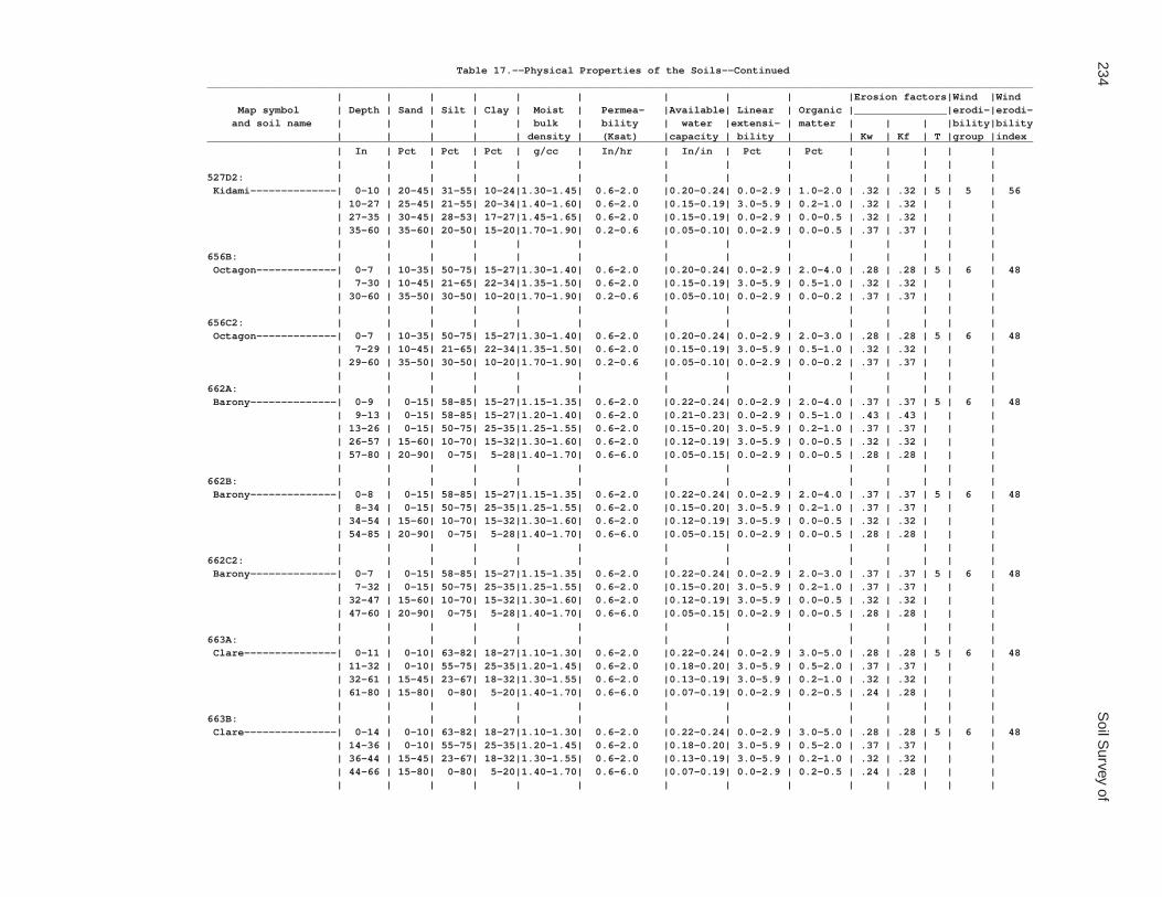
234S
oil Survey of
Table 17.--Physical Properties of the Soils--Continued______________________________________________________________________________________________________________________________________ | | | | | | | | | |Erosion factors|Wind |Wind Map symbol | Depth | Sand | Silt | Clay | Moist | Permea- |Available| Linear | Organic |_______________|erodi-|erodi- and soil name | | | | | bulk | bility | water |extensi- | matter | | | |bility|bility | | | | | density | (Ksat) |capacity | bility | | Kw | Kf | T |group |index______________________________________________________________________________________________________________________________________ | In | Pct | Pct | Pct | g/cc | In/hr | In/in | Pct | Pct | | | | | | | | | | | | | | | | | | |527D2: | | | | | | | | | | | | | | Kidami--------------| 0-10 | 20-45| 31-55| 10-24|1.30-1.45| 0.6-2.0 |0.20-0.24| 0.0-2.9 | 1.0-2.0 | .32 | .32 | 5 | 5 | 56 | 10-27 | 25-45| 21-55| 20-34|1.40-1.60| 0.6-2.0 |0.15-0.19| 3.0-5.9 | 0.2-1.0 | .32 | .32 | | | | 27-35 | 30-45| 28-53| 17-27|1.45-1.65| 0.6-2.0 |0.15-0.19| 0.0-2.9 | 0.0-0.5 | .32 | .32 | | | | 35-60 | 35-60| 20-50| 15-20|1.70-1.90| 0.2-0.6 |0.05-0.10| 0.0-2.9 | 0.0-0.5 | .37 | .37 | | | | | | | | | | | | | | | | |656B: | | | | | | | | | | | | | | Octagon-------------| 0-7 | 10-35| 50-75| 15-27|1.30-1.40| 0.6-2.0 |0.20-0.24| 0.0-2.9 | 2.0-4.0 | .28 | .28 | 5 | 6 | 48 | 7-30 | 10-45| 21-65| 22-34|1.35-1.50| 0.6-2.0 |0.15-0.19| 3.0-5.9 | 0.5-1.0 | .32 | .32 | | | | 30-60 | 35-50| 30-50| 10-20|1.70-1.90| 0.2-0.6 |0.05-0.10| 0.0-2.9 | 0.0-0.2 | .37 | .37 | | | | | | | | | | | | | | | | |656C2: | | | | | | | | | | | | | | Octagon-------------| 0-7 | 10-35| 50-75| 15-27|1.30-1.40| 0.6-2.0 |0.20-0.24| 0.0-2.9 | 2.0-3.0 | .28 | .28 | 5 | 6 | 48 | 7-29 | 10-45| 21-65| 22-34|1.35-1.50| 0.6-2.0 |0.15-0.19| 3.0-5.9 | 0.5-1.0 | .32 | .32 | | | | 29-60 | 35-50| 30-50| 10-20|1.70-1.90| 0.2-0.6 |0.05-0.10| 0.0-2.9 | 0.0-0.2 | .37 | .37 | | | | | | | | | | | | | | | | |662A: | | | | | | | | | | | | | | Barony--------------| 0-9 | 0-15| 58-85| 15-27|1.15-1.35| 0.6-2.0 |0.22-0.24| 0.0-2.9 | 2.0-4.0 | .37 | .37 | 5 | 6 | 48 | 9-13 | 0-15| 58-85| 15-27|1.20-1.40| 0.6-2.0 |0.21-0.23| 0.0-2.9 | 0.5-1.0 | .43 | .43 | | | | 13-26 | 0-15| 50-75| 25-35|1.25-1.55| 0.6-2.0 |0.15-0.20| 3.0-5.9 | 0.2-1.0 | .37 | .37 | | | | 26-57 | 15-60| 10-70| 15-32|1.30-1.60| 0.6-2.0 |0.12-0.19| 3.0-5.9 | 0.0-0.5 | .32 | .32 | | | | 57-80 | 20-90| 0-75| 5-28|1.40-1.70| 0.6-6.0 |0.05-0.15| 0.0-2.9 | 0.0-0.5 | .28 | .28 | | | | | | | | | | | | | | | | |662B: | | | | | | | | | | | | | | Barony--------------| 0-8 | 0-15| 58-85| 15-27|1.15-1.35| 0.6-2.0 |0.22-0.24| 0.0-2.9 | 2.0-4.0 | .37 | .37 | 5 | 6 | 48 | 8-34 | 0-15| 50-75| 25-35|1.25-1.55| 0.6-2.0 |0.15-0.20| 3.0-5.9 | 0.2-1.0 | .37 | .37 | | | | 34-54 | 15-60| 10-70| 15-32|1.30-1.60| 0.6-2.0 |0.12-0.19| 3.0-5.9 | 0.0-0.5 | .32 | .32 | | | | 54-85 | 20-90| 0-75| 5-28|1.40-1.70| 0.6-6.0 |0.05-0.15| 0.0-2.9 | 0.0-0.5 | .28 | .28 | | | | | | | | | | | | | | | | |662C2: | | | | | | | | | | | | | | Barony--------------| 0-7 | 0-15| 58-85| 15-27|1.15-1.35| 0.6-2.0 |0.22-0.24| 0.0-2.9 | 2.0-3.0 | .37 | .37 | 5 | 6 | 48 | 7-32 | 0-15| 50-75| 25-35|1.25-1.55| 0.6-2.0 |0.15-0.20| 3.0-5.9 | 0.2-1.0 | .37 | .37 | | | | 32-47 | 15-60| 10-70| 15-32|1.30-1.60| 0.6-2.0 |0.12-0.19| 3.0-5.9 | 0.0-0.5 | .32 | .32 | | | | 47-60 | 20-90| 0-75| 5-28|1.40-1.70| 0.6-6.0 |0.05-0.15| 0.0-2.9 | 0.0-0.5 | .28 | .28 | | | | | | | | | | | | | | | | |663A: | | | | | | | | | | | | | | Clare---------------| 0-11 | 0-10| 63-82| 18-27|1.10-1.30| 0.6-2.0 |0.22-0.24| 0.0-2.9 | 3.0-5.0 | .28 | .28 | 5 | 6 | 48 | 11-32 | 0-10| 55-75| 25-35|1.20-1.45| 0.6-2.0 |0.18-0.20| 3.0-5.9 | 0.5-2.0 | .37 | .37 | | | | 32-61 | 15-45| 23-67| 18-32|1.30-1.55| 0.6-2.0 |0.13-0.19| 3.0-5.9 | 0.2-1.0 | .32 | .32 | | | | 61-80 | 15-80| 0-80| 5-20|1.40-1.70| 0.6-6.0 |0.07-0.19| 0.0-2.9 | 0.2-0.5 | .24 | .28 | | | | | | | | | | | | | | | | |663B: | | | | | | | | | | | | | | Clare---------------| 0-14 | 0-10| 63-82| 18-27|1.10-1.30| 0.6-2.0 |0.22-0.24| 0.0-2.9 | 3.0-5.0 | .28 | .28 | 5 | 6 | 48 | 14-36 | 0-10| 55-75| 25-35|1.20-1.45| 0.6-2.0 |0.18-0.20| 3.0-5.9 | 0.5-2.0 | .37 | .37 | | | | 36-44 | 15-45| 23-67| 18-32|1.30-1.55| 0.6-2.0 |0.13-0.19| 3.0-5.9 | 0.2-1.0 | .32 | .32 | | | | 44-66 | 15-80| 0-80| 5-20|1.40-1.70| 0.6-6.0 |0.07-0.19| 0.0-2.9 | 0.2-0.5 | .24 | .28 | | | | | | | | | | | | | | | | |
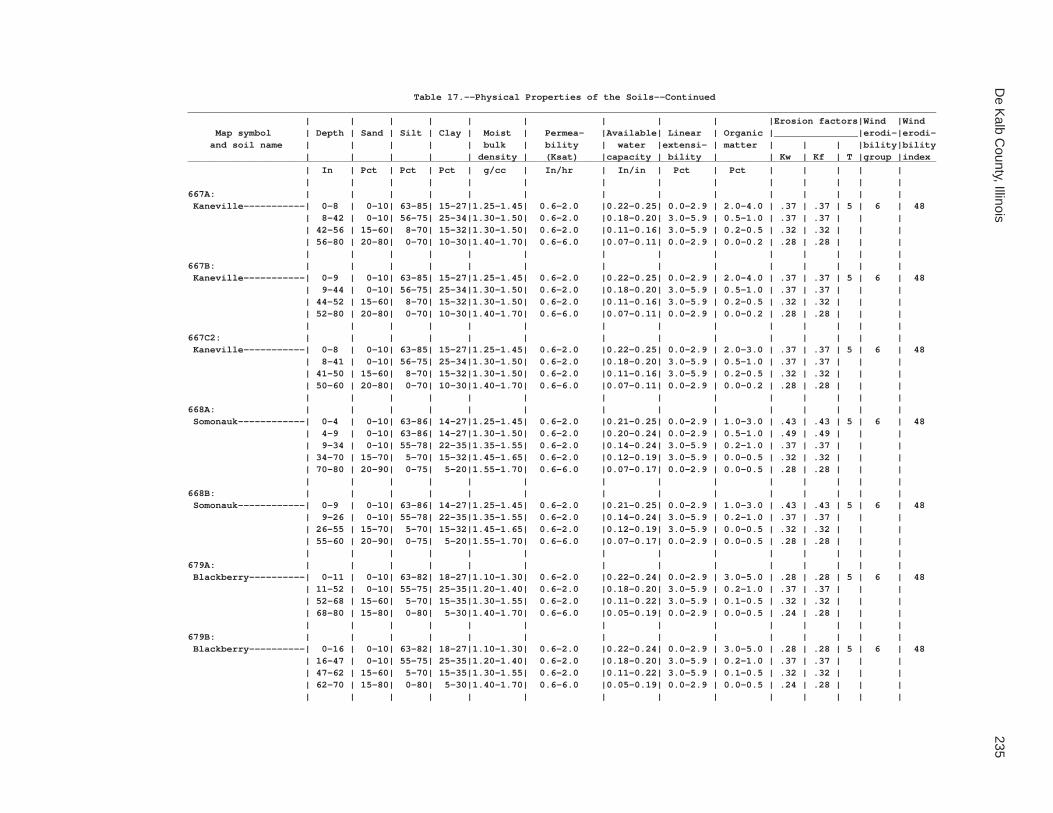
De K
alb County, Illinois
235
Table 17.--Physical Properties of the Soils--Continued______________________________________________________________________________________________________________________________________ | | | | | | | | | |Erosion factors|Wind |Wind Map symbol | Depth | Sand | Silt | Clay | Moist | Permea- |Available| Linear | Organic |_______________|erodi-|erodi- and soil name | | | | | bulk | bility | water |extensi- | matter | | | |bility|bility | | | | | density | (Ksat) |capacity | bility | | Kw | Kf | T |group |index______________________________________________________________________________________________________________________________________ | In | Pct | Pct | Pct | g/cc | In/hr | In/in | Pct | Pct | | | | | | | | | | | | | | | | | | |667A: | | | | | | | | | | | | | | Kaneville-----------| 0-8 | 0-10| 63-85| 15-27|1.25-1.45| 0.6-2.0 |0.22-0.25| 0.0-2.9 | 2.0-4.0 | .37 | .37 | 5 | 6 | 48 | 8-42 | 0-10| 56-75| 25-34|1.30-1.50| 0.6-2.0 |0.18-0.20| 3.0-5.9 | 0.5-1.0 | .37 | .37 | | | | 42-56 | 15-60| 8-70| 15-32|1.30-1.50| 0.6-2.0 |0.11-0.16| 3.0-5.9 | 0.2-0.5 | .32 | .32 | | | | 56-80 | 20-80| 0-70| 10-30|1.40-1.70| 0.6-6.0 |0.07-0.11| 0.0-2.9 | 0.0-0.2 | .28 | .28 | | | | | | | | | | | | | | | | |667B: | | | | | | | | | | | | | | Kaneville-----------| 0-9 | 0-10| 63-85| 15-27|1.25-1.45| 0.6-2.0 |0.22-0.25| 0.0-2.9 | 2.0-4.0 | .37 | .37 | 5 | 6 | 48 | 9-44 | 0-10| 56-75| 25-34|1.30-1.50| 0.6-2.0 |0.18-0.20| 3.0-5.9 | 0.5-1.0 | .37 | .37 | | | | 44-52 | 15-60| 8-70| 15-32|1.30-1.50| 0.6-2.0 |0.11-0.16| 3.0-5.9 | 0.2-0.5 | .32 | .32 | | | | 52-80 | 20-80| 0-70| 10-30|1.40-1.70| 0.6-6.0 |0.07-0.11| 0.0-2.9 | 0.0-0.2 | .28 | .28 | | | | | | | | | | | | | | | | |667C2: | | | | | | | | | | | | | | Kaneville-----------| 0-8 | 0-10| 63-85| 15-27|1.25-1.45| 0.6-2.0 |0.22-0.25| 0.0-2.9 | 2.0-3.0 | .37 | .37 | 5 | 6 | 48 | 8-41 | 0-10| 56-75| 25-34|1.30-1.50| 0.6-2.0 |0.18-0.20| 3.0-5.9 | 0.5-1.0 | .37 | .37 | | | | 41-50 | 15-60| 8-70| 15-32|1.30-1.50| 0.6-2.0 |0.11-0.16| 3.0-5.9 | 0.2-0.5 | .32 | .32 | | | | 50-60 | 20-80| 0-70| 10-30|1.40-1.70| 0.6-6.0 |0.07-0.11| 0.0-2.9 | 0.0-0.2 | .28 | .28 | | | | | | | | | | | | | | | | |668A: | | | | | | | | | | | | | | Somonauk------------| 0-4 | 0-10| 63-86| 14-27|1.25-1.45| 0.6-2.0 |0.21-0.25| 0.0-2.9 | 1.0-3.0 | .43 | .43 | 5 | 6 | 48 | 4-9 | 0-10| 63-86| 14-27|1.30-1.50| 0.6-2.0 |0.20-0.24| 0.0-2.9 | 0.5-1.0 | .49 | .49 | | | | 9-34 | 0-10| 55-78| 22-35|1.35-1.55| 0.6-2.0 |0.14-0.24| 3.0-5.9 | 0.2-1.0 | .37 | .37 | | | | 34-70 | 15-70| 5-70| 15-32|1.45-1.65| 0.6-2.0 |0.12-0.19| 3.0-5.9 | 0.0-0.5 | .32 | .32 | | | | 70-80 | 20-90| 0-75| 5-20|1.55-1.70| 0.6-6.0 |0.07-0.17| 0.0-2.9 | 0.0-0.5 | .28 | .28 | | | | | | | | | | | | | | | | |668B: | | | | | | | | | | | | | | Somonauk------------| 0-9 | 0-10| 63-86| 14-27|1.25-1.45| 0.6-2.0 |0.21-0.25| 0.0-2.9 | 1.0-3.0 | .43 | .43 | 5 | 6 | 48 | 9-26 | 0-10| 55-78| 22-35|1.35-1.55| 0.6-2.0 |0.14-0.24| 3.0-5.9 | 0.2-1.0 | .37 | .37 | | | | 26-55 | 15-70| 5-70| 15-32|1.45-1.65| 0.6-2.0 |0.12-0.19| 3.0-5.9 | 0.0-0.5 | .32 | .32 | | | | 55-60 | 20-90| 0-75| 5-20|1.55-1.70| 0.6-6.0 |0.07-0.17| 0.0-2.9 | 0.0-0.5 | .28 | .28 | | | | | | | | | | | | | | | | |679A: | | | | | | | | | | | | | | Blackberry----------| 0-11 | 0-10| 63-82| 18-27|1.10-1.30| 0.6-2.0 |0.22-0.24| 0.0-2.9 | 3.0-5.0 | .28 | .28 | 5 | 6 | 48 | 11-52 | 0-10| 55-75| 25-35|1.20-1.40| 0.6-2.0 |0.18-0.20| 3.0-5.9 | 0.2-1.0 | .37 | .37 | | | | 52-68 | 15-60| 5-70| 15-35|1.30-1.55| 0.6-2.0 |0.11-0.22| 3.0-5.9 | 0.1-0.5 | .32 | .32 | | | | 68-80 | 15-80| 0-80| 5-30|1.40-1.70| 0.6-6.0 |0.05-0.19| 0.0-2.9 | 0.0-0.5 | .24 | .28 | | | | | | | | | | | | | | | | |679B: | | | | | | | | | | | | | | Blackberry----------| 0-16 | 0-10| 63-82| 18-27|1.10-1.30| 0.6-2.0 |0.22-0.24| 0.0-2.9 | 3.0-5.0 | .28 | .28 | 5 | 6 | 48 | 16-47 | 0-10| 55-75| 25-35|1.20-1.40| 0.6-2.0 |0.18-0.20| 3.0-5.9 | 0.2-1.0 | .37 | .37 | | | | 47-62 | 15-60| 5-70| 15-35|1.30-1.55| 0.6-2.0 |0.11-0.22| 3.0-5.9 | 0.1-0.5 | .32 | .32 | | | | 62-70 | 15-80| 0-80| 5-30|1.40-1.70| 0.6-6.0 |0.05-0.19| 0.0-2.9 | 0.0-0.5 | .24 | .28 | | | | | | | | | | | | | | | | |

236S
oil Survey of
Table 17.--Physical Properties of the Soils--Continued______________________________________________________________________________________________________________________________________ | | | | | | | | | |Erosion factors|Wind |Wind Map symbol | Depth | Sand | Silt | Clay | Moist | Permea- |Available| Linear | Organic |_______________|erodi-|erodi- and soil name | | | | | bulk | bility | water |extensi- | matter | | | |bility|bility | | | | | density | (Ksat) |capacity | bility | | Kw | Kf | T |group |index______________________________________________________________________________________________________________________________________ | In | Pct | Pct | Pct | g/cc | In/hr | In/in | Pct | Pct | | | | | | | | | | | | | | | | | | |712A: | | | | | | | | | | | | | | Spaulding-----------| 0-22 | 0-7 | 58-73| 27-35|1.05-1.25| 0.6-2.0 |0.21-0.24| 3.0-5.9 | 4.0-6.0 | .24 | .24 | 5 | 4L | 86 | 22-38 | 0-7 | 58-75| 25-35|1.20-1.50| 0.6-2.0 |0.18-0.22| 3.0-5.9 | 0.5-2.0 | .37 | .37 | | | | 38-44 | 0-7 | 58-78| 22-35|1.25-1.55| 0.6-2.0 |0.17-0.22| 3.0-5.9 | 0.5-1.0 | .37 | .37 | | | | 44-80 | 0-7 | 66-80| 20-27|1.30-1.55| 0.6-2.0 |0.20-0.22| 0.0-2.9 | 0.0-0.5 | .49 | .49 | | | | | | | | | | | | | | | | |715A: | | | | | | | | | | | | | | Arrowsmith----------| 0-12 | 0-7 | 66-80| 20-27|1.20-1.35| 0.6-2.0 |0.22-0.24| 0.0-2.9 | 3.0-5.0 | .28 | .28 | 5 | 6 | 48 | 12-39 | 0-7 | 58-76| 24-35|1.25-1.45| 0.6-2.0 |0.18-0.20| 3.0-5.9 | 0.5-1.0 | .37 | .37 | | | | 39-60 | 0-7 | 66-80| 20-27|1.30-1.50| 0.6-2.0 |0.20-0.22| 0.0-2.9 | 0.0-0.5 | .49 | .49 | | | | | | | | | | | | | | | | |791A: | | | | | | | | | | | | | | Rush----------------| 0-4 | 0-15| 58-88| 12-27|1.20-1.35| 0.6-2.0 |0.22-0.24| 0.0-2.9 | 1.0-3.0 | .43 | .43 | 4 | 5 | 56 | 4-11 | 0-15| 58-88| 12-27|1.25-1.40| 0.6-2.0 |0.21-0.23| 0.0-2.9 | 0.5-1.0 | .49 | .49 | | | | 11-38 | 0-15| 51-78| 22-34|1.35-1.50| 0.6-2.0 |0.18-0.20| 3.0-5.9 | 0.5-1.0 | .37 | .37 | | | | 38-45 | 25-75| 5-50| 18-30|1.40-1.55| 0.6-2.0 |0.15-0.19| 3.0-5.9 | 0.2-1.0 | .28 | .32 | | | | 45-60 | 85-98| 0-13| 2-6 |1.60-1.80| 20-100 |0.02-0.04| 0.0-2.9 | 0.0-0.5 | .02 | .05 | | | | | | | | | | | | | | | | |791B: | | | | | | | | | | | | | | Rush----------------| 0-7 | 0-15| 58-88| 12-27|1.20-1.35| 0.6-2.0 |0.22-0.24| 0.0-2.9 | 1.0-3.0 | .43 | .43 | 4 | 5 | 56 | 7-35 | 0-15| 51-78| 22-34|1.35-1.50| 0.6-2.0 |0.18-0.20| 3.0-5.9 | 0.5-1.0 | .37 | .37 | | | | 35-46 | 25-75| 5-50| 18-30|1.40-1.55| 0.6-2.0 |0.15-0.19| 3.0-5.9 | 0.2-1.0 | .28 | .32 | | | | 46-60 | 85-98| 0-13| 2-6 |1.60-1.80| 20-100 |0.02-0.04| 0.0-2.9 | 0.0-0.5 | .02 | .05 | | | | | | | | | | | | | | | | |792A: | | | | | | | | | | | | | | Bowes---------------| 0-9 | 0-10| 63-82| 18-27|1.30-1.50| 0.6-2.0 |0.22-0.25| 0.0-2.9 | 2.0-4.0 | .37 | .37 | 4 | 6 | 48 | 9-13 | 0-10| 65-85| 15-25|1.35-1.50| 0.6-2.0 |0.21-0.24| 0.0-2.9 | 0.5-1.0 | .43 | .43 | | | | 13-43 | 0-10| 55-73| 27-35|1.30-1.50| 0.6-2.0 |0.18-0.20| 3.0-5.9 | 0.0-1.0 | .37 | .37 | | | | 43-51 | 30-85| 2-50| 10-30|1.55-1.75| 0.6-6.0 |0.10-0.16| 0.0-2.9 | 0.0-0.5 | .28 | .32 | | | | 51-61 | 80-98| 0-18| 2-10|1.60-1.80| 20-100 |0.02-0.04| 0.0-2.9 | 0.0-0.5 | .02 | .05 | | | | | | | | | | | | | | | | |792B: | | | | | | | | | | | | | | Bowes---------------| 0-7 | 0-10| 63-82| 18-27|1.30-1.50| 0.6-2.0 |0.22-0.25| 0.0-2.9 | 2.0-4.0 | .37 | .37 | 4 | 6 | 48 | 7-37 | 0-10| 55-73| 27-35|1.30-1.50| 0.6-2.0 |0.18-0.20| 3.0-5.9 | 0.0-1.0 | .37 | .37 | | | | 37-43 | 30-85| 2-50| 10-30|1.55-1.75| 0.6-6.0 |0.10-0.16| 0.0-2.9 | 0.0-0.5 | .28 | .32 | | | | 43-60 | 80-98| 0-18| 2-10|1.60-1.80| 20-100 |0.02-0.04| 0.0-2.9 | 0.0-0.5 | .02 | .05 | | | | | | | | | | | | | | | | |802B: | | | | | | | | | | | | | | Orthents, loamy-----| 0-8 | 23-52| 28-50| 22-27|1.70-1.75| 0.2-0.6 |0.18-0.22| 3.0-5.9 | 0.5-2.0 | .43 | .43 | 5 | 6 | 48 | 8-60 | 20-52| 25-58| 22-30|1.70-1.80| 0.2-0.6 |0.16-0.20| 3.0-5.9 | 0.2-1.0 | .43 | .43 | | | | | | | | | | | | | | | | |830: | | | | | | | | | | | | | | Landfills. | | | | | | | | | | | | | | | | | | | | | | | | | | | |

De K
alb County, Illinois
237
Table 17.--Physical Properties of the Soils--Continued______________________________________________________________________________________________________________________________________ | | | | | | | | | |Erosion factors|Wind |Wind Map symbol | Depth | Sand | Silt | Clay | Moist | Permea- |Available| Linear | Organic |_______________|erodi-|erodi- and soil name | | | | | bulk | bility | water |extensi- | matter | | | |bility|bility | | | | | density | (Ksat) |capacity | bility | | Kw | Kf | T |group |index______________________________________________________________________________________________________________________________________ | In | Pct | Pct | Pct | g/cc | In/hr | In/in | Pct | Pct | | | | | | | | | | | | | | | | | | |865: | | | | | | | | | | | | | | Pits, gravel. | | | | | | | | | | | | | | | | | | | | | | | | | | | |3076A: | | | | | | | | | | | | | | Otter---------------| 0-27 | 0-15| 58-82| 18-27|1.10-1.25| 0.6-2.0 |0.22-0.24| 0.0-2.9 | 3.0-7.0 | .32 | .32 | 5 | 6 | 48 | 27-41 | 0-25| 46-82| 18-29|1.20-1.45| 0.6-2.0 |0.17-0.22| 3.0-5.9 | 1.0-3.0 | .49 | .49 | | | | 41-65 | 15-55| 17-70| 15-28|1.30-1.55| 0.6-2.0 |0.15-0.20| 0.0-2.9 | 0.5-2.0 | .49 | .49 | | | | | | | | | | | | | | | | |3776A: | | | | | | | | | | | | | | Comfrey-------------| 0-7 | 15-45| 28-55| 18-27|1.20-1.40| 0.6-2.0 |0.20-0.24| 0.0-2.9 | 5.0-7.0 | .32 | .32 | 5 | 6 | 48 | 7-26 | 15-45| 20-55| 18-35|1.20-1.40| 0.6-2.0 |0.16-0.20| 3.0-5.9 | 1.0-4.0 | .32 | .32 | | | | 26-63 | 15-55| 10-55| 15-35|1.30-1.50| 0.6-2.0 |0.15-0.19| 3.0-5.9 | 0.5-2.0 | .32 | .32 | | | | | | | | | | | | | | | | |______________________________________________________________________________________________________________________________________

238 Soil Survey of
Table 18.--Chemical Properties of the Soils
(Absence of an entry indicates that data were not estimated.)
__________________________________________________________ | | | | Map symbol | Depth | Cation- | Soil |Calcium and soil name | |exchange |reaction |carbon- | |capacity | | ate__________________________________________________________ | In |meq/100 g| pH | Pct | | | |59A: | | | | Lisbon---------------| 0-11 | 18-27 | 5.6-7.3 | 0 | 11-36 | 16-25 | 5.6-7.8 | 0 | 36-39 | 12-22 | 6.1-8.4 | 0-20 | 39-70 | 9.0-16 | 7.4-8.4 | 15-40 | | | |60C2: | | | | La Rose--------------| 0-7 | 13-20 | 6.1-7.8 | 0 | 7-21 | 13-20 | 6.1-7.8 | 0-20 | 21-60 | 7.0-14 | 7.4-8.4 | 15-40 | | | |60D2: | | | | La Rose--------------| 0-7 | 13-20 | 6.1-7.8 | 0 | 7-20 | 13-20 | 6.1-7.8 | 0-20 | 20-60 | 7.0-14 | 7.4-8.4 | 15-40 | | | |62A: | | | | Herbert--------------| 0-8 | 15-24 | 5.6-7.3 | 0 | 8-12 | 10-18 | 5.6-7.3 | 0 | 12-26 | 15-23 | 5.6-7.3 | 0 | 26-36 | 13-22 | 6.1-8.4 | 0-20 | 36-60 | 9.0-16 | 7.4-8.4 | 10-40 | | | |67A: | | | | Harpster-------------| 0-18 | 24-33 | 7.4-8.4 | 10-40 | 18-36 | 17-25 | 7.4-8.4 | 5-40 | 36-41 | 14-23 | 7.4-8.4 | 5-40 | 41-60 | 9.0-19 | 7.4-8.4 | 10-40 | | | |68A: | | | | Sable----------------| 0-19 | 26-33 | 5.6-7.3 | 0 | 19-23 | 20-29 | 5.6-7.3 | 0 | 23-47 | 15-23 | 5.6-7.8 | 0 | 47-60 | 12-18 | 6.6-8.4 | 0-30 | | | |103A: | | | | Houghton-------------| 0-7 | 140-200 | 4.5-7.8 | 0 | 7-60 | 100-200 | 4.5-7.8 | 0 | | | |104A: | | | | Virgil---------------| 0-7 | 13-24 | 6.1-7.8 | 0 | 7-13 | 9.0-17 | 5.1-7.3 | 0 | 13-49 | 16-23 | 5.1-7.8 | 0 | 49-58 | 9.0-19 | 5.6-7.8 | 0-10 | 58-60 | 6.0-19 | 6.1-8.4 | 0-20 | | | |148A: | | | | Proctor--------------| 0-11 | 16-24 | 5.1-7.8 | 0 | 11-27 | 16-25 | 5.6-7.3 | 0 | 27-44 | 11-23 | 5.6-7.3 | 0 | 44-73 | 3.0-16 | 6.1-7.8 | 0-10 | | | |148B: | | | | Proctor--------------| 0-12 | 16-24 | 5.1-7.8 | 0 | 12-29 | 16-25 | 5.6-7.3 | 0 | 29-48 | 11-23 | 5.6-7.3 | 0 | 48-60 | 3.0-16 | 6.1-7.8 | 0-10 | | | |

De Kalb County, Illinois 239
Table 18.--Chemical Properties of the Soils--Continued__________________________________________________________ | | | | Map symbol | Depth | Cation- | Soil |Calcium and soil name | |exchange |reaction |carbon- | |capacity | | ate__________________________________________________________ | In |meq/100 g| pH | Pct | | | |152A: | | | | Drummer--------------| 0-14 | 24-35 | 5.6-7.8 | 0 | 14-41 | 13-25 | 5.6-7.8 | 0 | 41-47 | 9.0-21 | 6.1-8.4 | 0-20 | 47-60 | 6.0-20 | 6.6-8.4 | 0-40 | | | |154A: | | | | Flanagan-------------| 0-18 | 16-32 | 5.6-6.5 | 0 | 18-38 | 22-35 | 5.6-6.5 | 0 | 38-45 | 16-27 | 6.1-6.5 | 0 | 45-49 | 6.0-18 | 6.6-7.8 | 0-10 | 49-60 | 4.0-16 | 7.4-8.4 | 10-30 | | | |171A: | | | | Catlin---------------| 0-11 | 17-24 | 5.1-7.3 | 0 | 11-44 | 14-23 | 5.1-7.3 | 0 | 44-49 | 12-22 | 6.1-7.8 | 0-5 | 49-60 | 4.0-16 | 7.4-8.4 | 5-25 | | | |171B: | | | | Catlin---------------| 0-11 | 17-24 | 5.1-7.3 | 0 | 11-45 | 14-23 | 5.1-7.3 | 0 | 45-57 | 12-22 | 6.1-7.8 | 0-5 | 57-70 | 4.0-16 | 7.4-8.4 | 5-25 | | | |193A: | | | | Mayville-------------| 0-8 | 8.0-21 | 5.1-7.3 | 0 | 8-12 | 7.0-17 | 5.1-6.5 | 0 | 12-24 | 15-22 | 5.1-6.5 | 0 | 24-31 | 12-20 | 5.1-7.8 | 0-5 | 31-60 | 6.0-16 | 7.4-8.4 | 1-30 | | | |193B: | | | | Mayville-------------| 0-6 | 8.0-21 | 5.1-7.3 | 0 | 6-8 | 7.0-17 | 5.1-6.5 | 0 | 8-28 | 15-22 | 5.1-6.5 | 0 | 28-32 | 12-20 | 5.1-7.8 | 0-5 | 32-60 | 6.0-16 | 7.4-8.4 | 1-30 | | | |193C2: | | | | Mayville-------------| 0-6 | 8.0-19 | 5.1-7.3 | 0 | 6-24 | 15-22 | 5.1-6.5 | 0 | 24-34 | 12-20 | 5.1-7.8 | 0-5 | 34-60 | 6.0-16 | 7.4-8.4 | 1-30 | | | |198A: | | | | Elburn---------------| 0-13 | 21-26 | 5.6-7.8 | 0 | 13-44 | 16-25 | 5.6-7.8 | 0 | 44-65 | 9.0-18 | 6.1-8.4 | 0-20 | 65-80 | 1.0-9.0 | 6.1-8.4 | 0-20 | | | |206A: | | | | Thorp----------------| 0-14 | 20-28 | 5.1-7.8 | 0 | 14-19 | 11-17 | 5.1-7.3 | 0 | 19-43 | 14-23 | 5.1-7.3 | 0 | 43-50 | 11-19 | 5.6-7.8 | 0-5 | 50-65 | 3.0-19 | 6.1-8.4 | 0-20 | | | |

240 Soil Survey of
Table 18.--Chemical Properties of the Soils--Continued__________________________________________________________ | | | | Map symbol | Depth | Cation- | Soil |Calcium and soil name | |exchange |reaction |carbon- | |capacity | | ate__________________________________________________________ | In |meq/100 g| pH | Pct | | | |219A: | | | | Millbrook------------| 0-8 | 15-24 | 5.1-7.8 | 0 | 8-12 | 10-18 | 5.1-7.3 | 0 | 12-26 | 15-23 | 5.1-7.3 | 0 | 26-41 | 11-20 | 5.1-7.3 | 0 | 41-65 | 6.0-19 | 5.6-8.4 | 0-20 | | | |221B2: | | | | Parr-----------------| 0-9 | 10-19 | 5.6-7.3 | 0 | 9-28 | 11-19 | 5.6-7.3 | 0 | 28-36 | 10-14 | 6.6-8.4 | 0-20 | 36-60 | 5.0-11 | 7.4-8.4 | 5-35 | | | |221C2: | | | | Parr-----------------| 0-9 | 10-19 | 5.6-7.3 | 0 | 9-29 | 11-19 | 5.6-7.3 | 0 | 29-33 | 10-14 | 6.6-8.4 | 0-20 | 33-60 | 5.0-11 | 7.4-8.4 | 5-35 | | | |233A: | | | | Birkbeck-------------| 0-8 | 11-28 | 5.1-7.3 | 0 | 8-11 | 9.0-24 | 5.1-7.3 | 0 | 11-46 | 16-29 | 5.1-7.3 | 0 | 46-56 | 9.0-19 | 6.1-7.8 | 0-5 | 56-60 | 8.0-16 | 7.4-8.4 | 15-25 | | | |233B: | | | | Birkbeck-------------| 0-4 | 11-28 | 5.1-7.3 | 0 | 4-9 | 9.0-24 | 5.1-7.3 | 0 | 9-54 | 16-29 | 5.1-7.3 | 0 | 54-60 | 9.0-19 | 6.1-7.8 | 0-5 | 60-68 | 8.0-16 | 7.4-8.4 | 15-25 | | | |236A: | | | | Sabina---------------| 0-6 | 14-22 | 5.6-7.3 | 0 | 6-8 | 11-17 | 5.1-7.3 | 0 | 8-40 | 28-41 | 4.5-7.3 | 0 | 40-47 | 12-22 | 6.6-7.8 | 0-5 | 47-80 | 9.0-20 | 7.4-8.4 | 0-25 | | | |318D2: | | | | Lorenzo--------------| 0-8 | 13-20 | 5.6-7.3 | 0 | 8-18 | 10-20 | 5.6-7.8 | 15-35 | 18-60 | 0.0-4.0 | 7.4-8.4 | 15-40 | | | |325A: | | | | Dresden--------------| 0-9 | 13-22 | 5.6-7.3 | 0 | 9-29 | 14-20 | 5.6-7.3 | 0 | 29-33 | 10-16 | 5.6-7.8 | 0-15 | 33-60 | 0.0-4.0 | 7.4-8.4 | 15-40 | | | |325B: | | | | Dresden--------------| 0-7 | 13-22 | 5.6-7.3 | 0 | 7-27 | 14-20 | 5.6-7.3 | 0 | 27-32 | 10-16 | 5.6-7.8 | 0-15 | 32-60 | 0.0-4.0 | 7.4-8.4 | 15-40 | | | |325C2: | | | | Dresden--------------| 0-7 | 13-20 | 5.6-7.3 | 0 | 7-26 | 14-20 | 5.6-7.3 | 0 | 26-30 | 10-16 | 5.6-7.8 | 0-15 | 30-60 | 0.0-4.0 | 7.4-8.4 | 15-40 | | | |

De Kalb County, Illinois 241
Table 18.--Chemical Properties of the Soils--Continued__________________________________________________________ | | | | Map symbol | Depth | Cation- | Soil |Calcium and soil name | |exchange |reaction |carbon- | |capacity | | ate__________________________________________________________ | In |meq/100 g| pH | Pct | | | |327B: | | | | Fox------------------| 0-7 | 8.0-20 | 5.1-7.3 | 0 | 7-11 | 11-22 | 5.1-6.5 | 0 | 11-32 | 10-22 | 5.6-7.8 | 0-30 | 32-60 | 0.0-3.0 | 7.4-8.4 | 5-45 | | | |330A: | | | | Peotone--------------| 0-13 | 30-38 | 5.6-7.8 | 0 | 13-50 | 22-33 | 6.1-7.8 | 0 | 50-60 | 15-26 | 6.6-8.4 | 0-15 | | | |344B: | | | | Harvard--------------| 0-9 | 16-24 | 5.1-7.8 | 0 | 9-30 | 15-23 | 5.1-7.3 | 0 | 30-56 | 9.0-22 | 5.6-7.8 | 0-5 | 56-69 | 3.0-19 | 5.1-8.4 | 0-20 | | | |348A: | | | | Wingate--------------| 0-9 | 13-24 | 5.6-7.3 | 0 | 9-12 | 10-20 | 5.1-7.3 | 0 | 12-30 | 15-25 | 5.1-7.3 | 0 | 30-47 | 12-19 | 5.1-7.8 | 0-5 | 47-60 | 9.0-17 | 6.6-8.4 | 0-20 | | | |348B: | | | | Wingate--------------| 0-9 | 13-24 | 5.6-7.3 | 0 | 9-12 | 10-20 | 5.1-7.3 | 0 | 12-27 | 15-25 | 5.1-7.3 | 0 | 27-52 | 12-19 | 5.1-7.8 | 0-5 | 52-60 | 9.0-17 | 6.6-8.4 | 0-20 | | | |348C2: | | | | Wingate--------------| 0-7 | 13-22 | 5.6-7.3 | 0 | 7-25 | 15-25 | 5.1-7.3 | 0 | 25-46 | 12-19 | 5.1-7.8 | 0-5 | 46-60 | 9.0-17 | 6.6-8.4 | 0-20 | | | |356A: | | | | Elpaso---------------| 0-21 | 26-35 | 5.6-7.3 | 0 | 21-44 | 14-25 | 6.1-7.3 | 0 | 44-69 | 9.0-25 | 6.6-7.8 | 0-10 | 69-80 | 9.0-20 | 6.6-8.4 | 0-30 | | | |488A: | | | | Hooppole-------------| 0-17 | 20-30 | 7.4-8.4 | 5-30 | 17-44 | 16-25 | 7.4-8.4 | 12-30 | 44-60 | 1.0-8.0 | 7.4-8.4 | 10-30 | | | |512A: | | | | Danabrook------------| 0-19 | 19-26 | 5.6-7.3 | 0 | 19-34 | 15-25 | 5.1-7.3 | 0 | 34-53 | 12-21 | 5.6-7.8 | 0-20 | 53-60 | 9.0-13 | 7.4-8.4 | 15-40 | | | |512B: | | | | Danabrook------------| 0-13 | 19-26 | 5.6-7.3 | 0 | 13-33 | 15-25 | 5.1-7.3 | 0 | 33-50 | 12-21 | 5.6-7.8 | 0-20 | 50-60 | 9.0-13 | 7.4-8.4 | 15-40 | | | |

242 Soil Survey of
Table 18.--Chemical Properties of the Soils--Continued__________________________________________________________ | | | | Map symbol | Depth | Cation- | Soil |Calcium and soil name | |exchange |reaction |carbon- | |capacity | | ate__________________________________________________________ | In |meq/100 g| pH | Pct | | | |512C2: | | | | Danabrook------------| 0-8 | 17-24 | 5.6-7.3 | 0 | 8-27 | 15-25 | 5.1-7.3 | 0 | 27-40 | 12-21 | 5.6-7.8 | 0-20 | 40-65 | 9.0-13 | 7.4-8.4 | 15-40 | | | |527B: | | | | Kidami---------------| 0-3 | 7.0-18 | 5.1-7.3 | 0 | 3-10 | 6.0-14 | 5.1-7.3 | 0 | 10-37 | 10-19 | 5.1-7.3 | 0 | 37-45 | 8.0-15 | 6.1-8.4 | 0-30 | 45-60 | 7.0-11 | 7.4-8.4 | 25-40 | | | |527C2: | | | | Kidami---------------| 0-9 | 7.0-16 | 5.1-7.3 | 0 | 9-30 | 10-19 | 5.1-7.3 | 0 | 30-40 | 8.0-15 | 6.1-8.4 | 0-30 | 40-60 | 7.0-11 | 7.4-8.4 | 25-40 | | | |527D2: | | | | Kidami---------------| 0-10 | 7.0-16 | 5.1-7.3 | 0 | 10-27 | 10-19 | 5.1-7.3 | 0 | 27-35 | 8.0-15 | 6.1-8.4 | 0-30 | 35-60 | 7.0-11 | 7.4-8.4 | 25-40 | | | |656B: | | | | Octagon--------------| 0-7 | 11-22 | 5.6-7.3 | 0 | 7-30 | 12-19 | 5.6-7.3 | 0 | 30-60 | 5.0-11 | 7.4-8.4 | 10-35 | | | |656C2: | | | | Octagon--------------| 0-7 | 11-20 | 5.6-7.3 | 0 | 7-29 | 12-19 | 5.6-7.3 | 0 | 29-60 | 5.0-11 | 7.4-8.4 | 10-35 | | | |662A: | | | | Barony---------------| 0-9 | 13-24 | 5.1-7.8 | 0 | 9-13 | 10-18 | 5.1-7.3 | 0 | 13-26 | 16-23 | 5.1-7.3 | 0 | 26-57 | 9.0-22 | 5.6-7.8 | 0-5 | 57-80 | 3.0-10 | 5.6-8.4 | 0-20 | | | |662B: | | | | Barony---------------| 0-8 | 13-24 | 5.1-7.8 | 0 | 8-34 | 16-23 | 5.1-7.3 | 0 | 34-54 | 9.0-22 | 5.6-7.8 | 0-5 | 54-85 | 3.0-10 | 5.6-8.4 | 0-20 | | | |662C2: | | | | Barony---------------| 0-7 | 13-22 | 5.1-7.8 | 0 | 7-32 | 16-23 | 5.1-7.3 | 0 | 32-47 | 9.0-22 | 5.6-7.8 | 0-5 | 47-60 | 3.0-10 | 5.6-8.4 | 0-20 | | | |663A: | | | | Clare----------------| 0-11 | 17-26 | 5.6-7.8 | 0 | 11-32 | 16-25 | 5.1-7.3 | 0 | 32-61 | 11-21 | 5.6-7.8 | 0-5 | 61-80 | 3.0-13 | 6.1-8.4 | 0-20 | | | |

De Kalb County, Illinois 243
Table 18.--Chemical Properties of the Soils--Continued__________________________________________________________ | | | | Map symbol | Depth | Cation- | Soil |Calcium and soil name | |exchange |reaction |carbon- | |capacity | | ate__________________________________________________________ | In |meq/100 g| pH | Pct | | | |663B: | | | | Clare----------------| 0-14 | 17-26 | 5.6-7.8 | 0 | 14-36 | 16-25 | 5.1-7.3 | 0 | 36-44 | 11-21 | 5.6-7.8 | 0-5 | 44-66 | 3.0-13 | 6.1-8.4 | 0-20 | | | |667A: | | | | Kaneville------------| 0-8 | 13-24 | 5.6-7.3 | 0 | 8-42 | 17-22 | 5.6-7.8 | 0 | 42-56 | 9.0-20 | 6.1-8.4 | 0-10 | 56-80 | 6.0-18 | 6.1-8.4 | 0-20 | | | |667B: | | | | Kaneville------------| 0-9 | 13-24 | 5.6-7.3 | 0 | 9-44 | 17-22 | 5.6-7.8 | 0 | 44-52 | 9.0-20 | 6.1-8.4 | 0-10 | 52-80 | 6.0-18 | 6.1-8.4 | 0-20 | | | |667C2: | | | | Kaneville------------| 0-8 | 13-22 | 5.6-7.3 | 0 | 8-41 | 17-22 | 5.6-7.8 | 0 | 41-50 | 9.0-20 | 6.1-8.4 | 0-10 | 50-60 | 6.0-18 | 6.1-8.4 | 0-20 | | | |668A: | | | | Somonauk-------------| 0-4 | 10-22 | 5.1-7.3 | 0 | 4-9 | 9.0-18 | 5.1-7.3 | 0 | 9-34 | 13-23 | 5.1-7.3 | 0 | 34-70 | 9.0-20 | 5.1-7.8 | 0-5 | 70-80 | 3.0-13 | 6.1-8.4 | 0-20 | | | |668B: | | | | Somonauk-------------| 0-9 | 10-22 | 5.1-7.3 | 0 | 9-26 | 13-23 | 5.1-7.3 | 0 | 26-55 | 9.0-20 | 5.1-7.8 | 0-5 | 55-60 | 3.0-13 | 6.1-8.4 | 0-20 | | | |679A: | | | | Blackberry-----------| 0-11 | 17-26 | 6.1-7.3 | 0 | 11-52 | 15-23 | 5.1-7.3 | 0 | 52-68 | 9.0-22 | 5.6-8.4 | 0-20 | 68-80 | 3.0-19 | 5.6-8.4 | 0-20 | | | |679B: | | | | Blackberry-----------| 0-16 | 17-26 | 6.1-7.3 | 0 | 16-47 | 15-23 | 5.1-7.3 | 0 | 47-62 | 9.0-22 | 5.6-8.4 | 0-20 | 62-70 | 3.0-19 | 5.6-8.4 | 0-20 | | | |712A: | | | | Spaulding------------| 0-22 | 24-33 | 7.4-8.4 | 10-40 | 22-38 | 17-25 | 7.4-8.4 | 5-40 | 38-44 | 14-23 | 7.4-8.4 | 5-40 | 44-80 | 12-17 | 7.4-8.4 | 10-40 | | | |715A: | | | | Arrowsmith-----------| 0-12 | 18-26 | 6.1-7.3 | 0 | 12-39 | 15-23 | 6.1-8.4 | 0-10 | 39-60 | 12-17 | 7.4-8.4 | 0-25 | | | |

244 Soil Survey of
Table 18.--Chemical Properties of the Soils--Continued__________________________________________________________ | | | | Map symbol | Depth | Cation- | Soil |Calcium and soil name | |exchange |reaction |carbon- | |capacity | | ate__________________________________________________________ | In |meq/100 g| pH | Pct | | | |791A: | | | | Rush-----------------| 0-4 | 9.0-22 | 5.1-7.3 | 0 | 4-11 | 8.0-18 | 5.1-7.3 | 0 | 11-38 | 15-23 | 4.5-6.5 | 0 | 38-45 | 9.0-20 | 4.5-7.3 | 0 | 45-60 | 1.0-5.0 | 7.4-8.4 | 10-35 | | | |791B: | | | | Rush-----------------| 0-7 | 9.0-22 | 5.1-7.3 | 0 | 7-35 | 15-23 | 4.5-6.5 | 0 | 35-46 | 9.0-20 | 4.5-7.3 | 0 | 46-60 | 1.0-5.0 | 7.4-8.4 | 10-35 | | | |792A: | | | | Bowes----------------| 0-9 | 16-24 | 5.1-7.3 | 0 | 9-13 | 9.0-20 | 5.1-7.3 | 0 | 13-43 | 16-23 | 5.1-6.5 | 0 | 43-51 | 6.0-18 | 5.1-8.4 | 0-10 | 51-61 | 2.0-7.0 | 7.4-8.4 | 10-40 | | | |792B: | | | | Bowes----------------| 0-7 | 16-24 | 5.1-7.3 | 0 | 7-37 | 16-23 | 5.1-6.5 | 0 | 37-43 | 6.0-18 | 5.1-8.4 | 0-10 | 43-60 | 2.0-7.0 | 7.4-8.4 | 10-40 | | | |802B: | | | | Orthents, loamy------| 0-8 | 10-25 | 5.6-7.8 | 0-10 | 8-60 | 10-20 | 5.6-8.4 | 0-20 | | | |830: | | | | Landfills. | | | | | | | |865: | | | | Pits, gravel. | | | | | | | |3076A: | | | | Otter----------------| 0-27 | 16-30 | 6.1-7.8 | 0 | 27-41 | 12-23 | 6.1-7.8 | 0 | 41-65 | 10-21 | 6.1-8.4 | 0-10 | | | |3776A: | | | | Comfrey--------------| 0-7 | 20-30 | 6.1-7.8 | 0 | 7-26 | 12-29 | 6.1-7.8 | 0 | 26-63 | 10-25 | 6.6-8.4 | 0-10 | | | |__________________________________________________________

De Kalb County, Illinois 245
Table 19.--Water Features
(See text for definitions of terms used in this table. Estimates of the frequency of ponding and flooding apply to the whole year rather than to individual months. Absence of an entry indicates that the feature is not a concern or that data were not estimated.)
___________________________________________________________________________________________________________________ | | | Water table | | Ponding | Flooding | | | depth | | | _______________ ___________________________________________________ Map symbol |Hydro-|Months | Upper | Lower |Kind of |Surface| Duration |Frequency | Duration |Frequency and soil name |logic | | limit | limit | water | water | | | | |group | | | | table | depth | | | |___________________________________________________________________________________________________________________ | | | Ft | Ft | | Ft | | | | | | | | | | | | | |59A: | | | | | | | | | | Lisbon----------------| B |Jan-May|1.0-2.0|2.0-4.0|Perched | --- | --- | --- | --- | None | |Jun-Dec| >6.0 | >6.0 | --- | --- | --- | --- | --- | None | | | | | | | | | |60C2: | | | | | | | | | | La Rose---------------| B |Jan-Dec| >6.0 | >6.0 | --- | --- | --- | --- | --- | None | | | | | | | | | |60D2: | | | | | | | | | | La Rose---------------| B |Jan-Dec| >6.0 | >6.0 | --- | --- | --- | --- | --- | None | | | | | | | | | |62A: | | | | | | | | | | Herbert---------------| B |Jan-May|0.5-2.0|2.0-4.0|Perched | --- | --- | --- | --- | None | |Jun-Dec| >6.0 | >6.0 | --- | --- | --- | --- | --- | None | | | | | | | | | |67A: | | | | | | | | | | Harpster--------------| B |Jan-May|0.0-1.0| >6.0 |Apparent|0.0-0.5| Brief | Frequent | --- | None | |Jun-Dec| >6.0 | >6.0 | --- | --- | --- | --- | --- | None | | | | | | | | | |68A: | | | | | | | | | | Sable-----------------| B |Jan-May|0.0-1.0| >6.0 |Apparent|0.0-0.5| Brief | Frequent | --- | None | |Jun-Dec| >6.0 | >6.0 | --- | --- | --- | --- | --- | None | | | | | | | | | |103A: | | | | | | | | | | Houghton--------------| A |Jan-Apr|0.0-1.0| >6.0 |Apparent|0.0-1.0| Long | Frequent | --- | None | |May-Jun|0.0-1.0| >6.0 |Apparent|0.0-1.0| Brief | Frequent | --- | None | |Jul-Oct| >6.0 | >6.0 | --- | --- | --- | --- | --- | None | | Nov |0.0-1.0| >6.0 |Apparent|0.0-1.0| Brief | Frequent | --- | None | | Dec |0.0-1.0| >6.0 |Apparent|0.0-1.0| Long | Frequent | --- | None | | | | | | | | | |104A: | | | | | | | | | | Virgil----------------| B |Jan-May|0.5-2.0| >6.0 |Apparent| --- | --- | --- | --- | None | |Jun-Dec| >6.0 | >6.0 | --- | --- | --- | --- | --- | None | | | | | | | | | |148A: | | | | | | | | | | Proctor---------------| B |Jan-Dec| >6.0 | >6.0 | --- | --- | --- | --- | --- | None | | | | | | | | | |148B: | | | | | | | | | | Proctor---------------| B |Jan-Dec| >6.0 | >6.0 | --- | --- | --- | --- | --- | None | | | | | | | | | |152A: | | | | | | | | | | Drummer---------------| B |Jan-May|0.0-1.0| >6.0 |Apparent|0.0-0.5| Brief | Frequent | --- | None | |Jun-Dec| >6.0 | >6.0 | --- | --- | --- | --- | --- | None | | | | | | | | | |154A: | | | | | | | | | | Flanagan--------------| B |Jan-May|1.0-2.0|3.5-6.0|Perched | --- | --- | --- | --- | None | |Jun-Dec| >6.0 | >6.0 | --- | --- | --- | --- | --- | None | | | | | | | | | |171A: | | | | | | | | | | Catlin----------------| B | Jan | >6.0 | >6.0 | --- | --- | --- | --- | --- | None | |Feb-Apr|2.0-3.5|3.5-5.5|Perched | --- | --- | --- | --- | None | |May-Dec| >6.0 | >6.0 | --- | --- | --- | --- | --- | None | | | | | | | | | |171B: | | | | | | | | | | Catlin----------------| B | Jan | >6.0 | >6.0 | --- | --- | --- | --- | --- | None | |Feb-Apr|2.0-3.5|3.5-5.5|Perched | --- | --- | --- | --- | None | |May-Dec| >6.0 | >6.0 | --- | --- | --- | --- | --- | None | | | | | | | | | |

246 Soil Survey of
Table 19.--Water Features--Continued___________________________________________________________________________________________________________________ | | | Water table | | Ponding | Flooding | | | depth | | | _______________ ___________________________________________________ Map symbol |Hydro-|Months | Upper | Lower |Kind of |Surface| Duration |Frequency | Duration |Frequency and soil name |logic | | limit | limit | water | water | | | | |group | | | | table | depth | | | |___________________________________________________________________________________________________________________ | | | Ft | Ft | | Ft | | | | | | | | | | | | | |193A: | | | | | | | | | | Mayville--------------| B | Jan | >6.0 | >6.0 | --- | --- | --- | --- | --- | None | |Feb-Apr|2.0-3.5|3.5-4.5|Perched | --- | --- | --- | --- | None | |May-Dec| >6.0 | >6.0 | --- | --- | --- | --- | --- | None | | | | | | | | | |193B: | | | | | | | | | | Mayville--------------| B | Jan | >6.0 | >6.0 | --- | --- | --- | --- | --- | None | |Feb-Apr|2.0-3.5|3.5-4.5|Perched | --- | --- | --- | --- | None | |May-Dec| >6.0 | >6.0 | --- | --- | --- | --- | --- | None | | | | | | | | | |193C2: | | | | | | | | | | Mayville--------------| B | Jan | >6.0 | >6.0 | --- | --- | --- | --- | --- | None | |Feb-Apr|2.0-3.5|3.5-4.5|Perched | --- | --- | --- | --- | None | |May-Dec| >6.0 | >6.0 | --- | --- | --- | --- | --- | None | | | | | | | | | |198A: | | | | | | | | | | Elburn----------------| B |Jan-May|1.0-2.0| >6.0 |Apparent| --- | --- | --- | --- | None | |Jun-Dec| >6.0 | >6.0 | --- | --- | --- | --- | --- | None | | | | | | | | | |206A: | | | | | | | | | | Thorp-----------------| C |Jan-May|0.0-1.0| >6.0 |Apparent|0.0-0.5| Brief | Frequent | --- | None | |Jun-Dec| >6.0 | >6.0 | --- | --- | --- | --- | --- | None | | | | | | | | | |219A: | | | | | | | | | | Millbrook-------------| B |Jan-May|0.5-2.0| >6.0 |Apparent| --- | --- | --- | --- | None | |Jun-Dec| >6.0 | >6.0 | --- | --- | --- | --- | --- | None | | | | | | | | | |221B2: | | | | | | | | | | Parr------------------| B | Jan | >6.0 | >6.0 | --- | --- | --- | --- | --- | None | |Feb-Apr|2.0-3.5|3.5-4.0|Perched | --- | --- | --- | --- | None | |May-Dec| >6.0 | >6.0 | --- | --- | --- | --- | --- | None | | | | | | | | | |221C2: | | | | | | | | | | Parr------------------| B | Jan | >6.0 | >6.0 | --- | --- | --- | --- | --- | None | |Feb-Apr|2.0-3.5|3.5-4.0|Perched | --- | --- | --- | --- | None | |May-Dec| >6.0 | >6.0 | --- | --- | --- | --- | --- | None | | | | | | | | | |233A: | | | | | | | | | | Birkbeck--------------| B | Jan | >6.0 | >6.0 | --- | --- | --- | --- | --- | None | |Feb-Apr|2.0-3.5|3.5-6.6|Perched | --- | --- | --- | --- | None | |May-Dec| >6.0 | >6.0 | --- | --- | --- | --- | --- | None | | | | | | | | | |233B: | | | | | | | | | | Birkbeck--------------| B | Jan | >6.0 | >6.0 | --- | --- | --- | --- | --- | None | |Feb-Apr|2.0-3.5|3.5-6.6|Perched | --- | --- | --- | --- | None | |May-Dec| >6.0 | >6.0 | --- | --- | --- | --- | --- | None | | | | | | | | | |236A: | | | | | | | | | | Sabina----------------| C |Jan-May|0.5-2.0|3.5-5.5|Perched | --- | --- | --- | --- | None | |Jun-Dec| >6.0 | >6.0 | --- | --- | --- | --- | --- | None | | | | | | | | | |318D2: | | | | | | | | | | Lorenzo---------------| B |Jan-Dec| >6.0 | >6.0 | --- | --- | --- | --- | --- | None | | | | | | | | | |325B: | | | | | | | | | | Dresden---------------| B |Jan-Dec| >6.0 | >6.0 | --- | --- | --- | --- | --- | None | | | | | | | | | |325C2: | | | | | | | | | | Dresden---------------| B |Jan-Dec| >6.0 | >6.0 | --- | --- | --- | --- | --- | None | | | | | | | | | |

De Kalb County, Illinois 247
Table 19.--Water Features--Continued___________________________________________________________________________________________________________________ | | | Water table | | Ponding | Flooding | | | depth | | | _______________ ___________________________________________________ Map symbol |Hydro-|Months | Upper | Lower |Kind of |Surface| Duration |Frequency | Duration |Frequency and soil name |logic | | limit | limit | water | water | | | | |group | | | | table | depth | | | |___________________________________________________________________________________________________________________ | | | Ft | Ft | | Ft | | | | | | | | | | | | | |327B: | | | | | | | | | | Fox-------------------| B |Jan-Dec| >6.0 | >6.0 | --- | --- | --- | --- | --- | None | | | | | | | | | |330A: | | | | | | | | | | Peotone---------------| B |Jan-Jun|0.0-1.0| >6.0 |Apparent|0.0-0.5| Brief | Frequent | --- | None | |Jul-Dec| >6.0 | >6.0 | --- | --- | --- | --- | --- | None | | | | | | | | | |344B: | | | | | | | | | | Harvard---------------| B |Jan-Dec| >6.0 | >6.0 | --- | --- | --- | --- | --- | None | | | | | | | | | |348A: | | | | | | | | | | Wingate---------------| B | Jan | >6.0 | >6.0 | --- | --- | --- | --- | --- | None | |Feb-Apr|2.0-3.5|3.5-6.0|Perched | --- | --- | --- | --- | None | |May-Dec| >6.0 | >6.0 | --- | --- | --- | --- | --- | None | | | | | | | | | |348B: | | | | | | | | | | Wingate---------------| B | Jan | >6.0 | >6.0 | --- | --- | --- | --- | --- | None | |Feb-Apr|2.0-3.5|3.5-6.0|Perched | --- | --- | --- | --- | None | |May-Dec| >6.0 | >6.0 | --- | --- | --- | --- | --- | None | | | | | | | | | |348C2: | | | | | | | | | | Wingate---------------| B | Jan | >6.0 | >6.0 | --- | --- | --- | --- | --- | None | |Feb-Apr|2.0-3.5|3.5-6.0|Perched | --- | --- | --- | --- | None | |May-Dec| >6.0 | >6.0 | --- | --- | --- | --- | --- | None | | | | | | | | | |356A: | | | | | | | | | | Elpaso----------------| B |Jan-May|0.0-1.0| >6.0 |Apparent|0.0-0.5| Brief | Frequent | --- | None | |Jun-Dec| >6.0 | >6.0 | --- | --- | --- | --- | --- | None | | | | | | | | | |488A: | | | | | | | | | | Hooppole--------------| B |Jan-May|0.0-1.0| >6.0 |Apparent|0.0-0.5| Brief | Frequent | --- | None | |Jun-Dec| >6.0 | >6.0 | --- | --- | --- | --- | --- | None | | | | | | | | | |512A: | | | | | | | | | | Danabrook-------------| B | Jan | >6.0 | >6.0 | --- | --- | --- | --- | --- | None | |Feb-Apr|2.0-3.5|3.5-5.0|Perched | --- | --- | --- | --- | None | |May-Dec| >6.0 | >6.0 | --- | --- | --- | --- | --- | None | | | | | | | | | |512B: | | | | | | | | | | Danabrook-------------| B | Jan | >6.0 | >6.0 | --- | --- | --- | --- | --- | None | |Feb-Apr|2.0-3.5|3.5-5.0|Perched | --- | --- | --- | --- | None | |May-Dec| >6.0 | >6.0 | --- | --- | --- | --- | --- | None | | | | | | | | | |512C2: | | | | | | | | | | Danabrook-------------| B | Jan | >6.0 | >6.0 | --- | --- | --- | --- | --- | None | |Feb-Apr|2.0-3.5|3.5-5.0|Perched | --- | --- | --- | --- | None | |May-Dec| >6.0 | >6.0 | --- | --- | --- | --- | --- | None | | | | | | | | | |527B: | | | | | | | | | | Kidami----------------| B | Jan | >6.0 | >6.0 | --- | --- | --- | --- | --- | None | |Feb-Apr|2.0-3.5|3.5-4.5|Perched | --- | --- | --- | --- | None | |May-Dec| >6.0 | >6.0 | --- | --- | --- | --- | --- | None | | | | | | | | | |527C2: | | | | | | | | | | Kidami----------------| B | Jan | >6.0 | >6.0 | --- | --- | --- | --- | --- | None | |Feb-Apr|2.0-3.5|3.5-4.5|Perched | --- | --- | --- | --- | None | |May-Dec| >6.0 | >6.0 | --- | --- | --- | --- | --- | None | | | | | | | | | |

248 Soil Survey of
Table 19.--Water Features--Continued___________________________________________________________________________________________________________________ | | | Water table | | Ponding | Flooding | | | depth | | | _______________ ___________________________________________________ Map symbol |Hydro-|Months | Upper | Lower |Kind of |Surface| Duration |Frequency | Duration |Frequency and soil name |logic | | limit | limit | water | water | | | | |group | | | | table | depth | | | |___________________________________________________________________________________________________________________ | | | Ft | Ft | | Ft | | | | | | | | | | | | | |527D2: | | | | | | | | | | Kidami----------------| B | Jan | >6.0 | >6.0 | --- | --- | --- | --- | --- | None | |Feb-Apr|2.0-3.5|3.5-4.5|Perched | --- | --- | --- | --- | None | |May-Dec| >6.0 | >6.0 | --- | --- | --- | --- | --- | None | | | | | | | | | |656B: | | | | | | | | | | Octagon---------------| B | Jan | >6.0 | >6.0 | --- | --- | --- | --- | --- | None | |Feb-Apr|2.0-3.5|3.5-4.0|Perched | --- | --- | --- | --- | None | |May-Dec| >6.0 | >6.0 | --- | --- | --- | --- | --- | None | | | | | | | | | |656C2: | | | | | | | | | | Octagon---------------| B | Jan | >6.0 | >6.0 | --- | --- | --- | --- | --- | None | |Feb-Apr|2.0-3.5|3.5-4.0|Perched | --- | --- | --- | --- | None | |May-Dec| >6.0 | >6.0 | --- | --- | --- | --- | --- | None | | | | | | | | | |662A: | | | | | | | | | | Barony----------------| B | Jan | >6.0 | >6.0 | --- | --- | --- | --- | --- | None | |Feb-Apr|2.0-3.5| >6.0 |Apparent| --- | --- | --- | --- | None | |May-Dec| >6.0 | >6.0 | --- | --- | --- | --- | --- | None | | | | | | | | | |662B: | | | | | | | | | | Barony----------------| B | Jan | >6.0 | >6.0 | --- | --- | --- | --- | --- | None | |Feb-Apr|2.0-3.5| >6.0 |Apparent| --- | --- | --- | --- | None | |May-Dec| >6.0 | >6.0 | --- | --- | --- | --- | --- | None | | | | | | | | | |662C2: | | | | | | | | | | Barony----------------| B | Jan | >6.0 | >6.0 | --- | --- | --- | --- | --- | None | |Feb-Apr|2.0-3.5| >6.0 |Apparent| --- | --- | --- | --- | None | |May-Dec| >6.0 | >6.0 | --- | --- | --- | --- | --- | None | | | | | | | | | |663A: | | | | | | | | | | Clare-----------------| B | Jan | >6.0 | >6.0 | --- | --- | --- | --- | --- | None | |Feb-Apr|2.0-3.5| >6.0 |Apparent| --- | --- | --- | --- | None | |May-Dec| >6.0 | >6.0 | --- | --- | --- | --- | --- | None | | | | | | | | | |663B: | | | | | | | | | | Clare-----------------| B | Jan | >6.0 | >6.0 | --- | --- | --- | --- | --- | None | |Feb-Apr|2.0-3.5| >6.0 |Apparent| --- | --- | --- | --- | None | |May-Dec| >6.0 | >6.0 | --- | --- | --- | --- | --- | None | | | | | | | | | |667A: | | | | | | | | | | Kaneville-------------| B | Jan | >6.0 | >6.0 | --- | --- | --- | --- | --- | None | |Feb-Apr|2.0-3.5| >6.0 |Apparent| --- | --- | --- | --- | None | |May-Dec| >6.0 | >6.0 | --- | --- | --- | --- | --- | None | | | | | | | | | |667B: | | | | | | | | | | Kaneville-------------| B | Jan | >6.0 | >6.0 | --- | --- | --- | --- | --- | None | |Feb-Apr|2.0-3.5| >6.0 |Apparent| --- | --- | --- | --- | None | |May-Dec| >6.0 | >6.0 | --- | --- | --- | --- | --- | None | | | | | | | | | |667C2: | | | | | | | | | | Kaneville-------------| B | Jan | >6.0 | >6.0 | --- | --- | --- | --- | --- | None | |Feb-Apr|2.0-3.5| >6.0 |Apparent| --- | --- | --- | --- | None | |May-Dec| >6.0 | >6.0 | --- | --- | --- | --- | --- | None | | | | | | | | | |668A: | | | | | | | | | | Somonauk--------------| B | Jan | >6.0 | >6.0 | --- | --- | --- | --- | --- | None | |Feb-Apr|2.0-3.5| >6.0 |Apparent| --- | --- | --- | --- | None | |May-Dec| >6.0 | >6.0 | --- | --- | --- | --- | --- | None | | | | | | | | | |

De Kalb County, Illinois 249
Table 19.--Water Features--Continued___________________________________________________________________________________________________________________ | | | Water table | | Ponding | Flooding | | | depth | | | _______________ ___________________________________________________ Map symbol |Hydro-|Months | Upper | Lower |Kind of |Surface| Duration |Frequency | Duration |Frequency and soil name |logic | | limit | limit | water | water | | | | |group | | | | table | depth | | | |___________________________________________________________________________________________________________________ | | | Ft | Ft | | Ft | | | | | | | | | | | | | |668B: | | | | | | | | | | Somonauk--------------| B | Jan | >6.0 | >6.0 | --- | --- | --- | --- | --- | None | |Feb-Apr|2.0-3.5| >6.0 |Apparent| --- | --- | --- | --- | None | |May-Dec| >6.0 | >6.0 | --- | --- | --- | --- | --- | None | | | | | | | | | |679A: | | | | | | | | | | Blackberry------------| B | Jan | >6.0 | >6.0 | --- | --- | --- | --- | --- | None | |Feb-Apr|2.0-3.5| >6.0 |Apparent| --- | --- | --- | --- | None | |May-Dec| >6.0 | >6.0 | --- | --- | --- | --- | --- | None | | | | | | | | | |679B: | | | | | | | | | | Blackberry------------| B | Jan | >6.0 | >6.0 | --- | --- | --- | --- | --- | None | |Feb-Apr|2.0-3.5| >6.0 |Apparent| --- | --- | --- | --- | None | |May-Dec| >6.0 | >6.0 | --- | --- | --- | --- | --- | None | | | | | | | | | |712A: | | | | | | | | | | Spaulding-------------| B/D |Jan-May|0.0-1.0| >6.0 |Apparent|0.0-0.5| Brief | Frequent | --- | None | |Jun-Dec| >6.0 | >6.0 | --- | --- | --- | --- | --- | None | | | | | | | | | |715A: | | | | | | | | | | Arrowsmith------------| B |Jan-May|1.0-2.0| >6.0 |Apparent| --- | --- | --- | --- | None | |Jun-Dec| >6.0 | >6.0 | --- | --- | --- | --- | --- | None | | | | | | | | | |791A: | | | | | | | | | | Rush------------------| B |Jan-Dec| >6.0 | >6.0 | --- | --- | --- | --- | --- | None | | | | | | | | | |791B: | | | | | | | | | | Rush------------------| B |Jan-Dec| >6.0 | >6.0 | --- | --- | --- | --- | --- | None | | | | | | | | | |792A: | | | | | | | | | | Bowes-----------------| B |Jan-Dec| >6.0 | >6.0 | --- | --- | --- | --- | --- | None | | | | | | | | | |792B: | | | | | | | | | | Bowes-----------------| B |Jan-Dec| >6.0 | >6.0 | --- | --- | --- | --- | --- | None | | | | | | | | | |802B: | | | | | | | | | | Orthents, loamy-------| B | Jan | >6.0 | >6.0 | --- | --- | --- | --- | --- | None | |Feb-Apr|3.5-5.0|5.0-6.0|Perched | --- | --- | --- | --- | None | |May-Dec| >6.0 | >6.0 | --- | --- | --- | --- | --- | None | | | | | | | | | |830: | | | | | | | | | | Landfills. | | | | | | | | | | | | | | | | | | | |865: | | | | | | | | | | Pits, gravel. | | | | | | | | | | | | | | | | | | | |3076A: | | | | | | | | | | Otter-----------------| B |Jan-May|0.0-1.0| >6.0 |Apparent|0.0-0.5| Brief | Frequent | Brief | Frequent | | Jun | >6.0 | >6.0 | --- | --- | --- | --- | Brief | Frequent | |Jul-Oct| >6.0 | >6.0 | --- | --- | --- | --- | --- | None | |Nov-Dec| >6.0 | >6.0 | --- | --- | --- | --- | Brief | Frequent | | | | | | | | | |3776A: | | | | | | | | | | Comfrey---------------| B |Jan-May|0.0-1.0| >6.0 |Apparent|0.0-0.5| Brief | Frequent | Brief | Frequent | | Jun | >6.0 | >6.0 | --- | --- | --- | --- | Brief | Frequent | |Jul-Oct| >6.0 | >6.0 | --- | --- | --- | --- | --- | None | |Nov-Dec| >6.0 | >6.0 | --- | --- | --- | --- | Brief | Frequent | | | | | | | | | |___________________________________________________________________________________________________________________
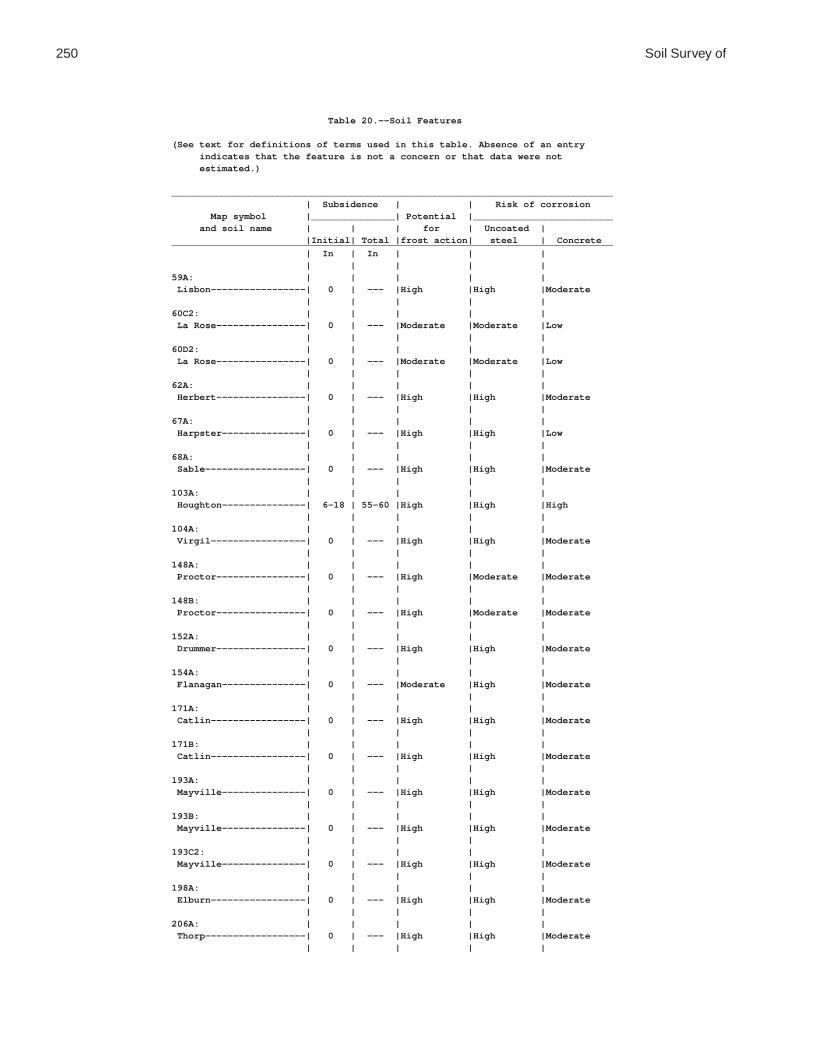
250 Soil Survey of
Table 20.--Soil Features
(See text for definitions of terms used in this table. Absence of an entry indicates that the feature is not a concern or that data were not estimated.)
_______________________________________________________________________________ | Subsidence | | Risk of corrosion Map symbol |_______________| Potential |_________________________ and soil name | | | for | Uncoated | |Initial| Total |frost action| steel | Concrete_______________________________________________________________________________ | In | In | | | | | | | |59A: | | | | | Lisbon-----------------| 0 | --- |High |High |Moderate | | | | |60C2: | | | | | La Rose----------------| 0 | --- |Moderate |Moderate |Low | | | | |60D2: | | | | | La Rose----------------| 0 | --- |Moderate |Moderate |Low | | | | |62A: | | | | | Herbert----------------| 0 | --- |High |High |Moderate | | | | |67A: | | | | | Harpster---------------| 0 | --- |High |High |Low | | | | |68A: | | | | | Sable------------------| 0 | --- |High |High |Moderate | | | | |103A: | | | | | Houghton---------------| 6-18 | 55-60 |High |High |High | | | | |104A: | | | | | Virgil-----------------| 0 | --- |High |High |Moderate | | | | |148A: | | | | | Proctor----------------| 0 | --- |High |Moderate |Moderate | | | | |148B: | | | | | Proctor----------------| 0 | --- |High |Moderate |Moderate | | | | |152A: | | | | | Drummer----------------| 0 | --- |High |High |Moderate | | | | |154A: | | | | | Flanagan---------------| 0 | --- |Moderate |High |Moderate | | | | |171A: | | | | | Catlin-----------------| 0 | --- |High |High |Moderate | | | | |171B: | | | | | Catlin-----------------| 0 | --- |High |High |Moderate | | | | |193A: | | | | | Mayville---------------| 0 | --- |High |High |Moderate | | | | |193B: | | | | | Mayville---------------| 0 | --- |High |High |Moderate | | | | |193C2: | | | | | Mayville---------------| 0 | --- |High |High |Moderate | | | | |198A: | | | | | Elburn-----------------| 0 | --- |High |High |Moderate | | | | |206A: | | | | | Thorp------------------| 0 | --- |High |High |Moderate | | | | |

De Kalb County, Illinois 251
Table 20.--Soil Features--Continued_______________________________________________________________________________ | Subsidence | | Risk of corrosion Map symbol |_______________| Potential |_________________________ and soil name | | | for | Uncoated | |Initial| Total |frost action| steel | Concrete_______________________________________________________________________________ | In | In | | | | | | | |219A: | | | | | Millbrook--------------| 0 | --- |High |High |Moderate | | | | |221B2: | | | | | Parr-------------------| 0 | --- |Moderate |High |Moderate | | | | |221C2: | | | | | Parr-------------------| 0 | --- |Moderate |High |Moderate | | | | |233A: | | | | | Birkbeck---------------| 0 | --- |High |High |High | | | | |233B: | | | | | Birkbeck---------------| 0 | --- |High |High |High | | | | |236A: | | | | | Sabina-----------------| 0 | --- |High |High |High | | | | |318D2: | | | | | Lorenzo----------------| 0 | --- |Moderate |Moderate |Moderate | | | | |325A: | | | | | Dresden----------------| 0 | --- |Moderate |Moderate |Moderate | | | | |325B: | | | | | Dresden----------------| 0 | --- |Moderate |Moderate |Moderate | | | | |325C2: | | | | | Dresden----------------| 0 | --- |Moderate |Moderate |Moderate | | | | |327B: | | | | | Fox--------------------| 0 | --- |Moderate |Moderate |Moderate | | | | |330A: | | | | | Peotone----------------| 0 | --- |High |High |Moderate | | | | |344B: | | | | | Harvard----------------| 0 | --- |High |Moderate |Moderate | | | | |348A: | | | | | Wingate----------------| 0 | --- |High |High |Moderate | | | | |348B: | | | | | Wingate----------------| 0 | --- |High |High |Moderate | | | | |348C2: | | | | | Wingate----------------| 0 | --- |High |High |Moderate | | | | |356A: | | | | | Elpaso-----------------| 0 | --- |High |High |Moderate | | | | |488A: | | | | | Hooppole---------------| 0 | --- |High |High |Low | | | | |512A: | | | | | Danabrook--------------| 0 | --- |High |High |Moderate | | | | |512B: | | | | | Danabrook--------------| 0 | --- |High |High |Moderate | | | | |512C2: | | | | | Danabrook--------------| 0 | --- |High |High |Moderate | | | | |
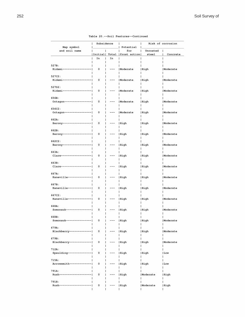
252 Soil Survey of
Table 20.--Soil Features--Continued_______________________________________________________________________________ | Subsidence | | Risk of corrosion Map symbol |_______________| Potential |_________________________ and soil name | | | for | Uncoated | |Initial| Total |frost action| steel | Concrete_______________________________________________________________________________ | In | In | | | | | | | |527B: | | | | | Kidami-----------------| 0 | --- |Moderate |High |Moderate | | | | |527C2: | | | | | Kidami-----------------| 0 | --- |Moderate |High |Moderate | | | | |527D2: | | | | | Kidami-----------------| 0 | --- |Moderate |High |Moderate | | | | |656B: | | | | | Octagon----------------| 0 | --- |Moderate |High |Moderate | | | | |656C2: | | | | | Octagon----------------| 0 | --- |Moderate |High |Moderate | | | | |662A: | | | | | Barony-----------------| 0 | --- |High |High |Moderate | | | | |662B: | | | | | Barony-----------------| 0 | --- |High |High |Moderate | | | | |662C2: | | | | | Barony-----------------| 0 | --- |High |High |Moderate | | | | |663A: | | | | | Clare------------------| 0 | --- |High |High |Moderate | | | | |663B: | | | | | Clare------------------| 0 | --- |High |High |Moderate | | | | |667A: | | | | | Kaneville--------------| 0 | --- |High |High |Moderate | | | | |667B: | | | | | Kaneville--------------| 0 | --- |High |High |Moderate | | | | |667C2: | | | | | Kaneville--------------| 0 | --- |High |High |Moderate | | | | |668A: | | | | | Somonauk---------------| 0 | --- |High |High |Moderate | | | | |668B: | | | | | Somonauk---------------| 0 | --- |High |High |Moderate | | | | |679A: | | | | | Blackberry-------------| 0 | --- |High |High |Moderate | | | | |679B: | | | | | Blackberry-------------| 0 | --- |High |High |Moderate | | | | |712A: | | | | | Spaulding--------------| 0 | --- |High |High |Low | | | | |715A: | | | | | Arrowsmith-------------| 0 | --- |High |High |Low | | | | |791A: | | | | | Rush-------------------| 0 | --- |High |Moderate |High | | | | |791B: | | | | | Rush-------------------| 0 | --- |High |Moderate |High | | | | |

De Kalb County, Illinois 253
Table 20.--Soil Features--Continued_______________________________________________________________________________ | Subsidence | | Risk of corrosion Map symbol |_______________| Potential |_________________________ and soil name | | | for | Uncoated | |Initial| Total |frost action| steel | Concrete_______________________________________________________________________________ | In | In | | | | | | | |792A: | | | | | Bowes------------------| 0 | --- |High |Moderate |Moderate | | | | |792B: | | | | | Bowes------------------| 0 | --- |High |Moderate |Moderate | | | | |802B: | | | | | Orthents, loamy--------| 0 | --- |Moderate |Moderate |Moderate | | | | |830: | | | | | Landfills. | | | | | | | | | |865: | | | | | Pits, gravel. | | | | | | | | | |3076A: | | | | | Otter------------------| 0 | --- |High |High |Low | | | | |3776A: | | | | | Comfrey----------------| 0 | --- |High |High |Low | | | | |_______________________________________________________________________________

254
Table 21.--Classification of the Soils
(An asterisk in the first column indicates that the soil is a taxadjunct to the series. See text for a description of those characteristics that are outside the range of the series.)
_______________________________________________________________________________________ | Soil name | Family or higher taxonomic class |_______________________________________________________________________________________ | Arrowsmith---------------|Fine-silty, mixed, superactive, mesic Aquic Argiudolls Barony-------------------|Fine-silty, mixed, superactive, mesic Oxyaquic Hapludalfs Birkbeck-----------------|Fine-silty, mixed, superactive, mesic Oxyaquic Hapludalfs Blackberry---------------|Fine-silty, mixed, superactive, mesic Oxyaquic Argiudolls Bowes--------------------|Fine-silty, mixed, superactive, mesic Mollic Hapludalfs Catlin-------------------|Fine-silty, mixed, superactive, mesic Oxyaquic Argiudolls Clare--------------------|Fine-silty, mixed, superactive, mesic Oxyaquic Argiudolls Comfrey------------------|Fine-loamy, mixed, superactive, mesic Cumulic Endoaquolls Danabrook----------------|Fine-silty, mixed, superactive, mesic Oxyaquic Argiudolls Dresden------------------|Fine-loamy over sandy or sandy-skeletal, mixed, active, | mesic Mollic Hapludalfs Drummer------------------|Fine-silty, mixed, superactive, mesic Typic Endoaquolls Elburn-------------------|Fine-silty, mixed, superactive, mesic Aquic Argiudolls Elpaso-------------------|Fine-silty, mixed, superactive, mesic Typic Endoaquolls Flanagan-----------------|Fine, smectitic, mesic Aquic Argiudolls Fox----------------------|Fine-loamy over sandy or sandy-skeletal, mixed, superactive, | mesic Typic Hapludalfs Harpster-----------------|Fine-silty, mixed, superactive, mesic Typic Calciaquolls Harvard------------------|Fine-silty, mixed, superactive, mesic Mollic Hapludalfs Herbert------------------|Fine-silty, mixed, superactive, mesic Udollic Epiaqualfs Hooppole-----------------|Fine-loamy, mixed, superactive, calcareous, mesic Typic | Endoaquolls Houghton-----------------|Euic, mesic Typic Haplosaprists Kaneville----------------|Fine-silty, mixed, superactive, mesic Oxyaquic Hapludalfs Kidami-------------------|Fine-loamy, mixed, active, mesic Oxyaquic Hapludalfs La Rose------------------|Fine-loamy, mixed, active, mesic Typic Argiudolls Lisbon-------------------|Fine-silty, mixed, superactive, mesic Aquic Argiudolls Lorenzo------------------|Fine-loamy over sandy or sandy-skeletal, mixed, active, | mesic Typic Argiudolls Mayville-----------------|Fine-silty, mixed, superactive, mesic Oxyaquic Hapludalfs Millbrook----------------|Fine-silty, mixed, superactive, mesic Udollic Endoaqualfs Octagon------------------|Fine-loamy, mixed, active, mesic Oxyaquic Hapludalfs Orthents-----------------|Fine-loamy, mixed, active, nonacid, mesic Oxyaquic | Udorthents Otter--------------------|Fine-silty, mixed, superactive, mesic Cumulic Endoaquolls*Parr---------------------|Fine-loamy, mixed, active, mesic Oxyaquic Argiudolls Peotone------------------|Fine, smectitic, mesic Cumulic Vertic Endoaquolls Proctor------------------|Fine-silty, mixed, superactive, mesic Typic Argiudolls Rush---------------------|Fine-silty, mixed, superactive, mesic Typic Hapludalfs Sabina-------------------|Fine, smectitic, mesic Aeric Epiaqualfs Sable--------------------|Fine-silty, mixed, superactive, mesic Typic Endoaquolls Somonauk-----------------|Fine-silty, mixed, superactive, mesic Oxyaquic Hapludalfs Spaulding----------------|Fine-silty, mixed, superactive, mesic Typic Calciaquolls Thorp--------------------|Fine-silty, mixed, superactive, mesic Argiaquic Argialbolls Virgil-------------------|Fine-silty, mixed, superactive, mesic Udollic Endoaqualfs Wingate------------------|Fine-silty, mixed, superactive, mesic Oxyaquic Hapludalfs |________________________________________________________________________________________

Printing Soil Survey Maps
The soil survey maps were made at a scale of 1:12000 and were designed to beused at that scale. To print the maps at 1:12000 scale, set the view to ActualSize from the View pull down menu.
Using the pan tool, go to the area you would like to print. Select the GraphicSelection Tool by holding down the Text Selection Tool button and clicking on theGraphic Selection Tool button.

Then using the Graphic Selection Tool drag a box around the area you would liketo print. Note dashed lines forming a box around area to print.
Select File Print. The Print Range will be set to Selected graphic. Click OK andthe map will be sent to the printer.


Descriptions of Special Features
Name Description Label
Blowout A small saucer-, cup-, or trough-shaped hollow or depression formedby wind erosion on a preexisting sand deposit. Typically 0.2 acre to2.0 acres.
BLO
Borrow pit An open excavation from which soil and underlying material havebeen removed, usually for construction purposes. Typically 0.2 acreto 2.0 acres.
BPI
Calcareous spot An area in which the soil contains carbonates in the surface layer.The surface layer of the named soils in the surrounding map unit isnoncalcareous. Typically 0.5 acre to 2.0 acres.
CSP
Clay spot A spot where the surface layer is silty clay or clay in areas where thesurface layer of the soils in the surrounding map unit is sandy loam,loam, silt loam, or coarser. Typically 0.2 acre to 2.0 acres.
CLA
Depression, closed A shallow, saucer-shaped area that is slightly lower on the landscapethan the surrounding area and that does not have a natural outlet forsurface drainage. Typically 0.2 acre to 2.0 acres.
DEP
Disturbed soil spot An area in which the soil has been removed and materialsredeposited as a result of human activity. Typically 0.25 acre to 2.0acres.
DSS
Dumps Areas of nonsoil material that support little or no vegetation.Typically 0.5 acre to 2.0 acres.
DMP
Escarpment, bedrock A relatively continuous and steep slope or cliff, produced by erosionor faulting, that breaks the general continuity of more gently slopingland surfaces. Exposed material is hard or soft bedrock.
ESB
Escarpment, nonbedrock A relatively continuous and steep slope or cliff, generally producedby erosion but in some places produced by faulting, that breaks thecontinuity of more gently sloping land surfaces. Exposed earthymaterial is nonsoil or very shallow soil.
ESO
Glacial till spot An exposure of glacial till at the surface of the earth. Typically 0.25acre to 2.0 acres.
GLA
Gravel pit An open excavation from which soil and underlying material havebeen removed and used, without crushing, as a source of sand orgravel. Typically 0.2 acre to 2.0 acres.
GPI
Gravelly spot A spot where the surface layer has more than 35 percent, by volume,rock fragments that are mostly less than 3 inches in diameter in anarea that has less than 15 percent rock fragments. Typically 0.2 acreto 2.0 acres.
GRA

Name Description Label
Gray spot A spot in which the surface layer is gray in areas where thesubsurface layer of the named soils in the surrounding map unit aredarker. Typically 0.25 acre to 2.0 acres.
GSP
Gully A small channel with steep sides cut by running water through whichwater ordinarily runs only after a rain or after melting of snow or ice.It generally is an obstacle to wheeled vehicles and is too deep to beobliterated by ordinary tillage.
GUL
Iron bog An accumulation of iron in the form of nodules, concretions, or softmasses on the surface or near the surface of soils. Typically 0.2 acreto 2.0 acres.
BFE
Landfill An area of accumulated waste products of human habitation, eitherabove or below natural ground level. Typically 0.2 acre to 2.0 acres.
LDF
Levee An embankment that confines or controls water, especially one builtalong the banks of a river to prevent overflow onto lowlands.
LVS
Marsh or swamp A water-saturated, very poorly drained area that is intermittently orpermanently covered by water. Sedges, cattails, and rushes are thedominant vegetation in marshes, and trees or shrubs are the dominantvegetation in swamps. Typically 0.2 acre to 2.0 acres.
MAR
Mine or quarry An open excavation from which soil and underlying material havebeen removed and in which bedrock is exposed. Also denotes surfaceopenings to underground mines. Typically 0.2 acre to 2.0 acres.
MPI
Mine subsided area An area that is lower than the soils in the surrounding map unitbecause of subsurface coal mining. Typically 0.25 acre to 3.0 acres.
MSA
Miscellaneous water A small, constructed body of water that is used for industrial,sanitary, or mining applications and that contains water most of theyear. Typically 0.2 acre to 2.0 acres.
MIS
Muck spot An area that occurs within an area of poorly drained or very poorlydrained soil and that has a histic epipedon or an organic surfacelayer. The symbol is used only in map units consisting of mineralsoil. Typically 0.2 acre to 2.0 acres.
MUC
Oil brine spot An area of soil that has been severely damaged by the accumulationof oil brine, with or without liquid oily wastes. The area is typicallybarren but may have a vegetative cover of salt-tolerant plants.Typically 0.2 acre to 2.0 acres.
OBS
Perennial water A small, natural or constructed lake, pond, or pit that contains watermost of the year. Typically 0.2 acre to 2.0 acres.
WAT

Name Description Label
Rock outcrop An exposure of bedrock at the surface of the earth. Not used wherethe named soils of the surrounding map unit are shallow overbedrock or where “Rock outcrop” is a named component of the mapunit. Typically 0.2 acre to 2.0 acres.
ROC
Saline spot An area where the surface layer has an electrical conductivity of 8mmhos/cm-l more than the surface layer of the named soils in thesurrounding map unit. The surface layer of the surrounding soils hasan electrical conductivity of 2 mmhos/cm-l or less. Typically 0.2acre to 2.0 acres.
SAL
Sandy spot A spot where the surface layer is loamy fine sand or coarser in areaswhere the surface layer of the named soils in the surrounding mapunit is very fine sandy loam or finer. Typically 0.2 acre to 2.0 acres.
SAN
Severely eroded spot An area where, on the average, 75 percent or more of the originalsurface layer has been lost because of accelerated erosion. Not usedin map units in which “severely eroded,” “very severely eroded,” or“gullied” is part of the map unit name. Typically 0.2 acre to 2.0acres.
ERO
Short steep slope A narrow area of soil having slopes that are at least two slope classessteeper than the slope class of the surrounding map unit.
SLP
Sinkhole A closed depression formed either by solution of the surficial rock orby collapse of underlying caves. Typically 0.2 acre to 2.0 acres.
SNK
Slide or slip A prominent landform scar or ridge caused by fairly recent massmovement or descent of earthy material resulting from failure ofearth or rock under shear stress along one or several surfaces.Typically 0.2 acre to 2.0 acres.
SLI
Sodic spot An area where the surface layer has a sodium adsorption ratio that isat least 10 more than that of the surface layer of the named soils inthe surrounding map unit. The surface layer of the surrounding soilshas a sodium adsorption ratio of 5 or less. Typically 0.2 acre to 2.0acres.
SOD
Spoil area A pile of earthy materials, either smoothed or uneven, resulting fromhuman activity. Typically 0.2 acre to 2.0 acres.
SPO
Stony spot A spot where 0.01 to 0.1 percent of the surface cover is rockfragments that are more than 10 inches in diameter in areas wherethe surrounding soil has no surface stones. Typically 0.2 acre to 2.0acres.
STN
Unclassified water A small, natural or manmade lake, pond, or pit that contains water,of an unspecified nature, most of the year. Typically 0.2 acre to 2.0acres.
UWT

Name Description Label
Very stony spot A spot where 0.1 to 3.0 percent of the surface cover is rockfragments that are more than 10 inches in diameter in areas wherethe surface cover of the surrounding soil is less than 0.01 percentstones. Typically 0.2 acre to 2.0 acres.
STV
Wet depression A shallow, concave area within an area of poorly drained or verypoorly drained soils in which water is ponded for intermittentperiods. The concave area is saturated for appreciably longer periodsof time than the surrounding soil. Typically 0.2 acre to 2.0 acres.
WDP
Wet spot A somewhat poorly drained to very poorly drained area that is atleast two drainage classes wetter than the named soils in thesurrounding map unit. Typically 0.2 acres to 2.0 acres.
WET