peace river flow regime - sd90eb963f6af014d.jimcontent.com · steering committee struck a mu...
TRANSCRIPT
1
Peace River Flow Regime Report to the MPWA IWMP Steering Committee
2017
Peace River Flow Regime Working Group 1/31/2017
2
EXECUTIVE SUMMARY The Mighty Peace Watershed Alliance (MPWA) Integrated Watershed Management Plan (IWMP) Steering Committee struck a multi-sector Peace River Flow Regime Working Group to investigate a number of flow-related topics and provide recommendations to the Steering Committee for consideration in their planning process. The Working Group met four times, sharing sector perspectives and information, before drafting this report. Overall, the Working Group found that there are a number of issues related to the current Peace River flow regime. Several desired flow values identified by basin residents may no longer be met by the river. Management of this regulated river system is complex. With the short amount of time available to them, the Working Group tried to avoid characterizing the technical aspects of pre- and post-regulation flow regime as this work has been done by others elsewhere. Instead they focused on:
• Creating a list of community flow values (important to basin residents) that could guide water managers and decision-makers moving forward;
• Developing a draft workplan with desired outcomes (and strategies and actions to achieve outcomes) that the MPWA can incorporate into its IWMP; and
• Identifying how the MPWA can communicate with several key land and water initiatives that can potentially influence flow and other aspects of river health over the next five to ten years.
“We need to identify what values we want to see the flow regime provide, and work with decision makers to achieve these values.” Working Group Member

3
ACRONYMS AEP Alberta Environment and Parks BC British Columbia cm or m3 cubic meters cms or m3/s cubic meters per second EC Environment Canada GOA Government of Alberta GOC Government of Canada IFN Instream Flow Needs IK / TEK Indigenous Knowledge / Traditional Ecological Knowledge IWMP Integrated Watershed Management Plan km kilometres MPWA Mighty Peace Watershed Alliance MRBB Mackenzie River Basin Board PADEMP Peace Athabasca Delta Ecological Monitoring Program PCA Parks Canada Agency SC Steering Committee WG Working Group
ACKNOWLEDGEMENTS The Working Group (listed in Appendix 1) acknowledges their sectors, agencies and the public for supporting their participation on the Working Group. In particular, we thank all those who made sector presentations and provided additional information to inform our work. We also thank MPWA staff for their administrative support of the Working Group as well as the staff of the Belle Petroleum Centre (Peace River) for their logistical assistance. Finally, we thank the Mighty Peace Watershed Alliance for providing this opportunity to provide meaningful input into their Integrated Watershed Management Plan for the Peace-Slave watershed.
4
INTRODUCTION
BACKGROUND After completing a ‘state of the watershed report’ and in developing their terms of reference for an Integrated Watershed Management Plan (IWMP), the Mighty Peace Watershed Alliance (MPWA) identified a number of topics relevant to future areas of work, including ‘Peace River flow regime. To investigate this topic further, the IWMP Steering Committee struck a multi-sector Peace River Flow Regime Working Group (WG). Membership of this group is listed in Appendix 1. The Steering Committee (SC) also developed terms of reference (Appendix 2) listing a number of flow-related topics for the WG to investigate further. The jurisdiction of the MPWA is the Peace and Slave Watersheds of Alberta which is, subsequently, the scope of this working group. Nevertheless, some consideration was given to important factors outside this jurisdiction that could improve management of the flow regime within the province.
METHODOLOGY The WG met four times from October 2016 through January 2017. After sharing sector perspectives and information on flow and flow management in the Peace-Slave watershed (see Resources listed in Appendix 3), the WG then developed recommendations for the Steering Committee. This includes a work plan with future flow-related activities for consideration in the MPWA IWMP (Appendix 4). While they endeavored to work in a multi-sector, consensus-seeking manner, the WG was limited by the short amount of time provided to undertake their tasks. Thus, while this report provides a summary of what was learned and discussed, as well as a number of recommendations for consideration in further work, it by no means implies WG consensus or broad sector approval. Further sector engagement and consultation on flow and other related topics will be necessary as the IWMP process moves forward.

5
WORKING GROUP FINDINGS
DEFINITIONS The ‘flow’ of a river can be measured as the amount of water it discharges past a certain point, at a certain point in time. Flow is often measure as a rate (cubic meters per second or cms) or as a volume (cubic meters or cm). A hydrograph is a graph showing the rate of flow (discharge) versus time past a specific point in a river.
A flow regime looks at several factors of river flow including magnitude, frequency, duration, timing and rate of change. River flow, and its subsequent discharge, can change throughout the course of a year in response to precipitation, temperature1, evapotranspiration, and drainage basin characteristics. River flow can also be influence by its source (glaciers, plains, etc.) and its tributaries. Flow can also be viewed as the historical flow, the actual physical amount of water measured, or the naturalized flow, the flow that would have occurred before any man-made impacts such as land cover changes (e.g. impermeable surfaces), water withdrawals, or obstructions (dams, weirs, etc.). 1 For a look at precipitation and temperature trends in Alberta since the 1950s, see the Alberta Climate Records website.
6
STATE OF PEACE RIVER FLOW REGIME The Peace River is Alberta’s longest and largest river, flowing nearly 2,000 km from its start in the Rocky Mountains in British Columbia (BC) to its end where it flows into the Slave River in northeastern Alberta. This watershed drains approximately one-third of Alberta. In BC, the Peace River begins where the Finlay and Parsnip watersheds meet. These waters then flow into Williston Reservoir (established in 1967) before passing through the WAC Bennett Dam, Dinosaur Reservoir and Peace Canyon Dam. Before it hits the Alberta border, the Peace River is joined by several tributaries including the Beatton, East Pine, Half-way, Moberly, Pine, Beaton and Kiskatinaw rivers. At the border, the annual flow averages 48.6 billion cubic meters (cm).
A Watershed (also known as a catchment or basin) is an area of land that catches precipitation (rain, hail, snow) and drains into a common body of water, such as a river, tributary, lake or wetland. For more general water information, see Facts about Water in Alberta.
7
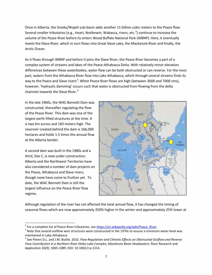
Once in Alberta, the Smoky/Wapiti sub-basin adds another 11 billion cubic meters to the Peace flow. Several smaller tributaries (e.g., Heart, Notikewin, Wabasca, rivers, etc.2) continue to increase the volume of the Peace River before its enters Wood Buffalo National Park (WBNP). Here, it eventually meets the Slave River, which in turn flows into Great Slave Lake, the Mackenzie River and finally, the Arctic Ocean. As it flows through WBNP and before it joins the Slave River, the Peace River becomes a part of a complex system of streams and lakes of the Peace-Athabasca Delta. With relatively minor elevation differences between these waterbodies, water flow can be both obstructed or can reverse. For the most part, waters from the Athabasca River flow into Lake Athabasca, which through several streams finds its way to the Peace and Slave rivers3. When Peace River flows are high (between 3000 and 7000 cms), however, ‘hydraulic damming’ occurs such that water is obstructed from flowing from the delta channels towards the Slave River.4 In the late 1960s, the WAC Bennett Dam was constructed, thereafter regulating the flow of the Peace River. This dam was one of the largest earth-filled structures at the time. It is two km across and 183 meters high. The reservoir created behind the dam is 166,000 hectares and holds 1.5 times the annual flow at the Alberta border. A second dam was built in the 1980s and a third, Site C, is now under construction. Alberta and the Northwest Territories have also considered a number of dam projects on the Peace, Athabasca and Slave rivers, though none have come to fruition yet. To date, the WAC Bennett Dam is still the largest influence on the Peace River flow regime. Although regulation of the river has not affected the total annual flow, it has changed the timing of seasonal flows which are now approximately 250% higher in the winter and approximately 25% lower at
2 For a complete list of Peace River tributaries, see https://en.wikipedia.org/wiki/Peace_River. 3 Note that several outflow weir structures were constructed in the 1970s to ensure a minimum water level was maintained in Lake Athabasca. 4 See Peters D.L. and J.M. Buttle. 2010. Flow Regulation and Climatic Effects on Obstructed Outflow and Reverse Flow Contribution in a Northern River-Delta-Lake Complex, Mackenzie Basin Headwaters. River Research and Application 26(9): 1065-1089. DOI: 10.1002/rra.1314.
8
their peak in the spring/summer. Additionally, the day-to-day effect of meeting peak power generation needs can see a change in river level of several meters within a 24-hour period. These changes in the flow regime have affected some aspects of the river such as ice freeze-up and break-up, sediment transport, channelization and the frequency of flooding riparian areas. Additionally, it affects the health of flood-dependent ponds and wetlands associated with the mainstem, particularly in the Lower Peace and the Peace-Athabasca Delta). Numerous studies over the past four decades have looked at the effects of these changes to the river.5 Unfortunately, studies are hampered by the fact that there is limited pre-dam baseline information to set benchmarks for comparison of changes pre- and post-regulation. Studies have shown however, that the number of ice-jam and summer flooding events has declined since regulation, and this in turn has contributed to the drying (reduction in extent of surface water extent and increased extent of willows) of the flood-dependent delta, as well as changes in delta wildlife (e.g., waterfowl, fur-bearers) that require a wet habitat. Other impacts include an increase in invasive species such as thistle. Several multi-year studies, such as the Northern River Basins Study (NRBS), characterized these changes. The NRBS also had a number of recommendations in its final report. It would be a useful exercise, if not already done, to evaluate which recommendations were implemented, or not, and why. Until the recent work of the MPWA, there has also been a failure in the past four decades since the dam was built to implement an adaptive management approach to river management, including selecting and monitoring indicators to measure watershed health. Going forward, the MPWA state of the watershed reporting process will regularly report on both surface water quantity and quality (two of six indicator categories), as well as other measures of aquatic ecosystem health. Additionally, rivers do not exist in isolation and other factors such as land cover, land use changes, climate change and cumulative effects also affect river health. A warming climate could lead to a shorter ice season, thinner ice cover, declines in spring snowpack, precipitation increases and increased
5 Note that studies tend to focus on the effects of regulation on the delta. Few studies have been done on the effects of river regulation on the wetlands of the Lower Peace before the river enters WBNP.
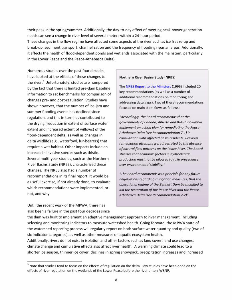
Northern River Basins Study (NRBS)
The NRBS Report to the Ministers (1996) included 20 key recommendations (as well as a number of additional recommendations on monitoring and addressing data gaps). Two of these recommendations focused on main stem flows as follows:
“Accordingly, the Board recommends that the governments of Canada, Alberta and British Columbia implement an action plan for remediating the Peace-Athabasca Delta (see Recommendation 7-1) in consultation with affected basin residents. Previous remediation attempts were frustrated by the absence of natural flow patterns on the Peace River. The Board stresses that economic factors in hydroelectric production must not be allowed to take precedence over environmental stability.”
“The Board recommends as a principle for any future negotiations regarding mitigation measures, that the operational regime of the Bennett Dam be modified to aid the restoration of the Peace River and the Peace-Athabasca Delta (see Recommendation 7-2)”.
9
evaporation, etc. For more information about the state of the Peace River, see the MPWA State of the Watershed report. For a selection of reports and articles characterizing different aspects of the Peace River flow regime, see Appendix 3 (Resources). Note that flow conditions can also be a factor in water quality. A previous WG looked at water quality conditions. The IWMP will need to ensure that connection points are made between flow and water quality in the final IWMP.
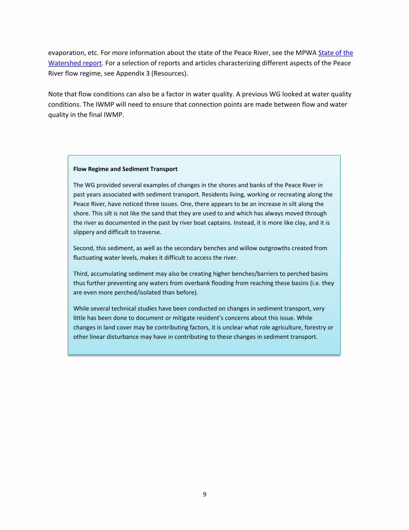
Flow Regime and Sediment Transport
The WG provided several examples of changes in the shores and banks of the Peace River in past years associated with sediment transport. Residents living, working or recreating along the Peace River, have noticed three issues. One, there appears to be an increase in silt along the shore. This silt is not like the sand that they are used to and which has always moved through the river as documented in the past by river boat captains. Instead, it is more like clay, and it is slippery and difficult to traverse.
Second, this sediment, as well as the secondary benches and willow outgrowths created from fluctuating water levels, makes it difficult to access the river.
Third, accumulating sediment may also be creating higher benches/barriers to perched basins thus further preventing any waters from overbank flooding from reaching these basins (i.e. they are even more perched/isolated than before).
While several technical studies have been conducted on changes in sediment transport, very little has been done to document or mitigate resident’s concerns about this issue. While changes in land cover may be contributing factors, it is unclear what role agriculture, forestry or other linear disturbance may have in contributing to these changes in sediment transport.
10
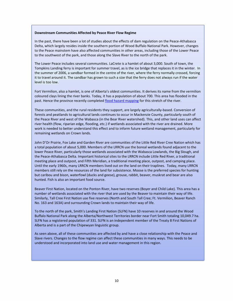
Downstream Communities Affected by Peace River Flow Regime
In the past, there have been a lot of studies about the effects of dam regulation on the Peace-Athabasca Delta, which largely resides inside the southern portion of Wood Buffalo National Park. However, changes to the Peace mainstem have also affected communities in other areas, including those of the Lower Peace to the southwest of the park, and those along the Slave River to the north of the park.
The Lower Peace includes several communities. LaCrete is a hamlet of about 3,000. South of town, the Tompkins Landing ferry is important for summer travel, as is the ice bridge that replaces it in the winter. In the summer of 2006, a sandbar formed in the centre of the river, where the ferry normally crossed, forcing it to travel around it. The sandbar has grown to such a size that the ferry does not always run if the water level is too low. Fort Vermilion, also a hamlet, is one of Alberta’s oldest communities. It derives its name from the vermilion coloured clays lining the river banks. Today, it has a population of about 700. This area has flooded in the past. Hence the province recently completed flood hazard mapping for this stretch of the river. These communities, and the rural residents they support, are largely agriculturally-based. Conversion of forests and peatlands to agricultural lands continues to occur in Mackenzie County, particularly south of the Peace River and west of the Wabasca (in the Bear River watershed). This, and other land uses can affect river health (flow, riparian edge, flooding, etc.) if wetlands associated with the river are drained. More work is needed to better understand this effect and to inform future wetland management, particularly for remaining wetlands on Crown lands. John D’Or Prairie, Fox Lake and Garden River are communities of the Little Red River Cree Nation which has a total population of about 5,000. Members of the LRRCN use the boreal wetlands found adjacent to the lower Peace River, particularly those wetlands associated with the Wabasca Lowlands, the Big Slough, and the Peace-Athabasca Delta. Important historical sites to the LRRCN include Little Red River, a traditional meeting place and outpost, and Fifth Meridian, a traditional meeting place, outpost, and camping place. Until the early 1960s, many LRRCN members lived out on the land on their traplines. Today, many LRRCN members still rely on the resources of the land for subsistence. Moose is the preferred species for hunting but caribou and bison, waterfowl (ducks and geese), grouse, rabbit, beaver, muskrat and bear are also hunted. Fish is also an important food source. Beaver First Nation, located on the Ponton River, have two reserves (Boyer and Child Lake). This area has a number of wetlands associated with the river that are used by the Beaver to maintain their way of life. Similarly, Tall Cree First Nation use five reserves (North and South Tall Cree; Ft. Vermilion, Beaver Ranch No. 163 and 163A) and surrounding Crown lands to maintain their way of life.
To the north of the park, Smith’s Landing First Nation (SLFN) have 10 reserves in and around the Wood Buffalo National Park along the Alberta/Northwest Territories border near Fort Smith totaling 10,049.7 ha. SLFN has a registered population of 331. SLFN is an independent member of the Treaty 8 First Nations of Alberta and is a part of the Chipewyan linguistic group.
As seen above, all of these communities are affected by and have a close relationship with the Peace and Slave rivers. Changes to the flow regime can affect these communities in many ways. This needs to be understood and incorporated into land use and water management in this region.
11
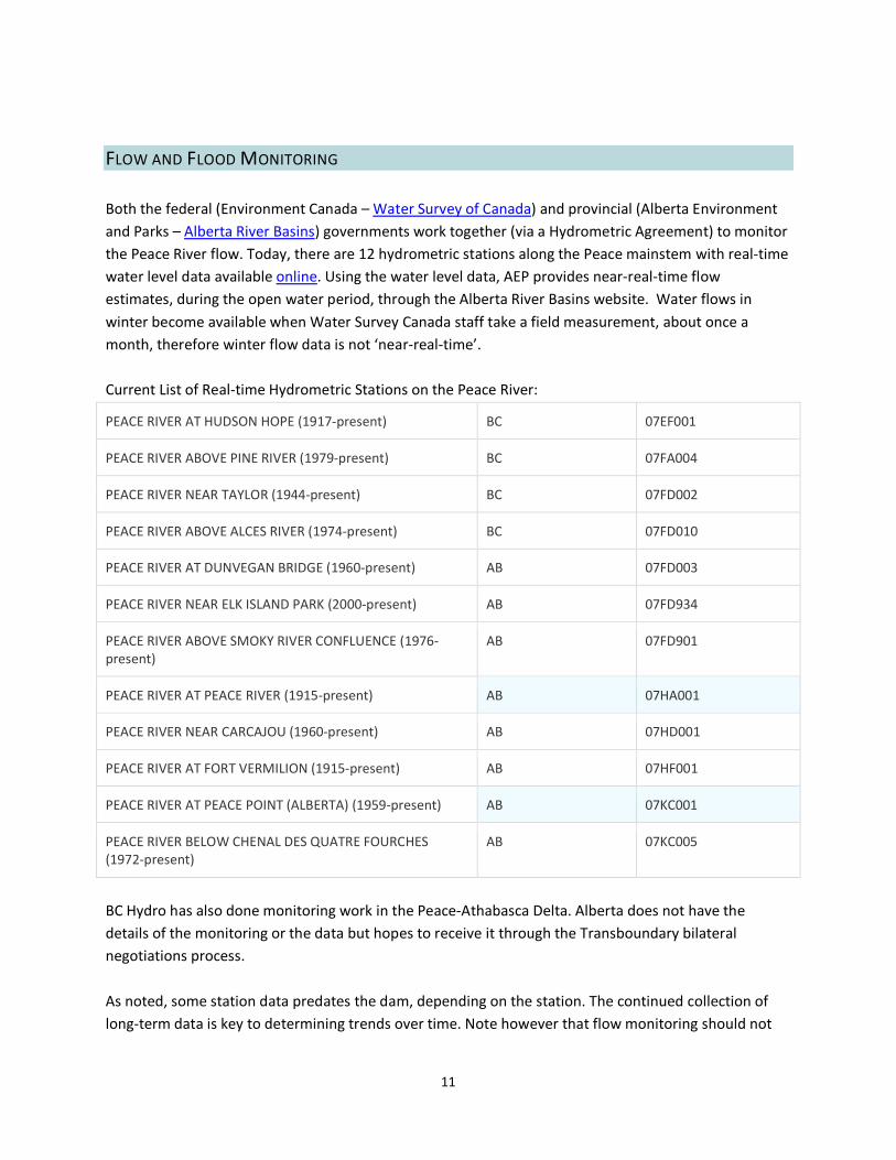
FLOW AND FLOOD MONITORING Both the federal (Environment Canada – Water Survey of Canada) and provincial (Alberta Environment and Parks – Alberta River Basins) governments work together (via a Hydrometric Agreement) to monitor the Peace River flow. Today, there are 12 hydrometric stations along the Peace mainstem with real-time water level data available online. Using the water level data, AEP provides near-real-time flow estimates, during the open water period, through the Alberta River Basins website. Water flows in winter become available when Water Survey Canada staff take a field measurement, about once a month, therefore winter flow data is not ‘near-real-time’. Current List of Real-time Hydrometric Stations on the Peace River:
PEACE RIVER AT HUDSON HOPE (1917-present) BC 07EF001
PEACE RIVER ABOVE PINE RIVER (1979-present) BC 07FA004
PEACE RIVER NEAR TAYLOR (1944-present) BC 07FD002
PEACE RIVER ABOVE ALCES RIVER (1974-present) BC 07FD010
PEACE RIVER AT DUNVEGAN BRIDGE (1960-present) AB 07FD003
PEACE RIVER NEAR ELK ISLAND PARK (2000-present) AB 07FD934
PEACE RIVER ABOVE SMOKY RIVER CONFLUENCE (1976-present)
AB 07FD901
PEACE RIVER AT PEACE RIVER (1915-present) AB 07HA001
PEACE RIVER NEAR CARCAJOU (1960-present) AB 07HD001
PEACE RIVER AT FORT VERMILION (1915-present) AB 07HF001
PEACE RIVER AT PEACE POINT (ALBERTA) (1959-present) AB 07KC001
PEACE RIVER BELOW CHENAL DES QUATRE FOURCHES (1972-present)
AB 07KC005
BC Hydro has also done monitoring work in the Peace-Athabasca Delta. Alberta does not have the details of the monitoring or the data but hopes to receive it through the Transboundary bilateral negotiations process. As noted, some station data predates the dam, depending on the station. The continued collection of long-term data is key to determining trends over time. Note however that flow monitoring should not

12
be considered in isolation of other measures of aquatic ecosystem health. Overall, the health of the downstream delta is an indicator of the cumulative impact of the activities upstream. Monitoring initiatives like the Peace Athabasca Delta Ecological Monitoring Program (PADEMP) can help quantify impacts. Concerns about cumulative impacts from regional development and climate change have led to the formation of PADEMP by a group of stakeholders working together for long-term monitoring and reporting on the health of the Peace-Athabasca Delta through western science and traditional knowledge. The Alberta Biodiversity Monitoring Institute is another monitoring initiative with collection points throughout the northern watersheds. In addition, Alberta monitors break-up conditions and flooding annually on the Peace up to the park boundary, and the park monitors break-up conditions within the park reach of the Peace River and water extent and flooding (if any) in the PAD.
FLOW REGIME MANAGEMENT Alberta has a number of tools for managing river flows. First and foremost, the Water for Life strategy sets policy direction. Secondly, several pieces of legislation, including the Water Act, Public Lands Act, and Environmental Protection and Enhancement Act, provide statutory tools for protecting flows, allocating withdrawals, preventing contamination, etc. Municipal Governments also have a role to play, as the bodies responsible for planning development around waterbodies and often, for managing drinking water and wastewater infrastructure. Finally, industry, agriculture and other land users can affect river health. Best management practices that reduce point and non-point source pollution are important for reducing nutrients, maintaining water quality etc.
The Peace River, as part of the larger Mackenzie River watershed, extends beyond Alberta’s borders. Hence, the Government of Alberta (GOA) requires effective mechanisms to communicate with other jurisdictions. At the Mackenzie Basin scale, this is achieved via Alberta’s membership on the Mackenzie River Basin Board. At a provincial/territorial scale, this occurs through Transboundary Water Agreements, both completed (Northwest Territories) and in progress (BC). Alberta also interacts with BC Hydro through the Joint Task Force on Peace River Ice, in implementing and revising the “Operating Procedures for Influencing the Freeze-Up and Break-up of the Peace River at the Town of Peace River” to mitigate potential flooding at the Town of Peace River.

13
RISKS / THREATS TO FLOW The biggest impact on the flow of the Peace River is regulation by the WAC Bennett Dam. Much has been written about this (see Resources in Appendix 3) so the WG does not describe this in detail. Note that subsequent dams at Peace Canyon and Site C, while having a local impact, do not add greatly to the changes to the Peace river flow regime.6 However, the impact of all three dams operating as part of an integrated BC Hydro system on Peace River flow has not been assessed (only the incremental impact of Site C on its own was assessed by the Joint Review Panel). A growing risk to river flow is climate change, which could further change total and seasonal flow. Temperature change can also add to issues such as algal blooms and fish kills. Allocations, less than 1% of the watershed, do not currently have a large impact. Changes to land cover are likely having some impact where such changes lead to increased point and non-point source pollution, development on flood plains; degradation of wetlands and riparian edge, etc. Taken together, the cumulative impact of these risks can affect flow, which in turn can affect a number of river flow characteristics such as ice regime (timing and height of freeze-up, timing of break-up, quality of ice for winter ice bridges), flushing flows, channelization, riparian edge, frequency and magnitude of mainstem ice-jam and summer overland flooding and the wet/dry cycle of small lakes and wetlands, muskrat and other wildlife habitat (fisheries, wolves, bison, etc.), etc. In turn, this can have impacts on the communities that live along the river, including the exercise of Mode of Life (transportation, recreation, subsistence, etc.) and the quiet enjoyment of the land (Treaty Rights).
KNOWLEDGE GAPS While the current flow of the Peace River is well monitored and generally understood, the interaction of this flow with other watershed elements (such as side channels, adjacent wetlands and ponds, fisheries, groundwater, etc.) is less well known. The effects of flow regulation, land use changes, cumulative effects, and climate change make understanding these interactions even more challenging. While there have been numerous studies on different aspects of the Peace River flow regime in the past four decades (see Appendix 3), and even a few overarching attempts at synthesis, it seems there is still much to learn about this dynamic river system. However, before more data gathering is done, it is important to ensure we are asking the right questions, pinpointing the issues, and making sure new information can inform decision-makers and provide them management options and tools.
6 Note that in building Site C, BC Hydro has consulting with downstream stakeholders including Smith’s Landing First Nation and Little Red River First Nation.

14
RECOMMENDATIONS After learning about flow regime of the Peace River, the WG was asked “What should flow management look like in the Peace-Slave watershed in the future?” The WG answered that flow regime should be:
• Sustainable (healthy, functional and resilient); • Managed adaptively using benchmarks to measure progress in achieving clearly-defined
objectives; • Managed to optimize social, economic and environmental values; and • Monitored and Understood.
From this discussion, the WG came up with a vision for the Steering Committee to consider guiding future work in this area as follows: The Peace River Flow Regime is healthy, understood and adaptively managed (using both Scientific and Traditional ecological knowledge) to optimize delivery of desired social, economic and ecological goods and services (including instream flow needs and wetland health in the Lower Peace watershed), for current and future generations. The WG then discussed at length what they would do to improve current flow management. Suggested actions were many but can be grouped into the following outcomes that could be achieved through implementation of the IWMP:
1.0 People are aware of the importance of the Peace River flow regime and what it provides.
2.0 The current Peace River flow regime and its relationship to the aquatic ecosystem health of other waterbodies (e.g. delta lakes, Lower Peace and delta wetlands, groundwater, etc.) is understood.
3.0 Cultural, social, economic and environmental issues with the current flow regime are documented, well understood and communicated to decision-makers.
4.0 Desired Aboriginal, cultural, social, economic and ecological flow values to guide management of the Peace River and its tributaries are identified and shared by all.
5.0 Potential management options and tools to achieve optimal community flow values are investigated.
6.0 The management option and/or tools that best achieves community shared flow values is communicated to AEP, as they negotiate and manage transboundary water agreements for the Peace, Slave and other transboundary waterbodies.
7.0 The LUF Upper and Lower Peace regional plans recognize the importance of, and contribute to
15
the achievement of, the values associated with the Peace River flow regime, and hence the overall health of the Peace River, and its associated tributaries, wetlands and other waterbodies.
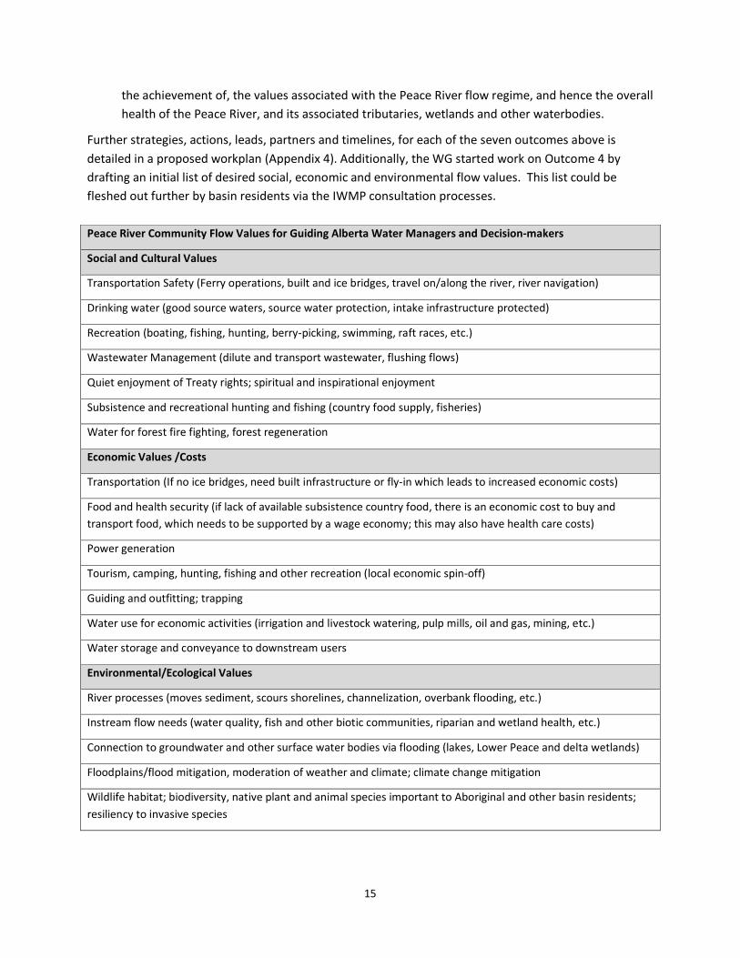
Further strategies, actions, leads, partners and timelines, for each of the seven outcomes above is detailed in a proposed workplan (Appendix 4). Additionally, the WG started work on Outcome 4 by drafting an initial list of desired social, economic and environmental flow values. This list could be fleshed out further by basin residents via the IWMP consultation processes. Peace River Community Flow Values for Guiding Alberta Water Managers and Decision-makers
Social and Cultural Values
Transportation Safety (Ferry operations, built and ice bridges, travel on/along the river, river navigation)
Drinking water (good source waters, source water protection, intake infrastructure protected)
Recreation (boating, fishing, hunting, berry-picking, swimming, raft races, etc.)
Wastewater Management (dilute and transport wastewater, flushing flows)
Quiet enjoyment of Treaty rights; spiritual and inspirational enjoyment
Subsistence and recreational hunting and fishing (country food supply, fisheries)
Water for forest fire fighting, forest regeneration
Economic Values /Costs
Transportation (If no ice bridges, need built infrastructure or fly-in which leads to increased economic costs)
Food and health security (if lack of available subsistence country food, there is an economic cost to buy and transport food, which needs to be supported by a wage economy; this may also have health care costs)
Power generation
Tourism, camping, hunting, fishing and other recreation (local economic spin-off)
Guiding and outfitting; trapping
Water use for economic activities (irrigation and livestock watering, pulp mills, oil and gas, mining, etc.)
Water storage and conveyance to downstream users
Environmental/Ecological Values
River processes (moves sediment, scours shorelines, channelization, overbank flooding, etc.)
Instream flow needs (water quality, fish and other biotic communities, riparian and wetland health, etc.)
Connection to groundwater and other surface water bodies via flooding (lakes, Lower Peace and delta wetlands)
Floodplains/flood mitigation, moderation of weather and climate; climate change mitigation
Wildlife habitat; biodiversity, native plant and animal species important to Aboriginal and other basin residents; resiliency to invasive species

16
Finally, throughout their discussion, the WG noted that there are a number of federal, provincial, and non-government initiatives occurring that may affect the flow of the Peace River (table below). Currently, it is unclear what the relationship or communication path is between these initiatives. A suitable role of the MPWA is to a) at a minimum, be aware of these other processes and how they will affect the work of the MPWA, and b) be a link between initiatives, perhaps by hosting an annual flow forum or other event for sharing information. Concurrent Initiatives associated with Peace River Flow Regime:
Initiative 2017 2018 2019 2020 2021
AB-BC Transboundary Bilateral Agreement
Negotiations may resume in 2017
Amisk Hydroelectric Project (Dunvegan)
Application review construction
Athabasca Watershed Council
Currently planning development of an integrated watershed management plan.
BC Hydro Site C Clean Energy Project
construction
Delta Dialogue Network (U of S)
Travelling Art Exhibit Other education and outreach projects.
GOA LUF Regional Planning Pre-planning background work
No schedule yet released.
GOA Wetland Policy Implementation
Now applicable to both the White and Green Areas. Note that wetland inventory work is also being conducted (see http://geodiscover.alberta.ca)
MPWA IWMP Draft, consult and seek approval
Plan implementation
Mackenzie River Basin Board
Currently working on a second State of aquatic ecosystem health report.
NWT-AB Transboundary Bilateral Agreement
Implementation is ongoing.
PADEMP Ongoing PAD monitoring, education and outreach
Slave River and Delta Partnership
NWT Govt focus on the Lower Slave and the Slave delta with issues including drying of the delta, navigation, traditional harvesting, etc.
UNESCO status of WBNP Panel preliminary report; Strategic Environmental Assessment
Wapiti River Water Management Plan
Scenario-building; drafting
approval
17
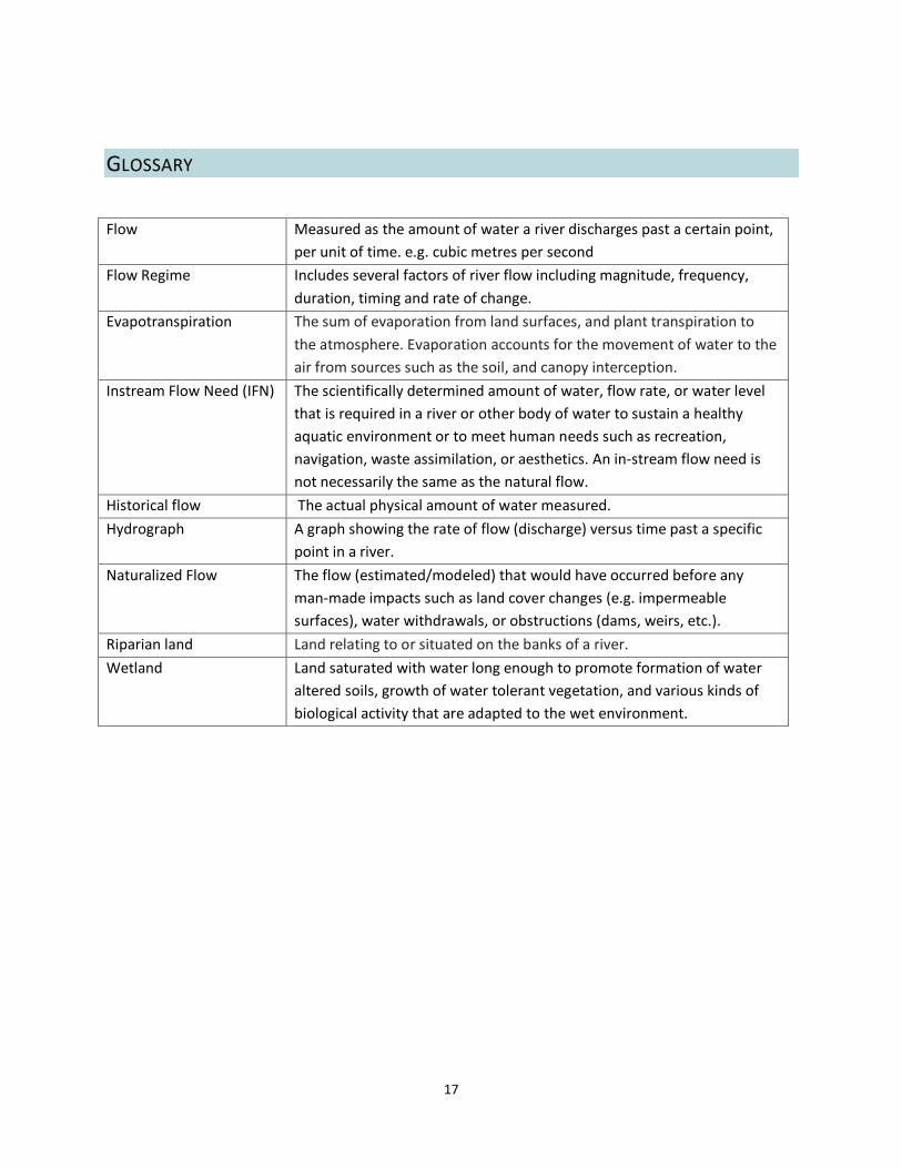
GLOSSARY
Flow Measured as the amount of water a river discharges past a certain point, per unit of time. e.g. cubic metres per second
Flow Regime Includes several factors of river flow including magnitude, frequency, duration, timing and rate of change.
Evapotranspiration The sum of evaporation from land surfaces, and plant transpiration to the atmosphere. Evaporation accounts for the movement of water to the air from sources such as the soil, and canopy interception.
Instream Flow Need (IFN) The scientifically determined amount of water, flow rate, or water level that is required in a river or other body of water to sustain a healthy aquatic environment or to meet human needs such as recreation, navigation, waste assimilation, or aesthetics. An in-stream flow need is not necessarily the same as the natural flow.
Historical flow The actual physical amount of water measured. Hydrograph A graph showing the rate of flow (discharge) versus time past a specific
point in a river. Naturalized Flow The flow (estimated/modeled) that would have occurred before any
man-made impacts such as land cover changes (e.g. impermeable surfaces), water withdrawals, or obstructions (dams, weirs, etc.).
Riparian land Land relating to or situated on the banks of a river. Wetland Land saturated with water long enough to promote formation of water
altered soils, growth of water tolerant vegetation, and various kinds of biological activity that are adapted to the wet environment.

18
APPENDIX 1 – WORKING GROUP MEMBERSHIP
Name Surname Job Title or Perspective Affiliation
Bob Cameron IWMP Steering Committee Mighty Peace Watershed Alliance
Tom Cardinal Elder Woodland Cree First Nation
Kate Churchill Non-government Agency Mackenzie Municipal Services Agency
Carmen
de la Chevrotiere Transboundary Water Quantity Specialist
Transboundary Waters Secretariat/ Alberta Environment & Parks
Jeff Dixon Lands Coordinator Smith’s Landing First Nation
Henry Francis-Kidney Councilor Beaver First Nation
Megan Graham Education & Outreach Coordinator Mighty Peace Watershed Alliance
Stuart Macmillan Manager, Resource Conservation Wood Buffalo National Parks, Parks Canada
Alisha Mody NGO Mackenzie Municipal Services Agency
Adam Norris Watershed Coordinator Mighty Peace Watershed Alliance
Petra Rowell Project Manager Consultant
Ray Toews Councilor, Rural Municipality Mackenzie County
Tim Toth (alternate) Senior Transboundary Water Advisor Transboundary Waters Secretariat/ AEP
James Tupper Economic interests Public at large
Jim Webb First Nation outside of WBNP Little Red River First Nation
Matthew Whitehead Alternate Woodland Cree First Nation

19
APPENDIX 2 – TERMS OF REFERENCE
Integrated Watershed Management Plan Working Group Peace River Flow Regime
Terms of Reference The following document describes the purpose and structure of the working groups including what they should achieve, who will participate, how work will be done and when it will be completed. The Board of Directors approved these Terms of Reference. Context The Mighty Peace Watershed Alliance Society (MPWA) is a multi-stakeholder not-for-profit organization registered under Alberta’s Society Act. The MPWA is one of several Watershed Planning and Advisory Councils created under Alberta’s Water for Life strategy. The MPWA is committed to achieving and implementing the three goals of the strategy:
• Safe, secure drinking water supply • Healthy aquatic ecosystems • Reliable, quality water supplies for a sustainable economy.
The implementation of these goals is guided by the vision, mission and shared values of the MPWA: Vision – The Peace is a healthy, sustainable watershed that supports our social environmental and economic objectives. Mission – To promote watershed excellence, the Mighty Peace Watershed Alliance will monitor cumulative effects from land use practices, industry and other activities in the watershed and work to address issues through science, education, communication policy and by supporting watershed stewardship. Objectives The working groups will work through the Issues of Concern as directed by the Integrated Watershed Management Plan Steering Committee (IWMP SC) in a consensus process. The end goal for each Issue of Concern is a set of concrete recommendations to the IWMP SC on how to improve water quality and quantity in pursuit of the 3 goals of the Water for Life strategy. This includes statements about the Issue of Concern and potential options for addressing this, which are ranked. Working Group Tasks 1. To review the information presented by the Integrated Watershed Management Plan Steering Committee (IWMP SC), review and assess for completeness and data gaps. 2. The working group will ensure that Issue of Concern is properly framed through discussion and brainstorming.
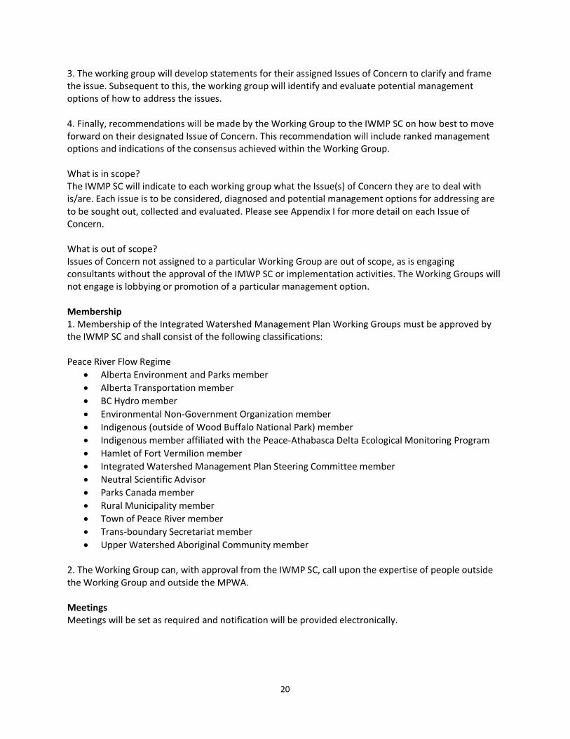
20
3. The working group will develop statements for their assigned Issues of Concern to clarify and frame the issue. Subsequent to this, the working group will identify and evaluate potential management options of how to address the issues. 4. Finally, recommendations will be made by the Working Group to the IWMP SC on how best to move forward on their designated Issue of Concern. This recommendation will include ranked management options and indications of the consensus achieved within the Working Group. What is in scope? The IWMP SC will indicate to each working group what the Issue(s) of Concern they are to deal with is/are. Each issue is to be considered, diagnosed and potential management options for addressing are to be sought out, collected and evaluated. Please see Appendix I for more detail on each Issue of Concern. What is out of scope? Issues of Concern not assigned to a particular Working Group are out of scope, as is engaging consultants without the approval of the IMWP SC or implementation activities. The Working Groups will not engage is lobbying or promotion of a particular management option. Membership 1. Membership of the Integrated Watershed Management Plan Working Groups must be approved by the IWMP SC and shall consist of the following classifications: Peace River Flow Regime
• Alberta Environment and Parks member • Alberta Transportation member • BC Hydro member • Environmental Non-Government Organization member • Indigenous (outside of Wood Buffalo National Park) member • Indigenous member affiliated with the Peace-Athabasca Delta Ecological Monitoring Program • Hamlet of Fort Vermilion member • Integrated Watershed Management Plan Steering Committee member • Neutral Scientific Advisor • Parks Canada member • Rural Municipality member • Town of Peace River member • Trans-boundary Secretariat member • Upper Watershed Aboriginal Community member
2. The Working Group can, with approval from the IWMP SC, call upon the expertise of people outside the Working Group and outside the MPWA. Meetings Meetings will be set as required and notification will be provided electronically.
21
Reporting
1. The Working Groups is responsible to and reports to the Integrated Watershed Management Plan Steering Committee, which in turn is responsible to and reports to the MPWA board (MPWA Process Guide section 6.1).
2. The Working Group will report to the IMWP SC after every meeting and the IWMP SC will report to the Board at minimum at every regular Board meeting. Quorum A simple majority of committee members shall constitute quorum. Delegation The Working Group may, with permission from the IWMP SC, delegate tasks to other qualified individuals or groups. Timelines The Working Group will convene in September 2016 and complete their work by January 2017. Scope The following is a list of components and questions to help start the work of the Peace River Flow Regime working group. A. Objectives of the Flow Regime 1. What should be the objectives for the flow regime? 2. What changes in flow regime are needed to achieve desired ecological outcomes?
a. What frequency of flooding is needed to achieve ecological outcomes? b. What drives flooding in wetlands complexes beyond ice jams? c. How do we apply the optimization model to the different objectives for flow regime? d. Effect on water temperature e. Volume and timing f. What percentage of the flooding is controlled by BC dams? g. What are the alternatives to ice jams for restoring ecological function? h. Effect of flow regime on lower Peace Watershed wetlands
3. Effect of flow regime on the ability of First Nations and Metis to exercise Mode of Life as guaranteed by Treaties and Aboriginal Rights
a. Assemble and present First Nation’s knowledge and concerns around the impact of Peace River Flow Regime on their way of life b. What conditions are necessary to enable access to fishing and hunting grounds (ice bridges, First Nations and Metis/bush travel with boats)? What costs/benefits are associated with restoring these?
4. What are the positive and negative implications (operational, structural, hazards and costs) associated with changes to flow regime?
a. Effect on wildlife and fish b. Effect on riparian zone c. Impact on channel development

22
d. Effect on recreational opportunities e. Effects on infrastructure (includes transportation such as ice bridges and ferries)
5. Promote communication of relevant information between parties
a. Understand and promote the work done by Peace Athabasca Delta Ecological Monitoring Program b. How to ensure effective engagement of all players? c. How does this Issue of Concern fit into in the Land Use Framework? d. What are the transboundary issues? e. Identify opportunity within the trans-boundary process to inform and make recommendations
B. Data Gaps 1. Is the amount of gauging along the Peace River appropriate? 2. What technical resources are available (e.g. LiDAR, satellite digital elevation model)? 3. Assess funding options for characterizing the management options for wetlands affected by flow regime.
23
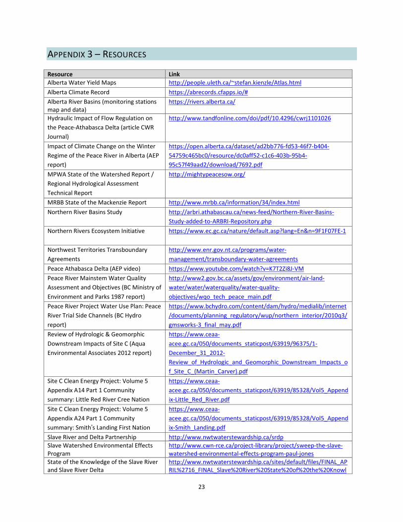
APPENDIX 3 – RESOURCES Resource Link Alberta Water Yield Maps http://people.uleth.ca/~stefan.kienzle/Atlas.html Alberta Climate Record https://abrecords.cfapps.io/# Alberta River Basins (monitoring stations map and data)
https://rivers.alberta.ca/
Hydraulic Impact of Flow Regulation on the Peace-Athabasca Delta (article CWR Journal)
http://www.tandfonline.com/doi/pdf/10.4296/cwrj1101026
Impact of Climate Change on the Winter Regime of the Peace River in Alberta (AEP report)
https://open.alberta.ca/dataset/ad2bb776-fd53-46f7-b404-54759c465bc0/resource/dc0aff52-c1c6-403b-95b4-95c57f49aad2/download/7692.pdf
MPWA State of the Watershed Report / Regional Hydrological Assessment Technical Report
http://mightypeacesow.org/
MRBB State of the Mackenzie Report http://www.mrbb.ca/information/34/index.html Northern River Basins Study
http://arbri.athabascau.ca/news-feed/Northern-River-Basins-Study-added-to-ARBRI-Repository.php
Northern Rivers Ecosystem Initiative
https://www.ec.gc.ca/nature/default.asp?lang=En&n=9F1F07FE-1
Northwest Territories Transboundary Agreements
http://www.enr.gov.nt.ca/programs/water-management/transboundary-water-agreements
Peace Athabasca Delta (AEP video) https://www.youtube.com/watch?v=K7T2Zi8J-VM Peace River Mainstem Water Quality Assessment and Objectives (BC Ministry of Environment and Parks 1987 report)
http://www2.gov.bc.ca/assets/gov/environment/air-land-water/water/waterquality/water-quality-objectives/wqo_tech_peace_main.pdf
Peace River Project Water Use Plan: Peace River Trial Side Channels (BC Hydro report)
https://www.bchydro.com/content/dam/hydro/medialib/internet/documents/planning_regulatory/wup/northern_interior/2010q3/gmsworks-3_final_may.pdf
Review of Hydrologic & Geomorphic Downstream Impacts of Site C (Aqua Environmental Associates 2012 report)
https://www.ceaa-acee.gc.ca/050/documents_staticpost/63919/96375/1-December_31_2012-Review_of_Hydrologic_and_Geomorphic_Downstream_Impacts_of_Site_C_(Martin_Carver).pdf
Site C Clean Energy Project: Volume 5 Appendix A14 Part 1 Community summary: Little Red River Cree Nation
https://www.ceaa-acee.gc.ca/050/documents_staticpost/63919/85328/Vol5_Appendix-Little_Red_River.pdf
Site C Clean Energy Project: Volume 5 Appendix A24 Part 1 Community summary: Smith’s Landing First Nation
https://www.ceaa-acee.gc.ca/050/documents_staticpost/63919/85328/Vol5_Appendix-Smith_Landing.pdf
Slave River and Delta Partnership http://www.nwtwaterstewardship.ca/srdp Slave Watershed Environmental Effects Program
http://www.cwn-rce.ca/project-library/project/sweep-the-slave-watershed-environmental-effects-program-paul-jones
State of the Knowledge of the Slave River and Slave River Delta
http://www.nwtwaterstewardship.ca/sites/default/files/FINAL_APRIL%2716_FINAL_Slave%20River%20State%20of%20the%20Knowl
24
edge%20Report.pdf Streamflow in the Mackenzie Basin, Canada (paper)
http://pubs.aina.ucalgary.ca/arctic/Arctic56-4-328.pdf
The Peace Athabasca Delta (BC Hydro video)
https://www.youtube.com/watch?v=cnDlycIvwGg
The Regulation of Peace River: A Case Study for River Management (Book by Michael Church)
https://books.google.ca/books?id=-nITBwAAQBAJ&pg=PA251&lpg=PA251&dq=peace+river+flow+regime&source=bl&ots=qvlv-HYuvb&sig=komVm3hp_ZmXF6hU7JGLp0sFk3c&hl=en&sa=X&ved=0ahUKEwj64Mivp6fRAhVH1GMKHXuLBpo4ChDoAQheMAU#v=onepage&q=peace%20river%20flow%20regime&f=false
Tracking Change Initiative http://www.trackingchange.ca/ Trends in Slave River flows (Northwest Territories State of the Environment website)
http://www.enr.gov.nt.ca/state-environment/112-trends-slave-river-flows
Vulnerability Assessment of the Slave River and Delta
http://www.nwtwaterstewardship.ca/sites/default/files/FINAL_April'16_%20FINAL_SRDP_VulnerabilityAssessment.pdf
Woodland Cree First Nation (video) https://www.youtube.com/watch?v=2IVQgNi5cOE
25
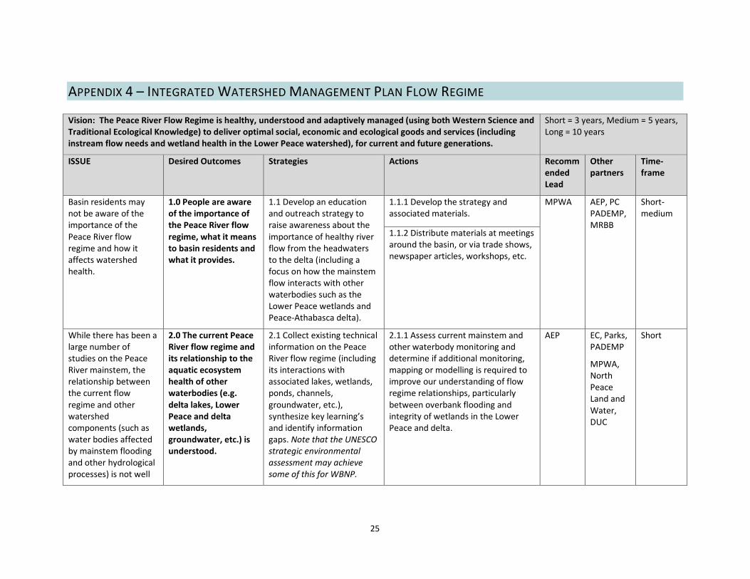
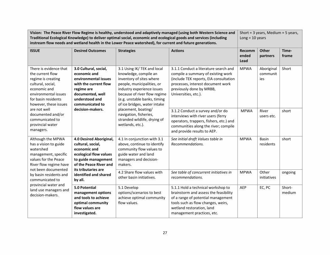
APPENDIX 4 – INTEGRATED WATERSHED MANAGEMENT PLAN FLOW REGIME Vision: The Peace River Flow Regime is healthy, understood and adaptively managed (using both Western Science and Traditional Ecological Knowledge) to deliver optimal social, economic and ecological goods and services (including instream flow needs and wetland health in the Lower Peace watershed), for current and future generations.
Short = 3 years, Medium = 5 years, Long = 10 years
ISSUE Desired Outcomes Strategies Actions Recommended Lead
Other partners
Time-frame
Basin residents may not be aware of the importance of the Peace River flow regime and how it affects watershed health.
1.0 People are aware of the importance of the Peace River flow regime, what it means to basin residents and what it provides.
1.1 Develop an education and outreach strategy to raise awareness about the importance of healthy river flow from the headwaters to the delta (including a focus on how the mainstem flow interacts with other waterbodies such as the Lower Peace wetlands and Peace-Athabasca delta).
1.1.1 Develop the strategy and associated materials.
MPWA AEP, PC PADEMP, MRBB
Short-medium
1.1.2 Distribute materials at meetings around the basin, or via trade shows, newspaper articles, workshops, etc.
While there has been a large number of studies on the Peace River mainstem, the relationship between the current flow regime and other watershed components (such as water bodies affected by mainstem flooding and other hydrological processes) is not well
2.0 The current Peace River flow regime and its relationship to the aquatic ecosystem health of other waterbodies (e.g. delta lakes, Lower Peace and delta wetlands, groundwater, etc.) is understood.
2.1 Collect existing technical information on the Peace River flow regime (including its interactions with associated lakes, wetlands, ponds, channels, groundwater, etc.), synthesize key learning’s and identify information gaps. Note that the UNESCO strategic environmental assessment may achieve some of this for WBNP.
2.1.1 Assess current mainstem and other waterbody monitoring and determine if additional monitoring, mapping or modelling is required to improve our understanding of flow regime relationships, particularly between overbank flooding and integrity of wetlands in the Lower Peace and delta.
AEP
EC, Parks, PADEMP
MPWA, North Peace Land and Water, DUC
Short

26
Vision: The Peace River Flow Regime is healthy, understood and adaptively managed (using both Western Science and Traditional Ecological Knowledge) to deliver optimal social, economic and ecological goods and services (including instream flow needs and wetland health in the Lower Peace watershed), for current and future generations.
Short = 3 years, Medium = 5 years, Long = 10 years
ISSUE Desired Outcomes Strategies Actions Recommended Lead
Other partners
Time-frame
understood. 2.2 Organize a technical committee to identify, prioritize and fill data gaps. (Build on existing PADEMP work but extend membership outside of Delta.)
2.2.1 Undertake a literature review of naturalized to recorded flow comparisons. Then calculate instream flow needs (via modelling/naturalizing recorded flows dataset). Compare to current flow regime and identify any issues.
AEP MRBB has done some modeling work
short
2.2.2 Review and update the 1980s study to evaluate the effectiveness of the weirs constructed in the delta in the 1970s. This should inform if a) maintenance of these structures is required; b) whether these structures were/are still effective, and c) if such structures might provide management options for other areas of the Peace watershed.
AEP EC, PC, MRBB
medium
2.2.3 Conduct a literature review, and possible initiate a study, to assess sediment transport /siltation/water quality issues identified by basin residents.
AEP EC, PC, MRBB
medium
2.2.4 Conduct a study to identify the feasibility, optimal conditions and costs of doing a release to augment flooding; as well as the costs of not doing anything.
AEP EC/PC/ PADEMP
27
Vision: The Peace River Flow Regime is healthy, understood and adaptively managed (using both Western Science and Traditional Ecological Knowledge) to deliver optimal social, economic and ecological goods and services (including instream flow needs and wetland health in the Lower Peace watershed), for current and future generations.
Short = 3 years, Medium = 5 years, Long = 10 years
ISSUE Desired Outcomes Strategies Actions Recommended Lead
Other partners
Time-frame
There is evidence that the current flow regime is creating cultural, social, economic and environmental issues for basin residents however, these issues are not well documented and/or communicated to provincial water managers.
3.0 Cultural, social, economic and environmental issues with the current flow regime are documented, well understood and communicated to decision-makers.
3.1 Using IK/ TEK and local knowledge, compile an inventory of sites where people, municipalities, or industry experience issues because of river flow regime (e.g. unstable banks, timing of ice bridges, water intake placement, boating/ navigation, fisheries, stranded wildlife, drying of wetlands, etc.).
3.1.1 Conduct a literature search and compile a summary of existing work (include TEK reports, EIA consultation processes, interest document work previously done by MRBB, Universities, etc.).
MPWA Aboriginal communities
Short
3.1.2 Conduct a survey and/or do interviews with river users (ferry operators, trappers, fishers, etc.) and communities along the river; compile and provide results to AEP.
MPWA River users etc.
short
Although the MPWA has a vision to guide watershed management, specific values for the Peace River flow regime have not been documented by basin residents and communicated to provincial water and land use managers and decision-makers.
4.0 Desired Aboriginal, cultural, social, economic and ecological flow values to guide management of the Peace River and its tributaries are identified and shared by all.
4.1 In conjunction with 3.1 above, continue to identify community flow values to guide water and land managers and decision-makers.
See initial draft Values table in Recommendations.
MPWA Basin residents
short
4.2 Share flow values with other basin initiatives.
See table of concurrent initiatives in recommendations.
MPWA Other initiatives
ongoing
5.0 Potential management options and tools to achieve optimal community flow values are investigated.
5.1 Develop options/scenarios to best achieve optimal community flow values.
5.1.1 Hold a technical workshop to brainstorm and assess the feasibility of a range of potential management tools such as flow changes, weirs, wetland restoration, land management practices, etc.
AEP EC, PC Short-medium

28
Vision: The Peace River Flow Regime is healthy, understood and adaptively managed (using both Western Science and Traditional Ecological Knowledge) to deliver optimal social, economic and ecological goods and services (including instream flow needs and wetland health in the Lower Peace watershed), for current and future generations.
Short = 3 years, Medium = 5 years, Long = 10 years
ISSUE Desired Outcomes Strategies Actions Recommended Lead
Other partners
Time-frame
6.0 The management option and/or tools that optimizes community shared flow values is communicated to AEP, as they negotiate and manage transboundary water agreements for the Peace, Slave and other transboundary waterbodies.
6.1 MPWA board recommends the desired management regime to AEP’s transboundary unit.
MPWA AEP Medium-long
7.0 The LUF Upper and Lower Peace regional plans recognize the importance of, and contribute to the health of the Peace River, and its associated tributaries, wetlands and other waterbodies.
7.1 Compete the IWMP and provide it to the LUF Regional Planning staff for consideration in the upper and lower Peace regional plans.
MPWA GOA Short
7.2 Examine the Wetland Policy in relation to the Lower Peace and determine how policy implementation (and the policy valuation framework) will affect wetlands and wetland values within the Peace River watershed.
7.2.1 Ask the Wetland Policy Implementation office to make a presentation to the MPWA board to address this question.
MPWA AEP Short