pebble project 2017 reclamation report mlup no. 6118 · pebble project . 2017 reclamation report ....
TRANSCRIPT

PEBBLE PROJECT
2017 Reclamation Report
MLUP No. 6118
PREPARED BY: PEBBLE LIMITED PARTNERSHIP
DECEMBER 31, 2017

PEBBLE LIMITED PARTNERSHIP
2017 Reclamation Report i December 31, 2017
CONTENTS
1.0 INTRODUCTION .................................................................................................................................. 1
1.1 Location ........................................................................................................................................ 1 1.2 Reclamation Objectives and Requirements .................................................................................. 1 1.3 Work Summary ............................................................................................................................. 2 1.4 Other Permits and Regulatory Requirements ............................................................................... 3
2.0 PROJECT DESCRIPTION .................................................................................................................... 4
2.1 Site Access .................................................................................................................................... 4 2.2 Environmental Controls ................................................................................................................ 4 2.3 Material & Equipment Staging ..................................................................................................... 5 2.4 Field Staff and Logistics ............................................................................................................... 6
3.0 MAINTENANCE ACTIVITIES ............................................................................................................ 7
3.1 Planned vs. Actual Activity .......................................................................................................... 7 3.2 Surface Disturbance and Reclamation .......................................................................................... 7 3.3 Consumptive Water Use ............................................................................................................... 7 3.4 2017 Repair Sites .......................................................................................................................... 7 3.5 Investigation Sites ......................................................................................................................... 9 3.6 State Inspection ........................................................................................................................... 11 3.7 Internal Inspections ..................................................................................................................... 11 3.8 MLUP No. 6118 Special Stipulations ........................................................................................ 12
4.0 SIGNATURE ....................................................................................................................................... 13
TABLES Table 1. 2017 Repair Site Summary ...................................................................................................... 2 Table 2. Water Use Summary ............................................................................................................... 7 Table 3. 2017 Borehole Inspection Summary ..................................................................................... 12
FIGURES Figure 1. Pebble Project Vicinity Figure 2. Pebble Claim Blocks Figure 3. 2017 Maintenance Locations Figure 4. Pebble Project Field Installations
APPENDICES
Appendix A: Maintenance Photos Appendix B: Drill Site Inspection Categories Appendix C: 2017 Borehole Inspection Status (electronic)

PEBBLE LIMITED PARTNERSHIP
Annual Reclamation Report 1 December 31, 2017
1.0 INTRODUCTION
This report summarizes care and maintenance activities conducted during the 2017 field season at the Pebble Project, a mineral exploration and development project operated by the Pebble Limited Partnership (PLP). PLP is a U.S. company wholly owned by Northern Dynasty Minerals Ltd. of Vancouver, Canada, conducting exploration-related activities on state mineral claims leased to the Pebble East Claims Corporation, Pebble West Claims Corporation, and U5 Resources, Inc. These activities are authorized by Miscellaneous Land Use Permit (MLUP) No. 6118 issued by the Alaska Department of Natural Resources, Division of Mining, Land and Water (ADNR-MLW).
During 2017, PLP operated the Pebble Project in care and maintenance status. There were no exploration conducted during the calendar year. PLP did conduct minor repair and maintenance activities in 2017, resulting in less than one-tenth of one acre (< 0.1) of disturbed land. All disturbed areas have been fully reclaimed in accordance with AS 27.19 and 11 AAC 97.
1.1 LOCATION
The Pebble Project is located in the Lake and Peninsula Borough in southwest Alaska. The main deposit is centered approximately 200 miles SW of Anchorage, 60 miles W of Cook Inlet and 17 miles NW of Iliamna (Figure 1). The Pebble Project comprises 2,402 Alaska state mineral claims, and contains one of the world’s most significant undeveloped deposits of copper, gold, and molybdenum (Figure 2).
1.2 RECLAMATION OBJECTIVES AND REQUIREMENTS
Alaska statute (AS 27.19) and regulation (11 AAC 97) require mining operators to reclaim any disturbed land to a “stable condition”, which means rehabilitation to a state that allows for the reestablishment of a vegetative cover within a reasonable period of time. MLUP No. 6118 further stipulates that:
• Surface disturbance shall be held to a minimum, and will be reclaimed by backfilling, contouring, and spreading of organic rich overburden to promote stabilization and natural revegetation.
• The area reclaimed shall be reshaped and recontoured to blend with surrounding physiography using strippings and overburden, and then stabilized to a condition that shall retain sufficient moisture to allow for natural revegetation.
• Upon completion of drilling activities, drill pads shall be reclaimed as necessary, including reseeding, to encourage natural revegetation of the sites and protect them from erosion. Trenches shall be backfilled with material excavated and mounded slightly.
• All exploration trenches shall be reclaimed before the end of the exploration season in which they are constructed, unless they are specifically approved to remain open by the Division of Mining, Land & Water.

PEBBLE LIMITED PARTNERSHIP
Annual Reclamation Report 2 December 31, 2017
MLUP No. 6118 also requires the filing of this reclamation report and Annual Reclamation Statement by December 31 of each year the permit is in effect. The Annual Reclamation Statement and Letter of Intent to do Reclamation were submitted with APMA A20186118 on December 8, 2017.
MLUP No. 6118 also includes multiple special stipulations addressing:
• Mineral Closing Order 393 (Special Stipulation A) • Bristol Bay Area Plan requirements (B) • Wildlife Management (C-F) • Site Monitoring, Maintenance, and Reporting (G-H) • Water Use (K)
Activities for special stipulations A-H are described in Section 3.8. Water use (K) is summarized in Section 3.3. The entirety of this report satisfies Special Stipulation J (Annual Report).
1.3 WORK SUMMARY
Work conducted during the 2017 field season included:
• Detailed investigation of five sites with minor surface water seepage, and repairs as appropriate (e.g., drilling, re-grouting).
• Removal of aboveground casing at 138 inactive sites. • Routine maintenance (e.g., safety marker replacements, plug/cap maintenance, security
controls). • Continued monitoring of select sites to evaluate revegetation success and previous
repairs. • 837 routine inspections of select field installations as required by MLUP No. 6118.
Drill sites re-drilled, grouted, and closed are summarized in Table 1 and shown on Figure 3. Details for each location are provided in Section 3.4. Inspections and results are presented in Appendix C. Representative photographs are included in Appendix A.
Table 1. 2017 Repair Site Summary
Borehole ID
Initial Drill Date
ADL Claim No.
Easting (UTM
NAD27)
Northing (UTM
NAD27) Activity
3127 2003 516873 2155401.824 1401960.748 Re-drilled and grouted; upwelling reduced but not cutoff completely. Revisit in 2018 with different rig configuration to complete repair.
3131 2003 516873 2155343.151 1401852.352 Drilled, grouted, and reclaimed; all water flow stopped. 7386 2007 524684 2153380.446 1407342.562 Drilled, grouted, and reclaimed; all water flow stopped. 9475 2009 540442 2161885.08 1406679.89 Drilled, grouted, and reclaimed; all water flow stopped. 8433M 2008 516874 2155701.446 1402203.615 Drilled, grouted, and reclaimed; all water flow stopped.

PEBBLE LIMITED PARTNERSHIP
Annual Reclamation Report 3 December 31, 2017
1.4 OTHER PERMITS AND REGULATORY REQUIREMENTS
Activities conducted during 2017 did not require other permits or approvals from other state or federal agencies.
PEBBLE LIMITED PARTNERSHIP
Annual Reclamation Report 4 December 31, 2017
2.0 PROJECT DESCRIPTION
2.1 SITE ACCESS
Field operations are based out of PLP’s office at the Iliamna Airport in Iliamna, AK. Access to all worksites within the Pebble deposit is by helicopter only. PLP does not use ground vehicles to access the deposit area or travel between worksites. As a result, the deposit area remains free of temporary roads and tracks.
2.2 ENVIRONMENTAL CONTROLS
2.2.1 Vegetation and Tundra Preservation
PLP’s standard field work procedures require the use of wooden tundra pads and platforms for all heavy equipment and materials to minimize vegetation impacts. Individual worksites are also organized to have as small a footprint as possible, with mobilization and demobilization occurring within the shortest time frame to limit duration impacts. When a surface disturbance is necessary, groundcover, including vegetation, is removed and stockpiled for later use in reclaiming the site. Once the activity is complete, excavated areas are backfilled and re-covered with reserved tundra. Disturbed areas are also revegetated with native seed or an approved seed mixture as appropriate.
2.2.2 Fuel Management and Spill Prevention
PLP uses double-walled, welded aluminum fly tanks to transport and store all fuel for field operations. Tanks are filled at PLP’s Iliamna location to no more than 80 percent of the total capacity. (Most tanks used have a total capacity of 110 gallons, meaning each will contain no more than 88 gallons.) Each tank is visually inspected for leaks or spills prior to transport by helicopter.
All active fuel tanks are placed in welded aluminum secondary containments sized to hold 110 percent of the tank’s maximum capacity. Containments are placed on level ground at least 100 feet from any surface water.
Each tank location is stocked with a spill containment and cleanup kit. All field staff have been trained in the proper response and reporting protocols as part of PLP’s SPCC Plan. PLP also maintains a contract with Alaska Chadux Corporation to provide 24-hour spill response, if necessary. After each worksite is demobilized, the area is inspected to ensure no leaks or spills occurred.
2.2.3 Erosion and Sediment Control
Certified weed-free straw was used in conjunction with re-seeding efforts at multiple locations to minimize wind and water erosion and promote more thorough vegetation growth.

PEBBLE LIMITED PARTNERSHIP
Annual Reclamation Report 5 December 31, 2017
2.3 MATERIAL & EQUIPMENT STAGING
2.3.1 Main Supply Depot
The Main Supply Depot (MSD) was initially constructed in 2004 and serves as the primary storage and staging area for field operations. The site occupies approximately 2.5 acres of a gravel bluff in the West Deposit area (SE1/4 SE1/4 of Sec 21, T3S R35W and the NE1/4 NE1/4 of Sec 28, T3S, R35W) (ADL Nos. 516811 and 516874).
Multiple temporary wood frame buildings (including West Bay 4 building) and platform tents provide sheltered storage for machinery, drilling equipment, environmental supplies, and variety of small parts and tools. Small quantities of drilling fluids, motor oils, and antifreeze are stored in sealed, original packaging inside weather-proof shelters. All temporary structures are constructed on elevated platforms or placed on tundra pads.
Other items such as drill rods, lumber, tundra pads, outhouses, fuel containments, rig supports, are stored within the MSD yard on racks or elevated platforms. These items represent equipment consolidated at the MSD from multiple field locations when exploration activities ceased in 2013.
2.3.2 Fuel Storage
Jet A fuel is used for all large mechanized field equipment (pumps, generators, drill rigs). Multiple aluminum fly tanks were transported to and stored at the MSD by helicopter to support 2017 field operations in accordance with PLP’s fuel management policies (Section 2.2.2). The maximum volume of fuel stored at the MSD during 2017 was approximately 600 gallons. Smaller volumes of fuel were transported to individual work sites as necessary and stored appropriately (aluminum containments, spill kits). All fuel tanks were removed to Iliamna at the end of the 2017 field season. No fuel or other petroleum product spills were identified or reported during the 2017 field season.
2.3.3 Watershed
The Watershed site is located approximately 0.75 miles east of the MSD in the SW1/4 SE1/4 of Sec 22, T3S, R35W (ADL No. 524712). The site consists of three temporary buildings constructed on elevated platforms: one Quonset-style building with a corrugated metal roof (14’ x 16’) that served as a light machine shop, and two wood frame buildings (9’ x 38’; 10’ x 16’) used to store hoses, miscellaneous hand tools and field supplies. A small generator shed is attached to the Quonset hut. One 110-gallon fuel tank (empty) is kept in an aluminum containment next to the shed.
PLP continues to use the Watershed site as a storage location for field equipment.
2.3.4 West Bay 1 and 3
Each West Bay location consists of two temporary wooden structures (an 8’ x 12’ emergency shelter and a smaller generator shack). These structures are used to provide shelter for monitoring crews during data collection. West Bay 1 is located in the SW1/4 SW1/4 of Sec 23, T3S, R35W (ADL No. 524714). West Bay 3 is located in the NE1/4 SW1/4 of Sec 33, T3S, R36W (ADL No. 642412). PLP continues to use both West Bay locations to store field equipment.

PEBBLE LIMITED PARTNERSHIP
Annual Reclamation Report 6 December 31, 2017
Note: The facility previously identified as West Bay 4 remains in place, but due to its location within the footprint of the MSD it is not inventoried as a separate field site.
2.3.5 Meteorological and Communications
The Pebble 1 meteorological station is located in the SW1/4 NE1/4 of Sec 20, T3S, R35W (ADL No. 524829). The small site consists of a temporary fiberglass structure (approximately 8 x 8 ft) and associated equipment.
The Koktuli Mountain radio repeater is located in the NE1/4 SW1/4 of Sec 36, T3S, R35W (ADL No. 646608). The small site consists of a temporary metal structure (approximately 8 x 8 ft) and associated equipment. During 2017, steel cables and the tower structure were replaced due to vandalism that occurred during winter 2016-2017.
PLP continues to use the Pebble 1 met station to collect basic meteorological data, while the Koktuli Mountain repeater remains the primary means of communication with helicopters and field crews.
2.3.6 Acid Rock Drainage Test Location
The ARD site is located in the SE 1/4 SE 1/4 of Section 22, T3S, R35W (ADL No. 524713). It was set up to evaluate real time weathering and acid generation potential in area rock. The site consists of 12 large plastic barrels filled half way with rock fragments. Barrels are racked on wood tundra pads.
Each barrel is covered with a 40-mil HDPE tarp to prevent water intrusion. Drainage tubes are also sealed to prevent leakage. In August 2016 PLP installed aluminum plates on top of each barrel to guard against wind and wildlife damage. Aluminum plates are either 3/8-inch or 1/4-inch thick and secured with ratchet straps.
PLP intends to re-start field testing at the ARD site in 2018 and conducted initial site preparation work in fall 2017.
2.4 FIELD STAFF AND LOGISTICS
All work crews are based out of Iliamna and ferried to the work site by helicopter each day work is being performed. All waste is removed from the field and properly disposed in Iliamna.

PEBBLE LIMITED PARTNERSHIP
Annual Reclamation Report 7 December 31, 2017
3.0 MAINTENANCE ACTIVITIES
3.1 PLANNED VS. ACTUAL ACTIVITY
PLP has operated the Pebble Project in a care and maintenance status since 2014 and did not conduct any renewed exploration activity in 2017. Minor repair and maintenance activities were planned for the 2017 field season and completed as described in sections 3.4, 3.5, and 3.88.
3.2 SURFACE DISTURBANCE AND RECLAMATION
Surface disturbances during the 2017 field season totaled 0.0565 acres, or 2,461.33 square feet. All disturbed areas have been reclaimed; 0.0 acres remain disturbed.
3.3 CONSUMPTIVE WATER USE
Minor water quantities were required to prepare grout mixtures for re-drilled sites. Water was obtained from existing boreholes that have been retained as water sources, or from the site being repaired. Water volumes did not exceed thresholds requiring permit coverage.
Table 2. Water Use Summary
Repair Location Borehole ID
Source Water Location (Borehole ID)
Water Volume (gallons)
3127 5330 600 3132 5330 500 7386 7365 400 8433M 5330 500 9475 9475/5330 1000
3.4 2017 REPAIR SITES
Maintenance activities were conducted during the 2017 field season (June – October).. Representative photos for re-drilled/grouted sites are provided in Appendix A.
3.4.1 Borehole 3127
This site was first repaired in 2016 by backfilling with bentonite pellets (see 2016 Annual Reclamation Report). These repairs were initially successful but subsequent inspection in spring 2017 showed that minor upwelling (approximately 1 gallon per minute [gpm]) had recurred. Water quickly dissipates into the surrounding tundra.
PLP’s drilling contractor (Foundex Pacific) made two attempts to re-drill and grout the site in 2017, with limited success. Water flow was reduced but not completely cut off. Foundex advised that the site would be better addressed with an alternate rig configuration that can more accurately adjust to the borehole’s initial drilling angle (-49°). After consultation with DNR, PLP decided to forgo a third attempt in 2017 and instead plans to implement the contractor’s recommendation in 2018.

PEBBLE LIMITED PARTNERSHIP
Annual Reclamation Report 8 December 31, 2017
Approximately 160 square feet were disturbed during repair efforts. The site was reclaimed and stabilized to minimize erosion, but was not reseeded in anticipation of additional repair work in 2018. PLP will continue to monitor the site and report changes to DNR.
3.4.2 Borehole 3132
Borehole 3132 is co-located with Borehole 3131, which was successfully re-drilled, grouted, and closed in 2015. Inspection in 2016 showed a small, diffuse upwelling that quickly dissipated into the surrounding ground. The water volume was too small to quantify, but appeared consistent. The exact source or point of origin could not be determined.
The original borehole was drilled to a depth of 71.5 feet and grouted to the surface with approximately 60.8 cubic feet of grout mix (dry volume). All water flow was successfully cut off. No casing or surface structures were left in place.
All heavy equipment and materials were set on tundra pads. A small area of approximately 120 square feet, including a small sump to manage excess water, was excavated to complete repairs. Disturbed areas were then reclaimed and regraded to minimize erosion. The site will be re-inspected in 2018 to verify repair success and seeded with an approved seed mixture if appropriate.
3.4.3 Borehole 7386
This site is located in the West Deposit area and is co-located with Borehole 7380. A clear, consistent upwelling (less than 1 gpm) was observed in 2016. Water flowed downhill in a discrete channel before dissipating into the surrounding ground.
The original borehole was drilled to a depth of 162.67 feet and grouted to the surface with approximately 65.8 cubic feet of grout mix (dry volume). All water flow was successfully cut off. No casing or surface structures were left in place.
All heavy equipment and materials were set on tundra pads. A small area of approximately 160 square feet, including a small sump to manage excess water, was excavated to complete repairs. Where present, existing vegetation was preserved for re-use. Disturbed areas were then reclaimed and regraded to minimize erosion. The site will be re-inspected in 2018 to verify repair success and seeded with an approved seed mixture if appropriate.
3.4.4 Borehole 8433M
This site is located approximately 800 feet southwest of the MSD in the West Deposit. No surface structures are present. The 2016 inspection observed water flowing consistently at a rate of 1-2 gpm and before dissipating into surrounding ground. A previous attempt to cut off water flow using bentonite pellets in 2016 was unsuccessful.
The original borehole was drilled to a depth of 51.5 feet and grouted to the surface with approximately 21 cubic feet of grout mix (dry volume). All water flow was successfully cut off. No casing or surface structures were left in place.

PEBBLE LIMITED PARTNERSHIP
Annual Reclamation Report 9 December 31, 2017
All heavy equipment and materials were set on tundra pads. A small area of approximately 60 square feet, including a small sump to manage excess water, was excavated to complete repairs. Where present, existing vegetation was preserved for re-use. Disturbed areas were then reclaimed and regraded to minimize erosion. The site will be re-inspected in 2018 to verify repair success and seeded with an approved seed mixture if appropriate.
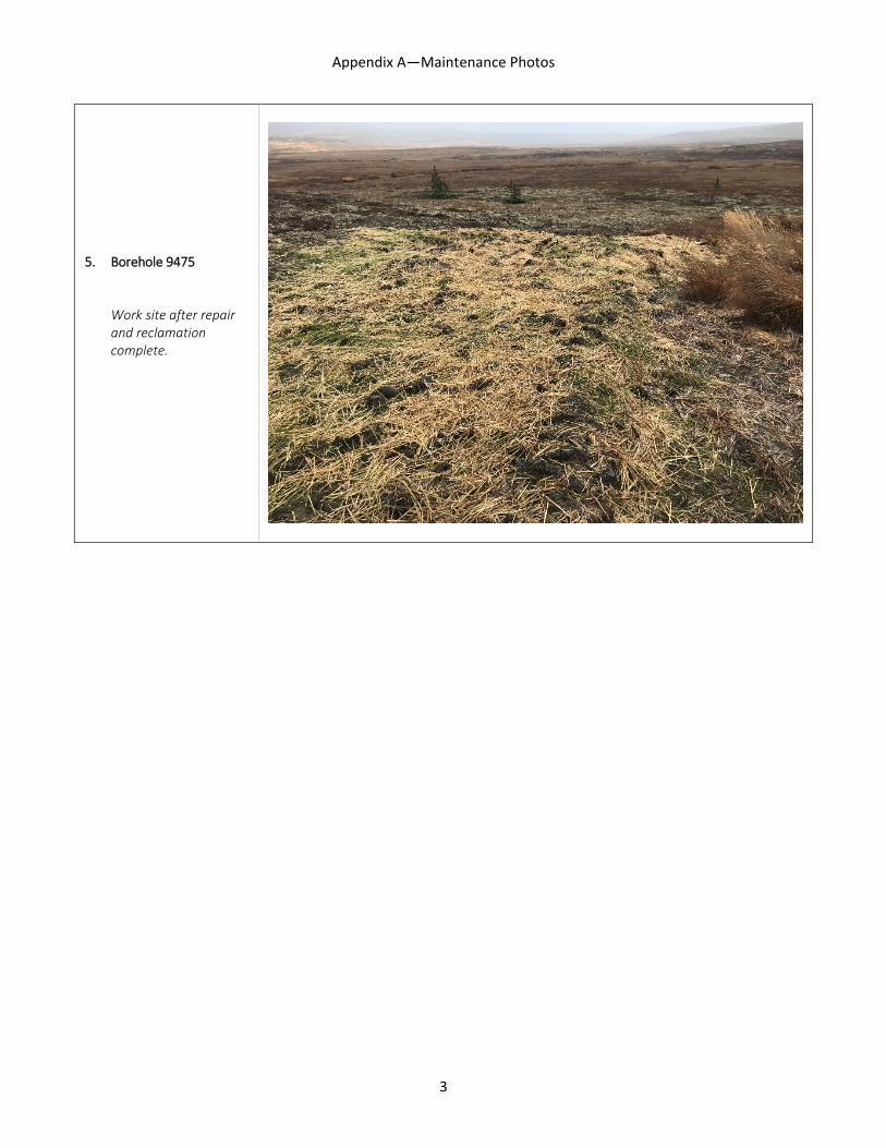
3.4.5 Borehole 9475
This site is located in the East Deposit area and was previously used for long-term monitoring. Upwelling was first observed in 2014, with an initial repair attempt made in fall 2015. Repairs at that time were unsuccessful, as upwelling had resumed by spring 2016. Prior to 2017 repairs, water was observed flowing at a rate of approximately 2-3 gpm before dissipating into the ground approximately 130 feet downgradient.
The original borehole was drilled to a depth of 102.33 feet and grouted to the surface with approximately 160 cubic feet of grout mix (dry volume). All water flow was successfully cut off. The existing casing was removed.
All heavy equipment and materials were set on tundra pads. An area of approximately 1000 square feet, including a two-stage sump to manage excess water, was excavated to complete repairs. Existing vegetation from a portion of the site was preserved for re-use. Disturbed areas were then reclaimed by regrading, re-seeding with an approved seed mixture and covering with straw to minimize erosion.
The site will be re-inspected in 2018 to verify repair success and determine the need for additional reclamation measures, if any.
3.4.6 GH08-156
This site is located on a hillside that experiences fairly consistent sheet flow at the surface. As a result, the surrounding ground is often saturated for long periods during the summer and fall. This site was identified in 2016 as a potential repair site due to water observed around the base. Inspection by PLP’s drilling contractor determined that water was not originating from the borehole, but was instead flowing from upgradient areas and pooling in the small depression around the casing.
To confirm this assessment, PLP decided to permanently close the site by removing the aboveground casing backfilled the borehole with bentonite. The site was allowed to stabilize for several days and re-inspected. Subsequent observation confirmed the water source; no water was upwelling from the borehole. PLP will reinspect the site in 2018 to further confirm repairs and conduct additional reclamation, if necessary.
3.5 INVESTIGATION SITES
PLP was directed to investigate additional sites where surface water or potential subsidence was observed during previous inspections, and conduct repairs as necessary. All sites were inspected in 2017; none require additional repair.

PEBBLE LIMITED PARTNERSHIP
Annual Reclamation Report 10 December 31, 2017
3.5.1 Borehole 11538
In 2016, minor upwelling was observed at base of marker (approximately 0.5-1 gpm). No other water sources were observed at the time. The outflow channel is poorly defined, but stronger vegetative growth can be seen where water flows.
Multiple inspections in 2017, including an investigation by Foundex Pacific on 8/15/2017, found no water present at the surface or upwelling near the marker. The most likely water source is shallow groundwater that occasionally daylights at the drill site following heavy precipitation. During the DNR staff inspection on 9/15/2017 following several days of rain, water was observed ponded at the surface near the borehole marker.
PLP will continue to monitor this site and report any change in condition to DNR.
3.5.2 Borehole 12550
A 2016 inspection found water ponded in a depression near the borehole location. Upwelling was not observed suggesting that water is likely the result of precipitation collecting in the depression.
A subsequent investigation by Foundex Pacific on 8/15/2017 found no water present at the surface or upwelling near the marker. The most likely water source is shallow groundwater that occasionally daylights at the drill site following heavy precipitation. During the DNR staff inspection on 9/15/2017 following several days of rain, water was observed ponded at the surface near the borehole marker.
PLP will continue to monitor this site and report any change in condition to DNR.
3.5.3 Boreholes 5332 and 6339
Both sites are located in areas that are often wet at the surface and experience significant sheet flows from upgradient areas following heavy rains. Previous inspections have observed water at the surface at both locations, but consistently found no evidence of upwelling from the boreholes. Investigation by Foundex Pacific on 8/15/2017 found no surface water at Borehole 5332; saturated ground was observed at Borehole 6339, consistent with the surrounding area. PLP does not plan any further follow-up for these sites.
3.5.4 Borehole 4279
This site is located on the edge of wide, flat area north of the MSD that acts as a natural flood plain to an ephemeral stream. Seasonal precipitation routinely causes surface water to pond across the area. PLP has inspected this site on multiple occasions and determined that ponded water is not attributable to the borehole. PLP does not plan any further follow-up for this site.
3.5.5 Borehole 12561 and GH11-236
Borehole 12561 is located one mile west of the MSD in the West Deposit. A circular depression approximately 20 inches deep is visible around the wood marker. Field crews first observed the depression in 2013 and noted that it was likely the result of settling after the site was initially reclaimed. Inspections in 2015 and 2016 found no change in site condition. PLP again inspected

PEBBLE LIMITED PARTNERSHIP
Annual Reclamation Report 11 December 31, 2017
the site in August 2017 and found no measurable changes. PLP will continue to monitor the site as directed by DNR.
GH11-236 is located 2.25 miles northwest of the MSD. A circular depression approximately 12 inches deep is visible around the well casing. This condition was first observed by field crews in 2012, who noted the depression was about one foot below the surrounding ground. Subsequent inspections in 2013 and 2016 have made the same measurement, suggesting that the depression is the result of ground settling immediately after well installation in 2011 rather than ongoing subsidence. PLP again inspected the site in August 2017 and found no measurable changes, with the depression measuring approximately 20 inches deep.
3.6 STATE INSPECTION
DNR staff conducted a three-day inspection of the Pebble Project from September 15-17, 2017, during which they inspected over 300 drill sites and all field installations. PLP staff participated in the inspection.
As of the date of this Annual Reclamation Report (December 31, 2017), DNR has not made its 2017 inspection report available for review. PLP will address any findings in the report when available.
3.7 INTERNAL INSPECTIONS
PLP conducts routine inspections of project drill sites during each field season to ensure compliance with all permit and regulatory requirements. Information is summarized and provided to DNR, including current status, repair or maintenance needs, presence of above ground structures, reclamation status, safety markings, and abandonment method, if applicable.
PLP assigns an alpha-numeric code to each drill site following inspection to more easily characterize each location and plan future maintenance and inspection needs. Numerals (1-3) describe the borehole operating status (e.g., active or potential use for monitoring or future drilling) while letters (A-E) describe the surface condition, including reclamation status and maintenance needs, if any. A detailed explanation of each code is provided in Appendix B.
During the 2017 field season, PLP inspected 837 individual borehole locations. The status of each project borehole inspected in 2017 is provided in Appendix C.
As shown in Table 2, nearly all sites (99 percent) are in stable condition and require no further action (D and E). Two sites require follow up inspection or maintenance (C), while an additional site requires repairs to control minor upwelling (B). None of the project drill sites require major repairs (A) or otherwise pose a notable risk of causing adverse impact.

PEBBLE LIMITED PARTNERSHIP
Annual Reclamation Report 12 December 31, 2017
Table 3. 2017 Borehole Inspection Summary Surface Condition
A B C D E
Major Repairs
Stable/ Minor Repairs
Maintenance or Follow-up
Stable/ Monitored
Stable/ No Action Total [a]
Bore
hole
St
atus
1 Active 0 1 0 26 601 628
2 Inactive 0 0 0 0 0 0
3 Closed 0 0 2 15 701 718 Total 0 1 2 41 1302 1346
[a] Includes drill sites within the active claim boundary only.
3.8 MLUP NO. 6118 SPECIAL STIPULATIONS
3.8.1 A—Mineral Closing Order 393
PLP did not conduct any activity in 2017 within the boundaries of MCO 393.
3.8.2 B—Talarik Creek Vegetative Buffer
PLP did not conduct any activity in 2017 within 150 feet of the ordinary high water mark of Talarik Creek.1
3.8.3 C—Caribou Calving Areas
PLP routinely avoids wildlife when present near work sites. No caribou were observed near any work site. All 2017 work was conducted after the typical calving period for caribou in the vicinity. PLP coordinated with ADFG staff prior to commencing seasonal work as required.
3.8.4 D—Moose Rutting and Overwintering Areas
PLP routinely avoids wildlife when present near work sites. All 2017 work was conducted outside of typical moose rutting and overwintering seasons. No moose were observed near any work site. PLP coordinated with ADFG staff prior to commencing seasonal work as required.
3.8.5 E—Bear Denning
PLP does not conduct field activities within one-half mile of any known bear dens. PLP requested known bear den locations from ADFG as required, but none were provided. No bear dens were identified during the 2017 field season.
1 Special Stipulation B identifies “Talarik Creek” but PLP is not aware of any such creek near the project site. PLP assumes the reference is to Upper Talarik Creek rather than Lower Talarik Creek. In either case, no work was performed within the stated area.

PEBBLE LIMITED PARTNERSHIP
Annual Reclamation Report 13 December 31, 2017
3.8.6 F—Waterfowl Molting Area
PLP did not conduct any 2017 field activities near waterfowl molting areas. Prior to the start of seasonal work, PLP coordinated with ADFG staff to minimize the potential for any impacts.
3.8.7 G—Monitoring
Status and site conditions for all sites listed in MLUP No. 6118 Appendix 3 is provided in Appendix C of this report.
3.8.8 H—2017 Work Plan
Information provided in this Annual Reclamation Report satisfies the requirements of Special Stipulation H as follows:
• PLP inspected the 193 boreholes identified for closure or on a more frequent monitoring schedule. Results are presented in Appendix C.
• PLP inspected the condition of boreholes identified in the 2016 DNR Field Report. Results are described in Section 3.0 and Appendix C.
• PLP inspected 360 sites identified for retention. Results are presented in Appendix C. • PLP fully closed all remaining inactive sites by removing aboveground casing and
reclaiming each site. Sites are described in Appendix C. Information regarding casing removals was provided to DNR on November 30, 2017.
4.0 SIGNATURE
This report, prepared by Tim Havey, PLP Environmental Manager, is dated December 31, 2017 and satisfies the annual reporting requirements of MLUP No. 6118.
Signed,
Tim Havey Environmental Manager, PLP
PEBBLE LIMITED PARTNERSHIP
Annual Reclamation Report 1 December 2016
APPENDIX A
Representative Maintenance Photographs

Appendix A—Maintenance Photos
1
1. Borehole 3127 Minor upwelling shown following second repair attempt.
2. Borehole 3132 Work site after repair and reclamation complete.

Appendix A—Maintenance Photos
2
3. Borehole 7386 Aerial photo of work site after repair and reclamation complete.
4. Borehole 8433M Work site after repair and reclamation complete.
Appendix A—Maintenance Photos
3
5. Borehole 9475 Work site after repair and reclamation complete.

PEBBLE LIMITED PARTNERSHIP
Annual Reclamation Report December 2017
APPENDIX B
Inspection Categories

PEBBLE LIMITED PARTNERSHIP
Annual Reclamation Report December 2017
Table B-1. Borehole Status Codes
Code Category Description 1 Active Primary designation for active monitoring wells (groundwater quality, geotechnical, etc.).
Also used for some former exploration boreholes that are maintained as possible water sources. Active sites do not have material plugs (grout, cement, bentonite) but may be fitted with mechanical plugs or caps.
2 Inactive Site is not currently used as monitoring/study location, but is preserved for potential future use (e.g., additional drilling, water source). Inactive sites maintain aboveground structures (casing, valves, caps).
3 Closed Site is fully decommissioned. Borehole has been plugged as appropriate. All surface structures removed, with possible exception of wood post indicating location and borehole ID.
Table B-2. Reclamation/Maintenance Condition Codes
Code Category Description A Major
Repairs Site condition presents an identified environmental compliance or health & safety concern, or is at risk of progressing if not addressed as soon as possible. Significant repairs necessary, typically requiring advanced planning, technical staff and additional equipment. Coordination and approval from DNR or other agency may be required. Examples: upwelling of discolored or voluminous water; discharge to surface water.
B Minor repairs Site condition requires repairs or rehabilitation, but is stable and not at risk of deteriorating further. Work does not require technical staff but generally cannot be completed during routine maintenance trips or by one person. Advance approval from DNR or other agency is usually not required unless circumstances dictate. All repair activities summarized in annual report. Examples: Margo plug replacement/installation; large area rehabilitation or revegetation efforts; grout injection.
C Routine Maintenance or Additional Investigation
Maintenance requirements are small or insignificant and generally the result of normal operation or exposure to elements. Repairs can be completed by staff during routine inspections and do not require specialized equipment or advance planning. Also used to identify sites where condition cannot be confirmed, thus requiring additional inspection or involvement of higher level staff. Examples: application of sealant around cap; water valve replacement; ponded surface water with unconfirmed source.
D Stable/ Monitored
Site condition is stable and has been fully reclaimed, but with past maintenance issues or known to have higher maintenance needs. All structural equipment, if any, is in good condition. Routine monitoring is generally more frequent than Category E sites. Examples: artesian sites; sites with recent, major repairs.
E Stable/ No Action
Site condition is stable and has been fully reclaimed. All structural equipment, if any, is in good condition. No known issues. No history of upwellings, leaks, or staining. Located in an area unlikely to cause concern (e.g., wetlands, artesian zone). Inspection frequency is lower than Category D sites.

PEBBLE LIMITED PARTNERSHIP
Annual Reclamation Report December 2017
APPENDIX C
Borehole Status (electronic file)