pembina river - manitoba · 6 introduction r esidents of the pembina river watershed are fortunate...
TRANSCRIPT

Pembina River Integrated Watershed Management Plan
May, 2011


Turtle MountainConservation District
Pembina River Integrated Watershed Management Plan May, 2011
Project Management Team Brenda Seward, Myna Cryderman, Howard Ganske, Brian Hammond, Randy Hodge, Murray Seymour, Cliff Greenfield, Barb Kingdon, Andrea McLean, Tim Teetaert, Keith Wallcraft, Yasemin Wruth, Neil Zalluski, Justin Reid, Jonathan Wiens
Prepared and Published by the Pembina River Watershed Planning Authority
in partnership with the
and theProvince of Manitoba
Partnering RMs Argyle, Killarney-Turtle Mountain, Lorne, Louise, Morton, Pembina, Riverside, Roblin, Stanley, Strathcona
The project management team was made up of dedicated individuals with a close connection to the Pembina River watershed. We are farmers, ranchers, RM councillors, Conservation District managers, and landowners. We are proud of the results of this plan, and are thankful to all the watershed residents who contributed to its development. We would like to dedicate this plan to long-time resident and farmer, Keith Wallcraft (1952 - 2010).

Watershed Plan SummaryThe Pembina River Integrated Watershed Management Plan was developed as a partnership between the Pembina Valley, Assiniboine Hills, and Turtle Mountain Conservation Districts, the Province of Manitoba and an engaged group of community stakeholders. The plan outlines tasks for residents, government agencies and other stakeholders that work towards conserving or restoring land, water, and protecting drinking water sources in the watershed.
This ten-year plan will act as a road map for anyone who wants to see this watershed support a healthy community in the future.
The planning process extended over two years and was completed in 2010.
The plan consists of four goals for the watershed:
1. Improve and maintain drinking water quality throughout the watershed (page 23);
2. Reduce algal blooms and improve surface water quality for residents wildlife, and recreation (page 26);
3. Protect our lakes and rivers from excess erosion (page 28);
4. Improve surface water management to reduce flooding, wetland loss, and protect aquatic ecosystems (page 30);
Over five million dollars will be directed towards conservation programming in this watershed over the next ten years. This plan will help ensure that money is allocated to areas where it will provide the most benefit. Governments, stakeholders and residents each have a role to play in ensuring this plan is successfully implemented. By developing new partnerships and integrating our resources we can look forward to measurable improvements in our watershed over the next ten years.
4

Pembina River Integrated Watershed Management Plan
5

6
Introduction
Residents of the Pembina River watershed are fortunate to have bountiful supplies of clean and
accessible fresh water. Water has defined the agricultural industry, society and culture of Manitoba’s Pembina region. It is the responsibility of all residents, and the government representatives charged with water protection, to ensure our water remains clean, and in bountiful supply for the health and prosperity of future generations.
This integrated watershed management plan will be a tool used by residents, government agents and other stakeholders, to assist in making responsible decisions on how we manage water, land development, drainage, and allocate conservation dollars.
In Manitoba, resource managers are moving towards a watershed-
based management philosophy. Watersheds are considered the most ecologically and administratively appropriate units for managing water. Water flows downstream through a watershed and any activity that happens upstream affects what happens downstream.
Working within watersheds gives people the opportunity to address water quality, quantity, community and habitat issues
“My family operates a grain and cattle farm near the Pembina River and we feel that all residents should respect this river and help maintain this watershed as a great place to live, work and play.” – Resident, Pembina River Watershed
beyond the scope of single jurisdictions like towns or municipalities, as well as consider cumulative impacts of land use practices.
The Pembina River watershed is situated along the Canada-US boundary spanning ten municipalities in Manitoba and four counties in North Dakota. This diverse watershed covers an area of 10,521 square kilometers (3,958 square miles) and is one of many watersheds that contribute to the Red River basin. This management plan will be dealing primarily with the Canadian side of the Pembina River watershed 5,155 square kilometers (1939.42 square miles) but will draw upon a Canada-US joint planning initiative begun in 1998 and led by the Pembina River Basin Advisory Board.
Birds at Manitou - Photo by D. Bonner

7
The first section of this plan outlines each of the four goals. Each goal has a list of recommended actions and a map detailing where they should occur. The second section of this report provides the supporting information used to help decide where the recommended actions are most required.
This section of the plan has many maps outlining why some sections of the watershed
need to be managed differently than others. Utilizing the most relevant and up-to-date information helped us select the most achievable solutions. Understanding the connection between landscape features, how we use the land, and the quality and quantity of downstream water is critical to the long-term health and prosperity of residents in the Pembina River watershed.
Guiding Principle
Maintain and improve the health of the watershed in order to protect and enhance water sources and quality, ensure biological diversity and a healthy ecosystem. These actions will in turn provide social and economic benefits and future sustainability to the residents of the watershed and society in general.
Pembina River Integrated Watershed Management Plan
8
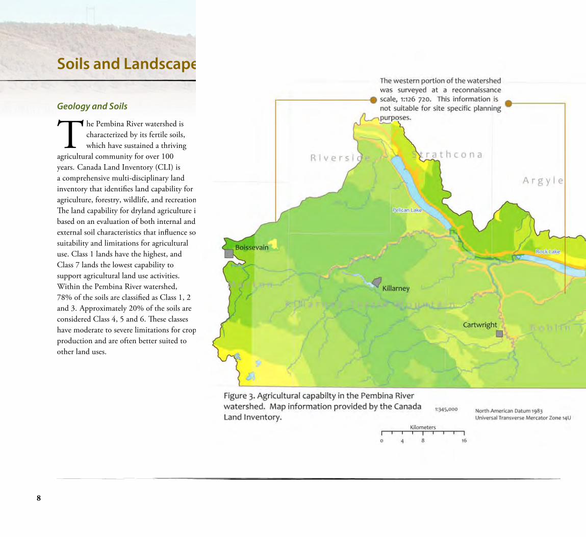
Geology and Soils
The Pembina River watershed is characterized by its fertile soils, which have sustained a thriving
agricultural community for over 100 years. Canada Land Inventory (CLI) is a comprehensive multi-disciplinary land inventory that identifies land capability for agriculture, forestry, wildlife, and recreation. The land capability for dryland agriculture is based on an evaluation of both internal and external soil characteristics that influence soil suitability and limitations for agricultural use. Class 1 lands have the highest, and Class 7 lands the lowest capability to support agricultural land use activities. Within the Pembina River watershed, 78% of the soils are classified as Class 1, 2 and 3. Approximately 20% of the soils are considered Class 4, 5 and 6. These classes have moderate to severe limitations for crop production and are often better suited to other land uses.
Soils and Landscape of the Pembina River Watershed
9
Pembina River Integrated Watershed Management Plan
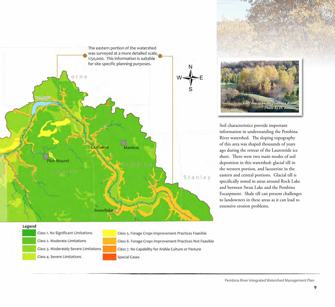
Soil characteristics provide important information in understanding the Pembina River watershed. The sloping topography of this area was shaped thousands of years ago during the retreat of the Laurentide ice sheet. There were two main modes of soil deposition in this watershed: glacial till in the western portion, and lacustrine in the eastern and central portions. Glacial till is specifically noted in areas around Rock Lake and between Swan Lake and the Pembina Escarpment. Shale till can present challenges to landowners in these areas as it can lead to extensive erosion problems.
Golf course on the Pembina River- Photo by D. Bonner
10
Soils and Landscape of the Pembina River Watershed
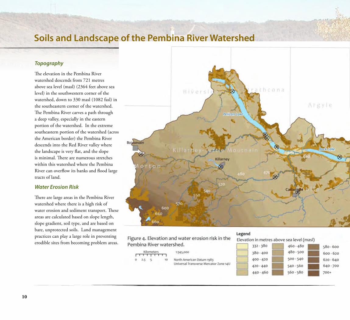
Topography
The elevation in the Pembina River watershed descends from 721 metres above sea level (masl) (2364 feet above sea level) in the southwestern corner of the watershed, down to 330 masl (1082 fasl) in the southeastern corner of the watershed. The Pembina River carves a path through a deep valley, especially in the eastern portion of the watershed. In the extreme southeastern portion of the watershed (across the American border) the Pembina River descends into the Red River valley where the landscape is very flat, and the slope is minimal. There are numerous stretches within this watershed where the Pembina River can overflow its banks and flood large tracts of land.
Water Erosion Risk
There are large areas in the Pembina River watershed where there is a high risk of water erosion and sediment transport. These areas are calculated based on slope length, slope gradient, soil type, and are based on bare, unprotected soils. Land management practices can play a large role in preventing erodible sites from becoming problem areas.

11
Pembina River Integrated Watershed Management Plan
Shale Erosion and Solutions
One of the goals in the watershed is to look at placing shale traps in the Cypress Creek to reduce the shale loading of the Pembina River just downstream of Rock Lake. By lowering the shale load being transported downstream this will allow the river through natural processes to create a larger channel and lessen the duration of flooding in Rock Lake.
A shale trap is a fish friendly dam or weir structure placed in a stream that captures shale and other larger mobile sediments. It is not meant to restrict flow but to create a pool of water upstream of the dam that allows the shale to settle out and remain behind the weir.
The dam or weir lessens the gradient of the river and will act to reduce erosion because of the flatter slope of the stream.
Shale Trap

12
Water Quantity
The Pembina River originates in the Turtle Mountains and flows in an easterly direction across
southern Manitoba, connecting Pelican Lake, Rock Lake and Swan Lake. Major tributaries include the Long River, Badger Creek, Cypress Creek, Snowflake Creek, and Mowbray Creek. The Pembina River crosses the American border near Windygates and finally meets the Red River near Pembina, North Dakota.
The Province of Manitoba, in partnership with Environment Canada, operates 20
hydrometric gauging stations throughout the watershed. The oldest station is located at Windygates, with data from this station extending back to 1962. The hydrometric data indicates that stream-flow in the Pembina River is highly variable and many of its tributaries are intermittent.
Further flow variability may be experienced as the impacts of climate change are realized. Maintaining water on the land will improve the sustainability and resiliency of the ecosystem and ensure that residents will be able to enjoy the habitat and resources of the watershed for generations to come.
Figure 5. Annual flow volumes on the Pembina River at Windygates Manitoba.
Water Flooding Story
Water in the Pembina River Watershed
“Floods in the Pembina River watershed usually come slowly and stay a while. Due to this regions well-sloped topogra-phy, flooding is usually limited to the Val-ley region. In the Canadian portion of the Pembina River watershed, flooding is linked to plentiful moisture, and because this region generally has a ‘moisture-deficit’, this is usually a good thing for farming. When you are in a drought it’s hard to grow anything. The 1980s were very dry and the Pembina River totally dried up in 1988. There was little flow in the spring and little rainfall. This meant that the crop yields for the for the most part were lower.” – Cliff Greenfield, Pembina Valley Conservation District Manager
“The flooding is an inconvenience but not life threatening, the dry will kill you, you can’t eat dust and nothing grows without moisture.” - Anonymous Resident, Pembina River watershed
“Floods in the Pembina River watershed usually come slowly and stay a while. Due to this regions well-sloped topography, flooding is usually limited to the Valley region. In the Canadian portion of the Pembina River watershed, flooding is linked to plentiful moisture, and because this region generally has a ‘moisture-deficit’, this is usually a good thing for farming. When you are in a drought it’s hard to grow anything. The 1980s were very dry and the Pembina River totally dried up in 1988. There was little flow in the spring and little rainfall. This meant that the crop yields for the most part were lower.” – Cliff Greenfield, Pembina Valley Conservation District Manager
“The flooding is an inconvenience but not life threatening, the dry will kill you, you can’t eat dust and nothing grows without moisture.” - Resident, Pembina River watershed

13
Pembina Valley Watershed Management PlanWhen It Rains It Pours
“Agricultural land in a flood plain will get flooded, and this is to be expected. The Pembina Valley is no stranger to this phenomenon and producers are impacted when large floods inundate the floodplain. Agriculture is a risky business and living in a floodplain makes it that much more so. The flow record shows that this watershed has experienced more significant flooding in the last 20 years than it had in the
previous 60 years and some producers are having a tough time adjusting to this change. Ryan and Christine Andries farm alongside of the Pembina River near Swan Lake and count on getting a late hay crop off their floodplain. They have struggled over the last few years because of the duration and intensity of the flooding and the sometimes back to back spring and summer floods.” – Cliff Greenfield, Pembina Valley Conservation District Manager
“My father and grandfather farmed near here for 60 years and only experienced two large floods. We have farmed here for 20 years and have had seven significant floods. Our buildings are not threatened but we have lost a lot of valuable hay over those years that we hadn’t banked on. We also feel that it’s going to get worse before it gets better so we don’t count on that income anymore.” – Ryan and Christie Andries
The Pelican Lake Enhancement Project utilizes three control structures to managewater levels on the Pembina River and Pelican Lake. The operation of the control structures are regulated based on the conditions outlined by the Environment Act Licence #1426 RR.
The Province of Manitoba is required to regulate a target level range of 411.54 to 412.00 masl. The Pelican Lake Advisory Committee provides input to the Province on how the control structures are to be operated. The Rock Lake control structure located at the outlet of the lake is
used to raise Rock Lake water levels during periods of low flow. Killarney Lake’s water level is regulated to improve water quality, and maintain water levels sufficient for recreational, flood prevention, and drinking water use.
Pembina River Integrated Watershed Management Plan

14
Water Quality
Environment Canada maintains one long-term water quality monitoring station in the extreme southeast portion of the watershed. According to recent analysis, total phosphorus (TP) concentration at this site increased by 52.1% from 1975 to 1999. Excessive phosphorus loading can have a detrimental effect on aquatic ecosystems. The researchers suggest that this substantial increase in phosphorus is caused by human activities on the landscape.
More recently, an increase in nutrient levels throughout the Pembina River watershed has caused large algal blooms in Killarney, Pelican, Rock and Swan lakes. These blooms have impaired drinking water quality, caused significant fish kills, and have hampered recreational activities.
Figure 6. Trend in total phosphorus concentration in the Pembina River near Windygates, MB, 1974 to 1999 (inclusive). Dots represent measured concentrations, while the solid line represents the trend in flow adjusted concentrations. The percent change in median concentration refers to the median concentration of the flow-adjusted trend line (Manitoba Conservation Report No. 2001-07. Web address: http://www.gov.mb.ca/waterstewardship/reports/quality/trend_report.pdf
0
0.2
0.4
0.6
0.8
1
1.2
1.4
1.6
1.8
1974 1976 1978 1980 1982 1984 1986 1988 1990 1992 1994 1996 1998 2000
Timem
g/L
52.1% increase in median TP concentration from 1974 to
1999 (p<0.0001)
Killarney Lake – A lake in need of help….
In 1996 the Killarney Lake Water Quality Committee was established to address concerns over severe algal blooms and declining water quality in Killarney Lake. A number of initiatives were put into place including re-directing nutrient rich spring runoff water from entering the lake by large control gates; an informational kiosk at the beach; confined swimming area at the public beach; and others. Despite these initiatives, algal blooms remain a significant concern. Recently, the Killarney Lake Action Committee was formed to address specific actions that can be taken to reduce the impacts of algae. The Committee is committed to innovative means to alleviate algal blooms including harvesting algae, public education about nutrient control, aeration, etc. as well as working to reduce nutrient contributions through upstream watershed management.
15
Pembina River Integrated Watershed Management Plan
Rock Lake in Summer - C. Greenfield
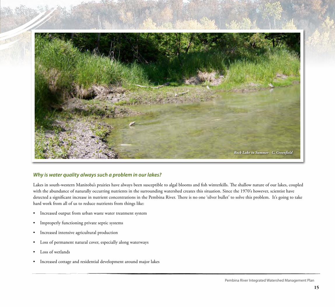
Why is water quality always such a problem in our lakes?
Lakes in south-western Manitoba’s prairies have always been susceptible to algal blooms and fish winterkills. The shallow nature of our lakes, coupled with the abundance of naturally occurring nutrients in the surrounding watershed creates this situation. Since the 1970’s however, scientist have detected a significant increase in nutrient concentrations in the Pembina River. There is no one ‘silver bullet’ to solve this problem. It’s going to take hard work from all of us to reduce nutrients from things like:
• Increased output from urban waste water treatment system
• Improperly functioning private septic systems
• Increased intensive agricultural production
• Loss of permanent natural cover, especially along waterways
• Loss of wetlands
• Increased cottage and residential development around major lakes

16
Public Drinking Water
There are 15 public water systems in the Pembina River watershed that provide treated drinking water for over 5,000 residents. Four of these public water systems treat surface water from local lakes or reservoirs. Ten obtain water from groundwater wells. One obtains water from both sources. Two of these public drinking water systems have been under boil water advisories in the last five years. Residents who are not connected to a public water system obtain their drinking water from private or semi-public sources (usually a groundwater well). Drinking water assessments for each public water system can be found in Appendix B.
Groundwater
Groundwater is the primary water source for most residents in the Pembina River watershed. The expansive Odanah shale aquifer underlies the central and eastern portion of the watershed. A second aquifer, the Turtle Mountain Formation, predominates in the uplands of the western portion of the watershed. Water quality across these two bedrock aquifers ranges from fair to poor, with naturally occurring iron and manganese often found above drinking water guidelines. Nitrate and bacteria contamination often causes drinking water guidelines to be exceeded at individual well sites due to poor well head conditions.

17
Pembina River Integrated Watershed Management Plan
Substantially better water quality can be found in scattered unconfined sand and gravel aquifers. These aquifers are of limited size and are more susceptible to contamination. Deep buried valley aquifers are also found in this watershed, and although they are very deep and difficult to locate, they can be a source of high quantity and quality groundwater.
Wellhead - Photo by D. Bonner
18
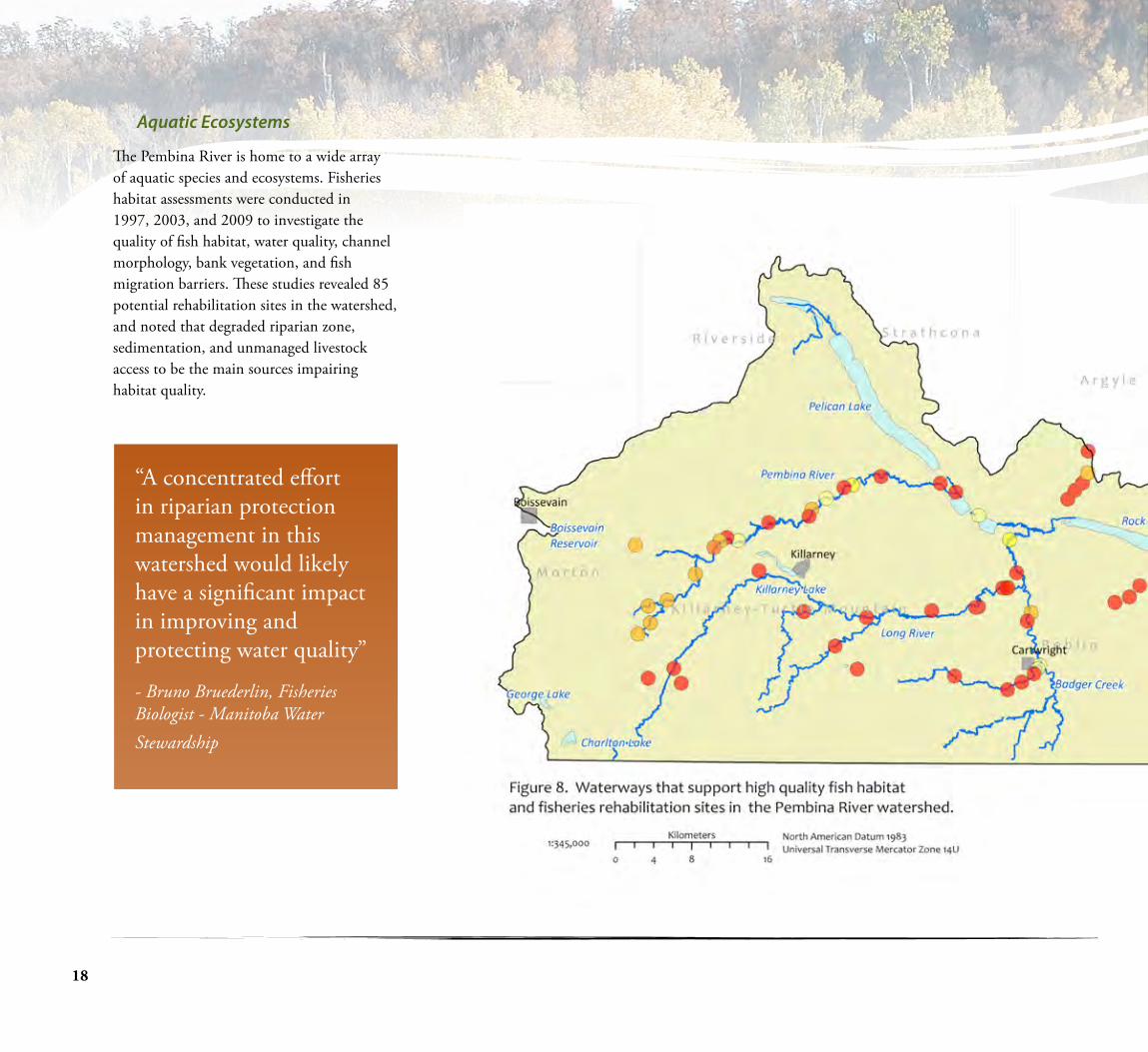
Aquatic Ecosystems
The Pembina River is home to a wide array of aquatic species and ecosystems. Fisheries habitat assessments were conducted in 1997, 2003, and 2009 to investigate the quality of fish habitat, water quality, channel morphology, bank vegetation, and fish migration barriers. These studies revealed 85 potential rehabilitation sites in the watershed, and noted that degraded riparian zone, sedimentation, and unmanaged livestock access to be the main sources impairing habitat quality.
“A concentrated effort in riparian protection management in this watershed would likely have a significant impact in improving and protecting water quality”
- Bruno Bruederlin, Fisheries Biologist - Manitoba Water Stewardship
19
Pembina River Integrated Watershed Management Plan
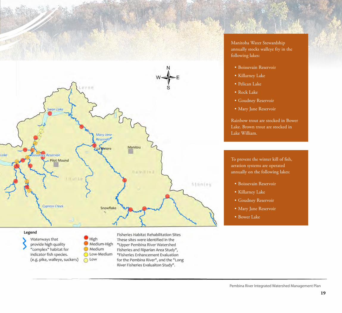
Manitoba Water Stewardship annually stocks walleye fry in the following lakes:
•Boissevain Reservoir
•Killarney Lake
•Pelican Lake
•Rock Lake
•Goudney Reservoir
•Mary Jane Reservoir
Rainbow trout are stocked in Bower Lake. Brown trout are stocked in Lake William.
To prevent the winter kill of fish, aeration systems are operated annually on the following lakes:
•Boissevain Reservoir
•Killarney Lake
•Goudney Reservoir
•Mary Jane Reservoir
•Bower Lake
20
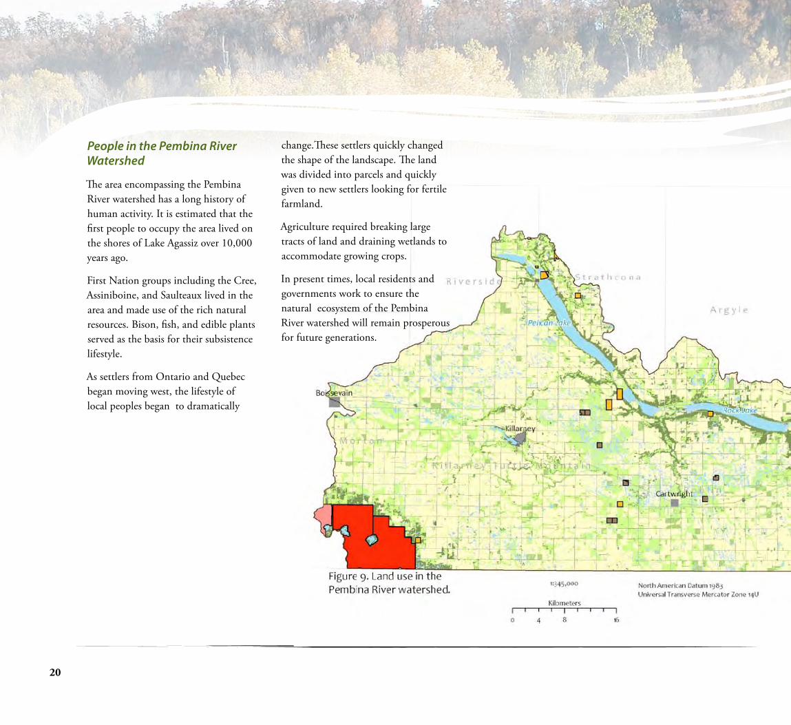
People in the Pembina River Watershed
The area encompassing the Pembina River watershed has a long history of human activity. It is estimated that the first people to occupy the area lived on the shores of Lake Agassiz over 10,000 years ago.
First Nation groups including the Cree, Assiniboine, and Saulteaux lived in the area and made use of the rich natural resources. Bison, fish, and edible plants served as the basis for their subsistence lifestyle.
As settlers from Ontario and Quebec began moving west, the lifestyle of local peoples began to dramatically
change.These settlers quickly changed the shape of the landscape. The land was divided into parcels and quickly given to new settlers looking for fertile farmland.
Agriculture required breaking large tracts of land and draining wetlands to accommodate growing crops.
In present times, local residents and governments work to ensure the natural ecosystem of the Pembina River watershed will remain prosperous for future generations.

21
Pembina River Integrated Watershed Management Plan
La Rivière - Photo by D. Bonner
A vibrant and diverse agricultural community has been sustained in the Pembina River watershed for over 100 years. Over this time, agricultural practices and the structure of rural communities has changed. These changes have occurred due to global market factors and improvements in agricultural technology. Some changes have occurred as a result of improvements to land management, such as the change in tillage practices over the last 35 years to an increase in conservation tillage and a decrease in summerfallowed and conventionally tilled land. Other changes have occurred as a result of commercial fertilizer usage and
the emergence of large-scale agro-business, creating larger farms but fewer farmers.
Wetland drainage has also been facilitated by the increased capability of new agricultural equipment, and pressures to harvest higher yields. The accumulated loss of wetlands over many years has had a cascading negative effect across the watershed.
Photo by D. Bonner
Forage 4%
Wetlands 4%
Grassland Pasture18%
Annual Cropland58%
Water 3%
Trees 10%
Urban 3%
22
What are the issues in the Pembina River Watershed?
Watershed residents, previous watershed plans, stakeholders, and technical experts helped
develop the following five watershed issue statements. Specific problem site locations were recorded for each of these issues.
• Flooding - The frequency and severity of spring and summer flooding is costing municipalities and landowners too much money in damaged infrastructure and loss of crops.
• Surface Water Quality - The rivers and lakes in this watershed are saturated with too much algae in the summer months resulting in poor recreation opportunities, and unhealthy water for residents and wildlife.
• Drinking Water Quality - There is a lack of confidence in the drinking water quality throughout the watershed.
• Soil Loss/Erosion - Lakes and rivers are becoming clogged by the large amount of shale and silt eroding into our waterways.
• Drainage - There are a wide range of issues surrounding drainage in this watershed. Better drainage control and planning is required. Large scale illegal drainage is creating major problems for downstream landowners. The services provided by wetlands including drought resilience, flood dampening, water quality improvements,
biodiversity, and groundwater recharge are disappearing.
The following studies and plans were used in identifying issues:
• Fisheries Enhancement Evaluation for the (Lower) Pembina River (1997)
• Goudney Source Water Protection Action Plan (2007)
• Killarney Lake and Watershed Management Plan
• Pembina River Basin Watershed
Management Plan (2005)
• Upper Pembina River Fisheries Study (2006)
Numerous technical experts and stakeholders worked together to create the Pembina River Watershed Team, they included:
• A Rocha• Agriculture Canada - Agriculture
Environmental Services Branch • Assiniboine Hills Conservation District• Department of Fisheries and Oceans• Keystone Agricultural Producers• Manitoba Agriculture, Food,
and Rural Initiatives• Manitoba Conservation • Manitoba Emergency Measures Organization• Manitoba Habitat Heritage Corporation• Manitoba Intergovernmental Affairs
• Manitoba Beef Producers Association• Manitoba Water Stewardship • Pembina Valley Conservation District• Pembina Valley Protection Association• Swan Lake First Nation• Turtle Mountain Conservation District
The project management team considered all of this information in developing the following four goals for the Pembina River integrated watershed management plan:
1. Improve and maintain drinking water quality throughout the watershed.
2. Reduce algal blooms and improve surface water quality for residents, wildlife, and outdoor recreation.
3. Protect our lakes and rivers from excess erosion.
4. Improve surface water management to reduce flooding, wetland loss, and protect aquatic ecosystems.

23
Pembina River Integrated Watershed Management Plan
Goal 1 – Improve and maintain drinking water quality throughout the watershed.
Reason for Goal: Protecting water at its source, or before it arrives at drinking water treatment facilities, is a preventative, multi-barrier approach to drinking water protection. Although much of the water in Manitoba requires some treatment to meet drinking water quality guidelines, it is less expensive and more ecologically responsible to prevent contamination to our source waters than to try and remediate water quality in treatment facilities. Protecting drinking water quality at its source also protects local aquatic ecosystems such as streams and lakes, and ensures the continued quality of groundwater aquifers. This approach to water management requires consideration of activities in the entire watershed, or the area of land that contributes to that stream, lake or groundwater aquifer.
This approach to water management requires consideration of activities in the entire watershed, or the area of land that contributes to that stream, lake or groundwater aquifer.
How are we going to achieve this goal: Create a high level of public awareness about protecting and maintaining groundwater for semi-public and private wells. Local Conservation Districts should provide increased:
• Education on groundwater quality, well development, maintenance, and well head protection.
• Provide targeted financial assistance for groundwater quality testing, well head assessments, well sealing and shock chlorination.
Actions aimed at protecting drinking water quality for Public Water Systems include:
• Implement actions identified in drinking water source assessments. (Appendix B)
• Promote the protection of wetlands, riparian areas, and permanent cover. Secure Conservation Agreements with private landowners to conserve drinking water quality.
• Promote a net gain of wetlands and healthy riparian areas in public drinking water sub-watersheds.
• Investigate the feasibility of purchasing a water circulation unit as a pilot project to improve drinking water quality.
Public Health Inspectors, under authority of the Public Health Act, are able to follow up on complaints regarding polluting, fouling, or contamination of public drinking water sources:
Killarney (204-523-5285)
Morden (204-822-2850)
• Ensure that all Planning District Development Plans continue to protect and manage development activities around public drinking water sources. Ensure that all future Planning District Development Plans recognize the goals and objectives of this integrated watershed management plan and the associated drinking water source assessments.
• Provide increased education and financial incentives for nutrient management:
• Managed livestock grazing, off-site watering, riparian area management, soil testing, variable rate fertilizer application, manure management and fertilizer management.
• Erect signs to remind boaters that they are boating on a public drinking water source.
• Provide education to residents on who they should contact if they witness polluting, fouling, or contamination of a public drinking water source (surface water or groundwater).
Blue-green algae on Rock Lake

24
Drinking Water Protection
A drinking water protection committee conducted a preliminary assessment on the 15 water sources that supply public water systems in the Pembina River watershed. The assessment protocol and procedures used in this assessment were derived from a report entitled “Manitoba Source Water Assessment Recommended Method for Public Water Systems”, and are found in Appendix B of this plan. It is important to note that the assessment process is qualitative and is a part of multi-barrier approach to assessing threats to public drinking water. A summary of this non-technical process is described below.
Each water source supplying a public water system was mapped and a buffer was applied around the withdrawal point. Buffers are important management tools, because areas nearer to a withdrawal point are more likely to influence water quality than an area that is further away. For groundwater systems, the area within a 1.5 kilometre radius of the well head was reviewed. For surface water sources the review area included the entire sub-watershed. A site visit was conducted by a provincial and municipal representatives and a local resident to look at land activities within these buffer areas. An informal list of potential pollutant sources or risks was created. For each public water system the top few threats identified by this team are presented below, as well as a list of recommended actions that we believe will reduce risk and work to protect the source of drinking water for the thousands of residents
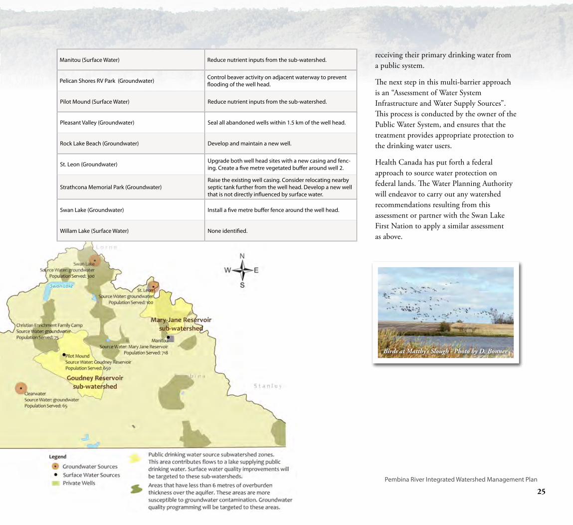
Recommendations from public drinking water source assessments in the Pembina River watershed
Public Water System Recommended Action
Boissevain (Groundwater) Install barrier around well heads.
Boissevain (Surface Water) Reduce nutrient inputs from the sub-watershed.
Cartwright (Groundwater) Install fence barrier to create a five metre buffer around well head.
Christian Enrichment Family Camp (Groundwater) Seal all abandoned wells within 1.5 km of the well head.
Clearwater (Groundwater) Develop a new well that is not directly influenced by sur-face water.
Killarney (Surface Water)
Reduce nutrient inputs from the subwatershed. Develop an effective septic system educational campaign. Deliver an enhanced inspection program of waste-water systems on residential properties in sensitive areas to ensure water quality is being protected.
Manhattan Beach Retreat Center (Groundwater) Consider relocating nearby septic tank further from the well heads. (Current distance 10 metres).
25
Pembina River Integrated Watershed Management Plan
Recommendations from public drinking water source assessments in the Pembina River watershed
Public Water System Recommended Action
Boissevain (Groundwater) Install barrier around well heads.
Boissevain (Surface Water) Reduce nutrient inputs from the sub-watershed.
Cartwright (Groundwater) Install fence barrier to create a five metre buffer around well head.
Christian Enrichment Family Camp (Groundwater) Seal all abandoned wells within 1.5 km of the well head.
Clearwater (Groundwater) Develop a new well that is not directly influenced by sur-face water.
Killarney (Surface Water)
Reduce nutrient inputs from the subwatershed. Develop an effective septic system educational campaign. Deliver an enhanced inspection program of waste-water systems on residential properties in sensitive areas to ensure water quality is being protected.
Manhattan Beach Retreat Center (Groundwater) Consider relocating nearby septic tank further from the well heads. (Current distance 10 metres).
receiving their primary drinking water from a public system.
The next step in this multi-barrier approach is an “Assessment of Water System Infrastructure and Water Supply Sources”. This process is conducted by the owner of the Public Water System, and ensures that the treatment provides appropriate protection to the drinking water users.
Health Canada has put forth a federal approach to source water protection on federal lands. The Water Planning Authority will endeavor to carry out any watershed recommendations resulting from this assessment or partner with the Swan Lake First Nation to apply a similar assessment as above.
Manitou (Surface Water) Reduce nutrient inputs from the sub-watershed.
Pelican Shores RV Park (Groundwater) Control beaver activity on adjacent waterway to prevent flooding of the well head.
Pilot Mound (Surface Water) Reduce nutrient inputs from the sub-watershed.
Pleasant Valley (Groundwater) Seal all abandoned wells within 1.5 km of the well head.
Rock Lake Beach (Groundwater) Develop and maintain a new well.
St. Leon (Groundwater) Upgrade both well head sites with a new casing and fenc-ing. Create a five metre vegetated buffer around well 2.
Strathcona Memorial Park (Groundwater)Raise the existing well casing. Consider relocating nearby septic tank further from the well head. Develop a new well that is not directly influenced by surface water.
Swan Lake (Groundwater) Install a five metre buffer fence around the well head.
Willam Lake (Surface Water) None identified.
Birds at Matthy’s Slough - Photo by D. Bonner

26
Goal 2 – Reduce algal blooms and improve surface water quality for residents, wildlife, and outdoor recreation.
Reason for Goal: Every year extensive algal blooms emerge on water bodies in our watershed. The primary cause of our decreasing surface water quality is increasing nutrient run-off from human sewage, agriculture, and unsustainable development. High levels of nitrogen and phosphorus increase production of algae and aquatic plants. This process causes serious problems, including: changes to aquatic life habitat, reduced levels of oxygen, and increased taste and odour problems in drinking water. In addtion, some forms of algae can produce
dangerous toxins. At the three public meetings held in 2008, all residents expressed a desire to see improvements in the water quality of our lakes and rivers.
How we are going to achieve this goal: By working cooperatively with landowners, agricultural producers, cottage owners, rural municipalities, and the federal and provincial governments. Water quality in many parts of the Pembina River watershed is poor, and change will only occur if there is a concerted and targeted response by all partners, especially municipalities and planning districts. If we maintain status quo, water in the Pembina River watershed residents will see more algal blooms and face a degraded aquatic ecosystem.
Recommendations for this goal have been divided into:
• Incentive based programming for agricultural producers
• Education and awareness for all watershed residents
• Municipal programs
• Partner programs
Incentive based programming for agricultural producers:
Conservation Districts and Manitoba Agriculture, Food, and Rural Initiatives will provide increased financial support to assist producers in implementing

27
Pembina River Integrated Watershed Management Plan
beneficial management practices such as off‐site site watering, riparian fencing, manure management, and winter site management. Efforts will be targeted to the “Valley and River Zone” where it will be most effective.
• Financial support will be provided to help producers implement actions identified in their Environmental Farm Plan.
• Manitoba Habitat Heritage Corporation and Ducks Unlimited Canada will secure Conservation Agreements with willing landowners to conserve and restore wetlands in key areas of the watershed.
Education and awareness for all watershed residents:
• Education and awareness will be provided on the proper management of private septic systems and the hazards resulting from the releases of E.coli, and nutrients.
• Provide increased education on beneficial management practices for nutrient management to crop and livestock producers.
• Educational programs such as Envirothon, Riverwatch and Water Festivals will be offered to all schools in the watershed.
Provincial and Municipal Programs:
• Manitoba Water Stewardship, Manitoba Conservation, Rural Municipalities, and communities will work together to improve the quality of water released from waste water treatment facilities.
• Manitoba Conservation will offer an enhanced inspection program of wastewater systems on residential properties in sensitive areas to ensure water quality is being protected.
• Promote the ‘Water Soft Paths’ approach to reducing water use for drinking water and wastewater treatment. ‘Water Soft Paths’ is a holistic water use planning approach that focuses on water demand management and strives to reduce water use through innovation, conservation, reallocation and changing use and re-use while working within ecological limits.
• Manitoba Water Stewardship - Water Quality Section will consider establishing a long term water quality sampling station at
an appropriate location along the Pembina River.
• Review the “Development Capacity” of all the major lakes in this watershed.
Partner Programs
• Ensure that Crown Lands continue to be managed in an environmentally sustainable manner to minimize potential impacts on water quality.
• All organizations will work towards establishing an Environmental Goods and Services Program.
• Allocate funding and effort to address water quality concerns near Kelly’s Ravine north of Rock Lake.
Pembina River at Sheffield Bridge
Goal 2 Con’t
28
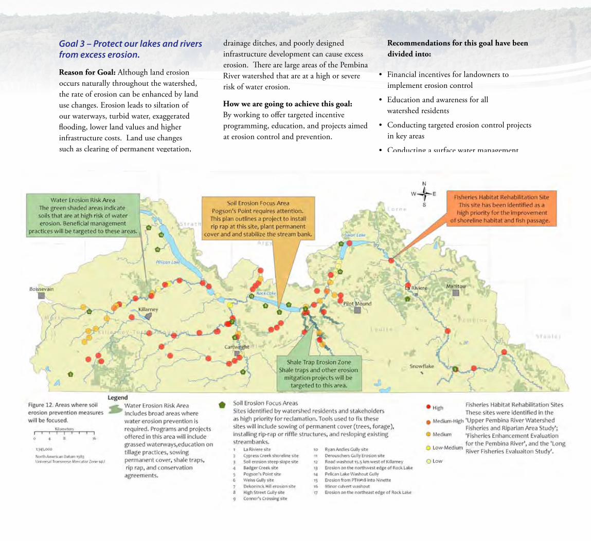
Goal 3 – Protect our lakes and rivers from excess erosion.
Reason for Goal: Although land erosion occurs naturally throughout the watershed, the rate of erosion can be enhanced by land use changes. Erosion leads to siltation of our waterways, turbid water, exaggerated flooding, lower land values and higher infrastructure costs. Land use changes such as clearing of permanent vegetation, improperly maintained
drainage ditches, and poorly designed infrastructure development can cause excess erosion. There are large areas of the Pembina River watershed that are at a high or severe risk of water erosion.
How we are going to achieve this goal: By working to offer targeted incentive programming, education, and projects aimed at erosion control and prevention.
Recommendations for this goal have been divided into:
• Financial incentives for landowners to implement erosion control
• Education and awareness for all watershed residents
• Conducting targeted erosion control projects in key areas
• Conducting a surface water management study to identify retention areas
29
Pembina River Integrated Watershed Management Plan
Recommendations to get the most bang-for-our-buck:
• Focus our efforts in the areas that need it the most, which include:
• Water Erosion Risk Zone
• Shale Trap Erosion Zone
• Soil Erosion Focus Area
Programs and projects to help clean up our lakes and rivers:
• Provide education to agricultural producers on the implementation best management practices for water erosion control on private lands. Promote appropriate tillage practices,
managed grazing systems, grassed waterways and sowing of permanent cover (trees, forage).
• Provide increased financial support for the implementation of beneficial management practices for water erosion control in areas with severe and high water erosion risk.
• Provide public education on the cause of erosion in the watershed, and solutions for managing local problems.
• Secure Conservation Agreements (or other agreements) with private landowners to ensure that existing permanent cover is protected across the watershed.
• Conduct a surface water management study to identify the most effective water retention zones in each sub-watershed.
• Conservation Districts, Manitoba Water Stewardship, and Rural Municipalities will work together to help develop water retention areas and targeted erosion control projects in the Soil Erosion Focus Area.
• Shale traps will be developed in the Shale Trap Erosion Zone.
• Address 10 project sites in the Upper Pembina River Fisheries and Riparian Study (1996).
• Address five project sites in the Fisheries Enhancement Study for the Pembina River (2001).
• Address 10 project sites in the Long River Fisheries Study (2009).
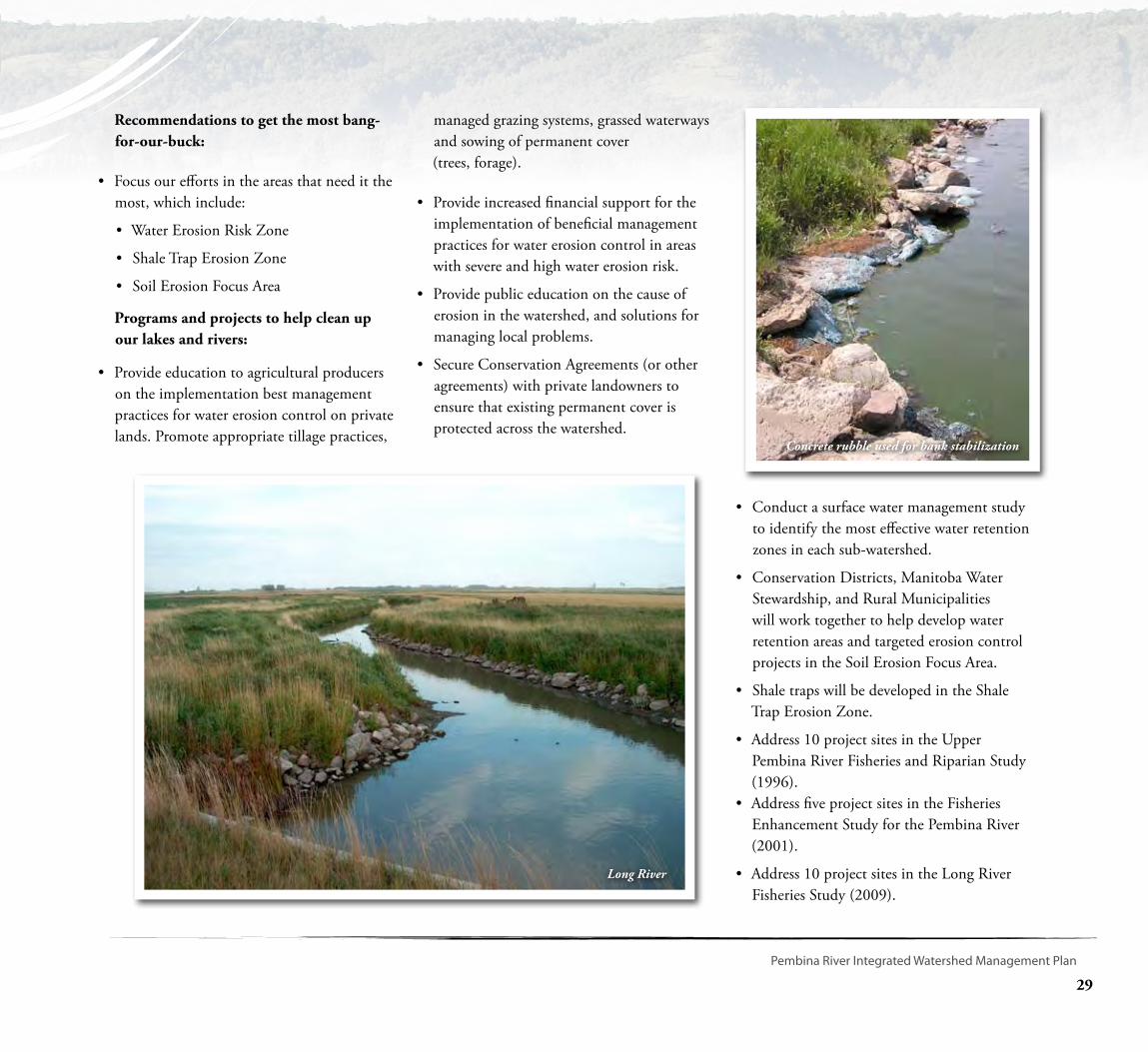
Long River
Concrete rubble used for bank stabilization
30
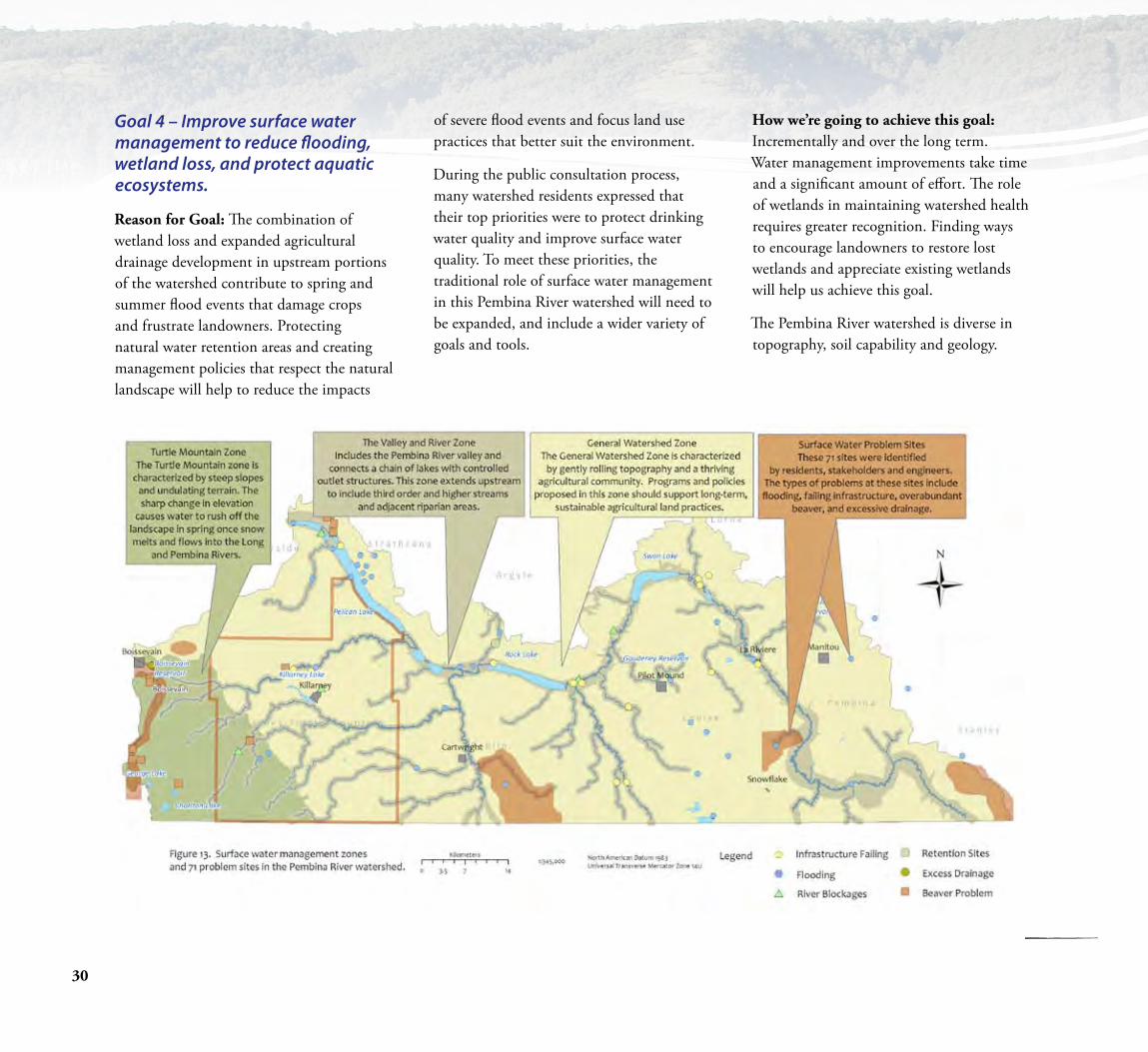
Goal 4 – Improve surface water management to reduce flooding, wetland loss, and protect aquatic ecosystems.
Reason for Goal: The combination of wetland loss and expanded agricultural drainage development in upstream portions of the watershed contribute to spring and summer flood events that damage crops and frustrate landowners. Protecting natural water retention areas and creating management policies that respect the natural landscape will help to reduce the impacts
of severe flood events and focus land use practices that better suit the environment.
During the public consultation process, many watershed residents expressed that their top priorities were to protect drinking water quality and improve surface water quality. To meet these priorities, the traditional role of surface water management in this Pembina River watershed will need to be expanded, and include a wider variety of goals and tools.
How we’re going to achieve this goal: Incrementally and over the long term. Water management improvements take time and a significant amount of effort. The role of wetlands in maintaining watershed health requires greater recognition. Finding ways to encourage landowners to restore lost wetlands and appreciate existing wetlands will help us achieve this goal.
The Pembina River watershed is diverse in topography, soil capability and geology.

31
Pembina River Integrated Watershed Management Plan
Land and water management practices in an area characterized by steep hills, highly erosive soils and significant flows will require a different approach than an area situated in a valley bottom with flat topography and productive soils. Within this plan, incentive programs and management policies have been tailored to fit the natural features of three distinct zones. In addition, 71 “Surface Water Problem Sites” were identified in meetings with residents, rural municipalities, and provincial engineers. Detailed descriptions of these sites are available at Conservation District offices and include flooding concerns upstream of the Sheffield Bridge and at the outlet of Rock Lake. Existing structures at these sites are perceived to be causing a constriction of flow in the Pembina River.
General Watershed Zone: This region is characterized by gently rolling topography, thriving agricultural community, and rich soils. The following recommendations work towards strengthening this productive agricultural region and finding opportunities to conserve and restore wetlands and permanent cover.
• Promote no-net-loss of wetlands.
• Promote the retention of natural and permanent cover to allow water infiltration and reduced water run-off.
• Provide incentives for the retention and restoration of wetlands and riparian areas.
• Ensure that there is uniformity in Water Control Works and Drainage Licensing, policies and enforcement across the watershed. Ensure that Conservation
Districts and Rural Municipalities receive copies, and are permitted to comment, on all Water Control Works and Drainage License applications proposed within their boundaries. Ensure that a Water Control Works and Drainage Licensing Officer meets with every conservation district board on an annual basis to discuss the drainage licensing process and provide updates on any local concerns.
• Develop and maintain open communication with the landowners and authorities in the American portion of the watershed.
• Conduct a surface water management study to identify the most effective water retention zones in each sub-watershed. Construct water retention structures at identified sites.
Valley and River Zone: This region is situated along the Pembina Valley bottom and connects a chain of lakes with controlled outlet structures. Residents in this area enjoy beautiful recreational areas but experience frequent flood events due to their downstream location in the watershed. This zone also captures much of the downstream end of major rivers and creeks in the watershed, including valuable fisheries and wildlife habitat located along waterways and their riparian areas. Water levels are managed at three locations in this zone.
The following recommendations work towards minimizing flooding and erosion, conserving wildlife habitat and enhancing outdoor recreation.
• Manage river flows through the use of water control structures (Pelican Lake water control structure, Rock Lake water control structures, culverts, sheet pile weirs, man-made riffles).
• Provide better direction to landowners on how to get the latest flood forecast information for the Pembina River from Pelican Lake to Swan Lake.
• Consider purchasing flood prone lands to allow for the restoration of the natural Pembina River floodplain. Prioritize land downstream of Pelican Lake.
• Investigate repairing, replacing, or removing the control structure/fish ladder at La Rivière to improve fish passage and aquatic ecosystem health.
• Maintain natural biodiversity, including aquatic ecosystems, by encouraging conservation of riparian areas.
• Conduct feasibility studies on the construction or restoration of water control structures at the outlet of both Rock and Swan lakes.

32
• The Turtle Mountain Zone: This region is characterized by a sharp elevation change. Water runs quickly off the Turtle Mountains and flows into the Long and Pembina rivers. The following recommendations work towards minimizing downstream flooding and fast water run-off into severe and high risk water erosion areas.
• Promote no-net-loss of wetlands.
• Conduct a surface water management study to identify the most effective water retention zones in each sub-watershed. Construct water retention structures at identified sites. Focus area includes Orthez Creek.
• Promote the retention of natural and permanent cover to allow water infiltration and reduced water run-off.
• Encourage agricultural beneficial management practice demonstration sites on Crown Lands.
• Ensure that:
• Crown Lands continue to be managed with a high level of consideration for watershed health.
• All new Crown Land Management Plans recognize the goals and objectives of this Integrated Watershed Management Plan.
• Consultations are held with the Watershed Planning Authority and neighbouring Conservation Districts before Crown Land Management Plans are implemented.
• A 30 metre riparian buffer zone is maintained around water bodies when brush clearing is required.
Binney - Photo by D. Bonner
•Ecological integrity is maintained when any future developments (roads, subdivisions, access points) are considered around isolated water bodies on Crown Lands.
33
Pembina River Integrated Watershed Management Plan
Implementation
In order to ensure that this watershed plan will be implemented over the next ten years, time, effort, and
funding will need to be allocated to all four goals. Appendix A outlines the specific recommended actions, timelines, and evaluation factors for all lead organizations.
Conservation Districts
•Over five million dollars in funding is proposed for Conservation district programming in this watershed over the next 10 years.
•All three Conservation Districts will use this plan in developing and implementing their annual budgets and staff work plans.
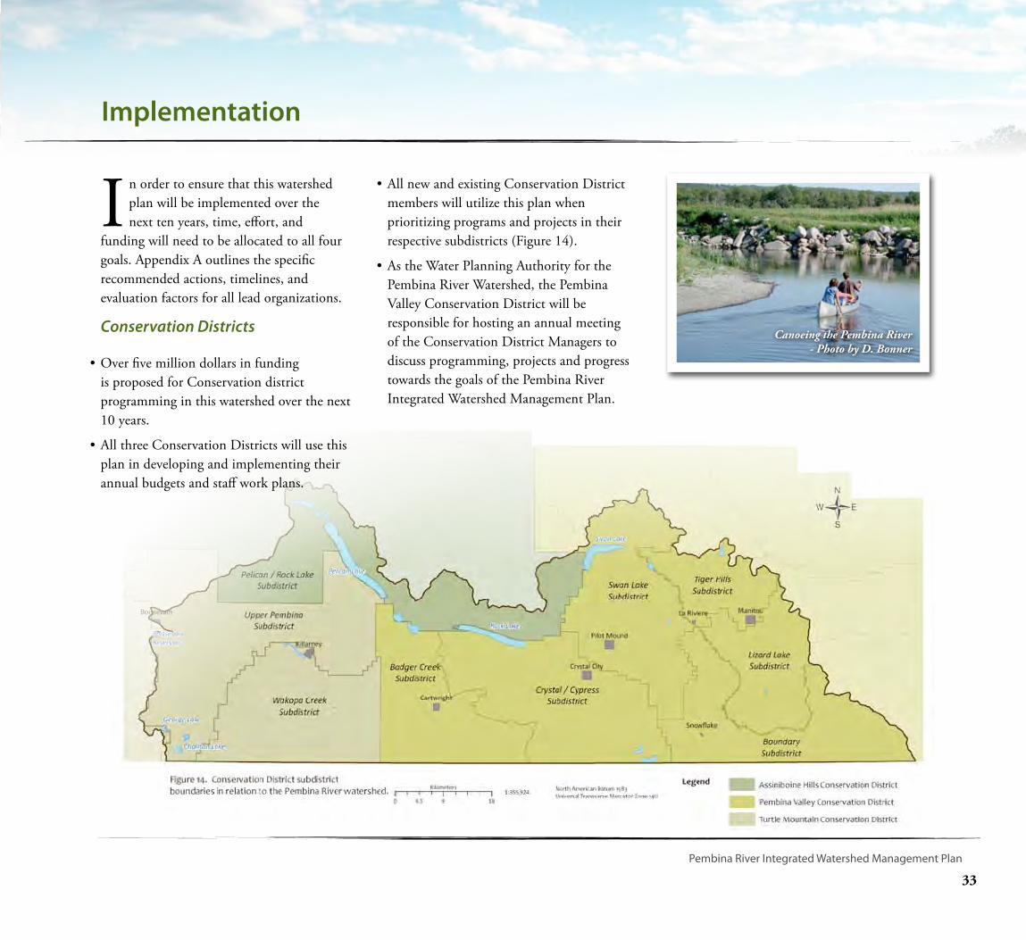
•All new and existing Conservation District members will utilize this plan when prioritizing programs and projects in their respective subdistricts (Figure 14).
•As the Water Planning Authority for the Pembina River Watershed, the Pembina Valley Conservation District will be responsible for hosting an annual meeting of the Conservation District Managers to discuss programming, projects and progress towards the goals of the Pembina River Integrated Watershed Management Plan.
Canoeing the Pembina River - Photo by D. Bonner
34
Partners
A large team of government and non-government agencies have identified themselves as having the ability to contribute to the implementation of this plan. Participating organizations are listed beside their respective actions in Appendix A. A Pembina River integrated watershed management implementation meeting will be hosted by the Pembina River Water Planning Authority every three years to check up on how all aspects of the plan are being implemented.
Linkages to Development Plans
Development Plans are policy documents that reflect provincial land use policies and local policies. This document is intended to help guide those responsible for making local land use decisions and approving local development activities. These plans also set out zoning by-laws and restrictions for residential, commercial, recreation, and industrial land uses. The Pembina River Water Planning Authority recognizes the close linkage between the Pembina River Watershed Planning and the eight development plans currently in place in this watershed. By working together, both development planning and watershed planning can help result in improved watershed health for the benefit of all residents.
A vital action identified by watershed residents in the development of the Pembina River integrated watershed management plan was the need to continue to protect and manage development activities around public drinking water sources.
•The Killarney and Turtle Mountain Planning District
•The Louise Planning District
•The South Central Planning District
•The Roblin-Cartwright Planning District
•The Morden Stanley Thompson Winkler Planning District
•The Morton Boissevain Planning District
•The Pembina Manitou Planning District
•The 23 West Planning District
Survey Crew on Pembina River
35
Pembina River Integrated Watershed Management Plan
2. To Ensure the protection, retention and,where required, rehabilitation of riparianareas, the following conditions apply todevelopment along waterways or waterbodies (as per pending regulation under theWater Protection Act, and the Crown Lands Act):
•That a setback as large possible be applied to provincially designated “vulnerable water bodies” and the following lakes or reservoirs: Boissevain Reservoir, Killarney Lake, Mary Jane Reservoir, Pelican Lake,
The following policies should be adopted in future development plans.
1. Intensive and high-pollution risk development activities, (land uses and structures that have a high risk of causing pollution and include, but are not limited to chemical/ fertilizer storage facilities, disposal fields, fuel tanks, waste disposal grounds, wastewater treatment facilities) will be restricted in public drinking water source zones (Figure 10). Where restriction is not possible, development may be considered in public drinking water source zones provided:
• the proponent can prove by adequate engineering or hydro-geological investigation that the proposed activity will not cause pollution of the public drinking water supply or;
• appropriate precautionary measures have been taken to sufficiently mitigate the risk ofendangering the quality of the water supply for public drinking water supply purposes.
Highway into La Riviere - Photo by D. Bonner
Rock Lake, Swan Lake, and William Lake. Where a substantial setback is not possible, that minimum setback of 30 metres be considered adjacent and upslope of the high-water mark.
•That the natural vegetative cover be retained or rehabilitated within the above setback distances in the above noted water bodies;
•That no alteration is made to the near shore aquatic habitat unless the activity adheres to a Fisheries and Oceans Canada Operational Statement or is reviewed by Fisheries and Oceans Canada.
3. To Review the “Development Capacity” of all the major lakes in this watershed. This process involves conducting a study to determine the number of cottages and housing developments that a lake can support without compromising the lakes water quality or ecological functions.
Working in partnership with Manitoba Water Stewardship, the Water Planning Authority can hire expertise to better understand the feasibility of establishing a development capacity for lakes within the watershed.

36
Acronyms
AAFC - AESB – Agriculture and Agri-Food Canada - Agri-Environment Services Branch (formerly Prairie Farm Rehabilitation Administration – PFRA, a branch of Agriculture and Agri-Food Canada)
AHCD – Assiniboine Hills Conservation District
CD – Conservation District
DFO – Fisheries and Oceans Canada (formerly known as the Department of Fisheries and Oceans)
DUC – Ducks Unlimited Canada
FASL – Feet above sea level
IGA – Manitoba Intergovernmental Affairs
IWMP – Integrated Watershed Management Plan
MASL – Metres above sea level
MIT – Manitoba Infrastructure and Transportation
MAFRI – Manitoba Agriculture, Food and Rural Initiatives
MHHC – Manitoba Habitat Heritage Corporation
MWS – Manitoba Water Stewardship
NCC – Nature Conservancy Canada
PD – Planning District
PFRA – Prairie Farm Rehabilitation Administration (now referred to as Agri-Environment Services Branch)
PMT – Project Management Team (Steering Committee)
PVCD – Pembina Valley Conservation District
RM – Rural Municipality
TMCD – Turtle Mountain Conservation District
WPA – Water Planning Authority

37
Pembina River Integrated Watershed Management Plan
Glossary
Algal Bloom – A heavy growth of algae in a body of water, often a result of high nutrient concentrations and warm weather conditions.
Aquatic Ecosystem – The components of the earth related to, living in or located in or on water or the beds or shores of a water body, including but not limited to:
a) all organic and inorganic matter, and
b) all living organisms and their habitat, and their interacting natural systems.
Beneficial Management Practice (BMP) – a practical solution used to deal with soil and water conservation concerns, including techniques used to manage agricultural and urban runoff and modify agricultural waste management.
Canada Land Inventory – A federal-provincial multi-disciplinary land inventory project that produced maps that indicated the capability of land to sustain agriculture, forestry, recreation and wildlife.
Conservation Agreement – A legal agreement between a landowner and a conservation organization that ensures the protection of the property’s conservation values by limiting future use or development.
Development Plan – A document that outlines the general objectives and policies that will guide the overall use, planning and
development of land in a planning district or individual municipality.
Drinking Water Source – Raw, untreated water in the environment that is used to supply a drinking water system as defined in The Drinking Water Safety Act.
Ecological goods and services – Natural services that healthy ecosystems provide to society such as the purification of air and water, water supply, raw materials (timber), recreation, habitat, scenery, waste treatment, climate stabilization, erosion control and sediment retention, regeneration of soil fertility, soil formation, carbon storage, biological control and pollination, to name a few.
GUDI (Groundwater under the direct influence of surface water) – A groundwater source that has a hydraulic connection to surface water body, or that has significant changes in its water characteristics (chemical and biological) similar to surface water conditions.
Natural Areas – Land which remains undeveloped and supports a healthy ecosystem that provides ecological goods and services, including wildlife habitat.
Non-point Source Pollution – Pollution that cannot be traced to a single site or source. It is often characterized by garbage,
debris, trash, fertilizers, oils, pesticides and other waste and debris.
Nutrient Loading – Discharging of nutrients (fertilizer or sewage) from the watershed into receiving water body (lake, river, wetland); expressed usually as mass per unit area per unit time.
Planning District – A group of two or more partnering municipalities that share similar geography and land use. A Planning District works to ensure the prudent development and use of the districts resources for agricultural, commercial, industrial, residential, social and environmental needs. Planning Districts utilize development plans and zoning by-laws to help shape the future of their region.
Point Source Pollution – Pollution from a single identifiable source, such as a wastewater effluent pipe discharging into a river.
Private Water Source – A surface or groundwater source that provides water to a single connection, usually a home or farm.
Provincial Land Use Policies (PLUPs) – A set of polices describing the Provincial interest in sustainable land use and development. Local planning authorities use them as a guide when preparing their development plan.
38
Glossary Continued
Public Water Source – A surface or groundwater source that provides water to a system with 15 or more service connections
Riparian Area – The land adjacent to a stream, river, lake or wetland. It contains vegetation that, due to the presence of water, is distinctly different from the vegetation of adjacent upland areas.
Semi-Public Water Source – A surface or groundwater source that is not public or private, consists of less than 15 service connections, or a single connection that supplies a public facility such as a school or hospital.
Sensitive Developments – Any development that will or, under specific circumstances (spill, accident, etc), could reasonably be expected to impact a source water by contributing pathogenic organisms, deleterious chemicals, nutrients, or increase the turbidity of the source water.
Source Water – The raw, untreated water that is used to supply a public or semi-public water source. Source waters may be surface water, such as a lake, reservoir or river, or groundwater.
Stakeholder – A person (or group) who is responsible for making or implementing a management action. A stakeholder will be
affected by the action, and can aid or prevent its implementation.
Water Control Works – A dyke, dam, surface or subsurface drain, drainage, improved natural waterway, canal, tunnel, bridge, culvert borehole or contrivance for carrying or conducting water, that:
a) temporarily or permanently alters or may alter the flow or level of water, including but not limited to water in a waterway or waterbody, by any means, including drainage; or
b) changes or may change the location or direction of flow of water, including but not limited to water in a waterway or waterbody, by any means, including drainage.
Water Quality Index (WQI) – is a means of summarizing large amounts of data into simple terms for reporting to management and the public in a consistent manner. It is calculated using twenty-five water quality variables and combines the scope, frequency and amplitude that variables exceed the water quality objectives and guidelines. The Water Quality Index ranges from 0-100 and is used to rank water quality into categories ranging from poor to excellent. Similar to the UV index or an air quality index, it can tell us whether the overall quality of water bodies poses a potential threat to various uses of water, such as habitat for aquatic life,
irrigation water for agriculture and livestock, recreation and aesthetics, and drinking water supplies.
Waterway – A landscape feature (natural or artificial) that continuously or intermittently transports water on the earth’s surface, including headwater, rivers, creeks, channels, streams, and drains.
Zoning By-Law – A detailed document (text and maps) used by a planning authority (municipality or planning district) to implement development plan policies. A zoning bylaw works by regulating land use and development.

39
Pembina River Integrated Watershed Management Plan
Goal 1 - Improve and maintain drinking water quality throughout the watershed.
Objective 1 - Create a high level of public awareness on protecting and maintaining high quality groundwater from semi public and private wells.
Recommended Action Recommended Targets Lead Organizations(s) Evaluation of Success
1Provide increased education and awareness on well water quality. Provide education on well development, mainte-nance, and well head protection.
Entire watershed. Drinking Water Action Areas. AHCD, PVCD, TMCD
Ensure that educational material and an educational workshop is developed by 2012.
2Provide financial assistance for groundwater quality testing, well head assessments, well sealing and shock chlorination.
Entire watershed. Offer a higher rate of financial assistance in areas with less then six meters of overburden. Through public consultations it was
identified that specific attention needs to be paid to Ninette, Crystal
City, and La Riviere.
AHCD, PVCD, TMCD CD budgets and reporting reflect targeted program delivery.
Objective 2: Utilize public education, financial incentives, and water pollution enforcement to improve water quality at the 15 public drinking water sources.
3 Implement the recommended actions identified in the drinking water source assessments.
All 15 public drinking water sources. Through public consultations it has
been identified that specific attention needs to be paid to Ninette, Strath-
cona Park, Pilot Mound, Killarney Lake, Cartwright, Manitou, and Clearwater.
AHCD, PVCD, TMCD, MWS - Planning and Coordi-nation, MWS - Office of
Drinking Water
Drinking water assessments distrib-uted to partner Rural Municipalities. Projects are conducted to reduce contamination susceptibility.
4
Implement the actions identified in the Goudney Reservoir Ac-tion Plan (2007) and the Killarney Lake and Watershed Manage-ment Plan (2003). These plans identify specific actions that should be taken to improve drinking water quality.
Goudney Reservoir and Killarney Lake subwatershed See Plan See plan at www.pvcd.ca
5 Investigate the feasibility of purchasing a water circulation unit as a pilot project to improve drinking water quality.
Goudney Reservoir, Mary Jane Reser-voir, or Killarney Lake PVCD, TMCD
Funding proposals are written and submitted to the Rural Municipali-ties, Communities, and Provincial and Federal agencies.
Appendix A.
Table continued on next page...
40
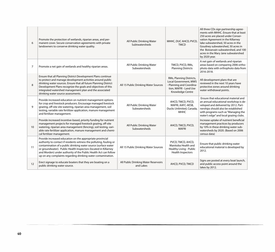
6Promote the protection of wetlands, riparian areas, and per-manent cover. Secure conservation agreements with private landowners to conserve drinking water quality.
All Public Drinking Water Subtwatersheds
MHHC, DUC AHCD, PVCD, TMCD
All three CDs sign partnership agree-ments with MHHC. Ensure that at least 250 acres are placed under Conser-vation Agreement in the Killarney lake subwatershed, 50 acres in the Goudney subwatershed, 50 acres in the Boissevain subwatershed, and 100 acres in the Mary Jane subwatershed by 2020 year.
7 Promote a net gain of wetlands and healthy riparian areas. All Public Drinking Water Subwatersheds
TMCD, PVCD, RMs, Planning Districts
A net gain of wetlands and riparian areas based on comparing 2006 ortho-photo data with orthophoto data from 2016-2018.
8
Ensure that all Planning District Development Plans continue to protect and manage development activities around public drinking water sources. Ensure that all future Planning District Development Plans recognize the goals and objectives of this integrated watershed management plan and the associated drinking water source assessments.
All 15 Public Drinking Water Sources
RMs, Planning Districts, Local Government, MWS - Planning and Coordina-
tion, MAFRI - Land Use Knowledge Centre
All development plans that are reviewed in the next 10 years have protective zones around drinking water withdrawal points.
9
Provide increased education on nutrient management options for crop and livestock producers. Encourage managed livestock grazing, off-site site watering, riparian area management, soil testing, variable rate fertilizer application, manure management and fertilizer management.
All Public Drinking Water Subwatersheds
AHCD, TMCD, PVCD, MAFRI, AAFC-AESB,
Ducks Unlimited, Canada, MHHC
Ensure that educational material and an annual educational workshop is de-veloped and delivered by 2012. Part-nerships should also be established with programs such as “Managing the water’s edge” and local grazing clubs.
10
Provide increased incentive-based, priority funding for nutrient management projects for managed livestock grazing, off-site watering, riparian area management (fencing), soil testing, vari-able rate fertilizer application, manure management and chemi-cal fertilizer management.
All Public Drinking Water Subwatersheds
AHCD, TMCD, PVCD, MAFRI
Increase uptake of nutrient beneficial management practices by producers by 10% in these drinking water sub-watersheds by 2020. (Based on 2006 census data)
11
Provide increased education on the appropriate provincial authority to contact if residents witness the polluting, fouling or contamination of a public drinking water source (surface water or groundwater). Public Health Inspectors (located in Killarney and Morden) under authority of the Public Health Act can follow up on any complaints regarding drinking water contamination.
All 15 Public Drinking Water Sources
PVCD, TMCD, AHCD, Manitoba Health and
Healthy Living - Public Health Inspectors
Ensure that public drinking water educational material is developed by 2012.
12 Erect signage to educate boaters that they are boating on a public drinking water source.
All Public Drinking Water Reservoirs and Lakes AHCD, PVCD, TMCD
Signs are posted at every boat launch, and public access point around the lakes by 2012.

41
Pembina River Integrated Watershed Management Plan
Goal 2: Reduce algal blooms and improve surface water quality for residents, wildlife, and outdoor recreation.
Objective 1: Reduce nutrient loading by 10% at the Pembina River Windygates station (Total phosphorus loading from 1994-2007: 190.9 t/yr. Goal for 2020: 171.2 tonnes per year). Total nitrogen loading from 1994-2006: 1044.4 tonnes per year. Goal for 2020: 940.0 tonnes per year.)
Recommended Action Recommended Target Area Lead Organizations(s) Evaluation of Success
Action Section #1. Provide incentive based programs for agricultural beneficial management practices to reduce nutrient loading.
1
Conservation Districts will work with Manitoba Agriculture, Food and Rural Initiatives (MAFRI) and AAFC - Agri-Environmental Services Branch (AAFC- AESB) to provide technology transfer/extension and potential financial support to assist producers in implementing beneficial management practices such as off-site site watering, riparian fencing, manure management, and winter site management.
Valley and River Zone AHCD, PVCD, TMCD, MAFRI, AAFC – AESB
Increase uptake of beneficial manage-ment practices by livestock producers by 10% in the Valley and River Zone by 2020. (Based on 2006 census data)
2Provide funding for producers to implement projects identified in their Environmental Farm Plan. Provide education on benefi-cial management practices to reduce nutrient run-off.
Entire watershed MAFRIAn increased proportion of producers are utilizing beneficial management practices by 2020.
3
Secure conservation agreements with private landowners for wetland and riparian conservation. If available, promote the Wet-land Restoration Incentive Program, which would provide water retention across the watershed.
Entire watershedMHHC, DUC, MWS - Wet-land Restoration Incen-
tive Program
Secure 10 Wetland Restoration Agree-ments in this watershed (or 50 acres of restored wetlands). Secure 10 Conser-vation Agreements (minimum 40 acres each) by 2020.
4Investigate the feasibility of an environmental goods and ser-vices program in this watershed. Landowners are then provided incentives to retain wetlands.
Entire watershedMAFRI, MWS, AHCD,
PVCD, TMCD, DUC, KAP, MHHC, RMs
An effective environmental goods and services program is offered by 2015.
Action Section #2. Provide education and awareness on improving surface water quality.
5Provide education and awareness on the proper management of private septic systems and the hazards resulting from the releases of nitrates, e-coli, and nutrients.
Septic Monitoring ZoneAHCD, TMCD, PVCD, MB Conservation – Environ-
mental Services
Ensure that educational outreach, including newsletters to watershed residents, are developed and delivered by 2012.
6
Provide increased education on nutrient management options for crop and livestock producers. Encourage managed livestock grazing, off-site watering, riparian fencing, manure manage-ment, winter livestock management, and chemical fertilizer management.
Entire watershed AHCD, PVCD, TMCD, AAFC-AESB, MAFRI
Ensure that educational outreach, including newsletters to watershed residents, are developed and delivered by 2012.
7 Organize educational events and develop outdoor classrooms to promote watershed health.
School aged children and the general public in the entire watershed AHCD, PVCD, TMCD
Conservation District annual report outlines activities for public education of school children.
8 Provide education on methods to reduce water pollution from urban water run-off. Entire watershed AHCD, PVCD, TMCD
Ensure that educational material and an educational workshop is developed and delivered by 2012.
9Promote the River Watch and Envirothon Programs in high schools. These program encourage high school students to get involved in monitoring and conserving local waterways.
All the high schools within the water-shed PVCD, AHCD, TMCD
A Riverwatch Program is established in every high school Pembina River Watershed by 2015.
Table continued on next page...

42
Action Section #3. Wastewater treatment facilities and land management projects.
10Ensure that nutrient discharge reduction options are required when new wastewater treatment facilities are licensed, or when existing waste water treatment facilities are relicensed.
All the wastewater treatment facilities within the watershed
MB Conservation - Envi-ronmental Services
To be determined by MB Conserva-tion - Environmental Services on an individual basis.
11
Investigate opportunities to reduce nutrient discharges from existing wastewater treatment facilities. Explore designing larger and more efficient lagoon cells, engineered wetlands, and incor-porating wastewater treatment options that can reduce nutrient discharges. Allocate infrastructure funding to assist wastewater treatment facilities to reduce phosphorus discharges to < 1 mg/l.
All the wastewater treatment facilities within the watershed
RMs, MB Conservation - Environmental Services
All wastewater treatment facilities in the watershed incorporate nutri-ent discharge reduction technology within their facilities by 2020.
12Enhanced inspection program of wastewater systems on resi-dential properties in sensitive areas to ensure water quality is being protected.
Septic Monitoring Zone MB Conservation - Envi-ronmental Services
Inspection program is initiated by 2012.
13
Promote the “Water Soft Paths” approach to reducing municipal costs for drinking water treatment and wastewater treatment. “Water Soft Paths” is a holistic water use planning approach that focuses on the demand-side management and strives to reduce water demand through innovation, conservation, reallocation and changing use and re-use while working within ecological limits.
All the communities within the wa-tershed PVCD, AHCD, TMCD, RMs
Education material is developed by 2012. Education workshops are of-fered to interested rural municipalities.
14 Allocate funding and effort to address surface water quality threats.
Kelly's Ravine (North-west of Rock Lake) AHCD
3 of the 4 projects identified by the 2001 Upper Pembina River Fisheries Study are completed in 5 years.
15Ensure that Crown Lands continue to be managed in an environ-mentally sustainable manner to minimize potential impacts on water quality.
All Crown Lands in the watershedMB Conservation, AAFC-AESB, MAFRI - Land Use
Knowledge Centre
Ensure that when future crown land management plans are developed that they recognize the goals and ob-jectives of this integrated watershed management plan.
16
Add a provincial long term water quality monitoring station within the Pembina River watershed to better determine the source of water quality threats and to better understand the long term water quality trends.
At the outlet of 05OA (between 05OA and 05OB). Or at some point deemed
appropriate by MWS Water Quality Branch.
MWS - Surface Water Quality Management
Section
A new long term water quality moni-toring station is established by 2013.

43
Pembina River Integrated Watershed Management Plan
Goal 3: Protect our lakes and rivers from excess erosion.
Objective 1: A 10% increase in the uptake of beneficial management practices for erosion control by producers in highly and severely erodible soils by 2020 (based on 2006 census data).
Recommended Action Recommended Target Area Lead Organizations(s) Evaluation of Success
Action Section #1. Provide incentive based programs for agricultural beneficial management practices to reduce nutrient loading.
1
Provide education to agricultural producers on the implementation beneficial management practicesfor water erosion control. Promote appropriate tillage practices, managed grazing systems, grassed waterways , sowing of permanent cover (trees,forage) and other appropriate beneficial manage-ment practices.
Entire watershed
AHCD, TMCD, PVCD, MAFRI - Go Teams,
AAFC-AESB (Agri-Envi-ronmental Knowledge and Decision Support)
(Sustainable Agricultural Systems and Practices)(Shelterbelt Program)
Educational material is developed by 2012. Reduce the amount of annual cropland in soil that has a high to severe water erosion risk (within 50 meters of watercourses) from 4.1% to 3% in 10 years (based on 2006 census data). Water erosion control beneficial management practices are utilized on 50% of the lands considered a water erosion risk area.
2
Provide increased financial support to agricul-tural producers on the implementation beneficial management practices for water erosion control. Promote appropriate tillage practices, managed grazing systems, grassed waterways, sowing of permanent cover (trees, forage) and other appropri-ate beneficial management practices.
Water Erosion Risk Area. CD boards have discretion to identify risk areas outside of mapped area.
AHCD, PVCD, TMCD, MA-FRI (Agri-Environmental
Service Centre)
Reduce the amount of annual cropland in soil that has a high to severe water erosion risk (within 50 meters of watercourses) from 4.1% to 3% in 10 years (based on 2006 census data). Water erosion control benefi-cial management practices are utilized on 50% of the water erosion risk area.
3Provide public education on the cause of erosion in the watershed, and solutions for managing local problems.
Entire watershed AHCD, PVCD, TMCD, MAFRI Go Teams
Ensure that educational material is developed and signage is erected at public access points around the watershed.
4
Secure conservation agreements (or other land protection agreements) with private landowners to ensure that existing permanent cover is protected across the watershed.
Entire watershed MHHC, PVCD, TMCD, AHCD
Ensure that at least 1000 acres of permanent cover are placed under conservation agreement by 2020.
5Conduct a surface water management study to identify the most effective water retention zones in each sub-watershed.
Each subwatershedAHCD, TMCD, PVCD, MWS - Water Control Systems
Management, Consultant
Terms of Reference for a surface water management study signed by 2012.
6
Address soil erosion at specific sites along vul-nerable watercourses utilizing a variety of tools including planting permanent cover (trees, forage), fencing, small control structures, and rip rap.
Soil Erosion Focus Area - 17 specific sites. CD boards have discretion to
identify additional sites.
AHCD, TMCD, PVCD, RMs, MWS - Water Control
Systems Management
Conservation Districts have applied funding and staff time to address these specific sites.
7Utilize shale traps, or similar structures, to reduce the amount of sediment entering the Pembina River waterway.
Shale Trap Erosion ZonePVCD, MWS - Water
Control Systems Manage-ment
PVCD has applied money and staff time to address these specific sites.
8
Complete projects at 10 sites as identified in the Upper Pembina River Fisheries and Riparian Study (1996). Complete projects at 5 sites as identified in the Fisheries Enhancement Study for the Pembina River (2001). Complete projects at 10 sites as identi-fied in the Long River Fisheries Study (2009).
Fisheries Habitat Rehabilitation Sites. 85 specific sites. AHCD, PVCD, TMCD All project sites are completed as identified by 2020.

44
Goal 4: Improve surface water management to reduce flooding and wetland loss, and protect aquatic ecosystems.
Objective 1: Reduce the economic impact on landowners from spring and summer flooding.
Objective 2: Improve the incentive to maintain wetlands by providing financial incentives and education on the value of wetlands for drinking water, drought resistance, and flood protection.
Recommended Actions and Suggested Policies to Adopt Lead Organizations(s) Evaluation of Success
General Watershed Zone -
Management PolicyAgriculture production zone with opportunities to conserve and restore wetlands and permanent cover.
1 Promote no net loss of wetlands.AHCD, TMCD, PVCD, MWS - Water
Control Works and Drainage Licens-ing
Review Provincial water works drain-age license approvals annually, and
ensure that objectives are being met.
2 Promote the retention of natural and permanent cover to allow water infiltration and reduced water run-off. AHCD, TMCD, PVCD Programs are offered in annual Conser-
vation District budgets.
3 Provide incentives for the retention and restoration of wetlands and riparian areas.
AHCD, TMCD, PVCD, MHHC, MWS - Wetland Restoration Incentive
Program
Programs are offered in annual Con-servation District budgets. Ensure that Conservation Agreement targets are
met for Goals 1, 2, and 3.
4
Ensure that there is uniformity in Water Control Works and Drainage Licensing, policies and enforcement across the watershed. Ensure that Conservation Dis-tricts and Rural Municipalities receive copies, and are permitted to comment, on all Water Control Works and Drainage License applications proposed within their boundaries. Ensure that a Water Control Works and Drainage Licensing Officer meets with every conservation district board on an annual basis to discuss the drainage licensing process and provide updates on any local concerns.
MWS - Water Control Works and Drainage Licensing
Review Water Control Works and Drain-age licence approvals annually, and
ensure that objectives are being met. Aim for increased compliance and/or a
reduction in offence notices issued.
5 Develop and maintain open communication with the landowners and authori-ties in the American portion of the watershed. PVCD PVCD to continue to work with the
Pembina River Basin Advisory Board.
6
Conduct a surface water management study to identify the most effective water retention zones in each sub-watershed. Construct water retention structures at identified sites. Focus areas include: Badger/Mylor waterway, PTH #253 east of Rock Lake, and the Gimby Creek provincial waterway flooded site.
AHCD, TMCD, PVCD, MWS - Water Control Systems Management,
Consultant
Terms of Reference for a surface water management study signed by 2011.
7 The 18 "Surface Water Problem Sites" within this zone will be addressed and prioritized based on the policies within this zone.
Manitoba Infrastructure and Trans-portation, RMs, PVCD, TMCD, AHCD,
MWS - Water Control Systems Management
Annual work plans and budgets ad-dress the identified problem sites.
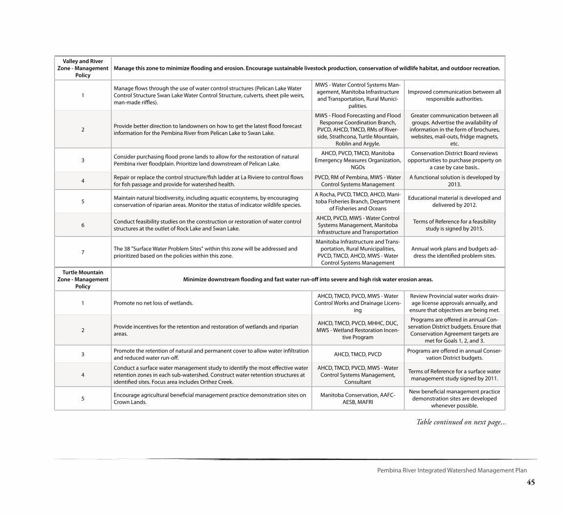
45
Pembina River Integrated Watershed Management Plan
Valley and River Zone - Management
PolicyManage this zone to minimize flooding and erosion. Encourage sustainable livestock production, conservation of wildlife habitat, and outdoor recreation.
1Manage flows through the use of water control structures (Pelican Lake Water Control Structure Swan Lake Water Control Structure, culverts, sheet pile weirs, man-made riffles).
MWS - Water Control Systems Man-agement, Manitoba Infrastructure and Transportation, Rural Munici-
palities.
Improved communication between all responsible authorities.
2 Provide better direction to landowners on how to get the latest flood forecast information for the Pembina River from Pelican Lake to Swan Lake.
MWS - Flood Forecasting and Flood Response Coordination Branch,
PVCD, AHCD, TMCD, RMs of River-side, Strathcona, Turtle Mountain,
Roblin and Argyle.
Greater communication between all groups. Advertise the availability of
information in the form of brochures, websites, mail-outs, fridge magnets,
etc.
3 Consider purchasing flood prone lands to allow for the restoration of natural Pembina river floodplain. Prioritize land downstream of Pelican Lake.
AHCD, PVCD, TMCD, Manitoba Emergency Measures Organization,
NGOs
Conservation District Board reviews opportunities to purchase property on
a case by case basis..
4 Repair or replace the control structure/fish ladder at La Riviere to control flows for fish passage and provide for watershed health.
PVCD, RM of Pembina, MWS - Water Control Systems Management
A functional solution is developed by 2013.
5 Maintain natural biodiversity, including aquatic ecosystems, by encouraging conservation of riparian areas. Monitor the status of indicator wildlife species.
A Rocha, PVCD, TMCD, AHCD, Mani-toba Fisheries Branch, Department
of Fisheries and Oceans
Educational material is developed and delivered by 2012.
6 Conduct feasibility studies on the construction or restoration of water control structures at the outlet of Rock Lake and Swan Lake.
AHCD, PVCD, MWS - Water Control Systems Management, Manitoba Infrastructure and Transportation
Terms of Reference for a feasibility study is signed by 2015.
7 The 38 "Surface Water Problem Sites" within this zone will be addressed and prioritized based on the policies within this zone.
Manitoba Infrastructure and Trans-portation, Rural Municipalities,
PVCD, TMCD, AHCD, MWS - Water Control Systems Management
Annual work plans and budgets ad-dress the identified problem sites.
Turtle Mountain Zone - Management
PolicyMinimize downstream flooding and fast water run-off into severe and high risk water erosion areas.
1 Promote no net loss of wetlands.AHCD, TMCD, PVCD, MWS - Water
Control Works and Drainage Licens-ing
Review Provincial water works drain-age license approvals annually, and
ensure that objectives are being met.
2 Provide incentives for the retention and restoration of wetlands and riparian areas.
AHCD, TMCD, PVCD, MHHC, DUC, MWS - Wetland Restoration Incen-
tive Program
Programs are offered in annual Con-servation District budgets. Ensure that Conservation Agreement targets are
met for Goals 1, 2, and 3.
3 Promote the retention of natural and permanent cover to allow water infiltration and reduced water run-off. AHCD, TMCD, PVCD Programs are offered in annual Conser-
vation District budgets.
4Conduct a surface water management study to identify the most effective water retention zones in each sub-watershed. Construct water retention structures at identified sites. Focus area includes Orthez Creek.
AHCD, TMCD, PVCD, MWS - Water Control Systems Management,
Consultant
Terms of Reference for a surface water management study signed by 2011.
5 Encourage agricultural beneficial management practice demonstration sites on Crown Lands.
Manitoba Conservation, AAFC- AESB, MAFRI
New beneficial management practice demonstration sites are developed
whenever possible.
Table continued on next page...

46
6
Consider adopting the following policies for all Crown Lands in the Turtle Mountain Zone:
Ensure that Crown Lands continue to be managed with a high level of consider-ation for watershed health.
Manitoba Conservation, AAFC-AESB, MAFRI
All new Crown Land Management Plans in this watershed, cite this plan.
Ensure that all new Crown Land Management Plans recognize the goals and objectives of this Integrated Watershed Management Plan.
Manitoba Conservation, AAFC-AESB, MAFRI
All new Crown Land Management Plans in this watershed, cite this plan.
Ensure that Consultations are held with the Watershed Planning Authority and neighbouring Conservation Districts before Crown Land Management Plans are implemented.
Manitoba Conservation, AAFC-AESB, MAFRI
All new Crown Land Management Plans in this watershed, cite this plan.
Ensure that a 30 metre riparian buffer zone is maintained around waterbodies when brush clearing is required.
Manitoba Conservation, AAFC-AESB, MAFRI
Reviews of AAFC- AESB Annual Reports and site visits by CD board members.
Ensure that ecological integrity is maintained when any future developments (roads, subdivisions, access points) are considered around isolated waterbodies on Crown Lands.
Manitoba Conservation, AAFC-AESB, MAFRI, RMs, Planning
Districts
New development plans are reviewed by the Water Planning Authority and
Conservation District.
7 The 15 "Surface Water Problem Sites" within this zone will be addressed and prioritized based on the policies within this zone.
Manitoba Infrastructure and Trans-portation, Rural Municipalities,
PVCD, TMCD, AHCD, MWS - Water Control Systems Management
Annual work plans and budgets ad-dress the identified problem sites.
47
Pembina River Integrated Watershed Management Plan
Appendix B.
Source Water Protection
Clean, potable drinking water is critical for human life, therefore, a necessity for prosperous sustainable communities. Protecting water at its source, or before it arrives at our treatment facilities, is a preventative approach to water management. It is more ecologically responsible and may be less expensive and to prevent contamination to our source waters, than to try and remediate water quality in treatment facilities.
Source water protection provides benefits to watersheds beyond those realized at the water treatment plant. Clean water benefits aquatic ecosystems, supports recreational and wildlife values, and ensures sustainability for future generations. Source water protection fits well within the integrated watershed management framework as it pulls from a wide knowledge base spanning hydrogeology, land use planning, water quality, municipal infrastructure and industry as well as relying heavily on local knowledge for describing area conditions and implementing actions.
The approach to source water protection planning varies widely across Canada. Manitoba has adopted a ‘grassroots’ approach to source water protection. A source water assessment is conducted with a group of local, technical and non-technical
representatives and their recommendations are placed within an integrated watershed management plan. This locally-led approach to protecting drinking water sources is inline with the shared governance model adopted for soil and water management across municipal Manitoba through the Conservation Districts program. The process is quick, easy to follow and relies primarily on the common sense of a small group of people. In this watershed, 9 sources of drinking water are from groundwater, and six are from the surface water. As a result, this team was comprised of a hydrogeologist, a regional drinking water officer, a watershed planner, Conservation District representatives, and a municipal representative that changed based on which municipal system was being reviewed. This team has made recommendations based on one site visit, a relatively simple review of land activities in the area, and a follow-up discussion of potential threats to drinking water quality based on what they observed during site visits and information available in the provincial groundwater database.
Public Drinking Water Sources
In Manitoba, the Office of Drinking Water defines a public water system as a potable supply of drinking water with 15 or more connections. The Pembina River watershed contains 15 public drinking water systems,
9 of which withdraw their water from a groundwater source, six from surface water sources, and one from both. Some of these public drinking water systems use multiple wells to withdraw water for a single community.
Source Water Assessments
The source water assessments are completed in two steps: 1. Mapping Source Water Protection Zones. A desk-top exercise that includes creating maps that display potential source water threats, land cover and local infrastructure. This is done within a 1.5 kilometre buffer around each public water system well, or sub watershed of a surface water source. Information to create these maps is drawn from provincial databases that may not be updated with current information. To ‘groundtruth’ what is identified within the source water protection zones, site visits are held.
2. Site Visits. Site visits are conducted by a group of local and technical experts. Information on the maps and accompanying data are considrered, but a careful reiew of individual well conditions and land use activities at the site are the focus of this visit. Potential threats are discussed and precautionary measures that could be applied to protect wells are considered.
48
Potential pollutant sources examined in this assessment include:
• Roadways
• Wastewater treatment plants
• Manure storage areas
• Railways
• Oil Wells
• Contaminated sites
• Chemical, fuel, petro-chemical storage locations
• Industry
• Mining operations
• Waste disposal sites
• Agricultural drains
• Population centres
Boil Water Advisories
There is a history of boil water advisories in the Pembina river watershed. Rock Lake Beach campground is currently under a long-term boil water advisory. Strathcona Park and Pilot Mound have both been under temporary boil water advisories within the last 5 years. The community of Ninette, which is serviced by private or semi-private wells, is also under a long-term boil water advisory.
Recommendations for all public drinking water sources
1. Intensive and high-pollution risk development activities, (land uses and structures that have a high risk of causing pollution and include, but are not limited to chemical/fertilizer storage facilities, disposal fields, fuel tanks, waste disposal grounds, wastewater treatment facilities) will be restricted in public drinking water source zones. Where restriction is no possible, development may be considered in public drinking water source zones provided:
• the proponent can prove by adequate engineering or hydro-geological investigation that the proposed activity will not cause pollution of the public drinking water supply or;
• appropriate precautionary measures have been taken to sufficiently mitigate the risk of endangering the quality of the water supply for public drinking water supply purposes.
2. To prevent significant surface water quality and drinking water quality deterioration, developments in or near surface waters and riparian areas will be restricted, or limited, if they:
• lead to the contribution of nutrients, pathogenic organisms, dleterious chemicals or materials to these waters;
• accelerate erosion and bank instability;
• cause the removal of natural vegetative cover; and/or
• may have an impact on the in-stream flows needed to maintain healthy aquatic ecosystems.
Seal unused, abandoned and poorly constructed wells that are located within a source protection zones for all public drinking water.
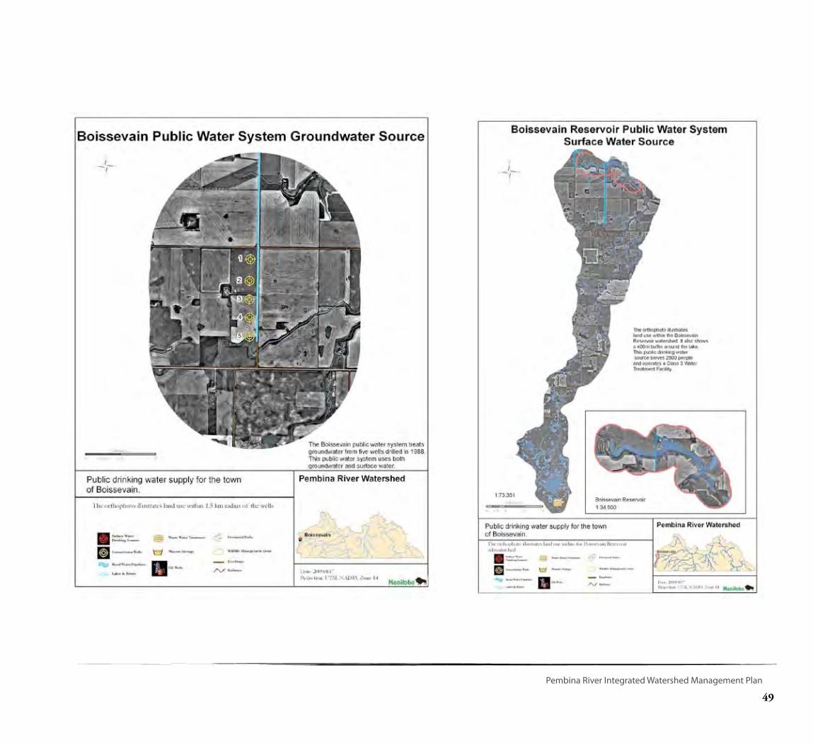
49
Pembina River Integrated Watershed Management Plan
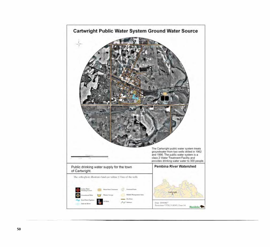
50

51
Pembina River Integrated Watershed Management Plan
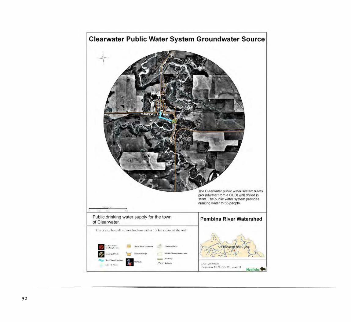
52
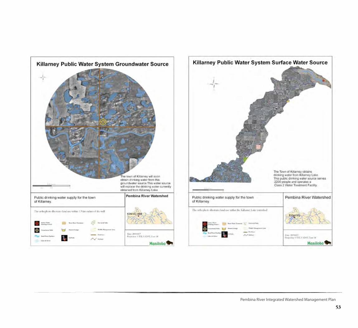
53
Pembina River Integrated Watershed Management Plan
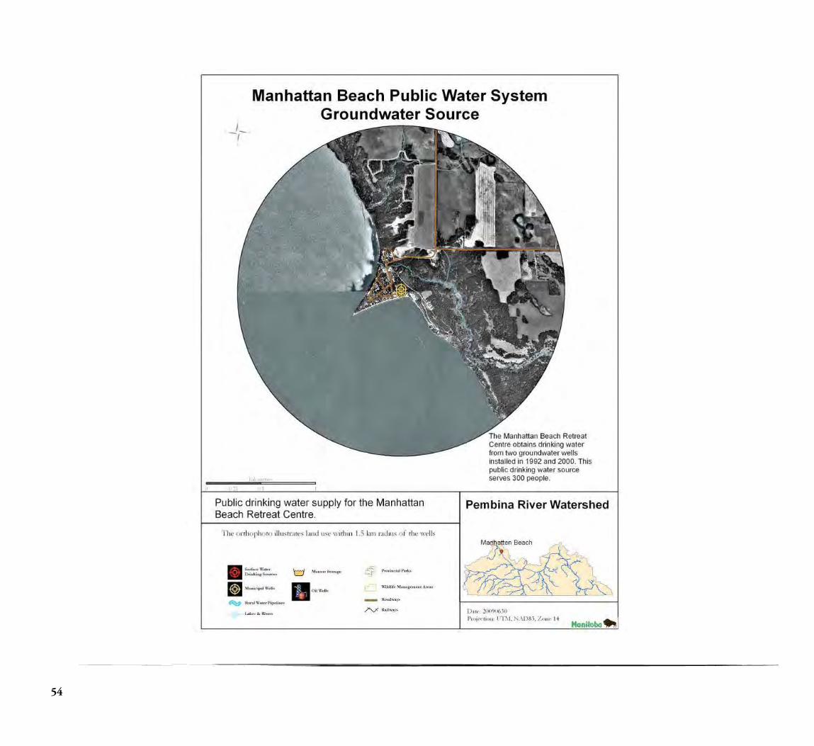
54
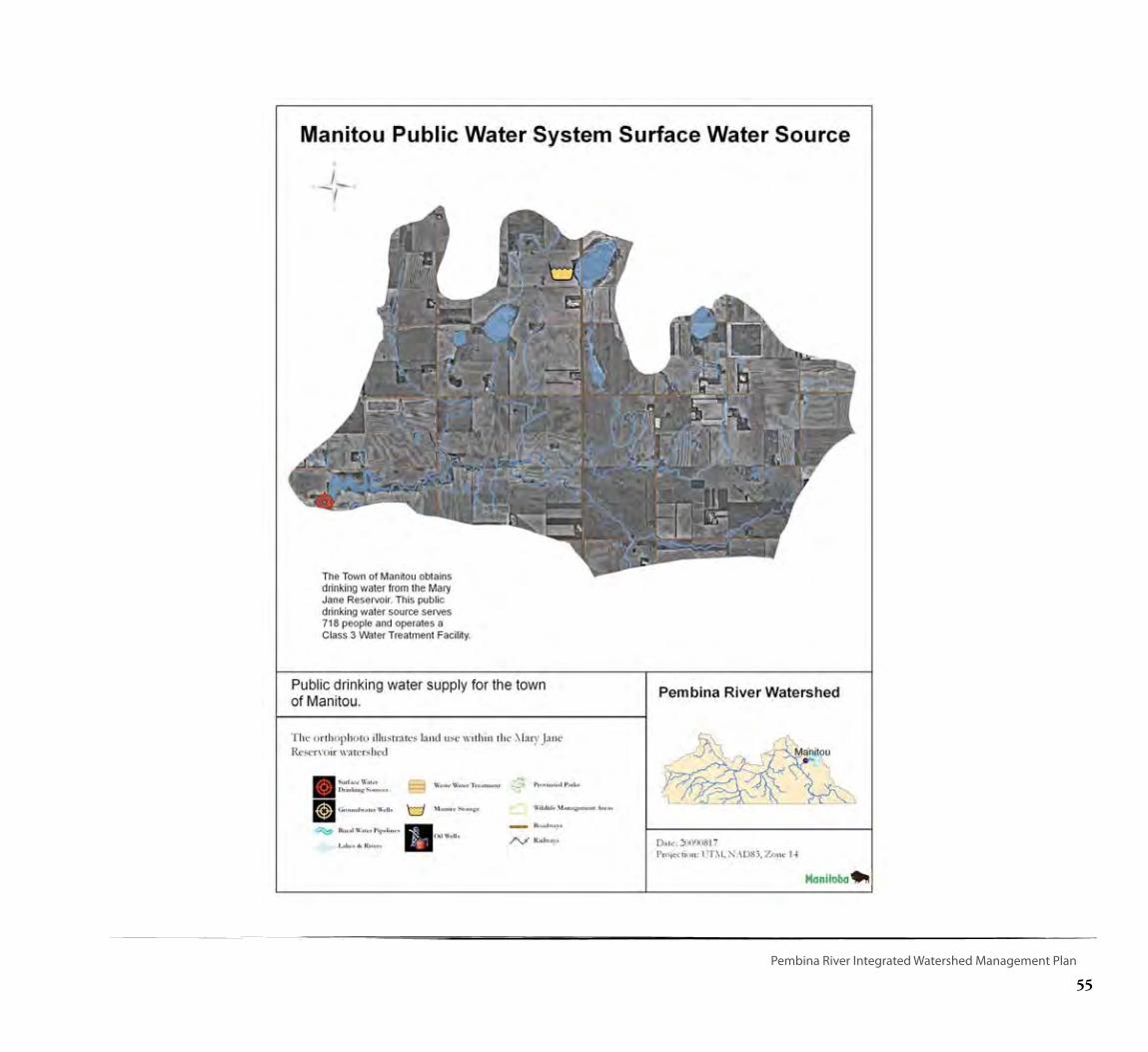
55
Pembina River Integrated Watershed Management Plan
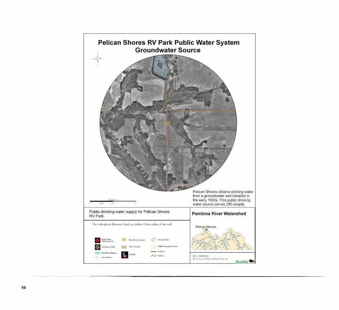
56
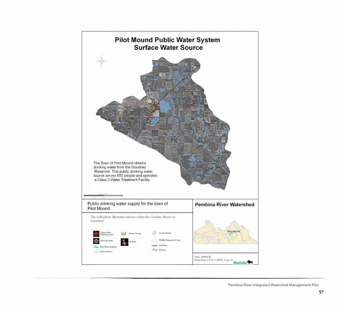
57
Pembina River Integrated Watershed Management Plan
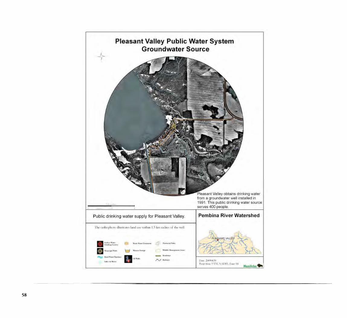
58
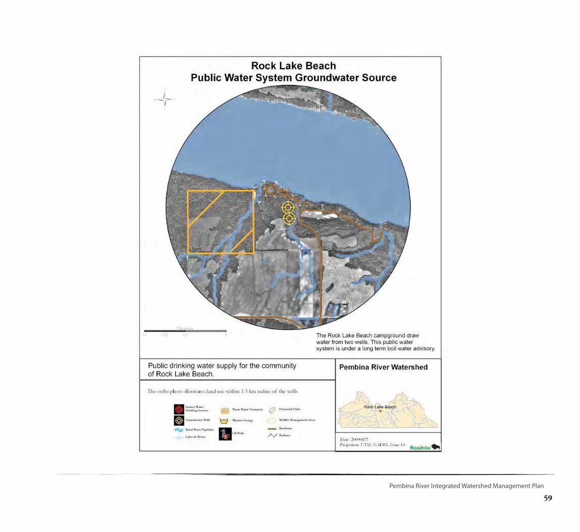
59
Pembina River Integrated Watershed Management Plan
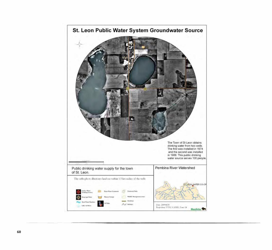
60

61
Pembina River Integrated Watershed Management Plan
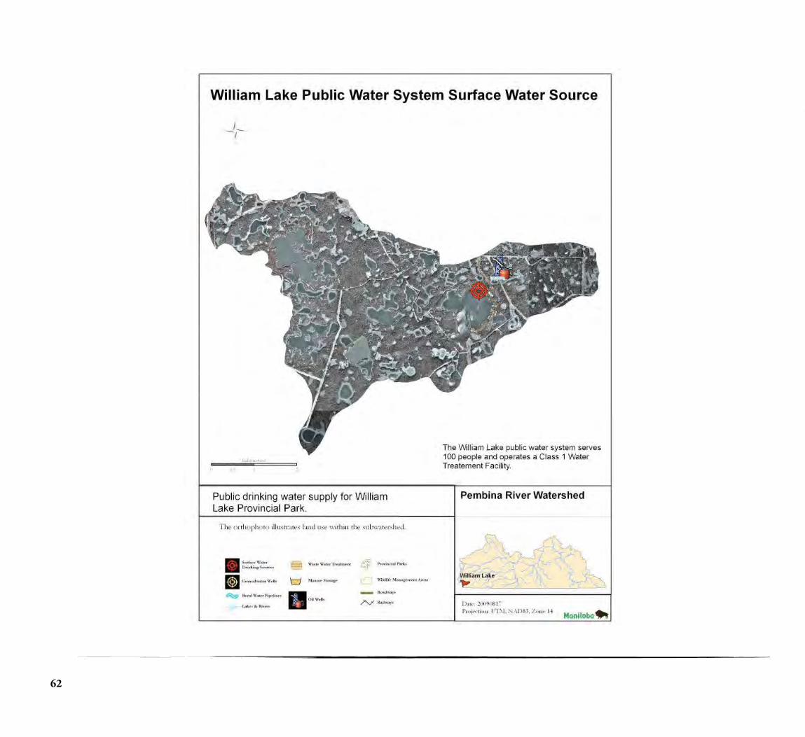
62

63
Pembina River Integrated Watershed Management Plan
Appendix C.
A landowner expresses interest in signing a Conservation Agreement
MHHC representative and CD Manager reviews the eligibility of property based
on MHHC and Pembina River IWMP criteria
Inform landowner of program criteria
Is the property within a drinking water
source watershed or within 1.5 kilometers
of a public watersource
Pembina River Watershed Conservation Agreement Flow Chart
No
Yes
MHHC and PVCD, TMCD and AHCD agree to cooperate and promote the
Conservation Agreement Program and contact key landowners within the
watershed
MHHC and Pembina River IWMP Criteria:
Is the property comprised of: - wetlands
- riparian areas - grasslands or woodlands
and is ≥ 40 acres, or has a specialfeature or location
Yes Move forward with Conservation Agreement
Is the property within the Valleyand River
Zone?
No
Yes Move forward with Conservation Agreement
Is the property within the Turtle Mountain Zone (headwaters)?
No
Yes Move forward with Conservation Agreement
No
Inform landowner of other opportunities for
conservation
Moving forward with Conservation Agreement
Wetland Wetland RestorationRiparian Area Grasslands or Woodlands
Land adjacent to a lake, or 3rd order stream or
greater
Funding may be provided by
MHHC, MB Water Stewardship,
and/orConservation District*
Class 1 wetland or higher
Funding may be provided by MHHC, MB Water Stewardship, Pot
Holes Plus, and/or Conservation District*
Restoring drained wetlands
Funding may be provided by MHHC, MB Water Stewardship, and Environment Canada, and/or Conservation
District*
Protecting valuable wildlife or Species-at-
Risk habitat
Funding may be provided by MHHC, Environment Canada and/or Conservation
District*
Conservation Agreement delivered by MHHC
In unique situations where a potential Conservation Agreement property falls outside the criteria of MHHC and the
Pembina River IWMP, CD Boards have discretion to direct staff to pursue a CD administered Conservation Agreement.
* Not all Conservation Agreements automatically receive funding from identified partners.

64
Photo Credits
Algae Advisory Sign http://www.gov.mb.ca/waterstewardship/quality/beaches.html


Soils and Landscape of the Pembina River Watershed
Pembina River Integrated Watershed Management Plan