periodic technical report part b
TRANSCRIPT

1
Periodic technical report
Part B D 1.6

2
Periodic technical report
Part B D 1.6
Project [1] Number: [727550]
Project Acronym: [GEMex]
Project title: [Cooperation in Geothermal energy research Europe-Mexico for development of
Enhanced Geothermal Systems and Superhot Geothermal Systems]
Period covered by the report: from [01/10/2016] to [31/03/2018]
Periodic report: 1st Periodic Report
Version 1.0
K. Kieling, E. Jolie, D. Bruhn (GFZ) and the GEMex consortium
Work package 1
May 2018
Website: http://www.gemex-h2020.eu
The GEMex project is supported by the
European Union’s Horizon 2020
programme for Research and Innovation
under grant agreement No 727550

3
Table of Contents
List of figures 5
List of tables 6
1 Objectives 9
2 Explanation of the work carried out per WP 10
2.1 Work Package 1: Project Management 10
2.1.1 Task 1.1 Legal Issues 11
2.1.2 Task 1.2 Financial issues 11
2.1.3 Task 1.3 Administrative issues 11
2.1.4 Task 1.4 Meetings 11
2.1.5 Task 1.5 Deliverables to the European Commission 13
2.1.6 Task 1.6 Coordination with Mexican Partners 13
2.1.7 Deviations from the Description of Action 13
2.2 Work Package 2: Dissemination 14
2.2.1 Task 2.1 Strategic Communication Plan and communication campaign 15
2.2.2 Task 2.2 Website 15
2.2.3 Task 2.3 Open access database 17
2.2.4 Task 2.4 Promotion of project results 18
2.2.5 Task 2.5 Events 22
2.2.6 Deviations from the Description of Action 23
2.3 Work Package 3: Regional Resource Models 24
2.3.1 Task 3.1 Integrated regional models and characterisation of the geothermal and volcanic systems
26
2.3.2 Task 3.2 Integrated geothermal models and resource assessment 33
2.3.3 Task 3.3 Analogue modelling 35
2.3.4 Publications 38
2.3.5 Dissemination activities (talks, posters, workshops) 38
2.3.6 Deviations from the Description of Action 38
2.4 Work Package 4: Tectonic control on fluid flow 39
2.4.1 Task 4.1 Understanding from exhumed systems 41
2.4.2 Relationships between brittle structures, and fluid flow in active systems (Los Humeros and
Acoculco) 43
2.4.3 Geochemical characterization and origin of cold and thermal fluids 46
2.4.4 Publications 51
2.4.5 Dissemination activities (talks, posters, workshops) 51
2.4.6 Patents 52
2.4.7 Deviations from the Description of Action 52
2.5 Work Package 5: Detection of deep structures 53
2.5.1 Task 5.1 Resistivity imaging of EGS and SHSG 54
2.5.2 Task 5.2 Seismic imaging 58
2.5.3 Task 5.3 Evaluation of other geophysical data 60
2.5.4 Task 5.4 Integration of methods and inversions constraints 62
4
2.5.5 Publications 63
2.5.6 Dissemination activities 63
2.5.7 Deviations from the Description of Action 63
2.6 Work Package 6: 65
2.6.1 Task 6.1 Rock, fracture, and reservoir fluid properties 68
2.6.2 Task 6.2 Reservoir characterization 77
2.6.3 Task 6.3 Model approaches for EGS 78
2.6.4 Task 6.4 Model approaches for SHGS 79
2.6.5 Publications 80
2.6.6 Dissemination 80
2.6.7 Deviations from the Description of Action 81
2.7 Work Package 7: Concepts for EGS 82
2.7.1 Task 7.1 Integrated reservoir model 82
2.7.2 Task 7.2 Stimulation Design 83
2.7.3 Task 7.3 Induced seismicity and environmental hazards 83
2.7.4 Task 7.4 Public engagement 83
2.7.5 Dissemination and communication activities 84
2.7.6 Deviations from the Description of Action 84
2.8 Work Package 8: Concepts for Superhot 85
2.8.1 Task 8.1 Prediction of reservoir properties 86
2.8.2 Task 8.2 Materials for installation in super-hot systems 87
2.8.3 Task 8.3 Drilling and completion 87
2.8.4 Task 8.4 Thermal loop design and performance monitoring 88
2.8.5 Publications 88
2.8.6 Dissemination activities (talks, posters, workshops) 88
2.9 Work Package 9: Ethics 89
3 Impact 90
4 Deviations from Annex 1 (if applicable) 91
4.1 Tasks 91
4.2 Use of resources 92
5 References 95

5
List of figures
Figure 1: Website homepage ................................................................................................................................ 16
Figure 2: Open Access Database - List of available layers ..................................................................................... 17
Figure 3: Open Access Database - WebGIS tool .................................................................................................... 17
Figure 4: Boundaries of the local, regional and supra-regional models ............................................................... 26
Figure 5: Los Humeros preliminary regional GeoModel ....................................................................................... 29
Figure 6: Los Humeros preliminary local GeoModel ............................................................................................. 29
Figure 7: Acoculco preliminary regional GeoModel .............................................................................................. 30
Figure 8: Measurement sites for structural data .................................................................................................. 36
Figure 9: Location of measurement point for gravity and resistivity survey and for passive seismic stations in Los
Humeros ....................................................................................................................................................... 54
Figure 10: Status of the resistivity data acquisition in Los Humeros – first phase. Green lines are calderas and
faults. Red triangles are sounding locations. Triangles with no border and with a border are soundings
where only MT data are available respectively. Soundings with a red cross over are soundings with bad
data quality .................................................................................................................................................. 56
Figure 11: Second stage of the field work in Los Humeros. Black triangles denote the planned sounding
locations. ...................................................................................................................................................... 56
Figure 12: Horizontal resistivity cross-section through the preliminary 1D model of Los Humeros at 2400 meters
above sea level. Black dots are MT station locations. Green lines are calderas and faults. ........................ 57
Figure 13: West-east vertical cross-section through the preliminary 1D resistivity model of Los Humeros. ....... 57
Figure 14: Elevation [m] (a), velocities relative to the satellite line of sight [mm/year] (b) and the standard
deviation of velocities [mm/year] (c) over Los Humeros obtained by PS time series analysis of Envisat
ASAR SLC products. ...................................................................................................................................... 62
Figure 15: Geological map of the Acoculco area and the exhumed system of Zacatlan (after Avellan et al. 2017)
showing all Task 6.1 sampling points of the field trips described in the text, not yet including the samples
of the March 2018 field trip. ........................................................................................................................ 69
Figure 16: List of Task 6.1 samples taken in the Acoculco area and in the exhumed system of Zacatlan area, not
yet including the samples of the March 2018 field trip. Stratigraphic classification after Avellan et al.
(2017). .......................................................................................................................................................... 70
Figure 17: Geological map of the Los Humeros area and the exhumed system of Las Minas (after Carrasco
Nunez et al. 2017b) showing all Task 6.1 sampling points of the field trips described in the text, not yet
including the samples of the March 2018 field trip. .................................................................................... 70
Figure 18: List of Task 6.1 samples taken in the Los Humeros area and in the exhumed system of Las Minas
area, not yet including the samples of the March 2018 field trip. Stratigraphic classification after Carrasco-
Nunez et al. (2017b) and Norini et al (2015) ................................................................................................ 71

6
Figure 19: Crossplots of preliminary measurement results of TUDa performed on 52 plugs from the Jan 2017
and 44 plugs from the May/June 2017 field trips (Weydt et al. 2017). ....................................................... 72
Figure 20: Crossplots of preliminary measurement results of UNITO. ................................................................. 74
Figure 21: Thermophysical properties of an aqueous 0.07 M NaCl fluid equivalent for Los Humeros geothermal
field relative to pure water indicated as percent deviation at 25 °C reference temperature and ambient
pressure. ....................................................................................................................................................... 75
Figure 22: Percentage of budget used during the first period of GEMex by partner. The horizontal line shows
the expected costs if the budget use would be exactly proportional to the project runtime (18 months). 94
List of tables
Table 1: Status quo of personal resources WP1 ................................................................................................... 10
Table 2: List of project meetings ........................................................................................................................... 12
Table 3: Status quo of personal resources WP2 ................................................................................................... 14
Table 4: List of oral or poster presentations ......................................................................................................... 22
Table 5: List of information events for stakeholders ............................................................................................ 22
Table 6: List of joint events with other H2020 projects ........................................................................................ 23
Table 7: Status quo of personal resources WP3 ................................................................................................... 24
Table 8: List of tasks using preliminary GeoModels .............................................................................................. 31
Table 9: Status quo of personal resources WP4 ................................................................................................... 39
Table 10: Status quo of personal resources WP5 ................................................................................................. 53
Table 11: Data selected for PS-InSAR time series analysis. LH and AC stand for the images covering the Los
Humeros and Acoculco geothermal fields, respectively. ............................................................................. 61
Table 12: Status quo of personal resources WP6 ................................................................................................. 65
Table 13: Interaction of Task 6.1 with other work packages ................................................................................ 76
Table 14: Status quo of personal resources WP7 ................................................................................................. 82
Table 15: Status quo of personal resources WP8 ................................................................................................. 85
Table 16: Changes in the use of resources (compared to the Grant Agreement). Only costs above 3000 € are
listed. More details can be found in the financial statements of each partner. .......................................... 94

7
Executive summary
This report gives an overview over the project activities performed in the first reporting period, which
covers the period from 1st October 2016 to 31st March 2018. It provides a detailed description of the
actions taken and the results obtained so far. Deviations from the Description of Action in the Grant
Agreement are highlighted for each work package, as well as dissemination activities and publications.
The status of all work packages is reported and the links to the milestones reached and deliverables
already submitted or in preparation are shown.
GEMex is a joined effort of the European project (funded by the European Union’s Horizon 2020
programme for Research and Innovation under Grant Agreement No 727550) and the Mexican partner
project (funded by the Mexican Energy Sustainability Fund CONACYT-SENER, project 2015-04-268074).
This project report focusses on the European part, but since the two project are strongly connected,
sometimes depending on each other and in all aspects collaborating, a strict distinction between
activities performed by the Mexican or European colleagues is sometimes difficult. Consequently, this
report will at some parts refer to the work performed by the Mexican team.
The general status of the project is: project is on track. Currently, we do not anticipate any delays for
the upcoming deliverables. The project experienced some delays at the beginning, which were mostly
caused be the late provision of funding to the Mexican partner project and the missing permission for
geophysical exploration at the Acoculco geothermal site. As a consequence, the project coordinator
requested a project amendment which included the readjustment of due dates of a number of
deliverables and milestones. This amendment was accepted by the European Commission and as a
consequence we will now be able to reach all deliverables within the new timeframe.
Thanks to the great dedication and engagement of the consortium, significant progress was made
towards the achievement of the objectives of GEMex. All work packages have successfully started
their work. The main achievement can very roughly be summarized as follows:
The management of the project (WP1) is ongoing and has set the boundary conditions for a
successful implementation of the project activities. Most significantly, a close cooperation
with the Mexican partner project has been encouraged and very good communication with
the Mexican GEMex consortium is continuously sustained.
The dissemination of project results and internal communication (WP2) has been enabled
and supported. Various channels of dissemination have been used to reach different target
groups. Internal communication has been supported by the Virtual Research Environment,
which is used by both, the Mexican and the European consortium.
The resource assessment (SP1; WP3 and 4) has been started and a lot of activities, which
build the basic geological knowledge on the two research sites, have been carried out.
Several fieldtrips were dedicated to collecting new data and take rock, fluid and gas samples.
Preliminary geological and volcanological models have been developed. The knowledge
gained in this part of the project has been presented to the project partners, which will
subsequently make use of the results achieved so far. The geological fieldwork as well as the
modelling were both performed in collaboration with the Mexican team in an equal
partnership.

8
The reservoir characterization (SP2; WP5 and 6) has started and the necessary data are
currently collected. Geophysical fieldwork in Los Humeros is currently ongoing: some data
has been collected already by all geophysical methods foreseen, the survey planning for the
completion of the measurements is finished, data collection will be finished within 2018 and
data analysis is ongoing. Sample analysis for physical rock properties is ongoing such that this
data can contribute to the reservoir model to be established in WP6. Geophysical fieldwork
has benefitted from enormous support by the Mexican team, who did the major part of the
geophysical field surveys, even though survey planning and data analysis are carried out in an
equal partnership.
The concept development (SP3; WP 7 and 8) is still at the beginning and has mainly
undertaken a literature review to analyse the state of the art, as well as acquisition of
already existing data. Additionally, the work on social acceptance and public engagement has
already started and collaboration with the Mexican team is very good, which is a prerequisite
for this very sensitive part of the project activities.

9
Explanation of the work carried out by the beneficiaries and overview of the progress
This section describes shortly objectives of the project and gives a detailed insight into initial
achievements and results from various activities implemented in individual tasks within all nine work
packages of GEMex from the first 18 months of the project.
1 Objectives
GEMex is based on the assumption that the development of hot-EGS and SHGS resources carries an
enormous potential to expand the known geothermal resource base and to multiply its energy
output. Thus the overall objective of GEMex is to show a way how to better understand, explore and
develop a) EGS in a hot geological environment and b) super-hot resources that cannot be explored
and exploited by standard technologies.
The objectives for GEMex follow from the barriers and challenges identified for hot-EGS and SHGS
resources. These include:
To speed up the geothermal development in Mexico and beyond, by leveraging the
knowledge of European and Mexican researchers and industry
To reduce pre-drill mining risk by in depth understanding of the geological context of the
resource, in order to improve prediction of the occurrence of geothermal resources and their
quality
To improve geophysical imaging and detection of deep reservoir structures by novel
approaches dedicated to HOT-EGS and SHGS, and targeted to improved imaging resolution
To improve predictive models for reservoir characterisation and simulation
To provide conceptual models for sustainable site development

10
2 Explanation of the work carried out per WP
2.1 Work Package 1: Project Management
Lead: GFZ
Partners: CNR, GFZ, ISOR, TNO, UNIBA
Duration: month 1-44
Status: started and ongoing
Objectives:
The main objective of this work package is to properly coordinate and manage the legal, financial and
administrative issues associated with GEMex and to ensure effective communication between the
partners, the European Commission and all interested parties. This WP also encompasses the
coordination with the Mexican partner project as well as the management and monitoring of
deliverables and the planning, organising and implementing of Executive Board meetings.
An additional objective of the work package is the adjustment of the projects efforts with regard to
the scientific aims and the summary of the results from the technical work packages towards the
overarching project results.
Participant
number
1 2 3 4 7 Total
Short name
GFZ
ISO
R
TNO
UN
IBA
CN
R
PM foreseen in
total GEMex
36 4 4 4 1 49
PM used 13.5 3.3 1.9 2 0.5 21.2
Table 1: Status quo of personal resources WP1
Summary (incl. exploitable results and theirs exploitation):
The project management has been concentrating on coordinating different tasks and internal
communication in order to implement the action according to the description of action. All the legal,
financial and administrative issues of the project have been supervised and carried out accordingly.
The communication with the Mexican partner project as well as the CFE (who holds the concessions
for the two geothermal sites investigated in the project) has been a major task in the work package.
Scientifically, recommendations have been given to the technical work packages with regards to
detailing of project plans. Two scientific workshops have been organised: The first workshop in June
2017 in Morelia (Mexico) was organised jointly with the Mexican partners and CFE to discuss in detail
the project goals and to identify overlaps between the project goals and the interests of CFE in order
to join the efforts. The second workshop was conducted in January 2018 in Potsdam (Germany) to

11
specify the activities leading to the concept for EGS (WP7) and identify the best location within the
Acoculco caldera. Both meetings were attended by EB-members and some WP-leads.
No deviations from the Description of Action have to be reported.
2.1.1 Task 1.1 Legal Issues
GEMex received a solid legal base as the consortium agreement was prepared by GFZ, negotiated with
all beneficiaries and, finally, signed by all beneficiaries. Additionally, the coordinator negotiated a
"Collaboration and confidentiality agreement" between the European Consortium and the CFE, who
holds the concession for the two geothermal sites under investigation in GEMex. Negotiations were
finished in March 2017 and the agreement was finally signed by all beneficiaries in August 2017.
The coordinator has been providing comprehensive advice on the legally correct implementation of
the action to the consortium on various occasions.
Due to various changes occurred on the project, which were mainly caused by problems in the
cooperation with the Mexican side and by the missing permission for geophysical exploration of the
Acoculco site, and which affected the DoA and the financial aspects of GEMex, the coordinator
supported the partners while preparing and submitting the first amendment to the Grant Agreement
in 2018.
2.1.2 Task 1.2 Financial issues
The partners have been constantly informed on the financial issues and given advice when needed.
The pre-financing from the European commission was distributed among the partners according to the
consortium plan specified in the Consortium Agreement. A rough financial overview over the financial
status has been achieved with the interim reports collected every 6 months and partners have been
notified if their costs so far seem unusually high.
2.1.3 Task 1.3 Administrative issues
The coordinator has been in constant contact with the partners, providing them with administrative
notifications via various mailing lists and exchanging individually on upcoming deadlines, activities or
events.
The consortium agreed to submit interim reports always before (interim) project meetings. The
coordinator has collected interim reports from all beneficiaries every 6 months which include a rough
description of actions performed, publications, dissemination activities, collected data and delays with
respect to the description of action. All beneficiaries have contributed to interim reports.
2.1.4 Task 1.4 Meetings
Project meetings are foreseen approximately every 6 months in order to encourage communication
between the project partners and to facilitate the planning of joint tasks and the exchange of results.
Table 1 details the planned and already carried-out project meetings.

12
Event Location Planned Date Organizer
1st project meeting: Kick-off
meeting (Joint meeting with
Mexican partners)
Morelia (Mich.),
Mexico
15.-17.11.2016 UMSNH
2nd project meeting: European
project meeting
Utrecht, The
Netherlands
23.-24. 3.2017 TNO
3rd project meeting: General
Assembly (Joint meeting with
Mexican partners)
Akureyri, Iceland 2.-3. 10. 2017 ISOR / GFZ
4th project meeting: European
project meeting
Bari, Italy 12.-13. March 2018 UNIBA
5th project meeting: General
Assembly (Joint meeting with
Mexican partners)
Morelia (Mich.),
Mexico
October 2018 UMSNH
6th project meeting: European
project meeting
Bochum, Germany Mai 2019 HBO
Final conference and General
Assembly (Joint meeting with
Mexican partners)
Potsdam, Germany February 2020? tbc GFZ
Mexican final meeting Mexico Aug/Sep 2020 UMSNH
Table 2: List of project meetings
All project partners contributed to the project meetings. At all project meetings an Executive Board
meeting took place. An exceptional Executive Board meeting was organised on 26 Jan 2018 on the
precise planning of the project activities with regard to the project site in Acoculco in connection
with the scientific workshop.
Additionally, virtual Executive Board meetings have been implemented whenever need arose.
30 Jan 2017 on various issues concerning the synchronisation with Mexican partner project
5 May 2017 on preparation of GA in Iceland and workshop on corrosion in Mexico as well as
update on Mexican project status
10 Aug 2017 on possible change of project site for EGS
28 Aug 2017 on financial situation of Mexican partner project
5 Dec 2017 on next steps concerning the project site in Acoculco
Meetings with the Mexican coordinator are specified in the report on Task 1.6 Communication with
Mexican partners.
Stakeholder Board meetings have been organised by partner EGEC and are reported in Task 2.5
Events.

13
2.1.5 Task 1.5 Deliverables to the European Commission
All Deliverables to the European commission which are scheduled for the first reporting period have
been delivered. The first few deliverables have been withdrawn in June 2017 in order to reset them in
the project template. No modifications to the content have been made, only to the format.
The Project Management plan with a detailed Gantt chart and a Work Breakdown Structure was
delivered in D1.7 Project Management Plan.
All public deliverables have been published on the project website once they have been accepted by
the Project Officer of INEA.
2.1.6 Task 1.6 Coordination with Mexican Partners
The coordinator ensures continuous communication with the Mexican partner project. The Mexican
partners have access to the internal website VRE and the documents exchanged therein. The
Mexican coordinator has participated in all project meetings so far and has a permanent guest status
in the Executive Board. Therefore, the Mexican coordinator did participate in most of the Executive
Board meetings specified in the report on Task 1.4 Meetings.
Additionally, several skype-meetings have been conducted. Here we summarize only the most
important ones:
24 Mar 2017 joint meeting with PO Daniel Maraver on the delayed distribution of Mexican
funding
18 Jul 2017 meeting on changes made to the Mexican project plan
22 Nov 2017 joint meeting with Task 7.4 and CFE on social work in Mexico
Organisational requests from the Mexican coordinator have been communicated to the project
partners.
Apart from the official communication through the coordinator, all work-package leaders and most
task leaders have been in close contact with their Mexican counterpart in order to ensure joint
activities and the syncronisation of the two projects. The organisation of joint field-trips was the
most important point up-to now, as well as the close collaboration in WP3 and 4 for the first version
of geological, volcanological, and thermal models.
Two project meetings have been implemented jointly with the Mexican partners, namely the Kick-off
meeting in Mexico in Nov 2016 and the General Assembly meeting in Akureyri (Iceland) in Oct 2017.
All Mexican WP leaders and most of the task leaders have attended the joint meetings.
2.1.7 Deviations from the Description of Action
No deviations from the Description of Action have to be reported.

14
2.2 Work Package 2: Dissemination
Lead: CNR
Partners: CNR, EGEC, GFZ, IGA
Duration: month 1-44
Status: started and ongoing
Objectives:
Work Package 2 is ongoing and will follow the course of the GEMex project up to the end. WP2 is
setting up the dissemination strategies and the tools to ensure a fruitful cooperation with Mexico on
geothermal energy, to facilitate internal communication within the project consortium and external
with the interested stakeholders. The dissemination of the project results has already started by
means of different channels implemented in the 5 tasks and it will continue in the next months with
the new foreseen tools. The objectives already achieved in each task are reported in the next
subsections and the activities are detailed in the task reports.
Participant
number
1 6 7 22 24 Total
Short name
GFZ
RW
TH
CN
R
EGEC
IGA
PM foreseen in
total GEMex
4 0 13.5 5.5 2 25
PM used 1.7 0.24 7.6 3.05 0.5 13.1
Table 3: Status quo of personal resources WP2
Summary (incl. exploitable results and theirs exploitation):
In the frame of WP2 was delivered a report on the Strategic and communication plan. This
deliverable is currently at the second version and it is working as handbook to implement the
strategies to communicate within the consortium and to engage stakeholders in an effective way.
The website (D2.2) is online since the end of December 2016 and since July 2017 is equipped with
traffic tracer which provides as statistic dashboard in the backend. In 9 months, we have had about
1630 connections, 9988 page viewed and more than 30 users per week in average. Most of the clicks
came from Mexico (15%) and Germany (13%), the most viewed page is the home page, but in the last
weeks also the pages dedicated to the events (e.g., 1st side event and the GeoTherm 2018) has had a
valuable score.
To share and make available the data produced by the GEMex project an Open Access Database and
a report (D2.3) to describe its scope and operation were released. The database has to be enlarged
with all the datasets in production in the different WPs. It currently includes many datasets related to
the sampling locations. In particular, structural stations collected during 3 different field work,

15
geochemical sampling points, petrophysical sampling points and CO2 flux measurement points are
already stored, catalogued and made available as webGIS map.
Although many activities related to the other WP2 products has started, the connected deliverable
are foreseen for the last months of the project (e.g., D2.4, D2.5, D2.6, D2.7 and D2.8).
The progress of the activities (i.e., achievement of the foreseen Milestones and release of the due
deliverables) and the resources used are in line with the timing and effort/cost proposed in the Grant
Agreement (GA).
The collaboration between work package leader, task leaders, project coordinator, WP2 participants,
and the WP/task leaders of other work packages is very good.
No deviations from the Description of Action have to be reported.
2.2.1 Task 2.1 Strategic Communication Plan and communication campaign
This conceptual and organizational task is continuously ongoing. The plan for dissemination was
arranged by CNR with the contribution of EGEC, GFZ and IGA at the beginning of the project. The plan
provides different parts to spread the project information and results to the identified target groups.
The dissemination plan also describes the main key messages and communication channels and tools
in use and foreseen. A stakeholder map was prepared and the report includes an appendix on events
planned. The events are organized by typology (e.g., project events, scientific events, stakeholder
events and informative events for stakeholders, workshop for consulting stakeholders), date, GEMex
implication, event name and the location.
The Strategic communication plan was implemented by CNR and described in the report D2.1
(https://goo.gl/Q3YGyT). A first version was finished in month 10. In month 18 the Strategic
communication plan was revised by the WP2 participants and released as second version.
A stakeholder platform campaign and a stakeholder board were organized (and are reported in detail
in Task 2.4).
The project branding, which includes logos and document and presentation template, was successfully
developed.
2.2.2 Task 2.2 Website
The project website was designed and implemented by CNR within the first three months of the
project: http://www.gemex-h2020.eu. It represents the D2.2. The website includes information on
the project as well as all the publications and events regarding GEMex.
In the publications section, the references provided by the project participants are listed and their
related file (if publically available) is linked for download. The events section publishes all the
presentations in which GEMex project was described. The project report section lists all the
deliverables with different colour on the basis of their status (i.e., green=delivered, orange=under
delivering and white=to be delivered). A page reporting the links to the most important geothermal
projects recently funded by the EC is available.

16
Figure 1: Website homepage
The website will be continuously updated up to the end of the project.
The administration part of the website is equipped with a statistical tool able to report the website
traffic in the form of charts and analytic reports.
The Mexican WP2 counterside set-up a Spanish version of the website (www.gemex-h2020.mx)
which is continuously synchronised with the English version and vice versa in a joint effort.
The private part of the project website, dedicated to the project consortium (Partner’s Corner), was
realized by using the Virtual Research Environment (VRE) technology based on an e-infrastructure
provided by D4science.org organization. In the VRE a Shared Workspace acts as data repository
where a remote, redundant file system is able to store data in different format and size in a system
of folders that can be shared among the community. The VRE includes also a social networking
facility allows the community to interact, share documents such as info, photos and data. The VRE is
very well used by the project partners. Most important administrative (e.g. minutes from meetings
and virtual meetings) and scientific documents (field reports, presentations, publications (drafts and
published) are shared via VRE platform.

17
2.2.3 Task 2.3 Open access database
For Task 2.3, CNR has set-up an Open Access Database (OADB) to collect, describe and display the
GEMex geothermal data, in the form of maps, datasets and information on models. Currently all
stored data are catalogued and provided as interactive maps in a WebGIS.
Figure 2: Open Access Database - List of available layers
Figure 3: Open Access Database - WebGIS tool

18
The Open Access Database relies on GeoNode software, which allows to organize and display data in
agreement with the main international standards and protocols.
CNR produced the D2.3 that includes the description of the GEMex Open Access Database
implementation and the collection of data. Part of this report is in the form of a handbook to help
user to access the available information.
Currently the OADB includes 21 spatial layers. All the layers are described with metadata in
compliance with INSPIRE (i.e., standard ISO19139) and made available for the download in different
file format. The layers are viewable in a webGIS interface embedded in the OADB. The uploaded
layers include some general dataset made freely available by the Mexican authorities (e.g., DEM, a
vectorial geological map, some geological important sites, caldera points, ...) and the locations of the
sampling sites recorded by the GEMex scientists during the field works performed during this period.
A dedicated map groups all the different sites represented by a different symbology.
The database is available by a dedicated link in the project website. It will be updated continuously
with the datasets produced by each partner up to the end of the project.
2.2.4 Task 2.4 Promotion of project results
This task started in month 1 and is continuously ongoing. Task 2.4 aims at organising and generating
the publications to promote project results. The planning and organisation of these publications is
presented in the GEMex Strategic Communication Plan (Task 2.1).
The activities and publications foreseen for the promotion of project results are detailed, and closely
linked, to both to T2.1 and T2.5.
Firstly, the release of the first e-news, foreseen for M18, has been shifted due to a delay in project
results and it is now foreseen for M24. In the meanwhile, the main dissemination channels have
been established (Mailchimp account and newsletter lists), including a list of more than 4000
stakeholders fitting the target audience for dissemination. Subscription to the distribution list is free
and open to everybody through a signup form on the GEMex website. The distribution list is also
used for dissemination of GEMex events and related activities.
Secondly, the GEMex brochure is planned around months 36-39.
Thirdly, a first draft of the Action Plan EU-Mexico, which aims at assessing barriers and best practices
for geothermal development in Mexico, has been presented in project meeting n°4 in Italy and
discussed with project partners. A table of content organising this action plan was already
agreed, during the 3rd project meeting in Iceland, particularly with partners from T7.4, with which the
deliverable is closely linked. The Mexican consortium also commented it. The presentation of the
first draft of the Action Plan has accomplished the milestone MS9.
Fourthly, promotion of project results and activities is ongoing through the EGEC monthly
newsletters, and during ETIP-DG meetings and newsletters.

19
Publications are already available (see Publications at the end of each WP report), but we expect that
the submission of scientific and technical publications will mainly be addressed in the second part of
the project once more results will be available.
The task has also contributed to the establishment of a network of stakeholders interested in project
results. A database of more than 4000 contacts was established for GEMex project results
dissemination.
Moreover, a call for interest for participation in the activities of the GEMex Stakeholders Board has
been circulated in April 2017 and has led to the establishment of a Board comprising of 15 members.
The Board held its first meeting on November 15th, 2017, in Brussels, Belgium (see T2.5). Interested
stakeholders can submit their application to be part of the Board by sending an email to
A project flyer was designed and approximately 300 flyers have been distributed up to now.
Finally, project activities and first results have been presented to the public in several conferences
and meetings (Table 4)
Event Location /Date Who Authors, Title
EGU 2017 Vienna (Austria) Cesare
Comina
(UNITO)
C. Comina et al.: “A multidisciplinary
approach for the characterisation of
fault zones in geothermal areas in
central Mexico”
GeoEnergi2017 –
Geothermal
Conference
Bergen
(Norway), 22-23
May 2017
Walter
Wheeler
(CIPR)
W. Wheeler et al.: “GEMex- Europe-
Mexico collaboration for development
of Enhanced Geothermal Systems and
Superhot Geothermal Systems”
Jiri Muller
(IFE)
Muller, J., “Laboratory Studies of
Geothermal Tracers at Supercritical
Conditions.”
IAVCEI Conference
Portland (USA),
14-18 Aug 2017
G Gropelli Groppelli, G., et al., “New geological,
structural and volcanological data of
the Los Humeros Volcanic Complex:
implications for reconstruction of the
3D model volcanic structure and
geothermal exploration.”
German Geothermal
Congress; Keynote
lecture
Munich
(Germany), 12-
14 Sept 2017
David Bruhn
(GFZ)
GEMex: Cooperation Europe-Mexico
for the development of
unconventional geothermal systems
IMAGE Final
Conference
Akureyri
(Iceland), 4-6
Oct. 2017
Anna Jentsch
(GFZ)
Structural-geological impact on soil
gas composition at Los Humeros
Volcanic Complex

20
Tania Toledo
(GFZ)
Seismic network survey design and
performance
5th European
Geothermal Workshop
Karlsruhe
(Germany), 12-
13 October
2017
Leandra
Weydt
(TUDA)
Weydt, L., Bär, K., Sass, I. (2017):
Outcrop Analogue Study to Determine
Petrophysical Properties of the Los
Humeros and Acoculco Geothermal
Systems, Mexico
Stanford Geothermal
workshop,
Presentation on
GEMex
Standford
(USA), Feb 2018
Egbert Jolie
(GFZ)
E. Jolie et al.: GEMex –A Mexican-
European Research Cooperation on
Development of Superhot and
Engineered Geothermal Systems
European Geothermal
PhD Day
Zurich
(Switzerland),
14-16 Mar 2018
Tania Toledo
(GFZ)
T. Toledo et al.: “Experimental
Network Design for Earthquake
Location Problems: application to
geothermal
field seismic networks”
Baptiste
Lepillier (TU-
Delft/GFZ)
B. Lepillier, R. Bakker, D. Bruhn:
“Characterization of a fracture-
Controlled Enhanced Geothermal
System (EGS) in the Trans-Mexican-
Volcanic-Belt (TMVB)”
Emmanuel
Olvera-
García
(UNIBA)
E. Olvera-Garcia: “The Las Minas
exhumed geothermal system
(Veracruz, Mexico): a proxy for Los
Humeros geothermal field”
Gergö Hutka
(GFZ)
Hutka GA, Hofmann H, Farkas MP,
Yoon JS, Zimmermann G, Zang A,
“Benchmarking of hydro-mechanical
coupled models against true-triaxial
laboratory hydraulic fracturing
experiments”
Seminar Universidad
Politecnica de
Catalunya (UPC-
IDAEA-CSIC),
March 15th
2018
Francesco
Parisio (UFZ)
Parisio, F., “Enhanced supercritical
geothermal systems: toward
stimulation design”
EGU 2018 Vienna
(Austria), 9 -13
April 2018
Leandra
Weydt
(TUDA)
L. Weydt, K. Bär, I. Sass: “Outcrop
analogue study to determine reservoir
properties of the Los Humeros and

21
Acoculco geothermal fields, Mexico”
(EGU2018- 7228)
Damien
Bonté (UU)
D. Bonté et al.: “Preliminary
estimation of the thermal structure of
the Acoculco-Los Humeros area,
Mexico” (EGU2018-16270)
Philippe
Calcagno
(BRGM)
P. Calcagno et al.: “3D preliminary
geological models of Los Humeros and
Acoculco (Mexico) - H2020 GEMex
project” (EGU2018-12811)
Eszter Békési Békési, E. et al., “Active deformation
of the eastern Trans-Mexican Volcanic
Belt based on InSAR persistent
scatterers” (EGU2018-15520)
Giordano
Montegrossi
(CNR)
“Modeling of Los Humeros
geothermal field: preliminary results”,
EGU2018-17600
Tania Toledo
(GFZ)
Toledo, T., “Optimized Experimental
Network Design for Earthquake
Location Problems: applications to
geothermal fields seismic networks”,
EGU 2018-15056
Juliane
Kummerow
(GFZ)
Kummerow, J., Raab, S., Schüssler, J.,
“Fluid-rock interactions at near- and
supercritical conditions and their
effect on physical properties of high-
enthalpy hydrothermal systems”
(EGU2018-7097)
Paromita
Deb (RWTH)
Deb et al., “Hydraulic-fracturing
experiments on a laboratory scale for
numerical codes verification”
(EGU2018-16136)
Francesco
Parisio (UFZ)
Parisio F., Vinciguerra S., Kolditz O.
and Nagel T., “The lithological control
on the brittle-ductile transition in
volcanic areas” (EGU2018-2429)
80th EAGE Conference Copenhagen,
Denmark, June
2018
Paromita
Deb (RWTH)
Deb et al., Laboratory fracking
experiments for verifying numerical
simulation codes, 1354, Hydro-
22
Thermal-Mechanical Modelling in
Tight Formations
Breaking the Rules!
Energy Transitions as
Social Innovations,
International
conference hosted by
the Leibniz Research
Alliance on Energy
Transitions
Berlin
(Germany), June
14-15, 2018
Eleonora
Annunziata
(SSSA)
Annunziata, E., Contini, M., Diaz, F.,
Karytsas, S., Manzella, A., Padovan, D.,
Sciullo, A., “Public engagement
strategy: a conceptual model for
enhancing the development of
geothermal energy”
Table 4: List of oral or poster presentations
2.2.5 Task 2.5 Events
The planning of events for the GEMex project is a continuous organisational task and closely linked to
Task 2.1 Strategic communication plan and communication campaign. The first version of the events
planning was achieved as Milestone 8 in project month 9 and is included as Annex 1 in Deliverable
D2.1 Strategic communication plan. It specifies events in 4 categories: 1) project events, 2) scientific
events, 3) information events for stakeholders, 4) workshops for consulting stakeholders.
Information events for stakeholders have been organized by the GEMex consortium or were
attended by a representative of the consortium and are specified in Table 5.
Event Location /Date Who
GEMex Workshop on public
acceptance
Morelia (Mexico),
Feb 2017
(SSSA)
GEMex Workshop on
Corrosion, Erosion and Scaling
in Los Humeros
Los Humeros
(Mexico), 7-10
March 2017
Ernst Huenges, Simona Regenspurg, Anna
Jentsch (GFZ), Ingólfur Örn Þorbjörnsson, Gunnar
Skúlason Kaldal (ISOR)
EU-MX dialogue on Energy
(invited presentation on
GEMex)
Mexico City
(Mexico), 23 Jan
2018
Paromita Deb (RWTH)
European Science Diplomacy
Week in Mexico (invited
presentation on GEMex)
Mexico City
(Mexico), 24 March
2018
Jan Diederik van Wees (TNO)
GEMex side-event at
Descramble final conference
and in conjunction with ETIP-
DG
Pisa (Italy), 27
March 2018
K. Kieling, E. Huenges (GFZ), E. Trumpy (CNR), D.
Liotta (UNIBA), D. Bonté (UU), J. D. van Wees
(TNO), F. Poletto, B. Farina (OGS), C. Clauser
(RWTH), V. Pinzuti (EGEC)
Table 5: List of information events for stakeholders

23
EGEC has organised the first workshop for consulting stakeholders: The GEMex Stakeholder Board
held its first meeting on November 15th, 2017, in Brussels, Belgium. The fruitful discussion arose
many interesting points, which touched, among other things, the lessons learned and next actions for
market development.
Project meetings have been organised and conducted and are detailed in the report on Task 1.4
Meetings.
No scientific events have been organised in the reporting period, but the GEMex consortium has
contributed presentations to several scientific meetings, as specified in the report on Task 2.4
Promotion of project results. A session on “International Research on Engineered and Superhot
Geothermal Systems” has been proposed for the GRC (Oct 2018 in Reno, Nevada, USA) and will be
chaired by members of the GEMex consortium.
Finally, during the first reporting period, GEMex WP2 staff participated to the Innovation and
Networks Executive Agency (INEA) proposed activities. An overview of the GEMex project was given
at the INEA meeting held in Bruxelles in June 2017. The INEA meeting was the occasion to start the
cooperation with the Dissemination staffs of the running EU geothermal project funded within H2020
program. The cooperation, among the things, allowed to have a joint booth of the EU geothermal
project on Deep Geothermal at GeoTherm expo & congress 2018.
Event Location /Date Who
INEA meeting (Coordinator’s Day) Brussels (Belgium), July
2017
Katrin Kieling (GFZ), Eugenio Trumpy
(CNR), Valentina Pinzuti (EGEC)
Geotherm 2018; Joint booth with
other deep geothermal H2020
projects
Offenburg (Germany), 1-2
Mar 2018
Katrin Kieling, Angela Spalek (GFZ),
Eugenio Trumpy, Adele Manzella
(CNR), Pierre Durst (BRGM)
Table 6: List of joint events with other H2020 projects
2.2.6 Deviations from the Description of Action
Task 2.4: RWTH has used 0.24 PM for Dissemination although this was not foreseen in the GA.
Paromita Deb from RWTH took part in the EU-MX dialogue on Energy and gave an invited
presentation on GEMex on behalf of the coordinator.

24
2.3 Work Package 3: Regional Resource Models
Lead: UU
Partners: BRGM, CNR, OGS, TUDA, UNIBA, UROMA3, UU
Duration: month 1-44
Status: started and ongoing
Objectives:
Work Package 3 is focusing on modelling the resources at regional scale both in Acoculco and Los
Humeros. The models are geological (conceptual, numerical, and analogical), thermal, and
hydrogeological. These models have for objective to characterize the geological and geothermal
system in close collaboration with the geological and geophysical work respectively performed in
WP4 of WP5. The understanding at regional scale on how the geological and geothermal systems
have evolved and are structured will help the purpose of the other work packages.
Participant
number
4 5 7 8 9 12 14 Total
Short name
UN
IBA
UU
CN
R
TUD
A
BR
GM
OG
S
UR
OM
A3
PM foreseen
in total GEMex
2 20 57 12 22 2 17 132
PM used 1 14.9 12.19 0 3.53 1 2 34.62
Table 7: Status quo of personal resources WP3
The work is benefiting from a strong working relationship between Europe and Mexico, both, with
the academic partners and the industry partner CFE.
The progress of the activities (i.e., achievement of the foreseen Milestones and release of the due
deliverables) and the resources used are in line with the timing and effort/cost proposed in the Grant
Agreement (GA).
Minor deviations from the Description of Action are reported below in section 2.3.6.
Task 3.1 has the objective to gather each geo-scientific specialty around a common platform to build
a shared understanding of the geological system in the form of a conceptual and 3D model
(Deliverable 3.1). Main results are:
3 preliminary models: 2 for Los Humeros (local and regional) and a regional for Acoculco
created as a collaboration between EU and Mexican partners. These models have been made
available to the GEMex community through the VRE
Published and unpublished data have been gathered for Acoculco and Los Humeros volcanic
complexes and organized in a GIS environment.
A report on the knowledge gathered regarding the conceptual model has been prepared and
made available on the VRE

25
The progress of Task 3.1 is according to schedule. The MS10, MS11, and MS13 that were related to
T3.1 have all been delivered on time.
Task 3.2 has the objective to create thermal and hydrogeological models to understand the
geological, volcanological, and geothermal systems at regional scale for Los Humeros and Acoculco.
The ultimate aims are to create a resource assessment of both sites.
The work on the thermal and hydrogeological modelling included first a collection of data (both for
temperature and hydrogeology) specifically for the purpose of the modelling. Then, by using the
geological structure and knowledge provided by Task 3.1 and WP4 a preliminary model has been
built for the thermal structure in Los Humeros and Acoculco, and for the hydrogeology in Acoculco.
Further knowledge will be provided by the update of the model in Task 3.1, and new knowledge
mainly from Task 3.3, WP4 and WP5. Main results are:
For the thermal models
Preliminary models both in Acoculco and Los Humeros with hypotheses that will be
confirmed later on during GEMex (magmatic body parameters definition).
For the Hydrogeological model
Information has been provided through collaboration with the Mexican team at CICESE
currently working on quantitative hydrogeology (e.g. whatershed) and geochemical study.
Theses information have led to the understanding of the boundary condition of the system
allowing the modelling to progress with complete knowledge of the area.
Additional information concerning the system were provided by CFE
The progress of Task 3.2 is according to schedule. The only milestone MS15 was slightly delayed
(from M6 to M11) due to a discussion regarding the dissemination of data with CFE but this issue has
been solved at GEMex level and the work in T3.2 is now back on track.
The Task 3.3 has two main objectives addressing:
the relationships between regional tectonics and volcanoes
the surface deformation patterns related to the collapse of caldera and volcanic edifices.
Task 3.3 ‘Analogue modelling’ has started in October 2017 (M12):
A field survey has been carried out in Los Humeros in November 2017, during which
geological-structural data have been collected in cooperation with personnel of Task 4.2 and
Mexican institutions. Post fieldwork, the collected data have been analyzed.
A first series of analogue models has been carried out by CNR-IGG, starting in January 2018
and focused on the study of caldera collapse and the associated surface deformation.
The result of the T3.3 will be use by T3.1 and other partners that try to understand the evolution and
structure of the volcanic edifices.

26
2.3.1 Task 3.1 Integrated regional models and characterisation of the
geothermal and volcanic systems
The task T3.1 “Integrated regional models and characterization of the geothermal and volcanic
systems” coordinated by the BRGM, gathers scientists from Europe and Mexico.
The Los Humeros and Acoculco sites are studied following three complementary 3D scales (Figure 4):
Supra-regional, ~100x50-70x30-40 km
Regional, 56x36x7b.s.l. km
Local, 9.5x12.5x7b.s.l. km
Figure 4: Boundaries of the local, regional and supra-regional models
The local scale is not described in the Description of Activity of the project, as T3.1 deals with
regional integration. However, the scale of the exploitation in Los Humeros has been envisaged after
the beginning of GEMex to fulfil the need of other partners, e.g. WP6 for simulation. In Acoculco, no
local scale model has been built during the reporting period.
Management and internal dissemination
Several meetings, workshops, teleconferences have been organized during the reporting period to
reach the milestones and deliverables of T3.1, and to communicate beyond the task framework
within GEMex. These actions are listed in the following.
Presentations and discussion took place at all project internal meetings
Eight teleconference were held during the reporting period. (Minutes of these meetings are
available on VRE)
T3.1 Los Humeros tele-workshops (05-09/2017): From May to September 2017, weekly
technical tele-workshops were organized by the LH 3D core team (EU+MX) to set up the Los
Humeros 3D preliminary geological models
T3.1 Acoculco tele-workshops (05-09/2017): From May to September 2017, bimonthly
technical tele-workshops were organized by the AC 3D core team (EU+MX) to set up the
Acoculco 3D preliminary geological models.

27
WP4-T3.1 Los Humeros regional geological interpretation teleconference (13/12/2017): A
teleconference was organized by WP4 to discuss the geological interpretation in LH at
regional scale.
Scientific Acoculco workshop (Potsdam, 26/01/2018): During the workshop and exceptional
EB-meeting, the input of T3.1 was the base of further planning for WP5 (resistivity and
gravity survey)
3D GeoModels
In agreement with the GEMex Description of Activity, the preliminary 3D geological models built in
the scope of T3.1 are on the internal webpage since end-October 2017. Los Humeros regional, Los
Humeros local, and Acoculco regional GeoModels are available on the internal project website.
These models delivered in October 2017 (MS11) consist in primary 3D interpretation of the main
geological objects from existing data and knowledge. Consequently, geological interpretation of
existing maps, boreholes, seismic profiles, or other media were adapted to integrate them properly
in the models.
The preliminary models are coherent geometrical description of the main geological features to be
taken into account for the geothermal objective of the project. These geological features were
chosen and modelled in agreement with the help of the referent geologists and other relevant
partners.
a) Methodology
o Data compilation: As requested during the Kick-off meeting of GEMex by the project
coordination, a wish list was prepared in November 2016. It listed the main data and
knowledge needed to start the building of the regional geological models. At the same time,
a review of existing data and literature has been performed related to the construction of
the GeoModels for Los Humeros and Acoculco. This phase ended in March 2017 with the
milestone MS10 dedicated to the data compilation.
o The implementation of the GeoModels of Los Humeros and Acoculco started in May 2017.
The construction of the models is conducted in a collaborative work gathering teams of
European and Mexican colleagues. A loop was established through three main steps: (i) data
& knowledge, (ii) modelling, (iii) validation. On a practical way, data & knowledge are
proposed by the referent geologists. This information is then used to build the shapes of the
models. The results are discussed and validated at the team level. Then, new or revised data
& knowledge is input in a new loop, and so on, until the models are satisfying for the
partners.
The close connection between EU and MX is crucial in this process. Regular meetings are
organized to allow the interaction as much as possible. These tele-workshops are organized
on a regular basis, one every week or every second week, to discuss the vision of the
geological objects in 3D, how they are modelled, to share documents, data, interpretation in
cross-sections and boreholes, ideas, etc. In addition, data, comments, results (such as PDF3D)
are exchanged among the team via e-mail.

28
o Interaction with other WPs: A close collaboration is in place with WP4 “Tectonic control on
fluid flow” since the beginning of T3.1 to ensure a relevant geological interpretation from
existing knowledge and new field acquisition. As scheduled, the interaction with WP5
“Detection of the deep structures” was less developed during the reporting period, mainly
because of the field work that is still on going at the time of this report. However the
preliminary models from T3.1 are already in use in WP5 (see d) below). The link with WP5
will be strengthened in the following period to better constrain the GeoModels. To initiate
this process, a teleconference was held on 05/02/2018 to discuss a collaborative way of
working between T3.1 and WP5.
Los Humeros integrated 3D models are conducted by BRGM. Acoculco modelling is driven by CNR,
under the supervision of BRGM. All the GeoModels are built using the GeoModeller software.
b) Los Humeros
The geological map from Carrasco-Núñez et al. (2017b) and the two geological sections from
Carrasco-Núñezet al. (2017a) and Norini et al. (2015) are the main references to set up the
preliminary models. In addition, sixteen wells with a geological description have been provided by
CFE. Considering the lack of information available on their geometry, the wells are considered as
vertical. The Digital Elevation Model (DEM) is provided by INEGI (Instituto Nacional de Estadística
Geogreafía e Informática).
The Los Humeros preliminary regional and local GeoModels are fully described in Evanno (2017)
available on internal webpage. The update of the preliminary models will start at the end of the
reporting period.
Regional scale: The GeoModel at regional scale (56 km x 36 km x 12 km, i.e. down to 7 km
b.s.l.) presents four geological groups (Figure 5: Los Humeros preliminary regional
GeoModel): basement, pre-caldera rocks, rocks from the caldera, post-caldera rocks. The
geological map (Carrasco-Núñez, 2017b) and sections (Carrasco-Núñezet al., 2017a; Norini et
al., 2015) have been re-interpreted accordingly. The geological description of the wells made
it possible to match all the information with the four groups selected for the modelling of the
regional model.
Eleven complementary cross sections were used to constrain the regional model. They were
drawn according to the two references cross-sections cited above to ensure a coherent
interpretation, for instance in terms of geological formations thickness.
Local scale: The GeoModel at local scale (9.5 km x 12.5 km x 12 km, i.e. down to 7 km b.s.l.)
presents nine units (Figure 6). The geological map (Carrasco-Núñez et al., 2017b) and
geological cross sections (Carrasco-Núñezet al., 2017a; Norini et al., 2015) have been re-
interpreted accordingly. It was not possible to match the wells’ description with the nine
units for three of them among the sixteen wells available.
One complementary cross section was used to constrain the local model.
At the local scale, a geological and a geophysical CFE’s 3D models have been retrieved in the
last months. Two reports have been made by Kristian Bär (TU Darmstadt) to describe these
models. They will be used to update the preliminary T3.1 GeoModels with new information,
e.g. more wells available.

29
Figure 5: Los Humeros preliminary regional GeoModel
Figure 6: Los Humeros preliminary local GeoModel

30
c) Acoculco
The main reference for the Acoculco preliminary regional GeoModel is Avellan et al. (map and cross-
section, in preparation). Relevant data from the two wells available on the site are also taken into
account, as well as GEMex field work data. In addition, two geological cross-section have been
interpreted to constrain the model at depth. The Digital Elevation Model (DEM) is provided by INEGI
(Instituto Nacional de Estadística Geogreafía e Informática).
The model covers 56 x 37 km, down to 7 km b.s.l. Five groups of rocks are modelled. The
basement, that is the foreseen geothermal target for Acoculco, is split in four units while all
the volcanic rocks are gathered in a single unit (Fig. 4).
Figure 7: Acoculco preliminary regional GeoModel
d) Use beyond T3.1
The preliminary T3.1 GeoModels are used by other GEMex partners since they have been released in
October 2017. This activity is described in Table 8.
31
Task Preliminary GeoModel
in use
Purpose Partner
T3.2 Los Humeros local and
regional
Hydrogeological simulation BRGM
T3.2 Acoculco regional Thermal modelling CNR
T4.2 Los Humeros local and
regional
Acoculco regional
Geological interpretation Uni Bari
CNR
T5.1 Acoculco regional Modelling inversion of geophysical EM data
from CFE and literature
CNR
T5.2 Los Humeros local and
regional
Seismic data analysis OGS
T5.4 Los Humeros local and
regional
Elastic modelling OGS
T6.2 Los Humeros local Understanding the relationship between the
geological surfaces and the feed zones
obtained from analysing the production data
and heating up profiles of wells.
CNR
RWTH
T6.4 Los Humeros local and
regional
Heat transport and fluid flow simulation RWTH
Table 8: List of tasks using preliminary GeoModels
Conceptual models
The information used to build the volcanological conceptual model is organized to compile
deliverable D3.2 and feed the activities for D3.1. A review of existing data and literature has been
performed related to the construction of the volcanological conceptual models for Los Humeros and
Acoculco. This phase ended in March 2017 with the milestone MS10 dedicated to the data
compilation. A draft version of the “Regional Structural and Tectonic Synthesis of the Acoculco and
Los Humeros Geothermal fields” was delivered in June 2017 to the project consortium.
At the supra-regional scale, the conceptual model intends to present the geothermal system down to
the Moho including the geothermal gradient.
The same extension for the regional scale has been chosen for both conceptual and 3D geological
models. It is proposed that the conceptual model uses the geological framework, and that the
geological interpretation benefits from the conceptual model, especially in the areas with low data
availability.
We started to model the plumbing system to define the geometrical extent, location,
longevity, temperature of the heat source. The basement rocks and the volcanic pile are

32
reconstructed within their stratigraphic, alteration and structural settings also in terms of
permeability and role within the geothermal system.
Data have been gathered from all possible sources accessible so far, including the new data
that are becoming progressively available from the GEMEX project.
Data collected are progressively archived and catalogued. All relevant data that can be
georeferenced are geopositioned in formats that can then be shared with the other
participants (as rasters or as .shp of polygons, lines and points along with their associated
information and metadata). Data are currently organised to feed the supra-regional
conceptual model aimed at defining the boundary conditions for the regional conceptual
model, focussed on the definition of the magmatic source and its associated volcanic system.
Published and unpublished data have been gathered for Acoculco and Los Humeros volcanic
complexes, eastern Trans-Mexican Volcanic Belt. This synthesis is meant to be used in
combination with the ArcGIS geodatabase available at Roma Tre that contains all the
relevant information. Although the dataset extends far beyond the geographical location of
the two study areas (Los Humeros and Acoculco), the spatial distribution of the gathered
data is described for an area of about 250 km x 250 km. Gathered data cover:
Mechanic Stratigraphy at crustal scale
Thermal structure of the crust
Structure of the upper crust
Local Geology
Two fieldwork campaigns have been conducted to update both the Los Humeros local and
regional conceptual models with petrological and volcanological inputs. The first fieldwork
took place in May 2017. The second one in November 2017 was specifically dedicated to
petrological study where the Los Humeros magmatic rock sampling followed the new
geological map from Carrasco-Núñez et al. (2017b) in Terra Digitalis and the new chronologic
framework published in Carrasco-Núñez et al (2018). Results will also be provided to Task 6.1
to better understand how rock type, geochemical composition, texture and degree of
alteration influences the petrophysical and mechanical properties.
Achievements
Milestone MS10 “Identification and gathering of all known geological and geophysical information
regarding the geothermal systems of Los Humeros and Acoculco” achieved. A list of data is available
on the internal website.
Milestone MS13 “Knowledge concerning the volcanological structure and evolution at the regional
scale” was achieved. A short report is available on the internal website.
Milestone MS11 “Integration of all the initially gathered information and construction of an
integrated 3D model” consists in the preliminary GeoModels of Los Humeros regional and local, and
Acoculco regional. Each one comes with:
Metadata sheet for more information
GeoModeller files
PDF3D file
TSurf files

33
2.3.2 Task 3.2 Integrated geothermal models and resource assessment
The task T3.2 “Integrated geothermal models and resource assessment” coordinated by Utrecht
University, regroup scientist from Europe and Mexico. The task covers the whole length of the
GEMex project but the main deliverables are due at M30. For this reporting period, the regional scale
has been considered for both Los Humeros and Acoculco sites (Figure 4).
Management and internal dissemination
In addition to the numerous bilateral interactions between collaborators working on similar aspect in
Europe and Mexico, discussions have occurred at all the GEMex meetings during the reporting period
to reach the milestones and deliverables of T3.2.
Resource assessment: thermal modelling
In agreement with the GEMex Description of Action, the task 3.2 has a dedicated component to
extend the knowledge of the subsurface temperature. Los Humeros is a complex system that is
convectively transporting heat at reservoir level (core of WP6), but little is known regarding the
thermal structure beyond this central part of the system where the exploitation of the geothermal
system is occurring. The regional thermal modelling is primarily interested in understanding and
characterising the regional thermal variations that show the impact of the large scale and regional
aspects.
The work has mostly been perform by UU and CNR in collaboration with TUDa and UNIBA. An
important aspect to mention here is the fruitful collaboration that has been put into place with the
academics GEMex Mexico counterparts and CFE.
The first step was to collect the required information. The preliminary model is a first attempt to
gather and regroup all known information such as the structure of the volcano-sedimentary pile
(from Task 3.1), the pre-GEMex knowledge at regional scale that has been comprehensively put
together by Uni Roma 3 in the MS13, compositional information from T6.1 and field information
from WP4.
a) Thermal structure of Los Humeros: preliminary results (lead: D. Bonté – Utrecht University)
Collection and analysis of the temperature measurements.
The first activity concerns the retrieving and analysis of the temperature measurements in Los
Humeros (and Acoculco) which lead to milestone MS15 Gathering of existing temperature
information completed and knowledge in Acoculco and Los Humeros that was due at M6 but due to a
slow start of the collaboration had to be postponed by a few month. The very positive point is that
this initial temperature request has contributed to open a trustful channel of communication
between GEMex and CFE. Overall, the temperature information, together with multiple other
information (e.g. pressure, well path), has been received from CFE in two batches of first 16 wells
and then 36 wells for a total of 52 wells for Los Humeros and 2 wells in Acoculco (the only 2 that have
been drilled). Those consist of continuous temperature logs in each well at deferent thermal recovery
time allowing interpretation from a thermal point of view.

34
In Los Humeros, a first aspect to be considered is the temperature logs time series. The temperature
values have not been measured after enough resting period and the temperatures remain perturbed.
Consequently, temperature measurements at the bottom of the well have been collected and
corrected using the ICS method described in Goutorbe et al. (2007).
Preliminary modelling results
The methodology used the B3T modelling tool described thoroughly in Limberger et al., 2017. The
result is a 3D thermal block that has the extension of the regional model of Los Humeros developed
in T3.1 and show variation according to the temperature. The next step will be to systematically
integrate newly created knowledge concerning the deeper and regional part of the model.
b) Setting of the regional thermal model in the Acoculco area (lead : G. Gola - CNR)
The main activities related to the processing of the available temperature data measured in the EAC-
1 and EAC-2 wells and the setting of the regional numerical model to study the thermal structure of
the Acoculco geothermal field.
Extrapolation of static temperatures: The time-temperature series acquired during the
thermal recovery of the boreholes after drilling (up to 24 hours) permitted to extrapolate the
static temperatures by the application of the well-known Horner Plot method. In both the
wells, the resulting static profiles show common features: i) a mainly conductive heat
transport dominates the underground thermal structure and ii) starting from a roughly linear
geothermal gradient in the range 106 – 117 °C/km in the first 1.7 – 1.8 km, the deepest
logged intervals display a rapid increase of the thermal gradient up to 275 – 355 °C/km.
Regional thermal modelling: The regional thermal model was set up with the aim to test the
working hypothesis about the existence of a recent and relatively shallow magmatic intrusion
that induced in the overlaying rocks a transient thermal signal capable to justify the observed
temperatures. The geological model performed in the WP 3.1 has been imported in the
numerical domain and each geological layer has been characterized by a set of petrophysical
properties controlling the time-dependent conductive heat transport. The comparison
between the numerical results and the measured thermal profiles constrained the actual
thermal structure to the warming or cooling early-stage evolution. We would stress that the
current regional model represent a preliminary scenario. More activities are planned,
principally the integration of other geothermal exploration proxies (e.g. geophysical,
geochronological and petrological data) in order to better constrain the deep structures and
the thermal evolution of the region. As the Acoculco geothermal field has not been yet
explored in detail, large uncertainties may exist due to the lack of data. In the next steps, a
sensitivity study will be performed by a Monte Carlo approach.
Regional hydrogeological model of Los Humeros area
One of the objectives of the work performed in task 3.2 by BRGM is to use the Los Humeros 3D
geological model built in Task 3.1 to integrate all the available information into a conceptual regional
hydrogeological model in collaboration with European and Mexican partners. This model will provide
a quantitative tool to have a regional understanding of the fluids in the systems, their origins,
interactions, and paths as well as testing hypothesis or assess uncertainties.

35
a) Status of current work
Main activities
Collection of data concerning the regional hydrogeology of Los Humeros (ongoing, master
thesis of Christober Barge (Feb. – July 2018), in cooperation with Mexican partner)
Mexican partners: quantitative hydrogeological and geochemical study, including acquisition
of field data, of the regional watersheds
All available data concerning hydrogeology of the area (and temperature distributions) is
gathered in the same GIS system that has been used to build the geological model.
A lot of effort is currently put in setting an operational workflow to go back and forth
between geological model (GeoModeller) and hydrothermal model (ComPASS) including :
o meshing of the geological model (done with the CGAL library),
o comparison of model results with available data
Then, the calibration of boundary conditions should enable the reproduction of a first and
rough regional distribution of hydraulic heads and temperature distribution. This preliminary
model will be used to explore the effect of regional structures on fluid flows.
A skype meeting was held on March the 1st to synchronize the work between European WPs
3, 4 and 6 and Mexican partners.
Preliminary results
The watersheds of the area are quite extensive. They are more or less overlapping with the
geological model built in task 3.1. An important point is that one of the watersheds is a closed
watershed which has implication on the type of boundary conditions at the regional level and the
way to integrate evaporation from the system. Most of the eastern flank of the area is considered to
be a recharge area, what seems to be confirmed by isotopes. The most important pathways for fluids
seem to be 1) the carbonate aquifer outcropping all around the watershed and 2) the main fault
zones. There is very small precipitation in the caldera area whereas it can reach 1500mm in some
area of the watershed. Pico de Orizaba (the highest peak in Mexico) is at the southern part of the
watersheds.
Achievements
Milestone MS15 “Gathering of existing temperature information completed and knowledge in
Acoculco and Los Humeros established” has been achieved. Data is available to the project
consortium in the internal website.
2.3.3 Task 3.3 Analogue modelling
Summary of Activity
The activity of Task 3.3 ‘Analogue modelling’ has started in October 2017 (M12). The main aims of Task
3.3 regard the interplay between tectonics and magmatic processes in shaping volcanic edifices, in
order to understand specific volcano-tectonic issues relevant for the geothermal exploration of the
study area. Task 3.3 aims to address two main research questions: (1) interactions between regional
tectonics and volcanoes, and (2) collapse of caldera and volcanic edifices, and the associated surface
deformation. These questions will be answered by using analogue modelling, which is an experimental
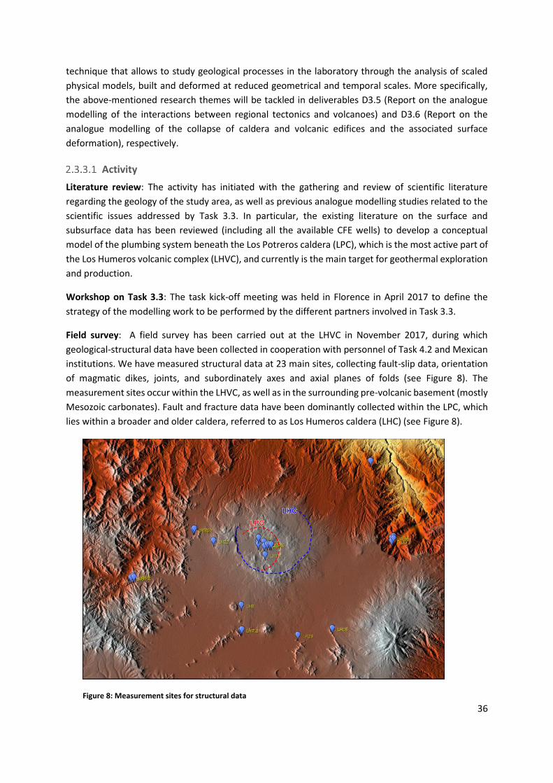
36
technique that allows to study geological processes in the laboratory through the analysis of scaled
physical models, built and deformed at reduced geometrical and temporal scales. More specifically,
the above-mentioned research themes will be tackled in deliverables D3.5 (Report on the analogue
modelling of the interactions between regional tectonics and volcanoes) and D3.6 (Report on the
analogue modelling of the collapse of caldera and volcanic edifices and the associated surface
deformation), respectively.
Activity
Literature review: The activity has initiated with the gathering and review of scientific literature
regarding the geology of the study area, as well as previous analogue modelling studies related to the
scientific issues addressed by Task 3.3. In particular, the existing literature on the surface and
subsurface data has been reviewed (including all the available CFE wells) to develop a conceptual
model of the plumbing system beneath the Los Potreros caldera (LPC), which is the most active part of
the Los Humeros volcanic complex (LHVC), and currently is the main target for geothermal exploration
and production.
Workshop on Task 3.3: The task kick-off meeting was held in Florence in April 2017 to define the
strategy of the modelling work to be performed by the different partners involved in Task 3.3.
Field survey: A field survey has been carried out at the LHVC in November 2017, during which
geological-structural data have been collected in cooperation with personnel of Task 4.2 and Mexican
institutions. We have measured structural data at 23 main sites, collecting fault-slip data, orientation
of magmatic dikes, joints, and subordinately axes and axial planes of folds (see Figure 8). The
measurement sites occur within the LHVC, as well as in the surrounding pre-volcanic basement (mostly
Mesozoic carbonates). Fault and fracture data have been dominantly collected within the LPC, which
lies within a broader and older caldera, referred to as Los Humeros caldera (LHC) (see Figure 8).
Figure 8: Measurement sites for structural data

37
Data analysis: After the field work, the collected structural data have been analysed and elaborated;
in particular, stress inversion methods (right dihedron angle and P and T axes) have been applied to
fault populations to obtain the principal stress axes. The location of the sites of measurement and the
raw structural data have been uploaded on the internal VRE platform.
Analogue modelling: A first series of analogue models has been carried out by CNR-IGG. This series
has started in January 2018, and focused on the study of caldera collapse and the associated surface
deformation. Literature data report that the LPC is characterized by a resurgent block, and thus our
experimental set-up has included both caldera collapse and subsequent intra-caldera resurgence. The
model set up consists of a brittle overburden overlying a low-viscosity Newtonian fluid simulating a
circular magma chamber. During the first phase the analogue magma is evacuated through a tube
below the model, after that (phase 2) the analogue magma is intruded to simulate intra-caldera
resurgence.
Definition of conceptual model for upcoming analogue models: In addition, the review of literature
data, together with field observations, suggested that granitic intrusions (found in wells H5-H11-H19-
H20-H25-H26-H37) are trapped in the soft caldera group ignimbrites (layers with low cohesion and
rigidity), between the more rigid layers of the pre and post caldera succession (Teziutlan andesite and
basaltic andesite). The ascent of such highly viscous intrusions may induce the resurgence and
deformation of the eastern part of the LPC floor. These data have allowed the definition of a
conceptual model that will be used to define the boundary conditions to be imposed to a series of
analogue models that will be carried out by Roma 3 University.
Summary of results
Field work: Evidence for recent faulting affecting the volcanic edifice has been nearly exclusively found
within the LPC, where faults often deform ca. 6 ka old pumices, and define a sub-radial pattern. The
Maztaloya/Los Humeros fault (MLHF) is the main structure of this system, and extends across the
whole LPC in a roughly NNW-SSE direction. Kinematic indicators reveal dominant normal faulting on
the MLHF and other main faults. Reverse faulting has also been occasionally observed on some minor
fault segments within the LPC. Inversion of fault-slip data collected on the MLHF and other secondary
normal faults splaying from this structure yield extension directions varying approximately between
ENE and WSW. Structures in the pre-volcanic substratum mostly consist of ca. NW-SE trending folds
and thrusts formed during the Laramide orogenesis. Cross joints sub-orthogonal to the fold axes often
represent the dominant set. Magmatic dikes frequently exploit ca. NE-trending pre-existing
discontinuities in the pre-volcanic substratum. At a larger scale, some volcanic centres are aligned
along NNE to NE directions, suggesting a control of similarly oriented structures.
Analogue modelling: The first models carried out by CNR-IGG were dedicated to test the model set
up and reproducibility of results. Then, we have started the experimental work that has initially
addressed the role of the overburden thickness (above the analogue magma chamber) on caldera
collapse. The main preliminary modelling results are the following: (1) caldera collapse is invariably
accommodated by both normal faults and reverse faults. Reverse faults are the first structures to
develop, while normal faults develop at late stages and form the most external caldera ring. (2)
Subsidence of asymmetric caldera is accommodated by trapdoor collapse characterized by the tilting
of a roof block. (3) Caldera ring faults often show an along-depth dip variation. (4) Magma resurgence

38
is often accompanied by the reactivation of pre-existing caldera faults. Future modelling work will also
focus on the interaction between volcano edifices and the pre-existing regional tectonic structures
defined from tasks 4.1 and 4.2.
2.3.4 Publications
Evanno, G., 2017. 3D preliminary geological modelling of the Los Humeros geothermal area (Mexico).
Master Thesis, ENAG/MFE-088-GB-2017, 123 pp.
2.3.5 Dissemination activities (talks, posters, workshops)
Bonté, D., Limberger, J., Békési, E., Beekman, F., van Wees, J.-D., 2018 (accepted).Preliminary
estimation of the thermal structure of the Acoculco-Los Humeros area, Mexico. European
Geosciences Union General Assembly, EGU2018-16270, Vienna, Austria.
Bonté, D., et al., Regional resources models: Integrated regional models, GEMex information event,
Pisa (Italy), 27 Mar 2018
Calcagno, P., Evanno, G., Trumpy, E., Gutiérrez-Negrín, L. C., Macías Vásquez, J. L., Carrasco, G.,
Liotta, D., and the GEMex T3.1 team, 2018 (accepted).3D preliminary geological models of Los
Humeros and Acoculco (Mexico) - H2020 GEMex project. European Geosciences Union General
Assembly, EGU2018-12811, Vienna, Austria.
Calcagno, P., et al., State of the art of the Gemex WP 3: Integrated regional models, GEMex
Stakeholder Board meeting (Brussels, Belgium, 15/11/2017)
Jolie, E., et al., GEMex - A Mexican-European Research Cooperation on Development of Superhot and
Engineered Geothermal Systems. Proceedings, 43rd Workshop on Geothermal Reservoir
Engineering, Stanford University, Stanford (CA, USA), 2018
Montegrossi, G., Deb, P., Clauser, C., Diez, D., Ramirez Montes, M. A, 2018 (accepted). Modeling of
Los Humeros geothermal field: preliminary results.European Geosciences Union General
Assembly, EGU2018-17600, Vienna, Austria.
2.3.6 Deviations from the Description of Action
Tasks 3.3: The analogue modelling laboratory of CNR-IDPA has rescheduled its activity with the aim
of a better integration among the three analogue modelling laboratories involved in the Task 3.3
(CNR-IGG, CNR-IDPA and UROMATRE) and an efficient use of their instrumental resources. For this
reason, the laser scanner mentioned in the GA will not be acquired, and the budget will be used for
other equipment and eligible costs. Nonetheless, the duties, deliverables and schedule of the
laboratory will not be affected by this deviation, as the analysis will be conducted with alternative
techniques (digital photogrammetry) in collaboration with the other two laboratories.
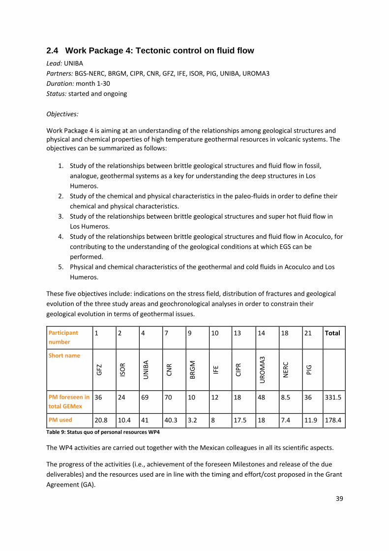
39
2.4 Work Package 4: Tectonic control on fluid flow
Lead: UNIBA
Partners: BGS-NERC, BRGM, CIPR, CNR, GFZ, IFE, ISOR, PIG, UNIBA, UROMA3
Duration: month 1-30
Status: started and ongoing
Objectives:
Work Package 4 is aiming at an understanding of the relationships among geological structures and physical and chemical properties of high temperature geothermal resources in volcanic systems. The objectives can be summarized as follows:
1. Study of the relationships between brittle geological structures and fluid flow in fossil,
analogue, geothermal systems as a key for understanding the deep structures in Los
Humeros.
2. Study of the chemical and physical characteristics in the paleo-fluids in order to define their
chemical and physical characteristics.
3. Study of the relationships between brittle geological structures and super hot fluid flow in
Los Humeros.
4. Study of the relationships between brittle geological structures and fluid flow in Acoculco, for
contributing to the understanding of the geological conditions at which EGS can be
performed.
5. Physical and chemical characteristics of the geothermal and cold fluids in Acoculco and Los
Humeros.
These five objectives include: indications on the stress field, distribution of fractures and geological
evolution of the three study areas and geochronological analyses in order to constrain their
geological evolution in terms of geothermal issues.
Participant
number
1 2 4 7 9 10 13 14 18 21 Total
Short name
GFZ
ISO
R
UN
IBA
CN
R
BR
GM
IFE
CIP
R
UR
OM
A3
NER
C
PIG
PM foreseen in
total GEMex
36 24 69 70 10 12 18 48 8.5 36 331.5
PM used 20.8 10.4 41 40.3 3.2 8 17.5 18 7.4 11.9 178.4
Table 9: Status quo of personal resources WP4
The WP4 activities are carried out together with the Mexican colleagues in all its scientific aspects.
The progress of the activities (i.e., achievement of the foreseen Milestones and release of the due
deliverables) and the resources used are in line with the timing and effort/cost proposed in the Grant
Agreement (GA).

40
Minor deviations from the Description of Action are reported below in section 2.4.7.
WP4 is dedicated to:
1. the study of the exhumed geothermal system (Las Minas area) in order to shed light on the
structures affecting and controlling the fluid paths at depth in Los Humeros;
2. the study of Los Humeros geothermal system with the aim to better understand the
structures controlling the superhot fluid paths;
3. the study of Acoculco area, in order to contribute (by fieldwork) to define the geological
conditions at which EGS will be simulated;
4. the definition of the physical and chemical characteristics of the cold and hydrothermal fluid
in Acoculco and Los Humeros.
Regarding the first point, a new geological map of the Las Minas area is going to be concluded, based
on the revision of the stratigraphic and petrologic settings as reconstructed from fieldwork and rock-
samples analyses. Paleo-fluids having determined the hydrothermal mineralization are studied by
fluid inclusion and isotopic analyses. Preliminary results indicate that part of the paleo-fluids were
trapped in a magmatic-skarn hydrothermal system similar to that likely present below the Los
Humeros exploited geothermal reservoir. Thus, the study of the Las Minas fossil exhumed system will
give information on the possible exploitation of a deep super-hot reservoir at Los Humeros.
The fieldwork study of Los Humeros area is based on the integration between structural and
kinematic data with geomorphological analysis of available digital terrain models and satellite
images, and with stratigraphic, volcanological and petrological data from outcrops and rock-samples
(sampling was partly conducted together with WP6). The results indicate that the caldera area is
characterized by a sufficient permeability as a consequence of the interplay between pre-existing
regional structures (SW-NE and NW-SE oriented) and structures developed during the caldera
collapse and resurgence. It is also inferred that the regional structures acted as conduits to drive the
meteoric recharge of the geothermal systems. The stratigraphic and petrological study carried out in
the Los Humeros area permitted to shed light on the most recent volcanic events, believed to be
strictly linked to the present geothermal system. New Ar-Ar and U/Pb datings show a much younger
age for the peak caldera volcanism and the extent of the build-up phase (see Carrasco‐Núñez et al.,
2018).
Acoculco studies highlighted two main active geological trending structures, NW-SE and SW-NE
oriented, respectively. The study of their kinematics permitted to infer the present stress field that is
consistent with the extensional tectonics affecting the area. The whole area where the CFE boreholes
(that are supposed to be used for the EGS system) were drilled, has been studied in detail. The
results indicate that the boreholes are presumably located in footwall of an active SW-NE oriented
normal fault, NW dipping. If this will be confirmed by indirect studies, their distance from the
permeable zone is estimated to be in about 200 m, thus resulting as an excellent site for the EGS
simulation studies, though the potential induced reactivation of the fault has to be assessed as part
of WP7 to avoid unwanted induced seismicity at possibly significant magnitudes.
As it regards the geochemical study of cold and geothermal fluids carried out in Los Humeros, the
isotopic characterization of collected samples from cold springs allows to obtain information

41
regarding the altitude vs dD‰ (d18O‰) local relation. These findings represent a novelty for LHGS
and suggest that different regional “feeding zones” seem to be present.
Finally, regarding high temperature tracers to be used in the geothermal wells for monitoring the
geothermal flux, IFE performed several tests: Two tracers were stable at 250°, but recoveries were
low with Basalt in the vials. A third tracer had near 100% recovery at 350°C (both without and with
Basalt in the vials). Moreover, this tracer was fully recovered in a flow experiment at 250°C. A patent
is filed.
2.4.1 Task 4.1 Understanding from exhumed systems
In this task, the region around Las Minas is investigated. This area is located close to the Los Humeros
geothermal field, and it is considered as the fossil, exhumed analogue of the present geothermal
field. It is in fact characterised by both a similar stratigraphic volcanic succession and carbonate
substratum. In Las Minas, the heat source of the paleo-geothermal system, now represented by
multiple Neogene magmatic intrusions, is broadly exposed. The hydrothermal circulation is testified
by Cu-Au-Fe ore deposits, almost represented by skarn masses and minor hydrothermal quartz-veins.
Main activities
In the first reporting period, the team of Task 4.1 has performed the following main activities:
The revision of the existing bibliography and geological maps was carried out at the
beginning of the project (4 months). The results of this study were used to prepare the
fieldwork
Fieldwork, consisting of 6 periods (approximately 10 days each, partly joined with other
WPs)
o rock sampling (rock-samples for petrographic and fluid inclusions analyses)
o collection of structural and kinematic data on fault surfaces
o revision of the stratigraphic column exposed in the deep incision of Las Minas
o scan-lines of key-outcrops (SWIR hyperspectral outcrop scans)
o drone photography
study of rock-samples and thin sections
analysis of fluid inclusions
Sr-Nd-Pb isotope determination
geochronological studies (U/Pb and Ar/Ar): analysis of 7 samples (4 from Las Minas, 3 from
San Miguel Tenango) finished, analysis of 36 samples (33 from Las Minas, 4 from San Miguel
Tenango) is ongoing.
Presentation of activities and results at internal project meetings, at event for stakeholders
and at scientific events
Out of those, some activities, always in cooperation with our Mexican colleagues, were finalized:
to review the already mapped geological structures;
to revise the stratigraphic setting;
to collect structural and kinematic data, to reconstruct the local stress field at the time of
the geothermal circulation;

42
to define the geochemical characteristics of the paleo-fluids;
to date rock-samples, in order to better constrain the geological evolution of the analogue.
Main results
The main results indicate that the existing map needs to be updated with new structures affecting
both the substratum and the volcanic succession, partly. These structures are NW-SE and,
dominantly, SW-NE trending. Along these trends the permeability was effective, as indicated by the
distribution of the magmatic dykes and some hydrothermal mineralizations. The main shear zone is
however SW-NE oriented and it seems to have influenced the location of skarn deposits. The
stratigraphic column exposed in the deep incision of Las Minas was revised and updated by the
discovery of a basaltic lava upon the limestone and of lacustrine sediments deposited before the
evolution of the Los Humeros caldera. The collection of structural and kinematic data on fault
surfaces indicate that the two above mentioned fault systems were characterized by different
kinematics during fluid flow: a normal kinematics dominantly characterizes the SW-NE trending
faults, whereas a right lateral strike-slip to right lateral oblique slip kinematics typifies the NW-SE
fault system. Furthermore, the distribution and textural features of fractures at the outcrop scale are
under study by scan lines including orientation, frequency and size data, together with mechanical
properties of the fractured blocks. This ground-level data is extrapolated to the fracture geometry
captured in 3D models built from drone photography. These datasets are already collected in key-
outcrops, in cases including SWIR hyperspectral outcrop scans (3D models archived at Uni Research
CIPR).
The study of rock-samples and thin sections allowed us to better characterize the magmatic bodies,
the skarn, in terms of their mineralogy and petrological evolution, their mineralogy and to typify the
hydrothermal association. The composition of the main intrusive body is quarzodioritic to
granodioritic and the level of emplacement, calculated using the thermobarometry methods, is 4.7 +
0.6 km. This body is intruded by multiple injections of magma related to different events. The first is
mainly characterized by granodioritic to granitic dykes, while the second is more mafic. The
mineralogy of the skarn linked to the magmatic intrusion, is dominated by garnet and clinopyroxene
associated to quartz and plagioclase. Skarn bodies have also been affected by hydrothermal
circulation testified by some hydrous minerals (epidote, chlorite) and ore deposits mainly composed
by sulphides (pyrite, chalcopyrite) and locally by Fe-oxide (magnetite).
Fluid inclusions have been analyzed in quartz associated to skarn and in late hydrothermal quartz.
Four main fluid inclusion types have been distinguished on the basis of microthermometric and
Raman data and their optical characteristics at room temperature: 1) L-type, two-phase (liquid +
vapor) liquid-rich, aqueous inclusions; 2) V-type, two-phase (liquid + vapor) vapor-rich, inclusions,
containing low-density CO2 in the vapor phase; 3) VCO2-type: three- or two-phase (liquid H2O + vapor
CO2 ± H2S ± liquid CO2) gas-rich inclusions; 4) LH-type: multiphase (liquid + vapor + halite ± hematite ±
magnetite ± undetected solids) aqueous, liquid-rich inclusions. Hypersaline LH-type inclusions record
the circulation of high-temperature magmatic derived fluid, while, moderate to low-salinity L-type
inclusions could result from the mixing of hypersaline magmatic fluids with meteoric waters. V-type
inclusions likely testify boiling processes in the system, whereas VCO2 inclusions possibly trapped
aqueous-carbonic fluids issued during metasomatic processes on carbonates, which formed Ca-
bearing silicates of skarn. Thus, LH-type and VCO2-type inclusions record a magmatic-skarn
43
hydrothermal system similar to that possibly occurring within the basement at Los Humeros, below
the present-day exploited reservoir. On the other hand, the fluids trapped in L-type inclusions show
some features which are more similar to those of the fluids stored in geothermal reservoirs.
The samples, processed for Sr-Nd-Pb isotope determination, have been carefully selected among the
collected rocks from Las Minas exhumed complex. They consist of igneous rocks and limestone
subjected to thermometamorphism of the Mesozoic basement together with samples of
hydrothermal origin found as veins (mainly calcite) or pervasive skarn secondary minerals (mica,
garnet and magnetite) within the host rock. Igneous rocks are both intrusive or subvolcanic sills.
Finally, geochronological studies (U/Pb and Ar/Ar) are on course to date rock samples, in order to
better define the geologic evolution, and on hydrothermal minerals collected along shear planes,
with the aim to date the fluid flow during fault activity. Regarding zircon U-Pb isotope geochronology
(using SHRIMP IIe facilities) executed by PGI-NRI team, studies involving 4 samples from Las Minas
area were carried out till now. The samples include plutonic rocks from basement units, preliminary
confirming their Miocene/Pliocene age and one volcanoclastite of Pleistocene age, in which also
older, Carboniferous and Jurassic zircons were identified. Additional 33 samples collected in January
2018 for U/Pb isotope and magneto-stratigraphic studies are being analysed.
Another example of exhumed system, studied for better understanding of the regional setting
around Acoculco caldera is represented by the San Miguel Tenango geological units. For purpose of
the U/Pb isotope zircon datings three samples of andesites from Diatrema Zacatlan Puebla, which
intrude Jurassic and Cretaceous limestones, were analysed so far. Preliminary results point to early
Pliocene age of these volcanics. Another 4 samples (basalt, granites, ignimbrite) of the pre-caldera
successions are currently investigated.
2.4.2 Relationships between brittle structures, and fluid flow in active systems
(Los Humeros and Acoculco)
Los Humeros
The review of bibliography and analysis of existing geological maps engaged the WP4 group in the
first period (about 3-4 months) of activities. In the same period, an in depth geomorphological
analysis of digital terrain models and satellite images has been conducted. These preliminary
studies, in cooperation with our Mexican colleagues, permitted us to plan the forthcoming
fieldwork.
Several fieldworks (4 periods of about 20 days each) and laboratory analyses on rock-samples and
thin sections have been carried out in this study area, always in cooperation with colleagues from
the Mexican consortium and from the CFE company. The lab-studies are finalized to petrographic
analyses to be correlated with sampling campaigns of WP6 and SWIR hyper-spectral scanning of
selected well cores with the aims to better explain the processes governing the reservoir properties.
These activities are dedicated to:
collect kinematic and structural data from the caldera area and surroundings;

44
define the geometric setting of the geological structures and the stress field present during
their development;
collect rock-samples, in order to better define their mineralogical composition and
evolution, and to get information on the magma source and its depth;
the analysis of the stratigraphic succession and physical volcanology from field and borehole
observations, in order to better constrain the geological evolution of the caldera complex;
collect rock-samples for Ar/Ar datings, archaeomagnetic and isotopic studies;
structural analysis of the sedimentary rock-substratum, cropping out in the surroundings of
the study area.
o The collection of kinematic and structural data within the caldera is completed
(more than 90 outcrops have been analyzed in the field) and
o a GIS-based 3D model is under construction, including borehole and available
geophysical data to understand the relationships between active and inherited
brittle structures, volcanism and geothermal fluid flow. Magma resurgence
processes are considered as a possible process to explain the present structural
setting within the caldera, thus influencing the local deformation and permeability
distribution.
X-ray Computed Tomography have been applied on selected rocks samples representative of the
main geothermal reservoirs of Los Humeros and of the fossil analogue of Las Minas in order to obtain
information on their primary porosity. In particular, andesite, Mesozoic limestone and an intrusive
acidic rock have been analyzed.
A mineralogical characterization of the alteration facies associated with active and fossil fracture
systems surveyed in the field is under study. Stratigraphic and petrological studies on samples
related to the entire volcanic history at Los Humeros including the most recent magmatic events are
on course and the results will give us information on the depth and origin of the present magmatic
heat source. Samples for petrological and alteration studies are stored at UNIROMA and UNAM. An
updated stratigraphy of the caldera fill has been reconstructed by fieldwork by personnel of UNIBA
and CNR. In both institutions thin sections for further analyses have been already worked up. Some
samples, collected during field work, have been also selected for isotopic analyses and datings
(Ar/Ar method); irradiation will be performed in next months.
Stratigraphic field survey at 1:25,000 scale and sampling on the Western sector of the caldera floor
generated an updated geological map of an area of more than 30 km2, including some of the most
recent volcanic activity of the area of the caldera complex. This survey has been also used to locate
outcrops for archaeomagnetic sampling. Archaeomagnetic sampling (230 samples from 9 sites) was
performed on January 2018, devoted to the age determination of the youngest terms of the
reconstructed statigraphical sequence, and samples are presently under analysis. Laboratory analysis
of samples of very recent olivine basalt lava flows and selected fallout deposits study are on course
for the reconstruction of the volcanological processes during the evolution of the caldera complex.
The hyper-spectral scans of Los Humeros cores, conducted by CIPR along with CFE personnel, will
be processed in the upcoming months to show the variation in mineralogical.

45
An UAV with thermal camera was flown at Los Humeros in February, covering several areas within
the caldera. Images are to be processed, yet. However, it is already possible to clearly see 1-5m wide
areas of enhanced heat flow around gas vents (warm spots up to about 30°C) in the northern part of
the field. They appear to be aligned, which hints at fault-controlled heat/gas flow.
Finally, morpho-structural lineaments analysis and fieldwork (more than 100 outcrops have been
analyzed in the field), has allowed the inference of the orientation (mainly NW-SE and SW-NW
trending) and location of regional shear zones linking the geothermal field to the surrounding areas,
where the meteoric recharge is occurring. Also, kinematic indicators on brittle structures in the
substratum have been collected in the field, to reconstruct the evolution of the regional and local
stress field. The identified active or inherited shear zones will be further investigated as suspected to
represent the structural conduits channelling the meteoric water to the geothermal area. Here, the
enhanced permeability (due to the interplay between regional and caldera collapse structures)
favours the geothermal exploitation.
All results will be passed along to WP6 and WP8 for the development of the reservoir models.
Activities and results have been presented at internal project meetings and stakeholder events.
Acoculco
The revision of the existing bibliography benefited of recent studies carried out by our Mexican
colleagues. They produced a new geological map of the area, highlighting the volcanic evolution of
the Acoculco area. This map was used as a base for our studies.
In the first reporting period, Acoculco has thus far been investigated through 6 fieldwork activities
(almost 7 days each) and laboratory analysis (rock-samples for petrographic studies and thin
sections). The activities were dedicated to:
checking the mapped geological structures;
collecting structural and kinematic data along brittle shear zones;
at key outcrops making detailed analyses of spatial fracture properties using scan lines and
drone imagery, for estimating permeability;
analyzing the area where the borehole(s) for the EGS studies are located.
Fieldwork permitted to recognize two main fault zones, NW-SE and SW-NE trending respectively.
Such shear zones display mutual crosscutting relations, although having different kinematic
behaviour: dominantly normal, for the SW-NE trending faults, and from strike-slip (1st kinematic
event) to right-lateral oblique-slip (2nd kinematic event), for the NW-SE trending faults. These two
different systems can be explained in the same regional stress field, interpreting the NW-SE systems
as transfer zones, active during the ongoing extension.
Key-outcrops were photographed in detail by drone and converted by photogrammetry into 3D
virtual-outcrop models. These, combined with structural scan-lines of fracture density, width and
length, provide a detailed field-based analysis at the cm to m scale of the 3D fracture distribution and
permeability estimation will be derived in forthcoming months and will be provided for the reservoir
models of WP6 and WP7. Finally, detailed fieldwork was concentrated also close to the area where

46
the CFE boreholes are located, the ones that will be considered to perform simulations to test and
establish EGS. The study through the area permitted to recognize that:
the boreholes are located on the footwall of a SW-NE oriented normal fault, thus resulting
dry and hot;
the distance from the borehole to the permeable zone increases to depth, but at surface, it is
estimated to be about 200 meters;
the main fault zone close to the boreholes is supposed to be active, since the soil is deformed
and active gas emissions are recorded.
The results of this study have been taken in account for the forthcoming geophysical and
geochemical studies. Finally, PGI-NRI team is currently performing U-Pb isotope, geochronological
and paleomagnetic studies for eight samples (collected in January 2018) from different Acoculco
inside-caldera volcanic successions.
2.4.3 Geochemical characterization and origin of cold and thermal fluids
The task 4.3 was divided in different subtask as follows:
4.3.1. Fluid flow paths;
4.3.2. Geochemical characterization of fluids and hydrogeology;
4.3.3. Diffuse degassing and emanation;
4.3.4. Geochemical modelling;
4.3.5. HT tracer;
4.3.6. Fluid-rock interaction.
Subtask 4.3.1 Fluid flow paths
The goal of this subtask is to address the integration between field structural and geochemical data,
meaning the integration of results from Task 4.3 with Task 4.2.
The activity was based on teleconferences with the involved researchers, addressing the on-going
achievements, often in cooperation with colleagues from other WPs, especially from WP3. Similarly,
deep discussions were carried out during GEMex technical meetings.
About Los Humeros, preliminary geochemical data (as it will be described in the following sections)
suggest that the meteoric recharge areas are located in the regional surroundings of the caldera.
Hence, regional structures playing the role of structural channels and connecting the recharge areas
to the geothermal exploited areas, are necessary. By this, the issue focusses on which field
methodology could be applied to get information from the surface, although a wide, thick and
mechanically homogeneous ignimbrite is covering outcrops substratum.
The location of few geothermal manifestations (i.e. water temperature above the average value in
boreholes) outside the caldera area, once more indicates the occurrence of structural channels
favouring the flow of deep waters, even through the ignimbrite. As a consequence, a morpho-
structural approach was proposed, studying the distribution of the regional tectonic lineaments from
satellite images, both in the caldera area and in the regional surroundings. The results (described in
2.4.2.1) are preliminarily suggesting two main structural trends, NW-SE and SW-NE oriented,

47
accounting for channelling the fluid path toward the caldera area, where the more intense
deformation stored the fluids.
Differently about Acoculco, the issue is focussed on the main structural setting affecting the study
area and, particularly, the structures affecting the borehole surroundings. Since the geochemical
study is presently on its initial stage (collection of data), the fluid path is here only inferred on the
basis of field-structural information, suggesting that the intersections between NW-SE and SW-NE
fault systems enhanced the necessary local permeability.
Subtask 4.3.2 Geochemical characterization of fluids and hydrogeology
Literature review
The collection of geochemical data for cold and thermal fluids was performed in Los Humeros (LHGS)
and Acoculco (AGS) geothermal systems. Sampling sites were selected checking the scientific
literature published in international and “Mexican” journals and also taking into account information
coming from the CFE. The revision of literature is completed and the data obtained are integrated
with new ones. The collected data regard: chemical and isotopic characteristics of cold and thermal
springs, water wells, surface water, geothermal fluids and natural gas manifestations (gas vents and
diffuse degassing).
The main BRGM objective in this task is to develop auxiliary chemical and isotope geothermometers
like Na-Li, Na-Rb, Na-Cs, K-Sr, K-Mn, K-Fe, K-F, K-W and δ18OH2O-SO4, in order to better know the
deep reservoir temperatures in High-Temperature (HT) volcanic areas such as Los Humeros and
Acoculco. Preliminary literature review has been carried out by BRGM with the collaboration of the
other partners, especially the Mexican partners (CFE, etc.), in order to collect the main geological
information and most of the geochemical data of the fluids sampled from Los Humeros deep wells
and from thermal Acoculco springs.
From the existing literature data, only the deep temperature values estimated using the Na-Li
auxiliary geothermometer could be compared with those given by the classical geothermometers
and those measured at the bottom-hole.
Field work
IGG-CNR, in collaboration with CICESE, University of Morelia and University of Guanajuato,
performed in the LHGS (03th-16th June 2017) a very detailed hydrogeochemical study mainly aimed to
define the chemical and isotopic characteristics of cold and thermal waters and geothermal gases in
order to identify the feeding areas of the LHGS, constrain the equilibrium temperature reached by
the fluid at depth and identify the secondary processes (i.e. phase separation, precipitation of
mineral phases). Big effort was dedicated to the identification and selection of cold springs located
outside the Los Humeros caldera, suitable to study the local relation between stable isotope
compositions and mean infiltration altitude of meteoric waters. Fifty-five water samples were
collected during the geochemical survey (34 cold springs, 15 cold wells, 2 small lakes (maar), 2
thermal springs and 2 reinjection wells). Chemical and isotopes analysis are completed (Li+, Na+, K+,
Mg2+, Ca2+, B, As, SO42-, Cl-, NO3
-, F, dissolved monomeric SiO2, 18O/16O and the D/1H isotope ratios
and the information obtained by preliminary interpretation was used to address the second field trip
in LHGS performed in March 2018.

48
The very first geochemical fieldwork at the Caldera of Acoculco was performed by the IGG-CNR and
the University of Florence (26th of January to the 4th of February, 2018). The main purposes of the
measurement campaign were to:
1) Identify the spatial distribution of diffuse soil CO2 flux and their correlation with the main
fault/fracture system (for further details see paragraph of the subtask 4.3.3);
2) Sample both cold and thermal springs and the local (Los Azufres and Alcaparrosa) gas
emissions for analyzing their chemical and isotopic characteristics to define the fluid
source(s).
During the field trip in Acoculco, 51 water samples from thermal and cold discharges, and free and
dissolved gas samples from bubbling pools (3) and thermal springs (1) were collected. Most of the
chemical and isotopes analysis of waters (Li+, Na+, K+, Mg2+, Ca2+, B, As, SO42-, Cl-, NO3
-, F, dissolved
monomeric SiO2, 18O/16O and the D/1H isotope ratios) and gases (CO2, H2S, Ar, O2, N2, CH4, δ13C-CO2)
are finished and in the next month it will be completed.
A few gas and water samples were also taken by BGS in January 2018. Analysis and interpretation are
ongoing.
BRGM has also prepared a campaign of fluid sampling and on-site measurements in the Los
Humeros (from deep wells) and Acoculco (from thermal springs) geothermal areas, with the
collaboration of CNR and Mexican teams (UMSNH, CFE colleagues) from March 20 to 31, 2018.
Internal communication
Multiple teleconferences with different European and Mexican partner and also CFE on planning and
organization of field work activities took place.
Presentations were given and discussions took place at all project internal meetings.
Results
Chemical characteristics of water samples from cold and thermal springs and wells in LHGS gave an
important indication regarding the water/rock interaction processes (interaction with limestones
formations, andesite rocks, ecc.). Isotopic characterization of collected samples from cold springs
allows to obtain information regarding the altitude vs dD‰ (d18O‰) local relation. These findings
represent a novelty for LHGS and suggest that different “feeding zones” seem to be present, giving
the chance to identify the main altitude of feeding zones of the geothermal system. Further
investigations are necessary and the second field trip in LHGS is properly addressed.
Variable compositions from Ca2+–SO42− or Na+–SO4
2− (acid or near-acid waters from the Acoculco
Caldera) to Ca2+–HCO3− or Na+–HCO3
− (especially from outside the caldera), were observed in AGS.
Acidic waters rich in SO4 are probably due to the interaction between meteoric water and gas rich in
CO2 and H2S present in main natural gas manifestations. Waters Ca-HCO3 and Na-HCO3 are originated
by water-rock interaction process between limestones and/or andesite rocks, respectively. Chemical
and isotopic data are in progress.
Subtask 4.3.3 Diffuse Degassing
Literature review

49
As an initial step a comprehensive literature and data review was performed to define the target
area for a CO2 flux scouting survey. Focus of this literature and data review was in particular on
structural-geological data, areas with geothermal surface manifestations, existing soil gas data,
location of the central production field, etc.
Field work and Lab work (Los Humeros)
A planning field trip was performed in March 2017 to prepare the CO2 flux scouting survey.
Objective of the CO2 flux survey performed by GFZ from May to June 2017 was the identification of
areas characterized by anomalous CO2 degassing, which should serve as a profound database for a
more comprehensive soil gas survey covering a larger variety of different soil gases. For that reason a
large area of ~6x4km was covered by approximately 2600 CO2 flux measurements based on the
accumulation chamber method. Sampling was performed along profiles perpendicular to the major
strike direction of the encountered structures. In addition, 10 samples for carbon isotopic analysis
have been collected from anomalous CO2 flux areas for a better understanding of the source of the
CO2 flux anomalies.
The preliminary results gave indications of various areas of increased structural permeability. A
preliminary CO2 flux map served as the basis for
1) a soil gas survey by BGS focusing specifically on some areas with CO2 flux anomalies,
2) the design of the flight paths for a drone-based infrared survey,
3) the planning and grid optimization as well as technical optimization of used devices for an
area-wide soil gas survey, and
4) the optimum placement of a long-term monitoring station for CO2 flux measurements from
April-October 2018.
Another parameter measured during this initial survey was the natural local dose rate in the central
production field for further tests of their applicability in geothermal exploration. Specific nuclides will
be selected from the dataset for further processing and comparison to other soil gas parameter.
A larger gas survey was done at Los Humeros in Feb 2018 by BGS. Analysis and interpretation are
ongoing. BGS focused on 4 areas within the broader region surveyed by GFZ 2017. BGS main aim was
to focus on a much denser arrangement of soil gas and gas flux measurements across areas of known
or presumed faulting, with a view to trying to locate individual vents. Some 330 sites were studied
for flux/composition, and 50 sites for isotopes. Also, BGS deployed a rapid survey tool for measuring
CO2 concentrations in the air just above the ground - several 1000s of measurements were made
with analysis spacing down to about 1m – individual gas vents were clearly identified.
During March 2018 measurements of CO2 diffuse degassing and sampling of gases from natural
manifestations in LHGS are performed by IGG-CNR.
Field work and Lab work (Acoculco)
In January 2018 the IGG-CNR and University of Florence performed measurements of CO2 diffused
from soil in the Acoculco area. The ϕCO2 values were measured at 418 sites within the Acoculco

50
Caldera (areas affected by tectonic feature and also sites named Los Azufres, Alcaparrosa and
“Lagunilla”) using the Accumulation Chamber (AC) method.
The preliminary results indicate that:
CO2 flux anomalies depending on preferential tectonic lines were not observed;
low CO2 fluxes were measured (ranging between 0.12 and 48.9 g m−2 day−1), implying that
most data were associated with soil respiration.
Internal communication
Multiple teleconferences on data review and planning of field work activities, organization, further
involvement of additional partners in the Mexican consortium (Loic Pfeiffer, CICESE).
Presentations were given and discussions took place at all project internal meetings.
Subtask 4.3.4 Geochemical Modelling
Regarding the geochemical modeling, ISOR performed the following activities:
a) development of a new program for chemical speciation and reaction progress calculations
called RockJuice. As it was decided earlier – most of the budget attributed for ÍSOR (WP 4),
24 person/month, has been attributed to the computer program development. The progress
of 25% has been calculated based on the amount of hours spent on the computer code
development since October 1st. According to the author of the computer code, there might
be a problem to finalize the program before the end of month 24, however, we can not
predict at this stage how the code development will progress.
b) review of the CFE data with the boreholes chemical composition, temperature and pressure
logs
c) the deep fluid has been modeled using the chemical speciation program WATCH (Arnórsson
et al., 1982, Bjarnason, 2010) on the basis of the analyzed chemical composition of the steam
and liquid phase given by the CFE.
The geochemical modelling carried out by IGG-CNR on the geochemical data provided by CFE, on
fluid sampled at well head, follow a complex procedure with the aim to reconstruct the fluid
composition at well bottom. A further step is to use the reconstructed fluid, representative of the
system, to investigate the possible precipitation of secondary phases and check the behaviour of
geothermometers against the measured temperatures. The procedure use geochemical modelling
codes (WATCH, CHIM-XPT) to reconstruct the fluid composition at well bottom with the aid of a
specific wellbore simulator (WELLSIM, HOLA) to better describe phase segregations in terms of
steam/liquid ratio and CO2 partitioning.
An advanced geochemical model were carried out by means of CHIM-XPT, to compute pH at depth
and have temperature evaluation using the theory described in Reed and Spycher 1984. The possible
precipitation of secondary minerals was investigated as well.
Internal communications
The introduction to the new computer code has been presented during the GEMEX 2nd General
Assembly in Akureyri 2-3 October 2017.

51
Subtask 4.3.5 Development, qualifying and application of high-T tracers
IFE performs the study regarding high temperature tracer. Of seven tracer candidates tested for
static thermal stability up to 250°C, three were regarded as sufficiently stable to qualify for further
stability and flooding property tests. The three candidates (Tracer A, B and C) were tested for
thermal stability in closed quarts vials at temperatures up to 350°C. When Basalt was not present,
the recoveries were near 100% for all the three candidates. When Basalt was present, the recoveries
of Tracer A and B were considerably reduced, while the recovery for Tracer C remained unchanged.
Flooding experiments were performed at temperatures up to 250°C using a column filled with Basalt
rock particles. Tracer B was not recovered in the flooding experiments, Tracer A was slightly retained
while Tracer C behaved nearly in the same way as the ideal tracer tritiated water. Tracer B was not
regarded as suitable due to adsorption, and Tracer A was not suitable for the type of rock tested, but
may perhaps be used for other rock types.
Subtask 4.3.6 Los Humeros geothermal field and fluid-rock interaction experiments
IGG-CNR and University of Florence perform the study related to fluid-rock interaction in LHGS.
Andesitic rock from Tezuitilan Formation (50-150 µm granulometric fraction) has been selected as a
starting material for the experiments. It has been characterized from mineralogical point of view and
a whole rock analysis is in progress. Moreover, water sampled in Cofre de Perote and supposed to be
representative of pristine fluid circulating in andesitic reservoir has been chosen as liquid reactant.
A series of fluid rock interaction experiments under CO2 overpressure have been undertaken at 200-
300 °C in order to monitor solid and liquid changes due to the interaction. All experimental runs were
performed in an externally heated micro-reactor and the liquid/solid ratio was arbitrarily chosen to
be ~16. Another series of experiments will be executed in the next months at the same T using a
different solid as starting material
2.4.4 Publications
Carrasco‐Núñez, G., Bernal, J. P., Dávila, P., Jicha, B., Giordano, G., & Hernández, J. (2018).
Reappraisal of Los Humeros volcanic complex by new U/Th zircon and 40Ar/39Ar dating: Implications
for greater geothermal potential. Geochemistry, Geophysics, Geosystems. DOI:
10.1002/2017GC007044
2.4.5 Dissemination activities (talks, posters, workshops)
Groppelli, G., et al., New geological, structural and volcanological data of the Los Humeros Volcanic
Complex: implications for reconstruction of the 3D model volcanic structure and geothermal
exploration. IAVCEI Conference, Portland, USA, 14-18 August 2017
Jentsch, A., et al., Structural-geological impact on soil gas composition at Los Humeros Volcanic
Complex, IMAGE Final Conference, Akureyri, Iceland. 4-6 Oct. 2017
Liotta, D., et al., State of the art of WP 4 after one year of GEMex , GEMex Stakeholder Board
meeting, Brussels (Belgium), 15 Nov 2017
Liotta, D., State of the art of the GEMex WP4: Tectonics and fluid flow. GEMex information event,
Pisa (Italy), 27 Mar 2018.

52
Muller, J., Laboratory Studies of Geothermal Tracers at Supercritical Conditions. GeoEnergi2017 –
Geothermal Conference, Bergen (Norway), 22-23 May 2017
Olvera-García, E., The Las Minas exhumed geothermal system (Veracruz, Mexico): a proxy for the Los
Humeros geothermal field. European Geothermal PhD Day, Zurich (Switzerland), 15-16 March 2018
Wheeler, W., et al., GEMex- Europe-Mexico collaboration for development of Enhanced Geothermal
Systems and Superhot Geothermal Systems. GeoEnergi2017 – Geothermal Conference, Bergen
(Norway), 22-23 May 2017
2.4.6 Patents
A patent has been filed for the tracer candidates and will be published in June 2018.
2.4.7 Deviations from the Description of Action
Task 4.2: Isotopic analyses on the altered core-samples of Los Humeros geothermal wells are delayed
as these samples have only recently arrived in Europe and they will be used for other analyses before
they can be made available for isotopic analyses. If the samples are sent to the CNR within 3-4
months the isotopic analyses will be carried out within the project extension period.
Only one sample of the mafic dikes collected by CNR in the basement surrounding the Los Humeros
caldera is fresh enough to allow radiometric dating. The sample have been hand-crushed and sieved,
and the groundmass (fraction 250÷355 µm) has been separated using magnetic methods followed by
handpicking under a binocular microscope. The radiometric analysis is in delay as the 40Ar-39Ar
laboratory at CNR-IGG is currently under maintenance. The analysis will be scheduled as soon as the
laboratory equipment will become fully operational and the analysis will be carried out within the
project extension period.
Task 4.3, Subtask 4.3.2: At the beginning stage of the project, the activities were delayed due to
internal issues on the Mexican side (multiple changes of task leaders, financing issues, etc.). Also,
during the sampling campaign (carried out by IGG-CNR) on 2017 in LHGS, customs authority
(Guadalajara airport) retained all scientific equipment shipped from Italy, obstructing the import
processing and the regular schedule of the planned work. The process to recover the equipment was
extremely delayed due to lack of communication between Mexican Airport Customs and Mexican
partner involved. Now, the equipment seems to be missed and its searching process represents a
very difficult challenge. Even if the equipment is still retained by the Mexican customs, the planned
activity for 2017 was complete and is ongoing for 2018.
The approximate progress of the BRGM contribution in task 4.3 until now is close to 10%. Relative to
the planned schedule, the BRGM activities have been slowed down, given that the campaign of fluid
sampling has been delayed from 6 to 7 months, but this deviation is still acceptable.

53
2.5 Work Package 5: Detection of deep structures
Lead: ISOR
Partners: CIPR, CNR, CRES, GFZ, HBO, ISOR, KIT, OGS, TNO, UU
Duration: month 1-44
Status: started and ongoing
Objectives:
The development of seismic and resistivity methods for high temperature geothermal fields have
been the subject of the former and ongoing FP-6&7 supported projects I-GET and IMAGE. The
objective of this work package is to further advance the methodology and test it by application to
two high temperature systems in Mexico: the superhot conditions at depth in the Los Humeros field
and the Acoculco EGS field. The existing models from two superhot fields in Iceland (Krafla and
Reykjanes) will also be revised by applying improved methodology and results from the two first
deep drilling projects in Iceland, IDDP-1 in Krafla and IDDP-2 in Reykjanes. The improved models from
these fields will be compared to the Mexican fields. In addition, the results from GEMex will be
compared to available results from high temperature fields in Indonesia and Africa.
Participant
number
1 2 3 5 7 11 12 13 17 19 Total
Short name
GFZ
ISO
R
TNO
UU
CN
R
CR
ES
OG
S
CIP
R
KIT
HB
O
PM foreseen in
total GEMex
45 54 20 41 8 22 24 24 45 36 319
PM used 13.5 38.5 4.65 16.91 4.04 4.25 14.2 6.4 17.66 14.9 134.9
Table 10: Status quo of personal resources WP5
GEMex takes advantage of a large variety of methods being applied at the same location with a lot of
different methods applied with regard to data analysis. This provides an excellent opportunity for the
comparison of methods and the integration of different datasets.
The geophysical work in both geothermal sites suffered from the late provision of the Mexican
funding, since all work is planned in strong collaboration with the Mexican partners. Therefore the
fieldwork started later than initially planned. However, in the first reporting period, a lot of the
geophysical work has started and is going to be completed in 2018. Figure 9 show the measurement
points for gravity and resistivity as well as the station locations of the passive seismic network
installed at Los Humeros.
Data analysis is only starting, however preliminary results from the resistivity survey in Los Humeros
have already been shared with the project consortium.

54
Figure 9: Location of measurement point for gravity and resistivity survey and for passive seismic stations in Los Humeros
2.5.1 Task 5.1 Resistivity imaging of EGS and SHSG
Subtask 5.1.1: Synthetic model calculations to optimize the results of 3D MT/TEM
modelling and avoid artefacts (ÍSOR, CNR)
MS27 “Synthetic resistivity model calculations completed” has been reached in time.
Deliverable 5.1 on synthetic model calculations to optimize the results of 3D MT/TEM and avoid
artefacts was written by ÍSOR, CNR and KIT and delivered in December 2017 (available on the
website: https://goo.gl/AsEyYp)
In the deliverable, efforts were undertaken to further the understanding of the underdetermined
problem of inversion of resistivity data, i.e. by investigating how to regularize the inversion with
external constraints. The work carried out was a continuation of previous efforts with an emphasis on
how data from high-temperature geothermal fields could look like, which artefacts emerge and what
is the way forward from where we stand today.
The deliverable is composed of three parts i) synthetic data created from a generic high-temperature
geothermal system, ii) synthetic data created for the Acoculco geothermal area in Mexico and iii)
investigation of the influence of fault systems on the magnetotelluric data.

55
Subtask 5.1.2: Review and QC of existing data from Mexican sites (ÍSOR)
ÍSOR received TEM and MT data from Los Humeros through CFE and quality checked them. Some of
the data, their inversion and interpretation are discussed in a recent paper published in Geothermics
by Arzate et al. (2018). In general the data are not of a good quality but aided in making a resistivity
survey plan for Los Humeros. Some of the soundings might be used in the 3D inversion of the
resistivity data for the area.
The Vertical Electric Sounding (VES) from Acoculco were reviewed and used by CNR for task 5.1.1.
Subtask 5.1.3: Survey design and preparation for additional measurements in
Acoculco and Los Humeros (ÍSOR, CNR, KIT)
A resistivity survey plan for Los Humeros and Acoculco was drafted for the first time in Morelia at
the kick-off meeting in October 2016, jointly by the European and Mexican partners. The discussion
was ongoing for the next few months. Based on the already existing data from the two areas (Task
5.1.2), the synthetic model calculations (Task 5.1.1) and other more recent geoscientific results from
the areas within GEMex, the proposed survey plan was discussed between all the collaborators and
approved at the meeting in Akureyri, Iceland in October 2017.The plan was shown to CFE for their
comments. Preparations for the coming field survey in Los Humeros as well as a timetable were
discussed amongst the partners and decided on in several skype meetings. The first phase of the field
work in Los Humeros was performed from November to December 2017 and the second phase is
scheduled in April 2018. The plan for the resistivity soundings in the second phase was discussed and
approved at the meeting in Bari, March 2018.
The survey plan for Acoculco was made in a collaboration between the Mexican and European
partners, discussed a several skype meetings, the meeting on EGS in Potsdam in January 2018 and
finalized at the European meeting in Bari in Italy, in March 2018. The survey plan for Acoculco
proposed 75 sounding pairs. The orientation of the grid is parallell and perpendicular to the
orientation of the main faults in the region and the center of the grid is where the EGS experiment is
planned to take place. The field work is planned for four weeks in May 2018.
5.1.4: Acquisition of new MT and TEM data collection in both fields, field work and
QC (ÍSOR, KIT)
During four weeks in November-December 2017 the first part of the resistivity field campaign was
carried out in Los Humeros. The majority of the work was done by the Mexican partners, who took
care of logistics, transportation and equipment. A team from the European side (ISOR and KIT) joined
in part of the field work. The campaign and the collaboration between the two sites was smooth and
most successful – a learning full process for everyone. The team communicated daily with CFE and
the local community during the field campaign. Some 50 TEM soundings and 75 MT soundings were
collected – most of them of good quality. Fehler! Verweisquelle konnte nicht gefunden werden.
shows the current status of the collected soundings and preliminary quality control.
In April 2018 (as this report is being written), the second part of the survey in Los Humeros is taking
place where 60 MT/TEM sounding pairs and 25 TEM soundings (at the sites where TEM data were
not collected in the first part) are collected. The plan for the resistivity soundings in the second phase
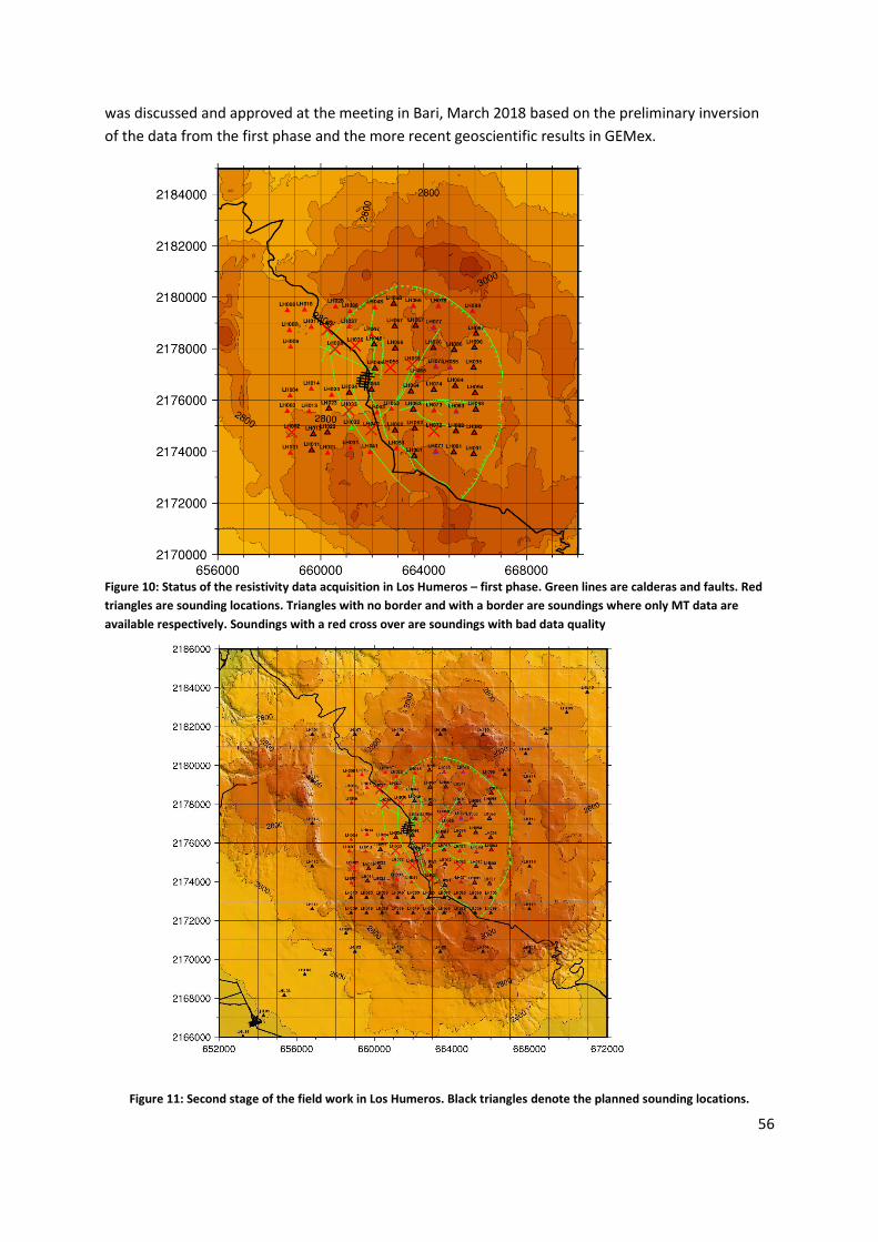
56
was discussed and approved at the meeting in Bari, March 2018 based on the preliminary inversion
of the data from the first phase and the more recent geoscientific results in GEMex.
Figure 11: Second stage of the field work in Los Humeros. Black triangles denote the planned sounding locations.
Figure 10: Status of the resistivity data acquisition in Los Humeros – first phase. Green lines are calderas and faults. Red
triangles are sounding locations. Triangles with no border and with a border are soundings where only MT data are
available respectively. Soundings with a red cross over are soundings with bad data quality

57
Task 5.1.5: Data processing and resistivity models (1D and 3D) of the Los Humeros
and Acoculco fields (ISOR, CNR, KIT)
Data processing of the TEM and MT data from the first phase of the Los Humeros resistivity campaign
is well underway. Several different processing schemes have been tested, using the bounded
influence remote reference processing (birrp), procMT, and WinGLink codes. Preliminary EDI files of
good quality soundings have been used to to construct a preliminary resistivity model of the Los
Humeros area based on 1D joint inversion of the TEM and MT data. Figure 12 and Figure 13 show a
horizontal resistivity depth slice at 2,400 m a.sl. and a vertical resistivity cross-section through the
model, respectively, for demonstration purposes only. More detailed models will be available when
the field work is finished and the processing has been finalized.
Figure 12: Horizontal resistivity cross-section through the preliminary 1D model of Los Humeros at 2400 meters above
sea level. Black dots are MT station locations. Green lines are calderas and faults.
Figure 13: West-east vertical cross-section through the preliminary 1D resistivity model of Los Humeros.

58
Management and internal dissemination
Several meetings, workshops, teleconferences have been organized during the reporting period to
reach the milestones and deliverables of Task 5.1, and to communicate beyond the task framework
within GEMex. These actions are listed in the following.
GEMex Kick-off meeting (Morelia, Mexico, 15-17/11/2016)
GEMex European meeting (Utrecht, The Netherlands, 23-24/03/2017)
GEMex General Assembly meeting (Akureyri, Iceland, 02-03/10/2017)
GEMex European meeting (Bari, Italy, 12-13/03/2018)
General teleconferences: Several teleconference were held during the reporting period. Minutes of these meetings are available on VRE:
Los Humeros field campaign November 2017: Report from the field survey in Los Humeros
Meeting at the end of the Los Humeros field campaign; 27/11/2017 ISOR, UNAM and KIT
2.5.2 Task 5.2 Seismic imaging
GFZ organized (M4) a workshop with all partners in Potsdam (Germany) in order to define the procedure and the implementation of the description of work. Each partner gave a presentation on what they did in the past what and how they are going to do within GEMex.
Subtask 5.2.1: Data acquisition
All partners contributed to the gathering and evaluation of existing passive and active seismic methods and the design of the new acquisition network in Los Humeros for passive monitoring based on the objectives and the instruments available. Due to the difficulties associated with authorization to access Acoculco, it was decided that Los Humeros would see the deployment of the main instrumentation first. Activities at Acoculco were postponed.
In agreement with the Mexican partners, the European stations will stay in Los Humeros. Approximately 15 stations from the Mexican team will be deployed in Acoculco.
Task 5.2.1a) Gathering and evaluation of existing passive and active seismic
After OGS initial active existing seismic data request to Mexicans, OGS performed an analysis of
geological and geophysical well data using information available in literature and information received
from Mexicans, in order to update the geophysical model utilized to simulate the seismic waveform
propagation with temperature (including melting and possible supercritical conditions). OGS received
logs of wells H42 and H43 (Los Humeros), performed log editing and analysis of Vp, Vs and Vp/Vs,
covering a limited depth range. OGS also received Los Humeros seismic-line digitized data from
Mexicans (CFE data from UNAM), for lines L5, L2, L3 and L4. OGS data processing included formatting,
geometry, pre-processing and editing, quality control. The processing is in progress for L5, and in initial
preparation phase for L2, L3 and L4. L5 data processing includes shallow model tomography from
shot’s first breaks, static correction, velocity analysis, CMP stack, signal improvement and data
migration. Preliminary interpretation of structural events on provisional results was performed.
Task 5.2.1 b) Design of new acquisition networks for passive monitoring and based on the objectives and instruments available
GFZ worked intensively on setting up a methodology for network design, with application to the
Mexican network. The results and the method are submitted to JVGR. OGS contributed to the final

59
evaluation of seismic acquisition network design in Los Humeros, for tomographic inversion reliability
purposes (continuation after Utrecht meeting).
Task 5.2.1 c) Deployment and acquisition of new data using short-period and broadband seismometers
Regarding the instrumentation, HBO provided 3 broad-band seismometers. GFZ (Geophysical Instrumental Pool of Potsdam) provided 40 seismometers (20 broadband Trillium compact seismometers and 20 short-period Mark-sensors) and 43 dataloggers (20 EDL and 23 Data-cube) and 43 solar panels). All instruments were deployed by GFZ and the Mexican partners (University of Morelia and UNAM).
GFZ set up an ftp server to allow the partners downloading the passive seismic data that the Mexican
upload once they have collected them in the field (on a regular basis).
Subtask 5.2.2: Seismic structure (tomography methods) of the geothermal fields
and their surrounding
As the data have only just been recorded, data analysis is just starting.
a) Earthquake analysis: KIT performed an archive of the Los Humeros passive seismic data (up to Feb.
18), and get prepared for detection and picking of induced earthquakes.
b) Travel-time tomography: GFZ and KIT discussed the way to analyze the data, in terms of detection
parameters and algorithms. For the purpose of this subtask, OGS prepared and uploaded on VRE the
initial 3D geophysical regional and local models of Los Humeros, starting from WP3.1 model results
and using compressional velocity and formation data from literature (3D velocity grids uploaded on
VRE). ISOR worked on setting-up TomoDD for preparing the tomographic inversion.
c) Ambient noise correlation methods: TNO internal discussion on the details of the data processing
work-flow was performed.
d) Attenuation: Even if foreseen in 5.2.2d, at the moment no borehole seismic data (VSP) are
available, therefore, not usable for seismic interferometry with body waves at depth from active
sources (5.2.2c) and attenuation analysis (5.2.2d) as initially expected.
e) Beamforming: HBO developed tools to analyze the acquired seismic data from Mexico which are
ready to use and already tested on several datasets: A parallelized beam-forming algorithm based on
Matlab to identify the speed and direction of surface and body waves was developed. The tool was
tested among others on a dataset in North America (Parkfield) with the emphasis on anisotropic
observations.
Subtask 5.2.3: Time-dependent processes within the structures
As the data have only just been recorded, data analysis is just starting.
d) Time lapse study: HBO developed a Python-based GUI to perform the proposed time-lapse study
of passive seismic attributes caused by partially saturated rocks. This GUI is tested on a local dataset
from Bochum. Moreover, a synthetic time reversal modelling study was conducted to locate and
characterize microseismic events. We are in the process of publishing the results.

60
Subtask 5.2.4: Modeling
a) Methods: HBO implemented a high-performance wave-propagation modeling code on a large-
scale computer at the Jülich Supercomputing Centre (JSC), Germany.
c) Full-waveform modelling: OGS performed a sensitivity analysis on dependence of elastic properties
on temperature and pressure conditions, approach based on synthetic/numerical models (submitted
paper “Sensitivity of seismic properties to temperature variations in a geothermal reservoir” to
Geothermics) (also for the purposes of T5.4). OGS also performed a full-waveform seismic modeling
with temperature using an initial model derived from literature (Presented during Akureyri GA,
2017).
2.5.3 Task 5.3 Evaluation of other geophysical data
Results of Task 5.3 will provide information on deformation (T5.3.2) and fracture porosity (T5.3.1) of
the expected reservoirs at Los Humeros and Acoculco. T5.3.1 data will be used in T5.4. for joint
inversion with magnetotelluric data. Furthermore, the results will have implications for WP6.
Subtask 5.3.1: Gravity and magnetics
a) Obtain available gravity data and check the quality for their use in Bouguer maps (KIT).
No data from previous gravity surveys have been obtained up to now. The data is available to the
Mexican partners, but not to the EU part for confidentiality reasons. We are still in negotiations to
also buy access to this data.
b) Add gravity stations as required. (KIT)
The survey design has been performed jointly by European and Mexican partners. One gravity survey
has been conducted from 17 Nov- 16 Dec 2017 with major effort from the Mexican partners, who
also provided the instrumentation. A researcher from KIT took part in the survey from 17 – 26 Nov.
Gravity has been measured at approximately 280 locations in the same area as the resistivity survey
(Task 5.1).
A second survey is planned for April/May 2018. The survey design and preparation has been
completed.
c) Gravity and magnetic data modelling to provide constraint for joint interpretation. (KIT, UU,
TNO, CRES)
Set-up of GIS database including georeferenced geological and geophysical interpretation and
existing data points, including gravity measurement points (in preparation of D5.6)
Digitizing geological section for gravity forward modelling, concept of scenarios for fracture
porosity, comparison with temperatures, collection of density data from other partners and
literature, forward modelling of expected gravity effect for different scenarios of fracture
porosity
Work in the first 18 months’ period progressed in parts as planned in the task, however, the
fieldwork related work started with a delay of 6 months due to accessibility of the geothermal fields

61
in Mexico. This lead to a delay of reaching Milestone M29 (planned to be reached in M12). By the
end of this reporting period 50% of M5.3 has been reached (Figure 7 and 8). Note that full
completion is planned to be reached in M20.
Subtask 5.3.2: GPS & InSAR (TNO, UU, ISOR)
a) Obtain InSAR data from satellites (TNO).
TNO and UU collected freely available C-band satellite data covering Los Humeros and Acoculco and
selected the datasets suitable for processing. We performed PS-InSAR (Persistent Scatterer by
Synthetic Aperture Radar Interferometry, Hooper et al. (2007)) time series analysis over the eastern
sector of the Trans-Mexican Volcanic Belt with main focus on the Los Humeros and Acoculco
geothermal fields. We used C-band Single Look Complex (SLC) Envisat ASAR and Sentinel-1A images
acquired on descending orbits between 2003 March - 2007 February and 2016 October – 2018 January,
respectively. Milestone 30 has been reached in time.
Satellite Orbit Study
Area Coverage
Number of
Images Track Processed
Envisat Descending LH 20030308-20070313 22 (13 used) 212 Yes
Envisat Descending AC 20030216-20091206 31 (16 used ) 484 Yes
Envisat Ascending AC 200302-201004 34 148 No
Sentinel-1 Descending LH, AC 20161016-20180103 33 (33 used) 143 Yes
Sentinel-1 Ascending LH, AC 20170312-20180130 17 5 No
Table 11: Data selected for PS-InSAR time series analysis. LH and AC stand for the images covering the Los Humeros and
Acoculco geothermal fields, respectively.
b) Collect high precision GPS for calibration
Campaign-based GPS measurements were conducted by the Mexican partners starting in April 2017.
Results of the first two campaigns are collected, but we have not yet received a description about the
details of measurements and corrections. The two campaigns took place in April-May 2017 and in
September 2017. 14 GPS stations were deployed in total, 6 for Los Humeros and 8 for Acoculco.
Further campaigns are expected to come and movements based on the GPS data will be compared
with InSAR results in the upcoming reports.
c) Analysis of crustal deformation by use of InSAR and high precision GPS data to identify reservoir
compartmentalisation and sort out background vertical motions related to magmatism. Compare
to similar results in superhot systems in Iceland (TNO, ÍSOR).
Processing was performed on Envisat ASAR and Sentinel-1A images with descending orbits covering
Los Humeros and Acoculco. A singe master from each dataset was selected based on criteria for
perpendicular and temporal baselines after Hooper et al. (2007). During the processing the
interferograms were investigated and the ones with no visible coherence and perpendicular baselines
above 500 m were discarded.

62
Based on the Envisat results the Los Humeros geothermal field is characterized by about 4-8 mm/year
of surface subsidence (Figure 14b). The largest subsidence is observed in the Norther part of the field.
On the other hand, these movements might be (partly) influenced by the atmospheric phase
overprinting the deformation signal. Therefore, correction is required based on the calculation of
stratified tropospheric delays. We are currently working on these corrections and the revised
deformation maps will be documented in future reports of task 5.3.2.
Figure 14: Elevation [m] (a), velocities relative to the satellite line of sight [mm/year] (b) and the standard deviation of
velocities [mm/year] (c) over Los Humeros obtained by PS time series analysis of Envisat ASAR SLC products.
2.5.4 Task 5.4 Integration of methods and inversions constraints
As the data acquisition in the Tasks 5.1, 5.2 and 5.3 is still ongoing and processing has only started,
the integration of methods has not yet started and work has mostly been restricted to theoretical
considerations.
5.4.4: Interpretation of geophysical models in terms of geothermal parameters like temperature,
porosity etc. Input from lab measurement of physical properties required (WP6.1) and structural
maps (WP4.1).
OGS performed sensitivity analysis on dependence of elastic properties on temperature and pressure
conditions, with an approach based on synthetic/numerical models (submitted GEMex paper
“Sensitivity of seismic properties to temperature variations in a geothermal reservoir” to
Geothermics, in review). OGS also performed elastic full-waveform simulation along the acquisition
line L5 of Los Humeros, with comparison of simulations calculated by initial model derived from WP3
with velocity from literature and initial velocity model derived from seismic data.
5.4.5: Distribution of rock modulus of elasticity and correlation to temperature: Comparing the
spatial distribution of rock modulus of elasticity with the temperature distribution data derived from
the thermo-mechanical models during task 3.3, Derive deep formation temperatures from seismic
and gravity surveys. (CRES, OGS).
CRES performed
evaluation of formation temperature readings at Los Humeros from published and CFE data,
development of simplified 1-D P-T models for Los Humeros,

63
estimation of rock modulus of elasticity at Los Humeros from published literature,
Investigation of suitable statistical models and development of 1-D correlations of T with Vp
and μ for Los Humeros and Acoculco.
5.4.6: Utilize ensemble-based inversion methods facilitating uncertainty quantification
CIPR has further developed a framework for ensemble-based inversion, and implemented simulators
for TEM and MT into this framework. An expanded abstract utilizing the upgraded framework on
synthetic data has been submitted for consideration by SEG 88th Annual Meeting. CIPR has also
evaluated different approaches to joint utilization of multiple geophysical data types for geothermal
applications. Some thoughts regarding this were presented in the meeting in Bari. This presentation
also pointed out the availability of the inversion framework for other project participants, and the
desire from CIPR’s side of obtaining seismic simulators from other project partners for
implementation within the framework.
2.5.5 Publications
Poletto, F., Farina, B., Carcione, J. M., Sensitivity of seismic properties to temperature variations in a
geothermal reservoir, Geothermics, submitted
2.5.6 Dissemination activities
Békési, E., Martins, J., Fokker, P., Bonté, D., Limberger, J., van Wees, J.-D., “Active deformation of the
eastern Trans-Mexican Volcanic Belt based on InSAR persistent scatterers”, Geophysical Research
Abstracts Vol. 20, EGU2018-16136, EGU General Assembly 2018, Vienna (Austria)
Toledo, T., et al., “Seismic network survey design and performance”, IMAGE Final Conference,
Akureyri (Iceland), 4-6 Oct. 2017
Toledo, T. et al.: “Experimental Network Design for Earthquake Location Problems: application to
geothermal field seismic networks”, European Geothermal PhD Day, 14-16 Mar 2018, Zurich,
Switzerland
Toledo, T., Jousset, P., Maurer, H., Krawczyk, C.: “Optimized Experimental Network Design for
Earthquake Location Problems: applications to geothermal fields seismic networks”, Geophysical
Research Abstracts Vol. 20, EGU2018-15056, EGU General Assembly 2018, Vienna (Austria)
Tveit, S., Mannseth, T., “Identification of geothermal reservoirs from ensemble-based Bayesian
inversion of 3D MT data”, expanded abstract for SEG 88th Annual Meeting, submitted
2.5.7 Deviations from the Description of Action
Task 5.2:
Subtask 5.2.1 c) There is no activity planned so far concerning the DAS acquisition method. The
reason for this is that the DAS acquisition was foreseen for the site in Acoculco in the assumption
that a new well would be drilled. A DAS installation would only make sense if the cable would be
deployed before/during the casing of the borehole because the measurement requires a good
coupling of the cable to the drilled rock. This was not correctly communicated between the two

64
consortia and it came to our attention only after the signature of the GA, that there will be no new
drilling in Acoculco. Consequently, we do not see a possibility for DAS installation during the lifetime
of the project.
The completion of Milestone 28 will be reached in M20 (as indicated in the amendment of the GA)
The deployment of seismic stations in Los Humeros was already finished in M13 (only two stations
were added in M18). However, we had no permission to install instruments in Acoculco until
December 2017. Hence, all European stations have been installed in Los Humeros and it was agreed
that the Mexican teams will deploy their newly acquired stations in Acoculco. The Mexican stations
have only arrived in Perote in March and deployment is starting. 16 Mexican stations will be
deployed by the Mexican team and data sharing with the European team as with the Los Humeros
dataset is foreseen.
Subtask 5.2.2 d) Attenuation: Even if foreseen in 5.2.2d, at the moment no borehole seismic data
(VSP) are available, therefore, not usable for seismic interferometry with body waves at depth from
active sources (5.2.2c) and attenuation analysis (5.2.2d) as initially expected.
Task 5.3:
The completion of Milestone 29 will be reached in M20 (as indicated in the amendment of the GA): A
second fieldwork in Los Humeros and Acoculco is scheduled from 12.4.2018 to 16.5.2018. This will
include the final acquisition of the necessary “other” geophysical data. The deliverable will be
reached in month 32.

65
2.6 Work Package 6:
Lead: RWTH
Partners: BGS-NERC, CNR, GFZ, ISOR, RWTH, TNO, TUDA, UFZ, UNITO, UU
Duration: month 1-32
Status: started and ongoing
Objectives:
In Work Package 6, the EGS reservoir in Acoculco and the SHGS reservoir in Los Humeros will be
characterised with respect to rock and fluid properties and their variation with temperature and
pressure. These are required, on the one hand, for setting up and parameterising discretised
structural models used in static and dynamic numerical simulations of fluid flow, heat transport, and
phase behaviour before and during geothermal exploitation. On the other hand, rock and fluid
properties and their variation with temperature and pressure are required for interpreting
geophysical seismic and electromagnetic measurements on the surface.
Participant
number
1 2 3 5 6 7 8 18 20 23 Total
Short name
GFZ
ISO
R
TNO
UU
RW
TH
CN
R
TUD
A
NER
C
UN
ITO
UFZ
PM foreseen in
total GEMex
21 6 5 17 68 3 18 17.5 21 6 182.5
PM used 5 4.9 0.5 4.7 38.3 1.3 13 5.7 29.5 5 107.9
Table 12: Status quo of personal resources WP6
TASK 6.1
Main objective:
Analysis of petrophysical and geomechanical properties of reservoir rock samples and outcrop
analogues at different pressure and temperature conditions (D6.1):
Status/ Achievements:
5 field trips were conducted and a total of 333 samples were taken for petrophysical and
rock mechanical investigations; out of which 252 samples are from the Los Humeros area,
outcrop analogues and exhumed systems of Las Minas including 70 plugs from 41 core
sections of 15 cored wells of the LH geothermal field; and 81 are from the Acoculco area,
outcrop analogues and exhumed systems (D6.1, D6.2 and D6.3).
A list of petrophysical and mechanical properties of previous investigations of the two
geothermal fields was compiled and made available to all GEMex partners.
A comprehensive list of planned experiments at the different partner institutions was
established and serves to define the workflow of lab experiments.
The setup of a comprehensive GEMex Outcrop catalogue was started to be able to compare
results of petrological, geochemical and petrophysical investigations from different WPs with
each other.

66
3 Master thesis were started at TUDA to work on the petrophysical characterization of (i) the
basement rocks, (ii) the reservoir andesites and (iii) the reservoir samples of the drill cores.
Lab experiments both under lab and in-situ conditions are ongoing (D6.1, D6.2 and D6.3).
Shallow geophysical field experiments were conducted in Acoculco and Las Minas to
determine petrophysical and mechanical properties at a larger scale than the lab scale and
thus allow for upscaling.
TASK 6. 2
Main objective:
Create static reservoir models with gridded property values for Los Humeros and Acoculco. Quantify
uncertainties in final reservoir model as a result of uncertainties in input parameters.
Status:
In order to create reservoir property models, we will utilize the petrophysical property database,
which is being created in Task 6.1 as well as hydraulic properties of fluids, which are derived by data
analysis of temperature, pressure and production data from more than 50 CFE wells. Heating up
profiles of pressure and temperature data are being investigated to obtain steady state temperature
field by following required corrections. This data can then be utilized for calibrating temperature
models. Laboratory measurements as well as CFE well data analysis for rock and fluid properties is
currently ongoing.
Achievements:
Temperature, Pressure and Production data received from CFE for more than 50 Los
Humeros wells and 2 Acoculco wells, Numerical reservoir simulation report of Los Humeros,
2015.
Data analysis of pressure and temperature to identify the top and bottom of the feed zones,
identifying pressure pivot points (for input towards D6.3 and D 6.6).
TASK 6.3
Main objectives:
Creating a reliable set of hydraulic fracturing (HF) data under controlled conditions in a
laboratory.
Verification of different numerical hydraulic stimulation design tools using the HF data
created.
Stochastic modeling sequence will be followed for heat transport and fluid flow for both
steady-state and transient models for estimating and reducing uncertainty in model
predictions for Acoculco.
Status:
4 large samples of granodiorite and marble were collected from Las Minas and Pueblo Nuevo
Quarry respectively. The field trip for sample collection took place between 17.03.17 –
23.03.17 while the samples arrived in Aachen on 25.01.18. Currently the samples are
undergoing cutting and polishing as a preparation for the experiment. Experimental setup is
being prepared (preliminary tests on functionality of control software, pumps, data recorder
etc.).
Experimental data from the previous HDR research project, the value of the physical
properties and the boundary condition details were distributed to UFZ, GFZ and TNO to start
testing/developing their respective simulation codes. UFZ and GFZ are currently testing and
developing their codes. TNO plans to start this activity in October 2018.

67
Achievements:
The shipment of the large samples of granodiorite and marble for HF experiment arrived in
Aachen on 25 January 2018. The shipment was a big hurdle considering the fact that the
budget as well as the responsible party for such shipments have not been considered initially
during project planning. Managing budget and shipment of samples have taken longer than
expected (a delay of more than 6 months).
Validation of numerical approach for hydraulic-fracture propagation against analytical
solutions (D6.5) – UFZ. Simulation in progress for the code comparison against experiment of
hydraulic-fracture propagation (D6.5) in both UFZ and GFZ.
TASK 6.4
Main Objectives:
To characterize adequately the fracture zones using surface and subsurface data. The
fracture properties will then be upscaled to obtain an average bulk permeability (Input for
D6.6)
Quantify uncertainties for numerical modeling of heat transport and fluid flow by stochastic
modelling for both steady state and transient conditions of Los Humeros reservoir model
(D6.3 and D6.6)
Assist in permeability characterization and understand stress regimes in the borehole by
analysis of the drilling data, such as for example mud loss, in collaboration with other WPs
(Contribution towards D6.6, D8.1 and D8.3)
Formulating and testing of plastic yield surface to model brittle-ductile transition at high
temperature and high pressure (Contribution towards D7.2)
Status:
Work ongoing to define the thermodynamic conditions of the wells and the reservoir at the
feed zones, and the pressure, temperature and enthalpy properties within the well. This
provides the base data for the production model (to be performed after the steady state
model) which will be used for the calibration of the reservoir model.
Several wells have data on discharge condition measured at wellhead. We use the pressure
and temperature conditions at depth found so far for the feed zones to model the flowing
condition. This modeling helps in clarifying the contribution of the feed zones to the well
production, and provide the P, T, Enthalpy and steam/brine ratio along all the well profile,
down to the well bottom.
Simulation and validation against analytical solutions of hydraulic-fracture propagation
(D6.3);
Development and validation against experimental results on carbonates and basalt formation
from literature of a brittle-ductile transition rheological model (D6.3, D6.6).
Achievements:
Development and validation against experimental results on carbonates and basalt formation
from literature of a brittle-ductile transition rheological model (D6.3, D6.6).
The wellbore model, coupled with the reservoir properties obtained in Task 6.2, provide the
thermodynamic description for both the natural (steady state model) an exploitation model
(calibrated model) for Los Humeros geothermal prospect, in particular we obtain the P,T, Enthalpy
values within the well needed to couple the production data with the reservoir model (D6.3, D6.6).
68
Until now well bore modelling was performed using data from 16 wells only which was received from
CFE in July 2017. However, towards end of 2017, data from more than 40 CFE wells have been
received and currently these data is being used for integrating in the well bore model.
2.6.1 Task 6.1 Rock, fracture, and reservoir fluid properties
Activities
Field trips and sampling campaigns:
Fieldtrip 1 January 17 (17.-26.01.2017), organised by UNIBA and supported by Mexican
partners, 24 samples taken
Field Trip 2: March 17 (17.-23.03.2017), organised by RWTH and supported by Mexican
partners, sample collection for Task 6.1 laboratory measurements and Task 6.3 Hydraulic
fracturing measurements. Four large samples for hydraulic fracturing experiments and
additionally 10 smaller samples for standard petrophysical measurements were acquired
from Las Minas and Pueblo Nuevo Quarry
Field Trip 3: May/June 17 (24.05.-06.06.2017), organised by TUDA, CNR and Mexican
partners
o a total of 115 samples, summing up to 1140 kg were collected from outcrop
analogues in and around both Los Humeros and Acoculco as well as from the
exhumed system in Las Minas. All relevant units of both geothermal fields were
sampled to acquire a representative sample set for petrophysical characterization.
o Additionally CFE provided access to the core storage facility at the CFE Los Humeros
field camp and we set up a catalogue of all available drill core material of the Los
Humeros geothermal wells and photographed them all for the planning of further
investigations, sampling and for the general use within the other WPs of GEMex.
o BGS sampled of rocks in the vicinity of Acoculco, and Los Humeros to provide
samples of relatively pristine material for lab experiments. Approximately 20 kg of
material was collected, representing the 4 main rocks units of interest (granite,
limestone, andesite and ignimbrite).
o Also sampling approximately 10 kg of altered rocks at Las Minas (link with Task 4.1)
to better understand reactions associated with high temperature fluids entering
rocks. Specifically targeted were samples showing evidence for igneous-derived,
silica-rich fluids interacting with carbonate-rick rocks (marbles and limestones)
outside of the skarn zone, and cherts which may have undergone thermal alteration
in the marble zone.
o An extended report on this field trip was compiled by Kristian Bär, Christopher
Rochelle and Leandra Weydt and uploaded to the VRE
o Sample shipment delays have greatly impacted work on these samples, but they are
now at the European partners, and their preparation and analysis is ongoing.
Field Trip 4: Jan/Feb 18 (13.01.-07.02.2017) Joint field trip of WP4 and WP6 TUDa and Uni
Bari, supported by Mexican partners (also reported in WP4)

69
o a total of 148 samples, which were directly cored in the field, were collected from
outcrop analogues in and around Los Humeros as well as from the exhumed system
in Las Minas and Zacatlan. All relevant units of both geothermal fields were sampled
to acquire a representative sample set for petrophysical characterization.
o Additionally CFE permitted extensive sampling of the drill core material at the CFE
Los Humeros field camp, which were chosen based on their lithology and the
existence of previous investigations published.41 different core sections of the drill
cores of 15 wells were sampled and altogether 70 plugs were taken.
o Further sampling of rocks at Las Minas (link with Task 4.1) was performed by BGS to
better understand reactions associated with high temperature fluids reacting with
rocks.
Field Trip 5: March 18 (01.-09.03.2018) lead by UNITO and supported by Mexican partners
o to perform outcrop scale geomechanical and geophysical analysis with shallow
geophysical methods (electric tomography and ultrasonic velocity measurements)
and for the collection of additional samples for lab analysis to help with the
interpretation of the results of the geophysical experiments.
o In the Acoculco area 6 sites were selected and observed of which 3 sites were
selected for the detailed surveys. An overview was given during the project meeting
in Bari.
o For Los Humeros experiments were conducted in the exhumed system of Las Minas
only.
Summary Acoculco: a total of 81 samples were taken (see Figure 2 and Figure 3), not yet including
the samples of the March 2018 field trip
Figure 15: Geological map of the Acoculco area and the exhumed system of Zacatlan (after Avellan et al. 2017) showing
all Task 6.1 sampling points of the field trips described in the text, not yet including the samples of the March 2018 field
trip.
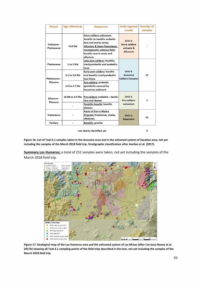
70
Figure 16: List of Task 6.1 samples taken in the Acoculco area and in the exhumed system of Zacatlan area, not yet
including the samples of the March 2018 field trip. Stratigraphic classification after Avellan et al. (2017).
Summary Los Humeros: a total of 252 samples were taken, not yet including the samples of the
March 2018 field trip
Figure 17: Geological map of the Los Humeros area and the exhumed system of Las Minas (after Carrasco Nunez et al.
2017b) showing all Task 6.1 sampling points of the field trips described in the text, not yet including the samples of the
March 2018 field trip.
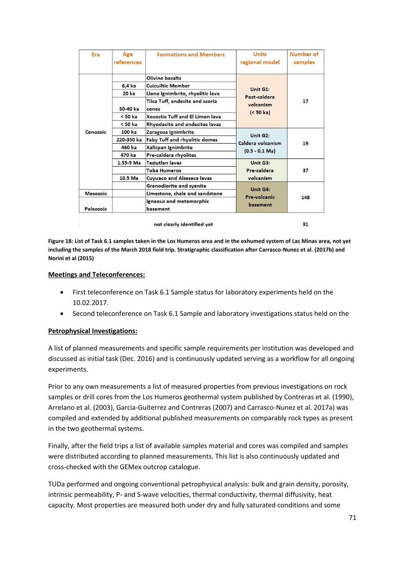
71
Figure 18: List of Task 6.1 samples taken in the Los Humeros area and in the exhumed system of Las Minas area, not yet
including the samples of the March 2018 field trip. Stratigraphic classification after Carrasco-Nunez et al. (2017b) and
Norini et al (2015)
Meetings and Teleconferences:
First teleconference on Task 6.1 Sample status for laboratory experiments held on the
10.02.2017.
Second teleconference on Task 6.1 Sample and laboratory investigations status held on the
Petrophysical Investigations:
A list of planned measurements and specific sample requirements per institution was developed and
discussed as initial task (Dec. 2016) and is continuously updated serving as a workflow for all ongoing
experiments.
Prior to any own measurements a list of measured properties from previous investigations on rock
samples or drill cores from the Los Humeros geothermal system published by Contreras et al. (1990),
Arrelano et al. (2003), Garcia-Guíterrez and Contreras (2007) and Carrasco-Nunez et al. 2017a) was
compiled and extended by additional published measurements on comparably rock types as present
in the two geothermal systems.
Finally, after the field trips a list of available samples material and cores was compiled and samples
were distributed according to planned measurements. This list is also continuously updated and
cross-checked with the GEMex outcrop catalogue.
TUDa performed and ongoing conventional petrophysical analysis: bulk and grain density, porosity,
intrinsic permeability, P- and S-wave velocities, thermal conductivity, thermal diffusivity, heat
capacity. Most properties are measured both under dry and fully saturated conditions and some

72
samples will be used to measure selected properties at high temperature (up to 170°C) and pressures
(up to 60 MPa).
The destructive geomechanical experiments at TUDA are planned after the conventional non-
destructive petrophysical characterization of the samples if finished. Unconfined Compressive
Strength (UCS), Young’s modulus, shear modulus, cohesion, Poisson ratio, tensile strength, shear
strength will be measured.
All results will be correlated to the geochemistry, petrology and in cooperation with UniRoma3 with
the degree of alteration of the different rock types to facilitate the model parametrization with the
help of the available well data.
Figure 19: Crossplots of preliminary measurement results of TUDa performed on 52 plugs from the Jan 2017 and 44 plugs
from the May/June 2017 field trips (Weydt et al. 2017).
BGS will undertake complimentary geochemical and mineralogical studies to the petrophysical ones
of the other partners. These are ongoing, and detailed information about fluid-rock reactions from
the lab experiments should be available in the near future.
In terms of borehole samples, BGS has nearly completed analyses of a single sample from H-48. This
shows a relatively expected reaction sequence of alteration (formation of quartz, K-feldspar, chlorite
and calcite), but also evidence of changing fluid compositions over time (dissolution of some quartz
and all the K-feldspar). Interestingly, the most recent precipitates show possible evidence for
boiling/vapour separation and oxidation.
In terms of surface precipitates BGS is completing analyses of silica-rich precipitates from surface
infrastructure. Evidence for highly porous masses composed of spheres of silica, within which are
bands enriched in iron oxides – the latter probably reflecting physical movement of small amounts of
corrosion products from inside the well lining can be seen. Associated with some of the iron oxides
are sub-micron grains of gold/silver.

73
GFZ performed conventional petrophysical analysis on additional rock samples from Acoculco: bulk
and matrix density, effective porosity, P- and S wave velocities, formation factor, surface
conductance, water permeability.
GFZ/TU Delft performed XRF and XRD measurements of all samples of the first field trip January
2017. Additional measurements of the other samples are planned.
GFZ work in progress: special preparation of rock samples for high temperature experiments.
RWTH performed conventional petrophysical measurements of matrix density and bulk density, total
porosity, thermal conductivity (dry and saturated), P wave velocity (dry and saturated), specific heat
capacity, magnetic susceptibility in the samples collected in January 2017.
Several laboratory tests have been conducted at UNITO on available Mexican samples. Particularly
petrophysical properties were measured including: density and porosity measurements, ultrasonic
pulse velocity (both P- and S-wave velocities (when possible), electrical resistivity (in dry and
saturated conditions). Parallel to this work rock analogue limestone samples, collected in a quarry in
North-western Italian Alps, were thermally treated at temperature ranging from 105° to 600°C and
subjected to non-destructive and destructive laboratory tests. These tests allowed evaluating the
variation in physical and mechanical properties of limestone rocks similar to the Mexican ones as a
consequence of temperature. On each sample similar tests to the ones conducted for the Mexican
cores have been undertaken with the addition of Uniaxial Compressive Strength tests. All these tests
were repeated before and after thermal cycles. These measurements were also interpreted by
microscopical observations on thin sections. The increase of crack density with temperature was
found to be the main cause of the degradation of physical and mechanical properties. Further
processing of these results in comparison with Mexican sample evidence will potentially allow a
more complete understanding of the rock behaviour with temperature.
High p/T experiments
Delays in receiving sample shipments have hindered progress with the lab experiments. However,
BGS has put on a series of sealed cells where andesitic material is being reacted with synthetic Los
Humeros reservoir water at 200°C. The purpose of these tests is to see if similar reactions can be
identified to those seen in borehole core samples. Similar experiments will shortly be initiated at
300°C.
GFZ started thermophysical characterization of relevant hydrothermal fluids: The electrical
conductivity of NaCl and Na2SO4 solutions of different concentrations was measured in dependence
of temperature at elevated pressure.
The high p/T set-up for measuring rock properties was redesigned and is currently being tested.
GFZ planned:
Electrical measurements on salt solutions and their mixtures will be continued

74
Fluid-rock interaction experiments will be performed at supercritical conditions to determine
the effect of mineral dissolution/precipitation on the electrical properties of the reservoir
fluid
Electrical and hydraulic measurements on fluid saturated rock samples (limestones, volcanic
rocks) up to supercritical pT conditions, to determine the effect of fluid-rock interaction on
bulk conductivity and permeability.
Shallow geophysical experiments - Mexican Field work:
During March 1 to 9, 2018 field works were conducted in the Acoculco and Las Minas areas for
shallow geophysical experiments (Electric Resistivity Tomography - ERT) and geomechanical
characterization. In the Acoculco area 3 sites were selected for detailed surveys:
Quarry 6 – 2 electic tomographies, 2 geomechanical surveys, 1 transient station with thermal
camera, ultrasonic velocity measurements;
El campanario – 1 electric tomography, ultrasonic velocity measurements;
Acoculco wells – 2 electrical tomographies.
In Las Minas area 3 sites were selected for detailed surveys:
Juan Marcos – 1 electric tomography, 1 geomechanical survey, ultrasonic velocity
measurements;
Granados Quarry - 1 electric tomography, 1 geomechanical survey, block sampling;
Rinconada fault - 1 electric tomography, 1 geomechanical survey, ultrasonic velocity
measurements, transient station with thermal camera.
Preliminary results of the ERT surveys have evidenced the presence of electric resistivity anomalies
in correspondence of fault zones and of lithological variations (e.g. limestones to andesite).
An example of the combination of the above mentioned studies is reported in were laboratory and
field ultrasonic measurements of the Mexican samples are compared to the rock analogue samples.
Figure 20: Crossplots of preliminary measurement results of UNITO.

75
Reservoir fluid properties
Available chemical fluid data for 13 wells at Los Humeros has been screened. Fluid samples date back
till 1987 but most data is rather recent, with 7 wells sampled during the years 2016 and 2017.
Overall, liquid sample composition is quite variable showing mixtures of chlorite, carbonate and
sulfate salts as well as silica. Total dissolved solid (TDS) content, in contrast, is low and 1.3 g per kg of
solute on average and 4 g per kg at maximum. The latter would correspond to an equivalent NaCl
concentration of ca. 0.07 mol/l as also reflected by the highest electrical fluid conductivity measured
(7 mS/cm at 25°C).
A striking feature of some of the fluid samples (e.g., from well H-58) is an unusually high boron
content of up to 3.6 g per kg of solute, presumably present as dissolved borate salts (Bernard et al.,
2011).
Regarding the thermophysical liquid phase properties of the fluids, from the low TDS content alone,
it is implied that these very closely match with pure water properties at given pressure and
temperature conditions, provided that the fluid state is subcritical. Consequently, the respective
IAPWS formulations for ordinary water substance (IAPWS R12-08, 2008; IAPWS R15-11, 2011; IAPWS
R6-95, 2016) could then be reliably used in reservoir models or for reservoir and plant engineering
purposes. This should apply for viscosity, density, sonic velocity, thermal conductivity, and specific
heat as indicated in Figure 21 for the aqueous 0.07 M NaCl fluid equivalent mentioned before (e.g.,
Hoffert et al., 2015). For viscosity, as the physical property in this list most affected by TDS content,
the departure from pure water properties should be +1.2 % at most followed by density (+0.24 %),
sonic velocity (+0.18 %), thermal conductivity (-0.13 %), and specific heat (-0.31 %), respectively, at
25 °C reference temperature and ambient pressure. Electrical fluid conductivity, in contrast, is
significantly affected by TDS content and consequently shows variations between samples ranging
from ca. 0.1 to 7 mS/cm at 25 °C.
Figure 21: Thermophysical properties of an aqueous 0.07 M NaCl fluid equivalent for Los Humeros geothermal field
relative to pure water indicated as percent deviation at 25 °C reference temperature and ambient pressure.
1,2
0,240,18
-0,13
-0,31-0,5-0,4-0,3-0,2-0,1
00,10,20,30,40,50,60,70,80,9
11,11,21,31,41,5
Viscosity Density Sonic Velocity ThermalConductivity
Specific Heat
Dep
artu
re f
rom
pu
re w
ater
pro
per
ties
/ %

76
The activities and exchange with other WPs is described in the following table.
WP using
preliminary results
Purpose Partner
WP5 Measured densities for gravimetric exploration KIT, TUDa
WP7/8 Comparison of lab data and petrophysical data from
logs and well tests
RWTH, TUDA,
CNR, GFZ, GZB
WP4 Correlate Petrophysics with geochemistry and
petrology
TUDa will send offcuts of the drill core material to
UniRoma3 for geochemical and alteration analysis.
Results will be correlated with petrophysics.
BGS plans to make a comparison between the results of
lab experiments (WP6 - when they are completed) and
rock samples from Las Minas being analysed in WP4.
BGS plans to compare the lab-generated high
temperature fluids with well fluids from WP4.
TUDa, BGS,
UniRoma3
WP4 Use T6.1 samples for fluid inclusion analysis
BGS has selected 2 interesting samples to forward to
CNR for fluid inclusion work, and is collecting sufficient
metadata to send with these.
Additionally sample material from the drill cores will be
selected by TUDa and forwarded to CNR
BGS, TUDa,
CNR
Table 13: Interaction of Task 6.1 with other work packages
Achievements
Milestone M31: Laboratory test samples acquired: 5 field trips were conducted and a total
of 333 samples were taken for petrophysical and rock mechanical investigations; out of
which 252 samples are from the Los Humeros area, outcrop analogues and exhumed systems
of Las Minas including 70 plugs from 41 core sections of 15 cored wells of the LH geothermal
field; and 81 are from the Acoculco area, outcrop analogues and exhumed systems.
A list of petrophysical and mechanical properties of previous investigations of the two
geothermal fields was compiled and made available to all GEMex partners.
A comprehensive list of planned experiments at the different partner institutions was
established and serves to define the workflow of lab experiments
The setup of a comprehensive GEMex Outcrop catalogue was started to be able to compare
results of petrological, geochemical and petrophysical investigations from different WPs with
each other.
3 Master thesis were started at TUDa to work on the petrophysical characterization of (i) the
basement rocks, (ii) the reservoir andesites and (iii) the reservoir samples of the drill cores.
Lab experiments both under lab and in-situ conditions are ongoing and are on track to being
finish to achieve Milestone M32 : Laboratory tests finished within the deadline.

77
Shallow geophysical field experiments were conducted in Acoculco and Las Minas to
determine petrophysical and mechanical properties at a larger scale than the lab scale and
thus allow for upscaling.
2.6.2 Task 6.2 Reservoir characterization
Activities (RWTH):
Literature review for understanding the geology, geophysics and reservoir conditions of Los
Humeros and Acoculco.
Communication (tele-conferences) and discussion with WP 3 towards developing the Los
Humeros structural model.
Import of Geomodeller structural format to RWTH in-house simulation code, SHEMAT suite.
Efforts concentrated towards preserving geometry of faults. This structural model is gridded
in Shemat Suite and then property modeling is performed.
Several data requests sent to CFE for well data, geological and geophysical models, reservoir
engineering reports, etc.
Skype meetings with Mexican partners to facilitate collaboration of work for Los Humeros
and Acoculco reservoir models.
Data analysis of pressure and temperature to identify the top and bottom of the feed zones,
identifying pressure pivot points (for input towards D6.3 and D 6.6),
Estimatation of physical (thermodynamic) properties of fluids in Los Humeros (Contribution
towards D6.1 and D6.3)
Extraction of information from the available well data to use towards calibration of the
reservoir models to be performed in Task 6.4 (Contribution towards D6.6)
Activities (CNR):
Investigation on heating up profile, to identify the possible feed zones
Investigation on pressure build up during heating, to identify the pivot point and the pressure
controlling the feed zones as well as the pressure in the wellbore surrounding
Wellbore modeling to assess fluid P,T and enthalpy at well bottom
This approach was followed for each well, according to the availability of data.
Activities (UU):
A preliminary regional thermal model for Los Humeros has been developed, building on the regional
work that has been done in WP3. The geometry of the model is based on the structure of the
volcanological system at regional scale and the conceptual understanding that gives some insight to
understand the thermal framework that host the geothermal system. The thermal model uses
average lithology for each individual layer and the temperature information from the wells that have
been collected and corrected.
Results/ Achievements:
Request and preliminary analysis of CFE data: Temperature, Pressure and Production data for
more than 50 Los Humeros wells and 2 Acoculco wells, Numerical reservoir simulation report
of Los Humeros, 2015

78
WP3 preliminary Los Humeros models is imported to inhouse Simulation software Shemat
Suite and first runs on temperature modeling were performed.
Well data analysis of temperature data and pressure for identifying characteristics of feed
zone is ongoing.
2.6.3 Task 6.3 Model approaches for EGS
Workshop:
Workshop conducted in RWTH on 20th June 2017 with all partners involved in Task 6.3 for
verification of simulation code. Francesco Parisio (UFZ), Hannes Hofmann (GFZ), Peter Fokker
(TNO), Stephan Düber (GiB, RWTH), Martin Feinendegen (GiB, RWTH), Paromita Deb (GGE,
RWTH) and Yousef Heider (IAM, RWTH) attended the workshop which involved
demonstration of the hydraulic fracturing experiment and discussion of the state of the art
simulation codes which are used by different institutions for simulation of stimulation
approaches. Discussion on upcoming experiments and simulations.
Activities (RWTH):
Field trip was carried out in March 2017 (also reported in Task 6.1) along with Mexican
partners in order to sample rocks for Hydraulic fracturing experiment (field trip: 17.03.17 –
23.03.17, arrival of samples in Aachen: 25.01.18)
2 large samples of Granodiorite and 2 large samples of Marble each measuring 50 × 50 × 50
cm3 were sampled from Las Minas and Pueblo Nuevo Quarry which are considered as
exhumed systems of Los Humeros and Acoculco.
Shipment of large sample blocks from Mexico to Germany (D6.4 and D 6.5). The shipment
was a big hurdle considering the fact that the budget as well as the responsible party for such
shipments have not been considered initially during project planning. Managing budget and
shipment of samples have taken longer than expected (a delay of more than 6 months).
Setup and preparation of HF experiment (preliminary tests on functionality of control
software, pumps, data recorder etc.)
Samples are shipped to Aachen, Germany and handed over to Stone Mansion for cutting and
polishing to prepare them for the hydraulic fracturing experiment.
Experimental data from the previous HDR research project, the value of the physical
properties and the boundary condition details were distributed to all Task 6.3 partners to
start testing/developing their respective simulation codes.
First simulation results show high influence of fluid viscosity on fracking process. Research on
viscosity of fracturing fluid (glycerol-ink mixture) has shown high temperature dependency.
Improvements on experimental setup regarding measurement of fluid viscosity and
temperature have been conducted.
Activities (UFZ):
Literature review of computational methods for hydraulic fracture propagation;
Simulation and validation against analytical solutions of hydraulic-fracture propagation;
Simulation and comparison against experimental results on hydraulic-fracture propagation
for code comparison (D6.5).

79
Activities (GFZ):
Simulation and validation of FRACOD2D and PFC2D against analytical solutions of hydraulic-
fracture propagation;
Simulation and comparison of FRACOD2D and PFC2D against experimental results on
hydraulic-fracture propagation for code comparison.
Validation of numerical approach for hydraulic-fracture propagation against analytical
solutions ongoing (D6.5)
Achievements:
Validation of numerical approach for hydraulic-fracture propagation against analytical
solutions (D6.5);
2.6.4 Task 6.4 Model approaches for SHGS
Activities (RWTH, CNR):
Literature review for understanding of fracture permeability characterization.
Communication and discussion with other Work Packages (WP 4) for using fracture geometry
data collected using scan lines and other geological measurements in order to feed into
fracture modeling process.
Collaborating with other Work Packages to retrieve CFE drilling data. The mud loss data and
other drilling data to assist in permeability characterization and understanding stress regimes
in the borehole.
A preliminary rough field model (steady state) was carried out using the data obtained so far
in task 6.2 and 6.4, to check the consistency and stability of the model, using the supercritical
Equation Of State for water and CO2 developed at CNR-IGG in the framework of
DESCRAMBLE project. The model will be refined and updated during the project, and possibly
extended down below accounting for the hot rocks intruding the limestones.
Work ongoing to define the thermodynamic conditions of the wells and the reservoir at the
feed zones, and the Pressure, Temperature and Enthalpy properties within the well,
providing the base data for the production model (to be performed after the steady state
model) used for the calibration of the reservoir model.
Activities (UFZ):
Literature review on brittle-ductile transition rheology;
Development of plastic yield surface for brittle-ductile transition at high temperature and
high pressure.
Results:
This work, accounting also the input from other tasks, will fulfill the deliverables “D6.3 Report on the
numerical reservoir model used for the simulation of the Los Humeros reservoir”,”D6.6 Report on the
calibrated model for the super-hot reservoir at Los Humeros and its calibration against available field
data”.
Starting from the wellhead data during production, and well geometry, we are working
towards obtaining a flowing well model that compute the P,T, Enthalpy profile of the well.

80
In our case many wells have data on discharge condition measured at well-head, and we
used the P,T conditions at depth found so far for the feed zones to model the flowing
condition. This modeling help in clarifying the contribution of the feed zones to the well
production, and provide the P, T, Entalpy and steam/brine ration along all the well profile,
down to the well bottom.
The wellbore model, coupled with the reservoir properties obtained in task 6.2, provide the
thermodynamic description for both the natural (steady state model) an exploitation model
(calibrated model) for Los Humeros geothermal prospect, in particular we obtain the P,T,
Enthalpy values within the well needed to couple the production data with the reservoir
model.
Simulation and validation against analytical solutions of hydraulic-fracture propagation
(D6.3);
Development and validation against experimental results on carbonates and basalt formation
from literature of a brittle-ductile transition rheological model (D6.3, D6.6).
2.6.5 Publications
Parisio F., Tarokh A., Makhnennko R., Naumov D., Yuan-Miao X., Kolditz O., Nagel T., Experimental
characterization and numerical modelling of fracture processes in granite. Journal of the Mechanics
and Physics of Solids, under review (2018).
Yoshioka K., Parisio F., Naumov D., Lu R., Kolditz O., Nagel T., Cross-Verification of Discrete and
Smeared Numerical Approaches for the Simulation of Hydraulic Fracturing. International Journal of
Geomathematics, under review (2018).
Parisio F., Naumov D., Kolditz O., Nagel T., Material forces: an insight into configurational energy.
Mechanics Research Communication (2018, Article in press).
Parisio F., Nagel T., Kolditz O., Vinciguerra S., Lithology and dilatancy control the brittle-ductile
transition in volcanic areas, Nature Geoscience (2018, submitted).
2.6.6 Dissemination
Weydt, L., Bär, K., Sass, I. (2017): Outcrop Analogue Study to Determine Petrophysical Properties of
the Los Humeros and Acoculco Geothermal Systems, Mexico. – Proceedings 5th European
Geothermal Workshop, Karlsruhe, 12-13 October 2017.
Weydt, L., Bär, K., Sass, I. (2018): Outcrop analogue study to determine reservoir properties of the
Los Humeros and Acoculco geothermal fields, Mexico - Geophysical Research Abstracts Vol. 20,
EGU2018-7228, EGU General Assembly 2018.
Kummerow, J., Raab, S., Schüssler, J. (2018). Fluid-rock interactions at near- and supercritical
conditions and their effect on physical properties of high-enthalpy hydrothermal systems -
Geophysical Research Abstracts Vol. 20, EGU2018-7097, EGU General Assembly 2018.
Montegrossi, G., Deb, P., Clauser, C., Diez, H. and Ramirez, M.A, Modeling of Los Humeros
geothermal field: preliminary results, Geophysical Research Abstracts Vol. 20, EGU2018-17600, EGU
General Assembly 2018 (Poster Session)

81
Parisio F., Vinciguerra S., Kolditz O. and Nagel T., The lithological control on the brittle-ductile
transition in volcanic areas, EGU General Assembly 2018, Vienna, 8th-13th April 2018, EGU2018-2429
Hutka GA, Hofmann H, Farkas MP, Yoon JS, Zimmermann G, Zang A (2018) Benchmarking of hydro-
mechanical coupled models against true-triaxial laboratory hydraulic fracturing experiments. 9th
European Geothermal PhD Days, Zürich, Switzerland, 14.-16. March.
Deb et al., Hydraulic-fracturing experiments on a laboratory scale for numerical codes verification,
Geophysical Research Abstracts Vol. 20, EGU2018-16136, EGU General Assembly 2018 (Poster
Session)
Deb et al., Laboratory fracking experiments for verifying numerical simulation codes, 1354, Hydro-
Thermal-Mechanical Modelling in Tight Formations, 80th EAGE Conference, Copenhagen, Denmark,
June 2018 (Oral)
Seminar entitled “Enhanced supercritical geothermal systems: toward stimulation design” held at
Universidad Politecnica de Catalunya – Instituto de Diagnóstico Ambiental y Estudios del Agua -
Consejo Superior de Investigaciones Científicas (UPC-IDAEA-CSIC), March 15th 2018, by Francesco
Parisio.
2.6.7 Deviations from the Description of Action
WP6: In course of the amendment, UNITO has shifted budget from “subcontracting” to “direct
personnel costs”. However during the amendment we forgot to also add the person months which
are associated to this. Consequently, UNITO has already used more person months than indicated in
the GA for WP6, but they have still enough resources to finish their work in WP6 in the next periods
Task 6.1: Milestone 31 was reached late, only in month 16 instead of month 6: After the first two
field trips in January and March 2017 researchers noted that further samples are needed. Therefore
additional field trips were organised and a third collection was finished in May 2017, but until July
2017 no shipping company could be found for the transport to Europe (probably because of
regulations for export of minerals /fossils).Finally with the help of the Mexican partners, a shipping
company was found, but due to administrative issues on the Mexican site, the shipping started end
of December 2017; Samples arrived end of January 2018. A fourth field trip was planned and
executed in January/February 2018 for final sampling and also sampling the drill cores from the Los
Humeros SHGS reservoir, which are very important to be able to compare them to the samples from
the outcrop analogue and exhumed systems.
The late reaching of this milestone was one reason for the application for the amendment. After
approval of the amendment, the activities of Task 6.1 are on track again and no further delays are
anticipated.
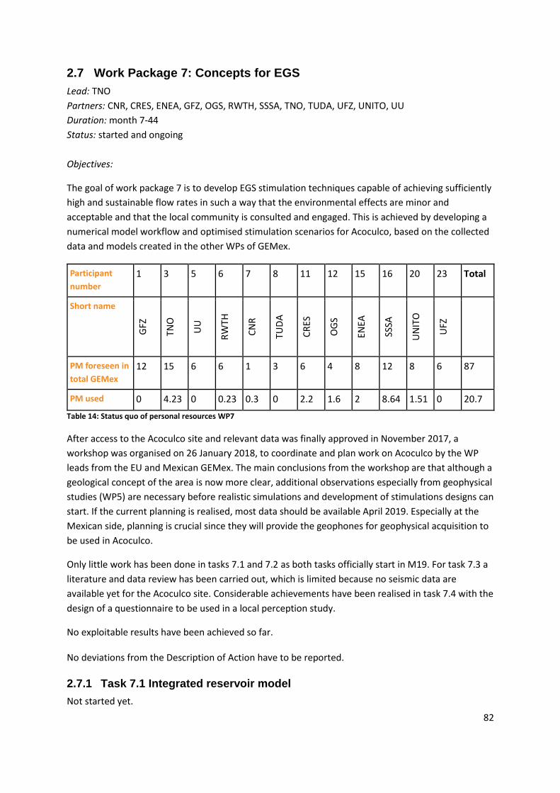
82
2.7 Work Package 7: Concepts for EGS
Lead: TNO
Partners: CNR, CRES, ENEA, GFZ, OGS, RWTH, SSSA, TNO, TUDA, UFZ, UNITO, UU
Duration: month 7-44
Status: started and ongoing
Objectives:
The goal of work package 7 is to develop EGS stimulation techniques capable of achieving sufficiently
high and sustainable flow rates in such a way that the environmental effects are minor and
acceptable and that the local community is consulted and engaged. This is achieved by developing a
numerical model workflow and optimised stimulation scenarios for Acoculco, based on the collected
data and models created in the other WPs of GEMex.
Participant
number
1 3 5 6 7 8 11 12 15 16 20 23 Total
Short name
GFZ
TNO
UU
RW
TH
CN
R
TUD
A
CR
ES
OG
S
ENEA
SSSA
UN
ITO
UFZ
PM foreseen in
total GEMex
12 15 6 6 1 3 6 4 8 12 8 6 87
PM used 0 4.23 0 0.23 0.3 0 2.2 1.6 2 8.64 1.51 0 20.7
Table 14: Status quo of personal resources WP7
After access to the Acoculco site and relevant data was finally approved in November 2017, a
workshop was organised on 26 January 2018, to coordinate and plan work on Acoculco by the WP
leads from the EU and Mexican GEMex. The main conclusions from the workshop are that although a
geological concept of the area is now more clear, additional observations especially from geophysical
studies (WP5) are necessary before realistic simulations and development of stimulations designs can
start. If the current planning is realised, most data should be available April 2019. Especially at the
Mexican side, planning is crucial since they will provide the geophones for geophysical acquisition to
be used in Acoculco.
Only little work has been done in tasks 7.1 and 7.2 as both tasks officially start in M19. For task 7.3 a
literature and data review has been carried out, which is limited because no seismic data are
available yet for the Acoculco site. Considerable achievements have been realised in task 7.4 with the
design of a questionnaire to be used in a local perception study.
No exploitable results have been achieved so far. No deviations from the Description of Action have to be reported.
2.7.1 Task 7.1 Integrated reservoir model
Not started yet.

83
2.7.2 Task 7.2 Stimulation Design
Not started yet.
2.7.3 Task 7.3 Induced seismicity and environmental hazards
ENEA has collected data on the stratigraphy and seismicity of Acoculco and Los Humeros.
Stratigraphic reconstruction based on acquired wells stratigraphy of the main lithological units in
Acoculco and Los Humeros have been completed. A review report on induced seismicity is in
progress.
Assuming a generic EGS system, because of lack of specific-case data (waiting for Acoculco data),
OGS is performing a review study on the control procedures applied for a number of some well-
known cases. Until now OGS has performed a literature review on seismic hazard monitoring for EGS
sites with special attention to the following field cases: Fenton Hill (New Mexico, USA);
Rosemanowes (Cornwall, UK); Hijiori (Japan); Soultz (France); Cooper Basin (Australia); Basel
(Switzerland); Landau (Germany); Berlín (El Salvador). This analysis is focused primarily on seismic
monitoring, correlation between seismicity and exploitation activity, and alert protocols. Existing
protocols for induced micro-seismicity monitoring that can be suitable for the EGS systems in the
study area have been reviewed and discussed. The same results and methodologies obtained for T7.3
will also be used for the purposes of WP 8.
2.7.4 Task 7.4 Public engagement
Objectives:
The task aims to define a conceptual and practical model for implementing public engagement
strategy to support and improve the local acceptance of the development of geothermal energy
activities (enhanced geothermal system (EGS) and super-hot resources (SHSG)).
The design of a conceptual model requires the identification of suitable stakeholders that can
assume an active and passive role in the development of geothermal energy projects. Then, a quali-
quantitative investigation is carried out on different stakeholders to discover their interpretations
and perspectives on geothermal energy development issues. Questionnaires and unstructured
interviews will be submitted to citizens, companies, public authorities and local communities both in
Mexico, Europe and several developing countries. Based on the results of these activities, a
framework is being built to integrate public authorities’ and private companies efforts in fostering
sustainable energy transition by taking into account local communities’ ordinary life and socio-
economic needs and the perception of companies’ behaviors (social responsibility) related to energy
projects among the wider group of final energy consumer.
Activities:
(M1-M6) Preparatory action to fine tune the focus of the activities foreseen in the task 7.4:
Cooperation with Mexican partners for planning activities regarding social acceptance and
public engagement strategies (emails, conference calls and attendance at 1st Simposio
Ambiental, Economico y Social de sistemas geotermicos mejorados y supercalientes in
Morelia (Mexico) February 26, 2017).
Cooperation with European partners for planning activities regarding social acceptance and
public engagement strategies (emails, conference calls, physical meeting in Pisa 8 Feb 2017.
84
(M1-M18) Identification of stakeholders for carrying out interviews and questionnaire
Collection of information to design a stakeholders’ map.
Collection of information to assess the feasibility of in-field activities through a strong
cooperation with Mexican colleagues:
o Arrangement of the seminar "Geothermal energy and society: social acceptance and
public engagement in geothermal energy developments" (16th of April 2018) in Mexico
with CFE and Mexican social-economic-environment research team.
o Arrangement of fieldwork in the 4 local communities (ejidos) of interest for the GEMEX
in order to carry out interviews with some representatives of communities in April 2018.
o Collection of preliminary sociodemographic data related to the 4 local communities
(ejidos) that will be involved in the 7.4 task fieldwork in April 2018.
(M5-M15) Literature review on public engagement for the development of geothermal projects
Review of practices from the side of project developers and operators in order to achieve
social acceptance of geothermal power plant projects.
Measurement methods of socioeconomic impacts of renewable energy projects.
Review of current literature about public authorities’ activities to engage population and
stakeholders in the renewable energy projects.
The relationship between consumers and companies in the development of renewable
energy projects.
(M15-M18) Design of questionnaire and interview protocol and collection of data
Design and launch of the questionnaire survey to investigate consumer’s loyalty toward
energy utilities involved in the development of geothermal energy projects. The survey has
been carried out in Mexico, Brasil, China, Russia, South Africa, and India by collecting around
300 questionnaires for each country.
Design of a short questionnaire to investigate energy use and knowledge in local
communities located in Acoculco area. The questionnaire, with the support of Mexican
colleagues, is going to launch in July 2018.
(M1-M18) Internal communication activities
5 teleconferences were held with 7.4 task members and Mexican colleagues during the
reporting period:
2.7.5 Dissemination and communication activities
Submission of the abstract Eleonora Annunziata, Michele Contini, Fernando Diaz, Spyros
Karytsas, Adele Manzella, Dario Padovan and Alessandro Sciullo “Public engagement
strategy: a conceptual model for enhancing the development of geothermal energy” to the
International Conference "Breaking the Rules! Energy Transitions as Social Innovations"
2.7.6 Deviations from the Description of Action
No deviation in the reporting period.

85
2.8 Work Package 8: Concepts for Superhot
Lead: GFZ
Partners: CRES, ENEA, GFZ, HBO, IFE, ISOR, OGS, RWTH, TNO, UFZ, UU
Duration: month 1-44
Status: started and ongoing
Objectives:
In WP8 we aim to develop and verify concepts and technologies to access and exploit super-hot
reservoirs (> 300°C, including conditions above the critical point of water in the reservoir) on the
basis of the work and data derived in SP1 and SP2 combined with additional information provided by
the operating site in Los Humeros. Main objectives are:
To integrate the results obtained from the technical work packages 3-6 and use them in
various model approachs in order to predict the reservoir properties
To prepare a list of material suitable for installation in super-hot conditions
To prepare a best-practice guide for drilling and completion in super-hot setting
To to give recommendations for a thermal loop design
To provide propose a montoring systems in order to avoid or mitigate potential threads for
the environment
Participant
number
1 2 3 5 6 10 11 12 15 19 23 Total
Short name
GFZ
ISO
R
TNO
UU
RW
TH
IFE
CR
ES
OG
S
ENEA
HB
O
UFZ
PM foreseen in
total GEMex
15 20 6 6 6 2 6 3 8 10 6 331.5
PM used 0 3.2 1.1 0 0 0 1 0.5 0 5 6 16.8
Table 15: Status quo of personal resources WP8
In Task 8.1 a detailed plan for the modelling of the reservoir has been set-up. The task is strongly
depending on the input from the other work packages, namely WP 3 for the static geological model
and WP6 for the shared simulation model in terms of a gridded subsurface model with geological
properties assigned. Consequently only a few activities have yet been conducted. Once the gridded
reservoir model is available, the task partners agreed to conduct three different types of simulation:
2D-2phase calculations with TOUGH, modeling of continuum damage and fracture propagation, and
semi-analytical coupled modelling. Based on the results from the simulations, recommendations for
drilling and sustainable reservoir exploitation will be established.
In Task 8.2 intensive discussion with the Mexican partners and the operator in Los Humeros (CFE)
concerning the material tests have been conducted. The preparation of the on-site test is ongoing,

86
material have already been selected and a workflow for the analysis of the tested material has been
set-up.
In Task 8.3 a review of the specific drilling and completion problems in Los Humeros has been
conducted. In parallel, experience from other super-hot sites is collected and evaluated. Detailed
summary and description of results will serve as a draft drilling concept for SHGS as being described
in D8.3 for the design of well completion.
No deviations from the Description of Action have to be reported.
2.8.1 Task 8.1 Prediction of reservoir properties
Work package 8.1 addresses numerical modelling of superhot geothermal systems (SHGS). It targets
the deep subsurface below already existing wells of Los Humeros.
A workshop was held 23/5/2017 in Potsdam to streamline the activities in this work package and to
discuss mutual dependencies. Delegates were present from GFZ, UFZ, TNO/UU and RWTH.
Based on the gridded model, dynamic simulations will be performed in different ways. We envisage
2D-2phase calculations with TOUGH (GFZ). GFZ will collect and combine as many data as
possible (hydraulic, chemical, thermal, mechanical) as a base for the models. A master
student will join as from April on to start this data collection.
Brittle-ductile transition in superhot geothermal systems and modeling of continuum
damage and fracture propagation (UFZ). UFZ will set up a constitutive model for the brittle-
ductile transition and use it as the base for fracture propagation analyses in high
temperature and pressure conditions.
Semi-analytical coupled modeling (TNO/UU). A first assessment has been made of available
coupled semi-analytical approaches. Here, the approach of Atefi-Monfared et al. seems to be
promising: a 1D approximation of the geomechanical response, which might be feasible for
complicated constitutive models, calibrated by 3D responses for simple constitutive models.
Main activities
Literature review of brittle-ductile transition in volcanic areas and systems;
Numerical simulations with a brittle-ductile transition model to understand fracture
propagation at high pressure and high temperature conditions.
Thermo-hydro-mechanical simulations of hydraulic stimulations with inelastic constitutive
model.
Main results to be included in Deliverables D8.1 and D8.4
Development of a rheological model;
Analyses of localization and failure in high temperature and high pressure conditions;
Correlation between seismicity and rheology in volcanic areas;
Assessment of brittle-ductile transition depth in basaltic and carbonatic volcanic;

87
2.8.2 Task 8.2 Materials for installation in super-hot systems
During the Kick-off Meeting (KoM) of the GEMex project in Morelia it was proposed that ÍSOR would
run a workshop in connection to Task 8.2 on corrosion and scaling. On 6th – 10th March 2017 the
workshop was held in the offices of the Los Humeros geothermal field in Mexico. Participants were
GEMex partners, over 25 attendees, mostly from Comisión Federal de Electricidad (CFE), engineering,
chemical and operational exerts as well as partners from Universidad Nacional Autónoma de México
(UNAM), Universidad Michoacana de San Nicolás de Hidalgo (UMSNH), Instituto Nacional de
Electricidad y Energías Limpias (INEEL), Iceland GeoSurvey (ÍSOR) and the German Research Centre
for Geosciences (GFZ).
After the workshop CFE asked for guidelines for corrosion testing in flowing high-temperature
geothermal well. ÍSOR along with UNAM have worked in cooperation with CFE towards providing
such guidelines. Materials that will be tested have been selected and gathered from various sources
and are ready to be cut into samples once the test setup has been finalized. Preparation of the on-
site material test is ongoing.
Additionally, UFZ has worked on numerical modeling approaches for metal corrosion. UFZ has
achieved a review of constitutive model of plasticity and damage for strength of metals as a function
of corrosion.
2.8.3 Task 8.3 Drilling and completion
GFZ, OGS, BRGM and international partners compiled the worldwide drilling activities of superhot
geothermal systems (Reinsch et al 2017). The work outlines the challenges and potential
opportunities that these systems provide for international collaboration to ultimately utilize
supercritical geothermal systems as a geothermal energy resource.
HBO has done a more detailed review of past drilling escapades in other super-hot locations
worldwide, investigated conditions of LHGF together with completion and drilling techniques used
and kick-started laboratory experiments on improvements of conventional cement blends in super-
hot locations as well as FEM modelling.
HBO conducted an onsite meeting February 19-20 2018 in Morelia, Michoacán (Mexico) with drilling
and completion experts, geologists and geochemists from Comisión Federal de Electricidad (CFE) in
Morelia and Los Humeros. Between 21st and 23rd of February 2018, field trips to Los Humeros and
Acoculco geothermal fields were organised in order to investigate problems up close. After very
successful meetings and discussions with CFE detailed and proprietary drilling related data had been
requested for several, selected wells including:
daily drilling reports including detailed drilling parameters and logging data such as Leak Off
Test (LOT) etc.
cement composition
properties of drilling fluid,
summary of challenges concerning drilling and well completion.
88
CRES has investigated and reported experience from practices adopted in other wells which
encountered superhot temperatures (e.g. Nisyros 1, Greece).
Detailed summary and description of results will serve as a draft drilling concept for SHGS as being
described in D8.3 for the design of well completion.
2.8.4 Task 8.4 Thermal loop design and performance monitoring
Allthough Task 8.4 has not yet officially started, some activities have already been carried out be the
partners in order to facilitate a smooth start of the task.
CRES carried out a literature review on surface expoitation and monitoring schemes. ENEA focused
on description of a monitoring system for soil mobility of elements during geothermal exploitation of
superhot systems. Geothermal areas are characterised by high levels of Potentially Harmful Elements
(PHE). In particular, some heavy metals as: As, Cu Pb, and Hg in some conditions, evidence a higher
mobility respect the “pedogenic” elements, promoted by the low pH and by the soil microorganisms
adapted to survive in such environments. These environmental aspects are studied reviewing
suitable tools to monitor PHE concentration levels and distribution pattern. This activity is necessary
to manage actions to reduce both pollution and to reduce the population risk. Until now ENEA
focused mainly on carrying a critical review on the mobility of trace elements in soils, focused on
geothermal soils with the purpose to give a picture of the state of art on this subject and to suggest
innovative and “rapid” chemical approach to test pollutant mobility. For the next reporting
periods, our aim is to compare some mobility tests in soils from Mexico geothermal areas with soils
collected in a different geothermal areas as the Flegran Field, with the aim to suggest a innovative
chemical approach methods to test trace elements mobility in such environment.
2.8.5 Publications
Reinsch, T., Dobson, P., Asanuma, H., Huenges, E., Poletto, F., Sanjuan, B., (2017): Utilizing
supercritical geothermal systems: a review of past ventures and ongoing research
activities. - Geothermal Energy, 5, 16.
Parisio F., Nagel T., Kolditz O., Vinciguerra S., Lithology and dilatancy control the brittle-ductile
transition in volcanic areas, Nature Geoscience (2018, submitted)
2.8.6 Dissemination activities (talks, posters, workshops)
Parisio, F., “Enhanced supercritical geothermal systems: toward stimulation design”, seminar held at
Universidad Politecnica de Catalunya – Instituto de Diagnóstico Ambiental y Estudios del Agua -
Consejo Superior de Investigaciones Científicas (UPC-IDAEA-CSIC), March 15th 2018
Parisio F., Vinciguerra S., Kolditz O. and Nagel T., “The lithological control on the brittle-ductile
transition in volcanic areas”, European Geosciences Union General Assembly 2018, Vienna (Austria),
8-13 April 2018

89
2.9 Work Package 9: Ethics
Lead: GFZ
Duration: month 1-44
Status: started and ongoing
Objectives:
This work package sets out the 'ethics requirements' that the project must comply with. There is only
one deliverable which must provide details on the material which will be imported to/exported from
EU and provide the adequate authorizations.
Status:
No person months are associated with this work package. The coordinator takes care of the
compliance with the ethic requirements.
Up to now import and export to/from Mexico included mainly two things:
Equipment or scientific measurements: all equipment which is imported to Mexico and was /
will also be exported. Hence, the project partners acquired a permission for temporary
import of scientific equipment which was checked by the Mexican customs.
Export of samples of rocks, fluids and gas: all samples were of scientific value only and had
no significant content of fossils or minerals. Consequently they neither represent a
commercial value, nor are they of historical value to the Mexican people. Again, the export of
samples was always checked and authorized by the Mexican customs.

90
3 Impact
The Impact as detailed in section 2.1 of the DoA is still relevant. In addition to the DoA, we can report
the following impact of the project after the first reporting period subdivided into a “scientific”, and
“technological” impact:
Scientific
Peer reviewed publications: 3 published, 4 submitted
Presentation on conferences: 22
Master thesis:1
Transfer of knowledge:
o Through collaboration within GEMex, we strengthen the transfer of knowledge
between the 31 involved Mexican and European partners
o with strong links to other H2020 projects (GeoWell, DESTRESS, SURE, DEEPEGS,
DESCRAMBLE and IMAGE) as well as recent the Mexican project CEMIE-Geo, we
additionally ensure a transfer of knowlegde gained in other H2020 projects to the
European and Mexican research community
Technology
Patent application on a tracer for superhot resources (WP4)

91
4 Deviations from Annex 1 (if applicable)
4.1 Tasks
Task 2.4: RWTH has used 0.24 PM for Dissemination although this was not foreseen in the GA.
Paromita Deb from RWTH took part in the EU-MX dialogue on Energy and gave an invited
presentation on GEMex on behalf of the coordinator.
Tasks 3.3: The analogue modelling laboratory of CNR-IDPA has rescheduled its activity with the aim
of a better integration among the three analogue modelling laboratories involved in the Task 3.3
(CNR-IGG, CNR-IDPA and UROMATRE) and an efficient use of their instrumental resources. For this
reason, the laser scanner mentioned in the GA will not be acquired, and the budget will be used for
other equipment and eligible costs. Nonetheless, the duties, deliverables and schedule of the
laboratory will not be affected by this deviation, as the analysis will be conducted with alternative
techniques (digital photogrammetry) in collaboration with the other two laboratories.
Task 4.2: Isotopic analyses on the altered core-samples of Los Humeros geothermal wells are delayed
as these samples have only recently arrived in Europe and they will be used for other analyses before
they can be made available for isotopic analyses. If the samples are sent to the CNR within 3-4
months the isotopic analyses will be carried out within the project extension period.
Only one sample of the mafic dikes collected by CNR in the basement surrounding the Los Humeros
caldera is fresh enough to allow radiometric dating. The sample have been hand-crushed and sieved,
and the groundmass (fraction 250÷355 µm) has been separated using magnetic methods followed by
handpicking under a binocular microscope. The radiometric analysis is in delay as the 40Ar-39Ar
laboratory at CNR-IGG is currently under maintenance. The analysis will be scheduled as soon as the
laboratory equipment will become fully operational and the analysis will be carried out within the
project extension period.
Task 4.3, Subtask 4.3.2: At the beginning stage of the project, the activities were delayed due to
internal issues on the Mexican side (multiple changes of task leaders, financing issues, etc.). Also,
during the sampling campaign (carried out by IGG-CNR) on 2017 in LHGS, customs authority
(Guadalajara airport) retained all scientific equipment shipped from Italy, obstructing the import
processing and the regular schedule of the planned work. The process to recover the equipment was
extremely delayed due to lack of communication between Mexican Airport Customs and Mexican
partner involved. Now, the equipment seems to be missed and its searching process represents a
very difficult challenge. Even if the equipment is still retained by the Mexican customs, the planned
activity for 2017 was complete and is ongoing for 2018.
The approximate progress of the BRGM contribution in task 4.3 until now is close to 10%. Relative to
the planned schedule, the BRGM activities have been slowed down, given that the campaign of fluid
sampling has been delayed from 6 to 7 months, but this deviation is still acceptable.
Task 5.2: Subtask 5.2.1 c) There is no activity planed so far concerning the DAS acquisition method.
The reason for this is that the DAS acquisition was foreseen for the site in Acoculco in the assumption
that a new well would be drilled. A DAS installation would only make sense if the cable would be
deployed before/during the casing of the borehole because the measurement requires a good
92
coupling of the cable to the drilled rock. This was not correctly communicated between the two
consortia and it came to our attention only after the signature of the GA, that there will be no new
drilling in Acoculco. Consequently, we do not see a possibility for DAS installation during the lifetime
of the project.
The completion of Milestone 28 will be reached in M20 instead of M12: The deployment of seismic
stations in Los Humeros was already finished in M13 (only two stations were added in M18).
However we had no permission to install instruments in Acoculco until December 2017. Hence, all
European stations have been installed in Los Humeros and it was agreed that the Mexican teams will
deploy their newly acquired stations in Acoculco. The Mexican stations have only arrived in Perote in
March and deployment is starting. 16 Mexican stations will be deployed by the Mexican team and
data sharing with the European team as with the Los Humeros dataset is foreseen.
Subtask 5.2.2 d) Attenuation: Even if foreseen in 5.2.2d, at the moment no borehole seismic data
(VSP) are available, therefore, not usable for seismic interferometry with body waves at depth from
active sources (5.2.2c) and attenuation analysis (5.2.2d) as initially expected.
Task 5.3:The completion of Milestone 29 will be reached in M20 instead of M12: A second fieldwork
in Los Humeros and Acoculco is scheduled from 12.4.2018 to 16.5.2018. This will include the final
acquisition of the necessary “other” geophysical data. The deliverable will be reached in month 32.
WP6: In course of the amendment, UNITO has shifted budget from “subcontracting” to “direct
personnel costs”. However during the amendment we forgot to also add the person months which
were associated to the subcontracting. Consequently, UNITO has already used more person months
than indicated in the GA for WP6, but they have still enough resources to finish their work in WP6 in
the next periods.
Task 6.1: Milestone 31 was reached late, only in month 16 instead of month 6: After the first two
field trips in January and March 2017 researchers noted that further samples are needed. Therefore
additional field trips were organised and a third collection was finished in May 2017, but until July
2017 no shipping company could be found for the transport to Europe (probably because of
regulations for export of minerals /fossils).Finally with the help of the Mexican partners, a shipping
company was found, but due to administrative issues on the Mexican site, the shipping started end
of December 2017; Samples arrived end of January 2018. A fourth field trip was planned and
executed in January/February 2018 for final sampling and also sampling the drill cores from the Los
Humeros SHGS reservoir, which are very important to be able to compare them to the samples from
the outcrop analogue and exhumed systems.
The late reaching of this milestone was one reason for the application for the amendment. After
approval of the amendment, the activities of Task 6.1 are on track again and no further delays are
anticipated.
4.2 Use of resources
The expenditure of resources, person months and budget, is overall in line with the foreseen amounts.
However, there have been some changes, which are explained in the table below if the costs were
higher than 3000€. More details can be found in the financial statements of each partner.

93
Partner Not planned
resources
Explanations/ Change
All partners 11,251.68 € Additional costs for EMDESK license subscription for setting up
an internal communication reporting tool within, estimated to
11,251.68 € for the entire project duration. Each project
partner therefore has to pay additional 468.82 € for the license.
Before signing the contract for using EMDESK on GEMex, the
coordinator had contacted the project officer for approval of
these additional costs, which were approved upon.
GFZ/RWTH 3,116.15 € A dissemination activity was carried out as a result of request
from the EU Delegation, Mexico in context to the EU-Mexico
Energy Dialogue. Budget from GFZ should be transferred to
RWTH for this travel.
GFZ 9,081.00 € 9,081.00 € had to be paid for catering during the joint project
meeting with the Mexican project in Iceland, Akureyri.
The coordinator has accounted for this budget because some
of the personnel costs could be saved due to GFZ providing in-
kind contributions to the project.
GFZ 5,232.13 € Costs for transport of large blocks for the hydraulic fracturing
tests were unexpectedly high and GFZ had to cover those costs
to ensure the feasibility of the hydraulic fracturing test within
Task 6.3.
GFZ provided the budget. Costs for kick-off meeting of GFZ
were lower than expected, such that the planned ressources
could be used for the sample transport.
GFZ 5,180.77 € 3 scientists, Workshop Los Humeros (Mexico) March 2017: The
workshop was necessary to increase the communication with
the Mexican partners but especially with CFE and gain their
trust in the project. Also the Material test to be conducted
within Task 8.2 was prepared and close contact between the
GEMex researchers and CFE staff established.
Budget is shifted from the personnel costs because GFZ
provided personnel in-kind to the project.

94
GFZ 5,302.51 € 3 scientists, workshop and management meeting, June 2017,
Morelia (Mexico): Extended Executive Board meeting and
workshop together with Mexican WP-leaders and CFE staff to
identify common interests between the project and CFE and to
clarify the projects objectives and the necessary steps to reach
those.
Budget is shifted from the personnel costs because GFZ
provided personnel in-kind to the project.
Table 16: Changes in the use of resources (compared to the Grant Agreement). Only costs above 3000 € are listed. More
details can be found in the financial statements of each partner.
Figure 22: Percentage of budget used during the first period of GEMex by partner. The horizontal line shows the expected
costs if the budget use would be exactly proportional to the project runtime (18 months).
Due to administrative reasons, IGA has not submitted a financial statement for this reporting period.
However, they have internally reported their use of ressources, which is fully in line with the
foreseen budget.
0
10
20
30
40
50
60
70
80
GFZ
ISO
R
TNO
UN
IBA
UU
RW
TH
CN
R
TUD
A
BR
GM IFE
CR
ES
OG
S
CIP
R
UR
OM
A
ENEA
SSSA KIT
NER
C
HB
O
UN
ITO
PIG
EGEC
UFZ
IGA
1 2 3 4 5 6 7 8 9 10 11 12 13 14 15 16 17 18 19 20 21 22 23 24
Percentage of cost used
Until Month 6 Until Month 11 Until Month 18 limit if (planned costs)=(actual costs)
GEM
ex

95
5 References
Alavia, W., J. Lovera, B. Cortez, T. Graber (2013): Solubility, Density, Refractive Index, Viscosity, and
Electrical Conductivity of Boric Acid + Lithium Sulfate + Water System at (293.15, 298.15, 303.15,
308.15 and 313.15) K, Journal of Chemical & Engineering Data, 58, 1668−1674.
Arnórsson, S., Sigurdsson, S. and Svavarsson, H. (1982). The chemistry of geothermal waters in
Iceland. I. Calculation of aqueous speciation from 0°C to 370°C. Geochimica et Cosmochimica Acta, v.
46, 1513–1532.
Arrelano, V.M., García, A., Barragán, R.M., Izquirdo, G., Aragón, A., Nieva, D. (2003): An updated
conceptual model of the Los Humeros geothermal reservoir (Mexico), Journal of Volcanology and
Geothermal Research, 124: 67-88.
Arzate, J., Corbo-Camargo, F., Carrasco, G., Hernández, J., & Yutsis, V. (2018): The Los Humeros
(Mexico) geothermal field model deduced from new geophysical and geological data. Geothermics,
71, 200-211
Avellán et al. (2017 in prep.): Geology of the Pleistocene Acoculco Caldera Complex, eastern Trans-
Mexican Volcanic Belt (Mexico). Journal of Maps, 25 p.
Bernard, R., Y. Taran, M. Pennisi, E. Tello, A. Ramirez (2011): Chloride and Boron behavior in fluids of
Los Humeros geothermal field (Mexico): A model based on the existence of deep acid brine, Applied
Geochemistry, 26, 2064-2073.
Bjarnason, J.Ö., 2010: The chemical speciation program WATCH, version 2.4. ÍSOR – Iceland
GeoSurvey, Reykjavik, website: www.geothermal.is/software.
Canet, C., Trillaud, F., Prol-Ledesma, R.M., González-Hernández, G., Peláez, B., Hernández-Cruz, B., Sánchez-Córdova, M.-M., Thermal history of the Acoculco geothermal system, eastern Mexico: Insights from numerical modeling and radiocarbon dating, J. Volcanol. Geotherm. Res. 305 (2015) 56–62 Carrasco-Núñez, G., López-Martínez, M., Hernández, J., Vargas, V., 2017a. Subsurface stratigraphy
and its correlation with the surficial geology at Los Humeros geothermal field, eastern Trans-Mexican
Volcanic Belt, Geothermics, 67, 1-17. http://dx.doi.org/10.1016/j.geothermics.2017.01.001.
Carrasco-Núñez, G., Hernández, J., De León, L., Dávila, P., Norini, G., Bernal, J.P., Jicha, B., Navarro,
M., López, P., 2017b. Geologic Map of Los Humeros volcanic complex and geothermal field, eastern
Trans-Mexican Volcanic Belt, Terra Digitalis 1 (2), 1-11. DOI: 10.22201/igg.terradigitalis.2017.2.24.78.
Carrasco-Núñez. G., Bernal, J.P., Dávila, P., Jicha, B., Giordano, G., Hernández, J., 2018. Reappraisal of
Los Humeros volcanic complex by new U/Th zircon and 40Ar/39Ar dating: Implications for greater
geothermal potential, Geochemistry, Geophysics and Geosystems, 19, 132-149.
https://doi.org/10.1002/2017GC007044
Contreras, E., Domínguez, B., Rivera O., (1990): Petrophysical Measurements in Drill Cores from the
Los Humeros Geothermal Field, Geotermia, Rev. Mex. Geoenergia: 6, 9-42.

96
Garcia-Guíterrez, A., Contreras, E. (2007): Measurement of Thermal Conductivity and Diffusivity of
Drill Core Samples from the Los Humeros Geothermal Field, Mexico, by a Line-Source Technique, GRC
Transactions, 31: 555-560.
Goutorbe, B., Lucazeau, F. & Bonneville A., 2007. Comparison of several BHT correction methods: a
case study on an Australian data set. Geophysical Journal International 170: 913-922.
Hooper, A., Segall, P. and Zebker, H., (2007): Persistent scatterer interferometric synthetic aperture radar for crustal deformation analysis, with application to Volcán Alcedo, Galápagos. Journal of Geophysical Research: Solid Earth, 112(B7).
Limberger, J., Bonté, D.D.P., de Vicente, G., Beekman, F., Cloetingh, S.A.P.L. & van Wees, J.D. (2017).
A public domain model for 1D temperature and rheology construction in basement-sedimentary
geothermal exploration - an application to the Spanish Central System and adjacent basins. Acta
Geodaetica et Geophysica, 52, (pp. 269-282) (14 p.
Norini et al. (2015): Structural analysis and thermal remote sensing of the Los Humeros Volcanic
Complex: Implications for volcano structure and geothermal exploration. Journal of Volcanology and

97
Coordination Office, GEMex project
Helmholtz-Zentrum Potsdam Deutsches GeoForschungsZentrum
Telegrafenberg, 14473 Potsdam
Germany