permafrost response on economic development, environmental security and natural resources ||...
TRANSCRIPT

OFFSHORE PERMAFROST.AND OIL AND GAS FIELD DEVELOPMENT
ARNE INST ANES Norwegian Geotechnical Institute (NGI) P.O.Box 3930 Ullevaal Hageby N-OB06 Oslo. NORWAY
MARINA LEIBMAN Earth Cryosphere Institute. Russian Academy of Sciences Vavilov st. 30/6. room 74a 117982 Moscow. RUSSIA
EVGENY S. MELNIKOV Earth Cryosphere Institute. Russian Academy of Sciences Vavilov st. 30/6. room 74a 117982 Moscow. RUSSIA
1. Background and Introduction
Experience from oil and gas field development in the Beaufort Sea and Barents Sea has clearly shown that there is a need for mapping of offshore pennafrost and better understanding of the physical properties of offshore permafrost in order to develop cost effective and environmentally friendly technologies fir the development of new fields. The most promising area for future offshore Arctic oil and gas field development is the Barents Sea including the shallow waters of the Pechora Sea where development is presently on the way. Russian researchers and institutes have studied offshore permafrost for more than 60 years and represent vast knowledge and experience. Modem Arctic offshore geotechnical soil investigations have been and can be carried out by Russian companies.
A substantial amount of data from field investigations in the Beaufort Sea and the Barents Sea have been collected by oil companies during the last 30 years. Unfortunately, only results from a limited number of these investigations are available in the public domain.
This paper presents a SUIIllIUU)' of previously published data and information on offshore permafrost and the authors' recent experience from Arctic offshore field investigations. Section 2 gives an overview of drilling structures suggested and utilised in the Arctic offshore. Classification and genesis of offshore permafrost are briefly discussed in section 3. Section 4 presents an overview of offshore pennafrost in the Norwegian sea, "Norwegian" Barents Sea and Svalbard Archipelago. Section 5 discusses potential challenges related to oil and gas field development in areas with offshore permafrost and section 6; detection and field investigation of offshore permafrost. Summary and conclusions are presented in section 7.
95
R. Paepe and V. Melnikov (eds.), PerlnQ,!rost Response on Economic Development, Environmental Security and Natural Resources, 95-103. @ 2001 Kluwer Academic Publishers.

96
2. Drilling Structures in tbe Arctic
Different structural concepts have been suggested for Arctic exploration drilling and oil and gas production. In deep water (water depth> 30 m) conical or vertical sided structures show the most promise. Gravitational and floating structures with sloping sides designed to fail ice in flexure have been proposed and constructed for use in the Beaufort Sea [1]. These structures can be designed to break the ice either upwards or downwards. The ice load associated with failure in flexure is substantially lower than crushing failure thus a lower design ice load can be used. The upward breaking structure has several weaknesses as pointed out by Gerwick Jr. [2]. Sanderson [1] indicated that it is doubtful if these structures can function as designed for other than thin first-year ice, because if the ice fails to clear the sloping sided structure, the loads can be similar to or greater than those acting on a vertical sided structure.
In the Hibernia field (water depth 80 m), off the east coast of Canada, a conical structure with "teeth" on the exterior wall has been designed and installed to intercept icebergs earlier. Because of the reduction in kinetic energy before a large contact area is established, ice loads can be reduced by 40% [2]. For deeper water a similar concept, "the stepped pyramid" has been suggested.
In the shallow waters of the Beaufort Sea, artificial hydraulically placed fill islands or gravel islands have predominately been used for exploration of oil and gas. There are in general four types of artificial sand islands [3]: i) Sacrificial beach; ii) Sandbag retained islands; iii) Armoured-slope islands: iv) Caisson retained islands. More recently, ice platforms and spray ice islands [4, 33] have appeared as a cheaper and more environmentally friendly alternative to artificial sand and gravel islands.
For the Prirazlomnoye oil field in the Pechora Sea (water depth approximately 20 m), a large steel gravity caisson structure (126 m x 126 mat mudline /93 m x 93 mat top) with sloping walls has been designed [28]. The Norwegian Geotechnical Institute has been responsible for detailed design of the foundations. At the Varandey More (water depth 12 to 15 m) oil field further south in the Pechora Sea, the structural concept is not known. However, based on the authors' experience, it is likely that a similar concept to the Prirazlomnoye field will be used, alternatively an artificial island. At both these fields, seabed subzero temperatures, i.e. offshore permafrost, have been observed.
In connection with offshore Arctic oil and gas field development, pipelines will play an important role. The problems associated with the design of onshore pipelines in areas with permafrost is well known [29] and similar problems will be associated with offshore pipelines in areas with offshore permafrost. This has been taken into account in the design of the Baydaratslcaya Bay gas pipeline from Yamal Peninsula southwards [30, 31]. See also Section 5.
The choice of structural concept in the Arctic is dependent on many factors such as type of reservoir, production rate and time span, water depth, environmental loads (waves, current, wind, ice), geotechnical conditions and presence of offshore permafrost.

97
3. Definition, Classification and Genesis of Offshore Permafrost
3.1 DEFINITIONS AND CLASSIFICATION
Pennafrost is commonly defined as soil and rock which stay colder than 0 °C for at least two consecutive winters and the intervening summer and is, hence, a thennal definition. However, other definitions of pennafrost require the presence of ice in the sediments. If the thennal definition is also applied to submarine sediments, this means that seabed sediments that are maintained at temperatures below 0 °C by cold saline bottom water are defined as subsea, subaqueous or offshore permafrost.
Subzero seabed temperatures exists in large areas of the Arctic ocean. The phenomenon is well documented from the Beaufort Sea [5, 6, 7] and the Russian Arctic [8, 9, 10, 11, 12, 13, 14]. There are also observations of subsea permafrost in the Norwegian part of the Barents Sea [15].
From an engineering point of view it is the subsea permafrost with ice inclusions that are of main interest and concern. Ice-rich subsea permafrost conditions represent a special challenge during drilling and foundation of structures. Frozen offshore soils provides good foundation materials as long as they stay frozen, but might be subjected to volume change and reduced bearing capacity if thawed.
Several authors have classified different types of subsea pennafrost. The Russian authors mainly base their classifications on the genesis of the permafrost, while NorthAmerican classification is based on ice content.
Romanovskii [16] suggested the following offshore cryolithozones: i) Continentalflooded permafrost (formed on-land and flooded during the transgression); ii) Oceanic, formed sub-aqueously. Continental cryolithozone thickness can be modeled by correlations between transgressions and regressions. Oceanic cryolithozone may be 50-70 m thick and its extent is determined by the ocean currents. Danilov and Zhigarev [17] defined a special sub-sea cryogenic zone, which are either offshore or on-land sediments cryogenically transformed, dipped into the sea and brought to a new thermal equilibrium in the marine environment. Subdivision of offshore permafrost can, according to [17, 18, 19,20] be carried out based on:
Conditions of formation - sub-aqueous marine or sub-aqueous continental; Life time - seasonal or perennial; Age - contemporary or relic; State - cryotic, dry-frost, or frozen and thawed.
[6, 15,21] define different types of offshore permafrost based on ice content as shown in Table 1. The ice-bonded permafrost, which is of main interest for engineering design, is subdivided into three groups: CI: Shallow ice-bonded permafrost - close to the seabed and may extend several kilometres offshore. C2: Deep ice-bonded permafrost - extend down to 200m below seabed. C3 : Layered ice-bonded permafrost - consists of two ore more separate permafrost layers.

98
Type
A
B
c
Category Ioe:-free sediments ICA>bearing sediments Ice-booded sediments
TABLE 1. Definition of different types of offiihore pennaftost Definition • Sediments not expected to (do not) contain ice • Temperature maintainM below zero by cold saline bottom water • Sediments (expected to) contain ice • ice quantity or bonding is not sufficient to influence strength or seismic velOOities • ice quautity or bonding is sufficient to influence strength and seismic velocities
3.2 GENESIS OF OFFSHORE PERMAFROST
To understand the genesis of offshore permafrost, knowledge of geological and climatic history is required. Type A permafrost is probably present in most of the Arctic Ocean. However, ice-bearing sediments require special conditions to develop and exist.
In general, ice-bearing offshore permafrost is created because of increased sea level the last 18 000 years. The sea have flooded onshore permafrost and created offshore or subaqueous permafrost. This type of "ancient" permafrost is called relict permafrost. To predict the existence of relict offshore permafrost, historical records of sea level fluctuations are needed.
The sea level has risen more than 100m world-wide the last 18 000 years. General records of sea level changes can not be used on specific continental shelves, due to local variations of sea level caused by glaciation and deformation of the earth's crust. Local studies of sea level change is necessary to predict the exact sea level and shoreline in historic times.
When the cold Arctic air is replaced by warmer seawater, the O°C-isotherm can move downwards and the relict permafrost melts from the surface down. In addition, the geothermal gradient will cause the O°C-isotherm to move upwards, thawing the permafrost from the bottom up.
The permafrost will then be degrading or thinning from both top and bottom. Cold subzero seawater can, however, maintain the seabed temperature below O°C. Offshore permafrost can also be aggrading or growing for example where coastal retreat (by sea level change or coastal erosion) exposes unfrozen freshwater lake sediments to subzero seawater temperatures or where there are fresh water outflow or seepage of groundwater through the marine sediments.
Two or more permafrost layers can develop in response to fluctuations in sea level and alternate flooding and drainage of sediments [6, 15,21).
Onshore permafrost is distributed irregularly and the irregularities are difficult to predict. Permafrost depth, thickness and ice content changes rapidly over short distances, mainly because of surface drainage patterns. This irregularity is inherited when the sediments are flooded by seawater.
99
4. Distribution of Offshore Permafrost in the "Norwegian" Arctic Ocean
Seabed subzero temperatures and hence pennafrost, probably exists in the entire Arctic Ocean. Gritsenko and Bondarev [22] suggest that offshore permafrost extends to 100m water depth on the Arctic shelf of Russia. Close to the shore, in water depths of a few meters, ice-rich permafrost is likely to occur. As the water depth increases, the depth to the permafrost table increases [23].
In the Norwegian Sea (water depths exceeding 4-500 m) and Norwegian sector of the Barents Sea, the temperatures in near bottom sediments are maintained below 0 °C by the cold (close to -2 0c) saline bottom seawater. The pore water of the soils is (in general) saline and that prevents the formation of ice-crystals and ice-lenses in the sediments. The thickness of ~ subsea permafrost varies from 0 to 20 m beneath the seabed. In the Svalbard Archipelago the presence of submarine permafrost is limited. Gregersen and Eidsmoen [25] modeled the extent of permafrost from the shore line based on deep thermistor strings (100 m) in the shore area at Longyearbyen and Svea. The results showed that permafrost only extended 50 m from the shoreline.
For the offshore areas south of the Svalbard Archipelago (Spitsbergen-banken) insitu sediment temperature measurements has been carried out at water depth 110 In.
The temperature profile showed subzero temperatures from the seabed down to 15 m beneath the seabed [15]. Based on · the temperature measurement and the paleoclimatic history of the area, L0V0 et al. [15] concluded that ice-bearing sediments cannot exist in this region at water depths greater than 100 m. For shallower water, it was concluded that ice-bearing sediments may have formed in the periods of low sea level, but to preserve this permafrost, saline pore water had to be replaced by freshwater. There are, however, limited field data available from the Svalbard offshore and further investigations has to confirm the conclusions of no ice-bearing sediments.
5. Effects on Offshore Operations
The existence of offshore permafrost has to be taken into consideration when designing structures in the Arctic offshore. Experience form the Alaskan Beaufort Sea suggests that the following problems might occur due to offshore permafrost [7]:
Uneven thaw settlement and overstraining of warm oil pipelines, especially in the near-shore area [23, 30, 31]. Overstraining can be avoided by: i) Pipeline routing avoiding areas with ice-rich permafrost, ii) Elevate pipeline above seabed, iii) Insulate and/or refrigerate pipeline on the outside wall, iv) Use heavy-wall small diameter pipeline that can accept higher stress, v) Chill the fluid to be transported. Differential settlements and failure of foundations due to thawing of permafrost. Freeze-back and subsidence of well bores. Freeze-back has been experienced in Prudhoe and occurs when a well is completed and then shut in. Water inside the casing and in the formation tends to freeze and the expansion causes tremendous pressure on the well casing. Subsidence damage might occur when the well starts

100
production. The hot fluid will thaw a zone around the well fare and if the zone is sufficient compressible a vertical load will be imposed on the well casing. Problems with dredging operations because of ice-bonded material has been encountered in the construction of artificial islands in the Canadian Beaufort Sea. Interpretation of exploration seismic reflection records might be complicated by the existence of permafrost. Misinterpretation of deep structures could result from a patchy lateral distribution of high seismic velocities.
In addition, it is believed that thawing of offshore permafrost in combination with other mechanisms (gas release and earthquakes) may trigger submarine slide activity.
6. Detection and Investigation of Offshore Permafrost
6.1 THEORETICAL STUDIES
Because of the lack of accurate field data, modeling of the presence of offshore permafrost and mapping based on thermodynamic models and estimations, are important tools for analysis of offshore permafrost distribution and properties.
The presence and development of offshore permafrost can be estimated using theoretical thermodynamic models based on: - geological and climatic history - soil and rock properties - seawater temperature - geothermal gradient
These models can give indications on whether offshore permafrost can exist or not. The models have to be verified by field investigations.
6.2 SEISMIC METHODS
Seismic-acoustic geophysical investigations can be used to verify the theoretical models. Interpretation of geophysical data is complicated by the fact that offshore permafrost has irregular thickness and areal distribution.
Ground ice and ice-bonded permafrost bodies are of interest as they may indicate aggrading permafrost and localisation of subsea gas deposits [13, 24].
The propagation velocity of compressionaI- and shear-waves will in general increase with increased ice content in sediments. However, the velocities are also dependent on material type, density and stress state.
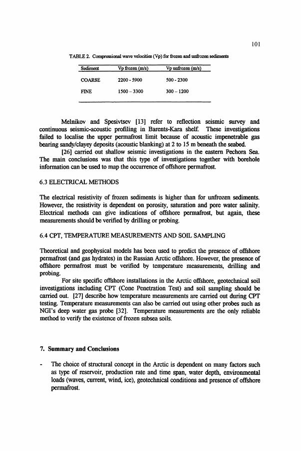
A summary of the range of velocities in different types of onshore sediments in frozen and unfrozen state, measured by numerous authors is shown Table 2.
The scatter in the data indicates that acoustic wave velocities can give indications of permafrost offshore, but verification requires direct observation by drilling or probing.
101
TABLE 2. Compressional wave velocities (Vp) for frozen and unfrozen sediments
Sediment Vp frozen (m/s) Vp unfrozen (m/s)
COARSE 2200- 5900 500 - 2300
FINE 1500-3300 300-1200
Melnikov and Spesivtsev [13] refer to reflection seismic survey and continuous seismic-acoustic profiling in Barents-Kara shelf. These investigations failed to localise the upper permafrost limit because of acoustic impenetrable gas bearing sandy/clayey deposits (acoustic blanking) at 2 to 15 m beneath the seabed.
[26] carried out shallow seismic investigations in the eastern Pechora Sea. The main conclusions was that this type of investigations together with borehole information can be used to map the occurrence of offshore permafrost.
6.3 ELECTRICAL METHODS
The electrical resistivity of frozen sediments is higher than for unfrozen sediments. However, the resistivity is dependent on porosity, saturation and pore water salinity. Electrical methods can give indications of offshore permafrost, but again, these measurements should be verified by drilling or probing.
6.4 CPT, TEMPERATURE MEASUREMENTS AND SOIL SAMPLING
Theoretical and geophysical models has been used to predict the presence of offshore permafrost (and gas hydrates) in the Russian Arctic offshore. However, the presence of offshore permafrost must be verified by temperature measurements, drilling and probing.
For site specific offshore installations in the Arctic offshore, geotechnical soil investigations including CPT (Cone Penetration Test) and soil sampling should be carried out. [27] describe how temperature measurements are carried out during CPT testing. Temperature measurements can also be carried out using other probes such as NGI's deep water gas probe [32]. Temperature measurements are the only reliable method to verify the existence of frozen subsea soils.
7. Summary and Conclusions
The choice of structural concept in the Arctic is dependent on many factors such as type of reservoir, production rate and time span, water depth, environmental loads (waves, current, wind, ice), geotechnical conditions and presence of offshore permafrost.

102
Offshore (submarine) permafrost exists in large areas of the Arctic ocean and can be classified based on genesis or ice content For engineering design. the icebonded submarine permafrost is the main interest and concern. In water depths exceeding 4-500 m in the Norwegian Sea and 100 m in the northern Barents Sea, the temperature is maintained below O°C by cold saline bottom seawater. Because of saline pore water, it is unlikely that the sediments contain ice inclusions. This conclusion has to be verified by in-situ testing. Submarine permafrost can affect offshore operations due to: i) Thaw settlements and overstraining of pipelines, ii) Differential settlements and failure of offshore foundations, iii) Freeze-back and subsidence of well bores, iv) Problems with dredging operations, v) Slide activity associated with thawing of submarine permafrost. Detection of submarine permafrost can be carried out by indirect methods such as: i) Seismic methods, ii) Electrical methods, iii) Cone penetration test (CPT). However, for detailed design of offshore facilities, the indirect methods must be accompanied by soil sampling and in-situ temperature measurements. Russian researchers and institutes have studied offshore permafrost for more than 60 years and represents vast knowledge and experience. Modem Arctic offshore geotechnical soil investigations have been and can be carried out by Russian companies.
8. Acknowledgements
The authors would like to acknowledge Den norske stats oljese/skap a.s. (Statoil) for partial funding of the study presented in this paper and Mr. Gisle HAland, Statoil, for valuable discussions during the course of the study.
9. References
1. Sanderson, T. J. O. (1988) Ice mechanics - risk to offshore structures. Graham and Trotman Ltd., London Great Britain.
2. Gerwick Jr; B. C. (1990) Recent development in structural concepts for Arctic ocean platforms. Proceedings of the International Conforence on Development and Commercial Utilization of Technologies in Polar Regions (polartech ' 90), Copenhagen, Denmark, pp. 428-441.
3. Wang, 1. L. And Peters, D. B. (1985) Overview of artificial island design and construction in the Arctic. Proceedings of the conference Arctic '85 - Civil Engineering in the Arctic Offshore.
4. Instanes. A (1993) An experimental study of the mechanical properties of spray ice. PhD thesis 1993:30, Department ofGeoteclmical Engineering, Norwegian Institute of Technology, Trondheim, Norway. 267 p.
5. OsterkampT. E. (1986) A review of subsea permafrost conditions along Alaska's coast. Proceedings of Workshop on Subsea Permafrost. Tech. Mem. No. 139, National Research Council of Canada, Ottawa.
6. Sellmann, P. V. And Hopkins, D. M. (1983) Subsea permafrost distribution on the Alaskan shelf. Proceedings of the Fourth International Conforence on permafrost, pp. 75-82, Fairbanks, Alaska.
7. Sackinger, W. M., Barnes. P. W. Harrison W. D. et aI. (1976) Problems and priorities in offShore permafrost research National Academy of Sciences, Washington D.C., USA
8. Baranov,I.Ya. (1977) Geocryological map of the USSR, scale 1:5,000,000. Moscow: GUGK, 4 p. 9. Grigoriev, N.F. (1966) permafrost of Yak uti an coastal zone. Moscow: Nauka, 180 p.

103
10. Grigoriev, N.F. (1987) Cryolithozone of littoral near western Yamal. permafrost Institute Press, Yakutsk, Russia. 112 p.
11. Soloviev, VA, Ginsburg. G. D., Telepnev, E. V. and Mikhailyuk, Yu.N. (1987) Cryogeothermal conditions and gas-hydrates within the interior of the Arctic Ocean. Leningrad, Russia. 150 p.
12. Fartyshev, AI. (1993) Features ofLaptev Sea oflShore pennafrost. Novosibirsk: Nauka, 136 p. 13. Melnikov, V.P. and Spesivtsev, V.I. (1995) Engineering-geological conditions of Barents-Kara shelf.
Novosibirsk: Nauka. Siberian Press RAS, 198 p. 14. Baulin, V.V. ed, (1996) Natural conditions of Baydaratskaya Guba. Preliminary results of studies for
submarine construction. Moscow: IPO "Ecosystem ", 234 p. IS. Love, V., Elverll0i, A, Antonsen, P., Solheim, A, Butenko, G., Gregersen, O. And Liestel, O. (1990)
Submarine pennafrost and gas hydrates in the northern Barents Sea. Norwegian Polar Research Institute. Report no. 56, Oslo, Norway.
16. Romanovskii, N.N. (1993) Principles of cryogenesis of lithosphere. Textbook. Moscow University Publisher.
17. Danilov,I.D. and Zhigarev, L A (1977) Frozen ground of Arctic shelf. Frozen ground and snow cover. Moscow: Nauka, p. 17-26.
18. Soloviev, VA (1983) OfIShore cryolithozone and stages of its evolution. Principle problems in palaeogeography of Late Cenozoic in Arctic. Leningrad: Nedra, p. 185-192.
19. Danilov, LD. (1996) Arctic Ocean as a separate cryogenic natural system. Proceedings of the First Conforence of Russian Geocryologists, 3-5 June 1996, Moscow State University. Vol. I, p. 193-203.
20. Zhigarev, LA (1981) Cryolithozone dynamics of East Siberian Sea and Chuckotsk Sea in Pleistocene and Holocene II Permafrost dynamics history of Eurasia. Moscow: Nauka, p. 181-191.
21. Hunter, J. A M. (1983) Geophysical techniques for subsea pennafrost investigations. Proceedings of the Fourth International Conforence on permafrost, pp. 88-89, Fairbanks, Alaska.
22. Gritsenko, I. and Bondarev, V. (1994) Subsea pennafrost, gas hydrates and gas pockets in cenozoic sediments of Barents, Pechora and Kara Seas, Proceedings of the 1.f'l' World Petroleum Congress, pp. 341-348.
23. Nixon, J. F. (1991) Thaw-subsidence effects on offshore pipelines. Journal of Cold Regions Engineering 5(1) pp. 28-39.
24. Gogyainov, N.N.(ed.) (1992) Usage of seismic-acoustic methods in hydrogeology and engineering geology. Moscow: Nedra, p. 135-146.
25. Gregersen, O. and Eidsmoen, T. (1998) Permafrost conditions in the shore area at Svalbard NGI Publication No. 174, Oslo, Norway.
26. Okko, O. T., Gritsenko, l. I. Bondarev, V. N., Rokos, S. I., Loktev, A S. and Kostin, D. A (1996) Shallow seismic investigations to study hazardous sub-bottom pennafrost and gas in eastern Pechora Sea. AMIGE publication, Murmansk.
27. Dlugach, A , Loktev, A , Okko, O. and Rokos, S. (1995) Soil mechanical properties and in-1!itu temperatures from Arctic offShore CPT -data. Proceedings of International Symposium on Cone Penetration testing, Linkeping. Sweden, Vol. 2, pp. 167-172.
28. Energy Day. (1997) Russian Tour de Force in the Arctic. Lloyd's list Energy Day, September II, 1997. 29. Williams, P. J. (1989) Pipelines and Permafrost - Science in a Cold Climate. Carleton University press,
Ottawa, Canada. 129 p. 30. Dubikov, G. I., Figarov, N. and Tsourikov, A (1994) Subsea pennafrost and gas pipeline construction oC
the Baydaratskaya Bay crossing in Siberia, Russia. Proceedings of the "I' International Cold Regions Engineering Speciality Conforence, Edmonton, Alberta, 7-9 March 1994, pp. 843-863.
31. Neizvestnov, Ya. V., Kurbatov, G. I. and Filipov, B. V. (1996) Geocryological problems of Cor design and construction of pipelines at the Arctic shelfr. Proceedings of the First Russian Geocryologist Meeting, ,3-5 June 1996, Moscow State University, Vol. 3, pp. 107-113.
32. Mokkelbost, K H. and Strandvik, S. O. (1998) Development of NGI's deep-water gas probe. Proceedings of the International Conference "Technology for deep-sea geological investigations: Development, application and results ", Society for Underwater Technology (SUT), London, Great Britain, November 1998. In press.
33. Spesivtsev, V. L (1987) Results of studies on the problem ofice-1!table platfonns within the shallow water zone of the Arctic seas. Floating and stationary technical means of marine oil-gas deposit development. Riga, p. 35-37.