permittee-responsible mitigation master plan for the ...files.dep.state.pa.us/programintegration/pa...
TRANSCRIPT

Permittee-Responsible Mitigation Master Plan
for the Atlantic Sunrise Project Susquehanna County, Pennsylvania
Transcontinental Gas Pipe Line Company, LLC.
Prepared By: First Pennsylvania Resource, LLC.
a wholly-owned subsidiary of Resource Environmental Solutions, LLC. 33 Terminal Way, Suite 431A
P ittsburgh, PA 15219
Revision 1 October 2016
Permittee-Responsible Mitigation Plan for the Atlantic Sunrise Project – Susquehanna County Transcontinental Gas Pipe Line Company, LLC.
Rev.1 October 2016 Page i
TABLE OF CONTENTS
1.0 Introduction ..................................................................................................................... 1 2.0 Objectives ......................................................................................................................... 1 3.0 Site Selection ................................................................................................................... 2 4.0 Site Protection Instrument(s) ................................................................................... 3 5.0 Baseline Data ................................................................................................................... 4 6.0 Determination of Mitigation Needs ......................................................................... 5 7.0 Mitigation Work Plan .................................................................................................... 9 8.0 Maintenance Plan .......................................................................................................... 9 9.0 Performance Standards ............................................................................................. 10 10.0 Monitoring Requirements ........................................................................................ 10 11.0 Long-Term Management Plan ................................................................................ 10 12.0 Adaptive Management Plan .................................................................................... 11 13.0 Financial Assurances .................................................................................................. 11 14.0 References ..................................................................................................................... 12

Permittee-Responsible Mitigation Plan for the Atlantic Sunrise Project – Susquehanna County Transcontinental Gas Pipe Line Company, LLC.
Rev.1 October 2016 Page ii
LIST OF APPENDICES Appendix A: Figures Figure 1: Project Location Map Figure 2: Mitigation Site/Impact Location Reference Map
Figure 3: Towanda Creek Mitigation Site Resource Development Map Appendix B: Impact Site Wetland Function-Value Evaluation Forms Appendix C: Towanda Creek Permittee-Responsible M itigation P lan

Permittee-Responsible Mitigation Plan for the Atlantic Sunrise Project – Susquehanna County Transcontinental Gas Pipe Line Company, LLC.
Rev.1 October 2016 Page 1
1.0 Introduction First Pennsylvania Resource, LLC. (FPR), a wholly-owned subsidiary of Resource Environmental Solutions (“RES”), has prepared this Permittee-Responsible Mitigation (PRM) Master Plan for the Atlantic Sunrise Project (Project) on behalf of Transcontinental Gas Pipe Line Company, LLC. (Permittee or Transco). The purpose of this plan is to compensate for unavoidable impacts to waters of the United States (U.S.) associated with Project activities in Susquehanna County, Pennsylvania (PA). This PRM Master Plan includes one site-specific PRM Plan as Appendix C: Towanda Creek PRM Plan, which provides additional detail for the Towanda Creek PRM Site (PRM Site or PRM Project) where mitigation will occur to offset the proposed wetland impacts within Susquehanna County. Appendix A, Figure 1: Project Location Map provides an overview of the proposed Project and associated PRM Site. The PRM site has obtained all necessary biological, cultural, and erosion and sediment control clearances and permits necessary for construction.
2.0 Objectives The objectives of the PRM Plan are to restore, enhance, and preserve wetland and riparian resources to replace the functions and values lost in association with unavoidable temporary (construction) and permanent (operational) impacts to exceptional value (EV) Palustrine Scrub Shrub (PSS) wetlands and EV and non-EV Palustrine Forested (PFO) wetlands associated with the Project in Susquehanna County. As described in this PRM Master Plan for Susquehanna County, and in the individual PRM Plan prepared for the PRM Site (Appendix C: Towanda Creek PRM Plan), the proposed mitigation approach employs a functional based, watershed scale approach to provide optimal replacement of PSS and PFO functions and values lost as a result of the Project. This PRM Master Plan for Susquehanna County also uses ratio based replacement requirements to ensure that the functional replacement being provided adaquately replaces the physical acreage of the functional areas being impacted in Susquehanna County. Additionaly, while the PRM Site will mitigate for impacts that occur across multiple counties as a result of the Project, this PRM Plan (Attachment C: Towanda Creek PRM Plan) addresses impacts that occur only in Susquehanna County.
Overarching Approach and Mitigation Site Developing multiple smaller mitigation projects along the entire length of the Project closer to the individual impact locations would result in a piecemeal mitigation approach and diminished overall functional uplift and watershed benefit, while also having a lower probability of long-term success for each individual PRM location. Therefore the proposed approach concentrates on a smaller number of sites strategically located in the headwaters and floodplains of watersheds that will benefit from the mitigation efforts while ensuring optimal replacement of functions and values lost as a result of the Project. Mitigation for Project impacts in Susquehanna County will occur within one PRM Site as shown in Table 1: Proposed PRM Site for the Atlantic Sunrise Project (Susquehanna County).
Table 1: Proposed PRM Site for the Atlantic Sunrise Project (Susquehanna County) PRM Site Watershed County PRM Plan Appendix
Towanda Creek 4 Bradford C
The PRM Site contains PFO, PSS, and PEM wetlands and an unnamed tributary (UNT) to Towanda Creek, designated as a trout-stocked and migratory fishery stream (TSF, MF) according to section 93.9: Designated Water Uses and Water Quality Criteria of the PA Code Chapter 93: Water

Permittee-Responsible Mitigation Plan for the Atlantic Sunrise Project – Susquehanna County Transcontinental Gas Pipe Line Company, LLC.
Rev.1 October 2016 Page 2
Quality Standards. Mitigation of these resources will optimize ecological uplift to replace the functions and values that will be lost as a result of the Project. The mitigation efforts proposed at the PRM Site listed above will replace the primary functions and values impacted at the impact site, which include wildlife habitat, flood flow alteration, nutrient removal and retention, and sediment/toxicant reduction. Additional information on the evaluated functions and values at the impact locations as well as the proposed mitigation site is provided in Section 6.0: Determination of Mitigation Needs.
3.0 Site Selection The General Compensatory Mitigation Requirements of the Compensatory Mitigation Final Rule [“Final Rule,” (33 CFR 332.3(b)(2))] establish mitigation credits as the preferred method of compensatory mitigation for impacts to aquatic resources of the U.S., followed by In-Lieu Fee credits (ILF), and finally on-site or off-site mitigation. Transco investigated each of these options through the site selection process, as described below.
Mitigation Banking Transco first sought to purchase approved mitigation credits from the Upper Susquehanna River Mitigation Bank – Phase I (USRMB I) within the Upper Susquehanna River Subbasin (State Water Plan Watershed 4) for impacts to PSS and PFO wetlands resulting from the Project. There are not enough available credits from USRMB I to compensate for the proposed impacts, and credits are needed to offset Project impacts in other Watersheds. There are no other available banks from which to purchase credits in other impact watersheds, and therefore mitigation banking is not a viable option.
In-Lieu Fee ILF crediting is not an option for this project because no active ILF programs are available.
On-Site Mitigation In order to minimize impacts to aquatic features and habitat areas, the Permittee has limited the width of the proposed construction limits of disturbance (LOD) and permanent easements to the greatest extent practicable. This narrowed easement does not allow room for on-site restoration, and not all homeowners are interested in providing larger easements which would provide space for on-site restoration. Lastly, even with larger easements which would allow for on-site restoration, not all of the sites have land suitable for restoration. Restoration could be done outside of an area with a permanent easement, however this would not be acceptable mitigation as there is no guarantee this area would be preserved into perpetuity. The avoidance measure of using a narrow LOD thereby narrows the potential area available for resource restoration. Even if possible, small on-site restorations would provide minimal benefit to the local watersheds relative to the impacts proposed within the LOD. Completing on-site mitigation would create multiple, small, spacially separate PRM projects. These smaller isloated projects have been shown to be less ecologically beneficial, have a lower likelihood for long-term success, are more succepitble to invasive species due to increased edge effect. They also create an increased number of maintenance plans to be reviewed, increasing the long-term regulatory burden on the state by requiring reviews and field visits to multiple small restoration sites.

Permittee-Responsible Mitigation Plan for the Atlantic Sunrise Project – Susquehanna County Transcontinental Gas Pipe Line Company, LLC.
Rev.1 October 2016 Page 3
The Permittee therefore has determined that the on-site mitigation opportunities are less conducive to complying with the “no net loss” and/or “watershed approach” policy(s) commensurate with the Final Rule.
Off-Site Permittee-Responsible Mitigation Due to the ecological demands of the PRM, Transco concludes that using a restoration approach which combines construction and operational impacts from multiple locations into a few larger restoration sites will provide the best ecological uplift, long-term sustainability, and functional replacement of the impacted wetland resources. In making that determination, Transco decided that entrusting the legal, logistical, and environmental aspects of compensatory mitigation to FPR will ensure the greatest chance of success for this Project and most effectively address watershed needs. The proposed PRM Site embodies many of the critical components of the Final Rule including the likelihood for success and sustainability, the significance of the restored water body within the watershed, and the proximity of the impact and mitigation sites from a watershed perspective. The likelihood of success was the most important factor that the Permittee considered while evaluating the following mitigation options. By selecting primarily exceptional value riparian and headwaters mitigation sites, the restoration approach will provide watershed-scale benefits and functional uplift well suited to replace functions and values lost as a result of the Project. FPR will act as the mitigation services agent (“Agent”) on behalf of Transco. FPR on behalf of Transco, will be responsible for implementation of the PRM plan in addition to meeting performance standards, monitoring, and long-term management of the property as described in 33 CFR §332.3(l). The Permittee will remain responsible for legal duties and responsibilities associated with wetland mitigation as necessary in accordance with PADEP Chapter 105 Rules and Regulations regarding wetland replacement criteria guidelines and 33 CFR § 332.
4.0 Site Protection Instrument(s) The PRM Site will be permanently protected by a declaration of restrictive covenant in advance of the proposed activities outlined in the mitigation plan, ensuring the long-term protection of the PRM Site. The site protection instrument will be recorded in the county courthouse within 60 days following the U.S. Army Corps of Engineers (USACE) and PA Department of Environmental Protection (PADEP) (“Agencies”) approvals. A copy of the site protection instrument to be filed upon permit approval is included in the PRM Plan (Appendix C: Towanda Creek PRM Plan). The site protection instrument restricts activities that are incompatible with the objectives of the PRM Plan. FPR will act as the initial long-term steward unless another qualified, watershed-focused, entity is willing to assume long-term stewardship responsibilities. FPR’s heirs, assigns, or purchasers will be responsible for protecting lands contained within the PRM Site in perpetuity in accordance with the terms of the PRM Plan, unless the lands are transferred or sold to a local, state, or federal resource agency or non-profit conservation organization. Should a trustworthy, willing third-party conservation easement holder wish to protect the PRM Site in perpetuity, they will have the option to switch the declaration of restrictive covenant to a conservation easement. Entrusting the PRM Site to a third-party conservation easement holder may commence only when FPR, the Permittee, and the Agencies have mutually concluded that the PRM Site has achieved all of its objectives and sufficiently satisfied performance standards.

Permittee-Responsible Mitigation Plan for the Atlantic Sunrise Project – Susquehanna County Transcontinental Gas Pipe Line Company, LLC.
Rev.1 October 2016 Page 4
5.0 Baseline Data Baseline site investigations were conducted to develop an appropriate mitigation plan for the PRM Site. These baseline site investigations yielded a significant amount of existing condition project information including, but not limited to:
• Waters of the U.S. delineation and Global Positioning System (GPS) location of the boundary;
• USACE Jurisdictional Determination of wetland boundaries and nexuses; • Surface soil borings; • Flora community composition data; • Informal terrestrial and aquatic fauna community composition data; • Topographic survey (up to 6-inch accuracy) throughout the proposed conservation
area; • Land steward interviews relative to historical and present site conditions including
land use practices; • Extensive photo and field note documentation; • Cultural Resources Geographic Informaion System (CRGIS) searches, • Pennsylvania Natural Diversity Inventory (PNDI) searches, • General documentation of site conditions including constraints, access, potential
staging areas, and a resulting plan for probable construction sequencing. Specific baseline data collected for the PRM Site is provided in Section 5.0: Baseline Data of the PRM Plan (Appendix C: Towanda Creek PRM Plan). The following table, Table 2: Summary of Existing PRM Site Resources provides a summary of existing resources at the PRM Site. The PRM Plan contains further detail regarding the existing PRM Site resources based upon the wetland delineations and other environmental surveys.
Table 2: Summary of Existing PRM Site Resources
Resource Type PRM Site Pre-Mitigation Resources
Total Acres 36.93 Uplands 22.28
Wetlands1
(Acres)
PEM 2.22 PSS 4.38 PFO 8.05
TOTAL 14.65
Streams (Linear Feet)
Perennial - Intermittent 66.77 Ephemeral -
TOTAL 66.77
Notes: 1. PEM – Palustrine Emergent; PSS – Palustrine Scrub Shrub; PFO – Palustrine Forested

Permittee-Responsible Mitigation Plan for the Atlantic Sunrise Project – Susquehanna County Transcontinental Gas Pipe Line Company, LLC.
Rev.1 October 2016 Page 5
The following table, Table 3: Summary of PRM Site Clearances and Approvals provides a summary of clearances and approvals received for the PRM Site. Further detail regarding the status and history of these clearances, including copies of individual approvals, is provided within the PRM Plan (Appendix C: Towanda Creek PRM Plan).
Table 3: Summary of PRM Site Clearances and Approvals
PRM Site Approval Type Approval Status
Towanda Creek
USACE Section 404/401 WQC Under Review PHMC Clearance received 5/8/15 Rare, Threatened, and Endangered Species PNDI clearance received 5/11/15
E&S Control (PADEP Chapter 102) Clearance received 7/15/15
6.0 Determination of Mitigation Needs Project Impacts The Project will result in 0.44-acre of impact to EV PSS and EV and non-EV PFO wetlands in Susquehanna County (excluding temporary impacts to PSS wetlands). Of the 0.44 wetland impact acre, 0.02 is EV PSS, 0.14 is non-EV PFO, and 0.28 is EV PFO impact. No non-EV PSS impacts are anticipated in Susquehanna County. The PADEP defines EV wetlands under PA Code Title 25 § 105.17, and has requested separate mitigation ratios for EV and non-EV PSS and PFO wetlands. Project impacts in Susquehanna County are proposed within PA State Water Plan Watershed 4 (Upper Susquehanna-Tunkhannock). Appendix A, Figure 2: Mitigation Site/Impact Reference Location Map depicts the locations of the proposed mitigation in relation to the Project. No permanent fill of any wetland resources will occur as a result of the Project. All long-term impacts are expected to be a result of conversion from PFO to PEM or PSS wetlands. The temporary (construction) impacts will occur in the areas where construction will take place and existing wetlands will be allowed to revert to their previous state following construction in these areas. The permanent (operational) impacts will occur within the maintained ROW, where annual operational maintenance is required by Federal Energy Regulatory Commission (FERC) Wetland and Waterbody Construction and Mitigation Procedures. These permanent impacts will not involve dredging or filling of wetlands, but will involve annual mowing of PSS wetlands. All temporary PFO impacts resulting from the Project in Susquehanna County are proposed to be mitigated for at the PRM Site. Some of the temporary and permanent PFO impact areas are also being replanted on-site, providing double mitigation for these areas. The PFO construction impacts which are not being replanted in the field, will be seeded following construction, under the site restoration requirements of the Erosion and Sediment Control Plan. Replanting of woody vegetation or wetland replacement species in the construction right-of-ways (ROWs) is not proposed because these areas are not protected under any easement and could be impacted by future landowner activities. Accounting for these areas at the PRM Site will provide greater functional replacement, and ensure the long-term success of mitigation for these temporary impacts. The follow ing wetland mitigation ratios apply to the PRM Site: 2.5:1 for EV PFO wetlands, 2:1 for non-EV PFO wetlands, 1.75:1 for EV PSS wetlands, and 1.5:1 for non-EV PSS wetlands. No non-EV PSS wetlands are anticipated to be impacted in

Permittee-Responsible Mitigation Plan for the Atlantic Sunrise Project – Susquehanna County Transcontinental Gas Pipe Line Company, LLC.
Rev.1 October 2016 Page 6
Susquehanna County. Impact ratios were discussed with both the PADEP and USACE during multiple meetings prior to and during permit submittal, and are based on previous ratios used for similar projects. Impact locations and proposed mitigation site locations are depicted by watershed in Appendix A, Figure 2: Mitigation Site/Impact Location Reference Map. As discussed in Section 2.0: Objectives, the PRM Site will provide a total of 4.67 acres of mitigation which will be used to offset Project impacts across two counties. Of the 4.67 mitigation acres provided by the PRM Site, 1.02 acre is required for impacts occurring in Susquehanna County. Table 4: Summary of Impacts In Susquehanna County and Required Mitigation provides a summary of mitigation needs and physical impacts. Total mitigation needed has been adjusted to account for 0.01-acre of proposed permanent impact to PEM Wetland W-2 within the Saddle Swamp easement area as a result of proposed upgrades/improvements to a permanent agricultural crossing at the PRM Site.
Table 4: Summary of Impacts in Susquehanna County and Required Mitigation
Wetland Type Wetland Impacts (Acres)
Proposed Mitigation
Ratio (X:1)
Total Mitigation
Needed
Total Mitigation Available (Acres)
EV PFO 0.28 2.5 0.70
4.67 Non-EV PFO 0.14 2.0 0.28
EV PSS 0.02 1.75 0.04 Non-EV PSS 0.00 1.5 0.00
Total 0.44 - 1.02* *Note – Wetland impacts include 0.01 acre of proposed permanent impact to PEM Wetland W-2 within the Saddle Swamp easement area as a result of proposed upgrades/improvements to a permanent agricultural crossing at the PRM Site. This impact was subtracted from the mitigation total, as shown in Table 6: Wetland Mitigation Summary.
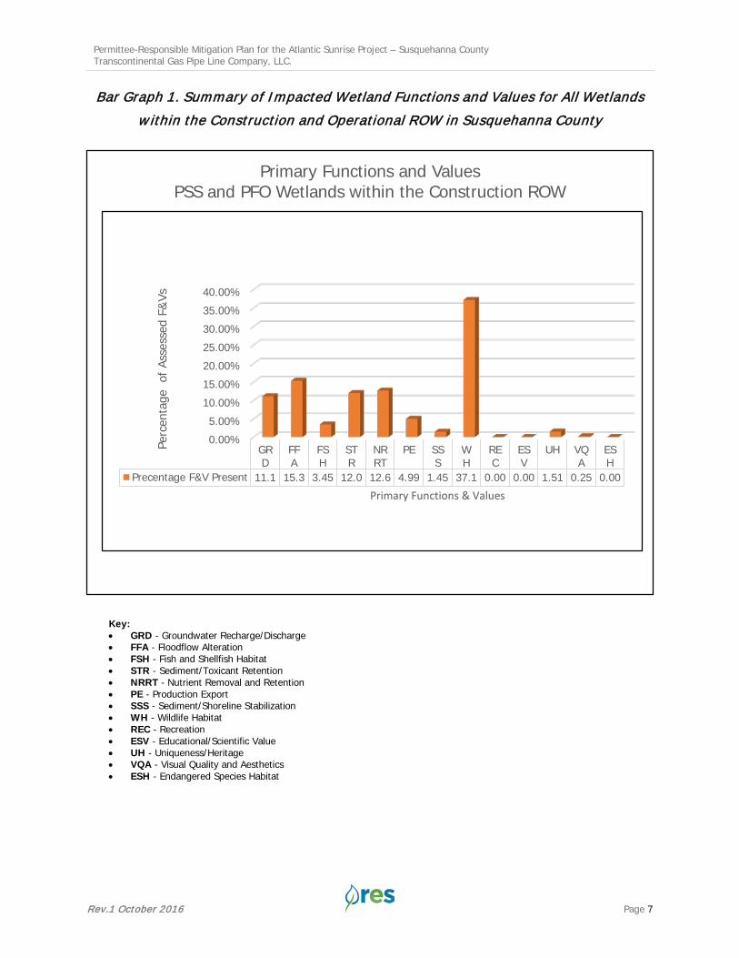
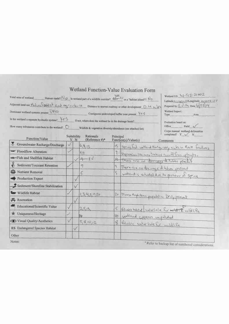
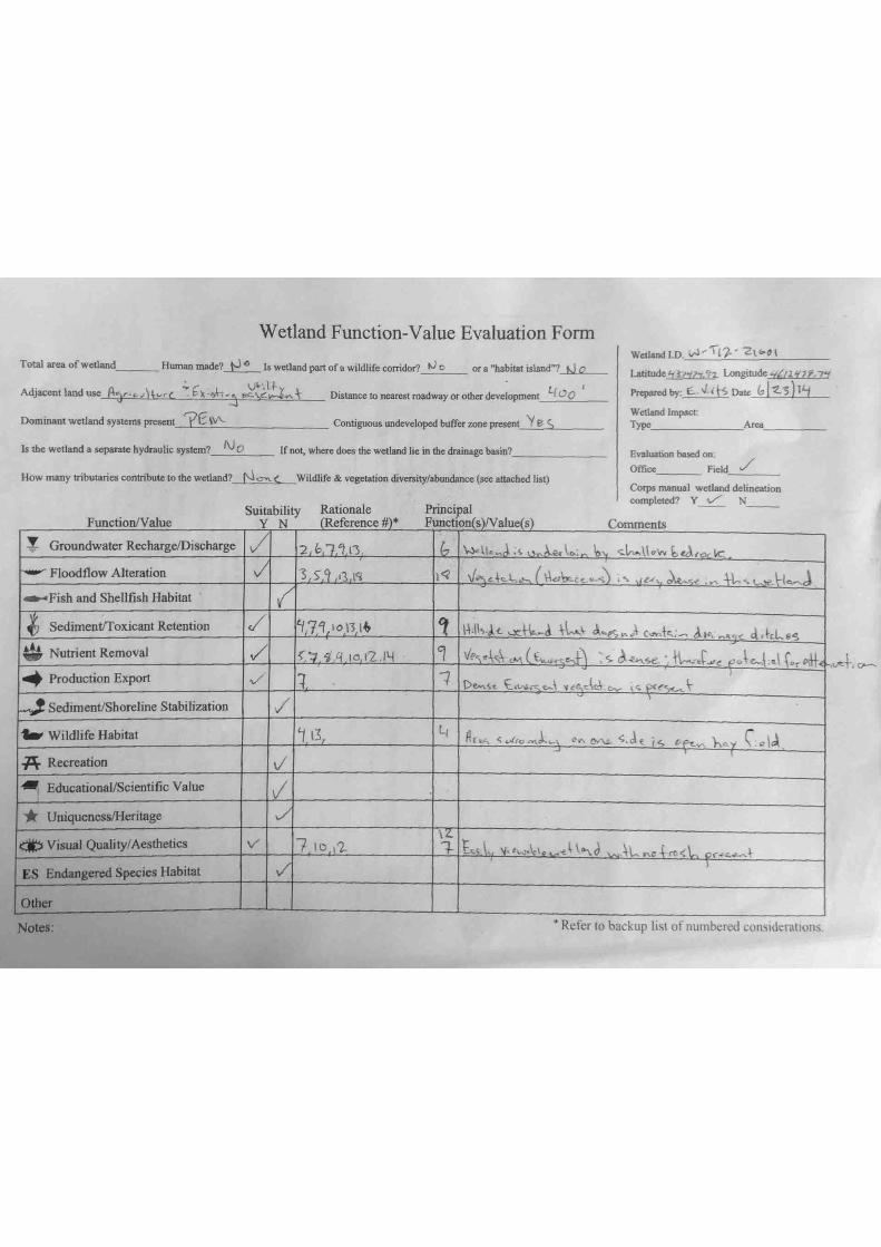
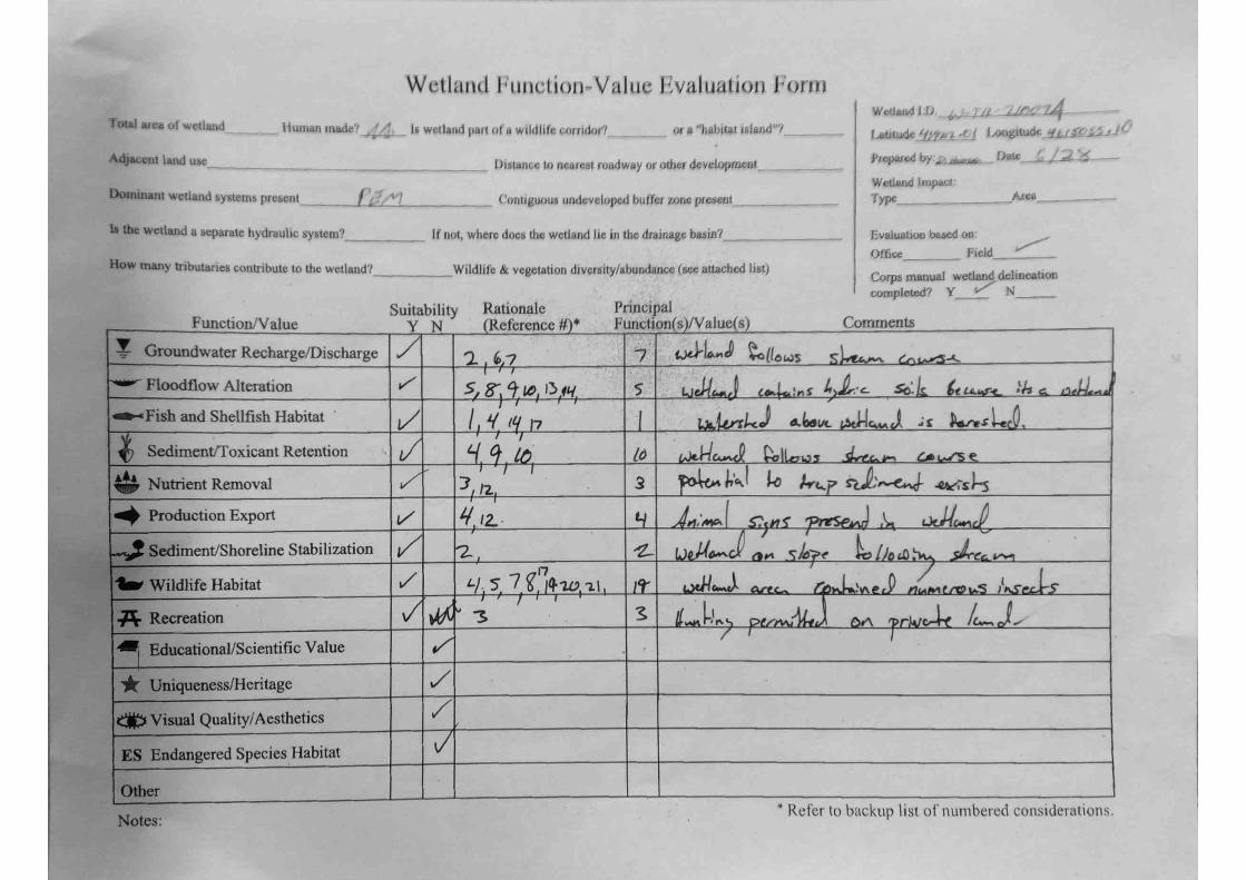
Functional Impacts The USACE Highway Methodology Workbook Supplement: Wetland Functions and Values (Supplement, 1993) was used to evaluate the functions and values of the wetlands at the impact site and the PRM Site. The Supplement is a qualitative approach to describing the physical characteristics of and identifying the functions and values exhibited by a wetland. The approach to applying functions and values to the impacted wetlands and the mitigation wetlands was agreed upon between the PADEP, USACE, and Transco during a pre-application meeting on March 17, 2015. A bar graph showing the primary functional impacts associated with the Project is provided below.
Permittee-Responsible Mitigation Plan for the Atlantic Sunrise Project – Susquehanna County Transcontinental Gas Pipe Line Company, LLC.
Rev.1 October 2016 Page 7
Bar Graph 1. Summary of Impacted Wetland Functions and Values for All Wetlands w ithin the Construction and Operational ROW in Susquehanna County
Key: • GRD - Groundwater Recharge/Discharge • FFA - Floodflow Alteration • FSH - Fish and Shellfish Habitat • STR - Sediment/Toxicant Retention • NRRT - Nutrient Removal and Retention • PE - Production Export • SSS - Sediment/Shoreline Stabilization • WH - Wildlife Habitat • REC - Recreation • ESV - Educational/Scientific Value • UH - Uniqueness/Heritage • VQA - Visual Quality and Aesthetics • ESH - Endangered Species Habitat
0.00%5.00%
10.00%15.00%20.00%25.00%30.00%35.00%40.00%
GRD
FFA
FSH
STR
NRRT
PE SSS
WH
REC
ESV
UH VQA
ESH
Precentage F&V Present 11.1 15.3 3.45 12.0 12.6 4.99 1.45 37.1 0.00 0.00 1.51 0.25 0.00
Perc
enta
ge o
f Ass
esse
d F&
Vs
Primary Functions & Values
Primary Functions and ValuesPSS and PFO Wetlands within the Construction ROW

Permittee-Responsible Mitigation Plan for the Atlantic Sunrise Project – Susquehanna County Transcontinental Gas Pipe Line Company, LLC.
Rev.1 October 2016 Page 8
Based on an assessment of any potential impacts to the functions and values of PEM wetlands in association with construction and operation of the Project, it was deemed no mitigation will be required. Impacts to PEM wetlands will be temporary, and all areas will be returned to grade, and reseeded following construction. Permanent conversion impacts to PSS wetlands are anticipated in the operation footprints as a result of the Project, and mitigation w ill be provided at the PRM Site to offset these impacts. Construction (temporary) impacts to PSS wetlands will be temporary; these areas outside of the 10-foot w ide operational ROW will be seeded with a native seed mix, and will naturally revert to PSS. The 10 foot-wide operational ROW will be maintained in PSS wetlands no more frequently than on an annual basis and in accordance with FERC Wetland and Waterbody Construction and Mitigation Procedures and the Transco plan.
Proposed Functional Uplift The Wetland Function-Value Evaluation Form from the Supplement was used to document the existing functions and values that will be impacted as part of the Project. It was also used to determine the baseline and anticipated ecological lift the PRM Site will experience as a result of the proposed mitigation. The baseline field forms are included within the PRM Plan (Appendix C: Towanda Creek PRM Plan). These improvements to the wetland functions and values after restoration combined with the additional upland acreage restored as part of the PRM Site will more than offset the overall functions and values lost as a result of the Project. Table 5: Summary of Functional Uplift summarizes proposed functional uplift for the PRM Site.
Proposed Mitigation Acreage The mitigation ratios used to allocate mitigation acreage for each restoration activity at the PRM Site are based on previously used mitigation ratios. The mitigation ratios, in combination with the previously discussed impact ratios ensure that the functions and values being replaced at the
Table 5: Summary of Functional Uplift
Site Location Functions and Values Pre-Project Principal Function
Post-Project Principal Function
Project Impact Locations
Flood Flow Alteration Yes No Nutrient Removal Yes No Wildlife Habitat Yes No
Towanda Creek – Chippewa Swamp
Flood flow alteration Yes Yes Nutrient Removal No Yes Sediment/Toxicant Retention No Yes Wildlife Habitat Yes Yes Groundwater Recharge/Discharge No Yes
Towanda Creek – Saddle Swamp
Flood flow alteration No Yes Nutrient Removal No Yes
Sediment/Toxicant Retention Yes Yes Wildlife Habitat No Yes Groundwater Recharge/Discharge Yes Yes

Permittee-Responsible Mitigation Plan for the Atlantic Sunrise Project – Susquehanna County Transcontinental Gas Pipe Line Company, LLC.
Rev.1 October 2016 Page 9
mitigation sites provide an adaquate physical replacement of those functions and values impacted as a result of the Project, while also taking into account temporal losses. The proposed mitigation for the Project will include wetland enhancement and upland restoration in the amounts indicated in Table 6: Wetland Mitigation Summary, which includes the mitigation approach, wetland resources, applicable mitigation ratios and mitigation acreages provided by the PRM site. Appendix A, Figure 3 presents the resource development map for the proposed restoration activities at the PRM Site as summarized below.
Table 6: Wetland Mitigation Summary
PRM Site Mitigation Approach Wetland Type
Site Acreage
Mitigation Ratio (X:1)
Mitigation Acreage
Towanda Creek
Re-establishment - 1.38 1:1 1.371 Enhancement PEM/PSS 6.60 2:1 3.30 Preservation PFO 8.052 - -
Totals - 16.03 - 4.67 Notes: 1 – The Mitigation Acreage Total accounts for 0.01 acre of proposed permanent impact to PEM Wetland W-2 w ithin the Saddle Swamp easement area as a result of proposed upgrades/ improvements to a permanent agricultural crossing at the PRM Site. This proposed impact has been deducted from the Mitigation Acreage Total. 2 - The PRM Project w ill preserve 8.05 acres of PFO wetlands w ithin the Chippewa easement. While the USACE recognizes preservation as mitigation at a ratio of 6.66:1, the PADEP does not and therefore PFO preservation was not included in the final mitigation acreage total.
In addition to providing sufficient acreage to compensate for impacts to PSS and PFO resources as a result of the Project, mitigation at the PRM Site will additionally include upland restoration and preservation, providing additional ecological benefits beyond the required mitigation. Construction of the Project will not result in any permanent impacts to streams or other waterbodies. As such, none of the proposed stream enhancement work is being used for mitigation on this Project.
7.0 Mitigation Work Plan The Mitigation Work Plan is included within the Mitigation Work Plan section of the PRM Plan (Appendix C: Towanda PRM Plan). This work plan discusses how the specific physical characteristics of the site (e.g. topography, hydrology, soils, past land use) factor into the mitigation design, and the proposed actions that will be undertaken to attain ecolological uplift.
8.0 Maintenance Plan The PRM Site will be monitored and maintained by FPR, as described in the Monitoring Requirements section of the PRM Plan. FPR will act as the willing agent to perform all duties associated with satisfying compensatory mitigation requirements. Through contractual agreement with the Permittee, FPR will commit to restoring, enhancing, and preserving wetland functions and maintaining wetland habitats in accordance with the provisions in the PRM Plan. Yearly maintenance will be documented in the annual monitoring report along with a discussion of any anticipated maintenance events that will be needed the following year. In general, two to three site visits will be conducted annually during the first 3 years to monitor the sites for invasive species and adapt the yearly maintenance plans as needed based upon these observations.

Permittee-Responsible Mitigation Plan for the Atlantic Sunrise Project – Susquehanna County Transcontinental Gas Pipe Line Company, LLC.
Rev.1 October 2016 Page 10
In general, maintenance will be heaviest during the first 3 years of establishment, and will usually entail mechanical weed control events, along with two to three chemical control events, all targeting invasive species. Maintenance will focus on controlling any pockets of invasive species that might still be present on-site and monitoring for the establishment of any new stands of invasive species. Control methods will be targeted to deal with the individual species as they are found and will include both mechanical and chemical control. The Agent projects that by the 4th and 5th years, the intensity of management efforts required will drop off significantly as the native plant community will be relatively well established and resilient against the establishment and encroachment of invasive species.
9.0 Performance Standards The Permittee will monitor the PRM Site to demonstrate compliance with the Performance Standards detailed in Section 9.0: Performance Standards within the PRM Plan.
10.0 Monitoring Requirements In accordance with the provisions detailed in Section 10.0: Monitoring Requirements of the PRM Plan (Appendix C: Towanda Creek PRM Plan), an as-built report will be submitted to the PADEP and USACE within 60 days following completion of all work outlined in the PRM Plan. The Permittee will monitor the PRM Site for 5 years to demonstrate compliance with the Performance Standards. A 5 year baseline monitoring time period is appropriate because the mitigation provided by the PRM Site will not be used to offset permanent fill impacts, and the majority of the restoration is enhancement of existing wetlands. FPR will submit a monitoring report to the PADEP and USACE by December 31st of the year monitoring occurs. The monitoring report will include data sufficient for comparison to the Performance Standards described in Section 9.0: Performance Standards of the Towanda Creek PRM Plan (Appendix C). FPR will also include a discussion of all activities that took place at the PRM Site. At a minimum, the monitoring report will include the monitoring program components detailed in Section 10.0: Monitoring Plan of the Towanda Creek PRM Plan (Appendix C).
11.0 Long-Term Management Plan The following long-term management plan will apply to the PRM Site. Site-specific details are provided within the long-term management plan included in the PRM Plan. To ensure the long-term sustainability of the restoration project, FPR will initially perform maintenance and long-term management. The Permittee anticipates that these activities will be minimal as the project is designed to be self-sustaining with limited management activities. After performance standards have been successfully attained, annual visual inspections will be conducted after each growing season to identify any need for invasive species control, additional signage, or boundary maintenance. The USACE and PADEP will be notified if any remedial action is necessary to ensure compliance with the original performance standards detailed in the PRM Plan. Specific items required as part of a Long-Term Management Plan are listed below.
Annual Patrols Walk-through surveys will be conducted annually to qualitatively monitor the general condition of the habitats on the site. Notes to be made may include observations of species encountered, water quality, general extent of wetlands and streams, and any occurrences of erosion, structure failure, or invasive or non-native species establishment. If there are any noted items that require maintenance, this should be recorded and submitted in a report to the Agencies.
Permittee-Responsible Mitigation Plan for the Atlantic Sunrise Project – Susquehanna County Transcontinental Gas Pipe Line Company, LLC.
Rev.1 October 2016 Page 11
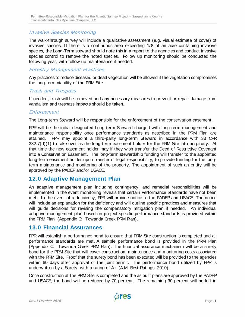
Invasive Species Monitoring The walk-through survey will include a qualitative assessment (e.g. visual estimate of cover) of invasive species. If there is a continuous area exceeding 1/8 of an acre containing invasive species, the Long-Term steward should note this in a report to the agencies and conduct invasive species control to remove the noted species. Follow up monitoring should be conducted the following year, with follow up maintenance if needed.
Forestry Management Practices Any practices to reduce diseased or dead vegetation will be allowed if the vegetation compromises the long-term viability of the PRM Site.
Trash and Trespass If needed, trash will be removed and any necessary measures to prevent or repair damage from vandalism and trespass impacts should be taken.
Enforcement The Long-term Steward will be responsible for the enforcement of the conservation easement. FPR will be the initial designated Long-term Steward charged with long-term management and maintenance responsibility once performance standards as described in the PRM Plan are attained. FPR may appoint a third-party long-term Steward in accordance with 33 CFR 332.7(d)(1) to take over as the long-term easement holder for the PRM Site into perpituity. At that time the new easement holder may if they wish transfer the Deed of Restrictive Covenant into a Conservation Easement. The long-term stewardship funding will transfer to the appointed long-term easement holder upon transfer of legal responsibility, to provide funding for the long-term maintenance and monitoring of the property. The appointment of such an entity will be approved by the PADEP and/or USACE.
12.0 Adaptive Management Plan An adaptive management plan including contingency, and remedial responsibilities will be implemented in the event monitoring reveals that certain Performance Standards have not been met. In the event of a deficiency, FPR will provide notice to the PADEP and USACE. The notice will include an explanation for the deficiency and will outline specific practices and measures that will guide decisions for revising the compensatory mitigation plan if needed. An individual adaptive management plan based on project-specific performance standards is provided within the PRM Plan (Appendix C: Towanda Creek PRM Plan).
13.0 Financial Assurances FPR will establish a performance bond to ensure that PRM Site construction is completed and all performance standards are met. A sample performance bond is provided in the PRM Plan (Appendix C: Towanda Creek PRM Plan). The financial assurance mechanism will be a surety bond for the PRM Site that will cover construction, maintenance and monitoring costs associated with the PRM Site. Proof that the surety bond has been executed will be provided to the agencies within 60 days after approval of the joint permit. The performance bond utilized by FPR is underwritten by a Surety with a rating of A+ (A.M. Best Ratings, 2010). Once construction at the PRM Site is completed and the as built plans are approved by the PADEP and USACE, the bond will be reduced by 70 percent. The remaining 30 percent will be left in

Permittee-Responsible Mitigation Plan for the Atlantic Sunrise Project – Susquehanna County Transcontinental Gas Pipe Line Company, LLC.
Rev.1 October 2016 Page 12
place for the life of the PRM Site to cover maintenance and monitoring costs. The bond will be closed once all performance standards are met, and final sign-off on the PRM Site has been provided by the USACE and PADEP.
Long-term Stewardship Funding Prior to construction of the Project, the Permitee will deposit funds into an escrow account to cover long-term stewardship of the PRM Site. These funds are anticipated to be sufficient to cover the full cost of long-term stewardship activities for the entire PRM Site. The total sum for the PRM Site escrow amount includes all expenses for long-term management and allocates funds for invasive species management contingency funds, and is provided in the PRM Plan.
14.0 References Environmental Laboratory. 1987. Corps of Engineers Wetlands Delineation Manual. U.S. Army
Engineer Waterways Experiment Station, Vicksburg, Miss. Technical Report Y-87-1. 207 p.
Federal Register (2008) Compensatory Mitigation for Losses of Aquatic Resources; Final Rule. 33 CFR Parts 325 and 332. (Volume 73, Number 70). Rules and Regulations. Accessed 8/20/13. http://water.epa.gov/lawsregs/guidance/wetlands/upload/2008_04_10_wetlands_ wetlands_mitigation_final_rule_4_10_08.pdf
United States Department of Agriculture Natural Resources Conservation Service. The PLANTS Database. National Plant Data Center. Accessed 8/20/14. http://plants.usda.gov.
U.S. Army Corps of Engineers. 2011. Regional Supplement to the Corps of Engineers Wetland Delineation Manual: Northcentral and Northeast Region (Version 2.0), ed. J.S. Wakeley, R.W. Lichvar, C. V. Noble, and J.F. Berkowitz. ERDC/EL TR-12-1. Vicksburg, MS: U.S. Army Engineer Research and Development Center.
United States Army Corps of Engineers, New England District. 1993. Highway Methodology Workbook Supplement: Wetland Functions and Values – A DescriptiveApproach. http://www.nae.usace.army.mil/Portals/74/docs/regulatory/Forms/HighwaySupplement. pdf.

Permittee-Responsible Mitigation Plan for the Atlantic Sunrise Project – Susquehanna County
Williams Field Services, LLC.
Rev.1 October 2016
APPENDIX A
Figures

_̂
_̂
_̂
_̂
_̂
Sources: Esri, HERE, DeLorme, Intermap, increment P Corp., GEBCO, USGS,FAO, NPS, NRCAN, GeoBase, IGN, Kadaster NL, Ordnance Survey, Esri Japan,METI, Esri China (Hong Kong), swisstopo, MapmyIndia, © OpenStreetMapcontributors, and the GIS User Community
0 2010
Miles
FIGURE 1ATLANTIC SUNRISE PROJECT
PROJECT LOCATION MAPPENNSYLVANIA
©
Topographic imagery from US Geological Survey.Horizontal Datum is NAD 83 PA North.
Study limits are approximate.
Legend
Restoration Site Name
_̂ Briar Creek
_̂ Headwaters of Larrys Creek
_̂ Hibred Farms
_̂ Swatara Creek
_̂ Towanda Creek
Proposed Pipeline Location

_̂
_̂
_̂
_̂
_̂
Hibred Farms
Headwatersof Larrys
Creek
Towanda Creek
Briar Creek
Swatara Creek
CARBONCENTRE
CHESTER
CLINTON
COLUMBIA
CUMBERLAND
DAUPHIN
JUNIATA
LACKAWANNA
LANCASTER
WYOMING
YORK
LEBANON
LEHIGH
LUZERNE
LYCOMING
FRANKLIN
HUNTINGDON
ADAMS
BERKS
BRADFORDSUSQUEHANNA
TIOGA
UNION
MIFFLIN
MONROE
MONTGOMERY
MONTOUR
NORTHUMBERLAND
PERRY
POTTER
SCHUYLKILLSNYDER
SULLIVAN
2
9
6
3
12
7
10
13
13
5
11
4
4
8
0 2010
Miles
FIGURE 2ATLANTIC SUNRISE PROJECT
MITIGATION SITE/IMPACT LOCATIONREFERENCE MAPPENNSYLVANIA
©
Legend
Restoration Site
_̂Briar Creek
_̂Headwaters of Larrys Creek
_̂Hibred Farms
_̂Swatara Creek
_̂Towanda Creek
Pipeline Impact AllocationBriar CreekHWLCHibred FarmsSwatara CreekTowanda CreekCounty Boundaries
PA Subbasin Boundaries2 - Central Delaware River Subbasin9 - Central West Branch Susquehanna River Subbasin6 - Lower Central Susquehanna River Subbasin3 - Lower Delaware River Subbasin12 - Lower Juniata River Subbasin7 - Lower Susquehanna River Subbasin10 - Lower West Branch Susquehanna River Subbasin13 - Potomac River Subbasin5 - Upper Central Susquehanna River Subbasin11 - Upper Juniata River Subbasin4 - Upper Susquehanna River Subbasin8 - Upper West Branch Susquehanna River Subbasin

FIGURE 3ATLANTIC SUNRISE PROJECT
TOWANDA CREEK MITIGATION SITE RESOURCE DEVELOPMENT MAP
BRADFORD COUNTY, PENNSYLVANIA
0 320160
Feet
©
Service Layer Credits: Source: Esri, DigitalGlobe, GeoEye, EarthstarGeographics, CNES/Airbus DS, USDA, USGS, AEX, Getmapping,Aerogrid, IGN, IGP, swisstopo, and the GIS User Community
Legend
Towanda Easements (36.93 AC)Stream Enhancement (66.77 LF)Agricultural Crossing
Wetlands by Restoration Type (16.03 AC)Preservation (8.05 AC) Enhancement (6.60 AC) Re-Establishment (1.38 AC)

Permittee-Responsible Mitigation Plan for the Atlantic Sunrise Project – Susquehanna County
Williams Field Services, LLC.
Rev.1 October 2016
APPENDIX B
Impact Site Wetland Function-Value Evaluation Forms


Permittee-Responsible Mitigation Plan for the Atlantic Sunrise Project – Susquehanna County
Williams Field Services, LLC.
Rev.1 October 2016
APPENDIX C
Towanda Creek Permittee-Responsible Mitigation Plan