permitting and leasing for maine offshore wind
TRANSCRIPT


pg. 1
PERMITTING AND LEASING FOR MAINE OFFSHORE WIND
ENERGY PROJECTS
Offshore Wind Energy Project Roadmap 2013
Prepared by
Jeff Thaler, Esq., University of Maine
On behalf of
Maine Composites Alliance (MCA)
Maine Wind Industry Initiative (MWII)
Environmental and Energy Technology Council of Maine (E2Tech)
January 2013
pg. 2
Project Background
Maine possesses considerable natural wind and ocean energy resources and has assets in its current business base – precision and composites manufacturing, engineering, construction, marine services and trades, applied research and development, and transportation and logistics – to play a significant role in the onshore, offshore and ocean energy supply chains necessary to develop these resources.
The Maine Composites Alliance (MCA), Maine Wind Industry Initiative (MWII) and Environmental and Energy Technology Council of Maine (E2Tech) are collaborating to help organize, promote and expand Maine’s ocean and wind energy cluster through a) strengthening the industry’s supply chain in Maine, b), fostering collaboration between Maine businesses and global partners, and c) recruiting major suppliers and/or manufacturers to Maine.
Jeff Thaler, an energy and environmental attorney presently serving as Visiting Professor of Energy Law and Policy at the University of Maine Schools of Law and Economics, used his years of experience working with the DeepCWind Consortium and on other energy projects to create roadmaps for potential developers and interested parties on federal, state and local laws and regulations applicable for Maine Marine Hydrokinetic Projects (MHK) and for offshore wind energy projects. Each roadmap serves as an instructional outline for permitting and licensing in the Gulf of Maine for developers and is intended to help interest and guide potential wind and ocean energy developers to the Gulf of Maine. Mr. Thaler served as the primary author and Maine Law student Andrew Wells assisted with the research and editing.
MCA is an alliance of composite businesses in Maine who work together to recognize and promote Maine’s leadership in the international composite industry. They enhance the competitiveness of Maine’s existing composite industry and their members by providing opportunities for new commercial ventures, and by providing education and training for members and their employees. MCA serves marine, automotive, aerospace, architecture and industrial industries throughout Maine, the United States and the world. http://www.mainecompositesalliance.org. MWII is a collaborative created to organize Maine wind industry interests, act as a knowledge transfer network linking opportunities to Maine companies, relate industry needs to the state and federal government and act as a communication hub, representing Maine-based industrial partners in the wind energy industry. www.mainewindindustry.com.
E2Tech seeks to build and expand the State’s environmental, energy and clean technology sectors. In addition to providing networking and educational events, E2Tech promotes business development and sustainable job growth, research and development, new product commercialization, cluster initiatives and supply chain development. www.e2tech.org.

pg. 3
Permitting and Leasing Roadmap for Offshore Maine Wind Energy Projects
December 2012—by Jeff Thaler1
I. WIND ENERGY PROJECTS IN STATE WATERS
A. Within One of Maine’s Test Sites
1. Maine Statutes and Programs
In order to facilitate the development of alternative ocean energy in Maine, the Governor’s Ocean Energy Task Force recommended and drafted L.D. 1465 (.pdf), which was passed unanimously by the Maine State Legislature in June 2009.
The legislation directed the Maine Department of Conservation, in consultation with the Maine State Planning Office, to select up to five locations within Maine state waters to be designated as "Ocean Energy Testing Areas."
Through comprehensive review of available map information and numerous meetings with the public and interest groups, three sites were designated by MDOC on Dec. 15, 2009—off of Monhegan Island, Boon Island, and Damariscove Island. More information on the test sites can be found at the Maine ocean energy website, http://www.maine.gov/doc/initiatives/oceanenergy/oceanenergy.shtml.
As part of Maine’s efforts to expedite regulatory review of demonstration wind or wave projects proposed to be developed within a test site, a special general permit program was established to be administered by the Department of Environmental Protection.
Maine DEP’s General Permit
A general permit can be acquired for an “Offshore wind energy demonstration project", which is
defined as follows:
H. "Offshore wind energy demonstration project" or "project" means a wind energy
development that uses a wind turbine to convert wind energy to electrical energy and that
employs no more than 2 wind energy turbines, each of which may use different technology, for
1 NOTE: This Roadmap document was prepared with the research and initial drafting assistance of Andrew Wells, a
Maine Law student. It is not intended to provide legal advice to any reader, nor is any attorney-client relationship created. This document is for educational purposes only to convey general information and a general understanding of the law, not to provide specific legal advice. There is no attorney client relationship between you and any of the authors. This document should not be used as a substitute for competent legal advice from a licensed professional attorney applied to your circumstances.

pg. 4
the primary purpose of testing and validating a turbine blade design, floating platform or other
support structure, mooring or anchoring system or other offshore wind energy technology that
the applicant certifies is designed for use in ocean waters and is not in use elsewhere in the Gulf
of Maine for commercial production of electricity and that may also include:
(1) Up to 3 meteorological towers per wind energy turbine proposed;
(2) One submerged utility line that is sized to transmit:
(a) An amount of electricity less than or equal to that produced by the offshore wind energy
demonstration project; or
(b) Up to 25 megawatts of electricity if the line is intended to serve multiple offshore wind
energy demonstration projects located within the Maine Offshore Wind Energy Research Center
and the department has not previously granted approval for such a submerged utility line
pursuant to this section; and
(3) A wave energy test project.2 38 M.R.S.A. §480-HH(1)(H)
If a general permit is acquired, then a permit under 38 M.R.S.A. §480-C (Natural Resources Protection
Act) is not required. 38 M.R.S.A. §480-HH(1). The Maine DEP is the lead agency for permits under 480-
HH.
Contents of General Permit
Pursuant to 38 MRSA §480-HH(3), the application must include the following:
Written certification that all of the wind farm test site facilities will be entirely within the test
site, with the exception of the submerged utility line.
A site plan, which includes a plan view drawing of the entire site, and all proposed facilities that
would be constructed. This includes geographic system references, the energy generating
facilities, meteorological tower, monitoring equipment, and any submerged utility lines. The
site plan should include a narrative, which describes the proposed construction activities. This
includes the proposed methods of construction, operation, and eventual removal of the
offshore wind energy demonstration project. Additionally, there must be an explanation of
management of fuels, lubricants and other materials that would be used for project
maintenance. There must also be a site drawing that includes the design and location of the
2 Note that a wave energy test project, which can be developed within a test site along with a wind project, is
defined in the statute as: "Wave energy test project" means a hydropower project, as defined by section 632, subsection 3, that uses ocean wave action to produce electricity and that: (1) Is proposed as part of an offshore wind energy demonstration project and is designed and sited to test production of electricity from wave energy in conjunction with and in a manner that complements electricity produced by an offshore wind energy turbine; (2) Employs up to 2 wave energy converters, each of which may use different technology, that the applicant certifies are designed for use in the ocean and are not in use elsewhere in the Gulf of Maine for commercial production, for the primary purpose of testing and validating the overall design of the converter and its related systems, subsystems or components; and (3) May include one or more of the following additional elements: (a) A mooring or anchoring system; and (b) An ocean sensor package. 38 M.R.S.A. §480-HH(1)(K)
pg. 5
mooring lines, and anchoring system. Additionally, there must be a scale drawing of the
location of the utility lines, which is accompanied by an explanation of the proposed plans for
the construction of the lines, and how the location and construction of the lines will comply with
permit rule standards. Furthermore, the plan must include a drawing of the location of the
proposed wind turbines in relation to other offshore wind energy demonstration projects within
10 kilometers, and a written verification that the proposed project would not interfere with the
operation of any other wind energy projects.
Before applying for a General Permit, the applicant must consult with the Department of Marine
Resources. The application should include a report following the consultation that would
include present information concerning the commercial fishing and other current uses of the
project area, and any information taken from a field report concerning marine resources,
benthic communities in the marine areas in and surrounding the proposed location of any
mooring lines, anchors, utility lines, meteorological tower, ocean sensor package, or other
project elements secured to the seabed.
Written acknowledgement that the DEP may require the applicant to take remedial action,
which might include the termination and removal of all facilities and submerged utility lines.
The applicant must also acknowledge that they would bear the cost of the remedial action.
A fish and wildlife monitoring plan that would include an explanation of the monitoring process
of the behavior and interaction of species listed as endangered or threatened under Title 12
MRSA §6975 or Title 12 MRSA §12803, as well as all bird species, bats, marine mammals and
other marine resources for the duration of the general permit. The plan should account for the
monitoring of the potential impacts resulting from all of the project equipment, facilities, and
actions. These actions include the mooring system, anchoring system, and submerged utility
lines on the various animal species and marine resources. The plan should also include details
concerning the methods and the equipment used in the monitoring process. Additionally, the
plan would include a description of how the monitoring information will be analyzed, put into an
electrical format, and send the information to the DEP. Furthermore, there must be a detailed
explanation of the monitoring schedule and implementation of the data recovery, maintenance
of the monitoring equipment and the quarterly reports to the DEP, as well as a schedule that
considers ocean conditions, seasonal variations in species presence or absence, and other
biological factors. Furthermore, the plan should describe the remedial measures that will be
taken if any adverse impact to any fish or wildlife in the vicinity is found, and a description of the
equipment that will be used to monitor and potential adverse impact from any noise and
electromagnetic fields produced by the project’s construction and subsequent operation. The
application must include provisions for applicants to provide annual monitoring reports and any
recommendations for any modifications to the facilities or removal plan. Thirty days prior to the
submission of the report to the DEP, the applicant shall supply a draft of the report to the
Department of Marine Resources, Department of Inland Fisheries and Wildlife, the DOC, the
United States Fish and Wildlife Services and the National Marine Fisheries Service, and allow the
agencies to make comments and recommendations pertaining to the draft report. The
submitted report must include these comments.

pg. 6
A Navigation safety plan, which would be designed to protect the public safety, public property,
and project facilities from potential events such as a collisions between commercial and
recreational vehicles with the proposed facilities, and the possible entanglement of fishing
equipment with the facility’s underwater equipment and devices, and electrocution. The plan
must consider and provide for the following;
o A boundary of an exclusion zone around the proposed generation facilities, anchoring
system, submerged utility lines, and other facilities. The boundary should be described
with global positioning system coordinates and should be designed to take up only
enough area needed by the project to accomplish its purposes. The extreme corners of
the exclusion zone must be marked with lights, buoys, or other indicators that would be
sufficient to warn sea vessels of the project elements both above and underneath the
water, and the exclusion zone boundaries both day and night.
o The generating facilities must be marked with fog signals, low-intensity navigation lights,
hazard marking lights, or other aids to navigation. The generation facilities must also be
painted “in a way that considers the aesthetic resources of the project area as well as
the safety of the public and project facilities. . .” and meets the Federal Aviation
Administration and United States Coast Guard guidelines.
o Procedures to ensure the safety of the public near the project area.
o A description of the monitoring procedures, and the actions that the applicant will
partake in detecting and addressing an emergency situation.
A removal plan that indicates the applicant will initiate a project removal plan within 60 days of
the expiration of the general permit at the applicant’s expense. The removal plan should
provide for the complete removal of the project from the water, unless the applicant supplies
substantial proof to the DEP that there are plans for continued beneficial use. The removal plan
should minimize the disturbance of the seabed as much as possible, and include provisions to
monitor the potential impact of the removal on endangered or threatened species, and marine
resources. The plan should also include an implementation schedule and the estimated cost of
the removal, prepared by a professional engineer. There must also be written evidence and
certification that the applicant possesses the necessary funds for the project removal. The
applicant is required to post the removal funds with a bond company or federal or state-
chartered lending institution authorized to do business in Maine. The amount can never be less
than 25% of the estimated removal cost.
The applicant must provide documentation that there has been a consultation with Department
of Marine Resources, Department of Inland Fisheries and Wildlife, DOC, Maine Land Use
Regulation Commission (LURC) (now the Maine Land Use Planning Commission), the Executive
Department, United States Army Corps of Engineers, United States Coast Guard, National
Marine Fisheries Service (NMFS), National Park Service, United States Fish and Wildlife Service,
the lobster management policy council established under Title 12 section 6447 for the lobster
management zone, and each municipality in which or adjacent to the location of the project.
The applicant must also include the recommendations of the agencies, and if the
recommendations are not followed, specific reasoning why they were not carried out. The
pg. 7
agencies shall be given 60 days to comment, and the municipalities shall be notified at least 30
days before the initiation of the project and invited to participate in the consultation process.
The applicant must provide documentation of insurance that would include a liability policy for
bodily injury, environmental, and property damage.
Documentation must be provided that shows that the applicant has the technological and
financial means to complete project.
The applicant must provide certification that they or anyone with a financial interest in the
project does not have any other permit for an offshore wind development project pending. This
does not apply for any applications by the University of Maine System that are funded in part or
in whole federally or by the state.
If offshore wind energy demonstration project proposed for location within Maine Offshore
Wind Energy Research Center, needs to be in cooperation with University of Maine Systems, and
there must be written evidence of such.
Notification by the Department of Environmental Protection
There is a review period of 60 days for the applications. The review period begins when the
department has accepted the application for processing. The DEP must notify the applicant if the
department determines that the requirements have not been met, within the 60-day period. If the
department finds that the application does not meet the requirements, then they must also specifically
explain which requirements have not been satisfied. §480-HH(4)
Permit Term
If the project is not located in the Maine Offshore Wind Energy Research Center off of
Monhegan Island, than the permit term is either three years from the date construction on submerged
lands started or five years from the date the general permit has been granted, whichever date that
comes first. However, if the site is located in the Maine Offshore Wind Energy Research Center than the
permit term is from five years from the date construction begins on submerged lands, or seven years
from the date the application has been granted, whichever date that comes first. §480-HH(8).
Removal
Within 60 days of the expiration of the general permit term, the applicant must initiate their
removal plan. If the applicant has not implemented the removal plan within the 60 days of the
expiration of the permit, then the department may do what the department deems is necessary to
initiate the removal process. §480-HH(11)
Submerged Lands Lease
“Within 15 days of receipt of a copy of an application submitted to the Department of
Environmental Protection for a general permit under Title 38, section 480-HH or Title 38, section 636-A,
the director [of the Division of Parks and Public Lands] shall, if requested by the applicant, provide the
applicant a lease option, to be effective on the date of receipt of the application, for use of state-owned
submerged lands that are necessary to fulfill the project purposes as identified in the application. Within

pg. 8
30 days of receiving notice and a copy of a general permit granted pursuant to Title 38, section 480-HH
or Title 38, section 636-A, the director shall waive the review procedures and standards under this
section and issue a submerged lands lease for the permitted activity. The term of the lease must be
consistent with that of the permit, including any extension of the permit, and the period of time needed
to fully implement the project removal plan approved pursuant to Title 38, section 480-HH or Title 38,
section 636-A, as applicable. The director may include lease conditions that the director determines
reasonable, except that the conditions may not impose any requirement more stringent than those in a
permit granted under Title 38, section 480-HH or Title 38, section 636-A, as applicable, and may not
frustrate achievement of the purpose of the project.12 M.R.S.A. §1282(2)(F).”
Natural Resources Protection Act §480-C and §480-D
If the demonstration wind energy project is confined within the test site, then a permit under
the Natural Resources Protection Act, 38 M.R.S.A. §§480-A-HH, other than the general permit described
above, is not required. However, if a cable is run from the energy device to shore,3 then a permit would
be required for dredging, soil replacement, bulldozing, filling, drilling, or construction or alteration to
permanent structures in or on any protected natural resource or any land that is adjacent to and could
be washed into a coastal wetland, pond, river, stream, brook, or “significant wildlife habitat” located in a
freshwater wetland. 38 M.R.S.A. 480-C. This includes coastal shores. The DEP is again the lead agency
for this permit. 38 M.R.S.A. §480-A. Regulations for NRPA can be found in Chapters 305, 310, 315 and
335 here: http://www.maine.gov/sos/cec/rules/06/chaps06.htm.
The DEP requires that the application fit the following standards:
The proposed activity does not interfere with existing, scenic, aesthetic, recreational or
navigational uses.
The proposed activity would not cause unreasonable soil erosion and/or prevent soil to naturally
transfer from the land to the marine environment.
The proposed activity cannot cause any unreasonable harm to any “significant wildlife habitat,”
freshwater wetland plant habitat, threatened or endangered plant habitat, aquatic habitat,
travel corridor, freshwater, estuarine or marine fisheries, or other aquatic life. The DEP will also
consider the proposed mitigation the applicant intends to utilize to diminish the potential
impact of the project.
The proposed project cannot unreasonably interfere with the natural water flow of any surface
or subsurface waters.
The proposed activity will not violate any Maine state water quality laws.
The proposed activity will not unreasonably increase the risk of flooding adjacent lands.
3 If a cable is run to shore, then local or municipal ordinances may also be triggered, such as shoreland zoning; also,
depending on the local zoning, Planning Board approval may be required if the cable comes ashore into a Resource Protection District. It is beyond the scope of this document to analyze different local ordinances.

pg. 9
If the proposed project is on or adjacent to sand dunes, then the proposed activity will not
unreasonably interfere with the sand supply to the sand dunes, or increase the erosion hazard
to the dunes.
If the proposed project crosses any outstanding river segment, then the applicant must show
that there are no reasonable alternatives that would have less of an effect on the river segment.
If the proposed activity involves dredging, dredge spoil disposal, or the transporting of dredge
spoils by water then the applicant must show that the chosen transportation route minimizes
adverse impacts to the commercial fishing industry, and that the site is suitable geologically.
The DEP will consult with the Commissioner of Marine Resources, who will assess the potential
impacts of the transportation route to the area and the area’s fishing industry. The
Commissioner of the Marine Resources is required to hold a public meeting pertaining to the
proposed dredging operation in at least one of the municipalities impacted by the operations.
Furthermore: the applicant must do the following:
o Clearly mark the or designate the dredging area, and the spoil disposal and
transportation routes;
o Publish the approved transportation route in a newspaper of “general circulation” in the
“area adjacent to the route”;
o Publish in a newspaper of “general circulation” in the adjacent area to the approved
route the procedure that the applicant will use to answer inquiries concerning the loss
of fishing gear during the dredging. 38 M.R.S.A. §480-D.
2. Federal Statutes and Programs
Federal statutes must be considered and federal permits are required for offshore wind energy
projects installed and operated in Maine waters and submerged lands, including but not limited to the
Maine test sites. However, while BOEM has jurisdiction over offshore wind energy development in
federal waters, it does not have such jurisdiction for turbines or cables solely in Maine waters, which
begin at the shore and end three nautical miles from shore. Activities preformed in state waters can
have various impacts upon federal waters, which include but are not limited to the effect on navigation
of commercial and recreational vessels, the marine environment, and the commercial and recreational
fishing industry. Also, if a cable is run to shore from the test site, than additional federal oversight would
be required, as discussed below. For a general flowchart of federal statutes and programs discussed
below, see Appendices C and D attached to this document.
Rivers and Harbors Act Section 10 Permit
In order to prohibit the obstruction or alteration of navigable waters, any structures or activities
(e.g., anchoring cables, aids to navigation) occurring in or affecting the navigable waters of the U.S.,
including the Territorial Seas and the Outer Continental Shelf, are subject to authorization by the Army
Corps of Engineers. 33 U.S.C.A. §403. The ACOE can authorize activities by a standard individual permit,
letter-of-permission, nationwide permit, or regional permit. Based on the level of impacts associated

pg. 10
with a proposed project, the ACOE will make a determination on what type of permit is needed. For
example, Aids to Navigation may be authorized by a nationwide permit if they are approved by and
installed in accordance with requirements of the U.S. Coast Guard. (33 CFR 330.5(a)(1)). However, if the
ACOE can exercise its authority through mandatory Federal Power Act §4(e) conditions to the license, it
is possible that structures and activities that are part of a project authorized by a FERC license may not
require a § 10 Permit.
If a project may affect threatened or endangered species (or their designated critical habitat),
then the ACOE must consult with NMFS and USFWS before making a permit decision; additionally,
permit applicants will be required to submit a Biological Evaluation describing the species in the area,
the impact the project may have on the species or its critical habitat, and measures that can be taken to
minimize impacts. Before issuing a decision on a Standard Individual Permit, the ACOE will provide a 15
to 30 day public notice period. Also, the ACOE must provide notice of and opportunity for public
hearings before issuing a permit.
Ports and Waterways Safety Act (PWSA) Private Aids to Navigation
The PWSA was designed to allow for the Coast Guard to ensure safe navigation through U.S.
waters while protecting the marine environment. The USCG would also consult with the Secretary of
State, the Secretary of the Interior, the Secretary of Commerce, the Secretary of the Army, and the
Governors of affected States, to discuss other uses of U.S. waters including offshore energy projects. 33
U.S.C.A. §1223(c)(3)(B). The impact of the project needs to be considered, as well as the mitigation
measures the applicant will take. Potential radar interference resulting from the turbines and the
impact on navigational safety will also be taken into consideration and evaluated. Additionally, the
applicant might be required to provide an emergency response plan. Once the proposed navigation aids
are reviewed by the Coast Guard, the applicant must obtain either a permit or a letter of no objection.
Federal Aviation Act
The wind turbines could also interfere with airport radar as well. Specifically, the grouping of
numerous large turbines could create a “clutter” on the radar screen that could potentially confuse air
traffic controllers and needs to be evaluated. Therefore, the Federal Aviation Act (FAA), 49 U.S.C. §
1301 et. seq. needs to be considered as well. The lead agency for the FAA is the Federal Aviation
Administration. The “clutter” from the grouping of the turbines could potentially cause issues for
aircraft navigation. Also, if a structure is erected that is over 200 feet above ground level there must be
public notice. In addition, if the structure is near an airport, the FAA requests notice. 14 CFR §77.5 and
14 CFR §77.9. A structure is considered an obstruction if its height is 499 feet above ground level at the
site of the object, or 200 feet above ground level or above the airport elevation within 3 nautical miles
of an established reference point from the airport. 14 CFR §77.17. Thus, if the proposed structures to
be installed fit these height standards such as floating or offshore wind turbines, than a notice will need
to be filed with the FAA and approval obtained prior to construction.

pg. 11
Clean Water Act §404 Permit
Enacted to conserve and restore the quality of the nation's waterways, §404 of the Clean Water
Act, 33 USC § 1344, requires authorization for dredge and fill activities for activities in waters of the
United States, including certain wetlands. The 404 permit program is administered jointly by EPA and
the U.S. Army Corps of Engineers (ACOE). The ACOE handles the actual issuance of permits, and it
determines whether a particular area of land is a wetland or water of the United States. The ACOE also
has primary responsibility for ensuring compliance with permit conditions, although EPA plays a role in
compliance and enforcement.
The ACOE can authorize dredge and fill activities with a standard individual permit, a letter-of-
permission, a nationwide permit, or a regional permit. Based on the level of impacts associated with a
proposed project, the ACOE will make a determination on what type of permit review and authorization
is appropriate. Authorizations expire within 2-5 years from the date of issuance; however, they may be
renewed if the ACOE is notified at least one month prior to expiration.
In its application review, the ACOE will consult with federal and state agencies, to evaluate
potential impacts, such as effects on fish and wildlife, water quality, navigation, historic, cultural, scenic
and recreational values, and economics. The inter-agency consultation process also involves review and
negotiations to identify conservation measures that can help protect and mitigate potential effects.
Before issuing a decision on a Standard Individual Permit, the ACOE will provide a 15 to 30 day public
notice period. Also, the ACOE must provide notice of and opportunity for public hearings before issuing
a permit. Depending on the scope of the project and construction methods, certain activities associated
with advanced water-power renewable energy projects (e.g., transmission cables) may require a §404
permit.
If a project could affect a threatened or endangered species or its critical habitat, then the ACOE
must consult with the National Marine Fisheries Service (NMFS) and the U.S. Fish and Wildlife Service
(FWS) before issuing an authorization. Additionally, the project applicant may be required to submit a
Biological Evaluation.
National Environmental Policy Act (NEPA)
NEPA, 42 USC §§ 4321 et seq., was enacted so that federal agencies will evaluate the
environmental impacts of a proposed action and reasonable alternatives to those actions before
authorizing the action. NEPA provides a framework to identify and assess environmental effects and
reasonable alternatives to the proposed actions. The federal action agency, which is the agency issuing
the license, lease or permit (usually the Army Corps or Bureau of Ocean Energy Management (BOEM) for

pg. 12
offshore wind), is expected to utilize alternatives and/or mitigation to avoid or minimize impacts so that
the purpose and need for the proposed action is accomplished in a manner that does not result in
significant environmental effects. A detailed flowchart of the process can be found in Appendix E to this
document.
The federal action agency documents the NEPA process by first determining that either 1) the
proposed action is categorically excluded from detailed environmental review, or 2) the proposed
activity requires a detailed environmental review and documentation containing information about the
proposed project, alternatives considered, and likely environmental effects. If a categorical exclusion
does not apply, then the federal agency prepares either an Environmental Assessment (EA) or an
Environmental Impact Statement (EIS). If substantial issues are not identified in the scoping period,
agency staff will prepare an EA indicating that project is not likely to have significant effects, along with
a Finding of No Significant Impact (FONSI). 40 CFR §1508.9. If substantial issues are identified and there
is not a FONSI after the EA review, than an EIS must be prepared. 40 CFR §1501.4.
Broadly, an EIS must detail “the environmental impact of the proposed action, . . . any adverse
environmental effects which cannot be avoided should the proposal be implemented, . . . alternatives to
the proposed action, . . . the relationship between local short-term uses of man’s environment and the
maintenance and enhancement of long-term productivity, . . . and any irreversible and irretrievable
commitments of resources involved in the proposed action should it be implemented.” 42 U.S.C. §
4332(C). The NEPA regulations require consideration of direct, indirect and cumulative impacts, 40 C.F.R.
§ 1508.25(c) as well as a “rigorous” evaluation of “all reasonable alternatives”. Id. § 1502.14.
There is an early and open process to determine the significant issues associated with the
proposed action to be examined in the EIS called “scoping.” During scoping the lead agency invites local
agencies, Federal agencies, and affected Indian tribes to be involved in the process. 40 CFR §1501.7.
Once the decision is made that an EIS will be necessary, the lead agencies will publish a notice of intent
before the scoping process begins. 40 CFR §1507.1. In accordance with the significant issues identified
in the scoping process, the lead agency shall prepare a draft EIS, which will be made available to
cooperating agencies who are then given an opportunity to work with the lead agency and provide
comments. 40 CFR §1502.9(a). The agency shall then prepare a Final EIS, which responds to the
comments provided from the draft EIS. 40 CFR § 1502.9(b).
The lead agency prepares the EIS in a format which allows for a clear analysis, the
recommended structure includes the following: a cover sheet; summary; table of contents; purpose and
reason for action; the alternatives included with the proposed actions; potential environmental
consequences; list of preparers; list of agencies, organizations, and individuals to whom the statements
are sent; index; and appendices if necessary. 40 CFR §1502.10. Agencies will circulate the Draft EIS and
the Final EIS, unless the EIS is unusually long than the summary can be circulated. 40 CFR §1502.19.
An EA or an EIS must include a detailed description of the location and technology of the
proposed project. There must also be a clear and detailed description of the location of the

pg. 13
transmission wires. The permitee or licensee must also be able to demonstrate that they have the
technological capacity to complete the project. Potential alternative locations should also be included in
the description as well. 42 U.S.C. §4332.
Any other State or Federal agency, which has jurisdiction or expertise to the specific
environmental issue, is a cooperating agency. The lead agency is required to request the participation of
the coordinating agencies as early as possible in the process, and shall use the cooperating agencies’
proposals to the greatest extent possible within the lead agency’s responsibilities. 40 CFR §1501.6.
Environmental Review and Consultations Under NEPA or Section 10
Clean Air Act
The lead agency would need to work with the Environmental Protection Agency (EPA) and the
Maine Department of Environmental Protection (DEP) to determine whether the project could
potentially have an adverse impact on air quality pursuant to the Clean Air Act. The EIS would also take
into consideration the impact of construction and decommission of the project on the air quality. Under
the General Conformity Rule, federal actions that result in air emissions within a designated non-
attainment area, or an area with worse air quality than the National Ambient Air Quality Standards
(NAAQS), will have to conform to a federally approved state implementation plan (SIP). A federal action
can be issuing a license or a permit for the construction of an offshore renewable energy project. 40
CFR §93.152. Thus, if it is found that the air quality is below the NAAQS, than the SIP must be followed,
which is dictated by the Maine DEP.
Endangered Species Act (ESA)
The ESA prohibits the “take” of endangered or threatened species that are listed in 50 CFR
§17.11. The “resource agencies” U.S. Fish and Wildlife Service (FWS) and the National Marine Fisheries
Service (NMFS) administer the ESA. “Take” is defined as to harass, harm, pursue, wound, kill, capture,
collect or to disrupt the behavioral patterns or significantly impair the behavioral patterns. 16 U.S.C.A.
§1539. Under section 7 subsection 2 of the act, a federal action agency must consult with the resource
agencies to ensure that the agency’s activities, such as issuing a permit or a lease, shall not “jeopardize
the continued existence of any endangered or threatened species. . . .” or adversely impact the species’
habitat. 16 U.S.C.A. §1536.
Generally, an applicant will prepare a draft biological assessment (BA) under the supervision of
the action agency and in cooperation with the Service. Once complete, the applicant will submit the BA
to the action agency (e.g., FERC, ACOE) for its adoption and submission to the Service. Under the FERC
licensing process, FERC’s NEPA documentation includes an ESA section that serves as the final BA to the
Service. Any additional consultation after this is FERC’s responsibility.
If the action agency determines from the BA that the proposed action is not likely to have
adverse impacts and the Service concurs with this determination, then the consultation process is

pg. 14
complete. However, if the Service does not concur with such determination, or if the action agency
determines that the proposed action is likely to adversely impact an ESA-listed species or its critical
habitat, then the action agency must initiate formal consultation. To initiate formal consultation, a
written request must be submitted to the Service.
During formal consultation, the Service develops a “jeopardy analysis” and uses this analysis to
make informed decisions about the action’s effects. If the Service’s analysis concludes that the proposed
project is not likely to jeopardize the species and/or its critical habitat, then the Service will issue a “no
jeopardy” biological opinion (BO), along with an Incidental Take Statement (ITS) detailing the amount
and extent of expected incidental take, and terms and conditions that the applicant and the action
agency must take to minimize impacts. If the Service’s analysis concludes that the proposed project is
likely to jeopardize the species and/or adversely impact its critical habitat, then the Service will issue a
“jeopardy” BO, including any “reasonable and prudent alternatives” (“RPAs”) to the action that would
prevent adverse impacts. Issuance of the BO concludes the formal consultation process.
Also, if it is found that there would be a taking of an endangered or threatened species, then a
Section 10 (of the ESA) Incidental Take Permit (ITP) can be sought, even for a non-federal activity. In
order to receive an ITP, the applicant first must prepare a detailed habitat conservation plan (HCP)
outlining, among other elements, the likely impacts from anticipated taking, mitigation measures to
minimize and mitigate such impacts, and alternatives considered. Depending on the species involved, if
the relevant Service finds, in part, that the taking would be incidental, that the applicant will “to the
maximum extent practicable, minimize and mitigate the impacts of such a taking”, and that the taking
“will not appreciably reduce the likelihood of the survival and recovery of the species in the wild”, then
the ITP will be issued. 16 U.S.C.A. §1539.
Migratory Bird Treaty Act
The Migratory Bird Treaty Act (MBTA), 16 U.S.C. §§ 703-712, provides that it is illegal to pursue
any action that would result in the “taking” of migratory birds listed in 50 CFR §10.13 unless a permit is
obtained from the Secretary of the Interior. The regulations under the Act are regulated by USFWS. 50
CFR §10.1. If in the EA or EIS analysis, or monitoring, it is determined that there is a risk of taking under
the Migratory Birds Act, a Special Purposes Miscellaneous application would need to be completed and
filed with the U.S. Fish and Wildlife Service. 50 CFR §21.27.
However, the MBTA is relatively unique compared to other species protection laws in that it
only provides for criminal sanctions and does not allow for incidental take. 16 U.S.C. §§ 706-07.
Consequently, the MBTA exists as a lingering threat over existing and proposed offshore wind
development, with potentially significant liabilities. The MBTA codifies and implements four separate
treaties between the United States and Mexico, Great Britain, Japan, and Russia, respectively. The
MBTA imposes strict liability, prohibiting the taking or killing of migratory birds. The Act allows for a
misdemeanor conviction based upon strict liability, while a felony conviction requires a knowing
violation of the Act. 16 U.S.C. § 707(a)-(b) (2011). Under the MBTA, “take” means to “pursue, hunt,

pg. 15
shoot, wound, kill, trap, capture, [or] collect,” and includes both intentional and unintentional actions.
50 C.F.R. § 10.12.
The one caveat to the Act’s application to wind projects, however, is that prosecution for take is
left solely to the discretion of the USFWS; there is no citizen suit provision under the MBTA.
Consequently, the USFWS may exercise prosecutorial discretion when “a wind developer has employed
mitigation measures intended to minimize risk to avian species.”
Marine Mammals Protection Act
The Marine Mammals Protection Act (MMPA), 16 U.S.C. §§ 1361-1423(h), prohibits the taking of
marine mammals unless the taking is permitted by law. Under MMPA Section 101(a)(5)(A), an incidental
take permit can be applied for and acquired. 16 U.S.C.A. §1371. Section 101(a)(5)(A) authorizes, on
request, for the USFWS to allow for the application specific activity (other than commercial fishing) in a
specific geographical region the incidental, unintentional take of small numbers of a species or stock of
marine mammals if certain findings are made and regulations prescribed. 16 U.S.C.A. §1371. If it is
found that there would be a possible taking, the applicant will be advised to seek an Incidental
Harassment Authorization with NMFS and an Endangered Species Act Incidental Take Statement before
the project commences. There must be analysis, mitigation, and monitoring measures and these must
be consulted with the NMFS. Additionally, there should be an analysis done regarding the impact of the
potential noise from the construction and operation of the project on whales and sea turtles. The
implementing regulations can be found at 50 C.F.R. § 18.27 (USFWS regulations); 50 C.F.R. § 216 (NOAA
Fisheries regulations).
Magnuson-Stevens Fishery Conservation Act
The Magnuson-Stevens Fishery Conservation Act calls for an assessment of federally managed
fish and invertebrate species when the potential essential fish habitat (EFH) might be affected. The lead
agency for the Magnuson-Stevens Act is the NOAA’s NMFS, and the NMFS must be consulted to ensure
that there will not be an adverse impact on nearby fisheries. 16 U.S.C.A. §1855. The consultation would
include the NMFS and the permit’s lead agency, or the applicant acting as a non-federal representative
pursuant to 50 §CFR 600.920. Furthermore, the parties in the consultation are required to use the best
available scientific information to mitigate the potential impacts on the EFH. 50 CFR §600.920(d).
National Historic Preservation Act (NHPA) Section 106
Under NHPA, the construction of the proposed facility cannot be located on a historic property
listed in the National Register of Historic places, Maine’s State Register of Historic places, tribal lands,
and other historic lands that are not yet listed in the National or Maine State Historical Registers.
Consultations need to take place with National Park Service (NPS), Advisory Council on Historical
Preservation, and the State or Tribal Historic Preservation Officer. The visual effect on historic
properties within the “Area of Potential Effect” (APE) needs to be taken into consideration as well. If the
proposed project would have an adverse physical effect on a historical property, then that effect might
need to be mitigated or minimized. There can also be historical sites offshore, such as shipwrecks,
which must be taken into consideration. 16 U.S.C. §470(f).

pg. 16
In Maine, the State Historic Preservation Office, which would be consulted concerning the
project’s potential impact on historic landmarks, is the Maine Historic Preservation Commission.
Additionally, any Indian Tribes that may be adversely impacted must be consulted with.
There are three stages of formal consultation with defined time frames; however, FERC includes
NHPA analysis in its NEPA documentation, so the timeframes of the consultation stages are not
necessarily formally followed. The federal action agency will seek concurrence from the SHPO or the
ACHP at each stage.
Initiation of Consultation (60 days)- First, the action agency initiates a 30 day consultation period
with other relevant agencies to identity the Area of Potential Effect (APE) and to determine if any
historic resources exist within the APE that are listed or eligible for listing in the National Register.
Assessment of Adverse Effects (60 days)- If the action agency concedes that the action will affect
historic properties (or those eligible for listing), then the action agency consults with SHPO and Indian
tribes to assess what effect the project would have on the historic properties. Concurrence on
determination of effects is sought from SHPO and tribes, who have 30 days to respond to the finding. If
there is no response to a determination of effects, then the § 106 consultation concludes. If the SHPO or
a Tribe objects and the action agency cannot resolve the objection, then the action agency forwards the
objection to the ACHP, which can provide its opinion. Concurrence on project APE is then sought from
SHPO, Tribal governments, and other agencies involved. If it is determined that no historic properties
are present or that present properties will not be affected, then the action agency notifies SHPO. If
SHPO does not object within 30 days, then § 106 consultation concludes.
Resolution of Adverse Effects (60 days)- If the action agency concedes that that the project will
have adverse effects, then the action agency must consult with SHPO and tribes on mitigation measures
to protect or mitigate the effects on the historic properties. If the parties agree, they can incorporate
those measures into a Memorandum of Agreement (MOA).
In situations where FERC is the federal action agency for a proposed project, FERC typically
incorporates the PA (or MOA) into the project license, which defines the APE and requires the licensee
to develop and implement a Historic Properties Management Plan between the action federal agency
and SHPO. If the effects of the project on historic properties cannot be fully assessed before the action
agency approves the project, consultation may result in a Programmatic Agreement (PA) between the
SHPO and the action agency (e.g., FERC). If the action agency and SHPO are unable to agree on how to
resolve adverse effects, then the ACHP will make recommendations.

pg. 17
B. State Waters Outside of One of Maine’s Test Sites—Maine Programs
If a project is proposed for Maine waters outside of one of the three designated test sites, then
the General Permit program discussed above is not applicable, and the applicant must seek unexpedited
State approval under the Site Location of Development Act, 38 M.R. S. A. §481 et seq. The applicant will
have to demonstrate to the Maine DEP, in part, that there will be no adverse effect on natural
environment, scenic character, or natural resources in the area; and also demonstrate that it has made
adequate provision to fit development harmoniously into the existing natural environment. There are a
variety of implementing regulations that should be examined, in Chapters 371-377, that can be found
here: http://www.maine.gov/sos/cec/rules/06/chaps06.htm.
All of the other state and federal statutes and programs discussed in Subsection (A) above
(other than the General permit) would also apply to a project in State waters but outside of a test site. In
addition, a developer should be aware that the following statutes may also be applicable, depending on
specific circumstances and agency consultations.
Clean Water Act Section 401
An applicant for a federal license or permit to conduct an activity that may result in a discharge
to a navigable water of the United States must supply the federal licensing authority with a certification,
pursuant to 33 U.S.C. 1341, from the State that any such discharge will comply with State water quality
standards. The federal license or permit may not be issued until water quality certification has been
issued or waived. DEP may add conditions to the certification, and these must become conditions of
the federal license.
Where possible, the DEP has combined the decision concerning water quality certification with
the review of an application for a state permit that already requires compliance with state water quality
standards. In this case, the issuance of the order approving the project constitutes both the state
permit and the water quality certification. This may occur with reviews pursuant to, for example, the
Natural Resources Protection Act. See generally a graphic flowchart at Appendix A to this document.
Coastal Zone Management Act (CZMA) Consistency Certification
According to Section 307 of the CZMA, 16 U.S.C.A. § 1456 , for any applicant for a federal permit
to activities that would impact a state’s land or water use or natural resources in or outside the coastal
zone (in other words, Maine may also have CZMA jurisdiction over activities wholly in federal waters—
the location of the impacts is the key focus, not the location of the regulated activities), the applicant
must provide a certification showing that the activity would comply with the state’s federally approved
coastal zone program. 15 CFR §§930.50-930.66. The State of Maine created the Maine Coastal Zone
Management Program, and the National Oceanic and Atmospheric Administration (NOAA) approved it.

pg. 18
For a project within one of the three State designated test sites, approval of a General Permit should
satisfy the State’s Consistency requirement. However, for a project outside of the test site requiring
federal permitting, the State may still be required to review for consistency, and that would be handled
by the Department of Conservation.
The State or its designated CZMA agency has up to six months from receipt of the certification
to notify the federal licensing or permitting agency that it concurs with or objects to the consistency
certification. An objection means that the federal license or permit can be issued if the Secretary of the
Department of Commerce finds that the activity is consistent with the CZMA’s objectives or is otherwise
needed because of national security reasons. No federal license, lease or permit can be issued until
there is either actual or deemed (by failure to act within six months) concurrence by the state.
The Federal Agencies from which an applicant seeks a permit where a consistency review might
be required include the following:
The Army Corps of Engineers- Permits under section 404 of the CWA, Section 10 of the
River and Harbors Act, and a permit for transporting dredged material under section 103
of the Marine, Protection, Research, and Sanctuaries Act.
Environmental Protection Agency (EPA) NPDES permit under the CWA section 402,
Ocean Dumping permit (jointly with the Army Corps of Engineers) under MPRSA section
103.
Department of the Interior- Outer Continental Shelf Lands Act
Department of Energy/FERC- license under the Federal Power Act (FPA) section 4(e)
The DOC will also request a consistency review of other federal license or permit activity
if the action is reasonably expected to affect the Maine coastal zone.
Specific to offshore wind development, consistency review is triggered by the lease sale and SAP
process, and by approval of the COP; also, because the COP is considered a federal license or permit
under the CZMA, state approval of the Secretary of Commerce’s consistency determination is required.4
In the case of a COP, CZMA consistency review involves a consistency certification submitted by the
applicant, rather than a consistency determination submitted by BOEM. For a competitive lease sale, if
the state objects to a consistency determination, then BOEM can go forward if it concludes that the sale
is consistent with that state’s CZMP and it so notifies the state.5 For a noncompetitive lease sale, a
state’s consistency objection triggers an applicant’s ability to submit an amended plan to BOEM.6 BOEM
then requests the state’s consistency determination; if the state objects to the modified plan, then
4 16 U.S.C. §§ 1456(c)(1)(A), (1)(C), (3)(A) (2011); Preamble, Renewable Energy and Alternate Uses of Existing
Facilities on the Outer Continental Shelf, 30 C.F.R. §§ 250, 285, 290 (2009), 76 Fed. Reg. 19,638, Apr. 29, 2009, at 19691. See generally, Peter J. Schaumberg & Angela F. Colamaria, Siting Renewable Energy Projects on the Outer Continental Shelf: Spin, Baby, Spin!, 14 ROGER WILLIAMS U. L. REV. 624, 659 (2009). 5 15 C.F.R. §§ 930.43(d), (e) (2008). The procedure BOEM follows also is found in the Preamble to the Final Rules,
supra note 3, at 19651-52. 6 15 C.F.R. §§ 930.77-930.78, 930.82.

pg. 19
BOEM cannot override its decision, and the applicant can attempt to address any continuing state
concerns with another modified plan.7
Below are the steps of the CZMA consistency review process; for a graphic flow chart representation
of the CZMA process, see Appendix B to this document:
Step 1) Federal agency sends consistency determination, request for review, which includes the
supporting documents to DOC. If they have already consulted with DOC, the agency can go directly
to DEP and send consistency determination reference materials to the DOC. This process must be
done 90 days prior to final federal approval.
Step 2) The DOC sends copy of submission to the DEP and other appropriate agencies as soon as
they can.
Step 3) The DEP checks for completeness. The process must be done within 14 days. If the
submission is complete, then the state review process begins and a 60-day period begins from when
submission was received. If the submission is not complete then the DOC, in consultation with the
DEP, notifies the federal agency in writing and they work together to solve the information needs.
When the submission is found to be complete, the 60-day period starts.
Step 4) The State ensures public notification of federal consistency determination and the public can
comment. The comment period is usually 14 days. The notification and public comment period is
usually around 30 days.
Step 5) The lead agency (DEP) consults with other state agencies that may be involved. The
consultations must be done within 60 days, absent an approved extension.
Step 6) The DEP makes a determination on whether they concur or object and send the decision to
DOC in an agency order, which grants or denies permit.
Step 7) The DOC communicates the state’s concurrence or objection with federal agency once the
determination is made. If there is an objection, there needs to be an explanation concerning what
the inconsistency is and what can be done. The determination must be done within 90 days. 15 CFR
930.43(b).
Step 8) The DOC notifies director of Ocean Coastal Resource Management (OCRM) if there are any
objections and what they are. 15 CFR 930.43c. If there is no resolution in the 90 days, either party
can seek mediation through the Department of Commerce or the NOAA office of the OCRM. 15 CFR
§§930.110-116.
Submerged Lands Leasing Program
The director of the Bureau of Parks and Lands within the Department of Conservation (DOC)
may determine whether or not to grant a lease and grant the right to dredge, fill or erect pilings,
moorings, or other permanent structures on state owned submerged and intertidal for a term of 30
years. 12 M.R.S.A. §1862(2). For the director to grant a lease it is required that the proposed lease
7 Id. at § 930.84.

pg. 20
activity would not unreasonably interfere with navigation, fishing, or other marine uses of the area;
unreasonably diminish the availability of services and facilities needed for commercial marine activities;
nor interfere with the ingress and egress of riparian owners. 12 M.R.S.A. §1862(2)(A)(6). In addition,
the director may grant an easement for the use of state intertidal or submerged lands. 12 M.R.S.A.
§1862(3).
The director must consult with the Commissioner of the DOC, the Commissioner of Marine
Resources, the Commissioner of Inland Fisheries and Wildlife, and other agencies the director deems
appropriate in developing and enforcing the terms and conditions for conveyances of the grants. For
rental terms for a renewable ocean energy project, the director must consult with the Public Utilities
Commission as well. 12 M.R.S.A. §1862(7).
Within 30 days before filing applications for a lease or easement for a renewable energy project,
the applicant also must participate in a joint interagency pre-application meeting involving the
Department of Marine Resources and follow the permit procedures of the DEP or the LURC if necessary.
12 M.R.S.A. §1262(13)(B)(1). Furthermore, the applicant must communicate to the director that the
applicant has filed completed applications for necessary state permits for the project. 12 M.R.S.A.
§1262(13)(B)(2). The director must also provide notice to the Maine Resource Advisory Council and any
lobster management council. 12 M.R.S.A. §1262(13)(B)(3).
II. WIND ENERGY PROJECTS IN FEDERAL WATERS
Introduction
For a wind project where the turbines are in federal waters but the transmission cable to shore
goes through Maine waters, then the outside-of-test-site State provisions described in the previous
section may be applicable, along with the federal permitting and consultation statutes. For a project
that is entirely in federal waters, i.e. no cable crossing through Maine waters to shore, then the Maine
statutes may not apply, but the federal permitting and consultation statutes previously described would
apply.
Additionally, a Bureau of Ocean Energy Management (BOEM) commercial lease would also be
required for a renewable energy project on the outer continental shelf (OCS) pursuant to the Outer
Continental Shelf Lands Act (OCSLA). 43 USCA §1337(p). In Maine, the OCS includes the submerged
lands beginning three nautical miles from the ocean’s shore and ending 200 nautical miles from the
shore, which is where federal waters begin and end. 43 U.S.C.A. § 1301 and 30 CFR §585.10.
BOEM’s regulations for offshore wind development on the OCS allow for the competitive or
non-competitive lease of access rights in the OCS as well as permitting and licensing of test sites for new
technologies related to the development of renewable energy. Preamble, Renewable Energy and
pg. 21
Alternate Uses of Existing Facilities on the Outer Continental Shelf, 30 C.F.R. §§ 250, 285, 290 (2009), 76
Fed. Reg. 19,638, Apr. 29, 2009, http://www.gpo.gov/fdsys/pkg/FR-2009-04-29/pdf/E9-9462.pdf.
Generally, commercial leases last for twenty-five years and allow “development, construction, and
ultimately commercial production activities.” Id. at 19,670. For a general flowchart on the BOEM leasing
process, see Appendix F attached to this document.
After BOEM first grants a competitive preliminary lease, the lessee has six months (60 days for a
noncompetitively issued lease or grant) to submit a Site Assessment Plan (SAP) that details the proposed
site surveys and resource assessment, Id. at 19,840-41, and is subject to review under NEPA. Id. at
19,689-90. Upon the SAP’s approval, the lessee receives a five-year lease during which the lessee
conducts site assessment activities necessary for the submission of a Construction Operation Plan (COP),
a detailed description of the project activities, construction and operations that also is subject to NEPA
review. To somewhat “reduce the review time and gain efficiency,” however, BOEM allows a project
developer to combine its SAP and COP submissions for NEPA review purposes. Upon final approval of
the COP, a developer’s twenty-five year operations lease term begins. Id. at 19,670, 19,688.
Additionally, the Department of the Interior recently began implementing its “Smart from the
Start” approach to offshore wind development. The thrust of this approach is the designation of
several “Wind Energy Areas” (WEAs) along the Atlantic coast, which aims to allow for “coordinated
environmental studies, large-scale planning and expedited approval processes to speed offshore wind
energy development.” Although the long-term impact of such designations is not yet known, WEAs are
likely to partially simplify the leasing process for certain future offshore wind projects.
BOEM Leases
Competitive lease
BOEM may publish a public notice of a Request for Interest to lease all or parts of the OCS for
renewable energy projects in the Federal Register. 30 CFR §585.210. In the competitive lease process,
BOEM will use auctions to award the leases, and for each lease a proposed sale notice with a comment
period of 60 days and a final sale notice will be published in the Federal Register at least 30 days before
the date of the sale; additionally, the BOEM will publish calls for Information and Nomination for a lease
in the Federal Register, and the comment period is 45 days. 30 CFR §585.211.
A potential lessee must respond to a Call or a Request for Interest with the following
information: the area of the potential lease; a description of the applicant’s objectives and the facilities
that would be used to accomplish the objectives; a schedule of the proposed activities, data and
information pertinent to renewable energy and environmental conditions in the area of interest;
appropriate documentation showing that the applicant is qualified to hold a lease; and any other
necessary information. 30 CFR §585.213. If a lease or a grant is issued competitively, the applicant must
submit the SAP or the GAP within 60 days of issuance. 585 CFR §585.601. Additionally, for a

pg. 22
competitive lease, BOEM conducts the consistency certification pursuant to the CZMA. 30 CFR§
585.611.
Non-competitive lease
If there is no Call for a commercial lease, than an unsolicited request for a commercial lease can
still be sought, which must include the following: the area the applicant is requesting for the lease; a
description of the applicant’s objectives and the facilities that would be used to accomplish the
objectives; a schedule of the proposed activities; data and information pertinent to renewable energy
and environmental conditions in the area of interest; if possible, a statement from the appropriate state
or local authority that the proposed activity conforms with the state and local energy requirements, and
initiatives; documentation that shows the applicant is qualified to hold a lease; and the acquisition fee.
30 CFR §585.230. Upon receiving an unsolicited request for a lease, BOEM will publish a request for
interest to gauge whether there is an interest, and if competitive interest exists then BOEM will proceed
with the competitive process. 30 CFR §585.231. If it is determined that there is no competitive interest
then a notice will be published in the Federal Register and the applicant must submit an SAP (site
assessment plan) for a commercial lease, or a GAP (general activities plan) for a limited lease within 60
days of the notice to BOEM. 30 CFR §585.231. If a lease or a grant is issued non-competitively then the
SAP or the GAP must be submitted within 60 days after the Director of BOEM issues a determination
that there is no competitive interest. 30 CFR §585.601. Furthermore, an SAP for a non-competitive
lease requires that the applicant provide a consistency certification pursuant to the CZMA. 30 CFR
§585.611.
NEPA EA/EIS
The Bureau of Ocean Energy Management (BOEM) must conduct an EA or and EIS, if the EA does
not yield a FONSI as explained above. The same Federal Statutes would need to be considered, the
same consultations would be required, and the same federal permits are also needed. If it is found that
there is a significant risk of a taking under the ESA or MMPA, then incidental take permits must be
sought pursuant to the statutes. Furthermore, if a taking is found under the Migratory Birds Act, a
Special Purposes permit is required. Additionally, a CWA section 401 clean water certification is
required, and a permit under section 404 of the CWA is required if the project involves any dredging or
filling as described above. Consultations and interagency coordination is required for the CWA, NHPA,
and the Magnuson-Stevens Fishery Conservation and Management Act. BOEM also considers the
environmental characteristics on the EA or the EIS that the applicant will eventually undertake to
complete the COP. 76 FR 51391, Aug. 18, 2011.
SAP, COP, and GAP
An SAP (site application plan) must be submitted for the applicant to conduct any site
assessment activities on the commercial lease, a COP (construction and operations plan) must be
submitted to conduct any activities pertaining to the construction and operation of the facilities on the
commercial lease, and a GAP (general activities plan) must be submitted to conduct any activities on a
limited lease, a RUE (right of use and easements) grant, or an ROW (right of way) grant. 30 CFR
§585.600.

pg. 23
SAP (Site Application Plan)
The SAP describes the activities planned to be performed under the commercial lease, which
include the project easements and the test technology devices. The SAP is required to describe how
resource assessment and technology testing would be conducted, and data gathered from physical
characteristic surveys and environmental baseline surveys. 30 CFR §585.605. The plan must show that
the applicant has planned and prepared to conduct the proposed site assessment in a matter that
conforms to all applicable laws, regulations, and the lease provisions for the commercial lease. The site
assessment activities must not unreasonably interfere with other uses of the OCS, with activities
pertaining to national security, or activities pertaining to national defense. In addition, the plan must
show that the proposed activities will not cause undue harm to the natural resources, wildlife or human
life, property, objects, sites, or structures that have architectural or historical significance, or human,
marine, or coastal environment. The plan also needs to show that the applicant will use the safest and
best technology, the best management practices, and that the applicant will collect information that is
required for the COP. 30 CFR §585.606. See generally the flowchart at Appendix H attached to this
document.
Project Information
The SAP must include the following information:
The applicant’s contact information;
A discussion of the objectives, and proposed activities including the technology that will be
used;
The proposed schedule from the beginning to the end;
The designation of the operator;
Commercial lease stipulations and compliance;
A location plat;
The general structural and project design that includes information on each type of facility
associated with the proposed project;
A description of safety measures, and the environmental protection measures;
A description of proposed measures to be used to mitigate, minimize, or avoid any potential
incidental take or adverse environmental impact from the proposed project’s activities;
A CVA (certified verification agent) nomination if required;
Reference information;
Decommission and site clearance procedures;
Air quality information;
A listing of all Federal, state, and local authorizations or approvals required for the proposed
activities in the site assessment;
A list of agencies and people that have been communicated with and will potentially need to be
communicated with or consulted as a requirement to conduct the proposed activities in the site
assessment;
Financial assurance information;

pg. 24
Other information required by BOEM. 30 CFR §585.610.
Surveys
The SAP must include survey data, which has been collected. The types of surveys and the
information necessary are as follows:
A geotechnical survey, which includes all necessary seabed data that shows the conditions
below the seabed, will not jeopardize the integrity of the structures to be installed. The survey
could include tests from multiple locations. The tests include in situ tests, boring tests, soil
samples, and likely at least one deep boring test.
A shallow hazards survey that provides significant information to describe whether risks such as
shallow faults, gas seeps or shallow gas, slump blocks or slump sediments, hydrates, and ice
scour seabed sediments would be likely to impact the proposed facilities.
An archeological survey includes a description of the historic and prehistoric archeological
resources in the area, pursuant to the NHPA.
A geological survey includes data describing the seismic activity of the proposed site, fault
zones, the possibility and effects of seabed subsidence, and “the extent and geometry of
faulting attenuation effects of geologic conditions near the site.”
A biological survey includes descriptions of hard-bottom or live-bottom habitats; topographic
characteristics; and other resources such as fish habitats, migratory birds, marine mammals, sea
turtles, and sea birds in the vicinity of the proposed project. 30 CFR §585.610.
NEPA/CZMA
The SAP must include information that would aid BOEM in complying with the NEPA and the
CZMA, as a SAP may be subject to CZMA consistency review. For a competitive lease, BOEM will prepare
a NEPA document, and a CZMA consistency determination. However, for a non-competitive commercial
lease, or if a SAP submitted for a competitive lease shows changes in the information from the NEPA and
the CZMA documents, then the applicant must provide a SAP with additional information, which
describes resources, conditions, and activities which could be impacted by the proposed project. More
specifically, the additional requirement would include information pertaining to water quality, biological
resources, threatened or endangered species pursuant to the ESA, sensitive biological resources or
habitats, archeological resources, social and economic resources, coastal and marine uses, consistency
certification, hazard information, and other resources conditions and activities. 30 CFR §285.611.
Conducting SAP Activities
The applicant cannot begin conducting the activities in the SAP until BOEM has approved the
SAP. 30 CFR §285.614. The applicant must notify BOEM within 30 days of completing installation
activities approved in the SAP. 30 CFR §585.614. If the applicant files a timely Construction and
Operations Plan or a FERC license prior to the expiration of the lease, then the applicant can keep the
facilities in place while the COP or the FERC lease is being reviewed for approval. 30 CFR §585.618.

pg. 25
Construction and Operations Plan (COP)
The COP describes the applicant’s construction and decommissioning plans under the
commercial lease and project easement. The COP must describe all onshore, offshore, and support
facilities associated with the project, and all anticipated project easements. Furthermore, the plan
explains all proposed operation, construction activities, as well as the decommissioning plans. If the
applicant has filed for a Federal Energy Regulation Commission (FERC) license, then a COP is not
necessary. 30 CFR §585.620. A wind energy project on the OCS would not require a FERC license, and
thus would require a COP. The COP must be safe, the activities cannot unreasonably interfere with
other uses of the OCS, does not interfere with activities pertaining to national security or defense, must
not cause undue harm to the natural resources, wildlife or human life, property, objects, sites, or
structures that have architectural or historical significance, or human, marine, or coastal environment.
The plan must also use the safest and best technology, it must use the best management practices, and
properly trained personnel. 30 CFR §585.621. . See generally the flowchart at Appendix J attached to
this document.
Content of the COP
The COP includes the following project information:
The applicant’s contact information;
A designation of the operator if applicable;
A discussion of the objectives, and proposed activities including a proposed schedule from the
beginning to the end of the project and plans for phased development;
Commercial lease stipulations and compliance;
A location plat, and the general structural and project design that includes information on each
structure associated with the proposed project and how a CVA would be utilized, unless BOEM
specifies otherwise;
The location of all cables, which includes the cables running through the project easements and
a description of the installation techniques, testing maintenance, repair plans and techniques,
safety devices, corrosion protection, inspections, and decommissioning procedure;
A description of safety measures, and the environmental protection measures;
A list of chemical products that will be used in the construction and operation of the project if
the storage of the chemicals exceeds EPA’s reportable volume;
The waste disposal location and methods;
A description of any and all sea vessels, vehicles, and aircrafts that will be used on the project;
A description of the operating procedures and systems both under regular conditions and
emergency situations;
A description of proposed measures to be used to mitigate, minimize, or avoid any potential
incidental take or adverse environmental impact from the proposed project’s activities;
The CVA nomination;
Reference information;
Decommission and site clearance procedures;
Air quality information;
pg. 26
A listing of all Federal, state, and local authorizations or approvals required for the proposed
activities in the site assessment;
A list of agencies and people that have been communicated with and will potentially need to be
communicated with or consulted as a requirement to conduct the proposed activities in the
COP;
Financial assurance information;
Construction schedule; and
Other information required by BOEM. 30 CFR §285.626
The COP must include data from the following surveys:
A shallow hazards survey that provides significant information to describe whether risks such as
shallow faults, gas seeps or shallow gas, slump blocks or slump sediments, hydrates, and ice
scour seabed sediments would be likely to impact the proposed facilities.
An archeological survey including a description of the historic and prehistoric archeological
resources in the area, pursuant to the NHPA.
A geological survey includes data describing the seismic activity of the proposed site, fault
zones, the possibility and effects of seabed subsidence, and “the extent and geometry of
faulting attenuation effects of geologic conditions near the site.”
A biological survey includes descriptions of hard bottom or live bottom habitats; topographic
characteristics; and other resources such as fish habitats, migratory birds, marine mammals, sea
turtles, and sea birds in the vicinity of the proposed project.
A geotechnical survey, which includes all necessary seabed data showing that the conditions
below the seabed will not jeopardize the integrity of the proposed structures and anchoring
systems to be installed. The survey could include tests from multiple locations. The tests
include in situ tests, boring tests, soil samples, and likely at least one deep boring test.
The COP must also include an overall site investigation report, which takes into consideration
the data from the surveys. The analysis describes the potential for scouring of the seabed,
hydraulic instability, sand waves, instability of slopes at the location of the facilities, possible
decrease in sediment strength resulting from increased pore pressures, cycle loading, lateral
loading, dynamic loading, settlement and displacement, plastic deformation and formation
collapse mechanism, and sediment reactions on the facility foundation and/or anchoring
systems. For a floating wind farm project, the analysis would focus on the sediment reaction to
the anchoring and mooring systems. 30 CFR §585.626
The COP must also include sufficient information to assist BOEM in complying in NEPA and
potentially the CZMA. The COP must include the following information:
Hazard information that includes meteorology, oceanography, sediment movement, geology,
and shallow geological or manmade hazards;
Water quality;
Biological resources;
Threatened or endangered species pursuant to the ESA;

pg. 27
Sensitive biological resources or habitats;
Archeological resources pursuant to NHPA;
Social and economic resources which include but are not limited to employment, existing
infrastructure, land use, recreation, recreational and commercial fishing, coastal zone
management groups, and viewshed;
Coastal and marine uses such as military activities and vessel traffic;
Consistency certification pursuant to CZMA; and
Other resources, conditions and activities. 30 CFR §585.627.
After COP Approval
Once the COP is approved, the construction and installation of the project can commence
according to the construction schedule from the submitted COP unless BOEM requires a deviation from
the schedule. However, the applicant is also required to submit a facility design report, fabrication and
installation report, and Safety Management System before construction and installation of the project.
30 CFR §§585.631-585.632. Written notices must be provided to BOEM within 30 days after
commencing the placement of the project’s facilities, within 30 days of completing the construction and
installation of project facilities, and within 7 days prior to commencing commercial operation. 30 CFR
§585.636. An offshore wind project does not require a FERC license, and thus commercial operations
can begin 30 days after the CVA or the project engineers submit the final Fabrication and Installation
Report. 30 CFR §585.637.
Right-of-Use and Easement (RUE) Grants and Right-of-Way (ROW) Grants
A ROW grant allows the possessor of the grant to install cables, pipelines, and associated facilities involving the transportation or transmission of electricity from renewable energy projects. In addition, an RUE grant authorizes the construction and maintenance of facilities or other installations on the OCS that allow for the production, transportation, or transmission of electricity from any renewable energy resource. 30 CFR §585.300.
Limited Lease
Limited leases will be considered on a case-by-case basis. A limited lease will usually be issued
for projects smaller in scale. The project for a limited lease will likely generate less than 5 MW, and is
available for shorter terms (5 years or less).
Research Lease
Research leases will be considered by BOEM on a case-by-case basis. A research lease can only
be issued to a Federal agency or a state that is using the lease for renewable energy research that will be
utilized in the future for the generation, transmission, and transportation of renewable energy.
Additionally, the site used for a commercial lease needs to be a site where BOEM determines that there
is no competitive interest for the site. 30 CFR §585.238.

pg. 28
General Activities Plan (GAP)
The BOEM must approve the applicant’s GAP before conducting any activity under an ROW,
RUE, or a limited lease; aldso, a GAP may be subject to CZMA consistency review. 30 CFR §585.640. The
GAP describes the applicant’s proposed construction, activities, and decommissioning plan for all
facilities, which includes testing facilities, the onshore support facilities, and any easements for the
assessment and development of the lease or grant. The applicant must receive approval for the GAP
from BOEM before any of the activity under the lease or grant can be commenced. 30 CFR §585.640. .
See generally the flowchart at Appendix I attached to this document.
The activities under the GAP must be safe, they cannot unreasonably interfere with other uses
of the OCS, the activities cannot interfere with activities pertaining to national security or defense, they
must not cause undue harm to the natural resources, wildlife or human life, property, objects, sites, or
structures that have architectural or historical significance, or human, marine, or coastal environment.
The plan must also use the safest and best technology, the best management practices, and properly
trained personnel. 30 CFR §585.641.
Surveys Required for the GAP
The GAP must include data from the following surveys:
A shallow hazards survey that provides significant information to describe whether risks such as
shallow faults, gas seeps or shallow gas, slump blocks or slump sediments, hydrates, and ice
scour seabed sediments exist and would be likely to impact the proposed facilities.
An archeological survey that includes a description of the historic and prehistoric archeological
resources in the area, pursuant to the National Historic Preservation Act (NHPA).
A geological survey that includes data describing the seismic activity of the proposed site, fault
zones, the possibility and effects of seabed subsidence, and “the extent and geometry of
faulting attenuation effects of geologic conditions near the site.”
A biological survey including descriptions of hard bottom or live bottom habitats; topographic
characteristics; and other resources such as fish habitats, migratory birds, marine mammals, sea
turtles, and sea birds in the vicinity of the proposed project.
A geotechnical survey including relevant information pertaining to the seabed and engineering
of the proposed facility to allow for the facility’s foundation design, and to ensure that the
seabed and below will not jeopardize the foundation’s integrity. The survey should likely include
tests from multiple locations. The tests include in situ tests, boring tests, soil samples, and likely
at least one deep boring test. 30 CFR §585.645(a)
GAP Project Information
The GAP must include the following project information:
The applicant’s contact information;
A designation of the operator if applicable;

pg. 29
ROW, RUE, or limited lease grant stipulations;
A location plat;
The general structural and project design that includes information on each structure associated
with the proposed project;
A description of safety measures, and the environmental protection measures that will be
utilized;
A list of chemical products that will be used in the construction and operation of the project if
the storage of the chemicals exceeds the EPA’s reportable volume;
The waste disposal location and methods;
Reference information; decommission and site clearance procedures;
Air quality information pursuant to the Clean Air Act (CAA, 42 U.S.C. §7409) ;
A listing of all Federal, state, and local authorizations or approvals required for the proposed
activities in the site assessment;
A list of agencies and people that have been communicated with and will potentially need to be
communicated with or consulted as a requirement to conduct the proposed activities in the
GAP; financial assurance information;
Construction schedule; and
Other information required by BOEM. 30 CFR §585.645(b)
If the applicant is applying for an easement or constructing a facility that BOEM finds to be
“complex or significant” the following additional project information must be included:
A discussion of the construction activities, objectives and schedule;
Information pertaining to the location, design, transmission cables including the cables on
project easements, a description of environmental and safety measures for the project
deployment;
A general description of operating procedures and systems under normal circumstances and in
emergency situations;
CVA nomination;
Construction schedule; and
Any other information required by BOEM. 30 CFR §585.645(c)
GAP/NEPA Compliance
The applicant must submit information to assist BOEM in complying with the NEPA. The GAP
should include information pertaining to the following resources, activities and conditions:
Hazard information that includes meteorology, oceanography, sediment movement, geology,
and shallow geological or manmade hazards;
Water quality;
Biological resources;
Threatened or endangered species pursuant to the ESA;
Sensitive biological resources or habitats;

pg. 30
Archeological resources pursuant to NHPA;
Social and economic resources which include but are not limited to employment, existing
infrastructure, land use, recreation, recreational and commercial fishing, coastal zone
management groups, and viewshed;
Coastal and marine uses such as military activities and vessel traffic;
Consistency certification pursuant to CZMA; and
Other resources, conditions and activities. 30 CFR §585.646.
If the lease, ROW, or RUE grant was issued competitively, than the consistency certification is
processed by the BOEM, however, if it was issued noncompetitively the applicant will produce the
consistency certification. 30 CFR §585.647.
After the GAP is Completed
Once the BOEM approves the GAP, than the applicant can begin conducting activities in the
GAP, unless BOEM deems the easement of facility to be complicated or significant. 30 §CFR 285.650.
For facilities and easements deemed significant or complicated, than the applicant must submit
additional requirements listed above and a Safety Management System. 30 CFR §585.651. The
applicant must notify the BOEM in writing 30 days after completing the approved activities in the GAP.
In addition the applicant must provide the BOEM annual reports that show the applicant’s activities
comply with the terms and conditions of the GAP. 30 CFR §585.653. Once all approved activities under
the GAP have been completed, the applicant must commence their decommissioning plan. 30 CFR
§585.657.
Reports Before Commencing Activities Under the SAP, COP, or GAP
Prior to beginning the construction of any activities approved in the applicant’s SAP, COP or
GAP, the applicant must submit a Facility Design Report and a Fabrication and Installation Report to
BOEM. BOEM has 60 days to submit objections to the applicant. 30 CFR §585.700. The Facility Design
Report must include the following:
A cover letter;
A location plat;
Front, side, and plain view drawings of the facilities and structures of the project;
A complete set of structural drawings, which includes cathodic protection systems, jacket
design, pile foundations, mooring and tethering systems, foundations and anchoring systems,
and cable designs;
A summary of environmental data, which includes information pertaining to extreme weather,
wind and wave, current, tides, temperature, and water depth;
Engineering data summary including loading information, structural information, and foundation
information;
A complete set of design calculations;

pg. 31
Studies specific to the project used for facility design or installation;
A description of the loads that will be imposed upon the facility; and
A geotechnical report. 30 CFR §585.701.
The Fabrication and Installation Report explains how the facilities will be fabricated and installed
in compliance with the design criteria provided in the Facility Design Report, SAP, COP (if applicable),
and GAP, and should conform to accepted industry standards as well. The report must include the
following:
A cover letter;
A fabrication and installation schedule;
The installation process;
Federal, state, and local permits;
Environmental information, which includes water discharge, waste disposal, vessel information,
and onshore waste management; and
Project easements. 30 CFR §585.702.

Appendix A: Before FERC can issue License for construc8on, BOEM can issue lease, or Corps can issue Permit, Federal Agency needs CWA and CZMA
reviews with state agency
State Agency Jurisdic8on
CZMA (307)
For fed permit, need CZMA cert.
Dept. of Conserva8on
Maine Coastal program
Federal Consistency Review (state has 60 days to respond to
request)
Maine jurisdic8on 3 nau8cal miles (can be effect from outside zone)
Fed lands except, unless they effect
CZMA
Fed Ac8ons subject to consistency
review
Ac8vity conducted or supported by fed
agency or development in or impac8ng CZMA (15
CFR 930 sub c)
Non-‐Fed applicants ac8vity where fed permit is required and CMZA impacted
(sub d)
Ac#vi#es described in Plan 2 Sec of Interior for
development of or produc#on from Area leased under
OCLA (sub e)
Ac#vi#es subject to fed assistance under other fed programs submiAed by state
and local Gov. (sub F)
Need to send State CZMA agency cert
6 month period to object or concur
If state objects-‐ applicant can appeal
Sec of dept. of commerce can issue if found goes
along with CZMA or needed for na8onal security
CWA WQC
State has year to accept, waive or
deny…
401
US supreme court can review
Reasonable assurance for cert of
quality water standards
Comply with other state laws for
effluent discharge
401(d)-‐ needs to be procedure for public no8ce and comment

Appendix B-- CZMA Consistency Review
Fed agency sends consistency determination, request for review, and supporting documents to DOC
• If already consulted with DOC, can go straight to DEP and send consistency determination reference materials to DOC
• 90 days prior to final fed approval
DOC sends copy of
submission to DEP and
other appropriate agencies as
soon as they can
DEP Checks for completeness- within 14 days
• If complete state review process begins and 60 day period begins when submission was received (6 months for COP)
• If not complete- DOC in consultation with DEP (lead reviewing agency) notifies fed agency in writing and work together to solve info needs, when done 60 day period starts
State ensures public notification of fed consistency determination- public can comment – comment period usually 14 days
• This process usually 30 days
Lead Agency (DEP) consults with other state agencies that may be involved.
•Within 60 days
Lead (DEP) makes determination on
coinsurance or objection and sends decision to DOC in agency order that grants or denies
permit
(at the same time as previous step) DOC communicates states concurrence or objection with fed. If there is objection needs to be explain where the inconsistency is and what can be done.
•Within 90 days
• Look to 15 CFR 930.43(b).
DOC notifies director of OCRM if there are any objections and what they are.
• 15 CFR 930.43c
If there is no resolution in the 90 days, can seek mediation through the dept. of commerce or the OCRM.
• 15 CFR 930 sub g

Appendix C-‐-‐Federal Permi1ng Process
Federal Statutes
NEPA
All Federal Agencies Review EIS
MMPA
FWS; NOAA; NMFS
Magnuson-‐Stevens Fishery
ConservaAon and
Management Act
NOAA; NMFS
Marine ProtecAon, Research
and Sanctuaries
Act
EPA; USACE; NOAA
NaAonal Marine
Sanctuaries Act
NOAA
CZMA
NOAA-‐ (OCRM)
DOC consistency review
Na7onal Historic
Preserva7on Act
NPS State and Federal Register
Federal AviaAon Act
FAA
Federal Power Act
FERC, BOEM
Port and Waterways Safety Act
USCG
Rivers and Harbors Act
USACE
OCSLA
DOI
CWA
EPA; USACE 401, 404
Clean Air Act
EPA; BOEM

Appendix D: Some Federal Permits and Licenses
Army Corps of Engineers
Permit under 404 CWA (33 U.S.C. 1344)
Permit under sec?on10 Rivers and Harbors Act
(33 U.S.C. 403)
Permit for transport and dumping of
dredged material under sec 103 of MPRSA (33
U.S.C. 1413
US Coast Guard/Homeland Security
Permit for construc?on or modifica?on of bridge under sec 9
Rivers and Harbors Act (33 U.S.C. 401)
Could also be under General Bridge Act 33
U.S.C. 1501
Deep water Port under the Deep Water Port Act (33 U.S.C. 1501)
EPA
NPDES permit under sec 402 CWA (33 U.S.C.
1342)
FERC
Licenses

Appendix E: NEPA Environmental Analysis-‐ Federal Lead Agency
Environmental Analysis (NEPA)
EIS
Public Scoping Mee?ngs Dra7 EIS
Birds and Migratory birds (US Fish and Wildlife)
Noise Interferes with nes?ng, prey migra?on
Air Quality (EPA, BOEMRE)
CAA
Title 5 opera?ng permit
Water Quality (EPA, USCG)
CWA (Runoff, dredging)
Marine mammals (EPA, USACE,
NOAA)
Endangered Species Act (EPA?)
Marine Mammal protecBon act (FWS, NOAA,
NMFS)
Fish, fishermen and Fisheries (NOAA, NMFS)
ESA-‐ secBons 7 and 10
Sec 7 consultaBon with NOAA,
BOEM
Would acBon hinder ESA member?
Biological opinion, impacts
Would acBon interfere with reproducBon or distribuBon of
species
NaBonal Marine ProtecBon,
Research, and Sanctuaries Act
Magnuson-‐ Stevens
Consult with NMFS about EFH (essenBal fish habitats)
DescripBon of proposed acBon
Analysis of acBon on EFH and species
Fed agencies views on effects of acBon on EFH
MiBgaBon possibiliBes
Public Hearings Final EIS Record of Decision EA
Doesn’t take construcBon into consideraBon
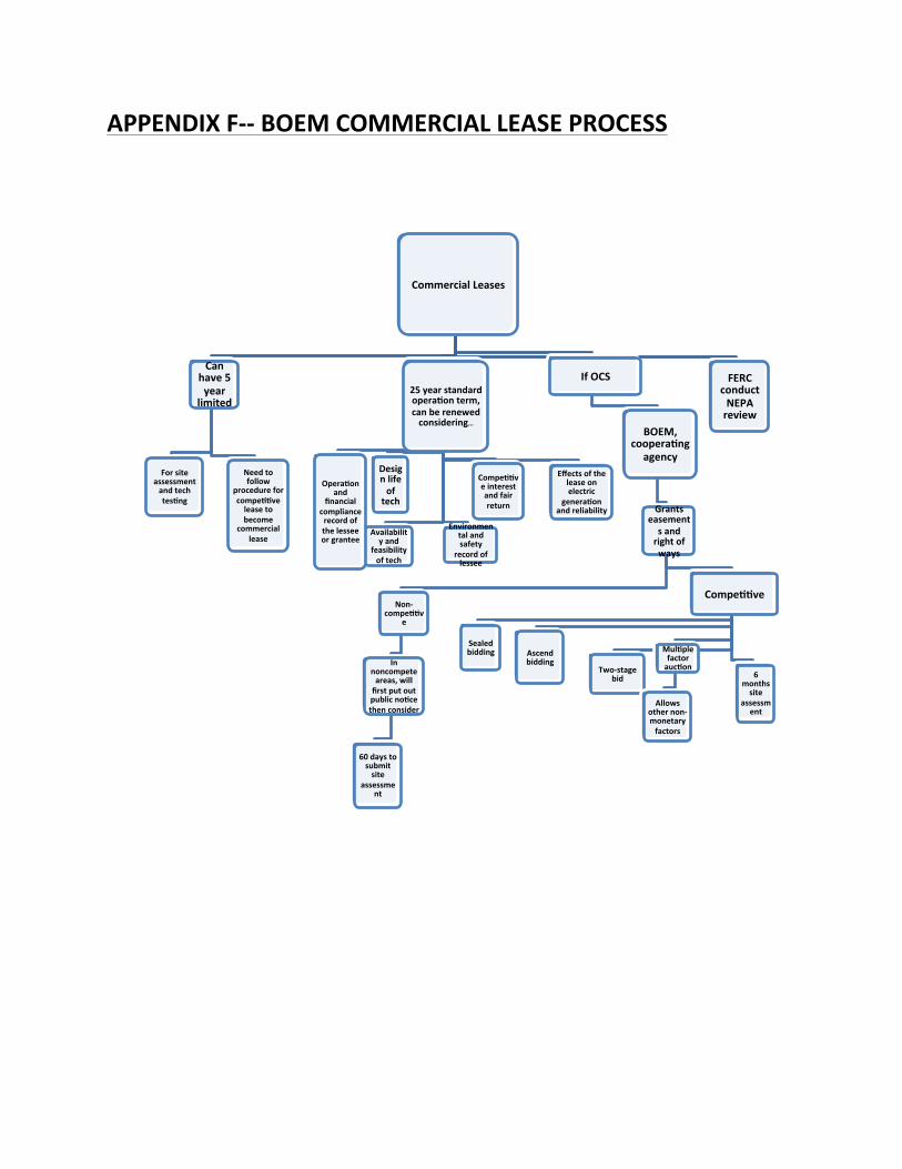
APPENDIX F-‐-‐ BOEM COMMERCIAL LEASE PROCESS
Commercial Leases
Can have 5 year
limited
For site assessment and tech tesBng
Need to follow
procedure for compeBBve lease to become
commercial lease
25 year standard operaBon term, can be renewed considering…
Design life of tech
Availability and
feasibility of tech
Environmental and safety
record of lessee
OperaBon and
financial compliance record of the lessee or grantee
CompeBBve interest and fair return
Effects of the lease on electric
generaBon and reliability
If OCS
BOEM, cooperaBng
agency
Grants easements and right of ways
Non-‐compeBBv
e
In noncompete areas, will first put out public noBce then consider
60 days to submit site
assessment
CompeBBve
Sealed bidding Ascend
bidding Two-‐stage
bid
MulBple factor aucBon
Allows other non-‐monetary factors
6 months site
assessment
FERC conduct NEPA review

Appendix G: Hydrokinetic Energy Project on the OCS: Commercial Leasing and Licensing; Competitive Interest (FERC and BOEM)
BOEM is the lead
BOEM issues noIce to determine if compeIIve interest
Applicants submit their
response to the noIce to BOEM
Has Ime given within noIce
period
If compeIIve interest, the interest is announced
BOEM Perform Area
IdenIficaIon
BOEM publishes final sales noIce
Bids are evaluated and
lease is executed
Applicant executes lease within 10 days of receiving lease copies
Applicant submits SAP or departure request to BOEM
To be done within 6 months
of lease execuDon
FERC and BOEM Conduct scoping and establish process plan
Applicant submits PAD to
FERC
Applicant submits
proposed study plan to FERC
FERC Issues study plan
determinaDon
Applicant conducts studies
Applicant files preliminary
license proposal
File license applicaDon with
FERC
FERC and BOEM issue
environmental document for comment
FERC Issues license
BOEM lease and FERC license terms are
synchronized

Appendix H--SAP (Site Assessment Plan) – BOEM
SAP
Must describe how the resource
assessment will be done
Need info from physical
characteristic surveys,
environmental surveys
SAP needs to demonstrate that there is no undue harm to resources and environment, safety precautions,
best and safest tech, best personnel, and will collect required
data for COP.
If lease or grant issued non-
competitively
Must submit within 60 days after
Director issues determination that
there is no competitive interest
Licensee includes consistency
certification with SAP and information pursuant to 15 CFR
930
If lease or grant is issued competitively
Must submit within 6 months of issuance
BOEM prepares consistency
determination
If the intention is to continue commercial
lease with an operations term…
Must submit a COP or FERC license at least 6
months before the end of site assessment term, can
be submitted with SAP
Must include significant data for BOEM to complete
NEPA analysis
BOEM may need to conduct additional
reviews

Appendix I: GAP (General Activities Plan) BOEM
GAP
Must no+fy BOEM within 30 days a8er comple+ng
installa+on approved by GAP
Must prepare annual report, must annually submit cer+fica+on of
GAP compliance
show compliance with terms and mi+ga+on
measures and monitoring
Annual report includes informa+on pertaining to the effec+veness of the measures, and if not
effec+ve, what will be done
Describes proposed construc+on, ac+vi+es and
conceptual decommissioning plans for planned facili+es that will be constructed and used, as
well as any easements
Need BOEM approval of GAP before you begin any of the
approved ac+vi+es on your lease or grant, must submit your
GAP within 6 months before issuance of
ROW or RUE.
Must show that plan conforms to rules and regs, is safe, does not unnecessarily interfere with other uses of the OCS, no undue harm to natural resources, life, property, uses best tech, and best management
processes.
Include info to help BOEM with the NEPA compliance (chart 30
CFR 285.646)
Include geological, geophysical, hazards,
archeological surveys, and baseline collec+on studies. 30 CFR 285.645 has
chart showing what must be in the GAP
If applying for a project easement or construc+ng facili+es deemed to be complex or significant, must provide addi+onal
info
construc+on and opera+on concept, cables on project easements, deployment ac+vi+es,
opera+ng procedures and systems, CVA
nomina+ons for reports required , construc+on
schedule.

Appendix J: COP (Construction Operations Plan)-‐ BOEM
COP
Describes all commercial opera?ons, construc?on ac?vi?es, and conceptual decommissioning plans
Includes all planned facili?es that will be
constructed
Includes decommissioning plans
Must get BOEM approval before conduc?ng any ac?vi?es on lease
Must show that ready to conduct ac?vi?es to the
responsibili?es listed in 30 CFR 285.105(a)
Chart of what needs to be presented in the 30 CFR
285.626
Must include significant amount of environmental informa?on for BOEM to conduct NEPA analysis
Chart of environmental informa?on in 30 CFR
285.628
BOEM will consult with appropriate agencies
must include the consistency cer?fica?on, and safety management
system
The BOEM reviews the COP, and will contact the licensee if there is missing
info
BOEM forwards a copy of COP Consistency
Cer?fica?on and info under the CZMA to the
DOC