peter steck dunnell road reports 11.10.09
TRANSCRIPT
Peter G. Steck Community Planning Consultant
P. O. Box 306, 80 Maplewood Avenue, Maplewood, New Jersey 07040 (973) 762-6568 Fax 762-5457
November 9, 2009
PLANNING MEMORANDUM -2 To: Maplewood Planning Board Re: Referral from the Maplewood Township Committee
Dunnell Road Police Building Redevelopment Plan 125 Dunnell Road, Block 17.16, Lot 10 INTRODUCTION
This Planning Memorandum supplements an earlier memorandum to the Maplewood Planning Board dated October 8, 2009. It contains additional research intended to assist the Planning Board in conducting its consistency review of proposed Ordinance No. 2604-09. The additional information offered to the Planning Board include a confirmation that the property at 125 Dunnell Road is in the R-1-7 Residential Zone rather than the NB Neighborhood Business Zone and a report on the results of a visual study. The visual study depicts what would be permitted should the Township Committee adopt the new zoning proposed in the draft Dunnell Road Police Building Redevelopment Plan dated September of 2009.
This additional information continues to be offered on behalf of two households on Maplewood Avenue. The individuals are Joe DePlasco & Nahela Hadi at 126 Maplewood Avenue and Diana Leo & Dr. Jane Aronson at 128 Maplewood Avenue. BACKGROUND INFORMATION
Following the October 7, 2009 introduction of Ordinance No. 2604-09 by the Township Committee, the Maplewood Planning Board held a public meeting on October 13, 2009. As authorized in the Municipal Land Use Law, the purpose of the referral to the Planning Board is to determine: 1) whether the zoning advanced in the rehabilitation plan is consistent with the Maplewood Master Plan, and 2) to offer advice to the Township Committee regarding the contents of the rehabilitation plan.
The portion of the October 13, 2009 Planning Board meeting dealing with the referral of Ordinance No. 2604-09 was consumed with planner Stuart Portney (the author of the rehabilitation plan) describing what was in the plan with Planning Board members and the general public asking questions of the planner. No time was left for the public to make comments.
Responding to questions, planner Stuart Portney indicated the he felt that a five-story building constructed at the front property line was consistent with the area and could be looked at as a transitional use. He also said that he was unsure about the location of the rear property line and did not know the consequences of the trunk sanitary sewer line which crossed the front yard area. Moreover, he could not reference any building in the surrounding area which was consistent with a building allowed on the subject site under the proposed zoning.

-2- ADDITIONAL RESEARCH ON ZONING
My earlier research indicated that all of the official records in the Township and at the Essex County Planning Board indicated that the property at 125 Dunnell Road was in the R-1-7 Zone which permitted single family dwellings with a maximum height of two stories and 35 feet and with a minimum front yard of 30 feet. Because comments from public officials suggested otherwise, on October 7, 2009 I filed a Government Records Request Form (OPRA request) for a “Copy of ordinance which changed Police Building property on Dunnell Road from R-1-7 Zone to NB Zone.” On October 15, 2009 I received a letter from the Township Clerk indicating that “The Township of Maplewood is in the process of securing documents to meet your Open Public Records request from the Engineering Department, Construction Code Official and the Planning/Zoning Board Secretary.” No response has been received to date. I understand that this matter was discussed by the Township Committee at its November 4, 2009 meeting despite the fact that it was not listed on the published agenda as a discussion item.
I again examined the Essex County Planning Board files on October 23, 2009 with the conclusion that all of the maps over the last approximately 20 years show the property in the R-1-7 Single-Family Zone. Based on this research, I concluded that the property is in the R-1-7 Zone as recommended in the March 9, 2004 Master Plan.
VISUAL STUDY
On Saturday morning, November 7, 2009, at sunrise to lessen the effect of wind, I marked the four corners of a potential building fully complying with the proposed zoning regulations in the Redevelopment Plan. Apparently the property has recently been surveyed in that the front property corners were staked. Two sets of helium filled balloons were tethered at the front property line 10 feet in from the westerly corner and 20 feet in from the easterly corner to adjust for side yard setbacks. Two additional sets of balloons were tethered 100 feet back from the two front points as shown on Plate I. Each potential building corner was marked by a large red balloon tethered to a 50 foot string with smaller red balloons at ten-foot intervals. Photographs were taken from various viewpoints at a pedestrian’s eye height. The results are shown on Plates II and III.
PLATE I

-3-
PLATE II RESULTS OF VISUAL STUDY
1. Permissible building dimensions looking east along Dunnell Road.
2. Permissible building location looking west along Dunnell Road.

-4-
PLATE III RESULTS OF VISUAL STUDY AND AERIAL PHOTOGRAPH
3. View from sidewalk along Valley Street. Two floors show above the Recreation Building.
4. Aerial photograph with approximate property line locations superimposed.
Source of aerial photograph: Bing maps – birdseye view.

-5- PLANNING COMMENTARY Based on the visual study results and past research, the following planning comments are respectfully offered for consideration by the Planning Board. 1. Master Plan Consistency
A fair reading of the March 9, 2004 Maplewood Master Plan can only yield the conclusion that the draft Rehabilitation Plan is substantially inconsistent with the Master Plan. The Land Use Element of the Master Plan recommends an R-1-7 designation. The Master Plan further recommends the formation of an ad hoc task force recognizing that the policy decision of the Township Committee to vacate the police building “represents a rare opportunity to either enhance municipal facilities or attract new development.” The 2004 Plan further states that “…the task force should seriously consider the historic preservation aspects of the existing police building and its site near Memorial Park. Amongst the options to be considered would be possible preservation of the building and the feasibility of adaptive reuse. [Page 153]
2. Visual Impact
Aside from its impact on the rear yards of Maplewood Avenue homes (at least the top two residential stories would be easily visible), a building conforming to the Redevelopment Plan would be dramatically incongruous with other buildings when viewed from alternate locations. From Valley Street, two stories would loom over the Township’s recreation building. From either direction on Dunnell Road or from Memorial Park, the building would be unique in its domination of the landscape.
3. Modification of the Redevelopment Plan Text
If the Planning Board believes that the proposed zoning regulations somehow represent good planning, then it should recommend different language in the Redevelopment Plan. It is recalled that the draft Redevelopment Plan includes the following observations:
“The Redevelopment Plan is clearly consistent with and promotes the planning policies and recommendations of the Township Master Plan, which seeks to promote the redevelopment of the site of the former Police Building on Dunnell Road.” [Page 50]
“The areas adjoining the designated Rehabilitation Area are zoned for neighborhood business….” [Page 51]
“The design standards and regulations contained in the Plan will promote redevelopment that will provide for residential development that will fit in with the character of the surrounding building and neighborhood character.” [Page 51]
To keep these provisions in the Redevelopment Plan text in light of the obvious inconsistencies and the gross incongruity of a potential new building is inappropriate.
-6-
4. Fiscal Considerations
When Ordinance No. 2604-09 was introduced by the Township Committee on October 7, 2009, certain Committee members indicated that a driving force for the redevelopment of the site was to help compensate for the cost of the new police building on Springfield Avenue. It would seem appropriate that the Township Committee divulge the total cost of the new police building (the total cost of land, building construction, furnishings and financing) and compare this cost with the potential net tax revenues from 50 dwelling units on the subject property.
5. Complete Discretion of the Township Committee
Comments were also offered by Township Committee members at the October 7, 2009 introduction of Ordinance No. 2604-09 that the Committee had the ability to negotiate with developers to get the type of project wanted by the Township. The Planning Board should keep in mind that these discussions are typically held behind closed doors and that the Township Committee has complete discretion in choosing its favorite developer. The problem is that under the proposed zoning, the Township Committee could actually pick a developer who would build a 50 foot tall building at the front property line. Furthermore, a developer presenting a conforming building to the Planning Board for site plan review essentially could not be denied. This type of unbridled discretion fosters arbitrary results which are not necessarily in the public interest.
6. Realistic Development Potential
Given the current downturn in the real estate market, the question arises regarding the timing of this offering to the development community. Developer interest and offering prices are likely to be diminished at this time. An equally important question relates to the presence of a regional sanitary sewer line in the front portion of the property. This sewer line is protected by an easement, is not owned by the Township, and cannot easily be relocated. It is further doubtful that the easement holder, the Joint Meeting of Essex and Union Counties, would permit the construction of a building over its sewer line. Because a one-lot redevelopment plan can be site-specific, why imply with zoning controls that a developer can build over the trunk sewer line?
7. Fatal Flaws in the Process
Thus far the Township’s redevelopment process is fraught with flaws as noted below:
o An appraisal of the property was completed using the wrong zone. o Interest from developers was solicited using the wrong zone. o The March 2009 study by planner Stuart Portney of The Metro Company
concluded that the site met the statutory criteria for designation as “in need of rehabilitation” referring more to system-wide utility conditions rather than on-site conditions.
-7-
o In his March 2009 study, Planner Portney concluded that a “program of rehabilitation may be expected to prevent further deterioration and promote the overall development of the community” despite there being no building to rehabilitate after demolition.
o The proposed redevelopment plan relies on the wrong zone. o The redevelopment plan in error indicates that the zoning for the adjacent
properties on Dunnell Road is the NB Zone instead of the R-1-7 Zone. o The redevelopment plan contains numerous statements which are not
supportable. 8. Developer Interest
The Township Committee appears to take the position that it will simply adopt the proposed redevelopment plan and thereby change the R-1-7 Zone to the new designation allowing 50 foot tall buildings and thereby eliminate the past chain of defects. The Committee should solicit an opinion from its attorney regarding whether this “after the fact” change actually remedies this litany of defects. Moreover, the Planning Board and Township Committee should ask itself what kind of developer would want to invest the necessary time and money in a project which springs from such a faulty foundation.
Attached: October 8, 2009 Planning Memorandum to Maplewood Planning Board October 6, 2009 Planning Memorandum to Township Committee
End file:

Peter G. Steck Community Planning Consultant
P. O. Box 306, 80 Maplewood Avenue, Maplewood, New Jersey 07040 (973) 762-6568 Fax 762-5457
October 8, 2009
PLANNING MEMORANDUM To: Maplewood Planning Board Re: Referral from the Maplewood Township Committee
Dunnell Road Police Building Redevelopment Plan 125 Dunnell Road, Block 17.16, Lot 10 INTRODUCTION On October 7, 2009 the Township Committee unanimously voted to introduce Ordinance No. 2604-09 which seeks to adopt the Dunnell Road Police Building Redevelopment Plan dated September 2009. The Township Committee referred the matter to the Maplewood Planning Board for a consistency review. It is understood that the Planning Board will be considering this at its October 13, 2009 meeting and that comments from the public will be entertained at that time. I have been requested to offer comments to the Planning Board by two households on Maplewood Avenue. The individuals are Joe DePlasco & Nahela Hadi at 126 Maplewood Avenue and Diana Leo & Dr. Jane Aronson at 128 Maplewood Avenue. Because of a prior professional commitment I cannot to be present, but I am offering this Planning Memorandum for consideration by the Planning Board. Upon analysis, this Planning Memorandum concludes that Ordinance No. 2604-09 is substantially inconsistent with Maplewood’s Master Plan. It also concludes that the September 2009 Dunnell Road Police Building Redevelopment Plan is fatally flawed by virtue of its reliance on the wrong zoning and offering the untenable observation that a 50 foot tall building at the front property line is somehow fits within the context of the surrounding area.
After its own analysis, the Planning Board is urged to conclude that Ordinance No. 2604 is substantially inconsistent with the Master Plan. The Planning Board is also urged to recommend against adoption of Ordinance No. 2604 by the Township Committee.
STATUTORY RESPONSIBILITY The Local Redevelopment and Housing Law [N.J.S.A.40A:12A-7.e] states that:
Prior to the adoption of a redevelopment plan, or revision or amendment thereto, the planning board shall transmit to the governing body, within 45 days after referral, a report containing its recommendation concerning the redevelopment plan. This report shall include an identification of any provisions in the proposed redevelopment plan which are inconsistent with the master plan and recommendations concerning these inconsistencies and any other matters as the board deems appropriate.
-2- Essentially, the Planning Board is assigned two tasks:
1) To read its March 9, 2004 Master Plan and opine whether the proposed zoning which permits a five-story apartment building consisting of 4 stories of residential use over a parking level with a zero front yard setback is substantially consistent with the plan, and
2) Regardless of consistency or inconsistency, the Planning Board is
given the opportunity to recommend or not recommend adoption of the plan.
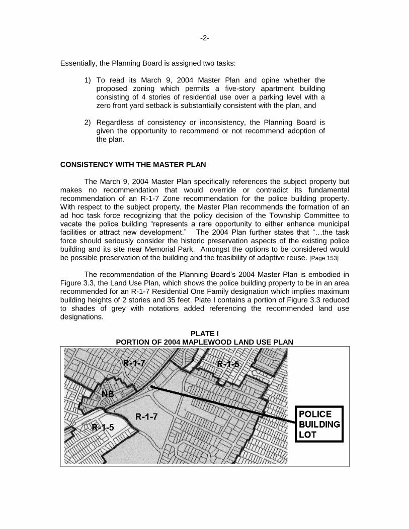
CONSISTENCY WITH THE MASTER PLAN The March 9, 2004 Master Plan specifically references the subject property but makes no recommendation that would override or contradict its fundamental recommendation of an R-1-7 Zone recommendation for the police building property. With respect to the subject property, the Master Plan recommends the formation of an ad hoc task force recognizing that the policy decision of the Township Committee to vacate the police building “represents a rare opportunity to either enhance municipal facilities or attract new development.” The 2004 Plan further states that “…the task force should seriously consider the historic preservation aspects of the existing police building and its site near Memorial Park. Amongst the options to be considered would be possible preservation of the building and the feasibility of adaptive reuse. [Page 153] The recommendation of the Planning Board’s 2004 Master Plan is embodied in Figure 3.3, the Land Use Plan, which shows the police building property to be in an area recommended for an R-1-7 Residential One Family designation which implies maximum building heights of 2 stories and 35 feet. Plate I contains a portion of Figure 3.3 reduced to shades of grey with notations added referencing the recommended land use designations.
PLATE I PORTION OF 2004 MAPLEWOOD LAND USE PLAN
-3- CLARIFYING THE EXISTING ZONING DESIGNATION
At the Township Committee’s October 6, 2009 meeting, the attached Planning Memorandum of the same date was distributed. As noted in the memorandum, my preliminary research indicated that the police building property was in the R-1-7 Residential One-Family Zone which was consistent with the recommendation of the 2004 Master Plan. My source of information was the recent purchase of Maplewood Zoning and Development Regulations from the Township Clerk’s office. The booklet contains a Zoning Map identical to the Zoning Map which appears on the Township’s web site.
As a courtesy, at the October 6, 2009 Township Committee meeting I was handed by the Township Attorney a map entitled Zoning Map 2009 which showed the police building property to be in an NB Neighborhood Business Zone. The map was allegedly prepared by the Maplewood Township Engineer and contains ten items under the heading “Remarks.” None of the items identify how the R-1-7 Zone was established for the police building property.
Receipt of this map prompted my further research. I filed an OPRA request for a copy of the Township ordinance which established the R-1-7 Zone for the police building property and am awaiting a response. It is noted that the Municipal Land Use Law requires that rezonings be done by ordinance and generally with an official notice to property owners within the rezoned area and within 200 feet of the rezoned area. My clients on Maplewood Avenue do not recall ever receiving a notice of a rezoning from the R-1-7 Zone to the NB Zone.
I also viewed the files of the Essex County Planning Board in the Essex County Engineering Department at 900 Bloomfield Avenue in Verona on October 8, 2009. The Municipal Land Use Law [N.J.S.A.40:55D-16] states in part that “Development regulations, except for the official map, shall not take effect until a copy thereof shall be filed with the county planning board.” As of noon on October 8, 2009 there is no ordinance or map in the Essex County Planning Board files which shows the police building property to be in the NB Neighborhood Business Zone. All of the recent maps show the police building property and the adjacent properties on Dunnell Road to be in the R-1-7 Zone.
I conclude that the police property is currently in the R-1-7 Residential One-Family Zone which limits building heights to 2 stories and 35 feet and requires a 30 foot minimum front yard setback. Any changes to that zoning classification cannot be made simply by the Township Engineer graphically altering a zoning map. Reclassifications must be done by ordinance, generally with advance notice to the affected property owners, and certainly with the public having an opportunity to comment.
PLANNING CONCLUSIONS
Having relied upon the wrong existing zoning, the September 2009 Dunnell Road Police Building Redevelopment Plan is fatally flawed. Aside from this flaw, it capriciously concludes that the Redevelopment Plan is consistent with the Master Plan. Further, as noted in the attached Planning Memorandum, permitting a new five-story building with no setback from the front property line is simply bad planning and does a disservice to this treasured part of Maplewood.

Peter G. Steck Community Planning Consultant
P. O. Box 306, 80 Maplewood Avenue, Maplewood, New Jersey 07040 (973) 762-6568 Fax 762-5457
October 6, 2009
PLANNING MEMORANDUM To: Maplewood Township Committee Re: Dunnell Road Police Building Redevelopment Plan 125 Dunnell Road, Block 17.16, Lot 10 INTRODUCTION As part of its effort to redevelop the property at 125 Dunnell Road, the Township of Maplewood has released a draft Dunnell Road Police Building Redevelopment Plan dated September 2009. [Draft Plan] Moreover, an ordinance to adopt this Draft Plan is expected to be introduced by the Township Committee on October 6, 2009, and it is understood that comments from the general public will be received at that time. This Planning Memorandum offers comments on the Draft Plan. The comments are made on behalf of property owners who are on the opposite side of the railroad tracks from the police building property. The owners of the two homes are Joe DePlasco & Nahela Hadi at 126 Maplewood Avenue and Diana Leo & Dr. Jane Aronson at 128 Maplewood Avenue. Upon review, this Planning Memorandum offers the following observations and conclusions from a land use planning viewpoint: 1. The Draft Plan appears to assume mistakenly that the police building property has
the same NB Zone designation as Maplewood Village along Maplewood Avenue. 2. The land use character of Dunnell Road is substantially different from the
Maplewood Village area along Maplewood Avenue. 3. Redevelopment under the terms of the Draft Plan will allow buildings radically out of
character with the remainder of Dunnell Road and with the larger surrounding area. 4. A heightened concern is warranted for the police building property because it is in a
signature location of Maplewood. 5. Development under the Draft Plan will adversely affect the residential properties at
126 and 128 Maplewood Avenue. 6. The Township’s effort to orchestrate redevelopment through the Local
Redevelopment and Housing Law by designation as an area in need of rehabilitation is questionable.
7. A redevelopment plan can have site specific standards which can better protect the
neighboring properties and maintain the land use character of the area.

-2- DESCRIPTION OF THE DRAFT PLAN
Selected key parts of the draft Dunnell Road Police Building Redevelopment Plan dated September 2009 and prepared by The Metro Company, LLC [Draft Plan] can be summarized as follows:
a) The police building property was designed as an “area in Need of rehabilitation” by the Township Committee on March 17, 2009 based on a March, 2009 study by the Metro Company, LLC entitled “Township of Maplewood, Dunnell Road Police Building Rehabilitation Study.” [Page 4]
b) This March 2009 study determined that the statutory criteria for an “area in
need of redevelopment” designation were met “on the basis of the extreme age and condition of the Study Area’s water, storm and sanitary sewer lines” and that “a program of rehabilitation may be expected to prevent further deterioration…..” [Page 4]
c) The police building property is included in the Maplewood Village Special
improvement District and therefore subject to the assessment on property in this District. [Page 5]
d) The current zoning for the police building property is Neighborhood Business
which allows building heights up to 50 feet. [Pages 12 & 14]
e) Part of the police building property is in a 100 year flood zone. [Page 16]
f) On June 24, 2009 letters of interest were solicited from potential redevelopers which resulted in six responses. [Page 18]
g) One of the goals of the Draft Pan is that “Buildings should be of an
appropriate scale……” [Page 20]
h) The Draft Plan is intended to accommodate demolition of the building and the construction of up to 4 levels of residential use over a parking level. [Page 22]
i) The Draft Plan is intended to supersede the current zoning standards. [Page
23]
j) Residential use is the only use permitted on the police building property. [Page 28]
k) Redevelopment is to be “fully contextual, consistent and compatible in terms
of design and appearance with buildings in and around the downtown area.” [Page 27]
l) Up to 50 dwelling units would be permitted with each unit having only one or
two bedrooms. [Page 31]

-3- DESCRIPTION OF THE DRAFT PLAN - Continued
m) New buildings are permitted to have a 0 front setback or at most a 20 foot front setback. [Page 33]
n) The maximum building height is 50 feet with no more than four stories being
residential stories. [Page 33]
o) The building is allowed to cover up to 50% of the lot and the building and paving areas together can cover up to 90% of the lot area. [Page 33]
p) Parking is required at a ratio of 1.2 parking spaces per dwelling unit. [Page 41]
q) Parking areas may be 5 feet from the rear property line. [Page 41]
r) The new building is required to meet Leadership in Energy and
Environmental Design (LEED) requirements. [Page 44]
s) The New Jersey Transit Railroad line is listed on the New Jersey National Register of Historic Places. [Page 48]
t) The Maplewood Shade Trees Ordinance and the Steep Slope Ordinance
should be taken into consideration. [Page 48]
u) Any new development is required to adhere to the New Jersey Council on Affordable Housing standards applicable to municipalities [which permit up to 20% of the 50 units to be affordable to low and moderate income households or allow a developer to made a cash payment to the municipality in lieu of providing the units in the building]. [Page 49]
v) As to compatibility with the 2004 Maplewood Master Plan, the Draft Plan
concludes that “The Redevelopment Plan is clearly consistent with and promotes the planning policies and recommendations of the Township Master Plan, which seeks to promote the redevelopment of the site of the former Police Building on Dunnell Road. [Page 50]
w) As to zoning compatibility, the Draft Plan states “The design standards and
regulations contained in the Plan will promote redevelopment that will provide for residential development that will fit in with the character of the surrounding building and neighborhood character.” [Page 51]
-4- PRELIMINARY PLANNING OBSERVATIONS AND CONCLUSIONS Based on a review of the Draft Plan, Maplewood’s current zoning and master plan documents, and an inspection of the police building property and the surrounding properties, following planning observations and conclusions are offered: 1. The Draft Plan appears to assume mistakenly that the police building property
has the same NB Zone designation as Maplewood Village along Maplewood Avenue.
The Township of Maplewood’s website has a link to the Maplewood Code which shows the police building property to be within the R-1-7 Residential One-Family Zone. The Zoning & Development Regulations booklet available in the Maplewood Township Clerk’s office dated January, 2009 and purchased October 5, 2009 also shows the police station property to be in the R-1-7 as shown in Appendix A. Moreover, the March 9, 2004 Master Plan recommends an R-1-7 designation for the police building property. Hence, the police building property as well as the adjacent properties along Dunnell Road would appear to be within the R-1-7 Zone.
The Draft Plan, however, shows the police building property and the adjacent properties along Dunnell Road to be in the NB Neighborhood Business Zone which is the same zone as the commercial properties along Maplewood Avenue. The NB Zone allows for 50 foot tall buildings and 0 front yard setbacks for three-story buildings. The R-1-7 Zone permits single-family detached homes on 70 foot wide lots with a minimum front yard of 30 feet and a maximum building height of two stories and 35 feet. Either the Draft Plan references the wrong zoning district or the zoning for the police building property has somehow been changed in a way not readily apparent to the general public.
2. The land use character of Dunnell Road is substantially different from the
Maplewood Village area along Maplewood Avenue.
The buildings in the Village along the Maplewood Avenue corridor are typically positioned at the front property line and abut one another. They are all one, two and three-story buildings on relatively small lots with commercial uses on the first floor with residential uses above. There are no four-story buildings, and there are no five-story buildings. With few exceptions, most buildings do not have any on-site parking – a situation typical of an older neighborhood commercial area. None of the area is in a flood hazard area.
The Dunnell Road corridor which includes the police building is different. The lots along the west side are wider and contain one and two-story buildings accommodating a variety of nonresidential uses. On-site parking is provided for the uses. With the exception of a portion of “Nelsons Garage,” the buildings have significant setbacks from the front property line. The Dunnell Road corridor is not a shopping area like the Village and the uses are not dependent upon pedestrian traffic. Portions of the properties are in a flood hazard area. Additionally, the rear yards have steep slopes as the land climbs upward toward the railroad tracks and the steep slopes are wooded. Along the east side of Dunnell is Memorial Park which accommodates a stream, wooded area and play areas, and a handsome one-story recreational building positioned on the far side of the stream.

-5- 3. Redevelopment under the terms of the Draft Plan will allow buildings
radically out of character with the remainder of Dunnell Road and with the larger surrounding area.
The development allowed under the standards of the Draft Plan would include an apartment building five stories high consisting of four stories of apartments over a parking story. A developer would be allowed to cut into the wooded slopes along the rear property line and construct a parking lot within five feet of the rear property line. Instead of the statewide requirement of 2 parking spaces per dwelling unit, a developer would need to provide only 1.2 spaces per unit. Moreover, an apartment building 50 feet in height could be constructed at the front property line with no setbacks whatsoever. Given these standards, a new building conforming to the Draft Plan would be substantially out of character with any of the nearby buildings or, for that matter, with any of the buildings in the Maplewood Village area.
4. A heightened concern is warranted for the police building property
because it is in a signature location of Maplewood Township.
The civic area which consists of the Municipal Building and Memorial Park is a prized land use vignette which has served the Township well. Its proximity to the Maplewood Train Station exposes the scene to an even greater number of people. When the train slows down to the Maplewood Station, and deposits commuters, residents and guests, it emerges from a wooded corridor. Passengers exit to the platform adjacent a handsome station building facing an expanse of greenery to the east and a small park to the west. Whether encountered by a train passenger, a shopper, a park jogger, a dog walker or a home hunter, this scene is one of the best features of Maplewood. It deserves protection from incongruous buildings.
5. Development under the proposed plan will adversely affect the residential
properties at 126 and 128 Maplewood Avenue. The two homes at 126 and 128 Maplewood Avenue back up to the train tracks and, although encountering train noise, have the compensating benefit of a short walk to the train station and to the goods and services of the Village. The rear yards of these homes slope downward to the tracks viewing only the roof of the police building filtered by trees. [The parapet at the flat roof section of the police building is approximately 28 feet above the ground level and is approximately at the elevation of the train tracks.] The development fostered by the Draft Plan will likely involve the disturbance of steep slopes, the removal of trees on the steep slopes, and the construction of two stories above the elevation of what is now the flat roof section of the police building. The two upper stories of a new building would have a clear view of the rear yards of the homes on Maplewood Avenue and will likely reflect the train noises toward their rear yards. Considering that the current zoning available to the public limits the building height to 35 feet and two stories, new development under the Draft Plan standards would adversely affect these residential properties.

-6- 6. The Township’s effort to orchestrate redevelopment through the Local
Redevelopment and Housing Law by designation as an area in need of rehabilitation is questionable.
The March 2009 Dunnell Road Police Building Rehabilitation Study by the Metro Company, LLC alleges that “a program of rehabilitation may be expected to prevent further deterioration and promote the overall development of the community….” [Page 13] In light of the Draft Plan’s expectation that the police building will be demolished, the question arises regarding what is left to be rehabilitated. With nothing left to rehabilitate, it would appear that the “area in need of rehabilitation” designation is defective. The tall building and high density allowed by the Draft Plan fosters demolition rather than the rehabilitation of the police building.
7. A redevelopment plan should have site-specific standards which protect
the neighboring properties and maintain the established land use character of the area.
A redevelopment plan for one lot can include redevelopment standards particular to that one lot. A redevelopment plan could state, for example, that no disturbance of the rear wooded steep slopes is permitted, that the building height is limited to 35 feet, and that a front yard setback which approximates the existing setback is required. Additionally, it is noted that the front of the police building property appears to be burdened by a “Supplementary Joint Trunk Sewer Easement” [See Appendix B] which may prohibit a building positioned at the front property line. In short, such standards would not only protect the established character of the area but would place the building rehabilitation alternative on more of an equal footing with the demolition alternative.
SUMMARY CONCLUSIONS
When a municipality engages in the redevelopment process, and particularly when its own property is to be redeveloped, there is a tendency for a municipality to shift into a developer role to the exclusion of other public concerns. The Draft Plan appears to ignore the character of the surrounding land use environment and to violate some of its own policies such as keeping new development in scale with existing buildings.
The current situation is an instance where the concerns of two households on
Maplewood Avenue are aligned with common sense community-wide planning goals. A reevaluation of the Draft Plan is urged at this early stage to clear-up the zoning confusion, to correct the inconsistencies in the Draft Plan, and to acknowledge the important location of the police building property.
Peter G. Steck, P.P., AICP N. J. Planner License No. 1776 October 6, 2009

APPENDIX A
MAPLEWOOD ZONING MAP SECURED FROM MAPLEWOOD TOWNSHIP CLERK’S OFFICE OCTOBER 5, 2009

APPENDIX B
PORTON OF THE TOWNSHIP OF MAPLEWOOD TAX MAPS
End file: