petroleum exploration and development in australia · bureau of mineral resources, geology and...
TRANSCRIPT
ll.M
•• . . .. ' .. . . . ............ . . . .:.:::: ~ ~:.:.:.: ..•••.. ~.: ... : .. :.:.~ ~'. '.:: :~'.'. '.:. ~':.::: '.' . :.~:.:.::: ...•.. : ..... ::.:::::: ....... . . . ::.: .................... :: .. : ......... ::.:: . : : : .. : . : . : : : .': '. '.: .: .. :. : : : ~ ~.":': "' .. : : : . .. : ••...• :::: :.: .... ::.::.~ .......... : ::: .... ::: .... : .... :: ... ~ ......•.... :: .. : .. : ..... :.: ... :.' : .•.. : ..•• : : :.::.' : : ::: :'.' .....•. :.:.':'.':::::.:.: . ' ................................... . . ':' .. : .. ':.' : : . ~ '. '. : : : ....... : .' : :: : '. : . : '. ':": .' .' ., .... ' ..... ~~.~.~. ~.~.~ .•. ·~··:·t·~·~:·~~=~~ .: ..... :: ...... : .... :: .. . . ....... ... . . ' ...... . . ' ". .. .
..... -'111"'!::"- - - - - - - - - --
B
BMR GEOLOGY AND GEOPHYSICS AUSTRALIA
Record 1991/80
Petroleum exploration and development in Australia
-activity and results, 1989
. . . . • ••••• :.: ••• 'e" ',- .. .. .... " .................. .. "::~::::::;:"::::..." .. : ........... : ..... :...... . .. .. . ....... ::: .. : ,-: ...................... . .:.~ ..........•..•.. ::.~ ................. :.:: .. .. . .. -. '.' .. ' ..... ' ................ . . ' "., ......... " ' .... ' ..................... ' .. .' ' .......... '" ' ....... ~ .... ' ................. '. .. , '::.' ..... :.~ .................. : ... ::.: ...... . ••••••.• ! •••.•. ! ...... : ...•..•..•..••••....• ,', ~', ,,': ~ ::: .":~'.': :.:.:.:::: :: ...•.. :.: ,': :: ••... ,' ........ . .',',: ::',':: :.:.: ..•• ,I::: ::: : ::::.',::::.: .... :.: .: .. : .::. "':':":'" ..
• ..-.... :::: :::: ': :::.: :::.::.: :::: :'/.:: ::.:.J::':. " . .... :. :::: ... :::::~ ~.:.:=: : ::'::: ..... : .. : .• : .::':.: .
~!II"'-"'''~''''-r'''''''-i-'''''-':. . .............. '. . ............... ' .. . :::"~"'"' ... _p .......... - ... -r" ....... -c.~ •• :.:: '.':": .:.::: •• : ••••••••• : •••••• :::: ;':" •••
::::I ........ IIIIIIIIi~ .... - ... -r--IillIIoj· ... :..:.:.:. ~ ~ •••••••• ;:: ;:~:.'.' •••••••••••••••••• : .' •••••••• :.: •••••• -- -- -- -- -- -- ~~_ ... ...I"'~r-""''''';;.IoL!.' ••••••••• '. ••••••• • ............ ' . ..' • -----------------=-------:-- -~ ....... ...I ....... - ... ....; ........ :..: •• :::.:.:: ::~ .. :.:.:: ::: ..... ::.:: .:::::: :;::'.: :: •
-- -- -- -- -- -- -- -- -- -- - ...... -,... ...... -... - ........ .: ......... :.:::::::::: ......... :: ... ~ ... : .. ' .. :.':". -- -- -- -- -- -- -- -- -- -- -- ~ ....... - .............. ~ .... :~ .... :: •......• ~ .. :: .. ::::.: .•......... ::: ... . --------------------- '" ..................... . --_--__ -_--_---=-__ --__ --__ --_--__ -__ --_-_ .... _ ... ~-...... i-... ..;;J ... ;.;.:.: ••• :::.:.:. ~:! :'.~: ::.~.:::~.:.:.::.: __________________ ~ __________ :"'II ... !-__ .L. ....... ..;;J .. oC.:.~ •••• : ••• : ••••• ::.:.: ••••••••• __ --__ --_---=--__ --__ -_--__ --__ --__ ---=--_--__ -_-_-__ -"'_ ........... - .... - ... -.a.;;::IIIIII"' • .:.~ ••••••• ::=:~: .. ::::: ---------~-----------------~------~--------~-~~t::!;:JC:::::Jc:~~~~.~.~.~ .• ·.·~·~:~:j:1I
BMR Record 1991/80
Petroleum exploration and development in Australia - activity and results, 1989
Prepared by the Petroleum Resource Assessment Branch of the Petroleum and Marine Geoscience Group,
Bureau of Mineral Resources, Geology and Geophysics, Canberra
This work is copyright. Apart from any fair dealing for the purposes of study, research, criticism or review, as permitted under the Copyright Act, no part may be reproduced by any process without written permission. Inquiries should be directed to the Principal Information Officer, Bureau Of Mineral Resources, Geology and Geophysics, GPO Box 378, Canberra, ACT 2601.
iii
CONTENTS
INTRODUCTION
1989 IN RETROSPECT
PETROLEUM GEOLOGY, RESOURCES AND PRODUCTION
Geology
Resources
Exploration Potential
Production
SUMMARY OF PETROLEUM EXPLORATION IN 1989
SUMMARY OF PETROLEUM DEVELOPMENT IN 1989
MAJOR ACTIVITIES IN 1989
Onshore Basins
Offshore Basins
APPENDICES
1. WELLS AND METRES DRILLED - 1979 to 1989
2. GRAPHS - WELLS AND METRES DRILLED -
1986 to 1989
3. ONSHORE DRILLING ACTIVITY BY STATE -
1979 to 1989
4. OFFSHORE DRILLING ACTIVITY BY STATE -
1979 to 1989
PAGE
1
2
4
7
7
8
12
14
17
22
73
74
75
76
iv
FIGURES
1. Australia's sedimentary basins
2. Location of oil and gas production, pipelines
and discoveries in 1989
3. Australia's demonstrated recoverable resources
of crude oil and natural gas
4. Petroleum exploration and development,
onshore and offshore wells drilled in
Australia 1960 - 1989
TABLES
1. Australia's total petroleum reserves, 30 June 1989
2. Summary of estimates ofthe recoverable proved plus probable, primary
and secondary petroleum reserves by basin as at 30.6.89
3a. Commercial production of petroleum in Australia, 1988 - 89
3b. Cumulative commercial production of petroleum in Australia
to 30 June 1989
4. Discoveries of petroleum - 1989 - offshore and onshore
5. Seismic survey activity - 1989 - onshore and offshore
6. Drilling rig activity as at 31.12.89
7. Wells drilled - 1989 - onshore and offshore
8. Exploration, development and production expenditure in 1988
9. Historical data: Expenditure and activity 1976 to 1989
Seismic survey activity 1985 to 1989
PAGE
5
6
10
11
25
26
27
27
28
32
36
40
66
71
72
1
INTRODUCTION
This report has been prepared by staff of the Petroleum Resource
Assessment Branch of BMR. The functions of the Branch include monitoring
petroleum exploration and development activity, preparation of estimates
of petroleum reserves and resources and their availability through time,
and provision of technical advice in relation to Commonwealth legislation
and policies concerning petroleum exploration, development and production.
The report provides a summary of petroleum exploration and development
activity in Australia during 1989. It also summarises BMR's assessments
of Australia's identified petroleum resources (reserves) and undiscovered
petroleum resource potential.
The report summarises activity in 1989 in each of the major onshore and
offshore sedimentary basins, and includes a summary of the number of wells
and metres drilled to the end of 1989, a table of discoveries of petroleum
in 1989, and a list of the major events in the history of the Australian
petroleum industry.
2
1989 IN RETROSPECT
Expenditure on both petroleum exploration and development in Australia
increased in 1989 compared with 1988. The number of onshore exploration
wells declined substantially to just over half the number in 1988, but
exploration wells drilled offshore increased. There were also increases
in the numbers of development wells, both onshore and offshore. Seismic
survey activity declined markedly onshore, particularly in South
Australia, but rose substantially offshore, with an overall rise to its
highest level in 4 years.
The highest proportion of exploration wells continued to be drilled in the
Eromanga Basin and its infrabasins - the Adavale, Cooper and Galilee
Basins. Other onshore basins which were actively explored were the
Amadeus, Bowen/Surat, Canning, Carnarvon, Georgina, McArthur, Otway and
Perth Basins. Most offshore exploration wells were in the Bonaparte and
Gippsland Basins: exploration wells were also drilled in the offshore
Carnarvon and Browse Basins. Onshore seismic surveys were mainly in the
Cooper/Eromanga and Bowen/Surat Basins, and offshore surveys were mainly
in the Gippsland, Bonaparte and Carnarvon Basins.
Forty-one oil, gas and condensate discoveries were made during 1988;
22 oil, 6 gas, and 3 gas/condensate discoveries were made onshore, and
5 oil, 3 oil and gas and 2 gas/condensate discoveries were made offshore.
Additions to demonstrated resources resulting from discoveries were
insignificant compared to upward revisions of resources in known fields,
and to changes resulting from production.
Development wells completed onshore were mainly in the Cooper/Eromanga
Basins, but development wells were also drilled in the Carnarvon Basin
(Barrow Island), Bowen/Surat and Amadeus Basins. Most offshore
development wells were in the Gippsland Basin: drilling continued at the
Bream field (9 wells), with drilling also at the Whiting and Perch fields.
3
Elsewhere, development wells were drilled at the Saladin, Chervil, South
Pepper and North Rankin fields in the offshore Carnarvon Basin and the
Jabiru and Challis fields in the Bonaparte Basin.
Several major offshore development projects were completed to production/
operation stage during 1989. The second phase of the North West Shelf gas
project began production, and production commenced from the Talisman and
Saladin oil fields. Proposals to develop the nearby Wanaea, Cossack,
Yamaderry and CowIe oil fields were made. Development of the Skua field
is also planned.
Onshore, gas pipelines from the Denison Trough and Walumbilla field to
Gladstone, and from Port Pirie to Whyalla were opened in November and May
respectively.
4
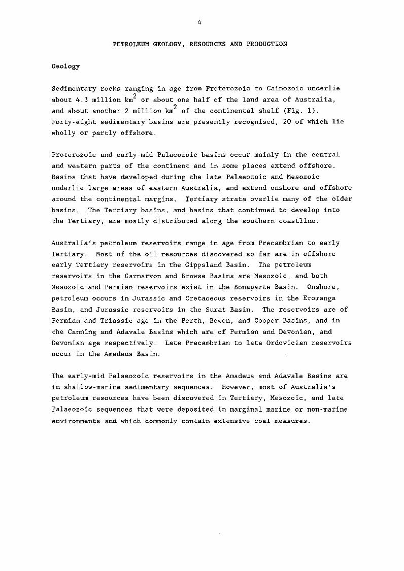
PETROLEUM GEOLOGY, RESOURCES AND PRODUCTION
Geology
Sedimentary rocks ranging in age from Proterozoic to Cainozoic underlie
about 4.3 million km2 or about one half of the land area of Australia,
and about another 2 million km2 of the continental shelf (Fig. 1).
Forty-eight sedimentary basins are presently recognised, 20 of which lie
wholly or partly offshore.
Proterozoic and early-mid Palaeozoic basins occur mainly in the central
and western parts of the continent and in some places extend offshore.
Basins that have developed during the late Palaeozoic and Mesozoic
underlie large areas of eastern Australia, and extend onshore and offshore
around the continental margins. Tertiary strata overlie many of the older
basins. The Tertiary basins, and basins that continued to develop into
the Tertiary, are mostly distributed along the southern coastline.
Australia's petroleum reservoirs range in age from Precambrian to early
Tertiary. Most of the oil resources discovered so far are in offshore
early Tertiary reservoirs in the Gippsland Basin. The petroleum
reservoirs in the Carnarvon and Browse Basins are Mesozoic, and both
Mesozoic and Permian reservoirs exist in the Bonaparte Basin. Onshore,
petroleum occurs in Jurassic and Cretaceous reservoirs in the Eromanga
Basin, and Jurassic reservoirs in the Surat Basin. The reservoirs are of
Permian and Triassic age in the Perth, Bowen, and Cooper Basins, and in
the Canning and Adavale Basins which are of Permian and Devonian, and
Devonian age respectively. Late Precambrian to late Ordovician reservoirs
occur in the Amadeus Basin.
The early-mid Palaeozoic reservoirs in the Amadeus and Adavale Basins are
in shallow-marine sedimentary sequences. However, most of Australia's
petroleum resources have been discovered in Tertiary, Mesozoic, and late
Palaeozoic sequences that were deposited in marginal marine or non-marine
environments and which commonly contain extensive coal measures.
~ EXMOUTH PLATEAU
Fig. 1.
D Phanerozoic baSinS
D Precambrian basins
E : : : 3 Basement
600km
Australia's sedimentary basins. Basement denotes regions generally unprospective for petroleum mainly areas underlain by crystalline rocks or by tightly folded or metamorphosed strata. The dashed lines are boundaries of concealed basins; locally relationships are complex, e.g. the Galilee Basin overlies the Adavale Basin and underlies the Eromanga Basin.
Jabiru _ Chellis &0 1(;- Olrwin
Bonaparte Basin Area 1(;
I Iltfby'. .'
8 ") • Cannong Area Talisman loom. - I
Rankin Area 1(; • Blina/Sundown/ H . ~orth Rankin W.Terrace II
Griffin~met ~Wa11eee W. Kora Barrow Island 01(;;1. D.mpill
Area ~.jrow Island
camarvo:A}.a lSaledin/Cher vii/ N. Herald/S. Pepper/Bamb ..
GAS
.() Discovery
-Pc Pro~ction Pipeline
OIL AND GAS
~ Discovery
• Production
WA
OIL
~ Discovery
• Production
Pipeline
6
Otwav· Basin Area 1
\-rAsi '\}IHobart
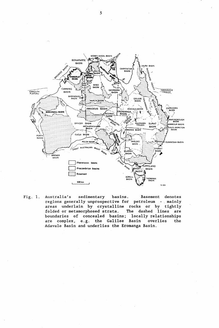
FIELD DISCOVERIES IN 1989
Fig. 2.
OFFSHORE Bonaparta/Browsa
Basin Ar ..
~ Talbot 1
~ Kalyptea 1
Carn.rvon Ar ••
~ Wanaea 1
~ Chinook 1
~ Cowie 1
GippslandBlsin Ar ..
{} Anemone 1
{} Angler 1
~ Blackback·,
~ Mulloway 1
{} Sweetlips 1
ONSHORE Moomba Ar ••
~ Alwyn 1
{} Amyema 1
{} Arrakis North
{} Atreides 1
~ Lycium 1
{} Marsilaa 1
{} Mettika 1
~ Spencer West 1
J.ckson Ar ..
~ Bowen 1
~ Corrella 1
~ Endeavour 1
~ Gidgee 1
~ Mahl1
~ Maxwell South
~ Muthero 1
~ North Ipundu 1
~ Pinaroo 1
~ Wandilo 1
Otw., S.sin Ar •• {} Ladbroke Grove
Location of oil and gas production, pipelines and discoveries in 1989.
7
Resources
Most of Australia's identified resources of crude oil occur in the
Gippsland Basin (Fig. 2, Table 1); smaller amounts exist in the Amadeus,
Bonaparte, Carnarvon, Cooper, and Eromanga Basins. Most identified
resources of natural gas occur in the Bonaparte, Carnarvon (inc. Exmouth
Plateau), Cooper and Gippsland Basins. Gas has been discovered in all
basins known to contain resources of crude oil and additionally in the
Adavale, Bass, Browse and Otway Basins.
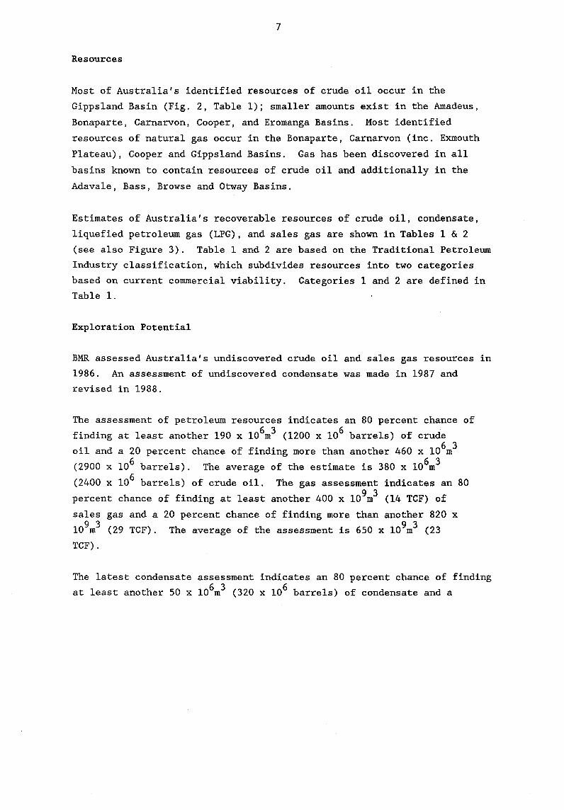
Estimates of Australia's recoverable resources of crude oil, condensate,
liquefied petroleum gas (LPG), and sales gas are shown in Tables 1 & 2
(see also Figure 3). Table 1 and 2 are based on the Traditional Petroleum
Industry classification, which subdivides resources into two categories
based on current commercial viability. Categories 1 and 2 are defined in
Table 1.
Exploration Potential
BMR assessed Australia's undiscovered crude oil and sales gas resources in
1986. An assessment of undiscovered condensate was made in 1987 and
revised in 1988.
The assessment of petroleum resources indicates an 80 percent chance of
finding at least another 190 x 106m3 (1200 x 106 barrels) of crude
oil and a 20 percent chance of finding more than another 460 x 106m3
(2900 x 106 barrels). The average of the estimate is 380 x 106m3
(2400 x 106 barrels) of crude oil. The gas assessment indicates an 80
percent chance of finding at least another 400 x 109m3 (14 TCF) of
sales gas and a 20 percent chance of finding more than another 820 x
109m3 (29 TCF). The average of the assessment is 650 x 109m3 (23
TCF).
The latest condensate assessment indicates an 80 percent chance of finding
at least another 50 x 106m3 (320 x 106 barrels) of condensate and a
8
20 percent chance of finding more than another 100 x 106m3 (630 x
106 barrels). The average of the assessment is 80 x 106m3 (500 x
106 barrels).
The assessments refer to the oil and gas resources, remaining to be
discovered in Australia's Phanerozoic sedimentary rocks, that could be
brought into production within the next 20 to 25 years. They exclude new
pool discoveries that may be made in Australia's identified fields and
accumulations that may occur in deep-water or remote areas along parts of
Australia's southern margin and in the offshore territories.
Production
Commercial production of oil began in Australia in 1964, from the Moonie
field in the Surat Basin (Fig. 1, Table 2). Production from Barrow Island
(Carnarvon Basin) began in 1967, and from Bass Strait (Gippsland Basin) in
1969. The Gippsland Basin is the major source of petroleum liquids in
Australia and with the completion of a liquids pipeline from Moomba to
Stony Point in 1982 and the Jackson to Moonie pipeline in 1983, the
Cooper/Eromanga Basins are presently the nation's second largest producer
of liquids.
Natural gas was first delivered to Brisbane, Melbourne, and Adelaide in
1969 from the Surat, Gippsland, and Cooper Basins respectively. In 1983
the Palm Valley field in the Amadeus Basin began supplying gas to the
Alice Springs power station, and in 1984 North West Shelf gas reached the
Perth market to supplement the gas from the Dongara field (Perth Basin)
which first supplied gas to Perth in 1971. Since 1976 Sydney has received
gas from the Moomba and adjoining fields (Cooper Basin). Other major
centres, particularly in Victoria and New South Wales, have also been
connected to gas supplies. A 1600 km gas pipeline from Palm Valley supplies gas to the Channel Island power station at Darwin, to Tennant
Creek, and to Katherine (Fig. 2).
9
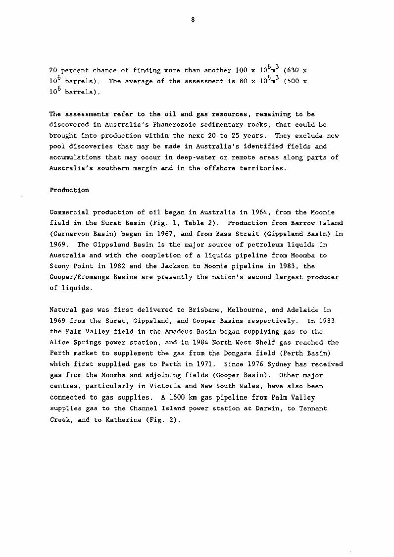
In 1988-89, Australia's crude oil and condensate production was
28.3 x 10⁶m3 (177 x 106 barrels), corresponding to an average rate
of about 77 500 m3jd (487 000 bblsjd); this was 9 percent less than
production for the previous year. Production from the Bass Strait fields
decreased from 73 percent in the previous year to 66 percent of
Australia's total production. This is a reflection of the continuing
depletion of the Kingfish and Halibut fields and increases in production
from the Jabiru and Challis fields in the Bonaparte Basin, and from fields
in the Carnarvon Basin.
Australia'S production of sales gas increased by nearly 3 percent compared
to the preceding year while the production of LPG decreased marginally.
10
CRUDE OIL ( 106 3) x m 7::
---I-' ..... I-'~
",."" ..,..,.., -"""""
L ~ 500 1~~~'~a,lr~.'·':-""·"·\' .. , I
400 ''''''''''', .. "''' ~
p ~OI)U<;TIC' N
300
200 !~~ Il'
100 : :
:
1980 1965 1970 1975 1980 1985 1 990
NATURAL GAS (xI09 mS ) 2400-r~~~-r-r-r~~~~'-~~~~r-~r-r-~~~~~~~~~~
2200-+-+-+-+-+-r-r-r-r-r~;-~+-+-+-r-+-r-r-~~~-+-+-+~
2000-+-+-+-+-+-+-+-+-+-+-+-+-+-+-+-+-+-+-+-+-+-+-+-+-+-+-+-
1800-+-+-+-+-+-+-+-+-+-+-+-+-+-+-+-+-+-+-+-+-+-+-+-+-+-+-;-
1400-+-+-+-+-+-+-+-+-+-+-+-+-+-+-+-+-+-+-+-+-+-+-+-+~
j200-+-+-+-+-+-+-+-+-+-+-+-+-+-+-+-+-+-+-+-+-+-+-+~
600
200
14-1/34
Fig. 3. Australia's demonstrated recoverable resources of crude oil and natural gas. Remaini~g recoverable resources at 30 June 1989 were: crude oil 3284 million m3 ; (natural gas) sales gas 2082 billion m .
11
Number Df wells
300~----------~------------~----------~------------~-----------r-----------'
• 2004-----------~--------_4+_+_----------_+------------+_--~------~~~----r_~ • I , 1\ I' ,\ I \
\ I \ y \
\
1004-------~--_4--~----~~~--~r_----_+------------+_--~r_~~~~r_----------~
1960 1965
Number Df wells
\ \ \ \ \ "' .... " "
1970
............ 1975 1980 1985 14.1133 1990
300,------------,------------.------------.------------~--------~~----------_,
2004---------~~r_~--~--_t+------------+------------~~--~~--~~~--~r_~
1004------+----~------------~~---------+----------_7~----------~----------~ i
1960
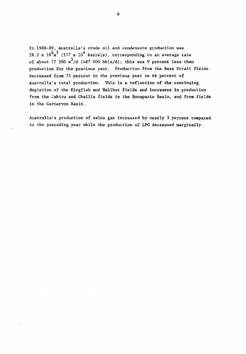
Fig. 4.
1965 1970 1975
,.--, ' ,. , ,~ , ,."
1/ "... " ... " OFFSHORE V
1980 1985 14·1132 1990
Petroleum exploration and development, onshore and offshore
wells drilled in Australia 1960-1989.
12
SUMMARY OF PETROLEUM EXPLORATION IN 1989
About $560 million was spent on exploration in 1989 compared with $503
million in 1988 and $353 million in 1987. A total of 224 wells were
drilled in 1989 of which 148 were exploration wells. Onshore, 109 wells
were drilled of which 60 were new field wildcat wells. Offshore drilling
accounted for 39 wells, of which 28 were new field wildcat wells.
Onshore exploration drilling was concentrated in the Eromanga Basin and
its infrabasins, mainly the Cooper Basin, in which 73 of the onshore
exploration wells (77 percent) were drilled. Other onshore exploration
wells were drilled in the Amadeus (1 well), Bowen/Surat (20 wells),
Canning (2 wells), Carnarvon (2 wells), Georgina (1 well), McArthur (3
wells), Otway (5 wells) and Perth (2 wells) Basins. Onshore exploration
drilling resulted in 16 oil discoveries, 6 gas discoveries and 3
gas/condensate discoveries. Extensions to known fields in the Amadeus,
Bowen/Surat, Cooper/Eromanga, Otway and Perth Basins were proved by
appraisal drilling programs.
The Cooper/Eromanga and its infrabasins were again the most active onshore
exploration areas in 1989 and accounted for 23 of the 25 onshore petroleum
discoveries. Thirteen of these discoveries were in Queensland and 10 in
South Australia. Two onshore petroleum discoveries were in the Otway
Basin of South Australia.
Offshore exploration drilling was carried out in the Bonaparte (19 wells),
Carnarvon (7 wells), Gippsland (12 wells) and Browse (one well) Basins.
Offshore exploration drilling resulted in 5 oil, 3 oil & gas and
13
2 gas/condensate discoveries. Appraisal drilling was carried out in the
Bonaparte Basin at the East Swan, Jabiru and Skua accumulations; Carnarvon
Basin at the Avocet, Chervil and Turtle fields; Gippsland Basin at the
Blackback and Bream fields. Appraisal drilling at the Jabiru field has
confirmed the southwest extent of the field after intersecting a 47 metre
oil column.
Statistics relating to petroleum exploration and development activity in
recent years are given in Figure 4 and the appendices.
Discoveries of petroleum in 1989 are listed in Table 4.
14
S~UffiY OF PETROLEUM DEVELOPMENT IN 1989
The level of development drilling activity increased substantially in 1989
compared with 1988, a total of 76 development wells was drilled - 47
onshore and 29 offshore. Development and production expenditure was $1378
million.
Of the 47 onshore development wells drilled, 24 were in the
Cooper/Eromanga Basins, 9 in the Bowen/Surat Basins, 13 in the Carnarvon
Basin and 1 in the Amadeus Basin. Offshore, the 29 development wells
comprised 18 in the Gippsland Basin, 9 in the Carnarvon Basin and 2 in the
Bonaparte Basin (Timor Sea area).
Queensland
A total of 20 development wells was drilled in 1989, the highest number
for over 10 years. Santos continued development drilling in several
Eromanga basin oi1fie1ds and AGL, CSR and Bridge continued oil and gas
development drilling in Surat Basin oil and gas fields. Production from
the Taylor field through permanent production facilities commenced in
October 1989.
The pipeline from the Denison Trough and the Wallumbilla field to
Gladstone was completed in November 1989. Gas was available for flow to
Gladstone in December 1989. An extension of this pipeline to Rockhampton
is proposed. Approval in principle has been given for the supply of 300
petajoules of natural gas to South Australian markets from fields in
southwest Queensland.

15
The viability of commercial extraction of methane gas from coal seams in
the northern Bowen basin is being examined. Exploration and production
testing are continuing.
South Australia
All 13 development wells drilled were onshore. Two each were at the
Gidgealpa oil/gas/condensate field and the Jena and Tirrawarra oil fields.
Three were in the Spencer oil field and one each in the Merrimelia,
Pelican, Sturt and Sturt East fields.
A pipeline supplying natural gas to Whyalla from Port Pirie was officially
opened in May 1989.
Following the Katnook gas discovery, proposals to supply the Mt Gambier
and possibly the Adelaide markets with gas are being investigated.
Victoria
In 1989, 18 development wells were drilled, the highest number since 1984.
Development drilling in the Bream oil and gas field continued with nine
additional wells. Two wells were redrilled from the Fortescue platform to
new targets. The Perch-3 well and the five Whiting mini-platform wells
were also drilled from the Maersk Giant jackup rig.
Western Australia
A total of 22 development wells was drilled in Western Australia in 1989.
Of these, 13 were oil wells on Barrow Island. Offshore, 9 wells were
drilled: 3 in the Saladin oil field, 2 in the Chervil oil field, 1 in the
South Pepper oil field and 3 in the North Rankin gas/condensate field.
16
Phase 2 (the LNG export phase) of the North West Shelf project began
production in July 1989 and will produce up to 7 million tonnes per year
of LNG for sale to Japan.
Talisman field production commenced in July 1989 from the Talisman-l
subsea completion to the Acqua Blu floating production facility. A second
Talisman producing well is being planned.
The feasibility of gas gathering from the Harriet, Bambra, Campbella nd
Rosette discoveries is being evaluated.
Production from the Saladin oilfield commenced in November 1989 and
Yamaderry and CowIe developments are under review for startup in 1991.
WAPET have recommended drilling and workovers in the Dongara field.
Design of facilities for the Tubridgi field is proceeding with a startup
date of July 1991 planned.
Development of the Wanaea and Cossack oil fields is being planned.
Northern Territory
Three development wells were drilled: 1 gas well in the Palm Valley field
and 2 wells offshore, 1 each in the Challis and Jabiru oil fields.
Production rates from the Jabiru and Challis fields increased during the
year and the area now is now the third largest producing province of
Australia.
Skua development is being planned for production to a floating facility.
17
MAJOR ACTIVITIES IN 1989
Onshore Basins (including WA Territorial Sea)
Amadeus Basin (NT)
Gosses Bluff No.2, the second well in the Gosses Bluff comet impact
structure, was a dry hole. One development well was drilled in the Palm
Valley gas field.
Bowen/Surat Basins (Qld, NSW)
Both exploration and development drilling continued at about the levels of
1988. Ten new field wildcat wells were drilled, but all were dry. Only
one of these was in the Denison Trough.
Nine appraisal and 9 development wells were drilled. Development and
appraisal drilling on the Taylor field continued, but only two of the 6
wells drilled were completed for production. Taylor No. 11 was completed
as an oil and gas producer from the Showgrounds Sandstone.
The conclusion of a gas purchase agreement between Queensland Alumina
Limited and Denison Trough Joint Venturers AGL Petroleum Operations Pty
Ltd and Oil Company of Australia NL is expected to result in new
exploration activity in the Denison Trough to increase reserves.
Potential for production from the Reids Dome Beds by fracture stimulation
of tight gas reservoirs is also planned for investigation.
Canning Basin (WA)
Two exploration wells, Cudalgarra North No. 1 and Setaria No.1, were
plugged and abandoned as dry holes.
18
Carnarvon Basin (WA)
Four exploration wells were drilled onshore in the Carnarvon Basin. One
well, CowIe No.1, drilled 5 km south of the Saladin oilfield in WA
Territorial Sea, was a mjaor oil and gas discovery. The well flowed at a
rate of 1015.4 m3/d (6390 bbls/d) of oil, and 55217.9 m3/d
(1.95 x 106 ft 3/d) of gas from a production test in the top of the
Barrow Group. The well has been suspended.
Rivoli No.1, located approximately 20 km southeast of North West Cape,
encountered a 17 m thick reservoir section in the Cretaceous Birdrong
Sandstone. Testing confirmed a 10 m gas column, and the well was plugged
and abandoned. Two other wells, Somelim No. 1 and Tent Hill No.1, were
both plugged and abandoned as dry holes.
Cooper/Eromanga Basins (SA, Qld)
Exploration and development activity declined in the Cooper and overlying
Eromanga Basins in 1989, a total of 73 wells being drilled. Extensive
floods during the year disrupted field operations and led to deferral of
planned programs. The number of exploration wells in South Australia was
about the same as in Queensland, but the number of appraisal wells in
South Australia was nearly four times greater than in Queensland.
Of the 37 exploration wells drilled, a total of 19 new field discoveries
was made. The discovery rate of 1:2 is slightly improved on the discovery
rate of 1:2.5 in 1988. The discoveries were mainly oil accumulations in
the Eromanga Basin sequence in Queensland. Hydrocarbons were found in
more than one formation in several fields.
Drilling in the Eromanga Basin sequence in Queensland was directed mainly
towards Hutton Sandstone targets in anticlinal traps, southwest of the
Jackson field. A test of Wandilo No. 1 recovered 42 barrels of oil at top
19
Hutton level, while an open hole drill stem test over a basal Hutton
3 sandstone flowed oil and water to the surface at 15 m /d (96 bb1s/d).
Bowen No. 1 encountered oil at four stratigraphic levels in the Eromanga
sequence. Tests were carried out on the Namur, Hutton and Adori
Sandstones and the Westbourne Formation. The Adori Sandstone, in which
3 the well was completed as an oil producer, flowed 49 API oil at 540 m /d
(3400 bb1s/d) in an open hole drill stem test.
A number of wells had targets in the basal Jurassic and deeper sections.
Gidgee No.1, west of the Munro field, discovered in 1988, recorded
hydrocarbon shows in the Murta Member, Hutton Sandstone and Patchawarra
Formation, but was completed as an oil producer in the Hutton Sandstone.
The Gidgee and Munro fields are the most southerly in the Eromanga Basin
in Queensland, lying close to the basin margin. Mahl No. 1 was designed
to test the Early Permian Tirrawarra Sandstone north of the Pepita trend
in a fault trap. The target sandstone was water saturated, but an open
hole drill stem test recovered 221 m of oil and oil cut mud from a
sandstone within the Triassic Tinchoo Formation. Mah1 No. 1 was plugged
and abandoned. Naccow1ah South No. 12, a Hutton Sandstone development
well, was deepened into the Permian to further evaluate the basal Jurassic
and Too1achee sections. A drill stem test of a new basal Jurassic pool
flowed 45.9 API oil to the surface at an average rate of 76 m3/d (480
bb1s/d). In addition, an oil leg to the previously defined Too1achee dry
gas accumulation was discovered following a drill stem test which flowed
16 m3jd (104 bb1s/d) of 33.3 API oil in addition to 181 x 103 m3jd
6 3 (1.6 x 10 ft /d) of gas. This oil discovery in the Toolachee gas
reservoir has further enhanced prospects of Permian oil along the
Jackson-Naccow1ah- Pepita trend. Naccow1ah South No. 12 was completed as
a dual Huttonjbasa1 Jurassic oil producer.
In the Cooper Basin in South Australia, exploration drilling was
concentrated in areas in the southwest of the basin, and near the
Queensland border in the east. A number of new gas fields were discovered
in the Patchawarra Formation in the eastern area (Mettika, Amyema,
Marsilea). Mettika No.1 and Amyema No.1 flowed small amounts of
condensate with gas during testing. Arrakis North No. 1 and Atreides
No.1, drilled on the western margin of the Nappamerri Trough, tested gas
in the Epsilon Formation and Patchawarra Formation respectively.
In the Eromanga sequence in South Australia, Spencer West No. 1 flowed oil
from the Namur Sandstone at the rate of 273 m3/d (1717 bbls/d) during
drill stem testing; oil was recovered from the Birkhead Formation.
Appraisal drilling on the Jena field resulted in the discovery of a new
oil pool in the Coorikiana Sandstone, but the well was completed for
production from the Murta Member. Alwyn No. 3 was a new pool discovery in
the McKinlay Member and was completed as an oil producer in both the Murta
and McKinlay members.
Gippsland Basin (Vic)
No wells were drilled in the onshore Gippsland Basin in 1989.
McArthur Basin (NT)
Stratigraphic drilling continued in the central McArthur Basin to evaluate
the petroleum potential of the Middle Proterozoic sequence.
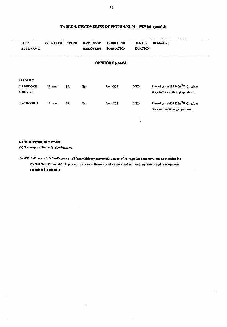
Otway Basin (SA, Vic)
Four new field wildcat wells and two appraisal wells were drilled in the
onshore Otway Basin in 1989.
21
Activity onshore was concentrated in the Gambier Embayment where the 1987
Katnook gas field discovery in the Penola Trough in South Australia has
acted as a spur to exploration. The successful Katnook No. 3 appraisal
well flowed gas from the Lower Cretaceous Pretty Hill Sandstone at a rate
6 3 6 3 of nearly 0.72 m x 10 m /d (25.4 x 10 m /d) in a production test,
a record for an Australian onshore well. The four new field wildcat wells
were also located in the Gambier Embayment. Ladbroke Grove No. 1 located
some 2 km south of the Katnook field, discovered gas in the Pretty Hill
Sandstone, but most production tests were inconclusive due to mechanical
problems. Laira No.1, drilled some 12 km to west of the Katnook field,
recorded gas shows in the main objective (? Pretty Hill Sandstone), but
production tests showed the zone to be water wet. Bool Lagoon No.1, also
drilled in the South Australian area of the Gambier Embayment, was a dry
hole. McEachern No.1, located in Victoria, was in progress at the end of
1989, and subsequently plugged and abandoned as a dry hole. Yindermere
No.2, located in Victoria in the Tyrendarra Embayment, was an
unsuccessful appraisal well for the 1987 Yindermere No. 1 oil discovery in
the Lower Cretaceous section. Production tests in Yindermere No. 2 were
disappointing and the well was plugged and abandoned as a dry hole.
Pedirka Basin (SA)
Three drill stem tests were run in the Poolawanna Formation in Poolawanna
No.3, but only minor gas was recovered. The well was plugged and
abandoned.
Perth Basin (WA)
No exploration drilling took place in the Perth Basin in 1989.
Development drilling continued on the Mt Horner field.
22
Offshore Basins
Bonaparte/Browse Basins (WA, NT)
Twelve new field wildcat wells were drilled in the Bonaparte/Browse
Basins, but only one significant discovery was made. Talbot No. I, in the
eastern part of the Vulcan Sub-basin, discovered oil in the Challis
Formation. The well flowed oil at a rate of 792 m3/d (4981 bbls/d)
accompanied by 105 x 106 m3/d (3.7 x 106ft3/d) of gas. Oil was
encountered in Kalyptea No.1, in the northern Browse Basin, but the well
was plugged and abandoned.
Barnett No.2, an appraisal well on the Barnett struc,ture, intersected a
26 m oil column and was completed as an oil producer. Barnett No. I, the
first well on the structure, found only minor oil shows in the target the
Kulshill Group. Barnett No. 2 tested the updip potential of the
structure.
Production drilling continued on the Jabiru and Challis fields.
Carnarvon Basin (WA)
Five exploration wells were drilled in the offshore part of the Carnarvon
Basin during 1989, resulting in two significant oil discoveries. Chinook
No.1, located 7 km northwest of Hilda No. lA, was drilled to test
Cretaceous Barrow Group, and top Triassic sands. The well intersected a
significant oil column in the top Barrow Group, which flowed at a rate of
1019 kl (6412 barrels) per day of light (52 API) oil, with a gas cap in
the overlying Mardie Greensand, which flowed at a rate of 122 000.5 m3/d
(4.3 x 106ft3/d).
The other major discovery was in the Wanaea No. 1 well, which was located
on the Madeleine Trend in the northern part of the Dampier Sub-basin, 25
km east of the North Rankin "A" gas production platform. The well
intersected a 100 m oil column in Late Jurassic to Early Cretaceous sands,
which flowed at a rate of 874 m3/d (5500 bbls/d) from a production test.
Reserves have been estimated to be as much as 40 million m3 (250 million
barrels), the largest oil discovery in Australia since the Fortescue field
in 1978, and the most significant in the Dampier Sub-basin - which up
until now has been regarded by many explorationists as gas prone.
Three other exploration wells, Alpha North No.1, Cygnus No.1 and
Montebello No. 1 were plugged and abandoned as dry holes.
Gippsland Basin (Vic)
Eleven new field wildcat wells were drilled in the offshore part of the
Gippsland Basin, all with targets in the Latrobe Group. Several
significant, but not major discoveries were made.
Oil was discovered in the northwestern area of the basin in Mullaway No.
1. The well, which lies west of the Barracouta field and the 1985
Whiptail oil discovery, has been plugged and suspended. Sweetlips No.1,
also located in the northern half of the basin, north of the Snapper
field, encountered an oil and gas bearing zone at the top of the Latrobe
Group, but was plugged and abandoned.
Angler No. 1 and Anemone No.1, located southeast of the Kingfish field in
274 m and 231 m water depth respectively, discovered gas and condensate in
the intra-Latrobe Group Upper Cretaceous section. Blackback No.1. sited
east of the Mackerel field, in 298 m of water, was an appraisal well and
deep pool test on the Hapuku structure. Production tests at 2891-2918.8 m
resulted in flows of oil and gas at rates of up to 239.7 m3/d (1508
bbls/d) and 50 x 103 m3/d (1.9 x 106ft3/d) respectively, and
formation tests recovered oil and gas or gas/condensate from several zones
in the deeper section. The Anemone, Blackback and Angler wells, were
terminated at 4775 m, 4401 m and 4337 m respectively, making them the
deepest wells drilled to date in the Gippsland Basin.
No significant hydrocarbons were encountered in the six remaining offshore
wells (Harlequin No.1, Conger No.1, Trumpeter No.1, Admiral No.1,
Shark No.1, Judith No.1).
25
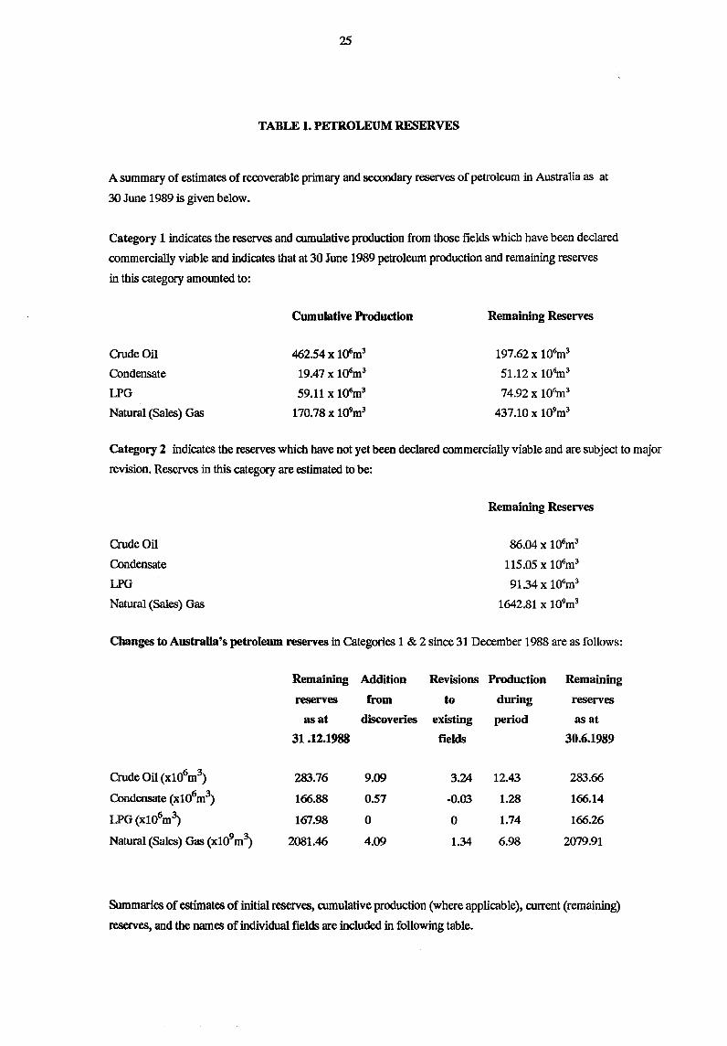
TABLE 1. PETROLEUM RESERVES
A summary of estimates of recoverable primary and secondary reserves of petroleum in Australia as at
30 June 1989 is given below.
Category 1 indicates the reserves and cumulative production from those fields which have been declared
commercially viable and indicates that at 30 June 1989 petroleum production and remaining reserves
in this category amounted to:
Cumulative Production Remaining Reserves
Crude Oil 462.54 x 10⁶m3 197.62 x 10⁶m3
Condensate 19.47 x 1ij6m3 51.12 x 10⁶m3
LPG 59.11 x 1ij6m3 74.92 x 10⁶m3
Natural (Sales) Gas 170.78 x 10⁹m3 437.10 x 10⁹m3
Category 2 indicates the reserves which have not yet been declared commercially viable and are sUbject to major
revision. Reserves in this category are estimated to be:
Crude Oil
Condensate
LPG
Natural (Sales) Gas
Remaining Reserves
86.04 x 10⁶m3
115.05 x 10⁶m3
9134x 106m3
1642.81 x 109m3
Changes to Australia's petroleum reserves in Categories 1 & 2 since 31 December 1988 are as follows:
Remaining Addition Revisions Production Remaining
reserves from to during reserves
as at discoveries existing period as at
31.12.1988 fields 30.6.1989
Crude Oil (x106m3) 283.76 9.09 3.24 12.43 283.66
Condensate (x106m3) 166.88 0.57 -0.03 1.28 166.14
LPG(x106m~ 167.98 0 0 1.74 166.26
Natural (Sales) Gas (x 109m3) 2081.46 4.09 1.34 6.98 2079.91
Summaries of estimates of initial reserves, cumulative production (where applicable), current (remaining)
reserves, and the names of individual fields are included in following table.
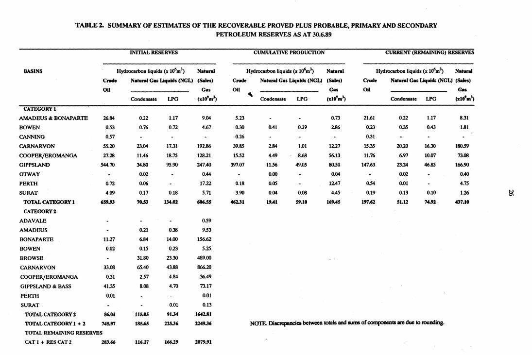
TABLE 2. SUMMARY OF ESTIMATES OF THE RECOVERABLE PROVED PLUS PROBABLE, PRIMARY AND SECONDARY
PETROLEUM RESERVES AS AT 30.6.89
INITIAL RESERVES .CUMULATIVE PRODUcnON CURRENT (REMAINING) RESERVES
BASINS Hydrocarbon liquids (x Ufm3) Natural Hydrocarbon liquids (x 106m3) Natunl Hydrocarbon liquids (x 106m; Natural
Crude Natural Gas Liquids (NGL) (Sales) Crude Natural Gas Liquids (NGL) (Sales) Crude Natural Gas Liquids (NGL) (Sales)
on Gas on Gas on Gas
Condensate LPG . (xlo'.~ ~
Condensate LPG (xlo'.') Condensate LPG (x1o'.~
CATEGORY I
AMADEUS &: BONAPARTE 26.84 0.22 1.17 9.04 5.23 0.73 21.61 0.22 1.17 8.31
BOWEN 0.53 0.76 0.72 4.67 0.30 0.41 0.29 2.86 0.23 0.35 0.43 1.81
CANNING 0.57 0.26 0.31
CARNARVON 55.20 23.04 17.31 192.86 39.85 2.84 1.01 12.27 15.35 20.20 16.30 lSO.59
COOPER/EROMANOA 27.28 11.46 18.75 128.21 15.52 4.49 8.68 56.13 11.76 6.97 10.07 73.08
GIPPSLAND 544.70 34.SO 95.90 247.40 397.07 11.56 49.05 SO.50 147.63 23.24 46.85 166.90
arwAY 0.02 0.44 0.00 0.04 0.02 0.40
PERm 0.72 0.06 17.22 0.18 0.05 12.47 0.54 0.01 4.75
SURAT 4.09 0.17 0.18 5.71 3.90 0.04 0.08 4.45 0.19 0.13 0.10 1.26
rorAL CATEGORY 1 '9.93 7O.5J 134.02 -.s5 462.31 1'.41 59.10 16'.45 1!J'7.62 5L12 7432 437.10
CATEGORY 2
ADAVALE 0.59
AMADEUS 0.21 0.38 9.53
BONAPARTE 11.27 6.84 14.00 156.62
BOWEN 0.02 0.15 0.23 5.lS
BROWSE 31.SO 23.30 489.00
CARNARVON 33.08 65.40 43.88 866.20
COOPER/EROMANGA 0.31 2.57 4.84 36.49
GIPPSLAND &: BASS 41.35 8.08 4.70 73.17
PERm -0,01 0,01
SURAT 0.01 0.13
rorAL CATEGORY 2 86.04 115.05 '1.34 1642.81
rorAL CATEGORY 1 + 2 74M7 185.65 225.36 224'.36 Nom. DillCl'epllDCies between t.oIaIs and sums of c::omponenlB are due to rounding.
TOTAL REMAINING RESERVES
CAT 1 + RES CAT 2 283.66 116.17 166.2' 2079.91
~
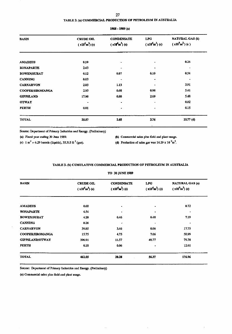
27 TABLE 3. <a) COMMERCIAL PRODUCTION OF PETROLEUM IN AUSTRALIA
BASIN
AMADEUS
BONAPARTE
BOWEN/SURAT
CANNING
CARNARVON
COOPER/EltOMANGA
GIPPSLAND
OTWAY
PERTH
TOTAL
CRUDE OIL
(xlO'm~ (e)
0.10
2.43
0.12
0.03
203
293
17.90
0.01
25.57
Source: Department of Primary Industries and Energy. (preliminary)
(a) Fiscal year ending 30 June 1989.
(e) 1 m3 = 6.29 barrels (liquids), 35.315 ft 3 (gas).
1988 ·1989 (a)
CONDENSATE
(xlO'm~ (e)
0.07
1.13
0.68
0.80
2.68
LPG
(xlO(jm~ (e)
0.10
0.98
269
3.76
NATURAL GAS (b)
( xlO'm3 ) (e )
0.26
0.54
3.91
5.41
5.48
0.02
0.15
15.77 (d)
(b) Commercial sales plus field and plant usage.
(d) Production of sales gas was 14.29 x 10 9m3•
TABLE 3. (b) CUMULATIVE COMMERCIAL PRODUCTION OF PETROLEUM IN AUSTRALIA
BASIN
AMADEUS
BONAPARTE
BOWEN/SURAT
CANNING
CARNARVON
COOPER/EltOMANGA
GIPPSLAND/OTWAY
PERTH
TOTAL
CRUDE OIL
(xlO'm~ (e)
0.68
4.54
4.20
0.26
39.85
15.75
396.91
0.18
462.55
Source: Department of Primary Industries and Energy. (preliminary)
<a) Commercial sales plus field and plant usage.
TO 30 JUNE 1989
CONDENSATE
(x10'm~ (e)
0.46
3.46
4.73
11.57
0.06
20.28
LPG
(x10(jm~ (e)
0.48
0.06
7.06
48.77
56.37
NATURAL GAS (a)
(x10'm~ (e)
0.72
7.19
17.75
58.99
79.70
12.61
176.96
28
TABLE 4. DISCOVERIES OF PETROLEUM - 1989 (a)
BASIN OPERATOR STATE
WELL NAME
BONAPARTE
TALBOT 1 Santos NT
BROWSE
KALVPTEA 1 BHP NT
CARNARVON
CHINOOK 1 BHP WA
COWLE 1 WAPET WA
WANAEA 1 Woodside WA
GIPPSLAND
ANEMONE 1 Petrofina Vic
ANGLER 1 Petrofina Vic
BLACKBACK 1 Esso Vic
MULLOWAY 1 Esso Vic
SWEETI...IPS 1 Esso Vic
NATURE OF PRODUCING
DISCOVERY FORMATION
OFFSHORE
Oil Unknown Fm
Oil Unknown Fm
Oil,Gas BarrowGp
Gas, Oil Flacourt Fm
Oil Unknown Fm
Gas, Cond Latrobe Gp
Gas,Cond Latrobe Gp
Oil Lttrobe Gp
Oil Latrobe Gp
Gas,OiI Latrobe Gp
CLASSI·
FICATION
NFD
NFD
NFD
NFD
NFD
NFD
NFD
NPD
NFD
NFD
REMARKS
Flowed oil at 795m3/d and gas at 108Mm3/d.
Average rate 684m3/d oil. Cased and
suspended as a future oil producer.
Recovered 95 m3 of oil and l.8m3 gas.
Plugged and abandoned.
Flowed oil at lOl9m3/d and gas at
121 762.5m3/d. Cased and suspended as
a future oil producer.
Flowed oil at 1 016m3/d and gas at
55 217m3/d. Cased and suspended as a
future oil producer.
Flowed oil at 874m3/d. Cased and
suspended as a future oil producer.
Plngged and abandoned as a gas/
condensate discovery.
Plugged and abandoned as a gas/
condensale discovery.
Recovered 2.96m3 oil. Plugged and
abandoned.
Recovered 2O.5m3 oil. Cased and
suspended as a future oil producer.
Plugged and abandoned as a gas/
condensate discovery.
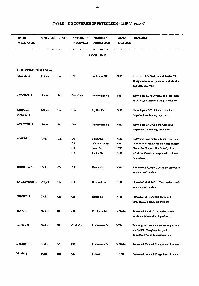
29
TABLE 4. DISCOVERIES OF PETROLEUM - 1989 (a) (cont'd)
BASIN
WELL NAME
OPERATOR STATE
COOPERJEROMANGA
ALWYN 3 Santos SA
AMYEMA 1 Santos SA
ARRAKIS Santos SA
NORTH 1
ATREIDES 1 Santos SA
BOWEN 1 Delhi Old
CORELLA 1 Delhi Old
ENDEAVOUR 1 Ampol Old
GIDGEE 1 Delhi Old
JENA 5 Santos SA
KEENA 2 Santos SA
LYCIUM 1 Santos SA
MAHL 1 Delbi Qld
NATURE OF PRODUCING
DISCOVERY FORMATION
ONSHORE
011 McKinlay Mbr
Gas,Cond Patchawarra Fm
Gas Epsilon Fm
Gas Patchawlrra Fm
011 NamurSst
Oil Westboume Fm
Oil Adorl Sst
Oil Hutton Sst
Oil Hutton Sst
011 Birkhead Fm
Oil Hutton Sst
Oil Cooikiana Sst
Cond,Gas Patchawarra Fm
011 Patcbawlrra Fm
011 Triassic
CIASSI.
FICATION
NPD
NFD
NFD
NFD
NFD
NFD
NFD
NFD
NFD
NFD
NFD
NPD(b)
NPD
NFD(b)
NFD(b)
REMARKS
Recovered 4.5m3 oil from McKinlay Mbr.
Completed as an oil producer in Murta Mbr
and McKinlay Mbr.
Flowed gas at 198 200m3/d and condensate
at 13.4m3/d.Completed as a gas producer.
Flowed gas at 326 OOOm3/d. Cased and
suspended as a future gas producer.
Flowed gas at 41 909m3/d. Cased and
suspended IS I future gas producer.
Recovered 3.2m oil from Namur Sst, 10.5m
oil from Westboume Fm aDd 423m oil from
Hutton Sst. Flowed oil at 541m3/d from
Adorl SsL Cased and suspended as a future
oil producer.
Recovered 1 423m oil. Cased and suspended
as a future oil producer.
Flowed oil at 54.4m3/d. Cased and suspended
as I future oil producer.
Flowed oil at 163.4m3/d. Cased and
suspended as a future oil producer.
Recovered 9m oil. Cased and suspended
as a future Murta Mbr oil producer.
Flowed gas at 209,OOOm3/d and condensate
at 4.5m3/d. Completed for gas in
Toolachee Fm and Patchawarra Fm.
Recovered 206m oil. Plugged and abandoned.
Recovered 122m oil. Plugged and abandoned.
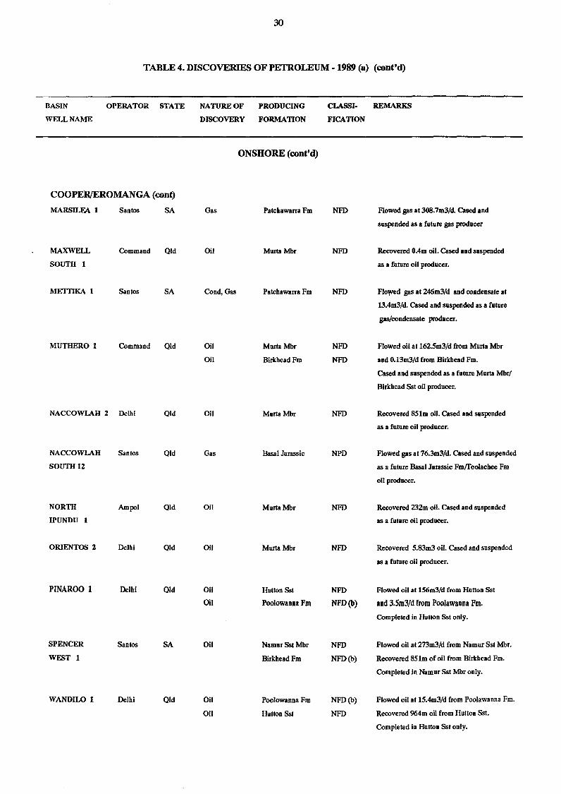
30
TABLE 4. DISCOVERIES OF PETROLEUM - 1989 (a) (cont'd)
BASIN OPERATOR STATE
WELL NAME
COOPEWEROMANGA(conQ
MARSILEA 1 Santos SA
MAXWELL Command Old
SOUTH 1
METTIKA 1 Santos SA
MUTHERO 1 Command Old
NACCOWLAH Z Delhi Old
NACCOWLAH Santos Old
SOUTHlZ
NORTH Ampol Old
IPUNDU 1
ORIENTOS Z Delhi Old
PINAROO 1 Delhi Old
SPENCER Santos SA
WESTl
WANDILO 1 Delhi Old
NATURE OF PRODUCING
DISCOVERY FORMATION
ONSHORE (cont'd)
Gas PalChawarra Fm
Oil Murta Mbr
Cond, Gas Patchawarra Fm
Oil Murta Mbr
Oil BirkheadFm
Oil Murta Mbr
Gas Basal Jurassic
Oil Murta Mbr
Oil MurtaMbr
Oil Hutton Sst
Oil Poolowanna Fm
Oil Namur Sst Mbr
Birkhead Ftu
Oil Poolowanna Fm
Oil Hutton Sst
CLASSI.
FICATION
NFD
NFD
NFD
NFD
NFD
NFD
NPD
NFD
NFD
NFD
NFD(b)
NFD
NFD(b)
NFD(b)
NFD
REMARKS
Flowed gas at 308.7m3/d. Cased and
suspended as a future gas producer
Recovered O.4m oil. Cased and suspended
as a future oil producer.
FIo",ed gas at 246m3/d and condensate at
13.4m3/d. Cased and suspended as a future
gas/condensate prodncer.
Flowed oil at 162.5m3/d from Murta Mbr
and O.13m3/d from Birkhead Fm.
Cased and suspended as a future Mnrta Mbr/
Birkhead Sst oil producer.
Recovered 851m oil. Cased and suspended
as a future oil producer.
Flowed gas at 76.3m3/d. Cased and suspended
as a future Basal Jurassic Fmlfoolachee Fm
oil producer.
Recovered 232m oil. Cased and suspended
as a future oil producer.
Recovered 5.83m3 oil. Cased and suspended
as a future oil producer.
Flowed oil at 156m3/d from Hutton Sst
and 3.5m3/d from Poolawanna Fm.
Completed in Hutton Sst only.
Flowed oil at273m3/d from NamurSst Mbr.
Recovered 851m of oil from Birkhead Fm.
Completed in Namur Sst Mbr only.
Flowed oil at 15.4m3/d from Poolawanna Fm.
Recovered 964m oil from Hutton Sst.
Completed in Hutton Sst only.
31
TABLE 4. DISCOVERIES OF PETROLEUM - 1989 (a) (cont'd)
BASIN
WELL NAME
OTWAY
LADBROKE
GROVE 1
KATNOOK :z
OPERATOR STATE
miramar SA
mtramar SA
(a) Preliminary subject to revision.
(b) Not completed for production formation.
NATURE OF PRODUCING
DISCOVERY FORMATION
ONSHORE (cont'd)
Gas Pretty Hill
Gas Pretty Hill
CLASSI
FICATION
NFD
NPD
REMARKS
Flowed gas at ISS 74Om3/d. Cued and
suspended as a future gas producer.
Flowed gas at 463 832m3/d. Cased and
suspended as future gas producer.
NOTE: A discovery is defined here as a well from which any measureable amount of oil or gas has been recovered; no consideration
of commerciality is implied. In previous years some discoveries which recovered only small amounts of hydrocarbons were
not included in this table.
32
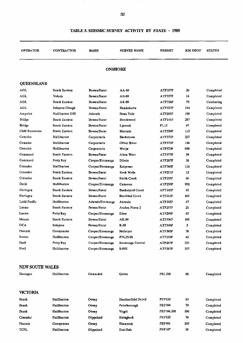
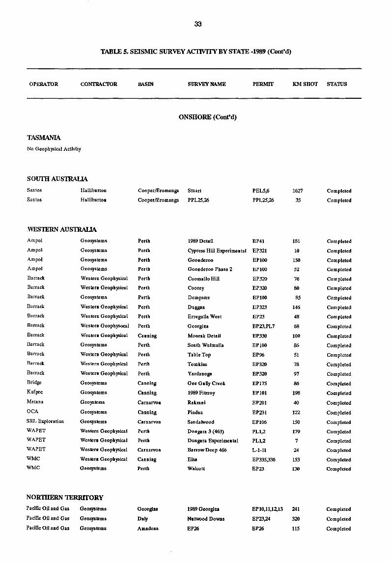
TABLE 5. SEISMIC SURVEY ACI1VITY BY STAlE - 1989
OPERATOR CONTRACTOR MSIN SURVEY NAME PERMIT KM SHOT STATUS
ONSHORE
QUEENSlAND
AGL South Eastern Do_nlSurat AA-89 ATP337P 26 Completed
AGL Velseis Do_nlSurat AB-89 ATP337P 14 Completed
AGL South Eastern Do_nlSurat AR-89 ATP336P 79 Continuing
AGL Seispros Clough Do_nlSurat Dundaburra ATP337P 116 Completed
Ampolex Halliburton GSI Adavale Swan Vale ATP268P 190 Completed
Bridge South Eastern Do_nlSura! Beecbwood ATP145P 207 Completed
Bridge Sou tb Eas tern Do_nlSurat Lynrock PL15 47 Completed
Cluff Resources Soutb Eastern Do_nlSurat Merinda ATP350P 113 Completed
Comalco Halliburton Carpentaria Durketown ATP373P Z27 Completed
Comalco Halliburton Carpentaria Oliver River ATP373P 156 Completed
Comalco Halliburton Carpentaria Weipa ATP373P 698 Completed
Command South Eastern Do_nlSurat Alton West ATP377P 50 Completed
Command Pelly Ray Cooper/Eromanga Dilwin ATP267P 36 Completed
Crusader Halliburton Cooper/Eromanga Kalpo_r ATP368P 116 Completed
Crusader South Eastern Bo_nlSurat Rock Wells ATP251P 12 Completed
Crusader South Eastern Bo_nlSurat Smith Creek ATP258P 66 Completed
Delhi Halliburton Cooper/Eromanga Cameron ATP259P 992 Completed
Hartogen South Eastern Bo_nlSurat Dasketyard Creek APT145P 93 Completed
Hartogen South Eastern Do_nlSurat Dendiboi Creek ATP212P 165 Completed
Ladd Pacific Halliburton Adavale/Eromanga Aureole ATP265P 47 Completed
Lasmo Sonth Eastern Do_nlSurat Avalon Phase 2 ATP257P 21 Completed
Lasmo Petty Ray Cooper/Eromanga Eden ATP299P 45 Completed
Mosaic South Eastern Do_nlSurat AK-89 ATP336P 103 Completed
OCA Seispros Do_nlSurat R-89 ATP349P 5 Completed
Phoenix Geosystems Cooper/Eromanga McIntyre ATP303P 70 Completed
Santos Halliburton Cooper/Eromanga PPL25/26 ATP259P 42 Completed
Shell Pelty Ray CooperlEromanga Eromanga Central ATP267P 355 Completed
Shell Halliburton CooperlEromanga S-89E ATP267P 357 Completed
NEW SOUTH WALES Hartogen Halliburton Gunnedah Quinn PEL238 88 Completed
VICIDRIA
Beach Halliburton Otway Heatberfield Detail PEP119 63 Completed
Beach Halliburton Otway Peterborough PEPI04 79 Completed
Beach Halliburton Otway Vogel PEPI04,108 106 Completed
Crusader Halliburton Gippsland Stringbark PEP 123 34 Completed
Phoenix Geosystems Otway Sbamrock PEPIOI 103 Completed
TCPL Halliburton Gippsland East Sale PEPI07 24 Completed
33
TABLE 5. SEISMIC SURVEY ACIlVITY BY STATE -1989 (Cont'd)
OPERATOR CONTRACTOR
TASMANIA
No Geophysical Activity
SOUTH AUSTRALIA
Santos
Santos
Halliburton
Halliburton
WESTERN AUSTRALIA
Ampol Geosystems
Ampol Geosystems
Ampol Geosystems
Ampol Geosystems
Barrack Western Geophysical
Barrack Western Geophysical
Barrack Geosystems
Barrack Western Geophysical
Barrack Western Geophysical
Barrack Western Geophysocal
Barrack Western Geophysical
Barrack Geosystems
Barrack Western Geophysical
Barrack Western Geophysical
Barrack Western Geophysical
Bridge Geosystems
Kufpec Geosystems
Metana Geoystems
OCA Geosystems
SRL Exploration Geosystems
WAPET Western Geophysical
WAPET Western Geophysical
WAPET Western Geophysical
WMC Western Geophysical
WMC Geosystems
NORTHERN TERRITORY
Pacific Oil and Gas
Pacific Oil and Gas
Pacific Oil and Gas
Geosystems
Geosystems
Geosystems
MSIN SURVEY NAME
ONSHORE (Cont'd)
Cooper!Eromanga Stuart
Cooper!Eromanga PPL25,26
Perth
Perth
Perth
Perth
Perth
Perth
Perth
Perth
Perth
Perth
Canning
Perth
Perth
Perth
Perth
Canning
Canning
Carnarvon
Canning
Carnarvon
Perth
Perth
Carnarvon
Canning
Perth
Georgina
Daly
Amadeus
1989 Detail
Cypress Hill Experimental
Goonderoo
Goonderoo Phase 2
Coomallo Hill
Coorey
Dempster
Duggan
Erregulla West
Georgina
Moorak Detail
South Wulmulla
TableTop
Tomkins
Yardanoga
Gee Gully Creek
1989 Fitzroy
Rakrani
Pindan
Sandalwood
Dongara 3 (463)
Dongara Experimental
Barrow Deep 466
Elsa
Walcott
1989 Georgina
NUlwood DoWIS
EP26
PERMIT KM SHOT STATUS
PELS,6
PPL25,26
EP41
EP321
EP100
EPloo
EP320
EP320
EP100
EP323
EP23
EP23,PL7
EP330
EP100
EP96
EP320
EP320
EP175
EPI01
EP201
EP231
EP106
PL1,2
PL1,2
L-I-H
EP335,336
EP23
1627
35
181
10
150
52
76
80
85
146
48
68
100
86
51
78
97
86
198
40
122
150
179
7
24
153
130
EPI0,11,12,13 241
EP23,24 320
EP26 115
Completed
Completed
Completed
Completed
Completed
Completed
Completed
Completed
Completed
Completed
Completed
Completed
Completed
Completed
Completed
Completed
Completed
Completed
Completed
Completed
Completed
Completed
Completed
Completed
Completed
Completed
Completed
Completed
Completed
Completed
34
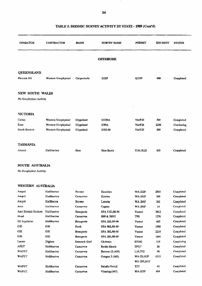
TABLE S. SEISMIC SURVEY ACTIVffY BY STAlE - 1989 (Cont'd)
OPERATOR CONTRACTOR
QUEENSlAND
Phoenix Oil Western Geophysical
NEW SOUTH WALES
No Geophysical Activity
VICIDRIA
Cultus
Esso
South Eastern
TASMANIA
Amoco
Western Geophysical
Western Geophysical
Western Geophysical
Halliburton
SOUTH AUS1RALIA
No Geophysical Activity
WES1ERN AUS1RALIA
Ampol Halliburton
Ampol Halliburton
Ampol HaIliburon
Arco Halliburton
Ausl Seismic Brokers Halliburton
Bond Halliburton
Elf Aquitaine Halliburton
GSI GSI
GSI GSI
GSI GSI
Lasmo Digicon
APET Halliburton
WAPET Halliburton
WAPET Halliburton
WAPET Halliburton
WAPET Halliburton
BASIN
Carpentaria
Gippsland
Gippsland
Gippsland
Bass
Browse
Carnarvon
Browse
Carnarvon
Bonaparte
Carnarvon
Bonaparte
Perth
Bonaparte
Bonaparte
Exmouth Gulf
Carnarvon
Carnarvon
Carnarvon
Carnarvon
Carnarvon
SURVEY NAME
OFFSHORE
Q21P
GC89A
G89A
GSE-89
Bass Basin
Enneidra
Katrina
Loretta
Cygnus
SPA 5 SU88-90
889& 889H
SPA 25U89-9O
SPA 9S1)88-89
SPA 38U88-90
SPA 251)88-89
Chelonia
Rosily Shoals
Barrow 12 (459)
Gorgon 3 (465)
Saladin Detail
Vlamiog (467)
PERMIT
Q/21P
Vic/P23
Vic/P24
Vic/P25
T/14,18,22
WA-212P
WA-203P
WA-206P
WA-202P
Vacant
TP8
Vacant
Vacant
Vacant
Vacant
EP342
TP3,7
LlO,TP2
WA-25,192P
WA-205,241P
TP3
WA-213P
KM SHOT STATUS
800
300
2230
500
435
2564
390
341 14
3012
1276
685
1588
2218
1644
519
36
98
1515
42
644
Completed
Completed
Continuing
Completed
Completed
Completed
Completed
Completed
Completed
Completed
Completed
Completed
Completed
Completed
Completed
Continuing
Completed
Completed
Completed
Completed
Completed
35
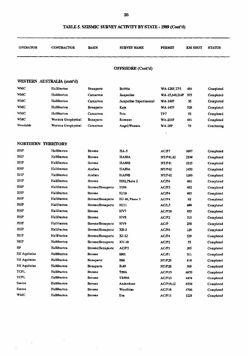
TABLE 5. SEISMIC SURVEY ACI1VITYBYSTATE -1989 (Conttd)
OPERATOR CONTRACTOR MSIN SURVEY NAME PERMIT KM SHOT STATIJS
OFFSHORE (Conttd)
WESTERN AUSTRALIA (conttd)
WMC Halliburton Bonaparte Bobbie WA-I28P,TP5 484 Completed
WMC Halliburton Carnarvon Jacqueline WA-15,149,214P 875 Completed
WMC Halliburton Carnarvon Jacqueline Experimental WA-149P 35 Completed
WMC Halliburton Bonaparte Kaye WA-147P 528 Completed
WMC Halliburton Carnarvon Peta TP7 50 Completed
WMC Western Geophysical Bonaparte Roxanne WA-2llP 441 Completed
Woodside Western Geophysical Carnarvon Angel/Wanaea WA-28P 79 Continuing
NOR1BERN TERRITORY
BHP Halliburton Browse HA-5 AC/p7 1097 Completed
BHP Halliburton Browse HA88A NT/P41,42 2190 Completed
BHP Halliburton Browse HA88B NT/P41 2125 Completed
BHP Halliburton Arafura HA89A NT/P42 1450 Completed
BHP Halliburton Arafura HA89B NT/P42 1200 Completed
BHP Halliburton Browse HB2,Phase2 AC/P6 862 Completed
BHP Halliburton Browse/Bonaparte HH6 AC/P3 482 Completed
BHP Halliburton Browse HJ10 AC/P4 403 Completed
BHP Halliburton Browse/BOna parte HJ-IO, Phase 3 AC/P4 92 Completed
BHP Halliburton Browse/Bonaparte HJll AC!L3 400 Completed
BHP Halliburton Browse HV7 AC/P10 933 Completed
BHP Halliburton Browse HV8 AC/P2 315 Completed
BHP Halliburton Borwse/Bonaparte HV9 AC/P 2SO Completed
BHP Halliburton Browse/Bonaparte XB-3 AC/P6 129 Completed
BHP Halliburton Browse/Bonaparte XJ-12 AC/P4 529 Completed
BHP Halliburton Browse/Bonaparte XV-10 AC/P2 55 Completed
BP Halliburton Browse/Bonaparte AC/P5 AC/PS 385 Completed
Elf Aquitaine Halliburton Browse 8801 AC/P1 311 Completed
Elf Aquitaine Halliburton Bonaparte B88 NT/P28 410 Completed
Elf Aquitaine Hallibnrton Bonaparte B-89 NT/P28 500 Completed
TCPL Halliburton Browse T89A AC/P13 6879 Completed
TCPL Halliburton Browse TR89A AC/P13 4474 Completed
Santos Hallibnrton Browse Anderdone AC/PI0,12 6350 Completed
Santos Halliburton Browse Woodbine AC/PI0 4706 Completed
WMC Halliburton Browse Eva AC/Pll 1224 Completed
36
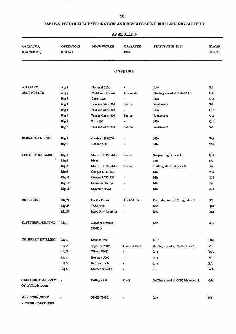
TABLE 6. PETROLEUM EXPLORATION AND DEVELOPMENT DRILLING RIG ACIWITY
OPERATOR!
(OWNED BY)
ATCO-APM
AUSTPTYLTD
MRRACK ENERGY
CENTURY DRILUNG
DRILLCORP
FLEfCHER DRILUNG
GEARHART DRILUNG
GEOLOGICAL SURVEY
OF QUEENSlAND
MEREENIE JOINT
VENTURE PARTERNS
OPERATORS
RIG NO.
Rig 1
Rig 2
Rig 3
Rig 4
Rig 5
Rig6
Rig 7
Rig 8
Rig 1
Rig2
Rig 1
Rig2
Rig 3
Rig 5
Rig 11
Rig 16
Rig 18
Rig 24
Rig 25
Rig 29
Rig 1
Rig 1
Rig 2
Rig 3
Rig 4
Rig 5
Rig 6
AS AT 31.U.89
DRAW WORKS OPERATED
FOR
ONSHORE
National 610E
Mid-Cont. U-36A Ultramar-
Cabot 1287
Franks Cabot 300 Santos
Franks Cabot 300
Franks Cabot 300 Santos
Troy 600
Franks Cabot 300 Santos
Cardwell KM250
Bourne 5000
Ideco BIR Rambler Santos
Ideco
Ideco BIR Rambler Santos
Cooper LTD 750
Cooper LTD 750
Brewster Skytop
Snperior 700M
Franks Cabot Adelaide Pet.
TSM6000
Ideco H44 Rambler
Gardner Denver
2500DD
Kremco 750T
Superior 700E Gas and Fuel
Oilwel1840E
Houston 5000
National T-32
Kremco K 600 T
Failing 2500 GSQ
OIME75OSL
STATUS AT 31-12-89
Idle
Drilling ahead at Katnook 3.
Idle
Workovers
Idle
Workovers
Idle
Workovers
Idle
Idle
Suspending Bowen 1.
Idle
Drilling ahead at Jena 6.
Idle
Idle
Idle
Idle
Preparing to drill Etingimbra 1
Idle
Idle
Idle
Idle
Drilling ahead at McEachern 1.
Idle
Idle
Idle
Idle
Drilling ahead at GSQ Maneroo 1.
Idle
STATE!
TERR.
SA
Old
Old
SA
Old
Old
Old
SA
WA
WA
Old
SA
SA
WA
Old
SA
Old
NT
Old
Old
WA
Old
Vic
WA
NT
SA WA
Qld
NT
37
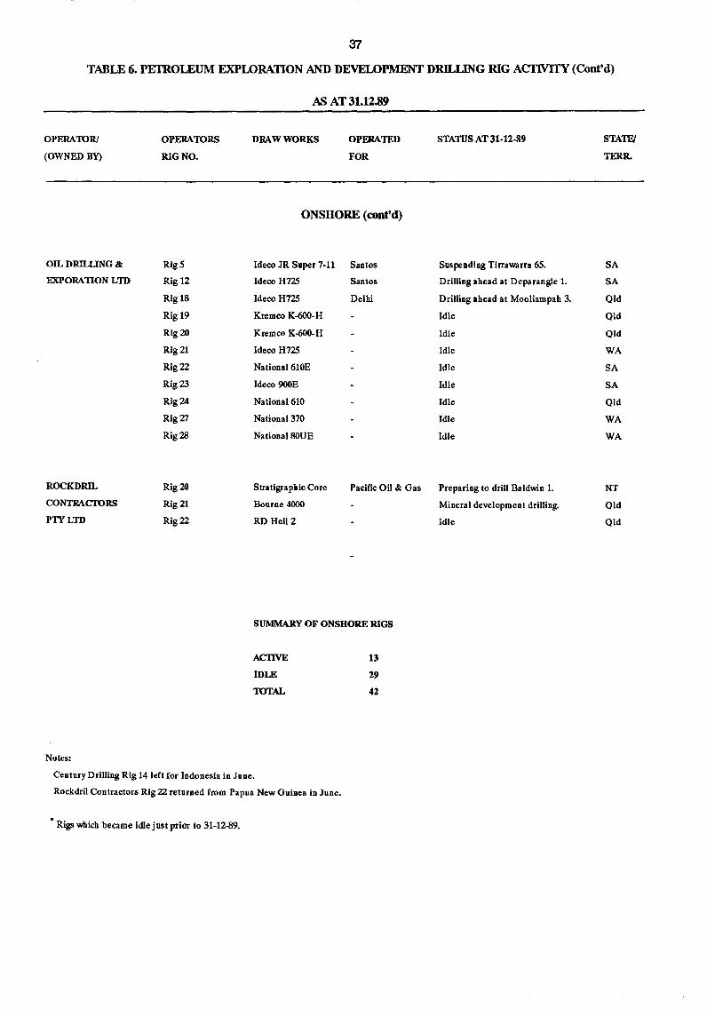
TABLE 6. PEIROLEUM EXPLORATION AND DEVELOPMENT DRll..J.JNG RIG AC1WITY (Cont'd)
OPERATOR!
(OWNED BY)
OIL DRILLING &
EXPORATION LTD
OPERATORS
RIG NO.
RigS
Rig 12
Rig 18
Rig 19
Rig 20
Rig 21
Rig 22
Rig 23
Rig 24
Rig 27
Rig2B
M AT 31.12.89
DRAW WORKS OPERATED
FOR
ONSHORE (cont'd)
Ideco JR Super 7-11 Santos
Ideco H725 Santos
Ideco H725 Delhi
Kremco K-600-H
Kremco K-600-H
Ideco H725
National 610E
Ideco 900E
National 610
National 370
National80UE
STATIJS AT 31·12·89
Suspending Tirrawarra 65.
DriJling ahead at Deparangie 1.
Drilling ahead at Mooliampah 3.
Idle
Idle
Idle
Idle
Idle
Idle
Idle
Idle
ROCKDRIL
CONTRACTORS
PTYLTD
Rig 20
Rig 21
Rig 22
Stratigraphic Core
Bourne 4000
Pacific Oil & Gas Preparing to drill Baldwin 1.
RD Heli 2
SUMMARY OF ONSHORE RIGS
Notes:
ACTIVE
IDLE
TOTAL
Century Drilling Rig 14 left for Indonesia in June.
Rockdril Contractors Rig 22 returned from Papua New Guinea in June.
Rigs which became idle just prior to 31-12-89.
13
29
42
Mineral development drilling.
Idle
STATFJ
TERR.
SA
SA
Qld
Old
Old
WA
SA
SA
Old
WA
WA
NT
Old
Old
38
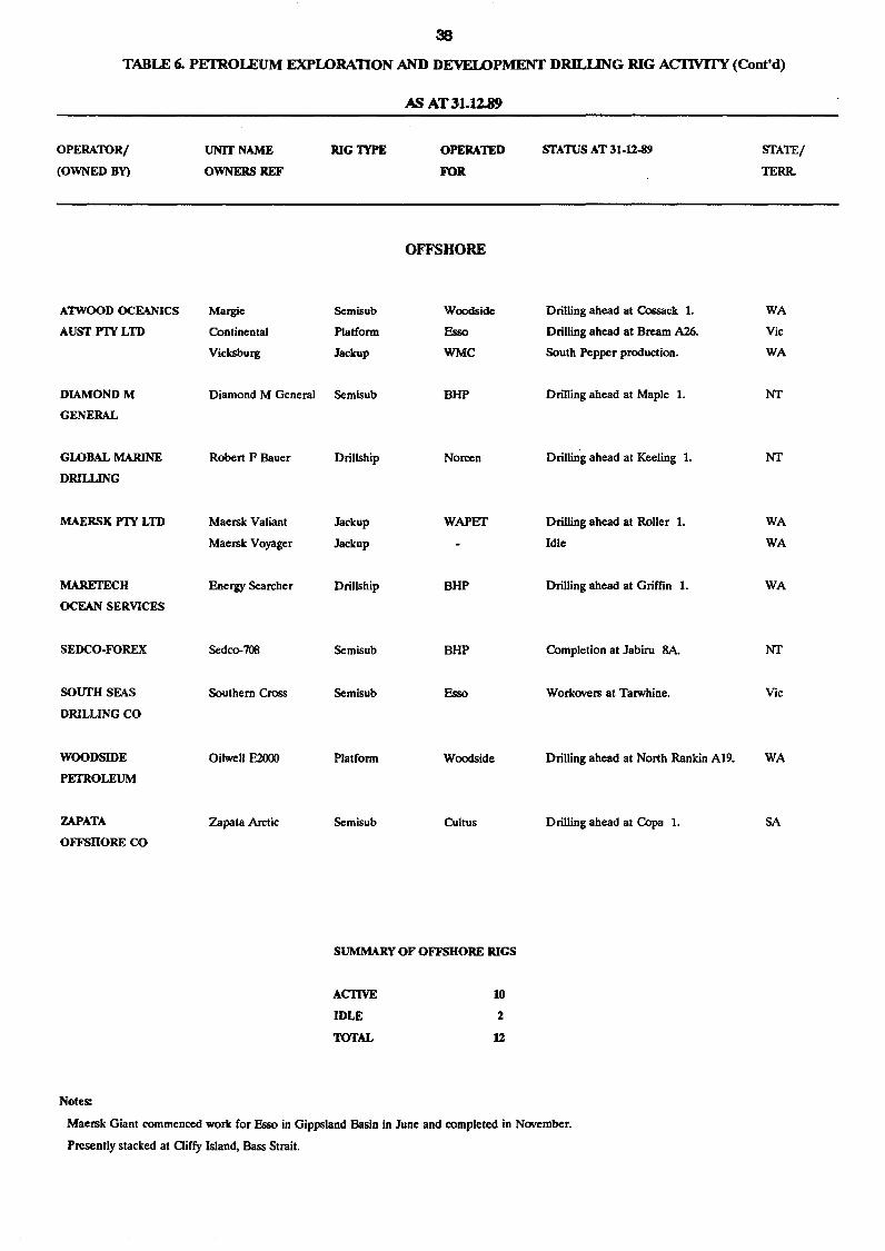
TABLE 6. PETROLEUM EXPLORATION AND DEVELOPMENT DRH...LlNG RIG AC1lVfI'Y (Com'd)
OPERATORI
(OWNED BY)
A1W<X>D OCEANICS
AUSTFlYLTD
DIAMONDM
GENERAL
GLOBAL MARINE
DRILUNG
MAERSK FlY LTD
MARETECH
OCEAN SERVICES
SEDCO-FOREX
sourn SEAS
DRILLING CO
WOODSIDE
PETROLEUM
ZAPATA
OFFSHORE CO
Notes:
UNIT NAME
OWNERS REF
Margie
Continental
Vicksburg
Diamond M General
Robert F Bauer
Maersk Valiant
Maersk Voyager
Energy Searcher
Sedco-708
Southern Cross
Oilwell E2000
Zapata Arctic
RIG TYPE
Semisub
Platform
Jackup
Semisub
Drillship
Jackup
Jackup
Drillship
Semisub
Semisub
Platform
Semisub
AS AT 31.J.l.89
OPERATED
FOR
OFFSHORE
Woodside
Esso
WMC
BHP
Noreen
WAPET
BHP
BHP
Esso
Woodside
Cultus
SUMMARY OF OFFSHORE RIGS
ACI1VE
IDLE
TOTAL
10
2
12
STArns AT 31·12-89
Drilling ahead at Cossack 1.
Drilling ahead at Bream A26.
South Pepper production.
Drilling ahead at Maple 1.
Drilling ahead at Keeling 1.
Drilling ahead at Roller 1.
Idle
Drilling ahead at Griffin 1.
Completion at labiru SA.
Workovers at Tarwhine.
Drilling ahead at North Rankin A19.
Drilling ahead at Copa 1.
Maersk Giant commenced work for Esso in Gippsland Basin in June and completed in November.
Presently stacked at aiffy Island, Bass Strait.
STATE/
TERR.
WA
Vic
WA
NT
NT
WA
WA
WA
NT
Vic
WA
SA
12
10
(I)
(!) 8 0::
L... o 0:: W CD
5 b z
39
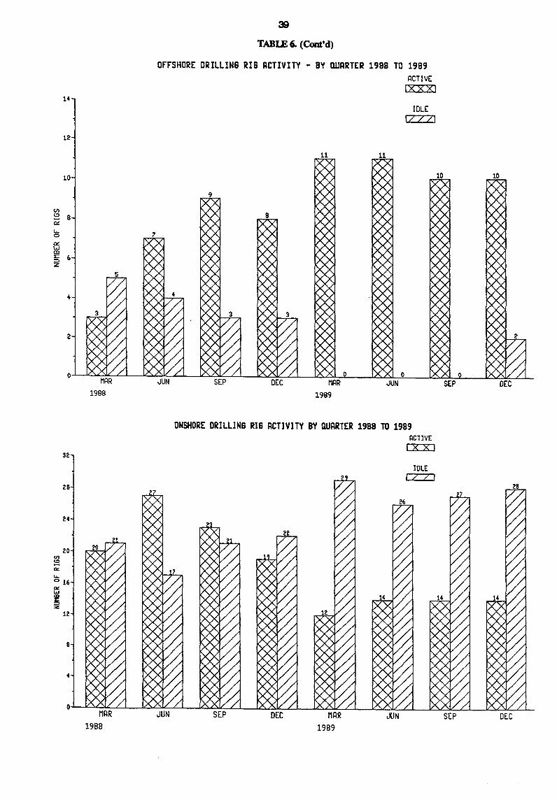
TABlE 6. (Cont'd)
orrSHO~E DRILLING RIG ACTIVITY - BY QUARTER 1988 TO 1989 ~CTIVE
Ixxxi
IDLE II III
0~~~~~--~~-4~~~~~L-~~~~ __ ~~~ __ ~~~~ __ ~~~L-__ ~~~~ M~R JUN SEP DEC DEC
en
'" -"" ......
32
28
24
016
"" ..... CD z:: ::l :z
12
8
4
1988
MRR 1988
JUN
1989
ONSHORE DRILLING RIG ACTIVITY BY QUARTER 1988 TO 1989 ACllVE [XX]
SEP DEC MRR 1989
IDLE CTZJ
JUN SEP DEC
40
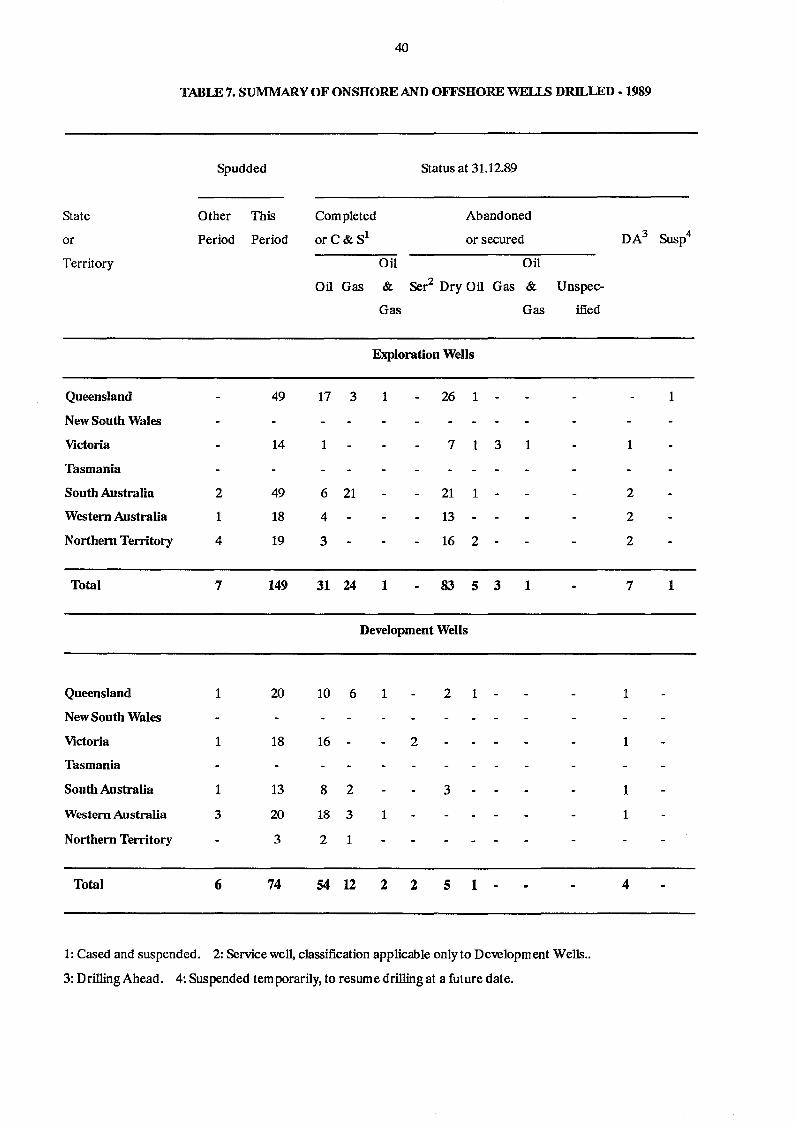
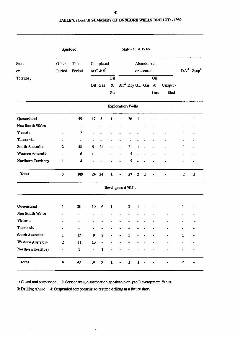
TABLE 7. SUMMARY OF ONSHORE AND OFFSHORE WELLS mm.-LED - 1989
Spudded Status at 31.12.89
State Other This Completed Abandoned
or Period Period orC&Sl or secured
Territory Oil Oil
Oil Gas & Ser2 Dry Oil Gas & Unspec-
Gas Gas ified
Exploration Wens
Queensland 49 17 3 1 26 1
New South Wales
Victoria 14 1 7 1 3 1
Tasmania
South Australia 2 49 6 21 21 1
Western Australia 1 18 4 13
Northern Territory 4 19 3 16 2
Total 7 149 31 24 1 83 5 3 1
Development Wells
Queensland 1 20 10 6 1 2 1
New South Wales
Victoria 1 18 16 2
Tasmania
South Australia 1 13 8 2 3
Western Australia 3 20 18 3 1
Northern Territory 3 2 1
Total 6 74 54 12 2 2 5 1
1: Cased and suspended. 2: Service well, classification applicable only to Development Wells ..
3: Drilling Ahead. 4: Suspended temporarily, to resume drilling at a future date.
DA3
1
2
2
2
7
1
1
1
1
4
Susp4
1
1
41
TABLE 7. (Cont'd) SUMMARY OF ONSHORE WELLS DRILLED· 1989
Spudded Status at 31.12.89
State Other This Completed Abandoned
or Period Period orC&Sl or secured
Territory Oil Oil
Oil Gas & Ser2 Dry Oil Gas & Unspec-
Gas Gas ified
Exploration Wells
Queensland 49 17 3 1 26 1
New South Wales
Victoria 2 1
Tasmania
South Australia 2 48 6 21 21 1
Western Australia 6 1 5
Northern Territory 1 4 5
Total 3 109 24 24 1 57 2 1
Development Wells
Queensland 1 20 10 6 1 2 1
New South Wales
Victoria
Tasmania
South Australia 1 13 8 2 3
Western Australia 2 11 13
Northern Territory 1 1
Total 4 45 31 9 1 5 1
1: Cased and suspended. 2: Service well, classification applicable only to Development Wells ..
3: Drilling Ahead. 4: Suspended temporarily, to resume drilling at a future date.
DA3
1
1
2
1
1
2
Susp4
1
1
42
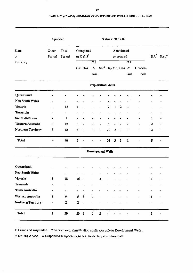
TABLE 7. (Cont'd) SUMMARY OF OFFSHORE WEI...I.S DRILLED -1989
Spudded Status at 31.12.89
State Other This Completed Abandoned
or Period Period orC&Sl or secured
Territory Oil Oil
Oil Gas & Ser2 Dry Oil Gas & Unspec-
Gas Gas ified
Exploration Wells
Queensland
New South Wales
Victoria 12 1 7 1 2 1
Tasmania
South Australia 1
Western Australia 1 12 3 8
Northern Territory 3 15 3 11 2
Total 4 40 7 26 3 2 1
Development Wells
Queensland
New South Wales
Victoria 1 18 16 - 2
Tasmania
South Australia
Western Australia 1 9 5 3 1
Northern Territory 2 2
Total 2 29 23 3 1 2
1: Cased and suspended. 2: Service well, classification applicable only to Development Wells ..
3: Drilling Ahead. 4: Suspended temporarily. to resume drilling at a future date.
DA3
1
2
2
5
1
1
2
Susp4
43
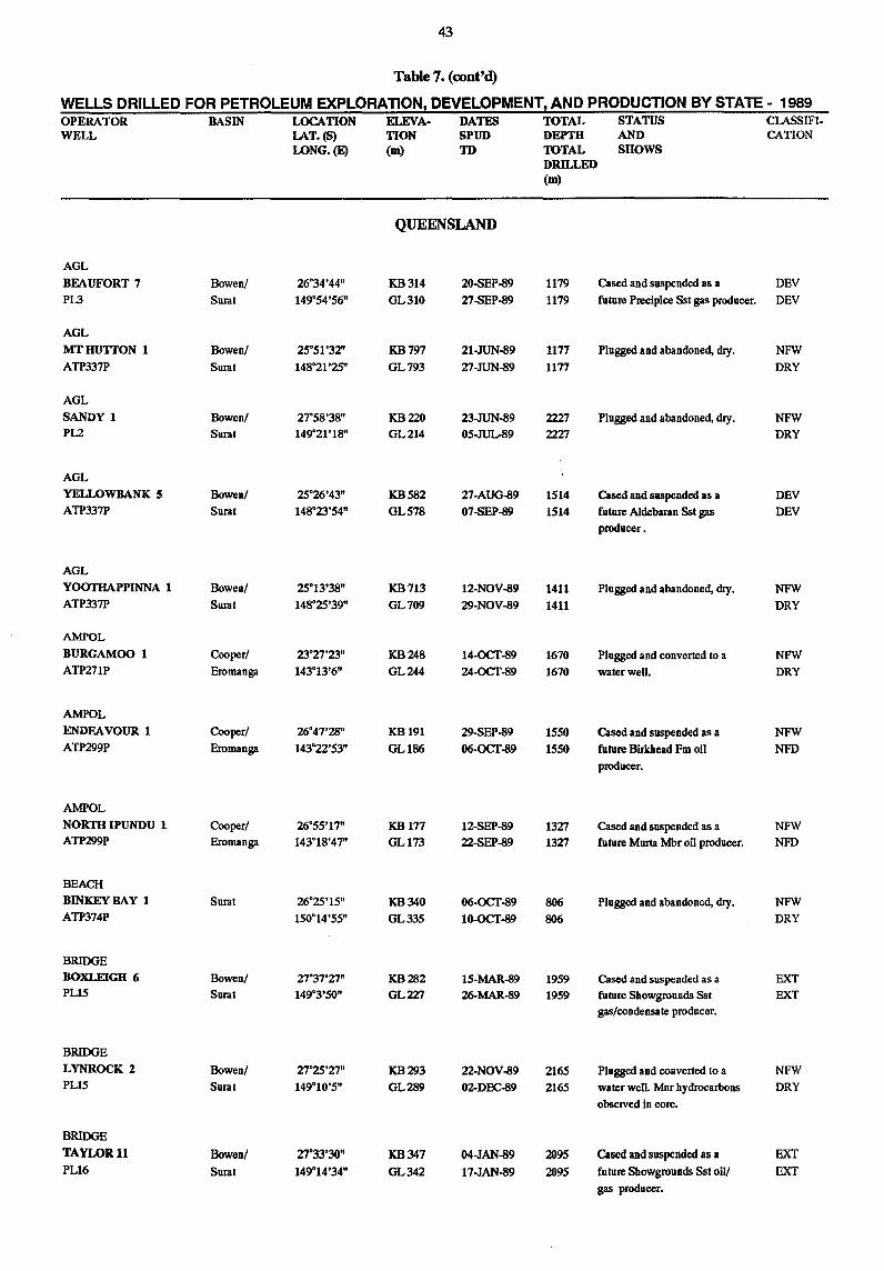
Table 7. (cont'd)
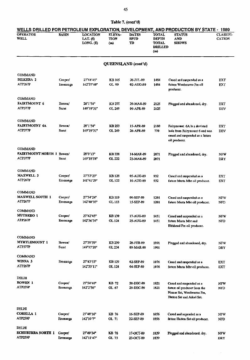
WELLS DRILLED FOR PETROLEUM EXPLORATION, DEVELOPMENT! AND PRODUCTION BY STATE - 1989 OPERATOR BASIN LOCATION ELEVA· DATES TOTAL STATUS CLASSIFI-WELL LAT_(S) TION SPUD DEPTH AND CATION
LONG.(E) (m) m TOTAL SHOWS DRILLED (m)
QUEENSLAND
AGL
BEAUFORT 7 Bowen! 26°34'44" KB314 20-SEP-89 1179 Cased and suspended as a DEV
PL3 Sural 149°54'56" GL310 27-SEP-89 1179 future Precipice Ssl gas producer. DEV
AGL
MTHUTTON 1 Bowen! 25°51'32" KB797 21-JUN-89 1177 Plugged and abandoned, dIy. NFW
ATP337P Sural 148°21'25" GL793 27-JUN-89 1177 DRY
AGL
SANDY 1 Bowen! 27°58'38" KB220 23-JUN-89 2227 Plugged and abandoned, dIy. NFW P12 Sural 149°21'18" GL214 05-JUL-89 2227 DRY
AGL
YELLOWBANK 5 Bowenl 25°26'43" KB582 27-AUG-89 1514 Cased and suspended as a DEV ATP337P Sural 148°23'54" GL578 07-SEP-89 1514 future Aldebaran Ssl gas DEV
producer.
AGL
YOOTHAPPINNA 1 Bowen! 25°13'38" KB713 12-NOV-89 1411 Plugged and abandoned, dIy. NFW ATP337P Sural 148°25'39" GL709 29-NOV-89 1411 DRY
AMPOL
BURGAMOO 1 Cooper! 23°27'23" KB248 14-OCT-89 1670 Plugged and converted 10 a NFW ATP271P Eromanga 143°13'6" GL244 24-OCT-89 1670 water well. DRY
AMPOL
ENDEAVOUR 1 Cooper! 26°47'28" KB 191 29-SEP-89 1550 Cased and suspended as a NFW ATP299P Eromanga 143"22'53" GLl86 O6-OCT-89 1550 future Birkhead Fm oil NFD
producer.
AMPOL
NORTH IPUNDU 1 Cooper/ 26°55'17" KB177 12-SEP-89 1327 Cased and suspended as a NFW ATP299P Eromanga 143°18'47" GL173 22-SEP-89 1327 future Murta Mbr oil producer. NFD
BEACH
BINKEYBAY 1 Sural 26°25'15" KB340 06-OCT-89 806 Plugged and abandoned, dIy. NFW ATP374P 150°14'55" GL335 10-OCT-89 806 DRY
BRIDGE BOXLEIGH 6 Bowen/ 27°37'27" KB282 15-MAR-89 1959 Cased and suspended as a EXT PL15 Sural 149°3'50" GL227 26-MAR-89 1959 future Showgrounds Ssl EXT
gas/condensate producer.
BRIDGE
LYNROCK 2 Bowen! 27°25'27" KB293 22-NOV-89 2165 Plugged and converted 10 a NFW PL15 Sural 149°10'5" GL289 02-DEC-89 2165 water well. Mnr hydrocarbons DRY
observed in core.
BRIDGE
TAYLOR 11 Bowen/ 27°33'30" KB347 04-JAN-89 2095 Cased and suspended as a EXT PL16 Sural 149°14'34" GL342 17-JAN-89 2095 future Showgrounds Ssl oil! EXT
gas producer.
44
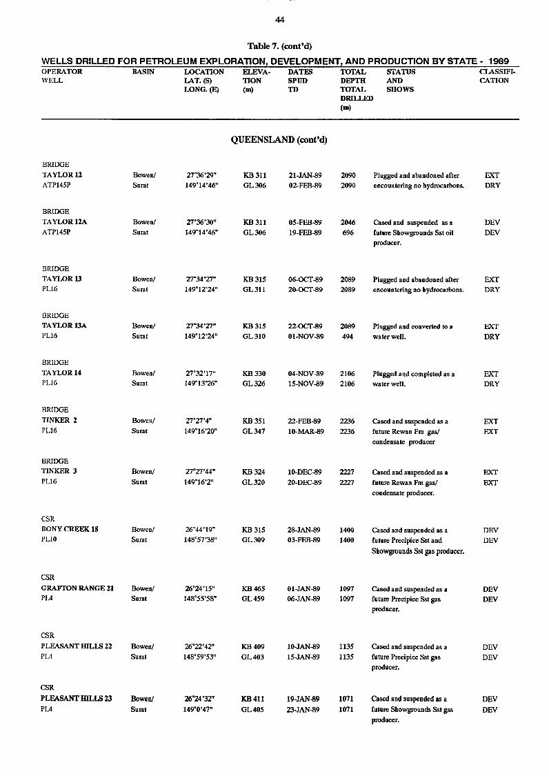
Table 7. (cont'd)
WELLS DRILLED FOR PETROLEUM EXPLORATION, DEVELOPMENT! AND PRODUCTION BY STATE - 1989 OPERATOR BASIN LOCATION ELEVA- DATES TOTAL STATUS CLASSIFI-WELL LAT.(S) TION SPUD DEPTH AND CATION
LONG. (E) (m) TD TOTAL SHOWS DRILLED (m)
QUEENSlAND (cont'd)
BRIDGE
TAYLOR 12 Bowen! 27·36'29" KB311 21-JAN-89 2090 Plugged and abandoned after EXT ATP145P Surat 149·14'46" GL306 02-FEB-89 2090 encountering no hydrocarbons. DRY
BRIDGE
TAYLOR12A Bowen! 27·36'30" KB311 OS-FEB-89 2046 Cased and suspended as a DEV ATPI45P Surat 149·14'46" GL306 19-FEB-89 696 future Showgrounds Sst oil DEV
producer.
BRIDGE
TAYLOR 13 Bowen! 27·34'27" KB315 06-OCT-89 2089 Plugged and abandoned after EXT PLl6 Surat 149·12'24" GL311 20-OCT-89 2089 encountering no hydrocarbons. DRY
BRIDGE
TAYLOR13A Bowen! 27·34'27" KB31S 22-OCT-89 2089 Plugged and converted 10 a EXT PLl6 Surat 149·12'24" GL310 01-NOV-89 494 water well. DRY
BRIDGE
TAYLOR 14 Bowen! 27·32'17" KB330 04-NOV-89 2106 Plugged and completed as a EXT PLl6 Surat 149·13'26" GL326 15-NOV-89 2106 water well. DRY
BRIDGE
TINKER 2 Bowen! 27·27'4" KB351 22-FEB-89 2236 Cased and suspended as a EXT PLl6 Surat 149·16'20" GL347 10-MAR-89 2236 future Rewan Fm gas! EXT
condensate producer
BRIDGE
TINKER 3 Bowen! 27·27'44" KB324 10-DEC-89 2227 Cased and suspended as a EXT PLl6 Sural 149·16'2" GL320 20-DEC-89 2227 future Rewan Fm gas! EXT
condensate producer.
CSR
BONY CREEK 18 Bowen! 26·44'19" KB315 28-JAN-89 1400 Cased and suspended as a DEV PLlO Surat 148·57'38" GL309 03-FEB-89 1400 future Precipice Sst and DEY
Showgrounds Sst gas producer.
CSR
GRAFTON RANGE Z1 Bowen! 26·24'15" KB465 01-JAN-89 1097 Cased and suspended as a DEV PL4 Surat 148·55'58" GL459 06-JAN-89 1097 future Precipice Sst gas DEV
producer.
CSR
PLEASANT HILLS 22 Bowen! 26·22'42" KB409 10-JAN-89 1135 Cased and suspended as a DEY PL4 Sural 148·59'53" GL403 15-JAN-89 1135 future Precipice Sst gas DEY
producer.
CSR
PLEASANT mLLS Z3 Bowen! 26°24'32" KB411 19-JAN-89 1071 Cased and suspended as a DEV PL4 Sural 149·0'47" GL405 23-JAN-89 1071 future Showgrounds Sst gas DEV
producer.
45
Table 7. (cont'd)
WELLS DRILLED FOR PETROLEUM EXPLORATION! DEVELOPMENT! AND PRODUCTION BY STATE - 1989 OPERATOR BASIN LOCATION ELEVA· DATES TOTAL STATUS CLASS!FI· WELL LAT. (S) TION SPUD DEPTII AND CATION
LONG.(E) (m) TD TOTAL SHOWS DRILLED (m)
QUEENSlAND (cont'd)
COMMAND
DILKERA 2 Cooper! 27"44'45" KBI05 26-JUL..89 1484 Cased and suspended as a EXT ATP267P Eromanga 142"37'40" GL 99 02-AUG-89 1484 future Weslboume Fm oil EXT
producer.
COMMAND
FAIRYMOUNT 6 Bowen! 28°1 '54" KB255 29·MAR-89 2125 Plugged and abandoned, dry. EXT ATP377P Sural 149"19'31" GL249 09-APR-89 2125 DEV
COMMAND
FAIRYMOUNT 6A Bowen! 28"1'54" KB253 15-APR-89 2180 Fairymounl 6A is a devialed EXT ATP377P Sural 149°19'31" GL249 26-APR-89 770 bole from Fairymounl 6 and was DEV
cased and suspended as a future
oil producer.
COMMAND
FAIRYMOUNTNORTH 1 Bowen! 28°0'13" KB228 14-MAR-89 2071 Plugged and abandoned, dry. NFW ATP377P Surat 149°18'54" GL222 23-MAR-89 2071 DRY
COMMAND
MAXWELL 3 Cooper/ 27"53'23" KBI28 05-AUG-89 932 Cased and suspended as a EXT ATP267P Eromanga 141"41'29" GLI22 10-AUG-89 932 future Murta Mbr oil producer. EXT
COMMAND
MAXWELL SOUTH 1 Cooper! 27"54'24" KB119 09-SEP-89 1201 Cased and suspended as a NFW ATP267P Eromanga 142"40'35" GLI13 15-SEP-89 1201 future Murta Mbr oil producer. NFD
COMMAND
MUTHERO 1 Cooper! 27"42'45" KB130 17-AUG-89 1451 Cased and suspended as a NFW ATP267P Eromanga 142"36'34" GLI24 25-AUG-89 1451 future Murta Mbr and NFD
Birkhead Fm oil producer.
COMMAND
MYRTLEMOUNT 1 Bowen! 27°59'59" KB239 28-FEB-89 1991 Plugged and abandoned, dry. NFW ATP377P Surat 149°17'20" GL234 09-MAR-89 1991 DRY
COMMAND
WINNA 3 Eromanga 27°43'55" KB129 02-SEP-89 1076 Cased and suspended as a EXT ATP267P 142°33'11" GLI24 04-SEP-89 1076 future Murta Mbroil producer. EXT
DEUll
BOWEN 1 Cooper/ 27°54'40" KB 72 2O-DEC-89 1821 Cased and suspended as a NFW ATP259P Eromanga 142"2'56" GL 67 29-DEC-89 1821 fu ture oil producer from Ihe NFD
Namur Sst, Westboume Fm,
Hutton Ssl and Adori Sst
DEUll
COREUA 1 Cooper/ 27°48'16" KB 76 16-SEP-89 1856 Cased and supended as a NFW ATP259P Eromanga 142°10'7" GL 71 22-SEP-89 1856 future HUlton Sst oil producer. NFD
DEUll
ECBUBURRA NORm 1 Cooper! 27°49'34" KB 78 17·OCT-89 1839 Plugged and abandoned, dry. NFW ATP259P Eromanga 142°11'47" GL 73 23-OCT-89 1839 DRY
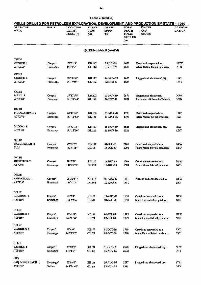
46
Table 7. (cont'd)
WELLS DRILLED FOR PETROLEUM EXPLORATION, DEVELOPMENT! AND PRODUCTION BY STATE - 1989 OPERATOR BASIN LOCATION ELEVA· DATES TOTAL STATUS CLASSIFI. WELL LAT.(S) TION SPUD DEPTH AND CATION
LONG.(E) (m) TO TOTAL SHOWS DRILLED (m)
QUEENSLAND (cont'd)
DEUII
GIDGEE 1 Cooper! 28"31'9" KB 117 25.JUL.89 1631 Cased and suspended as a NFW ATP259P Eromanga 141"8'0" GL112 31.JUL.89 1631 future Hutton Sst oil producer. NFD
DEUII
GIDGEE 2 Cooper! 28"30'50" KB117 24·NOV-89 1636 Plugged and abandoned, dry. EXT ATP259P Eromanga 141"7'45" GL112 02·DEC-89 1636 DRY
DEUII
MAHL 1 Cooper! 27"17'59" KB202 23·NOV-89 2879 Plugged and abandoned NFW ATP259P Eromanga 141"19'46" GL198 2O-DEC-89 2879 Recovered oil from the Triassic. NFD
DEUII
MOOLIAMPAH 2 Cooper! 28"19'58" KBI36 03-MAY-89 1798 Cased Ind suspended as a EXT ATP259P Eromanga 141"16'52" GL131 ll-MAY-89 1798 future Namur Sst oil producer. EXT
MUNRO 4 Cooper! 28"32'14" KB 127 16-NOV-89 1526 Plugged and abandoned, dry. EXT ATP259P Eromanga 141"12'10" GL122 20-NOV-89 1526 DRY
DEUII
NACCOWLAH 2 Cooper! 27"29'9" KB 101 01.JUL.89 2201 Cased and suspended as a NFW Pl25 Eromanga 142"8'11" GL 95 15.JUL.89 2201 future Murla Mbr oil producer. NFD
DEUII ORIENTOS 2 Cooper! 28"2'58" KB 140 ll-DEC-89 1589 Cased and suspended as a NFW ATP259P Eromanga 141"25'36" GL135 18-DEC-89 1589 future Murta Mbr oil producer. NFD
DEUII
PARAGILGA 1 Cooper! 28"32'54" KB 113 06-AUG-89 1511 Plugged and abandoned, dry. NFW ATP259P Eromanga 141"4'19" GLI08 12-AUG-89 1511 DRY
DEUII PINAROO 1 Cooper! 28"9'4" KB 87 17-AUG-89 1850 Cased and suspended as a NFW ATP259P Eromanga 141"59'52" GL 81 24-AUG-89 1850 future Hutton Sst oil producer. NFD
DELHI WANDILO 1 Cooper/ 28"4'12" KB 82 01-SEP-89 1793 Cased and suspended as a NFW ATP259P Eromanga 142"1 '34" GL 77 07-SEP-89 1793 future Hutton Sst oil producer. NFD
DEUII
WANDILO 2 Cooper! 28"4'6" KB 79 01-OCT-89 1748 Cased and suspended as a EXT ATP259P Eromanga 142"1 '17" GL 74 08-OCT-89 1748 future Hutton Sst oil producer. EXT
DEUII
YANBEE 1 Cooper! 26"50'3" KB 91 31-OCT-89 2592 Plugged and abandoned, dry. NFW ATP259P Eromanga 141"1 '3" GL 86 16-NOV-89 2592 DRY
GSQ
GSQ LONGREACH 1 Eromangal 23"6'60" KB oa 19·AUG-89 1297 Plugged and abandooed, dry. STR ATP166P Galilee 144"34'60" GL na 03-NOV-89 1341 DRY
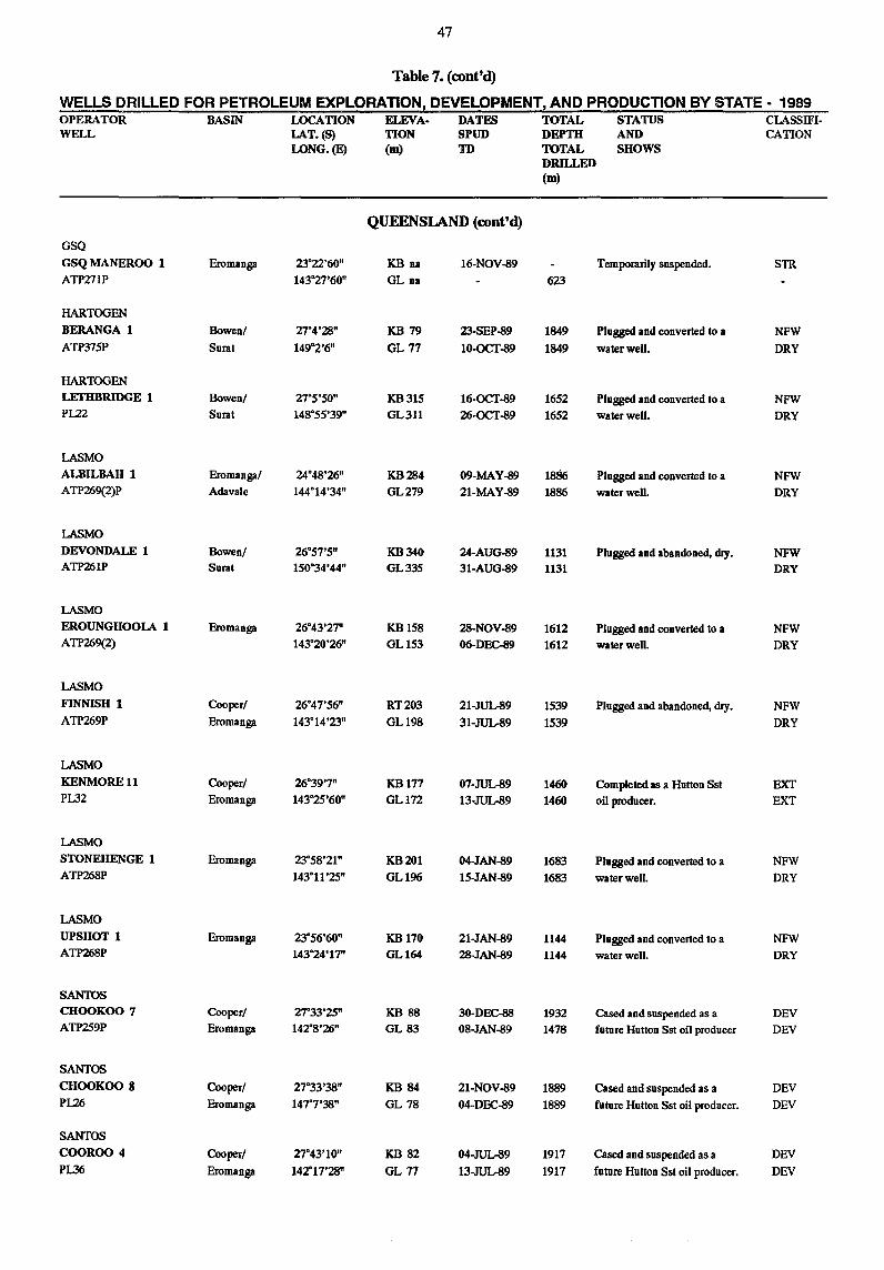
47
Table 7. (ront'd)
WELLS DRILLED FOR PETROLEUM EXPLORATION I DEVELOPMENT1 AND PRODUCTION BY STATE - 1989 OPERATOR BASIN LOCATION ELEVA· DATES TOTAL STATUS CLASSIFI-WELL LAT_(S) TlON SPUD DEPTH AND CATION
LONG_(E) (m) TD TOTAL SHOWS DRILLED (m)
QUEENSlAND (ront'd)
GSQ
GSQ MANEROO 1 Eromanga 23"22'60" KB na 16-NOV-89 Temporarily suspended. STR ATP271P 143"27'60" GL na 623
HARTOGEN
BERANGA 1 Bowen! 27"4'28" KB 79 23-SEP-89 1849 Plugged and converted 10 a NFW ATP375P Sural 149"2'6" GL 77 10-OCT-89 1849 waterweU. DRY
HARTOGEN
LETIIBRIDGE 1 Bowen! 27"5'50" KB315 16-OCT-89 1652 Plugged and converted 10 a NFW PL22 Sural 148"55'39" GL311 26-OCT-89 1652 water well. DRY
LASMO
ALBILBAH 1 Eromanga! 24"48'26" KB284 09-MAY-89 1886 Plugged and converted 10 a NFW ATP269(2)P Adavale 144"14'34" GL279 21-MAY-89 1886 water well. DRY
LASMO
DEVONDALE 1 Bowen! 26"57'5" KB340 24-AUG-89 1131 Plugged and abandoned, dry. NFW ATP261P Sural 150"34'44" GL335 31-AUG-89 1131 DRY
LASMO
EROUNGHOOLA 1 Eromanga 26"43'27" KB158 28-NOV-89 1612 Plugged and converted 10 a NFW ATP269(2) 143"20'26" GL153 06-DEC-89 1612 waterweU. DRY
LASMO
FINNISH 1 Cooper! 26"47'56" RT203 21-JUL.89 1539 Plugged and abandoned, dry. NFW ATP269P Eromanga 143"14'23" GL198 31-JUL.89 1539 DRY
LASMO
KENMORE 11 Cooper! 26"39'7" KB177 07-JUL.89 1460 Completed as a Hutton Sst EXT PL32 Eromanga 143"25'60" GLI72 13-JUL.89 1460 oil producer. EXT
LASMO
STONEHENGE 1 Eromanga 23"58'21" KB201 04-JAN-89 1683 Plugged and converted 10 a NFW ATP268P 143"11'25" GLI96 15-JAN-89 1683 water well. DRY
LASMO
UPSHOT 1 Eromanga 23"56'60" KB170 21-JAN-89 1144 Plugged and converted to a NFW ATP268P 143"24'17" GLI64 28-JAN-89 1144 water well. DRY
SANTOS CHOOKOO 7 Cooper! 27"33'25" KB 88 3O-DEC-88 1932 cased and suspended as a DEV ATP259P Eromanga 142"8'26" GL 83 08-JAN-89 1478 future Hutton Sst oil producer DEV
SANTOS
CHOOKOO 8 Cooper! 27"33'38" KB 84 21-NOV-89 1889 cased and suspended as a DEV PI.26 Eromanga 147"7'38" GL 78 04-DEC-89 1889 future Hutton Sst oil producer. DEV
SANTOS
COOROO 4 Cooper! 27"43'10" KB 82 04-JUL.89 1917 cased and suspended as a DEV PL36 Eromanga 142"17'28" GL 77 13-JUL.89 1917 future Hutton Sst oil producer. DEV
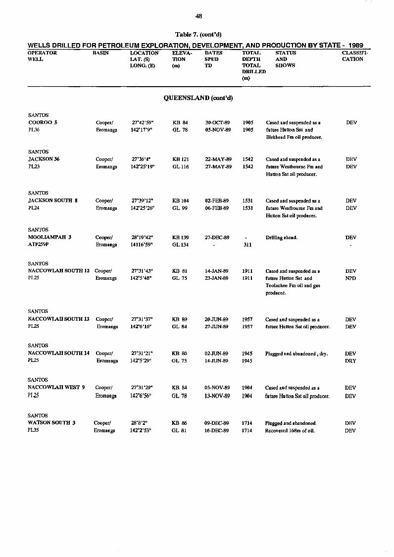
48
Table 7. (cont'd)
WELLS DRILLED FOR PETROLEUM EXPLORATION, DEVELOPMENT, AND PRODUCTION BY STATE - 1989 OPERATOR BASIN LOCATION ELEVA- DATES TOTAL STATUS CLASSIFI-WELL LAT. (8) TION SPUD DEPTH AND CATION
LONG.(E) (m) TO TOTAL SHOWS DRILLED (m)
QUEENSlAND (cont'd)
SANTOS COOROO 5 Cooper! 27"42'59" KB 84 30-OCT-89 1905 Cased and suspended as a DEV
P1.36 Eromanga 142"17'9" GL 78 05-NOV-89 1905 futnre Hutton Sst and
Birkhead Fm oil producer.
SANTOS
JACKSON 36 Cooper! 27"36'4" KB 121 22-MAY-89 1542 Cased and snspended as a DEV
P123 Eromanga 142"25'19" GL116 27-MAY-89 1542 futnre Westbonme Fm and DEV
Hutton Sst oil producer.
SANTOS
JACKSON SOUTII 8 Cooper! 27"39'12" KB104 02-FEB-89 1531 Cased and suspended as a DEV P124 Eromanga 142"25'26" GL 99 06-FEB-89 1531 futnre Westboume Fm and DEV
Hutton Sst oil producer.
SANTOS
MOOLlAMPAH 3 Cooper! 28"19'42" KB139 27-DEC-89 Drilling ahead. DEV ATP259P Eromanga 14116'59" GL134 311
SANTOS NACCOWLAH SOUTIllZ Cooper! 27"31 '43" KB 81 14-JAN-89 1911 Cased and suspended as a DEV P125 Eromanga 142"5'48" GL 75 23-JAN-89 1911 futnre Hutton Sst and NPD
Toolachee Fm oil and gas
producer.
SANTOS
NACCOWLAH SOUTH 13 Cooper! 27"31'37" KB 89 20-JUN-89 1957 Cased and suspended as a DEV P125 Eromanga 142"6'16" GL 84 27-JUN-89 1957 futnre Hntton Sst oil producer. DEV
SANTOS
NACCOWLAH SOUTIl14 Cooper! 27"31 '21" KB 80 02-JUN-89 1945 Plugged and abandoned, dry. DEV P125 Eromanga 142"5'29" GL 75 14-JUN-89 1945 DRY
SANTOS
NACCOWLAH WEST 9 Cooper! 27"31'29" KB 84 05-NOV-89 1904 Cased and suspended as a DEV
P125 Eromanga 142°6'56" GL 78 13-NOV-89 1904 future Hutton Sst oil producer. DEV
SANTOS WATSON SOUTII 3 Cooper! 28"8'2" KB 86 09-DEC-89 1714 Plugged and abandoned DEV PL35 Eromanga 142"2'53" GL 81 16-DEC-89 1714 Recovered 168m of oil. DEV
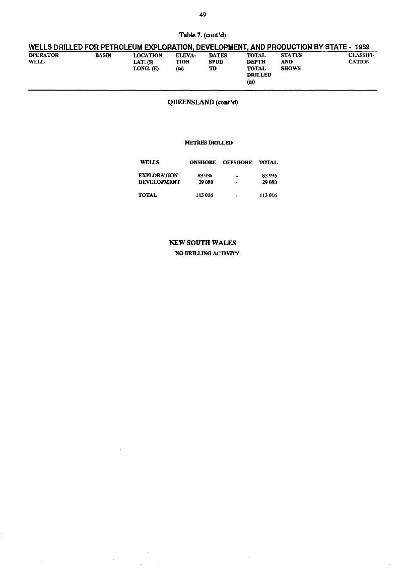
49
Table 7. (cont'd)
WELLS DRILLED FOR PETROLEUM EXPLORATION, DEVELOPMENT, AND PRODUCTION BY STATE - 1989 OPERATOR WELL
BASIN LOCATION LAT.(S) LONG.(E)
ELEVA· TION (m)
DATES SPUD TD
QUEENSlAND (cont'd)
METRES DRILLED
TOTAL DEPTH TOTAL DRILLED (m)
WELLS ONSHORE OFFSHORE TOTAL
EXPLORATION DEVELOPMENT
TOTAL
83936 29080
113016
NEW SOUTH WALES
NO DRILLING ACTIVITY
83936 29080
113016
STATUS AND SHOWS
CLASSIFI· CATION
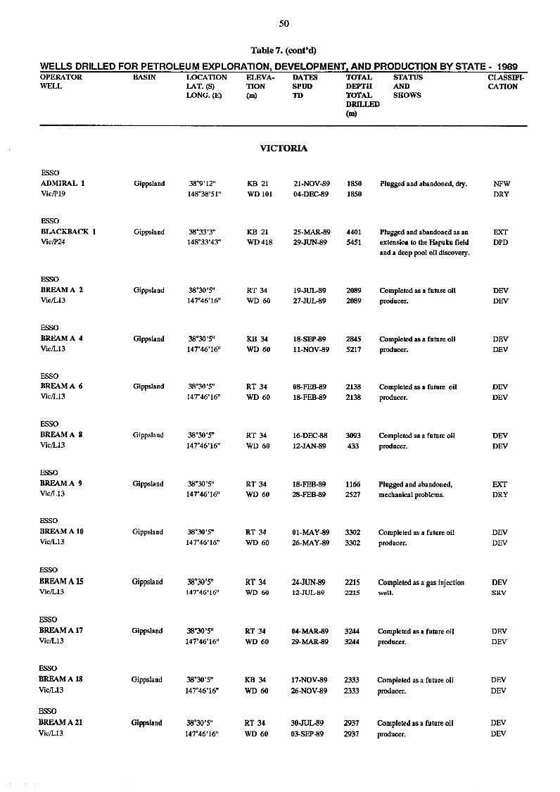
50
Table 7. (conttd)
WELLS DRILLED FOR PETROLEUM EXPLORATIONt DEVELOPMENT! AND PRODUCTION BY STATE - 1989 OPERATOR BASIN LOCATION ELEVA. DATES TOTAL STATUS CLASSIFI· WELL LAT. (S) TION SPUD DEPTH AND CATION
LONG.(E) (m) TD TOTAL SHOWS DRILLED (m)
VICTORIA
ESSO
ADMIRAL 1 Gippsland 38"9'12" KB 21 21·NOV-89 1850 Plugged and abandoned, dry. NFW Vic/P19 148"38'51" WDI01 04-DEC-89 1850 DRY
ESSO
BLACKBACK 1 Gippsland 38"33'3" KB 21 25-MAR-89 4401 Plugged and abandoned as an EXT Vic/P24 148"33'43" WD418 29-JUN-89 5451 extension to the Hapuku field DPD
and a deep pool oil discovery.
ESSO
BREAMA 2 Gippsland 38"30'5" RT 34 19-JUL-89 2089 Completed as a future oil DEV Vic/L13 147"46'16" WD 60 27-JUL-89 2089 producer. DEV
ESSO
BREAM A 4 Gippsland 38"30'5" KB 34 18-SEP-89 2845 Completed as a future oil DEV Vic/L13 147"46'16" WD 60 I1·NOV-89 5217 producer. DEV
ESSO BREAMA 6 Gippsland 38"30'5" RT 34 08-FEB-89 2138 Completed as a future oil DEV Vic/L13 147"46'16" WD 60 18-FEB-89 2138 producer. DEV
ESSO
BREAMA 8 Gippsland 38"30'5" RT 34 16-DEC-88 3093 Completed as a future oil DEV Vic/L13 147"46'16" WD 60 12-JAN-89 433 producer. DEV
ESSO
BREAM A 9 Gippsland 38"30'5" RT 34 18-FEB-89 1166 Plugged and abandoned, EXT Vic/L13 147"46'16" WD 60 28-FEB-89 2527 mechanical problems. DRY
ESSO
BREAM A 10 Gippsland 38"30'5" RT 34 01-MAY-89 3302 Completed as a future oil DEV Vic/L13 147"46'16" WD 60 26-MAY-89 3302 producer. DEV
ESSO
BREAM A 15 Gippsland 38·30'5" RT 34 24-JUN-89 2215 Completed as a gas injection DEV Vic/L13 147"46'16" WD 60 12-JUL-89 2215 well. SRV
ESSO
BREAM A 17 Gippsland 38·30'5" RT 34 04-MAR-89 3244 Completed as a future oil DEV Vic/L13 147"46'16" WD 60 29-MAR-89 3244 producer. DEV
ESSO
BREAM A 18 Gippsland 38·30'5" KB 34 17-NOV-89 2333 Completed as a future oil DEV
Vic/L13 147"46'16" WD 60 26-NOV-89 2333 producer. DEV
ESSO
BREAMA21 Gippsland 38"30'5" RT 34 30-JUL.89 2937 Completed as a future oil DEV
Vic/L13 147"46'16" WD 60 03-SEP-89 2937 producer. DEV
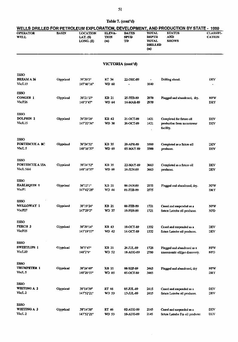
51
Table 7. (cont'd)
WELLS DRILLED FOR PETROLEUM EXPLORATlONz DEVELOPMENT! AND PRODUCTION BY STATE - 1989 OPERATOR BASIN LOCATION ELEVA- DATES TOTAL STATUS CLASSIFI-WELL LAT. (S) TION SPUD DEPTH AND CATION
LONG.(E) (m) TD TOTAL SHOWS DRILLED (m)
VICTORIA (cont'd)
ESSO
BRFAMA2(j Gippsland 38°30'5" RT 34 22-DEC-89 Drilling ahead. DEV
Vic/L13 147°46'16" WD 60 1640
ESSO
CONGER 1 Gippsland 38°21'27" KB 21 25-FEB-89 2970 Plugged and abandoned, dry. NFW Vic/P26 148°3'47" WD 64 14-MAR-89 2970 DRY
ESSO
DOLPHIN Z Gippsland 38°29'20" KB 42 21-OCT-89 1421 Completed for future oil DEV Vic/L15 147°22'34" WD 38 26-OCT-89 1421 production from monotower DEV
facility.
ESSO
FORTESCUEA 8C Gippsland 38°24'32" KB 35 20-APR-89 3300 Completed as a future oil DEV Vic/L5 148°16'37" WD 69 05-MAY-89 3300 producer. DEV
ESSO
FORTESCUE A 15A Gippsland 38°24'32" KB 35 22-MAY-89 3663 Completed as a future oil DEV Vic/L5&6 148°16'37" WD 69 16-JUN-89 3663 producer. DEV
ESSO
HARLEQUIN 1 Gippsland 38°12'1" KB 21 06-JAN-89 2575 Plugged and abandoned, dry. NFW ViclPl 147°42'28" WD 44 01-FEB-89 2575 DRY
ESSO
MULLOWAY 1 Gippsland 38°19'24" KB 21 08-FEB-89 1721 Cased and suspended as a NFW ViclP27 147°29'2" WD 37 19-FEB-89 1721 future Latrobe oil producer. NFD
ESSO
PERCH 3 Gippsland 38°29'14" KB 43 10-OCT-89 1332 Cased and suspended as a DEV Vic/P25 147°19'17" WD 42 14-OCT-89 1332 future Latrobe oil producer. DEV
ESSO
SWEETLIPS 1 Gippsland 38°5'47" KB 21 26-.TUlr89 1728 Plugged and abandoned as a NFW Vic/LI0 148°2'9" WD 52 18-AUG-89 2780 uneconomic oiVgas discovery. NFD
ESSO
TRUMPETER 1 Gippsland 38°24'49" KB 21 08-SEP-89 3465 Plugged and abandoned, dry NFW Vic/L5 148°20'57" WD 85 05-OCT-89 3465 DRY
ESSO
WBITINGA Z Gippsland 38°14'30" RT 46 05-JUL..89 2415 Cased and suspended as a DEV Vic/L2 147"52'21" WD 53 13-.TUlr89 2415 future Latrobe oil producer. DEY
ESSO
WHITINGA 3 Gippsland 38°14'30" RT 46 02-AUG-89 2145 Cased and suspended as a DEY
Vic/L2 147"52'21" WD 53 10-AUG-89 2145 future Latrobe Fm oil producer. DEV
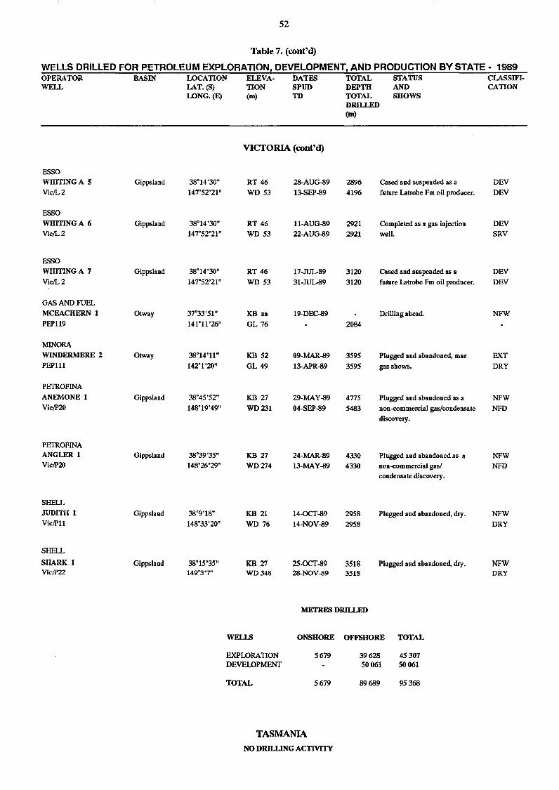
52
Table 7. (cont'd)
WELLS DRILLED FOR PETROLEUM EXPLORATION, DEVELOPMENT! AND PRODUCTION BY STATE - 1989 OPERATOR BASIN WELL
ESSO WHmNGA 5 Gippsland
Vic/L2
ESSO
WHmNGA 6 Gippsland Vic/L2
ESSO
WHmNGA 7 Gippsland
Vic/L2
GAS AND FUEL
MCEACHERN 1 Otway
PEP119
MINORA WINDERMERE 2 Otway PEPl11
PETROFlNA
ANEMONE 1 Gippsland Vic!P20
PETROFINA ANGLER 1 Gippsland Vic!P20
SHELL
JUDITH 1 Gippsland Vic/Pl1
SHELL
SHARK 1 Gippsland Vic/P22
LOCATION ELEVA· DATES TOTAL STATUS LAT. (S) WNG.(E)
38"14'30"
147"52'21"
38"14'30" 147"52'21"
38"14'30"
147"52'21"
37"33'51"
141"11'26"
38"14'11"
142"1'20"
38"45'52"
148"19'49"
38"39'35"
148"26'29"
38"9'18"
148"33'20"
38"15'35" 149"3'7"
TION SPUD DEPTH AND (m) TO TOTAL SHOWS
DRILLED (m)
VICfORIA (cont'd)
RT 46 28-AUG-S9 2896 Cased and suspended as a
WD 53 13-SEP-S9 4196 future Latrobe Fm oil producer.
RT 46 ll-AUG-S9 2921 Completed as a gas injection
WD 53 22-AUG-S9 2921 well.
RT 46 17-JUL-89 3120 Cased and suspended as a
WD 53 31-JUL-89 3120 future Latrobe Fm oil producer.
KBna 19-DEC-S9 Drilling ahead.
GL 76 2084
KB 52 09-MAR-S9 3595 Plugged and abandoned, mnr
GL 49 13-APR-S9 3595 gas shows.
KB 27 29-MAY-S9 4775 Plugged and abandoned as a
WD231 04-SEP-S9 5483 non-commercial gas/condensate
discovery.
KB 27 24-MAR-S9 4330 Plugged and abandoned as a
WD274 13-MAY-S9 4330 non-commercial gas! condensate discovery.
KB 21 14-OCT-S9 2958 Plugged and abandoned, dry.
WD 76 14-NOV-S9 2958
KB27 25-OCT-89 3518 Plugged and abandoned, dry. WD348 28-NOV-89 3518
METRES DRILLED
WELLS ONSHORE OFFSHORE TOTAL
EXPLORA nON DEVELOPMENT
TOTAL
TASMANIA
5679
5679
NO DRILLING ACTIVITY
39628 50061
89689
45307 50061
95368
CLASSIFI· CATION
DEV
DEV
DEV SRV
DEV
DEV
NFW
EXT DRY
NFW
NFD
NFW
NFD
NFW
DRY
NFW DRY
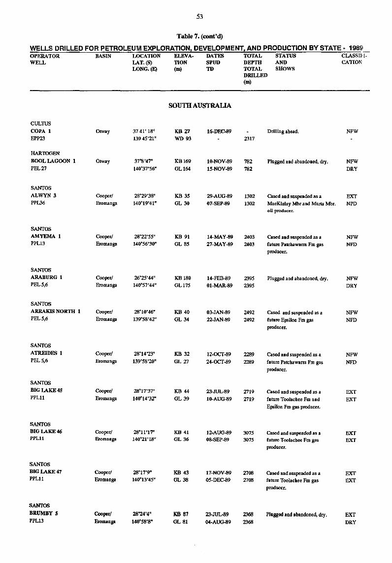
53
Table 7. (cont'd)
WELLS DRILLED FOR PETROLEUM EXPLORATION! DEVELOPMENT! AND PRODUCTION BY STATE - 1989_ OPERATOR BASIN LOCATION ELEVA· DATES TOTAL STATUS CLASSHI· WELL LAT.(S) TION SPUD DEPTH AND CATION
WNG.(E) (m) TD TOTAL SHOWS DRILLED (m)
SOUTH AUSTRALIA
CULTUS
COPA 1 Otway 3741' 18" KB 27 16·DEC-89 Drilling ahead. NFW EPP23 13945'21" WD 93 2317
HARTOOEN
BOOL LAGOON 1 Otway 37°8'47" KB169 10·NOV-89 782 Plugged and abandoned, dry. NFW PEL 27 140°37'56" GLI64 15·NOV-89 782 DRY
SANTOS
ALWYN 3 Cooper! 28°29'38" KB 35 29·AUG-89 1302 Cased and suspended as a EXT PPL36 Bromanga 140°19'41" GL 30 07·SEP-89 1302 MacKinlay Mbr and Murta Mbr. NPD
oil producer.
SANTOS
AMYEMA 1 Cooper! 28°22'55" KB 91 14-MAY-89 2403 Cased and suspended as a NFW PPL13 Bromanga 140°56'30" GL 85 27-MAY-89 2403 future Patchawam Fm gas NFD
producer.
SANfQS
ARABURG 1 Cooper! 26°25'44" KB180 14-FEB-89 2395 Plugged and abandoned, dry. NFW PEL 5,6 Bromanga 140°57'44" GLl75 01-MAR-89 2395 DRY
SANTOS
ARRAKIS NORTH 1 Cooper! 28°10'46" KB 40 03-JAN-89 2492 Cased and suspended as a NFW PEL 5,6 Bromanga 139°58'42" GL 34 22-JAN-89 2492 future Epsilon Fm gas NFD
producer.
SANTOS
ATREIDES 1 Cooper! 28°14'23" KB 32 12-OCT-89 2289 Cased and suspended as a NFW PEL 5,6 Eromanga 139°58'20" GL 27 24-OCT-89 2289 future Patchawarra Fm gas NFD
producer.
SANTOS
BIG LAKE 45 Cooperl 28°17'37" KB 44 23-JUL-89 2719 Cased and suspended as a EXT PPLll Eromanga 140°14'32" GL 39 10-AUG-89 2719 future Toolachee Fro and EXT
Epsilon Fro gas producer.
SANTOS BIG LAKE 46 Cooper! 28·11'17" KB 41 12-AUG-89 3075 Cased and suspended as a EXT PPLll Eromanga 140·21'18" GL 36 08-SEP-89 3075 future Toolachee Fm gas EXT
producer.
SANTOS
BIG LAKE 47 Cooper! 28°17'9" KB 43 17-NOV-89 2708 Cased and suspended as a EXT PPLll Eromanga 140·13'45" GL 38 05-DEC-89 2708 future Toolachee Fm gas EXT
producer.
SANTOS
BRUMBY 5 Cooper/ 28°24'4" KB 87 23-JUL.89 2368 Plugged and abandoned, dry. EXT PPL13 Eromanga 140°58'8" GL 81 04-AUG-89 2368 DRY
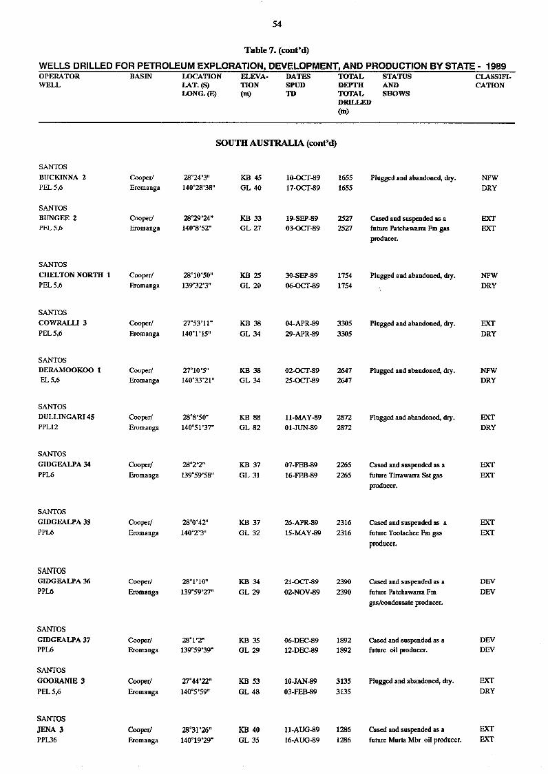
54
Table 7. (cont'd)
WELLS DRILLED FOR PETROLEUM EXPLORATION, DEVELOPMENT! AND PRODUCTION BY STATE - 1989 OPERATOR BASIN LOCATION ELEVA· DATES TOTAL STATUS CI.ASSIFI. WELL I.AT. (8) TION SPUD DEPTH AND CATION
LONG.(E) (m) TD TOTAL SHOWS DRILLED (m)
SOUTH AUSTRALIA (cont'd)
SANTOS
BUCKINNA 2 Cooper! 28'24'3" KB 45 10-OCT-89 1655 Plugged and abandoned, dry. NFW PEL 5,6 Eromanga 140'28'38" GL 40 17-OCT-89 1655 DRY
SANTOS
BUNGEE 2 Cooper! 28'29'24" KB 33 19-5EP-89 2527 Cased and suspended as a EXT PEL 5,6 Eromanga 140'8'52" GL 27 03-OCT-89 2527 future Patchawarra Fm gas EXT
producer.
SANTOS
CHELTON NORTH 1 Cooper! 28'10'50" KB 25 3O-SEP-89 1754 Plugged and abandoned, dry. NFW PEL 5,6 Eromanga 139'32'3" GL 20 06-OCT-89 1754 DRY
SANTOS
COWRALLI3 Cooper! 27"53'11" KB 38 04-APR-89 3305 Plugged and abandoned, dry. EXT PEL 5,6 Eromanga 140'1'15" GL 34 29-APR-89 3305 DRY
SANTOS
DERAMOOKOO 1 Cooper! 27'10'5" KB 38 02-OCT-89 2647 Plugged and abandoned, dry. NFW EL5,6 Eromanga 140'33'21" GL 34 25-OCT-89 2647 DRY
SANTOS
DULLINGARI 45 Cooper/ 28'8'50" KB 88 ll-MAY-89 2872 Plugged and abandoned, dry. EXT PPLl2 Eromanga 140'51'37" GL 82 01-JUN-89 2872 DRY
SANTOS
GIDGEALPA 34 Cooper! 28'2'2" KB 37 07-FEB-89 2265 Cased and suspended as a EXT PPL6 Eromanga 139'59'58" GL 31 16-FEB-89 2265 future Tirrawarra Sst gas EXT
producer.
SANTOS
GIDGEALPA 35 Cooper! 28'0'42" KB 37 26-APR-89 2316 Cased and suspended as a EXT PPL6 Eromanga 140'2'3" GL 32 15-MAY-89 2316 future Toolachee Fm gas EXT
producer.
SANTOS GIDGEA.LPA 36 Cooper/ 28°1'10" 1m 34 21-OCT-89 2390 Cased and suspended as a DEY
PPL6 Eromanga 139'59'27" GL 29 02-NOV-89 2390 future Patchawarra Fm DEV
gas/condensate producer.
SANTOS
GIDGEALPA 37 Cooper/ 28°1'2" KB 35 06-DEC-89 1892 Cased and suspended as a DEV PPL6 Eromanga 139°59'39" GL 29 12-DEC-89 1892 future oil producer. DEY
SANTOS
GOORANIE 3 Cooperl 27°44'22" KB 53 10-JAN-89 3135 Plugged and abandoned, dry. EXT
PEL 5,6 Eromanga 140°5'59" GL 48 03-FEB-89 3135 DRY
SANTOS
JENA 3 Cooperl 28°31'26" KB40 U-AUG-89 1286 Cased and suspended as a EXT
PPL36 Eromanga 140°19'29" GL 35 16-AUG-89 1286 future Murta Mbr oil producer. EXT
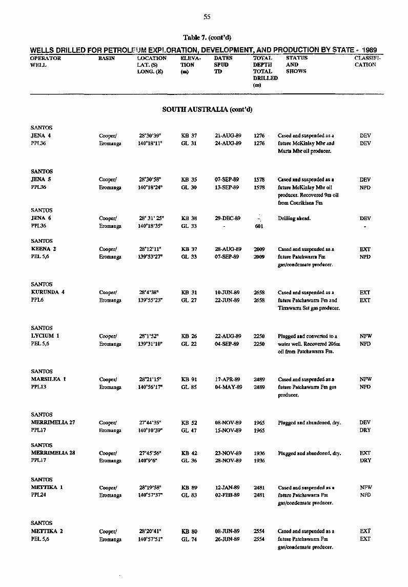
55
Table 7. (cont'd)
WELLS DRILLED FOR PETROLfUM EXPLORATION! DEVELOPMENT! AND PRODUCTION BY STATE a 1989 OPERATOR BASIN LOCATION ELEVA. DATES TOTAL STATUS CLASSIFI. WELL LAT.(S) nON SPUD DEPTH AND CATION
LONG.(E) (m) TD TOTAL SHOWS DRILLED (m)
SOUTH AUSTRALIA (cont'd)
SANTOS
JENA 4 Cooper/ 28"30'39" KB 37 21·AUG-89 1276 Cased and suspended as a DEV
PPL36 Eromanga 140"18'11" GL 31 24·AUG-89 1276 future McKinlay Mbr and DEV
Murta Mbr oil producer.
SANTOS
JENA 5 Cooper! 28"3O'SS" KB 35 07·SEP..s9 IS7S Cased and suspended as a DEV
PPl..36 Eromanga 140°18'24" GL30 13·SEN!9 1578 future McKinlay Mbr oil NPD
producer. Recovered 9m oil
from Conrikiana Fm
SANTOS
JENA (j Cooper/ 28" 31' 25" KB 38 29-DEC89 Drilling ahead. DEV
PPl..36 Eromanga 140"IS'3S" GL 33 601
SANTOS
KEENA 2 Cooper/ 28"12'11" KB 37 28·AUG-89 2009 Cased and suspended as a EXT PEL 5,6 Eromanga 139"53'27" GL33 07·SEP-89 2009 future Patchwarra Fm NPD
gas/condensate producer.
SANTOS
KURUNDA 4 Cooper! 28°4'38" KB 31 10.JUN-89 2658 Cased and suspended as a EXT PPL6 Eromanga 139"55'23" GL27 22·JUN-89 2658 future Patchawarra Fm and EXT
Tirrawarra Sst gas producer.
SANTOS
LYCIUM 1 Cooper! 28"1'52" KB 26 22·AUG-89 2250 Plugged and converted to a NFW PEL 5,6 Eromanga 139°31'10" GL22 04-SEP-89 2250 water well. Recovered 206m NFD
oil from Patchawarra Fm.
SANTOS
MARSILEA 1 Cooper! 28"21'15" KB 91 17·APR-89 2489 Cased and suspended as a NFW
PPL13 Eromanga 140°56'17" GL 85 04·MAY-89 2489 future Patchawarra Fm gas NFD
producer.
SANTOS
MERRIMELIA 27 Cooper! 27°44'35" KB 52 08·NOV-89 1965 Plugged and abandoned, dry. DEV
PPL17 Eromanga 140°10'39" GL 47 15·NOV-89 1965 DRY
SANTOS
MERRIMELIA 28 Cooper/ 27"45'56" KB 42 23·NOV-89 1936 Plugged and abandoned, dry. EXT PPL17 Eromanga 140°9'6" GL 36 28·NOV-89 1936 DRY
SANTOS
METrIKA 1 Cooper! 28°19'58" KB 89 12-JAN-89 2481 Cased and sllSpended as a NFW
PPL24 Eromanga 140°57'37" GL83 02-FEB-89 2481 future Patchawarra Fm NFD
gas/condensate producer.
SANTOS
METfIKA 2 Cooper! 28°20'41" KB SO OS.JUN-89 2554 Cased and suspended as a EXT
PEL 5,6 Eromanga 140"57'51" GL 74 26·JUN-89 2554 future Patchawarra Fm EXT
gas/condensate producer.
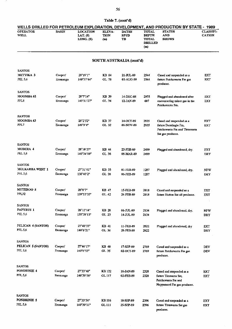
56
Table 7. (cont'd)
WELLS DRILLED FOR PETROLEUM EXPLORATION, DEVELOPMENT! AND PRODUCTION BY STATE - 1989 OPERATOR BASIN LOCATION ELEVA- DATES TOTAL STATUS ClASSIFI-WELL lAT. (S) TION SPUD DEPTH AND CATION
WNG.(E) (m) TD TOTAL SHOWS DRILLED (m)
SOUTH AUSTRALIA (cont'd)
SANTOS
METTIKA 3 Cooper! 28°19'1" KB 84 21-JUUl9 2544 Cased and suspended as a EXT PEL 5,6 Eromanga 140°57'44" GL 78 03-AUG-89 2544 future Patchawarra Fm gas EXT
producer.
SANTOS
MOOMBA62 Cooper! 28°7'14" KB 39 14-DEC-88 2975 Plugged and abandoned after EXT PPLS Eromanga 140°11'27" GL 34 12-JAN-89 607 encountering minor gas in the EXT
Patchawarra Fm.
SANTOS
MOOMBA63 Cooper! 28°2'52" KB 37 14-OCT-89 2935 Cased and suspended as a EXT PPL7 Eromanga 149°9'4" GL 32 08-NOV-89 2935 future Daralingie Fm, EXT
Patchawarra Fm and Tirrawarra
Sst gas producer.
SANTOS
MUDERA 4 Cooper! 28°10'27" KB 44 23-FEB-89 2499 Plugged and abandoned, dry. EXT PEL 5,6 Eromanga 140°34'10" GL 38 08-MAR-89 2499 DRY
SANTOS
MULKARRA WEST 1 Cooper! 27°51 '41" KB 33 01-FEB-89 1287 Plugged and abandoned, dry. NFW PEL 5,6 Eromanga 138°40'2" GL 28 06-FEB-89 1287 DRY
SANTOS
MUTEROO 5 Cooper! 28°8'7" KB 47 15-FEB-89 2018 Cased and suspended as a EXT PPL32 Eromanga 139°53'35" GL 42 24-FEB-89 2018 future Hutton Sst oil producer. EXT
SANTOS
PAPYRUS 1 Cooper! 28°12'14" KB 28 06-JUUl9 2134 Plugged and abandoned, dry. NFW PEL 5,6 Eromanga 139°38'13" GL 23 14-JUUl9 2134 DRY
PELICAN 4 (SANTOS) Cooper! 27°48'33" KB 41 ll-FEB-89 2822 Plugged and abandoned, dry EXT PEL 5,6 Eromanga 140°6'21" GL 36 28-FEB-89 2822 DRY
SANTOS
PELICAN 5 (SANTOS) Cooper/ 27°46'17" KB 40 17-SEP-89 2769 Cased and suspended as a DEV PEL 5,6 Eromanga 140°6'53" GL 35 02-OCT-89 2769 future Patchawarra Fm gas DEV
producer.
SANTOS
PONDRINIE 4 Cooper/ 27°33'48" KB 122 16-JAN-89 2320 Cased and suspended as a EXT PEL 5,6 Eromanga 140°39'58" GL117 02-FEB-89 2320 future Tirawarra Sst, EXT
Patchawarra Fm and
Nappamerri Fm gas producer.
SANTOS
PONDRINIE 5 Cooper/ 27°33'54" KB 116 10-SEP-89 2396 Cased and suspended as a EXT PEL 5,6 Eromanga 140°39'11" GL111 25-SEP-89 2396 future Tirrawarra Sst gas EXT
producer.
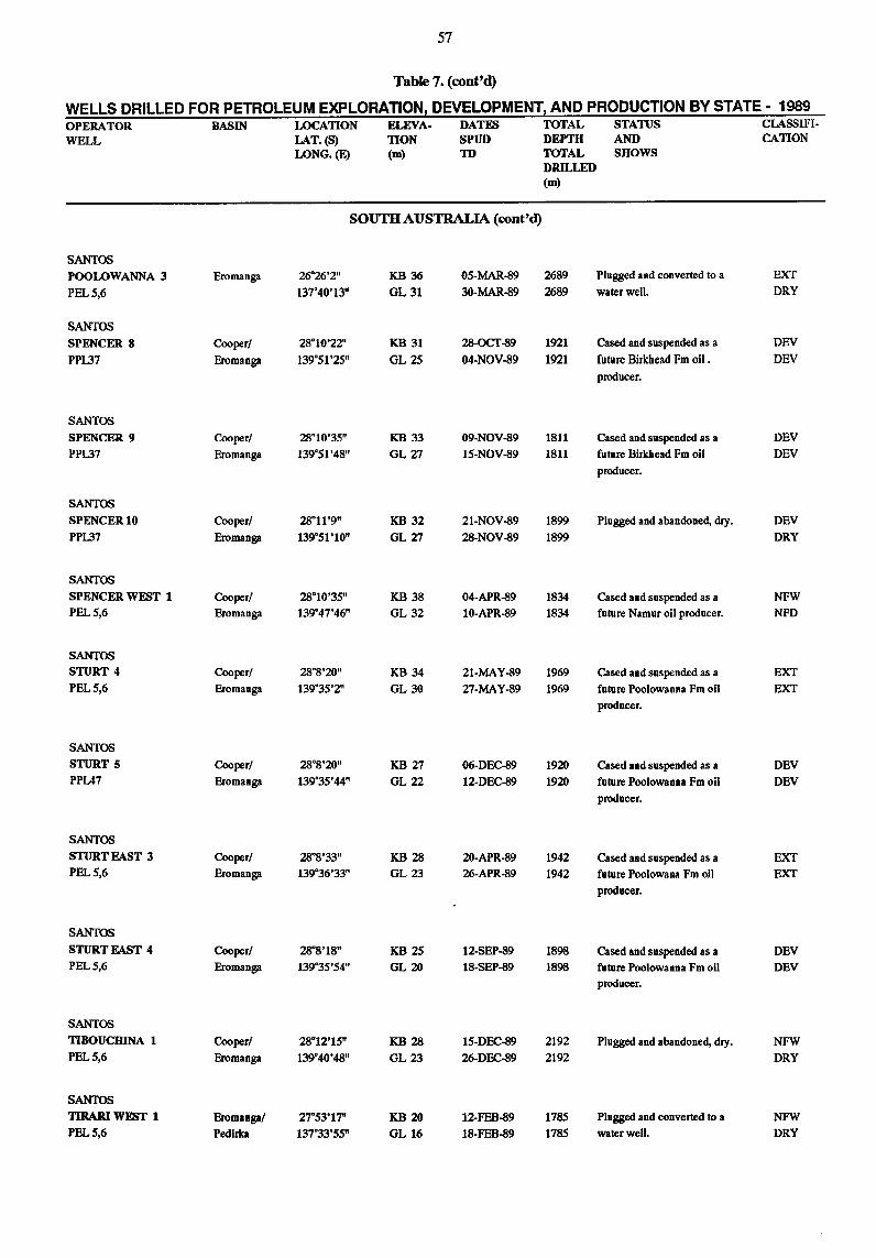
57
Table 7. (cont'd)
WELLS DRILLED FOR PETROLEUM EXPLORATION, DEVELOPMENT, AND PRODUCTION BY STATE - 1989 OPERATOR^BASIN^LOCATION^ELEVA- DATES^TOTAL^STATUS^CLASSIFI-WELL^ LAT. (S)^TION^SPUD^DEPTH^AND^ CATION
LONG. (E)^(m)^TD^TOTAL^SHOWSDRILLED(m)
SANTOS
SOUTH AUSTRALIA (cont'd)
POOLOWANNA 3 Eromanga 26°26'2" KB 36 05-MAR-89 2689PEL 5,6 137°40'13" GL 31 30-MAR-89 2689
SANTOSSPENCER 8 Cooper/ 28°10'22" KB 31 28-OCT-89 1921PPL37 Eromanga 139°51'25" GL 25 04-NOV-89 1921
SANTOSSPENCER 9 Cooper/ 28°10'35" KB 33 09-NOV-89 1811PPL37 Eromanga 139°51'48" GL 27 15-NOV-89 1811
SANTOSSPENCER 10 Cooper/ 28°11'9" KB 32 21-NOV-89 1899PPL37 Eromanga 139°51'10" GL 27 28-NOV-89 1899
SANTOSSPENCER WEST 1 Cooper/ 28°10'35" KB 38 04-APR-89 1834PEL 5,6 Eromanga 139°47'46" GL 32 10-APR-89 1834
SANTOSSTURT 4 Cooper/ 28°8'20" KB 34 21-MAY-89 1969PEL 5,6 Eromanga 139°35'2" GL 30 27-MAY-89 1969
SANTOSSTURT 5 Cooper/ 28.8,20,, KB 27 06-DEC-89 1920PPL47 Eromanga 139°35'44" GL 22 12-DEC-89 1920
SANTOSSTURT EAST 3 Cooper/ 28°8'33" KB 28 20-APR-89 1942PEL 5,6 Eromanga 139°36'33" GL 23 26-APR-89 1942
SANTOSSTURT EAST 4 Cooper/ 28°8'18" KB 25 12-SEP-89 1898PEL 5,6 Eromanga 139°35'54" GL 20 18-SEP-89 1898
SANTOSTIBOUCHINA 1 Cooper/ 2812'15" KB 28 15-DEC-89 2192PEL 5,6 Eromanga 139°40'48" GL 23 26-DEC-89 2192
SANTOSTIRARI WEST 1 Eromanga/ 27°53'17" KB 20 12-FEB-89 1785PEL 5,6 Pedirka 137°33'55" GL 16 18-FEB-89 1785
Plugged and converted to a^EXTwater well.^ DRY
Cased and suspended as a^DEVfuture Birkhead Fm oil.^DEVproducer.
Cased and suspended as a^DEVfuture Birkhead Fm oil^DEVproducer.
Plugged and abandoned, dry.^DEVDRY
Cased and suspended as a^NFWfuture Namur oil producer.^NFD
Cased and suspended as a^EXTfuture Poolowanna Fm oil^EXTproducer.
Cased and suspended as a^DEVfuture Poolowanna Fm oil^DEVproducer.
Cased and suspended as a^EXTfuture Poolowana Fm oil^EXTproducer.
Cased and suspended as a^DEVfuture Poolowanna Fm oil^DEVproducer.
Plugged and abandoned, dry.^NFWDRY
Plugged and converted to a^NFWwater well.^ DRY
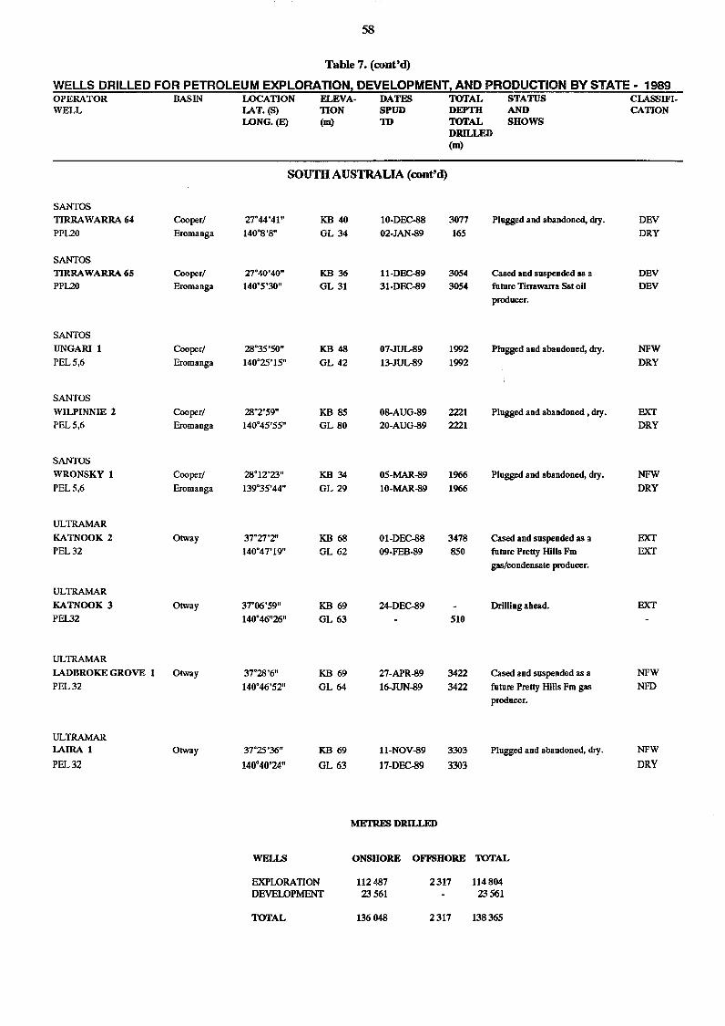
10-DEC-88 307702-JAN-89 165
11-DEC-89 305431-DEC-89 3054
07-1UL-89 199213-3UL-89 1992
08-AUG-89 222120-AUG-89 2221
05-MAR-89 196610-MAR-89 1966
01-DEC-88 347809-FEB-89 850
24-DEC-89510
27-APR-89 342216-JUN-89 3422
11-NOV-89 330317-DEC-89 3303
Plugged and abandoned, dry.^DEVDRY
Cased and suspended as a^DEVfuture Tirrawarra Sst oil^DEVproducer.
Plugged and abandoned, dry.^NFWDRY
Plugged and abandoned , dry.^EXTDRY
Plugged and abandoned, dry.^NFWDRY
Cased and suspended as a^EXTfuture Pretty Hills Fm^EXTgas/condensate producer.
Drilling ahead.^EXT
Cased and suspended as a^NFWfuture Pretty Hills Fm gas^NFDproducer.
Plugged and abandoned, dry.^NFWDRY
58
Table 7. (cont'd)
WELLS DRILLED FOR PETROLEUM EXPLORATION, DEVELOPMENT, AND PRODUCTION BY STATE - 1989 OPERATOR^BASIN^LOCATION^ELEVA- DATES^TOTAL^STATUS^CLASSEFI-WELL^ [AT. (S)^TION^SPUD^DEPTH^AND^ CATION
LONG. (E)^(m)^TD^TOTAL^SHOWSDRILLED(m)
SOUTH AUSTRALIA (cont'd)
SANTOSTIRRAWARRA 64 Cooper/ 27°44'41" KB 40PPL20 Eromanga 140°8'8" GL 34
SANTOSTIRRAWARRA 65 Cooper/ 27°40'40" KB 36PPL20 Eromanga 140°5'30" GL 31
SANTOSUNGARI 1 Cooper/ 28°35'50" KB 48PEL 5,6 Eromanga 140°25'15" GL 42
SANTOSWILPINN1E 2 Cooper/ 28°2'59" KB 85PEL 5,6 Eromanga 140°45'55" GL 80
SANTOSWRONSKY 1 Cooper/ 28°12'23" KB 34PEL 5,6 Eromanga 139°35'44" GL 29
ULTRAMAR1CATNOOK 2 Otway 37°27'2" KB 68PEL 32 140°47'19" GL 62
ULTRAMARKATNOOK 3 Otway 37°06'59" KB 69PEL32 140°46"26" GL 63
ULTRAMARLADBROICE GROVE 1 Otway 37°28'6" KB 69PEL 32 140°46'52" GL 64
ULTRAMARLAIRA 1 Otway 37°25'36" KB 69PEL 32 140°40'24" GL 63
METRES DRILLED
WELLS ONSHORE OFFSHORE TOTAL
EXPLORATION 112 487 2 317 114 804DEVELOPMENT 23 561 23 561
TOTAL 136 048 2 317 138 365
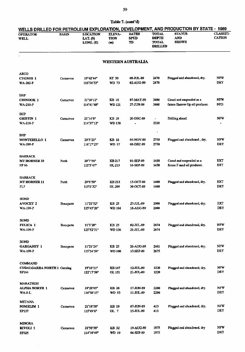
59
Table 7. (cont'd)
WELLS DRILLED FOR PETROLEUM EXPLORATION, DEVELOPMENT, AND PRODUCTION BY STATE - 1989 OPERATOR^BASIN^LOCATION^EIEVA- DATES^TOTAL^STATUS^CLASSIFI-WELL^ LAT. (S)^TION^SPUD^DEPTH^AND^ CATION
LONG. (E)^(m)^ TOTAL^SHOWSDRILLED
WESTERN AUSTRALIA
ARCOCYGNUS 1^Camarvon 19°42'44" RT 30 08-JUL-89 2470 Plugged and abandoned, dry. NEWWA-202-P 116°54'33" WD 73 02-AUG-89 2470 DRY
BHPCHINOOK 1^Carnarvon 21°10'12" KB 18 07-MAY-89 3400 Cased and suspended as a NFWWA-210.P 114°41'48" WD 121 27-JUN-89 3400 future Barrow Op oil producer. NFD
BHPGRIFFIN 1^Carnarvon 21°14'8" KB 18 20-DEC-89 Drilling ahead. NFWWA-210-P 114°37'12" WD 138 - 2220
BHPMONTEBELLO 1^Camarvon 20°5'21" KB 18 05-NOV-89 2750 Plugged and abandoned, dry. NEWWA-209-P 116°17'23" WI) 57 08-DEC-89 2750 DRY
BARRACKMT HORNER 10^Perth 29°7'56" KB 217 01-SEP-89 1450 Cased and suspended as a EXTEP 96 115°5'47" 0L213 16-SEP-89 1450 future F sand oil producer. EXT
BARRACKMT HORNER 11^Perth 29°8'50" KB 213 15-OCT-89 1408 Plugged and abandoned, dry. EXTPL7 115°6'32" 6L209 30-OCT-89 1408 DRY
BONDAVOCET 2^Bonaparte 11°21'52" KB 25 27-JUL-89 2000 Plugged and abandoned, thy. EXTWA-199-P 125°45'26" WD 104 18-AUG-89 2000 DRY
BONDFULICA 1^Bonaparte 11°5'20" KB 25 02-JUL-89 2674 Plugged and abandoned, dry. NFWWA-199-P 125°52'31" WI) 136 21-JUL-89 2674 DRY
BONDGARGtANEY 1^Bonaparte 11°21'24" KB 25 26-AUG-89 2481 Plugged and abandoned, dry. NFWWA-199-P 125°54'59" WI) 100 13-SEP-89 2675 DRY
COMMANDCUDALGARRA NORTH 1 Canning 19°10'11" KB 147 12-JUL-89 1220 Plugged and abandoned, dry. NEWEP164 122°17'50" GL 151 21-JUL-89 1220 DRY
MARATHONALPHA NORTH 1^Camanron 19°28'05" KB 20 17-JUN-89 2200 Plugged and abandoned, dry. NFWWA-8-L 116°58'15" WD 93 11-JUL-89 2200 DRY
METANASOMELIM 1^Camarvon 2118'58" KB 10 07-JUN-89 413 Plugged and abandoned, dry. NEWEP137 115°49'6" GL 7 15-JUL-89 413 DRY
MINORARIVOLI 1^Camarvon 21°58'58" KB 32 19-AUG-89 1975 Plugged and abandoned, dry NEW
EP325 114°10'49" WI) 19 06-SEP-89 1975 DRY
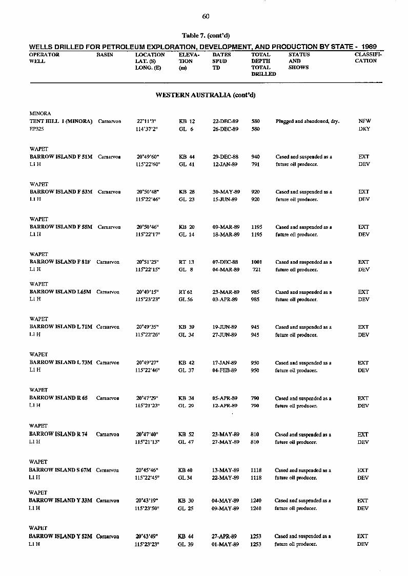
60
Table 7. (cont'd)
WELLS DRILLED FOR PETROLEUM EXPLORATION, DEVELOPMENT, AND PRODUCTION BY STATE - 1989 OPERATOR^BASIN^LOCATION^ELEVA- DATES^TOTAL^STATUS^CLASSIFI-WELL^ LAT. (S)^TION^SPUD^DEPTH^AND^ CATION
LONG. (E)^(in)^TD^TOTAL^SHOWSDRILLED
WESTERN AUSTRALIA (cont'd)
MINORATENT HILL 1 (MINORA) Carnarvon 22°11'3" KB 12 22-DEC-89EP325 114°37'2" GL 6 26-DEC-89
WAPETBARROW ISLAND F MM Camarvon 20°49'60" KB 44 29-DEC-88Li H 115°22'60" GL 41 12-JAN-89
WAPETBARROW ISLAND F 53M Carnarvon 20°50'48" KB 28 30-MAY-89Li H 115°22'46" GL 23 15-JUN-89
WAPETBARROW ISLAND F 55M Carnarvon 20°5046" KB 20 09-MAR-89Li H 115°22'17" GL 14 18-MAR-89
WAPETBARROW ISLAND F 8IF Carnarvon 20°51'25" RT 13 07-DEC-88Li H 115°22'15" GL 8 04-MAR-89
WAPETBARROW ISLAND L65M email/on 20°49'15" RT 61 23-MAR-89Li H 115°23'23" GL 56 03-APR-89
WAPETBARROW ISLAND L 71M Carnarvon 20°49'35" KB 39 19-JUN-89Ll H 115°22'26" GL 34 27-JUN-89
WAPETBARROW ISLAND L 73M C,arnarvon 20°49'27" KB 42 I7-JAN-89Li H 115°22'46" GL 37 04-FEB-89
WAPETBARROW ISLAND R 65 Carnarvon 20°47'29" KB 34 05-APR-89L1 H 115°21'23" GL 29 12-APR-89
WAPET
BARROW ISLAND R 74 Carnarvon 20°47'40" KB 52 23-MAY-89Li H 115°21'13" GL 47 27-MAY-89
WAPETBARROW ISLAND S 67M Camarvon 20°45'46" KB 40 13-MAY-89Li H 115°22'45" 0L34 22-MAY-89
WAPETBARROW ISLAND Y 33M Camarvon 20°43'19" KB 30 04-MAY-89Li H 115°23'50" GL 25 09-MAY-89
WAPETBARROW ISLAND Y 52M Carnarvon 20°43'49" KB 44 27-APR-89Li H 115°23'23" GL 39 01-MAY-89
580^Plugged and abandoned, dry.^NFW580^ DRY
940^Cased and suspended as a^EXT791^future oil producer.^DEV
920^Cased and suspended as a^FXT920^future oil producer.^DEV
1195^Cased and suspended as a^EXT1195^future oil producer.^DEV
1001^Cased and suspended as a^EXT721^future oil producer.^DEV
985^Cased and suspended as a^EXT985^future oil producer.^DEV
945^Cased and suspended as a^EXT945^future oil producer.^DEV
950^Cased and suspended as a^EXT950^future oil producer.^DEV
790^Cased and suspended as a^EXT790^future oil producer.^DEV
810^Cased and suspended as a^EXT810^future oil producer.^DEV
1118^Cased and suspended as a^EXT1118^future oil producer.^DEV
1240^Cased and suspended as a^EXT1240^future oil producer.^DEV
1253^Cased and suspended as a^EXT1253^future oil producer.^DEV
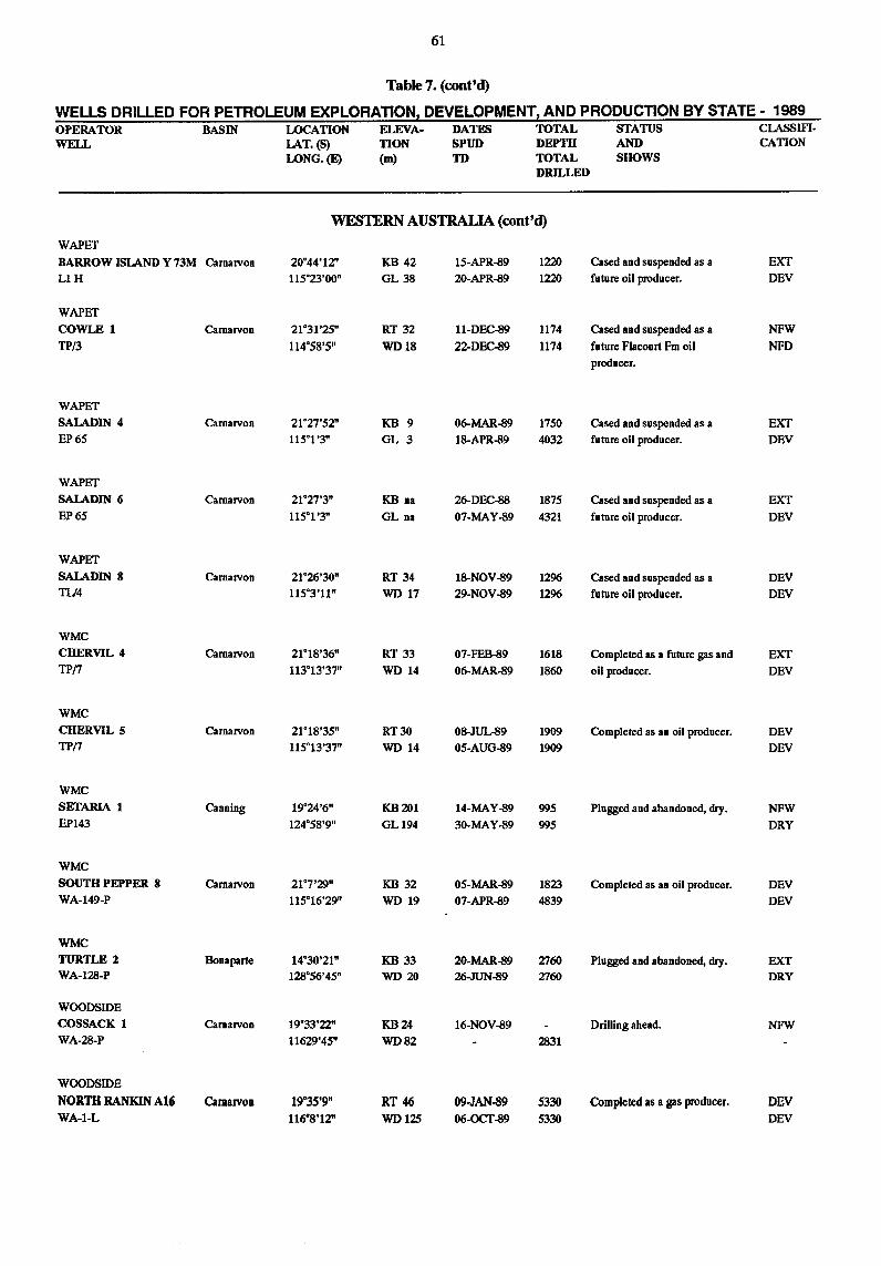
61
Table 7. (cont'd)
WELLS DRILLED FOR PETROLEUM EXPLORATION, DEVELOPMENT, AND PRODUCTION BY STATE - 1989 OPERATOR^BASIN^LOCATION^ELEVA- DATES^TOTAL^STATUS^CLASSIFI-WELL^ LAT. (S)^TION^SPUD^DEPTH^AND^ CATION
LONG. (E)^(m)^TD^TOTAL^SHOWSDRILLED
WAPET
WESTERN AUSTRALIA (cont'd)
BARROW ISLAND Y 73M Camarvon 20°44'12" KB 42 15-APR-89 1220Li H 115°23'00" GL 38 20-APR-89 1220
WAPETCOWLE 1 Camarvon 21°31'25" RT 32 11-DEC-89 1174TP/3 114°58'5" WD 18 22-DEC-89 1174
WAPETSALADIN 4 Carnarvon 21°27'52" KB 9 06-MAR-89 1750EP 65 115°1'3" GL 3 18-APR-89 4032
WAPETSALADIN 6 Carnarvon 21°27'3" KB na 26-DEC-88 1875EP 65 115°1'3" GL na 07-MAY-89 4321
WAPETSALADIN 8 Carnarvon 21°26'30" ST 34 18-NOV-89 1296TL/4 115°3'11" WD 17 29-NOV-89 1296
WMCCHERVIL 4 Camarvon 21°18'36" RT 33 07-FEB-89 1618TP/7 113°13'37" WD 14 06-MAR-89 1860
WMCCHERVIL 5 Carnarvon 21°18'35" RT 30 08-JUL-89 1909TP/7 115°13'37" WD 14 05-AUG-89 1909
WMCSETARIA 1 Canning 19°24'6" KB 201 14-MAY-89 995EP143 124°58'9" GL 194 30-MAY-89 995
WMCSOUTH PEPPER 8 Camarvon 21°7'29" KB 32 05-MAR-89 1823WA-149-P 115°16'29" WD 19 07-APR-89 4839
WMCTURTLE 2 Bonaparte 14°30'21" KB 33 20-MAR-89 2760WA-128-P 128°56'45" WD 20 26-JUN-89 2760
WOODSIDECOSSACK 1 Carnarvon 19°33'22" KB 24 16-NOV-89WA-28-P 11629'45" WD 82 - 2831
WOODSIDENORTH RAN1UN A16 Carnarvon 19°35'9" RT 46 09-JAN-89 5330WA-1-L 116°8'12" WD 125 06-OCT-89 5330
Cased and suspended as a^EXTfuture oil producer.^DEV
Cased and suspended as a^NFWfuture Flacourt Fm oil^NFDproducer.
Cased and suspended as a^EXTfuture oil producer.^DEV
Cased and suspended as a^EXTfuture oil producer.^DEV
Cased and suspended as a^DEVfuture oil producer.^DEV
Completed as a future gas and^EXToil producer.^ DEV
Completed as an oil producer.^DEVDEV
Plugged and abandoned, dry.^NFWDRY
Completed as an oil producer.^DEVDEV
Plugged and abandoned, dry.^EXTDRY
Drilling ahead.^NFW
Completed as a gas producer.^DEVDEV
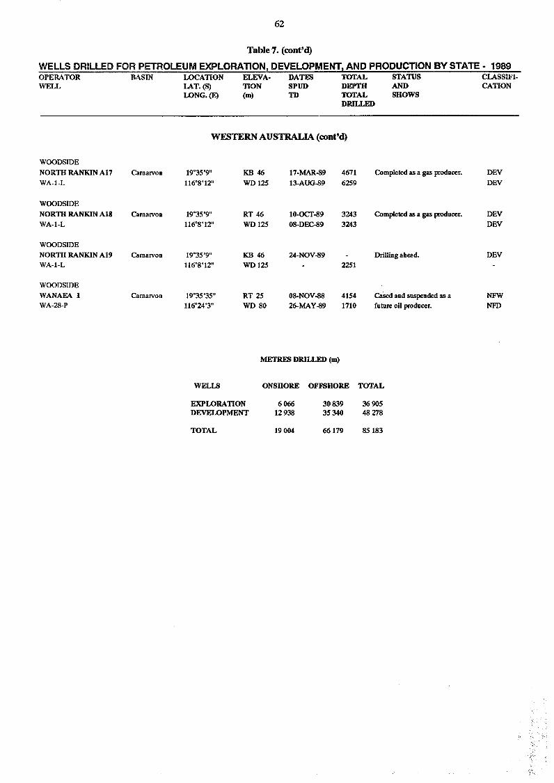
62
Table 7. (cont'd)
WELLS DRILLED FOR PETROLEUM EXPLORATION DEVELOPMENT, AND PRODUCTION BY STATE - 1989 OPERATORWELL
BASIN LOCATIONLAT. (5)LONG. (E)
FLEVA-110N(m)
DATESSPUDTD
TOTAL^STATUS^CLASS IF!-DEPTH^AND^ CATIONTOTAL^SHOWSDRILLED
WESTERN AUSTRALIA (cont'd)
WOODSIDENORTH RANKIN A17 Carnarvon 19°35'9" KB 46 17-MAR-89 4671 Completed as a gas producer. DEVWA-1-L 116°8'12" WD 125 13-AUG-89 6259 DEV
WOODSIDENORTH RANKIN Al8 Carnarvon 19°35'9" RT 46 10-OCT-89 3243 Completed as a gas producer. DEVWA-1-L 116°8'12" WD 125 08-DEC-89 3243 DEV
WOODSIDENORTH RANKIN Al9 Carnarvon 19°35'9" KB 46 24-NOV-89 Drilling ahead. DEVWA-1-L 116°8'12" WD 125 2251
WOODSIDEWANAEA 1 Carnarvon 19°35'35" RT 25 08-NOV-88 4154 Cased and suspended as a NFWWA-28-P 116°24'3" WD 80 26-MAY-89 1710 future oil producer. NFD
METRES DRILLED (m)
WELLS^ONSHORE OFFSHORE TOTAL
EXPLORATION 6 066 30 839 36 905DEVELOPMENT 12 938 35 340 48 278
TOTAL 19 004 66 179 85 183
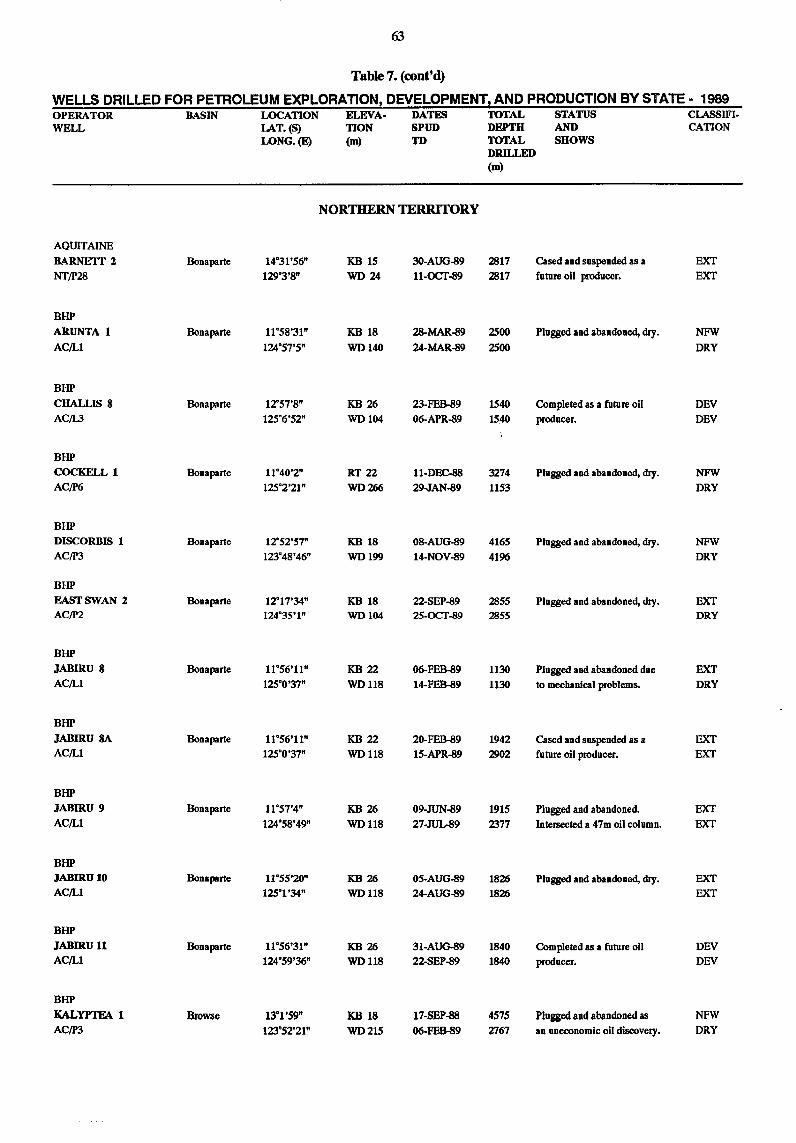
63
Table 7. (cont'd)
WELLS DRILLED FOR PETROLEUM EXPLORATION, DEVELOPMENT, AND PRODUCTION BY STATE - 1989 OPERATOR^BASIN^LOCATION^ELEVA- DATES^TOTAL^STATUS^CLASSIFI-WELL^ LAT. (5)^TION^SPUD^DEPTH^AND^ CATION
LONG. (E)^(m)^TD^TOTAL^SHOWSDRILLED(m)
AQUITAINE
NORTHERN TERRITORY
BARNETr 2 Bonaparte 14°31'56" KB 15 30-AUG-89 2817NT/P28 129°3'8" WD 24 11-OCT-89 2817
BHPARUNTA 1 Bonaparte 11°58'31" KB 18 28-MAR-89 2500AC/L1 124°57'5" WD 140 24-MAR-89 2500
BHPCHALLIS 8 Bonaparte 1757'8" KB 26 23-FEB-89 1540AC/L3 125°6'52" WD 104 06-APR-89 1540
BHPCOCKELL 1 Bonaparte 11°40'2" RT 22 11-DEC-88 3274AC/P6 125°2'21" WD 266 29-JAN-89 1153
BHPDISCORBIS 1 Bonaparte 12°52'57" KB 18 08-AUG-89 4165AC/P3 123°48'46" WD 199 14-NOV-89 4196
BHPEAST SWAN 2 Bonaparte 1717'34" KB 18 22-SEP-89 2855AC/P2 124°35'1" WD 104 25-OCT-89 2855
BHPJABIRU 8 Bonaparte 11°56'11" KB 22 06-FEB-89 1130AC/L1 125°0'37" WD 118 14-FEB-89 1130
BHPJAB1RU 8A Bonaparte 11°56'11" KB 22 20-FEB-89 1942AC/L1 125°0'37" WD 118 15-APR-89 2902
BHPJABIRU 9 Bonaparte 11°57'4" KB 26 09-JUN-89 1915AC/L1 124°58'49" WD 118 27-JUL-89 2377
BHPJABIRU 10 Bonaparte 11°55'20" KB 26 05-AUG-89 1826AC/L1 125°1'34" WD 118 24-AUG-89 1826
BHPJABIRU 11 Bonaparte 11°56'31" KB 26 31-AUG-89 1840AC/L1 124°59'36" WD 118 22-SEP-89 1840
BHP1CALYPTEA 1 Browse 13°1'59" KB 18 17-SEP-88 4575AC/P3 123°52'21" WD 215 06-FEB-89 2767
Cased and suspended as a^EXTfuture oil producer.^EXT
Plugged and abandoned, thy.^NFWDRY
Completed as a future oil^DEVproducer.^ DEV
Plugged and abandoned, dry.^NFWDRY
Plugged and abandoned, dry.^NFWDRY
Plugged and abandoned, dry.^EXTDRY
Plugged and abandoned due^EXTto mechanical problems.^DRY
Cased and suspended as a^EXTfuture oil producer.^EXT
Plugged and abandoned.^EXTIntersected a 47m oil column.^EXT
Plugged and abandoned, dry.^EXTEXT
Completed as a future oil^DEVproducer.^ DEV
Plugged and abandoned as^NFWan uneconomic oil discovety.^DRY
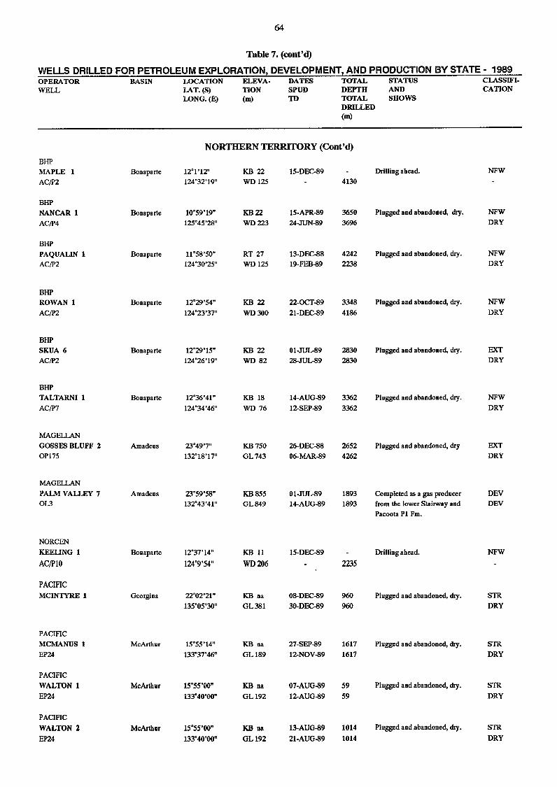
64
Table 7. (cont'd)
WELLS DRILLED FOR PETROLEUM EXPLORATION, DEVELOPMENT, AND PRODUCTION BY STATE - 1989 OPERATOR^BASIN^LOCATION^ELEVA-^DATES^TOTAL^STATUS^CLASSIFI-WELL^ LAT. (S)^TION^SPUD^DEPTH^AND^ CATION
LONG. (E)^(m)^TD^TOTAL^SHOWSDRILLED(m)
NORTHERN 'TERRITORY (Cont 'd)BHPMAPLE 1 Bonaparte 121'12" KB 22 15-DEC-89 Drilling ahead. NFWAC/P2 124°32'19" WD 125 4130
BHPNANCAR 1 Bonaparte 10°59'19" KB 22 15-APR-89 3650 Plugged and abandoned, My. NFWAC/P4 125°45'28" WD 223 24-JUN-89 3696 DRY
BHPPAQUAL1N 1 Bonaparte 11°58'50" RT 27 13-DEC-88 4242 Plugged and abandoned, dry. NFWAC/P2 124°30'25" WD 125 19-FEB-89 2238 DRY
BHPROWAN 1 Bonaparte 12°29'54" KB 22 22-0C1'-89 3348 Plugged and abandoned, dry. NFWAC/P2 124°23'37" WD 300 21-DEC-89 4186 DRY
BHPSKUA 6 Bonaparte 12°29'15" KB 22 01-JUL-89 2830 Plugged and abandoned, dry. OCTAC/P2 124°26'19" WD 82 28-JUL-89 2830 DRY
BHPTALTARNI 1 Bonaparte 12°36'41" KB 18 14-AUG-89 3362 Plugged and abandoned, dry. NFWAC/P7 124°34'46" WD 76 12-SEP-89 3362 DRY
MAGELLANGOSSES BLUFF 2 Amadeus 23°49'7" KB 750 26-DEC-88 2652 Plugged and abandoned, dry EXT0P175 13218'17" GL 743 06-MAR-89 4262 DRY
MAGELLANPALM VALLEY 7 Amadeus 23°59'58" KB 855 01-JUL-89 1893 Completed as a gas producer DEV0L3 132°43'41" GL 849 14-AUG-89 1893 from the lower Stairway and DEV
Pacoota P1 Fm.
NORCENKEELING 1 Bonaparte 1237'14" KB 11 15-DEC-89 Drilling ahead. NFWAC/P10 124°9'54" WD 206 2235
PACIFICMCINTYRE 1 Georgina 22°02'21" KB na 08-DEC-89 960 Plugged and abandoned, dry. STR
135°05'30" GL 381 30-DEC-89 960 DRY
PACIFICMCMANUS 1 McArthur 15°55'14" KB na 27-SEP-89 1617 Plugged and abandoned, dry. STREP24 133°37'46" GL 189 12-NOV-89 1617 DRY
PACIFICWALTON 1 McArthur 15°55'00" KB na 07-AUG-89 59 Plugged and abandoned, dry. STREP24 133°40'00" GL 192 12-AUG-89 59 DRY
PACIFICWALTON 2 McArthur 15°55'00" KB na 13-AUG-89 1014 Plugged and abandoned, dry. STREP24 133°40'00" GL 192 21-AUG-89 1014 DRY
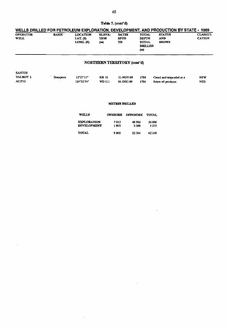
65
Table 7. (cont'd)
WELLS DRILLED FOR PETROLEUM EXPLORATION, DEVELOPMENT, AND PRODUCTION BY STATE· 1989 OPERATOR WELL
SANTOS
TALBOT 1 AC/P12
BASIN
, Bonaparte
LOCATION LAT.(S) LONG.(E)
ELEVA. TION (m)
DATES SPUD TD
TOTAL DEPTH TOTAL DRILLED (m)
NORTHERN TERRITORY (cont'd)
STATUS AND SHOWS
12'27'11" 124'52'54"
KB 11 WDlll
ll-NOV-89 01-DEC-89
1784 1784
Cased and suspended as a
future oil producer.
WELLS
EXPLORATION DEVELOPMENT
TOTAL
METRES DRILLED
ONSHORE OFFSHORE TOTAL
7912 1893
9805
48984 3380
52364
56896 5273
62169
CLASSIFI· CATION
NFW
NFD
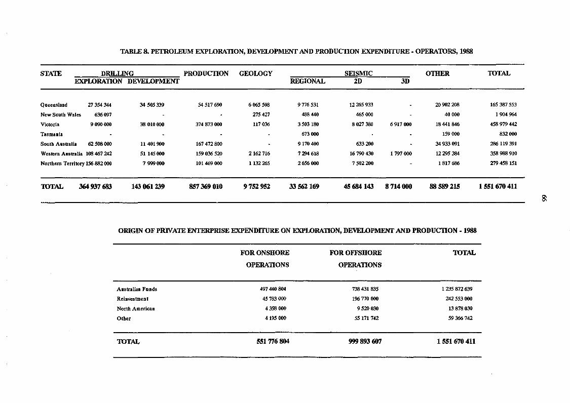
TABLE 8. PE1ROLEUM EXPLORATION, DEVELOPMENT AND PRODUCTION EXPENDITURE· OPERATORS, 1988
STATE DRILLING PRODUCTION GEOLOGY SEISMIC OTIIER EXPLORATION DEVELOPMENT REGIONAL 2D 3D
Queensland Zl354344 34 505339 54517690 6065508 9776531 12265933 20902208
New South Wales 636097 Zl54Zl 488 440 465000 40000
Victoria 9090000 38 010000 374873000 117036 3503180 80Zl380 6917000 18441846
Tasmania 673000 159000
Sou th Australia 62508000 11401900 167472800 9170400 633200 34933091
Western Australia 108 467 242 51145000 159036520 2162716 7294618 16790430 1797 000 12295384
Northern Territory 156 882000 7999000 101469000 1132265 2656 000 7502200 1817686
1UTAL 364937683 143 061239 857369010 9752952 33 562169 45684143 8714000 88589 215
ORIGIN OF PRlV ATE ENTERPRISE EXPENDITURE ON EXPLORATION, DEVELOPMENT AND PRODUCTION· 1988
FOR ONSHORE
OPERATIONS
Australian Funds 497440804
Reinvestment 45783 000
North American 4358000
Other 4195000
TOTAL 551776804
FOR OFFSHORE
OPERATIONS
738431835
196770000
9520 030
55171742
999 8fJ3 607
TOTAL
1235872639
242553000
13 878030
59366742
1551670411
TOTAL
165387553
1904964
458979442
832000
286119391
358988910
Zl9458151
1551670411
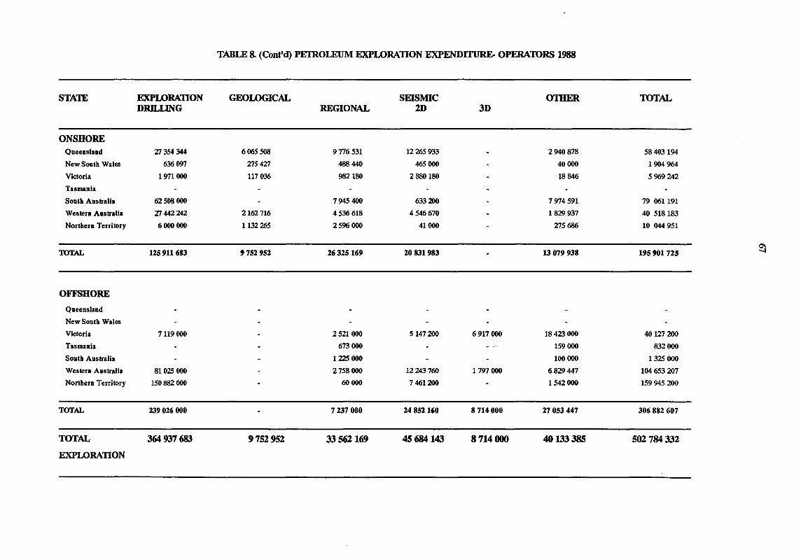
TABLE 8. (Cont'd) PETROLEUM EXPLORATION EXPENDI11JRE.. OPERATORS 1988
STAlE EXPLORATION GEOLOGICAL SEISMIC 01HER TOTAL DRlLLING REGIONAL 2D 3D
ONSHORE Queensland ZT354344 606550S 9776531 12265933 2940878 58403194
New South Wales 636 097 ZT54ZT 488 440 465000 40000 1904964
Victoria 1971000 117036 982180 2880180 18846 5969242
Tasmania
South Australia 62508000 7945400 633200 7974591 79 061191
Western Australia ZT 442242 2162716 4536 618 4546670 1829 937 40 518183
Northern Territory 6000000 1132265 2596 000 41000 ZT5686 10 044 951
TOTAL 125911683 9752952 26325169 20831983 13 079 938 195901725 ~
OFFSHORE
Queensland
New South Wales
Victoria 7119000 2521000 5147200 6917000 18423 000 40 lZT 200
Tasmania 673000 159000 832000
South Australia 1225 000 100 000 1325 000
Western Australia 81025 000 2758000 12243760 1797 000 6829 447 104653207
Northern Territory 150882000 60000 7461200 1542000 159945200
TOTAL 239026000 7237000 24852160 8714000 27053447 306882607
TOTAL 364937683 9752952 33562169 45684143 8714000 40 133385 562784332
EXPLORATION
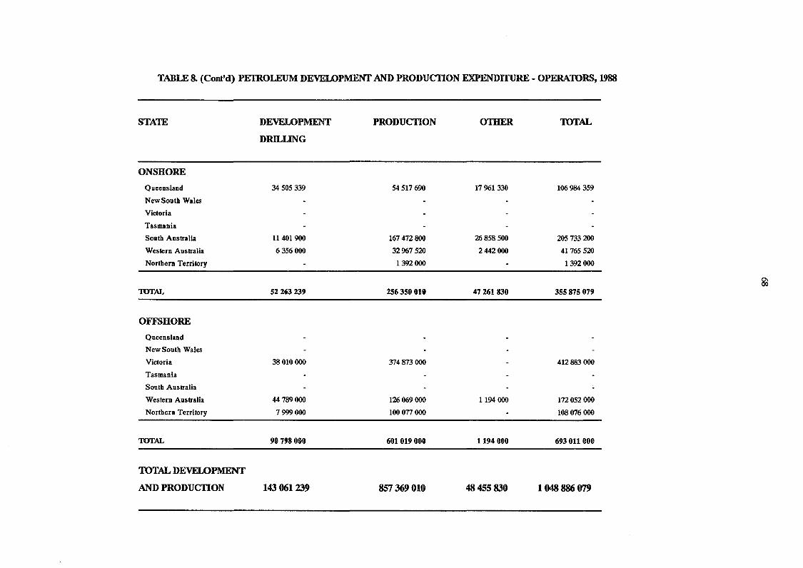
TABLE 8. (Cont'd) PElROLEUM DEVEWPMENT AND PRODUCTION EXPENDITURE - OPERATORS, 1988
STA'IE DEVELOPMENT PRODUCTION OTHER TOTAL
DRILLING
ONSHORE
Queensland 34 505 339 54517690 17961 330 106984 359
New South Wales
Victoria
Tasmania
South Australia 11401900 167472800 26858500 205733200
Western Australia 6356000 32967520 2442000 41765520
Northern Territory 1392 000 1392 000
TOTAL 52263239 256350010 47261830 355875079
OFFSHORE
Queensland
New South Wales
Victoria 38 010000 374873000 412883000
Tasmania
South Australia
Western Australia 44789000 126069000 1194000 172052000
Northern Territory 7999000 100 077 000 108076000
TOTAL 90798000 601019000 1194000 693011 000
TOTAL DEVELOPMENT
AND PRODUCTION 143 061239 857369010 48455830 1048886079
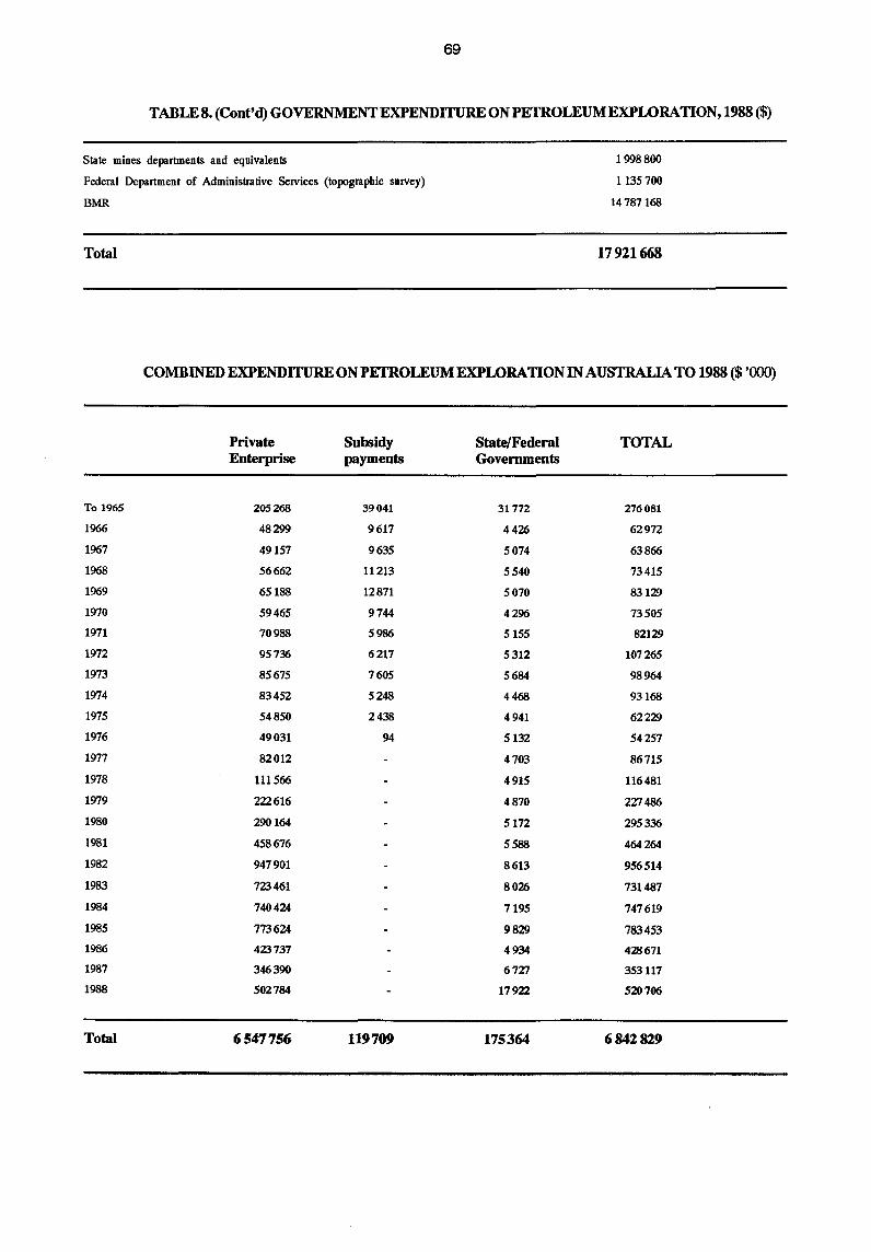
69
TABLE 8. (Cont'd) GOVERNMENT EXPENDITURE ON PETROLEUM EXPLORATION, 1988 ($)
State mines departments and equivalents
Federal Department of Administrative SelVices (topographic sUIVey)
BMR
Total
1998800
1135700
14787168
17921668
COMBINED EXPENDITURE ON PETROLEUM EXPLORATION IN AUSTRALIA TO 1988 ($ '000)
Private Subsidy State/Federal TOTAL Enterprise payments Governments
To 1965 205268 39041 31772 276081
1966 48299 9617 4426 62972
1967 49157 9635 5074 63866
1968 56662 11213 5540 73415
1969 65188 12871 5070 83129
1970 59465 9744 4296 73505
1971 70988 5986 5155 82129
1972 95736 6217 5312 107265
1973 85675 7605 5684 98964
1974 83452 5248 4468 93168
1975 54850 2438 4941 62229
1976 49031 94 5132 54257
1977 82012 4703 86715
1978 111566 4915 116481
1979 222616 4870 227486
1980 290164 5172 295336
1981 458676 5588 464264
1982 947901 8613 956514
1983 723461 8026 731487
1984 740424 7195 747619
1985 773624 9829 783453
1986 423737 4934 428671
1987 346390 6727 353117
1988 502784 17922 520706
Total 6547756 119709 175364 6842829
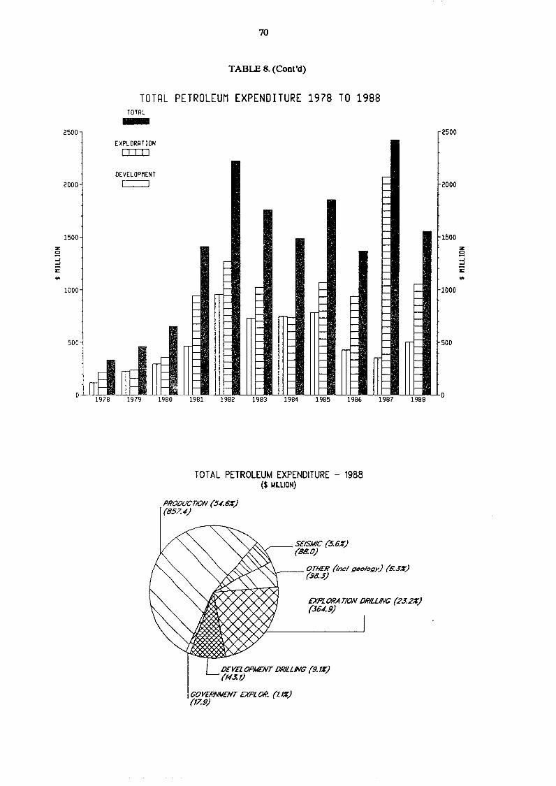
2500
2000
1500 z g ...J ...J
E: ... 1000
500
o i~,
70
TABLE 8. (Cont'd)
TOT~L PETROLEUM EXPENDITURE 1978 TO 1988 TOTAL -
EXPLORAT ION o::rn
DEVELOPMENT [===:J
IfF 1979
r-I-I-I-I- .. ~
19BO
r-l-l-I- r-I- r- l-
r- l- I- I- -\
I- l- I- I- -l- I- I- -
l- I- l-I- - I- -I- l- I- - I- -I- l-I-
l- I- - I- -l-
I- I- - I- -l- I- I- - I- -I-- l- I- - I- -l- I- I- - I- -- l- I- - I- -- l- I- - I- -- l- I- - I- -- l- I- - l- I-
19B1 1982 1983 1984 1985 1986
TOTAL PETROLEUM EXPENDITURE - 1988 ($ ~LlION)
r-I------I-r-I-I-r-I-I-I-I-I- r-I- I-l- l-l- I-I- l-l- l-I- l-l- I-l- i-
l- I-l- I-~ ,-l- I-
'- -- -- -
1987 1988
PROOUCTION (54.6%) (857.4)
SEISAIIC (5.6%) (88.0)
OTHER (incl geology) (6.3%) '-..,...-- (98.3)
EXPLORA TlON MILLING (23.2%) (36./.9)
DEVELOPMENT ORILLNG (9.1%) (143.1)
GOVERNMENT EXPLOH. (tl%) (17.9)
2500
2000
1500 z g ..J ..J
i:: ... 1000
500
0
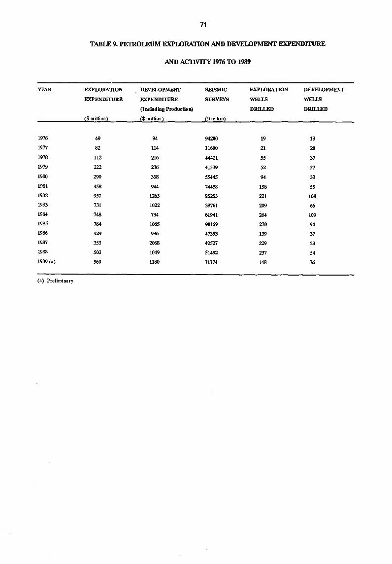
71
TABLE 9. PEIROLEUM EXPLORATION AND DEVELOPMENT EXPENDITURE
AND ACIWITY 1976 TO 1989
YE\R EXPLORATION DEVELOPMENT SEISMIC EXPLORATION DEVELOPMENT
EXPENDITURE EXPENDITURE SURVEYS WELLS WELLS
(Including Produdion) DRILlED DRILlED
($ million) ($ million) (line km)
1976 49 94 94200 19 13
1977 82 114 11600 21 20
1978 112 216 44421 55 37
1979 222 236 41539 52 57
1980 290 358 55445 94 33
1981 458 944 74438 158 55
1982 957 1263 95253 221 108
1983 731 1022 38761 209 66
1984 748 734 61941 264 109
1985 784 1065 90169 270 94
1986 429 936 47353 139 37
1987 353 2068 42527 229 53
1988 503 1049 51492 237 54
1989 (a) 560 1180 71774 148 76
(a) Preliminary
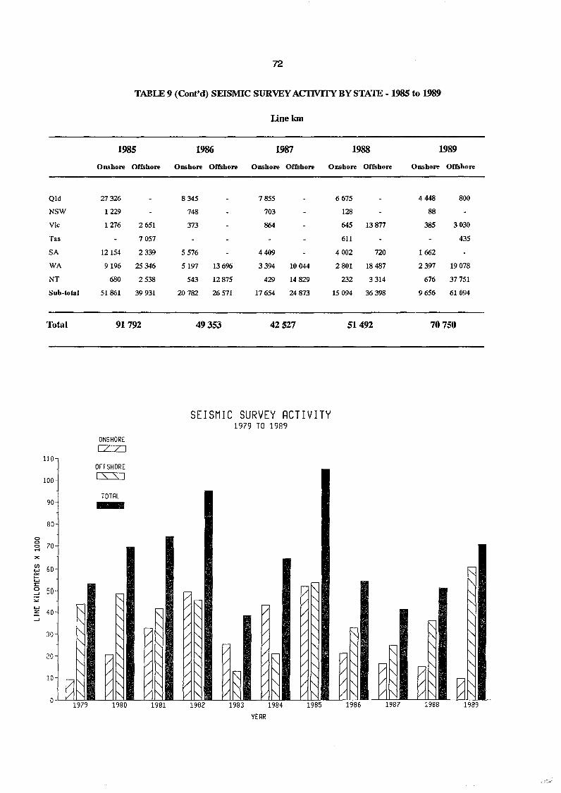
Qld
NSW
Vic
Tas
SA
WA
NT
Sub·total
Total
110
100
90
80
<:> <:>
70 <:> .... x CIl 60 w
"'" I-W 2:: 0 50 ..J
"" W ::z 40 -
r-f"-
..J ~ 30 f"-
~ 20 " ,,, 10
0
'" ~~ 1979
72
TABLE 9 (Cont'd) SEISMIC SURVEY ACI1VITYBYSTAlE -1985 to 1989
1985
Onshore Offshore
27326
1229
1276 2651
7057
12154 2339
9196 25 346
680 2538
51861 39931
91792
ONSHORE CZZJ
OFFSHORE cs=:s:J
TOTRL -" " "-"-"-" - "-V t"-
V f"-/ ~ / f"-
1980
F: r- ~ V ~ V '" V '" V ~ V l"-V '" V l"-
1981
Iinekm
1986 1987 1988
Onshore Offshore Onshore Offshore Onshore Offshore
8345 7855
748 703
373 864
5576 4409
5197 13696 3394 10044
543 12875 429 14829
20782 26 571 17654 24 873
49353 42527
SEISMIC SURVEY RCTIVITY 1979 TO 1989
..... -[/ V" V~ - V" V "- / V" V "- / V"
/" V "- V / /~
V " , /'" V '" V V -
:/ '" V V ~ /~ V t"- V ~ V " / " V f"- V " V "- / '" V f"- V "- V 1'\ / ~
1982 1983 1984 1985
YERR
6675
128
645 13877
611
4002 720
2801 18487
232 3314
15094 36398
51492
-I"-'" r-, " ~
V " - '" V "
/ ~ V "- / f"-/ " / ~
1986 1987
1989
Onshore Offshore
4448 800
88
385 3030
435
1662
2397 19078
676 37751
9656 61094
70750
~ "-
" "-"-
~ "-
'" "-
" "-
" " ..... " '" V " ~~ / " V " 1988 1989
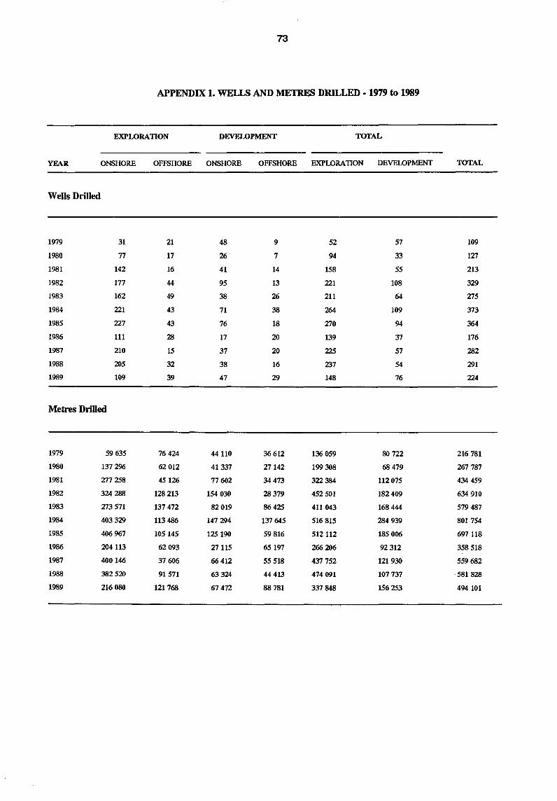
73
APPENDIX 1. WELLS AND METRES DRILLED - 1979 to 1989
EXPLORATION DEVELOPMENT TOTAL
YEAR ONSHORE OFFSHORE ONSHORE OFFSHORE EXPLORATION DEVELOPMENT TOTAL
Wells Drilled
1979 31 21 48 9 52 57 109
1980 77 17 26 7 94 33 127
1981 142 16 41 14 158 55 213
1982 177 44 95 13 221 108 329
1983 162 49 38 26 211 64 275
1984 221 43 71 38 264 109 373
1985 227 43 76 18 270 94 364
1986 111 28 17 20 139 37 176
1987 210 15 37 20 225 57 282
1988 205 32 38 16 237 54 291
1989 109 39 47 29 148 76 224
Metres Drilled
1979 59635 76424 44110 36612 136 059 80 722 216781
1980 137296 62012 41337 27142 199 308 68 479 267787
1981 277258 45126 77602 34473 322 384 112075 434 459
1982 324288 128 213 154030 28379 452501 182409 634 910
1983 273571 137472 82019 86425 411 043 168444 579487
1984 403329 113486 147294 137645 516815 284939 801754
1985 406967 105145 125 190 59816 512112 185006 697 118
1986 204113 62093 27115 65197 266 206 92 312 358518
1987 400146 37606 66412 55518 437752 121930 559682
1988 382520 91571 63324 44413 474091 107737 ·581828
1989 216080 121768 67472 88781 337848 156253 494 101
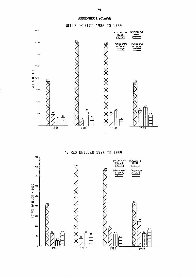
Cl W ...J ...J
a::
240
210
190
150
Cl 120 c.n ...J ...J W ::l:
90
60
30
350
o o 300 o
x
Cl 250 w ...J ...J
a:: Cl 200 V> W c.:: ..... E' 150
100
50
74
APPENDIX 1. (Coot'd)
WELLS DRILLED 1986 TO 1989
210
(XPL DRAT! (Jj ONSHORE [XX]
EXPLORATION OrrSHORE
c:z::zJ
METRES DRILLED 1986 TO 1989
EXPLORR T[ ON ONSHORE [XX]
EXPLORIHlON orrSHORE [ZZJ
OCv(LOPnENT OIISHOR[
o:::IJ
DEVELOPMENT on· SHORE
c::::::J
DEVELOPMENT ~SHORE
DIJ
DEVELOPMENT crrSHORE
c:::::J
47
29
84
66
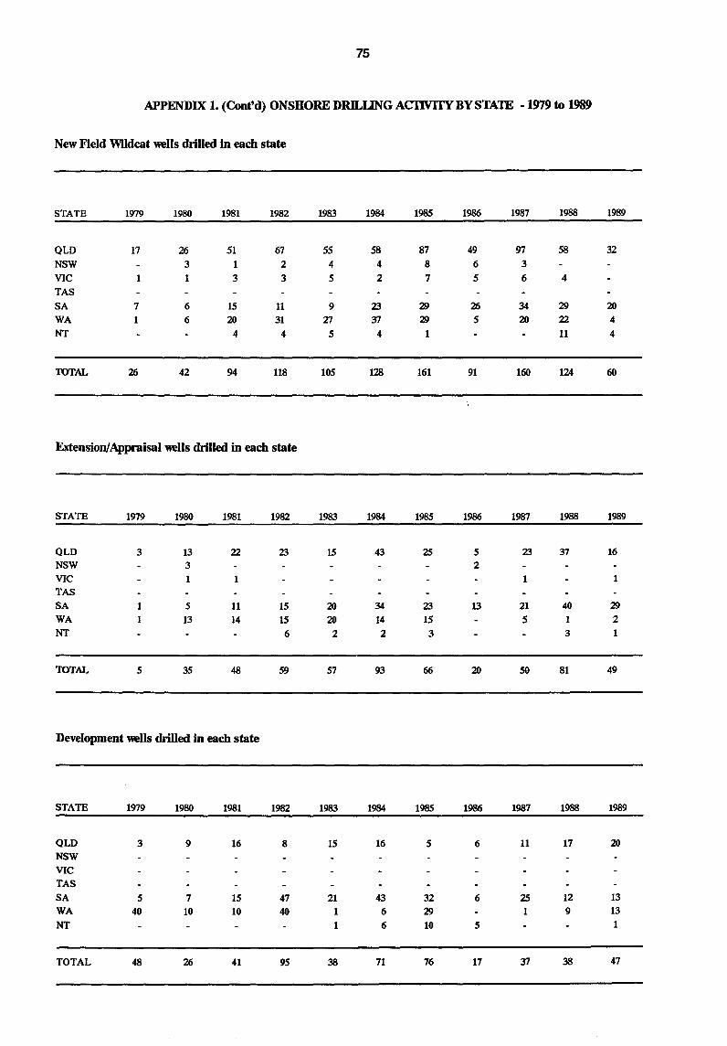
75
APPENDIX 1. (Cont'd) ONSHORE DRILUNG ACIWJfY BY STAlE • 1979 to 1989
New Field Wildcat wells drilled in each state
STATE 1979 1980 1981 1982 1983 1984 1985 1986 1987 1988 1989
QLD 17 26 51 67 55 58 87 49 97 58 32 NSW 3 1 2 4 4 8 6 3 VIC 1 3 3 5 2 7 5 6 4 TAS SA 7 6 15 11 9 23 29 26 34 29 20
WA 1 6 20 31 27 37 29 5 20 22 4 NT 4 4 5 4 1 11 4
TOTAL 26 42 94 118 105 128 161 91 160 124 60
Extension/Appraisal wells drilled in each state
STATE 1979 1980 1981 1982 1983 1984 1985 1986 1987 1988 1989
QLD 3 13 22 23 15 43 2S 5 23 37 16 NSW 3 2 VIC 1 1 1 1 TAS SA 1 5 11 15 20 34 23 13 21 40 29 WA 1 13 14 15 20 14 15 5 1 2 NT 6 2 2 3 3 1
TOTAL 5 35 48 59 57 93 66 20 50 81 49
Development wells drilled in each state
STATE 1979 1980 1981 1982 1983 1984 1985 1986 1987 1988 1989
QLD 3 9 16 8 15 16 5 6 11 17 20
NSW VIC
TAS SA 5 7 15 47 21 43 32 6 2S 12 13 WA 40 10 10 40 1 6 29 1 9 13 NT 1 6 10 5 1
TOTAL 48 26 41 95 38 71 76 17 37 38 47
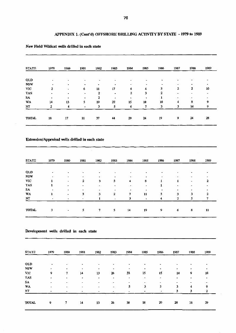
76
APPENDIX 1. (Cont'd) OFFSHORE DRILlJNG ACI'lVlTY BY STATE - 1979 to 1989
New Field Wildcat wells drilled in each state
STATE 1979 1980 1981 1982 1983 1984 1985 1986 1987 1988 1989
OLD NSW VIC 2 6 11 17 6 4 3 2 2 10 TAS 2 2 3 2 SA 2 1 WA 14 13 5 19 22 15 10 10 4 8 9 NT 2 4 3 5 6 7 3 3 14 9
TOTAL 18 17 11 37 44 29 24 19 9 24 28
Extension/Appraisal wells drilled in each state
STATE 1979 1980 1981 1982 1983 1984 1985 1986 1987 1988 1989
OLD NSW VIC 1 2 3 3 4 8 1 1 2 TAS 1 1 SA WA 3 3 2 7 11 3 3 3 2 NT 1 3 4 2 5 7
TOTAL 3 5 7 5 14 19 9 6 8 11
Development wells drilled in each state
STATE 1979 1980 1981 1982 1983 1984 1985 1986 1987 1988 1989
OLD NSW VIC 9 7 14 13 26 33 15 15 14 9 18 TAS SA WA 5 3 5 3 4 9 NT 3 3 2
TOTAL 9 7 14 13 26 38 18 20 20 16 29