phase 1: program (5100) scoping phase phase 2: … · 2016-11-23 · task code 5264) • t&e...
TRANSCRIPT

April 7, 2016
- 1 -
Design Process Outline (DPO) (Abbreviations may be found in the DPO Index)
Project No: Control No: Letting Date: Project Location: Designer: Roadway Design Unit Head:
PHASE 1: PROGRAM (5100) SCOPING PHASE PHASE 2: PLANNING (5200) INITIAL PROJECT REVIEW AND SETUP – Payroll Activity 5200 (Clarity Task Code
5282) Request Information:
• Traffic Counts, Design Year Traffic Data Information Supplied:
• Signed Highway Improvement Programming Request (Form DR-73) • Bridge Data (Bridge Task Code 5241) • Bridge Hydraulic Study (Bridge Task Code 5246) • Planning Environmental Review (P&PD Task Code 5247) • Wetland Delineation (P&PD Task Code 5264) • T&E Habitat Evaluation (P&PD Task Code 5273) • Planning Traffic Engineering Recommendations (Traffic Task Code 5256) • Preliminary Planning Pavement Determination (M&R Task Code 5258) • Initial Purpose & Need Statement (get from Scoping Planning Document) • Initial Project Description (get from Scoping Planning Document) • Project Scoping Planning Document (part of signed Form DR-73) • As-Built Plans • Survey Base Plans (Task Code 5235) • Aerial Survey (Task Code 5237) • Photo Log Ortho Photo (Task Code 5244) • Clarity Schedule (Program Management Section Task Code 5254) • Cultural Resource Identification and Evaluation (Historic Project Review) (P&PD
Task Code 5268) • Lighting Appraisal (Task Code 5274) • Stormwater Treatment Form A – “Project Development” Preliminary Erosion
Control & Landscape Review (Roadside Stabilization Unit (RSU) Task Code 5278)
• Planning Project Considerations (if available) Action:
• Meet with the RD Survey Coordinator to determine the survey needs of the project

April 7, 2016
- 2 -
• For projects without survey, the RD Unit Head will obtain the as-built plans and transmit them to the Highway Total Station Coordinator in Geodetic Surveys to create the project alignment
• Determine the Design Standard and Typical Section using Nebraska Minimum Design Standards and the RDM
• Complete Form DR-76, Roadway Design – Principal Controlling Design Criteria, and route for signatures
• Review FEMA Flood Plain Maps • After Form DR-76 has been returned with signatures, request any design
exceptions or relaxations that may be needed. A request for a relaxation of the Minimum Design Standards to the Board of Public Roads Classifications and Standards should be presented as a PowerPoint slide show. Requests to the Secretary of the Board to place your project on the agenda shall be submitted at least two weeks before the meeting and will include the PowerPoint slide show (to comply with the Open Meeting Act) and a time estimate for the presentation
• Generate Initial Footprint (IFP) (Task Code 5238) • Planning Alignment Design for Bridge (Task Code 5240) • RD Unit Head review/adjust Clarity schedule • Conduct Project Coordination Meeting 20 (Exhibit A) (Task Code 5290)
Submittals: • Send Initial Footprint (IFP) to P&PD • Send Planning Alignment Design to Bridge • Send notice to Clarity that the activity Activity 5200 is done
DESIGN TASK REQUIRED BEFORE BEGINNING PIH PHASE ENVIRONMENTAL REVIEW MEETING 10 (Exhibit A) – Payroll Activity 5300 (Clarity Task Code 5284)
Note: This is a Roadway Design (RD) meeting that shall be held for all New & Reconstructed projects prior to “Preliminary Roadway Design”. Consult with the RD Environmental Liaison Engineer to determine the need for Meeting 10 on 3R projects.

April 7, 2016
- 3 -
PLAN-IN-HAND PHASE PHASE 3: DESIGN (5300) PRELIMINARY ALIGNMENT DESIGN FOR BRIDGE HYDRAULICS – Payroll Activity 5300 (Clarity Task Code 5336)
Action: • Preliminary design of vertical and horizontal alignments through bridge areas
Submittals: • Proposed & existing alignments to Bridge Hydraulic Unit for analysis
PRELIMINARY ROADWAY DESIGN - Payroll Activity 5300 (Clarity Task Code 5350) Request Information:
• Earthwork Balance Factor from the DE • Accident Report (May be on Falcon in OnBase). Request Sheet for Accident
Summary (Form DR-312): Rate Analysis, Collision Diagram, & Spot Map (3 yr.). This report is for NDOR use only & shall not be shared with the general public. (Traffic Task Code 5224 5256)
• Traffic Counts, Design Year Traffic Data • District/City review of property access during construction (ADA compliant?)
(RDM – 2006 Chapter Ten, Section 10.B Sixteen) • Soils information for MS4 Stormwater Treatment Facility BMP (STF) sites
Information Supplied: • Highway Improvement Programming Request (Form DR-73) • Engineering Review or Initial Project Review and Setup - Meet with the author of
this document if/as needed • Approved Design Relaxations/Exceptions • CADD Files (Plotted Survey, PDU Task Code 5330)
o Aerials, Topography, Alignment, Location Map • Correspondence File • 9x9 Aerials • As-Built Plans • Roadview Explorer • GeoPak Files • Preliminary Pavement Determination from M&R (M&R Task Code 5258) • Bridge Data Sheet (TS&L) (Bridge Task Code 5346) • Bridge Hydraulic Study (Bridge Task Code 5342) • FEMA Flood Plain Maps • Initial Wetland Determination (P&PD Environmental Section Task Code 5264) • Prelim. Landscape Concept (P&PD Environmental Section Task Code 5360) • Threatened & Endangered Species (T&E) Agency Comments • Historic Project Review (P&PD Environmental Section Task Code 5268) • Traffic Recommendations (Traffic Task Code 5256) • Lighting Appraisal (RD Lighting Unit Task Code 5274)

April 7, 2016
- 4 -
• Right-of-Way Ownership Plans (R.O.W. Task Code 5348) • Roadside Stabilization Appraisals (P&PD Environmental Section Roadside
Stabilization Unit (RSU) Task Code 5362) • Stormwater Treatment Form A – “Project Evaluation” (from RSU)
Action: • Determine the Design Standard and Typical Section using Nebraska Minimum
Design Standards and the RDM • Complete Form DR-76, Roadway Design – Principal Controlling Design Criteria,
and route for signatures • After Form DR-76 has been returned with signatures, request any design
exceptions or relaxations that may be needed. A request for a relaxation of the Minimum Design Standards to the Board of Public Roads Classifications and Standards should be presented as a PowerPoint slide show. Requests to the Secretary of the Board to place your project on the agenda shall be submitted at least two weeks before the meeting and will include the PowerPoint slide show (to comply with the Open Meeting Act) and a time estimate for the presentation Move above to Planning
• Conduct Construction Meeting (Exhibit T) (Task Code 5313) • e-mail the Railroad Liaison Engineer with the Project Control Number, Project
Number, Designer, and Designer’s Phone Number • Complete the “Public Meeting Checklist” (Exhibit C) • Fill out the preliminary Waterway Permit Data Sheet (Form DR-290) and
justification for impacted wetlands and/or channel changes (why avoidance was not possible) and place on Falcon in OnBase. Send notice to the Environmental Program Manager in P&PD (Task Code 5353)
• Conduct “Environmental Review Meeting 20” (Exhibit A) (Task Code 5378) • Conduct Project Coordination Meeting 30 (Exhibit A) (Task Code 5315) • Conduct Alternative Design Analysis (Task Code 5366) • Complete the Waterway Permit Data Sheet (Form DR-290) • Conduct Meeting A (CADD Coordination Policy, Version 8
http://www.nebraskatransportation.org/roadway-design/downloads.htm) • Check for Right-of-Way Permits on CICS (Exhibit D) • Design vertical and horizontal alignments • Request Bridge Special Investigations (e.g. allowable CBC parapet height, is
bridge rail NCHRP 350/MASH compliant) • Design intersections/frontage roads; check geometry with Traffic • Perform preliminary earthwork computations • Delineate and compute drainage areas • Determine Q values and size drainage structures • Preliminary design of culverts, storm sewers, special ditches and median drains • Present access control recommendations to Access Control Group (Exhibit D) • Confirm Notify Hwy. Survey Coordinator if Right-of-Way Survey is
needed/ordered or has been ordered • Complete the “Erosion Control Plan-in-Hand Checklist” (Exhibit F)

April 7, 2016
- 5 -
• Draft Covenant Agreements - City/County: Request for Agreement (Form DR-65) (Include Stormwater Treatment Facilities (STFs) for MS4 – Maintenance of Treatment BMPs STFs, if required. See the Drainage and Erosion Control Manual (Drainage Manual), Chapter Three, Section 7.A.5).
• Review by RD Hydraulics Engineer if a Floodway/Floodplain is near project • Constructability/Phasing Meeting (Exhibit E). Early Bridge involvement is
critical • Conduct FHWA Oversight Coordination Meeting #1 (Task Code 5382) (Full
oversight projects only PODI/POCI projects only) • Review and Complete Stormwater Treatment Form A – “Project Evaluation” (in
Falcon under Roadway Correspondence OnBase) • Identify all Stormwater Outfall locations and determine Priority Stormwater
Outfalls, initiate Stormwater Treatment Form B – “Stormwater Treatment Facilities BMPs” (See the Drainage Manual, Chapter Three, Section 5), consult RD Hydraulics Engineer as needed
• Calculate Water Quality Volume and Discharge Rate at Priority Stormwater Outfall locations (See the Drainage Manual, Chapter Three, Section 6)
• Select Stormwater Treatment Facilities BMPs (STFs) at outfall locations and complete initial design (See the Drainage Manual, Chapter Three, Section 7)
• Coordinate with Adjacent MS4 Communities concerning selection and design of Stormwater Treatment Facilities BMPs (STFs) (See the Drainage Manual, Chapter Three, Section 7.A.3)
Additional Information/Action by Others: • Review by RD Hydraulics Engineer if a Floodway/Floodplain is near the project • Traffic: Studies, Signals, Signing, etc. • RD Hydraulics: Drainage Structures and Review of Stormwater Pipes, Culverts,
Non-Bridge size Concrete Box Culverts and Stormwater Treatment Facilities (STFs) as requested by Roadway Designer
• P&PD: Utilities, Environmental Survey, Design Environmental Review • RSU: Review of Stormwater Treatment Form B – “Stormwater Treatment
Facilities BMPs (STFs)”, Pre-PIH Review (P&PD Task Code 5362) • Railroad Liaison: Preliminary Plan Review (Railroad Liaison Task Code 5358) • M&R: Soils Investigation • M&R: Retaining Walls/Settlement • Additional Survey (Form DR-150): For Hydraulic Surveys or missing items
(e.g. sewers, water lines, center pivot, utilities, or to extend cross-sections or pavement shots)
• Aerial Photography - Request for Aerial Photography (Form DR-474) • Bridge: Bridge/Bridge Hydraulics/Bridge size culverts • R.O.W.: Relocation Concept Study (R.O.W. Task Code 5356) • District: District Plan Review No. 1 (Program Management Task Code 5370) • District Program Evaluation (Program Management Task Code 5327) • District: Detour Location/ADA Access during construction (RDM – 2006 Chapter
Ten, Section 10.B Sixteen)

April 7, 2016
- 6 -
Reviews: • Scope of project with RD Unit Head and Asst. Design Engr. (invite Roadway
Design Engineer, DE, Environmental Program Manager, Environmental Analyst Supervisor, Roadside Stabilization Manager, and/or Railroad Liaison Engineer as required). Review Clarity schedule for content equal to scope of work to address “Scope Change Window”. The Environmental Units will determine whether or not they want to be invited to the PIH at this meeting
• Review/revise: 1. Purpose & Need Statement 2. Project Description 3. Project Scoping Document
Keep all versions on Falcon, date and save any changes as version R1, R2, etc. (See Scope Report, Task Code 5388)
• Preliminary Approved Pavement Determination Review (M&R Task Code 5364) • “Design Checklist” (Exhibit B) with RD Unit Head • RD Unit Head review and approval of preliminary Stormwater Treatment Facility
BMP (STF) design; forward Form B – “Stormwater Treatment Facilities BMPs” to the RSU
• Ditch grades and erosion control methods with the P&PD Roadside Stabilization Manager
• Sidewalk design with Traffic Engineer & Traffic Analysis Engineer; discuss crossing/signal/push button placement
• Special information from support units and other divisions • Covenant Relinquishment Agreement (CRA) for revising (Exhibit G) (include
Stormwater Treatment Facilities (STFs) for MS4 – Maintenance of Treatment BMPs STFs, if required. See the Drainage Manual, Chapter Three, Section 7.A.5)
• Design for content and quality by RD Unit Head Submittals:
• Selected Final Alignment: Send through RD Unit Head to Photogrammetry and PDU to update Survey (offsets, culvert data, & data sheets) & input file to R.O.W. Pre-design Supervisor
• Agreements: Request for Agreement (Form DR-65) • Back-up Preliminary Roadway Design to Falcon ProjectWise • Stormwater Treatment within MS4 Communities Form B – “Stormwater
Treatment Facilities BMPs” • Send notice activity that Activity 5300 is done:
o RD Unit Head o RD Lighting Unit Head o Bridge Designer o DE o Design Plans Manager in PDU o P&PD Roadside Stabilization Manager o Traffic Engineer

April 7, 2016
- 7 -
o PSS Project Manager (See Exhibit I, Sheet #2) o Clarity
COST UPDATE #1 - Status 30 – Payroll Activity 5300 (Clarity Task Code 5368) Action:
• Check with RD Unit Head for funding split (e.g. City or Railroad) • Complete estimate of plan quantities:
o Project Information Sheet (Form DR-342) o Project Quantity Sheet (Form DR-343)
Reviews: • “Cost Estimate Checklist” (Exhibit H) • Review of estimate by RD Unit Head
Submittals: • Transmit Estimate Quantities Estimate to the Highway Estimating Unit and the
Estimate Quantities & the Design Plans to the Final Plans Coordinator (in Construction) & and receive Cost Update #1 prior to PIH (Task Code 5319)
• Send notice to Clarity that Task Code 5368 is done PLAN-IN-HAND (PIH) – Payroll Activity 5300 (Clarity Task Code 5380)
Request Information: • Ask the DCE whether “Construction Surveying” and “Re-establish
Property Corners” will be performed by State forces or bid as part of the contract.
Information Supplied: • Wetland Delineation Plans (2W) and Mitigation Site Priority List • Preliminary Design Plans from PDU (PDU Task Code 5354) • Preliminary Utility Inspection (P&PD Utilities Section Task Code 5374) • Wetland Mitigation Strategy (P&PD Environmental Section Task Code 5390) • Bridge Borings (M&R Task Code 5372) • Railroad Company Approval (Railroad Liaison Task Code 5384) • Noise Report Determination (P&PD Noise & Air Unit Task Code 5386) • Preliminary Project Agreements (Including Stormwater Treatment Facilities for
MS4 – Maintenance of STFs, if required. See the Drainage Manual, Chapter Three, Section 7.A.5)
• Preliminary Relinquishment Agreements (Including Stormwater Treatment Facilities for MS4 – Maintenance of STFs, if required. See the Drainage Manual, Chapter Three, Section 7.A.5)
Action: • Request that PDU plot PIH plans • Assemble PIH plans (RDM - 2006 Chapter Eleven):
o PIH Title Sheet (include Location Map & Traffic ADT) o 2L Sheets o P & P Sheets o Culvert Sections
April 7, 2016
- 8 -
o Typical Section o X-Sections o 2W/2A Sheets o Right-of-Way Ownership Plans o Wetland information
• Request that District Maintenance inspect the culverts on the project (send request with PIH plans transmittal)
• Complete the T&E Checklist and place on Falcon in OnBase; send notice to the Environmental Program Manager Technical Documents Unit in P&PD (Task Code 5395)
• Conduct in-field review with Plans-In-Hand (“Plan-In-Hand Checklist”, Exhibit J) • Confirm or update the Project Description / Purpose & Need on Falcon (Task
Code 5396) (See Scope Report) • Review the completed “Public Meeting Checklist” (Exhibit C) from Clarity Task
5350 • Conduct Public Information Meeting, if indicated (Exhibit C)
o Provide PDU with information for mosaic and displays (“Guidelines for Public Meetings”, Exhibit L)
o Provide the Communications Division Public Involvement Coordinator with completed Public Meeting Notice Worksheet (Form DR-356)
• Coordinate with P&PD Utilities Section, discuss conflicts/resolution • Conduct Project Coordination Meeting 35 (Exhibit A) after the PIH (Task Code
5331) Reviews:
• Project Scoping Planning Document (save all versions on Falcon in OnBase, date and save any changes as version R1, R2, etc.)
• Design for content and quality by RD Unit Head Submittals:
• Back-up PIH Design to Falcon ProjectWise • Send notice activity is done to Design Plans Manager in PDU • Send notices PIH Plans are available (Exhibit I) (Task Code 5317) • Transmit PIH plans at least 2 weeks prior to the PIH date (Railroad personnel
require 5 weeks’ notice), see “Distribution of Plans” (Exhibit I); distribute 5 weeks prior to Public Information Meeting when held concurrently w/PIH
• Place the completed “Erosion Control Plan-in-Hand Checklist” (Exhibit F) on Falcon in OnBase and send notice to the P&PD Wetland Manager and Roadside Stabilization Manager
• Send notice that Form DR-290 (Waterway Permit Data Sheet) is available in OnBase to the P&PD Wetland Manager and Roadside Stabilization Manager
• Submit FAA Form 7460-1 to the Nebraska Department of Aeronautics, if required (“Airway Highway Clearances”, Exhibit R)
• Send notice to Clarity the PIH (Task Code 5380) has been conducted

April 7, 2016
- 9 -
SCOPE (PIH) REPORT – Payroll Activity 5300 (Clarity Task Code 5388) Information Supplied: MOVED TO PIH (TASK CODE 5380)
• Preliminary Utility Inspection (P&PD Utilities Section Task Code 5374) • Mitigation Concept Plans (P&PD Environmental Section Task Code 5390) • Bridge Borings (M&R Task Code 5372) • Railroad Company Approval (Railroad Liaison Task Code 5384) • Noise Report Determination (P&PD Noise & Air Unit Task Code 5386) • Preliminary Project Agreements (P&PD Agreements Task Code 5340)
(Including Stormwater Treatment for MS4 – Maintenance of Treatment BMPs, if required. See the Drainage Manual, Chapter Three, Section 7.A.5)
• Preliminary Relinquishment Agreements (P&PD Agreements Task Code 5338) (Including Stormwater Treatment for MS4 – Maintenance of Treatment BMPs, if required. See the Drainage Manual, Chapter Three, Section 7.A.5)
(1) Combine comments/changes from PIH to one set of plans and label as PIH Set (2) Conduct post PIH field inspection review – RD personnel office review (3) The RD Unit Head should review the Scoping Planning Document and respond
to all of the items where it is indicated that resolution will occur at the plan-in-hand.
(4) Review any changes to the project with the P&PD Environmental Program Manager
(5) Review the completed “Public Meeting Checklist” (Exhibit C) from Clarity Task 5350 for changes approved by RD Unit Head and Asst. Design Engr.
(6) Prepare the Scope (PIH) Report (“Plan-In-Hand Report Outline”, Exhibit K) (7) Review the Scope (PIH) Report with RD Unit Head (8) Submit the Scope (PIH) Report to Falcon OnBase and to the Asst. Design
Engr. for routing (9) Revise the routed the Scope (PIH) Report as needed (10) Review/revise Confirm/Update Project Description, and Purpose & Need
Statement and the T&E Checklist w/RD Unit Head (save all versions on Falcon in OnBase, date and save any changes as version R1, R2, etc.) (Task Code 5396)
(11) Submit revised the Scope (PIH) Report to the Asst. Design Engr. for distribution
(12) After the the Scope (PIH) Report has been routed, change the date of the report to the approval date and place the the Scope (PIH) Report in Falcon OnBase
(13) If applicable, request Design Relaxations/Exceptions (RDM - 2006 Chapter One Appendix H)
PUBLIC HEARING PHASE PHASE 4: ENVIRONMENTAL APPROVAL (5400) FUNCTIONAL DESIGN – Payroll Activity 5400 (Clarity Task Code 5428) NOTE: Send a note to inform the Design Plans Manager if this activity will not be done by PDU.
Request Information: • Accident Studies, Request Sheet for Accident Summary (Form DR-312)

April 7, 2016
- 10 -
• MS4 landscaping design (if applicable) (See the Drainage Manual, Chapter Three, Section 8.A)
Information Supplied: • Signed Covenant Agreements from Clarity Task 5350 • Final Pavement Determination (M&R Task Code 5406) • Final Bridge Data Sheet (Bridge Task Code 5410) • Soils Foundation Report (M&R Task Code 5452) • Soils, Situation, and Subgrade Report (M&R Task Code 5450) • Final Delineation & Mitigation Plans (P&PD Environmental Section Task Code
5440) • Roadside Stabilization PIH Review (P&PD Environmental Section Task Code
5426) • Landscape Concept & PIH Review (P&PD Environmental Section Task Code
5424) • Lighting Layout (RD Lighting Unit Task Code 5422) • Lighting Design (Task Code 5429) • Lighting Comps & Specs (Task Code 5453) • Approved 4(f) Statement (P&PD Task Code 5476) • Final E.I.S Acceptance (P&PD Task Code 5480) • Approved CE Documentation (P&PD Task Code 5481) • Final E.A. Acceptance (P&PD Task Code 5482) • Roadway Floodplain Certification (Task Code 5485) • Bridge Floodplain Certification (Bridge Task Code 5488) • Functional Design Plans/Prep Public Meeting from PDU (PDU Task Code 5432)
Action: • Make changes, if needed, as the result of the Noise Report – Keep R.O.W.
Design, Lighting, Traffic, Wetlands, etc. informed. • Revise design according to Public Information Meeting (if held), the PIH
inspection, and the approved the Scope (PIH) Report comments • Conduct Meeting B (CADD Coordination Policy, Version 8) • Design details to be considered (“Design Checklist”, Exhibit B) • Schedule a meeting with the City, Irrigation District, etc. to determine conflicts
and if rehabilitation will be a part of the project • Present access control design to Access Control Group, if needed (Exhibit D) • Request that PDU plot Functional Plans • Conduct “Environmental Review Meeting 30” (Exhibit A) (Task Code 5454) • Constructability/Phasing: Consider holding a meeting (Exhibit E) • Complete MS4 Treatment BMP STF design (See the Drainage Manual, Chapter
Three, Section 8) • MS4 Treatment BMP STF Plan Labeling (See the Drainage Manual, Chapter
Three, Section 8.D) • Begin Writing Special Provisions

April 7, 2016
- 11 -
Additional Information/Action by Others: • District Plan Review No. 2 (Program Management Task Code 5436) • Traffic Signals/Studies/Signing • Traffic Engineering Review (Traffic Task Code 5464) • Lighting Layout (RD Lighting Unit Task Code 5422) Move to “Information
Supplied) • Detour Location Accomplished in Phase # • Drainage Structures and Box Culverts • Retaining Walls • Utilities • Additional Survey (DR Form 150): For Hydraulic Surveys or missing items
(e.g. water lines, center pivots, sewers, utilities, or to extend cross-sections or pavement shots)
• Request for Aerial Photography (Form DR-474) • Bridge • Bridge Hydraulics Unit • R.O.W.
Reviews: • Review/revise Confirm/Update Project Description, and Purpose & Need
Statement and the T&E Checklist (save all versions on Falcon in OnBase, date and save any changes as version R1, R2, etc.)
• Avoidance & Minimization Review w/P&PD Environmental Program Manager • Covenant Relinquishment Agreement (CRA) for revising (Exhibit G) (Include
Stormwater Treatment Facilities (STFs) for MS4 – Maintenance of Treatment BMPs STFs, if required. See the Drainage Manual, Chapter Three, Section 7.A.5)
• Review by RD Hydraulics Engineer if a Floodway/Floodplain is near project as needed
• “Design Checklist” (Exhibit B) with RD Unit Head • Review of design for content and quality by RD Unit Head • MS4 Form B – “Stormwater Treatment Facilities BMPs” review by RD Unit Head
Submittals: • Selected Final Alignment: Send through RD Unit Head to Photogrammetry and
PDU to update survey (offsets, culvert data, & data sheets) & input file to R.O.W. Pre-design Supervisor Move to Phase 3
• Back-up Functional Design to Falcon ProjectWise • Revised Waterway Permit Data Sheet (Form DR-290), if needed, to P&PD
Wetlands Unit • Send notice activity that Activity 5400 is done to:
o Design Plans Manager o RD Unit Head o Traffic Engineer
o Clarity o PSS Project Manager
(See Exhibit I, Sheet #2)

April 7, 2016
- 12 -
COST UPDATE #2 - Status 40 – Payroll Activity 5400 (Clarity Task Code 5446) Note: Cost Update #2 is only required when a Public Hearing will be held.
Action: • Check with RD Unit Head for funding split (e.g. City or Railroad) • Complete estimate of plan quantities:
o Project Information Sheet (Form DR-342) o Project Quantity Sheet (Form DR-343)
Reviews: • “Cost Estimate Checklist” (Exhibit H) • RD Unit Head review of estimate
Submittals: • Estimate to Highway Estimating (in Construction) & receive Cost Update #2 • Send notice to Clarity that Task Code 5446 is done
DESIGN PREP FOR PUBLIC HEARING & HIGHWAY COMMISSION Payroll Activity 5400 (Clarity Task Code 5434 5435)
Information Required Before Scheduling a Public Hearing: • Signed Draft Environmental Impact Statement (EIS) or Environmental
Assessment (EA) • Signed City Covenant Agreement (CA) (if applicable) (Including Stormwater
Treatment Facilities (STFs) for MS4 – Maintenance of Treatment BMPs STFs, if required. See the Drainage Manual, Chapter Three, Section 7.A.5)
• Signed Covenant Relinquishment Agreement (CRA) (if applicable) (Including Stormwater Treatment Facilities (STFs) for MS4 – Maintenance of Treatment BMPs STFs, if required. see the Drainage Manual, Chapter Three, Section 7.A.5)
• Noise Study (if a Noise Study was conducted) Information Supplied:
• Air Aerial Photo Display • Hearing Transcript
Action: • Complete Public Meeting Notice Worksheet (Form DR- 356) & send to Public
Hearing Officer in Communications • RD Unit Head review/update of the project on the web (approximately every six
months) • Complete “Guidelines for Public Meetings” (Exhibit L) & give to PDU • Prepare the Engineering Statement and the Public Hearing presentation • Conduct Design Public Hearing Dry Run (Exhibit M) prior to scheduling Public
Hearing • Take the press release to the Public Hearing Dry Run for approval • Request Public Hearing Officer in Communications schedule Public Hearing • Conduct Design Public Hearing (Exhibit L) • Prepare Highway Commission Statement (Exhibit N)

April 7, 2016
- 13 -
• Request that the Executive Secretary of the Highway Commission inform the local government(s) of the Highway Commission Meeting
• Notify the Roadway Design Engineer that the project is ready to present to the Highway Commissioners
• Asst. Design Engr. (or designee): present Highway Commission Statement to Highway Commission for approval
Reviews: • Review/revise Confirm/Update Project Description, Purpose & Need Statement,
T&E Checklist and the Scoping Scope Document save all versions on Falcon in OnBase, date and save any changes as version R1, R2, etc.)
• Comments and plans from Public Information Meeting (if held) and label plans as “Public Information Meeting Plan Set”
• Transcript and consolidate comments and plans from Design Public Hearing and label plans as “Design Public Hearing Plan Set”
• Review and analyze the citizen comments received at the Public Hearing and respond to the originator of the comment (cc responses to the NEPA Project Manager and the Public Involvement Coordinator)
Submittals: • Transmit Functional Plans (“Distribution of Plans”, Exhibit I) • Hearing Statement • Highway Commission Statement • Expressway System projects: send Location Map and Expressway Map to the
Executive Secretary of the Highway Commission 10 days before the Commission meeting
• Send notice that Functional Plans have been transmitted to: o DE o Traffic Engineer o Design Plans Manager o P&PD Wetlands Unit Head o Communication Division Public Hearing Officer
FINAL DESIGN PHASE PHASE 5: PLAN DETAILS (5500) FINAL ROADWAY DESIGN DETAILS – Payroll Activity 5500 (Clarity Task Code 5508)
Information Required Before Beginning Final Roadway Design Details (Federal-Aid Projects):
• Final EA – Finding Of No Significant Impact (FONSI) (P&PD Environmental Section Task Code 5482) (See RDM - 2006 Chapter Thirteen, Section 4)
• Final EIS - Record Of Decision (ROD) (P&PD Environmental Section Task Code 5480) (RDM - 2006 Chapter Thirteen, Section 4)
• Signed and approved Categorical Exclusion (CE) NEPA Document (See RDM - Chapter Thirteen, Section 4)
Information Supplied: • Project Approval from Highway Commission and Governor

April 7, 2016
- 14 -
• Final 4F Statement (P&PD Environmental Section Task Code 5476) (RDM - 2006 Chapter Thirteen, Section 4)
• Preliminary Landscaping Plans (P&PD Environmental Section Task Code 5466)
• Final Wetland Mitigation Plans (P&PD Task Code 5518) • Roadside Stabilization Erosion Control Design (P&PD Environmental Section
Roadside Stabilization Unit Task Code 5528) • Roadside Stabilization Erosion Control Computations (P&PD Environmental
Section Task Code 5572) • Final Pavement Determination Verification (M&R Task Code 5504 5555) • Traffic Review (Traffic Task Code 5464) • Lighting Plans, Computations, & Specifications (Lighting Unit Task Codes 5524
and 5552) • Bridge Design Details/Plans (Bridge Task Code 5520) • Special Plans from Bridge (Bridge Task Code 5540) • Approved Bridge Data Sheet (Bridge Task Code 5460) • Final Bridge Plans & Specifications (Bridge Task Codes 5544 & 5556) • Roadway Design Plans - PDU (PDU Task Code 5532)
Action: • Design Finalize design geometry, grades, and cross-sections for driveways,
intersections, frontage roads, etc. (“Design Checklist”, Exhibit B) • Finalize plans and notes for Stormwater Treatment Facilities (STFs) • Revise impacted wetland areas if/as needed • Prepare geotechnical plans (wick drains, instrumentation, etc.) • Conduct “Environmental Review Meeting 40” (Exhibit A) (Task Code 5512) • Request seed mixtures from the P&PD Roadside Development Unit
approximately two months prior to PS&E turn-in • Request Special Plans from Bridge Special Projects Unit (Box Culverts using
the Concrete Box Culvert Request Sheet, Form DR- 67; Retaining Walls, Headwalls etc., using the Custom Special Plan Request Sheet, Form DR-66) approximately two months prior to PS&E turn-in (Task Code 5516)
• Request that PDU plot Final Design Plans for Final Design Review • Constructability/Phasing Meeting (Exhibit E): Review Bridge Plans, verify vertical
clearance • Review and Finalize the Waterway Permit Data Sheet (Form DR-290) for
changes due to right-of-way, place in OnBase and send notice to the Environmental Program Manager in P&PD (Task Code 5591).
• Conduct FHWA Oversight Coordination Meeting #2 (Task Code 5560) (Full oversight PODI/POCI projects only)
Additional Information/Action by Others: • District Final Plan Review (Program Management Task Code 5580) • District: Detour Locations • Railroad Liaison: Drainage, Constructability, Crossings, etc.

April 7, 2016
- 15 -
• M&R: Soils/Foundation investigation needed • P&PD: Utilities • Additional Survey (Form DR-150): For Hydraulic Surveys or missing items
(e.g. water lines, center pivot, sewer pipe, utilities, or to extend cross-sections or pavement shots)
• Request for Aerial Photography (Form DR-474) • R.O.W.
Reviews: • Project Description, Purpose & Need Statement, T&E Checklist and the Scoping
Scope Document (save all versions on Falcon in OnBase, date and save any changes as version R1, R2, etc.). If changes or revisions are required notify the Environmental Section Manager in P&PD immediately
• Designer check of lighting pole locations • Requests & changes recommended in the District Final Plan Review • Review by RD Hydraulics Engineer if a Floodway/Floodplain is near the project
Move to Phase 3 • Hearing Plans, transcript, notes, and comments • P&PD Roadside Stabilization Unit Head - Erosion control w/cross-sections and
MS4 Treatment BMPs STFs (P&PD Roadside Stabilization Unit Task Code 5528 5572)
• P&PD Roadside Stabilization Unit Head – Landscape Plan Review (P&PD Roadside Stabilization Unit Task Code 5574)
• “Earthwork Checklist” (Exhibit O) • “Design Checklist” (Exhibit B) and Final Design Plans with RD Unit Head • Final Design Plans with RD Unit Head
Submittals: • Send phasing plans to Traffic for use in producing traffic control plans • Back-up roadway design to Falcon ProjectWise & Send notice Clarity Task 5508
is done to: o R.O.W. Design o Asst. Design Engr. and RD Unit Head o District: DCE & Project Manager o Design Plans Manager o P&PD Roadside Stabilization Unit Manager o Roadway Design Survey Coordinator o P&PD Traffic Analysis - traffic forecast needs updating o R.O.W. Relocations - with comment about business and home relocations o PSS Project Manager (See Exhibit I, Sheet #2) o Clarity
• Transmit early acquisition Final Design Plans to R.O.W. (when applicable)

April 7, 2016
- 16 -
FINAL DESIGN DETAIL REVIEW – Payroll Activity 5500 (Clarity Task Code 5576) Information Supplied:
• Final Roadway Design Plans from PDU (PDU Task Code 5532) • Final Landscape Design & Specifications (P&PD Environmental Section
Roadside Stabilization Unit Task Code 5568) Request Information:
• Request tree/stump counts from the District Reviews:
• Design for content and quality by RD Unit Head • Plans with RD Unit Head using “Design Checklist” (Exhibit B) • Conduct traffic review (pavement marking plans, special plans, signals, etc.). Tell
Traffic if the project has centerline and/or edge line rumble strips – this may change the type of striping specified/required on the project.
• MS4 Treatment BMP STF labeling on Final Design Plans with RD Unit Head (See the Drainage Manual, Chapter Three, Section 8.D)
Submittals: • Back-up Final Design to Falcon ProjectWise (include culvert sections) • Design Plans to District (Task Code 5550) • Send notice activity that Activity 5500 is done to:
o Design Plans Manager o R.O.W. Designer o RD Lighting Unit Head o P&PD Environmental Section Manager o P&PD Utilities Engineer o Traffic Engineer o DE o Clarity
• Request that PDU plot Final Design Plans showing the limits of construction • Transmit Final Design Plans (“Distribution of Plans”, Exhibit I) • Transmit asphalt surfacing areas to M&R
COST UPDATE #3 - STATUS 45 – Payroll Activity 5500 (Clarity Task Code 5584) Information Supplied:
• Receive asphalt surfacing quantities from M&R Action:
• Check with RD Unit Head for funding split (e.g. City or Railroad) • Complete estimate of plan quantities:
o Project Information Sheet (Form DR-342) o Project Quantity Sheet (Form DR-343)
• Update the City Financial Agreement (Request for Agreement, Form DR-65) (Include Stormwater Treatment Facilities (STFs) for MS4 – Maintenance of Treatment BMPs STFs, if required. See the Drainage Manual, Chapter Three, Section 7.A.5)

April 7, 2016
- 17 -
Reviews: • “Cost Estimate Checklist” (Exhibit H) • RD Unit Head review of estimate
Submittals: • Estimate to Highway Estimating Unit (in Construction) & receive Cost
Update #3 • Send notice to Clarity that Task Code 5584 is done
DESIGN REVIEW OF SUPPORT PROCESSES – Payroll Activity Varies (Clarity Task Code Varies)
Reviews: • Agreements:
o City/County (Include MS4 Maintenance, if required) o Railroad o Irrigation o NRD
• Wetlands • Utilities • Right-of-Way • Geotechnical • Phasing • MS4 Construction Phasing (See the Drainage Manual, Chapter Three,
Section 8.B) • Promises • Final Relinquishment Agreement (Exhibit G) (Include Stormwater Treatment
Facilities (STFs) MS4 – Maintenance of Treatment BMPs STFs, if required. See the Drainage Manual, Chapter Three, Section 7.A.5)
• Working days and verify letting date Action:
• Conduct Meeting C (CADD Coordination Policy, Version 8)
PHASE 6: R.O.W. ACQUISITION PHASE (5600) PRELIMINARY RIGHT-OF-WAY PLANS REVIEW – Payroll Activity 5600 (Clarity Task Code 5610)
Information Supplied: • Preliminary Right-of-Way Plans from Right-of-Way Design (R.O.W. Task Code
5602) • Final Soils Foundation Review (M&R Task Code 5604) • Right-of-Way Negotiation Plans (R.O.W. Task Code 5636) • Right-of-Way Certificate (R.O.W. Task Code 5666) • Railroad Agreements/Easements (Railroad Liaison Task Code 5644) • 404 Permits (P&PD Task Code 5634) • Utility Plans & Computations (P&PD Utility Section Task Code 5660)

April 7, 2016
- 18 -
• Compaction Review & Report (M&R Task Code 5670) Reviews:
• Preliminary Right-of-Way Plans by designer and RD Unit Head • The completed “Public Meeting Checklist” (Exhibit C) from Clarity Task 5350 for
changes approved by the RD Unit Head, Asst. Design Engr., and Roadway Design Engineer
• Review MS4 Treatment BMP STF labeling on R.O.W. plans with RD Unit Head (See the Drainage Manual, Chapter Three, Section 8.D)
Action: • Conduct “Preliminary Right-of-Way Plan Review Meeting” (Exhibit P). Document
decisions and responsible party - send to attendees and cc the Asst. Design Engr.
• Finalize the Waterway Permit Data Sheet (Form DR-290) and place on Falcon at: Projects\#####\roadway\correspondence\projdevcorr\wetcorr and send notice to the Environmental Program Manager in P&PD (Task Code 5607). E-mail the completed form and requested attachments to Lori Ellison and the EPU Biologist in P&PD so that the permit process can be completed
• Conduct “Environmental Review Meeting 50” (Exhibit A) (Task Code 5608) Additional Information/Action by Others:
• Traffic: Traffic Signal and Permanent Guide Sign Locations Submittals:
• When requested by Railroad Liaison, add the proposed Railroad Easements to the cross-sections and then submit to the Railroad Company through Railroad Liaison Engineer
DESIGN PLANS TO UTILITY SECTION (See Exhibit Q) – Payroll Activity 5600 (Clarity Task Code 5614)
Information Supplied: • Right-of-Way Appraisal Plans (R.O.W. Task Code 5612)
Action: • Request that PDU plot the Utility Plans • Contact the P&PD Utility Coordinator and discuss the project
Reviews: • Right-of-Way Appraisal Plans
Submittals: • Transmit the latest reproducible plans to P&PD Utility Section (Exhibit Q)
o Send notice that Clarity Task Code 5614 is done to appropriate PSS Project Manager (See Exhibit I, Sheet #2)
PRE-APPRAISAL PUBLIC MEETING – Payroll Activity 5600 (Clarity Task Code 5620) Information Supplied:
• Right-of-Way Appraisal Plans (R.O.W. Task Code 5612) Action:
• Conduct Information Meeting (Pre-Appraisal), if warranted

April 7, 2016
- 19 -
o Provide Public Hearing Officer in Communications with completed Public Meeting Notice Worksheet (DR Form 356)
o Provide PDU with information for mosaic and displays (“Guidelines for Public Meetings”, Exhibit L)
• Schedule/Conduct Information Meeting (Pre-Appraisal), contact Public Hearing Officer in Communications
FINAL PLANS PHASE PHASE 7: PLAN PACKAGE (5700)
FINAL DESIGN PLAN PACKAGE MODIFICATIONS – Payroll Activity 5700 (Clarity Task Code 5705)
Information Supplied: • Roadside SWPPP Development (P&PD Environmental Section Task Code
5760) • Final Green Sheet (P&PD Environmental Section Task Code 5740) • Final Asphalt Computations Summary of Quantities & Typical Sections (M&R
Task Code 5725) • Utility Plans & Computations (P&PD Utility Section Task Code 5660) • Right-of-Way Negotiation Plans (R.O.W. Task Code 5636) • Traffic Control Plans (Traffic Task Code 5745)
Action: • Make changes, if needed, as the result of appraisal and negotiation (Note: if the
property in question is in condemnation proceedings, advise Legal) • Make changes, if needed, as a result of utility conflicts – Keep R.O.W., Lighting,
Traffic, Wetlands, etc. informed • Conduct “Environmental Review Meeting 60” (Exhibit A) (Task Code 5770) • Conduct Project Coordination Meeting 70 (Exhibit A) (Task Code 5770)
Additional Information/Action by Others: • Landscape Plan & Specification Review (P&PD Environmental Section Task
Code 5750) • Final Roadside Stabilization Erosion Control Specification Review (P&PD
Environmental Section Roadside Stabilization Unit Task Code 5755) Reviews:
• Project Description, Purpose & Need Statement, T&E Checklist and the Scoping Scope Document (save all versions on Falcon in OnBase, date and save any changes as version R1, R2, etc.). If changes or revisions are required notify the Environmental Section Manager in P&PD immediately
• District/City review of property access during construction (ADA Compliant?) (RDM - 2006 Chapter Ten, Section 10.B Sixteen)
• Requests/changes as a result of appraisal and negotiation • “Design Checklist” (Exhibit B) with RD Unit Head • Design for content and quality by RD Unit Head • Review/Conduct rehabilitation meeting with Utilities, District, and City

April 7, 2016
- 20 -
Submittals: • Send notice/submittals of design changes to parties involved:
o R.O.W. o City/County o Lighting Unit Head o Traffic Engineer o P&PD Utilities Section o P&PD Wetland Unit Head o Railroad Liaison Engineer o Construction Estimating Unit Manager o DE
• Send plans and final surfacing areas to M&R Estimates for final asphalt surfacing computations
• Design changes to PDU (PDU Task Code 5765) FINAL PLANS PACKAGE & REVIEW FOR P.S. & E. - Payroll Activity 5700 (Clarity Task Code 5790)
Request Information: • Ask the DCE whether “Construction Surveying” and “Re-establish Property
Corners” will be performed by State forces or bid as part of the contract. Moved to PIH
Information Supplied: • Right-of-Way Certificate (R.O.W. Task Code 5666) • Railroad Agreements (Railroad Liaison Task Codes 5640, 5644, & 5648) • Lighting Final Plans Package (Lighting Unit Task Code 5790) • Status of Utilities Report (P&PD Utilities Section Task Code 5735) • Asphalt Surfacing Pavement Design Special Provisions (M&R Task Code 5730) • 2-K Sheets (M&R Task Code 5720) • Final Project Agreements (P&PD Agreements Section Task Code 5715)
(Including Stormwater Treatment Facilities (STFs) for MS4 – Maintenance of Treatment BMPs STFs, if required. See the Drainage Manual, Chapter Three, Section 7.A.5)
• Final Relinquishment Agreements (P&PD Agreements Section Task Code 5710) (Including Stormwater Treatment Facilities (STFs) for MS4 – Maintenance of Treatment BMPs STFs, if required. See the Drainage Manual, Chapter Three, Section 7.A.5)
Action: • Finalize design details and computations (e.g. guardrail) • Finalize Special Provisions and Special Prosecution & Process • Calculate % of work on railroad right-of-way within 50 feet of the centerline of the
nearest railroad track (RDM - 2006 Chapter Two, Section 21.B Chapter Twelve, Section 1)

April 7, 2016
- 21 -
• Calculate % of work on railroad right-of-way outside of the first 50 feet from the centerline of the nearest railroad track (RDM - 2006 Chapter Two, Section 21.B Chapter Twelve, Section 1)
• Calculate and split out quantities per Funding Group • PS&E Forms: PS&E Required Sheet (Form DR-280), Length Sheet (Form DR-
415), Grading Item Summary Sheet (Form DR-064) • If the project includes bridge structures and/or box culverts, request that PDU list
Standard Plan Number 490, “Bird Exclusion Netting”, on the title sheet • Prepare and Submit Supplemental City Financial Agreement to DE for
signatures, use PS&E quantity and unit prices (Request for Agreement, Form DR-65) (Include Stormwater Treatment Facilities (STFs) for MS4 – Maintenance of Treatment BMPs STFs, if required. See the Drainage Manual, Chapter Three, Section 7.A.5)
• Public Interest Letter (by Asst. Design Engr. ) to FHWA, if applicable (submit to Deputy Director Engineering before FHWA Approval and Ads Sent Out Date, see Letting Schedule) (RDM - 2006 Chapter Fifteen, Section 6)
• Assemble Special Plans (Erosion Control, Guardrail Hardware, Special Access during construction, Curb Ramps, MS4, etc.)
• Request that PDU plot the PS&E plans • Cross-check all construction notes with the computations • Prepare the reports for the project (After final PS&E corrections made):
o Slope Stake o Blue top o Paving Grades
• Place the reports in Falcon OnBase under “Construction Reports” & Notify District Project Manager
• Notify the District Project Manager where to find the Temporary Erosion Control sheets on Falcon in OnBase (blank sheets for the contractors use)
Reviews: • Project Description and Scoping Scope Document • Check Agreements (Including Stormwater Treatment Facilities (STFs) for MS4 –
Maintenance of Treatment BMPs STFs, if required. See the Drainage Manual, Chapter Three, Section 7.A.5)
• PS&E Plan Package with RD Unit Head and Design Plans Manager • “Earthwork Final Plans Checklist” (Exhibit O)
Submittals: • Project Plan Package to PS&E
o Send notice that Clarity Task 5790 is done to appropriate PSS Project Manager (See Exhibit I, Sheet #2)
PS&E PHASE PHASE 8: LETTING (5800) Submittals:
• Blue-lined plans to PDU for PS&E changes (PDU Task Code 5845) • PS&E changes to Asst. Design Engr. /RD Unit Head to review/seal/sign & date • Resubmit plans to PS&E (Task Code 5850)

April 7, 2016
- 22 -
POST LETTING DESIGN MODIFICATIONS PHASE 9: BEGIN CONSTRUCTION PHASE (5900) POST LETTING SUPPORT AND PLAN REVISION Payroll Activity 5900
Action: • Attend pre-construction meeting • Make revisions, if needed, as the result of Construction recommendations • Acquire written FHWA approval for all projects on the National Highway System
and for all Federally funded projects before revisions are submitted to the Construction
• Obtain originals from the vault, make revisions to plans (RDM - 2006 Chapter Eleven, Section 7)
• Revisions processed between the PS&E turn-in and the letting date must follow the revision process (RDM – Chapter Eleven, Section 7) and be dated after the project is executed (approximately one month after the letting date).
• Update MS4 Form B - (“Stormwater Treatment Facilities BMPs”) as necessary Submittals:
• Project Books to the District: o Slope Stake o Blue top o Paving Grades
• Design revisions to PDU • MS4 Form B (“Treatment BMPs”) to RSU • Revised plans (original and revised sheets) & revision letter to Construction

The changes to Exhibit A are too numerous to document. Exhibit A should be treated as a new Exhibit


Exhibit A April 7, 2016
A-1
PROJECT COORDINATION MEETINGS Establish Needed Inputs, Meeting Protocol, and Documentation Guidance
(Schedule all meetings trough Environ. Liaison Engr. (Julie Wells) Roadway Design Hydraulic & Environmental Liaison Section

Exhibit A April 7, 2016
A-2

Exhibit A April 7, 2016
A-3
ACRONYMS, ABBREVIATIONS AND SYMBOLS:
CE Categorical Exclusion (Class II Environmental Document) CM Coordination Meeting DPO Design Process Outline EA Environmental Assessment (Class III Environmental Document) EDU Environmental Documents Unit EDUM Environmental Documents Unit Manager EIS Environmental Impact Statement (Class I Environmental Document) EPU Environmental Permits Unit ER Environmental Report IF Initial Footprint M&R Materials & Research Division NEPA National Environmental Policy Act PA Programmatic Agreement PCM Project Coordination Meeting PIH Plan-In-Hand PIP Public Involvement Plan PS&E Plans, Specifications and Estimates PSPM Project Scheduling and Program Management PSS Project Scheduling System RD Roadway Design RDELE Roadway Design Environmental Liaison Engineer ROW Right-of-Way RSU Roadside Stabilization Unit SDLSS Scoping Documents and Location Studies Supervisor T&E Threatened and Endangered TDU Technical Documents Unit DEFINITIONS:
NEPA Document – The NEPA document is the Environmental Document. To avoid confusion within this document, the environmental document will be referred to as the NEPA document, whether an EIS (Class I), CE (Class II), or an EA (Class III). Environmental Documentation – Supporting environmental documentation including, but not limited to, agency correspondence, wetland permits, floodplain certifications and permits, Section 4(f) documents (park and recreational land, wildlife and waterfowl refuges, and historical sites), Section 106, threatened and endangered species documentation, and hazardous material documentation. Refer to Work Breakdown Structure and to the Programmatic Categorical Exclusion Agreement between FHWA and NDOR dated April 2015 for definitions of project phases and Level thresholds.

Exhibit A April 7, 2016
A-4
PROCESS:
The Project Coordination Meeting structure has been designed to concur with the Work Breakdown Structure and the Programmatic Categorical Exclusion Agreement between FHWA and NDOR signed into effect April 2015. The importance of these meetings is to establish impacts and threshold levels earlier within the project to alleviate schedule changes and project delays. For threshold levels and project type examples for each level, refer to Appendix A, B and C within the Agreement. The Project Coordination Meetings (PCM) will be scheduled and documented by the Roadway Design Environmental Liaison Engineer (RDELE). The four meetings are required for each project unless a determination is made that states a specific PCM is not required. The meetings and their occurrence throughout the life of a project is as follows:
• PCM 20 – End of Phase 2 during the Planning Phase • PCM 30 – Beginning of Phase 3 during the Design Phase • PCM 35 – End of Phase 3 during the Design Phase • PCM 70 – Within Phase 7 during the Plans Package Phase
The meetings will be scheduled based on the Clarity schedule date. If Roadway Design would like to have a meeting earlier, they can request that meeting through the Roadway Design Environmental Liaison Engineer based on whether the needed information has been collected and/or completed. A meeting notice and the project schedule will be sent out approximately one to two weeks in advance to state that the necessary tasks have been completed that are listed within this guidance document. The meetings will be held the 1st and 3rd Mondays of each month between 1:00 PM and 4:00 PM, and adjusted accordingly around various holidays occurring on those days. Projects are likely to have separate meetings outside of the PCMs that will bring important stakeholders together to discuss in further detail environmental issues related to the project. The list of “Information Needed and has been Completed/Collected” is a checklist to be utilized by Roadway Design that shows that the required information has been actually completed prior to attending the PCM. Roadway Design would also be responsible for notifying stakeholders involved when pieces of information are missing in order to attend the various meetings.

Exhibit A April 7, 2016
A-5
PROJECT COORDINATION MEETING 20 END OF PHASE 2 DURING THE PLANNING PHASE:
WHEN MEETING OCCURS:
• After Phase 1 Program Phase • At the end of Phase 2 Planning Phase • After ground survey has been completed and After Initial Footprint has been determined
INFORMATION NEEDED AND HAS BEEN COMPLETED / COLLECTED: ☐Crash Data (Traffic) ☐Planning Level Assessment of whether ROW acquisition may be required (RD/ROW) ☐Planning Level Assessment of whether Permanent/Temporary Easements may be
required (RD/ROW) ☐Planning Level Assessment of whether driveways or County Roads be realigned (RD) ☐Pavement Determination (M&R) ☐Bridge Determination (Bridge) ☐Presence Determination of EJ/LEP Population (HR) ☐Ground Survey completed (Roadway Design) ☐Layout Initial Footprint (Roadway Design) ☐Impacts determined within Initial Footprint (Roadway/Environmental) ☐Planning Environmental Review (Environmental) ☐Preliminary Bridge TS&L to Roadway Design (Bridge) ☐Preliminary NEPA Level Determination (Environmental) ☐Preliminary Public Involvement Plan (Communication) ☐DR-73 Planning Document (Program Management) ☐Floodplain Present ☐Floodway Present ☐Curb and Flume Construction – sufficient shoulder width to construct ☐Culverts Replacement, Removal, Construction, Extensions (Y or N?) ☐Grading Beyond the shoulder hinge point likely? ☐ROW Needed ☐MS4 Form A (RSU) ☐T&E Checklist (RD)
PURPOSE OF MEETING: ☐Review the DR-73 Planning Document to determine if any changes are needed. ☐Review Project Length via Google Earth – Compare Initial Footprint to Environmental
Resources. ☐Identify Environmentally Sensitive Areas. Review environmental resources and determine
if additional field surveys are required. ☐Answer questions needed to update the Planning Environmental Review. ☐Discuss design and environmental requirements that could impact the NEPA document
and/or environmental documentation, project scope, project schedule, and project design. ☐Confirm preliminary environmental class/level (CE – Level 1, 2, or 3 / EA / EIS). ☐PSPM Coordinator will determine if the schedule needs to be adjusted based on impacts. ☐Based on initial footprint, determine if wetland mitigation will be necessary. If so, will it be
mitigated at a bank or mitigated on site. If on-site mitigation is required, then site selection and design would need to be completed.

Exhibit A April 7, 2016
A-6
WHAT TO PROVIDE AT MEETING: ☐Planning Document (OnBase – RD) ☐Initial Footprint covering project length (Google Earth .kmz file – RD) ☐Environmental Resources (Google Earth .kmz file - EDU)
ATTENDEES: ☐Bridge Management Engineer ☐Bridge Hydraulics Engineer ☐District Representative ☐Environmental Documents Unit Coordinator ☐Environmental Documents Unit Manager ☐Environmental Permits Unit Coordinator ☐Environmental Permits Unit Manager ☐Environmental Section Manager (Optional) ☐Hazmat, Air & Noise Coordinator ☐Project Scheduling Program Management Coordinator ☐Public Involvement Coordinator ☐Roadway Design Engineer Unit Head ☐Roadway Design Engineer/Designer ☐Roadway Design Environmental Liaison Engineer ☐Roadway Design Hydraulics Engineer ☐Roadway Design Section Head (Optional) ☐Roadside Stabilization Unit Erosion Control Designer ☐Section 106/Historic Coordinator ☐Technical Documents Unit Manager ☐Threatened & Endangered Species Biologist

Exhibit A April 7, 2016
A-7
Project Coordination Meeting 20 (Clarity Task 5290) (Conduct at the End of Phase 2, Planning Phase)
Proj No.:
Proj Name:
Control No.:
Date:
Attendees: ☐Bridge Management Engineer _____________________________________________________________ ☐Bridge Hydraulics Engineer ________________________________________________________________ ☐District Representative ___________________________________________________________________ ☐Environmental Documents Unit Coordinator ___________________________________________________ ☐Environmental Documents Unit Manager _____________________________________________________ ☐Environmental Permits Unit Coordinator ______________________________________________________ ☐Environmental Permits Unit Manager ________________________________________________________ ☐Environmental Section Manager (Optional) ___________________________________________________ ☐Hazmat, Air & Noise Coordinator ___________________________________________________________ ☐Project Scheduling Program Management Coordinator __________________________________________ ☐Public Involvement Coordinator ____________________________________________________________ ☐Roadway Design Engineer Unit Head ________________________________________________________ ☐Roadway Design Engineer/Designer ________________________________________________________ ☐Roadway Design Environmental Liaison Engineer ______________________________________________ ☐Roadway Design Hydraulics Engineer _______________________________________________________ ☐Roadway Design Section Head (Optional) ____________________________________________________ ☐Roadside Stabilization Unit Erosion Control Designer ___________________________________________ ☐Section 106/Historic Coordinator ___________________________________________________________ ☐Technical Documents Unit Manager _________________________________________________________ ☐Threatened & Endangered Species Biologist __________________________________________________
Information Provided: ☐Planning Document (OnBase and Summary Provided by RDHEL) ☐Initial Footprint covering Project Length (Google Earth .kmz file – RD) ☐Environmental Resources (Google Earth .kmz file – EDU)
Meeting Agenda:
☐Review the DR-73 Planning Report to determine if any changes are needed.
☐Review Project Length via Google Earth – Compare Initial Footprint to Environmental Resources.
☐Identify environmentally sensitive areas. Review environmental resources and determine if additional field surveys are required.
☐Answer questions needed to update Planning Environmental Review.
☐Discuss design and environmental requirements that could impact the NEPA document and/or environmental documentation, project scope, project schedule, and project design.

Exhibit A April 7, 2016
A-8
☐Confirm preliminary environmental class.
☐PSPM Coordinator will determine if the schedule needs to be adjusted based on impacts.
☐Based on initial footprint, determine if wetland mitigation will be necessary. If so, will it be mitigated at a bank or mitigated on site. If on-site mitigation is required, then site selection and design would need to be completed.
Summarize Threshold Impacts (Refer to Threshold Summary Spreadsheet for Levels): ☐Highway Capacity Changes _______________________________________________________________ ☐Right-of-Way Needs _____________________________________________________________________ ☐National Wildlife and Scenic River or National Recreational River __________________________________ ☐Floodplain / Floodway ____________________________________________________________________ ☐Section 404 Wetland / Streams (Impacts, Mitigation Required, Permit Type, Onsite / Off-site) ____________ ☐Section 9 – Coast Guard Permit ____________________________________________________________ ☐Threatened & Endangered Species __________________________________________________________ ☐Section 106 (Historic) ____________________________________________________________________ ☐Hazmat, Noise & Air ______________________________________________________________________ ☐Section 4f (Park, recreational lands, wildlife, waterfowl refuges, historic sites) _________________________ ☐Traffic Disruptions (Temporary Road, Detour or Ramp Closure) ___________________________________ ☐Property Access ________________________________________________________________________ ☐Environmental Justice – Minority / Low Income Populations ______________________________________ ☐Public Involvement _______________________________________________________________________
Summary of Project Description: _______________________________________________________________________________________ _______________________________________________________________________________________ _______________________________________________________________________________________ _______________________________________________________________________________________ _______________________________________________________________________________________ Notes: _______________________________________________________________________________________ _______________________________________________________________________________________ _______________________________________________________________________________________ _______________________________________________________________________________________ _______________________________________________________________________________________ Action Items: _______________________________________________________________________________________ _______________________________________________________________________________________ _______________________________________________________________________________________ _______________________________________________________________________________________ _______________________________________________________________________________________

Exhibit A April 7, 2016
A-9
PROJECT COORDINATION MEETING 30 PHASE 3 PRIOR TO PLAN-IN-HAND VISIT:
WHEN MEETING OCCURS:
• After Phase 2 and following the Construction Meeting • After design has been refined based on environmental resources and determined
impacts. • Before PIH Plans have been distributed to the District. • Before completing the PIH visit.
INFORMATION NEEDED AND HAS BEEN COMPLETED / COLLECTED: ☐Bridge Borings (M&R)
o Preliminary Geo-Tech Finding (Driven Pile vs Drilled Shaft) ☐Pavement Determination Review confirmed with Cores and FWD (M&R) ☐Bridge Determination Review (Bridge) ☐Environmental Surveys (T&E, Section 106, Hazmat) ☐Wetland delineation (EPU) ☐Construction Meeting Completed (RD) ☐Preliminary Waterway Permit Data Sheet DR290 (RD) ☐Design Environmental Review (EDU) ☐Plan in Hand Plans (RD) ☐Days of Detours, Total Construction Time, Access, Temporary Roads, Access Crossings
(RD)
PURPOSE OF MEETING: ☐Review preliminary environmental impacts and resources ☐NEPA Class Determination (Level I, II, III, EA, EIS) ☐Review project length via aerials (Google Earth .kmz files) ☐Compare Project Footprint to Locations of Environmental Resources
WHAT TO PROVIDE AT MEETING: ☐Pre-PIH Design covering project length (Google Earth .kmz file – RD) ☐Preliminary T&E Checklist (OnBase – RD) ☐Environmental Resources (Google Earth .kmz file - EDU)
☐Floodplain Present ☐Floodway Present ☐Curb and Flume Construction – sufficient shoulder width to construct ☐Culverts Replacement, Removal, Construction, Extensions (Y or N?) ☐Grading Beyond the shoulder hinge point likely? ☐ROW Needed
ATTENDEES: ☐Bridge Management Engineer ☐Bridge Hydraulics Engineer ☐District Representative ☐Roadway Design Section Head (Optional) ☐Roadway Design Engineer Unit Head ☐Roadway Design Engineer/Designer ☐Roadway Design Hydraulics Engineer ☐Roadway Design Environmental Liaison Engineer ☐Project Scheduling Program Management Coordinator ☐Public Involvement Coordinator

Exhibit A April 7, 2016
A-10
☐Environmental Section Manager (Optional) ☐Environmental Permits Unit Manager ☐Environmental Permits Unit Coordinator ☐Environmental Documents Unit Manager ☐Environmental Documents Unit Coordinator ☐Roadside Stabilization Unit Erosion Control Designer ☐Threatened & Endangered Species Biologist ☐Hazmat, Air & Noise Coordinator ☐Section 106/Historic Coordinator
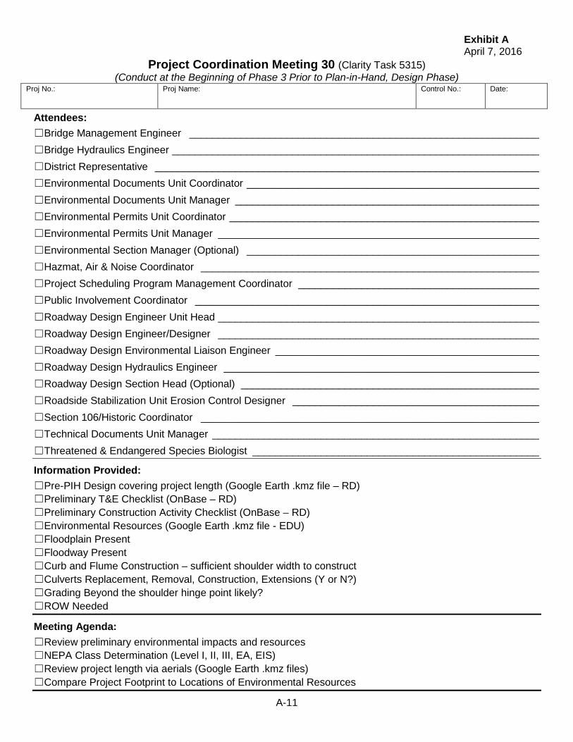
Exhibit A April 7, 2016
A-11
Project Coordination Meeting 30 (Clarity Task 5315) (Conduct at the Beginning of Phase 3 Prior to Plan-in-Hand, Design Phase)
Proj No.:
Proj Name:
Control No.:
Date:
Attendees: ☐Bridge Management Engineer _____________________________________________________________ ☐Bridge Hydraulics Engineer ________________________________________________________________ ☐District Representative ___________________________________________________________________ ☐Environmental Documents Unit Coordinator ___________________________________________________ ☐Environmental Documents Unit Manager _____________________________________________________ ☐Environmental Permits Unit Coordinator ______________________________________________________ ☐Environmental Permits Unit Manager ________________________________________________________ ☐Environmental Section Manager (Optional) ___________________________________________________ ☐Hazmat, Air & Noise Coordinator ___________________________________________________________ ☐Project Scheduling Program Management Coordinator __________________________________________ ☐Public Involvement Coordinator ____________________________________________________________ ☐Roadway Design Engineer Unit Head ________________________________________________________ ☐Roadway Design Engineer/Designer ________________________________________________________ ☐Roadway Design Environmental Liaison Engineer ______________________________________________ ☐Roadway Design Hydraulics Engineer _______________________________________________________ ☐Roadway Design Section Head (Optional) ____________________________________________________ ☐Roadside Stabilization Unit Erosion Control Designer ___________________________________________ ☐Section 106/Historic Coordinator ___________________________________________________________ ☐Technical Documents Unit Manager _________________________________________________________ ☐Threatened & Endangered Species Biologist __________________________________________________
Information Provided: ☐Pre-PIH Design covering project length (Google Earth .kmz file – RD) ☐Preliminary T&E Checklist (OnBase – RD) ☐Preliminary Construction Activity Checklist (OnBase – RD) ☐Environmental Resources (Google Earth .kmz file - EDU) ☐Floodplain Present ☐Floodway Present ☐Curb and Flume Construction – sufficient shoulder width to construct ☐Culverts Replacement, Removal, Construction, Extensions (Y or N?) ☐Grading Beyond the shoulder hinge point likely? ☐ROW Needed
Meeting Agenda: ☐Review preliminary environmental impacts and resources ☐NEPA Class Determination (Level I, II, III, EA, EIS) ☐Review project length via aerials (Google Earth .kmz files) ☐Compare Project Footprint to Locations of Environmental Resources

Exhibit A April 7, 2016
A-12
Summarize Threshold Impacts (Refer to Threshold Summary Spreadsheet for Levels): ☐Highway Capacity Changes _______________________________________________________________ ☐Right-of-Way Needs _____________________________________________________________________ ☐National Wildlife and Scenic River or National Recreational River __________________________________ ☐Floodplain / Floodway ____________________________________________________________________ ☐Section 404 Wetland / Streams (Impacts, Mitigation Required, Permit Type, Onsite / Off-site) ____________ ☐Section 9 – Coast Guard Permit ____________________________________________________________ ☐Threatened & Endangered Species __________________________________________________________ ☐Section 106 (Historic) ____________________________________________________________________ ☐Hazmat, Noise & Air ______________________________________________________________________ ☐Section 4f (Park, recreational lands, wildlife, waterfowl refuges, historic sites) _________________________ ☐Traffic Disruptions (Temporary Road, Detour or Ramp Closure) ___________________________________ ☐Property Access ________________________________________________________________________ ☐Environmental Justice – Minority / Low Income Populations ______________________________________ ☐Public Involvement _______________________________________________________________________
Summary of Project Description: _______________________________________________________________________________________ _______________________________________________________________________________________ _______________________________________________________________________________________ _______________________________________________________________________________________ _______________________________________________________________________________________ _______________________________________________________________________________________ Notes: _______________________________________________________________________________________ _______________________________________________________________________________________ _______________________________________________________________________________________ _______________________________________________________________________________________ _______________________________________________________________________________________ _______________________________________________________________________________________ _______________________________________________________________________________________ Action Items: ______________________________________________________________________________________ _______________________________________________________________________________________ _______________________________________________________________________________________ _______________________________________________________________________________________ _______________________________________________________________________________________ _______________________________________________________________________________________ _______________________________________________________________________________________ ______________________________________________________________________________________

Exhibit A April 7, 2016
A-13
PROJECT COORDINATION MEETING 35 PHASE 3 AT END OF DESIGN PHASE:
WHEN MEETING OCCURS:
☐At the end of Phase 3 Design Phase ☐After the PIH Report (Final Scope Report) has been distributed. ☐Prior to Public Involvement Action in Phase 4
INFORMATION NEEDED AND HAS BEEN COMPLETED / COLLECTED: ☐Protected Population Evaluation (HR) ☐District Program Evaluation – Cumulative Impacts (PSPM) ☐Final Public Involvement Plan (Communications) ☐Final Pavement Determination (M&R) ☐Final Scope Report (RD) ☐Final Bridge Datasheet (Bridge) ☐Required Contract Provisions (CE Section 20)
PURPOSE OF MEETING: ☐Confirm that there are no Cumulative Impacts (NEPA)??? ☐Review Draft CE - unofficially ☐Review Final Scope Report
WHAT TO PROVIDE AT MEETING: ☐Updated DR290 (Falcon/OnBase – RD) ☐Updated LOCs (Google .kmz file – RD) ☐Final Scope Report (Falcon/OnBase – RD) ☐Updated Public Involvement Plan (Communications) ☐Updated T&E Checklist (OnBase – RD)
ATTENDEES: ☐Bridge Management Engineer ☐Bridge Hydraulics Engineer ☐District Representative ☐Roadway Design Section Head (Optional) ☐Roadway Design Engineer Unit Head ☐Roadway Design Engineer/Designer ☐Roadway Design Hydraulics Engineer ☐Roadway Design Environmental Liaison Engineer ☐Project Scheduling Program Management Coordinator ☐Public Involvement Coordinator ☐Environmental Section Manager (Optional) ☐Environmental Permits Unit Manager ☐Environmental Permits Unit Coordinator ☐Environmental Documents Unit Manager ☐Environmental Documents Unit Coordinator ☐Roadside Stabilization Unit Erosion Control Designer ☐Threatened & Endangered Species Biologist ☐Hazmat, Air & Noise Coordinator ☐Section 106/Historic Coordinator

Exhibit A April 7, 2016
A-14

Exhibit A April 7, 2016
A-15
Project Coordination Meeting 35 (Clarity Task 5331) (Conduct at the End of Phase 3 After Plan-in-Hand, Design Phase)
Proj No.:
Proj Name:
Control No.:
Date:
Attendees: ☐Bridge Management Engineer _____________________________________________________________ ☐Bridge Hydraulics Engineer ________________________________________________________________ ☐District Representative ___________________________________________________________________ ☐Environmental Documents Unit Coordinator ___________________________________________________ ☐Environmental Documents Unit Manager _____________________________________________________ ☐Environmental Permits Unit Coordinator ______________________________________________________ ☐Environmental Permits Unit Manager ________________________________________________________ ☐Environmental Section Manager (Optional) ___________________________________________________ ☐Hazmat, Air & Noise Coordinator ___________________________________________________________ ☐Project Scheduling Program Management Coordinator __________________________________________ ☐Public Involvement Coordinator ____________________________________________________________ ☐Roadway Design Engineer Unit Head ________________________________________________________ ☐Roadway Design Engineer/Designer ________________________________________________________ ☐Roadway Design Environmental Liaison Engineer ______________________________________________ ☐Roadway Design Hydraulics Engineer _______________________________________________________ ☐Roadway Design Section Head (Optional) ____________________________________________________ ☐Roadside Stabilization Unit Erosion Control Designer ___________________________________________ ☐Section 106/Historic Coordinator ___________________________________________________________ ☐Technical Documents Unit Manager _________________________________________________________ ☐Threatened & Endangered Species Biologist __________________________________________________
Information Provided: ☐ Final DR290 (Falcon/OnBase) ☐ Final LOCs (Google .kmz file – RD) ☐ Final Scope Report (OnBase) ☐ Updated Public Involvement Plan (Communications) ☐ Updated T&E Checklist (OnBase – RD)
Meeting Agenda: ☐ Confirm that there are no Cumulative Impacts (NEPA)??? ☐ Review Draft CE - unofficially ☐ Review Final Scope Report

Exhibit A April 7, 2016
A-16
Summarize Threshold Impacts (Refer to Threshold Summary Spreadsheet for Levels): ☐Highway Capacity Changes _______________________________________________________________ ☐Right-of-Way Needs _____________________________________________________________________ ☐National Wildlife and Scenic River or National Recreational River __________________________________ ☐Floodplain / Floodway ____________________________________________________________________ ☐Section 404 Wetland / Streams (Impacts, Mitigation Required, Permit Type, Onsite / Off-site) ____________ ☐Section 9 – Coast Guard Permit ____________________________________________________________ ☐Threatened & Endangered Species __________________________________________________________ ☐Section 106 (Historic) ____________________________________________________________________ ☐Hazmat, Noise & Air ______________________________________________________________________ ☐Section 4f (Park, recreational lands, wildlife, waterfowl refuges, historic sites) _________________________ ☐Traffic Disruptions (Temporary Road, Detour or Ramp Closure) ___________________________________ ☐Property Access ________________________________________________________________________ ☐Environmental Justice – Minority / Low Income Populations ______________________________________ ☐Public Involvement _______________________________________________________________________
Summary of Project Description: _______________________________________________________________________________________ _______________________________________________________________________________________ _______________________________________________________________________________________ _______________________________________________________________________________________ _______________________________________________________________________________________ _______________________________________________________________________________________ _______________________________________________________________________________________ Notes: _______________________________________________________________________________________ _______________________________________________________________________________________ _______________________________________________________________________________________ _______________________________________________________________________________________ _______________________________________________________________________________________ _______________________________________________________________________________________ _______________________________________________________________________________________ Action Items: ______________________________________________________________________________________ ______________________________________________________________________________________ _______________________________________________________________________________________ _______________________________________________________________________________________ _______________________________________________________________________________________ ______________________________________________________________________________________ ______________________________________________________________________________________ ______________________________________________________________________________________

Exhibit A April 7, 2016
A-17
PROJECT COORDINATION MEETING 70 PHASE 7 CE VALIDATION:
WHEN MEETING OCCURS:
☐After ROW Acquisition ☐Designer/Engineer has incorporated right-of-way changes into the plans. ☐Prior to PS&E Turn-in
INFORMATION NEEDED AND HAS BEEN COMPLETED / COLLECTED: ☐ROW Acquisition ☐Changes from ROW negotiation(s) and acquisition(s) have been incorporated into plans. ☐Verify that the questions on the Approved NEPA Document were answered correctly
PURPOSE OF MEETING: ☐Review plans to ensure that changes to project due to ROW negotiation and acquisition
have been incorporated. ☐Confirm that restricted areas are denoted on plans before PS&E Turn-in (e.g. detours,
ROW, staging areas, access, protected areas, and concrete cleanout) ☐Verify that Plans, Special Provisions, and NEPA document reflect environmental
commitments made in the Green Sheet. ☐To review Final Scoping Report and confirm the plans reflect the final project scope ☐Assist Environmental Section in completing “Environmental Certification”
☐Confirm that project beginning and ending and limits of construction are consistent with the NEPA document
☐To verify that the 404 permit/floodplain permit is correct and confirm that the 2W sheets have wetland delineation layers shown.
☐ Verify Structure numbers match NEPA document ☐Directives for nighttime or daytime construction / lighting, historic properties (if any),
tree preservation ☐Easements are shown
☐Confirm threatened and endangered species commitments are in the NEPA document ☐Confirm permits needed and received (404, Stormwater, Floodplain) ☐Confirm that NEPA commitments made it into the Green Sheet
WHAT TO PROVIDE AT MEETING: ☐PS&E Plans (OnBase – RD) ☐Signed NEPA Document (OnBase – EPU) ☐Green Sheet (OnBase – EDU)
ATTENDEES: ☐Roadway Design Section Head (Optional) ☐Roadway Design Engineer Unit Head ☐Roadway Design Engineer/Designer ☐Roadway Design Environmental Liaison Engineer ☐Environmental Section Manager (Optional) ☐Environmental Permits Unit Manager ☐Environmental Permits Unit – Coordinator ☐Environmental Documents Unit Manager ☐Environmental Documents Unit – Coordinator ☐Roadside Stabilization Unit Erosion Control Designer

Exhibit A April 7, 2016
A-18

Exhibit A April 7, 2016
A-19
Project Coordination Meeting 70 (Clarity Task 5770) (Conduct during Phase 7, Plan Package Phase)
Proj No.:
Proj Name:
Control No.:
Date:
Attendees: ☐Environmental Documents Unit Coordinator ___________________________________________________ ☐Environmental Documents Unit Manager _____________________________________________________ ☐Environmental Permits Unit Coordinator ______________________________________________________ ☐Environmental Permits Unit Manager ________________________________________________________ ☐Environmental Section Manager (Optional) ___________________________________________________ ☐Roadway Design Engineer Unit Head ________________________________________________________ ☐Roadway Design Engineer/Designer ________________________________________________________ ☐Roadway Design Environmental Liaison Engineer ______________________________________________ ☐Roadway Design Section Head (Optional) ____________________________________________________ ☐Roadside Stabilization Unit Erosion Control Designer ___________________________________________
Information Provided: ☐PS&E Plans (OnBase – RD) ☐Signed NEPA Document (OnBase – EPU) ☐Green Sheet (OnBase – EDU)
Meeting Agenda: ☐Review plans to ensure that changes to project due to ROW negotiation and acquisition have been
incorporated. ☐Confirm that restricted areas are denoted on plans before PS&E Turn-in (e.g. detours, ROW, staging
areas, access, protected areas, and concrete cleanout) ☐Verify that Plans, Special Provisions, and NEPA document reflect environmental commitments made
in the Green Sheet. ☐Review Final Scoping Report and confirm the plans reflect final project scope. ☐Assist Environmental Section in completing “Environmental Certification”
☐Confirm that project beginning and ending and limits of construction are consistent with the NEPA document
☐To verify that the 404 permit/floodplain permit is correct and confirm that the 2W sheets have wetland delineation layers shown.
☐ Verify Structure numbers match NEPA document ☐Directives for nighttime or daytime construction / lighting, historic properties (if any), tree
preservation ☐Easements are shown ☐Confirm threatened and endangered species commitments are in the NEPA document ☐Confirm permits needed and received (404, Stormwater, Floodplain) ☐Confirm that NEPA commitments made it into the Green Sheet

Exhibit A April 7, 2016
A-20
Summary of Commitments: _______________________________________________________________________________________ _______________________________________________________________________________________ _______________________________________________________________________________________ _______________________________________________________________________________________ _______________________________________________________________________________________ _______________________________________________________________________________________ _______________________________________________________________________________________ _______________________________________________________________________________________ _______________________________________________________________________________________ Notes: _______________________________________________________________________________________ _______________________________________________________________________________________ _______________________________________________________________________________________ _______________________________________________________________________________________ _______________________________________________________________________________________ _______________________________________________________________________________________ _______________________________________________________________________________________ _______________________________________________________________________________________ Action Items: ________________________________________________________________________________________ ________________________________________________________________________________________ _______________________________________________________________________________________ _______________________________________________________________________________________ _______________________________________________________________________________________ _______________________________________________________________________________________ _______________________________________________________________________________________ ________________________________________________________________________________________ ________________________________________________________________________________________ ________________________________________________________________________________________

Exhibit D April 7, 2016
D-1
Access Control Determination Refer to the “Access Control Policy to the State Highway System.”
Necessary documents for Access Control Meetings: Preliminary Access Control Determination (Is AC needed or not?) Prelim Design, (Clarity Task 5350)
1. Bring As-built plans, 9" by 9" aerial photos, a. Note existing access control or not.
Preliminary Controlled Access Determination Preliminary Design, (Clarity Task 5350) 1. Bring the Preliminary plans or Engineering Review. 2. Bring current R.O.W. plans, (usually Ownership Plans.) 3. Bring photo plan (this will be used for the actual review).
a. Note property lines. b. Note location of existing access.
c. Note type of existing access. d. Note proposed access locations.
4. Prepare and bring Access Summary (See Page E-2).
Individual Access Determination Functional Design, (Clarity Task 5428) 1. Bring the Plan-in-Hand plans. 2. Bring current R.O.W. plans. 3. Bring cross-sections (if applicable). 4. Bring photo plan sheet (this will be used for the actual review).
a. Note property lines. b. Note location of existing access.
c. Note type of existing access. d. Note proposed access locations.
5. Prepare and bring Access Summary (See Page E-2).
Changes or Revisions 1. Bring current R.O.W. plans. 2. Bring photo plan (this will be used for the actual review).
a. Note property lines. b. Note location of existing access.
c. Note type of existing access. d. Note proposed access locations.
3. Invite the requester (appraiser/negotiator). 4. Bring cross-sections (if applicable).
Note: When Access Control is purchased with the project, the Highway Commission and Governor’s approval are required.
ROW PERMITS: shows a list of permits in the area selected Here’s the program for viewing ROW permits on the Mainframe: Use CICS1 by entering C1 and your dr##### and password (same as using your time sheet).
Enter 8 to select Integrated Highway Inventory System. Enter 22 to select Use & Occupancy Permits. Enter 2 to select Query. Enter 3 to select Use & Occupancy Permit by Hwy/County/Type/Status Query.
Enter the highway # and a reference post range – county, type and status may be left blank.
cc's ON ACCESS CONTROL LETTERS:MIKE OWEN BRANDIE NEEMANN Planning and Project Development - Division Head DISTRICT ENGINEER District # DAN FOREMAN Right of Way Division - R.O.W. Design Engineer JILL SMITH Right of Way Division - Property Management DAVE HOLLAND Right of Way Division - Chief Appraiser JOSEPH WERNING FHWA CONSULTANTS (If involved)
Exhibit D April 7, 2016
D-2
Access Summary
(1) Mile
(1) Side
Existing Access Location
(Station & Side)
(2) Existing Type of Access
(Stage II)
New Access Location
(Station & Side)
(3) Type of
New Access
(4) Desirable
Access Per Mile By Policy
(4) Is Min. Spacing Criteria Met?
Yes No Remarks: Yes No Remarks: Yes No Remarks: Yes No Remarks: Yes No Remarks: Yes No Remarks: Yes No Remarks: Yes No Remarks: Yes No Remarks: Yes No Remarks: Yes No Remarks: Yes No Remarks: Yes No Remarks: Yes No Remarks: Yes No Remarks: Yes No Remarks: (1) “Mile” represents the distance from the beginning of the project in whole numbers. “Side” represents the side of the roadway when traveling in the direction of increasing
station. (2) If there is existing access control, use the types shown on R.O.W. ownership plans. If there is no existing access control, this column does not apply. (3) Use the existing access control type if there is one -- otherwise, leave blank. (4) See pages 7-8 of the Access Control Policy.

Exhibit G April 7, 2016
G-1
Covenant and Final; Relinquishment Agreements Roadway Designers Process
Covenant Relinquishment Agreement: (CRA) 1. Review Planning & Project Development’s (P&PD) CRA(s), if any. 2. Determine if a new or revised CRA is needed. 3. If needed, prepare the following information for the CRA:
A. Location Map Exhibit (Plan Development Unit). Review with your supervisor. 4. Submit the information to P&PD. 5. Review P&PD’s draft CRA and comment. 6. Receive signed copy before scheduling the dry run of the Public Hearing. Final Relinquishment Agreement: (FRA) 1. Review Covenant Relinquishment Agreement. 2. Prepare information for FRA.
A. Modify Location Map Exhibit (Plan Development Unit). Review with your supervisor. 3. Submit the information to P&PD. 4. Review the draft FRA and return it to P&PD. Routing List for Agreements: 1. Roadway Design - Engineer (Jim Knott Mike Owen) 2. Director’s Office – Deputy Director Engineering (Khalil Jaber) 3. Planning & Project Development - Agreement Services (Jerry Adams) 4. Controller Division Finance Administrator (Steve Maraman Marilyn Hayes) 5. Planning & Project Development - Agreement Engineer (Randy ElDorado) 6. Planning & Project Development - Engineer (Mike Owen Brandie Neemann) 7. Return to: Planning & Project Development - Agreement Services (Jerry Adams)

Exhibit G April 7, 2016
G-2

Exhibit I April 7, 2016
I-1
Distribution of Plans Please note substantial changes from the Engineering Review on the plans transmittal letter. Clarity Task 5380: Preliminary Plans for Plan-In-Hand (PIH). Include location map & typical section
# Of Sets Half size plans (use cell “Preliminary Plans”) distribute 2 weeks prior to PIH 4 - For our use on the Plan-In-Hand field inspection 1 - Bridge [M. Traynowicz] (if applicable) 1 - Traffic Engineering [D. Waddle] (send “Constructability Issues” Checklist, Exhibit E) 1 - R.O.W. - invite designer on PIH [cc D. Foreman & ROW Project Manager] (if buying ROW) 2 - Materials & Research [M. Lindemann, & B. Varilek; thru M. Syslo] 3 - District Construction Office (DCE/Office, PM, & Main. Super. Send “Constructability Issues”
Checklist, Ex. E) 1 - Railroad Liaison [T. Palmer] (incl: X-sects, show exist. RR ROW & location of rails) 5 4 - Planning & Project Development (P&PD) [R. Poe, 2 for J. Jurgens, & 2 for
B. Neemann ____________ ] (invite to PIH if applicable, See Exhibit J, pg. 6 5) 2 - Highway Archaeologist [K. Paitz] 2 - FHWA (when federal oversight) [Joseph Werning] (only Interstate, New and Reconstruction
or PODI/POCI projects) 1 - Plans Manager [P. Brunken] 1 - City or County (if impacted) 1 - Airport Authority (if airport near project) 2 - Construction Div. [C. Oie J. Knott, F. Brill – “Constructability Issues” Checklist, Exhibit E. ask
for Working days/ Letting] Notify plans are that the Roadway Design PIH Plan set is available on Falcon OnBase – DCE, Lighting Engineer [C. Humphrey], P&PD Scoping & Utilities Engr. [Brandie Neemann ___________], P&PD Environmental Permits Unit Manager [T. Ringenberg], P&PD Roadside Stabilization Supervison [R. Poe], P&PD Technical Documents Supervisor [D. Dittmer], P&PD Environ Documents Supervisor [J. Barber], P&PD Traffic Counter Shop [S. Stroud PSS], Project Manager [See Sheet I-2] - Invite to PIH with District Construction Engr., Maint. Supervisor, & PM – (also on
Exhibit J, pg. 6 5) Note: Railroad personnel need 5 weeks notice to attend PIH
Clarity Task 5434: Functional Plans (Hearing Plans) (use cell “Preliminary Plans”)
#2 sets (1/2) - District Construction Office (DCE/Office & PM) 1 set (1/2) - Affected Divisions and FHWA, if major change was made to the PIH plans (Ex. Major change in the grade line - 1 (½ size) set to O. Qudus M. Lindemann, M&R) 1 set (1/2) - City and/or County (if impacted) 4 sets 2(full) & 2(1/2) - Public Hearing Plans - take along to Public Hearing #1 set (1/2) - Planning & Project Development [B. Neemann _____________ ] 1 set (1/2) - Plans Manager [P. Brunken] #1 set (1/2) - Railroad Liaison [T. Palmer] (Incl. X-sec. showing exist. RR ROW & location of the
rails) Notify plans are that the Roadway Design Functional Plan set is available on Falcon in OnBase- DCE, Traffic Engineering [D. Waddle], P&PD Environmental Section Mgr. [J. Jurgens], P&PD Scoping & Utilities Engr. [Brandie Neemann _____________ ], PSS Project Manager [See Sheet I-2]
# - Distribute 5 weeks prior to Public Hearing if applicable

Exhibit I April 7, 2016
I-2
Clarity Task 5576: Final Design Plans - Include Location map & typical section # Of Sets (half size plans) (use cell “Preliminary Plans”)
1 - Construction Div. [F. Brill - Send “Constructability Issues” Checklist, Exhibit E] 1 - Plans Manager [P. Brunken] 2 - Planning & Project Development [J. Barber, & R. Poe] 2 - Materials & Research [M. Lindemann, & B. Varilek; thru M. Syslo] (3 sets if Asphalt Surfacing) 1 - R.O.W. Design Engineer [D. Foreman] (include cross sections) 2 - District Construction Office (DCE/Office & PM) 1 - FHWA [Joseph Werning] (If federal overview is required for project) 1 - Bridge [M. Traynowicz] (plan and profile sheets of bridge areas only) 1 - City and/or County (if impacted) 2 - Highway Archaeologist [K. Paitz] 1 - Keep available in Roadway Design (stamp Final Design Plans) 1 - Airport Authority (if near airport, See Exhibit R) 1 - Railroad Liaison [T. Palmer] (include culvert X-sec. & X-sec. w/ RR ROW and location of rails
shown) Notify plans are that the Roadway Design Final Design Plan set is available on Falcon OnBase – DCE, Traffic Engr. & Asst. Traffic Engr. [D. Waddle & A. Swanson], P&PD Environmental Section Manager [J. Jurgens, Lighting Engineer] [C. Humphrey], P&PD Scoping & Utilities Engr. [Brandie Neemann ________________ ], PSS Project Manager [See Below]
Clarity Task 5614: Design Plans to Utility Section
1 - P&PD [Scoping & Utilities Engineer B. Neemann ___] send after ROW negotiations. (Exhibit Q) Notify plans are that the Roadway Design Final Design Plan set is available on Falcon OnBase - P&PD Scoping & Utilities Engr. [Brandie Neemann __________ ], PSS Project Manager [See Below] NOTE: Changes to the design after Final Design plans are sent out: A Notification of change should be given to the affected Divisions (ex: ROW, Wetlands/ Environmental Section, Utilities, District - DCE & PM). This note or E-mail should include: Project Name & Control Number, a brief description of the change, location, effect on the project, and the anticipated time updated plans will be available. PSS Project Manager Assignments ITS, Safety &Interstate Projects: Lloyd Peterson Districts 1 & 6: Cindy Hosler District 2: Drew Parks Mark Fischer Districts 3 & 7: Paul Fintel Districts 4 & 5 8: Jim Grupe Nick Burnham District 5: Jaime Kamarad District 8: Steve Moore

Exhibit J April 7, 2016
J-1
PLAN-IN-HAND CHECKLIST Date of Inspection: / /
Project No: Project Name: C.N.
Project Location:
Designer: Unit Head:
Project Type: New Construction Reconstruction 3R
Design Standard: Terrain: Level Rolling
Design Speed: mph
National Functional Classification: State Functional Classification:
On NHS? Yes No On Priority Commercial System? Yes No
Letting Date: Working Days:
Existing Roadway: Width Depth Type Earth Shoulder Width:
Existing Shoulder: Width Depth Type
Design Roadway: Width Depth Type Mill: Class/Depth /
Design Shoulder: Width Depth Type Earth Shoulder Width:
Existing Clear Zone/Lateral Obstacle Clearance: Existing 1:6 Side Slopes?
TRAFFIC COUNT 20 20
ADT
DHV
% Heavy Trucks
Twenty-Year Forecast Map:
Attendance:

Exhibit J April 7, 2016
J-2
List of specific design questions:
Lighting recommendations:
Utility conflicts or utilities not show on plans:
Stream Gauge installations:
Substation locations:
Railroad involvement (measure distance to signals and length of crossing):
Safety Hazards within 1000 ft. of the project:
Airports within four miles of the project (see Exhibit R):
Bridge recommendations:
Bridge structures less than 20 ft. in length (notify Bridge Division for inspection):
Guardrail to remain in place; do end treatments meet NCHPR 350 or MASH?
Guardrail to remain in place; height at completion of project (27 28 in. min. on the NHS, 26½ in. other projects):

Exhibit J April 7, 2016
J-3
Guardrail connections to a bridge; do they meet current standards? (request determination from Bridge):
Surfacing or removal recommendation for raised medians (request from Traffic):
Widening recommendations for horizontal curves:
Within corporate limits of:
Hazardous waste/underground storage tank sites:
Wetland/floodplain considerations:
4-F/6-F lands impacted:
Tree/stump count (trees/stumps larger than 80 in. circumference at 40 in. height):
Clearing & grubbing:
Relinquishments:
Additional survey:
FHWA Design Exceptions/Relaxations of the MDS:

Exhibit J April 7, 2016
J-4
DISTRICT RECOMMENDATIONS:
Public Meeting (Exhibit C):
Balance factor and material availability:
Accommodation of Traffic:
Detour (include Hwy #s and Ref. Posts):
Phasing/Constructability Issues (Exhibit E):
Temporary road location and design:
Traffic affected adversely enough to be a “Significant Project”? Yes No
(If Yes, a Traffic Management Plan is required, see Exhibit K, pg. K-5).
Guardrail removal:
Salvage items: (e.g. guardrail, delineators)
Surfacing comments:
Other road templates:
Snow control:
Erosion Control considerations (Exhibit F):
Preferred Concrete Flume Type:
Special accessibility needs during construction (ADA):
Sidewalks/Bicycle Paths:
Items to be accomplished by State Forces:
Re-establish Lot Corners (corridor protection, etc.)? Yes No
Are logo signs to be removed? Yes No
Miscellaneous:

Exhibit J April 7, 2016
J-5
INVITE TO THE PLAN-IN-HAND (See Exhibit I for distribution of plans)
1. Bridge Personnel (if bridges on project) 2. R.O.W. Designer [cc D. Foreman & ROW Project Manager] (if buying ROW) 3. Materials & Research – Geotechnical Engineer [M. Lindemann] 4. District – Engineer, Construction Engineer, Maintenance Supervisor, Project Manager 5. Railroad Liaison [T. Palmer] (RR personnel need 5 weeks advance notice to attend PIH) 6. Planning & Project Development - Environmental [T. Ringenberg, R. Poe, D. Dittmer,
J. Barber through and J. Jurgens] (if applicable. Invite J. Jurgens to New or Reconstructed projects only)
7. Planning & Project Development – Assigned Environmental Permits Unit Coordinator [M Schroer, R. Walkowiak, N. Burnham, R. Yerdon, J. Williams, K. Baker, P. Sward, or S. Sisel] (if applicable) Please verify your project coordinator in Clarity before sending invitations.
8. T&E Biologist [M. Marinovich] (if applicable) 9. Planning & Project Development - Scoping & Utilities Engineer [B. Neemann ________] 10. Planning & Project Development - Utilities Coordinator [through Scoping & Utilities
Engineer B. Neemann ________] 11. FHWA (when oversight) [Joseph Werning] (only Interstate, New and Reconstruction or
PODI/POCI projects) 12. City and/or County Personnel (if impacted)
ITEMS TO TAKE ON PIH: Camera, 100 ft. tape or equivalent Digital hand level Safety vest, cap/hard hat Strobe light
This checklist or a customized list Correspondence file(s) Four sets of half-size plans One set of half-size cross sections One set of ROW ownership plans
NOTE: Be aware of your surroundings, traffic may not slow down for you and rattlesnakes enjoy to warmth of the culverts that you are inspecting.

Exhibit J April 7, 2016
J-6
PRE & POST PLAN-IN-HAND NOTES Wetlands/ Environmental Issues: Following the plan in hand inspection, if there are changes to the project the designer will meet with the Environmental Program Manager or his representative to review the changes and determine if changes to the pre-permit application consultation process will be necessary. 3R Projects: The need for a plan-in-hand will be determined on a project-by-project basis. A plan-in-hand is required if the project is on the NHS. A plan-in-hand is not required if a project has existing 1:6 foreslopes, but may be held if it would be beneficial. Raised median: Raised medians on high speed roadways will be usually be removed with the project and replaced with a painted median. For existing raised medians on the mainline roadway: check with the Traffic Division before the plan-in-hand and with the District at the plan-in-hand to find out if they have a very good reason why the raised median should remain. Airplane: If taking an aircraft and extra seats are available coordinate with the Bridge Division in case they need to inspect a nearby bridge. Municipalities: If a project is located within the corporate limits and we anticipate the municipality will need to share in the project’s cost we need to invite representatives of the municipality to attend the plan-in-hand. Lighting: (Determined by the Lighting Engineer) If lighting is needed tell the municipality at the plan-in-hand what their share of the estimated costs will be for the installation of the lights and that the energy and maintenance costs will be 100% the municipality’s cost. This also needs to be in the city agreement (the energy costs will not be in the city agreement but should be known in case the municipality asks). Thus, well in advance of the plan-in-hand, we need to get a recommendation from the Lighting Engineer if lighting will or will not be a part of the project and what its estimated construction costs will be as well as what the anticipated energy costs will be. Utilities: Review project with Utility Coordinator before the plan-in-hand. Invite them to the plan-in-hand. After the plan-in-hand meet with the Utility Coordinator to review utilities that will need to be surveyed. Miscellaneous: If the project is likely to have questions from the public, generally an urban project or one with major new alignment, a meeting may be scheduled shortly after the plan-in-hand with the Director and Deputy Director-Engineering to inform them about the project.

Exhibit K April 7, 2016
K-1
Plan-In-Hand Report Outline Date: Date of Report (Note: After the PIH Report has been routed, change this to the date of
the approved report) From: Designer ______________________________ To: Project File Thru: Unit Head or Assistant Design Engineer____________________________ Subject: Plan-In-Hand Report/Scoping Document (The Clarity “Plan-In-Hand” late date is __/__/__)
Project number, name of project, and control number (The Clarity letting date is __/__/__) (When functioning as a scoping document, the subject line should read “Plan-In-Hand and Scoping Report)
Clarity Schedule:
The Clarity “Plan-In-Hand” late date is __/__/__ The Clarity letting date is __/__/__.
Location (CE): Beginning and end location - reference posts. (Note change to project length) Give a brief description of location, including city, county, highway/roadway name, highway number, beginning and ending mileposts*, and, if necessary, give the distance to nearest landmark (e.g. 15 miles north of local airport).
Scope of Work: General statement of work involved [Grading, structures, surfacing type/ depth (Lane and Shoulder), etc.]
Traffic Count (13.1): Tabular form (New & Recon. = Initial year of construction and 20 years in the future) (3R = Initial year of construction and 20 years in the future for concrete surfacing and full depth asphalt surfacing or initial year of construction and 10 years in the future for Asphalt overlay).
Design Standard (14.1): 1. New and Reconstructed - DR number, class, and terrain 2. (3R) - design year traffic (Initial year of construction plus 20 years for Concrete surfacing and
full depth Asphalt surfacing or 10 years for Asphalt overlay). 3. On Priority Commercial System? 4. On National Highway System? (14.1) Note if the project will/will not include the addition of through lane capacity. (An increase to
through lane capacity can be described as: physically adding through traffic lanes, grade separation for either roads or railroads, or adding auxiliary lanes that are at least 1 mile long or are made continuous through a series of successive interchanges.)
Crash History Analysis: Include a statement such as “Traffic Engineering has performed a review and analysis of the crashes on this segment of roadway and as a result of this study have determined that (1) no additional crash mitigation measures are necessary, or (2) the following mitigation measures will be incorporated in the project, or (3) additional study is necessary at the following locations to determine the appropriate mitigation measures (list locations). The full details of the Traffic Engineering report are in the project file.”
General: Date of the plan-in-hand and persons present Bridges: Proposed work and condition of bridges (If the bridge is to remain in place get a statement
from Bridge that the operating capacity can safely service the system for an additional 20 years) Proposed work if applicable, include the following statement for each structure: “The bridge scope of work meets the requirements of the Nebraska Minimum Design Standards for new bridges, reconstructed bridges, or bridges to remain in place.”
Agreements: List agreements required and city participation if required Balance Factor: Balance factor recommended by the District Material Needed: Note “Project is balanced” or where borrow may be available Accommodation of Traffic (15.1 - 15.2, 15.4 - 15.9, 16.2 - 16.6): (Exhibit E)
Detour used – use highway #’s and reference posts (If no detour, state “No detour is anticipated for construction activities on this project.”) Phasing

Exhibit K April 7, 2016
K-2
Temporary Road location and design Traffic affected adversely enough to be classified a “Significant Project” (Page L-5 See Page K-7) Answer the following questions:
• (15.1 - 15.2) How many working days will the detour, temporary road, or ramp closure be in effect?
• (15.4, 15.8) Is the adverse (out-of-direction) travel related to the detour, temporary road, or ramp closure greater than 5 miles (in an urban area, defined as population of 5,000 or greater within corporate limits) or 25 miles (in a rural area)? Describe the detour route and expected duration. Note if any improvements will be necessary on the detour route.
• (15.5) Will the project result in a temporary or permanent interference with local special events or festivities? (Interference would include any construction activities occurring on the same segment of street utilized for the festivities, closure of a road used for festivities, closure of access for any duration to an adjacent property used for the festivities during event, or complete closure of a main route to the town during the festivities.)
• (15.6) Will the project result in temporary or permanent adverse effects to through-traffic dependent businesses?
• (15.7) Will the project result in substantial permanent traffic pattern changes or disruptions, such as permanently close a roadway or roadway intersection, increase through lane capacity, create new intersections, or convert the roadway into a higher classification roadway?
• (15.9) Note mitigation measures or commitments intended to avoid, minimize or offset detours or other traffic impacts.
• (16.2 - 16.3) Is access to a residential property anticipated to be temporarily closed during construction? No Yes, for greater than 5 working (business) days Yes, for greater than 10 working (business) days
• (16.4) Will access to a business be closed during operational hours? • (16.5) Will there be restricted access emergency service facilities or providers during
construction? • (16.6) Will the project potentially permanently change the functional utility of a property?
(Example: If the adjacent property requires heavy truck access and the access change is such that heavy trucks could no longer make the revised turn radii into the property, this would change the functionality of the adjacent property.)
Constructability Issues: If any (Exhibit E) Items left to be Determined from the Scoping Document: e.g. “Grading from the hinge point
may be required for the following work (Roadway Design will make a determination at the Plan-in-Hand):”
Changes: Major changes to the Scoping Planning Document and any changes to the plan-in-hand plans [Incl. est. cost of changes (Line shifts etc)]
Right-of-Way (1.1 - 1.5, 16.1): ROW will be required and est. # of tracts. (1.1) ROW (including temporary or permanent easements) will/will not be acquired on this project. (1.2) (If ROW will be required:) The estimated amount of ROW acquired will/will not be greater than two AC/mile. (To determine average acres per mile, include the total estimated acreage for all ROW required for construction (including temporary and permanent easements). For projects under one mile in length, the estimated total acreage of easements/ROW must be less than two acres.) Major property improvements are/are not proposed to be removed as a part of this project. The improvements to be removed are (Provide description. Examples of major property improvements include residential and business structures, functional garages or outbuildings, or other features which would change the functional utility of the property. Examples of minor improvements include fencing, landscaping, sprinkler systems, and mailboxes.) (1.3) The type of property proposed to be acquired is (provide description, i.e. farmland, pasture, business, home, apartment/rental, occupied/vacant, functional/dilapidated). (1.4-1.5) The preliminary estimate of ROW acquisition is: ___ acres of permanent ROW/Easements, and ___ acres of temporary ROW/Easements.

Exhibit K April 7, 2016
K-3
(16.1) Note if any access to businesses or residences will be permanently closed. Lot corner establishment: contract item? Access Control Committee recommendation
Relocation Assistance (1.6 - 1.7): Note if relocation assistance or building removal will be required (1.6) There are up to # relocations anticipated; up to # residential, and up to # non-residential. (1.7) (Describe the type of non-residential relocation; i.e., type of activity conducted by the business or farm)
Miscellaneous (12.1, 20.1): Shelterbelt or irrigation well removals, pivot interference, special access consideration, drainage, channel changes, median surfacing, etc. (12.1) Note if a need for noise mitigation measures has been established. (20.1) Note if a Wellhead Protection Area occurs within the project study area. (Refer to IER)
Snow Control: If Note if any snow control measures are proposed (4:1 backslope, living snow fence, wider ditch, etc.)
Relinquishments: Potential highway relinquishments to county or city Roadside Development: Type of seeding, erosion control and present or future landscaping plan MS4 (8.2 - 8.3):
(8.2) Project located in an MS4 Community? Stormwater Treatment assessment required? Specify if Treatment BMPs STFs will be included in the project. (8.3) Is there more than one acre of ground disturbance?
Public Meetings (18.1): Anticipated public hearings and/or information meetings involvement or public involvement activities that have already been conducted. Note any unresolved controversy.
4F-6F Lands (2.1, 3.1): Possible park or school land Note if there are any 4F or 6F lands within the project limits and if they are impacted by the project. (2.1) (Section 4(f) properties are planned or existing publicly owned parks, recreation areas, or wildlife and waterfowl refuges, or any significant historic sites (including historic bridges eligible for National Register of Historic Places listing) officially designated as such by a Federal, State, or local agency). (3.1) Section 6(f) lands are those where Land and Water Conservation Fund Act (L&WCF) funds were used to acquire property or to improve property. Coordinate with P&PD to determine if there are 6(f) properties within the project limits.
Historic Properties (10.1): Possible impacts Note if there are any properties listed or eligible for the National Register of Historic Properties in the study area and potential impacts.
Signals: Anticipated traffic signals. Lighting: Anticipated lighting; intersection or continuous. Utilities (4.2): Any unusual utility conflicts. Are stream gauge installations present? (Update utilities
shown on plans.) (4.2) Note if federal funds will be used to relocate utilities or if the project contractor will be responsible for utility relocations. (Discuss with Utility Coordinator)
Railroad: Any railroad involvement on project or detour. Removals: If Note if Maintenance will remove guardrail or delineators: as recommended by the
District. 3R Project Guardrail: Maintain, replace, or remove? (3R guardrail will be maintained or replaced
unless we are grading a safety section, i.e. 1:6 grading to the Horizontal Clear Zone for a New or Reconstructed project)
Wetlands/Waters of the U.S. (7.1,7.3 – 7.4): Possible wetlands, 404 permit, etc. (7.1) Note if there are wetlands, stream channels, or other waters within the project study area. (7.3 – 7.4) Note the estimated amount of wetland impacts in acres. (Record the amount under 0.5 ac and then in 0.5 acre increments above 0.5 acres.) Note if on-site mitigation is proposed.
Flood Plain Floodplain/Floodway (6.1 – 6.2): (6.1) Encroachment on FEMA flood plain (See Exhibit S for wording). (6.2) Will the project action cause a greater than one foot rise in the Base Flood Elevation (BFE), any rise in a floodplain that potentially impacts an adjacent structure, or any rise in a floodway? Yes No N/A
Special Investigation: Any areas requiring special investigation from other Divisions.

Exhibit K April 7, 2016
K-4
Construction Schedule: Working days/ construction seasons. Request from the Final Plans Coordinator: Construction Division.
Templates: Connecting highway or street templates typical section. Exceptions/ Relaxation of Standards: Note requests for exceptions or relaxation of standards,
Incl. supporting data. (Note if “No exceptions are required”). Hazardous Waste (11.4): Note previous or existing gas stations, fuel storage sites, factories,
landfills, substations, etc. - permit requirements? (11.4) Note if any soil disturbance will occur below or beyond the pre-existing ground prior to the original roadway construction within an active Superfund site. (Refer to IER for determination of Superfund site within the project study area.)
Safety Enhancements: List safety enhancements (Page K-4). Accommodation of Bicycles and Pedestrians (4.3): If bicycle shared-use paths will be included
on this project, briefly note where: Bicycle shared-use path… station to station on the south side. If bicycle shared-use paths will not be included, briefly mention items that will improve bicycle shared-use travel such as new surfacing, surfaced or widened shoulders.
Curb Ramps & Sidewalks: Note whether curb ramp and sidewalk construction will be included on the project. For example: “Curb ramps and sidewalks are in place and will not be included with this project” or “Curb ramps will be included and blended to the sidewalks where required within the project limits.”
ADA Access During Construction: See Chapter Ten Sixteen of the RDM, Section 10.B.7 11. Retaining Walls: Height, Length, and location, or “None anticipated”. Airport (20.3): Airports List airports within four miles of the project and any coordination that has
occurred with the Department of Aeronautics. Refer to the “Instructions and Guidance for Completing the Nebraska Categorical Exclusion Determination Form for Federal-Aid Projects” as guidance for the items in parenthesis (e.g. Traffic Count (13.1)).
Note: Headings with a must have comments on all projects. Wetlands/ Environmental Issues: Following the plan in hand inspection, if there are changes to the project, the designer will meet with the Environmental Program Manager or his/her representative to review the changes and to determine if changes to the pre-permit application consultation process will be necessary. Attachments:
1. Location Map 2. Detour Map, if applicable 3. Scoping Planning Document (for approval routing only, without the Accidents) 4. Purpose and Need Statement (for approval routing only) 5. Project Description (for approval routing only) 6. Pavement Determination (for approval routing only) 7. DR Form DR-76, “Principal Controlling Design Criteria” (for approval routing only) 8. Miscellaneous 9. T&E Checklist (for approval routing only)
Note: DO NOT INCLUDE the Accident Report (NOT EVEN for approval routing) Give Location on Falcon for: Verify that the following documents are current and filed in OnBase:
1. Purpose and Need Statement 2. Project Description 3. T&E Checklist

Exhibit K April 7, 2016
K-5
Plan-In-Hand Report Transmittal Approval Routing:
1. Roadway Design Assistant Design Engineer #1 2. Roadway Design Assistant Design Engineer #2 3. Roadway Design Assistant Design Engineer #3 4. Roadway Design Assistant Design Engineer #4 5. Roadway Design Assistant Design Engineer #5 (in charge of project) 6. Roadway Design Assistant Design Engineer #6 [N. Sorben] 7. Roadway Design Engineer [J. Knott M. Owen] 8. Traffic Engineer [D. Waddle] 9. Bridge Engineer [M. Traynowicz] 10. District - District Engineer 11. Roadway Design Assistant Design Engineer #6 [N. Sorben] 12. 11. Roadway Designer Engineer [J. Knott M. Owen] 13. 12. Roadway Design Asst Design Engr. #5 (in charge of project) 14. 13. Roadway Design Administrative Assistant [S. Schuelke L. Piening]
Send Approved Copies To:
Bridge Engineer [M. Traynowicz] Communication- Public Involvement Coordinator/Hwy. Commission Secretary [S. Kugler] Construction-Final Plans Coord. [Frank Brill] Materials & Research (2 copies) [M. Lindemann & B. Varilek through M. Syslo] Project Scheduling & Program Management (2) [A. Starr] Planning & Project Development- Div. Head (2) [M. Owen B. Neemann] P & PD Scoping & Utilities Engineer [B. Neemann ___________] P & PD Wetlands Mgr. [T Ringenberg] P & PD Roadside Stabilization Mgr [R. Poe] Right Of Way Manager [B. Frickel] ROW – Prop. Mgmt. Supervisor [T. Wicken] ROW - Relocation Assistance [G. Weinert] ROW Design Engr. (2) [D. Foreman] P&PD Planning & Location Studies Engr. [J. Wilkinson N. Salac] Rail & Public Transportation - Railroad Liaison (if applicable) [T. Palmer] Traffic Engineer [D. Waddle] FHWA (2 copies) [J. Werning] (if applicable) Include a copy of the PIH Plans with comments District (2 copies) - District Engineer Project Manager Include a copy of the PIH Plans with comments City or County (if applicable) Department of Aeronautics (if applicable)
Notify available on Falcon in OnBase ROW Design Engr. [D. Foreman] ROW Division Chief Appraiser [D. Holland] ROW Division Project Mgr. [K. Svoboda] P & PD - EPU/EDU Administrative Assistant [L. Ellison] P&PD Environmental Section Mgr. [J. Jurgens] P & PD - Traffic Counter Shop [S. Stroud] RD - Lighting Engineer [C. Humphrey] Rail & Public Transportation - Railroad Liaison [T. Palmer]

Exhibit K April 7, 2016
K-6
Safety Enhancements
Examples of safety enhancements on a project: This list is not an exclusive list -- other items may be added if appropriate.
New driving surface Widened shoulders Surfaced shoulders Updated guardrail Lateral obstacle removal Widened bridges Updated bridge curbs Widened driving lanes Improved vertical alignment Improved horizontal alignment 6:1 foreslopes Improved drainage Updated signing Added lanes Left-turn lane Right-turn lane Lighting Channelization Shoulder rumble strip/edgeline stripe Centerline rumble strip Beveled edge Removed/Improved skewed intersections Signalized intersections Closing driveways on radius Improve safety at railroad crossings Separate bicycle paths Sidewalk/ Pathways Grade separation Remove parking Living snow fence Improved surfacing Curb ramps will be built Existing curb ramps will be upgraded to current ADA standards or rebuilt

Exhibit K April 7, 2016
K-7
Guidelines for Addressing Work Zone Safety and Mobility: Identification of “Significant Projects”
A projects’ affect on the flow of traffic through the work zone is critical to the success of the project in the public’s perception. Projects which have the possibility of congesting traffic beyond acceptable delays may be considered a “significant project”. Note that only 3 projects in the 2007 fiscal year would’ve required this designation. A project may be labeled “significant” because it is: (A) Located within the boundaries of the Transportation Management Areas (TMA) of
Omaha and Lincoln and the project is expected to occupy a location for more than three (3) days with either intermittent or continuous lane closures."
or (B) 1. Project Characteristics - to include but not be limited to: project type, type of
work zone (full closure, lane reductions, cross-overs, night work, etc,), project schedule, area type (urban, suburban, rural).
2. Travel and Traffic Characteristics - to include but not be limited to: traffic volumes, seasonal and temporal variations, vehicle mix, type of travel (commuter, tourist, freight), public and private access, special events, impacts of weather.
3. Work Zone Characteristics - to include but not be limited to: impacts on local and regional transportation networks, capacity issues, level of public interest, number of travelers impacted, expected safety impacts, expected delays, impacts on nearby commercial, public, and private facilities and properties.
or (C) Because the District Engineer so designated it. (For additional information see Section 4 of “Guidelines for Addressing Work Zone Mobility and Safety”). This “Significant Project” designation requires:
• A decision at the Plan-In-Hand (PIH) & inclusion in the PIH Report. • The Traffic Control Engineer will determine whether a project is “significant” or
not prior to and reconfirm after the PIH & include the decision reached in the PIH report.
Public participation will be required when a project is declared a “Significant Project”. (For additional information see Section 5 of “Guidelines for Addressing Work Zone Mobility and Safety”). PS&E Turn-in Sheet: Check the box reading “Work Zone Significant Project Spec. (final Plans)”. This means that the project will include a special provision that refers to a Traffic Control Plan and other items that will need to be taken care of during the project.

Exhibit K April 7, 2016
K-8

Exhibit M April 7, 2016
M-1
Public Hearing - Dry Run Invitation List Do not schedule the Public Hearing until after the dry run is completed. Others may be invited when appropriate. Randy Peters Kyle Schneweis (Director) Thomas Goodbarn (District 1 Engineer) * Khalil Jaber (Deputy - Engineering) Tim Weander (District 2 Engineer) Moe Jamshidi (Deputy - Operations) Kevin Domogalla (District 3 Engineer) Jill McAuliffe (Administrative Assistant - Director’s Office) Wes Wahlgren (District 4 Engineer), Verneda Kelly (Administrative Assistant - Director’s Office) Doug Hoevet (District 5 Engineer) Gary Thayer (District 6 Engineer) * Jim Knott Mike Owen (Roadway Design - Division Head) Kurt Vosburg (District 7 Engineer) Kevin Donahoo (Roadway Design - Hydraulic Engr.) Mark Kovar (District 8 Engineer) Bob Carnazzo Jodi Kocher (Hydraulic Unit Head) Julie Wells (Environmental Liaison Engr.) Phil TenHulzen, (Roadway Design - Standards Engineer) Lorraine Legg (Assistant Design Engineer) Chris Lutz (Unit Head - Expressway) Toby Fierstein (Unit Head - Expressway) Jennifer Thompson Doug Pillard (Design Consultant Coordinator) Terry Gibson (Assistant Design Engineer) Brian Johnson (Unit Head - Interstate) Jeff Johnston (Unit Head - Interstate) Nathan Sorben (Assistant Design Engineer) Pat Brunken (Hwy. Design Plans Manager) John Thomas (Assistant Design Engineer) Lonnie Huebert (Design Consultant Coordinator) Brendon Schmidt Tyler Schmidt (Unit Head - Resurfacing) Carl Humphrey (Lighting/Urban Engineer) Syed Ataullah (Assistant Design Engineer) Tony Kessler (Design Consultant Coordinator) Kevin Krolikowski (Unit Head - Rural) Jodi Kocher Brendon Schmidt (Unit Head - Rural) Amy Starr (Project Scheduling & Program Management) Mary Jo Oie ______________ (Manager - Communication)
Sarah Kugler (Public Involvement Coordinator/Highway Commission Secretary) Dan Waddle (Traffic Division Head) Claude Oie Jim Knott (Construction Division Head) John Miller (Construction – Hwy. Estimating) Mike Owen Brandie Neemann (Planning & Project Development (P&PD) - Division Head) Jim Wilkinson Noel Salac (P&PD- Location Studies Engineer) Randy ElDorado (P&PD - Agreements Engineer) Jason Jurgens (P&PD - Environmental Section Mgr.) Tony Ringenberg (P&PD - Highway Wetlands Manager) Jon Barber (P&PD - Environmental Analyst Supervisor) Brandie Neemann ______________ (P&PD –Scoping & Utilities Engineer) Mark Traynowicz (Bridge Division Head) Bob Frickel (ROW Division Head) Dan Foreman (ROW Design Engineer) Ryan Huff (Rail and Public Transportation Engineer) Mick Syslo (Materials and Research Division Head) Mark Osborn (Roadway Asset Mgmt. Engineer) Contact the District Engineer before scheduling the Dry Run and ask if he/she is interested in attending. Schedule the dry run accordingly. * When scheduling the dry run, make sure the people with an * are available, include your Assistant Design Engineer. Outlook Address: DOR RD-Dry Run

Exhibit M April 7, 2016
M-2

Exhibit S April 7, 2016
S-1
PIH Report Floodplain Wording (6.1) Choose from the following: MAPPED COMMUNITIES
Condition 1. Review of Floodplain Mapping shows that the project is located in a Mapped and Participating Community and crosses or overlaps upon Zone A Floodplains.
P-I-H Statement: (6.1) Review of floodplain mapping shows that the project overlaps upon one or more mapped Zone A Floodplains. Certification(s) will be required from the Roadway Design Hydraulics Section and/or the Bridge Hydraulics Section confirming that the project conforms to floodplain regulations. Certifications will be forwarded to the Environmental Permits Unit for inclusion in a Permit Application.
Condition 2. Review of Floodplain Mapping shows that the project is located in a Mapped and Participating Community and crosses or overlaps upon Zone A Floodplains and Floodways. Check with Roadway Design Hydraulics or Bridge Hydraulics Section to confirm whether Statement A or Statement B (below) is applicable. Use only the statement that applies:
P-I-H Statement A (Typically use this statement when there is no channel or bridge work which changes the roadway profile, the conveyance capacity of the bridge or channel, and no roadway work which changes vertical or horizontal alignment or the existing roadway prism.):
(6.1) Review of floodplain mapping shows that the project overlaps upon one or more mapped designated Floodways. The and Zone A Floodplains. Based on the current scope of work the project will be designed to assure that no increase in a Floodway’s Base Flood Elevation occurs. Certification(s) will be All certifications required from the Roadway Design Hydraulics Section and/or the Bridge Hydraulics Section confirming that the project conforms to meets floodplain regulations. Certifications will be forwarded to the Environmental Permits Unit for inclusion in a Permit Application. Any change in project scope will be communicated to the Hydraulics Section(s).
or
P-I-H Statement B (Typically use this statement when Statement A condition does not apply.):
(6.1) Review of floodplain mapping shows that the project overlaps upon one or more designated Floodways and Zone A Floodplains. Roadway Design Hydraulics Section and/or the Bridge Hydraulics Section will do a hydraulic investigation to determine the effect of the project on the Floodway’s Base Flood Elevation. Depending on results of the analysis, the Hydraulics Section(s) will either certify that the current scope of the project conforms to floodplain regulations, work with Roadway Design to modify the project to conform to regulations, or pursue a floodplain map revision. It is unknown at this time whether or not a map revision will be required. All certifications required from the Hydraulics Section(s) confirming that the project meets floodplain regulations will be forwarded to the Environmental Permits Unit for inclusion in a Permit Application. Any change in project scope will be communicated to the Hydraulics Section(s).

Exhibit S April 7, 2016
S-2
Condition 3. Review of Floodplain Mapping shows that the project is located in a Mapped and Participating Community and does not overlap upon any Floodplain or Floodway.
P-I-H Statement: (6.1) Review of floodplain mapping shows that the project does not overlap upon a mapped Floodplain or Floodway. No floodplain certification or permit is required for this project.
Condition 4. Review of Floodplain Mapping shows that the project is located in a Mapped but Non-Participating Community and crosses or overlaps upon Zone A Floodplains.
P-I-H Statement: (6.1) Review of floodplain mapping shows that the project overlaps upon one or more mapped Zone A Floodplains in a non-participating community. Certification(s) will be required from the Roadway Design Hydraulics Section and/or the Bridge Hydraulics Section confirming that the project conforms to floodplain regulations. Certifications will be forwarded to the Environmental Permits Unit for record retention. A Permit is not required.
NON-MAPPED COMMUNITIES Condition 5. Review of Floodplain Mapping shows that the project is in a Non-Mapped
and Non-Participating Community and crosses or overlaps upon Potential Zone A Floodplains.
P-I-H Statement: (6.1) The project is located in a non-participating community with no floodplain mapping; State Minimum Standards apply. Review of topographic mapping shows that the project overlaps upon one or more Potential Zone A Floodplains. Certification(s) will be required from the Roadway Design Hydraulics Section and/or the Bridge Hydraulics Section confirming that the project conforms to floodplain regulations. Certifications will be forwarded to the Environmental Permits Unit for record retention. A Permit is not required.
Condition 6. Review of Floodplain Mapping shows that the project is in a Non-Mapped and Non-Participating Community and does not overlap upon a Potential Zone A Floodplains).
P-I-H Statement: (6.1) The project is located in a non-participating community with no floodplain mapping; State Minimum Standards apply. Review of topographic mapping shows that the project does not overlap upon a Potential Zone A Floodplain. This project does not require a floodplain certification or permit.
BY EXPLICIT PERMISSION OF THE ROADWAY HYDRAULICS ENGINEER ONLY Condition 7. Review of Project Scope and Plans shows that the project work Does Not
Meet the Criteria for Development.
P-I-H Statement: (6.1) Review of the project scope, project description and Plan-In-Hand Plans by the Roadway Design Hydraulics Engineer indicates that the project work has no potential to impact the Zone A Floodplains/Floodways it might cross, and does not meet the criteria for Development within a floodplain/floodway. Certification will not be required from the Roadway Design Hydraulics Section or the Bridge Hydraulics Section. A Permit is not required.
(6.2) Use the following text (Designer should confirm that it applies): P-I-H Statement: (6.2) It is anticipated that this project will be certified to meet floodplain
regulations. It is not anticipated to cause greater than one foot of rise in the Base Flood Elevation within a Zone A Floodplain, any rise in the Base Flood Elevation within a Designated Floodway, nor to impact a building.
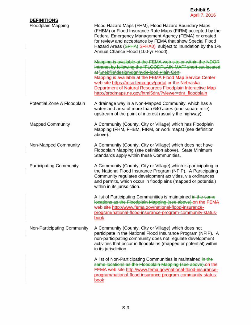
Exhibit S April 7, 2016
S-3
DEFINITIONS Floodplain Mapping Flood Hazard Maps (FHM), Flood Hazard Boundary Maps
(FHBM) or Flood Insurance Rate Maps (FIRM) accepted by the Federal Emergency Management Agency (FEMA) or created for review and acceptance by FEMA that show Special Flood Hazard Areas (SFHA) SFHA0) subject to inundation by the 1% Annual Chance Flood (100-yr Flood).
Mapping is available at the FEMA web site or within the NDOR Intranet by following the “FLOODPLAIN MAP” short cut located at \\nebfile\design\dgnhyd\Flood Plain Cert. Mapping is available at the FEMA Flood Map Service Center web site https://msc.fema.gov/portal or the Nebraska Department of Natural Resources Floodplain Interactive Map http://prodmaps.ne.gov/html5dnr/?viewer=dnr_floodplain
Potential Zone A Floodplain A drainage way in a Non-Mapped Community, which has a
watershed area of more than 640 acres (one square mile) upstream of the point of interest (usually the highway).
Mapped Community A Community (County, City or Village) which has Floodplain
Mapping (FHM, FHBM, FIRM, or work maps) (see definition above).
Non-Mapped Community A Community (County, City or Village) which does not have
Floodplain Mapping (see definition above). State Minimum Standards apply within these Communities.
Participating Community A Community (County, City or Village) which is participating in
the National Flood Insurance Program (NFIP). A Participating Community regulates development activities, via ordinances and permits, which occur in floodplains (mapped or potential) within in its jurisdiction.
A list of Participating Communities is maintained in the same locations as the Floodplain Mapping (see above).on the FEMA web site http://www.fema.gov/national-flood-insurance-program/national-flood-insurance-program-community-status-book
Non-Participating Community A Community (County, City or Village) which does not
participate in the National Flood Insurance Program (NFIP). A non-participating community does not regulate development activities that occur in floodplains (mapped or potential) within in its jurisdiction.
A list of Non-Participating Communities is maintained in the same locations as the Floodplain Mapping (see above).on the FEMA web site http://www.fema.gov/national-flood-insurance-program/national-flood-insurance-program-community-status-book

Exhibit S April 7, 2016
S-4
State Minimum Standards No construction, improvement or obstruction shall be allowed in the floodplain unless it is demonstrated that the effect of the
(paraphrased) construction will increase the water surface elevation of the base (100 year) flood for a:
• Zone A Floodplain - one foot or less (< 1.0 feet), and • Floodway – no rise (0.00 feet).

Exhibit T is a new Exhibit


Exhibit T April 7, 2016
T-1
Construction Meeting Agenda
This meeting is to be scheduled by the Roadway Design Unit Head or LPA Unit Head. Attendees: District Engineer, Roadway Designer, Bridge Designer, Traffic, Construction, Hydraulics (Optional) LPA Project Attendees: NDOR Project Coordinator, LPA RC/PL, LPA designees for Roadway, Bridge, Traffic, Construction, Hydraulics (Optional) Purpose: We are here to provide answers about the project that are necessary to begin the NEPA process. When: Schedule after preliminary plans have been distributed, prior to PIH visit. Deliverables: Information to complete the PIH report. Summarize the conclusions reached at this meeting and include in PIH report:
o Will there be traffic disruptions requiring detours, temporary roads, or ramp closures that are greater than 30 working days, or greater than 135 working days?
o Urban (pop of 5,000 or greater) detour: Is there less than 5 miles of adverse (out-of-direction) travel? Are there access provisions for local traffic?
o Rural detour: Is there less than 25 miles of adverse (out-of-direction) travel? Are there access provisions for local traffic?
o Are there any measures being taken to avoid, minimize, or offset detours or other traffic impacts? Commitments to restrict detours?
o Does the project interfere with local special events or festivals, either on a temporary or permanent basis?
o Does the project have an adverse effect to through-traffic dependent businesses, either on a temporary or permanent basis?
o Will the project result in a substantial permanent traffic pattern change or disruption? (permanently closing a roadway or roadway intersection, increase through lane capacity, create new intersections, convert a roadway into a higher classification roadway)
o Will the project result in complete closure of access to residential properties greater than 5 working days, or greater than 10 working days?
o Will the project result in complete closure of business access during operational hours?
o Will the project restrict access to emergency service facilities or providers? o Will the project permanently change the functional utility of a property? (truck
turning movements, etc)

Exhibit T April 7, 2016
T-2
Discussion: Roadway Design
• Amount of work scoped for the project – how many construction seasons are anticipated?
• Areas of potential impacts to access • Preliminary ideas for phasing the construction activities on the project
o Maintenance of traffic o Possible detours o Interchanges – slip ramps or closures? o Residential access impacts
Perm Temp
o Business access impacts Perm Temp
o Emergency Services (Fire, Ambulance, Hospital, Health clinic etc.) Access impacts Effect of detour
Bridge • Can the bridge can be built under traffic.
o Recommendation for under traffic or closed. o Allowable lane widths. o Issues/challenges. o Estimated cost differences for each option if possible.
• Bridge Hydraulics – prelim design for temporary crossing o span lengths, flow – can temp access be constructed with a temporary bridge or
is it possible to use culverts? o Will there be temporary crossing conflicts with adjacent property? o Are the grades to access the temporary crossing too steep for the crossing to be
feasible? • Will a work platform be required for construction? • Will there be a grade change?
District / LPA • Preference for detour route, if necessary. (If bridge is not phaseable, is it possible to
build with temporary crossing or is a detour necessary/preferred)? • Information on local celebrations/festivals • Known residences/businesses that may experience access issues during project
construction • Are there other construction projects in the area that may affect traffic detours or
access?
Traffic • Lane width recommendations • Temporary access or detour recommendations
Construction • Constructability issues to address • Special provisions to include in project PS&E file • Will early clearing and grubbing be necessary?

Index April 7, 2016
INDEX
Abbreviations ADA Americans With Disabilities Act ADE Roadway Design Assistant Design Engineer Bridge Bridge Division CA Covenant Agreement CADD Computer Aided Drafting and Design CICS Customer Information Control System Communications Communications Division Construction Construction Division CRA Covenant Relinquishment Agreement DCE District Construction Engineer DE District Engineer DPO Design Process Outline EA Environmental Assessment EIS Environmental Impact Statement FEMA Federal Emergence Management Agency FHWA Federal Highway Administration FONSI Finding Of No Significant Impact FRA Final Relinquishment Agreement M&R Materials and Research Division NDOR Nebraska Department of Roads NRD Natural Resource District PDU Plan Development Unit in Roadway Design PIH Plan-In-Hand P&PD Planning and Project Development Division PS&E Plans, Specifications, and Estimates Section in Construction PSS Project Scheduling System RD Roadway Design Division RDM Roadway Design Manual ROD Record of Decision R.O.W. Right Of Way Division SWPPP Stormwater Pollution Prevention Plan Traffic Traffic Engineering Division

Index April 7, 2016
INDEX
http://www.transportation.nebraska.gov/roadway-design/consult-downloads/design-documentation/DPO.pdf
DPO Exhibit Index A Roadway Design/Environmental Coordination B Design Checklist C Public Meeting Checklist D Access Control Meeting E Constructability Issues F Erosion Control Plan-In-Hand Checklist G Covenant and Final Relinquishment Agreements Process H Cost Estimate Checklist I Distribution of Plans J Plan-In-Hand Checklist K Plan-In-Hand Report Outline L Guidelines for Public Hearing / Checklist M Dry Run Invitation List (for Public Hearings) N Project Statement for the Highway Commission Meeting O Earthwork Checklist P Preliminary R.O.W. Plan Review Meeting Attendees List Q Plans to Utilities R Airway Highway Clearances S PIH Report Floodplain Wording T Construction Meeting Agenda