philippine notices to mariners - 202.90.149.235202.90.149.235/jdownloads/notice to...
TRANSCRIPT
PHILIPPINE
NOTICES TO MARINERS
Edition No.: 0229 February 2016
Notices Nos.: 013 to 052
CONTENTSI Index of Charts AffectedII Notices to MarinersIII NAVPhil InformationIV Publication Notice
Produced by the Hydrography Branch
Published by theDepartment of Environment and Natural Resources
NATIONAL MAPPING AND RESOURCE INFORMATION AUTHORITY
Notices to Mariners – Philippine edition are now on- line at
http:// www.namria.gov.ph under the heading Download
Subscription may be requested thru e-mail at [email protected]
GENERAL NOTICES
1. NOTICES TO MARINERS is a publication issued to mariners giving emphasisto changes in aids to navigation as well as recent charts correction data. It canbe availed through a written application to the Director, Hydrography Branch,NAMRIA, 421 Barraca Street, San Nicolas, 1010 Manila. Copies may also beobtained directly from NAMRIA or other agencies distributing marineinformation. Digital format could be downloaded from NAMRIA Website:www.namria.gov.ph. or requested through E-mail address: [email protected] international service of centralization of Notices To Mariners exists in officesat various ports where national and certain foreign Notices To Mariners may beobtained. The Hydrography Branch of NAMRIA is the office of centralization inthe Philippines.
2. The capital “P” or “T” affixed in the number of any notice denotes “preliminary”or “temporary”, respectively. Asterisk “ * ” indicates that the information is basedupon original Philippine source.
3. The codes of symbols in braces “[ ]” are referred to the INT 1 Publication of theInternational Hydrographic Organization (IHO).
4. All directions and bearings are measured clockwise from true North 000” to360”. Bearing on lights is based on the observer from seaward toward the light
5. The visibility assigned to the lights never exceeds the calculated distance atwhich they can be seen from a height of 4.57 meters above the level of thewater at high tide.
6. Masters of vessels and other concerned are requested to advance any report ofdangers to navigation and other information affecting Philippine Charts andCoast Pilots which may come to their attention to the Director, HydrographyBranch, 421 Barraca Street, San Nicolas, 1010 Manila, Philippines. If suchinformation warrants urgent attention like for instance the non-existence of aidsto navigation or failure of light beacons or similar structure or existence offloating mines, masters of vessels are requested to contact directly NAMRIARadio Station DUS (free of charge) at 0800 and 1600 hours on weekdays and0900 and 1600 hours on Saturdays. Station DUS transmits on 8484.0 KHz(Channel 1-CW) and 6363.0 KHz (Channel 2-CW). Contacts by landline may behad through telephone nos. (+632)245-0295, Facsimile nos. (+632)242-2090and E-mail: [email protected].
7. Changes in aids to navigation, their maintenance and correction of deficienciesin operation are under the operation of the Philippine Coast Guard. Report ofdefects and recommendations concerning aids to navigation should beforwarded to the Commandant, Philippine Coast Guard, Port Area, Manila,Philippines.
8. WARNINGS: Masters of vessels are warned that great care should beexercised in navigating Philippine waters because of the low visibility andoccasional failure of some temporary lights. Buoys and beacons are sometimeslost or destroyed specially after typhoons. Temporary deficiencies in thestandard aids to navigation published in this office may have been correctedbefore subsequent notice is issued.
9. Nautical Charts, Coast Pilot book, Topographic Maps, Tide and Current Tablesand related publications are available for sale at the following NAMRIA MapSales offices:
i
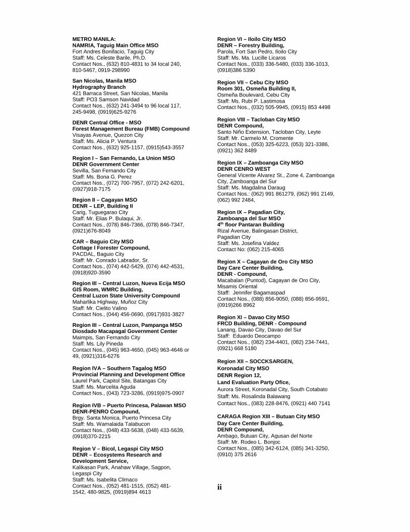
METRO MANILA:NAMRIA, Taguig Main Office MSOFort Andres Bonifacio, Taguig CityStaff: Ms. Celeste Barile, Ph.D.Contact Nos., (632) 810-4831 to 34 local 240,810-5467, 0919-298990
San Nicolas, Manila MSOHydrography Branch421 Barraca Street, San Nicolas, ManilaStaff: PO3 Samson NavidadContact Nos., (632) 241-3494 to 96 local 117,245-9498, (0919)625-9276
DENR Central Office - MSOForest Management Bureau (FMB) CompoundVisayas Avenue, Quezon CityStaff: Ms. Alicia P. VenturaContact Nos., (632) 925-1157, (0915)543-3557
Region I – San Fernando, La Union MSODENR Government CenterSevilla, San Fernando CityStaff: Ms. Bona G. PerezContact Nos., (072) 700-7957, (072) 242-6201,(0927)918-7175
Region II – Cagayan MSODENR – LEP, Building IICarig, Tuguegarao CityStaff: Mr. Elias P. Bulaqui, Jr.Contact Nos., (078) 846-7366, (078) 846-7347,(0921)676-8049
CAR – Baguio City MSOCottage I Forester Compound,PACDAL, Baguio CityStaff: Mr. Conrado Labrador, Sr.Contact Nos., (074) 442-5429, (074) 442-4531,(0918)920-3590
Region III – Central Luzon, Nueva Ecija MSOGIS Room, WMRC Building,Central Luzon State University CompoundMaharlika Highway, Muñoz CityStaff: Mr. Cielito ValinoContact Nos., (044) 456-0690, (0917)931-3827
Region III – Central Luzon, Pampanga MSODiosdado Macapagal Government CenterMaimpis, San Fernando CityStaff: Ms. Lily PinedaContact Nos., (045) 963-4650, (045) 963-4646 or49, (0921)316-6276
Region IVA – Southern Tagalog MSOProvincial Planning and Development OfficeLaurel Park, Capitol Site, Batangas CityStaff: Ms. Marcelita AgudaContact Nos., (043) 723-3286, (0919)975-0907
Region IVB – Puerto Princesa, Palawan MSODENR-PENRO Compound,Brgy. Santa Monica, Puerto Princesa CityStaff: Ms. Wamalaida TalabuconContact Nos., (048) 433-5638, (048) 433-5639,(0918)370-2215
Region V – Bicol, Legaspi City MSODENR – Ecosystems Research andDevelopment Service,Kalikasan Park, Anahaw Village, Sagpon,Legaspi CityStaff: Ms. Isabelita ClimacoContact Nos., (052) 481-1515, (052) 481-1542, 480-9825, (0919)894 4613
Region VI – Iloilo City MSODENR – Forestry Building,Parola, Fort San Pedro, Iloilo CityStaff: Ms. Ma. Lucille LicarosContact Nos., (033) 336-5480, (033) 336-1013,(0918)386 5390
Region VII – Cebu City MSORoom 301, Osmeña Building II,Osmeña Boulevard, Cebu CityStaff: Ms. Rubi P. LastimosaContact Nos., (032) 505-9945, (0915) 853 4498
Region VIII – Tacloban City MSODENR Compound,Santo Niño Extension, Tacloban City, LeyteStaff: Mr. Carmelo M. CromenteContact Nos., (053) 325-6223, (053) 321-3386,(0921) 362 8489
Region IX – Zamboanga City MSODENR CENRO WESTGeneral Vicente Alvarez St., Zone 4, ZamboangaCity, Zamboanga del SurStaff: Ms. Magdalina DaraugContact Nos.: (062) 991 861279, (062) 991 2149,(062) 992 2484,
Region IX – Pagadian City,Zamboanga del Sur MSO4th floor Pantaran BuildingRizal Avenue, Balingasan District,Pagadian CityStaff: Ms. Josefina ValdezContact No: (062) 215-4065
Region X – Cagayan de Oro City MSODay Care Center Building,DENR - Compound,Macabalan (Puntod), Cagayan de Oro City,Misamis OrientalStaff: Jennifer BagamaspadContact Nos., (088) 856-9050, (088) 856-9591,(0919)266 8962
Region XI – Davao City MSOFRCD Building, DENR - CompoundLanang, Davao City, Davao del SurStaff: Eduardo DeocampoContact Nos., (082) 234-4401, (082) 234-7441,(0921) 668 5180
Region XII – SOCCKSARGEN,
Koronadal City MSO
DENR Region 12,
Land Evaluation Party Ofice,
Aurora Street, Koronadal City, South Cotabato
Staff: Ms. Rosalinda Balawang
Contact Nos., (083) 228-8476, (0921) 440 7141
CARAGA Region XIII – Butuan City MSO
Day Care Center Building,DENR Compound,Ambago, Butuan City, Agusan del NorteStaff: Mr. Rodeo L. BonjocContact Nos., (085) 342-6124, (085) 341-3250,(0910) 375 2616
ii

Users may consult Notices to Mariners issued by the following foreignagencies for notices covering Philippine waters.
USA: National Geospatial & Intelligence AgencyCode GIMM, Mall Shop D-444600 Sangamore RoadBethesda, MD 20816-5003USAhttp://pollux.nss.ngamil
United Kingdom: The United Kingdom Hydrographic OfficeAdmiralty WayTaunton, Somerset, TA1 2DN,UKwww.ukho.gov.uk
Japan: Hydrographic and Oceanographic DepartmentJapan Coast GuardMLIT Aomi Building2-5-18, Aomi, Koto-ku,Tokyo 135-0064Japanhttp://www1.kaiho.mlit.go.jp
Australia: Royal Australian NavyHydrographic Service161 Walker Street,North Sydney, NSW, 2060Australiawww.hydro.gov.au
iii

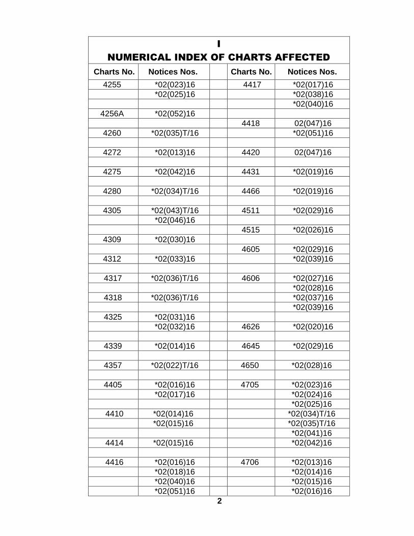
I
NUMERICAL INDEX OF CHARTS AFFECTED
Charts No. Notices Nos. Charts No. Notices Nos.
1501 *02(023)16 *02(041)16*02(025)16 *02(042)16
*02(043)T/161515 *02(045)16 *02(044)T/16
*02(045)161546 *02(016)16 *02(046)16
*02(018)16 02(047)16*02(019)16
4204 *02(034)T/161551 *02(033)16
4205 *02(034)T/161564 *02(043)T/16
*02(046)16 4211 *02(024)16*02(025)16
4200 *02(013)16*02(014)16 4212 *02(024)16*02(015)16*02(016)16 4214 *02(043)T/16*02(017)16 *02(046)16*02(018)16 *02(052)16*02(019)16*02(020)16 4218 *02(013)16*02(021)16
*02(022)T/16 4221 *02(021)16*02(023)16 *02(045)16*02(024)16*02(025)16 4222 *02(021)16*02(026)16*02(027)16 4226 *02(042)16*02(028)16*02(029)16 4229 *02(035)T/16*02(030)16*02(031)16 4230 *02(041)16*02(032)16*02(033)16 4236 *02(023)16
*02(034)T/16*02(035)T/16 4236 *02(023)16*02(036)T/16*02(037)16 4237 *02(045)16*02(038)16 02(047)16*02(039)16*02(040)16 4243 *02(023)16
1
I
NUMERICAL INDEX OF CHARTS AFFECTED
Charts No. Notices Nos. Charts No. Notices Nos.
4255 *02(023)16 4417 *02(017)16*02(025)16 *02(038)16
*02(040)164256A *02(052)16
4418 02(047)164260 *02(035)T/16 *02(051)16
4272 *02(013)16 4420 02(047)16
4275 *02(042)16 4431 *02(019)16
4280 *02(034)T/16 4466 *02(019)16
4305 *02(043)T/16 4511 *02(029)16*02(046)16
4515 *02(026)164309 *02(030)16
4605 *02(029)164312 *02(033)16 *02(039)16
4317 *02(036)T/16 4606 *02(027)16*02(028)16
4318 *02(036)T/16 *02(037)16*02(039)16
4325 *02(031)16*02(032)16 4626 *02(020)16
4339 *02(014)16 4645 *02(029)16
4357 *02(022)T/16 4650 *02(028)16
4405 *02(016)16 4705 *02(023)16*02(017)16 *02(024)16
*02(025)164410 *02(014)16 *02(034)T/16
*02(015)16 *02(035)T/16*02(041)16
4414 *02(015)16 *02(042)16
4416 *02(016)16 4706 *02(013)16*02(018)16 *02(014)16*02(040)16 *02(015)16*02(051)16 *02(016)16
2

I
NUMERICAL INDEX OF CHARTS AFFECTED
Charts No. Notices Nos. Charts No. Notices Nos.
4706 *02(017)16 *02(043)T/16*02(018)16 *02(046)16*02(021)16*02(023)16 4715 *02(013)16*02(024)16 *02(021)16*02(025)16*02(033)16 4716 *02(022)T/16
*02(036)T/16 *02(031)16*02(038)16 *02(032)16*02(040)16*02(041)16 4718 *02(014)16*02(042)16 *02(015)16
*02(043)T/16 *02(016)16*02(046)16 *02(017)1602(047)16 *02(019)16
*02(036)T/164707 *02(022)T/16 *02(038)16
*02(026)16 *02(040)16*02(029)16*02(030)16 4719 02(047)16*02(031)16
4720 *02(030)16*02(032)16 *02(031)16*02(033)16 *02(032)16
*02(036)T/16*02(044)T/16 4722 *02(026)16
*02(029)164708 *02(016)16
*02(018)16 4723 *02(030)16*02(019)16 *02(044)T/16*02(020)16*02(027)16 4723A *02(022)T/16*02(028)16 *02(024)16*02(037)16 *02(030)16*02(039)16 *02(033)16
*02(044)T/164714 *02(013)16 *02(046)16
*02(014)16*02(015)16 4726A *02(013)16*02(023)16 *02(021)16*02(025)16 *02(023)16*02(041)16 *02(024)16
3
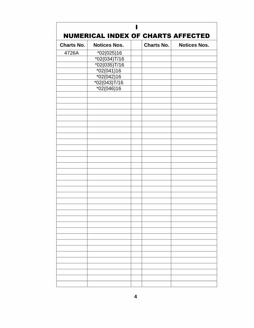
I
NUMERICAL INDEX OF CHARTS AFFECTED
Charts No. Notices Nos. Charts No. Notices Nos.
4726A *02(025)16*02(034)T/16*02(035)T/16*02(041)16*02(042)16
*02(043)T/16*02(046)16
4

II
NOTICES TO MARINERS
*02(013)16 – LUZON, S. COAST, Quezon, Catanauan – Light
CATANAUAN LIGHT (F2594), restored to normal operation since 13January 2016.
Position: 13° 35' 29" N., 122° 19' 15" E.[Luzon Datum]
Characteristics: Fl R 5s
NAMRIA Charts affected: 4200, 4218, 4272, 4706, 4714, 4715, 4726A.(PCG NM No. 004 of 2016; HD 009/16)
*02(014)16 – TABLAS ISLAND, Looc Bay – Light
MALBOG PORT LIGHT (F2527), restored to normal operation since16 December 2015.
Position: 12° 13' 34" N., 122° 00' 14" E.[Luzon Datum]
Characteristics: Fl R 5s
NAMRIA Charts affected: 4200, 4339, 4410, 4706, 4714, 4718.(PCG NM No. 004 of 2016; HD 009/16)
*02(015)16 – PANAY ISLAND, NW. COAST, Malay, Nasog – Light
NASOG POINT LIGHT (F2336.8), restored to normal operation since20 September 2015.
Position: 11° 54' 00" N., 121° 53' 06" E.[Luzon Datum]
Characteristics: Fl W 5s
NAMRIA Charts affected: 4200, 4410, 4414, 4706, 4714, 4718.(PCG NM No. 004 of 2016; HD 009/16)
*02(016)16 – NEGROS ISLAND, NW. COAST, Bacolod City – Light
BANAGO LIGHT (F2358.2), restored to normal operation since 22September 2015.
Position: 10° 42' 24" N., 122° 56' 54" E.[Luzon Datum]
Characteristics: Fl R 5s
NAMRIA Charts affected: 1546, 4200, 4405, 4416, 4706, 4708, 4718.(PCG NM No. 004 of 2016; HD 009/16)
5
II
NOTICES TO MARINERS
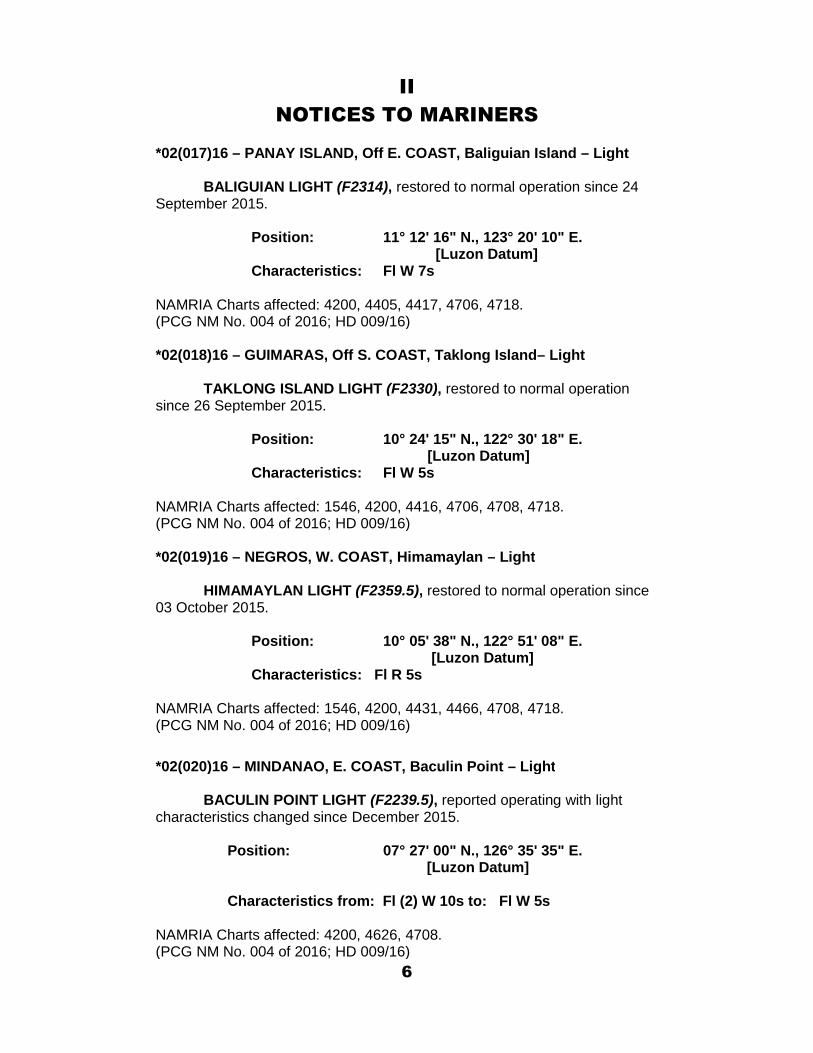
*02(017)16 – PANAY ISLAND, Off E. COAST, Baliguian Island – Light
BALIGUIAN LIGHT (F2314), restored to normal operation since 24September 2015.
Position: 11° 12' 16" N., 123° 20' 10" E.[Luzon Datum]
Characteristics: Fl W 7s
NAMRIA Charts affected: 4200, 4405, 4417, 4706, 4718.(PCG NM No. 004 of 2016; HD 009/16)
*02(018)16 – GUIMARAS, Off S. COAST, Taklong Island– Light
TAKLONG ISLAND LIGHT (F2330), restored to normal operationsince 26 September 2015.
Position: 10° 24' 15" N., 122° 30' 18" E.[Luzon Datum]
Characteristics: Fl W 5s
NAMRIA Charts affected: 1546, 4200, 4416, 4706, 4708, 4718.(PCG NM No. 004 of 2016; HD 009/16)
*02(019)16 – NEGROS, W. COAST, Himamaylan – Light
HIMAMAYLAN LIGHT (F2359.5), restored to normal operation since03 October 2015.
Position: 10° 05' 38" N., 122° 51' 08" E.[Luzon Datum]
Characteristics: Fl R 5s
NAMRIA Charts affected: 1546, 4200, 4431, 4466, 4708, 4718.(PCG NM No. 004 of 2016; HD 009/16)
*02(020)16 – MINDANAO, E. COAST, Baculin Point – Light
BACULIN POINT LIGHT (F2239.5), reported operating with lightcharacteristics changed since December 2015.
Position: 07° 27' 00" N., 126° 35' 35" E.[Luzon Datum]
Characteristics from: Fl (2) W 10s to: Fl W 5s
NAMRIA Charts affected: 4200, 4626, 4708.(PCG NM No. 004 of 2016; HD 009/16)
6
II
NOTICES TO MARINERS
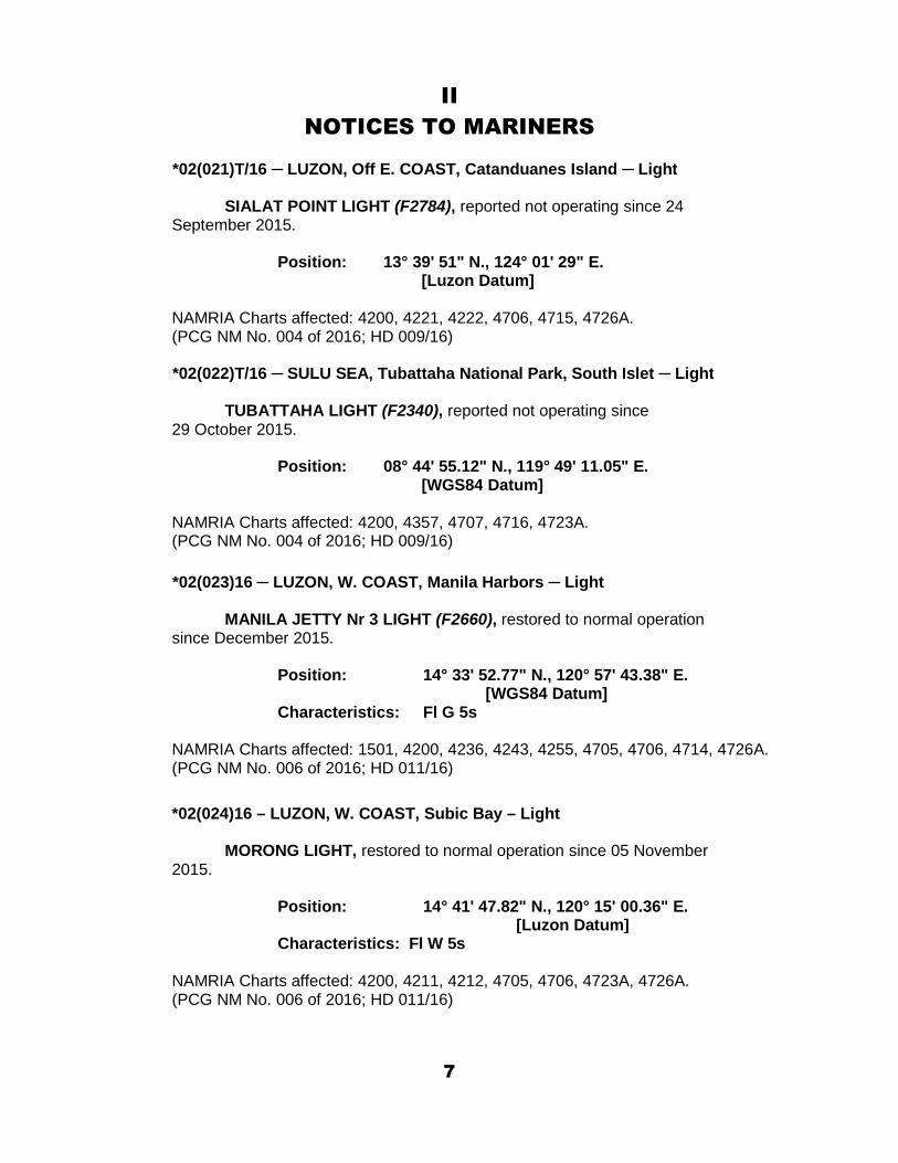
*02(021)T/16 ─ LUZON, Off E. COAST, Catanduanes Island ─ Light
SIALAT POINT LIGHT (F2784), reported not operating since 24September 2015.
Position: 13° 39' 51" N., 124° 01' 29" E.[Luzon Datum]
NAMRIA Charts affected: 4200, 4221, 4222, 4706, 4715, 4726A.(PCG NM No. 004 of 2016; HD 009/16)
*02(022)T/16 ─ SULU SEA, Tubattaha National Park, South Islet ─ Light
TUBATTAHA LIGHT (F2340), reported not operating since29 October 2015.
Position: 08° 44' 55.12" N., 119° 49' 11.05" E.[WGS84 Datum]
NAMRIA Charts affected: 4200, 4357, 4707, 4716, 4723A.(PCG NM No. 004 of 2016; HD 009/16)
*02(023)16 ─ LUZON, W. COAST, Manila Harbors ─ Light
MANILA JETTY Nr 3 LIGHT (F2660), restored to normal operationsince December 2015.
Position: 14° 33' 52.77" N., 120° 57' 43.38" E.[WGS84 Datum]
Characteristics: Fl G 5s
NAMRIA Charts affected: 1501, 4200, 4236, 4243, 4255, 4705, 4706, 4714, 4726A.(PCG NM No. 006 of 2016; HD 011/16)
*02(024)16 – LUZON, W. COAST, Subic Bay – Light
MORONG LIGHT, restored to normal operation since 05 November2015.
Position: 14° 41' 47.82" N., 120° 15' 00.36" E.[Luzon Datum]
Characteristics: Fl W 5s
NAMRIA Charts affected: 4200, 4211, 4212, 4705, 4706, 4723A, 4726A.(PCG NM No. 006 of 2016; HD 011/16)
7

II
NOTICES TO MARINERS
*02(025)16 – LUZON, Mariveles off S. Coast, La Monja Island – Light
LA MONJA LIGHT (F2632), restored to normal operation since 06November 2015.
Position: 14° 22' 38" N., 120° 31' 15" E.[Luzon Datum]
Characteristics: Fl W 5s
NAMRIA Charts affected: 1501, 4200, 4211, 4255, 4705, 4706, 4714, 4726A.(PCG NM No. 006 of 2016; HD 011/16)
*02(026)16 – MINDANAO, Off SW. COAST, Salauag Island – Light
SALAUAG ISLAND LIGHT (F2189), restored to normal operationsince 25 December 2015.
Position: 04° 35' 23" N., 119° 28' 01" E.[Luzon Datum]
Characteristics: Fl W 5s
NAMRIA Charts affected: 4200, 4515, 4707, 4722.(PCG NM No. 006 of 2016; HD 011/16)
*02(027)16 – MINDANAO, S. COAST, Baganian Peninsula – Light
TABINA LIGHT, restored to normal operation with light characteristicschanged since 13 November 2015.
Position: 07° 26' 04" N., 123° 27' 03" E.[Luzon Datum]
Characteristics from: Fl W 10s to: Fl W 5s
NAMRIA Charts affected: 4200, 4606, 4708.(PCG NM No. 006 of 2016; HD 011/16)
*02(028)16 – MINDANAO, S. COAST, Igat Bay – Light
MARGOSATUBIG LIGHT (F2224), restored to normal operation with lightcharacteristics changed since 28 June 2015.
Position: 07° 34' 50" N., 123° 10' 05" E.[Luzon Datum]
Characteristics from: Fl (2) W 5s to: Fl (3) W 5s
NAMRIA Charts affected: 4200, 4606, 4650, 4708.(PCG NM No. 006 of 2016; HD 011/16)
8
II
NOTICES TO MARINERS
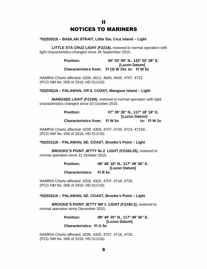
*02(029)16 – BASILAN STRAIT, Little Sta. Cruz Island – Light
LITTLE STA CRUZ LIGHT (F2218), restored to normal operation withlight characteristics changed since 26 September 2015.
Position: 06° 53' 09" N., 122° 02' 28" E.[Luzon Datum]
Characteristics from: Fl (3) W 15s to: Fl W 5s
NAMRIA Charts affected: 4200, 4511, 4605, 4645, 4707, 4722.(PCG NM No. 006 of 2016; HD 011/16)
*02(030)16 – PALAWAN, Off S. COAST, Mangsee Island – Light
MANGSEE LIGHT (F2159), restored to normal operation with lightcharacteristics changed since 03 October 2015.
Position: 07° 30' 30" N., 117° 18' 18" E.[Luzon Datum]
Characteristics from: Fl W 5s to: Fl W 3s
NAMRIA Charts affected: 4200, 4309, 4707, 4720, 4723, 4723A.(PCG NM No. 006 of 2016; HD 011/16)
*02(031)16 – PALAWAN, SE. COAST, Brooke’s Point – Light
BROOKE’S POINT JETTY Nr.2 LIGHT (F2160.25), restored tonormal operation since 21 October 2015.
Position: 08° 46' 18" N., 117° 49' 36" E.[Luzon Datum]
Characteristics: Fl R 5s
NAMRIA Charts affected: 4200, 4325, 4707, 4716, 4720.(PCG NM No. 006 of 2016; HD 011/16)
*02(032)16 – PALAWAN, SE. COAST, Brooke’s Point – Light
BROOKE’S POINT JETTY NR 1 LIGHT (F2160.2), restored tonormal operation since December 2015.
Position: 08° 46' 20" N., 117° 49' 36" E.[Luzon Datum]
Characteristics: Fl G 5s
NAMRIA Charts affected: 4200, 4325, 4707, 4716, 4720.(PCG NM No. 006 of 2016; HD 011/16)
9
II
NOTICES TO MARINERS
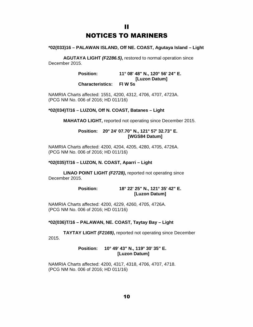
*02(033)16 – PALAWAN ISLAND, Off NE. COAST, Agutaya Island – Light
AGUTAYA LIGHT (F2286.5), restored to normal operation sinceDecember 2015.
Position: 11° 08' 48" N., 120° 56' 24" E.[Luzon Datum]
Characteristics: Fl W 5s
NAMRIA Charts affected: 1551, 4200, 4312, 4706, 4707, 4723A.(PCG NM No. 006 of 2016; HD 011/16)
*02(034)T/16 – LUZON, Off N. COAST, Batanes – Light
MAHATAO LIGHT, reported not operating since December 2015.
Position: 20° 24' 07.70" N., 121° 57' 32.73" E.[WGS84 Datum]
NAMRIA Charts affected: 4200, 4204, 4205, 4280, 4705, 4726A.(PCG NM No. 006 of 2016; HD 011/16)
*02(035)T/16 – LUZON, N. COAST, Aparri – Light
LINAO POINT LIGHT (F2728), reported not operating sinceDecember 2015.
Position: 18° 22' 25" N., 121° 35' 42" E.[Luzon Datum]
NAMRIA Charts affected: 4200, 4229, 4260, 4705, 4726A.(PCG NM No. 006 of 2016; HD 011/16)
*02(036)T/16 – PALAWAN, NE. COAST, Taytay Bay – Light
TAYTAY LIGHT (F2169), reported not operating since December2015.
Position: 10° 49' 43" N., 119° 30' 35" E.[Luzon Datum]
NAMRIA Charts affected: 4200, 4317, 4318, 4706, 4707, 4718.(PCG NM No. 006 of 2016; HD 011/16)
10

II
NOTICES TO MARINERS
*02(037)P/16 – MINDANAO, Zamboanga del Sur, Baganian Peninsula – Light
Insert symbol [P1] for Baganian Light, with the following details:
Position: 07° 22' 40" N., 123° 27' 06" E. (PA)[Luzon Datum]
Characteristics: Fl (2) W 10sRange: 18 NMStructure: Concrete tower, 15 m high
NAMRIA Charts affected: 4200, 4606, 4708.(PCG NM No. 008 of 2016; HD 013/16)
*02(038)16 – PANAY, Off E. COAST, Apiton Pass – Pilot station
Insert symbol [T1.1], for Pilot boarding station, at:
11° 06' 12" N., 123° 05' 09" E. [Luzon Datum]
NAMRIA Charts affected: 4200, 4417, 4706, 4718.(PPA Administrative Order No. 09-2015; HD 015/16)
*02(039)16 – MINDANAO, S. COAST, Zamboanga del Sur – Light
SAN PABLO LIGHT, restored to normal operation with lightcharacteristics changed since January 2016.
Position: 07° 38' 07" N., 123° 28' 10" E.[Luzon Datum]
Characteristics from: Fl W 5s to: Fl R 5s
NAMRIA Charts affected: 4200, 4605, 4606, 4708.(PCG NM No. 012 of 2016; HD 018/16)
*02(040)16 – PANAY, Off E. COAST, Calabazas Island – Light
CALABAZAS LIGHT (F2316), restored to normal operation sinceSeptember 2015.
Position: 11° 04' 34" N., 123° 01' 17" E.[Luzon Datum]
Characteristics: Fl W 10s
NAMRIA Charts affected: 4200, 4416, 4417, 4706, 4718.(PCG NM No. 012 of 2016; HD 018/16)
11
II
NOTICES TO MARINERS
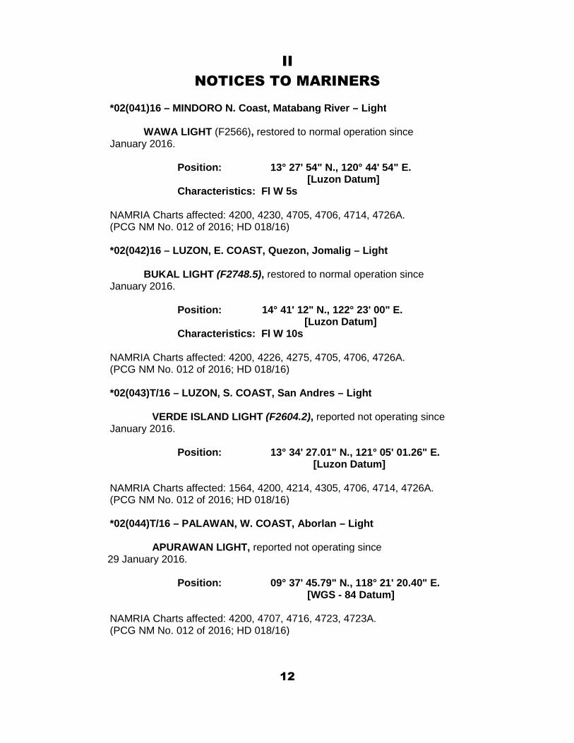
*02(041)16 – MINDORO N. Coast, Matabang River – Light
WAWA LIGHT (F2566), restored to normal operation sinceJanuary 2016.
Position: 13° 27' 54" N., 120° 44' 54" E.[Luzon Datum]
Characteristics: Fl W 5s
NAMRIA Charts affected: 4200, 4230, 4705, 4706, 4714, 4726A.(PCG NM No. 012 of 2016; HD 018/16)
*02(042)16 – LUZON, E. COAST, Quezon, Jomalig – Light
BUKAL LIGHT (F2748.5), restored to normal operation sinceJanuary 2016.
Position: 14° 41' 12" N., 122° 23' 00" E.[Luzon Datum]
Characteristics: Fl W 10s
NAMRIA Charts affected: 4200, 4226, 4275, 4705, 4706, 4726A.(PCG NM No. 012 of 2016; HD 018/16)
*02(043)T/16 – LUZON, S. COAST, San Andres – Light
VERDE ISLAND LIGHT (F2604.2), reported not operating sinceJanuary 2016.
Position: 13° 34' 27.01" N., 121° 05' 01.26" E.[Luzon Datum]
NAMRIA Charts affected: 1564, 4200, 4214, 4305, 4706, 4714, 4726A.(PCG NM No. 012 of 2016; HD 018/16)
*02(044)T/16 – PALAWAN, W. COAST, Aborlan – Light
APURAWAN LIGHT, reported not operating since29 January 2016.
Position: 09° 37' 45.79" N., 118° 21' 20.40" E.[WGS - 84 Datum]
NAMRIA Charts affected: 4200, 4707, 4716, 4723, 4723A.(PCG NM No. 012 of 2016; HD 018/16)
12
II
NOTICES TO MARINERS
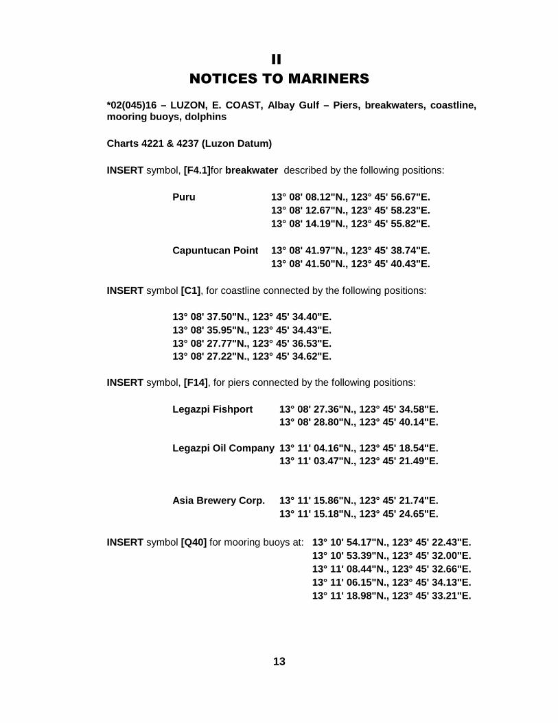
*02(045)16 – LUZON, E. COAST, Albay Gulf – Piers, breakwaters, coastline,mooring buoys, dolphins
Charts 4221 & 4237 (Luzon Datum)
INSERT symbol, [F4.1]for breakwater described by the following positions:
Puru 13° 08' 08.12"N., 123° 45' 56.67"E.
13° 08' 12.67"N., 123° 45' 58.23"E.
13° 08' 14.19"N., 123° 45' 55.82"E.
Capuntucan Point 13° 08' 41.97"N., 123° 45' 38.74"E.
13° 08' 41.50"N., 123° 45' 40.43"E.
INSERT symbol [C1], for coastline connected by the following positions:
13° 08' 37.50"N., 123° 45' 34.40"E.
13° 08' 35.95"N., 123° 45' 34.43"E.
13° 08' 27.77"N., 123° 45' 36.53"E.
13° 08' 27.22"N., 123° 45' 34.62"E.
INSERT symbol, [F14], for piers connected by the following positions:
Legazpi Fishport 13° 08' 27.36"N., 123° 45' 34.58"E.
13° 08' 28.80"N., 123° 45' 40.14"E.
Legazpi Oil Company 13° 11' 04.16"N., 123° 45' 18.54"E.
13° 11' 03.47"N., 123° 45' 21.49"E.
Asia Brewery Corp. 13° 11' 15.86"N., 123° 45' 21.74"E.
13° 11' 15.18"N., 123° 45' 24.65"E.
INSERT symbol [Q40] for mooring buoys at: 13° 10' 54.17"N., 123° 45' 22.43"E.
13° 10' 53.39"N., 123° 45' 32.00"E.
13° 11' 08.44"N., 123° 45' 32.66"E.
13° 11' 06.15"N., 123° 45' 34.13"E.
13° 11' 18.98"N., 123° 45' 33.21"E.
13
II
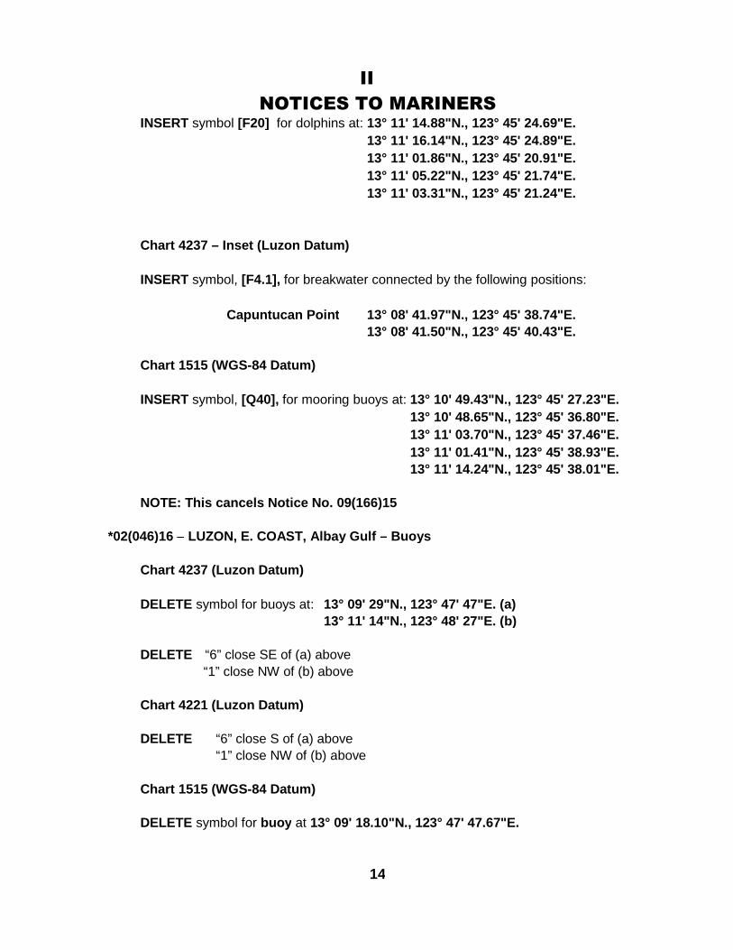
NOTICES TO MARINERSINSERT symbol [F20] for dolphins at: 13° 11' 14.88"N., 123° 45' 24.69"E.
13° 11' 16.14"N., 123° 45' 24.89"E.
13° 11' 01.86"N., 123° 45' 20.91"E.
13° 11' 05.22"N., 123° 45' 21.74"E.
13° 11' 03.31"N., 123° 45' 21.24"E.
Chart 4237 – Inset (Luzon Datum)
INSERT symbol, [F4.1], for breakwater connected by the following positions:
Capuntucan Point 13° 08' 41.97"N., 123° 45' 38.74"E.
13° 08' 41.50"N., 123° 45' 40.43"E.
Chart 1515 (WGS-84 Datum)
INSERT symbol, [Q40], for mooring buoys at: 13° 10' 49.43"N., 123° 45' 27.23"E.
13° 10' 48.65"N., 123° 45' 36.80"E.
13° 11' 03.70"N., 123° 45' 37.46"E.
13° 11' 01.41"N., 123° 45' 38.93"E.
13° 11' 14.24"N., 123° 45' 38.01"E.
NOTE: This cancels Notice No. 09(166)15
*02(046)16 – LUZON, E. COAST, Albay Gulf – Buoys
Chart 4237 (Luzon Datum)
DELETE symbol for buoys at: 13° 09' 29"N., 123° 47' 47"E. (a)
13° 11' 14"N., 123° 48' 27"E. (b)
DELETE “6” close SE of (a) above
“1” close NW of (b) above
Chart 4221 (Luzon Datum)
DELETE “6” close S of (a) above
“1” close NW of (b) above
Chart 1515 (WGS-84 Datum)
DELETE symbol for buoy at 13° 09' 18.10"N., 123° 47' 47.67"E.
14
II
NOTICES TO MARINERS
*02(047)16 – LUZON, E. COAST, Albay Gulf – Depths
Chart 4237 (Luzon Datum)
INSERT depth 1 3/4 at 13° 10' 53.58"N., 123° 48' 03.65"E. (a)
depth 6 4/5 at 13° 11' 16.27"N., 123° 47' 16.50"E. (b)
depth 1 at 13° 10' 43.11"N., 123° 45' 31.97"E. (c)
depth 3 1/5 at 13° 08' 49.22"N., 123° 46' 41.01"E. (d)
depth 8 4/5 at 13° 08' 21.06"N., 123° 49' 51.23"E. (e)
DELETE depth 2 ½ close SW of (a) above
depth 7 ¼ close SW of (b) above
depth 3 ½ close E of (c) above
depth 5 ¾ close E of (d) above
depth 9 close NW of (e) above
Chart 4221 (Luzon Datum)
INSERT depth 6 4/5 at 13° 11' 16.27"N., 123° 47' 16.50"E. (f)
depth 8 4/5 at 13° 08' 21.06"N., 123° 49' 51.23"E. (i)
DELETE depth 7 ¼ close SW of (f) above
depth 9 close NW of (e) above
Chart 1515 (WGS-84 Datum)
INSERT depth 12.5 at 13° 11' 11.53"N., 123° 47' 21.30"E. (h)
depth 16.1 at 13° 08' 16.32"N., 123° 49' 56.03"E. (i)
DELETE depth 13.3 at (h) above
depth 16.5 close S of (i) above
depth 20.1 close N of (i) above
NOTE: This cancels Notice No. 09(166)15
NAMRIA Charts affected: 1515, 4200, 4221, 4237.(NAMRIA-HB Field Data; HD 020/16)
15
II
NOTICES TO MARINERS
*02(048)16 – LUZON, S. COAST, Verde Island Passage – Light
MALAJIBOMANOC ISLET LIGHT (F2607), reported not operating sinceJanuary 2016 and restored to normal operation since 03 February 2016
Position: 13° 37' 43" N., 120° 57' 50" E.[Luzon Datum]
Characteristics: Fl W 10s
NAMRIA Charts affected: 1564, 4200, 4214, 4305, 4706, 4714, 4723A, 4726A.(PCG NM Nos. 012 & 015 of 2016; HD 018/16 & 021/16)
02(049)16 – PHILIPPINE WATERS – Submarine cables
Chart 4237 (Luzon Datum)
INSERT symbol, [L30.1], for submarine cable described by the following positions:
13° 10' 13.8"N., 123° 45' 07.8"E.
13° 10' 34.8"N., 123° 45' 50.4"E.
13° 12' 09.6"N., 123° 47' 32.4"E.
13° 12' 20.4"N., 123° 47' 51.6"E.
13° 12' 25.2"N., 123° 48' 16.8"E.
13° 12' 04.8"N., 123° 51' 46.8"E.
*02(050)16 – SAMAR, W. COAST, Samar Sea and Carigara Bay – Submarine cables
Charts 4420 and 4418 (Luzon Datum)
INSERT symbol, [L30.1], for submarine cable described by the following positions:
12° 03' 32.10"N., 124° 36' 45.96"E. – Calbayog (shore)
11° 59' 50.70"N., 124° 35' 22.56"E.
12° 00' 27.90"N., 124° 28' 30.36"E.
12° 04' 11.82"N., 124° 21' 39.36"E.
12° 14' 07.02"N., 124° 12' 11.16"E.
12° 16' 04.74"N., 124° 11' 14.76"E.
12° 03' 32.10"N., 124° 36' 46.56"E. – Calbayog (shore)
11° 59' 21.90"N., 124° 35' 29.76"E.
11° 55' 42.90"N., 124° 35' 02.76"E.
11° 30' 30.90"N., 124° 41' 07.56"E.
11° 17' 42.90"N., 124° 38' 22.56"E. – Capoocan (shore)
16
II
NOTICES TO MARINERSChart 4719 (Luzon Datum)
INSERT symbol, [L30.1], for submarine cable described by the following positions:
12° 03' 32.10"N., 124° 36' 46.56"E. – Calbayog (shore)
11° 59' 21.90"N., 124° 35' 29.76"E.
11° 55' 42.90"N., 124° 35' 02.76"E.
11° 30' 30.90"N., 124° 41' 07.56"E.
11° 17' 42.90"N., 124° 38' 22.56"E. – Capoocan (shore)
Chart 4706 (WGS-84 Datum)
INSERT symbol, [L30.1], for submarine cable described by the following positions:
12° 03' 27.6"N., 124° 36' 51.6"E. – Calbayog (shore)
11° 59' 17.4"N., 124° 35' 34.8"E.
11° 55' 38.4"N., 124° 35' 07.8"E.
11° 30' 26.4"N., 124° 41' 12.6"E.
11° 17' 38.4"N., 124° 38' 27.6"E. – Capoocan (shore)
NAMRIA Charts affected: 4200, 4237, 4418, 4420, 4706, 4719.(UKHO Admiralty NM, Weekly Edition 7; HD 022/16)
*02(051)16 – PANAY E. COAST - Iloilo Strait – Wreck
INSERT symbol, [K23], for wreck with unknown depth at
10° 41' 20.4"N., 122° 35' 49.2"E
[Luzon Datum]
NAMRIA Charts affected: 4418, 4416.(PCG Notam 005/16; HD 008/16)
*02(052)16 – LUZON S. COAST - Batangas Bay – Restricted Area
INSERT symbols, [N20 and N21] for no anchorage and no fishing zone at thefollowing positions:
Latitude Longitude
1 13° 43' 21.19" N 121° 03' 26.58" E
2 13° 42' 28.49" N 121° 02' 07.30" E
3 13° 42' 24.57" N 121° 02' 02.03" E
4 13° 42' 22.41" N 121° 01' 59.32" E
5 13° 42' 17.52" N 121° 01' 53.97" E
6 13° 42' 13.88" N 121° 01' 50.65" E
7 13° 42' 09.51" N 121° 01' 47.03" E
Continued on page 1817
II
NOTICES TO MARINERS8 13° 42' 06.46" N 121° 01' 44.77" E
9 13° 42' 01.14" N 121° 01' 41.32" E
10 13° 41' 57.90" N 121° 01' 39.55" E
11 13° 41' 50.60" N 121° 01' 36.09" E
12 13° 41' 46.41" N 121° 01' 34.50" E
13 13° 41' 41.22" N 121° 01' 32.77" E
14 13° 40' 29.02" N 121° 01' 08.78" E
15 13° 40' 24.17" N 121° 01' 07.43" E
16 13° 40' 15.81" N 121° 01' 05.19" E
17 13° 40' 10.66" N 121° 01' 04.13" E
18 13° 40' 05.37" N 121° 01' 03.14" E
19 13° 39' 59.04" N 121° 01' 02.24" E
20 13° 39' 53.04" N 121° 01' 01.67" E
21 13° 39' 46.37" N 121° 01' 01.34" E
22 13° 39' 41.39" N 121° 01' 00.86" E
23 13° 39' 35.42" N 121° 01' 00.03" E
24 13° 39' 29.12" N 121° 00' 58.86" E
25 13° 39' 21.50" N 121° 00' 57.00" E
26 13° 39' 13.53" N 121° 00' 54.19" E
27 13° 39' 09.84" N 121° 00' 52.56" E
28 13° 38' 58.37" N 121° 00' 46.76" E
29 13° 37' 04.26" N 120° 59' 49.76" E
30 13° 36' 55.50" N 120° 59' 45.79" E
31 13° 36' 50.86" N 120° 59' 43.55" E
32 13° 36' 44.79" N 120° 59' 41.00" E
33 13° 36' 27.55" N 120° 59' 35.89" E
34 13° 36' 18.01" N 120° 59' 33.74" E
35 13° 36' 08.03" N 120° 59' 32.17" E
36 13° 35' 54.53" N 120° 59' 30.71" E
37 13° 35' 47.49" N 120° 59' 30.45" E
38 13° 35' 40.27" N 120° 59' 30.61" E
39 13° 35' 28.14" N 120° 59' 31.52" E
40 13° 35' 21.82" N 120° 59' 32.23" E
41 13° 35' 16.06" N 120° 59' 33.08" E
42 13° 35' 05.23" N 120° 59' 34.99" E
43 13° 34' 57.58" N 120° 59' 36.86" E
44 13° 34' 51.34" N 120° 59' 38.79" E
45 13° 34' 46.16" N 120° 59' 40.61" E
46 13° 34' 38.59" N 120° 59' 43.53" E
47 13° 34' 29.86" N 120° 59' 47.41" E
48 13° 34' 21.70" N 120° 59' 51.56" E
Continued on page 19
18
II
NOTICES TO MARINERS
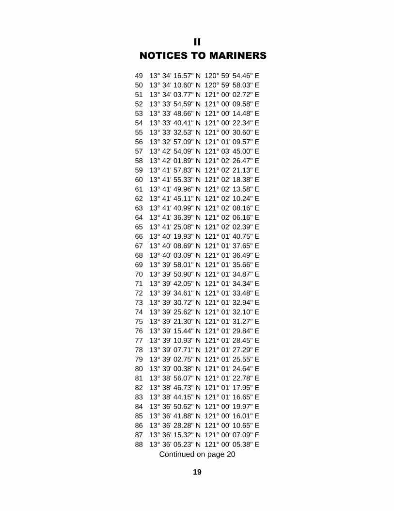
49 13° 34' 16.57" N 120° 59' 54.46" E
50 13° 34' 10.60" N 120° 59' 58.03" E
51 13° 34' 03.77" N 121° 00' 02.72" E
52 13° 33' 54.59" N 121° 00' 09.58" E
53 13° 33' 48.66" N 121° 00' 14.48" E
54 13° 33' 40.41" N 121° 00' 22.34" E
55 13° 33' 32.53" N 121° 00' 30.60" E
56 13° 32' 57.09" N 121° 01' 09.57" E
57 13° 42' 54.09" N 121° 03' 45.00" E
58 13° 42' 01.89" N 121° 02' 26.47" E
59 13° 41' 57.83" N 121° 02' 21.13" E
60 13° 41' 55.33" N 121° 02' 18.38" E
61 13° 41' 49.96" N 121° 02' 13.58" E
62 13° 41' 45.11" N 121° 02' 10.24" E
63 13° 41' 40.99" N 121° 02' 08.16" E
64 13° 41' 36.39" N 121° 02' 06.16" E
65 13° 41' 25.08" N 121° 02' 02.39" E
66 13° 40' 19.93" N 121° 01' 40.75" E
67 13° 40' 08.69" N 121° 01' 37.65" E
68 13° 40' 03.09" N 121° 01' 36.49" E
69 13° 39' 58.01" N 121° 01' 35.66" E
70 13° 39' 50.90" N 121° 01' 34.87" E
71 13° 39' 42.05" N 121° 01' 34.34" E
72 13° 39' 34.61" N 121° 01' 33.48" E
73 13° 39' 30.72" N 121° 01' 32.94" E
74 13° 39' 25.62" N 121° 01' 32.10" E
75 13° 39' 21.30" N 121° 01' 31.27" E
76 13° 39' 15.44" N 121° 01' 29.84" E
77 13° 39' 10.93" N 121° 01' 28.45" E
78 13° 39' 07.71" N 121° 01' 27.29" E
79 13° 39' 02.75" N 121° 01' 25.55" E
80 13° 39' 00.38" N 121° 01' 24.64" E
81 13° 38' 56.07" N 121° 01' 22.78" E
82 13° 38' 46.73" N 121° 01' 17.95" E
83 13° 38' 44.15" N 121° 01' 16.65" E
84 13° 36' 50.62" N 121° 00' 19.97" E
85 13° 36' 41.88" N 121° 00' 16.01" E
86 13° 36' 28.28" N 121° 00' 10.65" E
87 13° 36' 15.32" N 121° 00' 07.09" E
88 13° 36' 05.23" N 121° 00' 05.38" E
Continued on page 20
19
II
NOTICES TO MARINERS
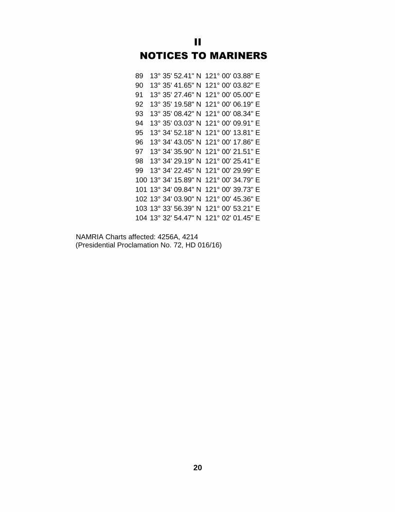
89 13° 35' 52.41" N 121° 00' 03.88" E
90 13° 35' 41.65" N 121° 00' 03.82" E
91 13° 35' 27.46" N 121° 00' 05.00" E
92 13° 35' 19.58" N 121° 00' 06.19" E
93 13° 35' 08.42" N 121° 00' 08.34" E
94 13° 35' 03.03" N 121° 00' 09.91" E
95 13° 34' 52.18" N 121° 00' 13.81" E
96 13° 34' 43.05" N 121° 00' 17.86" E
97 13° 34' 35.90" N 121° 00' 21.51" E
98 13° 34' 29.19" N 121° 00' 25.41" E
99 13° 34' 22.45" N 121° 00' 29.99" E
100 13° 34' 15.89" N 121° 00' 34.79" E
101 13° 34' 09.84" N 121° 00' 39.73" E
102 13° 34' 03.90" N 121° 00' 45.36" E
103 13° 33' 56.39" N 121° 00' 53.21" E
104 13° 32' 54.47" N 121° 02' 01.45" E
NAMRIA Charts affected: 4256A, 4214(Presidential Proclamation No. 72, HD 016/16)
20

IIINAVPHIL INFORMATION
Date: 22 December 2015
Reference: PCG NTM 178-2015 (HD 186/15)
_____________________MESSAGE_______________________NAVPHIL 089/15 – SULU SEA – METEOROLOGY AND OCEANOGRAPHY
SURVEYMETOCEAN SURVEY VESSEL “M/V PETANI SELATAN 5803” HAS
SUCCESSFULLY FINISHED THE INSTALLATION OF THEIR MOORINGEQUIPMENT/INSTRUMENTS RELATIVE TO THE METOCEAN SURVEYPROJECT IN OFFSHORE SOUTH SULU SEA AS PART OF THEIRPETROLEUM EXPLORATION ACTIVITIES.
LOCATION OF METOCEAN SURVEY INSTRUMENTS:INSTRUMENT DESCRIPTION COORDINATES
(WGS-84)
METOCEANBUOY
METBUOY ANCHORWAS DROPPED 650mAHEAD OF LOCATION
TO ACCOUNT FOR 13%SWING BACK
06° 31.632’ N.119° 15.425’ E.
DWR (WAVE)
DWR ANCHOR WASDROPPED 500m AHEAD
OF LOCATION TOACCOUNT FOR 13%
SWING BACK
06° 29.503’ N.119° 18.133’ E.
CURRENTMOORING
SUB-SURFACE LINE TOWHICH THE TOP
INSTRUMENT IS AT 40MBELOW SEA
06° 28.510’ N.119° 20.091’ E.
THE METOCEAN SURVEY INSTRUMENTS WILL REMAIN IN THEABOVE MENTIONED POSITIONS FOR ONE (1) YEAR OR UNTIL DECEMBER2016.
SAFETY ZONE – A “NO-GO AREA” IS ESTABLISHED WITHIN 5NAUTICAL MILES FROM THE ABOVE POSITIONS.
THIS CANCELS NAVPHIL 086/15
ALL SHIPS/WATERCRAFTS TRANSITING THE VICINITY OF THEABOVE MENTIONED AREA ARE ADVISED TO TAKE NOTE OF THEINFORMATION AND TAKE NECESSARY PRECAUTIONARY MEASURES.
21
IIINAVPHIL INFORMATION
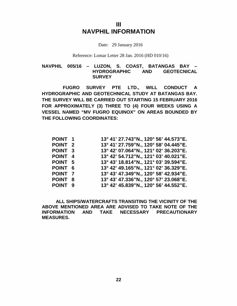
Date: 29 January 2016
Reference: Lomar Letter 28 Jan. 2016 (HD 010/16)
NAVPHIL 005/16 – LUZON, S. COAST, BATANGAS BAY –HYDROGRAPHIC AND GEOTECNICALSURVEY
FUGRO SURVEY PTE LTD., WILL CONDUCT A
HYDROGRAPHIC AND GEOTECHNICAL STUDY AT BATANGAS BAY.
THE SURVEY WILL BE CARRIED OUT STARTING 15 FEBRUARY 2016
FOR APPROXIMATELY (3) THREE TO (4) FOUR WEEKS USING A
VESSEL NAMED “MV FUGRO EQUINOX” ON AREAS BOUNDED BY
THE FOLLOWING COORDINATES:
POINT 1 13° 41’ 27.743”N., 120° 56’ 44.573”E.POINT 2 13° 41’ 27.759”N., 120° 58’ 04.445”E.POINT 3 13° 42’ 07.064”N., 121° 02’ 36.203”E.POINT 4 13° 42’ 54.712”N., 121° 03’ 40.021”E.POINT 5 13° 43’ 18.814”N., 121° 03’ 39.594”E.POINT 6 13° 42’ 49.165”N., 121° 02’ 36.329”E.POINT 7 13° 43’ 47.349”N., 120° 58’ 42.934”E.POINT 8 13° 43’ 47.336”N., 120° 57’ 23.068”E.POINT 9 13° 42’ 45.839”N., 120° 56’ 44.552”E.
ALL SHIPS/WATERCRAFTS TRANSITING THE VICINITY OF THEABOVE MENTIONED AREA ARE ADVISED TO TAKE NOTE OF THEINFORMATION AND TAKE NECESSARY PRECAUTIONARYMEASURES.
22

Intentionally left as blank
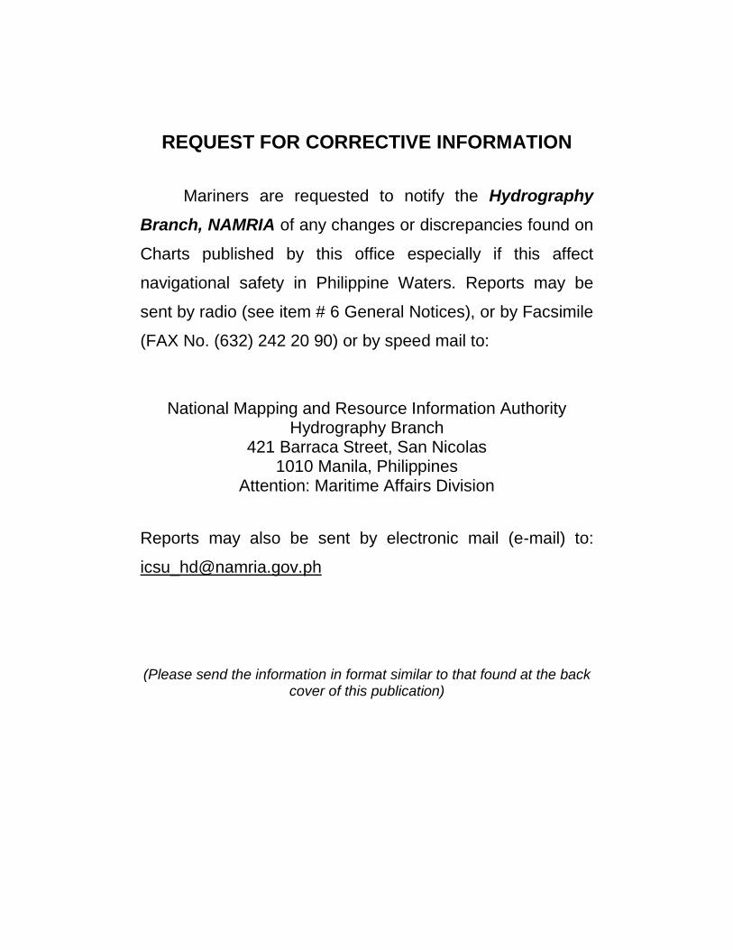
REQUEST FOR CORRECTIVE INFORMATION
Mariners are requested to notify the Hydrography
Branch, NAMRIA of any changes or discrepancies found on
Charts published by this office especially if this affect
navigational safety in Philippine Waters. Reports may be
sent by radio (see item # 6 General Notices), or by Facsimile
(FAX No. (632) 242 20 90) or by speed mail to:
National Mapping and Resource Information AuthorityHydrography Branch
421 Barraca Street, San Nicolas1010 Manila, Philippines
Attention: Maritime Affairs Division
Reports may also be sent by electronic mail (e-mail) to:
(Please send the information in format similar to that found at the backcover of this publication)
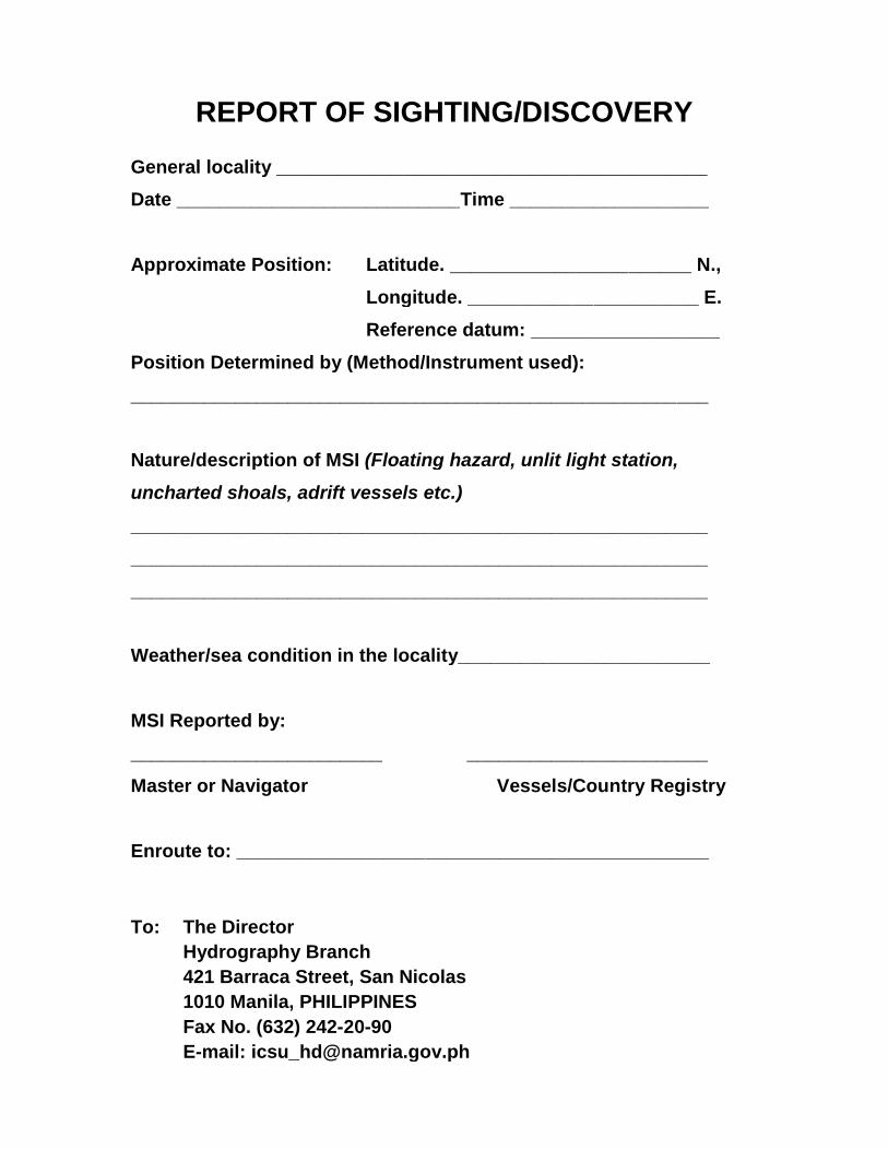
REPORT OF SIGHTING/DISCOVERY
General locality _________________________________________
Date ___________________________Time ___________________
Approximate Position: Latitude. _______________________ N.,
Longitude. ______________________ E.
Reference datum: __________________
Position Determined by (Method/Instrument used):
_______________________________________________________
Nature/description of MSI (Floating hazard, unlit light station,
uncharted shoals, adrift vessels etc.)
_______________________________________________________
_______________________________________________________
_______________________________________________________
Weather/sea condition in the locality________________________
MSI Reported by:
________________________ _______________________
Master or Navigator Vessels/Country Registry
Enroute to: _____________________________________________
To: The Director
Hydrography Branch
421 Barraca Street, San Nicolas
1010 Manila, PHILIPPINES
Fax No. (632) 242-20-90
E-mail: [email protected]