philippines: pearl of the orient seas · pdf filephilippines: pearl of the orient seas ......
TRANSCRIPT
I N T R O D U C T I O N T O P H I L I P P I N E G E O G R A P H Y
75
75
Philippines: Pearl of the Orient SeasBayang magiliw, perlas ng silanganan—says the first line of the Philippine National anthem. Sa dagat atbundok, sa simoy at sa langit mong bughaw, the same anthem aptly declares. Composed of more than7,000 islands and islets, the Philippines continue to “mesmerize” both local and foreign touristsalike. The beauty and splendor of this country is, indeed, second to none for the Filipino whoselove is unquestionably for his native land. Perhaps, such patriotism is best expressed with thisending of the Philippine national anthem: Ang mamatay ng dahil sa iyo.
The following article is lifted from lonelyplanet.com’s introduction of the Philippines:
he second-largest archipelago in the world, with over 7000 tropical islands, thePhilippines is one of the great treasures of Southeast Asia. Often overlooked by travelersbecause of its location on the ‘wrong’ side of the South China Sea, the Philippinesrewards those who go the extra distance to reach it. And because it’s off the beaten path,
the Philippines is a great place to escape the hordes who descend on other parts of SoutheastAsia. First and foremost, the Philippines is a place of natural wonders – a string of coral-fringedislands strewn across a vast expanse of the western Pacific. Below sea level, the Philippinesboasts some of the world’s best diving and snorkeling, including wreck diving and swimmingwith the whale sharks. Above sea level, it has a fantastic landscape with wonders enough tostagger even the most jaded traveler: the Chocolate Hills of Bohol, Banaue & the Rice Terracesand fascinating reminders of the islands’ history in places such as Samar & Leyte and Vigan.And if you’re after palm-fringed, white-sand beaches, try laidback Sipalay or flat-out party townBoracay.
Of course, any traveler who has been here will tell you that it’s the people and theirculture that makes the Philippines unique. Long poised at the centre of Southeast Asian trade,colonized by a succession of world powers, the Philippines is a vivid tapestry that reflects itsvaried cultural inheritance. And despite the poverty that afflicts much of the nation, the Filipinosthemselves are among the most ebullient and easygoing people anywhere. The Philippines trulyqualifies as one of the last great frontiers in Southeast Asian travel. Cross whichever ocean youneed to and see for yourself.
Chapter
7
T
I N T R O D U C T I O N T O P H I L I P P I N E G E O G R A P H Y
76
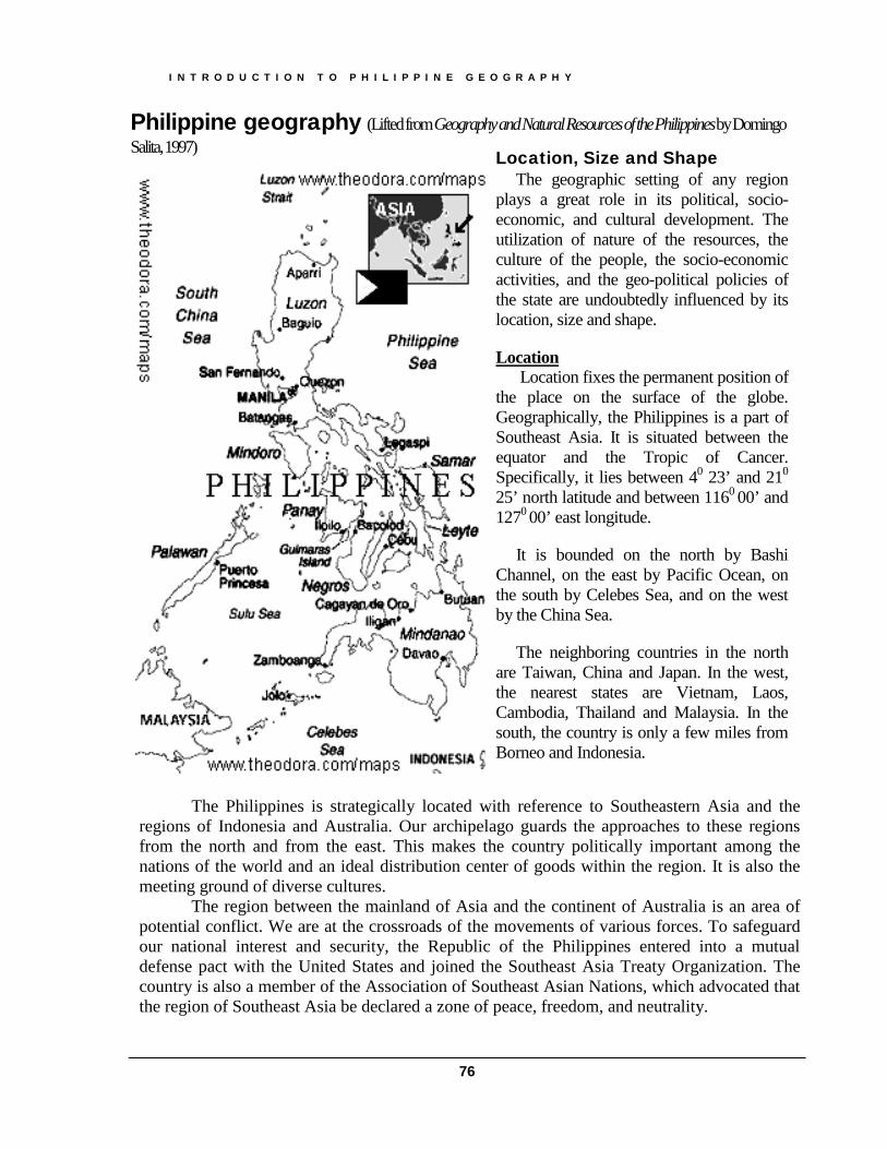
Philippine geography (Lifted fromGeography and Natural Resources of the Philippines by DomingoSalita,1997)
The Philippines is strategically located with reference to Southeastern Asia and theregions of Indonesia and Australia. Our archipelago guards the approaches to these regionsfrom the north and from the east. This makes the country politically important among thenations of the world and an ideal distribution center of goods within the region. It is also themeeting ground of diverse cultures.
The region between the mainland of Asia and the continent of Australia is an area ofpotential conflict. We are at the crossroads of the movements of various forces. To safeguardour national interest and security, the Republic of the Philippines entered into a mutualdefense pact with the United States and joined the Southeast Asia Treaty Organization. Thecountry is also a member of the Association of Southeast Asian Nations, which advocated thatthe region of Southeast Asia be declared a zone of peace, freedom, and neutrality.
Location, Size and ShapeThe geographic setting of any region
plays a great role in its political, socio-economic, and cultural development. Theutilization of nature of the resources, theculture of the people, the socio-economicactivities, and the geo-political policies ofthe state are undoubtedly influenced by itslocation, size and shape.
Location Location fixes the permanent position ofthe place on the surface of the globe.Geographically, the Philippines is a part ofSoutheast Asia. It is situated between theequator and the Tropic of Cancer.Specifically, it lies between 40 23’ and 210
25’ north latitude and between 1160 00’ and1270 00’ east longitude.
It is bounded on the north by BashiChannel, on the east by Pacific Ocean, onthe south by Celebes Sea, and on the westby the China Sea.
The neighboring countries in the northare Taiwan, China and Japan. In the west,the nearest states are Vietnam, Laos,Cambodia, Thailand and Malaysia. In thesouth, the country is only a few miles fromBorneo and Indonesia.
I N T R O D U C T I O N T O P H I L I P P I N E G E O G R A P H Y
77
The Philippines has a maritime or insular location. In this respect, it is similar to Japan.Insular location has an advantage over continental location in the sense that the insular statedoes not have a common land boundary with its neighbors. The common land boundary is asensitive spot where conflict of interest usually originates. It is partly because of this insularlocation that the Philippines is enjoying a comparatively peaceful relation with her neighbors.Our physical separation from the Asian mainland gives us a distinct security advantage. [Itshould be noted, however that the Philippines is also in conflict with its neighbors due to itsclaims in the Spratly’s or Kalayaan Islands].
Commercially, The Philippines lies on the major oceanic trade route and air laneplying between the United States and Asia. Culturally, it is the center of the blending of eastand west. By virtue of our location, we have contacts with the countries of Asia from whichmany of our customs, industries, writings, and words in the Philippine languages werederived.
The geographical location of the Philippines in the tropics is greatly responsible for theclimatic conditions prevailing in the country. The uniformly high temperature and abundantamount of rainfall that prevails in the archipelago have a direct bearing on our soil,agricultural, forest and water resources.
SizeSize is an important factor in evaluating the economic and political potentialities of a
state. Small countries are always handicapped by their limited land resources. The need foradequate space is not only necessary to support a large population but also to provide room forexpansion and development. [It should be noted however, that geographical size is not somuch significant in terms of its ability to develop or progress—take the case of Singapore forexample]
The combined land and water areas of the Philippines is about 1, 800, 000 km2 ofwhich the water areas comprise about five times the land areas. The Archipelago Doctrine isnow adopted in the new constitution of the Philippines as a basis in determining the inland andterritorial waters of the country.
The total land area of the Philippines, excluding Sabah, is 300, 000 km2 or 30, 000,000 hectares. It is about the size of Italy, slightly larger than the size of United Kingdom, butslightly smaller than Japan. It is composed of 7, 107 islands and islets of which only 2, 773 arenamed. Luzon and Mindanao are the two biggest islands, their combined area comprisingabout 70% of the total land area of the Philippines.
According to the classification of Valkenburg (1961), the Philippines is classified asLarge State [states whose areas are between 100, 000 to 500, 000 mi2]. Others are Pakistan,Japan, France, New Zealand, Italy. Other classifications are:
Gigantic—more than two million square miles [United States, China, Brazil] Very Large—with areas between 500, 000 to two million square miles [India,
Indonesia, Argentina, Mexico] Medium—with areas between 25, 000 to 100, 000 square miles [United Kingdom,
Cuba, Greece] Small—with areas between 10, 000 to 25, 000 square miles [Taiwan, Denmark,
Switzerland]

I N T R O D U C T I O N T O P H I L I P P I N E G E O G R A P H Y
78
Very Small—with areas between 1, 000 to 10, 000 square miles [Israel, Kuwait,Lebanon]
Miniature—with areas less than 1, 000 square miles [Bahrain, Vatican, Monaco]
ShapeThe shape of a country is another geographic element that has a bearing on its
economic, social and political development. Compactness and elongation represent the twoextremes in shape. The more compact the state is, the smaller is the ratio of its boundary inrelation to its area. France is a good example of a compact state since its shape approaches thatof a circle. On the other hand, Chile is a typical example of an elongated state since its lengthis many more times longer than its width.
For countries that have more than one unit, three classifications are used namely: Broken—where two or more segments are disconnected Fragmented—where there are numerous islands but the whole territory occupies a
definite are of the globe Scattered—where the various parts are found in different parts of the world.
Malaysia is an example for a broken shape for it is made up of three separateparts—Malaya, North Borneo, and Sarawak. Philippines is an example offragmented shape since it has so many islands all occupying a definite territory.The former British Empire which had territories in all parts of the world was anexample of scattered shape.
The Philippines is an elongated and fragmented state, as its parts are disconnected. Itappears on the map like broken beads of a rosary. From the economic, social, and politicalstandpoint, such shape of the Philippines is a disadvantage. Construction of a continuousnetwork of roads and railroads throughout the length and breadth of the country is a nearphysical impossibility. Thus, economic development cannot be accelerated in the absence ofgood means of transportation and communication. The problems of administration andsupervision as well as the implementation of governmental policies cannot be easily carriedout because of the physical division of the country. This is one factor that will favor thedecentralization of governmental administration.
Socially and politically, the country cannot easily achieve national unity and solidarity.The fragmentary nature of the country is mainly responsible for the regional thinking of theFilipinos. The existence of many tribal and ethnic groups is partly due to the archipelagiccharacter of the nation. This is also the reason why we have so many languages and dialectswhich hinders the realization of a national language.
In matters of security, the numerous islands and the long coastline make it difficult todefend the country against foreign invasion. Likewise, the apprehension of smugglers and theprevention of illegal entry of aliens have become a major problem of the country due to thepresence of many landing beaches in many parts of the archipelago.
On the other hand, a long coastline has its advantage. It provides good fishing grounds,fine harbors, and milder climate due to the existence of land and sea breezes. As to date, thePhilippine Government has constructed the Pan Philippine Highway, which starts from Aparri,

I N T R O D U C T I O N T O P H I L I P P I N E G E O G R A P H Y
79
Cagayan to Zambangoa City in Mindanao. Two ferry services are made—between Luzon andVisayas and the other between Visayas and Mindanao.
LAND FORMSThe plains, plateaus and mountains are the major topographic features of the
Philippines, which in varying combination make up the landforms of the country. Landformsprovide the permanent backdrop against which the economic, social and political history of thecountry is enacted.
Salient Physiographic/Topographic Features of the Philippines:
The irregular configuration of the Archipelago and its fragmentary characterconsisting of about 7, 107 islands and islets;
The mountainous character of the islands running on a general north to south trendand in close proximity to the coastline;
The great extent of the coastline reaching a total of 17, 640 kilometers, which is twiceas long as that of the United States;
Sulu Sea which lies between Palawan and Mindanao is the largest internal body ofwater of the country;
The structural plains lying between mountain systems and the narrow an interruptedcoastal plains;
The few large rivers and many streams which are very short and swift, that descend tothe sea;
The great variety of lakes that are diverse origin of which Laguna de Bay being thelargest;
The big number of active, dormant, and extinct volcanoes, among which TaalVolcano has the most violent eruptions;
The presence of coral reefs fringing the shores of most the islands, and many islets aremade up of corals; and
The vast extent of the territorial waters within the international treaty limits whichcomprises more than five times the land area.
The nature of the landforms of the Philippines is such that cultivable lands are foundin all part of the country. There is no province that does not have any suitable agriculturalland. It is, however, noted that although the highlands are not rugged, the level lands of thecountry are not extensive. This is a handicap in mechanized agriculture.
Starting from Northern Luzon, the western side is occupied by the Ilocos Coastal plainflanked in the east by the Central Cordillera. Cagayan Valley lies between the CentralCordillera and the Sierra Madre Mountains that extend to the shores of the Pacific Ocean. InCentral Luzon, the western margin is occupied by the Zambales Mountain system, then by the
Central Plain; in the east is a continuation of the Sierra Madre. Southern Luzon has adiverse topography of volcanic upland, lake regions and plain areas. Plain areas for agriculture
I N T R O D U C T I O N T O P H I L I P P I N E G E O G R A P H Y
80
are available in both Southwestern Luzon and the Bicol region. The Bicol plain is the mostextensive level land of Southeastern Luzon.
In the Visayas, the islands have mountainous cores. The arable lands are found alongthe coasts, although some interior plains are found in Panay and Leyte. The sugar lands ofNegros may be considered as both coastal and interior plains.
Mindanao offers a complex topography. There are three principal mountain ranges: (1)the mountain ranges which form the backbone of Zamboanga Peninsula and MisamisOccidental; (2) the Central Highland extending from north to south following the westernboundary of Agusan and Davao where Mt. Apo is located; and (3) the Diwata Mountains inthe east following the coast. The Lanao-Bukidnon plateau and the Tiruray tableland are theprincipal plateaus while the Cotabato Valley and Agusan-Davao Lowland are the principalplains. The coastal plains throughout Mindanao are also suitable and are centers ofsettlements.
Origin of the Philippine Landforms
The present landforms of the Philippines have come about through the complexprocess of diastrophism, vulcanism and gradation. These landforms are very much interrelatedwith origin of the Archipelago itself. The occurrence of tectonic earthquake is an effect ofdiastrophism. The formation of elongated mountains such as the Sierra Madre and theCordillera is caused by diastrophism while the conical peaks are the result of vulcanism. Mt.Apo, Mayon Volcano and Kanlaon Volcano are examples of volcanic mountains. The erosionof the highlands and the consequent deposition of the sediments at the oceanic basin comprisethe process of gradation. It is gradation that generally causes the formation of minorlandforms, such as rivers, valley, lakes, deltas, hills, rapids, and falls. The deltas formed byPasig River and Pampanga River as they enter Manila Bay are the results of gradation process.
The location of Philippines on the western margin of the Pacific Ocean, which iscomparatively unstable segment of the earth’s crust may help explain the pattern of landformdevelopment. The entire margin of the Pacific Basin from Kamchatka to Japan,Taiwan,Philippines, Indonesia, and New Zealand owes much of its development to the action of theforces of folding, faulting, and volcanic activity. This region has been called by manygeologists as the “girdle of fire” or “ring of fire” because it is a region of the frequent volcanicactivity.
Destructive Earthquakes in the Philippines
1968 August 02-- Ms7.3 -- Casiguran Earthquake1973 March 17-- Ms7.0 -- Ragay Gulf Earthquake1976 August 17-- Ms7.9 -- Moro Gulf Earthquake1983 August 17-- Ms6.5 -- Laoag Earthquake1990 February 08 -- Ms6.8 -- Bohol Earthquake1990 June 14 -- Ms7.1 -- Panay Earthquake1990 July 16 -- Ms7.9 -- Luzon Earthquake1994 November 15 -- Ms7.1 -- Mindoro Earthquake

I N T R O D U C T I O N T O P H I L I P P I N E G E O G R A P H Y
81
1996 May 27-- Ms5.6 -- Bohol Earthquake1999 June 07-- Ms5.1 -- Bayugan Earthquake2002 March 06 -- Ms6.8 -- Palimbang Earthquake2003 February 15 -- Ms6.2 -- Masbate Earthquake
Some Active Volcanoes in the Philippines
Name of Volcano Province Elevation(Km)
No. ofHistoricalEruptions
LatestEruption/Activity
Babuyan Claro Cagayan (BabuyanIslands) 0.843 4 1917
Banahaw Laguna, Quezon 2.169 3 1843
Bulusan Sorsogon 1.565 16 2006 March 21- June28
Cagua Cagayan 1.160 2 1907Camiguin deBabuyanes
Cagayan (BabuyanIslans) 0.712 1 1857
Didicas Cagayan (BabuyanIslands) 0.228 6 1978 Jan. 6-9
Hibok-Hibok Camiguin 1.332 5 1948 Sept. 31 - 1953July
Iraya Batanes 1.009 1 1454Iriga Camarines Sur 1.143 2 1642 Jan. 4Kanlaon Negros Oriental 2.435 26 2006 June 3-July 25
Makaturing Lanao del Sur 1.908 7 1882
Matutum Cotabato 2.286 1 1911 March 07
Mayon Albay 2.460 48 2006 July 14 (on-going)
PinatuboBoundaries ofPampanga, Tarlacand Zambales
1.445 2 1992 July 09 -August 16
Ragang Cotabato 2.815 7 1916 July
Smith Cagayan (BabuyanIslands) 0.688 5 1924
Taal Batangas 0.311 33 1977 Oct. 3
I N T R O D U C T I O N T O P H I L I P P I N E G E O G R A P H Y
82
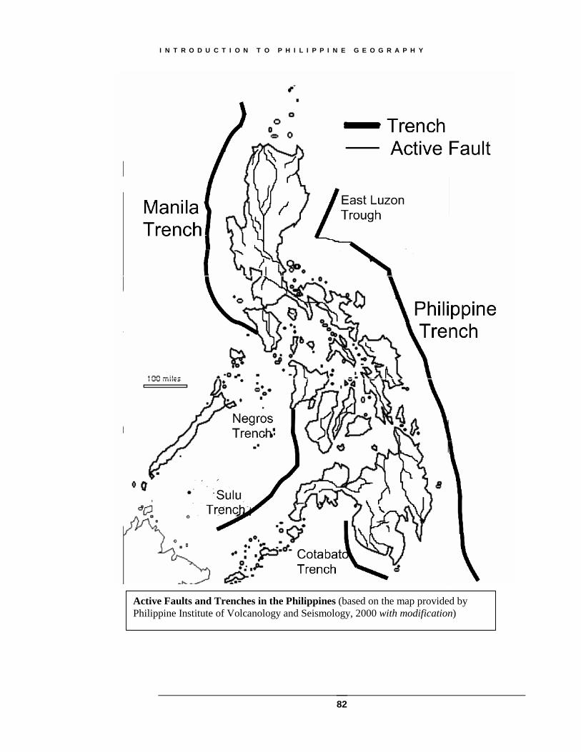
Active Faults and Trenches in the Philippines (based on the map provided byPhilippine Institute of Volcanology and Seismology, 2000 with modification)

I N T R O D U C T I O N T O P H I L I P P I N E G E O G R A P H Y
83
Philippine Volcanoes (as of 1997)

I N T R O D U C T I O N T O P H I L I P P I N E G E O G R A P H Y
84
The Pacific Theory
A study of the nature of the rocks beneath the ocean and the volcanic character of thearchipelago made Dr. Bailey Willis conclude that the Philippines was formed through themarginal and peripheral eruptions of the Pacific Basin. The eruptions of the submarinevolcanoes during the remote geologic past and the piling up of their extrusives caused theemergence of the islands above the sea, giving rise to the Philippine Archipelago.
The Asiatic Theory
A more rational theory holds view that the Philippines was once a part of the continentalshelf of Asia. Dr. Leopoldo Faustino (1928) stated that:
The present land areas of the Philippines are merely the higher portions of a partlysubmerged mountain mass…The outline of the Archipelago was first marked at theclose of the Paleozoic Era during the Permian Revolution when a movement of theAsiatic land mass to the south caused the China Sea depression and crumpled theedge of the continental platform. In other words the Philippine Islands formed thebarrier that separated the waters of the Pacific Ocean from the waters of the presentChina Sea.
The Permian Revolution referred to above is an important event in geologic history,which took place some 200 million years ago. It was characterized by a worldwide mountain-building movement. It was during this period that the outline of the Philippines was believedto have been brought for the first time above sea level.
Landforms and Economic Development
Plains, under proper climatic conditions, provide the most favorable sites for economicand social progress. Plains are the lowlands of a continent. History tells us that the cradles ofancient civilization started in the delta of the Nile River and in the valleys of Tigris-EuphratesRivers. These places were fertile, and the rivers provided not only natural irrigation but alsothe highways for transportation and commerce. Due to the advantages plains offer forsettlement and agricultural development, the greater bulk of the world’s population areconcentrated in the lowlands.
This situation is also true in the Philippines where the plains are better developed andthickly populated. And such situation will remain to be true even after the country has attainedagro-industrial economy. This is expected because manufacturing industries are generally builton plains where the ease of transportation facilitates the bringing of raw materials to thefactories as well as the distribution of finished products to the consumers.
From the standpoint of agricultural development, the topography of the land is themost important factor that limits its productivity. Slope, which is an element of landform, is acritical factor. Where the slope is steep, the area becomes unfit for agriculture. Soil erosionproceeds at a faster rate since the topsoil, which is rich in humus, is easily eroded and the soilbecomes unproductive. This is true in the Philippines.
I N T R O D U C T I O N T O P H I L I P P I N E G E O G R A P H Y
85
Considering the country’s landform and climate, giving the allowance for settlement,and industrial and commercial purposes, it is estimated that about 45 percent of the land areaof the Philippines is suitable for cultivation. Comparing it with Japan, it is significant to notethat only 16 percent of the total land area of Japan is arable. It is reasonable then to state thatthe landforms of the country as a whole is favorable for economic development. There are novery high mountains and very steep slopes in the country. However, the drawback is that thelevel lands are not extensive enough which could be a handicap in mechanized farming.
CLIMATE OF THE PHILIPPINES
Life of man is related to climate in several ways. It influences the kind of crops that hecan raise, the kind of clothing that he will wear, and the kind of shelter that he may build.Climate is one of the factors that affect the vitality, energy, and attitudes of man.
WEATHER & CLIMATIC ELEMENTS
To understand the climate of the Philippines, which is comparable to that of CentralAmerica, it is important to understand the elements of weather and climate. Weather is thecondition of the atmosphere at a given time and place. This condition is temporary in nature. It maylast for a few minutes, hours or days only. It is expressed by a combination of several elements,primarily (a) temperature; (b) humidity; (c) precipitation; (d) pressure and (e) winds. Climateon the other hand, is a generalization of day-to-day weather conditions taken over a longer period oftime. Climate is permanent in character.
Temperature
Based on the average from all weather stations in the Philippines taken for a period of15 years, excluding those from Baguio and Silang, Cavite, the coolest month falls in Januarywith a mean temperature of 25.4 degrees Celsius when it is winter in the northern hemispherewhile the warmest month occurs in May with a mean temperature of 28.1 degrees Celsius.Accordingly, using the temperature and rainfall as the basis, the climate of the country isdivided into three seasons: hot dry season from March to May; rainy season from June toNovember; and the cool dry season from December to February.
Owing to the insular nature of the Philippines, the sea and land breezes make thetemperature of the country quite agreeable With the exception of April and May, the nights arecomparatively cool throughout the year.
Case in point: Baguio, with an elevation of about 1, 500 meters, has an average annualtemperature of 17.9 degrees Celsius, which is 9 degrees Celsius cooler than theneighboring lowland city of San Fernando, La Union. This makes the temperature ofBaguio comparable with that of a temperate climate. Because of its invigoratingclimate, Baguio was made the “Summer Capital of the Philippines”. This mean annualtemperature of 17.6 degrees Celsius is very close to the optimum temperature of 18degrees Celsius Dr. Huntington, in his Principles of Human Geography calledattention to the fact that people’s health and strength are greatest when the
I N T R O D U C T I O N T O P H I L I P P I N E G E O G R A P H Y
86
thermometer drops to 14 degrees Celsius to 16 degrees Celsius at night, and rises to 21degrees Celsius or 24 degrees Celsius by day, the average being 18 degrees Celsius.Man can work more efficiently under this temperature.
Humidity
Humidity refers to the moisture content of the atmosphere. When the temperature iswarm and the place is near bodies of water, more moisture is evaporated to the clouds. Thewarmer the air the more moisture it can hold and when it is fully saturated, we say that therelative humidity is 100%. Relative Humidity is the ratio of the actual moisture content of theatmosphere to that which it can hold to be saturated at the same temperature.
The conditions of humidity have much to do with comfort and health as do temperatureand winds. When the weather is warm and the humidity is high, the rate of evaporation fromthe human body is retarded, thus increasing the sensible temperature. With high temperatureand high humidity, one perspires with the slightest exertion, making the body uncomfortable.In the Philippines, the annual mean relative humidity varies from 76.7% to 85.7%. Baguio hasthe highest annual mean of 85.6%, while the stations with the least annual mean relativehumidity are Dagupan, Manila Vigan and Cebu.
Rainfall/Precipitation
Rainfall is more important in the Philippines as a climatic element that temperature.Rainfall distribution throughout the country varies from one region to another due totopography and the wind systems.
During the cool months, the rains in the Philippines are mainly due to the northeasterlyair currents, which come directly from the Pacific Ocean causing rainfall over the eastern partof the archipelago. These are the so-called northeast-monsoon rains.
From January to May, rainfall is heaviest in the eastern part of the country, withprecipitation mostly concentrated on southeastern Samar and the northeastern Mindanao.From June to September, the rains are more abundant in the western part, August being thewettest month. This is due to the effects of the southwesterly winds and the influence oftyphoons. From October to December, rainfall concentration shifts again to the eastern portionof the country. Based on records, it was observed that the wettest months in the country wasfrom July to August. It is for this reason why a proposal was made to make July and August thvacation months and start the school calendar in September of every year. On the other hand,March, April, May are the driest months of the country.
Based on the distribution of rainfall, four climatic types are recognized.
Type 1. Two pronounced wet and dry seasons; wet during the months of June toNovember and dry from December to May. This type of climate is found in thewestern part of Luzon, Mindoro, Palawan, Panay and Negros. These regions areshielded from the northeast monsoon and even in good part from the trade winds ofhigh mountain ranges, but are open to southwest monsoon and cyclonic storms.

I N T R O D U C T I O N T O P H I L I P P I N E G E O G R A P H Y
87
Type 2. No dry season with a very pronounced maximum rain period in December,January and February. Catanduanes, Sorsogon, eastern part of Albay, CamarinesNorte, Camarines Sur, eastern Quezon, Samar, Leyte and eastern Mindanao have thistype. [Note: The tragic death caused by continuous rains and consequent landslides inLeyte last December 2003]
Type 3. This is an intermediate type with no pronounced maximum rain period and ashort dry season lasting from one to three months only. Areas under this type are thewestern parts of the Cagayan Valley, the eastern part of the Mountain region, southernQuezon, Masbate, Romblon, northeastern Panay, eastern Negros, central and southernCebu, eastern Palawan and northern Mindanao. These localities are only partlysheltered from the northeasterly and trade winds and are open to the southwestmonsoon or at least to frequent cyclonic storms.
Type 4. Uniformly distributed rainfall. The regions affected by this type are theBatanes, northeastern Luzon, southwestern part of Camarines Norte, western parts ofCamarines Sur and Albay, eastern Mindoro, Marinduque, western Leyte, northernCebu, Bohol and most of central, eastern and southern Mindanao. These regions are sosituated that they are open to the northeasterly and trade winds as well as the southwestmonsoon and the cyclonic storms.
Pressure and Winds
The existence of winds is dependent on the difference in pressure, which in turn iscaused by the difference in temperature. Wind moves from high pressure to low pressureareas. The higher the difference the greater is the velocity of the wind. Thus, a fallingbarometer is to be taken as sign of an approaching storm but if the pressure starts increasinggradually, it marks the coming of a fair weather.
Pressure and winds exert a profound effect on the temperature and precipitation. Aminor change in pressure may cause a change in the velocity and direction of the wind. Achange in movement of the wind may produce changes in temperature, which may in turnaffect precipitation. Such a succession of events may produce a variety in weather and climaticconditions.
In the Philippines, there are three important air movements: (a) trade winds, (b)southwest monsoon (habagat), and (c) northeast monsoon (amihan).
The trade winds originate in the high pressure area of the eastern north Pacific Ocean.After crossing the vast expanse of the Pacific in a westerly direction, it reaches the Philippinesfrom the northeast or east direction, depending upon the existence of a low pressure area. Thisis the wind that predominates during the months of February to May, which are periods of dryseason in many parts of the country. Although this wind system comes from the eastern NorthPacific Ocean, it is the least moist of the three streams.

I N T R O D U C T I O N T O P H I L I P P I N E G E O G R A P H Y
88
Climate map of the Philippines.(Source: http://sabinefabris.girlshopes.com/climatemapofthephilippines/)
I N T R O D U C T I O N T O P H I L I P P I N E G E O G R A P H Y
89
The southwest monsoon is the deflected southeast trades of the southern hemisphere.AS the southeast trades cross the equator, they are due to the rotation of the earth, deflected tothe right thus approaching the Philippines form the southwest quadrant. This monsoon blowsfrom May to October when it is winter for part of the time in the southern hemisphere. Thestream gathers enough moisture from the sea and, due to the warm temperature at eth equator,the active convectional movements carry the moisture upward to great heights, causing strongwinds and rains.
The northeast monsoon, which is often times called the “northerns”, blows during themonths of November to February. This is the period when it is winter in the northernhemisphere. High pressure areas develop in Siberia and Manchuria and, due to the rotation ofthe earth, the wind system approaches the Philippines ina northeasterly direction. This gives usour coldest temperature throughout the country.
Typhoons
Typhoons frequently visit the Philippines. Typhoons originate from the intertropicalconvergence zone (ITCZ)—the meeting of place of the northerns and southwestern monsoonwhose position passes between Mindanao and Luzon. They specifically originate from theregion of the Marianas and Caroline Islands of the Pacific Ocean. These typhoons areclassified as (a) destructive—a natural hazard that occur in any place traversed by thecyclonic center, causing great damage to life and property. The (b) ordinary is one that doesnot cause much damage and is looked upon as a blessing because it brings with it cloudiness,rainfall, and a reduction in temperature.
The Philippine Atmospheric, Geophysical and Astronomical Services Administration(PAGASA), sends out warnings or typhoon signals.
Public Storm Signal No. 1—indicates that wind velocity of from 50 to 60 km/hr andis expected in the locality within 24 hours.
Public Storm Signal No. 2—means that winds with a velocity of from 61 to 100km/hr may be expected in the locality within 24 hours.
Public Storm Signal No. 3—indicates that winds with a velocity of from 101 to 185km/hr may be expected in the locality within the next 12 hours.
Public Storm Signal No. 4—has a wind velocity of 185 km/hr or more. Strong windsaccompanied by heavy rains pose a great danger to life and property.
Tropical cyclones/typhoons that caused most deaths in the Philippines
Tropical Storm Uring [Thelma] of 1991 -- 5,080 deaths Typhoon Nitang [Ike] of 1984 -- 1,029 deaths Typhoon [Trix] of 1952 – 995 deaths Typhoon [Amy] of 1951 – 991 deaths Typhoon Rosing [Angela] of 1995 – 936 deaths

I N T R O D U C T I O N T O P H I L I P P I N E G E O G R A P H Y
90
Climate and Economic Development
A study of the highly developed countries of the world particularly the United States,Great Britain, Germany, Belgium Sweden and Japan reveals that these countries are located inthe temperate regions. It was once asserted that only in temperate climates do people have thenecessary energy to work hard and produce, to acquire new knowledge and advance theireconomic condition. On the other hand, climate in the tropics was said to sap the energy of theinhabitants so that physical tasks are postponed and mental effort avoided. This study now isdiscredited. The climate simply influences the activities of man, but it is man who decides anddetermines the progress of a nation.
The modern view is that a tropical environment does not challenge man to give hisbest. Life is comparatively easy. Plants for food are grown abundantly without much effort.The soil can be made to yield crops throughout the year. Since there are no winter seasons,clothing and shelter is minimal. It is then outside the tropics, where there are winter seasonsand shortages of water supply that man was forced to prepare himself for these difficulties.
From the standpoint of human activity, the climate in the Philippines is reasonablyfavorable for socio-economic development. A book entitled, The Commonwealth of thePhilippines, described the climate in the Philippines as the most healthful and comfortable ofany portion of the tropics inhabited by man. The enormous amount of rainfall and presence ofenormous moisture, properly conserved and utilized, will increase the agricultural output ofthe country. And with the use of irrigation systems and better quality of seeds and cropcombinations, an efficient system of farm management can be evolved.
For industrial development, the abundance of rainfall has given us good sources forwater power. In the absence of commercial natural oil, we have to turn to our hydro-electricplants for generating cheap electricity.
NATURAL RESOURCES OF THE PHILIPPINESFundamental law on Natural Resources. Article XII of the 1987 Philippine Constitution,entitled The National Economy and Patrimony provides for the exploration, development andutilization of natural resources in the country.
The Bureau of Forest Development is entrusted by law to classify lands of the PublicDomain into timberland and agricultural land. Until the land is classified as agricultural land,the Bureau of Lands cannot alienate or dispose such land. If the land is found to be morevaluable for mining purposes than for either timber or farming, then the land will be classifiedas mineral land. The Bureau of Mines is directly responsible in the administration anddisposition of the mineral lands of the country.
Classification Natural Resources
From the scientific standpoint, the natural resources of the country may be classifiedinto: waters, soils, forests, minerals and fishery resources. Agricultural resources such as

I N T R O D U C T I O N T O P H I L I P P I N E G E O G R A P H Y
91
crops, livestock and cultured fisheries are strictly speaking not part of the natural resourcessince they are the results of the industry of man. Natural resources may also be classified asinexhaustible, renewable, or non-renewable. Inexhaustible are those that are not destroyed likewater. Forestry, fishery and wildlife are the renewable resources. Minerals like coal and oil arenon-renewable because once they are consumed, they are gone forever.
Water Resources. The Philippines has numerous rivers of various significance. In Luzon,Cagayan and Agno rivers are the most outstanding. Cagayan River—the longest in thePhilippines, has made Cagayan Valley very fertile, and the richest tobacco-growing region inthe country. The Agno River has been developed for hydroelectric power. In Mindanao, theAgusan River and Rio Grande de Mindanao are of prime importance in the region.
Besides rivers, the Philippines has also numerous lakes. The most important lakes areLaguna de Bay, Lake Bombon, Lake Mainit and Lake Lanao.
Soil Resources
Classification of Soils
1. Alluvial Soils. These are the best agricultural soils of the country as they are the mostfertile. These soils have been formed through the agency of water. Materials arederived from the highlands and brought down to the plains and valleys througherosion. These may be of fine or coarse textures. Fine alluvial soil is found in theCentral Plain of Luzon, Cagayan Valley, Panay Plain and plains of Rio de Mindanao.This soil is conducive for rice growing. Coarse alluvial soil is found in Pampanga,Tarlac, Negros Occidental and Iloilo. Sugarcane grows well in these regions.
2. Shales and Sandstone Soils. These are soil derived from the weathering of twosedimentary rocks—shale and sandstone. Shale soil is clayey, which is often darkbrown, plastic and sticky. When dry, it is hardened and is difficult to plow. Sandstoneis sandy and permeable. This soil is found in eastern Ilocos, south of Quezon, a portionof Bicol, Samar Masbate, Bohol and Surigao. Generally, this soil is good for rice,tobacco, corn and sugarcane but not as good as alluvial.
3. Limestone Soils. This soil is found in many parts of the country from Northern Luzonto Sulu. Most of the small islands are made of coralline limestone. This soil is rich incalcium. This soil is found in Batanes, Mountain Province, Rizal, Quezon, Masbate,Romblon, Samar, bohol, Cebu, Negros and Panay. Cultivated limestone soils areplanted with corn, coconut, citrus, cassava and bananas. Limestone easily erodes,hence, this soil is better adopted for pasture lands and orchards rather than for farmcrops.
4. Andesite and Basalt Soils. These are fine grained igneous rocks, which are derivedfrom volcanic extrusion. These are found most in uplands like Mountain Province,Zambales, Bataan, Palawan, Bukidonon, Lanao and Basilan. Process of weathering isslow for this soil since basalt is a hard rock. Soil is generally shallow and of lowfertility.

I N T R O D U C T I O N T O P H I L I P P I N E G E O G R A P H Y
92
5. Mountain Soils. These are found in mountainous regions. This soil is not yet well-studied since it is difficult to access thick forests. This soil abounds in Cordillera,Sierra Madre. It cannot be utilized for farming purposes.
Forests Resources
Forest Types
1. Dipterocarp. This is a variety of the tropical rain forest and it grows well where rainfallis consistent and high. This forest produces much of lumber. Apitong, Yakal areexamples of trees found in this forest.
2. Molave. This is common in the western part of the Philippines where there is a distinctwet and dry season. Principal varieties under this type are narra, ipil and molave.Lumbers of these trees are highly valued for cabinet and furniture works.
3. Pine. This type occupies the mountain regions of Northern Luzon and Mindoro.4. Mangrove. This type is found along the coastal area of the mouths of streams and on
the shores of protected bays. Trees of this type are used for light construction, fuel andmanufacture of charcoal. Nipa palm is the common type of tree found in this forest.
5. Beach. This is found in sandy beaches in many shores of the country. It is of littlecommercial value.
6. Mossy. This is a protected forest that helps conserve water resources and prevent soilerosion. It is found in high rugged mountains, which are quite inaccessible. It is asanctuary for wild life.
Philippine Geographic RegionsA geographic region is an area in which there is some conspicuous unity in the
expression of the natural and cultural setting. The essential unity may rest primarily uponlandforms or a combination with climate, soils, vegetation and culture of the inhabitants. Thesixteen regions of the Philippines are divided according to major island groups, landform andlocation of the provinces. The country is divided into: National Capital Region (NCR);Cordillera Administrative Region (CAR); Region I (Ilocos); Region 2 (Cagayan VAlley);Region 3 (Central Luzon); Region 4a and 4b (Southern Tagalog); Region 5 (Bicol); Region 6(Western Visayas); Region 7 (Central Visayas); Region 8 (Eastern Visayas); Region9(Western Mindanao); Region 10 (Northern Mindanao); Region 11(Southern Mindanao); andRegion 12 (Central Mindanao); Autonomous Region of Muslim Mindanao (ARMM); and theRegion of Caraga.

I N T R O D U C T I O N T O P H I L I P P I N E G E O G R A P H Y
93
DESCRIPTION OF THE GEOGRAPHIC REGIONS OF THE PHILIPPINES
National Capital Region (NCR)—Window to the WorldLocation: Along the flat, alluvial delta of the Pasig River (Luzon)Topography: Sixty percent of the region is non-agricultural in nature.Climate: NCR experiences two pronounced seasons; dry (January–May) and rainy (rest of theyear)Economy: The economy of the NCR is anchored in Manila, the country’s capital. NCR is theheart of the nation’s financial, commercial, industrial, political and cultural activities. ManilaBay is the country’s finest and busiest due to international and domestic trade.
Cordillera Administrative Region (CAR)—Home of the IgorotsLocation: Landlocked administrative body in North-Central LuzonTopography: The region is traversed on all sides by the Grand Cordillera Range, amountainous chain, which rises abruptly from the sea at Cagayan and Ilocos Norte and runstowards Mt. Pulag in Benguet. Only a fraction is falt agricultural land. Cordillera is thewatershed of Luzon, having a system of rivers that can provide irrigation and could generateenergy.Climate: Precipitation is extreme: there are 8-9 months of moderate-to-heavy rainseverywhere. Temperatures can drop to almost freezing point, and frost is common.Economy: CAR is a treasure house of precious and industrial minerals, including gold, silverand copper. Abra and Kalinga sit on large reserves of gold and copper. Agriculture remains asthe region’s main livelihood. Benguet produces large quantity of vegetables and cut-flowers.
Ilocos Region—Tobacco CapitalLocation: A land with a narrow coastal strip that stretches from Lingayen Gulf to CapeBoreador in the North. It faces the South China Sea in the west and Malaya range in the eastTopography: The region resembles a slim, elongated hook in the western rib of Luzon. Theeastern part is hilly and mountainous; while the western part is a flatland stretching from thenorth down to the province of Pangasinan. The coasts lack good harbors and the shoreline isshallow and the bays are unprotected.Climate: In general, warm weather prevails in most parts of the region, although it has rainyseasons.Economy: Farming remains the principal livelihood. People are engaged in livestock andpractice crop diversification. They are also into weaving and pottery. Tobacco is the majorcommercial crop. The region also boasts of its vast fishery resources and salt-industry.
Cagayan Valley—Where the Mighty River FlowsLocation: It is at the northeastern portion of LuzonTopography: Cagayan Valley has a depressed central portion where mountain streams flowdirectly into the Cagayan River, the longest river in the country. The region has over 890kilometers of coastline and rich fishing grounds. About 50% of the regional land mass isagricultural. 40% is forestlands.

I N T R O D U C T I O N T O P H I L I P P I N E G E O G R A P H Y
94
Climate: It is relatively dry from November to April, and wet for the rest of the year, exceptfor Batanes, which is practically wet the whole year round.Economy: It produces rice, corn, and bulbs like garlic, onion and ginger. Tobacco is the majorcash crop. Rattan basketry, which is endemic to Nueva Viscaya, is another profitablelivelihood activity. The region also produces native soft brooms that are sold in NCR markets.Isabel used to be a leader in wood industry but it has declined over the years due to log ban inthe region.
Central Luzon—Rice Granary of the PhilippinesLocation: This region lies midway the northern and southern tips of Luzon. West of the regionis China SeaTopography: It has a diverse topography. The agricultural plains are vast and fertile, plantedmostly with rice. It has also virgin forests and mountains that yield precious ore and mineralresources. Its western portion features a coastal area that stretches from the Bataan Peninsula,to Pampanga and to Bulacan. Its active volcano, Mt. Pinatubo has changed the region’slandscape since it erupted in 1991.Climate: The region has two pronounced seasons; dry (November-April) and rainy (May-October), except in Nueva Ecija, where it rains almost all year round.Economy: It is one of the most progressive regions in the country. This progress may be partlyattributed to the former U.S. military bases of Subic and Clark, which have been convertedinto free port investment sites. Bataan houses the country’s major export processing zones.Zambales is the major producer of chromite and other forest products. Nueva Ecija and Tarlacare the main rice producers. Pampanga and Tarlac are also a major producer of sugarcane.Fishpond culture also flourishes in Bulacan and Pampanga.
Southern Tagalog—The Philippines Premiere RegionLocation: It is located along the southwestern portion of Luzon.Topography: This region is the country’s largest region. Southern Tagalog has varied terrain—from rolling hills and valleys, to plains and mountain ranges. It is one of the most progressiveregions in the country. It surrounded by large bodies of water.Climate: Several coastal towns particularly those in Marinduque, Occidental Mindoro,Oriental Mindoro and Romblon are within the typhoon belt.Economy: The region’ stepping stone to progress is the CALABARZON—Cavite, Laguna,Batangas, Rizal and Quezon for in this zone, some of the world’s industrial leaders haveestablished their businesses in this area. Also, it attributes its development to its rich metallicand non-metallic mineral resources, like the 148-million metric ton marble reserves ofRomblon. Palawa is also noted for its offshore oil deposits. It also boasts of its fresh waterresources and fishing grounds.
Bicol Region—Land of the VolcanoesLocation: The peninsula forming the southeastern extremity of Luzon, with some other islandscomprise the Bicol region.

I N T R O D U C T I O N T O P H I L I P P I N E G E O G R A P H Y
95
Topography: Bicol’s irregular terrain ranges from slightly undulating hills to rollingmountains. It has many volcanoes, the most famous of which is Mt. Mayon. The region hasalso embayed coastal areas. Its natural harbors give refuge to ships during bad weather.Climate: Three climate types exist in this region: the absence of dry season in the eastern coastfacing the Pacific; long rainy season and very short dry season in the western coast andmainland Masbate; and an even distribution of rainfall throughout the rest of the region,disrupted only by typhoons.Economy: Abaca is the region’s economic base. Bicol has also generated revenues fromcoconut growing, gold mining, and cottage industries. The region is developing its metallicand non-metallic mineral resources, which are ideal for finished and semi-processed industrialproduction. Bicolandia also pins its hopes on tourism industry.
Western Visayas—The Sugar CapitalLocation: This region is a part of an island group that occupies the central past of thearchipelago. It is bounded by Visayan Sea in the north, Sulu Sea in the west, Bohol Sea in theeast, and Zamboanga Peninsula in the south.Topography: The region’s terrain is dominated by a chain of mountains that extend from northto south of the Panay island. In the middle of this chain are low ridges that run northeast anddivide the Panay island into three. The Guimaras is a coral-limestone island. NegrosOccidental’s coastal area is rimmed with corral reefs and shoals and dotted by mangroveswamps, and rocky beaches. Numerous rivers and streams flow through the island.Climate: Climate changes are extremely variable in Western Visayas, due to its precariouslocation in the monsoon belt. Areas exposed to northern and northeastern wind-flows receivemore rain than the sheltered south-central areas.Economy: In the 1970’s, Western Visayas was to be known as the country’s sugar capital.After surviving the economic crisis in 1984, the region is going full gear into agro-industrialization. It is also pursuing alternative industries like prawn farming, rice production,food processing and ethanol production. Among these, prawn culture is a top earner.
Central Visayas—The Perennial Trade HubLocation: Central Visayas span on both sides the belt of the Philippine Archipelago, betweenthe major Islands of Luzon and Mindanao. At the center is Cebu. The region is surrounded bythe Bohol Strait and the Tañon Strait, which separate the island provinces from one another.Topography: The region is characterized by interior highlands punctuated by narrow coastalstrips of land suitable for cultivation. It has limited arable farmland but sufficient grazing landand some tracts of timberland. Bohol has the most unique topography: farmlands areconcentrated in the central interior, which is a plateau.Climate:Economy: This region is one of the country’s most progressive regions mainly because ofCebu, a trade hub since the time of the Spaniards. This is due to the location of Cebu, which isat the center of the Philippines making it an ideal spot for commodity distribution by sea orair. It has more domestic air and sea linkages than Manila, enabling it to communicate with therest of the archipelago. Several multi-national companies have been encouraged to base theiroperations in Cebu, especially in Mactan Export Processing Zone—the so-called “Ceboom”
I N T R O D U C T I O N T O P H I L I P P I N E G E O G R A P H Y
96
phenomenon. Bohol and Negros Oriental’s assets are their rich farmlands, vast fisheryresources and breathtaking scenic spots. Most of these islands are also exciting destinations foreco-tourism and sports events.
Eastern Visayas—The Gateway to Conquest and FreedomLocation: Samar and Leyte form the Eastern boundary of the Visayas. Bounding the region isCebu in the west and the Pacific Ocean in the east.Topography: The two islands differ in terrain. Leyte is rugged, with high mountain mass in theinterior, while Samar is entirely covered by low rough hills. The mountains and hills arebroken by valleys and coastal lands of various widths. Both islands have long, undulatingcoastlines. The region has many watersheds and numerous rivers. The whole region isvulnerable to seismic movement. It is traversed by the Philippine Fault Zone, which runsthrough the Philippine Deep. Leyte is more vulnerable to earthquakes because the tectonic lineextends through its entire length. All coastal municipalities and barangays facing the PacificOcean are prone to tidal waves and tsunamis.Climate: Frequent typhoons characterized the region. Both islands have coasts that areexposed to the Pacific Ocean. An average of seven typhoons pass the region annually.Weatehr is generally wet throughout the year, with heavy rainfall from December to January.Western Leyte has a short dry period from February to May.Economy: Agriculture is the potential strength of Eastern Visayas. Its extensive farmlands areutilized for the production of major cash crops, like palay, coconut and sugar. It is also beingtargeted as an alternative source of rice and corn to supplement the losses of the lahar-ravagedCentral Luzon. Mining is a stable source of income in this region. Leyte provides the regionwith its geothermal power that is said to be enough to supply the energy needs of Cebu andLuzon.
Western Mindanao—Land of the BadjaosLocation: Western Mindanao is in the northwest of the island of Mindanao. It is bounded byNegros in the north, Sulu Sea in the west and Lanao Provinces and Misamis Occidental in theeast, and Mindanao Sea in the south.Topography: This region is rough and mountainous. Zamboanga del Norte is mountainous inthe northwest, while the coastal and central plains are cultivated farmlands. Zamboanga delSur’s vast farmlands lie in the north. Basilan is less rugged in terms of topography.Climate: The climate of the region is wet and dry. Zamboanga del Sur has short dry seasonand a long rainy season. Zamboanga del Norte and Basilan have an evenly distributed rainyseason.Economy: This region relies on agriculture to feed its two million people. The region has threeof the most important fishing grounds in the entire country: Moro Gulf in Zamboanga del Sur;Sindangan Bay in Zamboanga del Norte; and Pilas Channel in Basilan, where fish like tuna,mackerel and sardines abound. The region is also a tourist destination.
I N T R O D U C T I O N T O P H I L I P P I N E G E O G R A P H Y
97
Northern Mindanao—The HinterlandLocation: This region refers to the provinces in the northern portion of Mindanao.Topography: The region has long coastline. It has several mountain ranges: Caballero andMapoto mountain ranges; and Central Cordillera of Bukidnon. Calabugao Plateau and theMaapag Plains in Bukidon and a chain of seven volcanoes in Camiguin Island complete thevaried topography of the region. Northern Mindanao is cut by two seismic fault zones: onehits Camiguin and the other hits Cagayan de Oro City.Climate: Eastern part of the region has a wet season and a short dry season. It is partlyshielded from the northeast monsoon but is exposed to the tropical storms that usuallyaccompany the southwest monsoon.Economy: This region is promoted as a main gateway in Mindanao, via Cagayan de Oro City.The region’s rapid industrialization has been helped in some way by low-cost hydroelectricpower that is indispensable for the processing of raw materials. The nucleus of the region’sprogress, however, remains concentrated in its agricultural output. Bukidnon is a majorproducer of pineapple. Camiguin continues to astound tourist with its main cash crop, thelanzones. Its extensive fishing industry is also a key player in its development.
Southern Mindanao—Gateway to the SouthLocation: This region lies diagonally on the southern tip of Mindanao.Topography: The region’s varied terrain consists mostly of mountain ranges, wide fertilevalleys, plateaus and flatland. The Mount Apo range sprawls on the plains of Davao del Sur. Itacts as a natural boundary between the province and South Cotabato. Fertile arable lands liesin the many huge fissures of this mountain chain. Practically, all kinds of crops are grown inthese tracts of land.Climate: The region is seldom visited by typhoons. The region is visited by a generous rainfallthroughout the year. Heavier rains, however, are experienced in the eastern coast. The weatheris usually cool and mild.Economy: Agriculture and wood processing are two of the main industries of SouthernMindanao. Forested areas are fully developed for large scale logging operators. The region isat present is the biggest producer of lumber in the country. Grain processing is another majorindustry. Large quantities of export-quality fruits like pineapples, bananas and citrus are alsoproduced in the region. Fishing is a major industry, especially in the coastal areas. Mineralresources like gold and copper are mined in Davao.
Central Mindanao---Realm of Mount ApoLocation: The region is in the southeastern section of Mindanao.Topography: The region’s terrain consists of lands that are highly suitable for agricultural,urban, industrial and other related uses. There are hilly to mountainous areas that are classifiedas forest reserves. The area around Lake Lanao is rugged and broken by mountain ranges. TheCotabato floodplain is oartly swampy and overlain by alluvial deposits of clay, sand andgravel. It has four principal volcanoes: Mount Apo—boundary of Davao and Cotabato; Mt.Talomo, between Lanao del Norte and Cotabato; Mt. Blik, shared by Cotabato andMaguindanao; and Mt. Ragang in Cotabato and the most active of the four. A minor fault linecuts through Cotabato. The region is endowed with fresh water resources that supply its

I N T R O D U C T I O N T O P H I L I P P I N E G E O G R A P H Y
98
irrigation for domestic and industrial use. Two of these rivers are being developed into sourcesof hydroelectric power and irrigation. These are Cotabato River and Agus River.Climate: It has a dry and wet season. Its weather is generally mild throughout the year.Economy: Although it remains an agricultural region, Central Mindanao has come to rely onits expanding industrial sector, especially in exports and investments. The region is a majorexporter of rice, sugar, and copra. It also exports steel, garments, textile, furniture, and marineproducts. Lanao is the largest source of marine fish production.
Caraga-The Newest Region in the PhilippinesLocation: This region is made up of the provinces found in northernmost section of Mindanao.Its name is after the Visayan term “calag”, which means “soul” or “spirit”.Topography: This region is located on one of the most geologically unstable zones in theworld. Surigao is precariously perched on the edge of the Philippine Deep. The region hasnumerous river systems, which includes the mighty Agusan River, which waters and drainsmost of the region’s agricultural lands. Skirting this river are wetlands, which constitutesCaraga’s ecosystem. These wetlands harbor diverse species of flora and fauna.Climate: Caraga’s location makes it vulnerable to the northeast monsoon, which usuallyaccompanies typhoons. There is not a single dry month. Rain is more frequent in Decemberand January.Economy: This region boasts its cast natural resources that can be tapped for development.Surigao del Norte has the biggest deposit of nickel, gold, iron, sand and gravel in the region.Its waters also are teeming with marine life. The agricultural lands yield rice, coconut and rootcrops. Surigao del Sur prides itself for having the largest iron deposit in the world. Theprovince is also rich in marine and forest resources. Agusan del Sur is noted for its palm oilplantation.
Autonomous Region of Muslim Mindanao—The Enclave of the MuslimsLocation: ARMM is a dispersed region. Lanao del Sur and Maguindanao are located in themainland, while Sulu and Tawi-Tawi are scattered south of the Zamboanga Peninsula.Topography: The region has varied terrain, characterized by rolling planes, valleys, lakes,mountains and island-grouping. Sulu is practically covered by mountains, most of which arevolcanic in origin.Climate: The region has a short dry season. It is exposed to the northeast monsoon. OnlyLanao has a temperate climate, which is cold and moderate.Economy: ARMM is one of the poorest regions in the Philippines. Smuggling remains atraditional practice to this day, along with illegal fishing.