phindile mashau report environmental and social impact
TRANSCRIPT

Environmental and Social Impact
Assessment (ESIA) process for
the proposed Offshore
Exploration Drilling - Namibia
Block 2913B
Final Environmental Impact Report
TOTAL E&P Namibia BV
Project number: 60582294
May 2019

i
Quality information
Prepared by Checked by Approved by
Phindile Mashau Environmental Scientist
Nicola Liversage Director - Environment, Middle East
and Africa
Nicola Liversage Director - Environment, Middle East
and Africa
Revision History
Revision Revision date Details Authorized Name Organisation
01 2019-03-20 Technical Yes
Mr Jason Frederick TOTAL
Ms Monica Castro TOTAL
Dr Lima Maartens LM Environmental Consulting
Distribution List
# Hard Copies PDF Required Association / Company Name
1 1 (CD) Ministry of Environment and Tourism
1 1 (CD) Ministry of Mines and Energy

Environmental and Social Impact Assessment (ESIA) process for the proposed
Offshore Exploration Drilling - Namibia Block 2913B
Project number: 60582294
ii
Prepared for:
TOTAL E&P Namibia BV
5 Otto Nitzsche Strasse
Klein Windhoek
Windhoek
Namibia
Prepared by:
Phindile Mashau
Environmental Scientist
T: +27 12 421 3894
AECOM SA (Pty) Ltd
263A West Avenue
Centurion
Tshwane
0157
South Africa
T: +27(0) 12 421 3500
F: +27 (0)12 421 3501
aecom.com
© 2019 AECOM SA (Pty) Ltd. All Rights Reserved.
This document has been prepared by AECOM SA (Pty) Ltd (“AECOM”) for sole use of our client (the “Client”) in
accordance with generally accepted consultancy principles, the budget for fees and the terms of reference agreed
between AECOM and the Client. Any information provided by third parties and referred to herein has not been
checked or verified by AECOM, unless otherwise expressly stated in the document. No third party may rely upon
this document without the prior and express written agreement of AECOM.

Environmental and Social Impact Assessment
(ESIA) process for the proposed Offshore Exploration Drilling - Namibia Block 2913B
Project number: 60582294
iii
NON-TECHNICAL SUMMARY
BACKGROUN D TO TH E PROJECT
TOTAL EP NAMIBIA B.V. (herein referred to as TOTAL) is undertaking an Environmental and Social Impact
Assessment (ESIA) process for the offshore exploration drilling activities in Block 2913B, Namibia.
TOTAL conducted a series of pre-application meetings with relevant authorities and subsequently submitted an
application for an Environment Clearance Certificate (ECC) to the Ministry of Mines and Energy (MME) for
recommendation to the Ministry of Environment and Tourism (MET).
The Project requires an assessment of the affected area as well as the surrounding environment (biophysical and
social). TOTAL has appointed AECOM Africa (Pty) Ltd (herein referred to as AECOM) as the independent
Environmental Assessment Practitioner (EAP) to undertake the ESIA process, in support of the required Namibian
legislative authorisations. TOTAL is undertaking the ESIA process in terms of the Environmental Management Act,
2007 and the Environmental Impact Assessment (EIA) Regulations 2012.
STUD Y AREA FOR TH E PROJECT
Exploration drilling will take place within offshore Block 2913B which is approximately 300 kilometres (km) off the
coast of Namibia from Lüderitz. The surface area of Block 2913B is approximately 8215 square kilometres (km2),
several wells may be drilled for exploration or appraisal purposes within this block. The expected well location(s) will
be influenced by the expected location of oil-bearing layer(s), and the desire to avoid shallow gas, which may pose
a safety hazard during drilling.
ESIA PROCESS
The ESIA process consists of two phases (Scoping and Impact Assessment), which is broken down into discrete
activities to ensure compliance with the EIA Regulations 2012.
Sco ping Phas e
The purpose of the Scoping Phase was to communicate the scope of the proposed Project to Interested and
Affected Parties (I&APs), to identify issues for consideration, and to develop the terms of reference for specialist
studies to be conducted in the Impact Assessment Phase.
At the end of the Scoping Phase, a Final Scoping Report (FSR) was prepared that outlined the key issues of concern
and the terms of reference for the specialist studies to address these issues.
Impact As s es s ment Phas e
Subsequent to the identification of anticipated impacts, specialist studies were conducted as part of the ESIA
process to assess the significance of these impacts. The specialist investigations conducted are:
Environmental Baseline Study / Assessment;
Meteorological and Oceanographic Study (MetOcean Study);
Marine Noise Assessment; and
Social Impact Assessment.
The specialist studies and other relevant information / assessments were integrated into this Draft ESIA Report and
Environmental and Social Management Plan (ESMP).
This Final ESIA and ESMP Report has been prepared in compliance with Section 15(2) of the EIA Regulations 2012.
STAKEH OLD ER CON SULTATION
Key stakeholders (MME, MET and Ministry of Fisheries and Maine Resources (MFMR)) were engaged from May 2018
with the intention to clarify the ESIA process and the authorities’ main concerns. Pre-application meetings with
relevant authorities were held in September 2018.

Environmental and Social Impact Assessment
(ESIA) process for the proposed Offshore Exploration Drilling - Namibia Block 2913B
Project number: 60582294
iv
The public consultation process commenced on 21 September 2018 and Public Open Days were conducted within
the 21-day period (21 September 2018 – 12 October 2018) subsequent to the initial announcement of the Project
application.
The Draft Scoping Report (DSR) was submitted for public review for a period of 21 days from 15 January 2019 to
04 February 2019. Once the public review period for the DSR concluded, the report was updated to a Final Scoping
Report (FSR) together with the Comment and Response Report (CRR). The FSR was submitted to the MME on 11
March 2019 after which AECOM proceeded with the ESIA Phase.
Subsequent to the submission approval of the FSR, a notification will be distributed to all registered I&APs informing
them of the submission of the FSR and the availability of the Draft ESIA Report. A period of 21 days will be available
for public review of this Draft ESIA Report, inclusive of the ESMP and specialist studies, from 01 April 2019 to 21
Apr il 2 0 1 9 . Electronic copies of the Draft ESIA Report will be made available on request.
Public Open Days to present the findings of the Draft ESIA Report were conducted on 0 9 April 2019 and 11 April
2 0 1 9 at Lüderitz and Oranjemund, respectively.
Should an ECC be issued, all registered I&APs will be notified of the decision and have t he opportunity to appeal the
decision should they not agree with the authorisation issued or any conditions of authorisation.
PROJECT OVERVIEW
A summary of the Project phases, anticipated activities, aspects and impacts is provided below:
A spect Potential Impact Ph ase A c tivities
Ge neration an d release of
air emissions
Physiological effects on marine fauna
Mobilisation
Operation
Demobilisation
Exhaust gas emissions produced by the combustion of gas or liquid fuels.
Fugitive emissions associated with leaking tubing, valves,
connections, flanges, open-ended lines, pump seals, compressor seals, pressure relief valves or tanks, and
hydrocarbon loading and unloading operations.
Vent or flaring off some of the oil and gas.
Incineration of waste.
Greenhouse gas
emissions
Discharge of waste to sea
Reduction of water quality
Mobilisation
Operation
Demobilisation
Normal vessel discharge.
Ballast water discharge.
Discharge of cuttings, drilling fluid or cement. Impacts on marine fauna and flora
Introduction of exotic marine species
Discharge of
c uttings, d ri lling fluid or
c e ment
Smothering of seabed
habitat and associated benthic fauna and flora
Operation Riserless drilling phase.
Cementing of well casing.
Discharge of cuttings overboard.
Physiological effects
on marine fauna and flora
Reduction of water
quality
Disturbance to th e seabed
an d
association
se d iments
Elimination or disturbance of benthic
fauna and flora
Planning
Operation
Pre-drilling surveys.
Penetration of the seabed by the drill bit.
Removal of the blowout preventer (BOP).
Reduction of water quality
Ge neration of m arine noise
Behavioural impact on marine fauna
Planning
Operation
Semi-submersible rig positioning.
Drilling.
Vertical seismic profile (VSP) Airgun Operations.
Demobilisation /
A bandonment
of
In frastructure
Increased habitat for marine fauna and
benthic organisms
Demobilisation Abandonment of infrastructure.

Environmental and Social Impact Assessment
(ESIA) process for the proposed Offshore Exploration Drilling - Namibia Block 2913B
Project number: 60582294
v
A spect Potential Impact Ph ase A c tivities
Re q uired workforce
Employment creation Mobilisation
Operation
Demobilisation
All Project activities.
Pro ject / f in ancial
sp end
Multiplier effect on the local economy
Mobilisation
Operation
Demobilisation
All Project activities, which involves capital and operational expenditure, especially expenditure on procurement of local
goods and services.
Pro ject /
f in ancial sp end
Fiscal impacts Mobilisation
Operation All Project activities which are necessary to ensure a functional
Project. The Project as a whole will pay royalty and taxes.
Re q uired
workforce
Presence of foreign
workforce
Mobilisation
Operation
Demobilisation
All Project activities.
Pro ject
ac tivities
Physical intrusion and
nuisance impacts
Mobilisation
Operation
Demobilisation
All Project activities. Most Project activities will contribute to
nuisance impacts.
Pro ject
p e rceptions
Stakeholder
opposition
Mobilisation
Operation All Project activities. Stakeholders usually form perceptions on
the Project as whole and not individual activities.
Demobilisation Decommissioning phase impacts
Demobilisation All Project activities.
Dri l l and support vessel
tran sit
Impact on Fishing Mobilisation
Operation
Demobilisation
Offshore activities.
BASELIN E EN VIRON MEN T
Air qua lit y and Wind
The offshore ambient air quality of Namibia is not generally recorded but considered to be largely free of man-made
pollutants, as Namibia overall does not have major industries. The wind generates the heavy and regular south-
westerly swells that impact on the coast on an oceanic scale, it equally locally contributes to the northward-flowing
longshore currents. The upwelling of deep, cool water along the Namibian coast is caused by the Benguela Sea
current. The prevalent winds in the Benguela Current Large Marine Ecosystem (BCLME) region are driven by the
South Atlantic subtropical areas of high pressure (i.e. anticyclone), the eastward moving mid-latitude cyclones south
of Southern Africa.
Bat hymet r y and Geo lo gy
The bathymetry of the survey block has been assessed from the analysis of the first return extracted from previous
seismic datasets. These show several deep-water bathymetric features across the block which are expected to
relate to geological features, where variability in seabed erosion have created defined boundaries in the bathymetr y
and potentially seabed erosion. This in turn may affect habitat types on both a localised and regional level.
Bio phys ica l Envir o nment
Numerous conservation areas and a Marine Protected Area (MPA) exist along the coastline of southern Namibia,
although none fall within the area of interest.
Seabed features such as the Orange Bank, Childs Bank and Tripp Seamount have been reported for adjacent
licence Blocks 2913A and 2914B. Features such as banks, knolls and seamounts (referred to collectively here as
‘seamounts’), which protrude into the water column, are subject to, and interact with, the water currents surrounding
them. Sensitive communities including gorgonians, octocorals and reef-building sponges have been reported to
occur on the continental shelf but are not likely to be found within Block 2913B.
Due to its offshore location, plankton abundance is expected to be low, with the major fish spawning and migration
routes occurring further inshore on the shelf. The dominant fish in the area would include the migratory large pelagic
species such as albacore tuna (Thunnus alalunga), yellowfin tuna (T. albacares), bigeye tuna (T. obesus), swordfish
(Xiphias gladius), and various shark species.
A good number of the breeding seabird species forage at sea with most birds being found relatively close inshore
(10-30 km), however the African Penguins have been recorded to explore as far as 60 km offshore.

Environmental and Social Impact Assessment
(ESIA) process for the proposed Offshore Exploration Drilling - Namibia Block 2913B
Project number: 60582294
vi
The closest marine mammal range to the proposed exploration site is the Resident Killer whale. The biggest threat
to these marine mammals is solid waste pollution, which consists mainly of plastic waste as w ell as discarded or lost
fishing gear.
Deep-water coral communities, some in the form of a reef whilst others remain solitary, may be present within the
survey area as these benthic filter-feeders generally occur at depths exceeding 150 metres (m). These animals add
structural complexity to otherwise uniform seabed habitats thereby creating areas of high biological diversity.
Severe dioxygen (O2) depletion can lead to the formation of hydrogen sulphide (H 2S) gas by anaerobic bacteria in
anoxic seabed muds. This can be released periodically from the muds as ‘sulphur eruptions’, causing upwelling of
anoxic water and formation of surface slicks of sulphur discoloured water.
So cia l Envir o nment
The economies of several towns along the coast of the //Karas region depend on marine based economic activities.
Block 2913B is located well offshore beyond the 1,000 m depth contour. Other users of the area inshore of the
Exploration Licence blocks include the commercial fishing industry, oil and gas licence holders , and Namibia’s
marine diamond mining concession holders. Other industrial uses include the intake of feed-water for fish
processing, mariculture or diamond-gravel treatment. However, as all these activities are located on the coast and
well inshore of the proposed survey area, none should be affected by exploration activities carried out within Block
2913B.
IMPACT ASSESSMEN T
The most significant environmental threat from offshore drilling operations is the risk of a major spill of crude oil
occurring either from a blow-out or loss of well control, which is highly unlikely with the implementation of all the
Project controls.
Offshore drilling operations carry an inherent risk of oil entering the marine environment because of an unplanned
oil spill event. Depending on the location and severity of an incident, oil could reach the coast. Reservoir
hydrocarbons, of which the exact composition is unknown, are a possible source of oil.
It was found that should an oil spill occur adjacent to the Project area, such a spil l would not reach the coast or any
conservation areas (SLR Environmental Consulting, 2017). Oil is predicted to travel in a north-westerly direction
away from the coast and thus no oil is predicted to reach the shoreline. As such, it is assumed that as Blo ck 2913B
is directly adjacent to the area studied in the SLR Environmental Consulting (2017) study, the same assumption can
be made. However, it is recommended that, prior to exploration activities commence, TOTAL develops an oil spill
management and rehabilitation plan.
CON CLUSION S AN D RECOMMEN D ATION S
The proposed would result in temporary and localised impacts on marine fauna and water quality, but it is considered
to be small and short-term under normal operating conditions. The area of interest is far removed from the
conservation area, the shore, and other sensitive receptors (e.g. key faunal breeding / feeding areas, bird or seal
colonies and nursery areas for commercial fish stocks).
Benthic communities in the area of interest are relatively ubiquitous, comprising fast-growing species that are able
to rapidly recruit into disturbed areas; thus being less susceptible to the effects of smothering. The disturbance of
benthic communities within the drill cuttings deposition footprint is considered negligible in relation to the available
area of similar habitat on and off the edge of the continental shelf in the Atlantic Offshore Bioregion. The potential
impact on the benthic fauna is considered to be localised and of short-term duration.
Government will accrue revenue, which will constitute a beneficial social impact by virtue of the fact that it will
increase the amount of money Government will have at its disposal to construct and maintain infrastructure,
implement development projects and render other services to its constituencies. TOTAL will be liable for an annual
petroleum licence area rental charge for exploration. During exploration, royalties would not apply and, as
exploration does not directly generate income, neither would direct taxes on company income / profits apply. There
would, however, be indirect benefits to the fiscus. These are likely to be relatively modest and should primarily take
the form of Value Added Tax (VAT) and income taxes levied on direct and indirect Project expenditure in Namibia as
discussed above. However, it would also be associated with moderate amounts of local expenditure leading to a
limited but positive impact on the balance of payments.

Environmental and Social Impact Assessment
(ESIA) process for the proposed Offshore Exploration Drilling - Namibia Block 2913B
Project number: 60582294
vii
Considering the relatively depressed economic base of towns where the Project wo uld be based, it is likely that the
Project will result in some, albeit limited, economic benefits through direct and multiplier effects stimulated by capital
expenditure during the mobilisation and drilling phases.
The proposed will require a workforce to mobilise the drill rig and equipment and therefore has the potential to
provide limited direct employment to people within the local study area during the mobilisation phase. It is expected
that many of these positions will only be needed for a relatively short period, and will largely involve skilled and semi-
skilled positions, with limited employment opportunities for unskilled individuals. However, the acquisition of new
skills during the mobilisation period could make individuals more employable in the future.
The fishing industry contributes to the economy of several of Namibia’s coastal towns, including Lüderitz. The
impact on fisheries and recreational fishing have not been determined; however, if activities result in a significant
negative impact on the feasibility of the fishing industry it would likely impact a considerable number of households
that are dependent on the sector for their livelihoods. Fishery studies undertaken for similar scenarios established
that it is unlikely for planned oil and gas exploration activities to have significant impacts on the fishing industry, if
appropriate mitigation is applied; however, exploration activities could in the case of unplanned events such as a
blow out from drilling and associated activities result in a low to medium impacts despite mitigation measures.
The most significant environmental threat from offshore drilling operations is the risk of a major spill of crude oil
occurring either from a blow-out or loss of well control, which is highly unlikely with the implementation of all the
Project controls. Offshore drilling operations carry an inherent risk of oil entering the marine environment because
of an unplanned oil spill event. Depending on the location and severity of an incident, oil could reach the coast.
Reservoir hydrocarbons, of which the exact composition is unknown, are a possible source of oil.
It was found that should an oil spill occur adjacent to the Project area, such a spill would not reach the coast or any
conservation areas (SLR Environmental Consulting, 2017). Oil is predicted to travel in a north-westerly direction
away from the coast and thus no oil is predicted to reach the shoreline. As such, it is assumed that as Block 2913B
is directly adjacent to the area studies in the SLR Environmental Consulting (2017) study, the same assumption can
be made.
However, it is recommended that, prior to exploration activities commencing, TOTAL develops an oil spill
management and rehabilitation plan. This plan is to be provided for authority and public comment.
Based on the findings of this ESIA, AECOM conclude that the generally low significant impacts with mitigation
associated with normal operations should support a positive decision and the issuing of an ECC for the proposed
Project.

Environmental and Social Impact Assessment
(ESIA) process for the proposed Offshore Exploration Drilling - Namibia Block 2913B
Project number: 60582294
viii
Table of Contents
1. Introduction ..................................................................................................................................................................................................................................15 1.1 Project Background ..............................................................................................................................................................................................15
1.2 Purpose of Study ....................................................................................................................................................................................................15 1.2.1 Namibia’s Oil and Gas Industry History and Policy Initiatives ..............................................................................................15
1.3 Purpose of the Environmental and Social Impact Assessment Report .....................................................................16 1.4 Structure of the Report ......................................................................................................................................................................................16
1.5 Project Team ...............................................................................................................................................................................................................17 1.5.1 The Applicant .............................................................................................................................................................................................................17
1.5.2 The Environmental Assessment Practitioner ..................................................................................................................................17 1.5.3 Summary of the Project Team ......................................................................................................................................................................18
1.6 Assumptions and Limitations .......................................................................................................................................................................19 2. Environmental and Social I mpact Assessment Process.......................................................................................................................20
2.1 Scoping Phase ..........................................................................................................................................................................................................21 2.2 Environmental and Social Impact Assessment Phase .............................................................................................................23
2.2.1 Specialist Investigations ...................................................................................................................................................................................23 2.2.2 Impact Assessment and Mitigation Measures ...............................................................................................................................24
2.2.3 Draft Environmental and Social Impact Assessment Report ..............................................................................................25 2.2.4 Environmental and Social Management Plan ..................................................................................................................................25
2.3 Final Environmental and Socia l Impact Report ...............................................................................................................................26 2.4 Decision-Making Phase ....................................................................................................................................................................................26
3. Policy, Regulatory and Administrative Framework......................................................................................................................................27 3.1 The Constitution of Namibia, 1990 ..........................................................................................................................................................27
3.2 Petroleum (Exploration and Production) Act, 1991 (Act No. 2 of 1991) and the Petroleum
(Exploration and Production) Amendment Act, 1993 (Act No. 2 of 1993)................................................................27 3.3 Environmental Management Act, 2007 (Act No. 7 of 2007) ................................................................................................27
3.4 Environmental Impact Assessment Regulations, 2012 ..........................................................................................................28 3.5 Additional Applicable Legislation ...............................................................................................................................................................28
3.6 International Laws and Conventions .......................................................................................................................................................32 3.7 Development Policies and Institutions ..................................................................................................................................................33
3.8 Project Policies and Standards ...................................................................................................................................................................34 3.8.1 TOTAL Group Code of Conduct ..................................................................................................................................................................34
3.8.2 TOTAL Group Ethics Charter .........................................................................................................................................................................34 4. Overview of the Project ......................................................................................................................................................................................................35
4.1 Project Location ......................................................................................................................................................................................................35 4.1.1 Area of Influence .....................................................................................................................................................................................................35
4.2 Project Schedule .....................................................................................................................................................................................................37 4.3 Main Project Co mponents ..............................................................................................................................................................................37
4.3.1 Onshore logistics base ......................................................................................................................................................................................37 4.3.2 Exploration Activities ...........................................................................................................................................................................................37
4.3.3 Drilling Process.........................................................................................................................................................................................................38 4.3.4 Crew Transfer .............................................................................................................................................................................................................42
4.4 Waste management .............................................................................................................................................................................................42 4.5 Description of Alternatives .............................................................................................................................................................................42
4.5.1 The ‘No Project’ Alternative ............................................................................................................................................................................42 4.5.2 Drilling Unit Options ..............................................................................................................................................................................................43
4.5.3 Onshore Base Location .....................................................................................................................................................................................43 5. Stakeholder Consultation Process ..........................................................................................................................................................................44
5.1 Stakeholder Identification and Analys is ...............................................................................................................................................44 5.1.1 Public Open Days ...................................................................................................................................................................................................45
5.1.2 Draft ESIA Report Review Perio d ...............................................................................................................................................................45

Environmental and Social Impact Assessment
(ESIA) process for the proposed Offshore Exploration Drilling - Namibia Block 2913B
Project number: 60582294
ix
5.1.3 Final ESIA Report.....................................................................................................................................................................................................45
5.2 Decision-making Phase ....................................................................................................................................................................................45 6. Baseline Environment ..........................................................................................................................................................................................................46
6.1 Physical Environment ..........................................................................................................................................................................................46 6.1.1 Climate ............................................................................................................................................................................................................................46
6.1.2 Air qualit y and Wind Patterns ........................................................................................................................................................................48 6.1.3 Bathymetr y and Geology .................................................................................................................................................................................50
6.1.4 Noise.................................................................................................................................................................................................................................51 6.2 Biophysica l Environment ..................................................................................................................................................................................52
6.2.1 Marine Habitats ........................................................................................................................................................................................................52 6.2.2 Fish .....................................................................................................................................................................................................................................54
6.2.3 Seabirds .........................................................................................................................................................................................................................56 6.2.4 Sea turtles ....................................................................................................................................................................................................................57
6.2.5 Marine Mammals .....................................................................................................................................................................................................57 6.2.6 Deep-water Coral Communities .................................................................................................................................................................59
6.2.7 Seamount Communities ...................................................................................................................................................................................59 6.2.8 Conservation Areas ..............................................................................................................................................................................................59
6.3 Social Environment ...............................................................................................................................................................................................61 6.3.1 Offs hore Economic Activities .......................................................................................................................................................................61
6.3.2 Administrative Context and Gover nance ............................................................................................................................................62 6.3.3 Demographics ..........................................................................................................................................................................................................63
6.3.4 Economic profile .....................................................................................................................................................................................................66 6.3.5 Employment and income .................................................................................................................................................................................66
6.3.6 Service delivery ........................................................................................................................................................................................................68 7. Environmental Impact Assess ment ........................................................................................................................................................................70
7.1 Impact / Activit y Screening .............................................................................................................................................................................70 7.2 Impacts on the Physical and Bio-physical Environment .........................................................................................................70
7.2.1 Release of Air Emissions ..................................................................................................................................................................................70 7.2.2 Discharge of Waste to Sea..............................................................................................................................................................................72
7.2.3 Disturbance to the Seabed / Seabed Sediments .........................................................................................................................78 7.2.4 Noise Generation ....................................................................................................................................................................................................79
7.2.5 Demobilisation and Infrastructure Abandonment .......................................................................................................................82 7.3 Impacts on the Socia l Environment .........................................................................................................................................................83
7.3.1 Employment creation during the mo bilisation phase................................................................................................................83 7.3.2 Multiplier effects on the local economy ...............................................................................................................................................84
7.3.3 Fiscal impact ...............................................................................................................................................................................................................85 7.3.4 Presence of project workforce ....................................................................................................................................................................86
7.3.5 Physical Intrusion and Nuisance Impact ..............................................................................................................................................87 7.3.6 Impacts on the fishing industry ...................................................................................................................................................................88
7.3.7 Impacts on Touris m ..............................................................................................................................................................................................88 7.3.8 Opposition because of perceived negative impacts.................................................................................................................89
7.3.9 Employment creation during the operational phase ..................................................................................................................90 7.3.10 Change in employment requirements during demo bilisation ............................................................................................91
7.4 Summary of Impacts ...........................................................................................................................................................................................91 7.5 Cumulative Impacts ..............................................................................................................................................................................................97
7.6 Unplanned Events ..................................................................................................................................................................................................97 8. Conclus ion ....................................................................................................................................................................................................................................99
9. References ................................................................................................................................................................................................................................ 101 Appendix A : Env ironmental Management Plan .......................................................................................................................................................... 105
Appendix B : Specialist Studies ................................................................................................................................................................................................ 106 B.1 Marine Noise Modelling ................................................................................................................................................................................. 107
B.2 Environmental Baseline Study ................................................................................................................................................................. 108

Environmental and Social Impact Assessment
(ESIA) process for the proposed Offshore Exploration Drilling - Namibia Block 2913B
Project number: 60582294
x
B.3 Social Impact Assessment ......................................................................................................................................................................... 109
Appendix C : Stakeho lder Database..................................................................................................................................................................................... 110 Appendix D : Scoping and ESIA Stakeholder Consultatio n ............................................................................................................................. 111
D.1 Authority Meeting Attendance Registers ........................................................................................................................................ 112 D.2 Site Notices ............................................................................................................................................................................................................. 113
D.3 Background Information Document .................................................................................................................................................... 114 D.4 Announcement Letters.................................................................................................................................................................................. 115
D.5 FGM Attendance Registers and Minutes ......................................................................................................................................... 116 D.6 Public Open Day Attendance Registers, Minutes and Information Presented .................................................. 117
D.7 Draft ESIA Public Open Day Notices ................................................................................................................................................... 118 Appendix E : Co mments and Response Report ......................................................................................................................................................... 119
Appendix F : I mpact / Activ ity Screening Results ..................................................................................................................................................... 120
Figures
Figure 2-1: Simplified Impact Assessment Process ......................................................................................................................................................20 Figure 2-2: Mitigation Hierarchy .....................................................................................................................................................................................................24 Figure 2-3: Impact Identification and Assessment Process ...................................................................................................................................25 Figure 4-1: Stages of a Petroleum Develo pment Project ..........................................................................................................................................35 Figure 4-2: Location of Exploration Block 2913B ............................................................................................................................................................36 Figure 4-3: Block 2913B in relation to other Exploration Licence Areas .......................................................................................................36 Figure 4-4: Example of Drilling Rig and Support Vessel ..............................................................................................................................................38 Figure 4-5: Schematic of drilling process ...............................................................................................................................................................................39 Figure 4-6: Drill ing fluid circulation process and solids control onboard rig ...............................................................................................40 Figure 6-1: The location of B lock 2913B in relation to neighbouring blocks 2913A and 2914B ..............................................46 Figure 6-2: Oranjemund average annual temperature (Source: National Oceanic and Atmospheric Administration
(2018)) .................................................................................................................................................................................................................................................................47 Figure 6-3: Oranjemund average annual precipitation (Source: National Oceanic and Atmospheric Administration,
2018) ....................................................................................................................................................................................................................................................................47 Figure 6-4: Oranjemund average daylight hours (Source: National Oceanic and Atmospheric Administration,
2018) ....................................................................................................................................................................................................................................................................47 Figure 6-5: Lüderitz average annual temperature (Source: National Oceanic and Atmospheric Administration,
2018) ....................................................................................................................................................................................................................................................................48 Figure 6-6: Lüderitz average annual precipitation (Source: National Oceanic and Atmospheric Administration,
2018) ....................................................................................................................................................................................................................................................................48 Figure 6-7: Lüderitz average daylight hours (Source: National Oceanic and Atmospheric Administration, 2018) .....48 Figure 6-8: The main features of the Benguela Current System (Source: Pisces Environmental Services (Pty) Ltd,
2018) ....................................................................................................................................................................................................................................................................49 Figure 6-9: Wind Speed vs Wind Direction data for the offshore area 28°29’ S; 15°16’E (Source: Pisces
Environmental Ser vices (Pty) Ltd, 2018) .................................................................................................................................................................................50 Figure 6-10: Expected Sediments within Block 2913B Offshore Namibia (Source: mo dified after Rogers, 1977) ....51 Figure 6-11: Photo of Seabed in Block 2913B...................................................................................................................................................................53 Figure 6-12: The Current System along West Coast of Namibia (Checkley et al ., 2009).................................................................53 Figure 6-13: Distribution of sardine (left) and distribution of both sardinella species (right) (Source: Benguela
Current Commission, 2012) ..............................................................................................................................................................................................................55 Figure 6-14: Sightings A: South African and Australian fur seal, B: Fin whale, C: Heviside Dolphin and D-E: ...................58 Figure 6-15: Distribution of marine species in the BCLME (Source: adapted from SLR Environmental Cons ulting,
2017) ....................................................................................................................................................................................................................................................................58 Figure 6-16: Conser vation areas along the Namibian Coast (Source: Holness et a l., 2014).........................................................60 Figure 6-17: Proposed Marine Protected Area a long the coast (Currie, Grobler, & Kemper, 2008) .........................................61 Figure 7-1: Maximum risk level on water column ..............................................................................................................................................................77

Environmental and Social Impact Assessment
(ESIA) process for the proposed Offshore Exploration Drilling - Namibia Block 2913B
Project number: 60582294
xi
Tables
Table 1-1: Structure and Content of the Draft ESIA Report .....................................................................................................................................17 Table 1-2: Practitioners and Specialists Contributing to ESIA Process .........................................................................................................18 Table 2-1: Potential Environmental and Socia l Impacts Identified during the Scoping Phase ....................................................21 Table 3-1: EIA Listed Activities relevant to the Project ................................................................................................................................................28 Table 3-2: Additional Applicable Laws and Regulations .............................................................................................................................................28 Table 3-3: Applicable Policies and P lans .................................................................................................................................................................................31 Table 3-4: International Treaties, Conventions and Protocols ...............................................................................................................................32 Table 4-1: Cuttings and mud volumes per phase ............................................................................................................................................................40 Table 4-2: Drilling fluids generic composition .....................................................................................................................................................................41 Table 4-3: Drilling fluids generic composition (Non-Aqueous Based Mud) .................................................................................................41 Table 5-1: Public Open Days Conducted ................................................................................................................................................................................45 Table 5-2: Venues for Draft Scoping Report ........................................................................................................................................................................45 Table 6-1: Red Data Fish Species (Davies et al ., 2014; Earth's Endangered Creatures, 2018) ....................................................55 Table 6-2: Red Date Seabird Species (Source: Davies et al., 2014; Benthic Solutions, 2019) .....................................................56 Table 6-3: Sea Turtles that may be present in the Study Area (Source: Benguela Curr ent Commission, 2012)...........57 Table 6-4: Marine mammal sightings .........................................................................................................................................................................................57 Table 6-5: Population size and distribution (Source: NSA, 2014; 2017a) ......................................................................................................64 Table 6-6: Household size and head of household (Source: NSA, 2014; 2017a) ...................................................................................64 Table 6-7: Gender and Age Distribution (Source: NSA, 2014; 2017a).............................................................................................................65 Table 6-8: Literacy by gender (15yrs>) (Source: NSA, 2016) ..................................................................................................................................65 Table 6-9: Regional literacy rural vs. urban (15yrs>), 2016 (Source: NSA, 2017a)..................................................................................65 Table 6-10: Highest level of education (20 yrs>) (Source: NSA, 2017a).........................................................................................................65 Table 6-11: Main industry of employed population aged 15 years-old and above by area, 2011-2016 (Source: NSA,
2014; 2017a,b) .............................................................................................................................................................................................................................................66 Table 6-12: Economic Activit y, 15 years and older, //Karas Region (Source: NSA, 2014; 2017a,b).........................................67 Table 6-13: Household main source of Income (Source: NSA, 2014; 2017a)...........................................................................................67 Table 6-14: Type of housing (Source: NSA, 2014; 2017a).........................................................................................................................................67 Table 6-15: Tenure status (Source: NSA, 2014; 2017a)...............................................................................................................................................67 Table 6-16: Sources of drinking and cooking water (Source: NSA, 2014; 2017a) .................................................................................68 Table 6-17: Access to sanitation (Source: NSA, 2014; 2017a) .............................................................................................................................69 Table 6-18: Energy used for cooking, lighting, and heating (Source: NSA, 2014; 2017a)................................................................69 Table 7-1: Physiological effects of a ir emissions on marine fauna ....................................................................................................................71 Table 7-2: Greenhouse gas emissions on glo bal war ming .......................................................................................................................................71 Table 7-3: Reduction of water qualit y due to normal discharge to sea ...........................................................................................................73 Table 7-4: Effect of normal discharge on marine fauna and flora........................................................................................................................74 Table 7-5: Reduction of water qualit y due to ballast discharge to sea ............................................................................................................75 Table 7-6: Reduction of water qualit y due to cuttings, drill ing fluid and cement .....................................................................................77 Table 7-7: Smothering of seabed due to discharge of cutting, drilling fluid and cement (affecting flora and fauna) .79 Table 7-8: Effects of marine noise on marine fauna .......................................................................................................................................................81 Table 7-9: D emobilisation / abandonment of infrastructure....................................................................................................................................82 Table 7-10: Employment creation.................................................................................................................................................................................................84 Table 7-11: Multiplier effects on the local economy ......................................................................................................................................................85 Table 7-12: Fiscal impact .....................................................................................................................................................................................................................86 Table 7-13: Presence of project workforce ...........................................................................................................................................................................86 Table 7-14: Physical intrusion and nuisance impacts ...................................................................................................................................................87 Table 7-15: Impact on the fishing industry ............................................................................................................................................................................88 Table 7-16: Impact on tourism .........................................................................................................................................................................................................89 Table 7-17: Opposition because of perceived negative impacts .......................................................................................................................89 Table 7-18: Employment creation during operation ......................................................................................................................................................90 Table 7-19: Change in employment requirements ..........................................................................................................................................................91 Table 7-20: Summary of Physical and Bio physica l Impacts ....................................................................................................................................92 Table 7-21: Summary of Socia l Impacts .................................................................................................................................................................................95

Environmental and Social Impact Assessment
(ESIA) process for the proposed Offshore Exploration Drilling - Namibia Block 2913B
Project number: 60582294
xii
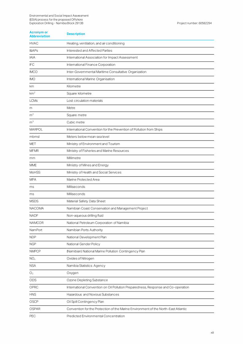
Acronyms and Abbreviations
Acronym or
Abbreviation Description
AECOM AECOM Africa (Pty) Ltd
AIDS Acquired Immunodeficiency Syndrome
AoI Area of Influence
BCLME Benguela Current Large Marine Ecosystem
BOP Blowout preventer
BWM Ballast Water Management
CaCO3 Calcium carbonate
CLO Community Liaison Officer
CO Carbon monoxide
CO2 Carbon dioxide
COLREGs Convention on the International Regulations for Preventing Collisions at Sea
CR Critically Endangered
CRR Comment and Response Report
dB Decibel
DREAM Dose related Risk and Effect Assessment Model
DSR Draft Scoping Report
EAP Environmental Assessment Practitioner
EBS Environmental Baseline Study
ECC Environmental Clearance Certificate
ECO Environmental Control Officer
EHS Environmental Health and Safety
EHS Environment, Health and Safety
EIA Environmental Impact Assessment
EMA Environmental Management Act, 2007 (Act No. 7 of 2007)
EMS Environmental Management System
EN Endangered
ESDD Environmental and Social Due Diligence
ESIA Environmental and Social Impact Assessment
ESMP Environmental and Social Management Plan
FGMs Focus Group Meetings
FSR Final Scoping Report
GDP Gross Domestic Product
GG Government Gazette
GHG Greenhouse Gas
GIS Geographic Information Systems
GRN Government of the Republic of Namibia
H2S Hydrogen sulphide
HIV Human Immunodeficiency Virus
Environmental and Social Impact Assessment
(ESIA) process for the proposed Offshore Exploration Drilling - Namibia Block 2913B
Project number: 60582294
xiii
Acronym or Abbreviation
Description
HVAC Heating, ventilation, and air conditioning
I&APs Interested and Affected Parties
IAIA International Association for Impact Assessment
IFC International Finance Corporation
IMCO Inter-Governmental Maritime Consultative Organization
IMO International Marine Organisation
km Kilometre
km2 Square kilometre
LCMs Lost circulation materials
m Metre
m2 Square metre
m3 Cubic metre
MARPOL International Convention for the Prevention of Pollution from Ships
mbmsl Meters below mean sea level
MET Ministry of Environment and Tourism
MFMR Ministry of Fisheries and Marine Resources
mm Millimetre
MME Ministry of Mines and Energy
MoHSS Ministry of Health and Social Services
MPA Marine Protected Area
ms Milliseconds
ms Milliseconds
MSDS Material Safety Data Sheet
NACOMA Namibian Coast Conservation and Management Project
NADF Non-aqueous drilling fluid
NAMCOR National Petroleum Corporation of Namibia
NamPort Namibian Ports Authority
NDP National Development Plan
NGP National Gender Policy
NMPCP (Namibian) National Marine Pollution Contingency Plan
NOx Oxides of Nitrogen
NSA Namibia Statistics Agency
O2 Oxygen
ODS Ozone Depleting Substance
OPRC International Convention on Oil Pollution Preparedness, Response and Co-operation
HNS Hazardous and Noxious Substances
OSCP Oil Spill Contingency Plan
OSPAR Convention for the Protection of the Marine Environment of the North -East Atlantic
PEC Predicted Environmental Concentration

Environmental and Social Impact Assessment
(ESIA) process for the proposed Offshore Exploration Drilling - Namibia Block 2913B
Project number: 60582294
xiv
Acronym or Abbreviation
Description
PNEC Predicted No Effect Concentrations
PPE Personal Protective Equipment
PTS Permanent Threshold Shift
REACH Registration, Evaluation, Authorisation and Restriction of Chemicals
ROV Remotely Operated Vehicle
SABS South African Bureau of Standards
SACNASP South African Council for Natural Scientific Professions
SACW South Atlantic Central Water
SCP Stakeholder Consultation Process
SEA Strategic Environmental Assessment
SEL Sound Exposure Level
SIA Social Impact Assessment
SOLAS International Convention for the Safety of Life at Sea
SOPEP Shipboard Oil Pollution Emergency Plan
SOx Oxides of Sulphur
SPL Sound Pressure Level
SPRFMA South Pacific Regional Fisheries Management Authority
SWAPO South West Africa People's Organization
TB Tuberculosis
TCP Technical Co-operation Permit
ToR Terms of Reference
TOTAL TOTAL EP NAMIBIA B.V.
TTS Temporary Threshold Shift
UNCLOS United Nations Convention on the Law of the Sea
UNESCO United Nations Educational, Scientific and Cultural Organization
VAT Value Added Tax
VCT Voluntary Counselling and Testing
VOS Voluntary Observing Ship
VSP Vertical seismic profile
VU Vulnerable
WBM Water Based Mud

Environmental and Social Impact Assessment
(ESIA) process for the proposed Offshore Exploration Drilling - Namibia Block 2913B
Project number: 60582294
15
1. Introduction
1.1 Project Background
TOTAL EP NAMIBIA B.V. (TOTAL), as operator and major (70%) shareholder, proposes to undertake offshore
exploration drilling activities in Block 2913B (the Project). The surface area of Block 2913B is approximately 8 ,215
square kilometres (km2), with several wells possibly to be drilled for exploration or appraisal purposes within this
block.
Exploration drilling will take place within offshore Block 2913B which is approximately 300 kilometres (km) off the
coast of Namibia from Lüderitz. Water depths in this area range from approximately 2 ,600 to 3,300 meters below
mean sea level (mbmsl). The well’s total depth is expected to be about 6,260 mbmsl. The duration of drilling
operations is expected to be approximately three (3) to six (6) months per well, anticipated to commence in the
second half 2019 and first half of 2020.
1.2 Purpose of Study
TOTAL holds an Exploration Licence under Block 2913B offshore and intends to implement the activities of the
exploration programme by drilling exploration and appraisal wells within the exploration licence area.
The main objectives of the proposed Project are to:
Confirm and specify the presence of hydrocarbon deposits; and
In case of discovery, further exploration and appraisal wells may be required to understand the characteristics
of the reservoir and its commercial interest.
Potential direct future benefits which could result from this Project include:
Contributing towards the need for economic activity development within the Lüderitz and Oranjemund areas;
Potential job opportunities; and
Potential contribution to science sharing relevant biodiversity benthos data.
More details of the proposed Project are provided in Section 4.
1.2.1 Namibia’s Oil and Gas Industry History and Policy Initiatives
The first Namibian oil and gas exploration wells were drilled in the 1960s, but it wasn’t until 1974 that the presence
of hydrocarbons was confirmed through the discovery of the Kudu Gas Field on the northern section of the Orange
Basin, directly west of Oranjemund. By 1991, fewer than ten hydrocarbon wells had been drilled in Namibia, with no
commercially viable reserves having been discovered (Light & Shimutwikeni, 1991).
Between 2010 and 2014, at least 13 wells were drilled in Namibia bringing the total number of offshore hydrocarbon
wells drilled in Namibian waters to 32. Of these, 15 have been exploratory wells, seven have been appraisal wells,
and a further ten have been drilled for scientific research (National Petroleum Corporation of Namibia (NAMCOR),
2017a). The collection of survey, seismic and aeromagnetic data has contributed to a substantial geological and
geophysical database for the country and has revealed the existence of four offshore frontier basins of interest to
explorers: The Orange, Lüderitz, Walvis and Namibe basins. Commercially viable petroleum reserves are yet to be
discovered in Namibia.
Policy advice is provided to Ministry of Mines and Energy (MME) by NAMCOR, a state-owned company which is also
responsible for promoting exploration and production in the country. NAMCOR also has “the mandate to carry out
reconnaissance, exploration and production operations either on its own or in partnership with other organisations
in the industry” (NAMCOR, 2017b). NAMCOR is actively engaged in identifying prospects and leads, as well as in
promoting and marketing the oil and gas potential of Namibia to local and international companies.
Environmental and Social Impact Assessment
(ESIA) process for the proposed Offshore Exploration Drilling - Namibia Block 2913B
Project number: 60582294
16
1.3 Purpose of the Environmental and Social Impact Assessment
Report
AECOM Africa (Pty) Ltd (AECOM) was appointed by TOTAL as the independent Environmental Assessment
Practitioner (EAP) to conduct the Environmental and Social Impact Assessment (ESIA) process, in support of the
required Namibian legislative authorisations. More details of the ESIA Project team are provided in Section 1.5. The
ESIA to be conducted is intended to fulfil the Namibian EIA requirements, as well as TOTAL’s own internal standards
for ESIA investigations.
The purpose of this Draft ESIA and Environmental and Social Management Plan (ESMP) Report is to summarise:
A description of EAP that prepared the report;
A detailed description of the proposed activity;
A description of the need and desirability of the project and details of the alternatives that were investigated;
A description of the environment that may be affected;
A description of the Stakeholder Consultation Process (SCP) that was undertaken tote da;
Findings, recommendations and copies of specialist studies;
An indication of the method used to identify impact significance;
An assessment of specific information required by the competent authority;
A comparative assessment of all alternatives, where applicable;
An assessment of each potentially significant impact;
A description of any assumptions, uncertainties and gaps in knowledge;
An opinion on whether the activity should be authorised or not and, if it should be authorised, under what
conditions; and
An ESMP for the full lifecycle of the Project.
This Draft ESIA Report will be made available for public review for a period of 21 days. Subsequently, comments
from stakeholders will be incorporated into an updated Final ESIA Report. This repo rt will be submitted to the MME
as the competent authority, for review and recommendation to the Ministry of Environment and Tourism (MET) who
will make the final decision on the Application for the Environmental Clearance Certificate (ECC).
1.4 Structure of the Report
This report has been prepared in compliance with the Environmental Impact Assessment (EIA) Regulations, 2012.
The structure and content are outlined in Table 1-1 below.
Environmental and Social Impact Assessment
(ESIA) process for the proposed Offshore Exploration Drilling - Namibia Block 2913B
Project number: 60582294
17
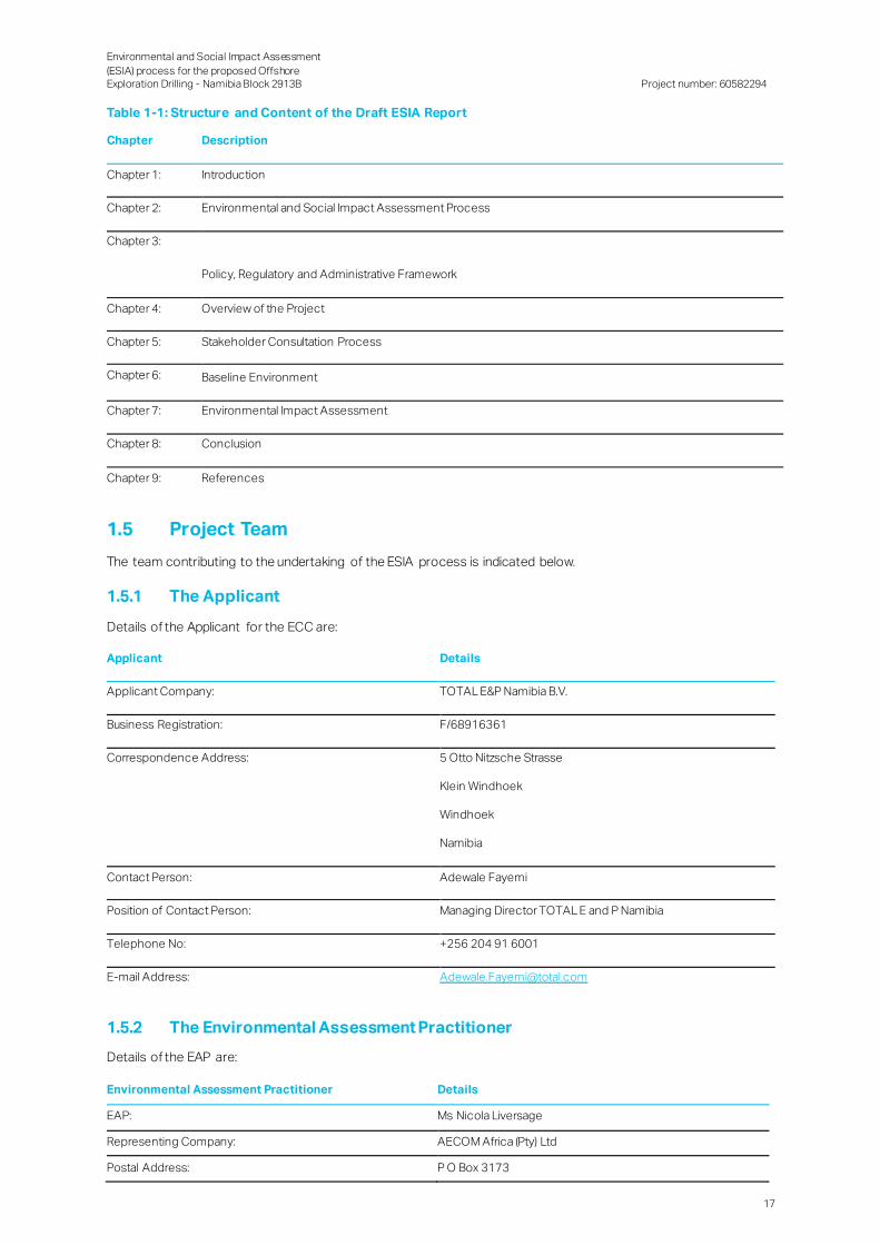
Table 1-1: Structure and Content of the Draft ESIA Report
Chapter Description
Chapter 1: Introduction
Chapter 2: Environmental and Social Impact Assessment Process
Chapter 3:
Policy, Regulatory and Administrative Framework
Chapter 4: Overview of the Project
Chapter 5: Stakeholder Consultation Process
Chapter 6: Baseline Environment
Chapter 7: Environmental Impact Assessment
Chapter 8: Conclusion
Chapter 9: References
1.5 Project Team
The team contributing to the undertaking of the ESIA process is indicated below.
1.5.1 The Applicant
Details of the Applicant for the ECC are:
Applicant Details
Applicant Company: TOTAL E&P Namibia B.V.
Business Registration: F/68916361
Correspondence Address: 5 Otto Nitzsche Strasse
Klein Windhoek
Windhoek
Namibia
Contact Person: Adewale Fayemi
Position of Contact Person: Managing Director TOTAL E and P Namibia
Telephone No: +256 204 91 6001
E-mail Address: [email protected]
1.5.2 The Environmental Assessment Practitioner
Details of the EAP are:
Environmental Assessment Practitioner Details
EAP: Ms Nicola Liversage
Representing Company: AECOM Africa (Pty) Ltd
Postal Address: P O Box 3173
Environmental and Social Impact Assessment
(ESIA) process for the proposed Offshore Exploration Drilling - Namibia Block 2913B
Project number: 60582294
18
Environmental Assessment Practitioner Details
Pretoria
South Africa
0001
Telephone: +27 12 421 3500
E-mail Address: [email protected]
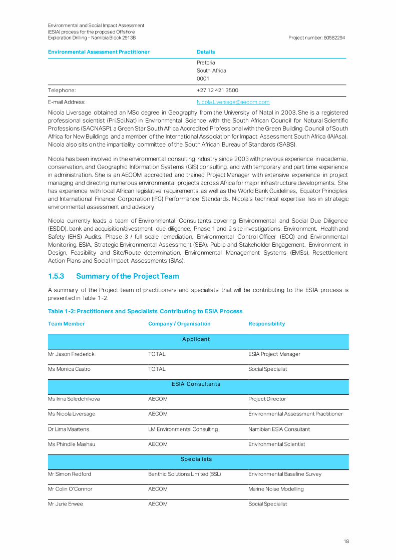
Nicola Liversage obtained an MSc degree in Geography from the University of Natal in 2003. She is a registered
professional scientist (Pri.Sci.Nat) in Environmental Science with the South African Council for Natural Scientific
Professions (SACNASP), a Green Star South Africa Accredited Professional with the Green Building Council of South
Africa for New Buildings and a member of the International Association for Impact Assessment South Africa (IAIAsa).
Nicola also sits on the impartiality committee of the South African Bureau of Standards (SABS).
Nicola has been involved in the environmental consulting industry since 2003 with previous experience in academia ,
conservation, and Geographic Information Systems (GIS) consulting, and with temporary and part time experience
in administration. She is an AECOM accredited and trained Project Manager with extensive experience in project
managing and directing numerous environmental projects across Africa for major infrastructure developments. She
has experience with local African legislative requirements as well as the World Bank Guidelines, Equator Principles
and International Finance Corporation (IFC) Performance Standards. Nicola’s technical expertise lies in str ategic
environmental assessment and advisory.
Nicola currently leads a team of Environmental Consultants covering Environmental and Social Due Diligence
(ESDD), bank and acquisition/divestment due diligence, Phase 1 and 2 site investigations, Environment, Health and
Safety (EHS) Audits, Phase 3 / full scale remediation, Environmental Control Officer (ECO) and Environmenta l
Monitoring, ESIA, Strategic Environmental Assessment (SEA), Public and Stakeholder Engagement, Environment in
Design, Feasibility and Site/Route determination, Environmental Management Systems (EMSs), Resettlement
Action Plans and Social Impact Assessments (SIAs).
1.5.3 Summary of the Project Team
A summary of the Project team of practitioners and specialists that will be contributing to the ES IA process is
presented in Table 1-2.
Table 1-2: Practitioners and Specialists Contributing to ESIA Process
Team Member Company / Organisation Responsibility
A p p l ic an t
Mr Jason Frederick TOTAL ESIA Project Manager
Ms Monica Castro TOTAL Social Specialist
ESIA Con sultan ts
Ms Irina Seledchikova AECOM Project Director
Ms Nicola Liversage AECOM Environmental Assessment Practitioner
Dr Lima Maartens LM Environmental Consulting Namibian ESIA Consultant
Ms Phindile Mashau AECOM Environmental Scientist
Sp e c ial ists
Mr Simon Redford Benthic Solutions Limited (BSL) Environmental Baseline Survey
Mr Colin O’Connor AECOM Marine Noise Modelling
Mr Jurie Erwee AECOM Social Specialist

Environmental and Social Impact Assessment
(ESIA) process for the proposed Offshore Exploration Drilling - Namibia Block 2913B
Project number: 60582294
19
1.6 Assumptions and Limitations
The following assumptions, limitations and constraints associated with the Project have been identified for this ESIA
process:
The ESIA process is multi-disciplinary and is informed by the Project team. It is thus necessary to assume that
the information provided by the Project team is accurate and true, at the time it was sourced;
Data shown in the maps were supplied by various sources and were used as received. The data was not
verified; and
Regarding the SCP process, every effort was made to inform all possible interested and affected stakeholders.
Information presented by the stakeholders is presumed to be accurate and has been presented timeously.
Very limited information is available of the project area, so comparisons have been made with the neighbouring
exploration areas Block 2913A and 2914B and the Orange Basin Technical Co-operation Permit (TCP), which
lies offshore on the west coast of South Africa.
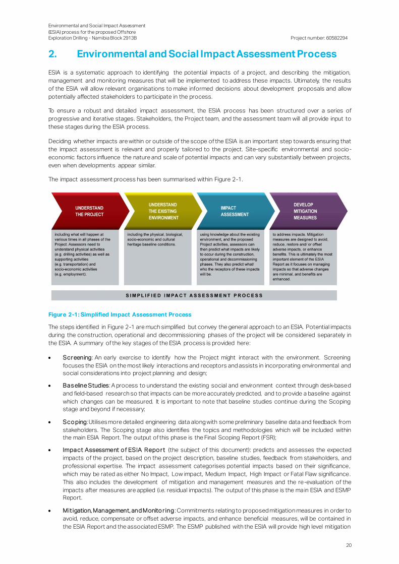
Environmental and Social Impact Assessment
(ESIA) process for the proposed Offshore Exploration Drilling - Namibia Block 2913B
Project number: 60582294
20
2. Environmental and Social Impact Assessment Process
ESIA is a systematic approach to identifying the potential impacts of a project, and describing the mitigation,
management and monitoring measures that will be implemented to address these impacts. Ultimately, the results
of the ESIA will allow relevant organisations to make informed decisions about development proposals and allow
potentially affected stakeholders to participate in the process.
To ensure a robust and detailed impact assessment, the ESIA process has been structured over a series of
progressive and iterative stages. Stakeholders, the Project team, and the assessment team will all provide input to
these stages during the ESIA process.
Deciding whether impacts are within or outside of the scope of the ESIA is an important step towards ensuring that
the impact assessment is relevant and properly tailored to the project. Site-specific environmental and socio-
economic factors influence the nature and scale of potential impacts and can vary substantially between projects,
even when developments appear similar.
The impact assessment process has been summarised within Figure 2-1.
Figure 2-1: Simplified Impact Assessment Process
The steps identified in Figure 2-1 are much simplified but convey the general approach to an ESIA. Potential impacts
during the construction, operational and decommissioning phases of the project will be considered separately in
the ESIA. A summary of the key stages of the ESIA process is provided here:
Scr eening: An early exercise to identify how the Project might interact with the environment. Screening
focuses the ESIA on the most likely interactions and receptors and assists in incorporating environmental and
social considerations into project planning and design;
Bas eline Studies: A process to understand the existing social and environment context through desk-based
and field-based research so that impacts can be more accurately predicted, and to provide a baseline against
which changes can be measured. It is important to note that baseline studies continue during the Scoping
stage and beyond if necessary;
Sco ping: Utilises more detailed engineering data along with some preliminary baseline data and feedback from
stakeholders. The Scoping stage also identifies the topics and methodologies which will be included within
the main ESIA Report. The output of this phase is the Final Scoping Report (FSR);
Impact Assessment o f ESIA Repo r t (the subject of this document): predicts and assesses the expected
impacts of the project, based on the project description, baseline studies, feedback from stakeholders, and
professional expertise. The impact assessment categorises potential impacts based on their significance,
which may be rated as either No Impact, Low impact, Medium Impact, High Impact or Fatal Flaw significance.
This also includes the development of mitigation and management measures and the re-evaluation of the
impacts after measures are applied (i.e. residual impacts). The output of this phase is the ma in ESIA and ESMP
Report.
Mit igation, Management, and Monito r ing : Commitments relating to proposed mitigation measures in order to
avoid, reduce, compensate or offset adverse impacts, and enhance beneficial measures, will be contained in
the ESIA Report and the associated ESMP. The ESMP published with the ESIA will provide high level mitigation

Environmental and Social Impact Assessment
(ESIA) process for the proposed Offshore Exploration Drilling - Namibia Block 2913B
Project number: 60582294
21
and monitoring measures and form the basis for the preparation of detailed management and implementatio n
plans covering certain activities of the mobilisation, operation and demobilisation phases, or potentially
affected receptors.
The ESIA and associated technical studies were undertaken in line with relevant Namibian legislation and other
applicable international standards (see Section 3).
The ESIA for this Project aim to address the impacts associated with the proposed exploration Project and provide
an assessment of the Project in terms of the biophysical, social and economic environments to assist the
environmental authorities (MME and MET) and TOTAL in making decisions regarding the design, commissioning,
exploration and abandoning (decommissioning) of the proposed Project.
Consistent with the Namibian EIA process, this ESIA process consists of three phases:
Scoping Phase (including the Plan of Study for the EIA);
EIA Phase (including the ESMP) – the current phase; and
Decision-Making Phase.
2.1 Scoping Phase
The main purpose of the Scoping Phase was to identify and investigate issues related to the Project and list
potentially significant impacts that require further assessment in the ESIA Phase.
Issues and impacts were identified by the project team using theoretical knowledge, experience on similar projects,
and consultation with I&APs and other key stakeholders (such as National, Regiona l and Local Government
Departments and Authorities). The Scoping Phase also identified the most appropriate means by which the
potential impacts were assessed.
Table 2-1 contains the impacts identified by the EAP, Project team, as well as those identified by registered I&APs
during the Scoping Phase. The table also indicates which activity to be conducted during the ESIA Phase will assess
the identified impact, and which ESIA deliverable will provide the impact assessment, associated significance and
recommended mitigation or enhancement measures.
Table 2-1: Potential Environmental and Social Impacts Identified during the Scoping Phase
Activities Aspect Impact Description
Air Emissions Air quality Physiological effect on marine fauna and contribution to global greenhouse gas
emissions. Emissions may be generated by exhaust gas, fugitive emissions
associated with leaking tubing, pumps and other equipment, vent or flaring of oil and
gas used during well testing.
Physical,
Biological and
Marine
Environment
Unplanned events
e.g. small
operational spill,
blowout
Offshore drilling operations carry an inherent risk of oil entering the marine
environment as a consequence of an unplanned oil spill event.
Biological
Environment
Discharge of waste
to sea
Different types of waste may be discharged to sea. These include: deck drainage,
machinery space drainage, sewage, galley waste, cooling water and the opening
and closing of the blowout preventer (BOP). The discharge of waste to sea could
create local reductions in water quality. Deck and machinery space drainage may
result in small volumes of oils, detergents, lubricants and grease, the toxicity of
which varies depending on their composition, being introduced into the marine
environment. Sewage and gallery waste would place a small organic and bacterial
loading on the marine environment, resulting in an increased biological oxygen
demand.
Traffic Support vessel
traffic interaction
The implementation of the safety zone around the drilling unit would effectively
exclude fishing vessels from accessing fishing grounds within 500 m of the drilling
unit. The abandonment of the wellhead on the seafloor would also pose an

Environmental and Social Impact Assessment
(ESIA) process for the proposed Offshore Exploration Drilling - Namibia Block 2913B
Project number: 60582294
22
Activities Aspect Impact Description
with commercial
fishing
obstruction to any fishing activity directed towards the seabed (namely any
demersal and longline fisheries).
The exclusion of fisheries from the safety zone would effectively reduce fishing
grounds, which in turn could potentially result in a loss of catch and/or increased
fishing effort. The majority of fishing effort is directed inshore of the 1,000 m
isobaths, far inshore of the area of interest. Only one fishery, the large pelagic
longline sector, is in the vicinity of Block 2913B. None of the other fishing sectors
are expected to be affected by the proposed exclusion zone.
Traffic Support vessel
interaction with
recreational fishing
and tourism
The support vessel travelling from the port to the drilling unit may affect existing
recreational fishing, angling and boat trip routes, specifically from the southern
limits of Diaz Point to Grosse Bucht which is close to Lüderitz. The impact on these
routes could potentially lead to either an increase or a decrease in recreational
fishing and tourism. Facilities close to Diaz Point to Grosse Bucht could experience
a decrease in tourist accommodation capacity presuming that Project staff is
accommodated in that area.
Benthic
Environment
Physical
disturbance of the
seabed sediments
Drilling operations would result in the direct physical disturbance and removal of
sediments, as well as potential changes in sediment characteristics and condition.
Any benthic fauna present on the seabed and in the sediment in the disturbance
footprint would be either completely eliminated or may potentially be disturbed or
crushed. Resuspension of seabed sediments may also result in increased turbidity
near the seabed, potentially with physiological effects on benthic faunal
communities.
Marine
Environment
Noise Various sources of noise within the marine environment may be created: drilling
noise, propeller and positioning thrusters, well logging and testing noise, machinery
noise, and helicopter noise. Elevated noise levels could impact marine fauna.
Social Employment
creation
The proposed Project has the potential to create limited local employment
opportunities. Employment will likely improve the income and quality of life of those
individuals and families who benefit from employment.
Social Local procurement
of goods and
services
Several activities will require the purchase of equipment and services and could
generate several contracts, which could improve business for local suppliers.
Social Multiplier effect on
the local economy
The Project’s capital expenditure, as well as monthly wage bill and procurement
expenses, are expected to result in an injection of cash into the economy of the
broader Project area. Thus, the Project could result in several economic benefits for
local business communities through multiplier effects.
Social Nuisance impacts Project activities could result in an increase of the ambient noise due to the
helicopter transfers between the drilling unit and Oranjemund and restrict traffic and
movement patterns of local residents and commuters at the logistical base . These
impacts could thus result in a decrease in the quality of life. Nuisance impacts
generally results in a deterioration of sense of place, the magnitude of this impact
depends on several factors. One of these factors is the current state of the
landscape: The impact of a large and visible artificial structure on the sense of place
will be correspondingly larger than if the landscape already bears the marks of
development, similarly the baseline noise, traffic, air quality levels will determine how
communities will be receptive or can adapt to any changes. Another factor is the
meanings and feelings that people attach to the anticipated changes. If a
development promises to offer tangible benefits to surrounding communities (for
example job creation in a context of high unemployment or development), it is
unlikely that its impact on the character of the landscape or increase in nuisance
levels will be perceived in a negative light by most community members – even if
Environmental and Social Impact Assessment
(ESIA) process for the proposed Offshore Exploration Drilling - Namibia Block 2913B
Project number: 60582294
23
Activities Aspect Impact Description
that impact is substantial from a nuisance point of view. If the proposed Project is
evaluated against these criteria, it is evident that it could produce a significant
impact in the context of Oranjemund, but to a lesser degree in the more
industrialised Lüderitz; however, Oranjemund might be more receptive and/or
willing to adapt to nuisance levels considering the potential benefits of the Project.
Social Stakeholder
opposition
It is possible that there could be some opposition towards the proposed Project,
especially as a result of people’s perceptions around employment, safety and
economic impacts.
Social Decommissioning
phase impacts
It is inevitable that the individuals employed during the Project’s exploration phase
will lose their jobs upon decommissioning.
Stakeholder engagement was conducted to identify potential I&APs, inviting I&APs to register , as well as to notify
I&APs of the ESIA process to obtain the required ECC from the MME. Input from I&APs has been considered and
was integrated into the Draft Scoping Report (DSR).
The DSR was made available for public comment over a period of 21 calendar days (excluding public holidays). All
comments received were captured in a Comment and Response Report (CRR) and included in the FSR , submitted
to the MME for acceptance.
2.2 Environmental and Social Impact Assessment Phase
All potential significant environmental issues (physical, biophysical, social and economic) associated with the
proposed Project identified in the Scoping Phase (Table 2-1) were investigated during the ESIA Phase.
2.2.1 Specialist Investigations
To address the potential impacts identified during the scoping phase (Table 2-1), the specialist investigations
described below were conducted. Specialist reports are contained in Appendix B.
2.2.1.1 Environmental Baseline Studies
An Environmental Baseline Study (EBS) was conducted to characterise the existing environment, with the following
objectives:
Describe the main physico-chemical and biological characteristics of the study area and highlight its main
sensitivities;
Emphasise the presence of any endangered species and/or habitat as well as the different types of invasive
species;
Describe the socio-economic context and activities related to the study area;
Locate, describe and map sensitive areas present in Block 2913b including biodiversity and ecosystems
services (i.e. existing or potential benefits that biodiversity or ecosystems contribute towards human well-
being; e.g. provisioning services, regulating services, cultural services and/or supporting services); and
Clearly identify and assess any existing infrastructure and/or any existing contamination of the natural
environment by pollutants (including but not limited to natural seepage) located wit hin the Block 2913B in order
to preserve the Company’s rights and circumscribe its responsibilities.
2.2.1.2 MetOcean Study
A Meteorological and Oceanographic Study (MetOcean Study) was conducted in Block 2913B. It collected the
following data:
Currents speed and directions through the water column;
Sea temperatures and salinity through the water column;
Water elevation;
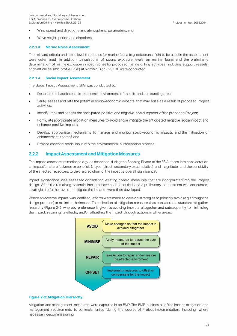
Environmental and Social Impact Assessment
(ESIA) process for the proposed Offshore Exploration Drilling - Namibia Block 2913B
Project number: 60582294
24
Wind speed and directions and atmospheric parameters; and
Wave height, period and directions.
2.2.1.3 Marine Noise Assessment
The relevant criteria and noise level thresholds for marine fauna (e.g. cetaceans, fish) to be used in the assessment
were determined. In addition, calculations of sound exposure levels on marine fauna and the preliminar y
determination of marine exclusion / impact zones for proposed marine drilling activities (including support vessels)
and vertical seismic profile (VSP) at Namibia Block 2913B were conducted.
2.2.1.4 Social Impact Assessment
The Social Impact Assessment (SIA) was conducted to:
Describe the baseline socio-economic environment of the site and surrounding area;
Verify, assess and rate the potential socio-economic impacts that may arise as a result of proposed Project
activities;
Identify, rank and assess the anticipated positive and negative social impacts of the proposed P roject;
Formulate appropriate mitigation measures to avoid and/or mitigate the anticipated negative social impact and
enhance positive impacts;
Develop appropriate mechanisms to manage and monitor socio -economic impacts and the mitigation or
enhancement thereof; and
Provide essential social input into the environmental authorisation process.
2.2.2 Impact Assessment and Mitigation Measures
The impact assessment methodology, as described during the Scoping Phase of the ESIA, takes into consideration
an impact’s nature (adverse or beneficial), type (direct, secondary or cumulative) and magnitude, and the sensitivit y
of the affected receptors, to yield a prediction of the impact’s overall ‘significance’.
Impact significance was assessed considering existing control measures that are incorporated into the Project
design. After the remaining potential impacts have been identified and a preliminary assessment was conducted,
strategies to further avoid or mitigate the impacts were then developed.
Where an adverse impact was identified, efforts were made to develop strategies to primarily avoid (e.g. through the
design process) or minimise the impact. The selection of mitigation measures has considered a standard mitigation
hierarchy (Figure 2-2) whereby preference is given to avoiding impacts altogether and subsequently to minimising
the impact, repairing its effects, and/or offsetting the impact through actions in other areas.
Figure 2-2: Mitigation Hierarchy
Mitigation and management measures were captured in an EMP. The EMP outlines all of the impact mitigation and
management requirements to be implemented during the course of Project implementation, including, where
necessary decommissioning.

Environmental and Social Impact Assessment
(ESIA) process for the proposed Offshore Exploration Drilling - Namibia Block 2913B
Project number: 60582294
25
The significance of the impacts was then re-evaluated based on these mitigation measures. The resulting impact is
known as the ‘residual’ impact and represents the impact that will remain following the application of mitigation and
management measures, and thus the ultimate level of impact associated with the Project. The basic process which
was adopted for assessing potential Project impacts in the ESIA is illustrated in Figure 2-3.
Figure 2-3: Impact Identification and Assessment Process
2.2.3 Draft Environmental and Social Impact Assessment Report
This Draft ESIA Report has been prepared in compliance with Section 15(2) of the EIA Regulations 2012. The
specialist studies and other relevant information / assessments have been integrated into this report. The Draft
ESIA Report will be made available for public comment over a period of 21 calendar days (excluding public holidays).
The objective of the public comment period is for I&APs to raise issues about the information presented in the report
and for them to raise any other issues related to the proposed Project. It also provides an opportunity for I&APs to
see if their issues have been captured correctly.
2.2.4 Environmental and Social Management Plan
The ESMP (Appendix A) outlines the impacts and mitigation measures for the planning / mobilisation,
exploration/drilling (operation), and demobilisation phases of the Project. The ESMP comprises the following:
Summary of impacts: the predicted negative environmental impacts for which mitigation is required, and
positive impacts requiring enhancement;
Description of mitigation measures: the ESMP identifies feasible and cost-effective mitigation measures to
reduce significant negative environmental impacts to acceptable and legal levels. Mitigation measures are
described in detail and will be accompanied by designs, equipment descriptions, and operating procedures,
where appropriate, as well as descriptions of technical aspects of implementing the mitigation measures;
Description of monitoring programme: the monitoring programme indicates the linkages between impacts,
indicators to be measured, measurement methods and definition of thresholds that will signal the need for
corrective actions;
Emergency Action Plan: the identification of possible accidents during the various phases of the Project, with
measures on how these will be prevented and/or managed;
Institutional arrangements depict and define the responsibilities for mitigation and monitoring action;
─ Legal enforceability: the key legal considerations with respect to the ESMP are:
Legal framework for environmental protection.
Legal basis for mitigation.
Implementation schedule and reporting procedures that specify the t iming, frequency and duration of the
mitigation measures; and
Description of requirements for record keeping, reporting, review, auditing and updating the EMP.
Environmental and Social Impact Assessment
(ESIA) process for the proposed Offshore Exploration Drilling - Namibia Block 2913B
Project number: 60582294
26
2.3 Final Environmental and Social Impact Report
Following the review period, the Draft ESIA Report will be updated with comments received from the public to
produce a Final ESIA Report. The Final ESIA Report will be submitted to the MME for recommendation to MET. MET
will then issue a decision concerning the ECC.
2.4 Decision-Making Phase
If the proposed Project is authorised to proceed, an ECC will be drafted and issued. The ECC may contain conditions
that TOTAL must adhere to. All I&APs will be notified of the decision and appeal provisions. Should I&APs or TOTAL
disagree with the decision taken, they may lodge an appeal.
Environmental and Social Impact Assessment
(ESIA) process for the proposed Offshore Exploration Drilling - Namibia Block 2913B
Project number: 60582294
27
3. Policy, Regulatory and Administrative Framework
This section provides an overview of the policy and legislative context, including the preliminary identification of
legislation, policies, plans, guidelines and instruments applicable to the Project.
3.1 The Constitution of Namibia, 1990
The Namibian government has adopted a number of policies that promote sustainable development. Most of these
originate in clauses of the Namibian Constitution. In Article 95 (i), the State undertakes to actively promote and
maintain the welfare of the people by adopting policies aimed at the utilisation of natural resources on a sustainable
basis for the benefit of all Namibians. Article 98 (i) provides assurance that “the economic order of Namibia shall be
based on the principles of a mixed economy with the objective of securing economic growth, prosperity and a life
of human dignity for all Namibians”. Article 100 provides for the Sovereign Ownership of Natural Resources; all land,
water and natural resources shall belong to the State except when lawfully owned. Article 144 gives provision for
International Law and Agreements binding upon Namibia (Republic of Namibia, 1990) (Government of the Republic
of Namibia (GRN), 2005a).
The constitutional recognition of environmental concerns triggered widespread legislative reform relating to the
management of natural resources in Namibia. The country’s environmental protection effort is currently comprised
of the Environmental Management Act, 2007 (Act No. 7 of 2007) and its Regulations (2012).
3.2 Petroleum (Exploration and Production) Act, 1991 (Act No. 2 of 1991) and the Petroleum (Exploration and Production) Amendment
Act, 1993 (Act No. 2 of 1993)
TOTAL Namibia holds an offshore Exploration Licence under Block 2913B and intends to implement the activities
of the exploration programme by drilling one or more exploration wells within the exploration licence area.
In accordance with the Petroleum Act, 1991 and in an effort to promote petroleum exploration activities in Namibia,
the MME is the Competent Authority for this Project. In terms of Section 34 of the Petroleum Act , 1991, the
Directorate of Petroleum Affairs within the MME regulates the petroleum industry. It issues licences for petroleum
exploration and production and can approve or reject licence applications based on the outcome of ESIA reports.
3.3 Environmental Management Act, 2007 (Act No. 7 of 2007)
The purpose of the Environmental Management Act, 2007 (EMA) is to “promote the sustainable management of the
environment and the use of natural resources by establishing principles for decision making on matters affecting
the environment; to establish the Sustainable Development Advisory Council; to provide for the appointment of the
Environmental Commissioner and environmental officers; to provide for a process of assessment and control of
activities which may have significant effects on the environment; and to provide for incidental matters.”
The Act requires adherence to the principle of optimal sustainable yield in the exploitation of all natural resources.
The Act gives effect to Article 95 (l) of the Namibian Constitution by establishing general principles for the
management of the environment and natural resources. It promotes the coordinated and integrated management
of the environment and sets out responsibilities in this regard. Furthermore, it intends to give statutory effect to
Namibia’s Environmental Assessment Policy; further, it enables the Minister responsible for the environment to give
effect to Namibia’s obligations under international environmental conventions; and provides for associated matters.
The EMA promotes inter-generational equity in the utilisation of all natural resources. Environmental impact
assessments and consultations with communities and relevant regional and local authorities are provided for to
monitor the development of projects that potentially have an impact on the environment.
To obtain an ECC, a person who wants to carry out an activity listed according to Section 27 of the EMA must follow
a multi stage process in line with Sections 32-37 of the EMA and with the regulations for the implementation of the
EMA as Gazetted in February 2012 which have listed certain activities that may not be undertaken without an ECC.
The MET is the custodian of Namibia’s natural environment and its mission is to “promote biodiversity conservation
in the Namibian environment through the sustainable utilisation of natural resources and tourism development for
the maximum social and economic benefit of its citizens”. MET develops, administers and enforces environmenta l
legislation and policy.

Environmental and Social Impact Assessment
(ESIA) process for the proposed Offshore Exploration Drilling - Namibia Block 2913B
Project number: 60582294
28
The MET is responsible for the administration of the ESIA process undertaken in terms of the Environmenta l
Management Act, 2007 and the EIA Regulations, 2012. The MET will be responsible for issuing a decision on the
ESIA based on the recommendation from MME. If approved, the MET will issue an ECC.
3.4 Environmental Impact Assessment Regulations, 2012
On 6 February 2012 the Commencement of the Environmental Management Act, 2007 (Act No. 7 of 2007) was
published in the Government Gazette (GG), thereby becoming law. The Minister of Environment and Tourism, under
Section 56 of EMA, made the regulations set out in the Schedule (GRN, 2012) . The Minister also listed activities
(each with sub-activities) that may not be undertaken without an ECC.
All activities which need an ECC must follow the EIA Regulations, 2012, which have been made according to Section
56 of the EMA. These require inter alia that the proponent of an activity designates an EAP to manage the
assessment process and ensures that the environmental assessment procedures, specified in the EMA, the EIA
Regulations and Guidelines, are followed.
Listed activities, as contained in the EIA Regulations, 2012, applicable to the Project are indicated in Table 3-1.
Table 3-1: EIA Listed Activities relevant to the Project
Activity Number Activity Description Relevance to the Project
Listed Activity 2.3 The import, processing, use and recycling, temporary storage, transit or export of waste.
Waste would be generated by the drilling unit and transported to shore. Drill cuttings will be discharged to the sea.
Listed Activity 3.2 Other forms of mining or extraction of any natural resources whether regulated
by law or not.
The objective of the proposed exploration well drilling is to discover and appraise the hydrocarbon potential
of the geological structure or “prospect” in the area of
interest. This may result in the extraction of oil or gas. Listed Activity 3.3 Resource extraction, manipulation,
operation, conservation and related
activities.
Listed Activity 3.4 The extraction or processing of gas from natural and non-natural resources.
Listed Activity 9.1 The manufacturing, storage, handling or processing of a hazardous substance
defined in the Hazardous Substances
Ordinance, 1974
Non-aqueous drilling fluid (NADF) and hydrocarbons are not specifically defined in the Hazardous
Substances Ordinance, 1974. This activity has,
however, been included as components of the drilling fluid are hydrocarbons and the “general view” is that
hydrocarbons are hazardous.
Listed Activity 9.3 The bulk transportation of dangerous goods using pipeline, funiculars or
conveyors with a throughout capacity of
50 tons or 50 cubic metres (m3) or more
per day.
The proposed drilling operation would make use of infrastructure (particularly the pipe casings inside the
wellbore) which could convey oil or gas from the
geological structure to the drilling unit at the surface.
This activity is included to provide for a situation where the throughput capacity of hydrocarbons is 50 tons or
50 m3 or more per day.
Listed Activity 9.4 The storage and handling of a dangerous goods, including petrol, diesel, liquid
petroleum gas or paraffin, in containers
with a combined capacity of more than 30 m3 at any one location.
The proposed drilling operation would make use of infrastructure which would handle and would store oil,
gas and/or fuel (diesel). This activity is included to
provide for a situation where the combined storage capacity exceeds 30 m3 at any one location.
Listed Activity 10.1 The construction of (e) any structure
below the high-water mark of the sea;
The proposed drilling operations would result in the placement of drilling equipment (i.e. a wellhead) on the
seabed. During decommissioning the wellhead(s)
would be abandoned on the seafloor.
3.5 Additional Applicable Legislation
Additional legislation that may be applicable to the Project are summarised in Table 3-2 below.
Table 3-2: Additional Applicable Laws and Regulations
Sector Law
Petroleum Petroleum Products and Energy Act, 1990 (Act No. 13 of 1990) (as amended by the Petroleum
Products and Energy Amendment Act, 1994 (Act No. 29 of 1994), Petroleum Products and Energy
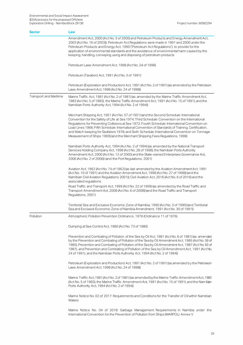
Environmental and Social Impact Assessment
(ESIA) process for the proposed Offshore Exploration Drilling - Namibia Block 2913B
Project number: 60582294
29
Sector Law
Amendment Act, 2000 (Act No. 3 of 2000) and Petroleum Products and Energy Amendment Act,
2003 (Act No. 16 of 2003)); Petroleum Act Regulations were made in 1991 and 2000 under the
Petroleum Products and Energy Act, 1990 (“Petroleum Act Regulations”), to provide for the
application of environmental standards and the avoidance of environmental harm caused by the keeping, handling, conveying, using and disposing of petroleum products
Petroleum Laws Amendment Act, 1998 (Act No. 24 of 1998)
Petroleum (Taxation) Act, 1991 (Act No. 3 of 1991)
Petroleum (Exploration and Production) Act, 1991 (Act No. 2 of 1991) (as amended by the Petroleum
Laws Amendment Act, 1998 (Act No. 24 of 1998))
Transport and Maritime Marine Traffic Act, 1981 (Act No. 2 of 1981) (as amended by the Marine Traffic Amendment Act,
1983 (Act No. 5 of 1983), the Marine Traffic Amendment Act, 1991 (Act No. 15 of 1991), and the Namibian Ports Authority Act, 1994 (Act No. 2 of 1994))
Merchant Shipping Act, 1951 (Act No. 57 of 1951) (and the Second Schedule: International
Convention for the Safety of Life at Sea 1974; Third Schedule: Convention on the International
Regulations for Preventing Collisions at Sea 1972; Fourth Schedule: International Convention on Load Lines 1966; Fifth Schedule: International Convention of Standards of Training, Certification,
and Watch keeping for Seafarers 1978; and Sixth Schedule: International Convention on Tonnage
Measurement of Ships 1969) (and the Merchant Shipping Fees Regulations, 1998)
Namibian Ports Authority Act, 1994 (Act No. 2 of 1994) (as amended by the National Transport Services Holding Company Act, 1998 (Act No. 28 of 1998), the Namibian Ports Authority
Amendment Act, 2000 (Act No. 12 of 2000) and the State-owned Enterprises Governance Act,
2006 (Act No. 2 of 2006)) (and the Port Regulations, 2001)
Aviation Act, 1962 (Act No. 74 of 1962) (as last amended by the Aviation Amendment Act, 1991 (Act No. 10 of 1991) and the Aviation Amendment Act, 1998 (Act No. 27 of 1998)) (and the
Namibian Civil Aviation Regulations 2001)); Civil Aviation Act, 2016 (Act No. 6 of 2016) and the
associated regulations
Road Traffic and Transport Act, 1999 (Act No. 22 of 1999) (as amended by the Road Traffic and
Transport Amendment Act, 2008 (Act No. 6 of 2008)) (and the Road Traffic and Transport
Regulations, 2001)
Territorial Sea and Exclusive Economic Zone of Namibia, 1990 (Act No. 3 of 1990) (and Territorial Sea and Exclusive Economic Zone of Namibia Amendment, 1991 (Act No. 30 of 1991))
Pollution Atmospheric Pollution Prevention Ordinance, 1976 (Ordinance 11 of 1976)
Dumping at Sea Control Act, 1980 (Act No. 73 of 1980)
Prevention and Combating of Pollution of the Sea by Oil Act, 1981 (Act No. 6 of 1981) (as amended by the Prevention and Combating of Pollution of the Sea by Oil Amendment Act, 1985 (Act No. 59 of
1985), Prevention and Combating of Pollution of the Sea by Oil Amendment Act, 1987 (Act No. 63 of
1987), and Prevention and Combating of Pollution of the Sea by Oil Amendment Act, 1991 (Act No.
24 of 1991), and the Namibian Ports Authority Act, 1994 (Act No. 2 of 1994))
Petroleum (Exploration and Production) Act, 1991 (Act No. 2 of 1991) (as amended by the Petroleum
Laws Amendment Act, 1998 (Act No. 24 of 1998))
Marine Traffic Act, 1981 (Act No. 2 of 1981) (as amended by the Marine Traffic Amendment Act, 1983
(Act No. 5 of 1983), the Marine Traffic Amendment Act, 1991 (Act No. 15 of 1991), and the Nam ibian Ports Authority Act, 1994 (Act No. 2 of 1994))
Marine Notice No. 02 of 2017: Requirements and Conditions for the Transfer of Oil within Namibian
Waters
Marine Notice No. 04 of 2018: Garbage Management Requirements in Namibia under the
International Convention for the Prevention of Pollution from Ships (MARPOL) Annex V

Environmental and Social Impact Assessment
(ESIA) process for the proposed Offshore Exploration Drilling - Namibia Block 2913B
Project number: 60582294
30
Sector Law
Disaster Risk Management Act, 2012 (Act No. 10 of 2012) (and the Disaster Risk Management
Regulations, 2013)
Local Authorities Act, 1992 (Act No. 23 of 1992): Town of Lüderitz: Regulations relating to waste management
Environmental Management Act, 2007 (Act No. 7 of 2007)
Marine Resources Act, 2000 (Act No. 27 of 2000)
Water Resources Management Act, 2013 (Act No. 11 of 2013) (promulgated, but not yet
implemented)
National Marine Pollution Contingency Plan (NMPCP), 2017
Environmental Marine Resources Act, 2000 (Act No. 27 of 2000)
Nature Conservation Ordinance, 1975 (Ordinance 4 of 1975) (and the Regulations Relating to
Nature Conservation, 1976 and the Amendment of Regulations, 2010)
National Heritage Act, 2004 (Act No. 27 of 2004) (as amended by the State-owned Enterprises
Governance Act, 2006 (Act No. 2 of 2006)) (and the National Heritage Regulations, 2005)
Water Act, 1965 (Act No. 54 of 1956) (as made applicable in Namibia)
Water Resources Management Act, 2013 (Act No. 11 of 2013) (promulgated, but not yet
implemented)
Namibian Islands’ Marine Protected Area, 2009
Hazardous Substances Hazardous Substance Ordinance, 1974 (Ordinance 14 of 1974) (and the General Regulations,
1979)
Disaster Risk Management Act, 2012 (Act No. 10 of 2012) (and the Disaster Risk Management
Regulations, 2013)
Atomic Energy and Radiation Protection Act, 2005 (Act No. 5 of 2005) (and the Radiation Protection and Waste Disposal Regulations, 2011)
Labour Labour Act, 2007 (Act No. 11 of 2007) (and the Labour Amendment Act, 2012 (Act No. 2 of 2012)) (and the Regulations relating to the Health and Safety of Employees at Work, 1997; and Labour
General Regulations, 2008)
Employees’ Compensation Act, 1941 (Act No. 30 of 1941) (and General Regulations, 1961) (Amendment Act, 1995 (Act No. 5 of 1995), that came into force on 1 March 1995, amends the Act
substantially and changes its name from the Workmen’s Compensation Act to the Employees’
Compensation Act)
Social Security Act, 1994 (Act No. 34 of 1994) (as amended by the State-owned Enterprises Governance Act. 2006 (Act No. 2 of 2006) and the Labour Act, 2007 (Act No. 11 of 2007)) (and the
General Regulations, 1995)
Public and Environmental Health Act, 2015 (Act No. 1 of 2015) (promulgated, but not yet
implemented)
Affirmative Action (Employment) Act, 1998 (Act No. 29 of 1998) (as amended by Act No. 6 of 2007
and the Labour Act, 2007 (Act No. 11 of 2007)) (and the General Regulations, 1999)
Health General Health Regulations (Government Notice 121 of 14 October 1969 as amended)
Tobacco Products Control Act, 2010 (Act No. 1 of 2010) (and the General Regulations, 2014)

Environmental and Social Impact Assessment
(ESIA) process for the proposed Offshore Exploration Drilling - Namibia Block 2913B
Project number: 60582294
31
Sector Law
Public and Environmental Health Act, 2015 (Act No. 1 of 2015) (promulgated, but not yet
implemented)
Marine Heritage Wreck and Salvage Act, 2004 (Act No. 5 of 2004)
Foreign Trade Foreign Investment Act, 1990 (Act No. 27 of 1990)
Arms and Ammunition Arms and Ammunition Act, 1996 (Act No. 7 of 1996) (and the General Regulations, 1998)
A summary of other policies, plans and guidelines applicable to the proposed project is provided in Table 3-3.
Table 3-3: Applicable Policies and Plans
Policy / Plan Provisions
Draft White Paper on the Energy Policy of Namibia, 1998
The White Paper on the Energy Policy (1998) is the overarching policy document which guides future policy and planning in the energy sector.
Namibia Vision 2030 This outlines the country's development programmes and strategies to achieve its
national objectives. One of the major objectives of Vision 2030 is to “ensure the
development of Namibia’s ‘natural capital’ and its sustainable utilisation, for the benefit of the country’s social, economic and ecolog ical well-being”.
Namibia’s 5th National Development Plan (NDP5) – Working together
towards prosperity (2017/18 –
2021/22)
The NDP5 provides the context for all development in Namibia, with the overarching aim of economic and social development.
NDP5 was launched on the 31 May 2017 by Namibia’s Head of State, His Excellency Dr.
Hage G.Geingob. This is the fifth NDP in the series of seven (7) NDPs that are to implement
and achieve the objectives and aspirations of Namibia’s long term vision (Vision 2030). In
sequence, NDP5 will be the third five year implementation vehicle towards Vision 2030
(Namport, 2018).
Namibia’s Green Plan , 1992 The Green Plan emphasised the reciprocal relationship between environmental health and living standards and the link between the state of the economy and the state of the
environment. The Green Plan recorded consensus on the need for an Environmental
Assessment Policy to “ensure that independent environmental impact assessments
form part of the prefeasibility study of all development projects and subjecting all such
projects to long term regular environmental monitoring”. In a reference to reducing opportunity costs, the Green Plan states (optimistically) that government should “permit
only those developments that do not restrict the developmental options of future
generations of poor people”.
Towards a Coastal Policy for
Namibia, Green Paper, 2009
The policy will guide the use and management of Namibia’s coastal areas in the short-
medium- and long-term. The intention is to bring lasting benefits to the people without jeopardising the chances of future generations to meet their own needs. This can only
happen when human interaction with the environment is well managed, and resources
are not exhausted. The Green Paper explores in broad strokes how this may be possible,
based on the results of the process thus far, and provides the opportunity for further
debate so that the end policy will be exactly what the country needs.
Minerals Policy of Namibia, 2002 The Policy sets out guiding principles for the development of the mining sector designed to ensure that it maintains its leading role in the growth of the national economy while at
the same time operating within environmentally acceptable limits. To this end, one of the
objectives of the policy is listed as ensuring compliance with national and other relevant
environmental policies.
Policy for the Conservation of Biotic
Diversity and Habitat Protection, 1994
This Policy was drafted by MET to ensure adequate protection of all spec ies and
subspecies, of ecosystems and of natural life support processes.
Namibia: National Code on HIV/AIDS in Employment, 2000
A Charter of Rights on HIV/AIDS was launched in 2000 to provide guidelines on confidentiality and privacy for people living with HIV/AIDS. In 2003, Namibia launched the
national antiretroviral therapy programme to provide treatment for people living with
HIV/AIDS in government health facilities. Since the programme was launched, the Ministry of Health and Social Services (MoHSS) has trained medical practitioners from both the
public and private sectors. The Ministry has also developed extensive prevention
programmes, especially for women and young people, including preventing mother-to-
child transmission, and workplace programmes.
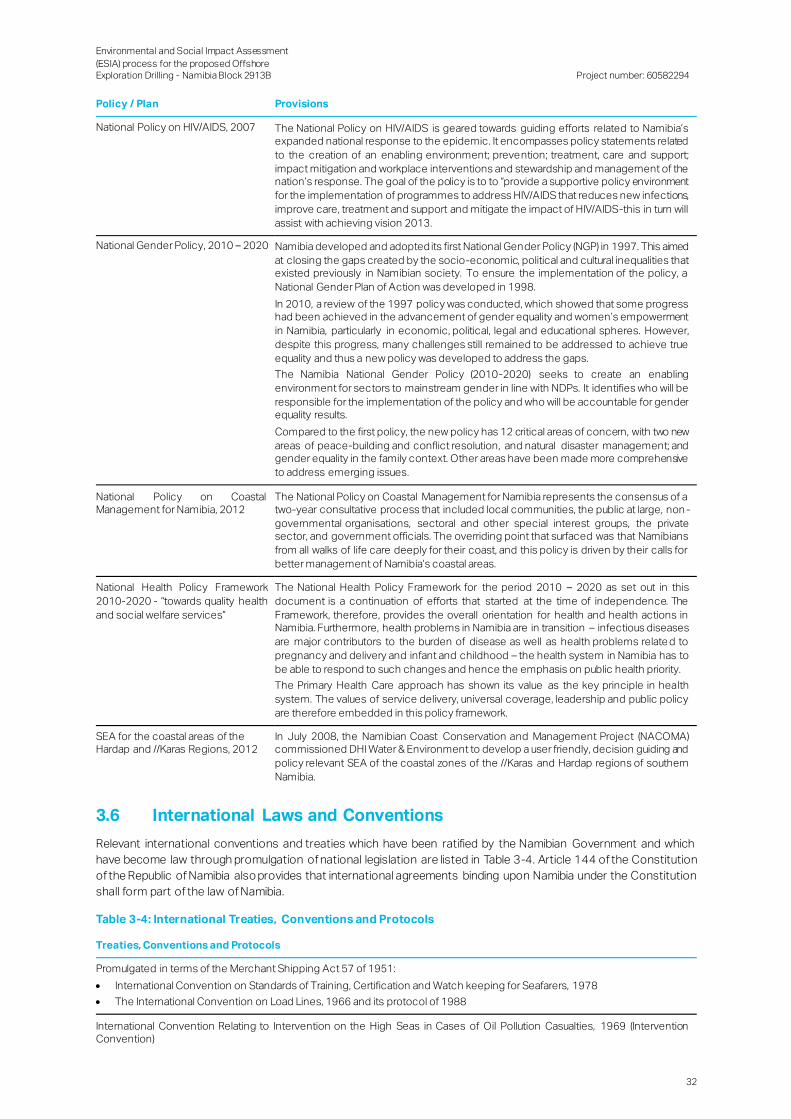
Environmental and Social Impact Assessment
(ESIA) process for the proposed Offshore Exploration Drilling - Namibia Block 2913B
Project number: 60582294
32
Policy / Plan Provisions
National Policy on HIV/AIDS, 2007 The National Policy on HIV/AIDS is geared towards guiding efforts related to Namibia’s expanded national response to the epidemic. It encompasses policy statements related
to the creation of an enabling environment; prevention; treatment, care and support;
impact mitigation and workplace interventions and stewardship and management of the nation’s response. The goal of the policy is to to “provide a supportive policy environment
for the implementation of programmes to address HIV/AIDS that reduces new infections,
improve care, treatment and support and mitigate the impact of HIV/AIDS-this in turn will
assist with achieving vision 2013.
National Gender Policy, 2010 – 2020 Namibia developed and adopted its first National Gender Policy (NGP) in 1997. This aimed
at closing the gaps created by the socio-economic, political and cultural inequalities that existed previously in Namibian society. To ensure the implementation of the policy, a
National Gender Plan of Action was developed in 1998.
In 2010, a review of the 1997 policy was conducted, which showed that some progress had been achieved in the advancement of gender equality and women’s empowerment
in Namibia, particularly in economic, political, legal and educational spheres. However,
despite this progress, many challenges still remained to be addressed to achieve true
equality and thus a new policy was developed to address the gaps.
The Namibia National Gender Policy (2010-2020) seeks to create an enabling
environment for sectors to mainstream gender in line with NDPs. It identifies who will be
responsible for the implementation of the policy and who will be accountable for gender equality results.
Compared to the first policy, the new policy has 12 critical areas of concern, with two new
areas of peace-building and conflict resolution, and natural disaster management; and gender equality in the family context. Other areas have been made more comprehensive
to address emerging issues.
National Policy on Coastal Management for Namibia, 2012
The National Policy on Coastal Management for Namibia represents the consensus of a two-year consultative process that included local communities, the public at large, non -
governmental organisations, sectoral and other special interest groups, the private sector, and government officials. The overriding point that surfaced was that Namibians
from all walks of life care deeply for their coast, and this policy is driven by their calls for
better management of Namibia’s coastal areas.
National Health Policy Framework
2010-2020 - “towards quality health
and social welfare services”
The National Health Policy Framework for the period 2010 – 2020 as set out in this
document is a continuation of efforts that started at the time of independence. The
Framework, therefore, provides the overall orientation for health and health actions in Namibia. Furthermore, health problems in Namibia are in transition – infectious diseases
are major contributors to the burden of disease as well as health problems relate d to
pregnancy and delivery and infant and childhood – the health system in Namibia has to
be able to respond to such changes and hence the emphasis on public health priority.
The Primary Health Care approach has shown its value as the key principle in health
system. The values of service delivery, universal coverage, leadership and public policy
are therefore embedded in this policy framework.
SEA for the coastal areas of the Hardap and //Karas Regions, 2012
In July 2008, the Namibian Coast Conservation and Management Project (NACOMA) commissioned DHI Water & Environment to develop a user friendly, decision guiding and
policy relevant SEA of the coastal zones of the //Karas and Hardap regions of southern
Namibia.
3.6 International Laws and Conventions
Relevant international conventions and treaties which have been ratified by the Namibian Government and which
have become law through promulgation of national legislation are listed in Table 3-4. Article 144 of the Constitution
of the Republic of Namibia also provides that international agreements binding upon Namibia under the Constitution
shall form part of the law of Namibia.
Table 3-4: International Treaties, Conventions and Protocols
Treaties, Conventions and Protocols
Promulgated in terms of the Merchant Shipping Act 57 of 1951:
International Convention on Standards of Training, Certification and Watch keeping for Seafarers, 1978
The International Convention on Load Lines, 1966 and its protocol of 1988
International Convention Relating to Intervention on the High Seas in Cases of Oil Pollution Casualties, 1969 (Intervention Convention)
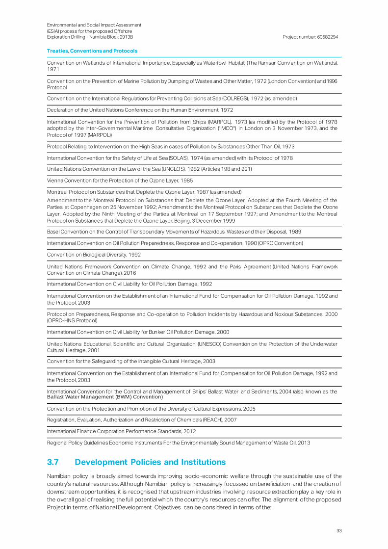
Environmental and Social Impact Assessment
(ESIA) process for the proposed Offshore Exploration Drilling - Namibia Block 2913B
Project number: 60582294
33
Treaties, Conventions and Protocols
Convention on Wetlands of International Importance, Especially as Waterfowl Habitat (The Ramsar Convention on Wetlands), 1971
Convention on the Prevention of Marine Pollution by Dumping of Wastes and Other Matter, 1972 (London Convention) and 1996 Protocol
Convention on the International Regulations for Preventing Collisions at Sea (COLREGS), 1972 (as amended)
Declaration of the United Nations Conference on the Human Environment, 1972
International Convention for the Prevention of Pollution from Ships (MARPOL), 1973 (as modified by the Protocol of 1978 adopted by the Inter-Governmental Maritime Consultative Organization ("IMCO") in London on 3 November 1973, and the
Protocol of 1997 (MARPOL))
Protocol Relating to Intervention on the High Seas in cases of Pollution by Substances Other Than Oil, 1973
International Convention for the Safety of Life at Sea (SOLAS), 1974 (as amended) with its Protocol of 1978
United Nations Convention on the Law of the Sea (UNCLOS), 1982 (Articles 198 and 221)
Vienna Convention for the Protection of the Ozone Layer, 1985
Montreal Protocol on Substances that Deplete the Ozone Layer, 1987 (as amended)
Amendment to the Montreal Protocol on Substances that Deplete the Ozone Layer, Adopted at the Fourth Meeting of the
Parties at Copenhagen on 25 November 1992; Amendment to the Montreal Protocol on Substances that Deplete the Ozone
Layer, Adopted by the Ninth Meeting of the Parties at Montreal on 17 September 1997; and Amendment to the Montreal
Protocol on Substances that Deplete the Ozone Layer, Beijing, 3 December 1999
Basel Convention on the Control of Transboundary Movements of Hazardous Wastes and their Disposal, 1989
International Convention on Oil Pollution Preparedness, Response and Co-operation, 1990 (OPRC Convention)
Convention on Biological Diversity, 1992
United Nations Framework Convention on Climate Change, 1992 and the Paris Agreement (United Nations Framework Convention on Climate Change), 2016
International Convention on Civil Liability for Oil Pollution Damage, 1992
International Convention on the Establishment of an International Fund for Compensation for Oil Pollution Damage, 1992 and
the Protocol, 2003
Protocol on Preparedness, Response and Co-operation to Pollution Incidents by Hazardous and Noxious Substances, 2000 (OPRC-HNS Protocol)
International Convention on Civil Liability for Bunker Oil Pollution Damage, 2000
United Nations Educational, Scientific and Cultural Organization (UNESCO) Convention on the Protection of the Underwater Cultural Heritage, 2001
Convention for the Safeguarding of the Intangible Cultural Heritage, 2003
International Convention on the Establishment of an International Fund for Compensation for Oil Pollution Damage, 1992 and
the Protocol, 2003
International Convention for the Control and Management of Ships’ Ballast Water and Sediments, 2004 (also known as the Ballast Water Management (BWM) Convention)
Convention on the Protection and Promotion of the Diversity of Cultural Expressions, 2005
Registration, Evaluation, Authorization and Restriction of Chemicals (REACH), 2007
International Finance Corporation Performance Standards, 2012
Regional Policy Guidelines Economic Instruments For the Environmentally Sound Management of Waste Oil, 2013
3.7 Development Policies and Institutions
Namibian policy is broadly aimed towards improving socio-economic welfare through the sustainable use of the
country’s natural resources. Although Namibian policy is increasingly focussed on beneficiation and the creation of
downstream opportunities, it is recognised that upstream industries involving resource extraction play a key role in
the overall goal of realising the full potential which the country’s resources can offer. The alignment of the proposed
Project in terms of National Development Objectives can be considered in terms of the:

Environmental and Social Impact Assessment
(ESIA) process for the proposed Offshore Exploration Drilling - Namibia Block 2913B
Project number: 60582294
34
White Paper on the Energy Policy, 1998;
Vision 2030;
The Fifth National Development Plan; and
Namibia’s Industrial Policy.
3.8 Project Policies and Standards
3.8.1 TOTAL Group Code of Conduct
TOTAL is committed to instil the values of respect, responsibility and exemplarity. The following three priority
business principles are equally critical to TOTAL’s success as a responsible company:
Commitment to health, safety and environment.
Compliance with the highest integrity standards’
Respect for human rights.
3.8.2 TOTAL Group Ethics Charter
TOTAL is committed to growing its business based on shared values and common principles that clearly assert its
ethical standards and accountability for all its businesses. In particular, TOTAL is accountable to:
Its shareholders, with the objective of striving to ensure a good return on their investment and providing them
complete and transparent information on a regular basis.
Its customers, with the commitment to supplying quality products and services in strict compliance with
accepted safety and environmental standards.
Its employees, with attention to their professional development and the promotion of health and safety in the
workplace.
Its suppliers and partners, in accordance with clear contract terms and conditions. The Group expects them
to comply with the principles and behaviours described in its Code of Conduct.
The civil society. TOTAL contributes to the social and economic development of the countries in which it
operates, in compliance with local legislation and regulation. It is committed to protecting the environment and
respecting local cultures.

Environmental and Social Impact Assessment
(ESIA) process for the proposed Offshore Exploration Drilling - Namibia Block 2913B
Project number: 60582294
35
4. Overview of the Project
TOTAL, as operator and major (70%) shareholder, propose to undertake offshore exploration drilling activities in
Block 2913B. The stages of a potential petroleum development project are indicated in Figure 4-1.
Figure 4-1: Stages of a Petroleum Development Project
4.1 Project Location
Exploration drilling will take place within offshore Block 2913B which is approximately 300 km off the coast of
Namibia from Lüderitz. (Figure 4-2), adjacent to the southernmost Namibian offshore border with South Africa.
Figure 4-3 provides an indication of the locality of Block 2913B in relatio n to other offshore exploration licence
areas. Water depths in this area range from approximately 2 ,600 to 3,300 mbmsl. The surface area of Block 2913B
is approximately 8,215km2 and several wells may be drilled for exploration or appraisal purposes within this block.
The expected well location(s) will be influenced by the location of oil-bearing layer(s), and the desire to avoid shallow
gas, which may pose a safety hazard during drilling.
4.1.1 Area of Influence
The Area of Influence (AoI) for the Project can currently be defined as:
The exploration licence area (Block 2913B) in which drilling will take place;
The route of the drilling vessel and supporting vessels from the onshore base ( Lüderitz) to Block 2913B; and
The flight path within which crew members will be transported, via helicopter, to Block 2913B.
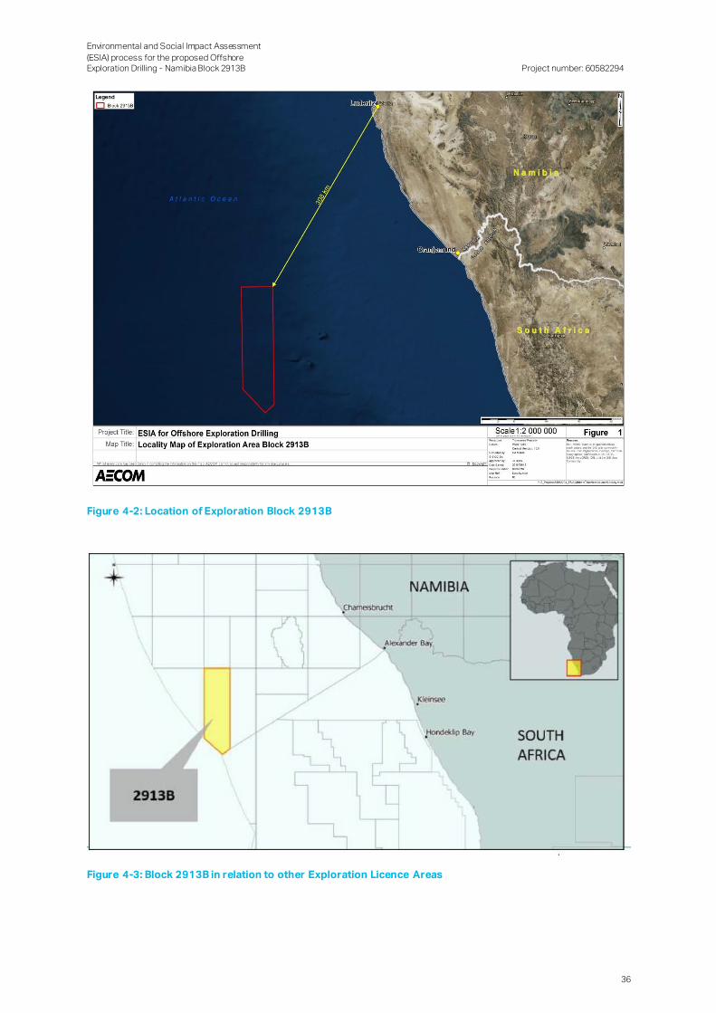
Environmental and Social Impact Assessment
(ESIA) process for the proposed Offshore Exploration Drilling - Namibia Block 2913B
Project number: 60582294
36
Figure 4-2: Location of Exploration Block 2913B
Figure 4-3: Block 2913B in relation to other Exploration Licence Areas

Environmental and Social Impact Assessment
(ESIA) process for the proposed Offshore Exploration Drilling - Namibia Block 2913B
Project number: 60582294
37
4.2 Project Schedule
The duration of drilling operations is expected to be approximately three (3) to six (6) months per well, anticipated to
commence in the second half 2019 and first half of 2020..
4.3 Main Project Components
The main project components are described in this section:
4.3.1 Onshore logistics base
The onshore logistics base would be located in the Port of Lüderitz, due to its proximity to the licence area. The
shore base would provide for the storage of materials and equipment (including drill pipes, drilling mud, chemicals
and diesel) that would be shipped to the drilling unit and back to storage for onward international freight forwarding.
The shore base would also be used for offices (with communications and emergency procedures / facil ities), waste
management services, bunkering vessels, and stevedoring / customs clearance services.
The service infrastructure required to provide the necessary onshore support is currently in place in Lüderitz and
thus no additional permanent onshore infrastructure is expected for this Project.
Crew will be transported via helicopter to the drilling unit.
4.3.2 Exploration Activities
The exploration activities required include:
Mobilising of drilling unit (commonly referred to as "drilling rig", the precise typology of which is not yet defined
at this stage of the Project) and equipment:
─ Mobilisation of the drilling rig and up to three (3) or more support vessels (Figure 4-4);
─ The rig hosts skilled personnel necessary for operations, and will be equipped with a helideck for the
transport of equipment and staff;
─ Storage of equipment and products in a logistics base whose location will be decided during the coming
months;
Drilling and testing the well:
─ Placing equipment, preparation of drilling mud;
─ Use of a drill bit attached to a drill string to drill the marine subsoil in successive sections, of smaller and
smaller diameter;
─ Casing consolidation of the drilled section, then cementation to ensure cohesion between the ground
and the tube;
─ Continuous circulation of drilling mud to balance the well pressure and raise the drill cuttings to the rig;
─ Installation of a well blowout preventer, to prevent any accidental release of hydrocarbons and to shut
the well in case of blow out;
─ Evaluation of the characteristics of the well: logging, possibly vertical seismic profile in the well, well test,
and short-term burning of hydrocarbons and fuels produced in small quantities;
Capping and suspending/abandoning the well:
─ In the event of hydrocarbon discovery: temporary securing of the well (suspension): insulation by a
cement barrier at the roof of the reservoir and at the wellhead;

Environmental and Social Impact Assessment
(ESIA) process for the proposed Offshore Exploration Drilling - Namibia Block 2913B
Project number: 60582294
38
─ In the absence of hydrocarbons: cement plugs isolating the different horizons crossed by the well and
the seabed for a definitive securing of the well (abandonment);
─ Withdrawal of all equipment (the wellhead(s) will remain and will be securely sealed);
─ Treatment of waste;
─ Departure of the rig from the licence area; and
Analysing the results.
Figure 4-4: Example of Drilling Rig and Support Vessel
4.3.3 Drilling Process
4.3.3.1 Overview of drilling process
The first step in the drilling process is to ‘spud’ the well using a large diameter conductor. This large diameter
conductor is, either set in place by jetting, or by drilling the sea floor formation. Drilling then continues from the
bottom of the conductor going deeper through the sea floor. Drilling typically proceeds by applying weight on a ‘drill
string’ made up of a drill pipe and a bottom hole assembly (that includes the drill bit, drill collars, heavy weight drill
pipe, jarring devices and down-hole measuring equipment). Normally, the rig’s top drive rotates the drill string to turn
the drill bit at its lower end. The drill bit has a larger diameter than the drill string, so that an annular space is formed
around the drill pipe as drilling progresses. The drill bit cuts into the rock formation and detaches cuttings. Drilling
fluid is pumped down inside the drill string, through nozzles in the drill bit, which then flushes the cuttings up through
the annular space between the drill string and the borehole wall until they are removed from the well.
Wells are drilled in sections, the top hole sections are typically drilled without a riser (riserless) and the drilling fluids
and cuttings are ejected from the well at the seabed. For subsequent hole sections, a ma rine riser / BOP assembly
is installed connecting the well back to the rig (Figure 4-5). The advantages of this are that:
The drilling fluids can be circulated back to the rig, cleaned and re-used;
A closed circuit of drilling fluid and cuttings makes it easier for well engineers to assess the composition of the
formation drilled;
Additional additives can be added to the drilling fluid to increase its weight and counteract the risk of a well
kick or blowout; and
If needed, in a case of loss of well control or blowout situation, the BOP can shear the drill pipe and seal in the
well by a succession of hydraulic rams.

Environmental and Social Impact Assessment
(ESIA) process for the proposed Offshore Exploration Drilling - Namibia Block 2913B
Project number: 60582294
39
Figure 4-5: Schematic of drilling process
4.3.3.2 Drilling fluids
The functions of drilling fluid are to:
Control formation pressure and prevent well control issues;
Transfer cuttings from the wellbore to the surface;
Preserve wellbore stability;
Minimise formation damage and seal permeable formations;
Cool and lubricate the drill string;
Provide information about the wellbore; and
Minimise risk to personnel, the environment, and the drilling equipment (well barrier).
4.3.3.2.1 Riserless drilling
The initial sections may be drilled using a seawater system. Seawater will be pumped down the drill string forcing
the cuttings back up the borehole into the water column and onto the seabed. While drilling, the borehole will be
cleaned out using guar gum sweeps. Prior to cementing, the hole will be displaced to a pre-hydrated bentonite pad
mud to keep the hole open. The cuttings and drill fluids (pad mud and sweeps) produced during this section will be
discharged at the seabed. Table 4-1 indicates expected cuttings volumes from drilling. The two first phases are
planned to be drilled riser less using Water based mud (WBM). The WBM will be discharged during drilling operations
in allowable quantities.
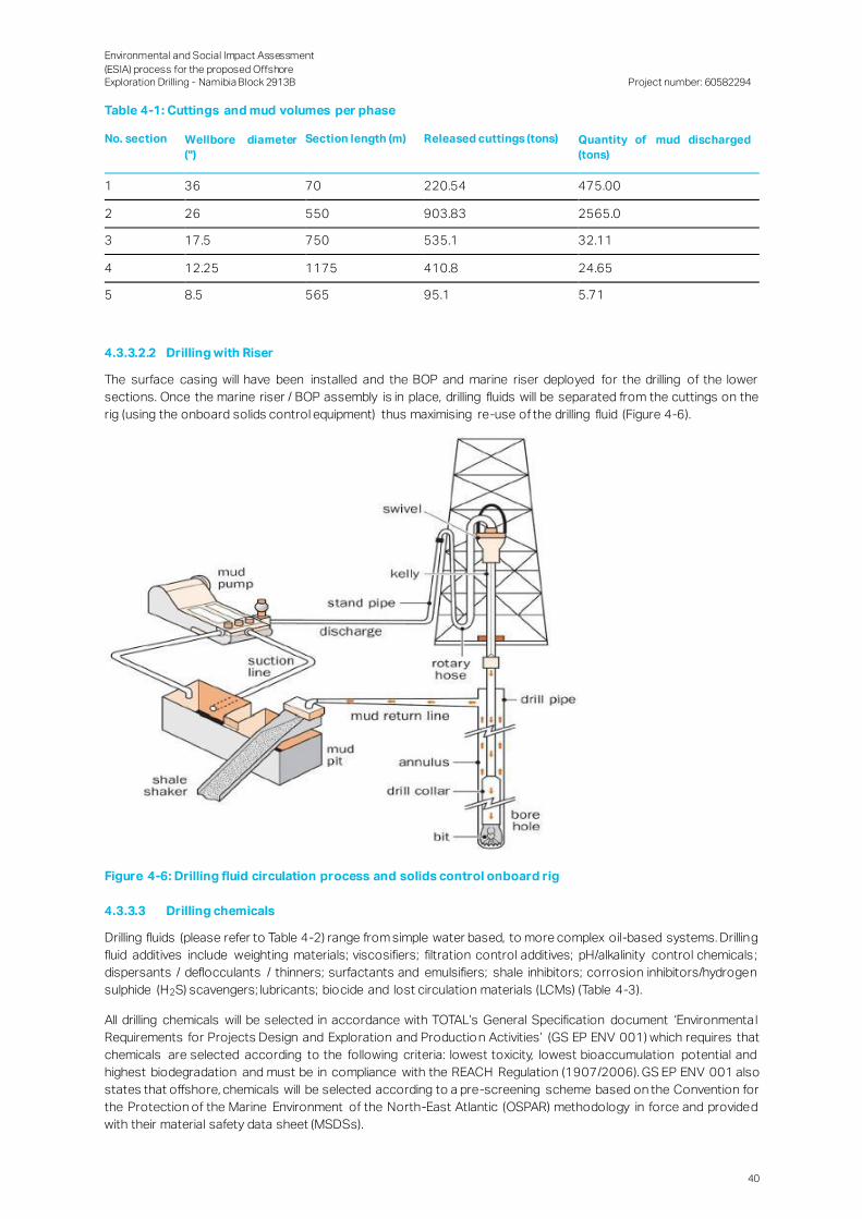
Environmental and Social Impact Assessment
(ESIA) process for the proposed Offshore Exploration Drilling - Namibia Block 2913B
Project number: 60582294
40
Table 4-1: Cuttings and mud volumes per phase
No. section Wellbore diameter
('')
Section length (m) Released cuttings (tons) Quantity of mud discharged
(tons)
1 36 70 220.54 475.00
2 26 550 903.83 2565.0
3 17.5 750 535.1 32.11
4 12.25 1175 410.8 24.65
5 8.5 565 95.1 5.71
4.3.3.2.2 Drilling with Riser
The surface casing will have been installed and the BOP and marine riser deployed for the drilling of the lower
sections. Once the marine riser / BOP assembly is in place, drilling fluids will be separated from the cuttings on the
rig (using the onboard solids control equipment) thus maximising re-use of the drilling fluid (Figure 4-6).
Figure 4-6: Drilling fluid circulation process and solids control onboard rig
4.3.3.3 Drilling chemicals
Drilling fluids (please refer to Table 4-2) range from simple water based, to more complex oil-based systems. Drilling
fluid additives include weighting materials; viscosifiers; filtration control additives; pH/alkalinity control chemicals ;
dispersants / deflocculants / thinners; surfactants and emulsifiers; shale inhibitors; corrosion inhibitors/hydrogen
sulphide (H2S) scavengers; lubricants; biocide and lost circulation materials (LCMs) (Table 4-3).
All drilling chemicals will be selected in accordance with TOTAL’s General Specification document ‘Environmenta l
Requirements for Projects Design and Exploration and Productio n Activities’ (GS EP ENV 001) which requires that
chemicals are selected according to the following criteria: lowest toxicity, lowest bioaccumulation potential and
highest biodegradation and must be in compliance with the REACH Regulation (1907/2006). GS EP ENV 001 also
states that offshore, chemicals will be selected according to a pre-screening scheme based on the Convention for
the Protection of the Marine Environment of the North-East Atlantic (OSPAR) methodology in force and provided
with their material safety data sheet (MSDSs).

Environmental and Social Impact Assessment
(ESIA) process for the proposed Offshore Exploration Drilling - Namibia Block 2913B
Project number: 60582294
41
Table 4-2: Drilling fluids generic composition
Estimated Consumptions MT / Section Total Quantity
Products
(example)
Function Conc
HiVis /GG (kg/m3)
Conc PAD
(kg/m3)
36'' 26'' PAD MT
Barite Weight Agent2 100 80.00 80.0
Caustic Soda Alkalinity1 5 5 1.25 2.75 4.00 8.0
Soda Ash Alkalinity2 5 5 1.25 2.75 4.00 8.0
Aldacide G Bactericide 1.5 0.00 1.20 1.2
Potassium
Chloride Kcl
Shale inhibitor1 60 0.00 48.00 48.0
Ez-Mud Shale inhibitor1 (Polymer)
10 0.00 8.00 8.0
Bentonite Viscosifier1 80 20.00 44.00 - 64.0
Barazan Viscosifier2 (Polymer) 3 10 0.75 1.65 8.00 10.4
Dextrid Fluid Loss1 (Starch) 30 0.00 24.00 24.0
Pac R-Polymer Fluid Loss2 10 10 2.50 5.50 8.00 16.0
Condet E Surfactant 3 0.28 - 0.28
Table 4-3: Drilling fluids generic composition (Non-Aqueous Based Mud)
Estimated Consumptions MT / Section
Products (example) Function Concentration (kg/m
3)
17 1/2'' 12 1/4'' 8 1/2''
EDC-99 DW Base oil 500 16.78 12.88 2.98
FACTANT Primary emulsifier (fatty Acid) 70 2.35 1.80 0.42
EZ MUL NT Secondary emulsifier (fatty Acid)
40 1.34 1.03 0.24
DURATONE-E Filtration control-I (l ignite) 25 0.84 0.64 0.15
LIQUITONE Filtration control-II (Polymer) 45 1.51 1.16 0.27
Lime Alkalinity control 30 1.01 0.77 0.18
SUSPPENSION Pack Viscosifier 1 (Organophilic clay)
30 1.01 0.77 0.18
BARAVIS IE 568 Viscosifier 2 (Fatty acid) 15 0.50 0.39 0.09
Calcium Chloride Calcium Chloride 70 2.35 1.80 0.42
Barite (Weighting Agent) 850 28.53 21.90 5.07
4.3.3.4 Cementing
Cementing involves mixing a slurry of cement, cement additives and water and pumping it do wn into the casing and
up the annulus (void) formed between the casing and the well bore. The cement sheath anchors and supports the
casing string and protects the steel casing from corrosion by formation fluids. It also provides a hydraulic seal that
prevents fluid communication between producing zones in the borehole and blocks escape of fluids to the surface.
Typically a small margin of excess cement is prepared for each cementing activity in order to account for possible
losses on account of the activity. The excess cement is subsequently discharged in allowable quantities.
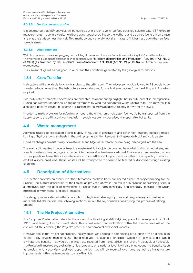
Environmental and Social Impact Assessment
(ESIA) process for the proposed Offshore Exploration Drilling - Namibia Block 2913B
Project number: 60582294
42
4.3.3.5 Vertical seismic profile
It is anticipated that VSP activities will be carried out in order to verify surface obtained seismic data. VSP refers to
measurements made in a vertical wellbore using geophones inside the wellbore and a source (generally an airgun
array) at the surface near the well. This methodology generally obtains images of higher resolution than surface
towed seismic.
4.3.3.6 Abandonment
Well abandonment consists of plugging and isolating all the zones of interest (formations containing fluids) from the surface.
The well will be plugged and abandoned in accordance with Petroleum (Exploration and Production) Act, 1991 (Act No. 2
of 1991) (as amended by the Petroleum Law s Amendment Act, 1998 (Act No. 24 of 1998)) and TOTAL’s corporate
requirements.
The cement plugs will be designed to withstand the conditions generated by the geological formations.
4.3.4 Crew Transfer
Helicopters will be available for crew transfers to the drilling unit. The helicopters would allow up to 18 people to be
transferred at any one time. The helicopters can also be used for medical evacuations from the drilling unit if or when
required.
Two daily return helicopter operations are expected to occur during daylight hours daily, except in emergencies .
During bad weather conditions, i.e. fog or extreme rain / wind the helicopters will be unable to fly. This may result in
a possible positive impact in Lüderitz or Oranjemund as crew would have to stay in town for the day(s).
In order to make provision for refuelling on-board the drilling unit, helicopter fuel would be transported from the
supply base to the drilling unit via the platform supply vessels in specialised transportable fuel tanks.
4.4 Waste management
Activities related to exploration drilling (supply of rig, use of generators and other heat engines, possibly limited
burning of hydrocarbons and fuels in the well test phase, drilling itself, etc.) will generate liquid and solid waste.
Liquid discharges consist mainly of wastewater and bilge water treated before being discharged into the sea .
The main solid wastes include putrescible waste (mainly food), to be crushed before being discharged at sea, and
specific waste such as cuttings, discharged into the sea after treatment on board. To a lesser extent, waste common
to the operation of any offshore installation (such as used lubricants, paint remains, other limited quantity chemicals ,
etc.) will also be produced. These wastes will be transported to shore to be tr eated or disposed through existing
channels.
4.5 Description of Alternatives
This section provides an overview of the alternatives that have been considered as part of project planning for the
Project. The current description of the Project as provided above is the result of a process of examining various
alternatives, with the goal of developing a Project that is both technically and financially feasible, and which
minimises environmental and social impacts.
The design process started with consideration of high-level strategic options and progressively focused in on
more detailed alternatives. The following sections set out the key considerations during this process of refining
options
4.5.1 The ‘No Project’ Alternative
The ‘no project’ alternative refers to the option of withholding (indefinitely) any plans for development of Block
2913B and leaving it in its current state. This would mean that exploration within the licence area will not be
considered, thus avoiding the Project’s potential environmental and social impacts.
However, should the Project not proceed, the key objectives relating to establishing production of the oil fields in an
economically prudent manner using sound reservoir management principles would not be met, and it would
eliminate any benefits that would otherwise have resulted from the establishment of the Project. Most noticeably,
the Project will improve the availability of fuel products on a national level. It will also bring economic benefits such
as employment, secondary business opportunities that will be required over time, as well as infrastructure
improvements within certain coastal towns of Namibia.

Environmental and Social Impact Assessment
(ESIA) process for the proposed Offshore Exploration Drilling - Namibia Block 2913B
Project number: 60582294
43
4.5.2 Drilling Unit Options
The conditions within Block 2913B, in particular the water depth, mean that certain types of drilling equipment (a
jack-up rig for example) are unsuitable. It is anticipated that the drilling in Block 2913B will be carried out with a semi-
submersible rig, or with a drill ship, depending on further studies and availability of each type of drilling unit on the
market.
4.5.3 Onshore Base Location
Lüderitz has been identified as a potential location for the logistics base to be established in support of the drilling.
Lüderitz hosts facilities and supporting contractors that could make it a suitable logistics base.
Environmental and Social Impact Assessment
(ESIA) process for the proposed Offshore Exploration Drilling - Namibia Block 2913B
Project number: 60582294
44
5. Stakeholder Consultation Process
The SCP is an integral part of the ESIA process. The objectives of SCP in an environmental process are to provide
sufficient and accessible information to stakeholders in an objective manner to assist them to:
Raise issues of concern and suggestions to mitigate impact and enhance benefits;
Verify that their issues have been recorded and considered in the environmental investigations;
Assist in commenting on feasible alternatives;
Contribute relevant local information and knowledge to the socio- environmental assessment; and
Comment on the findings of the socio-environmental assessment.
The approach towards any SCP is dependent on the details of the project. Each project has a particular geographic
and technical nature, and hence the SCP should be structured accordingly. Where possible, and within the required
statutory frameworks, it is also desirable to structure such a process to address the process needs of I&APs.
5.1 Stakeholder Identification and Analysis
A stakeholder is defined as any individual or group that is potentially affected by the project, or who has an interest
in the project and its impacts. In order to develop an effective approach to engagement, it is necessary to determine
who the stakeholders are and to assess their needs and expectations for engagement based on their interest and
influence in relation to the project.
Stakeholder analysis considers how a stakeholder or stakeholder group may be affected by the project and what
influence they may have on project outcomes in order to understand their needs and expectations for engagement .
Stakeholder identification and analysis was thus conducted with the main aims of facilitating:
Identification of the stakeholders;
Consultation with the stakeholders;
Evaluation of:
─ Their perception of the Project and of its impacts; the gap between this perception and the reality;
─ Their expectations of the Project, for example job creation, use of the local goods and services by TOTAL
and its contractors, socio-economic development projects; the legitimacy and urgency of these
expectations were analysed;
─ Their potential level of influence (direct and indirect, positive and negative) on other stakeholders;
─ Positive, neutral or negative attitude towards the Project;
─ Potential disturbances and sources of pressure or constraints with some stakeholders;
Classification and ranking of stakeholders:
─ Those that are likely to be affected by the future Project; and
─ Those with a substantial influence on the Project.
A copy of the stakeholder database is contained in Appendix C. Currently, stakeholders can be grouped as:
Government:
─ National governmental departments (e.g. the MME, MET and Ministry of Fisheries and Marine Resources
(MFMR));
─ Local government (e.g. town councils);
─ Parastatals (e.g. the Namibian Ports Authority (NamPort));
Business:
─ Adjacent exploration licence area holders;
─ Non-Governmental Organisations (NGOs);
Civil Society:

Environmental and Social Impact Assessment
(ESIA) process for the proposed Offshore Exploration Drilling - Namibia Block 2913B
Project number: 60582294
45
─ General public and other interested parties;
─ Potentially directly affected stakeholders (e.g. fishing associations); and
─ Potential indirectly affected stakeholders.
5.1.1 Public Open Days
Public Open Days were conducted as indicated in Table 5-1 below. The attendance registers, and comments from
the Public Open Days, as well as the information presented at these meetings will be contained in Appendix D.
Please refer to Appendix D.7.
Table 5-1: Public Open Days Conducted
Venue Town Date Time
Benguela Community Hall Lüderitz 09 April 2018 15h00 – 18h00
Namdeb Recreational Centre Oranjemund 11 April 2018 15h00 – 18h00
5.1.2 Draft ESIA Report Review Period
The purpose of the draft ESIA was to enable I&APs to verify that their contributions have been captured, understood
and correctly interpreted, and to raise any additional queries, comments or questions they may have of the
proposed Project. A period of 21 days was allowed for public review of the draft ESIA from 0 1 April 2019 to 21 April
2 0 1 9 at the venues indicated in Table 5-2. Electronic copies of the draft ESIA will be made available on request.
Table 5-2: Venues for Draft Scoping Report
Venue Address Contact Details
Lüderitz Community Library Ring Street, Lüderitz +264 63 202 444
Oranjemund Community Library 9th Avenue, Oranjemund +264 63 239 399
5.1.3 Final ESIA Report
Once the public review period for the draft ESIA concluded, the report was updated to a final ESIA together with the
CRR. The final ESIA will be submitted to the MME (this report).
5.2 Decision-making Phase
Should an ECC be issued, all registered I&APs will be notified of the decision and have the opportunity to appeal the
decision should they not agree with the authorisation issued or any conditions of authorisation.

Environmental and Social Impact Assessment
(ESIA) process for the proposed Offshore Exploration Drilling - Namibia Block 2913B
Project number: 60582294
46
6. Baseline Environment
NOTE: THE SUB-SECTIONS SET OUT IN THE SECTION BELOW SHOULD BE READ IN CONJUNCTION WITH THE DESKTOP STUDY ENCLOSED
HER EWITH A S AP P ENDIX B.2 .
The understanding of the environmental and social context and sensitivity within the project area is important to
understand the potential impacts of the proposed project activities. In this ESIA, the receiving environment is
defined as the physical and geophysical environment, the biophysical environment (which includes marine and
coastal plants and animals), and the social environment (including livelihoods and commercial activities). This
section provides a description of the attributes of the physical, biophysical and social receiving environment of the
Project area and the southern Namibian offshore regional area.
Very limited information is available of the Project area, so comparisons have been made with the neighbouring
exploration areas Block 2913A and 2914B and the Orange Basin TCP, which lies offshore on the west coast of South
Africa and covers approx. 15,474km² in water depths between 2,700m and 4,250m (Figure 6-1).
Figure 6-1: The location of Block 2913B in relation to neighbouring blocks 2913A and 2914B
6.1 Physical Environment
6.1.1 Climate
During the summer season a clear east-to-west gradient is experienced on the Namibian coast and in winter, a
northwest-to-southeast gradient is experienced that is characterised by little to no rainfall. The coastal areas
experience mean monthly minimum temperatures ranging from 16 - 22 degrees Celsius (°C) and maximum
temperatures throughout the year of 10 – 17 °C (Figure 6-2 and Figure 6-5) (GRN, 2015).
Average daylight hours for Oranjemund and Lüderitz are indicated in Figure 6-4 and Figure 6-7 respectively.
Annual precipitation in 2018 ranged from 15.4 mm at Lüderitz to 53.1 mm at Oranjemund. The southern coastline
is characterised by frequent dense fog (which is further driven by the Benguela Current System), and overall lower

Environmental and Social Impact Assessment
(ESIA) process for the proposed Offshore Exploration Drilling - Namibia Block 2913B
Project number: 60582294
47
temperatures than in the rest of the region. The extreme fog conditions experienced in winter could result in a delay
in planned flights as a result of decreased visibility (Figure 6-3 and Figure 6-6).
Figure 6-2: Oranjemund average annual temperature (Source: National Oceanic and Atmospheric
Administration (2018))
Figure 6-3: Oranjemund average annual precipitation (Source: National Oceanic and Atmospheric
Administration, 2018)
Figure 6-4: Oranjemund average daylight hours (Source: National Oceanic and Atmospheric
Administration, 2018)

Environmental and Social Impact Assessment
(ESIA) process for the proposed Offshore Exploration Drilling - Namibia Block 2913B
Project number: 60582294
48
Figure 6-5: Lüderitz average annual temperature (Source: National Oceanic and Atmospheric
Administration, 2018)
Figure 6-6: Lüderitz average annual precipitation (Source: National Oceanic and Atmospheric
Administration, 2018)
Figure 6-7: Lüderitz average daylight hours (Source: National Oceanic and Atmospheric Administration ,
2018)
6.1.2 Air quality and Wind Patterns
The offshore ambient air quality of Namibia is not generally recorded but considered to be largely free of man-made
pollutants, as Namibia overall does not have major industries (Risk-Based Solutions, 2018). The nearshore Benguela
Current Large Marine Ecosystem (BCLME) is largely driven by wind. The wind generates the heavy and regular
south-westerly swells that impact on the coast on an oceanic scale, it equally locally contributes to the northward-
flowing longshore currents. The upwelling of deep, cool water along the Namibian coast is caused by the Benguela
Sea current. The prevalent winds in the BCLME region are driven by the South Atlantic subtropical areas of high
pressure (i.e. anticyclone), the eastward moving mid-latitude cyclones south of Southern Africa, and the seasonal
atmospheric pressure field over the subcontinent (Pisces Environmental Services (Pty) Ltd, 2018) ( Figure 6-8).

Environmental and Social Impact Assessment
(ESIA) process for the proposed Offshore Exploration Drilling - Namibia Block 2913B
Project number: 60582294
49
Figure 6-8: The main features of the Benguela Current System (Source: Pisces Environ mental Services
(Pty) Ltd, 2018)
The south Atlantic anticyclone is a persistent feature within this system and it is also part of the intermittent belt of
high-pressure systems which encircle the subtropical southern hemisphere. This anticyclone experiences a range
of changes throughout the different seasons - the strongest in the arid and blazing summer season, when it also
attains its southernmost extension. Furthermore, it lies south west and south of Southern Africa as indicated by
Voluntary Observing Ship (VOS) data in Figure 6-9. During the winter season (season of low precipitation), the south
Atlantic anticyclone weakens and migrates north-westwards (Swart, 2017).
The most resilient upwelling cells are located where the inner-continental shelf is narrow (closer to the coast) and
winds are strong. This upwelling causes deep, nutrient-rich water to move to the sea surface where planktonic plants
make use the nutrients; these plants then serve as a food source for fish and other animals as driven by wind (Swart,
2017).

Environmental and Social Impact Assessment
(ESIA) process for the proposed Offshore Exploration Drilling - Namibia Block 2913B
Project number: 60582294
50
Figure 6-9: Wind Speed vs Wind Direction data for the offshore area 28°29’ S; 15°16’E (Source: Pisces
Environmental Services (Pty) Ltd, 2018)
6.1.3 Bathymetry and Geology
The continental shelf off southern Namibia is variable in width. Off the Orange River, the shelf is approximately 230
km wide and characterised by well-defined shelf breaks, a shallow outer shelf, and the aerofoil-shaped submarine
‘Recent River Delta’ on the inner shelf. It narrows to the north reaching its narrowest point approximately 90 km off
Chameis Bay, before widening again to 130 km off Lüderitz (Rogers, 1977).
The prominent topographic features of the shelf include the relatively st eep descent to about 100 m, the gentle
decline to about 180 m and the undulating depths to about 200 m. The Orange Banks comprise three low mounds
rising to about 160 m on the outer shelf. North of Chameis Bay, the shelf becomes a stepped feature, with a low step
having an elevation between roughly 400 m – 450 m below mean sea level (bmsl), making it one of the deepest in
the world. The variable topography of the shelf is of significance for nearshore circulation and for fisheries (Shannon
and O’Toole, 1998). Banks on the continental shelf include the Orange Bank (Shelf or Cone), a shallow (160 m – 190
m) zone that reaches maximal widths (180 km) offshore of the Orange River, and Child’s Bank, situated approximately
150 km offshore at about 31°S. Tripp Seamount, approximately 100 km east of the area of interest, is a geological
feature situated approximately 300 km offshore at about 29°S, which rises from the seabed at approximately 1,000
m to a depth of 150 m (Figure 6-10).

Environmental and Social Impact Assessment
(ESIA) process for the proposed Offshore Exploration Drilling - Namibia Block 2913B
Project number: 60582294
51
Figure 6-10: Expected Sediments within Block 2913B Offshore Namibia (Source: modified after Rogers,
1977)
The inner shelf is underlain by Precambrian bedrock (also referred to as Pre-Mesozoic basement), whilst the middle
and outer shelf areas are composed of Cretaceous and Tertiary sediments (Dingle, 1973; Birch et al., 1976; Rogers,
1977; Rogers & Bremner, 1991; Bagguley and Prosser, 1999; Stevenson and McMillan, 2004). Due to erosion on the
continental shelf, the unconsolidated sediment layer is generally thin, often less than 1 m. Sediments become finer
seawards, changing from sand on the inner and outer shelves to muddy sand and sandy mud in deeper water ; the
latter is expected to occur within Block 2913B. However, this general pattern has been modified considerably by
biological deposition (high levels of calcium carbonate (CaCO3) within the shelf sediments) and localised river input.
An approximately 500 km long mud belt (up to 40 km wide, and of 15 m average thickness) is situated over the outer
edge of the middle shelf between the Orange River and St. Helena Bay (Birch et al., 1976; Meadows et al., 1997;
2002; Herbert and Compton, 2007).
The bathymetry of the survey block has been assessed from the analysis of the first return extracted from previous
seismic datasets. These show several deep-water bathymetric features across the block which are expected to
relate to geological features, where variability in seabed erosion have created defined boundaries in the bat hymetr y
and potentially seabed erosion. This in turn may affect habitat types on both a localised and regional level.
Conspicuous features include shallow canyons (i.e. mass gravitational flow features), escarpments, eroded plateaus
and sedimentary basins.
6.1.4 Noise
N O TE: THIS SUB-SECTION BELOW SHOULD BE READ IN CONJUNCTION WITH THE IMPACT ASSESSMENT ENCLOSED HEREWITH AS APPENDIX
B.1 .
Noise pollution in the BCLME predominantly stems from mining exploration (seismic) and flights over predator
breeding sites usually transporting tourists, and mainly around the offshore islands. Seismic activities are believed
to affect the behaviour of some species of fish, particularly changing the migration pattern of tuna fish species or
resulting in the tuna fish species acclimatising itself deeper than its habitual level. Likewise, aircraft flying over
seabird and seal breeding colonies cause stampedes and nest desertion. Seismic related activities are not
permitted within Marine Protected Areas (MPAs) as the noise can have negative impacts to breeding areas (Davies
et al., 2014).
6.1.4.1 Sound Thresholds
Thresholds are usually proposed in terms of one or more different sound level metrics ( Sound Pressure Level (SPL)
and Sound Exposure Level (SEL)) and for different levels of potential impact ranging from mortality, physical injur y
and hearing impairment through to behavioural reactions which includes changes in feeding, breeding, respiration
Environmental and Social Impact Assessment
(ESIA) process for the proposed Offshore Exploration Drilling - Namibia Block 2913B
Project number: 60582294
52
or patterns of movement such as fleeing or avoidance. Thresholds for hearing impairment consider potential
permanent and temporary effects on hearing where animals exposed to sufficiently intense or lengthy sound can
experience an increase in hearing threshold (i.e. poorer sensitivity) for some period of time following exposure.
This change in hearing is called a sound-induced threshold shift and the amount of shift is determined by the
distance between a sound and the individual at the time of hearing the sound in combination with the amplitude,
duration, frequency content, temporal pattern, and energy distribution of the sound exposure relative to the hearing
sensitivity of the species and the background sound levels. Hearing threshold shifts may be permanent (PTS) or
temporary (TTS) and thus hearing impairment impacts are generally considered at these two levels:
Permanent threshold shift (PTS) is a permanent, irreversible increase in the threshold of audibility at a specified
frequency or portion of an individual’s hearing range above a previously established reference level. This is
considered to be auditory injury. Due to the absence of data on permanent injury in marine taxa, PTS
thresholds have been extrapolated from observed TTS responses and therefore, there are high levels of
uncertainty in the currently available threshold criteria for PTS in marine receptors.
TTS is a temporary, reversible increase in the threshold of audibility at a specified frequency or portion of an
individual’s hearing range above a previously established reference level.
Behavioural thresholds are based on observations of individuals or groups of individuals when exposed to sound at
a given level (Southall et al., 2007; Popper et al., 2014; National Marine Fisheries, 2018). The sound levels involved
are lower or for a shorter duration than those that would give rise to PTS or TTS. The nature of the sound, in terms
of its frequency content as well as its duty cycle, whether continuous (e.g. non-impulsive sounds associated with
drilling) or intermittent (e.g. impulsive sounds associated with VSP airguns) governs how the receptor may respond.
The response of the animal is also often context-dependent (i.e. feeding, breeding, migrating, life cycle stage etc.)
and may relate to its motivation and previous experience to the perturbing sound. Where dual metric impact
thresholds are available, the threshold criterion which is exceeded first (i.e. the more precautionary of the two
measures) is used to determine potential impact distances (Southall et al., 2007; National Marine Fisheries, 2016).
6.2 Biophysical Environment
6.2.1 Marine Habitats
The offshore marine ecosystems comprise a limited range of habitats, namely unconsolidated seabed sediments
and the water column. The biological communities ‘typical’ of these habitats are described briefly below, focussing
both on dominant and conspicuous species, as well as potentially threatened or sensitive species, which may be
affected by the proposed exploration well drilling (SLR Environmental Consulting, 2017) .
Several studies have been carried out on the southern Afr ican West Coast continental shelf benthos however, the
benthic fauna of the outer shelf and continental slope (beyond 450m water depth) are very poorly known. However,
benthic communities are generally influenced by the complex interplay of environmental factors, with water depth
and sediment particle size being considered the two major factors determining and affecting benthic communit y
structure and distribution on the southern African West (MetOcean Services International (Pty) Ltd (2019) adapted
from Christie, 1974; 1976; Steffani, 2007a; 2007b). The periodic intrusion of low oxygen water masses in the deep -
water shelf areas of the southern Africa West Coast is likely to also contribute to benthic community variabilit y
(MetOcean Services International (Pty) Ltd (2019) adapted from Monteiro and van der Plas, 2006; Pulfrich et al.,
2006). Sampling and characterization of benthic fauna was including in the Environmental Baseline Study. The
benthic community observed during sampling and video observations was similar based on a firm cream to light
brown clay with only a fine soft surface layer of unconsolidated materials (ca 1-2 cm). Samples taken were not rich,
with conspicuous fauna limited to polychaetes, (including worm tubes) and sipunculids.
Much of the seabed has been broadly categorised by Rogers and Bremner (1991), however the species
communities and interaction of benthic animals are poorly understood. Polychaetes and small bivalves are likely to
dominate the seabed in shelf waters <200m whereas echinoderms (see urchins, star fish, etc.), burrowing and
swimming crabs and shrimps are more likely to be common in deeper waters (Rogers and Bremner, 1991). Epifaunal
and bottom dwelling species are also expected to occur within soft-bottom sediments in the survey area. Atkinson
(2009) reported numerous species of urchins and burrowing anemones beyond 300m depth off the South African
West Coast. The seabed was observed to be largely homogeneous during the Environmental Baseline Survey, with
an absence of conspicuous sedimentation. A characteristic sample is shown in (Figure 6-11).

Environmental and Social Impact Assessment
(ESIA) process for the proposed Offshore Exploration Drilling - Namibia Block 2913B
Project number: 60582294
53
Figure 6-11: Photo of Seabed in Block 2913B
The bulk of the seawater in this area is made up by South At lantic Central Water (SACW) (Figure 6-12) and occurs
either in its pure form in the deeper regions or is mixed with previously upwelled water of the same origin on the
continental shelf (Nelson and Hutchings, 1983) with a salinity reported to range between 34.5% and 35.5%
(Shannon, 1985).
Figure 6-12: The Current System along West Coast of Namibia (Checkley et al., 2009)
Seawater temperatures on the continental shelf of the southern Benguela typically vary between 6°C and 16°C with
well-developed thermoclines. The continental shelf waters of the Benguela system are characterised by low oxygen
concentrations, especially on the bottom. SACW itself has depressed oxygen concentrations (~80% saturation

Environmental and Social Impact Assessment
(ESIA) process for the proposed Offshore Exploration Drilling - Namibia Block 2913B
Project number: 60582294
54
value), but lower oxygen concentrations (<40% saturation) frequently occur (Bailey et al., 1985; Chapman and
Shannon, 1985).
6.2.1.1 Nutrients and Plankton production
Cold upwelled water is rich in inorganic nutrients containing various forms of nitrates, phosphates and silicates
(Chapman and Shannon, 1985). During upwelling processes, the comparatively nutrient -poor surface waters are
displaced by enriched deep water which supports substantial seasonal primary phytoplankton production. High
phytoplankton productivity in the upper layers again depletes the nutrients in these surface waters. This results in
a wind-related cycle of plankton production, mortality, sinking of plankton detritus and eventual nutrient re-
enrichment occurring below the thermocline as the phytoplankton decays (SLR Environmental Consulting, 2017).
Phytoplankton is mainly dominated by diatoms which are adapted to the turbulent sea conditions. Diatom blooms
occur after upwelling events whereas dinoflagellates are more common in blooms that happen during quiescent
periods (SLR Environmental Consulting, 2017).
Meso-zooplankton (< 2 mm body width) communities includes egg, larval, juvenile and adult stages of copepods,
cladocerans, euphausiids, decapods, chaetognaths, hydromedusae and salps, as well as protozoans and
meroplankton larvae (Maartens, 2003; Hansen et al., 2005) with copepods being the most dominant group making
up 70%-85% of the zooplankton (SLR Environmental Consulting, 2017).
Ecosystem models have estimated that 36% of the phyto- and 5% of the zooplankton are lost to the seabed
annually (Shannon et al., 2003), which has a substantial effect on the ecosystems of the Benguela region resulting
in high organic content of the muds in this region. Most of the organic detritus is not directly consumed and enters
the seabed decomposition cycle which can potentially lead to subsequent depletion of oxygen in deeper waters.
Within the survey area phytoplankton biomass is expected to be diminished due to high turbulence and deep mixing
in the water column, which leads to poor feeding conditions for micro -, meso-, macro-zooplankton and
ichthyoplankton (Lett et al., 2007), thus zoo- and ichthyoplankton abundance are expected to be low overall.
Severe oxygen depletion can lead to the formation of hydrogen sulphide (H2S) gas by anaerobic bacteria in anoxic
seabed muds (Brüchert et al., 2003). This can be released periodically from the muds as ‘sulphur eruptions’, causing
upwelling of anoxic water and formation of surface slicks of sulphur discoloured water (Emeis et al., 2004).
6.2.2 Fish
While overall species richness and levels of endemism are reasonably low, several species of marine fish and other
marine organisms are for the most part abundant along the Namibian coast as a direct result of the nutrient-rich
Benguela current and upwelling cells (Pisces Envieonmental Consulting (Pty) Ltd, 2014a). Fish and other marine
species which are important for the economy include hake, orange roughy and monkfish (demersal or deep-water
species), which are found at the sea bottom far out to sea and provide the highest economic returns; horse
mackerel, pilchard and anchovy (pelagics usually occur closer to the surface and shore); and species associated
with the coastline such as rock lobster, seals and birds. In addition, 31 species of cetaceans are known to occur in
Namibian waters, and the Heaviside dolphin (Cephalorhynchus heavisidii) is endemic to the Benguela current
ecosystem (Ministry of Fisheries and Marine Resources, 2009; Ministry of Environment and Tourism, 2010).
Sardine (Sardinops sagax) is a transboundary species occurring from southern Angola to South Africa eastwards
into the Agulhas system. There are two main stocks, southern and northern, separated by the Lüderitz upwelling
cell. The proposed Project area is located within the area of the southern stock, close to the Benguela Fronts as
illustrated in Figure 6-13. No spawning grounds have been recorded in the area and the occurrence of Madeir an or
flat sardinella (Sardinella maderensis) and the Round sardinella (S. aurita) is inexistent (Davie et al., 2014).
Due to its offshore location, plankton abundance is expected to be low, with the major fish spawning and migration
routes occurring further inshore on the shelf. The dominant fish in the area would include the migratory large pelagic
species such as albacore tuna (Thunnus alalunga), yellowfin tuna (T. albacares), bigeye tuna (T. obesus), swordfish
(Xiphias gladius) and shark species (Pisces Environmental Services (Pty) Ltd, 2018).

Environmental and Social Impact Assessment
(ESIA) process for the proposed Offshore Exploration Drilling - Namibia Block 2913B
Project number: 60582294
55
Figure 6-13: Distribution of sardine (left) and distribution of both sardinella species (right) (Source:
Benguela Current Commission, 2012)
Fish species which are classified as endangered or vulnerable have that status as a result of various factors. These
factors may include poor regulation of the tourism sector, lack of pollution control, overfishing and unsustainable
fishing techniques. Table 6-1 indicates some of the fish species which have been categorised as Vulnerable (VU) or
Endangered (EN) within Namibian waters.
Table 6-1: Red Data Fish Species (Davies et al., 2014; Earth's Endangered Creatures, 2018)
Species Common name Namibian
status1
Year assessed Population
trend
Oxynotus centrina Angular Rough Shark VU 2007 Unknown
Thunnus obesus Bigeye Tuna VU 1996 Uncertain
Rhinobatos cemiculus Blackchin Guitarfish EN 2007 Decreasing
Rostroraja alba Bottlenose Skate EN 2006 Decreasing
Squalus acanthias Piked dogfish VU 2006 Decreasing
Rhinobatos rhinobatos Common Guitarfish / Violinfish EN 2007 Decreasing
Centrophorus squamosus Deepwater Spiny Dogfish VU 2003 Decreasing
Epinephelus marginatus Dusky Grouper EN 2004 Decreasing
Carcharias taurus Grey Nurse Shark / Spotted
Ragged-tooth Shark
VU 2005 Unknown
Carcharodon carcharias Great White Shark VU 2005 Unknown
Centrophorus granulosus Gulper Shark VU 2006 Decreasing
Galeorhinus galeus Soupfin VU 2006 Decreasing
1 EN – Endangered, VU – Vulnerable
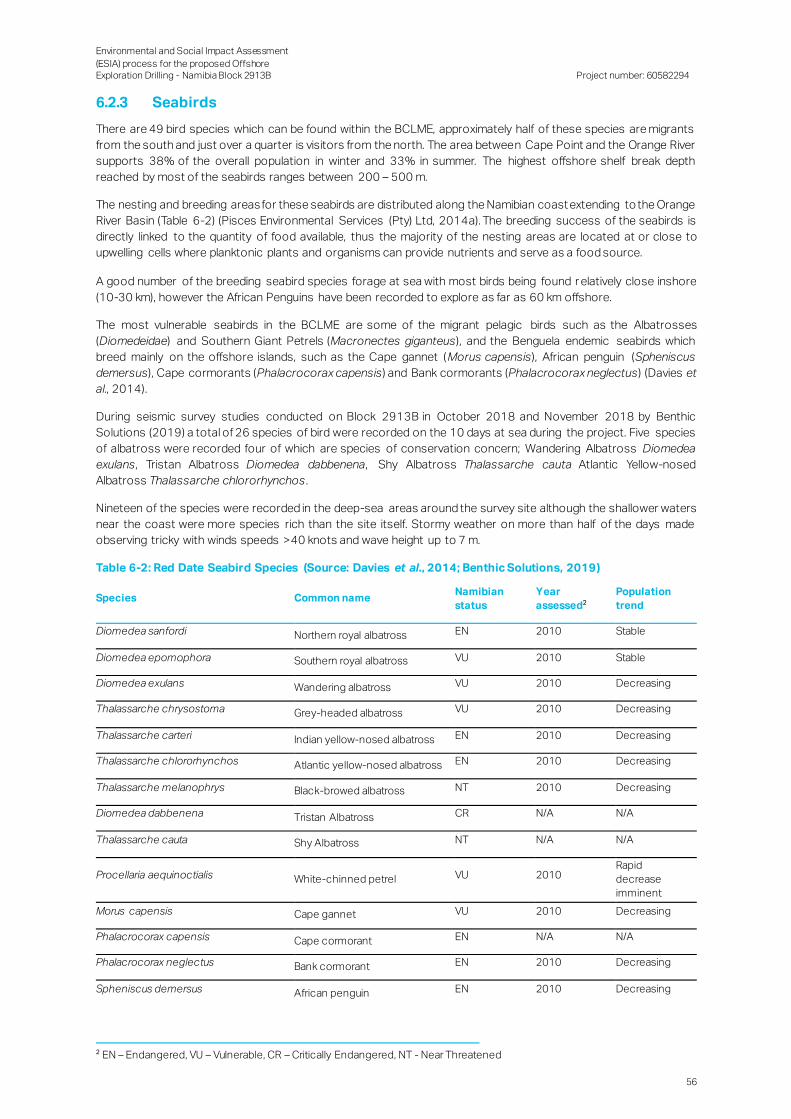
Environmental and Social Impact Assessment
(ESIA) process for the proposed Offshore Exploration Drilling - Namibia Block 2913B
Project number: 60582294
56
6.2.3 Seabirds
There are 49 bird species which can be found within the BCLME, approximately half of these species are migrants
from the south and just over a quarter is visitors from the north. The area between Cape Point and the Orange River
supports 38% of the overall population in winter and 33% in summer. The highest offshore shelf break depth
reached by most of the seabirds ranges between 200 – 500 m.
The nesting and breeding areas for these seabirds are distributed along the Namibian coast extending to the Orange
River Basin (Table 6-2) (Pisces Environmental Services (Pty) Ltd, 2014a). The breeding success of the seabirds is
directly linked to the quantity of food available, thus the majority of the nesting areas are located at or close to
upwelling cells where planktonic plants and organisms can provide nutrients and serve as a food source.
A good number of the breeding seabird species forage at sea with most birds being found r elatively close inshore
(10-30 km), however the African Penguins have been recorded to explore as far as 60 km offshore.
The most vulnerable seabirds in the BCLME are some of the migrant pelagic birds such as the Albatrosses
(Diomedeidae) and Southern Giant Petrels (Macronectes giganteus), and the Benguela endemic seabirds which
breed mainly on the offshore islands, such as the Cape gannet (Morus capensis), African penguin (Spheniscus
demersus), Cape cormorants (Phalacrocorax capensis) and Bank cormorants (Phalacrocorax neglectus) (Davies et
al., 2014).
During seismic survey studies conducted on Block 2913B in October 2018 and November 2018 by Benthic
Solutions (2019) a total of 26 species of bird were recorded on the 10 days at sea during the project. Five species
of albatross were recorded four of which are species of conservation concern; Wandering Albatross Diomedea
exulans, Tristan Albatross Diomedea dabbenena, Shy Albatross Thalassarche cauta Atlantic Yellow-nosed
Albatross Thalassarche chlororhynchos .
Nineteen of the species were recorded in the deep-sea areas around the survey site although the shallower waters
near the coast were more species rich than the site itself. Stormy weather on more than half of the days made
observing tricky with winds speeds >40 knots and wave height up to 7 m.
Table 6-2: Red Date Seabird Species (Source: Davies et al., 2014; Benthic Solutions, 2019)
Species Common name Namibian
status
Year
assessed2
Population
trend
Diomedea sanfordi Northern royal albatross EN 2010 Stable
Diomedea epomophora Southern royal albatross VU 2010 Stable
Diomedea exulans Wandering albatross VU 2010 Decreasing
Thalassarche chrysostoma Grey-headed albatross VU 2010 Decreasing
Thalassarche carteri Indian yellow-nosed albatross EN 2010 Decreasing
Thalassarche chlororhynchos Atlantic yellow-nosed albatross EN 2010 Decreasing
Thalassarche melanophrys Black-browed albatross NT 2010 Decreasing
Diomedea dabbenena Tristan Albatross CR N/A N/A
Thalassarche cauta Shy Albatross NT N/A N/A
Procellaria aequinoctialis White-chinned petrel VU 2010 Rapid
decrease
imminent
Morus capensis Cape gannet VU 2010 Decreasing
Phalacrocorax capensis Cape cormorant EN N/A N/A
Phalacrocorax neglectus Bank cormorant EN 2010 Decreasing
Spheniscus demersus African penguin EN 2010 Decreasing
2 EN – Endangered, VU – Vulnerable, CR – Critically Endangered, NT - Near Threatened

Environmental and Social Impact Assessment
(ESIA) process for the proposed Offshore Exploration Drilling - Namibia Block 2913B
Project number: 60582294
57
6.2.4 Sea turtles
Sea turtles in Namibia are categorised under the critically endangered and endangered status, this is as a result of
the turtles being hunted extensively in the past for their skins and meat. Turtles that may be present in the area are
indicated in Table 6-3.
Table 6-3: Sea Turtles that may be present in the Study Area (Source: Benguela Current Commission,
2012)
Species Common name Namibian
status
Year assessed Population
trend
Dermochelys coriacea Leatherback turtle CR 2000 Decreasing
Caretta caretta Loggerhead EN 1996 Not recorded
Chelonia mydas Green turtle EN 2004 Decreasing
6.2.5 Marine Mammals
Marine mammals along the Namibian shoreline include seals, whales and dolphins (Bianchi, et al., 1999). Marine
mammals are divided into two orders, namely Cetacea and Pinnipedia. The Cetacea order consists of whales and
dolphins, while the Pinnipedia order represents seals (Figure 6-15) (Bianchi et al., 1999). According to (Currie et al.,
2008) these marine mammals contribute towards the retention and concentration of nutrients in the coastal regions
through supporting the ecosystem and 7% of these species are endemic to Namibia.
The biggest threat to these marine mammals is solid waste pollution, which consists mainly of plastic waste as well
as discarded or lost fishing gear (Davies et al., 2014). The closest marine mammal range to the proposed exploration
site is the Resident Killer whale (Orcinus orca), a sub-order of the Cetacea group.
During seismic survey studies conducted on Block 2913B in October 2018 and November 2018 by Benthic
Solutions (2019), visual sightings of marine mammal species are indicated in Table 6-4 and .
Table 6-4: Marine mammal sightings
Species Sightings
Common Name Scientific Name
Dusky Dolphin Lagenorhynchus obscurus 1
Fin Whale Balaenoptera physalus 4
Haviside dolphin Cephalorhynchus heavisidii 2
Cephalorhynchus heavisidii Globicephalus macrorhynchus 2
Unidentified Baleen whale sp. 4
Unidentified Whale sp. 1
South African and Australian Fur Seals Arctocephalus pusillus 28
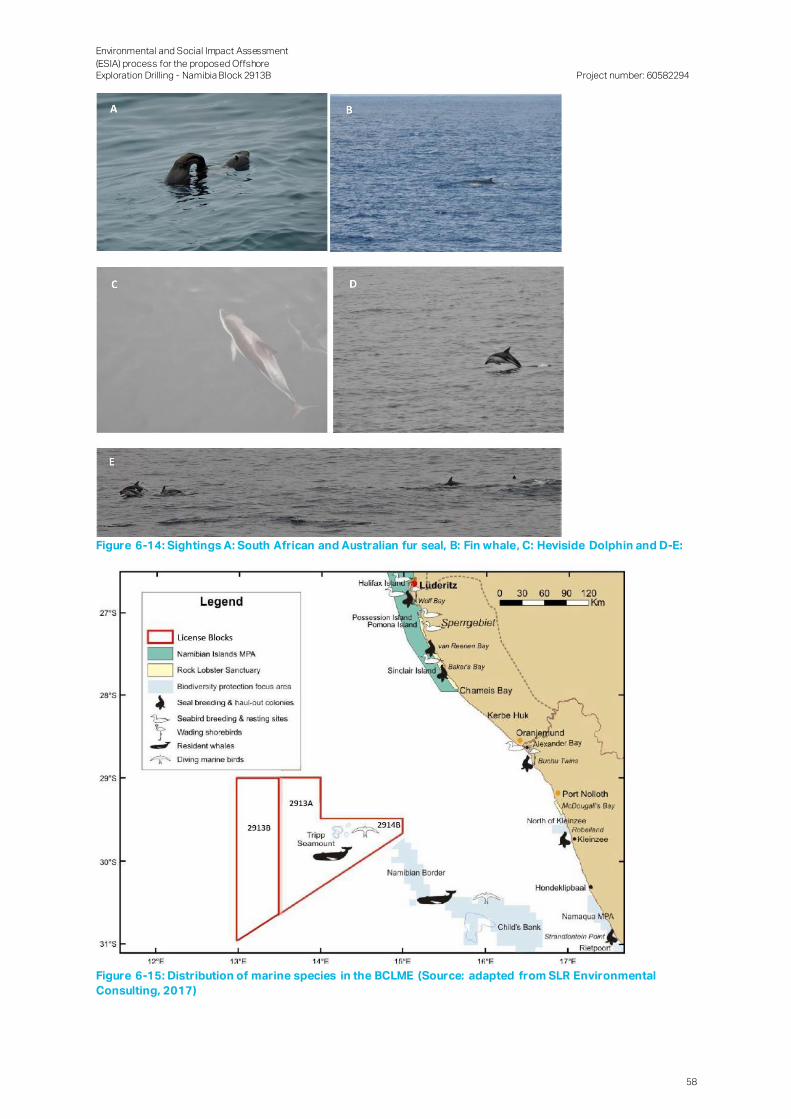
Environmental and Social Impact Assessment
(ESIA) process for the proposed Offshore Exploration Drilling - Namibia Block 2913B
Project number: 60582294
58
Figure 6-14: Sightings A: South African and Australian fur seal, B: Fin whale, C: Heviside Dolphin and D-E:
Figure 6-15: Distribution of marine species in the BCLME (Source: adapted from SLR Environmental
Consulting, 2017)
Environmental and Social Impact Assessment
(ESIA) process for the proposed Offshore Exploration Drilling - Namibia Block 2913B
Project number: 60582294
59
6.2.6 Deep-water Coral Communities
Deep-water coral communities, some in the form of a reef whilst others remain solitary, may be present within the
Project area as these benthic filter-feeders generally occur at depths exceeding 150 m. These animals add
structural complexity to otherwise uniform seabed habitats thereby creating areas of high biological diversit y
(Breeze et al., 1997; MacIssac et al., 2001). They establish themselves below the thermocline where there is a
continuous and regular supply of concentrated particulate organic matter, caused by the flow of a relatively strong
current over special topographical formations which cause eddies to form. Nutrient seepage from the substratum
might also promote a location for settlement (Hovland et al., 2002). Substantial shelf areas in the productive
Benguela region should thus potentially be capable of supporting rich, cold water, benthic, filter-feeding
communities. Areas of potential interest within the block would typically be found around discreet bathymetric
features, such as along the edge of well-defined escarpments where strong currents and harder substrates are
likely to be encountered.
6.2.7 Seamount Communities
Seabed features such as the Orange Bank, Childs Bank, and Tripp Seamount have been reported for nearby licence
Blocks 2913A and 2914B. Features such as banks, knolls and seamounts (referred to collectively here as
‘seamounts’), which protrude into the water column, are subject to, and interact with, the water currents surrounding
them. The effects of such seabed features on the surrounding water masses can include the upwelling of relatively
cool, nutrient-rich water into nutrient-poor surface water thereby resulting in higher productivity (Clark et al., 1999),
which can in turn strongly influences the distribution of organisms on and around seamounts. Studies conducted
on other seamounts have identified that enhanced fluxes of detritus and plankton, developed in response to the
complex current regimes, lead to the development of detritivore-based food-webs, which in turn resulted to the
presence of seamount scavengers and predators. Many of these species are long-lived and slow-growing, moving
into deeper waters with age after spending time around the summits of seamounts in their early stages ( South
Pacif ic Regional Fisheries Management Authority (SPRFMA), 2007). Evidence of enrichment of bottom-associated
communities and high abundances of demersal fishes have been regularly reported over such seabed features.
Enhanced currents, steep slopes and volcanic rocky substrata, in combination with locally generated de tritus,
favour the development of suspension feeders in the benthic communities characterising seamounts (Rogers,
1994). Deep- and cold-water corals (including stony corals, black corals and soft corals) are a prominent
component of the suspension-feeding fauna of many seamounts, accompanied by barnacles, bryozoans,
polychaetes, molluscs, sponges, sea squirts, basket stars, brittle stars and crinoids (reviewed in Rogers, 2004).
There is also associated mobile benthic fauna that includes echinoderms (sea urchins and sea cucumbers) and
crustaceans (crabs and lobsters) (reviewed by Rogers, 1994). Some of the smaller cnidarian species remain solitary
while others form reefs thereby adding structural complexity to otherwise uniform seabed habitats. The coral
frameworks offer refuge for a great variety of invertebrates and fish (including commercially important species)
within, or in association with, the living and dead coral framework thereby creating spatially fragmented areas of high
biological diversity. Compared to the surrounding deep-sea environment, seamounts typically form biological
hotspots with a distinct, abundant and diverse fauna, many species of which remain unidentified.
Consequently, the demersal/benthic fauna of seamounts is often highly unique and may have a limited distribution
restricted to a single geographic region, a seamount chain or even a single seamount location (Rogers et al., 2008),
whereas large pelagic species in contrast are migratory and can travel vast distances across the oceans.
Sensitive communities including gorgonians, octocorals and reef-building sponges have been reported to occur
on the continental shelf and are expected to be found around Tripp Seamount, but are not likely to be found within
Block 2913B.
6.2.8 Conservation Areas
Numerous Priority Focus Areas (PFAs) (Figure 6-16, conservation areas and marine protected area (MPA) () exist
along the coastline of southern Namibia (Namibian Islands Marine Protected Area), although none fall within the area
of interest.
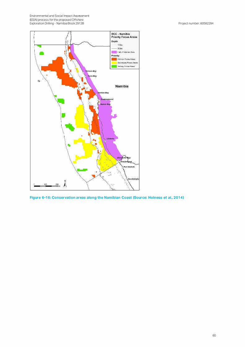
Environmental and Social Impact Assessment
(ESIA) process for the proposed Offshore Exploration Drilling - Namibia Block 2913B
Project number: 60582294
60
Figure 6-16: Conservation areas along the Namibian Coast (Source: Holness et al., 2014)
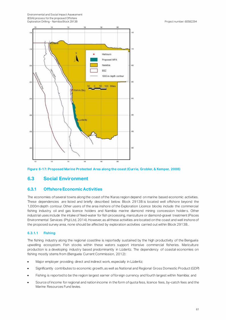
Environmental and Social Impact Assessment
(ESIA) process for the proposed Offshore Exploration Drilling - Namibia Block 2913B
Project number: 60582294
61
Figure 6-17: Proposed Marine Protected Area along the coast (Currie, Grobler, & Kemper, 2008)
6.3 Social Environment
6.3.1 Offshore Economic Activities
The economies of several towns along the coast of the !Karas region depend on marine based economic activities.
These dependencies are listed and briefly described below. Block 2913B is located well offshore beyond the
1,000m depth contour. Other users of the area inshore of the Exploration Licence blocks include the commercial
fishing industry, oil and gas licence holders and Namibia marine diamond mining concession holder s. Other
industrial uses include the intake of feed-water for fish processing, mariculture or diamond-gravel treatment (Pisces
Environmental Services (Pty) Ltd, 2014). However, as all these activities are located on the coast and well inshore of
the proposed survey area, none should be affected by exploration activities carried out within Block 2913B. .
6.3.1.1 Fishing
The fishing industry along the regional coastline is reportedly sustained by the high productivity of the Benguela
upwelling ecosystem. Fish stocks within these waters support intensive commercial fisheries. Mariculture
production is a developing industry based predominantly in Lüderitz. The dependency of coastal economies on
fishing mostly stems from (Benguela Current Commission, 2012):
Major employer providing direct and indirect work, especially in Lüderitz;
Significantly contributes to economic growth, as well as National and Regional Gross Domestic Product (GDP)
Fishing is reported to be the region largest earner of foreign currency and fourth largest within Namibia; and
Source of income for regional and nation income in the form of quota fess, licence fees, by-catch fees and the
Marine Resources Fund levies.
Environmental and Social Impact Assessment
(ESIA) process for the proposed Offshore Exploration Drilling - Namibia Block 2913B
Project number: 60582294
62
6.3.1.2 Diamond Mining
Diamond mining is an important source of revenue for Namibia as well as the Region. Diamond mining companies
collectively contributed N$ 2.5 billion in royalties, taxes and dividends to the State Revenue Fund in 2013. De Beers
is by far the largest contributor in this respect, having paid US$154 million in taxes, royalties and charges in 2011
and almost double this amount, US$294 million, the following year. Efforts to promote and facilitate downstream
industries are also ongoing, with mining houses supplying local manufacturers with rough diamonds. Co astal and
offshore mining is concentrated most notably along the stretch of coast between Chameis Bay (around 150 km
south of Lüderitz) and Hondeklipbaai in South Africa. De Beers Marine, under contract with Namdeb, operates five
motor vessels used for extracting and processing diamonds from the ocean bed and a further two chartered
vessels used for exploration and sampling. Present-day land-based diamond mining also occurs near Lüderitz,
albeit on a far smaller scale than during the early 1900s, entailing a few satellite mines with some more substantial
operations closer to Oranjemund.
6.3.1.3 Tourism
The tourism industry makes a considerable contribution to Namibia’s economy. Tourist arrivals made up just under
91% of the 1.5 million arrivals to Namibia in 2015. Recreational activities making use of the coastal and marine
environment are an important component in the range of factors which attract tourists to Namibia. Lüderitz, and to
a lesser degree Oranjemund, are frequently visited by tourists, where activities centred around the ocean include
birding, sailing, fishing, wind-surfing and kiteboarding, surfing, kayaking and whale watching. The local tourism
industry in Lüderitz has reportedly grown significantly over the last 20 years. It has a number of historical sites and
buildings reflecting the town’s German history. The wild horses of the Namib, desert tours and trips to the historic
ghost mine town of Kolmanskop are also key tourist attractions. The Lüderitz Waterfront (N$35 million investment
in 2002) was created primarily to promote Lüderitz as a tourist destination. Lüderitz hosts key events with a focus
on the ocean (e.g. annual Crayfish Festival, Lüderitz Speed Sailing Challenge. A number of passenger cruise liner
operators include Lüderitz in their list of locations.
For tourists visiting Oranjemund, much of the town’s attraction lies in its abundance of desert fauna and flora that is
indigenous to the harsh environment of the Namib Desert. The area is strictly controlled as only tour operators with
concessions and visitors with valid permits are granted access. Tourist attractions include the former diamond
settlements, turned ghost towns, such as Kolmanskop, Pomona, Bogenfels and Elizabeth Bay.
6.3.1.4 Lüderitz Town
Several large-scale enterprises, mainly in mining, fishing and tourism, dominate the Lüderitz economy, whereas a
community of small-scale businesses located especially in and around the low-income areas generally lack the
capability to scale up their business models. A characteristic of the economy t hat arguably distinguishes Lüderitz
from other towns is its dependence on the regional and global economy. The Lüderitz economy is dependent on
industries which tend to be more cyclical in nature. The Lüderitz Town Council is working with businesses to diversify
and expand the local economy through an increased focus on developing industries such as aquaculture, tourism,
logistics, retail and amenities. The strong wind conditions in the area have also attracted interest from energy
companies interested in opportunities for wind energy.
6.3.1.5 Oranjemund Town
Oranjemund is a diamond mining town, established in 1936 as an accessory facility to support the land diamond
mining operations. The Town’ was classified as a private mining town and visitors to the town requir ed security
clearance and authorization in order to gain access to the town.
The town has several utilities, such as sport grounds, schools, medical centres, residential facilities, an airport of
international standard, and community centres, developed by Mining companies. Mining employees who resided in
Oranjemund town were provided with free housing, water and electricity, there are approximately 3 000 Mine owned
accommodation units within the town. A large part of the Towns economic activity is centred on services sector,
with Mining companies outsourcing non-core activities to private business and individuals, which led to the
establishment of the retail and service industry which include the following of the following shops and services:
Spar, Woolworths, Bars and Restaurants, Bottle stores, etc. It should be noted that mining operations within
Oranjemund are being decommissioned and the town has now been opened to the public. .
6.3.2 Administrative Context and Governance
Namibia gained independence on 21 March 1990 after more than a century of colonial rule and some 40 years of
being governed by the then-apartheid state of South Africa. Its population consisted of just over 2.3 million people
Environmental and Social Impact Assessment
(ESIA) process for the proposed Offshore Exploration Drilling - Namibia Block 2913B
Project number: 60582294
63
in 2016 (Namibia Statistics Agency (NSA) 2017a), which is relatively low, when compared to its land surface area of
820,000 square kilometres (km2) (i.e. about four times the size of the United Kingdom). Namibia is divided into 14
administrative regions, of which the Khomas Region (in which the capital of Windhoek is situated) is the most
populated and most economically active.
The Project’s onshore activities will likely be based from Lüderitz and Oranjemund, which are both coastal tows
situated within the !NamiNűs and Oranjemund Constituencies of the //Karas Region. The Region is bordered in the
north by the Hardap Region, on the west by the Atlantic Ocean with South Africa’s Northern Cape Province forming
the Region’s Eastern and Southern Border. The Region’s administrative capital is situated in Keetmanshoop, which
is situated approximately 280 km north-east (as the crow flies) of Oranjemund town.
The country, which is a unitary state, is administrated by three tiers of governance, namely central, regional and local.
Central government consists of the President and the two Houses of Parliament, the National Assembly and
National Council. Regional governance is the responsibility of regional councils which regulatory powers is provided
under the Regional Councils Act of, 1992. (Act No. 22) The Act requires regional leaders to advise the President and
central government on matters relating to the region. The political head of a region is the Governor, who is appointed
by the President. The regions are divided into constituencies for electoral purposes. Each constituency elects one
member to the regional council using a first-past-the-post electoral system. The term of office of the regional
council members is six years. The regional councils elect from amongst their members two persons as member s
of the National Council. The sitting Governor of //Kharas Region, Mrs. Lucia Basson, is a member of South West
Africa People's Organization (SWAPO) and was elected in 2015. SWAPO also won both Oranjemund and !NamiNűs
constituencies during the 2015 regional elections. The next National and Regional elections will likely be held in
2020 and 2021, respectively.
The local authorities are generally only established in urban centres, with regional authorities administrating the rur al
areas within their region. Regional councils are responsible for specified service delivery in rural areas, while the
local authorities are responsible for service delivery in urban areas. Currently the only service provision
responsibility of the regional councils specified in the Regional Councils Act is the provision of basic services in
areas where settlements are proclaimed, but no local authorities are established. Local governance is undertaken
by four types of councils, with the nature of councils depending on the size of its jurisdiction; these councils include
municipal, town, village and settlement councils. The municipal councils are the most autonomous of the local
authorities. Under the Local Authorities Act, the Minister responsible for regional and local government may further
classify the municipalities into Part I and Part II municipalities. Currently there are three Part I and 15 Part II
municipalities, and 30 town and village councils in Namibia. Part I municipalities generally have a r obust financia l
basis and considerable autonomy regarding the determination of property tax and obtaining loans under the
provisions of the Local Authorities Act, whereas Part II municipalities have a more fragile financial basis and are
subject to control exercised by the Ministry of Regional and Local Government, Housing and Rural Development .
Most of the town councils cannot balance their budgets without substantial transfers from the central government
or donors, and their financial autonomy, in general, is limited.
Both Lüderitz and Oranjemund are governed by town councils lead by SWAPO who won the majority of seats during
the 2015 Local Government elections.
6.3.3 Demographics
6.3.3.1 Population Growth and Distribution
Similar to the national population, the regional population experienced marginal growth since 2011, growing with
2% annually to reach 85,759 in 2016 (NSA, 2017a). On a constituency level, Oranjemund recorded the highest
growth rate (2.3%), between 2001 and 2011, while !NamiNűs recorded a negative growth rate during this period
(NSA, 2014). Regional growth rates could partially be attributed to in-migration, as //Karas has experienced long
term nett in-migration of between 99 and 300 people per 1000 inhabitants since 2001. Although no census data is
available on constituency level from 2016 onwards, it is believed that Lüderitz Town would mimic regional growth
rates, whereas the growth rate in Oranjemund would have declined substantially in recent years, due to recent
downturn in economic activities.
Just more than half of the regional population (54%) resided within the region’s main urban centres in 2016, namely:
Keetmanshoop (25%), Lüderitz Town (16%), Karasburg (5%) and Oranjemund town (5%) (NSA, 2014; 2017a).
Settlement patterns throughout the region and both constituencies clearly follow economic activities. This trend is
especially evident in the !NamiNűs constituency, where 92% (or 12 537) of the constituency’s population resided
in Lüderitz and to a lesser degree in Oranjemund where only 33% (or 3 908) of the constituency resided in
Oranjemund town (NSA, 2014).

Environmental and Social Impact Assessment
(ESIA) process for the proposed Offshore Exploration Drilling - Namibia Block 2913B
Project number: 60582294
64
In terms of population distribution //Karas is one of the least densely populated regions within the country, with less
than 0.5 persons per km2 on average, this trend is also evident in !NamiNűs (0.3 people/ km2). In contrast to the
Region and !NamiNűs Oranjemund, due to its relatively small land area (4 623 square kilometre or 3% of the regional
land area), boast with a population density of just more than 2 people/ km2 (NSA, 2014).
The average household size in the !NamiNűs constituency is 3.1, which is marginally higher than in Oranjemund
(2.7), but lower than the regional (3.6) and the national average (4) ( Table 6-5). Oranjemund has a relatively low
proportion of households (30%) which are headed by females - as opposed to 44% nationally, 33% regionally and
41% in ! !NamiNűs (NSA, 2014; 2017a).
Table 6-5: Population size and distribution (Source: NSA, 2014; 2017a)
A re a Ye ar A n n ual g rowth rate
2001 2011 2016 2001-2011 2011 -2016
Namibia 1 830 330 2 113 077 2 324 388 2.0 1.9
//Karas 69 329 77 421 85 759 1.1 2.0
!NamiNűs 14 542 13 859 na -0.5 na
Oranjemund 7 789 9 837 na 2.3 na
Table 6-6: Household size and head of household (Source: NSA, 2014; 2017a)
A re a House h old size Ge n d e r h ouse h old h e ad (2011)
2011 2016 Male F e m ale
Namibia 4.4 3.9 56% 44%
//Karas 3.6 3.3 61% 39%
!NamiNűs 3.1 Na 59% 41%
Oranjemund 2.7 Na 70% 30%
6.3.3.2 Age, Gender and Language Distribution
The age distribution on national, regional and constituency levels shows a similar trend across the regional
and!NamiNűs populations, with a third of the population falling within the 15 to 59 age bracket followed by those
between 5 and 14 years of age (Table 6-7). In contrast, Oranjemund has a considerably higher proportion of
individuals falling within the 15 to 59 year age bracket and relatively few individuals older than 60 years of age ( Table
6-7). Taking a closer look at working-age individuals reveals that the bulk of the working age population in !NamiNűs
constituency is concentrated in the 30 to 45-year-old age bracket, whereas the labour force in Oranjemund is more
widely distributed, between the 20 to 45- year-old age bracket. The town also has a notably smaller population
younger than 20 years old.
Table 6-7 also presents the gender ratio (proportion of males per 100 females in a given population) within the
region and its respective constituencies. It indicates relatively equal gender proportions across //Ka ras and
!NamiNűs, but a disproportionate distribution in Oranjemund, where males far outnumber their female
counterparts. This gender disparity can partially be attributed to past in-migration of male jobseekers, likely driven
by diamond mining and related economic activities within Oranjemund. This correlates with the relatively high
growth rate reported between 2001 and 2011. It should be notedthat this trend should be considered in light of
recent economic down turn in the constituency and Oranjemund town in particula r, which could result in some
outmigration-.
Prominent languages spoken throughout the region include Afrikaans (33%) followed by Oshiwambo (30%) and
Nama/Damara (25%) (NSA, 2017a). This distribution can be extrapolated to the respective constituencies; ho wever,
it is likely that the proportion of indigenous languages is more prominent in rural outskirts of both constituencies,
while the proportion of Afrikaans speaking people is slightly higher than the regional average in urban centres,
especially Oranjemund.

Environmental and Social Impact Assessment
(ESIA) process for the proposed Offshore Exploration Drilling - Namibia Block 2913B
Project number: 60582294
65
Table 6-7: Gender and Age Distribution (Source: NSA, 2014; 2017a)
A re a Ge n d e r ratio tre n d A g e (ye ars) – 2016
2011 2016 0- 4 5-14 15-59 60>
Namibia 94 95 14% 22% 57% 6%
//Karas 104 102 14% 16% 63% 6%
!NamiNűs 101 Na 10% 20% 66% 4%
Oranjemund 121 Na 11% 15% 73% 1%
6.3.3.3 Literacy and Education
National literacy (or ability to read and write with understanding in any language) rates increased from 81% in 2011
to 89% in 2016 (Table 6-8). During the same period //Karas’ literacy rate increased with 5% to reach 97% (NSA,
2017a). The literacy rate among the regional population is slightly higher among males and within those residing in
urban centres, such as Lüderitz and Oranjemund (Table 6-9). The literacy rate within !NamiNűs and Oranjemund
constituencies in 2011 was 98% and 99%, respectively. In light of national and regional improvement in literacy
rates since 2011, it is anticipated that these rates would still be very high, especially within Lüderitz and Oranjemund
towns.
The level of formal education among the region’s adult population is relatively low, with only one fifth of those older
than 20 years having completed secondary school (Table 6-10). Constituency-level data on education levels could
not be obtained for 2016 onwards and it was therefore assumed that these educational levels will to a certain degree
mimic the level of education among the regional population. It is still likely that education levels are higher within
these constituencies due to their relatively high proportion of urbanised population, which implies better access to
educational facilities.
Table 6-8: Literacy by gender (15yrs>) (Source: NSA, 2016)
A re a 2016 2011
A l l Male F e m ale
Namibia 89% 89% 89.4 87.9
//Karas 96% 96% 96.5 95.7
!NamiNűs Na 98% 98.4 98.5
Oranjemund Na 99% 99.6 99.3
Table 6-9: Regional literacy rural vs. urban (15yrs>), 2016 (Source: NSA, 2017a)
/ /Karas Region Ge n d e r
Male F e m ale
Rural 94% 95%
Urban 98% 97%
Table 6-10: Highest level of education (20 yrs>) (Source: NSA, 2017a)
Ed ucation level No sc h ool in g Som e p rim ary Com p le te d
p rim ary
Com p le te d
se c on d ary
Complete Tertiary
Namibia – 2016 0.5 18.4 49.7 22.6 8.3
Namibia – 2011 1.5 23.7 48.5 20.5 5.8
//Karas 0.7 0.7 19.2 18.1 5.9

Environmental and Social Impact Assessment
(ESIA) process for the proposed Offshore Exploration Drilling - Namibia Block 2913B
Project number: 60582294
66
6.3.4 Economic profile
6.3.4.1 Key economic sectors
The agriculture, forestry and fishing industries can be regarded as the mainstay of the regional economy, with just
less than a third of the regional population employed within this sector in 2011, followed by those employed in the
mining and administrative industries, which employed 8.9% and 8.5% of the respectively. On a constituency level
the data shows that !NamiNűs constituency was heavily reliant on fishing which, together with limited agriculture,
provides 42% of jobs, which is significantly higher than the regional average of 32%. The next most prominent
employing sectors are manufacturing and administrative and support service activities (both 8% ), with construction
as well as mining and quarrying contributing 6% of jobs each. For Oranjemund the largest proportion of the
employed population works in the mining sector.
Table 6-11: Main industry of employed population aged 15 years-old and above by area, 2011-2016
(Source: NSA, 2014; 2017a,b)
In d ustry Nam b iai
2016
Nam ib ia
2011
/ /Karas
2011
!Nam iNűs
2011
Agriculture, Forestry & Fishing 20.2% 30% 32.4% 42%
Mining & Quarrying 2.2% 3% 8.9% 6%
Manufacturing 6.6% 6% 5.7% 8%
Electricity, Gas, Steam & Heating, Ventilation, and Air Conditioning (HVAC) 0.7% 0.2% 0.2% 0.2%
Water & Waste management 0.7% 0.3% 0.4% 0.5%
Construction 9.3% 7% 6.3% 6%
Wholesale & Retail 9.7% 7% 6.3% 5%
Transport & Storage 3.3% 4% 3.8% 3%
Accommodation and Food storage 7.1% 4% 3.3% 4%
Information and communication 0.9% 1% 0.8% 0.6%
Financial Insurance Activities 2.3% 2% 1.4% 2%
Real estate 0.2% 0.1% 0.0% 0.1%
Professional Science 1.8% 2% 1.0% 1.1%
Administrative 6.0% 9% 8.5% 8%
Public Admin 4.5% 6% 6.9% 4%
Education 6.1% 6% 3.8% 3%
Human health & Social 2.8% 3% 2.5% 2%
Arts & Recreation 0.6% 1% 0.3% 0.2%
Other services 6.4% 3% 2.1% 1%
Private Households 8.7% 6% 5.0% 2%
Extraterritorial organisations 0.2% 0.1% 0.0% 0%
Don’t know 0% 1% 0.3% 0.5%
6.3.5 Employment and income
Three quarters of the region’s population was classified as economically active, which is considerably less than in
2011. The employment rate among the regional economically active population (population over 15 years-old,
which are economically active) was 80% in 2011, of these 68% were employed and 32% unemployed. Wages and
salaries are by far the most important source of income for households across all scales of the study area.
Approximately 48% of Namibian households report that their main source of income is from salaries and wages.
This figure is substantially higher for the!NamiNűs constituency and Oranjemund town.
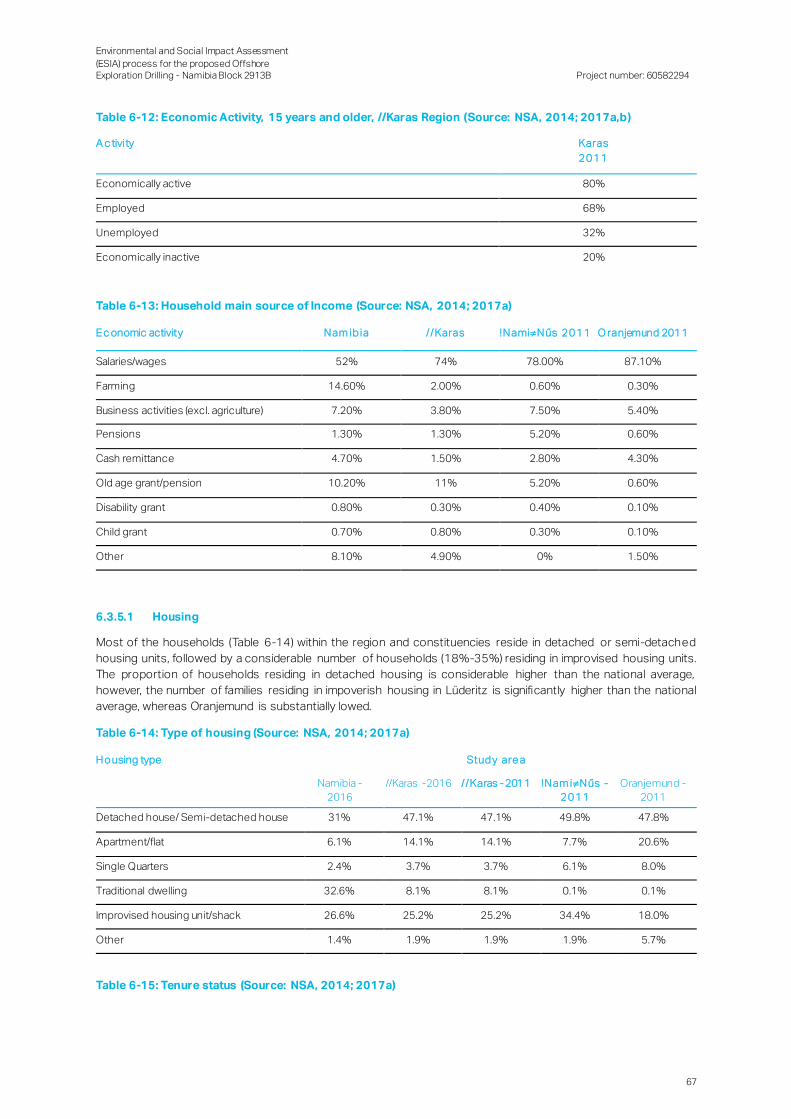
Environmental and Social Impact Assessment
(ESIA) process for the proposed Offshore Exploration Drilling - Namibia Block 2913B
Project number: 60582294
67
Table 6-12: Economic Activity, 15 years and older, //Karas Region (Source: NSA, 2014; 2017a,b)
A c tivity Karas
2011
Economically active 80%
Employed 68%
Unemployed 32%
Economically inactive 20%
Table 6-13: Household main source of Income (Source: NSA, 2014; 2017a)
Ec onomic activity Nam ib ia / /Karas !NamiNűs 2011 O ranjemund 2011
Salaries/wages 52% 74% 78.00% 87.10%
Farming 14.60% 2.00% 0.60% 0.30%
Business activities (excl. agriculture) 7.20% 3.80% 7.50% 5.40%
Pensions 1.30% 1.30% 5.20% 0.60%
Cash remittance 4.70% 1.50% 2.80% 4.30%
Old age grant/pension 10.20% 11% 5.20% 0.60%
Disability grant 0.80% 0.30% 0.40% 0.10%
Child grant 0.70% 0.80% 0.30% 0.10%
Other 8.10% 4.90% 0% 1.50%
6.3.5.1 Housing
Most of the households (Table 6-14) within the region and constituencies reside in detached or semi-detached
housing units, followed by a considerable number of households (18%-35%) residing in improvised housing units.
The proportion of households residing in detached housing is considerable higher than the national average,
however, the number of families residing in impoverish housing in Lüderitz is significantly higher than the national
average, whereas Oranjemund is substantially lowed.
Table 6-14: Type of housing (Source: NSA, 2014; 2017a)
Housing type Stud y are a
Namibia -
2016
//Karas -2016 //Karas -2011 !Nam iNűs -
2011
Oranjemund -
2011
Detached house/ Semi-detached house 31% 47.1% 47.1% 49.8% 47.8%
Apartment/flat 6.1% 14.1% 14.1% 7.7% 20.6%
Single Quarters 2.4% 3.7% 3.7% 6.1% 8.0%
Traditional dwelling 32.6% 8.1% 8.1% 0.1% 0.1%
Improvised housing unit/shack 26.6% 25.2% 25.2% 34.4% 18.0%
Other 1.4% 1.9% 1.9% 1.9% 5.7%
Table 6-15: Tenure status (Source: NSA, 2014; 2017a)

Environmental and Social Impact Assessment
(ESIA) process for the proposed Offshore Exploration Drilling - Namibia Block 2913B
Project number: 60582294
68
Housing type Stud y are a
Nam ib ia –
2016
/ /Karas – 2016 / /Karas -2011 !Nam iNűs -
2011
O ranjemun d -
2011
Owner occupied with mortgage 12.4% 8.8% 13.2% 12.8% 9.5%
Owner occupied without mortgage 51% 28.3% 35.8% 30.6% 12.7%
Rented from employer 4.8% 20.3% 6.1% 4.0% 21.9%
Rented from individual 13.7% 10.5% 7.3% 7.4% 7.5%
Rented from Private firm - - 7.0% 6.8% 23.8%
Rented from local authority - - 5.1% 13.0% 4.7%
Occupied rent free 17.9% 32.1% 24.7% 25.0% 19.8%
Other 0.2% 0.0% 0.8% 0.5% 0.2%
6.3.6 Service delivery
6.3.6.1 Access to water and sanitation
Safe drinking water and adequate sanitation is a necessity for good health, as households without safe water and
proper sanitation systems are more vulnerable to water borne diseases. The majority of households within the
region and respective constituencies (95%) have access to safe water.
Access to sanitation facilities is problematic across in the regional area with almost a quarter of households that did
not have any access to sanitation (Table 6-16). In contrast, both constituencies have minimal households with now
access to sanitation.
Table 6-16: Sources of drinking and cooking water (Source: NSA, 2014; 2017a)
Source Namibia -
2016
//Karas -
2016
//Karas -
2011
!NamiNűs
- 2011
Oranjemun
d - 2011
Safe
water
Piped water 64% 73% 70% 70% 73%
Borehole with tank covered 7% 3% 6% 0% 0%
Public piped 22% 19% 17% 29% 27%
Borehole/with tank covered & well protected 4% 0% 0% 0% 0%
Bottled 1% 0% 0% 0% 0%
Total safe water 97% 95% 93% 99% 100%
Other Borehole with tank uncovered & well
unprotected
4% 0% 1% 0% 0%
River/ Dams and Canal 3% 2% 5% 0% 0%
Other 0% 0% 1% 0% 0%
Total unsafe water 7% 3% 7% 0% 0%

Environmental and Social Impact Assessment
(ESIA) process for the proposed Offshore Exploration Drilling - Namibia Block 2913B
Project number: 60582294
69
Table 6-17: Access to sanitation (Source: NSA, 2014; 2017a)
San itation type Nation al -
2016
/ /Karas -
2016
/ /Karas -
2011
!NamiNűs -
2011
O ranjemund -
2011
Private/ Shared flush 41% 64% 64% 83% 77%
Pit latrine with ventilation pipe 6% 7% 4% 2% 11%
Covered pit latrine without ventilation pipe 4% 0.1% 3% 1% 4%
Uncovered pit latrine without ventilation pipe 3% 1% 2% 0% 3%
Bucket toilet (manually removed) 1% 2.9% 3% 4% 1%
No toilet facility (bush, riverbed, fields) 46% 25.1% 23% 10% 0%
Other 0.1% 0.1% 1% 0% 2%
6.3.6.2 Access to energy for cooking, lighting and heating
Electricity use at a regional level is relatively limited, with only 48% of households using it for cooking. In comparison,
a much larger proportion of households (69%) within the region use electricity for lighting purposes ( Table 6-18).
Table 6-18: Energy used for cooking, lighting, and heating (Source: NSA, 2014; 2017a)
Purpose of energy National - 2016 //Karas -
2016
//Karas -
2011
!NamiNűs
- 2011
Oranjemund
- 2011
Energy used for cooking
Electricity 35% 48% 42.1% 45.9% 62.4%
Wood 50% 25% 27.7% 4.0% 1.7%
Gas 12% 26% 29.2% 48.8% 35.5%
Energy used for lighting
Electricity 45% 69% 67% 77% 95%
Candle 12% 15% 23% 16% 4%
Other 43% 16% 10% 7% 1%

Environmental and Social Impact Assessment
(ESIA) process for the proposed Offshore Exploration Drilling - Namibia Block 2913B
Project number: 60582294
70
7. Environmental Impact Assessment
The impact assessment methodology, as described during the Scoping Phase of the ESIA, takes into consideration
an impact’s nature (adverse or beneficial), type (direct, secondary or cumulative) and magnitude, and the sensitivit y
of the affected receptors, to yield a prediction of the impact’s overall ‘significance’.
7.1 Impact / Activity Screening
Subsequent to the Scoping Phase, a screening exercise was conducted of the potential interactions of the
proposed Project with the physical, biophysical and socio-economic environments:
N o int er act io n where the proposed Project is unlikely to interact on the environment;
Mino r negative interaction where there is likely to be an interaction, but the resultant effect is unlikely to change
baseline conditions significantly;
Mo derate/major negative int er act io n where there is likely to be an interaction and the resultant impact is likely
to have reasonable potential to cause a significant effect on the environment; or
Po sitive int er act io n where there is likely to be a positive interaction and the resultant impact has a positive
effect on the environment.
Impact significance was assessed considering existing control measures that are incorporated into the Project
design. After the remaining potential impacts have been identified and a preliminary assessment was conducted,
strategies to further avoid or mitigate the impacts were then developed.
7.2 Impacts on the Physical and Bio-physical Environment
7.2.1 Release of Air Emissions
Air emissions may be generated from the following activities:
Exhaust gas emissions produced by the combustion of gas or liquid fuels in turbines, boilers, compressors,
pumps and other engines for power and heat generation;
Fugitive emissions associated with leaking tubing, valves, connections, flanges, open-ended lines, pump
seals, compressor seals, pressure relief valves or tanks, and hydrocarbon, fuels, oils and lubricants loading and
unloading operations;
Vent or flaring off some of the oil and gas brought to the surface during well testing; and
Incineration of waste on board the drilling unit and support vessels.
The release of gaseous pollutants e.g. carbon dioxide (CO2), oxides of nitrogen (NOx), oxides of sulphur (SOx) and
carbon monoxide (CO) from the drilling unit, support vessels and helicopters have the potential to cause short-term
reductions in local air quality. These emissions will mainly be released near its source. Such emissions may have
negative physiological effects on marine fauna but may also contribute to global greenhouse gas emissions.
The release of emissions may cause a short-term reduction in local air quality and a negligible increase in
greenhouse gases that would make an insignificant contribution on the global scale. Most emissions would occur
at the drill site during drilling and well testing, as well as from support vessels and helicopters along the route from
the drilling unit, Lüderitz (onshore base) and potentially Oranjemund (helicopter base).
Flow testing would result in hydrocarbons being burned at the well sit e. Despite the negative perception of flaring, it
is one of the safest methods of disposing unwanted hydrocarbons that cannot otherwise be captured and used for
other purposes (SLR Environmental Consulting, 2017).
Even though most of the solid waste would be transported to shore for disposal, certain non-toxic combustible
wastes may be incinerated on the drilling unit and support vessels . An example of the non-toxic combustible waste
may include (e.g. galley waste). The volumes of solid waste that may be incinerated on board, and hence also the
volumes of atmospheric emissions, would be minimal. The frequency of waste transportation to shore will depend
on the waste volume produced relative to safety precautions.

Environmental and Social Impact Assessment
(ESIA) process for the proposed Offshore Exploration Drilling - Namibia Block 2913B
Project number: 60582294
71
Table 7-1: Physiological effects of air emissions on marine fauna
IMPACT DESCRIPTION: PHYSIOLOGICAL EFFECTS OF AIR EMISSIONS ON MARINE FAUNA
Predicted for project phase: Mobilisation Operation Demobilisation
Dimension Rating
PRE-MITIGATION
Duration Short Term (1) Consequence:
Slightly detrimental
(-7)
Significance:
Low negative
(-21)
Extent Site (1)
Intensity x type
of impact Low Medium - negative (-4)
Probability Likely (3)
MITIGATION:
Implement a maintenance plan to ensure all emission causing infrastructure receives regular maintenance to minimise
emissions released into the atmosphere.
Implement leak detection on emission generating infrastructure .
Identify all Ozone Depleting Substances (ODSs) and implement controls to prevent or minimise release into the atmosphere
– this includes:
─ Replacing ODS generating equipment with non-ODSs generating equipment;
─ Minimising the use of ODS generating equipment; and
─ Maintaining ODS generating equipment to prevent leaks.
Repairing leaking equipment within a suitable timeframe.
Incineration of waste to be restricted outside of ports and to specific items. This should be detailed in the Waste
Management Plan.
Drilling schedules to be optimised to ensure that energy consumption is minimised.
Use a high-efficiency burner for flaring to maximise combustion of the hydrocarbons in order to minimise emissions and
hydrocarbon ‘drop-out’ during well testing.
Maximise flare combustion efficiency by controlling and optimising flare fuel/air/stream flow rate s.
POST-MITIGATION
Duration Short Term (1) Consequence:
Negligible
(-5)
Significance:
Low negative
(-15)
Extent Site (2)
Intensity x type of impact
Low - negative (-2)
Probability Likely (3)
Given the distance (250 km) of the offshore activities, air emissions are expected to disperse rapidly and there is no
potential for accumulation of air pollution leading to any long-term impacts. The potential impact of emissions due
to drilling and associated activities would be localised and of limited duration and far from any potential receptors.
The significance of this impact is, therefore, assessed to be very low without mitigation.
Table 7-2: Greenhouse gas emissions on global warming
IMPACT DESCRIPTION: GREENHOUSE GAS EMISSIONS ON GLOBAL WARMING
Predicted for project phase: Operation
Dimension Rating
PRE-MITIGATION
Duration Short Term (1)
Consequence:
Slightly detrimental
(-7)
Significance:
Low negative
(-21)
Extent Site (1)
Intensity x type
of impact Low Medium - negative (-4)
Probability Likely (3)
MITIGATION:
Use a high-efficiency burner for flaring to maximise combustion of the hydrocarbons in order to minimise emissions and hydrocarbon ‘drop-out’ during well testing.
Use energy-efficient combustion equipment (engines, turbines) to reduced fuel use and thus greenhouse gas (GHG)
emissions.
Maximise flare combustion efficiency by controlling and optimising flare fuel/air/stream flow rates.
Ensure no incineration of waste occurs within the port limits.

Environmental and Social Impact Assessment
(ESIA) process for the proposed Offshore Exploration Drilling - Namibia Block 2913B
Project number: 60582294
72
IMPACT DESCRIPTION: GREENHOUSE GAS EMISSIONS ON GLOBAL WARMING
Predicted for project phase: Operation
POST-MITIGATION
Duration Short Term (1) Consequence:
Negligible
(-5)
Significance:
No Impact
(-10)
Extent Site (2)
Intensity x type
of impact Low - negative (-2)
Probability Possible (2)
The release of emissions may cause a short-term reduction in local air quality and a negligible increase in
greenhouse gases that would make an insignificant contribution on the global scale.
7.2.2 Discharge of Waste to Sea
Various discharges to sea are typical of an offshore exploration project:
Normal vessel discharge;
Ballast water discharge; and
Discharge of cuttings, drilling fluid and cement.
Discharge of waste shall comply with the Marine Notice No. 04 of 2018: Garbage Management Requirements in
Namibia under MARPOL Annex V.
7.2.2.1 Normal vessel discharge
Normal discharges are expected from the following sources:
Deck drainage: Deck drainage consists of liquids from rainfall, sea spray, deck and equipment washing.
Machinery space drainage: Vessels occasionally discharge treated bilge water. Bilge water is drainage water
that collects in a ship’s bilge space.
Sewage: Discharges of sewage would vary according to the number of persons on board and would be
intermittent.
Galley wastes: Galley wastes, comprising mostly of biodegradable food waste, generated on board the project
vessels would be discharged over board.
Cooling water: Seawater would be used as the cooling for generators on board the drilling unit and the heated
seawater would be discharged overboard.
Opening and closing of the BOP: A further operational discharge is associated with routine well opening and
closing operations.
These discharges would result in the local reduction in water quality, which may also impact marine fauna:
Physiological effects: Ingestion of hydrocarbons, detergents and other waste could have adverse effects on
marine fauna, which could ultimately result in mortality;
Increased food source: The discharge of galley waste and sewage would result in an additional food source for
opportunistic feeders; and
Increased predator - prey interactions: Predatory species may be attracted to the aggregation of fish attracted
by the increased food source.
The discharge of waste would mainly be done at the drill site and along transport route from the onshore base to
the drilling site. Although Block 2913B is located a great distance from sensitive receptors, discharges could still
affect migratory species within the area of influence. Vessel discharges on route to Lüderitz could result in
discharges closer to shore, thereby potentially having an environmental effect on the sensitive coastal environment.
The drilling unit and support vessels would have the necessary sewage treatment systems, oil/water separators
and food waste macerators to ensure compliance with MARPOL 73/78 standa rds. Given the distance from the
shore, waste discharges are expected to disperse rapidly and there is no potential for accumulation of wastes
leading to a long-term impact.

Environmental and Social Impact Assessment
(ESIA) process for the proposed Offshore Exploration Drilling - Namibia Block 2913B
Project number: 60582294
73
It is only likely to be pelagic species of fish, birds, turtles and cetaceans that may be affected by the discharges,
some of which are species of conservation concern. The abundance of these species in the area of interest is
expected to be low, and they are unlikely to respond to the minor changes in water quality resulting from vess el
discharges.
Table 7-3: Reduction of water quality due to normal discharge to sea
IMPACT DESCRIPTION: REDUCTION OF WATER QUALITY DUE TO NORMAL DISCHARGE TO SEA
Predicted for project phase: Mobilisation Operation Demobilisation
Dimension Rating
PRE-MITIGATION
Duration Short Term (1) Consequence:
Negligible
(-5)
Significance:
Low negative
(-15)
Extent Site (1)
Intensity x type of impact
Low - negative (-2)
Probability Likely (3)
MITIGATION:
Develop the following plans which address all wastes generated during the various activities:
─ Shipboard Oil Pollution Emergency Plan (SOPEP);
─ Oil Spill Contingency Plan (OSCP)
─ Oil Spill Rehabilitation Plan;
─ Waste Management Plan; and
─ Ballast Water Management Plan.
These plans should discuss waste management strategies for drilling fluids, domestic wastes, sanitary wastes, radioactive
wastes, produced water, drill cuttings, hydrocarbons and any other waste stream s identified on site. These strategies should involve both sustainable production and consumption.
Waste must be segregated before storage and appropriate disposal. This should be clearly outlined in the Waste
Management Plan, e.g.:
─ The generation of waste should be avoided as far as practicable; where it cannot be avoided, waste should be reduced,
re-used and recovered (including recycling and composting); where waste cannot be reduced, re -used and/or
recovered, it should be disposed of in an environmentally sound manner (at the Lüderitz and/or Oranjemund landfills with prior permission from the Town Council(s)).
─ Waste minimisation can be achieved by: buying in bulk quantities; using refillable, bulk dispensers (e.g. toiletries) (vs. individually packaged products); working with suppliers in order to limit the use of, and establishing recycling for,
product packaging; avoiding the use of polystyrene foam altogether; using glass/durable plastic rather than disposable
plastic items (straws/cups); providing in-room recycling procedures and appropriate receptacles.
Waste storage must be available, secure and not open to the elements.
Disposal of general and hazardous waste should occur onshore in accordance with the appropriate laws and ordinances –
this methodology must be outlined in the Waste Management Plan. Where waste cannot be disposed of onshore the conditions of MARPOL must be adhered to.
Incineration of waste to be restricted outside of ports and to specific items. This should be detailed in the Waste
Management Plan.
Ships: Discharge of food waste less than 3 nautical miles offshore must be comminuted to particle sizes smaller than 25
millimetres (mm).
Ships: Discharge of food waste which is not comminuted may only be disposed at 12 nautical miles offshore.
Food waste cannot be discharged within 500 m of a fixed and floating platform (refer to the Marine Notice No. 04 of 2018:
Garbage Management Requirements in Namibia under MARPOL Annex V).
The discharge of sewage into the sea is prohibited, except when the ship has in operation an approved sewage treatment
plant or when the ship is discharging comminuted and disinfected sewage using an approved system at a distance of more
than 3 nautical miles from the nearest land. Sewage which is not comminuted or disinfected may be discharged at a
distance of more than 12 nautical miles from the nearest land when the ship is en route and proceeding at not less than 4
knots.
Sewage effluent must be discharged more than 5 m below the water surface.
Waste discharges must be controlled where fauna is observed being attracted to the area.
Oil spills must be cleaned immediately using the appropriate oil absorbents with low to no toxicity.
Relevant staff must be trained in spill identification and remediation.
Leak, spill detection and maintenance programmes must be undertaken on all infrastructure which has the potential to leak
and create waste (liquid, gas, solid, etc.).
Use a low-toxicity biodegradable detergent for the cleaning of all deck spillages.
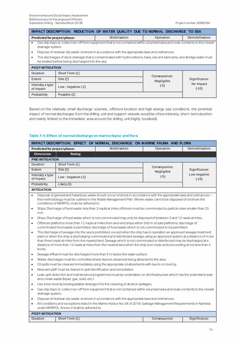
Environmental and Social Impact Assessment
(ESIA) process for the proposed Offshore Exploration Drilling - Namibia Block 2913B
Project number: 60582294
74
IMPACT DESCRIPTION: REDUCTION OF WATER QUALITY DUE TO NORMAL DISCHARGE TO SEA
Predicted for project phase: Mobilisation Operation Demobilisation
Use drip trays to collect run-off from equipment that is not contained within a bunded area and route contents to the closed
drainage system.
Dispose of residual oily waste onshore in accordance with the appropriate laws and ordinances.
The discharges of deck drainage that is contaminated with hydrocarbons, fuels, oils and lubricants, and all bilge water must
be treated before being discharged into the sea.
POST-MITIGATION
Duration Short Term (1) Consequence:
Negligible
(-5)
Significance:
No Impact
(-10)
Extent Site (2)
Intensity x type
of impact Low - negative (-2)
Probability Possible (2)
Based on the relatively small discharge volumes, offshore location and high energy sea conditions, the potential
impact of normal discharges from the drilling unit and support vessels would be of low intensity, short -term duration
and mainly limited to the immediate area around the drilling unit (highly localised).
Table 7-4: Effect of normal discharge on marine fauna and flora
IMPACT DESCRIPTION: EFFECT OF NORMAL DISCHARGE ON MARINE FAUNA AND FLORA
Predicted for project phase: Mobilisation Operation Demobilisation
Dimension Rating
PRE-MITIGATION
Duration Short Term (1) Consequence:
Negligible
(-5)
Significance:
Low negative
(-15)
Extent Site (2)
Intensity x type of impact
Low - negative (-2)
Probability Likely (3)
MITIGATION:
Disposal of general and hazardous waste should occur onshore in accordance with the appropriate laws and ordinances –
this methodology must be outlined in the Waste Management Plan. Where waste cannot be disposed of onshore the conditions of MARPOL must be adhered to.
Ships: Discharge of food waste less than 3 nautical miles offshore must be comminuted to particle sizes smaller than 25
mm.
Ships: Discharge of food waste which is not comminuted may only be disposed of between 3 and 12 nautical miles.
Offshore platforms more than 12 nautical miles from land and ships within 500 m of said platforms: discharge of
comminuted food waste is permitted; discharge of food waste which is not comminuted is not permitted.
The discharge of sewage into the sea is prohibited, except when the ship has in operation an approved sewage treatment
plant or when the ship is discharging comminuted and disinfected sewage using an approved system at a distance of m ore
than three nautical miles from the nearest land. Sewage which is not comminuted or disinfected may be discharged at a
distance of more than 12 nautical miles from the nearest land when the ship is en route and proceeding at not less than 4
knots.
Sewage effluent must be discharged more than 5 m below the water surface.
Waste discharges must be controlled where fauna is observed being attracted to the area.
Oil spills must be cleaned immediately using the appropriate oil absorbents with low to no toxicity.
Relevant staff must be trained in spill identification and remediation.
Leak, spill detection and maintenance programmes must be undertaken on all infrastructure which has the potential to leak
and create waste (liquid, gas, solid, etc.).
Use a low-toxicity biodegradable detergent for the cleaning of all deck spillages.
Use drip trays to collect run-off from equipment that is not contained within a bunded area and route contents to the closed
drainage system.
Dispose of residual oily waste onshore in accordance with the appropriate laws and ordinances.
All conditions and exceptions listed in the Marine Notice No. 04 of 2018: Garbage Management Requirements in Namibia
under MARPOL Annex V shall be adhered to.
POST-MITIGATION
Duration Short Term (1) Consequence: Significance:

Environmental and Social Impact Assessment
(ESIA) process for the proposed Offshore Exploration Drilling - Namibia Block 2913B
Project number: 60582294
75
IMPACT DESCRIPTION: EFFECT OF NORMAL DISCHARGE ON MARINE FAUNA AND FLORA
Predicted for project phase: Mobilisation Operation Demobilisation
Extent Site (2) Negligible
(-5)
No Impact
(-10) Intensity x type
of impact Low - negative (-2)
Probability Possible (2)
7.2.2.2 Ballast water discharge
To maintain the stability and trim of the drilling unit and the support vessels, seawater would be pumped into
designated ballast tanks and released to sea during mobilisation and transit to site. Depending on where the ballast
water is loaded, it may contain larvae, cysts, eggs and adult marine organisms from other locations. Thus , ballasting
and de-ballasting of project vessels could lead to the introduction of exotic species and harmful aquatic pathogens
to the marine ecosystem. Vessels and the transportation of infrastructure from one location to another also provide
the potential for translocation of introduced or alien species. As such the unlikely impact related to the introduction
of alien invasive marine species is considered to be of medium intensity in the long-term and of regional to national
extent. Once established, an invasive species is likely to remain in perpetuity. The significance of impact is
consequently deemed medium to high without mitigation.
The discharge of ballast water from support vessels and drilling units would take place at the drill site, which is
located more than 250 km offshore. The drill site, as mentioned before, is not near any sensitive receptors or
conservation areas. The risk that discharge of ballast water may have is significantly reduced by management
measures to be implemented contained within the International Marine Organisation (IMO) guidelines: exchanging
ballast water at least 370 km from the nearest land and in water of at least 200 m depth. The risk of this impact is
further reduced by the highly dynamic, wave-exposed coastline of Namibia, which contributes to minimising the
establishment of alien invasive species resulting in comparatively low numbers of such species in the region (SLR
Environmental Consulting, 2017).
Table 7-5: Reduction of water quality due to ballast discharge to sea
IMPACT DESCRIPTION: REDUCTION OF WATER QUALITY DUE TO BALLAST DISCHARGE TO SEA
Predicted for project phase: Mobilisation Operation Demobilisation
Dimension Rating
PRE-MITIGATION
Duration Short to medium Term (2) Consequence:
Highly detrimental
(-14)
Significance:
Low negative
(-28)
Extent National (4)
Intensity x type
of impact Medium high - negative (-8)
Probability Possible (2)
MITIGATION:
Each vessel which carries ballast water is to have a Ballast Water Management Plan which complies with the requirements set out in the International Convention for the Control and Management of Ships ’ Ballast Water and Sediments, 2004.
All ships will also have to carry a Ballast Water Record Book and an International Ballast Water Management Certificate.
Ships need to comply with Regulations D1 and D2 of the International Convention for the Control and Management of
Ships' Ballast Water and Sediments, 2004).
Ships performing ballast water exchange shall do so with an efficiency of 95% volumetric exchange of ballast water. For
ships exchanging ballast water by the pumping-through method, pumping through three times the volume of each ballast
water tank shall be considered to meet the standard described. Pumping through less than three times the volume may be
accepted provided the ship can demonstrate that at least 95% volumetric exchange is met.
Ships conducting ballast water management shall discharge less than 10 viable organisms per cubic metre greater than or
equal to 50 micrometres in minimum dimension and less than 10 viable organisms per millilitre less than 50 micrometres in minimum dimension and greater than or equal to 10 micrometres in minimum dimension; and discharge of the indicator
microbes shall not exceed the specified concentrations.
Ballast water exchange must take place at least 200 nautical miles from the nearest land and in water at least 200 m deep
where possible, taking into account the guidelines developed by the IMO. No ballast water is to be exchanged within ports
or harbours.
All ships shall remove and dispose of sediments from spaces designated to carry ballast water in accordance with the provisions of the ship‘s Ballast Water Management Plan.
Ensure all infrastructure (e.g. wellheads, BOPs and guide bases) that has been used in other regions is thoroughly cleaned
prior to deployment.

Environmental and Social Impact Assessment
(ESIA) process for the proposed Offshore Exploration Drilling - Namibia Block 2913B
Project number: 60582294
76
IMPACT DESCRIPTION: REDUCTION OF WATER QUALITY DUE TO BALLAST DISCHARGE TO SEA
Predicted for project phase: Mobilisation Operation Demobilisation
Use filtration procedures during loading in order to avoid the uptake of potentially harmful aquatic organisms, pathogens
and sediment that may contain such organisms.
Ensure that routine cleaning of the ballast tank to remove sediments is carried out, where practicable, in mid-ocean or
under controlled arrangements in port or dry dock, in accordance with the provisions of the ship's Ballast Water Management Plan.
Officers and crew shall be familiar with their duties in the implementation of ballast water management particular to the shi p
on which they serve and shall, appropriate to their duties, and be familiar with the ship‘s Ballast Water Management Plan.
The Ballast Water Management Plan must be approved by the relevant authorities.
POST-MITIGATION
Duration Short Term (1) Consequence:
Slightly detrimental
(-6)
Significance:
Low negative
(-12)
Extent Regional (3)
Intensity x type of impact
Low - negative (-2)
Probability Possible (2)
7.2.2.3 Cuttings, drilling fluid and cement
Discharge of cuttings, drilling fluid or cement are possible due to the following:
During the riserless drilling stage, cuttings from the top-hole sections would be discharged onto the seafloor
where they would accumulate in a conical cuttings pile around the wellhead;
After a casing string is set in a well, specially designed cement slurries are pumped into the annular space
between the outside of the casing and the borehole wall. During this operation a maximum of 150% of the
required cement volume would be pumped into the space between the casing and the borehole wall. Due to
the low temperatures and high pressures at the proposed well depth, the excess cement would diss olve slowly
into the surrounding seawater. Typically a small margin of excess cement is prepared for each cementing
activity in order to account for possible losses on account of the activity. The excess cement is subsequently
discharged in allowable quantities.
During the risered drilling, cuttings are circulated to the drilling unit, where the cuttings are removed from the
returned drill mud and treated to reduce oil content before being discharged overboard. Cuttings released
from the drilling unit would be dispersed more widely around the drill site by prevailing currents.
The potential impacts associated with the discharge of cuttings, drilling fluid and cement include:
Smothering of seabed habitat and associated benthic fauna. Any benthic fauna present on the seabed within
the footprint of the discharge may potentially be disturbed or crushed;
Marine fauna and benthic organisms may suffer toxicity and bioaccumulation effects due to leaching of
cement additives;
Increased water turbidity and reduced light penetration resulting in indirect physiological effects on marine
fauna; and
Reduced physiological functioning of marine organisms due to indirect biochemical effects.
The discharge of cuttings at the seabed would have effects on benthic faunal communit ies living on the seabed or
within the sediments in the vicinity of the drill site and within the fall-out footprint of the cuttings plume discharged
from the drilling unit. Although the benthic fauna at the water depths encountered in the area of interest is poorly
understood, deep water fauna inhabiting unconsolidated sediments is expected to be relatively ubiquitous, usually
comprising fast-growing species able to rapidly recruit into areas that have suffered environmental disturbance.
Epifauna living on the sediment typically comprise urchins, burrowing anemones, molluscs, seapens and sponges,
many of which are longer-lived and, therefore, more sensitive to disturbance. No rare or endangered species are
known to occur in the deep-water area. As noted in 6.2, during the field survey portion of the baseline study photos
and videos showed very limited evidence of conspicuous fauna.
TOTAL routinely conducts modelling of cuttings discharges prior to drilling using the SINTEF Dose related Risk and
Effect Assessment Model (DREAM) / ParTrack model. The DREAM (Dose Related Risk and Effect Assessment
Model) is a three-dimensional particle model for assessing the consequences of regular planned releases to the
marine environment. DREAM helps visualise and analyse releases occurring over extended time periods in the water
column. The ParTrack model includes releases of drill fluids and cuttings. Additional environmental risk calculations

Environmental and Social Impact Assessment
(ESIA) process for the proposed Offshore Exploration Drilling - Namibia Block 2913B
Project number: 60582294
77
for bottom sediments and particle stress in the water column are also carried out using Predicted Environmenta l
Concentration (PEC) / Predicted No Effect Concentration (PNEC) analysis. The (PEC) is calculated by the model
based on the drilling fluids composition, product characteristics and environmental conditions. This PEC is then
compared to the Predicted No Effect Concentrations (PNEC) to characterize whether or not the anticipated
concentration is expected to have a significant risk of impact on the habitat. A fine resolution 1/32° configuration of
the global HYCOM assimilated currents model provides MetOcean inputs to cover the area offshore Namibia. The
results of the PEC / PNEC analysis are shown in Figure 7-1. Areas in red on the figure have PEC / PNEC greater than
1 at the period specified.
Figure 7-1: Maximum risk level on water column
Although the risk (PEC / PNEC) exceeds 5% near the well (~1 km), the risk to the water column is limited in time and
only during WBM discharges. The risk becomes non-significant to null when the riserless discharges are over
(planned for about 21 days after drilling begins). No residual impact on water column is expected at the end of
activities. Discharge of non-aqueous based mud on cuttings presents no risk to the water column below 5%.
Table 7-6: Reduction of water quality due to cuttings, drilling fluid and cement
IMPACT DESCRIPTION: REDUCTION OF WATER QUALITY DUE TO CUTTINGS, DRILLING FLUID AND CEMENT
Predicted for project phase: Operation
Dimension Rating
PRE-MITIGATION
Duration Short Term (1) Consequence:
Slightly detrimental
(-9)
Significance:
Low negative
(-27)
Extent Site (2)
Intensity x type of impact
Medium - negative (-6)

Environmental and Social Impact Assessment
(ESIA) process for the proposed Offshore Exploration Drilling - Namibia Block 2913B
Project number: 60582294
78
IMPACT DESCRIPTION: REDUCTION OF WATER QUALITY DUE TO CUTTINGS, DRILLING FLUID AND CEMENT
Predicted for project phase: Operation
Dimension Rating
Probability Likely (3)
MITIGATION:
Collect and review Remotely Operated Vehicle (ROV) footage of pre-drilling surveys to identify potential vulnerable habitats within 150 m from the well location.
Ensure drill site is located more than 500 m from any identified vulnerable habitats.
Avoiding excess cement usage by monitoring (by ROV) for discharges during cementing.
Use high efficiency solids control equipment to reduce the need for fluid change out and minimise the amount of residual
fluid on drilled cuttings.
Ensure regular maintenance of the on-board solids control package.
Ensure that all responsible staff receive adequate training.
Report emergency situations to the relevant authorities and initiate the relevant emergency procedures (refer to Appendix A).
Prioritize low-toxicity and partially biodegradable additives in drilling fluid and cement.
POST-MITIGATION
Duration Short Term (1) Consequence:
Negligible
(-5)
Significance:
No Impact
(-10)
Extent Site (2)
Intensity x type
of impact Low - negative (-2)
Probability Possible (2)
Cuttings discharged from the drilling unit would also have both direct and indirect effects on primary producers
(phytoplankton) in surface waters and pelagic fish and invertebrate co mmunities in the water column. Due to the
offshore location of the area of interest, the abundance of phytoplankton, pelagic fish and invertebrate fauna is likely
to be very low. Being dependent on nutrient supply, plankton abundance is typically spatially and temporally highly
variable and is thus considered to have a low sensitivity.
7.2.3 Disturbance to the Seabed / Seabed Sediments
Disturbance to the seabed may occur during the following activities:
During pre-drilling surveys, a ROV would be deployed to obtain video footage of the seabed at the proposed
well location. Although the standard operating procedure is not to settle or rest the ROV on the seabed, the
ROVs thrusters may stir up the soft or silty sediments when operating close to the seabed. This res uspension
of fine sediments would temporarily disturb seabed communities and result in localised increased turbidity.
The penetration of the seabed by the drill bit would physically disturb a small surface area and displace deeper
sediments around the wellhead. Casing of the hole and installation of the wellhead and BOP would potentially
also result in localised direct disturbance of an area around the well site.
The removal of the BOP, which would include the use of a ROV, may also result in the localised disturbance of
the seabed.
Any benthic fauna and flora present on the seabed and in the sediment in the disturbance footprint would be either
eliminated or may potentially be disturbed or crushed. Resuspension of seabed sediments by ROV thrusters may
also result in increased turbidity near the seabed, potentially with physiological effects on benthic faunal and floral
communities.
Deep water fauna, inhabiting unconsolidated sediments, and flora is expected to be relatively abundant, comprising
fast-growing species able to rapidly recruit into areas that have suffered disturbance.
The immediate effect on the benthos depends on their degree of mobility, with sedentary and relatively immobile
species likely to be physically damaged or destroyed during the drilling disturbance. Sediment in the area of interest
is dominated by muds and sandy muds (SLR Environmental Consulting, 2017). Due to the high natural variability in
benthic communities in the region, the structure of the communities in the area of interest would likely be highly
spatially and temporally variable and is likely to comprise fast-growing species able to rapidly recruit into areas that
have suffered natural environmental disturbance.

Environmental and Social Impact Assessment
(ESIA) process for the proposed Offshore Exploration Drilling - Namibia Block 2913B
Project number: 60582294
79
Table 7-7: Smothering of seabed due to discharge of cutting, drilling fluid and cement (affecting flora and
fauna)
IMPACT DESCRIPTION: SMOTHERING OF SEABED DUE TO DISCHARGE OF CUTTING, DRILLING FLUID
AND CEMENT (AFFECTING FLORA AND FAUNA)
Predicted for project phase: Operation
Dimension Rating
PRE-MITIGATION
Duration Long Term (4) Consequence:
Slightly detrimental
(-7)
Significance:
Low negative
(-21)
Extent Footprint (1)
Intensity x type
of impact Low - negative (-2)
Probability Likely (3)
MITIGATION:
Implement procedures that stipulate that ROVs do not land or rest on the seabed as part of normal operations.
Ensure drill site is located more than 500 m from any identified vulnerable habitats.
Avoiding excess cement usage by monitoring (by ROV) for discharges during cementing.
Ensure all recovered drilling mud is taken to shore for treatment and re-use.
Ensure that all responsible staff receive adequate training
Report emergency situations to the relevant authorities and initiate the relevant emergency procedures (refer to Appendix
A).
Use high efficiency solids control equipment to reduce the need for fluid change out and minimise the amount of residual fluid on drilled cuttings.
Prioritize low-toxicity and partially biodegradable additives in drilling fluid and cement.
POST-MITIGATION
Duration Medium Term (3) Consequence:
Slightly detrimental
(-6)
Significance:
Low negative
(-18)
Extent Footprint (1)
Intensity x type
of impact Low - negative (-2)
Probability Likely (3)
Considering the available area of similar habitat on and off the edge of the continental shelf in the Atlantic Offshore
Bioregion, this minimal disturbance of and reduction in benthic biodiversity can be considered negligible. Impacts
on the offshore benthos as a result of physical damage and sediment disturbance are considered to be much
localised. The intensity and duration of an impact on unconsolidated sediments is considered to be of medium
intensity in the short-term (recovery is expected to take place within two to five years). Therefore, this impact on
unconsolidated sediments is assessed to be of low significance without mitigation.
7.2.4 Noise Generation
N O TE: THIS SUB-SECTION BELOW SHOULD BE READ IN CONJUNCTION WITH THE IMPACT ASSESSMENT ENCLOSED HEREWITH AS APPENDIX
B.1 .
Noise are typically to be generated by the following sources during the proposed Project:
7.2.4.1 Semi-submersible rig positioning
Semi-submersible rigs always float on pontoons and are towed to location by tw o or more tugs. During drilling
operations, the deck is lowered but kept above wave height. Rigs used in deep water or harsh environments ,
maintain position over the drilling location either by anchors (and where fitted, with rig thruster assistance as
necessary) or by dynamic positioning using a series of computer-controlled thrusters. Rig anchoring typically
involves the deployment by anchor handler vessel, of eight or more 12 tonne high efficiency seabed penetrating
anchors. During the positioning of the semi-submersible rig:
PTS may occur in low frequency cetaceans if they remain within a distance of 23 m from tugs/anchor vessels
positioning the rig or 43 m from thrusters for a period of 1 hour. TTS may occur if they remain within 505 m
from tugs/anchor vessels or 934 m from thrusters for a similar period.

Environmental and Social Impact Assessment
(ESIA) process for the proposed Offshore Exploration Drilling - Namibia Block 2913B
Project number: 60582294
80
PTS may occur in mid frequency cetaceans if they remain within close proximity (e.g. less than 10 m) from
vessels of thrusters for a period of 1 hour. TTS may occur if they remain within 29 m from vessels or 53 m from
thrusters for a similar period.
PTS may occur in phocid pinnipeds if they remain within a distance of 13 m from tugs/anchor vessels
positioning the rig or 23 m from thrusters for a period of 1 hour. TTS may occur if they remain within 271 m
from tugs/anchor vessels or 500 m from thrusters for a similar period.
PTS may occur in otariid pinnipeds if they remain within close proximity (e.g. less than 10 m) from vessels of
thrusters for a period of 1 hour. TTS may occur if they remain within 20 m from vessels or 36 m from thrusters
for a similar period.
Moderate behavioural reactions in marine mammals, such as changes in swimming direction and speed, may occur
beyond the range at which TTS could occur. At distances beyond 1 km the likelihood of any observable responses
to sound is expected to be low.
TTS may occur in high sensitivity fish if they remain within 185 m from vessels or 341 m from thrusters for a period
of 12 hours. Recoverable injury may only occur if they remain in proximity (within 10 m) to the operations for a period
of 48 hours; although the likelihood is that they will move away from a disturbing sound source. TTS effects on low
and medium sensitivity fish are estimated to be moderate within metres of a continuous sound source, and low at
intermediate and greater distances.
Previous studies in the project area (SLR Environmental Consulting, 2017) estimated that the overall underwater
ambient noise levels in the project area would range from about 80 decibel (dB)rms re 1μPa (root mean square sound
pressure over the measured period, expressed as dB re 1 μPa) in calm conditions (including possible low frequency
noise component), up to about 120 dBrms re 1μPa during periods of higher winds and or heavy rainfall, or when ships
are moving past the area of interest. It is assumed that such levels may be typical for the region in which the project
activity is taking place. It is therefore likely that marine life will have become largely habituated to such sound levels
and there would be a minimal relative increase to existing levels of disturbance on pinnipeds and fish species.
7.2.4.2 Driving/Drilling
Sound will be generated from the rig at the drilling location when the drilling programme is in progress. The sound
source levels emitted during the drilling programme would typically consist of the driving of a conductor pipe, drill
pipe operation and on-board machinery. The sound will be mainly emitted above water, with low transmission into
the water from the air; however, some sound will be emitted directly into the water. During the driving of conductor
pipe:
PTS may occur in low frequency cetaceans if they remain within a distance of 235 m from driving activities for
a period of 1 hour. TTS may occur if they remain within 2.3 km from driving activities for a similar period.
PTS may occur in mid frequency cetaceans if they remain within a distance of 11 m from driving activities for
a period of 1 hour. TTS may occur if they remain within 113 m from driving activities for a similar period.
PTS may occur in phocid pinnipeds if they remain within a distance of 171 m from driving activities for a period
of 1 hour. TTS may occur if they remain within 1.7 km from driving activities for a similar period.
PTS may occur in otariid pinnipeds if they remain within a distance of 197 m from driving activities for a period
of 1 hour. TTS may occur if they remain within 1.9 km from driving activities for a similar period.
Moderate behavioural reactions in marine mammals, such as changes in swimming direction and speed, may occur
beyond the range at which TTS could occur. At distances beyond 2 km the likelihood of any observable responses
to sound is expected to be low.
TTS may occur in fish if they remain within 201 m for a period of 1 hour. Injury (recoverable or mortal) may only occur
if they remain in proximity (within 15 m) to the operations for a period of 1 hour. For these and longer periods the
likelihood is that fish will move away from a disturbing sound source before any injury is likely to occur. Low level
disturbance to fish may occur at distances beyond the possible TTS distances. However, as described above, it is
considered that the local underwater sound environment would be dominated by sound from existing commercial
and oil industry vessel traffic and there would be a minimal relative increase to existing levels of disturbance on fish
species.
During drilling activities, PTS may occur in cetaceans and pinnipeds if they remain within proximity (e.g. less than 10
m) from drilling activities for a period of 1 hour. TTS may occur in low frequency cetaceans if they remain within 17

Environmental and Social Impact Assessment
(ESIA) process for the proposed Offshore Exploration Drilling - Namibia Block 2913B
Project number: 60582294
81
m for a similar period; for other species groups this would occur if they remain within proximity (e.g. less than 10 m).
The likelihood of any observable effects on fish species due to drilling sound is low.
7.2.4.3 VSP Airgun Operations
Sound will be generated by air gun operations during VSP activities, where geophones are lowered into the well and
a seismic source (typically an array of multiple individual air guns) is either lowered over the well (from a rig or
stationary vessel, known as zero-offset VSP) or from a source vessel which travels away from the well (known as
offset VSP). Air is released into the water, forming a bubble, which expands and contracts resulting in a change of
pressure. The pressure output signature of an individual air gun consists of a short duration pulse, typically 10 -20
milliseconds (ms) associated with the initial release of air, followed by longer duration, lower amplitude pulses
associated with the secondary bubble oscillations. It is envisaged that the VSP will be shot from the rig and will take
place at the end of drilling operations. It will generally last for 12 hours during which it will be shot around 50 times
continuously for 6 hours. At present there are two likely source types which will be chosen by a contractor at a later
stage. During the VSP airgun operations:
PTS may occur in low frequency cetaceans if they remain within a distance of 30 m from VSP airgun activities
for a period of 1 hour. TTS may occur if they remain within 300 m from driving activities for a similar period.
PTS or TTS may occur in mid frequency cetaceans if they remain within close proximity (e.g. less than 10 m)
from VSP airgun activities for a period of 1 hour.
PTS may occur in phocid pinnipeds if they remain within a distance of 12 m from VSP airgun activities for a
period of 1 hour. TTS may occur if they remain within 122 m from driving activities for a similar period.
PTS may occur in otariid pinnipeds if they remain within a distance of 14 m from VSP airgun activities for a
period of 1 hour. TTS may occur if they remain within 143 m from driving activities for a similar period.
Table 7-8: Effects of marine noise on marine fauna
IMPACT DESCRIPTION: EFFECTS OF MARINE NOISE ON MARINE FAUNA
Predicted for project phase: Operation
Dimension Rating
PRE-MITIGATION
Duration Short Term (1) Consequence:
Slightly
detrimental
(-9)
Significance:
Low negative
(-27)
Extent Site (1)
Intensity x type
of impact Low Medium - negative (-6)
Probability Likely (3)
MITIGATION:
Employees must be provided with adequate Personal Protective Equipment (PPE).
The plant and all equipment must be properly maintained to avoid creation of unnecessary additional noise.
Noisy operations should, wherever possible run concurrently in order to minimise the duration of high noise levels .
Noise levels shall be monitored to comply with the relevant health and safety requirements.
All works that deviate from normal operating conditions shall be reported and actions initiated to mitigate against to prevent
recurrence of the incident.
VSP operations:
Undertake a 30-minute pre-start scan (prior to soft-starts) within the 3 km radius observation zone in order to confirm there
is no cetacean activity within 500 m of the source.
Ensure that observations “soft start” are planned :
─ Implement a “soft-start” procedure of a minimum of 20 minutes’ duration when initiating the VSP acoustic source. This
requires that the sound source be ramped from low to full power rather than initiated at full power, thus allowing a flight
response by marine fauna to outside the zone of injury or avoidance.
─ Commence “soft-start” procedure only once it has been confirmed by a suitably trained crew member during the 30-
minute pre start-up visual scan that there is no cetacean activity within 500 m of the source.
Where possible, sensitive receptors should be forewarned before noisy VSP operations commence.
Assign relevant staff for observation, distance estimation and reporting, to perform marine mammal observations and
notifications.
Maintain visual observations within the 500 m shut-down zone continuously during VSP operation to identify if there aren’t
any cetaceans present.
Shut down the acoustic source if a cetacean is sighted within 500 m shut-down zone until such time as the animal has
moved to a point more than 500 m from the source.

Environmental and Social Impact Assessment
(ESIA) process for the proposed Offshore Exploration Drilling - Namibia Block 2913B
Project number: 60582294
82
IMPACT DESCRIPTION: EFFECTS OF MARINE NOISE ON MARINE FAUNA
Predicted for project phase: Operation
Dimension Rating
Ensure that during periods of low visibility (where the observation zone cannot be clearly viewed out to 3 km), including
night-time, the VSP source is only used if during the preceding 24-hour period:
─ there have not been three or more cetacean-instigated shut down situations, and
─ a two-hour period of continual observation was undertaken in good visibility (to the extent of the observation zone) and
no cetaceans were sighted.
POST-MITIGATION
Duration Short Term (1) Consequence:
Negligible
(-5)
Significance:
No impact
(-10)
Extent Site (1)
Intensity x type of impact
Low negative (-2)
Probability Possible (-2)
The use of soft start procedures and use of visual monitoring prior to start of source and delay if a marine mammal
is observed within a typical 500 m exclusion zone will allow time for marine mammals to move away from t he source
operations. Ensure that pre shot observation, soft start are planned for the VSP.
Provided that receptors are not located directed beneath the VSP source or within the main directivity of the source,
TTS may occur in fish if they remain within 26 m of VSP operations for a period of 1 hour.
Low level disturbance to fish may occur beyond 13 km. As described above, it is considered that the local
underwater sound environment would be dominated by sound from existing commercial and oil industry vessel
traffic and there would be a minimal relative increase to existing levels of disturbance on fish species.
7.2.5 Demobilisation and Infrastructure Abandonment
Once the wellhead has been installed, a BOP would be lowered to the seabed and installed onto the wellhead. The
BOP stack extends above the seabed into the water column, thereby providing a pillar of hard substrate in an area
of otherwise unconsolidated sediments. During initial cementing, excess cement emerges out of the top of the well
onto the cuttings pile or is discarded on the seabed, where it may set and remain in a pile to subsequently be
colonised by epifauna and attract fish and other mobile predators.
After the wells are abandoned, the wellhead would be left on the seafloor, thereby providing har d substrate in an
area of otherwise unconsolidated sediments. The availability of hard substrata on the seabed provides opportunity
for colonisation by sessile benthic organisms and provides shelter for demersal fish and mobile invertebrates
thereby potentially increasing the benthic biodiversity and biomass in the continental slope region.
The benthic fauna inhabiting unconsolidated sediments are expected to be relatively abundant, varying only with
sediment grain size, organic carbon content of the sediments and/or near-bottom oxygen concentrations. Epifauna
living on the sediment typically comprise urchins, burrowing anemones, molluscs, sea pens and sponges, many of
which are longer-lived and therefore more sensitive to disturbance.
The presence of the subsea infrastructure (e.g. wellheads and guide bases) would increase the amount of hard
substrate that is available for the colonisation of benthic organisms. This may increase biodiversity and biomass in
the vicinity of physical structures on the seabed.
Table 7-9: Demobilisation / abandonment of infrastructure
IMPACT DESCRIPTION: DEMOBILISATION / ABANDONM ENT OF INFRASTRUCTURE
Predicted for project phase: Demobilisation
Dimension Rating
PRE-MITIGATION
Duration Permanent (5) Consequence:
Slightly detrimental
(-8)
Significance:
Low negative
(-16)
Extent Footprint (1)
Intensity x type
of impact Low - negative (-2)
Probability Possible (2)

Environmental and Social Impact Assessment
(ESIA) process for the proposed Offshore Exploration Drilling - Namibia Block 2913B
Project number: 60582294
83
IMPACT DESCRIPTION: DEMOBILISATION / ABANDONM ENT OF INFRASTRUCTURE
Predicted for project phase: Demobilisation
MITIGATION:
Seal the well by inserting cement plugs in the well bore.
Well integrity must be tested.
Remove all BOP infrastructure.
Notify the relevant authorities of the project closure.
Scan sea floor for dropped equipment and retrieve items where practicable and safe to do so.
Notify the relevant authorities where items could not be retrieved.
POST-MITIGATION
Duration Permanent (5) Consequence:
Slightly detrimental
(-8)
Significance:
Low negative
(-16)
Extent Footprint (1)
Intensity x type
of impact Low - negative (-2)
Probability Possible (2)
7.3 Impacts on the Social Environment
N O TE: THE SUB-SECTIONS SET O UT IN THE S ECTION BELOW SHOULD BE READ IN CONJUNCTION WITH THE IMPACT METHODOLOGY
HER EWITH A S AP P ENDIX B.3
The increase of surface area afforded by residual cement and abandoned wellheads is small and highly localised
and is likely to have an impact of low intensity on the benthic macrofauna. The duration of the impact would be
permanent. Overall the significance of this impact is considered to be of very low (neutral) significance.
The organisation and presentation of the full range of socio -economic impacts that are expected to arise because
of a proposed project or activity is challenging, for several reasons. First, potential impacts, and the elements that
combine to determine the socio-economic status of affected populations, are multi-dimensional and interrelated.
For example, insufficient access to services such as water, sanitation and health care is both a cause and an effect
of poverty. On the one hand, the lack of access to such services impacts negatively on health status, the
opportunity to acquire market-related skills and the amount of time available for productive activities. On the other
hand, poor people are often forced to live in areas where service delivery is limited or absent. Thus, if a project
increases the availability of services in an area, the ability of surrounding communities to take advantage of these
services may to some extent depend on their current socio -economic status. Second, the linkages between
various potential project impacts are complex and can be mutually reinforcing. For example, in-migration and
increased incomes can combine to put pressure on economies and infrastructure, as housing demand and
purchase power will increase. Impacts may also have both positive and negative dimensions. For example,
employment creation is an important project benefit, but it may also generate a context for negative impacts such
as social conflict and/or excessive in-migration. Finally, many socio-economic impacts cascade. For example, in-
migration is in itself an impact, but in turn may engender additional impacts, for example pressure on available
services such as housing and health services.
7.3.1 Employment creation during the mobilisation phase
The proposed project will require a small workforce to mobilise the drill rig and equipment and therefore has a small
potential to provide very limited direct employment to people within the local study area during the mobilisation
phase. It is expected that many of these positions will only last for a relatively short period, and will largely involve
highly skilled and semi-skilled positions, with limited employment opportunities for unskilled individuals. However,
the possible acquisition of new skills during the mobilisation period could make individuals more employable in the
future.
A large number of households within the study area face significant socio -economic challenges such as poverty;
unemployment and underdevelopment. Any project related employment therefore has the potential to improve the
livelihoods and income stability of future employees and their dependants, especially if employees are from socio -
economically depressed households. Whether unemployed and under-employed individuals within the study area
will be able to take up employment opportunities depends largely on their level of education, skill and work
experience. The demographic characteristics of the population in the local study area indicate that a large, relatively
uneducated, local labour pool is available. This suggests that, even though a large potential labour pool exists in the
study areas, a considerable proportion of this labour pool may not be adequately skilled to qualify for positions
requiring skilled labour. However, in recent years several oil and gas exploration projects have been undertaken

Environmental and Social Impact Assessment
(ESIA) process for the proposed Offshore Exploration Drilling - Namibia Block 2913B
Project number: 60582294
84
within the region, which would have skilled some individuals, that if available can be considered for employment on
the Project.
The degree to which employment benefits of the projects will accrue to local communities further depends on the
following project-related factors:
The recruitment practices of the contractor appointed by TOTAL to assist with rig mobilisation, which in turn
may depend on the contractual requirements imposed by TOTAL on the contractor in terms of employment ;
and
The ease with which the construction contractor will be able to identify and recruit suitably skilled persons in
local communities, as very stringent standards are set for TOTAL’s contactors and the skill level required to
participate in any employment created.
In addition to creating job opportunities related to construction, the projects may also lead to indirect employment
creation. This could involve formal employment (e.g. upgrade of onshore facilities, refuse removal from logistic base,
catering and security services) or employment in the informal sector (for instance local residents can establish food
stalls for the convenience of mobilisation workforce).
Employment on the projects will also have some degree of multiplier effect on the local economy, and that increased
spending power due to wages and salaries earned will benefit local businesses, suppliers of goods and
commodities, etc. This multiplier effect will be further enhanced by capital and opera tional expenditure by the
projects – e.g. through the local procurement of goods, materials and services. The creation of employment
opportunities during the mobilisation phase of the project can therefore be seen as a positive impact on the
benefitting individuals and their dependants.
Table 7-10: Employment creation
IMPACT DESCRIPTION: EMPLOYMENT CREATION
Predicted for project phase: Mobilisation
Dimension Rating
PRE-MITIGATION
Duration Short term (2)
Consequence: Negligible
(5)
Significance: Negligible -
positive
(20)
Extent Limited (2)
Intensity type of
impact Very low - positive (1)
Probability Probable (4)
MITIGATION
Explore whether a skills database is available from government and Oil & Gas Company's that recently completed similar
activities in the area;
Maximise and monitor local recruitment & procurement (incl. using local skills and small-business databases);
Tender criteria should require training and skills development of the con tractor workforce by the contractor
Promote skills development and training for workforce;
Procurement of materials, goods and services from local suppliers where feasible; and
Encourage indirect employment creation in the informal sector where feasible.
POST-MITIGATION
Duration Short term (2)
Consequence: Slightly beneficial
(8)
Significance:
Minor - positive (40)
Extent Limited (2)
Intensity type of
impact Moderately high - positive (4)
Probability Likely (5)
7.3.2 Multiplier effects on the local economy
Considering the relatively depressed economic base of the towns where the Project would be based, it is likely that
the Project will result in some, albeit limited, economic benefits through direct and multiplier effects stimulated by
capital expenditure during the mobilisation and exploration/drilling phases.

Environmental and Social Impact Assessment
(ESIA) process for the proposed Offshore Exploration Drilling - Namibia Block 2913B
Project number: 60582294
85
Establishment of onshore logistics base and mobilisation would increase, to a limited degree, the demand for of
goods and services, and as a result will stimulate and/or sustain growth within the local service sectors; which be
relatively well established, considering previous oil and gas exploration campaigns undertaken in the area. This
economic environment could generate some opportunities for small to medium businesses; provided they are
formalised and able to meet TOTAL’s procurement requirements. A considerable part of the Project’s needs will,
however, be highly technical and unlikely to be found within the site-specific or local study areas. For these needs,
TOTAL may procure from businesses elsewhere in region or in neighbouring countries, such as South Africa. Such
procurement will expose a wider area to the Project’s economic stimulus, albeit to a diluted degree.
Local and regional procurement spend will enhance the positive economic impact of the project to a certain degree,
as the revenue accruing to enterprises will produce limited, but beneficial downstream impacts on the local
economy, which is currently in decline. Given that a significant proportion of moneys derived from wages earned
would likely be spent locally, it is expected to create substantial flows of revenue within surrounding business
operators, thus acting as a catalyst for growth in the economy.
Table 7-11: Multiplier effects on the local economy
IMPACT D ESCRIPTION : MULTIPLIER EFFECTS ON TH E LOCAL ECON OMY
Pre d ic te d for p ro je c t p h ase : Mobilisation Operation
Dim e n sion Ratin g
PRE-MITIGATION
Duration Project Life (5) Consequence:
Moderately beneficial
(10)
Significance:
Negligible - positive
(30)
Extent Regional (4)
Intensity type of
impact Very low - positive (1)
Probability Unlikely (3)
MITIGA TIO N :
As for maximising employment benefits:
Give preference first to capable local service providers when appropriate;
Monitoring of sub-contractors’ procurement;
Development of a register of local service providers in consultation with the Namibian Government and other oil and gas
companies (in preparation for future activities – which are dependent on the exploration results); and
Local procurement objectives should be formalised in TOTAL's procurement policy for the Project.
PO ST -MITIGA TIO N
Duration Project Life (5) Consequence:
Moderately beneficial
(12)
Significance:
Minor - positive
(72)
Extent Regional (4)
Intensity type of
impact Moderate - positive (3)
Probability Highly probable (6)
7.3.3 Fiscal impact
Government will accrue revenue, which will constitute a beneficial social impact as it will increase the amount of
money Government will have at its disposal to construct and maintain infrastructure, implement development
projects and render other services to its constituencies. TOTAL will be liable for an annual petroleum licence are a
rental charge for exploration. During exploration, royalties would not apply and, as exploration does not directly
generate income, neither would direct taxes on company incomes / profits apply. There would, however, be indirect
benefits to the fiscus. These are likely to be relatively modest and should primarily take the form of Value Added Tax
(VAT) and income taxes levied on direct and indirect project expenditure in Namibia discussed above. The project
would have a necessarily high import content given its specialised nature. However, it would also be associated with
moderate amounts of local expenditure leading to a limited but positive impact on the balance of payments.
Whether this income translates into benefits for the Project’s host communities depends on how Government
decide to apply it. Current indications are that the overall positive impact associated on macro-economic variables
is considered to be of very low significance.
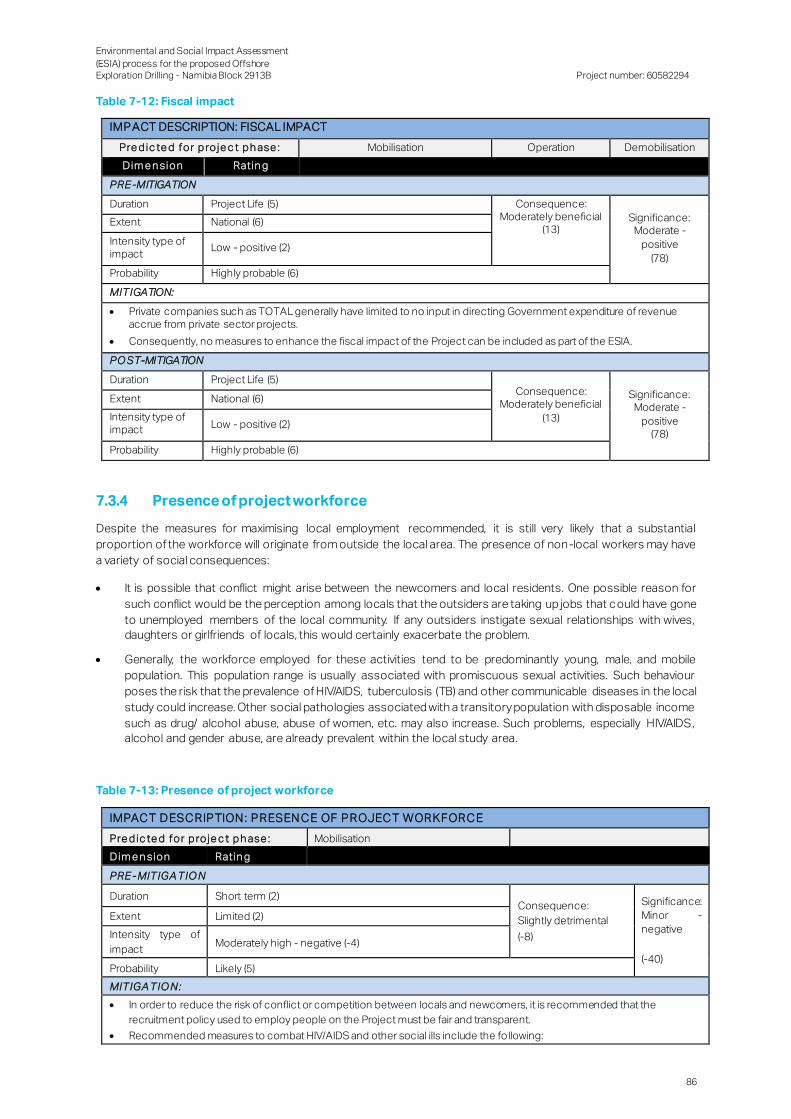
Environmental and Social Impact Assessment
(ESIA) process for the proposed Offshore Exploration Drilling - Namibia Block 2913B
Project number: 60582294
86
Table 7-12: Fiscal impact
IMPACT DESCRIPTION: FISCAL IMPACT
Pre d ic te d for p ro je c t p h ase : Mobilisation Operation Demobilisation
Dim e n sion Ratin g
PRE -MITIGATION
Duration Project Life (5) Consequence: Moderately beneficial
(13) Significance:
Moderate -
positive
(78)
Extent National (6)
Intensity type of impact
Low - positive (2)
Probability Highly probable (6)
MITIGATION:
Private companies such as TOTAL generally have limited to no input in directing Government expenditure of revenue accrue from private sector projects.
Consequently, no measures to enhance the fiscal impact of the Project can be included as part of the ESIA.
PO ST-MITIGATION
Duration Project Life (5) Consequence:
Moderately beneficial
(13)
Significance: Moderate -
positive (78)
Extent National (6)
Intensity type of impact Low - positive (2)
Probability Highly probable (6)
7.3.4 Presence of project workforce
Despite the measures for maximising local employment recommended, it is still very likely that a substantial
proportion of the workforce will originate from outside the local area. The presence of non-local workers may have
a variety of social consequences:
It is possible that conflict might arise between the newcomers and local residents. One possible reason for
such conflict would be the perception among locals that the outsiders are taking up jobs that could have gone
to unemployed members of the local community. If any outsiders instigate sexual relationships with wives,
daughters or girlfriends of locals, this would certainly exacerbate the problem.
Generally, the workforce employed for these activities tend to be predominantly young, male, and mobile
population. This population range is usually associated with promiscuous sexual activities. Such behaviour
poses the risk that the prevalence of HIV/AIDS, tuberculosis (TB) and other communicable diseases in the local
study could increase. Other social pathologies associated with a transitory population with disposable income
such as drug/ alcohol abuse, abuse of women, etc. may also increase. Such problems, especially HIV/AIDS,
alcohol and gender abuse, are already prevalent within the local study area.
Table 7-13: Presence of project workforce
IMPACT D ESCRIPTION : PRESEN CE OF PROJECT WORKFORCE
Pre d ic te d for p ro je c t p h ase : Mobilisation
Dim e n sion Ratin g
PRE - MITIGA TIO N
Duration Short term (2) Consequence:
Slightly detrimental
(-8)
Significance:
Minor -
negative
(-40)
Extent Limited (2)
Intensity type of
impact Moderately high - negative (-4)
Probability Likely (5)
MITIGA TIO N:
In order to reduce the risk of conflict or competition between locals and newcomers, it is recommended that the
recruitment policy used to employ people on the Project must be fair and transparent.
Recommended measures to combat HIV/AIDS and other social ills include the following:
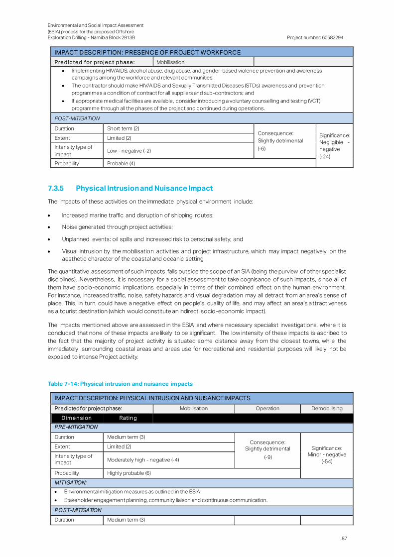
Environmental and Social Impact Assessment
(ESIA) process for the proposed Offshore Exploration Drilling - Namibia Block 2913B
Project number: 60582294
87
IMPACT D ESCRIPTION : PRESEN CE OF PROJECT WORKFORCE
Pre d ic te d for p ro je c t p h ase : Mobilisation
Implementing HIV/AIDS, alcohol abuse, drug abuse, and gender-based violence prevention and awareness
campaigns among the workforce and relevant communities;
The contractor should make HIV/AIDS and Sexually Transmitted Diseases (STDs) awareness and prevention
programmes a condition of contract for all suppliers and sub-contractors; and
If appropriate medical facilities are available, consider introducing a voluntary counselling and testing (VCT)
programme through all the phases of the project and continued during operations.
POST-MITIGATION
Duration Short term (2) Consequence:
Slightly detrimental
(-6)
Significance:
Negligible -
negative
(-24)
Extent Limited (2)
Intensity type of
impact Low - negative (-2)
Probability Probable (4)
7.3.5 Physical Intrusion and Nuisance Impact
The impacts of these activities on the immediate physical environment include:
Increased marine traffic and disruption of shipping routes;
Noise generated through project activities;
Unplanned events: oil spills and increased risk to personal safety; and
Visual intrusion by the mobilisation activities and project infrastructure, which may impact negatively on the
aesthetic character of the coastal and oceanic setting.
The quantitative assessment of such impacts falls outside the scope of an SIA (being the purview of other specialist
disciplines). Nevertheless, it is necessary for a social assessment to take cognisance of such impacts, since all of
them have socio-economic implications especially in terms of their combined effect on the human environment .
For instance, increased traffic, noise, safety hazards and visual degradation may all detract from an area’s sense of
place. This, in turn, could have a negative effect on people’s quality of life, and may affect an area’s a ttractiveness
as a tourist destination (which would constitute an indirect socio -economic impact).
The impacts mentioned above are assessed in the ESIA and where necessary specialist investigations, where it is
concluded that none of these impacts are likely to be significant. The low intensity of these impacts is ascribed to
the fact that the majority of project activity is situated some distance away from the closest towns, while the
immediately surrounding coastal areas and areas use for recreational and residential purposes will likely not be
exposed to intense Project activity.
Table 7-14: Physical intrusion and nuisance impacts
IMPACT DESCRIPTION: PHYSICAL INTRUSION AND NUISANCE IMPACTS
Pre dicted for project phase: Mobilisation Operation Demobilising
Dim e n sion Ratin g
PRE -MITIGATION
Duration Medium term (3) Consequence:
Slightly detrimental
(-9)
Significance: Minor - negative
(-54)
Extent Limited (2)
Intensity type of impact Moderately high - negative (-4)
Probability Highly probable (6)
MITIGATION:
Environmental mitigation measures as outlined in the ESIA.
Stakeholder engagement planning, community liaison and continuous communication.
PO ST-MITIGATION
Duration Medium term (3)
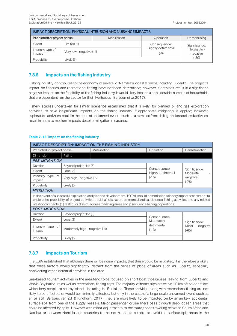
Environmental and Social Impact Assessment
(ESIA) process for the proposed Offshore Exploration Drilling - Namibia Block 2913B
Project number: 60582294
88
IMPACT DESCRIPTION: PHYSICAL INTRUSION AND NUISANCE IMPACTS
Pre dicted for project phase: Mobilisation Operation Demobilising
Extent Limited (2) Consequence: Slightly detrimental
(-6)
Significance: Negligible -
negative
(-30)
Intensity type of impact
Very low - negative (-1)
Probability Likely (5)
7.3.6 Impacts on the fishing industry
Fishing industry contributes to the economy of several of Namibia’s coastal towns, including Lüderitz. The project’s
impact on fisheries and recreational fishing have not been determined; however, if activities result in a significant
negative impact on the feasibility of the fishing industry it would likely impact a considerable number of households
that are dependent on the sector for their livelihoods (Barbour et al.,2017).
Fishery studies undertaken for similar scenarios established that it is likely for planned oil and gas exploration
activities to have insignificant impacts on the fishing industry, if appropriate mitigation is applied; however,
exploration activities could in the case of unplanned events such as a blow out from drilling and associated activities
result in a low to medium impacts despite mitigation measures.
Table 7-15: Impact on the fishing industry
IMPACT D ESCRIPTION : IMPACT ON TH E FISH IN G IN D USTRY
Predicted for project phase: Mobilisation Operation Demobilisation
Dimension Rating
PRE - MITIGA TIO N
Duration Beyond project life (6) Consequence:
Highly detrimental
(-15)
Significance: Moderate -
negative
(-75)
Extent Local (3)
Intensity type of
impact Very high - negative (-6)
Probability Likely (5)
MITIGA TIO N:
In the event of successful exploration and planned development, TOTAL should commission a fishery impact assessment to explore the probability of project activities could (a.) displace commercial and subsistence fishing activities and any related
livelihood impacts, (b.) restrict or disrupt access to fishing areas and (c.) influence fishing populations.
PO ST -MITIGA TIO N
Duration Beyond project life (6) Consequence: Moderately
detrimental
(-13)
Significance: Minor - negative
(-65)
Extent Local (3)
Intensity type of
impact Moderately high - negative (-4)
Probability Likely (5)
7.3.7 Impacts on Tourism
The ESIA established that although there will be noise impacts, that these could be mitigated; it is therefore unlikely
that these factors would significantly detract from the sense of place of areas such as Lüderitz, especially
considering other industrial activities in the area.
Sea-based tourism activities in the area tend to be focused on short boat trips/cruises leaving from Lüderitz and
Walvis Bay harbours as well as recreational fishing trips. The majority of boats trips are within 10 km of the coastline,
which ferry people to nearby islands, including Halifax Island. These activities along with recreational fishing are not
likely to be affected, or would be minimally affected, but only in the case of a large-scale unplanned event such as
an oil spill (Barbour, van Zyl, & Kinghorn, 2017). They are more likely to be impacted on by an unlikely accidenta l
surface spill from one of the supply vessels. Major passenger cruise liners pass through deep ocean areas that
could be affected by spills. However, with minor adjustments to the route, those travelling between South Africa and
Namibia or between Namibia and countries to the north, should be able to avoid the surface spill areas. In the

Environmental and Social Impact Assessment
(ESIA) process for the proposed Offshore Exploration Drilling - Namibia Block 2913B
Project number: 60582294
89
absence of an unplanned event such as an oil spill, it is unlikely that the project would have a significant negative
impact on Tourism.
Table 7-16: Impact on tourism
IMPACT D ESCRIPTION : IMPACT ON TOURISM
Pre d ic te d for p ro je c t p h ase : Mobilisation Operation Demobilisation
Dim e n sion Ratin g
PRE - MITIGA TIO N
Duration Medium term (3) Consequence:
Slightly detrimental
(-8)
Significance:
Negligible - negative
(-24)
Extent Local (3)
Intensity type of
impact Low - negative (-2)
Probability Unlikely (3)
MITIGA TIO N:
Because of the low significance of this impact, mitigation measures are not applicable
PO ST -MITIGA TIO N
Duration Medium term (3) Consequence:
Slightly detrimental
(-8)
Significance: Negligible -
negative
(-24)
Extent Local (3)
Intensity type of
impact Low - negative (-2)
Probability Unlikely (3)
7.3.8 Opposition because of perceived negative impacts
This impact differs from the preceding ones in that it deals with potential impact of community and stakeholder
attitudes and actions on the project, rather than impacts of the project on communities. The relevance of such
impacts in the context of this report stems from the fact that, as with the other impacts discussed above,
appropriate mitigation will be required – the difference being that, in this instance, the mitigation measures would be
aimed at changing aspects of stakeholder perceptions and behaviour rather than changing aspects of the project’s
design and implementation.
The impact assessed here pertains to the fact that perceptions regarding potential negative project impacts
(whether these be accurate or not) could intensify community opposition to the proposed project – which, in turn,
could potentially increase active community resistance to project plans.
Strained stakeholder relations could have a very detrimental impact on the successful implementation of a project:
if a company’s affected parties view the operation with suspicion or disdain, they have t he power not only to delay
the environmental authorisation process through appeals; they can also damage the company’s public image
through bad publicity. Acrimonious stakeholder and community relations often give rise to active social mobilisation
against a project or to costly litigation.
Despite TOTAL’s best intentions to fostering positive community relations, there is considerable risk that one or
more of the negative scenarios sketched above could materialise during project implementation. This risk stems
primarily from the fact that the stakeholders that will be affected are sensitive about a.) practices of Oil and Gas
companies is general and b.) the potential impact on fishery and marine biodiversity. This sensitivity poses a risk for
the proposed project. These concerns and attitudes should not be ignored and their potential to solidify into active
community opposition to the project should not be underestimated.
Table 7-17: Opposition because of perceived negative impacts
IMPACT D ESCRIPTION : OPPOSITION BECAUSE OF PERCEIVED N EGATIVE IMPACTS
Pre d ic te d for p ro je c t p h ase : Mobilisation Operation
Dimension Rating
PRE - MITIGA TIO N
Duration Project Life (5)
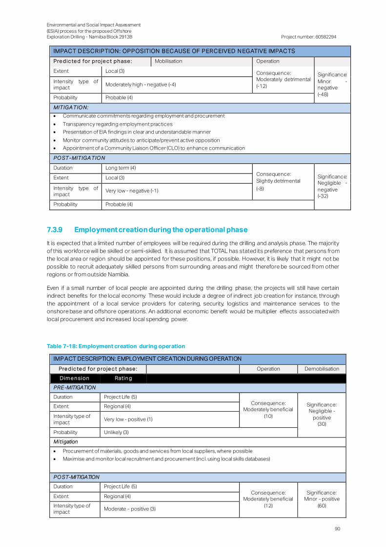
Environmental and Social Impact Assessment
(ESIA) process for the proposed Offshore Exploration Drilling - Namibia Block 2913B
Project number: 60582294
90
IMPACT D ESCRIPTION : OPPOSITION BECAUSE OF PERCEIVED N EGATIVE IMPACTS
Pre d ic te d for p ro je c t p h ase : Mobilisation Operation
Extent Local (3) Consequence: Moderately detrimental
(-12)
Significance:
Minor - negative
(-48)
Intensity type of impact
Moderately high - negative (-4)
Probability Probable (4)
MITIGA TIO N:
Communicate commitments regarding employment and procurement
Transparency regarding employment practices
Presentation of EIA findings in clear and understandable manner
Monitor community attitudes to anticipate/prevent active opposition
Appointment of a Community Liaison Officer (CLO) to enhance communication
PO ST -MITIGA TIO N
Duration Long term (4) Consequence:
Slightly detrimental
(-8)
Significance: Negligible -
negative (-32)
Extent Local (3)
Intensity type of impact
Very low - negative (-1)
Probability Probable (4)
7.3.9 Employment creation during the operational phase
It is expected that a limited number of employees will be required during the drilling and analysis phase. The majority
of this workforce will be skilled or semi-skilled. It is assumed that TOTAL has stated its preference that persons from
the local area or region should be appointed for these positions, if possible. However, it is likely that it might not be
possible to recruit adequately skilled persons from surrounding areas and might therefore be sourced from other
regions or from outside Namibia.
Even if a small number of local people are appointed during the drilling phase, the projects will still have certain
indirect benefits for the local economy. These would include a degree of indirect job creation for instance, through
the appointment of a local service providers for catering, security, logistics and maintenance services to the
onshore base and offshore operations. An additional economic benefit would be multiplier effects associated with
local procurement and increased local spending power.
Table 7-18: Employment creation during operation
IMPACT DESCRIPTION: EMPLOYMENT CREATION DURING OPERATION
Pre d ic te d for p ro je c t p h ase : Operation Demobilisation
Dim e n sion Ratin g
PRE -MITIGATION
Duration Project Life (5) Consequence:
Moderately beneficial
(10)
Significance: Negligible -
positive (30)
Extent Regional (4)
Intensity type of impact
Very low - positive (1)
Probability Unlikely (3)
Mitigation
Procurement of materials, goods and services from local suppliers, where possible
Maximise and monitor local recruitment and procurement (incl. using local skills databases)
PO ST-MITIGATION
Duration Project Life (5) Consequence:
Moderately beneficial
(12)
Significance: Minor - positive
(60)
Extent Regional (4)
Intensity type of impact
Moderate - positive (3)
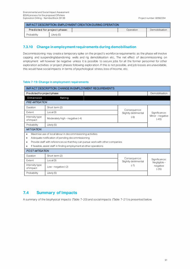
Environmental and Social Impact Assessment
(ESIA) process for the proposed Offshore Exploration Drilling - Namibia Block 2913B
Project number: 60582294
91
IMPACT DESCRIPTION: EMPLOYMENT CREATION DURING OPERATION
Pre d ic te d for p ro je c t p h ase : Operation Demobilisation
Probability Likely (5)
7.3.10 Change in employment requirements during demobilisation
Decommissioning may create a temporary spike on the project’s workforce requirements as the phase will involve
capping and suspending/abandoning wells and rig demobilisation etc., The net effect of decommissioning on
employment will however be negative unless it is possible to secure jobs for all the former personnel for other
exploration activities or project phases following exploration. If this is not possible, and job losses are unavoidable,
this would have social impacts in terms of psychological stress, loss of income, etc.
Table 7-19: Change in employment requirements
IMPACT DESCRIPTION: CHANGE IN EMPLOYMENT REQUIREMENTS
Pre dicted for project phase: Demobilisation
Dim e n sion Ratin g
PRE -MITIGATION
Duration Short term (2) Consequence:
Slightly detrimental
(-9)
Significance: Minor - negative
(-45)
Extent Local (3)
Intensity type of impact
Moderately high - negative (-4)
Probability Likely (5)
MITIGATION:
Maximise use of local labour in decommissioning activities
Adequate notification of pending decommissioning
Provide staff with references so that they can pursue work with other companies
If feasible, assist staff in finding employment at other operations
PO ST-MITIGATION
Duration Short term (2) Consequence:
Slightly detrimental
(-7)
Significance: Negligible -
negative
(-35)
Extent Local (3)
Intensity type of impact Low - negative (-2)
Probability Likely (5)
7.4 Summary of Impacts
A summary of the biophysical impacts (Table 7-20) and social impacts (Table 7-21) is presented below.
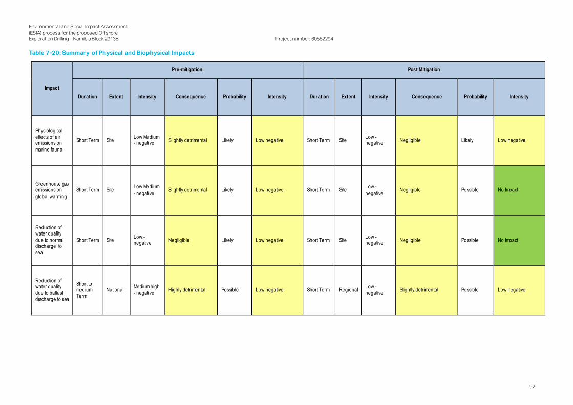
Environmental and Social Impact Assessment
(ESIA) process for the proposed Offshore Exploration Drilling - Namibia Block 2913B
Project number: 60582294
92
Table 7-20: Summary of Physical and Biophysical Impacts
Impact
Pre-mitigation: Post Mitigation
Duration Extent Intensity Consequence Probability Intensity Duration Extent Intensity Consequence Probability Intensity
Physiological
effects of air emissions on
marine fauna
Short Term Site Low Medium - negative
Slightly detrimental Likely Low negative Short Term Site Low - negative
Negligible Likely Low negative
Greenhouse gas emissions on
global warming
Short Term Site Low Medium
- negative Slightly detrimental Likely Low negative Short Term Site
Low -
negative Negligible Possible No Impact
Reduction of water quality
due to normal discharge to
sea
Short Term Site Low - negative
Negligible Likely Low negative Short Term Site Low - negative
Negligible Possible No Impact
Reduction of water quality
due to ballast discharge to sea
Short to medium
Term
National Medium high
- negative Highly detrimental Possible Low negative Short Term Regional
Low -
negative Slightly detrimental Possible Low negative
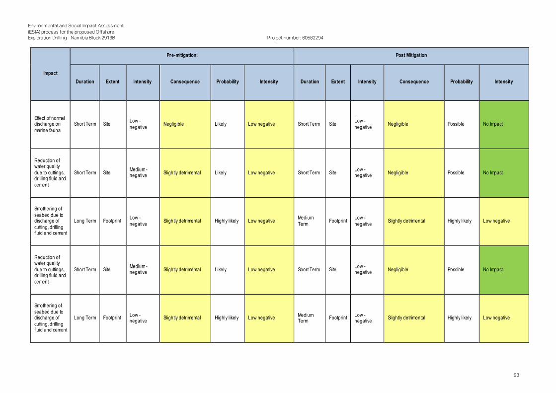
Environmental and Social Impact Assessment
(ESIA) process for the proposed Offshore Exploration Drilling - Namibia Block 2913B
Project number: 60582294
93
Impact
Pre-mitigation: Post Mitigation
Duration Extent Intensity Consequence Probability Intensity Duration Extent Intensity Consequence Probability Intensity
Effect of normal discharge on
marine fauna
Short Term Site Low -
negative Negligible Likely Low negative Short Term Site
Low -
negative Negligible Possible No Impact
Reduction of water quality
due to cuttings, drilling fluid and
cement
Short Term Site Medium - negative
Slightly detrimental Likely Low negative Short Term Site Low - negative
Negligible Possible No Impact
Smothering of
seabed due to discharge of
cutting, drilling fluid and cement
Long Term Footprint Low -
negative Slightly detrimental Highly likely Low negative
Medium
Term Footprint
Low -
negative Slightly detrimental Highly likely Low negative
Reduction of water quality
due to cuttings, drilling fluid and
cement
Short Term Site Medium - negative
Slightly detrimental Likely Low negative Short Term Site Low - negative
Negligible Possible No Impact
Smothering of
seabed due to discharge of
cutting, drilling fluid and cement
Long Term Footprint Low - negative
Slightly detrimental Highly likely Low negative Medium Term
Footprint Low - negative
Slightly detrimental Highly likely Low negative

Environmental and Social Impact Assessment
(ESIA) process for the proposed Offshore Exploration Drilling - Namibia Block 2913B
Project number: 60582294
94
Impact
Pre-mitigation: Post Mitigation
Duration Extent Intensity Consequence Probability Intensity Duration Extent Intensity Consequence Probability Intensity
Toxicity to
marine fauna due to discharge
of cutting, drilling fluid and
cement
Short Term Site Medium -
negative Slightly detrimental Likely Low negative Short Term Site
Low -
negative Negligible Possible No Impact
Reduction in water quality
due to discharge of cutting,
drilling fluid and cement
Short Term Site Low - negative
Negligible Likely Low negative Short Term Site Low - negative
Negligible Possible No Impact
Elimination or
disturbance of benthic fauna
due to seabed disturbance
Short Term Site Medium -
negative Slightly detrimental Definite Medium negative Short Term Site
Low -
negative Negligible Highly likely Low negative
Reduction of water quality due to seabed
disturbance
Short Term Site Low - negative
Negligible Likely Low negative Short Term Site Low - negative
Negligible Possible No Impact
Effects of marine noise on
marine fauna
Short Term Site Medium - negative
Slightly detrimental Likely Low negative Short Term Site Low - negative
Negligible Possible No Impact
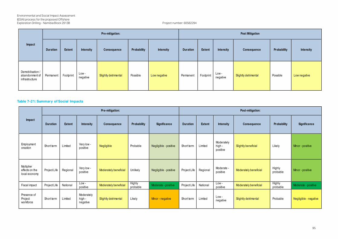
Environmental and Social Impact Assessment
(ESIA) process for the proposed Offshore Exploration Drilling - Namibia Block 2913B
Project number: 60582294
95
Impact
Pre-mitigation: Post Mitigation
Duration Extent Intensity Consequence Probability Intensity Duration Extent Intensity Consequence Probability Intensity
Demobilisation / abandonment of
infrastructure
Permanent Footprint Low -
negative Slightly detrimental Possible Low negative Permanent Footprint
Low -
negative Slightly detrimental Possible Low negative
Table 7-21: Summary of Social Impacts
Impact
Pre-mitigation: Post-mitigation:
Duration Extent Intensity Consequence Probability Significance Duration Extent Intensity Consequence Probability Significance
Employment creation
Short term Limited Very low - positive
Negligible Probable Negligible - positive Short term Limited Moderately high -
positive
Slightly beneficial Likely Minor - positive
Multiplier effects on the
local economy
Project Life Regional Very low -
positive Moderately beneficial Unlikely Negligible - positive Project Life Regional
Moderate -
positive Moderately beneficial
Highly
probable Minor - positive
Fiscal impact Project Life National Low -
positive Moderately beneficial
Highly
probable Moderate - positive Project Life National
Low -
positive Moderately beneficial
Highly
probable Moderate - positive
Presence of
Project workforce
Short term Limited
Moderately
high - negative
Slightly detrimental Likely Minor - negative Short term Limited Low - negative
Slightly detrimental Probable Negligible - negative
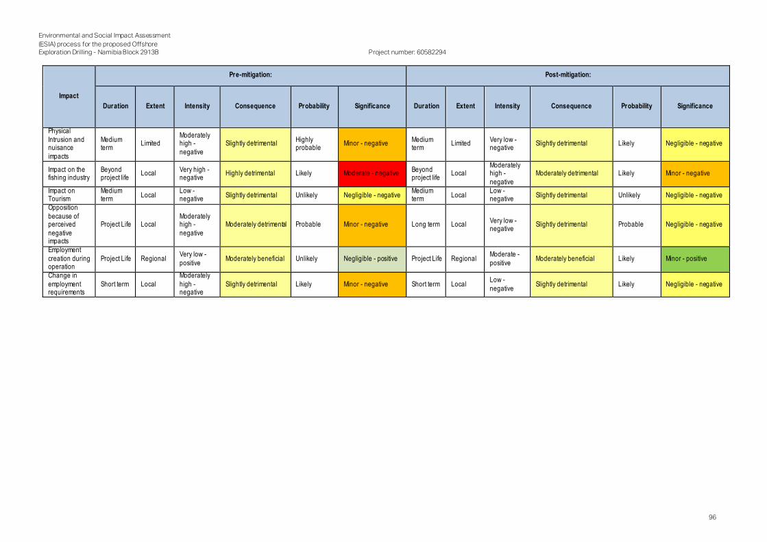
Environmental and Social Impact Assessment
(ESIA) process for the proposed Offshore Exploration Drilling - Namibia Block 2913B
Project number: 60582294
96
Impact
Pre-mitigation: Post-mitigation:
Duration Extent Intensity Consequence Probability Significance Duration Extent Intensity Consequence Probability Significance
Physical
Intrusion and nuisance
impacts
Medium term
Limited Moderately high -
negative
Slightly detrimental Highly probable
Minor - negative Medium term
Limited Very low - negative
Slightly detrimental Likely Negligible - negative
Impact on the fishing industry
Beyond project life
Local Very high - negative
Highly detrimental Likely Moderate - negative Beyond project life
Local Moderately high -
negative
Moderately detrimental Likely Minor - negative
Impact on Tourism
Medium term
Local Low - negative
Slightly detrimental Unlikely Negligible - negative Medium term
Local Low - negative
Slightly detrimental Unlikely Negligible - negative
Opposition
because of perceived
negative impacts
Project Life Local Moderately high -
negative
Moderately detrimental Probable Minor - negative Long term Local Very low - negative
Slightly detrimental Probable Negligible - negative
Employment
creation during operation
Project Life Regional Very low -
positive Moderately beneficial Unlikely Negligible - positive Project Life Regional
Moderate -
positive Moderately beneficial Likely Minor - positive
Change in
employment requirements
Short term Local
Moderately
high - negative
Slightly detrimental Likely Minor - negative Short term Local Low -
negative Slightly detrimental Likely Negligible - negative

Environmental and Social Impact Assessment
(ESIA) process for the proposed Offshore Exploration Drilling - Namibia Block 2913B
Project number: 60582294
97
7.5 Cumulative Impacts
The International Finance Corporation (IFC) defines cumulative impacts as ‘impacts that result from the incrementa l
impact, on areas or resources used or directly impact by the project, from other existing, planned or reasonably
defined developments at the time the risks and impacts identification process is conducted’. Significant cumulative
impacts can result from individually minor but collectively significant actions taking place over a period of time. Thus
existing, proposed and possible future activities have and will continue to have a cumulative impact on the
biophysical and socio-economic environment in the Project area.
Cumulative effects are difficult to predict as they are the result of complex interactions between multiple projects
or activities. This difficulty is compounded by the fact that details of future development are largely unknown; there
are currently no other known drilling operations proposed at the same time.
Until oil and gas discoveries are made, it is difficult to predict whether and when any future oil and gas activity might
occur, or the type, location, duration or level of those potential activities. In addition, methods to explore for, develop,
produce, and transport petroleum resources would vary depending on the area, operator and discovery.
Mitigation and management of cumulative impacts often require cooperation with other stakeholders or at a
government level and are frequently beyond the ability of a single project development to control solely. In line with
international good practice, mitigation should be commensurate with the level of contribution to the cumulative
impact by TOTAL.
7.6 Unplanned Events
Offshore drilling operations carry an inherent risk of oil entering the marine environment because of an unplanned
oil spill event. Depending on the location and severity of an incident, oil could reach the coast. Reservoir
hydrocarbons, of which the exact composition is unknown, are a possible source of oil. Other possible oil sources
include; various oil derived materials stored and used in bulk on board the drilling unit and support vessels. The most
relevant of these materials are diesel or marine gas oil, lubricating oils and hydraulic oils.
It is important to understand the main risks of oil spills associated with exploration drilling and the consequences if
any spills were to occur. Identifying the consequence of a spill requires understanding of what is likely to happen to
the oil in the marine environment.
It was found that should an oil spill occur adjacent to the Project area, such a spill would not reach the coast or any
conservation areas (SLR Environmental Consulting, 2017). Oil is predicted to travel in a north-westerly direction
away from the coast and thus no oil is predicted to reach the shoreline. As such, it is assumed that as Block 2913B
is directly adjacent to the area studies in the SLR Environmental Consulting (2017) study, the same assumption can
be made.
However, it is recommended that, prior to exploration activities commence, TOTAL develops an oil spill contingency
plan.
In addition, the following management measures are to be implemented:
Engineer wells according to best practices (BOP, etc) .
Develop and implement an OSCP that summarises reactionary measures in the unlikely event of a subsea
release.
Develop and implement a SOPEP that summarises the reactionary measures in the event of on-board oil spills.
Develop and implement a refuelling procedure for bunkering.
Oil spill response training must be implemented.
Ensure all staff receive training on handling and storage of liquid hazardous materials .
Where options exist for variation in hazardous chemical products, the product with the lowest toxicity mus t
always be selected.
Ensure all liquid hazardous substances are stored within secondary containment.
Ensure all liquid hazardous substances are appropriately labelled and that the relevant MSDSs for their safe
use are kept on record.
All hazardous materials containment areas must be regularly inspected.

Environmental and Social Impact Assessment
(ESIA) process for the proposed Offshore Exploration Drilling - Namibia Block 2913B
Project number: 60582294
98
Suitable firefighting equipment must be stored in close proximity and all staff must be made aware of the
dangers of burning chemicals/smoke inhalation.
Ensure drainage water passes though oil screening processes in order to remove oils prior to discharge.
Alternatively slop oil unit can be used to lower the oil content acceptable parts per million (PPM) volumes.
All staff are to be provided with appropriate PPE.

Environmental and Social Impact Assessment
(ESIA) process for the proposed Offshore Exploration Drilling - Namibia Block 2913B
Project number: 60582294
99
8. Conclusion
The proposed Project would result in temporary and localised impacts on marine fauna and flora as well as on water
quality, but it is considered to be small and short-term under normal operating conditions. The area of interest is far
removed from the conservation area, the shore, and other sensitive receptors (e.g. key faunal breeding / feeding
areas, bird or seal colonies, and nursery areas for commercial fish stocks).
Benthic communities in the area of interest are relatively ubiquitous, comprising fast -growing species that are able
to rapidly recruit into disturbed areas; thus being less susceptible to the effects of smothering. The disturbance of
benthic communities within the drill cuttings deposition footprint is considered negligible in relation to the available
area of similar habitat on and off the edge of the continental shelf in the Atlantic Offshore Bioregion. The potential
impact on the benthic fauna is considered to be localised and of short -term duration.
Government will accrue revenue, which will constitute a beneficial social impact by virtue of the fact that it will
increase the amount of money Government will have at its disposal to construct and maintain infrastructure,
implement development projects and render other services to its constituencies. TOTAL will be liable for an annual
petroleum licence area rental charge for exploration, which will increase annually During exploration, royalties would
not apply and, as exploration does not directly generate income, neither would direct taxes on company incomes /
profits apply. There would, however, be indirect benefits to the fiscus. These are likely to be relatively modest and
should primarily take the form of Value Added Tax and income taxes levied on direct and indirect project expenditur e
in Namibia. The Project would have a necessarily high import content given its specialised nature. However, it would
also be associated with moderate amounts of local expenditure leading to a limited but positive impact on the
balance of payments.
Considering the relatively depressed economic base of towns where the Project would be based, it is likely that the
Project will result in some, albeit limited, economic benefits through direct and multiplier effects stimulated by capital
expenditure during the mobilisation and exploration/drilling phases.
The proposed Project will require a workforce to mobilise the drill rig and equipment and therefore has the potential
to provide limited direct employment to people within the local study area during the mobilisation phase. It is
expected that many of these positions will only last for a relatively short period, and will largely involve skilled and
semi-skilled positions, with limited employment opportunities for unskilled individuals. However, the acquisition of
new skills during the mobilisation period could make individuals more employable in the future. And during the
drilling/exploration phase?
The fishing industry contributes to the economy of several of Namibia’s coastal towns, including Lüderitz. Fishery
studies undertaken for similar scenarios established that it is likely for planned oil and gas exploration activities to
have insignificant impacts on the fishing industry, if appropriate mitigation is applied; however, exploration activities
could in the case of unplanned events such as a blow out from drilling and associated activities result in a low to
medium impacts despite mitigation measures. However, if activities result in a significant negative impacts on the
feasibility of the fishing industry it would likely impact a considerable number of households that are dependent on
the sector for their livelihoods. Fishery studies undertaken for similar scenarios established that it is unlikely for
planned oil and gas exploration activities to have significant impacts on the fishing industry, if appropriate mitigation
is applied; however, exploration activities could in the case of unplanned events such as a blow out from drilling and
associated activities result in a low to medium impacts despite mitigation measures.
The most significant environmental threat from offshore drilling operations is the risk of a major spill of crude oil
occurring either from a blow-out or loss of well control, which is highly unlikely with the implementation of all the
Project controls.
Offshore drilling operations carry an inherent risk of oil entering the marine environment because of an unplanned
oil spill event. Depending on the location and severity of an incident, oil could reach the coast. Reservoir
hydrocarbons, of which the exact composition is unknown, are a possible source of oil.
It was found that should an oil spill occur adjacent to the Project area, such a spill would not reach the coast or any
conservation areas (SLR Environmental Consulting, 2017), furthermore TOTAL’s early modelling (to support the
OSCP development) draws the same conclusion. Oil is predicted to travel in a north-westerly direction away from
the coast and thus no oil is predicted to reach the shoreline. As such, it is assumed that as Block 2913B is directly
adjacent to the area studied in the SLR Environmental Consulting (2017) study, the same assumption can be made.
However, it is recommended that, prior to exploration activities commence, TOTAL develops an oil spill management
and rehabilitation plan.

Environmental and Social Impact Assessment
(ESIA) process for the proposed Offshore Exploration Drilling - Namibia Block 2913B
Project number: 60582294
100
Based on the findings of this ESIA, AECOM conclude that the generally low significant impacts with mitigation
associated with normal operations should support a positive decision and the issuing of an ECC for the proposed
Project.

Environmental and Social Impact Assessment
(ESIA) process for the proposed Offshore Exploration Drilling - Namibia Block 2913B
Project number: 60582294
101
9. References
Atkinson, L.J., 2009. Effects of demersal trawling on marine infaunal, epifaunal and fish assemblages: studies in the
southern Benguela and Oslofjord. PhD Thesis. University of Cape Town.
Bagguley, J. and S. Prosser, 1999. The interpretation of passive margin depositional processes using se ismic
stratigraphy: examples from offshore Namibia. Geological Society London Special Publications 153(1):321-344.
Bailey, G.W., Beyers, C.J. De, B. and S.R. Lipschitz, 1985. Seasonal variation of oxygen deficiency in waters off
southern South West Africa in 1975 and 1976 and its relation to catchability and distribution of the Cape rock-
lobster Jasus lalandii. S. Afr. J. Mar. Sci., 3: 197-214.
Barbour, T., van Zyl, H., & J. Kinghorn, 2017. Environmental Impact Assessment for Proposed Deep-Water
Exploration Well Drilling in Petroleum Exploration Licence 39 off The Coast of Southern Namibia: Socio-Economic
Assessment. Shell Namibia Upstream BV. Retrieved from
https://slrconsulting.com/media/files /documents /Appendix_4_5-Socio-Economic_Assessment.pdf
Bianchi, G. et. al, 1999. The Living Marine Resources of Namibia, Rome: Food and Agricultural organisation of the
United Nations.
Birch G.F., Rogers J., Bremner J.M. and G.J. Moir, 1976. Sedimentation controls on the continental margin of
Southern Africa. First Interdisciplinary Conf. Mar. Freshwater Res. S. Afr., Fiche 20A: C1-D12.
Breeze, H., D.S. Davis, M. Butler and V. Kostylev, 1997. Distribution and status of deep-sea corals off Nova Scotia.
Marine Issues Special Committee Special Publication No. 1. Halifax, NS: Ecology Action Centre. 58p.
Brüchert, V., B.B. Jørgensen, K. Neumann, D. Riechmann, M. Schlösser, H. Schulz, 2003. Regulation of bacterial
sulfate reduction and hydrogen sulfide fluxes in the central Namibian coastal upwelling zone. Geochimica et al.,
Cosmochimica Acta 67(23): 4505-4518.
Chapman, P. and L.V. Shannon, 1985. The Benguela Ecosystem. Part II. Chemistry and related processes. Oceanogr.
Mar. Biol. Ann. Rev., 23: 183-251.
Checkley, D.M., Ayon, P. Baumgartner, T.R., Bernal, M., Coetzee, J.C., Emmett, R., Guevara-Carrasco, R., Hutchings, L.,
Ibaibarriaga, L., Nakata, H., Oozeki, Y., Planque, B., Schweigert, J., Stratoudakis, Y., C. van der Lingen, 2009. Habitats.
In: Climate Change and Small Pelagic Fish, Cambridge University Press. pp12-44.
Christie, N.D., 1974. Distribution patterns of the benthic fauna along a transect across the continental shelf off
Lamberts Bay, South Africa. Ph.D. Thesis, University of Cape Town, 110 pp and Appendices.
Christie, N.D., 1976. A numerical analysis of the distribution of a shallow sublittoral sand macrofauna along a transect
at Lambert's Bay, South Africa. Transactions of the Royal Society of South Africa, 42: 149-172.
Clark, M.R., S. O'Shea, D. Tracey and B. Glasby, 1999. New Zealand region seamounts. Aspects of their biology,
ecology and fisheries. Report prepared for the Department of Conservation, Wellington, New Zealand, August 1999.
107 pp.
Currie, H., Grobler, K. & J. Kemper, 2008. Namibian Islands’ Marine Protected Area , Swakopmund: Namibian Marine
Ecosystem Project.
Davies, S., Hjort, A., Boyer, D. & H. Boyer, 2014. Benguela Current Large Marine Ecosystem: State of the Marine
Environment, Swakopmund: Benguela Current Commission.
Dingle, R.V., 1973. The Geology of the Continental Shelf between Lüderitz (So uth West Africa) and Cape Town with
special reference to Tertiary Strata. J. Geol. Soc. Lond., 129: 337-263.
Earth's Endangered Creatures, 2018. Earth's Endangered Creatures. [Online] Available at:
http://earthsendangered.com/search-regions3.asp?search=1&sgroup=allgroups&ID=229
Emeis, K.C., V. Brüchert, B. Currie, R. Endler, T. Ferdelman, A. Kiessling, T. Leipe, K. Noli-Peard, U. Struck, and T. Vogt,
2004. Shallow gas in shelf sediments of the Namibian coastal upwelling ecosystem. Continental Shelf Research
24(6):627-642.

Environmental and Social Impact Assessment
(ESIA) process for the proposed Offshore Exploration Drilling - Namibia Block 2913B
Project number: 60582294
102
Government of the Republic of Namibia (GRN), 2005a. The Constitution of the Republic of Namibia. pp 44, 45, 47
,62.
GRN, 2012. Environmental Impact Assessment Regulations: Environmental Management Act, 2007, Windhoek:
Republic of Namibia Ministry of Environment and Tourism.
GRN, 2015. National climate Change Strategy and Action Plan, Windhoek: Republic of Namibia Ministry of
Environment and Tourism.
GRN, 2017. National Marine Pollution Contingency Plan. Republic of Namibia. pp 116.
Hansen. F.C., R.R Cloete and H.M. Verheye, 2005. Seasonal and spatial variability of dominant copepods along a
transect off Walvis Bay (23ºS), Namibia. African Journal of Marine Science, 27: 55-63.
Herbert, C.T. and J.S. Compton, 2007. Geochronology of Holocene sediments on the western margin of South Africa.
South African Journal of Geology, 110: 327-338
Hovland, M., S. Vasshus, A. Indreeide, L. Austdal and Ø. Nilson, 2002. Mapping and imaging deep-sea coral reefs off
Norway, 1982- 2000. Hydrobiol. 471: 13-17.
Lett, C., J. Veitch, C.D. Van der Lingen and L. Hutchings, 2007. Assessment of an environmental barrier to transport
of ichthyoplankton from the southern to the northern Benguela ecosystems. Mar.Ecol. Prog. Ser., 347: 247-259.
Light, M. P. R., & Shimutwikeni, N. (1991). Namibia, practically unexplored, may have land, offshore potential. Oil and
Gas Journal ;(USA), 89(14): 85.
Maartens, L., 2003. Biodiversity. In: Molloy, F. and T. Reinikainen (Eds). Namibia's Marine Environment. Directorate of
Environmental Affairs, Ministry of Environment and Tourism, Namibia: 103-135.
MacIssac, K., C. Bourbonnais, E.D. Kenchington, J.R. Gordon and S. Gass, 2001. Observations on the occurrence
and habitat preference of corals in Atlantic Canada. In: (eds.) J.H.M. Willison, J. Hall, S.E. Gass, E.L.R.
Meadows, M.E., Dingle, R.V., Rogers, J. and E.G. Mills, 1997. Radiocarbon chronology of Namaqualand mudbelt
sediments: problems and prospects. South African Journal of Science, 93: 321-327.
Meadows, M.E., Rogers, J., Lee-Thorp, J.A., Bateman, M.D. and R.V. Dingle, 2002. Holocene geochronology of a
continental-shelf mudbelt off southwestern Africa. The Holocene, 12: 59-67.
Ministry of Environment and Tourism, 2010. Namibia’s Draft Fourth National Report to the United Nations
Convention on Biological Diversity (UNCBD) Windhoek: MET.
Ministry of Fisheries and Marine Resources, 2009. An Overview of the Namibian Fishing Industry in A review of
Namibian Trade and Industry 2010, Windhoek: MFMR.
Monteiro, P.M.S. and A.K. Van der Plas, 2006. Low Oxygen Water (LOW) variability in the Benguela System: Key
processes and forcing scales relevant to forecasting. In: SHANNON, V., HEMPEL, G., MALANOTTE- RIZZOLI, P.,
MOLONEY, C. and J. WOODS (Eds). Large Marine Ecosystems, Vol. 15, pp 91-109.
Namibia Statistics Agency (NSA), 2014. Population and Housing Census - 2011: !Karas Regional Profile. Namibia
Statistics Agency, Windhoek. Retrieved from
https://cms.my.na/assets/documents/p19dptss1r6qqq76pcp1ssp46tn.pdf
NamPort, 2018. ational Development Plan (NDP5). [Online] Available at: https://www.namport.com.na/abo ut -
namport/national-development-plan-ndp5-/494/
National Marine Fisheries Service, (2016). Technical Guidance for Assessing the Effects of Anthropogenic Sound
on Marine Mammal Hearing: Underwater Acoustic Thresholds for Onset of Permanent and Temporary Thresh old
Shifts. U.S. Dept. of Commer., NOAA. NOAA Technical Memorandum NMFS-OPR-55, 178 p.
National Marine Fisheries Service, 2018. Revision to Technical Guidance for Assessing the Effects of Anthropogenic
Sound on Marine Mammal Hearing (Version 2.0): Underwater Acoustic Thresholds for Onset of Permanent and
Temporary Threshold Shifts. U.S. Dept. of Commer., NOAA. NOAA Technical Memorandum NMFS-OPR-59, 178 p.
National Oceanic and Atmospheric Administration), 2018. [Online] Available at: https://www.ncdc.noaa.gov/cdo-
web/datasets/GHCNDMS/locations/FIPS:WA/detail#stationlist

Environmental and Social Impact Assessment
(ESIA) process for the proposed Offshore Exploration Drilling - Namibia Block 2913B
Project number: 60582294
103
National Petroleum Corporation of Namibia (NAMCOR). 2017a. Upstream Activities - Exploration and Production
(Online). Available: https://www.namcor.com.na/upstream/upstream-activities
National Petroleum Corporation of Namibia (NAMCOR). 2017b. Overview (Online). Available:
https://www.namcor.com.na/about/overview
Nelson, G. and L. Hutchings, 1983. The Benguela upwelling area. Prog. Oceanogr., 12: 333-356.
NSA, 2016. Namibia Household Income and Expenditure Survey (NHIES) 2015/2016 Report. Namibia Statistics
Agency, Windhoek. Retrieved from https://cms.my.na/assets/documents/NHIES_ 2015-16.pdf
NSA, 2017b. The Namibia Labour Force Survey 2016 Report. Namibia Statistics Agency, Windhoek. Retrieved from
https://cms.my.na/assets/documents/Labour_Force_Survey_-_20161.pdf
NSA. (2017a). Namibia Inter-censal Demographic Survey 2016 Report. Namibia Statistics Agency, Windhoek.
Retrieved from https://cms.my.na/assets/documents/NIDS_2016.pdf
Pisces Environmental Services (Pty) Ltd, 2014a. Environmental Impact Assessment for Namibia 3D Seismic Survey
for Blocks 2913A & 2914B (PEL). Marine Fauna Study. 164pp.
Pisces Environmental Services (Pty) Ltd, 2014b. Proposed Exploration Well Drilling in Block 1 off the West Coast of
South Africa - Marine Faunal Assessment, Tokai: CCA Environmental (Pty) Ltd.
Pisces Environmental Services (Pty) Ltd, 2014c. Basic Assessment for Marine Sediment Sampling Activities in
Various Diamond Concession Areas, West Coast, South Africa, Tokai: s.n.
Pisces Environmental Services (Pty) Ltd, 2018. Amendment Application for Offshore Diamond Mining in Sea
Concessions 2C and 3C, s.l.: s.n.
Popper, A. N., Hawkins, A. D., Fay, R. R., Mann, D., Bartol, S., Carlson, T., Coombs, S., Ellison, W. T., Gentry, R., Halvorsen,
M. B., Løkkeborg, S., Rogers, P., Southall, B. L., Zeddies, D., and W. N. Tavolga, 2014. Sound Exposure Guidelines for
Fishes and Sea Turtles: A Technical Report. ASA S3/SC1.4 TR-2014 prepared by ANSI Accredited Standards
Committee S3/SC1 and registered with ANSI. Springer and ASA Press, Cham, Switzerland.
Pulfrich, A., Penney, A.J., Brandao, A., Butterworth, D.S. and M. Noffke, 2006. Marine Dredging Project: FIMS Final
Report. Monitoring of Rock Lobster Abundance, Recruitment and Migration on t he Southern Namibian Coast.
Prepared for De Beers Marine Namibia, July 2006. 149pp.
Risk-Based Solutions, 2018. Final Draft Environmental Social Impact Assessment (ESIA) and Environmental Social
Management Plan (EMP), s.l.: s.n.
Rogers, A.D., 1994. The biology of seamounts. Advances in Marine Biology, 30: 305-350.
Rogers, A.D., 2004. The biology, ecology and vulnerability of seamount communities. IUCN, Gland, Switzerland.
Available at: www.iucn.org/themes/ marine/pubs/pubs.htm 12 pp.
Rogers, A.D., M.R. Clark, J.M. Hall-Spencer, J.M. and K.M. Gjerde, 2008. The Science behind the Guidelines: A
Scientific Guide to the FAO Draft International Guidelines (December 2007) For the Management of Deep-Sea
Fisheries in the High Seas and Examples of How the Guidelines May Be Practically Implemented. IUCN, Switzerland,
2008.
Rogers, J. and J.M. Bremner, 1991. The Benguela Ecosystem. Part VII. Marine-geological aspects. Oceanogr. Mar.
Biol. Ann. Rev., 29: 1-85.
Rogers, J., 1977. Sedimentation on the continental margin off the Orange River and the Namib Desert. Unpubl. Ph.D.
Thesis, Geol. Dept., Univ. Cape Town. 212 pp.
Shannon, L.J., C.L. Moloney, A. Jarre and Field, J.G. 2003. Trophic flows in the southern Benguela during the 1980s
and 1990s. Journal of Marine Systems , 39: 83 - 116.
Shannon, L.V. and M.J. O'Toole, 1998. BCLME Thematic Report 2: Integrated overview of the oceanography and
environmental variability of the Benguela Current region. Unpublished BCLME Report, 58pp SIMMONDS, M.P., and
LOPEZ - JURADO, L.F. 1991. Nature. 337: 448.
Environmental and Social Impact Assessment
(ESIA) process for the proposed Offshore Exploration Drilling - Namibia Block 2913B
Project number: 60582294
104
Shannon, L.V., 1985. The Benguela Ecosystem. Part 1. Evolution of the Benguela, physical features and processes.
Oceanogr. Mar. Biol. Ann. Rev., 23: 105-182.
SLR Environmental Consulting, 2017. EIA for proposed Deep Water Exploration Well D rilling in Petroleum
Exploration Licence 39 off the coast of southern Namibia. Final EIA Report & EMP. Report No. 4. SLR Ref.
734.19109.00001. 64pp.
South Pacific Regional Fisheries Management Authority (SPRFMA), 2007. Information describing seamount habit at
relevant to the South Pacific Regional Fisheries Management Organisation.
Southall, B.L., Bowles, A.E., Ellison W.T., Finneran J.J., Gentry, R.J., Greene Jr, C.R., Kastak, D., Ketten, D.R., Miller, J.H.,
Nachtigall, P.E., Richardson, J.W., Thomas, J.A, and P.L Tyack, 2007. Marine Mammal Noise Exposure Criteria: Initial
Scientific Recommendations. Aquatic Mammals, Vol 33, 411–522.
Steffani, N., 2007a. Biological Baseline Survey of the Benthic Macrofaunal Communities in the Atlantic 1 Mining
Licence Area and the Inshore Area off Pomona for the Marine Dredging Project. Prepared for De Beers Marine
Namibia (Pty) Ltd. pp. 42 + Appendices.
Steffani, N., 2007b. Biological Monitoring Survey of the Macrofaunal Communities in the Atlantic 1 Mining Licence
Area and the Inshore Area between Kerbehuk and Bogenfels. 2005 Survey. Prepared for De Beers Marine Namibia
(Pty) Ltd. pp. 51 + Appendices.
Stevenson, I.R. and I.K. McMillan, 2004. Incised valley fill stratigraphy of the Upper Cretaceous succession, proximal
Orange Basin, Atlantic margin of southern Africa. Journal of the Geological Society 161:185-208.
Swart, A., 2017. Assessment of the Baseline Meteorological and Air Quality Conditions over Uubvlei, Oranjemund,
Tshwane: University of Pretoria.

Environmental and Social Impact Assessment
(ESIA) process for the proposed Offshore Exploration Drilling - Namibia Block 2913B
Project number: 60582294
105
Appendix A : Environmental Management Plan

Environmental and Social Impact Assessment
(ESIA) process for the proposed Offshore Exploration Drilling - Namibia Block 2913B
Project number: 60582294
106
Appendix B : Specialist Studies

Environmental and Social Impact Assessment
(ESIA) process for the proposed Offshore Exploration Drilling - Namibia Block 2913B
Project number: 60582294
107
B.1 Marine Noise Modelling

Environmental and Social Impact Assessment
(ESIA) process for the proposed Offshore Exploration Drilling - Namibia Block 2913B
Project number: 60582294
108
B.2 Environmental Baseline Study

Environmental and Social Impact Assessment
(ESIA) process for the proposed Offshore Exploration Drilling - Namibia Block 2913B
Project number: 60582294
109
B.3 Social Impact Assessment

Environmental and Social Impact Assessment
(ESIA) process for the proposed Offshore Exploration Drilling - Namibia Block 2913B
Project number: 60582294
110
Appendix C : Stakeholder Database

Environmental and Social Impact Assessment
(ESIA) process for the proposed Offshore Exploration Drilling - Namibia Block 2913B
Project number: 60582294
111
Appendix D : Scoping and ESIA Stakeholder Consultation

Environmental and Social Impact Assessment
(ESIA) process for the proposed Offshore Exploration Drilling - Namibia Block 2913B
Project number: 60582294
112
D.1 Authority Meeting Attendance Registers

Environmental and Social Impact Assessment
(ESIA) process for the proposed Offshore Exploration Drilling - Namibia Block 2913B
Project number: 60582294
113
D.2 Site Notices

Environmental and Social Impact Assessment
(ESIA) process for the proposed Offshore Exploration Drilling - Namibia Block 2913B
Project number: 60582294
114
D.3 Background Information Document

Environmental and Social Impact Assessment
(ESIA) process for the proposed Offshore Exploration Drilling - Namibia Block 2913B
Project number: 60582294
115
D.4 Announcement Letters

Environmental and Social Impact Assessment
(ESIA) process for the proposed Offshore Exploration Drilling - Namibia Block 2913B
Project number: 60582294
116
D.5 FGM Attendance Registers and Minutes

Environmental and Social Impact Assessment
(ESIA) process for the proposed Offshore Exploration Drilling - Namibia Block 2913B
Project number: 60582294
117
D.6 Public Open Day Attendance Registers, Minutes and Information
Presented

Environmental and Social Impact Assessment
(ESIA) process for the proposed Offshore Exploration Drilling - Namibia Block 2913B
Project number: 60582294
118
D.7 Draft ESIA Public Open Day Notices

Environmental and Social Impact Assessment
(ESIA) process for the proposed Offshore Exploration Drilling - Namibia Block 2913B
Project number: 60582294
119
Appendix E : Comments and Response Report

Environmental and Social Impact Assessment
(ESIA) process for the proposed Offshore Exploration Drilling - Namibia Block 2913B
Project number: 60582294
120
Appendix F : Impact / Activity Screening Results

Environmental and Social Impact Assessment
(ESIA) process for the proposed Offshore Exploration Drilling - Namibia Block 2913B
Project number: 60582294
121
Project Phase Project Activities Physical
Environment
Biophysical Environment Social Environment
Wa
ter
Qu
alit
y an
d N
ois
e
Air
Qua
lity
and
No
ise
Se
ab
ed
Se
dim
ent
s
Fis
h a
nd
Pla
nkt
on
Be
nth
ic C
om
mu
niti
es
Av
i-fa
una
(Bird
s)
Ma
rin
e M
amm
als
Se
ab
ed
Fe
atu
res
Ne
ars
ho
re a
nd
Sh
ore
Are
as
Pro
tec
ted
Are
as
Fis
hin
g
Ma
rin
e T
raff
ic
Pu
blic
He
alth
an
d S
afe
ty
Se
rvic
e D
eliv
ery
Hu
man
Se
ttle
men
ts
Em
plo
ymen
t an
d In
co
me
Mob ilisation Transit of drilling unit and support vessels
Discharge of ballast water
Accommodation rental
Onshore base rental
Local Service providers
Procurement of equipment and material
Seabed survey
O p eration Presence and operation of drilling unit and
support vessels
Operation of helicopters
Drilling of wells
Discharge of drill cuttings and excess cement
Plug well with cement
De mobilisation Abandoned wellheads on seafloor
Demobilisation of drilling unit and support vessels from drill site
Colour Key: No interaction
Minor interaction
Moderate / major interaction
Positive interaction

Environmental and Social Impact Assessment
(ESIA) process for the proposed Offshore Exploration Drilling - Namibia Block 2913B
Project number: 60582294
122

Environmental and Social Impact Assessment
(ESIA) process for the proposed Offshore Exploration Drilling - Namibia Block 2913B
Project number: 60582294
123
Phindile Mashau
Environmental Scientist
T: +27 12 421 3894
AECOM SA (Pty) Ltd
263A West Avenue
Centurion
Tshwane
0157 South Africa
T: +27(0) 12 421 3500
F: +27 (0)12 421 3501
aecom.com