physical environment of the philippines by jannah s. salazar
TRANSCRIPT

PHYSICAL ENVIRONMENT OF THE PHILIPPINES
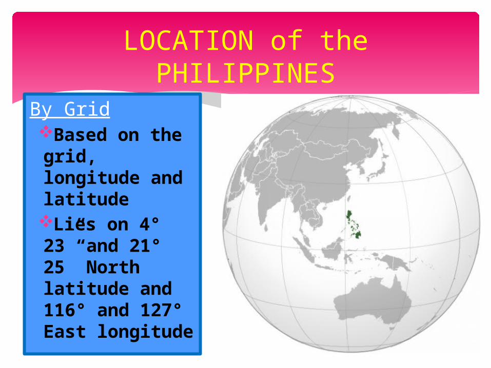
By GridBased on the grid, longitude and latitudeLies on 4° 23” and 21° 25” North latitude and 116° and 127° East longitude
LOCATION of the PHILIPPINES

By InsularBased on the bodies of water
North – Bashi Channel
South – Celebes SeaEast – Pacific OceanWest - South China
Sea

By BisinalBased on the neighboring countries
North – TaiwanSouth –
MalaysiaEast – Palao
IslandWest - Vietnam

1. It is the only Christian nation in the non-Christian Asian world.
2. It is the melting pot of races and culture, with a unique heritage from Asia, Europe, Latin America and North America.
3. It is the bridge that links the Oriental and Occidental Worlds.
IMPORTANCE of the PHILIPPINES

4. It is the crossroads of Asia’s air and sea routes.
5. It is the bastion of democracy in Asia where most countries are kingdoms, military dictatorships or one-party governments.

7, 107 islands 2, 773 have names and 1, 190 are
inhabited Total land Area: 115, 707 square
miles or 299, 681 square kilometers
SIZE of the PHILIPPINES

In terms of land area:oPhilippines is almost as large as Italy;

o larger than New Zealand;

o twice as big as Greece;
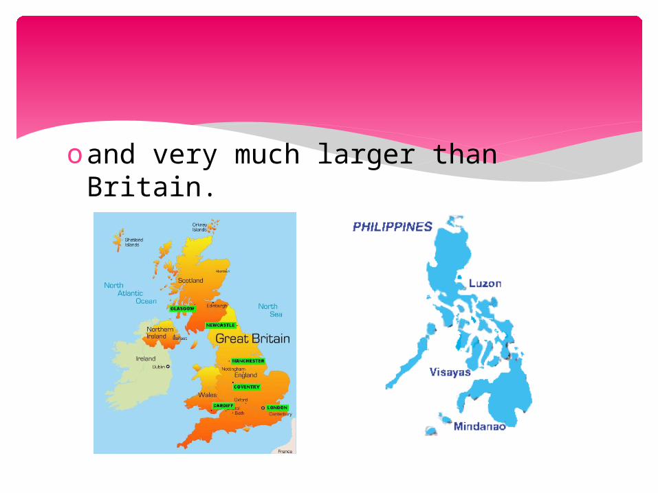
oand very much larger than Britain.

LUZON
largest island in the Philippines(40, 814 sq.miles)bigger than Hungary or Portugal

MINDANAO
second largest island in the Philippines(36, 906 sq.miles)bigger than Austria

VISAYAS
(56, 606 sq.km)

Northernmost point of the Philippines: Y’Ami Isle (78 miles from Taiwan)
Southernmost point: Saluag Isle (only 34 miles east of Borneo)
On a clear sunny day, Taiwan is visible from Y’Ami, and Borneo visible from Saluag Isle.

SHAPE of the PHILIPPINES
The shape of the Philippines is elongated.
Advantages:oexistence of good fishing grounds,
ports, and fair weather because of the winds coming from the islands and the seas

Disadvantages:o it is difficult to have a continuous
system of transportation of highways and railways
oeconomic development is hindered by the lack of an effective system of transportation

NATIONAL TERRITORY
Since 1956, the Philippines seas declared an archipelago principle of internal waters, meaning that the islands, waters and other natural features of the country are to be regarded as a single geographical, economic and political unit.
Subsequently, the archipelago principle was established in our national legislation, most recently in Article 1 of the 1986 Constitution. Through the United Nations Convention on the Law of the Sea (UNCLOS), which was signed by 117 states in Jamaica, on December 10, 1982, the Philippine Delegation won recognition for the archipelago principle for all nations.

The archipelago principle is a distinct contribution of the Philippines to international law. By this legal principle, we have secured sovereign title over all our archipelagic waters, the air space above them, the seabed and subsoil below them, and the resources contained therein.

The 1982 UNCLOS Treaty also designated a new concept of the Exclusive Economic Zone (EEZ), or a 200-mile belt of water around our archipelago (subject to agreement with neighboring countries whose Zones cross our own). Within this EEZ, the Philippines has the sovereign right to explore, exploit, conserve and manage the natural resources of the ocean, the seabed and the subsoil.

The following table includes new geographical data on Philippine territory:
Land Area . . . . . . . . . . . . .111, 707 sq. milesTotal Area with UNCLOS Treaty . . . . . . . . . . . . . . . . . . . . . . 520, 707 sq. nautical milesTotal Area under Economic Zone of 200 miles from baselines . . . . . . . . . . . . . . . . . . . . . . . . . . . . . . . . . 625, 800 sq. nautical miles

NATIONAL TERRITORY

CLIMATE
Tropical and monsoonal in character
Two distinct seasons: dry and wet season
Dry season (lasts from March to June)
Wet season (July to October)

The intervening months of the year – November to February are neither too dry nor too wet. It is the Philippine springtime, a delightful season of the year.

Coolest month – January (with an average temperature of 25.5 ° C
Hottest month – May (with an average temperature of 28.3 ° C
But in many cases, temperature during summer is higher than this, that is why extreme heat is widely felt.
Humidity – this refers to the moisture content of the atmosphere.

It is said that the humidity of the Philippines is high because of the high temperature and also because of the surrounding seas.
The average humidity of the Philippines in a month is from 71% every March to 85% in September.
There is abundant sunshine all year round, so flowers of all kinds bloom every day.
The Philippines holds the world’s record for the heaviest 24-hour rainfall of 979.4 mm. which occurred in Manila on October 17, 1967.
There is also plenty of rain.

A. Cape/Headland/Peninsula
B. Mountain RangeC. MountainD.VolcanoE. Valley
LAND FORMS

F. PlateauG.HillsH.PlainsI. Wetland

CAPE/HEADLAND/PENINSULA A cape is a pointed pieces of land
that extends out into a sea, ocean, lake, or river.
A headland is a type of peninsula. It is a point of land, usually high, that extends out into a body of water and thus has water on three sides.
A peninsula is a piece of land that is surrounded by water but connected to mainland via an isthmus.

EXAMPLES
1. Cape San Agustin (Davao Oriental)
2. Cape Bolinao (Bolinao province of Pangasinan)
3. Bataan Peninsula (rocky extension of the Zambales Mountains)
4. Bicol Peninsula (part of Bicol Region)
5. Caramoan Peninsula (north-east Camarines Sur, Bicol)

8. Bondoc Peninsula (CALABARZON Region)
9. San Ildefonso Peninsula (Central Luzon)
10.Tinaca Point (southern Davao del Sur)
11.Zamboanga Peninsula (Zamboanga)

MOUNTAIN RANGE
a chain of mountains bordered by highlands or separated from other mountains by passes or valleys

EXAMPLES1. Caraballo Mountains (bet. Cordillera
Central and Sierra Madre) 2. Cordillera Central (northern Luzon)
3. Kalatungan Mountain Range (Bukidnon)
4. Kitanglad Mountain Range (Bukidnon)
5. Sierra Madre (starts in Cagayan &
ends in Quezon)

MOUNTAIN
a large landform that stretches above the surrounding land in a limited area usually in the form of a peak

EXAMPLES1. Mount Agad-Agad (Iligan City)
2. Batorampon Point (Zamboanga City)
3. Mount Samat (Bataan)
4. Mount Guiting-Guiting (Sibuyan Island)
5. Mount Mantalingahan (Palawan)
6. Mount Hamiguitan (Davao Oriental)

7. Mount Kabuyao (Benguet)
8. Mount Lantoy (Cebu)
9. Mount Mirador (Quezon Province)
10.Mount Dulang-Dulang (Bukidnon)
11.Mount Victoria (Palawan)
12.Mount Nailog (Sibuyan Island) 13.Mount Pangasugan (Leyte)

14.Mount Pulag (or sometimes Mount Pulog) (bet. Benguet, Ifugao & Nueva Vizcaya)
15.Sleeping Beauty (Kalinga)
16.Mount Sumagaya (Mindanao)
17.Thumb Peak (Palawan)
18.Mount Halcon (Oriental Mindoro)

VOLCANO
an opening, or rupture, in a planet’s surface or crust, which allows hot magma, ash and gases to escape from below the surface

EXAMPLES1. Mount Isarog (Camarines Sur)
2. Mount Apo (bet. Davao del Sur & North Cotabato)
3. Mount Arayat (Pampanga)
4. Babuyan Claro (Babuyan Islands)
5. Balatukan (Mindanao)
6. Mount Bulusan (Sorsogon)
7. Biliran (central Philippines)

8. Balut Sarangani (Davao del Sur)
9. Mount Banahaw (boundary of Laguna and Quezon)
10.Cagua Volcano (Cagayan) 11.Camiguin de Babuyanes
(Calayan Island)
12.Binubulauan (Kalinga)
13.Bud Dajo (Phil.Island of Jolo)
15.Cuernos de Negros (Negros Oriental)
16.Didicas Volcano (Babuyan Islands)
17.Mount Hibok-Hibok (Camiguin Island)
18.Iraya (Batanes)
19.Mount Iriga (Camarines Sur)

22.Kanla-on (Negros Island)
23.Laguna Caldera (southeast of Manila)
24.Leonard Kniazeff (Compostela Valley, Davao del Norte)
25.Mount Matutum (South Cotabato)
26.Makaturing (Lanao del Sur)
27.Mayon Volcano (Albay)
28.Mount Parker (South Cotabato)

29.Mount Pinatubo (borders of
Zambales, Tarlac & Pampanga) 30.Taal Volcano (Batangas)
31.Mount Ragang (boundary of Lanao del Sur & Cotabato)
32.Mount Kitanglad (Bukidnon) 33.Mount Labo (Camarines Norte)
34.Mount Makiling (Laguna)

VALLEY
a depression with predominant extent in one direction
the terms U-shaped and V-shaped are descriptive terms of geography to characterize the form of valleys

EXAMPLES1. Alah Valley (South Cotabato)
2. Valley Fault System (formerly Marikina Valley Fault System) (extends from San Mateo, Rizal to Taguig City on the south; running through the cities of Makati, Marikina, Parañaque, Pasig & Taguig)
3. Compostela Valley (Davao Region)
4. Cagayan Valley (also Region II)
5. Cotabato Valley (valley of the Rio Grande de Mindanao)

PLATEAU
an area of highland, usually consisting of relatively flat terrain

EXAMPLES1. Cabadiangan Plateau (Negros
Occidental)
2. First Plateau (Tagaytay)
3. Malandag Plateau (South Cotabato)
4. Tablas Plateau (Negros Occidental)
5. Tabuk Plateau (Kalinga-Apayao)
6. Tanauar Plateau (Olongapo)
7. Benguet 8. Bukidnon

HILLS
a landform that extends above the surrounding terrain
In areas with scarp/dip topography, a hill may refer to a particular section of flat terrain without a massive summit.

EXAMPLES
1. Himontagon Hills (Loay, Bohol)
2. Chocolate Hills (Tagbilaran, Bohol)

PLAINS
consist of vast, flat lands that usually have various grasses growing on them

EXAMPLES
1. Central Luzon Plains (Provinces: Aurora, Bataan, Bulacan, Nueva Ecija, Pampanga, Tarlac, & Zambales)
2. Manila-CALABARZON Plains 3. Catbalogan Plains (Western Samar,
Visayas)

WETLAND
an area of land which soil is saturated with moisture either permanently or seasonally

EXAMPLES1. Agusan Marsh Wildlife
Sanctuary (Agusan River)
2. Olango Island Wildlife Sanctuary (Central Visayas)
3. Naujan Lake National Park (Oriental Mindoro)
4. Tubbataha Reefs National Marine Park (Sulu Sea)

FAMOUS LANDFORMS
MAYON VOLCANO
also known as Mount Mayonan active stratovolcano in the province of Albay, in the Bicol Region

BANAUE RICE TERRACES
located in the Mountain Province of Luzonfound in the Cordillera region

CHOCOLATE HILLS
are an unusual geological formationlocated in Tagbilaran, Bohol, Philippines

HUNDRED ISLANDS
refers to a cluster of more than one hundred islands; 124 at low tide and 123 during high tidecan be found in Pangasinan

PALAWAN ISLANDS
known as the "Cradle of Philippine Civilization“There are about 1,768 islands included in this province, attracting both local and foreign visitors.

BORACAY ISLAND
a simple unknown island of white sand beacheslocated in Aklan, Philippines

CORREGIDOR ISLAND
will always be one of the most famous islands of the Philippines because this was the fortress of the joint allied forces of Word War II

CAGAYAN VALLEY
provides the country’s top agricultural crops ranging from rice, corn, sugarcane, banana, coconut and tobacco

TRINIDAD VALLEY
can be found in Mountain provinceknown as the Salad Bowl of the PhilippinesIts vast lands and fertile soil produces the freshest farm grown fruits and vegetables.

SIERRA MADRE
longest mountain range in the country (about 210 mi)runs the north-eastern coast of Luzon islandstarts in the province of Cagayan in the north and ends in Quezon in the south, just east of Laguna de Bay

MOUNT APO
volcanic mountainlocated between the provinces of Davao del Sur and North Cotabato in Mindanaotallest mountain in the Philippines

TAAL VOLCANO
an active volcano on the island of Luzon in the Philippineslocated in Talisay and San Nicolas in Batangas

CENTRAL LUZON PLAINS
largest plain in the countryproduces most of the country’s rice supply“Rice Bowl of the Philippines”Its provinces are: Aurora, Bataan, Bulacan, Nueva Ecija, Pampanga, Tarlac, and Zambales

WATER FORMS
A.ChannelB.StraitC.SeaD. Bay

G.LakeH.RiverI. WaterfallJ. Gulf

CHANNEL
is the physical confine of a river, slough or ocean strait consisting of a bed and banks

EXAMPLES
1. Babuyan Channel (can be seen in the Luzon Strait in the part of Batan Island and Balintang Channel)
2. Balintang Channel (separates the Batanes and Babuyan Islands)
3. Bashi Channel (strait bet. the Y’Ami Island of the Phils. & Orchid Island of Taiwan)

4. Canigao Channel (connects the Bohol Sea with the Camotes Sea) (It lies bet. Bohol & Leyte.)
5. Hilutangan Channel (separates Mactan Island from Olango Island)
6. Jintotolo Channel (connects the Sibuyan Sea with the Visayan Sea) (located bet. Panay and Masbate)

STRAIT
is a narrow, navigable channel of water that connects two larger navigable bodies of water
most commonly refers to a channel of water that lies between two land masses
may also refer to a navigable channel through a body of water that is otherwise not navigable

EXAMPLES1. Balabac Strait (separates the Balabac
island (Palawan province), from the islands north of Borneo, Malaysia)
2. Cebu Strait (sometimes called Bohol Strait) (separates the island provinces of Cebu and Bohol) (connects the western part of Bohol Sea with Camotes Sea)
3. Luzon Strait (connects the Philippine Sea, in the Western Pacific, to the South China Sea, bet. Taiwan and Luzon)
4. Mindoro Strait (separates Mindoro island from Busuanga island of Palawan)
5. San Bernardino Strait (separates the Bicol Peninsula of Luzon from the island of Samar in the south)
6. San Juanico Strait (separates the islands of Samar and Leyte)

7. Surigao Strait (connects the Bohol Sea with Leyte Gulf)
8. Tablas Strait (separates the Mindoro and Panay islands)
9. Tañon Strait (connects the Visayan Sea to the Bohol Sea)

SEA
generally refers to a large body of salt water
refers to a large expanse of saline water connected with an ocean
commonly used as a synonym for ocean
also used sometimes to describe a large saline lake that lacks a natural outlet

EXAMPLES
1. Bohol Sea (also called the Mindanao Sea) (lies south of Bohol and Leyte and north of Mindanao)
2. Camotes Sea (bordered by the islands of Leyte to the noth and east, Bohol to the south, and Cebu to the west)

3. Celebes Sea (bordered on the north by the Sulu Archipelago and Sulu Sea and Mindanao Island, on the east by the Sangihe Islands chain, on the south by Sulawesi, and on the west by Kalimantan in Indonesia)
4. Philippine Sea (part of the western Pacific Ocean) (bordered by the Philippines and Taiwan to the west, Japan to the north, the Marianas to the east and Palau to the south)

5. Samar Sea (between the Eastern Visayas and Luzon)
6. Sibuyan Sea (bounded by the island of Panay to the south, Mindoro to the west, and to the north the Bicol Peninsula of Luzon island)

7. Sulu Sea (separated from the South China Sea in the northwest by Palawan, and from the Celebes Sea in the southeast by the Sulu Archipelago) (Borneo is found to the southwest and Visayas to the northeast.)

BAY
an area of water mostly surrounded or otherwise demarcated by land
generally have calmer waters than the surrounding sea, due to the surrounding land blocking some waves and often reducing winds
can also be an inlet in a lake or pond

EXAMPLES1. Baler Bay (northeastern part of
Luzon island)
2. Batangas Bay (Batangas City, the capital of Batangas Province is located on the coast of the bay.)
3. Manila Bay (Luzon)
4. Ormoc Bay (Leyte)
5. Subic Bay (west coast of the island of Luzon)

LAKE
a body of liquid on the surface of a world that is localized to the bottom of basin
a body of fresh or salt water of considerable size that is surrounded by land

EXAMPLES1. Balukbaluk Lake (Basilan)
2. Lake Buhi (Buhi, Camarines Sur)
3. Bulusan Lake (Bulusan, Sorsogon)
4. Dagianan (Lanao del Norte)
5. Laguna de Bay (located in the island of Luzon bet. the provinces of Laguna to the south and Rizal to the north)

6. Lake Danao (located in Camotes Island in Cebu City)
7. Lake Maragang (Zamboanga del Sur)
8. Lake Nabua (Camarines Sur)
9. Lake Panamao (Jolo, Sulu, Mindanao)
10.Lake Paoay (Ilocos Norte)

RIVER
a natural watercourse, usually freshwater, flowing toward an ocean, a lake, a sea, or another river

EXAMPLES1. Abra River (Abra)
2. Agno River (Pangasinan)
3. Agusan River (third largest river basin of the Phils. located in the eastern part of Mindanao island)
4. Akean River (Panay)
5. Bulacan (is a river of the Phils. It flows to Manila Bay.)

6. Cagayan River (Cagayan Valley Region)
7. Davao River (Mindanao)
8. Iloilo River (longest river in Iloilo)
9. Pasig River (Luzon)
10.Marikina River (main river system in Eastern Metro Manila)

WATERFALL
a place where flowing water rapidly drops in elevation as it flows over a steep region or a cliff

EXAMPLES
1. Maria Cristina Falls (2nd highest falls in the Phils.) (found in Iligan City)
2. Pagsanjan Falls (Cavinti, Laguna)
3. Tinago Falls (Iligan City, Lanao del Norte)
4. Tinuy-an Falls (Bislig City, Surigao del Sur)
5. Limunsudan Falls (Lanao del Norte)

GULF
a large bay that is an arm of an ocean or sea

EXAMPLES
1. Albay Gulf (southern part of Luzon)
2. Moro Gulf (Mindanao)
3. Panay Gulf (extension of Sulu Sea)
4. Davao Gulf (Mindanao)
5. Ragay Gulf (separated from the Sibuyan Sea by Bondoc Peninsula in the west)

FAMOUS water FORMS
LAGUNA DE BAY
largest lake in the Philippines2nd largest inland freshwater lake in Southeast Asia after Lake Toba in Sumatra, Indonesialocated between the provinces of Laguna to the south and Rizal to the north

MANILA BAY
one of the finest natural harbor in the world which serves the port of Manila

TAAL LAKE
freshwater lake in the province of Batangashas an active volcano in its center, lies a few miles to the southwest of Laguna de Bay
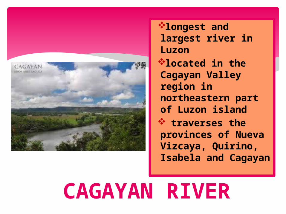
CAGAYAN RIVER
longest and largest river in Luzonlocated in the Cagayan Valley region in northeastern part of Luzon island traverses the provinces of Nueva Vizcaya, Quirino, Isabela and Cagayan

AGUSAN RIVER
third largest river basin of the Philippineslocated in the eastern part of Mindanao island in the Philippinesdraining majority of the Caraga Region and some parts of Compostela Valley province

MARIA CRISTINA FALLS
second highest falls in the Philippinesfound in Mindanao and is the landmark of Iligan Cityknown as the “Mother of Industry” & “Fountainhead of Progress”primary source of electric power for the whole Mindanao region

PAGSANJAN FALLS
indigenous name: Magdapio Fallsone of the most famed waterfalls in the Philippinesits actual location is not in Pagsanjan at all but in the adjacent town of Cavinti, Laguna