picnic area - maricopa county parks day-use picnic area offers 51 individual picnic sites. each site...
TRANSCRIPT
10/19/2016
Cave Creek Regional Park
EasyM od e rateM od e rate - Difficult
Rating M = M ultip le U se (all non- motorized access allowed)H/B = Hike /Bike Only
U se
Rating
0.80.52.35.8*0.22.11.41.6
Le ngthM i
CMFRFLGJJSOVQZSL
TrailCod e
(1.3)(0.8)(3.7)(9.3)*(0.3)(3.3)(2.3)(2.5)
Length(Km)
U se
M ,H/B†MMMMMMM
Ele v DiffTrailNam eClay M ineFlum eGo John††Jasp e rOve rton††QuartzSlate
Flat Roc k2171521804116440830088
Ft664655
12520
1249127
M
- Ele v Diff is d iffe re nc e in e le vation b e twe e n low and high p oints, whic h may or may not m atc h e nd p oints of trail. Gross change m ay b e gre ate r.
- Le ngths shown are one -way unle ss ind icate d b y * for round trip d istanc e .
- Due to round ing, se gm e nt le ngths on m ap m ay not ad d up to trail le ngths shown at le ft.
- †CM trail we st of m ine is Hike /Bike Only.- ††Ove rton and we st sid e of Go John are p art of the M aric op a Trail.
- Le ngths on m ap are for se gm e nts b e twe e n trail junctions ( ), or junction and trailhe ad .
WestBoundary
Spur
DesertEnclavePreserve
Cave
ClayMine
Apac
heWa
sh
RodeoArena
P. A. SeittsPreserve at GoJohn Canyon
(0.4)0.2
CLOUD RD
28 th
ST
CAVE CREEK PARKWAY
LAVA LN
JASP
ER
2357
2711
2093
2666
2807
2347
2602
2788
2610
2785
2288
2557
3060
2400
2000
2000
2800
2400
2200
2200
2200
2600
2400
2400
GJ
GJ
SL
FL
OV
GJ
OV
CM
JS
OLIV INE AV
V
7
`
Note: First 0.8 mile ofFlume Trail east of gateis also a service road.
No horses westof Clay Mine
M ainte nanc e
0.6(1.0)
0.6(1.0)
1.5(2.4)
(1.3)0.8
QZ
0.1(0.2)
0.8(1.
2)
0.9(1.5)
1.0(1.7)
0.9(1.
4)
0.9(1.5
)
0.5 (0.8)
1.3(2.2)
32 nd
ST
(1.1)0.7
0.6 Mile toCarefree Hwy
See reversefor details.
STATE
STATE
STATE
STATE
PRIV ATE
PRIV ATE
BLM
2600 Go John
Mountain
Go John Canyon
GunsightPass
1.4M ile s
(2.3
Kilome
ters)
3.9 Mi.(6.3 Km) to Spur CrossRanch from park boundary
Creek
FR0.6
(1.0)0.5(0.8)
Milit
ary
Slate
1.1(1.8)
0.4(0.6)
WAY
0.8(1.3) 0.6(0.9)
YZ
MARICOPATR
MARICOPA TR
MARICOPA TR
YIELDTO
N
EW
S
Contour Inte rval 40 Fe e t
Scale = 1:25,0001000 0 1000 2000Fe e t
250 0 250 500 Meters
Horse Re ntal
Pic nic Are aHorse Staging Are a
RV Dum p Station
Nature Ce nte rGroup Pic nic Are a(Reservable)
7
`
V
Y Fam ily Cam p groundEntranc e Station
Pe rm it re quire d for trust land
De se rt Foothills Land TrustRe gional Park Bound ary
Locke d V e hic le Gate
Trailhe adAc c e ss Gate
*Trail color varies by name.
M aric op a Trail* (IncludesOV and west side of GJ)
For horse outfitte r useTrail Outsid e ParkPark Trail*

435 ft(125 m)
Park BoundaryOverton Access
23
54
GJ
OVJS
GJ
SL
CAVE CREEK PARKWAY
1
VOverton Trail follows
shoulder of road.
B0.2
(0.4)
0.2(0.3)
0.1(0.2)
CM0.2
(0.3)
0.2(0.3
)
0.3(0.5)
0.2(0.3)
Go JohnTrailhead
Z
Z
Z
T ONA
LITE
DR
Permit required for trust land
Z
SlateTrailhead
2200
2400
2600
MARICOPATR
MAR
ICOP
AT R
Maricopa CountyParks and Recreation Department
Picnic Area and Trailheads
N
EW
S
Contour Inte rval 40 Fe e t
Scale = 1:9000250 0 250 500 750Fe e t
100 0 100 200 Meters
Group Pic nic Are a(Ram adas 1 - 5)
V Pic nic Are a
Hors e Staging Are a
PlaygroundB
Nature Ce nte rAm phithe ate r
Re s troom sZ
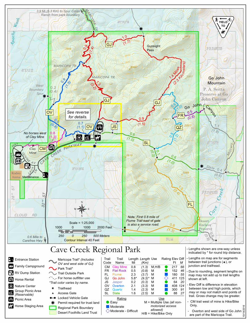
. Welcome to Cave Creek Regional ParkCave Cre e k Re gional Park was d e d ic ate d on Octobe r 31, 1992. This 2,922-ac re park is loc ate d within the Town of Cave Cre e k, 1.5 m ile s north ofCare fre e Highway on 32nd Stre e t.The land s c ape offe rs inte re s ting ge ologic al form ations , s c e nic vie ws , andSonoran De s e rt flora and fauna. Ele vations range from a low point in thes outhe as t c orne r of the park at 2,000 fe e t to 3,060 fe e t ne ar the c e nte r.Anc ie nt Hohokam Ind ians s taye d in the are a from around 800 A.D. until 1400A.D. Many re m ind e rs of the ir living in the are a s till re m ain. The park isloc ate d in the s outhwe s t c orne r of an are a that was the s c e ne of m ininge xploration and d e ve lopm e nt for ove r 120 ye ars . Irrigate d farm ing, cattle ands he e p ranc hing we re othe r ve nture s atte m pte d . All s uc h e fforts we rem arginal at be s t. Re m nants of the s e aband one d ope rations are vis ible .. Park RulesPLEASE OBSERVE PARK RULES!Park rule s are poste d throughout the park; the y are als o available as ahand out.. Nature CenterThe ne wNature Centerinc lud e s the park offic e , anim al e xhibits , inte rpre tived is plays , e d uc ational m ate rials, m e e ting room s , and a re tail are a. It isavailable for e ve nts.. PicnickingThe Group Picnic Area has four large ram ad as , e ac h of whic h c an bere s e rve d for a fe e . Two of the ram adas have four table s e ac h and e ac h c anbe re s e rve d for a four-hour pe riod ; the othe r two ram adas have s ix table se ac h, and c an be re s e rve d . This fac ility has table s , grills , d rinking wate r,e le c trical outle ts , c am pfire pits and a ne arby playground . The s e ram adas, ifnot m arke d as re s e rve d , are available on a firs t-c om e , firs t-s e rve d bas is.The Day-Use Picnic Area offe rs 51 ind ivid ual pic nic s ite s . Eac h s ite has atable and barbe c ue grill. The s e s ite s are available on a firs t-c om e , firs t-s e rve d bas is . Drinking wate r and re s troom s are available .. CampingThe Family Campground c ons is ts of 55 d e ve lope d c am ps ite s for te nt or RVcam ping, a te nt cam ping are a, re s troom s with flus h toile ts and hot-wate rs howe rs , and a d um p s tation. The re is a cam ping fe e pe r night. Re s e rvationsavailable :https ://m aric opac ountyparks .org or (602) 506-2930.
. TrailsCave Cre e k Re gional Park offe rs ove r 15 m ile s of trails for hiking, m ountainbiking and hors e bac k rid ing. All trails are s hare d -us e unle s s othe rwis ed e s ignate d . Dogs m us t be on le as h at all tim e s in the Park.The Horse Staging Area, s outh of the pic nic loop, has a large grave lparking lot to ac c om m odate hors e traile rs . Hitc h rails and wate r are als oavailable .Note : Trave l c an be ard uous if you are not pre pare d . Always c arry ple nty ofwate r, us e prote c tion from the s un, and le t s om e one know whe re you aregoing. Ple as e e nte r the Maric opa County She riff’s Offic e phone num be r of(602) 876-1000 into your c e ll phone prior to starting a hike . In c as e ofe m e rge nc y, d ial 911.. Hours of Operation and ContactsCave Cre e k Re gional Park is ope n 6 a.m . to 8 p.m . Sun - Thurs and 10p.m . Fri & Sat. A pe r-ve hic le e ntry fe e is re quire d . Ple as e us e the s e lf-paystation whe n the e ntranc e booth is not staffe d . For furthe r inform ationple as e c ontact the Park Offic e .Mailing Ad d re s s :Cave Cre e k Re gional Park37019 N. L ava L aneCave Cre e k, AZ 85331Te le phone : (623) 465-0431E-m ail:Te le phone for re s e rvations : (602) 506-2930E-m ail:m aric opac ountyparks @m ail.m aric opa.gov
cave c re e kpark@m ail.m aric opa.gov
@MCParks Follow us on Twitte r
Cave Cre e kParkL ike us on Fac e book
www.youtube .c om /Maric opaCountyParks