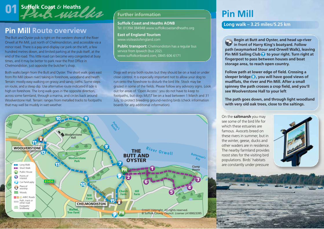
pin mill - suffolk coast and heaths pin mill in partnership with 01 local adnams pub in partnership...
TRANSCRIPT
01
Pin Mill In partnership with
01
Local Adnams pubIn partnership with
THE BUTT AND OYSTER Tel: 01473 780764Pin Mill, Ipswich, Suffolk, IP9 1JWLocation: Waterfront in village Restaurant/dining room YesGarden/courtyard Yes Bar meals YesChildren welcome Yes Accommodation YesDisabled access Yes Dogs welcome YesParking available Yes Credit cards welcome Yes
Woolverstone Hall
Felixstowe
Ipswich
oodbridge
Harwich
Aldeburgh
Southwold
Lowestoft
Beccles
NorthSea
W
01 Pin Mill02 Levington03 Waldringfield04 Woodbridge 05 Butley06 Orford07 Snape
08 Aldeburgh09 Eastbridge10 Westleton11 Walberswick12 Southwold 13 Wrentham14 Blythburgh
In partnership with
This leaflet has been produced with the generoussupport of Adnams to celebrate the 40th anniversaryof the Suffolk Coast and Heaths AONB.
“Adnams has been proud to work with Suffolk Coast andHeaths for many years on a variety of projects. We are basedin Southwold, just inside the AONB and it is with thisbeautiful location in mind that we have great respect for thebuilt, social and natural environment around us. Overseveral years we have been working hard to make ourimpact on the environment a positive one. Please visit ourwebsite to discover some of the things we’ve been up to.
We often talk about that “ah, that’s better” moment, andwhat better way to celebrate that than walking one of theseroutes and stopping off at an Adnams pub for some well-earned refreshment.
If you take this leaflet along to The Butt & Oyster they’ll behappy to offer you 10% off your meal before, during orafter your walk.”
Andy Wood, Adnams Chief Executive
adnams.co.uk 01502 727200 follow us on twitter.com/adnams
More Suffolk Coast and HeathsAONB pub walks
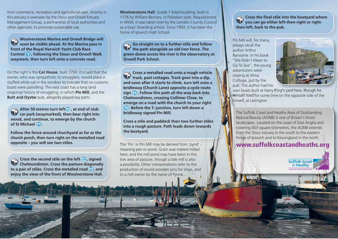
Pin Mill Long walk – 3.25 miles/5.25 km
Begin at Butt and Oyster, and head up-riverin front of Harry King’s boatyard. Follow
path (waymarked Stour and Orwell Walk), leavingPin Mill Sailing Club to your right. Turn right atfingerpost to pass between houses and boatstorage area, to reach open country.
Follow path at lower edge of field. Crossing asleeper bridge , you will have good views ofmudflats, the river and Pin Mill. After a smallspinney the path crosses a crop field, and you’llsee Woolverstone Hall to your left
The path goes down, and through light woodlandwith very old oak trees, close to the saltings.
On the saltmarsh you maysee some of the bird life forwhich these estuaries arefamous. Avocets breed onthese rivers in summer, but inthe winter, geese, ducks andother waders are in residence.The nearby farmland providesroost sites for the visiting birdpopulations. Birds’ habitatsare constantly under pressure
7
8
WOOLVERSTONE
CHELMONDISTON
WoolverstonePark
WoolverstoneHall
HillFarmMill
Farm
WalnutTree Farm
ChurchFarm
ClampHouse
Butterman’s Bay
Potter’s
Reach
CHURCH LANE
B1456
River Orwel l
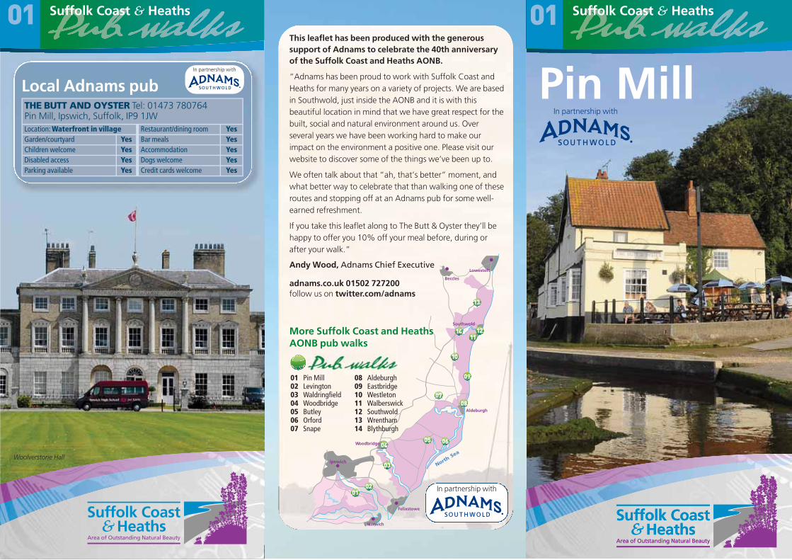
Pin Mill The Butt and Oyster pub is right on the western shore of the RiverOrwell at Pin Mill, just north of Chelmondiston, and accessible via aminor road. There is a pay-and-display car park on the left, a fewhundred metres down, and limited parking at the pub itself, at theend of the road. This little road can become very congested at busytimes, and it may be better to park near the Post Office inChelmondiston, just opposite the butcher’s shop.
Both walks begin from the Butt and Oyster. The short walk goes eastfrom Pin Mill (down river) taking in foreshore, woodland and heath.Terrain: mostly easy walking on grassy and sandy paths. Some stepson route, and a steep dip. Use alternative route indicated if tide ishigh on foreshore. The long walk goes in the opposite direction,across some farmland, through a marina, and circles back aroundWoolverstone Hall. Terrain: ranges from metalled tracks to footpathsthat may well be muddy in wet weather.
01
Dogs will enjoy both routes but they should be on a lead or underclose control. It is especially important not to allow your dog torun onto the foreshore to disturb the bird life. Stock may begrazed in some of the fields. Please follow any advisory signs. Lookout for areas of ‘Open Access’: you do not have to keep tofootpaths, but dogs MUST be on a lead between 1 March and 31July, to protect breeding ground-nesting birds (check informationboards for any additional information).
Long WalkShort Walk
Public House
Points ofinterest 1Car Park/Layby
Place ofworship
Path, track orother roadFootpath/bridleway
A/B/C Roads
Woods
Suffolk Coast and Heaths AONBTel: 01394 384948 www.suffolkcoastandheaths.org
East of England Tourismwww.visiteastofengland.com
Public transport: Chelmondiston has a regular busservice from Ipswich (bus 202). www.suffolkonboard.com, 0845 606 6171
Further information
4
32
1
5
6
THE BUTT ANDOYSTER
7
8
910
11
12
13
14
15
Crown copyright. All rights reserved.© Suffolk County Council. License LA100023395
The Suffolk Coast and Heaths Area of OutstandingNatural Beauty (AONB) is one of Britain’s finestlandscapes. Located on the coast of East Anglia andcovering 403 square kilometres, the AONB extendsfrom the Stour estuary in the south to the easternfringe of Ipswich and to Kessingland in the north.
www.suffolkcoastandheaths.org
from commerce, recreation and agricultural uses. Activity inthis estuary is overseen by the Stour and Orwell EstuaryManagement Group, a partnership of local authorities andother agencies, to promote sustainable use.
Woolverstone Marina and Orwell Bridge willsoon be visible ahead. At the Marina pass in
front of the Royal Harwich Yacht Club RaceControl , following the Stour and Orwell Walkwaymark, then turn left onto a concrete road.
On the right is the Cat House, built 1793. It is said that theowner, who was sympathetic to smugglers, would place astuffed white cat in the window to indicate that no customsboats were patrolling. The east coast has a long (andongoing) history of smuggling, in which Pin Mill, and theButt and Oyster pub, allegedly played key parts.
After 50 metres turn left , at end of club car park (waymarked), then bear right into
wood, and continue, to emerge by the church of St Michael .
Follow the fence around churchyard as far as thechurch porch, then turn right on the metalled roadopposite – you will see two stiles.
Cross the second stile on the left , signedChelmondiston. Cross the pasture diagonally
to a pair of stiles. Cross the metalled road , andenjoy the view of the front of Woolverstone Hall.
9
10
11
12
13
Cross the final stile into the boatyard whereyou can go either left-then-right or right-
then-left, back to the pub.
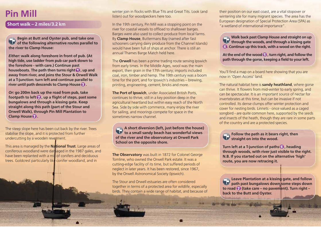
Pin Mill will, for many,always recall theauthor ArthurRansome. In his book“We Didn’t Mean toGo To Sea”, the youngadventurers werestaying at AlmaCottage, just by thepub. The author had hisown boats built at Harry King’s yard here, though hehimself lived for some time on the opposite side of theOrwell, at Levington.
Woolverstone Hall: Grade 1 listed building, built in 1776 by William Berners, in Palladian style. Requisitioned in WWII, it was taken over by the London County Councilas a boys’ boarding school. Since 1992, it has been thehome of Ipswich High School.
Go straight on to a further stile and followthe path alongside an old iron fence. The
green dome across the river is the observatory atOrwell Park School.
Cross a metalled road onto a rough vehicletrack, past cottages. Track goes into a dip,
and soon after it starts to climb, turn left onto abridleway (Church Lane) opposite a cycle routesign . Follow this path all the way back intoChelmondiston, crossing Collimer Close, toemerge on a road with the church to your right
. Before the T- junction, turn left down abridleway signed Pin Mill.
Cross a stile and paddock then two further stilesinto a rough pasture. Path leads down towardsthe boatyard.
The ‘Pin’ in Pin Mill may be derived from ‘pynd’ -meaning pen or pond. Grain was indeed milledhere, and the mill pond may have been in this low area of pasture, though a tide mill is also a possibility. Other interpretations refer to theproduction of round wooden pins for ships, andto a mill owner by the name of Pynne...
14
15
Begin at Butt and Oyster pub, and take oneof the following alternative routes parallel to
the river to Clamp House:
Either: walk along foreshore in front of pub. (Athigh tide, use ladder from pub car park down tothe foreshore - with care.) Continue pasthouseboats. The path then turns right , up andaway from river, and joins the Stour & Orwell Walkat a T-junction: turn left and continue parallel toriver until path descends to Clamp House .
Or: go 200m back up the road from pub, takefootpath to left , up a flight of steps, past somebungalows and through a kissing gate. Keepstraight along this path (part of the Stour andOrwell Walk), through Pin Mill Plantation toClamp House .
The steep slope here has been cut back by the river. Treesstabilise the slope, and it is protected from furtherundercutting by a wooden revetment.
This area is managed by the National Trust. Large areas ofconiferous woodland were damaged in the 1987 gales, andhave been replanted with a mix of conifers and deciduoustrees. Goldcrest particularly like conifer woodland, and in
1
3
2
3
winter join in flocks with Blue Tits and Great Tits. Look (andlisten) out for woodpeckers here too.
In the 19th century, Pin Mill was a stopping point on theriver for coastal vessels to offload to shallower barges.Barges were also used to collect produce from local farms.By Clamp House, Buttermans Bay (named after fastschooners carrying dairy produce from the Channel Islands)would have been full of ships at anchor. There is still anannual Thames Barge Match held here.
The Orwell has been a prime trading route serving Ipswichfrom early times. In the Middle Ages, wool was the mainexport, then grain in the 17th century; imports includedcoal, iron, timber and hemp. The 19th century was a boomtime for the port, and for Ipswich’s industries – brewing,printing, engineering, cement, bricks and more.
The Port of Ipswich, under Associated British Ports,continues to thrive, still in a key position deep in theagricultural heartland but within easy reach of the NorthSea. Side by side with commerce, many enjoy the river for sailing, and moorings compete for space in thesometimes narrow channel.
A short diversion (left, just before the house)to a small sandy beach has wonderful views
of the river and the observatory at Orwell ParkSchool on the opposite shore.
The Observatory was built in 1872 for Colonel GeorgeTomline, who owned the Orwell Park estate. It was acutting-edge facility of its time, but suffered periods ofneglect in later years. It has been restored, since 1967, by the Orwell Astronomical Society (Ipswich).
The Stour and Orwell estuaries are often consideredtogether in terms of a protected area for wildlife, especiallybirds. They contain a wide range of habitat, and because of
their position on our east coast, are a vital stopover orwintering site for many migrant species. The area has theEuropean designation of Special Protection Area (SPA) as “a wetland of international importance”.
Walk back past Clamp House and straight on upthrough the woods, and through a kissing gate
. Continue up this track, with a wood on the right.
At the end of the wood , turn right, and follow thepath through the gorse, keeping a field to your left.
You’ll find a map on a board here showing that you arenow in ‘Open Access’ land.
The natural habitat here is sandy heathland, where gorsecan thrive. It flowers from mid-winter to early spring, andcan be spectacular. It is an important source of nectar forinvertebrates at this time, but can be invasive if notcontrolled. Its dense clumps offer winter protection andcover for nesting birds. Linnets - once valued as a cagedsongbird - are quite common here, supported by the seedsand insects of the heath, though they are rare in some partsof the country and are a protected species.
Follow the path as it bears right, thenstraight on into the wood.
Turn left at a T-junction of paths , headingthrough woods, with river just visible to the right.N.B. If you started out on the alternative ‘high’route, you are now retracing it.
Leave Plantation at a kissing gate, and followpath past bungalows down some steps down
to road (take care – no pavement). Turn right –back to the Butt and Oyster.
2
6
5
4
Pin Mill Short walk – 2 miles/3.2 km