pisa cp final aug09 - central otago district plans/pi… · pisa district community plan august...
TRANSCRIPT

Pisa District Community Plan August 2009 Page 1
máë~=máë~=máë~=máë~=afpqof`qafpqof`qafpqof`qafpqof`q=`çããìåáíó=mä~å=`çããìåáíó=mä~å=`çããìåáíó=mä~å=`çããìåáíó=mä~å====

Pisa District Community Plan August 2009 Page 2
Table of Contents
Executive Summary 3
Vision 4
Map of Area 5
Community Profile 6
Location 6
History 6
Economy 7
Environment 7
Lifestyle 9
Social Infrastructure 9
Specific Features of the Area 10
Discussion Points
Community Development 11
Community 11
Recreation 13
Community Facilities 14
Lake Dunstan 15
Physical Infrastructure 17
Roading 17
Rubbish and Recycling 19
Planning 20
What is important to the Community? 22

Pisa District Community Plan August 2009 Page 3
The Pisa District Community Plan
Executive Summary
Process
This Community Plan has emerged from a consultative process designed to encourage
community participation. Emphasis has been placed on obtaining community views
regarding the Pisa District, identifying its points of difference and determining what
opportunities there might be to ensure it remains an attractive and desirable place in which
to live, work and play.
This Plan has distilled the individual opinions into a collective community vision and
proposes a number of key recommendations that will assist in the development of the Pisa
District as a sustainable community. While the Plan has no legal status, it does provide an
important insight on the direction the community would like to head and provides direction
for many of the organisations involved or who identify with the Pisa District. To this end,
having a community group to oversee the aims of this Plan, on behalf of the community, will
be important and help to drive many of its recommendations. Currently, a local group of
volunteers is helping to develop and implement the plan.
Community Plan Process
The Outline planning process and time frame is as follows:
Initial Community meeting – held October 2008
Community Workshop – held February 2009
Draft Plan developed – March–May 2009
Draft Plan available for comment – June/July 2009
Submissions reviewed by Working Party – August 2009
Changes made to Community Plan – August 2009
Community Plan signed off – August 2009

Pisa District Community Plan August 2009 Page 4
Vision
We Value
Our Environment
• Lake Dunstan
• The rural aspect
• The vineyard and boating ambience
• Low density development
• The unique landscape with the ring of mountains including the Sugar Loaf, Pisa
Range and St Bathans Range
• The aquatic wildlife
Our Community
• A safe place to live
• Where people communicate and know one another
• Has a sense of community
• Is unique and independent from Cromwell, but retains links to it
• Has a plan for its future
• Respect of peoples places and spaces.
Recreation
• Lake Dunstan – asset to be maintained and enhanced; with walkways and a family-
friendly lake shore; the opportunities for water activities
• Green spaces
• Suitable spaces for all recreational pursuits and their users
• Safe walking and cycling access ways

Pisa District Community Plan August 2009 Page 5
Pisa District

Pisa District Community Plan August 2009 Page 6
Community Profile
Location
This Community Plan comprises both sides of State Highway 6 from Lowburn bridge north to
the head of Lake Dunstan. The area enjoys the immediate and visually stunning boundaries
of Lake Dunstan in the east and the flat-topped Sugar Loaf in the west (with the Pisa Range
beyond it).
The area is a series of residential subdivisions, lifestyle blocks and farmland situated along
Lake Dunstan and State Highway 6. The Parkburn Quarry, operated by Fulton Hogan, is just
north of the urban community. It serves as a boundary to the urban community, limiting
expansion in that direction. Sheep farming, viticulture, orchards and lifestyle blocks
characterise the largely rural aspect of the area, particularly between State Highway 6 and
the Sugar Loaf and west and north of the Parkburn Quarry.
Pisa Moorings is 8 kilometres north of Cromwell, 41 kilometres to Alexandra, 45 kilometres
from Wanaka, 54 kilometres from Arrowtown and 72km to Queenstown.
History
The Pisa District presumably takes it name from the Pisa Range to its west. The highest point
is Mt Pisa (1961m). It was so named by Otago surveyor John Turnbull Thomson and his
assistant Alexander Garvie on a trek through the Lindis Pass in 1857, because a rocky
outcrop reminded them of Italy’s ‘leaning tower of Pisa’. (Discover New Zealand: A Wises Guide, 1994)
The Pisa District was until recent times, predominately rural farm land. Mt Pisa Station has a
long and continuous history in the area. Its original homestead was built in 1865 from stone
quarried from above the building site. The farm was subdivided after the first World War
and sold to returning soldiers. Today, Pisa Station is a 4691ha sheep and cattle farm that has
been in the same family since 1924. (www.totaltravel.co.nz)
Since the late 1990s viticulture has become increasingly prominent in the area, which is
proving agreeable to pinot noir grape growing.
The building of homes in Pisa Moorings began in the early 1990s. It was the first residential
subdivision in the area and intended to be a rural-style subdivision; the original
developments were clearly promoted as a low level infrastructure developments by the
developers.

Pisa District Community Plan August 2009 Page 7
Economy
Historically, the local economy has been based on farming, particularly sheep farming.
Farming remains important, but there has been growing diversity with the emergence of
orchards and since the 1990s, vineyards and residential subdivisions. While there are a
number of holiday homes the residential population would appear to be largely a mix of
retired people and families. Most working people are either self-employed, employed in
nearby centres or in land related activities such as horticulture, viticulture and farming.
Central Otago has been subject to rapid economic development during the past five years.
The Cromwell basin has experienced the effects of this growth with the price of land and
houses increasing from the lows experienced in the 1990s. In the Pisa District, both Pisa
Village and Perriam Cove residential developments have emerged and the number of new
homes in the district increased substantially during this economically buoyant period.
According to Statistics New Zealand in the meshblock area from Lowburn to the top of the
Lake and therefore, including the Pisa District, median household income in 2006 was
$57,300. For Central Otago the average household income in 2006 was $43,400.
Wineries offer the only retail outlets in the area and there is provision for a retail space at
Perriam Cove, which is unutilised. There is also some tourist, home/farm stay
accommodation in the area.
Parkburn Quarry falls within the Pisa District. This industrial area has gravel and bitumen
operations on the site with a further bitumen plant proposed.
Environment
The Pisa District has a predominately rural setting of farm land, orchards and vineyards.
State Highway 6 effectively runs through its centre with subdivisions and some rural
properties on the lakeside and rural holdings on the other side up to the foot of the Sugar
Loaf. On the top of the Sugar Loaf is an old airstrip which is still used infrequently by small
aircraft.
The area has stunning and distinctive landscape qualities, which include Lake Dunstan; the
surrounding mountains, particularly the Pisa range in the west and most immediately, the
Sugar Loaf beneath it.
The Sugar Loaf has a CODC Significant Landscape Feature classification. This classification
recognises the Sugar Loaf as a clearly visible and distinct local feature due to its unique
glacial river terraces with flat tops and steep side slopes. Similar to those at Bendigo and in
parts of the Ardgour Valley, they rise out of the flat river plains to more than 300 metres

Pisa District Community Plan August 2009 Page 8
above sea level. The CODC review says that in general, this feature should be retained.
(Central Otago District Rural Review) Most of the lower river terracing was lost with the formation of
Lake Dunstan.
Any proposed development is now subject to strict regulations and would require resource
consent. The area that this relates to has grown over time as awareness of its values has
heightened.
The 27-hectare, Department of Conservation managed Mahaka Katia Scientific Reserve (Pisa
Flats) identifies the formerly widespread “river terrace cushion” as best represented in this
area and notes other unique characteristics.
Although small and significantly modified, this area represents the best remaining
native saline vegetation on the Upper Clutha terraces. Small areas of saline soils
were formerly a characteristic feature of the basins of the Central Otago Ecological
Region. Lindis, Pisa, and Dunstan Ecological District: A Survey Report for the Protected Natural Areas Programme (1994)
Lake Dunstan in the east of the district is visually appealing and within close proximity,
particularly to those living in the residential subdivisions, for recreational pursuits including
boating, swimming, walking and picnicking.
The Pisa District enjoys a typical Central Otago continental climate. The prevailing wind is
the nor-westerly with the impact of the wind decreasing as you approach the mountains.
The west of the district is somewhat sheltered from the wind and therefore, probably has
its own microclimate.

Pisa District Community Plan August 2009 Page 9
Lifestyle
The population in the Pisa District has grown substantially in the past decade with many
families making their homes in the area. The Statistics New Zealand meshblock, which
includes the Pisa District has a recorded population of 86 in 2001 and 219 in 2006. This is an
increase of 160 percent. Anecdotal evidence suggests the population has continued to
grow. There are some absentee owners who come for holidays. Its lake front location also
attracts day visitors.
There is a mix of ‘ages and stages’ in the community with both retired people and families.
They enjoy the rural/vine-growing ambience of the area, which contributes to the special
nature of this community, but also acknowledge the challenges such diversity brings.
Social Infrastructure
The social infrastructure of the Pisa District is undeveloped. However, a wide range of
health, education, recreation and emergency services can be comfortably accessed in
Cromwell, 8 kilometres away. The nearest community hall is at Lowburn at the southern end
of the Pisa District. The nearest church is at Lowburn. Since the building of the new
Presbyterian Church in Cromwell, regular services are no longer held at Lowburn but the
church is available for functions eg weddings, funerals. The church is currently available for
use by anyone.

Pisa District Community Plan August 2009 Page 10
Specific Features
Characteristics Pastoral farming, orchards, vineyards, residential subdivisions.
Population The Statistics NZ meshblock from Lowburn to the top of Lake Dunstan,
which includes the Pisa District recorded the resident population in
2006 at 219. This is up from 84 in 2001; an increase of 160 percent.
Occupied Dwellings There were 96 occupied dwellings in 2006 in the wider Pisa area. In
the residential subdivisions there are a total of 455 sections (note
some of these already have houses on them) that have been
subdivided (or could be potentially subdivided) within the zone under
current District Plan conditions.
Ethnicity Occupants regarded themselves as European 75%; Maori 1.3%.
Climate Continential.
The average rainfall is approximately 400mm. There are on average
70 wet days per year.
There is a marked variation between winter temperatures (down to -
10 degrees C) and summer temperatures (up to 35 degrees C).
The prevailing wind is nor-westerly.
Features Lake Dunstan
The Sugar Loaf (Significant Landscape Feature)
Pisa Mountain range directly behind the Sugar Loaf
St Bathans Range
Mount Pisa Station
45th Parallel
Rural holdings
Vineyards
Orchards
Natural, rural setting
Close proximity to Cromwell
Lowburn Collie Club
Airstrip on the Sugar Loaf
Industries Pastoral, viticulture, horticulture, quarrying, tourism, technology
businesses based at home

Pisa District Community Plan August 2009 Page 11
Community Development
Community
The people of the Pisa District are keen to preserve their lifestyle, which they characterise as
peaceful, with a rural aspect and a lake and vineyard ambience.
The district has experienced rapid population growth and corresponding housing
development in the past decade. This has resulted in a mix of people at various ‘ages and
stages’ of life, including retired people and employed people with families. The challenge of
managing the diverse expectations of the age and stage life variance; rural land activities
and residential activities; and permanent residents and absentee (holiday) home owners,
was acknowledged at the meeting. These expectations relate to the extent and nature of
future development including what community facilities should be established and where.
There was overwhelming support for the coming together of the various communities and
people in the district. They want to build a sense of community and to achieve an integrated
community for consensus decision-making in relation to planning and the communities’
wellbeing.
It is important in building a community that those that live there feel secure. This includes
personal safety of people in the community, support in the event of an emergency and a
support network for the elderly and sick. These matters involve a number of agencies as
well as the surrounding community. Residents in the community possess a wide range of
skills that may be utilised in the event of an emergency or when a need is identified. As a
general rule such people only become known when there is an emergency and some
centralised knowledge of peoples special skills would be helpful. This could be done on a
voluntary basis of people supplying information.
It was identified as an issue that respect of individual property and access to privately
owned areas is often a privilege provided by the owner and not a right. Respect of these
privately owned areas as well as public spaces is important in a community. This includes
travelling within the community at speeds which respect the peaceful community
environment.
Communication was considered an important element, with all voices being heard.

Pisa District Community Plan August 2009 Page 12
There were suggestions for social gatherings, community events and a website/blog/email.
There was interest in continuing to have the district represented with suggestions made for
the longer term, which included continued representation on the community board/council
and a ratepayers’ association.
Objective
To build a strong sense of community within the Pisa District that has respect for the
varying needs and shared values of residents.
Recommendations for action:
• Involve as many people as possible in the formulation of this Community Plan and
its subsequent implementation.
• Hold community meetings in relation to ideas in this plan.
• Determine the best method of communication to inform them about meetings,
participatory processes and outcomes, eg, newsletter, emails, column in
community newspaper.
• Investigate the formation of a community association or other representative
organisation.
• Carry out a voluntary community audit of peoples skills in the community.
• Education on accessibility to public and private areas and encourage respect of
these areas.

Pisa District Community Plan August 2009 Page 13
Recreation
Opportunities for recreation in the Pisa District are high given its proximity to Lake Dunstan
and its rural and largely undeveloped location.
Some aspects of recreation are discussed elsewhere in this report. They include
development of a children’s playground (community facilities section), tennis courts, a bird
sanctuary and safe spaces for water activities (Lake Dunstan section).
Interlinking walkways and cycleways through reserve land, around the lake and extending to
Cromwell and Wanaka were the most supported recreational activity put forward. These
walkways would require toilets and rubbish bins at appropriate places. There is some cross
over here in relation to roading. With the rural nature of the housing subdivisions,
walkways were suggested as safe route for those on foot and bikes.
Reserves and the preservation of green spaces gained consistent interest. Most existing
reserve area is in strips and pockets around the subdivisions. Beautification of key sites
including tree planting within the district was favoured but any such plan must be in
harmony with the surrounding landscape. The lake front area, which has the greatest
potential for developing reserve areas (see also, Lake Dunstan section), is administered by
Land Information New Zealand (LINZ). The development of a picnic area was suggested,
with some possible locations indicated, including alongside a proposed children’s
playground and on the lake front.
It was identified that a community garden or orchard could be developed which would
enhance the community spirit while providing fruit/vegetables to the community.
Objective
To ensure recreational opportunities are developed and maintained in line with the values
and needs of the community.
Recommendations for action
• Develop a plan for a network of walkways/cycleways that meet recreational
desires and safety concerns. The network should consider linking key areas
including reserves and Lake Dunstan.
• Create walkways/cycleways to an appropriate standard, which promote
community use.
• Identify existing green spaces and reserves and potential ones and consider how
they might be used, maintained and/or developed.
• Identify potential picnic sites and how these may be developed.
• Develop a community garden.

Pisa District Community Plan August 2009 Page 14
Community Facilities
A number of community facilities were mooted. Suggestions for the future included a
community hall, volunteer fire station, a place for sports/concerts, a meeting point, art
gallery/boutique/tourism shop, a kindergarten/preschool and public toilets were raised, but
there was limited community support for these. There was interest in establishing a
cafe/wine bar, a children’s playground, a park area and to a lesser extent, a playground for
adults (eg, tennis courts).
Objective
To develop a realistic level of facilities that meets the needs of the community.
Recommendations for action
• Talk to CODC Parks and Reserves department about plans already in motion for a
children’s playground.
• Investigate appropriateness of and possibilities for a cafe/wine bar (including
designated retail space in the area) and how a business of this type could be
attracted to the district.

Pisa District Community Plan August 2009 Page 15
Lake Dunstan
Lake Dunstan is a significant part of the Pisa District landscape. It is a natural asset that
contributes to the area and makes it a desirable place to live and play. It offers many
recreational opportunities in, on and around the lake. Currently these are occurring in a
spontaneous, ad hoc way. The community expressed a strong interest in maintaining and
enhancing the lake and lake area to facilitate greater enjoyment of it and to ensure the
diversity of activities and users are adequately and safely accommodated.
Lake Dunstan is administered by The Clutha Management Committee and LINZ and any
development of the shore would have to be coordinated with these groups.
Access to the lake and walkways along the shore were a reoccurring theme that is discussed
elsewhere in this report (recreation section).
There was strong support for an upgrade to the boat ramp; maintaining the lakeshore, the
lake and reserves (including clearing weed from the lake); and some natural landscaping.
There was also some interest in having a jetty and pontoon and in streetscape planting
along the lake front for beautification, wind break and shade purposes.
There was concern about conflict of use on the lake and whether there should be
designated areas for specific uses to ensure a safer environment. These include: a swimming
area away from the boat ramp; a ski lane by the boat ramp.
It was noted that the shoreline areas are valuable habitat for endangered bird species.
Development within the Pisa Moorings district is already compromising wildlife habitat.
There is a black billed gull colony (a nationally threatened species) that is found only on the
small shingle spit between Pisa Moorings and Perriam Cove. Similarly there are banded
dotterils and pied stilts at a number of sites around the lake, particularly on the very barren
looking land to the north of North Pisa village. Falcons are also present in the area. The
crested grebe has been doing well on the lake and protection of some of the special bird
habitats before further encroachment on the lake by people means these birds will not be
lost. It was suggested a no-boating, wildlife (bird) reserve on nesting areas of the lake,
which could encompass the habitat of the Southern Crested Grebe.
It was acknowledged that some of the challenges relating to these changes might include
educating water users about designated areas and enforcing regulations and requirements
relating to access of both vehicles and foot traffic. The intention of these improvements is to
enhance the lifestyle of the community. They may also attract recreational users from
outside the Pisa District.

Pisa District Community Plan August 2009 Page 16
Objective:
To plan for the safety and enjoyment of various interests and recreational pursuits on and
in Lake Dunstan, while preserving and enhancing the area’s special, natural environment.
Recommendations for action:
• Get the boat ramp assessed to determine future requirements and costs.
• Investigate the feasibility of developing and maintaining a jetty and/or pontoon.
• Develop landscape concept drawings that show reserves on the lake shore and
plantings along the lake front.
• Identify specific issues for lake maintenance.
• Liaise with appropriate agencies to coordinate development on the lake shore.
• Liaise with the Clutha Management Committee to determine demarcation of in/on
water activities (boating, jet skies, swimming) to avoid conflict of use.
• Discuss with Clutha Management Committee how rules on and around the lake can
be enforced.
• Gather data on the purpose, nature and area required for a bird sanctuary and
how it might be protected.
Pisa District Community Plan August 2009 Page 17
Physical Infrastructure
Infrastructure is critically important for all communities. The Pisa community has
experienced significant population growth in the past decade and there is room for further
housing development and population growth in the future based on the current subdivided
area. It is important the community prioritise and decide on the nature of any additional
infrastructure.
The initial subdivision of Pisa Moorings was designed by developers and accepted by the
Central Otago District Council as a rural subdivision: the original developments were clearly
promoted as a low level infrastructure development by the developers. This distinction was
in sympathy to its rural location and resulted in less physical infrastructure such as footpaths
and street lighting.
Subsequent residential developments have taken a more suburban approach to
infrastructure, most obvious in the newest residential subdivision of Pisa Cove.
Roading
Roading is integral to any community and particularly for Pisa with State Highway 6 running
through it. Most residents need to access this highway on a daily basis to get to work, school
and for most, if not all, social and commercial services. Many considered that travelling
through the Pisa district is special and the roading network should be like a scenic corridor
with stops for various activities associated with the wine industry.
There was discussion about getting clear and visible signs on State Highway 6 to identify the
Pisa District. There was interest in making access off the highway welcoming and safer by
lowering the highway speed zone in the area.
It was suggested that there needed to be better signage within the residential area to
identify key public amenities available.
It was also suggested that speed limits be reduced within the community and that speed
restrictions be introduced along the lake front with enforceable rules defining vehicle and
foot traffic accessways.
A suggestion for the future was to have footpaths beside roads, but there was more
immediate interest in developing walkways and cycleways to access the lake, within Pisa
Moorings and even linking to Cromwell. While this introduces a recreational element,
walkways also offer obvious practical and safety aspects that relate to reducing foot and
cycle traffic on roads around the area. (See recreation section.) Other future improvements

Pisa District Community Plan August 2009 Page 18
raised included kerbing and channelling eg Ferry Road, to improve road drainage and
protect the road infrastructure.
Some interest was expressed in having public transport available to Cromwell.
The issue of school bus safety (routes, bus stops, turnaround point) was previously raised
and it was suggested that investigation could occur to develop a joint commercial bus
stop/school bus stop.
Objective
To have a road network that is safe and practical for all users.
Recommendations for action:
• Lobby New Zealand Transport Agency to improve the intersection at the entrance
to Pisa Moorings.
• Investigate welcoming signs to the district.
• Advocate for reduced speed restrictions within the residential area, including the
lake front.
• Develop appropriate parking at the lake.
• Investigate a bus stop for the area.
• Assess the need for signage to identify amenities within the residential area.

Pisa District Community Plan August 2009 Page 19
Rubbish and Recycling
There was some interest in having a rubbish collection from bins on the waterfront to
ensure the area stayed tidy. Recycling attracted greater support. Recycling bins for glass
and other materials were suggested as there is currently no household collection service
for recyclables. The idea of a recycling depot was put forward, but there was uncertainty
about a suitable location for it. It was suggested that while there is wheelie bin
collection services currently that this service could come under the Council based
system.
Objective
To have a rubbish and recycling system that meets the needs of the community.
Recommendations for action
• Assess demand for a rubbish collection service around the lake front.
• Investigate the feasibility of having recycling bins or a recycling collection
service for households.

Pisa District Community Plan August 2009 Page 20
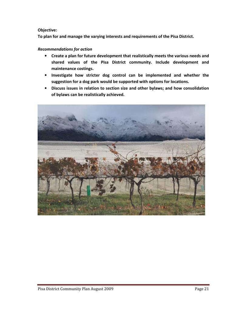
Planning
In the past, development in the Pisa area has been somewhat adhoc. Residents of this
fledgling district believe there needs to be clear direction for the future so they can continue
to enjoy the lifestyle that attracted many of them to the area. Within the residential area
there have been a number of subdivisions occur including Wakefield Bay, Pisa North, Pisa
Vineyard, Pisa Moorings, Pisa Village, Perriam Cove and Orchard Bank with a further
subdivision across the State Highway on Clarks Road.
At the meeting there was clear acknowledgment of, and a resolve to, manage the challenges
of differing interests: rural and residential; and the wide range of residents’ life stages and
associated needs.
There was a strong emphasis on maintaining the rural aspect of the Pisa District, on
maintaining and developing reserves, developing walkways and cycleways (recreation
section) and improving access to the lake.
Some concern was raised about how all proposed development would fit into the area and
funding was identified as a challenge in relation to realising and maintaining the
improvements. The topic of community liaison in relation to emergency planning, civil
defence and/or neighbourhood watch was broached on a number of occasions.
Strong support was given for stricter dog control, but there was limited support for a dog
park.
There was also interest in the size of sections. Discussion gave consideration to enforcing a
minimum section size (1,000sqm), closing loopholes for subdivision and how these
suggestions would impact on older, single folk who might prefer smaller section sizes.
While further subdivision was not necessarily favoured there was strong support that should
subdivision occur that land should be taken for recreation purposes as part of consent
conditions.
A suggestion for gaining an understanding and possible consolidation of council bylaws
(building/planning regulations between communities) gained good support.
Some concern was also expressed about the operation of the Parkburn Quarry and finishing
of the buffer zone between the quarry and the residential area.
Pisa District Community Plan August 2009 Page 21
Objective:
To plan for and manage the varying interests and requirements of the Pisa District.
Recommendations for action
• Create a plan for future development that realistically meets the various needs and
shared values of the Pisa District community. Include development and
maintenance costings.
• Investigate how stricter dog control can be implemented and whether the
suggestion for a dog park would be supported with options for locations.
• Discuss issues in relation to section size and other bylaws; and how consolidation
of bylaws can be realistically achieved.
Pisa District Community Plan August 2009 Page 22
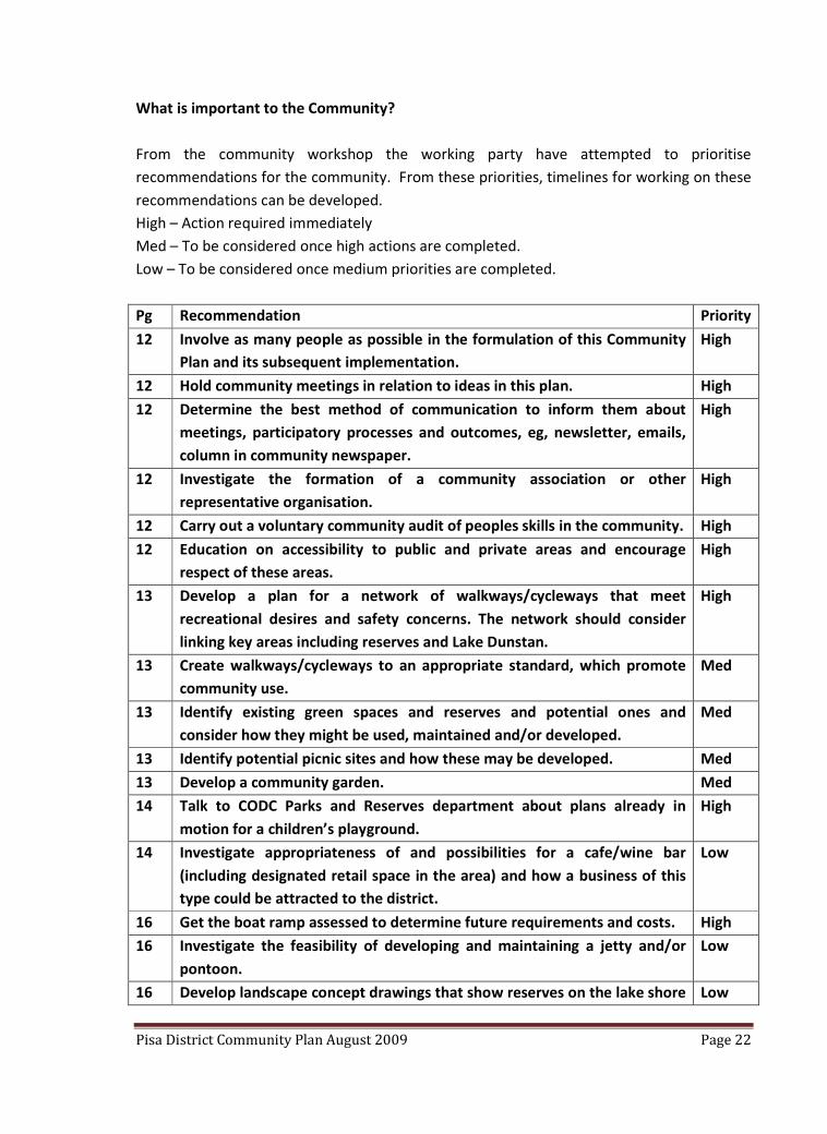
What is important to the Community?
From the community workshop the working party have attempted to prioritise
recommendations for the community. From these priorities, timelines for working on these
recommendations can be developed.
High – Action required immediately
Med – To be considered once high actions are completed.
Low – To be considered once medium priorities are completed.
Pg Recommendation Priority
12 Involve as many people as possible in the formulation of this Community
Plan and its subsequent implementation.
High
12 Hold community meetings in relation to ideas in this plan. High
12 Determine the best method of communication to inform them about
meetings, participatory processes and outcomes, eg, newsletter, emails,
column in community newspaper.
High
12 Investigate the formation of a community association or other
representative organisation.
High
12 Carry out a voluntary community audit of peoples skills in the community. High
12 Education on accessibility to public and private areas and encourage
respect of these areas.
High
13 Develop a plan for a network of walkways/cycleways that meet
recreational desires and safety concerns. The network should consider
linking key areas including reserves and Lake Dunstan.
High
13 Create walkways/cycleways to an appropriate standard, which promote
community use.
Med
13 Identify existing green spaces and reserves and potential ones and
consider how they might be used, maintained and/or developed.
Med
13 Identify potential picnic sites and how these may be developed. Med
13 Develop a community garden. Med
14 Talk to CODC Parks and Reserves department about plans already in
motion for a children’s playground.
High
14 Investigate appropriateness of and possibilities for a cafe/wine bar
(including designated retail space in the area) and how a business of this
type could be attracted to the district.
Low
16 Get the boat ramp assessed to determine future requirements and costs. High
16 Investigate the feasibility of developing and maintaining a jetty and/or
pontoon.
Low
16 Develop landscape concept drawings that show reserves on the lake shore Low

Pisa District Community Plan August 2009 Page 23
and plantings along the lake front.
16 Identify specific issues for lake maintenance. Med
16 Liaise with appropriate agencies to coordinate development on the lake
shore.
Med
16 Liaise with the Clutha Management Committee to determine demarcation
of in/on water activities (boating, jet skies, swimming) to avoid conflict of
use.
Med
16 Discuss with Clutha Management Committee how rules on and around
the lake can be enforced.
Med
16 Gather data on the purpose, nature and area required for a bird sanctuary
and how it might be protected.
Low
18 Lobby New Zealand Transport Agency to improve the intersection at the
entrance to Pisa Moorings.
High
18 Investigate welcoming signs to the district. Low
18 Advocate for reduced speed restrictions within the residential area,
including the lake front.
Med
18 Develop appropriate parking at the lake. High
18 Investigate a bus stop for the area. High
18 Assess the need for signage to identify amenities within the residential
area.
Med
19 Assess demand for a rubbish collection service around the lake front. Low
19 Investigate the feasibility of having recycling bins or a recycling collection
service for households.
Low
21 Create a plan for future development that realistically meets the various
needs and shared values of the Pisa District community. Include
development and maintenance costings.
High
21 Investigate how stricter dog control can be implemented and whether the
suggestion for a dog park would be supported with options for locations.
Med
21 Discuss issues in relation to section size and other bylaws; and how
consolidation of bylaws can be realistically achieved.
High