planet ranch lease - bureau of reclamation · pdf filewater rights within planet ranch lease...
TRANSCRIPT

U.S. Department of the Interior Bureau of Reclamation Lower Colorado Region April, 2015 Boulder City, Nevada
Planet Ranch Lease Draft Environmental Assessment LC-14-15 Volume One- Environmental Assessment Lower Colorado Region, Boulder City, Nevada

Draft Environmental Assessment Planet Ranch Lease LC-14-15 Prepared by: United States Department of the Interior Bureau of Reclamation Lower Colorado Region Boulder City, Nevada

Mission Statements The mission of the Department of the Interior is to protect and provide access to our Nation’s natural and cultural heritage and honor our trust responsibilities to Indian Tribes and our commitments to island communities. The mission of the Bureau of Reclamation is to manage, develop, and protect water and related resources in an environmentally and economically sound manner in the interest of the American public.
1
Table of Contents 1.0 Purpose of and Need for the Action .............................................................5
1.1 Introduction ..................................................................................................5 1.2 Background to the Purpose and Need ..........................................................5 1.3 Purpose and Need ......................................................................................10 1.4 Bill Williams River Water Rights Settlement Act of 2014.......................10 1.5 Tiering and Incorporation by Reference ...................................................14 1.6 Compliance with Environmental Statutes .................................................14
2.0 Description of Alternatives ........................................................................15 2.1 No Action Alternative ...............................................................................15 2.2 Proposed Action Alternative .....................................................................15 2.3 Alternatives Considered but not Evaluated Further ..................................17
3.0 Affected Environment and Environmental Consequences ........................18 3.1 Proposed Action Analysis Method ...........................................................18 3.2 Cumulative Impact Analysis Method and Identified Cumulative Actions20 3.3 Affected Environment and Environmental Consequences .......................22
4.0 References .................................................................................................54 5.0 List of Preparers .........................................................................................57 6.0 Consultation and Coordination ..................................................................58
6.1 Cooperating Agencies ................................................................................58 6.2 Tribal Consultation ....................................................................................58 6.3 Endangered Species Consultation ................................................................58 6.4 Scoping/Public Involvement .....................................................................58

2
List of Tables Table 1 - Actions Considered for Cumulative Impacts Analysis .................................................. 21 Table 2 - Bill Williams and Big Sandy River Discharge History ................................................. 24 Table 3 - Native American Groups with Cultural Affiliations to the 2011 Class I Area. ............. 35 Table 4 - Land Jurisdiction in the Bill Williams River Watershed ............................................... 41 Table 5 - Land Jurisdiction in Mohave County ............................................................................ 44 Table 6 - Land Jurisdiction in LaPaz County ................................................................................ 44 Table 7 – Potential jurisdiction change from private to State for Mohave and La Paz Counties . 46 Table 8 – Potential jurisdiction change from private to State in the Bill Williams River
Watershed ............................................................................................................................. 46 Table 9- Potential jurisdictional change from private to Tribal in Mohave County ..................... 47 Table 10- Potential jurisdictional change from private to Tribal in Bill Williams River Watershed
............................................................................................................................................... 47 Table 11 – Income and Poverty Levels ......................................................................................... 50 Table 12 – Area demographic breakdown .................................................................................... 52 List of Figures Figure 1 - LCR MSCP ROD Planning Area ................................................................................... 7 Figure 2 - LCR MSCP ROD Planning Area on the Bill Williams River ........................................ 7 Figure 3 - Planet Ranch and Bill Williams River NWR ................................................................. 8 Figure 4 – Planet Ranch showing broad alluvial valley (2014) ...................................................... 9 Figure 5 - Overview of Bill Williams River and Tributaries ........................................................ 12 Figure 6 - Existing Equipment and Infrastructure within Lease area............................................ 16 Figure 7 - Existing Roads within the Lease area ........................................................................... 17 Figure 8 - Bill Williams River Watershed .................................................................................... 23 Figure 9 – Surface flow on the Bill Williams NWR near west end of Planet Ranch (2014) ........ 25 Figure 10 Riparian habitat, designated critical habitat, roads, and irrigation infrastructure on the
Lease area. Southwestern willow flycatcher (SWFL) yellow-billed cuckoo (YBCU) and northern Mexican gartersnake (NMGS). .............................................................................. 31
Figure 11 - Hualapai EO Reservation and Indian Public Domain Allotments ............................. 39 Figure 12 - Land jurisdiction in the Bill Williams River Watershed ............................................ 42 Appendices Appendix A- Bill Williams River Settlement Act of 2014 Appendix B- Big Sandy Planet Ranch Settlement Agreement Appendix C- Hualapai Bill Williams River Agreement

3
List of Acronyms or Abbreviations Acronym or abbreviation Term Act Bill Williams River Water Rights Settlement Act of 2014 AF Acre-foot AFY Acre-foot per Year ADEQ Arizona Department of Environmental Quality ADWR Arizona Department of Water Resources AGFC Arizona Game and Fish Commission AGFD Arizona Game and Fish Department ARMCO Arizona Ranch and Metals Company BIA Bureau of Indian Affairs Bill Williams River NWR Bill Williams River National Wildlife Refuge Big Sandy River-Planet Ranch Agreement
Big Sandy River-Planet Ranch Water Rights Settlement Agreement
BLM Bureau of Land Management CAP Central Arizona Project CEQ Regulations Council on Environmental Quality Regulations for
Implementing the Procedural Provisions of NEPA 2011 Class I Class I Cultural Resources Records Review for the 3,418-
acre Planet Ranch Property for the U.S. Bureau of Reclamation-Lower Colorado Regional Office, La Paz and Mohave Counties, Arizona
DOI Department of the Interior EA Environmental Assessment EIS Environmental Impact Statement EO Executive Order ESA Endangered Species Act GHG Greenhouse Gases HCP Habitat Conservation Plan LCR MSCP FEIS/EIR Lower Colorado River Multi-Species Conservation Plan,
Final Programmatic Environmental Impact Statement/Environmental Impact Report
FPPA Farmland Protection Policy Act Freeport Freeport Minerals Corporation Hualapai BWR Agreement Haulapai Tribe Bill Williams River Water Rights
Settlement Agreement LCR Lower Colorado River LCR MSCP Lower Colorado River Multi-Species Conservation Program Lease Lease for 3,418 acres of land and 5,549 AFY of associated
water rights within Planet Ranch Lease area 3,418 acres of land included in Lease MBTA Migratory Bird Treaty Act MPO Mine Plan of Operations MSCP Multi-Species Conservation Program NEPA National Environmental Policy Act of 1969, as amended

4
List of Acronyms or Abbreviations Acronym or abbreviation Term NHPA National Historic Preservation Act NRHP National Register of Historic Places RDA Rural Development Area Reclamation Bureau of Reclamation Reservation Hualapai Reservation Review area One-mile review buffer around Lease area studied in 2011
Class I ROFR Right of First Refusal lands Secretary Secretary of the Interior Service U. S. Fish and Wildlife Service TCP Traditional Cultural Property Tribe Hualapai Tribe U.S. United States of America USACE U.S. Army Corps of Engineers USFS U.S. Forest Service Wilderness Wilderness Area
5
1.0 Purpose of and Need for the Action 1.1 Introduction This Environmental Assessment (EA) was prepared in compliance with the National Environmental Policy Act (NEPA) and the Council of Environmental Quality Regulations for Implementing the Procedural Provisions of NEPA (CEQ Regulations). The purpose of this EA is to evaluate the potential impacts of the Proposed Action on the physical and human environment and determine if the impacts would be significant, warranting the preparation of an Environmental Impact Statement. 1.1.1 Proposed Federal Action The Bureau of Reclamation (Reclamation) is proposing to acquire a lease for 3,418 acres of land and 5,549 acre-feet per year (AFY) of associated water rights within the property known as “Planet Ranch” from the Freeport Minerals Corporation (Freeport) to benefit the Lower Colorado River Multi-Species Conservation Program (LCR MSCP). This Federal action is authorized and directed by the Bill Williams River Water Rights Settlement Act of 2014 (Act), which is discussed in detail in Section 1.4. Reclamation has assumed the role of lead Federal agency for the preparation of this EA, with the Bureau of Land Management (BLM), Bureau of Indian Affairs (BIA), and the U.S. Fish and Wildlife Service (Service) as cooperating agencies. 1.2 Background to the Purpose and Need 1.2.1 Lower Colorado River Multi-Species Conservation Program The LCR MSCP is a 50-year (2005 to 2055) multi-stakeholder Federal and non-Federal partnership which was created to balance the use of Lower Colorado River (LCR) water resources with the conservation of native species and their habitats in compliance with the Endangered Species Act (ESA). The program is cooperatively funded by the Federal government and the states of Arizona, California, and Nevada. This long-term effort works toward the recovery of listed species, and protects and maintains wildlife habitat along the LCR from Lake Mead to the Southerly International Boundary with Mexico through the implementation of a Habitat Conservation Plan (HCP). The purposes of the LCR MSCP are to develop and implement a plan that will:
o Conserve habitat and work toward the recovery of threatened and endangered species, as well as reduce the likelihood of additional species being listed;
o Accommodate present water diversions and power production and optimize opportunities for future water and power development, to the extent consistent with existing laws; and
o Provide the basis for incidental take authorizations.

6
Reclamation is responsible for implementing the LCR MSCP over the 50-year term of the program. The LCR MSCP is governed by a Steering Committee, which is an unincorporated association of more than 50 water and power users, State, Federal, local entities, and tribes, including the Hualapai Tribe (Tribe). The Steering Committee works with Reclamation to coordinate the implementation of the LCR MSCP. A major component of the LCR MSCP is the creation and management of habitat to benefit 26 covered species. Cottonwood-willow, honey mesquite, marsh, and backwater are the predominant land cover types to be created under the LCR MSCP. Habitat creation goals include the establishment of a total of 8,132 acres of habitat including:
o 5,940 acres of cottonwood-willow o 1,320 acres of honey mesquite o 512 acres of marsh o 360 acres of backwater
Several documents provide the framework and implementation of the LCR MSCP. These include: the Lower Colorado River Multi-Species Conservation Program, Final Programmatic Environmental Impact Statement/Environmental Impact Report (LCR MSCP FEIS/EIR) which provided NEPA compliance for the LCR MSCP; Final HCP; Final Biological Assessment, the Biological and Conference Opinion on the Lower Colorado River Multi-Species Conservation Program, Arizona, California and Nevada; Section 10 Endangered & Threatened Species – Incidental Take Permit; LCR MSCP Funding and Management Agreement; and LCR MSCP Implementing Agreement. These documents are available at http://www.lcrmscp.gov/. 1.2.2 Lower Colorado River Multi-Species Conservation Program, Final Programmatic Environmental Impact Statement/Environmental Impact Report The LCR MSCP FEIS/EIR is a programmatic document which identifies alternatives and the potential range of impacts associated with the implementation of the LCR MSCP HCP. It is intended to serve as the basis for future project-specific NEPA documents for LCR MSCP conservation projects such as the proposed Federal action described in this EA. The LCR MSCP FEIS/EIR included analysis of the lower Bill Williams River as a potential location for implementation of the LCR MSCP Conservation Plan in the “Off-Site Conservation Area Alternative” because of the lower Bill Williams River’s high potential for the creation of cottonwood-willow riparian and honey mesquite habitat. The LCR MSCP FEIS/EIR resulted in the Record of Decision, Lower Colorado River Multi-Species Conservation Plan (ROD), which describes the selected alternative for the LCR MSCP (Figures 1 and 2). The selected alternative incorporated the “Off-Site Conservation Area Alternative”, thus identifying the lower Bill Williams River, specifically Planet Ranch and Bill Williams River National Wildlife Refuge (Bill Williams River NWR), as potential locations for implementation of the LCR MSCP. Planet Ranch and Bill Williams River NRW are discussed further below.

7
Figure 1 - LCR MSCP ROD Planning Area
Figure 2 - LCR MSCP ROD Planning Area on the Bill Williams River
8
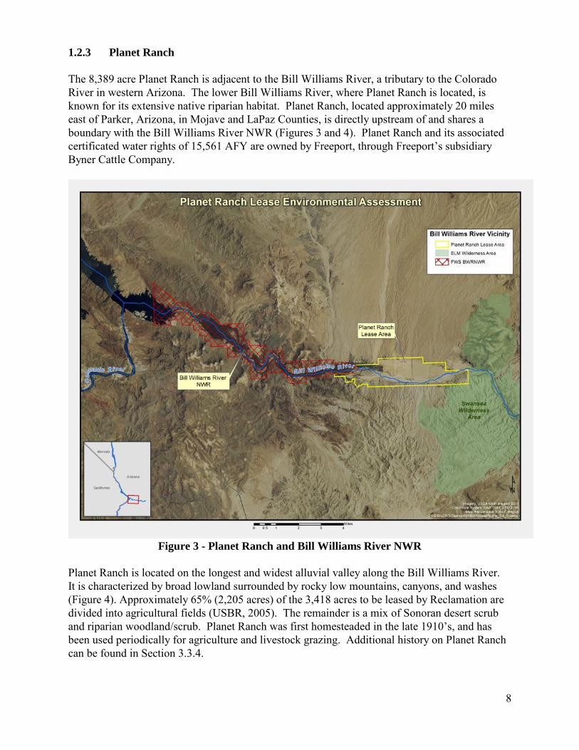
1.2.3 Planet Ranch The 8,389 acre Planet Ranch is adjacent to the Bill Williams River, a tributary to the Colorado River in western Arizona. The lower Bill Williams River, where Planet Ranch is located, is known for its extensive native riparian habitat. Planet Ranch, located approximately 20 miles east of Parker, Arizona, in Mojave and LaPaz Counties, is directly upstream of and shares a boundary with the Bill Williams River NWR (Figures 3 and 4). Planet Ranch and its associated certificated water rights of 15,561 AFY are owned by Freeport, through Freeport’s subsidiary Byner Cattle Company.
Figure 3 - Planet Ranch and Bill Williams River NWR
Planet Ranch is located on the longest and widest alluvial valley along the Bill Williams River. It is characterized by broad lowland surrounded by rocky low mountains, canyons, and washes (Figure 4). Approximately 65% (2,205 acres) of the 3,418 acres to be leased by Reclamation are divided into agricultural fields (USBR, 2005). The remainder is a mix of Sonoran desert scrub and riparian woodland/scrub. Planet Ranch was first homesteaded in the late 1910’s, and has been used periodically for agriculture and livestock grazing. Additional history on Planet Ranch can be found in Section 3.3.4.

9
In 2005, the Planet Ranch property was studied by the LCR MSCP to determine the acreages and types of native vegetation that could be established at the site and to see if these lands could be used to support the habitat restoration program (USBR, 2005). The study concluded that 3,418 acres were suitable for program use because there was sufficient soil moisture and enough influence from groundwater to benefit riparian vegetation. In 2008, the LCR MSCP Steering Committee approved a land and water resolution that authorized Reclamation to enter into negotiations to secure the 3,418 acres of land and 5,549 AFY of water rights associated with Planet Ranch.
1.2.3 Bill Williams River National Wildlife Refuge The 6,100 acre Bill Williams River NWR is located at the confluence of the Bill Williams River and the Colorado River at Lake Havasu. The Bill Williams River NWR is known for its diverse habitats, including rocky desert uplands and a lush riparian corridor. It contains 1,386 acres of native cottonwood and willow and provides habitat for 355 species of birds, 34 documented reptiles, 40 species of butterflies, 57 species of mammals, and seven species of amphibians, including several species covered under the LCR MSCP (Service, 2014). The Bill Williams River NWR has been recognized by the National Audubon Society and the American Bird Conservancy as a birding area of global importance. The Bill Williams River is one of the Management Units identified in the Service’s Recovery Plan for the southwestern willow flycatcher. Additionally, the Nature Conservancy identified the Bill Williams River complex as harboring a large number of regionally important species and habitats, making it one of the priority sites for the conservation of biodiversity on the Colorado River. The Bill Williams River NWR holds one of the last stands of naturally regenerated cottonwood-willow forests along the lower Colorado River (Service, 2014).
Figure 4 – Planet Ranch showing broad alluvial valley (2014)
10
1.3 Purpose and Need The purpose of the Federal action is to acquire a lease for 3,418 acres of land and 5,549 AFY of associated water rights (Lease) within Planet Ranch in order to continue implementation of the LCR MSCP through the creation and management of habitat as described in Section 1.2.1. The Lease is needed because Planet Ranch offers one of the few large scale opportunities for habitat restoration in that portion of the LCR MSCP planning area in Arizona. It is estimated that the Lease would allow for the future development of around 400 acres of land cover types including cottonwood-willow, marsh, and backwater ponds. Additionally, just under 400 acres of cottonwood-willow land cover type on the Bill Williams River NWR are expected to be protected by securing the Lease (USBR, 2010), as a result of decreased irrigation for agricultural use at Planet Ranch. The combined area of restoration and habitat protected represent about 10% (800/8,132 acres) of the total LCR MSCP goal for habitat creation. 1.4 Bill Williams River Water Rights Settlement Act of 2014 1.4.1 Hualapai Tribe Water Rights and U.S Trust Responsibility In 2010, the Hualapai Tribe (Tribe) requested that the Department of the Interior (DOI) establish a Federal Negotiation Team to quantify the Tribe’s reserved water rights. Based on this request, DOI appointed a Federal Negotiation Team after determining that a reasonable basis existed to resolve the Tribe’s water rights through settlement. The Federal Negotiation Team has representatives from the BIA, Reclamation, National Park Service, BLM, Service, DOI Office of the Solicitor, and Department of Justice. The main 1,142 square mile (992,463 acres) Hualapai Reservation (Reservation) is located in northwestern Arizona, with the northern boundary along 108 miles of the Colorado River. A separate settlement, the Hualapai Tribe Water Rights Settlement Agreement is being negotiated to resolve the Tribe’s claims to the Colorado River and the Verde River in Arizona. Further negotiations on discussions of the Hualapai Tribe Water Rights Settlement Agreement will proceed in the future, but the timing and terms of this agreement are not known at this time. Due to these uncertainties and because the Hualapai Tribe Water Rights Settlement Agreement is not included in the Act (discussed below), the Hualapai Tribe Water Rights Settlement Agreement is not addressed further in this document but will be addressed, as appropriate, in future NEPA compliance. The Tribe also has water rights claims in the Bill Williams River watershed. The Tribe has a 60 acre Executive Order (EO) Reservation within the Big Sandy River basin in the Bill Williams River watershed near Wikieup, AZ. Additionally, there are 650 acres of Indian public domain allotments located in the Big Sandy River basin near the Tribe’s EO Reservation. The Tribe’s reserved water rights, the Reservation, the EO Reservation, and the Indian public domain allotments are considered Indian Trust Assets (ITA) that DOI bureaus are responsible for protecting as described in the DOI Manual (512 DM 2). ITAs are discussed further under Section 3.3.6.

11
1.4.2 The Bill Williams River Water Rights Settlement Act of 2014 The Act, signed into law on December 16, 2014 (Public Law 113-223), directs the Secretary of the Interior (Secretary) to enter into the Big Sandy River-Planet Ranch Water Rights Settlement Agreement (Big Sandy River-Planet Ranch Agreement) and the Hualapai Tribe Bill Williams River Water Rights Settlement Agreement (Hualapai BWR Agreement) (Agreements). The Agreements settle certain water rights claims among certain parties in the Bill Williams River watershed in Arizona and provide for the Lease to benefit the LCR MSCP. The Act states that execution of the Agreements by the Secretary are not major Federal actions for purposes of section 102 of NEPA and that the Secretary shall comply with all applicable Federal environmental laws including NEPA and the Endangered Species Act of 1973 (ESA) in the implementation of the Agreements and the Act (Appendix A). 1.4.3 Big Sandy River-Planet Ranch Agreement The Big Sandy River-Planet Ranch Agreement would be executed by the Secretary in a dual capacity representing: 1) DOI and its constituent bureaus and 2) the Hualapai Tribe (Tribe); the United States (U.S) as trustee for the Tribe, its members and Allottees. Other executing parties include the Arizona Game and Fish Commission (AGFC) on behalf of the Arizona Game and Fish Department (AGFD); the Arizona Department of Water Resources (ADWR); and Freeport. The Big Sandy River-Planet Ranch Agreement confirms certain water rights among Freeport, AGFC, the Tribe’s EO Reservation, the Indian public domain allotments (referred to as Trust Land parcels), and LCR MSCP. The Big Sandy River-Planet Ranch Agreement also addresses sever and transfer Applications filed with ADWR by Freeport in 2010. Freeport owns and operates the Bagdad mine (Figure 5). Freeport has historical water right claims that support its diversion of subsurface water from the Wikieup well field for the Bagdad mine. Freeport filed sever and transfer applications to transfer water rights from the Planet Ranch and Lincoln Ranch properties to their Wikieup well field to provide additional legal certainty for its diversions of subsurface water. The BIA, BLM, Service, and AGFC filed objections to these applications.

12
Figure 5 - Overview of Bill Williams River and Tributaries
Freeport currently has 40,071 AFY of historical water right claims to support diversions from the Wikieup well field. Through execution of the Big Sandy River-Planet Ranch Agreement, Freeport would agree to limit its combined annual diversions at the Wikieup well field and five groundwater wells to 10,055 AFY, which is their maximum historical annual use. The annual Diversion Limitation would continue to be binding on all of the 40,071 AFY of historical water right claims, regardless of any subsequent transfer of title of the water rights to third parties or regardless of any future change in place of use or point of diversion for the water rights. Freeport would agree not to sell the lands associated with the Wikieup well field until they permanently cease mining operations at the Bagdad Mine. The BIA, BLM, Service, and AGFC would agree to withdraw their objections to the sever and transfer applications. The filing of these objections and their withdrawal are not Federal actions subject to NEPA. However, as discussed in Section 1.4.5 below, this EA will analyze the cumulative effects of the withdrawal of these objections to discern and clarify all potential impacts of the DOI implementation of the Big Sandy River-Planet Ranch Agreement. The ADWR has not taken final action on the Federal or AGFC sever and transfer objections, and has not taken action on Freeport’s sever and transfer applications.
13
The Big Sandy River-Planet Ranch Agreement also provides for Freeport to issue the Lease to Reclamation for the LCR MSCP while concurrently donating the same leased land and water rights to AGFC. After the transfer of ownership, AGFC would acquire the Lease that was issued to LCR MSCP. A draft version of the Big Sandy-Planet Ranch Agreement can be found in Appendix B. 1.4.4 Hualapai Bill Williams River Agreement The Hualapai BWR Agreement would be executed by the Tribe, Freeport, and the Secretary representing the United States (U.S) as trustee for the Tribe, its Members and the Allottees. This differs from the Big Sandy River-Planet Ranch Agreement where the Secretary would be executing in a dual capacity. The Hualapai BWR Agreement settles certain water rights held by the Tribe and Freeport among the Tribe and Freeport, provides protections for the Tribe’s water rights through restrictions on Freeport’s drilling and pumping in association with the Tribes trust land and fee title parcels, and requires that Freeport provide supplemental water to the trust land parcels in certain circumstances. Freeport would contribute $1 million toward the Tribe’s water supply alternatives study regarding the Tribe’s Colorado River claims. Freeport would also contribute to the Tribe’s economic development fund. Lastly, the U.S., the Tribe, and Freeport would waive certain future claims related to water rights in the Bill Williams River watershed. A draft version of the Hualapai BWR Agreement can be found in Appendix C. 1.4.5 Analysis of the Big Sandy River-Planet Ranch Agreement and Hualapai BWR Agreement The Big Sandy River-Planet Ranch Agreement is comprised of several parts, including the discretionary Federal action, several Federal administrative determinations, and other non-Federal actions which are not under the control or responsibility of the Federal agencies. The discretionary Federal action is Reclamation’s acquisition of a lease from Freeport for land and associated water rights within Planet Ranch and includes the maintenance of existing equipment and infrastructure within the Lease area. Consideration of the potential impacts of the Big Sandy River-Planet Ranch Agreement is included in this document. The administrative determinations would not be considered a Federal action as defined by NEPA or other Federal environmental laws; and therefore not subject to further analysis under those laws. Similarly, the non-Federal actions would not be subject to compliance with NEPA. The reason for considering all parts of the Big Sandy River-Planet Ranch Agreement in the analysis is to discern and clarify all potential impacts of DOI implementation of the Big Sandy River-Planet Ranch Agreement that are, and are not, subject to further analysis under NEPA and other Federal environmental laws. The Hualapai BWR Agreement does not include any Federal actions but outlines obligations of both the Tribe and Freeport. While further analysis of the Hualapai BWR Agreement is not necessary under NEPA, it will be addressed in this NEPA document to determine if there would be any adverse impacts to ITAs and other resources from its implementation. The Agreements will be addressed in the cumulative impacts section of this EA.
14
1.5 Tiering and Incorporation by Reference The CEQ regulations encourage both tiering and incorporation by reference. Tiering refers to following up on analysis contained in a broader EIS with an EIS or EA of a narrower scope, incorporating by reference the general discussions and concentrating solely on the issues specific to the narrower scope EIS or EA. An EA tiered to a broad EIS need only analyze the changes to, or details of, the original proposal not previously analyzed to determine if any of the changes or details result in potentially significant impacts (40 CFR 1502.20). In order to use the programmatic analysis in the LCR MSCP FEIS/EIR, this EA is tiered to and incorporates by reference the LCR MSCP FEIS/EIR. It summarizes environmental impacts identified in the LCR MSCP FEIS/EIR. The analysis in the EA is focused on only those impacts that were not described in the LCR MSCP FEIS/EIR to determine if any of the previously undescribed impacts would be significant. 1.6 Compliance with Environmental Statutes This EA complies with all applicable environmental, natural resource, and cultural resource statutes, regulations, and guidelines. The following statutes and regulations are relevant to the proposed project. American Indian Religious Freedom Act of 1978 (P.L. 95-341) National Historic Preservation Act of 1966 (P.L. 89-665), as Amended 1992 (P.L. 102-575) Native American Graves Protection and Repatriation Act (P.L. 101-601) Archaeological and Historic Preservation Act (P.L. 93-291) Archeological Resources Protection Act of 1979 (P.L. 96-95) National Environmental Policy Act of 1969 (42 USC 4321) Clean Air Act (33 USC 7401) and Amendments Clean Water Act (33 USC 1251 et esq.), Sections 401, 402, and 404 Safe Drinking Water Act (42 USC 300f) Endangered Species Act of 1973 (P.L. 93-205) Farmland Protection Policy Act (P.L. 97-98) Fish and Wildlife Coordination Act of 1958 (PL 85-624) Executive Order (EO) 11988 - Floodplain Management (1977) EO 11990 - Protection of Wetlands (1977) EO 12898 - Environmental Justice (1994) EO 13007 - Indian Sacred Sites (1996) EO 11593 - Protection and Enhancement of the Cultural Environment (1971) EO 13186- Protection of Migratory Birds (2001) EO 11514: Protection and Enhancement of Environmental Quality EO 12898: Federal Actions to Address Environmental Justice in Minority Populations and Low-Income Populations Migratory Bird Treaty Act (16 U.S.C. 703-711) Bald and Golden Eagle Protection Acts (16 U.S.C. 668-668d) Secretarial Order 3175: Departmental Responsibilities for Indian Trust Resources
15
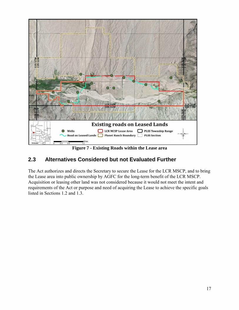
2.0 Description of Alternatives 2.1 No Action Alternative Under this alternative the Big Sandy River-Planet Ranch Agreement would not be implemented. Reclamation would not acquire the Lease; consequently the habitat would not be used to meet the goals of the LCR MSCP. Freeport would remain the owner of the entire 8,389 acres of Planet Ranch and associated water rights of 15,561 AFY. 2.2 Proposed Action Alternative 2.2.1 LCR MSCP Lease and Donation Under this alternative the Big Sandy River-Planet Ranch Agreement would be implemented and Reclamation would acquire the Lease. Upon execution of the Big Sandy River-Planet Ranch Agreement, Freeport (lessor) would issue the 50 year Lease to Reclamation (lessee) to maintain habitat and implement future restoration projects toward achieving the goals of the LCR MSCP HCP (Reclamation, 2004). Freeport would retain ownership of the remaining 4,971 upland acres of Planet Ranch and associated water rights of 10,012 AFY. On the same date as the execution of the Lease, Freeport would donate the 3,418 acres of land and 5,549 AFY of associated water rights included in the Lease through a warranty deed to AGFC. Freeport’s interests as lessor of the property would then be assigned to AGFC thus making AGFC the lessor and Reclamation the lessee. Until a restoration plan is developed, activities at the lease area would be limited to maintenance of existing facilities. Details of the lease are given below: Management Activities The Lease would allow Reclamation to engage in habitat restoration and other compatible activities for the benefit of the LCR MSCP. At this time, there are no final plans for modification of the Lease area for habitat development. Future development, operation, and maintenance plans for the Lease area will be reviewed to identify the need for additional NEPA compliance. Reclamation would be responsible for complying with all terms of the Lease and for ensuring appropriate environmental compliance for all Federal actions undertaken by Reclamation on the leased property. As the landowner of the Lease area, AGFC would retain the responsibility for activities undertaken by AGFC that are not considered Federal Actions. This responsibility would include completion of any required environmental compliance. AGFC would coordinate with Reclamation to ensure these activities are compatible with the LCR MSCP. Lease Fee and Taxes Reclamation would pay Freeport $8,300,000 for the 50 year Lease. This amount is based upon an appraisal of the property conducted by the DOI Office of Valuation Services. AGFC would pay voluntary payments in lieu of taxes to Mohave and La Paz Counties for the Lease area. Access Freeport would grant Reclamation and AGFC easements for existing access roads and access to the well(s) located on Planet Ranch lands that are not part of the Lease. Freeport would reserve

16
an easement for access to the Lease area for maintenance purposes on the Planet Ranch property adjacent to the Lease area. The main access road to the Lease area would be open to the public. Equipment and Infrastructure The Lease area would include all existing wells, pumps, canals, and all other existing improvements. Reclamation would be responsible for maintenance of existing facilities and roads included in the Lease (Figures 6 and 7). Hazardous Materials Phase I, II, and III Environmental Site Assessments were conducted for hazardous materials. Remediation actions were taken by the previous owner, City of Scottsdale. An updated Phase I Environmental Site Assessment is in progress which may result in additional remediation actions by Freeport.
Figure 6 - Existing Equipment and Infrastructure within Lease area
17
Figure 7 - Existing Roads within the Lease area
2.3 Alternatives Considered but not Evaluated Further The Act authorizes and directs the Secretary to secure the Lease for the LCR MSCP, and to bring the Lease area into public ownership by AGFC for the long-term benefit of the LCR MSCP. Acquisition or leasing other land was not considered because it would not meet the intent and requirements of the Act or purpose and need of acquiring the Lease to achieve the specific goals listed in Sections 1.2 and 1.3.

18
3.0 Affected Environment and Environmental Consequences
3.1 Proposed Action Analysis Method This section includes information for each resource potentially affected by the Proposed Action and a discussion of environmental consequences of the Proposed Action and No Action alternative. The area of analysis for the impacts of the Proposed Action is the Lease area unless otherwise indicated. Since future restoration development and maintenance plans for the Lease area have not been developed, the potential impacts of management of the Lease area for LCR MSCP purposes, including habitat restoration and compatible activities are addressed in a general manner. The analysis of the proposed action will include both direct and indirect effects. The CEQ Regulations define direct effects as those which are caused by the action and occur at the same time and place. The CEQ Regulations define indirect effects as those which are caused by the action and occur later in time or father removed in distance. The environmental consequences described in Section 3.3 center on impacts specific to the Proposed Action that were not described in the LCR MSCP FEIS/EIR. 3.1.1 Resources Not Discussed Further The Proposed Action is limited to acquisition of the Lease. Until a restoration plan is developed, activities at the Lease area would be limited to maintenance of existing facilities. Due to the limited scope of the Proposed Action, the following resource areas were considered but are not further addressed in this document because they would not be impacted by the Proposed Action: Aesthetics, Air quality, Topography, Geology, Soil, Mineral Resources, Noise, and Water Quality. It was determined that Agricultural Resources and Transboundary Impacts were adequately addressed in the in the LCR MSCP FEIS/EIR Sections 3.2 and 3.18. Potential impacts to Floodplains and Wetlands are addressed under Section 3.3.2. “Biological Resources”. Brief summaries of these three resource areas and Greenhouse Gases (GHG) and Climate Change are below.
• Floodplains and Wetlands- Federal activities in floodplains and wetlands are guided in part by two Executive Orders. EO 11988 “Floodplain Management” and EO 11990 “Protection of Wetlands” direct Federal agencies to minimize impacts to these resources and restore and preserve the natural and beneficial values served by floodplains and wetlands when acquiring, managing, and disposing of Federal land and facilities, conducting or funding construction, or conducting programs affecting land use. Portions of the Lease area are located within the floodplain of the Bill Williams River (FEMA, 2014) and have soil moisture and depth to groundwater that would support the establishment of wetland vegetation (USBR 2005). The Bill Williams River NWR is also located partially in the floodplain of the Bill Williams River. The Bill Williams River NWR supports diverse riparian vegetation as a result of subsurface and surface water.

19
Acquisition of the Lease would have a beneficial impact to floodplains and wetlands within the Lease area and on the Bill Williams NWR. All actions within the Lease area would comply with EO 11988 and EO 11990. These benefits are discussed further under Section 3.3.2.
• Agricultural Resources -The Farmland Protection Policy Act (FPPA) (7 U.S.C. 4201)
was enacted to minimize the extent that Federal programs contribute to the unnecessary and irreversible conversion of farmland to nonagricultural uses and to assure that Federal programs will be compatible with State and local programs and policies. The FPPA does not prevent Federal agencies from converting farmland to non-agricultural uses, but requires that Federal agencies identify and take into account potential adverse effects of the proposal and consider alternatives that decrease the potential adverse effects. The FPPA applies to prime, unique, and statewide and locally important farmland, collectively referred to as “Important Farmland”. The Off-Site Conservation Area Alternative in the LCR MSCP FEIS/EIR included 7,772 acres of habitat development on the Muddy River/Moapa Valley and Virgin River, Bill Williams River, and the Lower Gila River. At the time the LCR MSCP FEIS/EIR was prepared, Important Farmland had been mapped only on the Lower Gila River, and to date has not been mapped on the Bill Williams River. For the purposes of the LCR MSCP FEIS/EIR analysis, as a worst case scenario, all farmland along the Bill Williams River and other proposed off-site conservation areas was considered Important Farmland. It was determined that if all conservation area establishment occurred on farmland, it would represent 76 percent of the total farmland along the Bill Williams River. Overall, the impact of the Off-Site Conservation Area Alternative on Agricultural Resources was not found to be significant because the potential development of 7,772 acres of agricultural land in the three areas represented only 2.8 percent of the total 269,000 acres of agricultural land in the LCR MSCP planning area. At this time there are no final plans for modification of the lands for LCR MSCP habitat development. Any future NEPA compliance for habitat development would include a review to determine if any Important Farmland would be irreversibly altered.
• Transboundary Impacts- The LCR MSCP FEIS/EIR evaluated transboundary impacts for
the LCR MSCP, and determined there would be no transboundary impacts from conservation areas such as Planet Ranch that are located off the main-stem of the Colorado River. No further analysis is needed.
• Greenhouse Gases (CHG) and Climate Change- A solid body of scientific evidence supports the theory that rising global GHG emissions are significantly affecting the Earth’s climate (IPCC, 2014). The primary GHGs are carbon dioxide (CO2), methane, nitrogen dioxide, and fluorinated gases. Human induced emissions such as the burning of certain types of fuels are one means of release of GHGs in the atmosphere. The Proposed Action is primarily administrative. A small amount of greenhouse gases may be emitted if vehicles or various other fuel using equipment were used during maintenance activities at the Lease area. These emissions would be intermittent and are not expected to have a quantifiable impact on regional greenhouse gas emissions. In accordance with the draft CEQ guidance on Consideration of GHGs and the Effects of Climate Change in NEPA

20
Reviews (CEQ 2014), no further analysis of GHGs was determined necessary at this time. Any future NEPA compliance for restoration and additional maintenance activities would include analysis of GHGs as appropriate.
3.1.2 Resources Discussed Further in this EA The following resources are discussed under Section 3.3: Hydrology, Biological Resources, Cultural Resources/Traditional Cultural Properties/Sacred Sites, Indian Trust Assets, Land Use, Recreation, Socioeconomics, and Environmental Justice. 3.2 Cumulative Impact Analysis Method and Identified Cumulative Actions Cumulative impacts are defined as impacts to the environment that result from the incremental impact of the action when added to other past, present, and reasonably foreseeable future actions regardless of what agency (Federal or non-Federal) or person undertakes the action. Cumulative impacts can result from individually minor, but collectively significant, actions taking place over a period of time (40 CFR 1508.7).
This analysis will address the cumulative impacts of the Proposed Action in combination with other projects or management activities. Table 1 identifies activities (past, present, and reasonably foreseeable) that are either located in the vicinity of the Lease area or have been identified as having the potential for cumulative impacts when considered in addition to the impacts of the Proposed Action. These actions will be addressed as appropriate in Section 3.3. Since the activities would not necessarily impact all resource areas, the cumulative impacts section for each resource will begin with a summary of the activities having potential for cumulative impacts.

21
Table 1 - Actions Considered for Cumulative Impacts Analysis Type of Activity/ Project Name
Description Location
Big Sandy River-Planet Ranch Settlement Agreement
An overview of the major provisions of this Agreement is provided in Section 1.4.3. The Big Sandy River-Planet Ranch Agreement was reviewed to determine which parts may have potential cumulative impacts with respect to the Proposed Action. Based on this analysis, this cumulative impact analysis of the Big Sandy River-Planet Ranch Agreement will focus on the Freeport sever and transfer of water rights and associated activities including the 10,055 AFY limitation on diversions, specifically the cumulative water use in the Bill Williams River watershed.
Mohave County
Hualapai BWR Agreement
An overview of the major provisions of this Agreement is provided in Section 1.4.4. The Hualapai BWR Agreement was reviewed to determine which parts may have potential cumulative impacts with respect to the Proposed Action. The cumulative impact analysis of the Hualapai BWR Agreement will focus on potential impacts to ITAs, land uses, and socioeconomics.
Mohave County
Bagdad Mine Stockpile Extension Project
The BLM has initiated the NEPA process for a proposal by Freeport to modify their Mine Plan of Operations (MPO) at the Bagdad Mine, located in Yavapai County west of the unincorporated community of Bagdad, Arizona. The proposed modification would authorize the extension of an existing, consolidated leach and waste rock stockpile on the south side of the mine. The modification also requests the installation of limited, future distributed facilities south of the stockpile. In addition, Arizona Public Service Company has submitted a proposed amendment to an existing right-of-way for the construction of access roads to maintain a 115-kilovolt power line in the same geographic area as the MPO modification area. The MPO modification and right-of-way amendment propose new surface disturbance to approximately 600 acres of public land managed by the BLM and approximately 90 acres of private land.
Mohave, La Paz and Yavapai counties
Interstate 11 Corridor
Federal legislation enacted in 2012, Moving Ahead for Progress in the 21st Century (MAP-21), designates U.S. Highway 93 as future Interstate 11 between Phoenix and Las Vegas. Upgrading U.S. Highway 93 to a four-lane divided highway is in progress and has been completed in many locations. U.S. Highway 93 passes through the Bill Williams River watershed and the community of Wikieup.
Mohave and Yavapai county

22
Type of Activity/ Project Name
Description Location
Watershed Land Jurisdiction
A summary of the land jurisdiction in the Bill Williams River watershed is given in Section 3.3.6
Mohave, La Paz, and Yavapai County
Recreation Opportunities
Recreation opportunities are summarized in Section 3.3.7
Special Designations/Wild and Scenic River
Upstream from Planet Ranch, 20.5 miles of the Bill Williams River are suitable for inclusion into the National Wild and Scenic Rivers System. Congress has not acted on these determinations. Pending congressional action, these segments would be managed to protect their “outstandingly remarkable values” identified by the interdisciplinary team that make the segments eligible for inclusion in the National System and protected under the Wild and Scenic Rivers Act.
Mohave and La Paz County
Freeport/AGFC Agricultural Lease
Freeport has issued an agricultural lease that allows for the irrigation of lands at Planet Ranch to support cattle grazing. Under the terms of the Big Sandy-Planet Ranch Agreement, AGFC would assume management of this agricultural lease because the lands are within the Lease area and continue existing agricultural practices under the lease until initiation of restoration activities. There are 72 grazing allotments managed by the BLM’s Lake Havasu, Kingman, and Hassaympa District Offices within the Bill Williams River watershed.
Mohave and La Paz county
LCR MSCP Lease area restoration
The LCR MSCP is planning to conduct habitat restoration and maintenance on the Lease area in the future. This future activity is considered throughout this document.
Mohave and La Paz county
3.3 Affected Environment and Environmental Consequences 3.3.1 Hydrology 3.3.1.1 Affected Environment The size of the Bill Williams River watershed is approximately 5,400 square miles. The watershed is drained by the Bill Williams River and its major tributaries, the Big Sandy and the Santa Maria Rivers (Figure 8). The Bill Williams River is the largest river in northwestern Arizona and the largest tributary to the Colorado River between Hoover and Imperial Dams (USGS, 2002).

23
Figure 8 - Bill Williams River Watershed
The confluence of the Big Sandy and Santa Maria Rivers is located approximately 8 miles upstream from Alamo Dam. Downstream from Alamo Dam, the Bill Williams River flows in a westerly direction for about 40 miles before forming a broad delta at its confluence with the Colorado River at Lake Havasu (USACE, 2003). The Big Sandy River is the predominant contributor of streamflow on the Bill Williams River, contributing approximately two-thirds of the watershed's annual flow production with the Santa Maria River contributing about one-third of the annual inflow. Most the runoff into the Big Sandy River comes from three main tributaries, Knight Creek and Trout Creek at the north end of the Big Sandy Valley and Burro Creek which flows in from the northeast upstream of the confluence of the Big Sandy and Santa Maria Rivers. Flows in the Bill Williams River below Alamo Lake are regulated by Alamo Dam, which is owned and operated by the U.S. Army Corps of Engineers (USACE). Prior to construction of Alamo Dam in 1968, flows in the Bill Williams River were intermittent and widely varying. The result of regulation of the river has been a reduction in peak flows, an increase in base-flow, as well as periods of no flow in portions of the river downstream from the dam (AZ Geologic Survey, 1999).

24
Flows below Alamo Dam are regulated by the USACE based on a release schedule specified in the 2003 Alamo Dam and Lake Water Control Manual (USACE, 2003). The mean annual flows for the Big Sandy River are a reflection of storm events occurring during any given water year which greatly influence the magnitude of annual water yield. Table 2 provides a comparison of the flows in these two rivers. Table 2 - Bill Williams and Big Sandy River Discharge History River Period
of Record
Stream gage location
Mean annual discharge AFY
Lowest annual discharge AFY
*Water Year
Highest annual discharge AFY
Water Year
Bill Williams River
1970-2013
Immediately below Alamo Dam
93,021 1,484 1975 691,565 1993
Bill Williams River
1993-2009
Near Parker, AZ
83,063 843 2004 615,220 1993
Big Sandy River
1967-2013
Upstream of Alamo Lake
63,347 2,208 2000 523,524 2005
Source: U.S.G.S., 2015 *The water year time periods are from October 1 of a given year to September 30 of the following year. Example: The 1975 water year starts October 1st of 1974 and ends September 31st 1975. Below Alamo Dam, the Bill Williams River flows through a series of tight canyon reaches interspersed with several broad alluvial valleys, among which the Planet Valley, where Planet Ranch is located, is the largest. The hydrology of the Bill Williams River below Alamo Dam is characterized by intervening reaches of perennial flow, intermittent flow and reaches that are ephemeral in nature (with surface flows only appearing during large rain events). Continuous surface flow along this reach of the Bill Williams River typically will only occur from runoff during large rain events or when releases from Alamo Dam exceed approximately 500 cubic feet per second for at least a 24-hour period. This is due to the floodplain’s deep alluvium and significant storage capacity within the largely coarse grained sediments (USGS 2002). There is an aquifer along the Bill Williams River corridor between Alamo Dam and Lake Havasu that is hydraulically connected to surface flow in the channel throughout a large section of the reach. This aquifer, or underground layer of water, is contained by sandstone and alluvial (unconsolidated rock and silt) material beneath the floodplain of the river and provides a substantial volume of subsurface storage below the floodplain surface (Wilson and Owen-Joyce, 2002). Water is added to storage within the aquifer during periods of high flow in the river; during periods of low flow, out flow from this aquifer maintains base flows in downstream sections of the river where nearly impermeable consolidated rock is located near the surface. The portion of the river aquifer in Planet Valley (including the upstream end of the Bill Williams River NWR), provides the largest volume of subsurface storage in the lower Bill Williams River reach and buffers against changes in base flow in the Bill Williams River NWR (USGS 2002). At Planet Valley the aquifer is about 6 miles wide and as much as 400 feet deep. Aquifer storage in Planet Valley is a major control of base flow into the Bill Williams River NWR. Aquifer
25
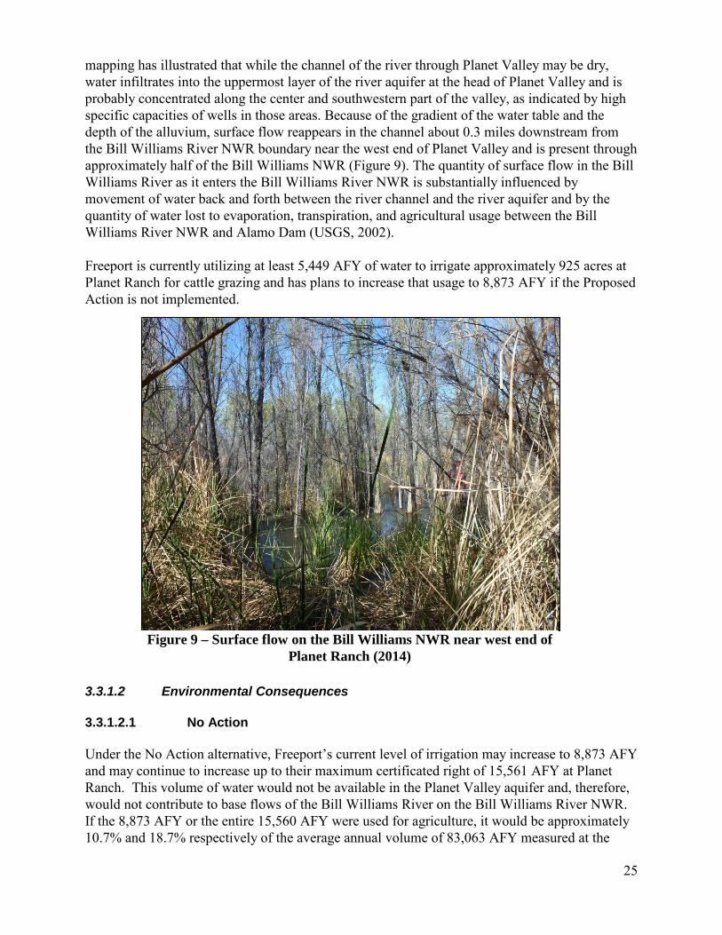
mapping has illustrated that while the channel of the river through Planet Valley may be dry, water infiltrates into the uppermost layer of the river aquifer at the head of Planet Valley and is probably concentrated along the center and southwestern part of the valley, as indicated by high specific capacities of wells in those areas. Because of the gradient of the water table and the depth of the alluvium, surface flow reappears in the channel about 0.3 miles downstream from the Bill Williams River NWR boundary near the west end of Planet Valley and is present through approximately half of the Bill Williams NWR (Figure 9). The quantity of surface flow in the Bill Williams River as it enters the Bill Williams River NWR is substantially influenced by movement of water back and forth between the river channel and the river aquifer and by the quantity of water lost to evaporation, transpiration, and agricultural usage between the Bill Williams River NWR and Alamo Dam (USGS, 2002). Freeport is currently utilizing at least 5,449 AFY of water to irrigate approximately 925 acres at Planet Ranch for cattle grazing and has plans to increase that usage to 8,873 AFY if the Proposed Action is not implemented.
3.3.1.2 Environmental Consequences 3.3.1.2.1 No Action Under the No Action alternative, Freeport’s current level of irrigation may increase to 8,873 AFY and may continue to increase up to their maximum certificated right of 15,561 AFY at Planet Ranch. This volume of water would not be available in the Planet Valley aquifer and, therefore, would not contribute to base flows of the Bill Williams River on the Bill Williams River NWR. If the 8,873 AFY or the entire 15,560 AFY were used for agriculture, it would be approximately 10.7% and 18.7% respectively of the average annual volume of 83,063 AFY measured at the
Figure 9 – Surface flow on the Bill Williams NWR near west end of Planet Ranch (2014)

26
BWR gage near Parker, AZ. Reclamation would not lease the water rights for the benefit of LCR MSCP restoration objectives. 3.3.1.2.2 Proposed Action The analysis area for impacts to hydrology includes the Lease area and the Bill Williams River downstream to the confluence of the Colorado River. Under the Proposed Action, 3,418 acres of Planet Ranch and 5,449 AFY of water rights would be leased to LCR MSCP for the long-term benefit of future LCR MSCP restoration objectives. A maximum of 5,449 AFY of water could be used which is 10,120 AFY less than what may be used under the No Action alternative. The Proposed Action would have an indirect beneficial impact to hydrology because there would be fewer water rights available for use on the Lease area; potentially resulting in more water remaining within the Planet Valley aquifer and contributing to base flows of the Bill Williams River. 3.3.1.2.3 Cumulative Impacts The analysis area for potential cumulative impacts to hydrology was defined as the Bill Williams River watershed. The actions from Table 1 considered for potential hydrologic cumulative impacts are the sever and transfer of water rights associated with the Big Sandy River-Planet Ranch Agreement, the Bagdad Mine Stockpile Expansion project, the Freeport/AGFC Agricultural Lease, and LCR MSCP Lease area restoration. The Big Sandy River-Planet Ranch Agreement specifies that upon withdrawal of objections to Freeport’s sever and transfer applications by BIA, BLM, Service, and AGFC, ADWR would issue a Conditional Order approving the sever and transfer of water rights held by Freeport. The sever and transfer would result in the transfer of approximately 8,873 AFY of water rights from Planet Ranch, and approximately 1,182 AFY from Lincoln Ranch (both ranches are located below Alamo Dam) to the Wikieup wellfield above Alamo Dam. These water rights would no longer be available for use at Planet and Lincoln Ranches. Because the water rights that would be severed and transferred would be used to support Freeport’s existing use of water from the Wikieup wellfield, a reduction in the volume of water available for use at Planet and Lincoln Ranches may lead to more water being available along the Bill Williams River from Lincoln Ranch to the Bill Williams River NWR. Freeport currently has 40,071 AFY of historical water right claims to support diversions from the Wikieup well field. Through execution of the Big Sandy River-Planet Ranch Agreement, Freeport would agree to limit its combined annual diversions from the Wikieup well field to 10,055 AFY. The 10,055 AFY limitation number represents the maximum annual delivery of water from the Wikieup well field between 1995 and 2010. This limitation would have a beneficial impact to hydrologic resources, since fewer surface water rights would be exercised at the Wikieup well field. The requirement that the annual diversion limitation would continue to be binding on all of the 40,071 AFY of historical water right claims, regardless of any subsequent transfer of title of the water rights to third parties or regardless of any future change in place of use or point of diversion for the water rights provides additional assurance that these surface water rights would not be exercised.
27
Actual water diversions from the Wikieup well field may affect surface water flows (Shafroth et.al. 2000). The surface-subsurface water connectivity is not well known in the Big Sandy River basin but it is believed that pumping of subsurface water may affect the surface water resource. Freeport currently diverts water from the Wikieup well field, and has done so since 1977; therefore the mean annual discharges shown for the Big Sandy River (the stream gauge closest to the Wikieup well field) in Table 2 may reflect existing pumping. The actual annual amount that Freeport would divert from the Wikieup well field in the future is not known. If their pumping rates remain consistent with their current pumping, mean annual discharges shown in Table 2 for the Big Sandy River are not expected to change as a result of pumping. However, since 10,055 AFY is Freeports maximum historical annual use, if they were to divert this amount every year, this could lead to lesser amounts of water in the basin and lower surface flows in the river. This may result in lower flows in the Big Sandy River, resulting in less water flowing to and through public land and the Arrastra Mountain Wilderness. Any potential decreases in the Bill Williams or Big Sandy River flows due to subsurface pumping would likely have the greatest effect on surface water during relatively dry water years and during the lowest flow period in the driest months of average water years. The Bagdad Mine Stockpile Extension Project is proposed by Freeport in support of continued operations at the Bagdad Mine. Impacts in addition to those described above for hydrology are not anticipated because water use at the mine would be subject to the 10,055 AFY limitation. Because of the connection between the Planet Valley aquifer and surface flows on the Bill Williams River, Freeport’s current water use of up to 5,449 AFY at Planet Ranch for the agricultural lease represents approximately 6.5% of the average annual volume of water that passes through the lower Bill Williams River based on the average annual volume of 83,063 AFY measured near Parker, AZ. During years with average or above average streamflow this is not expected to have a measurable impact on the Bill Williams River NWR. A measurable impact could potentially be seen if there is a sustained decrease in surface flows during periods of drought, which may result in longer distances of subsurface-only flows on the Bill Williams River NWR. This volume of water use is expected to continue when the agricultural lease is assigned to AGFC. The use of up to 5,449 AFY in association with the LCR MSCP Lease area restoration would not result in any additional impacts to hydrology from those described above. Although surface flows may be reduced from this water use during dry periods, the reduction in surface flows would be considerably less than if the entire 15,560 AFY were used for agriculture as described in Section 3.3.1.2.1. In summary, potential cumulative impacts from the Proposed Action, the Big Sandy-Planet Ranch Settlement Agreement, the Bagdad Mine Stockpile Expansion project, and the Freeport/AGFC Agricultural Lease, and LCR MSCP Lease area restoration are expected to be largely beneficial to hydrologic resources. This beneficial impact would be due to the reduced amount of surface water rights that would be exercised in the Bill Williams River watershed, potentially increasing the availability of water in the watershed.

28
3.3.2 Biological Resources 3.3.2.1 Affected Environment Vegetation within the Lease area is characterized as barren-open space or herbaceous vegetation, cottonwood-willow, mesquite, and saltcedar. Small areas of suitable habitat for Federally listed species occur on the western third of the Lease area. The remaining two thirds of the Lease area has experienced high levels of ground disturbance and habitat alteration as a result of farming and ranching activities. Currently, the majority of Planet Ranch is divided into farm fields equipped with a variety of irrigation systems, such as flooding, wheel lines, pivot, and solid set sprinklers (Figure 6). Vegetation in the farm fields consists largely of exotic species and alfalfa but there are surrounding areas with sparse upland vegetation typical of the Sonoran Desert. Due to the amount of agricultural development on the Lease area, common wildlife may only use these areas for foraging, migration from surrounding habitat, or other irregular opportunistic occurrences. It is unknown if wildlife surveys, outside the extent of those done by LCR MSCP or the Service, have been completed on the Lease area but it is assumed that species diversity is relatively low as a result of degraded habitat conditions when compared to upstream or down stream habitats and undisturbed uplands that have not been converted to agricultural fields. Vegetation directly upstream of the Lease area includes a riparian corridor within a narrowing canyon with the exception of the agricultural fields located at Lincoln Ranch, about 13 miles upstream of the Lease area. Vegetation immediately downstream of the Lease area consists of a robust riparian corridor within the Bill Williams River NWR. A mix of upland desert, marsh, and riparian habitat on the Bill Williams River NWR provides habitat for a diverse array of birds, fish, mammals, and reptiles. Common birds present in the area include species such as the song sparrow (Melospiza melodia), yellow warbler (Setophaga petechial), yellow-breasted chat (Icteria virens), black rail (Laterallus jamaicensis), and elf owl (Micrathene whitneyi). Almost 350 species of migratory birds have been identified along the Bill Williams River, mainly the Bill Williams River NWR, including resident, wintering, summer breeding, or migrating species. Non-native fish species such as the largemouth (Micropterus salmoides) and small mouth (Micropterus dolomieu) bass, outnumber native species in the Bill Williams River. Native species including the razorback sucker (Xyrauchen texanus) and bonytail chub (Gila elegans) have been stocked in Lake Havasu on the Colorado River near the mouth of the Bill Williams River. Mammal species present in the area include beaver (Castor Canadensis), bobcat (Lynx rufus), mountain lion (Puma concolor), gray fox (Urocyon cinereoargenteus), javelina (Tayassu tajacu), mule deer (Odocoileus hemionus), desert bighorn sheep (Ovis canadensis nelson), and ringtailed cat (Bassariscus astutus). Complete species lists for the area can be found at http://www.fws.gov/refuge/bill_williams_river/. According to the automated U.S. Fish and Wildlife Service Information, Planning, and Conservation System (IPAC) query conducted on July 28th, 2014:
• Federally listed species that may occur within the Lease area or immediately upstream or downstream of the Lease area include: California least tern (Sterna antillarum browni), southwestern willow flycatcher (Empidonax traillii extimus), yellow-billed cuckoo (Coccyzus americanus), Yuma clapper rail (recently renamed the Ridgeway Rail) (Rallus longirostris yumanensis), and northern Mexican gartersnake (Thannophis eques megalops).

29
• Candidate species for listing that may occur in the Lease area include relict leopard frog (Lithobates onca), Sprague’s pipit (Anthus spragueii), roundtail chub (Gila robusta), and Sonoran desert tortoise (Gopherus morafkai).
• Species with proposed (p) or designated (d) critical habitat within or directly adjacent to the Lease area include the yellow billed cuckoo (p), southwestern willow flycatcher (d) and northern Mexican gartersnake (p).
The western portion of the Lease area overlaps with 501.8 acres of critical habitat designated for the southwestern willow flycatcher and 553.6 acres of critical habitat proposed for the yellow-billed cuckoo (Figure 10). Critical habitat overlaps for these two species and originates at the confluence of the Colorado River and Bill Williams River. Surveys completed by LCR MSCP staff have detected southwestern willow flycatcher and yellow-billed cuckoo on the Bill Williams River NWR and in close proximity to wells number 3, 4, and 5 (S. Kokos, Personal Communication, 2015). LCR MSCP bird surveys have not detected California least tern, Sprague’s pipit, or Yuma clapper rail on the Bill Williams River NWR (S. Kokos, Personal Communication, 2015). It is unlikely, but California least tern may intermittently occur on the Lease area since there have been detections in Mohave and Pima counties (L. Fitzpatrick, Personal Communication, 2015). Sprague’s pipit may occupy alfalfa or fallowed fields during winter months. Habitat for Yuma clapper rail on the Bill Williams River is considered low quality nesting habitat and it is unlikely this species would occur within the Lease area, but surveys completed by the Service have detected Yuma clapper rails on the Bill Williams River delta near Lake Havasu and one wintering observation within the Lease area (K. Blair, Personal Communication, 2015.). Other migratory bird species may occasionally occur in areas near equipment, infrastructure, or roads. Proposed critical habitat for the northern Mexican gartersnake occurs from the confluence of the Colorado River and Bill Williams River upstream to Alamo dam (Figure 10). In 2011 and 2012, surveys were completed by the AGFD, under the auspices of the LCR MSCP, for lowland leopard frogs (Lithobates yavapaiensis) along the Bill Williams River from the confluence with Lake Havasu (Colorado River) upstream to a point east of Planet Ranch on BLM managed land. LCR MSCP completed the surveys because the lowland leopard frog is not Federally listed but is an evaluation species under the LCR MSCP, a sensitive species by USFS and BLM, and a species of concern in Arizona. During the surveys, ten northern Mexican gartersnakes were captured in funnel traps along the Bill Williams River on BLM land upstream of the Planet Ranch property in 2012 (Cotten and Grandmaison, 2013). However, it is important to note that the surveys from 2011-2013 were targeted for the frog and the Colorado River toad, not the northern Mexican gartersnake so methods, trap placement, location, and timing would be different depending upon the targeted species (T. Cotton, Personal Communication with L. Sabin, 2013). Habitat within the Lease area is not generally considered suitable for the northern Mexican gartersnake and the lowland leopard frog because both species require the presence of wetland sources which do not occur on the agricultural fields within the Lease area because the Bill Williams River is subsurface (Rosen and Schwalbe 1988). However, the lowland leopard frog, northern Mexican gartersnake, and other aquatic species may be washed downstream by high flows from Alamo Dam or flood events. IPAC query results included the Sonoran desert tortoise which may occur on the uplands surrounding the Lease area. Suitable habitat for the Sonoran desert tortoise also does not occur within the majority of the Lease area because the agricultural area is lacking native upland

30
species like creosote and bursage, the soils have been cultivated so they no longer are suitable for tortoises to dig burrows or find cover, or the habitat contains riparian vegetation which is not tortoise habitat. There is upland habitat on the northern and southern boarders of the Lease area that could be suitable for desert tortoise but they are outside of the areas where maintenance activities are anticipated to occur. However, Sonoran desert tortoises may wander in to the Lease area from surrounding habitat. The automated IPAC query results included species that are not believed to occur in the area and will not be impacted by the action. The species that will not be analyzed further in this EA are the relict leopard frog (Rana onca) and roundtail chub (Gila robusta). Relict leopard frogs are not found in the Lease area or on the Bill Williams River NWR (L. Fitzpatrick, Service, Personal Communication, 2015). Roundtail chub are not found on the Bill Williams River below Alamo Dam but occur much farther upstream in Burro Creek and in other tributaries to the Bill Williams River upstream of Alamo dam (L. Fitzpatrick, Personal Communication, 2015 and CRFWC, 2006). The IPAC query results also identified ten migratory birds of conservation concern that may occur within or near the Lease area. Birds of conservation concern are those species that have been identified by the Service, beyond those already identified as Federally threatened or endangered, that represent the Service’s highest conservation priorities. The list included Bell’s vireo (vireo belli), black-chinned sparrow (Spizella atrogularis), Brewer’s sparrow (Spizella breweri), Costa’s hummingbird (Calypte costae), Le Conte’s thrasher (Toxostoma lecontei), least bittern (Ixobrychus exilis), Lucy’s warbler (Vermivora luciae), prairie falcon (Falco mexicanus), snowy plover (Charadrius alexandrinus), and the Sonoran yellow warbler (Dendroica petechial ssp. Sonorana). 3.3.2.2 Environmental Consequences 3.3.2.2.1 No Action If Freeport were to use their maximum certificated water rights at Planet Ranch, this use may negatively impact approximately 1,008.8 acres of riparian habitat within the Lease area (Figure 10). The majority of the continuous riparian habitat is on the western end of the Lease area and downstream on the Bill Williams River NWR. A reduction in surface flows in the Bill Williams River can impact riparian vegetation, although the magnitude of this impact is not certain as any impacts would depend on duration of low flows and numerous other environmental factors. It is likely that future site restoration or habitat improvements beneficial for LCR MSCP covered species would not occur in this area and mitigation measures specified in the Biological and Conference Opinion on the LCR MSCP may not be fully implemented as quickly without the inclusion of the Lease in the LCR MSCP program.

31
Figure 10 Riparian habitat, designated critical habitat, roads, and irrigation infrastructure on the Lease area. Southwestern willow flycatcher (SWFL) yellow-billed cuckoo (YBCU)
and northern Mexican gartersnake (NMGS). Source: Reclamation, 2015 3.3.2.2.2 Proposed Action The Lease of Planet Ranch by the LCR MSCP is administrative in nature and would not directly impact common fish and wildlife, migratory birds, or Federally listed species or designated critical habitat within the Lease area. A reduction in the use of water rights for agricultural purposes on Planet Ranch would be a positive indirect impact as it will allow for more water to remain in the Bill Williams River and benefit the riparian habitat on the Lease area and downstream on the Bill Williams River National Wildlife Refuge. Under the terms of the Lease, LCR MSCP would be responsible for the maintenance of the existing equipment, infrastructure, and roads within the Lease area (Figures 6 and 7). Equipment and infrastructure include 11 wells, concrete irrigation ditches, and underground piping for sprinkler, center pivot, and side roll irrigation delivery systems. Maintenance activities are anticipated to be minor, occurring within previously disturbed areas and within existing roads resulting in no new ground disturbance. Regular monitoring of equipment, infrastructure, and roads will occur but maintenance activities are expected to be on an “as needed” basis.

32
Maintenance may include relatively simple adjustments only requiring hand tools. More intensive maintenance issues may require heavy equipment for grading or trenching. Negative impacts to wildlife can occur as a result of maintenance activities. Wildlife may be temporarily displaced, injured, or killed if not avoided, as a result of maintenance activities and vehicle traffic. Human activity, noise, and vibrations can cause wildlife to be temporarily displaced from nesting, roosting, or foraging areas. If vegetation removal is needed for maintenance activities, wildlife may lose small areas of habitat that may be important for cover, foraging, or other activities. Ground dwelling species could be entrapped in trenches if pipes or other equipment are excavated for repairs. Indirect impacts to wildlife from the Proposed Action can occur as a result of human activities and disturbance in the Lease area. Reproduction could be interrupted or delayed if they are forced to leave their nests or abandon young for long periods of time. Maintenance activities may also cause temporary restrictions to accessing forage or foraging areas but since activities are not expected to include major construction, most species will be able to circumvent any temporary barriers to movement. Prey species may also be temporarily displaced and may cause wildlife to spend more time locating prey species or foraging. Positive impacts to wildlife can also occur as a result of maintenance activities and reduced water right allocations on the Lease area. Minor routine maintenance can prevent large emergency repairs with bigger disturbance footprints which could result in more habitat loss. Routine road maintenance can prevent off-road travel if the road ways are washed out from flooding events. Reclamation is in the process of completing informal ESA Section 7 consultation with the Service for the Proposed Action for the southwestern willow flycatcher, yellow-billed cuckoo, Yuma clapper rail, California least tern, and the northern Mexican gartersnake. Reclamation has assessed that the effects and anticipated them to be insignificant and discountable, and determined that the Proposed Action may affect but is not likely to adversely affect the five Federally listed species mentioned above. No adverse effect to designated or proposed critical habitat is expected as a result of the Proposed Action because maintenance of the existing equipment, infrastructure, and roads within the Lease area will be conducted within previously disturbed areas. Species that are candidates for listing under the ESA will not be included in this informal Section 7 consultation. If a species listing status changes, the actions will be reviewed and Section 7 consultation will be re-initiated, as needed. The following minimization measures will be incorporated into maintenance activities to prevent harassment, injuries, or mortalities to listed, candidate, species of conservation concern, and species protected by the Migratory Bird Treaty Act (MBTA):
• Education on listed species will be provided to staff and contractors by an approved biologist. This education program will include information to aid in species identification, current status, and actions to avoidance controls.
• All ground disturbing activities will only occur within previously disturbed areas. • Maintenance project areas with suitable habitat will be surveyed for listed, candidate,
species of conservation concern, and nesting migratory birds protected by the MBTA. If any are detected:
• No nesting habitat for listed species will be removed or degraded.
33
• Project activities will be scheduled outside the nesting period during which these species are likely to be utilizing the area.
• If project activities cannot be scheduled outside the nesting period, an experienced biologist will identify exclusion areas to avoid impacts to nesting birds.
• A maximum speed limit of 25 mph will be established within the Lease area to reduce the potential for tortoises, lowland leopard frogs, northern Mexican gartersnakes, and other ground dwelling species to be struck by vehicles.
• If species are encountered, they are not to be handled and would be allowed to leave the area on their own volition. If there is a risk of mortality or entrapment, an approved biologist will be notified and appropriate actions will be taken.
• All excavations, such as trenches, will be backfilled immediately after the activity is completed or covered if left unattended over night to prevent entrapment of wildlife such as tortoises, frogs, or snakes. Trenches will be checked regularly and prior to backfilling to ensure no wildlife is trapped.
The above listed minimization measures and any others identified through informal consultation with the Service will be incorporated into the final EA. If any of the measures to avoid adverse effects to listed species can’t be implemented, Section 7 consultation with the Service will be re-initiated. 3.3.2.2.3 Cumulative Impacts The analysis area for potential cumulative impacts to Biological Resources is defined as the Bill Williams River watershed since the primary potential impact to Biological Resources are associated with impacts to hydrologic resources and impacts from the maintenance activities within the Lease area. The actions from Table 1 considered for potential biological resources cumulative impacts are the Big Sandy Planet Ranch Agreement, Interstate 11 Corridor, Bagdad Mine Stockpile Expansion project, the Freeport/AGFC Agriculture Lease, and LCR MSCP Lease area restoration. Cumulatively, impacts to biological resources from the activities listed in the previous paragraph may result in minor habitat loss and degradation within the Bill Williams River Watershed from construction or maintenance activities. An approximate number of acres impacted are unknown at this time do to the complexity of water use, uptake by vegetation and ground water in the system. The majority of the activities will occur on the uplands and would mainly affect species like the Sonoran desert tortoise or other reptiles, migratory birds, and mammals. Increased human activity as a result of construction, operation, and maintenance of projects may result in species being displaced from noise and vibrations, injured, or even killed if not avoided when vehicles or heavy equipment are used. Increased traffic volume can result in more collisions with wildlife during migration activities or while searching for food. Human activity can also attract predators if proper best management practices are not in place to minimize trash and other items that may be attractive to predators. Construction can also introduce weeds or other non-native species if not properly treated or appropriate equipment decontamination protocols are in place. Impacts from livestock can result in competition for resources but some avian species, such as the Sprague’s pipit will utilize agriculture fields for foraging and cover and will benefit from the
34
continuation of this activity in the Lease area. Ground dwelling species may be trampled or become trapped in burrows if stepped on by cattle or other ungulates such as wild burros that occur within the watershed. The potential for more water being used from the Big Sandy River system above Alamo Dam may have impacts to riparian vegetation and wildlife habitat during dry periods. Again, this impact is not certain and would depend on duration of lower flows and other complex hydrologic factors. As noted in Section 3.3.1.2.3, Freeport’s diversion of water from the Wikieup well field has been occurring since 1977, so the existing riparian vegetation and wildlife habitat reflects the effect these diversions may have on existing flows. Due to the 10,055 AFY limit placed upon water consumption by the Proposed Action, any negative impacts to riparian vegetation and wildlife habitat would be less in magnitude than if Freeport were to fully exercise their current surface water rights which are 15,561 AFY. The 10,055 AFY limit on water consumption will decrease the overall cumulative impacts to wildlife and wildlife habitat within the watershed. The hydrology analysis concluded that the potential cumulative impacts from the Proposed Action, the Big Sandy-Planet Ranch Settlement Agreement, the Bagdad Mine Stockpile Expansion project, the Freeport/AGFC Agricultural Lease, and the LCR MSCP Lease area restoration are expected to be largely beneficial to biological resources due to the reduced amount of surface water rights that could be exercised in the Bill Williams River watershed. A greater availability of water in the Bill Williams River is expected to have a beneficial impact to biological resources as a result of water uptake by vegetation within the riparian corridor and more water remaining in the river for use by aquatic species. Long-term benefits to the Bill Williams River watershed and overall health of the riparian corridor are anticipated once restoration is established. Additional water will be available to support a natural expansion of riparian vegetation communities or the establishment of riparian vegetation into areas not currently occupied by riparian species. Water used for restoration activities is intended to promote long-term benefits to habitat and species within the Lease area and downstream at the Bill Williams River NWR through habitat maintenance and creation. The cumulative impacts of the activities within the Bill William River Watershed are expected to be largely beneficial to plant and wildlife communities as it ultimately enables the LCR MSCP to implement goals and objectives for the benefit of LCR MSCP covered species. 3.3.3 Cultural Resources/Traditional Cultural Properties/Sacred Sites 3.3.3.1 Affected Environment Class I Cultural Resources Records Review The National Historic Preservation Act (NHPA) requires that Federal agencies consider and evaluate the effect that Federal projects may have on historic properties under their jurisdiction. A Traditional Cultural Property (TCP) is one that is eligible for the National Register of Historic Places (NRHP) because of its association with the cultural practices or beliefs of a living community that are: 1) rooted in that community’s history and 2) important in maintaining the continuing cultural identity of the community . EO 13007 “Indian Sacred Sites” requires that Federal agencies with legal or administrative responsibility for management of Federal lands, “to
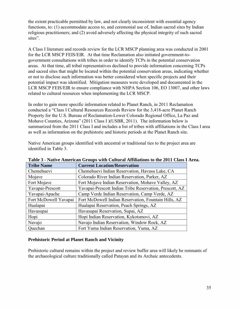
35
the extent practicable permitted by law, and not clearly inconsistent with essential agency functions, to: (1) accommodate access to, and ceremonial use of, Indian sacred sites by Indian religious practitioners; and (2) avoid adversely affecting the physical integrity of such sacred sites”. A Class I literature and records review for the LCR MSCP planning area was conducted in 2001 for the LCR MSCP FEIS/EIR. At that time Reclamation also initiated government-to-government consultations with tribes in order to identify TCPs in the potential conservation areas. At that time, all tribal representatives declined to provide information concerning TCPs and sacred sites that might be located within the potential conservation areas, indicating whether or not to disclose such information was better considered when specific projects and their potential impact was identified. Mitigation measures were developed and documented in the LCR MSCP FEIS/EIR to ensure compliance with NHPA Section 106, EO 13007, and other laws related to cultural resources when implementing the LCR MSCP. In order to gain more specific information related to Planet Ranch, in 2011 Reclamation conducted a “Class I Cultural Resources Records Review for the 3,418-acre Planet Ranch Property for the U.S. Bureau of Reclamation-Lower Colorado Regional Office, La Paz and Mohave Counties, Arizona” (2011 Class I )(USBR, 2011). The information below is summarized from the 2011 Class I and includes a list of tribes with affiliations in the Class I area as well as information on the prehistoric and historic periods at the Planet Ranch site. Native American groups identified with ancestral or traditional ties to the project area are identified in Table 3. Table 3 - Native American Groups with Cultural Affiliations to the 2011 Class I Area. Tribe Name Current Location/Reservation Chemehuevi Chemehuevi Indian Reservation, Havasu Lake, CA Mojave Colorado River Indian Reservation, Parker, AZ Fort Mojave Fort Mojave Indian Reservation, Mohave Valley, AZ Yavapai-Prescott Yavapai-Prescott Indian Tribe Reservation, Prescott, AZ Yavapai-Apache Camp Verde Indian Reservation, Camp Verde, AZ Fort McDowell Yavapai Fort McDowell Indian Reservation, Fountain Hills, AZ Hualapai Hualapai Reservation, Peach Springs, AZ Havasupai Havasupai Reservation, Supai, AZ Hopi Hopi Indian Reservation, Kykotsmovi, AZ Navajo Navajo Indian Reservation, Window Rock, AZ Quechan Fort Yuma Indian Reservation, Yuma, AZ Prehistoric Period at Planet Ranch and Vicinity Prehistoric cultural remains within the project and review buffer area will likely be remnants of the archaeological culture traditionally called Patayan and its Archaic antecedents.
36
The Historic Period at Planet Ranch and Vicinity Most of the historic period use of Planet Ranch and the vicinity was related to mining. The Planet Mine is near the southwest corner of the Planet Ranch property. The copper mining town of Swansea adjoins the eastern boundary of Planet Ranch. Land records indicate that Planet Ranch was first homesteaded in the late 1910s, with two homesteads established within or in immediate vicinity of Planet Ranch. The bulk of the remaining lands within the project area were acquired by the Santa Fe Pacific Railroad in 1924 as railroad land grants. Nothing is known of the development of Planet Ranch in the decades between 1924 and 1960. By 1962, Planet Ranch was under the ownership of a cattle company known as Arizona Ranch and Metals Company (ARMCO), which was based in Salt Lake City. By purchasing the railroad grant lands and leasing public lands in the vicinity of Planet Ranch, ARMCO expanded the ranch over the next decade to an estimated 10,000 acres for its livestock. Agricultural fields, laterals, and wells on the ranch were improved and maintained. In 1978, the Defense Nuclear Agency conducted two detonation tests on Planet Ranch as part of a simulation operation known as Miser’s Bluff. Two nuclear blasts were simulated by detonating seven ammonium nitrate charges on Planet Ranch. In 1984, ARMCO sold the private holdings of the cattle ranch to the City of Scottsdale. The City of Scottsdale purchased Planet Ranch in order to acquire its water rights to ensure a reliable water supply for Scottsdale. A proposal to construct a pipeline from Planet Ranch to the nearby Central Arizona Project (CAP) canal was never executed. In order to retain the water rights, the City of Scottsdale expanded the irrigation capabilities of Planet Ranch and leased the lands to local farmers for cultivation of alfalfa. Planet Ranch was purchased by Freeport from the City of Scottsdale in 2011. Results of Class I literature and records review The 2011 Class I included both the Lease area and a one-mile review buffer around the Lease area (Review area). The 2011 Class I reported six cultural resource investigations and 14 cultural resource sites within the Lease area and Review area. Additionally, over 40 potential historic sites may be present in the Lease area and Review area based on examination of General Land Office maps and archival research. Of the 14 recorded cultural resource sites in the Lease Area and Review Area, only three of them occur directly adjacent to or within the Lease area. Two of these are small prehistoric sleeping circle, rock alignment, and artifact scatter sites, and the other is the historic Planet Townsite. The remaining 11 sites include similar small prehistoric sites, most with rock features and artifact scatters. Of the 14 sites, only one prehistoric site, AZ M:13:5 (ASM), is recommended as eligible for the NRHP. The historic Planet Townsite is listed on the Arizona State Register but its eligibility for the NRHP has not yet been determined. Additionally, historic maps and archival data indicate that many Historic period resources are present in both the Lease area and Review area, but remain to be field verified and documented. Archaeological remains from the
37
detonation tests may rise to the level of site status given their potential significance in state and national events. No TCPs have been identified in the project area. It is possible that TCP’s and other important locales to Native Americans will yet be identified in the project area. 3.3.3.2 Environmental Consequences 3.3.3.2.1 No Action Under the No Action alternative, the management of Cultural Resources at the Lease area would not be assumed by LCR MSCP or AGFC. Any possible ongoing impacts to Cultural Resources would continue. 3.3.3.2.2 Proposed Action Under the Proposed Action, there would be no direct or indirect impacts to Cultural Resources from the acquisition of the Lease. The management of Cultural Resources at the Lease area would be assumed by LCR MSCP or AGFC depending on the activity. Federal and/or State laws developed to preserve and manage cultural resources would apply to activities undertaken at the Lease area. 3.3.3.2.3 Cumulative Impacts The analysis area for potential cumulative impacts to Cultural Resources/TCPs/Sacred Sites was defined as the Lease area because no potential impacts are anticipated outside of the Lease area. No cumulative impacts are anticipated because of the avoidance and minimization measures that would be implemented under the Proposed Action are expected to prevent or minimize impacts to cultural resources.
3.3.4 Indian Trust Assets 3.3.4.1 Affected Environment ITAs are defined as “legal interests in property held in trust by the United States for Indian tribes or individuals” (Reclamation, 1993). ITAs are those properties, interests, or assets of a Federally recognized Indian tribe or individual Indian over which the Federal government also has an interest, either through administration or direct control. The Federal government acts as a trustee with respect to these properties, interests, or assets. Examples of ITAs include lands, minerals, timber, hunting rights, fishing rights, water rights, in-stream flows, and other treaty rights. All Federal bureaus and agencies are responsible for protecting ITAs from adverse impacts resulting from their programs and activities. Each Federal bureau or agency, in cooperation with potentially affected tribe(s), must inventory and evaluate assets, and then mitigate or compensate for adverse impacts to the asset. While most ITAs are located on reservation lands, they can also be located off-reservation.

38
ITAs in the form of land, mineral rights, and preliminary federal reserved water right claims are present in the Bill Williams River watershed. The Tribe owns a 60 acre EO Reservation (Parcel 3) adjacent to the Big Sandy River as shown in Figure 11. This Reservation was established by EO No. 1368 on June 2, 1911 and is held in trust by the United States. It was irrigated and farmed historically, and has two former homesteads. It is not currently irrigated or inhabited. Potential water development and use on this Reservation would be from pumping from the alluvial aquifer or the deep groundwater aquifer. There is estimated to be 37 acres of potentially arable land on this EO Reservation. There are five Indian public domain allotments, which were patented (granted) by the United States pursuant to the Act of July 4, 1884, 23 Stat. 76, 96. These allotments are located in the Big Sandy River basin upstream from the Tribe’s EO Reservation. Four of these allotments, which total 560 acres, are considered in this EA. Three of these allotments, each 160 acres, are located side by side on Knight Creek in the upper Big Sandy River basin (Parcel 1). These allotments were patented in 1930. The fourth allotment is 80 acres (Parcel 2) and is located at the confluence of Knight and Trout Creeks. This allotment was patented in 1928. Potential water development and use on these allotments would be from pumping from the alluvial aquifer or the deep groundwater aquifer. The current proposed use of water on three of the four allotments is for gravel mining. Irrigated agriculture is the proposed use on the fourth allotment. When U.S. Highway 93 is designated as Interstate11 parallel to the Big Sandy River, the proposed water development on these allotments may change. The Big Sandy River-Planet Ranch Agreement confirms water rights on the Indian trust lands in the Big Sandy River watershed. The EO Reservation would be entitled to an annual diversion of 300 acre-feet. The four allotments addressed in the Big Sandy River-Planet Ranch Agreement would be entitled to an annual diversion of 394 acre-feet (Appendix A). The fifth allotment, a 90-acre subsurface estate adjacent to Knight Creek upstream from its confluence with Trout Creek, is not affected by the Agreements. The allottee has reserved mineral rights here which were retained when the former Pedro Pierce Allotment was sold in 1977. These reserved mineral rights are south of and contiguous with Parcel 1. There are no ITAs identified within the boundaries of Planet Ranch.

39
Figure 11 - Hualapai EO Reservation and Indian Public Domain Allotments
3.3.4.2 Environmental Consequences 3.3.4.2.1 No Action The No Action alternative would not impact the ITAs because the EO Reservation, Public Domain Allotments, mineral rights, and Federally reserved water rights associated with the lands are located upstream from Planet Ranch, in the Big Sandy River Basin. The ITAs would not be impacted by all of the Planet Ranch lands remaining in private ownership or potential use of 15,560 AFY for agriculture at Planet Ranch.

40
3.3.4.2.2 Proposed Action The Proposed Action would have no direct or indirect impact to ITAs as none are located within or in the vicinity of Planet Ranch. The Tribe’s EO Reservation, Public Domain Allotments, and Federally reserved water rights claims associated with the lands would not be impacted as they are located on the Big Sandy River and not in the immediate vicinity of the Lease area. 3.3.4.5.3 Cumulative Impacts The analysis area for potential cumulative impacts to ITAs was defined as the Big Sandy River basin because all ITAs under consideration within the Bill Williams River watershed are located along the Big Sandy River. The actions from Table 1 considered for potential ITA cumulative impacts are the sever and transfer of water rights associated with the Big Sandy River-Planet Ranch Agreement, and the Hualapai BWR Agreement. The sever and transfer of water rights associated with the Big Sandy River-Planet Ranch Agreement and associated withdrawal of objections and waivers is expected to settle, confirm, and resolve certain water rights claims among certain parties in the Bill Williams River watershed. This is expected to have a positive impact to ITAs as federal reserved water rights would be confirmed on the EO Reservation and Public Domain Allotments by Freeport and Freeport would agree not to object to these water rights. The 10,055 diversion limitation would benefit ITAs as fewer surface water rights would be exercised at the Wikiup wellfield, providing more assurance for a water supply for the EO Reservation and the Public Domain Allotments. Freeport would also provide $1,000,000 to the Tribe as a contribution toward the cost of the Tribe’s study of water project alternatives. The Hualapai BWR Agreement would have a beneficial impact to ITAs as it provides additional benefits to the Hualapai Tribe other than those provided in the Big Sandy-Planet Ranch Agreement. Freeport would agree to support trust acquisition of Cholla Canyon Ranch property owned in fee by the Tribe. Freeport and the Tribe would agree to establishment of buffer zones around the EO Reservation and Public Domain Allotments for new Freeport wells, and informal resolution of disputes over injuries from Freeport pumping on Tribal resources. Freeport would agree to provide supplemental water to the EO Reservation and Public Domain Allotments under certain circumstances. This supplemental water would be considered to be part of the water rights that are confirmed for the Tribe in the Big Sandy River-Planet Ranch Agreement. Freeport would agree to limit the exercise of its irrigation right on the Mracek property to a diversion of 130 AFY. Freeport would also provide a monetary contribution to the Tribe for the Tribe’s Economic Development Fund which may be used for the limited purpose of enabling the Tribe to acquire Colorado River Water Rights with the intent to increase the security of the Tribe’s water rights, and to otherwise facilitate the use of water on the Reservation (Hualapai BWR Agreement, Appendix B). Under the Hualapai BWR Agreement, Freeport would also grant the Tribe the right of first refusal to match any bona fide (good faith) offer to purchase 2,865.98 acres of land owned by Freeport in Mohave County (Banegas Ranch and Right of First Refusal (ROFR) lands). This right of first refusal does not guarantee that the Banegas Ranch or ROFR lands would be sold or that the Tribe would become the owner, but gives the Tribe the opportunity to offer to purchase if Freeport decides to sell. If the Tribe were ever to purchase Banegas Ranch or the ROFR lands

41
and want to place the lands in trust status, they would be required to submit an application to place the lands in trust status to the BIA and follow a process which involves the input of the local governments. Both of the Agreements would have beneficial impacts to the Tribe. There would be no cumulative impacts to ITAs from the Proposed Action and the Agreements because the Proposed Action would not impact ITAs. 3.3.5 Land Use 3.3.5.1 Affected Environment Land jurisdiction within the Bill Williams River watershed is shown by acres in Table 4 and in Figure 12. More detailed information on land uses within the watershed is given below. Table 4 - Land Jurisdiction in the Bill Williams River Watershed Jurisdiction Acres in watershed Percent of Total BLM 1,432,075 41.44% State 965,769 27.95% Private 859,566 24.88% USFS 173,285 5.01% U.S. Army Corps of Engineers 16,032 0.46% Service 6,100 0.18% Local or State Parks 1,118 0.03% Tribal Lands 864 0.03% Reclamation 641 0.02% Total 3,455,450 100.00% Source: Reclamation, 2015

42
Figure 12 - Land jurisdiction in the Bill Williams River Watershed
Source: Reclamation, 2015 BLM The BLM manages public land within the watershed, including eight Wilderness Areas (Wilderness). All of these Wilderness Areas were established by the Arizona Desert Wilderness Act of 1990. Three of these are being considered in this analysis because of their proximity to Planet Ranch and the Big Sandy and Bill Williams Rivers: Arrastra Mountain Wilderness, Rawhide Mountains Wilderness, and Swansea Wilderness (Figure 5). The western and southern portions of the 129,800-acre Arrastra Mountain Wilderness encompass more than 20 miles of the Big Sandy and Santa Maria rivers. This Wilderness is managed by the BLM’s Kingman Field Office. The 38,470-acre Rawhide Mountains Wilderness includes portions of two mountain ranges, the Rawhide Mountains to the north and the Buckskin Mountains to the south, separated by eight miles of the Bill Williams River. The 16,400-acre Swansea Wilderness adjoins the eastern boundary of Planet Ranch and includes the eastern end of the Buckskin Mountains, the Black Mesa extension to the north, and six miles of the Bill Williams River. The Buckskin Mountain portion includes a complex drainage system leading to the river (BLM, 2012). The Rawhide Mountains and Swansea Wilderness areas are managed by the BLM’s Lake Havasu Field Office. Congress expressly reserved a quantity of water for the BLM Wilderness Areas sufficient to fulfill the purposes for designation as wilderness with priority date being the date of enactment of the Arizona Desert Wilderness Act of 1990.

43
The 1989 Bill Williams Riparian Management Area Plan, the 2007 Lake Havasu Field Office ROD and Approved Resource Management Plan, and the 1995 Kingman Resource Area Resource Management Plan provide management direction for BLM land including the Wilderness areas. State of Arizona The Arizona State Land Department manages State Trust lands within the watershed. These lands were granted to the State under the provisions of the Federal Enabling Act that provided for Arizona’s statehood in 1912. These lands are held in trust and managed for the sole purpose of generating revenues for the 13 State Trust land beneficiaries, the largest of which is Arizona’s K-12 education (Arizona State Land Department, 2014) Private Private lands within the watershed are owned by a variety of owners with a variety of uses including but not limited to residential, mining, and ranching. The watershed includes the unincorporated communities of Wikieup and Bagdad. The watershed includes portions of three counties: Mohave, La Paz, and Yavapai. The Mohave, La Paz, and Yavapai counties’ land use plans provide direction for use of private and other lands within the watershed. The Lease would be located in Mohave and La Paz counties, so this overview of land use plans focuses on those two counties. The Mohave County General Plan (Mohave County Plan), last updated in 2010, consists of existing and anticipated conditions affecting the County, establishes goals, policies and implementation measures that guide the County’s future actions, and describes actions to take to achieve the County’s desired future. The desired future is framed by major planning concepts which include protection of the environment; conservation of the County’s natural resources; and preserving and enhancing historic, cultural, open space, and recreational lands and structures. An important part of the Mohave County Plan is the designation of land uses. The Mohave County Plan designates broad planning area types as well as more specific land uses within the broad planning areas. The portion of the County in which Planet Ranch is located is within the planning area known as “Rural Development Area (RDA)”. RDAs are defined as “…an area where residents presently enjoy a rural lifestyle, wide open spaces and few neighbors. Most of the land in Mohave County is included in this area type. Properties in these areas are generally at least five acres in size, and many are much larger than this. A significant amount of land within this area type is owned by the Federal or State governments, or is included in an Indian reservation” (Mohave County, 2010). RDAs include all areas of Mohave County not designated for more extensive development. The Mohave County Plan includes 18 land uses ranging from residential, non-residential, and public land uses. There are no land uses planned for the portion of the RDA in which Planet Ranch is located. Land jurisdiction within Mohave County is shown by acres in Table 5.
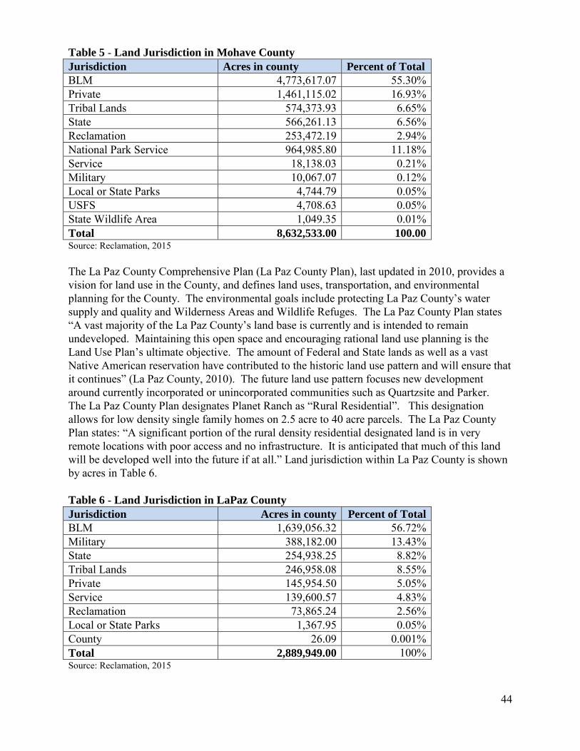
44
Table 5 - Land Jurisdiction in Mohave County Jurisdiction Acres in county Percent of Total BLM 4,773,617.07 55.30% Private 1,461,115.02 16.93% Tribal Lands 574,373.93 6.65% State 566,261.13 6.56% Reclamation 253,472.19 2.94% National Park Service 964,985.80 11.18% Service 18,138.03 0.21% Military 10,067.07 0.12% Local or State Parks 4,744.79 0.05% USFS 4,708.63 0.05% State Wildlife Area 1,049.35 0.01% Total 8,632,533.00 100.00 Source: Reclamation, 2015 The La Paz County Comprehensive Plan (La Paz County Plan), last updated in 2010, provides a vision for land use in the County, and defines land uses, transportation, and environmental planning for the County. The environmental goals include protecting La Paz County’s water supply and quality and Wilderness Areas and Wildlife Refuges. The La Paz County Plan states “A vast majority of the La Paz County’s land base is currently and is intended to remain undeveloped. Maintaining this open space and encouraging rational land use planning is the Land Use Plan’s ultimate objective. The amount of Federal and State lands as well as a vast Native American reservation have contributed to the historic land use pattern and will ensure that it continues” (La Paz County, 2010). The future land use pattern focuses new development around currently incorporated or unincorporated communities such as Quartzsite and Parker. The La Paz County Plan designates Planet Ranch as “Rural Residential”. This designation allows for low density single family homes on 2.5 acre to 40 acre parcels. The La Paz County Plan states: “A significant portion of the rural density residential designated land is in very remote locations with poor access and no infrastructure. It is anticipated that much of this land will be developed well into the future if at all.” Land jurisdiction within La Paz County is shown by acres in Table 6. Table 6 - Land Jurisdiction in LaPaz County Jurisdiction Acres in county Percent of Total BLM 1,639,056.32 56.72% Military 388,182.00 13.43% State 254,938.25 8.82% Tribal Lands 246,958.08 8.55% Private 145,954.50 5.05% Service 139,600.57 4.83% Reclamation 73,865.24 2.56% Local or State Parks 1,367.95 0.05% County 26.09 0.001% Total 2,889,949.00 100% Source: Reclamation, 2015

45
U.S. Forest Service A portion of Prescott National Forest, managed by the U.S. Forest Service is located within the Bill Williams River watershed. The Forest is managed for multiple uses as outlined in the 1987 Land and Resource Management Plan, which is currently being revised. U.S Army Corps of Engineers/Local or State Parks The USACE administers lands associated with Alamo Dam and reservoir. These lands are managed by AGFD and Arizona State Parks Department for recreation, fisheries, and wildlife purposes. Fish and Wildlife Service The Service manages the 6,100 acre Bill Williams River NWR, which was originally part of the Havasu NWR and later designated as a distinct Wildlife Refuge in 1993. The Service possesses one Federal reserved water right, per the January 22, 1941 Executive Order #8647 that originally established the Refuge "...as a refuge and breeding ground for migratory birds and other wildlife". The Bill Williams River NWR is discussed in more detail in Sections 1.2.3 and 3.3.2.1. Tribal The Tribe has a 60 acre EO Reservation within the Big Sandy River near Wikieup. Additionally, there are 560 acres of Indian public domain allotments and a 90 acre subsurface mineral estate located in the Big Sandy River basin near the Tribe’s EO Reservation. Reclamation The BLM manages Reclamation land located at the confluence of the Bill Williams River and Colorado River. This land is associated with the Boulder Canyon Project and other Reclamation water projects and is managed as outlined in the 2007 Lake Havasu Field Office ROD and Approved Resource Management Plan. 3.3.5.2 Environmental Consequences 3.3.5.2.1 No Action The analysis area for direct and indirect impacts to land uses includes the Lease area as it relates to Mohave and LaPaz counties. Under the No Action alternative the entire 8,389 acres of Planet Ranch would remain in private ownership. Current land uses at the Lease area would continue as determined by Freeport. Lands would be managed in accordance with existing plans and Federal, State, and County requirements. 3.3.5.2.2 Proposed Action The direct impact to land uses from the Proposed Action would be a change in ownership. Under the Proposed Action, 3,418 acres at Planet Ranch would change from private to State ownership. Of the 3,418 acres; 1,957 acres are in Mohave County and 1,461 are in La Paz County (Reclamation, 2015). The remaining 4,971 acres of Planet Ranch would remain in private ownership. Table 7 shows the potential new acres by jurisdiction, new percent of total acres, and percent change for Mohave and La Paz Counties.
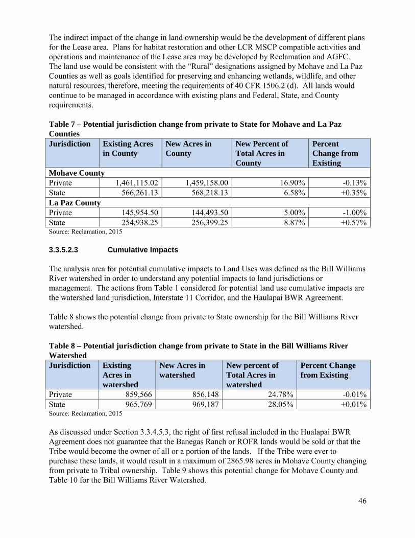
46
The indirect impact of the change in land ownership would be the development of different plans for the Lease area. Plans for habitat restoration and other LCR MSCP compatible activities and operations and maintenance of the Lease area may be developed by Reclamation and AGFC. The land use would be consistent with the “Rural” designations assigned by Mohave and La Paz Counties as well as goals identified for preserving and enhancing wetlands, wildlife, and other natural resources, therefore, meeting the requirements of 40 CFR 1506.2 (d). All lands would continue to be managed in accordance with existing plans and Federal, State, and County requirements. Table 7 – Potential jurisdiction change from private to State for Mohave and La Paz Counties Jurisdiction Existing Acres
in County New Acres in County
New Percent of Total Acres in County
Percent Change from Existing
Mohave County Private 1,461,115.02 1,459,158.00 16.90% -0.13% State 566,261.13 568,218.13 6.58% +0.35% La Paz County Private 145,954.50 144,493.50 5.00% -1.00% State 254,938.25 256,399.25 8.87% +0.57% Source: Reclamation, 2015 3.3.5.2.3 Cumulative Impacts The analysis area for potential cumulative impacts to Land Uses was defined as the Bill Williams River watershed in order to understand any potential impacts to land jurisdictions or management. The actions from Table 1 considered for potential land use cumulative impacts are the watershed land jurisdiction, Interstate 11 Corridor, and the Haulapai BWR Agreement. Table 8 shows the potential change from private to State ownership for the Bill Williams River watershed. Table 8 – Potential jurisdiction change from private to State in the Bill Williams River Watershed Jurisdiction Existing
Acres in watershed
New Acres in watershed
New percent of Total Acres in watershed
Percent Change from Existing
Private 859,566 856,148 24.78% -0.01% State 965,769 969,187 28.05% +0.01% Source: Reclamation, 2015 As discussed under Section 3.3.4.5.3, the right of first refusal included in the Hualapai BWR Agreement does not guarantee that the Banegas Ranch or ROFR lands would be sold or that the Tribe would become the owner of all or a portion of the lands. If the Tribe were ever to purchase these lands, it would result in a maximum of 2865.98 acres in Mohave County changing from private to Tribal ownership. Table 9 shows this potential change for Mohave County and Table 10 for the Bill Williams River Watershed.

47
Table 9- Potential jurisdictional change from private to Tribal in Mohave County Jurisdiction Existing
Acres in Mohave County
New Acres in Mohave County
New Percent of Total Acres in watershed
Percent Change from Existing
Private 1,461,115.02 1,458,249.10 16.89% -0.19% Tribal 574,373.93 577,239.91 6.68% 0.50% Source: Reclamation, 2015 Table 10- Potential jurisdictional change from private to Tribal in Bill Williams River Watershed Jurisdiction Existing
Acres in watershed
New Acres in watershed
New Percent of Total Acres in watershed
Percent Change from Existing
Private 859,566 856,700.02 24.79% -0.33% Tribal 864 3,729.98 0.10% 331.71% Source: Reclamation, 2015 While a large percent change in tribal acres is shown in Table 10, it should be noted that the potential new acres would represent only 0.10% of the total acres in the watershed. Designation of the I-11 Corridor may increase economic development along the corridor. No cumulative impacts from the Proposed Action and the I-11 Corridor designation are anticipated as U.S. Highway 93/I-11 Corridor is not in direct proximity to the Lease area. The current land jurisdiction has resulted in a watershed that is primarily rural. The change in ownership of the Lease area is not expected to have a cumulative impact on the rural nature of the watershed because the Lease area would be used for habitat restoration and other compatible activities, all of which would be consistent with the current rural setting at Planet Ranch. 3.3.6 Recreation 3.3.6.1 Affected Environment Since Planet Ranch is currently privately owned, public entrance to Planet Ranch and any subsequent recreational activities are subject to approval by Freeport. Bill Williams River NWR offers a visitor center, hunting, fishing, hiking, auto tours, a non-motorized boat trail, wildlife observation including bird watching, and photography. The average number of yearly visitors engaging in these activities during 2010 to 2013 was 148,845. Wildlife observation, primarily bird watching had the largest visitor group. Bird watching is a very popular activity which draws both United States and international visitors due to the Bill Williams River NWR’s high bird diversity and it’s designation by the National Audubon Society and the American Bird Conservancy as a birding area of global importance (K. Blair, Personal Communication, 2014).

48
The BLM managed Wilderness Areas provide opportunities for hiking, backpacking, hunting, rock climbing, bird watching, and photography in a rugged, remote setting. The Rawhide Wilderness includes the Bill Williams River gorge which contains a perennial reach of the Bill Williams River, allowing for kayaking and canoeing. The Swansea Wilderness also includes horseback riding and sightseeing at the historic townsite of Swansea. The wilderness areas are closed year-round to off-highway vehicle use and all other motorized/mechanized use. Other BLM managed lands along the Bill Williams River are managed for semi-primitive recreation that includes but is not limited to hiking, backpacking, camping, hunting, auto touring and off-highway vehicle use.
Alamo Lake State Park offers both water and land based recreation. The lake is a popular fishing location and also offers camp grounds, boat launches, picnic areas, wildlife viewing, hiking, swimming, and bicycling. 3.3.6.2 Environmental Consequences 3.3.6.2.1 No Action Under the No Action alternative the entire 8,389 acres of Planet Ranch would not be open to public recreation unless authorized by Freeport. No change to other recreational opportunities along the Bill Williams River is anticipated. 3.3.6.2.2 Proposed Action Under the Proposed Action alternative, the 3,418 acre Lease area would be open to public access because of its proposed State ownership and Federal management. Support for this public access by the Arizona Game and Fish Department and AGFC is documented in the minutes of the August 22, 2014 meeting of the AGFC (AGFC, 2014). The remaining 4,971 acres of Planet Ranch would not be open to public recreation unless authorized by Freeport. Restoration and site planning would be conducted for the Lease area which will identify the types and level of public access as well as the types of recreation activities that are compatible with the LCR MSCP. In accordance with the Act, public access would be consistent with all applicable Federal and State laws and management plans for the Lease area. Public access and recreation activities will be addressed as appropriate in any future NEPA compliance. Indirectly, public access and LCR MSCP compatible activities would increase the opportunities for recreation at the Lease area. 3.3.6.2.3 Cumulative Impacts The analysis area for potential cumulative impacts to Recreation was defined as the Big Sandy River and Bill Williams River. The action from Table 1 considered for potential recreation cumulative impacts is watershed land uses. The BLM Wilderness Areas and other BLM managed land, Bill Williams River NWR, and Alamo Lake State Park offer a variety of recreational opportunities with a minimal level of development. The Proposed Action is expected to add to the recreational opportunities and complement current land uses, leading to a positive cumulative impact to recreation. 3.3.7 Socioeconomics
49
3.3.7.1 Affected Environment Land within Planet Ranch is currently taxed by Mohave and LaPaz Counties as agricultural land. The Freeport/AGFC agricultural lease may make a contribution to the local economy through livestock production. However, this benefit is not quantifiable since Planet Ranch was fallowed for many years prior to the Freeport/AGFC agricultural lease. A staff of several people current performs caretaking and other maintenance activities at Planet Ranch. 3.3.7.2 Environmental Consequences 3.3.7.2.1 No Action Revenue to Mohave County or LaPaz County would not change as a result of the No Action alternative. Freeport would continue to pay taxes on its privately held land as required by Mohave and LaPaz Counties. 3.3.7.2.2 Proposed Action There are no direct socio-economic impacts identified because acquiring the Lease is administrative in nature. Potential indirect impacts which were considered are revenue to Mohave and LaPaz counties and changes in employment. Revenue to Mohave County or LaPaz County would not change as a result of the Proposed Action as voluntary contributions in lieu of taxes would be made by AGFC at the current tax rate for the Lease area in accordance with Arizona Revised Statute 17-272 (Arizona State Legislature, 2014). The AGFC voted unanimously to make these voluntary contributions in lieu of taxes at their September 5-6, 2014 Commission meeting (AGFC, 2014). Freeport would continue to pay taxes at its current rate on the remaining 4,971 acres. It is not known how many people would be employed if the Lease area were managed for LCR MSCP and compatible purposes, but it is expected that the number of people employed would be similar or would increase because individuals would be needed for operations and maintenance of the Lease area. 3.3.7.2.3 Cumulative Impacts The analysis area for potential socioeconomic cumulative impacts to was defined as Mohave and La Paz Counties. The actions from Table 1 considered for potential socioeconomic cumulative impacts to socioeconomics are the Interstate 11 Corridor, the Hualapai BWR Agreement, and the Freeport/AGFC agricultural lease. The designation and development of I-11 Corridor may lead to additional economic development and potentially more tax revenue from lands in the Bill Williams River Watershed. No cumulative impacts from the Proposed Action and the I-11 Corridor designation are anticipated because the Proposed Action of acquiring the Lease would not change the revenue to Mohave or La Paz Counties. If the Tribe were ever to purchase Banegas Ranch or the ROFR lands, they would continue to pay taxes to Mohave County at the tax rate in effect at the time of purchase. If the lands were placed in trust for the Tribe, the tribe would not pay taxes to Mohave County as local property taxes are

50
not paid on trust land (BIA, 2015). As discussed under Section 3.3.4.5.3, an application to the BIA by the Tribe to place the lands in trust would involve the input of the local governments. No impacts to agricultural revenues are defined as a result of the AGFC agricultural lease because there has not been measurable agricultural production at Planet Ranch for many years. 3.3.8 Environmental Justice 3.3.8.1 Affected Environment Executive Order 12898 (Federal Actions to Address Environmental Justice in Minority Populations and Low-Income Populations) directs federal agencies to determine whether their programs, policies, and activities have disproportionately high and adverse human health or environmental effects on minority and low-income populations. The analysis area for Environmental Justice includes Census Tracts located in the vicinity of Planet Ranch in Mohave and LaPaz counties as well as the unincorporated community of Wikieup, Arizona, located in Mohave County. Wikieup was selected for the cumulative impacts analysis because it is the largest community located on either the Bill Williams River or Big Sandy River. Data are compared to data from Mohave and La Paz counties and the state of Arizona. According to CEQ Guidance, communities should be identified as “low income” based on the annual statistical poverty thresholds from the U.S. Census Bureau (CEQ 1997). Table 11 includes per capita income, median household income, and poverty rates for Arizona, Mohave and La Paz Counties, the Census Tracts and Wikieup. Table 11 – Income and Poverty Levels
Area Per capita income Median Household Income % Below Poverty Level
Arizona 25,680 50,448 18.7 Mohave County 21,523 39,785 18.6 Census Tract 9548
19,502 38,861 14.3
Census Tract 9534.02
23,903 43,702 10.4
Wikieup, AZ 25,416 37,813 21.0 La Paz County 21,165 32,147 20.2 Census Tract 201 16,191 28,017 28.0 Census Tract 202.02 27,015 40,848 11.1
Source: U. S. Census, American Fact Finder In accordance with CEQ guidance, minority populations should be identified if the minority population in the project area “exceeds 50 percent” or if the percentage of minority population in the project area is meaningfully greater than the “minority population percentage in the general population or other appropriate unit of analysis” (CEQ 1997). For this analysis, the population percentages of the various racial and ethnic groups are compared to those in Arizona, Mohave
51
County, La Paz County, and Wikieup to determine any disproportionately high and adverse effects (Table 12). Minority populations in the Census Tracts did not exceed 50 percent of the analysis area for Environmental Justice. The percentage of minority population in the Census Tracts was not found to be meaningfully greater than the minority population percentage for Arizona and Mohave and La Paz Counties. The minority populations present in the Census Tracts and Wikieup do not meet the thresholds identified for Environmental Justice analysis, therefore are not addressed further in an Environmental Justice context.

52
Table 12 – Area demographic breakdown 1
Source: U.S. Census, American Fact Finder2
Race Ethnicity Area 2010
Population #White % of
Total for Area
#Black or African American
% of Total for Area
#American Indian and Alaska Native
% of Total for Area
#Asian % of Total for Area
#Native Hawaii and other Pacific Islander
% of Total for Area
#Other % of Total for Area
Two or more races
#Hispanic or Latino (of any race)
% of Total for Area
Arizona 6,392,017 4,667,121
73.0 259,008 4.1 296,529 4.6 176,695
2.8 12,648 0.2 761,716
11.9 218,300
3.4
1,895,149 29.6
Mohave County
200,186 173,878 86.9 1,882
0.9 4,500
2.2 2,103 1.1 341 0.2 11,989 6.0 5,493 2. 29,569 14.8
Census Tract 9548
7,012 6,006 85.7 271 3.9 170 2.4 32 0.5 14 0.2 295 4.2 224 3.2
1,009 14.4
Census Tract 9534.02
5,621 5,128 91.2 41 0.7 66 1.2 64 1.1 7 0.1 200 3.6 115 2.0
573 10.2
Wikieup, AZ
133 120 90.2 1 0.8% 0 0.0 0 0.0 0 0.0 8 6.0 4 3.0
16 12.0
La Paz County
20,489 14,306 69.8 129 0.6 2,628 12.8 107 0.5 7 0.1 2,551 12.5 761 3.7
4,806 23.5
Census Tract 201
2,815 2,334 82.9 18 0.6 36 1.3 11 0.4 3 0.1 363 12.9 50 1.8
715 25.4
Census Tract 202.02
647 613 94.7 0 0.0 2 0.3 7 1.1 0 0.0 14 2.2 11 1.7
36 5.6

53
3.3.8.2 Environmental Consequences 3.3.8.2.1 No Action No disproportionately high and adverse human health or environmental effects on minority and low-income populations have been identified as a result of the No Action alternative. A minority population was not identified for the analysis area. Based on the existing condition of other resources at and in the vicinity of Planet Ranch, there are no known high and adverse health or environmental effects occurring that would impact low-income populations. 3.3.8.2.2 Proposed Action The Proposed Action would not result in disproportionately high and adverse human health or environmental effects on minority and low-income populations. A minority population was not identified for the analysis area. The percent of individuals below poverty levels in the Census Tracts were compared to those for Arizona and Mohave and La Paz Counties. The poverty levels for the Census Tracts in Mohave County were either below or only slightly higher than those for Mohave County or Arizona. Census Tract 201 in La Paz County has a poverty rate that is 8 percent higher than the rate for La Paz County. Although Census Tract 201 has a higher poverty rate than LaPaz County as a whole, no high and adverse human health or environmental effects have been identified that may impact this Census Tract. 3.3.8.2.3 Cumulative Impacts There were no Environmental Justice impacts identified for any of the Census Tracts or Wikieup, AZ from the Proposed Action, therefore there would be no cumulative impacts.

54
4.0 References Arizona Game and Fish Commission. 2014. Minutes of the Telephonic Meeting of the Arizona Game and Fish Commission, August 22, 2014. Accessed March 17, 2015 at http://www.azgfd.gov/inside_azgfd/meeting_minutes.shtml Arizona Game and Fish Commission. 2014. Minutes of the Meeting of the Arizona Game and Fish Commission, September 5-6, 2014. Accessed March 17, 2015 at http://www.azgfd.gov/inside_azgfd/meeting_minutes.shtml Arizona Geological Survey. 1999. Hydrologic and Geomorphic Characteristics of the Bill
Williams River, Arizona. (Open-File Report 99-4). Tuscon, AZ Arizona State Legislature. 2014. Arizona Revised Statutes. Title 17-272. Voluntary
Contributions in Lieu of Property Taxes. Accessed March 17, 2015 http://www.azleg.state.az.us/FormatDocument.asp?inDoc=/ars/17/00272.htm&Title=17&DocType=ARS
Arizona State Lands Department, website accessed July 25, 2014 http://www.azland.gov/ Colorado River Fish and Wildlife Council (CRFWC). 2006. Range-wide Conservation
Agreement and Strategy for Roundtail Chub Gila robusta, Bluehead Sucker Catostomus discobolus, and Flannelmouth Sucker Catostomus latipinnis. Publication Number 06-1. 59pp.
Cotten, Taylor and David Grandmaison. 2013. Lowland Leopard Frog and Colorado River Toad Distribution and Habitat Use in the Greater Lower Colorado River Ecosystem [2012 Annual Report prepared for the Bureau of Reclamation Lower Colorado River Multi-Species Conservation Program]. Arizona Game and Fish Department, Phoenix, AZ.
Council on Environmental Quality (CEQ). 2014. Consideration of Greenhouse Gas Emissions and the Effects of Climate Change in NEPA Reviews.
Federal Emergency Management Agency. 2014. Data accessed at: http://www.fema.gov/ Garnett, G. 2015. U.S. Bureau of Reclamation, Lower Colorado Muti-Species Conservation
Program. Personal communication with Jessie Stegmeier. Intergovernmental Panel on Climate Change (IPCC). 2014. Fifth Assessment Report available
at www.ipcc.ch/report/ar5/index.shtml La Paz County. 2010. La Paz County Comprehensive Plan. Mohave County. 2010. Mohave County, Arizona General Plan.

55
Rosen, Philip C. and Cecil R. Schwalbe. 1988. Status of the Mexican and narrow-headed garter snakes (Thamnophis eques megalops and Thamnophis rufipunctatus rufipunctatus) in Arizona [Unpublished report to U.S. Fish and Wildlife Service]. Arizona Game and Fish Department, Phoenix, AZ.
Shafroth, P.B., J.C. Stomberg and D.T. Patten. 2000. Woody riparian vegetation response to different alluvial water table regimes. Western North American Naturalist. 60(1): 66-76. U.S. Army Corps of Engineers. 2003. Water Control Manual. Alamo Dam and Lake Colorado
River Basin Bill Williams River. Arizona. U.S. Bureau of Indian Affairs. 2015. Frequently asked questions. Accessed at
http://www.bia.gov/FAQs/ on February 25, 2015. U.S. Bureau of Land Management. 2012a. Arrastra Mountain Wilderness. Available at:
http://www.blm.gov/az/st/en/prog/blm_special_areas/wildareas/arrastra.html. _____. 2012b. Rawhide Mountains Wilderness Area. Available at:
http://www.blm.gov/az/st/en/prog/blm_special_areas/wildareas/rawhide.html. _____. 2012c. Swansea Wilderness Area. Available at:
http://www.blm.gov/az/st/en/prog/blm_special_areas/wildareas/swansea.html. U.S. Bureau of Reclamation. 1993. Policy directive on ITAs issued by the Commissioner of
Reclamation. _____. 2004a. Lower Colorado River Multi-Species Conservation Program, Volume I.
Programmatic Environmental Impact statement/Environmental Impact Report. December 17. Sacramento, CA.
_____. 2004b. Lower Colorado River Multi-Species Conservation Program, Volume II. Habitat
Conservation Plan. Final. December 17. (J&S 00450.00) Sacramento, CA. _____. 2004c. Lower Colorado River Multi-Species Conservation Program, Volume III:
Biological Assessment. Final. December 17. (J&S 00450.00) Sacramento, CA. _____. 2005. Planet Ranch: Potential Habitat Restoration Site, Preliminary Site Analysis and
Conceptual Design. Boulder City, Nevada. _____. 2010. Final Implementation Report, Fiscal Year 2011 Work Plan and Budget, Fiscal
Year 2009 Accomplishment Report. Boulder City, Nevada. _____. 2011. A Class I Cultural Resources Records Review for the 3,418-acre Planet Ranch
Property for the U.S. Bureau of Reclamation-Lower Colorado Regional Office, La Paz and Mohave Counties, Arizona. Tempe, AZ.
_____. 2015. Geographic Information System. Lower Colorado Regional Office.
56
U.S. Department of Census. 2014. American Fact Finder.
http://factfinder.census.gov/faces/nav/jsf/pages/index.xhtml U.S. Department of the Interior. 1995. Departmental Responsibilities for Indian Trust Resources.
Part 512 Chapter 2. U.S. Fish and Wildlife Service. 2014. Bill Williams River National Wildlife Refuge, Arizona.
Available at: http://www.fws.gov/refuge/bill_williams_river/. _____. 2013. NEPA and ESA Framework Report. Bill Williams River-Alamo Dam. ERO
Resources Corporation, Denver, CO. _____. 2011. Biological Compilation Report: Bill Williams River-Alamo Dam and Lake System
Information Compilation and Summary. Albuquerque, AZ. _____. 2004. Biological and Conference Opinion on the Lower Colorado River Multi-Species
Conservation Program, Arizona, California, and Nevada. USDI. U.S. Fish and Wildlife Service, Albuquerque, New Mexico (02-21-04-F-0161).
U.S. Geological Survey. 2002. Hydrologic Conditions in the Bill Williams River National
Wildlife Refuge and Planet Valley, Arizona, 2000. (Water-Resources Investigations Report 02-4214) Tucson, AZ.
_____. 2015. U.S.G.S. Water Data for the Nation. Accessed at: http://waterdata.usgs.gov/nwis

57
5.0 List of Preparers Faye Streier Natural Resource Specialist-National Environmental Policy Act Coordinator Bureau of Reclamation, Lower Colorado Regional Office Jessica Stegmeier Natural Resource Specialist- Biological Services Coordinator Bureau of Reclamation, Lower Colorado Regional Office Mark Slaughter Archaeologist Bureau of Reclamation, Lower Colorado Regional Office Heidi McMaster Environmental Protection Specialist Bureau of Reclamation, Lower Colorado Regional Office Dianne Bangle Geographic Information Systems Specialist Bureau of Reclamation, Lower Colorado Regional Office

58
6.0 Consultation and Coordination 6.1 Cooperating Agencies The BLM, BIA, and Service served as cooperating agencies in the preparation of the Draft EA. 6.2 Tribal Consultation As part of the NHPA Section 106 process, in 2010 Reclamation invited representatives of the Chemehuevi, Cocopah, Colorado River Indian Tribes, Fort Mohave Indian Tribe, Fort Yuma Quechan Tribe, Havasupai Tribe, Hopi Tribe, Hualapai Tribe, Las Vegas Paiute Tribe, Salt River Pima-Maricopa Indian Community, Santa Rosa Band of Cahuilla Indians, Sycuan Band of Kumeyaay Indians, Tohono O’odham Nation, Torres Martinez Desert Cahuilla Indians, Viejas Band of Kumeyaay Indians, and Hia C’ed O’odham Alliance on a field visit to Planet Ranch to discuss potential restoration activities. Representatives from the Cocopah Tribe, Chemehuevi Tribe, and Hualapai Tribe accepted the invitation and attended the field visit. All participants appreciated the opportunity to view Planet Ranch and were supportive of the idea of restoring native habitats. 6.3 Endangered Species Consultation Reclamation conducted a query of the Lease area using the U.S. Fish and Wildlife Service Information, Planning, and Conservation System (IPAC) query conducted on July 28th, 2014. The IPAC system automatically generated a species list and identified critical habitat within or near the Lease area. Reclamation used this information to inform this EA and complete informal Section 7 consultation. A letter was sent to U.S. Fish and Wildlife Service (Service) requesting concurrence on a may affect, not likely to adversely affect determination for the southwestern willow flycatcher, yellow-billed cuckoo, Yuma clapper rail, California least tern, and northern Mexican gartersnake. 6.4 Scoping/Public Involvement Notification of the initiation of a 30 day public comment period on the Draft EA was sent to a distribution list which includes Congressional, Federal, State, Tribal, and County contacts; non-governmental organizations; and other interested parties. A news release regarding the availability of Draft EA was sent to newspapers and other media and posted on Reclamation’s website at http://www.usbr.gov/newsroom/newsreleases.