planning and building in bushfire-prone areas for · pdf fileplanning and building in...
TRANSCRIPT

Planning and Building in Bushfire-Prone Areas for Owners and Builders December 2013
www.fire.tas.gov.au

Planning and Building in Bushfire-Prone Areas for Owners and Builders
2
Planning and Building in Bushfire-Prone Areas for Owners and Builders
A message from the Chief OfficerThe devastation caused by recent bushfires in Tasmania, Victoria and NSW are a constant reminder that we live in one of the most bushfire prone regions in the world and that we must plan for bushfire. In October 2012, the Tasmanian Government introduced significant reforms for planning and building in bushfire-prone areas. The reforms aim to balance development in bushfire-prone areas with the physical, social and emotional risk of bushfire in our communities.
Building for Bushfire will help you to understand the new planning and building requirements if you are looking to buy or build in a bushfire-prone area. It provides information on whether bushfire needs to be considered, what’s in a Bushfire Hazard Management Plan and the steps for getting one.
The planning and building process can be difficult, and you should remember that your Council, accredited Bushfire Hazard Assessors and the Tasmania Fire Service are there to help.
Of course, planning and building for bushfire is just the first step in minimising the bushfire threat. Just as important is to prepare your own Bushfire Survival Plan and to know your Community Protection Plan. The Tasmania Fire Service has good resources to help you prepare for an emergency.
Mike Brown Chief Officer Tasmania Fire Service

Planning and Building in Bushfire-Prone Areas for Owners and Builders
3Contents1 Bushfires in Tasmania 4
1.1 Building in a bushfire-prone area 5
1.2 Buying in a bushfire-prone area 6
1.3 What’s in this Guide 6
2 Planning your development 7
2.1 Am I in a bushfire-prone area? 7
What is bushfire-prone vegetation? 7
The role of accredited Bushfire Hazard Assessors 7
2.2 What is a Bushfire Hazard Management Plan 8
2.3 Balancing site location, construction requirements and maintenance 8
What is the Bushfire Attack Level? 9
2.4 Planning for access to buildings and water supply 9
DISCLAIMER
Whilst the Tasmanian Government has made every effort to ensure the accuracy and reliability of these guidelines, the Government accepts no responsibility for the accuracy, completeness or relevance to the viewer’s purpose, of the information in these guidelines and those viewing it for whatever purpose are advised to verify its accuracy and to obtain appropriate professional advice.
The Tasmanian Government, its officers, employees and agents do not accept any liability, however arising, including liability for negligence, for any loss or damage resulting from the use of, or reliance upon, the information contained in these guidelines.
3 Building your new home 10
4 Maintain your land 12
5 Prepare, act and survive 13
6 Checklist for building in bushfire-prone areas 14
7 Further Information 14
8 An example of a Bushfire Hazard Management Plan 15

Planning and Building in Bushfire-Prone Areas for Owners and Builders
4
Bushfire is part of the history and natural landscape of Tasmania. Over the years, there have been many significant bushfires in Tasmania, with the most recent being the devastating fires in and around the Dunalley area early in 2013 that destroyed over 200 homes.
Where we settle, build our houses and construct our roads can greatly influence where a bushfire will eventually run. These factors play an important role in the inherent safety of an area. Good land-use planning and development can minimise the bushfire threat and reduce the physical, social and emotional costs of bushfire.
In October 2012, new requirements for developing in bushfire-prone areas were introduced to help reduce vulnerability to bushfire. These new requirements incorporate lessons learned from recent fires in Tasmania and Victoria (particularly the ‘Black Saturday’ fires in 2010).
1 Bushfires in Tasmania
The new requirements mean that for all new development in bushfire-prone areas, an individual Bushfire Hazard Management Plan should be prepared (or an exemption to a Plan obtained). If you are thinking of developing, building, or buying land in a bushfire-prone area, this Guide will help explain how these Plans are created, the steps along the way, and where you can access help to work through the planning and building process.

Planning and Building in Bushfire-Prone Areas for Owners and Builders
5
If you are planning to develop in a bushfire-prone area, you need to plan to reduce your vulnerability to bushfire.
Minimum planning requirements and building standards aim to balance the benefits of your development with the protection of life, property and environment during a bushfire. They also support the work of Community Protection Planning and any emergency response by the Tasmania Fire Service.
In Tasmania all new development in a bushfire-prone area must be planned, designed and constructed to survive a fire with a Fire Danger Rating of 50 (see Figure 1). Your Bushfire Hazard Management Plan (or an exemption to a plan) will detail how your development meets these minimum requirements.
It is important to remember, however, that even if your home meets this requirement, fires can exceed a Fire Danger Rating of 50, at which point homes may not be defendable. The Tasmania Fire Service will provide advice on conditions during a bushfire, and whether you could defend your home or you should leave early.
The new requirements also place restrictions on the location of vulnerable (e.g. nursing homes) and hazardous (e.g. petrol stations) uses in bushfire-prone areas. In some exceptional circumstances, the proposed use and development may be unable to meet the minimum required standards, and the costs and dangers of the development may be too high for it to be approved.
0-11LOW-MODERATE
HIGH
VERY HIG
HSE
VER
E
EXTREME
12-24
25-49 50-74
75-99
100+
CATASTROPHIC
Figure 1: Fire Danger Rating
Total Fire Ban Days38
The Fire Danger Rating warns of the potential impact of a bushfire on any given day, based on forecast weather conditions. The Fire Danger Rating ranges from Low-Moderate (0) to Catastrophic (100+).
1.1 Building in a bushfire-prone area
FDR 50-74 Can stay and defend only if well prepared
FDR 50 Minimum standard for planning and building design

Planning and Building in Bushfire-Prone Areas for Owners and Builders
6
1.2 Buying in a bushfire-prone area
If you are considering buying land in a bushfire-prone area, you should check to see whether the property has an existing Bushfire Hazard Management Plan. The Plan will outline useful information for you, including how the land surrounding the building must be maintained, and where you can build, renovate, and extend without needing to prepare a new Plan.
Many older properties may not have a Bushfire Hazard Management Plan. In this instance, a Plan will only be required if you extend or renovate the property.
1.3 What’s in this GuideYour Bushfire Hazard Management Plan provides a consistent approach to managing bushfire hazards throughout the life of your development, including its planning, design, building and ongoing maintenance. This Guide provides details on when a Bushfire Hazard Management Plan is required, what’s in it, and the process for developing one.
This includes:
• What to consider in planning your development;
• Designing and building your development;
• Maintaining your property and responding in an emergency; and
• A checklist for planning and building in a bushfire-prone area.

Planning and Building in Bushfire-Prone Areas for Owners and Builders
7
2 Planning your development
2.1 Am I in a bushfire- prone area?
A ‘bushfire-prone area’ is an area where a bushfire is likely to occur that will cause significant damage to buildings and danger to life. Areas that are known to be bushfire-prone include land within 100 metres of bushfire-prone vegetation.Some local Council’s may have a planning overlay that shows bushfire-prone areas.
Both Council and accredited Bushfire Hazard Assessors can advise you whether your land is bushfire-prone. Remember, it is better to check whether your land is bushfire-prone early in the planning process to save time and costs later (for more details, see Section 7 - Further Information).
If your land is bushfire-prone then your proposed development will either be exempt, will need an exemption to a Bushfire Hazard Management Plan, or you will need to prepare one. Exemptions and Plans are available through an accredited Bushfire Hazard Assessor or the Tasmania Fire Service.
What is bushfire-prone vegetation?
Bushfire-prone vegetation includes areas of vegetation larger than one hectare (Ha). The one hectare area may be made up of clumps of vegetation separated by less than 20 metres, but will not include clumps of vegetation separated by more than 20 metres.
Bushfire-prone vegetation includes forests, shrubs and grasslands, but does not include maintained lawns, parks, orchards or horticultural land.
The role of accredited Bushfire Hazard Assessors
Accredited Bushfire Hazard Assessors are certified by the Tasmanian Fire Service to provide advice on matters relating to planning and building in bushfire-prone areas. In order to become accredited, Bushfire Hazard Assessors are trained in understanding how planning and construction relates in vulnerability to bushfires. They are also required to participate in Continuing Professional Development to ensure their work remains best-practice.
A list of accredited Bushfire Hazard Assessors can be found on the Workplace Standards website at www.workplacestandards.tas.gov.au

Planning and Building in Bushfire-Prone Areas for Owners and Builders
8
2.2 What is a Bushfire Hazard Management Plan
Your Bushfire Hazard Management Plan is your plan for a development in bushfire-prone areas. It contains specific details for your development, like: • Where will it be located?• How will it be constructed?• What ongoing maintenance is required to
minimise the bushfire hazard?
Accredited Bushfire Hazard Assessors can prepare Bushfire Hazard Management Plans. They will work with you to understand your land and development, in order to balance the construction and location requirements. They will prepare a report and draw up a Bushfire Hazard Management Plan which summarises the bushfire protection elements. An example of a Plan is provided on the last page of this Guide.
Remember that not all development in Tasmania requires a Bushfire Hazard Management Plan, only development in bushfire-prone areas. Repairs, maintenance and minor extensions away from bushfire-prone vegetation do not require a Plan.
2.3 Balancing site location, construction requirements and maintenance
Deciding where to build on your land is an important step in planning for bushfire. The decision needs to balance how close your building will be to bushfire-prone vegetation, the slope of your land, how you will manage your land, and how access to the building and emergency water supplies will be provided.
A Bushfire Hazard Management Plan balances these considerations through an assessment of Bushfire Attack Level (BAL) for your development. Developments that are planned close to bushfire-prone vegetation are likely to face large impacts from bushfire and will be assessed as having a high BAL. As a result, tighter building construction standards will be required so that the building can better protect itself and any occupants inside during a bushfire.
The land between your development and bushfire-prone vegetation is part of your hazard management area and acts to reduce the impact of bushfires on your building; as such it needs to be maintained in accordance with the Plan. Make sure you understand the costs associated with maintaining this area.
Accredited Bushfire Hazard Assessors will be able to help you balance where you choose to site your building, additional construction requirements and the maintenance required over time. Remember that the location of your chosen building site will be shown on the Bushfire Hazard Management Plan. If you decide later on that you want to build in a different location, then a new Plan may be needed.
Your Bushfire Hazard Management Plan will show:
• The Bushfire Attack Level for your development;
• The building site, including how far away it should be from any bushfire-prone vegetation;
• Ongoing maintenance requirements for your land;
• Access to your development and water supplies in the event of a bushfire; and,
• Any additional measures that should be incorporated to mitigate the bushfire hazard.
Planning and Building in Bushfire-Prone Areas for Owners and Builders
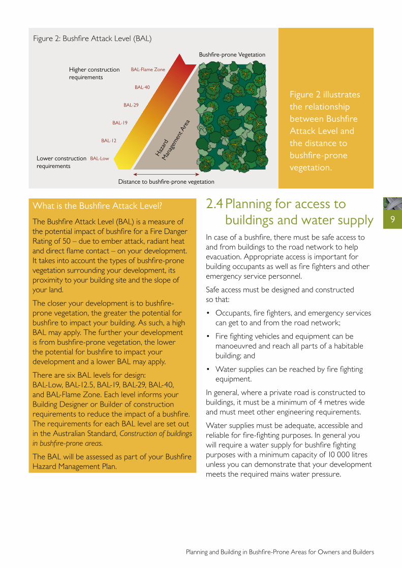
9What is the Bushfire Attack Level?
The Bushfire Attack Level (BAL) is a measure of the potential impact of bushfire for a Fire Danger Rating of 50 – due to ember attack, radiant heat and direct flame contact – on your development. It takes into account the types of bushfire-prone vegetation surrounding your development, its proximity to your building site and the slope of your land.
The closer your development is to bushfire-prone vegetation, the greater the potential for bushfire to impact your building. As such, a high BAL may apply. The further your development is from bushfire-prone vegetation, the lower the potential for bushfire to impact your development and a lower BAL may apply.
There are six BAL levels for design: BAL-Low, BAL-12.5, BAL-19, BAL-29, BAL-40, and BAL-Flame Zone. Each level informs your Building Designer or Builder of construction requirements to reduce the impact of a bushfire. The requirements for each BAL level are set out in the Australian Standard, Construction of buildings in bushfire-prone areas.
The BAL will be assessed as part of your Bushfire Hazard Management Plan.
Figure 2 illustrates the relationship between Bushfire Attack Level and the distance to bushfire-prone vegetation.
Bushfire-prone Vegetation
Higher construction requirements
Lower construction requirements
Haz
ard
Man
agem
ent A
rea
BAL-Low
BAL-12
BAL-19
BAL-29
BAL-40
BAL-Flame Zone
Distance to bushfire-prone vegetation
Figure 2: Bushfire Attack Level (BAL)
2.4 Planning for access to buildings and water supply
In case of a bushfire, there must be safe access to and from buildings to the road network to help evacuation. Appropriate access is important for building occupants as well as fire fighters and other emergency service personnel.
Safe access must be designed and constructed so that:
• Occupants, fire fighters, and emergency services can get to and from the road network;
• Fire fighting vehicles and equipment can be manoeuvred and reach all parts of a habitable building; and
• Water supplies can be reached by fire fighting equipment.
In general, where a private road is constructed to buildings, it must be a minimum of 4 metres wide and must meet other engineering requirements.
Water supplies must be adequate, accessible and reliable for fire-fighting purposes. In general you will require a water supply for bushfire fighting purposes with a minimum capacity of 10 000 litres unless you can demonstrate that your development meets the required mains water pressure.

Planning and Building in Bushfire-Prone Areas for Owners and Builders
10
Once your Bushfire Hazard Management Plan has been approved, you can start to design your development in accordance with the Plan. The Australian Standard Construction of buildings in bushfire-prone areas sets out the construction requirements that must be adhered to for the Bushfire Attack Level (BAL) specified in your Plan.
The Standard contains six BAL levels that range from BAL-Low, with no additional construction requirements, through to BAL-Flame Zone, with the highest level of construction requirements. The requirements relate to building features such as: external walls, doors and windows; roofs; decks; water and gas supply; and the spaces beneath your building. The Case Study opposite provides an example for one such case, and includes some of the requirements for a BAL-19 level (for more details, see Section 7 - Further Information).
3 Building your new home

Planning and Building in Bushfire-Prone Areas for Owners and Builders
11
Case Study – Peter and Leah, a block on a new subdivisionPeter and Leah have just bought a block of land on an existing subdivision. The developer provided the Bushfire Hazard Management Plan, which was created when the subdivision was first planned. The Plan shows the building site, the property’s Hazard Management Area and the Bushfire Attack Level, BAL-19, on their land.
Peter and Leah were happy with the Plan, and talked to their Designer about the construction features required to meet BAL-19. Some of the items discussed included:• External cladding: Peter was free to choose
weatherboard cladding and the Designer incorporated bushfire-resisting boards near to the ground.
• Deck: Both Peter and Leah really wanted a timber deck. The Designer ensured that non-combustible materials were incorporated within 300mm of the external walls.
• Windows and Doors: Leah chose to install special bushfire screens across the windows and doors instead of bushfire shutters, which she didn’t like the look of. The screens she chose were also cheaper.
There were no additional requirements for the foundations and roof. Gaps around the house were covered with mesh to prevent burning embers becoming caught in them. Their designer suggested a simple rectangular design as good practice to minimise the buildings’ exposure to flames and heat.
Peter and Leah’s Bushfire Hazard Management Plan also showed their Hazard Management Area that had to be maintained to reduce the impact of bushfire on their home.
If your development has a high BAL, your accredited Bushfire Hazard Assessor may suggest solutions to reduce it. For instance, it may be possible to incorporate external ‘shielding’ structures between the building and bushfire-prone vegetation.
Remember that your Building Surveyor will check that your design meets the BAL and other requirements set out in your Plan before approving your development.

Planning and Building in Bushfire-Prone Areas for Owners and Builders
12
Before you move into your new home, you should create and maintain a Hazard Management Area – an area around and between your home and bushfire-prone vegetation – as shown in your Bushfire Hazard Management Plan. Failure to maintain this area as specified can risk lives and buildings.
A Hazard Management Area has two important roles. Firstly, it is much easier to defend your home when most flammable material close to your building has been removed. Secondly, it aids the protection of occupants and fire fighters who may be defending your home. An example of a Hazard Management Area is shown in Figure 3.
Your Hazard Management Area must be maintained all year round. Some common maintenance includes: • Remove selected small trees to create clumps
separated by open areas, rather than continuous strips of vegetation;
• Prune lower branches and shrubs; and,• Minimise fine fuels at ground level: Mow, slash,
and rake.
Note: While you should remove all trees next to your buildings, it is important to retain some established trees in your Hazard Management Area. Leaving some trees helps to trap embers and reduce wind speeds around your building.
4 Maintain your land
Hazard Management Area
• Remove selected trees • Prune lower branches up to 2m high • Minimise fine fuels on the ground
Unmanaged Bush/Forest
Figure 3: Hazard Management Area

Planning and Building in Bushfire-Prone Areas for Owners and Builders
13
If you live in bushfire-prone areas then your home is at risk from bushfire. Most bushfires in Tasmania occur during relatively mild summer weather and are easily controlled by fire fighters. However, bushfires that break out on very hot, dry and windy days can spread rapidly and may be difficult or impossible for fire fighters to control. These fires can burn large areas of forest and farmland, destroy homes and livestock, and sometimes kill or injure people.
A properly prepared home is more likely to survive a bushfire than one that hasn’t been prepared, and the chances increase significantly if able-bodied people are there to protect your home.
While properly prepared and defended homes can provide a safe haven during almost all bushfires, the Tasmania Fire Service recommends that you should not plan to defend your home when the fire danger rating exceeds 50 (severe) in your area, unless you have created and maintained your Hazard Management Area and ember-proofed your home.
The safest option always is to leave before a fire threatens your home. If you are not staying to defend your property, you should plan to leave early.
5 Prepare, act and surviveMany people have died in bushfires because they have tried to relocate too late, and have been trapped and burnt in their cars or on foot. Fewer lives will be lost if people who choose to leave do so well before a bushfire threatens their home.
It is important to prepare your Bushfire Survival Plan, read your Community Protection Plan and know your Nearby Safer Place. These can be obtained from your Council or the Tasmania Fire Service. For more information, visit www.fire.tas.gov.au
Planning and Building in Bushfire-Prone Areas for Owners and Builders
14
6 Checklist for building in bushfire-prone areasThere is a lot to think about when planning to build anywhere, let alone in a bushfire-prone area. The following checklist summarises the key issues for those looking to build in bushfire-prone areas.
Step 1: Is your land in a bushfire-prone area? (Section 2.1)
Talk to an accredited Bushfire Hazard Assessor or your Council to find out.
Step 2: Do you need a Bushfire Hazard Management Plan? (Sections 2.1 and 2.2)
If you are building or undertaking a major extension in a bushfire-prone area then you will need to consider bushfire as part of your development. Talk to an accredited Bushfire Hazard Assessor.
Step 3: Where should you site your Building? (Section 2.3)
Your decision should incorporate a variety of factors, not least of which is managing your bushfire hazard. Your accredited Bushfire Hazard Assessor can help you to best balance siting, construction requirements, and ongoing maintenance.
Step 4: What are the building requirements? (Section 3)
Your building should be designed to the Bushfire Attack Level specified on the Plan. Your accredited Building Hazard Assessor can advise you on construction requirements.
Step 5: Move in and Maintain (Section 4)
Congratulations! Now that you are living in your new home, your Bushfire Hazard Management Plan will show you how to maintain your Hazard Management Area to protect against bushfire.
Step 6: Prepare for Emergency (Section 5)
Be prepared for bushfire. Maintain your land, road access and water supplies. Prepare your Bushfire Survival Plan. Know your Community Protection Plan and your Nearby Safer Place.
7 Further InformationAccredited Bushfire Hazard Assessors A list of Accredited Bushfire Hazard Assessors is available at: www.workplacestandards.tas.gov.au
The Bushfire-Prone Areas Code Planning Directive No. 5 is available at: http://www.planning.tas.gov.au
Planning Advisory Note 20 Guidance on the Code and how to determine Bushfire-Prone Areas is available at: http://www.planning.tas.gov.au/library_and_information/planning_advisory_notes
Building of Regulation Advisory Note No. 1 of 2013 Guidance on building in Bushfire-Prone Areas is available at: http://workplacestandards.tas.gov.au/resources/building_guides/news_updates
Australian Standard AS3959 Construction of buildings in bushfire-prone areas is available for sale at: http://infostore.saiglobal.com/store/
Your Council

Planning and Building in Bushfire-Prone Areas for Owners and Builders
15
8 An example of a Bushfire Hazard Management Plan
10,000L WATER TANK FOR FIRE FIGHTING PURPOSES ONLY
EXISTING SHED
EXISTING SEPTIC TANK
BOU
NDA
RY
EXIS
TING
DRI
VEW
AY
BOUNDARY
BOUNDARY
27 m
10 m 20 m 30 m
23 m
34 m
34 m
24 m
2 X NEW 23500L
WATER TANKAS SHOWN
HAZARD MANAGEMENT AREAS – Hazard Management Area includes the area to protect the buildings as well as the access and water supplies. Vegetation in the Hazard Management Area (as dimensioned and shown) is to be managed and maintained in a minimum fuel condition.
Maintenance Schedule• Removal of fallen limbs, leaf & bark litter• Cut lawns short (less than 100mm) and maintain• Remove pine bark and other flammable garden mulch• Complete under-brushing and thin out the understorey• Prune low hanging trees to ensure separation from
ground litter• Prune larger trees to establish and maintain horizontal and
vertical canopy separation• Minimise storage of petroleum fuels• Maintain road access to the dwelling and water storage area
in accordance with a modified 4c Access Road • Remove fallen limbs, leaf & bark litter from roofs,
gutters and around the building.• Ensure 10,000 litres of dedicated water supply for
fire fighting is available• Check and test fire fighting pumps and hoses
ACCESS ROADPrivate access roads are to be constructed from the entrance to the property cross-over with the public road through to the dwelling and water storage area on the site.• Construction to a Modified
4C Access Road (minimum)• Vegetation must be cleared
for a height of 4m above the carriageway and 2m each side of the carriageway
FIRE FIGHTING WATER SUPPLYOn-Site water Storage – 10,000 litre dedicated fire fighting water supply tank, swimming pool dam or the like is to be provided a specified below:• Tanks, above ground pipes and fittings must be made of
non-rusting, non-combustible, non-heat-deforming materials• Tank and fittings must be situated more than 6m from a
building but contained with the Hazard Management Area• Tanks must have an opening in the top of not less than 250mm
diameter or be fitted with a standard compliant forged Storz 65mm adaptor fitted with a standard (delivery) washer rated to 1800 kPa working pressure and 2400 kPa burst pressure.
BUILDING CONSTRUCTIONBuildings in Bushfire Prone Areas to be built in accordance with the Building Code of Australia and Australian Standard AS3959.
BUSHFIRE PROTECTION MEASURESTo reduce the risk of bushfire attack continual maintenance of bushfire protection measures including building maintenance managed vegetation areas, water supply and road construction are to be undertaken by successive owners for perpetuity.
Building Hazard Management Area to be maintained as specified
Note: It should be borne in mind that the measures contained in this Bushfire Hazard Management Plan cannot guarantee that a building will survive a bushfire event on every occasion. This is substantially due to the degree of vegetation management, the unpredictable nature and behaviour of fire, and extreme weather conditions.
Bushfire Attack Level - BAL19

Published December 2013
Copyright State of Tasmania
ISBN 978 0 7246 5671 5
Tasmania Fire Service
www.fire.tas.gov.au
1313
92