planning and development committee - mississauga · planning and development committee october 2,...
TRANSCRIPT
Planning and Development Committee
Date
2016/02/01
Time
7:00 PM
Location
Civic Centre, Council Chamber, 300 City Centre Drive, Mississauga, Ontario, L5B 3C1 Ontario
Members
George Carlson Councillor - Ward 11 (Chair)
Bonnie Crombie Mayor
Jim Tovey Councillor - Ward 1
Karen Ras Councillor - Ward 2
Chris Fonseca Councillor - Ward 3
John Kovac Councillor - Ward 4
Carolyn Parrish Councillor - Ward 5
Ron Starr Councillor - Ward 6
Nando Iannicca Councillor - Ward 7
Matt Mahoney Councillor - Ward 8
Pat Saito Councillor - Ward 9
Sue McFadden Councillor - Ward 10
Contact
Mumtaz Alikhan, Legislative Coordinator, Legislative Services 905-615-3200 ext. 5425 - [email protected]
001
PUBLIC MEETING STATEMENT: In accordance with the Ontario Planning Act, if you do not make a verbal submission to the Committee or Council, or make a written submission prior to City Council making a decision on the proposal, you will not be entitled to appeal the decision of the City of Mississauga to the Ontario Municipal Board (OMB), and may not be added as a party to the hearing of an appeal before the OMB.
Send written submissions or request notification of future meetings to: Mississauga City Council c/o Planning and Building Department – 6th FloorAtt: Development Assistant 300 City Centre Drive, Mississauga, ON, L5B 3C1 Or Email: [email protected]
1. CALL TO ORDER
2. DECLARATION OF CONFLICT OF INTEREST
3. MINUTES OF PREVIOUS MEETING - January 18, 2016
4. MATTERS TO BE CONSIDERED
4.1. PUBLIC MEETING Port Credit GO Station Southeast Area Master Plan Implementation - Proposed Changes To Mississauga Official Plan File: CD.04-POR
4.2. Affordable Housing Program: Strategic Framework and Work Plan File: CD.06.AFF
4.3. RECOMMENDATION REPORT City Wide Proposed Updates to Site Plan Control By-law 0293-2006, as amended File: CD.21.SIT
4.4. Section 37 Community Benefits Report - 1571, 1575 and 1601 Lakeshore Road West, North side of Lakeshore Road West, east of Clarkson Road North - 2286974 Ontario Inc. File H-OZ 13/007
5. ADJOURNMENT
(Page 3)
(Page 21)
(Page 29)
(Page 36)
002

City of Mississauga
Corporate Report
Date: January 12, 2016 To: Chair and Members of Planning and Development
Committee From: Edward R. Sajecki, Commissioner of Planning and
Building
Originator’s files: CD.04-POR
Meeting date: 2016/02/01
Subject PUBLIC MEETING Port Credit GO Station Southeast Area Master Plan Implementation - Proposed Changes To Mississauga Official Plan
Recommendation 1. That the submissions made at the Planning and Development Committee Public Meeting
held on February 1, 2016, regarding the report titled “Port Credit GO Station Southeast Area Master Plan Implementation - Proposed Changes To Mississauga Official Plan - Public Meeting”, dated January 12, 2016, from the Commissioner of Planning and Building, be received.
2. That staff report back to Planning and Development Committee on the submissions
made from the public, and comments made from circulated departments and agencies, regarding the proposed changes to Mississauga Official Plan to implement the Port Credit GO Station Southeast Area Master Plan.
Report Highlights • The City is proposing changes to Mississauga Official Plan policies for the Port Credit
Local Area Plan to allow for intensification on lands generally located between the Port Credit GO Station and the future Hurontario/Main Light Rail Transit station.
• The changes implement the findings of the Port Credit GO Station Southeast Area Master Plan and provide direction on built form, land use and height.
• A statutory public meeting is a requirement under the Planning Act and represents the next step in the process of amending the Official Plan to incorporate the findings of the Master Plan.
003

Planning and Development Committee
January 12, 2016 2
Originators files: CD.04-POR
Figure 2: Official Plan Designations
Background On October 28, 2015, Council considered the report titled “Port Credit GO Station Southeast Area Master Plan Study” (see Appendix 1) and approved a number of recommendations including “that planning staff be directed to prepare an Official Plan Amendment to Mississauga Official Plan and the Port Credit Local Area Plan that implements the Port Credit GO Station Southeast Area Master Plan Study”. The proposed amendment will affect 12 separate parcels totalling approximately 5 acres (2.0 hectares). These lands are generally located between the Port Credit GO Station and the future Hurontario/Main Light Rail Transit station and are identified as Special Site 12 in the Local Area Plan (see Figure 1). These lands include the GO Station southeast parking lot which Metrolinx plans to redevelop with a new garage and mixed-use transit oriented development. The purpose of this report, and associated public meeting, is to provide information and seek comments from the community on the proposed changes. Additional information on the Master Plan and supporting documents can be viewed at: http://www.mississauga.ca/portal/residents/pcgomasterplan. A statutory public meeting is a requirement under the Planning Act and represents the next step in the process of amending the Official Plan. In addition to the public meeting, the proposed changes have been circulated to various departments and agencies for comment.
Comments The proposed changes are intended to allow for appropriate intensification in the area. The new policy ensures the findings of the completed Master Plan are implemented and adequate guidance is provided on matters of critical importance, such as built form, land use (e.g. required employment uses), and height. The proposed amendment does not change any land use designations. The subject lands are currently designated either “Mixed Use” or “Utility” (see Figure 2).
Figure 1: Subject Lands / Master Plan Area – east of Hurontario Street, south of the CN Railway, west of Helene Street and North of High Street
004
Planning and Development Committee
January 12, 2016 3
Originators files: CD.04-POR
The Mixed Use designation permits a range of uses including residential and employment. The Utility designation permits uses including telecommunication facility (site is currently owned by Bell) along with parking and accessory uses. A general overview of the changes and rationale are provided in the table below. A specific comparison between current and proposed policies is provided in Appendix 2. Table 1 - Summary And Rationale For Proposed Major Changes To Mississauga Official Plan Policies
Proposed Change Rationale Delete desirable Urban Form policy 10.2.2.3 which requires a detailed land use study to verify appropriate heights in the vicinity of the GO Station and replace it with a policy that states the Port Credit GO Station Southeast Area Master Plan is to be used in the review of development applications.
The policy is redundant as a detailed study has been complete and adopted by Council. The proposed policy states the adopted master plan “is to be used in the review of development applications”. As the master plan provides clear direction while allowing for some flexibility and creativity, this policy is an appropriate implementation approach.
Delete Special Site policy 13.1.12 which outlines matters that had to be addressed by a master plan for lands in the vicinity of the GO Station and replace these with policies that provide direction on built form and land uses as recommended in the Port Credit GO Station Southeast Area Master Plan.
The policy is redundant as a detailed study has been complete and adopted by Council. The proposed policy provides appropriate direction on key matters including: - Variation in height, separation distances
between buildings, size of floor plates - Design of parking structures - Amount of required non-residential gross
floor area and mix of uses - Achieving transit supportive design
including reduced parking standards, and integration of modes of travel.
Delete the requirement of Schedule 2B Port Credit Community Node Height Limits, for further study and amend the height limit on lands fronting Hurontario Street from either 2 to 3 or 2 to 6 storeys to 2 to 8 storeys with appropriate setbacks. Additionally, add a provision that the maximum height may be increased to 10 storeys to accommodate additional office space.
The width of Hurontario Street, including LRT station, and public realm (public walkway, landscaping, etc.) is sufficient to accommodate additional height without adversely impacting the surrounding lands.
005

Planning and Development Committee
January 12, 2016 4
Originators files: CD.04-POR
Next Steps: The following are the next steps that need to be undertaken: - Respond to any questions from the public and stakeholders regarding the proposed
policies. - Continue discussions with Metrolinx regarding Council’s requests for City involvement in the
review of development proposals and development of a smaller parking structure. - A report on comments will be prepared for consideration by the Planning and Development
Committee, which will address comments received from the public and from the circulation of the Draft policies.
- Metrolinx and City staff will confirm issues such as application fees, cash-in-lieu of parkland and any potential future community benefits, such as funds for public art, as part of any Section 37 (Bonus Zoning) Agreement.
- Staff will review the current zoning for lands designated Mixed Use along Ann Street in order to determine appropriate changes necessary to permit additional commercial uses in the existing buildings.
- Staff will review detail site design and development applications upon submission by applicant.
Financial Impact Not applicable.
Conclusion The proposed amendment to Mississauga Official Plan for the Port Credit Local Area implements the findings from the Port Credit GO Station Southeast Area Master Plan. The public meeting provides members of the community the opportunity to provide comments on the proposed changes. A report on comments will be brought back to Planning and Development Committee for final consideration.
Attachments Appendix 1: PDC Corporate Report October 2, 2015 Appendix 2: Current and Proposed (Amended) Policies Edward R. Sajecki, Commissioner of Planning and Building Prepared by: Paul Stewart, Planner
006

City of Mississauga
Corporate Report
Date: October 2, 2015
To: Chair and Members of Planning and Development Committee
From: Edward R. Sajecki, Commissioner of Planning and Building
Originator’s f iles:
CD.04-POR
Meeting date:
10/26/2015
Subject Port Credit GO Station Southeast Area Master Plan Study
Recommendation 1. That the report entitled “Port Credit GO Station Southeast Area Master Plan Study”, dated
October 2, 2015 from the Commissioner of Planning and Building, be endorsed; and
2. That planning staff be directed to prepare an Official Plan Amendment to Mississauga OfficialPlan and the Port Credit Local Area Plan that implements the Port Credit GO StationSoutheast Area Master Plan Study.
3. That realty services staff be directed to initiate the process of declaring the City ownedclosed Queen Street East road allowance lands surplus for the purposes of negotiating thetransfer of these lands to Metrolinx in support of the redevelopment of the Port Credit GOstation southeast parking lot.
4. That the Planning and Building Department advise Metrolinx of City Council’s request thatstaff be formally included in the review of redevelopment proposals for the Port Credit GOstation southeast parking lot.
5. That the Planning and Building Department advise Metrolinx of City Council’s request that asmaller parking structure be considered at the Port Credit GO Station in order to promoteactive transportation and transit usage.
Report Highlights Metrolinx is interested in redeveloping property within Special Site 12 (lands
identified in the Port Credit Local Area Plan) for a new parking structure andmixed-use transit oriented development on their southeast parking lot.
Plan Policy stipulates a comprehensive master plan is required before futureredevelopment of Special Site 12. Further, the City must be satisfied the master
APPENDIX 1
007

Planning and Development Committee October 2, 2015 2
Originator’s f iles: CD.04-POR
plan effectively addresses, among other matters, land use, built form, transportation and heritage.
Metrolinx engaged IBI Consulting to complete a draft master plan including apublic engagement program.
The proposed Master Plan envisions a vibrant, pedestrian friendly and cohesivearea with improved transit facilities and services, a concentrated mix of uses andactivities, an engaging and attractive public realm, a minimized ecological footprint, and design excellence.
The master plan recommendations satisfy the policies of the Port Credit LocalArea Plan. The recommendations establish a planning framework to guide futureredevelopment of this area and to ensure the built form, land use, heritage andtransportation issues are appropriately managed.
Additional issues and initiatives outside of the master plan, which may havebearing on the effectiveness of the Mobility Hub have been identified including: apedestrian/cycling bridge over the Credit River and potential reduction in theoverall amount of new GO Transit parking.
Background The redevelopment of the Port Credit GO Station plays an important role in building a City where transit underpins an environmentally responsible, inclusive, vibrant and successful community. As such, under Special Site 12 (see Appendix 1) of the Port Credit Local Area Plan, detailed planning for the site is required. Specifically, plan policy stipulates a comprehensive Master Plan be prepared to ensure a successful transformation of the site to support a mobility hub, addressing, among other matters, land use, built form, transportation and heritage.
The Proposed Redevelopment:
The Port Credit Mobility Hub Study completed in 2011 examined the opportunity for accommodating additional parking and mixed-use transit supportive development on their lands. Subsequently, Metrolinx approached the City of Mississauga in 2014 with respect to their interest in building a new 800 space parking structure (representing a new increase of 400 parking spaces) and mixed-use transit oriented development on their southeast parking lot. Metrolinx also proposed to consolidate the closed portion of the Queen Street East road which they currently lease from the City to support the redevelopment.
Figure 1: Master Plan Area
008

Planning and Development Committee October 2, 2015 3
Originator’s f iles: CD.04-POR
Preparation Of Master Plan:
The Master Plan applies to lands shown in Figure 1. The Master Plan covers 12 separate parcels totaling approximately 2 hectares (5 acres), including both private and publicly owned land. This generally includes all of the land south of the Port Credit GO Station, west of Hurontario Street, south of the C.N. railway, east of Helene Street and north of High Street.
Metrolinx, with assistance from the City staff, retained IBI Group to prepare the Port Credit GO Station Southeast Area Master Plan. Preparation of the plan involved research and analysis which informed specific recommendations for managing change and redevelopment in the area.
A comprehensive consultation program supported the planning process including the establishment of a website: www.mississauga.ca/portal/residents/pcgomasterplan, an Advisory Panel, and using various public engagement opportunities. Each of these tactics were designed to solicit a broad range of input from all stakeholders including adjacent land owners, the general public, and advisory and external groups, including:
Four Advisory Panel meetings; One Public Open House; One Urban Design Panel meeting; Notices were placed in the newspaper regarding initiation of the study and the public open house; Individual meetings with landowners; and Departmental and Agency discussions.
The Master Plan made a number of policy and guideline recommendations regarding built form and land use, illustrated in Figure 2, including:
The GO Station southeast parking lot (Block1)could potentially accommodate two towers (upto 22 storeys in height). Most likely the towerswould be residential, although if opportunityarises one tower could incorporate office useswithin a 19 storey building. The site could alsoaccommodate a minimum 2,800 sq. m. /30,140 sq. ft. of employment generating space.Depending on market opportunities andsuccess of proposed incentives, the amount ofemployment space could increase on the site.In addition to parking required for the mixed-usetransit oriented development an 800 spaceparking structure (net increase of 400 spaces)for GO Transit users is to be accommodated onthe site.
The remaining lands designated mixed-use(Blocks 2 and 4) also have potential toaccommodate additional development.Depending on issues such as heritage and property consolidation, an additional two towerscontaining a mix of residential and employment generating uses could be accommodated. Towersthat are illustrated at 10 storeys and 18 storeys reflect size and configuration of properties, and
Figure 2: Potential Development / Built Form (IBI)
009

Planning and Development Committee October 2, 2015 4
Originator’s f iles: CD.04-POR
further review is required to confirm whether or not the blocks can physically accommodate buildings up to 22 storeys. The Bell Parking lot which is currently designated Utility (Block 3) would require an Official Plan Amendment (OPA) to redevelop which would allow the proposal to be examined in detail.
Comments The Master Plan is an important document which forms the basis for future planning and evaluation of development applications in the vicinity of the Port Credit GO Transit station. Due to the size of the Master Plan it has not been attached but can be viewed at the following link: http://www7.mississauga.ca/documents/pb/main/2015/Port_Credit_GO_Station_Area_Master_Plan.pdf The stated vision for the Master Plan area is:
To create a vibrant, pedestrian friendly and cohesive area with improved transit facilitiesand services, seamless integration of modes of travel, a concentrated mix of uses andactivities, an engaging and attractive public realm, a minimized ecological footprint, anddesign excellence;
To build upon the success of Port Credit as a transit-supportive community. The MasterPlan envisions development that respects and complements the character of thesurrounding area; and
To set a precedent for community planning where transportation, intensified land useand urban design are integrated in a sustainable manner to support a thriving MobilityHub in Port Credit.
Overall, the Master Plan satisfies the Local Area Plan policy objectives. The following comments outline staff’s rationale for supporting the Master Plan specifically as it relates to the following policy considerations:
Built Form; Redevelopment of GO Parking Lot; Parking Structure Design; Employment; and Traffic Management.
Is The Envisioned Redevelopment Appropriate?
The massing of buildings and structures is greater within the Master Plan area than elsewhere in the Port Credit Community Node; however, as illustrated in Figure 3 it is appropriate given:
this mixed-use arearepresents the focal point ofthe Port Credit mobility hub,and is intended to have the
Figure 3: Conceptual Bird’s Eye 3-D Modelling – West View AcrossHurontario Street (IBI)
010
Planning and Development Committee October 2, 2015 5
Originator’s f iles: CD.04-POR
greatest heights, densities as well as a mix of uses;
the site is required to fulfill a number of objectives which impact built form, includingaccommodating a parking structure, Hurontario/Main Light Rail Transit (HMLRT) stationand associated public realm, providing a connection between the HMLRT and GOStation, preserving land for future improvements to accommodate Regional ExpressRail, and accommodating transit oriented development; and
the context supports the envisioned redevelopment (e.g. railway and parking lot to thenorth act as a buffer; parking garage is a good use of land in immediate vicinity ofrailway, width of Hurontario Street and public realm support building heights).
Is The Built Form Appropriate?
Built form policies and guidelines provide direction on height and building mass for the area. A maximum height of 22 storeys is proposed, with the exception of Hurontario frontage. This is consistent with the maximum height identified in the Local Area Plan. A maximum height along Hurontario Street frontage of 8 storeys is proposed. This is supportable based on the width of the street (see Figure 4).
Stepbacks to reinforce the transition between taller elements on the site and existing lower density development to the east (townhouses and mid-rise buildings) are also recommended. The Master Plan also makes provisions for respecting and integrating local heritage resources into the redevelopment. The built form will be reviewed in greater detail through the development approval process.
Is The
Proposed Number of GO Transit Parking Spaces Appropriate?
It is clear that there is a need for more parking currently and in the future at the Port Credit GO Station. Metrolinx, an agency of the Government of Ontario, has the responsibility for determining an appropriate amount of parking for the site and have jurisdiction on transit facilities and supporting infrastructure. However, concern has been expressed from the public and City departments as to the necessity of having an 800 space parking structure (representing a new increase of 400 spaces) for GO Transit. Such a substantive addition in parking appears to be contrary to creating a transit supportive environment in the area. It is recommended that a more ambitious approach to strategic parking management be considered
Figure 4: Width And Potential Interface Across Hurontario Street (IBI)
011

Planning and Development Committee October 2, 2015 6
Originator’s f iles: CD.04-POR
which could result in a reduced number of spaces and smaller parking structure at the Port Credit GO Station, and promote active transportation and transit.
Is The Design Of The Parking Structure Appropriate?
The Master Plan provides appropriate guidelines related to built form and design to guide the development of the parking structure. For the portions of the parking structure which cannot incorporate other uses (e.g. office, residential), the Master Plan requires the structure make a positive contribution to the streetscape.
Figure 5 and 6 provide additional examples of parking structures in Indianapolis and Cardiff which have been well designed and visually interesting. These parking structures serve as examples of how a typically utilitarian structure can incorporate design features which translate into urban art works.
However, the specific design of the parking structure and associated transit oriented development is ultimately the responsibility of the developer chosen by Metrolinx to develop the site. The proposed design elements will be assessed for appropriateness in the Port Credit context as well as feasibility and longevity given climate conditions, during the approval process.
Why Lot Consolidation Is Appropriate:
The most appropriate use for these lands (see Figure 7) is a parking structure given proximity to railway which is both a constraint (e.g. sensitive land uses cannot be located in this area) and an opportunity (e.g. potential to provide weather protected environment for people travelling between the HMLRT and GO Station). Not including the closed portion of the Queen Street East road allowance in the development would result in a smaller site, accommodating the same amount of parking and likely less transit oriented development.
How Will A Balance Of Residential and Employment Be Achieved?
It is desirable to enable employment uses at this site to ensure a balanced and well planned development. Although the area benefits from its close proximity to higher order transit, this
Figure 6: Eskenazi Hospital, Indianapolis (Serge Hoeltschi)
Figure 5: Cardiff Bay, Wales (Light Bureau)
Figure 7: Southeast Parking Lot Ownership (IBI)
012

Planning and Development Committee October 2, 2015 7
Originator’s f iles: CD.04-POR
alone is not sufficient to foster significant new office or commercial development. The master plan recommends an appropriate approach to getting employment which utilizes a variety of strategies including:
requiring a minimum amount of space for non-residential uses; using incentives (e.g. evaluating proposals based in-part on provision of additional
employment space) ; and providing direction on built form.
This approach is reasonable for attaining an appropriate amount of employment uses, and for not over mandating the provision of office and commercial space which could have negative impacts on the area (e.g. create long-term vacancies).
How Will The Traffic Be Managed?
A transportation analysis was completed. The analysis concludes the local road network can accommodate future development. However, traffic studies will be required for all development applications to confirm findings.
The area benefits from excellent access to public transit and provides opportunities for shorter trips to be made by walking or cycling which helps reduce vehicular traffic demand. The Master Plan also made a number of important recommendations to minimize traffic impacts (e.g. require Transportation Demand Management in new development, examine how to prioritize bus access, etc.). In addition, staff recommend Metrolinx consider reserving parking spaces in their structure to be used solely during off-peak hours in order to better promote all day usage of the system and reduce traffic at peak periods.
Can More Be Done To Support Active Transportation (e.g. opportunity for a bridge over the Credit River)?
As part of the Lakeshore Road Transportation Master Plan and Implementation Strategy, the Transportation and Works Department will be examining any necessary improvements to the Port Credit transportation infrastructure, including the need and justification of an additional crossing (either for active transportation or a combined active transportation / automobile based crossing) of the Credit River (Figure 8). In advance of any findings from this study, the Transportation and Works Department, with support from other departments, is investigating the opportunity of accessing the Mobility Hub Active Transportation Fund for any crossings that maybe justified through the Lakeshore Road Transportation Master Plan study process. This investigation of funding is not intended to predetermine the outcome of the study but rather to off-set any future costs to the City should a new crossing be warranted.
Figure 8: Credit River and Railway Bridge (Adiseshan Shankar)
013

Planning and Development Committee October 2, 2015 8
Originator’s f iles: CD.04-POR
Is There A Role For The City In The Metrolinx Request For Proposal (RFP) Process?
Metrolinx will release an Request For Proposal (RFP) in order to select a development partner. The Master Plan will form part of the RFP whereby the bidders will have a clear description of Metrolinx and the City’s expectations for future development. Metrolinx has prepared a short-list of three companies that will be sent the RFP and Master Plan, as a result of a Request For Qualifications (RFQ) that was released earlier in the year.
In order to ensure proposed redevelopment of the GO Station Parking Lot is responsive to the Master Plan, it is recommended that City representation be included in the review of the developer submissions to Metrolinx. It should be noted that when the Sheridan Campus was being developed in downtown Mississauga, City staff had the opportunity to review submissions and provide comments. Given the City will be transferring land to the redevelopment site, and may be accommodating temporary parking on other City owned lands (e.g. former lawn bowling site) in order to facilitate the development, a strong case can be made for City participation in the selection process.
Next Steps
The following are the next steps that need to be undertaken, subsequent to Council endorsement:
Planning staff prepare the implementing OPA, based on the Master Plan, circulate todepartment and agencies for comment, and hold a statutory public meeting. It should benoted that the Region has advised they are generally satisfied with the Master Plan, andfurther detailed comments will be provided after review of the OPA and any subsequentdevelopment applications. Additional investigations regarding pumping station capacitywill be required based on all potential development in the area, which the Region isundertaking as part of their Distribution and Collection System Master Plan forGreenfield and Intensification projects;
Realty Services staff initiate the process of declaring the City owned closed QueenStreet East road allowance lands surplus for the purpose of negotiating the transfer ofthe lands to Metrolinx for incorporation into Metrolinx’s parking lot redevelopment;
Council request Metrolinx to include City participation in review of proposals andconsider a more ambitious approach to parking management at the GO Station;
City staff continue discussions with Metrolinx regarding the opportunity of accessing theMobility Hub Active Transportation Fund;
Metrolinx and City confirm issues such as funds for public art, applications fees, cash-in-lieu of parkland, and any potential future community benefits and Section 37 bonusprovisions associated with the transit oriented development in order to ensure all biddersfor the Metrolinx RFP properly understand both planning and financial obligations;
Planning staff review zoning for lands designated Mixed Use along Ann Street anddetermine appropriate changes in order to permit additional commercial uses in theexisting buildings; and
Detailed site design and development applications submitted to the City for evaluation.
Strategic Plan
014

Planning and Development Committee October 2, 2015 9
Originator’s f iles: CD.04-POR
Aspects of the Master Plan touch upon a number of the Pillars in the Strategic Plan. Specifically it addresses the Pillar entitled “Move – Developing a Transit-Oriented City” and is consistent with the strategic goal to direct growth by supporting transit-oriented development policies and deliberate civic actions.
The Master Plan builds upon the successes of Port Credit as a transit-supportive community, while respecting and complementing the character of the surrounding area.
Financial Impact The cost of retaining the IBI Group to prepare the Master Plan was the responsibility of Metrolinx, with the exception of expenses associated with advertising and providing space for public and advisory panel meetings that were covered by the City.
The proposed policy framework is anticipated to result in new development appropriate for the area that will contribute to the City’s tax base and finances as well as help support investments being made in higher order transit.
Conclusion The Master Plan, represents a comprehensive study that is appropriate to support an amendment to the Local Area Plan as well as to be used in the review of subsequent development applications. Based on the information available at this time (e.g. location of transit station, maximum 400 additional parking spaces, land reserved for Regional Express Rail, mixed use development) the study satisfies the requirements of Special Site policies. Should any key assumptions change then the findings may have to be revisited.
The Queen Street Road allowance should be included in the GO Transit parking lot redevelopment in order to provide a large area which can better accommodate uses envisioned for the site. City staff are investigating the opportunity to access funding in the Mobility Hub Active Transportation Hub for another crossing of the Credit River. City staff acknowledge the need for additional parking, however, suggest Metrolinx consider a more ambitious approach to strategic parking management which could result in a reduction in the number of spaces and promote active transportation and transit.
Attachments Appendix 1: Port Credit Local Area Plan Policies Special Site 12
Edward R. Sajecki, Commissioner of Planning and Building
Prepared by: Paul Stewart, Planner
015
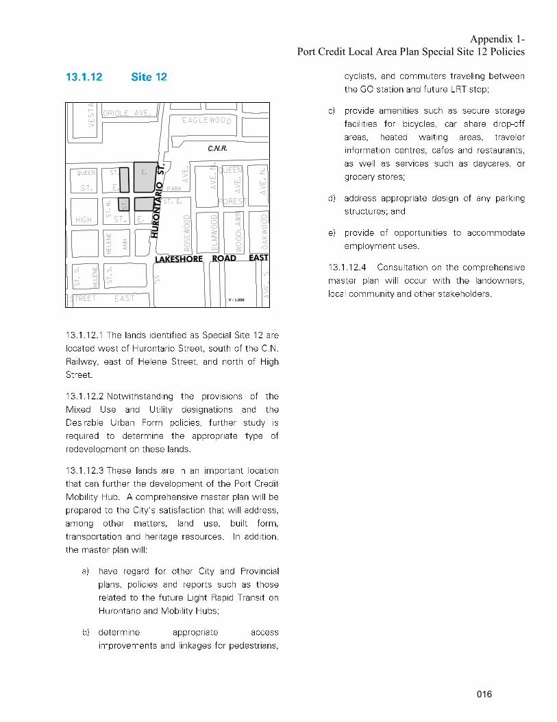
Appendix 1- Port Credit Local Area Plan Special Site 12 Policies
016

Appendix 2
COMPARISON OF CURRENT AND PROPOSED MISSISSAUGA OFFICIAL PLAN POLICIES FOR THE PORT CREDIT LOCAL AREA PLAN THAT IMPLEMENT THE
PORT CREDIT GO STATION SOUTHEAST AREA MASTER PLAN
Current Policy Proposed (Amended) Policy
Desirable Urban Form Policies:
10.2.2.3 To achieve the maximum heights, as
outlined on Schedule 2B, on the lands designated
Mixed Use or Utility in the vicinity of the GO station, a
detailed land use and urban design study will be
required to verify appropriate heights, design,
transition to adjacent lands and mix of uses.
10.2.2.3 The Port Credit GO Station Southeast Area
Master Plan will be used in the review of development
applications on lands designated Mixed Use or Utility
in the vicinity of the GO Station.
Special Site 12 Policies:
13.1.12 Site 12
13.1.12.1 The lands identified as Special Site 12 are
located west of Hurontario Street, south of the
C.N.Railway, east of Helene Street, and north of High
Street.
13.1.12.2 Notwithstanding the provisions of the Mixed
Use and Utility designations and the Desirable Urban
Form policies, further study is required to determine
the appropriate type of redevelopment on these lands.
13.1.12.3 These lands are in an important location that
can further the development of the Port Credit
Mobility Hub. A comprehensive master plan will be
prepared to the City’s satisfaction that will address,
among other matters, land use, built form,
transportation and heritage resources. In addition, the
master plan will:
a. have regard for other City and Provincial plans,
policies and reports such as those related to the future
Light Rapid Transit on Hurontario and Mobility Hubs;
b. determine appropriate access improvements and
linkages for pedestrians, cyclists, and commuters
traveling between the GO station and future LRT stop;
13.1.12 Site 12
13.1.12.1 The lands identified as Special Site 12 are
located west of Hurontario Street, south of the
C.N.Railway, east of Helene Street, and north of High
Street. These lands are in an important location that
has the potential to support further development of
the Port Credit Mobility Hub.
13.1.12.2 Notwithstanding the provisions of the Mixed
Use and Utility designations and the Desirable Urban
Form policies, the following provision shall apply, with
the Port Credit GO Station Southeast Area Master Plan
also to be used in the review of development
applications:
a) Minimum and maximum building heights are shown
in Schedule 2B and described below:
i) Maximum building heights of 22 storeys are
permitted throughout the special site area, with the
exception of lands fronting Hurontario Street, if the
tower component of a building is primarily residential.
Maximum building heights of 19 storeys are permitted
where the tower component is constructed primarily
for office or institutional purposes and is to have
greater floor to ceiling heights.
017

CURRENT AND PROPOSED PORT CREDIT LOCAL AREA PLAN POLICIES (Continued) Current Policy Proposed (Amended) Policy
c. provide amenities such as secure storage
facilities for bicycles, car share drop-off areas,
heated waiting areas, traveler information centres,
cafes and restaurants, as well as
services such as daycares, or grocery stores;
d. address appropriate design of any parking
structures; and
e. provide of opportunities to accommodate
employment uses.
13.1.12.4 Consultation on the comprehensive
master plan will occur with the landowners,
local community and other stakeholders.
ii) Residential and non-residential buildings fronting
Hurontario Street shall be no more than 8 storeys,
with a setback consistent with a 45 degree angular
plane generally required after 6 storeys.
The maximum permitted height of buildings fronting
Hurontario Street may be exceeded by one storey for
every storey of additional office use provided beyond
the recommended minimum requirement, up to a
maximum of two storeys. The ability to achieve up to
10 storeys along Hurontario Street will require a
proponent to provide further built form, design and
planning justification, to the satisfaction of the City.
iii) All buildings shall be a minimum of two storeys.
b) Variation in building heights and form, including the
position of towers relative to each other, should be
achieved.
c) A minimum of 30 metres shall be provided between
any portion of a building that is 8 storeys or higher to
another building that is 8 storeys or higher.
d) The maximum size of residential floor plates beyond
the 15th floor shall generally be 800 square metres or
less.
e) Long or full block buildings will be permitted but are
encouraged to provide internal mid-block connections
where possible and shall generally provide variation in the
facade to break up the massing (e.g. physical vertical
recesses, changes in materials or other forms of
articulation).
f) Above-grade structures must be contextually sensitive
and provide for visual interest and elements that
contribute to the streetscape, such as space for office,
retail/commercial or community uses, services for transit
users (e.g. ticketing, interactive information boards and
service kiosks), building entrances, community display
cases, public art, street furniture and landscape features.
Generally, a higher proportion of the building envelop that
faces a public street or gateway entry point should be
animated at street-level than not. The intent is to achieve
visual animation, interest and streetscape improvements
along each elevation of an above-grade parking structure,
with a target of generally providing animation at street
level along 2/3rds of a building envelope.
018

CURRENT AND PROPOSED PORT CREDIT LOCAL AREA PLAN POLICIES (Continued) Current Policy Proposed (Amended) Policy
g) All future developments over 1,000 sq. m. shall
provide an appropriate mix of non-residential,
employment-generating uses including office and
other uses such as retail stores, restaurants, personal
service establishments or community service space.
h) The following minimum gross floor area (GFA) of
employment-generating uses will be required as part
of future comprehensive block redevelopments:
Block 1: 2,800 sq. m.
Block 2: 1,400 sq. m.
Block 4: 250 sq. m.
i) Developments should be encouraged to provide
office space in larger, contiguous floorplates (at-grade
or above-grade) in order to accommodate a variety of
businesses and services.
j) Development applications shall demonstrate how
transit use, cycling, car and bike sharing, car pooling,
shared parking and other travel demand management
measures will be achieved.
k) Reduced, transit-supportive parking standards are
encouraged for future development within the Port
Credit GO Station Southeast Area. Through the
rezoning process, applicants are to provide a parking
study to justify the appropriateness of the specific
parking standards being proposed.
l) Development applications shall demonstrate how a
seamless integration of modes of travel and access is
achieved, especially at-grade and on the lower floors
of buildings.
Port Credit Community Node Height Limits – Schedule 2B
See Map A attached for existing height limits. See Map A for proposed changes, including: removing
cross-hatching indicating further study is required and
changing the height limit for a portion of Hurontario
Street from ‘‘2 to 3’’storeys and ‘‘2 to 6’’storeys to ‘‘2
to 8’’ storeys.
019

020

Date: January 12, 2016 To: Chair and Members of Planning and Development
Committee From: Edward R. Sajecki, Commissioner of Planning and
Building
Originator’s f iles: CD 06 AFF
Meeting date: 2016/02/01
Subject Affordable Housing Program: Strategic Framework and Work Plan
Recommendation 1. That the report titled, “Affordable Housing Program: Strategic Framework and Work Plan”,
from the Commissioner of Planning and Building, dated January 12, 2016 be received. 2. That $200,000 be allocated to the Planning and Building Department (PN#13962 Affordable
Housing Strategy) from the Planning Process Update Reserve 305160 for the purpose of completing the work for the Affordable Housing Program as outlined in the report titled , “Affordable Housing Program: Strategic Framework and Work Plan”, from the Commissioner of Planning and Building, dated January 12, 2016.
Report Highlights On November 25, 2015, Council Resolution 0270-2015 directed staff to examine
strategies to increase the supply of affordable housing. This report provides an outline of the work to be undertaken and a timeline to its completion.
The Affordable Housing Program will be delivered in stages, is anticipated to be completed in 2016 and includes: o Housing Advisory Panel and Technical Working Team o Second Units Licensing Review o Affordable Housing Demand/Supply Gap Analysis o Best Practices – Municipal Scan o Housing First for Public Land o Rental Housing Protection Policies o Cost Analysis of Incentives o Housing Program Action Plan
Additional funding to complete the Affordable Housing Program is requested for consulting
and implementation.
021

Background On November 25, 2015 Council passed Resolution 0270-2015 (Appendix 1) which directed staff to examine strategies to increase the supply of affordable housing. There are concerns that:
the City’s housing needs are not being met; there is very limited development of affordable housing; and, the City is in danger of losing some of its existing stock in areas such as the Hurontario
Corridor where large infrastructure investments are planned.
The objective of this report is to provide an outline of the work to be undertaken to develop an Affordable Housing Program. The work will build upon the City’s Housing Choices: Vision and Framework which Council endorsed in 2011. The work undertaken to date is as follows:
Summary of Housing Needs (2011) – Identified areas of need and set targets for affordable housing that was consistent with Peel Region’s work on housing targets.
Second Units Policy and Zoning By-law (2013) – A Second Unit Official Plan policy and Zoning By-law was adopted in 2013 and licensing began in January 2014. An update report was prepared in 2015.
Roof Overhead Roundtable (2015) – A consultation workshop was held with a range of stakeholders involved in the development of affordable housing including developers, non-profit groups, financial representatives and every level of government.
Comments Housing is part of a continuum with different stakeholders that play a variety of roles (Figure 1). At one end are emergency shelters that require funding from senior levels of government. At the other end, is ownership housing developed and delivered by the private market where pricing levels are determined by market forces. Housing is affordable if it costs less than 30% of household income for low and moderate income households.
Figure 1: The Housing Continuum
022
The proposed Affordable Housing Program will expand upon the work done to-date and focus on actions to narrow the gap between supply and demand. Affordable rental and ownership housing will be the focus of the Affordable Housing Program described within the body of this report. The Affordable Housing Program will create a supportive enabling policy environment for the development of affordable housing. This means that affordable housing is recognized not simply as the responsibility of governments, but that of numerous stakeholders, including property owners, developers, and non-profits. Innovative and bold strategies and implementation measures will be developed as part of the Affordable Housing Program. The limits of existing legislation will need to be pushed and tested. Advocacy for structural changes to existing legislation will be an essential goal if the City is to achieve impactful and meaningful results. Critical to this will be an exploration of new partnerships which support the City objectives regarding affordable housing, and a comprehensive understanding of the economics of land development which will influence the strategies Council ultimately decides to employ. The Affordable Housing Program will not only aim to increase the supply of affordable rental and ownership housing, but will look at ways of protecting the existing affordable housing stock, especially in areas experiencing redevelopment pressures, such as the Hurontario Street corridor. What May Council Expect as Deliverables?
The Affordable Housing Program will be delivered in phases to engage Council at key decision points. Given that the most effective public policy tends to be developed where there is freedom to be creative and to push the bar, a Housing Advisory Panel made up of industry experts will be established to explore innovation and new ideas. Additionally, ensuring these are grounded in sound operational framework, a Technical Working Team of staff comprised of expert policy writers, financial and taxation specialists, legislative experts, and implementation specialists will be established. The City will seek the latter through partnership with the Region who currently delivers a housing program and offers the needed experience and expertise. Some of the potential opportunities the Panel and staff team might explore include:
Provide Disposable Land to Affordable Housing Providers – Explore how publicly-owned lands may be disposed to affordable housing providers;
Zoning Regulations for Affordable Housing – Explore feasibility of creating new zoning regulations designed specifically for entry-level and affordable housing to be applied in new and existing neighbourhoods;
Permanent Affordable Housing – Investigate how to retain affordable ownership and rental housing stock;
023

‘Granny Flats’ - Investigate the feasibility of permitting the construction of ‘Granny Flats’ which are currently not permitted;
A description of each major component of work and expected deliverable is outlined in Table 1. The work program is aggressive and includes deliverables throughout the year with the full program established by the end of 2016.
Table 1:
Affordable Housing Program Work Plan
Item Timeline Description
Housing Advisory Panel Mar 2016
Establish an expert advisory panel to provide feedback and technical expertise on the housing program. Representatives from the non-profit sector, private development sector, senior levels of government and financial institutions will be included.
Technical Working Team
Feb 2016
Establish staff working team to provide support, advice and move the program forward. It will include representatives from Planning and Building, Finance, Legal Services and other key staff.
Second Units Licensing Review
Mar 2016 Removal of the existing administrative processes deemed to be a barrier to the development of new second units.
Affordable Housing Supply/Gap Analysis
Apr 2016
Undertake an order-of-magnitude analysis of the shortfall between the supply and demand for affordable housing including estimates of affordable ownership and rental housing in the City.
Best Practices – Municipal Scan Apr 2016
Identify existing and potential policy tools and strategies to connect the right policy interventions and incentives with the needs and objectives of this program including Provincial and Regional policies and tools. Review of best practices in other Canadian cities and beyond such as Vancouver, Montreal, Ottawa, Winnipeg, Medicine Hat, Edmonton, Toronto and London, U.K.
Housing First for Public Land
May 2016 Develop policies where affordable housing is a priority for all public lands that are being disposed.
Rental Housing Protection Policies
Jun 2016 Strengthen policies and develop by-laws to protect existing rental housing.
024

Table 1:
Affordable Housing Program Work Plan
Item Timeline Description
Cost Analysis of Incentives
Sep/Oct 2016
Costs for the different policy interventions and incentives will be calculated. Potential policy interventions and incentives could include the establishment of a Community Improvement Area, expediting development applications or waiving development charges.
Housing Program Action Plan
Nov/Dec 2016
An action plan outlining short, medium and long term actions to meet the City’s affordable housing goals.
Strategic Plan The need for affordable housing originated from the Strategic Plan Belong Pillar. Two strategic goals relate to affordable housing – Ensure Affordability and Accessibility and Support Aging in Place. Three strategic actions link to the work underway for the affordable housing strategy:
Action 1 – Attract and keep people in Mississauga through an affordable housing strategy.
Action 6 – Expand inclusionary zoning to permit more housing types and social services. Action 7 – Legalize accessory units.
Financial Impact Capital Budget #13962 currently with a net balance of about $100,000 will continue to be used to fund work related to the Affordable Housing Program and additional funding of $200,000 from the Planning Process Update Reserve 305160 is requested for consulting and program implementation.
Conclusion The proposed Affordable Housing Program expands upon the work done to-date. It aims to increase the supply of affordable rental and affordable ownership housing and to protect existing housing stock in areas experiencing redevelopment pressures such as the Hurontario Street corridor. To be successful Mississauga’s Affordable Housing Program must be a priority for all City Departments. The Affordable Housing Program will be completed in 2016 and will create a supportive environment for affordable housing in the city.
Attachments Appendix 1: Council Resolution 0270-2015
025

Edward R. Sajecki, Commissioner of Planning and Building Prepared by: Emily Irvine, Planner
026

027

028

Date: January 12, 2016 To: Chair and Members of Planning and Development
Committee From: Edward R. Sajecki, Commissioner of Planning and
Building
Originator’s file: CD.21.SIT
Meeting date: 2016/02/01
Subject RECOMMENDATION REPORT (CITY WIDE) Proposed Updates to Site Plan Control By-law 0293-2006
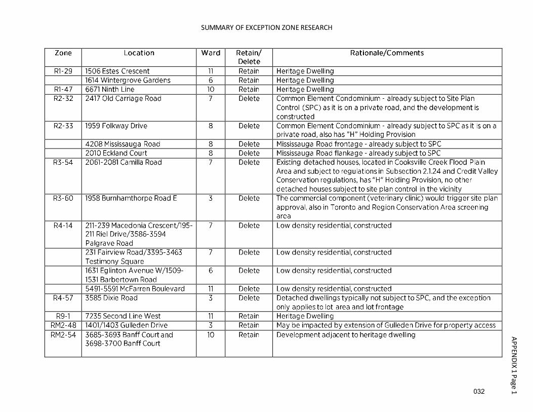
Recommendation That the Report dated January 12, 2016 from the Commissioner of Planning and Building titled "Proposed Updates to Site Plan Control By-law 0293-2006" be adopted, and that Site Plan Control By-law 0293-2006, as amended, be further amended in accordance with the draft By-law attached as Appendix 2 to this report. Background In June 2006, the City of Mississauga's Site Plan Control By-law was consolidated and updated. This By-law is further updated as necessary, based on periodic reviews by the Planning and Building Department, land severances and Council adopted recommendations with respect to development applications or land use studies. The purpose of this report is to identify required updates to the Site Plan Control By-law and to provide a rationale for each of the proposed updates. In addition, a draft By-law Amendment has been prepared and is attached as Appendix 2. Comments A number of amendments to the Site Plan Control By-law are proposed. In order of the sections of the By-law, they are as follows: Section 5 (a) Section 5 (a) of the Site Plan Control By-law states that all development or redevelopment on lands with certain Exception Zones be subject to site plan control. Each of these zones has been reviewed, and the chart in Appendix 1 summarizes the research and identifies which of the zones should be retained or deleted from this Section. No change is recommended for properties zoned "R1-29", "R1-47", "R9-1", "RM2-48", "RM2-54", "D-6" and "D-7".
029

Planning and Development Committee
2016/01/12 2
It is recommended that Exception Zones "R2-32", "R2-33", "R3-54", "R3-60", "R4-14", "R4-57", "U-4", "C5-19" and "O-9" be deleted from Section 5 (a). In addition to the above changes, two new Exception Zones are proposed to be added to the Site Plan Control By-law: The property identified as Special Site 1 in the Creditview Neighbourhood Character Area Special Site Policies is 4265 Perivale Road, and is known as the Crozier House. Section 16.7.3.1.2 b) of this policy states "new development will be subject to site plan approval to ensure compatibility with the heritage structure and the preservation of mature trees and other significant natural areas." It is zoned "R3-14". It is recommended that "R3-14" be added to Section 5 (a) for the property at 4265 Perivale Road. The property at 388 Hazelhurst Avenue was the subject of a rezoning application under file OZ 15/004 W2 and a land severance under file 'B' 15/005. The exception zone for the new parcel is "E3-15". Severing the original property into two parcels removed the second (new) parcel from site plan control. This is because the new parcel no longer has frontage on Lakeshore Road West, and it no longer abuts lands with a Greenbelt zone. One of the conditions of approval was that the severed parcel be placed back under site plan control regulations. It is recommended that "E3-15" be added to Section 5 (a) for the property at 388 Hazelhurst Avenue. To simplify the amending by-law, it is therefore recommended that item (a) of Subsection 5 be deleted and replaced as follows: (a) All development and redevelopment on lands zoned "R1-29", "R1-47", "R3-14", "R9-1",
"RM2-48", "RM2-54", "E3-15", "D-6", "D-7"; Schedule 2 The development of the former Madill Farm at the northwest quadrant of Hurontario Street and Highway 401 has resulted in the construction of a new service road, Madill Boulevard, that parallels the highway. The addition of this road removes the adjacent lands from directly abutting Highway 401, and therefore they are not subject to site plan control. However, the lands are still visible from Highway 401, and retain the locational attributes for Employment zones that should make them subject to site plan control. It is therefore recommended that Schedule 2 of the Site Plan Control By-law be amended to add Madill Boulevard and the extension of Kateson Road to Madill Boulevard. Schedule 10 This Schedule identifies properties with single detached homes which flank Confederation Parkway as subject to site plan control. It was common practice for houses with an exterior side yard abutting a major roadway to be subject to site plan control as part of a subdivision agreement. The properties identifed on this Schedule have all been constructed, and there is little value to the homeowner, or the Corporation, to subject them to the provisions of site plan
030

Planning and Development Committee
2016/01/12 3
control in the future. None of the other houses in these subdivisions are subject to site plan control. It is therefore recommended that Schedule 10 of the Site Plan Control By-law be deleted. Schedule 11 This Schedule identifies the property at 1 Wesley Crescent. This property was added to the Site Plan Control By-law as a condition of approval for a consent application under File 'B' 1/08. The consent certificate was never issued, and no severance was approved. This site contains a single detached home, and no other detached homes in this area are subject to site plan control. It is therefore recommended that Schedule 11 of the Site Plan Control By-law be deleted. Minor changes are required in the second preamble to update references from Mississauga Plan to Mississauga Official Plan. It is recommended that the second preamble be amended to read: "AND WHEREAS section 19.14.1 of the Official Plan for the City of Mississauga (Mississauga Official Plan) designates all lands in the City of Mississauga as a Site Plan Control Area;" Community Issues No community or public meetings are required to be held under the provisions of the Planning Act. Financial Impact Not applicable. Conclusion It is recommended that these changes be made to the Site Plan Control By-law to reflect a recent land severance, construction of new roads, protection of a heritage property and a review of Exception Zones to delete those that are no longer applicable. This ensures that areas of the City that are appropriate for the site plan review are identified as such, and where unnecessary, properties are removed. Attachments Appendix 1: Summary of Exception Zone Research Appendix 2: Draft By-law to Amend the Site Plan Control By-law Edward R. Sajecki Commissioner of Planning and Building Prepared by: Lisa Christie, Zoning By-law Planner
031
SUMMARY OF EXCEPTION ZONE RESEARCH
AP
PE
ND
IX 1
Pa
ge
1
032

APPENDIX 1 Page 2
033

034
DR
AFT
APPENDIX 2 Page 2
035

Date: January 12, 2016 To: Chair and Members of Planning and Development
Committee From: Edward R. Sajecki, Commissioner of Planning and
Building
Originator’s file: H-OZ 13/007 W2
Meeting date: 2016/02/01
Subject SECTION 37 COMMUNITY BENEFITS REPORT (WARD 2)
1571, 1575 and 1601 Lakeshore Road West, north side of Lakeshore Road West, east of
Clarkson Road North
Owner: 2286974 Ontario Inc.
Recommendation That the Report dated January 12, 2016 from the Commissioner of Planning and Building outlining the recommended Section 37 Community Benefits under file H-OZ 13/007 W2, 2286974 Ontario Inc., 1571, 1575 and 1601 Lakeshore Road West, north side of Lakeshore Road West, east of Clarkson Road North, be adopted and that a Section 37 agreement be executed in accordance with the following: 1. That the design and installation of the eastern Clarkson Village entry feature to be located
within the municipal right-of-way on the north side of Lakeshore Road West, east of Clarkson Road North, be approved as Section 37 Community Benefits contribution and that the owner enter into a Section 37 agreement with the City of Mississauga.
2. That City Council enact a by-law under Section 37 of the Planning Act to authorize the
Commissioner of Planning and Building and the City Clerk to execute the Section 37 agreement with 2286974 Ontario Inc., and that the agreement be registered on title to the lands in a manner satisfactory to the City Solicitor, to secure the Community Benefits.
Report Highlights
This City is seeking a Community Benefits contribution under Section 37 of the Planning
Act, in conjunction with the proponent’s Official Plan Amendment and Rezoning
036

Planning and Development Committee
2016/01/12 2
Originator's f ile: H-OZ 13/007 W2
applications; The proposal has been evaluated against the criteria contained in the Corporate Policy
and Procedure on Bonus Zoning; The Community Benefits contribution will be the design and installation of the eastern
Clarkson Village entry feature within the municipal right-of-way on Lakeshore Road West, east of Clarkson Road North;
The request can be supported subject to the execution of a Section 37 agreement and submission of securities in the amount of the value of the entry feature and its installation.
Background On February 24, 2014, a Supplementary Report was presented to Planning and Development Committee (PDC) recommending approval of Official Plan Amendment and Rezoning applications on the subjects lands under file OZ 12/010 W2, by 2286974 Ontario Inc.(Vandyk Development Group), to permit a 324 unit, 4 – 6 storey condominium apartment building with limited retail on the ground floor and a 3 storey office and commercial building, subject to a Holding Zone being placed on the property. The Holding Zone provision requires that the applicant complete works associated with the Turtle Creek culvert among other technical matters and execution of a Section 37 – Public Benefits agreement to the satisfaction of the City. PDC passed Recommendation PDC-0014-2014, which was adopted by Council on March 5, 2014. As part of the recommendation, staff was directed to hold discussions with the applicant to secure Community Benefits in accordance with Section 37 of the Planning Act and the Corporate Policy and Procedure on Bonus Zoning, and to return to Council with a Section 37 report outlining the recommended Community Benefits. Following Council adoption of the recommendation, the applicant requested a reduction in the maximum number of allowable units from 324 to 300. This reduced unit count was included in the site specific H-RA2-46 (Apartment Dwellings) zone. The purpose of this report is to provide comments and a recommendation with respect to the proposed Section 37 Community Benefits.
Comments Appendix 1 is an aerial photograph showing the subject lands and Appendix 2 is a conceptual rendering of the Clarkson Village entry feature. Section 37 Community Benefits Proposal
Council adopted Corporate Policy and Procedure 07-03-01 – Bonus Zoning on September 26, 2012. In accordance with Section 37 of the Planning Act and policies contained in Mississauga
037

Planning and Development Committee
2016/01/12 3
Originator's f ile: H-OZ 13/007 W2
Official Plan, this policy enables the City to secure community benefits when increases in permitted development are deemed good planning by Council through the approval of a development application. The receipt of the Community Benefits discussed in this report conforms to Mississauga Official Plan and the Corporate Policy and Procedure on Bonus Zoning. “Community Benefits” is defined in the Corporate Policy and Procedure as meaning facilities or cash secured by the City and provided by an owner/developer for specific public capital facilities, services or matters. Section 19.8.2 of Mississauga Official Plan provides examples of potential Community Benefits, such as the provision of public art, the provision of multi-modal transportation facilities or the provision of streetscape improvements. Following Council’s approval in principle of the subject applications, Planning staff met with Ward 2 Councillor, Karen Ras to discuss the possible community benefits relating to the proposal. The need for a new gateway entry feature at the east end of Clarkson Village along Lakeshore Road West was acknowledged as being long desired by the community. An entry feature was also contemplated through a previous development application by a different owner of the site before Corporate Policies regarding Bonus Zoning came into effect. Written confirmation has been provided by the owner confirming that they will build and install the entry feature as the community benefit. A cost estimate has been provided valuing the different components of the design and installation of the entry feature at a total of approximately $150,000. Staff have reviewed the cost estimate and found it to be accurate. Guiding Implementation Principles
The Section 37 Community Benefits proposal has been evaluated against the following guiding implementation principles contained in the Corporate Policy and Procedure on Bonus Zoning.
1. Development must represent good planning
A fundamental requirement of the use of Section 37 is that the application being considered must first and foremost be considered “good planning” regardless of the Community Benefit contribution. The Supplementary Report dated February 4, 2014 presented to PDC on February 24, 2014, evaluated the proposed Official Plan Amendment and Rezoning and recommended that the applications be approved as they are acceptable from a planning standpoint and represents good planning.
2. A reasonable planning relationship between the secured Community Benefit and the
proposed increase in development is required
The proposed contribution of the design and installation of the eastern Clarkson Village entry feature is considered a “highest priority” Community Benefit, as it is a contribution in the immediate vicinity of the site. The entry feature would be located in front of the development within the municipal right-of-way. This location represents the ideal spot for
038

Planning and Development Committee
2016/01/12 4
Originator's f ile: H-OZ 13/007 W2
such a feature as the proposed apartment building would be the first prominent structure leading into the easterly side of the village. A sign currently exists in front of this site, however it is small and not easily identifiable when travelling westward on Lakeshore Road West. In order to determine a fair value of the Community Benefits, Realty Services retained an independent land appraisal to determine the increased value of the land resulting from the density increase. In this instance, the increased value of the land has been determined to be $315,000. According to the Corporate Policy and Procedure, a Community Benefit should be in the range of 20 to 40% of the increased value of the land. The applicant has agreed to carry on the obligation of the previous property owner to install an entry feature in front of the property even before their development application was submitted. The estimated value of the entry feature of $150,000 exceeds the prescribed 20% to 40% range for a Community Benefit.
3. Community Benefit contributions should respond to community needs
The need for a new gateway entry feature at the east end of Clarkson Village along Lakeshore Road West had been identified through the public engagement process for the Lakeshore Road West - Clarkson Village Study and included in the Phase 2 Analysis & Recommendations Report dated August 2010. Council adopted the Clarkson Village Study in July 2013. An entry feature had also been contemplated through a previous development application by a different owner of the site before Corporate Policies regarding Bonus Zoning came into effect. Through the current application, Ward 2 Councillor, Karen Ras concurs that a new entry feature would be a desired addition to the community. The Councillor has also vetted the entry feature through the Clarkson Village BIA Board of Directors who are supportive of the proposal.
4. Ensure that the negotiation process of Section 37 Agreements is transparent
The land appraisal report prepared by an independent land appraiser and entry feature cost estimates are available for viewing. The applicant has agreed to build and install the entry feature which will belong to the City and be located within the municipal right-of-way. Any cost overruns will be the responsibility of the applicant. Securities in the amount of the value of the entry feature will need to be submitted to the City prior to any approval being granted.
Section 37 Agreement
The Planning and Building Department and the owner have negotiated mutually agreed upon conditions for the Community Benefit which will be reflected in the related agreement. The agreement provisions will include the following: a Community Benefit contribution of the design and installation of the eastern Clarkson
Village entry feature;
039

Planning and Development Committee
2016/01/12 5
Originator's f ile: H-OZ 13/007 W2
the entry feature shall be located within the municipal right-of-way in front of the development and be in the value of approximately $150,000;
the agreement is to be registered on title to the lands in a manner satisfactory to the City Solicitor, to secure the said benefits.
Financial Impact Given that that the design and installation of the eastern Clarkson Village entry feature will fulfil the Section 37 Community Benefit obligation, no additional cash benefits are to be provided. Staff are to investigate the possibility of having the entry feature lighted and any cost associated with connecting the entry feature to the street lighting network.
Conclusion Staff have concluded that the proposed Section 37 Community Benefit is appropriate, based on the increased density being recommended through the Official Plan Amendment, Rezoning, and Holding Zone removal applications; and that the proposal adheres to the criteria contained in the Corporate Policy and Procedure on Bonus Zoning. Further, the contribution of the eastern Clarkson Village entry feature implements the Lakeshore Road West - Clarkson Village Study.
Attachments Appendix 1: Aerial Photograph Appendix 2: Conceptual Rendering of Eastern Clarkson Village Entry Feature Edward R. Sajecki Commissioner of Planning and Building Prepared by: David Breveglieri, Development Planner
040

N
LEGEND:
SUBJECT:
FILE NO:
DWG. NO:
DRAWN BY:
12010A
SCALE:
1:3000
N
PDC DATE:
OZ 12/010 W2
LAKESHORE ROAD WEST
PETRIE WAY
TURTLE CREEK
JO
HN
SO
N'S LA
NE
ME
AD
OW
WO
OD
RO
AD
STEVELES CRES
CO
UR
TH
ALS
HA
M
DA
VEC
AT
H
RD
PENGILLEY PL.
ROAD WESTLAKESHORE
C.N.R.
RO
AD
SO
UT
HD
OW
N
RO
AD
QUEEN ELIZABETH WAY
RIV
ER
CREDIT
MISSISSAUGA
L A K E O N TA R I O
i:\cadd\projects\reportmaps\ 123195
SUBJECT LANDS
2016 02 01
2286974 ONTARIO INC.
APPEN
DIX 1
A. SHAH
THIS IS NOT A PLAN OF SURVEY.
DATE OF AERIAL PHOTO : SPRING 2015
T&W, Geomatics
Produced by041

APPENDIX 2
042