planning commission staff report … · synopsis: the applicant ... than the proposed project will...
TRANSCRIPT

PLANNING COMMISSION STAFF REPORT MEETING DATE: 5 June 2014 APPLICANT: Thackeray Garn Company REQUEST: Final Plat Approval for a Seven-Lot Minor Subdivision PROJECT NUMBER: S-14-002 ZONE: Master-Planned Mixed Use Zone PREPARED BY: Hayley Pratt, City Planner PARCEL ID: 1535200036; 0006; 0008; 0009; 1535300044 SYNOPSIS: The applicant, Thackeray Garn Company, is seeking final plat approval of a
seven-lot minor subdivision that is 55.23 acres in size and is located at approximately 3800
south, between 700 west and the Jordan River. The development site plan includes a mix of
housing types to the south (garden-style apartments, townhomes, and detached single
family) and commercial/industrial flex buildings to the north. These buildings are intended
primarily for light manufacturing, distribution, and small office businesses. Title 15 of the
South Salt Lake City Municipal Code identifies the Planning Commission is the land use
authority for minor subdivisions that are ten lots or less.
SUMMARY:
Utah Transit Authority (UTA) currently owns the subject property.
On 12 February 2014, the City Council approved the 900 West and public right of
way street vacation (Ordinance NO. 2014-02).
On 28 May 2014 the City Council gave final zoning and master plan approval for the
Riverfront Master Planned Mixed Use District.
Once a subdivision is proposed for Lot 1C, the Planning Commission will be
presented with the project proposal. The Planning Commission is the Land Use
Authority for the single family residential development that is to be located on Lot C.
The Planning Commission will be the Land Use Authority for any townhome
development that is to be constructed on Lot 4.
The proposal meets the minimum lot sizes and lot widths required by ordinance.
Staff believes that this development shows promise, and supports the addition of a
mixed use development.

STAFF ALTERNATIVES Approval of the 7-Lot Subdivision located at approximately 3800 South, between 700 West and the Jordan River, with the following conditions:
1. Once a subdivision is proposed for Lot 1C, the Planning Commission will be
presented with the project proposal. The Planning Commission is the Land Use
Authority for the single family residential development that is to be located on Lot C.
2. If Lot 4 is presented with a development consisting of townhomes rather than a
school, than the proposed project will go before the Planning Commission for
approval.
3. If a school is to be constructed on Lot 4, the applicant shall perform an additional
traffic study to ensure the safety and comfort of surrounding neighborhood residents
and students of the school.
4. The applicant will comply with all street and building Design Standards that were
approved as part of the re-zone process.
5. The applicant will continue to work with City staff to make all technical corrections
necessary for recoding.
6. The applicant will work with the City Engineer and Fire Marshal to ensure emergency
vehicles have sufficient access to the proposed residences.
7. Bonds for all common and public improvements will be submitted to the City prior to
any development.
8. All items of the staff report.
.
PLANNING COMMISSION STAFF REPORT General Information: Location: ~ 3610 S. 700-1000 West Surrounding Land Uses: North: Public/Quasi-Public Facilities (UTA Meadowbrook Office)
South: Very High Density Residential (30 plus units per acre) – Mission Meadowbrook Apartments East: Light Industrial and High Density Residential (16-29 units/acre) West: Very High Density Residential (30 + units/acre)
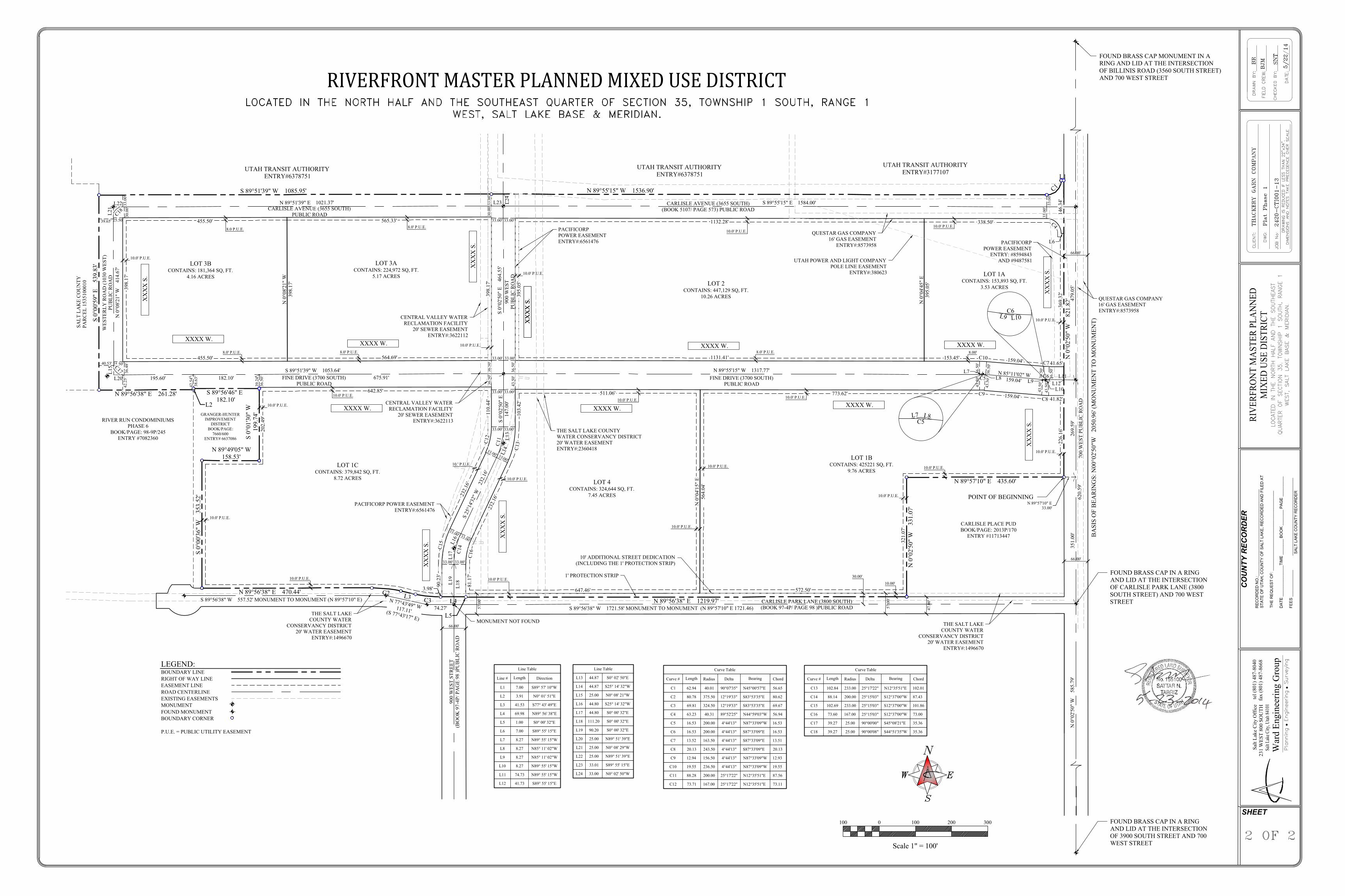
General Plan: The Future Land Use Map designates this neighborhood as Master Planned Mixed Use District. The City supports the addition of a mixed use neighborhood in this critical redevelopment area. This development will provide quality commercial and residential design that will attract a diversity of residents and employers. Size: The proposed subdivision will be approximately 55.23 acres. Lot 1A will be 3.53 acres in size; Lot 1B will be 9.76 acres in size; Lot 1C will be 8.72 Acres in size; Lot 2 will be 10.26 acres in size; Lot 3A will be 5.17 acres in size; Lot 3B will be 4.16 Acres in size; Lot 4 will be 7.45 acres in size. Access: Fine Drive will be constructed to run east, west along the development, from 700 west to the Jordan River. 900 West will continue south through the development and will intersect with Fine Drive, and Carlisle Park Lane. Collector vehicular roads are to be 900 west, and Fine Drive. Truck traffic due to the flex office uses will travel along Carlisle Avenue (3655 south), and will also circulate within the flex office subdivision. Local roads that are to be used by the residents will be connecting into Carlisle Park Lane, 900 west, and Fine Drive. In addition to automobile access, shared bike lanes and pedestrian paths are to be included within the development to promote alternative transportation modes. Shared bike lanes going both directions will be located along Fine Drive. A pedestrian trail/ sidewalk will be located along Fine Drive which connects to the Jordan River Parkway Trail which is an existing trail. This trail connection is found on the western side of the property and will improve county connectivity and trail accessibility. A traffic study has been performed for this development, however if on Lot 4 a school is to be constructed rather than townhomes an additional traffic study will be required to ensure the safety and comfort of surrounding neighborhood residents and students of the school. Staff finds that the accessibility of this development will improve automobile, pedestrian, and bicyclist connectivity for this area of the city so long as an additional traffic study is performed if a school is to be constructed on Lot 4.

Requirements: Article V. - Minor Development Special Requirements 15.12.510 - Limitations.
A. Minor developments shall be limited to owner occupied residential development and to commercial/industrial developments with individual lots which meet the minimum requirements of the respective zone and which are developable and capable of being built upon including consideration for the required parking, landscaping and other facilities required in the respective zone and by the use anticipated, and wherein all lots front on public streets which are or will be built according to city development specifications.
B. The lot or building site and street layout for the proposed development must not
preclude street access to land which the planning commission determines might be developed at a later date.
C. The development must not be part of a parcel from which a minor development was created less than three years earlier.
D. Minor development must contain less than ten lots.
(Ord. 2005-02, Attach. A (part)) 15.12.520 - Requirements.
A. Except as noted herein, minor developments must meet all applicable ordinance and specification requirements. Development approved variations from city ordinances or specifications may only be accomplished by approval as a PUD or other specific development type.
B. The development plan must be in compliance with all city ordinances,
specifications or regulations, or a variance must be granted from such requirements by the administrative law judge. The planning commission may approve a minor development subject to obtaining a specific variance from the administrative law judge. If such specific variance is not obtained, the approval is null and void.
C. The planning commission may require as part of the approval of the minor
development any improvements and/or public facility and/or utility or access easements that are required of other developments, as set forth in this chapter. Such easements or dedications must be recorded prior to the issuance of any permits for the development and before any improvements are commenced.
D. The development must still comply with all other relevant portions of this title
including bonding requirements.
15.12.640 - Lots and building sites.
A. All developments should result in the creation of lots or building sites which are developable and capable of being built upon. A development should not create lots or building sites which would make improvement impractical due to size, shape, steepness of terrain, location of watercourses, problems of sewerage, driveway grades, or other physical conditions.
B. All lots or parcels created by a development shall have frontage on a public or private street, improved to standards hereinafter required, equal to at least the street's minimum required width. Land designated as public or private street right-of-way shall be separate and distinct from lots adjoining such street right-of-way and not be included in the area of such lots.
C. For purposes of all new improvements, all lots shall be considered to have yard areas which shall meet the requirements of the respective zones and such yard area designations shall be made by the community development department for all lots in the city at the time of any requested improvement of said lot.

Staff Analysis: The proposed plat meets the City’s minimum subdivision and flag lot standards. Staff recommends approval of the proposed subdivision.
STAFF ALTERNATIVES Approval of the 7-Lot Subdivision located at approximately 3800 South, between 700 West and the Jordan River, with the following conditions:
1. Once a subdivision is proposed for Lot 1C, the Planning Commission will be presented with the project proposal. The Planning Commission is the Land Use Authority for the single family residential development that is to be located on Lot C.
2. If Lot 4 is presented with a development consisting of townhomes rather than a
school, than the proposed project will go before the Planning Commission for approval.
3. If a school is to be constructed on Lot 4, the applicant shall perform an additional
traffic study to ensure the safety and comfort of surrounding neighborhood residents and students of the school.
4. The applicant will comply with all street and building Design Standards that were
approved as part of the re-zone process. 5. The applicant will continue to work with City staff to make all technical corrections
necessary for recoding. 6. The applicant will work with the City Engineer and Fire Marshal to ensure emergency
vehicles have sufficient access to the proposed residences. 7. Bonds for all common and public improvements will be submitted to the City prior to
any development.
8. All items of the staff report
Attachments: 1. Proposed Subdivision Plat 2. Illustrative Plan View: Alternative School Location 3. Illustrative Plan View: Alternate Multifamily Layout

THE SURVEY WAS PERFORMED IN ACCORDANCE WITH GENERALLY ACCEPTED SURVEYING
PRACTICES, AND WAS MARKED ON THE GROUND AS SHOWN ON THIS PLAT.
SURVEYOR'S CERTIFICATE
OWNERS ACKNOWLEDGEMENT
RIVERFRONT MASTER PLANNED MIXED USE DISTRICT
I, SATTAR N. TABRIZ, DO HEREBY CERTIFY THAT I AM A PROFESSIONAL LAND SURVEYOR
LICENSED TO PRACTICE IN THE STATE OF UTAH, AND THAT I HAVE MADE A SURVEY OF THE
PARCEL OF LAND SHOWN AND DESCRIBED ON THIS MAP. I ALSO CERTIFY THAT BY AUTHORITY OF
THE OWNERS I HAVE SUBDIVIDED SAID PARCEL INTO LOTS, AND STREETS, TO BE HEREAFTER
KNOWN AS:
SHEETCOMMUNITY DEVELOPMENT DEPARTMENT APPROVAL AS TO FORM FIRE MARSHAL MOUNT OLYMPUS
QUESTAR ROCKY MOUNTAIN POWER
3900 SOUTH STREET
JORD
AN
RIV
ER
500
WES
T ST
700
WES
T
900
WES
T
MEADOW BROOK EXPY
BILLIS RD
3300 SOUTH ST
CARLISLE AVE
CARLISLE PARK LN
1000
WES
TUTAH TRANSIT AUTHORITY
A PUBLIC TRANSIT DISTRICT OF THE STATE OF UTAH
BY: ______________________________ BY: __________________________________
NAME:____________________________ NAME:_______________________________
TITLE:____________________________ TITLE:________________________________
STATE OF UTAH
S.S.
COUNTY OF SALT LAKE
ON THIS _____ DAY OF ____________, 2014, PERSONALLY APPEARED BEFORE ME
_____________________________________ AND _______________________________________, WHO
_________________________________, RESPECTIVELY, OF THE UTAH TRANSIT AUTHORITY, A
PUBLIC TRANSIT DISTRICT OF THE STATE OF UTAH, AND THAT THE FORGOING INSTRUMENT WAS
SIGNED IN BEHALF OF SAID UTAH TRANSIT AUTHORITY BY AUTHORITY, AND THEY ACKNOWLEDGE
TO ME THAT SAID UTAH TRANSIT AUTHORITY EXECUTED THE SAME.
MY COMMISSION EXPIRES: __________________________________________
NOTARY PUBLIC ________________________________________________
RESIDING IN ______________________________________________________
CONSENT TO DEDICATE AND SUBORDINATION AGREEMENT
KNOW ALL MEN BY THESE PRESENT, THAT ROCKY MOUNTAIN POWER, THE UNDERSIGNED OWNER
OF PERPETUAL EASEMENTS FOR ELECTRICAL TRANSMISSION AND DISTRIBUTION FACILITIES,
WHICH EASEMENTS TRAVERSE THE PROPERTY HEREIN SUBDIVIDED, HEREBY DEDICATES AND
SUBORDINATES ITS EASEMENTS TO ROADS, RIGHT-OF-WAY OR OTHER PUBLIC USES DESCRIBED
IN THE SUBDIVISION PLAT, PROVIDED THAT IF IT BECOMES NECESSARY TO RELOCATE THE
ELECTRIC FACILITIES PRESENTLY IN PLACE OR UPON SAID EASEMENTS AT THE INSTANCE OR
REQUEST OF ANY PUBLIC ENTITY, THE COST AND EXPENSES INCURRED THEREBY WILL BE BORNE
BY THE ENTITY REQUIRING OR REQUESTING THE SAME. IT IS SPECIFICALLY UNDERSTOOD AND
AGREED THAT ROCKY MOUNTAIN POWER WILL COMPLY WITH REASONABLE REQUIREMENTS OF
THE CITY REGARDING CUTTING, TRENCHING AND OTHER WORK TO BE PERFORMED WITHIN THE
PUBLIC STREETS AND DOES NOT SUBORDINATE ITS INTERESTS IN SAID EASEMENTS TO THE
SUB-DIVIDER OR TO PURCHASERS OF LOTS FROM THE SUB-DIVIDER OR TO ANY OTHER PERSONS
OR ENTITY.
IN WITNESS WHEREOF, ROCKY MOUNTAIN POWER HAS CAUSED ITS NAME TO BE HEREUNTO
AFFIXED BY ITS DULY AUTHORIZED OFFICER THIS _________ DAY OF
__________________, 2010.
ROCK MOUNTAIN POWER, A D/B/A OF PACIFICORP, AN OREGON CORPORATION
BY:______________________________
ITS:______________________________
STATE OF UTAH
COUNTY OF SALT LAKE
ON THIS ________ DAY OF _______________, 2010 PERSONALLY APPEARED BEFORE ME
__________________________, WHO BEING DULY SWORN DID SAY THAT HE/SHE IS THE SIGNER OF
THE WITHIN INSTRUMENT ON BEHALF OF ROCKY MOUNTAIN POWER, A D/B/A OF PACIFICORP, AN
OREGON CORPORATION, AND THAT THE WITHIN AND FORGOING AGREEMENT WAS SIGNED ON
BEHALF OF ROCKY MOUNTAIN POWER BY ACTUAL AUTHORITY.
P
R
O
J
E
C
T
UTAH TRANSIT AUTHORITYENTRY#3177107
CARLISLE PLACE PUDBOOK/PAGE: 2013P/170
ENTRY #11713447
GRANGER-HUNTERIMPROVEMENT
DISTRICTBOOK/PAGE:
7660/600ENTRY# 6637086
RIVER RUN CONDOMINIUMSPHASE 6
BOOK/PAGE: 98-9P/245ENTRY #7082360
LOT 2CONTAINS: 447,129 SQ, FT.
10.26 ACRES
1' PROTECTION STRIP
10' ADDITIONAL STREET DEDICATION(INCLUDING THE 1' PROTECTION STRIP)
30.0
0'33
.00'
33.00' 33.00'
30.0
0'33
.00'
25.50'39.65'
25.50'
36.4
8'40.53'
42.2
5'
38.6
3'
36.5
0'
33.00'33.00'
36.5
0'36
.50'
43.5
0'36
.50'
33.00'33.00'
33.00' 33.00'
33.00'
33.00'
33.00'
33.00'
33.00'33.00'
36.5
0'
36.5
0'
36.5
0'
36.5
0'43
.50'
43.5
0'
43.5
0'43
.50'
33.0
0'33
.00'
LOT 1ACONTAINS: 153,893 SQ, FT.
3.53 ACRES
LOT 3ACONTAINS: 224,972 SQ, FT.
5.17 ACRES
LOT 1CCONTAINS: 379,842 SQ, FT.
8.72 ACRESLOT 4
CONTAINS: 324,644 SQ, FT.7.45 ACRES
LOT 1BCONTAINS: 425221 SQ, FT.
9.76 ACRES
LEGEND:BOUNDARY LINERIGHT OF WAY LINEEASEMENT LINEROAD CENTERLINEEXISTING EASEMENTSMONUMENTFOUND MONUMENTBOUNDARY CORNER
P.U.E. = PUBLIC UTILITY EASEMENT
THE SALT LAKE COUNTYWATER CONSERVANCY DISTRICT20' WATER EASEMENTENTRY#:2360418
CENTRAL VALLEY WATERRECLAMATION FACILITY
20' SEWER EASEMENTENTRY#:3622113
PACIFICORP POWER EASEMENTENTRY#:6561476
CENTRAL VALLEY WATERRECLAMATION FACILITY
20' SEWER EASEMENTENTRY#:3622112
PACIFICORPPOWER EASEMENTENTRY#:6561476
UTAH POWER AND LIGHT COMPANYPOLE LINE EASEMENT
ENTRY#:380623
PACIFICORPPOWER EASEMENT
ENTRY: #8594843AND #9487581
QUESTAR GAS COMPANY16' GAS EASEMENT
ENTRY#:8573958
THE SALT LAKECOUNTY WATER
CONSERVANCY DISTRICT20' WATER EASEMENT
ENTRY#:1496670
QUESTAR GAS COMPANY16' GAS EASEMENTENTRY#:8573958
39.2
4'
42.5
4' FINE DRIVE (3700 SOUTH)PUBLIC ROAD
FINE DRIVE (3700 SOUTH)PUBLIC ROAD
900
WES
TPU
BLI
C R
OA
D
CARLISLE AVENUE (3655 SOUTH)(BOOK 5107/ PAGE 573) PUBLIC ROAD
WES
TER
LY R
OA
D (1
030
WES
T)PU
BLI
C R
OA
D
CARLISLE AVENUE (3655 SOUTH)PUBLIC ROAD
N 0°04'15" E
564.
04'
N 0°04'45" E
395.
05'
773.62'511.06'642.85'
232.
16'23
2.16
'
395.
05'
398.
17'
1132.28'
321.
07'
572.50'
369.
32'
226.
16'
647.46'
81.1
7'
90.2
3'
S 89°51'39" W 1053.64'675.91'182.10'195.60'
N 89°55'15" W 1317.77'
S 0°02'50" E 464.55'
S 0°02'50" E
147.
00'
S 25°14'32" W 232.16'
159.04'
110.
44'
103.
42'
N 89°51'39" E 1021.37' S 89°55'15" E 1584.00'
N 85°11'02" W159.04'
338.50'
CARLISLE PARK LANE (3800 SOUTH)(BOOK 97-4P/ PAGE 98 )PUBLIC ROAD
LOT 3BCONTAINS: 181,364 SQ, FT.
4.16 ACRES
700
WES
T PU
BLI
C R
OA
D
N 0°02'50" W 331.07'
N 89°57'10" E 435.60'
N 89°56'38" E 470.44'
S 0°00'36" W
353.52'
N 89°49'05" W158.53'
S 0°01'30" W
199.
74'
S 89°56'46" E 182.10'
N 89°56'38" E 261.28'
S 0°00'59" E 539.83'
S 89°51'39" W 1085.95' N 89°55'15" W 1536.90'
900
WES
T ST
REE
T(B
OO
K 9
7-4P
/ PA
GE
98 )P
UB
LIC
RO
AD
N 0°02'50" W 821.82'
L1
C1
L2
C2 L3 C3 L4
L5
N 89°56'38" E 1219.97'
10.0' P.U.E.
C4
L6
L7L8C5 L9
L10
C6
C8 41.82'
L11L12
C9
L13
L14
C11
C12
C13
L16
L17 C1
4L1
8L19
L20
L15 C17
C18L21
L22 L23 L24
N 0°08'21" W
398.
17'
41.65'C7C10 159.04'153.45'1131.41'
565.33'455.50'
564.69'455.50'
10.0' P.U.E.
10.0' P.U.E.
10.0' P.U.E. 10.0' P.U.E.
10.0' P.U.E.
10.0' P.U.E.
10.0' P.U.E.
10.0' P.U.E.
10.0' P.U.E.10.0' P.U.E.
10.0' P.U.E.
10.0' P.U.E.
8.0' P.U.E.8.0 P.U.E.
10.0' P.U.E.
8.0' P.U.E. 8.0' P.U.E.
10.0' P.U.E.
10.0' P.U.E.
10.0' P.U.E.
10.0' P.U.E.
10.' P.U.E.
10.0' P.U.E.
8.0' P.U.E. 8.00'
N 0°08'21" W 414.67'
C15
THE SALT LAKECOUNTY WATER
CONSERVANCY DISTRICT20' WATER EASEMENT
ENTRY#:1496670
Line Table
Line #
L1
L2
L3
L4
L5
L6
L7
L8
L9
L10
L11
L12
Length
7.00
3.91
41.53
69.98
1.00
7.00
8.27
8.27
8.27
8.27
74.73
41.73
Direction
S89° 57' 10"W
N0° 01' 51"E
S77° 43' 49"E
N89° 56' 38"E
S0° 00' 32"E
S89° 55' 15"E
N89° 55' 15"W
N85° 11' 02"W
N85° 11' 02"W
N89° 55' 15"W
N89° 55' 15"W
S89° 55' 15"E
Line Table
L13
L14
L15
L16
L17
L18
L19
L20
L21
L22
L23
L24
44.87
44.87
25.00
44.80
44.80
111.20
90.20
25.00
25.00
25.00
33.01
33.00
S0° 02' 50"E
S25° 14' 32"W
N0° 08' 21"W
S25° 14' 32"W
S0° 00' 32"E
S0° 00' 32"E
S0° 00' 32"E
N89° 51' 39"E
N0° 08' 29"W
N89° 51' 39"E
S89° 55' 15"E
N0° 02' 50"W
UTAH TRANSIT AUTHORITYENTRY#6378751
UTAH TRANSIT AUTHORITYENTRY#6378751
146.
34'
S 89°56'38" W 1721.58' MONUMENT TO MONUMENT (N 89°57'10" E 1721.46)
MONUMENT NOT FOUND
N 77°43'49" W117.11'(S 77°43'17" E)
S 89°56'38" W 557.52' MONUMENT TO MONUMENT (N 89°57'10" E)
66.00'
66.00'
47.0
0'
XXXX W.
XXXX W.XXXX W.
XXXX W.XXXX W.
XXXX W.XXXX W.
XX
XX
S.
XX
XX
S.
XX
XX
S.
XX
XX
S.
XX
XX
S.
XX
XX
S.
XX
XX
S.
XX
XX
S.
57.0
0'
57.0
0'
C16
202.
49'
30.00'
10.00'
N 0°02'50" W 585.79'
620.
59'
351.
00'
N 89°57'10" E33.00'
269.
59'
479.
05'398.
17'
74.27'
SALT
LA
KE
CO
UN
TYPA
RC
EL 1
5351
0001
0
3.98'
66.00'
Curve Table
Curve #
C1
C2
C3
C4
C5
C6
C7
C8
C9
C10
C11
C12
Length
62.94
80.78
69.81
63.23
16.53
16.53
13.52
20.13
12.94
19.55
88.28
73.71
Radius
40.01
375.50
324.50
40.31
200.00
200.00
163.50
243.50
156.50
236.50
200.00
167.00
Delta
90°07'35"
12°19'33"
12°19'33"
89°52'25"
4°44'13"
4°44'13"
4°44'13"
4°44'13"
4°44'13"
4°44'13"
25°17'22"
25°17'22"
Bearing
N45°00'57"E
S83°53'35"E
S83°53'35"E
N44°59'03"W
N87°33'09"W
S87°33'09"E
S87°33'09"E
S87°33'09"E
N87°33'09"W
N87°33'09"W
N12°35'51"E
N12°35'51"E
Chord
56.65
80.62
69.67
56.94
16.53
16.53
13.51
20.13
12.93
19.55
87.56
73.11
Curve Table
Curve #
C13
C14
C15
C16
C17
C18
Length
102.84
88.14
102.69
73.60
39.27
39.27
Radius
233.00
200.00
233.00
167.00
25.00
25.00
Delta
25°17'22"
25°15'03"
25°15'03"
25°15'03"
90°00'00"
90°00'08"
Bearing
N12°35'51"E
S12°37'00"W
S12°37'00"W
S12°37'00"W
S45°08'21"E
S44°51'35"W
Chord
102.01
87.43
101.86
73.00
35.36
35.36
War
d En
gine
erin
g G
roup
231
WES
T 80
0 SO
UTH
Salt
Lake
City
Off
ice
fax
(801
) 487
-866
8te
l (80
1) 4
87-8
040
2001000
Scale 1" = 100'
100 300
FOUND BRASS CAP MONUMENT IN ARING AND LID AT THE INTERSECTIONOF BILLINIS ROAD (3560 SOUTH STREET)AND 700 WEST STREET
FOUND BRASS CAP IN A RINGAND LID AT THE INTERSECTIONOF CARLISLE PARK LANE (3800SOUTH STREET) AND 700 WESTSTREET
SHEET
BASIS OF BEA
RINGS: N00°02'50"W
2050.96' (M
ONUMEN
T TO
MONUMEN
T)
POINT OF BEGINNING
FOUND BRASS CAP IN A RINGAND LID AT THE INTERSECTIONOF 3900 SOUTH STREET AND 700WEST STREET
C5L7 L8
C6L9 L10

