planning committee planning applications received
TRANSCRIPT

Planning Committee
PLANNING APPLICATIONS RECEIVED
DATE:
Wednesday 16 December 2015

_________________________________________________________________________________________________________________
Pla
nn
ing
Co
mm
itte
e
We
dn
es
da
y 1
6th
De
ce
mb
er
20
15
i
PLANNING COMMITTEE
APPLICATIONS
WEDNESDAY 16th DECEMBER 2015
PLANNING APPLICATIONS RECEIVED
SECTION 1 - MAJOR APPLICATIONS
SECTION 2 - OTHER APPLICATIONS RECOMMENDED FOR GRANT
SECTION 3 - OTHER APPLICATIONS RECOMMENDED FOR REFUSAL
SECTION 4 - CONSULTATIONS FROM NEIGHBOURING AUTHORITIES
SECTION 5 - PRIOR APPROVAL APPLICATIONS

_________________________________________________________________________________________________________________
Pla
nn
ing
Co
mm
itte
e
We
dn
es
da
y 1
6th
De
ce
mb
er
20
15
ii
PLANNING COMMITTEE
WEDNESDAY 16th DECEMBER 2015
INDEX
Page
No.
1/01
51 COLLEGE ROAD, HARROW
P/0737/15
GREENHILL
GRANT SUBJECT
TO LEGAL
AGREEMENT
1
1/02
2 – 12 NORTHWICK PARK ROAD, HARROW
P/3820/15
GREENHILL
GRANT
6
1/03
TOWNSEND HOUSE AND EATON HOUSE 152 -
174 NORTHOLT ROAD, HARROW
P/2163/15
ROXBOURNE
GRANT SUBJECT
TO LEGAL
AGREEMENT
45
1/04
ROYAL NATIONAL ORTHOPAEDIC HOSPITAL,
NHS TRUST, BROCKLEY HILL, STANMORE
P/4280/15
CANONS
APPROVE
104
1/05
ROYAL NATIONAL ORTHOPAEDIC HOSPITAL,
NHS TRUST, BROCKLEY HILL, STANMORE
P/4453/15
CANONS
APPROVE
104
2/01
11 KINGFISHER CLOSE, HARROW WEALD
P/4477/15
HARROW WEALD
GRANT
154
2/02
GARAGES ADJACENT TO 119 DABBS HILL
LANE, NORTHOLT
P/4649/15
ROXETH
GRANT
167
2/03
62-64 KENTON ROAD, HARROW
P/4426/15
GREENHILL
GRANT
184
2/04
60 OLD CHURCH LANE, STANMORE
P/4415/15
BELMONT
GRANT
203
_______________________________________________________________________________________ Planning Committee Wednesday 16 December 2015
1
SECTION 1 – MAJOR APPLICATIONS
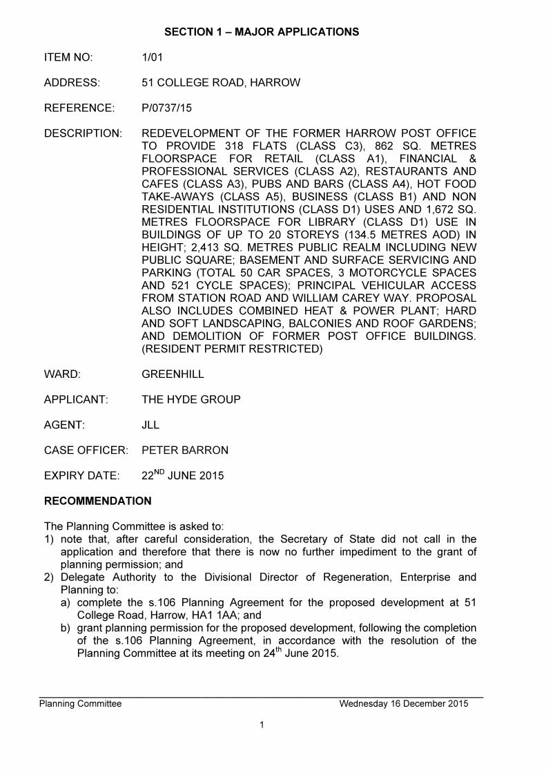
ITEM NO: 1/01 ADDRESS: 51 COLLEGE ROAD, HARROW REFERENCE: P/0737/15 DESCRIPTION: REDEVELOPMENT OF THE FORMER HARROW POST OFFICE
TO PROVIDE 318 FLATS (CLASS C3), 862 SQ. METRES FLOORSPACE FOR RETAIL (CLASS A1), FINANCIAL & PROFESSIONAL SERVICES (CLASS A2), RESTAURANTS AND CAFES (CLASS A3), PUBS AND BARS (CLASS A4), HOT FOOD TAKE-AWAYS (CLASS A5), BUSINESS (CLASS B1) AND NON RESIDENTIAL INSTITUTIONS (CLASS D1) USES AND 1,672 SQ. METRES FLOORSPACE FOR LIBRARY (CLASS D1) USE IN BUILDINGS OF UP TO 20 STOREYS (134.5 METRES AOD) IN HEIGHT; 2,413 SQ. METRES PUBLIC REALM INCLUDING NEW PUBLIC SQUARE; BASEMENT AND SURFACE SERVICING AND PARKING (TOTAL 50 CAR SPACES, 3 MOTORCYCLE SPACES AND 521 CYCLE SPACES); PRINCIPAL VEHICULAR ACCESS FROM STATION ROAD AND WILLIAM CAREY WAY. PROPOSAL ALSO INCLUDES COMBINED HEAT & POWER PLANT; HARD AND SOFT LANDSCAPING, BALCONIES AND ROOF GARDENS; AND DEMOLITION OF FORMER POST OFFICE BUILDINGS. (RESIDENT PERMIT RESTRICTED)
WARD: GREENHILL APPLICANT: THE HYDE GROUP AGENT: JLL CASE OFFICER: PETER BARRON EXPIRY DATE: 22ND JUNE 2015 RECOMMENDATION The Planning Committee is asked to: 1) note that, after careful consideration, the Secretary of State did not call in the
application and therefore that there is now no further impediment to the grant of planning permission; and
2) Delegate Authority to the Divisional Director of Regeneration, Enterprise and Planning to: a) complete the s.106 Planning Agreement for the proposed development at 51
College Road, Harrow, HA1 1AA; and b) grant planning permission for the proposed development, following the completion
of the s.106 Planning Agreement, in accordance with the resolution of the Planning Committee at its meeting on 24th June 2015.

_______________________________________________________________________________________ Planning Committee Wednesday 16 December 2015
2
INFORMATION This application was reported to the Committee on 24th June 2015 with the following recommendation: Recommendation A GRANT planning permission subject to: (i) the withdrawal by the Ministry of Defence of its objection or referral to the
Secretary of State; (ii) referral to the Greater London Authority (GLA); (iii) conditions; and (iv) the completion of a section 106 Planning Obligation;
by 24th September or such extended period as may be agreed in writing by the Chairman of the Planning Committee. Authority to be given to the Divisional Director of Regeneration and Planning, in consultation with the Director of Legal and Governance Services, for the sealing of the section 106 Planning Obligation and to agree any minor amendments to the conditions or the Planning Obligation. The proposed section 106 Planning Obligation Heads of Terms cover the following matters:
[see matters set out in report and addendum to Planning Committee 24th June 2015]
Recommendation B That if, by 24th September 2015 or such extended period as may be agreed in writing by the Chairman of the Planning Committee, the section 106 Planning Obligation is not completed, then delegate the decision to the Divisional Director of Planning to REFUSE planning permission for the appropriate reason. 1. The proposed development, in the absence of a Planning Obligation to (i) secure
an appropriate level of affordable housing within the development, (ii) fund the provision of infrastructure directly related to the development and (iii) provide necessary commitments in relation to the development, would fail to provide affordable housing and would fail to mitigate the impact of the development upon infrastructure and the wider area, contrary to the National Planning Policy Framework, Policies 3.8, 3.11, 5.6, 6.3, 7.5, 7.7 and 8.2 of the London Plan (2015), Policies CS 1 and CS 2 of the Harrow Core Strategy (2012) and Policies AAP 1, AAP 6, AAP 10, AAP 11, AAP 19 and DM 50 of the Local Plan (2013), and the provisions of the Harrow Planning Obligations supplementary planning document.
On 30th September 2015 a report was included in a supplemental agenda to the Planning Committee to advise that, although the Ministry of Defence’s objection had by that time been withdrawn and the referral process to the Greater London Authority had been concluded, an extension to the deadline for completion of the s.106 Planning Obligation was required. At that meeting, the Planning Committee resolved to agree an extension to the deadline, until 30th October 2015. Statutory Return Type: Largescale Major Development Council Interest: No Site Description
• 0.67 hectare site on south side of College Road, Harrow
• full site details set out in report to Planning Committee 24th June 2015 Proposal Details
_______________________________________________________________________________________ Planning Committee Wednesday 16 December 2015
3
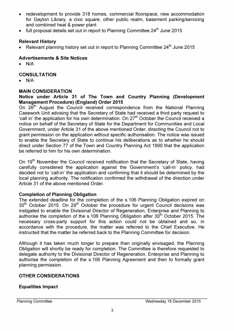
• redevelopment to provide 318 homes, commercial floorspace, new accommodation for Gayton Library, a civic square, other public realm, basement parking/servicing and combined heat & power plant
• full proposal details set out in report to Planning Committee 24th June 2015 Relevant History
• Relevant planning history set out in report to Planning Committee 24th June 2015 Advertisements & Site Notices
• N/A CONSULTATION
• N/A MAIN CONSIDERATION Notice under Article 31 of The Town and Country Planning (Development Management Procedure) (England) Order 2015 On 26th August the Council received correspondence from the National Planning Casework Unit advising that the Secretary of State had received a third party request to ‘call in’ the application for his own determination. On 27th October the Council received a notice on behalf of the Secretary of State for the Department for Communities and Local Government, under Article 31 of the above mentioned Order, directing the Council not to grant permission on the application without specific authorisation. The notice was issued to enable the Secretary of State to continue his deliberations as to whether he should direct under Section 77 of the Town and Country Planning Act 1990 that the application be referred to him for his own determination. On 19th November the Council received notification that the Secretary of State, having carefully considered the application against the Government’s ‘call-in’ policy, had decided not to ‘call-in’ the application and confirming that it should be determined by the local planning authority. The notification confirmed the withdrawal of the direction under Article 31 of the above mentioned Order. Completion of Planning Obligation The extended deadline for the completion of the s.106 Planning Obligation expired on 30th October 2015. On 29th October the procedure for urgent Council decisions was instigated to enable the Divisional Director of Regeneration, Enterprise and Planning to authorise the completion of the s.106 Planning Obligation after 30th October 2015. The necessary cross-party support for this action could not be obtained and so, in accordance with the procedure, the matter was referred to the Chief Executive. He instructed that the matter be referred back to the Planning Committee for decision. Although it has taken much longer to prepare than originally envisaged, the Planning Obligation will shortly be ready for completion. The Committee is therefore requested to delegate authority to the Divisional Director of Regeneration, Enterprise and Planning to authorise the completion of the s.106 Planning Agreement and then to formally grant planning permission. OTHER CONSIDERATIONS Equalities Impact
_______________________________________________________________________________________ Planning Committee Wednesday 16 December 2015
4
Section 149 of the Equalities Act 2010 created the public sector equality duty. Section149 states:- (1) A public authority must, in the exercise of its functions, have due regard to the need to: (a) eliminate discrimination, harassment, victimisation and any other conduct that is prohibited by or under this Act; (b) advance equality of opportunity between persons who share a relevant protected characteristic and persons who do not share it; (c) foster good relations between persons who share a relevant protected characteristic and persons who do not share it. Officers have taken this into account in the assessment of this application and the Committee must be mindful of this duty inter alia when determining all planning applications. The completion of the s.106 Planning Obligation does not have any material impact upon any equalities group and would not result in any infringement on Equalities legislation. Human Rights Act In addition Members should note that the Human Rights Act 1998 (HRA 1998) makes it unlawful for the Council to act incompatibly with Convention rights. Decisions by the Committee must take account of the HRA 1998. Therefore, Members need to be aware of the fact that the HRA 1998 makes the European Convention on Human Rights (“the Convention”) directly applicable to the actions of public bodies in England and Wales. The specific parts of the Convention relevant to planning matters are Article 6 (right to a fair hearing); Article 8 (right to respect for private and family life); Article 1 of the First Protocol (protection of property) and Article 14 (prohibition of discrimination). The completion of the s.106 Planning Obligation does not have any material impact in terms of any above the above Articles. S17 Crime & Disorder Act The completion of the s.106 Planning Obligation does not have any material impact in terms of crime and disorder. Consultation Responses
• N/A CONCLUSION The Committee is asked to: 1) note that, after careful consideration, the Secretary of State did not call in the
application and therefore that there is now no further impediment to the grant of planning permission; and
2) Delegate Authority to the Divisional Director of Regeneration, Enterprise and Planning to:
a) complete the s.106 Planning Agreement for the proposed development at 51 College Road, Harrow, HA1 1AA; and
b) grant planning permission for the proposed development, following the completion of the s.106 Planning Agreement, in accordance with the resolution of the Planning Committee at its meeting on 24th June 2015.

_______________________________________________________________________________________ Planning Committee Wednesday 16 December 2015
5
51 COLLEGE ROAD, HARROW

_______________________________________________________________________________________ Planning Committee Wednesday 16 December 2015
6
ITEM NO: 1/02 ADDRESS: 2 – 12 NORTHWICK PARK ROAD, HARROW REFERENCE: P/3820/15 DESCRIPTION: REDEVELOPMENT TO PROVIDE A THREE STOREY BUILDING
FOR A 48 UNIT ASSISTED LIVING CARE HOME (USE CLASS C2) WITH PARKING, LANDSCAPING AND BIN STORAGE
WARD: GREENHILL APPLICANT: YOURLIFE MANAGEMENT SERVICES LTD AGENT: THE PLANNING BUREAU CASE OFFICER: CALLUM SAYERS EXPIRY DATE: 02/11/2015 RECOMMENDATION GRANT planning permission for the development set out in the application and submitted plans, subject to conditions, as: The proposed development would replace a Hotel use on the site which there is no policy protection to retain, specifically to extra care housing for which there is an identified borough wide need. The use as a care home would make a contribution to the housing stock of the borough, as well as increasing housing choice within the borough. The proposed land use would conform with the surrounding residential land use, would have satisfactory access to public transport links and local shops. Furthermore, the proposed development would provide a development with a high quality design and appearance, and replace an existing building that is ad-hoc and piecemeal in appearance that detracts from the appearance of the property and wider area. The proposed development would therefore accord with Development Plan policies. INFORMATION This application is reported to the Committee as it is a proposal located on a site which is more than 0.1ha which falls outside of the thresholds set by category 1(d) of the Council’s Scheme of Delegation for the determination of new development. Statutory Return Type: E(20) Small-scale Major Development Council Interest: None Net Additional Floorspace: 1408.70 m2 GLA Community Infrastructure Levy (CIL) Contribution (provisional): £49,304.50 Harrow Community Infrastructure Levy (CIL) Contribution (provisional):£77,478.50
_______________________________________________________________________________________ Planning Committee Wednesday 16 December 2015
7
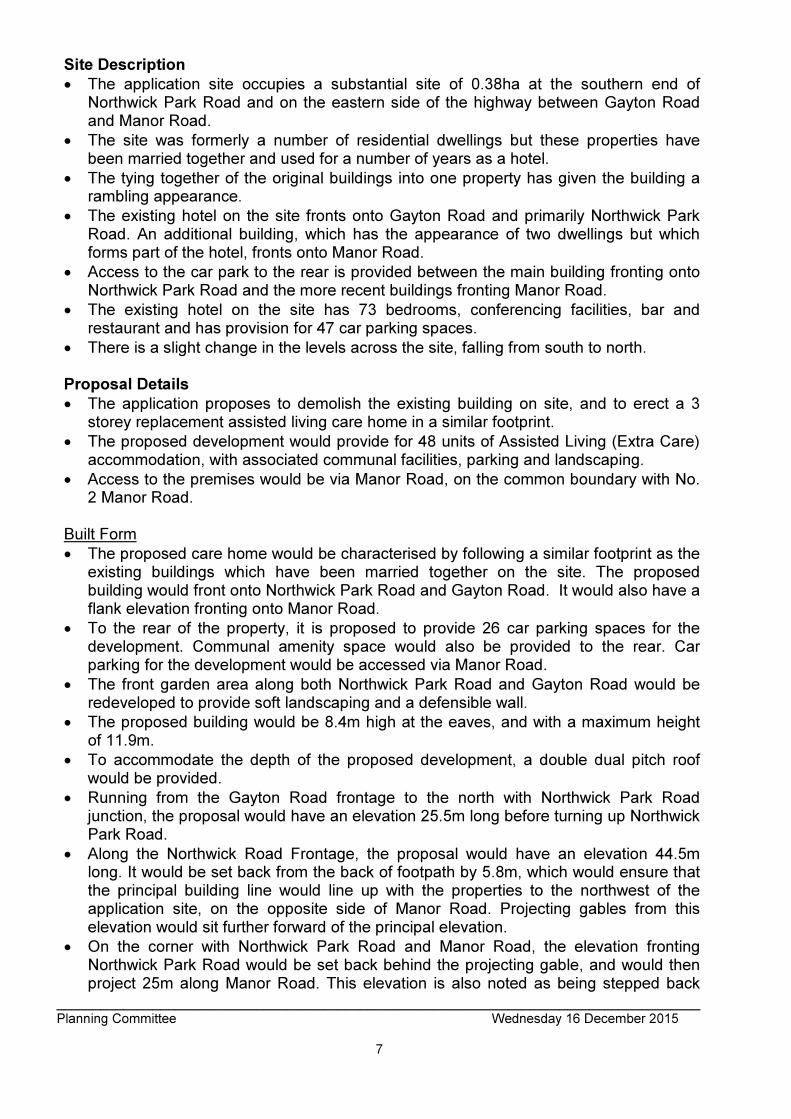
Site Description
• The application site occupies a substantial site of 0.38ha at the southern end of Northwick Park Road and on the eastern side of the highway between Gayton Road and Manor Road.
• The site was formerly a number of residential dwellings but these properties have been married together and used for a number of years as a hotel.
• The tying together of the original buildings into one property has given the building a rambling appearance.
• The existing hotel on the site fronts onto Gayton Road and primarily Northwick Park Road. An additional building, which has the appearance of two dwellings but which forms part of the hotel, fronts onto Manor Road.
• Access to the car park to the rear is provided between the main building fronting onto Northwick Park Road and the more recent buildings fronting Manor Road.
• The existing hotel on the site has 73 bedrooms, conferencing facilities, bar and restaurant and has provision for 47 car parking spaces.
• There is a slight change in the levels across the site, falling from south to north. Proposal Details
• The application proposes to demolish the existing building on site, and to erect a 3 storey replacement assisted living care home in a similar footprint.
• The proposed development would provide for 48 units of Assisted Living (Extra Care) accommodation, with associated communal facilities, parking and landscaping.
• Access to the premises would be via Manor Road, on the common boundary with No. 2 Manor Road.
Built Form
• The proposed care home would be characterised by following a similar footprint as the existing buildings which have been married together on the site. The proposed building would front onto Northwick Park Road and Gayton Road. It would also have a flank elevation fronting onto Manor Road.
• To the rear of the property, it is proposed to provide 26 car parking spaces for the development. Communal amenity space would also be provided to the rear. Car parking for the development would be accessed via Manor Road.
• The front garden area along both Northwick Park Road and Gayton Road would be redeveloped to provide soft landscaping and a defensible wall.
• The proposed building would be 8.4m high at the eaves, and with a maximum height of 11.9m.
• To accommodate the depth of the proposed development, a double dual pitch roof would be provided.
• Running from the Gayton Road frontage to the north with Northwick Park Road junction, the proposal would have an elevation 25.5m long before turning up Northwick Park Road.
• Along the Northwick Road Frontage, the proposal would have an elevation 44.5m long. It would be set back from the back of footpath by 5.8m, which would ensure that the principal building line would line up with the properties to the northwest of the application site, on the opposite side of Manor Road. Projecting gables from this elevation would sit further forward of the principal elevation.
• On the corner with Northwick Park Road and Manor Road, the elevation fronting Northwick Park Road would be set back behind the projecting gable, and would then project 25m along Manor Road. This elevation is also noted as being stepped back

_______________________________________________________________________________________ Planning Committee Wednesday 16 December 2015
8
into the site, as Manor Road curves in a westerly direction from the junction with Northwick Park Road.
• Fronting onto Northwick Park and Gayton Roads, the proposed development would be characterised by twin-gables projecting forward of the main front elevation.
Accommodation
• The proposed development would provide for 48 units for independent living, with an element of care tailored to the specific requirements of individual occupiers.
• The proposed development would comprise of 27 one bedroom and 21 two bedroom units.
• Assisted Living is a form of accommodation that is aimed at providing independent living for the frail elderly. Each of the units would be self-contained, and would be barrier free and would be entirely wheelchair accessible.
• Assisted Living provides a number of ‘enhanced’ facilities which set it apart from ‘sheltered or retirement’ developments. The development would provide;
• Residents lounge
• Community (hobbies) room
• Internal refuse room
• Laundry
• Battery car charging store
• Guest suite
• Accommodation to allow 24hr staffing
• Two lifts
• Level access throughout
• Provision of wheelchair accessible housing standards
• Close proximity to shops and services
• Good connection to public transport
• The proposal as submitted enables the frail elderly to buy in care packages to suit their needs as they change over time rather than pay the fixed costs of a nursing or residential care home. This type of accommodation allows the occupier to retain a level of independence, with the ability to purchase more assistance as required.
Environmental Impact Assessment (EIA) The Council has carried out a screening opinion pursuant to the Town and Country Planning (Environmental Impact Assessment) (England) Regulations 2011 (as amended) for the Redevelopment to provide a three storey building for a 48 unit assisted living care home (use class C2) with parking, landscaping and bin storage The opinion concludes that the proposed development is not EIA development. Relevant History P/272/05/CFU Part single/part 3 storey rear extension; 1/2 storey extension on site of 57 Gayton Road; revised car parking REFUSED : 22 April 2005

_______________________________________________________________________________________ Planning Committee Wednesday 16 December 2015
9
Reasons for Refusal: 1) The proposed development, by reason of excessive size, bulk and unsatisfactory design, would be visually obtrusive and overbearing, would not respect the scale, massing and form of the adjacent properties to the detriment of the amenities of the occupiers thereof, the appearance of the street scene and the character of the locality. 2) The proposed development, by reason of excessive size and bulk would be visually obtrusive, would be out of character with neighbouring properties and would not respect the scale and massing of those properties, to the detriment of the visual amenities of the neighbouring residents and the character of the area. 3) The proposed windows/ balconies in the rear elevation would allow overlooking of the adjoining properties and result in an unreasonable loss of privacy to the occupiers. The proposed intensification of the parking area to the rear of the site by reason of unsatisfactory siting in relation to the neighbouring residential properties and associated disturbance and general activity would be unduly obtrusive and detrimental to the visual and residential amenities of those properties and the character of the area. P/2792/05/CFU Part 2 / part 3 storey extension to provide additional bedrooms and conference facilities; Rearranged rear car parking REFUSED : 09 February 2006 Reason for Refusal: 1) The proposed 3 storey rear extension by reason of excessive depth would be visually obtrusive and overbearing when viewed from the rear garden of the adjoining property at 2 Manor Road to the detriment of the amenities of the occupiers thereof. 2) The proposed east facing rooflight windows within the rear extension would allow overlooking of the adjoining property and result in an unreasonable loss of privacy to the occupiers. 3) The first floor south east facing windows of the rear extension to be part fitted with obscure glazing, would give rise to direct or perceived overlooking of the rear of the adjoining property, causing a resultant loss of privacy, to the detriment of the occupiers thereof. 4) The proposed parking spaces 50 & 51 would extend that area of hardsurfacing to the frontage of the site to an unacceptable level, would be visually obtrusive and overbearing, would not respect the character of the wider locality to the detriment of the amenities and appearance of the street scene and the character of the area. P/0009/07/CFU Extension and alterations to hotel REFUSED : 20 March 2007 APPEAL DISMISSED: 03 April 2008 Reasons for Refusal: 1) The proposed additional 18 bedrooms together with additional conference facilities will be detrimental to the residential amenities of No.59 Gayton Road and the properties in the locality by reason of the additional activity associated with hotel use. 2) The three storey extension by reason of excessive depth would be visually obtrusive and overbearing when viewed from the rear garden of No.2 Manor Road. P/2030/08/CFU Extensions and alterations to hotel to provide additional bedrooms and re-locate conference centre (no additional floorspace)

_______________________________________________________________________________________ Planning Committee Wednesday 16 December 2015
10
GRANTED: 02 October 2008 P/0181/09 Extensions and alterations to existing hotel to provide 34 additional bedrooms & relocation of existing conference bar and restaurant facilities (no additional conference floorspace) GRANTED: 23 April 2009 P/0291/12 Demolition of existing buildings; redevelopment to provide part single, part three storey building with basement for use as a hotel comprising 118 guest rooms, restaurant and bar, meeting rooms, staff facilities and offices (use classes C1/A3/A4); provision of 38 car parking spaces, off-street servicing and landscaping; refuse and cycle storage; erection of 2.1m palisade metal fence along boundary GRANTED: 03 May 2012 P/0598/12 Extension of time to planning permission P/0181/09 dated 23/04/2009 for extensions and alterations to existing hotel to provide 34 additional bedrooms & relocation of existing conference bar and restaurant facilities (no additional conference floorspace) GRANTED: 25/05/2012 Pre-Application Discussion - Planning Performance Agreement The applicant engaged in pre-application consultation with the Local Planning Authority.
• Principle of the loss of the Hotel is acceptable, as there is no policy in place to protect them.
• Proposed accommodation must be demonstrated to meet the ‘front door test’ to ensure that it falls within Use Class C2, and as such would not be required to provide a level of affordable housing.
• Simplification of the design, especially the roof form.
• The height of the replacement new build should be of a similar height as the existing (or previously approved schemes) to ensure that it would be appropriate within the wider area, and not lead to harm to neighbouring residential occupiers.
Community and Stakeholder Engagement The Council’s Statement of Community Involvement (20012) states that ‘ideally the results of pre-application consultation should be included in the planning application and form part of the planning application process’. A Statement of Community Involvement has accompanied the Application and this document explains the programme of public consultation and community engagement carried out prior to the submission of the application. As part of its programme of community engagement, the applicant held one-to-one meetings with Councillors, neighbours and third party groups on Wednesday 10th June 2015. These were held on an appointment basis. A public exhibition was held on Thursday 9th July 2015, which 1000 residents and businesses were invited to attend. A press release was also issued within The Harrow Observer and The Harrow Times. On the day of the public exhibition, 30 residents attended. Three local Councillors attended this public exhibition. MP for Harrow West, Gareth Thomas was also invited to attend. Applicant Submission Documents
• Planning Statement

_______________________________________________________________________________________ Planning Committee Wednesday 16 December 2015
11
• Design and Access Statement
• Statement of Community Involvement
• Transport Assessment and Travel Plan
• Energy Statement/Sustainability Statement
• Drainage Report Consultations Highway Authority: No Objection, appraised under section 5 of this report Harrow Drainage Team: No Objection, subject to conditions Harrow Environmental Health Team: No Objection, subject to conditions Reason for Advertisement: Major Development Press Release: 20th August 2015 Expiry: 9th September 2015 Site Notice Erected: 21st August 2015 (x 3) Expiry: 10th September 2015 Notification Sent: 660 Expiry: 7th August 2015 Reponses Received: 6 Neighbours Consulted: Extensive consultation has been carried out, which covers a wide area surrounding the site, including Sheepcote Road, Northwick Park Road, Gayton Road, Bonnersfield Lane, Flambard Road, Kenton Road, Gerard Road, Manor Road, Rufford Close, Thurlby Close, Woodway Crescent. Summary of Responses:
• Objections (2)
• Support (4) Objections:
• Concerns of potential usage and traffic intensity created by permanent staff and visitors to a small site.
• Increase in infrastructure such as medical services
• Release of large properties does not always follow, as many of these are now subdivided after sale, further exacerbating the problems stated above.
Support:
• No Objection to planning application
• Despite short term disruption, the overall proposal is welcomed
• A switch from the commercial nature of the property to a more residential nature would be of benefit
• Risk of creating ‘sinkholes’ if the foundations are not built correctly as a result of the sites proximity to a natural spring line of groundwater draining off Harrow on the Hill.
• Access point from Manor Road should be spayed to as to avoid a clash between HGVs and disabled persons parking space immediately opposite.
• Proposal would improve the overall appearance of the site

_______________________________________________________________________________________ Planning Committee Wednesday 16 December 2015
12
• Reduce noise from the site late at night
• Reduce congestion
• Concerns over demolition/construction period and would welcome payments for window cleaning
The above responses are discussed within the body of this report, and specifically within Section 13. APPRAISAL Section 38(6) of the Planning and Compulsory Purchase Act 2004 requires that: ‘If regard is to be had to the Development Plan for the purpose of any determination to be made under the Planning Acts, the determination must be made in accordance with the Plan unless material considerations indicate otherwise.’ The Government has issued the National Planning Policy Framework (NPPF), which consolidates national planning policy and is a material consideration in the determination of this application. In this instance, the Development Plan comprises The London Plan (Consolidated with Amendments Since 2011) (2015) and the Local Development Framework (LDF). The LDF comprises The Harrow Core Strategy 2012, Harrow and Wealdstone Area Action Plan (AAP) 2013, the Development Management Policies Local Plan (DMP) 2013, the Site Allocations Local Plan (SALP) 2013 and Harrow Local Area Map (LAP) 2013. MAIN CONSIDERATIONS Principle of Development Affordable Housing Design, Character and Appearance of the Area Residential Amenity Traffic, Parking, Access, Servicing and Sustainable Transport Sustainability and Climate Change Mitigation Flood Risk and Development Equalities Implications and the Human Rights Act Trees and Development Ecology and Biodiversity Land Contamination and Remediation S17 Crime and Disorder Act Consultation Responses Principle of the Development Provision of Care Facilities including Extra Care Accommodation Paragraph 50 of the National Planning Policy Framework outlines that “local planning authorities should plan for a mix of housing based on current and future demographic trends, market trends and the needs of different groups in the community (such as, but not limited to, families with children, older people, people with disabilities, older people, people with disabilities, service families and people wishing to build their own homes). London Plan policy (2015) 3.16 outlines the need for additional and enhanced social infrastructure provision to meet the needs of its growing and diverse population. It states that “development proposals which provide high quality social infrastructure will be supported in light of local and strategic needs assessments,Facilities should be

_______________________________________________________________________________________ Planning Committee Wednesday 16 December 2015
13
accessible to all sections of the community and be located within easy reach by walking, cycling and public transport”. Further to this, 3.17 ‘Health and Social Care Facilities states that “proposals that provide high quality health and social care facilities will be supported in areas of identified need, particularly in places easily accessible by public transport , cycling and walking”. The London Plan (2015) also identifies a need for specialist accommodation for older people (including sheltered accommodation, extra care accommodation and nursing home care). Paragraph 3.50b states:
“Research suggests that the choices open to older Londoners to move into local specialist housing may have been constrained through inadequate supply. Extending these choices through a higher level of specialist provision will in turn free up larger family homes for family occupation. Over the period 2015-2025, older Londoners may require 3,600-4,200 new specialist units per annum. At the mid-point of this range, these might be broken down broadly into 2,600 private units pa, 1000 in shared ownership and some 300 new affordable units. There may also be a requirement for 400-500 new bed spaces per annum in care homes”
Table A5.1 of The London Plan provides indicative strategic benchmarks to inform local targets and performance indicators for specialist housing for older people (including sheltered accommodation, extra care accommodation and nursing home care) between 2015 and 2025. The annual benchmark figure for Harrow is stated as 150 units. Local plan policy DM 29 states that “the Council will support proposals on previously developed land for sheltered housing, care homes and extra care housing (across all tenures) for older people and those who may be vulnerable, provided that the proposal is accessible by public transport with good access to local amenities including shops and local facilities”. The requirement to provide specialist accommodation for the elderly is supported in paragraph 50 of the NPPF. The proposal is also supported by The London Plan (2015) and the Harrow DMP Local Plan (2013), subject to the development being high quality, in an area of identified need and accessible by public transport and local amenities. London Plan Policy 4.5 (London’s Visitor Infrastructure) seeks to support London’s visitor economy, including a target of achieving 40,000 net additional hotel bedrooms by 2036. In the context of planning decisions, the policy requires that developments should not result in the loss of strategically important hotel capacity. A footnote to the policy indicates that strategically important hotel capacity will depend on local circumstances, but typically comprises development exceeding 15,000 m2 outside Central London. The policy also cross-references London Plan Policy 2.16 (Strategic Outer London Development Centres), which identifies potential outer London development centres with a strategic function for leisure / tourism / arts / culture / sports; no town centres within Harrow are identified as such. The proposed development will result in the loss of 3,681 sqm of hotel floor space, which is modest in the context of the 15,000 m2 benchmark identified in Policy 4.5. Since the current London Plan was adopted in 2011 there have been a number of approvals within Harrow for an estimated 7,000 sqm of additional hotel floor space. This is offset by two recent proposals involving the loss of hotel floor space totalling 7,100 sqm (including this

_______________________________________________________________________________________ Planning Committee Wednesday 16 December 2015
14
application). Consequently, the overall potential loss of hotel floor space remains below the 15,000 sqm benchmark and if approved proposals for new hotel floor space are implemented, the overall position with respect to hotel floor space in the borough would be neutral. The proposal is therefore considered acceptable in the context of London Plan Policy 4.5. The policies outlined above provide support in principle for the provision of a care home, of any typology, at this location and within the borough. The applicant has submitted supporting information to demonstrate that Harrow as a borough is not meeting its current need of this type of care home, and as such the proposal would provide for a meaningful contribution both towards the housing target and also a type of sheltered housing. The applicant has submitted a Needs Assessment. The methodology used within the report to assess the current and future demand for care homes is based on the ‘What Homes Where’ toolkit, which shows that the proportion of population aged over 60 years will increase from 16% to 25.5% between 2008 and 2033. In light of this, the conformity of the proposed use with the surrounding land uses, the increased housing choice and offer, and the limited harm to the Borough’s offer of visitor accommodation, the proposal is therefore appropriate in terms of its land use and scale. Affordable Housing Core Policy CS1J of the Harrow Core Strategy (2012) seeks the maximum reasonable amount of affordable housing on all development sites, with a Borough-wide target of 40%. DM policy 24 states that proposals that secure an appropriate mix of housing on site and which contribute to the creation of mixed and inclusive communities will be supported. Paragraph 6.30 outlines that policy CS1 J applies to schemes for sheltered housing and extra care homes that fall within the thresholds. It goes onto say at paragraph 6.31 that “Residential care homes and nursing homes, where the accommodation is non-self-contained, fall within use Class C2 (Residential Institutions) and are not subject to the affordable housing policy”. Although the independent living flats (48 units) would be self-contained, the applicant has provided an affordable housing statement together with supporting evidence and case law for the development falling wholly within a C2 use Class. Paragraph 3.1.41 of the Mayors Housing SPG sets out the ‘front door’ test, whereby a self-contained unit with its own front door would indicate a C3 use. However, this paragraph also recognises that in some cases this may require refinement to take account of the components of care and support associated with some Extra Care schemes, which functionally are effectively C2 schemes. There is a significant amount of case law set by recent appeal decisions which assert that the level of care provided together with the level of support services within a development are key factors in determining whether a development falls within class C3 (dwellings) or C2 (Residential Institutions). In this case, the applicant has outlined that the internal doors to the independent living flats (ILF) are very much secondary due to the communal nature which exists within the scheme. It is clear from the submitted plans that the proposed development would provide self-contained units, and also a significant amount of communal floor space on the ground floor.
_______________________________________________________________________________________ Planning Committee Wednesday 16 December 2015
15
The communal floor space would provide a dining area, lounge area, and wellness suite for use by future residents. Furthermore, there would be a kitchen area that would be operated by staff of the development, which would be used to provide meals for future occupiers of they wished to utilise this facility and the communal dining room rather than cook meals within their private units. Whilst not in isolation, this relationship goes some way to demonstrating that these is an intrinsic link between the residential nature and the communal facilities that are available to provide assistance or care to future occupiers. Further to the actual floor space that is set aside as ancillary to the residential element, it is also noted that there is an explicit element of care that is attached to the development. As mentioned previously, the proposed uses on the ground floor are able to provide care to the future occupiers by preparing and serving meals within the communal dining area, providing a wellness suite to assist with health concerns. However, further to this, there are also care packages that the residents are able to purchase to assist them with their day to day living. Care packages are bespoke to each of the resident’s needs, with more or less assistance purchased depending on their ability to undertake such matters themselves. Care packages can range from as little as 1 hour per week to help with cleaning of the private residence up to as many as the tenant wishes dependent on where assistance is required. It is considered that the proposed development would be a fit for purpose development for elderly people to reside, who would be able to receive an element of care dependent of need, whilst still maintaining a level of independence. Future residents have the ability to purchase the residential unit in which they reside, which allows them am element of independence. However, it is clear from the proposed set up of the care home in terms of the living accommodation and also the assistance that is able to be provided as a result of the infrastructure, then residents would move into such a development with the knowledge that this was the level of service that would be provided and that this would be in line with their needs. It is considered that the fact and degree of the development through the balance of residential floorspace provided as private self-contained units, in conjunction with the communal floor space and the element of care that is provided for residents by staff that in this instance the development would be considered to fall within a C2 use. As such, it is considered that the proposal would not need to provide an affordable housing provision. Should the balance of communal, ancillary floor space be reduced, which as a result may impact on the level of care able to be provided to residents, then this may result in a material change of use to the development. Such a change of use may result in the development being considered to fall within the C3 Use Class, whereby an affordable housing contribution would be required. The above would accord with the conclusions of an Inspector in a recent appeal decision (APP/D0121/A/12/2168918), where the proposed layout of the scheme, and the care that is provided was deemed to be a significant factor as to why residents would indeed move in to such a facility. As such, and notwithstanding the multiple self-contained units with individual front doors, they would nonetheless be intrinsically tied to the communal facilities, and as such each of the units would not be considered to be independent to the rest of the facilities to amount to one building in separate planning units. The applicant has outlined that in order to live within the development residents must be at least 65 years of age, must undergo and pass a professional care assessment carried
_______________________________________________________________________________________ Planning Committee Wednesday 16 December 2015
16
out by an appropriately qualified member of staff to determine the initial level of care that is required for the resident. This would effectively ensure that appropriate residents in need of care would reside within the development. A condition has been recommended to ensure that the development would be age restricted with a pre-assessment to determine the correct tenant for the accommodation. Having regard to the above factors officers consider that on balance, the proposal would fall within a C2 development category as the self-contained units would not be so independent from the rest of the facilities to amount to separate planning units and therefore no affordable housing would be required in line with the Planning Obligations. Design, Character and Appearance of the Area The application site is currently in use as a hotel. However, it is noted that the built form, rather than being a purpose built hotel, has resulted through the amalgamation of residential properties. As such, the appearance of the existing property is rather ad-hoc, incoherent and fussy, with many conflicting design features on this relatively prominent site. Given the ad-hoc appearance of the property within the existing streetscene, it does not contribute positively to the architectural character of the area. As such, it is considered that the demolition of this building, and replacement with a purpose built structure, would provide the opportunity to have a replacement building that responds more appropriately to the vernacular of the area, and to provide an attractive building on this prominent site. The London Plan (2015) policies 7.4B and 7.6B set out the design principles that all boroughs should seek to ensure for all development proposals. The London Plan (2015) policy 7.4B states, inter alia, that all development proposals should have regard to the local context, contribute to a positive relationship between the urban landscape and natural features, be human in scale, make a positive contribution and should be informed by the historic environment. The London Plan (2015) policy 7.6B states, inter alia, that all development proposals should; be of the highest architectural quality, which complement the local architectural character and be of an appropriate proportion composition, scale and orientation. Development should not be harmful to amenities, should incorporate best practice for climate change, provide high quality indoor and outdoor spaces, be adaptable to different activities and land uses and meet the principles of inclusive design. Core Strategy policy CS1.B states that ‘all development shall respond positively to the local and historic context in terms of design, siting, density and spacing, reinforce the positive attributes of local distinctiveness whilst promoting innovative design and/or enhancing areas of poor design’. Policy DM1 of the DMP gives advice that ‘’all development proposals must achieve a high standard of design and layout. Proposals which fail to achieve a high standard of design and layout, or which are detrimental to local character and appearance, will be resisted.’’ Layout The proposed replacement building would continue to be located to the front of the site, fronting onto Gayton Road and Northwick Park Road. It would be marginally closer to the highway than what is currently on site. However, it is noted along Northwick Park Road that the principal building line would align with the dwellings located on the opposite side of Manor Road. The projecting gables would be situated slightly forward of this line towards the public highway, but would remain intermittent. Located on the corner of Gayton Road and Northwick Park Road, the proposed new build would sit much closer to the back of the footpath. It is noted on the Gayton Road frontage, there is not a strong building lone. The properties located on the junction of Gayton Road and Gerard Road

_______________________________________________________________________________________ Planning Committee Wednesday 16 December 2015
17
face onto Gerard Road, with a significant set off to the Gayton Road frontage. The three properties from this site back to the application site, do not line up neatly, all sitting slightly at odds with each other. On the apex of the corner which forms the junction of Gayton and Northwick Park Roads, the existing building is set quite far back into the site. This results in a large amount of hardstanding within the site. Whilst it is acknowledged that the building would be brought forward further in the site, and further forward than the existing properties to the east of the application property, it would provide an appropriate frontage to the public realm. The proposed building at this junction would front onto the corner of the junction of Northwick Park and Gayton Roads, and is noted as having a relatively wide gable feature. The bringing forward of the front elevation along this section would firstly provide a sense of uniformity of the building line, with a relatively consistent front building line within the site. Furthermore, the appropriate treatment of this elevation, with a large gable feature, would provide a strong frontage onto this corner. Along Manor Road, it is proposed to orientate the building up towards No. 2 Manor Road. It is noted that presently halfway along this frontage, there is a break in the building line, with an accessway provided to the site rear car park. On the northern side of the accessway is a pair of semi-detached dwellings, which provide staff accommodation for the hotel. As part of the application it is proposed to demolish these properties, and bring the building into one continuous build. The building mass would therefore move away from the common boundary with No. 2 Manor Road, from 0.5m to 9.8m further south. This elevation would be stepped in appearance, with it stepping back into the site the further the elevation goes north up Manor Road. This is partially as a result of the alignment of Manor Road, which orientates in a slightly westerly direction. Furthermore, the stepped appearance assists in both breaking up bulk and bringing the building line back away from the edge of the footpath to give some breathing space around the building and allow it to have a setting within the site. As a result of the layout of the proposed new build, the vehicle access to the property would then run along the northern boundary with No. 2 Manor Road. Design As mentioned previously, the existing hotel building is an amalgamation of a number of separate residential dwellings. As a result the design of the existing building is ad-hoc and piecemeal in appearance, and in conjunction with the excessive amount of hardstanding in the front garden, provides a poor appearance within the existing site and streetscene. Accordingly, the demolition of this building would not be objected to in design terms, as this would provide an opportunity to provide a replacement building that would be more appropriate within the site and streetscene. As mentioned previously, the building line near the junction of Northwick Park and Gayton Road would be much closer to the rear of the public footpath. The proposed new build nonetheless would broadly follow the same footprint as the existing building, although noted that it would project up Manor Road rather than having a detached element as existing. The proposed replacement build would be approximately 1.1m higher than existing property on site, but would have a much more simplistic design approach. The proposed frontage of the development would involve projecting gable features joined to each other, with recessed balconies located within these features. Juliet balconies would be located within the recessed elements of the elevations. From the public realm
_______________________________________________________________________________________ Planning Committee Wednesday 16 December 2015
18
there would be a relatively simple roof form presence to the street, but would have a double pitch roof to provide for the required depth of the building. Materials The supporting information submitted with the application provides detail of the materials that are proposed to be used across the scheme. It is acknowledged that a relatively simple palette of materials is proposed to be used. Whilst this is considered to be an appropriate and acceptable approach, there is some concern over the specific materials that have been proposed. Of note is the render that has been chosen, which appears to be overly light. Furthermore, the proposed details propose that grey uPVC windows and door frames are to be used within the development. The use of uPVC windows are not encouraged as they would not provide a high quality finish, which as a result, would fail the high quality of design test as required by DM1 of the Harrow Development Management Policies Local Plan (2013). However, as more suitable materials could be secured by way of a condition, such a condition is therefore recommended. Landscaping: The proposed building to be located on site would have a marginally larger footprint than what is currently located within the site. The existing hotel has a footprint of 1509sqm, and would be replaced by a development that would have a footprint of 1740sqm. The existing site is dominated by hard landscaping, with both the front and rear garden laid in tarmac. The rear garden area provides the formal car parking for the site, with some additional parking in the front garden areas fronting Northwick Park Road. The ad-hoc appearance and the extensive hard landscaping within the front garden fails to provide suitable setting within the existing streetscene. The proposed scheme offers an opportunity to improve the architectural merit of the building within the site, and also the ratio of hard and soft landscaping to provide it an appropriate setting within the site. The proposed plans indicate that though the proposed building line would be brought forward in the site towards the highway, it would take the opportunity to improve this relationship. In the first instance, it is proposed to relocate the car parking to the rear of the site, and to introduce soft landscaping into the front gardens fronting Northwick Park Road. Railings are indicated on some of the elevation plans provided but no detail is provided. As such, a condition also seeks details of boundary treatments. As mentioned, the rear of the site would remain the car parking area, and would provide for all the car parking for the development. Notwithstanding this, it is proposed to increase the amount of soft landscaping within the rear of the site, thereby enhancing the appearance of the site and also providing for a useable amenity space for the occupiers of the development. The provision of communal and other amenity spaces within the development are discussed later within this report. Hard Landscaping It is proposed to retain the tarmac that currently provides the access and parking to the rear of the site. The existing hardstanding in the front garden would be removed. As mentioned above, the front garden is dominated by hard surfacing, with very little meaningful soft landscaping to break this up or enhance the appearance of the site. Whilst it is proposed to bring the building line further forward within the site, the proposal would introduce significant amounts of soft landscaping which would enhance the proposed development and existing streetscene. Full details of hard landscaping has not been developed other than hard surfacing and boundary treatment. A condition has been

_______________________________________________________________________________________ Planning Committee Wednesday 16 December 2015
19
attached accordingly to ensure further detail in relation to hard landscaping is received. Notwithstanding this, it is considered that the ratio between hard and soft landscaping would be appropriate, and subject to a safeguarding condition this would be acceptable. Soft Landscaping Soft landscaping is an important element to the proposed development, as it assists in breaking up areas of hardstanding and improving the appearance of the development. The proposed development as mentioned previously would introduce soft landscaping between the front elevation and the property boundaries fronting Gayton and Northwick Park Roads. To the rear of the site, access and car parking is proposed, and as such requires hardstanding. Notwithstanding this, the proposed plans indicate that where possible, soft landscaping would be incorporated into the rear of the site. Specifically, amenity space is provided off the rear elevation of the proposed new build, which is able to be utilised by future occupiers. It is considered that the amount of soft landscaping proposed within the site would be appropriate, and would ensure that there would not be a dominance of hardstanding or buildings. A condition is recommended requiring further details of the soft landscaping on the site and a subsequent management plan. Conclusion: Subject to the conditions, it is considered that the external appearance and design of the buildings together with the proposed landscaping scheme are consistent with the principles of good design as required by the National Planning Policy Framework (2012). The resultant development would be appropriate in its context and would comply with policies 7.4B and 7.6B of The London Plan (2015), Core Policy CS1(B) of the Harrow Core Strategy, policy DM1 of the Council’s Development Management Policies Local Plan and the Council’s adopted Supplementary Planning Document – Residential Design Guide (2010), which require a high standard of design and layout in all development proposals. Residential Amenity London Plan Policy 7.6 Architecture states that buildings and structures should not cause unacceptable harm to the amenity of surrounding land and buildings in relation to privacy, overshadowing, wind and microclimate. Core Strategy Policy CS1 B requires development to respond positively to the local context in terms of design, siting, density and spacing. Policy DM1 Achieving a High Standard of Development sets out a number of privacy and amenity criteria for the assessment of the impact of development upon neighbouring occupiers. Harrow has also produced a Residential Design Guide SPD. The existing site is characterised by having a building layout on site that starts on Gayton Road, before turning the corner and being parallel with Northwick Park Road up to its junction with Manor Road. Along the Manor Road frontage, a pair of semi-detached dwellings are located which provide staff accommodation for the existing Comfort Inn Hotel. The proposed development would result in a replacement building of a similar layout within the site, although is noted as having a continuous building form and consistent design rationale. Furthermore, there would be a change in the use of the property away from being a hotel to a care home providing assisted living. Future Residents

_______________________________________________________________________________________ Planning Committee Wednesday 16 December 2015
20
The proposed development is a purpose built development to provide accommodation for elderly people, many with varying levels of mobility. Accordingly, the applicant has stated that as a result of the extra care accommodation provision, the space standards provided within the development are larger than a traditional C2 care home. The supporting documents state that the proposed accommodation (both private and communal areas) would comply with Lifetime Homes Standards. It is acknowledged that the Lifetime Homes criteria (and Code for Sustainable Homes) has now been superseded by the London Plan (2015) Housing Technical Standards, these criteria provide guidance for residential accommodation. Notwithstanding this, the proposed accommodation would exceed or meet the requirements of the London Plan in all instances. The applicant has confirmed that the proposed design of the care home will be fully compliant with the Care Standards Act 2000 for the recommended National Minimum Standards of the development. The space standards and internal layout will enable the delivery of the highest quality of care to all residents for the life of the building. This therefore means that the proposed care home is compliant with the aspirations, principles and objectives of the National Service Framework for Older People. Neighbouring Residential Amenity Use of the site The existing property is currently operating as a hotel, with car parking located to the rear of the site. The basic layout of the site would remain the same, with the replacement building fronting onto Gayton and Northwick Park Roads, and car parking to the rear as existing. However, it is noted that the access to the car parking at the rear would be altered from the existing. The nature of the hotel use on the site is that there would be a very transient nature, with short stay visitors frequenting the site. Furthermore, the hotel also has restaurant and conference rooms facilities, which adds to the intensity of the use of the site. Accordingly, the existing use has a higher volume of comings and goings on a more frequent basis than the proposed use. The use of the site as a care home, with residents owning their own accommodation, would ensure a type of living that would result in less coming and goings from transient occupiers. It is considered that the proposed change in use of the site would not result in an increase in noise and disturbance over and above the existing use of the property as a hotel. It is therefore considered that the proposed use of the property would accord with the policies listed above. An objection has been received regarding the construction nuisance from the site. It is noted that this would be temporary in nature, and hours of work has been condition as part of this permission to assist in mitigating harm to neighbouring amenity. Furthermore, a Construction Management Plan is considered appropriate to be condition, which shall be submitted to the Local Planning Authority for authorisation. Such an approved document shall be implemented accordingly with the aim to reduce impacts on neighbouring occupiers during the construction phase. Subject to such conditions, it is considered that the proposed development would not have an unacceptable impact on the neighbouring residential amenity. Built Development In terms of the potential for the impact on residential amenity as a result of the proposed development, this would be most keenly felt by the occupiers of No. 2 Manor Road that is located to the rear of the site, and No. 57 Gayton Road. On the common boundary with No. 2 Manor Road, there is currently a pair of semi-detached dwellings that are noted as sitting much further forward in the site than No.2 Manor Road. The existing building is

_______________________________________________________________________________________ Planning Committee Wednesday 16 December 2015
21
noted as following the common boundary with No. 61 Gayton Road, which is a residential property. The existing building is hard up against this common boundary and project further forward in the site towards the highway and also marginally behind. It is proposed to demolish the existing property on site, and replace it with one purpose built care home for assisted living. Whilst noted as broadly following the same footprint of the existing building, it would be set off the common boundary with No. 57 Gayton Road, and would also be set off the common rear boundary with No. 2 Manor Road. It would sit deeper within the site than existing, and the principle building line would align with the principal building line along Northwick Park Road, although noting that the gable features would project marginally forward of this again. The proposed new build would be approximately 1.1m higher than the existing building. Light and Outlook Paragraph 6.28 of the Residential Design Guide SPD (2010) provides a useful tool in the 45 degree code to demonstrate if development would lead to a visual impact on neighbouring residential occupiers as a result of a development. The proposed building line has shifted forward within the site, which is particularly noticeable on the Gayton Road end of the site. The building line would sit marginally (2.0m) forward of the property known as 55 Gayton Road. This elevation would then project back into the site for 6.7m, before stepping away from the common boundary a further meter, then projecting 8.0m back into the site. At its closest point the proposed new build would be 1.2m from the common boundary, which would also be where it is nearest to Gayton Road. The property at No. 55 Gayton Road is noted as being in residential use, and having windows within the flank elevation facing the application property, and also towards the rear of the site. The proposed new build would move the entire building line further away from the rear and flank of this property, and as a result of the minimal rearward projection beyond this property, would comply with the relevant 45 degree code in this instance. It is therefore considered that the proposed siting of the new build would not result in unacceptable harm to the occupiers of the property at No. 55 Gayton Road. The proposed front building line would move further forward within the site than that which currently existing. However, it is noted that the building line would continue to commence from the same corner of the building line that exists near the common boundary with No. 55. Whilst it is acknowledged that the proposed building line for the remainder of the front elevation would be set further forward, it would nonetheless have the same impact as the current building line. Accordingly, it is considered that the proposed siting of the new build, in relation to the amenities of the occupiers of No. 55 Gayton Road, would be acceptable. Manor Road Along the Manor Road streetscene, the adjoining detached property at No. 2 sits to the north of the pair of semi-detached properties on this common boundary. The existing properties are currently used for accommodation for staff of the hotel. It is noted that the existing dwellings sit some 5.9m further forward of the principle building line, as adhered to by No. 2 Manor Road. Given the significant forward siting of the building line of this pair of properties, it would project significantly through the relevant 45 degree code. The proposed development would result in the demolition of these buildings, and then the proposed new build would be set some 9.8m further off the common boundary with No. 2. Furthermore, the front elevation would be stepped back away from Manor Road more than the existing building line. It is considered that the proposed new build along the Manor Road frontage would be an improvement to the amenities of the occupiers of No. 2

_______________________________________________________________________________________ Planning Committee Wednesday 16 December 2015
22
Manor Road. It is noted that the proposed building depth along Manor Road would be deeper than that which currently exists on site. However, it is noted that it would be both significantly set of the common boundary, and would only marginally project beyond the rear elevation of No. 2 Manor Road. It is considered that the removal of the existing buildings on the common boundary would improve the outlook for the occupiers of No. 2 Manor Road, and to a lesser extent, but noticeably, the access to light. For the these reasons it is considered that the proposed development would not be harmful to the occupiers of No. 2 Manor Road by reason of loss of light or outlook. The proposed new build would be approximately 1.4m higher than the existing building on site, and would have a slightly deeper footprint within the site. Notwithstanding this, proposed new build would be sited in a much more appropriate location within the application property, in relation to the adjoining properties. As previously mentioned, the Manor Road element would be set some 9.8m off the common boundary, which would greatly improve the current situation on this boundary. On the Gayton Road frontage, the proposed flank elevation would be orientated to not follow the common boundary, which would ensure that the new build would not be chamfered along this boundary. Accordingly, the proposed rear elevation of the new build would be located further off the common boundary that which currently exists. It is therefore considered that the proposed layout and footprint of the new build would be an improvement on the existing situation, and would improve the amenity of neighbouring occupiers in terms of access to light and outlook. Privacy The existing property is currently in use as hotel, with windows facing both out over Gayton and Northwick Park Roads, and also towards the flank/rear of the properties on the south eastern side of Manor Road. The existing properties that front onto manor Road, under the current situation, would already experience a degree of overlooking/loss of privacy, as a result of the windows facing their rear gardens and elevations. Along the Northwick Park Road wing, this element would be approximately 3.5m closer to the common boundary with No. 2 Manor Road. However, through the rationalisation of the design approach to the scheme, the proposed new build would be approximately 5.0m further away from the common boundary. At the eastern end of the site, the existing building follows the common boundary with No. 55 Gayton Road. As a result of this relationship, the existing rear elevation is orientated slightly towards the rear garden, whereby enabling some level of overlooking. The proposed rear and flank elevation would be located further off the common boundary and also orientated away from the rear garden of No. 55 Gayton Road. This would, as a result of the re-orientation of the rear elevation, improve the current level of overlooking experienced by the occupiers of No. 55 Gayton Road. Along the wing that runs down Manor Road, it is noted that there would be first and second floor windows that would face out towards the flank elevation and rear garden of No. 2 Manor Road. This elevation would be more or less in line with the flank elevation of No. 2 Manor Road. It is noted at first floor there are flank windows that face onto the flank elevation of the property at No. 2 Manor Road. To the rear of that wing, but still on the flank elevation, there are no windows facing Manor Road, as the rear element as this part would be a

_______________________________________________________________________________________ Planning Committee Wednesday 16 December 2015
23
staircase. A rear facing window would provide light to this staircase. A window would be located in the flank elevation at first floor that would serve a communal hallway. The front half of the wing fronting onto Manor Road, is proposed to have two windows on the flank elevation. To the rear of the unit on that elevation would be a window serving a kitchen, with a second being a secondary window with a main balcony doors on the front elevation. Both of these windows are secondary windows to the relatively open plan living room/kitchen area, and as such there is not a strong requirement for these to be full length, which would allow a level of overlooking into the frontage of No. 2 Manor Road. It is therefore considered that to ensure no unacceptable impact to the occupiers of No. 2 Manor Road, high level windows would be appropriate in this flank elevation of the first and second floors. A condition has been attached accordingly. It is therefore considered that the proposed layout and positioning of the windows on this elevation, subject to a condition, would not result in an unacceptable level of loss of privacy to the occupiers of No. 2 Manor Road. The proposed development, in terms of its depth along the Northwick Park Road frontage, would be marginally closer to the property at No.2 Manor Road than the existing property. However, there is already an existing level of overlooking from the Hotel development on site, and it is considered that the proposed development would not exacerbate this to an unacceptable level. No. 14 Northwick Park Road To the north west of the application site is 14 Northwick Park Road, which appears to be in use as a single family home. This property fronts onto Northwick Park Road on the opposite side of Manor Road to the application site. It is noted that this property has a number of flank windows that face out over Manor Road to the application property. It is approximately 15m from the northern most boundary from the application property to the flank elevation of the dwelling at No. 14. The submitted information demonstrates that the existing build would be marginally closer to the Manor Road boundary, and at its closest point currently, would be deeper within the site than the proposed. The proposed new build would result in a longer and continuous building line along this common boundary, where it is currently two separate buildings. It is also noted that this elevation would be noticeably higher on the common boundary, with its gable ended projections replacing the hipped two-storey building that currently exists. On this boundary, this elevation would be 5.0m higher than the existing elevation, mostly as a result of the hipped roof being changed to a gable end in conjunction with the increase in height of the overall roof ridge. Whilst it is acknowledged that the proposed new build would result in one continuous building line along Manor Road, it would provide an elevation that would shorter than existing at its closest point, and would be stepping back away from Manor Road as it orientates in a southerly direction. It is considered, that notwithstanding the longer overall elevation fronting Manor Road, the staggered elevation stepping away from the public highway, and retention of at least 15m between elevations, there would not be an unacceptable loss of outlook or light to the occupiers of No. 14 Northwick Park Road. Given the separation distance from the proposed care home and other neighbouring properties, it is considered that it would not result in unreasonable harm to neighbouring occupiers by reason of a loss of light, outlook or privacy. Conclusion It is considered that the existing hotel located on the property already gives rise to some impacts on the amenities of the adjoining residential occupiers. The proposed
_______________________________________________________________________________________ Planning Committee Wednesday 16 December 2015
24
development would be noticeably larger than the existing hotel building, both in terms of its height and bulk. However, it is considered that the marginal increase in height and bulk, would not unacceptably exacerbate any existing impacts on the existing occupiers of the neighbouring properties. Accordingly, it is considered that subject to conditions, the proposed development would accord with the above policies. Traffic, Parking, Access, Servicing and Sustainable Transport The NPPF recognises that transport policies have an important role to play in facilitating sustainable development but also contribute to wider sustainability and health objectives. It further recognises that different policies and measures will be required in different communities and opportunities to maximise sustainable transport solutions will vary from urban to rural areas. London Plan policy 6.3 states that ‘development proposals should ensure that impacts on transport capacity and the transport network, at both a corridor and local level, are fully assessed’. Policies 6.9 and 6.10 relate to the provision of cycle and pedestrian friendly environments, whilst policy 6.13 relates to parking standards. Core Strategy policy CS1.Q seeks to ‘secure enhancements to the capacity, accessibility and environmental quality of the transport network’, whilst policy CS1.R reinforces the aims of London Plan policy 6.13, which aims to contribute to modal shift through the application of parking standards and implementation of a Travel Plan. The existing property provides for 38 car parking spaces for the hotel use on site, and as part of the application it is proposed to reduce the amount of parking by 12 spaces, providing a total of 26 on site car parking spaces. Whilst it would appear that the amount of on-site car parking is relatively low for a 48 bedroom care home, the actual amount of requirement for car parking is not proportionate to the amount of bed spaces provided within the development. This is as a result of the nature of the visitation frequencies to the use of the site as a care home, and with regard to the amount of car ownership by residents. The application site is noted as having a Public Transport Accessibility Level (PTAL) of 4 (good), but bordering on 5 and 6 which are excellent. For these reasons it is considered that the quantum of car parking would be appropriate, and would not lead to unacceptable harm to the safety and free flow of the surrounding highway network. As noted within the supporting information, the car parking provision would be mainly used by either staff or visitors of the residents within the care home. However, residents of the complex have the option of purchasing a parking space. It is likely that the biggest user group of the car parking spaces is likely to be the staff of the development. Accordingly, it is considered that to promote sustainable modes of transport, and encourage a shift away from the use of the private vehicle, the development should implement a Travel Plan. A Travel Plan should promote the use of sustainable transportation modes of transport to be utilised by staff members. It is therefore considered appropriate that a condition be attached accordingly to ensure that the Travel Plan is implemented and retained on site. Furthermore, monitoring of the success of the Travel Plan shall also be undertaken and a requirement is included in any such condition. Accordingly, it is considered reasonable that a condition to such affect is recommended. It is noted that the scheme would provide a satisfactory level of cycle storage. Subject to appropriate detailing of this structure, this would be acceptable. A condition is therefore considered appropriate to require details of this structure, and has been recommended
_______________________________________________________________________________________ Planning Committee Wednesday 16 December 2015
25
accordingly. Servicing and Refuse storage The proposed refuse and recycling facility is located on the northern side elevation of the element that would be fronting onto Manor Road, and would be located internally within the building. The location of this is considered to be appropriate as it would ensure a secure location that would not be harmful to the appearance of the area or conflict with the amenities of neighbouring properties. The Management of the development will ensure that this is brought to street for collection and then returned to the storage facility after collection. A condition is recommended to ensure that bins are only brought out on collection day, and shall be stored securely within the proposed storage area on all other days. Access The application site is currently accessed via a dropped kerb fronting onto Manor Road. The development would continue to be accessed from Manor Road, although the location of the dropped kerb would be relocated to be on the northern end of the site off Manor Road. It is therefore considered that the proposed servicing, subject to appropriate conditions, would be satisfactory and would accord with the Development Plan policies. Sustainability and Climate Change Paragraphs 96-98 of the NPPF relate to decentralised energy, renewable and low carbon energy. Chapter 5 of the London Plan contains a set of policies that require developments to make the fullest contribution to the mitigation of, and adaptation to, climate change, and to minimise carbon dioxide emissions. Specifically, policy 5.2 sets out an energy hierarchy for assessing applications, as set out below: 1) Be lean: use less energy 2) Be clean: supply energy efficiently 3) Be green: use renewable energy
Policy 5.3 seeks to ensure that future developments meet the highest standards of sustainable design and construction, whilst policies 5.9-5.15 support climate change adaptation measures. As part of the Design and Access Statement, the applicant has submitted a certain level of information with regard to the sustainability of the scheme. It states that the proposed development would include measures to ensure that the 40% improvement on Building Regulations would be met. The sustainability statement goes onto state that the development would look to use sustainably sourced construction materials. Furthermore, the construction of development would be undertaken using materials that would insure food thermal performance and generally well performing buildings from an energy consumption use. Lastly, the proposed new build would incorporate new technologies such as Photovoltaics to reduce energy demands. The methodology for the proposed Energy Strategy accords with the hierarchy set out within the London Plan and demonstrates how the minimum savings in carbon emissions against Building Control targets would be attempted to be achieved on site. The submitted information states that the proposed development would meet the 40% requirements as set down in the London Plan 2015. Notwithstanding this, a further, more detailed Energy/Sustainability report would need to be presented to provide calculations as to how
_______________________________________________________________________________________ Planning Committee Wednesday 16 December 2015
26
the 40% improvement on Building Regulations, as required under the London Plan (2015), would be achieved on site. Accordingly, a condition is recommended. Subject to such a condition, it is considered that the proposed development would therefore accord with the guidance and policies listed above. Flood Risk and Development The site is not located within a flood zone. However, is located within a Critical Drainage Area and given the potential for the site to result in higher levels of water discharge into the surrounding drains, could have an impact on the capacity of the surrounding water network to cope with higher than normal levels of rainfall. It is noted that an objection has been received in relation to flood risk to neighbouring sites, as a result of the increase in footprint and also the change in levels from the application site to neighbouring properties. The applicant has submitted a flood risk assessment in an attempt to demonstrate that the proposed development would not result in, or exacerbate flood risk either within the site or wider area. The Council’s Drainage Team has commented on the application and recommended conditions to ensure that development does not increase flood risk on or near the site and would not result in unacceptable levels of surface water run-off. It is considered reasonable that this matter could be addressed by way of appropriately worded safeguarding conditions. Notwithstanding the objection received, subject to safeguarding conditions the development would accord with National Planning Policy, The London Plan policy 5.12.B/C/D, and policy DM10 of the DMP. Equalities Statement Section 149 of the Equalities Act 2010 created the public sector equality duty. Section149 states:- (1) A public authority must, in the exercise of its functions, have due regard to the need to:
(a) eliminate discrimination, harassment, victimisation and any other conduct that is prohibited by or under this Act; (b) advance equality of opportunity between persons who share a relevant protected characteristic and persons who do not share it; (c) foster good relations between persons who share a relevant protected characteristic and persons who do not share it.
When making policy decisions, the Council must take account of the equality duty and in particular any potential impact on protected groups. On balance, it is considered that the proposal would have no impact with regard to section 149 of the Equalities Act 2010. Trees and Development It is noted that the application site is not located within a conservation area, and none of the trees located within, or adjacent to the site are protected by a Tree Protection Order. Accordingly, the Local Planning Authority is unable to protect the trees that are located within the development property. However, it is encouraged that existing trees and vegetation be retained where possible, the applicant has submitted a tree plan and also a soft landscaping plan. The details submitted demonstrate that where possible, trees are being retained within the site, which most notably are the prominent trees within the frontage to Gayton and Northwick Park Roads. However, some will be moved as part of the scheme. The applicant has submitted a landscaping plan, which indicates where the soft landscaping would be located within the site.

_______________________________________________________________________________________ Planning Committee Wednesday 16 December 2015
27
As mentioned previously, the application site is predominantly hard landscaped. As part of the planning application, it is proposed to introduce significant amount of soft landscaping, which includes the provision of further trees within the front and rear of the property. The proposed introduction of the trees into the development site both enhances the appearance of the development and also its appearance within the streetscene. Furthermore, the introduction of the trees into the development would also assist in increasing the ecological and biodiversity value of the property, which is discussed further below. Subject to such a condition, the proposal would be therefore accord with policy 7.21 of The London Plan and policy DM22 of the DMP. Ecology and Biodiversity The application site is located within a predominantly urbanised area with no recognised biodiversity or ecological value. A Preliminary Ecological Appraisal has been submitted in support of the application, which has assessed the site in terms of the existing level of biodiversity (inclusive of both flora and fauna) within the site. The surveys that have been undertaken are thorough, and have concluded that that no protected species have been found on the site. It is noted that as the site is predominantly hardstanding, and currently offers very little value in terms of ecological and biodiversity benefits. The information submitted has been reviewed by the Councils Biodiversity Officer who considers that the information and assessments that have been undertaken are fair and reasonable. Each of the submitted reports make a number of recommendations, and subject to these recommendations being condition to be implemented to improve habitats for birds, bats and invertebrates, the application would be acceptable. However, this should also include wildlife attractive planting and the provision of bird and bat boxes/tubes integrated within the buildings. Bird boxes within the development should cater for local biodiversity action plan species adapted to urban living such as house sparrow and swift. Accordingly, it is considered appropriate that a condition be attached requiring the recommendations to be implemented, and as such the application would be acceptable in terms of ecology and biodiversity. Subject to such conditions, the proposed development would comply with policies DM20 and DM21 of the Harrow Development Management Policies Local Plan 2013. Land Contamination and Remediation The NPPF (paragraph 121) requires LPAs to ensure that the site is suitable for the new uses proposed, taking account of ground conditions including pollution arising from previous uses. Adequate site investigation information, prepared by a competent person, should be presented. This reflects the requirements of policy DM15 of the DMP, which also requires an investigation of the hazards posed and appropriate. The application is accompanied by a Geo-Environmental Assessment [GEA], which summarises the extent of the any land contamination on the site. The GEA has been developed based on environmental information for the site obtained during various ground investigations. The report acknowledges that further information, in the form of contamination, should be provided and agreed with the LPA prior to the commencement of works on-site. The Council’s Environmental Health Team has reviewed the GEA and consider this to be satisfactory. However, they have commented that ongoing investigations will need to be undertaken and accordingly safeguarding conditions are
_______________________________________________________________________________________ Planning Committee Wednesday 16 December 2015
28
recommended to be attached. S17 Crime & Disorder Act Policy 7.3 of The London Plan (2015) seeks to ensure that developments should address security issues and provide safe and secure environments. Policy DM1 of the Development Management Policies Local Plan 2013 seeks to ensure that the assessment of design and layout of new development proposals will have regard to the arrangements for safe access and movement to and within the site. The development proposes a well-designed scheme and it is considered that this would provide increased levels of security for the site. Given the intended use of the site as a care home, specific industry standards are required to be met to ensure the safety and security of the future occupiers of the site. Accordingly, the proposed development, much like as existing, would provide a secure location for occupiers and would not result in anti-social behaviour. Consultation Responses The following points have been summarised from objections received directly by the Local Planning Authority.
• No Objection to planning application Noted
• Despite short term disruption, the overall proposal is welcomed Noted
• A switch from the commercial nature of the property to a more residential nature would be of benefit Noted
• Risk of creating ‘sinkholes’ if the foundations are not built correctly as a result of the sites proximity to a natural spring line of groundwater draining off Harrow on the Hill. No evidence is held to determine if there are sinkholes within the area. The physical construction of the building and the foundations would need to comply with Building Regulations.
• Access point from Manor Road should be spayed to as to avoid a clash between HGVs and disabled persons parking space immediately opposite. A tracking diagram has been provided to ensure safe egress and ingress. The Highways Authority has not raised an objection to the parking provision or layout.
• Proposal would improve the overall appearance of the site Noted
• Reduce noise from the site late at night Noted
• Reduce congestion Noted
• Concerns over demolition/construction period and would welcome payments for window cleaning

_______________________________________________________________________________________ Planning Committee Wednesday 16 December 2015
29
A Construction Management Plan is required to be approved and implemented throughout the entire development stage. This will be aimed at reducing impacts on neighbouring residential amenity. Whilst it cannot be guaranteed that there would be no dust nuisance, it is not able to be condition to require the developer to cover the costs of window cleaning for neighbouring properties.
CONCLUSION The principle of providing a care home on the site in replacement of the existing hotel is considered to be acceptable. The proposed development would result in an efficient use of the existing site and would provide care housing for older people within the borough for which there is policy need. It is considered that the proposed building would have an acceptable design and external appearance and would not have an undue impact on the character and appearance of the area or the residential amenity of neighbouring occupiers. Indeed the proposed development would have a much more appropriate appearance within the site and streetscene than the existing building, which is ad-hoc and piecemeal in appearance. The proposal would provide appropriate living conditions for the future occupiers of the development. In addition to this, the details submitted in relation to landscaping, boundary treatment, levels, the environmental enhancement scheme and cycle parking are considered to be acceptable. For all the reasons considered above, and weighing up the development plan policies and proposals, and other material considerations including comments received in response to notification and consultation as set out above, this application is recommended for grant. CONDITIONS: 1 The development hereby permitted shall be begun before the expiration of three years from the date of this permission. REASON: To comply with the provisions of Section 92 of the Town and Country Planning Act 1990. 2 The development hereby permitted shall be carried out in accordance with the following approved plans: NL-2141-03-AC-001 (REV A), NL-2141-03-AC-002 (REV A), NL-2141-03-AC-003 (REV B), NL-2141-03-AC-004 (REV C), NL-2141-03-AC-005 (REV B), NL-2141-03-AC-006 (REV B), NL-2141-03-AC-007 (REV B), NL-2141-03-AC-011 (REV A), NL-2141-03-AC-012 (REV A), NL-2141-03-AC-013 (REV B), NL-2141-03-AC-014 (REV B), NL-2141-03-AC-100 (REV B), NL-2141-03-AC-101 (REV C), NL-2141-03-AC-110 (REV C), NL-2141-03-AC-111 (REV C), NL-2141-03-AC-130 (REV D), NL-2141-03-AC-131 (REV D), NL-2141-03-AC-140 (REV D), NL-2141-03-AC-151 (REV E), NL-2141-03-AC-155 (REV C), NL-2141-03-AC-160 (REV E), NL-2141-03-AC-170 (REV A), CCL02658.BX09, Planning Statement, Tree Report (Part 1L IJK/8739/WDC), 8739/01, Transport Assessment, Statement of Community Involvement, Planting Strategy (MCS1162.P.400), AL202 (REV M), AL204 (REV M), AL205 (REV K), AL206 (REV E),MCS1162.GA.002 (REV P03), MCS1162.L.300 (REV PO3), Design & Access Sustainability Statement, Drainage Report, Construction Management Plan. REASON: For the avoidance of doubt and in the interests of proper planning. 3 Notwithstanding the details shown on the approved plans, the development hereby permitted shall not proceed above ground floor damp proof course level until samples of the materials to be used in the construction of the external surfaces noted (but not limited) below have been submitted, provided on-site and approved in writing by, the local planning authority:
_______________________________________________________________________________________ Planning Committee Wednesday 16 December 2015
30
a: External appearance of the care home b: Cycle storage facility c: Boundary Treatment The development shall be carried out in accordance with the approved details and shall thereafter be retained. REASON: To enhance the appearance of the development and safeguard the character and appearance of the area, in accordance with policies 7.4.B of The London Plan 2015 and policy DM1 of The Development Management Policies Local Plan 2013. Details are required prior to commencement of development beyond damp proof course to ensure a satisfactory form of development. 4 Other than those shown on the approved drawings, no soil stacks, soil vent pipes, flues, ductwork or any other pipework shall be fixed to the elevations of the buildings hereby approved. REASON: To enhance the appearance of the development and safeguard the character and appearance of the area, in accordance with policies 7.4.B of The London Plan 2015 and policy DM1 of The Development Management Policies Local Plan 2013. 5 A landscape management plan, including species numbers/locations, long term design objectives, management responsibilities and maintenance schedules for all communal landscape areas shall be submitted to, and approved in writing by, the local planning authority prior to the occupation of the development. The landscape management plan shall be carried out as approved. Details are required prior to occupation to ensure a satisfactory form of development. REASON: To safeguard the appearance and character of the area, and to enhance the appearance of the development in accordance with policy DM22 of The Development Management Policies Local Plan 2013. 6 All planting, seeding or turfing comprised in the approved details of landscaping shall be carried out in the first planting and seeding seasons following the occupation of the building, or the completion of the development, whichever is the sooner. Any existing or new trees or shrubs which, within a period of 5 years from the completion of the development, die, are removed, or become seriously damaged or diseased, shall be replaced in the next planting season, with others of a similar size and species, unless the local authority agrees any variation in writing. REASON: To safeguard the appearance and character of the area, and to enhance the appearance of the development in accordance with policy DM22 of The Development Management Policies Local Plan 2013. 7 Prior to any development on site, a scheme for tree protection measures shall be submitted to an approved in writing by the Local Planning Authority. The approved details shall be implemented prior to any works commencing on site, and shall remain in situ until after the physical works on site have been completed. REASON: To protect the health and wellbeing of the trees located on site, which are subject to Tree Protection Orders in accordance with policy DM22 of the Development Management Policies Local Plan (2013). Details are required prior to commencement of development to ensure a satisfactory form of development. 8 Prior to commencement of development, a further Bat Survey shall be undertaken, with its finding and outcomes submitted to and approved in writing by the Local Planning Authority. Outcomes and recommendations within the submitted information thereby approved shall be implemented and retained thereafter.

_______________________________________________________________________________________ Planning Committee Wednesday 16 December 2015
31
REASON: In the interests of protecting biodiversity within the site in accordance with policy DM21 of the Harrow DMP (2013). Details are required prior to commencement of development beyond damp proof course to ensure a satisfactory form of development. 9 The recommendations contained within documents OXF8976-R-002b and OXF8976-R-003a shall be implemented prior to the use of the development hereby permitted. The details thereby approved shall be implemented as approved and retained thereafter. REASON: In the interests of protecting biodiversity within the site in accordance with policy DM21 of the Harrow DMP (2013). 10 Notwithstanding the development hereby permitted, the windows within the flank elevation facing No. 2 Manor Road, shall be high level (the cill level should be no lower than 1.7m above internal floor level). The windows shall therefore be retained as such thereafter. REASON: To safeguard the residential amenities of occupiers of No. 2 Manor Road in accordance with policy DM1 of The Development Management Policies Local Plan 2013. 11 The development hereby permitted, shall not proceed beyond damp proof course until a noise report in accordance with the requirements of BS4142/2014 has been submitted to, and approved in writing by the Local Planning Authority. The details thereby approved shall be retained as such thereafter. REASON: To protect the amenity of neighbouring and future occupiers in accordance with policy DM1 of the Harrow Development Management Plan (2013). Details are required prior to commencement of development beyond damp proof course to ensure a satisfactory form of development. 12 Notwithstanding the submitted Geo-Environmental Report, a further (Phase II) investigation and risk assessment, in addition to any assessment provided with the planning application, must be completed in accordance with a scheme to assess the nature and extent of any contamination on the site. The contents of the scheme are subject to the approval in writing of the Local Planning Authority. The investigation and risk assessment must be undertaken by competent persons and a written report of the findings must be produced. The written report is subject to the approval in writing of the Local Planning Authority. The report of the findings must include:
(i) a survey of the extent, scale and nature of contamination; (ii) an assessment of the potential risks to: - human health,
- property (existing or proposed) including buildings, crops, livestock, pets, woodland and service lines and pipes,
- adjoining land, - groundwaters and surface waters, - ecological systems, - archeological sites and ancient monuments;
(iii) The results of the site investigation and detailed risk assessment and, based on these, an options appraisal and remediation strategy giving full details of the remediation measures required and how they are to be undertaken.
(iv) A verification plan providing details of the data that will be collected in order to demonstrate that the works set out in the remediation strategy are complete and identifying any requirements for longer-term monitoring of pollutant linkages, maintenance and arrangements for contingency action.
No development shall commence on site until details of the scheme of remedial action is

_______________________________________________________________________________________ Planning Committee Wednesday 16 December 2015
32
submitted to the Council, for approval in writing, and completed on site as approved. REASON: To ensure that risks from land contamination to the future users of the land and neighbouring land are minimised, together with those to controlled waters, property and ecological systems, and to ensure that the development can be carried out safely without unacceptable risks to workers, neighbours and other offsite receptors in accordance with policy 5.21.B of the London Plan 2015 and policy DM15 of the Development Management Policies Local Plan 2013. Details are required prior to commencement of development to ensure a satisfactory form of development. 13 Prior to occupation of the development, a verification report demonstrating completion of the works set out in the approved remediation strategy and the effectiveness of the remediation shall be submitted to and approved, in writing, by the local planning authority. The report shall include results of sampling and monitoring carried out in accordance with the approved verification plan to demonstrate that the site remediation criteria have been met. It shall also include any plan (a 'long term monitoring and maintenance plan') for longer-term monitoring of pollutant linkages, maintenance and arrangements for contingency action, as identified in the verification plan, and for the reporting of this to the local planning authority. The long-term monitoring and maintenance plan shall be implemented as approved. REASON: To protect groundwater and future end users of the site, in accordance with the Environmental Impact Assessment and in line with the requirements of the NPPF, policy 5.21.B of the London Plan 2015 and policy DM15 of the Development Management Policies Local Plan 2013. Details are required prior to occupation to ensure a satisfactory form of development. 14 Notwithstanding the approved plans, prior to the commencement of the development hereby permitted, details for a scheme for works for the disposal of sewage, surface water and surface water attenuation and storage works on site as a result of the approved development shall be submitted to the local planning authority to be approved in writing. The development shall be completed in accordance with the approved details and shall thereafter be retained. REASON: To ensure that the development has adequate drainage facilities, to reduce and mitigate the effects of flood risk and would not impact the character and appearance of the development, in accordance the recommendations of Core Strategy (2012) policy CS1, the NPPF and policies DM1, DM9 & DM10 of the Harrow Development Management Local Policies Plan (2013). Details are required prior to commencement of development to ensure a satisfactory form of development. 15 Before the hard surfacing hereby permitted is brought into use the surfacing shall EITHER be constructed from porous materials, for example, gravel, permeable block paving or porous asphalt, OR provision shall be made to direct run-off water from the hard surfacing to a permeable or porous area or surface within the curtilage of the site. Please note: guidance on permeable paving has now been published by the Environment Agency on REASON: To ensure that adequate and sustainable drainage facilities are provided, and to prevent any increased risk of flooding in accordance with policy DM22 of The Development Management Policies Local Plan 2013. 16 Prior to the commencement of the development hereby permitted, details relating to the long term maintenance and management of the on site drainage shall be submitted to and approved in writing by the Local Planning Authority. Details thereby approved shall be retained thereafter. Such a management/maintenance document shall fall with a ‘Owners
_______________________________________________________________________________________ Planning Committee Wednesday 16 December 2015
33
Manual’ to provide grater long term functionality and should include (but not limited to):
• Location of all SudS techniques on site
• Summary of how they work and how they can be damaged
• Maintenance requirements (a maintenance plan) and a maintenance record This will be determined by the type of SuDS but should include Inspection frequency; debris removal; vegetation management; sediment management; structural rehabilitation / repair; infiltration surface reconditioning
• Explanation of the consequences of not carrying out the specified maintenance
• Identification of areas where certain activities which might impact on the SuDS are prohibited
• An action plan for dealing with accidental spillages
• Advice on what to do if alterations are to be made to a development if service companies undertake excavations or other works which might affect the SuDS
The manual should also include brief details of the design concepts and criteria for the SuDS scheme and how the owner or operator must ensure that any works undertaken on a development do not compromise this. REASON: To ensure that the development has adequate drainage facilities, to reduce and mitigate the effects of flood risk and would not impact the character and appearance of the development, in accordance the recommendations of Core Strategy (2012) policy CS1, the NPPF and policies DM1, DM9 & DM10 of the Harrow Development Management Local Policies Plan (2013). Details are required prior to commencement of development to ensure a satisfactory form of development. 17 Prior to the commencement of development hereby approved on site beyond ground floor damp proof course, additional details of a strategy for the provision of communal facilities for television reception (eg. Aerials, dishes and other such equipment) shall be submitted to and approved in writing by the Local Planning Authority. Such details shall include the specific size and location of all equipment. The approved details shall be implemented prior to the first occupation of the building and shall be retained thereafter. No other television reception equipment shall be introduced onto the walls or the roof of the building without the prior written approval of the Local Planning Authority. REASON: In order to prevent the proliferation of individual television reception items on the building which would be harmful to the character and appearance of the building and the visual amenity of the area, thereby according with policy 7.4.B of The London Plan 2015 and policy DM1 of the Harrow Development Management Policies Local Plan 2013. Details are required prior to commencement of development to ensure a satisfactory form of development. 18 Notwithstanding the information submitted, no development shall take place, including any works of demolition, until a Construction Method Statement has been submitted to, and approved in writing by, the local planning authority. The approved Statement shall be adhered to throughout the construction period. The Statement shall provide for:
i. the parking of vehicles of site operatives and visitors ii. loading and unloading of plant and materials iii. storage of plant and materials used in constructing the development iv. measures to control the emission of dust and dirt during construction v. a scheme for recycling/disposing of waste resulting from demolition and
construction works REASON: To ensure that the construction of the development does not unduly impact on the amenities of the existing occupiers of the properties on the site, thereby according

_______________________________________________________________________________________ Planning Committee Wednesday 16 December 2015
34
with policies DM1, DM42, DM43 and DM44 of the Harrow Development Management Policies Local Plan 2013. Details are required prior to commencement of any works, including demolition, to ensure a satisfactory form of development. 19 Prior to the occupation of the development hereby permitted, a full Delivery and Service Plan shall be submitted to and approved in writing by the Local Planning Authority. The Delivery and Service Plan thereby approved shall be adhered to thereafter. REASON: To ensure that the development does not harm the safety and free flow of the public highway, thereby according with policies DM1, DM42, DM43 and DM44 of the Harrow Development Management Policies Local Plan 2013. Details are required prior to occupation to ensure a satisfactory form of development. 20 The refuse and waste bins shall be stored at all times, other than on collection days, within the designated refuse storage areas as shown on the approved plans. REASON: To enhance the appearance of the development and safeguard the character and appearance of the area, in accordance with policies 7.4.B of The London Plan 2015 and policy DM1 of The Development Management Policies Local Plan 2013. 21 The premises shall only be used for the purpose as set out in the application (Care Home) and for no other purpose, including any other purpose in Class C2 of the Schedule to the Town and Country Planning (Use Classes) Order 1987 (or in any provision equivalent to that Class in any Statutory Instrument revoking and re-enacting that order with or without modification). REASON: To safeguard the amenity of neighbouring residents and the character of the locality and in the interests of highway safety in accordance with policies DM1 and DM42 of the Harrow Development Management Policies Local Plan 2013. 22 No site works or development shall commence until details of the levels of the building(s), road(s) and footpath(s) in relation to the adjoining land and highway(s), and any other changes proposed in the levels of the site, have been submitted to, and approved by, the local planning authority. REASON: To ensure that the works are carried out at suitable levels in relation to the highway and adjoining properties in the interests of the amenity of neighbouring residents, the appearance of the development, drainage, gradient of access and future highway improvement, in accordance with policies DM1 and DM10 of the Councils Development Management Policies Local Plan 2013. Details are required prior to commencement of development to ensure a satisfactory form of development. 23 Notwithstanding the submitted information, prior to the commencement of development beyond damp proof course, a framework travel plan, including a detailed scheme for vehicle pick up and drop off times for the development shall be submitted to, and approved in writing by the local planning authority. The travel plan shall be implemented in accordance with the approved details from the commencement of the use on site and retained thereafter. REASON: To safeguard the amenities of neighbouring residents and to ensure that highway safety is not prejudiced in accordance with policies DM1 & DM42 of the Harrow Development Management Policies Local Plan (2013).
_______________________________________________________________________________________ Planning Committee Wednesday 16 December 2015
35
24 No construction / works in connection with the proposed development shall be carried out before 0800hrs or after 1800hrs on weekdays and Saturdays or at any time on Sundays or Bank Holidays. REASON: To safeguard the amenity of the neighbouring occupiers, thereby according with policy DM1 of the Harrow Development Management Policies Local Plan 2013. 25 Within 3 months (or other such period agreed in writing by the Local Planning Authority) of the first occupation of the development a post construction assessment shall be undertaken for each phase demonstrating compliance with the approved Energy Strategy and Sustainability Strategy which thereafter shall be submitted to the Local Planning Authority for written approval. REASON: To ensure the delivery of a sustainable development in accordance with National Planning Policy Framework, policies 5.2.B/C/D/E of The London Plan 2015, policy D12 of the Harrow Development Management Policies Local Plan 2015. 26 None of the individual units of residential accommodation at the development shall be used otherwise than as a private place of residence for a person or persons of whom at least one must be a “qualified person” (defined below) at the date of his or her first occupation of the unit in question’ For the purposes of this condition “a qualified person” means a person who is or has attained the age of 70 years and thereby in need of personal care by reason of old age or by reason of disablement. (Whether or not such person suffers from a registered disability under the terms of the Chronically Sick and Disabled Persons Act 1970). An occupier of one of the individual units of residential accommodation who is not a “qualified person” but who shares or previously shared the accommodation with a “qualified person” (e.g. a spouse or surviving spouse) must have attained the age of at least 60 years. REASON: To ensure the development continues to cater for those users requiring extra care housing, and thereby maintaining an appropriate housing choice and offer in the borough, thereby according with policy 3.8 of The London Plan 2015 and policy DM29 of the Development Management Policies Local Plan 2013. INFORMATIVES: 1 The following policies and guidance are relevant to this decision: National Planning Policy and Guidance: National Planning Policy Framework (2012) The London Plan (2015): 3.1 Ensuring Equal Life Chances for All 3.2 Improving Health and Addressing Health Inequalities 3.3 Increasing Housing Supply 3.5 Quality and Design of Housing Developments 3.8 Housing Choice 3.17 Health and Social Care Facilities 5.2 Minimising Carbon Dioxide Emissions 5.3 Sustainable Design and Construction 5.6 Decentralised Energy in Development Proposals

_______________________________________________________________________________________ Planning Committee Wednesday 16 December 2015
36
5.7 Renewable Energy 5.9 Overheating and Cooling 5.10 Urban Greening 5.12 Flood Risk Management 5.13 Sustainable Drainage 5.15 Water Use and Supplies 5.21 Contaminated Land 6.3 Assessing Effects of Development on Transport Capacity 6.9 Cycling 6.10 Walking 6.12 Road Network Capacity 6.13 Parking 7.2 An Inclusive Environment 7.3 Designing Out Crime 7.4 Local Character 7.5 Public Realm 7.6 Architecture Local Development Framework Harrow Core Strategy 2012 CS1 Overarching Policy CS2 Harrow and Wealdstone Development Management Policies Local Plan 2013 DM1 Achieving a High Standard of Development DM2 Achieving Lifetime Neighbourhoods DM12 Sustainable Design and Layout DM15 Prevention and Remediation of Contaminated Land DM20 Protection of Biodiversity and Access to Nature DM22 Trees and Landscaping DM45 Waste Management Supplementary Planning Documents Supplementary Planning Document: Access For All 2006 Supplementary Planning Document: Accessible Homes 2010 Supplementary Planning Document: Residential Design Guide 2010 Supplementary Planning Guidance: Sustainable Design & Construction 2014 Sudbury Hill Conservation Area Appraisal and Management Strategy 2 Statement under Article 31 (1)(cc) of The Town and Country Planning (Development Management Procedure) (England) Order 2010 (as amended) This decision has been taken in accordance with paragraphs 187-189 of The National Planning Policy Framework. Pre-application advice was sought and provided and the submitted application was in accordance with that advice. 3 Mayor CIL Please be advised that approval of this application by Harrow Council will attract a liability payment £49,304.50 of Community Infrastructure Levy. This charge has been levied under Greater London Authority CIL charging schedule and s211 of the Planning Act 2008.
_______________________________________________________________________________________ Planning Committee Wednesday 16 December 2015
37
Harrow Council as CIL collecting authority on commencement of development will be collecting the Mayoral Community Infrastructure Levy (CIL). Your proposal is subject to a CIL Liability Notice indicating a levy of £49,304.50 for the application, based on the levy rate for Harrow of £35/sqm and the stated increase in floorspace of 1,408.70m2 You are advised to visit the planning portal website where you can download the appropriate document templates. http://www.planningportal.gov.uk/planning/applications/howtoapply/whattosubmit/cil 4 Harrow CIL Harrow has a Community Infrastructure Levy which will apply Borough wide for certain uses of over 100sqm gross internal floor space. The CIL has been examined by the Planning Inspectorate and found to be legally compliant. It will be charged from the 1st October 2013. Any planning application determined after this date will be charged accordingly. Harrow's Charges are: Residential (Use Class C3) - £110 per sqm; Hotels (Use Class C1), Residential Institutions except Hospitals, (Use Class C2), Student Accommodation, Hostels and HMOs (Sui generis)- £55 per sqm; Retail (Use Class A1), Financial & Professional Services (Use Class A2), Restaurants and Cafes (Use Class A3) Drinking Establishments (Use Class A4) Hot Food Takeaways (Use Class A5) - £100 per sqm All other uses - Nil. The Harrow CIL Liability for this development is: £77, 478.50. 5 CONSIDERATE CONTRACTOR CODE OF PRACTICE The applicant's attention is drawn to the requirements in the attached Considerate Contractor Code of Practice, in the interests of minimising any adverse effects arising from building operations, and in particular the limitations on hours of working. 6 PARTY WALL ACT: The Party Wall etc. Act 1996 requires a building owner to notify and obtain formal agreement from adjoining owner(s) where the building owner intends to carry out building work which involves: 1. work on an existing wall shared with another property; 2. building on the boundary with a neighbouring property; 3. excavating near a neighbouring building, and that work falls within the scope of the Act. Procedures under this Act are quite separate from the need for planning permission or building regulations approval. “The Party Wall etc. Act 1996: Explanatory booklet” is available free of charge from: Communities and Local Government Publications, PO Box 236, Wetherby, LS23 7NB Please quote Product code: 02 BR 00862 when ordering Also available for download from the CLG website: http://www.communities.gov.uk/documents/planningandbuilding/pdf/133214.pdf Tel: 0870 1226 236 Fax: 0870 1226 237 Textphone: 0870 1207 405 E-mail: [email protected] 7 COMPLIANCE WITH PLANNING CONDITIONS IMPORTANT: Compliance With Planning Conditions Requiring Submission and Approval

_______________________________________________________________________________________ Planning Committee Wednesday 16 December 2015
38
of Details Before Development Commences - You will be in breach of planning permission if you start development without complying with a condition requiring you to do something before you start. For example, that a scheme or details of the development must first be approved by the Local Planning Authority. - Carrying out works in breach of such a condition will not satisfy the requirement to commence the development within the time permitted. - Beginning development in breach of a planning condition will invalidate your planning permission. - If you require confirmation as to whether the works you have carried out are acceptable, then you should apply to the Local Planning Authority for a certificate of lawfulness. 8 SUSTAINABLE URBAN DRAINAGE The applicant is advised that surface water run-off should be controlled as near to its source as possible through a sustainable drainage approach to surface water management (SUDS). SUDS are an approach to managing surface water run-off which seeks to mimic natural drainage systems and retain water on or near the site as opposed to traditional drainage approaches which involve piping water off site as quickly as possible. SUDS involve a range of techniques including soakaways, infiltration trenches, permeable pavements, grassed swales, ponds and wetlands. SUDS offer significant advantages over conventional piped drainage systems in reducing flood risk by attenuating the rate and quantity of surface water run-off from a site, promoting groundwater recharge, and improving water quality and amenity. Where the intention is to use soak ways they should be shown to work through an appropriate assessment carried out under Building Research Establishment (BRE) Digest 365. Support for the SUDS approach to managing surface water run-off is set out in the National Planning Policy Framework (NPPF) and its accompanying technical guidance, as well as the London Plan. Specifically, the NPPF (2012) gives priority to the use of sustainable drainage systems in the management of residual flood risk and the technical guidance confirms that the use of such systems is a policy aim in all flood zones. Policy 5.13 of the London Plan (2012) requires development to utilise sustainable drainage systems unless there are practical reasons for not doing so. Sustainable drainage systems cover the whole range of sustainable approaches to surface drainage management. They are designed to control surface water run-off close to where it falls and mimic natural drainage as closely as possible. Therefore, almost any development should be able to include a sustainable drainage scheme based on these principles. The applicant can contact Harrow Drainage Section for further information. Plan Nos: NL-2141-03-AC-001 (REV A), NL-2141-03-AC-002 (REV A), NL-2141-03-AC-003 (REV B), NL-2141-03-AC-004 (REV C), NL-2141-03-AC-005 (REV B), NL-2141-03-AC-006 (REV B), NL-2141-03-AC-007 (REV B), NL-2141-03-AC-011 (REV A), NL-2141-03-AC-012 (REV A), NL-2141-03-AC-013 (REV B), NL-2141-03-AC-014 (REV B), NL-2141-03-AC-100 (REV B), NL-2141-03-AC-101 (REV C), NL-2141-03-AC-110 (REV C), NL-2141-03-AC-111 (REV C), NL-2141-03-AC-130 (REV D), NL-2141-03-AC-131 (REV D), NL-2141-03-AC-140 (REV D), NL-2141-03-AC-151 (REV E), NL-2141-03-AC-155 (REV C), NL-2141-03-AC-160 (REV E), NL-2141-03-AC-170 (REV A), CCL02658.BX09, Planning Statement, Tree Report (Part 1L IJK/8739/WDC), 8739/01, Transport Assessment, Statement of Community Involvement, Planting Strategy (MCS1162.P.400), AL202 (REV M), AL204 (REV M), AL205 (REV K), AL206 (REV E),MCS1162.GA.002 (REV P03), MCS1162.L.300 (REV PO3), Design & Access Sustainability Statement, Drainage Report, Construction Management Plan
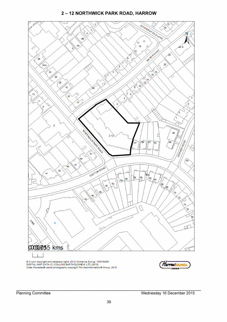
_______________________________________________________________________________________ Planning Committee Wednesday 16 December 2015
39
2 – 12 NORTHWICK PARK ROAD, HARROW

_______________________________________________________________________________________ Planning Committee Wednesday 16 December 2015
40
_______________________________________________________________________________________ Planning Committee Wednesday 16 December 2015
41

_______________________________________________________________________________________ Planning Committee Wednesday 16 December 2015
42

_______________________________________________________________________________________ Planning Committee Wednesday 16 December 2015
43
_______________________________________________________________________________________ Planning Committee Wednesday 16 December 2015
44
_______________________________________________________________________________________ Planning Committee Wednesday 16 December 2015
45
ITEM NO: 1/03 ADDRESS: TOWNSEND HOUSE AND EATON HOUSE 152 - 174
NORTHOLT ROAD, HARROW REFERENCE: P/2163/15 DESCRIPTION: DEMOLITION OF EXISTING BUILDINGS (USE CLASSES D1/ B1)
AND REDEVELOPMENT OF THE SITE TO PROVIDE 116 RESIDENTIAL FLATS (USE CLASS C3) INCLUDING AFFORDABLE HOUSING WITHIN A BUILDING RANGING FROM 6 TO 9 STOREYS IN HEIGHT WITH REFUSE STORES, VEHICLE AND CYCLE PARKING SPACES AT LOWER GROUND LEVEL; RAISED PODIUM AMENITY AREA; ASSOCIATED LANDSCAPING, ACCESS RAMPS, BOUNDARY TREATMENT AND NEW ELECTRONIC ENTRANCE GATES AT REAR; NEW VEHICLE CROSSOVER WITH ACCESS DRIVE FROM SHERWOOD ROAD (REINSTATEMENT OF EXISTING VEHICLE ACCESS POINTS); ASSOCIATED MECHANICAL AND VENTILATION PLANT INCLUDING PHOTOVOLTAIC PANELS; RELOCATION OF EXISTING ELECTRIC SUB-STATION (REVISED SCHEME)
WARD: ROXBOURNE APPLICANT: ORIGIN HOUSING AGENT: SAVILLS CASE OFFICER: SUSHILA BHANDARI EXPIRY DATE: 28/08/2015 RECOMMENDATION EXECUTIVE SUMMARY This application was originally reported to the 30th September 2015 Planning Committee Meeting with a recommendation for Grant (subject to an legal agreement). The Planning Committee resolved to defer the decision on this application, in order to allow the applicant the opportunity to re-consider the scheme based on the concerns expressed by Members at the meeting. There were three principle concerns raised by Members at the meeting which related to : 1) The height and scale of the proposed development and its impact upon the character
of the area and the impact in terms of overshadowing on the properties in Sherwood and Stanley Roads.
2) The failure to provide sufficient parking. 3) The failure to provide family size housing. Other issues raised by Members also included the potential noise disturbance from the proposed electronic gates to the undercroft parking, the potential for overlooking of the

_______________________________________________________________________________________ Planning Committee Wednesday 16 December 2015
46
first floor windows to Rose Court from the proposed podium garden, the loss of on-street parking bays and the provision of refuse storage. Following this deferral, the applicant met with Council Officers to discuss the approach forward to deal with the issues raised. Subsequent to this meeting, the applicant revised their proposal and engaged in a further public consultation event to present their revised proposal prior to submitting them formerly. Invitations to this public consultation event (by the Council) were sent to all those residents that originally responded to the first round of neighbour notifications and to local Ward Councillors. An invitation was also sent to London Assembly Member Navin Shah. This event was attended by one local resident and Assembly Member Navin Shah. In order to deal with the concerns raised by Members, the applicant has amended the scheme. The overall height of the building has been reduced by one storey, which would take the height of the building down to 9 storeys maximum. As a result of this reduction in height, the overall number of units has reduced from 123 to 116 units. In order to deal with the issue of overlooking of the rear gardens of the properties in Sherwood and Stanley Roads the applicant has introduced the provision of obscurely glazed balcony screens to the balconies in the west wing (fronting Sherwood Road) of the proposed development. It is also proposed to change the relevant rear facing windows in the section of the building fronting Northolt Road to directional windows to avoid any direct or perceived overlooking of the properties in Sherwood and Staley Roads. In order to deal with the issue of insufficient parking, the applicant has increased the number of parking spaces from 45 spaces to 53 spaces by introducing stackable parking bays. As the total number of units within the development has decreased to 116 units, the overall parking ratio for this development would be 0.46 spaces per flat. The applicant has also included the provision of 12 blue badge spaces to be provided for disabled drivers. The proposal would include 20% active electric car charging points and 20% ‘passive’ parking spaces to meet London Plan requirements. The proposal would also include the provision of 194 cycle parking spaces. There would be no net loss of on street parking bays to facilitate the new vehicular entrance to the undercroft parking space. The cost relocation of any on-street parking bays will be met by the applicant in agreement with the Highways Authority. The applicant has confirmed that the vehicle entrance gate would be operated with minimal noise disturbance. The applicant has also amended the undercroft layout to accommodate the required refuse storage to serve this development and also shown the temporary storage area for collections days. Officers consider that the applicant has taken the appropriate steps, including engaging with local residents again on this revised proposal to address the key issues raised. Each aspect of the amended scheme is discussed in detail in the appraisal below. As demonstrated below, Officers consider that the scheme before the Council is fully compliant with the adopted development plan policies and that the development now being proposed seeks to overcome the concerns raised by Members. Accordingly this application is being presented again to the Planning Committee with a recommendation for Grant. GRANT permission subject to authority being delegated to the Divisional Director of Planning in consultation with the Director of Legal and Governance Services for the completion of the Section 106 legal agreement and issue of the planning permission and
_______________________________________________________________________________________ Planning Committee Wednesday 16 December 2015
47
subject to minor amendments to the conditions or the legal agreement. The Section 106 Agreement Heads of Terms would cover the following matters:
i. Provision of 18 affordable rented flats and 29 shared ownership flats (41% of overall development)
ii. The submission of a Training and Employment Plan iii. Open Play Space Contribution: a contribution of £2,280 towards the improvement
of existing play space area within the locality of the site. iv. Legal Fees: Payment of Harrow Council’s reasonable costs in the preparation of
the legal agreement; and v. Planning Administration Fee: Payment of £500 administration fee for the
monitoring of and compliance with this agreement. REASON Whilst the proposed loss of B1 floorspace would be a departure from the development plan, having regard to the exceptional site circumstances and giving material weight to the extant prior approval to convert Eaton House into residential, it is considered that the overriding public benefits gained form a comprehensive redevelopment of the site in lieu of a piecemeal form of development that could come forward, would justify such a departure from the development plan. Furthermore, the provision of on-site affordable housing of 40% would meet the borough’s minimum target of 40% and would further contribute to the overriding public benefits that would be gained through this development. Notwithstanding the site allocation and policy provision for this site, it is considered that the departure from the development plan can be supported in this case for the reason outlined in the appraisal below and as discussed in detail below the proposal would be in accordance with other relevant development plan policies. The proposed redevelopment of the site would result in a modern, contemporary design that responds positively to the local context, and would provide appropriate living conditions which would be accessible for all future occupiers of the development. The layout and orientation of the buildings and separation distance to neighbouring properties is considered to be satisfactory to protect the amenities of the neighbouring occupiers and the development would contribute towards the strategic objectives of reducing the carbon emissions of the borough. The decision to GRANT planning permission has been taken having regard to the National Planning Policy Framework 2012, the policies and proposals in The London Plan (consolidated with all alterations since 2011)2015, the Harrow Core Strategy 2012 and the Development Management Policies Local Plan 2013, and to all relevant material considerations, and any comments received in response to publicity and consultation. RECOMMENDATION B That if by 31st March 2016, or such other extended period as may be agreed in writing by the Divisional Director – Regeneration and Planning in consultation with the Chair of the Planning Committee, the section 106 agreement is not completed, then it is recommended to delegate the decision to refuse planning permission to the Divisional Director – Regeneration and Planning on the grounds set out in the report. The proposed development, in the absence of a legal agreement to provide appropriate level of affordable housing on site that directly relate to the development, would fail to

_______________________________________________________________________________________ Planning Committee Wednesday 16 December 2015
48
comply with the requirements of policies 3.11 and 3.12 of The London Plan 2015 and policy CS1.J of the Harrow Core Strategy 2012, which seeks to maximise the provision of affordable housing delivery within the borough. INFORMATION This application is being reported to committee as the proposal constitutes development of more than 2 dwellinghouses and one that falls within a major category and therefore falls outside of Category 1(b) of the Scheme of Delegation. Statutory Return Type: Major Development Council Interest: None Gross Floorspace: sqm Net additional Floorspace: sqm GLA Community Infrastructure Levy (CIL) Contribution (provisional): Harrow CIL (provisional): NB: Affordable housing relief has not been applied to these amounts. This will be applied when upon submission of the liability notice. Site Description
• The application site comprises two attached buildings, five to six storeys in height located on the western side of Northolt Road.
• Townsend House fronts Northolt Road and has a lawful use as D1 (Education).
• Eaton House fronts both Northolt Road and Stanley Road and has a lawful use as B1 (Office). This building has prior approval to convert into 53 flats.
• Both buildings share a car park which is located at the rear and accessed from Sherwood Road.
• To the south west of the subject buildings is Rose Court, a small four storey building comprising 11 flats. Planning history relating to the subject site and Rose Court shows that all three buildings where constructed pursuant to planning permission granted under LBH/1580/13.
• To the north of the site and separated by Stanley Road is Bovis House, which is a six storey office building. This building is currently in the process of being converted into 101 flats under permitted development through the exercise of the prior approval process.
• Sherwood Road and Stanley Road located to the west of the subject site is characterised by traditional two-storey Victorian terraces.
• Directly opposite Townsend House, is a parade of two storey terraced properties comprising of ground floor commercial with residential above.
• To the north-east of the subject site is a small estate comprising of five storey, purpose built 1960’s blocks of flats.
• Directly to the south are a row of purposed built commercial/ office buildings at four storeys in height.
• The subject site is located in a designated Business Use Area as defined in the Site Allocations Local Plan (2013).
• South Harrow Town Centre and South Harrow Underground Station is located some 130 metres from the subject site.
• Parking restrictions operate on the surrounding roads.

_______________________________________________________________________________________ Planning Committee Wednesday 16 December 2015
49
Proposal Details
• The application proposes to demolish this existing building on the site and construct a new building ranging in height from six to 10 storeys.
• The new building would comprise 116 self-contained flats of which 47 units (41%) would be affordable housing (split as 18 units as affordable rent and 29 as shared ownership).
• The proposal would include a raised podium at the rear, which would also serve as an under-croft parking area.
• Due to the change in site levels, the under-croft parking would link into a semi-basement area, which would also accommodate refuse and cycle stores, plant rooms and electric sub-station.
• A total number of 53 car parking spaces are proposed of which 12 would be designated disabled spaces. Access to the car park would be from Sherwood Road and the entrance into the car park would be gated.
• The proposal would include a total 194 cycle parking spaces located within the basement area with an additional 4 cycle spaces located at ground level in front of the main entrance.
• The building would be served by 4 separate cores with each having lift access to the upper floors and basement area.
• Each unit would have access to a private balcony and access to the communal amenity area at the rear.
Revisions to Current Application
• Removal of the ninth storey fronting Northolt Road to reduce the overall height of the building to nine storeys.
• Reduction in the number of units from 123 to 116
• Reduction in the provision of on-site affordable housing from 50.5% to 41%
• Introduction of privacy screens and directional windows in the rear elevation of the proposed development.
• Increase in the number of parking spaces from 45 to 53 spaces. Disabled parking bays increased from 5 to 12 spaces. Cycle parking spaces increased from 124 to 194. Provision of active and passive electric charging points.
• Amendment to the refuse storage areas to fully accommodate the number of bins required.
Relevant History Eaton House LBH/16355 Outline: erection of 5 storey office block with basement and rear parking area (revised) GRANTED - 02/12/1981 LBH/20575 Details pursuant to planning permission lbh.16355 dated 2.12.81,5 storey office block with basement & parking GRANTED - 18/03/1982 LBH/25658 Five storey office building including car parking GRANTED - 14/06/1985 P/3363/10

_______________________________________________________________________________________ Planning Committee Wednesday 16 December 2015
50
Change of use of first and second floors from office (b1) to educational use (d1c) GRANTED – 21/03/2011 P/1490/14 Conversion of Offices (Class B1A) to Fifty Three Self-Contained Flats (Class C3) (PRIOR APPROVAL OF TRANSPORT & HIGHWAYS IMPACTS OF THE DEVELOPMENT, AND OF CONTAMINATION RISKS AND FLOODING RISKS ON THE SITE) GRANTED - 30/05/2014 Townsend House LBH/1580/13 Erection of 5 storey office block fronting Northolt Road. Demolition of nos.15 & 17 Stanley Road & 2, 4, & 6 Sherwood road & construction of link road & re-habitation of Nos.19.21,23 Stanley Road & erection of 4 storey block comprising 11 one bed flats (rear) GRANTED - 09/12/1977 LBH/16204 Waiver of condition no.18 attached to planning permission ref:LBH/1580/13 dated 9th December GRANTED - 10/01/1980 WEST/324/93/FUL Infill front extension and new entrance doors GRANTED - 10/08/1993 P/1283/07 Change of use of part ground floor from office to retail REFUSED - 31/05/2007 Reason for Refusal: The proposed change of use would, due to the loss of designated B1 office floor space of strategic importance to South Harrow and the wider Borough, be unacceptable in principle and contrary to policies SEM1 and EM13 and of the HUDP 2004 and recommendation 3B of the URS London Borough of Harrow Employment Land Study 2006. APPEAL ALLOWED – 16/11/2007 P/2457/09 Change of use of existing building from b1 [office] use to d1(c) [education] use. GRANTED - 15/01/2010 P/0216/10 Variation of condition 7 of planning permission ref: p/2457/09 dated 15 January 2010 for change of use of existing building from b1 (office) use to d1(c) education use APPROVED – 24/03/2013 Pre-Application Discussion (Ref.)
• P/4348/14/PREAPP The applicant had engaged extensively with the LPA in pre-application discussions with respect to the redevelopment of this site.
_______________________________________________________________________________________ Planning Committee Wednesday 16 December 2015
51
Applicant Submission Documents Planning Statement Design and Access Statement Travel Plan Transport Assessment Drainage Report and Flood Rick Assessment Energy Statement Code for Sustainable Homes (Pre-Assessment Report) Daylight and Sunlight Report Acoustic Planning Report Air Quality Assessment Consultations Thames Water Waste Comments: Surface Water Drainage – with regard to surface water drainage it is the responsibility of a developer to make proper provision for drainage to ground, water courses or a suitable sewer. In respect of surface water it is recommended that the applicant should ensure that storm flows are attenuated or regulated into the receiving public network through on or off site storage. When it is proposed to connect to a combined public sewer, the site drainage should be separate and combined at the final manhole nearest the boundary. Connections are not permitted for the removal of groundwater, where the developer proposes to discharge to a public sewer, prior approval from Thames Water Developer Services will be required. Reason – to ensure that the surface water discharge from the site shall not be detrimental top the existing sewerage system. Thames Water would recommend that petrol/ oil interceptors be fitted in all car parking/ washing/ repair facilities. Failure to enforce the effective use of petrol/ oil inceptors could result in oil-polluted discharges entering local watercourses. No impact piling shall take place until a pilling method statement (detailing the depth and type of piling to be undertaken and the methodology by which such piling will be carried out, including measures to prevent and minimise the potential for damage to subsurface sewerage infrastructure, and the programme for the works) has been submitted to and approved in writing by the local planning authority in consultation with Thames Water. Any piling must be undertaken in accordance with the terms of the approved piling method statement. Reason: The proposed works will be in close proximity to underground sewerage utility infrastructure. Piling has the potential to impact on local underground sewerage utility infrastructure. We would expect the developer to demonstrate what measures he will undertake to minimise groundwater discharges into the public sewer. Groundwater discharges typically result from construction site dewatering, deep excavations, basement infiltration, borehole installation, testing and site remediation. Any discharge made without a permit is deemed illegal and may result in prosecution under the provisions of the Water Industry Act 1991. Should the Local Planning Authority be minded to approve the planning application, Thames Water would like the following informative attached to the planning permission. “A Groundwater Risk Management Permit from Thames Water will be required for discharging groundwater into a public sewer. Any discharge made without a permit is deemed illegal and may result in prosecution under the provision of the Water Industry Act 1991. We would expect the developer to demonstrate what
_______________________________________________________________________________________ Planning Committee Wednesday 16 December 2015
52
measures he will undertake to minimise discharges into the public sewer”. Following initial investigation, Thames Water has identified an inability of the existing waste water infrastructure to accommodate the needs of this application. Should the Local Planning Authority look to approve the application, Thames Water would like the following ‘Grampian Style’ condition imposed. “Development shall not commence until a drainage strategy detailing any on and/ or off site drainage works, has been submitted to and approved by, the local planning authority in consultations with the sewerage undertaker. No discharge of foul or surface water from the site shall be accepted into the public system until the drainage works referred to in the strategy have been completed”. Reason – The development may lead to sewage flooding; to ensure that sufficient capacity is made available to cope with the new development; and in order to avoid adverse environmental impact upon the community. Should the Local Planning Authority consider the above recommendation is inappropriate or are unable to include it in the decision notice, it is important that the Local Planning Authority liaises with Thames Water Development Control Development prior to the Planning Application approval. Thames Water requests that the Applicant should incorporate within their proposal protection to the property by installing for example, a non- return value or other suitable device to avoid the risk of backflow at a later date, on the assumption that the sewerage network may surcharge to ground level during storm conditions. Water Comments With regards to water supply, this comes within the area covered by Affinity Water Company. Supplementary Comments Following initial investigation, a connection to the surface water sewer using either TQ14863514 or TQ14863503 on Sherwood Road would require the developer to finance an Impact study. However if the connection is made to TQ14863502 in Sherwood Road no impact study would be required. No impact study is required for connection to the foul water network. Environmental Health Team Air quality I am satisfied with air quality assessment. Please note it requires mitigation for ground floor dwellings with ventilation to be drawn from the Sherwood Road side. Also for demolition and construction air quality and emissions a management plan will need to be put in place to mitigate adverse effects. Contaminated land As brown field site I recommend imposition of the standard contaminated land planning conditions. Noise In terms of the acoustic report, I am generally satisfied with it. It recommends double glazing with appropriate ventilation because of the high noise levels affecting the SE façade. However, it also gives recommendations for plant noise emission criteria (section 3) which I disagree with. The normal standard would be for noise level limits to be 10dBA below the background LA90 level for all operating plant at 1m from the nearest noise

_______________________________________________________________________________________ Planning Committee Wednesday 16 December 2015
53
sensitive façade. However they suggest designing equal to the background level, pending discussions with the Environmental Health Officer. This is because of the relatively low levels involved. However I disagree that such a standard is “arguably outside the scope of BS4142” which is an appropriate reference. Therefore plant noise emission criteria should be designed to 10dBA below the background LA90 level for all operating plant at 1m from the nearest noise sensitive façade unless otherwise agreed. This could be set as a planning condition if appropriate. Housing Enabling Team The affordable housing offer from Origin Housing Group represents just over 50% of the total of 123 homes. The starting point for affordable housing provision is a 60:40 split (rent: shared ownership) within the offer. Based on a “target” 40% affordable housing offer this would translate into 29 homes for rent and 20 for shared ownership. Within the scheme 21 affordable rented homes are being made available and 41 shared ownership homes. Whilst it is disappointing that there is a deficit of some 8 affordable rented homes it is fair to say that the applicant has endeavoured to provide as many 2 bedroomed 4 person homes for rent as possible. At the time of discussions this was, and remains, a priority need.* Shared ownership provision exceeds policy and the applicant has also stated that it intends to endeavour to ensure that these are made at “affordability levels well below the GLA affordability thresholds”. We ask that Planning ensure through condition or the S106 that wheelchair homes (where it is noted that one more than policy requires within the affordable rented element is being provided) are delivered ready for immediate occupation by nominees. Housing Enabling and its surveying colleagues are happy to review proposals at the next appropriate design stage. Please also ensure that sufficient disabled parking bays are included in the development for every wheelchair home in the affordable rented tenure. Space for buggies and battery charging should also be provided. Subject to the above Housing Enabling support this application. Drainage Authority The FRA submitted is satisfactory; however, your approval should still be conditioned with our three drainage conditions as full drainage design is still required. Highways Authority They should be providing 189 cycle parking spaces. No mention of electric vehicle charging points – this need to be provided at a minimum of 20% active and 20% passive. There should be at least 1 motorcycle parking space. This development will need to be permit restricted. The relocation of the vehicle access is not a concern. Visibility is acceptable from all directions.
_______________________________________________________________________________________ Planning Committee Wednesday 16 December 2015
54
We will have to review what happens to the existing on-street parking bays but that can be done at a later date. If it is not feasible to either retain or relocate the bays, a suitable course of action can be agreed on. Advertisement Departure of Development Plan Major Development First Round of Consultation Posted: 4th June 2015 Expired: 9th July 2015 Site Notice Posted: 04.06.2015 Expired: 25.06.2015 Second Round of Consultation Advertisement Posted: 12.11.2016 Expired: 03.12.2015 Site Notice Posted: 12.11.2016 Expired: 03.12.2015 Notifications First Round Sent:513 Replies:23 (responses received from Nos. 22, 70, 73, 75, 79, Stanley Road and Nos. 10, 24, 29, 26, 25, 31, 33, 39, 44, 45, 46, 48, 56, 54 Sherwood Road) Expiry: 23/06/2015 Second Round Sent:513 Replies:0 Expiry: 30/11/2015 Addresses Consulted Please refer to attached site plan. Summary of Responses
• Parking is an issue – often blocked in by the Lohana traffic – well documented traffic flow and parking issues in Stanley Road during large events at DLC in Brember Road
• Parking provision is of concern parking should be 1:1 as most residents own cars
• The proposed density of the building will further worsen the restricted parking conditions present resident suffer under
• Access still needs to be addressed
• Entrance and exit car ramp to the building’s parking is positioned on Sherwood Road on a blind corner already risky due to the number of cars parked on it and around it – highly dangerous for pedestrians

_______________________________________________________________________________________ Planning Committee Wednesday 16 December 2015
55
• Traffic movement based on existing use is nonsensical because these are not residential properties
• Will there be any restriction on washing hanging on the balconies?
• Development is overweight at the rear
• Too tall and overdevelopment – ten storeys is unacceptable
• Proposed building’s appearance is severe and imposing – totally out of character and of crude form compared to the existing narrow houses of low rise Victorian terraces
• Excessive height would overshadow the existing low-rise homes and adversely impact the local street scene – impact on local skyline – decrease in sunlight on Sherwood Road will be enormous – the building will cast a long shadow over Sherwood Road’s existing properties to due orientation.
• Impact on privacy of a large number of houses
• 123 flats is too dense
• 101 flats adjacent Bovis House are already occupied
• 180 flats at Bridge Court Stanley Road with regular occurrences of ASB – experience has caused deterioration to this community
• Peaceful residence is under threat in Stanley Road – the location is already at full capacity – residents will suffer from decreased standard of living that contravenes Local Plan Core Strategy
• Infrastructure including sewers and drainage is of great concern
• A fatal gas blast in May 2008 next to this site raised issued of old pipework – the safety of existing homes is paramount
• Application to develop residential housing in place of the existing commercial-use building contravenes the Local Plan Core Strategy
• Prior approval already been granted for Bovis House and Eaton House, the redevelopment of Townsend House will have the cumulative impact of destroying available and much needed commercial use properties in the borough and especially in the Northolt Road area. Application contravenes the local council’s strategy for economic activity in Harrow
• Apartments clearly do not cater to families with children and instead target transient renting demographic – contradicts national policies about the necessity for a plan for mixed housing
• Marked deterioration of the area APPRAISAL Section 38(6) of the Planning and Compulsory Purchase Act 2004 requires that: ‘If regard is to be had to the Development Plan for the purpose of any determination to be made under the Planning Acts, the determination must be made in accordance with the Plan unless material considerations indicate otherwise.’ The Government has issued the National Planning Policy Framework (NPPF), which consolidates national planning policy and is a material consideration in the determination of this application. In this instance, the Development Plan comprises The London Plan 2015 and the Local Development Framework (LDF). The LDF comprises The Harrow Core Strategy 2012, Harrow and Wealdstone Area Action Plan (AAP) 2013, the Development Management Policies Local Plan (DMP) 2013, the Site Allocations Local Plan (SALP) 2013 and Harrow Local Area Map (LAP) 2013. MAIN CONSIDERATIONS

_______________________________________________________________________________________ Planning Committee Wednesday 16 December 2015
56
Principle of the Development Affordable Housing Housing Density and Unit Mix Design, Character and Appearance of the Area Residential Amenity/ Noise Traffic, Safety and Parking Development and Flood Risk Accessibility Sustainability Air Quality Environmental impact Assessment (EIA) Statement of Community Involvement Planning Obligations Equalities Impact S17 Crime & Disorder Act Consultation Responses Principle of the Development Policy Context The National Planning Policy Framework (NPPF) was published by the Government on March 27th 2012. The NPPF does not change the law in relation to planning (as the Localism Act 2012 does), but rather sets out the Government’s planning policies for England and how these are expected to be applied. It remains the case that the Council is required to make decisions in accordance with the development plan for an area, unless other material considerations indicate otherwise (S.38(6) of the Planning Act). The development plan for Harrow comprises: - The London Plan (consolidated with alterations since 2011) 2015 - The Local Development Framework [LDF] comprising:
o The Harrow Core Strategy 2012 o Development Management Policies Local Plan 2013 o Harrow and Wealdstone Area Action Plan 2013 o Site Allocations Local Plan 2013
The NPPF sets out policies and principles that local planning authorities should take into account, when both preparing local plans, and determining planning applications. The policies within the NPPF are a material consideration that should be given significant weight. At the heart of the NPPF is the presumption in favour of sustainable development. Under paragraph 7 it sets out three dimensions to sustainable development: economic, social and environmental. It goes on to state under paragraph 8 that these roles should not be taken in isolation as they are mutually dependant and thus to achieve sustainable development, economic, social and environmental gains should be sought jointly and simultaneously through the planning system. Pursuing sustainable development involves seeking positive improvements in the quality of the built, natural and historic environment, as well as in people’s quality of life (Para. 9). In terms of decision taking set under paragraph 14 gives effect to
• approving development proposals that accord with the development plan without delay; and
• where the development plan is absent, silent or relevant policies are out-of-date, granting permission unless:
o any adverse impacts of doing so would significantly and demonstrably

_______________________________________________________________________________________ Planning Committee Wednesday 16 December 2015
57
outweigh the benefits, when assessed against the policies in this Framework taken as a whole; or
o specific policies in this Framework indicate development should be restricted, for example (as set out under footnote 9) those policies relating to inter alia land designated as Green Belt or designated heritage assets.
The Further Alterations to the London Plan were the subject of examination-in-public during 2014. In March 2015 the Mayor of London published an updated version of the Plan consolidated with the adopted further as well as previously adopted alterations. The spatial strategy for London is set out at chapter 2 of the London Plan. It uses a number of strategic designations to identify areas for more accelerated levels of change, pursuant to the objective of accommodating London’s objectively assessed development needs. Site EM1 of the Site Allocations document allocates the Northolt Road business use area for employment-led redevelopment to deliver at least 150 homes and employment floorspace (including offices but excluding other main town centre uses). An indicative figure of 10,660m2 employment floorspace for the area overall is given but paragraph 3.6 confirms that the amount to be provided in individual proposals will be determined by the nature of the use and the extent of enabling residential or other development. Any proposals for the change of use of within a designated Business Use Area will be assessed against policy DM31 of the Development Management Policies Local Plan 2013 (DMP). In particular any proposal that would lead to the loss of Business Use Land/ Floorspace will need to satisfy criterion C and D of this policy as set out below. DM31 (C) The loss of industrial and business land and floor space to non-employment uses will only be permitted having regard to Policy CS1 O and where:
a. it can be demonstrated that a site is no longer suitable and viable for its existing or an alternative industrial or business use; and
b. a suitable period of continuous marketing activity has been undertaken without success.
DM31 (D) Where the loss of industrial or business floorspace can be demonstrated to the satisfaction of the Council, as required in (C) above, the Council will apply a sequential approach to redevelopment as follows:
i. proposals for alternative employment uses, excluding main town centre uses; ii. proposals for strategic community infrastructure not appropriate to town centre
locations; and iii. mixed use proposals that include and facilitate a significant element of
employment generating uses and/ or community uses. As Townsend House was last in use as education, it would also be assessed against policy DM47 of the DMP. Policy 3.18C of The London Plan 2015 seeks to resist the loss of educational facilities, unless it can be demonstrated that there is no ongoing or future demand for such a facility. Policy 3.16B of The London Plan is also of relevance which seeks the protection and enhancement of social infrastructure (such as colleges). This is reinforced under

_______________________________________________________________________________________ Planning Committee Wednesday 16 December 2015
58
policy DM47 of the Development Management Policies Local Plan (2013) (DMP) which also sets additional requirements to be met, such as evidence of marketing, that there are other adequate similar facilities within walking distance that offer equivalent provision or that the activities carried out cannot be made consistent with acceptable living conditions for nearby residents or the redevelopment of the site would secure an over-riding public benefit. In line with the policy DM31, the onus would be on the applicant to demonstrate that the existing business floor space/ land is no longer viable and that the site has been actively been marketed for a continuous period without any success. Notwithstanding this, criterion D of this policy will only support proposals that would either retain some form of alternative employment use or where in the case of mixed use proposals a significant element of employment or community uses. The Core Strategy and the subsidiary Local Plan documents provide a clear and positive planning strategy for delivering sustainable economic growth in Harrow over the plan period to 2026. A residential-only scheme on this site would run counter to that strategy by failing to contribute to economic development and job creation objectives. Any such proposal would therefore constitute a departure from the development plan. Appraisal As noted above, the site is located within the Northolt Road Business Use Area (South) and its site allocation (EM1) envisages mixed-use redevelopment, with employment floor space and enabling residential development (100 homes). The proposal involves the loss of vacant office (B1a) and education (D1) floor space and the development of 116 new build flats, of which 47 (40.5%) will be affordable. Whilst every application needs to be assessed against the Council’s development plan (i.e. London Plan and Harrow Local Plan) and the applicant has not sought to justify the loss of the B1a employment land against Policy DM32 (Office Development), the fact that prior approval has been granted for the conversion of Eaton House from office to residential should be regarded as a material consideration. Policy DM47 (Retention of Existing Community, Sport and Education Facilities) permits the loss of education facilities when the re-development of the site would secure an over-riding public benefit, and this is relevant in the context that the adjoining Eaton House could potentially come forward for residential development in the existing building, under Permitted Development. Whilst there has been a decline in vacant office space in the 12 months to March 2015, there remains 29,113 sq. m of vacant office space across the whole borough, including 16,431 sq. m of vacant office space in the nearby Harrow Opportunity Area. Despite the loss of office / employment and educational uses, on balance the proposal is considered acceptable as it would enable the comprehensive redevelopment of the site, compared to a piecemeal form development that would occur if the existing Eaton House was simply converted from office to residential under Permitted Development. Leaving a building in use class D1 (Townsend house) in close proximity to a residential use. Furthermore, a comprehensive redevelopment of the entire site, allows the local planning authority to consider the development standards relating to internal space, amenity space and carbon reduction whereas this would not be possible should the conversion of Eaton House come forward under Permitted Development. Most notably
_______________________________________________________________________________________ Planning Committee Wednesday 16 December 2015
59
the overriding public benefit would be the provision of 40.5% affordable housing, which would be consistent with the development plan policies and a better outcome compared to the provision of no affordable housing as part of the conversion of Eaton House under Permitted Development. In terms of the loss of the loss of the education use on this site, planning permission was granted under ref: P/2457/09 for the change of use of Townsend House from B1 offices to D1 education. At the time of when this permission was granted a full marketing report was submitted in support of this application which concluded at that time that there was a surplus of office floorspace within the borough and that there was no demand for the type of office space being offered by Townsend House. Council records show that at the time of when the application was considered the College that was seeking to use the premises mainly catered for the adult population, providing courses primarily aimed at overseas students. However, since this period the central government have introduced tighter measures on student immigration and consequently Colleges such as Zaskein College, which primarily relied upon overseas students as its form of funding has seen a marked decline in new student enrolment. Harrow as a broad range of education establishments in the borough. It is considered that the loss of the D1 use would have no detrimental impact upon education provision in the borough. The use of the site as alternative forms of education establishment such as primary or secondary school would not be suitable given the site circumstances set out above in regard to Eaton House. It is also considered that the change of use would provide an over-riding public benefit through the delivery of high quality new homes in a sustainable location (criterion d) of policy DM47. Conclusion In summary, whilst the proposed loss of B1 floorspace would be a departure from the development plan, having regard to the exceptional site circumstances comprising two adjoining building with distinctive uses and giving material weight to the extant prior approval to convert Eaton House into residential, it is considered that the overriding public benefits gained form a comprehensive redevelopment of the site in lieu of a piecemeal form of development that could come forward, would justify such a departure from the development plan. Furthermore, the provision of on-site affordable housing of 50% would more than exceed the borough’s minimum target of 40% and would further contribute to the overriding public benefits that would be gained through this development. Notwithstanding the site allocation and policy provision for this site, it is considered that the departure from the development plan can be supported in this case for the reason outlined above and as discussed in detail below the proposal would be in accordance with other relevant development plan policies. Affordable Housing Policy Context Policy CS1.J of the Harrow Core Strategy 2012 sets an aim for 40% of new housing development in the borough to be affordable housing and states that the Council will seek the maximum reasonable amount of affordable housing on all development sites with a capacity to provide for ten or more units having regard to various criteria and the viability of the scheme. Such requirements are in line with London Plan policy 3.12.A/B which requires the maximum reasonable level of affordable housing to be provided. The

_______________________________________________________________________________________ Planning Committee Wednesday 16 December 2015
60
reasoned justification to policy 3.12.A/B of The London Plan 2015 states that boroughs should take a reasonable and flexible approach to securing affordable housing on a site by site basis. The consolidated London Plan 2015 designates Harrow and Wealdstone as an Opportunity Area and seeks to increase the minimum annual housing target for Harrow from 350 to 593 per annum. Policy 3.11A of The London Plan sets out that of the 60% of the affordable housing should be for social and affordable rented accommodation and 40% for intermediate rent or sale of the overall affordable housing provision on any given development site. Policy 3.11B sets out that, individual boroughs should set out in their LDF the amount of affordable housing provision needed. This is further reinforced under policy DM24 of the DMP, which seeks a target mix for affordable housing. Appraisal The applicant is Origin Housing, and according to the supporting documents submitted, it is an affordable housing provider with a proven track record in delivering and managing mixed tenure and mixed-use developments. The applicant originally submitted a financial viability appraisal for the development site, which was based on the provision of 50.5% affordable housing of the overall housing scheme. This is broken down as 61 private market units, 41 shared ownership units and 21 social rented units. The Council originally tendered an external review of this viability, which after adjusting some of the assumptions made the viability submitted for the 50.5% affordable housing scheme showed that based on the assumptions made in terms of the gross development value and the cost of the development, the residual land value when taking into consideration the benchmark value of the existing land would generate a surplus of £347,019, although this becomes a deficit of £236,077 if profit is included on affordable housing, which is generally considered acceptable when assessing a viability of the scheme. The viability assessments undertaken by HEDC and BNP both concluded that if the scheme was to deliver a policy compliant tenure split of 60% affordable rent and 40% shared/ intermediate housing would reduce the overall provision of affordable housing on this site and would further worsen the viability position of this scheme. As noted above, this application was deferred by the Planning Committee at its meeting on the 30th September to allow the applicant to re-consider the submitted proposal in light of the concerns raised at the meeting. As a consequence of the reduction in the height of the overall development to nine storeys, the number of units provided on the site has decreased from 123 units to 116 units. Consequently this has meant that the overall provision of on-site affordable housing has been reduced. The overall provision of affordable housing has been reduced from 50.5% to 40.5%, which would still deliver a policy complaint scheme. The applicant provided an updated cost appraisal to reflect the change in the development proposal which has been internally reviewed by Council Officers. BNP were happy with the various inputs in the original appraisal and these have been carried through to the new appraisal, so no issues in this regard. The applicant has however now included a developer profit of 6% for affordable housing, whereas previously they omitted that even though it is a standard inclusion.

_______________________________________________________________________________________ Planning Committee Wednesday 16 December 2015
61
It is noted that the new appraisal seems to adopt the same floor area as the original scheme for the construction costs, even though the new proposal is smaller. This will over-inflate the build costs and push down the residual price. The new residual land value is £2.3M (was £3.6M originally), but this is well below the BNP benchmark of £3.388M i.e. no surplus. BNP’s appraisal accepted the scheme couldn’t achieve a policy compliant tenure split (60/40), with 34/66% proposed and an overall 50.4% affordable housing provision. The new scheme proposes 40.5% overall AH provision, with a 38.3/61.7% tenure split (Affordable Rent /Shared Ownership), which is closer to being policy compliant from a tenure perspective. Given that the current viability assessment results in a residual price below the benchmark value, there is no real scope to try to boast the tenure mix. The only outstanding issue is the fact they have used the same floor space for the construction costs, even though the scheme is smaller. However, even with a crude adjustment based on the smaller number of units (116 units versus 123 units is a 7 units / 5.7% reduction from the original scheme). This crudely reduces construction costs by £1.1M and therefore increases the residual value by the same amount, taking it to £3.4M; this equals the benchmark value of £3.4M from BNP. BNP accepted a slight surplus in the original appraisal, with this mainly being due to no developer profit on the affordable housing element. The new appraisal includes it, which is reasonable. Even if it was not included, the surplus would still only be of a similar amount to that accepted by BNP originally. In summary, the appraisal reflects the assumptions used in the previous appraisal and does not return a meaningful surplus that could be used to seek additional affordable housing. The scheme is policy compliant with a 40% affordable housing provision, but does not reflect the policy required tenure mix but this was accepted previously and the new split closer to being policy compliant than the original scheme. Apart from the construction floor space issue, the assessment seems acceptable. Officers consider that correcting the floor space figure / construction costs would not result in any massive surplus given the current deficit. As such Officer’s consider that it is not necessary for the Council to approach BNP to re-appraise this scheme.. The Council’s Housing Enabling Team is satisfied with the revised level of affordable housing tenure split being proposed, however have stated that a review clause should be included as part of the section 106 agreement which would secure further affordable rented housing on the site should viability improve. Given that the level of shared ownership would be much higher and given that the overall provision of affordable would be meet the minimum 40%, it is considered that a review mechanism would not be required in this instance. Indeed, such an approach would be considered unreasonable. This is further reinforced under paragraph 3.75 of the reasoned justification to policy 3.12 of The London Plan which sets that boroughs should consider whether it is appropriate to put in place provisions for re-appraising the viability of a scheme prior to its implementation. In particular, to take into account of economic uncertainties and in respect of schemes presently anticipated to deliver low levels of affordable housing. As the scheme would deliver a level of affordable housing
_______________________________________________________________________________________ Planning Committee Wednesday 16 December 2015
62
well in excess of the minimum of 40%, there is no policy basis to require a further review of the scheme through a section 106 obligation. Conclusion Whilst it is noted that the proposed tenure split of would not strictly comply with the 60/40 tenure split set out in the London Plan and the DMP, it is concluded that the level of total affordable housing at 40.5%, which would be secured by a section 106 agreement would meet he minimum policy requirement of 40%. Based on the above factors, it is considered that the development would accord with policies 3.11 and 3.12.A/B of The London Plan 2015, policy CS1.J of the Harrow Core Strategy 2012 and policy DM24 of the DMP. Housing Supply, Density and Overall Unit Mix Paragraph 48 of the NPPF reminds local planning authorities that housing applications should be considered in the context of the presumption in favour of sustainable development. London Plan and Local Plan policies on housing development must be viewed in the context of the forecast growth across London and Harrow’s spatial strategy for managing growth locally over the plan period to 2026. In this regard, it should be noted that, following the recently adopted further alterations to the London Plan, London’s annual housing monitoring target has increased from 32,210 to 42,389 homes p.a. and this includes Harrow’s target which has increased from 350 p.a. to 593 p.a. Furthermore, the site is within the South Harrow Core Strategy sub area to which Policy CS4 H seeks at least 406 new homes over the plan period to 2026. The proposal’s 123 homes would make a contribution equivalent to 21% of the new London Plan annual target and 30% of the Core Strategy sub area’s target. London Plan Policy 3.4 seeks to optimise housing output from development by applying the sustainable residential quality density matrix at Table 3.2 of the Plan. Supporting text to the policy makes it clear that the density matrix is only the start of planning for housing development and that it should not be applied mechanistically. Further guidance on how the matrix should be applied to proposals is set out in the Mayor’s Housing SPG (2012). The application site area is 0.28 hectares and it has a public transport accessibility level (PTAL) score of between 4 indicating a moderate-to-good level of public transport accessibility. The overall scheme has been revised and it now proposes 116 units. The proposal, taken as a whole, equates to a density of 414 units per hectare and, based on 293 habitable rooms, a density of 1,046 habitable rooms per hectare. The revised scheme would marginally exceed the upper end of the relevant density ranges for development in a central setting1 of 405 units per hectare, but would meet the habitable room range of 1,100 habitable rooms per hectare where the PTAL score is between 4 and 6. However, as noted above, the matrix is only the starting point for considering the density of development proposals. The applicant’s Design & Access Statement describes the urban context of the site, including Sherwood House (4 storey office building), Bovis House (6 storey former office
1 ‘central setting’ is defined at Table 3.2 of the London Plan as “(areas with very dense development, a mix
of different uses, large building footprints and typically buildings of four to six storeys, located within 800 metres walking distance of an International, Metropolitan or Major town centre”.

_______________________________________________________________________________________ Planning Committee Wednesday 16 December 2015
63
building, being converted to flats) and 4 storey residential blocks on the opposite side of Northolt Road. The Design and Access Statement goes on to explain how the massing and design of the proposal has evolved in response to this context, the constraint of neighbouring Rose Court and the modest, traditional residential environment to the rear of the site. Taking these factors into account and the desirability of making efficient use of this accessible, previously developed site, it is considered that the density of the proposal is acceptable. Paragraph 50 of the NPPF states that local planning authorities should plan for a mix of housing, based on demographic and market trends, and the needs of different groups, and that they should identify the size, type, tenure and range of housing that is required in particular locations. This approach is reflected in the planning decisions provisions of London Plan Policy 3.8 Housing Choice. Local Plan Policy DM24 undertakes to support proposals that secure an appropriate mix of housing on site and which contribute to the creation of inclusive and mixed communities. The policy goes on to have regard to, inter alia, the location of the site, the character of its surroundings and the need to optimise housing output on previously-developed land. The West London Strategic Housing Market Assessment (SHMA) (2010) reports the findings of detailed modelling of housing needs taking into account demographic and market trends and the needs of different groups. In terms of Harrow’s market housing, the Assessment reports a shortfall of 2 and 4 bedroom homes in the owner-occupier sector and a shortfall of 1 and 3 bedroom homes in the private rented sector. Notwithstanding these findings, and noting that that new build housing only accounts for a fraction of the overall housing stock in the Borough, paragraph 6.8 of the reasoned justification to Policy DM24 goes on to state that “,the Council does not consider it justified to prioritise dwelling sizes for market housing and advocates that, whilst having regard to identified needs, seeks to match housing mix to the location and nature of allocated sites, or sites likely to become available”. The housing mix of the proposal overall and of the open market component is set out in the table below:
Table 1: Detailed Housing Mix
Unit Size No. of Units (Total)
% of All Units
No. of Units
(Market)
% of Market Units
% of All Units
1 Bed2: 51 44% 35 57% 28%
2 Beds: 65 56% 34 43% 21%
Totals: 116 100% 68 100% 49%
Table 1 demonstrates that the overall housing mix of the proposal is skewed slightly in favour of 2 bedroom flats overall, and slightly in favour of 1 bedroom flats in respect of the open market component of the scheme. In view of the site location, being in very close proximity to a district centre and on a busy arterial road, a majority of smaller and flatted units suitable for young professionals and newly-formed households, whether as first-time buyers or in the private rented sector, is to be expected.
2 One of the proposed flats are described as studios but are shown on the floorplans as one bedroom flats.
Accordingly these are assessed as being one bedroom flats.

_______________________________________________________________________________________ Planning Committee Wednesday 16 December 2015
64
Whilst it is noted that there is a requirement to provide family sized units, given the site context i.e. high rise density development within a town centre location, the proposed dwelling type mix is considered to be appropriate to this location. Larger family sized units would require greater provision of amenity space which this scheme could not deliver. Furthermore, Housing Colleagues have raised no objection to the proposed mix and have confirm that the current demand is for 2 bed 4 person units, which this scheme delivers Thus it is considered that the proposed mix of home types/sizes would respond to the location of the site and the character of its surroundings whilst optimising the housing output of this accessible previously-developed site. The proposal would also, it is noted, add to the supply of modern homes in the area, all of which would achieve the Lifetime Homes standards and 10% of which would also achieve the enhanced requirements needed to be classified as Wheelchair-standard homes. Taken together with the affordable housing component (see the affordable housing section of this report), it is concluded that the proposal would make a positive contribution to the creation of inclusive and mixed communities in the South Harrow sub area. Design, Character and Appearance of the Area The NPPF reiterates the Government’s commitment to good design. However the NPPF is also clear that local planning authorities should not attempt to impose architectural styles or particular tastes, and emphasises that good design goes beyond the consideration of visual appearance and architecture. London Plan Policy 7.4 provides some context criteria for the consideration of design. Policy 7.6 sets out a wide ranging set of criteria for the consideration of proposed buildings and structures. Many of these – relating to issues of amenity, climate change, the quality of indoor and outdoor spaces, inclusive design and land-use optimisation – are dealt with in separate sections of this report. Those relating to character (7.4) and architecture, form and activities/uses (7.5) are incorporated in the appraisal below. Core Strategy Policy CS1 requires development proposals to respond positively to the local and historic context, and to reinforce positive attributes of local distinctiveness whilst promoting innovative design and/or enhancing areas of poor design. Policy DM1 of the Local Plan requires all development to achieve a high standard of design and layout. It goes on to set out a number of design and layout considerations to this end. Further, local guidance is set out in the Harrow Residential Design Guide SPD. The Design and Access Statement submitted with the application provides a detailed explanation of the context of the site, the urban design concept of the proposal and movement through the site. Massing, bulk, scale and height of buildings The massing, bulk, scale and height of the proposal is a response to the existing buildings on the site, the opportunity provided by the site corner at the junction of Northolt Road and Stanley Road, and the part existing/part emerging character of development on this side of Northolt Road for larger commercial and higher density residential buildings. The fall in levels from the Northolt Road frontage towards the rear of the site is a further factor in the formulation of the proposal. The main ‘arm’ of the building would front Northolt Road and would have a main height
_______________________________________________________________________________________ Planning Committee Wednesday 16 December 2015
65
of 18 metres/6 storeys. A contextual drawing submitted with the application demonstrates that this 6 storey element of the arm would be broadly equivalent in height and width to the existing Townsend House building. A further 5.8 metres/2 storeys height above this element of the main arm would be set in from the Northolt Road frontage by 3.6 metres and from the south-west end elevation by some 12 metres. The effect of these set-ins would be to provide a degree of continuity in the streetscene between the height of this arm and the height of Bovis House, and to ensure a graded or ‘stepped’ change in heights between the development and neighbouring Sherwood House and Rose Court (both 4 storeys). As noted above, following the deferral of this application from the 30th September Planning Committee meeting, the overall height of the building has been reduced down from 10 storeys to 9 storeys to take on board the concerns raised by Members and local residents. The highest part of the proposal is now shown to be 26.4 metres/9 storeys and would form an element of more vertical visual emphasis, contrasting with the horizontal proportions of the main ‘arm’ fronting Northolt Road. A contextual drawing submitted with the application demonstrates that this element would be 9 metres3 storeys higher than the equivalent height of the existing Eaton House building and neighbouring Bovis House. It is considered that the height of this element is the minimum necessary to ensure that it appears as a landmark component of the building at the site’s prominent corner in the streetscene of Northolt Road. A lesser height would not, it is considered, sufficiently differentiate this element from the other arms of the proposed building. The secondary ‘arm’ of the building would front Stanley Road and would be 24 metres/8 storeys high where it adjoins the landmark corner element, although there is a moderate fall in levels away from Northolt Road which would be reflected in the height of the elevation fronting Stanley Road. A contextual drawing submitted with the application demonstrates that this element would be 6 metres/2 storeys higher than the equivalent height of the existing Eaton House building, although it would be set further back from the from Stanley Road (by 2 metres) and Sherwood Road/Stanley Road link road (by 2.5 metres) than the existing building. The existing Eaton House building creates a visual juxtaposition between the site and the more traditional scale/form of residential development in Stanley Road and Sherwood Road. The proposal, by adding height/bulk to this part of the site, could be said to strengthen the existing visual juxtaposition. The final return ‘arm’ of the building would front the Sherwood Road/Stanley Road link road. For the most part this would comprise the flank end wall of the secondary arm, but would also include a 9 metres wide chamfered southward projection. A more pronounced change in levels to this elevation would enable the formation of a ‘lower ground’ level. Consequently, the flank end wall element would have a height of 26 metres/9 storeys. The chamfered projection would be 23.5 metres high/8 storeys. A contextual drawing submitted with the application demonstrates that this element would be 6 metres/2 storeys higher than the equivalent height of the existing Eaton House building, and it would be substantially wider in this elevation. Nevertheless, it is considered that the above observations on visual juxtaposition apply equally to this arm of the building. A further change to the existing Sherwood Road/Stanley Road link road would be the introduction of the amenity space podium deck. This would have a height of 4 metres but would be set back from the site boundary by between 6 and 14 metres, and has the potential to have its appearance softened by landscaping atop it.
_______________________________________________________________________________________ Planning Committee Wednesday 16 December 2015
66
In the context of national, regional and local policies that require efficient use of previously-developed sites in accessible locations, it is considered that the proposal provides an appropriate response. The massing and proportions of that part of the proposal fronting Northolt Road would reflect the part existing/part emerging character of development on this side of Northolt Road for larger commercial and higher density residential buildings. The south-western end of the building would be scaled so as to respond to the neighbouring Sherwood House and Rose Court buildings, whilst at the north-eastern end the introduction of a prominent landmark feature would mark the development’s presence in the streetscene of Northolt Road. The secondary and return arms of the development would manage a change in site levels to the rear of the site but would retain and strengthen the juxtaposition between Northolt Road development and more traditional residential areas behind. In considering the overall massing and scale in context of Northolt Road itself, the corner height of 9 storeys would not appear out of context with the established pattern of development and scale along Northolt Road itself. For example Eastcroft House located on a prominent corner junction of Northolt Road and the access road to Waitrose Supermarket, consists of a building that is 9 storeys in height at the corner stepping down to 8 storeys. The revised proposal would now fully be consistent with the established height of this building. Temple House located to the north of Eastcroft House is a 7 storey building (although the overall height of this building is broadly at the same height as the 8 storey ‘arm’ of Eastcroft House due to the rise in site levels). Having regard to the wider context of Northolt Road, it is considered that the massing and scale of the building would appear to sit comfortably within this context. Appearance The rationale for the façade design and materials proposed is documented in the applicant’s Design & Access Statement. This states that the proposed selection of brick as the facing material is a response to presence of brick as the material for traditional residential buildings in the locality. Recessed balconies and inset panels around window openings is intended to help modulate the building, whilst the first two floors at the corner fronting Northolt Road (at the junction with Stanley Road) have been recessed to articulate the main entrance to the development. Floor to ceiling height fenestration would ensure that the windows are of vertical emphasis in the elevations, a further reflection of the fenestration proportions of traditional residential development in the locality. The balustrading to the balconies/terraces would be obscure glazed, giving these elements a lightweight appearance in elevation whilst helping to screen domestic paraphernalia placed in these spaces. For practical reasons, ground floor balconies would be defined by brickwork planters. From its scale and design the proposal would, appropriately, appear as a higher density modern residential development. However the details as documented in the Design & Access Statement demonstrate that consideration has been given and an appropriate response provided to traditional residential development in the area. Every indication is that the design and finish of the development would, if approved, be carried out to a high standard. The final choice of materials and the details described are critical to achieving the high quality finish that has been promised and ensuring that the development exploits this opportunity to reinforce and enhance the positive attributes of the built environment of this part of South Harrow. It is therefore considered that the materials
_______________________________________________________________________________________ Planning Committee Wednesday 16 December 2015
67
and other detailed aspects of the design, as set out in the applicant’s Design & Access Statement, should be controlled through appropriate conditions of any planning permission. No details of the arrangements for the accommodation of external services (telecommunications equipment, any extraction plant etc) have been submitted with the application. However it is considered that such details can also be adequately controlled by condition. Context The urban context of the site and an urban analysis is documented in the applicant’s Design & Access Statement. It notes the varying heights and forms of development in Northolt Road and the juxtaposition with older, traditional two storey terraced residential development in the locality particularly to the rear of the site. It concludes that there is nothing of architectural merit to inform the overall design of the proposed development but notes the need to respond to the gradual change in levels at the rear. These context issues, in relation to massing & etc and appearance, are as set out above. Turning to development pattern, or urban grain, the proposal largely reflects the existing configurations of Townsend House and Eaton House, with the addition only of a return ‘arm’ alongside the Sherwood Road/Stanley Road link road as described above. More generally it is observed that development on this side of Northolt Road is characterised by large building footprints fronting Northolt Road and, in some instances, perpendicular projections. In this context the proposal could not be said to be at odds with the character of development on this side of Northolt Road. Space around buildings The proposal does not provide, within the site boundary, substantial spaces (although the building would be set-in from the site boundaries) around the building to the elevations fronting Northolt Road and Stanley Road. Consistent with the development pattern/urban grain as described above, this is not considered to be harmful to the character or appearance of this part of Northolt Road. A permanent gap would be retained in the form of the pedestrian link between Sherwood Road and Northolt Road at the south-western end of the site, and this helps to manage the relationship between the proposal and neighboring Sherwood House. At the other end of the site, Stanley Road and the substantial spaces around Bovis House provide a spatial context for the proposal’s landmark corner element and the secondary elevation fronting Stanley Road. At the rear, and notwithstanding the additional ‘return arm’ fronting the Sherwood Road/Stanley Road link road, the proposal would retain substantial space as a setting for development on the site in relation to adjoining Rose Court and surrounding houses and gardens in Stanley Road and Sherwood Road. The provision of a landscaped podium, providing an amenity for future occupiers of the development which would cover over the car parking area, would enhance the value of this space as a visual amenity relative to the visual value of the existing surface car park. Retention of natural features of merit It is not considered that there are existing natural features of merit within the site. The proposal would offer the opportunity for new landscaping along the site frontages to Northolt Road and Stanley Road, and to the new podium deck at the rear. The Council’s Landscape Architect has raised no objection to the proposal subject to the approval and implementation of a detailed landscape plan, including hard as well as soft landscaping,
_______________________________________________________________________________________ Planning Committee Wednesday 16 December 2015
68
as well as boundary treatment and site levels. Such details could be secured as a condition of planning permission pursuant to the requirements of Local Plan Policy DM 22. Local Plan Policy DM 21 seeks opportunities to enhance locally important habitats in accordance with the priorities of the Harrow Biodiversity Action Plan. The existing site is likely to be of limited biodiversity value (if any) so the proposal represents a valuable opportunity to design-in planting for wildlife and habitat creation such as nesting and roosting boxes. Again, such details can be secured and implemented as a condition of any planning permission. Functionality, access and movement London Plan Policy 5.13 requires development to minimise the generation of waste and maximise reuse or recycling. These sentiments are echoed in Core Strategy Policy CS1 X. Policy DM45 of the Development Management Policies Local Plan document requires proposals to make satisfactory provision for general waste, the separation of recyclable materials and the collection of organic material for composting. Detailed local design guidance is set out in the Council’s Code of Practice for the Storage and Collection of Refuse and Materials for Recycling in Domestic Properties (2008). The Code of Practice recommends a ‘two bin’ system for blocks of flats, comprising storage provision for general waste and recycling. The proposal would provide three enclosed refuse stores within the lower ground/basement area and the submitted drawings indicate that these have a capacity to accommodate 31 bins The Council’s Waste Management Team Leader has advised that 30 bins would be required: 15 x 1,100 litre general waste bins and 15 x 1,280 litre recycling bins. The revised scheme shows adequate provision of refuse storage to serve this development. The Code of Practice goes on to recommend that, for the ‘two bin’ system, collection should take place from a position not greater than 10 meters from the refuse bin. The submitted lower ground floor plan designates a refuse collection point within the site and adjacent to the Sherwood Road/Stanley Road link road, meaning that collections would be able to take place from the public highway. Arrangements to ensure that the bins are wheeled from the enclosed refuse stores to the collection point (and then returned) on collection days will need to be put in place. It is considered that such arrangements may be set-out as part of a waste management strategy that may be secured as a condition of any planning permission. It should be noted that, at present, the Council does not operate a collection service for organic waste from blocks of flats. This is confirmed in the Code of Practice, which advises that under-the-sink waste disposal units should be fitted to the flats to deal with food waste. To ensure that the development makes appropriate provision for the disposal of organic waste it is considered that units for the disposal of food waste from the proposed flats should be fitted and this may be addressed as a condition of any planning permission. It is expected that garden waste from the soft landscaped areas would be removed by grounds maintenance contractors for responsible disposal. The applicant has submitted a Design Statement on the lower ground floor car park. This confirms, amongst other things: that there would be a minimum 300mm side clearance at parking bays adjacent to walls or vehicle barriers; that aisle widths will generally be 6 metres for two way traffic; that a minimum headroom clearance of 2.1 metres will be provided; and that where possible support columns will be located at the edge of aisles

_______________________________________________________________________________________ Planning Committee Wednesday 16 December 2015
69
to optimise visibility for driver and pedestrian safety. Ventilation information contained within the Design & Access Statement opines that the car park will meet and exceed Building Regulations requirements for natural ventilation. Letter boxes would be located externally alongside the main entrance to the development at the Northolt Road/Stanley Road corner. This would facilitate efficient delivery by postal delivery agencies and would help to visually define the main entrance to the development. The Design and Access Statement also provides information on the proposed external works and lifts. This states that amenity and low level lighting would be installed to the landscaped areas, the podium amenity space and walkways. Details of such lighting could, it is considered, be controlled as part of the hard and soft landscaping details to be secured through conditions of any planning permission. In view of all of the above information and subject to detailed matters that, it is considered, can be controlled through conditions, the proposals functionality, access and movement attributes are considered to be acceptable. Other planning considerations In terms of the lifts, the Design & Access Statement advises that lift overruns would be kept to a maximum 1.1 metre protrusion over the roof and that, as there is no requirement for air conditioning or rooftop water storage. These would be the only projections above roof level. The photovoltaic (PV) panels would be obscured by a parapet wall design. The proposal makes provision for a new electricity sub-station to be accommodated within the lower ground floor area. The Design & Access Statement advises that BT Openreach Networks has confirmed that they can accommodate the new development without any upgrade to their existing infrastructure. Residential Amenity of Future Occupiers London Plan Policy 3.5 sets out several criteria for achieving good quality residential development. The policy aims to ensure that developments enhance the quality of local places3 and create homes that reflect the minimum space standards and are fit for purposes in other respects4. The policy also provides a commitment that the Mayor will issue guidance on implementation of the policy, and this commitment is fulfilled by the publication of the Mayor’s Housing SPG (2012). The SPG sets out detailed guidance on a range of matters relating to residential quality, incorporating the Secured by Design principles, and these form the basis for the assessment below5. Core Strategy Policy CS1 K requires a high standard of design and layout across all tenures within a development and consistent with the London Plan and its associated SPG. Policies DM1 and DM27 set out a number of privacy and amenity criteria for the assessment of proposals for residential development. Defining good places
3 See London Plan Policy 3.5 C.
4 See London Plan Policy 3.5 D.
5 Except Lifetime and Wheelchair Home criteria, which are addressed in the Accessibility section of this
report.

_______________________________________________________________________________________ Planning Committee Wednesday 16 December 2015
70
By redeveloping the site (rather than converting the existing offices) the proposal would contribute positively to the urban renewal of this part of Northolt Road. It would provide a prominent new building within the streetscene with a clearly defined entrance point at the corner of Northolt Road & Stanley Road and opportunities for new landscaping to the street frontages. It would also add to levels of natural surveillance of the immediate surroundings. It is therefore considered that the proposal would enhance the quality of this part of South Harrow in accordance with the principles of London Plan Policy 3.5. Communal outdoor amenity space Local Plan Policy DM27 states that the appropriate form and amount of amenity space should be informed by the Mayor’s Housing Design Guide (i.e. the SPG) and criteria set out in the policy. Those criteria are the likely needs of future occupiers, the character of the area, the privacy and amenity of neighbouring occupiers, and the quality of the space proposed. The proposal makes provision for a podium level communal amenity space to the rear of the building and this would provide 573 sq. metres landscaped outdoor space. Given the nature and location of the development – a high density scheme in an accessible location – and the form of accommodation proposed (1 & 2 bedroom flats) the provision of a podium level communal amenity space is considered to be a benefit of the scheme and improving the environment at the rear of these properties. The space would benefit from high levels of natural surveillance and would be of dimensions/configuration that would lend itself to domestic recreational activities. Outdoor play space Local Plan Policy DM28 requires on site provision of facilities where a development would result in a net increase in child yield. Applying the child yields at Appendix 1 of Harrow’s Planning Obligations SPD, it is calculated that the development would yield a total of 54 under 16’s comprising 36 x 0-4 year olds, 12 x 5-10 year olds, 4 x 11-15 year olds and 2 x 16-17 year olds. The Council’s Planning Obligations SPD, informed by Harrow’s PPG 17 Study, sets a quantitative standard of 4 square metres play space per child. When applied to the above child yield, this generates a requirement for 216 sq. metres playspace. The proposal does not make provision for the play space required. Notwithstanding this, the 573 sq. metres communal amenity space, described above could be adapted to provide at least 192 sq. metres play space for younger age groups (0-4 and 5-10 year olds). This can be secured as part of the agreement of landscaping details, by condition. It is considered that the remaining 24 sq. metres play space for teenage (11-15 and 16-17) age groups would be better met by new or enhanced provision off-site (for example at Roxeth Recreation Ground or Alexandra Park). Therefore, to mitigate the requirement generated by the development in respect of that age cohort, a contribution towards such off-site provision should be sought as part of the Planning Obligation. In accordance with the SPD formula the required contribution is a sum of £2,280. Officer’s will discuss this requirement with the applicant and report the outcome via the addendum prior to the Committee meeting. Entrances The Mayor’s Housing SPG calls for entrances to be visible from the public realm and clearly defined. The main entrance lobby would be situated on the Northolt Road

_______________________________________________________________________________________ Planning Committee Wednesday 16 December 2015
71
frontage, close to the corner with Stanley Road and at the base of the prominent ten storey module at this corner of the site. As such, it would be clearly in the streetscene of Northolt Road and clearly defined in the context of the development. The main entrance lobby would provide through-access for residents to the communal amenity space at the rear, via which the rear facing entrances to other cores of the development may be accessed. There would also be an entrance to the core at the south-western end of the development in the south-west flank wall of the proposal. This would be accessed via a ramp and path from Northolt Road, helping to activate that end of the site which faces onto the pedestrian link between Northolt Road and Sherwood Road. Similarly an entrance to the north-western core would be situated in the north-west rear wall of the development with access from the Sherwood Road/Stanley Road link road, and again would help to activate this part of the surrounding public realm. Shared circulation The SPG sets out the following guidelines (as relevant to the proposed development) for shared circulation space:
• all flats should be provided with an entry-phone system to operate the release of the main (communal) entrance door and that, unless a 24 hour concierge is provided, audio-visual verification to the access control system should be provided;
• internal corridors should receive natural light and ventilation;
• all flats entered at seventh floor (eighth storey) and above should be served by at least two lifts; and
• the number of flats accessed from a single core should not exceed 8 per floor. In the absence of details submitted with the application, to accord with the SPG and to ensure the required high standard with regards to functionality, as sought by Local Plan Policy DM 1, it is therefore considered that an audio-visual entry system should be installed, or such other alternative access security measures as may be appropriate, in accordance with details to be agreed by condition. All of the cores would be served by windows that would facilitate natural light and ventilation to the internal corridors and each core serves no more than either three or four flats per floor. All cores would be served by a lift and the core serving the ten storey part of the development would be served by a dual lift core. Two of the other three cores would serve flats on the seventh floor (eighth storey) and one would continue to the eighth floor (ninth storey), but these cores would only have a single lift. Ten flats situated on the seventh and eighths floors would be served by only one lift. Given this relatively modest number of flats, and the likely viability implications of adding dual lift cores to serve these ten flats, it is not considered that this shortfall below the SPG guideline is sufficiently significant as to justify withholding planning permission. Space standards, flexibility and adaptability The minimum space standards are set out at Table 3.3 of the London Plan and are reproduced within the SPG. With the exception of two flats, all of the proposed flats would meet or exceed the standards. The one exception relates to a unit described on the drawings and in the application documentation as a studio, but shown on the drawings as one bedroom flat. They would have an internal area of 42.7 sq. metres, well above the requirements for studios (39 sq. metres) but slightly below the 50 sq. metre requirement for 1 bedroom/2 person flats. Whilst it is regrettable that, as a new build development, all of the flats within the development would not fully comply, it is not

_______________________________________________________________________________________ Planning Committee Wednesday 16 December 2015
72
considered that a shortfall of 7.3 sq. metres in one unit out of a development of 116 homes would justify withholding planning permission. As good practice, the SPG recommends minimum bedroom sizes of 8 sq. metres for a single bedroom and 12 sq. metres for a double or twin bedroom. All of the bedrooms within the development, including those within the 2 flats labelled as ‘studio’ flats, would meet or exceed these recommended minimum sizes. Since reporting this application to the September Planning Committee, through a written ministerial statement, the Government introduced new technical housing standards in England and detailed how these would be applied through planning policy. These standards came into effect on the 1st of October 2015. From this date relevant London Plan policy and associated guidance in the Housing Supplementary Planning Guidance (SPG) should be interpreted by reference to the nearest equivalent new national technical standard. The Mayor intends to adopt the new standards through a minor alteration to the London Plan. In the interim the Housing Standards Policy Transition Statement (October 2015) should be applied in assessing new housing development proposals. This is also set out in the draft Interim Housing SPG. Therefore from October 2015, policy 3.2 (c) will require that table 3.3 to be substituted with Table 1 of the nationally described space standards. Policy 3.8 (c) of the London Plan relating to Housing Choice, from the 1 October should be interpreted as 90% of homes should meeting building regulations M4 (2) – ‘accessible and adopted dwellings’. Policy 3.8 (d) will require 10% of new housing to meeting building regulations M4 (3) – ‘wheelchair user dwellings’. The accessibility requirement of the scheme is considered in detail elsewhere in this appraisal. The SPG calls for flexibility within dwelling plans so that at least one bedroom is capable of use as either a twin or double room, according to occupier preferences. All of the flats would have at least one double bedroom (and which may be used as a twin room if preferred by future occupiers, albeit leaving limited circulation space in some instances). Storage and utility space, study and work As a minimum for 1 & 2 person occupation, the SPG requires storage space to a minimum of 1.5 square metres for homes receiving a public subsidy and 2.3 square metres for private sector homes. In all cases the storage area should have a minimum height of 2 metres and a further 0.5 square metres is required for each additional occupant. All of the flats incorporate an element of storage space but, to ensure compliance with this standard, it is considered necessary to secure this as a condition of any planning permission. The SPG also seeks adequate space and services to work from home, a point echoed at paragraph 7.23 of the Development Management Policies Local Plan document. An indicative furniture layout is set out on the application drawings and this demonstrates that all of the flats, including the studios, would have space for a table/desk. As such, each flat would have space flexible for dining and home study/work activities. It is envisaged that occupiers will make their own arrangements with regard to securing internet access. Private open space Every flat would have a private balcony space and these range in size across the development from 5 sq. metres to 11.5 sq. metres. In the case of six of the sixth floor

_______________________________________________________________________________________ Planning Committee Wednesday 16 December 2015
73
flats, their balconies would take the form of larger roof terraces, ranging in size from 11.6 sq. metres to 32.4 sq. metres. Given the nature and location of the development – a high density scheme in an accessible location – and the form of accommodation proposed (1 & 2 bedroom flats) the provision of balconies/roof terraces is considered to be acceptable. In terms of the quantity of provision, the SPG requires a minimum of 5 sq. metres per 1-2 person dwelling and an extra 1 sq. metre for each additional occupant. The majority of the proposed flats would have balcony sizes that meet or exceed these requirements, including through dual balcony provision in some instances. However, there are 5 x two bedroom/four person flats with balcony sizes of only 6.8 sq. metres, i.e. 0.2 metre below the SPG requirement. Such a shortfall is considered to be of nominal significance and, when viewed in the context of the otherwise generally good performance of the proposal in residential quality terms, not sufficient to justify withholding planning permission. The SPG also calls for a minimum depth and width of 1.5 metres for all balconies and other private open spaces. The proposed balconies and roof terraces would comply with these minimum dimensions. Privacy The SPG calls for habitable rooms within dwellings to be provided with an adequate level of privacy in relation to neighbouring property, the street and other public spaces. Paragraph 2.3.30 of the SPG refers to yardstick separation distances of 18-21 metres between facing habitable room windows. As a high density scheme there would inevitably be some tight overlooking relationships between homes within the development. These occur around the central courtyard where a distance of some 14 metres would exist between the facing inner north-west and south-east elevations, and obliquely between these two elevations and the inner south-west facing elevation. These elevations would, of course, all contain habitable room windows and balconies, meaning that there would be a high level of visibility between homes on the same level (i.e. looking directly across) and perceptions of visibility to/from homes on other levels within the development. Given the high density nature of the proposal, which is consistent with the need to make effective use of this accessible previously-developed site, and the likely expectations of the future occupiers of such a development, this is not considered to be unacceptable. A number of the balconies and roof terraces throughout the development would be sited adjacent to each other. To ensure that these private outdoor spaces are not the subject of overlooking or disturbance from adjacent spaces it is considered that separating privacy screens should be installed, details of which may be agreed as a condition of planning permission. In relation to the street frontages, the lower ground/ground floor flats would have their habitable room windows and balconies facing the adjacent pavement at relatively close proximity. In the case of Northolt Road, these would face the back edge of the pavement at a distance of 5 metres. The equivalent distances for Stanley Road range between 0.5 and 3 metres whilst those in respect of the Stanley Road/Sherwood Road link road would be between 2 and 6 metres. In all of these cases however balconies and windows would be set-back behind planting strips providing a clear demarcation between the public realm and the windows/private amenity space of the flats. The details of the hard and soft landscaping can be secured by condition.
_______________________________________________________________________________________ Planning Committee Wednesday 16 December 2015
74
Similarly, within the development, there would be habitable room windows and balconies facing onto the central courtyard at ground floor level, whilst flat 17’s windows and balcony would directly abut a route for residents at the south-western edge of the site, between Northolt Road and the central courtyard. To ensure high quality living conditions, in terms of privacy, for the future occupiers of the affected flats, it is considered that the control of landscaping details (by condition) should be used to secure an appropriately planted buffer in these locations also. Overall, it is considered that the proposal would secure a standard of privacy for future occupiers of the development that is commensurate with the intended character of this higher-density development (which makes effective use of this accessible previously-developed site) and the likely expectations of this scheme. Subject the details that may be controlled by condition, the proposal is considered to be acceptable in this regard. Dual aspect The SPG seeks to avoid single aspect dwellings where: the dwelling is north facing (defined as being within 45 degrees of north); the dwelling would be exposed to harmful levels of external noise; or the dwelling would contain three or more bedrooms. The definition of a dual aspect dwelling is one with openable windows on two external walls, which may be opposite (i.e. front & back) or around a corner (i.e. front and side) and the SPG calls for developments to maximise the provision of dual aspect dwellings6. One of the notable features of the design of the proposal is that the majority of the flats within the development would have dual and, in some cases, triple aspects. The following 32 flats would be single aspect only:
• NW elevation: Flats 1 & 2 (lower ground floor); 5 (ground floor); 19 (first floor); 33 (second floor); 48 (third floor); 63 (fourth floor); 78 (fifth floor); 93 (sixth floor); 105 (seventh floor)
• NE elevation: Flats 9 (ground floor); 23 (first floor); 37 (second floor); 52 (third floor); 67 (fourth floor); 82 (fifth floor); 97 (sixth floor); 107 (seventh floor)
• SE elevation: Flats 13 (ground floor); 27 (first floor); 39 & 42 (second floor); 54 & 57 (third floor); 69 & 72 (fourth floor); 84 & 87 (fifth floor); 99 & 102 (sixth floor); 109 & 112 (seventh floor)
Those single aspect flats on the north-west and north-east elevations would be within 45 degrees of north. There would be 18 such flats, equivalent to just under 15% of the total number of flats within the development, but in the context of the development’s overall good performance in terms of residential quality this is not considered to be sufficient to justify withholding planning permission. Those on the south-east elevation would, by definition, not be within 45 degrees of north. There would be 15 such flats. In terms of the external noise environment, this is appraised elsewhere in this report and measures for mitigating otherwise harmful external noise levels/ensuring adequate alternative means of ventilation to flats on the Northolt Road are recommended to be secured as a condition of any planning permission. None of the flats within the development would contain 3 or more bedrooms.
6 See paragraph 2.3.31 of the Mayor’s SPG.
_______________________________________________________________________________________ Planning Committee Wednesday 16 December 2015
75
Internal noise Paragraph 2.3.30 of the SPG refers to the acoustic as well as the visual privacy of homes within a development. The SPG seeks to limit the transmission of noise between flats, and from lifts/communal spaces to noise sensitive rooms, through careful attention to the layout of dwellings and the location of lifts. Local Plan Policy DM1 includes among its privacy and amenity considerations the adequacy of the internal layout in relation to the needs of future occupiers, and Harrow’s Residential Design Guide SPD amplifies the point by advising that the vertical and horizontal arrangement of flats within a development should avoid conflicting room-use (i.e. bedroom vs. living/other room) relationships between flats. In this regard the proposal performs as well as may be expected of a high density development. Generally, and with some inevitable exceptions, the proposal secures good horizontal arrangement by ‘handing’ the floorplans of individual flats across each floor, whilst the use of repeated layouts over several floors at a time ensures that conflicting vertical arrangements are minimised. The objective of the SPD in this regard is to supplement the sound insulation requirements of the Building Regulations which would, of course, still need to be achieved. It is therefore concluded that the ‘in combination’ benefit of the proposed layouts and the Building Regulations together would be one of optimum acoustic privacy/noise conflict limitation between flats across most of the development. The design and layout of the proposal generally avoids the placement of lifts and stair cores adjacent to bedrooms. The exception to this is the placement of a lift core that would be adjacent to a bedroom of flats 28, 43, 58, 73, 88, 104 and114. Compliance with the Building Regulations will provide some acoustic mitigation and the layout would secure optimum noise conflict limitation to all other flats within the development. In the context of the development’s overall good performance in terms of residential quality this is not considered to be sufficient to justify withholding planning permission. Floor to ceiling heights The SPG seeks a minimum floor to ceiling height between finished floor level and finished ceiling height in habitable rooms of 2.5 metres. Cross sections shown on the application drawings confirm that this would be achieved. Daylight and sunlight The SPG establishes no baseline standard for daylight or sunlight. Local Plan Policy DM1 includes among its amenity considerations the adequacy of light and outlook within buildings (habitable rooms and kitchens). A Daylight and Sunlight report has been submitted with the application but its scope is confined to the impact of the development upon neighbouring properties. As noted above, the majority of the flats would be dual aspect and the proposed layout places habitable room uses (bedrooms and living rooms) towards the external walls with bathrooms, kitchen areas and storage areas placed more centrally within the floorplates of the flats. As such, and in the context of daylight performance experienced in high density residential schemes, it may be expected (in the absence of evidence) that the habitable rooms would perform reasonably in terms of daylight but that the inner room uses would be more reliant on artificial lighting. In terms of sunlight, the south-east elevation (facing Northolt Road) would enjoy early
_______________________________________________________________________________________ Planning Committee Wednesday 16 December 2015
76
morning sunlight during the morning. Given the width of Northolt Road and the mainly low rise development opposite, it is anticipated that all windows and balconies in the south-east elevation would be capable of receiving some sunlight at this time of day. The north-west elevations (facing the courtyard and the Stanley Road/Sherwood Road link road) would enjoy some sunlight during the afternoon, although the configuration of the proposed building and neighbouring Rose Court would mean that levels of sunlight reached to the windows & balconies of some of the lower level flats may be more limited. In the context of a higher density scheme, however, it is considered likely that the development as a whole would perform relatively well in daylight and sunlight terms. Residential Amenity of Neighbouring Occupiers London Plan Policy 7.6 Architecture states that buildings and structures should not cause unacceptable harm to the amenity of surrounding land and buildings in relation to privacy, overshadowing, wind and microclimate. Core Strategy Policy CS1 B requires development to respond positively to the local context in terms of design, siting, density and spacing. Policy DM1 requires all development to achieve a high standard of privacy and amenity, and sets out a number of criteria for the consideration of the same. The Council’s Residential Design Guide supplementary planning document is also relevant. Visual Impact/Outlook As noted elsewhere in this report, the neighbouring building formerly known as Bovis House is currently undergoing refurbishment to convert all of the floors to residential use (101 flats). The building has a cross-form plan layout and is 6 storeys high. There would be a distance of approximately 19 metres between the north-east facing elevation of the proposal and the ‘end’ elevation of the south-west facing arm of the former Bovis House. On the opposite side of Northolt Road is the terrace of two storey dwellings numbered 179 to 195 Northolt Road and the (blank) flank elevation of the block of flats numbered 153-171 Northolt Road. A distance of approximately 21 metres and 30 metres approximately would be maintained between the proposal and the facing elevations of these neighbouring properties. Sherwood Road and Stanley Road run broadly perpendicular to the rear of the site. A distance of approximately 24 metres would be maintained between the north-west elevation of the development and the flank wall of the first house (under construction) on the south side of Stanley Road. The development would be visible from the gardens of dwellings forming the terrace south side of Stanley Road and the north side of Sherwood Road. It would also be visible from the front windows of dwellings on the north side of Stanley Road and the south side of Sherwood Road. Given the above separation distances and the fact that these neighbouring properties do not adjoin the application site, it is not considered to be meaningful to apply the Council’s 45 degree code to the assessment of impact upon these properties. Rather, it is more meaningful to consider impact in relation to these neighbouring properties in the context of the higher density development that is characteristic of this part of Northolt Road and how the design of the proposal responds to its circumstances. As noted above the overall height of the building has now been reduced from 10 storeys as originally proposed to 9 storeys. In terms of the Northolt Road frontage, the existing

_______________________________________________________________________________________ Planning Committee Wednesday 16 December 2015
77
Townsend House has a height of four conventional storeys with a further storey provided in a mansard roof. Drawings submitted with the application show that the main 6 storey part of the south-east elevation would be equivalent in height to that of the existing Townsend House, with the additional three storeys set back by 3.6 metres from the this Northolt Road elevation (and some 12 metres set-in from the south-west end elevation). So, in relation to the dwellings on the opposite side of Northolt Road, whilst the proposal would undoubtedly appear as a prominent feature in their outlook, in the context of the large buildings (including Townsend House) that already characterise the north-west side of Northolt Road, and the design of the proposal which would set-in the additional height/bulk from the main elevation edges of this arm of the development, it is not considered that the resulting impact would be unreasonably detrimental to the visual amenities of the occupiers of the facing dwellings. The tallest part of the proposed development (in its revised form)– the nine storey ‘landmark’ block on the corner of Stanley Road – would be broadly opposite the flank wall of the flank wall of the block of flats numbered 153-171 Northolt Road. As noted above, that neighbouring block is set further back from Northolt Road, meaning that there would be a generous separation between them, and that flank wall is blank as the flats in that block are orientated north-east to south-west. Accordingly, despite the scale of this part of the development, it is not considered that there would be a significant impact upon the outlook of these flats. Although the proposal would be visible from the outdoor space around the block of that’s it is not considered, in the circumstances described above, that there would be detriment to the visual amenities of the occupiers of that or other nearby blocks. In relation to the former Bovis House, drawings submitted with the application show that the north-east elevation would be four (at the corner) and two (for the remainder of this elevation) storey higher than the existing Eaton House but that this elevation would be 2 metres further back from the pavement edge than the existing building. Clearly the proposal would have a significant visual presence in the outlook from the flats currently under construction with the former Bovis House. As noted above, at its closest point the distance between the facing (8 storey) elevation of the proposal and the former Bovis House would be 19 metres. As both proposals would be higher density residential schemes and in the context of the character of this side of Northolt Road, it is not considered that the inter-relationship between them would be harmful to the outlook/visual amenity of their future occupiers. Existing residential development in Stanley Road and Sherwood Road is more traditional in scale/form but there nevertheless already exists a visual juxtaposition between these houses and the large office blocks/commercial buildings in the neighbouring part of Northolt Road. The adjacent link road provides a clear visual break between the houses/gardens and the application site. The design of the subject proposal responds by stepping down the building from 9 to 8 storeys along the north-east elevation fronting Stanley Road and, because of the change of levels resulting in a ‘lower ground’ floor, from 9 to 8 storeys along the north-west elevation fronting the link road. Nevertheless, the proposal would clearly retain and by additional height/bulk strengthen the existing visual juxtaposition, and so would undoubtedly appear as a dominant feature in the outlook of dwellings in Stanley Road and Sherwood Road and from their gardens. However, given that there is an existing visual juxtaposition and in the desirability of making efficient use of this previously-developed site in an accessible location, it is not considered that the resulting impact upon the amenities of occupiers of dwellings in Sherwood Road/Stanley Road would justify withholding planning permission.

_______________________________________________________________________________________ Planning Committee Wednesday 16 December 2015
78
Rose Court adjoins the application site at the south/south-west corner. It is a four storey block of flats that is sited at the (lower) level of the Sherwood Road/Stanley Road link road. The flats within the block are orientated north-east to south west and there is a small external amenity/utility area of some 3.5 metres depth between the north-east elevation and the application site boundary. The boundary is delineated by a brick wall (approx. 2 metres) beyond which there is a service level car park to Townsend House. The proposal would result in a change in outlook from the windows in the north-east elevation of Rose Court. However, the windows that would be affected serve bedrooms and kitchens of flats in Rose Court. The main living fronts Sherwood Road. Townsend House already intersects a 45 degree line drawn, on plan, from the eastern corner of Rose Court but the proposal would add the equivalent of four storeys to the height. Furthermore, the proposal would effectively ‘cover over’ the surface car park area to create a deck for the outdoor amenity area for the proposed flats. The deck would be broadly in line with the first floor level of Rose Court, above the level of the existing boundary wall and with its own means of enclosure atop, and this would have implications for the outlook from the north-east facing windows to the ground floor flats at Rose Court, as well as the setting of the adjacent external amenity/utility area of that block of flats. Given the existing substantial differential in height/scale between Townsend House and Rose Court, and their relative siting/arrangement, there is an existing impact upon outlook to the north-east facing windows of Rose Court and the addition of extra floors is unlikely to materially affect this existing situation (the impact upon daylight and sunlight is addressed below). That part of the development that would occupy the site of Eaton House would be 36.5 metres beyond the north-east elevation of Rose Court and would be stepped down to 6 storeys (above podium level) at the rear and so would, it is considered, be detrimental to the visual amenities of the occupiers of Rose Court. The podium would not intersect an upward 45 degree line measured from the base (still less the lower edge of the glazed area of the ground floor windows) of the north-east elevation of Rose Court. On this basis it is not considered that the impact of the podium upon the outlook from these windows, whilst a change from their current outlook, would justify withholding planning permission. Control of the landscaping and boundary treatment of the podium deck can be secured through planning conditions to further ensure that the impact upon the adjacent ground floor (and indeed first floor) windows of Rose Court are kept within acceptable parameters. The proposed development would undoubtedly be visible to residential occupiers and from commercial premises over a wider area than those specifically dealt with above. Given the conclusions about visual impact in relation to property much closer to the application site than those within the wider area, however, it follows that the visual impact upon occupiers of all other affected properties would be acceptable. Privacy The proposal would replace the existing office buildings with a higher density residential development. As such, the character as well as the scale of inter-visibility between the site and surrounding existing property would change significantly. The proposal would also introduce balconies throughout the elevations of the proposed development. Officers when considering the originally submitted proposed considered that the

_______________________________________________________________________________________ Planning Committee Wednesday 16 December 2015
79
separation distances/relationships described in respect of outlook/visual amenity above and having regard to the desirability of making efficient use of this previously-developed site in an accessible location, considered that the impact of the proposal in terms of actual and perceived overlooking of properties on the opposite side of Northolt Road, the former Bovis House and dwellings in Sherwood Road/Stanley Road would justify withholding planning permission. The applicant has shown that in order to address the concerned expressed by local residents and Members, obscure glazed privacy screens would be provided to the balconies along the wing fronting Sherwood Road and directional windows would be inserted to the sections of the rear elevation that are directly exposed to the rear gardens of Sherwood and Stanley Road. Given the perpendicular relationship between the north-east elevation of Rose Court and the adjacent ‘inner’ north-west elevation of the proposal, the overlooking relationship would be at an oblique angle and not, within this higher density context, unacceptable. Balconies are largely avoided along the adjacent ‘inner’ north-west elevation; one balcony on each of the 7th, 8th and 9th storey of this elevation would be provided but their relative height and position would be such that they would – in effect – only overlook the roof of Rose Court. The south-east elevation of Rose Court contains window to each storey and this is believed to serve a communal internal area (corridor or stair area). The south-west elevation of Rose Court has a main three storey height with the third floor/fourth storey set-back leaving what appear to be roof terrace/balcony areas on this side of the building. There is also a walled garden area at ground level on the south-west side of Rose Court. The facing elevation of the proposal would contain flank kitchen windows to each of the six storeys of this part of the development and balconies on the adjacent part of the south-west ‘end’ elevation. The distance between these and the adjacent boundary with Rose Court would be approximately 3.5 metres. As the windows in the flank elevation of Rose Court appear to serve a communal area the potential inter-visibility between them and the adjacent flank kitchen windows of the proposal is not considered to be unacceptable. However the balconies to flats 17, 31, 46, 61, 76 and 91 would give rise to potential for overlooking of the walled garden area and (from upper level balconies) the roof terraces of Rose Court at a proximity that would be detrimental to the privacy of the occupiers of Rose Court. To address this, it is considered necessary require the outer flank sides of these balconies to be installed with privacy screens as a condition of any planning permission. The bedroom windows to flats 17, 31, 46, 61, 76 and 91 would give rise to potential to overlook the utility/amenity space on the north-east side of Rose Court. However this space, by reason of its orientation and narrower width, is considered to be of lesser value as an amenity area and, combined with the desirability of not obscuring the bedroom windows (so that they have an adequate means of outlook), this relationship is on balance considered to be acceptable in privacy terms. As noted above, that part of the development that would occupy the site of Eaton House would be 36.5 metres beyond the north-east elevation of Rose Court and would be stepped down to 6 storeys (above podium level) although there would be large roof terraces over. Given this distance and the higher density context, it is not considered that this ‘back-to-back’ relationship would be detrimental to the privacy of the occupiers of Rose Court.

_______________________________________________________________________________________ Planning Committee Wednesday 16 December 2015
80
Adjacent to the south-east boundary of Rose Court there would be steps and an access area providing controlled and more direct access for residents of the neighbouring part of the development to the podium amenity space. It is considered that details of boundary treatment and landscaping to this part of the application site should be controlled, as a condition of any planning permission, to minimise overlooking (and potential for general nuisance to) windows in the adjacent part of the north-east elevation of Rose Court. It is important to note that residents of Rose Court , consulted as part of the pre-application consultation and as part of the statutory consultation on this application, have raised no objection to these proposals To conclude on privacy, Policy DM1 of the Local Plan undertakes to assess amenity having regard to, inter alia: the prevailing character of privacy and the need to make effective use of land; the overlooking relationship between windows and outdoor spaces; and the distances between facing windows to habitable rooms and kitchens. Applying these considerations to the circumstances of the application site and the relationship of the proposed development to its immediate and wider surroundings, it is concluded that the proposal – subject to the specific mitigation recommended - would achieve an appropriately high standard of privacy for neighbouring occupiers. Daylight, Sunlight and Overshadowing A Daylight and Sunlight Assessment has been submitted with the application. The Assessment uses widely-recognised methodology to assess the proposal’s impact upon neighbouring property against British Research Establishment (BRE) guidelines. This approach is more sophisticated than the Council’s 45 degree code and so it is considered to be more relevant (than the code) in the assessment of the proposal’s daylight and sunlight impacts, pursuant to Policy DM1. The Assessment measured the impact of the proposed development upon daylight to neighbouring property. For daylight, the assessment applies the Vertical Sky Component (VSC) method to identify windows that would exceed the BRE guideline and those where the reduction in daylight would not be less than a factor of 0.2 (i.e. 20%) and so meeting the BRE guideline. For sunlight, only windows within 90 degrees of due south are assessed and the Annual Probable Sunlight Hours (APSH) method is used which seeks 25% annual probable sunlight hours including 5% in the winter months, and reductions of not less than 0.2 (20%) of the former value. The results are shown in the table below:

_______________________________________________________________________________________ Planning Committee Wednesday 16 December 2015
81
Table 2: Results of BRE Daylight and Sunlight Testing
Addresses Daylight (VSC method) Sunlight (APSH method)
No. of windows tested
% meeting/ exceeding BRE
guidelines
No. of windows
tested
% meeting/ exceeding BRE
guidelines
153-171 Northolt Road
16 100 16 100
177 Northolt Road 5 20 1 100
179 Northolt Road 5 20 1 100
181 Northolt Road 3 0 - -
183 Northolt Road 2 0 - -
185 Northolt Road 2 0 - -
187 Northolt Road 2 100 - -
189 Northolt Road 2 100 - -
191 Northolt Road 2 100 - -
193 Northolt Road 2 100 - -
195 Northolt Road 3 100 1 100
197 Northolt Road 6 100 1 100
199 Northolt Road 4 100 - -
1-11 Rose Court 12 33 - -
3 Sherwood Road 5 100 - -
5 Sherwood Road 5 100 - -
7 Sherwood Road 5 100 - -
8 Sherwood Road 11 100 7 100
19 Stanley Road 8 63 6 50
21 Stanley Road 5 100 4 100
23 Stanley Road 5 100 4 100
25 Stanley Road 4 100 4 100
27 Stanley Road 9 100 8 100
Bovis House 94 99 82 98
The table shows that the impacts upon property in Northolt Road, Sherwood Road, Stanley Road and Bovis House are generally within acceptable parameters, using the VSC and APSH methods. The Assessment provides the following further analysis of the impact upon those windows tested for which the above results demonstrate a greater impact:
• 177 Northolt Road: Of the 4 windows with a greater than 20% reduction, the 2 windows at ground floor level would receive reductions of 21% and 29% - only marginally exceeding the 20% threshold.
• 179 Northolt Road: Of the 4 windows with a greater than 20% reduction, the 2 windows at ground floor level would receive reductions of 25% and 29% - only marginally exceeding the 20% threshold.
• 19 Stanley Road: Of the 3 windows with a greater than 20% reduction, the reductions range from 21% to 26% - only marginally exceeding the 20% threshold. In terms of sunlight, although 3 of the tested windows would experience in excess of 20% reductions in annual probable sunlight hours, all would continue to achieve the recommended 5% annual probable sunlight hours for winter sunlight.
• Bovis House: Only 1 window would experience a reduction of greater than 20%, and

_______________________________________________________________________________________ Planning Committee Wednesday 16 December 2015
82
its reduction would be 21% - only marginally exceeding the 20% threshold. In terms of sunlight, only 2 (out of 82 tested) windows would experience in excess of 20% reductions and 6 windows would experience an increase in annual probable sunlight hours.
The table shows that Rose Court would experience the greatest impact, with only 4 of its 12 tested windows meeting or exceeding the BRE guidelines using the VSC method. Of the 8 windows with a greater than 20% reduction, the reductions range from 22% to 33%. The Assessment goes on to explain: “,it is important to note that all of the rooms overlooking the site are bedrooms, for which the BRE guide states are ‘less important’ than main living rooms”7 and to assess the 12 tested windows at Rose Court in relation to the alternative daylight distribution (DD) method. The DD method calculates the area at working plane level inside a room that will have a direct view of the sky8. The Assessment concludes that, under the DD method, all 12 of the tested habitable rooms would “,continue to enjoy a very good level of daylight distribution, in excess of the BRE guidelines, such that the overall effect of the Proposed Development on the daylight to these bedrooms is unlikely to be noticeable”9. The Assessment also considers the potential of the development to overshadow the rear gardens of 19-27 Stanley Road and 8-10 Sherwood Road. This finds that they will “,continue to enjoy at least 2 hours of direct sunlight to more than 50% of their individual amenity areas on March 21st, such that the BRE recommendations will be satisfied”10. Not surprisingly, given its proximity and relationship to the application site, the most significant impact upon daylight – in terms of number of windows affected and the degree of effect using the VSC method – would occur in relation to Rose Court. However, the applicant’s further analysis using the DD method and having regard to the BRE guidance suggests that the loss of light to the bedrooms at Rose Court is unlikely to be noticeable. Having regard to the available evidence, and acknowledging that any loss of light is regrettable, it is not considered that the impact of the development upon Rose Court would be unacceptable. As stated above, no objection has been received from Rose Court residents Similarly, in relation to the other neighbouring properties affected in daylight and sunlight terms, having regard to the applicant’s analysis carried out in relation to the BRE guidelines, it is not considered that the impact of the development upon those properties would be unacceptable. To conclude, Policy DM1 of the Local Plan undertakes to assess amenity having regard to, inter alia: the prevailing character of amenity and the need to make effective use of land; and the adequacy of light and outlook within buildings (habitable rooms and kitchens). Taking into account the extent and degree of daylight and sunlight losses that would, as demonstrated by the assessment, occur, and on balance of the need to make efficient use of this accessible previously developed site, it is concluded that the proposal would maintain an appropriately high standard of amenity for neighbouring residential occupiers.
7 See paragraph 7.37 of the applicant’s Assessment.
8 See paragraph 4.5 of the applicant’s Assessment.
9 See paragraph 7.38 of the applicant’s Assessment.
10 See paragraph 7.68 of the applicant’s Assessment.
_______________________________________________________________________________________ Planning Committee Wednesday 16 December 2015
83
Traffic, Safety and Parking The NPPF11 requires proposals that would generate significant amounts of movement to be supported by a Transport Assessment and to provide a Travel Plan. London Plan Policy 6.3 requires the impact of proposals on transport capacity and the transport network to be assessed, and states that development should not adversely affect safety on the transport network. In addition to Transport Assessments and Travel Plans, the policy goes on to call for construction logistics plans and delivery & servicing plans to be secured. Traffic and Safety The Highway Authority has raised no objection on traffic or safety grounds. Parking London Plan Policies 6.9 and 6.13 give effect to the London Plan cycle and vehicle parking standards, including requirements for electric vehicle charging points (ECPs), parking for ‘blue badge’ holders and for cycle parking in particular to be secure, integrated and accessible. Local Plan Policy DM 42 requires on-site car and cycle parking in accordance with the London Plan and, in addition, 1 motorcycle/scooter space per 20 car parking spaces. It also requires the design and layout of parking areas to be safe, secure and fit for purpose. As a higher density residential development of 1 & 2 bedroom flats within an accessible location, the London Plan standard is for less than one car parking space per unit. As noted above, the applicant has revised the scheme to now show theprovision for 53 on-site spaces which equates to 0.46 spaces per unit. This represents an appropriately restrained level of car parking within the London Plan maximum standards. In addition the applicant in this revised submission has shown the provision of 12 ‘blue badge’ holder bays which would be adequate to serve the requirement of he development’s 12 wheelchair homes. The submitted drawings show provision for 168 cycle parking spaces within the lower ground car park and a further 26 spaces at ground level, adjacent to the main entrance. The London Plan requirement is differentiated into long stay (i.e. for residents) and short stay (i.e for visitors) provision. The long stay standard is 1 space per 1 bedroom flat and 2 spaces for all other dwellings; this equates to a total requirement for 180 long stay spaces. The short stay standard is for 1 space per 40 units and so this equates to a requirement is for 3 spaces. As such the revised proposal now shows the adequate provision of cycle parking for this development in line with the London Plan policies. The London Plan also calls for the installation of electric vehicle charging points (ECP) at a ratio of 20% of car parking spaces as ‘active’ provision and a further 20% as ‘passive’ future provision. No ECP provision is made. Local Plan Policy DM 42 calls for 1 motorcycle/scooter space per 20 car parking spaces. The applicant, in this revised scheme has shown the provision for active and passive electric charging points and the provision of 2 motorcycle parking spaces, which is considered to be adequate. The Highway Authority has recommended that the development be made ‘resident
11
See paragraphs 32 & 36 of the NPPF.

_______________________________________________________________________________________ Planning Committee Wednesday 16 December 2015
84
permit restricted’. This is considered necessary to ensure that the restrained level of on-site car parking provision does not give rise to additional on-street car parking stress within the surrounding public highway network. It would also help to encourage future residents to travel by more sustainable modes, by restraining the availability of car parking off as well as on the application site. Access into the lower ground area would be controlled, meaning that there would be no access other than for residents. As noted elsewhere in the report, it is a requirement that the development be finished to comply with the ‘Secured by Design’ principles and a condition to secure this is recommended. Transport Assessment and Travel Plans Local Plan Policy DM 43 requires applications for major developments to be accompanied by a Transport Assessment. A Transport Assessment has been submitted with the application. The Highways Authority has not objected to the Transport Assessment. The Policy also calls for the preparation and implementation of Travel Plans. The application has been accompanied by a Travel Plan. The Council’s Travel Planners have been consulted and their response will be reported to the Committee in the Addendum information. Servicing During Construction Local Plan Policy DM 44 states that proposals for major development should make satisfactory arrangements for access to and servicing within the site during construction. The submitted Transport Statement provides some information on construction (routes, hours of construction, deliveries and potential mitigation). Given the scale of proposed development and the particular sensitivity of the site (in relation to traffic volumes on Northolt Road and the proximity of existing residential premises at the rear) it is considered necessary, consistent with London Plan Policy 6.3, to require detailed Construction & Logistics and Delivery & Servicing Plans to be agreed. Such plans may be secured and implemented as a condition of any planning permission. Development and Flood Risk The site is within Flood Zone 1, meaning that the site is assessed as having a less than 1 in 1,000 annual probability of fluvial flooding from main rivers and, in accordance with the NPPF, sequential and exception testing of the proposed development is not required. However, the Local Plan designated the site as part of a critical drainage area meaning that it is susceptible to flooding from surface water. The NPPF states that a site-specific flood risk assessment (FRA) is required for proposals of 1 hectare or greater in Flood Zone 1. The application form states that the site area is 0.28 hectares. Accordingly, a full FRA is not required. However the applicant has submitted a drainage report. Paragraph 103 of the NPPF states that, when determining planning applications, local planning authorities should ensure flood risk is not increased elsewhere. London Plan Policy 5.12 states that development proposals must have regard to measures proposed in Catchment Flood Management Plans. It is noted that the EA’s Thames Catchment Flood Management Plan (2009) focuses on the adaptation of the urban environment to increase resistance and resilience to flood water, and that this objective informed the preparation of Harrow’s Local Plan policies on flood risk management. Core Strategy Policy CS1 U undertakes to manage development to achieve an overall

_______________________________________________________________________________________ Planning Committee Wednesday 16 December 2015
85
reduction in flood risk and increased resilience to flood events. Local Plan Policy DM 10 applies substantial weight to a target for mains water consumption of 105 litres per day and to the achievement of greenfield run-off rates before going on to set out design and layout criteria for major development proposals. These are addressed below. Use appropriate sustainable drainage measures to control the rate and volume of surface water run-off The applicant’s drainage strategy states that “,the potential SUDS on the site will be developed and explored further at detailed design stage in order to maximise the benefit they can provide in terms of floor mitigation and water quality. It should also be noted that while it is proposed to incorporate SUDS on the site including systems (such as permeable paving, soft landscaping and sedum roofs) the benefit of such measures has not been taken into account in the storage calculations presented in this report”. Thus, in the absence of submitted details and to meet the requirements of Local Plan and London Plan policies in this regard, it is considered that a detailed drainage strategy to secure sustainable drainage systems within the development is required, and that this may be secured as a condition of any planning permission. London Plan Policy 5.15 requires development to minimise the use of mains water by incorporating water saving measures and designing residential development so that mains water consumption would meet a target of 105 litres or less per head per day. As noted above, Local Plan Policy DM 10 also refers to this target. The new national optional standard is for an upper limit of 110 litres per person per day12. No specific details for the efficient use of mains water have been submitted. It is therefore considered that a strategy for efficient water use should be required, as a condition of any planning permission and that the new national target should be applied when considering such a strategy. Ensure separation of surface and foul water systems In its consultation response Thames Water has advised that, where it is proposed to discharge into a combined public sewer, the on-site drainage should be separate and combined only at the final manhole nearest the boundary. It is considered that detail could be secured as a condition of any planning permission. The applicant’s drainage strategy confirms that a surface water storage tank (see below) would discharge by gravity to the existing public sewer in Sherwood Road. For foul water disposal, the strategy states that the location and method of connection to the public system would be agreed with Thames Water. In its consultation response on the application, Thames Water has advised that it has identified an inability of the existing waste water infrastructure to accommodate the demands of the proposed development and consequently requests a drainage strategy to address the identified capacity issue as a condition of any planning permission. In light of this evidence, such a condition is considered reasonable and necessary. Make reasonable provision for the safe storage and passage of flood water in excessive events The applicant’s drainage strategy confirms that the proposal would incorporate a flow control device that would restrict discharge from the site for a 1 in 100 year storm event to 5 litres per second and that on-site attenuation storage of between 159 and 214 cubic metres is required. A drainage plan submitted with the application shows that a tank of
12
See requirement G2 of Building Regulations Approved Document G.

_______________________________________________________________________________________ Planning Committee Wednesday 16 December 2015
86
appropriate capacity would be situated beneath part of the undercroft parking area/refuse store. Demonstrate adequate arrangements for the management and maintenance of the measures used Since details of the SUDS systems to be used in the development would need to be worked-up in the event that planning permission is forthcoming, the proposed arrangements for the future management and maintenance of those systems cannot be determined at this stage. Therefore it is considered necessary to also secure a management and maintenance plan as a condition of any planning permission. Lifetime Neighbourhoods London Plan Policy 7.1 requires development to: improve people’s access to social and community infrastructure, shops, services, employment opportunities and public transport; contribute to healthy, active lives, social inclusion and cohesion, and people’s sense of place, safety and security; and reinforce the character, legibility, permeability and accessibility of the neighbourhood. Local Plan Policy DM2 requires the location, design and layout of development, and any associated improvements to the public realm, transport and other infrastructure, to contribute to the creation of lifetime neighbourhoods. The application site is within a reasonable walking distance of South Harrow district centre and would be well served by local bus routes using Northolt Road and by South Harrow Underground station. The applicant’s Planning Statement confirms that all of the flats have been designed to comply with Lifetime Homes standards and that 13 flats (i.e. 10%) would be fully wheelchair accessible. To ensure that the Lifetime Homes and Wheelchair Homes design standard are indeed fully met, as required by London Plan Policy 3.8 B and Core Strategy Policy CS1 K, it is considered necessary to secure these as part of an inclusive access strategy to be required as a condition of any planning permission. All of the stair and lift cores would continue down to the car park situated in the lower ground/undercroft part of the proposed development. The submitted drawing shows a total of 12 ‘blue badge’ car parking spaces, which would meet the requirements for the 12 wheelchair accessible homes. . The podium amenity space would be accessed via the main entrance lobby of the development and, externally, via steps up from Sherwood Road (to the south) and the Sherwood Road/Stanley Road link road (to the west). Refuse would be stored in enclosures within the in the lower ground/undercroft part of the proposed development. To ensure that both the communal amenity space and refuse storage areas are fully accessible to wheelchair users it is considered that details of these should also be demonstrated as part of an inclusive access strategy for the site to be secured as a condition of any planning permission. The Association of Chief Police Officers (ACPO) publication New Homes (2014) sets out up-to-date design and layout guidance for minimising opportunities for crime in new development. It should be demonstrated that the development would accord with ‘Secured by Design’ principles. It is considered that this requirement could be secured by condition of any planning permission. Sustainability The NPPF requires new development to comply with adopted local policies on

_______________________________________________________________________________________ Planning Committee Wednesday 16 December 2015
87
decentralised energy supply and to take account of landform, layout, building orientation, massing and landscaping to minimise energy consumption. London Plan Policy 5.2 applies the following hierarchy for the reduction of carbon dioxide emissions from new development: use less energy; supply energy more efficiently; and use renewable energy. The policy goes on to set out carbon dioxide reduction targets for residential and non-residential development, and requires detailed energy assessments to be submitted with applications for major development. The London Plan carbon dioxide reduction target for residential and non-domestic buildings during the period 2013-2016 is to achieve a 40% improvement on the 2010 Building Regulations (BR) (which equates to 35% above 2013 BR). London Plan Policy 5.3 requires development proposals to meet the minimum standards outlined in the Mayor’s SPG13 and sets out the principles for sustainable design and construction. Policy DM12 of Harrow’s Local Plan document sets out Harrow’s local requirements. An Energy Statement has been submitted with the application. In relation to the London Plan energy hierarchy, this provides the following information:
Use less energy (be lean) It is proposed to incorporate energy efficiency measures into the building fabric to reduce the energy demand of the development. Supply energy more efficiently (be clean) It is proposed to install a gas fired ‘micro’ combined heat & power (CHP) system into the development. Use renewable energy (be green) Photovoltaic (PV) panels are proposed to generate electricity for the communal areas of the development.
The Energy Statement calculates the CO2 reductions achieved by the above measures which, cumulatively, equate to 35.6%. This level of reduction would meet the 35% reduction above the 2013 Building Regulation target for domestic buildings for the period 2013-2016 as set out in London Plan Policy 5.2 B. The Policy (criterion E) goes on to reaffirm that CO2 reductions should be met on site and that, where it is clearly demonstrated that the targets cannot be fully achieved on site, any shortfall may be provided off site or through cash in lieu contributions to other projects. The Energy Statement confirms that it is unlikely to be able to achieve a 20% reduction directly from renewable technology due the area of roof available to install photovoltaic panels. In conclusion, whist it is noted that the proposal is unlikely to be able to meet the CO2 reduction through the use of renewable energy due to the constraints of the site, the overall energy strategy demonstrates that the proposal can meet the target reduction of 35% above the 2013 Building Regulations standard. The development would therefore broadly accord with development plan policies. To ensure compliance with these standards, a condition is attached requiring a post occupation assessment of energy ratings, demonstrating compliance with the submitted energy report.
13
For the purposes of this assessment the more up-to-date consultation draft supplementary planning guidance Sustainable Design and Construction (2013) has been used.

_______________________________________________________________________________________ Planning Committee Wednesday 16 December 2015
88
The Energy Statement states that no cooling is deemed necessary for the development. Air Quality and Ventilation London Plan Policy 7.14 sets out the policy considerations in relation to the assessment of the air quality impacts of (and to) development. In this regard it should be noted that the whole of the Borough has been designated as an Air Quality Management Area (AQMA), due to exceedances of the annual mean objective levels for nitrogen oxide (NO2) and particulates (PM10). An Air Quality Assessment has been submitted with the application. It concludes that for both the building and transport related emissions of the proposed development, the proposal can be considered to be better than ‘air quality neutral’. In terms of dust emissions magnitude associated with the demolition and construction phase, the Assessment concludes that with mitigation measures the risk magnitude to sensitive receptors may be reduced from ‘medium’ to ‘low’. The Council’s Environmental Health Officer has confirmed that he is satisfied with the Assessment and, informed by the Assessment, has advised that mitigation would be required for the proposed ground floor flats to ensure that ventilation is drawn from the Sherwood Road side of the development, and that a demolition and construction management plan (i.e. an air quality and dust management plan) would be required to ensure that the impact upon neighbouring occupiers is minimised. It is considered that such requirements are reasonable and necessary having regard to the provisions of London Plan Policy 7.14 and can be secured as conditions of any planning permission. Contaminated Land Paragraph 109 of the NPPF recognises that there is a role for the planning in the remediation and mitigation of derelict and contaminated land. More specifically, the National Planning Practice Guidance advises that the planning system should ensure that a site is suitable for its new use and prevent unacceptable risk from pollution, and states that as a minimum land should not be capable of being determined as contaminated land under Part 2A of the Environmental Protection Act 1990. Reference is also made to the EU Water Framework Directive. London Plan Policy 5.21 requires appropriate measures to be taken to ensure that the redevelopment of contaminated land does not activate or spread the contamination. Local Plan Policy DM 15 requires the consideration of proposals on land known or suspected to be contaminated to have regard to: the findings of a preliminary risk assessment; the compatibility of the intended use with the condition of the land; and the environmental sensitivity of the site. The Council’s Environmental Health Officer has recommended that an investigation and any necessary remediation be secured as a condition of any planning permission. Noise London Plan Policy 7.15 sets out criteria by which development proposals should manage noise. These can be summarised as avoiding adverse noise impacts on health and quality of life as a result of new development; mitigating and minimising potential adverse noise impacts upon new development; improving the acoustic environment; separating new noise sensitive development from major noise sources or, where separation is not possible, apply good acoustic design principles; and to promote new technologies/improved practices to reduce noise at source. This reflects the approach
_______________________________________________________________________________________ Planning Committee Wednesday 16 December 2015
89
espoused at paragraph 123 of the NPPF and associated guidance. Local Plan Policy DM 1 requires a high standard of amenity taking into account, inter alia, noise, hours of operation, and vibration. A noise survey was carried out on 22nd April 2015 and the results are published in the External Building Fabric Assessment submitted with the application. As might be expected, the results show that both average and minimum background noise levels are higher fronting Northolt Road and lower fronting Stanley Road and at the rear. To achieve appropriate internal noise levels the Assessment recommends:
• mechanical ventilation on the south-eastern elevation;
• certain specifications of glazing according to the sensitivity of different elevations within the development; and
• achievement of certain acoustic specifications for curtain walling.
The report concludes that “WWe do not consider that planning approval should be rejected on the basis of noise and can confirm internal noise levels can be effectively controlled by the specification of high specification acoustic double glazing on the noisiest facades”. The Council’s Environmental Health officer has confirmed that he is satisfied with this approach. It is considered that the specifications set out in the Assessment can be secured as a condition of any planning permission. The impact of the external noise environment upon balconies on the noisiest facades is not specifically addressed in the Assessment. Mitigation may be achieved by the formation of ‘winter gardens’ as referred to at paragraph 2.3.26 of the SPG. It is considered necessary that mitigation of the balconies on the noisiest facades should also be investigated and, where appropriate, implemented. A further planning condition in this regard is therefore recommended. The Assessment also makes recommendations in relation to noise emissions from any plant within the development. The Council’s Environmental Health officer has requested specific conditions in relation to noise from any plant and machinery within the development to ensure full compliance with the aforementioned planning policies. Accordingly, additional conditions relating to plant and machinery are recommended. Although not specifically dealt with in the applicant’s Assessment, it is likely given the scale of the proposed development and the proximity of surrounding residential premises, particularly Rose Court, that the proposal would give rise to adverse noise and vibration impacts during the demolition and construction phase. Such impacts are inevitable with a development of this nature, however it is considered that opportunities to secure mitigation can be explored and, where appropriate, implemented as part of a demolition and construction management plan, that may be required by condition of any planning permission. Environmental Impact Assessment (EIA) The application has been screened under the Town and Country Planning (Environmental Impact Assessment) (England) Regulations 2011 (as amended) and it is considered that the development does not constitute Environmental Impact Assessment (EIA) Development as the development would have relatively low impact on the wider environment. Statement of Community Involvement The NPPF, Localism Act and the Council’s Statement of Community Involvement

_______________________________________________________________________________________ Planning Committee Wednesday 16 December 2015
90
encourage developers, in the cause of major applications such as this to undertake public consultation exercise prior to submission of a formal application. A Statement of Community Involvement is included in the applicant’s Planning Statement. This documents the following engagement:
• pre-application discussions with the Council on 11th November 2014 and 19th January 2015;
• a presentation to the Council’s Major Development Panel in March 2015;
• public exhibitions at the site on 16th & 17th April 2015;
• an exhibition for local ward members and Planning Committee members on 22nd April 2015;
• advertisement in the Harrow Times on 9th April 2015; and
• 350 leaflets hand delivered to local households. A total of 25 people attended the exhibitions and three written responses were received. As a result of comments received the proposal was amended by alterations to the proposed podium amenity space; increased landscaping around the site; further consideration of the choice of materials; access improvements to the wheelchair homes. The applicant has sought to encourage public consultation in respect the proposal in line with the guidance set out in the NPPF and the Localism Act. In addition to this, prior to submitting the revised proposal the applicant undertook a further public engagement event to present the revised plans. Planning Obligations The heads of terms of the section 106 agreement have been set out above. These are considered necessary to make the application acceptable, in accordance with policy 3.2 of The London Plan 2015 and policies CS1.Z/AA and CS2.Q of the Harrow Core Strategy 2012. Equalities Impact Section 149 of the Equalities Act 2010 created the public sector equality duty. Section149 states:- (1) A public authority must, in the exercise of its functions, have due regard to the need to: (a) eliminate discrimination, harassment, victimisation and any other conduct that is prohibited by or under this Act; (b) advance equality of opportunity between persons who share a relevant protected characteristic and persons who do not share it; (c) foster good relations between persons who share a relevant protected characteristic and persons who do not share it. When making policy decisions, the Council must take account of the equality duty and in particular any potential impact on protected groups. It is considered that this application does not raise any equality implications. S17 Crime & Disorder Act Policies 7.3.B and 7.13.B of The London Plan and policy DM1 of the DMP require all new developments to have regard to safety and the measures to reduce crime in the design of development proposal.
_______________________________________________________________________________________ Planning Committee Wednesday 16 December 2015
91
The applicant has not specifically referred to the prevention of crime in the design proposal, other than that the proposal would be built to Secure by Design principles, but it is considered that the development design would not result in any specific concerns in this respect. The main entrances to each of the buildings would benefit from natural surveillance. The ground floor flats have been designed with defensible area to ensure security and privacy. Nonetheless, it should be demonstrated that the development would accord with ‘Secured by Design’ principles. It is considered that this requirement could be secured by condition. Accordingly, and subject to a condition, it is considered that the proposed development would not increase crime risk or safety in the locality, thereby according with the policies stated above. Consultation Responses
• Matters relating to parking have been addressed in the above appraisal. The parking standards would be in line with the London Plan requirements and an appropriate condition would be attached to ensure that no occupiers of this development would be eligible for a resident parking permit.
• Access points to the development have been looked at the highways authority which has confirmed that the access points would have no highway safety impact.
• Will regard to restrictions placed on washing hanging on balconies, this would be down to the management of the building by the owners. This is outside of the remit of planning policy.
• The height and scale of the building has been addressed in the appraisal above.
• Impact on privacy has been addressed in the appraisal above.
• Issue of density has been addressed in the appraisal above.
• In terms of other social issues arising from existing developments, these would be outside of the control of the planning legislation. The proposed scheme has been found to deliver a good mix of housing that meets current development plan polices.
• The proposed development would entail a comprehensive redevelopment of the site which would include new services and utilities. Such aspects of the development would be covered under separate legislation outside of planning considerations.
• The issue of the loss of the business floorspace has been addressed in the appraisal above.
• Housing mix has been addressed in the appraisal above.
• The current state of the buildings is relatively poor. The comprehensive development of the site would bring forward a high quality development both in terms of its visual and amenity value and would aid in making better use of this site than its current form.
CONCLUSION Whilst the proposed loss of B1 floorspace would be a departure from the development plan, having regard to the exceptional site circumstances and giving material weight to the extant prior approval to convert Eaton House into residential, it is considered that the overriding public benefits gained form a comprehensive redevelopment of the site in lieu of a piecemeal form of development that could come forward, would justify such a departure from the development plan. Furthermore, the provision of on-site affordable housing of 40.5% would meet the borough’s minimum target of 40% and would further contribute to the overriding public benefits that would be gained through this development. Notwithstanding the site
_______________________________________________________________________________________ Planning Committee Wednesday 16 December 2015
92
allocation and policy provision for this site, it is considered that the departure from the development plan can be supported in this case for the reason outlined in the appraisal above and as discussed in detail above the proposal would be in accordance with other relevant development plan policies. The proposed redevelopment of the site would result in a modern, contemporary design that responds positively to the local context, and would provide appropriate living conditions which would be accessible for all future occupiers of the development. The layout and orientation of the buildings and separation distance to neighbouring properties is considered to be satisfactory to protect the amenities of the neighbouring occupiers and the development would contribute towards the strategic objectives of reducing the carbon emissions of the borough. The decision to GRANT planning permission has been taken having regard to the National Planning Policy Framework 2012, the policies and proposals in The London Plan (consolidated with all alterations since 2011)2015, the Harrow Core Strategy 2012 and the Development Management Policies Local Plan 2013, and to all relevant material considerations, and any comments received in response to publicity and consultation. CONDITIONS General Conditions 1 The development hereby permitted shall be begun before the expiration of three years from the date of this permission. REASON: To comply with the provisions of Section 91 of the Town and Country Planning Act 1990. 2 Unless otherwise agreed in writing by the local planning authority, the development shall be carried out in accordance with the approved drawings. REASON: For the avoidance of doubt and in the interests of proper planning, and to ensure that the development is carried out to a high standard of design, layout, privacy and amenity in accordance with Policy DM 1 of the Development Management Policies Local Plan (2013). 3 Unless otherwise agreed in writing by the local planning authority, the development shall be carried out in accordance with the appearance & architecture, fenestration and balcony treatment details specified in the approved Design and Access Statement and on the approved drawings, and shall be permanently retained as such thereafter. REASON: To ensure that the development achieves a high standard of design in accordance with Policy DM 1 of the Development Management Policies Local Plan (2013). PRE COMMENCEMENT (PRE-DEMOLITION) 4 No demolition shall take place until a scheme (‘the first scheme’) for identifying, managing and disposing of any potential contamination hazards found during demolition of the existing buildings and structures on the site has first been submitted to, and agreed in writing by, the local planning authority. No development other than demolition shall take place until a scheme (‘the second scheme’) for the management of contamination risk at the site has first been submitted to, and agreed in writing by, the local planning authority. The second scheme shall include the following: a) details of a site investigation to provide information for a detailed assessment of the
risks to all receptors that may be affected, including those off site;
_______________________________________________________________________________________ Planning Committee Wednesday 16 December 2015
93
b) the results of the site investigation and an options appraisal and remediation strategy giving full details of remediation measures and how they are to be undertaken; and
c) a verification plan providing details of the data that will be collected in order to demonstrate that the works set out in the remediation strategy are complete and identifying any requirements for longer-term monitoring of pollutant leakages, maintenance and arrangements for contingency action.
The demolition shall be carried out in accordance with the first scheme so agreed. The development other than demolition shall be carried out in accordance with the second scheme so agreed. REASON: To ensure that the development does not activate or spread potential contamination at the site and that the land is appropriately remediated for the approved uses, in accordance with Policy 5.21 of the London Plan (2015) and Policy DM 15 of the Development Management Policies Local Plan (2013). To ensure that measures are agreed and in place to identify and manage potential sources of contamination during the demolition and construction phases of the development, this condition is a PRE-COMMENCEMENT condition. 5 No development shall take place, including any works of demolition, until a demolition and construction management plan has been submitted to, and approved in writing by, the local planning authority. The plan shall detail measures for the control and reduction noise and vibration associated with demolition, earthworks and construction. The development shall be carried out in accordance with the plan so agreed. REASON: To ensure that measures are put in place to manage and reduce noise and vibration impacts during demolition and construction and to safeguard the amenity of neighbouring occupiers, in accordance with Policy 7.15 of the London Plan (2015) and Policy DM1 of the Development Management Policies Local Plan (2013). To ensure that measures are agreed and in place to manage and reduce noise and vibration during the demolition and construction phases of the development, this condition is a PRE-COMMENCEMENT condition. 6 No development shall take place, including any works of demolition, until construction & logistics and delivery & servicing plans have first been submitted to, and agreed in writing by, the local planning authority. The plans shall include details of the arrangements for: a) the parking of vehicles of site operatives and visitors; b) loading and unloading of plant and materials; c) storage of plant and materials used in construction the development; d) the erection and maintenance of security hoardings including decorative displays and
facilities for public viewing; e) wheel washing facilities; and f) a scheme for recycling/disposing of waste resulting from demolition and construction
works. The demolition and construction of the development shall be carried out in accordance with the plans so agreed. REASON: To ensure that the transport network impact of demolition and construction work associated with the development is managed in accordance with Policy 6.3 of the London Plan (2015) and Policy DM 44 of the Development Management Policies Local Plan (2013). To ensure that measures are agreed and in place to manage transport impacts during the demolition and construction phases of the development, this condition is a PRE-COMMENCEMENT condition. 7 No development shall take place, including any works of demolition, until an Air

_______________________________________________________________________________________ Planning Committee Wednesday 16 December 2015
94
Quality and Dust Management Plan has been submitted to, and approved in writing by, the local planning authority. The plan shall detail measures for the control and reduction of dust emissions associated with demolition, earthworks, construction and track out, and arrangements for monitoring air quality during construction. The development shall be carried out in accordance with the plan so agreed. REASON: To ensure that measures are put in place to manage and reduce dust emissions during demolition and construction and to safeguard the amenity of neighbouring occupiers, in accordance with Policy 7.14 of the London Plan (2015) and Policy DM 1 of the Development Management Policies Local Plan (2013). PRE COMMENCEMENT (POST DEMOLITION) 8 No development shall take place, other than works of demolition, until works for the disposal, attenuation and storage of surface water have been submitted to, and agreed in writing by, the local planning authority. The development shall be carried out in accordance with the works so agreed. REASON: To ensure that the development achieves an appropriate greenfield run-off rate in this critical drainage area and to ensure that opportunities for sustainable drainage measures are exploited, in accordance with London Policies 5.11, 5.13 & 5.15 of the London Plan (2015) and Policy DM 10 of the Development Management Policies Local Plan (2013)To ensure that measures are agreed and built-in to the development to manage and reduce surface water run-off, this condition is a PRE-COMMENCEMENT condition. 9 No development shall take place, other than works of demolition, until a drainage system maintenance plan has been submitted to, and agreed in writing by, the local planning authority. The development shall be carried out and thereafter be managed and maintained in accordance with the plan so agreed. REASON: To ensure that the works for the disposal, attenuation and storage of surface water are maintained, in order to ensure that the development achieves an appropriate greenfield run-off rate in this critical drainage area and to ensure that sustainable drainage measures are fully operational over the lifetime of the development, in accordance with London Policies 5.11, 5.13 & 5.15 of the London Plan (2015) and Policy DM 10 of the Development Management Policies Local Plan (2013). To ensure that such measures that are required to secure the future management and maintenance of the surface water drainage systems are agreed and built-in to the development, this condition is a PRE-COMMENCEMENT condition. 10 No development shall take place, other than works of demolition, until a strategy for the efficient use of mains water within the development has been submitted to, and agreed in writing by, the local planning authority. The development shall be carried out in accordance with the strategy so agreed. REASON: To ensure that the development contributes to the efficient use of mains water and contributes to the consumption target of 110 litres per person per day, in accordance with London Policy 5.15 of the London Plan (2015) and Policy DM 10 of Development Management Policies Local Plan (2013). To ensure that measures are agreed and built-in to the development to manage and reduce surface water run-off, this condition is a PRE-COMMENCEMENT condition. 11 No development shall take place, other than works of demolition, until a foul water drainage strategy, detailing any on and/or off site works that may be needed to dispose of foul water from the development and to safeguard the development from foul water flooding, has been submitted to and agreed in writing by the local planning authority. The

_______________________________________________________________________________________ Planning Committee Wednesday 16 December 2015
95
development shall not be occupied until the foul water drainage strategy, including any on and/or off site works so agreed, has been implemented. REASON: To ensure that there would be adequate infrastructure in place for the disposal of foul water arising from the development, in accordance with Policy 5.14 of the London Plan (2015) and Harrow Core Strategy Policy CS1, to ensure separation of surface and foul water systems in accordance with Policy DM 10 of the Development Management Policies Local Plan (2013), and to ensure that the development would be resistant and resilient to foul water flooding in accordance with Policy DM 9 of the Development Management Policies Local Plan (2013). To ensure that measures are agreed and put in place to dispose of foul water arising from the development, this condition is a PRE-COMMENCEMENT condition. PROGRESSION POINT 12 Before any building on the site reaches damp proof course level, details of the materials to be used in the external surfaces of the buildings have been submitted to, and approved in writing by, the local planning authority. The development shall be carried out in accordance with the approved details or any amendment or variation to them as may be agreed in writing by the local planning authority. REASON: To ensure that the development achieves a high standard of design in accordance with Policy DM1 of the Development Management Policies Local Plan (2013). 13 The development hereby approved shall not progress beyond damp proof course level until a scheme for the hard and soft landscaping of the development, to include details of the planting, hard surfacing materials, site levels, external lighting external cycle parking and provision of a local play area has been submitted to, and agreed in writing by, the local planning authority. Soft landscaping works shall include: planting plans (at a scale not less than 1:100), written specification of planting and cultivation works to be undertaken and schedules of plants, noting species, plant sizes and proposed numbers / densities and an implementation programme. The hard surfacing details shall include samples to show the texture and colour of the materials to be used and information about their sourcing/manufacturer. The lighting details shall include information about the levels of luminance and any measures for mitigating the effects of light pollution. The hard and soft landscaping details shall demonstrate how they would contribute to the amenity and privacy of the proposed ground floor and lower ground flats of the neighbouring flats at Rose Court. The scheme shall also include details of the following: proposed finished levels, means of enclosure, vehicle and pedestrian access and circulation areas, minor artefacts and structures (such as play equipment, furniture, refuse storage, signs and lighting). The development shall be carried out in accordance with the scheme so agreed and shall be retained as such thereafter. REASON: To ensure that the development makes appropriate provision for hard and soft landscaping in accordance with Policy DM22 of the Development Management Policies Local Plan (2013) and contributes to the privacy and amenity of the proposed ground floor and lower ground floor flats and of the neighbouring flats at Rose Court, in accordance with Policy DM 1 of the Development Management Policies Local Plan (2013). 14 The development hereby approved shall not progress beyond damp proof course level until a scheme for the on-going management and maintenance of the soft landscaping within the development, to include a landscape management plan, including long term design objectives, management responsibilities and maintenance schedules for a minimum period of 5 years for all landscape areas, and details of irrigation

_______________________________________________________________________________________ Planning Committee Wednesday 16 December 2015
96
arrangements and planters, has been submitted to, and agreed in writing by, the local planning authority. The development shall be carried out in accordance with the scheme so agreed and shall be retained as such thereafter. REASON: To ensure that the development makes appropriate provision for hard and soft landscaping in accordance with Policy DM22 of the Development Management Policies Local Plan (2013). 15 The development hereby approved shall not progress beyond damp proof course level until proposals to enhance locally important habitats and to support locally important species, as identified in the Harrow Biodiversity Action Plan 2015-2020, within the site have been submitted to and agreed in writing by the local planning authority. The development shall be carried out in accordance with the proposals so agreed and shall be retained as such thereafter. REASON: To ensure that the development makes appropriate provision for the enhancement of biodiversity, in accordance with Policy DM 21 of the Development Management Policies Local Plan (2013). 16 The development hereby approved shall not progress beyond damp proof course level until an inclusive access strategy has been submitted to, and agreed in writing by, the local planning authority. The strategy shall: a) demonstrate compliance with the Lifetime Home Standards design and layout criteria
in respect of all homes within the development; b) demonstrate compliance with the Wheelchair Home Standards design and layout
criteria in respect of a minimum of 13 homes within the development c) detail the allocation of ‘blue badge’ spaces to the 13 wheelchair homes within the
development; d) demonstrate inclusive access to and within the podium amenity space; e) detail the design of all gradients, ramps and steps within communal areas of the
development; and f) detail the arrangements for disabled residents’ access to, and use of, waste and
recycling facilities within the development. The development shall be carried out in accordance with the strategy so agreed and shall be retained as such thereafter. REASON: To ensure that the development contributes to the achievement of a lifetime neighbourhood and that all homes comply with the Lifetime Homes Standards and that a minimum of ten per cent comply with the Wheelchair Homes Standards, in accordance with Policies 3.8 and 7.1 of the London Plan, Core Strategy Policy CS1 and Policy DM 2 of the Development Management Policies Local Plan (2013). 17 The development hereby approved shall not progress beyond damp proof course level proposals for the mitigation required to achieve satisfactory noise levels to the private balcony areas of the flats fronting Northolt Road have first been submitted to, and agreed in writing by, the local planning authority. The development shall be carried out in accordance with the proposals so agreed, and shall be retained as such thereafter. REASON: To ensure that potential adverse noise impacts to residential premises within the development are mitigated in accordance with Policy 7.15 of the London Plan, and to ensure a high standard of amenity for future occupiers in accordance with Policy DM1 of the Development Management Policies Local Plan (2013). PRE-OCCUPATION 18 The residential premises hereby approved shall not be occupied until: (i) an audio-visual access control system has been installed; or (ii) such alternative security

_______________________________________________________________________________________ Planning Committee Wednesday 16 December 2015
97
measures have been installed that shall first have been submitted to, and agreed in writing by, the local planning authority. REASON: To ensure that the development achieves a high standard of residential quality for future occupiers of the development in accordance with Policy 3.5 of the London Plan (2015) and Policy DM 1 of the Development Management Policies Local Plan (2013). 19 The development hereby approved shall not be occupied until privacy screens between adjoining balconies/roof terraces, and to the outer flank side of the balconies to proposed flats 17, 31, 46, 61, 76 and 91, have been installed in accordance with details that shall first have been submitted to, and agreed in writing by, the local planning authority. The development shall be retained as such thereafter. REASON: To ensure that the development achieves a high standard of privacy and amenity for future occupiers of this development and for the occupiers of neighbouring flats at Rose Court, in accordance with Policy 7.6 of the London Plan (2015) and Policy DM 1 of the Development Management Policies Local Plan (2013). 20 The development hereby approved shall not be occupied until the measures for the accosting insulation and ventilation of the flats detailed in the External Building Fabric Assessment submitted with the application have been implemented in full. REASON: To ensure that potential adverse noise impacts to residential premises within the development are mitigated in accordance with Policy 7.15 of the London Plan, and to ensure a high standard of amenity for future occupiers in accordance with Policy DM1 of the Development Management Policies Local Plan (2013) 21 Before the development hereby permitted is occupied, arrangements shall be agreed in writing with the local planning authority and be put in place to ensure that, with the exception of disabled persons, no resident of the development shall obtain a resident's parking permit within the Controlled Parking Zone. REASON: To ensure that the scheme adequately addresses parking pressures locally and sustainability requirements of policy DM42 of the Development Management Policies Local Plan (2013). 22 Within 3 months (or other such period agreed in writing by the Local Planning Authority) of the first occupation of each relevant phase a post construction assessment shall be undertaken for each phase demonstrating compliance with the approved Energy Statement (April 2015 – Ref:15-038-ES-01-0); which thereafter shall be submitted to the Local Planning Authority for written approval. REASON: To ensure the delivery of a sustainable development in accordance with the National Planning Policy Framework 2012, policies 5.2.B/C/D/E of The London Plan (2015) and policy DM12 of the Development Management Policies Local Plan (2013). ON-GOING 23 Any telecommunications apparatus, extraction plant, air conditioning units and other plant or equipment that is required to be installed on the site shall be carried out in accordance with details which shall first have been submitted to, and agreed in writing by, the local planning authority, and shall be permanently retained as such thereafter. The details shall include siting, appearance, any arrangements for minimising the visual impact and the noise output (if any). REASON: To encourage communal provision of satellite and digital television receiving equipment in accordance with Policy DM49 of the Development Management Policies Local Plan (2013), and to ensure that installations on the exterior of the buildings do not

_______________________________________________________________________________________ Planning Committee Wednesday 16 December 2015
98
detract from the amenities of neighbouring occupiers and/or future occupiers of the development in accordance with Policy DM1 of the Development Management Policies Local Plan (2013), and to ensure that potential adverse noise impacts are mitigated in accordance with Policy 7.15 of the London Plan, and to ensure a high standard of amenity in accordance with Policy DM1 of the Development Management Policies Local Plan (2013). 24 All planting, seeding or turfing comprised in the approved scheme of landscaping shall be carried out in the first planting and seeding seasons following the occupation of the building(s), or the completion of the development, whichever is the sooner. Any existing or new trees or shrubs which, within a period of 5 years from the completion of the 5 development, die, are removed, or become seriously damaged or diseased, shall be replaced in the next planting season, with others of a similar size and species, unless the local authority agrees any variation in writing. REASON: To ensure that the development makes appropriate provision for soft landscaping in accordance with Policy DM22 of the Development Management Policies Local Plan (2013). 25 The residential premises hereby approved shall each be provided with a storage space in accordance with standard 4.7.1 of the Mayor of London’s Housing SPG (2012) unless otherwise agreed in writing by the local planning authority. REASON: To ensure that the development achieves a high standard of residential quality for future occupiers of the development in accordance with Policy 3.5 of the London Plan (2015) and Policy DM 1 of the Development Management Policies Local Plan (2013). 26 The refuse and recycling bins shall be stored at all times, other than on collection days, within the designated refuse storage areas as shown on the approved plans. REASON: To ensure that the development would not adversely affect safety on the transport network, by safeguarding the proper functioning of the loading bay for all servicing needs of the development, in accordance with Policy 6.3 of the London Plan (2015), and to ensure a high standard of residential quality in accordance with Policy DM 45 of the Development Management Policies Local Plan (2013). 27 Notwithstanding the provisions of Part 16 (Communications) to Schedule 2 of the Town and Country Planning (General Permitted Development) Order 2015, or any order revoking and replacing that Order with or without modification, no development that would otherwise be permitted by that part of the Order (or the equivalent provisions of any replacement Order) shall be carried out without planning permission having first been obtained by the local planning authority. REASON: To ensure that the development preserves the highest standards of architecture and materials in accordance with Policies 7.6 and 7.7 of the London Plan (2015) and Policy DM1 of the Local Plan (2013). INFORMATIVES 1 The following policies are relevant to this decision: National Planning Policy Framework (2012) The London Plan (consolidated with alterations since 2011) 2015 Policies 2.13, 3.3, 3.4, 3.5, 3.6, 3.8, 3.11, 3.12, 5.1, 5.2, 5.3, 5.7, 5.11, 5.12, 5.13, 5.18, 6.3, 6.9, 6.13, 7.1, 7.2, 7.3, 7.4, 7.5, 7.6, 7.13, 7.14, 7.15, 7.18.

_______________________________________________________________________________________ Planning Committee Wednesday 16 December 2015
99
The Harrow Core Strategy (2012) Core Policies CS1 Development Management Policies Local Plan (2013) Policies DM 1, DM 2, DM 9, DM 10, DM 12, DM 14, DM 15, DM 21, DM 22, DM 24, DM 27, DM 28, DM 31, DM 32, DM 42, DM 43, DM 44, DM 45, DM 47, DM 49 Supplementary Planning Document – Residential Design Guide (2010) Supplementary Planning Document – Accessible Homes (2010) Code of Practice for Storage and Collection of Refuse and Materials for Recycling in Domestic Properties (2008). Housing: Supplementary Planning Guidance (2012) 2 CONSIDERATE CONTRACTOR CODE OF PRACTICE The applicant's attention is drawn to the requirements in the attached Considerate Contractor Code of Practice, in the interests of minimising any adverse effects arising from building operations, and in particular the limitations on hours of working. 3 PARTY WALL ACT: The Party Wall etc. Act 1996 requires a building owner to notify and obtain formal agreement from adjoining owner(s) where the building owner intends to carry out building work which involves: 1. work on an existing wall shared with another property; 2. building on the boundary with a neighbouring property; 3. excavating near a neighbouring building, and that work falls within the scope of the Act. Procedures under this Act are quite separate from the need for planning permission or building regulations approval. “The Party Wall etc. Act 1996: Explanatory booklet” is available free of charge from: Communities and Local Government Publications, PO Box 236, Wetherby, LS23 7NB Please quote Product code: 02 BR 00862 when ordering Also available for download from the CLG website: http://www.communities.gov.uk/documents/planningandbuilding/pdf/133214.pdf Tel: 0870 1226 236 Fax: 0870 1226 237 Textphone: 0870 1207 405 E-mail: [email protected] 4 COMPLIANCE WITH PLANNING CONDITIONS IMPORTANT: Compliance With Planning Conditions Requiring Submission and Approval of Details Before Development Commences - You will be in breach of planning permission if you start development without complying with a condition requiring you to do something before you start. For example, that a scheme or details of the development must first be approved by the Local Planning Authority. - Carrying out works in breach of such a condition will not satisfy the requirement to commence the development within the time permitted. - Beginning development in breach of a planning condition will invalidate your planning permission. - If you require confirmation as to whether the works you have carried out are acceptable, then you should apply to the Local Planning Authority for a certificate of lawfulness.

_______________________________________________________________________________________ Planning Committee Wednesday 16 December 2015
100
5 INFORMATIVE: In June 2006 Harrow Council adopted two Supplementary Planning Documents: “Access for All" and “Accessible Homes”, containing design guidelines for the provision of safe and convenient access for all disabled groups. Both documents can be viewed on the Planning pages of Harrow Council’s website. 6 INFORMATIVE: Notwithstanding the note on your submitted plan(s), this decision has been made on the basis of measurements scaled from the plan(s), unless a dimensioned measurement overrides it. Plan Nos: To be advised

_______________________________________________________________________________________ Planning Committee Wednesday 16 December 2015
101
TOWNSEND HOUSE, 160-174 NORTHOLT ROAD, HARROW
_______________________________________________________________________________________ Planning Committee Wednesday 16 December 2015
102

_______________________________________________________________________________________ Planning Committee Wednesday 16 December 2015
103
_______________________________________________________________________________________ Planning Committee Wednesday 16 December 2015
104
ITEM NOS: 1/04 & 1/05 ADDRESS: ROYAL NATIONAL ORTHOPAEDIC HOSPITAL, NHS TRUST,
BROCKLEY HILL, STANMORE REFERENCE: P/4280/15 AND P/4453/15 DESCRIPTION: P/4280/15
RESERVED MATTERS APPLICATION (CONDITION 4) FOR ALL MATTERS (SCALE APPEARANCE, LAYOUT, ACCESS LANDSCAPING) PURSUANT TO HYBRID PLANNING PERMISSION REFERENCE P/3191/12 (FOR THE PHASED COMPREHENSIVE, REDEVELOPMENT OF THE ROYAL NATIONAL ORTHOPAEDIC HOSPITAL) FOR THE DEVELOPMENT OF PRINCESS EUGENIE HOUSE. DEVELOPMENT TO INCLUDE DEMOLITION OF THE GRAHAM HILL UNIT AND CONSTRUCTION OF 2, 501SQM (GIFA) OF HOSPITAL FLOORSPACE (C2 USE CLASS), INCLUDING ACCOMMODATION FOR FAMILIES OF PATIENTS, REHABILITATION SPACE, CONSULTANCY SPACE, PATIENT CARE FACILITIES AND OTHER ANCILLARY CLINICAL AND SERVICE RELATED DEVELOPMENT. DEVELOPMENT ALSO TO INCLUDE ASSOCIATED LANDSCAPING, ACCESS BIN STORES, ONE CAR PARKING SPACE, PEDESTRIAN WORKS AND ANCILLARY WORKS P/4453/15 DETAILS PURSUANT TO CONDITION 7 (DESIGN AUDIT), CONDITION 8 (VISUAL IMPACT), CONDITION 9 (BIODIVERSITY STATEMENT), CONDITION 10 (CONSTRUCTION AND ENVIRONMENTAL MANAGEMENT PLAN), CONDITION 13 (SURFACE WATER DRAINAGE STRATEGY), CONDITION 14 (ACCESSIBILITY STATEMENT), CONDITION 15 (LIGHTING STATEMENT), CONDITION 17 (ARBORICULTURAL STATEMENT), CONDITION 18 (PARKING AND ACCESS STATEMENT), CONDITION 19 (LEVELS STATEMENT) CONDITION 24 (SITE INVESTIGATION) AND CONDITION 31 (BAT AND BIRD SURVEY) ATTACHED TO THE HYBRID PLANNING PERMISSION P/3191/12 ((FOR THE PHASED COMPREHENSIVE, REDEVELOPMENT OF THE ROYAL NATIONAL ORTHOPAEDIC HOSPITAL) FOR THE DEVELOPMENT OF PRINCESS EUGENIE HOUSE (REF: P/4280/15) TO DISCHARGE CONDITION 4
WARD: CANONS APPLICANT: ROYAL NATIONAL ORTHOPAEDIC HOSPITAL NHS TRUST AGENT: DELOITTE REAL ESTATE CASE OFFICER: NICOLA RANKIN
_______________________________________________________________________________________ Planning Committee Wednesday 16 December 2015
105
EXPIRY DATE: 9TH DECEMBER 2015 RECOMMENDATION P/4280/15 APPROVAL of reserved matters and conditions for the development described in the application and submitted plans subject to conditions set out at the end of this report; RECOMMENDATION P/4453/15 APPROVE the details pursuant to conditions 7 (design audit), condition 8 (visual impact), condition 9 (biodiversity statement), condition 10 (construction and environmental management plan), condition 13 (surface water drainage strategy), condition 14 (accessibility statement), condition 15 (lighting statement), condition 17 (Arboricultural statement), condition 18 (parking and access statement), condition 19 (levels statement), condition 24 (site investigation) and condition 31 (Bird and Bat Survey) attached to the hybrid planning permission P/3191/12 ((for the phased comprehensive, redevelopment of the Royal National Orthopaedic Hospital) for the development of princess Eugenie house (ref: P/4280/15) to discharge condition 4 described in the application and submitted plans: EXECUTIVE SUMMARY: The decision to grant planning permission has been taken having regard to the National Planning Policy Framework (2012), the policies of The London Plan (2015), Harrow’s Core Strategy (2012), the Harrow Site Allocations DPD (2013) and the policies of the Harrow Development Management Policies Local Plan (2013) listed in the informatives below, as well as to all relevant material considerations including the responses to consultation. The principle of development has been established under outline planning application P/3191/12 which was approved by the Planning Committee in August 2013. Since this date the Council has adopted the Site Allocations Local Plan and the Harrow Development Management Polices Local Plan (2013). The further alterations to the London Plan were also adopted in March 2015. It is considered that there are no policy changes which would warrant a different conclusion to the principle of development. The Princess Eugenie House (PEH) falls within the Central Development Zone (CDZ) and the PEH site has been designed in accordance with approved CDZ parameters plans (Ref: 101204-D-786 and 101204-D-789). The design of PEH is considered to be high quality and would accord with the approved RNOH Design Guidelines Rev A, dated February 2013. The submitted Visual Assessment report demonstrates that there will be no visual effects from surrounding publically accessible areas to the north of the site as a result of the PEH development. Officers consider that the proposed development will complement the approved outline plans and is appropriate to the local context of the immediate site setting and the overall hospital site and also responds appropriately to future phases of development. The proposed design is considered to be high quality and will not harm the visual amenity of the area or adjacent heritage assets. The proposals will introduce opportunities for greater biodiversity and will not adversely affect any of the ecological designations on the site. The proposed development will not result any adverse impacts on the capacity or safety of the transport network. The building will be highly sustainable and is targeted as BREEAM excellent in accordance with the masterplan requirements. The development will not give rise to any increased risk of flooding on the site or surrounding adjacent land and the proposed drainage strategy would accord with the site wide drainage strategy. For these reasons, it is recommended that the application is approved.

_______________________________________________________________________________________ Planning Committee Wednesday 16 December 2015
106
INFORMATION The application is reported to the Planning Committee because the application is a major development and therefore falls outside of category 1(d) of the Council’s scheme of delegation. Statutory Return Type: Major Development Council Interest: None. Gross Floorspace: 2501sqm Net additional Floorspace: n/a GLA Community Infrastructure Levy (CIL) Contribution (provisional): Exempt Harrow Community Infrastructure Levy (CIL) Contribution (provisional): None Site Description RNOH Site
• The Royal National Orthopaedic Hospital (RNOH) is a 41.45 hectare site which is located within the Green Belt at the north-east of the London Borough of Harrow.
• The RNOH is nationally and internationally renowned as a specialist orthopaedic hospital.
• The site is of strategic planning importance. It is one of four strategic developed sites in the Green Belt, as defined by the Site Allocations Development Plan Document (DPD) and the Development Management Policies Development Plan Document (2013).
• The Harrow Core Strategy (2012) recognises the national significance of the RNOH as a leading medical institution and supports proposals to secure the future of the RNOH, where there is no conflict with Green Belt policy and the special character of Harrow Weald Ridge would be preserved.
• The RNOH is located within the Harrow Weald Ridge Area of Special Character. There are significant changes in levels across the site. The site lies between 120 and 148.1m above Ordnance Datum (‘AOD’). The landform ‘curves’ around the eastern and western site boundaries at approximately 125 – 135 AOD and falls to approximately 120 m within the central parts, forming a ‘bowl’ within the centre of the site.
• There are large open areas to the north of the hospital, as well as wooded areas adjacent to Wood Lane.
• There are five vehicular access points to the site; one access point is located off Brockley Hill to the east, three access points are located off Wood Lane to the south and one access point is located off Warren Lane to the south-west.
• The majority of buildings on the application site are in a deteriorating condition with many of the derelict. The majority of existing buildings are one and two storey with some three storey.
• The site is subject to a Tree Preservation Order which includes 326 individual trees and 33 groups of trees
• The RNOH site is subject to two non-statutory ecological designations and one proposed non-statutory ecological designation: - Areas within the north and west of the site form part of the RNOH Grounds Site of Borough Grade 1 Importance for Nature Conservation (SBINC); - The southern edge of the RNOH site forms part of Pear Wood and Stanmore Country Park Site of Metropolitan Importance for Nature Conservation (SMINC) - An area of the site directly to the north forms part of the Watling Chase Community Forest planting site and environs a proposed Site of Local Importance for Nature Conservation (SLINC)
• An Area of Archaeological Priority lies immediately south of the site.

_______________________________________________________________________________________ Planning Committee Wednesday 16 December 2015
107
• There are two Scheduled Ancient Monuments on the site.
• The Locally Listed Buildings within the site are Eastgate House (original hospital building) and its associated roadside walls
• Little Common Conservation Area lies immediately to the south-west of the site and slightly extends into the site. The conservation area was created on the basis of its particularly mix of high quality, period properties, a high proportion of which is statutorily and locally listed and the trees and open spaces provided by Stanmore Common surround and interact with the attractive groups of buildings in Little Common, imparting much of the special landscape and qualities of the conservation area.
PEH Location
• The Princess Eugenie House (PEH) will be located to the west of the main hospital building site in the Central Development Zone. The other buildings within the Central Development Zone include the main hospital ward buildings, theatres, outpatients department, Spinal Injuries Unit, Aspire Centre and Graham Hill Rehabilitation Unit.
• The application site is approximately 0.4 hectares. The existing site comprises the Graham Hill Scoliosis Unit which is a 1970s brick single storey structure with a two storey central structure. A tarmac driveway is located to the southwest of the existing building. The existing building is located on a level concrete platform, approximately in the centre of the site with the ground to the south sloping up and the ground to the north sloping down. The immediate land around the building is comprised of grass and mature trees.
• The Little Common Conservation Area lies 70m to the west of the PEH site and is screened by mature trees.
• The Aspire building and associated car park lies to the south east of the site. The existing hospital building lies to the east.
• The buildings to the east are comprised of a variety of ages and scales. The central hospital buildings are largely 1-2 storeys high.
• A tarmac road lies to the south west of the site, beyond this is a woodland area. The tarmac road continues to the north and north west site boundary and provides one of the main access/egress points to the RNOH site.
• The recently constructed temporary car park lies to the north of the site
• The PEH site would be situated approximately 230 north of Wood Lane to the rear of the existing Aspire centre.
• The site generally slopes down to the north by between 5 and 10 degrees. The eastern section of the northern site boundary is formed by a steep embankment.
• The proposed building will be developed within the approved parameter plan approved under the hybrid permission P/3191/12.
• The existing woodland to the south west is designated as a Site of Importance for Nature Conservation (SINC) as is the northern part of the CDZ adjacent to the existing estates compound.
Proposed Details P/4280/15
• The application seeks approval of reserved matters in relation to condition 4 of hybrid planning permission P/3191/12 for the development of Princess Eugenie House (‘PEH’). Condition 4 of planning permission P/3191/12 states: “Approval of the details shown below (the Reserved Matters) for each phase of development shall be obtained from the local planning authority in writing before any development in that phase is commenced: - Layout

_______________________________________________________________________________________ Planning Committee Wednesday 16 December 2015
108
- Scale - Appearance - Access - Landscaping”
• A re-development of the site is proposed of the construction of a three storey accommodation block. The existing Graham Hill Unit on the site will be demolished.
• As a result of the topography of the land the building would have a lower ground, ground and first floor.
• The proposed building would have an irregular, contemporary form consisting of a partially curved central element and two rectangular blocks at either end.
• The PEH building will have an overall footprint of 1,065sqm and a total floor space of 2,501sqm.
• The building would span approximately 27 metres at its widest point. Overall building lengths vary from 11 to 70 metres
• The maximum building height within the CDZ is defined as 148.10m Above Ordnance Datum (AOD). The proposed building would sit under the level of 145.20m. The proposed maximum building height would be 11.3 metres.
• As the site is set on sloping ground it is proposed to reduce the levels to provide a level platform for the building. The levels will be reduced by approximately 7 metres in the southern part of the site.
• PEH will be occupied by three different parties, the RNOH, the Sick Children’s Trust (SCT) and the Matt Hampson Trust (MHB). RNOH will occupy 1,315m2, Sick Children’s Trust 946 m2 and the MHB 240m2.
• The building is intended to fulfil two distinct functions including provision of accommodation for relatives of patients enduring lengthy stays at the RNOH (PEH) and that of the former Graham Hill Unit (GHU) – A rehabilitation and independent living unit which is now to be the Matt Hampson building. Whilst separate in principal function they are intended to be linked.
• The Matt Hampson building (MHB) will be located in the southern part of the building over two floors on ground and first floors. The MHB building will be accessed from the ground floor and will contain assisted living accommodation comprising two wheelchair accessible flats.
• RNOH will be located within the northern end of the PEH building over 3 floors (lower ground, ground and first floors). Access to the RNOH section of the building will be from the lower ground floor and will contain staff rooms, offices, kitchen, canteen, meeting and consultation rooms on the lower ground floor and accommodation rooms on the floors above.
• The Sick Children’s Trust (SCT) would be located at the southern and central part of the building over 3 floors. Access to the SCT would be from the lower ground floor. The SCT building contains staff rooms, offices, kitchen and canteen, meeting rooms on the lower ground floor and accommodation on ground and first floors.
• Vehicular circulation is from two principal points of access from Wood Lane and the existing main point of access for the public from Brockley Hill. The PEH site will contain no publically available parking.
• One parking space will be provided as part of the Matt Hampson facilities
• A total of 8 cycle parking spaces would be provided adjacent to the main entrances. Proposal Details for P/4453/15
• The application seeks approval of details in respect of conditions 7 (design audit), condition 8 (visual assessment), condition 9 (biodiversity statement), 10 (construction and environmental management plan), condition 13 (surface water drainage strategy),
_______________________________________________________________________________________ Planning Committee Wednesday 16 December 2015
109
condition 14 (accessibility statement), condition 15 (lighting statement) condition 17 (tree survey), condition 18 (parking and access statement), condition 19 (levels plan) and condition 24 (site investigation) attached to hybrid planning permission reference P/3191/12 for the development of a biomedical engineering hub (P/3828/15) to discharge condition 4.
• A hybrid planning application for the comprehensive phased redevelopment of RNOH was approved by LB Harrow in August 2013 (P/3191/12). The hybrid planning permission included the comprehensive redevelopment of the RNOH site to include 56871m2 of hospital development (C2 Use Class), 21, 00m2 of multi storey car park (sui Generis) and 40, 260m2 of residential development (C3 Use Class) including the provision of open space and wider ancillary development.
• The current proposal should be considered in parallel with associated planning applications P/3828/15 and P/4101/15 for the reserved matters application for the development of a biomedical engineering hub and for the discharge of planning obligations for this phase of the development.
• Condition 7 states that: “Applications for approval of Reserved Matters submitted pursuant to this permission relating to layout, scale, appearance and landscaping shall be accompanied by a Design Audit. The Design Audit submitted shall set out (as appropriate) how the development described in the reserved matter(s): (a) complies with the approved "Design Guidelines" and the approved Parameter
Plans; (b) complies with the Mayor of London's adopted Housing guidance in force at the
time of the reserved matters submission and any Supplementary Planning Document ('SPD') in force as part of the Harrow Local Plan;
(c) provides an appropriate type and mix of residential units; (d) complies with the London Plan requirements for Lifetimes Homes and Inclusive
Design in force at the time of the reserved matters submission; (e) meets the required commitment to a reduction in Carbon Dioxide emissions in
force at the time of the reserved matters submission through the Local (Development) Plan or associated SPD for the area.
(f) how energy shall be supplied to the building(s), highlighting; i. how the building(s) relate(s) to the site-wide energy strategy; and ii. any other measures to incorporate renewables.
(g) how the proposed non residential building(s) have been designed to achieve a rating of BREEAM 'Excellent' or and how the proposed residential development has been designed to achieve a minimum Code for Sustainable Homes Level 4; (or equivalent replacement standard in force at the time of the reserved matters submission)
(h) Contributes to the objectives of "Secured by Design" (or its replacement). The development shall be carried out in accordance with the approved details unless otherwise agreed in writing by the Local Planning Authority. REASON: To ensure good design and high quality architecture throughout the development in line with the principles set out in the approved Design Guidelines (February 2013), including protection of Green Belt openness and the character and appearance of the wider area, in accordance with the Environmental Impact Assessment, in line with the objectives of the National Planning Policy Framework, London Plan (2015) policies 7.3, 7.4, 7.5, 7.6 and 7.16, Core Strategy (2012) policy CS1, Policies DM1, DM2 and DM12 of the Development Management Policies Local Plan and Section 17 of the Crime & Disorder Act 1998 and to ensure that the development contributes to climate change mitigation by meeting the highest standards of sustainable design and construction and achieving an adequate reduction in carbon dioxide emissions from onsite renewable generation, in accordance with the
_______________________________________________________________________________________ Planning Committee Wednesday 16 December 2015
110
Environmental Impact Assessment, in line with the principles set out in the approved Energy Statement, in accordance with the National Planning Policy Framework, London Plan (2011) policies 5.2, 5.3, 5.5, 5.6, 5.7, 5.10 and 5.11 and Harrow Core Strategy (2012) policy CS1.”
• Condition 8 states that: “Unless otherwise agreed in writing with the Local Planning Authority, applications for approval of Reserved Matters submitted pursuant to this permission relating to layout, scale, appearance and landscaping in the Central Development Zone shall be accompanied by a visual assessment sufficient to demonstrate the impact of the development on views from the north of the site. REASON: To ensure that the large scale developments in the CDZ respond positively to the site and the character of the Green Belt and the Harrow Weald Ridge Area of Special Character; in the interests of safeguarding openness and the character and appearance of the wider area, in accordance with the Environmental Impact Assessment and the objectives of the National Planning Policy Framework, London Plan (2015) policies 7.4, 7.6 and 7.16, Core Strategy (2012) policy CS1 and Policies DM1 and DM6 of the Development Management Policies Local Plan.”
• Condition 9 states that: “Unless otherwise agreed in writing by the Local Planning Authority, applications for approval of Reserved Matters submitted pursuant to this permission relating to layout, scale, appearance and landscaping of the public realm shall be accompanied by a detailed Ecology and Biodiversity Statement. The Ecology and Biodiversity Statement shall explain: (a) how the development accords with the submitted Framework Ecological
Management Plan (prepared by Aspect Ecology, dated November 2012); (b) how the development will incorporate new habitats, including bird boxes, bat roosts
and other wildlife features; (c) how the development will create wildlife habitats within the public realm, integrated
into the detailed SUDS designs (i.e. standing and running water, grassland, log piles, green/brown roofs) and existing and replacement trees;
(d) the management arrangements for these features The approved details shall be implemented prior to the occupation of the phase of the development to which the details relate. REASON: To ensure that the development contributes to improving the ecology and biodiversity of the area, in accordance with the Environmental Impact Assessment, in accordance with the National Planning Policy Framework, London Plan (2015) policy 7.19, Core Strategy (2012) policy CS1 and Policy DM21 of the Development Management Policies Local Plan.”
• Condition 10 states: “Development within each of the phases of the Development hereby approved shall be carried out only in accordance with a detailed Construction Environmental Management Plan (CEMP) for that phase of development, which shall be submitted to and approved in writing by the Local Planning Authority prior to commencement of any development within that phase. This document shall include: (a) details of the proposed Best Practice Measures (BPM) to be implemented during
construction of that phase of development to suppress dust and minimise noise and vibration associated with demolition/building works;
(b) a full detailed noise and vibration assessment for that phase; (c) the measures proposed to reduce and remove risks to the water environment and
reduce flood risk during construction; (d) a full Construction Logistics Plan, which demonstrates how the impact of
construction vehicles would be minimised; (e) details of proposed hours of work for construction activity; and (f) a summary of how the measures proposed address the mitigation identified in the
Environmental Impact Assessment.
_______________________________________________________________________________________ Planning Committee Wednesday 16 December 2015
111
The development shall be carried out in accordance with the approved details unless otherwise agreed in writing by the Local Planning Authority. REASON: To ensure that the impacts of the development throughout the implementation of the planning permission, are properly mitigated, in the interests of public amenity, biodiversity and the local natural environment in accordance with the Environmental Impact Assessment, in line with the National Planning Policy Framework, London Plan (2011) policies 5.3 and 7.19, Core Strategy (2012) policy CS1 and Policies DM1, DM20 and DM43 of the Development Management Policies Local Plan.”
• Condition 13 states: “Unless otherwise agreed in writing with the Local Planning Authority, applications for approval of Reserved Matters submitted pursuant to this permission relating to layout and landscaping shall be accompanied by a detailed Surface Water Drainage Scheme for the area covered by that reserved matter. The Surface Water Drainage Scheme shall explain how the development proposed meets the requirements of the approved Surface Water Drainage Strategy secured by condition No. 27. This details submitted shall explain: (a) the proposed use of Sustainable Urban Drainage Systems (SUDS) to manage surface water run-off, including the provision of soakaways, infiltration trenches, permeable pavements, grassed swales, ponds and wetlands; (b) surface water attenuation, storage and disposal works, including relevant calculations; (c) works for the disposal of sewage associated with the development. The development shall be carried out in accordance with the approved details and shall thereafter be retained. REASON: To ensure that the development has adequate drainage facilities, to reduce and mitigate the effects of flood risk, in accordance with the Environmental Impact Assessment, in line with the recommendations of Core Strategy (2012) policy CS1 and the National Planning Policy Framework.
• Condition 14 states that: Applications for approval of Reserved Matters submitted pursuant to this permission relating to layout, access and landscaping shall be accompanied by a detailed Accessibility Statement. This document shall explain: (a) how the proposal contributes to the creation of Lifetime Neighbourhoods; (b) how the proposed public realm areas would be accessible to all, including details of finished site levels, surface gradients and lighting; (c) how each of the hospital buildings and the multi-storey carpark would be accessible to all, including details of level access and internal accommodation arrangements; (d) how each of the residential dwellings would comply with Lifetime Homes standards, with 10% Wheelchair Homes compliance; (e) how the patients family accommodation would comply with Lifetime Homes standards, with 10% Wheelchair Homes compliance. The development shall be carried out in accordance with the approved details unless otherwise agreed in writing by the Local Planning Authority. REASON: To ensure that the development is accessible and inclusive to all, in line with the recommendations of London Plan (2015) policies 3.8 and 7.2 and Core Strategy (2012) policy CS1.
• Condition 15 states: “Applications for approval of Reserved Matters submitted pursuant to this permission relating to landscaping shall be accompanied by a detailed Lighting Strategy in line with the Code of Practice for the Reduction of Light Pollution issued by the Institute of Lighting Engineers. This strategy shall include details of the location, height and design of all lighting, the intensity of light to be emitted and the surface area to be illuminated. It shall explain:

_______________________________________________________________________________________ Planning Committee Wednesday 16 December 2015
112
(a) the rationale for the lighting proposed in public realm areas and buildings. (b) how the proposed lighting minimises impacts on biodiversity (c) how the proposed lighting minimises the risk and fear of crime, in accordance with
'Secured by Design' principles. The development shall be carried out in accordance with the approved details unless otherwise agreed in writing by the Local Planning Authority. REASON: To ensure that the development is adequately lit in order to minimise the risk and fear of crime, whilst ensuring that the proposed lighting would not unduly impact on local character, amenity or biodiversity, in line with the recommendations of London Plan (2015) policies 7.3 and 7.19 and Core Strategy (2012) policy CS1.”
• Condition 17 states: “Development within each of the phases of the Outline element of the development hereby approved shall be carried out only in accordance with a detailed Arboricultural Report for that phase of development, which shall be submitted and approved in writing by the Local Planning Authority prior to commencement of any development within that phase. This document shall explain how the trees outlined in pink on each of the drawings No 32-1011.06 (Tree Retention + Removal Plans, date 11.02.13) are to be retained, together with measures for their protection during the course of the development. If any trees outlined in pink are to be removed, lopped or topped, a full justification must be provided. This document shall also provide details of and a rationale for the proposed replacement tree planting within that phase, in accordance with the Landscape Strategy (February 2013) and the mitigation required by the Environmental Statement. REASON: To safeguard the Green Belt and the character and appearance of the area and to enhance the appearance of the development, in line with the requirements of London Plan (2015) policies 7.4 and 7.21, Core Strategy (2012) policy CS1 and Policies DM22 of the Development Management Policies Local Plan.”
• Condition 18 states: “Applications for approval of Reserved Matters submitted pursuant to this permission relating to layout and access shall be accompanied by a Parking and Access Statement. This document, where appropriate, shall include: (a) details of car parking provision for the Eastern and Western Development Zones,
in accordance with London Plan policy 6.13; (b) a detailed Parking Management Strategy for that part of the development
(including car club provision); (c) details of cycle parking provision for each of the proposed development zones, in
accordance with London Plan policy 6.9; (d) details of the location and specification of electric car charging points; (e) details of pickup and drop off facilities for the hospital (in applications relating to the
hospital only); (f) details of motorcycle and scooter parking; (g) details of pedestrian and cycle routes throughout that part of the scheme and how
this relates to the overall site-wide approach as set out in the Design Guidelines; (h) details of pedestrian and vehicle signage and wayfinding within the development; (i) details of enforcement procedures for parking offences on unadopted roads; Unless otherwise agreed in writing by the Local Planning Authority, the development shall be carried out in accordance with the approved Parking and Access Statement. REASON: To ensure that adequate levels of parking are proposed, that sustainable means of transport are encouraged and to ensure that no unacceptable increase in traffic movements result, in line with the recommendations of the Transport Assessment, the addendum to the Transport Assessment and Environmental Impact Assessment, in accordance with the National Planning Policy Framework, London Plan (2015) policies 6.3 and 6.13, Core Strategy (2012) policy CS1 and Policy DM42 of the Development Management Policies Local Plan.”

_______________________________________________________________________________________ Planning Committee Wednesday 16 December 2015
113
• Condition 19 states: “Applications for approval of Reserved Matters submitted pursuant to this permission shall be accompanied by a detailed Levels Plan. This plan shall explain details of the levels of the buildings, roads and footpaths in relation to the adjoining land and highway(s), and any other changes proposed in the levels of the site. REASON: To ensure that the works are carried out at suitable levels in relation to the highway and adjoining properties in the interests of the amenity of neighbouring residents, the appearance of the development, drainage, gradient of access and land contamination, in accordance with the Environmental Impact Assessment, in accordance with the National Planning Policy Framework, London Plan (2015) policy 5.21, Core Strategy (2012) policy CS1 and Policy DM9 of the Development Management Policies Local Plan.”
• Condition 24 states: “Prior to commencement of each phase of the Outline element of the development approved by this planning permission (or such other date or stage in development as may be agreed in writing with the Local Planning Authority), no development shall take place until a scheme that includes the following components to deal with the risks associated with contamination of the site shall each be submitted to and approved, in writing, by the local planning authority: (a) A site investigation scheme undertaken by competent persons, based on the submitted Phase 1 Ground Conditions Report (produced by Clarke Nicholls Marcel, dated September 2012), to provide information for a detailed assessment of the risk to all receptors that may be affected, including those off site. The report of the findings must include;- (i) A survey of the extent, scale and nature of contamination (ii) An assessment of the potential risks to - Human health
- Property (existing or proposed) including buildings, crops, livestock, pets, woodland and service lines and pipes
- Adjoining land - Groundwaters and surface waters - Ecological systems - Archaeological sites and ancient monuments (b) The results of the site investigation and detailed risk assessment referred to in (a) and, based on these, an options appraisal and remediation strategy giving full details of the remediation measures required and how they are to be undertaken. (c) A verification plan providing details of the data that will be collected in order to demonstrate that the works set out in the remediation strategy in (b) are complete and identifying any requirements for longer-term monitoring of pollutant linkages, maintenance and arrangements for contingency action. Unless otherwise agreed in writing by the Local Planning Authority, the development shall be carried out in accordance as approved. REASON: To protect groundwater and the future end users of the site and neighbouring sites, in accordance with the Environmental Impact Assessment and in line with the requirements of the National Planning Policy Framework and London Plan policies 5.3 and 5.21, Core Policy CS 1 and Policy DM15 of the Development Management Policies Local Plan.
• Condition 31 states: “No demolition of buildings or removal of trees or shrubs shall take place in any phase of development hereby permitted until up to date bat and breeding bird surveys have been submitted to and approved by the Local Planning Authority for that phase of development. If evidence of bat or breeding birds are found prior to demolition, specific mitigation measures should be included in any submission for the written approval of the Local Planning Authority. The development shall be
_______________________________________________________________________________________ Planning Committee Wednesday 16 December 2015
114
carried out in accordance with the approved details unless otherwise agreed in writing by the Local Planning Authority. REASON: To safeguard the ecology and biodiversity of the area, in accordance with the Environmental Impact Assessment and in line with the requirements of the National Planning Policy Framework, London Plan policy 7.19 and Core Strategy policy CS1.”
Environmental Impact Assessment The development that was considered under the Planning application reference P/3191/12 fell within the thresholds set out in Schedule 2 of the Town and Country Planning (Environmental Impact Assessment) Regulations 2015 (the EIA Regs), whereby an EIA is required for the purposes of assessing the likely significant environmental effects of the development. A Scoping Opinion was issued by the Council on the 26th June, 2012. Following design alterations and subsequent increases in proposed floorspace, a revised Scoping Opinion was issued by the Council on 28th September, 2012. The Scoping Opinion comments on the approach and methodology for assessing the impact of the following environmental topics:
� Socio-Economic Issues � Landscape and Visual Issues � Ecology and Nature Conservation � Archaeology and Built Heritage � Noise and Vibration � Air Quality � Traffic and Transportation � Ground Conditions � Water Resources and Flood Risk
An Environmental Statement (ES) was submitted as a supporting document to the Hybrid application (ref: P/3191/12), and this included environmental information under the above topics. Further information was also submitted in the form of an Environmental Statement Addendum to address the changes made to the scheme during the course of the application. Officers were satisfied that this represented the environmental information for the purposes of Regulation 3. Officers had full regard to the content of the Environmental Statement in the preparation of their report to the Planning Committee. The subject reserved matters application and associated discharge of conditions (No’s 7, 8, 9, 10 13, 14, 15, 17, 18, 19, 24 and 31 for the development of Princess Eugenie House has been prepared in response to Condition 4 of the Hybrid Planning permission which states: “Approval of the details shown below (the Reserved Matters) for each phase of development shall be obtained from the local planning authority in writing before any development in that phase is commenced: - Layout - Scale - Appearance - Access - Landscaping” Paragraph 8 of the Town and Country Planning (Environmental Impact Assessment) (England) Regulations 2015 (as amended) relates to ‘Subsequent applications where environmental information is previously provided’. It states that:
_______________________________________________________________________________________ Planning Committee Wednesday 16 December 2015
115
This regulation applies where it appears to the relevant planning authority that: (a) an application which is before them for determination—
(i) is a subsequent application in relation to Schedule 1 or Schedule 2 development; (ii) has not itself been the subject of a screening opinion or screening direction; and (iii) is not accompanied by a statement referred to by the applicant as an environmental statement for the purposes of these Regulations; and
(b) either—
(i) the original application was accompanied by a statement referred to by the applicant as an environmental statement for the purposes of these Regulations; or (ii) the application is for the approval of a matter where the approval is required by or under a condition to which planning permission deemed by section 10(1) of the Crossrail Act 2008(a) is subject.
(2) Where it appears to the relevant planning authority that the environmental information already before them is adequate to assess the environmental effects of the development, they shall take that information into consideration in their decision for subsequent consent. (3) Where it appears to the relevant planning authority that the environmental information already before them is not adequate to assess the environmental effects of the development, they shall serve a notice seeking further information in accordance with regulation 22(1).
Officers are satisfied that the environmental information already before them (i.e. the Environmental Statement which accompanied the Hybrid Planning application P/3191/12) is adequate to assess the environmental effects of the development, and that this information can be taken into consideration in this decision. Relevant History P/3191/12 Hybrid planning application for the comprehensive, phased, redevelopment of the Royal National Orthopaedic Hospital ("the Development"). The application is accompanied by an Environmental Statement. The development comprises two elements:
• An Outline Element - ("the Outline Element") To include: Up to 56,871sqm (Gross Internal Floor Area) of new hospital development, including rehabilitation unit and parent accommodation (Use Class C2); Up to 21,000 sqm (Gross Internal Floor Area) multi storey car park providing up to 805 car parking spaces; Up to 88 surface car parking spaces and up to 50 undercroft car parking spaces for operational hospital use; Up to 40,260 sqm (Gross Internal Floor Area) of residential development (Use Class C3) (including ancillary floorspace i.e. garages and undercroft parking) providing up to 356 residential units of which up to 45 units will be for staff accommodation (36 proposed and 9 existing); Partial change of use of Eastgate House from office to private residential (Use Class C3);
_______________________________________________________________________________________ Planning Committee Wednesday 16 December 2015
116
Up to approximately 19.2 hectares of public open space; Associated landscaping and ancillary works; Closure of existing access at north-eastern end of Wood Lane.
• A Detailed Element - ("the Detailed Element") Permanent: Demolition of four structures (incinerator, patients centre, Moor House Cottage and Moor House store); Realignment and alterations to the existing service road and access from the south-western end of Wood Lane; Provision of a new internal road and a new internal access point to the Aspire National Training Centre; Provision of a total of 75 car parking spaces for the Aspire National Training Centre; Associated lighting, drainage and landscape works.
• Temporary (5 years) - Construction of an area of hard standing to accommodate 121 car parking spaces, Erection of a 3m high fence to enclose the existing boiler house, Works to the existing estates compound; Associated lighting, drainage and landscape work
APPROVED : 17-Dec-2012 P/3341/13 Details pursuant to condition 7 (fencing), attached to planning permission P/1234/13 dated 04/07/2013 for 'temporary permission for a pre-fabricated extension to existing MRI building which is located towards the southern part of the site; associated plant; minor alignment to an existing footpath; associated landscaping (5 years)' APPROVED : 19-Dec-2013 P/3940/13 Details pursuant to condition 39 (soft landscaping) attached to Planning Permission P/3191/12 dated 5/08/2013 for Hybrid planning application for the comprehensive, phased, redevelopment of the Royal National Orthopaedic Hospital APPROVED : 07-Feb-2014 P/2407/13 approval of details pursuant to paragraphs 2 and 3 of part 6 of the first schedule of the planning obligation (employment and training strategy relating to the detailed element) attached to planning permission p/3191/12 dated 5th august 2013 APPROVED : 09-Ssep-2013 P/2384/13 Details pursuant to conditions 10 (Construction Environmental Management Plan Relating to the Detailed Element only), 36 (Drainage), 37 (Lighting), 38 (Tree/ Arboricultural report), attached to Planning Permission P/3191/12 dated 5/08/2013 APPROVED : 09-Sep-2013 P/2407/13 Approval of details pursuant to paragraphs 2 and 3 of part 6 of the first schedule of the planning obligation (employment and training strategy relating to the detailed element) attached to planning permission P/3191/12 dated 5th august 2013 APPROVED : 09-Sep-2013 P/3534/13 Details pursuant to conditions 5 (surface water disposal) and 6 (surface water attenuation) attached to planning permission P/1234/13 dated 04/07/2013 for temporary permission for a pre-fabricated extension to existing MRI building which is located towards the southern part of the site; associated plant; minor alignment to an existing footpath; associated landscaping (5 years) APPROVED : 06-Jan-2014 P/0231/14 Details pursuant to condition 31 (bird and bat survey) attached to Planning Permission P/3191/12 dated 5/08/2013. (These details relate only to the detailed element of the development).

_______________________________________________________________________________________ Planning Committee Wednesday 16 December 2015
117
APPROVED : 20-Feb-2014 P/0579/14 installation of a temporary surface car park; 8 no. lighting columns, vehicle ramp and associated landscaping (5 year) GRANTED 16-May-2014 P/0850/14 Details pursuant to condition 25 (contamination), attached to planning permission P/3191/12 dated 05/08/2013 APPROVED : 18-Jun-2014 P/1462/14 Details pursuant to condition 29 (buffer zone), attached to planning permission P/3191/12 dated 05/08/2013 APPROVED : 23-Jun-2014 P/1705/14 Details pursuant to pursuant to condition 33 (energy strategy), attached to planning permission P/3191/12 dated 05/08/2013 APPROVED : 05-Sep-2014 P/1713/14 Details pursuant to condition 25 (verification report - contamination) attached to planning permission p/3191/12 dated 05/08/2013 APPROVED : 05-Sep-2014 P/2121/14 Details pursuant to condition 25 (verification report - contamination) attached to planning permission P/3191/12 dated 05/08/2013 APPROVED : 01-Oct-2014 P/2636/14 Approval of details reserved by condition 25 (contamination) attached to planning permission P/3191/12 dated 5.8.2013 APPROVED : 03-Oct-2014 P/2541/14 Approval of details reserved by condition 30 (method statement for removing the Japanese knotweed from site) relating to planning permission P/3191/12 dated 05.08.2013 for new hospital APPROVED : 19-Dec-2014 P/1705/14 details pursuant to pursuant to condition 33 (energy strategy), attached to planning permission P/3191/12 dated 05/08/2013 GRANTED 05-Sep-2014 P/1713/14 Details pursuant to condition 25 (verification report - contamination) attached to planning permission P/3191/12 dated 05/08/2013 APPROVED : 05-sep-2014 P/3369/14 Non-material amendment to planning permission no. P/3191/12 dated 05/08/2014 - to remove condition no. 20 (Brockley hill improvement works). APPROVED : 23-Jan-2015 P/4206/14 Non-material amendment to increase the boundary of the central development zone (CDZ) parameter plan that was approved under planning permission P/3191/12 dated 05/08/2013 APPROVED : 23-Jan-2015
_______________________________________________________________________________________ Planning Committee Wednesday 16 December 2015
118
P/2284/15 Non- material amendment to planning permission P/3191/12 dated 5/8/15 to allow the submission of the site waste management plan prior to commencement of any development within that phase APPROVED : 14-Jul-2015 P/4326/15 Details pursuant to condition 27 (drainage strategy for the entire site, which includes details of surface water drainage and details for the disposal of foul water) attached to planning permission p/3191/12 dated 5/8/13 for hybrid planning application for the comprehensive, phased, redevelopment of the royal national orthopaedic hospital. APPROVED : 23-Jul-2015 P/3828/15 Reserved matters application (condition 4) for all matters (scale, appearance, layout, access, landscaping) pursuant to hybrid planning permission reference P/3191/12 for the development of a biomedical engineering hub. development to include construction of 4,271 SQM (GIFA) of hospital floorspace (C2 use class), including accommodation for medical research, science and teaching, and other ancillary clinical and service related development with landscaping, access, bin stores, pedestrian links and ancillary works. APPROVED : 27-Oct-2015 P/3830/15 Discharge of conditions 7 (design audit), condition 8 (visual assessment), condition 9 (biodiversity statement) condition 13 (surface water drainage strategy), condition 14 (accessibility statement), condition 15 (lighting statement) condition 17 (tree survey), condition 18 (parking and access statement), condition 19 (levels plan) and condition 31 (bats and birds) pursuant to hybrid planning permission reference P/3191/12 for the development of a biomedical engineering hub (P/3828/15) to discharge condition 4. APPROVED : 27-Oct-2015 P/3829/15 Reserved matters application (Condition 4) for all matters (scale, appearance, layout, access, landscaping) pursuant to hybrid planning permission reference P/3191/12 for the construction of enabling works. Development to include site clearance and the construction of a new access road, pedestrian and disabled access, associated landscaping and boundary treatments and ancillary works. APPROVED : 27-Oct-2015 P/3832/15 Discharge of conditions 7 (Design Audit), Condition 8 (Visual Assessment), Condition 9 (Biodiversity Statement) Condition 13 (Surface Water Drainage Strategy), Condition 14 (Accessibility Statement), Condition 15 (Lighting Statement) Condition 17 (Tree Survey), Condition 18 (Parking and Access Statement), Condition 19 (Levels Plan) pursuant to hybrid planning permission reference P/3191/12 for the development of enabling works associated with the development of the Biomedical Engineering Hub, in connection with the separate reserved matters application works (P/3829/15) to discharge condition 4. APPROVED : 27-Oct-2015 P/4101/15 Approval of details pursuant to part 7, paragraph 1 of the first schedule of the planning obligation (landscape and ecological management plan) attached to planning permission P/3191/12 dated 5th August 2013 in relation to the reserved matters application for the development of a biomedical engineering hub. APPROVED : 21-Oct-2015
P/4102/15 Approval of details pursuant to part 7, paragraph 1 of the first schedule of the

_______________________________________________________________________________________ Planning Committee Wednesday 16 December 2015
119
planning obligation (landscape and ecological management plan) attached to planning permission p/3191/12 dated 5th august 2013 in relation to reserved matters application for the enabling works in connection with the development of a biomedical engineering hub.
APPROVED : 21-Oct-2015
P/4449/15 Approval of details pursuant to section 106 agreement in relation to schedule 1, part 6, paragraph 1 (costs of construction), schedule 1, part 6, paragraph 2 (employment and training strategy) and schedule 1, part 7, paragraph 1 (landscape and ecological management plan) for the development of Princess Eugenie House pursuant to condition 4 of the hybrid planning permission p/3192/12 for the phased comprehensive, redevelopment of the Royal National Orthopaedic Hospital.
Expiry: 20.12.2015 Pre-Application Discussion: RNOH has been engaged in pre-application discussions with the Council since July 2012 in order to formalise the pre-application stage of the engagement in respect of the proposals. The existing Planning Performance Agreement agreed in 2012 has been updated to reflect the next phase of planning applications required to help facilitate the progression of the outline proposals. The applicant has engaged in several pre-application meetings with the Council to address the specific proposals for the Princess Eugenie House reserved matters application. The most recent pre application (P/2857/13/PREAPP) was supported by officers. Community and Stakeholder Engagement The Council’s Statement of Community Involvement (2006) states that ‘ideally the results of pre-application consultation should be included in the planning application and form part of the planning application process’. A Statement of Community Involvement accompanies the application (within the Planning Statement) and this document explains the programme of public consultation and community engagement carried out prior to the submission of the application. As part of its programme of community engagement, the applicant has initiated public consultation exercises in June 2014 including a public exhibition over two days which were sent to 1733 surrounding properties. Applicant Submission Documents
• Planning Statement (summary)
• PEH is an early phase reserved matters application to be submitted pursuant to the Hybrid Planning Permission. PEH will be occupied by three different parties: the RNOH, the Sick Children’s Trust and the Matt Hampson Trust. The Sick Children’s Trust is a charity that aims to keep families together to improve the recovery of seriously ill children. They provide free ‘Home from Home’ accommodation, as well as emotional and practical support, to families with sick children in hospital in the UK. Matt Hampson suffered a serious spinal injury while training with England U21’s. The Matt Hampson Foundation provides advice, support, relief and/or treatment for anyone suffering serious injury or disability which has arisen from any cause but in particular from participation in training for any sport or other form of physical education or recreation.
• PEH will be located to the west of the new main hospital building site in the Central Development Zone (CDZ). The CDZ currently contains the main hospital ward buildings theatres, outpatients department, Spinal Injuries Unit, Aspire Centre and Graham Hill Rehabilitation Unit. The Graham Hill site will be the new location for the PEH building.
_______________________________________________________________________________________ Planning Committee Wednesday 16 December 2015
120
• The principle of development was approved under the outline element of the hybrid planning permission, including the site location, building parameters and use. The application therefore seeks detailed permission in relation to access, appearance, scale, landscape and layout.
• The proposed development is fully in accordance with the approved outline plans and responds positively to the local context, including future phases of development.
• The proposed design is high quality and will not harm the visual amenity or heritage characteristics of the area.
• The proposals will enhance the existing hospital connect, with increased habitat and nesting opportunities, as well as landscaping, planting and an extensive green wall that will complement the biodiversity of the wider RNOH site.
� Design and Access Statement � Energy Strategy and Sustainability Statement � Arboricultural Impact Assessment � Air Quality Assessment � Construction and Environmental management Plan � Accessibility Statement � Landscape and Visual Impact Assessment � Ecology and Biodiversity Statement � Surface and Foul Water Drainage Strategy � Lighting Strategy � Contamination Report and Ground Investigation. � Tree Survey � Parking and Access Statement � Detailed Levels Plan
Consultations Internal Consultees: Housing Enabling: This reserved matters application does not deal with the housing element of the comprehensive development proposal and we therefore have no comments. Biodiversity Officer: Regarding landscaping plans the planting schedule (indexed on Civica as Tree Plans) shows amenity grass and meadow grass mixture as present. I cannot find any trace of these on the soft landscaping plan (416.04726.00002.16.202.0). Approval of details for PEH – Condition 9 Biodiversity Statement / Condition 15 – Impacts of lighting on Biodiversity Living wall (paragraph 3.5.3) – cutting/pruning? Surely this should be replacing planting cells, planting media and plants as required? Grassland (paragraph 3.5.8) - Grass rakings should not be piled at the margins of the grassland as nutrients will leach out back into the grassland again, which is contrary to the aims of the LEMP. The grassland is unlikely to produce potential habitat for grass snakes as it should really be maintained at a minimum height of 150mm if this were the case. I do not have a problem with it being maintained at minimum of 100mm which will cater more for invertebrates. I have reviewed the PEH External Illumination Impact report and all looks in order for discharge of Condition 15 – Impacts of Lighting on Biodiversity. Approval of details for PEH – Condition 31 Bird and Bat Survey

_______________________________________________________________________________________ Planning Committee Wednesday 16 December 2015
121
The accompanying bird and bat report does make it clear that given the presence of potential access point to the interior of building B33, it is recommended the interior of this building is checked for the presence of any nesting birds immediately prior to demolition where this occurs during the bird breeding season (March to August inclusive). Whereas demolition of B21 can proceed without any further safeguarding or protective measures. Therefore if the applicant is to demolish building B33 over this winter period and before March 2016 the Condition can be considered discharged – as the LPA we just need to be assured this is to happen. Lighting Engineer: The overall lighting strategy, choice of luminaires and mounting height would seem appropriate for the areas detailed and site location. Landscape Architect: P/4280/15 – Reserved Matters for PEH – General Hard/Soft Landscape proposals Hard Landscape Proposals Plan, 416.04726.00002.16.201.5 Rev 5 and 416.04726.00002.16..202.0 Rev 0 Soft Landscape Proposals Plan, the following is required:
• Proposed height of close boarded fence on hard and soft landscape plans
• Plant numbers on planting plan – spacing : numbers / m2 been given in Plant Schedule but not total numbers
• Proposed bulb planting noted in the design and access statement. Detail of the bulb planting proposed.
• North corner / tip of building – very steep slope, 1:1.45 gradient – review this area – a small retaining wall would be a preferable solution to a reinforced slope.
• Green Wall, east façade, all hard and soft detail required – planting proposals – details of plants and green wall, including wall and fixing, any irrigation, drainage, growing medium. The Design and Access Statement provides an indicative list and planting design strategy – more detail is required.
P/4453/15 – Approval of details in respect of condition 8 – Landscape Visual Impact From the Visual Assessment report there would appear to be no visual effects of the proposed PEH development, when viewed from the surrounding publicly accessible areas to the north of the site. No objections. Drainage Authority: The following additional information/clarification is required:
• TW consent to connect to the public sewer via existing foul drain,
• Clarification why 9.7 l/s is sw restricted discharge when it should be 5 l/s (greenfield run-off rate),
• For 5 l/s discharge minimum 100m3 of storage should be provided,
• Details of flow restrictor/hydrobrake should also be submitted. Environmental Health: No Objections to reserved matters application Condition 10 (Construction and Environmental Management Plan): Satisfied with this. Essentially the works will be done in phases, and the CEMP requires the project team for each phase to submit required information before the start of each phase. Condition 24 (Site Investigation and Contaminated Land): Satisfied with this. No significant contamination identified, so no remedial works required. However, the report does mention the possibility of unforeseen contamination being discovered, because of

_______________________________________________________________________________________ Planning Committee Wednesday 16 December 2015
122
the history of the site, as works progressed, so recommends a discovery strategy be prepared to cover this eventuality. Arboricultural Officer: No objections Highways Authority: Condition 10 – CEMP – The initial document is acceptable however a revised CEMP with all outstanding detail will need to be submitted for consideration when a contractor has been appointed. Condition 18 – Parking and access – we have no concerns and find the proposal acceptable. External Consultees: Thames Water: Waste: Based on the information provided Thames Water, has been unable to determine the waste water infrastructure of this application. Should the Local Planning Authority look to approve the application ahead of further information being provided, we request that the following ‘Grampian Style’ condition be applied: “Development shall not commence until a drainage strategy detailing any on and off site drainage works, has been submitted to and approved by, the local planning authority in consultation with the sewerage undertaker. No discharge of foul or surface water from the site shall be accepted into the public system until the drainage networks referred to in the strategy have been completed. Reason: The development may lead to sewage flooding; to ensure that sufficient capacity is made available to cope with the new development; and in order to avoid adverse environmental impact upon the community.” Surface Water Drainage: With regard to surface water drainage it is the responsibility of a developer to make proper provision for drainage to the ground, water courses or a suitable sewer. In respect of surface water, it is recommended that the applicant should ensure that storm flows are attenuated or regulated into the receiving public network through on site storage. No impact piling shall take place until a piling method statement (detailing the depth and type of piling to be undertaken and the methodology by which such piling will be carried out, including measures to prevent and minimise the potential for damage to the subsurface sewerage infrastructure, and the programme for the works) has been submitted to and approved in writing by the local planning authority in consultation with Thames Water. Any piling must be undertaken in accordance with the terms of the approved piling method statement. Reason: The proposed works will be in close proximity to the underground sewerage utility infrastructure. Piling has the potential to impact on local underground sewerage utility infrastructure. We would expect the developer to demonstrate what measures they will undertake to minimise groundwater discharges into the public sewer. Groundwater discharges typically result from construction site dewatering, deep excavations, basement infiltration, borehole installation, testing and site remediation. Any discharge made without a permit is deemed illegal and may result in prosecution under the provision of the Water Industry Act 1991. Thames Water would like the following informative attached to the planning permission: “A Groundwater Risk Management Permit from Thames Water will be required for
_______________________________________________________________________________________ Planning Committee Wednesday 16 December 2015
123
discharging ground water into the public sewer. Any discharge made without a permit is deemed illegal and may result in prosecution under the provisions of the Water Industry Act 1991. We would expect the developer to demonstrate what measures he will undertake to minimise groundwater discharges into the public sewer. Permit enquiries should be directed to Thames Water’s Risk Management Team by telephoning 02035779483 or by emailing [email protected]. Application forms should be completed online via www.thameswater.co.uk/wasterwaterquality In order for Thames Water to determine whether the existing sewer network has sufficient spare capacity to receive the increased flows from the proposed development, a drainage strategy must be submitted detailing the foul and surface water strategies. Details of any proposed connection points or alterations to the public system, including calculated discharge rates (pre and post development) must be included in the drainage strategy, along with details of the overall reduction in surface water flows i.e existing surface water discharges (pre-development) into the public sewers for storm periods 1 in 10, 30, 100 versus the new proposed volumes to be discharged for the whole development. In addition, the drainage strategy will need to fully demonstrate that the hierarchy of drainage options for surface water drainage has been followed in accordance with The London Plan policy 5.13. If initial investigations conclude that the existing sewer network is not enough, it will be necessary for the developer to fund an impact study. Thames Water cannot agree to the discharging of condition 13 Having reviewed the drainage details (RNOH PEH Condition 13 Detailed Drainage Strategy.pdf) Thames Water feel that there is insufficient detail to discharge the condition. In order to discharge the condition, please indicate the existing foul water flows from the site. In addition Thames water would require the developer to full demonstrate why they cannot deal with the surface water from off from the site in accordance with the London Plan. The London plan policy 5.13 identifies a hierarchy of drainage options for surface water drainage and as such would expect the development to follow this. Environment Agency: No objection to condition 13 as the applicant has demonstrated that surface water runoff will be reduced well below the 133 l/s as requested by the condition. In relation to Condition 24 (Site Investigation) we have recently revised our risk bars to focus our efforts on those development sites with the greatest environmental sensitivity. As such we are unable to provide specific comments on the discharge of condition 24. We recommend that you seek the views of your Environmental Health / Environmental Protection Department for further advice. The developer should continue to address any further risks to controlled waters from contamination at the site following the requirements of the National Planning Policy Framework and our Guiding Principles for Land Contamination. Our previous correspondence provides site-specific advice regarding land contamination issues in this location. We have no further comments to make with regard to land contamination issues for this site. Transport for London: No objections. NHS Harrow: NHS Harrow has no further comments Greater London Archaeological Advisory Service: Condition 22 attached to the Hybrid application (P3191/12) requires a programme of archaeological works to be carried out in the Eastern Development Zone where there is a known potential for evidence of

_______________________________________________________________________________________ Planning Committee Wednesday 16 December 2015
124
Roman activity. The above application lies outside the Eastern Development Zone. Condition 23 of the Hybrid application (P3191/12) requires a programme of historic building recording of the 1930s buildings within the site. The above application would impact only post-1990s buildings. No further assessment or conditions are therefore necessary in relation to the above application. It should however be recommended that the applicant employ a qualified archaeologist to formulate an overarching archaeological mitigation strategy in line with conditions 22 and 23 of the Hybrid application (P3191/12). This would be to ensure that the appropriate archaeological works are implemented as each phase of the development comes forward. Natural England: Statutory nature conservation sites – no objection Based upon the information provided, Natural England advises the Council that the proposal is unlikely to affect any statutorily protected sites or landscapes. Protected species: We have not assessed this application and associated documents for impacts on protected species. Natural England has published Standing Advice on protected species. You should apply our Standing Advice to this application as it is a material consideration in the determination of applications in the same way as any individual response received from Natural England following consultation. The Standing Advice should not be treated as giving any indication or providing any assurance in respect of European Protected Species (EPS) that the proposed development is unlikely to affect the EPS present on the site; nor should it be interpreted as meaning that Natural England has reached any views as to whether a licence is needed (which is the developer’s responsibility) or may be granted. Crime Prevention Design Adviser: The security measures proposed are acceptable. London Borough of Ealing: No Objection London Borough of Brent: No Objection Advertisement Site Notice : Major Development: Expiry: 09.11.2015 Press Advert: Major Development Expiry: 30.10.2015 Neighbour Notifications Sent: 1383 Replies: 0 Expiry: 14.10.2015 Addresses Consulted Notification letters were sent to properties within a wide area surrounding the site, extending south to London Road, west to Common Road, north to the M1 and east to Brockley Hill. In addition to this, properties within the London Borough of Barnet were also notified by letter. Following advice from Hertsmere Borough Council, notification letters were not sent to properties within this Borough. Eight site notices were however posted within the Hertsmere Borough. Summary of Responses
• None
_______________________________________________________________________________________ Planning Committee Wednesday 16 December 2015
125
APPRAISAL Section 38(6) of the Planning and Compulsory Purchase Act 2004 requires that: ‘If regard is to be had to the Development Plan for the purpose of any determination to be made under the Planning Acts, the determination must be made in accordance with the Plan unless material considerations indicate otherwise.’ The Government has issued the National Planning Policy Framework [NPPF] which consolidates national planning policy and is a material consideration in the determination of this application. In this instance, the Development Plan comprises The London Plan (consolidated with alterations since 2015) (2015) [LP] and the Local Development Framework [LDF]. The LDF comprises The Harrow Core Strategy 2012 [CS], Harrow and Wealdstone Area Action Plan 2013 [AAP], the Development Management Policies Local Plan 2013 [DMP], the Site Allocations Local Plan [SALP] 2013 and Harrow Local Area Map 2013 [LAP]. MAIN CONSIDERATIONS Principle of Development Design and Visual Impact including Impact on the Visual Amenities of the Green Belt and Area of Special Character Traffic, Parking, Access, Servicing and Sustainable Transport Sustainability Accessibility and Inclusive Design Biodiversity, Trees and Landscaping Flood Risk and Drainage Impact on Heritage Assets Land Contamination and Environmental Management S17 Crime & Disorder Act Consultation Responses Equalities and Human Rights Principle of Development The principle of development has been established under outline planning application P/3191/12 which was approved by the Planning Committee in August 2013. The outline planning permission considered the building location, building parameters and use. Since the outline planning permission was approved there have been some changes to the Harrow Development Plan. The Development Management Polices DPD and the Site Allocations DPD were adopted on 4 July 2013. However, advanced draft versions of the documents were reviewed as part of the hybrid application and consequently there are no significant differences in local policy which would impact the reserved matters proposals. In addition, further alterations to the London Plan were adopted in March 2015. It is also considered that there are no changes within the London Plan which would warrant a different conclusion with regard to the principle of the development. The approved CDZ masterplan set out the development parameters as set out in the table below:

_______________________________________________________________________________________ Planning Committee Wednesday 16 December 2015
126
Approved (Outline) Proposed
Building Height 148.10 AOD 145.2 AOD
Footprint 19, 400 sqm 1, 065 sqm
Floor space 77, 871 sqm 2, 501 sqm
Width Maximum 75 m Minimum 8 m (hospital dev) Minimum 2m
(ancillary structures)
8.5 m
Length Maximum 105 m Minimum 8m (hospital dev) Minimum 2m
(ancillary structures)
Between 11 to 70m
As demonstrated, the proposed PEH building would we within the agreed parameters of the hybrid planning permission and therefore is also considered to be acceptable in this regard. In addition, the parameters plan set out the land use zones within each development area, including for clinical hospital (C2 use class development) and associated ancillary structures together with area for circulation, associated hard standing, access roads and surface car parking. The PEH building will provide clinical hospital (C2 use class) and ancillary hospital space which would also meet the requirements of the CDZ parameters. In summary, it is considered that the principle of the Princess Eugenie House application is acceptable and would accord with the National Planning Policy Framework (2012), The London plan (2015), the Harrow Core Strategy (2012), the Harrow Site Allocations DPD (2013) and the Harrow Development Management Policies Local Plan (2013). Design and Visual Impact Including Impact on the Visual Amenities of the Green Belt and Area of Special Character The NPPF (2012) emphasises the importance to the design of the built environment stating that “Good Design is a key aspect of sustainable development, is indivisible from good planning and should contribute positively to making places better for people,Planning Policies and decisions should aim to ensure that developments will function well and add to the overall quality of the area, not just for the short term but over the lifetime of the development” (Paragraphs 56 and 58). The London Plan (2015) policy 7.4B states, inter alia, that all development proposals should have regard to the local context, contribute to a positive relationship between the urban landscape and natural features, be human in scale, make a positive contribution and should be informed by the historic environment. Core Strategy policy CS1.B states that ‘all development shall respond positively to the local and historic context in terms of design, siting, density and spacing, reinforce the positive attributes of local distinctiveness whilst promoting innovative design and/or enhancing areas of poor design’. Policy DM1 of Harrow’s the Development Management Policies Local Plan requires all development proposals to achieve a high standard of design and layout. It outlines that proposals should seek to optimise the potential of sites and create an inclusive environment that respects the character and setting of neighbouring development, the wider landscape and adds to the visual amenity of the place. Considerations should include scale, height, bulk
_______________________________________________________________________________________ Planning Committee Wednesday 16 December 2015
127
massing, the use of the proposal in relation to the neighbouring uses, materials, sustainability measures, inclusive access and the functionality of the development including car and cycle parking provision”. Core Strategy policy CS1.F states that ‘The quantity and quality of the Green Belt, Metropolitan Open Land, and existing open space shall not be eroded by inappropriate uses or insensitive development’. Section B of Policy DM1 of Harrow’s Development Management Policies Local Plan requires all proposals for the redevelopment or infilling of previously-developed sites in the Green Belt to have regard to the visual amenity and character of the Green Belt. Policy 6 of this Local Plan seeks to protect Area’s of Special Character from insensitive development. Layout and Scale The Design and Access Statement set out that a number of building locations were considered for the PEH site. However many locations were identified as being too remote from key existing and future hospital facilities. In determining the final location for PEH, the close proximity to the Aspire Centre and future hospital wards were considered to be of paramount importance. As discussed above, Princess Eugenie House will be comprised of two distinct elements – the parents accommodation of RNOH and the Sick Children’s Trust and the rehabilitation/independent living units of the Matt Hampson Building (former Graham Hill Unit). Whilst separate in principal function, they are intended to be linked. If the Matt Hampson building (MHB) is not fully or partially occupied, it is intended that the MHB will provide an overspill for parents requiring accommodation. The existing Graham Hill Unit will be demolished to make way for the re-development of PEH. Officers consider that the existing building does not have significant architectural merit, make effective use of the site and does not relate to the topography effectively. The Graham Hill unit is not listed and does not lie within a conservation area and there is no objection to its removal. There are a number of existing buildings around the application site, the Aspire Centre being the most dominant which lies adjacent to the south east boundary of the application site. Within the supporting documents the applicant contends that a key consideration informing the layout of the building is the integration and links with the Aspire Centre as it will be necessary for many patients to travel between the Aspire building and PEH. Currently the pedestrian route is long with a substantial change in level. As a functional requirement dictated by the local topography, the MHB is located at the south of the site, this being in closest proximity to the Aspire Centre. Two x two bedroom fully wheelchair accessible flats will be provided at ground and first floor levels and will include kitchen, living area and bathroom. The ground floor flat will have access to a semi private terrace area and the first floor will have access to a balcony. Both the ground and first floor flats will have a similar layout. It is intended that the ground floor unit would be used for higher dependency patients. All principal rooms would be orientated towards landscaped gardens. All floors are linked by a staircase and a lift. A pass door only links the MHB with PEH. The SCT accommodation will be located on the ground and first floor and will include a total of 18 large double sized and triple sized bedrooms with en suite facilities. The RNOH accommodation would be located in the north western side of the building and would also
_______________________________________________________________________________________ Planning Committee Wednesday 16 December 2015
128
include 18 large double and triple sized bedrooms on the ground and first floor. The lower ground floor will contain the principal entrance and reception area as well as a range common facilities for both the SCT and RNOH which will have their own separate entrances on the north eastern elevation. The proposed common facilities include lounge, dining room, kitchen, crèche and play areas. In addition the lower ground floor will include office space, meeting and consulting rooms. Proposed Accommodation Schedule
Location 1 bed 2 bed 2 bed disabled
3 bed
RNOH ground floor
4 3 2 1
RNOH first floor
2 3 2 1
SCT ground floor
3 5 - 2
SCT first floor
2 5 1 -
MHB ground floor
1
MHB first floor
1
The Design & Access Statement highlights that one of the key purposes of the building is to facilitate the patients’ transition between the hospital and the home. As such, the proposed PEH building will have a more domestic scale which relates appropriately to the building use. The building will have 3 storeys and will not exceed a datum height of 145.200 as defined within the Design Guidance. The impact of the building will be significantly mitigated through the natural topography of the ground by providing an upper and lower ground level. In order for the MHB and PEH building to be constructed without level changes internally, it is proposed to ‘cut’ the building into the hillside. The MHB entrance level will be at a datum level of 137.00 m with the highest part of the building being 8.85 metres above this and the lowest floor level and the principal entrance 3 metres below this datum. The nature of the semi domestic accommodation within the building permits domestic internal proportions which are extended to the outside to produce a building of modest scale in proportion to the floor area and number of rooms. In views from the north, the PEH building would have three storeys, however when viewed from the south it would only have a two storey appearance. The scale and massing of the building is broken up by the varied roofline heights, mix of materials as well as the curved living wall and angled curtain wall on the north east elevation. In terms of the buildings relationship with the existing buildings and proposed future phases of development, officers consider this to be appropriate in terms of layout and scale. PEH will be located downslope of the much larger Aspire Centre and will be lower in height than the proposed multi storey car park to the north and the future Private Patients building which would be located to the north east of PEH. Officers consider that

_______________________________________________________________________________________ Planning Committee Wednesday 16 December 2015
129
sufficient space would be provided around the building and that it would sit comfortably between the future phases of development and will sit within a green landscaped perimeter which will provide an attractive green buffer to the future phases of development. Condition 19 – Site Levels Condition 19 of the hybrid permission requires that details of the levels of the building in relation to adjoining roads and footpaths are provided. The applicant has provided a detailed levels plan which has taken account of the wider Masterplan re-development. As outlined above, the building complies with the approved RNOH CDZ parameters plan including the maximum datum height stipulated in the masterplan (148.10 AOD). The proposed building height would respect the height of the immediate proposed future surrounding buildings and the natural topography of the land. In terms of the site levels, suitable road levels and access points will be provided which will provide a satisfactory relationship with the surrounding future phases of development. Design and Appearance The submitted Design and Access Statement outlines that the building design has been informed by the site context, natural topography and ecological issues. The building will have a contemporary appearance and the proposed pallet of materials has been selected to complement the curtain walling and other key architectural features of the Aspire Centre. Moreover, the Design & Access Statement sets out that “the design of the building is intended to be an anthropomorphic model, in which the architecture shows some clinical structural analogies with the repaired human body. The landscaped ‘green’ and natural areas being analogous to the natural human external form and the hard lines and visible structures being analogous of exposed skeletal or surgically prosthetic forms”. The building will have a green wall to reinforce the landscaped views from the Aspire Building and from the future hospital wards that are intended to be constructed immediately to the east of PEH. The elevations facing west and north are to be largely glazed in order to be provide the occupiers views the landscaped and wooded areas. The elevations will also be comprised of a variation in stainless steel cladding panels. The PEH section of the building will be clad with textured stainless steel panels (corten rainscreen cladding). The MHB will be differentiated through the use of a mixture of grey and timber cladding panels. The main principal north eastern elevation will be comprised of a curved living green wall, punctured with slot windows framed in the same corteen material. A fully glazed lift shaft will be attached to this elevation which would be partially wrapped in a bio nest. This will consist of steel twigs and tubes creating a nest like structure on the living wall. The proposed bio nest will provide an interesting feature to the principal elevation and lift shaft against the backdrop of the living wall and will also provide additional habitat. The proposed lightweight structure with the proposed bio nest is considered to be an attractive and striking feature of this elevation of the building. The main circulation space on the north eastern side of the building on the ground and first floors of the SCT and the linking element to the MHB would be enclosed by angled curtain walling. The fully glazed curtain walling of this linking circulation space would also be reflected on the south western elevation. It is considered that the indicative combination of materials would provide a high quality appearance to the building and would be appropriate in the Green Belt setting. The building will also include some public art work on the main interior wall adjacent to the
_______________________________________________________________________________________ Planning Committee Wednesday 16 December 2015
130
principal staircase on the southern side of the building. The proposed art work would wrap around the inside to the exterior façade of the building under the projecting canopy. The proposed public art has been commissioned to be undertaken by Portuguese artist Alexandre Farto who has received critical acclaim around the world. Uplighters will be installed under the canopy to emphasis the proposed art work which is considered by officers to make a positive contribution to the character of the building. Condition 8 – Landscape and Visual Impact Assessment A visual impact assessment of the proposed development as required by condition 8 of the hybrid planning permission has been submitted under planning application P/3830/15. Condition 8 required this specifically to demonstrate the impact of the development in views from the north. The PEH proposals are visually well contained by existing mature trees and woodland on the site and within the surrounding area. The PEH development site is located on sloping ground between approximately 137m and 130.5m AOD. The proposed building will have a maximum building height of 11.3 meters (144.3m AOD). Various sections and short and long distance viewpoints have been considered to address the Visual Impact of the PEH building. These are the same as those identified within the Environmental Statement which accompanied the hybrid planning permission. In addition, photomontages have also been provided to assess the visual effects of the proposed PEH development from key views from the surrounding countryside and to help inform an appropriate choice of building materials. Overall, the visual impact assessment finds that there will be no views of PEH from the various assessment points, due to either natural topography or the dense network of retained intervening trees and woodland. Having regard to the findings of the visual impacts assessment and the high quality design response proposed, officers consider that the proposed development would not result in any adverse impacts on the visual amenities of the Green Belt or from the surrounding publically accessible areas from the north of the site, the Area of Special Character or the surrounding adjacent buildings both in the short and long term. Condition 7- Design Audit Condition 7 of the hybrid planning permission requires that every reserved matters application is accompanied by a design audit outlining how the development complies with a number of issues related to design and layout, security and energy and sustainability in order to ensure a high quality design and protection of Green Belt openness and the character of the wider area. As discussed above the proposed development complies with the “Design Guidelines” and approved parameter plans in accordance with the requirements of condition 7(a). It is considered that the proposed PEH building would have a high quality design and that the proposal demonstrates a building with the appropriate functionality required to deliver the proposed scheme, anticipated scope, scale and complexity of patient activity. Whilst the PEH scheme does include a residential component, this is not intended to be used for long term accommodation and therefore it is considered that condition 7 parts (b) and (c) are not relevant in this case. Condition 7, part (d) requires that the building will be inclusive to all. The building will comply with best practice Building Control requirements and the measures proposed are considered by officers to be sufficient – please refer to section 5 of the appraisal. Condition 7, parts (e) to (g) requires details on the energy reductions and sustainability of the building. The building will be highly sustainable and has been targeted to achieve BREEAM ‘Excellent’ and is anticipated to achieve a 40%

_______________________________________________________________________________________ Planning Committee Wednesday 16 December 2015
131
energy reduction in line with London Plan 2015 requirements. This is discussed in more detail in section 4 of the appraisal below and officers consider that this element of the scheme has been satisfactorily addressed. Condition 7, part (h) requires that the building will contribute to the objectives of “secured by Design”. The security measures to be implemented in the building and application site are outlined under section 9 of the appraisal and the submitted details have been referred to the Crime Prevention Design Advisor (CPDA). At the time of writing this report, further comments are awaited which will be reported in the committee addendum. Overall, subject to the comments of the CPDA, officers consider that all the criteria required under condition 7 have been satisfactorily addressed. Condition 15 - Lighting Strategy Condition 15 (parts a-c) requires that each reserved matters application is accompanied by a detailed lighting strategy in line with the Code of Practice for the Reduction of Light Pollution issued by the Institute of Lighting Engineers. The strategy is required to explain the rationale for lighting in public realm areas and buildings (criteria a), how it accords with ‘Secure by Design’ principles (criteria b) as well as outlining how it will minimise the impact on biodiversity (criteria c). The submitted lighting strategy includes a plan detailing location, height and design of all lighting. External lighting will include bollard lighting, ground lighting as well as 4m and 6m high columns with vertical slotted illumination to three sides. Uplighting is proposed in relation to the proposed art work only where this wraps around the inside to the exterior façade in order to minimize upward light spill. The submitted external lighting scheme shows that entrance areas and key pathways will be lit will provide good facial recognition and way finding within the site, providing safety and security for users of the building. The light strategy outlines that the proposed lighting scheme will comply with the Institution of Lighting Professionals Guidance Notes for the Reduction of Obtrusive Light (2011) and support the protection of biodiversity and swards light pollution. The report also finds that there will be few dwell areas or dark zones building design and emitted illuminance and will comply with crime prevention design criteria (BS5489-01.2013) The lighting scheme has been reviewed in terms of impacts on biodiversity. The accompanying biodiversity statement finds that the PEH supports limited interest in terms of biodiversity, although habitats of elevated value are present in the site surrounds. Notably, an area of woodland is present to the west of the site, on the opposite side of the service road which forms the western boundary of the site. This woodlands forms part of the non-statutory designation site of Borough Grade I Importance for Nature Conservation (SBINC). As such, the lighting strategy has sought to avoid an increase in light levels along the woodland edge, with use of directional lighting and ground level uplighting oriented away from the woodland. The lighting strategy concludes that on this basis, any significant increase in light levels would be avoided along the woodland edge, with light levels remaining below 1 lux. In addition, the report finds that the majority of grassland and tree planting to the west of the site will remain relatively dark and suitable for use by nocturnal wildlife. Direct light of the green wall will also be avoided, ensuring that this habitat area is suitable for bats and invertebrates. The findings of the report have been referred to the Council Biodiversity officer who has advised that the proposed lighting scheme will successfully minimize impacts on biodiversity and ensure that new areas of habitat are suitable for use by nocturnal species. In officer opinion, the rationale for proposed lighting is considered to be acceptable and

_______________________________________________________________________________________ Planning Committee Wednesday 16 December 2015
132
will minimize the potential for crime and not adversely impact on biodiversity. As such, overall, the details are considered to satisfactorily address the requirements of condition 15. Having regard to the requirements of the NPPF and the up-to-date Development Plan, it is considered that the proposed development would successfully integrate with the character of the site. It is considered that the scheme would not unduly impact on the visual amenities of the Green Belt, the special features of the Harrow Weald Ridge Area of Special Character or nearby protected trees or nearby trees of significant amenity value. As such, the proposal is considered to comply with the NPPF (2012), policies 7.4B and 7.6B of The London Plan (2015) core policy CS1 B of the Harrow Core Strategy (2012) and policies DM 1, DM16 and DM 6 of the Harrow Development Management Polices Local Plan (2013). Traffic, Parking, Access, Servicing and Sustainable Transport Sustainable transport modes and planning decisions should ensure that developments which generate significant movements are located where the need to travel will be minimised and the use of sustainable transport modes will be maximised. All developments which would generate significant amounts of movements are required to provide a Travel Plan (NPPF, Paragraph 32). The London Plan (2015) policies 6.3, 6.9, 6.10 and 6.13 seek to regulate parking in order to minimise additional car travel and encourage use of more sustainable means of travel. This is further emphasised by policy core policy CS 1 R of the Harrow Core strategy (2012). Policy DM 42 of the Harrow Development Management Local Plan outlines the council’s parking standards and cycle parking standards. The highways principles of the development were approved as part of the hybrid permission. The design of PEH would comply with the approved Transport Assessment and draft Travel Plan. Notably, the hybrid planning permission requires that a site wide travel plan is approved prior to the hospital start date. As outlined above, a new access road is required to provide vehicular access to the proposed PEH which is being considered under the separate reserved matters application, P/3829/15. The new access road will be developed off the existing Estates Compound junction from the main hospital road. The enabling works include the provision of pedestrian and disabled access to the south of the application site between the existing hospital buildings and the proposed PEH development. Condition 18 – Parking and Access Strategy Condition 18 (parts a –i) requires that reserved matters applications are accompanied by a Parking and Access Statement to address parking management, cycle parking provision and details of pick up and drop off facilities. The criteria of condition 18 are discussed below: Part (a) – Car Parking Provision for EDZ and WDZ The PEH site is located in the central development zone and therefore is not applicable to this reserved matters application. Part (b) – Parking Management Strategy No car parking is to be provided within the PEH site. It is envisaged that staff who have travelled by car would park their vehicles within the car parking areas presently located

_______________________________________________________________________________________ Planning Committee Wednesday 16 December 2015
133
within the within the wider RNOH site, as is the case for existing staff members. The Matt Hampson Building will include two wheelchair accessible flats. As part of the facilities, on accompanying car parking space will be provided which is to be used to train and assess patients accessing and using a private car. Part (c) – Cycle Parking Provision Dedicated cycle parking facilities will be provided solely for the PEH building. A total of 8 cycle parking spaces based on the anticipated number of staff within the PEH building. Cycle parking stands will be provided within the vicinity of the two main building entrances. Each cycle parking facility will provide a minimum of two Sheffield stands, providing capacity for upto four cycles. Based on the projected number of full time staff within the PEH building (22) and visitor cycle parking provision, the overall number proposed would accord with the London Plan (2015 standards. Part (d) – Electric Car Charging Points This criterion is not applicable in this instance as there is no car parking proposed within the reserved matters application. Part (e) – Pick Up and Drop Off Facilities A shared surface access route will be provided along the eastern boundary of the development site. This link will predominantly serve pedestrian movements to and from pedestrian car parks to the north. The shared surface will allow access for occasional refuse, servicing and delivery vehicles and for those wishing to pick up and drop off. At the northern end, the shared surface widens to allow vehicles to turn within the site. An area for picking up and dropping off will be provided at the southern end, with a further bay located in front of the RNOH entrance. The submitted parking and access statement outlines that refuse collections will be undertaken by tugs in keeping with the current arrangements across the site. A Separate Delivery and Servicing Plan is to be submitted prior to the occupation of PEH in order to discharge condition 21 attached to the hybrid permission. Part (f) – Motorcycle and Scooter Parking Access for motorcycles and scooters, which will park within the existing hospital parking supply in keeping with the existing arrangements. Part (g) – Pedestrian and Cycle Routes and Relationship with Design Guidelines As discussed, the shared surface route is the predominant pedestrian and cycle route proposed within the site which will provide a key link between the site and the surrounding hospital uses, including the adjacent car park to the north. Pedestrian links will also be provided between the application site and the existing footway which runs adjacent to the western perimeter of the site Part (h) –Details of Pedestrian and Vehicle Signage Pedestrian way finding signage is proposed to be located at the northern and southern corners of the development. The applicants have outlined that it will be necessary to regularly review and amend vehicle and pedestrian signage to account for changing circumstances. Pedestrian wayfinding signage will be located within the vicinity of the application site at the northern and southern corners of the development. There is not intended to be any vehicle and directional signage within the site itself. However, directional signage located along the routes to the site will be amended as necessary.

_______________________________________________________________________________________ Planning Committee Wednesday 16 December 2015
134
Part (i) – Details of Enforcement Procedures for Parking Offences on Unadopted Roads There will be no public available parking and there this is not relevant to this proposal. The application has been referred to the Highways Authority who have raised no objection to the proposals. It is considered that the submitted information provided satisfactorily addresses the requirements of condition 18. Condition 10 – Construction and Environmental Management Plan. The CEMP details measures of traffic management and monitoring controls. The CEMP has been referred to the Highways Authority who has advised that the principles outlined are acceptable but specific details are required in relation to the development, once a contractor has been appointed. Further details are sought from the applicant and any additional comment in respect of this will be reported via the committee addendum. For the reasons outlined above the transport impacts of the proposal are considered to be acceptable, having regard to the aims and objectives of the NPPF (2012) policies 6.1 and 6.3 of The London Plan (2015), core policy CS 1 R of the Harrow Core Strategy, and policies DM 42 and 43 of the Harrow Development Management Policies Local Plan (2013). Sustainability Paragraphs 96-98 of the NPPF relate to decentralised energy, renewable and low carbon energy. Chapter 5 of the London Plan (2015) contains a set of policies that require developments to make the fullest contribution to the mitigation of, and adaption to, climate change and to minimise carbon dioxide emissions. Specifically, policy 5.2 sets out an energy hierarchy for assessing applications, as set out below: 1) Be lean: use less energy 2) Be clean: supply energy efficiently 3) Be green: use renewable energy Policy 5.3 seeks to ensure that future developments meet the highest standards of sustainable design and construction, whilst polices 5.9 to 5.15 support climate change adaption measures. Policy DM 12 of the Harrow Development Management Policies Local Plan seeks to ensure that the design and layout of development proposals are sustainable. Its states that development will need to “utilise natural systems such as passive solar design and, wherever possible incorporate high performing energy retention materials”W”Proposals should make provision for natural ventilation and shading to prevent internal overheating and incorporate techniques that enhance biodiversity”. Policy DM 14 highlights that development proposals should incorporate renewable energy technology where feasible. Harrow Council’s Supplementary Planning Document on sustainable Building Design (adopted May 2009) seeks to address climate change through minimising emissions of carbon dioxide. The application is accompanied by a Sustainability Statement and BREEAM pre-assessment report, which details the likely energy demands of the proposed development and proposed energy supply measures. It also appraises policy and reviews project specific targets in relation to matters such as energy, water, resource conservation, waste management, biodiversity and pollution control. The building is targeted to achieve BREEAM excellent in line with the masterplan requirements.
_______________________________________________________________________________________ Planning Committee Wednesday 16 December 2015
135
1) Be Lean Energy Efficiency Standards The submitted Energy Statement indicates a range of passive design features and demand reduction measures proposed to reduce the carbon emissions of the proposed development. Passive measures are prioritised for the PEH building and are intended to limit the energy demands for space heating, cooling and lighting. Low energy lighting fittings will be used throughout the site with extensive use of Led technology. All systems will include automatic switching utilising presence/absence detection. Ventilation systems will be provided with heat recovery to avoid losses to the atmosphere. Where practical automatic switching of fans will be incorporated and air quality fan speed control utilised. 2) Be Clean Decentralised energy networks and combined heat and power were assessed at a site wide level as part of the ‘Masterplan Energy Strategy’ (Condition 33 of the hybrid permission which was approved under reference P/1705/14). The approved ‘Masterplan Energy Strategy’ established the basis for the provision of a site wide CHP network. The network has been provisionally identified to serve the Central Development Zone (CDZ) and the Eastern Development Zone (EDZ). The energy statement submitted with this application confirms that the PEH building has been included within the site wide load analysis for the proposed CHP/District Heating scheme. Phasing of the CHP scheme will follow site develop phases and requires a significant thermal load before it becomes operational. Should approval be granted for the scheme, this is anticipated to be some time after the completion of PEH. The supporting documentation outlines that the first CHP unit is expected to be installed in line with development of the PFI hospital to cater for the phases to that point and just beyond. It is the intention that the second clinical expansion and the construction of the EDZ would cover the completion of the redevelopment and future operation. Nevertheless, the development of PEH has been designed to integrate with the CHP system once installed. The services within the building are being designed to accept the generated electricity and hot water from the District CHP system – service routes for pipework interconnections are intended to be incorporated to facilitate easy connection in line with the loads outlined in the Masterplan Energy Strategy. As such, the proposed carbon saving from the future CHP has not been included at this stage. 3) Be Green Renewable Energy Solar photovoltaic panels will be incorporated to provide power to the building so that solar energy can be generated whenever possible. Other renewable energy technologies are to be incorporated in the form of Ground Source heat pumps, Air source heat pumps and Solar Thermal. As a result of building fabric efficiencies and through the use of renewable energy technologies, the supporting documentation outlines that PEH will achieve a 40% improvement over 2010 Part L Building Regulations. Adequate area for the necessary PVs is demonstrated on the submitted roof plan. At the time of writing this report additional information is being sought in relation to where the energy savings will be achieved and any additional information on this matter will be reported via the committee addendum. Other Sustainability Measures Additional BREEAM targets are sought in respect of recycling of aggregates and
_______________________________________________________________________________________ Planning Committee Wednesday 16 December 2015
136
responsible sourcing of materials as well as reducing water consumption. The supporting BREEAM pre assessment demonstrates that the building is capable of achieving the ‘Excellent’ standard. In order to ensure the energy policy requirement is satisfied and that the building achieves the BREEAM ‘Excellent’ target, a condition is recommended in respect of this, should approval be granted. Sustainable Urban Drainage London Plan policy 5.13 seeks to ensure that development utilises sustainable urban drainage systems (SUDS) unless there are practical reasons for not doing so. The submitted drainage strategy seeks to ensure that the development would be protected from flooding in a sustainable manner, including the provision of SUDS techniques to supplement on-site attenuation facilities. In line with the masterplan proposal, surface water attenuation will be managed on a site wide scale via the future attenuation pond. On site the proposed green roof and living wall will also provide attenuation. Additional details are sought in relation to on site surface water drainage proposals as discussed in more detail under section 7 of this appraisal. Urban Greening London plan policy 5.10 promotes urban greening measures, such as green infrastructure and public realm planting to contribute to the adaption to, and reduction of, the effects of climate change. Policy 5.11 of the London Plan (2015) seeks to ensure development proposals provide site planting and increase biodiversity, for sustainable urban drainage and improve the character and appearance of the area. The application is accompanied by a comprehensive landscape scheme which will provide significant visual and biodiversity enhancements. Biodiversity green climbing walls and ecological specific planting for external soft planted areas are to be used to help mitigate the ecological impact of the building. Accordingly, a condition is recommended for further details of hard and soft landscaping as well as the specific details of the green roof to be submitted and approved by the local planning authority. Subject to these conditions, it is considered that the proposal will result in enhancement and diversification of the site and will make a positive contribution to the character of the area in accordance with policy 5.11. In conclusion, subject to the above conditions and further clarification on issues outlined above, officers therefore consider that the proposal is in accordance with policies 5.2 to 5.18 of The London Plan (2015), core policy CS1 T, policies DM 12 and DM 14 of the Harrow Development Management Policies Local Plan and the Councils adopted SPD Sustainable Building Design. Accessibility and Inclusive Design The London Plan (2015) requires all new development in London to achieve the highest standards of accessibility and inclusive design as outlined under policies 7.1 and 7.2. Policy DM 2 of the Harrow Development Management Policies Local Plan (2013) seeks to ensure that buildings and public spaces are readily accessible to all. Condition 14 – Accessibility Statement Condition 14 (parts a – e) requires that reserved matters proposals are accessible and inclusive to all.

_______________________________________________________________________________________ Planning Committee Wednesday 16 December 2015
137
Criteria (a) requires details on how the proposals will contribute to Lifetime Neighbourhoods. Criteria (b) requires details on how the public realm will be made accessible including details of site levels, surface gradients and lighting. The existing site boundary levels will be maintained and the entrance level into the building will match the proposed building entrance level of 133 AOD. A detailed levels plan has been provided which indicates PEH has been designed at a level which will provide a suitable relationship with existing adjacent building (Aspire Building) and will facilitate the future phases of development including the MSCP and future PFI scheme and will provide suitable road levels and access points. It is proposed that all thresholds will be flush, with no more than a 5mm level change. In addition, it is indicated that where possible materials for threshold treatments will also have a visual contrast to assist people with visual disabilities. No publically available car parking facilities will be provided within the application site. However, as part of the Matt Hampson facilities, one parking space will be provided which would be used to train and assess patients accessing and using a private car. The space will be 3.6 metres wide and 6 metres in length and will situated adjacent to the flat entrances. It is proposed to install low energy light fittings throughout the site. The entrance areas and key pathways are will be lit. It is proposed that all systems will include automatic switching utilising presence/absence detection. This will provide good levels of facial recognition and way finding and safety and security for the users of the building. Officers consider that the proposed external lighting scheme to pathways and general movement zones will ensure accessibility for all users. Criteria (c) requires details of how buildings will be made accessible to all. In addition to level thresholds, the building will also be fully accessible in terms of vertical and horizontal circulation. The RNOH section of the building will have one lift which is located in the Green wall and also provides an external feature to the building. The SCT and MHB will also have one lift which is located within the central core between both uses. The two main circulation cores at either end of the building will provide enable easy access to all parts of each floor. Furthermore, within the circulation cores the stairs and lifts are positioned adjacent to each other to ensure routes for lift and stairs users are not separated. It is proposed that all circulation and accommodation stairs will meet the relevant guideline sunder part M of Building Regulations and the British Standard for the design of buildings to meet the needs of disabled people. All publically accessed doors will provide a minimum clear opening width of 800mm or 1000mm for external entrances and will incorporate visual manifestation where required. Floor finishes in public areas will contrast with walls and will have a suitable slip resistance. Fully accessible toilet accommodation will be provided on all floor so the building. Criteria (e) requires details on how the patients family accommodation would comply with Lifetime Homes standards, with 10% Wheelchair Homes compliance. The PEH building will provide a total of 38 family accommodation units, seven of which will be fully wheelchair homes compliant, representing 18.42%. The design and proposed spatial layouts of the bathrooms in each of the accessible units would accord with part M of the Building Regulations. The common rooms and courtyards will deliver accessible facilities thorough the provision of step free access, positioning of fittings. The accompanying Design and Access statement outlines that detailed design issues such as the accessibility of lighting, street furniture and fixtures and fittings which will be
_______________________________________________________________________________________ Planning Committee Wednesday 16 December 2015
138
required to contribute to the accessibility of the services and facilities provided need to be developed further as the scheme develops. The applicants acknowledge that further adjustments may be required to estate management policy or procedure or to the physical features of the landscaping to meet the needs of patients and parents in the future. For the reasons above, officers consider that the requirements of condition 14 have been adequately addressed and would ensure that the Princess Eugenie House would be accessible and Inclusive to all and the proposed measures would meet the requirements of policies 7.1 and 7.2 of the London Plan (2015), policy CS1 of the Harrow Core Strategy (2012) and policy DM 2 of the Harrow DMPLP (2013). Biodiversity, Trees and Landscaping Planning decisions should contribute to and enhance the natural environment by enhancing valued landscapes, minimising the impact on biodiversity and provide net gains in biodiversity where possible and minimise pollution and other adverse effects on the natural environment (NPPF, Paragraph 109). Policies DM 20 and DM 21 seek to ensure the protection of biodiversity and access to nature. Policy DM 20 requires that “The design and layout of new development should retain and enhance any significant features of biodiversity value within the site. Potential impacts on biodiversity should be avoided or appropriate mitigation sought”. Policy DM 21 outlines that proposals should secure the restoration and recreation of significant components of the natural environment. Planning considerations should take account of the need to retain or enhance existing landscapes, trees, biodiversity or other natural features of merit (Policy DM 1) and proposals for the redevelopment or infilling of strategic and other previously developed sites in the Green Belt are required to have regard to the contribution of the site and its surroundings to biodiversity (Policy DM 16 and 17). Policy 7.21B of The London Plan (2015) states that “Existing trees of value should be retained and any loss as the result of development should be replaced following the principle of ‘right place, right tree’. Wherever appropriate, the planting of additional trees should be included in new developments, particularly large-canopied species”. Policy DM 22 of the Development Management Policies Local Plan states that: “A. The removal of trees subject to TPOs or assessed as being of significant amenity value will only be considered acceptable where it can be demonstrated that the loss of the tree(s) is outweighed by the wider public benefits of the proposal.” “B. Development proposals will be required to include hard and soft landscaping that: a. Is appropriate to the character of the area; b. Is well laid out in terms of access, car parking and the living conditions of future occupiers and neighbours; c. Achieves a suitable visual setting for the building(s); d. Provides for sufficient space for new or existing trees and planting to grow; and e. Supports biodiversity.” “Proposals for works to trees in conservation areas and those the subject of tree preservation orders will be permitted where the works do not risk compromising the amenity value or survival of the tree.” Landscaping As discussed above, the accompanying visual impact assessment satisfactorily

_______________________________________________________________________________________ Planning Committee Wednesday 16 December 2015
139
demonstrates that the development of Princess Eugenie House will have no visual effects from surrounding publically accessible areas to the north of the site. The PEH building will be situated to the west centre of the RNOH complex and is partly characterised by mature trees and woodland that are situated to the north and west. The ground slopes steeply upward from the south in the direction of the Aspire building and from the Western Access Road. In order to provide level interior spaces within the building, it is intended to cut the structure into the slope, thereby creating different landscape opportunities including the provision of upper and lower landscaped spaces. Officers consider that the proposed soft landscaping will provide an attractive landscape setting which will enhance the external environment for other patients and visitors to the hospital, providing all year round seasonal interest and colour. A native hornbeam hedge will be planted along the eastern edge of the Western Access Road to augment the adjacent woodland area and conceal views of the close boarded fence which is required in this location for patient privacy and safety. Additional tree and shrub planting is proposed to enhance the approach to MHB and to provide an attractive setting for the MHB patio and seating area. The approach to the main entrances of RNOH and SCT on the north eastern elevation will be enhanced by various planting beds in order to visually break up areas of paving and to filter views of the building. It is proposed to use areas of meadow grass and shrub planting adjacent to the north eastern boundary in order to visually soften the steep level changes between the paved areas and the PFI scheme wing to the east of the site. In officer opinion, the green wall is considered to be an attractive feature of PEH which will help break up the massing of the building. In order to integrate the building with the more natural surroundings to the west and north, it is proposed to introduce substantial semi mature planting around the building but principally immediately to the west of it and along the perimeter of the new road. In addition, in order to reinforce the Green belt setting, the building is also proposed to have a green wall which will also provide biodiversity benefits. It is intended that views of the Multi Storey Car park located to the south of the site, will be somewhat buffered by the presence of PEH due to its siting at a lower level. As outlined, the level difference across the site will create the opportunity to create a lower and upper private garden area. The lower private garden will be accessed by patients only and is proposed to be utilised as a rehabilitation area, with opportunities to sit and relax. The lower garden will include a lawn area with seating surrounded by tree and shrub planting to provide an area of seclusion and privacy. The adjacent retaining walls and edges of the building will be softened with shrub planting and climbing plants. The upper garden area will be defined by a retaining wall. Details of the height of the retaining wall are not indicated as this will be dependent on the levels surrounding the retained Oak tree and the proposed 4 metre level difference between the lower ground and ground floors of the building. The retaining wall will be topped with a 1.1 metre high safety balustrade for the safety of patients and visitors. Officers recommend that a condition is attached to the permission should approval be granted, to ensure that the final heights and details of boundary treatment are agreed before implementation in order to ensure an acceptable appearance. The upper garden will include gently sloping meadow grass with seasonal bulb planting, trees and shrub planting.

_______________________________________________________________________________________ Planning Committee Wednesday 16 December 2015
140
The Living Green Wall The supporting documents have provided an indicative list of plant species that will be used. The proposed plants will mainly be evergreen in order to ensure there are no areas of exposed bare patches. However, some deciduous species have been selected for their wildlife value and will also provide some additional colour and seasonal variation and interest. Given the maintenance of the Green wall will be key to the appearance of the building in the long term, planning conditions are recommended to be attached as set out below to ensure the successful establishment of plant growth and on-going maintenance of the green wall for the lifetime of the building. Hard Landscaping The northern approach to the building will be via a 1:12 shared surface ramp – the intention is for vehicles and delivery vehicles to take second priority. A tiered bin store will provided off the main northern access road to accommodate level changes. The bin store will be enclosed with curved panels to a maximum height of 2.3 metres and would have a similar appearance to the corten cladding proposed for the main building. Proposed shrub planting around the bin store will soften its appearance. The appearance and location of the bin store is considered to acceptable by officers. Access to the RNOH will be provided via steps from the main shared surface access road or level access to the south of the steps to be provided from the PFI scheme. Access to the southern part of the building for MHB will be at level 0 will be from a paved walkway from the Western Access Road. A private patio area for the occupiers of MHB will be provided adjacent to the walkway. The proposed patio areas would be enclosed by 1.2 metre high corteen steel fencing to match the appearance of the building. Access to the west of the building will be via the lower ground level which will be used only by hospital patients. Two paved seating areas will be provided at either ends of the building which can be utilised by the adjacent dining areas. Outdoor seating areas will be provided adjacent to the SCT entrance. Cycle parking hoops will also be provided adjacent to both RNOH and SCT entrances. It is proposed that street furniture including bins, seating, cycle stands and signage will be contemporary in style and will aim to provide continuity in style and materials used on the building. Overall, officer are satisfied that the overall landscape proposals for PEH accord with the Landscape Strategy and relevant parts of the Design Guidelines. The Councils Landscape architect has advised that the proposed landscape strategy is acceptable subject to more details being provided on the specific planting strategy and landscape management and maintenance schedule for the scheme as well as a landscape management condition on the green wall which would be required to be maintained for the lifetime of the building. Condition 17 – Tree Survey Condition 17 requires that a detailed arboricultural report is provided for each phase of development in accordance with the tree retention and removal plans approved under the hybrid planning permission. The PEH site has limited trees on it and any growth which has spread on to the site and has already been earmarked to be removed to facilitate the development as part of the approved Arboricultural plan on the hybrid application The application has been referred to the Council’s Arboricultutral Officer who has not raised any objection to the proposal. As such, officers recommend that the details submitted under condition 17 are approved.

_______________________________________________________________________________________ Planning Committee Wednesday 16 December 2015
141
Condition 9 – Ecology and Biodiversity Statement The initial work undertaken on the hybrid planning permission found that there was limited ecological value on the PEH site which is not subject to any ecological designations. Framework Ecological Management Plan and New Habitats – criteria (a) and (b) The supporting Ecology and Biodiversity report demonstrates that the landscape and ecological aspects of the PEH scheme have been designed in accordance with Framework Ecological Management Plan in accordance with the requirements of condition 9 part (a). The key objective of the Framework Ecological management Plan was to focus any enhancement and management on key habitat areas including woodland, acid grassland and mature trees and to give secondary consideration to other habitats considered to be of some elevated value within a local context including orchards, scrub and ponds. The Framework also outlined the need to reflect other interests and uses at the site such as recreation, landscape and drainage and to provide and attractive and high quality setting for the hospital and other buildings. The proposals include the planting of native scrub and trees, creation of different areas of grassland, a green roof, green wall and screen, provision of bird and bat boxes and creation of habitat for invertebrates. Species have been selected in accordance with the Framework. In addition, the proposed landscape design will also include landscaped seating areas that will increase the recreational suitability of the surrounding areas of the building. A ‘bio nest’ will be located around the external body of the lift shaft in association with the living wall. This will consist of steel twigs and tubes creating a nest like structure on the wall. The intention is that the structure will provide a range of hollows and crevices that will be of value to a number of invertebrates. In this regard, officers consider will result in a high quality environment that would accord with the objectives of the original Framework and would satisfy both criteria (a) and (b) of condition 9. Wildlife habitats in the public realm/integration with SUDS and trees – criteria (c) The proposed site will be accessible to the public, while the nature of conservation measures, largely in the form of a living wall and bat and bird boxes and invertebrate boxes, are designed to be compatible with public use of the area. Notably, the living wall will provide visual and sensory interest through the assemblage of species planted. Management –Criteria (d) Management responsibilities will lie with the RNOH trust as part of on-going maintenance of the hospital site. The living wall will be subject to regular on going management and maintenance to ensure the value for ecology is maximised. Management activities will involve cutting and pruning. Scrub and trees will be subject to weed control, watering, replacement of tree guards and replanting of failed specimens. The amenity grasslands will be cut regularly throughout the year. It is outlined that bat and bird boxes will be monitored on a regular basis and any necessary repair work undertaken. The application has been referred to the Councils biodiversity officer who has advised that some amendments would be required in respect of the management proposals as outlined above. At the time of writing this report, additional information is being sought in this regard and any additional comments of the Biodiversity officer will be reported via the committee addendum. Condition 31 – Bird and Bat Survey The application is accompanied by a bird and bat survey which found no evidence of bats and that the surrounding environment on this site has negligible potential to support
_______________________________________________________________________________________ Planning Committee Wednesday 16 December 2015
142
roosting bats. The buildings to be demolished on the site including the Graham Hill Unit and a small brick built substation have also been examined for the presence of nesting birds and roosting bats. No evidence for the presence of bats or nesting birds was found. The details of the report have been referred to the Council’s biodiversity officer who has outlined that there are potential access points to the interior of building B33 (small brick substation). As such, it is recommended the interior of this building is checked for the presence of any nesting birds immediately prior to demolition where this occurs during the bird breeding season (March to August inclusive). Whereas demolition of B21 can proceed without any further safeguarding or protective measures. Therefore additional clarification is sought from the applicant with regard to the demolition of building B33 to ensure that no nesting birds will be adversely affected. Additional comments on this matter will be provided on the committee addendum. Condition 15 - Lighting As discussed above, the proposed lighting to the building and application site has been reviewed in terms of impacts on biodiversity. This is discussed in more detail in section 2 of the above appraisal. The details of the proposed lighting strategy have been referred to the Biodiversity officer who has not raised any objection to the proposed details. Subject to conditions in respect of the above matters, officers consider that the ecological and aesthetic value of the area would be significantly enhanced and the development would thereby comply with policies 7.21 and 7.19 of The London plan (2015) and policies DM 20, 21 and 22 of the Harrow Development Management Policies Local Plan (2013). Flood Risk and Drainage The NPPF (2012) outlines the need to manage flood risk from all sources (paragraph 100). Policies 5.13, 5.12 and 5.14 of The London Plan seek to address surface water management and a reduction in flood risk. Policy 5.13 of the London Plan requires that proposals should achieve greenfield run off rates and ensure that surface water is managed as close to its source as possible in accordance with the sustainable urban drainage (SUDS) hierarchy. Policy DM 9 states that “proposals requiring a Flood Risk Assessment must demonstrate that the development will be resistant and resilient to flooding and the design and layout of proposals must contribute to flood risk management and reduction” Further to this, policy DM 10 of the Harrow Development Management Policies Local Plan (2013) requires that “proposals for new development will be required to make provision for the installation and management of measures for the efficient use of mains water and for the control and reduction of surface water run off. Substantial weight will be afforded to the achievement of greenfield run off rates”. Condition 13 – Surface Water Drainage Strategy Condition 13 (parts a-c) requires that all reserved matters applications are accompanied by a surface water drainage scheme which meets the requirements of the approved surface water drainage strategy under condition 27. The scheme is required to demonstrate how the site will incorporate sustainable urban drainage (SUDS) techniques, surface water attenuation works and works for the disposal of sewage. The PEH application site is 0.39 hectares and lies in flood zone 1 and therefore has a low risk of fluvial flooding. The application is supported by a detailed Flood Risk Assessment and drainage which has been prepared in accordance with the site wide drainage strategy. The submitted Flood Risk Assessment finds that the development is at a low risk of
_______________________________________________________________________________________ Planning Committee Wednesday 16 December 2015
143
flooding from rivers and sea, groundwater, overland flows and water infrastructure including flooding from reservoirs. The proposed development will result in an increase in impermeable areas compared to the existing site circumstances. Consequently it will result in an increase in peak surface water run-off. The proposed drainage layout includes a flow control and an attenuation tank to mitigate against the increase. As with the existing surface water drainage system, it is anticipated that any potential flooding from this source is likely to follow the topography of the land and flow away from the site and as such the risk from this source is also expected to be low. The proposed attenuation tank and flow control device would limit the peak surface water flow to a rate no greater than the existing 1 in 1 year return period for all storm events up to the 1 in 100 year return period plus an allowance of 30% for climate change over the life of the development. Final discharge will be to the existing public sewer which runs along the road to the north of the site. With regard to foul water drainage, the peak foul water flow will be increased as a result of the proposal. However, demolition of the existing Graham Hill Unit will contribute towards some additional spare capacity in the existing network. It is proposed to maintain the connection of the development site to an adjacent foul water drainage system. The Environment Agency has advised that they have no objection the proposed details for surface water drainage. The London plan policy 5.13 identifies a hierarchy of drainage options for surface water drainage and as such the development would be required to follow this. Further details are sought from the applicant is this regard and any additional details will be reported via the committee addendum. The application has been referred to the Councils Drainage Engineers who have requested additional information on the proposals, including the use of SUDS techniques within the development. Any additional comments on this matter will be reported in the committee addendum. The application has also been referred to Thames Water who has objected to the discharge of condition 13. Thames Water requires further details of the existing foul water flows from the site. In addition Thames water would require the developer to demonstrate why the applicants cannot deal with the surface water from off from the site in accordance with the London Plan drainage hierarchy. As discussed above, further details are sought from the applicant is respect of this. Thames Water has requested that a number of planning conditions are attached to the decision notice of reserved matters application P/4280/15 which requires further details to be submitted to the local planning authority regarding the implications of the proposed development on the sewerage infrastructure system prior to the development commencing on site. Accordingly, additional planning conditions are recommended is this regard. Should the applicant address the additional requirements prior to the committee, this information, together with the removal of any conditions will be reported on the committee addendum. Impact on Heritage Assets Paragraph 129 of the NPPF states that ‘local planning authorities should identify and assess the particular significance of any heritage asset that may be affected by a proposal (including by development affecting the setting of a heritage asset) taking account of the available evidence and any necessary expertise’.

_______________________________________________________________________________________ Planning Committee Wednesday 16 December 2015
144
Policy CS1 of the Core Strategy states that ‘proposals that would harm the significance of heritage assets including their setting will be resisted. Policy DM 7 of the Harrow Development Management Policies Local Plan (2013) outlines that “Proposals that secure the preservation, conservation or enhancement of heritage assets and its setting or which secure opportunities for sustainable enjoyment will be approved”. The Little Common Conservation Area lies to the south west of the wider hospital site with a small area extending into the south western part of the RNOH site. The significance of the conservation area is primarily derived from the historic buildings and townscape it contains, although its setting also contributes to its significance. The character of the Conservation Area comprises, in part, the particular mix of buildings present and also their setting which comprises the open spaces which form an overriding feature of the place. The northern part of the Conservation area, closest to the site and accessible to the public comprises Warren lane and Wood Lane. The proposed development is within the building parameters approved as part of the original hybrid permission. From the nearest publically accessible part of the conservation area, namely Wood Lane and Warren Lane, dense vegetation covers views of the site. The PEH site lies approximately 230m north of the Wood Lane beyond the existing Aspire Centre and as such will not be visible from this location. Overall, officer consider that the development will have no impact on the setting and overall significance of the Little Common Conservation Area. The conclusion of the approved Environmental Statement which assessed the hybrid application, also considered that the proposed development would not result in any detrimental impacts on the conservation area. The details of the application have been referred to the Councils Conservation officer who has raised no objection to the proposals. For these reasons, it is considered that the proposed development would not conflict with the above development plan polices. Land Contamination and Environmental Management Policy 5.21 states that “Appropriate measures should be taken to ensure that the development on previously contaminated land does not activate or spread contamination”. Policy DM 15 of the Harrow DMP LP 2013 requires that “proposals for the re-development or re-use of land known or suspected to be contaminated and development or activities that pose a significant risk of land contamination will have regard to: a – The findings of a preliminary land contamination risk assessment b – The compatibility of the intended use with the condition of the land c – The environmental sensitivity of the site. “B Proposals that fail to demonstrate that intended use would be compatible with the condition of the land or which fail to exploit opportunities for decontamination will be resisted”. The application is accompanied by a site investigation report. The findings of the report demonstrated that there is a low risk of contamination and therefore no remedial action was recommended. The details of the report have been referred to the Councils Environmental Health Department who are satisfied with the conclusions. On this basis, it is considered that the proposed development would not conflict with the above policies and that the requirements of condition 24 have been satisfied.

_______________________________________________________________________________________ Planning Committee Wednesday 16 December 2015
145
Condition 10 – Construction and Environmental Management Plan. Policy 5.3 of the London Plan (2012 requires major development proposals to minimise pollution (including noise, air and urban runoff) and the generation of waste and maximise reuse. The applicant has submitted a Construction and Environmental Management Plan which details methods for sustainable construction of the development. The CEMP details measures to control air quality and management, noise and vibration management and water management including measures for road cleaning and site compound drainage. The CEMP has been referred to the Environmental Health Department who have advised that they are satisfied with the measures in the report. However, currently additional details are required for traffic management as discussed above. Further details are sought from the applicant and any additional comments in respect of this will be reported via the committee addendum. S17 Crime & Disorder Act Policy 7.3 of The London Plan (2015) and core policy CS1 E of the Harrow Core Strategy 2012 seek to ensure that developments should address security issues and provide safe and secure environments. Condition 7 (h) requires that the proposal must demonstrate how it contributes to the objective of “Secured by Design” and condition 15 (c) requires details on how the proposed lighting strategy will minimise the risk and fear of crime. The applicants have held several previous meetings with the Secure by Design Officer and have sought to incorporate these comments into the design. The accompanying Design and Access Statement states that the principles of Secured by Design have been considered from an early stage. It is the intention that the proposal will design out crime to improve the safety of patients staff and visitors. The site boundary will be secured Lighting has been selected to accord with BS 5489 and high contrasting circulation light will be avoided, such as lighting bollards that form dark areas, where appropriate. A secure site boundary will be formed around the application site. The western boundary will incorporate fencing and planting. The western edge contains a 1.5 metre drop to an open garden. Secure doors will be provided to the northern, eastern and southern boundary. A fence wall and gate (with anti-lift hinges) is proposed in order to secure the rear western amenity space. In addition a 1.8 metre fence and hedge will be provided adjacent to the western access road. Cycle stores will be well overlooked and their location is considered to be consistent with the recommendations of the SBD officer. There will be good levels of surveillance around the PEH building and the layout has been arranged to avoid the creation of unobserved areas. It is the intention that all key access points will be clearly signed with clear directional information. External lighting and landscaping proposals will ensure maximum natural surveillance so that there are no, hidden, shaded areas. The submitted lighting scheme demonstrates that all entrances, recesses, garden area, movement routes and drop off areas will be well lit. All light fittings are proposed to be vandal resistant and mounted at a height that reduces vulnerability to vandalism. All windows and doors will achieve the relevant security standard. (PAS 24 2012). Internal doors accessed of the main lobbies within RNOH and SCT will be accessed by either a key code or electronic fob access system. An intruder alarm system is laos proposed in compliance with ACPO security policy.

_______________________________________________________________________________________ Planning Committee Wednesday 16 December 2015
146
The application has been referred to the Metropolitan Police Crime Prevention Design Advisor who has confirmed that the security measures proposed for the development are acceptable. Consultation Responses No letters of objection have been received on the application. The comments raised in support of the proposal have been considered within the above appraisal. Equalities and Human Rights The provisions of the Human Rights Act 1998 have been taken into account in the processing of the application and the preparation of this report. In determining this planning application the Council has regard to its equalities obligations under section 149 of the Equalities Act 2010. For the purposes of this report there are no adverse equalities issues arising from this proposal. However, it is noted that equality impact assessments play an important role in the formulation of planning policies; however their use in respect of this specific application is very much the exception rather than the norm. Taking proper account of the guidance contained in the London Plan Supplementary Guidance on Planning for Equality and Diversity in London (and in particular paragraph 2.6) the Council considers that there is no requirement for a Race Equalities Impact Assessment. CONCLUSION For all the reasons considered above, and weighing up the development plan policies and proposals, and other material considerations including comments received in response to notification and consultation as set out above this application is recommended for grant. CONDITIONS 1 The reserved matters hereby permitted shall be begun before the expiration of two years from the date of this permission (as stated under condition 3 of hybrid planning permission P/3191/12). REASON: To comply with the provisions of Section 91 of the Town and Country Planning Act 1990. 2 Notwithstanding the details shown on the approved plans and documents, details and samples of the materials to be used in the construction of the external surfaces noted below shall be submitted to, and approved in writing by, the Local Planning Authority before the commencement of any work above DPC level of the buildings hereby permitted is carried out. a: the building b: the ground surfacing c: the boundary treatment The development shall be carried out in accordance with the approved details and shall thereafter be retained. REASON: To safeguard the character and appearance of the locality, in accordance with policy DM 1 of the Harrow Development Management Policies Local Plan (2013). To ensure that that the details area agreed and built into the development, this condition is a PRE-COMMENCEMENT condition. 3 Prior to the construction of any of the buildings hereby permitted, a plan indicating the positions, design, materials and type of boundary treatment to be erected shall be
_______________________________________________________________________________________ Planning Committee Wednesday 16 December 2015
147
submitted to, and approved in writing by, the local planning authority. The boundary treatment shall be completed before the development is occupied and shall thereafter be retained. REASON: To safeguard the character of the locality in accordance with policy DM 1 of the Harrow Development Management Policies Local Plan (2013). To ensure that that the details are agreed and built into the development, this condition is a PRE-COMMENCEMENT condition. 4 Development shall not commence until a drainage strategy detailing any on and off site drainage works, has been submitted to and approved by the local planning authority in consultation with the sewerage undertaker. No discharge of foul or surface water from the site shall be accepted into the public system until the drainage networks referred to in the strategy have been completed. REASON: The development may lead to sewage flooding; to ensure that sufficient capacity is made available to cope with the new development; and in order to avoid adverse environmental impact upon the community in accordance with policies 5.12, 5.13 and 5.14 of The London Plan 2015 and policies DM 9 and DM 10 of the Harrow Development Management Policies Local Plan (2013). To ensure that that the details are agreed and built into the development, this condition is a PRE-COMMENCEMENT condition. 5 Prior to any impact piling taking place, a piling method statement (detailing the depth and type of piling to be undertaken and the methodology by which such piling will be carried out, including measures to prevent and minimise the potential for damage to the subsurface sewerage infrastructure, and the programme for the works) has been submitted to and approved in writing by the local planning authority in consultation with Thames Water. Any piling must be undertaken in accordance with the terms of the approved piling method statement. REASON: To safeguard the underground sewerage utility infrastructure and ensure that there are no adverse environmental impacts on the community in accordance with policies 5.12, 5.13 and 5.14 of The London Plan 2015 and policies DM 9 and DM 10 of the Harrow Development Management Policies Local Plan (2013). To ensure that that the details are agreed and built into the development, this condition is a PRE-COMMENCEMENT condition. 6 Prior to the first occupation of the development, details of the green wall shown on the approved plans shall be submitted to and approved in writing by the Local Planning Authority. The details shall include: a) plant selection comprising predominantly native species appropriate to and applicable for aspect and use to encourage biodiversity b) an agreed mix of species to be planted within the first planting season as agreed in writing by the Local Planning Authority, following the practical completion of the building works. The development shall be carried out strictly in accordance with the approved details and shall be maintained as such thereafter unless otherwise agreed in writing with the Local Planning Authority. Evidence that the green wall has been installed in accordance with sub-points a) to b) above shall be submitted to and approved in writing by the Local Planning Authority prior to the first occupation of the development hereby approved. REASON: To ensure the development provides the maximum possible provision towards creation of habitats and valuable areas for biodiversity and to ensure an acceptable

_______________________________________________________________________________________ Planning Committee Wednesday 16 December 2015
148
impact on the character and appearance of the area in accordance with London Plan policies 7.4, 7.6, 5.10, and 7.19 and policies DM1, DM 21 and DM22 of the Harrow Development Management Policies Local Plan (2015). 7 Save where varied by the other planning conditions comprising this planning permission, the development hereby permitted shall be carried out in accordance with the approved plans and documents: 12097.01 A; 12097.00 A; 12097.02; 12097.03; 12097.04; 12097.05; 12097.06; 12097.08; 12097.09; 12097.10; 12097.11; A2389-1500 Rev T1; A2389-1501; A2389-1502 Rev T1; 134-764-1 1; 139-874-0.1 1; 116-159-2 1; 132-333-1 1; 9145-151-0.00; 108-1145-0 1; 416.04726.00002.16.202 Rev 1; 416.04726.00002.16.201 Rev 6; 416.04726.00002.16.203.0 Rev 0; 416.04726.00002.16.202; Design and Access Statement/Design Audit-compliance with design guidelines by Llewelyn Davies (dated 15th December 2014); Planning Statement by Deloitte (dated September 2015); Drawing titled: ANS Living Wall Module, Sample Fixing Instructions Sheet Solid Walls (Brick, Block, Concrete etc); 12097.A400; 12097.A403; 12097.A416; 12097.A417; 12097.A418; 12097.A425; 12097.A550; 12097.A551; 12097.A552; 12097.A302; L-90-200; Document titled: RNOH – Princess Eugenie House, Reserved Matters Conditions REASON: For the avoidance of doubt and in the interests of proper planning. 8 The development hereby permitted shall not be occupied until there has been submitted to, and approved by, the local planning authority, a scheme of hard and soft landscape works. Soft landscape works shall include: planting plans, and schedule of plants, noting species, plant sizes and proposed numbers/densities. REASON: To safeguard the appearance and character of the area, and to enhance the appearance of the development, in compliance with policies DM 1, DM 22 and DM 23 of the Harrow Development Management Policies Local Plan (2013). 9 All planting, seeding or turfing comprised in the approved details of landscaping shall be carried out in the first planting and seeding seasons following the occupation of the buildings, or the completion of the development, whichever is the sooner. Any existing or new trees or shrubs which, within a period of 5 years from the completion of the development, die, are removed, or become seriously damaged or diseased, shall be replaced in the next planting season, with others of a similar size and species, unless the local authority agrees any variation in writing. REASON: To safeguard the appearance and character of the area, and to enhance the appearance of the development, in compliance with policies DM 1 and DM 22 of the Harrow Development Management Policies Local Plan (2013). 10 Prior to the occupation of the development, a Green Wall Landscape Management Plan and Maintenance Schedule shall be submitted to and approved in writing by the Local Planning Authority. The Green Wall Landscape Management Plan and Maintenance schedule shall address the following: a. Explain how the green wall will be established and and maintained to a high standard to ensure the plants are always visually attractive and in good health. An allowance should be made for regular plant replacement throughout the seasons. b. Long term design objectives, management responsibilities and maintenance schedules The Landscape Management Plan and Maintenance Schedule shall be carried out in a timely manner in accordance with the approved details for the lifetime of the building. REASON: To ensure the development provides the maximum possible provision towards creation of habitats and valuable areas for biodiversity and to ensure an acceptable impact on the character and appearance of the area in accordance with London Plan
_______________________________________________________________________________________ Planning Committee Wednesday 16 December 2015
149
policies 7.4, 7.6, 5.10, and 7.19 and policies DM1, DM 21 and DM22 of the Harrow Development Management Policies Local Plan (2015). 11 A landscape management plan and maintenance schedule for all hard and soft landscape within the development, including long term design objectives, management responsibilities and maintenance schedules shall be submitted to, and approved in writing by, the local planning authority prior to the first occupation of the development, for its permitted use. The landscape management plan shall be carried out as approved. REASON: To safeguard the appearance and character of the area, and to enhance the appearance of the development in accordance with policies DM 1 and DM 22 of the Harrow Development Management Policies Local Plan (2013). 12 The development hereby permitted shall be undertaken in accordance with the details outlined in the Energy Strategy detailed in the document titled: RNOH – Princess Eugenie House, Reserved Matters Conditions and the BREEAM Position Report by Focus (dated 21st October 2015); unless otherwise agreed in writing with the local planning authority. Within 3 months (or other such period agreed in writing by the Local Planning Authority) of the first occupation of the development, a post construction assessment shall be undertaken demonstrating compliance with the approved Preliminary BREEAM Report and Energy Strategy which thereafter shall be submitted to the Local Planning Authority for written approval. The approved scheme shall remain operational for the lifetime of the development. REASON: To ensure the delivery of a sustainable development in accordance with policy 5.2 of The London Plan (2015) and policy DM 12 of the Harrow Development Management Policies Local Plan 2013. INFORMATIVES 1 The following policies are relevant to this decision: National Planning Policy: National Planning Policy Framework (2012)
The London Plan (2015): 3.1 Ensuring equal life chances for all 3.2 Improving health and addressing health inequalities 3.5 Quality and Design of Housing Developments 3.8 Housing Choice 3.16 Protection and Enhancement of Social Infrastructure 3.17 Health and Social Care facilities 5.2 Minimising carbon dioxide emissions 5.3 Sustainable design and construction 5.7 Renewable energy 5.10 Urban Greening 5.11 Green roofs and development site environs 5.12 Flood Risk Management 5.13 Sustainable Drainage 6.3 Assessing effects of development on transport capacity 6.9 Cycling 6.10 Walking 6.11 Smoothing traffic flow and tackling congestion 6.13 Parking
_______________________________________________________________________________________ Planning Committee Wednesday 16 December 2015
150
7.1 Building London’s neighbourhoods and communities 7.2 An inclusive environment 7.3 Designing out crime 7.4 Local character 7.6 Architecture 7.8 Heritage Assets and Archaeology 7.16 Green Belt 7.19 Biodiversity and access to nature 7.21 Trees and Woodlands
Harrow Core Strategy (2012) CS1: Overarching Principles
Harrow Development Management Policies Local Plan (2013): Policy DM 1 Achieving a High Standard of Development Policy DM 2 Achieving Lifetime Neighbourhoods Policy DM 6 Areas of Special Character Policy DM 7 Heritage Assets Policy DM 9 Managing Flood Risk Policy DM 10 On Site Water Management and Surface Water Attenuation Policy DM 12 Sustainable Design and Layout Policy DM 13 Decentralised Energy Systems Policy DM 14 Renewable Energy Policy DM 16 Maintaining the Openness of the Green Belt and Metropolitan Open Land Policy DM 17 Beneficial Use of Green Belt and Metropolitan Open Land Policy DM 20 Protection of Biodiversity and Access to Nature Policy DM 21 Enhancement of Biodiversity and Access to Nature Policy DM 22 Trees and Landscaping Policy DM 29 Sheltered Housing, Care Homes and Extra Care Housing Policy DM 42 Parking Standards Policy DM 43 Transport Assessments and Travel Plans Policy DM44 Servicing Policy DM 45 Waste Management Policy DM 46 New Community Sport and Educational Facilities Policy 50 Planning Obligations
Other Relevant Guidance: Supplementary Planning Document Sustainable Building Design (2009) Supplementary Planning Document – Access for All (2006) Supplementary Planning Document - Accessible Homes (2010) Supplementary Planning Document – Planning Obligations (2013) Mayor Of London, Housing Supplementary Planning Guidance (November 2012) Code of Practice for Storage and Collection of Refuse and Materials for Recycling in Domestic Properties (2008) 2 CONSIDERATE CONTRACTOR CODE OF PRACTICE The applicant's attention is drawn to the requirements in the attached Considerate Contractor Code of Practice, in the interests of minimising any adverse effects arising from building operations, and in particular the limitations on hours of working. 3 PARTY WALL ACT: The Party Wall etc. Act 1996 requires a building owner to notify and obtain formal
_______________________________________________________________________________________ Planning Committee Wednesday 16 December 2015
151
agreement from adjoining owner(s) where the building owner intends to carry out building work which involves 1. work on an existing wall shared with another property; 2. building on the boundary with a neighbouring property; 3. excavating near a neighbouring building, and that work falls within the scope of the Act. Procedures under this Act are quite separate from the need for planning permission or building regulations approval. “The Party Wall etc. Act 1996: Explanatory booklet” is available free of charge from: Communities and Local Government Publications, PO Box 236, Wetherby, LS23 7NB Please quote Product code: 02 BR 00862 when ordering Also available for download from the CLG website: Tel: 0870 1226 236 Fax: 0870 1226 237 Textphone: 0870 1207 405 E-mail: [email protected] 4 COMPLIANCE WITH PLANNING CONDITIONS IMPORTANT: Compliance With Planning Conditions Requiring Submission and Approval of Details Before Development Commences - You will be in breach of planning permission if you start development without complying with a condition requiring you to do something before you start. For example, that a scheme or details of the development must first be approved by the Local Planning Authority. - Carrying out works in breach of such a condition will not satisfy the requirement to commence the development within the time permitted. - Beginning development in breach of a planning condition will invalidate your planning permission. - If you require confirmation as to whether the works you have carried out are acceptable, then you should apply to the Local Planning Authority for a certificate of lawfulness. 5 DUTY TO BE POSITIVE AND PROACTIVE Statement under Article 31 (1)(cc) of The Town and Country Planning (Development Management Procedure) (England) Order 2010 (as amended). This decision has been taken in accordance with paragraphs 187-189 of The National Planning Policy Framework. Pre-application advice was sought and provided and the submitted application was in accordance with that advice. 6 The applicant is advised that a Groundwater Risk Management Permit from Thames Water will be required for discharging ground water into the public sewer. Any discharge made without a permit is deemed illegal and may result in prosecution under the provisions of the Water Industry Act 1991. We would expect the developer to demonstrate what measures he will undertake to minimise groundwater discharges into the public sewer. Permit enquiries should be directed to Thames Water’s Risk Management Team by telephoning 02035779483 or by emailing [email protected]. Application forms should be completed online via www.thameswater.co.uk/wasterwaterquality P/4280/15: Plan Nos: 12097.01 A; 12097.00 A; 12097.02; 12097.03; 12097.04; 12097.05; 12097.06; 12097.08; 12097.09; 12097.10; 12097.11; A2389-1500 Rev T1; A2389-1501; A2389-

_______________________________________________________________________________________ Planning Committee Wednesday 16 December 2015
152
1502 Rev T1; 134-764-1 1; 139-874-0.1 1; 116-159-2 1; 132-333-1 1; 9145-151-0.00; 108-1145-0 1; 416.04726.00002.16.202 Rev 1; 416.04726.00002.16.201 Rev 6; 416.04726.00002.16.203.0 Rev 0; 416.04726.00002.16.202; Design and Access Statement/Design Audit-compliance with design guidelines by Llewelyn Davies (dated 15th December 2014); Planning Statement by Deloitte (dated September 2015); Drawing titled: ANS Living Wall Module, Sample Fixing Instructions Sheet Solid Walls (Brick, Block, Concrete etc); 12097.A400; 12097.A403; 12097.A416; 12097.A417; 12097.A418; 12097.A425; 12097.A550; 12097.A551; 12097.A552; 12097.A302; L-90-200; Document titled: RNOH – Princess Eugenie House, Reserved Matters Conditions P/4453/15: Plan Nos: Design and Access Statement/Design Audit-compliance with design guidelines by Llewelyn Davies (dated 15th December 2014); Planning Statement by Deloitte (dated September 2015); BREEAM Position Report by Focus (dated 21st October 2015); Document titled: 6.0- Design Audit; Princess Eugenie House – Visual Assessment Ref: 416-04726-00002 Rev 6 (dated August 2015); Ecology and Biodiversity Statement; ECO1903.Ph1-EcoBioSt.vf4 (dated November 2015)); Flood Risk Assessment & Surface Water Drainage Strategy by CTP Ref: A2389/August 2015; Document titled 8.0 – Accessibility Statement; PEH External Illumination Impact by apt.design V5.2 (January 2015); Document titled C17 – Tree Protection Measures by Forbes-Laird Arboricultural Consultancy, Ref CC32-1011 (dated December 2014); Parking and Access Statement, Ref: PC/1560630 (dated June 2015); 416.04726.00002.16.203.1 Rev 1; Site Investigation Report by Southern Testing, Ref: J11948 (dated 24 September 2014); Document titled Condition 31 of Planning Permission P/3191/12: Breeding Birds and Bats (B21 and B33), by Aspect Ecology (dated November 2015); A2389-1500 Rev T1; A2389-1501; A2389-1502 Rev T1; 134-764-1 1; 139-874-0.1 1; 116-159-2 1; 132-333-1 1; 9145-151-0.00; 108-1145-0 1; Document titled: RNOH – Princess Eugenie House, Reserved Matters Conditions; Construction and Environmental Management Plan Prepared by Environ (November 2014) Ref: UK 20-20012

_______________________________________________________________________________________ Planning Committee Wednesday 16 December 2015
153
ROYAL NATIONAL ORTHOPAEDIC HOSPITAL NHS TRUST, BROCKLEY HILL,
STANMORE
_______________________________________________________________________________________ Planning Committee Wednesday 16 December 2015
154
SECTION 2 - OTHER APPLICATIONS RECOMMENDED FOR GRANT
ITEM NO: 2/01 ADDRESS: 11 KINGFISHER CLOSE, HARROW WEALD REFERENCE: P/4477/15 DESCRIPTION: CERTIFICATE OF LAWFUL DEVELOPMENT (PROPOSED): REAR
DORMER WARD: HARROW WEALD APPLICANT: MR RAMJI CHAUHAN AGENT: BUILDING DESIGN (UK) LTD CASE OFFICER: OLIVIER NELSON EXPIRY DATE: 16/11/2015 (EXTENDED EXPIRY DATE 17/12/2015) RECOMMENDATION GRANT a Certificate of Lawful Proposed Development described in the application and submitted plans, subject to conditions: INFORMATION The application is reported to the Planning Committee because the applicant is an elected member of Harrow Council. The application therefore falls outside of the Provision C of the scheme of delegation. Statutory Return Type: 26: Other Council Interest: None Site Description
• The application site consists of a two storey mid-terrace dwelling, which is located on the northern side of Kingfisher Close.
• It is noted that there are no existing extensions to the rear of the property. To the rear of the garden is a modest wooden shed.
• The property is a single family home.
Proposal Details
• Single rear dormer with glazed windows on the rear-facing elevation.
• The windows would be in line with those at first floor level. Revisions to Previous Application
• N/A
Relevant History LBH/38352 - redevelopment to provide 67 dwellings (flats on frontage in one 3-storey &

_______________________________________________________________________________________ Planning Committee Wednesday 16 December 2015
155
two 2-storey buildings, and houses at rear in three 2-storey terraces) with garages and parking and access (outline). REFUSE 31/08/1989 - Appeal DISMISSED 03/05/1990. EAST/42411/91/OUT - outline: 26 two storey houses with garages, access and car parking. GRANT 06/07/1992
Pre-Application Discussion (Ref.)
• None Applicant Submission Documents
• N/A
Consultations
• No consultation is required or undertaken for a Certificate of Lawful Proposed Development application.
APPRAISAL Compliance with Permitted Development Limitations 1) In relation to compliance with Class B the proposed development is appraised as
follows: Proposed Roof Enlargement – Class B In relation to compliance with Class B, the proposed development is appraised as follows: B1 a) Permission to use the dwellinghouse as a dwellinghouse has not been granted only by virtue of Class M, N, P or Q of Schedule 2, Part 3 of the General Permitted Development Order 2015. b) No part of the dwellinghouse would, as a result of the works, exceed the highest point of the existing roof. c) No part of the dwellinghouse, as a result of the works, would extend beyond the plane of an existing roofslope which forms the principal elevation of the dwellinghouse and fronts a highway. d) The resultant enlargement of the roof would have the following dimensions and volumes, as measured from the submitted plan:
Volume Calculations: Rear Dormer: (3.56 x 2.74 x 3.68) ÷ 2 = 17.94m3 Total = 17.94m3 The total volume of the loft extension will be 17.94 m3 which is within the tolerances for terraced properties.
e) The proposal: i. does not include the provision of a veranda, balcony, or raised platform; ii. does not include the installation, alteration, or replacement of a chimney, flue or soil and vent pipe. f) Not applicable as the dwellinghouse is not on article 2(3) land. B2 a) The applicant has confirmed that the materials to be used in the construction of
_______________________________________________________________________________________ Planning Committee Wednesday 16 December 2015
156
any exterior work would be of a similar appearance to those used in the construction of the exterior of the existing dwellinghouse. b) The proposed enlargement will be constructed so that: i. Excluding the hip-to-gable enlargement (aa) the original eaves of the roof are maintained, and (bb) the edge of the enlargement closest to the eaves of the original roof is set back no less than 200mm from the edge of the existing roof eaves. ii. No part of the proposed enlargement would extend beyond the outside face of any external wall of the original dwellinghouse. c) The proposal does not include a window in the flank elevation. Consultation Responses
• None
CONCLUSION For all the reasons considered above, the proposal complies with the relevant limitations set out in Schedule 2, Part 1 Class B of the Town and Country Planning (General Permitted Development) (England) Order 2015 relating to development within the curtilage of a dwellinghouse. It is therefore recommended that a Certificate of Lawful Proposed Development be issued. CONDITIONS 1 The proposed rear dormer would be within the tolerances of Schedule 2, Part 1, Class B of The Town and Country Planning (General Permitted Development) (England) Order 2015. 2 The proposal is therefore a lawful development. INFORMATIVES 1 INFORM23_M Considerate Contractor Code of Practice The applicant's attention is drawn to the requirements in the attached Considerate Contractor Code of Practice, in the interests of minimising any adverse effects arising from building operations, and in particular the limitations on hours of working. 2 INFORM32_M The Party Wall etc Act 1996 The Party Wall etc. Act 1996 requires a building owner to notify and obtain formal agreement from adjoining owner(s) where the building owner intends to carry out building work which involves: 1. work on an existing wall shared with another property; 2. building on the boundary with a neighbouring property; 3. excavating near a neighbouring building, and that work falls within the scope of the Act. Procedures under this Act are quite separate from the need for planning permission or building regulations approval. “The Party Wall etc. Act 1996: Explanatory booklet” is available free of charge from: Communities and Local Government Publications, PO Box 236, Wetherby, LS23 7NB Please quote Product code: 02 BR 00862 when ordering Also available for download from the CLG website: http://www.communities.gov.uk/documents/planningandbuilding/pdf/133214.pdf Tel: 0870 1226 236 Fax: 0870 1226 237 Textphone: 0870 1207 405 E-mail: [email protected]

_______________________________________________________________________________________ Planning Committee Wednesday 16 December 2015
157
3 INFORM53_M Grant of Certificate of Lawful Proposed Development – Householder You should be aware that, whereas a planning permission is valid for three years, a Certificate is only valid for as long as the permitted development legislation that gave rise to the decision remains in place. This could mean that, if the legislation changes after the Certificate was determined, your proposals may no longer be permitted development. In this case this Certificate decision was based on the revised permitted development rights for householders that the Government brought into effect on 15 April 2015. For further advice on the current householder permitted development guidance an interactive guide is available on the Planning Portal on: http://www.planningportal.gov.uk/permission/house 4 A Lawful Development Certificate solely confirms that development is lawful on the day that the LDC was submitted, i.e. 21st September 2015. A change in the circumstances after this date .e.g the implementation of another planning permission may mean development authorised as lawful may no longer be lawful. Plan Nos: RC/01, RC/02
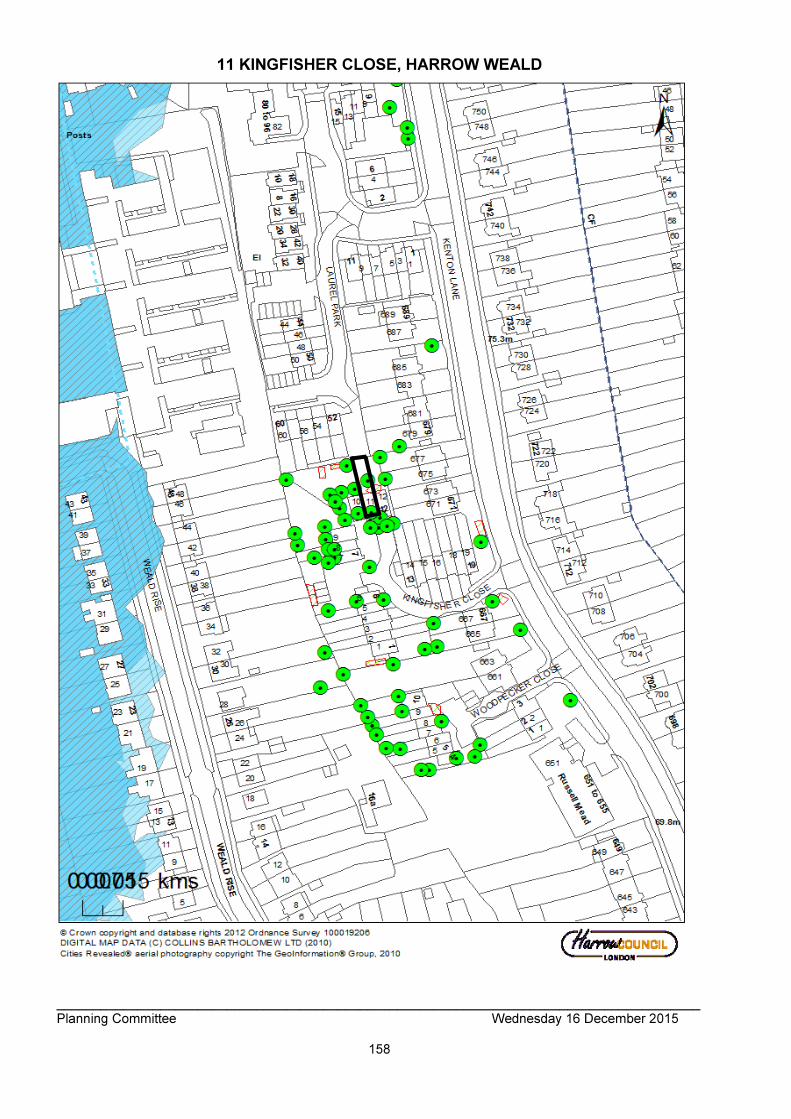
_______________________________________________________________________________________ Planning Committee Wednesday 16 December 2015
158
11 KINGFISHER CLOSE, HARROW WEALD

_______________________________________________________________________________________ Planning Committee Wednesday 16 December 2015
159
_______________________________________________________________________________________ Planning Committee Wednesday 16 December 2015
160

_______________________________________________________________________________________ Planning Committee Wednesday 16 December 2015
161

_______________________________________________________________________________________ Planning Committee Wednesday 16 December 2015
162

_______________________________________________________________________________________ Planning Committee Wednesday 16 December 2015
163
_______________________________________________________________________________________ Planning Committee Wednesday 16 December 2015
164

_______________________________________________________________________________________ Planning Committee Wednesday 16 December 2015
165
_______________________________________________________________________________________ Planning Committee Wednesday 16 December 2015
166
_______________________________________________________________________________________ Planning Committee Wednesday 16 December 2015
167
ITEM NO: 2/02 ADDRESS: GARAGES ADJACENT TO 119 DABBS HILL LANE, NORTHOLT REFERENCE: P/4649/15 DESCRIPTION: REDEVELOPMENT TO PROVIDE FOUR X TWO STOREY SEMI-
DETACHED DWELLINGHOUSES; LANDSCAPING; BIN AND CYCLE STORAGE; ON-STREET PARKING; REMOVAL OF VEHICLE CROSSOVER
WARD: ROXETH APPLICANT: LONDON BOROUGH OF EALING AND HILL RESIDENTIAL
LIMITED AGENT: JLL CASE OFFICER: DAVID BUCKLEY EXPIRY DATE: 09/12/2015 RECOMMENDATION GRANT planning permission for the development described in the application and submitted plans, subject to condition(s). INFORMATION: This application is reported to the Planning Committee as the scale of development (4 new houses) exceeds the provisions of Part 1 (b) of the Scheme of Delegation dated 29th May 2013. Statutory Return Type: 13: Minor Dwellings Council Interest: None Net additional Floorspace: 428 sqm GLA Community Infrastructure (CIL) Contribution (provisional): £14,980 (based on a £35 contribution per square metre of additional floorspace) Harrow Community Infrastructure (CIL) Contribution (provisional): £47,080 (based on a £110 contribution per square metre of additional floorspace) Site Description
• The application site currently consists of garages for use of residents in the area and is in the ownership of Ealing Borough Council. There are 12 garage units, plus additional space in front of these which is also used for parking.
• The houses on the northern side of Dabs Hill Road are located within the London Borough of Harrow, while the road and the pavement on the northern side of the street are located within the London Borough of Ealing.
• The site has a maximum width of 45m and a maximum depth of 24m. The footprint of the site is 950 sqm.
• The site is set within a row of residential dwellinghouses, with semi-detached houses to the west and to the east. The neighbour immediately to the west is No. 121 Dabs

_______________________________________________________________________________________ Planning Committee Wednesday 16 December 2015
168
Hill Lane, with No. 119 immediately to the east.
• To the rear/north of the site are the rear gardens of houses along ‘The Heights’. The plots of these houses slope up towards the rear where they adjoin the application site. The rear gardens of these houses are over 30m in depth.
• To the south of the site are several blocks of flats which are set within landscaping, several metres back form the street.
• There are no allocations related to the site and it is not located in a Critical Drainage Area or a Flood Zone
Proposal Details Summary of the Proposal
• It is proposed to demolish the existing garages and build 4 x semi- detached two storey dwellinghouses that would front on to Dabs Hill Lane.
Design of the Houses/Gardens
• The houses would be arranged in 2 x 2 pairs of semi-detached houses that would be designed to be in single occupancy.
• The houses would be of brick construction with a tiled roof. The roof design of all the houses would be gable ended.
• The houses would measure 9m in width with a depth of 6m. The eaves height would be 5.50m with a full height of 7.80m.
• Each house would have its own private front and rear gardens, with the rear garden measuring 7m in depth to the rear boundary.
Internal Configuration
• The internal floor areas and configuration would be the same for all 4 houses.
• These would consist of 3-bedroom 5-person houses measuring approximately 107 sqm in gross internal area, with 52 sqm on the ground floor and 55 sqm on the first floor.
• The bedrooms would all be located on the first floor, with a master bedroom at the front of the house facing Dabs Hill Lane, which would be served by an ensuite bathroom facing the front of the house. Bedroom 2 would also be at the front of the house, with the single bedroom at the rear of the house.
Bin and Cycle Storage, Car Parking
• Each house would have a side access which would lead to the rear garden and allow access to the bin stores and cycle parking stores which have been indicted on the proposed site plan.
• Sufficient bin and cycle storage has been indicated on the proposed site plan.
• Car parking can be used on the street, which does not have parking restrictions. Revisions to Previous Application
• None Relevant History HAR/5410/A- Erect 12 garages 15/04/1958 Pre-Application Discussion (Ref. P/2354/15/PREAPP) The proposal in the pre-application submission was found broadly acceptable and that officers would be likely to support the scheme. However, further information was
_______________________________________________________________________________________ Planning Committee Wednesday 16 December 2015
169
requested in regard to highways impact and proposed materials. Applicant Submission Documents Design and Access Statement Community Infrastructure Levy (CIL) Additional Information Form Planning Statement Energy and Sustainability Statement Arboricultural Impact Assessment Consultations Highways Authority - The adjacent road is located within Ealing Borough, therefore no comment on the proposal Engineering Drainage Section - See Section 4 of this report Tree Officer - See Section 5 of this report Landscaping Officer - See Section 2 of this report Advertisement
• N/A Site Notice Expiry Date: 30th November 2015 Reason for Site Notice: General Notification Notifications Sent: 66 Replies: 01 Expiry: 06/11/2015 Summary of Responses Response from leaseholder of a garage unit at the application site:
• Does not think it is reasonable for the existing garage sites to be removed and it will mean there will not be a parking space available.
APPRAISAL Section 38(6) of the Planning and Compulsory Purchase Act 2004 requires that: ‘If regard is to be had to the Development Plan for the purpose of any determination to be made under the Planning Acts, the determination must be made in accordance with the Plan unless material considerations indicate otherwise.’ In this instance, the Development Plan comprises The London Plan 2015, the Harrow Core Strategy 2012 and the Harrow Development Management Policies Local Plan 2013. MAIN CONSIDERATIONS Principle of the Development Character and Appearance of the Area Residential Amenity Flood Risk/Drainage Trees and Development Traffic and Parking Accessibility Sustainability

_______________________________________________________________________________________ Planning Committee Wednesday 16 December 2015
170
Human Rights and Equalities S17 Crime & Disorder Act Consultation Responses Principle of the Development Policy 3.8 of The London Plan (2015) encourages the borough to provide a range of housing choices in order to take account of the various different groups who require different types of housing. Further to this, Core Policy CS1 (I) states that ‘New residential development shall result in a mix of housing in terms of type, size and tenure across the Borough and within neighbourhoods, to promote housing choice, meet local needs, and to maintain mixed and sustainable communities’. Having regard to the London Plan and the Council’s policies and guidelines, it is considered that the proposed new dwellings would constitute an increase in housing stock within the borough which is encouraged. The existing garages on the site are old and are not of a suitable scale for modern cars and more likely to be used for storage purposes rather than car parking. Therefore it is considered that the loss of the parking spaces would be acceptable in principle. The land in which the proposed new dwellings would be erected on would constitute previously developed land, as the land is currently occupied by garages that form a communal garage block within the curtilage of a purpose built block of flats and dwellings. Therefore any development of the land would not be considered development of garden land, as identified within the Harrow Garden Land SPD (2013). Character and Appearance of the Area Policy 7.4 (B) of the London Plan requires that buildings, streets and open spaces should provide a high quality design response that has regard to the pattern and grain of the existing spaces and streets in orientation, scale, proportion and mass. Core Policy CS1.B specifies that ‘All development shall respond positively to the local and historic context in terms of design, siting, density and spacing, reinforce the positive attributes of local distinctiveness whilst promoting innovative design and/or enhancing areas of poor design; extensions should respect their host building.’ Policy DM1 of the DMP gives advice that ‘’all development proposals must achieve a high standard of design and layout. Proposals which fail to achieve a high standard of design and layout. Pattern of Development Paragraph 4.4 of the adopted SPD states that: “The pattern of development refers to the arrangement of plots, buildings and spaces around the building which, repeated over an area, forms part of that area's character and identity.” Paragraph 4.5 states that the pattern of development plays a vital role in defining the character of the street and influencing the perception of spaciousness and landscape capacity. Currently the northern side of Dabbs Hill Lane is characterised by having terraced and semi-detached dwellings. To the south are large multi-storey flatted blocks. The existing garages are more or less fronting the public highway, rather than being located to the rear of the residential properties. The proposed scheme would result in the removal of these garages and replacement with residential dwellings that would be more in line with

_______________________________________________________________________________________ Planning Committee Wednesday 16 December 2015
171
the pattern of development along the northern side of Dabbs Hill Lane The proposed new dwellinghouses would not strictly respect the building line along the northern side of Dabbs Hill Lane. However, it is noted that there is significant variations in the building line along this stretch of Dabbs Hill Lane as a result of the curvature of the public highway. The proposed buildings would not sit noticeably forward of the buildings either side of the application site and would maintain a comfortably relationship with the adjacent buildings and the highway whilst maintaining an appropriate depth of front garden and defensible space for future occupiers. Scale Massing and Form Paragraph 4.14 states that the scale and massing of a building relates to its physical dimensions, comprising width, depth and roof profile. The SPD goes on to state that new development should recognize the scale and massing of surrounding buildings and reflect these where they are a positive attribute of the area’s character. Within the streetscene it is noted that the proposed development would sit slightly higher in relation to the eaves height and also the roof ridge height, when read in conjunction with the two properties either side, this has also been stated in the submitted Planning Statement 2.24. However, given the varied building line along Dabbs Hill Road and the nominal difference in heights, the variation within heights would not be readily perceived. The proposed two pairs of semi-detached dwellings would be read in conjunction with each other, and accordingly, their building line, eave and ridge heights would be the same. The variation in the building heights would facilitate compliance with modern building regulation standards by providing level access and sufficient headroom internally. Character and Design of the Proposed Building The adopted SPD also emphasises the importance of local character and design. Paragraph 4.7 and 4.8 state that local character is an important consideration and that built form and room form are important elements of this. They also state that the design and layout of new development should recognise the character of the area in which it is located. Paragraphs 4.14 and 4.15 address issues related to design of new buildings and state that the roof form is very important in the character of new development. The proposed design is a relatively simple appearance but would provide a robust and cohesive finish to the building subject to appropriate detailing which will be secured by condition. The applicant has indicated a simple palette of materials which is considered to be acceptable in principle. However, these would need to be provided to include details of all external materials, which would include bricks, roof tiles, windows, door, reveals and rainwater goods to ensure a sympathetic finish. Refuse Storage and Servicing Paragraph 4.50 of the adopted Residential Design Guide SPD states that the design and layout of residential development must provide satisfactory arrangements for the storage and collection of recycling and waste. The Design and Access Statement part 2.4 states that each house will have its own refuse storage area in the front gardens for 2 x 240 litre bins, one for refuse and one for recycling. And that an area of hard standing for the bins will be provided in the soft landscaped front gardens screened behind the boundary fence. This refuse arrangement has been indicated on the submitted proposed site plan. This is considered a

_______________________________________________________________________________________ Planning Committee Wednesday 16 December 2015
172
satisfactory arrangement as required by Paragraph 4.50 of the adopted Residential Design Guide SPD. Hard and Soft Landscaping Paragraph 4.13 of the adopted SPD states that building forecourts make a particularly important contribution to streetside greenness and the leafy, suburban character in Harrow’s residential areas. A pathway would be laid out leading to the houses, along the side of the houses and immediately to the rear, forming a patio. The remainder of the garden will be a lawn. This would provide sufficient soft landscaping to meet the SPD requirements, while the hard landscaping would be required to be permeable. Harrow’s Landscape Architect has stated that the proposal would be acceptable subject to submission of hard and soft landscaping materials to be approved. A condition has been attached to address this. Boundary Treatments Paragraph 4.45 of the adopted Residential Design Guide SPD states that boundary treatment functions to distinguish between public and private spaces which is an important feature of avoiding neglected, poor quality spaces, while at the same time boundary treatments should not be excessive in scale or obtrusive. The submitted Design and Access Statement paragraph 2.5 states that the front gardens would be bounded by a mature hedge, which would provide a secure definition between the public and private domain to a height of 1.2m. A 1.8m high timber fence would form the treatment to the rear gardens, with an additional trellis to be added to the top bringing a height of 2.2m. The adopted SPD states that 1 metre height adjacent to a highway and 2 metres elsewhere is usually appropriate in most suburban areas. While the proposed treatments would be slightly higher than cited above, the boundary materials are considered acceptable and in keeping with the low level walls, hedges and fences that are used as front boundary treatments in the surrounding area. The rear trellis would be of an open character and therefore this would be considered acceptable. A condition has been attached for the submission of boundary treatment materials to ensure that these are acceptable. Residential Amenity Policies DM1 of the Development Management Policies Local Plan (2013) seeks to “ensure that the amenity and privacy of occupiers of existing and proposed dwellings are safeguarded. Amenity of Neighbouring Occupiers Neighbours to Rear/North at ‘The Heights’ The neighbours immediately to the rear/north are houses along The Heights and the rear gardens of these houses slope downwards sharply towards the houses on The Heights, creating greater potential for overlooking from the rear of the proposed houses. However, these neighbouring houses at The Heights have rear gardens of a generous depth of approximately 30 metres. The proposed houses would have a rear garden depth of approximately 7 metres, leaving an acceptable distance of 37 metres from the rear bedroom windows of the proposed dwellings to the rear of the dwellinghouses along The Heights. Furthermore, the boundary treatment would be over 2 metres in height, meaning the relationship with neighbouring occupiers with be similar to the existing situation along Dabbs Hill Road with policy DM1 of the Development Management Policies Local Plan (2013).
_______________________________________________________________________________________ Planning Committee Wednesday 16 December 2015
173
The distance between the proposed dwellinghouses and these neighbours to the rear is sufficient and would ensure the neighbouring occupiers would maintain an appropriate degree of privacy, in accordance with policy DM1. Neighbours to the Front/South along Dabbs Hill Lane To the front of the site there are several blocks of flats that are set away from the main road. Immediately opposite are flats at Percival Court and No. 86 Dabbs Hill Lane. These properties are sited well away from the application site and on the opposite side of the highway. No undue impacts would occur to these properties). Issues related to highways and parking and potential impact on these neighbours will be addressed in Section 5 of this report. Neighbours Immediately Adjacent to the Site The neighbours immediately adjacent to the site comprise No. 119 Dabbs Hill Lane to the west and No. 121 to the east of the application site. The impact of the proposal on these neighbours would be largely the same and so can be addressed together. The new houses would be a minimum of 3 metres from these adjacent neighbours and would be set on a similar building line, i.e. not significantly projecting beyond the front or rear building line of these neighbours. The proposal would therefore preserve the outlook of neighbouring houses from their front and rear windows. The boundary treatments are of an acceptable height and materials and would also have an acceptable impact on neighbouring light and outlook in accordance with policy DM1 of the Development Management Policies Local Plan (2013). There are no flank windows proposed or significantly raised patios/balconies proposed and therefore the impact on these neighbour’s in terms of overlooking or loss of privacy would be acceptable in accordance with policy DM1 Amenity of Future Occupiers Room Size and Layout - New National Standards On 25 March 2015 through a written ministerial statement, the Government introduced new technical housing standards in England and detailed how these would be applied through planning policy. The national standards came into effect on 1st October 2015 and therefore this application will be considered against the new national standards instead of the current London Plan standards. Furthermore, the imposition of any conditions requiring compliance with specific policy standards relating to new housing would need to be considered against the national standards. From 1st October 2015 relevant London Plan policy and associated guidance in the Housing Supplementary Planning Guidance (SPG) should be interpreted by reference to the nearest equivalent new national technical standard. The Mayor intends to adopt the new standards through a minor alteration to the London Plan. In the interim the Housing Standards Policy Transition Statement (October 2015) should be applied in assessing new housing development proposals. This is also set out in the draft Interim Housing SPG. Therefore from October 2015, policy 3.2 (c) requires that table 3.3 to be substituted with Table 1 of the nationally described space standards, which is set out in the table below. Policy 3.8 (c) of the London Plan relating to Housing Choice, from the 1 October should
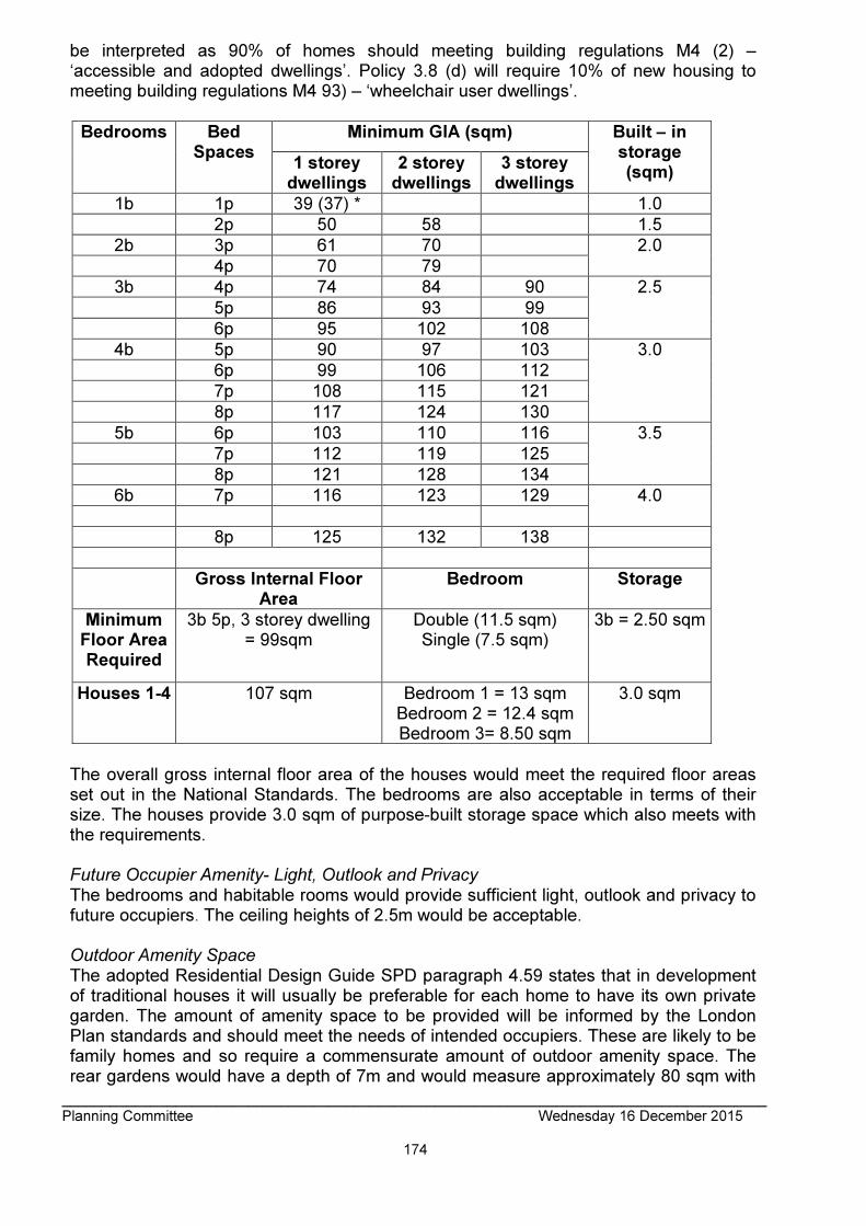
_______________________________________________________________________________________ Planning Committee Wednesday 16 December 2015
174
be interpreted as 90% of homes should meeting building regulations M4 (2) – ‘accessible and adopted dwellings’. Policy 3.8 (d) will require 10% of new housing to meeting building regulations M4 93) – ‘wheelchair user dwellings’.
Bedrooms Bed Spaces
Minimum GIA (sqm) Built – in storage (sqm)
1 storey dwellings
2 storey dwellings
3 storey dwellings
1b 1p 39 (37) * 1.0
2p 50 58 1.5
2b 3p 61 70 2.0
4p 70 79
3b 4p 74 84 90 2.5
5p 86 93 99
6p 95 102 108
4b 5p 90 97 103 3.0
6p 99 106 112
7p 108 115 121
8p 117 124 130
5b 6p 103 110 116 3.5
7p 112 119 125
8p 121 128 134
6b 7p 116 123 129 4.0
8p 125 132 138
Gross Internal Floor Area
Bedroom Storage
Minimum Floor Area Required
3b 5p, 3 storey dwelling = 99sqm
Double (11.5 sqm) Single (7.5 sqm)
3b = 2.50 sqm
Houses 1-4 107 sqm Bedroom 1 = 13 sqm Bedroom 2 = 12.4 sqm Bedroom 3= 8.50 sqm
3.0 sqm
The overall gross internal floor area of the houses would meet the required floor areas set out in the National Standards. The bedrooms are also acceptable in terms of their size. The houses provide 3.0 sqm of purpose-built storage space which also meets with the requirements. Future Occupier Amenity- Light, Outlook and Privacy The bedrooms and habitable rooms would provide sufficient light, outlook and privacy to future occupiers. The ceiling heights of 2.5m would be acceptable. Outdoor Amenity Space The adopted Residential Design Guide SPD paragraph 4.59 states that in development of traditional houses it will usually be preferable for each home to have its own private garden. The amount of amenity space to be provided will be informed by the London Plan standards and should meet the needs of intended occupiers. These are likely to be family homes and so require a commensurate amount of outdoor amenity space. The rear gardens would have a depth of 7m and would measure approximately 80 sqm with
_______________________________________________________________________________________ Planning Committee Wednesday 16 December 2015
175
a patio area and lawn space. The mayor of London Housing SPG 4.10.1 states that a minimum of 5 sqm of private outdoor space should be provided for 1-2 person dwellings and an extra 1 sqm of each additional occupant. The proposed development would provide well in excess of this and would be considered acceptable in terms of outdoor amenity space/private open space. Development and Flood Risk/Drainage Policy DM10 of the Harrow Development Management Policies Local Plan (2013) states that proposals for new development will be required to make provision for the installation and management of measures for the efficient use of mains water and for the control and reduction of surface water run-off. The Engineering Drainage Section has responded, stating that they require information related to surface water disposal and attenuation. They also require information related to water connection to public sewers, drainage layout and water storage. However, the site is not located in a Flood Zone or Critical Drainage Area. Furthermore, surface water capacity would be increased due to the removal of the existing hardstanding and the introduction of soft landscaping to the front and rear gardens. Therefore it is considered that the conditions would not be justified. Trees and Development Policy DM1 of the Harrow Development Management Policies Local Plan (2013) states that the assessment of the design and layout of proposals will have regard to the need to retain or enhance existing landscaping, trees, biodiversity or other natural features of merit. Policy DM22 states that the removal of trees subject to TPO’s (Tree Preservation Order) or assessed as being of significant amenity value will only be considered acceptable where it can be demonstrated that the loss of the tree(s) is outweighed by the wider public benefits of the proposal. The applicant has submitted an Arboricultural Report detailing the existing trees onsite and potential impacts from the proposed development. The Council’s Tree Officer does not have any objections to the proposal as the trees are not protected by TPO’s. Based on this and subject to a safeguarding condition, it is considered that the proposed works would not have any detrimental impact on the health of these trees. Therefore it is considered that the proposed development would be in compliance with Policy 7.21 of The London Plan (2015), Policies DM1 and DM22 of the Harrow DM Local Plan (2013) and the guidance contained in the Council’s adopted SPD Residential Design Guide (2010). Traffic and Parking The proposal would result in the loss of 12 purpose-built garages. However, due to the age of these garages, they are not practical for the use of modern cars, although the forecourt is currently used for parking and there are car parking spaces marked out on the site. As part of the proposal, the existing cross over would be removed and no parking would be provided on site. The site is within walking distance of Northolt Park Train Station or a relatively long walk or bus journey to Northolt London Underground Station and within a short walk of bus routes. If future occupiers if did have their own vehicles, these would require on- street parking. Therefore the proposal would result in the loss of car parking and potentially create demand for additional parking spaces from
_______________________________________________________________________________________ Planning Committee Wednesday 16 December 2015
176
the future occupiers. At present, the majority of the houses in close proximity to the application site use on street parking and the proposed car parking arrangement would be in keeping with this. A leaseholder of one of the garages has objected to the proposal due to the loss of his parking space. The flats opposite have purpose built car parks set away from the road. The site is not part of a controlled parking zone and there are no other parking restrictions at the site. The road itself is within Ealing Borough and the response from Ealing Borough Planning Department did not raise any concerns related to parking. The applicant has indicated 4 on-street parking spaces would be provided as part of the proposal but the applicant would need to apply to Ealing Borough Council to secure these. The road is of sufficient width that parking is possible on both sides of the road. Dabs Hill Lane is not considered sufficiently close to train or underground stations that it would be used for convenient parking by commuters. Therefore, whilst the development might result in some additional parking pressure on street, the closest part of the road network within Harrow Borough is almost 400m at the western end of The Heights. The Highways Authority considered that the development would not lead to undue pressures on the highway network of Harrow and it is noted that Ealing Council have not objected to the application on any grounds. Due to the site circumstances describe above and the limited number of units proposed, it is considered that that the proposal arrangement would be acceptable. 2 x secure storage spaces for bicycles have been described on the Design and Access Statement paragraph 2.3 and indicated on the proposed plans. This complies with the guidance of the London Plan for cycle parking standards and therefore would be considered acceptable. Accessibility Core Policy CS1.K of the Harrow Core Strategy and Policies 3.8, 7.1 and 7.2 of The London Plan (2015) require all new housing to be built to Lifetime Homes Standards. This has been replaced by New National Standards which require 90% of homes to meet Building Regulation M4 (2) - ‘accessible and adaptable dwellings’. The applicant has submitted information that highlights the elements whereby the proposed development would meet the Code for Sustainable Homes in terms of accessibility and adaptability. It should be noted that the Code for Sustainable Homes has been withdrawn and replaced with Building Regulation M4 (2), although many of the requirements are the same. A condition has been attached to ensure that the proposed dwellings will meet regulation M4 (2) as far as possible. Sustainability Policy DM12 of the Development Management Policies Local Plan (2013) states that proposals should attempt to incorporate sustainability measures wherever possible. The applicant has submitted an Energy and Sustainability Statement that details the measures that will be used to limit carbon emissions. There are restrictions on carbon emissions found within policy 5.2 of the London Plan (2015). These restrictions only
_______________________________________________________________________________________ Planning Committee Wednesday 16 December 2015
177
apply to major development and therefore the current proposal would not be expected to meet these restrictions. However, a reduction in carbon emissions is encouraged. The proposal is considered to be acceptable in accordance with the policies described above. Equalities Section 149 of the Equalities Act 2010 created the public sector equality duty. Section149 states:- (1) A public authority must, in the exercise of its functions, have due regard to the need to: (a) eliminate discrimination, harassment, victimisation and any other conduct that is prohibited by or under this Act; (b) advance equality of opportunity between persons who share a relevant protected characteristic and persons who do not share it; (c) foster good relations between persons who share a relevant protected characteristic and persons who do not share it. When making policy decisions, the Council must take account of the equality duty and in particular any potential impact on protected groups. It is not considered that there are any equality impacts as part of this application. S17 Crime & Disorder Act It is considered that this application would not have any detrimental impact upon community safety and is therefore acceptable in this regard.
Consultation Responses Response from leaseholder of a garage unit at the application site: • Does not think it is reasonable for the existing garage sites to be removed and it will
mean there will not be a parking space available. The impact of the loss of the garages related to on-street parking has been addressed in Section 6 above. The issue of the rent paid by this occupier for the garage is a civil matter between the owner of the site and the respondent. CONCLUSION For all the reasons considered above, and weighing up the development plan policies and proposals, and other material considerations, including comments received in response to consultation as set out above, this application is recommended for grant. CONDITIONS 1 The development hereby permitted shall be begun before the expiration of three years from the date of this permission. REASON: To comply with the provisions of Section 91 of the Town & Country Planning Act 1990. 2 Other than on collection days, the refuse/waste bins shall at all times be stored in the approved refuse/waste storage area. REASON: To safeguard the appearance and character of the area, and to enhance the appearance of the development in accordance with Policy DM1 of the Harrow Development Management Local Plans Policy (2013). 3 The development hereby permitted shall be constructed to the specifications of: “Part M, M4 (2), Category 2: Accessible and Adaptable Dwellings” of The Building Regulations
_______________________________________________________________________________________ Planning Committee Wednesday 16 December 2015
178
2015 and thereafter retained in that form. REASON: To ensure that, where the development is capable of meeting ‘Accessible and adaptable dwellings’ standards and that the development complies with Building Regulations. 4 The development hereby permitted shall not commence beyond damp proof course until samples of the materials to be used in the construction of the external surfaces have been submitted, provided on site, and approved in writing by, the local planning authority: Details shall include but not be limited to: i. External materials ii. Walls iii. Windows iv. Doors v. Roof vi. Rainwater goods The development shall be carried out in accordance with the approved details and shall thereafter be retained. REASON: To safeguard the appearance of the locality in accordance with policy DM 1 of the Development Management Policies Local Plan 2013. Details are required prior to commencement as the development would be unenforceable after this time. 5 No development shall take place, including any works of demolition, until a Construction Method Statement has been submitted to, and approved in writing by, the local planning authority. The approved Statement shall be adhered to throughout the construction period. The Statement shall provide for: i. the parking of vehicles of site operatives and visitors ii. loading and unloading of plant and materials iii. storage of plant and materials used in constructing the development iv. measures to control the emission of dust and dirt during construction v. a scheme for recycling/disposing of waste resulting from demolition and construction works REASON: To ensure that the construction of the development does not unduly impact on the amenities of the existing occupiers of the properties on the site, thereby according with policies DM1, DM42, DM43 and DM44 of the Harrow Development Management Policies Local Plan 2013. Details are required prior to commencement of development to ensure a satisfactory form of development. 6 The development hereby permitted shall be carried out in accordance with the following approved plans and in accordance with any details that are to be submitted as required by planning conditions: A_BA2-S03-DR_0001 Revision B; A_BA2-S03-DR_0100 Revision C; A_BA2-S03-DR_0200 Revision C; A_BA2-S03-DR_0300 Revision C; A_BA2-S03-DR_0310 Revision C; Design and Access Statement; Community Infrastructure Levy (CIL); Additional Information Form; Planning Statement; Energy and Sustainability Statement; Arboricultural Impact Assessment REASON: For the avoidance of doubt and in the interests of proper planning. 7 A landscape management plan, including species numbers/locations, long term design objectives, management responsibilities and maintenance schedules for all communal landscape areas shall be submitted to, and approved in writing by, the local planning authority prior to the occupation of the development. The hard and soft landscaping shall provide detail for (but not limited to): i. Boundary treatment
_______________________________________________________________________________________ Planning Committee Wednesday 16 December 2015
179
ii. Landscaping to be Approved iii. Hard landscape Material Details iv. Levels The landscape management plan shall be carried out as approved. REASON: To safeguard the appearance and character of the area, and to enhance the appearance of the development in accordance with policy DM22 of The Development Management Policies Local Plan 2013. Details are required prior to occupation of development to ensure a satisfactory form of development. 8 All planting, seeding or turfing comprised in the approved details of landscaping shall be carried out in the first planting and seeding seasons following the occupation of the building, or the completion of the development, whichever is the sooner. Any existing or new trees or shrubs which, within a period of 5 years from the completion of the development, die, are removed, or become seriously damaged or diseased, shall be replaced in the next planting season, with others of a similar size and species, unless the local authority agrees any variation in writing. REASON: To safeguard the appearance and character of the area, and to enhance the appearance of the development in accordance with policy DM22 of The Development Management Policies Local Plan 2013. 9 The development hereby permitted shall be constructed in accordance with the Tree Protection Plan and Tree Protective Fencing set out at appendices 6 & 7 of the approved Arboricultural Impact Assessment by Landscape Planning Ltd dated 29th September 2015. REASON: To protect the trees adjacent to the site which are considered to be of amenity value, thereby according with policy DM22 of the Development Management Policies Local Plan 2013. 10 Notwithstanding the provisions of the Town and Country Planning (General Permitted Development) (England) Order 2015 (or any order revoking and re-enacting that order with or without modification), no development which would otherwise fall within Classes A, B, D, E and F in Part 1 of Schedule 2 to that Order shall be carried out without the prior written permission of the local planning authority.
REASON: To safeguard the character of the area by restricting the amount of site coverage and size of dwelling in relation to the size of the plot and availability of amenity space and to safeguard the amenity of neighbouring residents.
INFORMATIVES 1 The following policies are relevant to this decision: National Planning Policy Framework (2012) The London Plan (2015) 3.5 Quality and Design of Housing Developments 3.8 Housing Choice 6.9 Cycling 6.13 Parking 7.2 An Inclusive Environment 7.3 Designing Out Crime 7.4 Local Character 7.6 Architecture

_______________________________________________________________________________________ Planning Committee Wednesday 16 December 2015
180
Harrow Core Strategy (2012) CS1.B Local Character CS1.K Lifetime Homes Harrow Development Management Policies Local Plan (2013) DM1 Achieving a High Standard of Development DM2 Achieving Lifetime Neighbourhoods DM42 Parking Standards DM45 Waste Management Supplementary Planning Documents Mayor of London Housing Supplementary Planning Guidance (2012) Residential Design Guide Supplementary Planning Document (2010) Accessible Homes Supplementary Planning Document (2010) Building Regulations 2010 M4 (2) Category 2: Accessible and Adaptable Dwellings 2 INFORMATIVE: The applicant's attention is drawn to the requirements in the Considerate Contractor Code of Practice. In the interests of minimising any adverse effects arising from building operations, the limitations on hours of working are as follows: 0800-1800 hours Monday - Friday (not including Bank Holidays) 0800-1300 hours Saturday 3 INFORMATIVE: The Party Wall etc. Act 1996 requires a building owner to notify and obtain formal agreement from adjoining owner(s) where the building owner intends to carry out building work which involves: 1. work on an existing wall shared with another property; 2. building on the boundary with a neighbouring property; 3. excavating near a neighbouring building, and that work falls within the scope of the Act. Procedures under this Act are quite separate from the need for planning permission or building regulations approval. "The Party Wall etc. Act 1996: explanatory booklet" is available free of charge from: Communities and Local Government Publications, PO Box 236, Wetherby, LS23 7NB Please quote Product code: 02 BR 00862 when ordering. Also available for download from the Portal website: https://www.gov.uk/party-wall-etc-act-1996-guidance 4 INFORMATIVE: Statement under Article 35(2) of The Town and Country Planning (Development Management Procedures) (England) Order 2015 This decision has been taken in accordance with paragraphs 187-189 of The National Planning Policy Framework. Harrow Council has a pre-application advice service and actively encourages applicants to use this service. 5 INFORMATIVE: A yellow Site Notice relating to this planning application describing the development and alerting interested parties of the development has been placed in the vicinity of the application site. You should now REMOVE this Site Notice.

_______________________________________________________________________________________ Planning Committee Wednesday 16 December 2015
181
6 INFORM 61_M Please be advised that approval of this application (either by Harrow Council, or subsequently by PINS if allowed on Appeal following a Refusal by Harrow Council) will attract a liability payment of £14,980 of Community Infrastructure Levy. This charge has been levied under Greater London Authority CIL charging schedule and s211 of the Planning Act 2008. Harrow Council as CIL collecting authority on commencement of development will be collecting the Mayoral Community Infrastructure Levy (CIL). Your proposal is subject to a CIL Liability Notice indicating a levy of £14,980 for the application, based on the levy rate for Harrow of £35/sqm and the stated increase in floorspace of 428 sqm You are advised to visit the planningportal website where you can download the appropriate document templates. http://www.planningportal.gov.uk/planning/applications/howtoapply/whattosubmit/cil 7 INFORM 62_M Harrow has a Community Infrastructure Levy which will apply Borough wide for certain uses of over 100sqm gross internal floor space. The CIL has been examined by the Planning Inspectorate and found to be legally compliant. It will be charged from the 1st October 2013. Any planning application determined after this date will be charged accordingly. Harrow's Charges are: Residential (Use Class C3) - £110 per sqm; Hotels (Use Class C1), Residential Institutions except Hospitals, (Use Class C2), Student Accommodation, Hostels and HMOs (Sui generis)- £55 per sqm; Retail (Use Class A1), Financial & Professional Services (Use Class A2), Restaurants and Cafes (Use Class A3) Drinking Establishments (Use Class A4) Hot Food Takeaways (Use Class A5) - £100 per sqm All other uses - Nil. The Harrow CIL Liability for this development is: (£47,080) 8 With regard to conditions relating to drainage issues, the development should ensure that: a) A copy of a letter from Thames Water with permission for connections to the public sewers is required. b) The development is subject to a limitation on a discharge to 5 l/s, consequently there will be a storage implication and the system should be checked for no flooding for a storm of critical duration and period of 1 in 100 years. These storage calculations should include all details of inputs and outputs together with impermeable and permeable areas drained. Please note that the M5-60(mm) is 21 and the Ratio “r” should read 0.43 for this region. Similarly the Volumetric Run-off Coefficient should be substantiated by calculations (Reference to Chapter 13 of The Wallingford Procedure) or a figure of 0.95 should be used for winter and summer. Please note that a value for UCWI of 150 is appropriate when calculating Percentage Runoff (PR) for storage purposes. Please include 30% allowance for climate change. c) Full details of drainage layout including details of the outlet and cross section of proposed storage are required. d) Full details of any flow restrictions (hydrobrake) that are proposed for this scheme need to be submitted together with the relevant graphs. REASON: To ensure that adequate drainage facilities are provided, reduce and mitigate the effects of flood risk following guidance in the National Planning Policy Framework.

_______________________________________________________________________________________ Planning Committee Wednesday 16 December 2015
182
9 The applicant is advised to consult with the Highway Authority of Ealing Council in order to undertake the works required to remove the crossover and provide on-street car parking. Plan Nos: A_BA2-S03-DR_0001 Revision B; A_BA2-S03-DR_0100 Revision C; A_BA2-S03-DR_0200 Revision C; A_BA2-S03-DR_0300 Revision C; A_BA2-S03-DR_0310 Revision C; Design and Access Statement; Community Infrastructure Levy (CIL); Additional Information Form; Planning Statement; Energy and Sustainability Statement; Arboricultural Impact Assessment
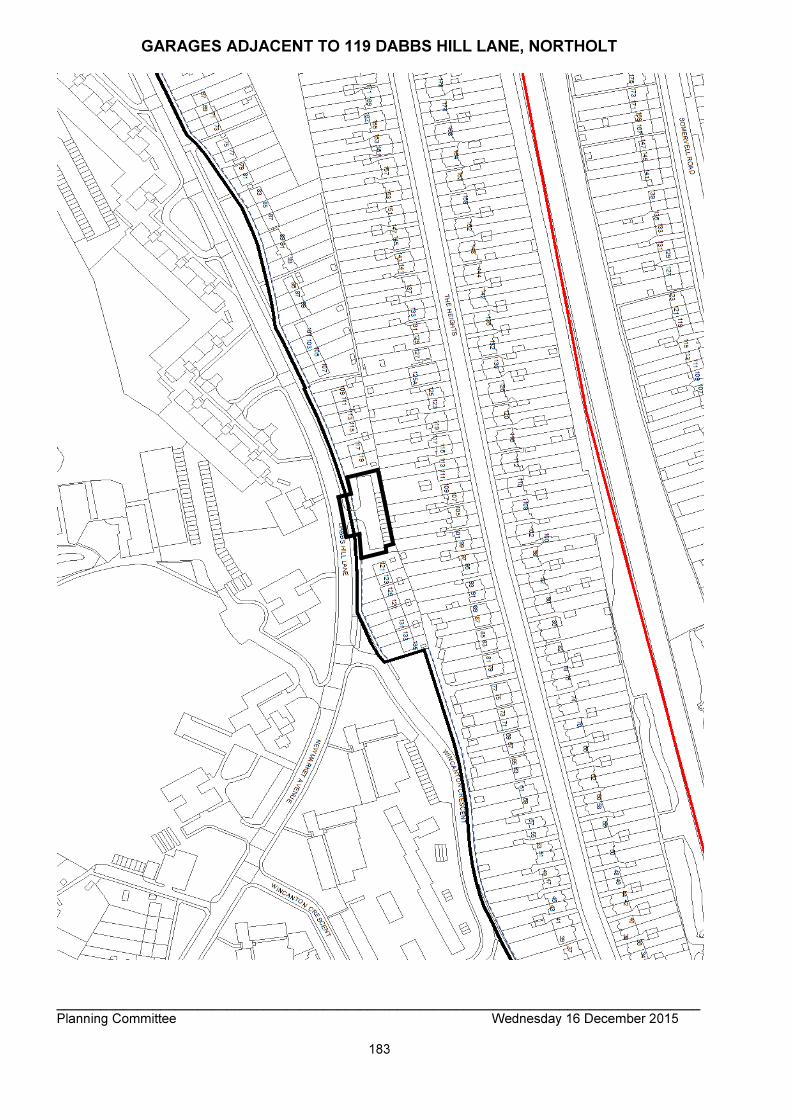
_______________________________________________________________________________________ Planning Committee Wednesday 16 December 2015
183
GARAGES ADJACENT TO 119 DABBS HILL LANE, NORTHOLT
_______________________________________________________________________________________ Planning Committee Wednesday 16 December 2015
184
ITEM NO: 2/03 ADDRESS: 62-64 KENTON ROAD, HARROW REFERENCE: P/4426/15 DESCRIPTION REDEVELOPMENT TO PROVIDE A FOUR STOREY BUILDING
FOR A THIRTY-THREE ROOMED HOUSE OF MULTIPLE OCCUPATION (HMO) WITH AMENITY SPACE, PARKING, LANDSCAPING AND BIN / CYCLE STORAGE
WARD GREENHILL APPLICANT: SAV DEVELOPMENTS LTD AGENT: CITY PLANNING CASE OFFICER: JUSTINE MAHANGA EXPIRY DATE: 20/11/2015 RECOMMENDATION GRANT permission for the development described in the application and submitted plans, subject to conditions: INFORMATION: This application is reported to Planning Committee as it would provide in excess of 400 sqm of non-residential floorspace. The application is therefore referred to the Planning Committee as it is excluded by Proviso 1(d) of the Scheme of Delegation dated 29 May 2013. Statutory Return Type: 18: Minor Development Council Interest: None Gross Floorspace: 872sqm Net Additional Floorspace: 580.1sqm GLA Community Infrastructure (CIL) Contribution: £20,303.50 Harrow Community Infrastructure (CIL) Contribution: £31,905.50 Site Description
• The application site is located on the northern side of Kenton Road, at no. 62-64 and contains a two-storey detached building.
• The property is irregular in shape, with a narrow projection at the rear.
• The existing building is constructed of white painted render and is located at the front of the site, with a single-storey projection at the side (adjacent Belvoir Court to the east).
• The Council’s Licensing Department has confirmed that the premises was most recently in use as a 12 bedroom (22 occupant) HMO (Licence number –

_______________________________________________________________________________________ Planning Committee Wednesday 16 December 2015
185
LN/000004806).
• To the front of the building is a parking forecourt, with two dropped kerbs.
• The surrounding area is predominantly residential, consisting of flatted developments along Kenton Road and semi-detached dwellings to the north-east along Rufford Close.
• Three-storey blocks of flats adjoin the application site on both sides of Kenton Road; Belvoir Court to the east and St Georges Court to the west.
• The rear boundary of the site adjoins the communal amenity space of a three-storey block of flats along Rufford Close.
• The property is not located within a conservation area, nor are there any listed buildings in the immediate surrounds.
Proposal Details
• The proposed development intends to demolish the existing two-storey building.
• The proposed replacement build would comprise a four storey detached HMO building (sui generis) providing 33 rooms, with a gross internal area of 872sqm.
• The building would include a basement level which would comprise a plant area and utility room.
• The proposed building would be constructed or red and orange brickwork, with a recessed lightweight fourth floor.
• 160sqm of outdoor communal amenity space would be located at the rear of the building.
• 2 wheelchair accessible car parking spaces would be provided in the front forecourt off Kenton Road.
• Refuse and recycling storage and secure sheltered cycle parking for 33 cycles would be provided in the rear garden.
• The HMO would comprise 33 single rooms, of which: o 5 rooms would have en-suite facilities; o 25 rooms would have an ensuite and kitchen facilities; and, o 3 wheelchair rooms would be provided on the ground floor.
• Communal facilities would include 4 kitchens, one living room on the ground floor and communal bathrooms on each level.
Relevant History WEST/485/95/FUL Change of use from Class C1 to C2 (guest house to residential care home for the elderly) REFUSED : 17 October 1995 WEST/162/94/FUL Single storey side to rear extension GRANTED: 08 July 1994 WEST/606/93/FUL Change of use: Class C1 to C2 (hotel to childrens care home) GRANTED: 17 January 1994
_______________________________________________________________________________________ Planning Committee Wednesday 16 December 2015
186
WEST/162/94/FUL Single storey side to rear extension GRANTED : 08 July 1994 Pre-Application Discussion (P/2706/15/PREAPP):
• The amended proposal to introduce a four-storey 33 bedroom HMO at the application site is acceptable in principle.
• Chamfering the north-eastern corner of the building is not considered acceptable in design terms. This corner should further inset from the common boundary with Belvoir Court.
• In order to provide a high standard of communal facilities for the 33 occupiers of the proposed HMO, it is recommended that the floorspace of the kitchen facilities is increased.
• Within any planning application the applicant would need to demonstrate that no harm would result to the amenity of surrounding residential occupiers.
Applicant Submission Documents
• Design and Access Statement, prepared by DGA
• Planning Statement, prepared by City Planning.
• Sunlight and Daylight Appraisal, prepared by Model Environments
• Environmental Health and Housing Statement, prepared by Glazebrook Associated LTD
• Energy Statement, prepared by Ensphere
• Transport Statement, prepared by TTP Consulting
• Travel Plan, prepared by TTP Consulting; and,
• Construction Management Plan, prepared by TTP Consulting. Consultations
• Highways Authority (Parking): No Objection
• Drainage Engineer: Recommended conditions of approval.
• Landscape Architect: No Objection subject to standard conditions.
• MET Police: No objections.
• TFL: The easiest way to meet accessibility requirements on types of cycle parking, as well as serve different user needs generally, is to provide a mix of types of cycle stands. Please ensure that this is included in the final plans.
• Environmental Health: No objections. Site Notice: Posted:12/10/2015 Neighbourhood Notifications: Belvoir Court, 68 Kenton Road, HA3 8UX Beaufort Court, Rufford Close, Harrow, HA3 8UX24 24 Flambard Road, Harrow, HA1 2NA 26 Flambard Road, Harrow, HA1 2NA St George Court, 58 Kenton Road, Harrow, HA3 8AB 1-11 Rufford Close, Harrow, HA3 8UX Sent: 40 Replies: 0 Expiry: 22/10/2015

_______________________________________________________________________________________ Planning Committee Wednesday 16 December 2015
187
Summary of Comments;
• N/A APPRAISAL Section 38(6) of the Planning and Compulsory Purchase Act 2004 requires that: ‘If regard is to be had to the Development Plan for the purpose of any determination to be made under the Planning Acts, the determination must be made in accordance with the Plan unless material considerations indicate otherwise.’ The Government has issued the National Planning Policy Framework (NPPF), which consolidates national planning policy and is a material consideration in the determination of this application. In this instance, the Development Plan comprises The London Plan (consolidated with alterations since 2011)(2015) and the Local Development Framework (LDF). The LDF comprises The Harrow Core Strategy 2012, Harrow and Wealdstone Area Action Plan (AAP) 2013, the Development Management Policies Local Plan (DMP) 2013, the Site Allocations Local Plan (SALP) 2013 and Harrow Local Area Map (LAP) 2013. MAIN CONSIDERATIONS Principle of Development Character and Appearance of the Area Residential Amenity Accessibility Traffic and Parking Sustainable Building and Design Equalities S17 Crime & Disorder Act 1998 Consultation Response Principle of Development Paragraph 50 of the National Planning Policy Framework (NPPF) (March 2012) states: ‘To deliver a wide choice of high quality homes, widen opportunity for home ownership and create sustainable, inclusive and mixed communities, local planning authorities should:
• Plan for a mix of housing based on current and future demographic trends, market trends and the needs of different groups in the community;
• Identify the size, type, tenure and range of housing that is required in particular locations, reflecting local demand’.
Paragraph 3.55 of the London Plan (consolidated and with amendments 2011) (2015) identifies that shared accommodation or houses in multiple occupation are a strategically important part of London’s housing offer, which meets distinct needs and reducing pressure on other elements of the housing stock. Policy DM30 of the DMP (2013) provides requirements for the proposals that result in the creation of properties into houses of multiple occupation. Specifically, it requires that a) there is good accessibility to local amenities and public transport; b) they accord with Accessible Homes Standards and provide satisfactory living conditions for the intended occupiers; and c) there will be no adverse impact on the amenity of the occupiers of neighbouring properties of the character of the area.

_______________________________________________________________________________________ Planning Committee Wednesday 16 December 2015
188
The Council’s Licensing Department has confirmed that the application site has most recently been in use as a 12 room (22 occupant) HMO (License number - LN/000004806). While the property is currently vacant, it is considered that due to the poor condition of the building, the licensed HMO would provide a sub-standard of accommodation to any potential occupiers. The on-going vacancy of the property also has the potential to contribute to anti-social behaviour in the area. Accordingly, the proposal to introduce a 33 bedroom HMO at the application site is acceptable in principle, subject to compliance with the relevant London Plan policies, development plan policies and supplementary planning guidance which seeks to provide high quality residential development and protect the residential amenity of surrounding occupiers. Character and Appearance of the Area DM1 of the DMP states that 'All development...proposals must achieve a high standard of design and layout. Proposals which fail to achieve a high standard of design and layout, or which are detrimental to local character and appearance will be resisted'. It goes on to say that 'the assessment of the design and layout of proposals will have regard to the context provided by neighbouring buildings and the local character and pattern of development and the provision of appropriate space around buildings for setting and landscaping as a resource for the occupiers and secure privacy and amenity' (DM1). The application site is located within a predominantly residential context. In terms of the composition of the residential buildings, the surrounding area along Kenton Road is characterised by multi-level flatted developments, while north-east of the site along Rufford Close is characterised by smaller semi-detached properties. The design of development along Kenton Road comprises more traditional three-storey brick buildings with pitched roofs as well as contemporary designed three-storied rendered buildings with inset fourth floors and roof terraces. In this context, the surrounding area does not include a strong urban character or significant coherence or commonality of design. Notwithstanding this, the application site, Belvoir Court (to the east) and the adjoining row of properties west of the site maintain a relatively consistent front building line. Massing and scale The proposed development would replace the existing two-storey pitched roof building, with a three-storey brick building with an inset fourth floor. The building would form part of the streetscene and appropriately relates its siting to the building line along Kenton Road. Specifically, the front building line of the proposed development would align with the principle front elevation of Belvoir Court to the east and would be set marginally forward of St Georges Court to the west. While the proposal represents an increased building footprint from the existing building, when considered in the context of the surrounding development, the building would sit comfortably within the central area of the site, leaving adequate spaces around the building to provide an appropriate setting. The building would be set a minimum distance of 1.1m from the side boundaries, which is similar to that provided on adjoining properties. The scale of the building takes its cues from the surrounding development further west along Kenton Road at no. 46 (Pine Court) and no 48 Kenton Road. Specifically, these properties include three-storey rendered buildings, with an inset flat roofed fourth floor.
_______________________________________________________________________________________ Planning Committee Wednesday 16 December 2015
189
The height and width of these properties is similar to that proposed at the application site. Furthermore, while the parapet height of the proposed building would slightly exceed the eaves of adjoining properties at Belvoir Court and St Georges Court, the maximum height of the building sits below the roof pitch of both adjoining properties. The ground floor lightweight conservatory located in the north-east corner of the ground floor and the resultant L shape of the upper floors reduces the bulk of the building when viewed from the rear facing windows of properties on Rufford Close (to the rear). While the flat roofed design of the building enables the development to provide four storeys while maintaining the established maximum building heights of the original pitched roof development nearby, the design of the building ensures that this level is subservient to the main building. Specifically, the fourth floor would be constructed of timber panels to distinguish from the lower levels, while the footprint has been set in from all parapets. The proposed screening to roof terraces has also been inset. Accordingly, the proposed fourth floor appears a recessive element which would not dominate the appearance of the building within the streetscene. Accordingly, the massing and scale of the proposed building is considered to be proportionate to the site and the surrounding scale of development. Architecture In terms of architecture, the proposed building would provide a more contemporary design approach, taking cues from the three / four-storey rendered buildings located west of the site along Kenton Road, while the proposed use of brick would relate to the traditional form of the three-storey buildings adjoining the site. The front façade of the building is considered to include reasonable reveals for window and door openings to provide a successful contrast from the brick elevation. The proposed inset fourth floor would be constructed of timber cladding in order to distinguish from the main building. Accordingly, this design approach is considered to satisfactorily relate to the surrounding development. The architectural design would provide a building of appropriate proportions which would sit comfortably within its surroundings. Subject to the use of robust materials, which would be secured by conditions, it is considered that the building proposed would accord with policies 7.4.B and 7.6.B of the London Plan, policy CS1.B of the CS and policy DM1 of the DMP. Layout and Landscaping The proposed siting of the building appropriately relates to the surrounding development and enables a sufficient area of landscaping to the front of the building. Specifically, the ratio and arrangement of soft and hard landscaping to the front of the building is considered to improve the visual appearance of the proposal within the streetscene. The use of hedging to the front of the ground floor windows would also provide an appropriate defensible barrier to these rooms. Notwithstanding this, while the proposed layout of the front garden is generally acceptable, a condition of approval will require the submission of further details relating to landscaping, landscaping materials and the proposed boundary treatment. The proposed location and arrangement of cycle storage in the rear garden is considered acceptable. While the location of the refuse storage in the rear garden does not comply with the Department for Transport guidance and the Council’s Refuse Code of Practice, which encourages bin placement to be within 10m of the point of pick up, given the scale of the required refuse storage shelter, it is not considered that this could
_______________________________________________________________________________________ Planning Committee Wednesday 16 December 2015
190
be suitably accommodated within the font garden. It is considered that an internal management regime, required by way of a condition of approval, would be sufficient in ensuring that refuse was stored in the rear garden and brought forward on collection days. The rear garden would also include a 160sqm communal garden. The location of this amenity area and proposed boundary treatment are considered to be acceptable. Residential Amenity Impact of the development on Neighbouring Amenity Policy DM1 of the DMP seeks to “ensure that the amenity and privacy of occupiers of existing and proposed dwellings are safeguarded. The existing HMO has a license to accommodate a maximum of 22 occupiers within 12 rooms. In this respect, the proposed 33 room HMO building would increase residential activity on the site, expressed through comings and goings, by a maximum of 10 persons. The applicant has indicated that the HMO would implement management services, such as a 24 hour concierge, to manage and minimise any noise and disturbance impacts to surrounding residents. A Construction Management plan has also been prepared by TTP consulting, outlining procedures which would be undertaken during construction in order to reduce the impact on the highway and surrounding residents. Furthermore, it is noted that the proposed development would not be out of character with the surrounding three-storey flatted developments, which are likely to achieve higher occupancy rates than the proposed development. No objections to the proposal have been received. Accordingly, the potential increased activity at the site is not considered to increase noise and disturbance to the detriment of the amenities of neighbouring occupiers, in accordance with DM1 of the DMP. Impact of the extension on Neighbouring Amenity To the east, the application site adjoins Belvoir Court, a three-storey ‘L’ shaped building with communal amenity space located adjacent the common boundary with the application site. The proposed development would be located 1.0 – 1.2m from this common boundary. At ground floor the proposed building would project approximately 5.9m beyond the main rear elevation of Belvoir Court. However, as the element of the proposal adjacent to this building would be a lightweight glazed structure with a pitched room rising away from the common boundary, this relationship would not result in undue impacts to the ground floor or rear amenity space of Belvoir Court in terms of overshadowing, overbearing impacts of loss of light. The proposed first, second and third floor of the development have been recessed from the common boundary with Belvoir Court to accord with the 45 degree code. A Natural Light Report, based on the methodology of the BRE’s ‘Site Layout Planning for Daylight and Sunlight’ submitted with this application also concludes that the overall daylight, sunlight and overshadowing effects on Belvoir Court as a result of the proposals are in accordance with the standards set by the BRE guidelines. To the west, the application site adjoins St Georges Court, a three-storey flatted

_______________________________________________________________________________________ Planning Committee Wednesday 16 December 2015
191
development. At the rear, the proposed development would extend approximately 0.5m beyond the rear elevation of this property. Given this relatively marginal extension beyond this property and the 2.7m separation between the buildings, no loss of outlook, light or increased sense of enclosure would occur to the occupiers. The proposal includes flank wall windows at ground, first and second floors facing both neighbouring properties. A glazed door would also be located within the western flank elevation of the building. A review of the existing arrangement on the site and neighbouring properties indicates that St Georges Court to the west and the application site both include flank wall windows. It appears that the small flank wall windows at St George’s Court serve landings. In this context and also considering that the proposed windows serve bathrooms, kitchens or landings and as these proposed windows are not located to the rear of the flank walls of the neighbouring properties, these windows are not considered to result in a harmful degree of overlooking. In terms of overlooking to the rear, it is acknowledged that the proposal would introduce additional rear facing windows and inset fourth floor roof terraces. However, given the character of the adjoining properties, which include three-storey flatted developments with communal gardens to the rear of the buildings, it is not considered that the proposal would result in an undue harm to the amenity of these properties in terms of loss of privacy. Furthermore, as the proposed fourth floor roof terraces have been inset from the parapet walls and include appropriate screening, no significant overlooking would result. It is considered that the proposed development would have an acceptable impact on the amenities of neighbouring occupiers, and would therefore would accord with the aims and objectives of policies 7.4B and 7.6B of The London Plan (consolidated with alterations since 2011)(2015), Core Policy CS1B of the Harrow Core Strategy (2012), policy DM1 of the Harrow Development Management Policies Plan (2013), and the adopted SPD: Residential Design Guide (2010). Future Occupiers Internal Configuration The proposed development would provide a HMO comprising 33 rooms. The applicant has indicated that the internal layout of the proposal has been designed in accordance with the Harrow Standards for Licensable Houses in Multiple Occupation and following advice from the Council’s Licensing Officer. Room Size and Layout Policy 3.5C of The London Plan specifies that Boroughs should ensure that, amongst other things, ‘’new dwellings have adequately sized rooms and convenient and efficient room layouts’’. Table 3.3 of The London Plan specifies minimum GIAs for residential units and advises that these minimum sizes should be exceeded where possible. The use of these residential unit GIA’s as minima is also reiterated in Appendix 1 of the Residential Design Guide SPD. Policy DM26 of the DMP specifies that ‘’proposals will be required to comply with the London Plan minimum space standards. Given that the proposal is for HMO accommodation rather than self-contained private units, regards has been given to the standards provided within the London Plan Supplementary Planning Guidance, which requires the minimum area of a single bedroom to be 8sqm, while a double or twin room should include a minimum area of 12sqm. In addition to this the Standards for Licensable Houses in Multiple Occupation requires that a single person unit (bedsit room) with kitchen facilities includes a minimum

_______________________________________________________________________________________ Planning Committee Wednesday 16 December 2015
192
area of 13sqm. The proposed development includes the following: Ground floor:
Room Type Area (sqm)
G.1 Disabled access room with ensuite 18.8sqm (including ensuite)
G.2 Disabled access room 12.4sqm
G.3 Disabled access room 13.2sqm
G.4 Single room with ensuite and kitchen facilities
15.9sqm including ensuite
G.5 Single room with ensuite
14.4sqm including ensuite
G.6 Single room with ensuite and kitchen facilities
15.6sqm including ensuite
G.7 Single room with ensuite and kitchen facilities
15.6sqm including ensuite
G.8 Single room with ensuite and kitchen facilities
15.6m including ensuite
First floor:
Room Type Area (sqm)
1.1 Single room with ensuite and kitchen facilities
16.4sqm including ensuite
1.2 Single room with ensuite and kitchen facilities
15.5sqm including ensuite
1.3 Single room with ensuite
13.1sqm including ensuite
1.4 Single room with ensuite
16.2sqm including ensuite
1.5 Single room with ensuite and kitchen facilities
16.1sqm including ensuite
1.6 Single room with ensuite and kitchen facilities
16.5sqm including ensuite
1.7 Single room with ensuite and kitchen facilities
18.2sqm including ensuite
1.8 Single room with ensuite and kitchen facilities
15.6sqm including ensuite
1.9 Single room with ensuite and kitchen facilities
15.6sqm including ensuite
1.10 Single room with ensuite and kitchen facilities
15.6sqm including ensuite

_______________________________________________________________________________________ Planning Committee Wednesday 16 December 2015
193
Second Floor:
Room Type Area (sqm)
2.1 Single room with ensuite and kitchen facilities
16.4sqm including ensuite
2.2 Single room with ensuite and kitchen facilities
15.5sqm including ensuite
2.3 Single room with ensuite
13.1sqm including ensuite
2.4 Single room with ensuite
16.2sqm including ensuite
2.5 Single room with ensuite and kitchen facilities
16.1sqm including ensuite
2.6 Single room with ensuite and kitchen facilities
16.5sqm including ensuite
2.7 Single room with ensuite and kitchen facilities
18.2sqm including ensuite
2.8 Single room with ensuite and kitchen facilities
15.6sqm including ensuite
2.9 Single room with ensuite and kitchen facilities
15.6sqm including ensuite
2.10 Single room with ensuite and kitchen facilities
15.6sqm including ensuite
Third floor:
Room Type Area (sqm)
3.1 Single room with ensuite and kitchen facilities
16.4sqm including ensuite
3.2 Single room with ensuite and kitchen facilities
16.0sqm including ensuite
3.3 Single room with ensuite and kitchen facilities
17.1sqm including ensuite
3.4 Single room with ensuite and kitchen facilities
17.4sqm including ensuite
3.5 Single room with ensuite and kitchen facilities
16.2sqm including ensuite
As detailed in the above tables, each room either meets or exceeds the requirements set out in the London Plan for minimum room sizes. It is also considered that each of the rooms would provide an adequate outlook and receive a satisfactory level of natural light. The proposed section plans also demonstrate that habitable rooms within the proposed fourth floor would have adequate room that would be of a satisfactory height for future occupiers. In this context, it is considered that the proposed living accommodation provided within the 33 rooms, in terms of size and layout would be considered acceptable. Each of the proposed rooms at fourth floor would also be provided with approximately 2.7sqm of private amenity space in the form of an inset roof terrace. Each terrace would be inset from the sides of the building and would be enclosed by 1.1m high obscured glazed balustrading. 1.8m high screening would be provided between adjacent terraces
_______________________________________________________________________________________ Planning Committee Wednesday 16 December 2015
194
to protect the privacy of the occupiers. Given the scale, screening and appropriate siting of these terraces, the provision of private amenity space at fourth floor is considered acceptable. Communal facilities The ground floor would provide a 37.8sqm open plan living / dining and kitchen room. The kitchen would provide a single oven/grill and sink to provide facilities for the ground floor occupiers who are without private kitchen facilities. One communal bathroom and WC is provided for the two occupiers of rooms G.2 and G.3 (wheelchair accessible) who are without private shower facilities. The proposed first and second floors would include a 10.0sqm kitchen / dining room, provided with a single oven/grill and sink to provide facilities for the occupiers of each floor who are without private kitchen facilities. No communal bathroom / WC would be provided at first or second floors as each room would be provided with an ensuite. The proposed third floor would include a 10.0sqm communal kitchen. Following pre-application discussions, the Council’s HMO Licensing officer has confirmed that the amended provision of shared kitchens, bathrooms and living room facilities at each level are acceptable and meet the required standards set out at Schedule 3 of The Licensing and Management of Houses in Multiple Occupation & Other Houses (Miscellaneous Provisions) (England) Regulations 2006. The proposed scheme also includes a 160sqm external amenity area to the rear of the building. Given the above, it is considered that the proposal would have no significant adverse implications for host and neighbouring residential amenities, and would accord with policies 7.4B and 7.6B of The London Plan (consolidated with alterations since 2011)(2015), policies DM1 and DM30 of the DMP and the Council’s adopted Supplementary Planning Document ‘Residential Design Guide (2010)’ in that respect. Accessibility Policy DM2 of the DMP and policies 3.5 and 3.8 of The London Plan (consolidated with alterations since 2011)(2015) seek to ensure that all new housing is built to ‘Lifetime Homes’ standards. Furthermore, The London Plan policy 7.2 requires all future development to meet the highest standards of accessibility and inclusion. Policy CS1.K of the Harrow Core Strategy requires all new dwellings to comply with the requirements of Lifetime Homes. Supplementary Planning Document Accessible Homes 2010 (SPD) outlines the necessary criteria for a ‘Lifetime Home’. In addition to the above, Policy DM30 of the DMP (2013) which relates to houses of multiple occupation, requires that they accord with Accessible Homes Standards and provide satisfactory living conditions for the intended occupiers. While the above policies require compliance with Lifetime Home Standards, in October 2015 these standards were replaced by New National Standards which require 90% of homes to meet Building regulation M4 (2) - ‘accessible and adaptable dwellings’. Those units that are indicated as Wheelchair Accessible units should meet M4(3) of the Building Regulations.

_______________________________________________________________________________________ Planning Committee Wednesday 16 December 2015
195
Notwithstanding this, in accordance with Lifetime Homes Standards, the applicants Design and Access Statement has confirmed that level access would be provided to the site at ground floor level from the parking area, within two wheelchair spaces provided on the ground floor of the development. Furthermore, the staircase would be of a design that could incorporate a chairlift in future. The Design and Access Statement has also demonstrated that the Lifetime Home Criteria would be achieved in each of the proposed rooms and communal areas. While it is acknowledged that the proposal meets Lifetime Homes Standards, a condition of approval is required to ensure that the proposed development would meet regulations M4 (2) and M4(3) of the Building Regulations which would secure an appropriate standard for future occupiers and make the units accessible to all. Accordingly, subject to compliance with this condition, it is considered that the proposed accommodation would be satisfactory and as such would comply with policy 3.5 of The London Plan (consolidated with alterations since 2011)(2015), standard 5.4.1 of the Housing SPG (2012). Traffic and Parking Policies DM26 and DM42 of the DMP give advice that developments should make adequate provision for parking and safe access to and within the site and not lead to any material increase in substandard vehicular access. The application site is located within an area with a PTAL (Public transport Accessibility Level) of 6a, which is considered to be an excellent level of accessibility to public transport nodes and community facilities. Notwithstanding this, the surrounding area includes extensive parking controls. At present the application site is served by an informal parking area that can accommodate four vehicles. Access to this area is via two crossovers onto Kenton Road. The proposed development would utilise the existing vehicle and pedestrian crossover from Kenton Road. Two off-street wheelchair parking spaces would be provided within the front forecourt, which would accord with the requirements of the London Plan. While the proposal would represent an overall reduction in of-street parking, given the high PTAL of the site and the nature of the units which are unlikely to be used by car owners, the Highway Authority have raised no concerns. Indeed the removal of a crossover is considered to be beneficial to highway safety and convenience. Additionally, due to the nature of the use it was considered that a reduction in car parking is feasible and facilitates the increased use of soft landscaping to the front of the building. In terms of trip generation, the Travel Plan submitted by the applicant indicated that the proposed development has the potential to generate 84 additional two-way trips per day. However, given the high PTAL rating of the site and also considering the nature of the proposed accommodation, it is considered that the majority of these trips would be undertaken by sustainable modes of transport. Secure and readily accessible cycle parking is provided, at one space per room, in line with the The London Plan (consolidated with alterations since 2011)(2015) requirements. This has been provided on site in the rear garden and is therefore considered

_______________________________________________________________________________________ Planning Committee Wednesday 16 December 2015
196
acceptable. It is therefore considered that the development would not result in any significant increase in traffic movements from the site or unreasonable impacts on highway safety and convenience, and subject to safeguarding conditions would therefore accord with policies DM26 and DM42 of the DMP (2013). Sustainable Build and Design The applicant has provided an Energy Statement, prepared by Ensphere. This statement provides an overview of the energy strategy in consideration of the site context, energy requirements and local priorities. Specifically, the proposed development has been designed to include the following:
• High performance building fabric and efficient lighting and controls to reduce energy demand;
• Passive design measures to reduce energy demand; and,
• Future proofing that flats to ensure potential connection to nay future district energy network.
The Energy Statement indicates that the proposal would include a 35% carbon reduction relative to the Building Regulations Part L 2013. Though not necessary for minor development (The London Plan policy for reductions in carbon emissions below Building Regulations standards relates to major applications), the reduction in carbon emissions of the development is supported and encouraged. The submitted information is considered to meet policy 5.2 of The London Plan (2015), and DM12, 13 and 14 of the Harrow Development Management Policies Local Plan (2013). Equalities Section 149 of the Equalities Act 2010 created the public sector equality duty. Section149 states:- (1) A public authority must, in the exercise of its functions, have due regard to the need to: (a) eliminate discrimination, harassment, victimisation and any other conduct that is prohibited by or under this Act; (b) advance equality of opportunity between persons who share a relevant protected characteristic and persons who do not share it; (c) foster good relations between persons who share a relevant protected characteristic and persons who do not share it. When making policy decisions, the Council must take account of the equality duty and in particular any potential impact on protected groups. It is not considered that there are any equality impacts as part of this application. S17 Crime & Disorder Act 1998 Prior to the submission of this application, the applicant entered into discussion with the Designing out Crime Officer from the Metropolitan Police. The Designing out Crime officer has confirmed that all recommendations made in regards to the security of residents, residents’ property and that of neighbouring residents and their property have been incorporated within the final design. Specifically, the main security concerns raised by the Designing out Crime Officer have
_______________________________________________________________________________________ Planning Committee Wednesday 16 December 2015
197
been addressed as follows:
• Strategic planting has been incorporated to discourage trespass outside ground floor windows and inside rear garden;
• Fob / key access and digilocks to internal and external doors to control movement within and around the building;
• Internally linked and monitored audible alarms to side and rear access doors;
• Concierge service at main entrance requiring all visitors to check in;
• Design measures to discourage congregation in the vicinity of the building, including the removal of dwarf walls; and,
• Secure refuse and cycle stores with a locking strategy; It is considered that the proposed new build would not adversely impact upon community safety issues and as such, would comply with policy 7.3 of The London Plan (2015) or Policy DM2 of the Harrow Development Management Policies Local Plan (2013). Consultation Responses
• N/A CONCLUSION It is considered that the proposed scheme for a 33 bedroom house in multiple occupation would contribute to a strategically important part of the housing stock of the borough, in accordance with paragraph 3.55 of the London Plan and Policy DM30 of the DMP (2013).Furthermore, the proposed development would have a satisfactory impact on the character of the area, the amenities of existing neighbouring occupiers and future occupiers of the development. For these reasons, weighing up the development plan policies and proposals, and other material considerations including comments received in response to notification and consultation as set out above, this application is recommended for grant. CONDITIONS 1 The development hereby permitted shall be begun before the expiration of three years from the date of this permission. REASON: To comply with the provisions of Section 92 of the Town and Country Planning Act 1990. 2 The development hereby permitted shall be carried out in accordance with the following documents and plans: 1469-001A; 1469-109-D; 1469-010-A; 1469-011-A; 1469-021-D; 1469-022-D;146-023-B; 1469-024-A; 146-025-A; 1469-100-H; 1469-110-H;1469-111-H; 1469-113-G; 1469-114-E; 1469-200-A; 1469-201-A; 1469-210-E; 1469-211-E; 1469-212-G; 1469-300-A; 1469-301-A ; Design and Access Statement; Sunlight and Daylight Appraisal; Environmental Health and Housing Statement; Energy Statement; Travel Plan; Construction Management Plan. REASON: For the avoidance of doubt and in the interests of proper planning. 3 Notwithstanding the details shown on the approved plans, the development hereby permitted shall not proceed above ground floor damp proof course level until samples of the materials to be used in the construction of the external surfaces noted below have been submitted, provided at the application site, and approved in writing by, the local planning authority:
_______________________________________________________________________________________ Planning Committee Wednesday 16 December 2015
198
a: External materials of the proposed buildings b: external materials of the proposed bin and cycle storage The development shall be carried out in accordance with the approved details and shall thereafter be retained. REASON: To enhance the appearance of the development and safeguard the character and appearance of the area, in accordance with policies 7.4.B of The London Plan (consolidated with alterations since 2011)(2015) and policy DM1 of The Development Management Policies Local Plan 2013. Details are required prior to the development proceeding beyond damp course level as the approval of details beyond this point would be likely to be unenforceable. 4 The development hereby permitted shall not proceed above ground floor damp proof course level until there has been submitted to, and approved by, the local planning authority: A: A scheme of hard and soft landscape works for the site; B: Details and specifications of boundary treatments Soft landscape works shall include: planting plans, and schedules of plants, noting species, plant sizes and proposed numbers / densities. REASON: To safeguard the appearance and character of the area, and to enhance the appearance of the development, thereby according with policy 7.4.B of The London Plan 2015 and policies DM1 and DM22 of the Development Management Policies Local Plan 2013. 5 All planting, seeding or turfing comprised in the approved details of landscaping shall be carried out in the first planting and seeding seasons following the occupation of the building, or the completion of the development, whichever is the sooner. Any existing or new trees or shrubs which, within a period of 5 years from the completion of the development, die, are removed, or become seriously damaged or diseased, shall be replaced in the next planting season, with others of a similar size and species, unless the local authority agrees any variation in writing. REASON: To safeguard the appearance and character of the area, and to enhance the appearance of the development in accordance with policy DM22 of The Development Management Policies Local Plan 2013. 6 Notwithstanding the approved plans, prior to development beyond damp course proof level, details for a scheme for works for the disposal of surface water, surface water attenuation and storage works on site as a result of the approved development shall be submitted to the local planning authority to be approved in writing. The development shall be completed in accordance with the approved details and shall thereafter be retained. REASON: To ensure that adequate drainage facilities are provided in accordance with the objectives set out under the National Planning Policy Framework 2012 and policy DM10 of the Harrow Development Management Policies Local Plan 2013. Details are required prior to the development proceeding beyond damp course level as the approval of details beyond this point would be likely to be unenforceable. 7 The refuse and waste bins shall be stored at all times, other than on collection days, within the designated refuse storage areas as shown on the approved plans. REASON: To enhance the appearance of the development and safeguard the character and appearance of the area, in accordance with policies 7.4.B of The London Plan (consolidated with alterations since 2011)(2015) and policy DM1 of The Development
_______________________________________________________________________________________ Planning Committee Wednesday 16 December 2015
199
Management Policies Local Plan 2013. 8 Prior to the construction of the building hereby approved on site beyond damp course level, additional details of a strategy for the provision of communal facilities for television reception (eg. aerials, dishes and other such equipment) shall be submitted to and approved in writing by the Local Planning Authority. Such details shall include the specific size and location of all equipment. The approved details shall be implemented prior to the first occupation of the building and shall be retained thereafter. No other television reception equipment shall be introduced onto the walls or the roof of the building without the prior written approval of the Local Planning Authority. REASON: In order to prevent the proliferation of individual television reception items on the building which would be harmful to the character and appearance of the building and the visual amenity of the area, thereby according with policy 7.4.B of The London Plan (consolidated with alterations since 2011)(2015) and policy DM1 of the Harrow Development Management Policies Local Plan 2013. Details are required prior to the development proceeding beyond damp course level as the approval of details beyond this point would be be likely to be unenforceable. 9 The development hereby permitted shall be constructed to the specifications of: “Part M, M4 (2) and M4(3), of the Building Regulations 2010 and thereafter retained in that form. REASON: To ensure that the development meet the appropriate accessibility standards in accordance with policies 3.5 and 3.8 of The London Plan, policy CS1.K of The Harrow Core Strategy 2012 and policies DM1 and DM2 of the Development Management Policies Local Plan 2013. INFORMATIVES: 1 INFORMATIVE: The following the policies are relevant to this decision: National Planning Policy Framework 2012 The London Plan (consolidated with alterations since 2011)(2015): 3.3, 3.5, 5.12, 6.3, 6.9, 6.13, 7.3.B, 7.4.B, 7.6.B, 7.8.C/D/E Harrow Core Strategy 2012: CS1.B/KHarrow Development Management Policies Local Plan (2013): DM1, DM2, DM10, DM12, DM30, DM42, DM45. Supplementary Planning Document: Residential Design Guide 2010 Supplementary Planning Document: Sustainable Building Design 2009 Supplementary Planning Document: Accessible Homes 2010 2 INFORM_PF2 Grant with pre-application advice Statement under Article 31 (1)(cc) of The Town and Country Planning (Development Management Procedure) (England) Order 2010 (as amended) This decision has been taken in accordance with paragraphs 187-189 of The National Planning Policy Framework. Harrow Council has a pre-application advice service and actively encourages applicants to use this service. Please note this for future reference prior to submitting any future planning applications.

_______________________________________________________________________________________ Planning Committee Wednesday 16 December 2015
200
3 INFORMATIVE: Please be advised that this application attracts a liability payment of £20,303.50 of Community Infrastructure Levy. This charge has been levied under Greater London Authority CIL charging schedule and s211 of the Planning Act 2008. Harrow Council as CIL collecting authority upon the grant of planning permission will be collecting the Mayoral Community Infrastructure Levy (CIL). Your proposal is subject to a CIL Liability Notice indicating a levy of £20,303.50 for the application, based on the levy rate for Harrow of £35/sqm and the residential floor area of 605sq.m. 4 Harrow CIL Harrow has a Community Infrastructure Levy which will apply Borough wide for certain uses of over 100sqm gross internal floor space. The CIL has been examined by the Planning Inspectorate and found to be legally compliant. It will be charged from the 1st October 2013. Any planning application determined after this date will be charged accordingly. Harrow's Charges are: Residential (Use Class C3) - £110 per sqm; Hotels (Use Class C1), Residential Institutions except Hospitals, (Use Class C2), Student Accommodation, Hostels and HMOs (Sui generis)- £55 per sqm; Retail (Use Class A1), Financial & Professional Services (Use Class A2), Restaurants and Cafes (Use Class A3) Drinking Establishments (Use Class A4) Hot Food Takeaways (Use Class A5) - £100 per sqm All other uses - Nil. The Harrow CIL Liability for this development is: £31,905.50 5 IMPORTANT: Compliance With Planning Conditions Requiring Submission and Approval of Details Before Development Commences - You will be in breach of planning permission if you start development without complying with a condition requiring you to do something before you start. For example, that a scheme or details of the development must first be approved by the Local Planning Authority. - Carrying out works in breach of such a condition will not satisfy the requirement to commence the development within the time permitted. - Beginning development in breach of a planning condition will invalidate your planning permission. - If you require confirmation as to whether the works you have carried out are acceptable, then you should apply to the Local Planning Authority for a certificate of lawfulness. 6 CONSIDERATE CONTRACTOR CODE OF PRACTICE The applicant's attention is drawn to the requirements in the attached Considerate Contractor Code of Practice, in the interests of minimising any adverse effects arising from building operations, and in particular the limitations on hours of working 7 PARTY WALL ACT: The Party Wall etc. Act 1996 requires a building owner to notify and obtain formal agreement from adjoining owner(s) where the building owner intends to carry out building work which involves:

_______________________________________________________________________________________ Planning Committee Wednesday 16 December 2015
201
1. work on an existing wall shared with another property; 2. building on the boundary with a neighbouring property; 3. excavating near a neighbouring building, and that work falls within the scope of the Act. Procedures under this Act are quite separate from the need for planning permission or building regulations approval. “The Party Wall etc. Act 1996: Explanatory booklet” is available free of charge from: Communities and Local Government Publications, PO Box 236, Wetherby, LS23 7NB Please quote Product code: 02 BR 00862 when ordering Also available for download from the CLG website: http://www.communities.gov.uk/documents/planningandbuilding/pdf/133214.pdf Tel: 0870 1226 236 Fax: 0870 1226 237 Textphone: 0870 1207 405 E-mail: [email protected] 8 Remove yellow site notice A yellow Site Notice relating to this planning application describing the development and alerting interested parties of the development has been placed in the vicinity of the application site. You should now REMOVE this Site Notice. Plan Nos: 1469-001A; 1469-109-D; 1469-010-A; 1469-011-A; 1469-021-D; 1469-022-D;146-023-B; 1469-024-A; 146-025-A; 1469-100-H; 1469-110-H;1469-111-H; 1469-113-G; 1469-114-E; 1469-200-A; 1469-201-A; 1469-210-E; 1469-211-E; 1469-212-G; 1469-300-A; 1469-301-A ; Design and Access Statement; Sunlight and Daylight Appraisal; Environmental Health and Housing Statement; Energy Statement; Travel Plan; Construction Management Plan.

_______________________________________________________________________________________ Planning Committee Wednesday 16 December 2015
202
62-64 KENTON ROAD, HARROW

_______________________________________________________________________________________ Planning Committee Wednesday 16 December 2015
203
ITEM NO: 2/04 ADDRESS: 60 OLD CHURCH LANE, STANMORE REFERENCE: P/4415/15 DESCRIPTION: FIRST FLOOR REAR EXTENSION; EXTERNAL ALTERATIONS WARD: BELMONT APPLICANT: MR ANDY TILSITER CASE OFFICER: MICHAEL ROWSON EXPIRY DATE: 11/11/2015 RECOMMENDATION GRANT planning permission for the development described in the application and submitted plans, subject to condition(s). Statutory Return Type: 21 (householder) Council Interest: None Gross Floor space: 8.10m2
GLA Community Infrastructure Levy (CIL) Contribution (provisional): N/A INFORMATION: This application is reported to the Planning Committee as it has been requested by a Nominated Member of the Planning Committee for this application to be reported to the Committee. It is therefore excluded from the Scheme of Delegation dated 29th May 2013 by Provision B. Site Description
• The subject site is located on the south west side of Church Lane and contains a Victorian two storey semi-detached house.
• No. 60 is locally listed as a pair with No.58 Church Lane and the properties once formed a single building known as ‘Leslie Cottage’.
• The front elevation has distinctive Victorian features relating to its period of construction, including a canted tile hung bay, decorative timber gable and angled porch.
• The house has been extended with a two storey side and rear extension, and single storey rear extensions.
• The property is sited within the Archaeological Priority Area and Flood Zone 3b.
Proposal Details
• The application proposes a first floor rear extension above an existing single storey rear extension. The proposal would have dual pitched roof with concealed gutters.
• The extension would measure 2.65m in depth, 4.15m in width and would measure 5.50m in height at the eaves increasing to a maximum height of 7.65m.
_______________________________________________________________________________________ Planning Committee Wednesday 16 December 2015
204
Relevant History LBH/9954 – Alterations and erection of a two storey side and rear extension GRANTED – 04/04/1974 P/0803/12 – Single storey rear extension REFUSED – 07/06/2012 Reason: 1. The proposed single storey rear extension, by reason of unsatisfactory design, detailing and relationship to the existing features of the dwellinghouse, would not preserve or enhance the character and appearance of this locally listed property, contrary to The National Planning Policy Framework 2012, policy 7.8D of The London Plan 2011, policy CS1D of the Harrow Core Strategy 2012 and policies D4 and D12 of Harrow Unitary Development Plan 2004. 2. The proposed single storey rear extension, by reason of its excessive height would result in a significant overbearing and enclosing impact to the rear of the adjoining dwellinghouse at No 58 Old Church Lane, to the detriment of the residential amenities of the occupiers of this property contrary to policy 7.6B of The London Plan 2011, saved policy D5 of the Harrow UDP 2004 and the adopted Supplementary Planning Document - Residential Design Guide 2010. ALLOWED on appeal under PINS reference APP/M5450/D/12/2179299 on 26/09/2012. Pre-Application Discussion
• None
Applicant Submission Documents
• Supporting Statement
Consultations
• Conservation Officer: In light of the previous appeal decision, this proposal would be subservient overall to the locally listed house and would not harm its special interest as long as materials and details were conditioned to match.
Advertisement
• The application was advertised in the local paper on 24/09/2015 and a site notice was displayed at the site on 08/10/2015.
Notifications Five 21 day neighbour consultation letters were sent on 21/09/2015 and one response was received. Following subsequent amendments five, 14 day consultation letters were sent on 05/11/2015 and one response was received. Summary of Responses
• The proposal would be an alien feature in the area.
• The development is out of character with its surroundings and contravenes the pattern of local development.
• The proposals do not allow for space around the building.
• The guttering would overhang neighbouring properties.
• The two storey element on the boundary would have significant impact on both

_______________________________________________________________________________________ Planning Committee Wednesday 16 December 2015
205
amenity and loss of light
• The tunnelling and claustrophobic effect will be harmful to neighbours’ wellbeing.
• The significant massing, bulk, scale and height of the proposal will have a detrimental impact on neighbouring properties in terms of being visually obstructive, over bearing and out of keeping.
• The extension would project a significant distance beyond a neighbours rear building line.
APPRAISAL The Government has adopted a National Planning Policy Framework [NPPF] on 27 March 2012 that consolidates national planning policy. This document now carries significant weight and has been considered in relation to this application. Section 38(6) of the Planning and Compulsory Purchase Act 2004 requires that: ‘If regard is to be had to the Development Plan for the purpose of any determination to be under the Planning Acts, the determination must be made in accordance with the Plan unless material considerations indicate otherwise.’ In this instance, the Development Plan comprises The London Plan (Consolidated with Alterations Since 2011) 2015, the Harrow Core strategy 2012 and the policies of the Harrow Development Management Policies Local Plan 2013. MAIN CONSIDERATIONS Impact on the locally listed building and character and appearance of the area Residential Amenity Development and Flood Risk S17 Crime & Disorder Act Equalities and Human Rights Considerations Consultation Responses Impact on the locally listed building and character and appearance of the area Policy DM1 of the DMP gives advice that ‘’all development proposals must achieve a high standard of design and layout. Proposals which fail to achieve a high standard of design and layout, or which are detrimental to local character and appearance, will be resisted.’’ This is in line with the design objectives of policy 7.4B of the London Plan and Core policy CS1.B of the Core Strategy. Policy DM7 of the DMP states that priority over other policies in the DPD will be afforded to the conservation of affected designated and non-designated heritage assets and their setting as appropriate to the significance of the assets. It states that applications will be approved that secure the preservation, conservation or enhancement of heritage assets. In allowing the appeal, reference APP/M5450/D/12/2179299 at the subject site, the Planning Inspector found that:
The original Victorian house is most clearly evident at the front with its canted tile hung bay, decorative timber gable and angled porch. However there have been extensive alterations within the last 40 years or so and large single and two storey extensions have been added to the side and rear. Compared with the rear elevation of No 58 it is clear that little of the original Victorian building is now visible at the back. The effect of the proposal on the significance of the undesignated heritage asset should therefore be considered within this context.

_______________________________________________________________________________________ Planning Committee Wednesday 16 December 2015
206
The proposal would be positioned at the rear of the property, beyond an existing two storey side and rear extension. As such, the proposal would not be visible from the front elevation and would not attach to or hide any of the original building fabric from view. The cumulative extension would substantially extend the original ‘cottage’ house, resulting in an extension 7.15m beyond the original rear elevation at first floor level. However, the planning history of both neighbouring properties illustrates that extensions of this scale are not unusual within the immediate area. Planning permission was recently granted at the attached neighbouring property, 58 Old Church Lane, under planning P/4838/14. That application proposed a two storey and single storey side and rear extension to the house, to mirror the design of the existing extensions at the subject property. Whilst it is recognised that the proposed addition would result in a loss of the potential symmetry to the rear elevation following construction of both proposals, this is not considered to be harmful to the character or appearance of the house or the area. Planning permission was also granted at the neighbouring property to the south, 62 Old Church Lane, under planning application P/2834/15. That proposal included two storey side and rear extensions and was under construction at the point of the Officer’s site visit. The two storey rear extension at that property extends 8.12m beyond the original rear elevation of the house. The subject proposal would extend less than 30cm beyond the rear building line at that property, which considering the 1.55m flank to flank separation distance between the two would be barely discernible when viewed from the rear. It is therefore considered that the bulk and position of the proposal is acceptable in context. The design of the proposal includes a dual pitch roof which is considered to be in keeping with the existing dual pitched roofs at the rear of the property, whilst the stepped floor plan would ensure that the three gable ends would appear as separate forms and not cramped. The proposed detailing including the concealed gutters and barge boards to match the existing roof is considered acceptable whilst a condition would ensure that the materials used would match the existing house, as requested by Harrow’s Conservation Officer. Harrow’s Conservation Officer has been consulted as part of the assessment of the planning application and is of the view that the proposal would be subservient overall to the locally listed house, would be acceptable in terms of character and appearance and would not harm its special interest. It is considered that the proposal would be in keeping with the character and appearance of the property and the surrounding area and that there would be no harm to the significance of the heritage asset and that the historic and architectural interest of the building would be retained. The proposal therefore complies with policy CS1B of The Harrow Core Strategy 2012, policies DM1 and DM7 of Harrow Development Management Policies Local Plan (2013) and Supplementary Planning Document Residential Design Guide (2010). Residential Amenity
_______________________________________________________________________________________ Planning Committee Wednesday 16 December 2015
207
The London Plan policy 7.6B states that buildings and structures should not cause unacceptable harm to the amenity of surrounding land and buildings, particularly residential buildings, in relation to privacy and overshadowing. Policy DM1 (sub-sections C and D) of the Development Management Policies Local Plan (2013) requires all development to achieve a high standard of privacy and amenity. The adopted SPD ‘Residential Design Guide’ elaborates upon policy DM1 with detailed guidance aimed at balancing the right of a landowner to develop their property with the need to protect adjoining occupiers from development that would unduly harm their residential amenities. The neighbouring property to the north, 58 Old Church Lane, is an attached two storey semi-detached house. It has been extended with a single storey rear extension. The shared boundary consists of a timber fence and vegetation. The proposal would be positioned 6.80m from the shared boundary and would project 6.50m beyond the existing rear elevation at no.58. The proposal would therefore not dissect a 45 degree line taken from the nearest corner of that property and would comply with the 45 Degree Code and paragraph 4.68 of the Residential Design Guide SPD (2010). The neighbouring property to the south, 62 Old Church Lane, is a two storey semi-detached house which has been recently extended with a substantial two storey and single storey side to rear extension. The shared boundary is formed by a timber fence. The two storey element of the extension at that neighbouring property is set 1.55m off the shared boundary. There is one window at ground floor level in the flank elevation, which serves a dining room, and one window in the flank elevation at first floor level, which serves a bathroom. Neither of the flank windows are primary windows serving habitable rooms, therefore they are not considered detrimentally impacted by the proposal. The windows in the rear elevation of that extension serve a lounge at ground floor level and a bedroom at first floor level. The proposal would extend less than 30cm beyond the rear elevation at that neighbouring property, and a flank to flank separation distance of 1.55m would ensure that the proposal would both comply with 45 Degree Code and be barely visible from the rear windows of no.62, preventing any harm to the living conditions within that neighbouring building. The extension would be visible from the rear garden of the neighbouring properties. However, it would be limited in bulk, and acceptable in terms of appearance, therefore would not result in any unacceptable overshadowing or loss of outlook from the rear gardens at those properties. In summary, the proposed extension would accord with Policy 7.6B of The London Plan (2015), Policy DM1 of the Harrow Development Management Policies Local Plan (2013) and the guidance contained in the Council’s adopted SPD Residential Design Guide (2010). Development and Flood Risk Policy DM10 was introduced to address surface water run off and flood risk from developments. The application site is within flood zone 3b.The proposal would not result in an increase in development footprint and all additional floorspace would be positioned at first floor level, well above the relevant flood levels. The proposal would therefore not result in

_______________________________________________________________________________________ Planning Committee Wednesday 16 December 2015
208
additional flood risk for the occupiers of the property or neighbouring properties and would accord with policy DM10 of Harrow Development Management Policies Local Plan (2013). S17 Crime & Disorder Act It is considered that the proposed development would not adversely impact upon community safety issues and so it would comply with policy 7.3 of The London Plan (2015). Equalities and Human Rights Considerations The provisions of the Human Rights Act 1998 have been taken into account in the processing of the application and the preparation of this report. In determining this planning application the Council has regard to its equalities obligations under section 149 of the Equalities Act 2010. For the purposes of this report there are no adverse equalities issues arising from this proposal. However, it is noted that equality impact assessments play an important role in the formulation of planning policies; however their use in respect of this specific application is very much the exception rather than the norm. Taking proper account of the guidance contained in the London Plan Supplementary Guidance on Planning for Equality and Diversity in London (and in particular paragraph 2.6) the Council considers that there is no requirement for a Race Equalities Impact Assessment. Consultation Responses
• The proposal would be an alien feature in the area.
• The development is out of character with its surroundings and contravene the pattern of local development.
• The proposals do not allow for space around the building.
• The significant massing, bulk, scale and height of the proposal will have a detrimental impact on neighbouring properties in terms of being visually obstructive, over bearing and out of keeping. - The above objections are addressed in section 1, above.
• The two storey element on the boundary would have significant impact on both amenity and loss of light.
• The tunnelling and claustrophobic effect will be harmful to neighbours’ wellbeing. - The above objections are addressed in section 2, above.
• The extension would project a significant distance beyond a neighbour’s rear building line. - The above objection is addressed in both section 1 and 2, above.
• The guttering would overhang neighbouring properties. - The proposal includes concealed guttering, preventing gutters overhanging the
neighbouring property.
CONCLUSION For the reasons considered above, and weighting up the development plan policies and other material considerations, including the objections received, this application is recommended for grant.

_______________________________________________________________________________________ Planning Committee Wednesday 16 December 2015
209
CONDITIONS 1 The development hereby permitted shall be begun before the expiration of three years from the date of this permission. REASON: To comply with the provisions of Section 91 of the Town and Country Planning Act 1990. 2 The development hereby permitted shall be carried out in accordance with the following approved plans: 1520/02-4A, 1520/02-3A, 1520/02-2, 1520/01-1, Plan number 1520/01-2 titled ‘PROPOSED PLANS’, Plan number 1520/01-2 titled ‘EXISTING ELEVATIONS’, Plan number 1520/01-2 titled ‘EXISTING PLANS’, Supporting Statement and Site Location Plan. REASON: For the avoidance of doubt and in the interests of proper planning. 3 The materials to be used in the construction of the external surfaces of the development hereby permitted shall match those used in the existing adjacent wall(s) of the building. REASON: To safeguard the appearance of the existing property and the locality in accordance with policy CS1B of The Harrow Core Strategy (2012) and policy DM1 of the Harrow Development Management Plan Policies Plan (2013). 4 Notwithstanding the provisions of the Town and Country Planning (General Permitted Development) (England) Order 2015 (or any order revoking and re-enacting that order with or without modification), no windows, doors or other openings shall be installed in the flank walls of the development hereby permitted without the prior permission in writing of the local planning authority. REASON: To safeguard the amenity of neighbouring residents in accordance with policy DM1 of the Harrow Development Management Policies Local Plan (2013). INFORMATIVES 1 The following policies are relevant to this decision: The National Planning Policy Framework (2012) The London Plan (2015) 7.4 Local Character 7.6B Architecture The Harrow Core Strategy 2012 CS1B Local Character Harrow Development Management Policies Local Plan (2013) DM1 Achieving a High Standard of Development DM7 Heritage Assets DM 10 On Site Water Management and Surface Water Attenuation Supplementary Planning Document Supplementary Planning Document Residential Design Guide (2010) 2 The applicant's attention is drawn to the requirements in the Considerate Contractor Code of Practice. In the interests of minimising any adverse effects arising from building operations, the limitations on hours of working are as follows:
_______________________________________________________________________________________ Planning Committee Wednesday 16 December 2015
210
0800-1800 hours Monday - Friday (not including Bank Holidays) 0800-1300 hours Saturday 3 Request to REMOVE Site Notice A yellow Site Notice relating to this planning application describing the development and alerting interested parties of the development has been placed in the vicinity of the application site. You should now REMOVE this Site Notice. 4 The Party Wall etc. Act 1996 requires a building owner to notify and obtain formal agreement from adjoining owner(s) where the building owner intends to carry out building work which involves: 1. work on an existing wall shared with another property; 2. building on the boundary with a neighbouring property; 3. excavating near a neighbouring building, and that work falls within the scope of the Act. Procedures under this Act are quite separate from the need for planning permission or building regulations approval. "The Party Wall etc. Act 1996: explanatory booklet" is available free of charge from: Communities and Local Government Publications, PO Box 236, Wetherby, LS23 7NB Please quote Product code: 02 BR 00862 when ordering. Also available for download from the CLG website: http://www.communities.gov.uk/documents/planningandbuilding/pdf/133214.pdf Tel: 0870 1226 236 Fax: 0870 1226 237 Textphone: 0870 1207 405 E-mail: [email protected] 5 GRANT WITHOUT PREAPP Plan Nos: 1520/02-4A, 1520/02-3A, 1520/02-2, 1520/01-1, Plan number 1520/01-2 titled ‘PROPOSED PLANS’, Plan number 1520/01-2 titled ‘EXISTING ELEVATIONS’, Plan number 1520/01-2 titled ‘EXISTING PLANS’, Supporting Statement and Site Location Plan

_______________________________________________________________________________________ Planning Committee Wednesday 16 December 2015
211
60 OLD CHURCH LANE, STANMORE

_______________________________________________________________________________________ Planning Committee Wednesday 16 December 2015
212

_______________________________________________________________________________________ Planning Committee Wednesday 16 December 2015
213
_______________________________________________________________________________________ Planning Committee Wednesday 16 December 2015
214

_______________________________________________________________________________________ Planning Committee Wednesday 16 December 2015
215
SECTION 3 - OTHER APPLICATIONS RECOMMENDED FOR REFUSAL
None.
SECTION 4 - CONSULTATIONS FROM NEIGHBOURING AUTHORITIES
None.
SECTION 5 - PRIOR APPROVAL APPLICATIONS
None.