planning committee report (11/11/10)
DESCRIPTION
Committee REport 11-11-2010TRANSCRIPT

Planning Applications Report
Planning Committee
11 November 2010

2
Bolton Council has approved a Guide to Good Practice for Members and Officers Involved in the
Planning Process. Appendix 1 of the Guide sets down guidance on what should be included in Officer
Reports to Committee on planning applications. This Report is written in accordance with that guidance. Copies of the Guide to Good Practice are available at www.bolton.gov.uk
Bolton Council also has a Statement of Community Involvement. As part of this statement, neighbour
notification letters will have been sent to all owners and occupiers whose premises adjoin the site of these applications. In residential areas, or in areas where there are dwellings in the vicinity of these
sites, letters will also have been sent to all owners and occupiers of residential land or premises,
which directly overlook a proposed development. Copies of the Statement of Community Involvement are available at www.bolton.gov.uk
The plans in this report have been annotated with the symbol ● to show where a letter of objection
has been received from an owner or occupier of a property shown on the Report Plan.
The plans in this report have been annotated with the symbol to show where a letter of support
has been received from an owner or occupier of a property shown on the Report Plan.
The plans in the report are for location only and are not to scale. The application site will generally be in the centre of the plan edged with a bold line.
The following abbreviations are used within this report: -
UDP The adopted Unitary Development Plan 2005 RSS Regional Spatial Strategy for the North West of England 2008
PCPN A Bolton Council Planning Control Policy Note
PPG Department of Communities and Local Government Planning Policy Guidance Note
MPG
SPG
SPD
Department of Communities and Local Government Minerals Planning Guidance Note
Bolton Council Supplementary Planning Guidance
Bolton Council Supplementary Planning Document PPS Department of Communities and Local Government Planning Policy Statement
TPO Tree Preservation Order EA Environment Agency
SBI SSSI
Site of Biological Importance Site of Special Scientific Interest
GMEU The Greater Manchester Ecology Unit
The background documents for this Report are the respective planning application documents which can be found at:-
www.bolton.gov.uk/planapps

INDEX Ref. No Page Item Ward Location
83194/09 1 BRCR HOLLANDS NURSERIES, DARWEN ROAD, BROMLEY
CROSS, BOLTON, BL7 9AB
83196/09 2 BRCR HOLLANDS NURSERIES, DARWEN ROAD, BROMLEY
CROSS, BOLTON, BL7 9AB
83840/10 3 WESO LAND OPPOSITE 7 - 11 PETER STREET AND REAR OF
744 - 756 WIGAN ROAD, WESTHOUGHTON, BOLTON, BL5 2DD
84065/10 4 HONE PILKINGTON QUARRY, MAKINSON LANE, HORWICH,
BOLTON, BL6 6NA
84545/10 5 HELO VICTORIA INN, 26 MARKLAND HILL, BOLTON, BL1
5AG
84637/10 6 SMIT GUIDE DOGS FOR THE BLIND, NUFFIELD HOUSE,
LOWNDES STREET, BOLTON, BL1 4QA
84716/10 7 HONE LAND AT FORMER PORTMAN MILL, TELFORD
STREET, HORWICH, BOLTON, BL6 6DY
84718/10 8 WESO 14 ST JAMES STREET, WESTHOUGHTON, BOLTON,
BL5 2EB
84746/10 9 GRLE LAND ADJACENT 235 MANCHESTER ROAD, BOLTON,
BL3 2QP
84827/10 10 TOHA 18 CHADWICK STREET, BOLTON, BL2 1JN
84847/10 11 RUMW 9 CAMBRIA SQUARE, BOLTON, BL3 4DF
84854/10 12 HALL 3 DOBSON ROAD, BOLTON, BL1 4RL
84866/10 13 HONE 123 CHURCH STREET, HORWICH, BOLTON, BL6 7BR
85052/10 14 HOBL FORMER TRAM DEPOT, 101 CHORLEY NEW ROAD,
HORWICH, BOLTON, BL6 5QQ
85062/10 15 BMET LAND AT DEEPDALE ROAD (OPPOSITE WASDALE
AVENUE), BOLTON
85063/10 16 HULT JUNCTION OF ST HELENS ROAD AND DEANE
CHURCH LANE, BOLTON
85064/10 17 SMIT LAND AT CHORLEY OLD ROAD (ADJACENT
JUNCTION WITH MOSS BANK WAY), BOLTON
18 SECTION 106 UPDATE


Date of Meeting: 11/11/2010 Item Number:
Application Reference: 83194/09
Type of Application: Full Planning ApplicationRegistration Date: 13/11/2009Decision Due By: 08/01/2010ResponsibleOfficer:
Helen Williams
Location: HOLLANDS NURSERIES, DARWEN ROAD, BROMLEY CROSS,BOLTON, BL7 9AB
Proposal: RETENTION OF REPLACEMENT NURSERY BUILDING ANDCHANGE OF USE TO A GARDEN CENTRE
Ward: Bromley Cross
Applicant: HollandsAgent : C/O Hollands
Officers Report
BackgroundThis application (and application 83196/09 for the retention of a statue, cafe and pondand the temporary retention of the polytunnels) was deferred at the Committee meetingof 1st April for further information relating to the following:
1. Material has allegedly been deposited at the rear of the siteThe material at the rear of the site is actually located within Birtenshaw Hall School'scurtilage, not on Holland's' land. Planning legislation makes provision for the use of landfor storage of plant, machinery, materials and equipment whilst works are ongoing. Thematerial stored within the grounds of the school are in association with ongoing works atthe school for a sensory garden. There is therefore currently not a breach of planninghere. However, given that the school has recently been granted permission for a newbuilding on another site (and therefore may not wish to continue with the development ofa sensory garden on the current site), the situation is being closely monitored byenforcement officers.
2. Further comments from the Ecology UnitIn 2007, when the planning application for the replacement nursery building at Hollandsand the change of use of the adjacent land for football pitches was being determined bythe Council, Greater Manchester Ecology Unit raised concerns regarding the impact of theconstruction of the football pitches on the adjacent Grade A Site of Biological Importance(SBI). With regard to the current planning applications for Holland's the Ecology Unit haveconfirmed that they have no comments to make, given that the two current proposals arefor the retention of features (the building, statue, pond and polytunnels) that are awayfrom the SBI and therefore do not affect it. The Unit have not raised any concerns overthe change of use of the building from a nursery to a garden centre.
The Ecology Unit were informed of the deposition of waste to the rear of the building, asreferred to above in point 1. This material is not sited adjacent to the SBI. Furthermore,on the 12th April 2010 the Unit approved the protection measures that have been put inplace by the applicant to create a protective zone around the SBI. It is thereforeconsidered that the SBI is suitably protected from the existing development.

3. Guidance on when a nursery becomes a garden centreA nursery (nursery garden) is a sui generis use (that is, has its own use class) and isdefined as an agricultural operation as the primary use of the land is for the growing ofplants. Retailing may be ancillary to agriculture provided that the only products to be soldare grown at the holding concerned. However planning case law (Allen v SOS & Reigate &Banstead BC 10/7/89) has established that the retailing of imported plants and shrubs, ifthey are not to comprise of more than 10% of total sales, could be described as beingancillary to the main agricultural use of the land. If this notional 10% of imported produceis exceeded it is therefore assumed that the retailing part of the business is no longerancillary to the main agricultural use, and therefore the use is a garden centre. It is alsowell documented in case law that it is extremely difficult to establish when a nurseryactually evolves into a garden centre and it remains difficult for planning authorities toenforce, for example the premises may appear not to sell many imported goods (in termsof displays) but their turnover figures may tell a different story. There are also exampleswhere imported plants have been grown-on on the site (rather than grown on the site)but have been held as being ancillary to the nursery by the Planning Inspectorate.
Garden centres are classed as A1 (retail) uses as their primary use is for the retail sale ofgoods to visiting members of the public. Holland's is in no doubt now a garden centregiven the evidence that has been submitted by the applicant (point 4 below).
As a garden centre is a standard A1 use, if goods that did not relate to gardening weresold within the premises there would not be a material change of use. However, the typesof goods sold within the premises could be restricted by way of planning conditions and itis therefore recommended that such conditions are attached to this permission, shouldthe application be granted. Conditions 2, 3, 4 and 5 would restrict the types of goods soldand the areas where these are sold within the building. These conditions would give theCouncil greater control over how Holland's operate and would stop the premises evolvinginto a normal shop.
Other uses with garden centres, such as cafes and offices, can be said to be ancillary tothe main retail use if they are within the same planning unit and are not a separate unitin themselves. This is considered that the cafe within Holland's is ancillary to the planningunit and this is discussed in more detail within the Officer's report for 83196/09.
4. Comment regarding the evidence provided by the applicant in respect ofpast and current operations at the premisesPrior to the submission of the application the applicant submitted information inconfidence, by way of detailed financial evidence, to the Council showing that the use ofthe site over the last 20 years has been that of a graden centre rather than a nursery asthe majority of the plants and produce that have been retailed over the last 20 years orso have been brought in, not grown or grown on at the site. This information wasassessed at the time by the previous Planning Case Officer and Planning EnforcementOfficers, who considered that the information provided was sufficient to justify that thebusiness had been operating as a garden centre for the past 20 years, notwithstandingthe erection of the new building. The advice gained at that time from the Council's LegalOfficers was that if the provided information did indeed prove that Holland's had beenoperating as a garden centre rather than a nursery for 10 years or more then, had theapplicant submitted an application for a Lawful Development Certificate for the use of thesite as a garden centre in 2007, the Council would have had no alternative other than togrant it. Instead a planning application for a replacement building for a nursery use wassubmitted by the applicant. The approval of this application has meant that it is now nolonger possible for a Certificate to be granted, as the approval opens a new chapter in thesite's planning history. Furthermore, conditions were added to the 2007 approval torestrict the use of the building as a nursery and not a garden centre.

The use of the site has therefore not changed, in planning terms, over this period, despiteHolland's calling themselves a nursery when they applied for permission to build areplacement building in 2007. Indeed, Holland's were wrong to refer to themselves as anursery as they were already retailing far more than 10% imported goods, as referred toabove in point 3.
It is clear from the current trading figures (1998 to 2009, submitted with the currentapplications), and indeed from visiting the premises, that Holland's is now operating as agarden centre and not a nursery, and therefore they are in breach of the conditionsattached to the 2007 approval for a replacement building. However, the business is notoperating substantially any differently than it has been over the past 10 plus years.
5. Advice on the status of this Green Belt site in the futureHolland's is located within an area of Green Belt that extends from Crompton Way to thesouth to Dunscar and Eagley to the north and then extends across the West PennineMoors. The boundaries of this Green Belt area will not be altered within Bolton's new CoreStrategy and the site will therefore remain within allocated Green Belt for the foreseeablefuture. Should the application for the retention of the building as a garden centre beapproved, a condition is suggested to restrict the use of the building as a garden centreonly (no other A1 retail use). Any alterations to the use of the premises would thereforerequire planning permission. It is unlikely that any other A1 use within this Green Beltlocation would be supported by Officers or would comply with planning policies withregard to impact on the vitality and viability of local centres.
Likewise, any proposals to extend the premises or vary any of the suggested conditionswould require planning approval and therefore would need to be determined on its ownmerits at that time.
6. Analysis of the cafe and its impact on other similar facilities in the local areaThis analysis is to be found within the Officer's report for 83196/09 (for the retention ofthe statue, cafe, pond and temporary polytunnels) within the section entitled “Impact onthe Vitality and Viability of Local Centres”.
Other information to Members following deferral of the applicationThe applicant has amended the list of items to be retailed in Area 1 of the building on thesite layout plan so that it is now clearer as to what they will be selling. Phrases such as"other goods" and "specialist" on the original plan were considered to be too ambiguousand could allow for a variety of goods to be sold that are not traditionally associated withgarden centres. The amended list of items will give the Council tighter control on thetypes of products to be sold within Area 1 (the indoor area accessed from the entrance).
Concerns have been raised regarding the potential use of the meeting room within thebuilding being hired out for conferences. A conference use could not be considered asbeing ancillary to the garden centre use of the building. The applicant has howeververbally confirmed that it is not the business' intention to let the room out forconferences. They have previously let community groups use the room for gardeningdemonstrations and workshops, which are considered to be ancillary to the business asthey are centred around gardening. Condition 6 is suggested to ensure that the meetingroom is only used for reasons ancillary to the garden centre use.
Proposal
Permission is sought for the retention of the erected replacement building for Holland'sand the change of use of the land and buildings from a nursery garden to a gardencentre. Holland's have been operating a garden centre business (Use Class A1) from theirrecently erected premises when they only have planning permission for a nursery (a suigeneris agricultural use). The applicant has therefore submitted this application

retrospectively.
This application should be read in connection with application 83196/09 for the retentionof a statue, cafe and pond and the temporary retention of polytunnels.
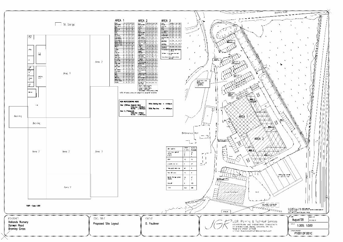
Site CharacteristicsThe application site lies to the south of Darwen Road between Birtenshaw Hall School andthe railway line between Hall i' th' Wood and Bromley Cross railway stations. It isoccupied by a single storey predominantly glass building with a footprint of some 80metres x 43 metres, which has, from the time that it was constructed, been largely usedfor the retailing of plants and garden products. Part of the building is utilised as a cafe.To the front of the site is a car parking area and access is taken from a shared drivewaywith Birtenshaw School which leads onto Darwen Road. To the rear of the site is an areaof open ground upon which planning permission has been granted for the laying out ofplaying fields.
History of the Site
In 1989 planning permission was granted (51523/89) for the erection of polytunnels atthe site. The application was determined on the basis that the polytunnels were to beused for an agricultural purpose; that is the growing of plants. The use was thereforedeemed to be an appropriate Green Belt use and permission was granted. An informativeattached to the decision notice stated that "For the avoidance of doubt this permissiondoes not authorise the use of the site as a garden centre".
Subsequently complaints were made to the Council to the effect that the site was beingused for the retailing of plants, Christmas trees and products that were not grown on thesite. As a result the site was visited by various enforcement officers over the years and anenforcement notice was served requiring the cessation of the use of the site for themanufacture of garden products and for the storage of HGVs in September 2000; this wascomplied with. Other matters were, however, deemed not to warrant the service of anyEnforcement Notice as the proprietor of the site maintained that the majority of theplants that were retailed were either grown or grown-on on site. Indeed, investigatingofficers were shown that there was a growing operation on site. It was, moreover, notconsidered expedient to serve Notices in respect of seasonal sales, for example ofChristmas trees, particularly bearing in mind that a percentage of imported plants andproducts could lawfully be retailed from the site.
When application 77574/07 was submitted it was for the erection of a replacementnursery building (including office, growing and sales areas) and the change of use of landto playing fields together with the erection of changing rooms with associated car parkingand a temporary growing/storage building. The report on the application stated that, "NoCertificate of Lawfulness has been issued that would establish the legality of a largerproportion of imported goods being sold. Therefore the lawful use at the site isconsidered to be that of an agricultural operation... with no more than 10% of sales beingof imported sales". The planning permission was therefore considered in these terms andpermission was granted subject to a number of conditions which restricted the use whichcould be carried out from the site.
The applicant has now produced detailed financial evidence on the precise levels of retailsales of imported plants and produce which have taken place over the years togetherwith a statement which states that only a small amount of growing on has taken place inorder to obtain added value to the product. Statements from organisations and personsassociated with sales to and from the site and the firm's accountant together with areport on trading from 1998 to 2009 have been submitted which indicate that thepercentages of "imported" plants and goods purchased for immediate sale have increasedduring the time that the business has been on the site and have been well in excess of

50% of turnover for the last 10 years. On the basis of this evidence it is apparent thatthe primary use of the site was for the retailing of imported produce; that is, a gardencentre. The fact that the true use of site was not established in 2007 does not alter thefact that the Council would have had to issue a Certificate of Lawfulness had one beenapplied for, by reason of the length of time that the use had been carried out.
It should be noted that in minor respects the building as erected is different from thatwhich was granted planning permission and with regard to the internal layout there isnow a cafe area (subject of application 83196/09), the office and ancillary space has beenreduced thereby increasing the available retail space and the areas devoted to opendisplay and sales have been increased.
PolicyPPG2 Green BeltsPPS4 Planning for Sustainable Economic Growth
UDP policies: D1, D2 Design; D3 Landscaping; A5 Road Network; A6 Car ParkingStandards; G1 and G2 Green Belt; G3 Reuse of Buildings in the Green Belt; R5 LandscapeCharacter; S4 Retail and Leisure; N3 Sites of Biological Importance.
AnalysisSection 38 of the Planning and Compulsory Purchase Act 2004 requires applications to bedetermined in accordance with policies in the Development Plan unless materialconsiderations indicate otherwise.
Applications which are not in accordance with Development Plan policies should berefused unless material considerations justify granting permission.
Similarly, proposals which accord with Development Plan policies should be approvedunless there are material considerations which would justify a refusal of permission.
It is therefore necessary to decide whether this proposal is in accordance with theDevelopment Plan and then take account of other material considerations.
The main impacts of the proposal are:-* impact on the Green Belt* impact on the character and appearance of the area* impact on the highway* impact on the vitality and viability of local centres* impact on the Birtenshaw Covenant
Impact on the Green BeltPPG2 Green Belts seeks to maintain the openness of the Green Belt and to protect it frominappropriate development. Very special circumstances should be demonstrated to justifyinappropriate development which is by definition harmful to the Green Belt. UDP policy G1states that the Council will not permit development unless it is clearly needed foragriculture or other appropriate uses and does not prejudice the purposes and objectivesof the Green Belt. Policy G2 states that the Council will not permit inappropriatedevelopment, including anything which does not maintain the openness of the landexcept for agriculture, and other appropriate uses. In all cases development should notprejudice the purposes and visual amenities of the Green Belt by reason of its scale,design and siting. Policy G3 relates to the reuse of existing buildings and essentiallystates that the reuse will be acceptable providing there are no greater impacts from thenew use on the openness of the Green Belt.
As stated above, a nursery garden use and the ancillary retailing of produce grown onthe site is an agricultural use and associated building works therefore constituteappropriate development in the Green Belt. This may also include the erection of

facilities ancillary to the primary agricultural use, such as appropriately sized anddesigned offices, car parking, and so on. As a garden centre use is predominantly aretail one, the erection of a building to be used as a garden centre would, by definition,constitute inappropriate development in the Green Belt and permission should not begranted unless there are very special circumstances which would outweigh the harm tothe Green Belt.
Given the evidence now available in terms of trading figures over the last 20 years,where it not for the approval of a replacement nursery building and the associatedrestrictive planning conditions, the lawful use of the site would have been as a gardencentre and the Council would have not have been able to reasonable refuse a Certificateof Lawfulness for this use should it have been submitted in 2007.
The garden centre use is not considered to have any additional impact on the opennessof the Green Belt as the building and car park are already constructed and there are noproposals to extend this built development. It is therefore considered that there will beno adverse impacts on the openness of the Green Belt over and above those existing inconnection with the permitted use (that of a nursery), compliant with Policy G3 of theUDP.
It is therefore considered that very special circumstances do exist in this instance andthat the retention of the building and the continued use of the site as a garden centre isin accordance with policies G1, G2 and G3 of the UDP.
Impact on the Character and Appearance of the AreaGreen Belt policies and UDP policy R5 seek to ensure that the character and appearanceof the area will not be harmed. Policy D2 seeks to ensure good urban design, includinglayout, density, height, massing, style, materials and landscaping.
The new building occupies a slightly smaller footprint than the previous buildings and itis of an improved visual appearance. The height, massing, and impact on the opennessof the Green Belt is similar to that which existed on the site. The design includessubstantial landscaping which effectively screens the development, reducing the visualimpact from outside the site.
The redevelopment has resulted in an improvement in the appearance of the site in thatthe old glasshouses have been removed and a new building with a landscaped parkingarea has been constructed. The proposed change of use will not alter the impact of thebuilding on the character and appearance of the area. The proposal accords withpolicies R5 and D2 of the UDP.
Impact on the HighwayUDP policies A5 and A6 aim to ensure that new developments will not have and adverseimpact on highway safety and that developments are provided with adequate car parkingbased on the Council's maximum car parking standards.
Highway Engineers have commented that the access road to the site is used bypedestrians and by wheelchair users and their carers as it also serves Birtenshaw HallSchool and carries a public footpath. The provision of the cafe is considered likely byEngineers to lead to increase pedestrian activity when there is no safe pedestrian routefrom Darwen Road . A new footway for pedestrians is required if planning permissionwere to be granted for the cafe use. The permission will therefore be conditionedaccordingly.
There are currently 100 car parking spaces plus 12 spaces for disabled persons which willbe available for users of the garden centre. This is considered to be more than adequatefor the use. An additional 93 spaces on and around the site of the polytunnels will also be

provided when the football fields eventually get brought into use.
Impact on the Vitality and Viability of Local CentresPolicy S4 of the UDP is restrictive of new retail development outside of existing identifiedretail centres which may harm their vitality and viability.
Given that there is a longstanding retail use on this site and that the permission will berestricted to a garden centre, a use which cannot easily be located within the existingbuilt up area, it is considered that there will be no adverse impacts on existing retailcentres. Indeed in the planning law case of Teignbridge 3/4/09 the Inspectorateconcluded that garden centres by necessity are usually located within rural areas and thatthey do not adversely affect the vitality and viability of existing centres.
The application will be conditioned such that the use shall be a garden centre only andthe range of products sold limited to those detailed on the approved plans. As such theproposal is considered to conform with Policy S4 of the UDP.
Impact on the Birtenshaw CovenantAlthough this is a consideration in the determination of the application, the applicationfalls to be determined in the light of the Council's planning policies and a separateconsent will be required from the Council under the terms of the Covenant.
The Covenant was entered into in order to preserve the land as private open space andfor the benefit and amenity of the district. It was agreed that all existing buildings shouldbe preserved and maintained and that no building other than structures for agriculturalpurposes should be erected on the land and nor should any streets, roads or footpaths bemade. The agreement allowed the use of the land for agricultural purposes or any otherpurpose which would preserve it as private open space.
When planning permission was granted for the nursery building, this was deemed not tobe a breach of the Covenant because this was an agricultural use. The polytunnels werealso treated in the same way. As the use of the building is now being changed to agarden centre with ancillary cafe, the Council's Legal Officers consider that this wouldconstitute a breach of the Covenant. The statue is also a breach of the Covenant. Theapplicant has indicated that an application for consent under the terms of the Covenantwill be made in the very near future.
ConclusionIt is considered that financial data and supporting information submitted with theapplication provides sufficient evidence to prove that the use of the site has involved thesale of substantial amounts of imported produce and that had an application for aCertificate of Lawfulness been submitted prior to the implementation of the 2007permission the Council would likely have had to grant it for these purposes. The gardencentre use is a continuation of the activities that have been carried out on the site formore than 10 years.
The redevelopment of the site has significantly improved the appearance of the area andits use as a garden centre will not impact on the openness of the Green Belt. It istherefore recommended that planning permission be granted subject to conditions.

Representation and Consultation Annex
RepresentationsLetters:- 14 letters of objection have been received plus a letter from the Turtonbranch of the Bolton and District Civic Trust objecting on the grounds that thedevelopment is:-
* contrary to Green Belt policy and harms openness* breaches the terms of the Birtenshaw Covenant* will result in extra traffic congestion* set a precedent for further development* cause additional noise and pollution* drive away wildlife
40 letters of support have been received; writers comment that the development has:
* improved the appearance of the site and the character of the area* created employment* is an attractive venue in an area devoid of infrastructure and facilities
ConsultationsAdvice was sought from the following consultees; Bolton Council Legal Officers, HighwayEngineers, Environmental Health Officers, Greater Manchester Ecology Unit
Planning HistoryApplication 77574/07 Erection of replacement nursery building and associateddevelopment together with the laying out of playing fields. Permission granted 8thOctober 2007.
Application 75599/06 Erection of a replacement nursery building (including office, growingand sales areas) together with car parking areas, boundary fencing and security lighting,change of use of land to playing fields, erection of changing rooms and associated carparking, and erection of a temporary growing/storage building. Refused May 2007 andD2."
Application 71687/05 for change of use to provide sports facilities (10 pitches), erectionof changing rooms, nursery building (incorporating restaurant, offices, growing and salesareas), 190 car parking spaces and temporary polycarbonate growing area. Withdrawn.
Application 70318/05 for use of land to provide sports facilities (9 pitches) and associatedchanging, community and clubhouse facilities and parking (180 spaces) together withrelocation of nursery to provide nursery, garden centre facilities and car park (90 spaces).Withdrawn.
Application 61632/02 for demolition of existing office/store and erection of replacementbuilding for ancillary staff accommodation and product sales. Withdrawn.
Application 5412/03 for prior approval for the installation of a 15 metretelecommunications pole, 3 no. antennae, 1 no. 300mm dish and equipment cabin withassociated works. Refused August 2003.
Application 61023/02 for installation of a 15 metre timber monopole with 3 no. antennaeand 1 no. 300mm dish, and equipment cabin and development ancillary thereto.Approved on appeal in 2002.
Application 51523/97 for erection of a hard standing for the handling of materials in theconstruction of a combined sewer outfall. Withdrawn in 1997.

Application 51523/89 for erection of glass houses and a storage building to formhorticultural nurseries. Approved 1989.
Recommendation: Approve subject to conditions
Recommended Conditions and/or Reasons
1. The premises as defined on plan P1001:DF:0011B received on the 9th March 2010 shall be used for agarden centre and for no other purpose (including any other purposes in Class A1 of the Schedule tothe Town and Country Planning (Use Classes) Order 1987, or in any provision equivalent to that Classin any statutory instrument revoking and re-enacting that Order). For the avoidance of doubt onlygoods listed on the approved plans shall be retailed from the site unless otherwise agreed in writingwith the Local Planning Authority.
Reason
Because the site lies within the Green Belt
2. The area shown as Area 1 on the approved plan (excluding the office area) shall only be used for thestorage, display, growing or growing on of plants or the retailing of the items specified on theapproved plan and for no other purpose unless otherwise agreed in writing with the Local PlanningAuthority.
Reason
To protect the character of the Green Belt.
3. The area shown as Area 2 on the approved plan shall only be used for the growing, growing on,storage, display or retailing of plants, shrubs and trees as specified on the approved plan. For theavoidance of doubt the permitted use includes the on-site preparation and sale of prepared baskets,tubs, and similar goods. Other products or non-plant goods are not permitted to be stored or soldfrom this area unless otherwise agreed in writing with the Local Planning Authority.
Reason
To limit the impact of the development upon the Green Belt.
4. Outdoor sales shall only take place within the area shown as Area 3 or otherwise defined on theapproved plan. There shall be no outdoor sales elsewhere in the site. For the avoidance of doubt noproducts other than those detailed on the approved plans shall be retailed from this area unlessotherwise agreed in writing by the Local Planning Authority.
Reason
To protect the openness and character of the Green Belt.
5. No other part of the site other than those shown on the approved plan shall be used for the retailingor storage of imported products, goods or plants for sale.
ReasonTo protect the character of the Green Belt.
6. The meeting room approved shall only be used for purposes ancillary to the use of the site as agarden centre and shall not be used for any other purpose.
Reason
Because other commercial uses my harm the amenities of the Green Belt.
7. The garden centre shall not be open to customers except between the hours of 09:00 and 17:00Monday to Saturday and between the hours of 10:00 and 16:00 on Sundays and Bank Holidays.
Reason
To safeguard the amenity and character of the area and to safeguard the living conditions of nearby

residents particularly with regard to noise and/or disturbance.
8. No deliveries shall be taken at or dispatched from the site except between the hours of 08:00 and18:00 Mondays to Fridays, 08:00 and 13:00 Saturdays and no deliveries shall be taken at ordispatched from the site on Sundays or Bank Holidays.
Reason
To safeguard the amenity and character of the area and to safeguard the living conditions of nearbyresidents particularly with regard to noise and/or disturbance.
9. The polytunnels shown on the approved plan to the south of the loading/unloading area shall beentirely removed and the area laid out as car parking within 6 months of the date of this decision orbefore the first use of the playing fields permitted under application 77574/07 whichever shall be thesooner.
Reason
To safeguard the openness and character of the Green Belt and to ensure that adequate car parkingprovision is made available for the playing fields.
10. Within 3 months of the date of this permission the site shall be drained in accordance with a drainagescheme which shall have been submitted to and approved in writing by the Local Planning Authority.
Reason
To ensure a satisfactory form of surface water disposal.
11. Within 3 months of the date of this permission the means of vehicular access from Birtenshaw accessroad including a mini-roundabout and the re-alignment of existing accesses shall be constructed andlaid out entirely in accordance with the approved plans.
Reason
In the interests of highway safety.
12. Within 3 months of the date of this permission full details of the highway works at the site accessroad comprising a splitter island and road markings shall be submitted to and approved by the LocalPlanning Authority and implemented in full. Such works to be retained thereafter.
Reason
In the interests of highway safety.
13. Within 3 months of the date of this permission full details of the highway works at the access toBirtenshaw School comprising a 2.0 metre wide footway from the site entrance to the junction withDarwen Road and for a further 10.0 metres along the Darwen Road frontage in an easterly directionshall be submitted to and approved by the Local Planning Authority. The approved footway shallthereafter be constructed within 6 months of the date of this permission. Such works to be retainedthereafter.
Reason
In the interests of highway safety.
. The Council has granted planning permission, subject to the conditions listed above, because theproposed development is in accordance with all relevant policies of the Development Plan (the UDPand the Regional Spatial Strategy Plan for the North-West), as is required by Section 38 of thePlanning and Compulsory Purchase Act 2004. There are no material considerations, as specified inthe Planning Officer Report, that outweigh this justification to support the grant of planningpermission. A summary of the relevant Development Plan policies pursuant to Article 22 of the Townand Country Planning (General Development Procedure) (England) (Amendment) Order 2003 andhow the proposed development relates to these policies is set out below.
Unitary Development Plan

G1, G2 and G3 as the proposed development will not have an adverse affect on the openness of theGreen Belt to a greater extent than the previous development.
R5 as the development will not adversely affect the landscape character of the area;
N3 as the proposed change of use will not affect the nearby Site of Biological Importance;
D1 and D2 as the application displays good urban design which would preserve local distinctiveness;
D3 as there is scope for sufficient landscaping ;
A5 as the development proposals take into account provision for roads, paths, servicing and parking;
A6 as the development is to provide car parking based on the Council's maximum car parkingstandards;
S4 as the proposal will not harm the vitality and viability of local retail centres.


Date of Meeting: 11/11/2010 Item Number:
Application Reference: 83196/09
Type of Application: Full Planning ApplicationRegistration Date: 13/11/2009Decision Due By: 08/01/2010ResponsibleOfficer:
Helen Williams
Location: HOLLANDS NURSERIES, DARWEN ROAD, BROMLEY CROSS,BOLTON, BL7 9AB
Proposal: RETENTION OF STATUE AND POND AND CHANGE OF USE OFPART OF PREMISES TO CAFE AND TEMPORARY PERMISSIONFOR 2 YEARS FOR POLYTUNNELS
Ward: Bromley Cross
Applicant: HollandsAgent : Mr Luxton
Officers Report
BackgroundThis application (and application 83194/09 for the change of use of the premises from anursery to a garden centre) was deferred at the Committee meeting of 1st April forfurther information relating to the following:
1. Material has allegedly been deposited at the rear of the site2. Further comments from the Ecology Unit3. Guidance on when a nursery become a garden centre4. A response from the Council's Legal Officers regarding the evidence provided by
the applicant in respect of past and current activity at the premises5. Advice on the status of this Green Belt site in the future6. Analysis of the cafe and its impact on other similar facilities in the local area
The information relating to points 1 to 5 is reported within the background section to theOfficer's report for application 83194/09. The analysis of the cafe (point 6) is found belowin the section of the report entitled “Impact on the Vitality and Viability of Local Centres”.
ProposalThe application has four elements:-
1. The retention of a statue of St George, which has been placed in front of the entranceto the building within the car parking and circulation area. The statue and stone plinth areapproximately 5 metres high and the plinth is 3 metres by 1.5 metres in size. A signstating "Welcome to Holland Gardening Centre” is displayed on the front of the plinth.
2. The retention of an area of the main building which is used as a cafe.
3. The retention of an irregularly shaped pond with a maximum width of 26 metres and alength of 31 metres with a capacity of 3510 cubic metres located to the rear of the site.It is proposed that the pond will ultimately discharge into land drains on the playingfields. The pond has been constructed instead of an underground water holding tankwhich was originally approved to collect the surface water from the site and it is located
on a part of the site that was shown to be used for car parking for the playing fields.Subsequent to the approval of the holding tank an amendment showing a pond whichalso impacted upon car parking space to the south west of the buildings was approved;the present pond was built instead.
4. The temporary retention of five polytunnels that are located to the rear of the newnursery buildings. The area occupied by the polytunnels is some 31 metres by 40 metresin size. The planning permission granted in 2007 for the new building was subject to acondition that the polytunnels would be removed once the replacement nursery buildinghad been constructed, or within 3 years, whichever period was the shorter. Thepolytunnels are presently being used for the storage/growing on of plants which are to beretailed. There is no retailing from these polytunnels.
This application should be read in connection with application 83194/09 for the change ofuse of the site and buildings from a garden nursery to a garden centre.
Site CharacteristicsThe application site lies to the south of Darwen Road between Birtenshaw Hall School andthe railway line between Hall i'th' Wood and Bromley Cross railway stations. It is occupiedby a single storey predominantly glass building with a footprint of some 80 metres x 43metres, which has, from the time that it was constructed, has been largely used for theretailing of plants and garden products. Part of the building is utilised as a cafe. To thefront of the site is a car parking area and access is taken from a shared driveway withBirtenshaw School which leads onto Darwen Road. To the rear of the site is an area ofopen ground upon which planning permission has been granted for the laying out ofplaying fields.
PolicyPPG2 Green BeltsPPS4 Planning for Sustainable Economic Growth
UDP policies: D1, D2 Design; D3 Landscaping; A5 Road Network; A6 Car ParkingStandards; G1 and G2 Green Belt; G3 Reuse of Buildings in the Green Belt; R5 LandscapeCharacter; S4 Retail and Leisure; N3 Sites of Biological Importance; EM10 Surface WaterRun Off.
AnalysisSection 38 of the Planning and Compulsory Purchase Act 2004 requires applications to bedetermined in accordance with policies in the Development Plan unless materialconsiderations indicate otherwise.
Applications which are not in accordance with Development Plan policies should berefused unless material considerations justify granting permission.
Similarly, proposals which accord with Development Plan policies should be approvedunless there are material considerations which would justify a refusal of permission.
It is therefore necessary to decide whether this proposal is in accordance with theDevelopment Plan and then take account of other material considerations.
The main impacts of the proposal are:-
impact on the Green Beltimpact on the character and appearance of the areaimpact on the highwayimpact on the vitality and viability of local centresimpact on land drainageimpact on the Birtenshaw Covenant

Impact on the Green BeltPPG2 Green Belts and UDP policies G1 and G2 seek to maintain the openness of theGreen Belt and to protect it from inappropriate development. Essentially this means thatonly development which is agricultural or recreational in nature is likely to be acceptablewithin the Green Belt. Very special circumstances should be demonstrated to justifydevelopment which is inappropriate and by definition harmful to the Green Belt.
Policy G3 relates to the change of use of existing buildings in the Green Belt and statesthat the reuse of existing buildings within the Green Belt will be considered to beappropriate development providing there is no greater impact upon the openness of theGreen Belt than the existing use of the building. New uses will only be acceptable if thereis likely to be no additional harm to the visual amenities of the Green Belt or the purposesof including land within it.
The statue of St George is located within a car parking area and it is viewed against thebackdrop of the buildings on the site. Whilst it constitutes inappropriate development, it isnot considered to be prejudicial to the visual amenities of the Green Belt and given itssize and location it does not impact upon the openness of the area. It is not considered toconflict with policies G1 and G2 of the UDP.
The acceptability of the use of part of the building as a cafe is more finely balanced asthe erection of a new building as a cafe would have constituted inappropriatedevelopment. However, as detailed in the report on the companion application 83194/09the use of the site has long been that of a garden centre and the space occupied by thecafe could be used alternatively for the display and retailing of garden products. It wouldbe difficult to argue that the existing limited refreshment use or even a more developedrestaurant use would have any greater impact on the Green Belt particularly as thebuilding is already in situ.
Whilst a cafe/restaurant use would be likely to make the site a more attractive destinationfor a different clientele there is unlikely to be any additional demand for vehicular parkingon the site given the alternative use to which the area of the building could be put. It istherefore considered that the use of this part of the building as a cafe would not harm theopenness of the Green Belt nor give rise to any additional adverse impacts on theamenities of the area. However, in order to prevent the establishment of an independentrestaurant use it is proposed to make the use personal to the applicant and ancillary tothe garden centre use of the site.
The pond has no adverse impact on the openness or the visual amenities of the GreenBelt. It is a necessary feature which facilitates the drainage of the site and it does notprejudice the aims and objectives of Green Belt policy.
The polytunnels were granted planning permission in 2007 but for only a temporaryperiod until the replacement building was completed or for three years, whichever periodwas the shortest. The applicant now seeks planning permission for the retention of thepolytunnels for a further 2 years. It is apparent that the development of the replacementmain building has now been completed and that the polytunnels are being used for thestorage and some growing on of plants for sale in the main building. The retention ofthese buildings significantly increases the size and scale of the built development on thissite and effectively allows more of the main building to be utilised for the retailing ofimported produce and plants rather than any storage and growing on of plants whichused to take place within the old buildings which stood on this site.
Given the polytunnels limited use for agricultural purposes they are not considered torepresent appropriate development and they harm the visual amenities and openness ofthe Green Belt contrary to policies G1 and G2 of Bolton's UDP. Should the application be

granted approval it is recommended that the applicant be given a period of 6 monthsbefore they need to remove the polytunnels completely so that they have adequateopportunity to reorganise.
Impact on the Character and Appearance of the AreaGreen Belt policies and UDP policy R5 seek to ensure that the character and appearanceof the area will not be harmed.
For the reasons stated above it is not considered that the statue or pond harm the visualamenities of the area and the cafe is an internal feature. The retention of the polytunnelsis considered to be contrary to policy R5 of the UDP in that they are visible from vantagepoints accessible to the public and they harm the visual amenities of the area by reasonof the increased area of the site which has built development upon it.
Impact on the HighwayUDP policies A5 and A6 aim to ensure that new developments will not have an adverseimpact on highway safety and that developments are provided with adequate car parkingbased on the Council's maximum car parking standards.
Highway Engineers have commented that the access road to the site is used bypedestrians and by wheelchair users and their carers as it also serves Birtenshaw HallSchool and carries a public footpath. The provision of the cafe is considered likely byEngineers to lead to increase pedestrian activity when there is no safe pedestrian routefrom Darwen Road . A new footway for pedestrians is required if planning permissionwere to be granted for the cafe use. The permission will therefore be conditionedaccordingly.
The pond is located on an area of land which was shown on the approved plan to havebeen occupied by 34 car parking spaces within an overspill car parking area for theplaying fields although this has freed up that part of the site which was to have beenoccupied by the pond and this will allow for 27 spaces to be constructed. It is notconsidered that this reduction in spaces will give rise to additional parking on thehighway.
The polytunnels are located on a part of the site which on the approved plans wereshown to be for additional overspill car parking of 60 spaces. These spaces were to havebeen made available in the event of demand arising from users of the playing fields.Whilst in the short term pending the construction of the playing fields there is clearly noneed for these spaces, the removal of the polytunnels will allow for the provision of thesespaces should there be a need when the playing fields are brought into use. The retentionof the buildings would therefore be contrary to UDP policy A5.
Impact on the Vitality and Viability of Local CentresOfficers visited the café on the morning of 30th September 2010 and noted the followingalterations to the café since previous visits:1. The extension of the seating area. There were about half a dozen tables outside thecafé area on the area illustrated as decking on the plans, both outside and within part ofarea 2.2. A food counter containing cakes and cold drinks had replaced a wooden counter.3. A kitchen was now visible to the rear of the counter as a window had been insertedinto the partition wall. This area is described on the submitted plans as the area fortoilets, not a kitchen. Two cookers and a preparation table were visible. 4. The café formerly had the appearance of a self-service area, with only vendingmachines. The introduction of the glass counter and kitchen gave Officers the impressionthat the area had become more of a café facility than it previously was. There were stillhowever vending machines within the café for cold drinks and snacks.

It was hard for Officers to ascertain the types and degree of hot and cold food beingserved in the café as there were no customers present at the time of the visit, nor anymenus. The owner was questioned about this and explained that the types of food onoffer changed on a daily basis dependent on the ingredients/stock they had. He alsoconfirmed that there was no takeaway service available and only limited hot food wasserved. There were no members of staff present at the café when Officers visited so it ispresumed that staff only serve at the café when they have customers (there is nodedicated member of staff for the café facility).
The café certainly has the appearance of a facility ancillary to the main use of thebusiness and it seems doubtful that the café would be a visitor destination in its ownright, particularly given that it is located within the centre of the building and that it isonly accessible by walking through the shop area (area 1). The café is also not openwhen the garden centre is closed. It is noted that the café area may have grown andchanged in character to some extent since earlier this year, but it is still relatively small inscale and function compared to the rest of the building. To keep the café ancillary to themain use of the building it is therefore suggested that conditions are added to anyconsent to restrict the size of the area used as a café and to restrict the hours of openingto that of the garden centre. Furthermore, a personal permission for the cafe is to begiven to the applicant so that the cafe cannot become established as an independent use.
At the Committee meeting of 1st April 2010 it was asked what impact the café atHolland’s would have/is having on similar facilities in the local area. The following foodestablishments are located near to Holland’s Nurseries and are shown on the attachedplan:
1. Café ancillary to the Co-op supermarket, 196 Darwen Road, Bromley Cross –recently opened.
2. 211 Darwen Road, Bromley Cross – previously Ray’s Bookmakers but has consentfor a café (A3) in 2010. Currently not open.
3. Bromley Crust, 450 Darwen Road, Bromley Cross – sandwich shop (A1) withindoor seating.
4. Tea Rooms, Last Drop Village, Bromley Cross – A3 use but possibly ancillary to thewider retail/leisure use of the complex.
5. Jumbles Country Park Café, off Bradshaw Road – A3 café.
The following are also local, but not near enough to Holland’s to be shown on the plan:6. Relish, The Mill, Deakins Business Park, Dunscar – A3 café.7. Poppy’s, 160a Blackburn Road, Egerton – A3 café.8. Woody’s, 273a Blackburn Road, Egerton – sandwich shop (A1) with outdoor
seating.9. Rushton’s Café, 10 The Hillock, Harwood – A3 café.
Planning is not able to consider commercial competition. Local Planning Authorities canonly seek to ensure that the vitality and viability of town and other centres are notharmed by developments. Indeed PPS4 Planning for Sustainable Economic Growth inreality aims to promote competition between retailers and enhance consumer choice. Ofthe cafés listed above, only the café in the Co-op, the premises with A3 permission onDarwen Road and Rushton’s Café are located within an allocated centre. The café in theCo-op and the premises with permission have actually opened or got planning permissionafter the café in Holland’s was established. It therefore appears that the owners of thesepremises are not concerned about the impact of Holland’s on their business proposals. Itis also likely that the other cafés and establishments in the local area have a wider choiceof menu than Holland’s currently does and are destination facilities in their own right.
It is therefore considered that the ancillary café in Holland’s will not have a negativeimpact in its own right on other similar facilities in the area, compliant with Policy S4 ofthe UDP.
Impact on Land DrainageUDP policy EM10 seeks to ensure that surface water run off is minimised and managed soas to reduce the environmental impact of developments.
The planning permission for the development of the site was subject to conditions whichrequired details of surface water management and a flood risk assessment was required.Details were submitted pursuant to the condition which required an on site tank and pondwith the run off directed onto the playing fields; these details were approved by theEnvironment Agency. The developer subsequently obtained planning permission for apond in the south west corner of the site and the present pond has been constructed inlieu of this approved amendment. Whilst the pond will in due course discharge into theplaying field drainage system, details have been submitted which show it discharging intoan existing surface water culvert and this arrangement is acceptable to the Council'sDrainage Engineers.
The proposal therefore complies with UDP policy EM10 on surface water management.
Impact on the Birtenshaw CovenantAlthough the impact on the Covenant is a consideration in the determination of theapplication, the application falls to be determined in the light of the Council's planningpolicies and a separate consent will be required from the Council under the terms of theCovenant.
The Covenant was entered into in order to preserve the land as a private open space andfor the benefit and amenity of the district. It was agreed that all existing buildings shouldbe preserved and maintained and that no building other than structures for agriculturalpurposes should be erected on the land and nor should any streets, roads or footpaths bemade. The agreement allowed the use of the land for agricultural purposes or any otherpurpose which would preserve it as private open space.
When planning permission was granted for the nursery building under application77574/07, this was deemed not to be a breach of the Covenant because this was deemedto be an application for an agricultural use and the polytunnels were treated in the sameway. As the proposed use of part of the building is a cafe, the Council's Legal Officersconsider that this would constitute a breach of the Covenant. The statue is also a minorbreach of the Covenant. However, the pond would not constitute a breach as it wouldpreserve the land as private open space. The polytunnels would not be in breach of theCovenant if they were used for agricultural purposes. The applicant has indicated that anapplication for consent under the terms of the Covenant will be made in the very nearfuture.
ConclusionFor the reasons detailed in this report it is recommended that planning permission begranted for the retention of the statue, pond an ancillary cafe. The retention of thepolytunnels represents inappropriate development in the Green Belt which would give riseto the additional commercial development taking place from the site which would impactadversely on the openess of the Green Belt. The application for the polytunnels istherefore recommended only for a 6 month permission so as to allow for thereorganisation of the business and so that the space is available for parking provision forthe playing fields.
Representation and Consultation Annex
RepresentationsLetters:- 14 letters of objection have been received plus a letter from the Turtonbranch of the Bolton and District Civic Trust objecting on the grounds that the

development is:
* contrary to Green Belt policy and harms openness* breaches the terms of the Birtenshaw Covenant* will result in extra traffic congestion* set a precedent for further development* cause additional noise and pollution* drive away wildlife* the pond is excessively large
40 letters of support have been received; writers comment that the development has:
* improved the appearance of the site and the character of the area* created employment and investment in the area* is an attractive venue in an area devoid of infrastructure and facilities* the Statue of St George represents a national symbol* a cafe and meeting room would be valuable local facilities
ConsultationsAdvice was sought from the following consultees; Council Highway and DrainageEngineers, the Greater Manchester Ecological Unit and the Environment Agency.
Planning HistoryApplication 77574/07 Erection of replacement nursery building and associateddevelopment together with the laying out of playing fields. Permission granted 8thOctober 2007.
Application 75599/06 Erection of a replacement nursery building (including office, growingand sales areas) together with car parking areas, boundary fencing and security lighting,change of use of land to playing fields, erection of changing rooms and associated carparking, and erection of a temporary growing/storage building. Refused May 2007.
Application 71687/05 for change of use to provide sports facilities (10 pitches), erectionof changing rooms, nursery building (incorporating restaurant, offices, growing and salesareas), 190 car parking spaces and temporary polycarbonate growing area. Withdrawn.
Application 70318/05 for use of land to provide sports facilities (9 pitches) and associatedchanging, community and clubhouse facilities and parking (180 spaces) together withrelocation of nursery to provide nursery, garden centre facilities and car park (90 spaces).Withdrawn.
Application 61632/02 for demolition of existing office/store and erection of replacementbuilding for ancillary staff accommodation and product sales. Withdrawn.
Application 5412/03 for prior approval for the installation of a 15 metretelecommunications pole, 3 no. antennae, 1 no. 300mm dish and equipment cabin withassociated works. Refused August 2003.
Application 61023/02 for installation of a 15 metre timber monopole with 3 no. antennaeand 1 no. 300mm dish, and equipment cabin and development ancillary thereto.Approved on appeal in 2002.
Application 51523/97 for erection of a hard standing for the handling of materials in theconstruction of a combined sewer outfall. Withdrawn in 1997.
Application 51523/89 for erection of glass houses and a storage building to formhorticultural nurseries. Approved 1989.

Recommendation: Approve subject to conditions
Recommended Conditions and/or Reasons
1. The permission for a cafe shall enure for the sole benefit of the applicant Mr D Faulkner and shall befor the period during which the premises are occupied by the applicant, after which time the usehereby approved shall cease. For the avoidance of doubt the cafe shall only be used ancillary to theprimary use of the site as a garden centre.
Reason
In the view of the personal circumstances of the applicant and in the light of the assurances given asto how the development applied for will be carried out.
2. The cafe shall not be open to customers except between the hours of 0900 and 1700 Monday toSaturday and between the hours of 1000 and 1600 on Sunday.
Reason
To safeguard the amenity and character of the area and to safeguard the living conditions of nearbyresidents particularly with regard to noise and/or disturbance.
3. No deliveries shall be taken at or dispatched from the site except between the hours of 0800 and1800 Mondays to Fridays, 0800 and 1300 on Saturdays and no deliveries shall be taken at ordispatched from the site on Sundays or Bank Holidays.
Reason
To safeguard the amenity and character of the area and to safeguard the living conditions of nearbyresidents particularly with regard to noise and/or disturbance.
4. A landscape scheme for the pond shall be submitted to and approved by the Local Planning Authoritywithin 3 months of the date of this permission. Such scheme shall be carried out within 6 months ofthe approval of the plans any trees and shrubs that die or are removed within five years of plantingshall be replaced in the next planting season with others of similar size and species.
Reason
To soften the development proposed and to enhance and improve the setting of the developmentwithin the landscape of the surrounding locality.
5. The polytunnels hereby permitted shall only be used for the growing or growing on of plants, shrubsor trees and for the avoidance of doubt shall not otherwise be used for storage or retail purposes orthe display of plants or products for sale. The public shall not have access to these buildings.
Reason
Because the site lies within the Green Belt and a non agricultural use would constitute inappropriatedevelopment.
6. The polytunnels hereby permitted shall be removed from the site within 6 months of the date of thispermission or prior to the commencement of the development of the playing fields permitted underapplication 77574/07 whichever shall be the sooner.
Reason
To prevent the further encroachment of development into the Green Belt.
7. Within 3 months of the date of this permission the pond hereby permitted shall be connected to theexisting surface water culvert as shown on the approved plan P1001:DF:001B in accordance withdetails which shall be submitted to and approved in writing by the Local Planning Authority.
Reason
To ensure the satisfactory drainage of the site.

8. Within 3 months of the date of this permission the means of vehicular access from Birtenshaw accessroad including a mini-roundabout and the re-alignment of existing accesses shall be constructed andlaid out entirely in accordance with the approved plans.
Reason
In the interests of highway safety.
9. Within 3 months of the date of this permission full details of the highway works at the site accessroad comprising a splitter island and road markings shall be submitted to and approved by the LocalPlanning Authority and implemented in full. Such works to be retained thereafter.
Reason
In the interests of highway safety.
10. Within 3 months of the date of this permission full details of the highway works at the access toBirtenshaw School comprising a 2.0 metre wide footway from the site entrance to the junction withDarwen Road and for a further 10.0 metres along the Darwen Road frontage in an easterly directionshall be submitted to and approved by the Local Planning Authority. The approved footway shallthereafter be constructed within 6 months of the date of this permission. Such works to be retainedthereafter.
Reason
In the interests of highway safety.
11. The floor area of the cafe shall be restricted to the floor area as shown on the approved plan.
Reason
For the avoidance of doubt as to what is permitted and to retain the cafe as an ancillary use to thegarden centre.
. The Council has granted planning permission, subject to the conditions listed above, because theproposed development is in accordance with all relevant policies of the Development Plan (the UDPand the Regional Spatial Strategy Plan for the North-West), as is required by Section 38 of thePlanning and Compulsory Purchase Act 2004. There are no material considerations, as specified inthe Planning Officer Report, that outweigh this justification to support the grant of planningpermission. A summary of the relevant Development Plan policies pursuant to Article 22 of the Townand Country Planning (General Development Procedure) (England) (Amendment) Order 2003 andhow the proposed development relates to these policies is set out below.
Unitary Development Plan
G1, G2 and G3 as the proposed development will not have an adverse affect on the openness of theGreen Belt to a greater extent than the previous development.
R5 as the development will not adversely affect the landscape character of the area;
N3 as the proposed change of use will not affect the nearby Site of Biological Importance;
EM10 as the development will not result in an unacceptable increased rate of surface run-off;
D1 and D2 as the application displays good urban design which would preserve local distinctiveness;
D3 as there is scope for sufficient landscaping ;
A5 as the development proposals take into account provision for roads, paths, servicing and parking;
A6 as the development is to provide car parking based on the Council's maximum car parkingstandards;
S4 as the proposal will not harm the vitality and viability of local retail centres.


Date of Meeting: 11/11/2010 Item Number:
Application Reference: 83840/10
Type of Application: Full Planning ApplicationRegistration Date: 16/03/2010Decision Due By: 11/05/2010ResponsibleOfficer:
Alex Allen
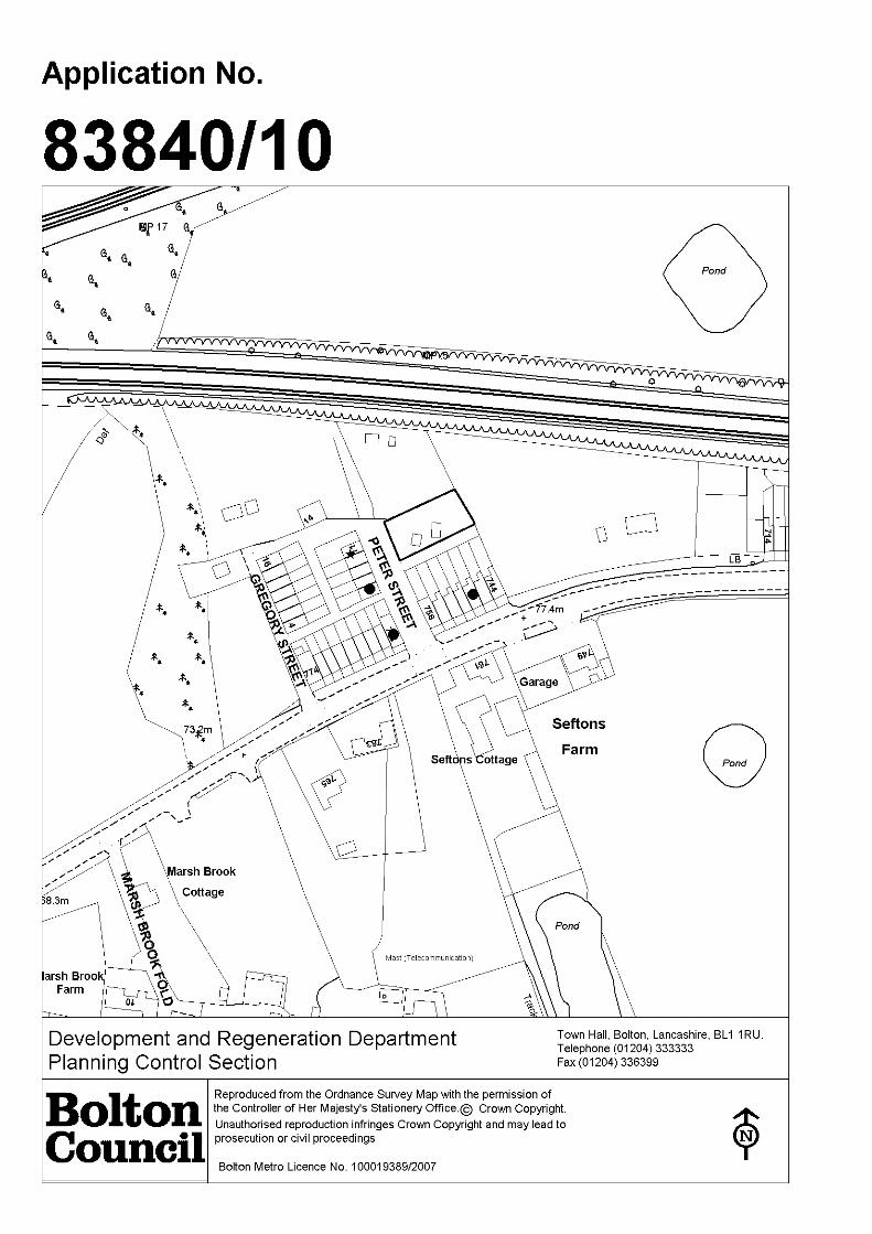
Location: LAND OPPOSITE 7 - 11 PETER STREET AND REAR OF 744 - 756WIGAN ROAD, WESTHOUGHTON, BOLTON, BL5 2DD
Proposal: DEMOLITION OF GARAGES AND REPLACEMENT WITHGARAGE COLONY CONSISTING OF SIX UNITS
Ward: Westhoughton South
Applicant: Mr GregoryAgent :
Officers Report
BackgroundThe application was deferred at the 22 July 2010 Planning Committee meeting byMembers pending an advanced site visit, deferred at the 19th August Planning Committeeto allow the applicant to revisit the proposal to address the following concerns:
Break up the large block of garages into individual garage plots;Provide garages with access from Back Wigan Road;Change the proposed materials used in the external appearance of the garages.Retain trees/vegetation within the site.
The applicant has provided plans which show the following:
5 of the garages with access from Back Wigan Road;replacement of the existing garage sited of Peter Street;brick outer leaf to be used on all elevations;retention of all vegetation/trees within the site.
Clarification was sought at the September Planning Committee over the followingmatters:
Why was the site partially fenced off;Does the owner have ambitions to develop the site for residential purposes;Serving of a Tree Preservation Order on the trees located within the site.
The applicant has confirmed that the fence was partially fenced off to prevent access tothe semi derelict garages which are in a poor state of repair. The owners of the landwish to erect garages on the site not new residential development. A Tree PreservationOrder has been placed on the trees located within the site as instructed by Members inAugust.
It is considered that the amended plans meet Member requirements.

ProposalThe application proposes the demolition of 7 garages and the erection/replacement of agarage colony consisting of 6 garage units. The front of the proposed garages would besited parallel with Back Wigan Road and with the rear walls of the properties which frontWigan Road. A distance of 6 metres would be achieved from the garage doors to therear yard walls of properties fronting Wigan Road.
Site CharacteristicsThe site is located off Wigan Road in the Hart Common area of Westhoughton. The siteis accessed from Peter Street and forms a rectangular site directly opposite No's 7 to 11Peter Street. One existing detached garage is sited in the north western corner of thesite abutting the unadopted Peter Street. The other garages and untidy land is located atthe rear of No;s 744 and 756 Wigan Road which is currently accessed from the backstreet at the rear of these properties.
The site currently consists of a number of detached garages of varying design, all withpitched roofs. Residential properties are located to the south on Wigan Road and West atPeter Street, all terraced properties. To the north and east there is vacant land.
PolicyUDP (2005) D1/D2 Design, N1 Nature Conservation, N9 Species Protection, A5 Roads,Paths, Servicing and Car Parking and A6 Car Parking.
AnalysisSection 38 of the Planning and Compulsory Purchase Act 2004 requires applications tobe determined in accordance with policies in the Development Plan unless materialconsiderations indicate otherwise.
Applications which are not in accordance with Development Plan policies should berefused unless material considerations justify granting permission.
Similarly, proposals which accord with Development Plan policies should be approvedunless there are material considerations which would justify a refusal of permission.
It is therefore necessary to decide whether this proposal is in accordance with theDevelopment Plan and then take account of other material considerations.
The main impacts of the proposal are:-
* impact on the character and appearance of the area;* impact on the Green Belt;* impact on the highway;* impact on protected species; and* impact on protected trees.
Impact on the character and appearance of the areaUDP policies D1 and D2 seek to ensure that development proposals contribute to goodurban design and are compatible with, or improve, their surroundings in terms oflayout, density, height, massing, architectural style, materials and landscaping.
The proposed siting of the garage colony is considered to be acceptable in this location.The existing garages, that are to be removed, are located around the site in variouslocations. Their removal and replace would serve to enhance the character andappearance of the area it is considered.
The garage colony would be located far enough away from the residential properties at

Peter Street and Wigan Road so as not to have an adverse impact on the outlook fromthese properties.
The existing garages all have pitched roofs and would now be proposed to also havepitched roofs.
Impact on the Green BeltPPG 2 states that the visual amenities of the Green Belt should not be injured byproposals for development within or conspicuous from the Green Belt which, althoughthey would not prejudice the purposes of including land in Green Belts, might bevisually detrimental by reason of their siting, materials or design.
As the garages would only be single storey in height and generally of a smaller heightthan the garages that are to be removed from the site, it is considered that theproposal would not adversely impact on the openness of the Green Belt, and subject toa roof design, the garage colony would not be visually detrimental and the design andsiting are considered be acceptable.
Impact on the highwayThe proposed garage fronting Peter Street would replace an existing garage. Theproposed garage would be set back from the Peter Street frontage and would be sitedin an identical position as the existing garage. The proposed garages fronting BackWigan Road would be sited further back than the existing garages. A number of localresidents were concerned that the garages would be rented out to people from outsidethe immediate local area, therefore causing on street car parking problems. It isconsidered to be appropriate to condition the use of the garages for (a) domestic useonly and also (B) limit the use of the garages to persons who live locally to theapplication site.
It is considered that the proposal would not be detrimental to highway safety andtherefore complies with policy.
Impact on protected speciesObjections have been received from residents of Peter Street regarding the potentialadverse impact on birds and bats that may use the trees/shrubbery and garages. Thetrees/shrubbery is considered to be of little amenity value and a landscaping conditionwill be added to any approval. There are no trees on the site that are covered by a TreePreservation Order.
The applicant has provided an amended site plan which retains the established leylandiiand shrubs within the site therefore helping to soften the views of the proposed newgarages.
Impact on protected treesSince the application was considered by Members in September 2010 a treepreservation order was placed upon a number of trees which are located within theapplication site. The Council's Trees and Woodland Officer has confirmed that theproposed development would not impact on any of the protected trees and thereforecomplies with Policy. It is appropriate to condition the protection of the trees whilstdevelopment is underway.
ConclusionIt is considered that the proposed garage colony is acceptable in terms of its design, andsiting. Although located within the Green Belt it is considered that there would be noadverse harm on the Green Belt by virtue of the size and design of the proposed garages.The application is therefore considered to be compliant with policy and guidance.

Members are therefore recommended to approve the application.

Representations and Consultation Annex
RepresentationsLetters:- 3 letters of objection were received from 748 and 758 Wiagan Road and 3Peter Street. The grounds of objection are as follows:
Peter Street cannot accommodate 6 garages;Adverse impact on the highway, an unadopted road;Impact on the Green Belt;Devaluation in property prices (not a material planning consideration);Loss of landscaping.
ConsultationsThe Highway Engineers, Environmental Health, Wildlife Liaison Officer, Wildlife Project,Landscape Section and Green space Section and Trees and Woodland Officer wereconsulted.
Planning History39665/91 - Erection of dwellings (means of access details only) Refused.39665/91 - Erection of one dwelling. Refused and dismissed at appeal.
Recommendation: Approve subject to conditions
Recommended Conditions and/or Reasons
1. The development hereby permitted shall be begun before the expiration of 3 years from the date ofthis permission.
Reason
Required to be imposed pursuant to section 91 of the Town and Country Planning Act 1990 asamended by Section 51 of the Planning and Compulsory Purchase Act 2004.
2. The development hereby approved/permitted shall not be brought into use unless and until a colourscheme for the proposed garage doors and roofs has been submitted to and approved by the LocalPlanning Authority and the roof/doors have been coloured in accordance with the approved scheme.The approved colour scheme shall thereafter be retained.
Reason
To ensure the development safeguards the character and visual appearance of the locality.
3. Prior to the commencement of the development hereby approved a preliminary bat survey shall beundertaken and shall then be submitted to and approved in writing by the Local Planning Authority.The approved details shall be implemented in full and retained thereafter.
Reason
To prevent harm to protected species.
4. The scrub habitat on the site shall not be removed during the period of March to August.
Reason
To avoid any potential adverse impacts upon birds during the nesting season of March to August.
5. No development shall be started until the trees within or overhanging the site which are the subjectof a Tree Preservation Order have been surrounded by fences of a type to be agreed in writing withthe Local Planning Authority. The approved fencing shall extend to the extreme circumference of thespread of the branches of the trees (in accordance with BS 5839) or as may otherwise be agreed inwriting with the Local Planning Authority; such fences shall remain until all development iscompleted.

Reason
In order to avoid damage to tree(s) within the site which are of important amenity value to the area.
6. No work, including the storage of materials, or placing of site cabins, shall take place within theextreme circumference of the branches of any tree which is the subject of a Tree Preservation Orderon or overhanging the site.
Reason
In order to avoid damage to tree(s) within the site which are of important amenity value to the area.
7. No development shall be started until a minimum of 14 days notice in writing has been given to theLocal Planning Authority that the protective fencing referred to in Condition 5 has been erected.
Reason
In order that the Local Planning Authority can inspect the protective fencing with a view to toavoiding damage to tree(s)/shrub(s)/hedgerow(s) within the site which are of important amenityvalue to the area.
8. The garages hereby approved shall be used for domestic purposes only and for the use of theoccupiers of any of the following properties:
No's 3 - 11 (inclusive) Peter Street, Westhoughton; andNos 744 - 756 Wigan Road, Westhoughton.
ReasonIn the interests of highway safety and to safeguard the living conditions of existing/future residents.
1. The Council has granted planning permission, subject to the conditions listed above, because theproposed development is in accordance with all relevant policies of the Development Plan (the UDPand the Regional Spatial Strategy Plan for the North-West), as is required by Section 38 of thePlanning and Compulsory Purchase Act 2004. There are no material considerations, as specified inthe Planning Officer Report, that outweigh this justification to support the grant of planningpermission. A summary of the relevant Development Plan policies pursuant to Article 22 of the Townand Country Planning (General Development Procedure) (England) (Amendment) Order 2003 andhow the proposed development relates to these policies is set out below.
Unitary Development Plan
N1 as the development proposals would not adversely affect the natural environment andbiodiversity;
N7 as new tree planting and maintenance together are proposed together with habitat managementand creation through landscape improvements and the benefit of the development outweighs the lossof some trees and hedgerows;
EM1 as the development proposals would make Bolton a cleaner, safer place;
EM2 as the development would avoid unacceptable impacts on existing uses or likely futuredevelopment by reason of pollution;
D1 and D2 as the application displays good urban design which would preserve local distinctiveness;
A5 as the development proposals take into account provision for roads, paths, servicing and parking.

Paddock Gate
5000mm
Fro
nt
wall
of
Terr
ace
4588mm
This Area has never been included in the development plan
Applicant
Westhoughton
Date: 3rd October 2010
Scale 1:100
Planning application Number 83840
720 Wigan RoadMr P Gregory
BL5 2DD
Ne
w F
en
ce
Rear Garden wall of 744 to 756 Wigan Road
Exis
t in
g T
ree
s
744746748750752754
Pro
pert
y B
ou
nd
ary
(E
xis
tin
g F
en
ce
Cove
red w
ith
Ru
ssia
n V
ine
)
This Area is nolonger included in the development plan
11000mm 3212mm
5540mm
2900mm
5540mm
4588mm4588mm2900mm
6000mm
1400mm
1400mm
1400mm
Existing Tree


Date of Meeting: 11/11/2010 Item Number:
Application Reference: 84065/10
Type of Application: County MattersRegistration Date: 19/04/2010Decision Due By: 19/07/2010ResponsibleOfficer:
Brian Johnson
Location: PILKINGTON QUARRY, MAKINSON LANE, HORWICH, BOLTON,BL6 6NA
Proposal: EXTENSION OF DIMENSION STONE/AGGREGATE QUARRYOPERATIONS
Ward: Horwich North East
Applicant: Armstrongs Aggregates LimitedAgent : The Mineral Planning Group
Officers Report
Background.This application is a resubmission of an proposal which members will recall that theyrefused consent for last year. That application is to be the subject of a planning appealwhich will be held as a Public Inquiry in January next year. The current proposal toextend the are of quarrying to the south of the existing site is identical to that applicationsave for the fact that it proposes a very low level of restoration
ProposalPlanning permission is sought for an extension to Pilkington Quarry for extraction ofdimension stone block together with ancillary secondary aggregate production from thatstone unsuitable for dimension stone production.
The proposed extension area is situated adjacent to the existing Pilkington Quarryplanning permission area. The existing planning permission covers an area ofapproximately 11.3 hectares. The proposed extension encompasses approximately 8.6hectares of land adjacent to the existing southern quarry face (allowing for a retainingwall to be maintained between the existing quarry and the proposed extension and safebenching). Only approximately 5.7 hectares of the total extension area is proposed to beutilised for phased mineral extraction, the remaining area incorporates stand-offs, theretaining wall, amenity mounding, staff parking/operational areas. The proposedextension would yield approximately 880,000 tonnes of dimension quality block stone and2 million tonnes of secondary aggregate by-product. Around 280,000 tonnes of excessshale is also proposed to be sold as a general fill material.
The site would be restored back to a low-level afteruse with mixed naturally regeneratedmoorland and agriculture. Benched quarry face exposures, scree slopes and a smallmarsh area would increase biodiversity and widen ecological niches in the locality uponcompletion.
The site is proposed to be worked the same as the permitted hours for the mineralextraction operations within the existing quarry as outlined below:

07:30 – 18:00 hours Monday to Friday 07:30 – 12:30 hours Saturdays
No production work would be undertaken on Saturday afternoons, Sundays or BankHolidays, when only maintenance of the plant and equipment would be carried out.
The winning and working of minerals and secondary aggregate operations would continuefor approximately 15 years (proposed end date of 2026).
Access to the site would be via the existing private access from Makinson Lane into thesite which is proposed to be fully resurfaced and selectively widened prior to mineralextraction commencing within the proposed extension area. A 10 mph speed limit isimposed on this access road. Within the site internal haul routes would be utilised. A fullwheel cleaning facility will be installed at the entrance to the site to prevent thedeposition of dust or other materials on the public highways.
It is proposed to include a passing-bay at the junction of Makinson Lane to MatchmoorLane. This would increase the visibility splay of this junction whilst allowing more thanadequate width for two HGV’s to safely pass. The widening of Makinson Lane to thenorth will also improve safety for HGV’s providing improved passing space.
The applicant has confirmed that the proposed extension will result in an increase of HGVmovements of up to 70 in and 70 out per day above the existing quarry traffic flow,resulting in a maximum of 120 HGV’s in and 120 HGV’s out per day. However, it shouldbe noted that the proposed traffic movements are fewer than those that have occurred inthe past at the quarry.
The northern, eastern and southern edges of the quarry have public footpaths runningadjacent to them (HOR053, HOR054 and HOR055). Footpath HOR057 runs along sidethe quarry access road, Makinson Lane.
Footpath HOR054 has been partially quarried away (by the previous owner of the site)and so cannot be walked at present. The applicant, following discussions with BoltonCouncil, is proposing, as part of the application, to divert this footpath to a safer andmore accessible location along the southern boundary of the proposed extension area.
Site CharacteristicsPilkington Quarry is located approximately 2 kilometres east of Horwich on the outskirtsof Bolton. The site is surrounded on its northern and southerly sides by agricultural land,to its easterly side by Matchmoor Lane which continues out onto Horwich Moor and isadjacent to Montcliffe Quarry to its western side.
The adjacent Pilkington Quarry site is currently utilised for the extraction of high qualitysandstone. The existing planning permission at Pilkington Quarry runs until February2042 and the proposed quarry extension operations would be limited to 15 yearsextraction including rolling restoration with a 5 year land management and aftercareperiod.
The proposed extension site is low-grade agricultural rough-pasture land to the south ofthe existing quarry the vast bulk of which is within an Area of Search forgritstone/sandstone as delineated in the published Bolton UDP proposals map.
PolicyThe proposed extension area falls within the Green Belt and is located within an ‘Area ofSearch’ for sandstone/gritstone in the adopted Bolton UDP proposals map. The followingpolicies from the Bolton UDP (Adopted October 2005) are considered relevant for thisproposal:

G1 – Green BeltN1 – Nature ConservationO7 – Public Rights of WayM1 – MineralsM2 – Minerals Area of SearchM3 – Determining Planning ApplicationsM5 – Aggregate Mineral Workings
The following Regional Policy documents are relevant to this proposal:
Regional Planning Guidance for the North West (RPG13 (March 2003)
The following National Policy documents are relevant to this proposal:
PPS1 – Delivering Sustainable DevelopmentPPG2 – Green BeltsPPS7 – Sustainable Development in Rural AreasPPS9 – Biodiversity and Geological ConservationMPS1 – Planning and MineralsMPS2 – Controlling and Mitigating the Environmental Effects of Minerals Extractionin EnglandMPG7 – The Reclamation of Mineral Workings
Also relevant is the ODPM document “Planning for the Supply of `Natural Building andRoofing Stone in England and Wales” published in March 2004.
AnalysisSection 38 of the Planning and Compulsory Purchase Act 2004 requires applications tobe determined in accordance with policies in the Development Plan unless materialconsiderations indicate otherwise.
Applications which are not in accordance with Development Plan policies should berefused unless material considerations justify granting permission.
Similarly, proposals which accord with Development Plan policies should be approvedunless there are material considerations which would justify a refusal of permission.
It is therefore necessary to decide whether this proposal is in accordance with theDevelopment Plan and then take account of other material considerations.
The main impacts of the proposal are:-
impact on the local environment and residential amenityimpact on the highway networkimpact on the character and appearance of the area
Impact on the local environment and residential amenityThe studies carried out as part of the Environmental Impact Assessment, have confirmedthat working within the quarry would be within Government guidelines for noise levelsand that dust would not cause any issues at the site. Furthermore, the extended areahas been shown to be an area that will produce significant levels of dimension stonerather than the smaller aggregate products most recently extracted from the existingquarry and, as such, no blasting is proposed, with all extraction by hydraulic excavator tomaximise dimension stone block yields. There will, therefore, be no disturbance to localresidents from blasting. Whilst there is a level of mineral waste that can be reasonablyprocessed and marketed as an aggregate, this is essentially a byproduct from the main

value extraction of the dimension stone.
Road conditions are to be substantially improved by widening and resurfacing ofMakinson Lane to a similar standard to Georges Lane, this will significantly improve localliving conditions for the nearest residents by reducing noise from vehicles using the lane.This, in turn, along with the installation of the wheel wash facility, should also reduce anyissues with debris being deposited on Makinson Lane. Likewise, the new surface willfacilitate the use of a mechanical road sweeper to ensure clean conditions are regularlymaintained.
Impact on the highway network
The policies of the development plan, in particular Policy M3, seeks to ensure thatproposals for mineral development do not adversely affect the safety of highway users inits vicinity and that existing transport routes are maintained and protected.
The proposed access into and out of the site would be via Makinson Lane and wouldutilise an existing road but with significant improvements such as resurfacing and theinclusion of passing bays.
The proposed operations would involve an average of 240 HGV movements (120 in and120 out per day).
Due to the previous historical HGV movements to and from the quarry being significantlyhigher than those proposed in this application, it is not considered that there are highwaygrounds for an objection to the proposal. Highway Management are satisfied that thedevelopment would not give rise to any unacceptable traffic or road safety problemssubject to the provision and maintenance of appropriate visibility splays.
Impact on the character and appearance of the areaThe site is within the Green Belt. However, PPG2 states that mineral extraction need notbe inappropriate development and that it need not conflict with the purposes of includingland in the Green Belt, provided that high environmental standards are maintained andthe site is well restored.
It has already been established that the extension area is within an Area of Search forgritstone in the Bolton UDP, which support the release of the land for this purpose subjectto environmental and other considerations.
Policy G1 of the Bolton UDP seeks to ensure that those proposals for development withinthe Green Belt do not adversely prejudice the purpose and objectives of the Green Belt.The main objectives for the use of land within the Green Belt are to provide opportunitiesfor access to the open countryside and recreation for the urban population and to retainattractive landscapes near to where to people live.
It is considered that the proposed operations would not significantly affect the opennessof the green belt and progressive restoration to create the proposed after-use wouldcontribute towards the achievement of the objectives for the use of land in Green Beltand would not conflict with the purposes of including land in Green Belt. As the vastbulk of the proposed extension area is allocated as an “Area of Search” for gritstone inthe most up-to-date adopted Bolton UDP quarrying is recognised as an appropriate usewithin the Green Belt by Bolton Council.
The applicant has also submitted details proving that special circumstances do exist hereto allow for the prudent use of resources through production of secondary aggregatefrom stone won that is not suitable for high-end dimension stone within the Green Beltarguing that Bolton Councils’ “Environment Strategy 2006 – 2011’ specifies the Councils

objective of increasing recycling”.
The concern by the Ramblers Association that due to the time scale of the proposedextension quarry, the restoration of the site could not be guaranteed is not justifiable.The extension area would have a life around 15 years. Restoration of the site will be‘rolling’ and would continue in a phased manner. The restoration of the site would beassessed at regular site monitoring visits. In this way restoration is regularly monitoredand can be enforced if necessary. Recent legislation allows for such monitoring of sites tobe charged to the operator and there is, therefore, no budgetary constraints to necessarymonitoring by officers.
Footpath HOR054 has been partially quarried away (by the previous owner of the site)and so cannot be walked at present. The applicant, following discussions with BoltonCouncil, is proposing, as part of this application, to divert the footpath to a safer andmore accessible location along the southern edge of the proposed extension areaincluding the construction of locally distinctive stone stiles. It is also noted that theproposal includes for the undergrounding of existing overhead power lines that cross theextension area and this would be a positive landscape benefit. The proposed diversion isconsidered to be a sensible one, which would be commodious.
ConclusionIt is considered that in view of Government guidance, the extraction ofsandstone/gritstone (and ancillary activities) would not be inappropriate development inGreen Belt and the proposed restoration of the site would contribute to the achievementof objectives for the use of land within Green Belts. A number of proposed conditions(see below) should ensure that high environmental standards are maintained and that thesite is well restored in accordance with the approved plans.
The application/ES has investigated all potential issues that may arise from the proposeddevelopment, all of which have been confirmed by formal consultees to have nounacceptable negative impact on the surrounding landscape, environment or localresidents.
The proposed extraction of primary sandstone block would facilitate the continued supplyof indigenous dimension stone products within the area, contributing to and helping tomaintain local distinctiveness. The production of aggregate as a secondary by-productfrom that stone found unsuitable for dimension stone block is fully in accord withgovernment guidance which encourages the prudent use of resources. The proposedlow-level restoration of the extension area to an agricultural/moorland use without theneed for importation of fill material has taken on-board members previous concernsregarding the earlier application and likewise significantly reduces the overall number oflorry movements proposed.
Members are recommended that, after first taking into consideration the environmentalinformation, as defined in the Town and Country Planning (Environmental ImpactAssessment) (England and Wales) Regulations 1999, submitted in connection with theapplication, planning permission be subject conditions.

Representation and Consultation Annex
RepresentationsLetters and petitions of objection: - At the time of writing this report 98 letters ofobjection have been received together with 5 petitions which raise the followingconcerns:
PollutionAggregate recycling could cause airborne particles, noise, spillage from vehicles;The extension could cause a decline in air quality;
NoisePotential of noise pollution
Traffic
Slow moving lorries increase the risk of accidents as other motorists attempt toovertake;Lorries exceed speed limits;The HGV’s will cause road surface erosion;The road sweeper employed by Armstrongs is very noisy and ineffective;Georges Lane is a B-road and is not designed to take a constant stream of HGV’s;Extra traffic will be added to roads which will be dangerous to those who usethem;Traffic would cause dangers to walkers and other recreational activities;Mud and debris on the roads;Water from the quarry freezing on the roads could dangerous;
SitingThe effect on wildlife of the area;The site will effect an area of natural beauty (NB: this site is not in an AONB);Effect on the Green Belt;
Other concernsThe applicants are poorly thought of locally due to the fire (NB: arson attack) attheir other site;Decrease in property values (not a planning matter)Inadequate drainage at the quarry leads to water pouring down Georges Lane.Increased business in an area of outstanding natural beauty (NB: this site is not inan AONB);The proposals will have a detrimental effect on Arcon Village.
Letters and petitions of support:- 71 letters of support and have been received.These letters support the proposal for the following reasons:
Jobs would be created/maintained for local people;The existing quarry is already well screened and the proposals would have verylittle visual impact;The extension area is allocated as an ‘Area of Search’ for gritstone in the BoltonUDP;Historical importance of the quarry (e.g. stone used for Bolton Town Hall);Impressive restoration proposals;High quality stone produced from the site;
Town Council:- No comments or to be reported
ConsultationsAdvice was sought from the following consultees;
Greater Manchester Geological Unit: - All concerns raised in the previous application

have now been addressed.
Greenspace Management (Wildlife Liaison Officer): - The land overlying theproposed extension area is not considered to be of great value or benefit to wildlife.Should consent for the application be considered, then the proposals for after-use designshould be welcomed, in line with policies N1 and N5 of the Councils current UDP.
Ramblers Association (Bolton Group): - Are aware of the need for building stoneand the preferred option of expanding existing quarries rather than opening new ones.Are concerned about the working practices of the quarry operator, the impact on thegreen belt, the additional lorry movements increasing danger and annoyance, increase inmud, slime and debris on the road and the time scale envisaged may mean restoration onthe site will not take place as promised.
Greater Manchester Transport Unit: - No comment
Environment Agency: - Have raised no objections in principle subject to the impositionof a number of conditions which would control the process of the development and therrequirements for the treatment of the site for restoration and after use.
Highways and Engineering Development:- The proposal is unlikely to have anysignificant impact on highway safety or capacity subject to the widening of MakinsonLane. Appropriate conditions suggested.
United Utilities: - No objection.
Greater Manchester Ecological Unit: - No comment.
Greenspace Management (Landscape Development and Design): - passing bay isrecommended. Full details of the final restoration scheme should be provided.
Public Rights of Way Team: - Subject to the provision of a suitable alternative route(for footpath 54 Horwich) along the proposed diversion line, the group support theintention to divert the footpath to again make it walkable. Support the application.
Greater Manchester Archaeological Unit: - No comment.
Planning HistoryPlanning permission was granted for the extraction of clay and coal from beneath thequarry in 1949 (ref 12/5/43).
Planning permission for stone extraction was granted at the existing Pilkington Quarry onthe 26th June 1950 (ref: 12/5/103).
In 1968 a further permission was granted for stone extraction from 4 hectares of landwithin the 1950 permission area (ref: 12/5/1642). Why this application was submittedwhen the site already had planning permission is not known.
In 1999, Santime Limited (the previous owners/operators of the quarry) obtained adetermination of new conditions under Schedule 13 of the Environment Act 1999 inrespect of the 1950 permission (ref: 50252/97).
Further planning permission was granted in November 2002 for a variation of condition23 of the Determination of New Conditions (ref: 61530/02) to permit the importation ofinert materials for stabilisation of the existing northern quarry face and restoration works.The stabilisation works on the buttress are complete – restoration works are ongoing.

When Armstrong Aggregates Limited acquired Santime Limited a correction was made topermission 50252/97 and 61530/02 to amend the end-date to the 22nd February 2042following the ‘Earthline’ case in 2003 which clarified the law on this issue. The decision onthe relevant applications was confirmed by Committee at it's last meeting.
A planning application (ref: 80931/08) for an extension to the quarry with associatedaggregate recycling and restoration infill over the whole site was refused by BoltonCouncil against officers recommendations in November 2009. This current application is aresubmission of this application but with the infill restoration element of the extensionarea removed.

Recommendation: Approve subject to conditions
Recommended Conditions and/or Reasons
1. The development hereby permitted shall be begun before the expiration of 3 years from the date ofthis permission.
Reason
Required to be imposed pursuant to section 91 of the Town and Country Planning Act 1990 asamended by Section 51 of the Planning and Compulsory Purchase Act 2004.
2. This permission is for the winning and working of minerals shall cease not later than 31 December2026. The site shall be fully restored, in accordance with a scheme approved under conditions 16,and all plant, machinery and structures associated with the development shall be removed from site,not later than 31 December 2027.
Reason.To provide for the completion and progressive restoration of the site within the approved timescale tominimise the duration of disturbance from the development hereby permitted in the interests of localamenity.
3. Not more than 120 HGV movements to and 120 HGV movements from the site to which this noticerelates shall take place during any single day. No HGV’s shall enter or exit the site on Sundays, Bankor Public Holidays.
Reason.In the interests of the amenities of local residents, highways safety and the protection of thesurrounding highway infrastructure.
4. No HGV’s shall enter or leave the site and no working shall take place within the site to which thisnotice relates except between the hours of: -
07.30 hours to 18.00 hours Monday to Friday; and07.30 hours to 12.30 hours on Saturdays.There shall be no working on Sundays, Bank and Public Holidays.
Reason.To protect the amenities of the local residents
5. Noise from any activity shall not exceed the equivalent free field continuous sound level (LAeq,1h)measured over a 1 hour period of 55 dB(A), as measured 3 metres from the facade of those noisesensitive properties located at Heather Hall, Lodge Farm and Grundy Cottages, except for operationsrelated to topsoil stripping, construction of screening mounds and restoration works, where amaximum equivalent continuous sound level (LAeq,1h) of 70 dB(A) applies, and such operationsleading to these latter noise levels shall not exceed more than 8 weeks in any 12 month period.
Reason.To protect the amenities of the local residents
6. Monitoring noise from the site operations shall be undertaken once a month and for a one hourperiod on any working day, or at any time interval to be agreed with the Mineral Planning Authorityat the noise points referred to in condition 5 for a period of 6 months from the date of this planningpermission. Monitoring beyond this period shall be in accordance with a scheme to be first submittedto and agreed in writing with the Mineral Planning Authority. Monitoring shall similarly be carried outat Lodge Farm at a point to be agreed with the Mineral Planning Authority within 3 months from thedate of this planning permission and in accordance with the requirements of this planning condition.
The results of this monitoring shall be recorded and submitted to the Mineral Planning Authority onthe last working day of each month for the 6 month period and shall include:-

(a) the measured one hour LAeq in dB;(b) date and time of measurement;(c) description of site activities at the time of the measurement;(d) details of the measuring equipment; and;(e) details of weather conditions including wind speed and direction of wind and temperature;(f) location of monitoring.
Reason.To protect the amenities of the local residents
7. No plant or machinery shall be used on the site unless fitted and operated with efficient noiseattenuation equipment. Such equipment shall be maintained in a good condition at all times inaccordance with the manufacturers specification and recommendations.
Reason.To protect the amenities of local residents and footpath users
8. Within 6 months from the date of this planning permission a scheme and programme of themeasures to be adopted for the suppression of dust shall be submitted to the Local PlanningAuthority for approval in writing. Such measures shall include, where necessary, the watering ofhaulage and access roads, restricting vehicle speed, watering of stockpiles, fitting of suitable dustsuppression equipment to drill rigs and restricting earthworks, stockpile movements outside drywindy weather conditions. The scheme shall be implemented within 28 days from the date ofapproval by the Mineral Planning Authority.
Reason.To control fugitive dust and protect the amenities of local residents
9. Those details of wheel cleaning facilities to the access points on Makinson Lane and Matchmoor Laneas approved and implemented under 50252/97 and 61530/02 shall be maintained and remainavailable for use as necessary throughout the life of the site in order to prevent the deposition ofdetritus on the highway. Any offending material deposited on the highway shall be immediatelyremoved, where practicable, and in any event at the end of each working day.
Reason.To prevent mud, dirt or debris being carried onto the public highway in the interests of HighwaysSafety.
10. All vehicles transporting material other than block stone to and from the site shall be suitably sheetedto prevent the deposition or loss of materials from the vehicle.
Reason.To prevent mud, dirt or debris being carried onto the public highway in the interests of HighwaysSafety.
11. No development within the quarry extension area shall be undertaken until the applicant has securedthe implementation of a programme of archaeological work (watching brief) in accordance with awritten scheme of investigation approved by the Mineral Planning Authority.
Reason.To make a record of any buried archaeological remains for archive and research purposes.
12. Any proposed liquid storage tanks for fuel oils or process chemicals, shall be located within a bundedarea having a capacity of not less than 110% of the combined volume of the tanks. The floor andwalls of the bund shall be impervious to oil and water and shall also be resistant to any storedchemicals. All inlet/outlet/vent pipes and gauges shall be within the bunded area.
Reason. To prevent pollution of the water environment.
13. Any oil or chemical drums used as storage containers shall be stored in a compound with animpervious base with the floor graded in such a manner that the contents of the largest drum areretained in the event of spillage.

Reason.To prevent pollution of the water environment.
14. There shall be no discharge of foul or contaminated drainage from the site into either ground wateror any surface water, whether direct or via soakaways.
Reason.To prevent pollution of the water environment.
15. Within 6 months of the date of this permission, a detailed scheme for the final restoration of the siteshall be submitted to the Mineral Planning Authority for approval in writing. such scheme as isapproved shall be implemented in full on completion of final restoration and shall include details ofthe provision of natural water features, and reinstatement of localised habitats (including existingdrainage ditches) and how the impact of the development on such habitats can be ultimatelymitigated.
Reason.To ensure that the site is reclaimed in a timely manner to a condition capable of beneficial after use,in the interests of visual amenity, landscape character and the objectives for the use of land withinthe Green Belt.
16. Not later than 1 November 2020, a scheme for the aftercare of the site following final restorationshall be submitted to the Local Planning Authority for approval in writing. The approved aftercarescheme shall be carried out for a period of five years after the completion of restoration.
Reason.To ensure that the reclaimed land is correctly husbanded and to bring the land to the standardrequired for agriculture/Country Park utilising latest ‘best practice’ methods
17. No waste materials shall be burnt on the site.
Reason.For avoidance of doubt.
18. The site shall be drained in accordance with a drainage scheme to be submitted to and approved inwriting by the Local Planning Authority within 3 months of the date of the planning permission.
Reason.To ensure a satisfactory form of drainage.
19. No development shall be commenced unless and until full details of the highway works at MakinsonLane comprising the widening of the carriageway, provision of passing bay and re surfacing havebeen submitted to and approved by the Local Planning Authority, and none of the development shallbe brought into use until such details as approved are implemented in full. Such works to beretained thereafter.
Reason
In the interests of highway safety.
20. The development hereby approved/permitted shall not be brought into use unless and until that partof the site to be used by vehicles has been laid out, drained and surfaced in accordance with detailsto be submitted to and approved by the Local Planning Authority and shall thereafter be madeavailable for the parking of cars at all times the premises are in use.
Reason
To encourage drivers to make use of the parking and circulation area(s) provided.
21. The development hereby approved/permitted shall not be brought into use unless and until fulldetails of the provision to be made within the curtilage of the site for the parking, turning, loadingand unloading of vehicles in connection with the proposed development have been submitted to andapproved by the Local Planning Authority; such facilities shall be provided and marked out before the

development hereby permitted is first brought into use and thereafter such facilities shall be retainedand not be used for any purpose except the parking, turning, loading or unloading of vehicles.
Reason
In the interests of highway safety.
22. There shall be no blasting of stone within the site unless otherwise agreed in writing with the localPlanning Authority. Any subsequent blasting shall be undertaken in accordance with the noiserestrictions set out in condition 05 above and shall be subject to 48 hours notice to the LocalPlanning authority and all residential property within 200 metres of the site boundary.
Reason.In the interest of protecting the living conditions of nearby residents.
23. No mineral extraction shall commence unless and until full details of the amenity mounds s to thesouth east and west of the site, include details of landscape treatment, have been submitted to andapproved in writing by the Local Planning Authority. The mounds shall be constructed in accordancewith the approved details and retained for the extent of the life of the mineral extraction andsubsequent restoration.
Reason.To minimise the visual impact of the development of the surrounding landscape.
1. The Council has granted planning permission, subject to the conditions listed above, because theproposed development is in accordance with all relevant policies of the Development Plan (the UDPand the Regional Spatial Strategy Plan for the North-West), as is required by Section 38 of thePlanning and Compulsory Purchase Act 2004. There are no material considerations, as specified inthe Planning Officer Report, that outweigh this justification to support the grant of planningpermission. A summary of the relevant Development Plan policies pursuant to Article 22 of the Townand Country Planning (General Development Procedure) (England) (Amendment) Order 2003 andhow the proposed development relates to these policies is set out below.
Unitary Development Plan
N1 as the development proposals would not adversely affect the natural environment andbiodiversity;
N7 as new tree planting and maintenance together are proposed together with habitat managementand creation through landscape improvements and the benefit of the development outweighs the lossof some trees and hedgerows;
N9 as the Applicant has demonstrated that any impact on protected species or its habitat can besuccessfully mitigated and monitored and a planning condition is to secure the provision of futurealternative habitats;
EM2 as the development would avoid unacceptable impacts on existing uses or likely futuredevelopment by reason of pollution;
EM3 as the development would not have adverse effects on levels of air, water, land, noise and lightpollution;
EM10 as the development would not result in an unacceptable increased risk of flooding;
D14 as the development would not adversely affect nationally important archaeological sites ormonuments or their setting;
A5 as the development proposals take into account provision for roads, paths, servicing and parking;
A6 as the development is to provide car parking based on the Council's maximum car parkingstandards;
O7 as the integrity of public rights of way through the development will be retained;


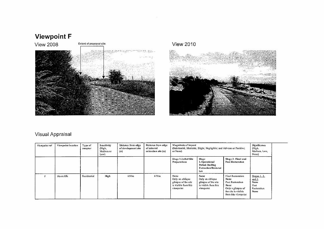


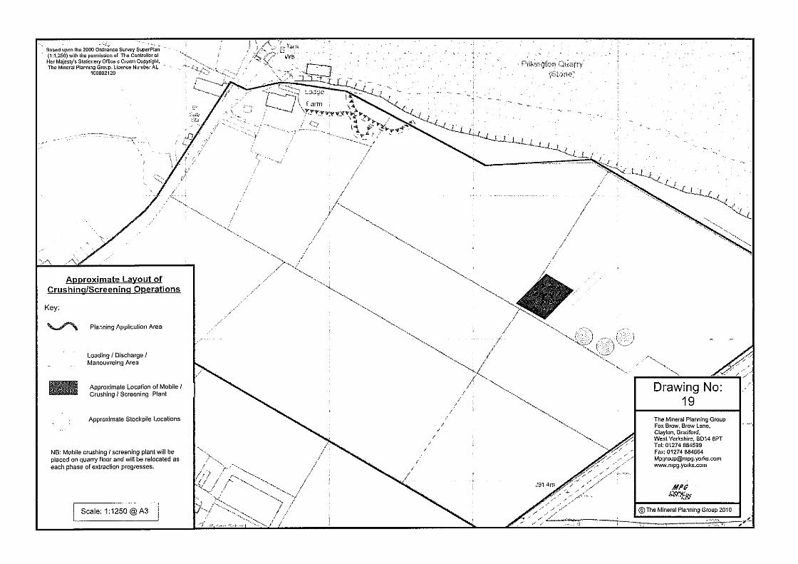


Date of Meeting: 11/11/2010 Item Number:
Application Reference: 84545/10
Type of Application: Full Planning ApplicationRegistration Date: 05/07/2010Decision Due By: 30/08/2010ResponsibleOfficer:
Helen Williams
Location: VICTORIA INN, 26 MARKLAND HILL, BOLTON, BL1 5AG
Proposal: ERECTION OF BOLLARD LIGHTS AND GROUND LIGHTS
Ward: Heaton and Lostock
Applicant: K Shaw and Sons Ltd.Agent : Makin Architecture
Officers Report
BackgroundThis application was deferred at the Committee meeting of 16th September for theapplicant to look at reducing the impact of the bollards on neighbouring properties andfor video evidence to be acquired by Officers of a typical weekend evening within the carpark of the public house. The video will be shown to Members at the meeting.
Since the application was deferred the applicant has attached opaque film around the topof one of the bollards, which has resulted in there being less glare from the light. Thecase officer viewed the 'new' bollard at dusk and is of the opinion that the use of theopaque film is a vast improvement and should be applied to all of the bollards in the carpark should the application be approved. A condition requesting that all bollards arecoated in this film within 28 days of permission is therefore suggested.
Following a landscaping report commissioned by the objector to the scheme, it is alsosuggested that a condition is attached to any approval to ensure that the applicantplants cherry laurel at a height of 1.75 to 2 metres tall on the boundary between the pubcar park and the rear garden of Lydsam Lea. The hedge should be allowed to grow to 2.4metres in height.
The application was also deferred at the 19th August meeting for the following additionalinformation:
Total number of lights proposed on the building and within the site Former NewFlood lights 14 1Wall lights 1 19Emergency lights 1 2Lanterns 3 3Mini ground recessed LEDs 0 21Bollards in car park 0 20
Although the total number of lights within the site have been increased the applicant hasstated that the number of brighter lights have been reduced significantly. Two plans

attached to the report illustrate the effects of the former lighting scheme (consistingpredominantly of flood lighting) and the light spill from the building, compared with thatof the new lighting scheme. It is clear from the plans that the new lighting scheme hasless light spill and less of an effect on neighbouring properties. Whilst the number offittings has increased, the use of less powerful fittings helps to keep the lightconcentrated close to the edge of the building where it is required. The applicant wouldalso like to point out that all the LED lights together produce a much lower light outputthan just one of the previous flood lights. It is also noted that the applicant is required toprovide lighting to allow people to leave safely as part of the licensing agreement.
Potential for a new hedge on the boundary with Lydsam LeaThe applicant is prepared to introduce some planting along the boundary with LydsamLea.
Restricting the hours of illumination to opening hoursThe applicant finds this condition acceptable and has requested that it is linked to theirapproved licensing hours, which are as follows:Mon-Thurs: 10am to 12amFri-Sat: 10am to 1amSun: 12pm to 12amFri and Sat before bank holidays: 10am to 2amSunday before bank holidays: 12am to 1amClosing time is half an hour later in each case.
ProposalPermission is sought for the erection of 20 round topped, stainless steel bollard lightsmeasuring 0.98 metres in height, which will be installed around the north, east and southboundaries of the car park and by the two disabled parking bays, and nine recessed LEDground lights on the terrace and at the entrance to the pub. A number of wall lights arealso proposed around the building, which will replace the former external lighting on thebuilding.
The new light fittings are intended for provide low level lighting for pedestrians and usersof the car park.
Site CharacteristicsThe application site consists of The Victoria Inn (a public house) and its curtilage. Thepub is currently been upgraded following planning consent for extensions and alterations(83477/10 and 83478/10). The original building was constructed in the 1790s. It isunderstood that the pub was a former coaching house and therefore has a longestablished use as a drinking establishment.
Car parking for the pub is situated to the north and east of the building.
To the north and south of The Victoria Inn are groups of trees protected by TreePreservation Orders 5 Bolton (Heaton) 1960 and 430 Bolton (Markland Hill) 1998. Thereare also a couple of single trees within the site that are also protected by the Orders.
The site is located within Chorley New Road Conservation Area, which is characterised inthe main by large dwellings set in large wooded grounds.
The surrounding area is predominantly residential in character. The nearest dwellings tothe public house are to the east of the site (Marshcotes, Oakwood Drive and Lydsam Lea,Marshdale Road).
PolicyPPS5 Planning for the Historic Environment

PPS23 Planning and Pollution Control
UDP Policies: N7 Trees, Woodland and Hedgerows; N8 Protected Trees; EM2Incompatible Uses; EM3 Pollution; D2 Design; D7 Conservation Areas; A5 Road Network.
PCPN10 Planning out Crime
AnalysisSection 38 of the Planning and Compulsory Purchase Act 2004 requires applications tobe determined in accordance with policies in the Development Plan unless materialconsiderations indicate otherwise.
Applications which are not in accordance with Development Plan policies should berefused unless material considerations justify granting permission.
Similarly, proposals which accord with Development Plan policies should be approvedunless there are material considerations which would justify a refusal of permission.
It is therefore necessary to decide whether this proposal is in accordance with theDevelopment Plan and then take account of other material considerations.
The main impacts of the proposal are:-
* impact on the amenity of neighbouring residents* impact on the character of the conservation area* impact on trees
Impact on the Amenity of Neighbouring ResidentsPolicy EM2 of the UDP states that the Council will not permit development that will resultin unacceptable impacts on existing uses or likely future development by reason of noise,smell, safety, health, lighting, disturbance, traffic or other pollution. Policy EM3 of theUDP states that the Council will permit developments which do not adversely affect levelsof air, water, land, noise or light pollution.
The proposed lighting is intended to illuminate the car park and outside areas of thepublic house in a more sensitive way than the previous lighting on and around thebuilding. The metal halide flood lights that originally projected from the eaves of thepublic house and illuminated the car park will be replaced with new wall light fittings thatonly shine up and down the walls. The car park will instead be illuminated by 20 stainlesssteel bollard lights that measure 0.98 metres in height and will be located around thenorth, east and south boundaries of the car park. The louvres of these lights are angledso that their light is directed downwards. This style of lighting has been chosen by theapplicant as it will provide light only where required. Nine LED ground lights are proposedon the newly built terraced area and at the entrance to the building at the rear of thesite. These again are at a low level, being only 3 watts.
At 0.98 metres high, the proposed bollard lights along the boundary of the car park areawill be lower in height than the boundary fencing. As the louvres are directed downwardsand therefore it is unlikely that there will be any light spillage from these lights into thesurrounding properties, particularly as they have a low level of luminance. The lights onthe pub building are again low in luminance and will only shine up and down the walls,not out into the car park as the former lights on the building did.
The Council's Pollution Control Officers have not raised any objection to the proposal andhave requested that the lighting is no more than 5 LUX when measured from the nearestresidential properties. The applicant has since sent in a report confirming the LUX levelsof all the proposed lighting with the site, which shows that there will be a LUX level of 0

at the neighbouring residential properties.
The objector to the application also raises concerns that the proposed lighting willencourage more activity and noise around the pub than previously was the case. As therewere lights already on the walls of the building prior to this application, it is notconsidered that the proposal would result in more patrons using the outdoor areas thanpreviously. The impact of the new terraced area on the amenity of neighbouring residentswas assessed during the determination of applications 83477/10 and 83478/10.
It is considered that the proposed lighting features will not harm the amenity ofneighbouring residents given their siting, direction and level of luminance, thereforecomplying with Policies EM2 and EM3 of the UDP.
Impact on the Character of the Conservation AreaPolicy D2 of the UDP states that the Council will permit development proposals thatcontribute to good urban design and that are compatible with, or improve, theirsurroundings. Policy D7 of the UDP states that the Council will permit developmentproposals that preserve or enhance the character or appearance of conservation areas.
The public house is within Chorley New Road Conservation Area. The proposed"up/down" lighting on the building will replace what are considered to be rather unsightlyflood lights, which are either on the walls are under the eaves of the building. It isconsidered that the replacement lighting on the building will improve its appearance. Thelow level lighting around the boundaries of the car park will also be sympathetic to thecharacter of the area.
It is therefore considered that the proposed lighting would be compatible with thecharacter and appearance of the area, compliant with Policies D2 and D7 of the UDP.
Impact on TreesPolicy N7 of the UDP seeks to protect and conserve existing trees, woodlands andhedgerows where possible when considering development proposals. Policy N7 goes on tostate that the Council will not permit development proposals which would result in theloss of trees, woodland areas or hedgerows of visual, historic or amenity importance andrequiring replacement planting where it is considered that the benefit of the developmentoutweighs the loss of some trees or hedgerows. UDP Policy N8 refers specifically toprotected trees.
The applicant has amended the siting of four of the proposed bollard lights followingconcerns from the Council's Tree Officer, who felt that they were originally too close toprotected trees within the site. The amended siting (shown in revision C) is nowconsidered to be acceptable by the Tree Officer and therefore it is considered that theproposal complies with Policies N7 and N8 of the UDP.
ConclusionIt is considered that the proposed lighting will not harm residential amenity, will becompatible with the conservation area and will not harm any of the protected trees withinthe site. Members are therefore recommended to approve the application.

Representation and Consultation Annex
RepresentationsLetters:- One letter of objection has been received from a resident of Lydsam Lea,Marshdale Road. This letter raises the following concerns:
The proposed LUX for the lighting is not shown on the plans;There is more lighting proposed than there was on site previously; less lighting shouldbe proposed;The lighting will be directly opposite residential properties;The external lighting on the building should also be assessed;The proposal is excessive, unnecessary and inappropriate, particularly in aconservation area;The increased lighting will promote and facilitate increased activity and noise wherepreviously there was none;The hours of luminance should be conditioned;The applicant should be requested by a condition to provide additional planting alongthe boundary with his property.
Elected Members:- A letter has been received from Cllr. Bob Allen (a ward councillor)supporting the objector to the proposal. He believes that the significantly enhancedlighting scheme would encourage people to spend time outside, not just on the terracebut on the various patios and on the car park and that the bollards are too many innumbers and are too bright, impacting on the amenity of neighbouring residents.
ConsultationsAdvice was sought from the following consultees; Pollution Control Officers, Tree Officer,Design and Conservation Officer and Highways Engineer.
Planning HistoryPermission was granted at Committee in April this year for the demolition of an existingextension, outhouse and smoking shelter and the erection of a single storey extension,first floor extension, entrance porch, ramps, steps and terrace (83477/10 and 83478/10for the Conservation Area Consent).
Permission was granted in March 2009 for the felling of two hawthorn trees (81725/09).
A smoking shelter was granted permission in April 2007 (76570/07).
A lounge extension was granted in September 1993 (43572/93).
Permission was granted for four signs in December 1991 (39615/91).
An application for the erection of canopies over both entrances, the formation of a newdoor and the erection of fencing was granted permission in January 1991 (37950/90).
A single storey extension with basement to form a restaurant and catering kitchen wasapproved in September 1988 (31950/88).

Recommendation: Approve subject to conditions
Recommended Conditions and/or Reasons
1. The development hereby permitted shall be begun before the expiration of 3 years from the date ofthis permission.
Reason
Required to be imposed pursuant to section 91 of the Town and Country Planning Act 1990 asamended by Section 51 of the Planning and Compulsory Purchase Act 2004.
2. The lighting in the scheme should be erected, directed and shielded so as to avoid nuisance toresidential accommodation in close proximity. The lighting should provide a standard maintainedillumination (LUX) as measured at the nearest residential properties affected of 5 LUX or less. Noother lighting equipment may then be used within the development other than as approved by theLocal Planning Authority.
Reason
To safeguard the amenity and character of the area and to safeguard the living conditions of nearbyresidents.
3. The lights hereby approved on the building and within the curtilage of the building shall not be litlater than the public house's approved licensing hours unless otherwise agreed in writing by the LocalPlanning Authority.
Reason
To safeguard the character and amenity of the area and to safeguard the living conditions of nearbyresidents.
4. Within 28 days of this decision being issued all the approved bollards shall have opaque film attachedto them all the way around the bulb area. This film shall be identical to that already attached to oneof the bollards within the car park, which was viewed by the Local Planning Authority on 19thOctober 2010. The film on each bollard shall be retained thereafter, unless otherwise agreed to inwriting by the Local Planning Authority.
Reason
To safeguard the amenity and character of the area and to safeguard the living conditions of nearbyresidents.
5. A cherry laurel hedge (prunus laurocerasus rotundifolia) shall be planted on the boundary betweenthe car park and the boundary of Lydsam Lea in accordance with a scheme to be submitted to andapproved by the Local Planning Authority with 21 days of this decision. The hedge should be 1.75 to2 metres tall when planted, in 25 litre pots and planted at 80cm centres, with mulching. Such ascheme shall be carried out within 28 days of the decision. Any shrubs that die or are removed withinfive years of planting shall be replaced in the next planting season with others of similar size andspecies. It is recommended that the hedge be allowed to grow to 2.4 metres tall, then topped.
Reason
To safeguard the amenity of neighbouring residents.
1. The Council has granted planning permission, subject to the conditions listed above, because theproposed development is in accordance with all relevant policies of the Development Plan (the UDPand the Regional Spatial Strategy Plan for the North-West), as is required by Section 38 of thePlanning and Compulsory Purchase Act 2004. There are no material considerations, as specified inthe Planning Officer Report, that outweigh this justification to support the grant of planningpermission. A summary of the relevant Development Plan policies pursuant to Article 22 of the Townand Country Planning (General Development Procedure) (England) (Amendment) Order 2003 andhow the proposed development relates to these policies is set out below.

Unitary Development Plan
N7 and N8 as the proposal does not affect the trees protected by Tree Preservation Order;
EM2 as the development would avoid unacceptable impacts on existing uses or likely futuredevelopment by reason of pollution;
EM3 as the development would not have adverse effects on levels of light pollution;
D1 and D2 as the application displays good urban design which would preserve local distinctiveness;
D7 as the development would preserve the character and appearance of the Conservation Area;
A5 as the development proposals take into account provision for roads, servicing and parking.

revdescription date
THE VICTORIA INNBOLTON
Car ParkProposed alterations to Existing Layout
COPYRIGHT OF MAKIN ARCHITECTUREDO NOT SCALE FROM THIS DRAWING DIMENSIONS TO BE CHECKED ON SITE
D
SK sketch P proposed T tender C construction AB asbuilt
www.makinarchitecture.com
scheme
scale
drawn date
1322
RAB
1:100@A1
P(115)rev
7-12-09
no.
t 0161 236 0051e [email protected]
1500
ramp1:15
ramp1:15
B
B
B
C C
C C
C
C
E
E
F
J
J
C
C
H
B
E
E
D
D
D
D
B
B
B
Lighting to existing signage replaced like - for - like
C E
Laylandii hedging alongside neighbouring property, planted at minimum 1.5 meters high
A
A
A
A
AAAA
A
A
A A A AA
A A
A
A
A
A
A
A
AA
G
A
A A
B
C
D
E
F
H
J
KEYA Low level bollard lighting, blue circle shows actual size of 177mm diameter. Louvres
angle lighting downwards
Cable trenching local to tree bases to be hand dug
Up / down wall light, orange circle shows actal size of 125mm diameter. Fixed at a height of 1800mm above walkway deck and terrace to nagate headroom issues
3 watt recessed LED ground light
recessed LED ground light
LED stair light recessed into stair stringer
Flood light, orange rectangle shows actual size of fitting. Fixed at a height of 1800mm above ground to negate headroom issues
Street light to low level garden, 2040mm high
Emergency fitting, illuminated only in emergency situation
Integral emergency wall light
C2 no bollards omitted 20-07-10BExternal Lighting Added 20-07-10ACurb to Markland Hill added 20-07-10
DHedging added 02-09-10


revdescription date
THE VICTORIA INNMARKLAND HILL - BOLTON
Site Plan showing levels of former lighting scheme
COPYRIGHT OF MAKIN ARCHITECTUREDO NOT SCALE FROM THIS DRAWING DIMENSIONS TO BE CHECKED ON SITE
-
SK sketch P proposed T tender C construction AB asbuilt
www.makinarchitecture.com
scheme
scale
drawn
date
1322
RAB
1:500@A3
E(902)rev
date
no.
t 0161 236 0051e [email protected]
Adjacent properties
Contour line indicating where light spread is 5 lux
5 lux
5 lux
5 lu
x


Date of Meeting: 14/10/2010 Item Number:
Application Reference: 84637/10
Type of Application: Extension of TimeRegistration Date: 19/07/2010Decision Due By: 18/10/2010ResponsibleOfficer:
Helen Williams
Location: GUIDE DOGS FOR THE BLIND, NUFFIELD HOUSE, LOWNDESSTREET, BOLTON, BL1 4QA
Proposal: APPLICATION TO EXTEND TIME LIMIT FOR IMPLEMENTATIONOF PLANNING APPLICATION 77562/07 (RENEWAL OFOUTLINE APPLICATION FOR PERMISSION (68543/04) TODEMOLISH EXISTING BUILDING AND ERECTION OFDWELLINGS (ALL MATTERS RESERVED))
Ward: Smithills
Applicant: Guide Dogs For The BlindAgent : DNS Planning & Design
Officers Report
ProposalThis is an application to extend the time limit for implementation of an outline planningapproval for the residential development of the former Guide Dogs for the Blind. Outlineplanning permission was granted for the erection of dwellings on the site (all mattersreserved) in July 2004 (68543/04) and again in August 2007 (77562/07).
Although the application remains as an "all matters reserved" application the applicanthas submitted an indicative site plan for the application site showing the siting of 113dwellings and the retention of the bowling green on Devonshire Road (Nuffield BowlingClub).
In addition to the extension of the commencement date for the development theapplicant also seeks to agree a Section 106 Agreement with the Council for the on-siteaffordable housing and the off-site contributions requested within the conditions attachedto 77562/07. The applicant seeks a Section 106 Agreement at this outline stage as theyfeel that this would make the site more attractive to a developer (it is a requirement ofthe Charities Act 1993 that Guide Dogs for the Blind must seek best value reasonableobtainable for land and this money is needed to be reinvested into the charity's newregional centre at Atherton).
Site CharacteristicsThe application site formerly accommodated the red brick two storey Nuffield House,which was used as a centre for Guide Dogs for the Blind since the 1960s. A new regionalcentre has since been established in Atherton (following the charity's major modernisationprogramme) making the Nuffield House site surplus to requirements. Nuffield House hasnow been demolished.
The application site also comprises a tennis court (southern boundary), a white renderedsingle storey building (next to the tennis court), a private bowling green (north western

corner) and a electricity substation (also in the north western corner of the site). Theremainder of the 3.64 hectare site is landscaped. A number of trees bound the site withthe ones fronting Devonshire Road and Lowndes Street being protected (TPO 46).
Vehicular access into the site was formerly taken from Lowndes Street. A private footpathfrom Devonshire Road serves the bowling club.
The bowling green is owned by the Guide Dogs but is to be leased to Nuffield BowlingClub (a private club). This part of the site is allocated as Recreational Open Space (PolicyO2).
The surrounding area is predominantly residential, characterised by a mix ofsemi-detached and terraced properties. Lowndes Street Day Nursery borders theapplication site to the east. To the north of the site is a large field and play area allocatedas Recreational Open Space.
PolicyPPS1 Delivering Sustainable DevelopmentPPS3 HousingPPS13 TransportPPS23 Planning and Pollution ControlPPS25 Development and Flood Risk
UDP Policies: N7 Trees, Woodlands & Hedgerows; N8 Protected Trees; EM2 IncompatibleUses; EM5 Derelict Land and Buildings; EM6 Energy Conservation and Efficiency; EM11Flood Protection; D2 Design; D3 Landscaping; D5 Public Art; O2 Recreational OpenSpace; O4 Provision of Open Space in New Developments; A5 Road Network; A6 CarParking Standards; H3 Housing Applications; H4 Affordable Housing; H5 Housing Density.
PCPN1 Health, Well-Being and Quality of Life; PCPN2 Space Around Dwellings; PCPN7Trees; PCPN8 Children's Play within New Residential Developments; PCPN10 Planning OutCrime; PCPN21 Highways Considerations; PCPN22 Public Art; PCPN27 HousingDevelopment; PCPN30 Provision for Education.
SPD Sustainable Design and ConstructionInterim Affordable Housing Planning Guidance Note
AnalysisSection 38 of the Planning and Compulsory Purchase Act 2004 requires applications tobe determined in accordance with policies in the Development Plan unless materialconsiderations indicate otherwise.
Applications which are not in accordance with Development Plan policies should berefused unless material considerations justify granting permission.
Similarly, proposals which accord with Development Plan policies should be approvedunless there are material considerations which would justify a refusal of permission.
It is therefore necessary to decide whether this proposal is in accordance with theDevelopment Plan and then take account of other material considerations.
The main impacts of the proposal are:-
impact on urban regenerationimpact on the character and amenity of the surrounding areaimpact on the highwayimpact on trees

impact on existing infrastructureimpact on the bowling green
Impact on Urban RegenerationNational policy on residential development is contained in PPS3 Housing. In order topromote more sustainable patterns of development, PPS3 makes it clear that the focusfor additional housing should be on existing towns and urban areas. It is important thatnew housing is located where it is accessible to jobs, shops and services by modes oftransport other than the car. The inefficient use of land should be avoided and to this endmaximum use should be made of previously developed land.
The principle of residential development on this site has already been established underplanning approvals 77562/07 and 68543/04, which granted outline permission for theerection of dwellings (all matters reserved). The site is in a sustainable location andbounded by residential properties.
Impact on the Character and Amenity of the Surrounding AreaPolicy D2 of the UDP requires that the design of new buildings respect the character ofthe area in which they are situated and the amenities of neighbouring properties.
Although this proposal is purely in order to establish the principle of residentialdevelopment, it is necessary to determine whether the site is suitable for the number ofdwellings proposed in terms of its size, location and specific characteristics. It isconsidered that the indicative layout submitted by the applicant and numbers of dwellingssuggested (113) could be accommodated on the site without harming the amenity orprivacy of surrounding residents, subject to effective landscaping and design. Thesedetails will be considered fully at the reserved matters stage.
As with the previous outline consents for the site, a condition is again suggested toprevent any development on the bowling green.
Impact on the HighwayPolicy A5 of the UDP states that in assessing development proposals the Council willpermit those that have taken into account provision for pedestrian and cyclists, roaddesign and layout, servicing and access arrangements, parking, and access to and bypublic transport. Development proposals should not adversely affect the safety ofhighway users as well as the safe and efficient circulation of vehicles.
A Transport Assessment was submitted by the applicant with the previous outlineapplication (68543/04). The Council's Highways Engineers raise no objection in principleto the proposed residential development of the site but have requested traffic calming onnearby streets. These improvements will be provided through the Section 106 Agreementand will enable the Council to undertake the works.
Impact on TreesPolicy N7 of the UDP seeks to protect and conserve existing trees, woodlands andhedgerows where possible when considering development proposals. Policy N7 goes on tostate that the Council will not permit development proposals which would result in theloss of trees, woodland areas or hedgerows of visual, historic or amenity importance andrequiring replacement planting where it is considered that the benefit of the developmentoutweighs the loss of some trees or hedgerows. Policy N8 of the UDP related specificallyto protected trees.
It is considered that the application site can be developed without the removal of thetrees which offer significant amenity value. The Council's Tree and Woodlands Officershave commented that the trees fronting Lowndes Street and Devonshire Road aresignificant and should be retained and given adequate clearance with any development.
This shall be required by condition.
Impact on Existing InfrastructurePolicies O4, H3 and H4 of the UDP and PCPNs 1, 8, 22 and 30 all seek to ensure that theexisting and proposed infrastructure has the capacity to absorb the proposeddevelopment. This includes requirements for affordable housing, and an off-sitecontribution for children's play space, public art, health facilities and education provision,as required by the previous outline planning permissions for the proposed site.
Unlike the previous outline applications for the site, the applicant now seeks to agree aSection 106 Agreement with the Council at an outline stage rather than at a reservedmatters stage (the other outline permissions had conditions attached requestingcontributions in line with the Council's policies, to be met at the reserved matters stage ofthe proposal).
Should the full policy requirements be requested for this application (113 residentialunits), the following contributions would be required:
Education - £392,226.05Highways improvements - £50,000Children's play space - £65,780Health facilities - £25,312Public Art - 1% of total development costsAffordable housing - 35% of units (40 units) on site.
Prior to the application being submitted the applicant entered pre-application discussionswith Council Officers regarding the viability of the scheme should the required Section 106contributions be paid. It has been agreed with Officers that the proposed development,within the current economic climate, would be unviable should the full amount ofcontributions be sought off a developer. A viability appraisal has been submitted to theCouncil and has been assessed by the Council's Surveyor. This illustrates that a developerwould only reasonably be able to provide a total contribution of £250,000 along with 10%on-site affordable housing. This total contribution falls short by £283,318 and by 29affordable houses, plus the public art contribution.
Although the reduced figures appear reasonable following the applicant's viabilityappraisal, Officers were concerned that the contributions may not be paid to the Councilfor some considerable time given that the application is only at an outline stage: adeveloper would have three years to submit a reserved matters application, then anotherthree years to commence development once the reserved matters applications wasapproved (plus the time taken to determine that application), then perhaps a few moreyears until the trigger occupation rate was met by when the contributions would have tobe paid. Officers have therefore agreed with the applicant to word the S106 as such that:
(i) a third of the monies would be paid on commencement of development (a‘clause’ has been put in that 25% of the dwellings must be started within 3years of the outline permission),
(ii) another third 18 months after commencement,(iii) and the last third 3 years after commencement.
The Council would therefore get the full £250,000 within 6 years of permission of thisapplication (should the development go ahead).
The Section 106 Agreement will also state that the 11 affordable units be among the first25% of the houses to be built within 3 years of the outline permission.
Should the proposed total contributions of £250,000 be agreed to by Members, Membersmay wish to decide how the money is to be split between the different requirements.Officers however advise that it be split as follows (comparable with their proportion as

requested above, with the exception of the local highways improvements and public art):
Education - £162,300Highways improvements - £50,000Children's play space - £27,220Health facilities - £10,480Public Art - £0
(plus 10% on-site affordable housing which equates to 11 houses).
Condition 13 of application 77562/07 also requested an off-site contribution towardsyouth facilities (though no sum is mentioned). There is no planning policy to support therequest for such facilities and therefore this condition is ultra vires, as there is no planningpolicy justification behind the condition. The condition therefore does not meet test ii(relevance to planning) of Circular 11/95 and should not be requested by the Council. A'youth facilities' contribution is therefore not listed by Officers within the proposeddistribution of contributions above.
Impact on the Bowling GreenPolicy O2 of the UDP states that the Council will permit development proposals that resultin the loss of, or damage to, public or private recreational open space provided that oneof four of the criteria listed in the policy is met.
Nuffield Bowling Club have their bowling green in the north western corner of theapplication site, which is accessed off Devonshire Road. The site is owned by the GuideDogs for the Blind but is to be leased to the private club. The bowling green and thepavilion are to be retained within the proposed development and a condition is to beattached to any approval to ensure that this facility is retained (condition 3).
The previous outline planning permissions for the proposed residential developmentrequested that the applicant improve the access, servicing and car parking for thebowling green as well as providing security fencing (condition 3) and also improve thesecurity at the club such as by installing CCTV (condition 14).
Improvements to the access, servicing and car parking for the bowling club have alreadybeen secured following an application from the Guide Dogs for a new access and threeparking spaces at the bowling green (83078/09). The Guide Dogs have agreed toundertake these improvements as landowner (some £10,000). Condition 3 on application77562/07 has therefore been satisfied and therefore should not be replicated on any newpermission.
With regard to the request for improved security at the club the applicant has confirmedthat a new security fence has now been erected at the club. The applicant has alsoconfirmed that they have discussed the issue of installing CCTV with Nuffield Bowling Clubcommittee members, who have stated that they do not want it because of the ongoingmaintenance costs. It is therefore felt that condition 14 should not be attached to anyrenewed permission.
The Chairman of the bowling club has written in in support of the application and hasstated that the applicant has more than proved their commitment to helping the bowlingclub remain viable.
ConclusionIt is considered that the principle of residential development on the site is acceptable andthat circumstances have not materially changed since outline planning permission wasrenewed in August 2007. Members are recommended to delegate the decision to theDirector to secure the Section 106 Agreement.

Representation and Consultation Annex
RepresentationsA letter of support has been received from the chairman of Nuffield Bowling Club whostates that the club have been working closely with the applicant and a lot has beenachieved at the club with their help. The bowling club are now no longer fearful for theirfuture as they were with the previous planning applications. The chairman also states inthe letter that Guide Dogs have more than proved their commitment to helping thebowling club remain viable.
ConsultationsAdvice was sought from the following consultees; Highway Engineers, Tree andWoodlands Officer, Greenspace Management Officers, Landscape Officers, StrategicHousing Officers, Corporate Property, Pollution Control Officers and United Utilities.
Planning HistoryAn application for the variation of condition 3 (remove requirement for improved parking,access and security fencing for the bowling green) and the removal of conditions 13(off-site contribution for youth facilities) and 14 (additional security features for thebowling green) was refused at Committee in March 2009 (81534/09).
Permission was granted at Committee in August 2007 for the renewal of outlineapplication 68543/04 to demolish the existing building and erection of dwellings (allmatters reserved) (77562/07).
Outline planning permission was granted 15th July 2004 for the demolition of existingbuildings and the erection of dwellings (all matters reserved) (application 68543/04).
An application submitted by the Guide Dogs for the change of use of land to form avehicular access and three parking spaces at Nuffield Bowling Green was approved inDecember 2009 (83078/09).

Recommendation: Delegate the decision to the Director
Recommended Conditions and/or Reasons
1. Application for the approval of Reserved Matters must be made not later than the expiration of threeyears beginning with the date of this permission and the development must be begun not later thanthe expiration of two years from the final approval of the reserved matters or, in the case of approvalon different dates, the final approval of the last such matter to be approved.
Reason
Required to be imposed pursuant to section 92 of the Town and Country Planning Act 1990 asamended by Section 51 of the Planning and Compulsory Purchase Act 2004.
2. Approval of the following details (hereinafter referred to as "The Reserved Matters") shall be obtainedfrom the Local Planning Authority in writing before any development commences:-
LayoutThe way in which buildings, routes and open spaces within the development are provided, situatedand orientated in relation to each other and to buildings and spaces outside the development;
ScaleThe height, width and length of each building proposed in relation to its surroundings;
AppearanceThe aspects of a building or place within the development which determine the visual impression itmakes, including the external built form of the development, its architecture, materials, decoration,lighting, colour and texture;
AccessThis covers accessibility to and within the site for vehicles, cycles and pedestrians in terms of thepositioning and treatment of access and circulation routes and how these fit into the surroundingaccess network; and
LandscapingThe treatment of land (other than buildings) for the purpose of enhancing or protecting the amenitiesof the site and the area in which it is situated and includes screening by fences, walls or other means,the planting of trees, hedges, shrubs or grass, the formation of banks, terraces or other earthworks,the laying out or provision of gardens, courts or squares, water features, sculpture, or public art, andthe provision of other amenity features.
Reason
The application is for outline planning permission and these matters were reserved by the applicantfor subsequent approval.
3. The existing bowling green and pavilion (Nuffield Bowling Club) shall not be developed for housing.
Reason
To protect the recreational facility.
4. The permission hereby granted does not imply that any work may be carried out to any trees whichare the subject of a Tree Preservation Order nor does it imply that such work would be authorised.
Reason
To safeguard the trees within or adjacent to the development site in the interests of protecting thelandscape of the area.
5. The trees fronting Lowndes Street and Devonshire Road shall be retained and given adequateclearance within the residential development.
Reason

To safeguard the trees within or adjacent to the development site in the interests of protecting thelandscape of the area.
6. Phase II ReportShould the approved Phase I Report recommend that a Phase II Report is required, then prior tocommencement of any site investigation works, design of the Phase II site investigation shall besubmitted to, and approved in writing by, the Local Planning Authority. Site investigations shall becarried out in accordance with the approved design and a Phase II Report shall then be submitted to,and approved in writing by, the Local Planning Authority prior to commencement of development.The Phase II Report shall include the site investigation data, generic quantitative risk assessment,detailed quantitative risk assessment (if required) and recommendations regarding the need orotherwise for remediation.
Should the Phase I Report recommend that a Phase II Report is not required, but during constructionand prior to completion of the development hereby approved, contamination or gas migration isfound or suspected, the developer shall contact the Local Planning Authority immediately and submitproposals for investigation and remediation of the contamination or gas migration within seven daysfrom the date that it is found or suspected to the Local Planning Authority for approval in writing.
Options AppraisalShould the Phase II Report recommend that remediation of the site is required then unless otherwiseagreed in writing with the Local Planning Authority, no development shall commence unless or untilan Options Appraisal has been submitted to, and approved in writing by, the Local PlanningAuthority. The Options Appraisal shall include identification of feasible remediation options,evaluation of options and identification of an appropriate Remediation Strategy.
Implementation of Remediation Strategy
No development shall commence, unless otherwise agreed in writing with the Local PlanningAuthority, until the following information relating to the approved Remediation Strategy has beensubmitted and approved by the Local Planning Authority:
i) Detailed remediation design, drawings and specification;
ii) Phasing and timescales of remediation;
iii) Verification Plan which should include sampling and testing criteria, and other records to beretained that will demonstrate that remediation objectives will be met; and
iv) Monitoring and Maintenance Plan (if appropriate). This should include a protocol for long termmonitoring, and response mechanisms in the event of non compliant monitoring results.
The approved Remediation Strategy shall be fully implemented in accordance with the approvedphasing and timescales and the following reports shall then be submitted to the Local PlanningAuthority for approval in writing:
v) A Verification Report which should include a record of all remediation activities, and datacollected to demonstrate that the remediation objectives have been met; and
vi) A Monitoring and Maintenance Report (if appropriate). This should include monitoring data andreports, and maintenance records and reports to demonstrate that long term monitoring andmaintenance objectives have been met.
Reason
To ensure that the development is safe for use.
7. The dwelling(s) shall achieve a Code Level 4 in accordance with the requirements of the Code forSustainable Homes: Technical Guide (or such national measure of sustainability for house design thatreplaces that scheme). No dwelling shall be occupied until a Final Code Certificate has been issuedfor it certifying that Code Level 4 has been achieved.
Reason
To reduce the impact on climate change and to improve the sustainability of the site.
8. Prior to the commencement of development, an energy assessment of the approved developmentand details of the location and type of renewable energy technology shall be submitted to andapproved by the Local Planning Authority. The renewable energy technology shall reduce the CO2emissions of predicted energy use of the development by at least 10%. The approved renewableenergy technology shall be installed, retained and maintained in perpetuity thereafter unless agreedby the Local Planning Authority.

Reason
To reduce the impact on climate change and to improve the sustainability of the site.
9. No building hereby permitted shall be occupied until surface water drainage works have beenimplemented on site which reduce the existing surface water run off by at least 50% in accordancewith details that have been submitted to and approved in writing by the local planning authority.Before these details are submitted an assessment shall be carried out of the potential for disposing ofsurface water by means of a sustainable drainage system in accordance with the principles set out inAnnex F of PPS25 (or any subsequent version), and the results of the assessment provided to thelocal planning authority. Where a sustainable drainage scheme is to be provided, the submitteddetails shall:
1. provide information about the design storm period and intensity, the method employed todelay and control the surface water discharged from the site and the measures taken toprevent pollution of the receiving groundwater and/or surface waters;
2. include a timetable for its implementation; and
3. provide a management and maintenance plan for the lifetime of the development whichshall include the arrangements for adoption by any public authority or statutory undertakerand any other arrangements to secure the operation of the scheme throughout its lifetime.
Reason
To reduce the risk of contaminating surface water run off and reduce the risk of localised floodingand down stream flooding by ensuring the provision of a satisfactory means of surface waterdispersion
. The Council has granted planning permission, subject to the conditions listed above, because theproposed development is in accordance with all relevant policies of the Development Plan (the UDPand the Regional Spatial Strategy Plan for the North-West), as is required by Section 38 of thePlanning and Compulsory Purchase Act 2004. There are no material considerations, as specified inthe Planning Officer Report, that outweigh this justification to support the grant of planningpermission. A summary of the relevant Development Plan policies pursuant to Article 22 of the Townand Country Planning (General Development Procedure) (England) (Amendment) Order 2003 andhow the proposed development relates to these policies is set out below.
Unitary Development Plan
N7 and N8 as the trees protected by Tree Preservation Orders are to form part of the developmentscheme;
EM2 as the development would avoid unacceptable impacts on existing uses or likely futuredevelopment by reason of pollution;
EM4 as investigation into land contamination has been carried out and suitable mitigation measureswould be secured by a planning condition;
EM5 as the development is for the reclamation and beneficial use of derelict land and buildingswithout unacceptable impacts;
EM6 as sustainable energy consumption is proposed via conditions;
D1 and D2 as the application displays good urban design which would preserve local distinctiveness;
D3 as there is scope for sufficient landscaping at the detailed stage;
D5 as a contribution towards public art has been considered;
O2 as there is scope for the provision of landscaping and amenity open space in the housingdevelopment area and therefore will be a Section 106 contribution towards public open space;
A5 as the development proposals take into account provision for roads, paths, servicing and parking;

A6 as the development is to provide car parking based on the Council's maximum car parkingstandards;
H3 as the housing development site is accessible; the development would help to provide a widerchoice and better mix of housing types, sizes and tenures; the existing and potential infrastructurehas the capacity to absorb the development; and the site has been previously developed;
H4 as the housing development would include dwellings as affordable provision within the totalsupply which is a requirement of suitable sites of 15 dwellings or more, or 1 hectare or more in size.


Date of Meeting: 14/10/2010 Item Number:
Application Reference: 84716/10
Type of Application: Full Planning ApplicationRegistration Date: 04/08/2010Decision Due By: 03/11/2010ResponsibleOfficer:
Helen Williams
Location: LAND AT FORMER PORTMAN MILL, TELFORD STREET,HORWICH, BOLTON, BL6 6DY
Proposal: ERECTION OF 19 HOUSES
Ward: Horwich North East
Applicant: ICS Homes LtdAgent : Frank Whittaker Town Planning Consultants
Officers Report
ProposalPermission is sought for 19 houses on the now cleared Portman Mill site. Two of theproposed houses (plots 18 and 19) are to be "two and a half storeys" (second flooraccommodated within the roof), with the remainder of the houses being two storeys.Plots 18 and 19 will be four bed dwellings, nine of the houses will be three bed dwellingsand eight houses will be two bed dwellings. The houses are to be located around acentral courtyard/cul-de-sac with vehicular access taken from Telford Street. 33 parkingspaces are provided within the site for both residents and visitors (175% parking).
The submitted plans have been amended by reducing the number of houses proposedfrom 20 to 19 and increasing the amount of on-site parking from 20 to 33. Theseamendments were carried out following concerns from local residents and Horwich TownCouncil regarding the perceived lack of parking. Neighbours were notified of the amendedplans on 10th September and Horwich Town Council were reconsulted at their meeting of23rd September.
Site CharacteristicsThe application site is the site of the former Portman Mill. The mill has been demolishedfollowing a fire in 2008, which left the buildings damaged beyond the point of restoration.The site is now cleared and surrounded by security fencing.
The site slopes down to the south/south east (down to Chorley New Road). Back streetencompass the site to its north east, south east and south west.
The site is bordered to the north, east and south by streets of traditional terracedhousing. The houses along Bateman Street and Hawksley Street have narrow back streetand limited rear yards and therefore were built at high density. To the west of the site isa Ford garage and to the north of this is open land.
PolicyPPS3 HousingPPS5 Planning for the Historic EnvironmentPPG13 Transport

PPS23 Planning and Pollution Control
UDP Policies: EM4 Contaminated Land; EM5 Derelict Land and Buildings; EM6 EnergyConservation and Efficiency; D1, D2 Design; D3 Landscaping; A5 Road Network; A6 CarParking Standards; H3 Housing Applications; H4 Affordable Housing.
PCPN2 Space Around Dwellings; PCPN10 Planning Out Crime; PCPN21 HighwaysConsiderations.
AnalysisSection 38 of the Planning and Compulsory Purchase Act 2004 requires applications tobe determined in accordance with policies in the Development Plan unless materialconsiderations indicate otherwise.
Applications which are not in accordance with Development Plan policies should berefused unless material considerations justify granting permission.
Similarly, proposals which accord with Development Plan policies should be approvedunless there are material considerations which would justify a refusal of permission.
It is therefore necessary to decide whether this proposal is in accordance with theDevelopment Plan and then take account of other material considerations.
The main impacts of the proposal are:-
impact on urban regenerationimpact on the character and appearance of the areaimpact on the amenity of neighbouring residentsimpact on the highwayimpact on existing infrastructure
Impact on Urban RegenerationNational policy on residential development is contained in PPS3 Housing. In order topromote more sustainable patterns of development, PPS3 makes it clear that the focusfor additional housing should be on existing towns and urban areas. It is important thatnew housing is located where it is accessible to jobs, shops and services by modes oftransport other than the car. The inefficient use of land should be avoided and to this endmaximum use should be made of previously developed land.
The principle of residential development on this site has already been established underoutline planning permission 74521/06 (all matters reserved). It is considered that theapplication site is in a highly sustainable location, close to good transport links, localschools, shops and facilities. The site is also within a predominantly residential area.
It is therefore considered that the proposal complies with PPS3 and Policy H3 of the UDP.
Impact on the Character and Appearance of the AreaPolicy D2 of the UDP states that the Council will permit development proposals thatcontribute to good urban design and that are compatible with, or improve, theirsurroundings.
The area surrounding the application site is, in the main, characterised by early twentiethcentury terraced housing that back onto narrow back streets and have limited rear yards.The proposed housing development will have a lower density than the surrounding builtarea and will be located around a courtyard/cul-de-sac. All houses will have rear amenityspace that will be larger than their more traditional neighbours'. Seven of the houses willface directly onto Telford Street and will be staggered down the road to follow the slope

of the site and surrounding area. Plots 1, 2, 3, 18 and 19 will have a similar width to theterraced housing in the area whilst plots 4 and 17 will be sited horizontally to make moreof a feature at the entrance to the courtyard. The front elevations to the houses will berelatively simple to match their terraced neighbours but will incorporate small groundfloor bays to add interest and give the houses a more modern twist.
Although there is a high level of surface car parking proposed within the development it isfelt that there is sufficient space for landscaping, which can be secured via a planningcondition.
It is considered that the proposed design, mix and layout of the development adequatelyaddresses Telford Street and is sensitive to the surrounding traditional terraces, therebycomplying with Policy D2 of the UDP.
Impact on the Amenity of Neighbouring ResidentsPCPN2 "Space Around Dwellings" sets out the minimum distances required betweendwellings to ensure privacy and make sure new developments relate well to surroundingresidential properties.
The houses with the closest relationship to the new development are along HawksleyStreet, who back onto the site. At the shortest length, the rear elevations of the houseson Hawksley Street are 13.2 metres away from the rears of the new houses at the backof the development. There are however no main windows on the rear elevations of thenew houses that will overlook the houses on Hawksley Street; the windows on the firstfloors of the new houses (plots 8 to 12) are either bathroom, hall or landing windows andthe windows on the ground floor can be screened by the rear boundary treatment (to beconditioned). The recommended distance within PCPN2 between main windows and blankgables or elevations with no main windows is 13.5 metres. It is considered that adifference in standard by 30 centimetres is not significant, particularly as the terracedproperties in the area already have a close relationship with their neighbours.Furthermore, the rears of the houses on Hawksley Street previously overlooked 2 metrehigh palisade fencing with barbed wire, a yard and the back of the more modern part ofthe mill. Their new view is considered to be improved.
The new houses along the south edge of the development will back onto the rear of theproperties along Chorley New Road. The new houses are however set at an angle andtherefore do not directly overlook the terraces, plus the interface distances are consideredto be adequate.
The existing houses that side onto the development site (15 Telford Street and 14 and 19Bateman Street) do no have any main windows in their side elevations. There aretherefore no privacy concerns regarding these properties.
It is considered for the reasons above that the proposed development will not have aharmful impact on the amenity of neighbouring residents and therefore complies withPCPN2.
Impact on the HighwayUDP Policy A5 and PCPN21 both seek to ensure forms of development which would nothave an adverse impact upon the road network and which make appropriate provision forparking, the needs of pedestrians and for vehicle manoeuvring.
Access into the development is proposed off Telford Street. A central cul-de-sac will servethose houses that do not front onto Telford Street.
The Council's Highways Engineers raised concerns regarding the initially submitted plansas there were only to be 20 parking spaces within the site for the proposed 20 houses

and as they is limited on-street parking in the area. The plans have since been amendedso that 33 parking spaces are now proposed for 19 houses (one house has been deletedfrom the proposal). Engineers have not raised any further concerns regarding parkingafter these amendments.
Engineers have also recommended that Back Chorley New Road (to the south of the site)be widened and that the kerb radii at Back Chorley New Road and the back street at rightangles to Bateman Street be improved. The applicant is able to improve the kerb radii asrequested but has stated that any widening of Back Chorley New Road would significantlyreduce the size of the site, hence the density of the scheme would be reduced along withits viability. Officers consider that the requested widening of the back street would beunreasonable considering the back street has historically been the same width and thatany works would be at a cost to the developer as well as at the cost to the overallscheme.
It is considered that the proposed development as submitted, but subject to the highwayconditions listed below, would not jeopardise highway safety and therefore would complywith Policy A5 of the UDP.
Impact on Existing InfrastructurePPS3 Housing sets the national indicative minimum site size threshold in which affordablehousing is required at 15 dwellings. Bolton Council follows this national threshold foraffordable housing provision. The local policy relating to affordable housing provision isPolicy H4 of the UDP.
The applicant proposes 19 houses, thereby an element of affordable housing is requiredwithin the proposed scheme. Following Bolton's policy that 35% of the houses should beprovided at a 60% discount, 7 of the 19 proposed houses on site should be affordableunless otherwise justified by the applicant.
During pre-application discussions with the applicant it was argued that building 19houses and giving up 7 of them to a housing association would be less viable to theapplicant than just building 14 houses, which would not require any contribution towardsaffordable housing provision. The area would therefore be losing out on five new housesthat could provide much needed accommodation for local first time buyers (given theirscale and the area of Horwich in which they will be built). Furthermore, the secureddevelopment of the application site would regenerate a site where a Section 215 Noticewas served due to its untidy appearance (which was considered to harm the amenity ofthe area). The applicant has also submitted a confidential financial appraisal to justifytheir position. Given these arguments Planning Officers support this approach andtherefore recommend that Members approve the application without any affordablehousing provision.
ConclusionIt is considered that the proposed residential development of the site would contribute togood urban design, would not harm the amenity of neighbouring residents, would notjeopardise highway safety and the benefits of the scheme in terms of urban renewal andthe regeneration of an unsightly site should outweigh the requirement for affordablehousing provision. Members are therefore recommended to approve the application.

Representation and Consultation Annex
RepresentationsLetters:- two letters of objection have been received from residents of 6 and 22Hawksley Street. These letters raise the following concerns:
Privacy/overlooking concerns;Loss of natural light, as was the case when the mill was there;Disruption caused by building work (Officer's note: this is not a material planningconsideration).
Horwich Town Council:- objected to the initial proposal at their meeting of 19thAugust 2010 as they considered that the parking provision is inadequate. TownCouncillors however withdrew their objection at their next meeting of 23rd September2010 following the submission of the amended plans.
ConsultationsAdvice was sought from the following consultees; Highways Engineers, Pollution ControlOfficers, Greater Manchester Archaeological Unit, Greater Manchester Police'sArchitectural Liaison Officers and United Utilities.
Planning HistoryApplication 77958/07 for the part demolition of the mill buildings, the residentialconversion of the traditional three storey part of the mill and the erection of a newbuilding to form 42 apartments, with associated car parking, storage and amenity spacewas refused at Committee in July 2008 as the applicant was not willing to pay therequested Section 106 Agreement contributions.
Outline planning permission was granted in September 2006 for the residentialdevelopment of the application site (all matters reserved) (application 74521/06). Thispermission sought to maintain the traditional three storey part of the mill.
A planning application for the continued use of the second floor of the mill as agymnasium was withdrawn by the Applicant in August 2005 (61406/05).
In 1993 planning permission was granted for the use of the vacant second floor of themill as a fitness centre (44006/93).
A planning application was refused in 1987 for the continued use of Portman Mill as a fleamarket (29358/87).

Recommendation: Approve subject to conditions
Recommended Conditions and/or Reasons
1. The development hereby permitted shall be begun before the expiration of 3 years from the date ofthis permission.
Reason
Required to be imposed pursuant to section 91 of the Town and Country Planning Act 1990 asamended by Section 51 of the Planning and Compulsory Purchase Act 2004.
2. No development shall be commenced until samples of the facing materials to be used for the externalwalls and roof(s) have been submitted to and approved in writing by the Local Planning Authority.
Reason
To ensure the development either fits in visually with the existing building and safeguards thecharacter and visual appearance of the locality or ensures the development safeguards the characterand visual appearance of the locality.
3. Trees and shrubs shall be planted on the site in accordance with a landscape scheme to be submittedto and approved by the Local Planning Authority before development is started. Such scheme shallbe carried out within 6 months of the occupation of any of the buildings or the completion of the newdevelopment, whichever is the sooner, or in accordance with phasing details included as part of thescheme and subsequently approved by the Local Planning Authority; any trees and shrubs that die orare removed within five years of planting shall be replaced in the next planting season with others ofsimilar size and species.
Reason
To soften the development proposed and to enhance and improve the setting of the developmentwithin the landscape of the surrounding locality.
4. Before development commences details of the treatment to all boundaries to the site shall besubmitted to and approved by the Local Planning Authority. uch details as are approved shall beimplemented in full before the development is first occupied or brought into use and retainedthereafter. It is advised that the boundary treatment to the rears of plots 8 to 12 is of a height highenough to restrict any overlooking between ground floor windows of the new houses and theproperties along Hawsley Street.
Reason
To ensure adequate standards of privacy are obtained and to enhance the setting of the developmentwithin the character of the locality.
5. The development hereby approved/permitted shall not be brought into use unless and until a kerbradii of 4 metre dimension, at the junction of Telford Street with the two back streets (northeast andsouth west of site) has been constructed entirely in accordance with details to be submitted to andapproved by the Local Planning Authority, and thereafter retained.
Reason
In the interests of highway safety.
6. The development hereby approved/permitted shall not be brought into use unless and until theexisting vehicular access onto Telford Street has been closed to vehicles, and the existing highwaymade good to adoptable footway standards. There shall thereafter be no means of vehicular accessto or from Telford Street, other than as shown on the approved plan.
Reason
In the interests of highway safety.
7. No development shall be commenced unless and until full details of the highway works at Telford

Street site frontage comprising the surfacing of the footway have been submitted to and approved bythe Local Planning Authority, and none of the development shall be brought into use until suchdetails as approved are implemented in full. Such works to be retained thereafter.
Reason
In the interests of highway safety.
8. Prior to the commencement of development a plan shall be submitted to and approved in writing bythe Local Planning Authority showing a 12 metre long driveway to plot 1.
Reason
To allow for suffient parking and in the interests of highway safety.
9. Prior to the occupation of the dwelling houses hereby permitted provision shall be made for theparking or garaging of a motor vehicle adjacent to each of the dwelling houses in the area identifiedfor that purpose on the approved plan. Those areas shall thereafter be retained at all times for thatpurpose. Notwithstanding the provisions of Schedule 2 Part 1 of the Town and Country Planning(General Permitted Development) Order 1995 (or any Order amending or replacing that Order) otherthat (a) garage(s), no extensions, porches, outbuildings, sheds, greenhouses, oil tanks or satelliteantennae shall be erected within that area.
Reason
To ensure that adequate provision is made for vehicles to be left clear of the highway.
10. Notwithstanding the provisions of Schedule 2 Part 1 of the Town and Country Planning GeneralPermitted Development Order 1995 (or any order amending or replacing that order) no extensions,porches, garages, outbuildings, sheds, greenhouses, oil tanks, or hardstandings shall be erectedwithin the curtilage of (any of) the approved dwellinghouse(s), other than those expressly authorisedby this permission.
Reason
The private garden space of the dwellings is limited and any extension could result in anunsatisfactory scheme in terms of open space and privacy requirements.
11. Phase II ReportShould the approved Phase I Report recommend that a Phase II Report is required, then prior tocommencement of any site investigation works, design of the Phase II site investigation shall besubmitted to, and approved in writing by, the Local Planning Authority. Site investigations shall becarried out in accordance with the approved design and a Phase II Report shall then be submitted to,and approved in writing by, the Local Planning Authority prior to commencement of development.The Phase II Report shall include the site investigation data, generic quantitative risk assessment,detailed quantitative risk assessment (if required) and recommendations regarding the need orotherwise for remediation.
Should the Phase I Report recommend that a Phase II Report is not required, but during constructionand prior to completion of the development hereby approved, contamination or gas migration isfound or suspected, the developer shall contact the Local Planning Authority immediately and submitproposals for investigation and remediation of the contamination or gas migration within seven daysfrom the date that it is found or suspected to the Local Planning Authority for approval in writing.
Options AppraisalShould the Phase II Report recommend that remediation of the site is required then unless otherwiseagreed in writing with the Local Planning Authority, no development shall commence unless or untilan Options Appraisal has been submitted to, and approved in writing by, the Local PlanningAuthority. The Options Appraisal shall include identification of feasible remediation options,evaluation of options and identification of an appropriate Remediation Strategy.
Implementation of Remediation Strategy
No development shall commence, unless otherwise agreed in writing with the Local PlanningAuthority, until the following information relating to the approved Remediation Strategy has beensubmitted and approved by the Local Planning Authority:
i) Detailed remediation design, drawings and specification;
ii) Phasing and timescales of remediation;
iii) Verification Plan which should include sampling and testing criteria, and other records to be

retained that will demonstrate that remediation objectives will be met; and
iv) Monitoring and Maintenance Plan (if appropriate). This should include a protocol for long termmonitoring, and response mechanisms in the event of non compliant monitoring results.
The approved Remediation Strategy shall be fully implemented in accordance with the approvedphasing and timescales and the following reports shall then be submitted to the Local PlanningAuthority for approval in writing:
v) A Verification Report which should include a record of all remediation activities, and datacollected to demonstrate that the remediation objectives have been met; and
vi) A Monitoring and Maintenance Report (if appropriate). This should include monitoring data andreports, and maintenance records and reports to demonstrate that long term monitoring andmaintenance objectives have been met.
Reason
To ensure that the development is safe for use.
12. The dwelling(s) shall achieve a Code Level 4 in accordance with the requirements of the Code forSustainable Homes: Technical Guide (or such national measure of sustainability for house design thatreplaces that scheme). No dwelling shall be occupied until a Final Code Certificate has been issuedfor it certifying that Code Level 4 has been achieved.
Reason
To reduce the impact on climate change and to improve the sustainability of the site.
13. Prior to the commencement of development, an energy assessment of the approved developmentand details of the location and type of renewable energy technology shall be submitted to andapproved by the Local Planning Authority. The renewable energy technology shall reduce the CO2emissions of predicted energy use of the development by at least 10%. The approved renewableenergy technology shall be installed, retained and maintained in perpetuity thereafter unless agreedby the Local Planning Authority.
Reason
To reduce the impact on climate change and to improve the sustainability of the site.
14. No building hereby permitted shall be occupied until surface water drainage works have beenimplemented on site which reduce the existing surface water run off by at least 50% in accordancewith details that have been submitted to and approved in writing by the local planning authority.Before these details are submitted an assessment shall be carried out of the potential for disposing ofsurface water by means of a sustainable drainage system in accordance with the principles set out inAnnex F of PPS25 (or any subsequent version), and the results of the assessment provided to thelocal planning authority. Where a sustainable drainage scheme is to be provided, the submitteddetails shall:
1. provide information about the design storm period and intensity, the method employed todelay and control the surface water discharged from the site and the measures taken toprevent pollution of the receiving groundwater and/or surface waters;
2. include a timetable for its implementation; and
3. provide a management and maintenance plan for the lifetime of the development whichshall include the arrangements for adoption by any public authority or statutory undertakerand any other arrangements to secure the operation of the scheme throughout its lifetime.
Reason
To reduce the risk of contaminating surface water run off and reduce the risk of localised floodingand down stream flooding by ensuring the provision of a satisfactory means of surface waterdispersion
. The Council has granted planning permission, subject to the conditions listed above, because theproposed development is in accordance with all relevant policies of the Development Plan (the UDPand the Regional Spatial Strategy Plan for the North-West), as is required by Section 38 of the

Planning and Compulsory Purchase Act 2004. There are no material considerations, as specified inthe Planning Officer Report, that outweigh this justification to support the grant of planningpermission. A summary of the relevant Development Plan policies pursuant to Article 22 of the Townand Country Planning (General Development Procedure) (England) (Amendment) Order 2003 andhow the proposed development relates to these policies is set out below.
Unitary Development Plan
EM4 as investigation into land contamination has been carried out and suitable mitigation measures isbe secured by a planning condition;
EM5 as the development is for the reclamation and beneficial use of derelict land and buildingswithout unacceptable impacts;
EM6 as sustainable energy consumption is to be conditioned;
D1 and D2 as the application displays good urban design which would preserve local distinctiveness;
D3 as there is scope for sufficient landscaping within the development;
A5 as the development proposals take into account provision for roads, paths, servicing and parking;
A6 as the development is to provide car parking based on the Council's maximum car parkingstandards;
H3 as the housing development site is accessible; the development would help to provide a widerchoice and better mix of housing types, sizes and tenures; the existing and potential infrastructurehas the capacity to absorb the development; and the site has been previously developed;
H4 as affordable housing provision has been considered in relation to the viability of the scheme.


Date of Meeting: 14/10/2010 Item Number:
Application Reference: 84718/10
Type of Application: Full Planning ApplicationRegistration Date: 09/08/2010Decision Due By: 04/10/2010ResponsibleOfficer:
Andrew McGlone
Location: 14 ST JAMES STREET, WESTHOUGHTON, BOLTON, BL5 2EB
Proposal: REMOVAL OF CONDITIONS 03 AND 04 ON APPLICATION82775/09 REGARDING WINDOW OPENINGS AND OBSCUREGLAZING
Ward: Westhoughton South
Applicant: Mr J GillAgent : Carolyn Jepps Ltd
Officers Report
ProposalThis is an application seeking to vary two conditions on planning approval 82775/09. Therespective conditions are no.3 and no.4, which are outlined below.
3. Unless otherwise agreed in writing with the Local Planning Authority, prior to thedevelopment hereby approved/permitted being brought into use, the bedroom window inthe Southern elevation of the development hereby approved/permitted shall be providedwith and permanently glazed, in textured glass whose obscuration level is 5 on a scale of1 - 5 (where 1 is clear and 5 is completely obscure).
4. Notwithstanding the submitted plans, prior to commencement of development plansshall be submitted to and approved by the Local Planning Authority, which show thebedroom window in the southern elevation to be top opening only. The approved windowdesign shall be installed in accordance with that approval before the extension is broughtinto use and retained thereafter.
Site CharacteristicsThis is a mid terraced property which has been extended to provide accommodation for aperson with disabilities, they are wheelchair bound. In the extension there is a bedroomand bathroom. A window serves each room; the bedroom overlooks the rear of no. 16which has a dining and kitchen in the rear elevation/outrigger. The bathroom windowoverlooks no. 14's garden. A timber fence lines the boundary between the two properties.Land levels drop into the back garden.
PolicyPPS1 Delivering Sustainable Development; PPS3 Housing
UDP (2005)
D1/D2 Design

Planning Control Policy NotesNo. 3 House Extensions
AnalysisSection 38 of the Planning and Compulsory Purchase Act 2004 requires applications tobe determined in accordance with policies in the Development Plan unless materialconsiderations indicate otherwise.
Applications which are not in accordance with Development Plan policies should berefused unless material considerations justify granting permission.
Similarly, proposals which accord with Development Plan policies should be approvedunless there are material considerations which would justify a refusal of permission.
It is therefore necessary to decide whether this proposal is in accordance with theDevelopment Plan and then take account of other material considerations.
The main impacts of the proposal are:-
* impact on the Living Conditions of no. 16
Impact on the Living Conditions of No. 16
The original conditions were appended to the decision notice for the extension to ensurethe privacy and amenity of the occupants of no. 16 were maintained. The windowinserted in the elevation in question should have been obscure glazed and top opening.When building the extension the applicant inserted a side opening window, rather thantop opening as specified in the condition. There are two matters relating to a top openingwindow, first is the noise implications and secondly is visual amenity. The noise issue isnot the reason behind the implementation of the condition and is not considered to beany materially different to the conservatory, which previously occupied the rear elevation.Due to the positioning of the side opening window the only view towards no. 16 isthrough the gap between the window frame and window pane. The presence of the fencerestricts the view so it is limited.
Condition 3 required the window to be obscure glazed. This has been implemented, butthe room is a bedroom for a disabled person. Along the party boundary with no. 16 is atimber fence of varying height. At the original rear elevations the fence is 1.827 metreshigh, at the middle of the window it is 1.677 metes, before rising to 1.995 metres beyondthe extension, however land levels drop significantly here. Permitted development entitleshome owners to have a 2 metre high party boundary. In this case there is additionalheight which can be erect at the rear elevation (0.173 metres) and in the middle of thewindow (0.333 metres), which can be carried out without planning permission. Thisadditional height would provide a higher screen, which would restrict views into no. 16'sdining room window to the upper part of the window. The occupants in the room will bebelow the fence line. Furthermore the previous conservatory had a side elevationcontaining clear glass. Therefore it is considered to be reasonable to allow the window inthe extension to be clear glass, subject to a 2 metre fence being maintained at all times.
Conclusion
It conclusion condition no. 4 has become in practicable due to the requirements to havean escape route through the window in question. It therefore seems unreasonable toenforce a condition which now not satisfy the tests for placing conditions on approvals.

The ethos of condition no. 3 would be satisfied by maintaining a 2 metre high boundaryfence between the respective properties. It would ensure the privacy and amenity of theoccupant at no. 16. Members are accordingly recommended to approve the applicationsubject to conditions, relating to the retention of the boundary fence.
Representation and Consultation Annex
RepresentationsLetters:- an objection has been submitted from the neighbour at no.16. A number ofsubmissions have been made containing the following grounds for objection:
the conditions were made at the planning officers insistence to protect the privacy ofmy home. There has been no change in circumstances relating to this basicrequirement and Icontinue to require my privacy to be maintained.the builder has knowingly fitted a window which blatantly does not comply with theabove conditions. In doing so it has confirmed that my privacy WILL be invaded, interms of sightAND sound, should this window be allowed to remain in situ. The type of windowinstalled is of the side opening type and when opened the gap between the windowand the frame (approx 50mm) allows a line of sight direct into my dining room.The council have already taken a lenient view regarding the 45 degree / right of lightruling in consenting to planning permission and under the circumstances I am of theopinion that anyfurther relaxation of conditions is unacceptable.there are three other means of escape from the extension through the two doors toeither side and additionally through the main property. It is most unlikely that adisabled person would choose to escape through a window with its inherent obstaclesrather than a choice of doorways which have been specially adapted.
Town Council:- The Town Council requested that conditions 03 and 04 on application82775/09 are not removed and asked for a site visit by the Bolton Council PlanningCommittee
ConsultationsAdvice was sought from the following consultees; none.
Planning HistoryApproval granted for the demolition of a conservatory and the erection of a ground floorextension to the rear to provide accommodation for a person with disabilities. Ref:82775/09.
Recommendation: Approve subject to conditions
Recommended Conditions and/or Reasons
1. The development hereby permitted shall be begun before the expiration of 3 years from the date ofthis permission.
Reason
Required to be imposed pursuant to section 91 of the Town and Country Planning Act 1990 asamended by Section 51 of the Planning and Compulsory Purchase Act 2004.
2. The materials to be used in the construction of the external surfaces of the extension herebypermitted shall match the colour, texture and size of those of the existing building, and shall be
retained thereafter.
Reason
To ensure the development fits in visually with the existing building and safeguards the character andvisual appearance of the locality.
3. The party boundary fence between no. 14 and no. 16 shall be raised to a height of 2 metre from theoriginal rear elevation through to the end of the extension at no. 14, as illustrated on the attachedplan. The fence shall be retained at all times thereafter.Reason
To ensure adequate standards of privacy are obtained and to safeguard the visual appearance of thearea.
1. YOU ARE REMINDED THAT THIS PERMISIION CONTAINS CONDITIONS THATREQUIRE YOU TO SUBMIT FURTHER DETAILS TO THE COUNCIL FOR IT’SFORMAL APPROVAL IN WRITING BEFORE ANY DEVELOPMENT STARTS ON SITE.YOU MUST ENSURE THAT YOU FULLY COMPLY WITH THE TERMS OF THESECONDITIONS AND DO NOT START ANY WORK ON SITE UNTIL THE COUNCILHAS APPROVED THESE DETAILS IN FULL.
IF YOU START WORK ON THE APPLICATION SITE WITHOUT DISCHARGING THECONDITION/S YOU WILL HAVE EXCEEDED THE SCOPE OF THIS DECISIONNOTICE WHICH, IN EFFECT, WILL NULLIFY THE PLANNING PERMISSION, THISCONSTITUTES A BREACH OF PLANNING CONTROL THAT MAY RESULT INENFORCEMENT PROCEEDINGS BEING INSTIGATED AGAINST THEDEVELOPMENT/THOSE WITH AN INTEREST IN THE DEVELOPMENT OR YOU MAYNEED TO SUBMIT A FRESH PLANNING APPLICATION FOR THE RETENTION OFTHE DEVELOPMENT SHOULD YOU WANT TO CONTINUE WITH THEDEVELOPMENT.
2. The Council has granted planning permission, subject to the conditions listedabove, because the proposed development is in accordance with all relevantpolicies of the Development Plan (the UDP and the Regional Spatial Strategy Planfor the North-West), as is required by Section 38 of the Planning and CompulsoryPurchase Act 2004. There are no material considerations, as specified in thePlanning Officer Report, that outweigh this justification to support the grant ofplanning permission. A summary of the relevant Development Plan policiespursuant to Article 22 of the Town and Country Planning (General DevelopmentProcedure) (England) (Amendment) Order 2003 and how the proposeddevelopment relates to these policies is set out below.
Unitary Development Plan
D1 and D2 as the application displays good urban design which would preservelocal distinctiveness.


Date of Meeting: 14/10/2010 Item Number:
Application Reference: 84746/10
Type of Application: Full Planning ApplicationRegistration Date: 09/08/2010Decision Due By: 04/10/2010ResponsibleOfficer:
Martin Mansell
Location: LAND ADJACENT 235 MANCHESTER ROAD, BOLTON, BL3 2QP
Proposal: ERECTION OF TWO STOREY BUILDING COMPRISING RETAILUNITS (CLASS A1, A2 & A3) ON GROUND FLOOR AND THREEAPARTMENTS ABOVE TOGETHER WITH PARKING TO REAR
Ward: Great Lever
Applicant: Lancashire PropertiesAgent : Urbane Forms
Officers Report
ProposalConsent is sought for the erection of a two-storey flat-roofed building comprising twoground floor retail units fronting Manchester Road with three apartments over, each withtheir own first floor amenity space. Four car parking spaces would be provided at the rear– three for the residential units and a shared service area for the two retail units.
Site CharacteristicsThe proposed location is a “gap” site on the otherwise built up frontage of ManchesterRoad. The site is generally level with a slight slope to the rear, is hard-surfaced andcontains scrub vegetation.
The former use of the site is unclear, indeed it appears to have no use. It has theappearance of a long-standing cleared site. It is understood that the site once containedthe access to a mine.
The character of the surrounding area is mixed but includes terraced houses frontingManchester Rd, large “shed” retail units at the nearby former football stadium, car salesand industrial uses. Directly to the rear of the site are the rear elevations of the terracedhouses of Alfred Street.
PolicyPPS1 Delivering Sustainable DevelopmentPPS3 HousingPPS4 Planning For Sustainable Economic Growth
UDP Policies D2 Design, A5 Roads, Paths, Parking and Servicing, A16 Pedestrians, EM2Incompatible Uses, EM3 Pollution, S5 Local Shopping
AnalysisSection 38 of the Planning and Compulsory Purchase Act 2004 requires applications tobe determined in accordance with policies in the Development Plan unless materialconsiderations indicate otherwise.

Applications which are not in accordance with Development Plan policies should berefused unless material considerations justify granting permission.
Similarly, proposals which accord with Development Plan policies should be approvedunless there are material considerations which would justify a refusal of permission.
It is therefore necessary to decide whether this proposal is in accordance with theDevelopment Plan and then take account of other material considerations.
The main impacts of the proposal are:-
* impact on the character and appearance of the area* impact on the road network* impact on economic development and regeneration* impact on living conditions
Impact on the Character and Appearance of the AreaSection 39 of the Planning and Compulsory Purchase Act 2004 places a general duty onLocal Planning Authorities that in the exercise of their powers they have regard to thedesirability of achieving good design. UDP Policy D2 requires new development to becompatible with its surroundings, to create a safe and secure environment whichminimizes the possibility of crime, and is accessible and useable to people of a range ofmobility and physical ability.
Manchester Road has a very mixed character reflecting the wide range of uses. However,this particular row contains mainly two-storey properties of a domestic scale fronting thehighway. Composite streetscene photographs demonstrate that despite the flat roof, thebuilding would be compatible with its surroundings.
At the request of GM Police, the design has been altered to show rear roller shuttersenclosing the rear parking area.
The proposed development is considered to represent an enhancement of thestreetsceene.
Impact on the Road NetworkUDP Policy A5 states that the Council will permit those developments that have taken intoaccount provision for pedestrians and cyclists; road design, layout and construction;vehicle servicing and access arrangements; car, cycle and motor-cycle parking; andaccess to, and by, public transport. Development proposals should not adversely affectthe safety of highway users, including pedestrians, as well as the safe and efficientcirculation of vehicles.
The proposed use is not considered to be likely to give rise to significant changes in thenature of vehicular or other movements over and above that of other forms ofdevelopment fronting Manchester Road.
The proposed parking provision is les than the adopted parking standards. However,these standards are expressed as maxima and should be revised downwards incircumstances (such as those of this proposal) where the site is well served by publictransport.
It is also noted that the Council's Highway Engineers do not raise objection.The proposalis considered to comply with UDP Policy A5.
Impact on Economic Development and Regeneration

PPS4 "Planning for Sustainable Economic Growth" states that Local Planning Authoritiesshould adopt a positive and constructive approach towards planning applications foreconomic development. Planning applications that secure sustainable economic growthshould be treated favourably. Policy S5 states that the Council will permit developmentproposals for small-scale shopping facilities, designed to meet the needs of the immediatelocality, in residential areas within the urban area and elsewhere - provided that they donot adversely affect the amenities of adjacent uses due to increased noise and traffic.
The proposal is considered to represent beneficial economic development. The amout offloorspace is less than the 100 square meters considered be the maximum for a localshopping facility.
The proposed retail units are unlikely to have a harmful effect on the vitality and viabilityof Bolton Town Centre.
Impact on Living ConditionsPolicies EM2 and EM3 seek to resist development which would give rise to pollution or toactivities incompatible with existing nearby uses.
The proposed use is not considered to be likely to give rise to land use conflicts over andabove that of other forms of development fronting Manchester Road. The relationshipbetween the retail units and the houses on Alfred Street would be identical to that whichis prevalent on many of the Borough's radial routes.
The principal rear elevations of the flats would be 21 metres from the principal rearelevations of the terraced houses on Alfred Street.
The proposal is considered to comply with UDP Policies EM2 and EM3 together with RSSpolicies seeking to reduce land use conflicts.
Value Added to the DevelopmentThe proposal was subject to preapplication discussions which sought to ensurecompatibility with the site's surroundings together with an appropriate access.
ConclusionThe proposal is considered to be beneficial in that it would bring a long vacant gap siteinto appropriate use. It is a modern version of a situation common on many radial routesin Bolton - shops with flats over. The difference is that as these unit would be constructedwith that purpose in mind, rather than conversion or retro-fitting, more amenity spaceand parking can be provided than is usual elsewhere.

Representation and Consultation Annex
RepresentationsLetters:- One letter of objection has been received from the Emerson Group on behalf ofGrangefern Properties, the operators of the adjacent Burden Retail Park. The sole groundof objection is that the parking proposed is substandard in terms of the Council’s parkingstandards. The issue has been considered within this report.
ConsultationsAdvice was sought from the following consultees; Highway Engineers, Pollution Control,GM Police, Regeneratiion and Economic Development
Planning HistoryPrevious approvals relating to car sales.
Recommendation: Approve subject to conditions
Recommended Conditions and/or Reasons
1. The development hereby permitted shall be begun before the expiration of 3 years from the date ofthis permission.
Reason
Required to be imposed pursuant to section 91 of the Town and Country Planning Act 1990 asamended by Section 51 of the Planning and Compulsory Purchase Act 2004.
2. No development shall be commenced until full details of the type and colour of facing materials to beused for the external walls and roof(s) have been submitted to and approved in writing by the LocalPlanning Authority.
Reason
To ensure the development fits in visually with the existing building and safeguards the character andvisual appearance of the locality.
[*delete one or the other*]
To ensure the development safeguards the character and visual appearance of the locality.
3. Prior to the commencement of development, a detailed specification for all doors and windowshereby approved shall be submitted to and approved by the Local Planning Authority. Thedevelopment shall be completed in accordance with the approved details, which shall thereafter beretained.
Reason
To ensure the development fits in visually with the existing building and safeguards the character andvisual appearance of the locality.
[*delete one or the other*]
To ensure the development safeguards the character and visual appearance of the locality.
4. Trees and shrubs shall be planted on the site in accordance with a landscape scheme to be submittedto and approved by the Local Planning Authority before development is started. Such scheme shallbe carried out within 6 months of the occupation of any of the buildings or the completion of the newdevelopment, whichever is the sooner, or in accordance with phasing details included as part of thescheme and subsequently approved by the Local Planning Authority; any trees and shrubs that die orare removed within five years of planting shall be replaced in the next planting season with others ofsimilar size and species.
Reason

To soften the development proposed and to enhance and improve the setting of the developmentwithin the landscape of the surrounding locality.
5. No development shall be commenced unless and until full details of the highway works at Back AlfredStreet comprising comprising widening and reconstruction have been submitted to and approved bythe Local Planning Authority, and none of the development shall be brought into use until suchdetails as approved are implemented in full. Such works to be retained thereafter.
Reason
In the interests of highway safety.
6. No development shall be commenced unless and until full details of the highway works at ManchesterRoad and Croft Lane comprising peak hour loading ban have been submitted to and approved by theLocal Planning Authority, and none of the development shall be brought into use until such details asapproved are implemented in full. Such works to be retained thereafter.
Reason
In the interests of highway safety.
7. The development hereby approved/permitted shall not be brought into use unless and until not lessthan 4 car parking spaces have been marked out and provided within the curtilage of the site, inaccordance with the approved/submitted details. Such spaces shall be made available for the parkingof cars at all times the premises are in use.
Reason
To ensure that adequate provision is made for vehicles to be left clear of the highway.
8. The development hereby approved/permitted shall not be brought into use unless and until fulldetails of the provision to be made within the curtilage of the site for the parking, turning, loadingand unloading of vehicles in connection with the proposed development have been submitted to andapproved by the Local Planning Authority; such facilities shall be provided and marked out before thedevelopment hereby permitted is first brought into use and thereafter such facilities shall be retainedand not be used for any purpose except the parking, turning, loading or unloading of vehicles.
Reason
In the interests of highway safety.
9. No use shall be commenced until the access road and footways leading thereto have beenconstructed in accordance with the approved plans.
Reason
For avoidance of doubt.
10. Phase II ReportShould the approved Phase I Report recommend that a Phase II Report is required, then prior tocommencement of any site investigation works, design of the Phase II site investigation shall besubmitted to, and approved in writing by, the Local Planning Authority. Site investigations shall becarried out in accordance with the approved design and a Phase II Report shall then be submitted to,and approved in writing by, the Local Planning Authority prior to commencement of development.The Phase II Report shall include the site investigation data, generic quantitative risk assessment,detailed quantitative risk assessment (if required) and recommendations regarding the need orotherwise for remediation.
Should the Phase I Report recommend that a Phase II Report is not required, but during constructionand prior to completion of the development hereby approved, contamination or gas migration isfound or suspected, the developer shall contact the Local Planning Authority immediately and submitproposals for investigation and remediation of the contamination or gas migration within seven daysfrom the date that it is found or suspected to the Local Planning Authority for approval in writing.
Options AppraisalShould the Phase II Report recommend that remediation of the site is required then unless otherwiseagreed in writing with the Local Planning Authority, no development shall commence unless or untilan Options Appraisal has been submitted to, and approved in writing by, the Local PlanningAuthority. The Options Appraisal shall include identification of feasible remediation options,

evaluation of options and identification of an appropriate Remediation Strategy.
Implementation of Remediation Strategy
No development shall commence, unless otherwise agreed in writing with the Local PlanningAuthority, until the following information relating to the approved Remediation Strategy has beensubmitted and approved by the Local Planning Authority:
i) Detailed remediation design, drawings and specification;
ii) Phasing and timescales of remediation;
iii) Verification Plan which should include sampling and testing criteria, and other records to beretained that will demonstrate that remediation objectives will be met; and
iv) Monitoring and Maintenance Plan (if appropriate). This should include a protocol for long termmonitoring, and response mechanisms in the event of non compliant monitoring results.
The approved Remediation Strategy shall be fully implemented in accordance with the approvedphasing and timescales and the following reports shall then be submitted to the Local PlanningAuthority for approval in writing:
v) A Verification Report which should include a record of all remediation activities, and datacollected to demonstrate that the remediation objectives have been met; and
vi) A Monitoring and Maintenance Report (if appropriate). This should include monitoring data andreports, and maintenance records and reports to demonstrate that long term monitoring andmaintenance objectives have been met.
Reason
To ensure that the development is safe for use.
11. The ground floor units shall not be open to customers except between the hours 0800 and 2300.Reason
To safeguard the amenity and character of the area and to safeguard the living conditions of nearbyresidents particularly with regard to noise and/or disturbance.
12. No deliveries shall be taken at or dispatched from the site except between the hours of 0800 and2300.
Reason
To safeguard the amenity and character of the area and to safeguard the living conditions of nearbyresidents particularly with regard to noise and/or disturbance.
13. No activities and/or operations shall take place on the site which release odorous emissions to theatmosphere without first submitting a scheme to the Local Planning Authority for approval showingdetails of the means of extraction and filtration of the odorous emissions and methods to beemployed to prevent noise disturbance. The approved scheme shall be implemented in full beforesuch operations and/or activites are first commenced and retained thereafter at all times.
Reason
To safeguard the living conditions of neighbouring residents particularly with regard to the effects ofodours.
. The Council has granted planning permission, subject to the conditions listed above, because theproposed development is in accordance with all relevant policies of the Development Plan (the UDP),as is required by Section 38 of the Planning and Compulsory Purchase Act 2004. There are nomaterial considerations, as specified in the Planning Officer Report, that outweigh this justification tosupport the grant of planning permission. A summary of the relevant Development Plan policiespursuant to Article 22 of the Town and Country Planning (General Development Procedure)(England) (Amendment) Order 2003 and how the proposed development relates to these policies isset out below.
Unitary Development Plan
EM2 as the development would avoid unacceptable impacts on existing uses or likely futuredevelopment by reason of pollution;

EM3 as the development would not have adverse effects on levels of air, water, land, noise and lightpollution;
EM4 as investigation into land contamination has been carried out and suitable mitigation measureswould be secured by a planning condition;
D1 and D2 as the application displays good urban design which would preserve local distinctiveness;
D3 as there is scope for sufficient landscaping at the detailed stage;
A5 as the development proposals take into account provision for roads, paths, servicing and parking;
A6 as the development is to provide car parking based on the Council's maximum car parkingstandards;

MANCHESTER ROAD
CROFT LANE
BACK ALFRED STREET
ALFRED STREET
EL SUB STATION
UNIT 1(APPROXIMATE AREA 92.71m2)
REFUSE AREA
CAR PARKS
SERVICE BAY
Dis
82.46
80.29
81.160
81.900
82.650
83.76
81.7381.7681.94
82.05
82.24
82.16
82.58
82.72
82.68
83.03
83.37
83.6483.72
83.55
83.34
83.11
82.850
82.580
82.040
82.000
83.91
83.85
80.5280.5981.22 80.98
80.86
82.04
83.4183.02
82.88
83.6983.68
83.28
80.36
80.28 80.05
82.3582.95
81.84 81.73 81.65
82.10
82.43
82.63
82.65
83.27
83.52
81.11 80.85 80.80
81.8481.54 81.13 80.70 80.31 79.94
80.44
82.075 82.100
82.75082.725
83.59 83.65
83.83
83.84
84.27
84.33
81.47081.445
80.910
80.885
81.99 81.56
81.03
80.29
81.00
81.45
80.89 80.26 79.84
81.56
80.92 80.35 79.94
83.64
83.13
GULLY
GULLY
GULLY GULLY
GULLYGULLY
GULLYGULLY
GULLY WST
CABLETV
BT
GAS
MANHOLE
BT
MANHOLEMANHOLE
MANHOLE
BT
GASGASLAMP
POST GAS
WST WSTGAS
MANHOLE
GAS
CABLETV
CONTROL BOX
BT
WST
BT
TELEPHONEBOX
WST
WST
WST
WST
WST
WST
WST
WST
WST
WST
MANHOLE
SIGNPOST
SIGNPOST
WST
RWP
83.375
83.100
83.000
82.800
83.375 83.000
82.125
82.925
83.100
82.925 82.750
82.850
81.300
81.42581.750
1
A
B
C
D
1 2 3
Dotted lines indicatetwo existing overheadwires to be moved.
New proposedoverhead cableposition
DOTTED LINE INDICATE THEEXTANT OF TRAFFIC ORDERFOR LOADING BAN AT PICKHOURS (7.30 TO 9.30 & 16.30TO 18.30)
HATCHED AREA INDICATESTHE EXTANT OF BACKALFRED STREET WITHMACADAM ROAD TOPPINGFINISH.
82.555
82.015
82.015
81.27081.245
HATCHED AREA INDICATES THEEXTANT OF BACK ALFREDSTREET PAVEMENTS TO BERECONSTRUCTED TOCARRIAGEWAY CONSTRUCTIONWITH MACADAM TOPPING FINISH.
BICYCLE ST
LIFT
UNIT 2(APPROXIMATE AREA 99.55m2)
SECURITYROLLER
SHUTTER
LINE OFLIGHT
FITTINGSABOVE
Ground Floor Plan architects designers projectmanagers


"Bolton Metro Licence No. 100019389/2007
Development and Regeneration DepartmentPlanning Control Section
Town Hall, Bolton, Lancashire, BL1 1RU.Telephone (01204) 333333Fax (01204) 336399
Application No.
84827/10
No Window
No Window
Reproduced from the Ordnance Survey Map with the permission ofthe Controller of Her Majesty's Stationery Office.
Crown Copyright.Unauthorised reproduction infringes Crown Copyright and may lead toprosecution or civil proceedings
CASTLE STREET
108a
108
110
114
for the Blind
99
18
106a
102
24
3
104
BA
CK
CR
AW
FO
RD
AVEN
UE
21
13
CR
AW
FO
RD
AVEN
UE
CHADWICK STREET
BACK CASTLE STREET
15
25
98
94
Pavilion
25
CRAWFO
RD STREET
STR
EE
T
19
15
CRAWFORD
14
BACK
CRAWFO
RD
CASTLESTREET
Club
1 to
7C
had
wic
k C
ourt
7

Date of Meeting: 11/11/2010 Item Number:
Application Reference: 84827/10
Type of Application: Full Planning ApplicationRegistration Date: 07/09/2010Decision Due By: 02/11/2010ResponsibleOfficer:
Jodie Turton
Location: 18 CHADWICK STREET, BOLTON, BL2 1JN
Proposal: CONVERSION OF DWELLING INTO TWO SELF CONTAINEDFLATS
Ward: Tonge with the Haulgh
Applicant: Mr AliAgent : James Halldron Associates
Officers Report
ProposalThe application proposes the change of use of 18 Chadwick Street from a single dwellingto two apartments. Apartment 1 will be distributed over the basement and ground floor.It will be divided into two bedrooms, living room, dining room, kitchen and bathroom.Apartment 2 will be divided on the first floor, with an additional room within the attic.The apartment will comprise of: 2 bedrooms, living room, kitchen and bathroom.
Two parking spaces are proposed within the rear yard area, accessed from CrawfordStreet. The parking spaces will be divided from the remainder of the yard with a woodenfence.
Site CharacteristicsThe application site is a two storey end terrace property, sited on the corner of ChadwickStreet and Crawford Avenue. To the rear is an enclosed rear garden/yard, which providesparking for one car.
To the west of the site is the old Chadwick Campus site, which is currently vacant. Thesurrounding area is predominantly residential, characterised by large Victorian semidetached and terraced properties. Over recent years there has been a strong trendtowards converting such properties into houses of multiple occupation (HMO) and flats.
PolicyUDP policies: EM2 Incompatible Uses; D1 and D2 Design; H3 Housing Development; A5Highway Considerations; A6 and Appendix 7 Car Parking Standards.
PCPN2 Space Around DwellingsPCPN3 House Extensions
AnalysisSection 38 of the Planning and Compulsory Purchase Act 2004 requires applications tobe determined in accordance with policies in the Development Plan unless materialconsiderations indicate otherwise.

Applications which are not in accordance with Development Plan policies should berefused unless material considerations justify granting permission.
Similarly, proposals which accord with Development Plan policies should be approvedunless there are material considerations which would justify a refusal of permission.
It is therefore necessary to decide whether this proposal is in accordance with theDevelopment Plan and then take account of other material considerations.
The main impacts of the proposal are:-
* impact on the design and character of the area* impact on neighbouring residential amenity* impact on the highway
Impact on the Design and Character of the AreaUDP policies D1 and D2 seek to ensure that development proposals contribute to goodurban design. Proposals should be compatible with, or improve, their surroundings, interms of their layout, density, height, massing, architectural style, materials andlandscaping; as well as, creating a safe and secure environment.
The external appearance of the building will remain largely as existing. Both flats will beaccessed from the existing front door and access to the separate flats will be providedinternally. A small fire escape well is to be provided below the front bay window, toprovide an escape route and light to the basement.
The internal division of the building into two apartments is not considered to present adetrimental impact to the character of the area. It is acknowledged that the largeVictorian houses characteristic of this area of the Tonge ward, notably around the formerChadwick Street campus, have been under significant pressure for conversion into smallflats, bedsits and HMO's, which do impact detrimentally and the character of the area.However, the current proposal is to divide the property into two dwellings, with a total offour bedrooms. The existing dwelling also has four bedrooms, plus attic room. Thereforethere will be no greater intensity to the use of the site than the existing situation. Theapartments proposed are large format, each spread over two floors and present spaciousliving accommodation for future residents.
The proposal is therefore not considered to have any detrimental impact on the designand character of the area and is considered to comply with UDP policies D1 and D2.
Impact on Residential AmenityUDP policy EM2 states that the Council will not permit development that will result inunacceptable impacts on existing uses or likely future development by reason of noise,smell, safety, health, lighting, disturbance, traffic or other pollution.
The proposed residential conversion is not considered to present any negative impact onthe adjoining property. The developers will be required to put sound insulation on theparty wall to ensure that there is no negative impact in terms of noise and disturbancefrom the apartments on the adjoining dwelling, this will be through the BuildingRegulations requirements.
There are no external alterations or extensions proposed, therefore the interfacedistances will remain as existing.
PCPN2 provides guidance on appropriate outdoor amenity space for apartments. An areaof amenity space measuring 36 square metres is to be retained to the rear of the

building, which is the required amount as detailed by PCPN2 for two apartments.
The proposal is considered to comply with UDP policy EM2 and PCPN2.
Impact on the HighwayUDP policy A5 states that development proposals should not adversely affect the safety ofhighway users, including pedestrians, as well as the safe and efficient circulation ofvehicles, this policy aim is supported by PCPN21. UDP policy A6 and Appendix 7 provideguidance on parking standards.
Two off street parking spaces are proposed to the rear of the dwelling, providing onededicated space per apartment. This provision is considered to be acceptable, especiallyin an area which is within easy walking distance of the town centre, railway station andwith good public transport links. The Council's Highway Engineers consider the parkingprovision acceptable and raise no highway concerns with regard to the proposal.
ConclusionThe proposal for the conversion of 18 Chadwick Street to two 2-bedroom apartments isnot considered to have any detrimental impact on the character of the Tonge area andthus complies with UDP policies D1 and D2. Two dedicated off-street parking spaces areproposed, in addition to amenity space to the rear of the building. The proposal isconsidered to comply with policy and is therefore recommended for approval.

Representation and Consultation Annex
RepresentationsLetters:- two letters of objection have been received from flat 3 and flat 4 CrawfordAvenue, raising the following concerns:
More family houses are needed in the area;There are too many flat conversions in the area resulting in problems of crime andanti-social behaviour.
ConsultationsAdvice was sought from the following consultees: BMBC Highway Engineers.
Planning HistoryNon relevant

Recommendation: Approve subject to conditions
Recommended Conditions and/or Reasons
1. The development hereby permitted shall be begun before the expiration of 3 years from the date ofthis permission.
Reason
Required to be imposed pursuant to section 91 of the Town and Country Planning Act 1990 asamended by Section 51 of the Planning and Compulsory Purchase Act 2004.
2. No development shall be commenced unless and until a detailed scheme showing the design, locationand size of a bin store has been submitted to and approved by the Local Planning Authority and suchworks that form the approved scheme shall be completed before the development is brought intouse, and retained thereafter.
Reason
To ensure the development safeguards the character and visual appearance of the locality and theliving conditions of nearby residents.
3. The development hereby approved/permitted shall not be brought into use unless and until not lessthan 2 car parking spaces have been marked out and provided within the curtilage of the site, inaccordance with the approved/submitted details. Such spaces shall be made available for the parkingof cars at all times the premises are in use.
Reason
To ensure that adequate provision is made for vehicles to be left clear of the highway.
4. Before development commences details of the treatment to all boundaries to the site shall besubmitted to and approved by the Local Planning Authority. Such details as are approved shall beimplemented in full before the development is first occupied or brought into use and retainedthereafter.
Reason
To ensure adequate standards of privacy are obtained and to enhance the setting of the developmentwithin the landscape character of the locality.
1. The Council has granted planning permission, subject to the conditions listed above, because theproposed development is in accordance with all relevant policies of the Development Plan (the UDPand the Regional Spatial Strategy Plan for the North-West), as is required by Section 38 of thePlanning and Compulsory Purchase Act 2004. There are no material considerations, as specified inthe Planning Officer Report, that outweigh this justification to support the grant of planningpermission. A summary of the relevant Development Plan policies pursuant to Article 22 of the Townand Country Planning (General Development Procedure) (England) (Amendment) Order 2003 andhow the proposed development relates to these policies is set out below.
Unitary Development Plan
EM2 as the development would avoid unacceptable impacts on existing uses or likely futuredevelopment by reason of pollution;
D1 and D2 as the application displays good urban design which would preserve local distinctiveness;
A5 as the development proposals take into account provision for roads, paths, servicing and parking;
A6 as the development is to provide car parking based on the Council's maximum car parkingstandards;
H3 as the housing development site is accessible; the development would help to provide a wider

choice and better mix of housing types, sizes and tenures; the existing and potential infrastructurehas the capacity to absorb the development; and the site has been previously developed.


Date of Meeting: 14/10/2010 Item Number:
Application Reference: 84847/10
Type of Application: Full Planning ApplicationRegistration Date: 24/08/2010Decision Due By: 19/10/2010ResponsibleOfficer:
Helen Williams
Location: 9 CAMBRIA SQUARE, BOLTON, BL3 4DF
Proposal: ERECTION OF A TWO STOREY EXTENSION AT SIDE ANDSINGLE STOREY AT REAR
Ward: Rumworth
Applicant: Mrs Zubeda HussienAgent :
Officers Report
ProposalThis application is a resubmission of application 84002/10 that was refused underdelegated powers on 1st June 2010. No changes have been made to the proposal.
Application 84002/10 was refused for the following reason:
"The proposal represents an over development of the site which would result in a loss ofoutlook and privacy for neighbouring occupiers and would be out of character with thesurrounding locality and is thus contrary to Policies D1 and D2 of Bolton's UnitaryDevelopment Plan and PCPN3 "House Extensions".
The two storey side extension will be 3.4 metres wide. The single storey rear extensionwill project 5.3 metres from the rear elevation, will be 5 metres wide and will beapproximately 4 metres from the party boundary with 7 Cambria Square.
Site CharacteristicsThe application property is a detached two storey house that was formerly four flats. Theproperty next door at 7 Cambria Square is also a detached house that was formerly flats.A side path measuring approximately just over 1 metre wide separates the two dwellingsat 7 and 9 Cambria Square. The gardens to the rear of numbers 7 and 9 slope up to thesouth. A low picket fence marks the party boundary between 7 and 9.
To the western side of Cambria Square are the terraced houses on Caledonia Street.Similar detached properties to the application house are to the north and south onCambria Square and Anglia Grove.
PolicyUDP Policies: D1 and D2 Design
PCPN2 Space Around Dwellings; PCPN3 House Extensions
AnalysisSection 38 of the Planning and Compulsory Purchase Act 2004 requires applications to

be determined in accordance with policies in the Development Plan unless materialconsiderations indicate otherwise.
Applications which are not in accordance with Development Plan policies should berefused unless material considerations justify granting permission.
Similarly, proposals which accord with Development Plan policies should be approvedunless there are material considerations which would justify a refusal of permission.
It is therefore necessary to decide whether this proposal is in accordance with theDevelopment Plan and then take account of other material considerations.
The main impacts of the proposal are:-
Impact on the amenity of neighbouring residentsImpact on the character and appearance of the area
Impact on the Amenity of Neighbouring ResidentsA two storey side extension and a single storey rear extension are both proposed withinthis application.
HE6 of PCPN3 states that two storey side extensions which have blank gable walls whichwould face an existing main window to a main room within a neighbouring propertyshould not come within 13.5 metres of those windows.
The proposed two storey side extension will be 3.4 metres wide (the full width of the sidegarden) and will come within approximately 11.3 metres of the front windows of 29 to 33Caledonia Street. This distance is 2 metres less than the minimum interface standarddescribed within PCPN3. However, this will be a similar relationship to that of the housesat 22 to 26 Cambria Street and the approved side/rear extension at 7 Cambria Squareand the relationship between the side of the terraced properties on Anglia Grove and 3 to7 Caledonia Street. Although less than the standards within PCPN3 it is felt that theimpact of the side extension on the houses on Cambria Street will be acceptable given theexisting close relationship between the houses in the area.
HE11 of PCPN3 states that single storey rear extensions of more than 2.1 metres inlength may be acceptable if they adjoin an existing extension or outbuilding, there is awall or fence comparable with the height of the extension, the proposal would notinfringe upon a 45 degree angle taken from the centre of the nearest main window of theadjacent dwelling, or there are no main windows of the adjacent dwelling affected.
The proposed single storey rear extension will extend 5.3 metres from the rear elevationand will be set approximately 4 metres in from the party boundary with neighbouring 7Cambria Square. The side of number 7 is built on the party boundary. The window on theground floor of number 7 nearest the party boundary is to a lounge and therefore is amain window. The proposed rear extension would impinge on a line drawn at a 45 degreeangle from the centre of the lounge window. It is therefore considered that the rearextension (the proposed kitchen) is too long and would have a detrimental impact on theliving conditions of the neighbouring residents at 7 Cambria Square. The privacy of theresidents of 7 Cambria Square would be further harmed by the window proposed in theeastern elevation of the rear extension.
3 to 7 Anglia Grove to the rear of the application property will only be approximately 14.4metres away from rear elevation of the rear extension. As there is only an open fencebetween the rears of 9 Cambria Square and the flats at 3 to 7 Anglia Grove and twowindows are proposed on the rear elevation of the extension it is considered that the rearextension would also harm the privacy and amenity of the residents at 3 to 7 Anglia

Grove. A distance of 21 metres would instead be required or a close boarded fence alongthe party boundary with 9 Cambria Square and 3 to 7 Anglia Grove.
It is therefore considered that the proposed rear extension would result in the loss ofoutlook and privacy for the neighbouring occupies at 7 Cambria Square and 3 to 7 AngliaGrove, contrary to PCPN3.
Impact on the Character and Appearance of the AreaPolicy D2 of the UDP states that the Council will permit development proposals thatcontribute to good urban design and that are compatible with, or improve, theirsurroundings.
The proposed side extension will continue the existing front and rear building lines andthe hipped roof will match the existing roof. The width of the side extension is also similarto the width of the side extension approved at the neighbouring detached property, 7Cambria Square.
The rear garden is approximately 9.5 metres in length and therefore the proposed singlestorey rear extension of 5.3 metres in length would extend over half the length of thegarden. The rear elevation and rear garden of 9 Cambria Square are particularly visiblefrom the street and it is felt that the proposed rear extension, by virtue of its length andsiting, would have a detrimental impact on the built character and appearance of thearea.
It is therefore considered that the rear extension does not contribute to good urbandesign and would be detrimental to the character and appearance of the area, contrary toPolicy D2 of the UDP and PCPN3.
Other MattersA two storey side/rear extension at the neighbouring property at 7 Cambria Square wasapproved under delegated powers in March 2009. This extension has not yet been built.The approved extension differs from the proposed extensions at number 9 in that it onlyextends to the rear by 4.596 metres and is adjacent Cambria Street and therefore awayfrom the party boundary with number 9. There is therefore no harmful impact on theresidential amenity, unlike this current application.
The letters of objection raise concerns that the application property has been convertedinto bedsits and that the site is currently untidy. The concerns about the bedsits wereraised as a recent enforcement case. Council Tax confirmed that only two people wereregistered at the property and the enforcement concluded that it seemed implausible that15 to 20 people could live at the property. At the time of the planning case officer's sitevisit there was no evidence of the property being untidy.
ConclusionIt is considered that the rear extension would be detrimental to the character andappearance of the area and would harm the amenity and privacy of the neighbouringresidents at 7 Cambria Square and 3 to 7 Anglia Grove, contrary to UDP Policy D2 andPCPN3. Members are therefore recommended to refuse the application.

Representations and Consultation Annex
RepresentationsLetters:- A letter of objection and a letter signed by six local residents have beenreceived. These letters raise the following concerns:
The previous identical application was refused;The property has been turned into a bedsit with approximately 15-20 people residingthere;The site is currently untidy.
Elected Members:- Councillor Ibrahim has requested that this application be heardbefore Committee.
ConsultationsNone.
Planning HistoryApplication 84002/10 for the same proposal (erection of two storey extension at side andsingle storey extension at rear) was refused under delegated powers on 1st June 2010 forthe following reason:
"The proposal represents an over development of the site which would result in a loss ofoutlook and privacy for neighbouring occupiers and would be out of character with thesurrounding locality and is thus contrary to Policies D1 and D2 of Bolton's UnitaryDevelopment Plan and PCPN3 "House Extensions".
7 Cambria Square (next door)Permission was granted under delegated powers in March 2009 for the erection of a twostorey extension at the side/rear (81489/09).
Recommendation: Refuse
Recommended Conditions and/or Reasons
1. The proposed rear extension would, by virtue of its design, length and siting, be detrimental to thecharacter and appearance of the area and in particular would impact detrimentally on the outlookand living conditions of neighbouring residents at 7 Cambria Square and 3, 5 and 7 Anglia Grove andis contrary to Policy D2 of Bolton's Unitary Development Plan and Planning Control Policy Note No.3 -"House Extensions".


Date of Meeting: 14/10/2010 Item Number:
Application Reference: 84854/10
Type of Application: Full Planning ApplicationRegistration Date: 26/08/2010Decision Due By: 21/10/2010ResponsibleOfficer:
Martin Mansell
Location: 3 DOBSON ROAD, BOLTON, BL1 4RL
Proposal: CHANGE OF USE FROM RESIDENTIAL (CLASS C3) TO SHOP(CLASS A1)
Ward: Halliwell
Applicant: Bolton SchoolAgent : CA Planning
Officers Report
ProposalConsent is sought for the change of use of this dwelling to a shop.
It is intended that the shop would sell school uniforms and associated items related to theadjacent Bolton School. The opening hours proposed would be 0900 to 1730 Monday toSaturday. It is understood that the proposal would involve the relocation of an existingretail facility from further within the school site.
Works would be predominantly internal, except for the construction of a disabled accessramp and handrail on the south elevation.
Six car parking spaces would be available on land adjacent to the south.
Site CharacteristicsThe site one of a row of houses fronting Dobson Road but sharing a rear boundary withBolton School.
Dobson Road is mixed in character, with the western side mainly occupied by the BoltonSchool boundary and the eastern side being predominantly residential.
The site is unallocated in Bolton Unitary Development Plan
PolicyPPS1 Delivering Sustainable DevelopmentPPS3 HousingPPS4 Planning For Sustainable Economic GrowthPPS5 Planning For the Historic Environment
UDP Policies D2 Design, A5 Roads, Paths, Parking and Servicing, A16 Pedestrians, EM2Incompatible Uses, EM3 Pollution, S5 Local Shopping
AnalysisSection 38 of the Planning and Compulsory Purchase Act 2004 requires applications to

be determined in accordance with policies in the Development Plan unless materialconsiderations indicate otherwise.
Applications which are not in accordance with Development Plan policies should berefused unless material considerations justify granting permission.
Similarly, proposals which accord with Development Plan policies should be approvedunless there are material considerations which would justify a refusal of permission.
It is therefore necessary to decide whether this proposal is in accordance with theDevelopment Plan and then take account of other material considerations.
The main impacts of the proposal are:-
* impact on the character and appearance of the area* impact on the road network* impact on living conditions
Impact on the Character and Appearance of the AreaSection 39 of the Planning and Compulsory Purchase Act 2004 places a general duty onLocal Planning Authorities that in the exercise of their powers they have regard to thedesirability of achieving good design.
UDP Policy D2 requires new development to be compatible with its surroundings, tocreate a safe and secure environment which minimizes the possibility of crime, and isaccessible and useable to people of a range of mobility and physical ability.
External changes are minimal. The proposed access ramp will have little visual impact andwill improve accessibility. The character of the road and the area in general is that of theschool, the nearby residential properties and the A673 Chorley New Road. The proposeddevelopment is not of such a scale that it will transform this existing character.
The Council's Tree and Woodland Manager has confirmed that there will be no impact ontrees of amenity value.
The impact on the character and appearance of the area is considered to be acceptable.
Impact on the Road NetworkUDP Policy A5 states that the Council will permit those developments that have taken intoaccount provision for pedestrians and cyclists; road design, layout and construction;vehicle servicing and access arrangements; car, cycle and motor-cycle parking; andaccess to, and by, public transport. Development proposals should not adversely affectthe safety of highway users, including pedestrians, as well as the safe and efficientcirculation of vehicles.
The proposed use is not considered to be likely to give rise to significant changes in thenature of vehicular or other movements over and above the existing lawful use or thelevel prevalent within the area. It is also noted that the Council's Highway Engineers donot raise objection subject to conditions limiting deliveries to the adjacent car parkingarea and preventing open unrestricted retail.
The parking standards adopted by the Council within UDP Policy A6 / Appendix 7 wouldset a maximum of 5 car parking spaces for a retail use of this size (150 sq m / 30).Therefore, the 6 car parking spaces are slightly in excess of the maximum limit for spacesat this development. However, as the Bolton School site is sensitive in terms of trafficgeneration and the land is already used informally for parking, it is not considered to beappropriate to limit this.

As the proposal involves the relocation of an existing retail facility from within the site tothe eastern boundary it is not considered to be likely to have a significant effect onvehicle movements in the Bolton School area.
The proposal is considered to comply with UDP Policy A5.
Impact on Living ConditionsPolicies EM2 and EM3 seek to resist development which would give rise to pollution or toactivities incompatible with existing nearby uses.
The use is considered appropriate for this area, given the generally mixed context. Theproposed use is not considered to be likely to give rise to land use conflicts over andabove the existing lawful use given the limited size of the site and the constraints of theopening hours.
The proposal is considered to comply with UDP Policies EM2 and EM3.
ConclusionAs the proposal invovles just 54.7 square metres of retail floorspace the proposal isconsidered to be minor in nature and the impacts are therefore necessarily limited.

Representation and Consultation Annex
RepresentationsLetters:- two identical representations have been made from residential properties onDobson Road. The grounds of objection are:-
surely school uniforms are purchased at the beginning of the yearcustomers will not use the spaces provided but will park on the highway in front ofresidents housesparents collecting children will use the spacescongestion and parking demand is a problem at this site and the provision isinadequate
Members:- Councillor Morris has requested a Committee determination and an advancesite visit
ConsultationsAdvice was sought from the following consultees; Highway Engineers, Pollution Control
Planning HistoryThe site has no planning history.
Recommendation: Approve subject to conditions
Recommended Conditions and/or Reasons
1. The development hereby permitted shall be begun before the expiration of 3 years from the date ofthis permission.
Reason
Required to be imposed pursuant to section 91 of the Town and Country Planning Act 1990 asamended by Section 51 of the Planning and Compulsory Purchase Act 2004.
2. The premises shall not be open to customers except between the hours of 0900 and 1730 Monday toSaturdays. No opening shall take place on Sundays and Bank Holidays.
Reason
To safeguard the amenity and character of the area and to safeguard the living conditions of nearbyresidents particularly with regard to noise and disturbance.
3. The development hereby approved/permitted shall not be brought into use unless and until not lessthan 6 car parking spaces have been marked out and provided within the curtilage of the site, inaccordance with the approved details. Such spaces shall be made available for the parking of cars atall times the premises are in use.
Reason
To ensure that adequate provision is made for vehicles to be left clear of the highway.
4. No vehicles delivering to the site shall wait or park on the highway and all deliveries shall instead bemade from the parking area adjacent to the south.
Reason
In the interests of highway safety.
5. There shall be no retail sales of goods or services unrelated to the adjacent school use at any time.
Reason

The use of the site for unrestricted retail shopping purposes would be contrary to the Council'sUnitary Development Plan Policies relating to retailing which seek to encourage the location ofshopping facilities in existing or planned centres.
. The Council has granted planning permission, subject to the conditions listed above, because theproposed development is in accordance with all relevant policies of the Development Plan (the UDP),as is required by Section 38 of the Planning and Compulsory Purchase Act 2004. There are nomaterial considerations, as specified in the Planning Officer Report, that outweigh this justification tosupport the grant of planning permission. A summary of the relevant Development Plan policiespursuant to Article 22 of the Town and Country Planning (General Development Procedure)(England) (Amendment) Order 2003 and how the proposed development relates to these policies isset out below.
Unitary Development Plan
EM2 as the development would avoid unacceptable impacts on existing uses or likely futuredevelopment by reason of pollution;
EM3 as the development would not have adverse effects on levels of air, water, land, noise and lightpollution;
D1 and D2 as the application displays good urban design which would preserve local distinctiveness;
A5 as the development proposals take into account provision for roads, paths, servicing and parking;
A6 as the development is to provide car parking based on the Council's maximum car parkingstandards;
S5 as the level of retail use is appropriate here


Date of Meeting: 11/11/2010 Item Number:
Application Reference: 84866/10
Type of Application: Full Planning ApplicationRegistration Date: 31/08/2010Decision Due By: 26/10/2010ResponsibleOfficer:
Jodie Turton
Location: 123 CHURCH STREET, HORWICH, BOLTON, BL6 7BR
Proposal: REMOVAL OF CONDITION 01 ON APPLICATION 82688/09(TEMPORARY PERMISSION) TO ENABLE EXTERNAL SEATINGAREA AT FRONT OF BUILDING TO REMAIN.
Ward: Horwich North East
Applicant: Mr K EubankAgent :
Officers Report
ProposalTemporary planning permission was approved in October 2009 for a period of 12 monthsfor an outside seating area at the front of the Conservative Club licensed premises inHorwich (82688/09). The current application seeks to remove condition 1 on thisplanning permission, to make this a permanent arrangement.
Condition 1 states:
"This permission shall be for a temporary period expiring on 31st October 2010 when theuse of the land hereby approved shall be discontinued and the land reinstated within onemonth of the expiry date in accordance with details which shall have been submitted toand approved in writing by the Local Planning Authority prior to the expiry date."
The condition was imposed in order for the Council to monitor the impact of the externalseating area.
The seating area (measuring 2.6 metres by 4 metres) is to be enclosed by a temporaryremovable barrier, which will be removed along with the table and chairs at 22:00 eachday. A bench and four tables with seats are proposed. The area is restricted to the northeast side of the entrance steps and is similar in size and style to the temporary seatingwhich was approved at the adjacent Bridge Inn public house.
Site CharacteristicsThe Conservative Club is sited within the Horwich Town Centre Conservation Area andLocal Town Centre shopping area.
The surrounding area is largely commercial in character. An adjacent block of residentialapartments (Friargate) is situated next door to the site.
The area where the land is to be used for outside seating is sited on the pavement to thefront of the Conservative Club.

PolicyNational Policy: PPG15 Planning and the Historic Environment.
Unitary Development Plan 2005: D1 and D2 Design; D7 Conservation Areas; EM2 andEM3 Unacceptable Impacts; A5 Highways.
PCPN21 Highway Considerations
AnalysisSection 38 of the Planning and Compulsory Purchase Act 2004 requires applications tobe determined in accordance with policies in the Development Plan unless materialconsiderations indicate otherwise.
Applications which are not in accordance with Development Plan policies should berefused unless material considerations justify granting permission.
Similarly, proposals which accord with Development Plan policies should be approvedunless there are material considerations which would justify a refusal of permission.
It is therefore necessary to decide whether this proposal is in accordance with theDevelopment Plan and then take account of other material considerations.
The main impacts of the proposal are:-
* impact on the Amenity of Neighbouring Occupiers and Residents* impact on Highway Safety* impact on the Conservation Area
Impact on the Amenity of Neighbouring Occupiers and ResidentsUDP policy EM2 states that the Council will not permit development that will result inunacceptable impacts on existing uses or likely future development by reason of noise,smell, safety, health, lighting, disturbance, traffic or other pollution.
The Council's Environmental Health Officer's have confirmed that no complaints havebeen received over the last 12 months regarding the Conservative Club and/or theoutdoor seating area.
On this basis, the 12 month temporary permission has successfully indicated that theseating area has not resulted in an unacceptable impact in terms of noise and disturbanceto nearby residents and commercial premises.
One letter of objection has however been received from the neighbouring apartmentblock (Friargate), raising concerns about litter from people using the seating area andabout noise. No other letters of objection have been received from residents at theFriargate apartment development.
On the basis that the seating has been awarded temporary permission for a period of 12months, and in that time there have been no complaints or issues of noise anddisturbance reported to Pollution Control the proposal is considered to be acceptable.The proposal is therefore considered to comply with UDP policies EM2 and EM3.
Impact on the HighwayUDP policy A5 states that development proposals should not adversely affect the safety ofhighway users, including pedestrians, as well as the safe and efficient circulation ofvehicles.
The outside seating area is located within the pavement area to the front of the

Conservative Club. It is not considered to present an obstruction to passing pedestriansdue to the width of the pavement at 6 metres. The seating area will be clearlydemarcated with posts and a removeable barrier, which will encourage people to sitwithin the designated seating outside area. A condition will be placed on the planningpermission to require the removal of the barrier and tables/chairs at the end of each day,with a maximum limit of 22:00 hours.
The Council's Highway Engineers are satisfied that the proposal would not result inunacceptable conditions for public highway users. The development is thereforeconsidered to comply with Policy A5 of the UDP.
Impact on the Conservation AreaUDP policy D7 states that the Council will permit development proposals that preserve orenhance the character or appearance of the conservation area. UDP policies D1 and D2seek to ensure that development proposals are in keeping with the character andappearance of the surrounding area.
The proposed seating area is small scale, accommodating only 4 tables. The siting anddesign has been well considered and is in keeping with the sensitivity of the conservationarea. It is envisaged the outdoor area will add vibrancy and vitality to the ConservationArea. The proposal is therefore considered to comply with UDP policies D1, D2 and D7.
ConclusionTemporary planning permission was approved in October 2009 for an outdoor seatingarea to the front of the Conservative Club, Church Street. Over the 12 month period ofthis permission there have been no complaints or issues of noise or disturbanceemanating from the seating area. The proposal for this to be made a permanentpermission is therefore considered to be acceptable and to comply with UDP policies EM2and EM3, as well as policies A5, D1, D2 and D7. The proposal is thereby recommendedfor approval.

Representation and Consultation Annex
RepresentationsLetters:- one letter of objection has been received from apartment 6, Friargate, ChurchStreet, raising the following concerns:
Noise;Litter;The seating area is not properly managed and the litter is not cleared up.
Town Council:- raise no objections.
ConsultationsAdvice was sought from the following consultees: BMBC Highway Engineers, PollutionControl Officers; Greater Manchester Police; Environment Agency.
Planning HistoryTemporary planning permission was approved in October 2009 for an outdoor seatingarea (82688/09)
Planning permission was refused in November 2007 for the retention of decking at therear (78368/08)
Planning permission was approved in April 2004 for the retention of an internallyilluminated sign (61131/02)

Recommendation: Approve subject to conditions
Recommended Conditions and/or Reasons
1. The use of the outdoor drinking/seating/smoking area shall cease at 22:00 hrs and the tables, chairs,umbrellas and boundary screening shall be removed and taken indoors on each day the Club is open.
Reason
To safeguard the amenity and character of the area and to safeguard the living conditions of nearbyresidents particularly with regard to noise and/or disturbance.
1. The Council has granted planning permission, subject to the conditions listed above, because theproposed development is in accordance with all relevant policies of the Development Plan (the UDPand the Regional Spatial Strategy Plan for the North-West), as is required by Section 38 of thePlanning and Compulsory Purchase Act 2004. There are no material considerations, as specified inthe Planning Officer Report, that outweigh this justification to support the grant of planningpermission. A summary of the relevant Development Plan policies pursuant to Article 22 of the Townand Country Planning (General Development Procedure) (England) (Amendment) Order 2003 andhow the proposed development relates to these policies is set out below.
Unitary Development Plan
EM2 as the development would avoid unacceptable impacts on existing uses or likely futuredevelopment by reason of pollution;
EM3 as the development would not have adverse effects on levels of air, water, land, noise and lightpollution;
D1 and D2 as the application displays good urban design which would preserve local distinctiveness;
D7 as the development would preserve and enhance the character and appearance of thesurrounding Conservation Areas;
A5 as the development proposals take into account provision for roads, paths, servicing and parking.


Date of Meeting: 11/11/2010 Item Number:
Application Reference: 85052/10
Type of Application: Full Planning ApplicationRegistration Date: 04/10/2010Decision Due By: 29/11/2010ResponsibleOfficer:
Alex Allen
Location: FORMER TRAM DEPOT, 101 CHORLEY NEW ROAD, HORWICH,BOLTON, BL6 5QQ
Proposal: REPLACEMENT AND RAISING OF ROOF HEIGHT BY 1.6M.CREATION OF TWO VEHICLE ACCESS DOORS TO BE FITTEDWITH ROLLER SHUTTERS
Ward: Horwich and Blackrod
Applicant: Mr Gary JonesAgent : KBR Building Consultancy
Officers Report
ProposalThe applicant proposes to replace and raise and existing roof adjacent to Beatrice Streetand Back Chorley New Road. A new roof dual pitched roof would be provided to replacethe existing roof. Along Back Chorley New Road the roof would be increased by 1.6metres where the eaves of the new roof would be. The ridge of the new roof would beset back from the boundary of Back Chorley New Road by 7 metres.
In addition, the applicant wishes to introduce 2 (no) roller shutter doors, one in theelevation fronting Beatrice Street and one in the elevation facing the vehicular access tothe Beatrice Mews development.
The new roof and doors would facilitate the use of the rear section of the building to beused for car repairs and an MOT bay (B2 use).
Site CharacteristicsThe site forms part of a large in the main two storey property which was formerly used asa tram depot, subsequently was used as an ATS garage and is currently used by ASLMotor Factors which provide vehicle parts to companies. In part this is a deliverybusiness which also deals with trade visitors at the premises.
The only existing vehicular access to the site is from Mottram Street which is located onthe SE corner of the site with a well used car park. There are currently no other vehicularor pedestrian access points into the building other than those facing Mottram Street.
PolicyUDP (2005) EM1 Cleaner/Safer, EM2 Incompatible Uses, EM3 Pollution, D1/D2 Design, A5Roads, paths, E4 General Industrial and warehousing on unallocated sites, E6Improvement of existing industrial areas and premises.
Planning Control Policy Notes:- No. 21 Highways Considerations.

AnalysisSection 38 of the Planning and Compulsory Purchase Act 2004 requires applications tobe determined in accordance with policies in the Development Plan unless materialconsiderations indicate otherwise.
Applications which are not in accordance with Development Plan policies should berefused unless material considerations justify granting permission.
Similarly, proposals which accord with Development Plan policies should be approvedunless there are material considerations which would justify a refusal of permission.
It is therefore necessary to decide whether this proposal is in accordance with theDevelopment Plan and then take account of other material considerations.
The main impacts of the proposal are:-
* principle of employment use of the site;* impact on the living conditions of existing residents;* impact on highway safety; and* impact on the character and appearance of the building/area.
Principle of employment use of the siteThe whole site would appear to have an established use for vehicle repair / servicing withan ancillary sales counter for the premises. The use of the building is not a matter forconsideration within this application in itself. It is a matter of the subdivision of thebuilding and how this changes the relationship the building has with adjoining land uses.
Of key concern is the impact the proposed changes to the building and use would haveon the adjacent residents on roads.
Impact on the living conditions of existing residentsUDP policies EM1, EM2 and EM3 seek to ensure that new development proposals do notresult in an unacceptable impact on existing uses by way of noise, smell, disturbance,traffic or other pollution.
The proposal would open up a number of new door openings within the Beatrice Streetand Back Chorley New Road elevations with high level doors and with the higher roof toaccommodate vehicle lifts within the building. The proposal would be for a seperate userto ASL Motor Factors. Whilst the property would appear to have B2 established use, theproposed new use of the premises would provide openings, particularly facing BeatriceMews some 11 metres from No's 19 - 20.
Due to the proximity of a motor garage to residential properties it is considered that thisis likely to result in noise and disturbance to local residents to the detriment of their livingconditions.
In addition, the existing car park at ASL Motor Factors appears to be well used.Therefore, given parking restrictions in and around the application site it is likely thatvehicles may attempt to park on Back Chorley New Road. Again this is likely to result inan increase of general activity and the resultant likely disturbance to local residents.
The proposal would not comply with policy.
Impact on highway safetyUDP policy A5 seeks to ensure that new development proposals which make adequateprovision for vehicle servicing and access arrangements, car parking and roaddesign/layout.

The proposal would be a seperate use than the existing users of the front section of thebuilding requiring seperate vehicular and pedestrian access. There are currently parkingrestrictions on Beatrice Street which preclude parking on this street during the whole day(8am until 6pm). Whilst Back Chorley New Road directly adjacent to the application siteis narrow (c. 4.4 metres). In addition, the existing ASL car park would appear to be wellused.
Therefore, it is likely due to the nature of the proposed use that the proposal is likely toresult in an increased level of on street car parking to the detriment of highway users ofBeatrice Mews and Back Chorley New Rood.
The proposal would not comply with UDP Policy A5.
Impact on the character and appearance of the building/areaThe rear of the former Tram building has a shallow corrugated iron pitched roof whichfronts Back Chorley New Road facing Beatrice Mews whilst there is a 1.5 metre highparapet wall with stone coping fronting Beatrice Street. In addition, the elevationfronting Beatrice Street also has metal spikes attached to the eaves to preventunauthorised access to the roof.
The proposal would replace the existing roof with a new pitched roof which would behigher than existing. New brickwork would match the existing building whilst a new steelportal roof would be constructed.
The proposal would improve the appearance of the existing building and would thereforecomply with UDP policies D1 and D2.
ConclusionThe proposal would create additional noise and disturbance to local residents on BeatriceMews to the detriment of their living conditions. In addition, the proposal is likely toresult in increased on street car parking to the detriment of highway safety and to theusers/residents of Beatrice Mews. It is considered that the improvements to the externalappearance of the building would not offset these negative aspects of the proposal.
The proposal does not comply with policy and is recommended for refusal.

Representation and Consultation Annex
RepresentationsLetters:- no representations have been received.
Town Council:- support the proposal.
Elected Members:- no comments received.
ConsultationsAdvice was sought from the following consultees: Council's Highways Engineers andPollution Control Officers.
Planning HistoryNo relevant planning history.

Recommendation: Refuse
Recommended Conditions and/or Reasons
1. The proposed development will give rise to increased traffic and result in on-street parking to thedetriment of the visual appearance of the locality and highway safety and is contrary to Policy A5 ofBolton's Unitary Development Plan and Planning Control Policy Note No. 21 Highway Considerations.
2. The proposed development will increase noise and activity in and around the premises to thedetriment of the living conditions of nearby residents and is contrary to EM1, EM2 and EM3 ofBolton's Unitary Development Plan.


Date of Meeting: 11/11/2010 Item Number:
Application Reference: 85062/10
Type of Application: Prior Notification (all)Registration Date: 05/10/2010Decision Due By: 29/11/2010ResponsibleOfficer:
James Berggren
Location: LAND AT DEEPDALE ROAD (OPPOSITE WASDALE AVENUE),BOLTON
Proposal: PRIOR NOTIFICATION FOR THE ERECTION OF A 14.8 METREHIGH TELECOMMUNICATIONS STREET POLE WITH SIXATENNAE AND ONE EQUIPMENT CABINET
Ward: Breightmet
Applicant: Vodafone LtdAgent : Mono Consultants
Officers Report
ProposalThis is an application for Prior Approval. The proposal consists of the erection of a 14.8metre high mast with six antenna and equipment housing. The proposed equipmentforms part of the 3rd Generation network. The mast is designed as a pole to blend in asmuch as possible with existing street furniture, such as street lights, within the urbanarea.
Site CharacteristicsThis is a proposed new telecommunications site. The proposed installation is located on agrassed highway verge on Deepdale Road, opposite Wasdale Avenue. To the east of thesite is an area of open land. The nearest residential properties are:
To the north is 198 Deepdale Road being 26 metres approx away and having a gablefacing relationship;To the south is Stormhill and 30 Foster Lane (The Bungalow) being 37 metres approxaway and rear facing, these elevations are well screened from the proposed site bytall trees;To the west is 64 Wasdale Avenue being approx. 28 metres away and 79 WasdaleAvenue at approx 30 metres. Both these properties have a gable facing relationshipwith the site;To the east is Dovedale Road, the nearest properties to the site being 70, 72 and 74.Number 70 is approx 64 metres away, number 72 is approx 61 metres away andnumber 74 is approx 60 metres way. All these properties rear elevations face the site.
There is an existing mast to the rear of Duddon Avenue and properties 163 - 169Deepdale Road which is located at distances of less than 15 metres, with a rear facingrelationship from these dwellings to the existing mast.
PolicyPPG8 (revised) Telecommunications.

UDP policy D6.
Planning Control Policy Note No. 25 - Telecommunications.
AnalysisPPG8 states that applications for Prior Approval must be considered on siting andappearance grounds only. Policies in the Development Plan relating to siting andappearance are relevant.
Applications which are acceptable in siting and appearance terms and comply with theprovision of the Development Plan, should be granted Prior Approval.
Similarly applications which are unacceptable in siting and appearance terms, and whichare contrary to the provisions of the Development Plan, should be refused Prior Approval.
It is therefore necessary to decide whether this application is acceptable in terms of sitingand appearance, with due regard being had to relevant Development Plan policies.
The Government's policy is to facilitate the growth of new and existingtelecommunications systems whilst keeping the environmental impact to a minimum.
Consideration of Alternative Sites and Mast SharingPPG8 and UDP policy D6 place strong emphases on the use and reuse of existing sites, inparticular the use of existing masts, buildings and other structures. The Governmentencourages applicants to hold pre-application discussions on with the Local PlanningAuthority and interested third parties regarding the consideration of alternative sites.
The lack of consideration of alternative sites can be a reason to refuse applications, butthe Local Planning Authority must give clear and specific reasoning, having borne in mindthe technical constraints of the Operators.
The applicants have considered the following sites and masts prior to the submission ofthis application, all of which are considered to be unacceptable for the following reasons:-
Duddon Avenue Depot - The head frame on the lattice mast is heavily loaded, coupledwith the lack of space at the base and that there is not an existing site share dealwith OPCS, this site was discounted. Also the Council have refused a redevelopmentof this site. An existing mast at the site has been installed under permitteddevelopment rights. Housing is in very close proximity to this site and proposals tofurther develop telecomms on this site have been consistently resisted for that reasonand therefore it is reasonable that the site should be discounted as inappropriate forany increase in telecommunications installations.Mosley Arms, Red Lane - Although there is space within the car park to accommodatea telecoms mast, the pub is situated directly opposite a primary school. Corporately ithas been recognised that sites near to or at schools would be discouraged from beingdeveloped in any way for telecommunication installations and Officers agree that thissite should reasonably be discounted also. Newby Road Street works, Newby Road - This location affords some screening,however there is insufficient space on the verge to accommodate a telecoms site,without blocking the highway visible splay. There have been similar proposals wherethe Council's opinion has been upheld against proposals which would have resulted inparts of the public highway being unreasonably obstructed and again it is consideredthat this site would not offer an opportunity for development of a telecommunicationsinstallation.
This is a shared mast between O2 and Vodafone, this will therefore remove the need foranother installation in the area. The telecommunications consultant has noted that it will

improve 3G coverage in the area and that objectors referring to existing good coveragemay perhaps be using 2G coverage. 3G, or third generation, base stations are required toprovide enhanced services - particularly those related to data and video.
Technical JustificationPPG8 states that Operators may be expected to demonstrate the need for the proposal.UDP policy D6 requires that the size of the mast is justified in terms of operationalefficiency, structural capacity and its relative importance in the network.
The applicants have not supplied existing and proposed Cell Coverage Diagrams. This isto be submitted shortly and the details of the coverage cells shall be reported via thesupplementary information sheet.
Design and Visual Amenity IssuesUDP policy D6 requires that the siting, scale and external appearance of the apparatus,and any associated landscaping, have been designed to minimise, eliminate or mitigatenegative impact on amenity, visual intrusion and, if applicable, the appearance ofstructures on which they are mounted.
The siting of the mast and equipment is to be in line with existing street furniture, suchas the existing lamp posts, albeit that the mast would be 6.8 metres higher than theexisting lamp posts which stand at 8 metres. The mast is required to be 14.8 metres toachieve the required coverage. The mast is considered to be located far enough awayfrom any residential property to not have an adverse impact on outlook. The nearestproperty being 198 Deepdale Road, approx 26 metres away and having a gable facingrelationship to the site. There is an existing mast to the rear of Duddon Avenue andproperties 163 - 169 Deepdale Road are less than 15 metres from this lattice tower, witha rear facing relationship to the existing mast.
The Council has allowed masts similar to the proposed mono pole structure in similarresidential areas and they are considered to generally be accepted as forming part of theurban fabric. It is considered that the mast and equipment would readily assimilate intothe character and appearance of the urban area.
It is considered that the design and siting of the mast and housing equipment cabinetwould not be detrimental to the character or appearance of the surrounding area.
Health ConsiderationsThe Central Government view is that if the output levels of the proposed equipment arebelow the guidelines recommended by the International Commission on Non-IonizingRadiation Protection, there should be no need for further consideration on healthgrounds.
PPG8 advises that Operators should provide Local Planning Authorities with ICNIRPcompliance statements. The applicants have provided an ICNIRP compliance statementfor this application. The Telecoms consultant has commented that the ICNIRP Certificateis valid and that while the base station will increase the radio wave levels around the basestation site, the resulting levels will remain well within the guidelines on public exposurein areas to which the public has access.
ConclusionNotwithstanding the coverage plan details, which are to be submitted and assessed, it isconsidered that the siting and design of the proposed telecommunications equipment isacceptable and in accordance with National and Local planning policy and guidance.
Members are recommended to approve the application for prior notification.

Representation and Consultation Annex
RepresentationsLetters:- 14 letters of objection have been received (some from the same addresses)objecting to the application. The letters are from residents of Deepdale Road, DovedaleAvenue, Foster Lane and Eskdale Avenue.
Elected Members:- Councillor Arthur Norris has requested a Committee site visit.
ConsultationsA site notice was posted on site on 15/10/2010.
The following local residents were consulted:-Deepdale Road - 165, 167, 169, 171, 173, 198, 200, 220, 224.Foster Lane - 30, Stonestack, Stormhill.Dovedale Road - 54, 58, 68, 72, 74, 76, 78.Wasdale Avenue - 58, 60, 62, 64, 65, 67, 69, 71, 73, 75, 77, 79.Duddon Avenue - 32, 34.Eskdale Avenue - 38
Advice was sought from the following consultees: Telecommunications Consultant (ECSLimited).
Planning HistoryNon relevant to this site
Recommendation: Prior Approval Granted with Conditions
Recommended Conditions and/or Reasons
1. The development hereby permitted shall be begun before the expiration of 3 years from the date ofthis permission.
Reason
Required to be imposed pursuant to section 91 of the Town and Country Planning Act 1990 asamended by Section 51 of the Planning and Compulsory Purchase Act 2004.
2. The development hereby approved/permitted shall not be brought into use unless and until a colourscheme for all external elements of the development to be painted has been submitted to andapproved by the Local Planning Authority and those elements have been coloured in accordance withthe approved scheme. The approved colour scheme shall thereafter be retained.
Reason
To ensure the development safeguards the character and visual appearance of the locality.
1. The Council has granted planning permission, subject to the conditions listed above, because theproposed development is in accordance with all relevant policies of the Development Plan (the UDPand the Regional Spatial Strategy Plan for the North-West), as is required by Section 38 of thePlanning and Compulsory Purchase Act 2004. There are no material considerations, as specified inthe Planning Officer Report, that outweigh this justification to support the grant of planningpermission. A summary of the relevant Development Plan policies pursuant to Article 22 of the Townand Country Planning (General Development Procedure) (England) (Amendment) Order 2003 andhow the proposed development relates to these policies is set out below.
Unitary Development Plan
D6 as the development proposal has been designed to fit in within the existing character of the area

in terms of its siting and design and there are no other suitable alternative locations for the proposedmonopole other than the proposed site.
A5 as the proposal would not be detrimental to the existing highway network.

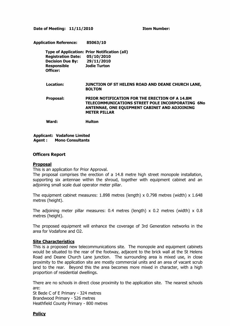
Date of Meeting: 11/11/2010 Item Number:
Application Reference: 85063/10
Type of Application: Prior Notification (all)Registration Date: 05/10/2010Decision Due By: 29/11/2010ResponsibleOfficer:
Jodie Turton
Location: JUNCTION OF ST HELENS ROAD AND DEANE CHURCH LANE,BOLTON
Proposal: PRIOR NOTIFICATION FOR THE ERECTION OF A 14.8MTELECOMMUNICATIONS STREET POLE INCORPORATING 6NoANTENNAE, ONE EQUIPMENT CABINET AND ADJOININGMETER PILLAR
Ward: Hulton
Applicant: Vodafone LimitedAgent : Mono Consultants
Officers Report
ProposalThis is an application for Prior Approval.The proposal comprises the erection of a 14.8 metre high street monopole installation,supporting six antennae within the shroud, together with equipment cabinet and anadjoining small scale dual operator meter pillar.
The equipment cabinet measures: 1.898 metres (length) x 0.798 metres (width) x 1.648metres (height).
The adjoining meter pillar measures: 0.4 metres (length) x 0.2 metres (width) x 0.8metres (height).
The proposed equipment will enhance the coverage of 3rd Generation networks in thearea for Vodafone and O2.
Site CharacteristicsThis is a proposed new telecommunications site. The monopole and equipment cabinetswould be situated to the rear of the footway, adjacent to the brick wall at the St HelensRoad and Deane Church Lane junction. The surrounding area is mixed use, in closeproximity to the application site are mostly commercial units and an area of vacant scrubland to the rear. Beyond this the area becomes more mixed in character, with a highproportion of residential dwellings.
There are no schools in direct close proximity to the application site. The nearest schoolsare:St Bede C of E Primary - 324 metresBrandwood Primary - 526 metresHeathfield County Primary - 800 metres
Policy

PPG8 (revised) Telecommunications.
UDP policies: D6 Telecommunications; A5 Impact on the Highway.
PCPN21 Highway ConsiderationsPCPN25 Telecommunications
AnalysisPPG8 states that applications for Prior Approval must be considered on siting andappearance grounds only. Policies in the Development Plan relating to siting andappearance are relevant.
Applications which are acceptable in siting and appearance terms and comply with theprovision of the Development Plan in terms of siting and appearance, should be grantedPrior Approval.
Similarly applications which are unacceptable in siting and appearance terms, and whichare contrary to the provisions of the Development Plan in terms of siting and appearance,should be refused Prior Approval.
It is therefore necessary to decide whether this application is acceptable in terms of sitingand appearance, with due regard being had to relevant Development Plan policies, anddetermine the accordingly.
The Government's policy is to facilitate the growth of new and existingtelecommunications systems whilst keeping the environmental impact to a minimum.
Consideration of Alternative Sites and Mast SharingPPG8 and UDP policy D6 place strong emphases on the use and reuse of existing sites, inparticular the use of existing masts, buildings and other structures. The Governmentencourages applicants to hold pre-application discussions on with the Local PlanningAuthority and interested third parties regarding the consideration of alternative sites.
The lack of consideration of alternative sites can be a reason to refuse applications, butthe Local Planning Authority must give clear and specific reasoning, having borne in mindthe technical constraints of the Operators.
The applicants have considered the following sites and masts prior to the submission ofthis application, all of which are considered to be unacceptable for the following reasons:-
Manfredi, Deane Church LaneThe existing site provider will not confirm interest at this time, therefore it has not beenpossible to offer this site as a potential option. Officers see no reason to dispute thisstance.
Pelham Street GarageThe garage owner is looking to redevelop the site and there will not be any spaceavailable to accommodate a mast. again officers are in agreemnet with this assessment.Furthermore this site is surrounded by housing with direct views across it.
Hulton Moor, St Helens RoadThe garage owner is not willing to accommodate a site on the property. Officers areunable to dispute this.
It is considered that the Applicant has undertaken sufficient consideration of alternativesites.

An independent advisor, Engineered Communications Solutions Ltd, was consulted on theconsideration of alternative sites and agrees with the Applicant's conclusions, based onthe area of need and the location of the sites considered.
Technical JustificationPPG8 states that Operators may be expected to demonstrate the need for the proposal.UDP policy D6 requires that the size of the mast is justified in terms of operationalefficiency, structural capacity and its relative importance in the network.
The Applicants have supplied existing and proposed Cell Coverage Diagrams. Theproposed equipment will improve the existing 3rd Generation service for O2 andVodafone for this section of St Helens Road, Deane Church Lane, Morris Green Road andthe surrounding area. Following consultation, Engineered Communications Solutions Ltd(ECS) has confirmed that the coverage plots submitted with the application show thatboth Vodafone and O2 currently have regions of coverage which are below their targetsin the area. The proposed site addresses these with no indication that the resultingcoverage is excessive (indicating that the mast height is justified).
On the basis of this information, the need for the proposed development is considered tohave been technically justified.
Design and Visual Amenity IssuesUDP policy D6 requires that the siting, scale and external appearance of the apparatus,and any associated landscaping, have been designed to minimise, eliminate or mitigatenegative impact on amenity, visual intrusion and, if applicable, the appearance ofstructures on which they are mounted.
The proposed telecommunications mast is a 14.8 metre high street pole. The mast andassociated equipment cabinets will be sited to the rear of the pavement, against a 1.3metre high brick wall. To the south west of the application site is a large hoardingadvertisement on the side of 248 St Helens Road.
The mast will be viewed against the existing street furniture, which incorporates lamposts(10 metres in height), railings and traffic lights. The pavement in the area of theapplication site is unusually wide, at a depth of up to 8.6 metres at the widest point. Theproposed mast and equipment cabinets will not therefore have any impact on pedestrianmanoeuvrability.
When taking into consideration the surrounding environment, the proposal is notconsidered to have a detrimental impact on the character and appearance of thesurrounding area. The proposed street pole will blend in with existing street furniture,and although higher than adjacent lampposts, at 14.8 metres, it will not appearincongruous at this busy junction, when viewed against existing street furniture, the brickwall directly to the north west and the large advertisement hoarding.
The proposal is therefore considered to comply with UDP policy D6.
Health ConsiderationsThe Central Government view is that if the output levels of the proposed equipment arebelow the guidelines recommended by the International Commission on Non-IonizingRadiation Protection, there should be no need for further consideration on healthgrounds.
PPG8 advises that Operators should provide Local Planning Authorities with ICNIRPcompliance statements. The applicants have provided an ICNIRP compliance statementfor this application.

Impact on the HighwayUDP policy A5 and PCPN21 seek to ensure that development proposals do not adverselyaffect the safety of highway users, including pedestrians, as well as the safe and efficientcirculation of vehicles.
The scheme proposes the siting of the mast and equipment cabinets on the pavement atthe junction of St Helens Road and Deane Church Lane. The pavement in this location isunusually wide, at a depth of up to 8.6 metres. The proposed mast and equipmentcabinets will not therefore have any impact on pedestrian manoeuvrability. Furthermore,the proposal is sited back from the vehicular junction and will not therefore provide anyobstruction or distraction to motorists. The Council's Highway Engineers consider theproposal to be acceptable in highway terms.
ConclusionThe proposal for a 14.8 metre high telecommunications mast, sited to the rear of thepavement, at the junction of St Helens Road and Deane Church Lane, is considered, inpolicy terms, to be an acceptable location. The mast will not present an incongruousfeature when viewed against existing street furniture and a large advertisement hoarding. The applicant has shown a need for the increase in coverage for the two operators(Vodafone and O2). There will be no detrimental impact on highway safety. Theproposal complies with policy and is therefore recommended for approval.

Representation and Consultation Annex
RepresentationsLetters:- no letters of representation have been received to date, however at the time ofwriting the Committee report the site notice date had not expired. Therefore any lettersreceived will be reported on the late list.
Petitions:- none received.
ConsultationsA site notice was posted on site on 21/10/2001.
The following local residents were consulted:- 1-3 Morris Green Lane; 1-5 Longfield Road;St Helens Youth Centre; Cottage 204 St Helens Road; 230 - 236, 233 - 241, 241A, 243 -247, 246-248, 247A, 249 - 257, 250 - 260 St Helens Road.
Advice was sought from the following consultees: BMBC Highway Engineers; EngineeredCommunications Solutions Ltd.
Planning HistoryNone relevant to this proposal.

Recommendation: Prior Approval Granted with Conditions
Recommended Conditions and/or Reasons
1. The development hereby permitted shall be begun before the expiration of 3 years from the date ofthis permission.
Reason
Required to be imposed pursuant to section 91 of the Town and Country Planning Act 1990 asamended by Section 51 of the Planning and Compulsory Purchase Act 2004.
2. The external finish and colour of the telecommunications mast and equipment hereby approved shallbe painted/powdercoated as follows:
Telecommunications Street Pole Installation - galvanised steel finish;Equipment cabinet and Operator Meter Pillar - Green (RAL 6009).
Such details as are approved shall be completed within 28 days of the installation of the equipmentwhich shall be retained so coloured thereafter.
Reason
To ensure the development safeguards the character and visual appearance of the locality.
1. The Council has granted planning permission, subject to the conditions listed above, because theproposed development is in accordance with all relevant policies of the Development Plan (the UDPand the Regional Spatial Strategy Plan for the North-West), as is required by Section 38 of thePlanning and Compulsory Purchase Act 2004. There are no material considerations, as specified inthe Planning Officer Report, that outweigh this justification to support the grant of planningpermission. A summary of the relevant Development Plan policies pursuant to Article 22 of the Townand Country Planning (General Development Procedure) (England) (Amendment) Order 2003 andhow the proposed development relates to these policies is set out below.
Unitary Development Plan
D6 as the development is for shared telecommunications site and apparatus, and the siting, scale,massing and external appearance minimise any negative impact on the locality.
A5 as the development proposals take into account provision for roads, paths, servicing and parking.


Date of Meeting: 11/11/2010 Item Number:
Application Reference: 85064/10
Type of Application: Prior Notification (all)Registration Date: 05/10/2010Decision Due By: 29/11/2010ResponsibleOfficer:
Helen Williams
Location: LAND AT CHORLEY OLD ROAD (ADJACENT JUNCTION WITHMOSS BANK WAY), BOLTON
Proposal: PRIOR NOTIFICATION FOR THE ERECTION OF A 14.53 METREHIGH TELECOMMUNICATIONS STREET POLE WITH SIXANTENNAE AND ONE EQUIPMENT CABINET
Ward: Smithills
Applicant: Vodafone LtdAgent : Mono Consultants
Officers Report
ProposalThis is an application for prior approval as the mast is less than 15 metres high.
The proposal comprises the erection of a 14.53 metre high telecommunications mast(street pole design) and an equipment cabinet measuring 1.898 metres by 0.798 metresand 1.648 metres high, which will be painted green. The mast and cabinet are to be sitedon the grass verge opposite the electricity sub-station to the south east of McDonald'srestaurant.
The proposed equipment will provide 3G (third generation) coverage for both Vodafoneand O2 as the mast will be shared by the two companies. The proposal will provideenhanced services for residents and businesses in the Smithills area.
Site CharacteristicsThis is a proposed new telecommunications site, but the proposed mast will be shared.
The proposed telecommunications site is located on a grass verge between the pavementand cobbled street off Chorley Old Road. The site is to the south eastern corner of theelectricity sub-station that is just beyond the Moss Bank Way/Chorley Old Roadroundabout. McDonald's restaurant is to the west of the proposed site.
Opposite the site, to the north, are semi-detached houses along Chorley Old Road. Thereare further houses to the south along Boot Lane.
PolicyPPG8 Telecommunications
UDP Policies: D2 Design; D6 Telecommunications; A5 Road Network
PCPN25 Telecommunications

AnalysisPPG8 states that applications for Prior Approval must be considered on siting andappearance grounds only. Policies in the Development Plan relating to siting andappearance grounds only. Policies in the Development Plan relating to siting andappearance are relevant.
Applications which are acceptable in siting and appearance terms and comply with theprovision of the Development Plan in terms of siting and appearance, should be grantedPrior Approval.Similarly applications which are unacceptable in siting and appearance terms, and whichare contrary to the provisions of the Development Plan in terms of siting and appearance,should be refused Prior Approval.
It is therefore necessary to decide whether this application is acceptable in terms of sitingand appearance, with due regard being had to relevant Development Plan policies, anddetermine the accordingly.
The Government's policy is to facilitate the growth of new and existingtelecommunications systems whilst keeping the environmental impact to a minimum.
The main impact of the proposal therefore is:
Impact on the character and appearance of the area
Impact on the Character and Appearance of the AreaUDP policy D6 requires that the siting, scale and external appearance of the apparatus,and any associated landscaping, have been designed to minimise, eliminate or mitigatenegative impact on amenity, visual intrusion and, if applicable, the appearance ofstructures on which they are mounted.
Permission is sought for the erection of a 14.53 metre high telecommunications mast('street pole' design and housing six antennae within the top section) and the installationof an ancillary equipment cabinet. The mast is to be coloured grey and the cabinet is tobe painted green.
The mast and cabinet are to be sited on a grass verge to the north eastern corner of anelectricity sub-station. There is a variety of street furniture in the immediate area to theproposed site, including road signs, bollards and street lights. The street lights on thepavement adjoining the grass verge measure approximately 10 metres in height. Themast is proposed to be sited between two of the street lights. 10 metre high trees alsoscreen the proposed site from the rear.
Whilst the proposed mast is 4.53 metres higher than the tallest structures in the vicinitythe independent consultant commissioned by the Council to assess the proposal hasstated that the mast height is justified given the proposed coverage. It is considered,despite its height, that the proposed mast and cabinet would not appear alien in itsposition given the presence of other street furniture. It is also considered that theproposed location, in visual terms, is the most suitable in the vicinity. Further up ChorleyOld Road is Green Belt.
It is therefore considered that the proposed telecommunications equipment would becompliant with Policy D6 of the UDP.
Other matters
Consideration of alternative sites and mast sharingThe applicants have considered the following sites prior to the submission of this

application, all of which are considered to be unacceptable for the following reasons:-Hope and Anchor Inn, Doffcocker Brow – This location is located within a diptherefore the required level of coverage would not be achieved.Verge at Doffcocker Brow – The operator felt that there is insufficient space toaccommodate a telecommunications installation here.Doffcocker Brow – The operator considered the site unsuitable as it would be directlyin front of houses with very little screening.
The independent consultant commissioned by the Council to assess the informationsubmitted has confirmed that the technical reason for choosing the site aginst that at theHope and Anchor Inn is correct as that site is over 10 metres lower than the proposal. itis also considered that the two other sites are unsuitable as set down above.
Technical justificationThe applicants have supplied existing and proposed Cell Coverage Diagrams. Theproposed equipment will provide an improved 3rd Generation service for Vodafone andO2 within the Smithills area. The Council's consultant has confirmed that the proposedcoverage does not appear excessive.
Health considerationsThe Central Government view is that if the output levels of the proposed equipment arebelow the guidelines recommended by the International Commission on Non-IonizingRadiation Protection, there should be no need for further consideration on healthgrounds. PPG8 advises that operators should provide Local Planning Authorities withICNIRP compliance statements. The applicants have provided an ICNIRP compliancestatement for this application and the Council's consultant has confirmed that thisstatement is valid.
Highways considerationsThe mast and cabinet are sited on a grass verge and therefore will not obstruct thepavement or the highway.
ConclusionIt is considered that the proposed 'street pole' telecommunications mast and theassociated equipment cabinet are acceptable in their design and siting and would nothave an adverse impact on the character and appearance of the area. Members aretherefore recommended to approve the application.

Representation and Consultation Annex
RepresentationsLetters:- one letter of objection has been received from a resident of Chorley Old Roadraising the following concerns:
Health implications – there is no conclusive evidence to suggest that masts do notcause health problems, such as cancer. There are young children living in the vicinityof the proposed mast;The mast should be not be erected in a residential area – there must be more suitablelocations than this;The mast will be an eyesore;Depreciation of property values (this is not a planning consideration);Concerns about the number of residents consulted (officer's note: the housessurrounding the application site were consulted and a site notice was posted on theproposed site).
ConsultationsA site notice was posted on site on 19/10/2010.The following local residents were consulted:-845 to 1023 (odd numbers) Chorley Old Road870 to 1046 (even numbers) Chorley Old Road2 & 7 Delph Hill Close
Advice was sought from the following consultees: Engineered Communications SolutionsLtd.
Planning HistoryNon relevant to this site.

Recommendation: Prior Approval Granted with Conditions
Recommended Conditions and/or Reasons
1. The development hereby permitted shall be begun before the expiration of 3 years from the date ofthis permission.
Reason
Required to be imposed pursuant to section 91 of the Town and Country Planning Act 1990 asamended by Section 51 of the Planning and Compulsory Purchase Act 2004.
2. The telecom mast and equipment cabin shall be painted/powdercoated in accordance with theapproved colour scheme. The mast and cabin shall be painted/powdercoated in accordance with theapproved details within 14 days of installation and shall be retained so coloured thereafter.
Reason
To safeguard the visual appearance of the area.
1. The Council has granted planning permission, subject to the conditions listed above, because theproposed development is in accordance with all relevant policies of the Development Plan (the UDPand the Regional Spatial Strategy Plan for the North-West), as is required by Section 38 of thePlanning and Compulsory Purchase Act 2004. There are no material considerations, as specified inthe Planning Officer Report, that outweigh this justification to support the grant of planningpermission. A summary of the relevant Development Plan policies pursuant to Article 22 of the Townand Country Planning (General Development Procedure) (England) (Amendment) Order 2003 andhow the proposed development relates to these policies is set out below.
Unitary Development Plan
D6 as the development is for shared telecommunications site and apparatus, and the siting, scale,massing and external appearance minimise any negative impact on the locality.
A5 as the development proposals take into account provision for roads, paths, servicing and parking.

