planning concepts and alternatives analysis
TRANSCRIPT

Boulder Municipal Airport MASTER PLAN UPDATE D.1
Planning Concepts and Alternatives Analysis
Introduction The purpose of this chapter is to present the Planning Concepts and Alternatives for
Boulder Municipal Airport, in terms of both their vision and reasoning. Therefore, several
basic assumptions have been established, which are intended to direct the future planning
of the Airport. These assumptions are supported by the aviation activity forecasts and
include a commitment for continued airport operation, which supports local and regional
needs.
The first assumption states that Runway 8/26 will be maintained to Airport Reference Code (ARC) B-II design standards with future instrument approach visibility minimums of 1-mile being protected to Runway 26. This is the same ARC designation that was identified in the 1992 Airport Master Plan. The second assumption states that the Airport’s existing glider operation will be maintained, utilizing either the present Runway 8G/26G configuration that reflects a non-federal/non-standard design installation, or an alternate layout configuration. The third assumption states that the existing runway length of 4,100 feet for Runway 8/26 will be maintained. Planning Goals Accompanying these assumptions are several goals, which have been established for purposes of directing the plan and establishing continuity in the future operation of the Airport. In the future, the Airport is projected to have the same type and volume of flying activity that has occurred over recent history. However, there may be improvements to how the Airport supports that activity in terms of safety and

Boulder Municipal Airport MASTER PLAN UPDATE D.2
infrastructure enhancements and responding to community needs. The planning goals take into account several categorical considerations relating to the needs of the Airport both in the short-term and the long-term, including safety, noise, capital improvements, land use compatibility, financial and economic conditions, public interest and investment, and community recognition and awareness. The goals of this Master Plan are: • Ensure that the future planning of the Airport will continue to support its
role in the region, to accommodate a variety of general aviation users in Airport Reference Code (ARC) B-II and below, ranging from glider to corporate aviation operators.
• Provide effective direction for the future operation of Boulder Municipal Airport through the preparation of a balanced plan and adherence to the adopted improvement program.
• Continue the provision of a safe and efficient environment for aircraft operation.
1) Plan the Airport to be able to safely accommodate the forecast aircraft fleet with facilities properly sized to accommodate forecast demand.
2) Maintain/update minimum standards, rules, and regulations for future operation of the Airport and the maintenance of existing facilities.
3) Direct any future land acquisition recommendations (i.e., fee simple and/or easement) in consideration of airport safety and land use compatibility.
• Preserve the Airport’s ground transportation access requirements with the area’s regional transportation goals.
• Maintain/enhance the self-sustaining capability of the Airport and ensure the financial feasibility of future airport capital improvements.
1) Program facilities to be constructed when demand is realized (construction is to be driven by actual demand, not forecast demand).
• Continue to address community concerns such as noise, wildlife habitat and impacts and environmentally sustainable maintenance practices.
• Plan and develop the Airport to be environmentally compatible with the community and minimize environmental impacts on both airport property and property adjacent to the Airport.

Boulder Municipal Airport MASTER PLAN UPDATE D.3
Airside Planning Alternatives Introduction
Because all other airport functions relate to and revolve around the basic runway/ taxiway layout, airside planning recommendations must first be carefully examined and evaluated. It is essential that the initial development of the Airport be commensurate with the anticipated needs and requirements of the airport users; however, the long-term expansion capabilities of the facility must also be considered and planned for to ensure the future success of the project. The main objective of the planning alternatives presented herein is to identify future projects that will result in a runway/taxiway system capable of accommodating the forecast aviation activity.
To accommodate the projected operational demand at Boulder Municipal Airport through the year 2023 (i.e., the end of the twenty-year planning period), two development alternatives for the Airport have been prepared and are presented in the following illustrations. Both the forecast operations and the goals of the City of Boulder, relative to aviation development and economic enhancement, were incorporated into the planning effort.
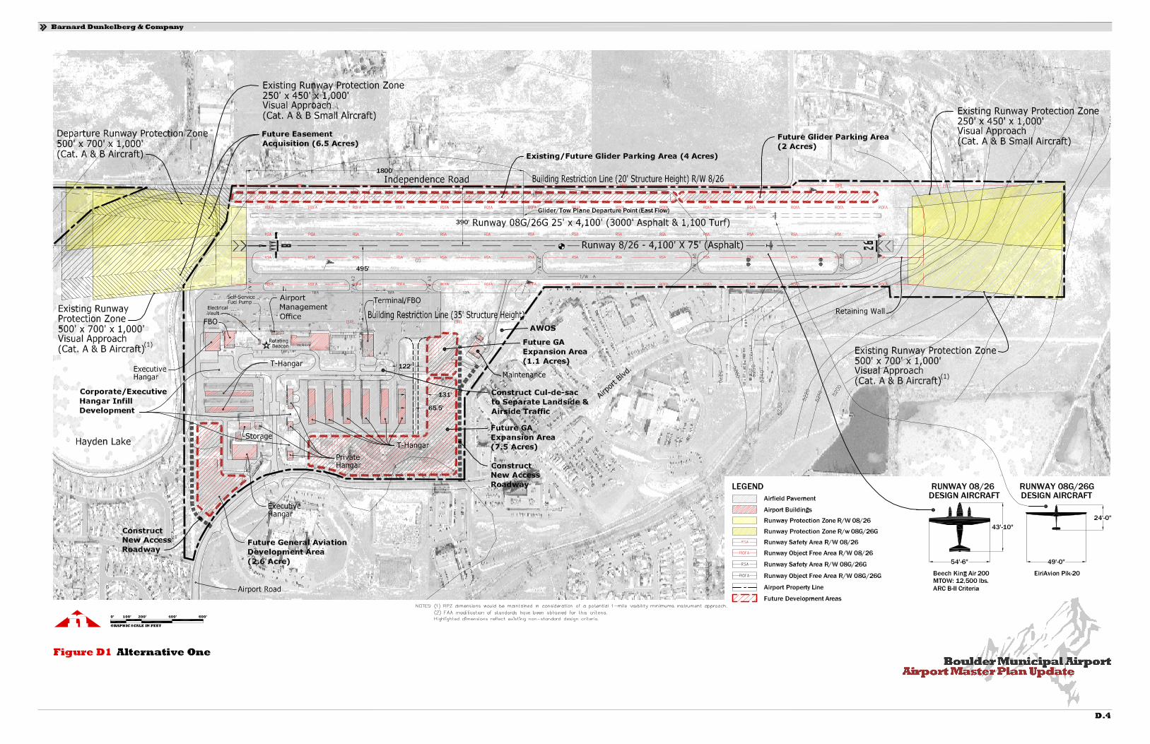
Alternatives The following airside planning alternatives were evaluated. Alternative One. Preserve the Airport’s existing parallel runway configuration & design standards, and implement future instrument approach upgrades to Runway 26. Runway 8/26.
• ARC Dimensional Criteria: Maintain existing ARC B-II design standards through the planning period of this document. Resolve existing non-standard dimensional criteria for runway centerline to holdline and runway object free area width through a request for a modification of standards. The FAA has previously granted existing modification of standards for both parallel runway and parallel taxiway centerline separation standards, and these additional modification requests are needed to provide consistency with previous non-standard design criteria determinations. In addition, the future application of instrument approach criteria for the Airport will not require the implementation of more restrictive FAA dimensional criteria in consideration of the proposed 1-mile visibility minimums.
• Dimensions: Based on the Airport’s existing and projected operational activity,
coupled with the facility’s existing site constraints (i.e., steep topography and

Boulder Municipal Airport MASTER PLAN UPDATE D.5
adjacent lake), the runway is to be maintained at its existing dimensions of 75 feet wide and 4,100 feet in length.
• Pavement: Maintain existing gross weight bearing capacity of 16,000 pounds single
wheel and 30,000 pounds dual-wheel gear configuration.
• Instrument Approach Criteria: The existing Runway 26 visual approach will be upgraded to a GPS Area Navigation (RNAV) procedure that will likely provide LNAV/VNAV ceiling minimums as low as a 532 feet and visibility minimums of 1-mile. In addition, the size of the runway protection zones (RPZs) for each runway end will be maintained at 500’ x 700’ x 1,000’.
• Runway Lighting: The existing Medium Intensity Runway Lights (MIRLs) that
currently serve the runway system will be maintained. In addition, Runway End Identifier Lights (REILs) are recommended for each runway end; however, a light emission study should be conducted in consideration of the City of Boulder’s existing lighting ordinance to determine if shielding of the lights will be needed. Also, the existing visual approach slope indicators (VASIs) serving Runway 26 are to be maintained, with VASIs being recommended for future installation on Runway 8, if feasible due to terrain. An approach lighting system will not be required at the Airport based upon the proposed 1-mile approach visibility minimums for Runway 26.
• Landing/Navigational Aids: The proposed Runway 26 instrument approach
upgrade is to be developed utilizing GPS technology; therefore, no additional ground-based NAVAIDs are recommended or required for installation.
Runway 8G/26G. • ARC Dimensional Criteria: As noted in the previous chapter, the Airport’s current
Airport Layout Plan (ALP) drawing documents the design/layout of the glider runway as a non-standard condition with no reference to a specified FAA design standard. Based upon initial FAA review, it has been determined that the current operational status of the glider runway could be maintained as a non-federal installation and absent of applicable FAA design standards.
• Dimensions: The existing runway length is adequate to accommodate the operation
of the glider tow planes and would be maintained at 4,100 feet. In addition, the existing runway width would be maintained at its current non-standard width of 25 feet due to the non-federal status of the runway.
• Pavement: There is no available existing gross weight bearing capacity data for the
paved portion of the glider runway. In accordance with specified FAA design

Boulder Municipal Airport MASTER PLAN UPDATE D.6
criteria, this pavement should be designed to a 12,500 pounds single wheel gear configuration.
• Instrument Approach Criteria: Maintain the runways existing visual approach
procedures to each runway end. In addition, the size of the existing RPZs for each runway end would be maintained at 250’ x 450’ x 1,000’.
• Runway Lighting: The existing glider runway is not equipped with runway edge
lights and no improvements are recommended since this runway is only used during daylight hours.
• Landing/Navigational Aids: no improvements are recommended.
Taxiway System Taxiway “A”.
• Airplane Design Group (ADG): Maintain existing ADG II standards through the planning period of this document.
• Dimensions: Maintain existing width (i.e., 35 feet) and the existing centerline
separation from the runway of 200 feet1.
• Pavement: Maintain existing gross weight bearing capacity commensurate with the runway facility (i.e., 16,000 pounds single wheel, 30,000 pounds dual-wheel gear configuration).
• Taxiway Lighting: Maintain existing Medium Intensity Taxiway Lights (MITLs) to
serve the taxiway system.
Glider Runway Taxiway System. The existing glider runway is not equipped with a parallel taxiway system and no improvements are recommended. Landside Improvements The following landside improvement areas have been identified and are presented in the following text.
1 An existing modification of standards for the 200-foot centerline separation was approved by the FAA in 1994.

Boulder Municipal Airport MASTER PLAN UPDATE D.7
General Aviation Development: • Existing west side hangar area, located south of the commercial aviation flight
line. Recommend infill hangar/apron development (corporate and executive hangars) within undeveloped parcels. New vehicular access roadway or extension of existing roadways would be required (Acreage: 2.6 acres).
• Southeast quadrant, located adjacent to the existing T-hangar development (Future). Programmed for T-hangar and executive hangar development opportunities that require additional vehicular access roadway and taxiway development (Acreage: 7.5 acres).
• Existing north side glider storage area, located adjacent to Independence Road. Recommend continuation of existing tiedown and glider trailer storage area (Acreage: 6.0 acres).
Commercial Aviation Development:
• Northeast quadrant, located along the flightline at the east end of the general aviation ramp. Programmed for commercial aviation storage/maintenance hangars and apron development. Facility expansion will require additional vehicular access roadway development (Acreage: 1.1 acres).
Property/Easement Acquisition The City of Boulder does not presently own or control those portions of the existing Runway 8 arrival and departure RPZs that extend beyond the current boundary of the Airport. Based upon the previously described airside development recommendations, the following property and/or easement acquisition recommendations are presented. Runway 8 RPZ (Arrival and Departure).
• Easement Acquisition: 6.5 acres. Development Projects The major projects associated with the Alternative One development include:
Airside.
1) Acquire RPZ/avigation easement for Runway 8 and Runway 8G RPZs (approx. 6.5 acres).
2) Conduct Runway 26 Type D Survey to support GPS approach procedure with vertical guidance (VNAV).
3) Install Runway 26 REILs. 4) Install Runway 8 VASI, if FAA criteria can be met. 5) Install new hangar access taxiway at east end of general aviation ramp. 6) Implement Runway 8/26 pavement maintenance projects.

Boulder Municipal Airport MASTER PLAN UPDATE D.8
7) Implement Runway 8G/26G pavement maintenance projects. 8) Implement Taxiway “A” pavement maintenance projects. 9) Implement general aviation apron pavement maintenance projects. 10) Install Runway 8 REILs.
Landside.
1) Construct roadway cul-de-sac/turnaround on existing airport access roadway. 2) Install perimeter fencing with control access gates (Phase One). 3) Construct new access roadway to serve southeast general aviation
development area. 4) Construct T-hangars and executive hangars with apron/taxiway paving within
southeast general aviation development area (Phase One). 5) Construct new access roadway to serve southwest general aviation
development area. 6) Construct corporate and executive hangars with apron/taxiway paving within
southwest general aviation development area (Phase One). 7) Construct T-hangars and executive hangars with apron/taxiway paving within
southeast general aviation development area (Phase Two), including the phase-out of older T-hangar facilities.
8) Install perimeter fencing with control access gates (Phase Two). 9) Implement general maintenance projects to City-owned hangars (painting,
siding, etc.). 10) Construct T-hangars and executive hangars with apron/taxiway paving within
southeast general aviation development area (Phase Three). 11) Install perimeter fencing with control access gates (Phase Three).
The implementation of Alternative One reflects many of the development recommendations shown on the current Airport Layout Plan (ALP). The ARC for Runway 8/26 is to be maintained at ARC B-II design criteria, with a proposed GPS approach procedure being developed to Runway 26. In addition, the glider runway (i.e., Runway 8G/26G) is to be retained in its present location, maintain the existing non-standard design configuration, and continue the FAA’s non-federal runway installation status that precludes federal funding participation on any projects associated with the glider runway facility.

Boulder Municipal Airport MASTER PLAN UPDATE D.9
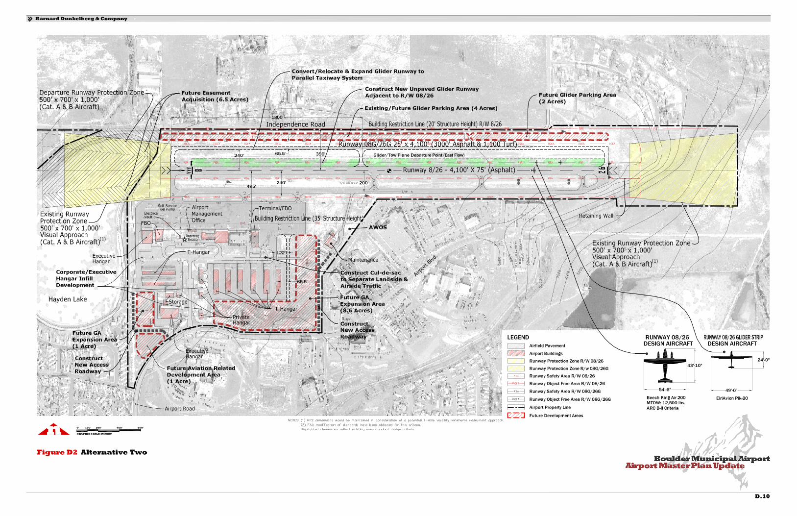
Alternative Two. Revise the Airport’s existing parallel runway configuration with the relocation of the glider runway, preservation of the Runway 8/26 design standards, and implementation of future instrument approach upgrade to Runway 26. Runway 8/26. Recommended improvements are the same as those specified for Alternative One. Runway 8G/26G2.
• ARC Dimensional Criteria: The glider runway is to be repositioned adjacent to the north side of Runway 8/26 and be developed as an unpaved turf/dirt strip3. The dimensional criteria for the glider runway would be incorporated by the existing ARC B-II design standards for Runway 8/26, requiring one set of RPZs and one set of runway safety area (RSA) and runway object free area (ROFA) boundaries.
• Dimensions: The existing glider runway length of 4,100 feet would be reduced to
3,900 feet to accommodate for the outboard placement of the threshold lights located at the Runway 8 landing threshold. In addition, the new compacted dirt/turf glider strip would be developed to a width of 75 feet to minimize potential conflicts with the existing Runway 8/26 MIRLs.
• Pavement: The proposed glider strip is to be unpaved, consisting of either
compacted dirt or turf. There are also low maintenance synthetic turf products on the market that could be utilized in lieu of the compacted dirt or a turf surface.
• Instrument Approach Criteria: Maintain the runways existing visual approach
procedures to each runway end. In addition, separate RPZs would not be required for the glider strip and thus the size of the existing RPZs for each end of Runway 8/26 would be maintained at 500’ x 700’ x 1,000’.
• Runway Lighting: The proposed glider strip would not be equipped with runway
edge lights.
• Landing/Navigational Aids: No improvements are recommended.
2 Reference to a parallel glider runway would be removed from the ALP, with the Airport offering both a paved and unpaved version of Runway 08/26 from which to operate. 3 The existing non-standard parallel runway configuration would be revised to a single runway layout that complies with specified FAA design standards.

Boulder Municipal Airport MASTER PLAN UPDATE D.11
Taxiway System Taxiway “A”. Recommended improvements are the same as those specified for Alternative One.
New Parallel Taxiway System.
• Airplane Design Group (ADG): The existing glider runway is to be converted to a parallel taxiway system which serves the north side of Runway 8/26 and provides access to the relocated glider strip. It is recommended that the taxiway system be developed to ADG II standards (i.e., with a 240-foot runway to taxiway centerline separation) with connector taxiways being developed to serve each runway end and the midfield taxiway connector4 location.
• Dimensions: Construct new taxiway to a 35 foot width, but increase the existing
centerline separation from the runway to 240 feet to avoid future applications for a modification of standards to the runway/taxiway centerline separation and the runway centerline to holdline separation on the taxiway.
• Pavement: Design and construct gross weight bearing capacity commensurate with
small aircraft standards (i.e., 12,500 pounds single wheel gear configuration).
• Taxiway Lighting: The taxiway system would primarily be used by gliders and tow planes during daylight hours only. Therefore, in pavement edge reflectors are recommended for installation in lieu of MITLs.
Landside Improvements The following landside improvement areas have been identified and are presented in the following text. General Aviation Development:
• Existing west side hangar area, located south of the commercial aviation flight line. Recommend infill hangar/apron development (corporate and executive hangars) within undeveloped parcels. New vehicular access roadway or extension of existing roadways would be required (Acreage: 1.0 acres).
• Southeast quadrant, located adjacent to the existing T-hangar development (Future). Programmed for T-hangar and executive hangar development opportunities that require additional vehicular access roadway and taxiway development (Acreage: 8.6 acres).
4 The midfield taxiway connector is to be positioned in conjunction with the existing midfield departure location for the glider tow operations.
Boulder Municipal Airport MASTER PLAN UPDATE D.12
• Existing north side glider storage area, located adjacent to Independence Road. Recommend continuation of existing tiedown and glider trailer storage area (Acreage: 6.0 acres).
Aviation-Related Development:
• Southwest quadrant, located between the existing mobile home park and Airport Boulevard. Programmed for aviation-related business or office development that does not require airside access to the runway/taxiway system. Facility development will require additional vehicular access roadway construction (Acreage: 1.0 acres).
Property/Easement Acquisition The City of Boulder does not presently own or control those portions of the existing Runway 8 arrival and departure RPZs that extend beyond the current boundary of the Airport. Based upon the previously described airside development recommendations, the following easement acquisition recommendations are presented. Runway 8 RPZ (Arrival and Departure).
• Easement Acquisition: 6.5 acres. Improvement Projects The major projects associated with the Alternative Two development include:
Airside.
1) Acquire RPZ/avigation easement for future Runway 8 and Runway 8G RPZs (approx. 6.5 acres).
2) Relocate/construct new unpaved glider runway. 3) Convert existing glider runway to north side parallel taxiway system. 4) Conduct Runway 26 Type D Survey to support GPS approach procedure with
vertical guidance (VNAV). 5) Install Runway 26 REILs. 6) Install Runway 8 VASI, if FAA criteria can be met. 7) Install new hangar access taxiway at east end of general aviation ramp. 8) Implement Runway 8/26 pavement maintenance projects. 9) Implement Taxiway “A” pavement maintenance projects. 10) Implement general aviation apron pavement maintenance projects. 11) Install Runway 8 REILs.
Boulder Municipal Airport MASTER PLAN UPDATE D.13
Landside. 1) Construct roadway cul-de-sac/turnaround on existing airport access roadway. 2) Install perimeter fencing with control access gates (Phase One). 3) Construct new access roadway to serve southeast general aviation
development area. 4) Construct T-hangars and executive hangars with apron/taxiway paving within
southeast general aviation development area (Phase One). 5) Construct new access roadway to serve southwest general aviation
development area. 6) Construct corporate and executive hangars with apron/taxiway paving within
southwest general aviation development area (Phase One). 7) Construct T-hangars and executive hangars with apron/taxiway paving within
southeast general aviation development area (Phase Two). 8) Install perimeter fencing with control access gates (Phase Two). 9) Implement general maintenance projects to City-owned hangars (painting,
siding, etc.). 10) Construct T-hangars and executive hangars with apron/taxiway paving within
southeast general aviation development area (Phase Three). 11) Install perimeter fencing with control access gates (Phase Three).
The implementation of Alternative Two reflects a change from the current non-standard parallel runway configuration to a single runway layout (i.e., Runway 8/26) that offers an adjacent unpaved dirt/turf runway for use by gliders and tow planes. The ARC for Runway 8/26 is to be maintained at ARC B-II design criteria, with a proposed GPS approach procedure being developed to Runway 26. In addition, the relocation of the glider runway and the development of a north side parallel taxiway system would provide an airfield layout and design configuration that complies with specified FAA design standards and that would be project eligible for federal funding participation. A comparative summary of the two planning alternatives for Boulder Municipal Airport is presented in the following table entitled AIRSIDE PLANNING ALTERNATIVES SUMMARY.

Boulder Municipal Airport MASTER PLAN UPDATE D.14
Table D1 AIRSIDE PLANNING ALTERNATIVES SUMMARY Boulder Municipal Airport Master Plan Update Alternative Alternative Existing One Two
Runway 8/26 Dimensions 75’ x 4,100’ 75’ x 4,100’ 75’ x 4,100’ Airport Reference Code B-II B-II B-II Instrument Approach Visual Approaches/
Each Runway End Visual & RNAV GPS/
1 -Mile Vis. Visual & RNAV GPS/
1 -Mile Vis. Runway Lighting MIRLS, VASI (RW
26) MIRLS, VASI (Ea.
RW. End) & REILS MIRLS, VASI (Ea. RW.
End) & REILS Runway 8G/26G (1)
Dimensions 25’ x 4,100’ 25’ x 4,100’ (To Be Relocated) Airport Reference Code (Not Defined) (Not Defined) --- Instrument Approach None None --- Runway Lighting None None ---
Glider Runway (2)
Dimensions --- --- 75’ x 3,900’ (2) Airport Reference Code --- --- B-II Instrument Approach --- --- None Runway Lighting --- --- None
Landside Development Area (Infill or Expansion)
General Aviation 16.1 Acres 16.1 Acres 17.5 Acres Commercial Aviation 2.9 Acres 1.1 Acres --- Aviation-Related --- --- 1 Acre
Sources: BARNARD DUNKELBERG & COMPANY. (1) The existing glider runway is currently designated on the Airport Layout Plan as a Non-Federal installation that does not comply with existing FAA dimensional criteria. (2) New glider runway would be developed adjacent to existing Runway 8/26 and the two runways would be operated as a single runway facility. Landside Improvement Concepts Introduction With alternatives for the framework of the airport’s ultimate airside development identified, the placement of needed landside facilities can now be analyzed in more detail. In general, landside facilities consist of terminal area development, aircraft parking aprons, support facility development, hangar development areas, and airport access. The

Boulder Municipal Airport MASTER PLAN UPDATE D.15
overall objective of the landside development planning at the Airport is the provision of facilities, which are conveniently located and accessible to the community, and which accommodate the specific requirements of airport users. Based on the forecast aviation activity levels and resultant facility requirements determination, it is anticipated that the projected demand for both apron and aircraft storage facilities can be accommodated at the Airport through the planning period. In addition, various undeveloped parcels of airport property will be evaluated with respect to long-term general aviation development capability. General Aviation Development The existing commercial general aviation development area, located along the Runway 8/26 flight line, can accommodate additional aviation infill/expansion development, consisting of both large storage/maintenance hangars and apron expansion. Approximately 2.9 acres of development area has been identified for these types of uses. There is also a large area of undeveloped airport property, consisting of approximately 7.5 acres, located south and east of the Airport’s large existing T-hangar complex. This area is well suited to accommodate new T-hangar facilities, as well as the addition of larger executive-type hangars, and these are the type of facilities which are depicted for future development on the current Airport Layout Plan. In addition, between 1.0 and 2.6 acres have been identified within the southwest quadrant of the Airport to accommodate the larger corporate/executive hangar types, although taxiway access may not be a feasible option. As can be noted from the previous chapters of this document, the Airport is projected to need hangar storage facilities for additional based aircraft throughout the 20-year planning period of this study. In consideration of the proposed general aviation development areas identified previously, the Airport would be capable of accommodating the projected general aviation aircraft storage requirements beyond the specified planning period. Airport Traffic Pattern Evaluation The establishment and regulation of airport traffic patterns are specified in Federal Aviation Regulations (FARs) Part 91, 93, and 97, and airport owners and operators in coordination with the FAA are responsible for selecting the patterns. Left traffic patterns are standard, and should always be established except where obstacles, terrain, and or noise-sensitive areas dictate. In addition, airport operators will often establish local procedures or patterns for other than fixed-wing, powered aircraft such as gliders, helicopters, ultralights, etc. This is the case at Boulder, which currently operates with a parallel powered aircraft and glider runway configuration, as well as a helicopter pattern.
Boulder Municipal Airport MASTER PLAN UPDATE D.16
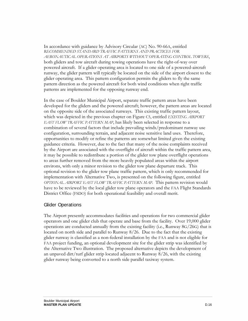
In accordance with guidance by Advisory Circular (AC) No. 90-66A, entitled RECOMMENDED STANDARD TRAFFIC PATTERNS AND PRACTICES FOR AERONAUTICAL OPERATIONS AT AIRPORTS WITHOUT OPERATING CONTROL TOWERS, both gliders and tow aircraft during towing operations have the right-of-way over powered aircraft. If a glider operating area is located to one side of a powered-aircraft runway, the glider pattern will typically be located on the side of the airport closest to the glider operating area. This pattern configuration permits the gliders to fly the same pattern direction as the powered aircraft for both wind conditions when right traffic patterns are implemented for the opposing runway end. In the case of Boulder Municipal Airport, separate traffic pattern areas have been developed for the gliders and the powered aircraft; however, the pattern areas are located on the opposite side of the associated runways. This existing traffic pattern layout, which was depicted in the previous chapter on Figure C5, entitled EXISTING AIRPORT EAST FLOW TRAFFIC PATTERN MAP, has likely been selected in response to a combination of several factors that include prevailing winds/predominant runway use configuration, surrounding terrain, and adjacent noise sensitive land uses. Therefore, opportunities to modify or refine the patterns are somewhat limited given the existing guidance criteria. However, due to the fact that many of the noise complaints received by the Airport are associated with the overflight of aircraft within the traffic pattern area, it may be possible to redistribute a portion of the glider tow plane overflight operations to areas further removed from the more heavily populated areas within the airport environs, with only a minor revision to the glider tow plane departure track. This optional revision to the glider tow plane traffic pattern, which is only recommended for implementation with Alternative Two, is presented on the following figure, entitled OPTIONAL AIRPORT EAST FLOW TRAFFIC PATTERN MAP. This pattern revision would have to be reviewed by the local glider tow plane operators and the FAA Flight Standards District Office (FSDO) for both operational feasibility and overall merit. Glider Operations The Airport presently accommodates facilities and operations for two commercial glider operators and one glider club that operate and base from the facility. Over 19,000 glider operations are conducted annually from the existing facility (i.e., Runway 8G/26G) that is located on north side and parallel to Runway 8/26. Due to the fact that the existing glider runway is classified as a non-federal installation by the FAA and is not eligible for FAA project funding, an optional development site for the glider strip was identified by the Alternative Two illustration. The proposed alternative depicts the development of an unpaved dirt/turf glider strip located adjacent to Runway 8/26, with the existing glider runway being converted to a north side parallel taxiway system.

Airport Master Plan UpdateBoulder Municipal Airport
Barnard Dunkelberg & Company
D.17
0 2,000 4,0001,000
Feet
Figure D3 Optional Airport East Flow Traffic Pattern Map
nn
8
26
Powered Aircraft PatternPowered Aircraft Pattern
Glider Tow Plane PatternGlider Tow Plane Pattern
Runway 8 DeparturesRunway 8 Departures
Runway
8 A
rriva
ls
Runway
8 A
rriva
ls
Option IIOption II
Option IOption I
Decisioin Point ADecisioin Point A
28th
Str
eet
36
Fo
oth
ills
Par
kway
157
119
44
43
119
7
39
Jay Road
N 7
5th
Str
eet
Valmont Road
Arapahoe RoadN
61s
t S
tree
t
N 6
3rd
Str
eet
N 5
1st
Str
eet
Diago
nal H
ighway
Pearl Parkway
Valmont Parkway
Kalmia Avenue Independence Road
BoulderMunicipal
Airport
BoulderMunicipal
Airport
HaydenLake
ValmontReservoir
N 5
7th
Str
eet
Air
po
rt R
oad
Legion Park
Source: Aerial Photography USGS 2002 Urban Area Digitial Ortho Photo Quarter Quad. Traffic Patterns: Boulder Soaring Club Representative
Legend
Flight Patterns
Glider/Tow Plane
Powered AircraftRunway Protection Zone
Airport Property
Jay Road
HeatherwoodSubdivision/Golf Course

Boulder Municipal Airport MASTER PLAN UPDATE D.18
This proposed layout of the runways would essentially operate as a single runway configuration, and thus eliminate the existing non-standard dimensional criteria for the current parallel runway system. Due to the application/recognition of FAA design standards, the existing glider storage could not be increased in width; however, the new taxiway system would create a new and expanded area for the movement and staging of gliders prior to takeoff. From an operational standpoint, the previously presented optional revision to the glider flight pattern could be implemented with this alternative, and would permit approximately 70%5 of the glider tow operations (i.e., approximately 13,500 operations) to be routed directly to the south side of the Airport without having to double back along the south side of Independence Road. This potential change in the glider flight pattern would likely have little effect to the footprint of the DNL noise contours, but may significantly reduce the impact of adjacent overflight noise for the existing noise sensitive residential development located northeast of the Airport. The City of Boulder, along with the input from the local glider community, now have the option of selecting from two glider runway configurations that can best meet the future development requirements of the Airport. Aviation-Related or Non-Aviation Development Alternative One of the airside planning alternatives identified one area, consisting of approximately one acre, that may well be suited for aviation-related or non-aviation development. The site, which is located within the southwest quadrant of the Airport, could be provided with direct vehicular access from Airport Road and would not be equipped with taxiway access to the runway/taxiway system. Vehicular Access Ground access is an important element in the overall ability of an airport to function properly. Not only is it vital that airport users have easy access to and from the airport’s general aviation facilities using ground transportation, but also surface transported freight (e.g., Fedex, UPS, and DHL) must be easily shipped to and from businesses located on or in the vicinity of the airport. Also, because airports are employment centers, proper access for people employed on airport property must be provided. In an effort to better segregate existing vehicles and aircraft traffic from the airport roadway system, as well as improve airport security, it is recommended that the airport’s existing access roadway system be modified and expanded to restrict airfield access to unauthorized vehicles. This will require the development of a roadway cul-de-sac/turnaround or gated barrier, located southeast of the existing Terminal/FBO building, that would restrict the movement of vehicles across the existing access taxiway
5 Operational estimates were obtained from a Soaring Society of Boulder (SSB) representative.

Boulder Municipal Airport MASTER PLAN UPDATE D.19
and onto the aircraft apron area. The closure of this roadway to public access would also require the development of a new access road, extending northward from Airport Road along the existing airport boundary, to provide public access to the existing maintenance hangar. This roadway would also be required to provide landside access to the proposed general aviation expansion area located within the southeast quadrant of the Airport. Additional access road construction would also be required to serve the future general aviation expansion area located within the southwest quadrant of the airport. This proposed roadway would extend northward from Airport Road, adjacent to the airport property line. Aviation Support Improvements Aviation support functions are those that are required for the airport to operate properly, but are not part of the runway/taxiway system and do not relate directly to aircraft storage facilities. There are no plans to implement an Air Traffic Control Tower (ATCT) at the airport, and airport fire protection services will continue to be provided by the City of Boulder Fire Department. Fuel Storage/Distribution System. It was determined that the Airport's projected fuel storage requirements can be accommodated through the year 2023 utilizing existing storage facilities. It should be noted that following an evaluation of existing fueling contract agreements, including historical and future fuel sales data, a self-serve fuel facility was installed at the Airport in 2005. American with Disabilities Act (ADA). There has been several inquires from the public regarding the Airport’s design considerations associated with the American with Disabilities Act (ADA). It should be noted that in 1991, the Airport expended over $109,000 for ADA improvements, with over 56% being funded by the Airport. The specified improvements included the installation of an ADA enclosure, an ADA lift, two ADA accessible restrooms, and handrail improvements to the existing stairwells. In addition, the airport has historically maintained a parking position on the apron that was identified as a handicap parking area. The striping for this parking area has been covered by pavement maintenance projects over the years and should be re-painted in conjunction with future striping projects on the apron. Boulder Municipal Airport Glider Rules & Regulations. If the Airport’s glider runway is relocated, as presented in Alternative Two, it is recommended that a Glider Rules & Regulations document be formally developed and approved by the City of Boulder with input being provided by the local glider community (both commercial operators and clubs) and the FAA’s Flight Standards District Office (FSDO). The Airport’s existing glider operations document (prepared by the Soaring Society of Boulder), entitled SSB

Boulder Municipal Airport MASTER PLAN UPDATE D.20
820 Club Operating Procedures could be used as a beginning template for the new document. Summary The proposed plan alternatives for Boulder Municipal Airport are intended to present the City of Boulder with a variety of options for future facility expansion. Following a careful assessment of the potential impacts of each alternative, in conjunction with a detailed FAA evaluation, the City must select a Recommended Improvement Plan, which will be presented in the AIRPORT PLANS chapter of this document. It is possible that the Recommended Improvement Plan will represent a combination, or phasing, of the two alternatives, utilizing portions of each to represent the ultimate airport configuration.