planning for the unknowable: impacts of transport...
TRANSCRIPT

"Cities and regions in a changing Europe: challenges and prospects"
5-7 July 2017, Panteion University, Athens, Greece
PLANNINGFORTHEUNKNOWABLE:IMPACTSOFTRANSPORT
INFRASTRUCTUREANDEVIDENCE-BASEDSPATIALDEVELOPMENT
POLICIES
PitsiavaMAGDALINI,Professor,AristotleUniversityofThessaloniki
KafkalasGRIGORIS,EmeritusProfessor,AristotleUniversityofThessaloniki
Contact:[email protected]
Abstract
Atthecoreoftheplanningprocess liesthequest forrationalityand legitimacyoftheplan.The
paperaddresses this issuebyproposinganevidence-basedapproach for theassessmentof the
impactoftransportinfrastructurechangeinrelationtospatialdevelopmentpolicypriorities.The
firstsectionexplorestherelationshipbetweenspatialdevelopmentandtransport infrastructure
and the constructionof a seven-step theoreticalmodel. The second section identifies themain
spatial developmentpolicypriorities for the EuropeanUnion territory. Finally, the third section
providestheoutlineofaterritorial impactassessmentframeworkenablingtheuseofterritorial
impactindicatorsasanevidence-basedbridgebetweenpolicyprioritiesandthestepsofthemodel.
Thespecificvalueaddedofthisapproachliesinitscomprehensiveandintegrativecharacterand
thecombinationofscientificallyrationalandpoliticallylegitimateparametersfortheassessment
oftheimpactoftransportinfrastructureandthe(re)formulationofspatialdevelopmentpolicies.
Keywords
spatialplanning,developmentpolicy,impactoftransportinfrastructure
2
Introduction:scopeandorientationoftheapproach
Spatialplansreferbydefaulttoafuturehorizonthatcouldbeaffectedbyunpredictableeventssuchas
physicaldisasters,politicalshifts,socio-economiccrisesortechnologicalchange.Inthissense,spatial
developmentplanningdealswithproblemsthat includedynamicparametersandvaluejudgements
whichchallengetherationalityandlegitimacyofplanningandwhichcouldbecharacterisedas‘wicked’
(Rittel & Webber, 1973). Such problems generate risks that depending on their scale may lead to
controversialandunexpectedoutcomesofthekindthatHall(1982)identifiedas‘GreatPlanningDisasters’.
Thus,planningshouldadapttotheneedtoaccommodatetheunexpectedandtocontainfailuresand
inexpediencies.
Inmostrelativelyrecentstatementsabouttheroleofspatialplanningtherearestrongideological
elementsconcerningtheorientationofplanningtowardsasupposedlybetter,smarter,healthier,
competitive,resilient,andsustainablerelationshipwithnaturalandbuiltenvironment.Ifweput
asideanyideologicalandmoralclaims,spatialplanningaimstothereshapingofspatialpatterns
according to comprehensive and integrated territorial strategies concerning the future
arrangement of population, networks and activities. In order to complete this mission, spatial
planning needs on the one hand strong social and political consent that provide the necessary
legitimacyofitsgoalsandontheotherhandreliablecriteriaofrationalitythatverifyitscompetence
toachievethem.Thelackoflegitimacymakesspatialplanningirrelevantandundesired.Thelack
of rationality raises doubts for the efficiency of spatial plans. Hence the continuous quest for
legitimacyandrationalitybecomestheburdenthataccompaniestheevolutionofallthedifferent
genresofspatialplanning.(Kafkalas,2016).
The formal rational planning paradigm known as SAP: Survey-Analysis-Plan, first introduced by
Geddes(1915)hasremaineddominantfordecades.However,thedifficultiestoimplementthese
apparentlysimplestepsledtoanoversimplificationthatundermineditscredibility.Bytheendof
the1960sitsplacewastakenbythesystemsviewofplanningaspresentedbyMcloughlin(1969)
andChadwick(1971)accordingtowhichtheanalysisshouldidentifytheelementsandtheinternal
relationshipsofaspatialsystemwhiletheplanaimstomaintain itssupposedequilibrium. In its
morepragmaticversionspatialplanninglimitstheanalysistoasmallnumberofcriticalelements
and qualifies the ambition of plans to achieve equilibrium. More recently, technological

3
developments allowing the collection and processing ofmassive amounts of data in real time,
enablethepursuitofevidencebaseddecisionmakingthatcurrentlydefinesthestateoftheartof
planning(Batty2011).Thenewtrendsrequireex-ante,ongoingandexpostevaluationofimpacts
correspondingtothe inception, implementationandoperationphaseofspatialplans.However,
despitethisapparentconsensusonmethodologythequestionofhowtoproceedfromtheanalysis
toproposalsremainsashardaseverandthereisnoclearand/oragreedwayofhowtobridgethe
gapfromthecollectionandanalysisofdatatotheformulationofproposals.
AccordingtoDavoudi(2012)planningfollowseitheraninstrumentalpathasawaytoimplement
policiesoranenlightenmentpaththatincludestheformulationofpolicies.Thepaperattemptsin
thefollowingthreesectionstocombinetheinstrumentalandtheenlightenmentpathsofplanning
throughtheelaborationofanapproach,underthesymbolicnameofIRIS1.First,therelationship
betweenspatialdevelopmentandtransportinfrastructureleadstotheadoptionofaseven-step
theoreticalmodel.Second,thekeyspatialdevelopmentpolicyprioritiesfortheEuropeanterritory
are identified. Third, a territorial impact assessment framework enabling the use of empirical
evidenceasabridgebetweenvisionandrealityisoutlined.Finally,theconclusionsarguethatthe
valueaddedoftheIRISapproachliesonprovidinginformationthatstrengthenstheabilityofspatial
planstoadaptinmorerationalandlegitimatewaystotheunknowablefutures.
1 Therelationshipofspatialdevelopmentandtransportinfrastructure
Economicgeographyandlocationtheorydealwiththeanalysisofthespatialpatternsofproduction
includingtheentirechainofthedecision-makingprocessfromtheinitialdecisiontoinvesttothe
choiceofparticularproductionsites.Inthiscontext,theroleofaccessibilitybecomescrucialdueto
thefactthathouseholdsandenterprisesaresearchingforlocationswithimprovedaccessinorder
tocapturetheresultingcomparativeadvantages.Householdsarelookingforlocationswithgood
1 AccordingtothemythIRISisadivinemessengerandapersonificationoftherainbowthatlinkstheworldofgodswiththatofthehumans.ShealsocarriesanewerofwaterfromStyx,theriveroftheunderworld,thatrevealsall,eithergodsorhumans,whoperjurethemselves.

4
accesstotheplacesofworkandthevarietyofamenities,whileenterprisesaremoresensitiveto
locationsprovidingaccesstothesourcesofrawmaterial(inputs)andthemarkets(outputs).
Theresultingspatialpatternscouldbedescribedasthecombinedandcumulativeoutcomeofthe
continuously changing balance between agglomeration (or centripetal) and dispersal (or
centrifugal) forces thatareguiding the locationofeconomicactivities (Krugman,1999:144-145,
Fujita et al., 2001:9). The relevant individual decisions are being taken by economic agents in
response to real (or perceived as such) opportunities for profitable production. Each individual
investmentgeneratesaspatialpatternofflowsofinputsandoutputsorofbackwardandforward
linkageswithsuppliersandmarkets.Theresultingspatialdevelopmentpatternscouldbeviewed
asthehistoricalfootprintofsuccessivelayersofinvestment(Massey,1979:50-51).
Transport infrastructure networks are closely linked to the processes of regional
convergence/divergence(Krugman,1991:23-25).Transportaxesdeterminetoa largeextentthe
locationofenterprisesandhouseholds,andhencethepatternoflanduseinanarea.Forexample,
theimprovementoftransportinfrastructureandgreateraccessibilitytourbanregionsencourage
sprawlandthecreationofwidespreadsuburbs.However,differentformsofaccessibilityinfluence
enterprisesandhouseholdsindifferentwaysthatrequireempiricalinvestigation(McQuaidetal,
1996).
Investmentintransportinfrastructureisgenerallyconsideredavitalpolicyfortheeconomicgrowth
ofcitiesandregions.This,initsmostsimplifiedformimpliesthatregionswithbetteraccesstothe
locationsofinputmaterialsandmarketsaremoreproductiveandcompetitivethanmoreremote
andisolatedregions(Giuliano,2004).Inparticular,EUtransportpolicyhasalwaysplacedincreased
mobility at the coreof its interest, a trend reflecting the importanceofmovements in a Single
Market.This isevident in the introductionofTrans-EuropeanNetworks (Articles154-156of the
Maastricht Treaty, 1992) as a key element of the Internal Market and the reinforcement of
EconomicandSocialCohesion.Duetotheirsignificanceandthescaleofthenecessaryinvestments
TENscouldbeplacedatthecoreofEuropeanspatialdevelopmentinterventions(DeCeuster,2005,
Buunketal.,1999).

5
However, it remains an open question what are the most appropriate types of investment in
transportinfrastructureandwhichtypesofregionsgetthehighestbenefits.Forexample,thereare
argumentsthatTrans-EuropeanNetworks,intendedtopromoteterritorialcohesionandparityof
access over the European territory, have increased spatial unevenness via their impact upon
accessibilityandthusupontheeconomicprospectsofregions(Vickermanetal,1999).Similarly,
therearearguments(Martin&Rogers,1995)thatbyimprovinginfrastructureinthepoorcountries
and regions relative to the rich, European structural funding may even increase industrial
concentrationandinduceregionaldivergence.Asspatialdevelopmenttheorists‘know’,thereisno
winningmixofpolicies thatcouldguaranteethestabilizationofcomparativeadvantages.Other
factors such as location-specific features could play a more important role in the economic
performance of regions and the determination of their relative position in the international
hierarchy(ESPON,2015).
The relationshipbetween transport infrastructureandspatial structure isextremelycomplexas
therearemanyfactorsinvolved.First,theinstitutionalcapacityofaregionplaysadecisiveroleon
howdirectandindirecteffectsoccurandtowhichdirection.Second,theinvolvedpublicagencies
andsocialpartnersexercisesignificantinfluenceonhowandwhetherornotapotentialimpactwill
occur.Third,theresponseofspatialpatternstochangesinaccessibilitytakesaratherlongtimeto
emerge.Alltheaboveareexamplesoffactorsthatmakeitverydifficulttoassignspecificterritorial
impactstospecificchanges intransport.Thecritical itemsforthe investigationof theterritorial
impactsofthetransportsystemcanbeincorporatedintotheconstitutingelementsoftheoretical
modelsexpressingtheinterrelationshipbetweenland-useandtransportchange.
There isagreatvarietyof integrated land-use transportmodelswhichcontainaseriesof inter-
linkedequationsforpredictingkeyvariablesrelatedwitheconomicactivity,transportchangeand
land-usepatterns (NERA,1999). Ingeneral land-usetransportmodelsaretypicallydeveloped in
order to simulate and evaluate land-use and transport system changes and their interactions,
incorporatingdifferentratesofchange.Thus,accordingtoGeurs&VanWee(2004)thesemodels
should fulfil the following criteria: (i) the spatial location of activities should be based on a
behaviouralrepresentationofthedifferentspatialprocessesandactorsinvolved;(ii)traveldemand
patternsshouldreflectaconsistentoutcomeoftheinterplaybetweenallthemajorbehavioural

6
responsestochangesincostsandcharacteristicsoftransportsupply,and(iii)shouldconsistently
linkthefullsetof(long-term)land-useand(short-term)travelbehaviouralresponses.
Aseven-step(cyclical)basemodelthatfulfilstheabovecriteriaisprovidedinFigure1.Thisisan
adaptedversionofaconceptualmodelontherelationbetweentransportinfrastructureandthe
spatialpatternofeconomicactivitiesproposedbyBruinsmaetal(1997)withabasicdifferencethat
transport cost isnot separatebut is incorporated in Step2 intoaccessibility thatexpresses the
generalizedcostoftravel.
Figure1:Asevenstep(cyclical)modelofspatialdevelopmentandtransportinfrastructure
STEP1Supplyoftransport
infrastructure
STEP2Changesinaccessibility
STEP3Demandformobility
STEP4Growthinproductivity
STEP5Reallocationofactivities
andpopulation
STEP6Demandfornew
mobility
STEP7Investmentfornew
infrastructure

7
Transportinfrastructurefirstandforemostaffectsaccessibilityandhenceincreasetheeconomic
potentialofregionsproducingaseriesofterritorialimpactsuponeconomicgrowth,thestateof
the environment and land use patterns (NERA, 1999, Vickerman et al., 1999). This process is
systematisedaccording to theadoptedmodel as follows: the supplyof transport infrastructure
(step 1) reduces the cost of transport and leads to improvement in accessibility (step 2) that
increases thedemand formovements (step3)and improves theproductivity in theareasof its
influence(step4)triggeringthereallocationofhouseholdsandactivities(step5)andthegeneration
ofdemandfornewmovements(step6)whichcreatepressuresforthesupplyofnewtransport
infrastructure(step7).
2 Identificationofkeypolicypriorities
Theelaborationofanevidence-basedframeworkfortheassessmentoftheterritorialimpactsof
transportinfrastructureuponspatialdevelopment,presupposestheidentificationoftherelevant
policyobjectivesandpriorities.Theadoptionandformulationofpoliciesisadynamicprocessthat
hasbothterritory-specificandtime-specificcomponents. Inthispaper,spatialdevelopmentand
transportpolicyprioritiesrefertotheterritoryoftheEuropeanUnionduringitslastprogramming
period 2007-2013 as they are stated in a series of official documents: the European Spatial
DevelopmentPerspective(CEC,1999),theTerritorialAgendaoftheEuropeanUnion(CEC,2007),
theGreenPaperonTerritorialCohesion(CEC,2008),andtheWhitePaperofEuropeanTransport
Policyfor2010(CEC,2001).Duringthecurrentprogrammingperiod2013-2020,theabovepolicy
prioritieshavebeenupdatedinaseriesofnewdocuments:EUROPE2020:Astrategyforsmart,
sustainable and inclusive growth (EC, 2010), Territorial Agenda of the European Union 2020:
TowardsanInclusive,SmartandSustainableEuropeofDiverseRegions(EC,2011)andtheWhite
PaperRoadmaptoaSingleEuropeanTransportArea(EC,2011).Thoughnotstudiedindetail,the
newdocumentshavebeenalsotakenintoaccountinordertoverifythattheproposedtheoretical
approach in addition to its theoretical coherencemaintains a significantdegreeof its empirical
relevance.
AccordingtotheMaastrichtTreatyfortheEuropeanUnion(signedin1992)thevariousEuropean
policiesshouldallcontributetothesocialandeconomiccohesionoftheUnion.Thisreferstothe
structuralpolicyaimingatthebalanceddevelopmentoftheEuropeanterritoryandclosingthegap

8
withthelessdevelopedareas.Furthermore,theMaastrichtTreatyemphasizedtheimportanceof
environmentalconsideration,includingmeasuresforspatialplanning,landusesandmanagement
ofwaterresources. Italso introducedtheconceptofTrans-EuropeanNetworks,establishedthe
CommitteeofRegionsandcreatedtheCohesionFundtoassistthefourcohesioncountries(Greece,
Spain, Portugal and Ireland) to cope with their environmental and transport infrastructure
problems.Fiveyearslater,in1997,theTreatyofAmsterdamintroducedtheconceptofterritorial
cohesioninrelationtotheservicesofgeneraleconomicinteresttounderlinetheimportanceofa
comprehensive approach to the promotion of cohesion over the entire European territory
(AndrikopoulouandKafkalas,2004).
Takentogethertheaboveevolutionarytrendsindicateanincreaseinsignificanceoftheterritorial
dimension in the EuropeanUnion institutional framework. This trend is indeed reflected in the
above-mentioned EU policy documents. Examination of these documents identifies the major
policyobjectivesinrelationtoboththespatialaspectsofEuropeandevelopmentandthepriorities
oftheEuropeantransportpolicy.
The specific contributionof theESDP isdefined in relation to thecentralobjectivesof theEU’s
spatialdevelopmentpoliciesandthedeclarationthat ‘thethreefundamentalgoalsofEuropean
policyareachievedequallyinalltheregionsoftheEU:economicandsocialcohesion;conservation
and management of natural resources and the cultural heritage; and more balanced
competitiveness of the European territory’. Through these objectives the spatial aspects of
developmentareconnectedtotheconceptofsustainableandbalanceddevelopment.TheESDP
elaboratesmore specific spatial development objectives or priorities: polycentric and balanced
spatial development, parity of access to new infrastructure, and prudent management and
protectionofnaturalandculturalresources(CEC,1999).TheintentionoftheESDPistoprovidea
common reference for the orientation of decision-making in ways that take into account the
territorial impactof the implementationof relevantEuropeanpoliciesbyall responsibleand/or
otherwise involvedactorsandagencies. Inparticular it isconsideredthat ‘theESDPisasuitable
policy framework for the sectoral policiesof theCommunity and theMember States thathave
territorialimpacts,aswellasforregionalandlocalauthorities,aimedasitisatachievingabalanced
andsustainabledevelopmentoftheEuropeanterritory’.
9
ThenextstepintheevolutionoftheEuropeanspatialplanningtheoreticalandpolicydomainisthe
formulationofaEuropeanTerritorialAgendaadoptedbytheEUministersofspatialplanning in
Leipzig (CEC, 2007). This effort is based upon the operational contribution of the territorial
dimensiontotheLisbonandGothenburgstrategies.Thepotentialinfluenceonspatialdevelopment
bythevarioussectoralEuropeanpolicies(especiallythosewithdirectspatialdimensionincluding
Common Agricultural Policy, transport policy, structural policy, competition policy, and
environmental policy) is a matter of concern. According to the ESDP this impact is expressed
through diverse items such as: land uses, productive systems, spatial patterns, income levels,
regionaltransfersandallocationofpublicfunds.ItshouldalsobementionedthattheESDPsetsfor
itself the task to promote the complementarity and positive synergy of the different European
policiesovertheEuropeanterritory.Thisisnotaneasytaskandasithasbeendocumentedalready
in the first report on the Social and Economic Cohesion, the diverse sectoral objectives of the
variouspoliciestendtoproduceconflictingresultsinthevariouscountriesandregionsoftheEU
(CEC,2002).
The policy objectives set by the European Transport Policy are particularly important for the
assessmentoftheterritorialimpactoftransportinfrastructure.Theseobjectivesareclearlydefined
intheaforementionedWhitePaperonTransportPolicyfor2010.Transportpolicyisamongthe
first Community policies that were introduced with the founding Treaty of Rome (article 74).
Transportwasconsideredasthenecessaryconditionforthefreemovementofpersonsandgoods,
astwoofthefourbasicfreedomsthatwereestablishedwiththecreationoftheCommonMarket,
theothertworeferringtothefreemovementofcapitalandservices.ThoughtheTreatyofRome
envisagedacommontransportpolicy,transportpolicyremainedinfactonlyaCommunitypolicy,
i.e.apolicyfortheharmonizationandcompletionofnationalpolicies.Therewaslittleprogressin
transportpolicyuntil1985whentheWhiteBookontheSingleMarketpromoteditsre-orientation
alongaseriesofbasicprinciplesincludingtheliberalizationoftheinternationalroadtransportof
goods,establishmentofsafetyrulesandspeedlimitsanddesigninganintegratedtrans-European
transportnetworktowhichlaterwasaddedabetterbalancebetweenroadandothermodesof
transport.FollowingtheMaastrichtTreatyestablishingtheEuropeanUnionandthe1992White
Book on transport, the opening-up of the transport market was adopted as the main guiding
principle.

10
Furthermore, theTreatyestablishing theEuropeanUnionprovided the legalbasis for theTENs.
UnderthetermsofChapterXVoftheTreaty(Articles154,155and156),theEuropeanUnionmust
aimtopromotethedevelopmentofTrans-EuropeanNetworksasakeyelementforthecreation
oftheInternalMarketandthereinforcementofEconomicandSocialCohesion.Thisdevelopment
includes the interconnectionand interoperabilityofnationalnetworksaswellasaccess tosuch
networks. In 1996 fourteen priority projects were identified – considered as ‘missing links’ or
‘congestionpoints’–forwhichpartialfinancialsupportwasplanned.In2001sixnewprojectsand
twoextensionswereaddedinviewoftheEuropeanenlargementandtakingintoaccountthePan-
EuropeancorridorsandtheTINAnetwork,whilein2004revisedguidelinesandfinancialregulation
adopted,withalistof30priorityprojects(includingtheoriginal14)(OfficialJournaloftheEuropean
Union,2004:AnnexIII).
The‘WhitePaperofEuropeanTransportPolicyfor2010:atimetodecide’(CEC,2001)summarizes
theevolutionoftransportpolicy.Theintentionofthisdocumentisnottoaddnewprioritiesbutto
encouragetheimplementationoftheadoptedprinciplesandpoliciesinordertoachieveabetter
balancebetweentransportmodesandespeciallybetweenroadandrailnetworksandtocontribute
intheimprovementofthecongestionandenvironmentalproblems.Themid-termreviewofthe
WhitePaperemphasisesthecontributionoftheTENsandtheMotorwaysoftheSeas(MoS)inthe
strengtheningofintermodalityandtheterritorialcohesionoftheEU(DeCeuster,2005).
Onthebasisoftheabovestrategicdocumentsthefollowingpolicyobjectivesareidentified:
Objective1:Parityofaccessintheproducednewinfrastructure.Theimprovementofaccessibility
of the various regions is the main pursuit of new transport infrastructure. However, the new
infrastructure, especially in intra-regional level and depending on land use and land reliefmay
providedifferentialimprovementinthevariouslocations.Thus,apatternofunevennessinrelation
totheiraccesstothenewinfrastructureisproduced.Nevertheless,atinter-regionallevelamore
balancedsystemoftransportismorepossibleespeciallybecausenewinfrastructureprioritizesthe
connectionofregionalcentres.Inthissense,newtransportinfrastructuremaycontributetothe
cohesionofawiderterritory.Theaboveimpactsshouldbeexaminedinrelationtotheovercoming
ofisolationofthemostremoteplaceswithineachregion.

11
Objective2:Balancedsystemofsettlementsandorganizationofruralspace.Transportsystemsare
directly connected with the organization of the network of settlements. Transport networks
influencetheorganizationofsettlementsenablingthethickeningof inter-urbanrelationshipsby
decreasingtherelativedistanceandimprovingcommunicationandaccessibility.Thisisespecially
truefortheconnectionbetweenthemainurbancentresofanimportantroadcorridor.Ruralspace
and smaller settlements are also benefited to the extent that the main nodes and roads are
interlinkedthroughareliablewebofsecondaryaxes.
Objective3:Prudentmanagementandprotectionofthenaturalandculturalresources.Allkindsof
transport create pressures to the natural and built environment (e.g. noise, air pollution,
fragmentationofecosystems,etc.).Thisismoreacuteinrelationtotheroadaxesandshouldbe
examinedinrelationtothereorientationofroadtrafficvolumes,thediversionoftraffictowards
alternativetransportmeansandnetworks.Inrelationtotheculturalenvironmentitisimportant
toensuretheaccessofculturalresourceswithoutexcessiveenvironmentalpressuresandrisks(i.e.
ofdamage,degradation,congestion,etc.)inarchaeologicalandotherculturalsites.
Objective 4 Cohesion, consisting of: 4a) Income convergence: The securing of the freedom of
movementforthebasicproductivefactorswithintheSingleMarketisapriorityoftransportpolicy.
Generally,theimpactoftransportpolicyuponregionaleconomicconvergenceandsocialcohesion
arecontroversialasitseemsthatthoughmostregionsgaininabsolutetermstheirrelativeposition
may becomeworse. In this respect, it is crucial that all other policies act in a complementary
manner in order to compensate any new imbalances induced by the operation of new road
infrastructure. 4b) Increase of employment and combating social exclusion: The relation of
transportpolicytothisobjectiveiseffectedthroughtheimprovementofthemobilityofthefactors
ofproductionandhencebettermatchingbetweendemandandsupplyinthelabourmarket.This
adaptation is not automatic and does not depend simply upon the capacity tomove. It is also
necessarytoimprovethesynergywithotherpoliciesandespeciallyvocationaltrainingpolicyatthe
respectivespatiallevels.

12
3 Territorialimpactassessmentframework
Aftertheformulationofthetheoreticalmodelandtheidentificationofthemainpolicyprioritiesa
critical task is toassessandpossiblyquantifytherelationshipsbetweentransport infrastructure
andspatialdevelopment.Towardsthisaimitbecomesnecessarytouseclustersofindicatorswhich
couldoperateasamediatingdevicelinkingthestepsofthetheoreticalmodelandthekeypolicy
objectives. Inmanyprojects,which focuson the territorial impactof transport systemdifferent
indicatorshavebeenconsidered(Andrikopoulou&Kafkalas,2000,EgnatiaOdosObservatory,2005,
Pitsiava,2007,Fourkas,2006,Kafkalas&Pitsiava,2010,ESPON,2005,ESPON,2009,ESPON,2012).
Theseeffortshavebeentakenintoaccountintheframeworkofthepresentapproachinorderto
describe the kind of indicators that seem appropriate in order to bridge the gap between the
theoreticalmodelandtheactualpolicypriorities.
Parityofaccessmeansthatpoliciesshouldaimtoclosetheaccessibilitygapamongthedifferent
areas.Thiscouldbepursuedthroughtheallocationofnewinvestmentfortheconstructionofnew
ortheimprovementofexistingtransportinfrastructure.Thesupplyofnewtransportinfrastructure
changes transport costs by either reducing the time-distance between areas or influencing the
choice of transport mode both leading to the generation of new and/or re-orientation of
movementsandlocationofactivities.Theterritorialimpactscouldbemeasuredontheonehand
withtransportsupplyindicatorssuchaslengthanddensityofroad/railnetworkpersurfaceand
populationandontheotherhandwithtransportdemandindicatorssuchastrafficvolume(vehicle,
passengerandfreight).Theaccessibilitylevels,eitherdailyaccessibilityorpotentialaccessibility,
couldbeassessedusingindicatorssuchasbeneficiarypopulationandtraveltimeorthegeneralized
costoftransport.Theaboveimpactshavebeenincorporatedinthesteps1,2,3,6and7ofthe
theoreticalmodel.
Inordertoconfrontsocioeconomicpolarizationandstrengthenterritorialcohesionitisnecessary
topromotepolycentricityandabalancedsystemofsettlementsthroughintegratedmultimodal
andintermodaltransportnetworks(Pitsiava,2007).Basic indicatorscorrespondingtothispolicy
objective are those related to both transport infrastructure supply and the socio-economic
characteristicsof thevariousareas (i.e.employmentpersector,GDPpercapita,unemployment
ratesetc.)whichareincorporatedinthesteps1,5and7ofthetheoreticalmodel.Inthisrespect,
13
compositetransportinfrastructureindicatorsareintroduced.Forexample,thecombinationofroad
densitypersurfaceinrelationtothenumberofinhabitantsperunitofroadnetwork(reflectingthe
potentialuseleveloftransportinfrastructure)evaluatestheadequacyofinfrastructureinrelation
tothepotentialneedsofthepopulation.
Theobjectivefortheprudentmanagementandprotectionofthenaturalandculturalrecourses
reflectstheconcernfortheprotectionandimprovementofthequalityofenvironment.Indicators
used in relation to this concern should address environmental pressures that are generatedby
socio-economic conditions (reflected by indicators such as population density and land use
patterns)andtheoperationofthetransportsystem(expressedbyindicatorssuchasinfrastructure
densityandtrafficvolumes)whichareincorporatedinthesteps1,3,5,6and7ofthetheoretical
model.Theterritorialimpactofthesepressureswithrespecttothequalityofenvironmentcould
bemeasuredwithindicatorssuchaslandchangeinsidetheNatura2000network,landtakenby
urbanortransportdevelopment,andpopulationexposedtoannoyance.Manyoftheseindicators
have already been tested and adopted by the European Environment Agency in its report on
IndicatorstrackingtransportandenvironmentintegrationintheEuropeanUnion(EEA,2001).
Thepursuit of thepolicies for social andeconomic cohesion is theultimate aimof all sectoral
policies. The assessment of progress towards this aim could be made using territorial impact
indicatorsmeasuringregionaldisparitiesastheyareexpressedbyeconomicandsocialvariables
suchastheGDPpercapita,employmentbysectorofproductionandunemploymentrates(step4
ofthemodel).Aswellasbyindicatorsmeasuringchangesinpopulationandactivityallocationas
theyaredepictedbypopulationdensity,landusepatterns,landvaluesandactivityrates(step5of
themodel).
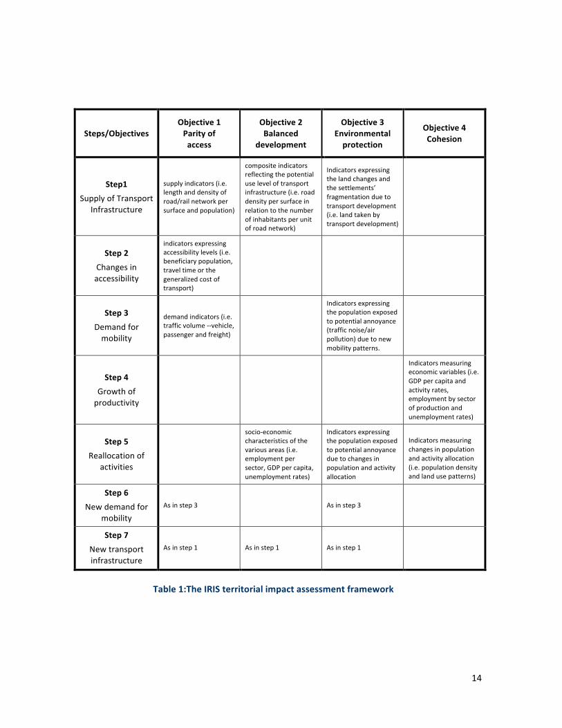
OnthebasisoftheaboveconsiderationstheconstructionoftheIRISterritorialimpactassessment
frameworkissummarizedinTable1.
14
Steps/ObjectivesObjective1Parityofaccess
Objective2Balanced
development
Objective3Environmentalprotection
Objective4Cohesion
Step1SupplyofTransport
Infrastructure
supplyindicators(i.e.lengthanddensityofroad/railnetworkpersurfaceandpopulation)
compositeindicatorsreflectingthepotentialuseleveloftransportinfrastructure(i.e.roaddensitypersurfaceinrelationtothenumberofinhabitantsperunitofroadnetwork)
Indicatorsexpressingthelandchangesandthesettlements’fragmentationduetotransportdevelopment(i.e.landtakenbytransportdevelopment)
Step2Changesinaccessibility
indicatorsexpressingaccessibilitylevels(i.e.beneficiarypopulation,traveltimeorthegeneralizedcostoftransport)
Step3Demandformobility
demandindicators(i.e.trafficvolume--vehicle,passengerandfreight)
Indicatorsexpressingthepopulationexposedtopotentialannoyance(trafficnoise/airpollution)duetonewmobilitypatterns.
Step4Growthofproductivity
Indicatorsmeasuringeconomicvariables(i.e.GDPpercapitaandactivityrates,employmentbysectorofproductionandunemploymentrates)
Step5Reallocationof
activities
socio-economiccharacteristicsofthevariousareas(i.e.employmentpersector,GDPpercapita,unemploymentrates)
Indicatorsexpressingthepopulationexposedtopotentialannoyanceduetochangesinpopulationandactivityallocation
Indicatorsmeasuringchangesinpopulationandactivityallocation(i.e.populationdensityandlandusepatterns)
Step6Newdemandfor
mobilityAsinstep3 Asinstep3
Step7Newtransportinfrastructure
Asinstep1 Asinstep1 Asinstep1
Table1:TheIRISterritorialimpactassessmentframework

15
Conclusion:planningfortheunknowable
Spatial planning is an improbable adventure into the future and its ambition to plan for the
unknowable is the source of its burden (Kafkalas 2016). Many planning models tend to use
conceptualabstractionsinordertopredictand/orshapethefutureonthebasisofidealizedspatial
representations.Incontrast,atthecoreoftheproposedIRISapproach,istheneedtodesigntools
and methods for the continuous monitoring of territorial impacts in order to allow maximum
flexibilityintheshapingofspatialdevelopmentplansandpolicies(KafkalasandPitsiava,2010).This
approachviewsspatialplanningaspartofthebroaderprocessesthatreshapespatialpatterns.In
thissense,spatialplanningentersalearningprocesstogetherwithamultitudeofsocialactorsthat
strivetoachievedesiredfutureoutcomes.
Initswiderdefinition,territorialimpactassessmentfocusesontheimpactofaproposedpolicyon
allaspectsofspatialdevelopment:economic,social,environmentalandcultural.Fromthepointof
view of spatial development, territorial impact assessment iswidely recognised as a key policy
concernandanappraisal tool necessary to assess goodplanningpractice (OECD,2002, ESPON,
2012).Inthiscontext,theIRISassessmentframeworkshouldbeconsideredasatoolforassessing
thepotentialimpactofstrategies,plans,policiesandprojects.Themorespecificvalueaddedofthe
IRIS approach lies in its comprehensive and integrative character that links the steps of the
theoretical model with the pursued policy objectives using clusters of indicators as mediating
device.Theapplicationoftheapproachinvolvesbothquantitativeandqualitativeelements.The
quantitativeelementsincludethecalculationofterritorialimpactindicatorswhilethequalitative
onesincorporatetheassumptionsconcerningthecorrespondencebetweenclustersofindicators,
policyobjectivesandstepsofthetheoreticalmodel.
The aim of the IRIS approach is tomaintain a high degree of theoretical coherence, empirical
relevanceandpracticaleffectiveness,whicharenecessaryfortheassessmentand(re)formulation
of policies involving the operation and planning of transport infrastructure. Depending on the
selection of indicators, the IRIS approach allows to take into account changes of the structural
characteristicsofthevariousareas(i.e.population,labourmarket,economy,landuses,etc.)over
different timeperiods.Thismeans thatdependingon the specificnatureand the technicaland
methodologicalrequirements,theapplicationofindicatorsprovidestheevidencebaseinorderto

16
assesstheeffectivenessofstrategicspatialdevelopmentandtransport infrastructurepoliciesas
wellastoguidetheirpossiblereformulation.Inthismanner,theIRISapproachprovidesamethod
to combine the instrumental and theenlightenmentpathsof theplanningprocess through the
tracing of the multiple correspondence between the clusters of indicators, the steps of the
theoreticalmodelandthepursuedpolicyobjectives.
References
ANDRIKOPOULOUE.,KAFKALASG.,(2000),SpatialImpactofEuropeanPolicies,Ziti,Thessaloniki(in
Greek)http://gkafkala.webpages.auth.gr/site/wp-content/uploads/2014/01/Spatial-Impact-of-
European-Policies_SDRU-2006.pdf
ANDRIKOPOULOUE.,KAFKALASG.,(2004),GreekregionalpolicyandtheprocessofEuropeanization:
1961-2000,in:DIMITRAKOPOULOSD.,PASSASA.,(editors),GreeceintheEuropeanUnion,
Routledge,London,p.35-47.
BATTYM.,(2011),Buildingascienceofcities.J.Cities(2011),doi:10.1016/j.cities.2011.11.008,
http://www.complexcity.info/files/2011/12/BATTY-CITIES-2011.pdf(visitedon30/05/17).
BRUINSMA,F,RIENSTRA,S.andRIETVELD,P.(1997)Economicimpactsoftheconstructionofa
transportcorridor:Amulti-levelandmulti-approachcasestudyfortheconstructionoftheA1
highwayintheNetherlands,RegionalStudies,Vol.31.4,pp.391-402.
BUUNK,W.,HETSEN,H.andJANSEN,A.J.(1999)Fromsectoraltoregionalpolicies:afirststep
towardsspatialplanningintheEuropeanUnion?EuropeanPlanningStudies,7,1,pp.81-98
CEC(COMMISSIONOFTHEEUROPEANCOMMUNITIES),(1999),EuropeanSpatialDevelopment
Perspective:TowardsBalancedandSustainableDevelopmentoftheTerritoryoftheEU,
Luxemburg,
http://ec.europa.eu/regional_policy/sources/docoffic/official/reports/pdf/sum_en.pdf(visitedon
30/05/17).

17
CEC(COMMISSIONOFTHEEUROPEANCOMMUNITIES),(2001),WhitePaperofEuropeanTransportPolicy
for2010:atimetodecide,COM(2001)370final,Brussels,
https://ec.europa.eu/transport/sites/transport/files/themes/strategies/doc/2001_white_paper/l
b_com_2001_0370_en.pdf(visitedon30/05/17).
CEC(COMMISSIONOFTHEEUROPEANCOMMUNITIES),(2002),FirstprogressreportonEconomicand
SocialCohesion,COM(2002)46final
http://ec.europa.eu/regional_policy/sources/docoffic/official/reports/pdf/interim1/com_2002_0
46_en_acte.pdf(visitedon30/05/17).
CEC(COMMISSIONOFTHEEUROPEANCOMMUNITIES),(2007),TerritorialAgendaoftheEuropeanUnion
TowardsaMoreCompetitiveandSustainableEuropeofDiverseRegions,Agreedontheoccasion
oftheInformalMinisterialMeetingonUrbanDevelopmentandTerritorialCohesioninLeipzigon
24/25May2007http://ec.europa.eu/regional_policy/sources/policy/what/territorial-
cohesion/territorial_agenda_leipzig2007.pdf
CEC(COMMISSIONOFTHEEUROPEANCOMMUNITIES),(2008),GreenPaperonTerritorialCohesion:
Turningterritorialdiversityintostrength,COM(2008)616final,Brussels,
http://ec.europa.eu/regional_policy/archive/consultation/terco/paper_terco_en.pdf(visitedon
30/05/17).
CHADWICKG.,(1971),ASystemsViewofPlanning-TowardsaTheoryoftheUrbanandRegional
PlanningProcess,PergamonPress
DAVOUDIS.,(2012),TheLegacyofPositivismandtheEmergenceofInterpretiveTraditioninSpatial
Planning,RegionalStudies,Vol.46.4,pp.429–441.
DeCeusterG.,(2005),ASSESS:AssessmentofthecontributionoftheTENandothertransport
policymeasurestothemidtermimplementationoftheWhitePaperontheEuropeanTransport
Policyfor2010,FinalReport,DGTREN,EuropeanCommission,Transport&MobilityLeuven,
https://ec.europa.eu/transport/sites/transport/files/facts-
fundings/evaluations/doc/2005_ten_t_assess.pdf(visitedon30/05/17).

18
EC(EUROPEANCOMMISSION),(2010),EUROPE2020:Astrategyforsmart,sustainableandinclusive
growth,COM(2010)2020final,http://eur-lex.europa.eu/legal-
content/EN/TXT/PDF/?uri=CELEX:52010DC2020&from=EN(visitedon30/05/17).
EC(EUROPEANCOMMISSION),(2011),WhitePaperRoadmaptoaSingleEuropeanTransportArea-
Towardsacompetitiveandresource-efficienttransportsystem,COM/2011/0144final,http://eur-
lex.europa.eu/legal-content/EN/TXT/PDF/?uri=CELEX:52011DC0144&from=EN(visitedon
30/05/17).
EC(EUROPEANCOMMISSION),(2011),TerritorialAgendaoftheEuropeanUnion2020:Towardsan
Inclusive,SmartandSustainableEuropeofDiverseRegions,agreedattheInformalMinisterial
MeetingofMinistersresponsibleforSpatialPlanningandTerritorialDevelopmenton19thMay
2011Gödöllő,Hungary,http://ec.europa.eu/regional_policy/sources/policy/what/territorial-
cohesion/territorial_agenda_2020.pdf(visitedon30/05/17).
EGNATIAODOSOBSERVATORY(2005)CurrentConditionsintheRegionsofthepathofEgnatiaOdos:
Cohesion,Mobility,Balance,Environment,1stImpactReportoftheMotorway,EgnatiaOdosA.E.,
Thessalonikihttp://observatory.egnatia.gr/reports/1st_impact_report_EN.pdf(visitedon
30/05/17).
EEA(EUROPEANENVIRONMENTALAGENCY),(2001),TERM2001:IndicatorsTrackingTransportand
EnvironmentIntegrationintheEuropeanUnion(TERM),Copenhagen,
https://www.eea.europa.eu/publications/term2001-sum(visitedon30/05/17).
ESPON(EUROPEANSPATIALPLANNINGOBSERVATIONNETWORK),(2005),ESPON2.1.1TerritorialImpact
ofEUTransportandTENPolicies
http://www.espon.eu/export/sites/default/Documents/Projects/ESPON2006Projects/PolicyImpac
tProjects/TransportPolicyImpact/fr-2.1.1_revised.pdf
ESPON(EUROPEANSPATIALPLANNINGOBSERVATIONNETWORK),(2009),TIPTAP:TerritorialImpact
PackageforTransportandAgriculturalPoliciesAppliedResearchProject,2013/1/6FinalReport–
PartAandB
http://www.espon.eu/export/sites/default/Documents/Projects/AppliedResearch/TIPTAP/Final_R
19
eport_Part_A-B.pdf,FinalReport–PartC
http://www.espon.eu/export/sites/default/Documents/Projects/AppliedResearch/TIPTAP/Final_R
eport_Part_C.pdf
ESPON(EUROPEANSPATIALPLANNINGOBSERVATIONNETWORK),(2012),TerritorialImpactAssessmentof
PoliciesandEUDirectives:Apracticalguidanceforpolicymakersandpractitionersbasedon
contributionsfromESPONprojectsandtheEuropeanCommission,TheESPON2013Programme
https://www.espon.eu/export/sites/default/Documents/Publications/Guidance/TerritorialImpact
Assessment/TIA_Printed_version.pdf
ESPON(EUROPEANSPATIALPLANNINGOBSERVATIONNETWORK),(2015),TRACCTransportAccessibilityat
Regional/LocalScaleandPatternsinEuropeAppliedResearch2013/1/10FinalReport|Version
06/02/2015Volume1TRACCExecutiveSummaryandMainReport
http://www.espon.eu/export/sites/default/Documents/Projects/AppliedResearch/TRACC/FR/TRA
CC_FR_Volume1_ExS-MainReport.pdf(visitedon30/05/17).
FOURKASV.,(2006),EgnatiaMotorwayObservatory:Monitoringofspatialimpactsoftransport
infrastructure,in:3rdInternationalConferenceonTransportResearchinGreece:Thecontribution
ofresearchindevelopingefficientandapplicablesolutionstotransportationproblems,
H.I.T./CE.R.T.H.,Thessaloniki,Greece,19-20May2006
http://observatory.egnatia.gr/presentations/3rd_SES_conf/vfourkas_3rd-conf-
SES_fullpaper_EN.pdf(visitedon30/05/17).
FUJITAM.,KRUGMANP.,VENABLESA.J.,(2001),TheSpatialEconomy:Cities,Regionsand
InternationalTrade,MITPress,Cambridge,Massachusetts&London,p.367.
GEDDESP.,(1915),CitiesinEvolution:Anintroductiontothetownplanningmovementandthe
studyofcivics,William&Norgate,London,p.409.
GEURS,K.T.,VANWEEB.,(2004),Land-use/transportinteractionmodelsastoolsforsustainability
impactassessmentoftransportinvestments:reviewandresearchperspectives,EuropeanJournal
ofTransportandInfrastructureResearch,4,no.3,pp.333-355.

20
GIULIANOG.,(2004).Landuseimpactsoftransportationinvestments:highwayandtransitin:
HansonS.,GiulianoG.,(editors),TheGeographyofUrbanTransportation,GuilfordPress,New
York,p.237-273.
HALLP.,(1982),GreatPlanningDisasters,UniversityofCaliforniaPress,p.308.
KAFKALASG.,PITSIAVAM.,(2010),Thespatialimpactsoftransportinfrastructure:apolicyrelevance
approachwithspecialfocusontheenvironment,in:RegionsandtheEnvironmentConference
ProceedingsoftheRegionalStudiesAssociationWinterConference,November2010,p.105-107.
KAFKALASG.,(2016),HowSpatialPlanningWorksanimprobableadventurebetweenpastand
future,in:IntroductoryspeechattheAESOPHoSMeeting:BacktoAgora:EuropeanValuesand
PlanningEducation,Thessaloniki10-12March2016http://gkafkala.webpages.auth.gr/site/wp-
content/uploads/2017/02/aesop-hos-gk-introductory-speech-1.pdf(visitedon30/05/17).
KRUGMANP.,(1991),GeographyandTrade,MITPress,Cambridge,MassachusettsandLondon,
p.142.
KRUGMANP.,(1999),Theroleofgeographyindevelopment,InternationalRegionalScienceReview
22-2,p.142-161.
MARTINP.J.,ROGERSC.A.,(1995),IndustrialLocationandPublicInfrastructure,Journalof
InternationalEconomics39,p.335-351.http://econ.sciences-
po.fr/sites/default/files/martinp/jie95.pdf(visitedon30/05/17).
MASSEYD.,(1979),Inwhatsensearegionalproblem?RegionalStudies,v.13,p.233-243.
MCLOUGHLINB.,(1969),UrbanandRegionalPlanning:ASystemsApproach,Faber&Faber,London,
p.336.
MCQUAIDR.W.,LEITHAMS.,NELSONJ.D.,(1996),Accessibilityandlocationdecisionsinaperipheral
regionofEurope:alogitanalysis,RegionalStudies,Vol.30,No6,p.579-588.
NATIONALECONOMICRESEARCHASSOCIATES,(1999),AFrameworkforAssessingStudiesoftheImpact
ofTransportInfrastructureProjectsonEconomicActivity,ReporttotheStandingAdvisory

21
CommitteeonTrunkRoadAssessment,DepartmentoftheEnvironment,Transportandthe
Regions,GreatBritain,London,p.33.
OECD(ORGANIZATIONFORECONOMICCOOPERATIONANDDEVELOPMENT),(2002),ImpactofTransport
InfrastructureInvestmentonRegionalDevelopment,Paris,p.153, https://www.itf-oecd.org/sites/default/files/docs/02rtrinveste.pdf(visitedon30/05/17).
PITSIAVAM.,(2007),TransportinfrastructureprioritiesandterritorialcohesionprospectsinSE
Europe,in:GETIMISP.,KAFKALASG.,(editors),OvercomingFragmentationinSoutheastEurope,
Ashgate,Aldershot,p.267-292.
RITTELH.,WEBBERM.,(1973),DilemmasinaGeneralTheoryofPlanning,PolicySciences4,155-169
VICKERMAN,R.,SPIEKERMANN,K.andWEGENER,M.(1999),Accessibilityandeconomicdevelopment
inEurope,RegionalStudies,Vol.33,No1,p.1-15.