planning justification report - barrie hall/planning-and-development/proposed... · planning...
TRANSCRIPT

PLANNING JUSTIFICATION REPORT 2596843 ONTARIO INC.
APPLICATIONS FOR OFFICIAL PLAN AMENDMENT
ZONING BY-LAW AMENDMENT SITE PLAN CONTROL APPROVAL
224 Ardagh Road Part of Block 264 on Registered Plan 51M-371
Parts 1, 2, & 3 of 51R-33187; and Part 4 on 51R-24641 City of Barrie
August 2019
PREPARED BY:
KLM PLANNING PARTNERS INC.
FILE No: P-2922

KLM PLANNING PARTNERS INC. August 2019
______________________________________________________________________________________ PLANNING JUSTIFICATION REPORT 2596843 ONTARIO INC. CITY OF BARRIE
TABLE OF CONTENTS 1.0 INTRODUCTION ..................................................................................................... 3
2.0 SUBJECT LANDS AND SURROUNDING AREA ........................................................... 3
2.2 SURROUNDING AREA ............................................................................................................ 4
3.0 PLANNING APPLICATIONS ..................................................................................... 6
Official Plan Amendment ............................................................................................................ 6
Zoning By-law Amendment ......................................................................................................... 6
Site Plan Control Approval .......................................................................................................... 6
4.0 PROPOSAL ............................................................................................................. 7
5.0 PLANNING POLICY ANALYSIS ............................................................................... 11
5.1 THE PLANNING ACT ............................................................................................................. 11
5.2 PROVINCIAL POLICY STATEMENT (2014) ............................................................................ 12
5.3 GROWTH PLAN FOR THE GREATER GOLDEN HORSESHOE (2019) ...................................... 14
5.4 CITY OF BARRIE OFFICIAL PLAN (January 2018 Consolidation) ........................................... 19
5.5 BARRIE ZONING BY-LAW 2009-141 ..................................................................................... 33
8.0 SUPPORTING REPORTS ........................................................................................ 38
Functional Servicing Report [Schaeffer & Associates Ltd., June 2019] ..................................... 38
Transportation Impact Study [Paradigm, May 2019] ............................................................... 38
Hydrogeological Study [Soil Engineers Ltd., May 2019] ........................................................... 39
Geotechnical Investigation [Soil Engineers Ltd., April 2018, revised June 2019] ..................... 40
Environmental Noise Impact Study [dBA Acoustical Consultants Inc., April 2018] .................. 41
Phase 1 Environmental Site Assessment [Soil Engineers Ltd., April 2, 2018] ........................... 42
9.0 CONCLUSION ....................................................................................................... 43

KLM PLANNING PARTNERS INC. August 2019
______________________________________________________________________________________ PLANNING JUSTIFICATION REPORT 2596843 ONTARIO INC. CITY OF BARRIE
LIST OF FIGURES FIGURE 1 – CONTEXT MAP FIGURE 2 – PROPOSED SITE PLAN FIGURE 3 – PROPOSED ELEVATIONS FIGURE 4 – GROWTH PLAN, SCHEDULE 8 – SIMCOE SUB-AREA FIGURE 5 – BARRIE OFFICIAL PLAN, SCHEDULE I – INTENSIFICATION AREA FIGURE 6 – BARRIE OFFICIAL PLAN, SCHEDULE G -DRINKING WATER SYSTEM VULNERABLE AREAS FIGURE 7 – BARRIE OFFICIAL PLAN, SCHEDULE A – LAND USE FIGURE 8 – CITY OF BARRIE ZONING BY-LAW 2009-141 FIGURE 9 – PROPOSED ZONING BY-LAW SCHEDULE

KLM PLANNING PARTNERS INC. August 2019
______________________________________________________________________________________ PLANNING JUSTIFICATION REPORT 2596843 ONTARIO INC. CITY OF BARRIE
1.0 INTRODUCTION KLM Planning Partners Inc. has been retained by 2596843 Ontario Inc. (the “Owner”), with respect to their proposed applications for Official Plan Amendment, Zoning By-law Amendment, and Site Plan Approval to facilitate the proposed mixed-use development on the lands legally described as Part of Block 264 on Registered Plan 51M-371, and municipally known as 224 Ardagh Road. The lands are located at the northwest corner of Ardagh Road and Ferndale Drive South in the City of Barrie (the “subject lands”), having a total area of approximately 1.08 hectares (2.66 acres), which is comprised of a parcel owned by the applicant of approximately 0.86 hectares (2.12 acres) and include a parcel of land that was deemed surplus by the City of Barrie on May 6, 2019 (part of the Fire Station 4 lands) of approximately 0.22 hectares (0.54 acres). The surplus lands are presently owned by the City of Barrie, and are subject to an agreement of purchase and sale with the applicant, which is conditional on approval of the proposed development. The lands are intended to be developed to accommodate a six (6) storey mixed use building at the southeasterly corner of the site, providing 292 square metres of commercial space at grade, fifty (50) residential apartments above, 212 square metres of rooftop amenity space, and a single level of below grade parking; while the balance of the site is envisioned to accommodate thirty-one (31) three (3) storey residential townhouses with access from a private common element condominium lane and served by 760 square metres of central shared private outdoor amenity space at grade. The purpose of this report is to provide planning analysis and justification in support of the proposed Official Plan Amendment, Zoning By-law Amendment, and Site Plan Approval applications which are required to facilitate the proposal. 2.0 SUBJECT LANDS AND SURROUNDING AREA 2.1 SUBJECT LANDS The subject lands are presently vacant with a total of 1.08 hectares (2.66 acres) in area, flanking Ardagh Road (+/- 95.4m) and fronting Ferndale Drive South (+/- 64.8m). As noted, the subject lands are a combination of two parcels – the first is approximately 0.86 hectares (2.12 acres) and is located at the northwest corner of the intersection of Ardagh and Ferndale; while the second parcel adjacent to the west is approximately 0.22 ha (0.54 acres). There is an existing brick gateway feature on the subject lands abutting the immediate corner of Ardagh Rd. and Ferndale Dr. S., which is proposed to be removed as part of the proposed site works. Refer to Figure 1- Context Plan for details.
1

KLM PLANNING PARTNERS INC. August 2019
______________________________________________________________________________________ PLANNING JUSTIFICATION REPORT 2596843 ONTARIO INC. CITY OF BARRIE
2.2 SURROUNDING AREA North: To the north are low density residential neighbourhoods comprised of single detached,
semi-detached, and street townhouse dwellings. These lands are designated Residential within the City of Barrie Official Plan.
East: To the east is Ferndale Drive South, with an existing commercial plaza and low-density
residential uses beyond. The commercial lands are designated General Commercial, and the residential lands are designated Residential within the City of Barrie Official Plan.
South: To the south is Ardagh Road, with existing low density residential neighbourhoods and
natural areas beyond. These lands are designated Residential, Future Urban, and Environmental Protection within the City of Barrie Official Plan. There is also a recently approved development immediately south of the subject lands, which is proposed to be developed with 268 residential apartment units and 36 stacked townhouse units (The Hedbern Development Corporation). This proposal is currently going through the site plan approval process.
West: To the west is a fire station (City of Barrie Fire Station 4), with natural areas and low
density residential neighbourhoods beyond. The lands are designated Institutional, Environmental Protection Area, and Residential respectively.
2

KLM PLANNING PARTNERS INC. August 2019
______________________________________________________________________________________ PLANNING JUSTIFICATION REPORT 2596843 ONTARIO INC. CITY OF BARRIE
FIGURE 1 – CONTEXT MAP
Subject Lands Former Fire Station 4 Lands
3

KLM PLANNING PARTNERS INC. August 2019
____________________________________________________________________________________________________________ PLANNING JUSTIFICATION REPORT 2596843 ONTARIO INC. CITY OF BARRIE
3.0 PLANNING APPLICATIONS The following planning applications are being submitted to facilitate the proposed development: Official Plan Amendment An Official Plan Amendment is required to facilitate the proposed development, to designate the former fire station lands from “Institutional” to “General Commercial” and to permit high density residential uses as well as allow residential uses to exist in stand-alone single use structures (townhouse blocks). These permissions are proposed as site-specific exceptions to the General Commercial designation of the City of Barrie Official Plan which will continue to apply. Zoning By-law Amendment A Zoning By-law Amendment is required to introduce site-specific development standards for the lands, as an exception to the applicable General Commercial (C4) zone category of the City of Barrie Zoning By-law 2009-141. The amendment will facilitate the proposed mixed-use building and townhouses by implementing the proposed Official Plan policies and land use designations to be amended. The exceptions for the lands consider treatment of the subject lands as a single parcel to establish setbacks to adjacent parcels, to permit high density residential uses, to allow residential uses to exist in stand-alone single use structures (townhouse blocks), and to establish an appropriate commercial to residential GFA ratio. Site Plan Control Approval An application for Site Plan Control Approval is required to facilitate the proposed development, detailing matters of functional/aesthetic design and relationship to the context, while ensuring adequate servicing, lighting, access, parking, and landscaping are provided.
4
KLM PLANNING PARTNERS INC. August 2019
____________________________________________________________________________________________________________ PLANNING JUSTIFICATION REPORT 2596843 ONTARIO INC. CITY OF BARRIE
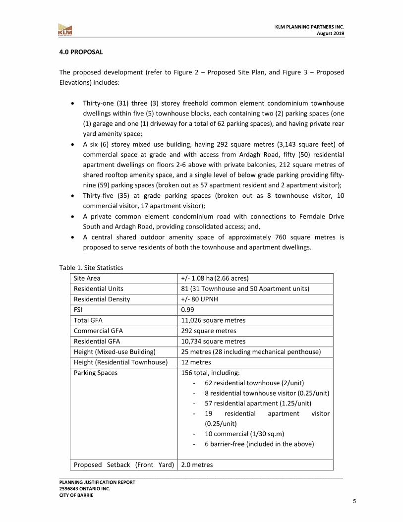
4.0 PROPOSAL The proposed development (refer to Figure 2 – Proposed Site Plan, and Figure 3 – Proposed Elevations) includes:
• Thirty-one (31) three (3) storey freehold common element condominium townhouse dwellings within five (5) townhouse blocks, each containing two (2) parking spaces (one (1) garage and one (1) driveway for a total of 62 parking spaces), and having private rear yard amenity space;
• A six (6) storey mixed use building, having 292 square metres (3,143 square feet) of commercial space at grade and with access from Ardagh Road, fifty (50) residential apartment dwellings on floors 2-6 above with private balconies, 212 square metres of shared rooftop amenity space, and a single level of below grade parking providing fifty-nine (59) parking spaces (broken out as 57 apartment resident and 2 apartment visitor);
• Thirty-five (35) at grade parking spaces (broken out as 8 townhouse visitor, 10 commercial visitor, 17 apartment visitor);
• A private common element condominium road with connections to Ferndale Drive South and Ardagh Road, providing consolidated access; and,
• A central shared outdoor amenity space of approximately 760 square metres is proposed to serve residents of both the townhouse and apartment dwellings.
Table 1. Site Statistics Site Area +/- 1.08 ha (2.66 acres) Residential Units 81 (31 Townhouse and 50 Apartment units) Residential Density +/- 80 UPNH FSI 0.99 Total GFA 11,026 square metres Commercial GFA 292 square metres Residential GFA 10,734 square metres Height (Mixed-use Building) 25 metres (28 including mechanical penthouse) Height (Residential Townhouse) 12 metres Parking Spaces 156 total, including:
- 62 residential townhouse (2/unit) - 8 residential townhouse visitor (0.25/unit) - 57 residential apartment (1.25/unit) - 19 residential apartment visitor
(0.25/unit) - 10 commercial (1/30 sq.m) - 6 barrier-free (included in the above)
Proposed Setback (Front Yard) 2.0 metres
5

KLM PLANNING PARTNERS INC. August 2019
____________________________________________________________________________________________________________ PLANNING JUSTIFICATION REPORT 2596843 ONTARIO INC. CITY OF BARRIE
from Ferndale Drive South (West property line) Proposed Setback (Rear Yard) to West Property Line
7.5 metres
Proposed Setback (Interior Side Yard) to North Property Line
10.0 metres
Proposed Setback (Exterior Side Yard) to Ardagh Road (South property line)
2.0 metres
Jobs 15 (comprised of: Work from home (156 persons * 0.055 job ratio = 8.58 jobs) + Commercial employees (1 employee per 48 square meters = 292/48 = 6.08 employees)
Residents 156 Overall residents projected to result from buildout of the proposed development has been calculated based on the City of Barrie Development Charge Background Study, dated June 6, 2014 which identifies the Persons Per Unit (PPU) for medium density residential typologies (townhouse) to be 2.34 occupants per unit, and for high density typologies (apartment) to be 1.67 occupants per unit. Furthermore, the study estimates that retail employees generated per area is calculated at 1 employee per 520 square feet (48 square metres) of GFA, which, when combined with work from home jobs-to-persons ratio accepted and utilized by the City of Barrie (0.055 jobs * projected residents), yields a job generation of 15 for this proposed development. On this basis, the proposed development will assist the City in achieving its growth target by introducing a projected combined total of 156 residents to the area, while generating 15 jobs (employees).
6

KLM PLANNING PARTNERS INC. August 2019
____________________________________________________________________________________________________________ PLANNING JUSTIFICATION REPORT 2596843 ONTARIO INC. CITY OF BARRIE
FIGURE 2 – PROPOSED SITE PLAN
7

KLM PLANNING PARTNERS INC. August 2019
____________________________________________________________________________________________________________ PLANNING JUSTIFICATION REPORT 2596843 ONTARIO INC. CITY OF BARRIE
FIGURE 3 – PROPOSED ELEVATIONS
8

KLM PLANNING PARTNERS INC. August 2019
____________________________________________________________________________________________________________ PLANNING JUSTIFICATION REPORT 2596843 ONTARIO INC. CITY OF BARRIE
5.0 PLANNING POLICY ANALYSIS 5.1 THE PLANNING ACT The purpose of the Planning Act is to promote economically, environmentally, and socially sustainable development through a land use planning system guided by provincial policy. The Act additionally aims to integrate matters of provincial interest in planning decisions and encourages cooperation and coordination of interests. The Act recognizes the decision-making authority and accountability of municipal councils, and endeavors to provide for fair, open, accessible, timely and efficient planning processes. Section 3(5) of the Act states: “A decision of the council of a municipality, a local board, a planning board, a minister of the Crown and a ministry, board, commission or agency of the government, including the Tribunal, in respect of the exercise of any authority that affects a planning matter,
a) shall be consistent with the policy statements issued under subsection (1) that are in effect on the date of the decision; and
b) shall conform with the provincial plans that are in effect on that date, or shall not conflict with them, as the case may be.”
The proposed development will be consistent with, and adhere to, the applicable Provincial and Municipal policies that are in effect on the date of the decision as outlined in this report. Analysis of the proposal’s consistency with the Provincial Policy Statement, and conformity with applicable in-effect Provincial Plans, are to follow. With the above information, the proposed development on the subject lands has regard for, and does not conflict with, applicable policies of the Planning Act.
9
KLM PLANNING PARTNERS INC. August 2019
____________________________________________________________________________________________________________ PLANNING JUSTIFICATION REPORT 2596843 ONTARIO INC. CITY OF BARRIE
5.2 PROVINCIAL POLICY STATEMENT (2014) The Provincial Policy Statement (the “PPS”) is a guiding document providing policy direction on matters of Provincial interest related to land use planning and development. The PPS seeks to set a policy foundation for regulations on land use and development while also supporting the Provincial goal to enhance the quality of life for Ontarians. The PPS includes policies that direct growth to existing urban areas which contributes to the creation of strong communities, healthy environments and long-term economic growth. The PPS calls for the building of strong communities as “Ontario’s long-term prosperity, environmental health and social well-being depend on wisely managing change and promoting efficient land use and development patterns”. Healthy, livable and safe communities should promote efficient development and land use patterns and accommodate an appropriate range and mix of residential, employment, institutional and recreational uses to meet long term needs. The proposed Official Plan Amendment, Zoning By-law Amendment, and Site Plan Control Approval applications are consistent with the policies of the PPS, including the following:
“Promoting efficient development and land use patterns which sustain the financial well-being of the Province and municipalities over the long term;” (Section 1.1.1.a) Providing for a focus of growth in Settlement Areas by promoting their vitality and regeneration” (Section 1.1.3.1)
The proposed applications seek to facilitate the development of a currently underutilized parcel of land in a settlement area within the City of Barrie, which is intended to support a range of uses and densities with an appropriate design. The development therefore addresses the PPS with respect to a focus of growth in Settlement Areas and as a result efficient use of land and infrastructure.
“Promoting cost-effective development patterns and standards to minimize land consumption and servicing costs;” (Section 1.1.1.e) “Ensuring that necessary infrastructure, electricity generation facilities and transmission and distribution systems, and public service facilities are or will be available to meet current and projected needs;” (Section 1.1.1.g) “Promoting opportunities for intensification and redevelopment, taking into account the availability of suitable existing and planned infrastructure and public service facilities” (Section 1.1.3.3)
The development proposal contemplates the efficient use of vacant lands and existing infrastructure. As part of this application, a Functional Servicing Report [Schaeffers Engineering,
10

KLM PLANNING PARTNERS INC. August 2019
____________________________________________________________________________________________________________ PLANNING JUSTIFICATION REPORT 2596843 ONTARIO INC. CITY OF BARRIE
May 2019] has been prepared to ensure efficient and adequate sewage, water, and stormwater services infrastructure exist to support this opportunity for intensification in a built-up area.
“Accommodating an appropriate range and mix of residential (including second units, affordable housing and housing for older persons), employment (including industrial and commercial), institutional (including places of worship, cemeteries and long-term care homes), recreation, park and open space, and other uses to meet long-term needs;” (Section 1.1.1.b) “To provide for an appropriate range and mix of housing types and densities required to meet projected requirements of current and future residents of the regional market area” (Section 1.4.1)
The proposed development would result in greater mix and range of housing options in the neighborhood and the City of Barrie by increasing the supply of residential apartment and townhouse units, while also providing commercial space which will create additional employment opportunities. The future residential dwellings will accommodate existing and future residents of varying age and family composition within the surrounding community. While the proposed density and stand-alone residential uses (townhouse blocks) are not permitted by the in force Official Plan or Zoning By-law, the proposed Official Plan and Zoning By-law Amendments will ensure the spirt and intent of the parent documents are preserved in a development including a mix of residential & commercial uses and a range of housing types in a context appropriate manner. Appropriate development standards will be established to ensure an efficient, functional, and aesthetically pleasing community design which is compatible with surrounding existing and future land uses, while respecting the overall development vision of the area.
“Avoiding development and land use patterns which may cause environmental or public health and safety concerns;” (Section 1.1.1.c) “The diversity and connectivity of natural features in an area, and the long-term ecological function and biodiversity of natural heritage systems, should be maintained, restored or, where possible, improved, recognizing linkages between and among natural heritage features and areas, surface water features and ground water features.” (2.1.2)
The subject lands are outside of Conservation Authority regulated areas, and sensitive environmental features have not been identified on the site. It is not anticipated that environmental or public health/safety concerns will arise as a result of the proposed development.
“Promoting densities for new housing that support the use of alternative transportation modes and public transit where it exists or is planned for” (Section 1.4.3d)
11

KLM PLANNING PARTNERS INC. August 2019
____________________________________________________________________________________________________________ PLANNING JUSTIFICATION REPORT 2596843 ONTARIO INC. CITY OF BARRIE
“Making efficient use of existing and planned transportation infrastructure” (Section 1.6.6.1a) “Promoting a land use pattern, density and mix of uses that minimizes the vehicular trips and support the development of viable choices and plans for public transit” (Section 1.6.7.4)”
The proposed development will contribute to public transit ridership in the area. The site is at the intersection of Ardagh Road and Ferndale Drive South with stops for Barrie Transit routes 2A, 2B, 7A, & 7B, connecting the site to the Allandale GO train station approximately 4 kilometres away. Located in close proximity to the subject lands are elementary schools (as near as +/-250 metres north on Ferndale Drive South), and parks (as near as +/-375 metres north on Ferndale Drive South) as well as existing local amenities in the vicinity, including: retail/restaurant/service commercial uses opposite the site east along Ardagh Road & Ferndale Drive South. In this regard the proposed development represents the appropriate use of the subject lands in achieving the vision of the Province and how new developments are to occur. Additionally, approval of the proposed development will aid the City of Barrie in meeting long-term growth targets while pursuing intended outcomes of the in-effect land use designations. Based on the foregoing, the proposed development on the subject lands is consistent with the applicable policies of the Provincial Policy Statement 2014. 5.3 GROWTH PLAN FOR THE GREATER GOLDEN HORSESHOE (2019) The Provincial Growth Plan for the Greater Golden Horseshow (the “Growth Plan”), took effect on May 16, 2019 and was prepared under the Places to Grow Act, 2005. It provides the framework to implement the Provincial vision for the establishment of strong, equitable, prosperous and complete communities poised to accommodate forecasted growth to the year 2041. The Greater Golden Horseshoe has been identified as one of North America’s fastest growing regions and it is important that growth be managed and directed in an appropriate manner. The Growth Plan seeks to guide decision-making on a number of matters including: transportation, infrastructure planning, land use-planning, urban form, housing, natural heritage and resource protection. Included in the Growth Plan are population and employment projections for the Golden Horseshoe area that are to be implemented by Regional and local municipalities. Section 3(5) of the Planning Act requires that any decision respecting a planning matter shall conform to the Provincial Plans that are in effect at the time.
12

KLM PLANNING PARTNERS INC. August 2019
____________________________________________________________________________________________________________ PLANNING JUSTIFICATION REPORT 2596843 ONTARIO INC. CITY OF BARRIE
Section 2.2.1 of the Growth Plan states that the majority of growth will be directed to settlement areas, such as those within the delineated built boundaries of the City of Barrie as follows: 2.2.1.2
“c) within settlement areas, growth will be focused in: i. delineated built-up areas; ii. strategic growth areas; iii. locations with existing or planned transit, with a priority on higher order transit where it exists or is planned; and iv. areas with existing or planned public service facilities;”
The subject lands are located within the City of Barrie’s delineated built up boundary as identified in its Official Plan. The proposed development will be situated on existing public transit routes, having access to infrastructure and community services in close proximity to the subject lands. Section 2.2.2 provides growth targets for delineated built up areas to be adopted by municipalities at the time of the next municipal comprehensive review:
“1.a) A minimum of 50 per cent of all residential development occurring annually within each of the Cities of Barrie, Brantford, Guelph, Hamilton, Orillia and Peterborough and the Regions of Durham, Halton, Niagara, Peel, Waterloo and York will be within the delineated built-up area; 2. Until the next municipal comprehensive review is approved and in effect, the annual minimum intensification target contained in the applicable upper- or single-tier official plan that is approved and in effect as of July 1, 2017 will continue to apply.
With respect to the achievement of the prescribed density targets, Section 5.2.4 of the Growth Plan states:
2. All upper- and single-tier municipalities will, through a municipal comprehensive review, apply the forecasts in Schedule 3 for planning and managing growth to the horizon of this Plan. 3. The population and employment forecasts and plan horizon contained in the applicable upper- or single-tier official plan that is approved and in effect as of July 1, 2017 will apply to all planning matters in that municipality, including lower-tier planning matters where applicable, until the upper- or single-tier municipality has applied the
13
KLM PLANNING PARTNERS INC. August 2019
____________________________________________________________________________________________________________ PLANNING JUSTIFICATION REPORT 2596843 ONTARIO INC. CITY OF BARRIE
forecasts in Schedule 3 in accordance with policy 5.2.4.2 and those forecasts are approved and in effect in the upper- or single-tier official plan.
The Simcoe Sub-area is specifically addressed in Section 6 of the Growth Plan, being the geographic area consisting of the County of Simcoe, the City of Barrie (described as the principle primary settlement area) and the City of Orillia. The subject lands are shown as within the Simcoe Sub-area on “Schedule 8 – Simcoe Sub-area” of the Growth Plan (See Figure 4). Applicable policies found in Section 6.3 of the Growth Plan state the following:
1. Primary settlement areas for the Simcoe Sub-area are identified in Schedule 8. 2. Municipalities with primary settlement areas will, in their official plans and other supporting documents:
a) identify primary settlement areas; b) identify and plan for strategic growth areas within primary settlement areas; c) plan to support the achievement of complete communities within primary settlement areas; and d) ensure the development of high-quality urban form and public open spaces within primary settlement areas through site design and urban design standards that create attractive and vibrant places that support walking and cycling for everyday activities and are transit supportive.
As the City of Barrie is a single tier municipality that is administratively separate from the County of Simcoe, density targets are included in the City of Barrie Official Plan (amended to January 2018). Section 3.1.2.3 of the City of Barrie Official Plan states that:
(b) By 2015, and for each year thereafter, at least 40 percent of residential dwelling unit development shall be directed to the area within the built-up area as identified on Schedule I - Intensification Areas of the Plan. (Mod D (k)) (d) The City’s Growth Management Strategy identifies that the built up area, as identified on Schedule I, can accommodate an additional 13,500 housing units, of which 39% are in the Urban Growth Centre and 61% are outside the Urban Growth Centre. An additional 5,700 units will be developed in the City’s designated Greenfield areas within the former City of Barrie, while approximately 15,700 units will be accommodated in the Salem and Hewitt’s Secondary Plan Areas. These units will accommodate the population forecast in the Growth Plan and will be subject to monitoring and review throughout the life of this Plan. (OPA 40 OMB PL 140770 PL 140771, PL140772 July 22, 2016)
14

KLM PLANNING PARTNERS INC. August 2019
____________________________________________________________________________________________________________ PLANNING JUSTIFICATION REPORT 2596843 ONTARIO INC. CITY OF BARRIE
In accordance with the above, the development would contribute to achievement of this target as follows:
• Total Developable Area: 1.08 ha • Potential No. of Dwelling Units: 81 units • 2014 Persons Per Unit – Medium Density (as per 2014 Projection): 2.571ppu • Total Number of Projected Persons: 156 • Number of Projected Jobs: Work from home (156 persons * 0.055 job ratio = 8.58 jobs)
+ Commercial employees (1 employee per 48 square meters = 292/48 = 6.08 employees): 14.66 jobs.
As noted, the proposed development would assist the City in meeting the intensification targets by contributing approximately 156 persons and 15 jobs for a total combination of 171 persons and jobs across the site, or 158.3 persons and jobs per hectare, based on the proposed built form. As the development proposes a combination of residential and non-residential uses, it is anticipated that the development will generate jobs related to the employment and work at home components, which is reflected in the above calculation. Based on the foregoing, it is our opinion that the proposed development conforms to the applicable policies of the Provincial Growth Plan.
15

KLM PLANNING PARTNERS INC. August 2019
____________________________________________________________________________________________________________ PLANNING JUSTIFICATION REPORT 2596843 ONTARIO INC. CITY OF BARRIE
FIGURE 4 – GROWTH PLAN SCHEDULE 8 – SIMCOE SUB-AREA
16

KLM PLANNING PARTNERS INC. August 2019
____________________________________________________________________________________________________________ PLANNING JUSTIFICATION REPORT 2596843 ONTARIO INC. CITY OF BARRIE
5.4 CITY OF BARRIE OFFICIAL PLAN (January 2018 Consolidation) The City of Barrie Official Plan (the “Official Plan”) was adopted by Council on June 22, 2009 and was approved the Ontario Ministry of Municipal Affairs and Housing on April 23, 2010. The City of Barrie Official Plan provides the policy direction for new development within the City and includes goals which will assist the City in achieving the density targets set out by the province. Section 3.1.1 provides broad goals of the Official Plan:
“3.1.1 GOALS (a) To accommodate projected needs for residential, employment, and other lands in order to achieve a complete community with an appropriate mix of jobs, local services, housing, open space, schools, and recreation opportunities. (b) To encourage and accommodate the continued expansion and diversification of the City's economic base with regard to the industrial, commercial, tourism, and institutional sectors in order to strengthen the City’s role as the area’s principal employment centre and to achieve an appropriate balance between employment and residential land uses. (e) To direct growth to take advantage of existing services and infrastructure where possible, and to minimize the cost of infrastructure extension.”
The proposed development will be serviced by existing hard infrastructure, and future residents and employees will benefit from available amenities and established public transit routes in the immediate vicinity. The proposal will also contribute to the range of available housing types, and to the overall housing stock, available to accommodate projected and targeted residential growth in the area. Furthermore, the development proposes to include a non-residential component assisting in the achievement of a diverse and expanded economic base. Section 3.1.2.2 (d) provides principles for the phasing and staging of development:
“3.1.2.2 (d) The approval of specific development applications shall be governed by the following principles: i) encouraging a mix and form of housing that supports affordable housing and specialty needs housing; (Mod D (g)) ii) giving priority to lands adjacent to existing development; iii) sequential development of neighbourhood facilities; iv) provision of community facilities and urban services with emphasis on using existing sewage and water services where possible; (Mod D (h)) v) provision of schools and parks; vi) provision of sidewalks and access to public transit. vii) sequential construction of collector roads and access to arterial and boundary roads;
17

KLM PLANNING PARTNERS INC. August 2019
____________________________________________________________________________________________________________ PLANNING JUSTIFICATION REPORT 2596843 ONTARIO INC. CITY OF BARRIE
viii) sequential construction of sanitary sewer and watermain extensions and electrical distribution systems; ix) adequacy of storm drainage; and, x) protection of the environment and significant natural resources.”
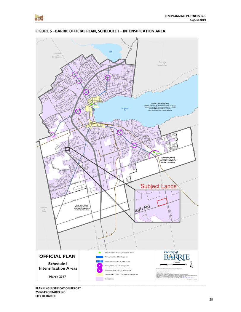
As noted, the proposed development will provide a mix and range of residential dwelling types and sizes to accommodate a range of individual and family needs. The lands are surrounded by an established community, and represent a remnant vacant parcel ready to be served by existing road, service, transit and community infrastructure. The subject lands are located within the “Built-up Boundary” on Schedule I – Intensification Areas (see Figure 5) of the City of Barrie Official Plan. The Built-up area will accommodate the majority of the growth throughout the City, providing a variety of housing options and employment opportunities to serve the projected growth of the City of Barrie. Section 3.3 of the Official Plan provides the goals and policy direction on housing within the City. “3.3.2 POLICIES
3.3.2.1 GENERAL POLICIES a) The City will encourage the maintenance of reasonable housing costs by
encouraging a varied selection with regard to size, density and tenure. The Zoning By-law will be amended to allow for innovative housing where it is recognized to be in accordance with good land use planning principles. (Mod D (p))
b) The City shall support programs and policies encouraging a wide range of housing opportunities including rental housing in order to meet identified housing needs in accordance with good land use planning principles.
c) The City shall encourage residential revitalization and intensification throughout the built-up area in order to support the viability of healthy neighbourhoods and to provide opportunities for a variety of housing types. Residential intensification includes secondary suites, conversion of existing housing into multiple unit forms, infill, redevelopment of clean and brownfield sites, and other innovative strategies. The review process for intensification applications will include consideration of the existing and planned character and lot fabric of the area as well as the intensification and density targets of this Plan. The City may specify standards in the implementing Zoning By-law for matters such as minimum densities, built form, height and setbacks to regulate the physical character of residential intensification and revitalization. Area specific Urban Design Guidelines will be developed to address built form including exterior design features. (Mod D (q))
d) The City will direct that new residential development be at densities that are consistent with this Plan and encourage the creation of complete, mixed use
18

KLM PLANNING PARTNERS INC. August 2019
____________________________________________________________________________________________________________ PLANNING JUSTIFICATION REPORT 2596843 ONTARIO INC. CITY OF BARRIE
communities that include the integration and use of transit and active transportation. (Mod D (s))
e) The City shall maintain a 10-year supply of designated land and a 3-year supply of draft approved and registered lots through residential intensification and redevelopment sufficient to provide an appropriate range of housing types and densities to meet projected requirements of current and future residents. (Mod D (t))”
The proposed development will assist the City of Barrie in achieving the housing direction of the Official Plan by providing revitalization and intensification on a underutilized vacant parcel of land and creating a complete mixed use community which will provide a range of housing options with regard to unit size, density and tenure in conjunction with retail and office commercial uses. A Zoning By-law Amendment has been submitted concurrently to facilitate the proposed development which will support a variety of housing typologies within the existing community and in the built-up area to assist the City of Barrie in achieving the housing goals set out by the Official Plan. The subject lands are also located in the Well Head Protection Area – D (25 year capture zone) on Schedule G – Drinking Water System Vulnerable Areas (see Figure 6) of the City of Barrie Official Plan. Section 3.5 of the Official Plan provides development policies related to lands containing natural heritage, natural hazards and resources which include groundwater protection.
“3.5.2.3.3 GROUNDWATER PROTECTION (a) Schedule G identifies areas where the variety of permitted land uses may be limited in
order to protect groundwater resources. (b) The City will work in partnership with the County of Simcoe, adjacent municipalities, the
Conservation Authorities, provincial ministries, the Health Unit and other partners to protect, maintain and enhance groundwater and surface waters to:
i) minimize and prevent the potential negative impacts of land use practices or development on groundwater; and (Mod D (hh))
ii) restrict or limit development and land use on lands containing wells and well head protection areas identified on Schedule G. (Mod D (ii))
(c) The City may require a risk assessment and/or hydrogeology analysis where there is potential for a proposed development to pose significant risk to a vulnerable aquifer located in one of the well head protection areas identified on Schedule G.
(d) The risk assessment which shall be completed to the satisfaction of the Ministry of the Environment and in consultation with the respective Conservation Authorities, where appropriate, and the City shall address the following:
i) existing groundwater quality and local hydrogeological setting; i) nature of any predicted adverse impacts;
19

KLM PLANNING PARTNERS INC. August 2019
____________________________________________________________________________________________________________ PLANNING JUSTIFICATION REPORT 2596843 ONTARIO INC. CITY OF BARRIE
ii) the ability to eliminate or effectively mitigate these impacts; and iv) the proposed mitigation measures.”
A Hydrogeological Assessment has been prepared by Soil Engineers Ltd. and is included as part of the submission. The report outlines the existing hydrogeological setting and demonstrates that the proposed development will not negatively impact the ground water or the well head protection area and provides recommendations on mitigation measures which in turn informs the Stormwater Management options for the proposed development. Furthermore, the eastern portion of the subject lands are designated “General Commercial”, with the remainder of the site designated “Institutional” on Schedule A – Land Use (see Figure 7). The entirety of the subject lands are proposed to be designated “General Commercial” as a part of the proposed Official Plan Amendment and will facilitate the conversion of the former fire station lands to permit the proposed development. Section 4.2.2.3 provides criteria for locating different types of development:
“4.2.2.3 LOCATIONAL CRITERIA (a) In areas where secondary plans have been prepared and adopted by the City, a determination has been made with regard to the appropriate location and concentrations of low, medium and high-density housing. In these areas, any additional medium or high-density residential proposals must proceed by way of amendment to this Plan. In areas where a secondary plan is not in effect, the locational criteria outlined in the remainder of this section shall apply. (b) Medium and high-density residential development shall be encouraged to locate in the Intensification Nodes and Corridors identified on Schedule I, and generally directed towards areas that are:
i) adjacent to arterial and collector roads; ii) in close proximity to public transit, and facilities such as schools, parks, accessible commercial development; and iii) where planned services and facilities such as roads, sewers and watermains, or other municipal services are adequate. (Mod E (n))
(e) Convenience Commercial uses may be permitted in suitable locations generally at the intersection of collector roads and local roads in a location central or easily accessible to the neighbourhood trade area.”
The lands are located in an area where a secondary plan is not in effect, and as such criteria of 4.2.2.3 apply. The development contemplates medium and high-density housing residential building forms on a vacant parcel of land at the intersection of two arterial roads (Ardagh Rd. and Ferndale Dr. S.), both of which are host to bus transit routes. The surrounding established community is well served by schools, parks, and commercial amenities as well as other social
20

KLM PLANNING PARTNERS INC. August 2019
____________________________________________________________________________________________________________ PLANNING JUSTIFICATION REPORT 2596843 ONTARIO INC. CITY OF BARRIE
infrastructure, and the development is proposed to be serviced efficiently by existing infrastructure. Finally, the non-residential component of the development is oriented towards the public arterial roads, and are poised to contribute to the commercial node that exists at the intersection of these roads. Section 4.2.2.6 of the Plan provides policies intended to guide residential intensification thoughout the City:
“(c) Intensification will contribute to development that is more compact and will efficiently use land and resources, optimize the use of existing and new infrastructure and services, support public transit and active transportation, contribute to improving air quality and promoting energy efficiency. (Mod E (t)) (d) Development applications that propose residential intensification outside of the Intensification Areas will be considered on their merits provided the proponent demonstrates the following to the satisfaction of the City:
i) that the scale and physical character of the proposed development is compatible with, and can be integrated into, the surrounding neighbourhood; ii) that infrastructure, transportation facilities, and community facilities and services are available without significantly impacting the operation and capacity of existing systems; iii) that public transit is available and accessible; iv) that the development will not detract from the City’s ability to achieve increased densities in areas where intensification is being focused; v) that sensitive, high quality urban design will be incorporated into the development including the efficiency and safety of that environment; and vi) that consideration is given to the preservation of heritage resources. Schedule I of this Plan identifies the intensification areas of focus.
Applications outside these areas will be considered on their merits subject to the planning principles and policies of this Plan. Applications that propose higher densities than existing conditions will not be treated favourably simply because they satisfy the definition of ‘intensification’ and contribute towards the City achieving its intensification and density targets”
The subject lands are located at the northwest corner of the intersection of two arterial roads, Ardagh Road and Ferndale Drive South, which contain hard infrastructure capable of servicing the proposed development, and host public transit (bus) routes with stops within walking distance of the proposed development. In its interface with the intersection, which has existing commercial plazas at the northeasterly and southeasterly corners, the proposed 6-storey mixed
21
KLM PLANNING PARTNERS INC. August 2019
____________________________________________________________________________________________________________ PLANNING JUSTIFICATION REPORT 2596843 ONTARIO INC. CITY OF BARRIE
use building with street related commercial will represent an appropriate relationship with the context and will contribute toward a highly attractive and walkable urbanized node. Where westerly and northerly interfaces with existing adjoining fire station and low-density residential uses are concerned, the 3-storey residential townhouses proposed internal to the site contribute to gradual decrease in massing and height from the more intense mixed-use building located at the corner, and additionally will buffer activities related to the commercial uses. Finally, the private road network including a pedestrian sidewalk will provide consolidated access to all proposed dwellings and non-residential uses, contributing to safe pedestrian and vehicular movement into and out of the site. The goals and policies for the overall “Commercial“ designations of the Official Plan relate to providing developments that service the greater community and are minimize the impacts to adjacent land uses. The goals of “Commercial” uses are as follows:
“4.3.1 GOALS (a) To maintain, enhance and support the City's role as the primary commercial/service
centre of the region. (b) To encourage the maintenance and expansion of commercial/service sector activity
through the adoption of land use designations and policies which will complement and enhance the efforts of the private sector in the provision of goods, services and employment opportunities.
(c) To promote a distribution of commercial facilities that provide a high level of convenience and accessibility for residents and limit the need for travelling extensive distances for minor purchases and local service facilities.
(d) To minimize the impacts of retail and other service development on adjacent land uses and on the traffic carrying capacity of area roads.”
The proposed development achieves the goals set out in the Official Plan for the “Commercial” designations in providing for a logical and efficient addition to the existing commercial uses at the intersection of Ardagh Road and Ferndale Drive South and providing a local mixed-use development including employment opportunities. The townhouse development internal to the site and located adjacent to the existing residential lands will provide for an appropriate transition in height and land use that will minimize impact on the existing neighbourhood to the north, and will assist the proposed development in cohesively integrating with the established residential community. The mixed-use development will also provide a high level of convenience and accessibility for future residents of both the development and for existing residents in the area.
“4.3.2.1 GENERAL POLICIES (a) There are five categories of commercial land uses established by this Plan as shown
on Schedule A – Land Use: (Mod E (aa))
22

KLM PLANNING PARTNERS INC. August 2019
____________________________________________________________________________________________________________ PLANNING JUSTIFICATION REPORT 2596843 ONTARIO INC. CITY OF BARRIE
1. City Centre; 2. Regional Centre; 3. Community Centre; 4. General Commercial; and 5. Convenience Commercial.
(b) The design, appearance and scale of new commercial development shall be in harmony with adjacent land uses and adequate screening, buffering and noise protection for adjoining residential uses shall be provided. Pedestrian accessibility, including barrier-free access, shall be considered in the design of new commercial development.
(c) Where new commercial development or redevelopment occurs, adequate off-street parking and off street loading facilities shall be provided except within the City Centre designation where the provision of these facilities shall be encouraged wherever feasible. In addition, commercial uses shall provide adequate parking which is accessible for persons with disabilities within close proximity to the access door. (Mod E (bb))
(d) The impact of commercial development on the safe and efficient movement of traffic, both vehicular and pedestrian, shall be minimized by encouraging shared access points including the use of cross access easements, for and between commercial developments as well as the provision of barrier-free pedestrian linkages between residential and commercial areas.
(e) The City may require the proponents of any application for commercial development not provided for in this Plan and the Zoning By-law to submit detailed impact studies. Impact studies may, among other matters, include an analysis of the impact of new development on existing shopping areas, the downtown core, traffic and public transportation. In reviewing an application, Council shall place greater emphasis on the merits of the application based on sound land use planning principles including location criteria, compatibility with surrounding uses and compatibility with the goals and policies of this Plan.
(f) Retail warehouse uses shall only be permitted on commercially designated lands. In recognition of their regional trade area, these uses will be encouraged to locate along County roads and major arterial roads.
(g) Regional scale shopping may occur in different forms including a Regional Centre and freestanding developments.
(h) The zoning of individual sites may not allow for a full range of commercial uses or the full extent of development intensity at every location based on site specific factors that may include traffic, land use compatibility, environmental and other factors.
(i) Approval of development within commercial areas will be subject to the availability of required urban services including municipal sewer and water, sidewalks, access to
23

KLM PLANNING PARTNERS INC. August 2019
____________________________________________________________________________________________________________ PLANNING JUSTIFICATION REPORT 2596843 ONTARIO INC. CITY OF BARRIE
public transit, adequate vehicular access, accessible and off-street parking and loading facilities.
The proposed development will provide enhanced landscape features and architectural elements which will provide an appropriate transition to adjacent residential lands. Parking and loading areas for the proposed development will be accommodated through the proposed private lane way internal to the site with accessible parking spaces provided in close proximity to main building entrances. Additionally, the applications contemplate a development serviced by an extension of municipal water, sanitary sewer and storm sewer infrastructure. Traffic, noise and vibration considerations have been assessed through the Traffic Impact Study and Noise & Vibration Study submitted as part of this application to ensure the site can be accessed safely and efficiently by motorists, cyclists, and pedestrians alike; and so that appropriate steps are taken in relation to protecting existing residential neighbourhoods from any noise or vibration resultant of the proposed mixed use development. The “General Commercial” designation of the City of Barrie Official Plan provides further policy details as it relates to permitted uses and their appropriate locations.
“4.3.2.5 GENERAL COMMERCIAL (a) Lands designated General Commercial are intended to provide a range of retail and
service commercial uses and should be easily accessible to the traveling public and connected to points within the city and beyond through a variety of modes of transportation including public transit, and active transportation infrastructure. Such uses may require large sites and may have significant on-site storage and parking needs. (Mod E (ii))
(b) The following uses may be permitted within a General Commercial designation: large scale retail and service commercial uses such as retail warehouse stores, automotive commercial, furniture and home furnishing uses, garden centres, supermarkets and food stores as well as smaller scale retail, service commercial and personal service uses; financial institutions and services; business, professional and medical offices; restaurants, recreation, entertainment and other community facilities such as libraries and day care centres, and medium density residential uses. (Mod E (jj))
(c) Development in a General Commercial designation shall be in separate buildings and/or a grouping of separate buildings.
(d) Residential uses shall be located within or above commercial or office uses at grade. (Mod E (kk))
(e) The planned size and function of General Commercial areas is designed to serve one or more residential planning areas.
24

KLM PLANNING PARTNERS INC. August 2019
____________________________________________________________________________________________________________ PLANNING JUSTIFICATION REPORT 2596843 ONTARIO INC. CITY OF BARRIE
(f) General Commercial areas will be permitted in suitable locations primarily at the intersection of arterial and collector roads and will be encouraged to establish in nodal fashion”
The surplus fire station component of the subject lands is presently designated “Institutional” within the City of Barrie Official Plan, which does not permit the residential and non-residential uses proposed. As such, the draft Official Plan Amendment seeks to redesignate these lands as “General Commercial” with site specific policies to match that permissions contemplated for the balance of the lands. The development proposes to include non-residential uses permitted under the “General Commercial” designation of the Official Plan which are compatible with and complementary to the existing commercial uses at the intersection of Ardagh Road and Ferndale Drive South. The 6-storey mixed use building will make efficient use of existing hard and social infrastructure present in the vicinity, offering a direct relationship between non-residential uses and the street, and further contributing to a high-quality urban environment with the inclusion of underground parking. The proposed 3-storey residential townhouse dwellings internal to the site will provide an appropriate transition in height, density, and use to the adjacent existing residential dwellings to the north and the fire station to the west, mitigating any potential impact of non-residential uses within and more intense massing of the 6-storey building Medium density residential uses permitted in the “General Commercial” designation of the Official Plan include townhouse and apartment dwelling unit typologies as proposed, however only to a maximum of 53 units per net hectare. As the proposal includes residential uses at an overall density of 81 units per net hectare, a policy has been proposed as part of the draft official plan amendment to permit high density residential uses, or those exceeding 54 units per net hectare, on the site. Given the transitional nature of the subject lands from the commercial intersection to the existing residential neighbourhood north, the proposed amendment will include provisions to permit the 6-storey mixed-use building and 3-storey stand-alone residential townhouse dwellings in addition to the non-residential uses permitted in the “General Commercial” designation. As noted, the proposal will establish an urban presence at the corner of Ardagh and Ferndale Drive South with the grade related and street accessed commercial within the base of the mixed use building, while the townhouse buildings will provide appropriate transition in height, density, and use to surrounding land uses, creating a nodal development at a prominent intersection while buffering the established residential community north. Section 6.6 of the Official Plan speaks to the appropriate design and integration of tall buildings for infill projects such as this:
25

KLM PLANNING PARTNERS INC. August 2019
____________________________________________________________________________________________________________ PLANNING JUSTIFICATION REPORT 2596843 ONTARIO INC. CITY OF BARRIE
6.6.1 CRITERIA The policies contained within Section 6.6 will be applicable to any building proposed to be greater than three (3) storeys in height. 6.6.2 LOCATION Policies found within Section 6.6 are applicable across the entire City, but it is anticipated that the majority of this type of development will occur within the Urban Growth Centre and in the Intensification Nodes & Corridors as identified on Schedule I. As such, a number of the following policies have greater applicability in the Urban Growth Centre or Intensification Areas than in other parts of the City. However, all policies will be considered when reviewing applications to increase height or site plan applications proposing buildings in excess of three (3) storeys. 6.6.3 GENERAL POLICIES (a) Innovative architectural design will be encouraged to reduce the visual and physical impact of height on the adjacent pedestrian realm, including design features such as tower and podium configurations or other design measures. (b) Tower design featuring floor plate sizes that result in slimmer buildings, along with other innovative design solutions which assist in reducing the visual and physical impact of tall buildings, will be preferred over slab style building design where important views need to be protected. (c) Where tall buildings are proposed adjacent to existing tall buildings, or where multiple tall buildings are proposed on the same property, sufficient separation distance (as detailed in Zoning By-law) will be provided between towers in order to maintain privacy, access to light, and views of the sky. Proposals for tall building developments are expected to include a rationale on the appropriate separation distance between adjacent towers. (d) Where possible, parking areas, site servicing, loading areas, and building utilities should be located towards the rear of buildings with appropriate screening. The use of underground parking is strongly encouraged in place of above-ground structured or surface parking. Where aboveground structured parking is proposed, at least 60 percent of the property frontage, and flankage in the case of corner lots, will consist of residential or commercial uses. (e) Tall buildings directly contribute to the look and feel of the City’s architectural styles. Accordingly, tall buildings will be held to a high standard of design excellence by using quality urban design, architectural treatments, and building materials in order to promote a visually interesting skyline. 6.6.4 POLICIES (a) BUILDING SHADOWING i) Tall buildings will be designed to best mitigate the impact of shadows on public parks and open spaces, private amenity areas, and surrounding streets, throughout the day. Development applications located adjacent to the open space waterfront areas
26

KLM PLANNING PARTNERS INC. August 2019
____________________________________________________________________________________________________________ PLANNING JUSTIFICATION REPORT 2596843 ONTARIO INC. CITY OF BARRIE
surrounding Kempenfelt Bay shall be designed to minimize the impacts of shadowing particularly between March 21 and September 21. ii) Buildings will make use of setbacks, stepping provisions, and other such design measures in order to reduce shadow impacts. Towers will be positioned on sites to reduce the extension of shadows onto surrounding areas. Appropriate spacing will be provided to allow for adequate sunlight and views of the sky between adjacent building towers.
The proposed development contemplates a 6-storey mixed-use building form with massing stepbacks above the first and second floors (northwesterly facades internal to the site), while providing articulation and window/door fenestration intended to mitigate impacts of building height, and to contribute to an attractive public & private pedestrian realm. The use of high- quality cladding and variation in building materials will further contribute to both the public realm at the Ardagh and Ferndale ROW interfaces, and internal to the site. Parking and loading areas are located internal to the site, with a limited amount of surface parking situated along the private road and the balance contained within the mixed-use building mass and underground parking areas. Loading and service areas have also been located to the rear of and within the ground level of the mixed-use building, providing for an uncompromised aesthetic for residents of the townhouse dwellings. Where shadowing is concerned a shadow study has been submitted with the applications to demonstrate the limited impact of the development on the site and the context. The proposed development and associated Official Plan Amendment will assist the City of Barrie in providing a complete mixed-use community with a range of housing options, and represents an appropriate level of intensification on a underutilized parcel of land. Given the foregoing, it is our opinion that the proposed amendments and development conform to and does not conflict with the general intent of the City of Barrie Official Plan.
27
KLM PLANNING PARTNERS INC. August 2019
____________________________________________________________________________________________________________ PLANNING JUSTIFICATION REPORT 2596843 ONTARIO INC. CITY OF BARRIE
FIGURE 5 –BARRIE OFFICIAL PLAN, SCHEDULE I – INTENSIFICATION AREA
28

KLM PLANNING PARTNERS INC. August 2019
____________________________________________________________________________________________________________ PLANNING JUSTIFICATION REPORT 2596843 ONTARIO INC. CITY OF BARRIE
FIGURE 6 – BARRIE OFFICIAL PLAN, SCHEDULE G – DRINKING WATER SYSTEM VULNERABLE AREAS
29

KLM PLANNING PARTNERS INC. August 2019
____________________________________________________________________________________________________________ PLANNING JUSTIFICATION REPORT 2596843 ONTARIO INC. CITY OF BARRIE
FIGURE 7 – BARRIE OFFICIAL PLAN, SCHEDULE A – LAND USE
30

KLM PLANNING PARTNERS INC. August 2019
____________________________________________________________________________________________________________ PLANNING JUSTIFICATION REPORT 2596843 ONTARIO INC. CITY OF BARRIE
5.5 BARRIE ZONING BY-LAW 2009-141 The subject lands are currently zoned “General Commercial Special Provisions (C4)(SP-341)(H-79)” Zone & “Major Institutional (I-M)” Zone by the City of Barrie Zoning By-law 2009-141 (see Figure 8). The proposed amendment will rezone the entirety of the site “General Commercial Special Provisions (C4)(SP-341)” to permit the residential and commercial uses proposed and to remove the Holding (H-79) Symbol on the subject lands. The proposed application to amend the Zoning By-law would implement the proposed Official Plan land use designation via site specific provisions facilitating the buildout of a mixed-use development on an underutilized parcel of land. The lands are proposed to be rezoned “General Commercial Special Provisions (C4)(SP-341)”, with the following exceptions to the parent category as follows:
• Notwithstanding the definition of Lot in Section 3, or any other provisions of By-law #2009-141 as amended, and notwithstanding the obtaining of any future land division under the provisions of the Planning Act, R.S.O. 1990, C.P.13 as amended from time to time, or the registration at any time of any Condominium Declaration, a Plan of Subdivision, or conveyance with respect to any portion of said land, the land zoned C4 (SP-341) by this By-law shall be considered to be one lot for the purposes of zoning;
• Permitted non-residential uses shall include: o Bake Shop; o Bank o Fitness or Health Club; o Fitness or Health Club, Local; o Florist; o Laundry or Dry Cleaning Depot; o Local Convenience Retail; o Office o Office, Medical; o Personal Service Store; o Photography Studio; o Restaurant; o Retail Store; o Service Store; o Art Gallery; o Commercial School; o Community Centre; o Day Nursery; o Place of Worship; o Religious institution;
31

KLM PLANNING PARTNERS INC. August 2019
____________________________________________________________________________________________________________ PLANNING JUSTIFICATION REPORT 2596843 ONTARIO INC. CITY OF BARRIE
• Additional permitted uses shall include Residential Block/Cluster/Street/Stacked Townhouse dwellings as a separate use or as part of a mixed-use building;
• Home occupations shall be permitted in accordance with 5.2.10; • Maximum permitted residential density shall be 90 units per net hectare; • For the purposes of this By-law, the front lot line shall be the property line adjacent to
Ferndale Drive South; • Section 6.3.4.3 shall not apply; • Section 13.2.63 b) shall be deleted; • Section 13.2.63 c) shall be deleted; • For apartment dwelling units, parking shall be provided at a rate of 1.5 spaces per
dwelling unit (1.25 for dwelling unit and 0.25 for visitors) • For Residential Block/Cluster/Street/Stacked Townhouse dwellings, parking shall be
provided at 1.75 spaces per dwelling unit (1.5 for dwelling unit and 0.25 for visitor). Tandem parking will be permitted.
• For non-residential uses, parking shall be provided at a rate of 1 parking space per 30 sq.m. of gross floor area;
• The minimum front yard (east) shall be 2 metres; • The minimum exterior side yard (south) shall be 2 metres; • The minimum interior side yard (north) shall be 10.0 metres; • The minimum rear yard (west) shall be 7.5 metres; • Accessory buildings shall be permitted in either the interior side yard and rear yard, to
be erected no closer than 0.6 metres from the interior side or rear yard property line, and with a maximum height of 4 metres,;
• Porches, decks, patios, and verandahs shall be permitted to encroach into any required yard to a maximum distance of 2 metres from any property line;
• The maximum building height for a mixed use building shall be 28.0 metres, including mechanical penthouses;
• The maximum building height for a townhouse dwelling shall be 12.0 metres • A minimum of 290 m² of non-residential uses shall be required on the ground floor of a
mixed-use building; and • A minimum of 730 m shared outdoor amenity area shall be provided.
The proposed development will provide a parking supply which conforms to the parking rate outlined in the City of Barrie Zoning By-law 2009-141. However, the proposed amendment will delineate the parking rate for both residential and visitor parking spaces to ensure that an adequate supply of residential and visitor spaces are provided. The proposed amendment will also include provisions for increasing permitted building heights and reducing yard setbacks to accommodate a mixed-use building at the corner of a prominent intersection which creates a nodal development. The proposed reduction in the front yard setback and side yard setback adjoining a street will allow for commercial uses on the ground floor of the mixed use building to address the public street and create a pedestrian friendly environment. The provision for
32

KLM PLANNING PARTNERS INC. August 2019
____________________________________________________________________________________________________________ PLANNING JUSTIFICATION REPORT 2596843 ONTARIO INC. CITY OF BARRIE
increased building heights will facilitate the 6-storey apartment building providing an appropriate level of intensification for the mixed-use development with townhouse dwellings internal to the site providing a transition in the height to existing residential uses. Based on the foregoing, it is our opinion that the proposed amendment to the Zoning By-law is appropriate in implementing the designations of the Official Plan and maintains the general intent of the parent zone category and By-law 2009-141.
33

KLM PLANNING PARTNERS INC. August 2019
____________________________________________________________________________________________________________ PLANNING JUSTIFICATION REPORT 2596843 ONTARIO INC. CITY OF BARRIE
FIGURE 8 – CITY OF BARRIE ZONING BY-LAW 2009-141
Subject Lands
34

KLM PLANNING PARTNERS INC. August 2019
____________________________________________________________________________________________________________ PLANNING JUSTIFICATION REPORT 2596843 ONTARIO INC. CITY OF BARRIE
FIGURE 9 – PROPOSED ZONING BY-LAW SCHEDULE
35

KLM PLANNING PARTNERS INC. August 2019
____________________________________________________________________________________________________________ PLANNING JUSTIFICATION REPORT 2596843 ONTARIO INC. CITY OF BARRIE
8.0 SUPPORTING REPORTS Functional Servicing Report [Schaeffer & Associates Ltd., June 2019] The Functional Servicing Report presents the municipal servicing scheme for the proposed mixed-use development at the northwest corner of the intersection between Ardagh Road and Ferndale Drive South in the City of Barrie. The site is proposed to fully capture up to the 100-year storm event and convey the controlled stormwater flow to the existing 600mm and 300mm storm sewers on Ardagh Road and Ferndale Drive South respectively. Quantity control is proposed to be provided via orifice tubes and superpipe storage, quality control will be achieved for TSS and phosphorous loading as per the described treatment trains (infiltration trenches and Jellyfish unit), and the water balance and erosion criteria will be met via the use of infiltration trenches in the rear yards. Sanitary servicing is proposed to be provided by the existing 250mm diameter sanitary sewer on Ferndale Drive South. The expected total peak sanitary flow for proposed development is 2.12L/s, a net increase of the flow in the existing system of ~1 % of the capacity of the receiving network, this load increase in considered negligible. The site is located in Pressure Zone 3N. There is an existing 300mm diameter watermain on Ardagh Road and a 400mm diameter watermain on Ferndale Drive South. The site is proposed to connect to both of these watermains in a 200mm diameter watermain loop. The proposed residential development has a maximum day plus fire demand of 168.05 L/s. No water supply constraints are expected due to the findings of the Water Storage and Distribution Master Plan, however during the detailed design phase, a hydrant test shall be conducted to confirm these findings. Transportation Impact Study [Paradigm, May 2019] Based on the investigations carried out, it is concluded that under existing traffic conditions, all study area intersections currently operate at acceptable levels of service and within capacity during the weekday AM and PM peak hours. No critical movements have been identified. For the 2020 and 2025 future conditions, all intersections and movements within the study area are forecast to operate at acceptable levels of service and within capacity during the weekday AM and PM peak hours. The proposed development can be accommodated by the existing transportation road network. Left turn lanes were determined to be not warranted on Ardagh Road at Street A or on Ferndale Drive at Street B. Minimum stopping and decision sight distance criteria are found to meet or
36

KLM PLANNING PARTNERS INC. August 2019
____________________________________________________________________________________________________________ PLANNING JUSTIFICATION REPORT 2596843 ONTARIO INC. CITY OF BARRIE
exceed thresholds in both directions along Ardagh Road and Ferndale Street at Street A and Street B, respectively. Passenger cars and snowplows would be able to traverse and circulate on- site and access the loading area without any issues. A heavy single unit (HSU) truck (similar to a garbage truck) would be able to navigate and circulate the site without conflict. The City of Barrie Zoning By-law 2009-141 (the Zoning By-law) requires the provision of 132 parking spaces for the proposed development - 47 for the townhouse units (1.5 spaces per unit), 75 for the condo units (1.5 spaces per unit) and 10 for the commercial floor space (1 space per 30 m2 GFA). Five (5) spaces are required to be barrier free. The parking supply of 156 spaces (62 for the townhouse units, 8 for townhouse visitors, 76 for the condo units and 10 for the commercial floor space) satisfies the Zoning By-law requirements, with a surplus of 24 spaces. Six (6) barrier free parking spaces are included in the proposed parking supply meeting the requirements outlined in the Zoning By-law. Based on the findings of this study, it is recommended the City of Barrie recognize the conclusions drawn above and that the development be approved as proposed with no conditions related to off-site transportation improvements. Hydrogeological Study [Soil Engineers Ltd., May 2019] Based on the findings of the Hydrogeological Study, the following summary of conclusions and recommendations are provided:
1. A review of the topography mapping for the area shows that the subject site is relatively flat having a gentle decline in elevation relief towards its northern limits.
2. The study has disclosed that beneath a layer of topsoil or asphalt pavement, a layer of earth fill was contacted in places beneath the site which is underlain by deposits of sand and silt with occasional layers of silty clay extending to the maximum investigated depth of 10.8 m.
3. The findings of this current study confirm that the groundwater levels range from El. 255.75 to greater than 255.7 masl (i.e. 4.15 to > 6.10 below ground surface). Review of the average of shallow groundwater elevations suggests that it flows in northwest and south-easterly directions, towards a tributary of Lake Simcoe to the east and towards Bear Creek to the west.
4. The groundwater levels beneath the site are approximately 0.98 to 4.10 m below the proposed townhouse blocks building, basement structures for Blocks A to E, and it is approximately 0.45 m below the 1-level underground parking structure for Block F, and it is 0.25 m above the proposed elevator pit structure for Block F. The groundwater levels at the site are approximately 1.37 to 5.43 m below the lowest invert levels for the proposed underground services.
37

KLM PLANNING PARTNERS INC. August 2019
____________________________________________________________________________________________________________ PLANNING JUSTIFICATION REPORT 2596843 ONTARIO INC. CITY OF BARRIE
5. The dewatering flow estimates for construction of the proposed Block C, F and the elevator pit structure beneath Block F suggests that the dewatering flow rates range from between 4,707 and 87, 116 L/day; by applying a safety factor of three (3), it could reach maximums of between 14, 122 L/day and 261,348 L/day. The construction dewatering flow rates for the excavations are below the 50,000 L/day threshold limit for requiring an approval for any proposed construction related groundwater takings, which will not require any registration or filing with the MECP. The construction dewatering rates which are below the PTTW threshold limit of 400,000 L/day but are above 50,000 L/day water taking approval requirement threshold, the recommended approval for groundwater taking would be required to be registered through an Environmental Activity and Sector Registry (EASR) with the EASR filing through the MECP.
6. The groundwater elevation is approximately 1.37 to 5.43 m below the estimated minimum invert elevation of the proposed underground services and it is not anticipated that construction dewatering will be required for the installation of the underground services beneath the site.
7. The estimated zone of influence for construction dewatering could reach a maximum of 15.0 m away from the conceptual dewatering alignments. There are neighbouring residential properties that are within the conceptual zone of influence for construction dewatering; however, there are no groundwater receptors, such as water wells, bodies of water, watercourses or wetlands that are present within the conceptual zone of influence for construction dewatering for the proposed development. The local shallow groundwater flow pattern may be temporarily affected during construction.
8. The Long-term foundation drainage rates from both an under-slab floor drainage network and from a mira drainage network for a conventionally shored excavation foundation and for the proposed elevator pit structure for the apartment building is approximately 80.0 L/day. By applying a safety factor of three (3), the foundation drainage seepage flow rates could reach a maximum of 240 L/day.
9. The groundwater levels lie at depths, ranging from between 3.55 m to greater than 6.10 m beneath the existing ground surface. The existing shallow sand could facilitate the infiltration of precipitation to the sub-surface beneath the site to replenish the shallow aquifer at depth, within LID infrastructure, where possible, to address future stormwater management planning for the proposed development.
Geotechnical Investigation [Soil Engineers Ltd., April 2018, revised June 2019] Based on the findings of the Geotechnical investigation, the following summary of conclusions and recommendations are provided:
1. Topsoil must be completely removed for the development. 2. Excavation for the townhouse foundation will extend to a depth below 1.5 to 2.0 m; the
subsoil is anticipated to consist of native sand or silt with localized earth fill. The earth
38

KLM PLANNING PARTNERS INC. August 2019
____________________________________________________________________________________________________________ PLANNING JUSTIFICATION REPORT 2596843 ONTARIO INC. CITY OF BARRIE
fill should be removed and the construction of conventional footings should extend onto the native subsoil. Alternatively, the earth fill can be upgraded into an engineered fill for footing construction after it is sub excavated, segregated free of topsoil or deleterious material and recompacted to the specified density in layers.
3. Excavation for the mid-rise building will extend to a depth below 3.5 m from grade and the subsoil is anticipated to consist of native sand or silt, capable of supporting the 6-storey building on conventional footings or raft foundation.
4. The construction of a conventional underground parking structure will consist of subsurface drainage collecting the groundwater and dissipate into the municipal sewer system. If the municipality does not accept the discharge of groundwater into the sewer system, the underground parking should be designed with a storage cistern to collect and store up the subsurface water for irrigation or surface cleaning during the dry season. Alternatively, a submerged “tank” structure with a raft foundation to resist the hydrostatic pressure can be designed for the underground parking if on site storage cistern is not practical.
5. All excavation must be sloped back for safety. Temporary shoring will be required in excavation where a safe backing slope cannot be provided due to space limitation.
Environmental Noise Impact Study [dBA Acoustical Consultants Inc., April 2018] dBA Acoustical Consulting Inc. has been retained to provide a noise impact study on behalf of 2596843 Ontario Inc. for the proposed “224 Ardagh Road 6 Storey Residential/Commercial Condominium & 3 Storey Townhouse Development” located on Ardagh Road and Ferndale Drive South, Barrie ON. The purpose of the study determined the noise impact from Ardagh Road and Ferndale Drive South vehicular traffic that impact the proposed mixed-use buildings and towns, required for site plan approval for the City of Barrie. Proposed for the development is a 6 storey mixed use building and 5 townhouse blocks. The following noise control measures are required to satisfy the indoor and outdoor noise level criterion:
• A/C Units for all Residential Units as recommended in Table 7. • Provisions for A/C Units for all Residential Units as recommended in Table 7. • Window, Door, and Wall construction as recommended in Table 6. • Registered warning clause on title Table 7. • A 2.43m Noise Barrier for specific locations to be installed as MOE requirements noted
in Figure 4. • A 1.83m Noise Barrier for specific Amenity Space as noted in Figure 4.
39

KLM PLANNING PARTNERS INC. August 2019
____________________________________________________________________________________________________________ PLANNING JUSTIFICATION REPORT 2596843 ONTARIO INC. CITY OF BARRIE
• It is recommended that a qualified acoustical consultant certify that the required noise control measures have been incorporated into the builder’s plans prior to issuance of a building permit.
• It is recommended that a qualified acoustical consultant certify that the required control measures have been properly installed prior to an occupancy permit.
Phase 1 Environmental Site Assessment [Soil Engineers Ltd., April 2, 2018] Soil Engineers was retained by 2596843 Ontario Inc. to carry out a Phase One Environmental Site Assessment for the subject lands. Throughout the years, the subject site was a vacant land. Currently, a portion of the subject site is used as a parking lot. The neighbouring properties consist mainly of residential subdivision to the north, a fire station building to the west, a commercial plaza beyond the Ferndale Drive South to the east and residential properties beyond Ardagh Road to the south of the subject site. A gas station is located to the southeast of the subject site. Based on the information obtained through our record review, interviews and visual observations recorded during our site reconnaissance, the Phase One ESA has revealed the following item of environmental concerns attended to the subject site:
• A gas station is located to the southeast of the subject site. • A stockpile of unknown quality is present on the southern portion of the subject site. • Fill material of unknown quality is present in the eastern portion of the subject site.
A Phase Two Environmental Site Assessment is recommended to address the above environmental concerns. Additionally, due to the use of a portion of the subject site for commercial use (parking lot), an RSC is required to be filed for the subject site. Phase 2 Environmental Site Assessment [Soil Engineers Ltd., July 24, 2018] The purpose of the Phase Two ESA was to determine the soil and groundwater quality at the subject site, as related to the environmental concerns identified in our Phase One Environmental Site Assessment (Phase One ESA) for the subject site. The field work was performed at selected locations on the subject site. Soil and groundwater samples were collected and submitted for chemical analysis in accordance with the Ministry of the Environment and Climate Change (MOECC) Table 2, Full Depth Generic Site Condition Standards for residential/parkland/institutional property use and coarse textured soil (Table 2 Standards). as published in the "Soil, Ground Water and Sediment Standards for Use Under Part XV.I of the Environmental Protection Act" (EPA), dated April 15, 2011
40

KLM PLANNING PARTNERS INC. August 2019
____________________________________________________________________________________________________________ PLANNING JUSTIFICATION REPORT 2596843 ONTARIO INC. CITY OF BARRIE
A review of the analytical results of the soil and groundwater samples indicates the tested parameters at the test locations meet the Table 2 Standards. Consequently, there are no contaminants identified at the subject site at concentrations above the applicable site condition standards (Table 2 Standards) during the Phase Two ESA. Based on the findings of the Phase Two ESA, it is our opinion that the property is suitable for the proposed development. No further environmental investigation is recommended at this time. 9.0 CONCLUSION The development proposal is consistent with the objectives and intent of the Provincial Policy Statement 2014 and conform to and do not conflict with the Provincial Growth Plan 2019. Additionally, the proposed Official Plan Amendment and Zoning By-law Amendment are appropriate to facilitate implementation of the vision set out in the applicable policies of the City of Barrie Official Plan. Given the above analysis, it is our opinion that the proposal is an appropriate and compatible form of development in the context of the governing policy framework and therefore the proposal represents good land use planning. KLM Planning Partners Inc. Ryan Mino-Leahan BA, MCIP, RPP Marshall Smith, BES, PMP, MCIP, RPP Partner Intermediate Planner
41