planning proposal mt gilead urban release area
TRANSCRIPT

Version 6: Post Exhibition 17.9.2021 Page 1
Planning Proposal Mt Gilead Urban
Release Area
Proposed amendment of
Campbelltown Local Environmental Plan 2015

Proposed Amendment to Campbelltown Local Environmental Plan 2015
MT GILEAD PLANNING PROPOSAL
Page 2 Version 6: Post Exhibition 17.9.2021
Definitions and abbreviations
CLEP 2015 means Campbelltown Local Environmental Plan 2015
DCP means Development Control Plan
DPIE means Department of Planning, Industry and Environment
EP&A Act 1979 means Environmental Planning and Assessment Act 1979 GSC
means Greater Sydney Commission
LGA means local government area
LVPA means Local Voluntary Planning Agreement
M means metres
MGURA means Mt Gilead Urban Release Area
PP means Planning Proposal
PPR means Planning Proposal Request
SEPP means State Environmental Planning Policy
SIC means Special Infrastructure Contribution Introduction/Background
Gilead was rezoned for urban purposes in September 2017 after an extensive planning phase. The Precinct is to provide a maximum of 1,700 lots, ranging in size from 375m2 to 700m2, supported by a network of open space and stormwater management facilities, a community hub and the conservation of existing sensitive ecological communities on the site. The local infrastructure delivery mechanism for the Precinct is a Voluntary Planning Agreement which was executed, between Council and the land owners. Subsequently to the rezoning, Lendlease has taken a controlling interest in the land and have commenced the urban development of the release area.
The State Government also imposes a SIC in respect of ‘higher order’ infrastructure.
Since rezoning, the Proponent has commenced the process of seeking development consent to enable the commencement of works as per the applicable planning framework.
Protection measures in respect of the koala are subject to ongoing strategy discussions with the relevant State authorities, Council, the Proponent and the community.

Proposed Amendment to Campbelltown Local Environmental Plan 2015
MT GILEAD PLANNING PROPOSAL
Page 3 Version 6: Post Exhibition 17.9.2021
The Site
Mt Gilead forms part of the Greater Macarthur Growth Area which is located south of the Campbelltown City Centre. The land subject to the PP (the land) is located south of the existing urban areas of Campbelltown, on the western side of Appin Road, and adjoining the southern boundary of the Noorumba Reserve.
The land comprises 6 allotments and has an approximate area of 216 hectares. The land is generally clear of structures and has been subject to cattle grazing and as a result, is dominated by cleared open grasslands and sparsely scattered tree coverage. There are some remaining stands of significant vegetation which have been conserved under a Biodiversity Certification Agreement and BioBank Agreement separate to this PP.
The land does not contain any items of local or State heritage significance and is not located within a heritage conservation area. The land is in close proximity to the State Heritage Listed Upper Canal Water Supply System and the curtilage associated with the greater Mount Gilead Homestead Precinct, a State Heritage Item.
Several riparian corridors traverse the land and generally align with most of the on-site remnant vegetation and related bushfire hazards and readily capable of remediation where needed and not subject to geotechnical hazards or mine subsidence issues.
An aerial photograph extract of the planning proposal in its immediate context are illustrated in Figure 1 below.
Figure 1 Location Map
Gilead Homestead
Noorumba Reserve
Beulah Reserve
Sydney Upper
Water Canal
Georges River
Stage 1 Gilead

Proposed Amendment to Campbelltown Local Environmental Plan 2015
MT GILEAD PLANNING PROPOSAL
Page 4 Version 6: Post Exhibition 17.9.2021
Part 1 – Objectives or Intended Outcomes
The Planning Proposal intends to amend the Campbelltown Local Environmental Plan 2015 (CLEP 2015) by updating exiting urban release area provisions to support delivery of 1,700 dwellings at Mt Gilead.
The Planning Proposal aims to:
• Provide for an increase diversity in dwelling types in a contemporary green field
environment • Ensure appropriate supporting infrastructure is facilitated • Enhance the protection of sensitive ecological communities, including endangered
and critically endangered species • Provide a diverse open space network • Detail a statutory planning framework to assist in realising the Mt Gilead Urban Release
Area vision • Minimise local hazards
Part 2 - Explanation of provisions
The Planning Proposal seeks to amend the CLEP 2015 as follows:
• Amend the land use zones and principal development standards relating to minimum lot size, building height, floor space ratio, land acquisition and subdivision requirements for certain forms of development.
• Relocate and expand the neighbourhood centre to provide a retail gross floor area of
4,000m2
• Increase the level of protection for land conserved under the Biodiversity Certification
Agreement by zoning the land E2 Environmental Conservation
• Increase the provisions of open space and environmental land from 29.91 hectares to 52.91 hectares
The Planning Proposal is accompanied by proposed amendments to the prevailing Development Control Plan. This plan will be the subject of separate review and public consultation, and will include an updated master plan.

Proposed Amendment to Campbelltown Local Environmental Plan 2015
MT GILEAD PLANNING PROPOSAL
Page 5 Version 6: Post Exhibition 17.9.2021
Part 3 – Justification
Section A – Need for the Planning Proposal 1. Is the planning proposal a result of any strategic study or report?
The Mt Gilead Urban Release Area (MGURA) has been identified for urban development since the 1973.
Its role as an urban release area has been reinforced in subject district level planning including most recently the Western Parkland City District Plan.
The MGURA was the subject of a rezoning that occurred in 2017.
A comprehensive review of the pre-existing planning framework was recently undertaken in response to market developments and more detailed environment and infrastructure studies associated with the initial development planning for the MGURA. This review was assembled as a Planning Proposal Request (PPR) and is supported by technical studies and reports as detailed below:
Table 1: Back Ground Studies and Reports
Specialist Technical Studies Author Date
Gilead Landscape Masterplan
ASPECT Studios October, 2018
Detailed Site Investigation with Limited Sampling - Mt Gilead
Douglas Partners Pty Ltd October, 2016
Remediation Action Plan – Mt Gilead Douglas Partners Pty Ltd August, 2017
Report on Preliminary Site Investigation
Douglas Partners Pty Ltd December, 2016
Mount Gilead Project (MDP Lands) Aboriginal Cultural Heritage Assessment
Cultural Heritage Connections & Virtus Heritage Pty Ltd.
July, 2017
Heritage Assessment and Management Strategy
TKD Architects June, 2017
Remediation Action Plan – Mt Gilead Douglas Partners Pty Ltd August, 2017

Proposed Amendment to Campbelltown Local Environmental Plan 2015
MT GILEAD PLANNING PROPOSAL
Page 6 Version 6: Post Exhibition 17.9.2021
2. Is the planning proposal the best means of achieving the objectives or intended outcomes, or is there a better way?
A Planning Proposal is the only relevant means of achieving the intended outcomes.
Importantly, it proposes the amendment of the principal local planning instrument applying to the Campbelltown Local Government Area, namely CLEP 2015.
Section B – Relation to Strategic Planning Framework
3. Is the planning proposal consistent with the objectives and actions of the applicable
regional, sub-regional or district plan or strategy (including any exhibited draft plans or strategies)
Greater Sydney Region Plan
A Plan for Growing Sydney has been prepared by the NSW State Government to guide land use planning decisions for the next 20 years. The Plan sets a strategy for accommodating Sydney’s future population growth and identifies the need to deliver 817,000 new jobs and 725,000 new homes by 2036. The Plan identifies that the most suitable areas for new housing are in locations close to jobs, public transport, community facilities and services.
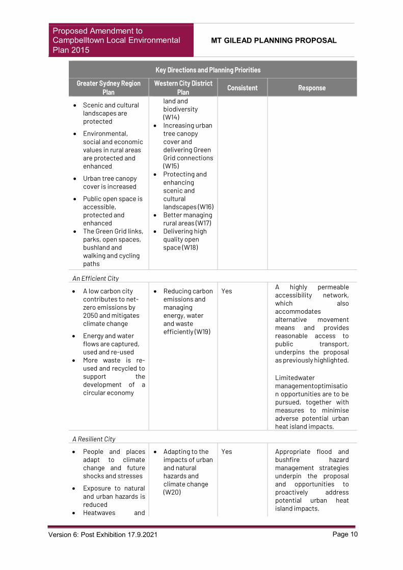
An assessment of the Planning Proposal against the relevant Directions and Objectives of GSRP is provided below in table 2. The proposal is generally consistent with the GSRP particularly as the proposal seeks to ensure that development outcomes meet contemporary expectations. Table 2: Response to Key Directions and Planning Priorities
Key Directions and Planning Priorities
Greater Sydney Region Plan
Western City District Plan Consistent Response
Infrastructure and Collaboration
Additional Studies – Post Gateway Author Date
Visual Analysis of Figtree Hill B4 and R3 TKD Architects December, 2020
Market Potential Assessment Location IQ November, 2020
Ecologist Biodiversity Certification Assessment
Ecological Australia December, 2020
Gilead Landscape Masterplan Report Aspect Studios May, 2021
Ecologist Biodiversity Certification Assessment (Addendum)
Ecological Australia June, 2021
Additional Studies – Post Exhibition Author Date
Ecologist Biodiversity Certification Assessment (Addendum)
Ecological Australia September, 2021
Heritage Impact Assessment TKD Architects September, 2021
Bushfire Assessment Report Building Code and Bushfire Hazard Solutions
September, 2021

Proposed Amendment to Campbelltown Local Environmental Plan 2015
MT GILEAD PLANNING PROPOSAL
Page 7 Version 6: Post Exhibition 17.9.2021
Key Directions and Planning Priorities
Greater Sydney Region Plan
Western City District Plan Consistent Response
A City Supported by Infrastructure
• Infrastructure supports the three cities
• Infrastructure aligns with forecast growth - growth infrastructure compact
• Infrastructure adapts to meet future needs
• Infrastructure use is optimised
• Planning for a city supported by infrastructure (W1)
Yes The requisite social and physical infrastructure needs required to support the proposal have been identified and an outline strategy for their delivery provided, including suggested framework for amending the prevailing Developer Contribution Plan (CP) and principles of a variation to the existing Voluntary Planning Agreement (VPA)
A Collaborative City
• Benefits of growth realised by collaboration of governments, community and business
• Working through collaboration (W2)
Yes Realisation of the revised vision will ultimately be dependent upon collaboration of various government instrumentalities, Council, the development sector and existing and envisaged community.
Liveability
A City of Great Places
• Services and infrastructure meet communities' changing needs
• Communities are healthy, resilient and socially connected
• Greater Sydney’s communities are culturally rich with diverse neighbourhoods
• Greater Sydney celebrates the arts and supports creative industries and innovation
• Providing services and social infrastructure to meet peoples changing needs (W3)
• Fostering healthy, creative, culturally rich and socially connected communities (W4)
Yes The revised vision and accompanying planning controls and proposed support infrastructure provide a template for people focused planning outcomes.
Community infrastructure, business and retail facilities, access to diverse open space and transport/access means will reflect in a health, resilient and socially connected community.
Housing in the City

Proposed Amendment to Campbelltown Local Environmental Plan 2015
MT GILEAD PLANNING PROPOSAL
Page 8 Version 6: Post Exhibition 17.9.2021
Key Directions and Planning Priorities
Greater Sydney Region Plan
Western City District Plan Consistent Response
• Greater housing supply
• Housing is more diverse and affordable
• Providing housing supply, choice and affordability, with access to jobs, services and public transport (W5)
Yes A central foundation of the proposal is increased housing supply, diversity and affordability.
The proposed introduction of the R3 medium density zone and lower minimum lot size provisions underpin the foregoing amended housing template.
A City of Great Places
• Great places that bring people together
• Environmental heritage is identified, conserved and enhanced.
• Creating and renewing great places and local centres, and respecting the District’s heritage (W6)
Yes Sensitivity to open space underpins the accompanying amended masterplan and proposed development controls.
Additionally, enhanced access to diverse open space resources, commercial and community facilities will be available, sensitive ecologically communities conserved and broad ranging infrastructure generally provided.
Productivity
A Well Connected City
• A metropolis of three cities -integrated land use and transport creates walkable and 30 minute cities
• The Eastern, GPOP and Western Economic corridors are better connected and more competitive and efficient
• Freight and logistics network is competitive and efficient
• Establishing the land use and transport structure to deliver a liveable, productive and sustainable Western Parkland City (W7)
Yes A hierarchical, fine grained accessibility strategy underpins the proposal. Direct access is proposed to higher order roads, existing roads are to be upgraded, and intersections enhanced and alternate movement means (pedestrian/cycle) integrated. Similar infrastructure extends upon such framework and provides a highly permeable structure, facilitating

Proposed Amendment to Campbelltown Local Environmental Plan 2015
MT GILEAD PLANNING PROPOSAL
Page 9 Version 6: Post Exhibition 17.9.2021
Key Directions and Planning Priorities
Greater Sydney Region Plan
Western City District Plan Consistent Response
• Regional connectivity is enhanced
appropriate public transport service levels.
Jobs and Skills for the City
• Harbour CBD is stronger and more competitive
• Greater Parramatta is stronger and better connected
• Western Sydney Airport and Badgerys Creek Aerotropolis are economic catalysts for Western Parkland City
• Internationally competitive health, education, research and innovation. precincts
• Investment and business activity in centres
• Industrial and urban services land is planned, protected and manager
• Economic sectors are targeted for success
• Leveraging industry opportunities from the Western Sydney Airport and Badgerys Creek Aerotropolis (W8)
• Growing and strengthening the metropolitan city cluster (W9)
• Maximising freight and logistics opportunities and planning and managing industrial and urban services land (W10)
• Growing investment, business opportunities and jobs in strategic centres (W11)
Yes The proposal is projected to support an increase of new jobs over the current projection - largely in the proposed centres and in the local construction and maintenance industries.
Sustainability
A City in its Landscape
• The coast and waterways are protected and healthier
• A cool and green parkland city in the South Creek corridor
• Biodiversity is protected, urban bushland and remnant vegetation is enhanced
• Protecting and improving the health and enjoyment of the District’s waterways (W12)
• Creating a Parkland City urban structure and identity with South Creek as a defining spatial element (W13)
• Protecting and enhancing bush
Yes The proposal seeks to conserve and embellish sensitive remnant ecological communities and riparian zones. Additionally, it provides a green grid dimension through structured and informal recreation areas and linkages, including Figtree Hill. A sustainable street tree planting regime is to be implemented.
Proposed Amendment to Campbelltown Local Environmental Plan 2015
MT GILEAD PLANNING PROPOSAL
Page 10 Version 6: Post Exhibition 17.9.2021
Key Directions and Planning Priorities
Greater Sydney Region Plan
Western City District Plan Consistent Response
• Scenic and cultural landscapes are protected
• Environmental, social and economic values in rural areas are protected and enhanced
• Urban tree canopy cover is increased
• Public open space is accessible, protected and enhanced
• The Green Grid links, parks, open spaces, bushland and walking and cycling paths
land and biodiversity (W14)
• Increasing urban tree canopy cover and delivering Green Grid connections (W15)
• Protecting and enhancing scenic and cultural landscapes (W16)
• Better managing rural areas (W17)
• Delivering high quality open space (W18)
An Efficient City
• A low carbon city contributes to net-zero emissions by 2050 and mitigates climate change
• Energy and water flows are captured, used and re-used
• More waste is re-used and recycled to support the development of a circular economy
• Reducing carbon emissions and managing energy, water and waste efficiently (W19)
Yes A highly permeable accessibility network, which also accommodates alternative movement means and provides reasonable access to public transport, underpins the proposal as previously highlighted.
Limitedwater managementoptimisation opportunities are to be pursued, together with measures to minimise adverse potential urban heat island impacts.
A Resilient City
• People and places adapt to climate change and future shocks and stresses
• Exposure to natural and urban hazards is reduced
• Heatwaves and
• Adapting to the impacts of urban and natural hazards and climate change (W20)
Yes Appropriate flood and bushfire hazard management strategies underpin the proposal and opportunities to proactively address potential urban heat island impacts.

Proposed Amendment to Campbelltown Local Environmental Plan 2015
MT GILEAD PLANNING PROPOSAL
Page 11 Version 6: Post Exhibition 17.9.2021
Key Directions and Planning Priorities
Greater Sydney Region Plan
Western City District Plan Consistent Response
extreme heat are managed

Proposed Amendment to Campbelltown Local Environmental Plan 2015
MT GILEAD PLANNING PROPOSAL
Page 12 Version 6: Post Exhibition 17.9.2021
Western City District Plan - Connecting Communities
The Western City District Plan (District Plan) sets out more detail with respect to the anticipated growth in housing and employment in the Western District and amongst other things, is intended to inform the assessment of planning proposals.
The District Plan identifies Gilead as a Land Release Area within the Greater Macarthur Growth Area. The majority of new communities in land release areas identified by the District Plan are located within precincts contained within State Environmental Planning Policy (Sydney Region Growth Centres) 2006.
Unlike the majority of land release areas, CLEP 2015 is the principal environmental planning instrument that applies to the land. Therefore, Gilead has not been subject to the various incremental State Government led amendments such as the 2016 Housing Diversity Package which resulted in development precincts such as Willowdale and New Breeze having a wider variety of lot sizes and dwelling types.
An assessment of the Planning Proposal against the relevant Directions and District Plan priorities is provided in Table 2. The proposal is generally consistent with the District Plan particularly as it seeks to ensure that development outcomes meet contemporary expectations.
Greater Macarthur Growth Area
The Greater Macarthur 2040: An Interim Plan for the Greater Macarthur Growth Area (Greater Macarthur 2040) provides the land use and infrastructure implementation plan for the Glenfield to Macarthur urban renewal precincts and the urban releases to the south of Campbelltown, including the Mt Gilead Urban Release Area.
Greater Macarthur 2040 identifies that Mt Gilead will be:
• rezoned and release land for urban development • deliver around 15,000 new homes in the broader Gilead precinct • provide higher density residential development around centres and along the
central transport corridor • conserve biodiversity corridors and waterways • create a central transport corridor providing public transport connections beyond
the site • create road upgrades and connections beyond the precinct
Greater Macarthur 2040 is supported by the Greater Macarthur and Wilton Retail Market Analysis (2016) which states that the Greater Macarthur Priority Growth Area has the potential for a network of centres including:
• sub-regional shopping centre at Wilton providing around 52,600m2 Gross Leasable Area (GLA) in total.
• second sub-regional shopping centre at West Appin providing around 32,600m2
GLA in total.

Proposed Amendment to Campbelltown Local Environmental Plan 2015
MT GILEAD PLANNING PROPOSAL
Page 13 Version 6: Post Exhibition 17.9.2021
• supermarket based shopping centre at Menangle Park providing around 15,000m2
GLA overall. • supermarket based town centre at Mount Gilead providing around 8,700m2 GLA.
The proposed Mt Gilead Town Centre has the capacity as a supermarket-based centre anchored by large format supermarkets (4,000m2) and supported by specialty retail floor space.
The Planning Proposal is generally consistent with Greater Macarthur 2040. The resizing and relocation of the current B1 Neighbourhood Centre zone to the B4 Mixed Use zone is consistent with the draft Preliminary Structure Plan and Wilton Retail Market Analysis for the Greater Macarthur Priority Growth Area.
Campbelltown Local Environmental Plan 2015 (CLEP 2015)
The Campbelltown Local Environmental Plan 2015 (CLEP 2015) is the principal environmental planning instrument for the City of Campbelltown. A summary of the existing planning framework and proposed amendment are illustrated in attachments 1 to 4 and discussed below:
Table 3: Proposed amendment to CLEP 2015
CLEP 2015 Current Proposed Amendment
Mapping
The zoning of land in Gilead uses the R2 Low Density Residential, RE1 Public Recreation and B1 Neighbourhood Centre zones.
The Planning Proposal seeks to introduce or amend the spatial location of land use zones as follows:
• Replace the B1 Neighbourhood Centre zoning with a B4
Mixed Use town centre zone and relocate to a more central location.
• Introduce R3 Medium Density Residential zone into the southern spine entry corridor, and adjacent to the B4 Mixed Use zone.
• Rezone portions of RU2 Rural Landscape to E2 Environmental Conservation and RE1 Public Recreation to allow for conservation of threatened species as well as providing open space.
• Rezone areas of RE1 Public Recreation that are subject to biobank protection to E2 Environmental Conservation.
• Reduce the extent of R2 Low Density Residential zoned land to reflect the revised open space and conservation area.
Key Land Use Current Controls Planning Proposal
(post-exhibition) Developable Land (Residential)
143.86ha 136.34ha
Developable Land (Village Centre)
0.31ha 2.38ha
Dedicated Open Space
12.86ha 37.85ha
Environmental Conservation
22.42ha 22.53ha
Proposed Amendment to Campbelltown Local Environmental Plan 2015
MT GILEAD PLANNING PROPOSAL
Page 14 Version 6: Post Exhibition 17.9.2021
The proposed zoning amendments are shown in attachment 1.

Proposed Amendment to Campbelltown Local Environmental Plan 2015
MT GILEAD PLANNING PROPOSAL
Page 15 Version 6: Post Exhibition 17.9.2021
CLEP 2015 Current Proposed Amendment Minimum Lot Size
The current minimum lot sizes for the R2 Low Density Residential are the following:
• 450m2
• 500m2
• 700m2
The current minimum lot size for the RU2 Rural Landscape zone is 100ha.
The Planning Proposal seeks to amend the Minimum Lot Size Map as follows:
• R2 Zone: 500m2 to 450m2
• R3 Zone: Introduced with no minimum lot size. • B4 Zone: Introduced with no minimum lot size.
The Planning Proposal also seeks to add specific areas on the minimum lot size map to allow additional provisions relating to lot sizes for specific development types. This includes Area 1 which will apply to the R3 Medium Density Residential zone and Area 2 which will apply to the R2 Low Density Residential zone. A new proposed Clause 4.1H is proposed. (Refer to Attachment 7)

Proposed Amendment to Campbelltown Local Environmental Plan 2015
MT GILEAD PLANNING PROPOSAL
Page 16 Version 6: Post Exhibition 17.9.2021
CLEP 2015 Current Proposed Amendment Maximum Height of Building
The current maximum building heights are:
• J: 9m (B1 Zone)
• E: 6m, 8.5m (R2 Zone)
• I: 8.5m (R2 Zone)
The Planning Proposal seeks to amend the Height of Building Map Sheet as follows:
• O: 15m (B4 Zone)
• J: 9m (R2 Zone)
• M:12m (R3 Zone)
The proposal seeks to apply a 9m height of building control for the R2 Low Density Residential Zone. This control is 0.5m higher than the standard 8.5m control applied by the Codes SEPP and is considered appropriate for development on sloping land.
Areas currently limited to a building height of 6m relate to land located on key view lines from the Old Mill to One Tree Hill. This resulted in a 6m building height control for a depth of approximately 30m on the northern side of One Tree Hill with associated screen planting. Due to the proposed inclusion of One Tree Hill in the open space network and further distancing of residential development form this area, an increase from 6m to 9m is considered appropriate.
The proposed 12m height limit on R3 Medium Density Land is commonly applied in similar land release settings and ideally supports terrace style housing. The proposal to amend Clause 4.3A to allow three storeys for all forms of residential accommodation in the R3 zone is not supported due to the opportunity to undertake a separate subdivision and built form process.
Alternatively, three storey development may be considered for multi dwelling housing as this form of housing involves the siting, dwelling design and strata subdivision within a single application and provides opportunity for a more rigorous merit assessment. The view corridors that have been established from Gilead Homestead into the site would not be significantly affected by the bulk and scale proposed from the B4 and R3 zone. It is proposed that any impacts that may occur, would be minimised through the planting of vegetation and use of recessive colours to reduce the dominance in the landscape and further revising of the town centre footprint which has been reduced.
Floor Space Ratio
The maximum floor space ratios for the R2 Low Density Residential zone 0.55:1. No FSR applies to the B1 and RU2 zones
The Planning Proposal seeks to amend the Floor Space Ratio Map by removing FSR for any residential zone. The proposal considered by Council on 20 October 2020 proposed an FSR of 2:1 for the B4 Mixed Use zone. However, to ensure this FSR was appropriate, a Market Potential Assessment by Location IQ was prepared as a condition of Gateway Determination. The report concluded this FSR would

Proposed Amendment to Campbelltown Local Environmental Plan 2015
MT GILEAD PLANNING PROPOSAL
Page 17 Version 6: Post Exhibition 17.9.2021
be achievable and recommended the extent of land zoned B4 be reduced from 4.4ha to 2.38ha. The 2.38 hectares of B4 Mixed Use will comprise of a 2,550m2 town centre with a retail component of 1400m2, with 1150m2 specialty stores and an additional 2000m2 commercial.
The land reservation map identified land required for public open space such as open space roads and utilities.
The Planning Proposal proposes to update the Land Reservation Map based on the updated Land Zoning Map where reserved exclusively for a public purpose, including the provision of open space and environmental conservation land and infrastructure.

Proposed Amendment to Campbelltown Local Environmental Plan 2015
MT GILEAD PLANNING PROPOSAL
Page 18 Version 6: Post Exhibition 17.9.2021
CLEP 2015 Current Proposed Amendment Clauses
Other than the requirements of Clause 4.1 (Minimum subdivision lot size) of CLEP 2015, Clause 4.1E also applies in respect to defining the minimum lot size that is part of Lot 3, DP 1218887, Appin Road, Gilead that is in RU2 Rural Landscape zone.
The proposal seeks a reduction of the minimum subdivision lot size from 100ha to 5ha to facilitate the subdivision of the land known as Part Lot 5 DP 1240836 and zoned RU2 on the western side of the Sydney Water Supply Upper Canal.
The proposed amendment is supported as future urban development would require a future subdivision to excise part of Lot 3 which would remain as rural land.
Despite subclause (3), development consent may be granted for the subdivision of land within Lot 61, DP 752042, Appin Road, Gilead, into lots that do not meet the minimum size shown on the Lot Size Map if: a) each lot has a minimum lot
size of not less than 375m2, and
b) no more than 65 lots have a lot size of less than 450m2, and
c) no more than 3 contiguous lots sharing a street frontage have a lot size of less than 450m2
d) each lot is located not more than 200m from a bus route, community centre or open space area
The Planning Proposal seeks to amend this sub clause so that it applies across the land (lot 1 to 5 in DP 1240836).
It is proposed that this sub clause will be revoked and the provisions replaced by the new Area 2 provisions.
Other than the requirements of Clause 4.1 (Minimum subdivision lot size) of CLEP 2015, Clause 4.1C also applies in respect to defining the minimum lot size for the following form of development:
• Dual occupancy • Semi-detached dwelling • Attached dwelling • Multi Dwelling Housing • Centre based child care
facilities • Residential Flat Buildings
The minimum lot sizes established by this clause currently only apply to land in the R2 and R4 zones and apply city wide.
The Planning Proposal seeks to establish the following subdivision standards for development in the R3 Medium Density Residential zone, this will be demonstrated in proposed clause 4.1H:
Column 1 Column 2 Column 3 Column 4 Dwelling House (detached)
R3 Medium Density Housing
250sqm 250 sqm
Dual Occupancy
R3 Medium Density Housing
500 sqm 250 sqm
Semi-detached
R3 Medium Density Housing
500 sqm 250 sqm
Attached Dwelling
R3 Medium Density Housing
1,000 sqm
200 sqm

Proposed Amendment to Campbelltown Local Environmental Plan 2015
MT GILEAD PLANNING PROPOSAL
Page 19 Version 6: Post Exhibition 17.9.2021
CLEP 2015 Current Proposed Amendment Clause 4.4 Floor Space Ratio sets out specific floor area controls for the following purposes.
Dwelling houses in Zone R2 Low Density Residential, Zone R3 Medium Density Residential and Zone R5 Large Lot Residential: 0.55:1
Dual occupancies in Zone R2 Low Density Residential, Zone R3 Medium Density Residential and Zone R5 Large Lot Residential: 0.45:1
Multi dwelling housing in Zone R2 Low Density Residential: 0.45:1
Multi dwelling housing in Zone R3 Medium Density Residential: 0.75:1
Currently, Clause 4.4(2A) is drafted such that the defined floor space controls are in addition to the Floor Space Ratio Map.
Under the current CLEP 2015, this would result in future dwellings having a permissible floor space ratio of 0.55 (map) + 0.55 (Clause 4.4(2A) being 1.1:1 which is excessive.
This outcome would be an unintended consequence arising from the translation of Council’s LEP into the standard format in 2015 and gazettal of the Mt Gilead Precinct in 2017.
Therefore, it is recommended that Clause 4.4(2A) be amended to exclude its application for areas shown on the Urban Release Area Map.
The PP also seeks to introduce a FSR of 2.0:1 for the B4 Mixed Use zone.
The proposed specification of an FSR for the B4 zone may be facilitated via the Floor Space Ratio Map.
Campbelltown (Sustainable City) Development Control Plan, 2015
The Campbelltown (Sustainable City) Development Control Plan 2015 (CSCDCP) provides development guidelines and site specific controls to support the delivery of CLEP 2015.
Volume 2, Part 7 of the CSCDCP contains a structure plan and series of development controls to guide delivery of the Mt Gilead Urban Release Area. The subject provision will be revised to support the achievement of the objectives of the proposed LEP amendment.
4. Will the planning proposal give effect to a council’s endorsed local strategic planning
statement, or another endorsed local strategy or strategic plan?
Draft Local Strategic Planning Statement
The Draft Local Strategic Planning Statement (LSPS) recently concluded public consultation and was adopted by Council at its Extraordinary Meeting of 18 February 2020. It details Campbelltown City Council’s plan for the community’s social, environmental and economic land use need over the next 20 years. The LSPS provides context and direction for land use decision making within the Campbelltown Local Government Area (LGA). It seeks to:

Proposed Amendment to Campbelltown Local Environmental Plan 2015
MT GILEAD PLANNING PROPOSAL
Page 20 Version 6: Post Exhibition 17.9.2021
• Provide a 20 year land use vision for the Campbelltown LGA • Outline the characteristics that make our city special • Identify shared values to be enhanced or maintained • Direct how future growth and change will be managed
The LSPS responds to the District and Regional Plans and to the community’s documented aspirations. The document establishes planning priorities to ensure that the LGA thrives now and remains prosperous in the future, having regard to the local context. The PPR is consistent with the draft LSPS as the proposal has good alignment with Council’s Community Strategic Plan and the relevant Directions, Objectives and Priorities of the District Plan.
Campbelltown Community Strategic Plan – Campbelltown 2027
The Campbelltown City Community Strategic Plan (CSP) is a ten (10) year vision that identifies the main priorities and aspirations for the future of the Campbelltown City Local Government Area (LGA) and is Council’s long term plan to deliver the community inspired vision.
The CSP acknowledges the need to provide for housing diversity and affordability in a structured way, whilst preserving the important natural attributes of the LGA and facilitating its promotion.
The Planning Proposal is consistent with the CSP and will specifically facilitate delivery of the key outcomes as detailed below.
Table 4: Consistency with Community Strategic Plan
CSP Outcome Statement of Consistency
Outcome 1
A vibrant, liveable city. • The community will be afforded the opportunity to review the Planning Proposal and engage at key stages in the decision-making process.
• The Planning Proposal seeks to revise the masterplan to improve place making, public domain and open space outcomes.
• Provides for the interpretation of historical uses and ownership of the site.
• Provides for greater housing choice and diversity.
Outcome 2
A respected and protected natural environment
• The Planning Proposal seeks to link two parcels of critically endangered ecological communities through the provision of an open space corridor.
• Is generally consistent with Council’s Natural Assets Corridor Map.
Outcome 3

Proposed Amendment to Campbelltown Local Environmental Plan 2015
MT GILEAD PLANNING PROPOSAL
Page 21 Version 6: Post Exhibition 17.9.2021
A thriving, attractive city • The proposal will facilitate the delivery of all local infrastructure on behalf of Council through a Voluntary Planning Agreement.
Outcome 4
A successful city • The proposal seeks to implement a more permeable road network and bus route that will serve a greater walking catchment within the site.
• The proposal continues to respect and manage key environmental and heritage outcomes identified for the site in the original rezoning.
Natural Asset Corridors
Council has developed two natural asset policy positions over the recent years to inform planning for the South Campbelltown Area. The natural asset policy position comprising of maps and principles was adopted by Council on 28 November 2017. The Planning Proposal is generally consistent with the adopted Council maps, which at the time of drafting, relied on the existing urban extent of the Mt Gilead Precinct. On 13 March 2018, Council considered the South Campbelltown Koala Connectivity Study. Wherein Council noted the findings of the study and resolved to forward the study to the NSW Government to inform the strategic planning processes for Macarthur South and associated infrastructure upgrades in respect to:
• Establishing at least three east-west primary natural asset corridors in the Mt Gilead
(South Campbelltown) urban release area, with minimum width ranging from 200m-425m with at least one corridor designed specifically for Koalas that achieves an average width of 425m
• The provision of at least three fauna and koalas overpasses along Appin Road,
supported by wildlife exclusion fences and koala grid across all associated driveways and intersections.
Although the Connectivity Study does not contain mapping of the recommended corridors, it referenced the previous 2017 natural asset corridors in relation to the location of recommended fauna crossings of Appin Road.
In this regard, the Roads and Maritime Services (RMS) undertook public consultation on the Review of Environmental factors for the upgrade of Appin Road in November 2018. As part of this process, Council made a submission that referenced the connectivity study and need for a fauna crossing as part of the works. Notwithstanding this representation, the RMS decided to proceed with the project and made minor amendments to include additional fauna fencing along the western side of Appin Road.

Proposed Amendment to Campbelltown Local Environmental Plan 2015
MT GILEAD PLANNING PROPOSAL
Page 22 Version 6: Post Exhibition 17.9.2021
Condition 22A of DA 2984/2020/DA-CW determined by the Campbelltown Local Planning Panel (the Panel) on 16 December 2020, required a revised boundary of proposed works adjacent to the section of the Noorumba-Mt Gilead Biobank/Conservation Stewardship Site located between Lot 3 DP 730136 Appin Road Gilead and Pt Lot 102 DP 611552 Noorumba Reserve. A minimum with of 250 m was specified by the Panel to be consistent with the advice of Dr Steve Phillips, as reported to Council’s Ordinary Meeting on 13 October 2020. Since this time, the recommendations of the Chief Scientist and Engineer, Advice on the protection of the Campbelltown Koala Population, has been considered by DPIE and TfNSW for an update to the Greater Macarthur 2040 strategy. This would facilitate an amended road design for Appin Road that would support a koala crossing in proximity to Naroomba Reserve. Any variation required to the existing 250 m corridor to be consistent with the Chief Scientist and Engineer advice could form an amendment to DA2984/2020/DA-CW, an updated State and Local Voluntary Planning Agreement, and future housekeeping amendment to the CLEP 2015. Therefore, having regard to the above, the Planning Proposal is generally consistent with contemporary policy in regard to natural asset corridors. The opportunity for wider, primary width corridors would be considered in future land release proposals in South Campbelltown and would be informed by the NSW Government’s policy in regard to the final Macarthur 2040 Plan and Cumberland Plain Conservation Plan which are yet to be finalised.
5. Is the Planning Proposal consistent with applicable State Environmental Planning Polices?
The following State Environmental Planning Policies (SEPPs) are relevant to the Planning Proposal and addressed in Table 5 below:
Table 5: Consistency with State Environmental Planning Policies
Assessment Against State Environmental Planning Policies
SEPP Consistency Evaluation
SEPP No 1 Development Standards
Yes Not applicable as CLEP 2015 is a Standard Instrument LEP and incorporates Clause 4.6 - Exceptions to Development Standards, which negates the need for consistency with SEPP 1.
SEPP No. 19 - Bushland in Urban Areas
Yes Where relevant, future vegetation removal will need to comply with the provisions of the SEPP and other companion legislation. It is noted that the land has been Biodiversity Certified.

Proposed Amendment to Campbelltown Local Environmental Plan 2015
MT GILEAD PLANNING PROPOSAL
Page 23 Version 6: Post Exhibition 17.9.2021
SEPP No. 21 - Caravan Parks
N/A Not Applicable to this Planning Proposal.
SEPP No. 33 - Hazardous & Offensive Development
N/A Not Applicable to this Planning Proposal.
SEPP No. 36 - Manufactured Home Estates
Yes The provisions of the SEPP are not compromised by the Planning Proposal.
SEPP No. 44 - Koala Habitat Protection
Yes Repealed
SEPP No. 50 - Canal Estate Development
N/A Not Applicable to this Planning Proposal.
SEPP No. 55 - Remediation of Land
Yes Contaminated lands investigations have identified 4 areas of Potential Areas of Environmental Concern (PAEC). A Remediation Action Plan has established that the PAECs can be made suitable for Residential development.
SEPP No. 64 - Advertising & Signage
Yes Any future advertising/signage will need to comply with the provisions of the SEPP.
SEPP No. 65 - Design Quality of Residential Flat Development
Yes Residential flat buildings and shop top housing are permissible in the B4 Mixed Use Zone shop top housing are also permissible in the R3 Medium Density Residential Zone. Such forms of development should comply with the SEPP or at least the principles in the case of shop top housing.
SEPP No. 70 - Affordable Housing (Revised Schemes)
N/A Not applicable to the subject land.
SEPP (Affordable Rental Housing) 2009
Yes The Proposal does not prejudice the application of the SEPP and development of the various forms of affordable housing.
SEPP (Building Sustainability Index: BASIX) 2004
Yes The Planning Proposal is not inconsistent with the application of the SEPP to residential development. All future residential development will need to comply with BASIX.

Proposed Amendment to Campbelltown Local Environmental Plan 2015
MT GILEAD PLANNING PROPOSAL
Page 24 Version 6: Post Exhibition 17.9.2021
SEPP (Educational Establishments & Child Care Facilities) 2017
Yes Any educational establishments will be subject to development approval in accordance with the provisions of the SEPP.
SEPP (Exempt & Complying Development Codes) 2008
Yes The Planning Proposal is not inconsistent with the SEPP and the provisions of which would apply to future developments.
SEPP (Mining, Petroleum Production & Extractive Industries) 2007
N/A The Planning Proposal does not impede potential mining of coal resources. As was the case with the original rezoning.
SEPP (Miscellaneous Consent Provisions) 2007
Yes The Proposal does not conflict or hinder the achievement of the SEPP aims.
SEPP (Primary Production and Rural Development) 2019
Justifiably Inconsistent
The site is currently designed to be an ‘urban release area.’ Any interfaces with primary production areas and rural development will be addressed.
SEPP (State & Regional Development) 2011
N/A Not Applicable to this Planning Proposal.
SEPP (State Significant Precincts) 2005
N/A Not Applicable to this Planning Proposal.
SEPP (Sydney Drinking Water Catchment) 2011
N/A Not Applicable to this Planning Proposal.
SEPP (Sydney Region Growth Centres) 2006
Yes The Planning Proposal is consistent with the subject SEPP which was recently amended to include Greater Macarthur.
SEPP (Vegetation in Non - Rural Areas) 2017
Yes The majority of the site is Biodiversity Certified with applications currently before Council to remove vegetation in line with the certification outcomes. The removal of additional vegetation will be required at the southern end of the site to facilitate the delivery of the revised open space masterplan. This vegetation is identified in the approved

Proposed Amendment to Campbelltown Local Environmental Plan 2015
MT GILEAD PLANNING PROPOSAL
Page 25 Version 6: Post Exhibition 17.9.2021
6. Is the Planning Proposal consistent with applicable Ministerial Directions (S9.1 directions)?
The Planning Proposal is either considered consistent, justifiably inconsistent or the inconsistency is of minor significance with the applicable Ministerial Directions (S9.1 directions). See Table 6 for an assessment of the Planning Proposal against the S9.1 Ministerial Directions.
Table 6: Consistency with Ministerial Directions Assessment Against Relevant S9.1 Ministerial Directions
Ministerial Direction Consistency Evaluation
1.1 Business and Industrial Zones
This Direction Seeks to encourage employment in suitable locations, protect appropriately zoned business and industrial land and support the viability of identified centres.
Yes The Proposal seeks a modification to the existing zoning provision for commercially zoned landfrom B1 to B4. The relocation and up zoning of the proposed local centre (B4) would provide for a retail and commercial hub. The Mixed Use Centre would not adversely impact the higher order centres of Campbelltown and Macarthur. A Market Potential Assessment was undertaken by Location IQ whereby it was recommended that the B4 Mixed Use centre be reduced to approximately 2.38ha to remain feasible.
Campbelltown Comprehensive Koala Plan of Management as not being Preferred Koala Feed Trees. Removal of this vegetation would be subject to a future development application to Council with assessment under the Biodiversity Conservation Act 2016.
SEPP (Koala Protection) 2020
Yes Stage 1 has been biodiversity certified and is assumed the native vegetation in the area is Koala Habitat. Koala credits are being retired in association with the proposed development as per the requirements of the Biodiversity Certification Order and EPBC approval.
SREP 20 Hawkesbury Nepean
Yes The Planning Proposal is consistent with the subject SEPP, and does not significantly affect the Hawkesbury – Nepean River.

Proposed Amendment to Campbelltown Local Environmental Plan 2015
MT GILEAD PLANNING PROPOSAL
Page 26 Version 6: Post Exhibition 17.9.2021
1.2 Rural Zones
This Direction seeks to protect the agricultural production value of rural lands.
Justifiably Inconsistent
The small perimeter area zoned RU2 Rural Landscape and interfacing with the ‘Balance Lands’ is proposed to be rezoned to E2 Environmental Conservation and RE1 Public Recreation in accordance with its intended land use. The current RU2 – Rural Landscape Zoning represents an interim transitionary zoning having regard to the interface with the ‘Balance Lands’. Such land however, has been previously endorsed as an Urban Release Area and any inconsistency with the subject Direction accepted.
1.3 Mining, Petroleum Production
This Direction seeks to ensure petroleum production and extractive industries are not compromised by inappropriate Development.
Yes The original rezoning of the Gilead Urban Release Area acknowledged the primacy of urban development in the subject context and on acceptable outcome in respect of the subject Direction. The Proposal does not introduce elements that would change the former conclusion.
1.5 Rural Lands
This Direction seeks to facilitate the protection of rural land and its intrinsic values and contributions to the social, economic and environmental outcomes.
Yes The Direction does not apply to the Campbelltown Local Government Area.
2.1 Environmental Protection Zones
This Direction seeks to ensure that environmentally sensitive areas are not compromised.
Yes Initially, the majority of the land is Biodiversity Certified. The Planning Proposal seeks to zone conservation areas E2 Environmental Conservation to assist in preserving the BioBank intentions.
2.3 Heritage Conservation
This Direction seeks to conserve items, areas, objects and places of environmental heritage significance and indigenous heritage significance.
Yes The Planning Proposal does not compromise the heritage significance of the site or its broader context. (Including the Gilead Homestead and curtilage) It seeks to recognise the potential local significance of the former Hillsborough Homestead, via a

Proposed Amendment to Campbelltown Local Environmental Plan 2015
MT GILEAD PLANNING PROPOSAL
Page 27 Version 6: Post Exhibition 17.9.2021
public open space zoning.
2.6 Remediation of Contaminated Land
This Direction seeks to reduce the risk of harm to human health and the environment by ensuring that contamination and remediation are considered.
Contaminated lands investigations have identified 4 areas of Potential Areas of Environmental Concern (PAEC). A Remediation Action Plan has established that the PAECs can be made suitable for Residential development.
3.1 Residential Zones
This Direction seeks to encourage housing diversity, optimise use of infrastructure and minimise the impacts on resource lands.
Yes The Planning Proposal seeks to provide for enhanced housing diversity through the introduction of an R3 Medium Density Residential Zone and greater variety in allotment sizes. In doing so, it seeks to optimise infrastructure investment outcomes. Additionally, a VPA will ensure a commitment to requisite infrastructure.
3.2 Home Occupations
This Direction seeks to facilitate low impact small businesses in dwelling houses.
Yes The Planning Proposal includes standard provisions to facilitate home occupations.
3.4 Integrating Land Use and Transport
This Direction seeks to ensure urban structures, building farms, land use locations, development design, subdivision and street layouts, development design, subdivision and street layouts achieve movement efficiencies, optimise amenity and safety and contribute to more sustainable community outcomes.
Yes The Planning Proposal provides a sensitive juxtaposition of land uses, with appropriate accessibility and is proximate to existing development. The commitment to an upgrade of Appin Road (VPA) is critical to facilitating appropriate access.
3.6 Shooting Ranges
This Direction seeks to maintain appropriate levels of public safety and amenity when rezoning land adjacent to shooting ranges.
Yes The Planning Proposal does not include or is within proximity to a shooting range.
4.1 Acid Sulphate Soils
This Direction seeks to avoid significant adverse environmental impacts from the use of land that has a probability of containing acid sulphate soils.
Yes A review of the NSW Natural Resource Atlas (NRA 2013) indicates there are no known occurrences of Acid Sulphate Soils. The original rezoning considered that

Proposed Amendment to Campbelltown Local Environmental Plan 2015
MT GILEAD PLANNING PROPOSAL
Page 28 Version 6: Post Exhibition 17.9.2021
the Acid Sulphate Soils present a low risk, therefore, no further assessment is required.
4.2 Mine Subsidence and Unstable Land
This Direction seeks to prevent damage to life, property and the environment on land identified as unstable or potentially subject to mine subsidence.
Yes The land is in the South Campbelltown Mine Subsidence District. The relevant mine subsidence considerations underpinned the zoning for urban purposes in 2017. The Planning Proposal is generally consistent in terms of the development impacts apart from the introduction of some increased residential densities. Such as, development forms can however, be appropriately managed in accordance with relevant subsidence paramount.
4.3 Flood Prone Land
This Direction seeks to ensure that development of flood prone land is consistent with the Policy and Principles as well as ensuring the LEP provides consideration of flood impacts and surrounding land.
N/A The site is not identified to be flood prone. Stormwater will be appropriately managed to minimise localised flooding.
4.4 Planning for Bushfire
This Direction seeks to protect life, property and the environment from bushfire hazards whilst, encouraging sound management of bushfire prone areas and discouraging incompatible land uses.
Yes The Planning Proposal has had regard to Planning for Bushfire Protection 2006 and generally does not increase the fire hazard for the release area. As part of the Public Agency Consultation period, NSW RFS requested that an updated Bushfire Report, the report has been provided to RFS and NSW RFS have no further concerns with the planning proposal.
6.1 Approvals and Referral Requirements
This Direction seeks to ensure that the LEP provisions encourage the efficient and appropriate assessment of development.
Yes The Planning Proposal does not contain provisions that introduce additional concurrence requirements.
6.2 Reserving land for Public Purposes
This Direction seeks to facilitate the provisions of public services and facilities by reserving the land for public purpose and remove any reservations of land for public
Yes The provision of public open space is being rationalised in the Planning Proposal. The rationalisation includes the designation of some current areas as conservation land (E2) in accordance

Proposed Amendment to Campbelltown Local Environmental Plan 2015
MT GILEAD PLANNING PROPOSAL
Page 29 Version 6: Post Exhibition 17.9.2021
purpose where land is no longer required for acquisition.
with their principal purpose, the addition of open space corresponding with a potential local heritage site and additional open space for enhanced connectivity. After a review of the open space network, an additional 3.7299ha has been provided as open space to strengthen the link between the two biodiversity conservation areas. Therefore, a precinct total of 37.85ha of RE1 Public Open Space would be provided and 22.53ha of E2 Environmental Conservation.
6.3 Site Specific Controls
This Direction seeks to discourage unnecessarily restrictive site specific planning controls.
Yes The Planning Proposal pertains to amendments to the ‘standard instrument’ Campbelltown LEP 2015. It is proposed to introduce clause 4.1H to address housing diversity. This provision is considered critical to achieving controlled and flexible housing diversity. It is noted however, that a separate Planning Proposal will be exhibited to relocate the proposed community facility and to permit its temporary use for s sales centre as a Schedule 1 amendment.
7.1 Implementation of a ‘Plan for Growing Sydney’
This Direction seeks to give legal effect to the planning principles; directions and priorities of sub-regions, strategic centres and transport gateways.
Yes The Planning Proposal is consistent with the Greater Sydney Region Plan.
7.12 Implementation of a ‘Greater Macarthur Land Release Investigation Area’
This Direction seeks to ensure that development within the Greater Macarthur Growth Area is consistent with the Greater Macarthur 2040 dated November 2018.
Yes The Planning Proposal is considered to be generally consistent with the Greater Macarthur 2040: An Interim Plan for the Greater Macarthur Growth Area.
Section C – Environmental Social or Economic impact

Proposed Amendment to Campbelltown Local Environmental Plan 2015
MT GILEAD PLANNING PROPOSAL
Page 30 Version 6: Post Exhibition 17.9.2021
7. Is there any likelihood that critical habitat or threatened species, populations or ecological communities, or their habitats, will be adversely affected as a result of the proposal?
The Minister for the Environment, Developer, Landowners and Council, have entered into a Biodiversity Certification Agreement on the land under the Threatened Species Conservation Act 1995.
The agreement includes the bio-banking of vegetation, and the retirement of particular biodiversity credits under other bio-banking agreements to facilitate the proposed development.
Accordingly, developments or activities proposed to be undertaken within the certified areas do not need to undertake assessment of impacts on threatened species, populations and ecological communities, or their habitats, that would normally be required under the EP&A Act.
The Biodiversity Certification Agreement requires the Developer to prepare and implement a Construction Environmental Management Plan to the satisfaction of Council prior to the clearing of land. The plan must include but not be limited to:
• the erection of temporary and permanent protective fencing around all areas
identified for conservation to minimise any inadvertent damage • the retention of hollow bearing trees (where possible) that potentially contain
roosting and breeding habitat for threatened microbats • the salvaging of trees or parts thereof for use as fauna habitat in other biobank sites • providing kerb and gutter and piped stormwater management infrastructure to
roads surrounding the conservation areas to ensure that stormwater will not flow into the conservation areas
• preparation of a dam de-watering plan for the removal of the farm dams • preparation of a fauna pre-clearance protocol for the removal of all trees
In this regard, the proposal is not considered to have an unacceptable impact on threatened species, populations, ecological communities or their habitats, within the meaning of the Threatened Species Conservation Act 1995.
A consistency report by Ecological Australia has been provided to support the planning proposal, the report demonstrates consistency between the Certification Order, Bio-Certification and the Planning Proposal.
The Environment, Energy and Sustainability Branch of DPIE has reviewed this report and finds that the Planning Proposal is generally not inconsistent with the biodiversity certification conferral, including the Ministerial Order and Biodiversity Certification Agreement.
8. Are there any other likely environmental effects as a result of the planning proposal
and how are they proposed to be managed?
Bushfire
The original rezoning demonstrated that development of the site could incorporate appropriate Bushfire Protection Measures in line with the requirements of Planning for

Proposed Amendment to Campbelltown Local Environmental Plan 2015
MT GILEAD PLANNING PROPOSAL
Page 31 Version 6: Post Exhibition 17.9.2021
Bushfire Protection 2006. The NSW Rural Fire Service (RFS) has adopted an update to this guideline and has resulted in changes to various requirements, in particular the provision of Asset Protection Zones (APZ) and categorisation of bushfire hazards.
As part of the Gateway Determination the NSW RFS was required to be consulted with prior to exhibition. The referral was submitted to the NSW RFS in April 2021 and again during public exhibition in July 2021. Comments were received by NSW RFS on the 27th of July whereby they requested an updated Bushfire Report that meets the guidelines for ‘Planning for Bushfire Protection 2019’. The report was provided to the NSW RFS on the 13 September 2021 with the NSW RFS stipulating that the planning proposal has satisfied the ‘Planning for Bushfire Protection 2019’ and no further action is required.
Contamination
The site is currently zoned for urban purposes. Lendlease has since lodged a series of development applications on the site that have confirmed the site is generally free of contamination. Four Potential Areas of Environmental Concern (PAEC) have been identified on Lots 1 to 5 in DP 1240836 (previously Lot 3 in DP 1218887) and include uncontrolled fill from road cuttings, asbestos containing material from the existing pipe network and hydrocarbon impacted soils along the alignment of an existing transmission line. A Remediation Action Plan (RAP) has been prepared to address the four PAEC and confirm the site can be made suitable for the proposed residential development.
Air Quality
Air quality and limitation on residential development of the site was previously considered under the original rezoning based on a yield of 1,700 lots. An Air Quality Assessment for the site was prepared that considered external existing land uses that may be a source of odour or air quality impacts as well as air quality impacts associated with the increase of traffic along Appin Road.
The assessment considered air quality impacts from the following external sources:
a. Rosalind Park Gas Plant approximately 1.1km from the site b. Menangle Quarry approximately 1.2km from the site c. Ingham Appin Broiler Complex approximately 4km from the site
In terms of existing land uses external to the site, the Air Quality Assessment concluded that the existing uses would not cause air quality impacts for the development of the site. The assessment also considered air quality impacts associated with increased traffic volumes along Appin Road.
The Development Control Plan did not include specific requirements for air quality to be addressed beyond compliance with DPE's Development Near Rail Corridors and Busy Roads - Interim Guideline. The Planning Proposal does not alter this conclusion.
Mine Subsidence

Proposed Amendment to Campbelltown Local Environmental Plan 2015
MT GILEAD PLANNING PROPOSAL
Page 32 Version 6: Post Exhibition 17.9.2021
The site falls within the South Campbelltown Mine Subsidence District and Coal Exploration Authorisation Area A248 that includes the Bulli and Balgownie Coal Seams. Mine subsidence was previously considered as part of the original rezoning of the site for residential development. The assessment concluded that mining of the Balgownie Seam is unlikely to be mined due to extraction constraints. No mining activities of the part of the site within the Bulli Seam are planned.
The Planning Proposal does not alter this conclusion. Further, since the site was rezoned, Subsidence Advisory NSW has been issuing approvals under the Coal Mine Subsidence Compensation Act 2017 and include appropriate design requirements to mitigate subsidence impacts on residential development should future mining occur.
Noise
Noise impacts on future development of the site were previously addressed as part of the original rezoning. Appin Road and future traffic noise was identified as the predominant noise source affecting the site. The Development Control Plan requires compliance with DPE's Development Near Rail Corridors and Busy Roads - Interim Guideline.
The Planning Proposal intends to maintain this requirement. These standards would be met through the use of architectural construction standards in accordance with the guideline and use of a landscape and noise wall treatment along the frontage to Appin Road. The noise wall and landscape treatment would be the subject of development applications for the subdivision of land within proximity to Appin Road.
Riparian Corridors
Riparian corridors were investigated and mapped as part of the original rezoning. Riparian corridor outcomes for the site were then confirmed with the NSW Department of Primary Industries - Water.
The Planning Proposal does not seek to alter the outcomes agreed with Department of Primary Industries - Water.
Open Space Provision
The Planning Proposal is supported with a Landscape Masterplan that provides a diverse range of open space with various functions including:
i. Riparian land ii. Informal open space (parks and play spaces)
iii. Structured sport and Active Open Space
iv. Ecological/Conservation Areas
The provision of open space is usually based on the traditional standard of 2.83ha of open space per 1,000 people. The current Gilead release area has a total of 29.91ha of open space, of which 12.86ha has a specific informal open space and active open space. This equates to 2.77 hectares per 1,000 people.

Proposed Amendment to Campbelltown Local Environmental Plan 2015
MT GILEAD PLANNING PROPOSAL
Page 33 Version 6: Post Exhibition 17.9.2021
The Planning Proposal is proposing to increase the informal open space and active open space from 12.86ha to 37.85ha. This equates to 8.19ha hectares per 1,000 people, which is significantly above the traditional standard.
As part of the Post Gateway Determination, Council has undertaken a review of the open space areas adjoining the conservation areas to improve both open space and pedestrian connections through the site, whilst increasing opportunities for the retention of existing trees. It also minimises edge impacts to land to be conserved for biodiversity conservation purposes. Since the original plans that were supported by Council and the Department, a further 3.7299ha is now proposed as open space to strengthen the link between the two biodiversity conservation areas.
Water Cycle Management
As part of the original rezoning, a Stormwater Management and Flooding Assessment was prepared for the site to address flood risk and detail the approach required to satisfy the principles of the NSW Floodplain Development Manual (as amended by the DPE's 2007 Flood Planning Guideline), and meet Council's stormwater detention and quality targets.
The assessment concluded that the 1 percent Annual Exceedance Probability (AEP) and Probable Maximum Flood (PMF) are generally contained with riparian corridors and outside of land intended for development and unlikely to impact on residential development. Where there were minor areas of residential land affected by flooding, Council determined that the definition of habitable floor levels and evacuation routes were to be addressed in future development applications for development of these areas. The Planning Proposal does not result in significant increases in development of land affected by the 1 percent AEP or PMF and this approach is proposed to be maintained.
A stormwater management strategy was prepared for the site to meet Council's engineering specifications and targets for stormwater management including stormwater detention to ensure post development flows are discharges do not exceed pre-development peak discharge rates for the 1 percent AEP and stormwater pollutant load reduction targets. This strategy was developed on the basis that two different developers would be delivering the site without placing a burden on one landowner to deal with the others stormwater.
This approach led to the identification of surplus stormwater detention and treatment facilities, in particular the inclusion of a stormwater detention and treatment basin along the northern boundary of Lot 61 in DP 750452. As part of Lendlease's current development applications, a revised Water Cycle Management Strategy has been lodged with Council to rationalise the stormwater management facilities and improve their delivery whilst still meeting Council's specifications.
9. How has the planning proposal adequately addressed any social and economic effects?
The Planning Proposal will contribute to the orderly development and social and economic benefit of the wider precinct.

Proposed Amendment to Campbelltown Local Environmental Plan 2015
MT GILEAD PLANNING PROPOSAL
Page 34 Version 6: Post Exhibition 17.9.2021
Positive social benefits of the Planning Proposal includes:
a. Increased housing supply and diversity in an accessible, serviceable setting. b. Creation of an environment that provides access to public and private spaces,
promotes healthy lifestyles and facilitates and will support a vibrant, robust and sustainable community.
c. Public benefits including additional public open space and community facilities. d. Provision of physical and social infrastructure generally.
Positive economic benefits of the Planning Proposal include:
a. Access to local employment opportunities, b. Significant local centre based employment, service and retail opportunities c. Significant construction and on-going maintenance activities.
The Gateway Determination issued by the Department of Planning, Industry and Environment requested the following studies be addressed in regards to floor space ratio, and visual amenity in respect of the State Heritage Item. The issues have been addressed below:
Town Centre Revised
A Market Potential Assessment was prepared by Location IQ on behalf of Lendlease. The report presents the ultimate development potential that can occur within Gilead Stage 1 Town Centre. It is identified that the Figtree Hill Village Centre would provide approximately 4,400m2 of commercial floor space, comprised of approximately, 2,550m2 of retail and 1,000 - 2,000m2 non-retail floorspace.
Prior to the review, Lendlease proposed a B4 Mixed Use Town Centre of approximately 4ha with an associated building height of 15m and a floor space ratio of 2:1. Considering the recommendations of the report and the proposed size of the Town Centre, it is proposed to reduce the land size of the B4 Mixed Use Town Centre to 2.38ha with the prior supporting development standards.
Council has reviewed the proposed town centre in light of the Market Potential Assessment Report and generally supports the findings of this study. Excess land previously proposed as B4 Mixed Use Zone is now proposed as R3 Medium Density Residential to provide a land use transition.
Visual Analysis
A Visual Analysis by TKD Architects was prepared on behalf of Lendlease which recognises the importance of the Gilead Homestead State Heritage Item and the views from this prominent location.
The proposed B4 Mixed Use Zone and R3 Medium Density Residential zones have a proposed building height of 15 metres and 12 metres respectively, and have been demonstrated by built form blocks in the renders within the Visual Analysis Assessment by TKD Architects.
The view corridors that have been established from Gilead Homestead into the site would not be significantly affected by the bulk and scale proposed from the B4 and R3 zone. It is

Proposed Amendment to Campbelltown Local Environmental Plan 2015
MT GILEAD PLANNING PROPOSAL
Page 35 Version 6: Post Exhibition 17.9.2021
proposed that any impacts that may occur, would be minimised through the planting of vegetation and use of recessive colours to reduce the dominance in the landscape and further revising of the town centre footprint which has been reduced.
Section D – State and Commonwealth interests.
10. Is there adequate public infrastructure for the planning proposal?
Local Infrastructure:
Lendlease and Council have executed a Voluntary Planning Agreement that secures the provision of the local infrastructure needed to support the incoming population.
The Planning Proposal will require amendments to the executed VPA to reflect the proposed changes to open space and conservation provisions. Should the PP progress, a further report would be provided to Council detailing the proposed changes to the VPA.
The amendments to the existing Voluntary Planning Agreement seeks to:
a. Retain the current provisions within the executed VPA to deliver works and dedicate land in an orderly manner in conjunction with the staged development of the release area; and
b. Amend the quantity and infrastructure work items to reflect the PPR.
State Infrastructure
A State Voluntary Planning Agreement (SVPA) was executed in May 2019 in respect of 1700 allotments (registered on title October 2019) between Lendlease Communities Figtree Hill Pty Ltd and the Minister for Planning and Public Spaces to a value of $86 Million. The SVPA funding is to be expended on works associated with the upgrade of Appin Road.
11. What are the views of State and Commonwealth public authorities consulted in
accordance with the Gateway determination?
The planning proposal is currently in the post-exhibition phase. The Gateway Determination required the following public authorities/organisations under section 3.34(2)(d) of the Act:
• NSW Rural Fire Service (Prior to exhibition) • Subsidence Advisory NSW • NSW Resources and Geoscience • Transport for NSW • Environment, Energy and Science Group of the Department of Planning, Industry and
Environment and • Heritage NSW
Consultation was undertaken pursuant to S3.34 of the EP&A Act, and required a minimum

Proposed Amendment to Campbelltown Local Environmental Plan 2015
MT GILEAD PLANNING PROPOSAL
Page 36 Version 6: Post Exhibition 17.9.2021
21 days, which was held from 5 July 2021 to 2 August 2021. Council received comments from five State authorities. Three authorities required additional information prior to Council finalising the Planning Proposal. As such, the additional information was provided in mid-September, with further responses received leading up to the end of October. Attachment 8 at the end of this Planning Proposal summarises the submissions received from the State authorities.
Part 4 - Mapping
The Planning Proposal is accompanied by the maps as shown in table 7 below:
Table 7: Schedule of Existing Maps, Map Amendments and New Clauses
Item Mapping Location
Existing and Proposed Zoning
Map
1500_COM_LZN_003_020_20170412 1500_COM_LZN_004_020_20170411 1500_COM_LZN_009_020_20150428
Attachment 1
Existing and Proposed Minimum Lot Size Map
1500_COM_LSZ_003_020_20200424 1500_COM_LSZ_004_020_20170411 1500_COM_LSZ_009_020_20170411
Attachment 2
Existing and Proposed Land
Reservation Map
1500_COM_LRA_003_020_20170412 1500_COM_LRA_004_020_20170411 1500_COM_LRA_009_020_20150428
Attachment 3
Existing and Proposed
Height of Buildings Map
1500_COM_HOB_003_020_20210420 1500_COM_HOB_004_020_20170411 1500_COM_HOB_009_020_20170411
Attachment 4
Existing and Proposed Floor
Space Ratio Map
1500_COM_FSR_003_020_20170412 1500_COM_FSR_004_020_20170411 1500_COM_FSR_009_020_20170411
Attachment 5
Existing and Proposed Dual Occupancy Map
1500_COM_LSD_003_020_20170412 1500_COM_LSD_004_020_20150428 1500_COM_LSD_009_020_20150428
Attachment 6
Proposed Clause 4.1H Attachment 7

Proposed Amendment to Campbelltown Local Environmental Plan 2015
MT GILEAD PLANNING PROPOSAL
Page 37 Version 6: Post Exhibition 17.9.2021
Part 5 - Community Consultation
A Gateway Extension was requested and granted on 14 April 2021 subject to section 3.34(7) of the Environmental Planning and Assessment Act 1979. The amendment required exhibition to be commenced by 5 July 2021.
In accordance with the Gateway Alteration, exhibition of the Planning Proposal occurred from 5 July 2021 to 2 August 2021.
During the exhibition period, Council received 6 public State authority submissions, 26 public submissions and 1 submission from the proponent.
Attachment 8 at the end of this planning proposal summarises all the submissions received from the public, public agencies and developers submission.
Part 6 - Project Timeline
Milestone Timeline Completed Referral to Local Planning Panel November 2019 Council Endorsement of Planning Proposal March 2020 Referral for Gateway Determination April 2020 Gateway Determination October 2020 Completion of additional supporting documentation June 2021 Public Exhibition July 2021 Consideration of Submissions September 2021 Finalisation of LEP amendment January 2022 Plan amendment made April 2022

Proposed Amendment to Campbelltown Local Environmental Plan 2015
MT GILEAD PLANNING PROPOSAL
Page 38 Version 6: Post Exhibition 17.9.2021
Planning Proposal Mt Gilead Urban
Release Area
Proposed amendment of
Campbelltown Local Environmental Plan 2015
Attachments 1-7

Proposed Amendment to Campbelltown Local Environmental Plan 2015
MT GILEAD PLANNING PROPOSAL
Page 39 Version 6: Post Exhibition 17.9.2021
Attachment 1 Changes to Zoning Map Existing Zoning Map

Proposed Amendment to Campbelltown Local Environmental Plan 2015
MT GILEAD PLANNING PROPOSAL
Page 40 Version 6: Post Exhibition 17.9.2021
Proposed Zoning Map
Proposed Amendment to Campbelltown Local Environmental Plan 2015
MT GILEAD PLANNING PROPOSAL
Page 41 Version 6: Post Exhibition 17.9.2021
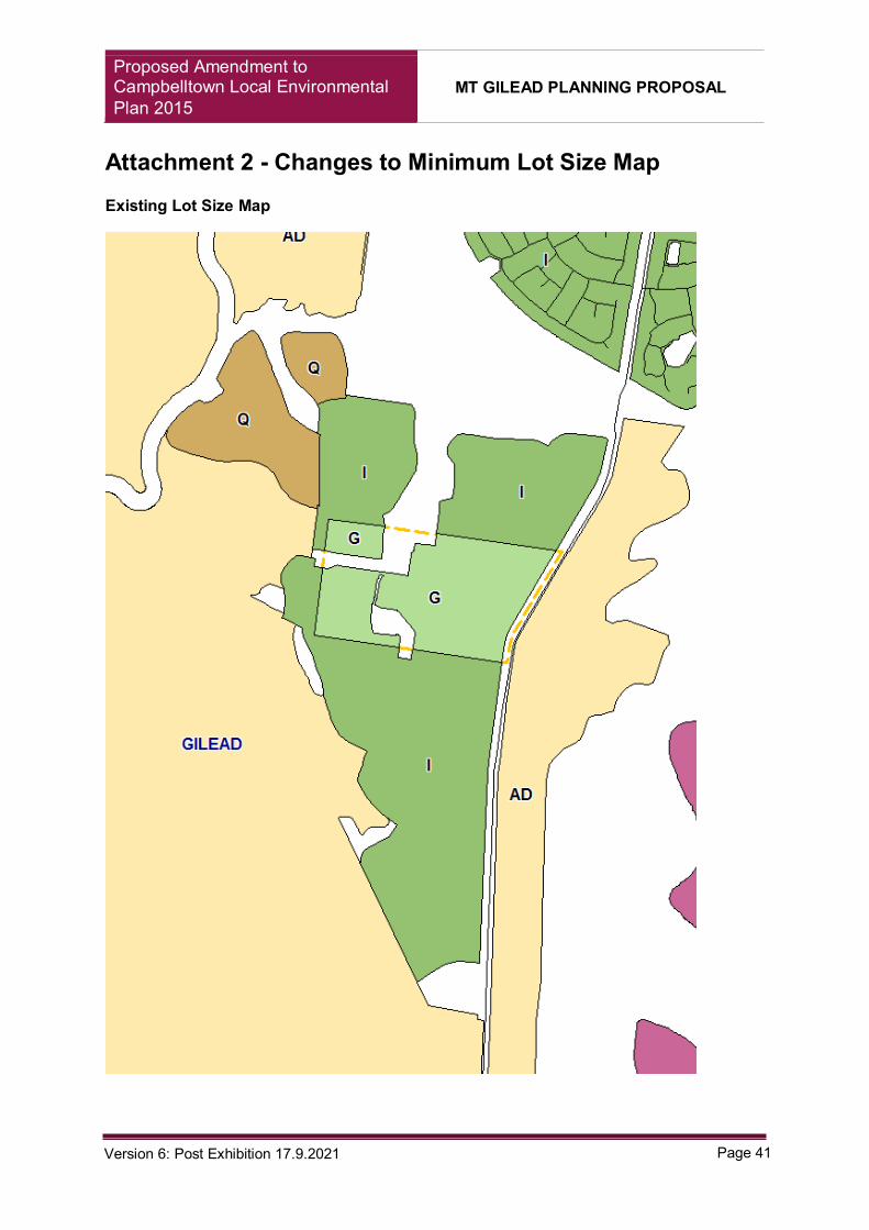
Existing Minimum Size Lot
Attachment 2 - Changes to Minimum Lot Size Map Existing Lot Size Map

Proposed Amendment to Campbelltown Local Environmental Plan 2015
MT GILEAD PLANNING PROPOSAL
Page 42 Version 6: Post Exhibition 17.9.2021
Proposed Lot Size Map

Proposed Amendment to Campbelltown Local Environmental Plan 2015
MT GILEAD PLANNING PROPOSAL
Page 43 Version 6: Post Exhibition 17.9.2021
Attachment 3 – Changes to Land Reservation Acquisition Map Existing Land Reservation Acquisition Map

Proposed Amendment to Campbelltown Local Environmental Plan 2015
MT GILEAD PLANNING PROPOSAL
Page 44 Version 6: Post Exhibition 17.9.2021
Proposed Land Reservation Acquisition Map

Proposed Amendment to Campbelltown Local Environmental Plan 2015
MT GILEAD PLANNING PROPOSAL
Page 45 Version 6: Post Exhibition 17.9.2021
Proposed Lot Averaging Provisions Map
Attachment 4 – Changes to Height of Building Map Existing Height of Building Map

Proposed Amendment to Campbelltown Local Environmental Plan 2015
MT GILEAD PLANNING PROPOSAL
Page 46 Version 6: Post Exhibition 17.9.2021
Proposed Height of Building Map

Proposed Amendment to Campbelltown Local Environmental Plan 2015
MT GILEAD PLANNING PROPOSAL
Page 47 Version 6: Post Exhibition 17.9.2021
Attachment 5 – Changes to Floor Space Ratio Map Existing Floor Space Ratio Map

Proposed Amendment to Campbelltown Local Environmental Plan 2015
MT GILEAD PLANNING PROPOSAL
Page 48 Version 6: Post Exhibition 17.9.2021
Proposed Floor Space Ratio Map
Attachment 6 – Changes to Dual Occupancy Development

Proposed Amendment to Campbelltown Local Environmental Plan 2015
MT GILEAD PLANNING PROPOSAL
Page 49 Version 6: Post Exhibition 17.9.2021

Proposed Amendment to Campbelltown Local Environmental Plan 2015
MT GILEAD PLANNING PROPOSAL
Page 50 Version 6: Post Exhibition 17.9.2021
Attachment 7 – Proposed Clause 4.1H
4.1H Exception to minimum lot sizes for certain land in Mount Gilead Release Area
(1) The objective of this clause is to provide opportunities for housing diversity and achieve the planned residential density in the R2 Low Density Residential and R3 Medium Density Residential zones.
(2) This clause applies to land within the Mount Gilead Urban Release Area identified on the Urban Release Area Map.
(3) Despite clause 4.1, development consent may be granted to the subdivision of land that is zoned R2 Low Density Residential to which this clause applies which results in a lot or lots with an area less than the minimum lot size shown on the Lot Size Map in relation to that land if as a result of the subdivision:
(a) each lot has a minimum lot size of not less than 375m2, and
(b) no more than 255 lots have a lot size of 375m2 or more and less than 450m2, and
(c) each lot with an area less than the minimum lot size as shown on the Lot Size Map in relation to the land has a street frontage of 11.5m
(d) each lot with an area less than the minimum lot size as shown on the Lot Size Map in relation to that land is not a corner allotment, and
(e) not more than 3 contiguous lots sharing a street frontage have a lot size of less than 450m2, and
(f) each lot with an area less than the minimum lot size as shown on the Lot Size Map in relation to that land is located not more than 200m from a planned bus route, community centre or open space.
(4) Despite clause 4.1, development consent may be granted to the subdivision of land that is zoned R2 Low Density Residential to which this clause applies which results in a lot or lots with an area less than the minimum lot size shown on the Lot Size Map in relation to that land if as a result of the subdivision:
(a) each lot has a minimum lot size of not less than 300m2, and
(b) no more than 255 lots have a lot size of 300m2 or more and less than 375m2, and
(c) each lot with an area less than the minimum lot size as shown on the Lot Size Map in relation to that land has a minimum street frontage of 10m
(d) each lot with an area less than the minimum lot size as shown on the Lot Size Map in relation to that, land is not a corner allotment, and
(e) Not more than 3 contiguous lots sharing a street frontage have a lot size of less than 450m2, and

Proposed Amendment to Campbelltown Local Environmental Plan 2015
MT GILEAD PLANNING PROPOSAL
Page 51 Version 6: Post Exhibition 17.9.2021
(f) each lot with an area less than the minimum lot size as shown on the Lot Size Map in relation to that, land is located not more than 200m from a planned bus route, community centre or open space area.
(5) Despite any other clause, development consent may be granted to development for a purpose specified in the table in this clause on land in a zone listed beside the purpose, if the area of the lot to be developed is equal to or greater than the area specified in Column 3 of the table.
(6) Despite clause 4.1 development consent may be granted to the subdivision of land in a zone that is specified in Column 2 of the table in this clause for a purpose listed beside the zone in Column 1, if the area of the lot to be created is equal to or greater than the area specified in Column 4 of the table.
Column Column 2 Column 3 Column 4
Dwelling House Zone R3 Medium Density Residential
250 square metres 250 square metres
Dual Occupancy Zone R3 Medium Density Residential
500 square metres 250 square metres
Semi-detached Dwelling
Zone R3 Medium Density Residential
500 square metres 250 square metres
Attached Dwelling Zone R3 Medium Density Residential
1,000 square metres 200 square metres
Proposed Amendment to Campbelltown Local Environmental Plan 2015
MT GILEAD PLANNING PROPOSAL
Page 52 Version 6: Post Exhibition 17.9.2021
Planning Proposal Mt Gilead Urban
Release Area
Proposed amendment of
Campbelltown Local Environmental Plan 2015
Attachments 8 Summarised Table of Submissions

Proposed Amendment to Campbelltown Local Environmental Plan 2015
MT GILEAD PLANNING PROPOSAL
Page 53 Version 6: Post Exhibition 17.9.2021
Attachment 8 – Submission Summary
Agency Submissions
Concerns Response
EES The submission considers that the PP is generally not inconsistent with the biodiversity certification conferral, including the Ministerial Order and Biodiversity Certification Agreement.
Noted. The Ecologist Biodiversity Certification Assessment Repot and Addendum outlines how the planning proposal is consistent.
EES recommends that the PP be reviewed against the findings of the report prepared by the Office of the Chief Scientist and Engineer (OCSE) – Advice on the Protection of Campbelltown Koala. The report, and subsequent follow up advice, sets out recommendations in regard to corridor widths, functionality, buffers and fencing to implemented to protect Koalas in Mt Gilead and the Greater Macarthur Growth Area.
Condition 22A of DA 2984/2020/DA-CW determined by the Campbelltown Local Planning Panel (the Panel) required a revised boundary of proposed works adjacent to the section of the Noorumba-Mt Gilead Biobank/Conservation Stewardship Site located between Lot 3 DP 730136 Appin Road Gilead and Pt Lot 102 DP 611552 Noorumba Reserve. A minimum with of 250 m was specified by the Panel to be consistent with the advice of Dr Steve Phillips, as reported to Council’s Ordinary Meeting on 13 October 2020. Since this time, the recommendations of the Chief Scientist and Engineer, Advice on the protection of the Campbelltown Koala Population, has been considered by DPIE and TfNSW for an update to the Greater Macarthur 2040 strategy. This would facilitate an amended road design for Appin Road that would support a koala crossing in proximity to Naroomba Reserve. Any variation required to the existing 250 m corridor to be consistent with the Chief Scientist and Engineer advice could form an amendment to DA2984/2020/DA-CW, an updated State and Local Voluntary Planning Agreement, and future housekeeping amendment to the CLEP 2015.
Heritage NSW
The current planning proposal no longer addresses the conservation
The objectives of the Heritage and Views within the Mount Gilead Development Control Plan are considered within the planning proposal.

Proposed Amendment to Campbelltown Local Environmental Plan 2015
MT GILEAD PLANNING PROPOSAL
Page 54 Version 6: Post Exhibition 17.9.2021
of many of the values identified in the Heritage Principles within the Mount Gilead DCP.
A visual analysis was also prepared to demonstrate that the proposed amendments would not significantly impact the view corridors.
The retention of the Ironbark vegetation and water body (lily pond) reflect the landscapes prior land use.
The proposed B4 zone is in key view corridor from Hillsborough to One Tree Hill. The amelioration of views due to the rezoning and heights has not been outlined clearly.
Currently, Cumberland Plain vegetation obstructs the view corridor from Hillsborough to One Tree Hill. The future village centre will be designed to consider improving the view corridor from the adjacent One Tree Hill.
Any future indicative landscape plan, subdivision plan or other detailed strategic or statutory plan for the subject site should incorporate in the design the Heritage Principles as described in the current site specific DCP.
A future amendment to the development control plan will be undertaken, and can address this comment. The Landscape Masterplan however incorporates the heritage controls in regards to the retention of One Tree Hill, Open space at the site of former Hillsborough Cottage and the retention of important view lines, and interpreted through streetscape.
An interpretation strategy is to be prepared to provide further insight to the history of the site, its significance and important views and vistas.
An interpretation plan may be prepared that addresses the history of the site. The finalisation of the planning proposal will facilitate the preparation of an Interpretation Strategy for the site.
The planning proposal will impact the historic setting of long distance views, rolling pastures, clusters of trees and water bodies.
The planning proposal does not seek to alter any land outside of the development envelope. However, it does seek to reduce its overall developable land and increase the open space.
At the detailed design stage, tree planting is thebe increased closer to the residential development.
Noted, future DCP images will be updated to reflect landscaped buffer areas.
Any future subdivision and development site is to provide a suitable vegetation buffer to protect the local item’s (Humewood Forest) natural heritage values and
A battleaxe handle (lot 2 DP1218887) separates the Humewood Forest from the residential development. The Consistency Report for Mount Gilead Stage 1 addresses the buffers to Beulah Reserve (Humewood Forest)

Proposed Amendment to Campbelltown Local Environmental Plan 2015
MT GILEAD PLANNING PROPOSAL
Page 55 Version 6: Post Exhibition 17.9.2021
minimise the potential edge effects.
A heritage impact statement is to be prepared that demonstrates the visual/aesthetic impacts on the State Heritage Items in the vicinity of the subject site and all necessary controls to minimise or avoid adverse impacts.
The State Heritage Register application for Mount Gilead was considered during the 2018 rezoning of Figtree Hill. The State Heritage Item Mount Gilead Homestead does not have a readily available CMP for the public.
A Heritage Impact Assessment has been prepared by TKD Architects to address the consideration of the planning proposal.
If the proponent has not undertaken their own investigations to assess the likelihood of relics and any subsequent management required under the Heritage Act 1977.
Noted.
The MDP Lands Aboriginal Cultural Heritage Assessment (ACHA) submitted dated July 2017 is incomplete and outdated as it does not comply with the legislated consultation requirements.
The proponent received an AHIP (C0005248) for the MDP lands in April 2020. As required by the legislation, consultation has been occurring and complied with as part of the ongoing management of the AHIP.
The AHIP supersedes the draft ACHA and appropriately addresses all statutory requirements as conditioned under the NPW Act.
More recent archaeological investigations and Aboriginal consultation, which would assist in understanding the values within the planning proposal. The more recent information should be considered as part of this planning proposal.
The information and data collected in accordance with the AHIP is being analysed. The information will be disseminated once the investigations are complete.
It was understood that Heritage NSW was satisfied that no further investigations were required prior to the commencement of development activity hence the granting of the AHIP.
NSW Rural Fire Service
A bushfire report is to be provided to support the planning proposal. Specifically addressing the document Planning for Bushfire Protection 2019: Section 4 Strategic Planning
The Bushfire Assessment Report has been provided to the NSW Rural Fire Service as part of the additional information requirement. No response has been provided since.
Water NSW

Proposed Amendment to Campbelltown Local Environmental Plan 2015
MT GILEAD PLANNING PROPOSAL
Page 56 Version 6: Post Exhibition 17.9.2021
WaterNSW overall concerns are the identification of the Upper Canal corridor as public open space, reconfiguration of the R2 Low Density Residential, associated intensification of planning controls for development immediately east of the Upper Canal and the reduction in minimum lot size for the RU2 Rural landscape zone in the west.
The planning proposal does not seek to alter the existing zones or protections to the upper canal.
The land directly east of the Upper Canal maintains an R2 zoning. However the rezoning of the RE1 land to R2 is to assist in flexibility for the stormwater management infrastructure.
The local VPA still pertains that stormwater management infrastructure is to be delivered in this area. A Development application will be required for this land and as such, Water NSW will be engaged to ensure there is no impact on the canal.
The planning proposal seeks to amend the minimum lot size on RU2 land on the western side of the Upper Canal. By doing so, it allows the site to be excised from the land, and will retain its rural land use. There is no direct impacts on the land use arrangements to the Canal.
The Gilead Landscape Masterplan Report identified the Canal as public open space for the community and as a regional open space connectivity. This is prohibited as it’s a critical bulk water supply. All references are to be removed.
Noted, the panning proposal does not intend to facilitate these changed conditions. The developer sought this as a green link aspiration for the future. If the opportunity does ever arise, negotiations would be had with WaterNSW.
The increase in urban densities proposed for the R2 land and potential impacts on the Upper Canal corridor, rezoning of the RE1 land should not proceed. Should it proceed, no lots are to be designed to back onto the corridor.
The RE1 zoned land in this location is being rezoned to provide flexibility in where the final stormwater management facility will be located to respond to various site constraints, including the location of existing flumes over the Upper Canal.
As required by the Voluntary Planning Agreement, the developer is still required to deliver stormwater management infrastructure in this location.
There are apprehensions had with the proposed 5ha Minimum Lot Size for the RU2 land (Lot 5 DP 124836) in regards to potential dwelling entitlement, and the potential access concerns.
There is already an existing dwelling entitlement upon the RU2 Rural Landscape (Lot 5 DP 124836) as well as this the site is situated within the potential Koala Corridor, and is within the Biodiversity Certification.
Tree plantings and revegetation is required to align with the Guidelines of
The change in the E2 zoning does not alter the revegetation requirements of the land, due to the biodiversity Certification and Biobank agreement.

Proposed Amendment to Campbelltown Local Environmental Plan 2015
MT GILEAD PLANNING PROPOSAL
Page 57 Version 6: Post Exhibition 17.9.2021
WaterNSW, and ensure that the area is managed to minimise Bushfire risk.
WaterNSW does not support the removal of the small RE1 parcel of land being rezoned to R2 Low Density Residential land (bordering the upper canal). If retention is not possible a boundary road and road reserve is to be considered.
The RE1 land was rezoned for stormwater management basin, and did not have an open space function. The land is being rezoned for flexibility on the location of the stormwater management facility.
The Minimum Lot Size provisions should be excluded from allotments adjacent to the Upper Canal corridor.
Residential dwellings interfacing the Upper Canal would be separated by a boundary road. The lots sizes that interface this area are also greater in lot sizes than other release areas.
An updated structure plan is to accompany the proposal, particularly in regards to zoning boundaries.
A revised Masterplan has been prepared to address the inconsistencies. The masterplan would form a future update to the Campbelltown Sustainable City Development Control Plan.
WaterNSW does not agree to the positioning of the Upper Canal as part of the open space network. This positioning may have promoted the increase in residential density.
The planning proposal does not seek to alter the existing zone in relation to the Upper Canal. The changes depicted in the Landscape Masterplan are not reflective of the residential changes.
The new masterplan represents an increase of open space which does not include the Upper Canal.
TFNSW
The planning controls for Mount Gilead are likely allow to a substantial increase to development yield beyond the 2017 amendment. (ie. 1,700 lots)
The lot yield is determined by a Local and State Voluntary Planning Agreement (VPA). The planning proposal does not seek to amend the existing provisions relating to the lot yield rather, it seeks to provide an enhanced diversity of housing within the existing development envelope, whilst maintaining the yield of 1,700 lots.
Traffic and transport implications of this potential yield increase has not been addressed.
The maximum yield is 1,700 lots and is controlled through the State and Local VPA, along with the development applications for the precinct. As the planning proposal is not increasing the yield, and is not amending the development there is no justification to why further traffic and transport would need to be addressed.
The Retail Centre has been determined based on the demand of the future community of the precinct, it does not anticipate in serving

Proposed Amendment to Campbelltown Local Environmental Plan 2015
MT GILEAD PLANNING PROPOSAL
Page 58 Version 6: Post Exhibition 17.9.2021
the broader catchment. As such, the traffic impacts will generally internalised.
TfNSW raises concerns of the proposed zone and the larger land area for the B4 Zone, compared to the original B1 zone, will result in increased traffic generation.
The Gateway Determination required a Retail Demand Analysis (RDA) to demonstrate that the proposed B4 Mixed Use zone was appropriate. The conclusion of the RDA was that the size of the retail centre needed to be reduced from 4,400sqm to circa 2,500sqm gross floor area.
This reduction is to cater for the future community within Mount Gilead, and will assist in internalizing the generalized traffic movements. The additional gross floor area within the retail centre will assist in ancillary and supporting uses for the community.
The ‘additional yield’ that would generally be accumulated from the potential residential development surrounding the town centre would still be required to meet the VPA yield cap, in doing so this will reduce the remaining yield for other residential zoned land in the precinct.
The introduction of the R3 zone would invariably lead to higher residential density. (40-45 dwellings/ha)
As previously explained, there is no increase to the overall yield. Any introduction of zones or minimum lot sizes require an adjustment to the remaining zonings within the precinct.
Greenfields generally only produce 25-30 dwellings per hectare through a terrace product. The intention is to delivery standard land subdivision in the R3 zone that would deliver lot sizes circa 250m2.
The scope of works and contributions set out under the State VPA were based on traffic and transport assessments which assumed a total of 1,700 lots.
No provision has been made in the State VPA for the development contributions which may be necessary when increasing the yield.
Noted. However, the planning proposal does not intend to increase the yield over the State and Local VPAs. It seeks to provide flexibility in the delivery of the maximum yield across the precinct.
If the current proposal does not intend to create more than 1,700 lots then TfNSW considers a new site specific clause nominating the dwelling cap should be included in the Campbelltown LEP 2015.
Noted. However, the State VPA makes provisions for this.
As demonstrated by the recent removal of dwelling caps for Macarthur Gardens, Claymore and Airds, despite the developer meeting its requirements for the registration of final lots, future landowners would have entitlements under various State Environmental Planning Policies to make applications for uses that may be determined as complying development. Therefore, a new clause in CLEP 2015 is not appropriate and could not be enforced.

Proposed Amendment to Campbelltown Local Environmental Plan 2015
MT GILEAD PLANNING PROPOSAL
Page 59 Version 6: Post Exhibition 17.9.2021
It was noted that Council had resolved to include a similar provision in the original zoning, however ever eventuated to the gazettal.
It is believed the final development yield will be subsequently higher than the 1,700 yield required under the State VPA. For this reason, TfNSW considers that the State VPA should be amended if the CLEP 2015 dwelling cap not be supported.
An amendment to the State VPA is only required where the yield cap is breached. Should the yield for some unforeseen reason be exceeded, the developer would be required to liaise with both DPIE and TfNSW to make satisfactory arrangements.
The State VPA already makes a far greater contribution towards State Infrastructure than normally required, and would support credits for future stages.
The new E2 zone would impact on the corridor Option 403 for the Link Road Corridor study. Even though option 403 is not a preferred option.
Noted. The zoning of the E2 Environmental Conservation zone is considered the best practice and assists in providing appropriate protection the land in line with the Biodiversity Certification Agreement and BioBank Agreement.
Any option that TfNSW proceeds with, would need to assess the impact on that land and provide appropriate offsets.
It is assumed that the land identified as proposed RE1 and E2 zones are not considered koala corridor and will not be fenced off.
TfNSW should be aware of the Biodiversity Certification Agreement and BioBank Agreement that applies to the land and the necessary measures that apply.
TfNSW is generally supportive of the revised bus network as it will cater to the proposed centre and potential school site however, there appears to be a few limitations in the revised network that will impact bus serviceability.
Noted
Circuitous bus networks are not supported by TfNSW.
TfNSW will be responsible for the bus routes when demand dictates. A reduced level of coverage would be provided if TfNSW suggestion is implemented to remove the northern circuit. The revised bus route and collector road network would increase the overall access to public transport.
The roundabout should be designed to allow buses to
Noted.

Proposed Amendment to Campbelltown Local Environmental Plan 2015
MT GILEAD PLANNING PROPOSAL
Page 60 Version 6: Post Exhibition 17.9.2021
make U-turns and turnaround on the boulevard.
The masterplan should be revised to allow for a 3.5m wide travel lane in each direction to safely accommodate buses and to overtake stationary buses.
Noted.
Public Submissions
Concerns Response
Exhibition Process and Other Exhibitions
Exhibition was not undertaken in accordance with Council’s policies and surrounding interest groups were not notified.
Campbelltown’s Community Participation Plan (2019) identifies that Planning Proposals require exhibition for 28 days or as specified by the Gateway Determination. The PP was publicly exhibited for 28 days from 5 July 2021 to 2 August 2021 and displayed on DPIE’s Planning Portal and Council’s ‘Over to You’ webpage. Although the Community Participation Plan does not specify a minimum distance for the issuing of notification letters for Planning Proposals, properties within a distance of 100 m were notified, consistent with the requirement for development applications. Council also notified relevant public authorities identified in the Gateway Determination. A separate and unrelated exhibition of the Campbelltown (Sustainable City) Development Control Plan Volume 2, Part 7 Mount Gilead was exhibited from 2 August 2021 until 30 August 2021. This amendment proposes new controls for the various form of residential development already permitted by CLEP 2015.
Issues regarding the exhibition of Mount Gilead Development Control Plan
The exhibition for the Mount Gilead Development Control Plan is separate to the planning proposal and not related.
Inadequate Assessment
The planning proposal does not adequately address the risk of soil contamination, health of Nepean Hawkesbury River system, impact on Mount Gilead Homestead.
Technical studies have been provided with respect to the planning proposal. These technical studies are undertaken by specialist consultants with expertise and qualifications in their respected fields. Reports that supported the original rezoning of the land in 2017 do not require update.

Proposed Amendment to Campbelltown Local Environmental Plan 2015
MT GILEAD PLANNING PROPOSAL
Page 61 Version 6: Post Exhibition 17.9.2021
The planning proposal does not address bushfire prone areas.
A bushfire report has been submitted as part of the requirements for the s.9.1 Ministerial Direction 4.4 Planning for Bushfire and was accepted as meeting the requirements of the NSW Rural Fire Service.
The planning proposal does not address Campbelltown’s poor air quality, traffic and Appin road
Alongside technical studies provided by the proponent, the Gateway Determination requires relevant public authorities and government agencies to be provided the planning proposal for comment. Any concerns are highlighted with the agencies and are addressed as part of the submission report.
Appin Road and Adjoining properties
Appin Road Upgrade Appin Road upgrade is subject to a Voluntary Planning Agreement with the Landowners and the NSW Department of Planning, Industry and Environment. Any upgrade works are to be commenced upon the commencement of development within the precinct. As such, Appin Road upgrade have not begun.
Impact to adjoining properties
The PP does not alter land use at the interface of Appin Road and therefore does not generate any additional impact. Access and egress provisions of the original masterplan anticipated a third central access point. This was to assist the precinct if developed by multiple landowners, which is now under single ownership. TfNSW has since approved the Appin Road REF which confirmed that the third central access point is not required and a median would be incorporated into Appin Road as a result of the upgrade. The PP does not alter this outcome.
Ecological Reports and Koala Habitats
Acknowledgement of the conditions of consent DA 2984/2020/DA-CW
Condition 22A of DA 2984/2020/DA-CW determined by the Campbelltown Local Planning Panel (the Panel) required a revised boundary of proposed works adjacent to the section of the Noorumba-Mt Gilead Biobank/Conservation Stewardship Site located between Lot 3 DP 730136 Appin Road Gilead and Pt Lot 102 DP 611552 Noorumba Reserve. A minimum with of 250 m was specified by the Panel to be consistent with the advice of Dr Steve Phillips, as reported to Council’s Ordinary Meeting on 13 October 2020. Since this time, the recommendations of the Chief Scientist and Engineer, Advice on the protection of the Campbelltown Koala Population, has been considered by DPIE and TfNSW for an update of the Greater Macarthur 2040 strategy. This would facilitate an amended road design for Appin Road that would support a koala crossing in proximity to Naroomba Reserve. Any variation required to the existing 250m corridor to be consistent with the Chief Scientist and Engineer advice could form an amendment to

Proposed Amendment to Campbelltown Local Environmental Plan 2015
MT GILEAD PLANNING PROPOSAL
Page 62 Version 6: Post Exhibition 17.9.2021
DA2984/2020/DA-CW, an updated State and Local Voluntary Planning Agreement, and future housekeeping amendment to the CLEP 2015. In response to concerns about consistency with Council’s Comprehensive Koala Plan of Management (CKPOM), EES has reviewed the applicant’s Biodiversity Certification Assessment report, prepared by Ecological Australia (December 2020) and advise it is not inconsistent with the conferral of biodiversity certification. Furthermore, the provisions of Clause 10 of Koala SEPP 2020 is not applicable to the determination of development applications on the site due to biodiversity certification of the land.
Corridor from Chief Scientist report has not been identified in Planning Proposal
The NSW Chief Scientist provided advice on proposed measures to protect the Campbelltown Koala Population in December 2019. Specifically on the proposed Mount Gilead Stage 2 precinct and the Cumberland Plain Conservation Plan. The Mount Gilead Stage 1 planning proposal is not situated in these two areas.
The April 2020 Chief Scientist report outlined various outcomes for Menangle Creek/Noorumba Reserve with respect to the crossing structures for Appin Road. Depending on if a crossing could be secured would depend on whether the Koalas need to be relocated, or otherwise managed against exposed threats.
Wildlife Crossing Structures for Appin Road
The viability of the crossing structure at Appin Road/Noorumba Reserve is a decision of the NSW Government and TfNSW. Until there is a decision on this, there is no justification or requirement to amend the planning controls within proximity to Menangle Creek. The NSW Policy for Conserving Koalas in the Wollondilly and Campbelltown area excludes connectivity from the east and west through exclusion fencing.
Condition 22A of DA 2984/2020/DA-CW determined by the Campbelltown Local Planning Panel (the Panel) required a revised boundary of proposed works adjacent to the section of the Noorumba-Mt Gilead Biobank/Conservation Stewardship Site located between Lot 3 DP 730136 Appin Road Gilead and Pt Lot 102 DP 611552 Noorumba Reserve. A minimum with of 250 m was specified by the Panel to be consistent with the advice of Dr Steve Phillips, as reported to Council’s Ordinary Meeting on 13 October 2020. Since this time, the recommendations of the Chief Scientist and Engineer, Advice on the protection of the Campbelltown Koala Population, has been considered by DPIE and TfNSW for an update of the Greater Macarthur 2040 strategy. This would facilitate an amended road design for Appin Road that would support a koala

Proposed Amendment to Campbelltown Local Environmental Plan 2015
MT GILEAD PLANNING PROPOSAL
Page 63 Version 6: Post Exhibition 17.9.2021
crossing in proximity to Naroomba Reserve. Any variation required to the existing 250m corridor to be consistent with the Chief Scientist and Engineer advice could form an amendment to DA2984/2020/DA-CW, an updated State and Local Voluntary Planning Agreement, and future housekeeping amendment to the CLEP 2015.
Campbelltown Koala Plan of Management (CKPoM) with respect to the Planning Proposal
The CKPoM does not apply to land which reflects the Biodiversity Certification as per the State Environmental Planning Policy (Koala Habitat Protection) 2021 clause (3)(1)(c).
The South Campbelltown Connectivity Study determines a minimum width from 200m to 425m.
However, as reported to Council’s Ordinary Meeting on 13 October 2020, Council’s ecologist (Steve Phillips) suggest a more meaningful approach to defining the dimension of SLAs would be to describe the optimal width, within the range of 409m-425m, the achievement of which would be assisted by requiring a minimum SLA width of 250m for all three SLAs (Menangle, Woodhouse and Mallaty Creek) and an average width of 350m.
Council understand that a final determination of the CS&E recommendations will be reflected within an updated Greater Macarthur Strategy.
Destruction of koala habitat and diminishing of Koalas
The planning proposal aims to retain 20ha of koala habitat on the site through protected BioBanks, and increasing open space to retain additional trees. If development was not to proceed, there is potential for the habitat to decline in quantity and quality.
The aim is to provide a balance to the precinct, and to reverse the ecological decline through further conservation of these BioBank and open space areas. The opening up old growth forests for logging in the State Forest Reserve is not relevant to this matter.
Great Koala National Park In regards to concerns of the Great Koala National Park, the precinct is not located within these lands.
Logging in the State Forest Reserve
Logging on site is prohibited through the current and proposed land zonings.
Combination of underpasses, overpasses and exclusion fending should be incorporated into the retrofitting of existing
Exclusion fencing would be installed to Appin Road. Feasibility assessments by TfNSW are being undertaken to determine the potential for an underpass, separate to this planning proposal.

Proposed Amendment to Campbelltown Local Environmental Plan 2015
MT GILEAD PLANNING PROPOSAL
Page 64 Version 6: Post Exhibition 17.9.2021
infrastructure and the new development in areas known of Koala habitats
Removal of ecological buffer areas to Beulah
The precinct is setback from Beulah reserve by a strip of land within Lot 2 DP 1218887 which is certified under the Threatened Species Conservation Act.
The buffer should be created to surround the 2 BioBanks in-situ
If assuming it is the BioBanks central to the proposal, the existing and proposed biobanks have been considered and provided through previous ecological assessments and approvals. There are no changes to any of the proposed buffers.
Heritage Values
Loss of views adjoining property
A visual analysis was undertaken by TKD to look at the historical key view corridors. The report concluded that there were no adverse impacts on the views and vistas.
Sustainability
Urban Heat Island threat The planning proposal seeks to increase the retention of existing trees and open space. The increase in tree canopy will assist with urban heat island levels. Alongside the increase in canopy cover a future development control plan will provide for controls that minimise the urban heat levels within the development envelopes.
Density Levels
Increase in density and activity on site will exacerbate the edge effects
Edge effects were considered throughout the Biodiversity Certification Assessment of the project. There is no evidence that edge effects will deteriorate with increased densities.
Reduction of lot sizes will result in reduction of deep soil planting zones.
The proposal does not amend the requirements for rear setbacks. An amendment to the Development Control Plan has been exhibited to ensure that building envelopes are considered with greater focus to landscaping and planting of trees.
Reduction of lot sizes is out of character with Campbelltown’s existing suburbs
The development is in keeping with similar Growth Areas within Campbelltown’s Local Government Area. It is also in accordance with the vision and key objectives in the Mount Gilead Development Control Plan. This ensures that development within Mount Gilead will maintain the characteristics that have been successful within other areas of Campbelltown.
Court Case
According to Council, the biodiversity certification exempts Mount Gilead Stage
On 24 September 2021, Her Honour, Duggan J handed down her judgement and dismissed all grounds of challenge.

Proposed Amendment to Campbelltown Local Environmental Plan 2015
MT GILEAD PLANNING PROPOSAL
Page 65 Version 6: Post Exhibition 17.9.2021
1 from the Provisions of the Koala Habitat Protection SEPP 2021
CKPoM fails to meet the intent of the Koala SEPP 2021 by allowing developers the option of offsetting koala habitat in areas away from where it is found. Awaiting Court decision.
On 24 September 2021, Her Honour, Duggan J handed down her judgement and dismissed all grounds of challenge.
Inconsistencies of Planning Agreements
The planning proposal should automatically void the biodiversity certification conferred on the property.
The planning proposal intends to amend land zonings that are benefitted by environmental agreements. By doing so, an increase protection to conservation and open space can be sought.
No conservation areas are being impacted by these amendments. However, additional measures and assessment may be required for the retained areas under the biodiversity certification prior to development consent.
An objective of the planning proposal is to provide an environmental bushland corridor that links Noorumba with the Beulah biobanking site, there is no consideration for north south movement of wildlife through the site.
The provision of the additional open space that surrounds the Hillsborough Biobank site assists in retaining and expanding the link and retaining the existing dam adjacent to the Macarthur Onslow Biobank.
Sewer Treatment and Disposal
Is the precinct to be serviced by a pump-out system or a sewage treatment plant.
Sydney Water will be servicing the development, and Glenfield Wastewater treatment plant will be facilitating the precinct in regards to wastewater.
Are there plans for a sewage treatment plant to be located between the upper canal and Menangle Creek.
There are no plans to construct a wastewater treatment plant adjacent to Menangle Creek.

Proposed Amendment to Campbelltown Local Environmental Plan 2015
MT GILEAD PLANNING PROPOSAL
Page 66 Version 6: Post Exhibition 17.9.2021
Dam Removal
Removal of dams in Stage 1 Mount Gilead property is not in line with the planning proposal that was provided for biodiversity certification.
No additional Dams have been proposed for removal.
The dam has been approved for dewatering and filling, this application sought to retain this dam which otherwise be filled in.
The dam that is proposed to be backfilled should be maintained as it is important for maintaining water inflow to the heritage dam.
To retain this dam, there is concern that the structural integrity may need to be reinforced to eliminate any damage that may occur to Heritage Dam. If development does not proceed the increase in risks to the ‘Heritage Dam’’ will continue.
Employment
There is no benefit to the community in regards to the supply of jobs.
The rezoning has provided for a larger retail function (B4 Mixed Use) which will generate employment opportunities far greater than the original zoning. The size of the centre was carefully curated through consultation with Location IQ and amended post Gateway Determination to ensure the retail component was suitable for the forecasted local population.
Insufficient Facilities
The planning proposal does not adequately address infrastructure. i.e electricity, schools, hospitals.
Endeavour Energy is providing the electricity supply through an extension of their existing network.
The original planning for the site addressed the requirement for schools, medical services and employment opportunities. The site has considered aspects of these through the town centre.
Schools will be dependent on the Department of Education or other relevant education entities on if they wish to proceed with a school.
Population increases, so will the requirement of open space.
The planning proposal increases open space by over 29ha.
Bushfire Evacuation and APZ

Proposed Amendment to Campbelltown Local Environmental Plan 2015
MT GILEAD PLANNING PROPOSAL
Page 67 Version 6: Post Exhibition 17.9.2021
Lack of Evacuation planning The Gateway Determination required compliance with the s9.1 Ministerial Directions including, 4.4 Planning for Bushfire. To meet requirements the planning proposal and supporting bush fire report was referred to the NSW RFS who confirmed it was satisfactory.
Imported Fill
Large quantities of fill being imported to the precinct.
A development consent was issued in December 2020 for the importation of fill. Conversely, a reduction of the quantity of material will be imported onto the side due to the planning proposals overall reduction in urban development.
Submission from Applicant
That the zoning map and associated development standards be amended to locate 3.07 ha of R3 Medium Density Residential zoned (currently proposed as R2 Low Density Residential) on the northern side of the main entry boulevard, north of the proposed B4 Mixed Use Village Centre. The amendment would support greater housing choice in proximity to the proposed Village Centre, via the provision of rear loaded, terrace style homes that would enjoy the amenity of local shopping, access to the proposed ‘Commons’ open space and provide an improved development interface with the village.
The zoning of land to support medium density housing is consistent with Council’s Local Strategic Planning Statement and Local Housing Strategy, which identifies a shortfall of housing suitable for smaller families or lone person households. The request is supportable given increasing pressure to protect environmentally sensitive land. The supporting visual analysis confirms the amendment would not impact significant views from the Mt Gilead State Heritage Item and is therefore supported.
Requests that proposed Clause 4.1H(6) be amended to reduce the minimum lot size for dwelling houses in the R3 Medium Density Residential zone from 250m2 to 225m2. The amendment is requested to support new
Proposed Clause 4.1H(6) would only require the sale of a house and land package for a dual occupancy, semi-detached or attached dwelling. The clause does not require a proposed lot of 250 m2 on land zoned R3 Medium Density Residential to include the dwelling design. Council’s approach is to only require a building envelope plan, as dwelling approval could occur as either a development consent or complying development certificate. Therefore, the

Proposed Amendment to Campbelltown Local Environmental Plan 2015
MT GILEAD PLANNING PROPOSAL
Page 68 Version 6: Post Exhibition 17.9.2021
home owners with the option of buying a dwelling without having to pay stamp duty on the combined value of the house and the land, based on the delivery of lots with dimensions of 9 m x 25 m suiting many standard home builder designs. Under the proposed controls, these products can only be delivered as a completed house and land package that increases overall costs for builders and the customer. The applicant estimates that about 6 per cent of the 1,700 lots would be delivered this way, and would support an important housing need.
Proposed Clause 4.1H(6) would only require the sale of a house and land package for a dual occupancy, semi-detached or attached dwelling. The clause does not require a proposed lot of 250 m2 on land zoned R3 Medium Density Residential to include the dwelling design. Council’s approach is to only require a building envelope plan, as dwelling approval could occur as either a development consent or complying development certificate. Therefore, the proposal to reduce the minimum lot size in the R3 zone is not supported.
proposal to reduce the minimum lot size in the R3 zone is not supported.
The applicant seeks to increase the SP2 Special Purpose (infrastructure) land in the north-east Figtree Hill by 1,155 m2 to ensure critical service infrastructure and associated retaining
There is no concern with increasing the land reservation for infrastructure purposes. Council would remain the acquisition authority for this land and would form part of an updated Local Voluntary Planning Agreement.

Proposed Amendment to Campbelltown Local Environmental Plan 2015
MT GILEAD PLANNING PROPOSAL
Page 69 Version 6: Post Exhibition 17.9.2021
structures are wholly contained within SP2 Special Purpose land.

Proposed Amendment to Campbelltown Local Environmental Plan 2015
MT GILEAD PLANNING PROPOSAL
Page 70 Version 6: Post Exhibition 17.9.2021
Developers Submission

Proposed Amendment to Campbelltown Local Environmental Plan 2015
MT GILEAD PLANNING PROPOSAL
Page 71 Version 6: Post Exhibition 17.9.2021

Proposed Amendment to Campbelltown Local Environmental Plan 2015
MT GILEAD PLANNING PROPOSAL
Page 72 Version 6: Post Exhibition 17.9.2021

Proposed Amendment to Campbelltown Local Environmental Plan 2015
MT GILEAD PLANNING PROPOSAL
Page 73 Version 6: Post Exhibition 17.9.2021