plans and streetscapes of pompeii and...
TRANSCRIPT
Plans and streetscapes of Pompeii and Herculaneum
Plans of POMPEII
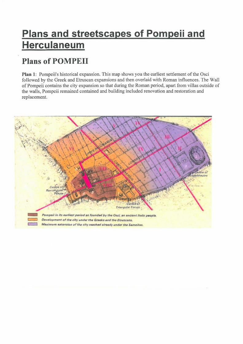
Plan 1: Pompeii's historical expansion. This map shows you the earliest settlement of the Osci followed by the Greek and Etruscan expansions and then overlaid with Roman influences. The Wall of Pompeii contains the city expansion so that during the Roman period, apart from villas outside of the walls, Pompeii remained contained and building included renovation and restoration and replacement.
- Pompeii Itt /t$ eat/i(Jst p~riod ss founded b y the Osci. sn Jttrc:Jent lt~tlic pflelpls.
c::::J lRwolopmflnf of the city und¥r th• GrBBks snd th r; Etruscttns.
c:::=J Maximum exten11ion of thfJ ci t y tHclt~ t~ltHdy ~mder the Samnfta.t.
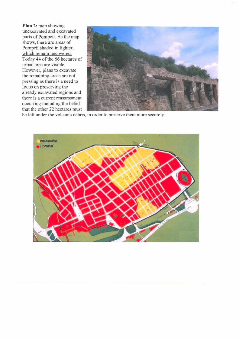
Plan 2: map showing unexcavated and excavated parts of Pompeii. As the map shows, there are areas of Pompeii shaded in lighter, which remain uncovered. Today 44 ofthe 66 hectares of urban area are visible. However, plans to excavate the remaining areas are not pressing as there is a need to focus on preserving the already excavated regions and there is a current reassessment occurring including the belief that the other 22 hectares must be left under the volcanic debris, in order to preserve them more securely.
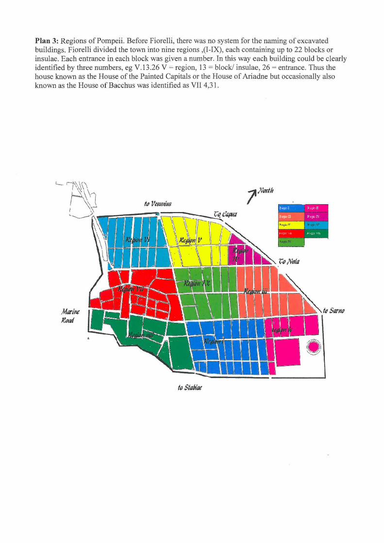
Plan 3: Regions of Pompeii. Before Fiorelli, there was no system for the naming of excavated buildings. Fiorelli divided the town into nine regions ,(I-IX), each containing up to 22 blocks or insulae. Each entrance in each block was given a number. In this way each building could be clearly identified by three numbers, eg V .13 .26 V = region, 13 = block/ insulae, 26 = entrance. Thus the house known as the House of the Painted Capitals or the House of Ariadne but occasionally also known as the House of Bacchus was identified as VII 4,31.
f(} Stu6illf
Plans of HERCULANEUM
Herculaneum was situated on the coast immediately to the west ofVesuvius and five miles south of Naples. Instead of the pumice that crushed and burnt Pompeii, Herculaneum was first smothered in super-heated gas and ash, then volcanic mud. The first surge carbonised the contents, and the second entombed them. Consequently, Herculaneum is in a much better state of preservation. Upper storeys, furniture, woodwork, paint and replanted gardens provide strong evidence for the lifestyle of this town.
modern town above buried parts of Herculaneum
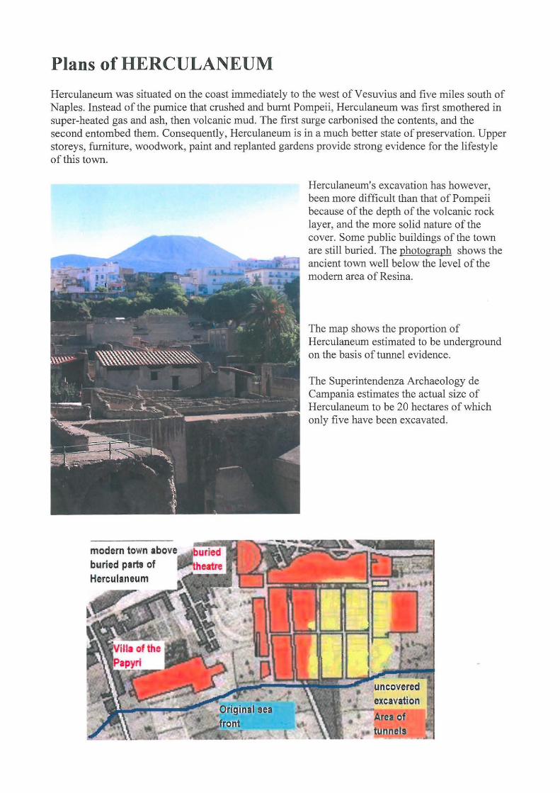
Herculaneum's excavation has however, been more difficult than that of Pompeii because of the depth of the volcanic rock layer, and the more solid nature of the cover. Some public buildings of the town are still buried. The photograph shows the ancient town well below the level of the modem area of Resina.
The map shows the proportion of Herculaneum estimated to be underground on the basis of tunnel evidence.
The Superintendenza Archaeology de Campania estimates the actual size of Herculaneum to be 20 hectares of which only five have been excavated.
excavation
Area of • tubnels

Herculaneum's roads are named according to the same scheme as those of Pompeii, with the main roads identified as decumanus maximus and decumanus inferior, and the crossroads labelled as cardo (III, IV, V). The Insulae which have been excavated are labelled on the map below and indicate that Herculaneum was a small residential town whereas Pompeii was a port, commercial centre and larger residential town. Estimates put Herculaneum at about a third the size of Pompeii (approximately 5000 people in Herculaneum and 20,000 people in Pompeii). Like Pompeii, the plan shows the grid of streets, and the division of the town into insula separated by narrow access streets which ran at right angles to the principal traffic streets. On the map below, Insula Orientalis I and II are additional excavated insulae in the eastern sector of the town.
1. House of Argus 2. House of Aristides 3. House of Mosaic Atriu">n 4. House of the Stag s 5. House of the Gem 6. House of the Telef?hu& Relief 7. Bakery 8.Palaestra 9.shops 10. Samnite house 11. central baths 12. suburban baths 13. priests of Augustus 14. council 15. basilica 16. boatsheds
..... _, (
I hl, UI<J V~
c J
15 Decumanus Maxi~'Us
' OuarHcr\: Su burbtlno
16 Boatsheds
r
In ui:1 Ori•mt~Uis II
(east) •
5
l p~ula On¢n1Hli" l
Bast
8
Palaestra
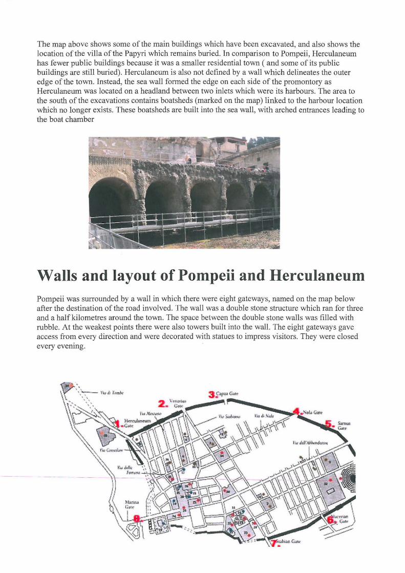
The map above shows some of the main buildings which have been excavated, and also shows the location of the villa of the Papyri which remains buried. In comparison to Pompeii, Herculaneum has fewer public buildings because it was a smaller residential town ( and some of its public buildings are still buried). Herculaneum is also not defmed by a wall which delineates the outer edge of the town. Instead, the sea wall formed the edge on each side of the promontory as Herculaneum was located on a headland between two inlets which were its harbours. The area to the south of the excavations contains boatsheds (marked on the map) linked to the harbour location which no longer exists. These boatsheds are built into the sea wall, with arched entrances leading to the boat chamber
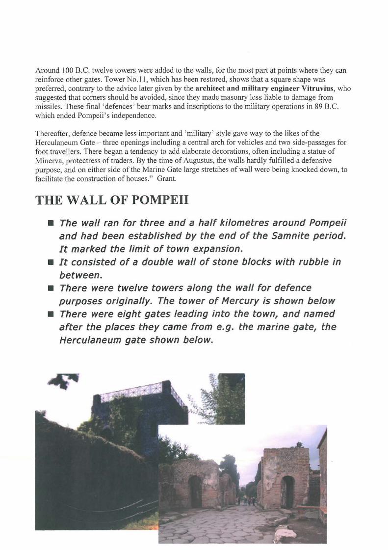
Wails and layout of Pompeii and Herculaneum Pompeii was surrounded by a wall in which there were eight gateways, named on the map below after the destination of the road involved. The wall was a double stone structure which ran for three and a half kilometres around the town. The space between the double stone walls was filled with rubble. At the weakest points there were also towers built into the wall. The eight gateways gave access from every direction and were decorated with statues to impress visitors. They were closed every evenmg.
Around 100 B.C. twelve towers were added to the walls, for the most part at points where they can reinforce other gates. Tower No.ll, which has been restored, shows that a square shape was preferred, contrary to the advice later given by the architect and military engineer Vitruvius, who suggested that corners should be avoided, since they made masonry less liable to damage from missiles. These final 'defences' bear marks and inscriptions to the military operations in 89 B.C. which ended Pompeii's independence.
Thereafter, defence became less important and 'military' style gave way to the likes of the Herculaneum Gate- three openings including a central arch for vehicles and two side-passages for foot travellers. There began a tendency to add elaborate decorations, often including a statue of Minerva, protectress oftraders. By the time of Augustus, the walls hardly fulfilled a defensive purpose, and on either side of the Marine Gate large stretches of wall were being knocked down, to facilitate the construction of houses." Grant.
THE WALL OF POMPEII
• The wall ran for three and a half kilometres around Pompeii and had been established by the end of the Samnite period. It marked the limit of town expansion.
• It consisted of a double wall of stone blocks with rubble in between.
• There were twelve towers along the wall for defence purposes originally. The tower of Mercury is shown below
• There were eight gates leading into the town, and named after the places they came from e.g. the marine gate, the Herculaneum gate shown below.
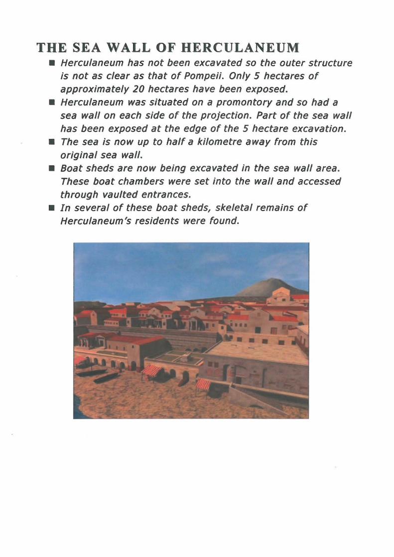
THE SEA WALL OF HERCULANEUM • Herculaneum has not been excavated so the outer structure
is not as clear as that of Pompeii. Only 5 hectares of approximately 20 hectares have been exposed.
• Herculaneum was situated on a promontory and so had a sea wall on each side of the projection. Part of the sea wall has been exposed at the edge of the 5 hectare excavation.
• The sea is now up to half a kilometre away from this original sea wall.
• Boat sheds are now being excavated in the sea wall area. These boat chambers were set into the wall and accessed through vaulted entrances.
• In several of these boat sheds, skeletal remains of Herculaneum's residents were found.
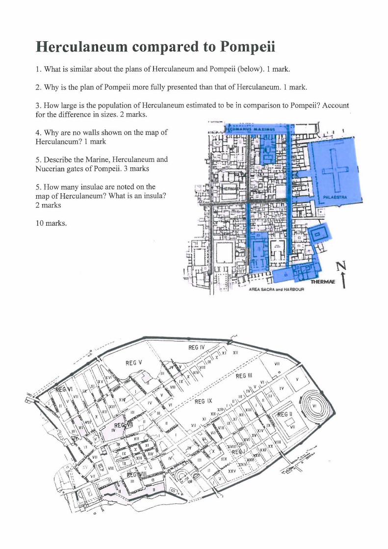
Herculaneum compared to Pompeii 1. What is similar about the plans of Herculaneum and Pompeii (below). 1 mark.
2. Why is the plan of Pompeii more fully presented than that of Herculaneum. 1 mark.
3. How large is the population of Herculaneum estimated to be in comparison to Pompeii? Account for the difference in sizes. 2 marks.
4. Why are no walls shown on the map of Herculaneum? 1 mark
5. Describe the Marine, Herculaneum and Nucerian gates of Pompeii. 3 marks
5. How many insulae are noted on the map of Herculaneum? What is an insula? 2 marks
10 marks.

Layout:
Pompeii and Herculaneum consisted of rectangular residential blocks called insulae (one is an insula). These were separated by narrow streets which ran at right angles to the main, long, traffic thoroughfares. The insula varied from about 850 square metres to a very large 5500 square metres. Each insulae was walled. Within the walls were suburban villas, rented flats, bath houses, shops, taverns and workshops depending upon the location of the insulae and
• General grid layouts
its size.
The walls of the Insula buildings bordered the street and doors opened directly into the street. Fiorelli numbered the regions of Pompeii and within each region, 22 insulae. He also introduced the system of numbering the doors of the Insula, so that a building could be identified by its region, its insula and its door number
The diagram below shows a number of Insulae in region 6. Several houses have been marked in pink. The crowded buildings in each insula stand out on this plan.
Make sure you know:
• Decumani and cardini (decumanus, cardo) • Insulae- description- thorough. • •Regions- an investigation system introduced by Fiorelli. How many
regions in Pompeii -how many insulae per region? How much has not been excavated? Herculaneum- how many insulae? Why a problem identifying extent
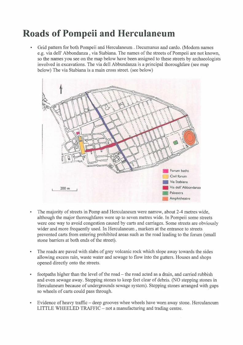
Roads of Pompeii and Herculaneum • Grid pattern for both Pompeii and Herculaneum . Decumanus and cardo. (Modem names
e.g. via dell' Abbondanza , via Stabiana. The names of the streets of Pompeii are not known, so the names you see on the map below have been assigned to these streets by archaeologists involved in excavations. The via dell Abbundanza is a principal thoroughfare (see map below) The via Stabiana is a main cross street. (see below)
200 m
Fori.Jm b:nhs
O vil forum
• Via Stab1ana • Via dell' Abbo ndanza
Pal~ estr:a
Amphitheatre
• The majority of streets in Pomp and Herculaneum were narrow, about 2-4 metres wide, although the major thoroughfares were up to seven metres wide. In Pompeii some streets were one way to avoid congestion caused by carts and carriages. Some streets are obviously wider and more frequently used. In Herculaneum , markers at the entrance to streets prevented carts from entering prohibited areas such as the road leading to the forum (small stone barriers at both ends of the street).
• The roads are paved with slabs of grey volcanic rock which slope away towards the sides allowing excess rain, waste water and sewage to flow into the gutters. Houses and shops opened directly onto the streets.
• footpaths higher than the level of the road - the road acted as a drain, and carried rubbish and even sewage away. Stepping stones to keep feet clear of debris. (NO stepping stones in Herculaneum because of undergrounds sewage system). Stepping stones arranged with gaps so wheels of carts could pass through. -
• Evidence of heavy traffic - deep grooves whee wheels have worn away stone. Herculaneum LITTLE WHEELED TRAFFIC - not a manufacturing and trading centre.
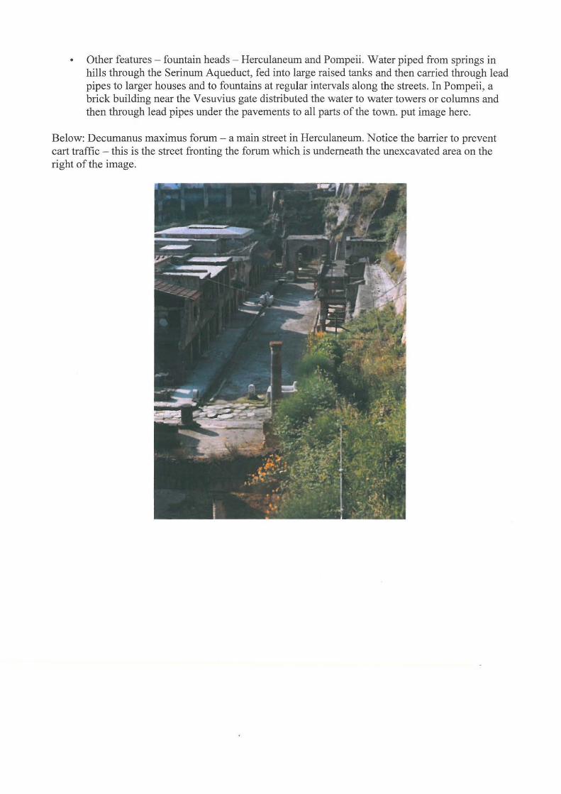
• Other features- fountain heads - Herculaneum and Pompeii. Water piped from springs in hills through the Serinum Aqueduct, fed into large raised tanks and then carried through lead pipes to larger houses and to fountains at regular intervals along the streets. In Pompeii, a brick building near the Vesuvius gate distributed the water to water towers or columns and then through lead pipes under the pavements to all parts of the town. put image here.
Below: Decumanus maximus forum - a main street in Herculaneum. Notice the barrier to prevent cart traffic - this is the street fronting the forum which is underneath the unexcavated area on the right of the image.

Source: Roads of Pompeii and Herculaneum
Using the three images below (a) (b) and (c) discuss the main features of the streets of Pompeii and Herculaneum.
a) Herculaneum.
b) Pompeii streets(b) Via dell' Abbundanza and (c) Via di Mercurio