plans for operational hurricane modeling at … for operational hurricane modeling at ncep/emc in...
TRANSCRIPT
Plans for Operational Hurricane Modeling at NCEP/EMC in FY17
Avichal Mehra, Vijay Tallapragada and the EMC Hurricane Team Environmental Modeling Center
NOAA / NWS / NCEP

Outline • 2017 HWRF Baseline configuration
• Preliminary HWRF Baseline test results
• HWRF upgrades and results • 2017 HMON configuration and preliminary results
• Current and future plans

FY17 HWRF v11.0.0 Implementation plans

System & Resolution Enhancements T&E with new 2017 NEMS GFS IC/BC Upgrade dynamic core from WRF3.7.a to WRF3.8 (with multiple bug fixes) Consider storm’s meridional movement when determining parent domain center Reduce coupling time step from 9min to 6 min for both waves and ocean Increase vertical resolution from 24 to 40 levels for POM with reduced time step ▪ New Tracker (from GFDL) ▪ Increase vertical resolution to 75 vertical levels and 10-hPa top, with adjusted domain
sizes for d02 (256 x 472) and d03 (256 x 472) (H216: 288 x 576)
Initialization/Data Assimilation Improvements Improve vortex initialization (new composite storm vortex) GSI code upgrades; new data sets for GSI (hourly shortwave, clear air water vapor and
visible AMV’s, GH changes, G –IV TDR data) Fully Cycled EnKF two-way hybrid DA when TDR data is available Change in blending threshold (to 65 Kt) HDOBS data assimilation
FY17 HWRF Baseline Configuration
-- Green: Included in Baseline -- Orange: Tested Separately

Physics Advancements
Bug fix for 10 meter wind (already in HWRFV3.8a) Update F-A Microphysics Updates to scale-aware SAS Updates to RRTMG (partial cloudiness) Update convection with G-F cumulus scheme
FY17 HWRF Baseline Configuration
-- Green: Included in Baseline -- Orange: Tested Separately

2017 HWRF Baseline Performance: North Atlantic Basin
• 2017 HWRF baseline experiments are mostly neutral in the North Atlantic basin as compared to H216 for track, intensity and bias.
• Track errors are larger as compared to GFS (both 2016 and 2017) for long-lead times.

2017 HWRF Baseline Performance: North East Pacific Basin
• 2017 HWRF baseline performance remains neutral for East Pacific basin as well.
• Early lead-time are slightly negative while longer-lead times are positive for both track and intensity.

Improve vortex initialization (new composite storm vortex) GSI code upgrades; new data sets for GSI (hourly shortwave, clear air
water vapor and visible AMV’s, GH changes, G –IV TDR data) Fully Cycled EnKF two-way hybrid DA when TDR data is available Change in blending threshold (to 65 Kt) HDOBS data assimilation
FY17 HWRF Initialization/Data Assimilation Improvements
-- Green: Included in Baseline -- Orange: Tested Separately
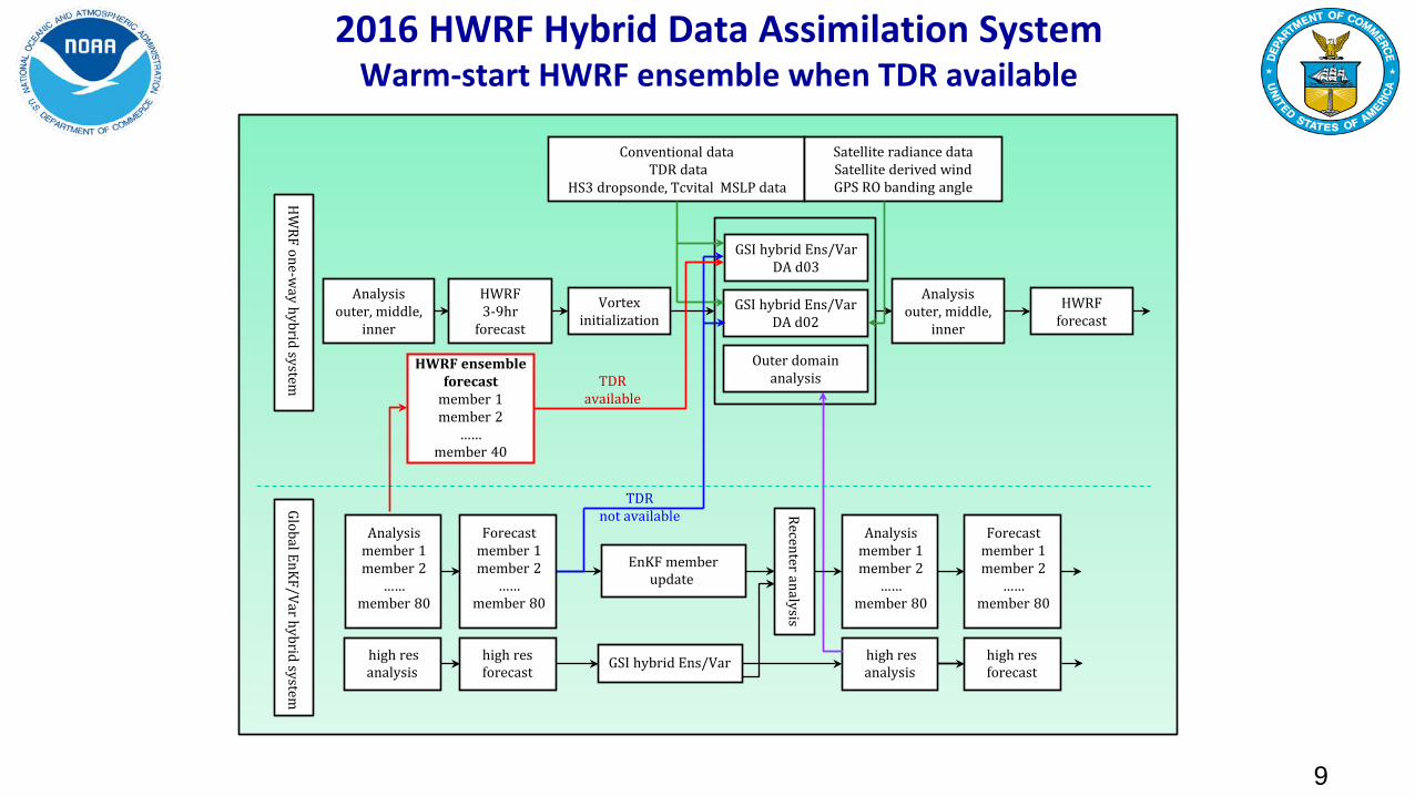
2016 HWRF Hybrid Data Assimilation System Warm-start HWRF ensemble when TDR available
Forecast member 1 member 2
…… member 80
high res forecast GSI hybrid Ens/Var
EnKF member update
Global EnKF/Var hybrid system
Recenter analysis
Analysis member 1 member 2
…… member 80
high res analysis
high res forecast
Analysis member 1 member 2
…… member 80
HW
RF one-way hybrid system
Conventional data TDR data
Satellite radiance data Satellite derived wind GPS RO banding angle
Vortex initialization
HWRF 3-9hr
forecast
Analysis outer, middle,
inner
HWRF forecast
high res analysis
GSI hybrid Ens/Var DA d02
GSI hybrid Ens/Var DA d03
Outer domain analysis
Forecast member 1 member 2
…… member 80
Analysis outer, middle,
inner
HS3 dropsonde, Tcvital MSLP data
9
TDR not available
TDR available
HWRF ensemble forecast
member 1 member 2
…… member 40

Conventional data TDR data
Satellite AMVs HS3 dropsonde
Tcvital MSLP data HDOB
Vortex initialization
HWRF Forecast (3-9hr)
Analysis outer, middle,
inner
HWRF forecast
GSI hybrid Ens/Var DA d02
GSI hybrid Ens/Var DA d03 Analysis
outer, middle, inner
GDAS/ENKF ensemble forecast
mem 001 mem 002
……
GDAS 3-9hr
forecast
GFS analysis
Satellite radiance data GPS RO banding angle
HW
RF EnKF/Var hybrid system
2017 HWRF Hybrid Data Assimilation System Cycled HWRF EnKF Ensemble Hybrid when TDR available
10
GDAS/ENKF Analysis
mem 001 mem 002
……
Forecast member 1 member 2
…… member 40
Analysis member 1 member 2
…… member 40
Analysis member 1 member 2
…… member 40
Forecast member 1 member 2
…… member 40
Vortex relocation member 1 member 2
…… member 40
Recenter Analysis
EnKF d01 & d02
EnKF d02
TDR mission in the next ~24 hours
Before TDR mission

2017 HWRF DA Improvements: North Atlantic Basin
• 2017 HWRF DA upgrades show improvement in tracks for longer-lead times.
• Intensity errors are significantly less as compared to baseline and H216 from Days 2-5.
• Bias results are very similar to H17B. • Preliminary results.

Bug fix for 10 meter wind (already in HWRFV3.8a) Update F-A Microphysics Updates to scale-aware SAS Updates to RRTMG (partial cloudiness) Update convection with G-F cumulus scheme
FY17 HWRF Physics Advancements
-- Green: Included in Baseline -- Orange: Tested Separately

21Z
29 Ju
ne 2
012
Problem
Solution
Constant rain drop size during rain evaporation (reduces evaporation)
Lack of stratiform precipitation
High reflectivity bias at anvil Increased largest
possible number concentration of snow
High reflectivity bias in PBL clouds Added a drizzle
parameterization (allows larger number of droplets) 13
12Z
23 Ju
ne 2
016
Old New
Ferrier-Aligo Microphysics Changes

2017 HWRF Physics Advancements
• Changes in Scale Aware SAS
• Updates to scale awareness • Decrease rate of rain conversion rate with decreasing air
temperatures above freezing levels • Enhance entrainment in dry environments • Precipitation changes in shallow convection to reduce presence
of low clouds • Changes to separation criteria between deep and shallow
convection

2017 HWRF Physics Advancements
• RRTMG Partial cloudiness modifications
• Adjustments to RH threshold methodology • Reduction in solar radiation biases over CONUS
• Grell-Freitas convective scheme implemented in HWRF
• NGGPS project (G. Grell and J.-W. Bao) • Based on Scale-aware/Aerosol-aware methods
(Grell and Freitas, 2014)

2017 HWRF Physics Advancements: North Atlantic Basin
• G-F scheme gives us the best track and intensity performance at Days 2 and 3.
• Errors are somewhat larger as compared to baseline for longer-lead times especially at Day 5.
• Preliminary results.
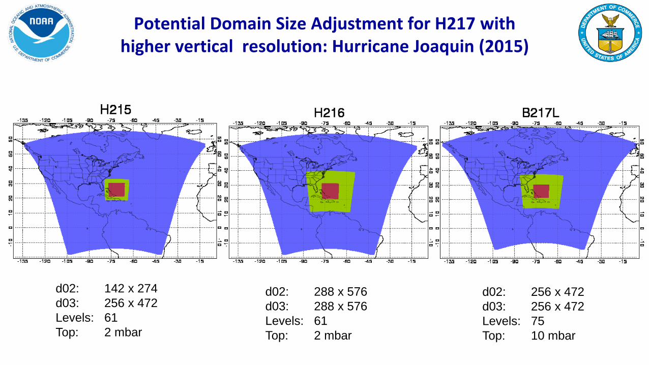
Potential Domain Size Adjustment for H217 with higher vertical resolution: Hurricane Joaquin (2015)
d02: 288 x 576 d03: 288 x 576 Levels: 61 Top: 2 mbar
d02: 256 x 472 d03: 256 x 472 Levels: 75 Top: 10 mbar
d02: 142 x 274 d03: 256 x 472 Levels: 61 Top: 2 mbar

2017 HWRF Combined Physics, DA and system changes: NATL
• Combined DA, Physics and system changes are giving us improvements in both track and intensity errors in the North Atlantic Basin as compared to H17B.
• Intensity and Bias errors are significantly less for longer-lead times especially at Days 3 - 5.
• Preliminary results.

2017 HWRF Combined Physics, DA and system changes: NATL
• Combined DA, Physics and system changes are giving us improvements in both track and intensity errors in the North Atlantic Basin as compared to H216.
• 50 Kt radius errors are also significantly less.
• Preliminary results.

Model upgrades
Physics and DA upgrades
Combined
Baseline (H17B)
Data Assimilation changes (H17T)
Physics changes (H17G)
H217
Description
1. Framework upgrade to HWRFV3.8a; domain center; new tracker 2. New 2017 GFS upgrade 3. U10 fix, smaller coupling time step. 4. GSI upgrades.
1. HDOBS 2. Blending
threshold 3. Fully self-cycled
EnKF
Assess impact of physics changes
Baseline + DA changes + all physics changes + others
Cases Three-season 2014-2016 simulations in ATL/EPAC cases (~2000)
Only Aircraft DA cases for 2014-2016
Priority cases (~400 cases in each basin)
Three-season 2014-2016 retrospectives ~5000 simulations in all TC basins
Platform WCOSS/Jet/Theia WCOSS/Jet/Theia WCOSS/Jet/Theia WCOSS Cray
HWRF Upgrade Plan for 2017 Implementation Multi-season Pre-Implementation T&E
FY17 HMON v1.0.0 Implementation plans

HMON: Hurricanes in a Multi-scale Ocean coupled Non-hydrostatic model
HMON: Implements a long-term strategy at NCEP/EMC for multiple static and moving nests globally, with one- and two-way interaction and coupled to other (ocean, wave, sea ice, surge, inundation, etc.) models using NEMS-NUOPC infrastructure.
HMON: A New Operational Hurricane Model at NCEP replacing GFDL Hurricane Model
HMON

• HMON: Advanced Hurricane Model using NMMB dynamic core which is currently being used in NCEP’s operational NAM and SREF systems.
• Shared infrastructure with unified model development in NEMS. A step closer towards NEMS/FV3 Unified Modeling System for hurricanes
• Much faster, scalable and uses CCPP style physics package
• Development supported by NGGPS, HFIP and HIWPP programs
• Provides high-resolution intensity forecast guidance to NHC along with HWRF (replacing the legacy GFDL hurricane model)
HMON: A New Operational Hurricane Model at NCEP
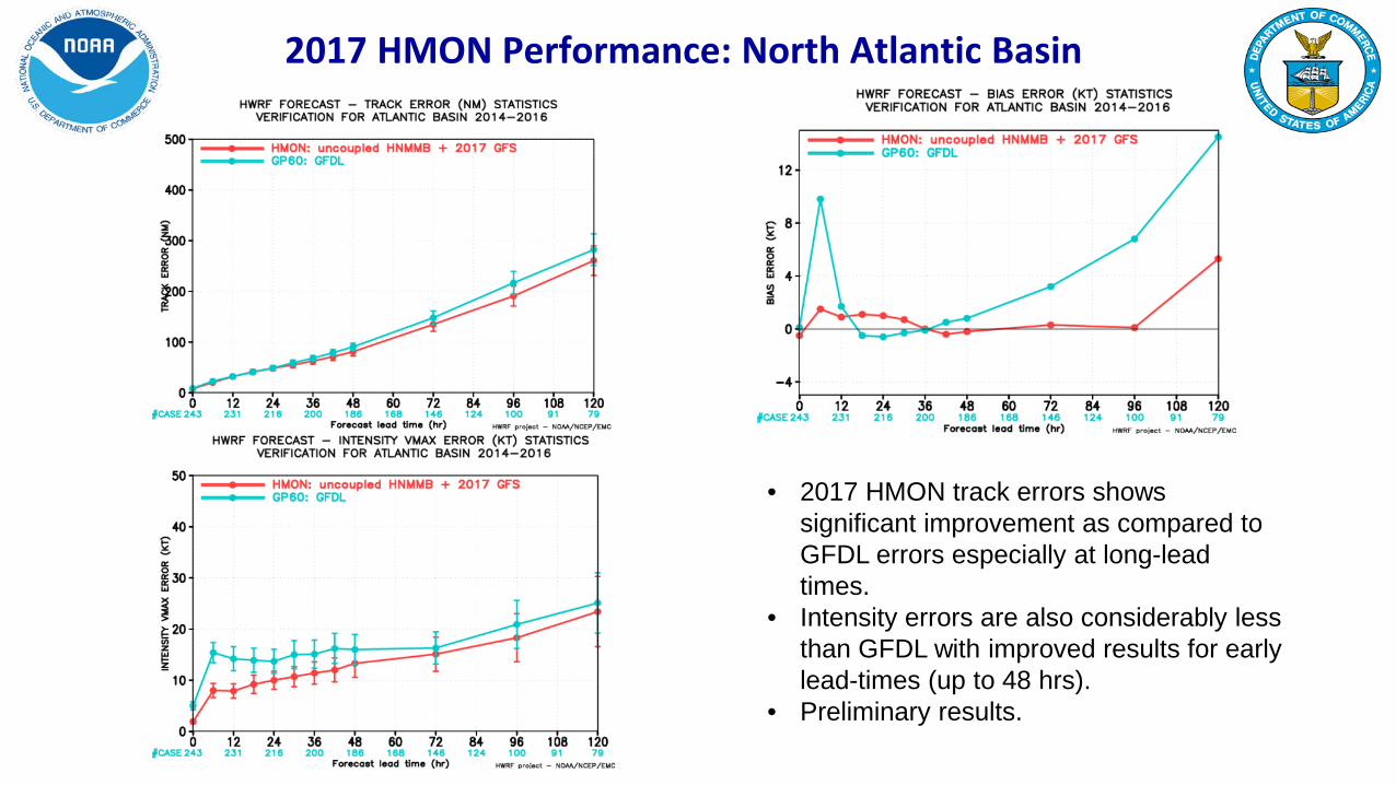
2017 HMON Performance: North Atlantic Basin
• 2017 HMON track errors shows significant improvement as compared to GFDL errors especially at long-lead times.
• Intensity errors are also considerably less than GFDL with improved results for early lead-times (up to 48 hrs).
• Preliminary results.

2014-16 Atlantic Basin: Relative to GFDL (interpolated)
HMON has improved track skills as compared to GFDL with an average improvement of more than 8%. It also has improved intensity skills with a mean improvement of >15%.
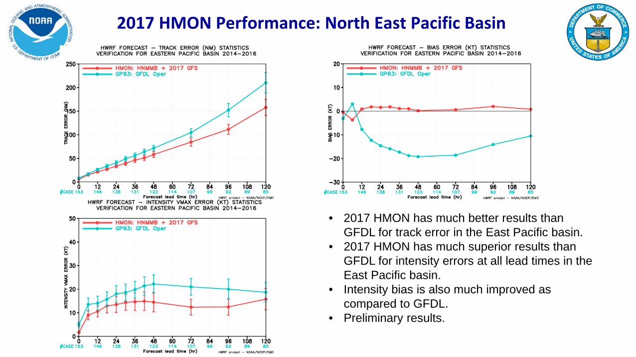
2017 HMON Performance: North East Pacific Basin
• 2017 HMON has much better results than GFDL for track error in the East Pacific basin.
• 2017 HMON has much superior results than GFDL for intensity errors at all lead times in the East Pacific basin.
• Intensity bias is also much improved as compared to GFDL.
• Preliminary results.

2014-16 East Pacific Basin: Relative to GFDL (interpolated)
HMON has improved track skills as compared to GFDL with an average improvement of more than 15%. It also has significantly improved intensity skills with a mean improvement of >20%.

HWRF/HMON Long-Term Plans
2016 2017 2018 2019 2020
NEMS Global Nests (NGGPS) GFDL –—–— HMON
Hurricane Models take over Hurricane Wave Forecasts
Basin-Scale HWRF/NMMB/FV3—–— Global/Tropical Domains
2016 Nov: Configuration ready 2016 Dec- 2017 March: Pre-implementation retrospective testing 2017 April: EMC CCB and code hand-off 2017 June: Operational Implementation
Development, T&E and Implementation Plans for HWRF & HMON
10-member HWRF/ HMON Ensembles
HWRF Operational Model Continues Followed by Ensembles
Thank You!

Supplementary Slides

2017 Data Assimilation Upgrades (ATL and EPAC)
Advanced self-cycled HWRF EnKF-GSI Hybrid Data Assimilation System (HDAS)

HWRF: Current and Future Tasks
• Further improvements to hurricane physics
• Further improvements to vortex initialization and data assimilation
• Increase/change vertical resolution, nested domain sizes
• Replace operational Hurricane Wave model with HWRF system • Three-way Atmosphere-Ocean-Wave coupling
• Basin-scale configurations

Operational System
2016 (nodes)
2017 (nodes)
Comments
HWRF 63 63 No change from 2016
WW3-multi2 9 0 WW3 coupled to HWRF
GFDL 3 0 Discontinued
HNMMB 0 26* Uses much less resources than HWRF
TOTAL 75 89 18.7% resource increase*
Targeted Resources for Hurricane Modeling (maximum per storm)
• Initial implementation is targeted for only 5 storms serving NHC areas of responsibility (NATL & EPAC)