plant community composition and structure monitoring at
TRANSCRIPT

National Park Service U.S. Department of the Interior
Natural Resource Stewardship and Science
Plant Community Composition and Structure Monitoring at Wind Cave National Park 2019 Data Report
Natural Resource Data Series NPS/WICA/NRDS—2019/1247

ON THIS PAGE Plant community composition and structure monitoring plot WICA_PCM_0023 at Wind Cave National Park, June 2019. Photograph courtesy of the National Park Service.
ON THE COVER View of canyon looking east towards Boland Ridge, near plant community plot WICA_PCM_0027 at Wind Cave National Park, June 2019. Photograph courtesy of the National Park Service.
Plant Community Composition and Structure Monitoring at Wind Cave National Park 2019 Data Report
Natural Resource Data Series NPS/WICA/NRDS—2019/1247
Theresa L. Schaffner,1 Daniel J. Swanson2, Stephanie L. Rockwood1
1National Park Service Northern Great Plains Inventory & Monitoring Network 820 Columbus Street Rapid City, SD 57701
2National Park Service Northern Great Plains Fire Management 26611 U.S. Hwy 385 Hot Springs, SD 57747
December 2019
U.S. Department of the Interior National Park Service Natural Resource Stewardship and Science Fort Collins, Colorado

ii
The National Park Service, Natural Resource Stewardship and Science office in Fort Collins, Colorado, publishes a range of reports that address natural resource topics. These reports are of interest and applicability to a broad audience in the National Park Service and others in natural resource management, including scientists, conservation and environmental constituencies, and the public.
The Natural Resource Data Series is intended for the timely release of basic data sets and data summaries. Care has been taken to assure accuracy of raw data values, but a thorough analysis and interpretation of the data has not been completed. Consequently, the initial analyses of data in this report are provisional and subject to change.
All manuscripts in the series receive the appropriate level of peer review to ensure that the information is scientifically credible, technically accurate, appropriately written for the intended audience, and designed and published in a professional manner.
Data in this report were collected and analyzed using methods based on established, peer-reviewed protocols and were analyzed and interpreted within the guidelines of the protocols.
Views, statements, findings, conclusions, recommendations, and data in this report do not necessarily reflect views and policies of the National Park Service, U.S. Department of the Interior. Mention of trade names or commercial products does not constitute endorsement or recommendation for use by the U.S. Government.
This report is available in digital format from the Northern Great Plains Inventory & Monitoring website and the Natural Resource Publications Management website. If you have difficulty accessing information in this publication, particularly if using assistive technology, please email [email protected].
Please cite this publication as:
Schaffner, T. L., D. J. Swanson, and S. L. Rockwood. 2019. Plant community composition and structure monitoring at Wind Cave National Park: 2019 data report. Natural Resource Data Series NPS/WICA/NRDS—2019/1247. National Park Service, Fort Collins, Colorado.
NPS 108/165815, December 2019
iii
Contents Page
Figures ................................................................................................................................................... iv
Tables ..................................................................................................................................................... v
Abstract ................................................................................................................................................. vi
Acknowledgments ................................................................................................................................ vii
Introduction ............................................................................................................................................ 1
Methods .................................................................................................................................................. 3
Sample Design ................................................................................................................................ 3
Plot Layout and Sampling .............................................................................................................. 5
Data Management and Analysis ..................................................................................................... 8
Results .................................................................................................................................................. 10
Further Analysis ................................................................................................................................... 31
Literature Cited .................................................................................................................................... 32

iv
Figures Page
Figure 1. Map of Wind Cave National Park (WICA) long-term monitoring plots visited in 2019. .................................................................................................................................................. 2
Figure 2. Long-term monitoring plot layout used for sampling vegetation used by the Northern Great Plains Inventory and Monitoring and Fire Ecology programs. .................................... 6
Figure 3. The Northern Great Plains Inventory & Monitoring vegetation crew used point-intercept (left and center panel) and quadrats (right panel) to document plant diversity and abundance. ....................................................................................................................................... 6
Figure 4. PCM_0026 had the highest absolute cover of native species observed from any plot in 2019 in Wind Cave National Park. ........................................................................................... 22

v
Tables Page
Table 1. Field journal for Northern Great Plains Network (NGPN) plant community monitoring (PCM) at Wind Cave National Park (WICA) in 2019. ....................................................... 3
Table 2. Field journal for fire plant community monitoring at Wind Cave National Park (WICA) in 2019. .................................................................................................................................... 4
Table 3. Exotic species included in the Northern Great Plains Network’s early detection and rapid response program. .................................................................................................................. 7
Table 4. A list of all plant species identified in Wind Cave National Park’s long-term plant community monitoring plots in 2019. ......................................................................................... 10
Table 5. Total number of plant species identified in plots monitored at Wind Cave National Park in 2019. ......................................................................................................................... 19
Table 6. Absolute percent cover of native and exotic plant species in plots monitored at Wind Cave National Park in 2019. ...................................................................................................... 21
Table 7. Woody species densities from 42 long-term monitoring plots visited at Wind Cave National Park in 2019. ................................................................................................................ 22
Table 8. Surface fuels summary for 45 plots visited in 2019 at Wind Cave National Park. ............... 27
Table 9. Disturbance type and area observed in 21 plots visited at Wind Cave National Park by Northern Great Plains Network and Northern Great Plains Fire in 2019. .............................. 29
vi
Abstract This report presents the results of the Northern Great Plains Inventory and Monitoring Network (NGPN) and Northern Great Plains Fire Ecology Program (NGPFire) vegetation monitoring at Wind Cave National Park (WICA) in 2019. This was the ninth year of combined monitoring efforts.
Crew members from NGPN visited 18 long-term monitoring plots to collect data representing the plant communities at WICA. The NGPFire program collected pre- and post-burn data from an additional 37 plant community and forest structure monitoring plots. This work is part of a long-term monitoring effort designed to evaluate the condition of the vegetation community and understand how it is changing over time. NGPN staff measured species richness, herb-layer height, native and non-native species abundance, ground cover, and site disturbance at each of the plots. In plots where woody species were present, tree regeneration, tall shrub density, tree density, and woody fuel loads were also measured. NGPFire conducted herb-layer height, native and non-native abundance, ground cover, disturbance, protocols at 18 plots, and where woody species were present, tree density, tree regeneration, tall shrub density, and woody fuel load protocols were completed at 35 plots.
In 2019, the NGPN and NGPFire monitoring crews identified 239 unique plant species from 55 plant community and forest structure monitoring plots. Of the 239 species observed in 2019, 203 were native and 34 were exotic.

vii
Acknowledgments We thank all the authors of the Northern Great Plains Plant Community Monitoring Protocol, particularly A. Symstad, for guidance on data collection and reporting. Thank you to the staff at WICA for providing logistical support. The 2019 NGPN vegetation field crew—C. Davis, M. Davis, S. Rockwood, R. Manuel, T. Schaffner, T. Bortz, and E. Duda, C. Knudtson, and A. Fowler— and 2019 NGPFire crew—D. Swanson, I. Muirhead, M. Pahler and L. Badertscher—collected the data included in this report.
1
Introduction Wind Cave National Park (WICA), established in 1903, is located in the southern Black Hills of South Dakota. The park purpose is to protect the unique Wind Cave resources and to preserve and enhance the mixed-grass prairie and native wildlife, while also providing for the enjoyment of the public. The 33,851 acres of WICA is a mosaic of ponderosa pine forest and mixed-grass prairie. While some areas have high exotic species cover, the native plant communities within the upland areas of WICA are considered to be in good condition (Komp et al. 2011).
The Northern Great Plains Fire Ecology Program (NGPFire) began vegetation monitoring at WICA in 1997 (Wienk et al. 2011). In 2011, the Northern Great Plains Inventory & Monitoring Program (NGPN) combined efforts with NGPFire (Ashton et al. 2012) to establish a coordinated vegetation monitoring protocol, and plot locations were shifted to better represent the entire park (Symstad et al. 2012b) based on the 2010 boundary. In 2011, WICA acquired the 5,550-acre Casey property, and ten upland plots were later installed to represent the addition to the park property. There is a separate effort to monitor streambank condition because riparian communities are an important resource for the park (Burkhart and Kovacs 2013). In this report, we provide summaries of the upland vegetation monitoring data collected at 55 plots visited in 2019 (Figure 1). For a more in-depth data report on long-term vegetation trends at WICA, refer to the 2011-2015 summary report (Ashton et al. 2016) or the most recent assessment of forest condition (Ashton et al. 2019).

2
Figure 1. Map of Wind Cave National Park (WICA) long-term monitoring plots visited in 2019. Plant Community (PCM) plots are represented in orange and Forest Structure plots are represented in green.

3
Methods The NGPN Plant Community Composition and Structure Monitoring Protocol (Symstad et al. 2012b, a) describes in detail the methods used for sampling long-term plots. Below, we briefly describe the general approach. For those interested in more detail, please see the protocol publications cited above, and available at http://science.nature.nps.gov/im/units/ngpn/monitor/plants.cfm.
Sample Design The NGPN and NGPFire implemented a survey to monitor plant community structure and composition in WICA using a spatially balanced probability design (Generalized Random Tessellation Stratified [GRTS]; Stevens and Olsen 2003, 2004). Using the GRTS design, NGPN selected 35 randomly located sites within WICA to install Plant Community Monitoring (PCM) plots. These 35 sites were split into five panels containing seven sites each. NGPN crews visit two panels (14 sites total) in June every year using a rotating sampling scheme that consists of seven plots visited the previous year and seven plots that have not been visited for four years. Data from these randomly selected sites can be used to estimate condition of vegetation communities for the whole park and can be used to discern trends in condition over time. Ten additional monitoring sites (2 per panel) were selected within the 2011 park addition and are on the same plot visit schedule as above. In 2019, NGPN crews visited sites in panel 3 and panel 4 during mid-June (Table 1). The NGPN crews commuted from Rapid City to WICA daily. Two NGPN crews, with help from NGPN program staff and volunteers, completed sampling in approximately 450 crew hours.
Table 1. Field journal for Northern Great Plains Network (NGPN) plant community monitoring (PCM) at Wind Cave National Park (WICA) in 2019. NGPN crews completed monitoring protocols at 18 plots.
Date Visited Plot Monitoring Type/ Panel Field Notes
6/13/2019 PCM_0015 PCM/ Panel 3 3 person crew
6/26/2019 PCM_0016 PCM/ Panel 3 3 person crew; quadrat protocol not performed due to high abundance of poison ivy in plot
6/18/2019 PCM_0017 PCM/ Panel 3 3 person crew
6/20/2019 PCM_0018 PCM/ Panel 3 3 person crew
6/13/2019 PCM_0019 PCM/ Panel 3 3 person crew
6/24/2019 PCM_0020 PCM/ Panel 3 3 person crew
6/17/2019 PCM_0021 PCM/ Panel 3 4 person crew
6/17/2019 PCM_0022 PCM/ Panel 4 4 person crew
6/25/2019 PCM_0023 PCM/ Panel 4 4 person crew
6/19/2019 PCM_0024 PCM/ Panel 4 3 person crew
6/19/2019 PCM_0025 PCM/ Panel 4 3 person crew
6/24/2019 PCM_0026 PCM/ Panel 4 4 person crew
6/26/2019 PCM_0027 PCM/ Panel 4 3 person crew
6/13/2019 PCM_0028 PCM/ Panel 4 5 person crew
4
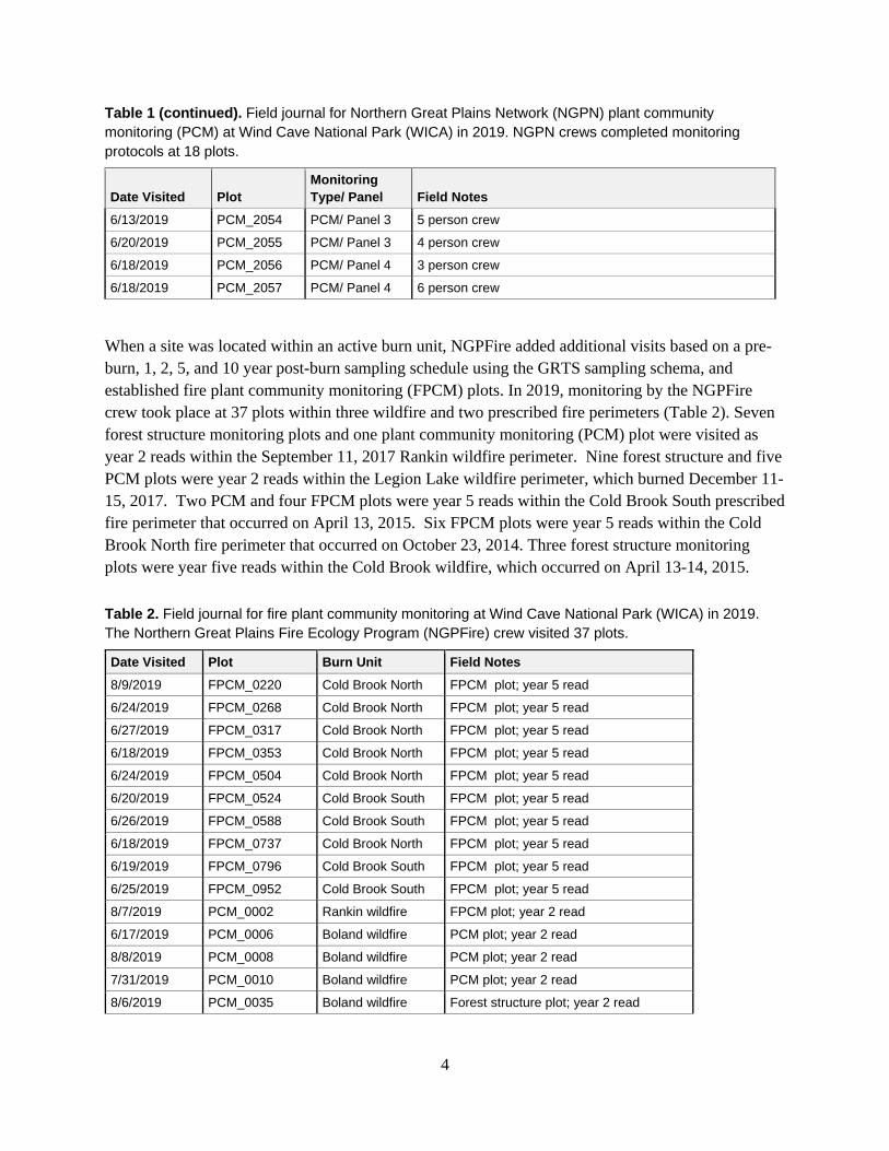
Table 1 (continued). Field journal for Northern Great Plains Network (NGPN) plant community monitoring (PCM) at Wind Cave National Park (WICA) in 2019. NGPN crews completed monitoring protocols at 18 plots.
Date Visited Plot Monitoring Type/ Panel Field Notes
6/13/2019 PCM_2054 PCM/ Panel 3 5 person crew
6/20/2019 PCM_2055 PCM/ Panel 3 4 person crew
6/18/2019 PCM_2056 PCM/ Panel 4 3 person crew
6/18/2019 PCM_2057 PCM/ Panel 4 6 person crew
When a site was located within an active burn unit, NGPFire added additional visits based on a pre-burn, 1, 2, 5, and 10 year post-burn sampling schedule using the GRTS sampling schema, and established fire plant community monitoring (FPCM) plots. In 2019, monitoring by the NGPFire crew took place at 37 plots within three wildfire and two prescribed fire perimeters (Table 2). Seven forest structure monitoring plots and one plant community monitoring (PCM) plot were visited as year 2 reads within the September 11, 2017 Rankin wildfire perimeter. Nine forest structure and five PCM plots were year 2 reads within the Legion Lake wildfire perimeter, which burned December 11-15, 2017. Two PCM and four FPCM plots were year 5 reads within the Cold Brook South prescribed fire perimeter that occurred on April 13, 2015. Six FPCM plots were year 5 reads within the Cold Brook North fire perimeter that occurred on October 23, 2014. Three forest structure monitoring plots were year five reads within the Cold Brook wildfire, which occurred on April 13-14, 2015.
Table 2. Field journal for fire plant community monitoring at Wind Cave National Park (WICA) in 2019. The Northern Great Plains Fire Ecology Program (NGPFire) crew visited 37 plots.
Date Visited Plot Burn Unit Field Notes 8/9/2019 FPCM_0220 Cold Brook North FPCM plot; year 5 read
6/24/2019 FPCM_0268 Cold Brook North FPCM plot; year 5 read
6/27/2019 FPCM_0317 Cold Brook North FPCM plot; year 5 read
6/18/2019 FPCM_0353 Cold Brook North FPCM plot; year 5 read
6/24/2019 FPCM_0504 Cold Brook North FPCM plot; year 5 read
6/20/2019 FPCM_0524 Cold Brook South FPCM plot; year 5 read
6/26/2019 FPCM_0588 Cold Brook South FPCM plot; year 5 read
6/18/2019 FPCM_0737 Cold Brook North FPCM plot; year 5 read
6/19/2019 FPCM_0796 Cold Brook South FPCM plot; year 5 read
6/25/2019 FPCM_0952 Cold Brook South FPCM plot; year 5 read
8/7/2019 PCM_0002 Rankin wildfire FPCM plot; year 2 read
6/17/2019 PCM_0006 Boland wildfire PCM plot; year 2 read
8/8/2019 PCM_0008 Boland wildfire PCM plot; year 2 read
7/31/2019 PCM_0010 Boland wildfire PCM plot; year 2 read
8/6/2019 PCM_0035 Boland wildfire Forest structure plot; year 2 read

5
Table 2 (continued). Field journal for fire plant community monitoring at Wind Cave National Park (WICA) in 2019. The Northern Great Plains Fire Ecology Program (NGPFire) crew visited 37 plots.
Date Visited Plot Burn Unit Field Notes 8/6/2019 PCM_0036 Boland wildfire PCM plot; year 2 read
8/16/2019 PCM_0038 Rankin wildfire Forest structure plot; year 2 read
8/5/2019 PCM_0046 Cold Brook wildfire Forest structure plot; year 5 read
8/15/2019 PCM_0051 Rankin wildfire Forest structure plot; year 2 read
8/16/2019 PCM_0054 Rankin wildfire Forest structure plot; year 2 read
9/6/2019 PCM_0056 Boland wildfire Forest structure plot; year 2 read
8/13/2019 PCM_0058 Boland wildfire Forest structure plot; year 2 read
9/17/2019 PCM_0059 Boland wildfire Forest structure plot; year 2 read
9/17/2019 PCM_0068 Boland wildfire Forest structure plot; year 2 read
8/15/2019 PCM_0070 Boland wildfire Forest structure plot; year 2 read
9/4/2019 PCM_0072 Boland wildfire Forest structure plot; year 2 read
6/26/2019 PCM_0076 Cold Brook South PCM plot; year 5 read
9/6/2019 PCM_0088 Boland wildfire Forest structure plot; year 2 read
8/13/2019 PCM_0090 Boland wildfire Forest structure plot; year 2 read
8/21/2019 PCM_0094 Cold Brook wildfire Forest structure plot; year 5 read
9/13/2019 PCM_0099 Boland wildfire Forest structure plot; year 2 read
8/16/2019 PCM_0102 Rankin wildfire Forest structure plot; year 2 read
8/15/2019 PCM_0103 Rankin wildfire Forest structure plot; year 2 read
8/20/2019 PCM_0110 Cold Brook wildfire Forest structure plot; year 5 read
8/15/2019 PCM_0115 Rankin wildfire Forest structure plot; year 2 read
8/23/2019 PCM_0118 Rankin wildfire Forest structure plot; year 2 read
6/20/2019 PCM_0120 Cold Brook South PCM plot; year 5 read
Plot Layout and Sampling At each site visited, the NGPN crew recorded plant species cover and frequency in a rectangular, 50 m x 20 m (0.1 ha), permanent plot (Figure 2). Data on ground cover, herb-layer height (≤ 2 m), and plant cover were collected on two 50 m transects (the long sides of the plot) using a point-intercept method (Figure 3). Species richness data from the point-intercept method were supplemented with species presence data collected in five 1 m2 quadrats located systematically along each transect (Figure 3). The NGPN crew measured species presence at ten quadrats per plot. If a plant species was identified in the plot but was not included on the verified park species list, a voucher plant specimen was collected when possible and submitted to a botanist for independent verification.

6
Figure 2. Long-term monitoring plot layout used for sampling vegetation used by the Northern Great Plains Inventory and Monitoring and Fire Ecology programs.
Figure 3. The Northern Great Plains Inventory & Monitoring vegetation crew used point-intercept (left and center panel) and quadrats (right panel) to document plant diversity and abundance.

7
When woody species were present within 38 m of plot center, monitoring crews collected tree regeneration and tall shrub density data within a 10 m radius subplot centered in the larger 50 m x 20 m (0.1 ha) plot. Trees with diameter at breast height (DBH) > 15 cm, present within the 0.1 ha plot were mapped and tagged. For each tree, the species, DBH, status (live or dead), and condition (e.g., leaf-discoloration, insect-damaged, etc.) were recorded. For all poles (2.54 ≤ DBH ≤ 15 cm) located within the 10 m radius subplot, only DBH and status were recorded. Tree and tall shrub species with DBH < 2.54 cm (seedlings) were tallied by species within the 10 m radius subplot. In 2019, NGPN changed the way these species counts were made. Stump sprouts (stems originating between ground level and 137 cm on the bole of trees that have died or been cut) were previously tallied individually, resulting in an over-representation of seedling recruitment. Now crews only count one sprout per dead tree stump based on the tallest height class present. If a sprout is attached to a live tree, it is not a seedling and therefore not counted. Dead and downed woody fuel load data were collected along two perpendicular, 100 ft (30.49 m) transects (fuel lines) with midpoints at the center of the plot (Figure 3), following Brown’s Line methods (Brown 1974, Brown et al. 1982). Fuel load data were only collected if at least one piece of woody litter or fuel intersected a fuel line.
NGPN crews assessed and documented common disturbances at each plot. The type, which included animal mounds, animal trails, and fire, and the approximate area (m2) of each disturbance was recorded. Plots were also assessed for the presence and abundance of target exotic species (Table 3), which is critical for early detection and rapid response to exotic species threats. These species were chosen in collaboration with the Midwest Invasive Plant Network, Northern Great Plains Exotic Plant Management Team, park managers, and local weed experts. Each target species was assigned an abundance class from 1-5, based on an ocular estimate of cover, where 1 = one individual, 2 = few individuals, 3 = cover of 1-5%, 4 = cover of 5-25%, and 5 = cover > 25% of the plot.
Table 3. Exotic species included in the Northern Great Plains Network’s early detection and rapid response program.
Habitat Scientific Name Common Name Riparian Alliaria petiolata garlic mustard
Riparian Polygonum cuspidatum; P. sachalinense; P. x bohemicum
knotweeds
Riparian Pueraria montana var. lobata kudzu
Riparian Iris pseudacorus yellow iris
Riparian Ailanthus altissima tree of heaven
Riparian Lepidium latifolium perennial pepperweed
Riparian Arundo donax giant reed
Riparian Rhamnus cathartica common buckthorn
Riparian Heracleum mantegazzianum giant hogweed
Upland Centaurea solstitialis yellow star thistle
Upland Hieracium aurantiacum; H. caespitosum orange and meadow hawkweed
Upland Isatis tinctoria Dyer's woad

8
Table 3 (continued). Exotic species included in the Northern Great Plains Network’s early detection and rapid response program.
Habitat Scientific Name Common Name Upland Taeniatherum caput-medusae medusahead
Upland Chondrilla juncea rush skeletonweed
Upland Gypsophila paniculata baby's breath
Upland Centaurea virgata; C.diffusa knapweeds
Upland Linaria dalmatica; L. vulgaris toadflax
Upland Euphorbia myrsinites & E. cyparissias myrtle spurge
Upland Dipsacus fullonum & D. laciniatus common teasel
Upland Salvia aethiopis Mediterranean sage
Upland Ventenata dubia African wiregrass
Data Management and Analysis FFI (FEAT/FIREMON Integrated; http://frames.gov/ffi/) was the primary software environment used for managing our sampling data. FFI is used by a variety of agencies (e.g., NPS, USDA Forest Service, U.S. Fish and Wildlife Service), has a national-level support system, and generally conforms to the Natural Resource Database Template standards established by the Inventory and Monitoring Program. Species scientific names, codes, common names, and native status are from the USDA Plants Database (USDA-NRCS 2017). However, nomenclature follows the Integrated Taxonomic Information System (ITIS). In the few cases where ITIS recognizes a new name that was not in the USDA PLANTS database, the new name was used, and a unique plant code was assigned. In the case where there is not enough evidence for genus and species identification, a special code for the unknown species was created. These are then designated as an exotic species in the total count, but omitted from the species list.
After data were entered in the database, 100% of records were verified with the original data sheets to minimize transcription errors, followed by a 10% review of records to confirm accuracy. After all data were entered and verified, automated queries were used to check for any remaining errors in the data. When errors were identified by the crew or the automated queries, corrections were made to the original datasheets and the FFI database.
Data summaries were produced using the FFI reporting and query tools, as well as R software (R version 3.6.1). The number of species encountered in each plot was calculated using data from point-intercept, quadrat, woody species, and target species protocols. Absolute cover was calculated using point-intercept data and is the total number of vegetation intercepts. This is often greater than 100% because more than one species can be intercepted per point due to overlapping vegetation.
The conservation status rank of plant species observed at WICA in 2019 was determined by cross-referencing with the NatureServe conservation status list, as well as the South Dakota rare plant species list. For the purpose of this report, a species was considered rare or of conservation concern if its state or global conservation status rank was critically imperiled (S1/G1), imperiled (S1/G2), or

9
vulnerable (S3/G3). The 2019 species list was also cross-referenced with the list of noxious weeds maintained by the South Dakota Department of Agriculture.

10
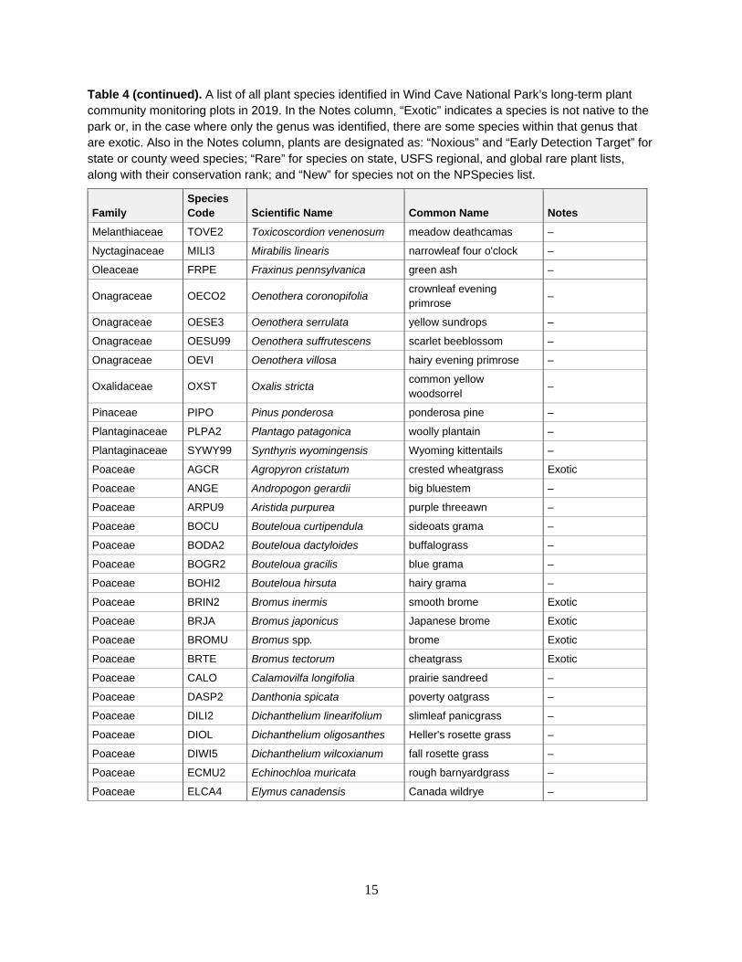
Results There are 589 vascular plant species on the WICA species list, and monitoring crews found 238 of these species in 2019 (Table 4). Of these plant species, 34 are exotic species at WICA. A majority of exotic plants identified were either forbs or graminoids (grasses, sedges, and rushes). The 2019 species list was cross-referenced with state- and county-wide rare and noxious exotic species lists for South Dakota. Two species matched the South Dakota exotic species list: Canada thistle (Cirsium arvense) and leafy spurge (Euphorbia esula). Two additional species are designated as noxious in Custer County: common mullein (Verbascum thapsus) and horehound (Marrubium vulgare). One new species to the park, found by the NGPFire crew, was thymeleaf sandwort (Arenaria serpyllifolia). This species will need a voucher specimen collected in a future visit for verification and herbarium records. No monitoring crews identified rare plant species in any plot in 2019.
Table 4. A list of all plant species identified in Wind Cave National Park’s long-term plant community monitoring plots in 2019. In the Notes column, “Exotic” indicates a species is not native to the park or, in the case where only the genus was identified, there are some species within that genus that are exotic. Also in the Notes column, plants are designated as: “Noxious” and “Early Detection Target” for state or county weed species; “Rare” for species on state, USFS regional, and global rare plant lists, along with their conservation rank; and “New” for species not on the NPSpecies list.
Family Species Code Scientific Name Common Name Notes
Agavaceae YUGL Yucca glauca soapweed yucca –
Anacardiaceae RHAR4 Rhus aromatica fragrant sumac –
Anacardiaceae TORY Toxicodendron rydbergii western poison ivy –
Apiaceae LOFO Lomatium foeniculaceum desert biscuitroot –
Asclepiadaceae ASCLE Asclepias spp. milkweed –
Asclepiadaceae ASPU Asclepias pumila plains milkweed –
Asteraceae ACMI2 Achillea millefolium common yarrow –
Asteraceae AMPS Ambrosia psilostachya Cuman ragweed –
Asteraceae ANNE Antennaria neglecta field pussytoes –
Asteraceae ANPA4 Antennaria parvifolia small-leaf pussytoes –
Asteraceae ANTEN Antennaria spp. pussytoes –
Asteraceae ARFR4 Artemisia frigida fringed sagewort –
Asteraceae ARLU Artemisia ludoviciana white sagebrush –
Asteraceae BREU Brickellia eupatorioides false boneset –
Asteraceae CANU4 Carduus nutans nodding plumeless thistle Exotic
Asteraceae CIAR4 Cirsium arvense Canada thistle Exotic; Noxious-SD
Asteraceae CIDR2 Cirsium drummondii dwarf thistle –
Asteraceae CIUN Cirsium undulatum wavyleaf thistle –
Asteraceae COCA5 Conyza canadensis horseweed –

11
Table 4 (continued). A list of all plant species identified in Wind Cave National Park’s long-term plant community monitoring plots in 2019. In the Notes column, “Exotic” indicates a species is not native to the park or, in the case where only the genus was identified, there are some species within that genus that are exotic. Also in the Notes column, plants are designated as: “Noxious” and “Early Detection Target” for state or county weed species; “Rare” for species on state, USFS regional, and global rare plant lists, along with their conservation rank; and “New” for species not on the NPSpecies list.
Family Species Code Scientific Name Common Name Notes
Asteraceae CORA4 Conyza ramosissima dwarf horseweed –
Asteraceae DYPA Dyssodia papposa fetid marigold –
Asteraceae ECAN2 Echinacea angustifolia purple coneflower –
Asteraceae ERCA4 Erigeron canus hoary fleabane –
Asteraceae ERFL Erigeron flagellaris trailing fleabane –
Asteraceae ERPH Erigeron philadelphicus Philadelphia fleabane –
Asteraceae GRSQ Grindelia squarrosa curlycup gumweed –
Asteraceae GUSA2 Gutierrezia sarothrae broom snakeweed –
Asteraceae HELIA3 Helianthus spp. sunflower –
Asteraceae HEMA2 Helianthus maximiliani Maximilian sunflower –
Asteraceae HEVI4 Heterotheca villosa hairy false goldenaster –
Asteraceae LASE Lactuca serriola prickly lettuce Exotic
Asteraceae LIPU Liatris punctata dotted blazing star –
Asteraceae LOAR5 Logfia arvensis field cottonrose Exotic
Asteraceae LYJU Lygodesmia juncea rush skeletonplant –
Asteraceae MUOB99 Mulgedium oblongifolium blue lettuce –
Asteraceae NOCU Nothocalais cuspidata prairie false dandelion –
Asteraceae PACA15 Packera cana woolly groundsel –
Asteraceae PAPL12 Packera plattensis prairie groundsel –
Asteraceae RACO3 Ratibida columnifera upright prairie coneflower –
Asteraceae SOMI2 Solidago missouriensis Missouri goldenrod –
Asteraceae SOMO Solidago mollis velvety goldenrod –
Asteraceae SONE Solidago nemoralis gray goldenrod –
Asteraceae SYER Symphyotrichum ericoides white heath aster –
Asteraceae SYLA3 Symphyotrichum laeve smooth blue aster –
Asteraceae SYMPH4 Symphyotrichum spp. aster –
Asteraceae SYOB Symphyotrichum oblongifolium
aromatic aster –
Asteraceae TAOF Taraxacum officinale common dandelion Exotic
Asteraceae TEAC Tetraneuris acaulis stemless four-nerve daisy –
Asteraceae TRDU Tragopogon dubius yellow salsify Exotic
Asteraceae XASP99 Xanthisma spinulosum lacy tansyaster –

12
Table 4 (continued). A list of all plant species identified in Wind Cave National Park’s long-term plant community monitoring plots in 2019. In the Notes column, “Exotic” indicates a species is not native to the park or, in the case where only the genus was identified, there are some species within that genus that are exotic. Also in the Notes column, plants are designated as: “Noxious” and “Early Detection Target” for state or county weed species; “Rare” for species on state, USFS regional, and global rare plant lists, along with their conservation rank; and “New” for species not on the NPSpecies list.
Family Species Code Scientific Name Common Name Notes
Boraginaceae CRCE Cryptantha celosioides buttecandle –
Boraginaceae CRTH Cryptantha thyrsiflora calcareous cryptantha –
Boraginaceae CYOF Cynoglossum officinale houndstongue Exotic
Boraginaceae LAOC3 Lappula occidentalis flatspine stickseed –
Boraginaceae LIIN2 Lithospermum incisum narrowleaf stoneseed –
Boraginaceae MELA3 Mertensia lanceolata prairie bluebells –
Boraginaceae ONBE Onosmodium bejariense soft-hair marbleseed –
Brassicaceae ALDE Alyssum desertorum desert madwort Exotic
Brassicaceae ARABI2 Arabis spp. rockcress –
Brassicaceae ARHI Arabis hirsuta hairy rockcress –
Brassicaceae ARPY4 Arabis pycnocarpa creamflower rockcress –
Brassicaceae DEPI Descurainia pinnata western tansymustard –
Brassicaceae DESO2 Descurainia sophia herb sophia Exotic
Brassicaceae DRRE2 Draba reptans Carolina draba –
Brassicaceae ERAS2 Erysimum asperum western wallflower –
Brassicaceae ERCA14 Erysimum capitatum sanddune wallflower –
Brassicaceae ERYSI Erysimum spp. wallflower Exotic
Brassicaceae LEDE Lepidium densiflorum common pepperweed –
Brassicaceae PHLU99 Physaria ludoviciana foothill bladderpod –
Cactaceae ESMI3 Escobaria missouriensis Missouri foxtail cactus –
Cactaceae OPFR Opuntia fragilis brittle pricklypear –
Cactaceae OPMA2 Opuntia macrorhiza twistspine pricklypear –
Cactaceae OPUNT Opuntia spp. pricklypear –
Campanulaceae CARO2 Campanula rotundifolia bluebell bellflower –
Campanulaceae TRPE4 Triodanis perfoliata clasping Venus' looking-glass –
Caprifoliaceae SYOC Symphoricarpos occidentalis western snowberry –
Caryophyllaceae ARSE2 Arenaria serpyllifolia thymeleaf sandwort Exotic; New
Caryophyllaceae CEAR4 Cerastium arvense field chickweed –
Caryophyllaceae PADE4 Paronychia depressa spreading nailwort –
Caryophyllaceae PASE Paronychia sessiliflora creeping nailwort –

13
Table 4 (continued). A list of all plant species identified in Wind Cave National Park’s long-term plant community monitoring plots in 2019. In the Notes column, “Exotic” indicates a species is not native to the park or, in the case where only the genus was identified, there are some species within that genus that are exotic. Also in the Notes column, plants are designated as: “Noxious” and “Early Detection Target” for state or county weed species; “Rare” for species on state, USFS regional, and global rare plant lists, along with their conservation rank; and “New” for species not on the NPSpecies list.
Family Species Code Scientific Name Common Name Notes
Caryophyllaceae SIAN2 Silene antirrhina sleepy silene –
Caryophyllaceae SILA21 Silene latifolia bladder campion Exotic
Chenopodiaceae CHENO Chenopodium spp. goosefoot –
Commelinaceae TRBR Tradescantia bracteata longbract spiderwort –
Commelinaceae TROC Tradescantia occidentalis prairie spiderwort –
Convolvulaceae COAR4 Convolvulus arvensis field bindweed Exotic
Convolvulaceae EVNU Evolvulus nuttallianus shaggy dwarf morning-glory –
Cupressaceae JUSC2 Juniperus scopulorum Rocky Mountain juniper –
Cyperaceae CABR10 Carex brevior shortbeak sedge –
Cyperaceae CADU6 Carex duriuscula needleleaf sedge –
Cyperaceae CAFI Carex filifolia threadleaf sedge –
Cyperaceae CAIN9 Carex inops sun sedge –
Cyperaceae CANE2 Carex nebrascensis Nebraska sedge –
Cyperaceae CAREX Carex spp. sedge –
Cyperaceae ELPA3 Eleocharis palustris common spikerush –
Euphorbiaceae EUES Euphorbia esula leafy spurge Exotic; Noxious-SD
Euphorbiaceae EUGL3 Euphorbia glyptosperma ribseed sandmat –
Euphorbiaceae EUPHO Euphorbia spp. spurge; sandmat –
Euphorbiaceae EUSP Euphorbia spathulata warty spurge –
Fabaceae AMCA6 Amorpha canescens leadplant –
Fabaceae ASAG2 Astragalus agrestis purple milkvetch –
Fabaceae ASCR2 Astragalus crassicarpus groundplum milkvetch –
Fabaceae ASGI5 Astragalus gilviflorus plains milkvetch –
Fabaceae ASGR3 Astragalus gracilis slender milkvetch –
Fabaceae ASLA27 Astragalus laxmannii Laxmann's milkvetch –
Fabaceae ASLO4 Astragalus lotiflorus lotus milkvetch –
Fabaceae ASMI10 Astragalus missouriensis Missouri milkvetch –
Fabaceae ASPL2 Astragalus plattensis Platte River milkvetch –
Fabaceae ASTRA Astragalus spp. milkvetch –
Fabaceae DAPU5 Dalea purpurea purple prairie clover –

14
Table 4 (continued). A list of all plant species identified in Wind Cave National Park’s long-term plant community monitoring plots in 2019. In the Notes column, “Exotic” indicates a species is not native to the park or, in the case where only the genus was identified, there are some species within that genus that are exotic. Also in the Notes column, plants are designated as: “Noxious” and “Early Detection Target” for state or county weed species; “Rare” for species on state, USFS regional, and global rare plant lists, along with their conservation rank; and “New” for species not on the NPSpecies list.
Family Species Code Scientific Name Common Name Notes
Fabaceae GLLE3 Glycyrrhiza lepidota American licorice –
Fabaceae LAOC2 Lathyrus ochroleucus cream pea –
Fabaceae LAPO2 Lathyrus polymorphus manystem pea –
Fabaceae MELU Medicago lupulina black medick Exotic
Fabaceae MEOF Melilotus officinalis yellow sweetclover Exotic
Fabaceae OXCA4 Oxytropis campestris field locoweed –
Fabaceae PEAR6 Pediomelum argophyllum silverleaf Indian breadroot –
Fabaceae PEES Pediomelum esculentum large Indian breadroot –
Fabaceae PSTE5 Psoralidium tenuiflorum slimflower scurfpea –
Fabaceae VIAM Vicia americana American vetch –
Grossulariaceae RIAU Ribes aureum golden currant –
Grossulariaceae RIOX Ribes oxyacanthoides Canadian gooseberry –
Hydrophyllaceae ELNY Ellisia nyctelea Aunt Lucy –
Iridaceae SIMO2 Sisyrinchium montanum strict blue-eyed grass –
Juncaceae JUIN2 Juncus interior inland rush –
Lamiaceae HEDR Hedeoma drummondii Drummond's false pennyroyal –
Lamiaceae HEHI Hedeoma hispida rough false pennyroyal –
Lamiaceae LECA2 Leonurus cardiaca common motherwort Exotic
Lamiaceae MAVU Marrubium vulgare horehound Exotic; Noxious-Custer County
Lamiaceae MEAR4 Mentha arvensis wild mint –
Lamiaceae MOFI Monarda fistulosa wild bergamot –
Lamiaceae SARE3 Salvia reflexa lanceleaf sage –
Lamiaceae SCGA Scutellaria galericulata marsh skullcap –
Liliaceae ALTE Allium textile textile onion –
Liliaceae CANU3 Calochortus nuttallii sego lily –
Liliaceae LEMO4 Leucocrinum montanum common starlily –
Liliaceae MAST4 Maianthemum stellatum starry false lily of the valley –
Linaceae LIRI Linum rigidum stiffstem flax –
Malvaceae SPCO Sphaeralcea coccinea scarlet globemallow –
15
Table 4 (continued). A list of all plant species identified in Wind Cave National Park’s long-term plant community monitoring plots in 2019. In the Notes column, “Exotic” indicates a species is not native to the park or, in the case where only the genus was identified, there are some species within that genus that are exotic. Also in the Notes column, plants are designated as: “Noxious” and “Early Detection Target” for state or county weed species; “Rare” for species on state, USFS regional, and global rare plant lists, along with their conservation rank; and “New” for species not on the NPSpecies list.
Family Species Code Scientific Name Common Name Notes
Melanthiaceae TOVE2 Toxicoscordion venenosum meadow deathcamas –
Nyctaginaceae MILI3 Mirabilis linearis narrowleaf four o'clock –
Oleaceae FRPE Fraxinus pennsylvanica green ash –
Onagraceae OECO2 Oenothera coronopifolia crownleaf evening primrose –
Onagraceae OESE3 Oenothera serrulata yellow sundrops –
Onagraceae OESU99 Oenothera suffrutescens scarlet beeblossom –
Onagraceae OEVI Oenothera villosa hairy evening primrose –
Oxalidaceae OXST Oxalis stricta common yellow woodsorrel –
Pinaceae PIPO Pinus ponderosa ponderosa pine –
Plantaginaceae PLPA2 Plantago patagonica woolly plantain –
Plantaginaceae SYWY99 Synthyris wyomingensis Wyoming kittentails –
Poaceae AGCR Agropyron cristatum crested wheatgrass Exotic
Poaceae ANGE Andropogon gerardii big bluestem –
Poaceae ARPU9 Aristida purpurea purple threeawn –
Poaceae BOCU Bouteloua curtipendula sideoats grama –
Poaceae BODA2 Bouteloua dactyloides buffalograss –
Poaceae BOGR2 Bouteloua gracilis blue grama –
Poaceae BOHI2 Bouteloua hirsuta hairy grama –
Poaceae BRIN2 Bromus inermis smooth brome Exotic
Poaceae BRJA Bromus japonicus Japanese brome Exotic
Poaceae BROMU Bromus spp. brome Exotic
Poaceae BRTE Bromus tectorum cheatgrass Exotic
Poaceae CALO Calamovilfa longifolia prairie sandreed –
Poaceae DASP2 Danthonia spicata poverty oatgrass –
Poaceae DILI2 Dichanthelium linearifolium slimleaf panicgrass –
Poaceae DIOL Dichanthelium oligosanthes Heller's rosette grass –
Poaceae DIWI5 Dichanthelium wilcoxianum fall rosette grass –
Poaceae ECMU2 Echinochloa muricata rough barnyardgrass –
Poaceae ELCA4 Elymus canadensis Canada wildrye –

16
Table 4 (continued). A list of all plant species identified in Wind Cave National Park’s long-term plant community monitoring plots in 2019. In the Notes column, “Exotic” indicates a species is not native to the park or, in the case where only the genus was identified, there are some species within that genus that are exotic. Also in the Notes column, plants are designated as: “Noxious” and “Early Detection Target” for state or county weed species; “Rare” for species on state, USFS regional, and global rare plant lists, along with their conservation rank; and “New” for species not on the NPSpecies list.
Family Species Code Scientific Name Common Name Notes
Poaceae ELEL5 Elymus elymoides squirreltail –
Poaceae ELLA3 Elymus lanceolatus thickspike wheatgrass –
Poaceae ELRE4 Elymus repens quackgrass Exotic
Poaceae ELTR7 Elymus trachycaulus slender wheatgrass –
Poaceae ELYMU Elymus spp. wildrye –
Poaceae HECO26 Hesperostipa comata needle and thread –
Poaceae HESP11 Hesperostipa spartea porcupinegrass –
Poaceae KOMA Koeleria macrantha prairie Junegrass –
Poaceae MUCU3 Muhlenbergia cuspidata plains muhly –
Poaceae MUPA99 Muhlenbergia paniculata tumblegrass –
Poaceae MURA Muhlenbergia racemosa marsh muhly –
Poaceae MUSQ3 Munroa squarrosa false buffalograss –
Poaceae NAVI4 Nassella viridula green needlegrass –
Poaceae PASM Pascopyrum smithii western wheatgrass –
Poaceae PHAR3 Phalaris arundinacea reed canarygrass Exotic
Poaceae PIMI7 Piptatherum micranthum littleseed ricegrass –
Poaceae POCO Poa compressa Canada bluegrass Exotic
Poaceae POPA2 Poa palustris fowl bluegrass –
Poaceae POPR Poa pratensis Kentucky bluegrass Exotic
Poaceae SCSC Schizachyrium scoparium little bluestem –
Poaceae SPCR Sporobolus cryptandrus sand dropseed –
Poaceae SPHE Sporobolus heterolepis prairie dropseed –
Poaceae VUOC Vulpia octoflora sixweeks fescue –
Polemoniaceae COLI2 Collomia linearis tiny trumpet –
Polemoniaceae PHAL3 Phlox alyssifolia alyssumleaf phlox –
Polemoniaceae PHAN4 Phlox andicola prairie phlox –
Polemoniaceae PHHO Phlox hoodii spiny phlox –
Polygalaceae POAL4 Polygala alba white milkwort –
Polygonaceae ERFL4 Eriogonum flavum alpine golden buckwheat –
Polygonaceae ERPA9 Eriogonum pauciflorum fewflower buckwheat –
Polygonaceae FACO Fallopia convolvulus black bindweed Exotic
Polygonaceae POAV Polygonum aviculare prostrate knotweed Exotic

17
Table 4 (continued). A list of all plant species identified in Wind Cave National Park’s long-term plant community monitoring plots in 2019. In the Notes column, “Exotic” indicates a species is not native to the park or, in the case where only the genus was identified, there are some species within that genus that are exotic. Also in the Notes column, plants are designated as: “Noxious” and “Early Detection Target” for state or county weed species; “Rare” for species on state, USFS regional, and global rare plant lists, along with their conservation rank; and “New” for species not on the NPSpecies list.
Family Species Code Scientific Name Common Name Notes
Polygonaceae PORA3 Polygonum ramosissimum bushy knotweed –
Polygonaceae RUCR Rumex crispus curly dock Exotic
Portulacaceae POOL Portulaca oleracea little hogweed Exotic
Primulaceae ANAR Anagallis arvensis scarlet pimpernel Exotic
Primulaceae ANOC2 Androsace occidentalis western rockjasmine –
Ranunculaceae ANCY Anemone cylindrica candle anemone –
Ranunculaceae ANEMO Anemone spp. anemone –
Ranunculaceae ANPA19 Anemone patens eastern pasqueflower –
Ranunculaceae DEBI Delphinium bicolor little larkspur –
Ranunculaceae MYMI2 Myosurus minimus tiny mousetail –
Rosaceae AMAL2 Amelanchier alnifolia Saskatoon serviceberry –
Rosaceae CEMO2 Cercocarpus montanus mountain mahogany –
Rosaceae FRVI Fragaria virginiana Virginia strawberry –
Rosaceae POHI6 Potentilla hippiana woolly cinquefoil –
Rosaceae POPE8 Potentilla pensylvanica Pennsylvania cinquefoil –
Rosaceae PRAM Prunus americana American plum –
Rosaceae PRVI Prunus virginiana chokecherry –
Rosaceae ROAC Rosa acicularis prickly rose –
Rosaceae ROAR3 Rosa arkansana prairie rose –
Rubiaceae GAAP2 Galium aparine stickywilly –
Rubiaceae GABO2 Galium boreale northern bedstraw –
Salicaceae POTR5 Populus tremuloides quaking aspen –
Saxifragaceae HERI Heuchera richardsonii Richardson's alumroot –
Scrophulariaceae CASE5 Castilleja sessiliflora Great Plains Indian paintbrush –
Scrophulariaceae PEAL2 Penstemon albidus white penstemon –
Scrophulariaceae PEGR5 Penstemon gracilis lilac penstemon –
Scrophulariaceae PEGR7 Penstemon grandiflorus large beardtongue –

18
Table 4 (continued). A list of all plant species identified in Wind Cave National Park’s long-term plant community monitoring plots in 2019. In the Notes column, “Exotic” indicates a species is not native to the park or, in the case where only the genus was identified, there are some species within that genus that are exotic. Also in the Notes column, plants are designated as: “Noxious” and “Early Detection Target” for state or county weed species; “Rare” for species on state, USFS regional, and global rare plant lists, along with their conservation rank; and “New” for species not on the NPSpecies list.
Family Species Code Scientific Name Common Name Notes
Scrophulariaceae VEAR Veronica arvensis corn speedwell Exotic
Scrophulariaceae VETH Verbascum thapsus common mullein Exotic; Noxious-Custer County
Selaginellaceae SEDE2 Selaginella densa lesser spikemoss –
Solanaceae PHLO4 Physalis longifolia longleaf groundcherry –
Solanaceae PHVI5 Physalis virginiana Virginia groundcherry –
Solanaceae SORO Solanum rostratum buffalobur nightshade –
Ulmaceae ULAM Ulmus americana American elm –
Urticaceae PAPE5 Parietaria pensylvanica Pennsylvania pellitory –
Verbenaceae VEBR Verbena bracteata bigbract verbena –
Verbenaceae VEST Verbena stricta hoary verbena –
Violaceae VINU2 Viola nuttallii Nuttall's violet –
Table 5 shows the total count of unique species observed in all plots in 2019. The highest number of unique species is 83, observed in both PCM_0018 and PCM_2054. The highest number of unique native species observed is 76 observed in PCM_2056, while the highest number of unique exotic species observed is 16 in PCM_0017. The plots where density-quadrat protocols were conducted reveal a much higher number of unique species observed. Two plots show zero unique species present; only tree and seedling protocols were conducted for the plot, and no trees or seedlings were present. Absolute cover calculations (Table 6) showed that plots visited by NGPN and NGPFire were on average more native than exotic. PCM_0026 (Figure 4) had the highest absolute cover of native species with 249%, and PCM_0016 had the highest absolute cover of exotic species 113%.

19
Table 5. Total number of plant species identified in plots monitored at Wind Cave National Park in 2019. This is a count of all unique species identified in the plot using species data from point-intercept, quadrat, trees, seedlings, and target exotic species protocols.
Vegetation Protocols Completed Plot
Native Species
Exotic Species
Total Species
All Protocols: Point-Intercept, Density-Quadrat, Trees, Seedlings, Target Species
PCM_0016 22 6 28
PCM_0018 68 15 83
PCM_0021 64 10 74
PCM_0023 46 2 48
PCM_0024 54 7 61
PCM_0025 59 15 74
PCM_0027 48 10 58
PCM_0028 69 7 76
PCM_2054 74 9 83
PCM_2055 63 15 78
PCM_2056 76 6 82
Point-Intercept, Density-Quadrats, Target Species
PCM_0015 40 15 55
PCM_0017 55 16 71
PCM_0019 52 14 66
PCM_0020 56 5 61
PCM_0022 52 11 63
PCM_0026 66 10 76
PCM_2057 68 3 71
Point-Intercept and Target Species
PCM_0006 23 1 24
PCM_0036 20 3 23
Point-Intercept, Trees, Seedlings, Target Species
FPCM_0220 20 3 23
FPCM_0268 19 2 21
FPCM_0317 19 4 23
FPCM_0353 18 2 20
FPCM_0504 21 2 23
FPCM_0524 25 1 26
FPCM_0588 19 4 23
FPCM_0737 13 2 15
FPCM_0796 19 5 24
FPCM_0952 19 7 26
PCM_0002 17 1 18
PCM_0008 15 1 16
PCM_0010 22 4 26
PCM_0035 27 3 30

20
Table 5 (continued). Total number of plant species identified in plots monitored at Wind Cave National Park in 2019. This is a count of all unique species identified in the plot using species data from point-intercept, quadrat, trees, seedlings, and target exotic species protocols.
Vegetation Protocols Completed Plot
Native Species
Exotic Species
Total Species
Point-Intercept, Trees, Seedlings, Target Species (continued)
PCM_0076 25 8 33
PCM_0120 11 6 17
Trees, Seedlings, Target Species
PCM_0038 0 0 0
PCM_0046 2 0 2
PCM_0051 1 0 1
PCM_0056 1 0 1
PCM_0058 2 0 2
PCM_0059 1 0 1
PCM_0068 1 0 1
PCM_0072 3 0 3
PCM_0088 1 0 1
PCM_0090 0 0 0
PCM_0094 2 0 2
PCM_0099 2 0 2
PCM_0102 5 0 5
PCM_0103 2 0 2
PCM_0110 2 0 2
PCM_0115 4 0 4
PCM_0118 2 0 2

21
Table 6. Absolute percent cover of native and exotic plant species in plots monitored at Wind Cave National Park in 2019. Absolute percent cover is calculated using the point-intercept data. This includes overlapping species canopies, which can result in values greater than 100%.
Plot Absolute % Exotic Cover Absolute % Native Cover FPCM_0220 31 157
FPCM_0268 35 107
FPCM_0317 45 69
FPCM_0353 22 63
FPCM_0504 17 78
FPCM_0524 49 94
FPCM_0588 47 84
FPCM_0737 49 68
FPCM_0796 21 92
FPCM_0952 50 72
PCM_0002 2 106
PCM_0006 31 145
PCM_0008 14 154
PCM_0010 94 175
PCM_0015 78 75
PCM_0016 113 79
PCM_0017 28 145
PCM_0018 37 156
PCM_0019 55 139
PCM_0020 0 231
PCM_0021 50 122
PCM_0022 87 146
PCM_0023 1 60
PCM_0024 75 130
PCM_0025 37 87
PCM_0026 17 249
PCM_0027 59 104
PCM_0028 2 125
PCM_0035 31 229
PCM_0036 42 208
PCM_0076 76 117
PCM_0120 30 21
PCM_2054 32 147
PCM_2055 68 98
PCM_2056 8 147
PCM_2057 2 105

22
Figure 4. PCM_0026 had the highest absolute cover of native species observed from any plot in 2019 in Wind Cave National Park. Photograph courtesy of the National Park Service.
NGPN and NGPFire crews collected woody species data at 44 plots in 2019 (Table 7). Of those plots, two did not have any tree, pole, or seedling species present. Seven unique species of trees and shrubs were observed, with ponderosa pine (Pinus ponderosa) as the dominant cover. NGPFire counted 593 ponderosa pine seedlings at FPCM_0353, the highest count from any plot visited in 2019. Most plots had fewer than 50 individual seedlings per species.
Table 7. Woody species densities from 42 long-term monitoring plots visited at Wind Cave National Park in 2019. DBH categories are tree (DBH > 15 cm), pole (2.54 cm ≤ DBH ≤ 15 cm), and seedling (DBH < 2.54 cm).
Plot Name Common Name Status DBH Count Density/ha FPCM_0220 ponderosa pine Live Seedling 10 318.27
FPCM_0220 ponderosa pine Live Pole 9 286.62
FPCM_0220 ponderosa pine Dead Pole 2 63.69
FPCM_0220 ponderosa pine Live Tree 6 191.08
FPCM_0220 ponderosa pine Dead Tree 1 31.85

23
Table 7 (continued). Woody species densities from 42 long-term monitoring plots visited at Wind Cave National Park in 2019. DBH categories are tree (DBH > 15 cm), pole (2.54 cm ≤ DBH ≤ 15 cm), and seedling (DBH < 2.54 cm).
Plot Name Common Name Status DBH Count Density/ha FPCM_0268 chokecherry Live Seedling 8 254.61
FPCM_0268 ponderosa pine Live Seedling 7 222.79
FPCM_0268 ponderosa pine Live Pole 1 31.85
FPCM_0268 ponderosa pine Live Tree 9 286.62
FPCM_0268 ponderosa pine Dead Tree 1 31.85
FPCM_0317 ponderosa pine Live Seedling 4 127.31
FPCM_0317 ponderosa pine Live Tree 9 286.62
FPCM_0317 ponderosa pine Dead Tree 1 31.85
FPCM_0353 ponderosa pine Live Seedling 593 18873.33
FPCM_0353 Rocky Mountain juniper Live Seedling 1 31.83
FPCM_0353 chokecherry Live Seedling 1 31.83
FPCM_0353 ponderosa pine Live Pole 3 95.54
FPCM_0353 ponderosa pine Dead Pole 2 63.69
FPCM_0353 ponderosa pine Live Tree 19 605.1
FPCM_0353 ponderosa pine Dead Tree 1 31.85
FPCM_0504 ponderosa pine Live Tree 10 318.47
FPCM_0504 ponderosa pine Dead Tree 1 31.85
FPCM_0524 chokecherry Live Seedling 49 1559.52
FPCM_0524 American elm Live Seedling 2 63.65
FPCM_0524 ponderosa pine Live Seedling 1 31.83
FPCM_0524 ponderosa pine Dead Pole 8 254.78
FPCM_0524 ponderosa pine Live Pole 7 222.93
FPCM_0524 ponderosa pine Live Tree 19 605.1
FPCM_0524 ponderosa pine Dead Tree 1 31.85
FPCM_0588 chokecherry Live Seedling 4 127.31
FPCM_0588 ponderosa pine Dead Pole 6 191.08
FPCM_0588 ponderosa pine Live Pole 6 191.08
FPCM_0588 ponderosa pine Live Tree 12 382.17
FPCM_0588 ponderosa pine Dead Tree 1 31.85
FPCM_0737 ponderosa pine Live Seedling 95 3023.55
FPCM_0737 chokecherry Live Seedling 22 700.19
FPCM_0737 ponderosa pine Live Pole 12 382.17
FPCM_0737 ponderosa pine Live Tree 12 382.17
FPCM_0796 chokecherry Live Seedling 88 2800.76

24
Table 7 (continued). Woody species densities from 42 long-term monitoring plots visited at Wind Cave National Park in 2019. DBH categories are tree (DBH > 15 cm), pole (2.54 cm ≤ DBH ≤ 15 cm), and seedling (DBH < 2.54 cm).
Plot Name Common Name Status DBH Count Density/ha FPCM_0796 ponderosa pine Dead Pole 3 95.54
FPCM_0796 ponderosa pine Dead Tree 4 127.39
FPCM_0952 ponderosa pine Live Seedling 20 636.54
FPCM_0952 ponderosa pine Dead Pole 37 1178.34
FPCM_0952 ponderosa pine Dead Tree 12 382.17
PCM_0002 ponderosa pine Live Seedling 10 318.27
PCM_0002 ponderosa pine Live Tree 1 31.85
PCM_0008 ponderosa pine Dead Pole 1 31.85
PCM_0008 ponderosa pine Dead Tree 4 127.39
PCM_0016 ponderosa pine Live Tree 1 10
PCM_0023 ponderosa pine Live Seedling 15 477.4
PCM_0023 ponderosa pine Live Pole 47 1496.82
PCM_0023 ponderosa pine Dead Pole 3 95.54
PCM_0023 ponderosa pine Live Tree 58 580
PCM_0027 ponderosa pine Live Seedling 86 2737.11
PCM_0027 Rocky Mountain juniper Live Seedling 1 31.83
PCM_0027 ponderosa pine Live Pole 19 605.1
PCM_0027 ponderosa pine Dead Pole 4 127.39
PCM_0027 Rocky Mountain juniper Live Pole 3 95.54
PCM_0027 ponderosa pine Live Tree 17 170
PCM_0035 ponderosa pine Live Seedling 17 541.06
PCM_0035 ponderosa pine Live Pole 44 1401.27
PCM_0035 ponderosa pine Dead Pole 3 95.54
PCM_0035 ponderosa pine Live Tree 6 191.08
PCM_0046 ponderosa pine Live Seedling 6 190.96
PCM_0046 ponderosa pine Live Pole 6 191.08
PCM_0046 ponderosa pine Dead Pole 2 63.69
PCM_0046 ponderosa pine Live Tree 10 318.47
PCM_0046 ponderosa pine Dead Tree 1 31.85
PCM_0051 ponderosa pine Live Tree 2 63.69
PCM_0056 chokecherry Live Seedling 475 15117.76
PCM_0058 chokecherry Live Seedling 249 7924.89
PCM_0058 American elm Live Seedling 19 604.71
PCM_0059 ponderosa pine Dead Pole 47 1496.82

25
Table 7 (continued). Woody species densities from 42 long-term monitoring plots visited at Wind Cave National Park in 2019. DBH categories are tree (DBH > 15 cm), pole (2.54 cm ≤ DBH ≤ 15 cm), and seedling (DBH < 2.54 cm).
Plot Name Common Name Status DBH Count Density/ha PCM_0059 ponderosa pine Live Pole 9 286.62
PCM_0059 ponderosa pine Live Tree 1 31.85
PCM_0068 ponderosa pine Dead Pole 4 127.39
PCM_0068 ponderosa pine Dead Tree 8 254.78
PCM_0072 chokecherry Live Seedling 15 477.4
PCM_0072 green ash Live Seedling 7 222.79
PCM_0072 ponderosa pine Dead Pole 61 1942.68
PCM_0072 ponderosa pine Live Pole 1 31.85
PCM_0072 ponderosa pine Dead Tree 11 350.32
PCM_0072 ponderosa pine Live Tree 3 95.54
PCM_0076 ponderosa pine Live Seedling 110 3500.95
PCM_0076 ponderosa pine Dead Pole 2 63.69
PCM_0076 ponderosa pine Live Tree 9 286.62
PCM_0076 ponderosa pine Dead Tree 7 222.93
PCM_0088 chokecherry Live Seedling 65 2068.75
PCM_0094 chokecherry Live Seedling 100 3182.69
PCM_0094 ponderosa pine Dead Pole 1 31.85
PCM_0094 ponderosa pine Dead Tree 1 31.85
PCM_0094 ponderosa pine Live Tree 1 31.85
PCM_0099 ponderosa pine Live Seedling 15 477.4
PCM_0099 ponderosa pine Live Pole 36 1146.5
PCM_0099 ponderosa pine Live Tree 2 63.69
PCM_0102 chokecherry Live Seedling 49 1559.52
PCM_0102 quaking aspen Live Seedling 27 859.33
PCM_0102 Saskatoon serviceberry Live Seedling 7 222.79
PCM_0102 ponderosa pine Live Seedling 4 127.31
PCM_0102 ponderosa pine Dead Pole 1 31.85
PCM_0103 ponderosa pine Live Seedling 46 1464.04
PCM_0103 ponderosa pine Live Pole 6 191.08
PCM_0103 ponderosa pine Dead Pole 2 63.69
PCM_0103 ponderosa pine Live Tree 9 286.62
PCM_0110 chokecherry Live Seedling 414 13176.32
PCM_0110 ponderosa pine Live Pole 6 191.08
PCM_0110 ponderosa pine Dead Pole 1 31.85

26
Table 7 (continued). Woody species densities from 42 long-term monitoring plots visited at Wind Cave National Park in 2019. DBH categories are tree (DBH > 15 cm), pole (2.54 cm ≤ DBH ≤ 15 cm), and seedling (DBH < 2.54 cm).
Plot Name Common Name Status DBH Count Density/ha PCM_0110 ponderosa pine Live Tree 9 286.62
PCM_0115 ponderosa pine Live Seedling 3 95.48
PCM_0115 quaking aspen Live Seedling 1 31.83
PCM_0115 American elm Live Seedling 1 31.83
PCM_0115 ponderosa pine Dead Pole 1 31.85
PCM_0115 ponderosa pine Live Tree 10 318.47
PCM_0115 ponderosa pine Dead Tree 2 63.69
PCM_0118 chokecherry Live Seedling 7 222.79
PCM_0118 ponderosa pine Live Tree 6 191.08
PCM_0120 ponderosa pine Dead Pole 2 149.25
PCM_0120 ponderosa pine Live Pole 2 149.25
PCM_0120 ponderosa pine Live Tree 5 373.13
PCM_2055 American elm Live Seedling 67 2132.4
PCM_2055 chokecherry Live Seedling 50 1591.34
PCM_2055 ponderosa pine Live Seedling 5 159.13
PCM_2055 Rocky Mountain juniper Live Tree 5 50
PCM_2055 Rocky Mountain juniper Dead Tree 1 10
PCM_2055 ponderosa pine Live Tree 1 10
PCM_2056 Rocky Mountain juniper Live Pole 1 31.85
Surface fuels and dead and downed wood provide foraging habitat and refugia for small wildlife species, as well as substrate for mosses and fungi. Downed wood can also provide “nursery” logs for vascular plant establishment. However, when surface fuels are too abundant in a forest they can increase the risk of high intensity fires. NGPFire developed a management target to maintain surface fuel loads between 2 and 10 tons per acre (tpa) within the Black Hills parks. NGPN and NGPFire crews surveyed and measured surface fuels in 45 of the plots visited in JECA (Table 8). In 2019, total fuel loading within the Cold Brook South and Cold Brook North units averaged 17.15 and 13.32 tpa, five growing seasons after their March 2015 and October 2014 prescribed fires. Five growing seasons after the Cold Brook wildfire, total fuel loading for three plots averaged 8.99 tpa. Two years after the Rankin wildfire, total fuel loading averaged 4.13 tpa, whereas ten plots within the Legion Lake perimeter averaged 1.92 tpa.

27
Table 8. Surface fuels summary for 45 plots visited in 2019 at Wind Cave National Park.
Macroplot
Average Tons per Acre Avg. Depth (in.)
1-hr 10-hr 100-hr 1-100-
hr
1000-hr
sound
1000-hr
rotten
1-1000-
hr Duff Litt Total Duff Litt Total FPCM_0220 0.06 0.95 1.45 2.46 0.00 0.00 2.46 2.90 1.60 6.97 0.2 0.4 0.6
FPCM_0268 0.00 0.41 0.73 1.13 0.00 0.73 1.86 5.72 1.42 9.00 0.3 0.4 0.7
FPCM_0317 0.00 0.00 0.00 0.00 1.85 0.48 2.33 6.51 1.42 10.26 0.4 0.4 0.7
FPCM_0353 0.00 0.28 2.20 2.47 3.29 3.69 9.45 7.04 1.80 18.29 0.4 0.5 0.9
FPCM_0504 0.00 0.28 0.00 0.28 0.64 0.55 1.46 0.79 1.22 3.47 0.0 0.3 0.4
FPCM_0524 0.10 0.55 0.00 0.65 0.84 2.39 3.88 12.15 2.14 18.16 0.7 0.5 1.2
FPCM_0588 0.18 0.82 0.73 1.72 3.05 0.19 4.97 3.35 1.44 9.75 0.2 0.4 0.6
FPCM_0737 0.08 1.09 1.46 2.63 5.88 8.68 17.18 12.76 1.96 31.90 0.7 0.5 1.2
FPCM_0796 0.16 2.58 1.54 4.28 12.40 0.30 16.98 2.11 1.52 20.61 0.1 0.4 0.5
FPCM_0952 0.06 0.69 3.64 4.39 6.87 2.51 13.77 1.20 1.27 16.24 0.1 0.3 0.4
PCM_0002 0.02 0.31 0.00 0.33 0.00 0.00 0.33 2.87 0.76 3.95 0.2 0.2 0.4
PCM_0008 0.00 0.00 0.00 0.00 0.00 0.00 0.00 0.26 0.60 0.86 0.0 0.2 0.2
PCM_0010 0.00 0.00 0.00 0.00 0.00 0.00 0.00 0.00 0.00 0.00 0.0 0.0 0.0
PCM_0016 0.00 0.00 0.00 0.00 0.00 0.00 0.00 0.00 0.00 0.00 0.0 0.0 0.0
PCM_0018 0.00 0.00 0.00 0.00 0.00 0.00 0.00 0.00 0.00 0.00 0.0 0.0 0.0
PCM_0021 0.00 0.00 0.00 0.00 0.00 0.00 0.00 0.00 0.00 0.00 0.0 0.0 0.0
PCM_0023 0.02 0.14 0.00 0.16 0.00 0.00 0.16 5.90 3.07 9.13 0.3 0.8 1.1
PCM_0024 0.00 0.00 0.00 0.00 0.00 0.00 0.00 0.00 0.00 0.00 0.0 0.0 0.0
PCM_0025 0.00 0.00 0.00 0.00 0.00 0.00 0.00 0.00 0.00 0.00 0.0 0.0 0.0
PCM_0027 0.00 0.00 0.00 0.00 0.00 0.00 0.00 9.33 3.53 12.86 0.5 0.9 1.4
PCM_0028 0.00 0.00 0.00 0.00 0.00 0.00 0.00 0.00 0.00 0.00 0.0 0.0 0.0
PCM_0035 0.06 0.00 0.00 0.06 0.00 0.00 0.06 2.20 0.94 3.20 0.1 0.2 0.4

28
Table 8 (continued). Surface fuels summary for 45 plots visited in 2019 at Wind Cave National Park.
Macroplot
Average Tons per Acre Avg. Depth (in.)
1-hr 10-hr 100-hr 1-100-
hr
1000-hr
sound
1000-hr
rotten
1-1000-
hr Duff Litt Total Duff Litt Total PCM_0038 0.10 0.41 1.45 1.96 0.00 0.00 1.96 0.35 0.40 2.71 0.0 0.1 0.1
PCM_0046 0.24 1.49 0.73 2.46 4.97 0.00 7.43 3.43 1.00 11.86 0.2 0.3 0.4
PCM_0051 0.00 0.14 0.00 0.14 0.00 0.00 0.14 1.32 0.26 1.72 0.1 0.1 0.1
PCM_0054 0.00 0.00 0.00 0.00 0.00 0.00 0.00 1.76 0.40 2.16 0.1 0.1 0.2
PCM_0059 0.02 0.00 0.00 0.02 0.00 0.00 0.02 0.53 0.42 0.97 0.0 0.1 0.1
PCM_0068 0.06 1.16 2.18 3.41 0.49 0.00 3.90 0.53 0.54 4.97 0.0 0.1 0.2
PCM_0070 0.00 0.00 0.00 0.00 0.00 0.00 0.00 0.00 0.00 0.00 0.0 0.0 0.0
PCM_0072 0.00 0.32 0.00 0.32 0.00 0.00 0.32 0.62 0.36 1.30 0.0 0.1 0.1
PCM_0076 0.00 2.03 4.36 6.40 3.77 3.45 13.61 4.23 1.70 19.54 0.2 0.4 0.7
PCM_0088 0.00 0.00 0.00 0.00 0.00 0.00 0.00 0.00 0.00 0.00 0.0 0.0 0.0
PCM_0090 0.00 0.00 0.00 0.00 0.00 0.00 0.00 0.00 0.00 0.00 0.0 0.0 0.0
PCM_0094 0.02 0.00 0.73 0.75 8.02 0.00 8.77 1.23 0.78 10.78 0.1 0.2 0.3
PCM_0099 0.38 0.87 0.00 1.24 0.00 0.00 1.24 0.44 0.46 2.14 0.0 0.1 0.1
PCM_0102 0.04 0.42 0.00 0.46 2.53 0.00 2.99 0.53 0.78 4.30 0.0 0.2 0.2
PCM_0103 0.06 0.28 0.73 1.06 3.81 0.00 4.87 2.64 1.28 8.79 0.2 0.3 0.5
PCM_0107 0.14 0.41 0.73 1.27 0.00 5.96 7.23 10.12 2.52 19.87 0.6 0.6 1.2
PCM_0110 0.25 0.44 0.00 0.69 0.00 0.00 0.69 2.99 0.66 4.34 0.2 0.2 0.3
PCM_0115 0.06 0.00 1.46 1.52 0.00 0.00 1.52 2.46 1.28 5.26 0.1 0.3 0.5
PCM_0118 0.10 0.14 0.73 0.96 0.00 0.00 0.96 2.02 1.16 4.14 0.1 0.3 0.4
PCM_0120 0.12 0.55 8.13 8.79 3.17 0.00 11.97 4.82 1.35 18.13 0.3 0.3 0.6
PCM_2054 0.00 0.00 0.00 0.00 0.00 0.00 0.00 0.00 0.00 0.00 0.0 0.0 0.0
PCM_2055 0.00 0.41 0.00 0.41 0.00 0.00 0.41 7.31 4.61 12.32 0.4 1.2 1.6
PCM_2056 0.00 0.00 0.00 0.00 0.00 0.00 0.00 0.00 0.00 0.00 0.0 0.0 0.0

29
Disturbances were observed in 21 of the 55 plots visited by NGPN and NGPFire in 2019 (Table 9). The most common disturbances were by related to animal use, such as grazing, animal trails, wallows, and prairie dog activity.
Table 9. Disturbance type and area observed in 21 plots visited at Wind Cave National Park by Northern Great Plains Network and Northern Great Plains Fire in 2019. The disturbance area was approximated out of a total area of 1000 m2 for PCM plots and 730 m2. When disturbance was landscape-wide, only presence was recorded as “Yes” in the Area column.
Plot Disturbance Type Area (m2) FPCM_0524 Animal Trail 10
PCM_0015 Animal Trail 40
PCM_0015 Grazing 50
PCM_0015 Wallow 10
PCM_0015 Flood 500
PCM_0015 Soil Disturbance 250
PCM_0016 Animal Trail 50
PCM_0016 Grazing 500
PCM_0016 Wallow 20
PCM_0016 Prairie Dog 110
PCM_0016 Soil Disturbance 65
PCM_0017 Grazing 1000
PCM_0017 Wallow 3
PCM_0017 Prairie Dog 1000
PCM_0017 Soil Disturbance 35
PCM_0018 Grazing 850
PCM_0018 Wallow 6
PCM_0018 Prairie Dog 25
PCM_0018 Soil Disturbance 28
PCM_0019 Animal Trail 3
PCM_0019 Wallow 10
PCM_0021 Animal Trail 2
PCM_0021 Grazing 20
PCM_0021 Wallow 3
PCM_0021 Soil Disturbance 4
PCM_0022 Grazing 1
PCM_0023 Wallow 4
PCM_0023 Wind (downed live tree) Yes
PCM_0024 Wildfire (Legion Lake Fire, Dec 2017) Yes

30
Table 9 (continued). Disturbance type and area observed in 21 plots visited at Wind Cave National Park by Northern Great Plains Network and Northern Great Plains Fire in 2019. The disturbance area was approximated out of a total area of 1000 m2 for PCM plots and 730 m2. When disturbance was landscape-wide, only presence was recorded as “Yes” in the Area column.
Plot Disturbance Type Area (m2) PCM_0025 Grazing 500
PCM_0025 Prairie Dog 200
PCM_0025 Soil Disturbance 200
PCM_0026 Animal Trail 50
PCM_0026 Wallow 3
PCM_0026 Soil Disturbance 5
PCM_0028 Prescribed Fire Yes
PCM_0036 Animal Trail 7
PCM_0036 Grazing 2
PCM_0038 Animal Trail 17
PCM_0059 Grazing 2
PCM_0059 Other 12
PCM_0068 Soil Disturbance 0.25
PCM_0090 Animal trail 17
PCM_0094 Animal Trail 22
PCM_0110 Animal Trail 24
PCM_2057 Small Mammal 1

31
Further Analysis This 2019 Data Report is intended to provide a basic review of the data collected during the 2019 vegetation monitoring visits by the NGPN and NGPFire crews at Wind Cave National Park. All data included in this report is available upon request from the Northern Great Plains Inventory and Monitoring Network, as well as in the archives found in the IRMA Data Store.

32
Literature Cited Ashton IW and C.J. Davis. 2016. Plant community composition and structure monitoring for Wind
Cave National Park: 2011-2015 summary report. Natural Resource Report. NPS/NGPN/NRR—2016/1236. National Park Service. Fort Collins, CO.
Ashton IW, C.J. Davis and D.J. Swanson. 2019. Forest structure and fuel loads at Wind Cave National Park: 2017 status report. Natural Resource Report. NPS/NGPN/NRR—2019/1950. National Park Service. Fort Collins, CO
Ashton, I., M. Prowatzke, M. Bynum, T. Shepherd, S. K. Wilson, and K. Paintner-Green. 2012. Wind Cave National Park plant community composition and structure monitoring: 2011 annual report. Natural Resource Technical Report NPS/NGPN/NRTR—2012/534. National Park Service, Fort Collins, CO.
Brown, J. K. 1974. Handbook for inventorying downed material. General Technical Report INT-16. USDA Forest Service, Intermountain Forest and Range Experiment Station, Ogden, UT.
Brown, J. K., R. D. Oberhue, and C. M. Johnston. 1982. Inventorying surface fuels and biomass in the Interior West. General Technical Report INT-129. USDA Forest Service, Intermountain Forest and Range Experiment Station, Ogden, UT.
Burkhart, B. A. and K. L. Kovacs. 2013. Condition assessment of streambanks and streamside vegetation on perennial streams in Wind Cave National Park: 2009-2012. Natural Resource Technical Report NPS/NGPN/NRTR—2013/758. National Park Service, Fort Collins, CO.
Komp, M. R., K. J. Stark, A. J. Nadeau, S. Amberg, E. Iverson, L. Danzinger, L. Danielson, and B. Drazkowski. 2011. Wind Cave National Park: Natural resource condition assessment. Natural Resource Report NPS/WICA/NRR—2011/478. National Park Service, Fort Collins, CO.
R Core Team. 2019. R: A language and environment for statistical computing. Vienna, Austria. https://www.R-project.org
Stevens, D. L. and A. R. Olsen. 2003. Variance estimation for spatially balanced samples of environmental resources. Environmetrics 14:593-610.
Stevens, D. L. and A. R. Olsen. 2004. Spatially balanced sampling of natural resources. Journal Of The American Statistical Association 99:262-278.
Symstad, A. J., R.A. Gitzen, C. L. Wienk, M. R. Bynum, D. J. Swanson, A. D. Thorstenson, and K. J. Paintner. 2012a. Plant community composition and structure monitoring protocol for the Northern Great Plains I&M Network-Standard Operating Procedures: version 1.01. Natural Resource Report NPS/NGPN/ NRR-2012/489.1.
Symstad, A. J., R.A. Gitzen, C. L. Wienk, M. R. Bynum, D. J. Swanson, A. D. Thorstenson, and K. J. Paintner. 2012b. Plant community composition and structure monitoring protocol for the

33
Northern Great Plains I&M Network: version 1.01. Natural Resource Report NPS/NGPN/ NRR-2012/489.
USDA-NRCS. 2012. The PLANTS Database (http://plants.usda.gov, 06 February 2017). National Plant Data Team, Greensboro, NC 27401-4901 USA.
Wienk, C., A. Thorstenson, J. Freeman, and D. Swanson. 2011. Northern Great Plains Fire Ecology Program review: 1997-2007. Natural Resource Report NPS/NRDS/NRDS—2010/112. National Park Service, Fort Collins, Colorado.

The Department of the Interior protects and manages the nation’s natural resources and cultural heritage; provides scientific and other information about those resources; and honors its special responsibilities to American Indians, Alaska Natives, and affiliated Island Communities.
NPS 108/165815, December 2019

National Park Service U.S. Department of the Interior
Natural Resource Stewardship and Science 1201 Oakridge Drive, Suite 150 Fort Collins, CO 80525
EXPERIENCE YOUR AMERICA TM