plataiai in boiotia - ascsa · hesperia yy (2008) pages 43-71 plataiai in boiotia a preliminary...
TRANSCRIPT
hesperia yy (2008)
Pages 43-71
PLATAIAI IN BOIOTIA
A Preliminary Report on
Geophysical and Field
Surveys Conducted in
2002-2005
ABSTRACT
Surface and geophysical surveys at Plataiai elucidate the development of
the settlement through nearly five millennia. Pottery distribution patterns show that the site was first occupied in the Neolithic and continued in use
through the Bronze Age, with a possible hiatus during the Dark Age. The
settlement recovered in Archaic and Early Classical times, expanded during the 4th century b.c., and underwent further development in Hellenistic,
Roman, Byzantine, and Early Modern times. Geophysical survey has located
a previously unknown section of the town's largest fortification circuit and a
probable gateway. Results allow a detailed reconstruction of the city grid and
the internal structures of some of the blocks surveyed.
Since 1996 the Plataiai Research Project has been dedicated to providing a
better understanding of this ancient Boiotian town's history and develop ment.1 Occupation is now firmly attested from at least the Late Neolithic, with further growth in the Early Helladic period and subsequently. The
settlement's evolution can be followed for almost five millennia until
its final demise in the 16th-17th century, in the Early Modern period. The general scheme of the site and the chronology of four consecutive
1. This project is a joint venture of
the 7th Ephorate of Classical Antiqui ties at Thebes, Boiotia, the University of Vienna, and the University of Min
nesota at Duluth, with the additional
participation of the Fitch Laboratory at the British School at Athens. We
wish to express our gratitude to the
following institutions for permits,
grants, and logistical support: the
Greek Ministry of Culture, the Jubi l?umsfonds der ?sterreichischen
Nationalbank, the Austrian Archaeo
logical Institutes at Vienna and at
Athens, the Vienna city council, the
Graduate School of the University of
Minnesota, the McKnight Foundation,
the Chancellor's Research Forum of
the University of Minnesota at Duluth,
and Trimble Vienna. We would also
like to thank many people for coopera
tion, counsel, and support: John Bint
liff, Alexandra Charami, Panagiotis
Defingos, Birgitta Eder, John M. Fos
sey, Peter Glass, Evangelia Kiriatzi,
Elena Koudouri, Dimitris Koutsodi
mos, Fritz Krinzinger, Georg Ladst?t
ter, Veronika Mitsopoulou-Leon, Anne
Salisbury, Kalliopi Sarri, and Ian K.
Whitbread. For earlier work at Plataiai,
see Waldstein, Tarbell, and Rolfe 1889;
Waldstein, Washington, and Irving Hunt 1890; Washington 1891; RE XX,
1950, cols. 2255-2332, s.v. Plataiai
(E. Kirsten); Fossey 1988; Prandi 1988. Recent preliminary reports on the
project, all with extensive bibliography, include Konecny 1998; Konecny, Boyd, and Whitbread 1999; Aravantinos and
Konecny 2000; Boyd and Whitbread
2000; Aravantinos, Konecny, and
M?rchese 2001,2003; Konecny 2005 and forthcoming. We are also grateful to the Hesperia reviewers and editor for
their helpful advice.
? The American School of Classical Studies at Athens

44 ANDREAS L. KONECNY ET AL.
Figure 1 (opposite). Plataiai 2005, site plan showing major features and
areas of geophysical survey (A-E). A. L. Konecny
fortification circuits of the town have been clarified with a high degree of
certainty. Surface features within the Hellenistic fortification walls have
provided a solid foundation for the reconstruction of the settlement's
internal structures. Recently a detailed geophysical survey has been inau
gurated in order to provide a nonintrusive analysis of subsurface features
and to elucidate the internal structure and schema of the ancient town. Our
purpose in this article is to report on how surface and geophysical surveys have greatly clarified our chronological, topographic, and architectural
understanding of the site since 2002.
ARCHAEOLOGICAL SURFACE SURVEY AT PLATAIAI
Survey Methodology
The site of Plataiai covers over 80 ha of rolling terrain within the confines
of the Hellenistic fortifications (Fig. 1). Surface surveys were undertaken
between 2002 and 2004. Budgetary constraints and limited personnel pre vented a complete sampling of the site. The survey was, therefore, designed to minimize cultural biases and maximize our limited resources.2 Areas of
examination were determined both by surviving physical features and a
random selection of areas within the grid. The pottery collected from the surveyed areas was analyzed in order
to determine typology, chronological horizon, and distribution in specific areas. All surveyed areas were added to the general grid in an effort to
reconstruct typological and chronological patterns of ceramic scatter at
the site. Sherd density was determined by a modified subjective approach since an absolute numeric counting of sherds per area was not possible.
Density was determined by surveyors walking in a zigzag pattern across
the sampled area. Concentrations of ceramic data and physical features
were noted and discussed at the end of each transect.
Random 1 m squares were also selected in which to determine the
density of sherds and other artifacts such as brick fragments, roof tiles, worked stone, and metal. Artifact concentrations were assigned to rough numerical categories ranging from 0 to 6, with 0 indicating a lack of arti
factual material, 1 with 2-3 artifacts per m2, and 6 indicating more than
100 fragments of material per m2. These densities are indicated in Figure 2.
A density of 6 was observed on the acropolis, 5 in its vicinity, 4 and 3
toward the east and northeast, 2 and 1 generally toward the south of the
site, and an even lower density south of the Hellenistic diateichisma. To be
comparable across the site, the estimates were always established by the
same person.
The distribution of ceramic types recovered from surface survey pro vides evidence for the date, location, and extension of the settlement during a number of periods in Greek prehistory and history. Plotting distribution
patterns of surface pottery according to chronology and density of occur
rence reveals trends in the growth, shrinkage, and intensity of occupation at Plataiai during different occupational periods.3
2. A strict metric approach (Bintliff
and Snodgrass 1988; Bintliff 1992, 1997; Bintliff and Howard 1999) was
not possible. 3. Sherd scatter density is subject
to
many external factors, such as later dis
turbance and erosion, that are not easily assessed. Nevertheless, scatter patterns and scatter densities can be regarded
as
a gross indicator of the relative inten
sity of ancient settlement activities in
the parts of the site under scrutiny. While the methods employed
at Pla
taiai are not as refined as other current
methods of intensive survey, we believe
the results are generally comparable.
For the difficulties involved in the
interpretation of the results of inten
sive ceramic survey, see Bintliff and
Howard 1999. A more detailed dis cussion of survey methodologies
em
ployed at Plataiai is reserved for the
final publication (Konecny, M?rchese,
and Aravantinos, in prep.).

PLATAIAI IN BOIOTIA
tOO_200 300m
-in situ remains ?-tentative reconstruction road grid
-secure reconstruction _______areas ?f geophysical exploration

46 ANDREAS L. KONECNY ET AL.
Figure 2. Varying artifactual densi
ties represented schematically by
hatching. A. L. Konecny
Settlement Development and Pottery
Distribution
Settlement activity at Plataiai is first attested in the Late Neolithic period. Situated at the foot of Mt. Kithairon in an area with a large amount of fertile
soil, Plataiai s location would have offered a number of benefits to settlers.
A plateau in the northwestern part of the site offered a position slightly elevated above the surrounding territory. This area, defined as Plataiai's
acropolis, possessed a strategic advantage not duplicated in the imme
diate vicinity?the security of an easily defended locale. A good source of
fresh water also exists at the base of the acropolis. The volume of water
from this natural spring would have substantially exceeded present levels
in the 5th-4th millennium b.c., when precipitation was more abundant
than in today's Mediterranean climate.4 At that time, too, Mt. Kithairon
to the south would probably have been heavily forested, as it is now on its
upper reaches, with the tree line descending at least to the edge of the plain.
Subsequent deforestation in historical periods was a result of the growing
prosperity of southern Boiotia in general and Plataiai in particular.
4. For climatic changes in the east
ern Mediterranean, see Bottema and
Woldring 1990; Eastwood, Roberts,
and Lamb 1998 (both based on the results of pollen analysis),
as well as the
views of E. Kirsten (RE XX, 1950,
col. 2257, s.v. Plataiai) and Pritchett
(1985, pp. 95-96).
PLATAIAI IN BOIOTIA 47
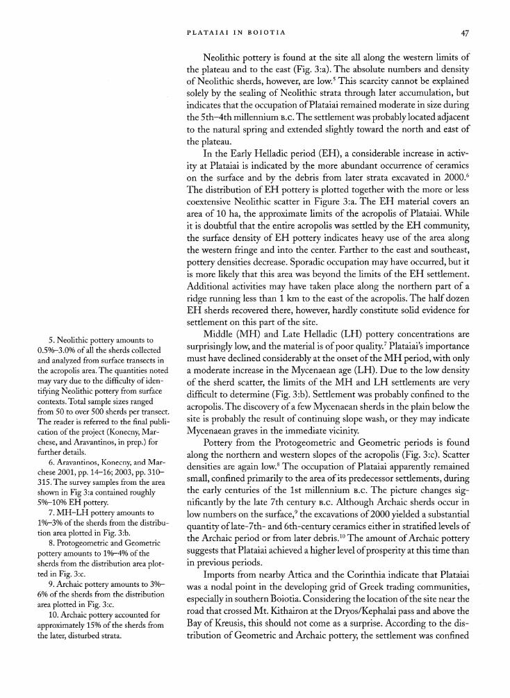
Neolithic pottery is found at the site all along the western limits of
the plateau and to the east (Fig. 3:a). The absolute numbers and density of Neolithic sherds, however, are low.5 This scarcity cannot be explained
solely by the sealing of Neolithic strata through later accumulation, but
indicates that the occupation of Plataiai remained moderate in size during the 5th-4th millennium b.c. The settlement was probably located adjacent to the natural spring and extended slightly toward the north and east of
the plateau.
In the Early Helladic period (EH), a considerable increase in activ
ity at Plataiai is indicated by the more abundant occurrence of ceramics
on the surface and by the debris from later strata excavated in 2000.6
The distribution of EH pottery is plotted together with the more or less
coextensive Neolithic scatter in Figure 3: a. The EH material covers an
area of 10 ha, the approximate limits of the acropolis of Plataiai. While
it is doubtful that the entire acropolis was settled by the EH community, the surface density of EH pottery indicates heavy use of the area along the western fringe and into the center. Farther to the east and southeast,
pottery densities decrease. Sporadic occupation may have occurred, but it
is more likely that this area was beyond the limits of the EH settlement.
Additional activities may have taken place along the northern part of a
ridge running less than 1 km to the east of the acropolis. The half dozen
EH sherds recovered there, however, hardly constitute solid evidence for
settlement on this part of the site.
Middle (MH) and Late Helladic (LH) pottery concentrations are
surprisingly low, and the material is of poor quality.7 Plataiai s importance must have declined considerably at the onset of the MH period, with only a moderate increase in the Mycenaean age (LH). Due to the low density of the sherd scatter, the limits of the MH and LH settlements are very difficult to determine (Fig. 3:b). Settlement was probably confined to the
acropolis. The discovery of a few Mycenaean sherds in the plain below the
site is probably the result of continuing slope wash, or they may indicate
Mycenaean graves in the immediate vicinity.
Pottery from the Protogeometric and Geometric periods is found
along the northern and western slopes of the acropolis (Fig. 3:c). Scatter
densities are again low.8 The occupation of Plataiai apparently remained
small, confined primarily to the area of its predecessor settlements, during the early centuries of the 1st millennium B.c. The picture changes sig
nificantly by the late 7th century b.c. Although Archaic sherds occur in
low numbers on the surface,9 the excavations of 2000 yielded a substantial
quantity of late-7th- and 6th-century ceramics either in stratified levels of
the Archaic period or from later debris.10 The amount of Archaic pottery
suggests that Plataiai achieved a higher level of prosperity at this time than
in previous periods.
Imports from nearby Attica and the Corinthia indicate that Plataiai
was a nodal point in the developing grid of Greek trading communities,
especially in southern Boiotia. Considering the location of the site near the
road that crossed Mt. Kithairon at the Dryos/Kephalai pass and above the
Bay of Kreusis, this should not come as a surprise. According to the dis
tribution of Geometric and Archaic pottery, the settlement was confined
5. Neolithic pottery amounts to
0.5?/o-3.0% of all the sherds collected
and analyzed from surface transects in
the acropolis area. The quantities noted
may vary due to the difficulty of iden
tifying Neolithic pottery from surface
contexts. Total sample sizes ranged from 50 to over 500 sherds per transect.
The reader is referred to the final publi cation of the project (Konecny, M?r
chese, and Aravantinos, in prep.) for
further details.
6. Aravantinos, Konecny, and M?r
chese 2001, pp. 14-16; 2003, pp. 310
315. The survey samples from the area
shown in Fig 3:a contained roughly 5%-10% EH pottery.
7. MH-LH pottery amounts to
l%-3% of the sherds from the distribu
tion area plotted in Fig. 3:b.
8. Protogeometric and Geometric
pottery amounts to l%-4% of the
sherds from the distribution area plot
ted in Fig. 3:c.
9. Archaic pottery amounts to 3%
6% of the sherds from the distribution
area plotted in Fig. 3:c.
10. Archaic pottery accounted for
approximately 15% of the sherds from the later, disturbed strata.

48 ANDREAS L. KONECNY ET AL.
0 100 200 300m ?~' "' ' \. 0 i 00 ZOO 300m l3_" x-^r -v
a b
0 100 200 300m ^ l ~~**^ V 0 /OQ 200 300m **s"~"*""" V
C d
PLATAIAI IN BOIOTIA 49
Figure 3 (opposite). Development of
settlement at Plataiai as shown by the
distribution of pottery: (a) Neolithic
and Early Helladic; (b) Middle and
Late Helladic; (c) Protogeometric, Geometric, and Archaic; (d) Classi
cal and Late Classical. A. L. Konecny
to the acropolis, except for one significant extension. Toward the south
eastern part of the
plateau there occurs a scatter of Archaic sherds around
the site of a temple that was excavated in 1891.n This pottery suggests that the cult of the goddess worshipped at the shrine commenced not
later than the 6th century b.c. The temple was originally built outside the
town, but was integrated into the settlement after Plataiai's expansion in
the late 4th century b.c. The location of the building supports the early excavators' identification of it as the Temple of Hera, situated, according to Herodotos, in a sacred precinct outside the confines of the Late Archaic
and Early Classical settlement.12
Pottery of Classical date was found across the site (Fig. 3:d).The mate
rial collected from the surface was, in most cases, poorly preserved, making it difficult to differentiate 5th- from 4th-century ceramic types. Neverthe
less, it may be stated with some certainty that material of 5th-century date
is abundant on and around the acropolis, with secondary concentrations
toward the southwest and the northeast. It is also evident that earlier Clas
sical material was transported to the later site of the Western Gate in the
large fortification circuit when this structure was built. The debris was used
for terracing the site of the gate.13 Excavations at the gate have yielded evidence dating the construction of the circuit to the last third of the
4th century b.c. It is clear that the town of Plataiai was still confined to the
acropolis in the 5th century, with scattered occupation in the immediate
rural districts of the community. The distribution of pottery dating to the
Late Classical period also indicates that the area protected by the new city wall was settled, to a
large extent, soon after 330 b.c.
Classical or Late Classical pottery was absent in a few locations. It
was not found in the southwestern part of the site, a rocky outcrop that
was not used for occupation or building. It was also absent from a number
of smaller areas that were seemingly unused during the first decades of
Plataiai's expansion. Generally, the density of surface finds outside the
acropolis remained relatively low compared to the plateau and its vicinity, and they were concentrated in the northern and northeastern areas (Fig. 2).
Although a substantial area was integrated into the newly extended settle
ment, buildings within the zone of expansion must have been scattered.
Presumably the population was not sufficient to cover all or even part of
the town with houses, public buildings, and an accompanying dense layer of occupational debris.
During the Hellenistic and Roman periods, the area of settlement
enclosed by the circuit wall did not change in size (Fig. 4:a). Outside the
southern cross wall, which, according to its masonry, should be dated to
the 3rd or possibly the 2nd century b.c., no trace of building activity can
be found. Pottery densities are also exceptionally low in this area. It is ob
vious that this part of the site was never occupied or used for settlement
purposes. Even the southern apex of the triangle confined by the southern
tip of the cross wall remained unused. Distributions of pottery indicate
that the northern and northwestern parts of the town were more densely built up and remained under more intensive use than the southern and
southeastern portions, where the scatter of sherds and roof tiles is nearly
insignificant.
11. Washington 1891.
12. Hdt. 9.52; see also Washington 1891.
13. For details, see Aravantinos and
Konecny 2000, pp. 9-12; Aravantinos,
Konecny, and M?rchese 2001, pp. 11?
13; 2003, pp. 305-309; Konecny 2005.

5o ANDREAS L. KONECNY ET AL.
Figure 4. Later settlement trends at
Plataiai as shown by the distribution
of pottery: (a) Hellenistic and Roman;
(b) Late Roman; (c) Medieval. A. L. Konecnv

PLATAIAI IN BOIOTIA 51
In the Late Roman period Plataiai shrank in size (Fig. 4:b). The areas
to the south, southeast, and northeast fell out of use and eventually lay bar
ren. Pottery of Late Antique date indicates concentrated habitation on and
around the acropolis plateau and along a line to the ruins of a church in
the north-central region of the eastern part of the site. The area of scatter
is, however, still substantially larger than the acropolis itself. The acropolis was refortified at an unknown date in the 3rd or 4th century a.D.14
Medieval pottery appears in four locations with various degrees of
density (Fig. 4:c). It occurs (1) to the northwest of the acropolis plateau,
(2) along its southern boundary, (3) astride its northeastern limits, and
(4) atop the northern part of the eastern ridge on which the fortification
line of the Late Classical town was situated. The first three locations yielded substantial concentrations of glazed pottery. Along the northeastern border
of the acropolis, the scattering of walls observed may represent the remains
of the village of Kato Kokla, known from later Ottoman tax records.15 The
fourth location yielded minimal ceramic remains, possibly reflecting a low
intensity of habitation. The survey evidence indicates that the pattern of
habitation changed in the Medieval period, as the settlement of Plataiai
dissolved into several nucleated clusters within the still visible circuit wall.
Later material is lacking. The site reverted to plowed land as settlement
activity shifted toward the southeast and the modern village of Plataies.
ARCHITECTURE AND URBAN TOPOGRAPHY: THE GEOPHYSICAL SURVEY
Previous geophysical surveys at Plataiai have already been reported in this
journal and elsewhere.16 Beginning in 2005 a new phase of geophysical
study was initiated. The purpose of this work is to provide a large-scale and
detailed analysis of a significant percentage of the site, elucidating the archi
tectural features and general urban scheme of the ancient town. The models
for this endeavor are the recent and highly successful surveys at the broadly
analogous sites of Tanagra in Boiotia and Philippi in Macedonia.17
Survey was undertaken over three weeks in October 2005, immediately after the first rainfall had soaked the ground following the summer drought.
Two geophysical techniques were employed: electrical ground resistance and
magnetic survey. Resistance survey determines the moisture and electrolyte
content of the earth immediately under the sample point by measuring its resistance to the passage of an electric current (measured in ohms, Q).
Abnormally dry features?stone, brick walls, or areas of concrete?appear as areas of greater resistance, while
waterlogged regions?e.g., ditches or
robbed wall foundations?appear as areas of lower resistance. Magnetic
survey measures localized fluctuations in the strength of the earth's mag netic field (measured in nanotesla, nT). Such fluctuations maybe strongly accented in areas of burning, areas where fired bricks are in use, or areas
where the underlying material is of volcanic origin. Stone building mate
rial may create a slight magnetic contrast with the surrounding subsurface
soil, and thus in some cases architectural features can be identified with a
high degree of probability.18
14. See the discussion in Konecny
1998, col. 58; Aravantinos, Konecny, and M?rchese 2003, pp. 299-301.
15. We are indebted to John Bintliff for drawing attention to the existence
of the medieval Turkish village of Kato
Kokla at Plataiai. See also Kiel 1997
and Sbonias 2004, especially the maps
included.
16. Konecny, Boyd, and Whit
bread 1999; Boyd and Whitbread
2000; Whitbread 2001; Aravantinos,
Konecny, and M?rchese 2003.
17. ForTanagra, see Bintliff et al.
2000,2001,2003; for Philippi, see
Boyd and Provost 2002; Provost and
Boyd 2003,2005, forthcoming. 18. More extensive technical expla
nations can be found in Clark 1996;
Scollar et al. 1990; Gaffney and Gater
2003.

52 ANDREAS L. KONECNY ET AL.
Resistance survey was carried out using a Geoscan RM-15 resistance
meter. Readings were taken in 30 m grids at a sample interval of one
reading per square meter. A twin-probe array was used with probe separa tion set at 0.5 m, in general providing a depth penetration of up to 1 m.
The magnetic survey was undertaken using a Geoscan FM-36 fluxgate
gradiometer. Readings were again taken in 30 m grids, but with a sample interval of four readings per square meter. Data were processed using cus
tom-designed software and the Maplnfo/Vertical Mapper GIS package. Minimal manipulation of the data has taken place; rare outlying readings
due to operator or instrument error have been removed, and in some cases
background readings have been adjusted to obtain an even background between grids. In 2005 a total area of 48,137 m2 (approximately 5 ha) was
surveyed with the resistance meter, while 7,198 m2 (approximately 0.7 ha) were covered with the magnetometer.
Data were gathered in four areas: the largest area was on the western
side of the town, south of the acropolis (Fig. 1:A); a second area was situ
ated on the acropolis (Fig. 1:B); a third area was situated at the northern
end of the town, east of the acropolis (Fig. 1:C, D); and a smaller, fourth
area was situated in and to the north of the theater (Fig. 1:E). Magnetic data were recorded in areas A and E only, and in Figures 5, 7, and 13 these
data are presented overlain on resistance data to clarify the relationships of
the two dataseis and the continuity of detection of major features.
Area A
The largest survey area is situated on the western side of the town, im
mediately east of the fortification wall and south of the acropolis. Resis
tance survey covered a total area of 2.8 ha, of which 0.6 ha was also sur
veyed with the magnetometer. The data from area A are shown in Figure 5, with an interpretation drawing presented in Figure 6, and a pseudo-three dimensional interpolation illustrated in Figure 7. The maximum extent
of the survey area is 330 m on its longer, north-south axis and up to
150 m east-west.
The resistance survey is characterized by background readings of
approximately 20 Q in the south, rising to about 30 Q in the north, with
much higher readings in the east. Much of this variation is probably due to
the depth of bedrock below the surface, which was minimal in the eastern
quadrant of the survey. Outcroppings of bedrock were noted throughout the
entire survey area. The predominance of bedrock precluded survey farther
to the east. On the western side, conversely, the presence of the fortifica
tion wall may have allowed a greater buildup of earth. Major features such
as streets tend to exhibit readings about 10 ?1 above background, while
ephemeral features maybe detectable at only 2 Q or 3 Q above background. Bedrock features, the fortification wall, and the area in front of the acropolis
wall exhibited readings up to 100 Q, above background. In the magnetic
survey significant features appear as negative anomalies about 5 nT to as
much as 40 nT below surrounding values. Areas of bedrock tend to appear as positive anomalies; architectural features therefore contrast with those
of the natural environment.

PLATAIAI IN BOIOTIA 53
The layout of archaeological features in area A is defined by five securely attested streets. Three of these run north-south (Fig. 6:b/c, c/d, and d/e) and can be traced for 75 m, 166 m, and 88 m, respectively. The orien
tation is 8.5? east of north in the local geodetic grid. The insula width
between streets b/c and c/d is 40 m, and the width between c/d and d/e is
43 m.Two streets run east-west (98.5?; Fig. 6:VI/VII and V1I/VIII). Street
VI/VII is detectable over 121 m on its north side, while VII/VIII can be
detected for 51 m. Between them, streets VI/VII and VII/VIII create an
insula length of 97 m. It is possible that a third east-west street, VIII/LX, has been partly detected at the southern limit of the survey area. There
is almost no evidence of a north-south street to the west of b/c, and the
north-south street that presumably exists some 40-43 m east of d/e is not
attested in the data. Streets appear to be uniformly 6 m wide.
While roads are well detected and insulae clearly outlined, structural
details within the city blocks are less well represented by the data. In general, more detail is apparent at the southern end of area A, whereas only general trends can be mapped to the north. It is possible that the greater depth of bedrock has helped to preserve features to the south, while features to
the north have been more completely destroyed. A large area toward the
northern end (Fig. 6:1) is currently plowed, also contributing to the lack
of anomalies in this area. Overall, there are two notable features at the
northern end of area A. One is a lack of evidence for major architectural
structures, suggesting that small-scale occupation was the norm for this part
of the town. The second is that areas best interpreted as bedrock features
appear to have been cut or quarried, most likely both, in order to provide both level building platforms and building material.
A number of complex features were observed on the north side of
street VIII/LX at the south end of the survey, as shown on Figure 6. These
consist mostly of short east-west linear features that were probably internal
or external walls of buildings. Block VIIIc, between b/c and c/d, is divided
by an edge feature that marks the boundary between higher readings on
the east side and lower readings to the west. Linear features on the east
side indicate probable architectural divisions. These contrast with possible
geological features on the west side, including feature 2, a high-resistance
anomaly measuring about 43 x 20 m, with an orientation not aligned with
the town grid. The well-defined edges of this feature might have been
produced by human action, ancient or modern, or they could be the result
of natural processes.
Farther north, block VIIc contains a major feature (Fig. 6:3) at its
north end that is also not quite aligned with the town grid. The feature may
predate?but more likely postdates?the grid. Feature 3 is linear, emerging from bedrock 4 at the north end of neighboring block Vlld. It is oriented
along a west-northwest axis for approximately 12 m, then turns west and
runs to the edge of the survey area for approximately 63 m. This latter
section is almost, but not quite, parallel with street VI/VII, 4-6 m to the
north. The feature is consistently 3 m wide and 5-10 Q above background,
although at its western end it becomes 10-20 il stronger. It also possesses a
strong magnetic reading, exhibiting a negative signature up to 20 nT below
background. The magnetic data suggest a slightly narrower anomaly (2.5 m)

54 ANDREAS L. KONECNY ET AL.
LJ -195
Figure 5. Area A: resistance data
(left); magnetic data on resistance
data (right). M. J. Boyd
with negative readings at its north and south edges, indicating a stone-built
facing. At the point where there is a directional change, a clearly defined
square feature is easily discerned. The magnetic data indicate a structure
with walls measuring 1 m thick and 6.25 m in length on each outer side.
It is probable that this structure is a tower, and it is likely, therefore, that
feature 3 is part of a fortification wall.
The northern end of block Vlld is dominated by a high resistance
feature (Fig. 6:4; 30-70 Q. above background) covering much of the north
end of the block and presumably representing an area of bedrock close to
the surface. It is also detected by magnetic survey, where feature 4 appears as a high-frequency, largely positive, anomaly. This feature ends with the
street c/d on its west side. The very straight edges on the north and south
may have resulted from quarrying. The southern boundary forms the
northern edge of feature 5, an area of low resistance 17 x 46 m, with internal
boundaries clearly defined in both the resistance and magnetic data sets.
Feature 5 consists of a northern section about 20 x 15 m, further subdivided
into two rooms, 5i and 5ii. Room 5i is about 7 x 15 m, while 5ii is about 12 x
15 m. The subdividing wall appears to be 1-2 m thick, its width perhaps due to rubble from the collapsed wall. The southern section of feature 5
is about 16 x 30 m. Although the data suggest internal subdivisions, these
cannot be precisely defined.

PLATAIAI IN BOIOTIA
-^
-la i edge or boundary features
architectural features
street outline
Figure 6. Area A: interpretation. M.J. Boyd
Most of the area of insula Vid, to the north of Vlld, is devoid of fea
tures, probably as a result of plowing. The streets are evident, but nothing else is visible (Fig. 6:1). Between the plowed area and the street VI/VII, the
data exhibit varying higher values, although clear features are lacking. These
observations (Fig. 6:6) may represent a building complex occupying the
width of the block and its southern 27 m. The reconstruction of feature 6
is less secure than other features, but the data broadly suggest a building or buildings measuring 14-20 m east-west and 6-14 m north-south. It seems likely that these units were also subdivided.

56 ANDREAS L. KONECNY ET AL.
.&%&.***
4-' W. }v*Z .*.
7*:
;i*-i
'N 100 m
PLATAIAI IN BOIOTIA 57
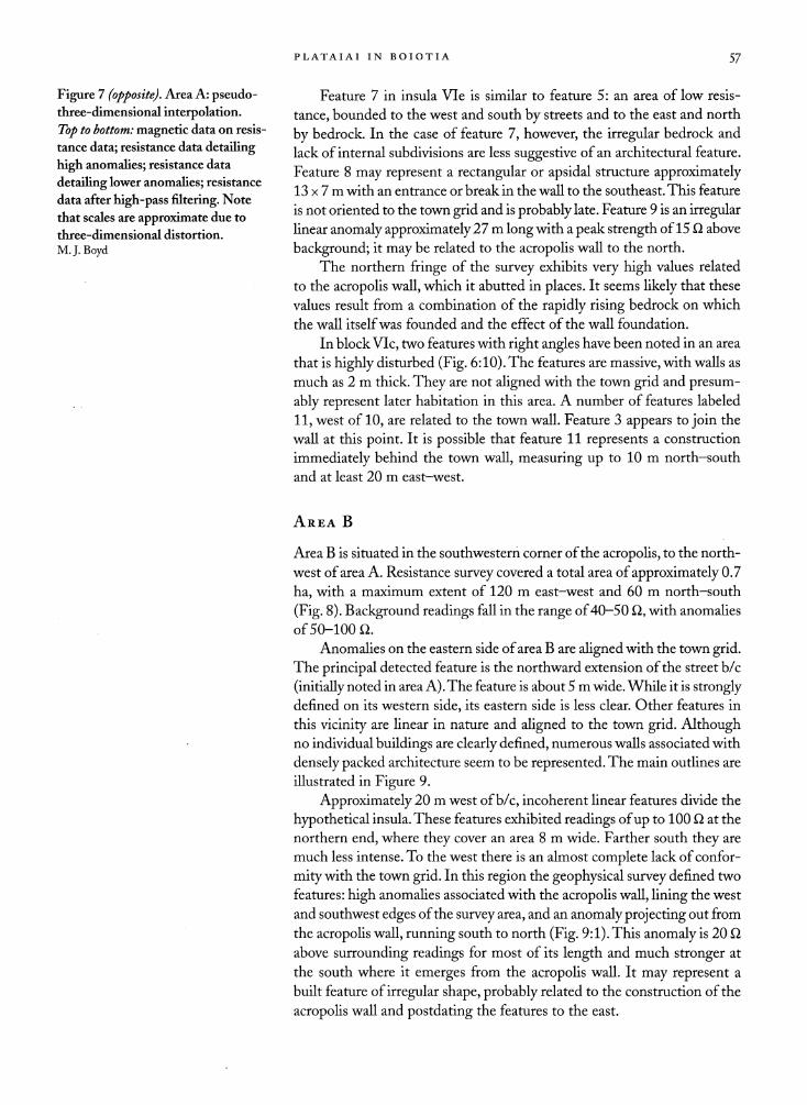
Figure 7 (opposite). Area A: pseudo three-dimensional interpolation.
Top to bottom: magnetic data on resis
tance data; resistance data detailing
high anomalies; resistance data
detailing lower anomalies; resistance
data after high-pass filtering. Note
that scales are approximate due to
three-dimensional distortion.
M.J.Boyd
Feature 7 in insula Vie is similar to feature 5: an area of low resis
tance, bounded to the west and south by streets and to the east and north
by bedrock. In the case of feature 7, however, the irregular bedrock and
lack of internal subdivisions are less suggestive of an architectural feature.
Feature 8 may represent a rectangular or apsidal structure approximately 13 x 7 m with an entrance or break in the wall to the southeast. This feature
is not oriented to the town grid and is probably late. Feature 9 is an irregular linear anomaly approximately 27 m long with a peak strength of 15 ?1 above
background; it may be related to the acropolis wall to the north.
The northern fringe of the survey exhibits very high values related
to the acropolis wall, which it abutted in places. It seems likely that these
values result from a combination of the rapidly rising bedrock on which
the wall itself was founded and the effect of the wall foundation.
In block Vic, two features with right angles have been noted in an area
that is highly disturbed (Fig. 6:10). The features are massive, with walls as
much as 2 m thick. They are not aligned with the town grid and presum
ably represent later habitation in this area. A number of features labeled
11, west of 10, are related to the town wall. Feature 3 appears to join the
wall at this point. It is possible that feature 11 represents a construction
immediately behind the town wall, measuring up to 10 m north-south
and at least 20 m east-west.
Area B
Area B is situated in the southwestern corner of the acropolis, to the north
west of area A. Resistance survey covered a total area of approximately 0.7
ha, with a maximum extent of 120 m east-west and 60 m north-south
(Fig. 8). Background readings fall in the range of 40-50 ?1, with anomalies
of 50-100 Q.
Anomalies on the eastern side of area B are aligned with the town grid. The principal detected feature is the northward extension of the street b/c
(initially noted in area A). The feature is about 5 m wide. While it is strongly defined on its western side, its eastern side is less clear. Other features in
this vicinity are linear in nature and aligned to the town grid. Although no individual buildings are clearly defined, numerous walls associated with
densely packed architecture seem to be represented. The main outlines are
illustrated in Figure 9.
Approximately 20 m west of b/c, incoherent linear features divide the
hypothetical insula. These features exhibited readings of up to 100 ?1 at the
northern end, where they cover an area 8 m wide. Farther south they are
much less intense. To the west there is an almost complete lack of confor
mity with the town grid. In this region the geophysical survey defined two
features: high anomalies associated with the acropolis wall, lining the west
and southwest edges of the survey area, and an anomaly projecting out from
the acropolis wall, running south to north (Fig. 9:1). This anomaly is 20 ?1
above surrounding readings for most of its length and much stronger at
the south where it emerges from the acropolis wall. It may represent a
built feature of irregular shape, probably related to the construction of the
acropolis wall and postdating the features to the east.

ANDREAS L. KONECNY ET AL.
Figure 8. Area B: resistance data.
M.J. Boyd
edge or boundary features ?
architectural features ? street outline
50 m
Figure 9. Area B: interpretation. M.J. Boyd
PLATAIAI IN BOIOTIA 59
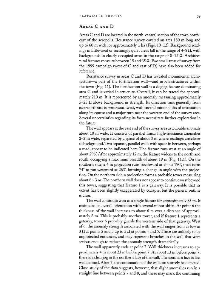
Areas C and D
Areas C and D are located in the north-central section of the town north
east of the acropolis. Resistance survey covered an area 180 m long and
up to 60 m wide, or approximately 1 ha (Figs. 10-12). Background read
ings in little-used or seemingly quiet areas fall in the range of 4-8 Q, with
backgrounds in clearly occupied areas in the range of 8-12 Q. Architec
tural features measure between 15 and 35 Q.Two small areas of survey from
the 1999 campaign (west of C and east of D) have also been added for
reference.
Resistance survey in areas C and D has revealed monumental archi
tecture?a part of the fortification wall?and urban structures within
the town (Fig. 11). The fortification wall is a dogleg feature dominating area C and is varied in structure. Overall, it can be traced for approxi
mately 210 m. It is represented by an anomaly measuring approximately 5-25 Q, above background in strength. Its direction runs generally from
east-northeast to west-southwest, with several minor shifts of orientation
along its course and a major
turn near the western end of the survey area.
Several uncertainties regarding its form necessitate further exploration in
the future.
The wall appears at the east end of the survey area as a double anomaly about 10 m wide. It consists of parallel linear high-resistance anomalies
2-3 m wide, separated by a space of about 3 m where readings are closer
to background. Two separate, parallel walls with space in between, perhaps a road, appear to be indicated here. The feature runs west at an angle of
about 296?. After approximately 12 m, the feature widens to the north and
south, occupying a maximum breadth of about 19 m (Fig. 11:1). On the
southern side, a 4 m projection runs southward at about 190?, then turns
74? to run westward at 263?, forming a change in angle with the projec tion. On the northern side, a projection forms a probable tower measuring about 8 x 3 m. The northern wall does not appear to continue west beyond this tower, suggesting that feature 1 is a gateway. It is possible that its
extent has been slightly exaggerated by collapse, but the general outline
is clear.
The wall continues west as a single feature for approximately 83 m. It
maintains its overall orientation with several minor shifts. At point 6 the
thickness of the wall increases to about 6 m over a distance of approxi
mately 8 m. This is probably another tower, and if feature 1 represents a
gateway, tower 6 probably guards the western side of that gateway. West
of 6, the anomaly strength associated with the wall ranges from as low as
3 Q at points 2 and 3 up to 5 Q. at points 4 and 5. These are unlikely to be
unprotected entrances, and may represent breaches in the wall that were
serious enough to reduce the anomaly strength dramatically. The wall apparently ends at point 7. Wall thickness increases to ap
proximately 4 m about 23 m before point 7. At about 13 m before point 7, there is a clear jog in the northern face of the wall. The southern face is less
well defined. After 7, the continuation of the wall can scarcely be detected.
Close study of the data suggests, however, that slight anomalies run in a
straight line between points 7 and 8, and these may mark the continuing

ON o
M Surveyed in 1999
100 m uncertain features
? architectural features
hypothetical street outline
W
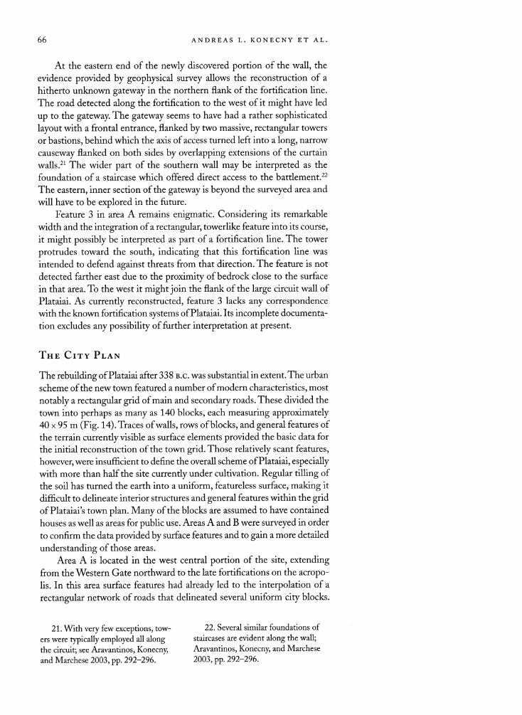
Figures 10 (top) and 11 (bottom). Areas C and D: resistance data and interpretation. M. J. Boyd

?g^r
?jSM1
Figure 12. Areas C and D: pseudo-three-dimensional interpolation. Left to
right: resistance data from west after high-pass
filtering; resistance data from west; resistance data from east. Note that scales are approximate due to three-dimensional
distortion. M. J. Boyd
CN

62 ANDREAS L. KONECNY ET AL.
line of the wall. This section, about 28 m in length, was probably dismantled
at some point to a lower level than the rest of the wall. The deeper burial of
the extant upper surface has likely resulted in a much weaker geophysical
signature for the feature at this point. North of the faint anomalies associated with the wall, between points
9 and 10, a series of linear anomalies run parallel to the wall, coinciding with a miniscule ridge formation on the ground. These features are 10-15
?2 above the background level, and thus are probably also built features.
The data are inconclusive, but one might conjecture the presence of some
sort of proteichisma at this point, perhaps protecting the corner of the wall
or forming a terrace that supported a road running parallel to the wall. The
faint anomalies at 11, described below, continue this feature.
Between points 10 and 8, the wall makes a dramatic 78? turn south
ward to run south at 193?. This turn is apparently not protected by a tower, and the feature between 10 and 8 is difficult to interpret. The faint lin
ear anomalies between 7 and 8 continue beyond 8, almost reaching the
features at 11. The feature that turns at 10 is about 7 Q, above background. It gradually gains strength running south until at the edge of the survey area it measures 30 Q above background. Running parallel with the outer
line is a second, inner line, barely detectable at 8 but marked by a very clear anomaly at point 12 and to the south. In places it is stronger than
the outer anomaly. This inner line is partly visible as a surface feature con
sisting of medium-sized, occasionally polygonal blocks characteristic of
domestic construction at Plataiai. Its proximity to the surface may explain its
strength.
These outer and inner features are 2-3 m thick, separated by a space of approximately 3 m. They do not run in a straight line, but turn slightly to the east. Their irregular orientation makes it unlikely that the inner fea
ture represents a street running up to the wall. All the evidence at Plataiai
indicates a strictly orthogonal street plan. Nonetheless, the interpretation of these anomalies remains unclear. The most likely explanation is that the
outer feature represents the wall, while the inner feature is the edge of a
city block. This fits very well with the reconstruction of the town grid for
the area. Moreover, while architectural features are obvious to the east of
the wall, no built features are apparent to the west.
The main features to the west of the wall are the faint parallel anomalies
at 11. These were visible in the 2005 survey, but even clearer in the small
1999 survey carried out in the same area. They are almost on the same
alignment as the features running from 7 to 8 and from 9 to 10, and they are, similarly, about 6 m apart. The anomaly strength is about 5 ?2 above
background, which is high in this area. The features at 11 may represent a road or a continuation of the proteichisma. Features to the north of the
wall, such as 16, are amorphous and difficult to interpret. Within the area enclosed by the wall, elements of the town grid are
discernible but not as obvious as in area A. The block widths are all 40
m, and the street widths are 5-6 m. The street g/h is faintly but securely attested in the data. Street h/j is more substantially preserved, measuring about 7 Q above background. Only 13 m of street j/k, located in area D,

PLATAIAI IN BOIOTIA 63
maybe detected.The position of k/1, outside the surveyed area, is entirely
conjectural. Blocks Ih and Ij, which are only partially represented in the
data, seem entirely devoid of architecture, in contrast to Ig and Ik, which
preserve considerable architectural remains. In Ig some features representing walls and buildings are closely aligned with the town grid, while others are
more closely aligned with nearby sections of the wall, as might perhaps be
expected. A linear feature running north-south divides the block precisely in two, as noted for area A, block VIIIc, and area B. Feature 13 is a coherent area of walls bordering street g/h; it measures about 22 x 17 m.
Major features closely aligned with the town grid are also present in area D. Area D includes three linear features with this orientation: fea tures 14 and 15, forming a right angle, and street j/k. Features 14 and 15
measure more than 30 ?1 above background. The small area to the east of
D surveyed in 1999 contains a feature with the same orientation and with
comparable anomaly strength. These may be interpreted as walls that are
consistent with the town grid, but it is clear that further magnetic survey and extension of the resistance survey area will be required to resolve the
problems of interpretation in this area.
Area E
Testing in area E was carried out above and to the north of the theater
in order to see if geophysics could reveal further details about this im
portant public building. Resistance survey covered about a third of a
hectare; a quarter of this area was also surveyed with the magnetometer
(Fig. 13). The area to the north of the theater, including the cavea, has been
plowed in recent times. This has undoubtedly caused damage to subsurface
features and has led to the uniform results in the northern part of the sur
vey beyond the orchestra. Resistance values fall within the range of 4-9 ?1
with no clear evidence for archaeological features. At the south end of this
half of the survey, a band of slightly raised values (6-10 ?1) is evident (Fig. 13: right, feature 1). Feature 1 might be aligned with the town grid, but the data are ambiguous. Immediately to the south, a band of lower values
(4-6 ?1; feature 2) is present. It is difficult to assign any archaeological
significance to these features.
Immediately south of this low band is the first significant feature (3) in area E. Feature 3 is a band of higher readings about 12 m broad with
clearly defined edges. Readings in this zone measure between 8 and 22 ?1.
This spot is clearly marked on the surface by a change in ground height
(higher to the south) and by a substantial quantity of stone debris. The
highest readings form a core 4-9 m in width, and 14-22 ?1 in intensity. Feature 3 is approximately 13? out of alignment with the town grid. It is
clearly detected on the magnetic survey, in which its northern edge appears as a
positive anomaly with an angle
at its eastern end. It seems reason
able to equate this feature with the northernmost extent of architectural
features associated with the theater. It is aligned with a large block on
the surface.

ON
60
40
30
20
IK 30 m N?
60
50
30
20
10
199
100
50
20 10
0 -10 -20
-50
-100
Figure 13. Area E (left to right): resistance data detailing lower anomalies; resistance data after high-pass filtering;
magnetic data on resistance data; interpretation. M. J. Boyd
magnetic anomaly
resistance edge
15 m Nt

PLATAIAI IN BOIOTIA 65
South of feature 3 is feature 4, an area of lower readings in the resis
tance data and an area whose outline is clearly delineated in the magnetic data. Feature 4 is 10 m wide at its western end and 8 m wide at its eastern
end. The northern edge of 4 may be seen as forming the southern edge of 3 (it respects the 13? angle), while the southern edge may be viewed as
forming the northern edge of feature 5, another broad anomaly of slightly elevated resistance values. Feature 5 is about 6 m wide and approximately 4 Q above background in anomaly strength. Its west-east axis is turned
roughly 7? clockwise from the orientation of the town grid. The interpreta tion of these alternating bands of low and high resistance is obscure.
In the southernmost quarter of the resistance survey measured values
reflect the elements of the cavea close to the surface. Readings rise to about
45 Q, and the overall width of the feature, which clearly extends beyond the 2005 survey limits, is about 16 m. One clear linear feature, 6, has been
marked on Figure 13.
ANALYSIS OF THE URBAN SCHEME
The Fortification Wall
During its long history, Plataiai suffered destruction on at least three occa
sions. The first of these occurred during the Persian Wars, the second dur
ing the Peloponnesian War. Then the town was destroyed by the Thebans
shortly before the battle of Leuktra in 371 B.c., after which it was abandoned
until the period immediately following the battle of Chaironeia in 338 B.c.19
Subsequently, the new town of Plataiai was rebuilt and eventually encom
passed seven times the space of the preceding settlements. Philip II of
Maced?n initially provided support for this extensive construction, and
Alexander the Great contributed even more generous funding.20 The new town was protected by a large fortification circuit of which
the western, southern, and eastern flanks can be traced as visible surface
features. A substantial portion of the northern circuit is also visible, but
not its entirety. One crucial part of the fortification circuit, the section
that linked its northeastern flank to the northwestern plateau where the
earlier settlements were located, is covered by silt. Consequently, its line
is unknown. Without major excavations in this area, geophysical survey is
the only logical method of locating the missing section of the circuit wall.
Therefore, this part of the site was surveyed during the first season of the
current geophysical project. The results of this work were more than satisfactory. A major feature
of substantial width running in a long, nearly uninterrupted line across
area C would seem to represent the missing part of Plataiai's circuit. The
wall crosses roughly from east to west and appears to turn sharply to the
south when it reaches a point approximately 100 m north of the acropolis
plateau. The evidence suggests that it was followed by a feature that might be interpreted as a road coming from the west. Further geophysical survey
will be necessary to explore how the fortification line was connected to
the acropolis.
19. Hdt. 8.50; Thuc. 3.20-24,
52-68; Xen. Hell. 6.3.1; Diod. Sic.
15.64; Paus. 4.1.1; 4.27.10; 9.1.5, 8.
20. Air. Anab 1.9, passim; Plut.
Alex. 34.3.
66 ANDREAS L. KONECNY ET AL.
At the eastern end of the newly discovered portion of the wall, the
evidence provided by geophysical survey allows the reconstruction of a
hitherto unknown gateway in the northern flank of the fortification line.
The road detected along the fortification to the west of it might have led
up to the gateway. The gateway seems to have had a rather sophisticated
layout with a frontal entrance, flanked by two massive, rectangular towers
or bastions, behind which the axis of access turned left into a long, narrow
causeway flanked on both sides by overlapping extensions of the curtain
walls.21 The wider part of the southern wall may be interpreted as the
foundation of a staircase which offered direct access to the battlement.22
The eastern, inner section of the gateway is beyond the surveyed area and
will have to be explored in the future.
Feature 3 in area A remains enigmatic. Considering its remarkable
width and the integration of a rectangular, towerlike feature into its course,
it might possibly be interpreted as part of a fortification line. The tower
protrudes toward the south, indicating that this fortification line was
intended to defend against threats from that direction. The feature is not
detected farther east due to the proximity of bedrock close to the surface
in that area. To the west it might join the flank of the large circuit wall of
Plataiai. As currently reconstructed, feature 3 lacks any correspondence with the known fortification systems of Plataiai. Its incomplete documenta
tion excludes any possibility of further interpretation at present.
The City Plan
The rebuilding of Plataiai after 338 b.c. was substantial in extent. The urban
scheme of the new town featured a number of modern characteristics, most
notably a rectangular grid of main and secondary roads. These divided the
town into perhaps as many as 140 blocks, each measuring approximately 40 x 95 m (Fig. 14). Traces of walls, rows of blocks, and general features of
the terrain currently visible as surface elements provided the basic data for
the initial reconstruction of the town grid. Those relatively scant features,
however, were insufficient to define the overall scheme of Plataiai, especially with more than half the site currently under cultivation. Regular tilling of
the soil has turned the earth into a uniform, featureless surface, making it
difficult to delineate interior structures and general features within the grid of Plataiais town plan. Many of the blocks are assumed to have contained
houses as well as areas for public use. Areas A and B were surveyed in order
to confirm the data provided by surface features and to gain a more detailed
understanding of those areas.
Area A is located in the west central portion of the site, extending from the Western Gate northward to the late fortifications on the acropo lis. In this area surface features had already led to the interpolation of a
rectangular network of roads that delineated several uniform city blocks.
21. With very few exceptions, tow
ers were typically employed all along
the circuit; see Aravantinos, Konecny,
and M?rchese 2003, pp. 292-296.
22. Several similar foundations of
staircases are evident along the wall;
Aravantinos, Konecny, and M?rchese
2003, pp. 292-296.

1 / y^^ ? WvwVlm?F*' i hZ?;.. Tri ^v "~~~'::'~-:=??*.. \\
ll y^^^^^'^^L 8 h j k 1
P q r S^^T
cJlvl B
J / ^
Figure 14. Geophysical survey areas with reference to the town
plan. A. L. Konecny and M. J. Boyd ^

68 ANDREAS L. KONECNY ET AL.
Geophysical survey confirmed that reconstruction. The results indicate
that habitation blocks were partitioned into subunits that may represent individual dwellings, probably ten per block. Those were bordered by solid
features that are likely to have been stone walls or stone foundations.23 No
uniform plan is discernible among the dwellings.24 They appear to be of
different designs, with open spaces or courtyards, and small, rectangular structures?huts and stables, perhaps?that occupied variable proportions of the available space. The existence of further interior partitions can
only be supposed, as they could not be detected using current geophysical
techniques.
Additionally, there appear to have been several large, unoccupied ar
eas in blocks VIIc and Vlld. The geophysical data suggest that a number
of blocks, especially those truncated by the large circuit wall, were only
partially built up, if at all. The later fortification of the acropolis plateau is accompanied by an empty strip that was approximately 30 m wide. The
most likely interpretation of this anomaly is that it represents a glacis?a defensive feature formed by tearing down all existing houses in the vicinity of the wall in order to deprive a possible attacker of a secured position for
siege.25 A very insignificant feature following this supposed glacis might
represent traces of a ditch in front of the wall.
Area B is smaller than area A and was located in the southwestern
corner of the acropolis plateau. Geophysical examination in this area focused
on the general habitation pattern. An effort was made to address the ques tion of whether there were any discernible effects on the size and nature of
buildings after Plataiai's occupation was once again restricted to the acrop olis. The results of the geophysical survey proved that the orthogonal grid of roads continued to the north and is detectable on the acropolis.26 The
general subdivisions of the blocks seem to be quite similar in layout to those
in the area south of the acropolis. Nevertheless, the structures identified
appear to be smaller in size and more compartmentalized, almost certainly because the area inside the late fortifications continued in use for a much
longer period than similar space to the south. It is obvious that the acropolis had a number of building phases that redefined the habitation pattern in
this area in late antiquity.
Geophysical survey of areas C and D also contributed substantial data
on the internal structure of the site. Traces of roads and adjacent buildings were detected, proving that the orthogonal grid of Plataiai extended into
the northern part of the town beyond the acropolis plateau. The direction
of the roads deviates slightly to the west, probably as a result of transfer
ring their orientation across the northern edge of the acropolis. The data
seem to indicate that the blocks in these areas were only partially built
23. Similar foundations were par
tially excavated in the eastern square
of the trenches at the Western Gate;
see Aravantinos and Konecny 2000,
pp. 9-10; Aravantinos, Konecny, and
M?rchese 2001, p. 11; 2003, pp. 305
309; Konecny 2005. 24. For uniform house designs of
the Classical period at Olynthos, Kas
sope, and Priene, see Hoepfner and
Schwandner 1986, pp. 42-60,107-130,
169-180. Interestingly, at Olynthos there were 10 dwellings of approxi
mately 300 m2 to one block.
25. The construction of this wall
probably took place during the 3rd or
4th century A.D., six centuries after the
establishment of the town grid; cf. Ara
vantinos, Konecny, and M?rchese 2003,
pp. 299-301. The area to the south of
the new wall was abandoned.
26. This is also indicated by con
spicuous surface features farther north.
PLATAIAI IN BOIOTIA 69
up, but it is unclear as to whether the results represent the ancient pattern of occupation or disturbance of the archaeological remains by intensive
plowing with modern farm equipment. An extension of the survey area
may clarify this issue.
The Theater
The only visible remains of Plataiai's theater are a depression resembling a
cavea and traces of walls that follow the depression on the ridge east of the
supposed Temple of Hera.27 This region, designated area E, was examined
to gather more information about this important public structure. Unfor
tunately, the results of the investigation are ambiguous. One linear feature
appears at a right angle to a short stretch of wall extant on the surface in
front of the cavea. It coincides with a long, narrow concentration of rubble
on the surface. This combination of features might be interpreted as part of the rear wall of the skene building. Two smaller features, parallel and to
the south of this ostensible wall, may represent internal walls of the stage
building. The interpretation of a wide feature of slightly higher resistance, farther
south in the area of the supposed orchestra, is uncertain. If it is indeed
associated with any additional architectonic structures, it could be equated with a wide pulpitum of Roman type.28 Surface and geophysical features
are sufficient to prove that the theater of Plataiai was not oriented along the main axis of the towns grid of streets and avenues, but was instead
placed at an oblique angle.
CONCLUSIONS
Surface and geophysical survey have added considerably to our knowledge of Plataiai's development, expansion, and internal structure. Pottery con
centrations make it possible to trace the establishment of the settlement in
the Late Neolithic, growth during the EH period, and a contraction during the MH and LH periods that is contrary to what might be expected on
the basis of the Homeric epics. After an expected low intensity of settle
ment activity during the Geometric period, Plataiai s revived importance as a local center in the Archaic and Classical periods is amply testified by
pottery collected from the surface and from excavated strata on the acrop olis plateau.
Together with evidence from historical sources, the distribution and
concentration patterns of surface pottery attest to the reconstruction of
Plataiai on a grand scale after its tumultuous history in the 5th and 4th
centuries b.c. The data also indicate that the extended perimeter was too
large to be occupied completely by the citizens of the town. In later times
the perimeter was reduced considerably, providing security for the former
nucleus of Plataiai but excluding large areas that were still inhabited. It is
unclear as to whether Plataiai was occupied without interruption until the
Medieval period, when it is evident that the residents had dispersed into
two or more separate settlements.
27. See Washington 1891. 28. Bieber 1971, pp. 167-220.

7? ANDREAS L. KONECNY ET AL.
Thanks to geophysical survey, the extension of an orthogonal grid of
roads and blocks is now documented to have covered a major portion of
the town after it was rebuilt in 338 B.c. It seems highly probable, as well
as logical, that this grid still determined building patterns or land use af
ter the perimeter of Plataiai was reduced in late antiquity. The previously unknown course of the northern front of the town's large circuit wall has
been detected, along with the existence of a gateway with a sophisticated
layout. A continuation of both surface and geophysical survey will in
crease our knowledge of the dimensions and changing design of Plataiai
during the city's long history.
REFERENCES
Aravantinos, V., and A. Konecny. 2000.
"Plataiai: Die Kampagne 1999,"
?Jh 69, pp. 8-15.
Aravantinos, V., A. Konecny, and
R. M?rchese. 2001. "Plataiai: Die
Kampagne 2000," ?Jh 70, pp. 9-19.
-. 2003. "Plataiai in Boiotia:
A Preliminary Report of the 1996 2001 Campaigns," Hesperia 72,
pp. 281-320.
Bieber, M. 1971. The History of the Greek and Roman Theater, 2nd ed.,
Princeton.
Bintliff, J. L. 1992. "The Boeotia
Project 1991: Survey at the City of
Hyettos," University of Durham and
University of Newcastle upon Tyne,
Archaeological Reports 1991, pp. 23
28.
-. 1997. "The Role of Science in
Archaeological Regional Surface
Artefact Survey," in Optical Technol
ogies in the Humanities (Optics with
in Life Sciences 4), ed. D. Dirksen
and G. von Bally, Berlin, pp. 9-28.
Bintliff, J. L., N. Evelpidou, E. Fari
netti, B. Music, I. Riznar, K. Sbo
nias, L. Sigalos, B. Slapsak, V. Stissi,
and A. Vassilopoulos. 2001. "The
Tanagra Survey: Report on the 2001
Season," Pharos 9, pp. 33-74.
Bintliff, J. L., E. Farinetti, J. Pobl?me,
K. Sarri, K. Sbonias, B. Slapsak, V. Stissi, and A. Vionis. 2003. "The
Leiden-Ljubljana Tanagra Project: The 2003 Season," Pharos 11,
pp. 35-43.
Bintliff, J. L., E. Farinetti, K. Sbonias,
L. Sigalos, and B. Slapsak. 2000.
"The Tanagra Survey: Report on
the 2000 Season," Pharos 8, pp. 93
128.
Bintliff, J. L., and P. Howard. 1999.
"Studying Needles in Haystacks: Surface Survey and the Rural Land
scape of Central Greece in Roman
Times," Pharos 7, pp. 51-91.
Bintliff, J. L., and A. Snodgrass. 1988.
"Mediterranean Survey and the
City," Antiquity 62, pp. 57-71.
Bottema, S., and H. Woldring. 1990.
"Anthropogenic Indicators in the
Pollen Record of the Eastern Med
iterranean," in Mans Role in the
Shaping of the Eastern Mediterra
nean Landscape, ed. S. Bottema,
G. Entjes-Nieborg, and W. van
Zeist, Rotterdam, pp. 231-264.
Boyd, M., and S. Provost. 2002. "Appli cation de la prospection g?ophy
sique ? la topographie urbaine I:
Philippes, les quartiers Sud-Ouest,"
BCH125, pp. 453-521.
Boyd, M., and I. K. Whitbread. 2000.
"Geophysical Studies at Plataiai
in 1999," in Aravantinos and
Konecny 2000, pp. 12-15.
Clark, A. 1996. Seeing Beneath the Soil:
Prospecting Methods in Archaeology, rev. ed., London.
Eastwood, W. J., N. Roberts, and
H. F. Lamb. 1998. "Palaeological and Archaeological Evidence for
Human Occupation in Southwest
ern Turkey: The Beys, ehir Occu
pation Phase," AnatSt 48, pp. 69-86.
Fossey, J. M. 1988. Topography and Pop
ulation of Ancient Boiotia, Chicago.
Gaffney, C. F, and J. Gater. 2003. Re
vealing the Buried Past: Geophysics for
Archaeologists, Stroud.
Hoepfner, W., and E.-L. Schwandner.
1986. Haus und Stadt im klassischen
Griechenland, Munich.

PLATAIAI IN BOIOTIA yi
Kiel, M. 1997. "The Rise and Decline
of Turkish Boeotia, 15th-19th
Century," in Recent Developments in the History and Archaeology of
Central Greece. Proceedings of the
Sixth International Boeotian Confer
ence, Bradford 1989, ta.]. Bintliff,
Oxford, pp. 315-358.
Konecny, A. 1998. "Der Plataiai Survey,
1996-1997," ?JhBeibl 67, cols. 53 62.
-. 2005. "Das Westtor im gro?en
Mauerring von Plataiai," in Syner
gia: Festschrift f?r Friedrich Krinz
inger, ed. B. Brandt, V. Gassner,
and S. Ladst?tter, Vienna, pp. 279
287.
-. Forthcoming. "The Walls of
Plataiai: A Preliminary Report," Boeotian Studies 7-8.
Konecny, A., M. J. Boyd, and I. Whit
bread. 1999. "Der Plataiai Survey: Die Kampagne 1998," ?JhBeibl 6$, cols. 41-52.
Konecny, A., R. M?rchese, and V. Ara
vantinos. In prep. Plataiai: Survey und Ausgrabungen, 1996-2007.
Prandi, L. 1988. Platea: Momenti eprob lemi d?lia storia di una
polis, Padua.
Pritchett, W. K. 1985. Studies in Ancient
Greek Topography 5 (University of California Publications in Classical
Studies 31), Berkeley.
Provost, S., and M. J. Boyd. 2003. "Ap
plication de la prospection g?ophy
sique ? la topographie urbaine II:
Philippes, les quartiers Ouest,"
BCH126, pp. 431-488. -. 2005. "The ?nsula of the 'Mai
son des Fauves' at Philippi (Mace
donia): A Geophysical Survey," in Ancient Greece at the Turn of the
Millennium: Recent Work and Fu
ture Perspectives (Publications of the
Canadian Archaeological Institute
at Athens 4), ed. N. M. Kennell and
J. E. Tomlinson, Athens, pp. 113
136.
-. Forthcoming. "Application
de la prospection g?ophysique ? la
topographie urbaine III: Philippes, les quartiers Sud," BCH.
Sbonias, K. 2004. "Accepting the Di
versity and the Multiple Layers of
Modern Greek Identity," in Per
ception and Evaluation of Cultural
Landscapes. Proceedings of an Interna
tional Symposium, Zakynthos, Decem
ber 1997 (Meletemata 38), ed. P. N.
Doukellis and L. G. Mendoni,
Athens, pp. 117-135.
Scollar, I., A. Tabbagh, A. Hesse, and
I. Herzog. 1990. Archaeological Pros
pecting and Remote Sensing, Cam
bridge.
Waldstein, C, F. B. Tarbell, and J. C.
Rolfe. 1889. "Discoveries at Plataia
in 1889," AJA 5, pp. 439-442.
Waldstein, C, H. S. Washington, and
W. Irving-Hunt. 1890. "Discoveries
at Plataia in 1890," AJA 6, pp. 445
475.
Washington, H. S. 1891. "Excavations
by the American School at Plataia
in 1891: Discovery of a Temple of Archaic Plan," AJA 7, pp. 390-405.
Whitbread, I. K. 2001. "Geophysical Studies at Plataiai in 2000," in Ara
vantinos, Konecny, and M?rchese
2001, pp. 16-19.
Andreas L. Konecny
Universit?t Wien
institut f?r klassische arch?ologie
franz klein gasse i
a-iiqo vienna
AUSTRIA
Michael J. Boyd
University of Cambridge
mcdonald institute for
archaeological research
downing street
cambridge cb2 3er
united kingdom
Ronald T. M?rchese
University of Minnesota at Duluth
department of history
269 a. b. anderson hall
duluth, minnesota 55812
Vassilis Aravantinos
Museum of Thebes
plateia keramopoullou
32 200 THEBES
GREECE